Embed Size (px)
Citation preview

Newmarket Green DCP
Supporting Report for the site specific DCP
PREPARED FOR
William Inglis & Son
PREPARED BY
Elton Consulting
CONTACT
Jenny Rudolph [email protected] 31 May 2011 (preface February 2013)

Prepared by
Samantha Czyz and Fiona van der
Hoeven
Reviewed by
Fiona van der Hoeven
Date 31 May 2011 (Preface January 2013)
Job number 09_1631
Document name
O:\Active Projects\09_1631 - INGLIS -
Inglis Redevelopment - Young St
Randwick\Planning\NEWMARKET
DCP\ELTON DCP JUSTIFICATION
REPORT\Feb 2013\Newmarket
justification report Feb 2013.doc
Version 1
This document is printed on paper produced using sustainable forestry practices and chlorine free pulp

Contents
Preface 1
1 Introduction 2
1.1 Purpose 2
1.2 Intended Outcome 2
2 Site Context, Location and Analysis 4
2.1 Regional context 4
2.2 Immediate locality 5
2.3 Site identification 5
3 Justification of Newmarket Green DCP 8
3.1 Introduction 8
3.2 Compliance with Randwick Local
Environmental Plan 8
3.3 Explaining the DCP controls 17
4 Assessment against other relevant
clauses 42
4.1 Introduction 42
4.2 Randwick Local Environmental Plan 42
5 Conclusion 43
5.1 Conclusion 43
6 Appendices 44
6.1 Lot identification 44
Figures
Figure 1. Newmarket Green Masterplan
Figure 2. Site Context Plan
Figure 3. Site Plan
Tables
Table 1. Summary of opportunities and
constraints
Table 2. DCP compliance with Clause 40A of
the Randwick LEP 1998 (equivalent
cl 6.12 Randwick LEP 2012)
Table 3. Comparison of Proposed DCP
Controls against Council’s Existing
Controls

Newmarket Green DCP - Supporting Report for the site specific DCP 1
Preface
This report was originally prepared in May 2011 to accompany the submission to Randwick City Council of a
revised Planning Proposal for Newmarket Green.
A number of changes have been made to the Planning Proposal, and the associated Development Control Plan
(DCP) and master plan, since the 2011 submission (refer to Planning Proposal for summary of changes).
The South East Joint Regional Planning Panel (JRPP) has now been appointed as the relevant planning
authority for the Planning Proposal. The Planning Proposal also now relates to the Randwick LEP 2012. It is
noted that many of the provisions of Randwick LEP 1998 have been directly translated to the new LEP and the
intent of the controls has remained in the 2012 LEP.
Randwick City Council have also publicly exhibited a draft new City-wide DCP. The Draft DCP is currently on
exhibition until 12 March 2013.
This report predates the drafting and public exhibition of Council’s draft City-wide DCP and the introduction of
the new LEP 2012. As such, the discussion and assessment of Newmarket Green DCP contained within this
report relates to the current DCPs applying in Randwick, as well as the relevant sections of Councils previous
LEP; Randwick LEP 1998. It is noted that Clause 40A ‘Site specific development control plans’ of the 1998 LEP
generally addresses the same issues as those addressed in the equivalent 6.12 ‘Development requiring the
preparation of a development control plan’. As such, the justification for Newmarket Green site-specific DCP
and master plan are generally the same and still relevant.
This report is thereby in accordance with the decision of the JRPP made on 4 December 2012 to support the
public exhibition of the planning proposal (and associated documentation).

2 Newmarket Green DCP - Supporting Report for the site specific DCP
1 Introduction
1.1 Purpose
Newmarket Green Development Control Plan (the DCP) has been prepared concurrently with Planning Proposal
which seeks to rezone the site from 2A Residential to a mix of R3 Medium Density Residential and B4 Mixed
Use under Randwick LEP 2012 to allow for high quality mixed density residential development with local
mixed uses.
The purpose of this report is to:
compare the proposed controls with Council’s existing controls that apply to the future development of
the site and provide justification for any variation to the controls
demonstrate that the DCP has been prepared in accordance with Clause 40A of Randwick LEP 1998
(equivalent to Clause 6.12 of Randwick LEP 2012) and embeds an indicative master plan which has
been prepared following extensive technical investigations and consultation.
It should be read in conjunction with the ‘Newmarket Green Planning Proposal’ prepared by Elton Consulting
and the ‘Newmarket Green DCP’ and ‘Newmarket Green Master Plan and Urban Design Report’ prepared by
Roberts Day.
This document is structured as follows:-
Section 1 Introduction sets out the purpose for the report and describes the intended outcomes and
guiding principles that the DCP will achieve
Section 2 Site Location, Context and Analysis provides a brief description of these elements
Section 3 Explanation of Newmarket Green DCP outlines the policy setting for the DCP
Section 4 Planning Assessment addresses the provisions in Clause 40A (6.12) of the Randwick LEP
Section 5 Conclusion and Recommendations concludes this report
Section 6 Annexure identifies the site allotment numbers.
1.2 Intended Outcome
The site’s vision was developed in consultation with the community, Council and other stakeholders during an
intensive Design Forum in March 2010. The project team used feedback from the Design Forum, including new
ideas, significant issues raised, priorities and community concerns, to develop a set of guiding principles for
the future development of the site. The intended outcome for the site has continued to be refined based on
the policy setting, technical studies of the site and consultation with the community, council and other
stakeholders.
The site provides a unique opportunity to facilitate a significant revitalisation project within Randwick that
reflects the Family’s contribution to the equine community, as well as its visionary approach to ensure the
future of the site makes a positive contribution to the local community. The vision for Newmarket Green
proposes a sustainable, green, walkable precinct for Randwick.
The masterplan for the site allows for a residential development of the site which is complemented by
commercial uses along Barker Street and adaptive reuse of the heritage buildings to celebrate these items.

Newmarket Green DCP - Supporting Report for the site specific DCP 3
Newmarket Green master plan focuses on integrating the site with its varied neighbours; celebrating its unique
cultural landscape and heritage items in a network of new public spaces; and, distributing a range of building
types and heights to promote good urban design outcomes and a commercially viable vision.
For further information refer to ‘Newmarket Green Master Plan and Urban Design Report’ prepared by Roberts
Day.
Figure 1 Newmarket Green Masterplan
Source: Roberts Day

4 Newmarket Green DCP - Supporting Report for the site specific DCP
2 Site Context, Location and Analysis
2.1 Regional context
Newmarket Green is located approximately 6km south east of the Sydney CBD, in the northern gateway of
Randwick LGA. It is situated in close proximity to the commercial centres of Kingsford, Kensington, Randwick,
Coogee, Bondi Junction and Maroubra Junction, and has good access to major employment areas of Sydney
Airport and Port Botany. The site is co-located with schools, tertiary institutions and regional parklands.
Newmarket Green is located at the edge of the Education and Health Specialised Centre, defined by the
University of NSW and Prince of Wales Hospital. This regional hub of activity is reinforced by the location of
Randwick racecourse, situated to the north of the University.
The Prince of Wales Hospital is located immediately north of Newmarket Green, and to the north-east is the
local centre of Randwick and The Spot Shopping Village. These uses are critical “anchors” and economic and
employment drivers for the local area. As the specialised centre continues to develop, it will provide significant
new employment opportunities that will require residential development in order to accommodate the growing
local and regional workforce. Newmarket Green is ideally located to provide a variety of housing types and
associated uses, such as cafes and small-scale retail, to service and support the specialised centre.
Newmarket Green is well located in terms of regional access, being in close proximity to the major arterials of
Anzac Parade (to the west) and Avoca Street (to the east). Barker Street provides important connectivity to
both these major roads.
Newmarket Green is around 5ha in size and is therefore of a suitable land-size and location to provide for
residential development including higher-density housing to complement the pattern of regionally-significant
development in the area, and act as an interface to adjoining residential dwellings.
Figure 2 Site Context Plan
Source: Roberts Day

Newmarket Green DCP - Supporting Report for the site specific DCP 5
2.2 Immediate locality
Newmarket Green is surrounded by diverse residential development to the west, Randwick High Schools to the
east, the Hospital to the north and Paine Reserve, Rainbow Street Public School and Randwick Boys High
School to the south (refer to Figure 2).
The dwelling stock to the west of the site and east of Botany Street is generally characterised by older
dwellings however there is evidence of change with some new two storey attached and detached dwellings as
well as unit development. The dwellings on the west side of Botany Street, opposite the site are characterised
by 4 storey residential flats (circa 1970).
Barker Street is characterised by a mix of residential and commercial uses, including the Prince of Wales
Hospital, Medical Research Building and Royal Hospital for Women opposite the site, and Randwick Girls and
Boys High Schools to the east of the site. There are small retail / commercial activities located at 142 to 146
Barker Street, and Struggletown Veterinary Hospital at 148 Barker Street.
Paine Reserve – a district park and community garden – and Rainbow Primary School are located directly
south of Newmarket Green. A number of other parks are located within walking distance of the site, including
Simon Pearce Park within the 400m, Writtle Park and Alison Park within the 800m and Kensington Park
approximately 1200m from the site (refer to Figure 2).
2.3 Site identification
Newmarket Green is a well established and maintained equine complex currently characterised by manicured
gardens, attractive stables and buildings and a large open car park at the rear. The site is a substantial
landholding of some 5 hectares within Randwick and has frontages to Barker, Young, Jane and Botany Streets
(refer to Figure 2).
The allotments included in the site specific DCP comprise of 22 individual lots detailed in Annexure 1.
The site is at a low point relative to the surrounding area and topography, and contains a slight slope from
west to south-east. There are approximately 124 trees on site of which 13 are on Randwick Council’s
Significant Tree Register, including:
9 Moreton Bay Figs
Port Jackson Figs
2 Norfolk Island Pines.
The site has several heritage listed items, including the old Newmarket Hotel (which is now a residence), the
Newmarket sale ring and the Newmarket Stables (The Big Stables). The ‘Big Stable’ is of particular interest as
it was built in the 1880s and has been used as a place for yearling sales, a detention barracks during World
War 2 and a laminex factory post war. It is listed on the State Heritage Register under the NSW Heritage Act.
Access to the site is currently from Young Street or Botany Street. The site has extensive frontage along
Barker Street as well as frontage onto Jane Street which offer additional access opportunities.
6 Newmarket Green DCP - Supporting Report for the site specific DCP
Figure 3 Site Plan
Source: Roberts Day
A site analysis has been undertaken by Roberts Day in conjunction with the project team and are documented
in the Planning Proposal prepared by Elton Consulting and the ‘Newmarket Green DCP’ and ‘Newmarket Green
Master Plan and Urban Design Report’. The site analysis identifies a range of issues that have contributed to
the site layout and built form of the master plan and DCP. A summary of the site analysis opportunities and
challenges are set out in the table below.
Table 1. Summary of opportunities and challenges
Opportunities Challenges
The site is in single landownership, thereby
allowing for redevelopment of a large infill site
which is uncommon in the region, thus achieving
more efficient use of land and services
Newmarket is located within Randwick Education and Health Specialised Centre Precinct and
adjacent to hospitals, research institutes and
schools, providing an opportunity to accommodate
higher density housing for key workers, students
and local residents.
Create enhanced facilities for employers who work
within the Hospital close to where they live
There are opportunities to integrate the site with
the adjacent area through built form, cycle and
pedestrian connections.
There are opportunities to enhance the value of
Maintenance of local views and vistas, particularly
towards important heritage items at the site,
including:
– Views to and from the Big Stable from Young
Street
– Views to and from the Big Stable from Botany
Street entrance
– Views to and from the Newmarket House along
Middle Street.
The need to provide an appropriate response to
heritage items on the site, in particular the Big
Stable and Newmarket house (including
curtilages), Moreton Bay Fig Tree (including
curtilages) and 22 Young Street.
Treatment of interfaces is particularly important,
given that the western portion of the site directly

Newmarket Green DCP - Supporting Report for the site specific DCP 7
Opportunities Challenges
the heritage items and the cultural landscape of
the site, particularly by linking the heritage items
with the surrounding community and built form.
There are opportunities to incorporate the
significant trees on site, in particular the Fig Tree
near the sales ring.
There are opportunities to improve natural
surveillance of the streets and safety of Paine
Reserve and school grounds by having people
residing and working in the area.
The site is well-located and close to public
transport for good access to Sydney CBD,
Maroubra Junction, Bondi Junction, Coogee and
Randwick Town Centre via bus services.
The surrounding height and mass of adjacent
institutional buildings offers opportunities for
development on the site to provide a transition
between the taller buildings and surrounding
residential area.
A height analysis was undertaken for the site and
surrounding areas to determine the most
appropriate height controls for the site (refer to
Figure 4). Buildings heights generally range 2-8
storey’s, up to maximum 9 storey’s:
– 2 to 3 storey’s close to existing residential
housing within the centre of the site
– Up to 6 storey’s adjacent to the High Schools
– Up to 9 storey’s along Barker Street opposite
the Hospital complex.
The site has a significant change in level from
Botany Street to the existing car park, which
provides, amongst other reasons, opportunities for
taller buildings to be located in the existing carpark
as they would not ‘dominate’ Botany Street.
The site has extensive frontage along Barker
Street, as well as frontage onto Jane and Botany
and Young Streets, which offer additional access
opportunities.
Opportunities for pedestrian links to the east to
create a permeable interface in the future.
adjoins residential properties.
Management of additional traffic resulting from
increased use of the site.
Assess the impact of parking – both on street and
off street.
Respond to the surrounding built form, in
particular Struggletown conservation area.
There are 13 Significant Trees which must be
retained on-site.
Ensure there is adequate local infrastructure, such
as electricity, gas, water and waste water.
Maintaining access to ambulance site, helicopter
flight path and 24 hour activity of hospital
The existing road network is operating at capacity
at the Avoca/Barker Street intersection.
Surrounding streets are typically narrow and
currently Botany Street is carrying high traffic
volumes, causing pressure on the road network.
Jane Street currently ends at a dead-end at the
south-western car park and thereby does not
contribute to the connectivity or permeability of
the site and wider area.
Difficult access off the existing round about on
Barker Street.
Potential for onsite contamination due to historical
uses and the nearby 7Eleven store.
Ensure the amenity of community gardens at Paine
Reserve is maintained and minimise
overshadowing.

8 Newmarket Green DCP - Supporting Report for the site specific DCP
3 Justification of Newmarket Green DCP
3.1 Introduction
The Newmarket Green DCP translates the Vision and master plan into planning and development controls for
the site.
The DCP document is structured as per the following sections:-
– SECTION 1: Introduction
– SECTION 2: Strategic Framework
– SECTION 3: Vision and Design Principles
– SECTION 4: Development Controls
– SECTION 5: Precinct Controls
– GLOSSARY and ANNEXURE
The Newmarket Green DCP forms a site specific DCP and as such, will override Council’s current DCPs. A
number of objectives contained within existing relevant DCPs have been taken into consideration in developing
the DCP for Newmarket Green; namely the Car Parking DCP and Multi-Unit Housing DCP. When converted to
a new comprehensive DCP, this can form a standalone DCP similar to Prince Henry and Bundock St.
The following sections explain and justify the controls that have been created for the Newmarket Green DCP
(section 3.2). Section 3.3 describes and compares the proposed controls against the development controls
contained within Council’s existing DCPs that would apply to development on the site.
3.2 Compliance with Randwick Local Environmental Plan
Newmarket Green DCP has been prepared in accordance with Clause 40A of the Randwick LEP 1998, which
requires the preparation of a site specific development control plan for site’s with an area more than 10,000
square metres of land.
In the new Randwick LEP 2012, Clause 6.12 contains an equivalent to Clause 40A albeit with some minor
changes in order/structure.
Clause 40A sets out specific requirements for the preparation of site specific DCPs as follows:
“A site specific development control plan is to be prepared following consultation with the Council and is to address, illustrate and explain, where appropriate, proposals in relation to the land covering the following range of matters (but is not limited to them):
(a) design principles drawn from an analysis of the site and its context (b) phasing of development (c) distribution of land uses, including public open space and environmental protection areas (d) subdivision pattern (e) building envelopes and built form controls (f) heritage conservation, including both Aboriginal and European heritage (g) infrastructure provision (h) remediation of the site (i) pedestrian, cycle and road access and circulation network, with particular regard to public transport
servicing (j) parking provision (k) provision of public facilities (l) impact on, and improvements to, the public domain (m) provision of open space, its function and landscaping (n) identification and conservation of native flora and fauna habitat on the site, including any threatened
species, populations or ecological communities

Newmarket Green DCP - Supporting Report for the site specific DCP 9
(o) the principles of ecologically sustainable development (p) identification, extent and management of buffer areas (q) identification , extent and management of water courses, wetlands and riparian lands, whether
identified on the map or not (r) identification, extent and management of habitat corridor (s) identification, extent and constraints of acid sulfate soils (t) opportunities to apply integrated natural water cycle design (u) opportunities to apply integrated renewable energy design (v) provision of housing mix and tenure choice, including affordable housing.”
Newmarket Green DCP has been prepared to comply with Clause 40A by addressing all necessary matters
listed above. Table 2 below outlines how the DCP addresses, illustrates and explains, where appropriate, the matters outlined in Clause 40A(2) (a) – (v).
It is important to note that the Newmarket Green DCP has also been structured to accord with Randwick City
Council’s proposed Comprehensive DCP: Standard Site Specific DCP Structure (June 2010).

Table 2 DCP compliance with Clause 40A of the Randwick LEP 1998 (generally equivalent to Clause 6.12 of Randwick LEP 2012)
Clause 40A issues to consider Newmarket Green DCP response
(a) design principles drawn from an analysis of the site and its context
Section 3.2 of Newmarket Green DCP contains written design principles for Newmarket Green. Design Principles have emerged through rigorous site and context analysis
undertaken by Roberts Day (refer to Newmarket Green Master Plan and Urban Design Report prepared by Roberts Day).
(b) phasing of development
As the site is an infill development which can be serviced by existing infrastructure and has frontages to Barker, Young and Botany Streets, the phasing of the development is not
as critical as compared to a large Greenfield site where the orderly provision of new infrastructure must be carefully delivered.
The master plan identifies 7 distinct precincts within the Newmarket Green site. The precincts are generally sited to follow the existing block pattern. It is likely that development
will occur by precinct ensuring the timely and appropriate delivery of Newmarket Green.
(c) distribution of land uses, including public open space and environmental
protection areas
Section 4.1 of Newmarket Green DCP contains written controls and embeds a master plan outlining the distribution of private blocks, activity strips and publicly accessible open
space for the site.
Land use
The DCP is based on the proposed rezoning for the site, to predominantly Medium-Density Residential (R3) and some Mixed Use (B4). The DCP and associated master plan
outlines the location of private blocks for residential use and the proposed location of activity strips which provide for certain additional uses (i.e. neighbourhood business
premises, local shops or medical centres) to those that are generally permissible in the proposed zones.
The location of activity strips in Newmarket Green, as illustrated in the Activity Strips Plan included in the DCP (section 4.7), is on Barker Street and around Newmarket House and
the Big Stable. Activity Strips are intended to activate the public domain and encourage local businesses and neighbourhood shops with active frontages on key public
thoroughfares in the site. By creating activity strips the DCP promotes the distribution of non-residential uses along key public thoroughfares. Activity strips along Barker Street
will activate the street and create a more pedestrian-focused environment. The location of activity strips at Newmarket House and the Big Stable will facilitate their adaptive re-
use in accordable with the heritage controls.
Publicly accessible open space
The DCP and associated master plan outlines the layout for publicly accessible open space. Generally the layout of publicly accessible open space has been guided by the historic
layout of the site and the location of heritage items and the cultural landscape. This is illustrated in the Open Space and Public Domain Plan embedded in the DCP. Approximately
37% of the site is dedicated to the creation of new streets and publicly accessible spaces. The spaces have been designed to seamlessly integrate with the local context, and
improve pedestrian and cycle connections between Randwick Town Centre and the Hospital Precinct through to Paine Reserve.
Publicly accessible open space in Newmarket Green has a recreational and aesthetic role for the community. It provides a mix of passive, formal and informal open spaces that
will support future residents and visitors. The siting of publicly accessible open spaces adjacent to heritage items and along a major north-south corridor within the site has been
designed to enable public access and appreciation of heritage items, create new spaces for respite, reflection and play, and create a green ‘thoroughfare’ connecting Barker Street
to the north to Paine Reserve to the south.
The provision of smaller ‘local’ parks creates appropriate distribution and variety of open spaces throughout the site. The parks are referred to as Sales Ring Green, Newmarket
Garden, Long Parade Green and Big Stable Green.
Another important component of the publicly accessible space is in the form of urban outdoor walkways and footpaths which are mainly located along major thoroughfares. These
outdoor spaces are strategically located along activity strips to take advantage of the adjacent land uses – such shops and cafes – as a means of contributing to the open space
experience of this urban area. As such, the DCP contains controls for areas along Barker Street, for example, to be provided with wide setbacks to facilitate a pedestrian friendly
urban open space environment.
The proposed control allows for the publicly accessible open space to remain in private ownership but guarantees that it will be publicly accessible by requiring a Right of Way to
be registered on Title for the subject land at subdivision stage. This approach is modelled on the approach used by Council in Maroubra Junction DCP, whereby section 3.1.10 of
the DCP includes a control for the establishment of a Right of Way across private blocks to create vehicle access to buildings. This purpose of this control is to ensure the quality
of the open space is maintained to current standards by requiring a Plan of Management for the publicly accessible open space thereby facilitating the highest standards of
maintenance and care. The publicly accessible open space will therefore be of the highest quality for the benefit of the whole community. For Newmarket Green, these controls
are proposed to be contained in a new LEP clause.
Environmental Protection Areas
The key areas to be protected on the site relate to the cultural and heritage landscape areas and significant trees. The DCP makes provisions for the retention of 13 significant
trees, including Fig Trees. The DCP also makes provision for the protection of significant cultural landscape areas/ gardens within the site (refer to part (f) of this table in relation
to protected heritage areas).

Clause 40A issues to consider Newmarket Green DCP response
(d) subdivision pattern
The DCP and associated master plan outline the indicative layout for streets, private blocks, and publicly accessible open space. Section 4.1 of the DCP contains general controls
and embeds the master plan to guide the subdivision layout for Newmarket Green.
The preparation of the proposed Master Plan for Newmarket Green, in particular the block and street pattern involved studying both current conditions and historical photographs.
The aim for the site in terms of layout is to achieve regular street pattern that connects seamlessly with the local context. As such, the Master Plan provides for an extension of
Jane Street connecting Struggletown to Paine Reserve, a park-edge drive along Paine Reserve connecting Botany Street to Young Street, and three new streets within the Barker
Street Precinct.
The part of Newmarket Green that has remained as a larger block in terms of its street pattern is the eastern portion of the site. This portion of the site contains significant
heritage values which have been identified as important elements to be retained. Although these constraints restrict new streets in the area, they also create significant
opportunities for extensive open space areas to allow pedestrians to access the heritage spaces. The master plan also provides the opportunity for future pedestrian connections
to the east.
Dimension Plans included in the Annexure assist to determine the individual and precinct block dimensions.
(e) building envelopes and built form controls
Section 4 of the Newmarket Green DCP contains general controls in relation to building envelope and built form and specifically:
– Section 4.8 of the DCP contains written controls in relation to height
– Section 4.9 of the DCP contains written controls in relation to setbacks
– Section 4.11 of the DCP contains written controls in relation to building articulation.
Section 5 of the Newmarket Green DCP translates general built form controls to precinct-specific controls that outline the recommended heights, setbacks, building massing and
location of key areas where specific architectural response is required. Suggested massing outcomes are also included in Section 5.
Height Building height controls are important in terms of bulk and scale of development and potential overshadowing and loss of privacy. The building height plan sets into place a maximum height framework under which envelope and built form controls can deliver quality design outcomes. The heights proposed in the DCP range from 2-3 storeys adjacent to the existing residential properties to 8 storeys adjacent to the Paine Reserve and 9 storeys fronting the Barker Street frontage. The maximum heights represent a proposed outcome that will not impact the adjacent amenity, and have been developed based on a comprehensive site analysis and subject to detailed design testing (refer to Newmarket Green Masterplan Report prepared by Roberts Day). The plans are consistent with the proposed LEP plans which show maximum height in metres.
The building heights have been determined with a focus on the relationship of building heights to neighbours, on-site heritage buildings and the spaces created between buildings.
Treatment of interfaces is particularly important, given that the western portion of the site directly adjoins neighbouring properties. This is evident in the master plan
revision/evolution provided in the Planning Proposal Report.
The maximum building heights are a response to an analysis of surrounding – physical form, land use, and the outcomes of specialist studies, particularly on heritage and
conservation, as well as traffic and transport. Key considerations have been: landform; views; heritage; urban structure and legibility; conservation; significant trees; existing and
proposed building heights within the locality; land uses; spatial qualities and overshadowing. Strategic planning considerations including the draft Health and Education Specialised
Centre; Randwick City Council housing targets; affordable and key worker housing needs; and the hierarchy of Randwick City Centres’ have also been considered.
A summary of maximum heights is provided below. Refer to the Planning Proposal for Newmarket Green for more detailed discussion of height responses.
– Barker Street – maximum 9 storeys building height sought along Barker Street is approximately 29.8 metres, lower than adjacent future redevelopment at Randwick
Neuroscience Research Facility (Stage 2 of which is completed and approved at 31.7 metres from ground level).
– Adjacent to Struggletown residences – maximum 3 storeys, however a small pocket adjacent in the south west corner of the site includes a 4 storey building adjacent to
existing dwellings in Struggle town. This building is set well back from the site boundary to reduce any amenity impacts for Struggle town.
– Adjacent to Paine Reserve – maximum 8 storeys to enhance the amenity and accessibility of Paine Reserve, provide for passive surveillance and improve the community’s
perceptions of its safety.
– Adjacent to the eastern boundary (Randwick High Schools) – maximum 6-7 storeys thereby creating opportunities to increase the passive surveillance of more concealed
areas of the school property
– Proximate to Heritage items (on-site) – Buildings to the north of the Big Stable, which are located in the State Heritage curtilage have been limited to 3 storeys. The building
east of the Big Stable has been limited to 2 storeys. The block to the east of Newmarket House is 3 storeys. Surrounding blocks range from 3, 4, 6 and 7 storeys.
Surrounding blocks are, however sited and scaled so to transition down toward Newmarket House and thereby protect views and amenity.
A study of key views (view sheds), included in the Newmarket Green Masterplan Report prepared by Roberts Day, illustrates appropriate transitions across the site in height.
Barker Street appears as a ‘complete street’, there is a clear transition or ‘dipping’ in height towards Struggletown, and the scale of development opposite Paine Reserve encloses
the space. Further, the studies indicate that from surrounding areas the taller elements typically fall outside a pedestrians’ field of vision. Note the sections are schematic with
detailed resolution of levels set to RLs to occur during detailed design for a Development Application.

Clause 40A issues to consider Newmarket Green DCP response
Setbacks
Building setback controls have been included in the DCP to control the bulk and scale of development. Setbacks to heritage items allow for appropriate curtilage areas to be
protected. Significant setbacks are also provided along public thoroughfares so to facilitate wider footpaths (where appropriate) for pedestrian activity and landscaping.
Built form adjacent to retained elements of heritage significance
Sections 4.2-Heritage and 4.11-Building Articulation contain controls in relation to development of new buildings in the vicinity of heritage items. These controls require that
building facades are articulated and contribute to the quality and character of the area, in particular where they are adjacent to heritage items. Specifically these buildings are
required to respond to and be compatible with the urban pattern, character, built form, scale, massing and materials of adjacent or nearby buildings that contribute to the area.
This control is adopted from the recommendations of the Heritage Assessment undertaken by GML, which is included as an accompanying report.
(f) heritage conservation, including both Aboriginal and European heritage
Section 4.2 and Section 4.3 of Newmarket Green DCP contain written controls and an associated Site Heritage Plan outlining heritage structures to be retained, indicative curtilage
areas to be retained, major view corridors to heritage items and significant trees to be retained. The DCP also includes a maps outlining the areas of high archaeological sensitivity
that will require further investigation at development application stage in relation to European archaeology and Aboriginal archaeology.
The proposed controls are derived from a Heritage Assessment carried out for the site by Godden Mackay Logan Heritage Consultants and Aboriginal Archaeology Assessment undertaken by Mary Dallas Consulting Archaeologists. The reports provide a detailed history of the site and recommend measures to conserve and enhance key heritage items at
the site. The recommendations form the basis of the heritage controls proposed in Newmarket Green DCP and the design principle of ‘Celebrating Heritage’. Copies of the reports
are included as part of the accompanying documents. The studies have considered the heritage significance of the site and conclude that the site is developable. The findings and
recommendations of the reports have been incorporated into the DCP.
The findings and recommendations of these assessments, and how the Newmarket Green DCP responds, is contained in the Planning Proposal prepared by Elton Consulting.
(g) infrastructure provision
Section 4.22 of DCP contains written controls in relation to stormwater management. Section 4.24 of the DCP contains written controls in relation to gas, electricity, WSUD, water
and sewer.
An Infrastructure Report undertaken for the site by Cardno is included as part of the accompanying documents. It concludes that:
– Gas, Telstra, Electrical utility authorities have confirmed that existing infrastructure can be upgraded and extended to service the proposed development.
– Sydney Water has confirmed that no upgrades to the existing sewer network are required as there is adequate spare capacity in the existing sewer network to cater for the
forecast increase in demand resulting from the development
– Upgrades to the existing potable water network will be required and will involve amplifications of mains fed by Randwick zone reservoir by Sydney Water.
– Water Sensitive Urban Design (WSUD) measures including bio-swales, Raingardens, infiltration systems, Gross Pollutant Traps and stormwater harvesting systems shall be
incorporated at the development application stage.
– The master plan involves nominally less impervious surfaces than the existing development and as such the post development flows are not anticipated to be increased as a
result of the development. A range of possible engineering and design solutions are required at DA stage to reduce pressure on Council’s downstream network and to meet
pre-existing flows.
(h) remediation of the site
Section 4.23 of Newmarket Green DCP contains written controls in relation to contamination.
A detailed Environmental Site Assessment was undertaken by E3 Consulting (refer to accompanying report), which assessed the potential for soil and/or groundwater
contamination to be present on the site, and to determine whether further environmental assessment is required. The E3 report has been peer reviewed by an OEH (formerly
DECCW) accredited Site Auditor.
The E3 Consulting investigations concluded that the identified potential for contamination to be present on the site does not preclude the potential use of the site for sensitive
uses such as medium density housing, subject to Phase 2 Environmental Assessment and (if found to be required), remediation and/or management to alleviate known potential
contamination. This is most appropriately to occur as part of a development application and therefore appropriate controls have been incorporated into the DCP to ensure that all
necessary remediation is undertaken.
For the purposes of the assessment the site was divided into three precincts – A, B and C (refer to map in accompanying Contamination report). A summary of key issues raised,
and how the DCP responds, is contained in the Planning Proposal prepared by Elton Consulting.
(i) pedestrian, cycle and road access and circulation network, with particular
regard to public transport servicing
Section 4.6 of Newmarket Green DCP contains written controls and an indicative Thoroughfares Plan and Road Sections to address pedestrian, cycle and road access and
circulation. Section 4.20 contains written controls for transport management. Section 4.19 contains written controls in relation to Green Travel.
Clause 40A issues to consider Newmarket Green DCP response
A Traffic and Transport Study undertaken by Cardno has been used as the basis for the DCP controls. Key principles for thoroughfares in Newmarket Green which the DCP
addresses are:
– Local self-containment and consequent reduction in private vehicle use.
– Improved pedestrian and cyclist movements via a connected network of cycle paths/footpaths of sufficient width, grade, illumination and surface conditions to promote
safe access by these transport modes.
– Improved permeability of the neighbourhood by allowing pedestrian and cycle connection through the site, particularly by creating east-west linkages
– An internal road network which balances connectivity with amenity, creating equal priority for all road users.
– Encourage residents to utilise public transport.
– Minimise private vehicle use
– Create opportunities to connect to school if necessary.
The DCP and associated Thoroughfare Plans provide for an internal movement system that creates a permeable site with pedestrian access from the north to the south of the site
and also in an east to west direction. The layout and design of streets is grounded on the design principle that streets and public spaces should be pleasant and attractive places
that encourage people to spend time in the public realm. By designing a well-connected and legible master plan with streets that are as much social places as they facilitate the
movement of cars, Newmarket Green will serve as a permeable, integrated, accessible and enjoyable place for people to move through and engage in public life. New streets in
Newmarket Green will be designed to facilitate vehicular movement as well as walking and cycling, by incorporating pedestrian passageways, footpaths and shared paths.
The Planning Proposal contains a detailed summary of the findings of the Traffic and Transport Assessment, and a description of how the Newmarket Green DCP provides a
positive response in relation to pedestrian, cycle and road access and circulation network, as well as public transport servicing and a Green Travel Plan which has been prepared
for Newmarket Green.
(j) parking provision
Sections 4.14 – 4.16 of the DCP contain written controls in relation to parking.
The parking strategy for Newmarket seeks to implement travel demand management techniques and to create an accessible and liveable area that has reduced car dependence.
The provision, control and regulation of parking are essential planning tools in achieving this outcome. The principles are:
― Create a community where it is possible to live well without a car.
― Discourage car travel by commuters and discourage excessive car ownership and usage by residents.
― Maximise public transport usage and encourage walking and cycling as much as possible for all users and provide scope for public domain improvements to occur (such
as footpath extensions, crossings, etc) without inappropriate restrictions that may discourage these modes of transport.
― Protect parking conditions in existing communities.
― Servicing should occur off-street as much as possible.
Newmarket Green DCP varies from Council’s Parking DCP by allowing a reduced car-parking rate where a Green Travel Plan is submitted with a DA. The intention of the parking
controls is to achieve the principles of sustainability in line with the Green Travel Strategy prepared by Cardno.
On site car parking
Traffic modelling has been undertaken by Cardno (refer (i) above). The Newmarket Green development can comfortably provide approximately 775 parking spaces, predominantly
within basement car parking and also separate garages provided for town house development. This is below Council’s DCP requirements (as outlined in Table 3). However, the
DCP contains a provision that a reduced parking rate for on-site parking is allowable only if an approved Green Travel Plan is prepared for the site. The Green Travel Strategy
provides guidance on the goals and vision for the parking management strategy for Newmarket Green. It outlines parking rates, strategies, types of use (i.e. unbundled/
consolidated) that can be applied to each precinct at the Development Application stage. A reduced parking rate however, is considered to be consistent with other Sydney
Council’s with sustainable transport objectives which include demand management policies in relation to car parking to promote ecologically sustainable development. It is also
consistent with State government planning policy for integrating land use and transport and the Randwick Education and Health Specialised Centre Discussion Paper. Refer to
Planning Proposal Report for further justification of reduce parking rated.
On street car parking
Currently approximately 109 on-street parking spaces are available in the immediate vicinity of the site. On-street parking is generally unrestricted surrounding the site although
there is one hour and two hour time restricted parking zones (resident excepted) on Middle Street, Jane Street, Botany Street and Barker Street. A resident parking permit scheme
is in operation along certain streets in the area. Jane Street north of Middle Street and Young Street provide parking on one side of the road only with parking not permitted on
the other side, providing two-traffic lanes. Jane Street south of Middle Street and Middle Street have narrow carriageways with parking available on both sides of the road, which
restrict the available carriageway to one traffic lane for two-way traffic flows.
A significant increase in the number of on-street car parking spaces will result from the building of new public roads. A net increase of 78 on-street car parking spaces will occur
as a result of the Newmarket Green development, equating to a total of 187 spaces across the site.

Clause 40A issues to consider Newmarket Green DCP response
(k) provision of public facilities
This has not been a requirement of Council. The master plan and DCP however clearly show the location of publicly accessible open space.
(l) impact on, and improvements to, the public domain
Sections 4.4 and 4.5 of Newmarket Green DCP contain written controls and embed an Open Space and Public Domain Plan, and Public Domain and Landscape Plan, outlining the
desired outcomes for design, amenity and safety of publicly accessible open space for the site.
The proposed thoroughfares, pedestrian promenade and greens on site establish the overall pedestrian realm for Newmarket Green. When taken together this creates a
continuous open space system which permeates Newmarket Green and represents approximately 37% of the total site area (including the creation of new streets within the site).
Improvements to the public domain will be in the form of new publicly accessible open space (see section (m) below), activation of Barker Street and the existing street network,
new public thoroughfares including pedestrian passageways and pedestrian connections to the existing street network to create permeability. Design improvements to the public
domain will be in the form of new and enhanced view corridors to heritage items, improved amenity of streets with the introduction of street trees and lighting, building
articulation and modulation and safety improvements to public places (i.e. Paine Reserve and the Schools) by introducing new opportunities for casual surveillance.
The publicly accessible open space system and landscape approach for Newmarket Green is based on a series of interconnected green squares connecting to Paine Reserve. Each
green will have a distinctive character which reflects its cultural values and historic role in Newmarket, whilst at the same time proposing subtle design interventions to ensure
they are highly desirable and attractive spaces for residents and visitors alike.
Street planting will be required on all public thoroughfares in accordance with a street tree hierarchy. The proposed landscaping includes both the retention of existing trees and
planting of new trees. The size of street trees (large, medium, small) corresponds to the character and type of thoroughfare.
The master plan has also considered its impact on adjacent public domain areas, in particular Paine Reserve and the community garden to the south. Solar studies undertaken by
Roberts Day (refer to Urban Design Report) reveal that a small portion of its northern edge of Paine Reserve will be in shadow due to the proposal, however, this is considered
acceptable given that the balance of the Reserve will be in constant sunlight. A balance of shade and sun is a desirable attribute in public spaces. Further, this shadow does not
adversely impact on the viability of the existing community garden.
(m) provision of open space, its function and landscaping
Section 4.4 of Newmarket Green DCP contains written controls and embeds an Open Space and Public Domain Plan outlining the distribution of publicly accessible open space for
the site, and Section 4.5 contains objectives and controls for landscaping.
The Heritage Report by GML identified an open space spine that reflects the site’s history. These spaces include the area associated with the sales ring, the garden area in front of
Newmarket House, the long parade green, and the area in front of the Big Stable. These spaces and the network of proposed streets will ensure that all areas of Newmarket
Green are accessible and integrated into a coherent and unified pedestrian experience.
Refer to Section (c) in this table for details of Open Space distribution and layout.
Refer to part (l) of this table for details of Landscaping.
(n) identification and conservation of native flora and fauna habitat on the site,
including any threatened species, populations or ecological communities
Section 4.5 of Newmarket Green DCP contains written controls and an indicate Landscape Plan that address the conservation of significant trees on site, is required at DA stage.
A detailed Tree Assessment has been undertaken by Arborcraft Consultants and included as an accompanying document. The assessment found that 13 of the trees on site are
noted in Randwick City Council’s Significant Tree Register:
– 9 Moreton Bay Figs (Trees 2-5, 12, 14, 16, 37 and 160)
– 2 Port Jackson Figs (Trees 13 and 22)
– 2 Norfolk Island Pines (Trees 1 and 15)
No trees on the surrounding streets are on the Register.
The layout of the master plan and Landscape Plan has been designed so that no significant trees will need to be removed.
(o) the principles of ecologically sustainable development
Section 4.21 of Newmarket Green DCP contains written controls that address principles of ecologically sustainable development, which are in line with the Design Principles for
Sustainability (refer to Section 3 of the DCP).
A Sustainability Report undertaken for the site by Elton Consulting and included as part of the accompanying documents provides principles and recommended planning controls
for sustainability incentives, which have been used as a basis for the DCP controls relating to greenhouse gas reductions, waste management and minimisation and ecological
footprint reductions.

Clause 40A issues to consider Newmarket Green DCP response
Key sustainability principles used to derive the proposed controls are:-
– Reducing greenhouse emissions through building orientation and design and encouraging sustainable transport
– Minimising the ecological footprint through waste reduction, water sensitive urban design, low potable water use, and environmentally friendly building materials
– Creating a network of green spaces to provide a safe and creative environment for different ages and lifestyles
– Providing diverse, adaptable and affordable housing options that support aging in place, residences for key health and education workers, quality lifestyle and
architectural choices
– Supporting community development through encouraging community input into the design process and creating spaces for cultural connections
– Establishing social and physical links to surrounding areas including walking and cycling paths
– Encouraging local enterprise through infrastructure investment and management support.
The DCP responds to these sustainability objectives by providing controls that are in accordance with the “Newmarket Sustainability Strategy” outlined in the report. The DCP
provides wide-ranging controls that relate to reducing greenhouse gases (i.e. through energy efficient technologies and rigorous design criteria for solar access, natural lighting,
minimal car parking and bicycle storage), waste minimisation and reductions in the ecological footprint of the development.
In addition, Section 4.19 of Newmarket Green DCP sets out the justification for reduced parking standards where a Green Travel Plan is provided, which establishes how
development will achieve sustainable transport usage. The master plan has also been developed in line with sustainable transport principles identified in Cardno’s Traffic and Transport Study.
Refer to Planning Proposal for further detail on the Sustainability initiatives at Newmarket Green.
(p) identification, extent and management of buffer areas
n/a
(q) identification , extent and management of water courses, wetlands and
riparian lands, whether identified on the map or not
Section 4.22 of Newmarket Green DCP contains written controls stormwater management.
One of the objectives of the controls is to protect both Newmarket Green and downstream properties from flooding and stormwater inundation. A flood assessment was
undertaken by Cardno. The flood modelling estimated flood behaviour at the site and provided recommendations for appropriate measures to be implemented to mitigate adverse
impacts on flood behaviour, and to ensure acceptable flood risk is achieved. The DCP controls include a range of requirements for all new development at the site. Suitable
measures for flood management include:
– Design of ground elevations and flowpaths to safely convey overland flow through the site;
– Inclusion of swales and piped drainage systems to convey flows;
– Construction of stormwater detention facilities to mitigate potential flow changes to adjoining properties;
– Setting of appropriate floor levels and basement entry levels for adjacent flood conditions;
– Fences at flowpaths to be constructed of open-type material to facilitate conveyance of flow; and
– Building and street layout to facilitate for safe evacuation of persons for storm events up to the probable maximum flood.
The revised master plan was reviewed by Cardno to assess whether the realignment of internal roads and block layouts changed the recommendations and findings of the original
flood report. Cardno found that the proposed rezoning and master plan is appropriate from a flood management perspective. The measures outlined above have been embedded
in the master plan in response to Cardno’s recommendations. Specific details on the appropriate measures can be considered in further detail at the development application
stage.
(r) identification, extent and management of habitat corridor
n/a
(s) identification, extent and constraints of acid sulfate soils
Council has confirmed that the site is not affected by Acid Sulfate Soils.
(t) opportunities to apply integrated natural water cycle design
Section 4.21 of Newmarket Green DCP contains written controls that address sustainability principles in relation to natural water cycle design.
The Sustainability Report prepared by Elton Consulting identified potential planning controls for natural water cycle design. The DCP adopts the principles and requires water
smart monitoring for all residential units and dwellings throughout the site as well as the early installation of water sensitive urban design (WSUD) features as part of an
Environmental Management Plan required to be submitted with all DAs.
Best practice stormwater treatment and water re-use can be achieved through the implementation of Water Sensitive Urban Design (WSUD) measures such as bio-swales,
Raingardens, infiltration systems, Gross Pollutant Traps and stormwater harvesting systems.
Clause 40A issues to consider Newmarket Green DCP response
(u) opportunities to apply integrated renewable energy design
Section 4.21 of Newmarket Green DCP contains written controls that address sustainability principles in relation to renewable energy.
The Sustainability Report prepared by Elton Consulting identified potential planning controls for renewable energy design. The DCP adopts the principles by requiring energy
smart monitoring for all residential units and dwellings throughout the site.
(v) provision of housing mix and tenure choice, including affordable housing.
Section 4.25 of Newmarket Green DCP contains written controls that address housing mix, tenure mix and affordable housing.
The DCP and Planning Proposal contain a provision that at least 5% of the residential floor space yield across the Newmarket Green site shall be affordable housing through a
range of possible affordable housing delivery mechanisms.
Previously this provision was only intended to be included in the DCP. However, as instructed by the JRPP, to provide further certainty to the community this provision is now
proposed to be included in the LEP. Including this provision into the LEP gives statutory weight to Council’s current Affordable Housing Policy. It thereby establishes a stricter
requirement for the provision for affordable housing within Newmarket Green than would otherwise exist as it must be considered under Section 79C of the EP&A Act 1979. The
LEP clause (supported by the DCP) allows for the adoption of a range of mechanisms to achieve affordable housing. They may include:
– An agreement or head-lease by the Hospital or research facility to acquire units to sell/rent to key hospital workers such as nurses, etc at affordable price points. Given the
proximity to the Hospital and Research precinct, accommodating hospital employees, including lower paid staff such as nurses, is a key priority to service the growing
specialised precinct.
– An agreement or head-lease by the University of NSW to acquire units to sell/rent as student accommodation at affordable price points. Given the proximity of the
University of NSW new housing supply could be targeted for students. Student housing is normally much smaller in size than conventional accommodation, therefore can
be provided at lower cost and higher densities.
– Work in partnership with community housing providers to develop affordable housing product. By working with community housing providers, housing can be aimed at
‘social rental’ to more specifically target key workers. Housing owned and managed by community housing providers can be rented to lower income earners at affordable
price points.
– Approach a registered community housing provider which has NRAS credits to develop, purchase and manage units using government subsidies to provide lower cost
rental housing over the 10 year period that NRAS applies.
– Approach aged care providers to purchase units and rent as independent living stock for aged persons. This would facilitate ‘ageing in place’, which is a high priority or the
east subregion, with an ageing population.
– An agreement with supportive accommodation providers (such as Ronald McDonald House) to acquire units to rent to visitors and families of hospital patients. The current
owners of Newmarket Green have been approached by Ronald McDonald House on several occasions with interest to purchase housing units for this purpose.
– Develop a variety of housing types including studios and 1-bedroom apartments, which can be sold to the market as more affordable housing options. This can be
achieved through adequate density and high-quality design of apartments.

Newmarket Green DCP - Supporting Report for the site specific DCP 17
3.3 Explaining the DCP controls
The Newmarket Green DCP aligns with the proposed structure for site specific DCP provided by Council.
3.3.1 Sections 1 – 3 of the Proposed DCP
Section 1 of the Newmarket Green DCP provide standard administrative information for the DCP.
Section 2 sets out the strategic framework for the future development of the site.
Section 3 sets out the vision and includes design principles which relate to celebrating heritage, quality
connections, open space and public realm, responsive heights and sustainability. The vision and principles
have evolved from technical investigations and consultation with Council, the community and stakeholders.
The Glossary at the end of the DCP contains relevant definitions. Definitions have been included only where a
term is not defined in the Randwick LEP 2012.
3.3.2 Section 4 of the Proposed DCP
Section 4 of the Newmarket Green DCP contains objectives and performance criteria and controls designed to
guide all development within the Newmarket Green site. Section 4 of the DCP describes the detailed controls
that apply across Newmarket Green.
Table 3 below, compares the proposed Newmarket Green DCP development controls with the relevant existing
Council controls (whether in a DCP, policy or otherwise). Table 3 provides an explanation of the intent and
purpose of the Newmarket DCP controls and their consistency with Randwick Council’s existing standards.
In general, the Newmarket Green DCP is consistent with Council’s LEP, DCPs and policy documents. Where
there is inconsistency between the proposed DCP and Council’s controls, an explanation and justification for
the inconsistency is provided in Table 3. Despite any inconsistency between the controls the Newmarket Green
DCP will achieve the overall objectives of Council policies are met.

Table 3 Comparison of Proposed DCP Controls against Council’s DCP Controls
Proposed Newmarket Green DCP objectives and performance criteria/controls
Current Randwick Council's relevant objectives and controls Explanation of standards and justification
Section 4.1 ACHIEVING THE VISION FOR THE SITE
OBJECTIVES
i. To ensure the sustainable development of the site in its urban context. ii. To establish a site layout, street pattern and built form that defines streets
and open spaces. iii. To create a transition from medium density dwellings adjoining Struggletown
to high density and mixed uses along Barker Street, Paine Reserve and the eastern boundary.
iv. To distribute floor space and height across the site so that high scale buildings are located along Barker Street, Paine Reserve and the eastern boundary, in order to create areas of open space in an economic manner.
v. To promote connectivity within the site and to surrounding streets through safe pedestrian and cycle pathways and streets.
vi. To distribute building height so that open space and heritage areas are provided with good amenity.
vii. To ensure Newmarket Green not adversely impact on surrounding residential properties in terms of privacy, solar access and flooding.
viii. To promote mixed and some non-residential uses along Barker Street and adaptive reuse of heritage buildings.
ix. To provide built form that facilitates high quality architecture and articulated buildings.
x. To facilitate the orderly subdivision and development of the site. PERFORMANCE CRITERIA
i. All development is to be generally in accordance with the Master Plan illustrated in Figure 8 and the development controls set out in this DCP.
ii. Any development proposing to vary from the Master Plan must demonstrate that the variation is consistent with the vision and is able to generally meet the objectives and controls in this DCP.
n/a
The purpose of this provision is to embody the indicative master plan into a document that the consent authority must consider in determining a development application under section 79C of the EP&A Act 1979. The proposed provisions require any DA to be in accordance with the master plan unless it can be demonstrated to Council that it is consistent with the vision and the applicable objectives and controls of this DCP.
Proposed Newmarket Green DCP objectives and performance criteria/controls
Current Randwick Council's relevant objectives and controls Explanation of standards and justification
Section 4.2 HERITAGE
OBJECTIVES
i. To ensure the heritage significance of the site is conserved, appropriately managed and respected by all new development.
ii. To celebrate and interpret the heritage significance of Newmarket Green in the design of buildings and open space.
iii. To provide opportunities for public access and appreciation of retained heritage items.
iv. To create opportunities for adaptive reuse of retained heritage items, in such a way that respects their heritage significance.
v. To ensure all development is designed to respond to the heritage character of the Struggletown Heritage Conservation Area (HCA).
PERFORMANCE CRITERIA
i. All development is to retain buildings and cultural landscape elements listed in the State Heritage Register and applicable Randwick LEP – the Big Stable, Newmarket House (and gardens), and the Sales Ring (and Moreton Bay Fig Tree) illustrated in Figure 9.
ii. New buildings in the immediate vicinity of on-site heritage items and adjoining the Struggletown Conservation Area are to be compatible with and respond to the urban pattern, character, built form, scale, massing and materials of adjacent heritage items.
iii. All development should be designed to retain significant views identified in Figure 9. A view analysis is to be provided with Development Applications that impact, or have the potential to impact, significant views identified in Figure 9.
iv. A Conservation Management Plan (CMP) is to be prepared for the Big Stable and Newmarket House and submitted with development applications for the Big Stable and Newmarket House, and must demonstrate that:
a. New buildings maintain an appropriate setback to the Big
Stable and Newmarket House (and adjoining cultural landscape features).
b. Significant views to the Big Stable and Newmarket House are retained.
c. Provision for on-site interpretation is made. d. Minimum curtilages areas are maintained around significant
buildings and landscape elements. e. New development, including alterations and additions, will
maintain significant building fabric and building elements. f. Adaptive reuse is compatible with the significance of the
heritage item.
v. All development applications for land containing a Heritage Item, as listed in the Randwick LEP, or for development within the Struggletown HCA, as identified in the Randwick LEP, muct
Randwick LEP 1998 Clause 43 Heritage Conservation OBJECTIVES to conserve the environmental heritage of Randwick City, and to conserve the heritage significance of heritage items and heritage conservation areas including
associated fabric, settings and views, and to conserve known or potential archaeological sites, and to conserve places of Aboriginal heritage significance. Clause 43(2) Requirement for consent Requires consent for development involving works to a heritage item or a building, work, relic or tree within a heritage conservation area. Clause 43(4) Effect on heritage significance
Requires council to consider the impact of any proposed development on the heritage significance of the item or the conservation area, particularly in terms of: the pitch and form of the roof; the style, size, proportion and position of the openings for windows or doors; and the colour, texture, style, size and type of finish of the materials to be used on the exterior of the building. Clause 43(5) Heritage Impact Assessment
Allows Council to require the preparation of a Heritage Impact Assessment to consider the effect on the heritage significance of a heritage item or heritage conservation area from the development proposals. This may apply to land:
– on which a heritage item is situated, or – within a heritage conservation area, or – within the vicinity of land referred to above.
Clause 43(6) Heritage conservation management plans
Allows Council to require the preparation of a conservation management plan to consider the heritage implications of development proposals. Clause 43(7) Archaeological sites
Requires Council, before granting consent to development on a known or potential archaeological site (other than land listed on the State Heritage Register or to which an interim heritage order applies) to notify the Heritage Office of its intentions to grant consent, and take into consideration any response received from the Heritage Council within 28 days after the notice is sent Clause 43(9) Demolition of item of State significance
Requires Council to notify the Heritage Council and take into consideration any response received, before granting consent for the demolition of a heritage item of State heritage significance (other than an item listed on the State Heritage Register or to which an interim heritage order applies). Clause 43(10) Conservation incentives
Allows Council to grant consent to development where: – the conservation of the heritage item is facilitated – the proposed development is in accordance with a heritage conservation management plan – all necessary conservation work identified in the heritage conservation management plan is carried
The proposed DCP controls are consistent with the intent of the Randwick LEP 2012 (and the earlier LEP 1998 version). The DCP adapts the Heritage Conservation objectives to be more specific to the identified heritage items at the site. The proposed provision meets the requirements of section 40A(2)(f) of Randwick LEP 1998 as the DCP addresses and illustrates measures for conservation of European and Aboriginal heritage. The proposed controls are in accordance with a Heritage Assessment carried out for the site by Godden Mackay Logan Heritage Consultants, which is summarised in Table 2(f) of this report. It is the intent of the controls to provide protection for significant items of heritage at Newmarket Green including the Big Stable, Newmarket House, Sales Ring / Moreton Bay Fig Tree in accordance with Council’s existing policy framework. All necessary requirements to undertake assessments and prepare plans (i.e. Conservation Management Plans, Heritage Impact Assessments) are provided for within the DCP. The proposed controls provide more specific requirements, than the DCP controls in Multi-Unit Housing DCP for development of or in the vicinity of heritage items at Newmarket Green. The proposed DCP includes requirements for submission of a Conservation Management Plan, photographic recording, archaeological assessment and an Interpretation Plan for certain types of development.

Proposed Newmarket Green DCP objectives and performance criteria/controls
Current Randwick Council's relevant objectives and controls Explanation of standards and justification
include a Heritage Impact Statement (HIS) unless a CMP has been prepared for the land and the development is in accordance with that CMP.
vi. Photographic recordings must be provided as a condition of consent, for all development proposing the demolition, in part or whole, of a Heritage Item listed in the Randwick LEP, or a contributory building in the Struggletown HCA, unless a HIS or CMP proposes an alternative method of recording.
vii. All development within the land identified as the Sales Ring/Fig Place Heritage Item (refer to Figure 9) must be in accordance with an Interpretation Plan prepared as part of a Development Application for that land. The Interpretation Plan is to be submitted with the Development Application and outline the proposed interpretation of the Sales Ring site and how the landscape design of the Sales Ring site responds to its historic geometry and use.
viii. The Heritage Council of NSW must be consulted prior to lodgement of a Development Application for development of the Big Stable (including change of use of the stable building).
ix. An Historical Archaeological Assessment prepared by a suitably qualified person in accordance with applicable guidelines, shall be submitted as part of a Development Application affecting areas of known archaeological sensitivity illustrated in Figure 8.
x. Approval under Section 60 of the Heritage Act 1977 will be required with any Development Application where development is likely to disturb areas of known archaeological sensitivity (refer to Figure 8), or that is likely to contain archaeological remains, or that is within the State Heritage Register listed curtilage for the Big Stable.
xi. Public domain features, such as the stone kerbing, in the Struggletown HCA are to be retained where they contribute to the heritage significance of the HCA.
out – the proposed development would not adversely affect the heritage significance of the heritage item,
including its setting, and – the amenity of the surrounding area is maintained.
Schedule 3
Describes the heritage items in Randwick LGA. There are three heritage items on the site:
Location Description No.
22 Young Street, Randwick Weatherboard Cottage, c. 1870 430
Young Street (Cnr Barker Street) Newmarket sale ring, big stable and Newmarket House
431
Multi-Unit Housing DCP 6.1 Heritage conservation areas and/or heritage items OBJECTIVES New development should respect the natural and built heritage significance of Randwick. Ensure the design and construction of new development complements the bulk, scale and character of
identified items or areas of heritage significance in the locality. CONTROLS P1 The design and construction of new development:
– complements the architectural character of any adjacent heritage item or the important characteristics of the heritage conservation area;
– does not dominate or overwhelm a conservation area or a particular heritage item in terms of its scale and proportions;
– retains the identified significance of the heritage item and/or heritage conservation area. – pays particular attention to the nature of design elements such as the
o massing of the building, proportion, locations and style of verandahs and balconies o style and pitch of roofs o location and proportions of window and door openings o external materials and colours
– complements but does not mimic the design features of the heritage item. P2 In any development adjacent to or in the vicinity of heritage buildings, the significance and visual prominence of the heritage buildings is respected. P3 When formulating design principles and interpreting streetscape issues the design of new development is in accordance with heritage advice and gives precedence to any adjacent or nearby heritage item in preference to other buildings. P4 New development:
– maintains a reasonable curtilage between heritage buildings and new buildings. – is massed so that the lower scale portions of new buildings provide a transition between the old and
the new. – retains sight lines from the street and other public spaces to the heritage item.

Proposed Newmarket Green DCP objectives and performance criteria/controls
Current Randwick Council's relevant objectives and controls Explanation of standards and justification
Section 4.3 ABORIGINAL HERITAGE
OBJECTIVES
i. To ensure Aboriginal heritage is appropriately managed during the redevelopment of the site.
PERFORMANCE CRITERIA
i. Development in areas identified as having Archaeological Sensitivity in Figure 10 require appropriate investigations and consultation with relevant local Aboriginal groups. Approval is required under Section 90 of the National Parks & Wildlife Act 1974 for consent to destroy Aboriginal archaeological items identified in the investigations.
ii. A Plan of Management (PoM) is to be prepared to address the ongoing protection and management of Aboriginal heritage items or objects identified during archaeological investigations.
Randwick LEP 1998 Clause 43 Heritage Conservation OBJECTIVE To conserve places of Aboriginal heritage significance. Clause 43(8) Places of Aboriginal heritage significance Requires Council to consider the effect of development on the heritage significance of places of Aboriginal heritage significance and any Aboriginal object known or reasonably likely to be located at the place, and to notify the local Aboriginal communities, and take into consideration any response received.
The proposed controls are consistent with the intent of Council’s LEP. The proposed control is in accordance with an Aboriginal Archaeology Assessment undertaken by Mary Dallas Consulting Archaeologists, which is submitted as an accompanying document to the planning proposal. Findings to date have indicated that some parts of the site have the potential to contain items of aboriginal archaeological heritage and they are identified as areas of “Archaeological Sensitivity” in archaeological sensitivity mapping embedded within the DCP (refer to Section 4.3 of the DCP). These areas shall be subject to more rigorous investigations at the development application stage. The proposed controls require Aboriginal archaeological investigations for sensitive areas to be undertaken at DA stage, approval of relevant State agencies and a preparation of a Plan of Management (where necessary) to address the protection and management of archaeological objects (if found to exist at the site). It is therefore considered that the site can be developed, with appropriate procedures put in place to ensure adequate management. The proposed controls thereby meet the requirements of section 40A(2)(f) of RLEP as the DCP addresses and illustrates measures for conservation of Aboriginal heritage. Refer to Table 2 for further discussion and justification of the proposed controls.

Proposed Newmarket Green DCP objectives and performance criteria/controls
Current Randwick Council's relevant objectives and controls Explanation of standards and justification
Section 4.4 OPEN SPACE
OBJECTIVES
i. To create open space and public domain areas that respond to
significant trees, cultural values and on-site heritage areas. ii. To provide a network of connected open spaces that are safe and
secure for all users. iii. To ensure open space and public domain areas celebrate
adjoining heritage items, thereby creating open spaces that are distinctive in character.
iv. To ensure that publicly accessible open space is of high quality and provides spaces that are suitable for a range of passive uses.
v. To facilitate pedestrian and cyclist connectivity through the site. vi. To provide adequate private open space for dwellings in the form
of a courtyard, balcony, deck or roof garden.
PERFORMANCE CRITERIA – OPEN SPACE AND PUBLIC DOMAIN (GENERAL)
i. Open space and public domain provision shall generally be
provided in accordance with the Open Space and Public Domain Plan in Figure 11.
PERFORMANCE CRITERIA – PUBLICLY ACCESSIBLE OPEN SPACE
i. A minimum of 5,000m2 of the site is to be publicly accessible
open space. The preferred location of publicly accessible open space is shown hatched in Figure 11.
ii. A Development Application affecting land identified as publicly accessible open space in Figure 11 shall include a condition of consent requiring an easement to be registered on Title across a minimum 5,000m2 of the land, to ensure that it be recognised as publicly accessible.
iii. A Plan of Management (PoM) for the publicly accessible open space shall be prepared and submitted as part of a Development Application affecting the hatched land. The PoM shall set out the design and landscaping guidelines, maintenance, security, access and list of activities that are prohibited for publicly accessible open space.
PERFORMANCE CRITERIA – PRIVATE AND COMMUNAL OPEN SPACE
i. Apartments shall have a minimum area of 8m2 of private open
space with a minimum dimension of 2 metres. ii. Townhouses or row houses shall have a minimum area of 25m2
of private open space, either on the ground floor or upper level terraces.
iii. Green roofs and green walls for multi-unit residential buildings are encouraged.
iv. Landscaped courtyards or gardens associated with residential flat buildings are to be treated predominantly as private communal open space for use by all residents of that building. Communal
Randwick LEP 1998 Clause 28 Tree Preservation Order Requires permission to remove trees. Multi-Unit Housing DCP 4.1 Landscape and private open space OBJECTIVES Enhance and contribute to the desired future character of the streetscape and
the locality. Reduce areas of hard paving. Relate to buildings and make a positive contribution to the lifestyle of the
occupants. Minimise stormwater run-off and water consumption through selection and
management of landscaping features. Provide useful areas of private open space for outdoor living and recreation to
serve the needs of the residents and enhance their quality of life. Set minimum standards for the size, shape and location of private open space. Private Open Space - General CONTROLS P3 Private open space:
– Provides privacy for its users; – is readily accessible from the main living areas of the dwelling so that it can
become an extension of the dwelling; – provides opportunities for outdoor recreation and living.
P4 Private open space may only be provided between the front of the building and the street where building setback and front fence design achieve a sympathetic relationship with the street. Private Open Space - Townhouses, row housing, villa housing etc CONTROLS P5 Each dwelling is provided with an area of useable private open space or courtyard area, at ground or podium level. PREFERRED SOLUTION S5 Townhouses, row houses, villa houses etc have a minimum area of 25 m2 of private open space.
Each area of private open space at ground or podium level is capable of containing a rectangle with minimum dimensions of 3m x 4m with only minor changes of level.
The proposed control is consistent with the intent and controls set out in Section 4.1 of Council’s Multi-Unit Housing DCP, and sets out more specific locational and design requirements relevant to Newmarket Green. The purpose of the proposed control is to provide adequate amounts of publicly accessible open space at Newmarket Green. Private open space Private open space controls are consistent with, but add to, the general controls for private open space in the existing DCP as well as specific controls in relation to private open space in flats and apartments and townhouses, row housing, villa housing etc. All dwellings will be required to be provided with areas of usable private open space in accordance with Council’s preferred solution, for the amount of private open space provision. i.e.:-
– minimum area of 25 m2 of private open space for townhouses, row houses, villa houses etc
– minimum area of 8 m2 of private open space for flats and apartments
– minimum dimension of 2m.
The proposed provision meets the requirements of section 40A(2)(l)(m) of RLEP as the DCP addresses and illustrates measures in relation to the public domain and provision and function of open space. Refer to Section 5 of this report for further detail. Landscaping Refer to Section 4.5 for details of proposed Landscaping controls.
Proposed Newmarket Green DCP objectives and performance criteria/controls
Current Randwick Council's relevant objectives and controls Explanation of standards and justification
open spaces are not to be divided up and allocated to individual dwellings within a development to the exclusion of other users in the building.
Private Open Space – flats and apartments CONTROLS P6 Each dwelling has access to an area of private open space in the form of a courtyard, balcony, deck or roof garden, accessible from within the dwelling. PREFERRED SOLUTION S6 Private open space for flats and apartments has a minimum area of 8 m2 and a minimum dimension of 2 metres.
Publicly accessible open space None set out in Council’s DCPs.
Publicly accessible open space Publicly accessible open space has been provided in the form of gardens, squares, grassed areas and large trees as per the Open Space and Public Domain Plan and Public Domain & Landscape Plan included in the DCP. Specific controls are proposed relating to the provision of at least 5,000sqm of land as legally publicly accessible open space (in accordance with the proposed LEP clause). This will be achieved by requiring an easement to be registered on Title for the subject land at subdivision stage. This approach is modelled on the approach used by Council in Maroubra Junction DCP, whereby section 3.1.10 of the DCP includes a control for the establishment of a Right of Way across private blocks to create vehicle access to buildings. Public benefits of this approach include:
– public access to the land at all times – well-managed and well-maintained space – link between surrounding streets, Paine Reserve and the zoned
public open space within the site – allowing walking across the site, as opposed to the current situation
with much of the site closed from public use – retaining and responding to heritage – opening the site up to public use and allows public appreciation of
the retained heritage items. The controls also require a management plan to be prepared which will set out the specific management regime for the publically accessible land to ensure a high quality landscape. The purpose of the controls is to support and provide further guidelines from the proposed new clause in the LEP.

Proposed Newmarket Green DCP objectives and performance criteria/controls Current Randwick Council's relevant objectives and controls
Explanation of standards and justification
Section 4.5 PUBLIC DOMAIN AND LANDSCAPE
OBJECTIVES
i. To respect and enhance the built heritage and cultural landscape character of the site.
ii. To ensure that landscape and built form design is integrated, particularly at the interface with the public domain.
iii. To reinforce the spatial qualities of the open space adjoining Newmarket House, the Big Stable and in the area of the Sale Ring.
iv. To promote a comfortable and safe environment for people including the provision of passive surveillance, shade and a human-scale.
v. To design the public domain in a manner that promotes a range of passive activities and different degrees of social interaction.
vi. To promote active edges along publicly accessible open space, which facilitate movement, access and sitting opportunities.
vii. To accentuate important views, particularly to heritage items and significant trees.
viii. To ensure a consistent landscape character within a given open space area, particularly species selection and planting patterns.
ix. To ensure that landscape elements generally display the qualities of elegance, simplicity and durability.
x. To encourage landscape design that provides for increases in ecological and cultural value through natural, endemic vegetation and existing heritage landscapes.
PERFORMANCE CRITERIA
i. Landscaping and public domain design shall generally be in accordance with the Landscape Character and Public Domain Plan in Figure 12.
ii. A landscape and public domain plan prepared by a suitably qualified person shall be submitted with all Development Applications proposing open space and/or public domain, and shall address the following (where appropriate):
a. The retention of significant trees. b. Appropriate street tree planting spaced at regular intervals, on new streets. c. Appropriate lighting in the public domain. d. An appropriate response to the cultural landscape and heritage items, which investigates opportunities for the retention of existing timber benches, plaques, sandstone elements, parade grounds and gardens.
iii. Trees alongside open space areas shall be planted in a single alignment and generally on centre with any adjacent rows. Staggered double rows of trees shall be spaced equidistantly on centre.
Multi-Unit Housing DCP 4.1 Landscape and private open space OBJECTIVES Refer to Objectives in Section 4.4 above. Landscapes Area CONTROLS P1 Landscaped areas are of sufficient size to enable the space to be used for recreational activities, or be capable of growing substantial vegetation. P2 Landscaped areas around flat buildings are treated as communal open space for use by all residents of development. Common open space is not divided up and allocated to individual dwellings within a development to the exclusion of other users on upper levels. PREFERRED SOLUTION S1 The minimum dimension for an area of land included in calculations for the landscaped area requirements is 2 metres.
The proposed control is consistent with Council’s existing controls set out in Section 4.1 of the Multi-Unit Housing DCP and provides more specific guidance as to the desired outcomes for Newmarket Green. In particular, the landscaping controls for public areas require planting of street trees and retention of significant trees in heritage landscape areas, in order to retain the amenity and character of the site. The purpose of the controls are to ensure that all development in the public domain be adequately landscaped to the standards set out in the DCP. It also provides guidance so that the landscape and public domain elements of the site enhance the cultural landscape through the retention of existing elements, where appropriate, and the opening up of cultural landscape areas to public use. The quantum of open space is dealt with in section 4.4. The proposed provision meets the requirements of section 40A(2)(m) of Randwick LEP 1998 as the DCP addresses and illustrates measures for landscaping improvements. Refer to table 2 for further discussion.
Proposed Newmarket Green DCP objectives and performance criteria/controls
Current Randwick Council's relevant objectives and controls Explanation of standards and justification
Section 4.6 PUBLIC THOROUGHFARES
OBJECTIVES
i. To provide safe, efficient and legible movement of pedestrians, cyclists and vehicles.
ii. To create a hierarchy of streets that promotes good connectivity with the existing street network.
iii. To promote direct vehicle access to the site from Young Street and Botany Street.
iv. To discourage new vehicle movements in Jane Street and Middle Street.
v. To provide on-street parking where possible. vi. To minimise vehicle speed and naturally calm traffic through good
street design. vii. To make adequate provision for footpaths, street trees, services and
drainage. viii. To retain the current width and local street function of Young Street.
PERFORMANCE CRITERIA
i. Public thoroughfares shall generally be in accordance with the Thoroughfare Types Plan in Figure 13.
ii. Road connections, pedestrian footpaths and capacity of public thoroughfares shall generally be in accordance with the thoroughfare cross-sections illustrated in Figures 14 to 19.
None set out in Council’s DCPs.
The proposed controls are in accordance with the Traffic and Transport Study undertaken by Cardno and submitted as an accompanying document to this report. The DCP controls provide for an internal movement system that creates a permeable site with access from the north to the south of the site and also new east west linkages. The DCP controls and associated Thoroughfare Plan and Sections are designed to create a well-connected, safe and legible street network with streets that facilitate the movement of cars, pedestrians and cyclists. The master plan includes a new east-west street connection to Botany Street, as well as a north-south street connection to Barker Street. The proposed public road connections are components of the movement system where vehicles are permitted to travel. Key features of the streets include the use of existing public roads (Barker Street, Young Street, Middle Street and Jane Street) to connect to the proposed internal roads to form a grid pattern that is in keeping with the surrounding road network. The character and cross-sections of the existing roads with frontages to Newmarket Green will predominantly remain the same. The proposed new roads are consistent with the character of existing and connecting roads. The cross-sections proposed for the new roads are consistent with the existing character of the area and the connecting roads. The carriageway characteristics of existing streets with frontages to Newmarket Green will predominantly remain the same:
– Barker Street will remain as it currently is with one traffic lane and one parking lane in each direction.
– Young Street will remain a two-way local road with one north-bound and one south-bound traffic lane. Parking will be permitted on the western side only. Young Street will not be widened so to maintain its historic character
– Middle Street will remain as it currently is, a two-way street with one traffic lane and parking permitted on both sides of the street.
– Jane Street and its extension will be a two-way street with one traffic lane. Parking will be permitted on both sides of the street. Currently Jane Street only has parking on the Eastern side of the road north of Middle Street.
It is considered important to maintain the character of the existing road environment (Middle, Jane and Young Streets) where possible. This has been designed to protect the safety of all road users, encourage slow-moving traffic, as well as ensure traffic flows easily through the grid network without major delays whilst maintaining the scale and pattern of existing streets. As shown in the DCP, no new road has been provided along the eastern boundary (i.e. along the boundary with the school). However, the thoroughfare layout provides the opportunity for a future vehicle connection to the east (off ST1), providing flexibility for any future redevelopment of the adjoining schools. The new street at the southern boundary has not been extended to the eastern boundary of the site, as it is constrained by the Big Stable – which is a major heritage

Proposed Newmarket Green DCP objectives and performance criteria/controls
Current Randwick Council's relevant objectives and controls Explanation of standards and justification
item and is being retained on-site, thereby making it impossible to extend the southern boundary road. No streets are provided to the eastern portion of the site, as a result of the significant heritage values located there. Rather, the provision of additional east-west links, one north of Middle Street and two south of Middle Street, will reduce walking distances for pedestrians and create links through the eastern portion of the site. The proposed provisions meets the requirements of section 40A(2)(i) of Randwick LEP 1998 as the DCP addresses and illustrates measures for pedestrian, cycle and road access and circulation network (refer to Table 2 for further discussion and justification of the controls).

Proposed Newmarket Green DCP objectives and performance criteria/controls Current Randwick Council's relevant objectives and controls
Explanation of standards and justification
Section 4.7 ACTIVITY STRIPS
OBJECTIVES
i. To activate and attract pedestrian activity along key public thoroughfares and alongside open space.
ii. To ensure non-residential land uses do not have an adverse effect on residential amenity.
iii. To facilitate adaptive reuse of Newmarket House and the Big Stable. iv. To promote activity and urban vitality within the public domain. v. To encourage interaction between people at ground level, particularly at the
building frontage.
PERFORMANCE CRITERIA
i. Activity-generating uses, such as business premises, neighbourhood shops or medical centres, are to be provided along the ground floor of buildings with an activity strip in Figure 20.
ii. Ground floor uses in activity strips shall provide a street address and have predominantly glass facades / shopfronts facing the adjacent public domain.
iii. At least 70% of the ground floor building facade of new buildings in activity strips shall be glass or another permeable material.
iv. Entries into ground floor premises should be at the same level as the public footpath. Access steps and ramps should be avoided. Despite this, the requirements set out in a Conservation Management Plan for the adaptive reuse of Newmarket House and the Big Stable may take precedence where there are requirements for access ramps or the like.
v. A consistent building setback is to be observed along the street frontage along activity strips.
vi. Awnings are to be provided over a public footpaths along activity strips as follows: a. A minimum height of 3m above the footpath. b. A minimum depth of 3m from the building facade. c. Not less than 600mm from the edge of the road/kerb.
vii. Adequate provision is to be made for natural lighting, ventilation, internal storage, waste storage, collection and servicing, to non-residential premises within activity strips.
viii. Advertising signs are to be in accordance with the relevant policy of Randwick City Council and State Environmental Planning Policy 64 – Advertising and Signage. Where non-compliance with a control in a Randwick City Council policy is proposed, a design justification statement must be submitted with the Development Application to demonstrate the signage is consistent with the general objectives of the subject policy.
ix. Those parts of the site identified as activity strips in Figure 20 shall generally provide non-residential uses on the ground floor that spill onto the footpath (i.e. outdoor dining).
x. Wider sidewalks and setbacks should be provided along activity strips in accordance with the Precinct controls in Part 5 of this DCP.
Randwick LEP 1998 Clause 35A Certain non-residential uses in Zone No 2D Allows development of business premises, neighbourhood shops or medical centres on land within Zone No 2D and located in identified activity strips, which is consistent with residential amenity, and primarily serves the local community. Footpath Dining & Trading DCP OBJECTIVES To maintain the primary function of footpaths as public
pedestrian corridors and domains, while encouraging reasonable opportunities for outdoor dining and other footpath trading activities.
To promote safe and healthy outdoor environments. To allow for the use of airspace over public roads and public land
for dining, only where appropriate. To ensure footpath trading activities are compatible with
surrounding land uses. To ensure consistent and unobstructed access to footpaths and
adjacent buildings is maintained, particularly for those with physical and vision disabilities.
To ensure access for people with disabilities is provided to both internal and external dining areas and all associated facilities.
To ensure that the amenity of adjacent residences is not adversely affected.
To enhance the social and aesthetic aspects of the City’s streetscapes.
To maintain safe conditions for motorists and cyclists. To require high quality furniture and fittings that enhance the
streetscape. To ensure that any footpath advertising is compatible with the
desired amenity and visual character of an area, is provided in suitable locations, does not impede access and is of high quality design and finish.
To have regard to the heritage significance of an item or area, where applicable.
The proposed control is consistent with the Randwick LEP 1998 . The purpose of this provision is to encourage development in activity strips for the mixed uses intended for the site, i.e. business premises, neighbourhood shops or medical centres. Activity Strips are proposed along Barker Street, around Newmarket House and the Big Stable. The purpose of the Barker Street Activity Strip is to activate this primary street frontage to accommodate neighbourhood scale non-residential uses. An activity strip is considered appropriate for this location as it is opposite the Hospital and a short distance from the University of NSW. A wide verge together with non-residential uses along Barker Street creates opportunities for respite for users and employees of the Hospital. The location of activity strips along Newmarket House and the Big Stable is intended to provide opportunities for adaptive re-use of these heritage buildings. Both Newmarket House and the Big Stables are adjacent to public open space and therefore are considered appropriate for uses that will activate the site and allow for an adaptive reuse of the buildings. The controls include specific guidance in relation to building facade materials and awnings in activity strips as a measure to improve the public domain. The proposed control specifies that the Footpath Dining and Trading DCP shall apply to all development in activity strip, and thereby the objectives and controls of the Footpath Dining and Trading DCP are not precluded by this DCP.

Proposed Newmarket Green DCP objectives and performance criteria/controls
Current Randwick Council's relevant objectives and controls
Explanation of standards and justification
Section 4.8 BUILDING HEIGHTS
OBJECTIVES
i. To ensure buildings transition in height to complement the scale of adjacent development.
ii. To ensure building heights contribute to the creation of high quality and comfortable open spaces, including publicly accessible open space.
iii. To minimise the impact of development on on-site heritage items and heritage conservation areas.
iv. To ensure building heights in the immediate vicinity of Struggletown and surrounding residential areas reflect the lower scale of development.
v. To ensure building heights in the immediate vicinity of Barker Street reflect the higher scale of development within Randwick Education and Health Specialised Centre.
vi. To ensure building heights transition up in buildings fronting Paine Reserve so as to encourage passive surveillance of the park.
vii. To allow for variation in massing and building height to create visual interest, distribute the bulk of the building and minimise amenity impacts on adjoining properties and the streetscape.
viii. To allow for flood mitigation measures to be incorporated into the design of new buildings.
PERFORMANCE CRITERIA
i. Development must not exceed the maximum number of storeys shown in Figure 21 and the maximum meters shown in Figure 22.
ii. Appropriate setbacks are to be provided to buildings where taller building elements are set back from the building edge, as shown in Figures 21 and 22 and the Precinct controls set out in Section 5 of this DCP.
iii. A floor levels shall not exceed the following maximum heights: a. Ground floors – 4.5m b. Residential floors – 3.2m c. Non-residential floors – 3.5m.
Note: Maximum building heights (in metres) are set out in the applicable Randwick LEP. Minimum floor heights, including floor to ceiling heights, are set out in State Environmental Planning Policy 65 – Design Quality of Residential Flat Development.
Multi-Unit Housing DCP 3.2 Height OBJECTIVES Use maximum height limits to assist in responding to the
desired future character of the local context. Minimise the impact of development on adjoining and nearby
land. Control the bulk and scale of development.
CONTROLS P1 Heights of walls, their location and orientation do not cause substantiated adverse impacts on the streetscape or adjoining properties, particularly in relation to privacy, solar access and building bulk. P2 Variations in massing and height create visual interest, distribute the bulk of the building and minimise amenity impacts on adjoining properties and the streetscape.
The proposed controls adapt the objectives in Section 3.2 of Council’s Multi-Unit Housing DCP to be specific to the site by providing more specific maximum building height across the site, which are within the overall maximum building heights set out in the RLEP amendment. Varying building heights are intended to provide for appropriate height interfaces within Newmarket Green and create variety in the built form and design. Lower building heights (2-3 storeys) are provided to buildings fronting heritage items, including the Big Stable and Newmarket House, and heritage curtilage areas to adequately respect their heritage value, bulk and scale. Lower heights (2-3 storeys) are also provided to buildings adjacent to the Struggletown Conservation Area to provide an appropriate transition in height to Struggletown. Development will respond to existing topographic conditions as the site is relatively lower in level than surrounding land to the east and west and therefore building heights will be perceived as lower particularly from existing properties fronting Botany Street. Higher building heights (up to 9 storeys) are provided to complement the scale of new development on Barker Street. Height analysis undertaken by Roberts Day demonstrates that building heights along Barker Street are at a lower RL than the overall height of the approved Neuroscience Research Facility. The building height will thereby complement the bulk and scale of the intensification occurring along Barker Street. These proposed heights create a balanced built form for Barker Street. Higher building heights (up to 8 storeys) have been provided opposite Paine Reserve to optimise opportunities for casual surveillance with minimal impact on amenity. Building heights on the eastern boundary are predominantly 7 storeys to provide new opportunities for surveillance to the schools while maintaining high amenity and high-quality built form. Solar Access studies undertaken by Roberts Day (refer to Urban Design Report by Roberts Day) illustrate that no significant overshadowing impact the neighbouring sites, and there will be minimal impacts on amenity. It also demonstrates that the building heights respond favourably to the topography and context of the areas and adjoining properties and create:-
– appropriate response to intensification occurring along Barker Street – a balanced built form within the site and at interfaces with the surrounding area – opportunities for surveillance of Paine Reserve and the schools – no significant overshadowing impact – minimal impact on amenity – opportunities for increased housing supple to contribute to affordable housing targets.
The proposed provision meets the requirements of section 40A(2)(e) of Randwick LEP 1998 as the DCP addresses and illustrates building envelopes and built form controls (refer to Table 2 for further discussion). Heights are shown as both storeys and heights in metres as instructed by the JRPP and to enable easy translation between the controls in the LEP and DCP.

Proposed Newmarket Green DCP objectives and performance criteria/controls
Current Randwick Council's relevant objectives and controls Explanation of standards and justification
Section 4.9 BUILDING SETBACKS
OBJECTIVES
i. To control the appearance of bulk and scale of development through appropriate building setbacks.
ii. To minimise the impact of development on adjoining land and to ensure adequate separation between buildings.
iii. To provide consistent setbacks and character on both sides of a public thoroughfare.
iv. To facilitate passive surveillance to streets and open spaces. v. To provide a strong street edges along activity strips. vi. To provide adequate space for landscaping, visual and acoustic
privacy and solar access. vii. To encourage the retention of significant views. viii. To create private open space for residential uses within the
private frontage of development blocks, including at ground level. ix. To provide a transitional zone between the built form and public
domain.
PERFORMANCE CRITERIA
x. Buildings are to be setback in accordance with the minimum setback requirements set out in Part 5 of this DCP.
xi. Building blocks are to be sited so that they maintain major view corridors (refer to the Master Plan in Figure 7) and create identifiable open spaces.
xii. Buildings are to be sited and designed to form a strong, predominantly continuous built edge to the primary street frontage or adjoining open space corridor. Where buildings have a frontage to two or more streets, the primary street frontage is generally that frontage with the longest boundary.
xiii. Permitted within the building setback are building attachments, including balconies, terraces, porches, bay windows, planters, and the like. Fin walls and similar vertical screening is to be setback a minimum of 0.5 metres from property boundaries to streets and other open spaces. Variations to this setback are encouraged to achieve building articulation and visual interest.
Multi-Unit Housing DCP 3.3 Building Setbacks OBJECTIVES Reduce the impact of development on adjoining land. Ensure adequate separation between buildings for landscaping, visual and
acoustic privacy, sunlight penetration and private open space. Integrate development with desirable characteristics of the established
streetscape. CONTROLS Front boundary setbacks P1 The front setback is determined by the existing and desired character of the streetscape. The setback is to be consistent with the setback of adjoining development or the dominant setback along the street. Side boundary setbacks P2 Buildings are set back from the side boundary to ensure that:
– there is adequate separation between buildings to maintain reasonable levels of solar access and minimise overshadowing.
– reasonable levels of privacy between neighbouring dwellings and their open spaces are provided.
– opportunities for landscaping and private open space are provided. – streetscape amenity is maintained.
Rear boundary setbacks P3 Buildings are set back from the rear boundary to ensure that:
– there is adequate separation between buildings to maintain reasonable levels of solar access and minimise overshadowing.
– reasonable levels of privacy between neighbouring dwellings and their open spaces are provided.
– opportunities for landscaping, communal recreation facilities and outdoor clothes drying spaces are provided.
– buildings are built across a site rather than down its length. General P4 The provision of eaves, window hoods and other sun-shading or weather protection devices demonstrates that no significant adverse impact on adjoining properties will occur. PREFERRED SOLUTION S4 Eaves, window hoods and other sun-shading or weather protection devices may encroach no more than 25% of the Preferred Solution for the building setback at that point.
The purpose of these controls is to set out the intended objectives for the setback of buildings which will ensure that development in Newmarket Green provides a high level of amenity for residents and visitors, minimises impact on adjoining properties, responds to the character of adjoining land and provides adequate space for landscaping, measures to enhance visual and acoustic privacy and retention of important views. The proposed controls adapt the objectives in Section 3.3 of Multi-Unit Housing DCP to be specific to the site (i.e. Objective (v) is specific to Activity Strips in Newmarket Green). Particular provisions that outline specific minimum building setbacks for each precinct are set out in Section 5 of the DCP. Generally the provisions comply with the setback controls of Multi-Unit Housing DCP as buildings are sited to ensure adequate separation between buildings, privacy, opportunities for landscaping and high streetscape amenity. The proposed provision meets the requirements of section 40A(2)(e) of Randwick LEP 1998 as the DCP addresses and illustrates building envelopes and built form controls (refer to Table 2 for further discussion).

Proposed Newmarket Green DCP objectives and performance criteria/controls
Current Randwick Council's relevant objectives and controls Explanation of standards and justification
Section 4.10 RESIDENTIAL DESIGN AND AMENITY
OBJECTIVES
i. To ensure new residential development is designed to provide all occupants with visual and acoustic privacy.
ii. To ensure new development respects the existing level of privacy of adjoining properties.
iii. To allow for adaptable dwellings that can suit a range of residents including the elderly and people with a disability.
PERFORMANCE CRITERIA – GENERAL
i. Multi-unit development must be in accordance with State Environmental Planning Policy 65 – Design Quality of Residential Flat Development.
PERFORMANCE CRITERIA – VISUAL PRIVACY
i. Direct overlooking into the habitable rooms and private open space of other dwellings is to be minimised through building layout, and the location and design treatment of windows, balconies, screening devices and/or landscape elements.
ii. Windows of habitable room with a direct outlook to the window of a habitable room of another dwellings within 12 metres shall:
a. Be offset from the edge of one window to the edge of the other by a distance that is sufficient to limit view into adjacent windows, or
b. Have permanent screening along the windows, or c. Have a minimum sill height of 1.7m above floor level, or d. Have fixed obscure glazing on windows up to 1.7m above
floor level, e. A combination of the above.
iii. Screens used to obscure views should be:
a. Perforated panels or trellis with maximum 25% openings
or solid translucent panels. b. Permanent, fixed and durable. c. Designed and coloured to blend in with the development.
PERFORMANCE CRITERIA – ACOUSTIC PRIVACY
i. Building design and layout shall minimise the transmission of
noise by separating quiet areas such as habitable rooms from common areas, parking areas, vehicle driveways and other noise generating development.
ii. Walls and floors between dwellings should be constructed in accordance the Building Code of Australia to manage sound transmission and noise.
Multi-Unit Housing DCP 4.2 Privacy OBJECTIVES Ensure new development is designed so that its occupants enjoy visual and
acoustic privacy. Respect the existing level of privacy of adjoining and nearby properties. Visual Privacy CONTROLS P1 Windows and balconies of main living areas are located to avoid overlooking of similar windows in adjoining dwellings and areas of private open space (whether part of the development or on adjoining properties). P2 Areas of private open space are designed and located to ensure a high level of user privacy. Landscaping, screen planting, fences and screens are used to prevent overlooking and improve privacy. Note: Plans and sections showing sight lines may be required to demonstrate the effectiveness of design measures proposed to avoid overlooking. PREFERRED SOLUTION S1 Where there is a horizontal separation of less than 10 metres between windows, they should offset, angled or screened to reduce potential privacy impacts.
A sill level of 1.6 metres above floor level provides satisfactory protection for overlooking.
Acoustic Privacy CONTROLS P3 Building layout and design minimises transmission of noise. Development is designed to separate “quiet areas” such as bedrooms from common recreation areas, parking areas, vehicle access ways and other noise generating activities. P4 Building construction minimises transmission of noise. Note: In locations or situations where noise from external sources such as heavily
Detailed controls are outlined in Section 4.2 of Council’s Multi-Unit Housing DCP in relation to privacy and view sharing and solar access for multi dwelling housing and residential flat buildings. The proposed control provides a more focused set of standards which addresses impacts of visual or acoustic privacy for new development at the site. Visual Privacy The proposed control generally reflects Council’s existing standards. There is a minor variation in that the proposed DCP refers to:-
– dwellings within 12m rather than 10m – the sill height is proposed to be screened to a height of 1.7m rather
than 1.6m.
Acoustic Privacy The DCP adopts Council’s existing controls.

Proposed Newmarket Green DCP objectives and performance criteria/controls
Current Randwick Council's relevant objectives and controls Explanation of standards and justification
PERFORMANCE CRITERIA – DAYLIGHT ACCESS
i. Building layout and design shall allow for reasonable levels of solar access in accordance with SEPP 65.
ii. Living areas shall be orientated to the north, where possible, to allow for access to winter sun and summer shade.
iii. Large windows shall be located on the north side of buildings, where possible, to allow for sun access. Large north-facing windows shall be shaded from summer sun by verandahs, balconies or roof eaves.
trafficked roads is identified as being a potential problem, Council may require a report from a qualified acoustic consultant. PREFERRED SOLUTION S4 Walls and floors between dwellings are constructed in accordance with the requirements of the Building Code of Australia regarding sound transmission and insulation. 4.3 View Sharing OBJECTIVES Minimise the obstruction of views by new development from adjoining buildings
and public places.
CONTROLS P1 The design and location of buildings takes existing topography, vegetation and surrounding development into account as a basis for assessing effect on view. P2 Development minimises effects on views and demonstrates steps that have been taken to mitigate view loss, in particular view loss of significant features such as the ocean, coastline, nearby open space areas and significant landmarks or buildings. P3 Buildings and dwellings are aligned to maximise view corridors between buildings. 4.4 Solar access and energy efficiency OBJECTIVES Maximise the implementation of energy efficient practices to conserve non-
renewable energy sources and minimise greenhouse gas emissions and air pollution.
Maximise the opportunity to replace grid supplied electricity with renewable energy sources such as solar hot water and photovoltaic electricity generation.
Allow reasonable solar access for the purposes of water heating and electricity generation for new development and for adjoining properties.
Use siting, layout and construction of buildings to achieve year-round comfort and minimise the need for fuel based heating or cooling.
Maximise the use of construction materials and processes that have the least adverse environmental effects.
Solar access to neighbouring properties CONTROLS P1 The design, orientation and siting of new buildings and landscaping minimises loss of solar access to neighbouring properties. P1.1 Solar access to existing solar collectors on adjacent buildings is maintained between 9am and 3pm each day, throughout the year. P1.2 Living areas of neighbouring dwellings do not have access to sunlight reduced to less than 3 hours per day throughout the year*.
View Sharing There is no similar control proposed in the DCP as the locational characteristics of the site mean view sharing is not relevant. The site is at a relative low point and there are no significant features such as the ocean, coastline, and significant landmarks or buildings near the site. The setback controls, open space location and master plan layout creates and retain views to heritage items on the site. Daylight Access The proposed DCP controls aim to achieve similar outcomes to Councils existing controls. The DCP requires that any dwelling will have to comply with the daylight access provisions in the Residential Flat Building Guidelines, which states that:- “Living rooms and private open spaces for at least 70 percent of apartments in a development should receive a minimum of three hours direct sunlight between 9 am and 3 pm in mid winter. In dense urban areas a minimum of two hours may be acceptable.”

Proposed Newmarket Green DCP objectives and performance criteria/controls
Current Randwick Council's relevant objectives and controls Explanation of standards and justification
P1.3 At least 50% of the principal landscaped areas of neighbouring dwellings does not have access to sunlight reduced to less than 3 hours per day throughout the year. * * If less than this is available in the existing situation, the new development is not to reduce this further.

Proposed Newmarket Green DCP objectives and performance criteria/controls
Current Randwick Council's relevant objectives and controls Explanation of standards and justification
Section 4.11 BUILDING ARTICULATION
OBJECTIVES
i. To provide quality architecture through articulation and modulation to building facades, particularly facades facing the street or publicly accessible open space.
ii. To promote building facades that make a positive contribution to the urban character of the public domain.
iii. To promote integration of buildings and open space. iv. To provide building articulation that responds to and respects
heritage items.
PERFORMANCE CRITERIA
i. Building footprints should include articulation to reduce bulkiness of buildings. Articulation may also occur on upper levels to provide visual relief and good design outcomes.
ii. Building articulation and good design should be achieved in inclusion of vegetation at ground level and unique architectural responses.
Multi-Unit Housing DCP Currently Randwick Council does not provide general controls for building articulation. Notwithstanding, some sections of Multi-Unit DCP are relevant: Section 3.2: Height contains the following performance criteria: “Variations in massing and height create visual interest, distribute the bulk of the building and minimise amenity impacts on adjoining properties and the streetscape” Section 2.1.4 Design Criteria: Type 1 – Two-level housing contains the following criteria for two-level terrace houses: Massing
– simple form, parallel to street, projections and articulation at rear of building. – party walls and chimneys give regular rhythm and visual interest to building
silhouette. Roof
– simple steep primary roof, ridge parallel to street frontage, solid masonry gable end at side boundaries and end of a row of dwellings, or continuous parapet along frontage.
– pitched roof with solid gable end or flat roof may be acceptable at rear. – dormer windows to attic rooms may be allowed, if they reflect scale and
form common in this type of building. Verandahs/balconies
– continuous verandahs along frontages, recessed between party walls with variations used to provide differentiation between dwellings.
– balustrades provide relief and ornamentation by use of contrasting, lighter and thinner material with heavier capping.
– verandah roof often below eaves of main roof to help articulate roof form. Windows/openings
– openings have vertical proportions and are arranged in a symmetrical pattern within verandah bays.
– front doors have visual prominence with highlights and/or sidelights and are sometimes recessed.
The purpose of proposed control is to set out the standards for a building articulation zone in which building articulation is allowed and encouraged. Building articulation is intended to enhance the quality of buildings throughout the site and facilitate balconies, terraces and the like. The proposed controls are consistent with Council’s existing controls. The DCP addresses building articulation and massing and is intended to achieve the same outcomes as Council’s existing DCP in relation to two-level terrace housing. Furthermore, Section 4.3 of the DCP contains performance criteria (ii) for development in the vicinity of heritage items in Struggletown terraces, which are required to “be compatible with and respond positively to the urban pattern, character, built form, scale, massing, materials of adjacent or nearby buildings that contribute to the Area”. Particular provisions that relate to the articulation of buildings and other specific design requirements for locations identified as ‘key areas’ are set out in Section 4.13 below. The DCP includes character statements in Section 5 of the DCP which achieves a similar outcome to Councils existing prescriptive controls. The proposed provision meets the requirements of section 40A(2)(e) of Randwick LEP 1998 as the DCP addresses and illustrates building envelopes and built form controls (refer to Table 2 for further discussion).

Proposed Newmarket Green DCP objectives and performance criteria/controls
Current Randwick Council's relevant objectives and controls Explanation of standards and justification
Section 4.12 MATERIALS AND FINISHES
OBJECTIVES
i. To select colours and materials that respect and enhance the heritage significance of the site.
ii. To ensure building materials are chosen that can withstand climatic extremes.
iii. To encourage the use of recycled and environmentally responsible materials.
iv. To provide high quality architectural design at the site.
PERFORMANCE CRITERIA
i. A sample board or schedule of colours, materials and finishes, is to be submitted with a development application for a residential or mixed use development (new or major alterations and additions).
ii. Materials that provide surface relief and articulation are encouraged.
iii. Changes of colour and texture should be used to complement façade articulation.
iv. Materials and finishes of buildings directly adjacent to the Big Stable should respect the heritage item.
Multi Unit Housing DCP Section 2.1.4 Design Criteria: Type 1 – Two-level housing contains the following criteria for two-level terrace houses: Materials, finishes and details
– walls of rendered masonry or exposed brick in compatible colour and texture to existing neighbouring buildings.
– roof material is compatible with prevailing original buildings (eg slate or corrugated galvanised iron).
– window frames, balustrading and friezes provide patterning and detail relief to elevation.
The purpose of the proposed control is to set out the standards for high-quality building materials and finishes at Newmarket Green. The proposed control allows for and encourages the use of materials that enhance the heritage significance of the site and promote facade articulation. As stated above, Section 4.2 of the DCP contains performance criteria (ii) for development in the vicinity of heritage items in Struggletown, which are required to be compatible with and respond positively to the urban pattern, character, built form, scale, massing, materials of adjacent or nearby buildings that contribute to the Area. Particular provisions that relate to the articulation of buildings and other specific design requirements for ‘key areas’ are set out in Section 4.13.

Proposed Newmarket Green DCP objectives and performance criteria/controls
Current Randwick Council's relevant objectives and controls Explanation of standards and justification
Section 4.13 DESIGN REQUIREMENTS FOR KEY AREAS
OBJECTIVES
i. To provide a high quality architectural response to key areas that will have visual prominence within the site and which are identified in Figure 23.
ii. To enhance major view corridors, in particular to heritage items, within the site.
iii. To ensure all buildings have an adequate street address. iv. To ensure the built form is suitably articulated at the pedestrian
level to create visual interest. v. To enhance the legibility of movement and access in Newmarket
Green.
PERFORMANCE CRITERIA
vi. Major view corridors are to be provided and enhanced by the provision of a specific architectural response at locations identified in Figure 23.
n/a
The purpose of the proposed controls is to ensure a high-quality architectural response to key buildings and locations within the site to improve the overall amenity of the public domain. Specific design requirements are intended to enhance major view corridors to heritage items by encouraging building articulation, façade projections and changes to building materials, colours and textures.

Proposed Newmarket Green DCP objectives and performance criteria/controls
Current Randwick Council's relevant objectives and controls Explanation of standards and justification
Section 4.14 PARKING
OBJECTIVES
i. To provide adequate and convenient car parking for all residents and visitors.
ii. To ensure the appropriate on-site provision and design of parking for people with mobility impairment.
iii. To ensure safe and sufficient parking for cyclists. iv. To increase choice of available transport options and reduce
dependence on cars by improve access by walking, cycling and public transport to housing, jobs and services.
v. To make cycling a viable transport alternative. vi. To limit the amount of the site area devoted to driveways and
parking, integrate these elements with landscape and building design and ensure an appropriate response to heritage sites.
vii. To restrain employee off-street parking provisions so as to discourage car travel.
viii. To enable the conversion of above ground parking in residential development and serviced apartments to other uses.
ix. To encourage on-site parking to be provided through a consolidated parking scheme offering unbundled parking ownership, to allow new residents to ‘opt out’ of car ownership and use car share arrangements.
PERFORMANCE CRITERIA – RESIDENTIAL
i. If a Green Travel Plan (GTP) is prepared and submitted with a Development Application for residential development, car parking shall be in accordance with the GTP with a maximum provision of:
a. 0.5 spaces per one bedroom unit or bedsitter/studio b. 0.8 spaces per two bedroom unit c. 1 space per two bedroom detached dwelling d. 1.2 spaces per three bedroom unit or detached dwelling e. 1 space per 6 units (all types) for visitor parking
ii. If no GTP is prepared and submitted with a Development
Application for residential development, or no previously approved GTP applies to the proposed development, car parking shall be in accordance with the applicable rates of car parking provision in Randwick City Council’s DCP.
iii. Where new streets can accommodate on-street car parking, visitor parking requirements for residential development can be provided on-street and offset against on-site visitor parking requirements where appropriate.
iv. No new resident parking schemes are to be introduced for the Newmarket Green site.
v. Tandem or stack parking (maximum two spaces) is permitted in residential buildings and serviced apartments where parking spaces are attached to the same strata title comprising a single dwelling unit.
Multi-Unit Housing DCP 5.1 Parking OBJECTIVES Provide adequate and convenient parking for both residents and visitors. Provide bicycle access and facilities. Ensure that on-site parking and driveway areas are not visually obtrusive and
do not detract from the appearance of dwellings and the streetscape. CONTROLS P1 Garages and parking structures are sited and designed to not dominate the street frontage by:
– minimising frontage width; – ensuring that the form, materials and detailing – complement the associated building; – being excavated, or setback further from the street than the associated
building. P2 The design of parking areas gives consideration to the need to provide parking spaces capable of use by people with a disability. P3 Accessible, safe and secure storage facilities for bicycles are provided:
– within the storage areas for each dwelling; or – within the designated parking space for each dwelling; or – in a separately secured purpose built facility provided in the basement (if
any) or on the ground floor. Note: Variations to the specified parking requirements will only be considered where supported by an independent report prepared by a suitably qualified consultant, addressing, in particular, the objectives of this DCP and demonstrating that adequate off-street parking to meet the needs of residents and visitors is provided, considering:
– the availability and access to public transport – levels of car ownership – availability and demand for car parking in the vicinity of the development.
Randwick Parking DCP 2.1 Parking requirements (general) OBJECTIVES To ensure than an acceptable level of off-street vehicle parking is provided in
the City of Randwick through specific standards to meet parking demand To recognise the need for flexibility and site specific parking solutions for
development 2.3 Parking requirements for various uses
The proposed controls are derived from a Traffic and Transport Study undertaken by Cardno and included in the accompanying documentation. The DCP provides specific controls that aim to achieve and support the sustainable transport principles for Newmarket Green outlined in the report. The controls generally reflect Council’s existing objectives and seek to ultimately achieve similar outcomes, as well as aim to facilitate a more sustainable outcome at the site. That is: to manage parking supply to reflect self-containment and accessibility of the site and hence to reduce the number of vehicles in the development and consequently the number of vehicle trips. Randwick City Council DCP Parking requirements for residential dwellings are not considered appropriate for the Newmarket Green development, but will apply if a suitable GTP has not been developed for an individual precinct. It is considered that a reduction in parking spaces compared to Council’s current DCP requirements is appropriate due to the following:
― Transit Orientated Development principles. ― Provision of walking/cycling movement networks to encourage active
transport. ― The site has good self-containment opportunities. ― The site is located in proximity to a number of town and
neighbourhood centres which provide a significant number of facilities and amenities within walking or cycling distance.
― The site is served by high frequency public transport corridors. ― The site is likely to target university students and/or hospital workers
as residents due to their place of employment and/or education being within walking distance.
― Some affordable housing will be provided as part of the development and residents in these dwellings are less likely to own a vehicle.
― Lower parking rates will discourage the use of private motor vehicles. ― The urban form of the proposed development is expected to be
consistent with surrounding development typologies. ― The allocation of pooled parking for residents. ― The development will provide an extensive choice of bicycle and
pedestrian networks. ― The site will provide a significant number of additional on-street
parking spaces ― The Randwick Education and Health Specialised Centre Discussion
Paper recommends to “Review parking controls to reflect accessibility of the Centre to public transport and live/work opportunities”.
In order to achieve this objective, a variation is proposed for the DCP in relation to parking rates by:-
- Reducing the parking rate and - Applying a maximum parking rate rather than Council’s standard
minimum rates. Council’s existing Parking DCP provides the traditional approach to car parking provision outlining minimum requirements for car parking. It is noted that a review of car parking provisions will be undertaken as part of the
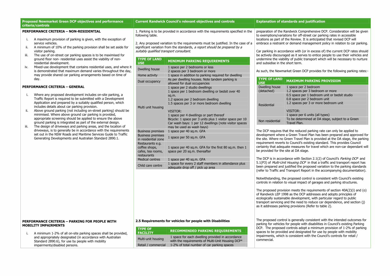
Proposed Newmarket Green DCP objectives and performance criteria/controls
Current Randwick Council's relevant objectives and controls Explanation of standards and justification
PERFORMANCE CRITERIA – NON-RESIDENTIAL
i. A maximum provision of parking is given, with the exception of service vehicles.
ii. A minimum of 10% of the parking provision shall be set aside for visitor parking.
iii. The use of on-street car parking spaces is to be maximised for ground floor non- residential uses assist the viability of non-residential development.
iv. Mixed-use development that contains residential uses, and where it is demonstrated that maximum demand varies throughout the day, may provide shared car parking arrangements based on time of day.
PERFORMANCE CRITERIA – GENERAL
i. Where any proposed development includes on-site parking, a Traffic Report is required to be submitted with a Development Application and prepared by a suitably qualified person, which includes details about car parking provision.
ii. Above ground parking (not including on-street parking) should be minimised. Where above ground car parking is provided, appropriate screening should be applied to ensure the above ground parking is integrated as part of the external design.
iii. The design of driveways and parking areas, and the location of driveways, is to generally be in accordance with the requirements set out in the NSW Roads and Maritime Services Guide to Traffic Generating Developments and Australian Standard 2890.1.
PERFORMANCE CRITERIA – PARKING FOR PEOPLE WITH MOBILITY IMPAIRMENTS
i. A minimum 1-2% of all on-site parking spaces shall be provided, and appropriately designated (in accordance with Australian Standard 2890.6), for use by people with mobility impairments/disabled persons.
1. Parking is to be provided in accordance with the requirements specified in the following table. 2. Any proposed variation to the requirements must be justified. In the case of a significant variation from the standards, a report should be prepared by a suitably qualified transport consultant.
TYPE OF LAND USE
MINIMUM PARKING REQUIREMENTS
Dwelling house 1 space per 2 bedrooms or less 2 spaces per 3 bedroom or more
Home activity 1 space in addition to parking required for dwelling
Dual occupancy As per dwelling houses. Note tandem parking is allowed for dual occupancies
Multi unit housing
1 space per 2 studio dwellings 1 space per 1 bedroom dwelling or bedsit over 40 sq.m. 1.2 spaces per 2 bedroom dwelling 1.5 spaces per 3 or more bedroom dwelling VISITOR: 1 space per 4 dwellings or part thereof Bicycle: 1 space per 3 units plus 1 visitor space per 10 Car wash bays: 1 per 12 dwellings (note visitor spaces may be used as wash bays)
Business premises 1 space per 40 sq.m. GFA
Business premises in residential zone
1 space per 50 sq.m. GFA
Restaurants e.g. coffee shops, cafes, tea rooms, restaurants
1 space per 40 sq.m. GFA for the first 80 sq.m. then 1 space per 20 sq.m. thereafter
Medical centres 1 space per 40 sq.m. GFA
Child care centre 1 space for every 2 staff members in attendance plus adequate drop off / pick up area
2.5 Requirements for vehicles for people with Disabilities
TYPE OF FACILITY
RECOMMENDED PARKING REQUIREMENTS
Multi-unit housing 1 space for each dwelling provided in accordance with the requirements of Multi-Unit Housing DCP*
Retail / commercial 1-2% of total number of car parking spaces
preparation of the Randwick Comprehensive DCP. Consideration will be given to exemptions/variations for off-street car parking rates in accessible locations as part of the Review. It is anticipated that revised DCP will embrace a restraint or demand management policy in relation to car parking. Car parking in accordance with (or in excess of) the current DCP rates should be actively discouraged as it serves to entice people to use their vehicles and undermine the viability of public transport which will be necessary to nurture and subsidise in the short term. As such, the Newmarket Green DCP provides for the following parking rates:-
TYPE OF LAND USE
MAXIMUM PARKING PROVISION
Dwelling house (detached)
1 space per 2 bedroom 1.2 spaces per 3 bedroom or more
Residential
0.5 space per 1 bedroom unit or bedsit studio 0.8 space per 2 bedroom unit 1.2 spaces per 3 or more bedroom unit VISITOR: 1 space per 6 units (all types)
Non residential To be determined at DA stage, subject to a Green Travel Plan.
The DCP requires that the reduced parking rate can only be applied to development where a Green Travel Plan has been prepared and approved for the site. Where no Green Travel Plan is provided at the DA stage, the parking requirement reverts to Council’s existing standard. This provides Council certainty that adequate measures for travel which are non-car dependant will be provided for the site at DA stage.
The DCP is in accordance with Section 2.1(2) of Council’s Parking DCP and 5.1(P3) of Multi-Unit Housing DCP in that a traffic and transport report has been prepared and justified the proposed variation to the parking standards (refer to Traffic and Transport Report in the accompanying documentation). Notwithstanding, the proposed control is consistent with Council’s existing controls in relation to visual impact of garages and parking structures. The proposed provision meets the requirements of section 40A(2)(i) and (o) of Randwick LEP 1998 as the DCP addresses and adopts principles of ecologically sustainable development, with particular regard to public transport servicing and the need to reduce car dependence, and section (j) as it addresses parking provisions (Refer to table 2).
The proposed control is generally consistent with the intended outcomes for parking for vehicles for people with disabilities in Council’s existing Parking DCP. The proposed controls adopt a minimum provision of 1-2% of parking spaces to be provided and designated for use by people with mobility impairments, which is consistent with the Council’s controls for retail / commercial.

Proposed Newmarket Green DCP objectives and performance criteria/controls
Current Randwick Council's relevant objectives and controls Explanation of standards and justification
ii. Unimpeded access shall be provided between each parking space for people with mobility impairments/disabled persons and the adjoining walkway.
iii. Parking spaces for people with mobility impairments/disabled persons shall be located close to wheelchair accessible entrances or lifts.
iv. Parking spaces for people with mobility impairments/disabled persons shall be identified by a sign incorporating the international symbol of access for persons with disabilities. The sign shall be readily visible from a vehicle at the entrance to the carpark, or guide signs indicating the direction of the parking spaces shall be provided.
provided
Community 2-3%
Education 2-3% for schools, 2% for Tertiary institutions
Entertainment 3-4%
Medical 3-4% for hospitals, 3% for medical centres * Note: the Multi-Unit Housing DCP states that access for people with a disability is to be provided to and within one dwelling at the following rates: 0-14 dwellings: 0 / 15-29 dwellings: 1 / 30-44 dwellings: 2 / 45-60 dwellings: 3 and so on. 3.6 Access and parking for people with disabilities OBJECTIVES To ensure that the design of parking areas are safe and compatible with best
practice standards for persons with a disability. To provide a sufficient number of designated car parking spaces for vehicles
used by people with disabilities. CONTROLS Designated car parking spaces must comply with the requirements of parking for people with disabilities in the BCA and the relevant AS, and should take into account the following criteria:
– Designated parking space(s) should be located in a part of the building that is accessible and connected by a continuous path of travel accessible to the buildings main lifts and/or wheelchair lifts. A continuous path of travel should provide ramps instead of steps and not be obstructed by railings or other structures.
– Parking areas that use lifts should include audio cues and tactile control panels incorporated into the design of the lift.
– Parking spaced for people with a disability should be level (less than 1 in 40 grade), parallel to or at 90 degrees to the angle of parking. Parking spaces must be a minimum of 3.2 metres wide, with unobstructed headroom of 2.5m.
– Parking spaces should be well lit, clearly line marked and the location of accessible space(s) should be indicated at the entrance of the car park.
– Parking areas should provide appropriate levels of lighting so that signage and directions can be easily read for convenience and safety.
– Paths of travel within the car park and buildings should remain unobstructed and provide comfort and ease of use.
– Doors and doorways within car parks are to be of adequate width to allow efficient access for people with a disability (e.g. wheelchairs)
– Internationally recognised symbols should be used for signposting with access signs for parking located in visible locations such as the main entrance/exits, within the car parking areas and near other accessible facilities.
At this rate the provision of car parking spaces for residential development would be consistent with Council’s existing standards.
The purpose of the control is to provide adequate numbers of car parking spaces for people with mobility impairments to the relevant Australian Standards.
The proposed provision meets the requirements of section 40A(2)(j) of Randwick LEP 1998 as the DCP addresses parking provisions (Refer to table 2 for further discussion).

Proposed Newmarket Green DCP objectives and performance criteria/controls
Current Randwick Council's relevant objectives and controls Explanation of standards and justification
Section 4.15 BICYCLE PARKING AND FACILITIES
OBJECTIVES
i. To encourage the use of bicycles for commuting by the provision of on-site bicycle parking and facilities.
PERFORMANCE CRITERIA
i. Accessible, safe and secure storage facilities for bicycles are to be provided in all buildings that provide on-site car parking:
a. within the storage areas of each dwelling, or b. within the designated parking space of each dwelling, or c. in a separately secured purpose-built bicycle parking
facility provided in the basements or on the ground floor of multi-unit dwellings.
ii. Bicycle parking provisions shall be outlined in a GTP, with a minimum rate of at least 1 space for every 3 dwellings.
iii. Bicycle storage facilities should be located in convenient locations, be clearly visible and accessible to pedestrian entries so as to encourage their use, and should be secured with an appropriate security/locking system.
iv. In commercial development, facilities should be provided for at least 1 readily accessible shower change room.
v. It is recommended that the design of bicycle storage facilities have regard to Aus-Roads Guide to Traffic Engineering Practice (Part 14- Bicycles).
Randwick Parking DCP 3.8 Bicycle Facilities OBJECTIVES To promote the use of bicycles as a safe and convenient form of transport for work and recreation To provide functional and secure bicycle storage areas and facilities. CONTROLS 1. Bicycle parking is to be provided in accordance with AS 2890.3 in all new residential developments (except aged and disabled housing, dwelling houses/dual occupancies), all new commercial, retail, community services, recreation and industrial facilitates.
LAND USE RATE
Residential – Multi-Unit housing 1 space for 3 units plus visitor 1 per 10
Commercial/ retail and industrial 1 space per 10 car spaces for first 200 then 1 space per 20 car spaces thereafter
Community, health and recreational 1 space per 10 car spaces
2. The design of facilities should take into account the specific parking requirement for cyclists under the following categories:
– All day parking for employees and students – All day parking at public transport nodes – Short term parking for visitors to shopping centres, offices and public/private buildings.
3. In all new development (excluding private dwelling houses and dial occupancies) bicycle parking is to be provided by way of either a secure, lockable area, lockers or bicycle racks, located within the ground floor foyer or adjacent within any forecourt, or within the parking area. 4. Bicycle parking facilities should be designed to be capable of accommodating and supporting all usual types of bicycles, to minimise damage in storage or during movement in/out of the parking space. 5. Design should meet requirements for safety and ease of use, with appropriate signage and aesthetic appearance. 6. Traditional bike racks that provide the means of locking one wheel of the bike to a fixture are not considered a secure arrangement and are discourages. Facilities that require a wheel to be removed are also not acceptable. 7. Access paths to bicycle parking areas should have a minimum width of 1.5 metres to accommodate a person pushing a bicycle. In the case where bicycle parking is provided within a general car park area, adequate sight lines are to be provided to ensure safety. 8. Refer to Figures in Parking DCP.
The proposed control is consistent with Council’s DCP in relation to bicycle parking facilities. The rate of bicycle parking will be – at minimum – equivalent to Council’s current rates for bicycle parking. A higher rate of bicycle parking is encouraged within a Green Travel plan (where prepared). The proposed provision meets the requirements of section 40A(2)(j) of Randwick LEP 1998 as the DCP addresses parking provisions (Refer to table 2 for further discussion).
Proposed Newmarket Green DCP objectives and performance criteria/controls
Current Randwick Council's relevant objectives and controls Explanation of standards and justification
Section 4.16 MOTORCYCLE PARKING
OBJECTIVES
i. To encourage the use of motorcycles for commuting by the provision of on-site parking.
PERFORMANCE CRITERIA
i. Motorcycle parking is to be provided in all buildings that provide on-site car parking, with a minimum rate of at least 1 motorcycle parking space for every 100 car parking spaces or part thereof.
None set out in Council’s DCPs.
There is no equivalent standard in Council’s DCP in relation to motorcycle parking. The purpose of the proposed control is to provide for an adequate number of parking spaces for motorcycles. The proposed provision meets the requirements of section 40A(2)(j) of Randwick LEP 1998 as the DCP addresses parking provisions (Refer to table 2 for further discussion).
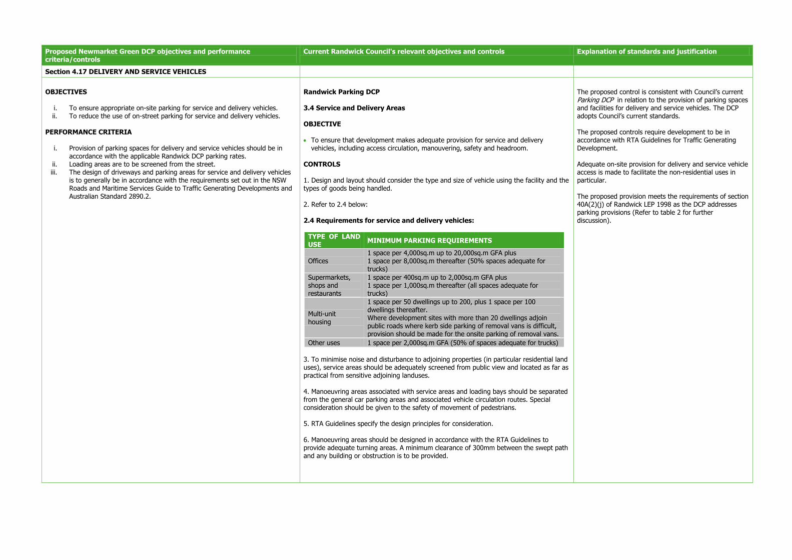
Proposed Newmarket Green DCP objectives and performance criteria/controls
Current Randwick Council's relevant objectives and controls Explanation of standards and justification
Section 4.17 DELIVERY AND SERVICE VEHICLES
OBJECTIVES
i. To ensure appropriate on-site parking for service and delivery vehicles. ii. To reduce the use of on-street parking for service and delivery vehicles.
PERFORMANCE CRITERIA
i. Provision of parking spaces for delivery and service vehicles should be in accordance with the applicable Randwick DCP parking rates.
ii. Loading areas are to be screened from the street. iii. The design of driveways and parking areas for service and delivery vehicles
is to generally be in accordance with the requirements set out in the NSW Roads and Maritime Services Guide to Traffic Generating Developments and Australian Standard 2890.2.
Randwick Parking DCP 3.4 Service and Delivery Areas OBJECTIVE To ensure that development makes adequate provision for service and delivery
vehicles, including access circulation, manouvering, safety and headroom. CONTROLS 1. Design and layout should consider the type and size of vehicle using the facility and the types of goods being handled. 2. Refer to 2.4 below: 2.4 Requirements for service and delivery vehicles:
TYPE OF LAND USE
MINIMUM PARKING REQUIREMENTS
Offices 1 space per 4,000sq.m up to 20,000sq.m GFA plus 1 space per 8,000sq.m thereafter (50% spaces adequate for trucks)
Supermarkets, shops and restaurants
1 space per 400sq.m up to 2,000sq.m GFA plus 1 space per 1,000sq.m thereafter (all spaces adequate for trucks)
Multi-unit housing
1 space per 50 dwellings up to 200, plus 1 space per 100 dwellings thereafter. Where development sites with more than 20 dwellings adjoin public roads where kerb side parking of removal vans is difficult, provision should be made for the onsite parking of removal vans.
Other uses 1 space per 2,000sq.m GFA (50% of spaces adequate for trucks)
3. To minimise noise and disturbance to adjoining properties (in particular residential land uses), service areas should be adequately screened from public view and located as far as practical from sensitive adjoining landuses. 4. Manoeuvring areas associated with service areas and loading bays should be separated from the general car parking areas and associated vehicle circulation routes. Special consideration should be given to the safety of movement of pedestrians. 5. RTA Guidelines specify the design principles for consideration. 6. Manoeuvring areas should be designed in accordance with the RTA Guidelines to provide adequate turning areas. A minimum clearance of 300mm between the swept path and any building or obstruction is to be provided.
The proposed control is consistent with Council’s current Parking DCP in relation to the provision of parking spaces and facilities for delivery and service vehicles. The DCP adopts Council’s current standards. The proposed controls require development to be in accordance with RTA Guidelines for Traffic Generating Development. Adequate on-site provision for delivery and service vehicle access is made to facilitate the non-residential uses in particular. The proposed provision meets the requirements of section 40A(2)(j) of Randwick LEP 1998 as the DCP addresses parking provisions (Refer to table 2 for further discussion).

Proposed Newmarket Green DCP objectives and performance criteria/controls
Current Randwick Council's relevant objectives and controls Explanation of standards and justification
Section 4.18 DRIVEWAYS AND VEHICLE MANOEUVRING AREAS
OBJECTIVES
i. To provide adequate space to efficiently move vehicles within a site.
ii. To minimise potential conflict between vehicles and pedestrians.
iii. To integrate driveway and manoeuvring areas with landscape features within the site.
iv. To minimise the detrimental visual impacts of parking and driveway areas on the site.
v. To design driveway gradients for vehicle and pedestrian safety.
vi. To ensure site planning and building layout minimises the area designated for driveways and manoeuvring areas.
vii. To limit the width of kerb crossings to maintain on street parking and minimise impacts on pedestrian amenity.
PERFORMANCE CRITERIA
i. Vehicles are to be able to enter and leave a multi-unit development in a forward direction at all times.
ii. Surface materials and external finishes are to be consistent and compatible with those used throughout the development.
iii. Parking layouts and driveway design is to conform with the requirements of Australian Standard 2890.1 ‘Off Street Car Parking’ and Randwick DCP.
iv. The location of, and entry level to, basement car parking entries shall have regard to adjacent flood conditions. Where required, basement car parking facilities should incorporate safe evacuation features in the event of overtopping during a storm, flood or rainfall event
5.2 Driveways and Manoeuvring Areas OBJECTIVES Provide adequate space for the efficient movement of vehicles within a site. Minimise the potential for conflict between vehicles and pedestrians. Minimise the amount of hard paved areas. Integrate driveway and manoeuvring areas with landscape features. Minimise the visual impact of parking and driveway areas. CONTROLS P1 Site planning and building layout minimises the amount of driveways and manoeuvring areas. P2 Vehicles are able to enter and leave the site in a forward direction at all times. Note: Where possible, access is provided from rear lanes. P3 The alignment of driveways and access roads is varied to create visual interest and avoid a ‘gun barrel’ effect. P4 Clearance between boundaries and driveways, access ways and parking spaces is of sufficient width to enable landscaping and screen planting. P5 Surface materials and external finishes are consistent and compatible with those used throughout the development. P6 Driveway gradients are designed for vehicle and pedestrian safety. Potential for vehicles to scrape at gradient changes is avoided. PREFERRED SOLUTIONS S2 Parking layout ensures that vehicles are able to enter parking spaces in a single turning movement and leave the space in no more than 2 turning movements. S3 Long sections of driveways provide passing bays to allow for access and circulation of vehicles. S4 Driveways have a minimum width of 3 metres and are located at least 1 metre from any side or rear boundary fence. S5 Large expanses of uncoloured concrete are to be avoided. S6 Driveway gradients do not exceed 1 in 6. For long ramps (greater than 20m) a maximum gradient of 1 in 5 can be used with suitable transition grades as outlined in Council’s Parking DCP.
The proposed controls generally reflect the objectives of Section 5.2 of Council’s Multi-Unit Housing DCP and seek to ultimately achieve the same outcomes. The DCP will achieve the desired outcomes of Council’s DCP in relation to:-
- Appropriate appearance and minimisation of visual impact of driveways and manoeuvring areas
- Vehicles shall enter and leave in a forward direction at all times.
The proposed controls require that the DCP conform to Council’s existing Parking DCP in relation to parking layouts and driveway design. Refer to Table 2 for further detail.
Proposed Newmarket Green DCP objectives and performance criteria/controls
Current Randwick Council's relevant objectives and controls Explanation of standards and justification
Section 4.19 GREEN TRAVEL PLAN
OBJECTIVES
i. To encourage and support sustainable travel through the provision of safe walking and cycling networks linked to key destinations, open space and public transport nodes.
ii. To minimise private vehicle use for all users. iii. To outline the matters to be addressed in a Green Travel Plan (GTP).
PERFORMANCE CRITERIA
i. A Green Travel Plan (GTP) shall be prepared and submitted with a Development Application for new development which will generate a travel/traffic demand.
ii. A GTP shall be consistent with the Green Travel Strategy developed for Newmarket Green and contained in Appendix A of this DCP. The Green Travel Strategy also contains guidance on what type of development will require a GTP to be prepared (refer to Section 3.3.8 of the Green Travel Strategy).
iii. A GTP should investigate travel demand management measures including, but not limited to, the following:
a. Management of parking supply to reflect self-containment and accessibility of the site.
b. Mechanisms to discourage car ownership and minimise car usage (e.g. consolidated parking scheme, unbundled parking ownership, car share or car pool schemes).
c. Promotion and support of active transport. d. Improved provision of public transport information. e. Provision of bicycle parking, storage facilities and end-of-trip
facilities. f. Mechanisms to encourage bicycle use (e.g. bicycle hire schemes for
residents) g. Incentives to encourage public transport use as part of the
development.
iv. If a GTP is not prepared, Council’s existing controls apply with regard to the provision of vehicle and bicycle parking.
None set out in Council’s DCPs.
The purpose of this provision is to encourage development that achieves higher standards of sustainable travel and to meet the principles for sustainable travel identified in the Traffic and Transport Study prepared by Cardno. The DCP includes an overall Green Travel Plan for the site, with the overarching objective:
- To minimise private vehicle use. - To encourage and support sustainable travel through safe walking
and cycling networks linked to public transport, key destinations, public open space and recreation opportunities.
The Newmarket Green Travel Strategy (GTS) provides a cohesive and holistic package of measures which provide guidance to staff, residents and visitors to Newmarket Green regarding the significance and ease of using sustainable transport modes. The preparation and adoption of site-specific Green Travel Plan’s is considered an appropriate response for this site based on its context. The site will support the principles of self containment and objectives of the Randwick Education and Health Specialised Centre Discussion Paper by ensuring that a range of daily activities/facilities (housing, employment, retail, recreational, educational) are located within close proximity to the site, thereby minimising the need for private vehicle journeys. The subject site is well situated within a convenient walking/cycling distance of a range of facilities and public transport stops. This supports the desired forms of sustainable transport, namely walking, cycling and public transport, as the preferred mode of transport which are to be promoted through the Green Travel Plan for any new redevelopment of the site, whether based on the overarching Green Travel Strategy or a site specific Green Travel Plan. The proposed provision meets the requirements of section 40A(2)(o) of Randwick LEP 1998 as the DCP addresses principles of ecologically sustainable development (Refer to table 2 for further discussion).

Proposed Newmarket Green DCP objectives and performance criteria/controls
Current Randwick Council's relevant objectives and controls Explanation of standards and justification
Section 4.20 TRANSPORT
OBJECTIVES
i. To minimise the impact of development at Newmarket Green on the surrounding road network.
ii. To promote the concept of transit-oriented development. iii. To promote public transport use for the site and viability of new public
transport investment in the region. iv. To contribute toward the mitigation of any road network improvements
identified to be as a direct result of the development of Newmarket Green. PERFORMANCE CRITERIA
i. The intersection of Young Street and Barker Street shall be signalised:
a. Prior to issue of the occupation certificate of all buildings in Precincts 1 and 2 (to ensure a high order pedestrian link is provided upon completion of development in this part of the site), or
b. Prior to completion (and occupation) of the 470th dwelling at the site (to ensure occupational thresholds are maintained)
whichever occurs first.
ii. The treatment of the Young and Barker Street intersection shall be subject to discussions with relevant State authorities and Randwick City Council at Development Application stage.
iii. The intersection of Young Street and Barker Street shall be constructed generally in accordance with the Plan illustrated in Figure 24and the relevant NSW Government road standards.
None set out in Council’s DCPs.
The purpose of this provision is to ensure that appropriate traffic management is undertaken prior to, or at an appropriate time during the development of the site. The proposed control is derived from a Traffic and Transport Study undertaken by Cardno which assessed the potential impact of development of the Newmarket Green site as well as background traffic growth and cumulative impact as a result of redevelopment of the Prince of Wales Hospital. Traffic modelling undertaken by Carndo reviewed a worst-case scenario to determine the required traffic improvements. Cardno identified as a result of existing deficiencies and cumulative growth, that road network improvements would be required at the locations identified in the DCP:
– Botany/Barker Street intersection – Avoca/Barker Street intersection – Botany/Rainbow Street intersection – Young/Barker Street intersection – Barker Street (pedestrian access)
Refer to Table 2 for detail and justification for the proposed future works. The purpose of the control is to ensure off site mitigation measures are considered for each development application. The off-site works will ensure intersections operate satisfactorily for the safety of road users, cyclists and pedestrians. The traffic measures can be enforced by Council at DA stage. The proposed provision meets the requirements of section 40A(2)(i) of Randwick LEP 1998 as the DCP addresses road access and circulation network (refer to Table 2 for further discussion).
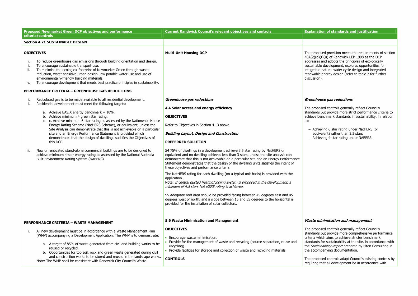
Proposed Newmarket Green DCP objectives and performance criteria/controls
Current Randwick Council's relevant objectives and controls Explanation of standards and justification
Section 4.21 SUSTAINABLE DESIGN
OBJECTIVES
i. To reduce greenhouse gas emissions through building orientation and design. ii. To encourage sustainable transport use. iii. To minimise the ecological footprint of Newmarket Green through waste
reduction, water sensitive urban design, low potable water use and use of environmentally-friendly building materials.
iv. To encourage development that meets best practice principles in sustainability. PERFORMANCE CRITERIA – GREENHOUSE GAS REDUCTIONS
i. Reticulated gas is to be made available to all residential development. ii. Residential development must meet the following targets:
a. Achieve BASIX energy benchmark + 10%. b. Achieve minimum 4 green star rating. c. c. Achieve minimum 6-star rating as assessed by the Nationwide House
Energy Rating Scheme (NatHERS Scheme), or equivalent, unless the Site Analysis can demonstrate that this is not achievable on a particular site and an Energy Performance Statement is provided which demonstrates that the design of dwellings satisfies the Objectives of this DCP.
iii. New or renovated stand-alone commercial buildings are to be designed to achieve minimum 4-star energy rating as assessed by the National Australia Built Environment Rating System (NABERS)
PERFORMANCE CRITERIA – WASTE MANAGEMENT
i. All new development must be in accordance with a Waste Management Plan (WMP) accompanying a Development Application. The WMP is to demonstrate:
a. A target of 85% of waste generated from civil and building works to be reused or recycled.
b. Opportunities for top soil, rock and green waste generated during civil and construction works to be stored and reused in the landscape works.
Note: The WMP shall be consistent with Randwick City Council’s Waste
Multi-Unit Housing DCP Greenhouse gas reductions 4.4 Solar access and energy efficiency OBJECTIVES Refer to Objectives in Section 4.13 above. Building Layout, Design and Construction PREFERRED SOLUTION S4 75% of dwellings in a development achieve 3.5 star rating by NatHERS or equivalent and no dwelling achieves less than 3 stars, unless the site analysis can demonstrate that this is not achievable on a particular site and an Energy Performance Statement demonstrates that the design of the dwelling units satisfies the intent of these objectives and performance criteria.
The NatHERS rating for each dwelling (on a typical unit basis) is provided with the application. Note: If central ducted heating/cooling system is proposed in the development, a minimum of 4.5 stars Nat HERS rating is achieved. S5 Adequate roof area should be provided facing between 45 degrees east and 45 degrees west of north, and a slope between 15 and 55 degrees to the horizontal is provided for the installation of solar collectors. 5.6 Waste Minimisation and Management OBJECTIVES Encourage waste minimisation. Provide for the management of waste and recycling (source separation, reuse and
recycling). Provide facilities for storage and collection of waste and recycling materials. CONTROLS
The proposed provision meets the requirements of section 40A(2)(o)(t)(u) of Randwick LEP 1998 as the DCP addresses and adopts the principles of ecologically sustainable development, explores opportunities for integrated natural water cycle design and integrated renewable energy design (refer to table 2 for further discussion). Greenhouse gas reductions The proposed controls generally reflect Council’s standards but provide more strict performance criteria to achieve benchmark standards in sustainability, in relation to:-
– Achieving 6 star rating under NatHERS (or equivalent) rather than 3.5 stars
– Achieving 4-star rating under NABERS.
Waste minimisation and management The proposed controls generally reflect Council’s standards but provide more comprehensive performance criteria which aims to achieve stricter benchmark standards for sustainability at the site, in accordance with the Sustainability Report prepared by Elton Consulting in the accompanying documentation. The proposed controls adapt Council’s existing controls by requiring that all development be in accordance with

Proposed Newmarket Green DCP objectives and performance criteria/controls
Current Randwick Council's relevant objectives and controls Explanation of standards and justification
Management Plan – Part A (or equivalent).
ii. All new residential development shall:
a. Incorporate waste minimisation design elements such as modular design and adaptability.
b. Maximise the use of original materials and finishes in adaptive reuse of existing buildings.
c. Support at-source waste separation and recycling including opportunities for green waste collection and on-site waste utilisation.
iii. Waste storage areas for garbage and recycling in multi-unit developments are to be provided in either a centralised garbage/recycling room accessible to garbage compactors or in a facility where bins can easily be placed on the kerb for collection. Facilities are to be located in basement areas where possible, and away from the front of the development, and are to be appropriately screened.
PERFORMANCE CRITERIA – ECOLOGICAL FOOTPRINT REDUCTIONS
i. All new residential development shall: a. Provide for water efficient appliances and fittings. b. Support water efficient landscaping c. Water smart monitoring.
ii. All new multi-unit development must demonstrate how it achieves the following (in a stand-alone Environmental Management Plan (EMP) or as part of the Development Application submission):
a. Minimal use of potable water during construction including opportunities for reuse or recycling of stormwater.
b. Soil erosion and sedimentation control measures. c. Water sensitive urban design (WSUD) features.
iii. Groundwater or water seepage is to be disposed of on-site either by an irrigation or infiltration system.
iv. WSUD features such as bioswales or raingardens are encouraged to filter run-off from the development.
v. Building materials and fittings specified in the construction and building phase shall improve the environmental performance of the building and be: a. High in recycled content b. Low in embodied energy and water c. Low in VOCs d. Minimal PVC e. Use only FSC certified or recycled timber.
vi. Installation of rainwater tanks is to be generally in accordance with Council’s Rainwater Tank Policy 2003 (or any update).
P1 Waste collection and separation facilities are provided for each dwelling. P2 Waste storage facilities for garbage and recycling containers are provided either as a centralised garbage/recycling room accessible to garbage compactors or in a facility where bins can be easily wheeled to the street for collection. The facilities are of a sufficient size to meet the needs of the dwellings and the garbage/recycling collection service. P3 The location and design of waste collection facilities complements the design of the development and is not visually obtrusive in the streetscape or from any public places. PREFERRED SOLUTION S1 Each dwelling has a waste storage cupboard in the kitchen sufficient to enable separation of recyclable material. Facilities are capable of holding at least a single day’s waste and allow for source separation of garbage, recyclable and compostible material. Design of landscaped areas makes provision for on-site composting. S3 Waste facilities should not be located between the front alignment of the building and the road.
Ecological Footprint Reductions There is no direct equivalent control in Council’s DCP in relation to ecological footprint reductions however Section 4.4 Solar access and energy efficiency is relevant. Refer to above for details of Section 4.4.
Council’s Waste Management Plan. The proposed control generally reflects existing standards and seeks to ultimately achieve the same outcomes, but apply stricter targets for waste re-use and recycling:-
– Target 85% of waste generated from civil and building works to be reused or recycled.
Ecological Footprint Reductions The proposed controls generally reflect Council’s standards but provide more focused standards which aim to achieve ‘benchmark’ sustainability outcomes, such as:-
– Environmental Management Plan is required for all development
– WSUD measures and water efficient landscaping.

Proposed Newmarket Green DCP objectives and performance criteria/controls
Current Randwick Council's relevant objectives and controls Explanation of standards and justification
Section 4.22 STORMWATER
OBJECTIVES
i. To manage urban stormwater within the natural catchment. ii. To ensure stormwater drainage does not degrade the water quality of the
catchments or cause erosion or sedimentation. iii. To manage construction sites to prevent environmental impacts from
stormwater. iv. To protect the site and downstream properties from flooding and stormwater
inundation through appropriate design and engineering solutions. v. To encourage on-site stormwater detention, collection and stormwater
harvesting. vi. To make adequate arrangements for the maintenance of stormwater facilities. vii. To ensure appropriate safety and evacuation measures in the event of a major
flood, in particular for basement car parking. PERFORMANCE CRITERIA
i. All development must comply with Randwick City Council’s ‘Private Stormwater Code Policy’ and ‘Rainwater Tanks Policy’ (or equivalents).
ii. Appropriate stormwater disposal systems must be provided, which ensure natural drainage flows can be maintained.
iii. New development shall ensure no nett loss of floodplain storage volume below the 1 in 100 year flood level.
iv. Where an engineered solution is not possible, generally all buildings shall be designed to accommodate a minimum floor level of 0.5m above the 1% Annual Exceedance Probability (AEP).
v. Where basement car parking is above the Peak Maximum Flood (PMF) level, measures to facilitate safe evacuation shall be incorporated, such as suitable staircases, advisory signage and protection of utilities/services.
vi. Pervious surfaces and paving shall be used for driveways, pathways and courtyards where practical.
vii. Where fencing is located within an overland flow path, that part of the fence below the 1% AEP should be constructed with open material.
viii. Implementation, and ongoing maintenance, of stormwater management measures shall be in accordance with Randwick City Council’s Specification for Stormwater Management policy.
ix. Notwithstanding the prevailing BASIX water conservation targets, the collection of rainwater/run-off for non-potable uses exceeding the target is encouraged.
x. A qualified drainage/hydraulic engineer shall design all stormwater controls, devices and water storage systems for the site.
Private Stormwater Code Policy OBJECTIVES To provide designers, builders and the general public with a guide of Council’s requirements for the disposal of private stormwater. The requirements will prevent damage, nuisance and risk to both Council and private property by controlling the flow of stormwater from private properties.
The proposed control is consistent with Council’s Private Stormwater Code Policy. The purpose of the proposed control is to set out the procedure for the identification of works prior to development to ensure the proper disposal of stormwater. The control provides for additional details and guidance than in Council’s existing DCP by:-
– requiring that all development comply with Council’s Rainwater Tanks Policy
– encouraging rainwater/run-off for non-potable uses to exceed the BASIX water conservation targets.
An Infrastructure Report undertaken for the site by Cardno is included as part of the accompanying documents. It found that:
– There is unlikely to be capacity within the existing stormwater network to take additional flows from the Newmarket site.
– The proposal involves nominally less impervious surfaces than the existing development and as such the post development flows are not anticipated to be increased as a result of the development. Notwithstanding, On-Site Detention will be required to reduce pressure on Council’s downstream network and to meet pre-existing flows, particularly noting the site presently incorporates detention storage to manage stormwater outflows.
– The current concept layout for the proposed development maintains the predominant existing overland flow path route through the site along Young Street.
– The redevelopment of the site therefore presents an opportunity to upsize stormwater pipes within public roadways and these measures, coupled with increased detention storage, will reduce the impact of overland flows through the site and enable safe conveyance of flows through the site in accordance with Council Standards and Australian Rainfall and Runoff (1997).
A Flooding Assessment undertaken for the site by Cardno is also included as part of the accompanying documents. It found that a range of measures to mitigate any potential flood impact for the site and adjoining sites should be implemented, and this is shall be subject to further investigation at the DA stage. The proposed provision meets the requirements of section 40A(2)(g) of Randwick LEP 1998 as the DCP addresses infrastructure provision requirements (refer to Table 2 for further discussion).

Proposed Newmarket Green DCP objectives and performance criteria/controls
Current Randwick Council's relevant objectives and controls Explanation of standards and justification
Section 4.23 CONTAMINATION
Objectives
i. To ensure adequate procedures and controls for the identification, assessment and management of contamination that may cause harm to people on the site.
ii. To ensure that, if contamination is identified on the site, precautions for managing the risk of harm from the contamination are implemented in a development so that the land is suitable for the proposed development.
PERFORMANCE CRITERIA
i. Unless the consent authority is satisfied that the land is suitable for the development, a development consent shall include the following condition:
a. A stage 2 site contamination investigation is to be undertaken to identify if the land to be developed contains contamination that may cause harm.
b. The stage 2 site contamination investigation must be undertaken in accordance with relevant Guidelines and as a minimum, investigate the following potential sources of contamination:
i. the condition of groundwater (and if contamination is present, the requirements for further investigations)
ii. building construction materials iii. previous fill material.
c. If required by the stage 2 site investigation, a Management
Works Plan (MWP) for the land must be prepared to specify future works to manage the identified contamination. The MWP is to be consistent with relevant Guidelines.
ii. Prior to construction works being undertaken at 152 – 154 Barker Street and 156 Barker Street, the following works must be undertaken:
a. The underground storage tank be decommissioned and removed in accordance with guidelines endorsed by the NSW Office of Environment and Heritage.
Randwick City Council Contaminated Land Policy 1999 The local planning policy sets out the provisions of the SEPP 55 and requires Council to consider contamination issues in all subdivision and development applications. In accordance with clause 7 of SEPP 55, Council will not consent to the carrying out of any development on land unless:
(a) it has considered whether the land is contaminated, and
(b) if the land is contaminated, it is satisfied that the land is suitable in its contaminated state (or will be suitable, after remediation) for the purpose for which the development is proposed to be carried out, and
(c) if the land requires remediation to be made suitable for any purpose for which the
development is proposed to be carried out, it is satisfied that the land will be remediated before the land is used for that purpose.
In addition to the requirements outlined in clause 7 of SEPP 55, Council will also require a preliminary investigation (Stage 1) to be submitted if Council has reasonable grounds to believe the land may be contaminated because of the land’s history, condition, or other information known to Council. Council will require a detailed site contamination investigation (Stage 2) to be undertaken when the results of the preliminary investigation demonstrate the potential for, or existence of contamination which may not be suitable for the proposed use of the land. The Stage 2 site investigation aims to:
– define the extent and degree of contamination; – assess the potential risk posed by contaminants to human health and the
environment; and – obtain sufficient information for the development of a Remedial Action Plan (if
necessary).
The proposed control is consistent with the intent of Council’s with Contaminated Lands Policy. The purpose of the proposed control is to set out procedures for the remediation of land (where necessary) prior to development to ensure health and public safety is maintained. A detailed Environmental Site Assessment was undertaken by E3 Consulting (refer to accompanying report), which assessed the potential for soil and/or groundwater contamination to be present on the site, and to determine whether further environmental assessment is required. The E3 report has been peer reviewed by a DECCW accredited Site Auditor. The findings and recommendations of this assessment have been used to form the controls of the DCP in relation to contamination. In accordance with Council’s Contaminated Land Policy 1999, preliminary investigations have been undertaken and the requirements for Stage 2 investigations are outlined in the proposed DCP. The proposed controls thereby meet the requirements of section 40A(2)(h) of Randwick LEP 1998 as the DCP addresses and illustrates measures for remediation of the sit. Refer to Table 2 for further discussion and justification of the proposed controls.

Proposed Newmarket Green DCP objectives and performance criteria/controls
Current Randwick Council's relevant objectives and controls Explanation of standards and justification
Section 4.24 UTILITIES AND SITE FEATURES
OBJECTIVES
i. To ensure all dwellings and commercial and retail units are adequately serviced by utilities.
ii. To ensure that facilities are of a sufficient size to meet the needs of the dwellings and the garbage/recycling collection service (in the case of waste facilities).
iii. To ensure utilities and site facilities are accessible, functional and unobtrusive from the streetscape.
iv. To ensure adequate screening to air-conditioning units and noise-generating facilities.
v. To ensure adequate and usable storage space is provided for new development.
PERFORMANCE CRITERIA
i. Water and sewer connections are to be provided in accordance with the requirements of Sydney Water Corporation.
ii. All electrical reticulation is to be underground. iii. Meter boxes are to be placed in positions acceptable
to the applicable energy service provider and screened from the street.
iv. Telephone lines and broadband internet are to be installed in accordance with the requirements of the service provider.
v. Adequate garbage and recycling areas must be provided to satisfy Randwick City Council’s waste collection requirements. These are to be integrated with the development and screened from public areas. Refer to Waste Management Performance Criteria in Section 4.21 of this DCP).
vi. A minimum storage area of 8m3 shall be provided for each dwelling and may be located internally or in garages or basements.
vii. Mail boxes are to be located in accordance with the delivery requirements of Australia Post.
viii. A suitably screened single common television/radio antenna (or other types of communication reception device) is to be provided to service all dwellings in a development.
Multi-Unit Housing DCP 5.5 Utilities / Site Facilities OBJECTIVES Ensure ancillary site facilities are convenient and visually attractive. Ensure utilities and ancillary site facilities blend in with the development and streetscape character and require
minimal maintenance. CONTROLS P1 Mail Delivery - Mailboxes are provided in accordance with the delivery requirements of Australia Post.
P2 Television/Radio Antennae and Satellite Dishes - Provision is made for a single common television/radio antenna and other types of communication reception devices to service all dwellings in a development.
P3 Electricity - Services are provided in accordance with the requirements of Energy Australia. All electrical reticulation within the site is underground. Meter boxes are placed in positions acceptable to Energy Australia and screened from the street.
P4 Gas - Reticulated gas supply to a meter for each dwelling and to optimum service points for cooking and space heating is provided.
P5 Water Supply - Water and sewerage connections are provided in accordance with the requirements of Sydney Water.
P6 Telephone - Telephone lines are installed in accordance with the requirements of the service provider.
P7 Laundry and Drying Facilities - An internal laundry is provided in each dwelling. Communal clothes drying facilities (where provided) are accessible to all residents and screened from the street and public places. Alternatively, a retractable or demountable clothes line is provided in the courtyard of each dwelling. 5.3 Storage OBJECTIVES Ensure that adequate provision is made in new development for storage space. CONTROLS P1 The design of development provides for readily accessible and separately contained storage areas for each dwelling. PREFERRED SOLUTIONS P1 The design of development provides for readily accessible and separately contained storage areas for each dwelling. S1 10m2 of storage space is provided for each dwelling with a minimum clearance height of 2.1 metres. At least 50% of the storage space is within the dwelling and is readily accessible from either the hallway or main living area of that dwelling. Storage facilities may be provided in basement or sub floor areas, or attached to garages.
The proposed controls are consistent with Council’s existing controls in relation to the provision of utilities for the site. Utilities The proposed controls adopt Council’s existing controls for Utilities/ Site facilities. The DCP provides additional performance criteria specific to the site by requiring adequate screening to air-conditioning and noise-generating facilities. Storage The proposed control for storage areas is generally in accordance with Section 5.3 of Council’s Multi-Unit Housing DCP but is a slight variation to Council’s preferred solution (i.e. requires 8 m3 of storage space rather than 10 m3 as per Council’s DCP). Despite this variation, the amount of storage space is considered to be appropriate for higher density development being proposed.
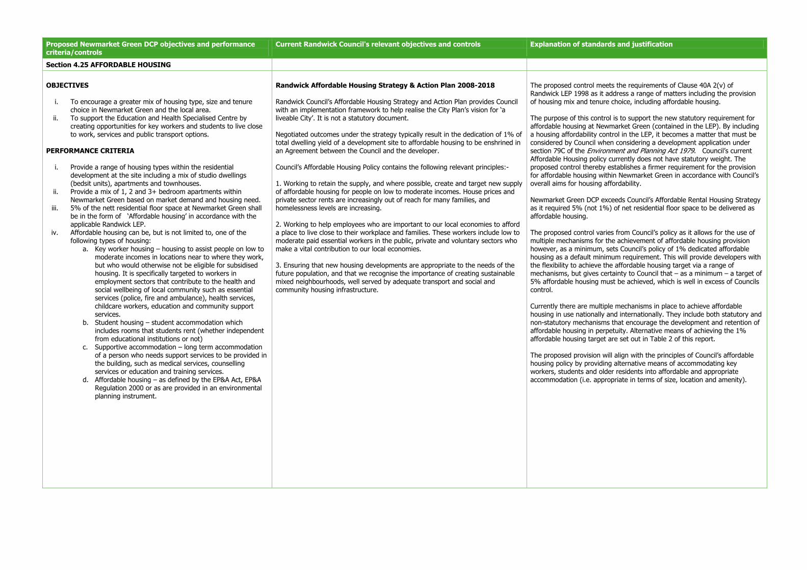
Proposed Newmarket Green DCP objectives and performance criteria/controls
Current Randwick Council's relevant objectives and controls Explanation of standards and justification
Section 4.25 AFFORDABLE HOUSING
OBJECTIVES
i. To encourage a greater mix of housing type, size and tenure choice in Newmarket Green and the local area.
ii. To support the Education and Health Specialised Centre by creating opportunities for key workers and students to live close to work, services and public transport options.
PERFORMANCE CRITERIA
i. Provide a range of housing types within the residential development at the site including a mix of studio dwellings (bedsit units), apartments and townhouses.
ii. Provide a mix of 1, 2 and 3+ bedroom apartments within Newmarket Green based on market demand and housing need.
iii. 5% of the nett residential floor space at Newmarket Green shall be in the form of ‘Affordable housing’ in accordance with the applicable Randwick LEP.
iv. Affordable housing can be, but is not limited to, one of the following types of housing:
a. Key worker housing – housing to assist people on low to moderate incomes in locations near to where they work, but who would otherwise not be eligible for subsidised housing. It is specifically targeted to workers in employment sectors that contribute to the health and social wellbeing of local community such as essential services (police, fire and ambulance), health services, childcare workers, education and community support services.
b. Student housing – student accommodation which includes rooms that students rent (whether independent from educational institutions or not)
c. Supportive accommodation – long term accommodation of a person who needs support services to be provided in the building, such as medical services, counselling services or education and training services.
d. Affordable housing – as defined by the EP&A Act, EP&A Regulation 2000 or as are provided in an environmental planning instrument.
Randwick Affordable Housing Strategy & Action Plan 2008-2018 Randwick Council’s Affordable Housing Strategy and Action Plan provides Council with an implementation framework to help realise the City Plan’s vision for ‘a liveable City’. It is not a statutory document. Negotiated outcomes under the strategy typically result in the dedication of 1% of total dwelling yield of a development site to affordable housing to be enshrined in an Agreement between the Council and the developer. Council’s Affordable Housing Policy contains the following relevant principles:- 1. Working to retain the supply, and where possible, create and target new supply of affordable housing for people on low to moderate incomes. House prices and private sector rents are increasingly out of reach for many families, and homelessness levels are increasing. 2. Working to help employees who are important to our local economies to afford a place to live close to their workplace and families. These workers include low to moderate paid essential workers in the public, private and voluntary sectors who make a vital contribution to our local economies. 3. Ensuring that new housing developments are appropriate to the needs of the future population, and that we recognise the importance of creating sustainable mixed neighbourhoods, well served by adequate transport and social and community housing infrastructure.
The proposed control meets the requirements of Clause 40A 2(v) of Randwick LEP 1998 as it address a range of matters including the provision of housing mix and tenure choice, including affordable housing. The purpose of this control is to support the new statutory requirement for affordable housing at Newmarket Green (contained in the LEP). By including a housing affordability control in the LEP, it becomes a matter that must be considered by Council when considering a development application under section 79C of the Environment and Planning Act 1979. Council’s current Affordable Housing policy currently does not have statutory weight. The proposed control thereby establishes a firmer requirement for the provision for affordable housing within Newmarket Green in accordance with Council’s overall aims for housing affordability. Newmarket Green DCP exceeds Council’s Affordable Rental Housing Strategy as it required 5% (not 1%) of net residential floor space to be delivered as affordable housing. The proposed control varies from Council’s policy as it allows for the use of multiple mechanisms for the achievement of affordable housing provision however, as a minimum, sets Council’s policy of 1% dedicated affordable housing as a default minimum requirement. This will provide developers with the flexibility to achieve the affordable housing target via a range of mechanisms, but gives certainty to Council that – as a minimum – a target of 5% affordable housing must be achieved, which is well in excess of Councils control. Currently there are multiple mechanisms in place to achieve affordable housing in use nationally and internationally. They include both statutory and non-statutory mechanisms that encourage the development and retention of affordable housing in perpetuity. Alternative means of achieving the 1% affordable housing target are set out in Table 2 of this report. The proposed provision will align with the principles of Council’s affordable housing policy by providing alternative means of accommodating key workers, students and older residents into affordable and appropriate accommodation (i.e. appropriate in terms of size, location and amenity).

Newmarket Green DCP - Supporting Report for the site specific DCP 41
3.3.3 Section 5 of the Proposed DCP
Newmarket Green has been divided into seven precincts for the purposes of section 5. The site’s setting
(context, adjacent uses, topography), vision and principles have guided the distribution of the eight distinct
precinct areas within the site. Each has an authentic character, responds to site's heritage value and
contributes to creating a sustainable development.
Section 5 of the DCP contains built form controls to guide development within each precinct. They are:-
Desired character for each precinct
Distribution of FSR and building height, which comply with the relevant LEP controls
Minimum setback controls, where there is a particular need for a specific setback (such as to create a
view corridor or protect a significant tree) – these are consistent with the general building setback
objectives and controls set out in Part 4 the DCP
Other requirements relating to basement parking access, activity strips and heritage, which are
consistent with the general objectives and controls set out in the DCP
Suggested illustrative massing outcomes.
The proposed controls for each precinct contain specific performance criteria and controls for the built form.
The proposed precinct controls are derived from and are in accordance with the general controls set out in
Section 4 of the DCP and are consistent with the overriding objectives of Randwick LEP 1998 and the
equivalent Randwick LEP 2012.

42 Newmarket Green DCP - Supporting Report for the site specific DCP
4 Assessment against other relevant clauses
4.1 Introduction
This section outlines how the Newmarket DCP accords with all relevant state and local planning controls.
4.2 Randwick Local Environmental Plan
The Randwick LEP 1998 includes a number of issues that should be taken into consideration in the
preparation of a DCP for this site. As such the following sections outline how the Newmarket Green DCP
addresses specific controls of relevance to the site, including:
Clause 40A – Master Plan and the Development Control Plan
Clause 43 – Heritage conservation
Clause 20D – Traffic and transport measures for zone No. 2D.
4.2.1 Requirements for the preparation of site specific Development Control Plans
Newmarket Green DCP has been prepared in accordance with Clause 40A of Randwick LEP 1998, which
requires the preparation of a site specific development control plan for site’s with an area more than 10,000
square metres of land.
Refer to Section 4.2 (Table 2) for a detailed description of how the Newmarket Green DCP satisfies the
requirements of Clause 40A – Master Plan and the Development Control Plan.
4.2.2 Heritage conservation
Clause 43 of Randwick LEP 1998 requires that Council consider the effect of any proposed development on
the heritage significance of identified heritage item before granting consent to development. Newmarket Green
DCP addresses this clause by providing heritage controls in accordance with a heritage assessment undertaken
by Godden Mackay Logan and Mary Dallas Archaeologists. This is discussed in more detail in Table 2 of this report.
4.2.3 Traffic and transport measures for Zone No 2D
Clause 20D of Randwick LEP 1998 provides certain additional controls for land within Zone No 2D (Residential
D—Comprehensive Development Zone) to ensure that traffic and transport issues are addressed. The clause
requires that:
“Despite any other provision of this plan, the Council must not grant consent to development of land within Zone No 2D unless it is satisfied that any relevant traffic or transport measures that may apply will be met.”
It is noted that the 2D zone is not a zoning option in the Randwick LEP 2012. Rather, the R3 Medium Density
Residential and B4 Mixed Use zones are proposed for the Newmarket Green site. Notwithstanding, the
Newmarket Green DCP has been developed in accordance with a Traffic and Transport Study undertaken for
the site by Cardno which addresses the objectives of the previous traffic and transport clause in the LEP.
Table 2 outlines in more detail how the DCP responds to traffic and transport issues.

William Inglis & Son Pty Ltd: Newmarket Green DCP - Supporting Report for the site specific DCP 43
5 Conclusion
5.1 Conclusion
This report provides an outline of the Newmarket Green DCP and associated master plan and has compared
the proposed DCP against Council’s existing DCPs and (at the time) LEP that relate to future development of
the site.
The Newmarket Green DCP is generally consistent with the intent and overall objectives of Council’s existing
DCPs. The proposed controls provide certainty to Council for future development of the site as the elements
within the DCP must be considered when assessing a Development Application under Section 79 of the
Environmental Planning & Assessment Act 1979. This provides statutory weight to the commitments expressed
in the DCP. Where variations occur between the existing and proposed controls, clear explanation has been
provided in this document. All variations have been supported by technical studies and are considered to be
required in order to realise the full potential of the site.
The Newmarket Green DCP will enable a predominantly residential development with mixed uses located
within the Education and Health Specialised Centre which provides:-
Diverse housing types and tenures, to tackle housing affordability;
Integration of streets with walkways and cycle paths;
High quality and architecturally designed buildings;
Publicly accessible local parks and green spaces;
Appreciation and celebration of the heritage value of the site; and
A sustainable new community for the area.
The DCP is necessary to encourage investment in and development of the site and provide a level of certainty
for existing residents. Newmarket Green has the potential to create some 800 new dwellings to house a
growing and diverse population base, to capitalise on the strategic location of the site, as well as provide
improved public open space and connectivity across the broader area.
The adoption of site specific DCP will set a distinct framework for future planning, design and development for
Newmarket Green which is consistent with aims and objectives of state and local strategies. It will also fulfil
the planning intent for the site as a provider of new residential development.

44 Newmarket Green DCP - Supporting Report for the site specific DCP
6 Appendices
6.1 Lot identification