Embed Size (px)
Citation preview

This article was downloaded by: [Oregon State University]On: 23 July 2014, At: 12:01Publisher: RoutledgeInforma Ltd Registered in England and Wales Registered Number: 1072954 Registeredoffice: Mortimer House, 37-41 Mortimer Street, London W1T 3JH, UK
International Journal of WaterResources DevelopmentPublication details, including instructions for authors andsubscription information:http://www.tandfonline.com/loi/cijw20
Supporting IWRM through spatialintegrated assessment in the LakeNaivasha basin, KenyaPieter Richard van Oelab, Vincent Omondi Odongoac, DawitWoubishet Mulatua, Francis Kamau Muthonia, Jane Njeri Ndunguac,Job Ochieng' Ogadaade & Anne van der Veena
a Faculty of Geoinformation Science and Earth Observation (ITC),University of Twente, Enschede, the Netherlandsb Water Resources Management Group, Wageningen University, theNetherlandsc Egerton University, Nakuru, Kenyad Faculty of Arts, Department of Geography and EnvironmentalStudies, University of Nairobi, Kenyae Department of Economics and Agricultural Economics, School ofBusiness and Economics, Masai Mara University, Narok, KenyaPublished online: 30 May 2014.
To cite this article: Pieter Richard van Oel, Vincent Omondi Odongo, Dawit WoubishetMulatu, Francis Kamau Muthoni, Jane Njeri Ndungu, Job Ochieng' Ogada & Anne van derVeen (2014) Supporting IWRM through spatial integrated assessment in the Lake Naivashabasin, Kenya, International Journal of Water Resources Development, 30:3, 605-618, DOI:10.1080/07900627.2014.920248
To link to this article: http://dx.doi.org/10.1080/07900627.2014.920248
PLEASE SCROLL DOWN FOR ARTICLE
Taylor & Francis makes every effort to ensure the accuracy of all the information (the“Content”) contained in the publications on our platform. However, Taylor & Francis,our agents, and our licensors make no representations or warranties whatsoever as tothe accuracy, completeness, or suitability for any purpose of the Content. Any opinionsand views expressed in this publication are the opinions and views of the authors,and are not the views of or endorsed by Taylor & Francis. The accuracy of the Contentshould not be relied upon and should be independently verified with primary sourcesof information. Taylor and Francis shall not be liable for any losses, actions, claims,

proceedings, demands, costs, expenses, damages, and other liabilities whatsoeveror howsoever caused arising directly or indirectly in connection with, in relation to orarising out of the use of the Content.
This article may be used for research, teaching, and private study purposes. Anysubstantial or systematic reproduction, redistribution, reselling, loan, sub-licensing,systematic supply, or distribution in any form to anyone is expressly forbidden. Terms &Conditions of access and use can be found at http://www.tandfonline.com/page/terms-and-conditions
Dow
nloa
ded
by [
Ore
gon
Stat
e U
nive
rsity
] at
12:
01 2
3 Ju
ly 2
014

Supporting IWRM through spatial integrated assessment in the LakeNaivasha basin, Kenya
Pieter Richard van Oela,b*, Vincent Omondi Odongoa,c, Dawit Woubishet Mulatua,
Francis Kamau Muthonia, Jane Njeri Ndungua,c, Job Ochieng’ Ogadaa,d,e and Anne van
der Veena
aFaculty of Geoinformation Science and Earth Observation (ITC), University of Twente, Enschede,the Netherlands; bWater Resources Management Group, Wageningen University, the Netherlands;cEgerton University, Nakuru, Kenya; dFaculty of Arts, Department of Geography and EnvironmentalStudies, University of Nairobi, Kenya; eDepartment of Economics and Agricultural Economics,School of Business and Economics, Masai Mara University, Narok, Kenya
(Received 25 October 2013; accepted 29 April 2014)
This study describes the mismatch between required knowledge and efforts byscientists and stakeholders in the Lake Naivasha basin, Kenya. In the basin, integratedwater resources management (IWRM) suffers from the absence of critically relevantknowledge. This study further presents a spatial integrated assessment framework forsupporting IWRM in the basin. This framework resulted from an ongoing debatebetween stakeholders and scientists studying the basin’s issues. It builds on jointlyidentified indicators for sustainable governance, and their interdependency, andknowledge gaps. For IWRM in the basin this is a first important step towards a morestructured debate on the implementation of IWRM.
Keywords: IWRM; integrated assessment; Lake Naivasha basin; Kenya
Introduction
The interdependence between human and natural subsystems of socio-ecological systems
tends to become stronger when resource demand approaches the limits of availability
(Molle, Wester, & Hirsch, 2010). In natural resources management, multiple perspectives
and conflicting interests often lead to complex problem situations, also called ‘wicked
problems’ (Ludwig, 2001; Rittel & Webber, 1973). Those involved in integrated water
resources management (IWRM), including both stakeholders and scientists, should
address such wicked problems in an interdisciplinary way (Pahl-Wostl, 2007).
IWRM is supported by advances in the development of modelling tools for evaluating
the consequences of different scenarios and alternative interventions (GWP, 2001; Loucks
& van Beek, 2005). Despite such progress and widespread political support, successful
examples of IWRM are hard to find (Biswas, 2008; McDonnell, 2008). Similar to the more
recent integrative concept of ‘ecosystem services’ (MEA, 2005), IWRM struggles to
tighten the ‘implementation gap’ (Cook & Spray, 2012). Attempts to tighten this gap
involve technological innovations in the fields of geographical information systems
(McDonnell, 2008) and integrated assessment modelling (Jakeman & Letcher, 2003; Kelly
(Letcher) et al., 2013). Such advances could promote a better factual understanding of the
relevant processes taking place, and could be used to structure the debate among
stakeholders (Pahl-Wostl, 2007; Voinov & Bousquet, 2010). In this respect, those
q 2014 Taylor & Francis
*Corresponding author. Email: [email protected]
International Journal of Water Resources Development, 2014
Vol. 30, No. 3, 605–618, http://dx.doi.org/10.1080/07900627.2014.920248
Dow
nloa
ded
by [
Ore
gon
Stat
e U
nive
rsity
] at
12:
01 2
3 Ju
ly 2
014

involved in IWRM need to “learn to manage by managing to learn” (Pahl-Wostl, 2007).
To support this process, this study presents a spatial integrated assessment (IA) approach
following three steps:
1. Identify key indicators for sustainable development and their interdependence
2. Identify knowledge gaps in the system dynamics of the entire socio-ecological
system
3. Address these knowledge gaps by gathering specific information.
The approach is illustrated by the case of the Lake Naivasha basin in Kenya. In this basin
there is no lack of stakeholder initiatives and meetings. However, the knowledge gaps are
overwhelming. The area has experienced rapid population growth and strong economic
development on the one hand and considerable environmental degradation on the other.
Because so many things are going on in the same geographical space simultaneously, this
case serves as a good example for spatial IA. Following a case-study description, key
indicators for sustainable development are presented. Then, knowledge that has emerged
from the socio-economics, hydrology and ecology disciplines is summarized into
knowledge gaps. Then, the proposed spatial IA approach, based on a joint effort by
stakeholders and scientists, is presented and discussed.
The Lake Naivasha basin
The Lake Naivasha basin (Figure 1) simultaneously supports a wetland of international
importance for biodiversity conservation (Ramsar, 2013) and a national economic hot
spot. Exports of cut flowers have tremendously increased levels of employment and
economic production. Water demands by the horticultural sector and the growing
population have recently increased substantially (Van Oel et al., 2013), while at the same
time land-use changes have affected the water balance and put the ecosystem under
pressure (Otiang’a-Owiti & Oswe, 2007). Consequently, a wicked-problem situation has
developed, with conflicting interests between stakeholder groups, including landowners,
water users, pastoralists, fishermen and tourist and conservation organizations. These
Figure 1. Lake Naivasha basin and its main rivers.
606 P.R. van Oel et al.
Dow
nloa
ded
by [
Ore
gon
Stat
e U
nive
rsity
] at
12:
01 2
3 Ju
ly 2
014

stakeholders disagree on the responsibility for addressing the problems (Becht, Odada, &
Higgins, 2005). Factual disagreements also exist due to poor availability of information.
Decision makers lack accurate and timely data, such as time series on meteorological
parameters, runoff and water abstraction. This lack has hampered the development and
enforcement of rules and regulations (WRMA, 2010).
Following a period of low lake water levels in 2009 and 2010 it became clear that the
pressures affecting the ecosystem could lead to severe water stress (Van Oel et al., 2013) and
poor water quality, leading to fish dying (Mutia et al., 2012). This raised a general sense of
urgency concerning the need for additional knowledge on how to secure a sustainable future
for the Lake Naivasha basin. In response, both international NGOs (AWS, 2011; WWF,
2011) and academic researchers contributed to produce a rich collection of knowledge
captured in literature. Still, knowledge generated is not necessarily useful and it is not always
possible to support actual interventions with sound evidence in a timely fashion. Thus,
there seems to be a mismatch between the scope of academic efforts and requirements for
knowledge generation in order to be able to implement IWRMpractices. Moreover, although
in recent years the need for community participation and consensus building has been
acknowledged (Becht et al., 2005;WRMA, 2010), there still is a serious “lack of compliance
and enforcement” regarding water-related policy (WRMA, 2010). Therefore, despite
considerable effort, progress towards sustainable management of the Lake Naivasha basin
has been limited (Harper, Morrison, Macharia, Mavuti, & Upton, 2011).
Key indicators for sustainable development and their interdependence
Supported by an intensive stakeholder process in the period 2009–2013 (see the appendix)
the following indicators have been identified as key for sustainable development of the
Lake Naivasha basin.
. Eco-hydrological indicators: water availability (in streams, aquifers and the lake),
water quality (with a focus on turbidity), and flora and fauna richness and abundance
(including the fish population in Lake Naivasha)
. Economic indicators: production and employment
. Social indicators: poverty alleviation and equity
These indicators are spatially explicit, and knowledge of their interdependencies reflects
possible conflicting interests. Interventions by those involved in water governance should
aim at manipulating the system in such a way that the indicators are affected as desired.
But this can only be achieved when decision makers can both anticipate the effect of
interventions (policies) and enforce operational rules. The interdependence between these
indicators is presented in Figure 2.
Knowledge gaps in the system dynamics of the entire socio-ecological system
The knowledge available from three traditional scientific disciplines is described in the
following three subsections. After this, the knowledge gaps considered the most relevant
in the light of Figure 2 are presented.
Knowledge of the socio-economic subsystem
Economic growth in general and job opportunities in the horticultural sector in particular
have been major drivers of population growth in the Lake Naivasha basin (Mulatu, Van
der Veen, Becht, Van Oel, & Bekalo, 2013). The human population in the basin has
International Journal of Water Resources Development 607
Dow
nloa
ded
by [
Ore
gon
Stat
e U
nive
rsity
] at
12:
01 2
3 Ju
ly 2
014
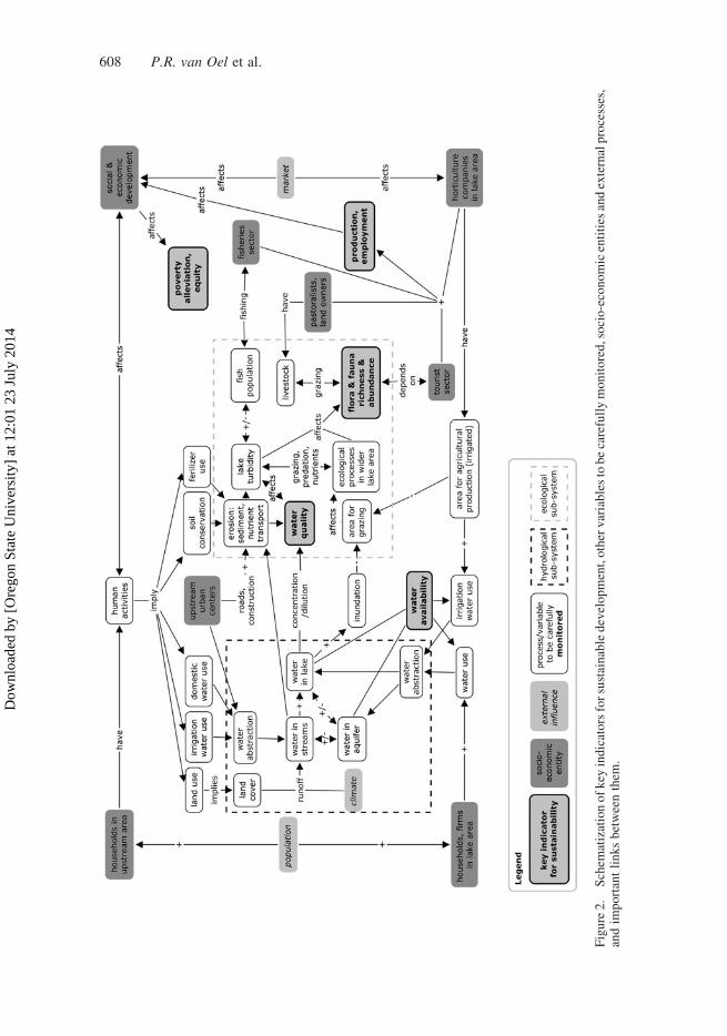
Figure2.
Schem
atizationofkey
indicatorsforsustainabledevelopment,othervariablestobecarefullymonitored,socio-economicentities
andexternalprocesses,
andim
portantlinksbetweenthem
.
608 P.R. van Oel et al.
Dow
nloa
ded
by [
Ore
gon
Stat
e U
nive
rsity
] at
12:
01 2
3 Ju
ly 2
014

increased, from around 250,000 in 1980 to over 600,000 in 2009 (KNBS, 2009).
Population growth and socio-economic developments have contributed to the degradation
of the lake and the lakeshore close to informal settlements (Harper &Mavuti, 2004). Other
effects include increased water abstractions (Van Oel et al., 2013) and land-use changes
that have amplified fluxes of nutrients and sediments into Lake Naivasha (Stoof-
Leichsenring, Junginger, Olaka, Tiedemann, & Trauth, 2011; Verschuren, 1999). On the
other hand, the socio-economic system also depends on the ecosystem services offered by
the Lake Naivasha basin. Especially the horticultural sector is contingent on the basin
water for irrigation (Van Oel et al., 2013). Fisheries depend on lake water quality, and the
tourism sector depends on the natural beauty of the area. These three sectors together
constitute the larger share of the local Naivasha economy on which the majority of the
population depends.
Most studies describing socio-economic activities focus on environmental degradation
caused by human activities. Some studies discuss management alternatives that take into
account both the environment and the economy (e.g. Ellis-Jones, 2007; Mekonnen,
Hoekstra, & Becht, 2012); but the effect of policy interventions is not easily estimated for
lack of data on socio-economic indicators at relevant spatial levels. Partly due to this lack
of data, little is known on the importance of the environment to both the local economy
and individual livelihoods.
Knowledge of the hydrological subsystem
The water balance of the Lake Naivasha basin has been described and discussed in a number
of studies (e.g. Ase, Sernbo, & Syren, 1986; Becht&Harper, 2002; Gaudet&Melack, 1981).
These studies have largely focused on the water budget of the lake rather than on
understanding basin-level hydrological processes. Because there is a considerable amount of
exchange between surface water and groundwater, groundwater hydrology is highly relevant
for describing the water budget of Lake Naivasha (Van Oel et al., 2013). There is net outflow
from the aquifer around Lake Naivasha, for which estimates vary (e.g. Clarke, Goodhall,
Allen, & Darling, 1990; Ojiambo, Poreda, & Lyons, 2001). Large uncertainties and gaps are
associated with the available data-sets for rainfall, discharges, evapotranspiration,
groundwater levels, land use and water abstraction. The effect of water abstractions on
lake volumes has been estimated (VanOel et al., 2013) but the difference between the effects
of abstraction from groundwater and surface water is unclear. With regard to surface
hydrology, the effects of land-use changes and climatic variability on the water balance are
also unclear.
Knowledge of the ecological subsystem
Lake Naivasha transformed from a clear to a turbid lake years ago (Harper, Mavuti, &
Muchiri, 1990). Influenced by both natural and human processes, the spatiotemporal
distribution of turbidity levels in Lake Naivasha varies (Ndungu et al., 2013). The major
drivers of turbidity are the introduction of alien species and physical-chemical degradation
(Gherardi et al., 2011). Physical-chemical degradation is affected by the inflow of runoff,
nutrients and sediments (Harper & Mavuti, 2004; Kitaka, Harper, & Mavuti, 2002), lake
volume changes, and seasonal differences affecting ecological processes. Lake Naivasha’s
exclusively exotic fish population (Gherardi et al., 2011) also affects and is affected by
turbidity (Britton & Harper, 2006; Gherardi et al., 2011; Hickley et al., 2004; Mavuti,
1990). Although many characteristics of Lake Naivasha’s aquatic ecological system have
International Journal of Water Resources Development 609
Dow
nloa
ded
by [
Ore
gon
Stat
e U
nive
rsity
] at
12:
01 2
3 Ju
ly 2
014

been described in the literature, the internal turbidity dynamics and therefore the lake’s
responses to perturbations and interventions remain largely unknown.
Descriptions of the Lake Naivasha ecosystem include those of Gaudet (1977, 1979),
Gaudet andMuthuri (1981), andMorrison andHarper (2009).Amajor focus of these studies
is the importance of thewetland system for lake water quality, with a particular emphasis on
the influence of Cyperus papyrus on nutrient and sediment balances. To understand the
importance of the Lake Naivasha wetland to the wider ecological system, there is a need to
shift attention to the roles of biotic and abiotic processes that regulate the ecosystem’s
productivity and species diversity (Muthoni, Groen, Skidmore, & Van Oel, 2014). Thus far
no spatially explicit analysis has been undertaken to understand the mechanisms that
regulate the productivity and species diversity in thewider area surrounding LakeNaivasha.
Identified knowledge gaps
From the three previous sections, four major knowledge gaps have been identified and
translated into four questions.
1. How does the socio-economic subsystem depend on the ecological system (ecosystem
services)?. The available literature on the socio-economic subsystem is biased towards
environmental problems caused by socio-economic developments. The functions and
value of the environment for various sectors (e.g. in terms of ecosystem services) are
under-evaluated. Particularly if one is to implement market mechanisms for sustainable
governance of the basin ecosystem—e.g. water pricing, or payment for ecosystem services
(PES)—this kind of knowledge is badly needed.
2. What are the influences of water use and land use on water availability?. The relatively
abundant knowledge on the hydrological subsystem is biased towards the most visible
part of the water balance: Lake Naivasha. The effects of abstractions from groundwater
and exchange between groundwater and surface water are largely unknown. Also, the
influences of land-use changes and water abstractions in the wider basin area are not very
well understood.
3. What are the (human) causes of the eutrophic state (turbidity) of Lake Naivasha?.
A reconstruction of events (e.g. blooms, invasive species, and general turbidity increase)
can be made from the available literature. However, this is not quite sufficient for
evaluating the impact of perturbations and the effectiveness of interventions.
4. How does the terrestrial ecosystem (biodiversity) depend on the water balance?. Though
much attention has been devoted to studying the importance of the Lake Naivasha fringe
for the lake itself, little is known about the importance of the lake system for the entire
ecosystem.
Addressing knowledge gaps through spatial integrated assessment
For the present situation in the Lake Naivasha basin, studying hydrological processes does
not make much sense without considering land-use changes and water abstractions. Also,
the dramatic changes with regard to aquatic and terrestrial ecology in recent decades
cannot be understood without considering external perturbations, including the increased
influx of sediment and nutrients and the introduction of alien species. On the other hand,
the socio-economic structure of the Lake Naivasha basin community also strongly
depends on the state of the natural environment by means of the ecosystem services it
610 P.R. van Oel et al.
Dow
nloa
ded
by [
Ore
gon
Stat
e U
nive
rsity
] at
12:
01 2
3 Ju
ly 2
014

provides. The emergence of institutions, including collective action, is influenced by the
states of both the natural and the social environment (Willy & Holm-Muller, 2013). Local
circumstances and differences in resource availability between upstream and downstream
parts of the river basin may lead to collective action and influence willingness to pay and
acceptance by participants of PES schemes. To capture the complexities related to
human–environment interactions, agent-based modelling could be applied (An, 2012;
Torrens, 2010). Examples of how to apply agent-based modelling to water resources use
and management include Berger, Birner, Diaz, Dıaz, and Wittmer (2007) and Van Oel,
Krol, and Hoekstra (2012). For this IA study of the Lake Naivasha basin, some preliminary
results are available (Van Oel & Van der Veen, 2011). When performing a spatial IA in a
socio-ecological system one needs to incorporate the spatial complexity of the relevant
processes. Because many systems are linked by their geographical overlap, geographical
information is of particular importance in integration and interdisciplinary research.
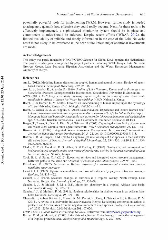
In Table 1, the most relevant aspects of the subsystems covered in this study are
summarized. An impression of the different types of fieldwork sampling locations is given
in Figure 3. Detailed field studies have been performed that allow outreach from the
traditional scientific disciplines to support IWRM. This multidisciplinary approach
includes reducing uncertainties in the factual knowledge base for IWRM by analyzing
historical spatiotemporal data. A preliminary outcome of this effort is described by
Odongo et al. (2014). The following sections decribe outreach from the traditional
scientific disciplines in more detail.
Outreach from the socio-economic subsystem to address Knowledge Gap 1
The Lake Naivasha basin is a relatively data-poor environment, especially when it
comes to socio-economic information. Therefore, the use of earth observation (EO) as an
additional resource is explored. As a first step, the spatial relationship between population
density and land-use and land-cover changes has been explored using a series of
remote-sensing data for the period 1973–2011 (Mulatu et al., 2013; Odongo et al., 2014).
To understand the socio-economic subsystem, market-based approaches (i.e. PES) are
currently being evaluated. A choice experiment for environmental valuation was used to
assess the preferences of the upstream households to improve ecosystem services (Mulatu,
Van der Veen, & Van Oel, 2014). Also, the preferences of socio-economic agents around
the lake (i.e. fishermen, firms and farms) are being explored. This approach will give
insight into links between the environment and the economy.
Outreach from the hydrological subsystem to address Knowledge Gap 2
This work addresses human influence (water abstractions, land use, land management)
on the hydrologic system. In addition to a hydrological process-based approach being
developed (Meins, 2013), impacts of land-use changes (Odongo et al., 2014) and soil
loss (Odongo, Onyando, Mutua, Van Oel, & Becht, 2013) have been investigated.
EO techniques, household surveys and hydrological models were employed to enhance
our understanding of the entire hydrological system, including the groundwater system
(Hogeboom, 2013; Odongo et al., 2014).
Outreach from the ecological subsystem to address Knowledge Gaps 3 and 4
With regard to the aquatic ecological system, the use of EO for monitoring chlorophyll a
and total suspended solids was explored using weekly to bi-weekly ground measurements
International Journal of Water Resources Development 611
Dow
nloa
ded
by [
Ore
gon
Stat
e U
nive
rsity
] at
12:
01 2
3 Ju
ly 2
014

Table
1.
Characteristicsofthesubsystem
s(scientificdisciplines).
Knowledgegap
addressed
Mainprocesses
Spatialscale
Mainsocial
agents
Integratedassessment
indicator(s)
Socio-economic
system
How
does
thesocio-economic
system
dependontheecological
system
(ecosystem
services)?
Water
use
Extent:basin
Ruralhouseholds;urban
centres
andcompanies;water
usercollectives;fishermen,
pastoralists;touristsector
Employment
Landuse
Resolution:landuse
(ha),
communities(ha–km2)
Landowners
Production
Fertilizeruse
Soilandwater
conservationefforts
Hydrologicalsystem
Whataretheinfluencesofwater
use
andlanduse
onwater
availability?
Rainfall,runoff
Extent:basin
Ruralhouseholds
Water
availabilityin
stream
s,aquifer
andlake
Water
balance
Resolution:land
cover
(,
ha),sub-basins
(,100km2)
Urban
centres
andcompanies
Erosion
Sedim
ent,nutrients
Aquaticecologicalsystem
What
arethehuman
causesofthe
eutrophic
state(turbidity)ofLake
Naivasha?
Hydraulics
Extent:lakeandriparianzone
Fishermen
Water
quality
Sedim
entation
Resolution:lakezones
(km2)
Turbiditydynam
ics
Urban
centres
Fishabundance
Terrestrialecologicalsystem
How
does
theterrestrialecosystem
(biodiversity)dependonthewater
balance?
Water
balance
Extent:riparianzoneand
wider
lakearea
Pastoralists
Speciesrichness
Inundation
Resolution:lakelevel
fluctuations(cm/ha)
Touristsector
Nutrientbalance
Landowners
Speciesabundance
612 P.R. van Oel et al.
Dow
nloa
ded
by [
Ore
gon
Stat
e U
nive
rsity
] at
12:
01 2
3 Ju
ly 2
014

Figure
3.
Fieldwork
locationsforthedifferentfocusdisciplines
ofthis
study:forthehydrological
system
,dischargemeasurementstations;
fortheaquatic
ecologicalsystem
,waterqualitysamplingsites;fortheterrestrialecologicalsystem
,transectsalongthelakeshore;forthesocio-economicsystem
,waterabstraction
locations.
International Journal of Water Resources Development 613
Dow
nloa
ded
by [
Ore
gon
Stat
e U
nive
rsity
] at
12:
01 2
3 Ju
ly 2
014

of chlorophyll a and total suspended solids taken in year 2011 (Ndungu et al., 2013).
By studying the lake system in a spatially explicit way, the linkages to the hydrological,
terrestrial ecological and socio-economic subsystems become more apparent. In studying
the terrestrial ecology around Lake Naivasha, extensive use is made of EO techniques.
Using plot measurements of productivity and enclosure experiments, system dynamics
were studied in great detail (Muthoni et al., 2014). Remote-sensing data are further used to
make spatiotemporally explicit estimates of plant species diversity in the ecosystem.
Discussion and conclusion
This study demonstrates how efforts by both local stakeholders and researchers have so far
inadequately addressed IWRM-related wicked problems in the case of the Lake Naivasha
basin, Kenya. The knowledge base currently available to local stakeholders is insufficient
to implement IWRM in the way stakeholders would like, and at the same time local
stakeholders are not collecting the data required to overcome this. Unfortunately, scientists
have mostly failed to tune their research focus to stakeholder needs. In their efforts to
produce cutting-edge research findings they tend to lean towards their own scientific
disciplines rather than aiming at filling the knowledge gaps hampering local IWRM
implementation. Moreover, scientists are generally not sufficiently motivated to
communicate their findings outside their own scientific disciplines. Ideally, scientific
efforts to improve IWRM should address knowledge gaps together with stakeholders.
To improve IWRM, the joint identification of key indicators for sustainable development,
and their interdependencies, and knowledge gaps is an important first step. This should
lead to the building blocks of a structured debate that could substantially contribute to the
implementation of IWRM.
A detailed analysis of available (disciplinary) knowledge is needed to account for
different perspectives. Also, one needs to incorporate the spatial complexity of the most
relevant processes. Because many systems are linked by their geographical overlap,
geographical information is of particular importance for integration and interdisciplinary
research. With regard to the wicked problems that IWRM generally aims to address, some
argue that no experts on these problems can exist (Ludwig, 2001). For this reason it is very
important to maintain a dialogue among all interested parties, including academic
researchers. From the bottom up, many initiatives have emerged over the years in which
local users have collectively pursued initiatives relevant to water governance. Local
initiatives mostly focus on the collective interest at the scale of local resources (e.g. the
lake or water projects). Collective activities include the ongoing work coordinated by the
Imarisha Naivasha board and the Kenya Country Office of the World Wide Fund
for Nature, following initiatives by the office of the prime minister of Kenya in 2012
(Imarisha Naivasha Trust, 2012) and the embassy of the Kingdom of the Netherlands
(IWRAP, 2012), respectively.
It is further argued that even when detailed disciplinary studies are required,
researchers should still keep track of the significant dependence on factors outside the
discipline. However, efforts towards achieving sustainability in relation to the Lake
Naivasha basin, including establishing sound and fair water allocation plans, have been
found to be seriously hampered by the lack of some of the most relevant knowledge. And
even if abundant relevant knowledge should become available and the major knowledge
gaps be sufficiently addressed, underlying conflicting interests will still remain.
Proposed interventions such as PES programmes (Mulatu et al., 2014), possibly
including the introduction of a water footprint premium (Mekonnen et al., 2012), are
614 P.R. van Oel et al.
Dow
nloa
ded
by [
Ore
gon
Stat
e U
nive
rsity
] at
12:
01 2
3 Ju
ly 2
014
potentially powerful tools for implementing IWRM. However, further study is needed
to adequately quantify how effective they could really become. Next, for these tools to be
effectively implemented, a sophisticated monitoring system should be in place and
commitment to rules should be enforced. Despite recent efforts (IWRAP, 2012), the
limited availability of reliable and timely information in the case of the Lake Naivasha
basin is not likely to be overcome in the near future unless major additional investments
are made.
Acknowledgements
This study was partly funded by NWO/WOTRO Science for Global Development, the Netherlands.The project is also greatly supported by project partners, including WWF Kenya, Lake NaivashaGrowers Group, Lake Naivasha Riparian Association and the Water Resources ManagementAuthority of Kenya.
References
An, L. (2012). Modeling human decisions in coupled human and natural systems: Review of agent-based models. Ecological Modelling, 229, 25–36.
Ase, L. E., Sernbo, K., & Syren, P. (1986). Studies of Lake Naivasha, Kenya, and its drainage area.Stockholm. Sweden: Naturgeografiska Institutionen, Stockholms Universitet in Stockholm.
AWS. (2011). AWS Kenya case study summary report: Exploring the value of water stewardshipstandards in Africa. Alliance for Water Stewardship (AWS). Naivasha, Kenya.
Becht, R., & Harper, D. M. (2002). Towards an understanding of human impact upon the hydrologyof Lake Naivasha, Kenya. Hydrobiologia, 488(1/3), 1–11.
Becht, R., Odada, E. O., & Higgins, S. (2005). Lake Naivasha: Experience and lessons learned brief.Lakebasinmanagement initiative:Experienceand lessons learnedbriefs. Including the final report:Managing lakes and basins for sustainable use, a report for lake basin managers and stakeholders(pp. 277–298). Kusatsu: International Lake Environment Committee Foundation (ILEC).
Berger, T., Birner, R., Diaz, J., Dıaz, N., &Wittmer, H. (2007). Capturing the complexity of water usesand water users within a multi-agent framework. Water Resources Management, 21, 129–148.
Biswas, A. K. (2008). Integrated Water Resources Management: Is it working? InternationalJournal of Water Resources Development, 24, 5–22. doi:10.1080/07900620701871718.
Britton, J. R., & Harper, D. M. (2006). Length-weight relationships of fish species in the freshwaterrift valley lakes of Kenya. Journal of Applied Ichthyology, 22, 334–336. doi:10.1111/j.1439-0426.2006.00769.x.
Clarke, M. C. G., Goodhall, D. G., Allen, D., & Darling, G. (1990). Geological, volcanological andhydrogeological controls on the occurrence of geothermal activity in the area surrounding LakeNaivasha, Kenya. Nairobi, Kenya.
Cook, B. R., & Spray, C. J. (2012). Ecosystem services and integrated water resource management:Different paths to the same end? Journal of Environmental Management, 109, 93–100.
Ellis-Jones, M. (2007). Naivasha – Malewa payments for environmental / watershed servicesfeasibility study overview.
Gaudet, J. J. (1977). Uptake, accumulation, and loss of nutrients by papyrus in tropical swamps.Ecology, 58, 415–422.
Gaudet, J. J. (1979). Seasonal changes in nutrients in a tropical swamp: North swamp, LakeNaivasha, Kenya. The Journal of Ecology, 67, 953–981.
Gaudet, J. J., & Melack, J. M. (1981). Major ion chemistry in a tropical African lake basin.Freshwater Biology, 11, 309–333.
Gaudet, J. J., & Muthuri, F. M. (1981). Nutrient relationships in shallow water in an African lake,Lake Naivasha. Oecologia, 49, 109–118.
Gherardi, F., Robert Britton, J., Mavuti, K. M., Pacini, N., Grey, J., Tricarico, E., & Harper, D. M.(2011). A review of allodiversity in Lake Naivasha, Kenya: Developing conservation actions toprotect East African lakes from the negative impacts of alien species. Biological Conservation,144, 2585–2596. doi:10.1016/j.biocon.2011.07.020.
GWP. (2001). Global Water Partnership ToolBox. Retrieved from http://www.gwptoolbox.orgHarper, D. M., &Mavuti, K. (2004). Lake Naivasha, Kenya: Ecohydrology to guide the management
of a tropical protected area. Ecohydrology and Hydrobiology, 4, 287–305.
International Journal of Water Resources Development 615
Dow
nloa
ded
by [
Ore
gon
Stat
e U
nive
rsity
] at
12:
01 2
3 Ju
ly 2
014

Harper, D. M., Mavuti, K. M., &Muchiri, S. M. (1990). Ecology and management of Lake Naivasha,Kenya, in relation to climatic change, alien species’ introductions, and agricultural development.Environmental Conservation, 17, 328–336.
Harper, D. M., Morrison, E. H. J., Macharia, M. M., Mavuti, K. M., & Upton, C. (2011). LakeNaivasha, Kenya: Ecology, society and future. Freshwater Reviews, 4, 89–114.
Hickley, P., Muchiri, M., Boar, R., Britton, R., Adams, C., Gichuru, N., & Harper, D. M. (2004).Habitat degradation and subsequent fishery collapse in Lakes Naivasha and Baringo, Kenya.Ecohydrology and Hydrobiology, 4, 503–517.
Hogeboom, H. J. (2013). On the influence of groundwater abstractions on Lake Naivasha’s waterlevel. (M.Sc.), University of Twente, Enschede, The Netherlands.
Imarisha Naivasha Trust. (2012). Lake Naivasha basin integrated management plan 2012–2022 –DRAFT. Naivasha, Kenya.
IWRAP. (2012). An Integrated Water Resource Action Plan (IWRAP) Programme: Sustainable landand water management for people, businesses and nature in the Lake Naivasha Basin, Kenya.Naivasha, Kenya.
Jakeman, A. J., & Letcher, R. A. (2003). Integrated assessment and modelling: Features, principlesand examples for catchment management. Environmental Modelling & Software, 18, 491–501.doi:10.1016/s1364-8152(03)00024-0.
Kelly (Letcher), R. A., Jakeman, A. J., Barreteau, O., Borsuk, M. E., ElSawah, S., Hamilton, S. H., &. . . Voinov, A. A. (2013). Selecting among five common modelling approaches for integratedenvironmental assessment and management. Environmental Modelling & Software, 47,159–181. doi:http://dx.doi.org/10.1016/j.envsoft.2013.05.005
Kitaka, N., Harper, D. M., & Mavuti, K. M. (2002). Phosphorus inputs to Lake Naivasha, Kenya,from its catchment and the trophic state of the lake. Hydrobiologia, 488, 73–80.
KNBS. (2009). Population and housing census. Kenya National Bureau of Statistics (KNBS).Nairobi, Kenya.
Loucks, D. P., & van Beek, E. (2005). Water resources systems planning and management:An introduction to methods, models and applications. Paris, France: Unesco.
Ludwig, D. (2001). The era of management is over. Ecosystems, 4, 758–764.Mavuti, K. M. (1990). Ecology and role of zooplankton in the fishery of Lake Naivasha.
Hydrobiologia, 208, 131–140.McDonnell, R. A. (2008). Challenges for Integrated Water Resources Management: How do we
provide the knowledge to support truly integrated thinking? International Journal of WaterResources Development, 24, 131–143. doi:10.1080/07900620701723240.
MEA. (2005). Ecosystems and human well-being: Synthesis Millenium Ecosystem Assessment(MEA). Washington, DC: Island Press.
Meins, F. M. (2013). Evaluation of spatial scale alternatives for hydrological modelling of the LakeNaivasha basin, Kenya. (M.Sc.), University of Twente, Enschede, The Netherlands.
Mekonnen, M. M., Hoekstra, A. Y., & Becht, R. (2012). Mitigating the water footprint of export cutflowers from the Lake Naivasha Basin, Kenya. Water Resources Management, 26, 3725–3742.
Molle, F., Wester, P., & Hirsch, P. (2010). River basin closure: Processes, implications andresponses. Agricultural Water Management, 97, 569–577. doi:10.1016/j.agwat.2009.01.004.
Morrison, E. H., & Harper, D. M. (2009). Ecohydrological principles to underpin the restoration ofCyperus papyrus at Lake Naivasha, Kenya. Ecohydrology and Hydrobiology, 9, 83–97.
Mulatu, D. W., Van der Veen, A., Becht, R., Van Oel, P. R., & Bekalo, D. J. (2013). Accounting forspatial non-stationarity to estimate population distribution using land use/cover. Case study:The Lake Naivasha basin, Kenya. Journal of Settlements and Spatial Planning, 4, 33–44.
Mulatu, D.W., Van der Veen, A., &Van Oel, P. R. (2014). Farm households’ preferences for collectiveand individual actions to improve water-related ecosystem services: The Lake Naivasha basin,Kenya. Ecosystem Services, 7, 22–33. http://dx.doi.org/10.1016/j.ecoser.2013.12.001
Muthoni, F. K., Groen, T. A., Skidmore, A. K., & Van Oel, P. R. (2014). Ungulate herbivoryoverrides rainfall impacts on herbaceous regrowth and residual biomass in a key resource area.Journal of Arid Environments, 100-101, 9–17. doi://dx.doi.org/10.1016/j.jaridenv.2013.09.007
Mutia, T. M., Virani, M. Z., Moturi, W. N., Muyela, B., Mavura, W. J., & Lalah, J. O. (2012).Copper, lead and cadmium concentrations in surface water, sediment and fish, C. Carpio,samples from Lake Naivasha: Effect of recent anthropogenic activities. Environmental EarthSciences, 67, 1121–1130.
616 P.R. van Oel et al.
Dow
nloa
ded
by [
Ore
gon
Stat
e U
nive
rsity
] at
12:
01 2
3 Ju
ly 2
014

Ndungu, J. N., Monger, B. C., Augustijn, D. C., Hulscher, S. J., Kitaka, N., & Mathooko, J. M.(2013). Evaluation of spatio-temporal variations in chlorophyll- a in Lake Naivasha, Kenya:Remote-sensing approach. International Journal of Remote Sensing, 34, 8142–8155.doi:10.1080/01431161.2013.833359.
Odongo, V. O., Mulatu, D. W., Muthoni, F. K., Van Oel, P. R., Meins, F. M., Van der Tol, C., & . . .Van der Veen, A. (2014). Coupling socio-economic factors and eco-hydrological processesusing a cascade-modeling approach. Journal of Hydrology (in press).
Odongo, V. O., Onyando, J. O., Mutua, B. M., Van Oel, P. R., & Becht, R. (2013). Sensitivityanalysis and calibration of the Modified Universal Soil Loss Equation (MUSLE) for the upperMalewa Catchment, Kenya. International Journal of Sediment Research, 28, 368–383. http://dx.doi.org/10.1016/S1001-6279(13)60047-5
Ojiambo, B. S., Poreda, R. J., & Lyons, W. B. (2001). Ground water/surface water interactions inLake Naivasha, Kenya, using d18o, dd, and 3h/3he age-dating. Ground Water, 39, 526–533.
Otiang’a-Owiti, G. E., & Oswe, I. A. (2007). Human impact on lake ecosystems: The case of LakeNaivasha, Kenya. African Journal of Aquatic Science, 32, 79–88.
Pahl-Wostl, C. (2007). The implications of complexity for integrated resources management.Environmental Modelling & Software, 22, 561–569. doi:http://dx.doi.org/10.1016/j.envsoft.2005.12.024
Ramsar. The Ramsar Sites Database: Ramsar report for Lake Naivasha, Site No. 724, WetlandsInternational Site Reference No. 1KE002, Designation Date: 10-04-1995 (2013).
Rittel, H. W. J., & Webber, M. M. (1973). Dilemmas in a general theory of planning. PolicySciences, 4, 155–169.
Stoof-Leichsenring, K. R., Junginger, A., Olaka, L. A., Tiedemann, R., & Trauth, M. H. (2011).Environmental variability in Lake Naivasha, Kenya, over the last two centuries. Journal ofPaleolimnology, 45, 353–367. doi:10.1007/s10933-011-9502-4.
Torrens, P. M. (2010). Agent-based models and the spatial sciences. Geography Compass, 4,428–448. doi:10.1111/j.1749-8198.2009.00311.x.
Van Oel, P. R., Krol, M. S., & Hoekstra, A. Y. (2012). Application of multi-agent simulation toevaluate the influence of reservoir operation strategies on the distribution of water availability inthe semi-arid Jaguaribe basin, Brazil. Physics and Chemistry of the Earth, Parts A/B/C, 47-48,173–181. doi:10.1016/j.pce.2011.07.051.
Van Oel, P. R., Mulatu, D. W., Odongo, V. O., Meins, F. M., Hogeboom, R. J., Becht, R., & . . . Vander Veen, A. (2013). The effects of groundwater and surface water use on total water availabilityand implications for water management: The case of Lake Naivasha, Kenya. Water ResourcesManagement, 27, 3477–3492. doi:10.1007/s11269-013-0359-3.
Van Oel, P. R., & Van der Veen, A. (2011). Using agent-based modeling to depict basin closure inthe Naivasha basin, Kenya: A framework of analysis. Procedia Environmental Sciences, 7,32–37. doi:10.1016/j.proenv.2011.07.007.
Verschuren, D. (1999). Sedimentation controls on the preservation and time resolution of climate-proxy records from shallow fluctuating lakes. Quaternary Science Reviews, 18, 821–837.
Voinov, A., & Bousquet, F. (2010). Modelling with stakeholders. Environmental Modelling &Software, 25, 1268–1281.
Willy, D. K., & Holm-Muller, K. (2013). Social influence and collective action effects on farm levelsoil conservation effort in rural Kenya. Ecological Economics, 90, 94–103. doi:http://dx.doi.org/10.1016/j.ecolecon.2013.03.008
WRMA. (2010). Water allocation plan – Naivasha basin 2010–2012. Water ResourcesManagement Authority (WRMA). Naivasha, Kenya.
WWF. (2011). Shared risk and opportunity in water resources: Seeking a sustainable future for LakeNaivasha. World Wide Fund for nature (WWF). Naivasha, Kenya.
Appendix: Stakeholder processes in the Lake Naivasha basin
Stakeholders’ participation in water resources management in Kenya, and the Lake Naivasha basinas such, is institutionalized in the Water Act of 2002, which defines the management, conservation,use and control of water resources. The act not only emphasizes decentralization and subsidiaritybut also creates a new institutional design that allows the engagement of government and non-government entities in the management of water resources through public-private-people (civilsociety) partnership. Leading the stakeholders are government organizations, including ministries
International Journal of Water Resources Development 617
Dow
nloa
ded
by [
Ore
gon
Stat
e U
nive
rsity
] at
12:
01 2
3 Ju
ly 2
014

and parastatals, that have the mandate and responsibility to manage natural resources. At the centreof government institutions in the Lake Naivasha basin is the Water Resources ManagementAuthority (WRMA), Naivasha subregional office, which has the overall mandate to conserve,manage and regulate the use of water resources. In addition, the legislation provides for the creationof water resource user associations (WRUAs). There are a total of 12 WRUAs in the basin, eachcollaborating with the WRMA. The WRUAs represent water users in a subcatchment area.The creation of WRUAs provides a bottom-up perspective and a deviation from the previousgovernment-centred initiatives.
The Imarisha Naivasha programme, a government outfit supported by the Prince of Wales’International Sustainability Unit, provides a forum for coordination of management activities andcollective engagement by the stakeholders involved in the conservation of the lake and its catchment.The board of Imarisha Naivasha includes representatives from public-sector, private-sector andcommunity organizations. The programme has, in consultation with other stakeholders, developed aLake Naivasha basin Sustainable Development Action Plan for 2012–2017 to guide in therestoration of the ecosystem functions, biodiversity and natural attractions of the Lake Naivashabasin. Further, the stakeholders have developed a Lake Naivasha Integrated Management Plan for2012–2017. The plan offers an integrated, coordinated, stakeholder-focused approach to theplanning, management and monitoring of developments within the basin, seeking equitable, efficientand environmentally sound solutions for the benefit of the entire community within the basin.
Non-governmental stakeholder participation in the basin’s management finds its origin in theLake Naivasha Riparian Association, the oldest institution in the basin (it was founded in 1929).Most of the private-sector organizations are engaged in water resources management due to thecommercial gains expected from the resources, e.g. the flower farms around the lake, which aremostly represented through their umbrella organization, the Lake Naivasha Growers Group (LNGG).International NGOs and donors have strongly participated in the basin’s management throughprojects aimed at supporting the capacity of institutions and local resource user groups. WWF-Kenyaand CARE-Kenya have been involved in coordination as intermediary institutions in a PES schemefor market-based approach to delivery of sustainable natural resource management and improvedlivelihoods. This is done through the involvement of the WRMA, the LNGG and the WRUAs.Through funding from the embassy of the Kingdom of the Netherlands, the Integrated WaterResource Action Plan (IWRAP, 2012) brings together various public and private partners fromKenya and the Netherlands on sustainable land and water management for people, businesses andnature in the Lake Naivasha basin.
Over the years, several research organizations have actively participated in the basin. Theseinclude the University of Twente, University of Nairobi, Egerton University, Leicester University,University of Bonn, University of Ghent and University of Western Ontario. Notable is the EarthObservation and Integrated Assessment project, in which the University of Twente, University ofNairobi and Egerton University collaborate with stakeholder organizations and other researchorganizations in the basin. This 5-year project focuses on how earth observation and derivativegeo-information may be instrumental in overcoming water-related societal clashes in a collaborativestakeholder setup. The project has held annual stakeholder meetings and workshops from 2009 to2013. Methods applied included scenario building through forecasting and back-casting andparticipatory mapping exercises. Thus were the key indicators for sustainable development identifiedas presented in the main text of the article.
618 P.R. van Oel et al.
Dow
nloa
ded
by [
Ore
gon
Stat
e U
nive
rsity
] at
12:
01 2
3 Ju
ly 2
014