Embed Size (px)
Citation preview

Support Considerations for the Houston Environmental Aerosol
Thunderstorm (HEAT) Project
Richard Dirks, Jim Moore, Steve Williams
UCAR/Joint Office for Science Support (JOSS)
Boulder, Colorado
HEAT First Planning Workshop
Boulder, CO 15-16 March 2004
http://www.joss.ucar.edu

To provide scientific, technical and administrative support services to the research community for the purpose of planning, organizing and implementing
research programs and associated field projects worldwide
JOSS Mission

Field Program Timeline
Project Office(if needed)
ExperimentDesignScience
PlanningMeeting Prepare Ops Plan,
Data Mgmt. Plan,Logistics, Bulletins
Initial Site Survey
Funding ProposalSubmissions
FacilityCoordination Mtg.
Facility Request& Approval
Operations Mtg.Finalize Ops PlanFinalize Data Mgmt Plan
-2yr
Site setupInitiate Data CollectionCommunications Sys.Shakedown
FIELD PROJECT
Data ProcessingQuality Control
2 month
Routine Archive/Access
Data AnalysisWorkshop
ProgramAssessment
2 yr
Special ConferenceSessions
Daily BriefingOnsite Data Mgmt.Operational Data CollectionFacility CoordinationSupport FunctionsIn-field Catalog
-1yr 1 yr

Operational Considerations for HEAT
Requirements for Operations Center
Participants on-site (facilities, schedules, etc.)
Air Traffic Control (ATC) Coordination
Communications capabilities (LAN, satcom, chat)
Access to real-time data (HEAT On-line Field Catalog)
Weather forecasting support (nowcasting)
Analysis Activities in the field (review and quick-look)
Safety (severe convection, lightning)
Multiple Objectives, multiple facilities

Internet
BAMEX Operations CenterMid-America Airport, IL
Ops. Coordination Science Team
Facility Status In-field Analysis
Forecast/Nowcast Data Ingest
BAMEX Field Catalog Data Collection
GBOS Coordination
Logistics
ATC/Military Coord.
BAMEX Communications Overview
NWS WFO
St. Louis, MO
Operational Weather Data
Specialized Model Data
NAWIPS
Severe Weather Alerts
NCAR, NOAA,
Rest of the World
Aircraft Coordination CenterMid-America Airport, IL
NRL P-3 Post Flight DebriefingsNOAA P-3 Mission PlanningDropsonde Jet A/c Status Updates
Data Processing A/c Logistics
Scientist Remote Access
Project Aircraft
T-1
Internet
Cell PhoneSat PhoneVHF, HFImage relay
Sat. P
hone
Imag
e, P
ositio
n
Data
Relay
Chat c
apab
ility
Dial-up Modem
Internet Provider
Mobile Field Systems
SMART-R, MIPS, MGLASS, MMesonets
VHF radio


FIELD CATALOG SAMPLE PRODUCTS

BAMEX Field Catalog Statistics• Status Reports and Operations Summaries
(600+ documents)
• Mission Related Reports and Products(2700+ documents)
•NOAA P-3, NRL P-3, Learjet, GBOS
• Near Real-Time Operational Image Products•Satellite, Surface, Upper Air, Forecast and Model
•Nearly 200,000 files/images using 20 gigabytes
• Report Authoring and Submission Tools
• Product Ingest Tools: upload forms, email and ftp
submissions, automated web downloading
• Mirror Sites in Boulder, CO, with near real-time synchronization
•Links to other project related real-time data sources

JOSS Data Management Philosophy
• Early involvement in project planning• Involvement with PIs to develop data
management strategy (e.g., plan, policy, format, special collection and processing)
• Consistent implementation of strategy for lifetime of project and beyond
• Reliable and efficient archive and distribution system
• Easy and efficient access to datasets by broader community including educators and students

JOSS DATA SERVICES
• Data Questionnaire• Data Management Plan• Real-time Data Ingest• Field Operations Catalog• Data Processing• Interactive Data Archive and Distribution (CODIAC)• Special Media Products and Services

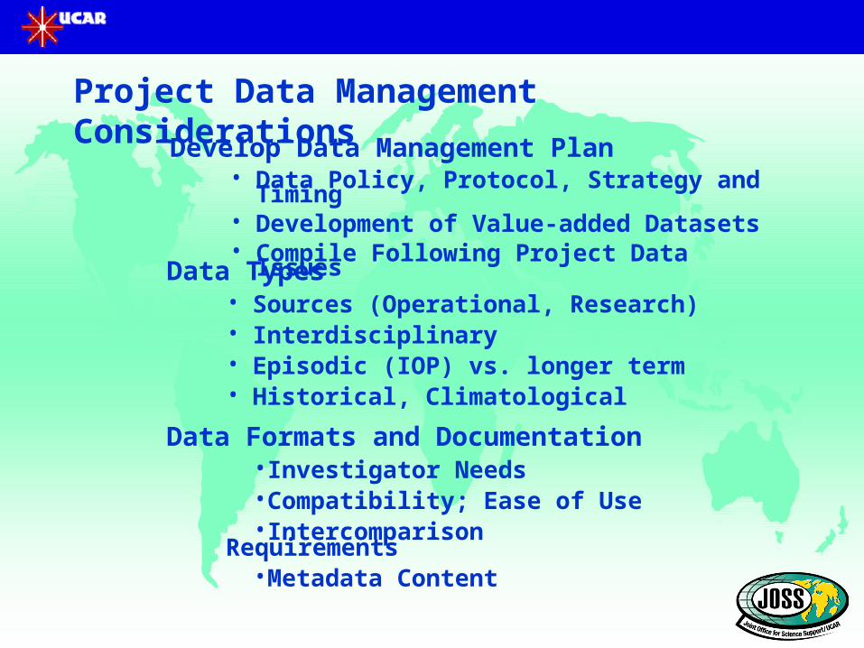
Develop Data Management Plan• Data Policy, Protocol, Strategy and Timing• Development of Value-added Datasets• Compile Following Project Data Issues
Data Types• Sources (Operational, Research)• Interdisciplinary• Episodic (IOP) vs. longer term• Historical, Climatological
Data Formats and Documentation•Investigator Needs•Compatibility; Ease of Use•Intercomparison Requirements•Metadata Content
12
Project Data Management Considerations

Data Management Considerations (Continued)
Data Collection
• Determine Requirements (Operational vs. Research)• Metadata MUST accompany data• Set-up access protocol
Real-time Data Requirements• Calibration, In-field Intercomparisons, Operations• Real-time Catalog, Documentation
Data Quality Control• Who? Where? When?• Coordination of data processing• Utilization and development of analysis tools• Investigator Responsibilities
13

Data Archival• Centralized vs. Decentralized• On-line vs. Off-line• Data Integration (CD Preparation)• Coordination with Other Programs• International Data Centers and Exchange
Data Management Considerations (continued)
Data Distribution• Ease of Data access• Metadata and Inventories (including browse products)• Restricted vs. Open • Preliminary vs. Final Datasets• Customized Data Requests
Coordination with Other Programs• Data Exchange and Analysis Tools• Standardized Formats• Interoperability with other Data Centers 14

Meteorological Networks in Vicinity of HEAT
1016 StationsAWS (o 405) LCRA (+ 157)
TNRCC (+ 145) CWOP (o 64)
ASOS (* 41) RAWS (o 36)
AWOS (* 27) ALERT (o 24)
TCOON (o 21) METAR (+ 17)
GPS (* 17) TX ET (o 12)
NWLON (+ 11)
AWOS dial (+ 10)
LAIS (+ 9)
TABS (+ 7)
PORTS (* 4)
CMAN (* 3)
LA DEQ (* 3)
NDBC Buoy (o 2)
SCAN (+ 1)
28.0
32.0
-98.0 -94.0
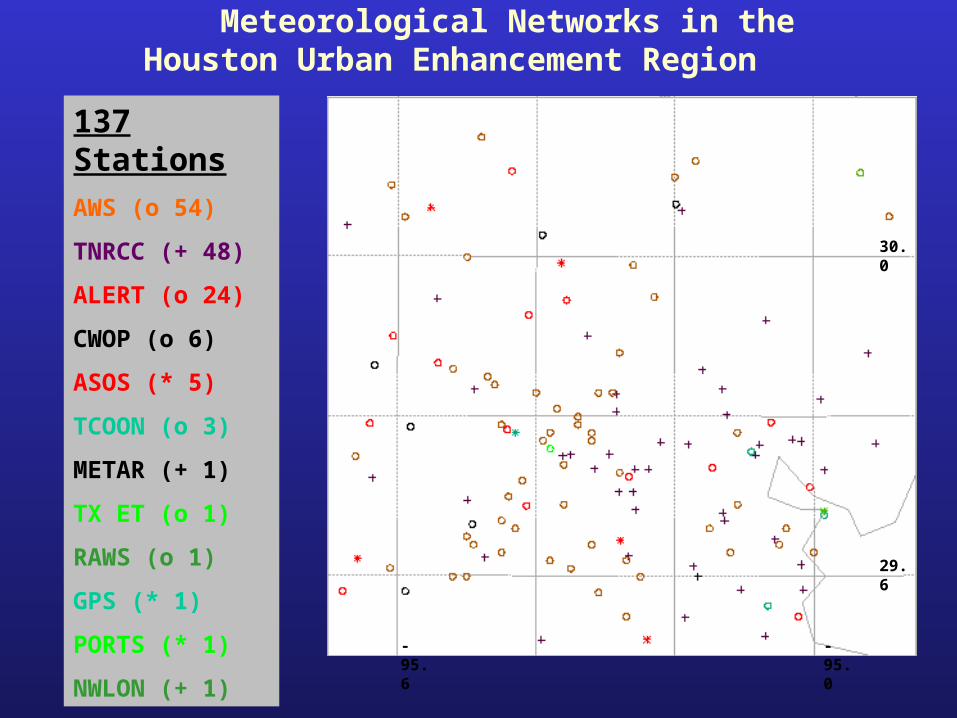
Meteorological Networks in the Houston Urban Enhancement Region
137 Stations
AWS (o 54)
TNRCC (+ 48)
ALERT (o 24)
CWOP (o 6)
ASOS (* 5)
TCOON (o 3)
METAR (+ 1)
TX ET (o 1)
RAWS (o 1)
GPS (* 1)
PORTS (* 1)
NWLON (+ 1)
29.6
30.0
-95.6 -95.0

Hourly Precipitation Stations in Vicinity of HEAT
1576 Stations
Met Stations (o 1016)
ALERT (+ 211)
NCEP (* 211)
NCDC 15-min (+ 138)
28.0
32.0
-98.0 -94.0

Hourly Precipitation Stations in the Houston Urban Enhancement Region
299 Stations
ALERT (+ 148)
Met Stations (o 137)
NCEP (* 11)
NCDC 15-min (+ 3)
-95.6 -95.0
30.0
29.6

Daily Precipitation Stations in Vicinity of HEAT
2096 Stations
Hourly (+ 1576)
Cooperative (+ 520)
28.0
32.0
-98.0 -94.0

Daily Precipitation Stations in the Houston Urban Enhancement Region
315 Stations
Hourly (+ 299)
Cooperative (+ 16)
-95.6 -95.0
30.0
29.6
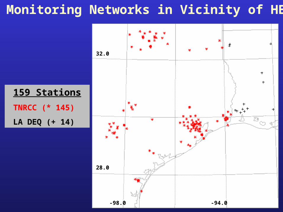
Air Monitoring Networks in Vicinity of HEAT
159 Stations
TNRCC (* 145)
LA DEQ (+ 14)
28.0
32.0
-98.0 -94.0