Embed Size (px)
Citation preview

Prepared By
Summary Report / April 2014
Land Subsidence from Groundwater Use in California
James W. Borchers • Michael Carpenter
With Support By

Summary Report / April 2014
Land Subsidence from Groundwater Use in California
Contributing Authors
• James W. Borchers• Vicki Kretsinger Grabert• Michael Carpenter• Barbara Dalgish• Debra Cannon
California Water Foundation The California Water Foundation (CWF) seeks to transition California to a sustainable and resilient water future – a future in which water is managed as a natural resource, looking across all sources and uses to find the best solutions for social welfare, economic development, and environmental sustainability. CWF supports innovative projects and policies that address water challenges today, while achieving long-term, science-based solutions for the future. CWF is an initiative of Resources Legacy Fund, with primary funding from S.D. Bechtel, Jr. Foundation and Pisces Foundation, and additional support from David and Lucile Packard Foundation and others. Learn more at: http://www.californiawaterfoundation.org.
Summary Report / April 2014
Land Subsidence from Groundwater Use in California
Acknowledgement
The California Water Foundation Subsidence Resources Group was established on April 29, 2013 to act as advisors for this report and is made up of those persons most knowledgeable on the subject of subsidence. The group has provided general input and subsequent review of reference lists, data assessments, and descriptions of monitoring and research needs. CWF appreciates the contributions of the 22 members listed below:
Gerald Bawden U.S. Geological Survey
Chris Bonds CA Dept. of Water Resources No. Central Region
Rob Carruth U.S. Geological Survey
Wes Danskin U.S. Geological Survey
Bill Ehorn CA Dept. of Water Resources Northern Region
Claudia Faunt U.S. Geological Survey
Devin Galloway U.S. Geological Survey
Randy Hanson U.S. Geological Survey
Carl Hauge CA Dept. of Water Resource (retired)
Donald C. Helm USGS/LLNL/CSIRO/UNR/NBMG/MSU (retired)
Charles Heywood U.S. Geological Survey
Thomas Holzer U.S. Geological Survey
Marti Ikehara USGS/NGS (retired)
Steven Ingebritsen U.S. Geological Survey
John Kirk CA Dept. of Water Resources So.Central Region
Stan Leake U.S. Geological Survey
Steven Phillips U.S. Geological Survey
Don Pool U.S. Geological Survey
Keith Prince U.S. Geological Survey (retired)
Francis S Riley U.S. Geological Survey (retired)
Eric Senter CA Dept. of Water Resources
Michelle Sneed U.S. Geological Survey
Summary Report / April 2014
Land Subsidence from Groundwater Use in California Table of Contents
Executive Summary
Introduction
1.0 Groundwater Extraction and Subsidence – Page 6
2.0 Examples of Subsidence from Groundwater Extraction In California – Page 9
2.1 Santa Clara Valley 2.2 San Joaquin Valley 2.2.1 Historical Subsidence in the San Joaquin Valley 2.2.2 Current Subsidence in the San Joaquin Valley 2.3 Sacramento Valley 2.4 Antelope Valley 2.5 Coachella Valley 2.6 Mojave River Basin and Vicinity
3.0 Measuring and Monitoring Land Subsidence – Page 31
3.1 Surveying and the Global Positioning System 3.2 Satellite Synthetic Aperture
Radar Interferometry (InSAR) 3.3 LiDAR 3.4 Borehole Extensometers
4.0 Recommendations – Page 34 4.1 Monitor Land Surface Elevation
Changes and Compaction 4.2 Monitor Ancillary Factors:
Groundwater Levels and Drillers’ Reports 4.3 Collect, Store and Disseminate Data 4.4 Evaluate and Prioritize Subsiding
Groundwater Basins
References cited are available in the full report found online at www.californiawaterfoundation.org

APRIL, 2014 SUMMARY REPORT Land Subsidence from Groundwater Use in California
{00233942.DOCX.14}
LSCE, BORCHERS AND CARPENTER 1
EXECUTIVE SUMMARY
California’s groundwater is a vital resource for the state that provides water supplies for urban
and rural areas, supports a large agricultural economy, and benefits fish and wildlife habitats and
ecosystems. Groundwater meets about 40 percent of the state’s water demands in an average
year. During droughts when surface supplies are limited, groundwater offers a critical buffer,
providing a higher percent of the state’s water supply. In 2014, it is anticipated statewide
groundwater use will be closer to 65 percent because of the critical nature of this year’s drought.
Historically, groundwater has been pumped as needed in many areas of the state, often with little
regard for the deleterious effects of over pumping. Over pumping is not sustainable in the long-
term and can lead to a number of adverse consequences, including water-quality degradation;
increased energy costs for groundwater pumping; costs for well deepening or replacement;
impacts to nearby rivers and streams; and land subsidence. This report highlights the current and
historical impacts of land subsidence in California due to groundwater pumping and makes
recommendations for monitoring and assessment. The purpose of this report is to summarize
knowledge about the extent and costs of subsidence so that this information can be part of a
larger discussion on sustainable groundwater management in California.
This report confirms that land subsidence in California is not just an historical occurrence, but
that it is an ongoing problem in many regions. The report presents key examples of significant
historical subsidence and current active occurrences of subsidence, including the impacts and
costs.1
There is no comprehensive land subsidence monitoring program in California. The information
in this report was compiled from individual regional or local studies, which usually were
initiated after substantial subsidence impacts had occurred. The most comprehensive evaluation
of land subsidence in California occurred between 1955 and 1970, to assist with the construction
of the state and federal water projects. Funding for this program ended soon after completion of
the state and federal water projects. The lack of comprehensive subsidence monitoring has had
costly consequences for the state.
Land subsidence has been discovered in many areas of the state, causing billions of dollars of
damage. Impacts from subsidence fall into the following categories:
loss of conveyance capacity in canals, streams and rivers, and flood bypass channels;
diminished effectiveness of levees;
1 The full report can be found at: Luhdorff & Scalmanini, Consulting Engineers, James Borchers, and Michael
Carpenter. 2014. Report of Findings: Land Subsidence from Groundwater Use in California.

APRIL, 2014 SUMMARY REPORT Land Subsidence from Groundwater Use in California
{00233942.DOCX.14}
LSCE, BORCHERS AND CARPENTER 2
damage to roads, bridges, building foundations, pipelines, and other surface and
subsurface infrastructure; and
development of earth fissures, which can damage surface and subsurface structures and
allow for contamination at the land surface to enter shallow aquifers.
This report summarizes six major areas of subsidence in California. In many of these regions
subsidence continues today, sometimes at nearly historically high rates of more than 1 foot/year
(ft/yr). This report provides examples of current and historical subsidence pieced together from
local or regional studies that were conducted by state, federal, or local agencies after subsidence
was discovered to have dramatically deformed the land surface and/or caused significant
infrastructure problems.
Santa Clara Valley
o Subsidence in Santa Clara Valley, in the South San Francisco Bay Area, has required
diking to prevent flooding from the bay; water well, and sanitary and storm sewer system
repairs; modifications to roads, bridges, and stream channel levees, and other
infrastructure construction and repair, translating to more than $756 million in damages.
o Between 1910 and 1995, downtown San Jose subsided 14 feet.
o Santa Clara Valley Water District essentially halted inelastic subsidence in the region by
implementing a monitoring program, importing surface water, and artificially recharging
groundwater. Groundwater pumpers report usage to the District. The District issues
permits for wells and collects a groundwater production charge to recover those costs.
San Joaquin Valley
o Subsidence from groundwater extraction in the San Joaquin Valley has been called the
greatest human alteration of the Earth’s surface.
o By 1970, subsidence of more than 1 foot had affected 5,200 mi2—more than half of the
valley—and in some areas it had reached 28 feet.
o Over the past decade, subsidence has been identified in two regions in the San Joaquin
Valley, including more than 4 feet during a 3½ year period near Corcoran, California.
o Subsidence has caused major impacts to infrastructure and physical features, including
the San Joaquin River, Delta-Mendota Canal, Friant-Kern Canal and San Luis Canal, as
well as numerous privately owned canals and related infrastructure such as turnouts,
bridges, pipelines, and storm sewers.
o These costs, add up to a total estimated cost of more than $1.3 billion during 1955-1972
(2013 dollars). Subsequent cost data are unavailable.

APRIL, 2014 SUMMARY REPORT Land Subsidence from Groundwater Use in California
{00233942.DOCX.14}
LSCE, BORCHERS AND CARPENTER 3
Sacramento Valley
o Subsidence in the Sacramento Valley has resulted in wide scale destructive failure of
steel groundwater well casings, making wells sometimes unusable.
o From the locations of damaged wells during a drought in 1976-1977, the subsidence
appears to stretch from central Colusa County, through Yolo County, to Dixon in Solano
County.
Antelope Valley
o Subsidence in Antelope Valley, east of Los Angeles, has been occurring for over 80
years. Increased pumping in the last 30 years due to population growth has accelerated
the groundwater level declines to as much as 300 feet in some areas.
o Subsidence has adversely affected runways at Edwards Air Force Base and caused other
negative consequences such as increased flooding and erosion; failed well casings; and
damage to roads, homes, and other structures.
Coachella Valley
o Subsidence in Coachella Valley, in Riverside County, paused after importation of surface
water began in 1949, but resumed in the 1970s as population and groundwater pumping
increased.
o Earth fissures formed in 1948 and again recently. A subsidence study of a portion of the
Coachella Branch of the All American Canal showed that the canal subsided as much as
1.35 feet from 1995 to 2010.
Mojave River Basin Area
o In the Mojave River Basin area, groundwater pumping resulted in groundwater-level
declines of more than 100 feet. Giant desiccation cracks, sink-like depressions, and earth
fissures more than 3 feet wide and deep have made permanent scars on the landscape.
o A 1998 survey indicated 2 to 5 feet of subsidence occurred in Lucerne Valley.
o Recent groundwater adjudication developed actions to stabilize the water levels of the
basin and manage groundwater pumping.
As indicated in this report, alarming rates of subsidence continue to occur throughout California,
causing impacts and costs that can have lasting effects to property and the environment. This
information is only being collected after the impacts from subsidence have occurred. The lack of
a coordinated subsidence monitoring program, uniform monitoring procedures, and an ongoing
data repository is causing significant irreversible impacts and costs to many regions and the state.
This report proposes the following recommendations to help California address the ongoing
economic and environmental impacts associated with over extraction of groundwater and the
resulting land surface subsidence.

APRIL, 2014 SUMMARY REPORT Land Subsidence from Groundwater Use in California
{00233942.DOCX.14}
LSCE, BORCHERS AND CARPENTER 4
Monitor Land Surface Elevation Changes and Compaction
Characterize Aquifer System and Monitor Groundwater Levels
Collect, Store and Disseminate Subsidence and Groundwater Data
Prioritize and Evaluate Subsiding Groundwater Basins

APRIL, 2014 SUMMARY REPORT Land Subsidence from Groundwater Use in California
{00233942.DOCX.14}
LSCE, BORCHERS AND CARPENTER 5
In an average year, groundwater
provides about 40% of the state’s
water supply; in the current drought, it
is expected to be 65% or more.
INTRODUCTION
As California contends with possibly the worst drought on record, the condition of the state’s
groundwater basins takes on increased importance. California’s groundwater is a vital resource
for urban, rural and agricultural water users, and for the health of aquatic ecosystems and
biological habitats. Groundwater basins underlie 40 percent of California. In an average year,
groundwater provides about 40 percent of the state’s water supply; in drought years, it may
provide 65 percent or more. In many basins, groundwater is the principal source of supply.
Groundwater levels in some areas of California are declining past historical lows. Projected
population increases, along with
alteration of precipitation patterns due to
climate change, will put added stress on
groundwater resources in the state.
Historically in California, groundwater
has been pumped as needed, often with
little regard for the deleterious effects of over pumping. Chronically declining groundwater
levels can lead to a number of adverse consequences, including saltwater intrusion or other water
quality degradation; reduced groundwater storage, availability and reliability; increased energy
costs; facilities costs for well deepening or replacement; streamflow depletion; environmental
effects; and land subsidence. This report highlights issues and key findings related to land
subsidence in California due to groundwater extraction2,3
When groundwater pumping chronically exceeds recharge, a long-term decline of groundwater
levels usually results. This can lead to inelastic compaction of the aquifer system, permanent
subsidence of the land surface, and even earth fissures. Some of the more costly consequences of
subsidence include:
coastal flooding
increased extent and depth of inland flooding
reduced freeboard and carrying capacity of canals, aqueducts, rivers and flood bypass
channels
damage to buildings, roadways, bridges, pipelines, canals, aqueducts, levees, sewerages,
and wells; and
increased sediment erosion or deposition and impairment of leveled agricultural fields
2The full report can be found at: Luhdorff & Scalmanini, Consulting Engineers, James Borchers, and Michael
Carpenter. 2014. Report of Findings: Land Subsidence from Groundwater Use in California. 3References are contained in the full report.

APRIL, 2014 SUMMARY REPORT Land Subsidence from Groundwater Use in California
{00233942.DOCX.14}
LSCE, BORCHERS AND CARPENTER 6
Recent observations of subsidence in the
San Joaquin Valley are unanticipated and
alarming, and likely to continue unless
changes occur.
As described below, significant subsidence has occurred historically in the San Joaquin Valley
and elsewhere in California, creating substantial economic costs. Indeed, the cost of remediating
subsidence in the San Joaquin Valley alone during 1955-1972 was estimated to be over $1.3
billion in 2013 dollars not including the significant damage to canals, river levees, and flood
channels. This is not merely a historical issue. Recent observations of subsidence in the San
Joaquin Valley are unanticipated and
alarming, and likely to continue unless
changes occur. The purpose of this
report is to summarize knowledge
about the extent and costs of
subsidence so that this information can
be part of a larger discussion on
sustainable groundwater management
in California.
A review of published literature revealed that there is no single compilation of historical and
active occurrences of subsidence in the state. Although this report is not an exhaustive detailing
of every occurrence of groundwater extraction-related subsidence in California, it presents key
examples of significant historical and active subsidence, including the impacts and costs. A more
detailed inventory is presented in the full report (Luhdorff and Scalmanini Consulting Engineers,
et al., 2014, Report of Findings: Land Subsidence from Groundwater Use in California)
California lacks a coordinated statewide subsidence monitoring program, uniform monitoring
and analysis procedures, and an accessible repository for subsidence-related data, which are
essential to the assessment of subsidence. Furthermore, the state lacks funding to support
technical synthesis and evaluation of data and remotely sensed imagery. Legislative and policy
changes are needed to address this ongoing problem that has immense economic and
environmental implications for the state of California.
The report is organized into the following sections: Section 1 explains subsidence processes
related to groundwater extraction. Section 2 offers examples of subsidence as a result of
groundwater extraction in California. Section 3 describes methods used to measure the
magnitude of land subsidence and ground-surface deformation, and Section 4 presents
recommendations related to subsidence monitoring and sustainable groundwater management.
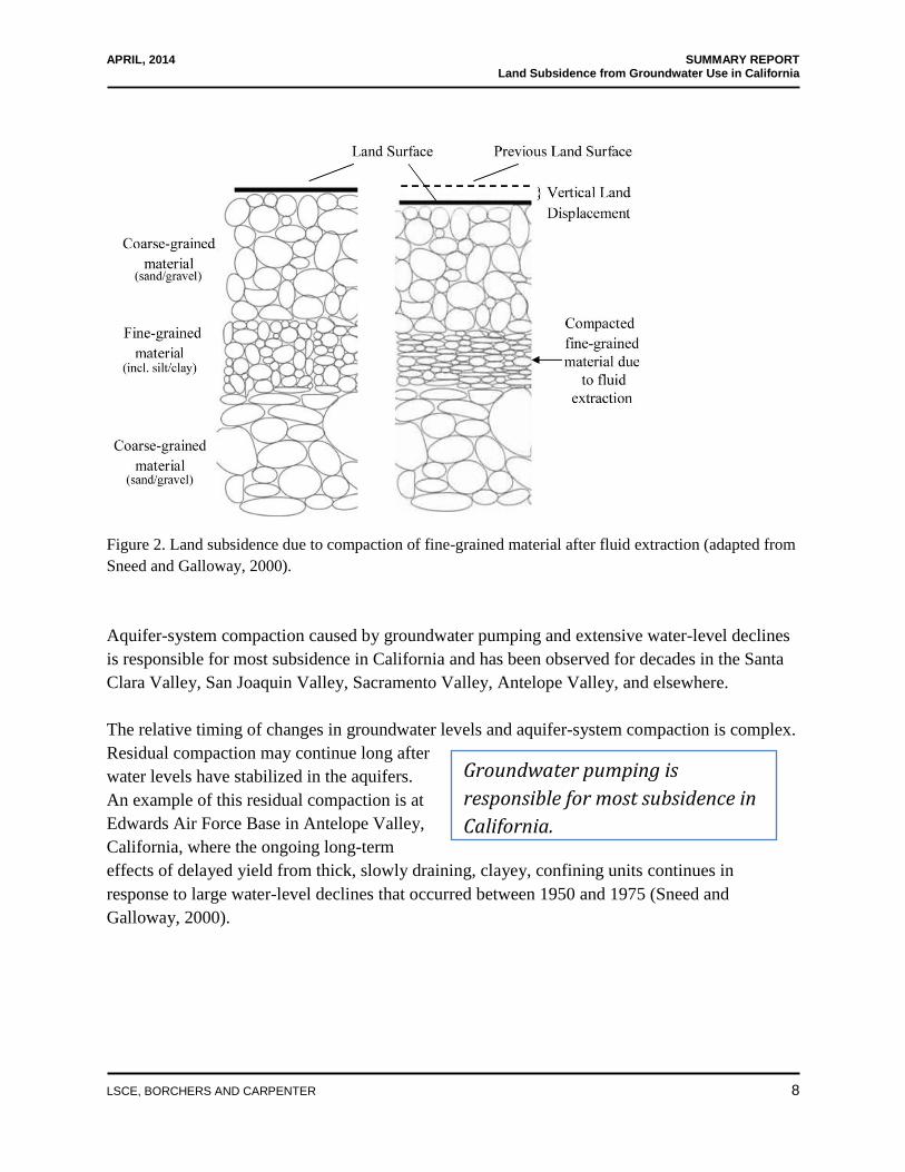
1.0 GROUNDWATER EXTRACTION AND SUBSIDENCE
A balance occurs naturally in an undeveloped aquifer system where recharge and discharge of
groundwater are equal. As seen in Figure 1, an aquifer system consists of layers of gravel, sand,
silt, and clay deposited by streams and rivers or in lakes or wetlands. Coarse-grained materials

APRIL, 2014 SUMMARY REPORT Land Subsidence from Groundwater Use in California
{00233942.DOCX.14}
LSCE, BORCHERS AND CARPENTER 7
such as sand and gravel transmit water readily; fine-grained materials such as clay and silt
impede the movement of water. Groundwater pumping changes the water balance of the aquifer
system (Galloway et al., 1999), deforms the land surface and may create permanent land
subsidence. In particular, when water is drained from clays, permanent subsidence will result
because much of the water drained cannot be replaced. This permanent deformation, called
inelastic or non-recoverable compaction, is responsible for permanent or non-recoverable land
subsidence (Hoffmann et al, 2003) (Figure 2). Inelastic compaction occurs when the structure of
the clays is compromised during compaction, such that it is unable to expand to its original
thickness even when groundwater levels rise to pre-pumping levels.
Figure 1. An undeveloped aquifer system in balance (adapted from Galloway et al., 1999)
APRIL, 2014 SUMMARY REPORT Land Subsidence from Groundwater Use in California
{00233942.DOCX.14}
LSCE, BORCHERS AND CARPENTER 8
Groundwater pumping is
responsible for most subsidence in
California.
Figure 2. Land subsidence due to compaction of fine-grained material after fluid extraction (adapted from
Sneed and Galloway, 2000).
Aquifer-system compaction caused by groundwater pumping and extensive water-level declines
is responsible for most subsidence in California and has been observed for decades in the Santa
Clara Valley, San Joaquin Valley, Sacramento Valley, Antelope Valley, and elsewhere.
The relative timing of changes in groundwater levels and aquifer-system compaction is complex.
Residual compaction may continue long after
water levels have stabilized in the aquifers.
An example of this residual compaction is at
Edwards Air Force Base in Antelope Valley,
California, where the ongoing long-term
effects of delayed yield from thick, slowly draining, clayey, confining units continues in
response to large water-level declines that occurred between 1950 and 1975 (Sneed and
Galloway, 2000).
APRIL, 2014 SUMMARY REPORT Land Subsidence from Groundwater Use in California
{00233942.DOCX.14}
LSCE, BORCHERS AND CARPENTER 9
Subsidence may continue long after
water levels have stabilized in the
aquifers.
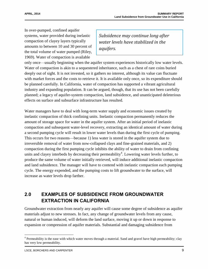
In over-pumped, confined aquifer
systems, water provided during inelastic
compaction of clayey layers typically
amounts to between 10 and 30 percent of
the total volume of water pumped (Riley,
1969). Water of compaction is available
only once—usually beginning when the aquifer system experiences historically low water levels.
Water of compaction is akin to a sequestered inheritance, such as a chest of rare coins buried
deeply out of sight. It is not invested, so it gathers no interest, although its value can fluctuate
with market forces and the costs to retrieve it. It is available only once, so its expenditure should
be planned carefully. In California, water of compaction has supported a vibrant agricultural
industry and expanding population. It can be argued, though, that its use has not been carefully
planned; a legacy of aquifer-system compaction, land subsidence, and unanticipated deleterious
effects on surface and subsurface infrastructure has resulted.
Water managers have to deal with long-term water supply and economic issues created by
inelastic compaction of thick confining units. Inelastic compaction permanently reduces the
amount of storage space for water in the aquifer system. After an initial period of inelastic
compaction and subsequent water-level recovery, extracting an identical amount of water during
a second pumping cycle will result in lower water levels than during the first cycle of pumping.
This occurs for two reasons—because 1) less water is stored in the aquifer system due to
irreversible removal of water from now-collapsed clays and fine-grained materials, and 2)
compaction during the first pumping cycle inhibits the ability of water to drain from confining
units and clayey interbeds by decreasing their permeability4. Lowering water levels further, to
produce the same volume of water initially retrieved, will induce additional inelastic compaction
and land subsidence. The manager will have to contend with inelastic compaction each pumping
cycle. The energy expended, and the pumping costs to lift groundwater to the surface, will
increase as water levels drop farther.
2.0 EXAMPLES OF SUBSIDENCE FROM GROUNDWATER
EXTRACTION IN CALIFORNIA
Groundwater extraction from nearly any aquifer will cause some degree of subsidence as aquifer
materials adjust to new stresses. In fact, any change of groundwater levels from any cause,
natural or human induced, will deform the land surface, moving it up or down in response to
expansion or compression of aquifer materials. Substantial and damaging subsidence from
4 Permeability is the ease with which water moves through a material. Sand and gravel have high permeability; clay
has very low permeability.
APRIL, 2014 SUMMARY REPORT Land Subsidence from Groundwater Use in California
{00233942.DOCX.14}
LSCE, BORCHERS AND CARPENTER 10
groundwater extraction in California is nearly always related to inelastic compaction in an
aquifer system, or to differences in the magnitude of compaction over short lateral distances.
In California, subsidence has resulted in expensive remediation to address loss of conveyance
capacity in canals, streams and rivers, flood bypass channels, diminished levee effectiveness, and
damage to roads, bridges, building foundations, pipelines, and other surface and subsurface
infrastructure. Development of earth fissures has damaged surface and subsurface structures and
also provided conduits for contamination at the land surface to enter shallow aquifers, degrading
groundwater resources.
Subsidence is occurring today at nearly historically high rates (almost 1 ft/yr) in some areas.
Even so, the location of all subsiding areas and the magnitude of subsidence throughout the state
cannot be determined by reviewing published reports or databases because California does not
have a coordinated statewide monitoring and reporting program for land subsidence. Therefore,
instead of a comprehensive description of this statewide phenomena, the following sections
provide examples pieced together from local or regional studies, some ongoing but mostly
historical, that were conducted by state, federal, or local agencies after subsidence was
discovered to have reached alarming proportion.
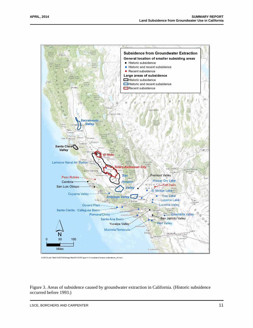
Summaries of such subsidence in the Santa Clara Valley, San Joaquin Valley, Sacramento
Valley, Antelope Valley, Coachella Valley, and Mojave River Basin and vicinity follow. More
information on each of these and other areas, as identified in Figure 3, is included in the full
report (Luhdorff and Scalmanini Consulting Engineers, et al., 2014, Report of Findings: Land
Subsidence from Groundwater Use in California).
APRIL, 2014 SUMMARY REPORT Land Subsidence from Groundwater Use in California
{00233942.DOCX.14}
LSCE, BORCHERS AND CARPENTER 11
Figure 3. Areas of subsidence caused by groundwater extraction in California. (Historic subsidence
occurred before 1993.)
APRIL, 2014 SUMMARY REPORT Land Subsidence from Groundwater Use in California
{00233942.DOCX.14}
LSCE, BORCHERS AND CARPENTER 12
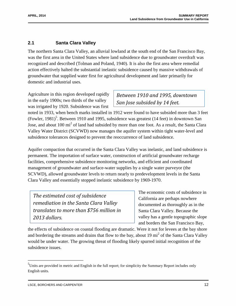
The estimated cost of subsidence
remediation in the Santa Clara Valley
translates to more than $756 million in
2013 dollars.
Between 1910 and 1995, downtown
San Jose subsided by 14 feet.
2.1 Santa Clara Valley
The northern Santa Clara Valley, an alluvial lowland at the south end of the San Francisco Bay,
was the first area in the United States where land subsidence due to groundwater overdraft was
recognized and described (Tolman and Poland, 1940). It is also the first area where remedial
action effectively halted the substantial inelastic subsidence caused by massive withdrawals of
groundwater that supplied water first for agricultural development and later primarily for
domestic and industrial uses.
Agriculture in this region developed rapidly
in the early 1900s; two thirds of the valley
was irrigated by 1920. Subsidence was first
noted in 1933, when bench marks installed in 1912 were found to have subsided more than 3 feet
(Fowler, 1981)5. Between 1910 and 1995, subsidence was greatest (14 feet) in downtown San
Jose, and about 100 mi2 of land had subsided by more than one foot. As a result, the Santa Clara
Valley Water District (SCVWD) now manages the aquifer system within tight water-level and
subsidence tolerances designed to prevent the reoccurrence of land subsidence.
Aquifer compaction that occurred in the Santa Clara Valley was inelastic, and land subsidence is
permanent. The importation of surface water, construction of artificial groundwater recharge
facilities, comprehensive subsidence monitoring networks, and efficient and coordinated
management of groundwater and surface-water supplies by a single water purveyor (the
SCVWD), allowed groundwater levels to return nearly to predevelopment levels in the Santa
Clara Valley and essentially stopped inelastic subsidence by 1969-1970.
The economic costs of subsidence in
California are perhaps nowhere
documented as thoroughly as in the
Santa Clara Valley. Because the
valley has a gentle topographic slope
and borders the San Francisco Bay,
the effects of subsidence on coastal flooding are dramatic. Were it not for levees at the bay shore
and bordering the streams and drains that flow to the bay, about 19 mi2 of the Santa Clara Valley
would be under water. The growing threat of flooding likely spurred initial recognition of the
subsidence issues.
5Units are provided in metric and English in the full report; for simplicity the Summary Report includes only
English units.

APRIL, 2014 SUMMARY REPORT Land Subsidence from Groundwater Use in California
{00233942.DOCX.14}
LSCE, BORCHERS AND CARPENTER 13
Land subsidence from groundwater
extraction in the San Joaquin Valley has
been called the greatest human
alteration of the Earth’s surface.
Roll (1967), Viets and others (1979), and Fowler (1981) estimated the direct costs of subsidence
remediation activities in the Santa Clara Valley, including repairing water wells damaged or
destroyed during 1960-1965, building and operation of sanitary and storm sewers and pumping
stations where waste fluids no longer flowed easily by gravity, building bayfront dikes and
stream channel levees to prevent flooding, and raising bridges and roads. Translated to 2013
dollars, these costs totaled $756 million. Additional costs included replacing destroyed wells or
repairing wells at times other than 1960-1965, raising 50 miles of levees protecting 30 mi2 of
privately owned salt evaporation ponds, de-silting stream channels in flood-prone areas,
repairing flood damaged roads, moving flooded railroad tracks, or property values lost by flood
zone designation or levee-obstructed views.
Although subsidence has been halted in the Santa Clara Valley, considerable effort and expense
are expended annually to deal with its legacy. Strict subsidence monitoring programs assure that
these continuing investments are not wasted.
2.2 San Joaquin Valley
Land subsidence from groundwater
extraction in the San Joaquin Valley has
been called the greatest human alteration of
the Earth’s surface (Galloway et al., 1999).
It is inexorably linked to the development
of agriculture and the availability of water.
Agriculture in the San Joaquin Valley developed a reliance on the aquifer system because the
region is semi-arid; streamflow into the east side of the valley varies substantially from year to
year and is mostly not available on the west side. More than half of the thickness of the aquifer
system in the valley is composed of fine-grained sediments, including clays, silts, and sandy or
silty clays (Williamson et al., 1989) that are susceptible to compaction if depressured by
pumping wells.
Subsidence related to groundwater withdrawal in the valley began in the mid-1920s and
increased as agricultural development intensified after World War II. Subsidence rates eventually
exceeded 1 ft/yr in some places. Eventually groundwater levels in the deep aquifer system on the
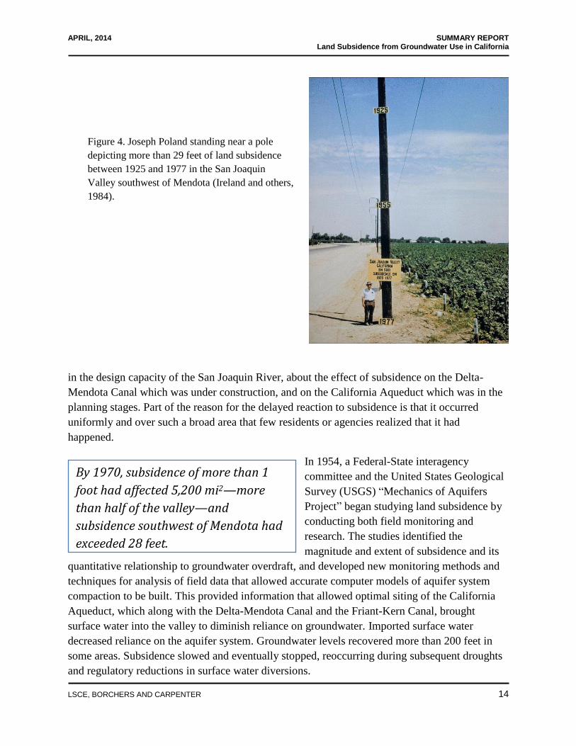
west side of the valley declined by more than 400 feet. By 1970, subsidence of more than 1 foot
had affected 5,200 mi2—more than half of the valley—and subsidence southwest of Mendota
exceeded 28 feet (Poland et al., 1975) (Figure 4).
Despite early recognition of the relation between groundwater-level decline and subsidence near
Delano (Ingerson, 1940), subsidence from groundwater overdraft was not investigated regionally
until the early 1950s, when government agencies became concerned about a 30 percent reduction
APRIL, 2014 SUMMARY REPORT Land Subsidence from Groundwater Use in California
{00233942.DOCX.14}
LSCE, BORCHERS AND CARPENTER 14
By 1970, subsidence of more than 1
foot had affected 5,200 mi2—more
than half of the valley—and
subsidence southwest of Mendota had
exceeded 28 feet.
in the design capacity of the San Joaquin River, about the effect of subsidence on the Delta-
Mendota Canal which was under construction, and on the California Aqueduct which was in the
planning stages. Part of the reason for the delayed reaction to subsidence is that it occurred
uniformly and over such a broad area that few residents or agencies realized that it had
happened.
In 1954, a Federal-State interagency
committee and the United States Geological
Survey (USGS) “Mechanics of Aquifers
Project” began studying land subsidence by
conducting both field monitoring and
research. The studies identified the
magnitude and extent of subsidence and its
quantitative relationship to groundwater overdraft, and developed new monitoring methods and
techniques for analysis of field data that allowed accurate computer models of aquifer system
compaction to be built. This provided information that allowed optimal siting of the California
Aqueduct, which along with the Delta-Mendota Canal and the Friant-Kern Canal, brought
surface water into the valley to diminish reliance on groundwater. Imported surface water
decreased reliance on the aquifer system. Groundwater levels recovered more than 200 feet in
some areas. Subsidence slowed and eventually stopped, reoccurring during subsequent droughts
and regulatory reductions in surface water diversions.
Figure 4. Joseph Poland standing near a pole
depicting more than 29 feet of land subsidence
between 1925 and 1977 in the San Joaquin
Valley southwest of Mendota (Ireland and others,
1984).

APRIL, 2014 SUMMARY REPORT Land Subsidence from Groundwater Use in California
{00233942.DOCX.14}
LSCE, BORCHERS AND CARPENTER 15
Comprehensive leveling surveys of the valley ended in 1970; and, over time, funding for
coordinated subsidence investigations also ended, and field installations such as borehole
extensometers and water-level monitoring wells were decommissioned or fell into disrepair. The
California Department of Water Resources (DWR) continued to collect compaction data from a
few extensometers and from deep monitoring wells where available, and state, federal, and local
water agencies continued to run surveys on canal alignments intermittently, but analysis of this
information has not been coordinated.
2.2.1 Historical Subsidence in the San Joaquin Valley
Specific instances and costs of historical subsidence in the San Joaquin Valley include the
following:
Delta-Mendota Canal—Repairs to submerged canal service turnouts, drain inlets, bridges,
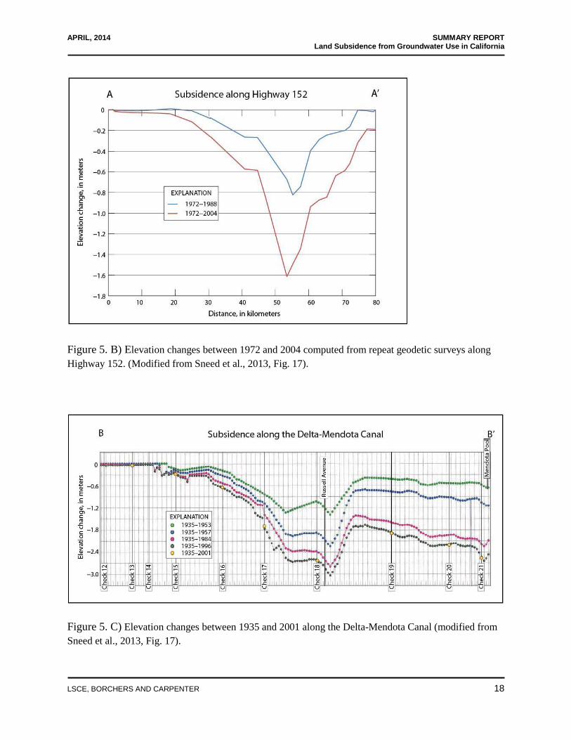
pipelines, check structures, embankments and concrete linings. Subsidence has impacted
about 30 miles of the Delta-Mendota Canal upstream from its terminus at Mendota Pool
by submerging canal service turnouts, drain inlets, bridges, pipelines, and check
structures used to control water surface elevation in the canal, and by overtopping the
concrete lining of the canal, reducing embankment freeboard, and flow capacity (Figure
5C). The United States Bureau of Reclamation (USBR) raised embankments and bridges,
and relocated pipeline crossings, and they and the San Luis Delta Mendota Water
Authority made other repairs and modifications. Using 1977 as the base year for these
repairs, the cost of USBR repairs in 2013 dollars is conservatively estimated as $30
million. (Prokopovich (1969, 1973, and 1986), Prokopovich and Herbert (1968) and
Prokopovich and Marriot (1983))
Outside Canal—Costs to raise embankments, bridges, turnouts, and weirs. Expensive
physical infrastructure problems have been caused by land subsidence in the Mendota
area. The flow capacity of the Central California Irrigation District’s Outside Canal has
been reduced 45 percent at the partly submerged Russell Avenue bridge (Figure 6).
Embankments were raised on the Outside Canal in 1971 and 1994, and improvements are
still continuing. Total costs for subsidence remediation on the Outside Canal are expected
to exceed more than $8.2 million.
Friant-Kern Canal—Repairs to canal berms, pumping plants, bridges, concrete linings,
canal turnouts, drains, and inlets. About 30 miles of the Friant-Kern Canal were impacted
by subsidence in the Tulare-Wasco area. Between the date construction was completed in
1951, and January 1975, parts of the affected reach of the canal subsided 5.5 feet,
interfering with operational activities (Prokopovich, 1983). Measurements of water depth
at closed check dams indicated that subsidence also affected parts of the canal farther
south toward Bakersfield. During 1976-1980 a 16.67 mile reach of the canal was
rehabilitated. Canal berm materials were excavated and re-compacted, concrete linings

APRIL, 2014 SUMMARY REPORT Land Subsidence from Groundwater Use in California
{00233942.DOCX.14}
LSCE, BORCHERS AND CARPENTER 16
The [direct] cost of subsidence in the San
Joaquin Valley during 1955-1972 was
estimated to be more than $1.3 billion in
2013 dollars.
were extended upward, bridges were raised, canal turnout structures and drain inlets were
modified, and three large pumping plants were raised on new foundations. Costs for the
remedial activities in 2013 dollars totaled $15 million (calculated from 1976, 1977, and
1980 contract amounts provided in Prokopovich, 1983).
San Luis Canal—Raising of canal linings, bridges, and other canal structures, as well as
the rehabilitation of roads. The San Luis Canal, a jointly used feature of the federal
Central Valley Project and the California State Water Project that was completed in 1968,
has been affected by subsidence along 85 miles of its length between the Los Banos and
Kettleman City areas. The canal, now considered the middle section of the California
Aqueduct, passes through three major subsidence bowls: 1) southwest of Mendota, 2)
near the town of Cantua Creek, and 3) near the town of Huron (Ireland and others, 1984).
Because subsidence due to groundwater extraction had adversely affected the earlier-built
Delta-Mendota Canal, designers incorporated as much as 10 feet of extra freeboard into
the San Luis Canal, adding $30.7 million (2013 dollars) to construction costs. Additional
subsidence required additional raising of canal linings, bridges, and other canal structures
and rehabilitation of roads at costs of $1.6 million, $4.7 million, and $4.5 million,
respectively, during 1982, 1983, and 1984 (Prokopovich and Marriot, 1983). Adjusting
for inflation, these costs amounted to $55.7 million in 2013 dollars. Total construction
costs to account for subsidence were $86.4 million.
The total cost to the government to account for or repair subsidence damage to major
public canals and drains in the San Joaquin Valley was $133.86 million (2013 dollars).
These are contract construction costs and do not include costs for design, inspection, or
studies. They also do not include the considerable cost of precompacting the San Luis
Canal and major lateral canal alignments by diking and flooding to avoid subsidence
caused by hydrocompaction of moisture deficient soils in the western San Joaquin
Valley.
In addition to these costs to the
government, additional costs
such as well replacement were
borne by farmers and irrigation
districts. According to Wilson
(1968), 275 wells were reported with failed casings due to subsidence-induced damage in
the 618 mi2 region of maximum subsidence in the valley during 1950-1961. Current costs
to replace an 18-in diameter agricultural well average $200-$250 per foot (Scott Lewis,
Luhdorff and Scalmanini Consulting Engineers, oral comm. November 20, 2013). A
conservative cost estimate to replace these wells, assuming each well is about 1,600 feet
deep, is $90 million dollars (2013 dollars).

APRIL, 2014 SUMMARY REPORT Land Subsidence from Groundwater Use in California
{00233942.DOCX.14}
LSCE, BORCHERS AND CARPENTER 17
Figure 5. A) Recent subsidence in the central San Joaquin Valley near El Nido between January 2007 and
March 2011. Cross sections A-A’ and B-B’ are shown in Figures 5B and 5C, respectively. (InSAR
derived subsidence data were provided as preliminary unpublished data courtesy of NASA-JPL).
APRIL, 2014 SUMMARY REPORT Land Subsidence from Groundwater Use in California
{00233942.DOCX.14}
LSCE, BORCHERS AND CARPENTER 18
Figure 5. B) Elevation changes between 1972 and 2004 computed from repeat geodetic surveys along
Highway 152. (Modified from Sneed et al., 2013, Fig. 17).
Figure 5. C) Elevation changes between 1935 and 2001 along the Delta-Mendota Canal (modified from
Sneed et al., 2013, Fig. 17).

APRIL, 2014 SUMMARY REPORT Land Subsidence from Groundwater Use in California
{00233942.DOCX.14}
LSCE, BORCHERS AND CARPENTER 19
Recent InSAR analyses show two
large areas in the San Joaquin Valley
currently subsiding substantially.
Figure 6. The partly submerged Russell Avenue bridge over the Outside Canal north of Mendota,
California. Before subsidence, canal inspections by Central California Irrigation District staff were
conducted from a boat passing under the bridge.
When costs of lost property value due to condemnation, re-grading irrigated land, and
replacement of irrigation pipelines and wells in subsiding areas are considered, the economic
cost of subsidence in the San Joaquin Valley was estimated to be $1.3 billion in 2013 dollars
during 1955-1972 (Gilbert Bertoldi, USGS (ret.), written commun., November 29, 2013). No
estimates of the indirect costs of land subsidence, such as flooding and long-term environmental
effects, have been made. Costs to repair canals also are not included in Bertoldi’s estimates.
2.2.2 Current Subsidence in the San Joaquin Valley
The current drought and changes to cropping
patterns from row crops and rangeland to
tree and other permanent crops have again
forced reliance on aquifer systems in the San
Joaquin Valley for agricultural irrigation
supplies. Recent Interferometric Synthetic Aperture Radar (InSAR) analyses show that two large
areas (Figure 7) in the San Joaquin Valley are currently subsiding substantially (Thomas Farr,

APRIL, 2014 SUMMARY REPORT Land Subsidence from Groundwater Use in California
{00233942.DOCX.14}
LSCE, BORCHERS AND CARPENTER 20
Figure 7. Recent subsidence in the central and southern San Joaquin Valley. Subsidence in the
southern subsidence bowl is during 2007-2010, and in the northern subsidence bowl during 2007-
2011. Recently subsiding areas are distant from the point of maximum historical subsidence during
1926-1970. (InSAR derived subsidence data were provided as preliminary unpublished data courtesy
of NASA-JPL).

APRIL, 2014 SUMMARY REPORT Land Subsidence from Groundwater Use in California
{00233942.DOCX.14}
LSCE, BORCHERS AND CARPENTER 21
Subsidence rates in the central San
Joaquin (El Nido) area are currently
about 20 times the rate of historical
subsidence in this area.
NASA-JPL, written communication, September, 2013; Jessica Reeves, Stanford University,
written commun., July 9, 2013; Sneed et al, 2013). These areas are a 1,200 mi2 subsidence bowl
near El Nido (south of Merced, and west of Madera ) and a larger bowl, about 2,700 mi2, west of
Tulare and east of Kettleman City (Figure 7). Currently subsiding areas shown on Figure 7 are
shifted substantially from the locales of major subsidence during 1926-1970. Studies and
planning efforts associated with the San Joaquin River Restoration Program have made much
more information available in the northern subsidence bowl than in the southern bowl to describe
specific instances of infrastructure problems related to current subsidence in the San Joaquin
Valley. These include:
The northern subsidence bowl: El Nido (Figures 5, 7). Subsidence rates in the El Nido area are
currently about 20 times the rate of average historical subsidence in this area. The U. S. Army
Corps of Engineers (USACE) predicts that
17 feet of subsidence will occur in the
northern subsidence bowl during 2000-
2060.
Sack Dam—Design and construction challenges. Surveys by DWR contractors found 0.6
feet of subsidence near the Sack Dam during 2008-2010. InSAR analysis by NASA-JPL
during 2007-2011 determined that more than 1 foot of subsidence had occurred near the
Sack Dam. Surveying by the USBR associated with redesign of the Sack Dam as part of
the San Joaquin River Restoration Program determined that subsidence near the dam
continued at a rate of about 0.5 ft/yr during 2011-2013. These discoveries halted planned
construction and design efforts for the $25 million project, as agencies considered how to
adapt to the lowered land surface and prepare for likely continued subsidence.
San Joaquin River—Reduction in flow capacity. Results of InSAR analysis and
surveying showed at least 1.8 feet of subsidence near the San Joaquin River between
2008 and 2010. Subsidence causes flow channels to sag, erosion at the upstream end of
the sag and sediment deposition in the sagged area. Subsidence likely has reduced the
flow capacity of the San Joaquin River west of El Nido to less than half its design
capacity of 1,500 ft3/s (Reggie Hill, Lower San Joaquin Levee District (LSJLD), oral
commun., December 11, 2013).
Eastside Bypass—Reduction in levee freeboard, reduction in flow capacity, increased
extent of flooding. InSAR analysis and surveying show 1.8 feet of subsidence near the
Eastside Bypass during 2008-2010. In 2008 the flow capacity of one reach of the bypass
was 5,000 ft3/s lower than the designed capacity, 17,500 ft
3/s. Modeling studies by DWR

APRIL, 2014 SUMMARY REPORT Land Subsidence from Groundwater Use in California
{00233942.DOCX.14}
LSCE, BORCHERS AND CARPENTER 22
predict that subsidence continuing at current rates will reduce levee freeboard by an
additional 1.5 feet between 2011 and 2016 reducing the flow capacity of this reach to
10,000 ft3/s. The USACE predicts that a flood breaching the west levee, which had
subsided more than the east levee, would inundate at least 32 mi2 and possibly as much as
170 mi2 west from the bypass.
Highway 152—Surveying by California Department of Transportation (Caltrans)
indicates that Highway 152 has subsided about 5.3 feet during 1972-2004 (Figure 5B).
The highway likely continues to subside along with all other surface infrastructure in this
subsidence bowl.
California High Speed Rail (CHSR)—Initial alignment of the Merced to San Jose section
of the planned CHSR indicates that the currently planned alternative routes pass through
parts of the northern subsidence bowl and that the southernmost route of the rail line
traverses the northern edge of the area of maximum subsidence and greatest rate of
subsidence south from Highway 152 (Figure 5A, 7).
The southern subsidence bowl: Tulare-Kettleman City (Figure 7). Maximum subsidence during
2007-2011 was 3.9 feet. The rate of subsidence in this area is similar to and in some places
greater than that of the northern subsidence bowl and extends much more broadly throughout the
San Joaquin Valley. The maximum rate of subsidence here is about twice the maximum rate that
occurred historically in the area. Current known effects include:
Highway 198—Caltrans surveying along Highway 198 (Figure 8) shows that the road
subsided 9.37 feet during 1900s-2004. The highway passes through the northern edge of
the subsidence bowl and so the survey data do not fully capture the maximum subsidence
in this region. Subsidence studies at the Lemoore Naval Air Station (Corbett and others,
2011) indicate that total subsidence there between 1925 and 2010 exceeded 10 feet—
considerably more than the Caltrans survey showed during the 1960s-2004 (3.5-4.0 feet).
Canals—flow capacity has been reduced in many canals in the area and canal check
structures in sagging canals have been rendered marginally useful.
California High Speed Rail—the proposed alignment of the main north to south line of
the CHSR runs directly through the subsidence bowl.

APRIL, 2014 SUMMARY REPORT Land Subsidence from Groundwater Use in California
{00233942.DOCX.14}
LSCE, BORCHERS AND CARPENTER 23
Figure 8. A) Location of Caltrans surveying profile along Highway 198 in the southern San Joaquin
Valley, and Lemoore Naval Air Station. (Courtesy of California Department of Water Resources.)
Figure 8. B) Elevation changes between the 1960s and 2004 computed from repeat geodetic surveys along
Highway 198. (Courtesy of California Department of Water Resources.)
Water districts, ranchers, and others are dealing with subsidence impacts on water delivery
infrastructure in an information vacuum because there has been no coordinated monitoring of
land subsidence. Were it not for fortuitous satellite radar analyses (NASA-JPL, Stanford
University, USGS) and recent attention focused by the San Joaquin River Restoration Program
planning activities, the breadth and magnitude of subsidence in the area would be unknown.
Much infrastructure in both the northern and southern subsidence bowls potentially could be
impacted by subsidence. Fortunately, federal, state and local agencies have been alerted to the
issues of recent subsidence and can begin to implement appropriate strategies to monitor

APRIL, 2014 SUMMARY REPORT Land Subsidence from Groundwater Use in California
{00233942.DOCX.14}
LSCE, BORCHERS AND CARPENTER 24
subsidence and minimize its impacts. For example, geotechnical and design engineers now can
adapt plans for design of the CHSR to accommodate potential future subsidence.
2.3 Sacramento Valley
The Sacramento Valley forms the northern one third of the agriculturally rich Central Valley of
California. Although it possesses substantial supplies of surface water, land subsidence in the
Sacramento Valley has occurred when groundwater-levels declined in response to pumping for
irrigation and public water supplies during droughts or in areas undersupplied by surface water.
The earliest subsidence investigations in the southwestern Sacramento Valley were done using
leveling data collected by the USGS and the National Geodetic Survey (NGS) between 1935 and
1964. Land-surface profiles based on these data showed apparent land subsidence of more than 2
feet along a level line between Zamora and Knights Landing in northern Yolo County; more than
1.0 foot near Arbuckle in southern Colusa County; and more than 1.5 feet in central Yolo County
between Zamora and Davis (Lofgren and Ireland, 1973). The area of greatest subsidence is south
of the terminus of the Tehama Colusa Canal, where agriculture developed relying solely on
groundwater for irrigation.
The magnitude of permanent land subsidence observed throughout the southwestern Sacramento
Valley indicates that groundwater levels have dropped below the water level at which inelastic
compaction of aquifer sediments is triggered. An early evaluation of video logs from 317 water
wells and water-level data showed that damaged wells had experienced historically low water
levels. Intact wells either were not experiencing historically low water levels, or were
constructed subsequent to the 1976-1977 drought that had stressed the aquifer system (Borchers
et al., 1998). Drilling and well-services companies reported that “well casings were snapping like
match sticks” throughout the southwestern Sacramento Valley during the 1976-1977 drought,
and that they could not keep pace with the demand for replacement wells.
Damaged wells are located in central Colusa County, through Yolo County, to Dixon in Solano
County. However, the Yolo County Global Positioning System (GPS) network was surveyed
later than the period when most wells were damaged (1976-1977) and does not extend into the
adjacent counties, so it cannot identify the extent of subsidence regionally. Subsidence in the
southwestern Sacramento Valley is a regional problem that cannot be adequately monitored by
local agencies acting independently. Monitoring the magnitude and extent of land subsidence
and its cause, and devising workable solutions to limit future occurrences requires interagency
coordination.

APRIL, 2014 SUMMARY REPORT Land Subsidence from Groundwater Use in California
{00233942.DOCX.14}
LSCE, BORCHERS AND CARPENTER 25
At Edwards Air Force Base, subsidence caused
sink-like depressions and earth fissures on the
surface of Rogers Lake bed, adversely affecting
the runways on the lake bed that are used for
landing aircraft.
2.4 Antelope Valley
Groundwater accounts for as
much as 90 percent of the water
supply for agricultural and
urban uses in the Antelope
Valley in the western Mojave
Desert east of Los Angeles. In
the city of Lancaster where the
population quadrupled between
1977 and 2010, extensive pumping contributed to groundwater level declines of as much as 300
feet since the 1930s. A regional relationship between land subsidence and groundwater-level
declines in the central Antelope Valley was established on the basis of geodetic and hydrologic
monitoring during 1926-1992 (Ikehara and Phillips, 1994). Subsidence of 6.6 feet at Lancaster
and more than 3 feet at the south edge of Rogers Lake resulted from groundwater pumping that
vastly exceeded recharge to the aquifer system (Figure 9). A 1,969 feet long by 7.5 feet deep
fissure located about 6.8 miles east-northeast from Lancaster was attributed to historical water-
level declines of 245 feet that had occurred prior to its appearance in 1978. At Edwards Air
Force Base (EAFB) groundwater levels declined 150 feet between 1915 and 1991.
At EAFB, subsidence caused sink-like depressions, polygonal cracks, and large earth fissures on
the playa surface of Rogers Lake bed, adversely affecting the runways on the lake bed that are
used for landing aircraft. Numerical modeling also indicated that due to the thickness and low
permeability of clayey confining units, only half the ultimate compaction would occur during the
30 years subsequent to the modeling. Residual inelastic compaction measured during winter
periods in the 1990s is partly caused by the ongoing long-term effects of delayed yield from
thick, slowly draining confining units still responding to large water-level declines between 1950
and 1975. Residual compaction and land subsidence from slowly draining confining units and
clayey interbeds is a legacy of groundwater mining and must be carefully considered in long-
term management of land and water resources at EAFB and elsewhere in the Antelope Valley.
In addition to earth fissures, other negative consequences of land subsidence in Antelope Valley
include altered drainage gradients; increased flooding and erosion; failed well casings; and
structural damage to roads, buildings, pipelines, canals, homes, and other structures. Facing
future population growth and limited options for alternative water sources, water managers in
Antelope Valley are seeking ways to make the best use of currently available resources. Injection
of treated State Water Project water into the aquifer system during the winter (when it is most
available) for later use in the summer (the peak demand period) is one potential element of a
groundwater management plan. The USGS, with local agencies, studied the feasibility of direct
well injection through existing production wells and developed a simulation/optimization model

APRIL, 2014 SUMMARY REPORT Land Subsidence from Groundwater Use in California
{00233942.DOCX.14}
LSCE, BORCHERS AND CARPENTER 26
to help evaluate the effectiveness of an injection program for halting the decline of groundwater
levels and avoiding future land subsidence while meeting increasing groundwater demand.
2.5 Coachella Valley
The Coachella Valley is located in Riverside County and extends 45 miles from the San
Bernardino Mountains to the northern shore of the Salton Sea. Groundwater has been a major
source of agricultural, municipal, and domestic water supply in the Coachella Valley since the
early 1920s. Groundwater levels declined throughout the Coachella Valley from the 1920s until
1949. In 1948, a large earth fissure formed in the La Quinta area. In 1949, imports of surface
water from the Colorado River to the southern Coachella Valley began, resulting in decreased
pumping and a recovery of water levels in some areas. Since the 1970s, demand for water in the
southern Coachella Valley has exceeded the deliveries of the imported surface water, and water
levels have again declined. The declining water levels have renewed land subsidence in the
Coachella Valley (Sneed, USGS, oral communication, May 30, 2013).
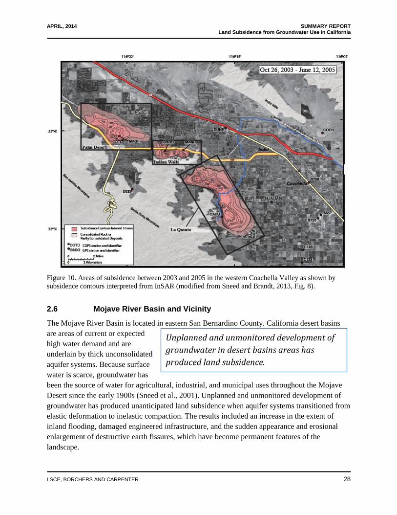
Concerns about land subsidence prompted the Coachella Valley Water District (CVWD) to
contact the USGS to cooperatively establish and operate a land subsidence monitoring network.
InSAR measurements made between June 27, 1995 and September 19, 2010 indicate that land
subsidence ranging from 0.72 to 1.97 feet occurred near Palm Desert, Indian Wells, and La
Quinta (Figure 10). Average subsidence rates in Palm Desert were relatively stable, increasing
Figure 9. Land subsidence in
Antelope Valley between 1930
and 1992 (modified by Galloway
et al., 1998 from Ikehara and
Phillips, 1994).

APRIL, 2014 SUMMARY REPORT Land Subsidence from Groundwater Use in California
{00233942.DOCX.14}
LSCE, BORCHERS AND CARPENTER 27
from 0.13 ft/yr during 1995-2000 to about 0.15 ft/yr during 2003-2010. Recently, earth fissuring
has reoccurred near La Quinta and differential compaction that damaged homes there has
resulted in litigation. Differential compaction that damaged homes in the Indian Wells area also
has been recently reported. A subsidence profile covering about 27 miles of the Coachella
Branch of the All American Canal showed that the canal had subsided as much as 1.35 feet in the
La Quinta area during June 27, 1995 to September 19, 2010.
The areas that have subsided in the Coachella Valley between 1996 and 2010 are coincident with
locations where groundwater levels declined, both during this period and during most of the past
century. In the northern and central parts of the study area, where substantial subsidence was
measured by 2010, water levels exhibited long-term declines during 1995-2010. The subsidence
in these areas is likely to be mostly permanent because water levels have declined to historically
low levels.
The CVWD has had initial success in halting declining water levels and subsidence in one area
of the valley. In the southwestern part of the valley, subsidence rates slowed or land surface
slightly rebounded during mid-2009-2010 as water levels rose in response to deliveries of
Colorado River water to groundwater recharge facilities. The correspondence between the timing
of increased deliveries and significant water-level recoveries suggests that the water applied to
the recharge ponds is effectively recharging the aquifer system, although reduced groundwater
pumping also can cause water-level recovery. The CVWD is encouraging golf courses and other
landscape irrigators to employ reclaimed water for irrigation purposes. An effective land
subsidence monitoring program helps water managers assess the effects of groundwater recharge
and conservation efforts.
APRIL, 2014 SUMMARY REPORT Land Subsidence from Groundwater Use in California
{00233942.DOCX.14}
LSCE, BORCHERS AND CARPENTER 28
Unplanned and unmonitored development of
groundwater in desert basins areas has
produced land subsidence.
Figure 10. Areas of subsidence between 2003 and 2005 in the western Coachella Valley as shown by
subsidence contours interpreted from InSAR (modified from Sneed and Brandt, 2013, Fig. 8).
2.6 Mojave River Basin and Vicinity
The Mojave River Basin is located in eastern San Bernardino County. California desert basins
are areas of current or expected
high water demand and are
underlain by thick unconsolidated
aquifer systems. Because surface
water is scarce, groundwater has
been the source of water for agricultural, industrial, and municipal uses throughout the Mojave
Desert since the early 1900s (Sneed et al., 2001). Unplanned and unmonitored development of
groundwater has produced unanticipated land subsidence when aquifer systems transitioned from
elastic deformation to inelastic compaction. The results included an increase in the extent of
inland flooding, damaged engineered infrastructure, and the sudden appearance and erosional
enlargement of destructive earth fissures, which have become permanent features of the
landscape.

APRIL, 2014 SUMMARY REPORT Land Subsidence from Groundwater Use in California
{00233942.DOCX.14}
LSCE, BORCHERS AND CARPENTER 29
The Fremont Valley, a deep, closed alluvial basin at the southern terminus of the Sierra Nevada
and just north from Antelope Valley, contains an aquifer system composed of as much as 900
feet of sedimentary materials (Holzer, 1984). Prior to 1920, wells in the valley center flowed6; by
1977, water levels in the central part of the valley had declined as much as 243 feet, primarily in
response to increased irrigation pumpage (Holzer, 1984). Subsidence caused by groundwater
withdrawal was documented by Pampeyan and others (1988). Subsidence has tilted the Koehn
Lake playa surface so that when surface water ponds on the playa during storms, it also floods
the area southwest of the playa where subsidence is centralized. Large earth fissures (Figure 11)
also formed in the Fremont Valley (Holzer and Galloway, 2005).
The USGS, in cooperation with the Fort Irwin National Training Center (NTC) in the Mojave
Desert, is investigating the mechanisms driving deformation on the surface of Bicycle Lake
Playa. Bicycle Lake Playa contains the runways used to transport troops and supplies to Fort
Irwin; its stability is of great concern to the NTC. An earth fissure and sink-like depressions
appeared on the playa in 2005 (Densmore, et al., 2010). Giant desiccation cracks have also been
observed. Increased groundwater pumping in the 1990s lowered groundwater levels 82 feet by
2009 and contributed to 0.9 feet of land subsidence during 1993-2006.
Concerns related to the potential for new or renewed land subsidence and fissuring prompted the
Mojave Water Agency (MWA) to contact the USGS to assess land subsidence. The USGS
established a geodetic network of monuments to monitor land subsidence in the Lucerne Valley
using GPS and prepared spatially detailed maps using InSAR to determine changes in vertical
land-surface elevation for the parts of the Mojave River and Morongo groundwater basin that are
managed by MWA.
Groundwater levels in the Lucerne Valley, in the Mojave River watershed east of Victorville,
California, have declined as much as 100 feet since the 1950s. A GPS survey in 1998 indicated
that as much as 2 feet of land subsidence may have occurred since topographic maps were made
in 1969 and 1975 (Sneed et al., 2003). InSAR analysis indicated that the land surface southeast
of the Lucerne Lake playa subsided about 0.3 feet between April 24, 1992 and November 8,
1999 near where groundwater levels had declined 100 feet by the early 1990s. Earth fissures
more than 3 feet in width and depth trend northeast-southwest across the southern playa (Figure
12) (Sneed et al., 2003a).
In 2002, an agreement settled the longstanding issues associated with adjudication of water in the
Mojave River Basin area, establishing thresholds for pumping that helped to reduce groundwater
overdraft. To mitigate subsidence and other effects of overdraft in the Mojave River Basin, the
MWA is using imported California State Water Project (SWP) water for artificial recharge by
6 The term ‘flowing well’ indicates that the water levels in the well are above the ground surface.

APRIL, 2014 SUMMARY REPORT Land Subsidence from Groundwater Use in California
{00233942.DOCX.14}
LSCE, BORCHERS AND CARPENTER 30
surface spreading. Adjudication, court ordered specification of rights of groundwater withdrawal,
is perhaps the last option available to ensure sustainability of water supplies when other options
have not been successful.
Figure 11. Earth fissure associated
with land subsidence caused by
groundwater pumping in Fremont
Valley, California, March 1978 (from
Holzer and Galloway, 2005).
Figure 12. Earth fissure near the
southeast edge of Lucerne Lake
playa in the Mojave Desert,
California. View is to the northeast,
with a five-gallon bucket for scale.
(Sneed et al., 2003a, Fig. 6 B)

APRIL, 2014 SUMMARY REPORT Land Subsidence from Groundwater Use in California
{00233942.DOCX.14}
LSCE, BORCHERS AND CARPENTER 31
There is no state or federal agency in
California that has the specific
responsibility to monitor land subsidence.
3.0 MEASURING AND MONITORING LAND SUBSIDENCE
Alarming rates of subsidence recently
have been measured in several areas
of California. This information has
been reported only after the impacts
from subsidence have occurred—
emphasizing the need for increased monitoring. There is no state or federal agency in California
that has the responsibility, or a program in place, specifically to monitor land subsidence.
Consequently, there are no statewide monitoring networks for subsidence. Smaller regional,
county-wide, or local monitoring networks are sometimes constructed to address a specific
subsidence issue. These small networks usually are not geared for long-term monitoring, but
rather operate for a project-specific period of time, usually implemented in reaction to a
subsidence crisis that has damaged essential infrastructure.
There are a few exceptions: adjudicated basins sometimes have management objectives that
require detailed subsidence monitoring and reporting, as do some agencies that are the primary
purveyor of water in a region. If land subsidence monitoring is defined as the systematic and
regular acquisition of information to describe the changing extent and magnitude of the problem,
then most of California must be considered unmonitored.
Viable methods for measuring and monitoring subsidence are briefly discussed below; additional
information is included in the full report (Luhdorff and Scalmanini Consulting Engineers, et al.,
2014, Report of Findings: Land Subsidence from Groundwater Use in California).
3.1 Surveying and the Global Positioning System
Historically, spirit-level surveys7 were used to measure changes in land-surface elevation of
bench marks. In 1995, the Navstar GPS, based on 24 earth-orbiting satellites, became fully
operational, providing continuously available access to at least 6 satellites visible to users in
North America. GPS measurements can be made with portable GPS receivers on a campaign
basis, or can incorporate data from more permanent installations at Continuous GPS sites
(CGPS).
There are more than 800 CGPS sites in California. These sites are unmanned and receive data
from GPS and sometimes other navigation satellite systems. They are installed, owned, and
operated by public agencies, consortiums, and private entities. Several of these entities archive
geodetic information from their own sites and from sites operated by other entities, and the data
7 Spirit-level surveys involve measuring the vertical difference between more than two locations, usually compared
to each other and to a known elevation at a benchmark.

APRIL, 2014 SUMMARY REPORT Land Subsidence from Groundwater Use in California
{00233942.DOCX.14}
LSCE, BORCHERS AND CARPENTER 32
are available via the Internet. CGPS sites are used as components of land deformation
monitoring networks that primarily show the horizontal movement of tectonic plates. Because
very few CGPS were installed with the intent to monitor land subsidence, few are optimally
located for that purpose.
Although they own and operate only one CGPS site in California, the NGS archives and provides
on their website for x, y, and z coordinates as well as time-series data for approximately 284
CGPS sites in California (Figure 13) that were constructed and are operated by other agencies or
consortia. These sites form the Continuously Operating Reference Station (CORS) network of
the NGS. The CORS network data add much-needed insight into the daily, seasonal, and climatic
variations of land surface elevations, which can be related to groundwater levels and extraction.
Figure 13. Continuously Operating Reference Station
(CORS) Network, retrieved from NGS September
16, 2013.

APRIL, 2014 SUMMARY REPORT Land Subsidence from Groundwater Use in California
{00233942.DOCX.14}
LSCE, BORCHERS AND CARPENTER 33
InSAR provides more detailed subsidence
information over larger areas than can be
measured by any other known technique.
3.2 Satellite Synthetic Aperture Radar Interferometry (InSAR)
InSAR is an invaluable satellite-based
remote-sensing technique that uses
radar signals to measure land-surface
deformation at an unprecedented level
of spatial detail and high degree of
measurement resolution. InSAR can provide more detailed subsidence mapping over larger areas
than can be measured by any other technique. Measurements can be done entirely retroactively,
by acquiring historic (1992 to present) repeat satellite Synthetic Aperture Radar (SAR) data sets
for the area of interest, and then processing the SAR data using interferometric techniques to
determine changes in elevation over large areas with a precision of a few millimeters. Much of
the Earth was repeatedly surveyed by the SAR satellites for establishing digital elevation models
and to detect deformation associated with earthquakes, volcanoes, and glaciers. Those data sets
provide the early basis for InSAR. Unfortunately, analyzing long-term SAR data can be difficult
because of the short life spans of the satellites (i.e., they are generally decommissioned after
about 5 years of service). The United States does not have a civilian SAR satellite, so presently
data must be purchased from international sources (e.g., Canada, Germany, Italy, Japan, and
Europe).
Under ideal conditions InSAR can detect surface deformation of less than half an inch over
hundreds of square miles, at a spatial resolution of 295 feet or better (Sneed et al., 2013). Radar
signals generated from a satellite are bounced off stable radar reflectors on the Earth’s surface,
such as roads, buildings, other engineered structures, mountains, and undisturbed ground and
rocks. The travel time of the radar signal from the satellite to the ground and back to the satellite
is proportional to the distance between the satellite and the ground. Subtracting, or interfering,
the data collected by a satellite passing over the Earth at different times provides the information
needed to prepare interferograms and interpret subsidence magnitude.
The quality of SAR data and the usefulness of interferograms can be affected by atmospheric
conditions (fog and clouds), land-use, satellite orbit geometry, ground cover, and topographic
relief. Methods have been developed to identify and discard, or correct for SAR images with
these issues. InSAR techniques have provided invaluable tools for remotely assessing large areas
with a high degree of measurement resolution, especially in California. InSAR techniques must
be integrated with ground-based geodetic surveying for ground-truthing and to provide
continuity of subsidence monitoring during periods when conditions are unsuitable for InSAR or
when satellites are inoperable.

APRIL, 2014 SUMMARY REPORT Land Subsidence from Groundwater Use in California
{00233942.DOCX.14}
LSCE, BORCHERS AND CARPENTER 34
3.3 LiDAR
LiDAR is a remote sensing technology that measures distance by illuminating a target with a
laser and analyzing the reflected light. LiDAR has been used extensively both in tripod-mounted
ground scanning and in airborne mapping surveys. LiDAR collects measurements independent of
weather conditions or time of day, but it is limited to line-of-sight measurements unless a target
is scanned from different vantage points. Tripod mounted LiDAR provides distance from the
instrument to millions of points on the land surface with a resolution of at least 0.39 inches.
Airborne LiDAR has been of invaluable assistance in geologic mapping and understanding
geomorphic processes that shape the land surface. There are many potential sources of error in
elevations acquired by airborne LiDAR: LiDAR equipment, interpolation, horizontal
displacement, flight height, terrain slope, and ground cover all influence LiDAR-determined
elevations (Hodgson and Bresnahan, 2004). Airborne LiDAR measurements have a lower
vertical resolution compared to other methods of measuring the elevation of the land surface.
3.4 Borehole Extensometers
Borehole extensometers measure the continuous change in vertical distance between the land
surface and a subsurface reference point, usually the bottom of a well (Riley, 1986). Several
different kinds of borehole extensometers have been used to measure aquifer-system compaction,
including pipe, cable (steel), rod, and magnetic/radioactive marker. Fiber-optic components for
borehole extensometers have been proposed. Pipe and steel-cable extensometers are most
common and have been used extensively in California. Aquifer-system compaction measured
using extensometers can be used to determine whether groundwater extraction from a particular
part of the aquifer system may be contributing to land subsidence. These measurements can be
compared to measurements of total land subsidence at the site (e.g., as determined from
surveying, co-located continuous GPS sites, or InSAR) to determine whether processes other
than aquifer-system compaction, such as hydrocarbon extraction, are also contributing to land
subsidence. Extensometers must be paired with several, short-screened, water-level monitoring
wells, called piezometers, to detect the onset of inelastic compaction for management purposes
and to calculate important mechanical and hydraulic properties of the aquifer system.
4.0 RECOMMENDATIONS
The following summary recommendations are provided to help California address the ongoing
economic and environmental impacts associated with over extraction of groundwater and
resulting land subsidence. A complete set of recommendations is contained in the full report
(Luhdorff and Scalmanini Consulting Engineers, et al., 2014, Report of Findings: Land
Subsidence from Groundwater Use in California). Only by monitoring and evaluation of
monitoring data can California avoid the potential costly impacts of land subsidence that have
plagued the state in the past. This report presents the technically necessary and desirable
APRIL, 2014 SUMMARY REPORT Land Subsidence from Groundwater Use in California
{00233942.DOCX.14}
LSCE, BORCHERS AND CARPENTER 35
measures. An economic analysis should be done to determine the most cost-effective set of
actions to limit and address future subsidence.
4.1 Monitor Land Surface Elevation Changes and Compaction
Remote Surveillance and Analysis: InSAR and Continuous GPS
InSAR provides the most cost efficient method to generate high-resolution land surface
deformation information over large areas with high spatial detail. InSAR products provide
detailed monitoring data and imagery that facilitates communicating the magnitude and extent of
subsidence to the general public. Although the United States does not have a civilian radar
satellite that can provide data for InSAR analysis, NASA and the Indian Space Agency are
cooperating to construct and launch a SAR satellite this decade.
All available SAR data covering unconsolidated aquifer systems in California should be acquired
and analyzed to identify areas of potential aquifer compaction, especially in areas of critical
infrastructure. Additionally, continuous GPS data should be examined for likely deformation
sources and correlated with InSAR results. New CGPS stations should be installed in areas of
actual or potential subsidence.
Ground Surveillance and Analysis: Surveying and Borehole Extensometry
Ground surveillance techniques are a critical component in identifying areas of subsidence, and
are an important complement to the remote techniques described above. Therefore, geodetic
surveys should be correlated with InSAR and CGPS data and with groundwater-level data.
Geodetic networks should be improved by upgrading and protecting geodetic monuments.
Borehole extensometers provide important aquifer compaction data. The distribution of
extensometers in groundwater basins and subbasins should undergo a comprehensive evaluation
and abandoned extensometers should be refurbished in priority areas. New extensometers should
be designed and installed to monitor likely compacting intervals in areas where InSAR, CGPS,
surveying, or infrastructure effects indicate that subsidence is occurring, or where groundwater
use is increasing. Extensometers should be paired with multi-depth monitoring wells
(piezometers) and a CGPS installation. New and more economical methods of building
extensometers should be tested and assessed.
4.2 Characterize Aquifer System and Monitor Groundwater Levels
Declining groundwater levels can trigger permanent land subsidence; it is therefore important to
monitor, compile, and interpret groundwater levels throughout the state. The collection and
storage of groundwater-level data by all federal, state, and local entities should be coordinated
and made publically available. The distribution of groundwater-level monitoring wells areally

APRIL, 2014 SUMMARY REPORT Land Subsidence from Groundwater Use in California
{00233942.DOCX.14}
LSCE, BORCHERS AND CARPENTER 36
and vertically within the aquifer system should be assessed to identify locations where additional
monitoring wells are needed to track changes in hydraulic head. In order to make groundwater
level monitoring measurements meaningful, and to use these measurements to understand the
response of the aquifer system to natural stresses (e.g., precipitation and droughts), imposed
stresses (e.g., pumping and artificial recharge) and the potential for land subsidence, requires that
the construction of monitored wells and the distribution of fine-grained sediments be understood
in the context of the aquifer system.
4.3 Collect, Store and Disseminate Data
Data collection related to subsidence, and the interpretation of such information, is fragmented. It
is critical to develop a state repository for subsidence-related information. Currently, collection,
storage, dissemination, and reporting of the data required to monitor and evaluate land
subsidence is dispersed among many federal, state, and local agencies. Coordinated data
maintenance should be achieved to assure consistent procedures for the collection, storage, and
availability of pertinent water-resources data. The Arizona Department of Water Resources
(ADWR) has developed a land subsidence monitoring program (Conway, 2013) that could
provide a model for implementing a statewide subsidence-monitoring program in California.
Alternatively, regional coordination of these responsibilities and an ongoing repository for the
storage and disbursement of these data would facilitate their efficient use by government
agencies, water purveyors and their consultants, and the public.
4.4 Evaluate and Prioritize Subsiding Groundwater Basins
If the above data were in available databases and archives, groundwater basins statewide could
be more easily and consistently prioritized for subsidence-relevant planning. In priority basins,
where subsidence has occurred or is likely to occur, a step-wise planning assessment and
management program could proceed as follows:
Evaluate historical groundwater-level monitoring information and establish augmented
groundwater-level monitoring networks to fully characterize the aquifer system.
Characterize land surface deformation in priority basins with InSAR techniques, follow-
up with geodetic surveys in subsiding areas, and establish a network of CGPS stations to
provide time-series data at critical points.
Establish borehole extensometers and associated multi-level monitoring well arrays to
measure compaction and hydraulic head in various depth intervals of the aquifer system
and CGPS installations to measure total change in land surface elevation at each
extensometer.

APRIL, 2014 SUMMARY REPORT Land Subsidence from Groundwater Use in California
{00233942.DOCX.14}
LSCE, BORCHERS AND CARPENTER 37
Establish measurable basin management objectives (BMOs) that identify goals for
groundwater levels, land-surface elevations, and rates of change of each to avoid amounts
or rates of inelastic compaction judged to be inappropriate for efficient operation of local
infrastructure. These BMOs could be implemented through pumping strategies, artificial
recharge, conservation strategies, and other sustainable groundwater management
alternatives.