Embed Size (px)
Citation preview
Suggested Solutions for Issues Concerning The Location of Mecca in Ptolemy’s Geography
Dan Gibson, 2013
Recently Muslim scholars have taken issue with my study of the geography of the Qur’an to claim that the city of Mecca did exist hundreds of years before Muhammad and that it is accurately charted in Ptolemy’s Geography which predates the founding of Islam by several centuries. This article will attempt to demonstrate that by using computer modeling it is possible to use Ptolemy’s coordinates to locate ancient cities and geographical features in Arabia and that Mecca is not on these maps.. (In this article I will use “AP” (After Ptolemy) to distinguish coordinates used under Ptolemy’s system from modern coordinates.)
Muslim scholars have claimed that Mecca can be found in Ptolemy’s list of places in Arabia, (Arabia Felix Map, Book 6, Chapter VII, Sixth map of Asia) but under another name. Some point to Macoraba (73 20 22 -AP) and some point to Centos village (69 20 21 30 AP) or Thebe town (69 40 21 - AP). In order to answer this we will have to understand something of the system that Ptolemy used, and examine his maps carefully before explaining why these conclusions are faulty.
Three Ancient Systems
For the sake of those who may not be familiar with ancient navigation, several systems of calculation have been used over the centuries by navigators and geographers to provide the positions of cities and other geographical features. The main ones are:
1. Ptolemaeus Claudius (Ptolemy) (90 AD - 168 AD), was a Greek writer who wrote among other things, the Geography, which listed latitude and longitude for many cities, mountains and other geographical features known in his day. The Geography is composed of eight books with the first volume explaining the method behind his system of coordinates. Volumes II - VII contain lists of locations and their coordinates with the last volume giving the 26 known

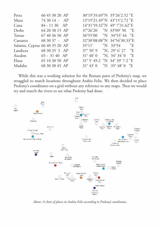
regions in his day. (Lennart Berggren and Jones 2000) He wrote in Greek about 150 A.D. during the time that Alexandria was waning as the centre of world learning. As far as we know Ptolemy did not draw a map, but rather plotted his coordinates on a large physical ball or globe. While his globe did not survive the ravages of time, the record of his coordinates survived in the Geography. His writings were later lost to the western world, although they were known in the Arab world. Around the beginning of the 15th century his works were rediscovered and translated from Greek into Latin, sparking the idea of a global coordinate system. This revolutionized medieval European geographical thinking. Starting in 1477 until as late as 1596 a large number of two dimensional European maps were drawn to try and replicate the list of places and coordinates that Ptolemy left us from his three dimensional globe. Starting in 1561 Gastaldi and then a host of others began to make corrections to the early maps and eventually maps based on Ptolemy were replaced by more modern maps based on actual physical observation by European explorers who began using the British system of latitude and longitude. (Tibbetts, G.R., Arabia in Early Maps, Falcon, Oleander, 1978)
Above: Ptolemy Cosmographia. A map drawn after Ptolemy in 1467. Note the size of Sri Lanka.
2. The Arabic system of Qiyās used isba’ and taf ’īla to measure distances. Locations of places were often given in isba’ (The number of fingers measured from the desert or ocean horizon to the pole star when held at arms length) and this system was the basis used for navigational instruments such as the kamal and later for the astrolabe. While Qiyās lost its popularity during the later Ottoman Empire, it continued to be used by some dhow captains until the 19th century. (Gibson, Qur’anic Geography, 2010, pg 335-345) Most descriptions of the science of Qiyās are found in Arabic nautical manuals known as rahmānis (Agius, Dionisius A., Seafaring in the Arabian Gulf and Oman: People of the Dhow, 2009). One of the better known manuals is: Kitāb ma’din al-asrār fi ‘ilm al-biḥār (The Mine of Secrets in the Science of the Seas, by Shaikh Nasr bin ‘Ali al Haduri). Handwritten copies are still used by some dhow captains today. Under the Qiyās system the world was divided into 224 isba’ or degrees.
3. The modern system of latitude and longitude was developed by the British in 1714 and is based from the town of Greenwich in the UK, using 360° degrees of latitude and longitude. Many books are written on the subject.
While there were earlier systems by Eratosthenes in the 3rd century BC and Hipparchus in the 2nd Century BC we will limit our dealings with these three systems: Ptolemy’s based on 81° degrees north and south and 360° degrees east and west (of which he tried to map 180° degrees), the Arab system based on 240° degrees around the world, and our modern system based on 360° degrees. As you can see, it will not be easy to simply move data back and forth between these systems.
Rejection of Claudius Ptolemaeus’ GeographyFew scholars accept Ptolemy’s coordinates as accurate. The value of his
coordinates has been contested by many scholars including Heuzey and Daumet (Mission archéologique de Macédoine, Paris, 1876, pg 1832); Flensted-Jensen (The Bottiaians and their Poleis, Studies in the Ancient Greek Polis, Stuttgart, 1995: pg 1133) and Hatzopoulos and Loukopoulou (Morrylos cite de la Crestonie, Athens, 1989: pg 85,); and Karl Müller (Geography Latin & Greek, Firmin-Didot, 1883, pg 5184.) Here are a few of the reasons:
1. Ptolemy calculated the circumference of the earth as 28,985 kilometers (18,000 miles), a massive error that offset his calculations by nearly 28 percent and his circumference was used in Europe until the Renaissance. Latitude was
measured from the equator, as it is today, but Ptolemy expressed it as the length of the longest day rather than degrees of an arc. He used the length of the midsummer day which increases from 12h to 24h as one moves from the equator to the polar circle). His system allowed for 81° degrees from deep in Africa to the Arctic. He then put the meridian of 0° longitude at the most western land he knew, the Canary Islands, and the farthest east (180° degrees) as “Serica” and “Sinae” (China), “Taprobane” or Sri Lanka and the “Aurea Chersonesus” or (Southeast Asian peninsula). Since Ptolemy’s diameter of the earth was too small, all of his positions need to be recalculated. The small circumference of the earth was perhaps one of the major reasons why Columbus thought he could easily sail across the Atlantic to China.
2. Since Ptolemy never visited most of the sites listed in the Geography, he had to rely on merchants to provide descriptions. Many of the places he mentions were plotted poorly because of this, and Ptolemy seldom gave exact location, rounding some places to the nearest degree.
3. Mistakes or inventions told to him by merchants and travelers became standard features on future European maps based on Ptolemy. Rivers in Arabia are an example. Ptolemy, who was desperate for descriptions of every place in the world garnered his information from whomever he could find who had some knowledge of distant places. Sometimes this information was misleading, sometimes fanciful or simply wrong.
4. Many of the names Ptolemy lists are obscured because they are written as the Greeks knew them or heard them, not as they might have been called in their original language, such as Arabic in the Middle East. Charles Forester comments:
“The modulation, for the sake of euphony of some Arabic consonants by the Greeks and Romans, for example, the substitution of the Greek theta for the Arabic Dal, as Thamata for Dama, Thabba for Dahban, Theba for Teba or Deba, Thauane for Doan: of the s, and t, for d, as Saphar for Dafar, Tamala for Al Demlou: of the s for z, as Sibi or Sesippi portus for Zebid: of the Greek phi for the Arabic ba, as Sapphar for Sabber: of the n for l, The Arabic termination in for the Hebrew el, is not an unusual change...” (Forester, Charles, The Historical Geography of Arabia, Volume 1, Duncan and Malcolm, MDCCCXLIV, Introduction, page LX-LXII)
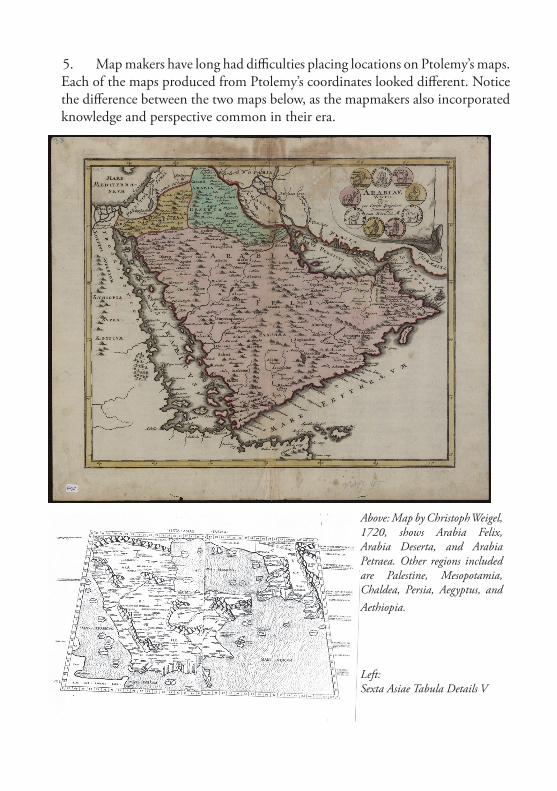
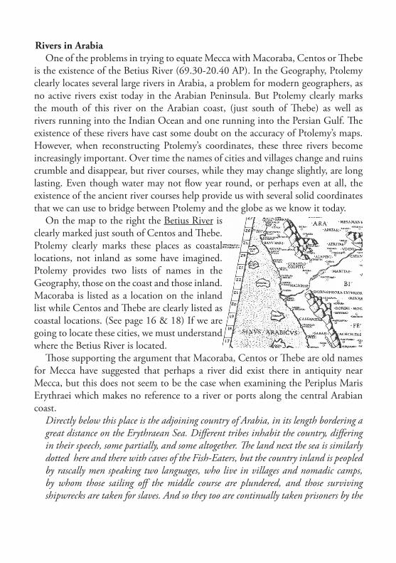
5. Map makers have long had difficulties placing locations on Ptolemy’s maps. Each of the maps produced from Ptolemy’s coordinates looked different. Notice the difference between the two maps below, as the mapmakers also incorporated knowledge and perspective common in their era.
Above: Map by Christoph Weigel, 1720, shows Arabia Felix, Arabia Deserta, and Arabia Petraea. Other regions included are Palestine, Mesopotamia, Chaldea, Persia, Aegyptus, and Aethiopia.
Left: Sexta Asiae Tabula Details V

6. It is common for people to simply look at the maps drawn in the fifteenth century and imagine which names match modern names, rather than comparing names, descriptions and the degrees of latitude and longitude used by Ptolemy to understand what he was referring to.
While it is tempting to simply dismiss Ptolemy`s Geography as being inaccurate, if one studies his system it becomes apparent that he was amazingly accurate within the Greek and Roman world and less accurate when locating places farther away. In this study we will concern ourselves mostly with Ptolemy`s maps of Felix Arabia, but in order to understand his system, we will have to examine other locations and develop a computerized model and mathematical algorithm that will allow us to translate data from Ptrolemy`s Geography into modern latitude and longitude.
Early in this process we must understand that Ptolemy’s latitude is quite stable and never exceed -3° to +2° differences, and for the actual territory of Greece the latitude differences varies from -1° to 1°. When we study longitude however, the coordinates given by Ptolemy with their actual counterparts shows an increasing trend of longitude differences eastwards (Livieratos 2006:165). From about 14.5° at the “Columns of Heracles” to about 26.5° at the area of Aegae and around 32° at the east coast of Cyprus. (Manoledakis, Manolis and Livieratos, Evangelos, 2007). This means that Ptolemy slowly stretched his map out towards the east.
Ptolemy’s Roman View of ArabiaThe Romans divided Arabia into three parts: Arabia Petraea (the Roman province
ruled from Petra), Arabia Deserta (the desert area of Arabia east and below the Roman Empire) and Arabia Felix (Happy Arabia) which is the incense producing land of Yemen and Oman and the southern part of Saudi Arabia, (Najran, Jazzan etc). (See http://nabataea.net/arabia.html for more information)
This is important, because Ptolemy divided his descriptions of Arabia into three separate maps, one for each of these areas. As we will demonstrate he did a decent job of the Roman province of Petraea, because it was under Roman control and he could speak to people who were very familiar with that region. He also spent a lot of time listing places on the Arabia Felix map, as incense was very important to the Romans and this was a land of fabled riches. As we will demonstrate, in doing so his Arabia Felix became larger than it should have been, and the desert map was squeezed into a much smaller area. In fact, Ptolemy only lists 25 places between Arabia Petrea and Arabia Felix on his Deserta map and over 200 places on his Arabia Felix map.
Rivers in Arabia One of the problems in trying to equate Mecca with Macoraba, Centos or Thebe
is the existence of the Betius River (69.30-20.40 AP). In the Geography, Ptolemy clearly locates several large rivers in Arabia, a problem for modern geographers, as no active rivers exist today in the Arabian Peninsula. But Ptolemy clearly marks the mouth of this river on the Arabian coast, (just south of Thebe) as well as rivers running into the Indian Ocean and one running into the Persian Gulf. The existence of these rivers have cast some doubt on the accuracy of Ptolemy’s maps. However, when reconstructing Ptolemy’s coordinates, these three rivers become increasingly important. Over time the names of cities and villages change and ruins crumble and disappear, but river courses, while they may change slightly, are long lasting. Even though water may not flow year round, or perhaps even at all, the existence of the ancient river courses help provide us with several solid coordinates that we can use to bridge between Ptolemy and the globe as we know it today.
On the map to the right the Betius River is clearly marked just south of Centos and Thebe. Ptolemy clearly marks these places as coastal locations, not inland as some have imagined. Ptolemy provides two lists of names in the Geography, those on the coast and those inland. Macoraba is listed as a location on the inland list while Centos and Thebe are clearly listed as coastal locations. (See page 16 & 18) If we are going to locate these cities, we must understand where the Betius River is located.
Those supporting the argument that Macoraba, Centos or Thebe are old names for Mecca have suggested that perhaps a river did exist there in antiquity near Mecca, but this does not seem to be the case when examining the Periplus Maris Erythraei which makes no reference to a river or ports along the central Arabian coast.
Directly below this place is the adjoining country of Arabia, in its length bordering a great distance on the Erythraean Sea. Different tribes inhabit the country, differing in their speech, some partially, and some altogether. The land next the sea is similarly dotted here and there with caves of the Fish-Eaters, but the country inland is peopled by rascally men speaking two languages, who live in villages and nomadic camps, by whom those sailing off the middle course are plundered, and those surviving shipwrecks are taken for slaves. And so they too are continually taken prisoners by the
chiefs and kings of Arabia; and they are called Carnaites. Navigation is dangerous along this whole coast of Arabia, which is without harbors, with bad anchorages, foul, inaccessible because of breakers and rocks, and terrible in every way. (Casson)This account was written during the first century AD shortly before Ptolemy, and
no river is mentioned, even though the author goes on to give other navigational aids before reaching Muza.
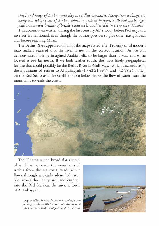
The Betius River appeared on all of the maps styled after Ptolemy until modern map makers realized that the river is not in the correct location. As we will demonstrate, Ptolemy imagined Arabia Felix to be larger than it was, and so he located it too far north. If we look farther south, the most likely geographical feature that could possibly be the Betius River is Wadi Mawr which descends from the mountains of Yemen to Al Luhayyah (15°42’21.99”N and 42°58’24.74”E ) on the Red Sea coast. The satellite photo below shows the flow of water from the mountains towards the coast.
Right: When it rains in the mountains, water flowing in Mawr Wadi enters into the ocean at Al Luhayyah making appear as if it is a river.
The Tihama is the broad flat stretch of sand that separates the mountains of Arabia from the sea coast. Wadi Mawr flows through a clearly identified river bed across this sandy area and empties into the Red Sea near the ancient town of Al Luhayyah.
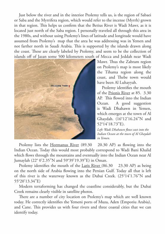
Just below the river and in the interior Ptolemy tells us, is the region of Sabaei or Saba and the Myrrifera region, which would refer to the incense (Myrrh) grown in that region. This helps us confirm that the Betius River is Wadi Mawr, as it is located just north of the Saba region. I personally traveled all through this area in the 1980s, and without using Ptolemy’s lines of latitude and longitude would have assumed from Ptolemy’s map that the area he was addressing was in Yemen and not farther north in Saudi Arabia. This is supported by the islands drawn along the coast. These are clearly labeled by Ptolemy, and seem to be the collection of islands off of Jazan some 500 kilometers south of Mecca and Jeddah near Wadi
Mawr. Thus the Zabram region on Ptolemy’s map is most likely the Tihama region along the coast, and Thebe town would have been Al Luhayyah.
Ptolemy identifies the mouth of the Prionis River at 85. 3.30 AP. This flowed into the Indian Ocean. A good suggestion is Wadi Dhahawn in Yemen, which emerges at the town of Al Ghaydah. (16°12’16.24”N and 52°14’18.73”E).
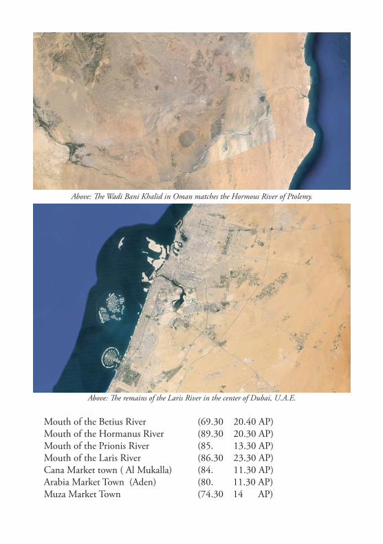
Ptolemy lists the Hormanus River (89.30 20.30 AP) as flowing into the Indian Ocean. Today this would most probably correspond to Wadi Bani Khalid which flows through the mountains and eventually into the Indian Ocean near Al Jumaylah (22° 0’2.35”N and 59°39’19.39”E) in Oman.
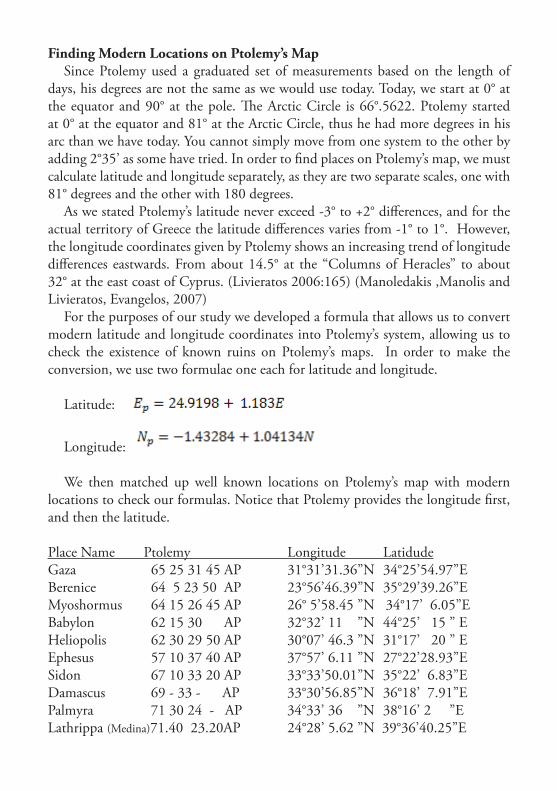
Ptolemy identifies the mouth of the Laris River (86.30 23.30 AP) as being on the north side of Arabia flowing into the Persian Gulf. Today all that is left of this river is the waterway known as the Dubai Creek. (25°14’1.76”N and 55°20’13.34”E)
Modern terraforming has changed the coastline considerably, but the Dubai Creek remains clearly visible in satellite photos.
There are a number of city location on Ptolemy’s map which are well known today. He correctly identifies the Yemeni ports of Muza, Aden (Emporiu Arabia), and Cane. This provides us with four rivers and three coastal cities that we can identify today.
Left: Wadi Dhahawn flows east into the Indian Ocean at the town of Al Ghaydah in Yemen.
Mouth of the Betius River (69.30 20.40 AP)Mouth of the Hormanus River (89.30 20.30 AP)Mouth of the Prionis River (85. 13.30 AP)Mouth of the Laris River (86.30 23.30 AP)Cana Market town ( Al Mukalla) (84. 11.30 AP)Arabia Market Town (Aden) (80. 11.30 AP)Muza Market Town (74.30 14 AP)
Above: The Wadi Bani Khalid in Oman matches the Hormous River of Ptolemy.
Above: The remains of the Laris River in the center of Dubai, U.A.E.
Finding Modern Locations on Ptolemy’s MapSince Ptolemy used a graduated set of measurements based on the length of
days, his degrees are not the same as we would use today. Today, we start at 0° at the equator and 90° at the pole. The Arctic Circle is 66°.5622. Ptolemy started at 0° at the equator and 81° at the Arctic Circle, thus he had more degrees in his arc than we have today. You cannot simply move from one system to the other by adding 2°35’ as some have tried. In order to find places on Ptolemy’s map, we must calculate latitude and longitude separately, as they are two separate scales, one with 81° degrees and the other with 180 degrees.
As we stated Ptolemy’s latitude never exceed -3° to +2° differences, and for the actual territory of Greece the latitude differences varies from -1° to 1°. However, the longitude coordinates given by Ptolemy shows an increasing trend of longitude differences eastwards. From about 14.5° at the “Columns of Heracles” to about 32° at the east coast of Cyprus. (Livieratos 2006:165) (Manoledakis ,Manolis and Livieratos, Evangelos, 2007)
For the purposes of our study we developed a formula that allows us to convert modern latitude and longitude coordinates into Ptolemy’s system, allowing us to check the existence of known ruins on Ptolemy’s maps. In order to make the conversion, we use two formulae one each for latitude and longitude.
Latitude:
Longitude:
We then matched up well known locations on Ptolemy’s map with modern locations to check our formulas. Notice that Ptolemy provides the longitude first, and then the latitude.
Place Name Ptolemy Longitude LatidudeGaza 65 25 31 45 AP 31°31’31.36”N 34°25’54.97”EBerenice 64 5 23 50 AP 23°56’46.39”N 35°29’39.26”EMyoshormus 64 15 26 45 AP 26° 5’58.45 ”N 34°17’ 6.05”EBabylon 62 15 30 AP 32°32’ 11 ”N 44°25’ 15 ” EHeliopolis 62 30 29 50 AP 30°07’ 46.3 ”N 31°17’ 20 ” EEphesus 57 10 37 40 AP 37°57’ 6.11 ”N 27°22’28.93”ESidon 67 10 33 20 AP 33°33’50.01”N 35°22’ 6.83”EDamascus 69 - 33 - AP 33°30’56.85”N 36°18’ 7.91”EPalmyra 71 30 24 - AP 34°33’ 36 ”N 38°16’ 2 ”ELathrippa (Medina)71.40 23.20AP 24°28’ 5.62 ”N 39°36’40.25”E
Petra 66 45 30 20 AP 30°19’35.69”N 35°26’2.52 ”EMuza 74 30 14 - AP 13°19’21.49”N 43°15’2.72 ”ECana 84 - 11 30 AP 14°31’59.32”N 49° 7’31.62”EDerbe 64 20 38 15 AP 37°26’20 ”N 33°09’ 50 ”ETarsus 67 40 36 50 AP 36°55’00 ”N 34°53’ 44 ”ECaesarea 68 30 37 - AP 32°30’08.08”N 34°54’30.33”ESalamis, Cyprus 66 40 35 20 AP 35°11’ ”N 33°54 ”ELaodicea 68 30 35 5 AP 37° 50’ 9 ”N, 29° 6’ 27 ”EAscalon 65 - 31 40 AP 31° 40’ 0 ”N, 34° 34’ 0 ”EElusa 65 10 30 50 AP 31° 5’ 49.2 ”N 34° 39’ 7.2 ”EMadaba 68 30 30 45 AP 31° 43’ 0 ”N 35° 48’ 0 ”E
While this was a working solution for the Roman parts of Ptolemy’s map, we struggled to match locations throughout Arabia Felix. We then decided to place Ptolemy’s coordinates on a grid without any reference to any maps. Then we would try and match the rivers to see what Ptolemy had done.
Above: A chart of places in Arabia Felix according to Ptolemy’s coordinates.

When we attempted to overlay these coordinates on a modern map many problems arose when trying to fit them correctly. (See below)
The solution to this was to manipulate Ptolemy’s coordinates until the rivers lined up. In order to do this we left two places on Ptolemy’s map in the north. Egra (Hegra), known as Mada’in Saleh today, and Gea Town which aligned with ancient Tayma. We then grouped the Beitius River and the other locations near to it and move them all southward until the Betius River was over Wadi Mawr. (The other grouped locations also moved southward. When we did this, many of the interior locations suddenly became apparent. In short, we matched Ptolemy’s Rivers to the location of the rivers today to obtain a correct map of Arabia. In doing so it became apparent that Ptolemy was not aware of the vastness of the deserts in Arabia’s interior, and that he plotted the locations in Yemen too far north.
Once we had shrunk Ptolemy’s map southward (with a small twist on the bottom to correct Ptolemy’s angle) many of the locations on Ptolemy’s map suddenly fit. Ptolomey’s Centros Village became modern day Jazan, Thebe Town became Al Luhayyah and Macorba becames Al-Mahabishah. Mara was then positioned as Ma’rib and Saudatha became modern day Sana’a. Sapphar then fit over Zafar, and Mochura in the north becase Yenbu. On the Indian Ocean coast Petros became modern day Salalah and Mosoha is what we know today as ancient Sumhuram.
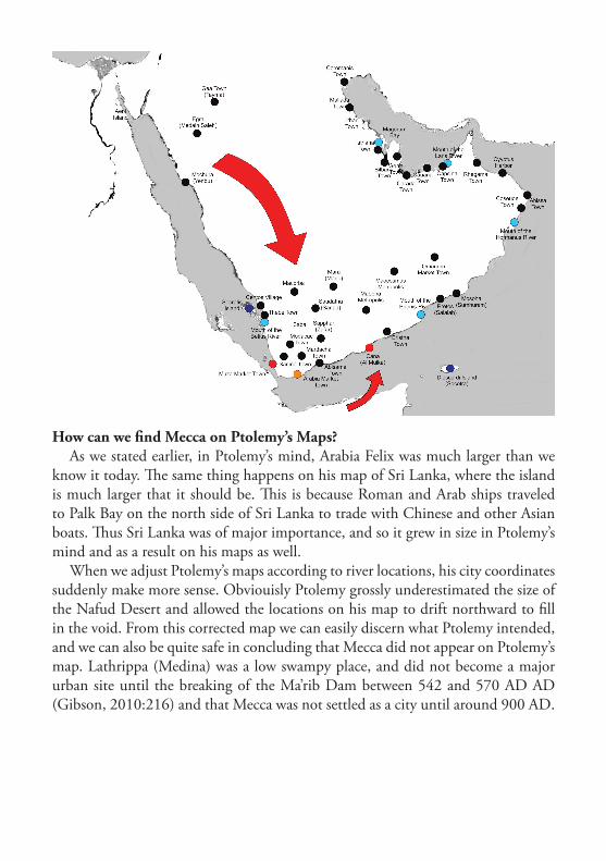
How can we find Mecca on Ptolemy’s Maps?As we stated earlier, in Ptolemy’s mind, Arabia Felix was much larger than we
know it today. The same thing happens on his map of Sri Lanka, where the island is much larger that it should be. This is because Roman and Arab ships traveled to Palk Bay on the north side of Sri Lanka to trade with Chinese and other Asian boats. Thus Sri Lanka was of major importance, and so it grew in size in Ptolemy’s mind and as a result on his maps as well.
When we adjust Ptolemy’s maps according to river locations, his city coordinates suddenly make more sense. Obviouisly Ptolemy grossly underestimated the size of the Nafud Desert and allowed the locations on his map to drift northward to fill in the void. From this corrected map we can easily discern what Ptolemy intended, and we can also be quite safe in concluding that Mecca did not appear on Ptolemy’s map. Lathrippa (Medina) was a low swampy place, and did not become a major urban site until the breaking of the Ma’rib Dam between 542 and 570 AD AD (Gibson, 2010:216) and that Mecca was not settled as a city until around 900 AD.

Bibliography
Agius, Dionisius A., Seafaring in the Arabian Gulf and Oman: People of the Dhow, Routledge, 2009
al Haduri , Shaikh Nasr bin ‘Ali, Kitāb ma’din al-asrār fi ‘ilm al-biḥār (The Mine of Secrets in the Science of the Seas, handwritten manuscript
Casson, Lionel, The Periplus Maris Erythraei: Text with Introduction, Translation, and Commentary, Princeton University Press, 1989
Forester, Charles, The historical geography of Arabia, Volume 1, Duncan and Malcolm, MDCCCXLIV, Introduction, page LX-LXII
Gibson, Dan, “Arabia” in ancient history: A discussion of the term ‘Arabia” and what it might have meant to Greek and Roman historians, http://nabataea.net/arabia.html, 2002
Gibson, Dan, Qur’anic Geography, ISP, 2010
Flensted-Jensen, The Bottiaians and their Poleis, Studies in the Ancient Greek Polis. Stuttgart, 1995
Hatzopoulos and Loukopoulou, Morrylos cite de la Crestonie, Athens, 1989
Heuzey L, H. Daumet, Mission archéologique de Macédoine, Paris, 1876
Lennart Berggren J., Jones, A., Ptolemy’s Geography, N. Jersey, 2000
Livieratos E., On the study of the geometric properties of historical cartographic representation. Cartographica 41 (2): 165-175, 2006
Manoledakis ,Manolis and Livieratos, Evangelos, On the digital placement of Aegae, the first capital of ancient Macedonia, according to Ptolemy’s Geographia. e-Perimetron, Vol. 2, No. 1, Winter 2007
Müller, Karl, Geography Latin & Greek, Firmin-Didot, 1883
Nobbe, Carolus Fridericus Augustus, Claudii ptolemaei, Geographia, Editio Stereotapa, (contains Greek edition), Lipsiae, 1843
Stevenson, Edward Luther, (translator) The Geography, by Claudius Ptolemy, English edition, New York, 1932
Tibbetts, G.R., Arabia in Early Maps, Falcon, Oleander, 1978
AddendumPtolemy’s Geography: Three Maps of Arabia
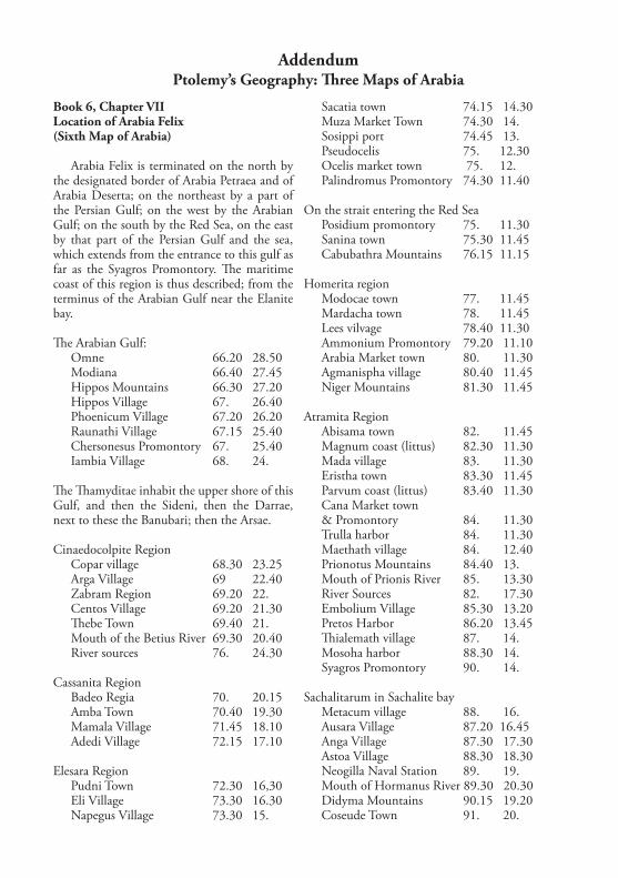
Book 6, Chapter VIILocation of Arabia Felix(Sixth Map of Arabia)
Arabia Felix is terminated on the north by the designated border of Arabia Petraea and of Arabia Deserta; on the northeast by a part of the Persian Gulf; on the west by the Arabian Gulf; on the south by the Red Sea, on the east by that part of the Persian Gulf and the sea, which extends from the entrance to this gulf as far as the Syagros Promontory. The maritime coast of this region is thus described; from the terminus of the Arabian Gulf near the Elanite bay.
The Arabian Gulf:Omne 66.20 28.50Modiana 66.40 27.45Hippos Mountains 66.30 27.20Hippos Village 67. 26.40Phoenicum Village 67.20 26.20Raunathi Village 67.15 25.40Chersonesus Promontory 67. 25.40Iambia Village 68. 24.
The Thamyditae inhabit the upper shore of this Gulf, and then the Sideni, then the Darrae, next to these the Banubari; then the Arsae.
Cinaedocolpite RegionCopar village 68.30 23.25Arga Village 69 22.40Zabram Region 69.20 22.Centos Village 69.20 21.30Thebe Town 69.40 21.Mouth of the Betius River 69.30 20.40River sources 76. 24.30
Cassanita RegionBadeo Regia 70. 20.15Amba Town 70.40 19.30Mamala Village 71.45 18.10Adedi Village 72.15 17.10
Elesara RegionPudni Town 72.30 16,30Eli Village 73.30 16.30Napegus Village 73.30 15.
Sacatia town 74.15 14.30Muza Market Town 74.30 14.Sosippi port 74.45 13.Pseudocelis 75. 12.30Ocelis market town 75. 12.Palindromus Promontory 74.30 11.40
On the strait entering the Red SeaPosidium promontory 75. 11.30Sanina town 75.30 11.45Cabubathra Mountains 76.15 11.15
Homerita regionModocae town 77. 11.45Mardacha town 78. 11.45Lees vilvage 78.40 11.30Ammonium Promontory 79.20 11.10Arabia Market town 80. 11.30Agmanispha village 80.40 11.45Niger Mountains 81.30 11.45
Atramita RegionAbisama town 82. 11.45Magnum coast (littus) 82.30 11.30Mada village 83. 11.30Eristha town 83.30 11.45Parvum coast (littus) 83.40 11.30Cana Market town & Promontory 84. 11.30Trulla harbor 84. 11.30Maethath village 84. 12.40Prionotus Mountains 84.40 13.Mouth of Prionis River 85. 13.30River Sources 82. 17.30Embolium Village 85.30 13.20Pretos Harbor 86.20 13.45Thialemath village 87. 14.Mosoha harbor 88.30 14.Syagros Promontory 90. 14.
Sachalitarum in Sachalite bayMetacum village 88. 16.Ausara Village 87.20 16.45Anga Village 87.30 17.30Astoa Village 88.30 18.30Neogilla Naval Station 89. 19.Mouth of Hormanus River 89.30 20.30Didyma Mountains 90.15 19.20Coseude Town 91. 20.

Oracle of Diana 91.40 20.Abissa Town 92.20 20.15Corodamum Promontory 93. 20.15
At the Entrance to the Persian GulfCyyptus Harbor 92.40 21.30Melanes mountains which are called Asabon, the middle part of which is located near the sea 93. 22.Asabon Promontory 92.30 23.30
Persian GulfIn the widely extended bay of the Ichthyophagi near which toward the interior, are the Macae; then the towns of the Anaritae:Rhegama Town 88. 23.10Sacrum Sun Promontory 87.20 23.20Mouth of Laris River 86.30 23.30Rive sources 81. 18.Capsina Town 86. 23.10Cauana town 85. 23.
Then of the EgeiSarcoa town 84.15 23.Carada town 83.40 23.30Atta Village 82. 23.15
Then of the GerraeiMagindanata town 81. 23.20Gerra town 80. 23.20Bilbana town 80. 24.10
Then of the ThaemiIthar town 80. 25.Magorum bay 80. 25.20Istriana town 80. 25.40
Then of the LaenitaeMallada town 80.10 26.10Chersonesus promontory 80.20 26.30Leantes Bay 70.15 27.Itamos Harbour 79.15 27.40
Then of the AbeceiSacer Bay 78.15 28.15Coromanis town 79. 28.45
Next the terminus on the confines of the desert and Mesanites bay 79. 3 0.10
The noted mountains of this land are those which we have mentioned towards the interior which are called the Zames, the middle part of which is located in 76. 25.
The Mrithi Mountains 80. 21.10The Climax mountains 76.30 16.Near which mountains is the fountain of the Stygian waters 78. 15.
Other mountains wanting namesAbove Cinaedocolpitae 71. 25.Above Cassanitae 73. 20.Below Marithos mountains 84.30 17.40Above Asabon mountains 88. 22.30
The Scenitae dwell in the interior near that part towards the north which is entirely mountainous; above are the Oaditae; toward the wouth from these are the Saraceni and the Thamydeni; then around the Zames mountains and towards the west from this are the Apataei and the Atritae and near these the Mesamanes and the Udeni; toward the east are the Laeeni, the Asapeni and the Iolysitae; to the south are the Catanitae, then the Thanuitae; from these towards the west the Manitae, above whom are the Alapeni, and near Cinaedopolita the Malichae. And below the Manitae is the Smyrnofera interior region; then the Minaei, a numerous race, below whom are the Doreni and the Mocritae; then the Sabaie and the Anchitae above the Climax mountains; around the Marithos mountains are the Malangitae to the north, and the Dachareni, the Zeiritae, then to the south the Bliulaei and the Omamitae, from whom the river source are the Cottabani as far as the Asabon mountain, below whom is the Libanotofora region; then near the Sachalita region are the Iobaritae; below the Gerraei are the Alemaeotae and extending as far as Climax mountains the Arabanitae; below all these the Chatramonitae from the Climax mountains even to Sachalitas; toward the south from the Climax are the Masonitae; then the Asaritae and near Homerita the Sappharitae and the Ratheni, above whom are the Maphoritae, thence to the beginning near the Chatramonitae is the Smyrnofera exterior region; near Syagrum as far as the sea are the Ascitae.

The towns and villages which are in Arabia Felix in the interior are the following:
Aramava 67.30 29.10Ostama 69.30 29.Thapava 71.40 29.Macna 67. 28.45Angala 68.15 28.45Madiama 68. 28.15Achrona 70. 28.15Obraca 71.30 28.20Rhadi village 73.30 28.30Pharatha 73.40 28.40Satula 77.30 28.19Laba 68.10 27.40Thaema 71. 27.Gea Town 71.15 27.20Aina 75.40 27,20Lugana 76.30 27.15Gaesa 78.40 27,15Siaca 68. 26,15Egra 70.30 26.Salma 74.30 26.Arra Village 75.40 26.10Digema 77. 26.30Saptha 78.15 26.20Phigea 79. 26.Badais 68.30 25.30Ausara 71. 25.30Iabri 74.30 25.Alata 77.20 24.30Mochura 69.40 24.30Thumna 71.10 24.50Alvara 71. 24.15Phalibinum 73.15 24.Salama 73.20 24.20Gorda 76.10 24.30Marata 79.20 24.20Ibirtha 79.40 24.40Lathrippa 71.40 23.20Carna 73.30 23.15Biavanna 76.30 23.Goeratha 77.40 23.Catara 79.30 23.20Baeba 71.30 22.30Macoraba 73.20 22.Sata 81.10 22.30Masthala 81.45 22.30Domana 82.20 22.30Atia 85. 22.15Ravana Regia 87. 22.Chabuata 89.15 22.Thumata 74.20 21.20
Olaphia 77.40 21.45Inapha 79.10 21.40Triagar 85. 21.20Aspa 91. 21.Agdamum 73.30 20.20Carman Regia 75.15 20.15Irala 80.20 20.15Maocosmus Metropolis 81.15 20.40Labris 81. 20.15Lattha 83.20 20.15Accipitrum Village 84.30 20.30Albana 71.30 19.15Chargatha 73.10 19.15Omanum Market town 87.40 19.45Marasdu 74.20 18.20Mara Metropolis 76. 18.40Iula 85.20 18.15Magulaba 75.30 17.Sileum 76.30 17.Mariama 78.10 17.10Thumna 79. 17.15Vodona 89. 17.20Marimatha 85.10 17.40Saba 73.40 16.55Menambis 75.45 16.30Thauba 78.40 16.10Saudatha metropolis 77. 16.30Madasara 81.45 16.20Gorda 82.30 16.Thabane 85.40 16.20Miba 74.20 15.20Source of Stygia Water 78. 15.Draga 79.10 15.15Sarvon 80.40 15.15Maepha Metropolis 83.15 15.Saraca 75.30 14.30Sapphar Metropolis 78. 14.Ara Regia 80.30 14.30Rhaeda 83.30 14.10Baenun 8.30 14.15Thuris 75.15 13.Lachchera 77.30 13.20Hyaela 79. 13.50Maccala 81. 13.45Sachla 82.40 13.20Sava Regia 76. 12.Deva 77.40 12.45Sochchor 78.30 12.40Bana 80.20 12.40Dela 82. 12.40Coa 83.30 12.30
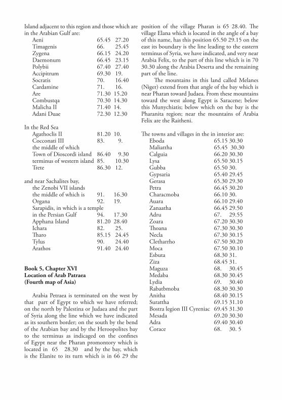
Island adjacent to this region and those which are in the Arabian Gulf are:
Aeni 65.45 27.20Timagenis 66. 25.45Zygena 66.15 24.20Daemonum 66.45 23.15Polybii 67.40 27.40Accipitrum 69.30 19.Socratis 70. 16.40Cardamine 71. 16.Are 71.30 15.20Combustqa 70.30 14.30Malicha II 71.40 14.Adani Duae 72.30 12.30
In the Red SeaAgathoclis II 81.20 10.Cocconati III 83. 9.the middle of which Town of Dioscordi island 86.40 9.30terminus of western island 85. 10.30Trete 86.30 12.
and near Sachalites bay, the Zenobi VII islands the middle of which is 91. 16.30Organa 92. 19.Sarapidis, in which is a temple in the Persian Gulf 94. 17.30Apphana Island 81.20 28.40Ichara 82. 25.Tharo 85.15 24.45Tylus 90. 24.40Arathos 91.40 24.40
Book 5, Chapter XVILocation of Arab Patraea(Fourth map of Asia)
Arabia Petraea is terminated on the west by that part of Egypt to which we have referred; on the north by Palestina or Judaea and the part of Syria along the line which we have indicated as its southern border; on the south by the bend of the Arabian bay and by the Heroopolites bay to the terminus as indicaged on the confines of Egypt near the Pharan promontory which is located in 65 28.30 and by the bay, which is the Elanite to its turn which is in 66 29 the
position of the village Pharan is 65 28.40. The village Elana which is located in the angle of a bay of this name, has this position 65.50 29.15 on the east its boundary is the line leading to the eastern terminus of Syria, we have indicated, and very near Arabia Felix, to the part of this line which is in 70 30.30 along the Arabia Deserta and the remaining part of the line.
The mountains in this land called Melanes (Niger) extend from that angle of the bay which is near Pharan toward Judaea. From these mountains toward the west along Egypt is Saracene; below this Munychiatis; below which on the bay is the Pharanita region; near the mountains of Arabia Felix are the Raitheni.
The towns and villages in the in interior are:Eboda 65.15 30.30Maliattha 65.45 30.30Calguia 66.20 30.30Lysa 65.50 30.15Gubba 65.50 30.Gypsaria 65.40 29.45Gerasa 65.30 29.30Petra 66.45 30.20Characmoba 66.10 30.Auara 66.10 29.40Zanaatha 66.45 29.50Adru 67. 29.55Zoara 67.20 30.30Thoana 67.30 30.30Necla 67.30 30.15Cletharrho 67.50 30.20Moca 67.50 30.10Esbuta 68.30 31.Ziza 68.45 31.Maguza 68. 30.45Medaba 68.30 30.45Lydia 69. 30.40Rabatbmoba 68.30 30.30Anitha 68.40 30.15Surattha 69.15 31.10Bostra legion III Cyreniac 69.45 31.30Mesada 69.20 30.30Adra 69.40 30.40Corace 68. 30. 5
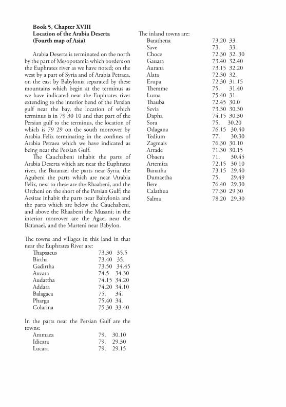
Book 5, Chapter XVIIILocation of the Arabia Deserta(Fourth map of Asia)
Arabia Deserta is terminated on the north by the part of Mesopotamia which borders on the Euphrates river as we have noted; on the west by a part of Syria and of Arabia Petraea, on the east by Babylonia separated by these mountains which begin at the terminus as we have indicated near the Euphrates river extending to the interior bend of the Persian gulf near the bay, the location of which terminus is in 79 30 10 and that part of the Persian gulf to the terminus, the location of which is 79 29 on the south moreover by Arabia Felix terminating in the confines of Arabia Petraea which we have indicated as being near the Persian Gulf.
The Cauchabeni inhabit the parts of Arabia Deserta which are near the Euphrates river, the Batanaei the parts near Syria, the Agubeni the parts which are near \Arabia Felix, next to these are the Rhaabeni, and the Orcheni on the short of the Persian Gulf; the Aesitae inhabit the parts near Babylonia and the parts which are below the Cauchabeni, and above the Rhaabeni the Musani; in the interior moreover are the Agaei near the Batanaei, and the Marteni near Babylon.
The towns and villages in this land in that near the Euphrates River are:
Thapsacus 73.30 35.5Birtha 73.40 35.Gadirtha 73.50 34.45Auzara 74.5 34.30Audattha 74.15 34.20Addara 74.20 34.10Balagaea 75. 34. Pharga 75.40 34.Colarina 75.30 33.40
In the parts near the Persian Gulf are the towns:
Ammaea 79. 30.10Idicara 79. 29.30Lucara 79. 29.15
The inland towns are:Barathena 73.20 33.Save 73. 33.Choce 72.30 32. 30Gauara 73.40 32.40Aurana 73.15 32.20Alata 72.30 32.Erupa 72.30 31.15Themme 75. 31.40Luma 75.40 31.Thauba 72.45 30.0Sevia 73.30 30.30Dapha 74.15 30.30Sora 75. 30.20Odagana 76.15 30.40Tedium 77. 30.30Zagmais 76.30 30.10Arrade 71.30 30.15Obaera 71. 30.45Artemita 72.15 30 10Banatha 73.15 29.40Dumaetha 75. 29.49Bere 76.40 29.30Calathua 77.30 29 30Salma 78.20 29.30