Embed Size (px)
Citation preview
Proceedings World Geothermal Congress 2015
Melbourne, Australia, 19-25 April 2015
1
Subsurface Characterization of the Leyte Geothermal Field, Philippines using
Magnetotellurics
David Carlo S. Austria, Randy J. Tugawin, Michael S. Pastor, Leandro B. Morillo, Carlos F. Los Banos and Domingo
B. Layugan
Energy Development Corporation, One Corporate Centre Bldg., Ortigas Center, Pasig City, Philippines
[email protected]; [email protected]
Keywords: 2-D inversion, geophysics, magnetotellurics, Leyte.
ABSTRACT
A geophysical study using magnetotellurics (MT) was conducted in Leyte Geothermal Field (LGF) in the Central Philippines. A set
of 93 new MT soundings were added to the 298 existing MT data from the LGF. Induction vector analysis indicates that the
geoelectric strike in the area is controlled by the left lateral Philippine Fault. The resistivity structure throughout LGF is
characterized by a resistive (>50 ohm-m) first layer, underlain by a conductive (<10 ohm-m) second layer followed by a moderately
resistive third layer (10-50 ohm-m). 2D inversion of the MT data reveals a high-low-high resistivity signature typical of geothermal
systems in volcanic arc setting. Subsurface information such as temperature and alteration data from drilled wells coincide with the
observed resistivity structure. Generated isoresistivity maps and models reveal that multiple resistive dome-shaped structures
associated with the proven geothermal reservoir are situated and centered beneath the Plio-Pleistocene volcanic peaks within the
LGF. Furthermore, the updoming structures are found to be aligned with the north-northwest oriented mountain range.
1. INTRODUCTION
The Philippine archipelago, an island arc system within the Pacific Ring of Fire, is endowed with large geothermal reserves, being
ranked as 2nd largest producer of geothermal energy in the world next to the United States (Ogena et al., 2010). Current efforts in
the country are geared towards identifying and developing geothermal resources as well as expanding current geothermal fields to
maximize their full potential as energy sources.
In the Central Philippines, the Leyte Geothermal Field (LGF) located in the central highlands of Leyte island remains as the leading
producer of geothermal energy in the country. It produces a total of around 710 megawatts and provides about 37% of the total
installed geothermal capacity in the Philippines. Since the late 1980's, the LGF has been the subject of several geological,
geochemical and geophysical studies which allowed the identification of two geothermal field sectors in the area namely: (a) the
Tongonan Sector which collectively includes Mahiao, Sambaloran and Malitbog, and; (b) the Mahanagdong Sector. In particular,
geophysical studies which include gravity, Schlumberger resistivity traversing (SRT) and vertical electrical sounding (VES)
provided crucial information to image and to characterize the subsurface structure of the LGF. Despite the efforts, questions remain
as to the resource extension of the LGF as well as the boundary and fluid flow conditions within this geothermal field.
In the past decade or so, magnetotellurics (MT) method has been utilized to model the subsurface conditions within the LGF (e.g.,
Maneja and Los Banos, 2002). The strength of this geophysical method lies on its ability to penetrate the deeper levels of the
geothermal field to define the resource boundaries and to determine the possible resource extension of existing geothermal systems.
In the LGF, another set of MT data were obtained more recently. Along with the temperature and alteration data as well as
previously acquired MT data, these new set of MT data allowed the refinement of the resistivity structure models of the entire LGF
and more importantly, the identification of possible resource extensions within the LGF. Results of such undertaking are presented
herein.
2. TECTONIC SETTING
Leyte Island, which is situated on the eastern section of the Visayan region, lies within a tectonically active region known as the
Philippine Mobile Belt (PMB) (Figure 1). To the east of Leyte Island, the PMB is bounded by the Philippine Trench, the
morphological expression of the westward subduction of the West Philippine Basin (Hamburger et al., 1983; Cardwell et al., 1980).
Subduction is manifested in Leyte by the presence of NW-SE trending volcanic centers such as Mt. BatoLunas, Mt. Mahagnao, Mt.
Lobi, Alto Peak and the volcanic peaks situated within the Leyte Geothermal Production Field (Mt. Janagdan, Mt, Mahanagdong,
Mt. Mamban, Mt. Malitbog, Mt. Samabaloran, Mt. Mahaio and Mt. Cabungangan). The estimated age of the Philippine Trench is
not earlier than 5 million years based on the rate of subduction, length of the subducted slab and age of the oldest volcanic arc
related to the subduction beneath Leyte (Aurelio, 2000).
The island is transected by the Philippine Fault Zone (PFZ), a major tectonic structure that extends for over 1,200 km. In the area of
study, the PFZ branches into three major NW-SE sub-parallel faults namely the West Fault Line (WFL), Central Fault Line (CFL)
and the East Fault Line (EFL). The presence of such structures contributes to the formation of different geothermal systems in
Leyte, including the Leyte Geothermal Field considered as the world's largest liquid dominated geothermal field (Figure 1).

Austria et al., 2015
2
Figure 1. Tectonic map of the Philippines showing the location of major structures bounding the Leyte Geothermal Field.
(modified after Zamoras et al., 2008) Also shown is the location of the LGF.
3. PREVIOUS GEOPHYSICAL SURVEYS
Several geophysical surveys were conducted throughout the Leyte Geothermal Field. Different methods such as gravity,
Schlumberger resistivity traversing (SRT), vertical electrical sounding (VES) and magnetotellurics (MT) were applied to image and
characterize the subsurface structure of the geothermal field. Based on the gravity studies there are two positive anomalies namely,
the Mahiao-Malitbog Anomaly and the Bao Anomaly (Ignacio and Bromley, 1982). The positive gravity anomalies are believed to
be part of the same plutonic body, separated 4 km apart by the sinistral movement of the Central Fault Line (Ignacio and Bromley,
1982). However, Apuada et al., (2000) suggested that the positive anomalies in Tongonan (Mahiao-Malitbog-Sambaloran) and Bao,
are due to the combined effects of the basement complex and the formations overlying it rather than the presence of plutonic
bodies. The Mahanagdong area on the other hand, exhibits a relatively low gravity signature which was attributed to the thickness
of the sedimentary rocks covering the area (Ignacio and Bromley, 1982; Apuada et al., 2000).
In 1990, Layugan et al. conducted a resistivity study at the Greater Tongonan Geothermal Field. It included the results of the VES
surveys, conducted by PNOC-EDC in 1981, 1983 and 1990 and the SRT surveys conducted by both PNOC-EDC and KRTA from
1973 to 1976. The resistivity study has delineated two low resistivity anomalies defined by <10-30 ohm-m zone. These were
associated with the active geothermal systems present in LGF and the likely upflow regions. The first anomaly is situated beneath
Mahiao-Sambaloran-Malitbog sector while the other is beneath Mahanagdong. The former is separated from the latter by an
impermeable resistive block (40 to 50 ohm-m) situated beneath Mamban, known as the Mamban Cold Block. This cold block is a
representation of an older geothermal system in Mamban, which apparently cooled off and the resistivity signature is attributed
mainly to relict alteration (Layugan, et al., 1990). Similarly, Apuada et al., (2000) also suggested that the geothermal system in
LGF can be divided into two separate geothermal systems based on gravity and resistivity data. These are: (1) the Mahiao,
Sambaloran and Malitbog Production field and (2) the Mahanagdong Production Field.
Other geophysical methods such as magnetotellurics have been conducted within the existing geothermal systems in the LGF.
Based on the MT survey conducted in Mahanagdong geothermal field, a 6km2 potential resource is situated farther east of the
Mahanagdong area (Maneja and Los Banos, 2002). This is supported by Pastor and Morillo (2012) and suggested the postulated
upflow is situated beneath Magaas Collapse. Similarly, a magnetotelluric study conducted in Tongonan sector reveals that further
expansion to the north is possible (Olivar et al., 2010). The assumption that both geothermal systems in Leyte Geothermal Field
(Tongonan and Mahanagadong) can be further expanded is based on the temperature patterns and resistivity signature. However,
because of the lack of MT data in the proposed expansion area, additional or further MT studies was recommended. This prompted
the latest MT survey conducted in Leyte Geothermal wherein additional 91 MT soundings were tested. This paper highlights the
results of the latest survey together with the existing MT data in LGF.
4. MAGNETOTELLURIC DATA ANALYSIS
Magnetotelluric soundings were carried out using the 5-channel MTU-5A Phoenix V5 System 2000TM with an average telluric
dipole spacing of 100 m and site spacing of roughly 1 km. In total, 391 MT soundings have been collected within the Leyte
Geothermal Field (LGF) in four separate field campaigns. The field campaigns in 2002, 2008, 2011-2012 and 2013 resulted to the

Austria et al., 2015
3
collection 53, 109, 138 and 91 MT soundings, respectively. Only 298out of the 390 Mt stations were used in the modeling. The 93
unused stations exhibit poor quality data, thus making them unsuitable for modeling. This high number of poor quality data is
attributed mainly to the presence of power plants, transmission lines and other sources of noise in producing geothermal field.
Modeling of the subsurface geophysical structures was done entirely using the WinGLinkTM Integrated Geophysical Processing
Software. A 2-D inversion modeling was specifically carried out.
To optimally model the subsurface resistivity structure, the MT data were rotated to -300 which is roughly parallel to the Philippine
Fault Zone (PFZ) transecting the area. To note, the induction vector analysis shows that the geoelectric strike in the Leyte
Geothermal Field is controlled by the PFZ oriented roughly NNW.
Figure 2. Resistivity profiles perpendicular to the major structures in Leyte Geothermal Field.
5. 2D MODELING RESULTS
The geophysical structure of the Leyte Geothermal Field was examined using the 2-D resistivity models derived along six
resistivity profiles (Figure 2). These profiles run across the geothermal field perpendicular to the major structures in LGPF. The
generated resistivity models generally show the resistivity structures at subsurface which were then correlated with the alteration
data, structures, stable temperature values and lithological data from drilled wells intersected by the sections. From these models
isoresistivity maps were generated at different elevations using the results of the 2-D resistivity models.
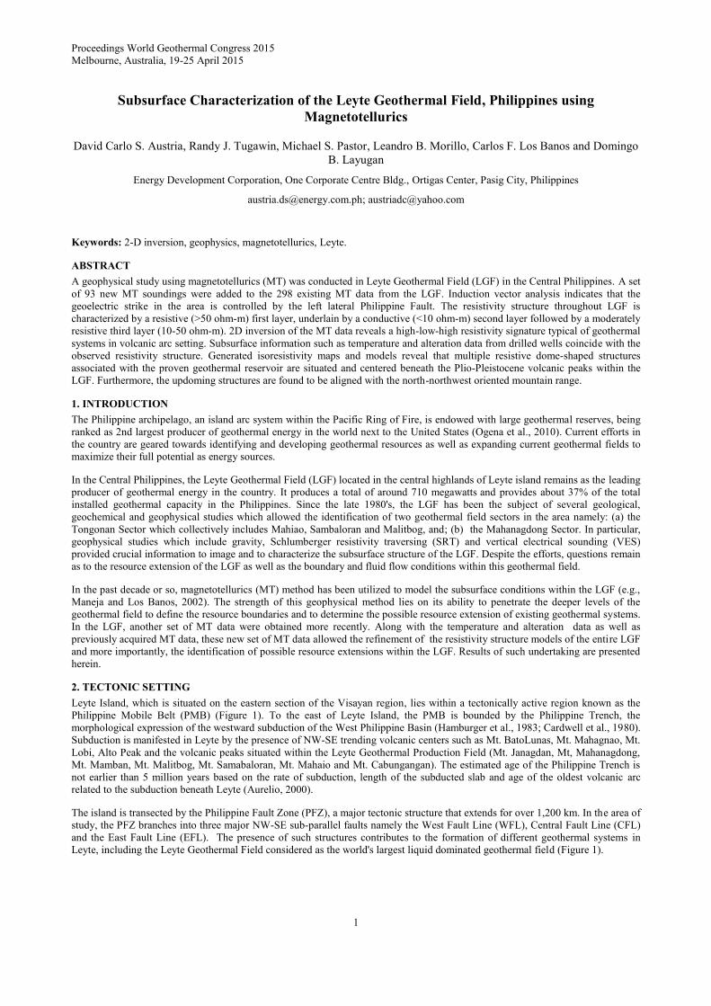
5.1 Resistivity Models
The 2-D resistivity models reveal a three-layer resistivity structure (Figure 3A-3F). The first layer has a relatively resistive
signature (>50 ohm-m). Below this resistive first layer is a highly conductive second layer (1-10 ohm-m), which is
characteristically thinnest beneath the volcanic peaks and thickens towards northwest and southeast. The bottommost layer exhibits
a relatively high resistivity signature (10-50 ohm-m) and is found updoming beneath the volcanic peaks in LGPF.
The generated resistivity profiles across the Tongonan Sector generally show a three layered structure (Figures 3A-3B). These
profiles transect the West Fault Line and East Fault Line and exhibit the resistivity structure beneath the sector. In detail, the first
Austria et al., 2015
4
layer is a highly resistive layer (>50 ohm-m) found covering the Tongonan Sector. It has a thickness of approximately 200 meters
and occupies most of the areas at higher elevation. Underlying this layer is a highly conductive layer that has an average thickness
of 500 meters. This second layer is thinnest beneath the volcanic peaks and thickens towards the northeast and the southwest. It is
worth noting that, in the southwest, a very prominent thick vertical conductive zone coincide with the trace of the West Fault Line.
The third layer, which is marked by the transition from<10 ohm-m resistivity values to 10-50 ohm-m, updomes beneath the
volcanic peaks. The updoming structures are centered beneath the volcanic peaks such as Mt. Mahiao and Mt. Sambaloran. Along
profile CC' , a similar dome shaped structure, having a moderately resistive core (10-50 ohm-m) overlain by a thick conductive
layer (>1000 meters) lies beneath Mt. Mamban (Figure 3C). Further, the highly resistive cover which is present on the Tongonan
profiles is notably absent.
Figure 3. Resistivity models across the Leyte Geothermal Field showing the high-low-high resistivity sequence typical of
high temperature geothermal systems. Also shown are the correlation of alteration and temperature data with the
observed resistivity structure.
Austria et al., 2015
5
Based on the resistivity models, the updoming structures found in Mahanagdong lie at deeper levels compared to those located at
the Tongonan Sector. In addition, as shown in the resistivity model, the highly conductive second layer is thicker attaining an
approximate thickness of 1.5 km beneath the Magaas Collapse (Figure 3D). This layer also thickens further towards northeast and
southwest.
The top of the resistive updoming structure or the base of conductor is found at around -600m elevation. Generally, resistivity
models representing both the Tongonan and Mahanagdong geothermal systems exhibit the same resistivity structure.
Another updoming structure is found beneath profile EE' which runs across the area south of Mahanagdong (Figure 3E). The
profile shows an updoming structure overlain by a highly conductive layer. It can be observed, however, that this updoming
structure is not that prominent as compared to those of Mahanagdong and Tongonan updoming structures. Further south, the very
conductive second layer seen on all the profiles, both Tongonan and Mahanagdong, starts to disappear (Figure 3F).
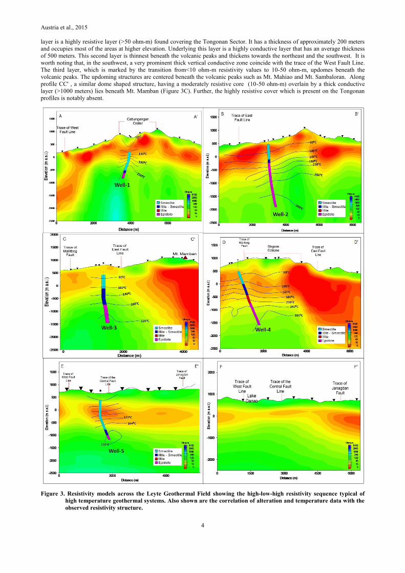
5.2 Isoresistivity Maps
The resistivity distribution across the Leyte Geothermal Field is reflected on isoresistivity maps generated using the resistivity
models derived from the 2D inversion modeling. Isoresistivity maps provide more information about the resistivity anomalies,
particularly on their location, area coverage, size, continuity at depth, boundary and relationship to other geologic features such as
faults, collapse, thermal manifestations, volcanic domes and altered ground.
At -600m elevation (Figure 4A), two distinct resistivity zones can be observed. The first is a relatively resistive zone occupying the
central portion of the plan map. It is generally oriented north-northwest to south-southeast and extends approximately 8 km long,
occupying the area from Mahanagdong to Cabungangan Collapse. This zone corresponds to the moderately resistive third layer
seen on most resistivity models. Notably the resistive anomalies in Tongonan Sector have a larger area coverage when compared
with those of the Mahanagdong Sector at this elevation. The second zone, on the other hand, is aconductive zone which occupies
the outer limits of the plan map and notably the area south of Mahanagdong Collapse. This conductive zone represents the second
layer seen on the resistivity sections. At deeper levels, particularly at -1200 m elevation, the resistive anomalies dominate most of
the plan map (Figure 4B).
Generally, it can be observed that moderate to highly resistive anomalies occur beneath the volcanic peaks in Leyte Geothermal
Field. These correspond to the updoming structures seen on the resistivity models. Most notable of these is the high resistivity zone
beneath the area northwest of Cabungangan collapse. The orientation of the anomalies is roughly parallel to that of the major
structures in the area such as the Central Fault Line.
Figure 4. Isoesistivity maps showing two separate high temperature zones situated in the Tongonan and Mahanagdong
Sectors. Both zones are found within the high resistivity region marking the upflow zones in Leyte Geothermal
Field.
6. DISCUSSION
The 2-D models presented reveals a resistivity signature typical of high temperature geothermal systems. The subsurface resistivity
structure of the Leyte Geothermal Field can be described as a three- layered structure. The first layer, characterized by a highly
resistive signature, represents the generally fresh to weakly altered formation of the Bao Volcanics (Figures 3A and B). This

Austria et al., 2015
6
volcanic formation, composed largely of lava flows, is the youngest formation covering both the Tongonan and the Mahanagdong
Sectors.
The second layer, underlying the resistive volcanic cover, falls within the resistivity range of 1-10 ohm-m. This conductive layer is
interpreted to be the clay cap of the geothermal system. The formation of the clay cap is attributed to the low temperature alteration
of the host rock, forming highly conductive clays such as smectite. The resistivity models show that the conductive clay cap
plunges and thickens towards the northeast and southwest, possibly indicating the outflow direction. It is worth noting that the trace
of the West and East Fault Lines at the resistivity profile coincides with the region where the highest attained thickness of the
conductive second layer or the vertical conductive zone is found. This may have been due to the fracturing brought about by
faulting which in turn promotes permeability. Thermal fluids flowing through the fractured rocks cause alteration which provided
the high conductivity signature seen beneath the trace of the West Fault Line.
The third layer is a moderately to highly resistive structure updoming beneath the volcanic peaks situated within the LGF. This
resistive signature is attributed mainly to the conversion of smectite and smectite-illite into a more resistive alteration minerals
belonging to the propylitic alteration assemblage such as epidote and chlorite. The highly resistive third layer is described in
various literatures (e.g. Johnston et al., 1992) as the geothermal reservoir and the likely upflow region. Drilled wells in LGPF such
as Well-2 indicate that the resistive updoming structures on the profiles coincide with the temperature values reaching up to 3000C
(Figures 3A-3D).
Representative resistivity models for the Tongonan Sector, correlated with alteration and temperature data from several wells,
reveal that the main upflow zone in Tongonan Sector is situated between Mt. Sambaloran and Mt. Mahiao, as reflected on profile
BB' (Figure 3B). The upflow zone is marked by a resistive updoming structure which coincides with high temperature values and
overlain by a conductive layer. This resistivity signature observed on most resistivity models, is commonly exhibited by high
temperature geothermal systems associated with volcanic environments (Bibby et al., 2005; Pellerin, et al., 1992; Anderson, et al.,
2000).
A resistivity model across the area in Mamban reveals a similar resistivity structure found in Tongonan and Mahanagdong Sectors
(Figure 3C). Alteration data from the intersected wells confirm the existence of an updoming three layered structure. Temperature
data, however, suggest that the said structure is relatively cold. As shown, drilled wells such as Well-3 yielded relatively low
temperature values at greater depths even after intersecting the resistive updoming structure. This would only indicate the existence
of an old waning geothermal system. To this end, the alteration and consequent the MT anomaly in Mamban are probably relict of
an older geothermal system. This confirms the findings of Layugan et al., 1990 that this updoming feature beneath Mamban is an
old waning system separating the Tongonan Sector from the Mahanagdong Sector.
Generally, the resistivity structure beneath Mahanagdong Sector is similar to that of the Tongonan Sector. The main upflow zone in
Mahanagdong Sector is situated beneath Magaas Collapse as marked by a resistive updoming structure and temperature values
reaching up to >3000C (Figure 3D). It can be observed that the geothermal reservoir in the sector is situated at deeper levels as
compared to that of the Tongonan Sector. This is reflected on the thickness of the clay cap and the elevation of the top of the
updoming structure. Based on the generated resistivity model, the top of the geothermal reservoirs in Tongonan and Mahanagdong
are found at around -500 m and -1300 m elevations, respectively.
The updoming structures where the highest temperature is possibly located, are aligned with the northwest-southeast trending
volcanic peaks in the Leyte Geothermal Field, such as Mt. Mahanagdong, Mt. Malitbog, Mt. Sambaloran and Mt. Mahiao (Figure
4A and 4B). This suggests that the geothermal systems in LGF are associated with the Plio-Pleistocene volcanism which, in turn, is
responsible for the emplacement of the BaoVolcanics. Previous studies (e.g., PNOC-EDC, 1993), suggested that the likely heat
source of the circulating thermal fluid, is the intrusive component of the BaoVolcanics. Temperature data from drilled wells within
the LGF show two distinct high temperature zones which correspond to the two main upflow zones. Apparently, the high resistivity
anomaly as well as the high temperature contours are still open to the northwest of Cabungangan. This suggests that the geothermal
resource may still extend towards the northwest.
Wells drilled nearest to the Cabungangan Collapse such as Well-1, yielded high temperate data reaching up to 2500C (Figure
3A).This suggest that the updoming structure found beneath the area northwest of Cabungangan is a potential target for further
exploration drilling and subsequently geothermal exploitation. The presence of this updoming structure suggests a northwest
extension of the Tongonan geothermal resource. Isoresistivity maps show that the very prominent updoming structure northwest of
Cabungangan is part of the high resistivity anomaly associated with the Tongonan geothermal system (Figure 4A and 4B). Thermal
manifestations are also present northwest of Cabungangan which indicates thermal leakages in the area.
7. CONCLUSION
Results of the 2D inversion of the MT data provided information regarding the subsurface resistivity structure, resource boundaries
as well as the possible extension of the resource. The following are the highlights of this study:
1).The three-layer dome shaped resistivity structure is associated with the geothermal systems in Tongonan and Mahanagdong
Sectors. Temperature and alteration data acquired from the drilled wells which intersect these updoming structures, confirm the
existence of the geothermal systems in these sectors. It could be inferred that similar resistivity structure located north-northwest of
Cabungangan Collapse may represent an extension of the Tongonan geothermal system. This anomaly in Cabungangan also
exhibits a dome shaped resistivity structure similar to the proven geothermal reservoirs in the LGF.
2).The upflow in Mahanagdong Sector is situated beneath Magaas collapse as previously suggested by Pastor and Morillo (2012).
The outflows, on the other hand, are in two directions: (1) towards the south-southwest and; (2) north-west towards the Bao Valley.

Austria et al., 2015
7
3).For the Tongonan Sector, the upflow is situated in Mahiao-Sambaloran area, as marked by the presence of high resistivity
anomaly and high measured well temperatures. The thermal fluids outflow in two directions: (1) further north-northwest of
Cabungangan and; (2) southwest towards the Bao Valley, where fluids from both the Tongonan and Mahanagdong systems mix, as
suggested by previous studies.
4).The anomalies associated with the proven geothermal systems are aligned with the Plio-Pleistocene volcanic peaks in the Leyte
Geothermal Field.
REFERENCES
Anderson, E., Crosby, D., Usher, G.: Bulls-Eye - Simple resistivity imaging to reliably locate the geothermal reservoir. Proceedings
World Geothermal Congress 2000, (2000).
Apuada, N.A., & Hunt, T.M.: Microgravity Measurements at Leyte Geothermal Power Project. Proceedings 18th Annual PNOC-
EDC Geothermal Conference (Makati), (1996), 12pp.
Apuada, N. A., Olivar, R. E. R., Rigor, D. M., Maneja, F. C., & Zaide-Delfin, M. C.: The Geophysical Structure of the Leyte
Geothermal Production Field, Philippines. Proceedings World Geothermal Congress 2000, (2000), pp 915 – 921.
Aurelio, M.A.: Shear partitioning in the Philippine: constraints from Philippine Fault and global positioning system data. The
Island Arc 9, (2000), 584-597.
Bibby, H.M., Risk, G.F., Caldwell, T.G., Bennie, S.L.: Misinterpretation of Electrical Resistivity Data in Geothermal Prospecting: a
Case Study from the Taupo Volcanic Zone. Proceedings World Geothermal Congress 2005, (2005).
Cardwell, R.K., Isacks, B.L., and Karig, D.E.: The spatial distribution of earthquakes, focal mechanism solutions and subducted
lithosphere in the Philippine and northeastern Indonesian Islands. In: Hayes, D.E. (ed.) The Tectonic and Geologic Evolution
of Southeast Asian Seas and Islands, Part 1. Am. Geophys. Union Monograph, 23, (1980), 1-35.
Hamburger, M., Cardwell, R.K., Isacks, B.L.: Seismotectonics of the Northern Philippine Island Arc. In: Hayes, D.E. (Ed), The
Tectonic and Geologic Evolution of Southeast Asian Sea and Islands. Part 2. A.G.U. Monograph 27, (1983), 1-22.
Ignacio, C., & Bromley, C.: Interpretation of Gravity Surveys at Tongonan Geothermal Field, Northern Leyte, Philippines. PNOC
EDC Technical Bulletin, (1982).
Johnston, J.M., Pellerin, L. and Hohmann, G.W.: Evaluation of Electromagnetic Methods for Geothermal Reservoir Detection.
Geothermal Resources Council Transactions, Vol 16, (1992), pp 241 – 245.
KRTA.: First Stage report on geothermal exploration in Leyte. KRTA report, 59pp, (1992).
Layugan, D., Catane, J., Maneja, F., Herras, E., & Vergara, M. : Resistivity Surveys Across the Tongonan Geothermal Filed. PNOC
EDC Internal Report, (1990).
Maneja, F., & Los Baños, C.: Magnetotelluric Sounding at Mahanagdong, Leyte Geothermal Production Field, Central Philippines.
PNOC EDC Internal Report, (2002).
Ogena, M.S. et al.: Philippine Country Update: 2005-2010 Geothermal Energy Development, Proceedings World Geothermal
Congress, Bali, Indonesia, (2010).
Olivar, R., Rigor, D., & Los Baños, C.: Magnetotelluric Survey at Leyte Geothermal Production Field. EDC Internal Report,.
(2010).
Pastor, M.S. & Morillo, L.B.: Mahanagdong MT Survey. PNOC-EDC Internal Report, (2012).
Pellerin, L., Johnston, J. M., & Hohmann, G. W.: Evaluation of Electromagnetic Methods in Geothermal Exploration. Geothermal
EM Exploration, pp. 405 - 408, (1992).
PNOC- EDC.: Greater Tongonan Geothermal Field: Integrated Resource Assessment, Vol 3. EDC Internal Report, (1993).
Zamoras, L.R., Montes, M.G.A., Queaño, K.L., Marquez, E.J., Dimalanta, C.B., Gabo, J.A.S., Yumul Jr., G.P.: The Buruanga
Peninsula and the Antique Range: two contrasting terranes in Northwest Panay, Philippines featuring an arc- continent
collision zone. Island Arc 17, (2008), 443–457.