Embed Size (px)
Citation preview
Subsidence Remediation Framework for Sugarloaf
SCA
Number:
Owner:
WWCUG-1477460896-14902
Environmental Operations Engineer
Status:
Version:
Approved
3.0
Effective:
Review:
11/03/2016
11/03/2019 Page 1 of 34
Uncontrolled unless viewed on the intranet
Subsidence Remediation Framework for Sugarloaf SCA
Document Number: WWCUG-1477460896-14902
Status: Approved
Version: 3.0
Effective: 11/03/2016
Review: 11/03/2019
Owner: Environmental Operations Engineer

Subsidence Remediation Framework for Sugarloaf SCA
Number:
Owner:
WWCUG-1477460896-14902
Environmental Operations Engineer
Status:
Version:
Approved
3.0
Effective:
Review:
11/03/2016
11/03/2019 Page 2 of 34
Table of Contents
1 Introduction ....................................................................................................................... 4
1.1 West Wallsend Underground Operations ........................................................................................ 4
1.2 Purpose ............................................................................................................................................ 4
1.3 Scope ............................................................................................................................................... 5
1.4 Relationships With Other Plans ....................................................................................................... 5
2 Subsidence Remediation Assessment and Planning ................................................... 6
2.1 Assessment of Subsidence Impacts ................................................................................................ 6
2.2 Mapping and recording .................................................................................................................... 6
2.3 Subsidence Remediation Prioritisation ............................................................................................ 7
2.4 Subsidence Remediation Plans ....................................................................................................... 8
3 Subsidence Remediation Methods ............................................................................... 10
3.1 Remediation Using Natural Fill Material ......................................................................................... 10
3.2 Remediation Using Cementitious Grout ......................................................................................... 11
3.3 Remediation Using Chemical Grout ............................................................................................... 11
3.4 Rock Fall Stabilisation Works ........................................................................................................ 12
3.5 Other Remediation Methods .......................................................................................................... 13
3.6 Contractor Selection and Engagement .......................................................................................... 13
4 Environmental Management Measures ........................................................................ 13
4.1 Soil and Vegetation Disturbance .................................................................................................... 13
4.2 Surface Water, Soil Erosion and Sediment Control ....................................................................... 14
4.3 Aboriginal Heritage Management .................................................................................................. 14
4.4 Hydrocarbon and Chemical Management ..................................................................................... 14
4.5 Waste Management ....................................................................................................................... 15
4.6 Transport and Access Management .............................................................................................. 15
4.7 Bushfire and Adverse Weather Preparedness............................................................................... 15
5 Monitoring ....................................................................................................................... 16
5.1 Remediation Monitoring ................................................................................................................. 16
5.2 Performance Indicators .................................................................................................................. 17
5.3 Contractor Auditing and Inspections .............................................................................................. 18
6 Reporting and Communication ..................................................................................... 19
7 OEH Approvals and Sign-off ......................................................................................... 20
8 Dispute Resolution ......................................................................................................... 21
9 Review ............................................................................................................................. 21
10 References ...................................................................................................................... 21
11 Appendices ..................................................................................................................... 23

Subsidence Remediation Framework for Sugarloaf SCA
Number:
Owner:
WWCUG-1477460896-14902
Environmental Operations Engineer
Status:
Version:
Approved
3.0
Effective:
Review:
11/03/2016
11/03/2019 Page 3 of 34
11.1.1 Ground Disturbance Permit (CAA HSEC PER 0004)............................................................ 23 11.1.2 Subsidence Remediation Scope and Hazard Checklist (WWC SD FRM 0271)
31 11.1.3 Subsidence Remediation Map (Example) ............................................................................. 33
12 Change Information ........................................................................................................ 34

Subsidence Remediation Framework for Sugarloaf SCA
Number:
Owner:
WWCUG-1477460896-14902
Environmental Operations Engineer
Status:
Version:
Approved
3.0
Effective:
Review:
11/03/2016
11/03/2019 Page 4 of 34
1 Introduction
1.1 West Wallsend Underground Operations
Oceanic Coal Australia Pty Limited (OCAL) manages and operates West Wallsend Underground (WWU) on behalf
of the Macquarie Coal Joint Venture (MCJV). OCAL is owned by Glencore Coal Assets Australia (Glencore). WWU
is located approximately 25 kilometres southwest of Newcastle in the Lake Macquarie Government Area.
WWU has Project Approval (PA 09_0203) from the Department of Planning for the West Wallsend Colliery
Continued Operations Project (WWCCOP) and associated Environmental Assessment (EA) (Umwelt, 2010),
assessed under Part 3A of the Environmental Planning and Assessment Act 1979 (EP&A Act).
The Project Approval allows for the continuation of mining operations at WWU and consolidates existing approvals
for underground mining and infrastructure. The Project Approval area encompasses longwall panels 38 to 52. The
underground mining method which WWU utilises is longwall retreat resulting in subsidence impacts discussed in
the scope below.
The Project Approval allows for mining activities underneath the Sugarloaf State Conservation Area (SCA),
managed by the NSW National Parks and Wildlife Service (NPWS) part of the Office of Environment and Heritage
(OEH) for the purposes of conservation of natural and cultural heritage and public visitation. As a result of WWU’s
underground operations certain areas of Sugarloaf SCA have been closed to the public due to the potential safety
risks associated with the subsidence impacts. These subsidence impacts require remediation before the land can
be returned to public use.
WWU is committed to remediating subsidence impacts that pose a risk to the public or the environment and has a
Public Safety Governance Process (contained in later generations of Public Safety Management Plans) in place
which describes a continual review process which aims to continue to remediate Sugarloaf SCA until it can be
agreed that it is safe and stable and ready to be returned to public use.
WWU has consent from OEH (OEH Consent for Subsidence Monitoring and Management Works in Sugarloaf SCA
2016 – 2021 – known as ‘OEH Consent’ within this document) to undertake subsidence remediation works in
Sugarloaf SCA in accordance with this Subsidence Remediation Framework.
1.2 Purpose
WWU are required by the conditions of the Project Approval and Extraction and Subsidence Management Plans
approved by the NSW Department of Planning and Environment (DPE) and Department of Resources and Energy
(DRE) to remediate subsidence impacts in consultation with OEH. This Subsidence Remediation Framework has
been developed in conjunction with OEH and is designed to:
• Establish agreed procedures for recording, assessing, planning, undertaking and monitoring subsidence
remediation in Sugarloaf SCA as required by the conditions of the Project Approval;
• Enable OEH to facilitate the performance of those works by WWU, to ensure that the post mining landform
within Sugarloaf SCA can be safely used by the public whilst protecting the environmental and other values
of lands reserved or acquired under the National Parks and Wildlife Act 1974; and
• Ensure an adequate level of planning, environmental assessment, consultation, notification and monitoring.

Subsidence Remediation Framework for Sugarloaf SCA
Number:
Owner:
WWCUG-1477460896-14902
Environmental Operations Engineer
Status:
Version:
Approved
3.0
Effective:
Review:
11/03/2016
11/03/2019 Page 5 of 34
1.3 Scope
This Subsidence Remediation Framework applies to subsidence remediation activities undertaken by WWU in
Sugarloaf SCA as a result of underground mining operations, specifically the remediation of subsidence induced
surface impacts which pose a risk to public safety, slope stability, the environment and OEH assets.
Subsidence induced surface impacts include, but are not limited to:
• Surface cracking of general surfaces, cliffs, rock face features and steep slopes;
• Surface stepping and ground deformation;
• Soils scarps or Vertical Block Movements (VBMs);
• Rock falls / Landslides / Flows;
• Tree falls; and
• Ponding and/or changes to drainage function on road and trails.
1.4 Relationships With Other Plans
WWU’s Project Approval conditions require the development and approval of Extraction and Subsidence
Management Plans and associated Land Management Plans and Public Safety Management Plans for specified
longwalls.
Land Management Plans aim for the re-establishment of a safe and stable landform following mining whilst Public
Safety Management Plans are developed to manage public safety. Together these plans intend to ensure that
mining impacts within Sugarloaf SCA are managed to meet the relevant requirements of section 30G(2) of the
National Parks and Wildlife Act 1974.
This Subsidence Remediation Framework describes how subsidence remediation activities will be planned,
undertaken and monitored in the Sugarloaf SCA to achieve the desired outcomes outlined in the Land
Management Plans and Public Safety Management Plans.
An overview of how this document sits in relation to existing subsidence management plans and programs is
detailed in Figure 1.
Figure 1 Process diagram

Subsidence Remediation Framework for Sugarloaf SCA
Number:
Owner:
WWCUG-1477460896-14902
Environmental Operations Engineer
Status:
Version:
Approved
3.0
Effective:
Review:
11/03/2016
11/03/2019 Page 6 of 34
2 Subsidence Remediation Assessment
and Planning
2.1 Assessment of Subsidence Impacts
The need for remediation of subsidence impacts will be determined through a risk based approach looking at any
surface cracks, soil scarps, vertical block movements, stepping and ground deformation or other subsidence impacts
recorded within Sugarloaf SCA. Subsidence impacts will be remediated where they present an unacceptable risk to
public safety, slope stability, the environment and OEH assets.
In 2013, WWU engaged Douglas Partners (2014c) to review the public safety risks associated with surface
cracking in Sugarloaf SCA and recommend mitigation measures. As a result of this review and following
consultation with OEH, WWU will remediate surface cracking as detailed below:
• Fill all subsidence cracks on or within 20 m of any access tracks;
• Fill subsidence cracks wider than 50 mm where they are within 200 m of an access track and where the
access to the location from the access tracks is flatter than 18°;
• Fill subsidence cracks wider than 75 mm, where slope angles range up to 30°; and
• For sites steeper than 30°, the crack remediation should be subject to a specific risk assessment by a
geotechnical engineer and may include filling of cracks greater than 100 mm wide.
All remaining surface impacts (including cracking) not covered by the above will be assessed by a geotechnical
engineer for risks to slope stability and remediated if required.
Slope instability may be caused by increased surface water infiltration via the exposed unremediated subsidence
cracks. The degree to which this has an impact varies greatly depending on the slope angle, rock and soil types,
rock mass strength characteristics, vegetation and existing ground water levels. The sealing of the surface cracks
and water diversions (if possible) are ways of minimising water inflow and the remediation of subsidence surface
cracking where this may occur is a remediation priority.
WWU will endeavour to remediate as many subsidence impacts as possible within Sugarloaf SCA, although there
may be impacts (e.g. longwall 41 VBM) that are unable to be remediated. There are some impacts, that have
workplace health and safety and environmental risks associated with the remediation which outweigh the benefits
of conducting the remediation works. These impacts will be assessed by the appropriate professional/s with an
assessment report to be provided to OEH and details of the subsidence impact also recorded in WWU’s GIS
database (with reference to the assessment report).
Prior to mining lease relinquishment all possible subsidence impacts will be remediated in accordance with the
relevant Subsidence Remediation Plan as detailed in Section 2.4, or otherwise assessed and deemed not to be
remediated.
2.2 Mapping and recording
WWU conduct geotechnical mapping prior to longwall mining, during extraction and on completion of extraction
with the data added to WWU’s GIS database. The geotechnical mapping records the location of all subsidence
impacts within the Sugarloaf SCA.
The GIS database is used in the planning and monitoring of remediation activities and as such can be analysed to:
1. Determine if remediation work is required for the mapped subsidence impact (Section 2.1);
2. Allocate a priority for the remediation of the subsidence impact (Section 2.3) ; and
Subsidence Remediation Framework for Sugarloaf SCA
Number:
Owner:
WWCUG-1477460896-14902
Environmental Operations Engineer
Status:
Version:
Approved
3.0
Effective:
Review:
11/03/2016
11/03/2019 Page 7 of 34
3. Provide specific information on the environmental constraints associated with the remediation of the subsidence
impacts (e.g. site access, topography, sensitive features, etc.).
The following specific data fields are to be recorded in the GIS database:
• Subsidence impact identification number;
• Location (easting and northing);
• Corresponding longwall number;
• Date of mapping and mapper’s name;
• Dimensions (length, depth, width);
• Slope (degrees);
• Slope stability (yes/no/undetermined);
• Geotechnical assessment or Subsidence Remediation Plan (yes/no);
• Assessment document number (Subsidence Remediation Plan number or geotechnical assessment report
title/number);
• Whether remediation required (yes/no/undetermined);
• Remediation priority (high/medium/low);
• Subsidence impact remediated (yes/no);
• Date of subsidence impact remediation;
• Remediation method (e.g. natural fill, cement grout);
• Monitoring regime (e.g. monthly, quarterly, annually);
• Dates monitored; and
• Comments section (include details of any follow up remediation activities that may be required, etc.).
The GIS database is to be provided to OEH on a fortnightly basis during subsidence remediation activities,
following any monitoring update and as requested by OEH.
2.3 Subsidence Remediation Prioritisation
Each subsidence impact (or an area of multiple subsidence impacts) will be given a remediation priority rating of
high, medium or low based on public safety, environmental and slope stability risks which is outlined below:
High Priority:
An impact will be deemed to have a high remediation priority if;
• The impact area is located on or within 20 m of a public access track or trail that remains open to the public
(e.g. Great North Walk, Sugarloaf Range Road, Aubs Ridge Road);
• The impact area has the potential for rock falls or rollouts;
• The impact has the potential to affect slope or landscape feature stability;
• The impact is located in a sensitive area (e.g. near known archaeological sites, endangered or threatened
ecological communities, or in or directly adjacent watercourses);
• The impact (in the case of surface cracking) is greater than 300 mm in width;
• The impact area is in a location highly visible to the local community; and
• The impact has the potential to affect adjacent landowners.
Medium Priority:
An impact will be deemed to have a medium remediation priority if;
• The impact area is located greater than 20 m from, but less than 200 m from a public access track or trail
that remains open to the public (e.g. Great North Walk, Sugarloaf Range Road, Aubs Ridge Road);
• The impact area is located on or within 20 m of a public access track or trail that is closed to the Public (e.g.
disused Forestry Track East); and
Subsidence Remediation Framework for Sugarloaf SCA
Number:
Owner:
WWCUG-1477460896-14902
Environmental Operations Engineer
Status:
Version:
Approved
3.0
Effective:
Review:
11/03/2016
11/03/2019 Page 8 of 34
• The impact is located in a steep slope area (>18°) however does not pose a short term instability risk or has
the potential to affect slope or landscape feature stability.
Low Priority:
An impact will be deemed to have a low remediation priority if;
• The impact area is located greater than 200 m from a public access track or trail that remains open or closed
to the public; and
• The impact is not located in a steep slope area (<18°) with low risk of ground instability.
Where it is logistically viable and practical, WWU will schedule remediation activities based on the remediation
priorities outlined above.
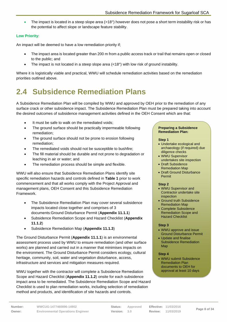
2.4 Subsidence Remediation Plans
A Subsidence Remediation Plan will be compiled by WWU and approved by OEH prior to the remediation of any
surface crack or other subsidence impact. The Subsidence Remediation Plan must be prepared taking into account
the desired outcomes of subsidence management activities defined in the OEH Consent which are that:
• It must be safe to walk on the remediated voids;
• The ground surface should be practically impermeable following
remediation;
• The ground surface should not be prone to erosion following
remediation;
• The remediated voids should not be susceptible to bushfire;
• The fill material should be durable and not prone to degradation or
leaching in air or water; and
• The remediation process should be simple and flexible.
WWU will also ensure that Subsidence Remediation Plans identify site
specific remediation hazards and controls defined in Table 1 prior to work
commencement and that all works comply with the Project Approval and
management plans, OEH Consent and this Subsidence Remediation
Framework.
• The Subsidence Remediation Plan may cover several subsidence
impacts located close together and comprises of 3
documents:Ground Disturbance Permit (Appendix 11.1.1)
• Subsidence Remediation Scope and Hazard Checklist (Appendix
11.1.2)
• Subsidence Remediation Map (Appendix 11.1.3)
The Ground Disturbance Permit (Appendix 11.1.1) is an environmental
assessment process used by WWU to ensure remediation (and other surface
works) are planned and carried out in a manner that minimises impacts on
the environment. The Ground Disturbance Permit considers ecology, cultural
heritage, community, soil, water and vegetation disturbance, access,
infrastructure and services and mitigation measures required.
WWU together with the contractor will complete a Subsidence Remediation
Scope and Hazard Checklist (Appendix 11.1.2) onsite for each subsidence
impact area to be remediated. The Subsidence Remediation Scope and Hazard
Checklist is used to plan remediation works, including selection of remediation
method and products, and identification of site hazards and controls.
Preparing a Subsidence Remediation Plan: Step 1
• Undertake ecological and archaeology (if required) due diligence checks
• WWU Supervisor undertakes site inspection
• Draft Subsidence Remediation Map
• Draft Ground Disturbance Permit
Step 2
• WWU Supervisor and Contractor undertake site inspection
• Ground truth Subsidence Remediation Map
• Complete Subsidence Remediation Scope and Hazard Checklist
Step 3
• WWU approve and issue Ground Disturbance Permit
• Update and finalise Subsidence Remediation Map
Step 4
• WWU submit Subsidence Remediation Plan documents to OEH for approval at least 10 days prior to commencement of

Subsidence Remediation Framework for Sugarloaf SCA
Number:
Owner:
WWCUG-1477460896-14902
Environmental Operations Engineer
Status:
Version:
Approved
3.0
Effective:
Review:
11/03/2016
11/03/2019 Page 9 of 34
The Subsidence Remediation Map (Appendix 11.1.3) will be a visual summary of site setup, known risks,
environmental and landscape features, and threatened species. The maps will consolidate the information
contained in the Ground Disturbance Permit and the Subsidence Remediation Scope and Hazard Checklist.
Hazards and controls
Ground
Disturbance
Permit
Remediation
Scope and
Hazard
Checklist
Subsidence
Remediation
Map
Other
Location of subsidence
(impact) area ✓
Crack geometry and estimated
fill volume ✓
Access, associated hazards
including landscape features ✓ ✓
Environmental features and
constraints (e.g. drainage,
erosion and sediment control,
archaeology, threatened
species and communities).
✓ ✓ ✓
Time since last subsidence/
signs of movement ✓
Formwork requirements ✓
Leakage paths and plugging
locations ✓ ✓
Fill material and remediation
technique/s ✓
Fill process Remediation
procedures
Pump, hose/pipeline location ✓
Spotter access/locations
(vegetation clear and safe) ✓ ✓
Rock stabilisation
requirements ✓
Site communications Remediation
procedures
Personnel
requirements/training
Remediation
Procedures
Monitoring requirements
Long Term
Monitoring Plan
Methodology
(Douglas Partners,
2014a), OEH
Consent, Project
Approval and
management plans
Heli-lift locations (if required) ✓ ✓
Table 1 Site specific hazards and controls
Once finalised and agreed upon by WWU and the Contractor, the Subsidence Remediation Plan will be submitted
to OEH for approval at least 10 days prior to work commencing.

Subsidence Remediation Framework for Sugarloaf SCA
Number:
Owner:
WWCUG-1477460896-14902
Environmental Operations Engineer
Status:
Version:
Approved
3.0
Effective:
Review:
11/03/2016
11/03/2019 Page 10 of 34
3 Subsidence Remediation Methods
A range of subsidence remediation methods may be used to achieve the desired outcomes of subsidence
management activities detailed in Section 2.4. Methods that may be used in the Sugarloaf SCA include:
1. Remediation of subsidence impacts utilising earthworks machinery and locally sourced, inert or stabilised
quarry fill material;
2. Remediation of subsidence impacts utilising cementitious grout;
3. Remediation of subsidence impacts utilising a chemical grout product;
4. Rock fall stabilisation activities;
5. Combination of the above methods (option 1, 2, 3 and 4); or
6. Other remediation methods approved by OEH.
The Subsidence Remediation Plan, geotechnical mapping, ecological and archaeological due diligence reports will
be used to determine the most appropriate remediation method based on the type and location of subsidence
impacts, and the following factors:
• The distance of the subsidence impact from existing access routes;
• The accessibility of the subsidence impact for remediation equipment;
• The disturbance required to remediate the subsidence impact effectively;
• The terrain surrounding the subsidence impact;
• The presence of any landscape features within the subsidence impact area (cliff lines, minor cliffs, rock face
features); and
• Environmental constraints (presence of threatened flora/fauna, vegetation density, proximity to
watercourses, erosion potential, archaeology).
Prior to the use of any remediation product or technique there must be an OEH approved remediation procedure in
place. Where updates to procedures are required, WWU will provide any changes to procedures to OEH for
approval and endorsement.
An overview of the remediation options is provided in Sections 3.1 to Section 3.5.
3.1 Remediation Using Natural Fill Material
Historically, WWU has utilised civil earthworks machinery (excavators, backhoes, bobcats, trucks etc.) and fill
material (natural and stabilised soils/gravels/clays), to successfully remediate subsidence impacts (surface
cracking) caused by mining operations. This technique has primarily been used on formed access tracks/trails or
open areas where equipment access is readily available and only minimal environmental disturbance is required to
complete the works.
This remediation technique is very effective as remediation works can generally be undertaken within short
timeframes and is cost effective (Table 2). Further detail regarding the specific application of this technique is
provided in Natural Fill Materials Procedure for Subsidence Remediation (WWC SD PRO 0053).
Benefits Negative Aspects
• Low cost option
• Requires minimal setup
• Works can generally be completed in shorter
timeframes to other options
• Well established procedures / contractor
experience.
• Can create additional surface disturbance to
achieve remediation results (access tracks,
stockpiles, etc.)
• Additional risk of impacting on sensitive areas
(archaeology/sensitive ecological areas)
• Erosion and sedimentation controls required to
manage site runoff
• Has potential to encourage weeds spread in the
Sugarloaf SCA
Table 2 Benefits/Weaknesses table for natural fill use in subsidence remediation

Subsidence Remediation Framework for Sugarloaf SCA
Number:
Owner:
WWCUG-1477460896-14902
Environmental Operations Engineer
Status:
Version:
Approved
3.0
Effective:
Review:
11/03/2016
11/03/2019 Page 11 of 34
3.2 Remediation Using Cementitious Grout
Remediation using cementitious grout has been previously undertaken by WWU in Sugarloaf SCA where access is
limited with difficult terrain. Grout can be pumped long distances in difficult terrain allowing for subsidence impacts
(surface cracking) in remote areas to be remediated where traditional methods (such as earthworks) could not be
undertaken without significant disturbance to the surrounding environment. Remediation of surface cracks using
grouting techniques has proven to be successful over WWU’s longwalls 38 – 40 (Douglas Partners, 2014b).
WWU has developed a Cementitious Grouting Procedure for Subsidence Remediation (WWC SD PRO 0110)
which takes into account the learning’s from the grouting incidents which occurred during the remediation of
longwall 41 in 2013. Based on the incident reviews and the nature of grouting products, remediation using
cementitious grout will generally be limited to impacts located on sloping terrain < 18º to minimise any chance of
grout spillage from flowing downhill.
The base materials required for cementitious grout is cement and water. Fine aggregate and flyash may be used
to increase bulk. Admixtures can be mixed into the cementitious grout mixture to strengthen, entrain air bubbles,
reduce or increase gel times. Crack filling with grout will utilise a variety of types of grout mixes, with the following
key properties:
• Flow characteristics commensurate to the application area;
• Adequate bearing strength for the envisaged loads;
• Low permeability;
• Suitable material to be pumpable over long distances;
• Durable;
• Long-term stable in air and water; and
• Low toxicity product.
The type of grout product will vary based on the location and underlying strata of the crack area to be remediated,
and the pumping distance required. As a minimum, a grout mix with low to medium strength and resistant to erosion
should be used. This grout mix is to have a minimum 1 day characteristic Uniaxial Compressive Strength (UCS) of
2 MPa and a 7 day UCS of 2 MPa. The maximum water:cement ratio for this grout mix should be 2:1. The purpose
of this grout is to provide a low strength, non-erodible crack infill.
Benefits Negative Aspects
• Product has been successfully used over previous
longwalls 38 to 40.
• Grout product can be pumped long distances
(product dependant) in difficult terrain
• Doesn’t require the establishment of access tracks
which minimises surface disturbance
• Proven technology for void filling (used extensively
in mining and construction industry)
• Use of grout products has resulted in two
significant spillage incidents in the past for WWU.
• To achieve longer pumping distances grout
characteristics are of a low viscosity (susceptible to
spillage).
• Cannot be used in steep slope areas without
significant controls in place to minimise risk of
spillage to the environment
• Requires establishment of pumping pad adjacent
to access tracks
• Can be visually intrusive to the local community
• Work areas can remain active for months.
Table 3 Benefits/Weaknesses table for cementitious grout use in subsidence remediation
3.3 Remediation Using Chemical Grout
Following the incident learning’s on longwall 41 and a detailed review of alternative remediation options to
cementitious grout injection, WWU, in consultation with industry experts, have been investigating the suitability of
expanding chemical products for use in the remediation of surface cracking within Sugarloaf SCA.
These types of products have been successfully used in the construction and mining industry for a variety of void
filling applications and are well suited for remote remediation activities and have potential applications for the

Subsidence Remediation Framework for Sugarloaf SCA
Number:
Owner:
WWCUG-1477460896-14902
Environmental Operations Engineer
Status:
Version:
Approved
3.0
Effective:
Review:
11/03/2016
11/03/2019 Page 12 of 34
Sugarloaf SCA. Most products consists of two chemical components which when combined together under
controlled conditions rapidly expand greater than the initial volume. The chemical properties of this type of product
allow it to be pumped significant distances and set rapidly on injection greatly reducing the potential risk of spillage
from the final product.
The product, if deemed suitable and subject to an approved procedure, will be used for remediation works primarily
in steep slope areas (>18º) to reduce any chance of spillage and minimise the impacts within Sugarloaf SCA.
Based on a geotechnical review undertaken by Golder Associates surface cracking will be filled to a specific depth
based on crack width (Table 4).
Crack Width (m) Minimum Foam Thickness (m)
0 to 0.5 1.0
0.5 to 1.5 3.0
>1.5 5.0
Table 4 Suggested minimum chemical grout thickness as a function of subsidence crack width
Following a detailed product and application review it was determined that any cracking filled with chemical grout
may require a nominated inert cap to ground level to reduce any ignition/product reaction to bushfires. Natural
material from the immediate area will be used where possible; however, in areas where this natural material is
unavailable, WWU may heli-lift in inert fill material to provide this cap.
WWU is still investigating this type of product for use in Sugarloaf SCA and any products chosen for remediation
will need to be approved by OEH prior to use and will have an approved product specific application procedure in
place.
Benefits Negative Aspects
• Rapidly expanding product minimises potential for
spillage of final product
• Can be used in steep slope areas without need for
plugging end of cracks (high viscosity).
• Less product required to achieve desired result
• Less time required for remediation works than
grout products.
• Generally low disturbance required (for pumping
pad)
• Significant cost involved
• Chemical products in raw form can be hazardous if
spilt or uncontrolled.
Table 5 Benefits/Weaknesses table for chemical grout use in Subsidence Remediation
3.4 Rock Fall Stabilisation Works
Rock fall stabilisation works have been identified as a pre and post mining mitigation measure for public safety.
Based on post mining geotechnical inspections, WWU may identify areas that require rock fall stabilisation works to
minimise any risks to public safety. This process generally involves the controlled removal or displacement of loose
slabs or rock from landscape features. This remediation technique is very effective as remediation works can
generally be undertaken within short timeframes and greatly reduces risks to public safety.
Benefits Negative Aspects
• Reduces short and longer term public safety risks
within the Sugarloaf SCA
• Controlled displacement of rocks can be planned.
• Works can generally be undertaken in short
timeframes (days)
• Higher risk activity (working at heights)
• Expensive
• Can be seen as creating impact
• Impacts to downslope vegetation
Table 6 Benefits/Weaknesses table for rock fall stabilisation use in subsidence remediation

Subsidence Remediation Framework for Sugarloaf SCA
Number:
Owner:
WWCUG-1477460896-14902
Environmental Operations Engineer
Status:
Version:
Approved
3.0
Effective:
Review:
11/03/2016
11/03/2019 Page 13 of 34
3.5 Other Remediation Methods
WWU will continue to review alternate remediation methods and products as opportunities arise. Prior to the
commencement of any new subsidence remediation methods or products within Sugarloaf SCA, WWU will consult
with and gain approval from OEH. This Subsidence Remediation Framework may be updated to reflect any new
approved products or subsidence remediation methods.
3.6 Contractor Selection and Engagement
A suitable contractor will be engaged by WWU to undertake the subsidence remediation works within Sugarloaf
SCA. All work is to be conducted in accordance with the WWU Contractor Management System (CMS). The
contractor will employ formal construction management techniques with respect to planning, supervision and
quality control, including:
• Developing a detailed project works schedule to manage the budget and work program;
• A SWMS for the proposed works;
• Risk assessments for key tasks and processes for assessing change management; and
• Design details and specifications for discrete areas of more complex work.
The contractor will appoint a Project Manager to manage and co-ordinate the site works, including:
• Documentation of the works, materials, conformance with safety and environmental management plans and
project learnings;
• Oversight of the implementation of remediation designs;
• Assessment against remediation performance indicators;
• Weekly reporting, including tracking against budget and variations to schedule;
• Training of new and existing contractor personnel, with specific regard to change management or
environmental requirements; and
• Works completion reporting, including the generation of a final remediation plan documenting the works
conducted and compliance with safety and environmental management plans, as well as other stake-holder
requirements.
WWU will ensure that the contractor and their employees working within Sugarloaf SCA are familiar with and are
compliant with the OEH Consent, this Subsidence Remediation Framework, approved remediation product
procedures and the Subsidence Remediation Plans relevant to the area in which they are working.
4 Environmental Management Measures
Consistent with WWU Environmental Management Strategy and the OEH Consent, a range of environmental
controls will be implemented during remediation works including but not limited to those defined in Sections 4.1 to
Section 4.7.
4.1 Soil and Vegetation Disturbance
To minimise the impacts of remediation activities on the natural values of Sugarloaf SCA, WWU will endeavour to
keep vegetation and soil disturbance to the absolute minimum required to undertake the remediation works. WWU
will implement the following management measures when planning for and undertaking remediation activities:
• Undertake ecological due diligence assessments as part of subsidence remediation planning to identify any
threatened species which may be present and/or impacted by remediation works;
• Identify, delineate and tag areas in which no vegetation clearance and/or trimming is permissible (e.g.
Endangered Ecological Communities and areas of threatened flora species);

Subsidence Remediation Framework for Sugarloaf SCA
Number:
Owner:
WWCUG-1477460896-14902
Environmental Operations Engineer
Status:
Version:
Approved
3.0
Effective:
Review:
11/03/2016
11/03/2019 Page 14 of 34
• Select sites and work areas to minimise vegetation and soil disturbance;
• Put in place appropriate erosion and sediment controls prior to the commencement of the work;
• Use existing roads and trails to access remediation sites;
• Use matting or other measures to delineate compressor and pump work areas;
• Lop branches, rather than the remove trees where possible;
• Undertake post works monitoring of any threatened species identified in ecological due diligence checks;
• Minimise impacts on fauna habitats (e.g. avoid removal of branches containing hollows and install nest boxes
if required);
• Undertake inspections of all erosion and sediment control measures during the remediation activities, with
particular emphasis following rainfall events greater than 10 mm in any 24 period;
• Rehabilitate access sites, tracks and equipment pads (e.g. controlling erosion, placing stockpiled vegetative
material over cleared and access tracks areas to encourage natural regeneration and prevent access to the
areas by vehicles and persons following remediation);
• Clean vehicles to minimise the introduction of weeds; and
• Monitor weeds in remediation areas and undertake weed control of access sites where required.
4.2 Surface Water, Soil Erosion and Sediment
Control
To prevent soil erosion and the pollution of waterways, temporary and or permanent surface drainage, erosion and
sediment controls (e.g. drains upslope of cracks, silt fences and sediment control structures) will be used where
required during remediation. Erosion and sediment control measures will be designed in accordance with best
practice principles and guidelines such as the Blue Book (Managing Urban Stormwater: Soils and Construction,
Volume 2E Mines and Quarries Department of Environment and Climate Change, 2008). These controls will
remain in place and be routinely inspected to ensure they are functional until such time as the remediated ground
has been stabilised.
4.3 Aboriginal Heritage Management
All works will be undertaken in accordance with WWU’s approved Aboriginal Cultural Heritage Management Plan
(ACHMP) (WWC SD EXT 0317). As part of the Subsidence Remediation Plan and in accordance with the ACHMP
a Ground Disturbance Permit form must be completed prior to undertaking subsidence remediation activities to
determine the proximity to and status of any aboriginal heritage sites.
Any previously unrecorded aboriginal heritage sites identified during remediation will be recorded by a suitably
qualified individual using the standard OEH site card. This information will be submitted to OEH for registration on
the OEH Aboriginal Heritage Information Management System (AHIMS) database. Any previously unrecorded sites
will also be subject to archaeological and cultural significance assessment, in consultation with aboriginal
stakeholders and in accordance with WWU procedures.
4.4 Hydrocarbon and Chemical Management
Hydrocarbons and chemicals other than those approved by OEH are not permitted to be transported, stored or
used in Sugarloaf SCA. Bulk fuel will not be stored within Sugarloaf SCA. Fuel and Oils required for the equipment
will be transported daily by 4WD vehicle in enclosed containers. Equipment (i.e. vehicles, compressor, pump,
water cart, hoses and pipelines) will be inspected for leaks during a pre-start check each day. Spill containment
and treatment resources (i.e. spill kits) will be provided on site and personnel will be trained in their use. Any spills
will be contained and then immediately reported to the Site Supervisor and WWU’s Environment and Community
Manager and cleaned up as per the requirements of the Pollution Incident Response Management Plan (PIRMP)
(WWC SD PLN 0074).
Subsidence Remediation Framework for Sugarloaf SCA
Number:
Owner:
WWCUG-1477460896-14902
Environmental Operations Engineer
Status:
Version:
Approved
3.0
Effective:
Review:
11/03/2016
11/03/2019 Page 15 of 34
4.5 Waste Management
All rubbish will be collected daily for disposal off-site by the remediation contractor. On completion of the
remediation activities, equipment and all waste will be removed from the site.
A portable chemical toilet will be located at the pump site where possible. Personnel will be instructed to use the
facility. Effluent wastes will be removed from the site by a registered contractor and disposed of in an appropriate
manner. WWU and the remediation contractor will conduct a post remediation inspection, to ensure all waste is
removed from site.
4.6 Transport and Access Management
In order to minimise the impacts of vehicle use in Sugarloaf SCA, WWU will implement management measures
which include:
• Only 4WD vehicles will be used for the transport of materials where possible;
• Conduct pre-site inspections of machinery;
• Vehicle movements kept to the absolute minimum required to conduct the works;
• Vehicles cleaned, serviced and maintained to an acceptable standard;
• Appropriate signage will be erected for public information;
• Vehicles carrying external loads will be appropriately restrained;
• OEH roads and trails used to undertake subsidence remediation and monitoring will be kept in good repair
for the duration of subsidence management activities;
• Regular inspections of roads and trails where drainage structures have been removed or altered for vehicle
access;
• Undertake assessment of OEH roads and trails impacted by subsidence and reinstate drainage and/or
install new drainage and rollovers where existing drainage is no longer functioning due to subsidence; and
• Not undertaking works in periods of wet weather where the surface of the road/trail may become damaged
by the passage of vehicles and equipment.
4.7 Bushfire and Adverse Weather Preparedness
The contractor in consultation with WWU will have in place bushfire and adverse weather preparedness controls
that address:
• Assessment of Rural Fire Service (RFS) bush fire risk ratings, fire locations and the cessation of work in
extreme and catastrophic risk periods and on Total Fire Ban (TOBAN) days;
• Assessment of meteorological conditions and the cessation of work in unfavourable temperature and wind
conditions;
• Communications;
• Location of equipment and vehicles;
• Compressor / pump site housekeeping;
• Preparedness for evacuation, including second egress / evacuation routes;
Emergency / Incident Management Plan (WWC SD PLN 0024) and associated contractor procedures; and
• Limiting access and works in periods of wet weather or immediately following wet weather until the ground
surface has dried out enough to prevent sinking and bogging of vehicles or machines and unnecessary
ground disturbance or road damage.
Subsidence Remediation Framework for Sugarloaf SCA
Number:
Owner:
WWCUG-1477460896-14902
Environmental Operations Engineer
Status:
Version:
Approved
3.0
Effective:
Review:
11/03/2016
11/03/2019 Page 16 of 34
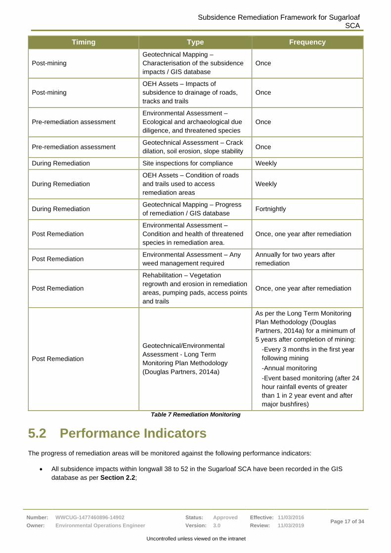
5 Monitoring
5.1 Remediation Monitoring
WWU will undertake pre and post remediation geotechnical and ecological monitoring programs within Sugarloaf
SCA as shown in Table 7. The monitoring aims to ensure compliance by employees and contractors with the
Project Approval and OEH Consent and that performance indicators detailed in Section 5.2 are achieved.
WWU will specifically monitor:
• Progress: The GIS database sent to OEH fortnightly will record details regarding the assessment of
subsidence impacts and the progress of subsidence remediation activities within the Sugarloaf SCA;
• Environmental Impacts: Ecological, archaeology and environmental inspections and monitoring will be
undertaken by WWU as required by the Subsidence Remediation Plan. Threatened species within the
subsidence remediation area will be monitored to ensure they are not adversely impacted by the
remediation activities. Erosion and weeds will also be monitored during and post remediation;
• OEH Assets: WWU will regularly inspect OEH roads and trails used to undertake subsidence remediation
and monitoring activities. WWU will undertake maintenance when required to ensure OEH roads and trails
are in good repair for the duration of subsidence management activities especially where heavy vehicles
are used and drainage structures have been removed or altered to allow for heavy vehicle access.
Furthermore, WWU will monitor and asses OEH tracks and trails post mining for subsidence impacts.
WWU will remediate any damage to the road surface, ponding and/or changes to drainage function of OEH
roads and trails affected by subsidence;
• Rehabilitation of Remediation Areas: WWU are required to rehabilitate and monitor the condition of
remediation sites, pumping pads, access points and access roads to ensure subsidence remediation areas
are being successfully rehabilitated, not eroding, vegetation is regenerating and not impacted by weeds
caused by remediation related disturbance. WWU must ensure access points to remediation areas are not
being used by vehicles and persons following remediation; and
• Effectiveness and Success of Remediation: Geotechnical monitoring will be undertaken as per the Long
Term Monitoring Plan Methodology (Douglas Partners, 2014a). Post remediation monitoring will focus on
ground and fill stability, soil erosion, revegetation effectiveness and risks to public safety. Long term
monitoring will continue for a period which indicates ongoing negligible subsidence and stable conditions
for a minimum of 5 year period after completion of mining. Following this, the first 5 years of data will be
used to assess ongoing long term monitoring if required.
Subsidence Remediation Framework for Sugarloaf
SCA
Number:
Owner:
WWCUG-1477460896-14902
Environmental Operations Engineer
Status:
Version:
Approved
3.0
Effective:
Review:
11/03/2016
11/03/2019 Page 17 of 34
Uncontrolled unless viewed on the intranet
Timing Type Frequency
Post-mining
Geotechnical Mapping –
Characterisation of the subsidence
impacts / GIS database
Once
Post-mining
OEH Assets – Impacts of
subsidence to drainage of roads,
tracks and trails
Once
Pre-remediation assessment
Environmental Assessment –
Ecological and archaeological due
diligence, and threatened species
Once
Pre-remediation assessment Geotechnical Assessment – Crack
dilation, soil erosion, slope stability Once
During Remediation Site inspections for compliance Weekly
During Remediation
OEH Assets – Condition of roads
and trails used to access
remediation areas
Weekly
During Remediation Geotechnical Mapping – Progress
of remediation / GIS database Fortnightly
Post Remediation
Environmental Assessment –
Condition and health of threatened
species in remediation area.
Once, one year after remediation
Post Remediation Environmental Assessment – Any
weed management required
Annually for two years after
remediation
Post Remediation
Rehabilitation – Vegetation
regrowth and erosion in remediation
areas, pumping pads, access points
and trails
Once, one year after remediation
Post Remediation
Geotechnical/Environmental
Assessment - Long Term
Monitoring Plan Methodology
(Douglas Partners, 2014a)
As per the Long Term Monitoring
Plan Methodology (Douglas
Partners, 2014a) for a minimum of
5 years after completion of mining:
-Every 3 months in the first year
following mining
-Annual monitoring
-Event based monitoring (after 24
hour rainfall events of greater
than 1 in 2 year event and after
major bushfires)
Table 7 Remediation Monitoring
5.2 Performance Indicators
The progress of remediation areas will be monitored against the following performance indicators:
• All subsidence impacts within longwall 38 to 52 in the Sugarloaf SCA have been recorded in the GIS
database as per Section 2.2;
Subsidence Remediation Framework for Sugarloaf SCA
Number:
Owner:
WWCUG-1477460896-14902
Environmental Operations Engineer
Status:
Version:
Approved
3.0
Effective:
Review:
11/03/2016
11/03/2019 Page 18 of 34
• Undertake assessment of OEH roads and trails impacted by subsidence. Reinstate drainage and/or install
new drainage and rollovers where existing drainage is no longer functioning due to subsidence; Ponding on
trails due to subsidence eliminated;
• All subsidence impacts have been assessed as per Section 2.1 and assessment reports provided to OEH
and referenced in GIS database;
• All surface cracks defined by Douglas Partners Subsidence Cracks Risk Assessment (2014c) remediated;
• All other subsidence induced surface impacts which have been assessed as posing a risk to public safety,
slope stability, the environment and/or OEH assets remediated;
• Remediation areas are neat, tidy and free of rubbish, excess fill and grout. All rubbish and equipment
associated with the completion of subsidence remediation works has been removed from the work site.
There is no rubbish or WWU equipment at the location of any completed subsidence remediation works;
• OEH road and trails used to undertake and monitor subsidence remediation in the same or better condition
as at the commencement of remediation. All associated drainage structures in good working order and
rollovers removed to facilitate access reinstated to original heights;
• Any pumping pads or new access points created to facilitate or as a result of subsidence remediation
activities and monitoring rehabilitated (e.g. controlling erosion, placing stockpiled vegetative material over
cleared and access tracks areas to encourage natural regeneration and prevent access to the areas by
vehicles and persons following remediation);
• Native vegetation is naturally regenerating and there is no evidence of vegetation die back in areas where
subsidence remediation has been undertaken (including access routes).Threatened species monitored and
found not to be adversely affected by subsidence remediation activities;
• No weed management measures are required in areas where subsidence remediation has been
undertaken (including access routes). Weeds are actively managed and controlled for 2 years following
completion of remediation;
• All subsidence impacts monitored as per Long Term Monitoring Plan Methodology (Douglas Partners,
2014a);
• Selected remediation products used within the reserve are to be durable and not prone to erosion,
degradation or leaching to air or water or be susceptible to bushfire;
• Remediated impacts are assessed to be safe and stable. Renewed crack dilation is not evident, movement
has stabilised, and there is no evidence of slumping, erosion and/or surface water infiltration;
• Drainage, erosion and/or sediment control measures are effective and maintained. Drainage upslope of
subsidence features is not contributing to erosion of subsidence impact, that there is no evidence of
erosion downslope of subsidence impact and that the access points to remediation area are not eroding;
• Installed risk mitigation measures (such as signs, fencing and drainage etc.) is in place and functional; and
• Remediated areas assessed by an independent and suitably qualified geotechnical engineer as safe,
stable and ready to be returned to public use.
In addition to the above, WWU will also ensure that the rehabilitated areas meet the completion criteria set out in
the approved Mining Operations Plan (MOP).
5.3 Contractor Auditing and Inspections
During the remediation process, the contractor will be required to complete a number of checklists to ensure
Health, Safety, Environment and Community (HSEC) controls are in place for each work shift. Regular inspections

Subsidence Remediation Framework for Sugarloaf SCA
Number:
Owner:
WWCUG-1477460896-14902
Environmental Operations Engineer
Status:
Version:
Approved
3.0
Effective:
Review:
11/03/2016
11/03/2019 Page 19 of 34
and audits as detailed in Table 8 will also be carried out by the geotechnical engineer, contractor’s supervisor and
WWU environmental representative. Periodic audits by health, safety and engineering personnel will also be
undertaken.
Audit / Inspection Type Responsible Frequency
Geotechnical mapping Geotechnical engineer Weekly during mining
Post remediation
Crack Remediation Hazard and Scope
Checklist – Pre site inspection
Contractor’s supervisor
WWU environmental
representative
Pre-commencement of
remediation activities
Ground Disturbance Permit
Contractor’s supervisor
WWU environmental
representative
Pre, during and post remediation
activities
Contractor Work Authority
Contractor’s supervisor
WWU environmental
representative
Authority lasts maximum 7 days
Acceptance to site electrical and
mechanical engineering inspections
Contractor supervisor
WWU environmental
representative Electrician and
mechanic
Pre-commencement of
remediation activities
Remediation checklists Contractor supervisor
Contractor/s
Shiftly during remediation and
upon cessation
Planned Task Observations –
Observations of compliance or
otherwise with procedures
WWU environmental
representative Monthly
Third party audit of procedural
compliance
Third party as determined by
WWU with adequate experience in
engineering and environmental
compliance
During trials
3 monthly during remediation
activities
Table 8 Auditing and inspection regime
6 Reporting and Communication
Remediation works are undertaken by WWU in accordance with the Project Approval and will be reported by WWU
to stakeholders as per Table 9.
Type Stakeholder Frequency
Submission of Subsidence
Remediation Plans OEH
10 days prior to proposed works
commencement
Notification of intended remediation
works commencing OEH 24 hours prior to commencement
Notification of incident DPE, OEH, DRE and other
stakeholders as per the PIRMP
As soon as possible following the
incident
Incident Reporting DPE, OEH, DRE and other
stakeholders 7 days
Subsidence Monitoring and
Remediation Reports
DPE, OEH, DRE and other
stakeholders Fortnightly

Subsidence Remediation Framework for Sugarloaf SCA
Number:
Owner:
WWCUG-1477460896-14902
Environmental Operations Engineer
Status:
Version:
Approved
3.0
Effective:
Review:
11/03/2016
11/03/2019 Page 20 of 34
Subsidence GIS database data
transfer OEH Fortnightly
Public Safety Governance Meeting OEH, DRE 6 monthly
Long Term Monitoring Report OEH Annually
WWU Annual Review DPE, OEH, DRE, EPA, DPI-Water Annually
Table 9 Remediation Reporting and communication
7 OEH Approvals and Sign-off
WWU has consent to undertake subsidence remediation activities within Sugarloaf SCA. In accordance with the
consent conditions, WWU will provide Subsidence Remediation Plans developed in accordance with this
Subsidence Remediation Framework to OEH for approval at least 10 days prior to the commencement of activities.
All remediation activities are to be undertaken in accordance with the Subsidence Remediation Framework, the
conditions of the Project Approval, Mining Leases and OEH Consent. Written approval from OEH is also required
for any changes to subsidence remediation methods and procedures used within Sugarloaf SCA.
Once remediation is complete, monitoring will be conducted and measured against the performance indicators
(Section 5). Monitoring will determine when areas of Sugarloaf SCA are safe and stable and can be re-opened for
use by the public (Figure 2).
Land returned to public use
Independent monitoring by suitably qualified expert determines
land is suitable for public use and land owners agree
Subsidence impacts not to be
remediated
Assessed as safe/stable or public
safety controls in place
Further remediation
required
Monitor
Section 5
Long Term Monitoring
Plan Methodology
(Douglas Partners, 2014a)
Assess and record all subsidence impacts
(Sections 2.1 – 2.3)
Remediate subsidence impacts
Prepare Subsidence Remediation Plan
(Section 2.4)
Undertake Remediation (Sections 3 & 4)
Further safety
controls required
Monitor
Long Term Monitoring Plan indicates
ongoing negligible subsidence and stable
conditions for a minimum of 5 years
Remediation complete
Independent monitoring by suitably qualified expert determines
land is safe and stable and land owners agree

Subsidence Remediation Framework for Sugarloaf SCA
Number:
Owner:
WWCUG-1477460896-14902
Environmental Operations Engineer
Status:
Version:
Approved
3.0
Effective:
Review:
11/03/2016
11/03/2019 Page 21 of 34
Figure 2. Process diagram displaying steps required for relinquishment of land
8 Dispute Resolution
Should a dispute arise between WWU and OEH regarding the remediation of a subsidence impact or any other
matter, both parties should try to resolve the issue at the staff level in the first instance. This Subsidence
Remediation Framework places the onus upon individual staff at all levels to agreeably identify differences and
accommodate them through negotiation.
To resolve outstanding issues, a timely meeting will be required between the parties, with minutes taken to
acknowledge the outcome of the discussions and any agreements or actions arising to further resolve the matter.
If post meeting, a dispute still cannot be resolved at staff level, it shall be escalated to an Independent Review
Committee or other third party expert in the field.
9 Review
This Subsidence Remediation Framework:
• Has an initial period of 5 years dated from the commencement of the OEH Consent;
• Will be reviewed by OEH and WWU at the end of the 5 years and may be revised or amended by
agreement of both parties at that time;
• May also be reviewed and revised before the 5 year period has expired as agreed by OEH and WWU; and
• Will be amended following the outcomes of any learning from trials and/or incidents, if required.
10 References
Department of Environment and Climate Change (2008) Blue Book - Managing Urban Stormwater: Soils and
Construction, Volume 2E Mines and Quarries
Douglas Partners (2014a) Long Term Monitoring Plan Methodology for LW38 to LW52 – Steep Slopes
Douglas Partners (2014b) Report on grouted crack remediation monitoring longwall panel 38, 39 and 40.
Douglas Partners (2014c) Subsidence Cracks Risk Assessment (WWC SD RA 0040)
OEH (2016) Consent for Subsidence Monitoring and Management Works in Sugarloaf SCA 2016 – 2021
Umwelt (2016) Aboriginal Cultural Heritage Management Plan (WWC SD EXT 0317)
Umwelt (2010) West Wallsend Colliery Continued Operations Project (WWCCOP) Environmental Assessment
West Wallsend Underground (2015) Cementitious grouting procedure for subsidence remediation (WWC SD PRO 0110)
West Wallsend Underground (2016) Emergency/Incident Management Plan (WWC SD PLN 0024)
West Wallsend Underground (2015) Natural Fill Materials Procedure for Subsidence Remediation (WWC SD PRO 0053)
West Wallsend Underground (2015) WWC, MCPP and Teralba Northgate Pollution Incident Response Management
Plan (WWC SD PLN 0074)

Subsidence Remediation Framework for Sugarloaf SCA
Number:
Owner:
WWCUG-1477460896-14902
Environmental Operations Engineer
Status:
Version:
Approved
3.0
Effective:
Review:
11/03/2016
11/03/2019 Page 22 of 34
West Wallsend Underground Extraction and Subsidence Management Plans
West Wallsend Underground Land Management Plans
West Wallsend Underground Public Safety Management Plans

Subsidence Remediation Framework for Sugarloaf SCA
Number:
Owner:
WWCUG-1477460896-14902
Environmental Operations Engineer
Status:
Version:
Approved
3.0
Effective:
Review:
11/03/2016
11/03/2019 Page 23 of 34
11 Appendices
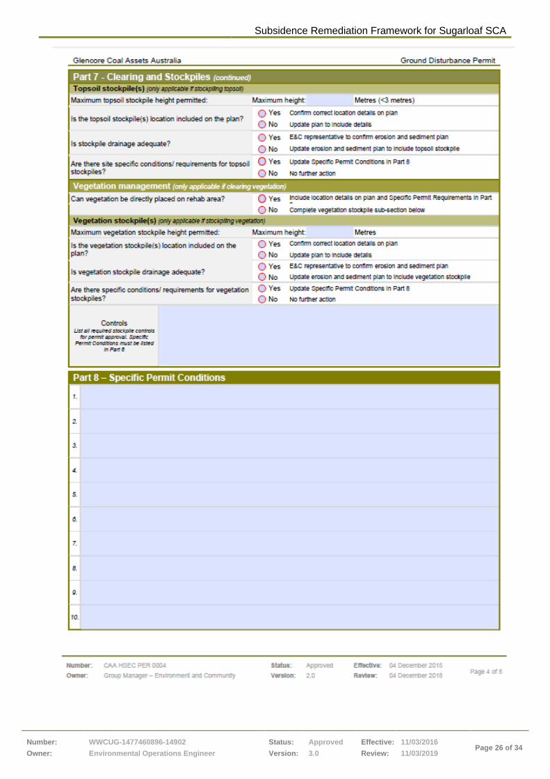
11.1.1 Ground Disturbance Permit (CAA HSEC PER 0004)

Subsidence Remediation Framework for Sugarloaf SCA
Number:
Owner:
WWCUG-1477460896-14902
Environmental Operations Engineer
Status:
Version:
Approved
3.0
Effective:
Review:
11/03/2016
11/03/2019 Page 24 of 34

Subsidence Remediation Framework for Sugarloaf SCA
Number:
Owner:
WWCUG-1477460896-14902
Environmental Operations Engineer
Status:
Version:
Approved
3.0
Effective:
Review:
11/03/2016
11/03/2019 Page 25 of 34
Subsidence Remediation Framework for Sugarloaf SCA
Number:
Owner:
WWCUG-1477460896-14902
Environmental Operations Engineer
Status:
Version:
Approved
3.0
Effective:
Review:
11/03/2016
11/03/2019 Page 26 of 34

Subsidence Remediation Framework for Sugarloaf SCA
Number:
Owner:
WWCUG-1477460896-14902
Environmental Operations Engineer
Status:
Version:
Approved
3.0
Effective:
Review:
11/03/2016
11/03/2019 Page 27 of 34
Subsidence Remediation Framework for Sugarloaf SCA
Number:
Owner:
WWCUG-1477460896-14902
Environmental Operations Engineer
Status:
Version:
Approved
3.0
Effective:
Review:
11/03/2016
11/03/2019 Page 28 of 34
Subsidence Remediation Framework for Sugarloaf SCA
Number:
Owner:
WWCUG-1477460896-14902
Environmental Operations Engineer
Status:
Version:
Approved
3.0
Effective:
Review:
11/03/2016
11/03/2019 Page 29 of 34

Subsidence Remediation Framework for Sugarloaf SCA
Number:
Owner:
WWCUG-1477460896-14902
Environmental Operations Engineer
Status:
Version:
Approved
3.0
Effective:
Review:
11/03/2016
11/03/2019 Page 30 of 34

Subsidence Remediation Framework for Sugarloaf SCA
Number:
Owner:
WWCUG-1477460896-14902
Environmental Operations Engineer
Status:
Version:
Approved
3.0
Effective:
Review:
11/03/2016
11/03/2019 Page 31 of 34
11.1.2 Subsidence Remediation Scope and Hazard
Checklist (WWC SD FRM 0271)

Subsidence Remediation Framework for Sugarloaf SCA
Number:
Owner:
WWCUG-1477460896-14902
Environmental Operations Engineer
Status:
Version:
Approved
3.0
Effective:
Review:
11/03/2016
11/03/2019 Page 32 of 34

Subsidence Remediation Framework for Sugarloaf SCA
Number:
Owner:
WWCUG-1477460896-14902
Environmental Operations Engineer
Status:
Version:
Approved
3.0
Effective:
Review:
11/03/2016
11/03/2019 Page 33 of 34
Uncontrolled unless viewed on the intranet
11.1.3 Subsidence Remediation Map (Example)

Subsidence Remediation Framework for Sugarloaf
SCA
Number:
Owner:
WWCUG-1477460896-14902
Environmental Operations Engineer
Status:
Version:
Approved
3.0
Effective:
Review:
11/03/2016
11/03/2019 Page 34 of 34
Uncontrolled unless viewed on the intranet
12 Change Information
Full details of the document history are recorded in the document control register, by version. A
summary of the current change is provided in Table 10.
Change Date Review team
(consultation) Change Summary
1 26 May 2015 W Covey
New document / Brief Page turn with
OEH
2 29 May 2015
C Armit, W Covey
Glencore format, include initial OEH
feedback and added sections from
cementitious grout procedure
3 3-15 June 2015 B Jackson, C Armit OEH feedback
4 11-22 October 2015 B Jackson, C Armit OEH feedback, post Westside trial
5 Dec 2015-March
2016
B Jackson, A Hutton, C
Armit, D Beckers, D van
Rensburg, C Power, B
Clibborn
OEH feedback, consultant review
Table 10 – Change information