Embed Size (px)
Citation preview

To, Date:
Public hearing cell,
Gujarat Pollution Control Board
Paryavaran Bhavan Sector-10 A,
Gandhinagar
Sub: Regarding Environmental Clearance and conducting of Public Hearing for M/s. Hotel
Kohinoor Pro. Dilubhai Amrubhai Varu, N/V- Katar, Tehsil:Rajula, Dist: Amreli, (Guj.), Survey
No. 223 Paiki 37, Belongs to “Cluster: Cluster of Blacktrap Mining Project, near village Katar,
Tehsil: Rajula, Dist: Amreli, Gujarat.
Dear Sir,
As per Terms of Reference awarded by the SEIAA for the above project belongs to cluster “Cluster Of
Blacktrap Mining Project” near village Katar. We have prepared a Draft EIA/EMP Report for conducting
public hearing as per the EIA Notification 2006.
We are hereby submitting Draft EIA/EMP Report and Executive Summary (Gujarati and English) in both
Hard and soft copies for your kind perusal and scrutiny for further processing of the case. Hope you will
find this in order.
We kindly request you to process expeditiously our application for conducting public
consultation/Hearing.
Thanking You,
Yours faithfully,
(Authorized Signatory)
M/s. Hotel Kohinoor , Pro. Dilubhai Amrubhai Varu
Encl.: As above

FOR
Cluster of Black Trap Mining Projects(Baseline monitoring period-Oct 2020 to Dec 2020)
At Survey No. 223 Paiki 37
Village-Katar, Tehsil- Rajula, District- Amreli,
(Gujarat)
Lease Area: 1.50 Ha.
Cluster Area: 09.48 Ha
DRAFT REPORT(Report Code: COG/DEIA/2020/09)
ENVIRONMENTAL IMPACT ASSESSMENT
&
ENVIRONMENTAL MANAGEMENT PLAN
Environment Consultant :
PROJECT PROPONENT:
M/s. Hotel Kohinoor
Pro. Dilubhai Amrubhai Varu
COGNIZANCE RESEARCH INDIA PVT LTD( Accredited by QCI/NABET-1619)
Gt-20, Sector-117, Noida, U.P
Website: http://www.cognizanceindia.com
,

INDEX
Serial No. CONTENTS Page No.
CHAPTER-I
INTRODUCTION
1.0 PREAMBLE 2/I
1.1 IDENTIFICATION OF PROJECT & PROJECT PROPONENT 3/I
1.2 BRIEF DESCRIPTION OF PROJECT 4/I
1.3 REGULARITY COMPLIANCES & APPLICABLE
RULES/REGULATIONS
11 /I
1.4 SCOPE OF THE STUDY 12 /I
1.5 POST-ENVIRONMENTAL CLEARANCE MONITORING 13 /I
1.6 TRANSFERABILITY OF ENVIRONMENTAL CLEARANCE 13 /I
1.7 GENERIC STRUCTURE OF ENVIRONMENTAL IMPACT
ASSESSMENT DOCUMENT
14 /I
1.8 IDENTIFICATION OF PROJECT PROPONENT 14/I
1.9 COMPLIANCE OF TOR CONDITION 15 /I
CHAPTER-II
PROJECT DESCRIPTION
2.0 GENERAL 2/II
2.1 DESCRIPTION OF THE PROJECT 3/II
2.2 GEOLOGY AND TOPOGRAPHY 4/II
2.3 QUANTITY OF RESERVES 7/II
2.4 MINING 7/II
2.5 UTILITIES 15/II
2.6 POWER SUPPLY 16/II
2.7 STATUTORY REQUIREMENTS 17/II
CHAPTER-III
DESCRIPTION OF ENVIRONMENT
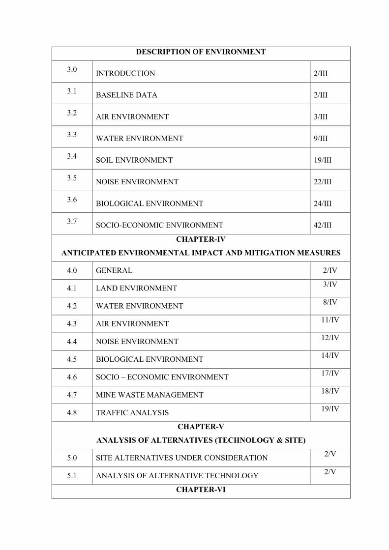
3.0 INTRODUCTION 2/III
3.1 BASELINE DATA 2/III
3.2 AIR ENVIRONMENT 3/III
3.3 WATER ENVIRONMENT 9/III
3.4 SOIL ENVIRONMENT 19/III
3.5 NOISE ENVIRONMENT 22/III
3.6 BIOLOGICAL ENVIRONMENT 24/III
3.7 SOCIO-ECONOMIC ENVIRONMENT 42/III
CHAPTER-IV
ANTICIPATED ENVIRONMENTAL IMPACT AND MITIGATION MEASURES
4.0 GENERAL 2/IV
4.1 LAND ENVIRONMENT 3/IV
4.2 WATER ENVIRONMENT 8/IV
4.3 AIR ENVIRONMENT 11/IV
4.4 NOISE ENVIRONMENT 12/IV
4.5 BIOLOGICAL ENVIRONMENT 14/IV
4.6 SOCIO – ECONOMIC ENVIRONMENT 17/IV
4.7 MINE WASTE MANAGEMENT 18/IV
4.8 TRAFFIC ANALYSIS 19/IV
CHAPTER-V
ANALYSIS OF ALTERNATIVES (TECHNOLOGY & SITE)
5.0 SITE ALTERNATIVES UNDER CONSIDERATION 2/V
5.1 ANALYSIS OF ALTERNATIVE TECHNOLOGY 2/V
CHAPTER-VI

ENVIRONMENTAL MONITORING PROGRAMME
6.0 INTRODUCTION 2/VI
6.1 PROPOSED SET UP 2/VI
6.2 MONITORING SCHEDULE AND PARAMETERS 3/VI
6.3 OCCUPATIONAL HEALTH AND SAFETY 5/VI
CHAPTER-VII
ADDITIONAL STUDIES
7.0 PUBLIC CONSULTATION 2/VII
7.1 HAZARD IDENTIOFICATION AND RISK ASSESSMENT
METHODOLOGY
2/VII
7.2 POTENTIAL HAZARDS & ‘ALARP’ CONDITION 7/VII
7.3 RISK PRIOROTISATION BASED ON HAZARDS 7/III
7.4 ADDITIONAL MITIGATION MAJORS TO BRING HAZARDS
UNDER “ALARP” ZONE
10/VII
7.5 NATURAL RESOURCE CONSERVATION 11/VII
CHAPTER-VIII
PROJECT BENEFITS
8.0 GENERAL 2/VIII
8.1 BENEFITS OF MINING 2/VIII
8.2 EMPLOYMENT 2/VIII
8.3 SOCIO ECONOMIC BENEFITS AND CER 4/VIII
8.4 PLANTATION 4/VIII
8.5 HEALTH 4/VIII
CHAPTER-IX
ENVIRONMENTAL MANAGEMENT PLAN
9.0 GENERAL 2/IX
9.1 AIR QUALITY MANAGEMENT 2/IX

9.2 NOISE POLLUTION CONTROL 3/IX
9.3 WATER QUALITY MANAGEMENT 3/IX
9.4 WASTE MANAGEMENT 3/IX
9.5 BIOLOGICAL MANAGEMENT MEASURES 4/IX
9.6 GREENBELT DEVELOPMENT PLAN 4/IX
9.7 OCCUPATIONAL HAZARDS& SAFETY 5/IX
9.8 EMP BUDGET 6/IX
9.9 SOCIO-ECONOMIC CONDITION OF THE REGION 9/IX
9.10 ENVIRONMENT POLICY 10/IX
9.11 CER DETAILS 11/IX
9.12 CONCLUSION 11/IX
CHAPTER-X
EXECUTIVE SUMMARY
10.0 PREAMBLE 2/X
10.1 PURPOSE OF THE REPORT 2/X
10.2 IDENTIFICATION OF PROJECT & PROJECT PROPONENT 3/X
10.3 BRIEF DESCRIPTION OF PROJECT 4/X
10.4 PROJECT DESCRIPTION 6/X
10.5 RECLAMATION AND AFFORESTATION PROGRAMME 8/X
10.6 LAND USE PATTERN 9/X
10.7 BASELINE ENVIRONMENTAL STATUS 11/X
10.8 ANTICIPATED ENVIRONMENTAL IMPACTS 13/X
10.9 ENVIRONMENTAL MONITORING PLAN 15/X
10.10 ANALYSIS OF ALTERNATIVES 16/X
10.11 ENVIRONMENTAL MONITORING PROGRAMME 17/X

10.12 COST ESTIMATES 20/X
10.13 ADDITIONAL STUDIES 22/X
10.14 PUBLIC CONSULTATION 23/X
10.15 PROJECT BENEFITS 23/X
10.16 CONCLUSIONS 23/X
CHAPTER-XI
DISCLOSURE OF CONSULTANTS ENGAGED
11 DISCLOSURE OF CONSULTANTS ENGAGED 1/Xl

LIST OF FIGURES
Fig. No. TITLE OF FIGURE Page No.
1.1 Location Map 10/I
1.2 10 KM Toposheet of the cluster 11/I
1.3 10 KM Toposheet of the Cluster 13/I
2.1 Drainage Map 6/II
3.1 The wind-rose diagram (October 2020-December 2020) 4/III
3.2 Ambient Air Quality sampling locations 7/III
3.3 Ambient Noise Quality Monitoring Locations 10/III
3.4 (a) Ground Water Quality Sampling Locations 13/III
3.4 (b) Surface Water Quality Sampling Locations 31/III
3.5 Soil Sampling Locations 35/III
3.6 Land Use Map 36/III
3.7 Wildlife Protected Area 45/III
6.1 Diagram representing Environment Management Cell 3/ VI

LIST OF TABLES
Table
No.
TITLE OF TABLE Page No.
1.1 Details of Mine lease area 5/I
1.2 Geographical coordinates of mine lease areas 6/I
1.3 Details of project and production details 7/I
1.4 Brief Description of the Project 7/I
1.5 Details w.r.t LoI and Mining Plan approals 12 /I
1.6 Compliance of ToR Conditions 15/I
2.1 Location Details 2/II
2.2 Latitude and Longitude, Geographical coordinates 3/II
2.3 Details of Mining Lease Area 4/II
2.4 Summary of Geological Reserve 7/II
2.5 Mining Parameters 8/II
2.6 Production details for the Project 8/II
2.7 Existing Landuse Pattern 9/II
2.8 Life of Mine 12/II
2.9 Blasting Parameter 15/II
2.10 Stage Wise Land Use Pattern 13/II
2.11 Water Requirement for all mines in cluster 16/11
2.12 Manpower Requirement for cluster 17/II
2.13 List of Mining Machinery 17/II
3.1 Ambient Air Quality Monitoring Stations 5/III
3.2 Ambient Air Quality Test Results 5/III
3.3 Location of Ground Water Sampling Sites 10/III
3.4 Ground water Sample Analysis Results 11/III
3.5 Water quality criteria as per Central Pollution Control
Board
14/III
3.6 Location of Surface Water Sampling Sites 16/III
3.7 Physico-chemical properties of surface water 17/III
3.8 Description of soil sampling locations 20/ III

3.9 Physico-chemical properties of soil 11/III
3.10 Noise Level Monitoring Stations in the Study Area 22/III
3.11 Noise Monitoring Results 23/III
3.12 Floral species reported from the proposed project site / Core
Zone
26/ III
3.13 Trees in the study area (Buffer Zone) 30/III
3.14 List of Shrubs in the study area (Buffer Zone) 31/ III
3.15 List of herbaceous species observed in the area (Buffer
Zone)
33/ III
3.16 List of climbers observed in the study area (Buffer Zone) 34/III
3.17 Systematic lists of birds in the study area with its
distribution and migratory status
37/III
3.18 List of Butterflies in the study area (Buffer Zone) 39/III
3.19 List of Reptiles in the study area 39/III
3.20 List of Mammals in the Buffer Zone 39/III
4.1 Stage wise Change in Land use Pattern 3/IV
4.2 Landuse Patter at the end of Five Year Period 6/ IV
4.3 Water requirement for specific lease area 9/IV
4.4 Maximum Depth of Working 10/IV
4.5 Noise Exposure Levels & Its Effects 13/IV
4.6 Progressive Afforestation Schedule 15/VI
4.6 Existing Traffic Scenario & LOS 14/ VI
4.7 Species Suggested for Plantation 17/IV
4.8 (i) Existing Traffic Scenario & LOS 19/IV
4.8(ii) Modified Traffic Scenario & LOS 20/IV
6.1 Monitoring Schedule and Parameters 4/VI
8.1 Employment detail 2/VIII
9.1 Progressive Afforestation Schedule for entire mines in
clustre
5/IX
9.2 Budget allocation for project cost 6/IX
9.3 Budget for EMP 7/IX
10.1 Anticipated life of project and cost of the project
5/X

10.2 Geographical Coordinates of mine lease area 5/X
10.3 Mining Parameter 8/X
10.4 Species Suggested for Plantation 8/X
10.5 Land use pattern 9/X
10.6 Key suggestive measures under EMP 16/X
10.7 Budget allotted for the Environmental Management Plan 20/X
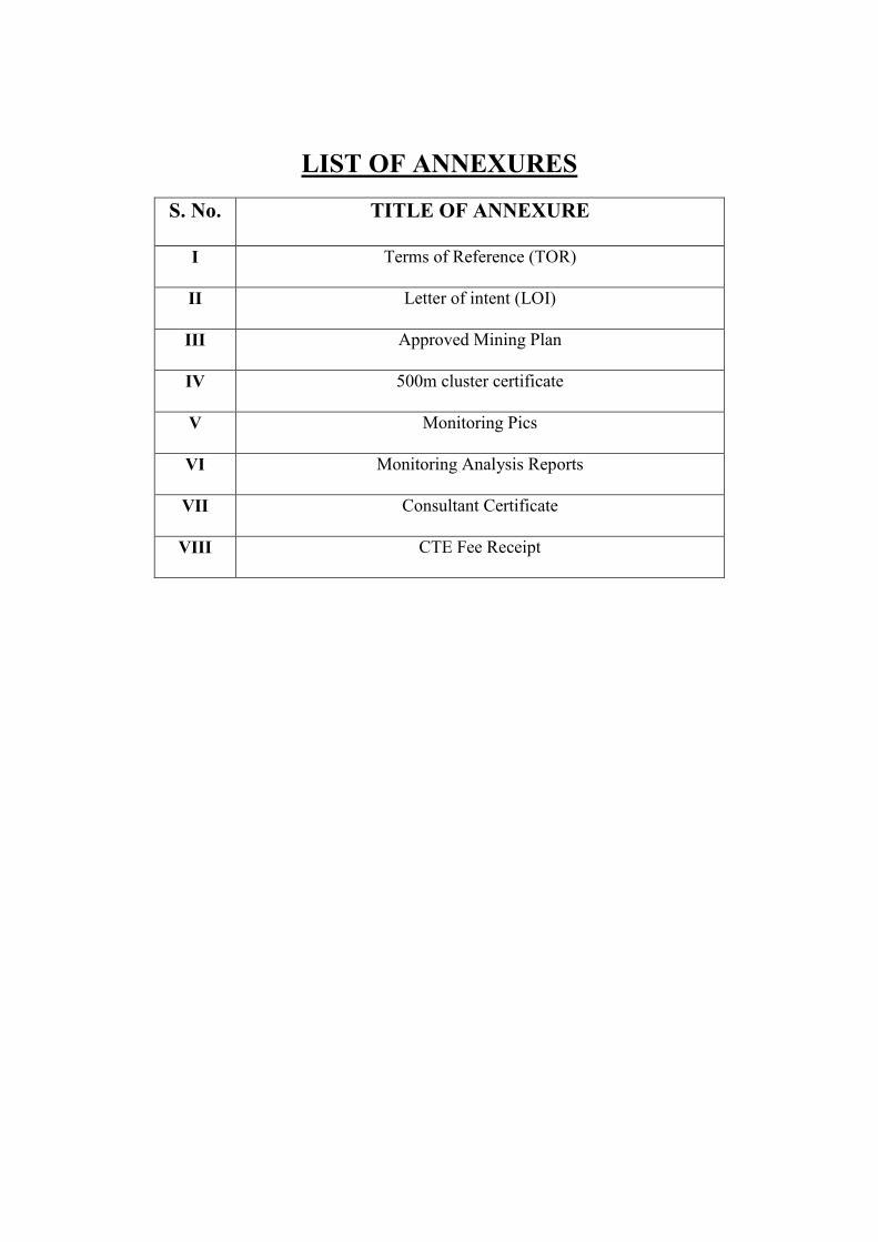
LIST OF ANNEXURES
S. No. TITLE OF ANNEXURE
I Terms of Reference (TOR)
II Letter of intent (LOI)
III Approved Mining Plan
IV 500m cluster certificate
V Monitoring Pics
VI Monitoring Analysis Reports
VII Consultant Certificate
VIII CTE Fee Receipt
Draft EIA for Cluster of Black Trap Mining Projects
Located at Village- Katar
Taluka –Rajula, District –Amreli,
State – Gujarat
Area: Total cluster 09.48 Ha
1 | I
Chapter – 1
Introduction
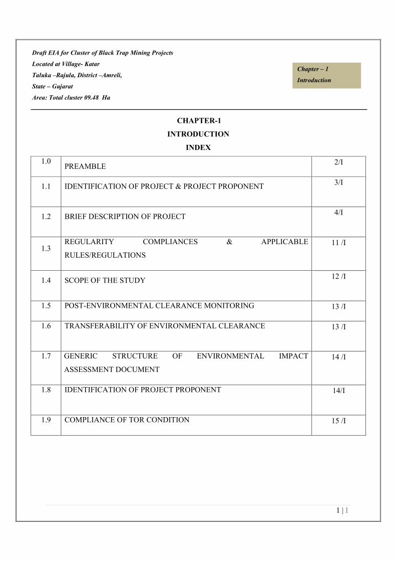
CHAPTER-1
INTRODUCTION
INDEX
1.0 PREAMBLE
2/I
1.1 IDENTIFICATION OF PROJECT & PROJECT PROPONENT 3/I
1.2 BRIEF DESCRIPTION OF PROJECT 4/I
1.3 REGULARITY COMPLIANCES & APPLICABLE
RULES/REGULATIONS
11 /I
1.4 SCOPE OF THE STUDY 12 /I
1.5 POST-ENVIRONMENTAL CLEARANCE MONITORING 13 /I
1.6 TRANSFERABILITY OF ENVIRONMENTAL CLEARANCE 13 /I
1.7 GENERIC STRUCTURE OF ENVIRONMENTAL IMPACT
ASSESSMENT DOCUMENT
14 /I
1.8 IDENTIFICATION OF PROJECT PROPONENT 14/I
1.9 COMPLIANCE OF TOR CONDITION 15 /I
Draft EIA for Cluster of Black Trap Mining Projects
Located at Village- Katar
Taluka –Rajula, District –Amreli,
State – Gujarat
Area: Total cluster 09.48 Ha
2 | I
Chapter – 1
Introduction
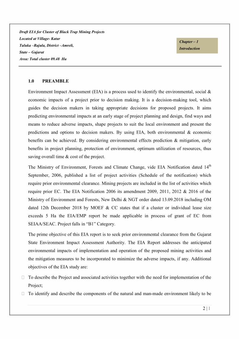
1.0 PREAMBLE
Environment Impact Assessment (EIA) is a process used to identify the environmental, social &
economic impacts of a project prior to decision making. It is a decision-making tool, which
guides the decision makers in taking appropriate decisions for proposed projects. It aims
predicting environmental impacts at an early stage of project planning and design, find ways and
means to reduce adverse impacts, shape projects to suit the local environment and present the
predictions and options to decision makers. By using EIA, both environmental & economic
benefits can be achieved. By considering environmental effects prediction & mitigation, early
benefits in project planning, protection of environment, optimum utilization of resources, thus
saving overall time & cost of the project.
The Ministry of Environment, Forests and Climate Change, vide EIA Notification dated 14th
September, 2006, published a list of project activities (Schedule of the notification) which
require prior environmental clearance. Mining projects are included in the list of activities which
require prior EC. The EIA Notification 2006 its amendment 2009, 2011, 2012 & 2016 of the
Ministry of Environment and Forests, New Delhi & NGT order dated 13.09.2018 including OM
dated 12th December 2018 by MOEF & CC states that if a cluster or individual lease size
exceeds 5 Ha the EIA/EMP report be made applicable in process of grant of EC from
SEIAA/SEAC. Project falls in “B1” Category.
The prime objective of this EIA report is to seek prior environmental clearance from the Gujarat
State Environment Impact Assessment Authority. The EIA Report addresses the anticipated
environmental impacts of implementation and operation of the proposed mining activities and
the mitigation measures to be incorporated to minimize the adverse impacts, if any. Additional
objectives of the EIA study are:
To describe the Project and associated activities together with the need for implementation of the
Project;
To identify and describe the components of the natural and man-made environment likely to be
Draft EIA for Cluster of Black Trap Mining Projects
Located at Village- Katar
Taluka –Rajula, District –Amreli,
State – Gujarat
Area: Total cluster 09.48 Ha
3 | I
Chapter – 1
Introduction
affected by the project;
To identify and quantify the environmental impacts associated with the project and recommend
appropriate mitigation measures;
To establish existing baseline status of different components of the environment so as to
facilitate visualization of post-project scenario:
� To propose mitigation measures to minimize environmental deterioration and nuisance
during construction and operation of the Project.
� To identify, assess and specify methods, measures and standards, to be to be taken into
consideration during detailed engineering design, construction and operation of the
project;
� To identify and justify the scope for post-project environmental monitoring to ensure
the implementation and the effectiveness of the environmental protection and pollution
control measures; and
� To identify any additional studies necessary to fulfill the objectives to the
requirements of this EIA Study.
1.1 IDENTIFICATION OF PROJECT PROPONENT
The total project area comprises of 4 mines in cluster with total area of 09.48 Ha.
The mining LOI for Mine 1 at Survey No- 223 Paiki 37 reference no.-
AMR/BTP/02/2019/008/01 amd e-auction dated 06.09.2019 for grant of Quarry lease for Katar
Blacktrap Block-B, in favour of Kind International vide letter no
GA/Lease/Auction/Minor/Blacktrap/Amreli/2019/1272 dated 01.11.2019 for a period of 30
years, copy attached as Annexure-II(a).
The mining LOI for Mine 2 at adjoining Survey no.-223 Paiki 37 reference no.-
AMR/BTP/02/2019/009/01 and e-auction dated 07.09.2019 was granted for mineral Black Trap
in favour of Shri Najubhai Champarajbhai Varu vide letter no.

Draft EIA for Cluster of Black Trap Mining Projects
Located at Village- Katar
Taluka –Rajula, District –Amreli,
State – Gujarat
Area: Total cluster 09.48 Ha
4 | I
Chapter – 1
Introduction
GA/Lease/Auction/Minor/Blacktrap/Amreli/2019/1278 dated 01.11.2019 for a period of 30
years, copy attached as Annexure-II (b).
The mining LOI for Mine 3 at adjoining Survey no.-223 Paiki 37 reference no.-
AMR/BTP/02/2019/010/01 and e-auction dated 12.09.2019 was granted for mineral Black Trap
in favour of Hotel Kohinoor vide letter no.
GA/Lease/Auction/Minor/Blacktrap/Amreli/2019/1284 dated 01.11.2019 for a period of 30
years, copy attached as Annexure-II (c).
The Environmental Clearance has been granted for Mine 4 at adjoining Survey no.-223 Paiki 37
vide letter no.-DEIAA/AMRELI/EC/1(a)/0004/2017/151 dated 27.04.2017 for mineral Black
Trap in favour of Shri Haresh Najbhai Khuman copy attached as Annexure-II (d).
1.2 BRIEF DESCRIPTION OF PROJECT
The demand for Black Trap is ever growing with the growth of the infrastructure sector in our
country. The mineral is used in the construction activities like buildings, structures. The
requirement for the mineral is always high in the nearby cities and towns. Therefore, there is
always a good demand of the mineral in the domestic market.
The proposed project is cluster of 4 mines. The Mine 1 Survey No.- 223 Paiki 37 is located at
Village-Katar, Taluka – Rajula, District –Rajula, State – Gujarat over an area 2.25 Ha. The
mining plan has been approved by Geology & Mining department, Govt. of Gujrat, Amreli vide
letter no.-GA/MP/BLOCK/2020/753 dated 02.06.2020 is attached as Annexure III(a).
The Mine 2 is located at Survey No.- Survey No.- 223 Paiki 37 Village-Katar, Taluka – Rajula,
District –Rajula, State – Gujarat over an area 3.73 Ha. The mining plan has been approved by
Geology & Mining department, Amreli vide letter no.-GA/MP/BLOCK/2020/751 dated
02.06.2020 is attached as Annexure III(b).
The Mine 3 is located at Survey No.- Survey No.- 223 Paiki 37 Village-Katar, Taluka – Rajula,
District –Rajula, State – Gujarat over an area 1.50 Ha. Geology & Mining department, Govt. of
Draft EIA for Cluster of Black Trap Mining Projects
Located at Village- Katar
Taluka –Rajula, District –Amreli,
State – Gujarat
Area: Total cluster 09.48 Ha
5 | I
Chapter – 1
Introduction
Gujrat, Amreli vide letter no.-GA/MP/BLOCK/2020/755 dated 02.06.2020 is attached as
Annexure III(c).
The Mine 4 is located at Survey No.- Survey No.- 223 Paiki 37 Village-Katar, Taluka – Rajula,
District –Rajula, State – Gujarat over an area 2.00 Ha. Environmental Clearance has been
granted vide letter no. DEIAA/AMRELI/EC/1(a)/0004/2017/756 dated 26.01.2017 is attached as
Annexure III(d).
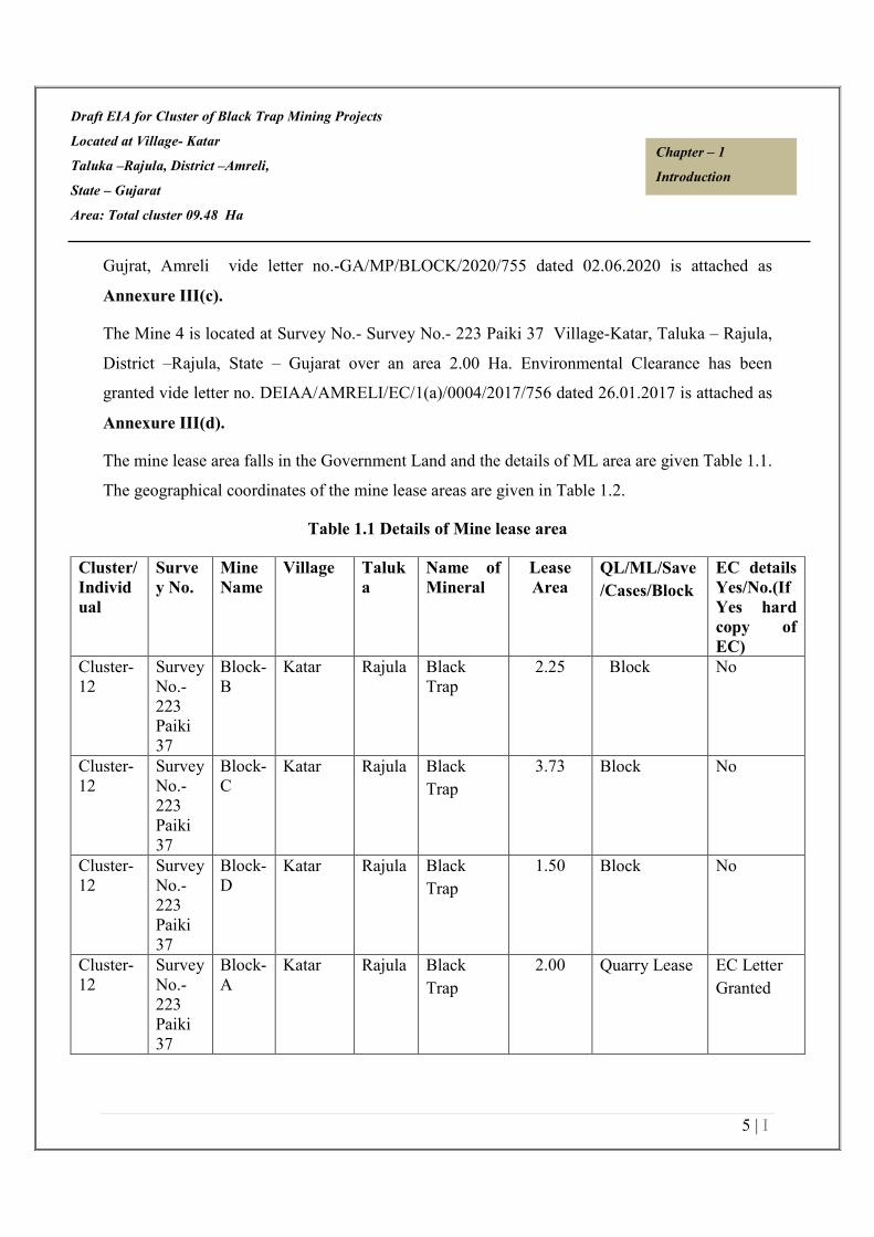
The mine lease area falls in the Government Land and the details of ML area are given Table 1.1.
The geographical coordinates of the mine lease areas are given in Table 1.2.
Table 1.1 Details of Mine lease area
Cluster/
Individ
ual
Surve
y No.
Mine
Name
Village Taluk
a
Name of
Mineral
Lease
Area
QL/ML/Save
/Cases/Block
EC details
Yes/No.(If
Yes hard
copy of
EC)
Cluster-
12
Survey
No.-
223
Paiki
37
Block-
B
Katar Rajula Black
Trap
2.25 Block No
Cluster-
12
Survey
No.-
223
Paiki
37
Block-
C
Katar Rajula Black
Trap
3.73 Block No
Cluster-
12
Survey
No.-
223
Paiki
37
Block-
D
Katar Rajula Black
Trap
1.50 Block No
Cluster-
12
Survey
No.-
223
Paiki
37
Block-
A
Katar Rajula Black
Trap
2.00 Quarry Lease EC Letter
Granted

Draft EIA for Cluster of Black Trap Mining Projects
Located at Village- Katar
Taluka –Rajula, District –Amreli,
State – Gujarat
Area: Total cluster 09.48 Ha
6 | I
Chapter – 1
Introduction
Table 1.2 Geographical coordinates of mine lease areas.
Mine Project Proponent Khasra no/ survey
no
Site co-ordinates
1 Shri Ghanshyambhai
Dilubhai Varu
Survey No.- 223
Paiki 37
21°01'42.5430"N to 21°01'39.1773"N
71°21'10.1141"E to 71°21'06.8365"E
2 Shri Najubhai
Champrajbhai Varu
Survey No.- 223
Paiki 37
21°01'29.8250"N to 21°01'28.1465"N
71°21'03.1852"E to 71°21'00.7929"E
3 Shri Dilubhai Amrubhai
Varu
Survey No.- 223
Paiki 37
21°01'12.8359"N to 21°01'14.1607"N
71°20'55.9831"E to 71°20'52.6102"E
4 Shri Hareshbhai Najbhai
Khuman
Survey No.- 223
Paiki 37
2326103.41"N to 2326142.05"N
744209.60"E to 744116.62"E
1.2.1 Project Nature, Size & Location
i. Nature
The proposed project is Black Trap Mining Project. The total Cluster area considered is 09.48Ha
of Government Land. The method of mining is Opencast Semi-Mechanized Method.
ii. Size
The proposed production of the entire cluster of mine is 1,45,566 MTPA. The proposed
production for Mine 1 is 15790 MTPA, Mine 2 is 47368 MTPA, Mine 3 is 47368 MTPA & for
Mine 4 is 35040 MTPA. The estimated project cost is Rs. 1,38,04,600 for Mine 1, Rs.
2,59,48,915 for Mine 2 & 2,47,94,100 for Mine 3. The anticipated life for Mine 1 is 30 yrs, Mine
2 is 30 yrs., mine 3 is 8 yrs. & for mine 4 is 13 yrs.

Draft EIA for Cluster of Black Trap Mining Projects
Located at Village- Katar
Taluka –Rajula, District –Amreli,
State – Gujarat
Area: Total cluster 09.48 Ha
7 | I
Chapter – 1
Introduction
iii. Location
The mining cluster area is located at Village-Katar, Taluka –Rajula, District –Amreli, State –
Gujarat). The restricted top sheet no. is 41 O/2.
Table 1.3 Details of project and production details
Mine Project
proponent
Production
Capacity
(TPA)
Khasra
no/survey no
Area
(ha)
1 Shri Ghanshyambhai
Dilubhai Varu
15790 MTPA Survey No.- 223
Paiki 37
2.25
2 Shri Najubhai
Champrajbhai Varu
47368 MTPA Survey No.- 223
Paiki 37
3.73
3 Shri Dilubhai
Amrubhai Varu
47368 MTPA Survey No.- 223
Paiki 37
1.50
4 Shri Hareshbhai
Nazbhai Khuman
60000 MTPA Survey No.- 223
Paiki 37
2.00
TOTAL 1,70,526 MTPA 9.48 Ha.
1.2.2 Brief description of the project
Table 1.4 Brief Description of the Project
S. No. Particulars Details
A. Nature & Size of
the Project
Katar Black Trap Mining Project
Total Cluster Area -09.48 Ha.
B. Location
Name of Village Katar
Tehsil Rajula

Draft EIA for Cluster of Black Trap Mining Projects
Located at Village- Katar
Taluka –Rajula, District –Amreli,
State – Gujarat
Area: Total cluster 09.48 Ha
8 | I
Chapter – 1
Introduction
District Amreli
State Gujrat
Toposheet No. 41 O/2
Mine Lease Area Details
Lease Area Total cluster 09.48 Ha
Type of Land Government Land
Topography Topographically, the lease area comprises undulating land.
Site Elevation Range
Plot/Khand/Survey
No.
Slice/strip at
R.L.
Survey No.- 223 Paiki 37 The altitude of the
area is 74-80 m RL
Survey No.- 223 Paiki 37 The altitude of the area is
77-82 m RL
Survey No.- 223 Paiki 37 The altitude of the area is
75-80 m RL
Survey No.- 223 Paiki 37 The altitude of the area is
74-80 m RL
Cost Details
Cost of the project Mine 1- 1,38,04,600/-
Mine 2- 2,59,48,915/-
Mine 3- 2,47,94,100/-
Mine 4- 1,38,04,600/-
Cost for EMP Mine 1-14,48,250/-
Mine 2- 17,55,850/-
Mine 3- 13,75,500/-
Mine 4- 14,48,250/-
Details of Environmental Setting

Draft EIA for Cluster of Black Trap Mining Projects
Located at Village- Katar
Taluka –Rajula, District –Amreli,
State – Gujarat
Area: Total cluster 09.48 Ha
9 | I
Chapter – 1
Introduction
Ecological Sensitive Areas
(National Park, Wild Life
Sanctuary, Biosphere
Reserve, Reserve/
Protected Forest etc.)
Lion Park National Forest is present at a distance of 4.32 km
in SSW direction.
Reserved land for wild animals of Gir is present at a distance
of 3.66 km in NE direction.
Water Bodies Kotadi river at a distance of 2.96 km in ENE direction.
Dharwadi River Dam at a distance of 7.14 km in E direction.
Nearest Town New Barptoli is present at a distance of 2.64 km in SE direction.
Nearest Railway Station Rajula Railway station (about 11 KM in E Direction)
Nearest National Highway
SH-107 About 1.46 KM in SSW Direction
SH-6 About 8.30 KM in E Direction
Nearest Airport Diu Airport about 55.54 Km in SW direction
Seismic Zone Zone III

Draft EIA for Cluster of Black Trap Mining Projects
Located at Village- Katar
Taluka –Rajula, District –Amreli,
State – Gujarat
Area: Total cluster 09.48 Ha
10 | I
Chapter – 1
Introduction
Figure 1.1 Location Map

Draft EIA for Cluster of Black Trap Mining Projects
Located at Village- Katar
Taluka –Rajula, District –Amreli,
State – Gujarat
Area: Total cluster 09.48 Ha
11 | I
Chapter – 1
Introduction
Figure 1.2 (10 Km Toposheet of the Cluster)
1.2.3 Projects importance to the country and the region
In the present scenario, the Black Trap has good market in the country. Black Trap is used to
provide bulk, strength, and other properties to construction materials like asphalt and concrete
It is also used as a decorative material in landscaping. Specific types of Black Trap are used in
the manufacture of glass and as a molding material for metal casting.
1.3 REGULATORY COMPLIANCES & APPLICABLE LAWS/REGULATIONS
Details w.r.t LOI and Mining Plan are stated below in tabulated form:
Table No. 1.5 Details w.r.t LOI and Mining Plan approvals
Mine Project Proponent LoI No. with date and till date validity Mining Plan approval
No. with date
1. Shri GA/Lease/Auction/Minor/Blacktrap/Amreli/2019/ GA/MP/BLOCK/2020/753

Draft EIA for Cluster of Black Trap Mining Projects
Located at Village- Katar
Taluka –Rajula, District –Amreli,
State – Gujarat
Area: Total cluster 09.48 Ha
12 | I
Chapter – 1
Introduction
Ghanshyambhai
Dilubhai Varu
1272 dated 01.11.2019 dated 02.06.2020
2. Shri Najubhai
Champrajbhai Varu
GA/Lease/Auction/Minor/Blacktrap/Amreli/2019/
1278 dated 01.11.2019
GA/MP/BLOCK/2020/751
dated 02.06.2020
3. Shri Dilubhai
Amrubhai Varu
GA/Lease/Auction/Minor/Blacktrap/Amreli/2019/
1284 dated 01.11.2019
GA/MP/BLOCK/2020/755
dated 02.06.2020
4. Shri Hareshbhai
Nazbhai Khuman
EC Letter has been granted CGM/MC/AMR/2/238
dated 22.09.2017
1.4 SCOPE OF THE STUDY
The application for the Terms of Reference for the proposed project was considered in the
meeting of the Gujarat SEAC. Based on the submissions and presentation made by the project
proponent in SEAC Gujarat & SEIAA has issued the TOR for the EIA study.
Mine
cluster
Project proponent TOR letter No EC letter No. If
received
1 Shri Ghanshyambhai Dilubhai
Varu
SEIAA/GUJ/TOR/1(a)/78/2021 No
2 Shri Najubhai Champrajbhai
Varu
SEIAA/GUJ/TOR/1(a)/79/2021 No
3 Shri Dilubhai Amrubhai Varu SEIAA/GUJ/TOR/1(a)/81/2021 No
4 Shri Hareshbhai Nazbhai
Khuman
EC Letter No.-
DEIAA/AMRELI/EC/1(a)/0004/2
017/756
Yes

Draft EIA for Cluster of Black Trap Mining Projects
Located at Village- Katar
Taluka –Rajula, District –Amreli,
State – Gujarat
Area: Total cluster 09.48 Ha
13 | I
Chapter – 1
Introduction
1.5 POST-ENVIRONMENTAL CLEARANCE MONITORING
For category A projects, it shall be mandatory for the project proponent to make public the
environmental clearance granted for their project along with the environmental conditions and
safeguards at their cost by prominently advertising it at least in two local newspapers of the
district or state where the project is located and in addition, this shall also be displayed in the
project proponent’s website permanently. For category B projects, irrespective of its clearance by
MoEF/SEIAA, the project proponent shall prominently advertise in the newspapers indicating
that the project has been accorded environmental clearance and the details of MoEF website
where it is displayed.
The project management shall submit half-yearly compliance reports in respect of the stipulated
prior environmental clearance terms and conditions on 1st June and 1st December of each
calendar year. All such reports shall be public documents. The latest such compliance report
shall be displayed on the web site of the concerned regulatory authority.
1.6 TRANSFERABILITY OF ENVIRONMENTAL CLEARANCE
A prior environmental clearance granted for a specific project or activity to an applicant may be
transferred during its validity to another legal person entitled to undertake the project or activity
on application by the transferor or the transferee with a written “no objection” by the transferor,
to, and by the regulatory authority concerned, on the same terms and conditions under which the
prior environmental clearance was initially granted, and for the same validity period.
1.7 GENERIC STRUCTURE OF ENVIRONMENTAL IMPACT ASSESSMENT
DOCUMENT
In terms of the EIA notification of the MoEF dated 14th
September 2006 as amended Dec 2009,
the generic structure of the EIA document should be as under:
1. Introduction
2. Project Description

Draft EIA for Cluster of Black Trap Mining Projects
Located at Village- Katar
Taluka –Rajula, District –Amreli,
State – Gujarat
Area: Total cluster 09.48 Ha
14 | I
Chapter – 1
Introduction
3. Description of the Environment
4. Anticipated Environmental Impact & Mitigation Measures
5. Analysis of alternatives (Technology & Site)
6. Environmental Monitoring Programme
7. Additional Studies
8. Project Benefits
9. Environmental Management Plan
10. Summary & Conclusion
11. Disclosure of Consultants engaged.
1.8 IDENTIFICATION OF PROJECT PROPONENT
Mine Project proponent Proponent address Khasra
no/survey no
1 Shri Ghanshyambhai Dilubhai
Varu
R/o Village-Katar, Tehsil-
Rajula, District-
Amreli(Gujrat)
Survey No.- 223 Paiki
37
2 Shri Najubhai Champrajbhai
Varu
R/o Village-Katar, Tehsil-
Rajula, District-
Amreli(Gujrat)
Survey No.- 223 Paiki
37
3 Shri Dilubhai Amrubhai Varu R/o Village-Katar, Tehsil-
Rajula, District-Amreli(Gujrat)
Survey No.- 223 Paiki
37
4 Shri Hareshbhai Nazbhai
Khuman
R/o P.O-Ghoba, Tehsil-
Savarkundla, District-Amreli,
Gujrat.
Survey No.- 223 Paiki
37
1.9 COMPLIANCE OF TOR CONDITION
Cluster of Black Trap Mining Projects located at Village- Katar, Taluka – Rajula, District –Amreli,
State – Gujarat. TOR have been granted by SEIAA, Gujarat. Details of TOR have been given in
section 1.4.

Draft EIA for Cluster of Black Trap Mining Projects
Located at Village- Katar
Taluka –Rajula, District –Amreli,
State – Gujarat
Area: Total cluster 09.48 Ha
15 | I
Chapter – 1
Introduction
Table No. 1.6 Compliance of ToR Conditions
S.No TOR Compliance Reference in the Report
1 A copy of the document in
support of the fact that the
Proponent is the rightful
lessee of the mine should be
given with compliance of
lease condition validated by
the concerned district
geologist.
Details of proponent & status of
lease has been given Chapter-1
in section 1.1
Letter of Intent is attached
as Annexure-II.
2 All documents including
approved mine plan, EIA
and public hearing should be
compatible with one another
in terms of the mine lease
area, production levels,
waste generation and its
management and mining
technology and should be in
the name of the lessee.
The documents including mine
plan and EIA report submitted
are compatible with one
another. Details related to
proponent, lease area & annual
production have been
mentioned Chapter-1, Section
1.2.1
Approved Mining Plan is
attached as Annexure- III
Mine plan
All details has been
complied in
chapter-2
3 All corner coordinates of the
mine lease area,
superimposed on a High
Resolution Imagery
toposheet, topographic sheet,
geomorphology and geology
of the area should be
All Corner Coordinates of
mining lease area superimposed
on Toposheet Composite Map
has been incorporated in
EIA/EMP Report
Chapter I
Ref (Fig: 1.2)

Draft EIA for Cluster of Black Trap Mining Projects
Located at Village- Katar
Taluka –Rajula, District –Amreli,
State – Gujarat
Area: Total cluster 09.48 Ha
16 | I
Chapter – 1
Introduction
provided including longitude
& latitude. Such an Imagery
of the proposed area should
clearly show the land use
and other ecological features
of the study area (core and
buffer zone).
4 Information should be
provided in Survey of India
Toposheet in 1:50,000 scale
indicating geological map of
the area, geomorphology of
land forms of the area,
existing minerals and mining
history of the area, important
water bodies, streams and
rivers and soil
characteristics.
The land use map showing
salient features of the area is
given in the report.
The geological map of the mine
lease area is also given in the
report showing geomorphology.
Land-use of the study area
Figure 3.1
5 It should be clearly stated
whether the proponent
Company has a well laid
down Environment Policy
approved by its Board of
Directors? If so, it may be
spelt out in the EIA Report
with description of the
prescribed operating
processes /procedures to
Yes, the proponent Company
has a well laid down
Environment Policy. The
hierarchical system or
administrative order of the
company has been given in the
EIA report.
Chapter IX
Section 9.10

Draft EIA for Cluster of Black Trap Mining Projects
Located at Village- Katar
Taluka –Rajula, District –Amreli,
State – Gujarat
Area: Total cluster 09.48 Ha
17 | I
Chapter – 1
Introduction
bring into focus any
infringement / deviation /
violation of the
environmental or forest
norms / conditions. The
hierarchical system or
administrative order of the
company to deal with the
environmental issues and for
insuring compliances with
the EC conditions may also
be given. The system of
reporting of non-
compliances / violations of
environmental norms to the
Board of Directors of the
Company and/or
shareholders or stakeholders
at large, may also be detailed
in the EIA Report.
6 Issues relating to mine
safety, including subsidence
study in case of underground
mining and slope study in
case of open cast mining
should be detailed. The
proposed safeguard
measures in each case
Details have been incorporated
in EIA report
Chapter-9
Section 9.7
Draft EIA for Cluster of Black Trap Mining Projects
Located at Village- Katar
Taluka –Rajula, District –Amreli,
State – Gujarat
Area: Total cluster 09.48 Ha
18 | I
Chapter – 1
Introduction
should also be provided.
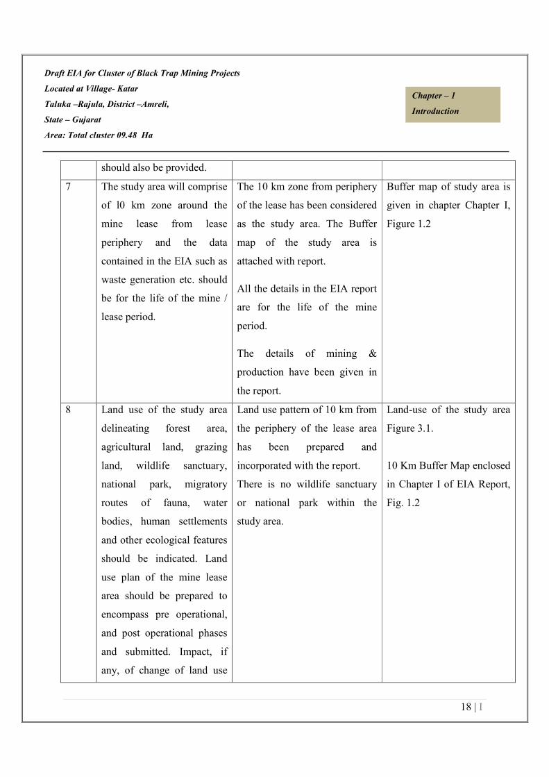
7 The study area will comprise
of l0 km zone around the
mine lease from lease
periphery and the data
contained in the EIA such as
waste generation etc. should
be for the life of the mine /
lease period.
The 10 km zone from periphery
of the lease has been considered
as the study area. The Buffer
map of the study area is
attached with report.
All the details in the EIA report
are for the life of the mine
period.
The details of mining &
production have been given in
the report.
Buffer map of study area is
given in chapter Chapter I,
Figure 1.2
8 Land use of the study area
delineating forest area,
agricultural land, grazing
land, wildlife sanctuary,
national park, migratory
routes of fauna, water
bodies, human settlements
and other ecological features
should be indicated. Land
use plan of the mine lease
area should be prepared to
encompass pre operational,
and post operational phases
and submitted. Impact, if
any, of change of land use
Land use pattern of 10 km from
the periphery of the lease area
has been prepared and
incorporated with the report.
There is no wildlife sanctuary
or national park within the
study area.
Land-use of the study area
Figure 3.1.
10 Km Buffer Map enclosed
in Chapter I of EIA Report,
Fig. 1.2

Draft EIA for Cluster of Black Trap Mining Projects
Located at Village- Katar
Taluka –Rajula, District –Amreli,
State – Gujarat
Area: Total cluster 09.48 Ha
19 | I
Chapter – 1
Introduction
should be given.
9. Details of the land for any
Over burden dumps outside
the mine lease, such as
extent of land area, distance
from mine lease, its land use
should be given
Details have been incorporated
in EIA report
Chapter-2
10 A Certificate from the
Competent Authority in the
State Forest Department
should be provided,
confirming the involvement
of forest land, if any, in the
project area. In the event of
any contrary claim by the
Project Proponent regarding
the status of forests, the site
may be inspected by the
State Forest Department
along with the Regional
Office of the Ministry to
ascertain the status of
forests, based on which, the
Certificate in this regard as
mentioned above be issued.
In all such cases, it would be
desirable for representative
There is no forest land within
the lease area.

Draft EIA for Cluster of Black Trap Mining Projects
Located at Village- Katar
Taluka –Rajula, District –Amreli,
State – Gujarat
Area: Total cluster 09.48 Ha
20 | I
Chapter – 1
Introduction
of the State Forest
Department to assist the
Expert Appraisal
Committees.
11 Status of forestry clearance
for the broken up area and
virgin forest land involved in
the Project including
deposition of net present
value (NPV) and
Compensatory afforestation
(CA) should be indicated. A
copy of the forestry
clearance should also be
furnished.
No forest land is involved in the
lease area, therefore, deposition
of net present value (NPV) and
compensated Afforestation is
not indicated.
12 Implementation status of
reorganization of forest
rights under the schedule
tribes and other traditional
forest Dwellers (Recognition
of Forest Rights) Act, 2006
should be indicated"
There is no forest land involved
in the leased out area. Hence,
this act is not applicable for this
project.
13 The vegetation in the RF /
PF areas in the study area,
with necessary details,
should be given.
No RF/PF is present within the
10 km radius of the lease area.
However, the vegetation details
of the study area are
incorporated with the report.
Chapter III
Section 3.1.6
Biological Environment
Draft EIA for Cluster of Black Trap Mining Projects
Located at Village- Katar
Taluka –Rajula, District –Amreli,
State – Gujarat
Area: Total cluster 09.48 Ha
21 | I
Chapter – 1
Introduction
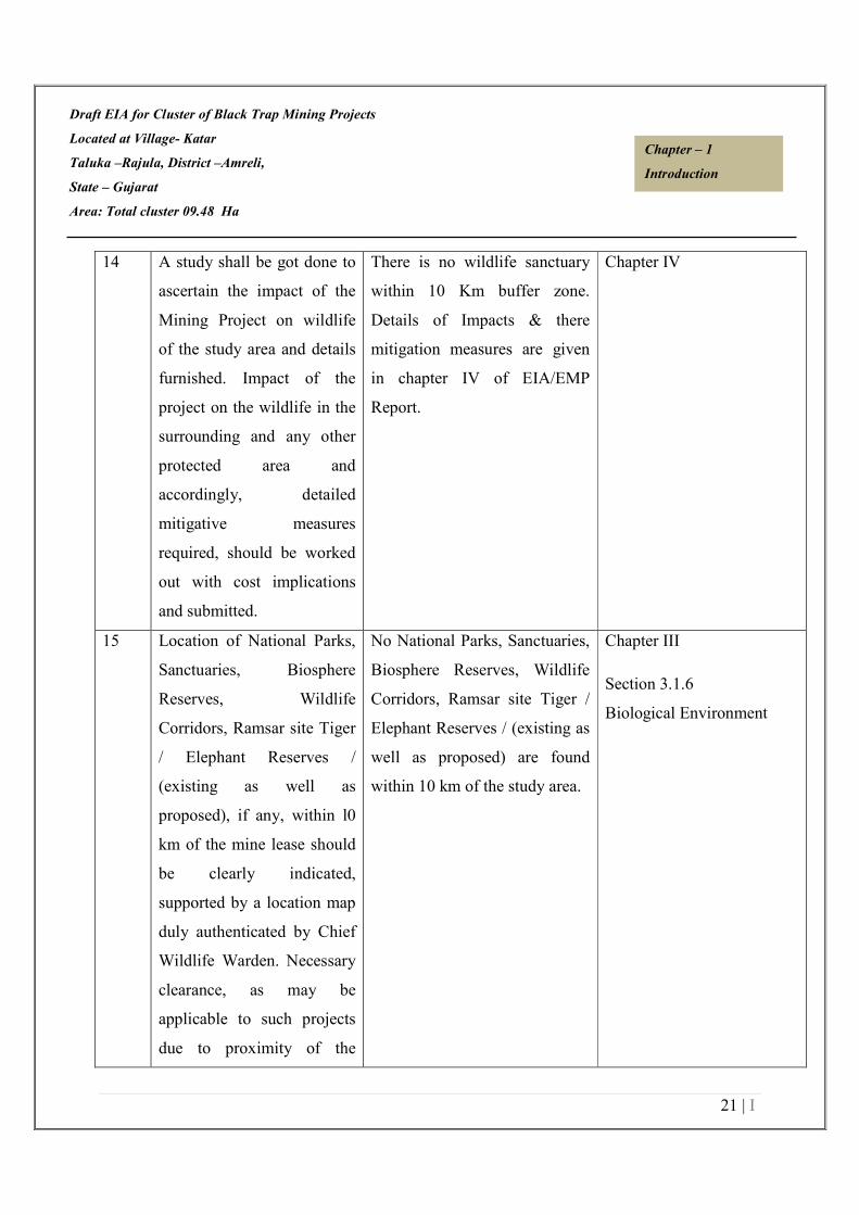
14 A study shall be got done to
ascertain the impact of the
Mining Project on wildlife
of the study area and details
furnished. Impact of the
project on the wildlife in the
surrounding and any other
protected area and
accordingly, detailed
mitigative measures
required, should be worked
out with cost implications
and submitted.
There is no wildlife sanctuary
within 10 Km buffer zone.
Details of Impacts & there
mitigation measures are given
in chapter IV of EIA/EMP
Report.
Chapter IV
15 Location of National Parks,
Sanctuaries, Biosphere
Reserves, Wildlife
Corridors, Ramsar site Tiger
/ Elephant Reserves /
(existing as well as
proposed), if any, within l0
km of the mine lease should
be clearly indicated,
supported by a location map
duly authenticated by Chief
Wildlife Warden. Necessary
clearance, as may be
applicable to such projects
due to proximity of the
No National Parks, Sanctuaries,
Biosphere Reserves, Wildlife
Corridors, Ramsar site Tiger /
Elephant Reserves / (existing as
well as proposed) are found
within 10 km of the study area.
Chapter III
Section 3.1.6
Biological Environment

Draft EIA for Cluster of Black Trap Mining Projects
Located at Village- Katar
Taluka –Rajula, District –Amreli,
State – Gujarat
Area: Total cluster 09.48 Ha
22 | I
Chapter – 1
Introduction
ecologically sensitive areas
as mentioned above, should
be obtained from the
Standing Committee of
National Board of Wildlife
and copy furnished.
16 A detailed biological study
of the study area (core zone
and buffer zone (10 Km
radius of the periphery of the
mine lease) shall be carried
out. Details of flora and
fauna, endangered, endemic
and RET species duly
authenticated, separately for
core and buffer zone should
be furnished based on such
primary field survey, clearly
indicating the schedule of
the fauna present. In case of
any Schedule-I fauna found
in the study area the
necessary plan along with
budgetary provisions for
their conservation should be
prepared in consultation
with State Forest and
Wildlife Department and
Detailed biological study of
core zone and buffer zone
within 10 km radius of the
periphery of the mine lease has
been carried out for the project.
The same has been incorporated
in Chapter III of the report.
Chapter III
Section 3.8
Biological Environment

Draft EIA for Cluster of Black Trap Mining Projects
Located at Village- Katar
Taluka –Rajula, District –Amreli,
State – Gujarat
Area: Total cluster 09.48 Ha
23 | I
Chapter – 1
Introduction
details furnished. Necessary
allocation of funds for
implementing the same
should be made as part of
the project cost.
17 Proximity to areas declared
as ‘Critically Polluted’ or the
Project areas likely to come
under the ‘Aravali Range’,
(attracting court restrictions
for mining operations),
should also be indicated and
where so required clearance
certifications from the
prescribed Authorities, such
as the SPCB or State Mining
Dept. should be secured and
furnished to the effect that
the proposed mining
activities could be
considered.
Proposed cluster of mines does
not come under critically
polluted area.
18 Similarly for costal projects,
a CRZ map duly
authenticated by one of the
authorized agencies
demarcating LTL, HTL,
CRZ area, location of the
mine lease w.r.t. CRZ,
This is not a CRZ project. So
this is not applicable.

Draft EIA for Cluster of Black Trap Mining Projects
Located at Village- Katar
Taluka –Rajula, District –Amreli,
State – Gujarat
Area: Total cluster 09.48 Ha
24 | I
Chapter – 1
Introduction
coastal features such as
mangroves, if any, should be
furnished. The Mining
Projects falling under CRZ
would also need to obtain
approval of the concerned
Coastal Zone Management
Authority.
19 R & R plan / compensation
details for the project
affected people should be
furnished. While preparing
the R & R plan, the National
Rehabilitation &
Resettlement Policy should
be kept in view. In respect
SCs / STs and other weaker
sections need based sample
survey, family-wise, should
be undertaken to assess their
requirement and action
programmes prepared
accordingly integrating the
sectoral programme of line
departments of the State
Governments. It may be
clearly brought out
villages(s) including their R
& R and socio-economic
aspects should be discussed
in the report.
There are no inhabited areas in
the allotted mine area, therefore
no R&R Plan is proposed.
However compensation will be
paid to the land owner in case
of private land in line with govt.
scheme.

Draft EIA for Cluster of Black Trap Mining Projects
Located at Village- Katar
Taluka –Rajula, District –Amreli,
State – Gujarat
Area: Total cluster 09.48 Ha
25 | I
Chapter – 1
Introduction
20 One season (non-monsoon)
[i.e. March-May (Summer
Season); October-December
(post monsoon season);
December-February (winter
season)] primary baseline
data on ambient air quality
as per CPCB Notification of
2009, water quality, noise
level, soil and flora and
fauna shall be collected and
the AAQ and other data so
compiled presented date-
wise in the EIA and EMP
Report" Site-specific
meteorological data should
also be collected. The
location of the monitoring
stations should be such as to
represent whole of the study
area and justified keeping in
view the pre-dominant
downwind direction and
location of sensitive
receptors. There should be at
least one monitoring station
within 500 m of the mine
lease in the pre-dominant
Base line study was carried out
for one Season (Summer
Season) from October 2020 to
December 2020. Details are
provided in EIA/EMP Report.
The locations of the monitoring
stations were decided on the
basis of prevailing
meteorological conditions
(Wind direction & wind speed)
of the study area.
The wind rose has been given in
chapter III of EIA/EMP Report.
One location has been selected
in downwind direction within
500 m from the lease boundary.
The mineralogical composition
of PM10, particularly for free
silica, has been given in chapter
III.
The location of the monitoring
sites has been shown in map.
Monitoring locations along
with map are attached in
Chapter III, Section 3.1

Draft EIA for Cluster of Black Trap Mining Projects
Located at Village- Katar
Taluka –Rajula, District –Amreli,
State – Gujarat
Area: Total cluster 09.48 Ha
26 | I
Chapter – 1
Introduction
downwind direction. The
mineralogical composition
of PM10, particularly for
free silica, should be given.
21 Air quality modeling should
be carried out for prediction
of impact of the project on
the air quality of the area. It
should also take into account
the impact of movement of
vehicles for transportation of
mineral. The details of the
model used and input
parameters used for
modeling should be
provided. The air quality
contours may be shown on a
location map clearly
indicating the location of the
site, location of sensitive
receptors, if any, and the
habitation. The wind roses
showing pre-dominant wind
direction may also be
indicated on the map.
AERMOD Cloud will be used
for air quality modelling. Detail
for the same will be given in
Final EIA report. .
22 The water requirement for
the Project, its availability
The total requirement for entire
cluster will be 17 KLD.
Chapter – II
Refer to Table-2.10.
Draft EIA for Cluster of Black Trap Mining Projects
Located at Village- Katar
Taluka –Rajula, District –Amreli,
State – Gujarat
Area: Total cluster 09.48 Ha
27 | I
Chapter – 1
Introduction
and source should be
furnished. A detailed water
balance should also be
provided. Fresh water
requirement for the Project
should be indicated.
Including drinking, plantation
& dust suppression.
23 Necessary clearance from
the Competent Authority for
drawl of requisite quantity of
water for the Project should
be provided.
Water requirement will be
fulfilled by private water tanker.
So, no clearance is required.
The project do not consume any
process water except for
drinking, dust suppression &
plantation. Plantation is
proposed, which will increase
the water holding capacity &
help in recharging of ground
water.
No artificial rainwater
harvesting is proposed for the
present project in lease area.
Chapter II
24 Description of water
conservation measures
proposed to be adopted in
the Project should be given.
Details of rainwater
harvesting proposed in the
Project, if any, should be
provided.
The project do not consume any
process water except for
drinking, dust suppression &
plantation. Plantation is
proposed, which will increase
the water holding capacity &
help in recharging of ground
water.

Draft EIA for Cluster of Black Trap Mining Projects
Located at Village- Katar
Taluka –Rajula, District –Amreli,
State – Gujarat
Area: Total cluster 09.48 Ha
28 | I
Chapter – 1
Introduction
25 Impact of the Project on the
water quality, both surface
and groundwater, should be
assessed and necessary
safeguard measures, if any
required, should be
provided"
Mining activity will not
intersect ground water.
Mining will be up to 3-6 m
below ground level or above the
ground water table whichever
comes first & ground water
table is 60 m minimum (rainy
season) to 65 m maximum (in
dry season) and the mining will
not intersects the ground level.
Chapter 2
26 Based on actual monitored
data, it may clearly be
shown whether working will
intersect groundwater.
Necessary data & document
in this regard may be
provided. In case the
working will intersect
ground water table, a
detailed hydro geological
study should be undertaken
& report furnished. The
report inter-alia shall include
details of the aquifers
present and impact of
mining activities on these
aquifers. Necessary
permission from Central
Working will not intersect
Ground water table as mining
will be up to 3-6 m below
ground level or above the
ground water table. The ground
water table is 60 m minimum
(rainy season) to 65 m
maximum (in dry season).
Chapter 2 & 4
Mine plan attached as
Annexure-III

Draft EIA for Cluster of Black Trap Mining Projects
Located at Village- Katar
Taluka –Rajula, District –Amreli,
State – Gujarat
Area: Total cluster 09.48 Ha
29 | I
Chapter – 1
Introduction
Ground Water Authority for
working below ground water
and pumping of ground
water should also be
obtained and copy furnished.
27 Details of any stream,
seasonal or otherwise,
passing through the lease
area and modification /
diversion proposed, if any,
and the impact of the same
on the hydrology should be
brought out.
No diversion is proposed.
28 Information on site
elevation, working depth,
groundwater table etc.
Should be provided both in
AMSL and bgl. A schematic
diagram may also be
provided for the same.
The Elevation details have been
incorporated in EIA report.
Mining will be up to 3-6 m
below ground level or above the
ground water table whichever
comes first.
Chapter 4, Section 4.2
29 A time bound Progressive
Greenbelt Development Plan
shall be prepared in a tabular
form (indicating the linear
and Quantities coverage,
plant species and time
frame) and Submitted
keeping in mind the same
Plantation/afforestation will be
done as per program i.e along
the road sides and near civic
amenities, as per mine plan.
Post plantation, the area will be
regularly monitored in every
season for evaluation of success
rate.
Chapter IX
Section 9.5

Draft EIA for Cluster of Black Trap Mining Projects
Located at Village- Katar
Taluka –Rajula, District –Amreli,
State – Gujarat
Area: Total cluster 09.48 Ha
30 | I
Chapter – 1
Introduction
will have to be executed up
front on commencement of
the Project. Phase-wise plan
of plantation and
compensatory afforestation
should be charted clearly
indicating the area to be
covered under plantation and
the species to be planted.
The details of plantation
already done should be
given. The plant species
selected for green belt
should have greater
ecological value and should
be of good utility value to
the local population with
emphasis on local and native
species and the species
which are tolerant to
pollution.
Details of list of Plant species
selected for green belt for
entire cluster is given in the
EIA report.
The plant species selected for
green belt have a greater
ecological value and are of
good utility value to the local
population. The plant species
are selected by giving emphasis
on local and native species and
the species which are tolerant to
pollution.
30 Impact on local transport
infrastructure due to the
Project should be indicated.
Projected increase in truck
traffic as a result of the
Project in the present road
network (including those
Traffic study for entire cluster
has been incorporated in EIA
report. About 16 trucks
Carrying the minerals per day.
Refer to Chapter IV
Section 4.8

Draft EIA for Cluster of Black Trap Mining Projects
Located at Village- Katar
Taluka –Rajula, District –Amreli,
State – Gujarat
Area: Total cluster 09.48 Ha
31 | I
Chapter – 1
Introduction
outside the Project area)
should be worked out,
indicating whether it is
capable of handling the
incremental load.
Arrangement for improving
the infrastructure, if
contemplated (including
action to be taken by other
agencies such as State
Government) should be
covered. Project Proponent
shall conduct Impact of
Transportation study as per
Indian Road Congress
Guidelines.
31 Details of the onsite shelter
and facilities to be provided
to the mine workers should
be included in the EIA
Report
A temporary rest shelter will be
provided for the workers near to
the site with provisions of
water, first aid facility,
protective equipments, etc.
Details are given in the
EIA/EMP Report.
Chapter II
Section 2.6.2
32 Conceptual post mining land
use and reclamation and
restoration of mined out area
(with plans and with
adequate number of
Details have been discussed in
EIA/EMP report
Chapter 2
Draft EIA for Cluster of Black Trap Mining Projects
Located at Village- Katar
Taluka –Rajula, District –Amreli,
State – Gujarat
Area: Total cluster 09.48 Ha
32 | I
Chapter – 1
Introduction
sections) should be given in
the EIA report.
33 Occupational Health impacts
of the Project should be
anticipated and the proposed
preventive measures spelt
out in detail. Details of pre-
placement medical
examination and periodical
medical examination
schedules should be
incorporated in the EMP.
The project specific
occupational health
mitigation measures with
required facilities proposed
in the mining area may be
detailed.
Occupational health impact
mainly is expected due air
pollution due to fugitive dust
emission because of movement
of vehicles. However
appropriate mitigation measures
for air pollution control have
been given in the report,
discussed in Chapter-4.
Each labour will undergo pre-
placement medical examination.
Thereafter periodical heath
check up will be arranged as
stated in the report.
Chapter VI
Section 6.3
Chapter IX
Section 9.7
34 Public health implications of
the Project and related
activities for the population
in the impact zone should be
systematically evaluated and
the proposed remedial
measures should be detailed
along with budgetary
allocations.
The proposed project being a
small scale semi-mechanized
mining project, there will be
hardly any process related
health implication on the
population of the nearby
villages except fugitive dust
emissions due to transportation.
Budgetary allocation is given in
Chapter-IX.
Chapter VII
Section 7.2
Chapter IX
Section 9.8
Draft EIA for Cluster of Black Trap Mining Projects
Located at Village- Katar
Taluka –Rajula, District –Amreli,
State – Gujarat
Area: Total cluster 09.48 Ha
33 | I
Chapter – 1
Introduction
35 Measures of socio economic
significance and influence to
the local community
proposed to be provided by
the Project Proponent should
be indicated. As far as
possible, quantitative
dimensions may be given
with time to time for
implementation.
Socio-economic significance
provided to the local
community i.e. to the nearby
villagers is given In the
EIA/EMP Report.
Chapter VIII
Section 8.3
36 Detailed environmental
management plan (EMP) to
mitigate the environmental
impacts which, should inter-
alia include the impacts of
change of land use, loss of
agricultural and grazing
land, if any, occupational
health impacts besides other
impacts specific to the
proposed Project.
The detailed environmental
management plan to mitigate
the environmental impacts has
been mentioned in of the
EIA/EMP Report.
Budget allocated for EMP has
been mentioned in chapter IX.
Chapter IX
37 Public Hearing points raised
and commitment of the
Project Proponent on the
same along with time bound
Action Plan with budgetary
provisions to implement the
same should be provided and
This is draft EIA report Public
hearing is yet to be conducted.

Draft EIA for Cluster of Black Trap Mining Projects
Located at Village- Katar
Taluka –Rajula, District –Amreli,
State – Gujarat
Area: Total cluster 09.48 Ha
34 | I
Chapter – 1
Introduction
also incorporated in the final
EIA/EMP Report of the
Project.
38 Details of litigation pending
against the project, if any,
with direction /order passed
by any Court of Law against
the Project should be given.
No litigation is pending against
the project.
39 The cost of the Project
(capital cost and recurring
cost) as well as the cost
towards implementation of
EMP should be clearly
addressed.
Details of Project cost & EMP
cost of entire cluster have been
mentioned Chapter-9.
Chapter-9 table no. 9.2 &
Table 9.3
40 A Disaster management Plan
shall be prepared and
included in the EIA/EMP
Report".
A Disaster management Plan
has been given in EIA report
Chapter VII
41 Benefits of the Project if the
Project is implemented
should be spelt out. The
benefits of the Project shall
clearly indicate
environmental, social,
economic, employment
potential, etc.
There will be opportunities of
direct and indirect
employments. There will be
around 73 personnel, most of
them will be skilled or semi-
skilled & unskilled workers As
per OM dated 30th September
2020 vide letter no. F.No. 22-
65/2017-IA.III by MOEF & CC
Chapter VIII

Draft EIA for Cluster of Black Trap Mining Projects
Located at Village- Katar
Taluka –Rajula, District –Amreli,
State – Gujarat
Area: Total cluster 09.48 Ha
35 | I
Chapter – 1
Introduction
budget allocation for CER will
be proposed after public hearing
in Final EIA report.
42 Besides above the below mentioned general points are also to be followed:-
1 Executive Summary of the
EIA/EMP Report
Compiled With EIA report.
2 All documents to be properly
referenced with index and
continuous page numberings.
Compiled With EIA report.
3 Where data are presented in the
Report especially in Tables, the
period in which the data were
collected and the sources should
be indicated.
Compiled With EIA report.
4 Project Proponent shall enclose
all the analysis/testing reports of
water, air, soil, noise etc. using
the MoEF&CC/NABL
accredited laboratories. All the
original analysis/testing reports
should be available
during appraisal of the Project.
Compiled With EIA report.
5 Where the documents provided
are in a language other than
English, an English translation
should be provided.
Compiled With EIA report.
Draft EIA for Cluster of Black Trap Mining Projects
Located at Village- Katar
Taluka –Rajula, District –Amreli,
State – Gujarat
Area: Total cluster 09.48 Ha
36 | I
Chapter – 1
Introduction
6 The Questionnaire for
environmental appraisal of
mining projects as devised
earlier by the Ministry shall also
be filled and submitted.
Compiled With EIA
report.
7 While preparing the EIA report,
the instructions for the
Proponents and instructions for
the Consultants issued by MoEF
vide O.M. No.
J‐11013/41/2006‐IA.II (I) dated
4th August, 2009, which are
available on the website of this
Ministry, should be followed.
Compiled With EIA report.
8 Changes, if any made in the
basic scope and project
parameters (as submitted in
Form-I and the PFR for securing
the TOR) should be brought to
the attention of MoEF&CC with
reasons for such changes and
permission should be sought, as
the TOR may also have to be
altered. Post Public Hearing
changes in structure and content
of the draft EIA/EMP (other
than modifications arising out of
the P.H. process) will entail
Agreed
Draft EIA for Cluster of Black Trap Mining Projects
Located at Village- Katar
Taluka –Rajula, District –Amreli,
State – Gujarat
Area: Total cluster 09.48 Ha
37 | I
Chapter – 1
Introduction
conducting the PH again with
the revised documentation.
9 As per the circular no.
J‐11011/618/2010‐IA. II (I)
dated 30.5.2012, certified report
of the status of compliance of
the conditions stipulated in the
environment clearance for the
existing operations of the
project, should be obtained from
the Regional Office of Ministry
of Environment, Forest and
Climate Change, as may be
applicable.
This is new case for
Mining. No certified
compliance report is
required.
10 The EIA report should also
include (i) surface plan of the
area indicating contours of main
topographic features, drainage
and mining area, (ii) geological
maps and sections and (iii)
sections of the mine pit and
external dumps, if any, clearly
showing the land features of the
adjoining area.
Compiled With EIA report.
Beside above standard TOR, following additional TOR;s are recommended.

Draft EIA for Cluster of Black Trap Mining Projects
Located at Village- Katar
Taluka –Rajula, District –Amreli,
State – Gujarat
Area: Total cluster 09.48 Ha
38 | I
Chapter – 1
Introduction
1. A study report for the impact of
vibration arising during blasting,
its reduction and distance at
which vibrations cease with
details of hazard coverage area
like human habilitation, water
bodies, educational institutes,
religious places and other
environmental sensitivities.
Details of measures/action plan
for mitigation of impact due to
vibrations within safe limit.
Details have been
incorporated in EIA report.
Chapter-2 & Chapter-7
2. Study report regarding impact of
blasting on public, workers and
property from fly rock and
vibration risks and its mitigation
measures.
Details have been complied
in EIA report
Chapter-2 & Chapter-7
3. Detailed action plan to comply
permissions/guidelines of
Director General of Mine Safety
(DGMS) during mining and
after end of life of mine with
approval of competent authority.
Details have been complied
in EIA report
Chapter-6 & Chapter-7
Section 6.3
Section 7.1
4. Approved mining plan including
progressive mine closure plan
shall be provided with EIA
report. Letter of approval of
IBM shall also be incorporated
Approved mine plan have
been enclosed with EIA
report.
Annexure-III

Draft EIA for Cluster of Black Trap Mining Projects
Located at Village- Katar
Taluka –Rajula, District –Amreli,
State – Gujarat
Area: Total cluster 09.48 Ha
39 | I
Chapter – 1
Introduction
with compliance of all the
recommendations mentioned in
approved mining plan.
5. Approved mining plan including
progressive mine closure plan
shall be provided
Approved mine plan have
been enclosed with EIA
report.
Annexure-III
4. Project site specific details such
as distance of the project site
from nearest (1) Human
Habitation (2) Water Body:
River/Creek/Nallah/Lake/Pond/
Reservoir/Canal/Bridge/Check
dam etc (3)National Highway
(4) State Highway (5) Railway
line (6) Heritage site (7)
National Park/Wild Life
Sanctuary/Proposed Eco
Sensitive Zone/notified Eco
sensitive Zone/ Reserve Forest/
Protected Forest shall be
included in the rapid EIA report
to be prepared covering one
season (other than monsoon)
data. A map indicating the aerial
distance of the lease area from
these entities.
There is no National
Park/Wild Life
Sanctuary/Proposed Eco
Sensitive Zone/notified Eco
sensitive Zone/ Reserve
Forest/ Protected Forest
within 10 Km Buffer Zone.
Required detailed have
incorporated in EIA report.
Chapter-1, Chapter-2 &
Chapter-3
Section 1.2.2
Section 3.8

Draft EIA for Cluster of Black Trap Mining Projects
Located at Village- Katar
Taluka –Rajula, District –Amreli,
State – Gujarat
Area: Total cluster 09.48 Ha
40 | I
Chapter – 1
Introduction
6. In case of lease is located in
river bed, detailed study report
by recognized institute of
National repute to assess Impact
of mining in river bed on
physical characteristics like river
stability, flood risk,
environmental degradation, loss
of habitat, decline in bio-
diversity, change/alteration in
river morphology and other
associated environmental
aspects.
Lease area is not a part of
river bed
7. In case of lease is located in
river bed, detailed study report
by recognized institute of
National repute to assess
Lease area is not located in
any river bed. So this point
is not applicable.
8. Distance of nearby mining lease
areas from the periphery of the
proposed project including a
map covering distance of 500 m
from the periphery of the
proposed project. In case of no
mining lease area are existing
within 500m periphery of the
proposed project, a certified of
the concerned
This project is cluster of 4
mines.
500m Cluster map attached
as Annexure-III

Draft EIA for Cluster of Black Trap Mining Projects
Located at Village- Katar
Taluka –Rajula, District –Amreli,
State – Gujarat
Area: Total cluster 09.48 Ha
41 | I
Chapter – 1
Introduction
9. Copies of all requisite
permissions including
permissions from District
Collector, commissioners of
Geology & mining, Indian
Bureau of Mines, GPCB, current
lease renewal status from
industries and Mine Department,
Government of Gujarat with
opinion of the district geologist
regarding compliance of all the
conditions in lease deed and
copy of renewed lease(if any)
etc.
All the requisite
permissions including mine
plan, lease deed have been
complied with EIA report.
10. Detailed outlay of Environment
Management Plan (EMP) with
year-wise budgetary provision
including bifurcation of each
activity with provision of capital
cost and recurring cost.
Detailed have been
discussed in EIA report
Chapter-9
11. A need-based outlay of
Environmental Management
Plan(EMP) with year-wise
budgetary provision including
bifurcation of each activity with
provision of capital cost and
recurring cost.
Detailed have been
discussed in EIA report
Chapter-9

Draft EIA for Cluster of Black Trap Mining Projects
Located at Village- Katar
Taluka –Rajula, District –Amreli,
State – Gujarat
Area: Total cluster 09.48 Ha
42 | I
Chapter – 1
Introduction
12. Compliance of MoEFCC’s O.M
No. 22-65/2017-IA-III dated
01/05/2018 regarding Corporate
Environment Responsibility
(CER), fund allocation based on
need based analysis for CER
shall be made as per the said
OM dated 01/05/2018 for
various activities therein.
As per OM dated 30th
September 2020 vide letter
no. F.No. 22-65/2017-
IA.III by MOEF & CC
budget allocation for CER
will be proposed after
public hearing in Final EIA
report
************************

Draft EIA for M/s. Hotel Kohinoor Pro. Dilubhai Amrubhai Varu
Located at Survey No. 223 Paiki 37, Village- Katar
Taluka –Rajula, District –Amreli,
State – Gujarat, Lease Area: 1.50 Ha.
Area: Total cluster 09.48 Ha
1 | I I
Chapter – 2
Project Description
CHAPTER-2
PROJECT DESCRIPTION
INDEX
2.0 GENERAL 2/II
2.1 DESCRIPTION OF THE PROJECT 3/II
2.2 GEOLOGY AND TOPOGRAPHY 4/II
2.3 QUANTITY OF RESERVES 7/II
2.4 MINING 7/II
2.5 UTILITIES 15/II
2.6 POWER SUPPLY 16/II
2.7 STATUTORY REQUIREMENTS 17/II

Draft EIA for M/s. Hotel Kohinoor Pro. Dilubhai Amrubhai Varu
Located at Survey No. 223 Paiki 37, Village- Katar
Taluka –Rajula, District –Amreli,
State – Gujarat, Lease Area: 1.50 Ha.
Area: Total cluster 09.48 Ha
2 | I I
Chapter – 2
Project Description
2.0 GENERAL
The Environmental Impact Assessment Documentation has been prepared in terms of EIA
notification of the MoEF&CC dated 14-9-2006, 1st Dec 2009, and its subsequent amendments
thereof till 15th
Jan, 2016, and the EIA Guideline Manual for Mining of Minerals (Feb, 2010) of
MoEF, Govt. of India, for seeking environmental clearance for mining in the existing area of
Black Trap Mine falling under category “B1”. The proposed project is cluster of 4 mines of Black
Trap forming total cluster area of 09.48 Ha.
2.1 DESCRIPTION OF THEPROJECT
Draft EIA for Cluster of Black Trap Mining Projects Located at Village- Katar, Taluka –Rajula,
District –Amreli, State – Gujarat. Detail of project proponents has been given in Section 1.8 of
chapter 1.
2.1.1 LOCATION DETAILS
The Cluster of Black Trap Mining Projects Located at Village- Katar, Taluka –Rajula, District –
Amreli, State – Gujarat with total cluster 09.48 Ha. SH-107 – 1.46 Km in SSW direction & SH-6
– 8.30 Km in E direction from lease area. Rajula Railway station is about 11.0 KM in E Direction.
The nearest airport is Diu Airport about 55.54 Km in SW direction.
Table 2.1 Location Details
District & State Amreli
Taluka Rajula
Village Katar
Total lease area (in Hectares) Total cluster 09.48 Ha.
Whether the area is recorded
To be in forest
(protected/reserved/etc.).
No
Ownership and Occupancy Govt. Land
Table 2.2 Latitude and Longitude, Geographical
coordinates

Draft EIA for M/s. Hotel Kohinoor Pro. Dilubhai Amrubhai Varu
Located at Survey No. 223 Paiki 37, Village- Katar
Taluka –Rajula, District –Amreli,
State – Gujarat, Lease Area: 1.50 Ha.
Area: Total cluster 09.48 Ha
3 | I I
Chapter – 2
Project Description
Mine Project Proponent Khasra no/ survey
no
Site co-ordinates
1 Shri Ghanshyambhai
Dilubhai Varu
Survey No.- 223
Paiki 37
21°01'42.5430"N to 21°01'39.1773"N
71°21'10.1141"E to 71°21'06.8365"E
2 Shri Najubhai
Champrajbhai Varu
Survey No.- 223
Paiki 37
21°01'29.8250"N to 21°01'28.1465"N
71°21'03.1852"E to 71°21'00.7929"E
3 Shri Dilubhai Amrubhai
Varu
Survey No.- 223
Paiki 37
21°01'12.8359"N to 21°01'14.1607"N
71°20'55.9831"E to 71°20'52.6102"E
4 Shri Hareshbhai Nazbhai
Khuman
Survey No.- 223
Paiki 37
2326103.41"N to 2326142.05"N
744209.60"E to 744116.62"E
2.0.1 Need of the Project
The mining project falls in the Amreli District of Gujarat, the area is devoid of industrial growth.
The earning sources of the region are limited. Most of the people are dependent upon agriculture
only. Mineral wealth of the state Gujarat provides the employment opportunity to the people of the
state as well as region also. Mining is one of the major core sector industries which play a crucial
role in the process of country economic development. The mineral Black Trap finds extensive use
in the construction and infrastructural works. The basic objective of the project is the effective
utilization of Material in the country or region. Black Trap is the world's most commonly used
material in construction etc. Black Trap will help in the economic growth of the country or region.
2.1 LEASE HOLDAREA
There is cluster of 4 mines with total cluster area 09.48Ha lies in Government Land. The break-up
of the land use for ancillary feature around the mining area is given below.

Draft EIA for M/s. Hotel Kohinoor Pro. Dilubhai Amrubhai Varu
Located at Survey No. 223 Paiki 37, Village- Katar
Taluka –Rajula, District –Amreli,
State – Gujarat, Lease Area: 1.50 Ha.
Area: Total cluster 09.48 Ha
4 | I I
Chapter – 2
Project Description
Table No. 2.3: Details of Mining Lease Area
2.2 GEOLOGY
i. Regional Geology
Located in the Southern part of the Saurasthra peninsula, the amreli district occupies as area of
6,760 sq. km and is inhabitated by 12,52,589 people. It is bounded in the north by the Rajkot
district, in the east by the Bhavnagar district, on the west by the Junagadh district and to the south
by the Arabian Sea. Flood plain of the Shatraunji River in the central part divides the undulatory
hilly terrains of the north and south. The southern part is occupied by the coastal plains. The
Shatrunji and Dhantarvadi River towards south into the Arabian Sea. The district is sub-divided into
10 talukkas namely-Babra, Lathi, Amreli, Kunkavav, Lilia, Dhari, Khambha, Savarkundia, Jafrabad
and Kodinar. The district is well connected by all weather roads and ameterguage railway line. The
district has an average annual rainfall of 51 cm. Excepting the coastal part, the entire district is
occupied by the Deccan volcanies represented by the flows of basalt, rhyolite/dacite and felsites
along with basic and acid intrusive. The rhyplite/dacite flows are restricted to ther Savarkundla area
while the felsites flows are exposed to the east Babra. Dykes of basalt and vicinity of the acid flows.
Mine Khasra no/survey no Village Annual
Production
(MTPA)
Area (ha)
1 Survey No.- 223 Paiki
37
Katar 15790 MTPA 2.25
2 Survey No.- 223 Paiki
37
Katar 47368 MTPA 3.73
3 Survey No.- 223 Paiki
37
Katar 47368 MTPA 1.50
4 Survey No.- 223 Paiki
37
Katar 60000 MTPA 2.00
TOTAL 1,70,526 MTPA 09.48 Ha.

Draft EIA for M/s. Hotel Kohinoor Pro. Dilubhai Amrubhai Varu
Located at Survey No. 223 Paiki 37, Village- Katar
Taluka –Rajula, District –Amreli,
State – Gujarat, Lease Area: 1.50 Ha.
Area: Total cluster 09.48 Ha
5 | I I
Chapter – 2
Project Description
The Deccan volcanic are overlain by laterite of the Bhatia formation or the Miliolite formation of
the Porbandar Group in different area.
Soil are mostly loamy, clayey, mixed, calcareous and montmorillonitic in nature. The Bouger
Gravity Anomaly varies from 10 to +30 m Gal, while the basement depth varies from less than
1000 m to 1700 m. Alluvial plains have the excellent while the valley fills pediplain and miliolite
limestone ridges have good propects.
Local Geology
Geologically the block area Situated on the the NE-SW trending dyke which is intruded in
the sub-horizontal basaltic flows of Deccan Volcanism
Age Group Formation Lithology
Halocene to recent Intrusive phase Dyke of Rhyolite, Felsite
and Felsite Porphyry
Basaltic and Dolerite
Uper Cretaceous to
Eocene
Deccan Volcanic Extrusiv
e Phase
Basaltic Lava Flow
TOPOGRAPHY
Topographically the QL area comprises undulating land. The altitude of the area is given below in
table..
Site Altitude
Mine 1 74-80m RL
Mine 2 77-82 m RL
Mine 3 75-80 m RL
Mine 4 72-80 mRL
.

Draft EIA for M/s. Hotel Kohinoor Pro. Dilubhai Amrubhai Varu
Located at Survey No. 223 Paiki 37, Village- Katar
Taluka –Rajula, District –Amreli,
State – Gujarat, Lease Area: 1.50 Ha.
Area: Total cluster 09.48 Ha
6 | I I
Chapter – 2
Project Description
Drainage System
The average rainfall in this area is very low, and it hardly exceeds 500-550mm. Seasonal water
stream do pass through the QL area in which the water flows through natural gradient. It is capable
of dealing with the rainwater during the rainy season. There is scarce chance of this water entering
into the Pits. If rainwater do get collected in pits and remain there for a considerable period of time,
it takes about two to three months to percolate down the ground. Normally work at bottom of the pit
remains suspended in the months following the rains. However, in case of necessity the water may
be pumped out using one diesel engine driven pump of say 5-10H.P. This water can be spilled in
the water drain made for the proper drainage of the mine water outside the QL area.
The general drainage of the area is SW. The average rainfall in this area is very low, and it hardly
exceeds 500-550mm. Seasonal water stream do pass through the Permit area in which the water
flows through natural gradient. It is capable of dealing with the rainwater during the rainy season.
Water availability in the region is very scare now a day so it is being proposed to discharge the
water collected in to the pit during rains into other non working areas for positive use like
agriculture etc.

Draft EIA for M/s. Hotel Kohinoor Pro. Dilubhai Amrubhai Varu
Located at Survey No. 223 Paiki 37, Village-
Taluka –Rajula, District –Amreli,
State – Gujarat, Lease Area: 1.50 Ha.
Area: Total cluster 09.48 Ha
2.3 QUANTITY OF RESERVES
The Block area is in Katar village
the estimation of resource, surface a
volume calculation. Volume has been multiplied to specific gravity to get the tonnage.
The depth of proved category is taken
Table No. 2.4
Proved
Mine No.
Mine 1 Survey No
Mine 2 Survey No
M/s. Hotel Kohinoor Pro. Dilubhai Amrubhai Varu
- Katar
Figure 2.1: Drainage Map
RESERVES
Katar village and Black Trap deposits 6 meter depth from surface level. For
the estimation of resource, surface area has been multiplied with 6 meter depth of
calculation. Volume has been multiplied to specific gravity to get the tonnage.
of proved category is taken m.
Table No. 2.4 Summary of Proved reserves is as below
Proved Reserve in Cluster situation
Plot no/Khand No./Survey No.
Survey No- 223 Paiki 37
Survey No- 223 Paiki 37
7 | I I
Chapter – 2
Project Description
meter depth from surface level. For
meter depth of Black Trap for
calculation. Volume has been multiplied to specific gravity to get the tonnage.
reserves is as below
Total Capacity
(MT)
15,790 MTPA
47,368 MTPA

Draft EIA for M/s. Hotel Kohinoor Pro. Dilubhai Amrubhai Varu
Located at Survey No. 223 Paiki 37, Village- Katar
Taluka –Rajula, District –Amreli,
State – Gujarat, Lease Area: 1.50 Ha.
Area: Total cluster 09.48 Ha
8 | I I
Chapter – 2
Project Description
Mine 3 Survey No- 223 Paiki 37 47,368 MTPA
Mine 4 Survey No- 223 Paiki 37 60000 MTPA
Total 1,70,526 MT
2.4 MINING
Method of Mining
Extraction of Black Trap will be done through opencast semi mechanized mining method. Mineral
will be removed in 1-3 m layer only forming in one slice /strips. Mineral will be loaded in
Trucks/Dumper /Tractor. Height of slices /strips will be 3m-6m. Mining activities will be carried
out in a manner so that there is no obstruction to the movement of water flow and Roads in the QL
area for movement of the Trucks/Dumper/Tractor after minerals loading will be towards both sides
through approach roads connecting to tar roads. No mining will be done in rainy season. No mining
shall be done within 500m meter distance from any irrigation dams (check dams), French wells,
erosion structure and bridge on national Highway.
The slice /strips Parameters shall be for mineral 1. Height – 3-6m
2. Width - width shall be more than 3 m the bench height or 3 times of widest m/c used:
Table no. 2.5 Mining Parameters
Parameters
Bench height 3m-6m
Bench width Not be less than the height of
benches
YEAR WISE PRODUCTION DETAIL:-
Year wise production detail for entire cluster has been given below in Table No. 2.6:
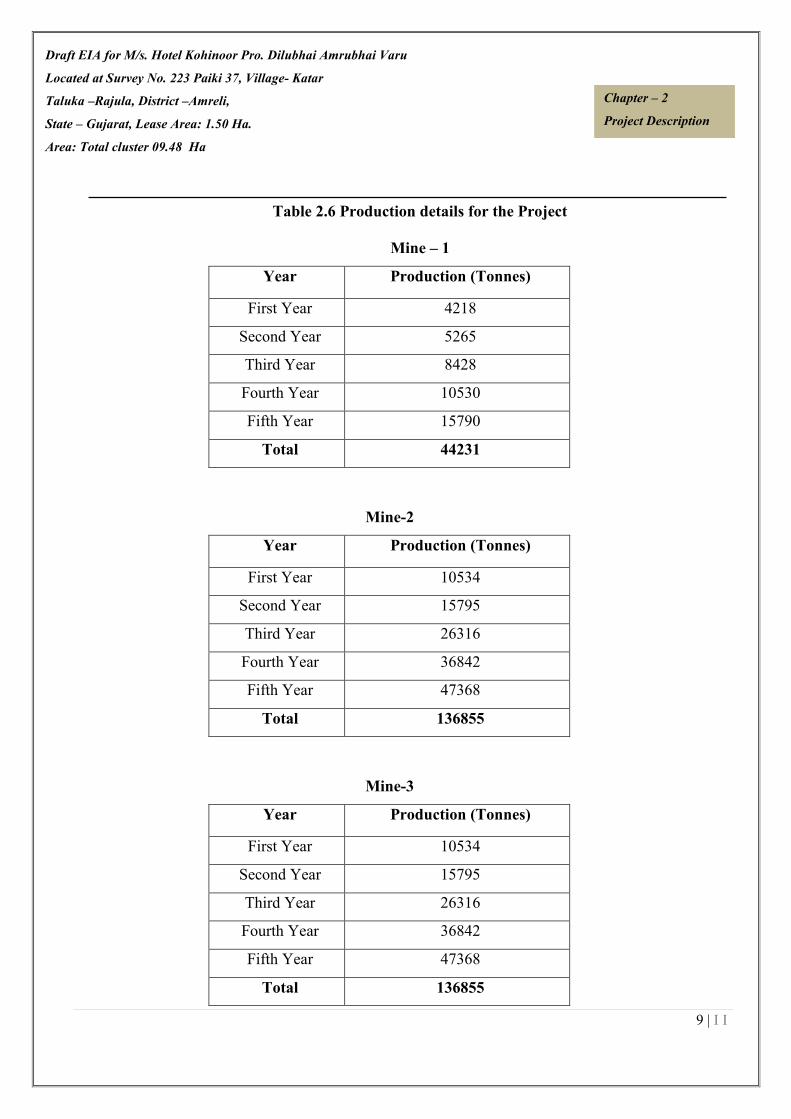
Draft EIA for M/s. Hotel Kohinoor Pro. Dilubhai Amrubhai Varu
Located at Survey No. 223 Paiki 37, Village- Katar
Taluka –Rajula, District –Amreli,
State – Gujarat, Lease Area: 1.50 Ha.
Area: Total cluster 09.48 Ha
9 | I I
Chapter – 2
Project Description
Table 2.6 Production details for the Project
Mine – 1
Year Production (Tonnes)
First Year 4218
Second Year 5265
Third Year 8428
Fourth Year 10530
Fifth Year 15790
Total 44231
Mine-2
Year Production (Tonnes)
First Year 10534
Second Year 15795
Third Year 26316
Fourth Year 36842
Fifth Year 47368
Total 136855
Mine-3
Year Production (Tonnes)
First Year 10534
Second Year 15795
Third Year 26316
Fourth Year 36842
Fifth Year 47368
Total 136855

Draft EIA for M/s. Hotel Kohinoor Pro. Dilubhai Amrubhai Varu
Located at Survey No. 223 Paiki 37, Village- Katar
Taluka –Rajula, District –Amreli,
State – Gujarat, Lease Area: 1.50 Ha.
Area: Total cluster 09.48 Ha
10 | I I
Chapter – 2
Project Description
Mine-4
Year Production (Tonnes)
First Year 35040
Second Year 35040
Third Year 35040
Fourth Year 35040
Fifth Year 35040
Total 175200
2.4.1 Existing land use of cluster
The entire lease hold area of cluster of mines is 09.48 Ha. in Village-Katar, Taluka- Rajula, District –
Amreli, State – Gujarat. The breakup of the existing land use for ancillary feature around the mining
area is given below:-
Table 2.7 Existing Landuse Pattern
Mine 1
Particulars Total
Pits & Quarries 0.9982
Top soil Dump --
Dumps --
Mineral Stack Yard --
Sub Grade stack Yard --
Infrastructure (Work shop, administrative Building) --
Roads --
Railway --
Green Belt --
Tailing Pond --
Effluent Treatment Plant --

Draft EIA for M/s. Hotel Kohinoor Pro. Dilubhai Amrubhai Varu
Located at Survey No. 223 Paiki 37, Village- Katar
Taluka –Rajula, District –Amreli,
State – Gujarat, Lease Area: 1.50 Ha.
Area: Total cluster 09.48 Ha
11 | I I
Chapter – 2
Project Description
Mineral Separation Plant --
Township --
Non Utilized 1.2518
Total 2.25
Mine 2
Particulars Total
Pits & Quarries 2.9078
Top soil Dump --
Dumps --
Mineral Stack Yard --
Sub Grade stack Yard --
Infrastructure (Work shop, administrative Building) --
Roads --
Railway --
Green Belt --
Tailing Pond --
Mineral Separation Plant --
Township --
Non Utilized 0.8222
Total 3.73
Mine 3
Particulars Total
Pits & Quarries 1.3728
Top soil Dump --
Dumps --
Mineral Stack Yard --

Draft EIA for M/s. Hotel Kohinoor Pro. Dilubhai Amrubhai Varu
Located at Survey No. 223 Paiki 37, Village- Katar
Taluka –Rajula, District –Amreli,
State – Gujarat, Lease Area: 1.50 Ha.
Area: Total cluster 09.48 Ha
12 | I I
Chapter – 2
Project Description
Sub Grade stack Yard --
Infrastructure (Work shop, administrative Building) --
Roads --
Railway --
Green Belt --
Tailing Pond --
Mineral Separation Plant --
Township --
Non Utilized 0.1272
Total 1.50
Mine 4
Particulars Total
Mining 0.0
Pits/Mining Activity Area 0.4731
Dumps 0.0
Haul Road 0.0050
Mineral Stack Yard --
Sub Grade stack Yard --
Infrastructure (Work shop, administrative Building) 0.0070
Plantation 0.0
Tailing Pond --
Mineral Stack 0.0
Remaining Virgin area 1.5149
Total 2.00

Draft EIA for M/s. Hotel Kohinoor Pro. Dilubhai Amrubhai Varu
Located at Survey No. 223 Paiki 37, Village- Katar
Taluka –Rajula, District –Amreli,
State – Gujarat, Lease Area: 1.50 Ha.
Area: Total cluster 09.48 Ha
13 | I I
Chapter – 2
Project Description
2.4.2 Life of mine
Table-2.8 Life of Mine
Mine Khasra No./Survey No. Mine life
1 Mine – 1
Survey Number-223 Paiki
37
30 Years
2 Mine – 1
Survey Number-223 Paiki
37
30 Years
3 Mine – 1
Survey Number-223 Paiki
37
08 Years
4 Mine – 1
Survey Number-223 Paiki
37
13 Years
2.4.3 Waste Management
The waste rocks found in the area is overburden over the Mineral bed & line rejects of sorting of
intergrowth of soil with clay. The thickness of mineral waste/OB varying is 1 m. The Rock
fragments of small size are also resulted after mining.
For Mine 1, Mine 2 & Mine , 95% of Mineral is saleable and 5% of sub grade material generated.
It is also proposed to stack the Sub grade. The sub grade generated shall be collected in sub grade
stack yard and shall be then mixed with high-grade mineral or may be used for filling & other
works in various industries.
For Mine 4, 10 % waste of ROM will be generated during mining. Total 175200 ROM & 17520
swelled waste will be generated. Initially during mining plan waste will be dumped on ground level
and then backfilling in mine out pit reached ultimate limit.

Draft EIA for M/s. Hotel Kohinoor Pro. Dilubhai Amrubhai Varu
Located at Survey No. 223 Paiki 37, Village- Katar
Taluka –Rajula, District –Amreli,
State – Gujarat, Lease Area: 1.50 Ha.
Area: Total cluster 09.48 Ha
14 | I I
Chapter – 2
Project Description
2.4.4 Reclamation and Rehabilitation of mined out area
During Proposal Period/at Conceptual Stage –During conceptual stage the mined out area will
be converted into water reservoir at the conceptual period. It will also serve the purpose as socio
economic and corporate social responsibility of the lessee by way of supplying water for irrigation
purpose or at will of the local people.
Table-2.9 (i) Stage Wise Land Use Pattern
Mine 1
At the End of the Five Year Periods
Particulars Mine 1
Pits 0.9982
Scree stack/topsoil ----
Infrastructure 0.0067
Mineral Stack Yard 0.0030
At the end of End of the Life of the Mine
Backfilled Area 0.00
Water Reservoir 0.00
Infrastructure ----
Mine 2
At the End of the Five Year Periods
Particulars Mine 1
Pits 2.9078
Scree stack/topsoil ----
Infrastructure 0.0067
Mineral Stack Yard 0.0030
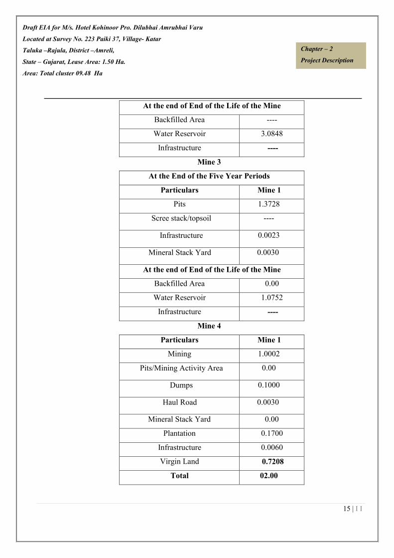
Draft EIA for M/s. Hotel Kohinoor Pro. Dilubhai Amrubhai Varu
Located at Survey No. 223 Paiki 37, Village- Katar
Taluka –Rajula, District –Amreli,
State – Gujarat, Lease Area: 1.50 Ha.
Area: Total cluster 09.48 Ha
15 | I I
Chapter – 2
Project Description
At the end of End of the Life of the Mine
Backfilled Area ----
Water Reservoir 3.0848
Infrastructure ----
Mine 3
At the End of the Five Year Periods
Particulars Mine 1
Pits 1.3728
Scree stack/topsoil ----
Infrastructure 0.0023
Mineral Stack Yard 0.0030
At the end of End of the Life of the Mine
Backfilled Area 0.00
Water Reservoir 1.0752
Infrastructure ----
Mine 4
Particulars Mine 1
Mining 1.0002
Pits/Mining Activity Area 0.00
Dumps 0.1000
Haul Road 0.0030
Mineral Stack Yard 0.00
Plantation 0.1700
Infrastructure 0.0060
Virgin Land 0.7208
Total 02.00
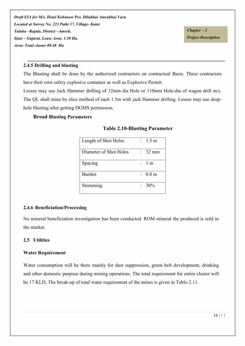
Draft EIA for M/s. Hotel Kohinoor Pro. Dilubhai Amrubhai Varu
Located at Survey No. 223 Paiki 37, Village- Katar
Taluka –Rajula, District –Amreli,
State – Gujarat, Lease Area: 1.50 Ha.
Area: Total cluster 09.48 Ha
16 | I I
Chapter – 2
Project Description
2.4.5 Drilling and blasting
The Blasting shall be done by the authorized contractors on contractual Basis. These contractors
have their own safety explosive container as well as Explosive Permit.
Lessee may use Jack Hammer drilling of 32mm dia Hole or 110mm Hole-dia of wagon drill m/c.
The QL shall mine by slice method of each 1.5m with jack Hammer drilling. Lessee may use deep-
hole blasting after getting DGMS permission.
Broad Blasting Parameters
Table 2.10-Blasting Parameter
2.4.6 Beneficiation/Processing
No mineral beneficiation investigation has been conducted. ROM mineral the produced is sold in
the market.
2.5 Utilities
Water Requirement
Water consumption will be there mainly for dust suppression, green belt development, drinking
and other domestic purpose during mining operations. The total requirement for entire cluster will
be 17 KLD, The break-up of total water requirement of the mines is given in Table-2.11.
Length of Shot Holes : 1.5 m
Diameter of Shot Holes : 32 mm
Spacing : 1 m
Burden : 0.8 m
Stemming : 30%

Draft EIA for M/s. Hotel Kohinoor Pro. Dilubhai Amrubhai Varu
Located at Survey No. 223 Paiki 37, Village- Katar
Taluka –Rajula, District –Amreli,
State – Gujarat, Lease Area: 1.50 Ha.
Area: Total cluster 09.48 Ha
17 | I I
Chapter – 2
Project Description
Table-2.11: Water requirement for specific lease area.
S. No. PLOT
/KHAND/SURVEY
NO.
WATER REQUIREMENT
Mine 1
Survey No-223 Paiki 37 Total water requirement is about 4.9 KLD = 0.7 KLD
(Drinking & Domestic Uses) + 1.8 KLD (Plantation) + 2.4
KLD (Dust Suppression).
Mine 2 Survey No-223 Paiki 37 Total water requirement is about 4.6 KLD = 0.7 KLD
(Drinking & Domestic Uses) + 1.5 KLD (Plantation) + 2.4
KLD (Dust Suppression).
Mine 3 Survey No-223 Paiki 37 Total water requirement is about 2.6 KLD = 0.6 KLD
(Drinking & Domestic Uses) + 1.2 KLD (Plantation) + 0.8
KLD (Dust Suppression).
Mine 4 Survey No-223 Paiki 37 Total water requirement is about 4.9 KLD = 0.7 KLD
(Drinking & Domestic Uses) + 1.8 KLD (Plantation) + 2.4
KLD (Dust Suppression).
2.6 Power Supply
Site services in the mining lease area will be electrified by power supply from Gujarat electricity
board.
2.6.1 Employment Generation
The manpower requirement for entire cluster is given below in Table 2.9

Draft EIA for M/s. Hotel Kohinoor Pro. Dilubhai Amrubhai Varu
Located at Survey No. 223 Paiki 37, Village- Katar
Taluka –Rajula, District –Amreli,
State – Gujarat, Lease Area: 1.50 Ha.
Area: Total cluster 09.48 Ha
18 | I I
Chapter – 2
Project Description
Table 2.12 Manpower Requirement for cluster
Mining Equipment's
The mine will be developed and operated using the following machines are given in Table below
2.10.
Table No. 2.13 List of Mining Machinery
2.6.2 Site services
The following facilities/amenities will be extended by the mine management under site services:
� A temporary rest shelter will be provided for the workers near to the site for rest.
� Provisions will also be made for following in the rest shelter:
� First aid box will be made available at the site.
� Sanitation facility i.e. septic tank or community toilet facility will be provided for the
workers.
2.7 Statutory requirements
PLOT/KHAND/SERV
EY NO.
MANPOWER PLOT/KHAND/SERVEY
NO.
MANPOWER
Survey No-223 Paiki 37
(Block-B)
19
Survey No-223 Paiki 37
(Block-C)
19
Survey No-223 Paiki 37
(Block-D)
19 Survey No-223 Paiki 37
(Hareshbhai Najbhai
Khuman)
16
Type No.s Make Capacity
Jack Hammers 2 Atlas Copco 32 mm
Dumper 2 Ashok Leyland 75 HP
Water tanker 1 Ford 5000 Litre
Water Pump 1 Local 5-10 HP
Poklean 1 Hitachi 148 HP
Compressor 1 Local 62.5 HP
D.G Set 1 Local 15 KVA

Draft EIA for M/s. Hotel Kohinoor Pro. Dilubhai Amrubhai Varu
Located at Survey No. 223 Paiki 37, Village- Katar
Taluka –Rajula, District –Amreli,
State – Gujarat, Lease Area: 1.50 Ha.
Area: Total cluster 09.48 Ha
19 | I I
Chapter – 2
Project Description
It is accepted that effective resource management cannot be done in isolation. The proponent
therefore vigorously pursues approaches towards coordination and integration where possible, so
as to lead to coordinated regulatory systems.
Various acts dealing with matters relating to the conservation and protection of the environment
and which a holder of a mining authorization must also take cognizance of include inter alia, the
following:
•Gujarat Minor Mineral Concession Rule, 2014 amended till date.
•The Mines Act, 1952.
• The Mines and Mineral (Development and Regulation) Act, 1957.
• Mines Rules, 1955.
•Mineral Concession Rules, 1960.
• Mineral Conservation and Development Rules, 1988.
•The Water (Prevention and Control of Pollution) Act, 1974.
• The Air (Prevention and Control of Pollution) Act, 1981.
• The Environment (Protection) Act, 1986.
•The Forest (Conservation) Act, 1980.
• The Wildlife (Protection) Act, 1972.
*************

CHAPTER-III
DESCRIPTION OF ENVIRONMENT INDEX
Sr. No. Contents Page No.
3.0 INTRODUCTION 2/III
3.1 BASELINE DATA 2/III
3.2 AIR ENVIRONMENT 3/III
3.3 WATER ENVIRONMENT 9/III
3.4 SOIL ENVIRONMENT 19/III
3.5 NOISE ENVIRONMENT 22/III
3.6 BIOLOGICAL ENVIRONMENT 24/III
3.7 SOCIO-ECONOMIC ENVIRONMENT 42/III
3.0 INTRODUCTION 2/III
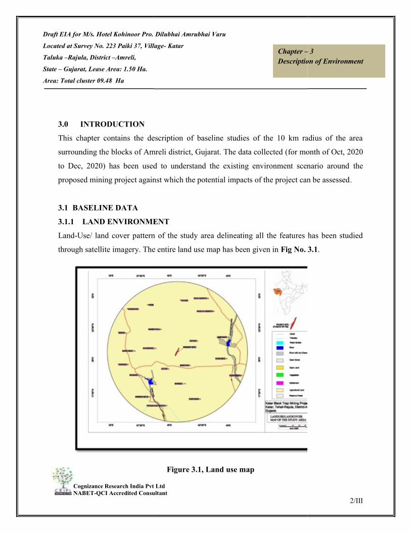
Draft EIA for M/s. Hotel Kohinoor Pro. Dilubhai Amrubhai Varu
Located at Survey No. 223 Paiki 37, Village
Taluka –Rajula, District –Amreli,
State – Gujarat, Lease Area: 1.50 Ha.
Area: Total cluster 09.48 Ha
Cognizance Research India Pvt Ltd NABET-QCI Accredited Consultant
3.0 INTRODUCTION This chapter contains the description of baseline studies of the 10 km radius of the area
surrounding the blocks of Amreli
to Dec, 2020) has been used to understand the existing environment scenario around
proposed mining project against which the potential impacts of the project can be assessed
3.1 BASELINE DATA 3.1.1 LAND ENVIRONMENTLand-Use/ land cover pattern of the study area delineating all the features has been studied
through satellite imagery. The entire land use
M/s. Hotel Kohinoor Pro. Dilubhai Amrubhai Varu
Survey No. 223 Paiki 37, Village- Katar
Cognizance Research India Pvt Ltd QCI Accredited Consultant
Chapter –Description of Environment
contains the description of baseline studies of the 10 km radius of the area
Amreli district, Gujarat. The data collected (for month of
has been used to understand the existing environment scenario around
proposed mining project against which the potential impacts of the project can be assessed
LAND ENVIRONMENT Use/ land cover pattern of the study area delineating all the features has been studied
imagery. The entire land use map has been given in Fig No. 3.1
Figure 3.1, Land use map
2/III
– 3 Description of Environment
contains the description of baseline studies of the 10 km radius of the area
(for month of Oct, 2020
has been used to understand the existing environment scenario around the
proposed mining project against which the potential impacts of the project can be assessed.
Use/ land cover pattern of the study area delineating all the features has been studied
Fig No. 3.1.
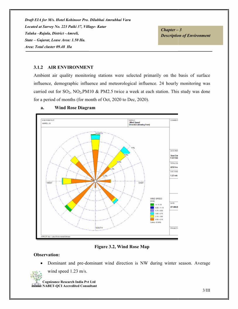
Draft EIA for M/s. Hotel Kohinoor Pro. Dilubhai Amrubhai Varu
Located at Survey No. 223 Paiki 37, Village
Taluka –Rajula, District –Amreli,
State – Gujarat, Lease Area: 1.50 Ha.
Area: Total cluster 09.48 Ha
Cognizance Research India Pvt Ltd NABET-QCI Accredited Consultant
3.1.2 AIR ENVIRONMENTAmbient air quality monitoring stations were selected primarily on the basis of surface
influence, demographic influence and meteorological in
carried out for SO2, NO2,PM10
for a period of months (for month of
a. Wind Rose Diagram
Observation:
Dominant and pre-dominant wind direction is NW during winter
wind speed 1.23 m/s.
M/s. Hotel Kohinoor Pro. Dilubhai Amrubhai Varu
Survey No. 223 Paiki 37, Village- Katar
Cognizance Research India Pvt Ltd QCI Accredited Consultant
Chapter –Description of Environment
AIR ENVIRONMENT Ambient air quality monitoring stations were selected primarily on the basis of surface
influence, demographic influence and meteorological influence. 24 hourly monitoring was
M10 & PM2.5 twice a week at each station. This study was done
(for month of Oct, 2020 to Dec, 2020).
Wind Rose Diagram
Figure 3.2, Wind Rose Map
dominant wind direction is NW during winter
3/III
– 3 Description of Environment
Ambient air quality monitoring stations were selected primarily on the basis of surface
fluence. 24 hourly monitoring was
twice a week at each station. This study was done
season. Average
Draft EIA for M/s. Hotel Kohinoor Pro. Dilubhai Amrubhai Varu
Located at Survey No. 223 Paiki 37, Village
Taluka –Rajula, District –Amreli,
State – Gujarat, Lease Area: 1.50 Ha.
Area: Total cluster 09.48 Ha
Cognizance Research India Pvt Ltd NABET-QCI Accredited Consultant
Calm is 43.64 %.
3.2.1 Ambient Air Quality
The ambient air quality was monitored in the impact area as per MoEF guidelines. The study
area represents mostly rural environment. The prime objective of the baseline air quality study
was to assess the ambient air quality of the mining lease area.
3.2.2 Methodology adopted for the study
The baseline status of the ambient air quality has been assessed through a scientif
designed ambient air quality network. The design of monitoring network in the air quality
surveillance programme has been based on the following consideration.
Meteorological parameters
Topography of the study area
Representative of regional backgro
Representative of likely impact areas.
Ambient Air Quality Monitoring (AAQM) stations were set up at 6 locations with due
consideration to the above mentioned points. AAQM locations were selected in downwind
and upwind direction of the proposed mining lease area covering core and buffer zones. The
details of the monitoring stations are given in
Ambient air quality monitoring was carried out twice a week with a frequency of 24 hours for
12 weeks during the study period. The common air pollutant namel
(PM10), Particulate Matter-2.5(PM2.5),
(NOX).
M/s. Hotel Kohinoor Pro. Dilubhai Amrubhai Varu
Survey No. 223 Paiki 37, Village- Katar
Cognizance Research India Pvt Ltd QCI Accredited Consultant
Chapter –Description of Environment
Ambient Air Quality
The ambient air quality was monitored in the impact area as per MoEF guidelines. The study
environment. The prime objective of the baseline air quality study
was to assess the ambient air quality of the mining lease area.
3.2.2 Methodology adopted for the study
The baseline status of the ambient air quality has been assessed through a scientif
designed ambient air quality network. The design of monitoring network in the air quality
surveillance programme has been based on the following consideration.
Meteorological parameters
Topography of the study area
Representative of regional background air quality for obtaining baseline status
Representative of likely impact areas.
Ambient Air Quality Monitoring (AAQM) stations were set up at 6 locations with due
consideration to the above mentioned points. AAQM locations were selected in downwind
d upwind direction of the proposed mining lease area covering core and buffer zones. The
details of the monitoring stations are given in Figure 3.2.
Ambient air quality monitoring was carried out twice a week with a frequency of 24 hours for
g the study period. The common air pollutant namely Particulate Matter
2.5(PM2.5), Sulphur-dioxide (SO2), and Oxides of Nitrogen
4/III
– 3 Description of Environment
The ambient air quality was monitored in the impact area as per MoEF guidelines. The study
environment. The prime objective of the baseline air quality study
The baseline status of the ambient air quality has been assessed through a scientifically
designed ambient air quality network. The design of monitoring network in the air quality
und air quality for obtaining baseline status
Ambient Air Quality Monitoring (AAQM) stations were set up at 6 locations with due
consideration to the above mentioned points. AAQM locations were selected in downwind
d upwind direction of the proposed mining lease area covering core and buffer zones. The
Ambient air quality monitoring was carried out twice a week with a frequency of 24 hours for
y Particulate Matter-10
dioxide (SO2), and Oxides of Nitrogen

Draft EIA for M/s. Hotel Kohinoor Pro. Dilubhai Amrubhai Varu
Located at Survey No. 223 Paiki 37, Village
Taluka –Rajula, District –Amreli,
State – Gujarat, Lease Area: 1.50 Ha.
Area: Total cluster 09.48 Ha
Cognizance Research India Pvt Ltd NABET-QCI Accredited Consultant
Table-3.1: Location of Ambient
1. Project Site
2. Near Mine Site
3. Kantahriya Koli
4. Vavdi
5 Katarpara
6 Kotadi
Table No. 3.2 Ambient Air Quality Test Results
Parameters PM 10
(μg/m3)
AAQM 100
MIN
MAX
AVERAGE
98 Percentile
MIN 78.86
MAX 85.77
AVERAGE 82.17
98 Percentile 85.76
M/s. Hotel Kohinoor Pro. Dilubhai Amrubhai Varu
Survey No. 223 Paiki 37, Village- Katar
Cognizance Research India Pvt Ltd QCI Accredited Consultant
Chapter –Description of Environment
3.1: Location of Ambient Air Quality Monitoring Station
AAQ1 --
Near Mine Site AAQ2 0.5 KM in S
Kantahriya Koli AAQ3 6.3 km in S
AAQ4 7.2 KM in N
AAQ5 2.0 KM IN
AAQ 6 3.5 Km in NE
Table No. 3.2 Ambient Air Quality Test Results
PM 10
(μg/m3)
PM2.5
(μg/m3)
SO2
(μg/m3)
NO2
(μg/m3)
100 60 80 80
Project Site (AAQ1)
78.33 39.37 10.92
84.73 43.67 14.63
81.47 41.47 12.53
84.18 43.46 14.21
Near project site (AAQ2)
78.86 39.14 10.91
85.77 45.59 13.77
82.17 41.67 12.24
85.76 45.00 13.75
5/III
– 3 Description of Environment
Air Quality Monitoring Station
0.5 KM in S
in S
N
W
Km in NE
NO2
(μg/m3)
80
20.97
24.74
22.73
24.70
20.15
24.81
22.48
24.37

Draft EIA for M/s. Hotel Kohinoor Pro. Dilubhai Amrubhai Varu
Located at Survey No. 223 Paiki 37, Village
Taluka –Rajula, District –Amreli,
State – Gujarat, Lease Area: 1.50 Ha.
Area: Total cluster 09.48 Ha
Cognizance Research India Pvt Ltd NABET-QCI Accredited Consultant
MIN 78.60
MAX 85.94
AVERAGE 83.05
98 Percentile 85.89
MIN 77.11
MAX 84.79
AVERAGE 81.09
98 Percentile 84.31
MIN
MAX
AVERAGE
98 Percentile
MIN
MAX
AVERAGE
98 Percentile
M/s. Hotel Kohinoor Pro. Dilubhai Amrubhai Varu
Survey No. 223 Paiki 37, Village- Katar
Cognizance Research India Pvt Ltd QCI Accredited Consultant
Chapter –Description of Environment
Kantahriya Koli (AAQ3)
78.60 40.17 10.21
85.94 52.94 13.94
83.05 42.30 12.25
85.89 48.71 13.94
Vavdi (AAQ4)
77.11 37.55 10.50
84.79 43.19 13.46
81.09 40.85 11.95
84.31 43.00 13.33
Katarpara (AAQ5)
79.09 40.06 11.06
85.73 44.41 13.98
82.88 42.45 12.64
85.52 44.25 13.87
Kotadi (AAQ6)
77.10 39.31 12.72
85.80 43.81 14.80
81.20 41.90 13.49
85.63 43.70 14.79
6/III
– 3 Description of Environment
19.04
24.92
22.45
24.81
21.64
25.02
22.95
24.72
20.59
24.74
22.82
24.70
19.89
24.98
22.52
24.97

Draft EIA for M/s. Hotel Kohinoor Pro. Dilubhai Amrubhai Varu
Located at Survey No. 223 Paiki 37, Village
Taluka –Rajula, District –Amreli,
State – Gujarat, Lease Area: 1.50 Ha.
Area: Total cluster 09.48 Ha
Cognizance Research India Pvt Ltd NABET-QCI Accredited Consultant
Figure 3.2: Ambient Air Quality sampling locations
Statistical parameters like minimum, maximum, average and 98
computed from the observed field data for all sampling stations. These are compared with the
standards prescribed by Central Pollution control Board (CPCB) for industrial, residentia
rural zone.
3.2.3: Baseline Scenario
a) Suspended Particulate Matter (PM2.5)Suspended particulate matter in general terms is the particulate matter in suspension in
ambient air. PM 2.5 refers to particles with a diameter of less than 2.5 microns.
usually called fine particles and contain secondary aerosols, combustion particles and re
M/s. Hotel Kohinoor Pro. Dilubhai Amrubhai Varu
Survey No. 223 Paiki 37, Village- Katar
Cognizance Research India Pvt Ltd QCI Accredited Consultant
Chapter –Description of Environment
Figure 3.2: Ambient Air Quality sampling locations
parameters like minimum, maximum, average and 98th percentiles have been
computed from the observed field data for all sampling stations. These are compared with the
standards prescribed by Central Pollution control Board (CPCB) for industrial, residentia
Suspended Particulate Matter (PM2.5) Suspended particulate matter in general terms is the particulate matter in suspension in
ambient air. PM 2.5 refers to particles with a diameter of less than 2.5 microns.
usually called fine particles and contain secondary aerosols, combustion particles and re
7/III
– 3 Description of Environment
percentiles have been
computed from the observed field data for all sampling stations. These are compared with the
standards prescribed by Central Pollution control Board (CPCB) for industrial, residential and
Suspended particulate matter in general terms is the particulate matter in suspension in
ambient air. PM 2.5 refers to particles with a diameter of less than 2.5 microns. These are
usually called fine particles and contain secondary aerosols, combustion particles and re-
Draft EIA for M/s. Hotel Kohinoor Pro. Dilubhai Amrubhai Varu
Located at Survey No. 223 Paiki 37, Village
Taluka –Rajula, District –Amreli,
State – Gujarat, Lease Area: 1.50 Ha.
Area: Total cluster 09.48 Ha
Cognizance Research India Pvt Ltd NABET-QCI Accredited Consultant
condensed organic metallic vapour, and acid components. Fine particles can reach all the way
down to the alveoli in the lungs. The minimum and maximum leve
within the study area was in the range of
ranging between 43.00 μg/m3 to 48.71
b) Suspended Particulate Matter (PMSuspended particulate matter in general terms is the part
ambient air. It includes dust, smoke etc. In general some of the important sources of
suspended particulate matter are mines. The following sources of suspended particulate matter
in the study area are identified:
Emission due to vehicular movement
Dust generation from ground or other mining operations
The minimum and maximum level of PM
77.10 µg/m3 to 85.80 µg/m3
µg/m3.
c) Sulfur Dioxide (SO2)
Sulfur dioxide gas is an inorganic gaseous pollutant. Sulfur dioxide emissions are expected to
be emitted wherever combustion of any fuel containing sulfur takes place. The sulfur in the
fuel will combine with oxygen to
in the study area are identified:
Emissions from domestic/consumption of fuel (coal, diesel, etc)
Emissions from DG sets used by mining activity and local residents
Sulfur dioxide in atmosphere
producing illness and lung injury. Further it can combine with water in the air to form toxic
acid aerosols that can corrode metal surfaces, fabrics and the leaves of plants. Sulfur dioxi
M/s. Hotel Kohinoor Pro. Dilubhai Amrubhai Varu
Survey No. 223 Paiki 37, Village- Katar
Cognizance Research India Pvt Ltd QCI Accredited Consultant
Chapter –Description of Environment
condensed organic metallic vapour, and acid components. Fine particles can reach all the way
down to the alveoli in the lungs. The minimum and maximum level of PM 2.5 recorded
within the study area was in the range of 37.55 μg/m3 to 52.94 μg/m3 with the 98th percentile
3.00 μg/m3 to 48.71 μg/m3.
b) Suspended Particulate Matter (PM10) Suspended particulate matter in general terms is the particulate matter in suspension in
ambient air. It includes dust, smoke etc. In general some of the important sources of
suspended particulate matter are mines. The following sources of suspended particulate matter
in the study area are identified:
ue to vehicular movement
Dust generation from ground or other mining operations
The minimum and maximum level of PM10 recorded within the study area was in the range of
with the 98th percentile ranging between 84.18
Sulfur dioxide gas is an inorganic gaseous pollutant. Sulfur dioxide emissions are expected to
be emitted wherever combustion of any fuel containing sulfur takes place. The sulfur in the
fuel will combine with oxygen to form sulfur dioxide. The following sources of sulfur dioxide
in the study area are identified:
Emissions from domestic/consumption of fuel (coal, diesel, etc)
Emissions from DG sets used by mining activity and local residents
Sulfur dioxide in atmosphere is significant because of its toxicity; sulfur dioxide is capable of
producing illness and lung injury. Further it can combine with water in the air to form toxic
acid aerosols that can corrode metal surfaces, fabrics and the leaves of plants. Sulfur dioxi
8/III
– 3 Description of Environment
condensed organic metallic vapour, and acid components. Fine particles can reach all the way
l of PM 2.5 recorded
μg/m3 with the 98th percentile
iculate matter in suspension in
ambient air. It includes dust, smoke etc. In general some of the important sources of
suspended particulate matter are mines. The following sources of suspended particulate matter
recorded within the study area was in the range of
84.18 µg/m3 to 85.76
Sulfur dioxide gas is an inorganic gaseous pollutant. Sulfur dioxide emissions are expected to
be emitted wherever combustion of any fuel containing sulfur takes place. The sulfur in the
form sulfur dioxide. The following sources of sulfur dioxide
is significant because of its toxicity; sulfur dioxide is capable of
producing illness and lung injury. Further it can combine with water in the air to form toxic
acid aerosols that can corrode metal surfaces, fabrics and the leaves of plants. Sulfur dioxide
Draft EIA for M/s. Hotel Kohinoor Pro. Dilubhai Amrubhai Varu
Located at Survey No. 223 Paiki 37, Village
Taluka –Rajula, District –Amreli,
State – Gujarat, Lease Area: 1.50 Ha.
Area: Total cluster 09.48 Ha
Cognizance Research India Pvt Ltd NABET-QCI Accredited Consultant
is an irritantant to the eyes and respiratory system. Excessive exposure to sulfur dioxide
causes bronchial asthma and other breathing related diseases as it affects the lungs.
The minimum and maximum level of SO
10.21 µg/m3 to 14.91 µg/m3 with the 98
µg/m3 The 24 hourly average values of SO
Quality Standards (NAAQS) and
below the applicable limits 80 µg/m3 for rural areas.
a) Oxides of Nitrogen (NO2
The important sources of oxides of Nitrogen are from utilities and auto exhaust due to
vehicular movement in mine le
study area are identified.
Emissions from field burning of coal.
Emissions from vehicular movements in the study area.
Oxides of Nitrogen in the presence of sunlight will undergo reactions with
organic compounds to produce all the effects associated with photochemical smog. NO
inherent ability to produce deleterious effects by themselves like toxicity. It causes
asphyxiation when its concentration is great enough to reduce the no
the air. The minimum and maximum level of NOx recorded within the study area was in the
range of 19.04 µg/m3 to 25.02
to 24.97 µg/m3.The 24 hourly average values of NO
Ambient Air Quality Standards (NAAQS) and it was found that all sampling stations recorded
values are below the applicable limits 80 µg/m
attached as Annexure-VI
M/s. Hotel Kohinoor Pro. Dilubhai Amrubhai Varu
Survey No. 223 Paiki 37, Village- Katar
Cognizance Research India Pvt Ltd QCI Accredited Consultant
Chapter –Description of Environment
is an irritantant to the eyes and respiratory system. Excessive exposure to sulfur dioxide
causes bronchial asthma and other breathing related diseases as it affects the lungs.
e minimum and maximum level of SO2 recorded within the study area was in the range of
10.21 µg/m3 to 14.91 µg/m3 with the 98th percentile ranging between 12.21
The 24 hourly average values of SO2 were compared with the National Ambient Air
Quality Standards (NAAQS) and it was found that all sampling stations recorded values are
below the applicable limits 80 µg/m3 for rural areas.
2) The important sources of oxides of Nitrogen are from utilities and auto exhaust due to
vehicular movement in mine lease area. The following sources of oxides of nitrogen in the
Emissions from field burning of coal.
Emissions from vehicular movements in the study area.
Oxides of Nitrogen in the presence of sunlight will undergo reactions with
organic compounds to produce all the effects associated with photochemical smog. NO
inherent ability to produce deleterious effects by themselves like toxicity. It causes
asphyxiation when its concentration is great enough to reduce the normal oxygen supply from
The minimum and maximum level of NOx recorded within the study area was in the
25.02 µg/m3 with the 98th percentile ranging between 2
µg/m3.The 24 hourly average values of NO2 were compared with the National
Ambient Air Quality Standards (NAAQS) and it was found that all sampling stations recorded
values are below the applicable limits 80 µg/m3 for rural areas. Air quality data has been
9/III
– 3 Description of Environment
is an irritantant to the eyes and respiratory system. Excessive exposure to sulfur dioxide
causes bronchial asthma and other breathing related diseases as it affects the lungs.
recorded within the study area was in the range of
12.21 µg/m3 to 14.80
were compared with the National Ambient Air
it was found that all sampling stations recorded values are
The important sources of oxides of Nitrogen are from utilities and auto exhaust due to
ase area. The following sources of oxides of nitrogen in the
Oxides of Nitrogen in the presence of sunlight will undergo reactions with a number of
organic compounds to produce all the effects associated with photochemical smog. NOX has
inherent ability to produce deleterious effects by themselves like toxicity. It causes
rmal oxygen supply from
The minimum and maximum level of NOx recorded within the study area was in the
percentile ranging between 24.37 µg/m3
compared with the National
Ambient Air Quality Standards (NAAQS) and it was found that all sampling stations recorded
for rural areas. Air quality data has been

Draft EIA for M/s. Hotel Kohinoor Pro. Dilubhai Amrubhai Varu
Located at Survey No. 223 Paiki 37, Village
Taluka –Rajula, District –Amreli,
State – Gujarat, Lease Area: 1.50 Ha.
Area: Total cluster 09.48 Ha
Cognizance Research India Pvt Ltd NABET-QCI Accredited Consultant
3.1.3 WATER ENVIRONMENT
Water quality assessment is one of the essential components of EIA study. Such assessment
helps in evaluating the existing health of water body and suggesting appropriate mitigation
measures to minimize the potential impact from development pro
ground water has been studied in order to assess proposed water
drinking, cooling and horticulture purpose.
The water quality at the site and other locations within the 10 km impact zone was monitored
during the study period (Oct 2020 to Dec, 2
the study are presented in Table 3.analysis are presented in the
Locations marked within the Study Area.
Table 3.3, Location of Water Sampling Sites
S.No. Location
3. Kantahriya Koli
4. Vavdi
5. Katarpura
M/s. Hotel Kohinoor Pro. Dilubhai Amrubhai Varu
Survey No. 223 Paiki 37, Village- Katar
Cognizance Research India Pvt Ltd QCI Accredited Consultant
Chapter –Description of Environment
ENVIRONMENT
Water quality assessment is one of the essential components of EIA study. Such assessment
helps in evaluating the existing health of water body and suggesting appropriate mitigation
measures to minimize the potential impact from development projects. Water quality of
ground water has been studied in order to assess proposed water-uses in construction,
drinking, cooling and horticulture purpose.
The water quality at the site and other locations within the 10 km impact zone was monitored
Oct 2020 to Dec, 2020) The water sampling locations marked within
Table 3.7 and Figure 3.2and the result of the monitoring and
analysis are presented in the Table 3.8 to Table 3.9showing Water Quality Monitoring
Locations marked within the Study Area.
Location of Water Sampling Sites (Dec 2020)
GROUND WATER
Code Distance & Direction
Kantahriya Koli GW 1 6.3 Km in
GW 2 7.2 km in N
GW 3 2.0 Km in W
10/III
– 3 Description of Environment
Water quality assessment is one of the essential components of EIA study. Such assessment
helps in evaluating the existing health of water body and suggesting appropriate mitigation
jects. Water quality of
uses in construction,
The water quality at the site and other locations within the 10 km impact zone was monitored
) The water sampling locations marked within
and the result of the monitoring and
showing Water Quality Monitoring
Distance & Direction
S
7.2 km in N
in W

Draft EIA for M/s. Hotel Kohinoor Pro. Dilubhai Amrubhai Varu
Located at Survey No. 223 Paiki 37, Village
Taluka –Rajula, District –Amreli,
State – Gujarat, Lease Area: 1.50 Ha.
Area: Total cluster 09.48 Ha
Cognizance Research India Pvt Ltd NABET-QCI Accredited Consultant
Figure 3.4,
Table 3.4
S.
No.Parameter Unit
1 pH Hazen
2 Colour
3 Odour -
4 Taste NTU
M/s. Hotel Kohinoor Pro. Dilubhai Amrubhai Varu
Survey No. 223 Paiki 37, Village- Katar
Cognizance Research India Pvt Ltd QCI Accredited Consultant
Chapter –Description of Environment
Figure 3.4, Ground Water Monitoring Locations
4, Ground water Sample Analysis Results
Limit (as per
IS:10500:2012)
GW1
GW2
Desirable PermissibleKantahriya
Koli Vavdi
Hazen 5.0-<0.1 25 7.96 7.74
Agreeable - <5.0 <5.0
Agreeable - Agreeable Agreeable
1.0 5.0 Agreeable Agreeable
11/III
– 3 Description of Environment
GW2 GW3
Vavdi Katarpara
7.74 7.43
<5.0 <5.0
Agreeable Agreeable
Agreeable Agreeable
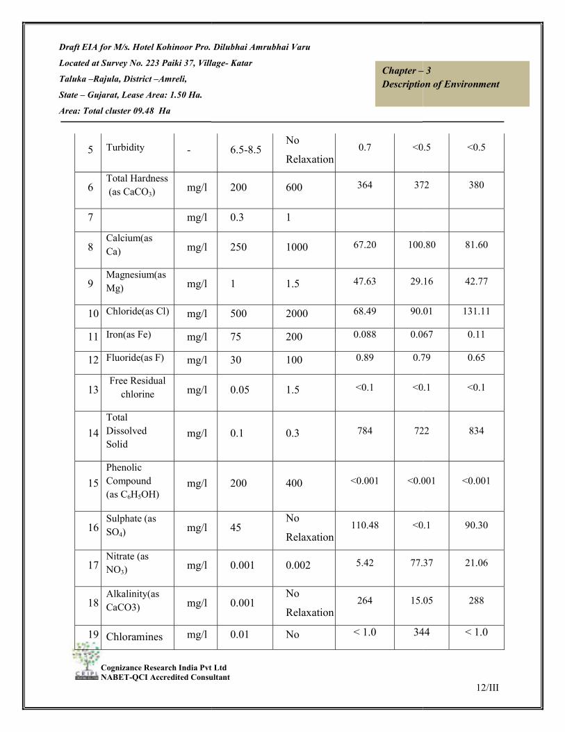
Draft EIA for M/s. Hotel Kohinoor Pro. Dilubhai Amrubhai Varu
Located at Survey No. 223 Paiki 37, Village
Taluka –Rajula, District –Amreli,
State – Gujarat, Lease Area: 1.50 Ha.
Area: Total cluster 09.48 Ha
Cognizance Research India Pvt Ltd NABET-QCI Accredited Consultant
5 Turbidity -
6 Total Hardness (as CaCO3) mg/l
7
mg/l
8 Calcium(as Ca) mg/l
9 Magnesium(as Mg) mg/l
10 Chloride(as Cl) mg/l
11 Iron(as Fe) mg/l
12 Fluoride(as F) mg/l
13 Free Residual
chlorine mg/l
14 Total Dissolved Solid
mg/l
15 Phenolic Compound (as C6H5OH)
mg/l
16 Sulphate (as SO4) mg/l
17 Nitrate (as NO3) mg/l
18 Alkalinity(as CaCO3) mg/l
19 Chloramines mg/l
M/s. Hotel Kohinoor Pro. Dilubhai Amrubhai Varu
Survey No. 223 Paiki 37, Village- Katar
Cognizance Research India Pvt Ltd QCI Accredited Consultant
Chapter –Description of Environment
6.5-8.5 No
Relaxation 0.7 <0.5
200 600 364 372
0.3 1
250 1000 67.20 100.80
1 1.5 47.63 29.16
500 2000 68.49 90.01
75 200 0.088 0.067
30 100 0.89 0.79
0.05 1.5 <0.1 <0.1
0.1 0.3 784 722
200 400 <0.001 <0.001
45 No
Relaxation 110.48 <0.1
0.001 0.002 5.42 77.37
0.001 No
Relaxation 264 15.05
0.01 No < 1.0 344
12/III
– 3 Description of Environment
<0.5 <0.5
372 380
100.80 81.60
29.16 42.77
90.01 131.11
0.067 0.11
0.79 0.65
<0.1 <0.1
722 834
<0.001 <0.001
<0.1 90.30
77.37 21.06
15.05 288
344 < 1.0

Draft EIA for M/s. Hotel Kohinoor Pro. Dilubhai Amrubhai Varu
Located at Survey No. 223 Paiki 37, Village
Taluka –Rajula, District –Amreli,
State – Gujarat, Lease Area: 1.50 Ha.
Area: Total cluster 09.48 Ha
Cognizance Research India Pvt Ltd NABET-QCI Accredited Consultant
(as Cl2)
20 Cadmium (as Cd) mg/l
21 Lead ( as Pb) mg/l
22 Total Chromium (as Cr)
mg/l
23 Copper (as Cu) mg/l
24 Total Ammonia mg/l
25 Nickel (as Ni) mg/l
26 Zinc(as Zn) mg/l
27 Manganese (as Mn) mg/l
28 Boron (as B) mg/l
29 Selenium (Se)
30 Arsenic (as As)
Microbiological Parameter
29 Total
Coliform
MPN
/100ml
30 E.coli E.coli
/100ml
M/s. Hotel Kohinoor Pro. Dilubhai Amrubhai Varu
Survey No. 223 Paiki 37, Village- Katar
Cognizance Research India Pvt Ltd QCI Accredited Consultant
Chapter –Description of Environment
Relaxation
0.01 0.05 <0.001 < 1.0
0.05 No
Relaxation <0.01 <0.001
0.01 No
Relaxation <0.01 <0.01
5 15 <0.01 <0.01
0.05 No
Relaxation <0.5 <0.01
0.5 No rule <0.01 <0.5
200 600 0.60 <0.01
0.03 0.2 <0.1 1.19
0.5 1.0 <0.1 <0.1
<0.01 <0.1
<0.01 <0.01
Microbiological Parameter
/100mlAbsent -
Absent Absent
E.coli
/100mlAbsent -
Not
detected
Not
detected
13/III
– 3 Description of Environment
< 1.0 <0.001
<0.001 <0.01
<0.01 <0.01
<0.01 <0.01
<0.01 <0.5
<0.5 <0.01
<0.01 0.77
1.19 <0.1
<0.1 0.15
<0.1 <0.01
<0.01 <0.01
Absent Absent
Not
detected
Not
detected

Draft EIA for M/s. Hotel Kohinoor Pro. Dilubhai Amrubhai Varu
Located at Survey No. 223 Paiki 37, Village
Taluka –Rajula, District –Amreli,
State – Gujarat, Lease Area: 1.50 Ha.
Area: Total cluster 09.48 Ha
Cognizance Research India Pvt Ltd NABET-QCI Accredited Consultant
Table 3.5 Water quality criteria as per Central Pollution Control Board
Designated-Best-
Use
Drinking Water Source
without conventional
treatment but after
disinfection
A
Outdoor bathing
(Organized)
B
Drinking water source
after conventional
treatment and
disinfection
C
Propagation of Wild
life and Fisheries
D
Irrigation, Industrial
Cooling, Controlled
Waste disposal
E
M/s. Hotel Kohinoor Pro. Dilubhai Amrubhai Varu
Survey No. 223 Paiki 37, Village- Katar
Cognizance Research India Pvt Ltd QCI Accredited Consultant
Chapter –Description of Environment
(<2) (<2)
Water quality criteria as per Central Pollution Control Board
Class of
water
Criteria
Total Coliforms Organism MPN/100ml shall be 50 or
less
pH between 6.5 and 8.5
Dissolved Oxygen 6mg/l or more Biochemical
Oxygen Demand 5 days 20°C 2mg/l or less
Total Coliforms Organism MPN/100ml shall be 500
or less;
pH between 6.5 and 8.5;
Dissolved Oxygen 5mg/l or more Biochemical
Oxygen Demand 5 days 20°C 3mg/l or less
Total Coliforms Organism MPN/100ml shall be 5000
or less;
pH between 6 to 9;
Dissolved Oxygen 4mg/l or more Biochemical
Oxygen Demand 5 days 20°C 3mg/l or less
pH between 6.5 to 8.5
Dissolved Oxygen 4mg/l or more Free Ammonia (as
N) 1.2 mg/l or less
pH between 6.0 to 8.5
Electrical Conductivity at 25°C
Max.1000
Sodium absorption Ratio Max. 26
14/III
– 3 Description of Environment
(<2) (<2)
Water quality criteria as per Central Pollution Control Board
Total Coliforms Organism MPN/100ml shall be 50 or
Dissolved Oxygen 6mg/l or more Biochemical
Demand 5 days 20°C 2mg/l or less
Total Coliforms Organism MPN/100ml shall be 500
Dissolved Oxygen 5mg/l or more Biochemical
Oxygen Demand 5 days 20°C 3mg/l or less
Total Coliforms Organism MPN/100ml shall be 5000
Dissolved Oxygen 4mg/l or more Biochemical
Oxygen Demand 5 days 20°C 3mg/l or less
Dissolved Oxygen 4mg/l or more Free Ammonia (as
Electrical Conductivity at 25°C micro mhos/cm

Draft EIA for M/s. Hotel Kohinoor Pro. Dilubhai Amrubhai Varu
Located at Survey No. 223 Paiki 37, Village
Taluka –Rajula, District –Amreli,
State – Gujarat, Lease Area: 1.50 Ha.
Area: Total cluster 09.48 Ha
Cognizance Research India Pvt Ltd NABET-QCI Accredited Consultant
Below
3.1.3.1 Result & Conclusion:
The pH limit fixed for drinking water samples as per IS
beyond this range the water will affect the mucus membrane or water supply
During the study period, the pH was var
pH values for all the samples collected in the study area during study period were found
to be within the limits.
The desirable limit for total dissolved solids a
whereas the permissible limit in absence of alternate source is 2000mg/l. In ground water
samples collected from the study area, the total dissolved solids are varying fro
mg/l to 834 mg/l. The TDS of the samples w
permissible limit of 500mg/l & 2000 mg/l respectively.
The desirable limit for chlorides is 250 mg/l as per IS
permissible limit of the same is 1000 mg/l beyond this limit taste, corrosion and
palatability are affected. The chloride level in
131.00 mg/l. the chloride samples are within the desirable limits.
The desirable limit as per IS
permissible limit for the same is 600 mg/l. In the ground water samples collected from
the study area, the hardness
Fluoride is the other important parameter, which has the desirable limit of 1 mg/l and
permissible limit of 1.5 mg/l. However, the optimum content of fluor
water is 0.5 to 0.8 mg/l. If the fluori
above 1.5 mg/l causes flurosis. In the ground water samples of study area the fluorid
M/s. Hotel Kohinoor Pro. Dilubhai Amrubhai Varu
Survey No. 223 Paiki 37, Village- Katar
Cognizance Research India Pvt Ltd QCI Accredited Consultant
Chapter –Description of Environment
Boron Max. 2mg/l
Below-E Not Meeting A, B, C, D & E Criteria
3.1.3.1 Result & Conclusion:
The pH limit fixed for drinking water samples as per IS-10500 Standards is 6.5 to 8.5
beyond this range the water will affect the mucus membrane or water supply
During the study period, the pH was varying for ground waters from 7.43 to 7.96
pH values for all the samples collected in the study area during study period were found
The desirable limit for total dissolved solids as per IS-10500 Standards is 500 mg/l
whereas the permissible limit in absence of alternate source is 2000mg/l. In ground water
samples collected from the study area, the total dissolved solids are varying fro
4 mg/l. The TDS of the samples were within the desirable limit & the
permissible limit of 500mg/l & 2000 mg/l respectively.
The desirable limit for chlorides is 250 mg/l as per IS-10500 Standards whereas,
permissible limit of the same is 1000 mg/l beyond this limit taste, corrosion and
palatability are affected. The chloride level in ground water samples 68.096 mg/l to
g/l. the chloride samples are within the desirable limits.
The desirable limit as per IS-10500 Standards for hardness is 200 mg/l whereas the
permissible limit for the same is 600 mg/l. In the ground water samples collected from
ss is varying from 364 mg/l to 380 mg/l.
Fluoride is the other important parameter, which has the desirable limit of 1 mg/l and
permissible limit of 1.5 mg/l. However, the optimum content of fluoride in the drinking
mg/l. If the fluoride content is less than 0.6 mg/l it causes dental carries,
above 1.5 mg/l causes flurosis. In the ground water samples of study area the fluorid
15/III
– 3 Description of Environment
Not Meeting A, B, C, D & E Criteria
10500 Standards is 6.5 to 8.5
beyond this range the water will affect the mucus membrane or water supply system.
ying for ground waters from 7.43 to 7.96. The
pH values for all the samples collected in the study area during study period were found
10500 Standards is 500 mg/l
whereas the permissible limit in absence of alternate source is 2000mg/l. In ground water
samples collected from the study area, the total dissolved solids are varying from 722
ere within the desirable limit & the
10500 Standards whereas,
permissible limit of the same is 1000 mg/l beyond this limit taste, corrosion and
ground water samples 68.096 mg/l to
10500 Standards for hardness is 200 mg/l whereas the
permissible limit for the same is 600 mg/l. In the ground water samples collected from
Fluoride is the other important parameter, which has the desirable limit of 1 mg/l and
ide in the drinking
de content is less than 0.6 mg/l it causes dental carries,
above 1.5 mg/l causes flurosis. In the ground water samples of study area the fluoride
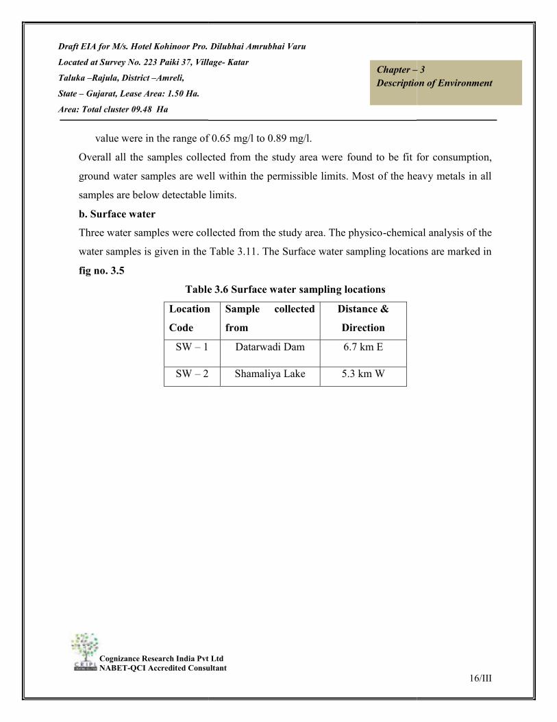
Draft EIA for M/s. Hotel Kohinoor Pro. Dilubhai Amrubhai Varu
Located at Survey No. 223 Paiki 37, Village
Taluka –Rajula, District –Amreli,
State – Gujarat, Lease Area: 1.50 Ha.
Area: Total cluster 09.48 Ha
Cognizance Research India Pvt Ltd NABET-QCI Accredited Consultant
value were in the range of 0.65
Overall all the samples collected from the study area were
ground water samples are well within the permissible limits. Most of the heavy metals in all
samples are below detectable limits.
b. Surface water Three water samples were collected from the study area. The physico
water samples is given in the Table 3.11
fig no. 3.5 Table 3.6
Location Code
SW – 1
SW – 2
M/s. Hotel Kohinoor Pro. Dilubhai Amrubhai Varu
Survey No. 223 Paiki 37, Village- Katar
Cognizance Research India Pvt Ltd QCI Accredited Consultant
Chapter –Description of Environment
value were in the range of 0.65 mg/l to 0.89 mg/l. Overall all the samples collected from the study area were found to be fit for consumption,
ground water samples are well within the permissible limits. Most of the heavy metals in all
samples are below detectable limits.
Three water samples were collected from the study area. The physico-chemica
amples is given in the Table 3.11. The Surface water sampling locations are marked in
Table 3.6 Surface water sampling locations
Location Sample collected from
Distance & Direction
1 Datarwadi Dam 6.7 km E
2 Shamaliya Lake 5.3 km W
16/III
– 3 Description of Environment
found to be fit for consumption,
ground water samples are well within the permissible limits. Most of the heavy metals in all
chemical analysis of the
. The Surface water sampling locations are marked in

Draft EIA for M/s. Hotel Kohinoor Pro. Dilubhai Amrubhai Varu
Located at Survey No. 223 Paiki 37, Village
Taluka –Rajula, District –Amreli,
State – Gujarat, Lease Area: 1.50 Ha.
Area: Total cluster 09.48 Ha
Cognizance Research India Pvt Ltd NABET-QCI Accredited Consultant
Figure 3.5 Surface Water Quality Sampling Locations
Table 3.7 Physico-chemical properties of surface water (Oct, 2020 to Dec 2020)
S. No. Parameter
1 pH
2 Temperature
3 Turbidity
4 Conductivity @25°C
M/s. Hotel Kohinoor Pro. Dilubhai Amrubhai Varu
Survey No. 223 Paiki 37, Village- Katar
Cognizance Research India Pvt Ltd QCI Accredited Consultant
Chapter –Description of Environment
Figure 3.5 Surface Water Quality Sampling Locations
chemical properties of surface water (Oct, 2020 to Dec 2020)
Unit
S.W. 1 S.W. 2
Datarwadi
Dam
Shamaliya
Lake
- 7.44
OC 24.3
NTU 5.1
Conductivity @25°C µs/cm. 495.3
17/III
– 3 Description of Environment
chemical properties of surface water (Oct, 2020 to Dec 2020)
S.W. 2
Shamaliya
Lake 8.09
24.8
8.7
331.5

Draft EIA for M/s. Hotel Kohinoor Pro. Dilubhai Amrubhai Varu
Located at Survey No. 223 Paiki 37, Village
Taluka –Rajula, District –Amreli,
State – Gujarat, Lease Area: 1.50 Ha.
Area: Total cluster 09.48 Ha
Cognizance Research India Pvt Ltd NABET-QCI Accredited Consultant
5 Total Suspended Solid
6 Total Alkalinity (as
CaCO3)
7
Biological Oxygen Demand
(Max.)
(at 270C for 3 days)
8 Dissolved Oxygen
(as O2) Min.
9 Calcium(as Ca)
10 Magnesium(as Mg)
11 Chloride(as Cl),Max
12 Iron(as Fe),Max
13 Fluoride(as F),Max
14 Total Dissolved Solid
15 Total Hardness
(as CaCO3)
16 Sulphate (as SO4)Max
17 Phosphate (as P)
18 Sodium (as Na)
19 Oil & Grease
20 Manganese (as Mn)
21 Total Chromiun (as Cr)
M/s. Hotel Kohinoor Pro. Dilubhai Amrubhai Varu
Survey No. 223 Paiki 37, Village- Katar
Cognizance Research India Pvt Ltd QCI Accredited Consultant
Chapter –Description of Environment
Total Suspended Solid mg/l 18
Total Alkalinity (as mg/l 124
Biological Oxygen Demand
(at 270C for 3 days)
mg/l 3.1
mg/l 7.8
mg/l 35.20
mg/l 16.52
mg/l 35.22
mg/l 0.272
mg/l 0.24
Total Dissolved Solid mg/l 312
mg/l 156.00
)Max mg/l 17.00
mg/l <0.2
mg/l 16.94
mg/l < 1.0
mg/l <0.1
Total Chromiun (as Cr) mg/l <0.05
18/III
– 3 Description of Environment
14
140
2.8
8.1
35.20
10.69
29.35
0.155
0.15
212
132.00
13.63
<0.2
10.66
< 1.0
<0.1
<0.05

Draft EIA for M/s. Hotel Kohinoor Pro. Dilubhai Amrubhai Varu
Located at Survey No. 223 Paiki 37, Village
Taluka –Rajula, District –Amreli,
State – Gujarat, Lease Area: 1.50 Ha.
Area: Total cluster 09.48 Ha
Cognizance Research India Pvt Ltd NABET-QCI Accredited Consultant
22 Zinc (as Zn)
23 Potassium (as K)
24 Nitrate (as NO3),Max
25 Cadmium (as Cd)
26 Lead ( as Pb)
27 Copper (as Cu)
28 Chemical Oxygen Demand (asO
29 Arsenic (as As )
30 Total Coli Form
Observation: The analysis results indicate that the
Dissolved Oxygen (DO) was observed in the range of 7.
requirement of 4 mg/l. BOD values were obser
The chlorides and Sulphates were found to be in t
mg/l respectively.
Bacteriological examination of surface water samples revealed the presence
range of 172 MPN/100 ml to 144
Based on the results it is evident that most of the
‘Category ‘C’ standards of CPCB indicating their suitability for Drinking water source after
conventional treatment and disinfection
Water test reports are attached as
M/s. Hotel Kohinoor Pro. Dilubhai Amrubhai Varu
Survey No. 223 Paiki 37, Village- Katar
Cognizance Research India Pvt Ltd QCI Accredited Consultant
Chapter –Description of Environment
mg/l <0.05
mg/l 4.06
),Max mg/l 1.54
mg/l <0.01
mg/l <0.01
mg/l <0.01
Chemical Oxygen Demand (asO2) mg/l 44.00
mg/l <0.01
MPN/100ml 172
e that the pH ranges between 7.44 and 7.89.
Dissolved Oxygen (DO) was observed in the range of 7.8 to 8.1 mg/l against the minimum
requirement of 4 mg/l. BOD values were observed to be in the range of 2.8-3.1
The chlorides and Sulphates were found to be in the range of 29.35-35.22 mg/l and 13.61
Bacteriological examination of surface water samples revealed the presence of total coliform in
range of 172 MPN/100 ml to 144 MPN/100 ml.
Based on the results it is evident that most of the parameters of the samples comply with
‘Category ‘C’ standards of CPCB indicating their suitability for Drinking water source after
conventional treatment and disinfection.
Water test reports are attached as Annexure-VI.
19/III
– 3 Description of Environment
<0.05
2.37
3.99
<0.01
<0.01
<0.01
36.00
<0.01
144
mg/l against the minimum
3.1 mg/l.
mg/l and 13.61-17.00
of total coliform in
parameters of the samples comply with
‘Category ‘C’ standards of CPCB indicating their suitability for Drinking water source after

Draft EIA for M/s. Hotel Kohinoor Pro. Dilubhai Amrubhai Varu
Located at Survey No. 223 Paiki 37, Village
Taluka –Rajula, District –Amreli,
State – Gujarat, Lease Area: 1.50 Ha.
Area: Total cluster 09.48 Ha
Cognizance Research India Pvt Ltd NABET-QCI Accredited Consultant
3.1.4 SOIL ENVIRONMENTSoil may be defined as a thin layer of earth’s crust, a medium for the growth of plants. The
soil characteristics include both physical and chemical properties. The soil survey and soil
sample were carried out / collected to assess the soil characteristics of the st
samples were collected from 4
locations are marked in Figure 3.characteristic of the soil samples is given in
Table 3.
S.No. Location
1 Kotadi
2 Kantahriya Koli
3 Vavdi
4 Katarpara
M/s. Hotel Kohinoor Pro. Dilubhai Amrubhai Varu
Survey No. 223 Paiki 37, Village- Katar
Cognizance Research India Pvt Ltd QCI Accredited Consultant
Chapter –Description of Environment
SOIL ENVIRONMENT e defined as a thin layer of earth’s crust, a medium for the growth of plants. The
soil characteristics include both physical and chemical properties. The soil survey and soil
sample were carried out / collected to assess the soil characteristics of the st
samples were collected from 4 locations and analyzed as per CPCB norms. The soil sampling
Figure 3.6 and shown in Table 3.8. The physico
characteristic of the soil samples is given in Table 3.9.
Table 3.8 Description of soil sampling locations
SOIL QUALITY
Code Distance & Direction
SQ1 3.5 m IN SE
Kantahriya Koli SQ2 6.3 km IN NW
SQ3 7.2 KM IN SW
Katarpara SQ4 2.0 km IN W
20/III
– 3 Description of Environment
e defined as a thin layer of earth’s crust, a medium for the growth of plants. The
soil characteristics include both physical and chemical properties. The soil survey and soil
sample were carried out / collected to assess the soil characteristics of the study area. Soil
locations and analyzed as per CPCB norms. The soil sampling
physico-chemical
Distance & Direction
m IN SE
km IN NW
KM IN SW
km IN W

Draft EIA for M/s. Hotel Kohinoor Pro. Dilubhai Amrubhai Varu
Located at Survey No. 223 Paiki 37, Village
Taluka –Rajula, District –Amreli,
State – Gujarat, Lease Area: 1.50 Ha.
Area: Total cluster 09.48 Ha
Cognizance Research India Pvt Ltd NABET-QCI Accredited Consultant
Table 3.9
S.No Parameter
1
Texture
Sand
Clay
Silt
2 pH
M/s. Hotel Kohinoor Pro. Dilubhai Amrubhai Varu
Survey No. 223 Paiki 37, Village- Katar
Cognizance Research India Pvt Ltd QCI Accredited Consultant
Chapter –Description of Environment
Figure 3.6, Soil Monitoring Locations Table 3.9, Physico-chemical properties of soil
Unit SQ-1 SQ-2 SQ-3
Kotadi
Kantahariya
Koli
Vavdi
- Sandy Clay
Sandy Clay
Loam
Sandy Clay Loam
% 46.64 46.83 50.21
35.01 28.56 27.80
% 18.35 24.61 21.99
- 7.68 7.62 7.88
21/III
– 3 Description of Environment
SQ-4
Katarpar
a
Sandy Clay Loam
Clay Loam
50.21 43.72
27.80 36.07
21.99 20.21
7.88 7.53

Draft EIA for M/s. Hotel Kohinoor Pro. Dilubhai Amrubhai Varu
Located at Survey No. 223 Paiki 37, Village
Taluka –Rajula, District –Amreli,
State – Gujarat, Lease Area: 1.50 Ha.
Area: Total cluster 09.48 Ha
Cognizance Research India Pvt Ltd NABET-QCI Accredited Consultant
4 Electrical
Conductivity
5 Cation exchange
capacity
6 Exchangeable
Potassium
7 Exchangeable
Sodium
8 Exchangeable
Calcium
9 Exchangeable
Magnesium
10 Sodium
Absorption Ratio
11 TKN (Total
Kjeldahl
Nitrogen)
12 Phosphorus(P2O
5)
13 Zinc (Zn)
14 Porosity
Observations: The pH value is ranging from 7.53 to 7.88
111.59 to 271.28 meq/100gm.
Soil testing Lab Reports are attached as
M/s. Hotel Kohinoor Pro. Dilubhai Amrubhai Varu
Survey No. 223 Paiki 37, Village- Katar
Cognizance Research India Pvt Ltd QCI Accredited Consultant
Chapter –Description of Environment
µmhos/c
m 318.5 322.6 290.6
meq/10
0 gm 99.08 111.59 179.29
mg/kg 265.55 239.63 340.87
mg/kg 4728.86 4626.58 4124.40
mg/kg 669.45 438.83 675.02
mg/kg 0.96 0.90 1.30
- 31.44 28.73 28.96
mg/kg
0.081 0.070 0.089
mg/kg 61.55 54.73 54.75
mg/kg 1.30 1.30 1.32
% 0.98 1.10 1.16
alue is ranging from 7.53 to 7.88. The cation exchange ratio value ranges from
.
Soil testing Lab Reports are attached as Annexure-VII.
22/III
– 3 Description of Environment
290.6 364.2
179.29 271.28
340.87 150.81
4124.40 3640.29
675.02 437.72
1.30 0.63
28.96 36.60
0.089 0.084
54.75 66.24
1.32 1.29
1.16 1.31
o value ranges from

Draft EIA for M/s. Hotel Kohinoor Pro. Dilubhai Amrubhai Varu
Located at Survey No. 223 Paiki 37, Village
Taluka –Rajula, District –Amreli,
State – Gujarat, Lease Area: 1.50 Ha.
Area: Total cluster 09.48 Ha
Cognizance Research India Pvt Ltd NABET-QCI Accredited Consultant
3.1.5 NOISE ENVIRONNENTThe noise levels within the study area were recorded using sound level meter and noise
monitoring results were compared wit
Environment Protection Act, 1986. The levels recorded are as stated in
level monitoring locations are marked in
Table 3.1
S.No. Location
1 Project Site
3. Kantahriya Koli
4. Vavdi
5. Katarpura
M/s. Hotel Kohinoor Pro. Dilubhai Amrubhai Varu
Survey No. 223 Paiki 37, Village- Katar
Cognizance Research India Pvt Ltd QCI Accredited Consultant
Chapter –Description of Environment
NOISE ENVIRONNENT The noise levels within the study area were recorded using sound level meter and noise
monitoring results were compared with the Ambient Noise Quality Standard notified under
Environment Protection Act, 1986. The levels recorded are as stated in Table 3.1
level monitoring locations are marked in Figure 3.7 and shown in Table 3.10
Table 3.10, Noise quality monitoring stations
NOISE QUALITY
Code Distance & Direction
Project Site NQ 1 --
Kantahriya Koli NQ 2 6.3 Km in
NQ 3 7.2 km in N
Katarpura NQ 4 2.0 Km in W
23/III
– 3 Description of Environment
The noise levels within the study area were recorded using sound level meter and noise
h the Ambient Noise Quality Standard notified under
Table 3.11. The noise
0.
Distance & Direction
6.3 Km in S
7.2 km in N
in W

Draft EIA for M/s. Hotel Kohinoor Pro. Dilubhai Amrubhai Varu
Located at Survey No. 223 Paiki 37, Village
Taluka –Rajula, District –Amreli,
State – Gujarat, Lease Area: 1.50 Ha.
Area: Total cluster 09.48 Ha
Cognizance Research India Pvt Ltd NABET-QCI Accredited Consultant
Figure 3.7Table 3.1
S. No. Locations
1 Project Site
2 Kantahriya Koli
3 Vavdi
4 Katarpura
Results Noise monitoring reveals that the minimum & maximum noise levels a
recorded as 50.5 dB (A) at NQ
maximum noise levels at night time were found
NQ1 respectively.
There are several sources in the 10 km radius of study area, which contributes to the local
noise level of the area. On the commencement of the project, the sound from traffic activities
will add to the ambient noise level of the area. This will be kept under check by taking proper
protective measures.
Ambient Noise Monitoring Lab Reports are attached as
3.1.6 BIOLOGICAL ENVIRONMENTIntroduction
M/s. Hotel Kohinoor Pro. Dilubhai Amrubhai Varu
Survey No. 223 Paiki 37, Village- Katar
Cognizance Research India Pvt Ltd QCI Accredited Consultant
Chapter –Description of Environment
Figure 3.7, Noise Monitoring Locations Table 3.11,Noise Monitoring Results
Equivalent Noise Level, dB (A)
Limit (as per CPCB
Guidelines),Leq, dB(A)
Observed value Leq, dB(A)
DAY* NIGHT* DAY*
75 70 61.1
55 45 50.7
55 45 51.1
55 45 50.5
ise monitoring reveals that the minimum & maximum noise levels at day time were
recorded as 50.5 dB (A) at NQ-4 & 61.1 dB (A) at NQ1 respectively. The minimum &
night time were found to be 41.1 dB (A) at NQ4 & 47.9
There are several sources in the 10 km radius of study area, which contributes to the local
noise level of the area. On the commencement of the project, the sound from traffic activities
to the ambient noise level of the area. This will be kept under check by taking proper
Ambient Noise Monitoring Lab Reports are attached as Annexure-VIII.
BIOLOGICAL ENVIRONMENT
24/III
– 3 Description of Environment
Equivalent Noise Level, dB (A)
Observed value Leq, dB(A)
DAY* NIGHT*
61.1 47.9
50.7 42.7
51.1 41.6
50.5 41.1
t day time were
respectively. The minimum &
to be 41.1 dB (A) at NQ4 & 47.9 dB (A) at
There are several sources in the 10 km radius of study area, which contributes to the local
noise level of the area. On the commencement of the project, the sound from traffic activities
to the ambient noise level of the area. This will be kept under check by taking proper

Draft EIA for M/s. Hotel Kohinoor Pro. Dilubhai Amrubhai Varu
Located at Survey No. 223 Paiki 37, Village
Taluka –Rajula, District –Amreli,
State – Gujarat, Lease Area: 1.50 Ha.
Area: Total cluster 09.48 Ha
Cognizance Research India Pvt Ltd NABET-QCI Accredited Consultant
Flora and fauna are the important
communities and are sensitive to external influences. Integrating the ecology into the planning
process is urgent need in the context of deterioration of natural environments, Biotic
communities, being dependent on the condition and resources of its sorrounding are
succeptible to change consequent upon any alteration in the environment. Hence change in the
status of flora & fauna is a basic requirement of Environment Impact Assessment Studies. In
view of the need for conservation of environment
fauna was collected within the study area.
Ecological systems show complex inter
including dependence, competition an
and animal species which interact not only among themselves but also with the abiotic
communities viz. Physical and chemical components of the environment.
Generally, biological communities are unbiase
Studies on biological aspects of ecosystems are important in Environmental Impact
Assessment for protection of flora and fauna. Information on the impact of environmental
stress on the eco-system serves as a
damage to a particular ecosystem. The biological environment includes both terrestrial and
aquatic ecosystem.
Period of the study and Study area The baseline study, for the evaluation of the floral and faunal biodiversity of the terrestrial
environment of the study area, within 10 Km radius from the proposed mining lease site of
Black Trap Mining Project at village
has been conducted during December 2016.
Methodology The primary objective of survey was to describe the floristic and faunal communities within
the study area. The sampling plots for floral inventory were selected randomly in th
M/s. Hotel Kohinoor Pro. Dilubhai Amrubhai Varu
Survey No. 223 Paiki 37, Village- Katar
Cognizance Research India Pvt Ltd QCI Accredited Consultant
Chapter –Description of Environment
Flora and fauna are the important constituents of the environment. They are organized into
communities and are sensitive to external influences. Integrating the ecology into the planning
process is urgent need in the context of deterioration of natural environments, Biotic
ng dependent on the condition and resources of its sorrounding are
succeptible to change consequent upon any alteration in the environment. Hence change in the
status of flora & fauna is a basic requirement of Environment Impact Assessment Studies. In
of the need for conservation of environment and biodiversity, information on flora &
fauna was collected within the study area.
Ecological systems show complex inter-relationships between biotic and abiotic components
including dependence, competition and mutualism. Biotic components comprise of both plant
and animal species which interact not only among themselves but also with the abiotic
communities viz. Physical and chemical components of the environment.
Generally, biological communities are unbiased indicators of climatic and edaphic conditions.
Studies on biological aspects of ecosystems are important in Environmental Impact
Assessment for protection of flora and fauna. Information on the impact of environmental
system serves as an efficient way for early warning system to check the
damage to a particular ecosystem. The biological environment includes both terrestrial and
Period of the study and Study area The baseline study, for the evaluation of the floral and faunal biodiversity of the terrestrial
environment of the study area, within 10 Km radius from the proposed mining lease site of
at village- Katar, Taluka- Rajula, District- Amreli, Gujarat. State
has been conducted during December 2016.
The primary objective of survey was to describe the floristic and faunal communities within
the study area. The sampling plots for floral inventory were selected randomly in th
25/III
– 3 Description of Environment
constituents of the environment. They are organized into
communities and are sensitive to external influences. Integrating the ecology into the planning
process is urgent need in the context of deterioration of natural environments, Biotic
ng dependent on the condition and resources of its sorrounding are
succeptible to change consequent upon any alteration in the environment. Hence change in the
status of flora & fauna is a basic requirement of Environment Impact Assessment Studies. In
and biodiversity, information on flora &
relationships between biotic and abiotic components
d mutualism. Biotic components comprise of both plant
and animal species which interact not only among themselves but also with the abiotic
d indicators of climatic and edaphic conditions.
Studies on biological aspects of ecosystems are important in Environmental Impact
Assessment for protection of flora and fauna. Information on the impact of environmental
n efficient way for early warning system to check the
damage to a particular ecosystem. The biological environment includes both terrestrial and
The baseline study, for the evaluation of the floral and faunal biodiversity of the terrestrial
environment of the study area, within 10 Km radius from the proposed mining lease site of
eli, Gujarat. State
The primary objective of survey was to describe the floristic and faunal communities within
the study area. The sampling plots for floral inventory were selected randomly in the suitable

Draft EIA for M/s. Hotel Kohinoor Pro. Dilubhai Amrubhai Varu
Located at Survey No. 223 Paiki 37, Village
Taluka –Rajula, District –Amreli,
State – Gujarat, Lease Area: 1.50 Ha.
Area: Total cluster 09.48 Ha
Cognizance Research India Pvt Ltd NABET-QCI Accredited Consultant
habitats within the 10km radius from the project site. The methodology adopted for faunal
survey involve; faunal habitat assessment, random intensive survey, opportunistic
observations, diurnal bird observation, active search for reptiles, activ
foot prints and review of previous studies. The aim was to set baselines in order to monitor
and identify trends after the commencement of mining activity. Emphasis has been placed on
presence of rare, endemic, migratory and threaten
literature review was also conducted to identify the representative spectrum of threatened
species, population and ecological communities as listed by IUCN, ZSI, BSI and in Indian
wild Life Protection act, 1972
IUCN/ SSC category system.
Habitats description of the project site (Core Zone) and surrounding The project site of this mining lease location is situated in a undulating terrain surrounded
with other already active mining lease in
characterized by undulating terrains with hillocks of limestone minerals and Sand dunes and
plain areas in between. As the study area is situated in the semi arid region,
area is mainly consisting of either xerophytes or short
because of the scarcity of water. The thorny scrubs are the dominant vegetative cover in most
of the region surveyed. The mining site is surroun
practiced in this region are Cotton, and Wheat. The cropping is mainly monsoon depended.
Habitats description of the study area (Buffer Zone) The present study area is located in
State. The area of the present investigation is located in the southern part of Amreli District of
Gujarat. Arabian sea occupies the entire southern boundary of he study area. The Arabian sea
enters landwards through Katar
the high tide which were covereted into saltpan. The large portion of the available landscape
was barren and covered with dense to open scrub. Only few agriculture fields were observed
M/s. Hotel Kohinoor Pro. Dilubhai Amrubhai Varu
Survey No. 223 Paiki 37, Village- Katar
Cognizance Research India Pvt Ltd QCI Accredited Consultant
Chapter –Description of Environment
habitats within the 10km radius from the project site. The methodology adopted for faunal
survey involve; faunal habitat assessment, random intensive survey, opportunistic
observations, diurnal bird observation, active search for reptiles, active search for scats and
foot prints and review of previous studies. The aim was to set baselines in order to monitor
and identify trends after the commencement of mining activity. Emphasis has been placed on
presence of rare, endemic, migratory and threatened species, if any in the study area. Desktop
literature review was also conducted to identify the representative spectrum of threatened
species, population and ecological communities as listed by IUCN, ZSI, BSI and in Indian
wild Life Protection act, 1972. The status of individual species was assessed using the revised
Habitats description of the project site (Core Zone) and surrounding The project site of this mining lease location is situated in a undulating terrain surrounded
with other already active mining lease in Katar villages. Topography of the area is
characterized by undulating terrains with hillocks of limestone minerals and Sand dunes and
plain areas in between. As the study area is situated in the semi arid region, vegetation of this
area is mainly consisting of either xerophytes or short-lived annuals. Vegetation is sparse,
because of the scarcity of water. The thorny scrubs are the dominant vegetative cover in most
of the region surveyed. The mining site is surrounded by few agriculture fields, the major crop
practiced in this region are Cotton, and Wheat. The cropping is mainly monsoon depended.
Habitats description of the study area (Buffer Zone) The present study area is located in Katar Village, Taluka-Rajula of Amreli district, Gujarat
State. The area of the present investigation is located in the southern part of Amreli District of
Gujarat. Arabian sea occupies the entire southern boundary of he study area. The Arabian sea
Katar creek and submerges a large portion of the inland area during
the high tide which were covereted into saltpan. The large portion of the available landscape
was barren and covered with dense to open scrub. Only few agriculture fields were observed
26/III
– 3 Description of Environment
habitats within the 10km radius from the project site. The methodology adopted for faunal
survey involve; faunal habitat assessment, random intensive survey, opportunistic
e search for scats and
foot prints and review of previous studies. The aim was to set baselines in order to monitor
and identify trends after the commencement of mining activity. Emphasis has been placed on
ed species, if any in the study area. Desktop
literature review was also conducted to identify the representative spectrum of threatened
species, population and ecological communities as listed by IUCN, ZSI, BSI and in Indian
. The status of individual species was assessed using the revised
The project site of this mining lease location is situated in a undulating terrain surrounded
villages. Topography of the area is
characterized by undulating terrains with hillocks of limestone minerals and Sand dunes and
vegetation of this
lived annuals. Vegetation is sparse,
because of the scarcity of water. The thorny scrubs are the dominant vegetative cover in most
ded by few agriculture fields, the major crop
practiced in this region are Cotton, and Wheat. The cropping is mainly monsoon depended.
eli district, Gujarat
State. The area of the present investigation is located in the southern part of Amreli District of
Gujarat. Arabian sea occupies the entire southern boundary of he study area. The Arabian sea
and submerges a large portion of the inland area during
the high tide which were covereted into saltpan. The large portion of the available landscape
was barren and covered with dense to open scrub. Only few agriculture fields were observed

Draft EIA for M/s. Hotel Kohinoor Pro. Dilubhai Amrubhai Varu
Located at Survey No. 223 Paiki 37, Village
Taluka –Rajula, District –Amreli,
State – Gujarat, Lease Area: 1.50 Ha.
Area: Total cluster 09.48 Ha
Cognizance Research India Pvt Ltd NABET-QCI Accredited Consultant
in the study area. Herb and shrubs community of this area is mainly consisting of either
xerophyted or short lived annuals.
FLORAL DIVERSITY
Floral Diversity of Core Zone/ Project Site During survey, lease area reported with following common floral species, which inclu
grasses and five herbs, and two shrub species
details of floral species recorded from project site are given in the
Table 3-12: Floral species reported from the proposed project site / Core
S. No. LifeForm/Habi1
Grasses 2 3
Herbs
4 5
6 7 8
Shrubs 9 10 11
Figure-3.8: Photographs
M/s. Hotel Kohinoor Pro. Dilubhai Amrubhai Varu
Survey No. 223 Paiki 37, Village- Katar
Cognizance Research India Pvt Ltd QCI Accredited Consultant
Chapter –Description of Environment
rea. Herb and shrubs community of this area is mainly consisting of either
xerophyted or short lived annuals.
Floral Diversity of Core Zone/ Project Site During survey, lease area reported with following common floral species, which inclu
grasses and five herbs, and two shrub species apart from green belt plantation. Taxonomic
details of floral species recorded from project site are given in the Table 3-12
: Floral species reported from the proposed project site / Core
Habi SpeciesName CommonName Cynodondactylon DhoobGhas
Dactylocteniumaegyptic KagatangoGhas Echinopsechinatus Utkanto
Lepidagathistrinervis Hiran-Boerhaviadiffusa Punarnava,Satha
Tridaxprocumbensi
Khal-muriya,T
Solanumsurattense OonthKateli Cassiaauriculata Tarwar Caesalpiniace
Indigoferaoblongifoli Zil Prosopisjuliflora GandoBaval
Zizyphussp. Bor
: Photographs Showing Project Site/Core Zone
27/III
– 3 Description of Environment
rea. Herb and shrubs community of this area is mainly consisting of either
During survey, lease area reported with following common floral species, which includes two
apart from green belt plantation. Taxonomic
12.
: Floral species reported from the proposed project site / Core Zone
Family Poaceae Poaceae
Asteraceae Acanthacea
NyctaginaceAsteraceae
Solanaceae Caesalpiniace
ae Fabaceae -

Draft EIA for M/s. Hotel Kohinoor Pro. Dilubhai Amrubhai Varu
Located at Survey No. 223 Paiki 37, Village
Taluka –Rajula, District –Amreli,
State – Gujarat, Lease Area: 1.50 Ha.
Area: Total cluster 09.48 Ha
Cognizance Research India Pvt Ltd NABET-QCI Accredited Consultant
Floral Diversity of the study area (Buffer Zone) The objective of floral inventory of the study area, is to provide necessary information on
floristic structure in the study area for formulating effective management and conservation
measures. The climatic, edaphic and biotic variations with their complex
composition of species, which are adapted to these variations, have resulted in different
vegetation cover, characteristic of each region. The following account of floral inventory has
been, based on the field survey conducted for a
very comprehensive data and is aimed only to give a general pattern of vegetation of this
region. Listing of the endangered, threatened and endemic species of flora in a locality and
drawing the attention to the
amongst the local people as a whole to protect such species from extinction, and to take
necessary measures for their conservation. These type of floristic study is an inventory for
such purpose and hence a necessity.
The vegetation types encountered in the study area can be broadly classified on the basis of
habitats into three categories:
Coastal vegetation
1. Mangroves
2. Vegetation along the sea shore
M/s. Hotel Kohinoor Pro. Dilubhai Amrubhai Varu
Survey No. 223 Paiki 37, Village- Katar
Cognizance Research India Pvt Ltd QCI Accredited Consultant
Chapter –Description of Environment
Floral Diversity of the study area (Buffer Zone) The objective of floral inventory of the study area, is to provide necessary information on
floristic structure in the study area for formulating effective management and conservation
measures. The climatic, edaphic and biotic variations with their complex interrelationship and
composition of species, which are adapted to these variations, have resulted in different
vegetation cover, characteristic of each region. The following account of floral inventory has
been, based on the field survey conducted for a short duration in the December 2016, is not
very comprehensive data and is aimed only to give a general pattern of vegetation of this
region. Listing of the endangered, threatened and endemic species of flora in a locality and
drawing the attention to the occurrence of such species, would aid in creating awareness
amongst the local people as a whole to protect such species from extinction, and to take
necessary measures for their conservation. These type of floristic study is an inventory for
nd hence a necessity.
The vegetation types encountered in the study area can be broadly classified on the basis of
2. Vegetation along the sea shore
28/III
– 3 Description of Environment
The objective of floral inventory of the study area, is to provide necessary information on
floristic structure in the study area for formulating effective management and conservation
interrelationship and
composition of species, which are adapted to these variations, have resulted in different
vegetation cover, characteristic of each region. The following account of floral inventory has
short duration in the December 2016, is not
very comprehensive data and is aimed only to give a general pattern of vegetation of this
region. Listing of the endangered, threatened and endemic species of flora in a locality and
occurrence of such species, would aid in creating awareness
amongst the local people as a whole to protect such species from extinction, and to take
necessary measures for their conservation. These type of floristic study is an inventory for
The vegetation types encountered in the study area can be broadly classified on the basis of
Draft EIA for M/s. Hotel Kohinoor Pro. Dilubhai Amrubhai Varu
Located at Survey No. 223 Paiki 37, Village
Taluka –Rajula, District –Amreli,
State – Gujarat, Lease Area: 1.50 Ha.
Area: Total cluster 09.48 Ha
Cognizance Research India Pvt Ltd NABET-QCI Accredited Consultant
Inland vegetation:
1. Open dry-deciduous vegetation
2. Thorny scrub vegetation
Exotic vegetation:
3. Vegetation along road side
4. Agriculture crop and weed
5. Hedge vegetation
The tree species, herbs, shrubs, climbers and major crops, observed during the biological
survey conducted are systematically documented.
Mangroves The dominant species of Mangrove vegetation in the study area is Avicennia alba, which have
a patchy distribution along the muddy pools on the sandy sea shore. Commonly found
seaweeds or most abundantly observed
lactuca and Bryopsis plumose.
Vegetation along the sea shore These areas were dominated by huge patches of mat forming species like Sericostema
pauciflorum, Sesuvium portulacastrum, Seuda fruticosa, Fago
Aeluropos lagopoides and Lepidagathis trinervensis.
The areas away from the sea coasts has got hard and stabilized soils, which supports shrubby
plant species such as Cassia auriculata, Indigofera oblongifolia, Fagonia indica, Chorchorus
depressus and Zizyphys nummularia.
Herbs commonly observed are Cyperu
prostratus, and Bergia odorata
M/s. Hotel Kohinoor Pro. Dilubhai Amrubhai Varu
Survey No. 223 Paiki 37, Village- Katar
Cognizance Research India Pvt Ltd QCI Accredited Consultant
Chapter –Description of Environment
duous vegetation
3. Vegetation along road side
4. Agriculture crop and weed
The tree species, herbs, shrubs, climbers and major crops, observed during the biological
ed are systematically documented.
The dominant species of Mangrove vegetation in the study area is Avicennia alba, which have
a patchy distribution along the muddy pools on the sandy sea shore. Commonly found
dantly observed seaweed in the coast along the cliffs were Ulva
lactuca and Bryopsis plumose.
Vegetation along the sea shore These areas were dominated by huge patches of mat forming species like Sericostema
pauciflorum, Sesuvium portulacastrum, Seuda fruticosa, Fagonia indica, Cressa cretica,
Aeluropos lagopoides and Lepidagathis trinervensis.
The areas away from the sea coasts has got hard and stabilized soils, which supports shrubby
plant species such as Cassia auriculata, Indigofera oblongifolia, Fagonia indica, Chorchorus
depressus and Zizyphys nummularia.
Herbs commonly observed are Cyperus arenaruis, Cyperus conglomeraleus, Convolvulus
prostratus, and Bergia odorata
29/III
– 3 Description of Environment
The tree species, herbs, shrubs, climbers and major crops, observed during the biological
The dominant species of Mangrove vegetation in the study area is Avicennia alba, which have
a patchy distribution along the muddy pools on the sandy sea shore. Commonly found
coast along the cliffs were Ulva
These areas were dominated by huge patches of mat forming species like Sericostema
nia indica, Cressa cretica,
The areas away from the sea coasts has got hard and stabilized soils, which supports shrubby
plant species such as Cassia auriculata, Indigofera oblongifolia, Fagonia indica, Chorchorus
s arenaruis, Cyperus conglomeraleus, Convolvulus

Draft EIA for M/s. Hotel Kohinoor Pro. Dilubhai Amrubhai Varu
Located at Survey No. 223 Paiki 37, Village
Taluka –Rajula, District –Amreli,
State – Gujarat, Lease Area: 1.50 Ha.
Area: Total cluster 09.48 Ha
Cognizance Research India Pvt Ltd NABET-QCI Accredited Consultant
Reserve Forest A nearest reserve forest is located at the distance of 0.7 km to the mine lease area and this
reserve forest area contains thick vegetation of Prosopis julif
Nilgai and other animals.
Open Dry Deciduous Vegetation The thorny scrub vegetation is the characteristic inland region of the study area, which
includes Prosopis juliflora, Salvadora oleoides, Salvadora persica,
Calotropis procera, Capparis decidua, Acacia jacquemontii, Acacia nilotica, Acacia senegal,
Maytenus emarginata, and Balanitis aegyptica
Terrains in the western part of the study area are almost plain with few gentle slopes. The
roadside and hedge vegetation was dominated by plants like
indicum, Opuntia elator, Calotropis giganatea, Clerodendrum phlomoides
Thorny Scrubs vegetation The thorny scrub vegetation of the study area is dominated by
oleoides, Zizyphus nummularis, Calotropis procera, Capparis decidua, Capparis decidua,
Acacia eburnean, Acacia jacquemontii, Acacia nilotica, Acacia Senegal, Dichrostachys
cinerea, Maytenus emarginata, and Balanitis aegyptica
Roadside and hedge vegetation Plants like Solanum indicum, Abutilon fruticosum, Opuntia elator, Calotropis giganatea,
Clerodendrum phlomoides, Capparis decidua
and hedge vegetation of the study area.
Trees The tree population was very less in this part of Amreli district. The dominant trees growing
in this area are Prosopis cineraria, Acacia nilotica, Acacia leucophloea,
indica.Tree species observed in the study area are given in the below table and t
belong to 18 families are enlisted from the study area.
M/s. Hotel Kohinoor Pro. Dilubhai Amrubhai Varu
Survey No. 223 Paiki 37, Village- Katar
Cognizance Research India Pvt Ltd QCI Accredited Consultant
Chapter –Description of Environment
A nearest reserve forest is located at the distance of 0.7 km to the mine lease area and this
reserve forest area contains thick vegetation of Prosopis juliflora and is a natural corridor for
Open Dry Deciduous Vegetation The thorny scrub vegetation is the characteristic inland region of the study area, which
Prosopis juliflora, Salvadora oleoides, Salvadora persica, Zizyphus nummularis,
Calotropis procera, Capparis decidua, Acacia jacquemontii, Acacia nilotica, Acacia senegal,
Maytenus emarginata, and Balanitis aegyptica.
Terrains in the western part of the study area are almost plain with few gentle slopes. The
side and hedge vegetation was dominated by plants like Solanum indicum, Abutilon
indicum, Opuntia elator, Calotropis giganatea, Clerodendrum phlomoides etc.
The thorny scrub vegetation of the study area is dominated by Prosopis juliflora, Salvadora
oleoides, Zizyphus nummularis, Calotropis procera, Capparis decidua, Capparis decidua,
Acacia eburnean, Acacia jacquemontii, Acacia nilotica, Acacia Senegal, Dichrostachys
cinerea, Maytenus emarginata, and Balanitis aegyptica.
and hedge vegetation Solanum indicum, Abutilon fruticosum, Opuntia elator, Calotropis giganatea,
Clerodendrum phlomoides, Capparis decidua and Euphorbia tirukalli dominated the roadside
and hedge vegetation of the study area.
population was very less in this part of Amreli district. The dominant trees growing
Prosopis cineraria, Acacia nilotica, Acacia leucophloea,
Tree species observed in the study area are given in the below table and t
belong to 18 families are enlisted from the study area.
30/III
– 3 Description of Environment
A nearest reserve forest is located at the distance of 0.7 km to the mine lease area and this
lora and is a natural corridor for
The thorny scrub vegetation is the characteristic inland region of the study area, which
Zizyphus nummularis,
Calotropis procera, Capparis decidua, Acacia jacquemontii, Acacia nilotica, Acacia senegal,
Terrains in the western part of the study area are almost plain with few gentle slopes. The
Solanum indicum, Abutilon
etc.
uliflora, Salvadora
oleoides, Zizyphus nummularis, Calotropis procera, Capparis decidua, Capparis decidua,
Acacia eburnean, Acacia jacquemontii, Acacia nilotica, Acacia Senegal, Dichrostachys
Solanum indicum, Abutilon fruticosum, Opuntia elator, Calotropis giganatea,
dominated the roadside
population was very less in this part of Amreli district. The dominant trees growing
Prosopis cineraria, Acacia nilotica, Acacia leucophloea, and Azadirachta
Tree species observed in the study area are given in the below table and tree species

Draft EIA for M/s. Hotel Kohinoor Pro. Dilubhai Amrubhai Varu
Located at Survey No. 223 Paiki 37, Village
Taluka –Rajula, District –Amreli,
State – Gujarat, Lease Area: 1.50 Ha.
Area: Total cluster 09.48 Ha
Cognizance Research India Pvt Ltd NABET-QCI Accredited Consultant
Table 3-
Sr.
No 1 Anacardiaceae 1/1 Mangiferaindica2 Annonaceae 2/1 Polylathialongifolia3 Arecaceae 3/1 Phoenixdactylifera(L.)Roxb4/2 Cocosnucifera L.4 Avicenniaceae 5/1 Avicenniamarinavar 5 Caesalpiniaceae6/1 Peltophorumpterocarpum7/2 TamarindusindicaL.6 Casuarinaceae 8/1 CasuarinaequisetifoliaL.7 Combretaceae 9/1 Terminaliacatappa8 Caricaceae
10/1 Caricapapaya L 9 Ehretiaceae
11/1 Cordiadichotoma12/2 Cordiagharaf(Forsk.)10 Meliaceae 13/1 Azadirachtaindica11 Mimosaceae 14/1 Acaciaauriculiformis15/2 Acacianilotica(L.)16/3 Acaciasenegal(Willd.)17/4 Acaciachundra(Roxb.ex.Rottl.18/5 Prosopiscineraria(L.)Druce
M/s. Hotel Kohinoor Pro. Dilubhai Amrubhai Varu
Survey No. 223 Paiki 37, Village- Katar
Cognizance Research India Pvt Ltd QCI Accredited Consultant
Chapter –Description of Environment
-13: Trees in the study area (Buffer Zone)
Family & Scientific name Vernacular
Mangiferaindica L. Ambo
Polylathialongifolia(Conn.)Thw. Asopalav
Phoenixdactylifera(L.)Roxb KhajuriL. Nariiel
Avicenniamarinavar acutissima CherCaesalpiniaceae Peltophorumpterocarpum (DC.)Backerex Heyne SonmukhiTamarindusindicaL. Amali
CasuarinaequisetifoliaL. Sharu
Terminaliacatappa L. Badam
Cordiadichotoma Forst. MotaGundaCordiagharaf(Forsk.)E.&A. NaniGundi
indica A. Juss Limbado
Acaciaauriculiformis L Austrialanbaval(L.) Del. subsp. Indica (Bth.) Brenan Baval
Acaciasenegal(Willd.) Gobita)Acaciachundra(Roxb.ex.Rottl. KairProsopiscineraria(L.)Druce Khyigdo
31/III
– 3 Description of Environment
Vernacular name
Ambo
Asopalav
Khajuri Nariiel
Cher
Sonmukhi Amali
Sharu
Badam
MotaGunda NaniGundi
Limbado
Austrialanbaval Baval
Gobita) Kair
Khyigdo

Draft EIA for M/s. Hotel Kohinoor Pro. Dilubhai Amrubhai Varu
Located at Survey No. 223 Paiki 37, Village
Taluka –Rajula, District –Amreli,
State – Gujarat, Lease Area: 1.50 Ha.
Area: Total cluster 09.48 Ha
Cognizance Research India Pvt Ltd NABET-QCI Accredited Consultant
Shrubs
Shrubs encountered during the present survey are given in the
families are enumerated from the study area, Most dominant shrub among them were
Prosopis juliflora,Cassia auriculata, Balanites aegyptiaca, Acacia Jacquemontii Leptadenia
pyrotechnica, Calotropis gigantea,Commiphora wightii and, Cappar
Table 3-14: List of Shrubs in the study area (Buffer Zone)
Sr. No 1 1/1 Agavaamericana L. 2 2/1 Leptadeniapyrotechnica(Forsk.)Decne.3/2 Calotropisgigantea(L.)4/3 Calotropisprocera(Ait.)3 Apocynaceae 5/1 Thevetiaperuviana(Pers.)Merrill4 Balanitaceae 6/1 Balanitesaegyptiaca(L.)5 Bignoniaceae 7/1 Tecomastans(L.)H.B.&6 Burseraceae Sr. No
Family& Scientificname8/1 Commiphorawightii(Arn.)Bhandari7 Cactaceae 9/1 Opuntiaelatior Mill. 8 Capparaceae
10/1 Capparisdecidua(Forsk.)Edgew9 Caesalpiniaceae
11/1 CassiaauriculataL 12/2 Cassiaitalica(Mill.)ex.10 Convolvulaceae 13/1 IpomoeafistulosaMart.exChoisy11 Euphorbiaceae
M/s. Hotel Kohinoor Pro. Dilubhai Amrubhai Varu
Survey No. 223 Paiki 37, Village- Katar
Cognizance Research India Pvt Ltd QCI Accredited Consultant
Chapter –Description of Environment
Shrubs encountered during the present survey are given in the Table 3-14 shrubs belong to 17
families are enumerated from the study area, Most dominant shrub among them were
Prosopis juliflora,Cassia auriculata, Balanites aegyptiaca, Acacia Jacquemontii Leptadenia
pyrotechnica, Calotropis gigantea,Commiphora wightii and, Capparis deciduas
: List of Shrubs in the study area (Buffer Zone)
Family& Scientific name Vernacularname
Agavaceae -
Asclepiadaceae Leptadeniapyrotechnica(Forsk.)Decne. KhipCalotropisgigantea(L.)R.Br Akado
(Ait.)R.Br Akado
Thevetiaperuviana(Pers.)Merrill Pilikarean
Balanitesaegyptiaca(L.) Del. Ingorio
Tecomastans(L.)H.B.&K. Peilafol
name VernacularnameCommiphorawightii(Arn.)Bhandari Gugal
Fafdo
Capparisdecidua(Forsk.)Edgew Kerdo
AvalCassiaitalica(Mill.)ex.Andrews Mithiaval
IpomoeafistulosaMart.exChoisy Nasarmo
32/III
– 3 Description of Environment
shrubs belong to 17
families are enumerated from the study area, Most dominant shrub among them were
Prosopis juliflora,Cassia auriculata, Balanites aegyptiaca, Acacia Jacquemontii Leptadenia
is deciduas.
: List of Shrubs in the study area (Buffer Zone)
Vernacularname
Khip Akado Akado
Pilikarean
Ingorio
Peilafol
Vernacularname
Gugal
FafdoThor
Kerdo
Aval Mithiaval
Nasarmo
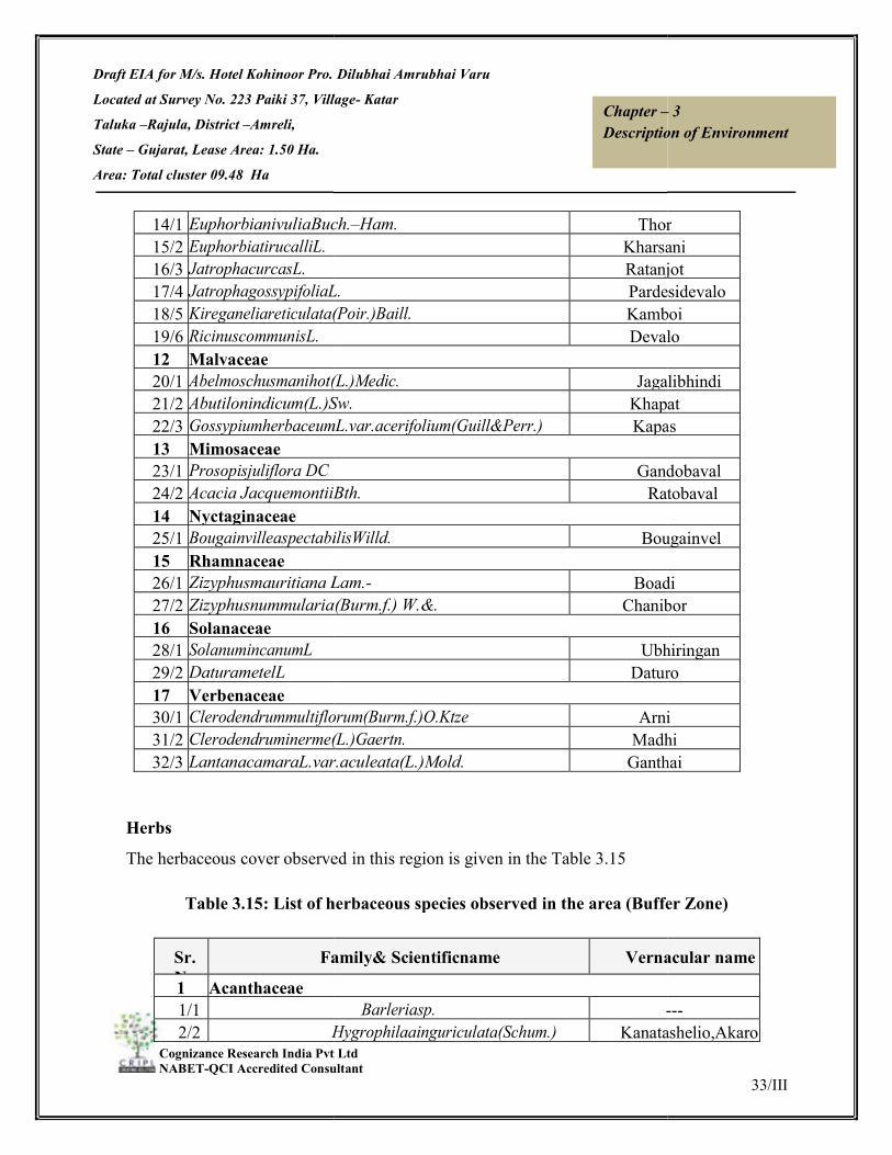
Draft EIA for M/s. Hotel Kohinoor Pro. Dilubhai Amrubhai Varu
Located at Survey No. 223 Paiki 37, Village
Taluka –Rajula, District –Amreli,
State – Gujarat, Lease Area: 1.50 Ha.
Area: Total cluster 09.48 Ha
Cognizance Research India Pvt Ltd NABET-QCI Accredited Consultant
14/1 EuphorbianivuliaBuch.15/2 EuphorbiatirucalliL. 16/3 JatrophacurcasL. 17/4 JatrophagossypifoliaL.18/5 Kireganeliareticulata(Poir.)Baill.19/6 RicinuscommunisL. 12 Malvaceae 20/1 Abelmoschusmanihot(L.)Medic.21/2 Abutilonindicum(L.)Sw.22/3 GossypiumherbaceumL.var.acerifolium(Guill13 Mimosaceae 23/1 Prosopisjuliflora DC 24/2 Acacia JacquemontiiBth.14 Nyctaginaceae 25/1 BougainvilleaspectabilisWilld.15 Rhamnaceae 26/1 Zizyphusmauritiana Lam.27/2 Zizyphusnummularia(Burm.f.)16 Solanaceae 28/1 SolanumincanumL 29/2 DaturametelL 17 Verbenaceae 30/1 Clerodendrummultiflorum(Burm.f.)O.Ktze31/2 Clerodendruminerme(L.)Gaertn.32/3 LantanacamaraL.var.aculeata(L.)Mold.
Herbs
The herbaceous cover observed
Table 3.15: List of herbaceous species observed in the area (Buffer Zone)
Sr. No
Family
1 Acanthaceae 1/1 2/2 Hygrophilaainguriculata
M/s. Hotel Kohinoor Pro. Dilubhai Amrubhai Varu
Survey No. 223 Paiki 37, Village- Katar
Cognizance Research India Pvt Ltd QCI Accredited Consultant
Chapter –Description of Environment
Buch.–Ham. Thor Kharsani
RatanjotJatrophagossypifoliaL. PardesidevaloKireganeliareticulata(Poir.)Baill. Kamboi
Devalo
(L.)Medic. JagalibhindiSw. Khapat
GossypiumherbaceumL.var.acerifolium(Guill&Perr.) Kapas
GandoJacquemontiiBth. Ratobaval
BougainvilleaspectabilisWilld. Bougainvel
Lam.- BoadiZizyphusnummularia(Burm.f.) W.&. Chanibor
UbhiringanDaturo
Clerodendrummultiflorum(Burm.f.)O.Ktze ArniClerodendruminerme(L.)Gaertn. MadhiLantanacamaraL.var.aculeata(L.)Mold. Ganthai
The herbaceous cover observed in this region is given in the Table 3.15
: List of herbaceous species observed in the area (Buffer Zone)
Family& Scientificname Vernacular
Barleriasp. ---Hygrophilaainguriculata(Schum.) Kanatashelio,Akaro
33/III
– 3 Description of Environment
Thor Kharsani Ratanjot Pardesidevalo Kamboi Devalo
Jagalibhindi Khapat Kapas
Gandobaval Ratobaval
Bougainvel
Boadi Chanibor
Ubhiringan Daturo
Arni Madhi
Ganthai
: List of herbaceous species observed in the area (Buffer Zone)
Vernacular name
--- Kanatashelio,Akaro

Draft EIA for M/s. Hotel Kohinoor Pro. Dilubhai Amrubhai Varu
Located at Survey No. 223 Paiki 37, Village
Taluka –Rajula, District –Amreli,
State – Gujarat, Lease Area: 1.50 Ha.
Area: Total cluster 09.48 Ha
Cognizance Research India Pvt Ltd NABET-QCI Accredited Consultant
2 Aizoaceae 3/1 TrianthemaportulacastrumL.4/2 SesuviumportulacastrumL.5/3 SesuviumsesuvioidesVerdc.3 Araceae 6/1 PistiastratiotesL. 7/2 LagenandraovateL.Thaw4 Asteraceae 8/1 EchinopsechinatusRoxb9/2 BlumeaerianthaDC.
10/3 TridaxprocumbensL11/4 XanthiumindicumKoen5 Boraginaceae
12/1 TrichodesmaindicumR.6 Cactaceae
13/1 OpuntiaelatiorMill.7 Chenopodiaceae
14/1 AtriplexstocksiiBoiss.15/2 SalicorniabrachiataRoxb.16/3 SuaedafruticosaForsk16/4 SuaedanudifloraMoq17/5 CressacreticaL. 18/6 ConvolvulusarvensisL.19/7 ConvolvulusprostratesForssk.8 Cyperaceae
20/1 Cyperussps. 21/2 Fimbristylissps. 9 Fabaceae(Papilionaceae)
22/1 Cajanuscajan(L) 23/2 CrotalariaburhiaBach.10 Liliaceae 24/1 AloebarbadensisMill.11 Najadaceae 25/1 Potamogetonspp. 12 Nyctaginaceae 26/1 BoerhaviadiffusaL.
M/s. Hotel Kohinoor Pro. Dilubhai Amrubhai Varu
Survey No. 223 Paiki 37, Village- Katar
Cognizance Research India Pvt Ltd QCI Accredited Consultant
Chapter –Description of Environment
TrianthemaportulacastrumL. SesuviumportulacastrumL. SesuviumsesuvioidesVerdc.
L.Thaw
EchinopsechinatusRoxb ShulioBlumeaerianthaDC. Kalhar
L PardesiBhangroindicumKoen
indicumR.Br. UndhaFuli
OpuntiaelatiorMill. Thor
Boiss. KhatiPalakhSalicorniabrachiataRoxb. SuaedafruticosaForsk HhariLuniniBhaji
Moq MorasPalio,Rudanti
ConvolvulusarvensisL. ConvolvulusprostratesForssk.
Fabaceae(Papilionaceae) Tuvar
CrotalariaburhiaBach.–Ham. Kharshan
barbadensisMill. Kunvarpato
BoerhaviadiffusaL.
34/III
– 3 Description of Environment
- - -
- -
Shulio Kalhar
PardesiBhangro
UndhaFuli
Thor
KhatiPalakh
HhariLuniniBhaji Moras Palio,Rudanti
- -
Tuvar Kharshan
Kunvarpato
-
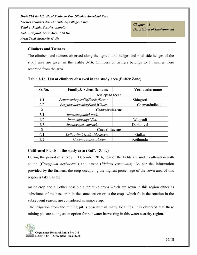
Draft EIA for M/s. Hotel Kohinoor Pro. Dilubhai Amrubhai Varu
Located at Survey No. 223 Paiki 37, Village
Taluka –Rajula, District –Amreli,
State – Gujarat, Lease Area: 1.50 Ha.
Area: Total cluster 09.48 Ha
Cognizance Research India Pvt Ltd NABET-QCI Accredited Consultant
Climbers and Twiners
The climbers and twiners observed along the agricultural hedges and road side hedges of the
study area are given in the
recorded from the area
Table 3-16: List of climbers observed in the study
Sr.No. Family1
1/1 Pentatropisspiralis(Forsk.)2/2 Pergulariadaemia(Forsl.)2
3/1 IpomeaaquaticForsk.4/2 Ipomeapestigridis5/3 Ipomoeapes3
6/1 Luffacylindrica(L.)M.J.Roem7/2 Cucumis
Cultivated Plants in the study area (Buffer Zone) During the period of survey in December 2016, few of the fields are under
cotton (Gossypium herbaceum
provided by the farmers, the crop occupying the highest percentage of the sown area of this
region is taken as the
major crop and all other possible alterna
substitutes of the base crop in the same season or as the crops which fit in the rotation in the
subsequent season, are considered as minor crop.
The irrigation from the mining pit is observed in many loc
mining pits are acting as an option for rainwater harvesting in this water scarcity region.
M/s. Hotel Kohinoor Pro. Dilubhai Amrubhai Varu
Survey No. 223 Paiki 37, Village- Katar
Cognizance Research India Pvt Ltd QCI Accredited Consultant
Chapter –Description of Environment
The climbers and twiners observed along the agricultural hedges and road side hedges of the
study area are given in the Table 3-16. Climbers or twiners belongs to 3 families were
: List of climbers observed in the study area (Buffer Zone)
Family& Scientific name VernacularnameAsclepiadaceae
Pentatropisspiralis(Forsk.)Decne Shingroti Pergulariadaemia(Forsl.)Chiov. Chamardudheli
Convolvulaceae IpomeaaquaticForsk. IpomeapestigridisL Wagpadi Ipomoeapes-capraeL. Darianivel
Cucurbitaceae Luffacylindrica(L.)M.J.Roem Galku
CucumiscallosusCogn Kothimdu
Cultivated Plants in the study area (Buffer Zone) During the period of survey in December 2016, few of the fields are under
Gossypium herbaceum) and castor (Ricinus communis). As per the information
provided by the farmers, the crop occupying the highest percentage of the sown area of this
major crop and all other possible alternative crops which are sown in this region either as
substitutes of the base crop in the same season or as the crops which fit in the rotation in the
subsequent season, are considered as minor crop.
The irrigation from the mining pit is observed in many localities. It is observed that these
mining pits are acting as an option for rainwater harvesting in this water scarcity region.
35/III
– 3 Description of Environment
The climbers and twiners observed along the agricultural hedges and road side hedges of the
. Climbers or twiners belongs to 3 families were
Vernacularname
Chamardudheli
Darianivel
Kothimdu
During the period of survey in December 2016, few of the fields are under cultivation with
). As per the information
provided by the farmers, the crop occupying the highest percentage of the sown area of this
tive crops which are sown in this region either as
substitutes of the base crop in the same season or as the crops which fit in the rotation in the
alities. It is observed that these
mining pits are acting as an option for rainwater harvesting in this water scarcity region.

Draft EIA for M/s. Hotel Kohinoor Pro. Dilubhai Amrubhai Varu
Located at Survey No. 223 Paiki 37, Village
Taluka –Rajula, District –Amreli,
State – Gujarat, Lease Area: 1.50 Ha.
Area: Total cluster 09.48 Ha
Cognizance Research India Pvt Ltd NABET-QCI Accredited Consultant
Major Crops: Major crops in the study area during winter season are Cotton (
Castor (Ricinus communis) and during monsoon period, Ground nut (
Bajra (Pennisetum typhoides), and Jowar(Sorghum bicolor) are cultivated as major crops.
Minor crops Minor crops practiced in this region during monsoon are Jeera/Jeeru (
Ground nut (Arachis hypogaea
(Triticum aestivum), Jeera (Cuminum cyminum L
Pulses The pulses cultivated in this region are Tuver (
Horticulture Practices and Fruits Grown: Mango (Mangifera indica) and Chikko (
villages in the study area.
Rare and Endangered Flora in the study area (Buffer Zone) The IUCN Red List is the world's most com
status of plant and animal species. It uses a set of criteria to evaluate the extinction risk of
thousands of species and subspecies. These criteria are relevant to all species and all regions
of the world. With its strong scientific base, the IUCN Red List is recognized as the most
authoritative guide to the status of biological diversity. Out of 17000 species of higher plants
known to occur in India, nearly 614 higher plant species were evaluated by IUCN. Am
them 247 species are under threatened category (IUCN, 2007).
Among the enumerated flora in the study area, no rare and endangered flora was observed.
Endemic Plants of the study area (buffer Zone) De Candolle (1855) first used the concept of “Endemi
taxonomic unit, especially a species which has a restricted distribution or habitat, isolated
from its surrounding region through geographical, ecological or temporal barriers.
M/s. Hotel Kohinoor Pro. Dilubhai Amrubhai Varu
Survey No. 223 Paiki 37, Village- Katar
Cognizance Research India Pvt Ltd QCI Accredited Consultant
Chapter –Description of Environment
Major crops in the study area during winter season are Cotton (Gossypium herbaceum
) and during monsoon period, Ground nut (Arachis hypogaea
), and Jowar(Sorghum bicolor) are cultivated as major crops.
Minor crops practiced in this region during monsoon are Jeera/Jeeru (Cuminum cyminum
Arachis hypogaea).Minor crops practiced in this region during winter are Wheat
Cuminum cyminum L) and Til (Sesamum indicum).
The pulses cultivated in this region are Tuver (Cajanus cajan) and Mug (Vigna radiate
Horticulture Practices and Fruits Grown: ) and Chikko (Manilkara zapota) plantation observed in few
Rare and Endangered Flora in the study area (Buffer Zone) The IUCN Red List is the world's most comprehensive inventory of the global conservation
status of plant and animal species. It uses a set of criteria to evaluate the extinction risk of
thousands of species and subspecies. These criteria are relevant to all species and all regions
ith its strong scientific base, the IUCN Red List is recognized as the most
authoritative guide to the status of biological diversity. Out of 17000 species of higher plants
known to occur in India, nearly 614 higher plant species were evaluated by IUCN. Am
them 247 species are under threatened category (IUCN, 2007).
Among the enumerated flora in the study area, no rare and endangered flora was observed.
Endemic Plants of the study area (buffer Zone) De Candolle (1855) first used the concept of “Endemic”, which is defined as an area of a
taxonomic unit, especially a species which has a restricted distribution or habitat, isolated
from its surrounding region through geographical, ecological or temporal barriers.
36/III
– 3 Description of Environment
Gossypium herbaceum), and
Arachis hypogaea),
), and Jowar(Sorghum bicolor) are cultivated as major crops.
Cuminum cyminum)and
).Minor crops practiced in this region during winter are Wheat
).
Vigna radiate)
) plantation observed in few
prehensive inventory of the global conservation
status of plant and animal species. It uses a set of criteria to evaluate the extinction risk of
thousands of species and subspecies. These criteria are relevant to all species and all regions
ith its strong scientific base, the IUCN Red List is recognized as the most
authoritative guide to the status of biological diversity. Out of 17000 species of higher plants
known to occur in India, nearly 614 higher plant species were evaluated by IUCN. Among
Among the enumerated flora in the study area, no rare and endangered flora was observed.
c”, which is defined as an area of a
taxonomic unit, especially a species which has a restricted distribution or habitat, isolated
from its surrounding region through geographical, ecological or temporal barriers.

Draft EIA for M/s. Hotel Kohinoor Pro. Dilubhai Amrubhai Varu
Located at Survey No. 223 Paiki 37, Village
Taluka –Rajula, District –Amreli,
State – Gujarat, Lease Area: 1.50 Ha.
Area: Total cluster 09.48 Ha
Cognizance Research India Pvt Ltd NABET-QCI Accredited Consultant
Out of 17000 species of known flowering p
endemic. Nearly 58 genera and 1932 taxa are found to be endemic to peninsular India
(Ahmedulla & Nayar, 1987). None of the documented flora from the study area can be
assigned endemic status.
Faunal Biodiversity of the study area (Buffer Zone) For the documentation of the faunal biodiversity of the study area with respect to birds,
reptiles, amphibians, and butterfly species, a detailed survey had been conducted, within 10
km radius from proposed site in
survey conducted during December 2016.
Avifauna Core Zone Only 5 Species reported from the project site (flying across site) which includes House Crow,
Indian Robin, Brown Shrike, Red
Buffer Zone Systematic account of the birds in the study area with the status of occurre
below table 3.17.
Table 3-17: Systematic lists of birds in the study area with its distribution and migratory status
Old Common name
I.ORDER:ANSERIFORMESMallard CommonTeal
Shoveller Brahminyduck
orRuddyshield duck
Spotbill CommonPochard
M/s. Hotel Kohinoor Pro. Dilubhai Amrubhai Varu
Survey No. 223 Paiki 37, Village- Katar
Cognizance Research India Pvt Ltd QCI Accredited Consultant
Chapter –Description of Environment
Out of 17000 species of known flowering plants of India nearly 5000 species are said to be
endemic. Nearly 58 genera and 1932 taxa are found to be endemic to peninsular India
(Ahmedulla & Nayar, 1987). None of the documented flora from the study area can be
ersity of the study area (Buffer Zone) For the documentation of the faunal biodiversity of the study area with respect to birds,
reptiles, amphibians, and butterfly species, a detailed survey had been conducted, within 10
km radius from proposed site in Katar Village, in Amreli District. This data is based on the
survey conducted during December 2016.
Only 5 Species reported from the project site (flying across site) which includes House Crow,
Indian Robin, Brown Shrike, Red-wattled lapwing and Cattle Egret.
Systematic account of the birds in the study area with the status of occurrence is given in the
: Systematic lists of birds in the study area with its distribution and migratory
New Common Name
Scientific Name Status
I.ORDER:ANSERIFORMES Mallard Anas RWCommonTeal Anas crecca W
NorthernShoveller Anas clypeata WRuddyShelduck Tadorna
ferruginea rW
Spot-billed Duck Anas RCommonPochard Aythya ferina W
II.ORDER:APODIFORMES
37/III
– 3 Description of Environment
lants of India nearly 5000 species are said to be
endemic. Nearly 58 genera and 1932 taxa are found to be endemic to peninsular India
(Ahmedulla & Nayar, 1987). None of the documented flora from the study area can be
For the documentation of the faunal biodiversity of the study area with respect to birds,
reptiles, amphibians, and butterfly species, a detailed survey had been conducted, within 10
Village, in Amreli District. This data is based on the
Only 5 Species reported from the project site (flying across site) which includes House Crow,
nce is given in the
: Systematic lists of birds in the study area with its distribution and migratory
Status
Schedule
RW IV W IV W IV rW IV
R IV W IV

Draft EIA for M/s. Hotel Kohinoor Pro. Dilubhai Amrubhai Varu
Located at Survey No. 223 Paiki 37, Village
Taluka –Rajula, District –Amreli,
State – Gujarat, Lease Area: 1.50 Ha.
Area: Total cluster 09.48 Ha
Cognizance Research India Pvt Ltd NABET-QCI Accredited Consultant
Family:Apodidae (swifts)CommonSwift
House swift
Family:Accipitridae(vulture,Sparrowhawk,Eagle,Harrier,KiteShikra
Black-winged IVORDER:CICONIIFORMES
Darter orSnake
Pond Heron CattleEgret
MedianorSmallerELittle Egret
IndianReef Heron Family:Charadriidae(Plover,Stilt,Oystercatcher,Lapwing,Avo
Black-winged Red-wattled
Family:Ciconiidae (Openbill,stork,Adjutant)Openbillstork Painted Stork
Family:Laridae(Tern,Gull,Jaeger,SkuaOldCommonnam
Little Tern River Tern
Little Cormorant IndianShag
Flamingo Family:Podicipedidae(Grebe)
Little Grebe
IndianSandgrouse Family:Threskiornithidae
BlackIbis WhiteIbis
Spoonbill
M/s. Hotel Kohinoor Pro. Dilubhai Amrubhai Varu
Survey No. 223 Paiki 37, Village- Katar
Cognizance Research India Pvt Ltd QCI Accredited Consultant
Chapter –Description of Environment
Family:Apodidae (swifts) CommonSwift Apus apus R
Little Swift Apus affinis RIII.ORDER :FALCONIFORMES
Family:Accipitridae(vulture,Sparrowhawk,Eagle,Harrier,KiteandShikra Accipiter badius R
Black-winged Elanus RIVORDER:CICONIIFORMES
Family:Anhingidae Oriental Darter Anhingamelanogas R
Family:Ardeidae(heron,Egret,Bittern) IndianPond-Heron Ardeola grayii R
CattleEgret Bubulcus ibis RIntermediateEgret Mesophoyx R
Little Egret Egretta garzetta RWesternReef- Egretta gularis R
Family:Charadriidae(Plover,Stilt,Oystercatcher,Lapwing,AvoBlack-winged Himantopus RRed-wattled Vanellus indicus R
Family:Ciconiidae (Openbill,stork,Adjutant) AsianOpen bill Anastomus R
Painted Stork Mycteria RFamily:Laridae(Tern,Gull,Jaeger,Skua ,Skimmer
New Scientific Name StatuLittle Tern Sterna albifrons RRiver Tern Sterna aurantia R
Family:Phalacrocoracidae(Cormorant) Little Cormorant Phalacrocorax RIndianCormorant Phalacrocorax R
Family:Phoenicopteridae(Flamingo) Greater Flamingo Phoenicopterus rW
Family:Podicipedidae(Grebe) Little Grebe Tachybaptus RFamily:Pteroclidae (Sandgrouse)
Chestnut- Pterocles exustus RFamily:Threskiornithidae(Spoonbill and Ibis)
Red-naped Ibis Pseudibis RAnastomus
oscitans Threskiornismel
anocephalus R
EurasianSpoonbill Platalea RW
38/III
– 3 Description of Environment
R IV R IV
and R IV R IV
R IV
R IV R IV R IV R IV R IV
Family:Charadriidae(Plover,Stilt,Oystercatcher,Lapwing,Avo R IV R IV
R IV R IV
Statu Schedul
R IV R IV
R IV R IV
rW IV
R IV
R IV
R IV R IV
RW IV

Draft EIA for M/s. Hotel Kohinoor Pro. Dilubhai Amrubhai Varu
Located at Survey No. 223 Paiki 37, Village
Taluka –Rajula, District –Amreli,
State – Gujarat, Lease Area: 1.50 Ha.
Area: Total cluster 09.48 Ha
Cognizance Research India Pvt Ltd NABET-QCI Accredited Consultant
V ORDER:COLUMBIFORMES
BlueRock Pigeon Ring Dove
Rufous Turtle VI : ORDER:CORACIFORMES
SmallBlue
Pied Kingfisher
WhitebreastedKingfFamily:Coraciidae (Roller)
BlueJay orRoller
Chestnut-headed ChestnutBlue-cheeked Bee-
VII.ORDER:GRUIFORMES
Coot IndianMoorhen
CommonCrane DemoiselleCrane
Crow-
Koel Butterflies in the study area: Butterflies in the study area are very few restricted distribution. Butterflies observed during
the present study are documented in the
Table 3.18: List of Butterflies in the study area (Buffer Zone)
Sr. No Scientific1
1/1 2
M/s. Hotel Kohinoor Pro. Dilubhai Amrubhai Varu
Survey No. 223 Paiki 37, Village- Katar
Cognizance Research India Pvt Ltd QCI Accredited Consultant
Chapter –Description of Environment
ORDER:COLUMBIFORMES Family:Columbidae(Pigeon, Dove) RockPigeon Columbalivia R
Eurasian Collared- Streptopelia ROriental Turtle- Streptopelia R
ORDER:CORACIFORMES Family:Alcedinidae(Kingfisher)
CommonKingfishe Alcedoatthis RFamily:Cerylidae
Pied Kingfisher Cerylerudis RFamily:Dacelonidae(Kingfishers)
White-throated Halcyon RFamily:Coraciidae (Roller)
IndianRoller Coracias RFamily:Meropidae(BeeEater)
Chestnut-headed Bee- Merops RBlue-cheeked Bee- Merops persicus R
VII.ORDER:GRUIFORMES Family:Rallidae ( Waterhen,
CommonCoot Fulica atra RCommonMoorhen Gallinula R
Family:Gruidae CommonCrane Grus grus R
DemoiselleCrane Grus virgo RVIII.ORDER:CUCULIFORMES Family:Centropodidae (Cocucal)
Greater Coucal Centropus RFamily:Cuculidae(cuckoo,Koel)
AsianKoel Eudynamys RButterflies in the study area: Butterflies in the study area are very few restricted distribution. Butterflies observed during
the present study are documented in the Table 3.18.
: List of Butterflies in the study area (Buffer Zone)
Scientificname & family CommonnameFamily:Papilionidae
Papiliopolytes CommonFamily:Pieridae
39/III
– 3 Description of Environment
R IV R IV R IV
R IV
R IV
R IV
R IV
R IV R IV
R IV R IV
R IV R IV
R IV
R IV
Butterflies in the study area are very few restricted distribution. Butterflies observed during
Commonname
CommonMormon

Draft EIA for M/s. Hotel Kohinoor Pro. Dilubhai Amrubhai Varu
Located at Survey No. 223 Paiki 37, Village
Taluka –Rajula, District –Amreli,
State – Gujarat, Lease Area: 1.50 Ha.
Area: Total cluster 09.48 Ha
Cognizance Research India Pvt Ltd NABET-QCI Accredited Consultant
2/1 3/2 IxiasMarianne3
4/1 5/2 6/3 7/4 Mycalesisperseus
Core Zone
There is no herpe to fauna observed
Buffer Zone
Table
Sr.No CommonName
1 Commongardenlizar2 OilveRidelyTurtle3 HouseGecko4 Fan-5 IndianCobra6 Russell’s Viper 7 CommonIndianKrait
Not sighted included Based on the information provided by the villagers during the interaction
with them with the help of pictorial representation (Secondary information)
Mammals Core Zone There were no mammals observed at site during site visit but as per interaction with local
people and proponent Lion, Leopard and Nilgai were sometimes observed near the area at
times. A study on the ecological aspect of the area with special em
M/s. Hotel Kohinoor Pro. Dilubhai Amrubhai Varu
Survey No. 223 Paiki 37, Village- Katar
Cognizance Research India Pvt Ltd QCI Accredited Consultant
Chapter –Description of Environment
Euremahecabe CommonGrassyellowIxiasMarianne White
Family:Nymphalidae Danauschrysippus PlainTiger
DanausgenutiaCramer StrippedTigerHypolimanasmisippus Danaidegg
Mycalesisperseus Common
herpe to fauna observed in the core zone.
Table 3.19: List of Reptiles in the study area
CommonName Scientificname
gardenlizar Calotesversicolor(Daudin) OilveRidelyTurtle Lepidochelysolivacea
HouseGecko Hemidactylusflaviviridis(RuppeSitanaponticeriana(Cuvier)
Cobra Najanaja(Linn.) Russell’s Viper Daboiarusselii(ShawandNodder
IndianKrait Bungaruscaeruleus(Schneider)
Not sighted included Based on the information provided by the villagers during the interaction
with them with the help of pictorial representation (Secondary information)
There were no mammals observed at site during site visit but as per interaction with local
people and proponent Lion, Leopard and Nilgai were sometimes observed near the area at
times. A study on the ecological aspect of the area with special emphasis on the wildlife of the
40/III
– 3 Description of Environment
Grassyellow Whiteorangetip
PlainTiger StrippedTiger Danaideggfly
bushbrown
Schedule
- I - - II II IV
Not sighted included Based on the information provided by the villagers during the interaction
There were no mammals observed at site during site visit but as per interaction with local
people and proponent Lion, Leopard and Nilgai were sometimes observed near the area at
phasis on the wildlife of the

Draft EIA for M/s. Hotel Kohinoor Pro. Dilubhai Amrubhai Varu
Located at Survey No. 223 Paiki 37, Village
Taluka –Rajula, District –Amreli,
State – Gujarat, Lease Area: 1.50 Ha.
Area: Total cluster 09.48 Ha
Cognizance Research India Pvt Ltd NABET-QCI Accredited Consultant
area was carried out by the Wildlife Institute of India(WII), Dehradun indicates that though
the the Lions are frequent visitors in and around the study area, but are not permanent
resident.
Buffer Zone
Table 3-
Sr.N
CommonName
1 FivestripedPalm2 Lion 3 Leopard 4 CommonMongoose5 Nilgai 6 Hare 7 Jackal 8 TheIndianWildBoar
Not sighted included Based on the information provided by the villagers during the interaction
with them with the help of pictorial representation (Secondary information)
Status of the Forest and their category in the study area (Buffer Zone) Mangrove patches along the Jafrabad creek were observed in theinter tidal area of the sea
shore.
The intertidal Zone Habitat in th
Costal Marine Eco system: The presence beaches, sand bars, few mudflats and, mangroves area characterize the intertidal
region of the study area.
Seacoast
M/s. Hotel Kohinoor Pro. Dilubhai Amrubhai Varu
Survey No. 223 Paiki 37, Village- Katar
Cognizance Research India Pvt Ltd QCI Accredited Consultant
Chapter –Description of Environment
area was carried out by the Wildlife Institute of India(WII), Dehradun indicates that though
the the Lions are frequent visitors in and around the study area, but are not permanent
-20: List of Mammals in the Buffer Zone
CommonName Scientificname
Palmsquirrel Funambuluspennanti(WroughtoPantheraleo
Pantherapardus Mongoose Herpestesedwardsi(Geoffroy) Boselaphustragocamelus
Lepusnigricollis Canisaureus(Linnaeus) WildBoar SusscrofaLinnaeus
Not sighted included Based on the information provided by the villagers during the interaction
of pictorial representation (Secondary information)
Status of the Forest and their category in the study area (Buffer Zone) Mangrove patches along the Jafrabad creek were observed in theinter tidal area of the sea
The intertidal Zone Habitat in the study area (Buffer Zone)
The presence beaches, sand bars, few mudflats and, mangroves area characterize the intertidal
41/III
– 3 Description of Environment
area was carried out by the Wildlife Institute of India(WII), Dehradun indicates that though
the the Lions are frequent visitors in and around the study area, but are not permanent
Schedule
IV I I
IV III IV IV III
Not sighted included Based on the information provided by the villagers during the interaction
Mangrove patches along the Jafrabad creek were observed in theinter tidal area of the sea
The presence beaches, sand bars, few mudflats and, mangroves area characterize the intertidal
Draft EIA for M/s. Hotel Kohinoor Pro. Dilubhai Amrubhai Varu
Located at Survey No. 223 Paiki 37, Village
Taluka –Rajula, District –Amreli,
State – Gujarat, Lease Area: 1.50 Ha.
Area: Total cluster 09.48 Ha
Cognizance Research India Pvt Ltd NABET-QCI Accredited Consultant
Sea coast in the study area is characterized by shore/cliff with isol
pools of intertidal water. Very few Mangrove strands of Avecenia alba observed along the
intertidal zone of the sea coast. The striking feature of the distribution of these mangrove
communities was that they were localized only in sc
some intertidal pools where there is the muddy deposition had been occurred. They were
completely absent in the sandy area.
region of the sea shore.
Saltpan along the fringes of Jafrabad Creek Saltpan along the fringe of Jafrabad creek attracts large population of birds including
flamingos, Avocet, Spoonbill, Large Egret, reef heron etc.
3.8 SOCIO-ECONOMIC ENVIRONMENT In this section of the report a
the proposed Black Trap Mining Projects
Amreli, State – Gujarat.The various attributes that have been taken into account are
population composition, employment generation, occupational shift,
consumption pattern, ethnic issue and law & order problem. The key objective of the study is
to assess possible impact of the
neighborhood known as study area.
The objectives of the socio-economic impact assessment are as follows:
a) To collect baseline data of the study area.
b) To know the socio-economic status of the people living in the study area
mining project.
c) To assess the possible impact of the project on socio
d) To measure the impact of the project on Quality of life of the people in the
APPROACH & METHODOLOGY
M/s. Hotel Kohinoor Pro. Dilubhai Amrubhai Varu
Survey No. 223 Paiki 37, Village- Katar
Cognizance Research India Pvt Ltd QCI Accredited Consultant
Chapter –Description of Environment
Sea coast in the study area is characterized by shore/cliff with isolated muddy patches and
pools of intertidal water. Very few Mangrove strands of Avecenia alba observed along the
intertidal zone of the sea coast. The striking feature of the distribution of these mangrove
communities was that they were localized only in scattered pocket of muddy deposition and
some intertidal pools where there is the muddy deposition had been occurred. They were
completely absent in the sandy area. Few mud skippers were also observed in the muddy
Saltpan along the fringes of Jafrabad Creek Saltpan along the fringe of Jafrabad creek attracts large population of birds including
flamingos, Avocet, Spoonbill, Large Egret, reef heron etc.
ECONOMIC ENVIRONMENT In this section of the report an attempt has been made to measure socio-economic
Mining Projects located at Village- Katar, Taluka –Rajula
The various attributes that have been taken into account are
composition, employment generation, occupational shift, household income,
consumption pattern, ethnic issue and law & order problem. The key objective of the study is
to assess possible impact of the project on socio-economic life of the people in the
study area.
economic impact assessment are as follows:
a) To collect baseline data of the study area.
economic status of the people living in the study area
c) To assess the possible impact of the project on socio-economic aspects in the study area.
d) To measure the impact of the project on Quality of life of the people in the
APPROACH & METHODOLOGY
42/III
– 3 Description of Environment
ated muddy patches and
pools of intertidal water. Very few Mangrove strands of Avecenia alba observed along the
intertidal zone of the sea coast. The striking feature of the distribution of these mangrove
attered pocket of muddy deposition and
some intertidal pools where there is the muddy deposition had been occurred. They were
Few mud skippers were also observed in the muddy
Saltpan along the fringe of Jafrabad creek attracts large population of birds including
economic impact of
Rajula, District –
The various attributes that have been taken into account are
household income,
consumption pattern, ethnic issue and law & order problem. The key objective of the study is
economic life of the people in the
economic status of the people living in the study area of the proposed
the study area.
d) To measure the impact of the project on Quality of life of the people in the study area.

Draft EIA for M/s. Hotel Kohinoor Pro. Dilubhai Amrubhai Varu
Located at Survey No. 223 Paiki 37, Village
Taluka –Rajula, District –Amreli,
State – Gujarat, Lease Area: 1.50 Ha.
Area: Total cluster 09.48 Ha
Cognizance Research India Pvt Ltd NABET-QCI Accredited Consultant
a) A mixture of both quantitative and qualitativ
socio-economic study.
b) The study has been conducted based on primary and secondary data.
has been collected through a sample survey of
secondary data has been collected from the administrative re
Gujarat, Census 2011, district hand
c) The details regarding population composition, number of literates,
collected from secondary sources and analyzed.
amenities available in the study area have been collected from secondary sources like
Census2011, and analyzed.
d) Two stage sampling design has been adopted to se
units are census villages in the rural areas and
units are households in the selected villages and towns/cities. Probability sampling has been
adopted to select the sampling units.
e) Estimation of various parameters has been made based on sample data and bottom top
approach has been adopted.
f) On the basis of a preliminary reconnaissance survey, two questionnaires were developed to
make it suitable to fulfill the obje
ended and close ended questions
g) The data collected during the above survey was analyzed to evaluate the
economic profile of the area.
h) Based on the above data, impacts due
assessed and recommendations for improvement
POSSIBLE IMPACT ASSESSMENT
Impact on population composition
M/s. Hotel Kohinoor Pro. Dilubhai Amrubhai Varu
Survey No. 223 Paiki 37, Village- Katar
Cognizance Research India Pvt Ltd QCI Accredited Consultant
Chapter –Description of Environment
a) A mixture of both quantitative and qualitative approach has been adopted
b) The study has been conducted based on primary and secondary data. While primary data
has been collected through a sample survey of selected households in the study area, the
collected from the administrative records of the Government of
, Census 2011, district hand books and from the Gujarat Government portal.
c) The details regarding population composition, number of literates, workers, etc have been
collected from secondary sources and analyzed. Also village/city/town wise details regarding
study area have been collected from secondary sources like
d) Two stage sampling design has been adopted to select the sampling units. The first stage
units are census villages in the rural areas and towns/cities in urban areas. The ultimate stage
the selected villages and towns/cities. Probability sampling has been
mpling units.
e) Estimation of various parameters has been made based on sample data and bottom top
f) On the basis of a preliminary reconnaissance survey, two questionnaires were developed to
make it suitable to fulfill the objectives of the study. The questionnaires contained both open
questions
g) The data collected during the above survey was analyzed to evaluate the
h) Based on the above data, impacts due to mining operation on the community have been
assessed and recommendations for improvement have been made.
POSSIBLE IMPACT ASSESSMENT
Impact on population composition
43/III
– 3 Description of Environment
e approach has been adopted in the current
While primary data
selected households in the study area, the
cords of the Government of
Government portal.
workers, etc have been
Also village/city/town wise details regarding
study area have been collected from secondary sources like
units. The first stage
towns/cities in urban areas. The ultimate stage
the selected villages and towns/cities. Probability sampling has been
e) Estimation of various parameters has been made based on sample data and bottom top
f) On the basis of a preliminary reconnaissance survey, two questionnaires were developed to
The questionnaires contained both open
prevailing socio-
to mining operation on the community have been

Draft EIA for M/s. Hotel Kohinoor Pro. Dilubhai Amrubhai Varu
Located at Survey No. 223 Paiki 37, Village
Taluka –Rajula, District –Amreli,
State – Gujarat, Lease Area: 1.50 Ha.
Area: Total cluster 09.48 Ha
Cognizance Research India Pvt Ltd NABET-QCI Accredited Consultant
The impact of the proposed mining project on population composition will
only few skilled and managerial staff will be recruited from outside and the rest will be
recruited locally. The impact will be significant if a large number of people from outside get
employed in the proposed project.
In that case not only the population
may make permanent social effects like rise in exploitation of women, higher crime rate,
increase in sexual diseases and depression among youth.
Impact on employment generationThe proposed Cluster of Black Trap
Rajula, District –Amreli, State
to 35 workers. It is understood that all the persons to be deployed for various mining activities
will be recruited locally and there is very little scope for migration of people from outside the
study area. The employment potentiality of the project is expected to ameliorate the economic
condition of the families of those persons who will get employed
project. However, the mining project will provide seasonal employment.
Impact on Health Extraction of “Minor Mineral (Black Trap
and stone crushing. The effects will vary depending
silica content in it and the size of the
disease often caused to miners, due to the inhalation of d
also lead to Silicosis, which is
with occupational respiratory ailments, skin allergies etc, but the
exposure is minimized. Further, regular health
any negative impact on their
health is expected if minimum precautions are taken by the miners.
Impact on income
M/s. Hotel Kohinoor Pro. Dilubhai Amrubhai Varu
Survey No. 223 Paiki 37, Village- Katar
Cognizance Research India Pvt Ltd QCI Accredited Consultant
Chapter –Description of Environment
The impact of the proposed mining project on population composition will
only few skilled and managerial staff will be recruited from outside and the rest will be
recruited locally. The impact will be significant if a large number of people from outside get
employed in the proposed project.
In that case not only the population of the study area will go up but also the skewed sex ratio
may make permanent social effects like rise in exploitation of women, higher crime rate,
increase in sexual diseases and depression among youth.
Impact on employment generation
Black Trap Mining Projects Located at Village-
State – Gujarat is expected to provide employment opportunities
. It is understood that all the persons to be deployed for various mining activities
will be recruited locally and there is very little scope for migration of people from outside the
study area. The employment potentiality of the project is expected to ameliorate the economic
condition of the families of those persons who will get employed in the proposed mining
project. However, the mining project will provide seasonal employment.
tion of “Minor Mineral (Black Trap) poses serious health risks due to dust, quarrying
and stone crushing. The effects will vary depending upon the nature of the dust particles,
silica content in it and the size of the particles. Pneumoconiosis is an occupational lung
miners, due to the inhalation of dust. Silica content in the soil
lead to Silicosis, which is again an occupational lung disease. Miners may
with occupational respiratory ailments, skin allergies etc, but the same are preventable if
exposure is minimized. Further, regular health check-up of the miners is required to prevent
e impact on their health. In the present mining project, no adverse impact on
expected if minimum precautions are taken by the miners.
44/III
– 3 Description of Environment
The impact of the proposed mining project on population composition will be marginal as
only few skilled and managerial staff will be recruited from outside and the rest will be
recruited locally. The impact will be significant if a large number of people from outside get
of the study area will go up but also the skewed sex ratio
may make permanent social effects like rise in exploitation of women, higher crime rate,
Katar, Taluka –
is expected to provide employment opportunities
. It is understood that all the persons to be deployed for various mining activities
will be recruited locally and there is very little scope for migration of people from outside the
study area. The employment potentiality of the project is expected to ameliorate the economic
in the proposed mining
) poses serious health risks due to dust, quarrying
upon the nature of the dust particles,
particles. Pneumoconiosis is an occupational lung
ust. Silica content in the soil may
again an occupational lung disease. Miners may also suffer
same are preventable if
up of the miners is required to prevent
health. In the present mining project, no adverse impact on

Draft EIA for M/s. Hotel Kohinoor Pro. Dilubhai Amrubhai Varu
Located at Survey No. 223 Paiki 37, Village
Taluka –Rajula, District –Amreli,
State – Gujarat, Lease Area: 1.50 Ha.
Area: Total cluster 09.48 Ha
Cognizance Research India Pvt Ltd NABET-QCI Accredited Consultant
In India poverty is widespread. The proportion of population living below the poverty line in
Gujarat fell from 32.5% in 2004
35.9% in 2011-12 in Gujarat and from 60% to 43% in India over the same period
The proposed mining project at
109 workers for a period of 260
Government of Gujarat each unskilled worker is eligible to get a minimum basic wage of Rs.
150 per day. In addition they will ge
amount an unskilled worker is expected to get is Rs 200 per day. The impact of the proposed
mining activity on household income in the study area is thus positive since
employment to local people, which will result to an increase in
workers who will be recruited for mining
a period of 260 days in a year.
Impact on consumption patternThe field survey has revealed that people in the study are poverty ridden.
income may change the consumption pattern of few
power but majority of the people will
Impact on road developmentMovement of trucks/tripper and other vehicles to and fro the quarry is
substantially, when mining will start. The existing
national and state highways are
Hence, there is ample scope for road
Impact on law & Order As local people will be employed to run the quarry, no law & order problem
expected that the workers will
homes after the day’s work is over. There
M/s. Hotel Kohinoor Pro. Dilubhai Amrubhai Varu
Survey No. 223 Paiki 37, Village- Katar
Cognizance Research India Pvt Ltd QCI Accredited Consultant
Chapter –Description of Environment
In India poverty is widespread. The proportion of population living below the poverty line in
Gujarat fell from 32.5% in 2004-05 to 17% in 2011-12. It fell from 54.7% in 2004
12 in Gujarat and from 60% to 43% in India over the same period
proposed mining project at Katar villages is expected to provide casual employment to
period of 260 days in a year. According to Department of labour,
each unskilled worker is eligible to get a minimum basic wage of Rs.
150 per day. In addition they will get V.D.A amounting to Rs. 50 per day. Thus the total
amount an unskilled worker is expected to get is Rs 200 per day. The impact of the proposed
mining activity on household income in the study area is thus positive since
people, which will result to an increase in household income of those
workers who will be recruited for mining operation. However, this impact will be effective for
year.
Impact on consumption pattern revealed that people in the study are poverty ridden. Increased household
income may change the consumption pattern of few families due to increased purchasing
power but majority of the people will continue to be burdened with poverty.
lopment Movement of trucks/tripper and other vehicles to and fro the quarry is expected to increase
substantially, when mining will start. The existing roads connecting the quarry with the
national and state highways are good. Lessee will maintain exiting road on regular basis
Hence, there is ample scope for road development in and around the mining areas.
As local people will be employed to run the quarry, no law & order problem is envisaged. It is
expected that the workers will attend to their duties from their residence and return to their
homes after the day’s work is over. There would have been law & order problem if the
45/III
– 3 Description of Environment
In India poverty is widespread. The proportion of population living below the poverty line in
12. It fell from 54.7% in 2004-05 to
12 in Gujarat and from 60% to 43% in India over the same period.
is expected to provide casual employment to
days in a year. According to Department of labour,
each unskilled worker is eligible to get a minimum basic wage of Rs.
t V.D.A amounting to Rs. 50 per day. Thus the total
amount an unskilled worker is expected to get is Rs 200 per day. The impact of the proposed
mining activity on household income in the study area is thus positive since it will provide
household income of those
operation. However, this impact will be effective for
Increased household
families due to increased purchasing
expected to increase
roads connecting the quarry with the
road on regular basis.
development in and around the mining areas.
is envisaged. It is
their residence and return to their
would have been law & order problem if the

Draft EIA for M/s. Hotel Kohinoor Pro. Dilubhai Amrubhai Varu
Located at Survey No. 223 Paiki 37, Village
Taluka –Rajula, District –Amreli,
State – Gujarat, Lease Area: 1.50 Ha.
Area: Total cluster 09.48 Ha
Cognizance Research India Pvt Ltd NABET-QCI Accredited Consultant
workers were migrants and lived in shanties closed to the mining area. However, to meet any
untoward incident one police post may be set up closed to the project area.
SUGGESTIONS
Provision of First Aid at mining siteExtraction of Black trap poses serious health
depending on the nature of the dust particles,
meet any emergency during extraction of the mineral and subsequent loading in
vehicles, provision for First Aid should be made by the project
person is removed to a doctor or health
be provided with First Aid.
M/s. Hotel Kohinoor Pro. Dilubhai Amrubhai Varu
Survey No. 223 Paiki 37, Village- Katar
Cognizance Research India Pvt Ltd QCI Accredited Consultant
Chapter –Description of Environment
lived in shanties closed to the mining area. However, to meet any
nt one police post may be set up closed to the project area.
Provision of First Aid at mining site poses serious health risks due dusting, quarrying. The effects vary
the dust particles, silica content in it and the size of the particle. To
any emergency during extraction of the mineral and subsequent loading in
vehicles, provision for First Aid should be made by the project proponent. Before the affected
ed to a doctor or health institution for necessary medical aid, the miner should
***************
46/III
– 3 Description of Environment
lived in shanties closed to the mining area. However, to meet any
risks due dusting, quarrying. The effects vary
silica content in it and the size of the particle. To
any emergency during extraction of the mineral and subsequent loading in the transport
proponent. Before the affected
institution for necessary medical aid, the miner should

Draft EIA for M/s. Hotel Kohinoor Pro. Dilubhai Amrubhai Varu
Located at Survey No. 223 Paiki 37, Village- Katar
Taluka –Rajula, District –Amreli,
State – Gujarat, Lease Area: 1.50 Ha.
Area: Total cluster 09.48 Ha
1/IV
Chapter – 4
Anticipated Environmental Impact
and Mitigation Measures
CHAPTER-IV
ANTICIPATED ENVIRONMENTAL IMPACT AND MITIGATION MEASURES
4.0 GENERAL 2/IV
4.1 LAND ENVIRONMENT 3/IV
4.2 WATER ENVIRONMENT 8/IV
4.3 AIR ENVIRONMENT 11/IV
4.4 NOISE ENVIRONMENT 12/IV
4.5 BIOLOGICAL ENVIRONMENT 14/IV
4.6 SOCIO – ECONOMIC ENVIRONMENT 17/IV
4.7 MINE WASTE MANAGEMENT 18/IV
4.8 TRAFFIC ANALYSIS 19/IV

Draft EIA for M/s. Hotel Kohinoor Pro. Dilubhai Amrubhai Varu
Located at Survey No. 223 Paiki 37, Village- Katar
Taluka –Rajula, District –Amreli,
State – Gujarat, Lease Area: 1.50 Ha.
Area: Total cluster 09.48 Ha
2/IV
Chapter – 4
Anticipated Environmental Impact
and Mitigation Measures
4.0 GENERAL
In this chapter we studied about the possible impact on the environment due to
proposed opencast mining project. The opencast mining operations in general cause
environmental degradation and if adequate control measures are not taken to
prevent/mitigate the adverse environmental impacts, these operations may cause
irreversible damage to the eco-system.
Impact Assessment Methodology
Environmental impacts are defined as any change in the environment either adverse or
beneficial. Environment Impact assessment is the most important tool for identifying
the possible impact on environment due to possible upcoming project. Baseline data has
been collected through well designed scientific network. Its shows the existing
environmental condition in the study area.
Following methodology has been adopted for impact assessment.
A) Listing of possible activities during the operational phase due to which
environmental degradation may occur.
B) Identifying applicable components on which the possible activities can cause the
possible impacts.
C) Key impact identification that include
� Impact on Land use Pattern;
� Impact on Topography and Drainage;
� Impact on Air quality including Climate;
� Impact on Water resources and quality;
� Impact on Noise levels and ground vibrations;
� Impact on Soil quality;
� Impact on Flora and Fauna;
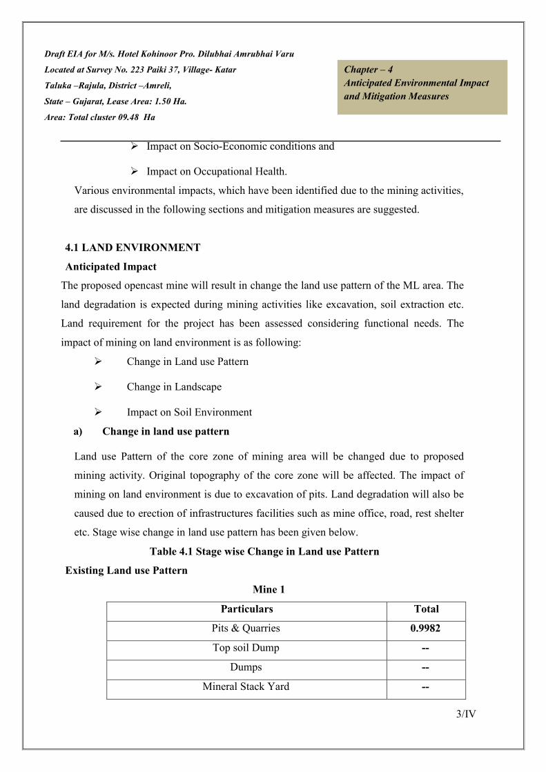
Draft EIA for M/s. Hotel Kohinoor Pro. Dilubhai Amrubhai Varu
Located at Survey No. 223 Paiki 37, Village- Katar
Taluka –Rajula, District –Amreli,
State – Gujarat, Lease Area: 1.50 Ha.
Area: Total cluster 09.48 Ha
3/IV
Chapter – 4
Anticipated Environmental Impact
and Mitigation Measures
� Impact on Socio-Economic conditions and
� Impact on Occupational Health.
Various environmental impacts, which have been identified due to the mining activities,
are discussed in the following sections and mitigation measures are suggested.
4.1 LAND ENVIRONMENT
Anticipated Impact
The proposed opencast mine will result in change the land use pattern of the ML area. The
land degradation is expected during mining activities like excavation, soil extraction etc.
Land requirement for the project has been assessed considering functional needs. The
impact of mining on land environment is as following:
� Change in Land use Pattern
� Change in Landscape
� Impact on Soil Environment
a) Change in land use pattern
Land use Pattern of the core zone of mining area will be changed due to proposed
mining activity. Original topography of the core zone will be affected. The impact of
mining on land environment is due to excavation of pits. Land degradation will also be
caused due to erection of infrastructures facilities such as mine office, road, rest shelter
etc. Stage wise change in land use pattern has been given below.
Table 4.1 Stage wise Change in Land use Pattern
Existing Land use Pattern
Mine 1
Particulars Total
Pits & Quarries 0.9982
Top soil Dump --
Dumps --
Mineral Stack Yard --

Draft EIA for M/s. Hotel Kohinoor Pro. Dilubhai Amrubhai Varu
Located at Survey No. 223 Paiki 37, Village- Katar
Taluka –Rajula, District –Amreli,
State – Gujarat, Lease Area: 1.50 Ha.
Area: Total cluster 09.48 Ha
4/IV
Chapter – 4
Anticipated Environmental Impact
and Mitigation Measures
Sub Grade stack Yard --
Infrastructure (Work shop, administrative Building) --
Roads --
Railway --
Green Belt --
Tailing Pond --
Effluent Treatment Plant --
Mineral Separation Plant --
Township --
Non Utilized 1.2518
Total 2.25
Mine 2
Particulars Total
Pits & Quarries 2.9078
Top soil Dump --
Dumps --
Mineral Stack Yard --
Sub Grade stack Yard --
Infrastructure (Work shop, administrative Building) --
Roads --
Railway --
Green Belt --
Tailing Pond --
Mineral Separation Plant --
Township --
Non Utilized 0.8222
Total 3.73

Draft EIA for M/s. Hotel Kohinoor Pro. Dilubhai Amrubhai Varu
Located at Survey No. 223 Paiki 37, Village- Katar
Taluka –Rajula, District –Amreli,
State – Gujarat, Lease Area: 1.50 Ha.
Area: Total cluster 09.48 Ha
5/IV
Chapter – 4
Anticipated Environmental Impact
and Mitigation Measures
Mine 3
Particulars Total
Pits & Quarries 1.3728
Top soil Dump --
Dumps --
Mineral Stack Yard --
Sub Grade stack Yard --
Infrastructure (Work shop, administrative Building) --
Roads --
Railway --
Green Belt --
Tailing Pond --
Mineral Separation Plant --
Township --
Non Utilized 0.1272
Total 1.50
Mine 4
Particulars Total
Mining 0.0
Pits/Mining Activity Area 0.4731
Dumps 0.0
Haul Road 0.0050
Mineral Stack Yard --
Sub Grade stack Yard --
Infrastructure (Work shop, administrative Building) 0.0070
Plantation 0.0
Tailing Pond --
Mineral Stack 0.0

Draft EIA for M/s. Hotel Kohinoor Pro. Dilubhai Amrubhai Varu
Located at Survey No. 223 Paiki 37, Village- Katar
Taluka –Rajula, District –Amreli,
State – Gujarat, Lease Area: 1.50 Ha.
Area: Total cluster 09.48 Ha
6/IV
Chapter – 4
Anticipated Environmental Impact
and Mitigation Measures
Remaining Virgin area 1.5149
Total 2.00
Land use pattern conceptual
Stage Wise Land Use Pattern
Mine 1
At the End of the Five Year Periods
Particulars Mine 1
Pits 0.9982
Scree stack/topsoil ----
Infrastructure 0.0067
Mineral Stack Yard 0.0030
At the end of End of the Life of the Mine
Backfilled Area 0.00
Water Reservoir 0.00
Infrastructure ----
Table 4.2 Stage Wise Land Use Pattern
Mine 2
At the End of the Five Year Periods
Particulars Mine 1
Pits 2.9078
Scree stack/topsoil ----
Infrastructure 0.0067
Mineral Stack Yard 0.0030
At the end of End of the Life of the Mine
Backfilled Area ----
Water Reservoir 3.0848
Infrastructure ----

Draft EIA for M/s. Hotel Kohinoor Pro. Dilubhai Amrubhai Varu
Located at Survey No. 223 Paiki 37, Village- Katar
Taluka –Rajula, District –Amreli,
State – Gujarat, Lease Area: 1.50 Ha.
Area: Total cluster 09.48 Ha
7/IV
Chapter – 4
Anticipated Environmental Impact
and Mitigation Measures
Mine 3
At the End of the Five Year Periods
Particulars Mine 1
Pits 1.3728
Scree stack/topsoil ----
Infrastructure 0.0023
Mineral Stack Yard 0.0030
At the end of End of the Life of the Mine
Backfilled Area 0.00
Water Reservoir 1.0752
Infrastructure ----
Mine 4
Particulars Mine 1
Mining 1.0002
Pits/Mining Activity Area 0.00
Dumps 0.1000
Haul Road 0.0030
Mineral Stack Yard 0.00
Plantation 0.1700
Infrastructure 0.0060
Virgin Land 0.7208
Total 02.00
b) Change in Landscape
At the end of the mining operation, quarry Lease area would be used as water reservoir and
a part of the remaining region would be used for plantation.
c) Impact on Soil Environment
The main type of soil erosion in the mining areas is water erosion, wind erosion and man-

Draft EIA for M/s. Hotel Kohinoor Pro. Dilubhai Amrubhai Varu
Located at Survey No. 223 Paiki 37, Village- Katar
Taluka –Rajula, District –Amreli,
State – Gujarat, Lease Area: 1.50 Ha.
Area: Total cluster 09.48 Ha
8/IV
Chapter – 4
Anticipated Environmental Impact
and Mitigation Measures
induced erosion water erosion takes place in rainy season. Most soil erosion is associated
with water erosion. To control the soil erosion afforestation will done around the ML area.
Top Soil Management
The lease area is bearing no soil cover. Hence storage of top soil will not arise.
Reclamation & rehabilitation –
During conceptual stage the mined out area will be converted into water reservoir at the
conceptual period. It will also serve the purpose as socio economic and corporate social
responsibility of the lessee by way of supplying water for irrigation purpose or at will of
the local people. At the end of the mining operation, Quarry Lease area would be used as
water reservoir, the water reservoir would be fenced. And a part of the remaining region
would be used for plantation.
Mitigation Measures
� The excavated pit will be fenced. However at the time of conceptual period of
mined out pit will be left as water reservoir which will meet the water
requirement of the surrounding village.
� No siltation on agricultural land will be allowed.
� Plantation will be done around the mining site as well as near the office area
which will minimize the propagation of air born dust.
4.2 WATER ENVIRONMENT
Water pollution due to mining is one of the most important concerns. Mining activities
in general causes adverse impact on the water quality due to mine effluent discharge. As
the mining activity for this proposed project will be done only in dry season and no
washing of beneficiation of ore is envisaged the impact on water quality is negligible.

Draft EIA for M/s. Hotel Kohinoor Pro. Dilubhai Amrubhai Varu
Located at Survey No. 223 Paiki 37, Village- Katar
Taluka –Rajula, District –Amreli,
State – Gujarat, Lease Area: 1.50 Ha.
Area: Total cluster 09.48 Ha
9/IV
Chapter – 4
Anticipated Environmental Impact
and Mitigation Measures
Impact on water Sources Ground Water
The ground water table is 60 m minimum (rainy season) to 65 m maximum (in dry
season). The working level in next five year is likely to reach up to 73 m RL, so it is not
likely to touch the Ground water table in dry season.
Wastewater Generation, Treatment & Disposal
The total water consumption in the Black Trap Mining Project is about 17 KLD. The
water will be used in the following manner.
• For dust suppression
• For domestic consumption
• For greenbelt development
Table 4.3 Water requirement for specific lease area
S. No. Plot /Khand/Survey No. Water Requirement
Mine 1
Survey No-223 Paiki 37 Total water requirement is about 4.9 KLD = 0.7 KLD
(Drinking & Domestic Uses) + 1.8 KLD (Plantation) + 2.4
KLD (Dust Suppression).
Mine 2 Survey No-223 Paiki 37 Total water requirement is about 4.6 KLD = 0.7 KLD
(Drinking & Domestic Uses) + 1.5 KLD (Plantation) + 2.4
KLD (Dust Suppression).
Mine 3 Survey No-223 Paiki 37 Total water requirement is about 2.6 KLD = 0.6 KLD
(Drinking & Domestic Uses) + 1.2 KLD (Plantation) + 0.8
KLD (Dust Suppression).
Mine 4 Survey No-223 Paiki 37 Total water requirement is about 4.9 KLD = 0.7 KLD
(Drinking & Domestic Uses) + 1.8 KLD (Plantation) + 2.4
KLD (Dust Suppression).
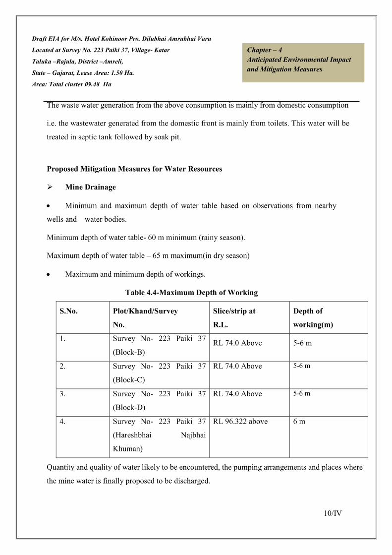
Draft EIA for M/s. Hotel Kohinoor Pro. Dilubhai Amrubhai Varu
Located at Survey No. 223 Paiki 37, Village- Katar
Taluka –Rajula, District –Amreli,
State – Gujarat, Lease Area: 1.50 Ha.
Area: Total cluster 09.48 Ha
10/IV
Chapter – 4
Anticipated Environmental Impact
and Mitigation Measures
The waste water generation from the above consumption is mainly from domestic consumption
i.e. the wastewater generated from the domestic front is mainly from toilets. This water will be
treated in septic tank followed by soak pit.
Proposed Mitigation Measures for Water Resources
� Mine Drainage
• Minimum and maximum depth of water table based on observations from nearby
wells and water bodies.
Minimum depth of water table- 60 m minimum (rainy season).
Maximum depth of water table – 65 m maximum(in dry season)
• Maximum and minimum depth of workings.
Table 4.4-Maximum Depth of Working
S.No. Plot/Khand/Survey
No.
Slice/strip at
R.L.
Depth of
working(m)
1. Survey No- 223 Paiki 37
(Block-B)
RL 74.0 Above 5-6 m
2. Survey No- 223 Paiki 37
(Block-C)
RL 74.0 Above 5-6 m
3. Survey No- 223 Paiki 37
(Block-D)
RL 74.0 Above 5-6 m
4. Survey No- 223 Paiki 37
(Hareshbhai Najbhai
Khuman)
RL 96.322 above 6 m
Quantity and quality of water likely to be encountered, the pumping arrangements and places where
the mine water is finally proposed to be discharged.

Draft EIA for M/s. Hotel Kohinoor Pro. Dilubhai Amrubhai Varu
Located at Survey No. 223 Paiki 37, Village- Katar
Taluka –Rajula, District –Amreli,
State – Gujarat, Lease Area: 1.50 Ha.
Area: Total cluster 09.48 Ha
11/IV
Chapter – 4
Anticipated Environmental Impact
and Mitigation Measures
Surface Water
� At conceptual stage whatever area will be left out after reclamation and
rehabilitation will be used as water reservoir & embankment will be made at the toe
of the dump.
� Garland Drains have been constructed around waste dump for preventing wash-offs
from dumps.
� Monitoring of water will be carried out periodically. Water analysis will be carried
out seasonally.
� Septic tanks and soak pits are being/ will be provided for the disposal of domestic
effluent generated from mine office.
Ground Water Pollution
• As there is no ground water intersection due to proposed mining activity there is no
ground water pollution will occur.
• Regular monitoring of water levels and quality in the existing open wells and bore
wells in the vicinity will be carried out. If found necessary, additional observation
wells will be sunk for monitoring the water levels and quality around the mine
representing both upstream and downstream conditions.
Water accumulated in the mine pit will be used for dust suppression. This water will
also be made available to villagers on demand for irrigation purpose after testing.
No discharge of water will be made to any surface water course.
Proper guidance and training will be given to the pump operator on safety and securities.
4.3 AIR ENVIRONMENT
Anticipated Impacts and Mitigation Measures
During the course of Black Trap Mining, no toxic substances are released into the
atmosphere, so there seems to be no potential threat to health of human beings. In mining
activities, dust will be generated during mining, loading and transportation. The only
source of fugitive gaseous emission during mining is vehicles which will be used for

Draft EIA for M/s. Hotel Kohinoor Pro. Dilubhai Amrubhai Varu
Located at Survey No. 223 Paiki 37, Village- Katar
Taluka –Rajula, District –Amreli,
State – Gujarat, Lease Area: 1.50 Ha.
Area: Total cluster 09.48 Ha
12/IV
Chapter – 4
Anticipated Environmental Impact
and Mitigation Measures
transportation.
MANAGEMENT
The environmental management for air pollution control includes:
• The un-metalled haul roads should be adequately compacted before being put into
use.
• Water should be sprinkled on these roads periodically every-day (twice in a day),
to wet the surface.
• Over loading of transport equipments should be avoided to prevent spillage.
• Transportation of minerals should be in covered vehicles to prevent fugitive dust
emission.
• Regular checking and maintenance of vehicles should be conducted once in every
two months and pollution under control certificate be obtained.
• It will be ensured that all transportation vehicles carry a valid PUC certificate.
• Masks will be provided to the workers daily during working hours (8 hrs) of the
mine.
• Plantation will be taken up along the approach roads and vicinity of mine lease.
The plantation arrests dust.
4.4 NOISE ENVIRONMENT
Noise impact on working environment
Noise generated at the mine is due to semi mechanized mining operations and truck
transportation activities. The noise generated by the mining activity dissipates within
the mine. There is no major impact of the mining activity on the nearby villages.
However, pronounced effect of above noise levels is felt only near the active working
area.
The impact of noise on the villages is negligible as the villages are far located from the
mine workings. Since there is no involvement of major machinery, the impact of noise
levels will be minimal.

Draft EIA for M/s. Hotel Kohinoor Pro. Dilubhai Amrubhai Varu
Located at Survey No. 223 Paiki 37, Village- Katar
Taluka –Rajula, District –Amreli,
State – Gujarat, Lease Area: 1.50 Ha.
Area: Total cluster 09.48 Ha
13/IV
Chapter – 4
Anticipated Environmental Impact
and Mitigation Measures
Noise abatement and control
In this mine the noise level will be up to tolerable limit 90 db(A) and the noise level can
be reduced by :
• Proper maintenance, oiling and greasing of machines at regular intervals will be
done to reduce the generation of noise.
• Adequate silencers will be provided in all the diesel engines.
• Plantation along the sides of approach roads, around office building and mine area
will be done to minimize the propagation of noise.
• Personal Protective Equipments (PPE) like earmuffs/earplugs will be provided to all
operators and employees working near mining machineries or at higher noise zone.
• Periodical noise level monitoring will be done.
Frequency levels and associated mental and physical response of humans are given in Table-4.3
Table-4.5 Noise Exposure Levels & Its Effects
Noise Levels dB(A) Exposure Time Effects
85 Continuous Safe
85-90 Continuous Annoyance and irritation
90-100 Short term Temporary shift in hearing
threshold, generally with complete
recovery
Above 100 Continuous Permanent loss of hearing
Short term Permanent hearing loss can be
Avoided
100-110 Several years Permanent deafness
110-120 Few months Permanent deafness
120 Short term Extreme discomfort
140 Short term Discomfort with actual pain
150 and above Single exposure Mechanical damage to the ear

Draft EIA for M/s. Hotel Kohinoor Pro. Dilubhai Amrubhai Varu
Located at Survey No. 223 Paiki 37, Village- Katar
Taluka –Rajula, District –Amreli,
State – Gujarat, Lease Area: 1.50 Ha.
Area: Total cluster 09.48 Ha
14/IV
Chapter – 4
Anticipated Environmental Impact
and Mitigation Measures
Source: Hand Book of EIA, Rao & Wooten
4.5 BIOLOGICAL ENVIRONMENT
The baseline flora and fauna has been depicted in Chapter-3. There are no wildlife
Sanctuary, national park, Breeding, roosting place so ecologically sensitive areas within
the 10 km periphery of the mine lease area. There no wildlife corridors in 10-km radius
area.
Impact on biodiversity
Present data have been collected through direct inventory as well as various
Government Departments such as forests, agriculture, fisheries, animal husbandry and
various offices to establish the pre-project biological environmental conditions. There
are no endangered species, wildlife sanctuary, wildlife corridors, faunal migratory
routes or eco-sensitive area near the whole study area. To save the flora/fauna around
the project area is one of the basic objectives of present project. For this, mine owner
agency planted a good roadside plantation along both side of the mine road.
Greenbelt and Plantation
Proposed Plantation at the Mine Site
The main aim of plantation in the mined out areas is to stabilize the land to protect it
from rain and wind erosion. The plantation scheme broadly covers the following areas:
• Greenbelt around peripheral portions of the ML area.
• Afforestation on top soil dumps and either sides of the haul roads.
Plantation will be raised at a spacing of 2.5 m at 7.5 m safety zone area, along the
periphery of the haul road, at own govt. land, at the govt. land provided by the govt. .
Greenbelt development in ML area
The entire plantation will be done on the periphery of the haul road, service roads,
nearby school etc., Precautionary measures will be taken for care of the forestation

Draft EIA for M/s. Hotel Kohinoor Pro. Dilubhai Amrubhai Varu
Located at Survey No. 223 Paiki 37, Village- Katar
Taluka –Rajula, District –Amreli,
State – Gujarat, Lease Area: 1.50 Ha.
Area: Total cluster 09.48 Ha
15/IV
Chapter – 4
Anticipated Environmental Impact
and Mitigation Measures
made by regular watering in the afforested area, to protect from grazing animals. Man
will be deployed for protecting & doing the above.
Number of saplings to be planted and budgetary estimate of the green cover
The breakup of the proposed afforestation programme with reclamation in progressive
manner for entire life of mine is given in Table-4.4
Table-4.6 Progressive Afforestation Schedule
Mine 1
Year Total No. of saplings
First 45
Second 45
Third 45
fourth 45
Fifth 45
Total 225
Mine 2
Year Total No. of saplings
First 74
Second 74
Third 74
fourth 77
Fifth 74
Total 373

Draft EIA for M/s. Hotel Kohinoor Pro. Dilubhai Amrubhai Varu
Located at Survey No. 223 Paiki 37, Village- Katar
Taluka –Rajula, District –Amreli,
State – Gujarat, Lease Area: 1.50 Ha.
Area: Total cluster 09.48 Ha
16/IV
Chapter – 4
Anticipated Environmental Impact
and Mitigation Measures
Mine 3
Year Total No. of saplings
First 30
Second 30
Third 30
fourth 30
Fifth 30
Total 150
Mine 4
Year Total No. of saplings
First 45
Second 45
Third 45
fourth 45
Fifth 45
Total 225
Plantation Species
The plants recommended for afforestation are as per Guidelines for Developing
Greenbelts, CPCB, March 2000 and listed in Table 4.5
Table-4.7 Species Suggested for Plantation
Sr.
No
Scientific Name General
Name
No’s to be Planted
01 Ficus benghalensis Banyan
Tree
200
02 Ficus religiosa Peepal 150
03 Delonix regia Gulmahor 200

Draft EIA for M/s. Hotel Kohinoor Pro. Dilubhai Amrubhai Varu
Located at Survey No. 223 Paiki 37, Village- Katar
Taluka –Rajula, District –Amreli,
State – Gujarat, Lease Area: 1.50 Ha.
Area: Total cluster 09.48 Ha
17/IV
Chapter – 4
Anticipated Environmental Impact
and Mitigation Measures
4.6 SOCIO – ECONOMIC ENVIRONMENT
The mine area does not cover any habitation. Hence the mining activity does not involve
any displacement of human settlement. No public buildings, places, monuments etc exist
within the lease area or in the vicinity. The mining operation will not disturb/ relocate any
village or need resettlement. Thus no adverse impact is anticipated. The impact of mining
activity in the area is positive on the socio-economic environment of the region. Katar
Black Trap; Mining Project will provide employment to local population and it will be
give preference to the local people whenever there is requirement of man power.
Probable Impact Assessment Impact on population composition
The impact of the proposed mining project on population composition will be marginal as
there will be no major immigration of people from distant areas. Only few skilled and
managerial staff will be recruited from outside and the rest will be recruited locally.
Similarly, there is no scope for emigration of people and there will be no displacement of
people due to land acquisition. The PP will ensure that all the unskilled workers deployed
for mining activities are local recruits. Further, no mining operation will be carried till it is
assured that local people has been recruited and deployed for mining operation.
Impact on Employment Generation
The proposed mining project is expected to provide Direct and Indirect employment
opportunities to local people of different skills and trades. It is a positive impact that
needs to been couraged. It has been estimated that 19 workers of various categories will
be employed directly.
The employment potentiality of the project is expected to ameliorate the economic
condition of the families of those persons who will get employed in the proposed mining
project. Further, the project will provide indirect employment to people who will be
04 Azadirachta indica Neem 273
05 Prosopis cineraria Khijado 150
Total 973

Draft EIA for M/s. Hotel Kohinoor Pro. Dilubhai Amrubhai Varu
Located at Survey No. 223 Paiki 37, Village- Katar
Taluka –Rajula, District –Amreli,
State – Gujarat, Lease Area: 1.50 Ha.
Area: Total cluster 09.48 Ha
18/IV
Chapter – 4
Anticipated Environmental Impact
and Mitigation Measures
involved in segregation of extracted mining materials, petty business and service oriented
industries.
Impact on consumption pattern
The field survey has revealed that people in the study area are generally poverty ridden.
Increased household income may slightly change and enhance the consumption pattern of
few who are burdened with poverty.
Impact on road development
Movement of trucks and other vehicles to and fro the quarry is expected to increase, when
mining will start. The existing roads connecting the quarry with the national and state
highways are mostly narrow mud roads. There will be mud slide and traffic bottle neck if
these roads are not widened and their conditions are not improved by making them paved
roads. Hence, there is ample scope for road development in and around the mining areas.
It is suggested that concerned department in the Government of the state to undertake
widening and strengthening of existing roads connecting the mining sites on priority
basis. There should also be budgetary support for road development in and around the
mining areas.
Impact on law & order
As local people will be employed to run the quarry, no law & order problem is envisaged.
It is expected that the workers will attend to their duties from their residence and return to
their homes after the day’s work is over. There would have been law & order problem if
the workers were migrants and lived in shanties closed to the mining area. However, to
meet any untoward incident one police post may be set up closed to the project area.
4.7 MINE WASTE MANAGEMENT
The waste rocks found in the area is overburden over the Mineral bed & line rejects of
sorting of intergrowth of soil with clay. The thickness of mineral waste/OB varying is 1

Draft EIA for M/s. Hotel Kohinoor Pro. Dilubhai Amrubhai Varu
Located at Survey No. 223 Paiki 37, Village- Katar
Taluka –Rajula, District –Amreli,
State – Gujarat, Lease Area: 1.50 Ha.
Area: Total cluster 09.48 Ha
19/IV
Chapter – 4
Anticipated Environmental Impact
and Mitigation Measures
m. The Rock fragments of small size are also resulted after mining.
It is also proposed to stack the Sub grade. The sub grade generated shall be collected in
sub grade stack yard and shall be then mixed with high-grade mineral or may be used for
filling & other works in various industries.
For Mine 4, 10 % waste of ROM will be generated during mining. Total 175200 ROM &
17520 swelled waste will be generated. Initially during mining plan waste will be dumped
on ground level and then backfilling in mine out pit reached ultimate limit.
4.8 TRAFFIC ANALYSIS
Traffic analysis is carried out by understanding the existing carrying capacity of the
connecting main roads in the area. Then depending on the capacity of the mine, the
number of trippers that will be added to the present scenario will be compared to the
carrying capacity.
During Mine operation for cluster of mines
Table 4.8 (i): Existing Traffic Scenario & LOS
Road V C Existing
V/C Ratio LOS
Near Katar Village
Intersection 250 2000 0.12 A
State Highway
(SH-107) 2400 15,000 0.16 A
Source: Capacity as per IRC: 64-1990
V= Volume of Vehicles in PCU’s/day & C= Capacity of Road in PCU’s/day
The existing Level of Service (LOS) is “A” & ‘‘B’’ i.e. excellent & very good.
V/C LOS Performance
0.0 - 0.2 A Excellent
0.2 - 0.4 B Very Good
0.4 - 0.6 C Good / Average / Fair
0.6 - 0.8 D Poor
0.8 - 1.0 E Very Poor
Reference: ENVIS Technical Report, IISc, Bangalore.
During Mine operation

Draft EIA for M/s. Hotel Kohinoor Pro. Dilubhai Amrubhai Varu
Located at Survey No. 223 Paiki 37, Village- Katar
Taluka –Rajula, District –Amreli,
State – Gujarat, Lease Area: 1.50 Ha.
Area: Total cluster 09.48 Ha
20/IV
Chapter – 4
Anticipated Environmental Impact
and Mitigation Measures
Proposed Capacity of mine/annum: 1,45,566 TPA
No. of working days: 300 days
Proposed Capacity of mine/day: 485.22 TPD
Truck Capacity: 20 tonnes
No. of trucks deployed/day: 24.26 trucks say 25 trucks
PCU/Day: 75
Table 4.8 (ii): Modified Traffic Scenario & LOS
Road V C Modified
V/C Ratio LOS
Near Katar village
Intersection 325 2000 0.16 A
State Highway
(SH-107) 2475 15000 0.16 A
Results
From the above analysis it can be seen that the V/C ratio for cluster of mines is likely to
change from 0.16 & 0.16 with LOS being same “A” & “A” respectively which is
‘Excellent, & ‘Excellent’, as per classification for State Highway (SH-107) & also the
LOS for nearby village intersection was “0.12” “A” (‘Excellent’) which remains same
“0.16” ‘A’ (‘‘Excellent’). So the additional load on the carrying capacity of the
concerned roads is not likely to have any adverse affect.
The minerals excavated will be loaded directly into trucks and transported to the
concerned market. The evacuation route for cluster is shown in the map as given below:
Transportation Route:

Draft EIA for M/s. Hotel Kohinoor Pro. Dilubhai Amrubhai Varu
Located at Survey No. 223 Paiki 37, Village
Taluka –Rajula, District –Amreli,
State – Gujarat, Lease Area: 1.50 Ha.
Area: Total cluster 09.48 Ha
Figure 4.1 Map Showing Evacuation Route
Traffic analysis is carried out
capacity of the roads near to the project site and the connecting main roads in the area.
Then depending on the capacity of the mine, the number of trucks that will be added to
the present scenario will be compared to the carrying capacity.
A storage point will be finalized and from there transportation will be done. But due
cluster Sand mining in the area there is hea
proposed to use to alternative transportation path. Traffic management has been proposed
as given below.
Traffic Management:
1. Roads will be repaired regularly and maintained in good conditions.
2. Haul roads will be sprinkled with water to keep the dust suppressed.
3. A supervisor will be appointed to regulate the traffic movement near the site.
4. Speed breakers will be constructed near accident prone areas to calm the traffic
and its speed.
M/s. Hotel Kohinoor Pro. Dilubhai Amrubhai Varu
Survey No. 223 Paiki 37, Village- Katar Chapter – 4
Anticipated Environmen
and Mitigation Measures
Figure 4.1 Map Showing Evacuation Route
Traffic analysis is carried out of individual mine by understanding the existing carrying
capacity of the roads near to the project site and the connecting main roads in the area.
city of the mine, the number of trucks that will be added to
the present scenario will be compared to the carrying capacity.
point will be finalized and from there transportation will be done. But due
mining in the area there is heavy load in the study area hence it has been
to use to alternative transportation path. Traffic management has been proposed
Roads will be repaired regularly and maintained in good conditions.
sprinkled with water to keep the dust suppressed.
A supervisor will be appointed to regulate the traffic movement near the site.
Speed breakers will be constructed near accident prone areas to calm the traffic
Metalled Road
Haul Road
SH-107
Cluster Area
21/IV
Anticipated Environmental Impact
and Mitigation Measures
by understanding the existing carrying
capacity of the roads near to the project site and the connecting main roads in the area.
city of the mine, the number of trucks that will be added to
point will be finalized and from there transportation will be done. But due
vy load in the study area hence it has been
to use to alternative transportation path. Traffic management has been proposed
A supervisor will be appointed to regulate the traffic movement near the site.
Speed breakers will be constructed near accident prone areas to calm the traffic

Draft EIA for M/s. Hotel Kohinoor Pro. Dilubhai Amrubhai Varu
Located at Survey No. 223 Paiki 37, Village- Katar
Taluka –Rajula, District –Amreli,
State – Gujarat, Lease Area: 1.50 Ha.
Area: Total cluster 09.48 Ha
22/IV
Chapter – 4
Anticipated Environmental Impact
and Mitigation Measures
5. Signage will be erected at the sensitive & precarious places to caution or provide
information to road users.
6. A storage point will be finalized and from there transportation will be done.
*************
Draft EIA for M/s. Hotel Kohinoor Pro. Dilubhai Amrubhai Varu
Located at Survey No. 223 Paiki 37, Village- Katar
Taluka –Rajula, District –Amreli,
State – Gujarat, Lease Area: 1.50 Ha.
Area: Total cluster 09.48 Ha
1/V
Chapter – 5
Analysis of Alternatives
(Technology & Site)
CHAPTER-V
ANALYSIS OF ALTERNATIVES (TECHNOLOGY & SITE)
5.0 SITE ALTERNATIVES UNDER CONSIDERATION 2/V
5.1 ANALYSIS OF ALTERNATIVE TECHNOLOGY 2/V

Draft EIA for M/s. Hotel Kohinoor Pro. Dilubhai Amrubhai Varu
Located at Survey No. 223 Paiki 37, Village- Katar
Taluka –Rajula, District –Amreli,
State – Gujarat, Lease Area: 1.50 Ha.
Area: Total cluster 09.48 Ha
2/V
Chapter – 5
Analysis of Alternatives
(Technology & Site)
5.0 ANALYSIS OF ALTERNATIVE TECHNOLOGY AND SITE
5.1 Site alternatives under consideration
Presence of Black Trap for commercial exploitation has been identified based on the result
of geological investigations and exploration carried out by the Geological Survey of India
(GSI).
The mining projects are site specific as such alternate sites were not considered.
5.2 Analysis of alternative technology
5.2.1 Choice of method of mining
Factors in the choice of an actual mining method for a given deposit are deposit
characteristics, percentage recovery, requirement of health and safety and environmental
concerns, production, scheduling scope of mechanization and automation, workforce
requirements wage rates, and land reclamation, operating and capital cost estimates. The
selection of the mining method (development and extraction) is a key decision to be made
in the opening up of a mine.
Surface or open pit mining is used for large, near-surface mineral deposits. Mineral
excavated loaded into trucks, and hauled to a facility where it is crushed and ground to a
uniform size for further processing.
The opencast mining method will be adopted because of the following reasons:
• The opencast mining operations ensure higher mineral conservation.
• Low stripping ratio.
The method used for mining is efficient for Black Trap Mining, so no alternative mining
method is proposed.
***********
Draft EIA for M/s. Hotel Kohinoor Pro. Dilubhai Amrubhai Varu
Located at Survey No. 223 Paiki 37, Village- Katar
Taluka –Rajula, District –Amreli,
State – Gujarat, Lease Area: 1.50 Ha.
Area: Total cluster 09.48 Ha
1 / VI
Chapter – 6
Environmental Monitoring Programme
CHAPTER-VI
ENVIRONMENTAL MONITORING PROGRAMME
INDEX
6.0 INTRODUCTION 1/VI
6.1 PROPOSED SET UP 2/VI
6.2 MONITORING SCHEDULE AND PARAMETERS 3/VI
6.3 OCCUPATIONAL HEALTH AND SAFETY 5/VI

Draft EIA for M/s. Hotel Kohinoor Pro. Dilubhai Amrubhai Varu
Located at Survey No. 223 Paiki 37, Village- Katar
Taluka –Rajula, District –Amreli,
State – Gujarat, Lease Area: 1.50 Ha.
Area: Total cluster 09.48 Ha
2 / VI
Chapter – 6
Environmental Monitoring Programme
6.0 INTRODUCTION
Success of any post project environmental monitoring programme depends upon the efficiency of
the organizational set up responsible for the implementation of the programme. Regular monitoring
of the various environmental parameters is also necessary to evaluate the effectiveness of the
management programme so that the necessary corrective measures can be taken in case there are
some drawbacks in the proposed programme. Since environmental quality parameters at work zone
and surrounding areas are important for maintaining sound operating practices of the project in line
with conformity with environmental regulations, the post project monitoring work forms part of
EMP.
6.1 PROPOSED SET UP
Keeping the utility of monitoring results in the implementation of the environmental management
program in view, an organizational chart has been proposed, headed by General Manager as shown
in Fig. 6.1
The said team will be responsible for:
i. Collecting water and air samples from surrounding area and work zone monitoring for
pollutants.
ii. Analyzing the water and air samples.
iii. Implementing the control and protective measures.
iv. Co-coordinating the environment related activities within the project as well as with outside
agencies.
v. Collecting statistics of health of workers and population of surrounding villages.
vi. Monitoring the progress of implementation of environmental management program.
The laboratory will be suitably equipped for sampling/testing for various environmental pollutants.

Draft EIA for M/s. Hotel Kohinoor Pro. Dilubhai Amrubhai Varu
Located at Survey No. 223 Paiki 37, Village- Katar
Taluka –Rajula, District –Amreli,
State – Gujarat, Lease Area: 1.50 Ha.
Area: Total cluster 09.48 Ha
3 / VI
Chapter – 6
Environmental Monitoring Programme
Fig. 6.1 Function of Environmental Management Cell
6.2 MONITORING SCHEDULE AND PARAMETERS
Air Quality Monitoring
Air Quality monitoring is essential for evaluation of the effectiveness of abatement programmes
and to develop appropriate control measures. The project proponent will monitor ambient air
quality in and around the proposed Black Trap Mining Projects at a frequency of once in a
fortnight or any other frequency as stipulated by MoEF and take appropriate air pollution control
measures in order to ensure that the concentration of PM2.5, PM10, SO2 and NOX are within limits.
Water Quality monitoring
Water quality monitoring involves periodical assessment of quality of surface water and the ground
water near the mining project. Surface water samples will be analyzed for all the parameters as per
EPA, 1986 ground water samples will be analyzed for all the parameters as per IS-10500.
ENVIRONMENT
MANAGEMENT CELL
Implementation of Control/Measure
Review with General Manager
Report submission and correspondence
with concern State/ Central Government
Environmental Monitoring
Environmental Officer
Head Environment
• Implementation of EMP
• Allotment of Daily jobs
• Field visits
• Analysis of samples-Air,
water, soils etc
• Environment Budgets &
sanctions
• Review Implementation
Lab assistant
Senior Chemist

Draft EIA for M/s. Hotel Kohinoor Pro. Dilubhai Amrubhai Varu
Located at Survey No. 223 Paiki 37, Village- Katar
Taluka –Rajula, District –Amreli,
State – Gujarat, Lease Area: 1.50 Ha.
Area: Total cluster 09.48 Ha
4 / VI
Chapter – 6
Environmental Monitoring Programme
Phreatic surface levels will be monitored throughout the life of the project to study the impact of
mining operations on ground water regime. A network of observation wells will be located in the
villages around the projects area for monitoring of phreatic surface levels. The water levels will be
monitored during pre-monsoon and post-monsoon seasons four times in a year.
Noise Level Monitoring
Noise level monitoring will be done for achieving the following objectives:
a) To compare sound levels with the values specified in noise regulations
b) To determine the need and extent of noises control of various noise generating sources
c) Correlation of noise levels with community response to noise levels
Noise level monitoring will be done at the work zone to assess the occupational noise exposure
levels. Noise levels will also be monitored at the noise generating sources like mineral handling
arrangements, vehicle movements and also nearby villages for studying the impact due to higher
noise levels for taking necessary control measures at the source.
Table 6.1: Monitoring Schedule and Parameters
S. No. Description of Parameters Schedule and Duration of
Monitoring
1
Air Quality
a)In the vicinity of the mine
b)In the vicinity of the transportation network
24 hourly samples twice a week
for one month in each season
except monsoon.
2
Water Quality
a) Water quality of surface and groundwater around
the site
b) Drinking water must conform to drinking water
standards
Once in a season for 4 season in
a year
3 Ambient Noise Level Twice in a year for couple of
years & then once in a year
4 Soil Quality Once in two years on project
monitoring area
5 Inventory of Flora(tree plantation, survival etc) Once in two years on project
monitoring area
6 Socio-economic condition of local, population,
physical survey
Once in 3 or 4 years

Draft EIA for M/s. Hotel Kohinoor Pro. Dilubhai Amrubhai Varu
Located at Survey No. 223 Paiki 37, Village- Katar
Taluka –Rajula, District –Amreli,
State – Gujarat, Lease Area: 1.50 Ha.
Area: Total cluster 09.48 Ha
5 / VI
Chapter – 6
Environmental Monitoring Programme
6.3 OCCUPATIONAL HEALTH AND SAFETY
Occupational safety and health is very closely related to productivity and good employer-employee
relationship. The factors of occupational health in proposed Black Trap Mining Project are mainly
dust emission. Safety of employees during operation and maintenance etc. shall be as per Mines rules
and regulations. To avoid any adverse effect on the health of workers due to various pollutants,
sufficient measures relating to safety and health will also be practiced:
� Provision of rest shelters for mine workers with amenities like drinking water etc.
� All safety measures like use of safety appliances, such as dust masks, helmets, shoes,
safety awareness programs, awards, posters, slogans related to safety etc.
� Training of employees for use of safety appliances and first aid in vocational training
center.
� Regular maintenance and testing of all equipment as per manufacturers’ guidelines.
� Periodical Medical Examination (PME) of all workers by a medical Officer
� First Aid facility is provided at the mine site.
� Close surveillance of the factors in working environment and work practices which may
affect environment and worker’s health.
� Working of mine as per approved mining plan and environmental plans.
6.3.1 Public Health Implication
With the mitigation measures in relation to air pollution, water pollution, soil contamination and
noise pollution proposed to be adopted at the mine a long with green belt plantation along the haul
road, it is expected that there will be no impact of mining on the population in the impact zone.
However, the following measures shall be adopted:
• Health check of all villagers in the immediate vicinity of the mine shall be carried out
periodically.
• In case any person or a group of persons is found to be suffering from any ailment, directly
related to mining, their medical treatment will be carried out free of cost.
Draft EIA for M/s. Hotel Kohinoor Pro. Dilubhai Amrubhai Varu
Located at Survey No. 223 Paiki 37, Village- Katar
Taluka –Rajula, District –Amreli,
State – Gujarat, Lease Area: 1.50 Ha.
Area: Total cluster 09.48 Ha
6 / VI
Chapter – 6
Environmental Monitoring Programme
• All water bodies e.g. wells and surface water sources in the vicinity of the mine, shall be
periodically tested for any pollution related to mining operations and remedial action taken, if
warranted. Operators of all transport vehicles shall be instructed not to honk unnecessarily while
passing through villages or near schools.
*********

Draft EIA for M/s. Hotel Kohinoor Pro. Dilubhai Amrubhai Varu
Located at Survey No. 223 Paiki 37, Village- Katar
Taluka –Rajula, District –Amreli,
State – Gujarat, Lease Area: 1.50 Ha.
Area: Total cluster 09.48 Ha
1/VII
Chapter – 7
Additional Studies
CHAPTER-VII
ADDITIONAL STUDIES
INDEX
S. No. CONTENTS Page No.
7.0 PUBLIC CONSULTATION 2/VII
7.1 HAZARD IDENTIFICATION AND RISK ASSESSMENT
METHOLODOGY
2/VII
7.2 POTENTIAL HAZARD & ‘ALARP’ CONDITION 7/VII
7.3 RISK PRIORITISATION BASED ON HAZARDS 10/VII
7.4 ADDITIONAL MITIGATION MAJORS TO BRING
HAZARDS UNDER “ALARP” ZONE
11/VII
7.5 NATURAL RESOURCE CONSERVATION 11/VII

Draft EIA for M/s. Hotel Kohinoor Pro. Dilubhai Amrubhai Varu
Located at Survey No. 223 Paiki 37, Village- Katar
Taluka –Rajula, District –Amreli,
State – Gujarat, Lease Area: 1.50 Ha.
Area: Total cluster 09.48 Ha
2/VII
Chapter – 7
Additional Studies
7.0 PUBLIC HEARING
This is a draft EIA report. Public hearing shall take place on the basis of this Draft EIA Report.
The proceedings along with all the details shall be incorporated in the Final EIA REPORT.
7.1 HAZARD IDENTIFICATION AND RISK ASSESSMENT METHODOLOGY
A) RISK
Risk concerns the deviation of one or more results of one or more future events from their expected value.
Tolerable risk: Risk which is accepted in a given context based on the current values of society
Protective measure: The combination of risk reduction strategies taken to achieve at least the
tolerable risk. Protective measures include risk reduction by inherent safety, protective devices,
and personal protective equipment, information for use and installation and training.
Severity: Severity is used for the degree of something undesirable.
Risk related to the
considered hazard
is a “function” of
Severity of the possible
harm that can result
from the considered
hazard
PROBABILITY OF OCCURRENCE OF THE
HARM
Frequency and
duration of
exposure
Probability of
occurrence of
hazardous event
Possibility of
avoiding or
limiting the harm

Draft EIA for M/s. Hotel Kohinoor Pro. Dilubhai Amrubhai Varu
Located at Survey No. 223 Paiki 37, Village- Katar
Taluka –Rajula, District –Amreli,
State – Gujarat, Lease Area: 1.50 Ha.
Area: Total cluster 09.48 Ha
3/VII
Chapter – 7
Additional Studies
Risk Analysis: A systematic use of available information to determine how often specified events
may occur and the magnitude of their likely consequences.
The different steps of risk assessment procedure are as given below:
Step I: Hazard Identification
The purpose of hazard identification is to identify and develop a list of hazards for each job in the
organization that are reasonably likely to expose people to injury, illness or disease if not effectively
controlled. Workers can then be informed of these hazards and controls put in place to protect
workers prior to them being exposed to the actual hazard.
Step II: Risk Assessment
Risk assessment is the process used to determine the likelihood that people exposed to injury, illness
or disease in the workplace arising from any situation identified during the hazard identification
process prior to consideration or implementation of control measures.
Risk occurs when a person is exposed to a hazard. Risk is the likelihood that exposure to a hazard
will lead to injury or health issues. It is a measure of probability and potential severity of harm or loss.
Step III: Risk Control
Risk control is the process used to identify, develop, implement and continually review all
practicable measures for eliminating or reducing the likelihood of an injury, illness or diseases
in the workplace.
Step IV: Implementation of risk controls
All hazards that have been assessed should be dealt in order of priority in one or more of the
following hierarchy of controls
The most effective methods of control are:
i. Elimination of hazards
ii. Substitute something safer
iii. Use engineering/design controls
iv. Use administrative controls such as safe work procedures
v. Protect the workers i.e. By ensuring competence through supervision and training, etc.

Draft EIA for M/s. Hotel Kohinoor Pro. Dilubhai Amrubhai Varu
Located at Survey No. 223 Paiki 37, Village- Katar
Taluka –Rajula, District –Amreli,
State – Gujarat, Lease Area: 1.50 Ha.
Area: Total cluster 09.48 Ha
4/VII
Chapter – 7
Additional Studies
Each measure must have a designated person and date assigned for the implementation of controls.
This ensures that all required safety measures will be completed.
Step V: Monitor and Review
Hazard identification, risk assessment and control are an on-going process. Therefore regularly
review the effectiveness of your hazard assessment and control measures. Make sure that you
undertake a hazard and risk assessment when there is change to the workplace including when work
systems, tools, machinery or equipment changes. Provide additional supervision when the new
employees with reduced skill levels or knowledge are introduced to the workplace.
B) RISK ANALYSIS
The risk assessment portion of the process involves three levels of site evaluation:
a) Initial Site Evaluation,
b) Detailed Site Evaluation,
c) Priority Site Investigations and Recommendations.
The risk assessment criteria used for all levels of site evaluation take into account two basic
factors:
The existing site conditions
The level of the travelling public's exposure to those conditions.
The Initial Site Evaluation and Detailed Site Evaluation both apply weighted criteria to the existing
information and information obtained from one site visit. The Initial Site Evaluation subdivides the
initial inventory listing of sites into 5 risk assessment site groups. The Detailed Site Evaluation risk
assessment is then performed on each of the three highest risk site groups in order of the group
priority level of risk. The result of the Detailed Site Evaluation process is a prioritized listing of the
sites within each of the three highest risk site groups.
Risk analysis is done for:
� Forecasting any unwanted situation
� Estimating damage potential of such situation

Draft EIA for M/s. Hotel Kohinoor Pro. Dilubhai Amrubhai Varu
Located at Survey No. 223 Paiki 37, Village- Katar
Taluka –Rajula, District –Amreli,
State – Gujarat, Lease Area: 1.50 Ha.
Area: Total cluster 09.48 Ha
5/VII
Chapter – 7
Additional Studies
� Decision making to control such situation
� Evaluating effectiveness of control measures
C) ACCEPTABLE RISK
Risk that is acceptable to regulatory agency and also to the public is called acceptable risk. There
are no formally recognized regulatory criteria for risk to personnel in the mining industry.
Individual organizations have developed criteria for employee risk and the concepts originally
arising from chemical process industries and oil and gas industries. Because of the uncertainties
linked with probabilistic risk analysis used for quantification of the risk levels the general guiding
principle is that the risk be reduced to a level considered
As Low as Reasonably Practicable (ALARP). The risk acceptability criteria are given in
following Table. It can be seen that there are three tiers:
a. A tolerable region where risk has been shown to be negligible and comparable with
everyday risks such as travel to work.
b. A middle level where it is shown the risk has been reduced to As Low As Reasonably
Practicable level and that further risk reduction is either impracticable or the cost is grossly
disproportionate to the improvement gained. This is referred as the ALARP region.
c. An intolerable region where risk cannot be justified on any grounds. The ALARP region is
kept sufficiently extensive to allow for flexibility in decision making and allow for the
positive management initiatives which may not be quantifiable in terms of risk reduction.
Table No. 7.1The risk acceptability criteria are given in following
1 Risk un acceptance and must be reduced. The actions
may include equipments and people or procedural
measures. If risk cannot be reduced to ALARP level,
operating philosophy must be fundamentally
reviewed by the management.
Intolerable Region
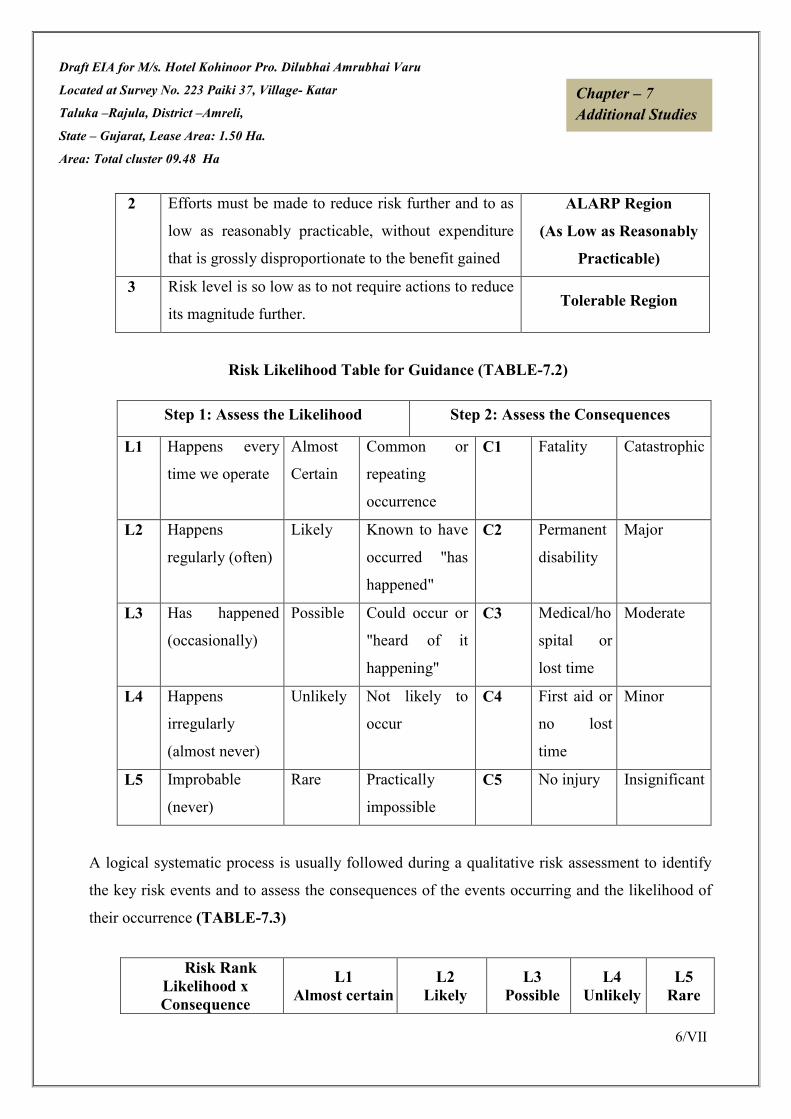
Draft EIA for M/s. Hotel Kohinoor Pro. Dilubhai Amrubhai Varu
Located at Survey No. 223 Paiki 37, Village- Katar
Taluka –Rajula, District –Amreli,
State – Gujarat, Lease Area: 1.50 Ha.
Area: Total cluster 09.48 Ha
6/VII
Chapter – 7
Additional Studies
2 Efforts must be made to reduce risk further and to as
low as reasonably practicable, without expenditure
that is grossly disproportionate to the benefit gained
ALARP Region
(As Low as Reasonably
Practicable)
3 Risk level is so low as to not require actions to reduce
its magnitude further. Tolerable Region
Risk Likelihood Table for Guidance (TABLE-7.2)
A logical systematic process is usually followed during a qualitative risk assessment to identify
the key risk events and to assess the consequences of the events occurring and the likelihood of
their occurrence (TABLE-7.3)
Step 1: Assess the Likelihood Step 2: Assess the Consequences
L1 Happens every
time we operate
Almost
Certain
Common or
repeating
occurrence
C1 Fatality Catastrophic
L2 Happens
regularly (often)
Likely Known to have
occurred "has
happened"
C2 Permanent
disability
Major
L3 Has happened
(occasionally)
Possible Could occur or
"heard of it
happening"
C3 Medical/ho
spital or
lost time
Moderate
L4 Happens
irregularly
(almost never)
Unlikely Not likely to
occur
C4 First aid or
no lost
time
Minor
L5 Improbable
(never)
Rare Practically
impossible
C5 No injury Insignificant
Risk Rank
Likelihood x
Consequence
L1
Almost certain
L2
Likely
L3
Possible
L4
Unlikely
L5
Rare

Draft EIA for M/s. Hotel Kohinoor Pro. Dilubhai Amrubhai Varu
Located at Survey No. 223 Paiki 37, Village- Katar
Taluka –Rajula, District –Amreli,
State – Gujarat, Lease Area: 1.50 Ha.
Area: Total cluster 09.48 Ha
7/VII
Chapter – 7
Additional Studies
RISK RATING:
• HIGH RISK 1-6
• MEDIUM RISK 7-15
• LOW RISK 16-25
7.2 POTENTIAL HAZARDS & ‘ALARP’ CONDITION
Mining and allied activities are associated with several potential hazards and risk to both
the employees and the public at large. A worker in a mine should be able to work under
“ALARP” conditions (as stated above), which are adequately safe and healthy. At the
same time the environmental conditions should be such as not to be impair his working
efficiency. This is possible only when there is adequate safety in mines.
7.3 RISK PRIORITISATION BASED ON HAZARDS
There are various factors, which can create unsafe working conditions/hazards in mining
of minor minerals from river bed.
The key risk (hazard x probability) event rating associated with sand bed mining and to
assess its consequences of such events occurring and the likelihood based on above
Table-2 are as:-
The Risk rating of such hazards is as follows:
a) Inundation / Flooding (C1 x L3=4)
b) Quick Sand Condition (C2 x L3=8)
c) Drowning. (C5 xL5=25)
C1
Catastrophic 1 2 4 7 11
C2
Major 3 5 8 12 16
C3
Moderate 6 9 13 17 20
C4
Minor 10 14 18 21 23
C5
Insignificant 15 19 22 24 25

Draft EIA for M/s. Hotel Kohinoor Pro. Dilubhai Amrubhai Varu
Located at Survey No. 223 Paiki 37, Village- Katar
Taluka –Rajula, District –Amreli,
State – Gujarat, Lease Area: 1.50 Ha.
Area: Total cluster 09.48 Ha
8/VII
Chapter – 7
Additional Studies
d) Accident due to vehicular movement.(C3 xL3=13)
e) Accident during sand loading, transporting and dumping=14.
(i.e., C4 xL2=14)
7.3.1 Accident during sand/mineral loading, transportation
The risk rating assigned to this activity is assigned as “14 i.e. it is likely event with minor
consequences”, as frequency of this operation is more but the predicted/assumed intensity(Based
on experience) is less like minor cuts, abbration, fall due to river bank collapse & falling of cattles,
if not under proper supervision to bring under ALARP ZONE.
a. The minerals are loaded in the trucks using hand shovels. There is possibility of injury in
the hands during loading with shovels.
b. There is possibility that the workers standing on the other side of loading may get injury
due to over thrown sand with pebbles.
c. There is possibility of workers getting injured during opening of side covers to facilitate
loading.
d. There is possibility of riverbank collapse.
e. There are chances of falling of cattle/children into pits in river bed by overlooking of
fenced area near worksite or improper supervision.
7.3.2 Accident due to vehicular movement
The risk rating assigned to this activity is assigned as 13 i.e., it is possible event with moderate
consequences as frequency of this operation is more but the predicted/assumed intensity(Based on
experience) is less like minor cuts, bodily injury due to rackless or untrained driver. However, a
strict control to be exercised to deploy trained drivers with valid driving license with a helper. A
strict supervision/control to be exercised to avoid drunken driving or driving by unauthorized
person to bring under ALARP ZONE.
The minerals loaded in trucks are being sent to through public roads.
a. All possibilities of road accidents are possible due to rash driving.
b. Accident may also occur during movement in the mine, in case pathway is not compacted
suitably or movement is at the embankment.
Draft EIA for M/s. Hotel Kohinoor Pro. Dilubhai Amrubhai Varu
Located at Survey No. 223 Paiki 37, Village- Katar
Taluka –Rajula, District –Amreli,
State – Gujarat, Lease Area: 1.50 Ha.
Area: Total cluster 09.48 Ha
9/VII
Chapter – 7
Additional Studies
c. There are possibilities that due to overloading. Some pebbles or big boulder may injure the
passerby public. In case Traffic & vehicle load bearing licensed capacity is neglected.
7.3.3 Inundation/Flooding
The risk rating assigned to this activity is assigned as 4(C1 xL3=4) i.e., it is only possible, if
warnings are neglected and work started without assessment of the river bed condition specially
during monsoon season ,the event will be catastrophic with major consequences as frequency of
this operation is possible. However the event has to be brought under ‘ALARP’ Zone by strict
supervision based on river water and other metrological data.
a. The possibility of inundation/flooding of the mines are very high during monsoon or during
heavy rains as the mine area lies in the riverbed.
b. There is danger to the trucks and other machineries due to flooding.
c. There is danger to the workers working in the mines.
Inundation or flooding is expected and beneficial for these mines as during this time only
the mineral reserve gets replenished.
7.3.4 Quick Sand Condition
The risk rating assigned to this activity is assigned as 8 (C2 x L3 =5) i.e., it is likely event with
major consequences as frequency of this operation is likely but the predicted/assumed intensity
(Based on experience) is major.
Hence data of water table must be collected and the mining work must be above the water table
(about 1.5 m above to bring under ALARP ZONE.) to avoid dangerous condition to vehicles
playing over sand dunes.
This condition occurs when the working crosses the water table at a certain depth and the
permeability of the strata is very high. This condition occurs when the effective stress in the sand
becomes zero due to influx of water i.e.
i = icr = y’/yw-;
Where, i = Hydraulic gradient,
icr = Critical Hydraulic gradient,

Draft EIA for M/s. Hotel Kohinoor Pro. Dilubhai Amrubhai Varu
Located at Survey No. 223 Paiki 37, Village- Katar
Taluka –Rajula, District –Amreli,
State – Gujarat, Lease Area: 1.50 Ha.
Area: Total cluster 09.48 Ha
10/VII
Chapter – 7
Additional Studies
y’ = submerged unit weight,
yw = unit weight of water.
This creates danger condition to the trucks and other machineries plying over the sand dunes on
the river banks.
7.3.5 Drowning
The risk rating assigned to this activity is assigned as 25 i.e., it is insignificant due to dry season
mining.
There are no possibilities of drowning in the river, since mining operations are carried out only in
the dry seasons. All mining activities will be stopped during the monsoon season.
7.4 ADDITIONAL MITIGATION MAJORS TO BRING HAZARDS UNDER “ALARP” ZONE
7.4.1 Measures to Prevent Accidents during Loading
1. The truck should be brought to a lower level so that the loading operation suits to the
ergonomic condition of the workers.
2. The loading should be done from one side of the truck only.
3. The workers should be provided with gloves and safety shoes during loading.
4. Opening of the side covers (pattas) should be done carefully and with warning to prevent
injury to the loaders.
5. Operations during daylight only.
6. No foreign material should be allowed to remain/spill in river bed and catchment area, or
no pits/pockets are allowed to be filled with such material.
7. Stockpiling of harvested material on the river bank should be avoided.
7.4.2 Measures to prevent accidents during transportation
1. All transportation within the main working should be carried out directly under the
supervision and control of the management.
2. The Vehicles must be maintained in good repairs and checked thoroughly at least once a
week by the competent person authorized for the purpose by the Management.
3. To avoid danger while reversing the trackless vehicles especially at the embankment and
tipping points, all areas for reversing of lorries should as far as possible be made man free,
and.

Draft EIA for M/s. Hotel Kohinoor Pro. Dilubhai Amrubhai Varu
Located at Survey No. 223 Paiki 37, Village- Katar
Taluka –Rajula, District –Amreli,
State – Gujarat, Lease Area: 1.50 Ha.
Area: Total cluster 09.48 Ha
11/VII
Chapter – 7
Additional Studies
4. A statutory provision of the fences, constant education, training etc. will go a long way in
reducing the incidents of such accidents.
5. Generally, overloading should not be permitted.
6. The truck should be covered and maintained to prevent any spillage.
7. The maximum permissible speed limit should be ensured.
8. The truck drivers should have proper driving license.
7.4.3 Measures to prevent Dangerous Incidents during Inundation/Flooding
Inundation of flooding is expected and beneficial for these mines as during this time only
the mineral reserve gets replenished.
1. During monsoon months and heavy rains the mining operations are ceased.
2. There should be mechanism/warning system of heavy rains and discharges from the
upstream dams.
7.4.4 Measures to Prevent Quick Sand Condition
1. The only way to avoid quick sand condition is by avoiding mineral lifting below water
table.
2. The critical hydraulic gradient (icr) should be maintained at less than 1 to prevent high
artesian pressure in a coarse sand area.
3. At least 0.5 m sand bed should be left in-situ while harvesting sand from riverbed.
7.4.5 Measure to Prevent Drowning
1. The mining should be done under strict supervision and only during the dry season.
2. Deep water areas must be identified.
3. No go zones should be clearly marked and made aware to the mine workers.
7.5 NATURAL RESOURCE CONSERVATION
Mining at the concave side of the river channel should be avoided to prevent bank erosion.
Similarly meandering segment of a river should be selected for mining in such a way as to
avoid natural eroding banks and to promote mining on naturally building (aggrading)
meander components.
**********

Draft EIA for M/s. Hotel Kohinoor Pro. Dilubhai Amrubhai Varu
Located at Survey No. 223 Paiki 37, Village- Katar
Taluka –Rajula, District –Amreli,
State – Gujarat, Lease Area: 1.50 Ha.
Area: Total cluster 09.48 Ha
1 / VIII
Chapter – 8
Project Benefits
CHAPTER-VIII
PROJECT BENEFITS
INDEX
8.0 GENERAL 2/VIII
8.1 BENEFITS OF MINING 2/VIII
8.2 EMPLOYMENT 2/VIII
8.3 SOCIO ECONOMIC BENEFITS AND CER 4/VIII
8.4 PLANTATION 4/VIII
8.5 HEALTH 4/VIII
Draft EIA for M/s. Hotel Kohinoor Pro. Dilubhai Amrubhai Varu
Located at Survey No. 223 Paiki 37, Village- Katar
Taluka –Rajula, District –Amreli,
State – Gujarat, Lease Area: 1.50 Ha.
Area: Total cluster 09.48 Ha
2 / VIII
Chapter – 8
Project Benefits
8.0 GENERAL
The proposed project is mining of Black Trap; it shall have no major impact on surrounding
environment. The proposed activity shall provide raw material to various industries, thereby
boosting overall improvement in economic growth of the state.
8.1 BENEFIT OF MINING
Improvement in the physical infrastructure
The impact on the civic amenities after the commencement of mining activities is likely to be
substantial. The basic requirements of the community needs will be strengthened by extending health
care, educational facilities developed in the township for the community, providing drinking water to
the villages, building/strengthening of existing roads in the area. The proponent will initiate the above
amenities either by providing or by improving the facilities in the area, which will help in uplifting the
living standards of local communities.
Medical facilities will be provided in the form of first-aid facility at the mine. These medical facilities
will also be available to local people in the surrounding in case of emergencies.
8.2 EMPLOYMENT
The socio-economic conditions of the surrounding villages indicate that employment generation is
seasonally. The occupational activities are agriculture, cattle rearing and employment in mines but on
daily wages. The mining activity will provide employment to local people which will increase socio-
economic status of the area.
The total direct manpower requirement for the proposed Cluster operation will be around 73
significant indirect employments is also expected due to the associated activities. This project
operation will provide livelihood to the poorest section of the society. Depending upon the General
shifts working, following will be the proposed manpower.
Table- 8.1 Employment Detail
PLOT/KHAND/SERV
EY NO.
MANPOWER PLOT/KHAND/SERVEY
NO.
MANPOWE
R
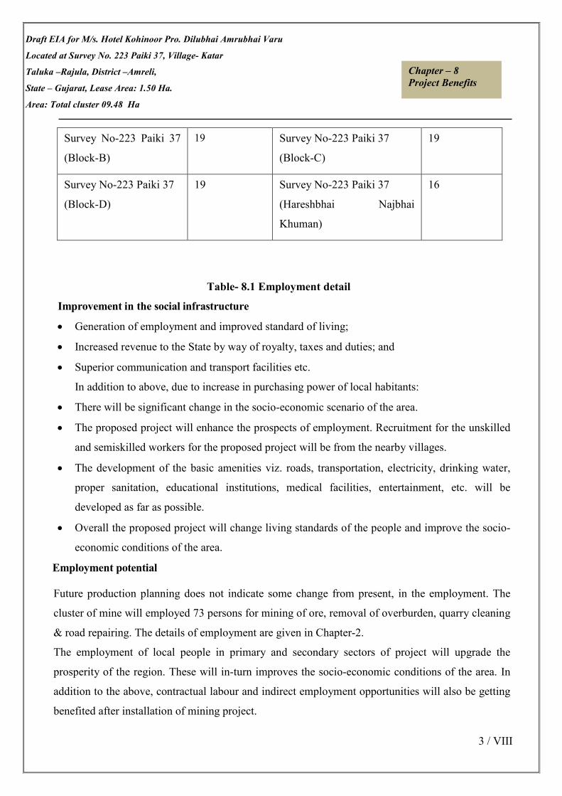
Draft EIA for M/s. Hotel Kohinoor Pro. Dilubhai Amrubhai Varu
Located at Survey No. 223 Paiki 37, Village- Katar
Taluka –Rajula, District –Amreli,
State – Gujarat, Lease Area: 1.50 Ha.
Area: Total cluster 09.48 Ha
3 / VIII
Chapter – 8
Project Benefits
Table- 8.1 Employment detail
Improvement in the social infrastructure
• Generation of employment and improved standard of living;
• Increased revenue to the State by way of royalty, taxes and duties; and
• Superior communication and transport facilities etc.
In addition to above, due to increase in purchasing power of local habitants:
• There will be significant change in the socio-economic scenario of the area.
• The proposed project will enhance the prospects of employment. Recruitment for the unskilled
and semiskilled workers for the proposed project will be from the nearby villages.
• The development of the basic amenities viz. roads, transportation, electricity, drinking water,
proper sanitation, educational institutions, medical facilities, entertainment, etc. will be
developed as far as possible.
• Overall the proposed project will change living standards of the people and improve the socio-
economic conditions of the area.
Employment potential
Future production planning does not indicate some change from present, in the employment. The
cluster of mine will employed 73 persons for mining of ore, removal of overburden, quarry cleaning
& road repairing. The details of employment are given in Chapter-2.
The employment of local people in primary and secondary sectors of project will upgrade the
prosperity of the region. These will in-turn improves the socio-economic conditions of the area. In
addition to the above, contractual labour and indirect employment opportunities will also be getting
benefited after installation of mining project.
Survey No-223 Paiki 37
(Block-B)
19
Survey No-223 Paiki 37
(Block-C)
19
Survey No-223 Paiki 37
(Block-D)
19 Survey No-223 Paiki 37
(Hareshbhai Najbhai
Khuman)
16

Draft EIA for M/s. Hotel Kohinoor Pro. Dilubhai Amrubhai Varu
Located at Survey No. 223 Paiki 37, Village- Katar
Taluka –Rajula, District –Amreli,
State – Gujarat, Lease Area: 1.50 Ha.
Area: Total cluster 09.48 Ha
4 / VIII
Chapter – 8
Project Benefits
8.3 SOCIO ECONOMIC BENEFITS
The benefits of mining activity will be similar to any industrial set-up. There will be opportunities of
direct and indirect employments. As mentioned earlier there will be around 73 personnel, most of
them will be skilled or semi-skilled & unskilled workers. As per OM dated 30th
September 2020 vide
letter no. F.No. 22-65/2017-IA.III by MOEF & CC budget allocation for CER will be proposed after
public hearing in Final EIA report.
Conclusion
As discussed, it is safe to say that the project is not likely to cause any significant adverse impact on
the ecology of the area, as adequate preventive measures will be adopted to contain the various
pollutants within permissible limits. Green belt development around the area will also be taken up as
an effective pollution mitigative technique, as well as to control the pollutants released from the
premises of the Black Trap Mining Project.
Population dynamics: - Due to the direct and indirect employment potential, there is a scope of
migration of people into project area and in the peripheral regions; from nearby areas.
Health Care facilities: - Lessee will undertake awareness program and community activities like
health, camps, medical aids, family welfare camps, AIDS awareness program etc.
Employment Potential: - There is a possibility of creation of direct and indirect employment
opportunities due to working of this mine.
The mine will also contribute to the Exchequer of State and Central Government.
8.4 PLANTATION
The management will provide free saplings of fruit and other trees, etc. to local during rain for
plantation. This will increase the consciousness in workers and near-by villagers for greenery. Fruit
trees can contribute towards their financial gains.
8.5 HEALTH
Periodic medical checkups as per Mines Act/ Rules and other social development and promotional
activities will be undertaken. All this will lift the general health status of the residents of the area
around mines.
************

Draft EIA for M/s. Hotel Kohinoor Pro. Dilubhai Amrubhai Varu
Located at Survey No. 223 Paiki 37, Village- Katar
Taluka –Rajula, District –Amreli,
State – Gujarat, Lease Area: 1.50 Ha.
Area: Total cluster 09.48 Ha
1 / XI
Chapter – 9
Environmental Management Plan
CHAPTER-IX
ENVIRONMENTAL MANAGEMENT PLAN
INDEX
9.0 GENERAL 1/IX
9.1 AIR QUALITY MANAGEMENT 2/IX
9.2 NOISE POLLUTION CONTROL 3/IX
9.3 WATER QUALITY MANAGEMENT 3/IX
9.4 WASTE MANAGEMENT 4/IX
9.5 BIOLOGICAL MANAGEMENT MEASURES 4/IX
9.6 GREENBELT DEVELOPMENT PLAN 4/IX
9.7 OCCUPATIONAL HAZARDS& SAFETY 6/IX
9.8 EMP BUDGET 6/IX
9.9 SOCIO-ECONOMIC CONDITION OF THE REGION 7/IX
9.10 ENVIRONMENT POLICY
9.11 CER DETAILS 7/IX
9.12 CONCLUSION 8/IX

Draft EIA for M/s. Hotel Kohinoor Pro. Dilubhai Amrubhai Varu
Located at Survey No. 223 Paiki 37, Village- Katar
Taluka –Rajula, District –Amreli,
State – Gujarat, Lease Area: 1.50 Ha.
Area: Total cluster 09.48 Ha
2 / XI
Chapter – 9
Environmental Management Plan
9.0 GENERAL
The Environment Management Plan (EMP) is required to ensure sustainable development in the
study area. This chapter covers cause of pollution, main source of pollution, nature of pollution
proposed mitigative measures for that pollution. This chapter consists of the set of mitigation,
management, monitoring and institutional measures to be taken during the implementation and
operation of the project, to eliminate adverse environmental impacts or reduce them to acceptable
levels. Overall air of Environment Management plan is as following:
� To reduce generation of pollutant due to various mining activity.
� Overall conservation of environment
� Proper use of natural resources
� Minimization of waste generation and pollution.
� Safety, welfare and good health of the work force and populace.
� Ensure effective operation of all control measures.
� Monitoring of cumulative and long time impacts.
� Ensure effective operation of all control measures.
9.1 AIR QUALITY MANAGEMENT
Over all air quality of the lease area as well in the buffer zone are well within permissible limit. Dust
emissions due to mineral handling, during mining operations are not much and restricted to the lease
area only. Air pollution is caused mainly due to dust generation added with gaseous emission from
transportation activities along with mining operation like loading, haulage etc.
9.1.1 Control of Fugitive Emissions
• Use of Personal Protection Equipment (PPE) like dust masks, ear plugs etc. by the mine
workers.
• Regular water sprinkling on haul roads & loading points will be carried out.
• Development of green belt/plantation around the lease boundary, roads, dumps etc.

Draft EIA for M/s. Hotel Kohinoor Pro. Dilubhai Amrubhai Varu
Located at Survey No. 223 Paiki 37, Village- Katar
Taluka –Rajula, District –Amreli,
State – Gujarat, Lease Area: 1.50 Ha.
Area: Total cluster 09.48 Ha
3 / XI
Chapter – 9
Environmental Management Plan
• Ambient Air Quality Monitoring will be conducted on regularly basis to assess
the quality of ambient air.
9.1.2 Prevention and control of gaseous pollution
In mining activities, the sources of gaseous emissions are blasting which is not proposed for this
project. Proper maintenance of machines improves combustion process & makes reduction in the
pollution. Good maintenance and monitoring of fuel and oil will not allow significant addition in
the gaseous emission.
9.2 NOISE POLLUTION CONTROL
• Proper maintenance, oiling and greasing of machines at regular intervals will be done to
reduce the generation of noise.
• Adequate silencers will be provided in all the diesel engines.
• Plantation along the sides of approach roads and mine area will be done to minimize the
propagation of noise.
• Personal Protective Equipments (PPE) like earmuffs/earplugs will be provided to all operators
and employees working near mining machineries or at higher noise zone.
• Periodical noise level monitoring will be done.
9.3 WATER QUALITY MANAGEMENT
Water for drinking and operations is required to be 17 KLD. It is proposed to obtain water for
drinking from nearby villages. Adequate control measures will be adopted to check not only the
wash-off from soil erosion but also uncontrolled flow of mine water.
9.4 WASTE MANAGEMENT
No top soil generated will be generated. For Mine 1, Mine 2 & Mine 3, 95% of Mineral is saleable and
5% of sub grade material generated. It is also proposed to stack the Sub grade. The sub grade
generated shall be collected in sub grade stack yard and shall be then mixed with high-grade mineral
or may be used for filling & other works in various industries.

Draft EIA for M/s. Hotel Kohinoor Pro. Dilubhai Amrubhai Varu
Located at Survey No. 223 Paiki 37, Village- Katar
Taluka –Rajula, District –Amreli,
State – Gujarat, Lease Area: 1.50 Ha.
Area: Total cluster 09.48 Ha
4 / XI
Chapter – 9
Environmental Management Plan
For Mine 4, 10 % waste of ROM will be generated during mining. Total 175200 ROM & 17520
swelled waste will be generated. Initially during mining plan waste will be dumped on ground level
and then backfilling in mine out pit reached ultimate limit.
9.5 BIOLOGICAL MANAGEMENT MEASURES
There is a requirement to establish a stable ecosystem with both ecological and economic returns.
Minimization of soil erosion and dust pollution enhances the beauty of the core and the buffer zone.
To achieve this, it is planned to increase plantation activities.
The basic objectives of plantations are as follows:-
• Improvement of Soil quality.
• Quick vegetative cover to check soil erosion.
• Improvement in mining site stability.
• Conservation of biological diversity.
• As dust receptor which likely to produce during mining.
9.6 GREENBELT DEVELOPMENT PLAN
Green belt is plantation of trees for reducing the pollution as they absorb both gaseous and
particulate pollutant, thus removing them from atmosphere. Green plants form a surface capable of
absorbing air pollutants and forming sinks for pollutants. It improves the aesthetic value of local
environment. Under present project, green belt has been planned with emphasis on creating
biodiversity; enhance natural surroundings and mitigating pollution. The greenbelt development
plan aims to overall improvement in the environmental conditions of the region. The plan with a
five-fold objective addresses issues such as providing sink for air pollutants likely to emitted from
the project; enhancing the forest cover for increasing the biodiversity of the region; providing
aesthetic value to the project area enhancing the ecological equilibrium of the area; and to a large

Draft EIA for M/s. Hotel Kohinoor Pro. Dilubhai Amrubhai Varu
Located at Survey No. 223 Paiki 37, Village- Katar
Taluka –Rajula, District –Amreli,
State – Gujarat, Lease Area: 1.50 Ha.
Area: Total cluster 09.48 Ha
5 / XI
Chapter – 9
Environmental Management Plan
proportion in combating soil erosion.
• Afforestation on degraded forest area, forest protection / conservation will be
carried out every year by the mine owner
• This activity will promote the emergence of the primary succession species, extremely
important for maintaining ecology and environmental health of the area
• This helps in regeneration & establishment of pioneer plant species saving exposed land &
land cutting
These plantations will be carried out around mining zone. Most of the area recommended for
mining will be used for Afforestation /greenbelt as per the “Forest (Conservation) Amendment
Rule, 2004”.
Table-9.1, Progressive Afforestation Schedule for Entire Mines in Cluster
9.7 OCCUPATIONAL HAZARDS AND SAFETY
Occupational safety and health is very closely related to productivity and good employer- employee
relationship. The factors of occupational health in Katar Black Trap Mining (cluster of 4 mines) are
mainly dust and land degradation. Safety of employees during operation and maintenance etc. shall
be as per Mines rules and regulations.
To avoid any adverse effect on the health of workers due to various pollutants, sufficient measures
relating to safety and health will also be practiced:
• Provision of rest shelters for mine workers with amenities like drinking water, portable toilets etc.
Sr. No Scientific Name General
Name
No’s to be
Planted
01 Ficus benghalensis Banyan Tree 200
02 Ficus religiosa Peepal 150
03 Delonix regia Gulmahor 200
04 Azadirachta indica Neem 273
05 Prosopis cineraria Khijado 150
Total 973

Draft EIA for M/s. Hotel Kohinoor Pro. Dilubhai Amrubhai Varu
Located at Survey No. 223 Paiki 37, Village- Katar
Taluka –Rajula, District –Amreli,
State – Gujarat, Lease Area: 1.50 Ha.
Area: Total cluster 09.48 Ha
6 / XI
Chapter – 9
Environmental Management Plan
• All safety measures like use of safety appliances, such as dust masks, helmets, shoes, non-
breakable goggles, knee pads, as the case may be, shall be ensured. Safety awareness programs,
awards, posters, slogans related to safety etc. will been couraged.
• Training of employees for use of safety appliances and first aid in vocational training center.
• Regular maintenance and testing of all equipment as per manufacturers guidelines.
• Periodical Medical Examination (PME) of all workers by a Medical Officer.
• First Aid facility will be provided at the mine site.
• Close surveillance of the factors in working environment and work practices which may affect
environment and worker’s health.
• Working of mine as per approved mining plan and environmental plans.
9.8 EMP BUDGET
It is necessary to include the environmental cost as a part of the budgetary cost component. The
project authorities propose to undertake the following environmental works to achieve the
environmental quality as desired. Total EMP budget allocated for entire cluster of mines is Rs.
60,27,850/-
Table 9.2, Budget allocation for project cost
S.No. PLOT /KHAND/SURVEY NO. Project Cost (Rs)
Mine 1 Survey No- 223 Paiki 37 (Block- B) 1,38,04,600/-
Mine 2 Survey No- 223 Paiki 37 (Block- C) 2,59,48,915/-
Mine 3 Survey No- 223 Paiki 37 (Block- D) 2,47,94,100/-
Mine 4 Survey No- 223 Paiki 37 (Haresh Najbhai Khuman) 1,38,04,600/-
Total 7,83,52,215/-
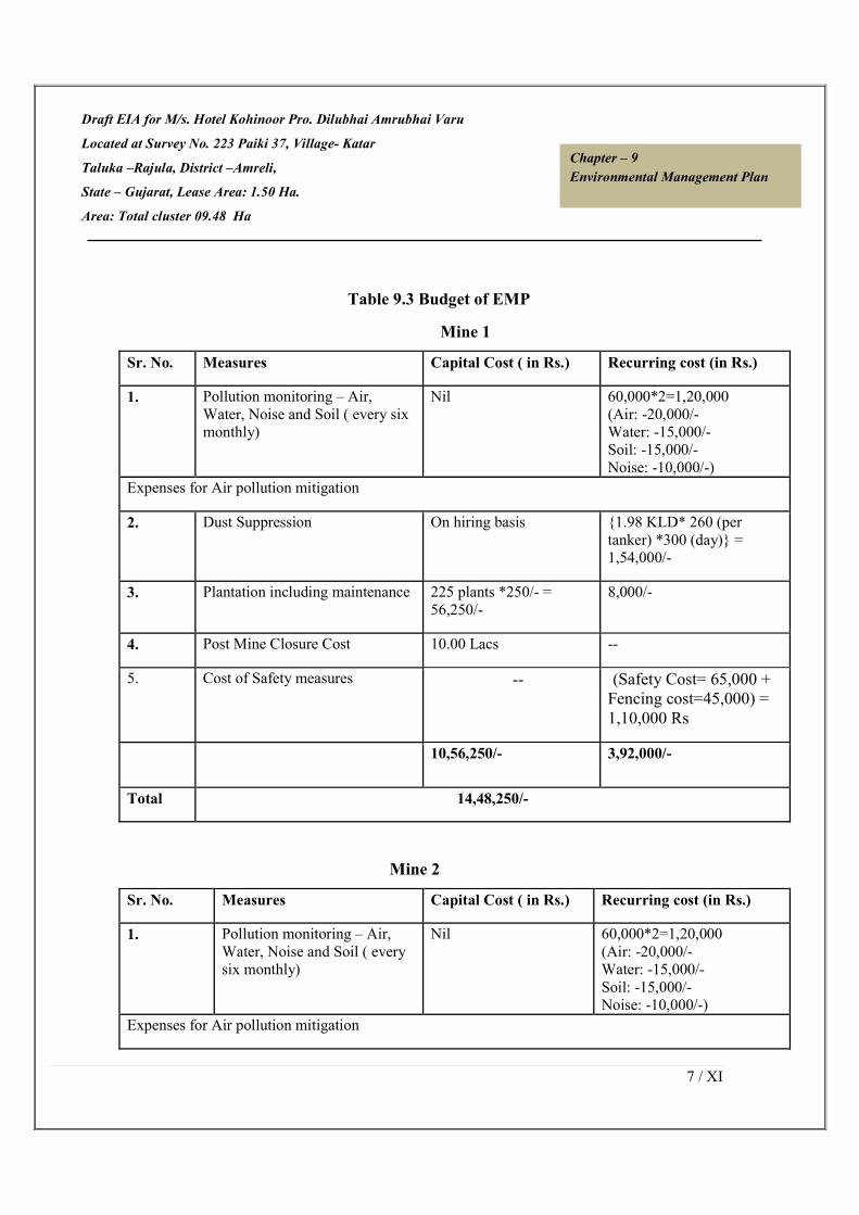
Draft EIA for M/s. Hotel Kohinoor Pro. Dilubhai Amrubhai Varu
Located at Survey No. 223 Paiki 37, Village- Katar
Taluka –Rajula, District –Amreli,
State – Gujarat, Lease Area: 1.50 Ha.
Area: Total cluster 09.48 Ha
7 / XI
Chapter – 9
Environmental Management Plan
Table 9.3 Budget of EMP
Mine 1
Sr. No. Measures Capital Cost ( in Rs.) Recurring cost (in Rs.)
1. Pollution monitoring – Air,
Water, Noise and Soil ( every six
monthly)
Nil 60,000*2=1,20,000
(Air: -20,000/-
Water: -15,000/-
Soil: -15,000/-
Noise: -10,000/-)
Expenses for Air pollution mitigation
2. Dust Suppression On hiring basis {1.98 KLD* 260 (per
tanker) *300 (day)} =
1,54,000/-
3. Plantation including maintenance 225 plants *250/- =
56,250/-
8,000/-
4. Post Mine Closure Cost 10.00 Lacs --
5. Cost of Safety measures -- (Safety Cost= 65,000 +
Fencing cost=45,000) =
1,10,000 Rs
10,56,250/- 3,92,000/-
Total 14,48,250/-
Mine 2
Sr. No. Measures Capital Cost ( in Rs.) Recurring cost (in Rs.)
1. Pollution monitoring – Air,
Water, Noise and Soil ( every
six monthly)
Nil 60,000*2=1,20,000
(Air: -20,000/-
Water: -15,000/-
Soil: -15,000/-
Noise: -10,000/-)
Expenses for Air pollution mitigation

Draft EIA for M/s. Hotel Kohinoor Pro. Dilubhai Amrubhai Varu
Located at Survey No. 223 Paiki 37, Village- Katar
Taluka –Rajula, District –Amreli,
State – Gujarat, Lease Area: 1.50 Ha.
Area: Total cluster 09.48 Ha
8 / XI
Chapter – 9
Environmental Management Plan
2. Dust Suppression On hiring basis {1.5 KLD* 300 (per tanker)
*300 (day)} = 1,35,000/-
3. Plantation including
maintenance
373 plants *250/- =
93,250/-
10,000/-
4. Post Mine Closure Cost 12.50 Lacs --
4. Cost of Safety measures -- (Safety Cost= 75,000 +
Fencing cost=74,600) =
1,49,600
13,43,250 4,12,600/-
Total 17,55,850/-
Mine 3
Sr. No. Measures Capital Cost( in Rs.) Recurring cost (in Rs.)
1. Pollution monitoring – Air,
Water, Noise and Soil ( every
six monthly)
Nil 60,000*2=1,20,000
(Air: -20,000/-
Water: -15,000/-
Soil: -15,000/-
Noise: -10,000/-)
Expenses for Air pollution mitigation
2. Dust Suppression On hiring basis {0.8 KLD* 300 (per tanker)
*300 (day)} = 72,000/-
3. Plantation including
maintenance
150 plants *250/- =
37,500/-
6,000/-
4. Post Mine Closure Cost 10.50 Lacs --
4. Cost of Safety measures -- (Safety Cost= 60,000 +
Fencing cost= 30,000) =
90,000 Rs
10,87,500 2,88,000/-
Total 13,75,500/-

Draft EIA for M/s. Hotel Kohinoor Pro. Dilubhai Amrubhai Varu
Located at Survey No. 223 Paiki 37, Village- Katar
Taluka –Rajula, District –Amreli,
State – Gujarat, Lease Area: 1.50 Ha.
Area: Total cluster 09.48 Ha
9 / XI
Chapter – 9
Environmental Management Plan
Mine 4
Sr. No. Measures Capital Cost( in Rs.) Recurring cost (in Rs.)
1. Pollution monitoring – Air,
Water, Noise and Soil ( every
six monthly)
Nil 60,000*2=1,20,000
(Air: -20,000/-
Water: -15,000/-
Soil: -15,000/-
Noise: -10,000/-)
Expenses for Air pollution mitigation
2. Dust Suppression On hiring basis {1.98 KLD* 260 (per
tanker) *300 (day)} =
1,54,000/-
3. Plantation including
maintenance
225 plants *250/- =
56,250/-
8,000/-
4. Post Mine Closure Cost 10.00 Lacs --
4. Cost of Safety measures -- (Safety Cost= 65,000 +
Fencing cost=45,000) =
1,10,000 Rs
10,56,250/- 3,92,000/-
Total 14,48,250/-
9.9 SOCIO-ECONOMIC CONDITIONS OF THE REGION
The benefits of mining activity will be similar to any industrial set-up. There will be opportunities of
direct and indirect employments. As mentioned earlier there will be around 73 personnel, most of
them will be skilled or semi-skilled & unskilled workers. As per OM dated 30th
September 2020 vide
letter no. F.No. 22-65/2017-IA.III by MOEF & CC budget allocation for CER will be proposed after
public hearing in Final EIA report.
9.10 ENVIRONMENT POLICY

Draft EIA for M/s. Hotel Kohinoor Pro. Dilubhai Amrubhai Varu
Located at Survey No. 223 Paiki 37, Village- Katar
Taluka –Rajula, District –Amreli,
State – Gujarat, Lease Area: 1.50 Ha.
Area: Total cluster 09.48 Ha
10 / XI
Chapter – 9
Environmental Management Plan
Project Proponents of Katar Black Trap Mining Project believes that responsible environmental
stewardship comprises diligent application of well-established natural resource management,
controls and practices for the protection of the mined out land, preservation of biodiversity and
proper disposal of waste if any following the best environmental practices during the process of
mining.
Environmental policy prescribed for standard operating process to bring into focus any
violation/deviation of the environment and forest norms/conditions that the company operations
will implement operational and risk management practices that provide for maximum protection of
people and the environment. To this end, the owner resolves that company will follow the below
mentioned practices:
Operate in accordance with prescribed industry standards while complying with all applicable
environmental, health and safety laws and regulations.
• Establish and maintain a well-defined environmental, health and safety management system to
guide its operations.
• Ensure that all employees, officers and directors understand and adhere to its environmental,
health and safety management program.
• Provide operations with the necessary resources, expertise and training to effectively carry
out its EHS management programs.
• Engage employees at all levels in programs directed towards minimizing adverse effects on
the environment resulting from mining activity.
• Work proactively with governments and the public in the development of cost effective and
realistic regulations that promote enhanced environmental, health and safety protection.
• Promote environmental awareness among its employees, their families and the communities in
which it operates.
• Require those who provide services and products to practice good environmental stewardship.
• Mitigate its environmental impacts through efficient use of resources, and the reduction of input
materials and waste.

Draft EIA for M/s. Hotel Kohinoor Pro. Dilubhai Amrubhai Varu
Located at Survey No. 223 Paiki 37, Village- Katar
Taluka –Rajula, District –Amreli,
State – Gujarat, Lease Area: 1.50 Ha.
Area: Total cluster 09.48 Ha
11 / XI
Chapter – 9
Environmental Management Plan
• Maintain a high degree of emergency preparedness.
9.11 CER DETAILS
As per OM dated 30th
September 2020 vide letter no. F.No. 22-65/2017-IA.III by MOEF & CC
budget allocation for CER will be proposed after public hearing in Final EIA report.
9.12 CONCLUSION
As discussed, it is safe to say that the project is not likely to cause any significant impact on the
ecology of the area, as adequate preventive measures will be adopted to contain the various
pollutants within permissible limits. Green belt development around the area will also be taken up as
an effective pollution mitigative technique, as well as to control the pollutants released from the
premises of the mine.
*****************

Draft EIA for M/s. Hotel Kohinoor Pro. Dilubhai Amrubhai Varu
Located at Survey No. 223 Paiki 37, Village- Katar
Taluka –Rajula, District –Amreli,
State – Gujarat, Lease Area: 1.50 Ha.
Area: Total cluster 09.48 Ha
1 / X
Chapter – 10
Summary and Conclusion
CHAPTER-X
SUMMARY AND CONCLUSION
INDEX
S. No. PARTICULARS PAGE NO.
10.0 PREAMBLE 2/X
10.1 PURPOSE OF THE REPORT 2/X
10.2 IDENTIFICATION OF PROJECT & PROJECT PROPONENT 3/X
10.3 BRIEF DESCRIPTION OF PROJECT 4/X
10.4 PROJECT DESCRIPTION 6/X
10.5 RECLAMATION AND AFFORESTATION PROGRAMME 8/X
10.6 LAND USE PATTERN 9/X
10.7 BASELINE ENVIRONMENTAL STATUS 11/X
10.8 ANTICIPATED ENVIRONMENTAL IMPACTS 13/X
10.9 ENVIRONMENTAL MONITORING PLAN 15/X
10.10 ANALYSIS OF ALTERNATIVES 16/X
10.11 ENVIRONMENTAL MONITORING PROGRAMME 17/X
10.12 COST ESTIMATES 20/X
10.13 ADDITIONAL STUDIES 22/X
10.14 PUBLIC CONSULTATION 23/X
10.15 PROJECT BENEFITS 23/X
10.16 CONCLUSIONS 23/X

Draft EIA for M/s. Hotel Kohinoor Pro. Dilubhai Amrubhai Varu
Located at Survey No. 223 Paiki 37, Village- Katar
Taluka –Rajula, District –Amreli,
State – Gujarat, Lease Area: 1.50 Ha.
Area: Total cluster 09.48 Ha
2 / X
Chapter – 10
Summary and Conclusion
10.0 PERMEABLE
Environment Impact Assessment (EIA) is a process used to identify the environmental, social &
economic impacts of a project prior to decision making. It is a decision-making tool, which guides
the decision makers in taking appropriate decisions for proposed projects. It aims predicting
environmental impacts at an early stage of project planning and design, find ways and means to
reduce adverse impacts, shape projects to suit the local environment and present the predictions and
options to decision makers. By using EIA, both environmental & economic benefits can be achieved.
By considering environmental effects prediction & mitigation, early benefits in project planning,
protection of environment, optimum utilization of resources, thus saving overall time & cost of the
project.
The Ministry of Environment, Forests and Climate Change, vide EIA Notification dated 14th
September, 2006, published a list of project activities (Schedule of the notification) which require
prior environmental clearance. Mining projects are included in the list of activities which require
prior EC. The EIA Notification 2006 its amendment 2009, 2011, 2012 & 2016 of the Ministry of
Environment and Forests, New Delhi & NGT order dated 13.09.2018 including OM dated 12th
December 2018 by MOEF & CC states that if a cluster or individual lease size exceeds 5 Ha the
EIA/EMP report be made applicable in process of grant of EC from SEIAA/SEAC. Project falls in
“B1” Category.
The prime objective of this EIA report is to seek prior environmental clearance from the Gujarat
State Environment Impact Assessment Authority. The EIA Report addresses the anticipated
environmental impacts of implementation and operation of the proposed mining activities and the
mitigation measures to be incorporated to minimize the adverse impacts, if any. Additional
objectives of the EIA study are:
10.1 PURPOSE OF THE REPORT
� To describe the Project and associated activities together with the need for implementation of
the Project;
� To identify and describe the components of the natural and man-made environment likely to
be affected by the project;
� To identify and quantify the environmental impacts associated with the project and
recommend appropriate mitigation measures;
� To establish existing baseline status of different components of the environment so as to

Draft EIA for M/s. Hotel Kohinoor Pro. Dilubhai Amrubhai Varu
Located at Survey No. 223 Paiki 37, Village- Katar
Taluka –Rajula, District –Amreli,
State – Gujarat, Lease Area: 1.50 Ha.
Area: Total cluster 09.48 Ha
3 / X
Chapter – 10
Summary and Conclusion
facilitate visualization of post-project scenario:
� To propose mitigation measures to minimize environmental deterioration and nuisance
during construction and operation of the Project.
� To identify, assess and specify methods, measures and standards, to be to be taken into
consideration during detailed engineering design, construction and operation of the project;
� To identify and justify the scope for post-project environmental monitoring to ensure the
implementation and the effectiveness of the environmental protection and pollution control
measures; and
� To identify any additional studies necessary to fulfill the objectives to the requirements of
this EIA Study.
10.2 IDENTIFICATION OF PROJECT & PROJECT PROPONENT
10.2.1 Identification of Project
The total project area comprises of 4 mines in cluster with total area of 09.48 Ha.
The mining LOI for Mine 1 at Survey No- 223 Paiki 37 reference no.-AMR/BTP/02/2019/008/01
amd e-auction dated 06.09.2019 for grant of quarry lease for Katar Blacktrap Block-B, in favour of
Kind International vide letter no GA/Lease/Auction/Minor/Blacktrap/Amreli/2019/1272 dated
01.11.2019 for a period of 30 years, copy attached as Annexure-II.
The mining LOI for Mine 2 at adjoining Survey no.-223 Paiki 37 reference no.-
AMR/BTP/02/2019/009/01 and e-auction dated 07.09.2019 was granted for mineral Black Trap in
favour of Shri Najubhai Champarajbhai Varu vide letter no.
GA/Lease/Auction/Minor/Blacktrap/Amreli/2019/1278 dated 01.11.2019 for a period of 30 years,
copy attached as Annexure-II .
The mining LOI for Mine 3 at adjoining Survey no.-223 Paiki 37 reference no.-
AMR/BTP/02/2019/010/01 and e-auction dated 12.09.2019 was granted for mineral Black Trap in
favour of Hotel Kohinoor vide letter no. GA/Lease/Auction/Minor/Blacktrap/Amreli/2019/1284
dated 01.11.2019 for a period of 30 years, copy attached as Annexure-II.
The Environmental Clearance has been granted for Mine 4 at adjoining Survey no.-223 Paiki 37 vide
letter no.-DEIAA/AMRELI/EC/1(a)/0004/2017/756 dated 26.04.2017 for mineral Black Trap in
favour of Shri Haresh Najbhai Khuman copy attached as Annexure-II.

Draft EIA for M/s. Hotel Kohinoor Pro. Dilubhai Amrubhai Varu
Located at Survey No. 223 Paiki 37, Village- Katar
Taluka –Rajula, District –Amreli,
State – Gujarat, Lease Area: 1.50 Ha.
Area: Total cluster 09.48 Ha
4 / X
Chapter – 10
Summary and Conclusion
10.2.2 Address of Project Proponent
Mine Project proponent Proponent address Khasra
no/survey no
1 Shri Ghanshyambhai
Dilubhai Varu
R/o Village-Katar, Tehsil-
Rajula, District-
Amreli(Gujrat)
Survey No.- 223 Paiki 37
2 Shri Najubhai
Champrajbhai Varu
R/o Village-Katar, Tehsil-
Rajula, District-
Amreli(Gujrat)
Survey No.- 223 Paiki 37
3 Shri Dilubhai
Amrubhai Varu
R/o Village-Katar, Tehsil-
Rajula, District-
Amreli(Gujrat)
Survey No.- 223 Paiki 37
4 Shri Hareshbhai
Nazbhai Khuman
R/o P.O-Ghoba, Tehsil-
Savarkundla, District-
Amreli, Gujrat.
Survey No.- 223 Paiki 37
10.3 BRIEF DESCRIPTION OF PROJECT
10.3.1 Need of the Project
Today in India Black Trap Mine is used widely in domestic construction sector, monuments
construction markets, hospitality industry, export market and handicraft and antiques. The
material is starting to be more well-known and popular because of technological
advancements, sophisticated quarrying techniques, and decreased cost of mining and growth
in usage as material in the decoration sector. Black Trap Mine as material is showing beauty
and long-lasting value and therefore people have started to use it more and more in
memorials and in other funerary items. Today Black Trap Mine is popular material in laying
floors and cladding walls in airports, hotels and other public and commercial centers.
10.3.2 Size of the project
The proposed project is cluster of 4 mine spread over 09.48 Ha of non-forest waste land. The

Draft EIA for M/s. Hotel Kohinoor Pro. Dilubhai Amrubhai Varu
Located at Survey No. 223 Paiki 37, Village- Katar
Taluka –Rajula, District –Amreli,
State – Gujarat, Lease Area: 1.50 Ha.
Area: Total cluster 09.48 Ha
5 / X
Chapter – 10
Summary and Conclusion
proposed project is production of Black Trap Mineral in the mine lease area and is classified
as “Category B1” by Ministry of Environment, Forest and Climate Change (MoEF&CC),
New Delhi as per the EIA Notification 2006 its amendment 2009, 2011, 2012 & 2016 of the
Ministry of Environment and Forests, New Delhi & NGT order dated 13.09.2018 including
OM dated 12th December 2018 by MOEF & CC.
10.3.3 Anticipated life of project and cost of the project
10.3.4
Table -10.1 Anticipated life of project and cost of the project
Mine Khasra No./Survey No. Mine life
1 Mine – 1
Survey Number-223 Paiki
37 (Block B)
30 Years
2 Mine – 2
Survey Number-223 Paiki
37 (Block C)
30 Years
3 Mine – 3
Survey Number-223 Paiki
37 (Block D)
08 Years
4 Mine – 4
Survey Number-223 Paiki
37 (Shri Hareshbhai
Najbhai Khuman)
13 Years
10.3.5 Location of the Project
The project is located in Village-Katar, Tehsil- Rajula, District: Jamnagar, Gujarat. The
geographical coordinates are stated below:
Table-10.2 Geographical Coordinates of mine lease area
Mine Project Proponent Khasra no/ survey
no
Site co-ordinates
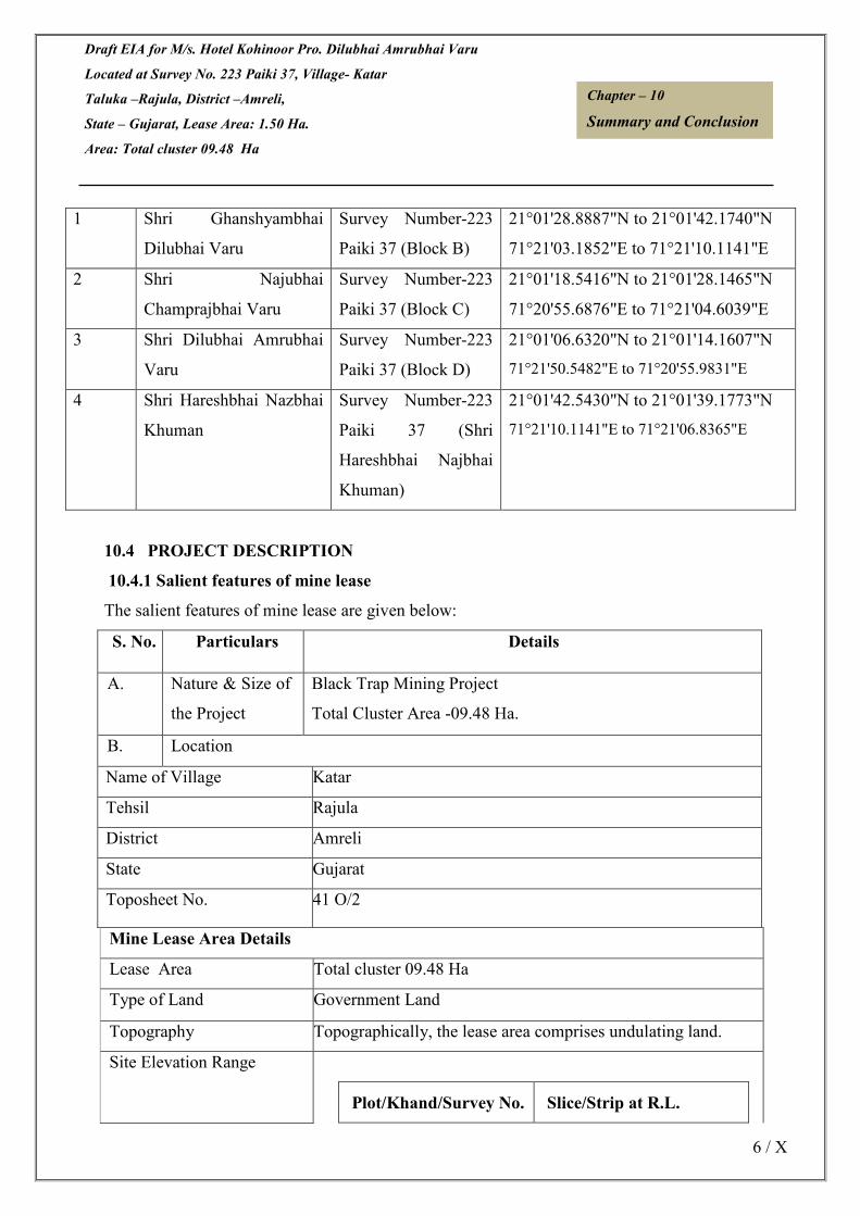
Draft EIA for M/s. Hotel Kohinoor Pro. Dilubhai Amrubhai Varu
Located at Survey No. 223 Paiki 37, Village- Katar
Taluka –Rajula, District –Amreli,
State – Gujarat, Lease Area: 1.50 Ha.
Area: Total cluster 09.48 Ha
6 / X
Chapter – 10
Summary and Conclusion
1 Shri Ghanshyambhai
Dilubhai Varu
Survey Number-223
Paiki 37 (Block B)
21°01'28.8887"N to 21°01'42.1740"N
71°21'03.1852"E to 71°21'10.1141"E
2 Shri Najubhai
Champrajbhai Varu
Survey Number-223
Paiki 37 (Block C)
21°01'18.5416"N to 21°01'28.1465"N
71°20'55.6876"E to 71°21'04.6039"E
3 Shri Dilubhai Amrubhai
Varu
Survey Number-223
Paiki 37 (Block D)
21°01'06.6320"N to 21°01'14.1607"N
71°21'50.5482"E to 71°20'55.9831"E
4 Shri Hareshbhai Nazbhai
Khuman
Survey Number-223
Paiki 37 (Shri
Hareshbhai Najbhai
Khuman)
21°01'42.5430"N to 21°01'39.1773"N
71°21'10.1141"E to 71°21'06.8365"E
10.4 PROJECT DESCRIPTION
10.4.1 Salient features of mine lease
The salient features of mine lease are given below:
S. No. Particulars Details
A. Nature & Size of
the Project
Black Trap Mining Project
Total Cluster Area -09.48 Ha.
B. Location
Name of Village Katar
Tehsil Rajula
District Amreli
State Gujarat
Toposheet No. 41 O/2
Mine Lease Area Details
Lease Area Total cluster 09.48 Ha
Type of Land Government Land
Topography Topographically, the lease area comprises undulating land.
Site Elevation Range
Plot/Khand/Survey No. Slice/Strip at R.L.

Draft EIA for M/s. Hotel Kohinoor Pro. Dilubhai Amrubhai Varu
Located at Survey No. 223 Paiki 37, Village- Katar
Taluka –Rajula, District –Amreli,
State – Gujarat, Lease Area: 1.50 Ha.
Area: Total cluster 09.48 Ha
7 / X
Chapter – 10
Summary and Conclusion
Survey No.- 223 Paiki 37 The altitude of the area is
74-80 m RL
Survey No.- 223 Paiki 37 The altitude of the area is
77-82 m RL
Survey No.- 223 Paiki 37 The altitude of the area is
75-80 m RL
Survey No.- 223 Paiki 37 The altitude of the area is
72-80 m RL
Cost Details
Cost of the project Mine 1- 1,38,04,600/-
Mine 2- 2,59,48,915/-
Mine 3-2,47,94,100/-
Mine 4- 1,38,04,600/-
Cost for EMP Mine 1-14,48,250/-
Mine 2- 17,55,850/-
Mine 3- 13,75,500/-
Mine 4- 14,48,250/-
Details of Environmental Setting
Ecological Sensitive Areas
(National Park, Wild Life
Sanctuary, Biosphere
Reserve, Reserve/
Protected Forest etc.)
• Lion Park National Forest is present at a distance of
4.32 km in SSW direction.
• Reserved land for wild animals of Gir is present at a
distance of 3.66 km in NE direction.
Water Bodies • Kotadi river at a distance of 2.96 km in ENE direction.
• Dharwadi River Dam at a distance of 7.14 km in E
direction
Nearest Town New Barptoli is present at a distance of 2.64 km in SE direction
Nearest Railway Station Rajula Railway station (about 11 KM in E Direction)
Nearest National Highway
SH-107 About 1.46 KM in SSW Direction
SH-6 About 8.30 KM in E Direction
Nearest Airport Diu Airport about 55.54 Km in SW direction.
Seismic Zone Zone III

Draft EIA for M/s. Hotel Kohinoor Pro. Dilubhai Amrubhai Varu
Located at Survey No. 223 Paiki 37, Village- Katar
Taluka –Rajula, District –Amreli,
State – Gujarat, Lease Area: 1.50 Ha.
Area: Total cluster 09.48 Ha
8 / X
Chapter – 10
Summary and Conclusion
10.4.2 Method of Mining
Extraction of Black Trap will be done through opencast semi mechanized mining method. Mineral
will be removed in 1-3 m layer only forming in one slice /strips. Mineral will be loaded in
Trucks/Dumper /Tractor. Height of slices /strips will be 3m-6m. Mining activities will be carried
out in a manner so that there is no obstruction to the movement of water flow and Roads in the QL
area for movement of the Trucks/Dumper/Tractor after minerals loading will be towards both sides
through approach roads connecting to tar roads. No mining will be done in rainy season. No mining
shall be done within 500m meter distance from any irrigation dams (check dams), French wells,
erosion structure and bridge on national Highway.
The slice /strips Parameters shall be for mineral 1. Height – 3-6m
2. Width - width shall be more than 3 m the bench height or 3 times of widest m/c used:
Table no. 10.3 Mining Parameters
Parameters
Bench height 3m-6m
Bench width Not be less than the height of
benches
10.5 RECLAMATION AND AFFORESTATION PROGRAMME
The plants recommended for afforestation are as per Guidelines for Developing Greenbelts, CPCB,
March 2000 and listed in Table 10.1
.
Table-10.4, Species Suggested for Plantation
Sr.
No
Scientific Name General
Name
No’s to be
Planted
01 Ficus benghalensis Banyan Tree 200
02 Ficus religiosa Peepal 150
03 Delonix regia Gulmahor 200
04 Azadirachta indica Neem 273
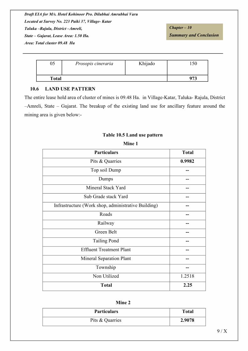
Draft EIA for M/s. Hotel Kohinoor Pro. Dilubhai Amrubhai Varu
Located at Survey No. 223 Paiki 37, Village- Katar
Taluka –Rajula, District –Amreli,
State – Gujarat, Lease Area: 1.50 Ha.
Area: Total cluster 09.48 Ha
9 / X
Chapter – 10
Summary and Conclusion
10.6 LAND USE PATTERN
The entire lease hold area of cluster of mines is 09.48 Ha. in Village-Katar, Taluka- Rajula, District
–Amreli, State – Gujarat. The breakup of the existing land use for ancillary feature around the
mining area is given below:-
Table 10.5 Land use pattern
Mine 1
Particulars Total
Pits & Quarries 0.9982
Top soil Dump --
Dumps --
Mineral Stack Yard --
Sub Grade stack Yard --
Infrastructure (Work shop, administrative Building) --
Roads --
Railway --
Green Belt --
Tailing Pond --
Effluent Treatment Plant --
Mineral Separation Plant --
Township --
Non Utilized 1.2518
Total 2.25
Mine 2
Particulars Total
Pits & Quarries 2.9078
05 Prosopis cineraria Khijado 150
Total 973
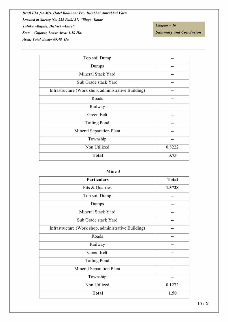
Draft EIA for M/s. Hotel Kohinoor Pro. Dilubhai Amrubhai Varu
Located at Survey No. 223 Paiki 37, Village- Katar
Taluka –Rajula, District –Amreli,
State – Gujarat, Lease Area: 1.50 Ha.
Area: Total cluster 09.48 Ha
10 / X
Chapter – 10
Summary and Conclusion
Top soil Dump --
Dumps --
Mineral Stack Yard --
Sub Grade stack Yard --
Infrastructure (Work shop, administrative Building) --
Roads --
Railway --
Green Belt --
Tailing Pond --
Mineral Separation Plant --
Township --
Non Utilized 0.8222
Total 3.73
Mine 3
Particulars Total
Pits & Quarries 1.3728
Top soil Dump --
Dumps --
Mineral Stack Yard --
Sub Grade stack Yard --
Infrastructure (Work shop, administrative Building) --
Roads --
Railway --
Green Belt --
Tailing Pond --
Mineral Separation Plant --
Township --
Non Utilized 0.1272
Total 1.50

Draft EIA for M/s. Hotel Kohinoor Pro. Dilubhai Amrubhai Varu
Located at Survey No. 223 Paiki 37, Village- Katar
Taluka –Rajula, District –Amreli,
State – Gujarat, Lease Area: 1.50 Ha.
Area: Total cluster 09.48 Ha
11 / X
Chapter – 10
Summary and Conclusion
Mine 4
Particulars Total
Mining 0.0
Pits/Mining Activity Area 0.4731
Dumps 0.0
Haul Road 0.0050
Mineral Stack Yard --
Sub Grade stack Yard --
Infrastructure (Work shop, administrative Building) 0.0070
Plantation 0.0
Tailing Pond --
Mineral Stack 0.0
Remaining Virgin area 1.5149
Total 2.00
10.7 BASELINE ENVIRONMENTAL STATUS
10.7.1 Soil quality
4 soil samples were collected in and around the mine lease area to assess the present soil quality of the
region. The pH value is ranging from 7.53 to 7.88. The cation exchange ratio value ranges from
111.59 to 271.28 meq/100gm. . Based on the results, it is evident that the soils are not contaminated by
any polluting sources.
10.7.2 Meteorology
Meteorological data at the site was monitored during Oct, 2020 to December, 2020.
10.7.3 Ambient Air Quality
Ambient Air Quality Monitoring (AAQM) has been carried out at seven locations pre-monsoon season of
October to December 2020. The minimum and maximum level of PM10 recorded within the study area
was in the range of 77.10 µg/m3 to 85.80 µg/m3 with the 98th percentile ranging between 84.18
µg/m3 to 85.76 µg/m3. The minimum and maximum level of PM 2.5 recorded within the study area was in
the range of 37.55 μg/m3 to 52.94 μg/m3 with the 98th percentile ranging between 43.00 μg/m3 to 48.71
μg/m3. The minimum and maximum level of SO2 recorded within the study area was in the range of 10.21

Draft EIA for M/s. Hotel Kohinoor Pro. Dilubhai Amrubhai Varu
Located at Survey No. 223 Paiki 37, Village- Katar
Taluka –Rajula, District –Amreli,
State – Gujarat, Lease Area: 1.50 Ha.
Area: Total cluster 09.48 Ha
12 / X
Chapter – 10
Summary and Conclusion
µg/m3 to 14.91 µg/m3 with the 98th percentile ranging between 12.21 µg/m3 to 14.80 µg/m3. The minimum
and maximum level of NOx recorded within the study area was in the range of 19.04 µg/m3 to 25.02 µg/m3
with the 98th percentile ranging between 24.37 µg/m3 to 24.97 µg/m3. The results thus obtained indicate that
the concentrations of PM10, SO2 and NO2 in the ambient air are well within the National Ambient Air Quality
(NAAQ) standards for Residential and Rural areas.
10.7.4 Water Quality
To assess the physical and chemical properties of water in the region, water samples from four locations
were collected from various water sources around the mine lease area. the pH was varying for
ground waters from 7.43 to 7.96. The total dissolved solids are varying from 722 mg/l to 834
mg/l. The chloride level in ground water samples 68.096 mg/l to 131.00 mg/l the chloride
samples are within the desirable limits. In the ground water samples collected from the study area,
the hardness is varying from 364 mg/l to 380 mg/l. In the ground water samples of study area
the fluoride value were in the range of 0.65 mg/l to 0.89 mg/l. The results indicate groundwater is
generally in conformity with the drinking water standards (IS: 10500) and surface water is in
conformity with IS-2296 standards.
10.7.5 Noise Levels
Noise monitoring reveals that the minimum & maximum noise levels at day time were
recorded as 50.5 to 61.1 dB (A) respectively. The minimum & maximum noise levels at night
time were found at 41.1 to 47.9 dB (A) respectively within the study area.
10.7.6 Ecological Environment
Based on the field studies and review of published literature, it is observed that there no
schedule-I species in the buffer zone. There are no wildlife sanctuaries and National Parks
within the study area of 10-km radius. However, some RF and PF are present within 10 km
radius from the mine site.
10.7.7 Social Environment
The implementation of the Black Trap Mining Project will generate both direct and indirect
employment. At present agriculture is the main occupation of the people as more than half of
the population depends on it. With the implementation of the proposed mining project the
occupational pattern of the people in the area will change making more people engaged in
industrial and business activities rather in agriculture. Thus there will be a gradual shifting of

Draft EIA for M/s. Hotel Kohinoor Pro. Dilubhai Amrubhai Varu
Located at Survey No. 223 Paiki 37, Village- Katar
Taluka –Rajula, District –Amreli,
State – Gujarat, Lease Area: 1.50 Ha.
Area: Total cluster 09.48 Ha
13 / X
Chapter – 10
Summary and Conclusion
population from agriculture to mining and industry. The study area is still lacking in
education, health, housing, water, electricity etc. It is expected that same will improve to a
great extent due to proposed mining project and associated industrial and business activities.
All persons aged seven years and above, who can both read and write with understanding in
any language have been considered as literate in this study.
10.8 ANTICIPATED ENVIRONMENTAL IMPACTS
10.7.1 Impact on air quality
Black Trap Mining is carried out by opencast semi mechanized method. The air borne
particulate matter generated by ore and handling operations, and transportation of ore is the
main air pollutant. The emissions of Sulphur dioxide (SO2), Oxides of Nitrogen (NO2)
contributed by diesel operated excavation/loading equipment and vehicles plying on haul
roads are marginal. Prediction of impacts on air environment has been carried out taking into
consideration proposed production and net increase in emissions, in Final EIA report.
Air pollution sources in the operating mine have been classified into:
10.7.1.1 Line Sources
A. Transportation of ore from mining benches to tipper platform of plant, movement of
tippers on the haul road is considered as line sources.
Water tankers with spraying arrangement will be used for regular water sprinkling on the haul
roads to ensure effective dust suppression. The tippers are well maintained so that exhaust
smoke does not contribute abnormal values of noxious gases and un- burnt hydrocarbons.
10.7.2 Impact on Water Resources
Surface Water Resources
As there is no seasonal nalla or water body within the leasehold area, therefore no change
will be observed due to mining operation.
Groundwater Resources
The ground water table in the lease area varies from 65 m to 70 m below general ground and

Draft EIA for M/s. Hotel Kohinoor Pro. Dilubhai Amrubhai Varu
Located at Survey No. 223 Paiki 37, Village- Katar
Taluka –Rajula, District –Amreli,
State – Gujarat, Lease Area: 1.50 Ha.
Area: Total cluster 09.48 Ha
14 / X
Chapter – 10
Summary and Conclusion
the mining will not intersects the ground level.
10.7.3 Impact on Water Quality
There is no toxic element in and around the applied area or in OB or ore. Hence
contamination of any nature is not expected for surface or any ground water source.
Analysis results of surface water samples collected from rivers and nallas in the buffer zone
indicate that the pH, total dissolved solids (TDS) are well below the prescribed limits.
No wastewater generation is envisaged due to the mining operations. The sanitary wastewater
will be sent to septic tanks. No impact of wastewater generation on the surface water is
envisaged, as there is no discharge into surface water resources.
10.7.4 Impact on noise levels and ground vibrations
With the mining operations, involving deployment of machinery for mine development,
excavation and transportation of sand, it is imperative that noise levels would increase. It is
also observed that these incremental noise levels will not significantly affect the existing
ambient noise levels.
With the adoption of controlled blasting techniques, the ground vibrations will be minimized.
10.7.5 Impact on Soil
The environmental impacts of the mining activities on topsoil are based on the quantity of
removal of topsoil and its dumping. In the present project as there is no top soil proposed, so
no adverse impact of excavation of topsoil is envisaged.
10.7.6 Impact on Flora and Fauna
As the mining activity is restricted to core zone, no significant impact on the flora of the
buffer zone due to the proposed mining of Black Trap is anticipated. It is proposed to include
Banyan Tree, Peepal, Gulmohar, Neem, Khijado etc in the plantation program as they serve
as sinks for gaseous emissions. Extensive plantation comprising of pollutant resistant trees
will be undertaken, which will serve not only as pollution sink but also as a noise barrier.
The incremental dust generations due to the mining operations, at the boundary of the mine

Draft EIA for M/s. Hotel Kohinoor Pro. Dilubhai Amrubhai Varu
Located at Survey No. 223 Paiki 37, Village- Katar
Taluka –Rajula, District –Amreli,
State – Gujarat, Lease Area: 1.50 Ha.
Area: Total cluster 09.48 Ha
15 / X
Chapter – 10
Summary and Conclusion
lease are insignificant and it is also expected that with the adoption of mitigation measures as
suggested in EMP, the impact due to operation of the mine will be minimal on the terrestrial
ecosystem and also on the adjacent forest area.
The impact on the fauna of the buffer zone due to the mining activity will be insignificant.
The proposed progressive plantation over a period of time will reduce the impact, if any, on
the fauna.
10.7.7 Impact on Land Use Pattern
The proposed opencast mine will not change the land use pattern of the ML area. There is no
land degradation due mining.
10.7.8 Impact on Socio-Economic Aspects
The mine area does not cover any habitation. Hence the mining activity does not involve any
displacement of human settlement. No public buildings, places, monuments etc exist within
the lease area or in the vicinity. The mining operation will not disturb/ relocate any village or
need resettlement. Thus no adverse impact is anticipated.
The impact of mining activity in the area is positive on the socio-economic environment of
the region. Black Trap Mining Project will be providing employment to local population and
it will give preference to the local people whenever there is requirement of manpower.
10.9 ENVIRONMENTAL MANAGEMENT PLAN
The summary of suggestive mitigation measures are given in below:
Table-10.6 Key suggestive measures under EMP
Impact Predicted Suggestive measure
Disturbance of free
movement/living of
wild fauna
• No labour camp will be allowed in reserve forest
• Awareness camps will be conducted for labours to make them
aware about sensitivity/importance of forest life
• No tract or new road for movement of labours or vehicles be laid
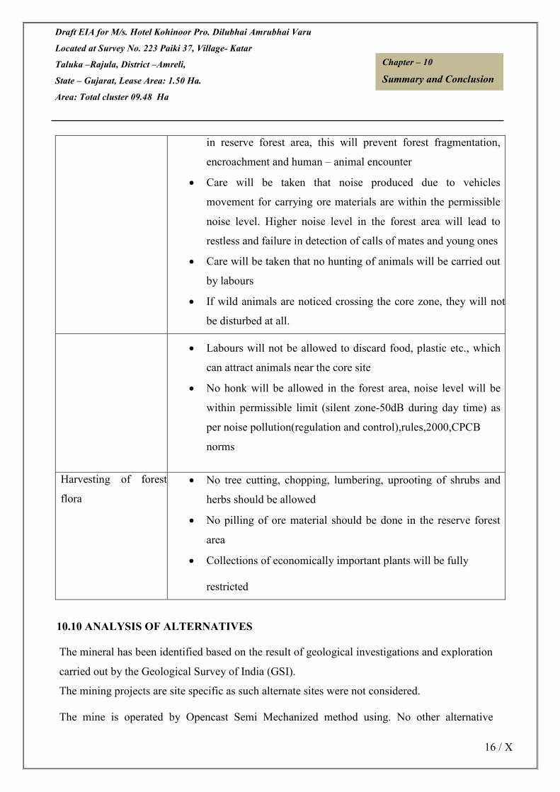
Draft EIA for M/s. Hotel Kohinoor Pro. Dilubhai Amrubhai Varu
Located at Survey No. 223 Paiki 37, Village- Katar
Taluka –Rajula, District –Amreli,
State – Gujarat, Lease Area: 1.50 Ha.
Area: Total cluster 09.48 Ha
16 / X
Chapter – 10
Summary and Conclusion
in reserve forest area, this will prevent forest fragmentation,
encroachment and human – animal encounter
• Care will be taken that noise produced due to vehicles
movement for carrying ore materials are within the permissible
noise level. Higher noise level in the forest area will lead to
restless and failure in detection of calls of mates and young ones
• Care will be taken that no hunting of animals will be carried out
by labours
• If wild animals are noticed crossing the core zone, they will not
be disturbed at all.
• Labours will not be allowed to discard food, plastic etc., which
can attract animals near the core site
• No honk will be allowed in the forest area, noise level will be
within permissible limit (silent zone-50dB during day time) as
per noise pollution(regulation and control),rules,2000,CPCB
norms
Harvesting of forest
flora
• No tree cutting, chopping, lumbering, uprooting of shrubs and
herbs should be allowed
• No pilling of ore material should be done in the reserve forest
area
• Collections of economically important plants will be fully
restricted
10.10 ANALYSIS OF ALTERNATIVES
The mineral has been identified based on the result of geological investigations and exploration
carried out by the Geological Survey of India (GSI).
The mining projects are site specific as such alternate sites were not considered.
The mine is operated by Opencast Semi Mechanized method using. No other alternative

Draft EIA for M/s. Hotel Kohinoor Pro. Dilubhai Amrubhai Varu
Located at Survey No. 223 Paiki 37, Village- Katar
Taluka –Rajula, District –Amreli,
State – Gujarat, Lease Area: 1.50 Ha.
Area: Total cluster 09.48 Ha
17 / X
Chapter – 10
Summary and Conclusion
technologies can be used because of the hard nature of the ore. Proposed mine is using eco-
friendly measures to minimize the impact of mining on the surrounding environment.
10.11 ENVIRONMENTAL MONITORING PROGRAMME
Attributes Sampling Measurement
Method
Test Procedure
Network Frequency
A. Air Environment
Meteorological
· Wind direction
· Relative
humidity
· Rainfall
Minimum
1 site
in the project
impact area
Regularly in
one
season by
Weather
Monitoring
Station
Mechanical/automatic
weather station
-
Pollutants
PM10
6 locations in
the project
impact area
(Minimum 1
Once in a
season.
Gravimetric method -
Gravimetric method -
SO2 EPA Modified West
&
Absorption in
Potassium Tetra
locations in Geake method Chloromercurate
upwind side, followed by
1 sites in Colorimetric
downwind estimation using P-
side / impact Rosaniline
zone and 1 in hydrochloride and
core zone) Formaldehyde (IS:
5182 Part - II).
NO2 Arsenite modified
Jacob & Hochheiser
Absorption in dil.
NaOH and then
Estimated
Colorimetrically
With
Sulphanilamide

Draft EIA for M/s. Hotel Kohinoor Pro. Dilubhai Amrubhai Varu
Located at Survey No. 223 Paiki 37, Village- Katar
Taluka –Rajula, District –Amreli,
State – Gujarat, Lease Area: 1.50 Ha.
Area: Total cluster 09.48 Ha
18 / X
Chapter – 10
Summary and Conclusion
and N (I-Nepthyle)
Ethylene diamine
Dihydrochloride
and Hydrogen
Peroxide
(CPCB Method).
B. Water Environment
pH, Turbidity, Set of grab Diurnal and As per IS 10500 Samples for water
Colour, Odour, samples Season wise quality should be
Taste, during pre collected and
TDS, Total and post- Analyzed
Hardness, Calcium monsoon as per :
hardness, for IS : 2488 (Part 1-
Magnesium ground and 5)
hardness, surface methods for
Chloride, Water in the Sampling
Fluoride, Sulphate, vicinity. and testing of
Nitrates, Industrial
Alkalinity, Effluents
Iron, Copper, Standard methods
Manganese, For
Mercury, examination of
Cadmium, Water
Selenium, Arsenic, and wastewater
Cyanide, Lead, analysis published
Zinc, Chromium, By
Aluminum, Boron, American Public
Phenolic Health
Compounds Association.

Draft EIA for M/s. Hotel Kohinoor Pro. Dilubhai Amrubhai Varu
Located at Survey No. 223 Paiki 37, Village- Katar
Taluka –Rajula, District –Amreli,
State – Gujarat, Lease Area: 1.50 Ha.
Area: Total cluster 09.48 Ha
19 / X
Chapter – 10
Summary and Conclusion
C. Noise
the lease
D. Soil
pH, Bulk Density,
Soil texture,
Nitrogen,
Available
Phosphorus,
Potassium,
Calcium,
Magnesium,
Sodium, Electrical
Conductivity,
Organic Matter,
Chloride
5 locations
in the project
impact area
Yearly/half
yearly
As per USDA
Method
As per USDA
Method
E. Socioeconomic
· Demographic
structure
· Infrastructure
resource base
· Economic
resource base
· Health status:
Morbidity pattern
· Cultural and
Aesthetic
attributes
· Education
Socioeconomic
survey is based
on
proportionate,
stratified and
random
sampling
method
Minimum for
two phases of
the project
Primary data
collection through
Questionnaire
Secondary data
from census
records, statistical
hard books,
toposheets, health
records and
relevant official
records available
with Govt.
agencies
Noise levels at Mine Quarterly / As per CPCB norms As per CPCB
Day & night time - Boundary, Half norms
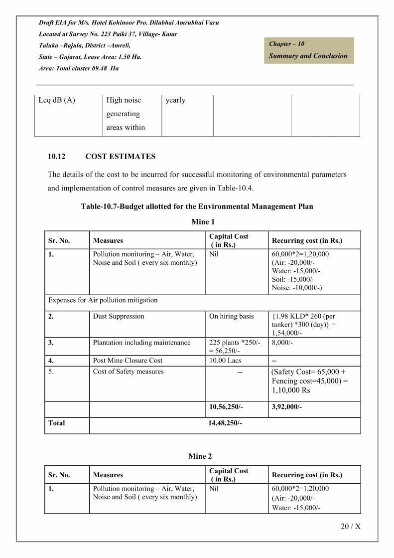
Draft EIA for M/s. Hotel Kohinoor Pro. Dilubhai Amrubhai Varu
Located at Survey No. 223 Paiki 37, Village- Katar
Taluka –Rajula, District –Amreli,
State – Gujarat, Lease Area: 1.50 Ha.
Area: Total cluster 09.48 Ha
20 / X
Chapter – 10
Summary and Conclusion
Leq dB (A) High noise yearly
generating
areas within
10.12 COST ESTIMATES
The details of the cost to be incurred for successful monitoring of environmental parameters
and implementation of control measures are given in Table-10.4.
Table-10.7-Budget allotted for the Environmental Management Plan
Mine 1
Sr. No. Measures Capital Cost
( in Rs.) Recurring cost (in Rs.)
1. Pollution monitoring – Air, Water,
Noise and Soil ( every six monthly)
Nil 60,000*2=1,20,000
(Air: -20,000/-
Water: -15,000/-
Soil: -15,000/-
Noise: -10,000/-)
Expenses for Air pollution mitigation
2. Dust Suppression On hiring basis {1.98 KLD* 260 (per
tanker) *300 (day)} =
1,54,000/-
3. Plantation including maintenance 225 plants *250/-
= 56,250/-
8,000/-
4. Post Mine Closure Cost 10.00 Lacs --
5. Cost of Safety measures -- (Safety Cost= 65,000 +
Fencing cost=45,000) =
1,10,000 Rs
10,56,250/- 3,92,000/-
Total 14,48,250/-
Mine 2
Sr. No. Measures Capital Cost
( in Rs.) Recurring cost (in Rs.)
1. Pollution monitoring – Air, Water,
Noise and Soil ( every six monthly)
Nil 60,000*2=1,20,000
(Air: -20,000/-
Water: -15,000/-

Draft EIA for M/s. Hotel Kohinoor Pro. Dilubhai Amrubhai Varu
Located at Survey No. 223 Paiki 37, Village- Katar
Taluka –Rajula, District –Amreli,
State – Gujarat, Lease Area: 1.50 Ha.
Area: Total cluster 09.48 Ha
21 / X
Chapter – 10
Summary and Conclusion
Soil: -15,000/-
Noise: -10,000/-)
Expenses for Air pollution mitigation
2. Dust Suppression On hiring basis {1.5 KLD* 300 (per tanker)
*300 (day)} = 1,35,000/-
3. Plantation including maintenance 373 plants *250/-
= 93,250/-
10,000/-
4. Post Mine Closure Cost 12.50 Lacs --
4. Cost of Safety measures -- (Safety Cost= 75,000 +
Fencing cost=74,600) =
1,49,600
13,43,250 4,12,600/-
Total 17,55,850/-
Mine 3
Sr. No. Measures Capital Cost( in
Rs.) Recurring cost (in Rs.)
1. Pollution monitoring – Air, Water,
Noise and Soil ( every six monthly)
Nil 60,000*2=1,20,000
(Air: -20,000/-
Water: -15,000/-
Soil: -15,000/-
Noise: -10,000/-)
Expenses for Air pollution mitigation
2. Dust Suppression On hiring basis {0.8 KLD* 300 (per tanker)
*300 (day)} = 72,000/-
3. Plantation including maintenance 150 plants *250/-
= 37,500/-
6,000/-
4. Post Mine Closure Cost 10.50 Lacs --
4. Cost of Safety measures -- (Safety Cost= 60,000 +
Fencing cost= 30,000) =
90,000 Rs
10,87,500 2,88,000/-
Total 13,75,500/-
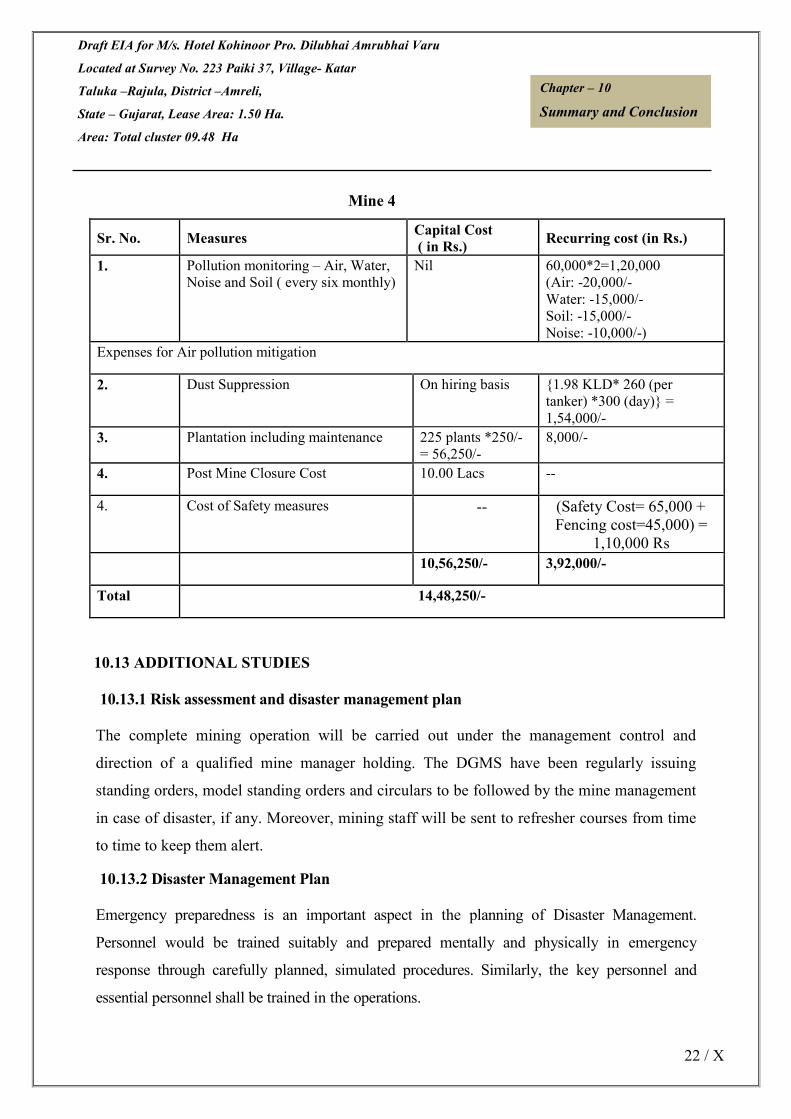
Draft EIA for M/s. Hotel Kohinoor Pro. Dilubhai Amrubhai Varu
Located at Survey No. 223 Paiki 37, Village- Katar
Taluka –Rajula, District –Amreli,
State – Gujarat, Lease Area: 1.50 Ha.
Area: Total cluster 09.48 Ha
22 / X
Chapter – 10
Summary and Conclusion
Mine 4
Sr. No. Measures Capital Cost
( in Rs.) Recurring cost (in Rs.)
1. Pollution monitoring – Air, Water,
Noise and Soil ( every six monthly)
Nil 60,000*2=1,20,000
(Air: -20,000/-
Water: -15,000/-
Soil: -15,000/-
Noise: -10,000/-)
Expenses for Air pollution mitigation
2. Dust Suppression On hiring basis {1.98 KLD* 260 (per
tanker) *300 (day)} =
1,54,000/-
3. Plantation including maintenance 225 plants *250/-
= 56,250/-
8,000/-
4. Post Mine Closure Cost 10.00 Lacs --
4. Cost of Safety measures -- (Safety Cost= 65,000 +
Fencing cost=45,000) =
1,10,000 Rs
10,56,250/- 3,92,000/-
Total 14,48,250/-
10.13 ADDITIONAL STUDIES
10.13.1 Risk assessment and disaster management plan
The complete mining operation will be carried out under the management control and
direction of a qualified mine manager holding. The DGMS have been regularly issuing
standing orders, model standing orders and circulars to be followed by the mine management
in case of disaster, if any. Moreover, mining staff will be sent to refresher courses from time
to time to keep them alert.
10.13.2 Disaster Management Plan
Emergency preparedness is an important aspect in the planning of Disaster Management.
Personnel would be trained suitably and prepared mentally and physically in emergency
response through carefully planned, simulated procedures. Similarly, the key personnel and
essential personnel shall be trained in the operations.

Draft EIA for M/s. Hotel Kohinoor Pro. Dilubhai Amrubhai Varu
Located at Survey No. 223 Paiki 37, Village- Katar
Taluka –Rajula, District –Amreli,
State – Gujarat, Lease Area: 1.50 Ha.
Area: Total cluster 09.48 Ha
23 / X
Chapter – 10
Summary and Conclusion
10.14 PUBLIC CONSULTATION
10.14.1 Public Hearing
This is draft EIA. Public hearing yet to conduct.
10.15 PROJECT BENEFITS
The impact on the civic amenities will be substantial after the commencement of mining
activities. Medical facilities will be provided in the form of first-aid facility at the mine.
These medical facilities will also be available to local people in the surrounding in case of
emergencies.
• Generation of employment and improved standard of living;
• Increased revenue to the State by way of royalty, taxes and duties; and
• Superior communication and transport facilities etc.
The employment of local people in primary and secondary sectors of project will upgrade the
prosperity of the region.
10.16 CONCLUSIONS
• The mining operations will meet the compliance requirements of MoEF.
• Community impacts will be beneficial, as the project will generate significant economic
benefits for the region;
• Adoption of best available technology and best management practices with more
environmental friendly process and
• With the effective implementation of the Environment Management Plan (EMP) during
the mining activities, the proposed project can proceed without any significant negative
impact on environment.
***************

Draft EIA for M/s. Hotel Kohinoor Pro. Dilubhai Amrubhai Varu
Located at Survey No. 223 Paiki 37, Village- Katar
Taluka –Rajula, District –Amreli,
State – Gujarat, Lease Area: 1.50 Ha.
Area: Total cluster 09.48 Ha
122 / XI
Chapter – 11
Consultant Engaged
CONSULTANTS ENGAGED
The consultant engaged for the preparation of the EIA/EMP of the project is M/s Cognizance
Research India Private Ltd. The information about the company with address is as follows:
Basic Information about the Consultant Engaged is as follows stated below:
Name of the Consultant Cognizance Research India Private Ltd.
Address GT-20, Sector – 117, Noida -201301 – U.P
Credentials Accredited by QCI/NABET
Personnel involved in the preparation of EIA/EMP report are stated below:
Sr.
No.
Name EC/FAE Details
01 Mr. Sanchit Kumar EC EIA Coordinator (Mining of minerals opencast).
02 Mr. NimishSinghvi FAE AP, SHW
03 Mr. Vineet Pandey FAE SE
04 Ms. Neha FAE AQ & NV
05 Mr. Ankur Sharma FAE WP
05 Ms. Pooja FAE EB

Draft EIA for M/s. Hotel Kohinoor Pro. Dilubhai Amrubhai Varu
Located at Survey No. 223 Paiki 37, Village- Katar
Taluka –Rajula, District –Amreli,
State – Gujarat, Lease Area: 1.50 Ha.
Area: Total cluster 09.48 Ha
123 / XI
Chapter – 11
Consultant Engaged
06 Mr. ChakorGedam FAE RH
07 Dr. P
RadhakrishnaMoorthy
FAE HG
08 Mr. Subhash Kumar FAE SC
09 Abhishek Kr. Singh FAE Geo & LU

Draft EIA for M/s. Hotel Kohinoor Pro. Dilubhai Amrubhai Varu
Located at Survey No. 223 Paiki 37, Village- Katar
Taluka –Rajula, District –Amreli,
State – Gujarat, Lease Area: 1.50 Ha.
Area: Total cluster 09.48 Ha
124 / XI
Chapter – 11
Consultant Engaged
Accreditation Certificate of the Consultant Engaged:

Draft EIA for M/s. Hotel Kohinoor Pro. Dilubhai Amrubhai Varu
Located at Survey No. 223 Paiki 37, Village- Katar
Taluka –Rajula, District –Amreli,
State – Gujarat, Lease Area: 1.50 Ha.
Area: Total cluster 09.48 Ha
125 / XI
Chapter – 11
Consultant Engaged
Consultant Contact Details:
Cognizance Research India Private Ltd.
Address – GT – 20, Sec – 117, Noida – 201301
Mobile no. - +919953843815
Email id – [email protected]
Website – www.cognizanceindia.com