Embed Size (px)
Citation preview

Sub-Basin Level Flood Action Programme
BULGARIAN TRIBUTARIES
REPUBLIC OF BULGARIA
MINISTRY OF ENVIRONMENT AND WATER
DANUBE RIVER BASIN DIRECTORATE
October, 2009
2
Table of Content
1 Introduction ........................................................................................................................ 3
2 Characterisation of Current Situation................................................................................. 3
2.1. Review and assessment of the current situation.................................................................. 3
2.1.1 Natural conditions ............................................................................................ 3
2.1.2 Hydrology........................................................................................................... 6
2.1.3 Characterisation of land uses.............................................................................. 8
2.1.4 Flood forecasting and warning......................................................................... 11
2.1.5 Institutional and legal framework .................................................................... 12
2.1.6 Recent awareness of flooding ?........................................................................ 13
2.2. Review and assessment of the predictable long term developments (consider the impact of
climate change too) .................................................................................................................. 13
2.2.1. Possible impacts on a current flood protection level.............................................. 13
2.2.2. Summary of existing national plans and ongoing programs .................................. 13
3 Target Settings ................................................................................................................. 14
3.1 Regulation of land use and spatial planning............................................................. 14
3.2 Reactivation of former, or creation of new retention and detention capacities........ 14
3.3 Technical Flood Defences........................................................................................ 14
3.4 Preventive actions .................................................................................................... 14
3.5 Capacity building of professionals........................................................................... 14
3.6 Raising awareness and preparedness of general public ........................................... 14
3.7 Prevention and Mitigation of Water Pollution Due to Floods ................................. 14
4 Measures to Achieve Targets ......................................................................................... 15

3
1 Introduction
The adoption in 1999 of the Strategy for Integrated Water Management marked the beginning
of the reforms in the water sector in Bulgaria in line with the WFD and other obligations
undertaken under international instruments. Several other programs such as: Strategy for the
Integrated Water Management in the Republic of Bulgaria – institutional aspects, National
Strategy for Management and Development of the Water Sector until 2015, and the
Operational Programme Environment 2007 - 2013 (OPE) complete the picture of ongoing
efforts towards compliance and enforcement of EU legislation.
Now the legal framework for environmental management of water resources and ecosystems
in Bulgaria comprises a system of decrees, laws, ordinances and regulations on different
administrative levels.
In addition, a process of drafting the National Strategy for the Environment 2010-2018 and its
Action Plan is in progress.
The transposition of the EU Flood Directive into national legislation is at its final stage.
Floods are basin wide phenomena which do not respect borders and often create common
problems between regions and countries. It is widely recognized that effective prevention of
and intervention against floods requires cross-border cooperation. Therefore, the EU Flood
Directive aims at creating one single flood risk management plan for each River basin, thus
promoting coordination and collaboration between authorities across borders.
The Action Programme for Sustainable Flood Protection in the Danube River Basin (ICPDR,
2004) also foresees preparation of the action plans for the sub-basins, which should serve as
essential tools to support cooperation and harmonization between the countries in the field of
flood risk management.
This Document is prepared in response to the ICPDR Flood Action Programme following the
content described in chapter 5.2 of the Programme and it summarises the key actions towards
preparation of the flood risk management plans.
2 Characterisation of Current Situation
2.1. Review and assessment of the current situation
2.1.1 Natural conditions
This Document includes all Danube tributaries whose River’s networks are formed on
Bulgarian territory. The main Danube tributaries in Bulgaria collect their water from the
northern slopes of the Balkan Mountains , with the exception of the upstream part of the Iskar
River and Danube Dobrudja Rivers in the Eastern part of the basin.
The Bulgarian Water Law defines the delineation of the Bulgarian part of the Danube River
Basin on the basis of catchments areas of the main Bulgarian tributaries of the Danube River.
Based on this description six major sub-basins could be defined as follows (shown on Figure
1):
• Ogosta River and Rivers West of Ogosta
• Iskar River
• Vit River
• Osam River

4
• Yantra River
• Roussenski Lom River
• Danube Dobrudja Rivers
Figure 1. Main sub-basins in the Bulgarian part of the Danube River Basin
Ogosta River and Rivers West of Ogosta
Ogosta River starts its way from Chiprovska River springing from Vraja glava peak at the
border with Serbia. In its upstream part it cuts through Mountain ous areas with steep slopes.
The relief in Ogosta midstream and downstream sections changes form semi-mountainous to
plain.
The total area of river basins including Ogosta is 8 022 km2. Ogosta River has about 40
tributaries, of which the most significant are Botunia (length 69 km catchment area 732 km2)
and Barsia (length 35 km catchment area 241 km2).
Iskar is the only river in the Bulgarian part of the Danube River Basin (DRB) which springs
in the southern part of the country. Its source is in the Rila Mountain and its upstream section
collects water from Vitosha, Lyulin, Plana Mountains and the southern slopes of the Balkan
Mountain, before cutting through the latter by the Iskar Gorge. With its 368 km Iskar River is
the longest Bulgarian tributary of the Danube River and also has the largest catchment area in
the Bulgarian part of the DRB – 8 647 km2.
The density of river network is 1,1 km / km2. There are 25 tributaries over 15 km. Greater
than they are Palakaria (39.2 km), Stari Iskar (65,2 km), River Slivnishka (38,1 km), of
Slatina (50,3 km), Batuliyska (40,2 km), Malak Iskar ( 85,5 km).
Vit River leads its way from the northern slopes of the Balkan Mountain. Its length is 189 km
and it has a long and narrow catchment area of about 3 220 km2, and a small number of
tributaries (about 10 Rivers exceeding 10 km in length).
The shape of the catchment area is highly elongated (average width of 25 km). The density of
river network is too small - 0,5 km/km2, mainly due to the shape of the catchment area and its
small altitude.
Osam River is formed by the confluence of Cherni Osam and Beli Osam Rivers near the town
of Troyan. Both of these main tributaries spring from the northern slopes of the middle

5
section of the Balkan Mountain. It is 314 km long and has a small catchment area of just over
2 824 km2. The small number of tributaries it has is relatively short.
The average slope of the river is 57‰. Catchment area is narrow with an average width of 20
km, which limited the opportunity to develop a dense river network. Tributaries of the river
are few, short and small catchments. The density of river network is 0,4 km/km2, a separate
tributaries to downstream reaches 0,15 km/km2.
Yantra River is the second largest among Bulgarian tributaries of the Danube in terms of
catchment area 7 879 km2 and length of 285 km. Its spring is at an altitude of about 1340 m at
Hadji Dimitar peak in the Balkan Mountain. Yantra River has 30 tributaries of length above
10 km, the longest among them being Rositsa River.
The density of river network in the basin varies. For the Yantra River, it is 0.7 km / sq km,
while for the tributaries it varies in the range of 0.3 km / sq km to 1.5 km / sq km.
Roussenski Lom River is 197 km long and unlike the other main tributaries of the Danube
starts its way from the relatively low part of the Danube Plain.
Russenski Lom River is formed by the merger of White with Black Lom. Beli Lom River
originated south of Razgrad, and Cherni Lom River - southeast of the town of Popovo.
The two main branches - Black and White Lom are respectively, 130 and 140 km in length to
the merger and have catchment areas 1549 km2 and 1276 km
2.
Danube Dobrudjanski Rivers
The Danube Dobrudzha tributaries occupy the upper northeastern part of Bulgaria. These are
all the rivers in the area bounded on the south and southwest lines of the watershed of rivers
Provadiyska Lom and Roussenski Lom, north of the Danube and the Romanian-Bulgarian
border and east of the Black Sea Basin.
Unlike other Bulgarian rivers that start from the steep slopes of high mountains and gradually
descend to the plains, Danube Dobrudjanski Rivers starts from the vast plains of the high
plateaus and descend into the dry river valleys only have surface runoff in their upper sections
with water gradually absorbed and disappearing down the flow due to the high permeability
of the soil and the small slope long before the point of discharge of rivers.
Rivers flowing into the Danube River, spring from the high plateau situated in the southern
part of Dobrudja between the towns of Razgrad and Varna and run to the North. Most
important rivers are:-Suha River 126 km long with a catchment area 2404 km2, Tsaratsar
River 108 km in length and catchment area 1062 km2, Kanagyol River- 110 km long, with
1745 km2.
Besides these three rivers, which in its upper course adopted by several tributaries, there are
about 4-5 separate rivers with smaller catchment areas. The average gradient of the rivers is
too small - between 3 and 12%.
Bulgaria is situated in the semi-arid zone under the mixed continental and Mediterranean
climate influence. Floods are generated on the Bulgarian territory under the following
conditions:
• Intensive snowmelt mixes with rainfall in springtime (this is usually the case at some
Bulgarian tributaries of the Danube, e.g. Yantra and the plain regions in Northeast
Bulgaria);
• Flush floods caused by relatively isolated heavy rainfalls in the summer (this happens
often at some Danube tributaries like Yantra and Rusenski Lom Rivers);

6
• High flows with long duration which might affect the stability of the levees and
subsequent flooding (this is an issue only along the Danube River).
2.1.2 Hydrology

7
Precipitation is relatively well distributed annually, the high and low flow periods are quite
well outlined, mostly because of the evaporation conditions.
The high flow period of the rivers under the continental influence is at April and June. These
are the rivers of the Danube River basin, in the Northern part of Bulgaria. The low flow of
those rivers is higher than of those at the Southern part of Bulgaria.
Significant influence on the annual distribution of the discharges cause the permanent snow
cover which is formed in high Mountains during the winter. The snow pack is accumulating
the winter precipitation thus transfering water from the winter season to late Spring and early
Autumn.
Ogosta River and Rivers West of Ogosta
In the Ogosta River high water occur in April and May when spring rains overlap with mass
snow melt forfeited by the high parts of the basin snow lasting until mid-March. High water is
terminated in June and in July comes the summer low water. In the river valleys west of
Ogosta River, the high water flow occurs in March-April.
Iskar River
As an extreme amount of low water, the minimum average monthly flow occurs in two forms
(winter and summer) for mountain streams, especially from Rila Mauntain. The winter
minimum is usually in February and/or January and the summer – in September. Winter
minimum is lower than in the summer one. For the middle sections of the tributaries of the
Iskar summer minimum is better developed, the quantity is lower than the winter. It also
occurs earlier: August - September.
Vit River
Vit River high water occurs during March - May when the spring is coupled with snow melt
and rainfall over the catchment. In the high mauntain part of the catchment at an altitude of
1500 m above permanent snow cover is maintained until the end of March. High water of the
river terminates at the end of June, then begins summer - autumn low water.
Osam River
Osam River high water occurs during March - May when the spring is coupled with snow
melt and rainfall over the catchment. In the high mauntain part of the catchment at an altitude
of over 1500 - 1700 m lasting snow cover is maintained until the end of March. High water of
the river terminates at the end of June, then begins summer - autumn low water.
Yantra River
Yantra River high water occurs during March - May when the spring is coupled with snow
melt and rainfall over the catchment. In the high mauntain part of the catchment at an altitude
of 1500 meters above permanent snow cover is maintained until the end of March. High water
of the river terminates at the end of June, then begin summer - autumn low water.
Roussenski Lom River
High water in the upper basin of the Roussenski Lom River is concentrated mainly in spring
(April-June), when intense rain falls. In winter (January-March) there is small increase in run-
off, more significant in the middle and lower part of the basin and the basin of the Cherni
Lom River, where the maximum of the monthly distribution appears in March.
Low water is in summer-autumn period and mainly during the months of August - November,
when appear the minimum values of average flow.

8
Danube Dobrudja Rivers
High water in the Danube Dobrudja Rivers is mainly in spring. Most rivers dry up in May-
June. For most eastern rivers high water is during the winter months February and March.
It should be noted that, the Bulgarian Danube tributaries are comparatively small and account
for only a modest increase in the total runoff of the Danube River .
2.1.3 Characterisation of land uses

9

10

11
2.1.4 Flood forecasting and warning
National Institute of Meteorology and Hydrology at BAS (Bulgarian Academy of Science) is
the main body carrying out scientific research and operational activities in the field of
meteorology and agrometeorology. The guiding principles of these activities, especially the
operational ones, are the Technical Regulations of the World Meteorological Organization,
where NIMH is the official representative of Bulgaria.
In September 2005 NIMH started to receive the European Flood Alert System (EFAS)
bulletins with indicative hydrological forecasts.
Ogosta River and Rivers West of Ogosta
The hydrological stations network of the river basins in question consists of 33 hydrological
stations (HS), 4 of which are on Ogosta River, 12 HS of them are located on Ogosta River’s
tributaries. The rest are located in the other river basins.
Iskar River
The hydrological stations network in the catchment of the Iskar River is composed of 18
hydrological stations. Of these, 4 are on the main river, and the rest on the tributaries.
Vit River
The hydrological stations network of Vit River’s catchment consists of 6 hydrological
stations. 3 of which are on the main river, and the rest on the tributaries.
Osam River
The Osam River’s hydrological stations network consists of 7 hydrological stations, 5 of
which are on the main river.
Yantra River
The Yantra River’s hydrological stations network consists of 16 hydrological stations, 3 of
which are on the main river, and the rest on the tributaries.
Roussenski Lom River
The Russenski Lom River’s hodrological station network comprises 4 hodrological stations,
2 of which are on the main river, while the remaining 2 HMS are on the main tributary Cherni
Lom River.
Danube Dobrudja Rivers
The Danube Dobrudzha tributaries’ hydrological stations network, consists of only two
stations.
The operational issues of flood monitoring, forecasting and warning are based on:

12
• Operational observations of River levels and provisional rating curves for real time
conversion of levels into discharges;
• Operational synoptic meteorological forecasts of precipitation and air temperature;
• Operational forecasts of precipitation and air temperature coming from the High
Resolution Limited Area meteorological forecasting model (ALADIN).
Under the umbrella of the World Meteorological Organization an agreement between
Bulgaria and Romania for real time data and flood forecasts/warnings exchange was signed in
2001. As a result, Bulgaria sends to Romania certain data on the main Bulgarian Danube
tributaries as it is given in the table below.
Operational data used for flood forecasting services and
transmitted operationally to Romania.
Station No. River Cross-section Data collection
16850 r. Ogosta Misia daily
18850 r. Iskar Orehovitza daily
21800 r. Vit Tarnene weekly
22800 r. Osam Izgrev weekly
23850 r. Yantra Karantzi daily
31830 r. Rusenski Lom Bojichen weekly
2.1.5. Institutional and legal framework
Water Act regulates the ownership and management of water within the territory of the
Republic of Bulgaria as a national indivisible natural resource and the ownership of the water
development systems and facilities.
Water management at the national level is implemented by the Minister of
Environment and Water.
Under the Ministry, as its regional structure, the Danube River Basin Directorate
(DRBD) is responsible for integrated water management at river basin level aiming to achieve
good ecological status and to ensure sustainable water use.
The state policy related to activities involving operation, construction, remodelling and
modernization of water development systems and facilities is implemented by:
• the Minister of Regional Development and Public Works: in respect to protection
against water-related damage and loss within the boundaries of settlements;
• the Minister of Agriculture and Food: in respect to protection against water-related
damage and loss beyond the boundaries of settlements;
• the Minister of Economy and Energy: in respect to hydro-power systems and
projects;
The policy related to activities involving operation, construction, remodelling and
modernization of water development systems and facilities constituting municipal property
shall be implemented by the competent municipality mayor.
Protection against water-related damage and loss covered herein shall be operational and
permanent.
Operational protection is implemented against flooding, ice accumulation and ice action,
and water-related natural disasters, and shall be directed by Ministry of Interior - the Civil

13
Protection.
Operational protection shall be implemented in accordance with an emergency response
plan. Emergency plans shall be drafted by the owners or users of water development systems
and hydraulic-engineering facilities.
Permanent protection shall include:
1. construction and maintenance of dikes and other hydraulic-engineering facilities and
protective structures;
2. establishment and maintenance of monitoring, forecasting and warning systems;
3. regulation of the groundwater level in the event of a hazardous raising or lowering
thereof;
4. activities for protection of drainage basins against water erosion;
5. maintenance of the hydraulic conductivity of river beds.
The hydraulic-engineering facilities and protective herein shall be maintained by the
owner or user thereof.
The Executive Environment Agency (ExEA) is another body of the Ministry of
Environment and Water which carries out monitoring functions on the territory of the whole
country and develops and maintains of the National Monitoring System of Environment and
information about state of environmental components. The Agensy also is a national referent
center in the frame of the European Environment Agency and in this respect it deals with
collecting, processing and reporting information as well as makes analyses and assessments.
Civil Protection Service Directorate is a structure under the Ministry of Interior and
implements the state policy in this frame. The main activities of Civil Protection Service are
directed towards protection of the population, the national economy, the material and cultural
values. The Service organizes and conducts life-saving and urgent emergency-reconstruction
activities in case of disasters occurring and also has the responsibility to collect data about
disasters and accidents, including floods, to advise on prevention activities and to solve
resulting consequences for the human life and environment.
2.1.6. Recent awareness of flooding
The flood events in 2006 were mostly driven by snowmelt causing long-lasting high
discharges in the Danube. Due to these high discharges, large floods affected the whole lower
Danube and the high water levels lasted for over six weeks.
High water levels of the Danube made three Bulgarian Danube tributaries - the Iskar, Vit and
Osam Rivers flow backward thus causing flooding of large areas along their banks.
The spring flood wave on the tributaries followed the one of the Danube, so there wasn’t
accumulation of adverse conditions due to the Danube’s backwater.
2.2. Review and assessment of the predictable long term developments (consider the impact of climate change too)
2.2.1. Possible impacts on a current flood protection level
• Trend of flood level
• Climate change
2.2.2. Summary of existing national plans and ongoing programs
Ongoing structural flood protection projects
1. Local flood protection projects;

14
2. Local erosion control projects.
Ongoing non-structural flood protection projects
1. The Basin council under the Danube River Basin Directorate is in a process of elaboration
of Action Programme on sustainable flood protection for whole Danube catchment area at the
Bulgarian territory.
2. Project on elaboration of methodology and determination of coastal areas and flood plain
areas of the main River s is under preparation. It shall include maps showing territory at risk
to be flooded by water level with different return periods and finalisation is foreseen in 2011.
3 Target Settings
3.1 Regulation of land use and spatial planning
Target 1: Landscape development plans and spatial plans respect flood hazard maps and
flood risk maps.
3.2 Technical Flood Defences
Target 1. Reconstruction and rehabilitation of flood protection structures in the towns
and municipalities
3.3 Preventive actions
Target 1. Enhancing flood forecast service
Target 2. Introduce principles of EU Flood Directive
3.4 Capacity building of professionals
Target 1 Build capacity of professionals and institutions responsible for flood
management
3.5 Raising awareness and preparedness of general public
Target 1 Inform the public about the causes of floods and improving awareness and
preparedness to avoid detrimental effects
15
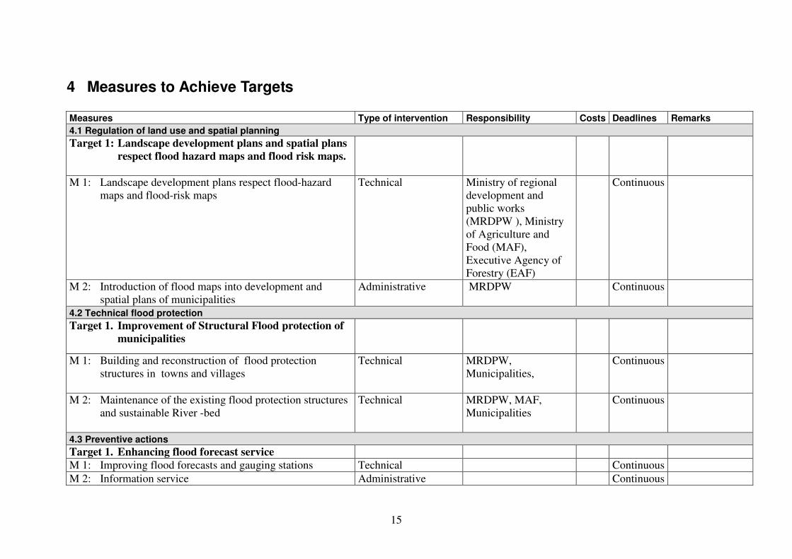
4 Measures to Achieve Targets
Measures Type of intervention Responsibility Costs Deadlines Remarks
4.1 Regulation of land use and spatial planning
Target 1: Landscape development plans and spatial plans
respect flood hazard maps and flood risk maps.
M 1: Landscape development plans respect flood-hazard
maps and flood-risk maps
Technical Ministry of regional
development and
public works
(MRDPW ), Ministry
of Agriculture and
Food (MAF),
Executive Agency of
Forestry (EAF)
Continuous
M 2: Introduction of flood maps into development and
spatial plans of municipalities
Administrative MRDPW Continuous
4.2 Technical flood protection
Target 1. Improvement of Structural Flood protection of
municipalities
M 1: Building and reconstruction of flood protection
structures in towns and villages
Technical MRDPW,
Municipalities,
Continuous
M 2: Maintenance of the existing flood protection structures
and sustainable River -bed
Technical MRDPW, MAF,
Municipalities
Continuous
4.3 Preventive actions
Target 1. Enhancing flood forecast service
M 1: Improving flood forecasts and gauging stations Technical Continuous
M 2: Information service Administrative Continuous

16
Target 2. Introduce principles of EU Flood Directive
M 1: Preparation and adoption of new or amendment of the
existing Water law
Legal /
Administrative
State
2009
M 2: Flood-risk management planning Administrative MoEW,
Basin Directorates
M 2.1. Preliminary flood risk assessment Scientific/ Technical 2010
M 2.2. Preparation of flood hazard maps Scientific/ Technical 2013
M 2.3. Preparation of flood risk maps Scientific/ Technical 2013
4.4 Capacity building of professionals
Target 1 Build capacity of professionals and institutions
responsible for flood management
M 1: Proficiency courses, meetings for exchange
knowledge, seminars
Administrative Ministries Continuous
M 2: Developing alert and operational plans Administrative Municipalities Continuous
M 3: Improvement of coordination between different
authorities in case of floods
Organizational State Continuous
4.5 Raising awareness and preparedness of general public
Target 1 Inform the public about the causes of floods and
improving awareness and preparedness to avoid
detrimental effects
M 1: Presentation of flood risk management plans to the
public
Information MoEW,
Basin Directorates
2015
M 2: Training activities, publishing informational brochures
etc.
Administrative MoEW,
Basin Directorates,
Municipalities, CPSD
Continuous