Embed Size (px)
Citation preview
Heft 2Koblenz 2004
IHP/HWRP - BERICHTE
Studies in Mountain Hydrology
AUS DER ARBEIT DESDEUTSCHEN IHP/HWRP-NATIONALKOMITEES
IHP - INTERNATIONAL HYDROLOGICAL PROGRAMME OF UNESCOHWRP - HYDROLOGY AND WATER RESOURCES PROGRAMME OF WMO


Studies in Mountain Hydrology
edited by A. Herrmann and U. Schröder
Koblenz 2004

A contribution of the German IHP/HWRP National Committee to UNESCO IHP VIFocal Area 3.3 Mountains and to WMO Hydrology and Water Resources Programme(HWRP), sub-programme Sustainable Development of Water Resources
HWRP - Hydrology and Water Resources Programme of WMO, Geneva
IHP - International Hydrological Programme of UNESCO, Paris
BfG - Federal Institute of Hydrology, Koblenz, Germany
Herausgeber: Deutsches Nationalkomitee für dasInternational Hydrological Programme (IHP) der UNESCO und dasHydrology and Water Resources Programme (HWRP) der WMOKoblenz 2004ISSN 1614-1180
© IHP/HWRP-Sekretariat Bundesanstalt für GewässerkundePostfach 20025356002 Koblenz, Deutschland
Fax +49 (0)261 1306 5422

Studies in Mountain Hydrology iii
Contents
Foreword ......................................................................................................................... v
Preface .............................................................................................................................. vii
Runoff formation in mountain environments and possible effectsof global warmingAndreas Herrmann .............................................................................................................. 1
The use of hydrological models for socio-economic decisionsin view of climate changeMark Verbunt and Joachim Gurtz ....................................................................................... 13
Mountain hydrology research in SlovakiaLadislav Holko and Pavik Miklánek ................................................................................... 27
Czech highlands and peneplains and their hydrological role,with special regard to the Bohemo-Moravian HighlandFrantišek Doležal, Tomáš Kvítek, Mojmír Soukup, Zbyněk Kulhavýand Martin Tippl ................................................................................................................. 41
Influence of vegetative cover changes on the soil water regimein headwater regions in the Czech RepublicMiroslav Tesar, Miloslav Sir, Igor Jan Dvorak and Lubomir Lichner ............................... 57
Hydrological investigations of experimental watershed basinsGeorge Gergov and Elena Rafailova .................................................................................. 73
Influence of land use changes on peak discharges - Two case studies,Upper Tanaro River and Dora Riparia River, Piedmont, ItalyVirgilio Anselmo and Elisa Guiot ....................................................................................... 91
Publications in the series IHP/HWRP-Berichte ............................................................. 103
Publications in the series IHP/OHP-Berichte ................................................................ 104


Studies in Mountain Hydrology v
Foreword
Mountainous regions take up a major part of the area of Central Europe. Their significance,however, is due not only to the impact of the area they occupy but also to the fact that they arean essential constituent of regional and supraregional climate systems. Changes intemperature and precipitation have in recent years led to the retreat of glaciers. Climaticchanges do not only affect glaciers or the nival zone; a change in climatic conditions also hasan impact on the entire hydrological and biogenous system of mountainous environments.
The starting point for research are representative and more or less small-scale areas atdifferent altitudes. Because of the very low network density, data of mountainous regions arerather rare, thus rendering these study areas all the more important. This publicationaddresses issues concerning the water balance in mountainous regions and its modelling.Further subjects are the impact of land use on runoff and erosion, the sediment discharge andthe chemism of mountain streams. Long time series are necessary in order to determine andquantify the long-term effects especially of climate change. The scientific need to encouragethe establishment of such study areas is of great significance. The functional relationshipsinduced by climate and the changes in the ecosystem have a considerable socio-economicrelevance – one just has to consider winter as well as summer tourism – so research in thesefields is of particular importance.
With this publication the German IHP/HWRP National Committee contributes to thedetermination of hydrological parameters and processes in mountainous environments as wellas to the clarification of the significance of climatically induced variations. My sincere thanksare extended to the authors of the papers for their contributions and to the editors AndreasHerrmann and Ulrich Schröder.
Professor Dr S. DemuthDirector of the German IHP/HWRP Secretariat


Studies in Mountain Hydrology vii
Preface
Mountain hydrology is by tradition a standard element of the International HydrologicalProgramme (IHP) of UNESCO. This is a rather impressive fact because continuing concernfor a single topic over decades is unique, at least for international scientific hydrologicalprogrammes. Mountain hydrology is presently incorporated in the UNESCO IHP Phase VI,Theme 3 Land Habitat Hydrology, Focal Area 3.3 Mountains. Already some time ago, thegrowing interdisciplinary orientation of research on the hydrology of high mountain areascalled for its inclusion in the Project 2.4 Comprehensive assessment of the surficialecohydrological processes of IHP Phase V. To meet the requirements of other UNESCOscientific programmes, the hydrology of mountain environments is also included in a jointIHP/MAB (Man and the Biosphere Programme) activity under the Main Line of Action II.2.3Joint IHP/MAB: Land-water interactions. In its Hydrology and Water Resources Programme(HWRP), WMO addresses, especially in the sub-programme Sustainable Development ofWater Resources, several aspects of ecohydrological processes.
Mountainous regions are also integrated into FRIEND, the cross-cutting programmecomponent of IHP Phase VI, and in particular the Northern European FRIEND Project 5Catchment Hydrological and Biogeochemical Processes in a Changing Environment. In thiscontext, the leading roles of UNESCO and WMO in enhancing mountain hydrology anddeveloping regional databases such as HKH-FRIEND and regional observation systems suchas HKH-HYCOS are worth mentioning.
Apart from the IHP, the theme of the IGBP's (International Geosphere-Biosphere Programme)core project, Biospheric Aspects of the Hydrological Cycle (BAHC), within the MountainResearch Initiative (MRI), directly related to mountain hydrology in which climate changeimpacts on hydrological processes and the redistribution of water resources play a role.Finally, the European Network of Experimental and Representative Basins (ERB) contributesconsiderably to scientific mountain hydrology activities in Europe.
Two years after the International Year of Mountains in 2002 and one year after theInternational Year of Freshwater in 2003, during which mountains were acclaimed for theirfunction as the water towers of the world, the International Conference on Hydrology ofMountain Environments took place in Berchtesgaden, Federal Republic of Germany from 27September to 1 October 2004. The conference was a contribution by Germany to IHP PhaseVI and was jointly convened by the German National Committee for the IHP of UNESCOand the HWRP of WMO, the Technical University of Braunschweig and the BerchtesgadenNational Park Authority.
The Berchtesgaden conference aimed at facilitating the exchange of scientific knowledge bybringing together scientists involved in the hydrology of mountainous areas with specialemphasis on physical processes and regional aspects. The conference defined deficits andfuture needs in the field of hydrology and water resources management for regional studyconcepts for the mountains of the world with respect to regional infrastructure and scientificpotential. It addressed various disciplines, agencies and administrative bodies coveringhydrological and water management aspects of mountain environments.

viii
To prepare some of these aspects in more detail for the conference, the Workshop onMountain Hydrology, organised jointly by the Northern European FRIEND Project 5, theEuromediterranean Network of Experimental and Representative Basins (ERB) and theRomanian National Institute of Meteorology and Hydrology, was held in Bucharest on 27September 2003. The German IHP/HWRP National Committee was a main sponsor of theworkshop. The programme was to some extent a thematic image of European hydrologicalresearch in mountain environments, although from the regional point of view some importantmountainous regions were not represented. However, the mixture of regional case studies andcountry reports presented at the workshop and published here largely reflects the present focalpoints of mountain hydrological research activity within the cooperating groups of NorthernEuropean FRIEND Project 5 and ERB.
The themes of the papers range from the observation of runoff formation under the possibleinfluence of climate change in various regions of the world, from studies of the impact ofland-use changes in headwaters on the soil water balance, the presentation of nationalnetworks of small study and experimental areas, and the assessment of anthropogenicinfluences based on historical data, to the utilisation of hydrological models for socio-economic decision-making with respect to climate change.
Andreas Herrmann and Ulrich Schröder, editors

Andreas Herrmann 1
Runoff formation in mountain environments and possible effects of global warming
Andreas HerrmannInstitute of Geoecology, Department of Hydrology and Landscape Ecology,
Technical University Braunschweig (TUBS), Germany
Abstract
This paper shows how hydrological small-scale studies in mountainous basins havecontributed to enlarge our knowledge about runoff formation which is considered anecohydrological key process. A most efficient conceptual basis for such studies is the holisticand multilateral ICA (Integrated Catchment Approach) which combines traditional waterbalances with water tracing and GIS techniques, and mathematical modelling. Experimentalresults are taken from mountainous study basins in which the TUBS Department ofHydrology and Landscape Ecology has been active. The main findings are that the runoffformation process can be subdivided in three principal evolution stages, that the tracertechnique is an indispensable purposeful tool on different scales and that climate warming issupposed to influence runoff regimes considerably, but runoff formation only gradually.Future research should concentrate on the extension of ICA applications preferably tosubpolar, boreal and tropical mountain environments, prolonging the existing data series toallow evaluation of climate change impacts on ecohydrology, and upscaling and transferringhydrological information to the so-called ungauged areas.
1 Introduction
Runoff formation and runoff regime are specific responses of hydraulic and hydrologicsystem behaviour on environmental conditions. Hence, change in those conditions maymodify runoff formation and behaviour of natural watersheds. Therefore, runoff formation isconsidered an ecohydrological key process. Depending on the systems’ complexity, changesdue to global warming will be more or less distinct, i.e. small and simply structuredhydrological systems should respond more spontaneously and unequivocally.
To allow the determination and quantification of such effects, special experiments and long-term monitoring have to be carried out at a high level of accuracy. Due to the global changediscussion, most relevant runoff formation concepts, as, for example, mentioned byUhlenbrook and Leibundgut (1997), have, for several years, been revisited if they are purelyformalistic, i.e. not taking into account from where the flood-generating water reallyoriginates, which are the pathways and how old it is.
To investigate runoff formation 19 small mountainous and hilly basins with sub-basins havebeen studied for 30 years under the umbrella of or in cooperation with the Department ofHydrology and Landscape Ecology at the Technical University Braunschweig (TUBS). Onthis basis, a new conceptual approach for runoff formation with its partial processes wasproposed by Herrmann in 1994 and recently refined in Herrmann (2002). The main focus inthis article is on summarising findings for runoff formation in mountains on a small basinscale, also with respect to possible effects of global warming on the regional runoff formationprocess pattern with conclusions for future research strategies.
Runoff formation in mountain environments and possible effects of global warming2
2 Experiments
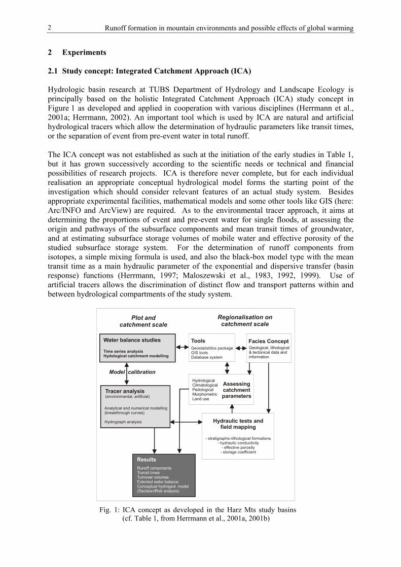
2.1 Study concept: Integrated Catchment Approach (ICA)
Hydrologic basin research at TUBS Department of Hydrology and Landscape Ecology isprincipally based on the holistic Integrated Catchment Approach (ICA) study concept inFigure 1 as developed and applied in cooperation with various disciplines (Herrmann et al.,2001a; Herrmann, 2002). An important tool which is used by ICA are natural and artificialhydrological tracers which allow the determination of hydraulic parameters like transit times,or the separation of event from pre-event water in total runoff.
The ICA concept was not established as such at the initiation of the early studies in Table 1,but it has grown successively according to the scientific needs or technical and financialpossibilities of research projects. ICA is therefore never complete, but for each individualrealisation an appropriate conceptual hydrological model forms the starting point of theinvestigation which should consider relevant features of an actual study system. Besidesappropriate experimental facilities, mathematical models and some other tools like GIS (here:Arc/INFO and ArcView) are required. As to the environmental tracer approach, it aims atdetermining the proportions of event and pre-event water for single floods, at assessing theorigin and pathways of the subsurface components and mean transit times of groundwater,and at estimating subsurface storage volumes of mobile water and effective porosity of thestudied subsurface storage system. For the determination of runoff components fromisotopes, a simple mixing formula is used, and also the black-box model type with the meantransit time as a main hydraulic parameter of the exponential and dispersive transfer (basinresponse) functions (Herrmann, 1997; Maloszewski et al., 1983, 1992, 1999). Use ofartificial tracers allows the discrimination of distinct flow and transport patterns within andbetween hydrological compartments of the study system.
Tracer analysis(environmental, artificial)
Analytical and numerical modelling(breakthrough curves)
Hydrograph analysis
ToolsGeostatistitics packageGIS toolsDatabase system
Hydraulic tests andfield mapping
- stratigraphic-lithological formations- hydraulic conductivity
- effective porosity- storage coefficient
HydrologicalClimatologicalPedologicalMorphometricLand use
Assessingcatchmentparameters
Water balance studies
Time series analysisHydological catchment modelling
Facies ConceptGeological, lithological& tectonical data andinformation
Plot andcatchment scale
Regionalisation oncatchment scale
Model calibration
Fig. 1: ICA concept as developed in the Harz Mts study basins(cf. Table 1, from Herrmann et al., 2001a, 2001b)

Andreas Herrmann 3
Table 1: Hydrological study basins of the TUBS Department of Hydrology and Landscape Ecology
NameLocation
Area[km2]
Elevationrange,mean
Catch-ment type
Bedrock, soils Vegetation References
Lange BramkeHarz Mts.,Germany
0.76 543-700 Forested,mountain
Paleozoic sand-stones and shales;podzoliccambisols
90% Norwegianspruce, 10%grassland
Herrmann et al. 2001Holko et al. 2001Maloszewski et al.1999Kim 1997Buchtele et al. 1996Herrmann 1994Schwarze et al. 1994Herrmann & Schöniger1992Schwarze et al. 1991Schöniger & Herrmann1990Schöniger 1990Herrmann et al. 1989Herrmann et al. 1987Herrmann et al. 1986Herrmann et al. 1984
Grosse SchachtHarz Mts.,Germany Kl. Mollental Gr. Mollental
9.6
2.021.49
341-861
430-861435-822
Forested,mountain
Paleozoic quart-zites, shales,diabase;Cambisol-regosols
90% forest, 10%grassland
Herrmann et al. 2001Schöniger 1998Schöniger et al. 1997Sommerhäuser 1994
RiefensbeekHarz Mts.,Germany
Hangental
6.0
0.7
380-641
450-612
Forested,mountain
Paleozoic schists,sand-stones,quart-zites;podsoliccambisols
90% forested
95% forested
Sommerhäuser 1994
KrummbachNorthern HarzForeland,GermanyOhebach
15
0.885
112-333
117-156
Agricult-ural, hilly
Quaternary sedi-ments (loess);clayey soils
100% arableland
Herrmann 1999Herrmann et al. 1997Tischer 1995Herrmann 1994
EisenbachSouthernLüneburgHeather,Germany
4.24 62-119 Agricult-ural, hilly
Sandy moraines;Cambisols
70% arable land,irrigated, 15%fallow land
Herrmann 1999Herrmann 1994Schöniger 1998Kim 1997Herrmann &Ueberschär 1993
LainbachBavarian Alps,Germany
18.80 670-1801 Forested,high-mountain
Triassic lime-stones,dolomite;Cretac. Sand-stones, shales;Pleistoc. glacial,lacustr. depositslithosols, rego-sols, cambisols
80% forest andwood;alpine pasturesand grassland;rock
Maloszewski et al.1983Stichler & Herrmann1982Herrmann et al. 1981Herrmann & Stichler1980Herrmann et al. 1979Stichler & Herrmann1978Herrmann 1978Herrmann et al. 1973
WimbachBavarian Alps,Germany
33.4 636-2713 Forested,high-mountain
Triassic lime-stones , dolo-mite; Pleistoc.Deposits; litho-sols, regosols,cambisols
20% forest80% rock, fantalus, outwashedplain
Maloszewski et al.1992
Runoff formation in mountain environments and possible effects of global warming4
Table 1 (cont.)
NameLocation
Area[km2]
Elevationrange,mean
Catch-ment type
Bedrock, soils Vegetation References
Cal RodóPyrenees,SpainCa l’IsardCan Vila
4.2
1.320.56
960-? Forested,agricultur-alhilly-highmountain
Paleocene rocks(limestones,clays, silts)Regosols,cambisols
10-52% agricult-ural land (arable,grassland)17-47% forests14-16% shrubs1-5% badlands
Herrmann et al. 1999
Jhikhu KholaMiddle Mts.,Nepal Khet River Bari River
0.10.125
891-1092 878- 936
Agricult-ural, hilly
Gneiss, phyllite,quartzite; ferral-sols, fluvisols
100% arable land
irrigated (khetland)rainfed (bari land)
Schumann et al. 2002Schumann et al. 2001
High HimalayaNepal
Modi KholaLangtang K.Imja Khola
148340135
3160-80913800-72324375-8501
High-mountain
Gneisses,granites, meta-sediments; Lithosols,regosols
Rock, fan talus,outwashed plain;grassland33% glaciated38% glaciated27% glaciated
Buchtele et al. 1998
2.2 Experimental basins
Most study basins in Table 1 cover <1 to 5 km². They are in no case urbanised, butpredominantly either agricultural or forested and even high-alpine with pastures and rock.Central European basins are lined up along a transect from the Bavarian Alps through theCentral European Highland to the hilly foreland of the Harz mountains, which is covered withloess-loam, and the Saalian sandy moraines north of it. Mediterranean mountains arerepresented here by the Catalonian Pyrenees, and sub-tropical ones by the NepaleseHimalayas. Since mostly short-term investigations were carried out, re-establishment of thestudies is required after a while if discrimination of global change effects on runoff behaviouris intended.
3 Results
3.1 General
Major findings from holistic approaches by ICA on small basin scale refer to:
(i) Better understanding of hydrological processes and systems behaviour; (ii) Runoff components for storm and snowmelt hydrographs; (iii) Origin and age of subsurface components; (iv) Groundwater table-discharge relationships; (v) Groundwater recharge; (vi) Detailed water balance; (vii) Improved runoff formation concept.
Findings under (i) to (iii) were presented and discussed in more detail and in the globalcontext in Herrmann (1997), results under (iv) and (v) in Herrmann et al. (1989), Schönigerand Herrmann (1990) and Schumann and Herrmann (2002), those under (vi) in Herrmann etal. (2001b) and under (vii) recently in Herrmann (2002). In the global change context,findings as listed under (ii) to (iv) are especially relevant because they give an answer to some

Andreas Herrmann 5
of the above-mentioned questions such as runoff formation process and origin, age andpathways of water-generating single flood hydrographs.
3.2 Specific results 1: Surface-subsurface flow patterns and hydrograph formation
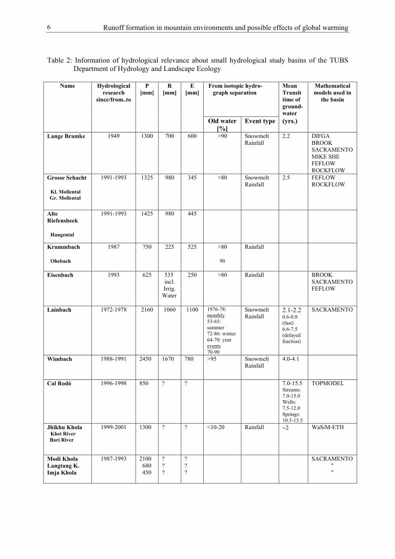
Much larger quantities of water can undergo an underground passage during single floodevents than the traditional hydrological investigation methods allow, i.e. the proportion ofactual rain or melt water leaving the basin immediately is most frequently negligible.Accordingly, direct or event-water water flow components as derived from environmentalisotopes and shown in Table 2 are normally less than, for instance, synthetic hydrographseparation methods or other conventional techniques admit. Another important findingrelated to runoff formation is that groundwater tables correlate positively with discharge, evenunder steep mountainous conditions with semi-confined and confined fractured rock aquifers.The statistically significant relation is hydraulically sound and distinctly non-linear. It differsfrom year to year and from basin to basin.
Furthermore, groundwater table-discharge relations are distinctly hysteretic (Fig. 1). Theirhydraulic interpretation has actually to be confined to the fact that rising groundwater tablesduring single events correspond to an increase of pressure head, thus allowing highergroundwater quantities to exfiltrate and the discharge to grow equally in flow direction. Themeaning of the steeper rising limb may be that in the initial phase the river-near sections ofthe watershed and/or macropore/fractures systems are drained first, thus generating the floodhydrograph until a steady-state situation which is followed by the draining of more distantsections and/or micropore/fissure systems (Schöniger and Herrmann, 1990).
The mentioned hydraulic mechanism will of course not principally change with climate-induced changes in available water volumes. But growth or reduction of water fluxes causedby global warming will of course influence the actually quantitatively balanced hydrologicalsystems.
3.3 Specific results 2: Runoff formation and partial processes
The following model concept for runoff formation as the ecohydrological target process wasdeveloped as a synthesis of these experimental findings. Accordingly, runoff formation can besplit into three distinct partial processes (Herrmann, 2002) (Fig. 3):
(1) Infiltration with saturation of top soils (initial saturation)and percolation
With the effective infiltration capacity of the soil matrix achieved, infiltration water quicklydrains, preferably vertically through macropore systems towards greater depths. Dye tracerexperiments show that even macroscopically homogeneous soils have lots of preferentialpathways once a broad infiltration front is established, which allows quick and efficientvertical transport (Schumann, 2004, Schumann et al. 2004).
Runoff formation in mountain environments and possible effects of global warming6
Table 2: Information of hydrological relevance about small hydrological study basins of the TUBSDepartment of Hydrology and Landscape Ecology
Name Hydrologicalresearch
since/from..to
P[mm]
R[mm]
E[mm]
From isotopic hydro-graph separation
MeanTransittime ofground-water
Mathematicalmodels used in
the basin
Old water[%]
Event type (yrs.)
Lange Bramke 1949 1300 700 600 >90 SnowmeltRainfall
2.2 DIFGABROOKSACRAMENTOMIKE SHEFEFLOWROCKFLOW
Grosse Schacht
Kl. Mollental Gr. Mollental
1991-1993 1325 980 345 >80 SnowmeltRainfall
2.5 FEFLOWROCKFLOW
AlteRiefensbeek
Hangental
1991-1993 1425 980 445
Krummbach
Ohebach
1987 750 225 525 >80
90
Rainfall
Eisenbach 1993 625 535 incl.Irrig.
Water
250 >80 Rainfall BROOKSACRAMENTOFEFLOW
Lainbach 1972-1978 2160 1060 1100 1976-78:monthly53-65:summer72-86: winter64-70: yearevents70-90
SnowmeltRainfall
2.1-2.20.6-0.8(fast)6.6-7.5(delayedfraction)
SACRAMENTO
Wimbach 1988-1991 2450 1670 780 >95 SnowmeltRainfall
4.0-4.1
Cal Rodó 1996-1998 850 ? ? 7.0-15.5Streams:7.0-15.0Wells:7.5-12.0Springs:10.5-15.5
TOPMODEL
Jhikhu Khola Khet River Bari River
1999-2001 1300 ? ? <10-20 Rainfall ∼2 WaSiM-ETH
Modi KholaLangtang K.Imja Khola
1987-1993 2100 680 450
???
???
SACRAMENTO " "

Andreas Herrmann 7
0
10
20
30
40
50
60
70
80
568,40 568,45 568,50 568,55 568,60 568,65 568,70
Groundwater table [m a.m.s.l.]
Dis
char
ge [l
/s]
Lange Bramke14-26 December 1998
0
50
100
150
200
250
562,00 562,50 563,00 563,50 564,00 564,50 565,00 565,50
Groundwater table [m a.m.s.l.]
Dis
char
ge [l
/s]
Gr. Mollental20 Dec.-6 Jan. 1995
55
60
65
70
75
80
85
90
95
100
568,6 568,62 568,64 568,66 568,68 568,7 568,72
Groundwater table [m a.m.s.l.]
Dis
char
ge [l
/s]
Eisenbach27 June-12 July 1991
Fig. 2: Evolution of discharge vs. groundwater table in two basins of fractured bedrock inthe Harz Mts. (Lange Bramke, Gr. Mollental), and in a hilly morainic basin(Eisenbach) 140 km north of Braunschweig, Germany (for description of basinssee Table 1)

Runoff formation in mountain environments and possible effects of global warming8
02468
10
12
14
16
18
20
00.0016.07.2002
12.0018.07.2002
00.0021.07.2002
12.0023.07.200
2
P [mm
]
0
50
100
150
200
250
300
350
400
450
D [l
/s]
6 0 3
6 0 4
6 0 5
6 0 6
6 0 7
6 0 8
6 0 9
0 0 . 0 01 6 . 0 7 . 0 2
1 2 . 0 01 8 . 0 7 . 0 2
0 0 . 0 02 1 . 0 7 . 0 2
1 2 . 0 02 3 . 0 7 . 0 2
Gw
Tab
le [m
a.m
.s.l.
]
5 6 8 .2
5 6 8 .3
5 6 8 .4
5 6 8 .5
5 6 8 .6
5 6 8 .7
5 6 8 .8
5 6 8 .9
0 0 .0 01 6 .0 7 .0 2
1 2 .0 01 8 .0 7 .0 2
0 0 .0 02 1 .0 7 .0 2
1 2 .0 02 3 .0 7 .0 2
Gw
Tab
le [m
a.m
.s.l.
]
5 4 9
5 4 9 , 5
5 5 0
5 5 0 , 5
5 5 1
5 5 1 , 5
5 5 2
0 0 . 0 01 6 . 0 7 . 2 0 0 2
1 2 . 0 01 8 . 0 7 . 2 0 0 2
0 0 . 0 02 1 . 0 7 . 2 0 0 2
1 2 . 0 02 3 . 0 7 . 2 0 0 2
Gw
Tab
le [m
a.m
.s.l.
]
Fig. 3: Lange Bramke basin during a flood event in July 2002: Evolution of precipitationP and discharge D (top), and of groundwater tables at different wells: at mediumslope of central basin (second from top), at toeslope of central basin (third fromtop) and at toeslope at basin outlet (bottom)

Andreas Herrmann 9
As to agricultural irrigation systems, ponding irrigation seems to cause more a rapid andquantitatively more efficient response of water fluxes travelling through preferential pathwaysthan sprinkler irrigation does. The transportation of dissolved matter such as agro-chemicalsthrough the unsaturated zone behaves in the same way (Schumann et al., 2004).
(2) Rise of groundwater table corresponding to increase of groundwater potential
Fluid mechanical effects due to mass transport through pulse pressure transmission and freeflow through macropores in soils and fractures and fissures in the bedrock cause basin-widecompression of the capillary fringe and an increase of subsurface pressure heads. Massdisplacement in the underground can be split into (i) vertical seepage in the unsaturated zoneand (ii) lateral groundwater flow in the saturated zone of the watershed. As a result of pulsepressure transmission, groundwater tables are allowed to rise, thus initiating process no. (3).
(3) Groundwater exfiltration to stream channels.
Final quick and efficient exfiltration, for which the whole wetted cross-section of the riverbed is acting, is a combined effect of high hydraulic potentials and pressure transmission.This finding is based on the fact that mass transfer alone can not explain the hugegroundwater exfiltration rates which are necessary in order to generate a flood hydrograph inthe frequent case of low hydraulic conductivity.
It should be kept in mind that the physical processes behind this runoff formation conceptmay be at best gradually but not principally affected by changes in a basin’s water availabilitydue to global warming. This fact is somehow encouraging with respect to the urgent need ofdeveloping a model tool for assessing runoff formation and runoff components according tothe origin and age of water under changing climatic and environmental conditions.
4 Conclusions and future tasks
4.1 General conclusions with respect to ICA
• ICA concepts as proposed here seem to be most suitable for reliable hydrological systemsanalysis. ICA is not a recent invention, but has been developed over decades, and is bestapplied to mountain terrain as this has the advantage of steep hydraulic gradients, thusresponding spontaneously and distinctly to an input impulse. However, ICA can besuccessfully applied to low-lying flatlands as well and it seems to be indispensable wherehydrological systems are constituents of even more complex environmental systems.
• Environmental and artificial tracers are found to support best the assessment andconfirmation of traditional water balances, and the calibration and validation ofhydrological basin models.
• A primary motivation for realising ICA in environmental sciences comes from the urgentneed to focus on the most relevant system processes which influence system behaviour ina changing environment. A central objective of ICA is therefore the ecohydrologicalrunoff formation process which affects storage and transport behaviour of water anddissolved matter in small basins directly.

Runoff formation in mountain environments and possible effects of global warming10
• ICA applications should be applied to other ecozones, too, like the sub-polar, boreal ortropical ones with a special emphasis on small mountainous basins. This would also allowbetter evaluation and prediction of how global warming will influence hydraulic andhydrologic behaviour of these very sensitive environments.
4.2 Specific conclusions with respect to runoff formation
• As a main result of ICA applications, traditional runoff formation concepts need to berevised or at least carefully examined for the study of water and matter fluxes in small-scale environments since they were found to be not hydraulically sound, to mostlyunderestimate subsurface runoff and therefore groundwater recharge rates, and tooverestimate surface runoff.
• Major partial processes of runoff formation are: (i) Infiltration with initial saturation and following percolation;(ii) Rise of the groundwater table combined with increasing groundwater potential(iii) Increase of groundwater exfiltration
with (ii) and (iii) mainly due to mass transport through pulse pressure transmission.
As a side effect groundwater table-discharge relationships are hysteretic.
• Preferential flowpaths play a major role in the quick transfer of water and dissolvedmatter, the study of which being a priority task, since unsaturated zones with importantpreferential flow involve considerable contamination potential.
• Presumably, impacts of climate change subsuming land-use change on runoff formationare less efficient than on runoff regime. The reason is that the prevailing physicalprocesses that control the hydraulic mechanisms of runoff formation will only graduallychange, whereas growth or reduction of water fluxes in space and quantity and theirchange in source (rain or melt water) and above all their shifts in time of occurrence mayalter runoff regimes in small mountainous basins considerably.
4.3 Future priority tasks
As a consequence of these findings, several priority tasks should be considered for futureresearch in this field:
• As already proposed by Herrmann (1997) hydrologic and hydraulic results based onenvironmental isotopes are an essential contribution to ICA development. However, theystill need to be settled on a safer and broader basis covering more (sub-polar, boreal, sub-tropical and tropical) ecozones, thus exceeding the number of approximately 100 basinswhich have so far been investigated world wide, the majority of which are mountainous.Furthermore, tracer studies need to be combined with geochemical investigations. Thefollowing focal activities are suggested in this context above all with respect to complexmountainous hydrological systems:
(i) Consolidation and extension of actual process knowledge;(ii) Extension of the regional variety of studied environments;

Andreas Herrmann 11
(iii) Development of adequate hydraulically-founded algorithms for groundwaterdynamics which will satisfy science and practice.
• The existing time series for climatic and hydrological variables in small mountainousstudy basins are too short to allow proper prediction of ecohydrological climate changeeffects. On the other hand, fund-raising for their extension is a problem if theexperimental sites are not part of a regular national or international monitoringprogramme.
• The methodical problems associated with extrapolating measuring results or softinformation to non-measured, ungauged areas, and upscaling results for medium and largebasin scales should be tackled immediately in order to allow, in future, the quick transferof research results to other areas.
• Relevant partial hydraulic and hydrologic processes should be carefully examined withrespect to their sensitivity on changing boundary conditions due to global warming. Thiswould allow more efficient experimental design focusing on the relevant system and sub-system constituents and components respectively.
References
HERRMANN A. (2002): Integrated approaches of the ecosystematic runoff formationprocess on a small basin scale. In: Baume, O. (ed.) Beiträge zur PhysischenGeographie – Festschrift zum 75. Geburtstag. Münchener Geogr. Abh. A52, 139-156.
HERRMANN A. (1997): Global review of isotope hydrological investigations. In: Oberlin, G.(ed.) FRIEND-3rd Report 1994-1997, Cemagref Editions, Antony, France, 307-316.
HERRMANN A., SCHÖNIGER M. and SCHUMANN S. (2001a): Integrated approach ofinvestigating and modelling runoff formation considering information fromenvironmental and artificial tracers. Freiburger Schriften zur Hydrologie 13, 90-97.
HERRMANN A., SCHÖNIGER M., SCHUMANN S., TRIMBORN P., STICHLER W. andGROTH P. (2001b): Multilateral approach of fissured rock aquifer systems in the HarzMts., Germany to assess risk potentials of drinking water reservoirs. Proc. XXXI IAHCongress on New Approaches to Characterising Groundwater Flow Munich 10-14Sept. 2001, Vol. 2, 951-956, Balkema.
HERRMANN A., KOLL J., LEIBUNDGUT CH., MALOSZEWSKI P., RAU R.,RAUERT W., SCHÖNIGER M. and STICHLER, W. (1989): Wasserumsatz in einemkleinen Einzugsgebiet im paläozoischen Mittelgebirge (Lange Bramke/Oberharz).Eine hydrologische Systemanalyse mittels Umweltisotopen als Tracer.Landschaftsökologie und Umweltforschung 17, Braunschweig.
MALOSZEWSKI P., HERRMANN A. and ZUBER A. (1999): Interpretation of tracer testsperformed in fractured rock of the Lange Bramke basin, Germany. Hydrogeol. J. 7,209-218.
MALOSZEWSKI P., RAUERT W., TRIMBORN P., HERRMANN A. and RAU R. (1992):Isotope hydrological study of mean transit times in an alpine basin (Wimbachtal,Germany).- J. Hydrol. 149, 343-360.
MALOSZEWSKI P., RAUERT W., STICHLER W. and HERRMANN A. (1983):Application of flow models in an alpine catchment area using tritium and deuteriumdata. J. Hydrol. 66, 319-330.

Runoff formation in mountain environments and possible effects of global warming12
SCHÖNIGER M. and HERRMANN A. (1990): Exfiltration and recharge mechanism in afissured paleozoic rock aquifer of a small catchment (Lange Bramke, Harz Mountains)from tracer hydrological and hydraulic investigations. Proc. XIInd IAH Congr.Lausanne 1990, Mém. Vol. XXII Part 1, 582-591.
SCHUMANN S. (2004): Research on Hydrological Processes and Pesticide Behaviour inIrrigated, Terraced Catchments in the Mid-Hills of Nepal. A Collaborative Project onEnvironmental Risks of Pesticides and Sustainable Development of IntegratedPesticide Management Systems (IPMS) in Nepal Considering Socio-EconomicConditions. Landschaftsökologie und Umweltforschung 44, Braunschweig.
SCHUMANN S. and HERRMANN A. (2002): Flood formation and modelling on a smallbasin scale from Integrative Catchment Approach (ICA). Extended Abstracts Internat.ERB/NWE FRIEND Project 5 Conference Demänowská dolina, Slovakia Sept. 2002,Bratislava, 75-78.
SCHUMANN S., LANGENBERG F. and HERRMANN A. (2004): Die Bedeutungpräferenzieller Fließbahnen für das Transportverhalten und Kontaminationsrisiko vonPflanzenschutzmitteln im Bewässerungsfeldbau. Beiträge zum Tag der Hydrologie2003‚ Wasser- und Stofftransport in heterogenen Einzugsgebieten‘ Potsdam 22.-23.März 2004, Forum f. Hydrologie u. Wasserbewirtschaftung 01.04 (in print).
UHLENBROOK S. and LEIBUNDGUT Ch. (1997): Abflußbildung bei Hochwasser inverschiedenen Raumskalen. Wasser und Boden 49, 13-22.

Mark Verbunt and Joachim Gurtz 13
The use of hydrological models for socio-economicdecisions in view of climate change
M. Verbunt and J. GurtzInstitute for Atmospheric and Climate Science,
Swiss Federal Institute of Technology (ETH) Zurich, Switzerland.
Abstract
This study describes possible impacts of climate change on the hydrological watershedprocesses in the Swiss Alpine Rhine catchment and illustrates how hydrological models canbe used as tools for decision-making processes for policy makers, economists and scientists.Climate change influences the hydrological catchment processes and therefore affects (i) theavailable water resources for hydraulic electricity production and (ii) the availability of snowfor winter tourism. To investigate the impact of climate change on these factors, thedistributed, grid-based hydrological Water flow and Balance Simulation Model (WaSiM-ETH) was applied in the Swiss Alpine Rhine catchment (4108 km2) using (i) observedmeteorological ground data for the control run simulation over the period 1981-2000 and (ii)14 monthly climate change scenarios for precipitation and air temperature (IPCC, 2001) forthe climate scenario runs over the period 2081-2100.
Results show a temporal shift in the runoff production, having direct consequences for thestorage and release mechanisms of hydropower plants and in-stream hydraulic plants. Highrunoff values will increase in winter as a result of more liquid precipitation while theavailable water resources decrease in summer as a result of the smaller building-up of thesnowpack. Results show further that the availability of snow will decrease as a result ofhigher temperatures. The number of days with sufficient snow covering required for skiingduring the ski season decreases especially at the lower altitudes. As a consequence also thesnow reliability (number of ski seasons with at least 100 days sufficient snow covering)decreases, leading to an upwards shift of snow-guaranteed areas and threatening the existenceof lower situated ski-accommodations.
1 Introduction
The increasing concentration of greenhouse gases due to human activities since pre-industrialtime lead to global warming and changes in precipitation pattern and other climate variables,which in turn have impacts on the hydrological cycle. Especially sensitive to changes inclimate are Alpine and pre-Alpine catchments due to their heterogeneous runoff generation,and processes like the melt and accumulation of snow and glaciers. Several studies estimatedan intensification of the water cycle (IPCC, 2001) and changes in the runoff regime (Bronstertet al., 2002; Chiew et al., 2002; Menzel and Bürger, 2002). These changes in hydrology arelikely to affect current land and water resources design and management practices(Middelkoop et al., 2001). Hydropower generation is the energy source that is most likely tobe impacted because it is sensitive to the amount, timing and geographical pattern ofprecipitation as well as temperature. In Switzerland, hydraulic plants produce the main part ofthe electricity production (56.2 % in 2002) from which more than half is generated by waterreleases from storage reservoirs and about 44% by in-stream hydraulic plants (SFOE, 2002).Most of the hydraulic electricity production occurs during the summer months (June to

The use of hydrological models for socio-economic decisions in view of climate change14
September) when runoff volumes are highest while during the months February till Aprilhydraulic energy production reaches its minimum. Switzerland has an electricity exportsurplus of 7.5 % (averaged over 1997-2002) which is mainly obtained during the summerseason resulting in an annual profit of 753 million Swiss Francs (averaged over 1997-2002).More than two thirds of the total electricity production in summer originates from hydraulicplants (reservoir and in-stream) and is therefore dependent on the water supply. Also otherelectricity production facilities like nuclear power plants depend on sufficient stream waterbecause they require water for cooling purposes. A changing climate might also influence,through hydrological processes like runoff production, the hydraulic electricity supply. It istherefore most important to investigate the possible consequences of a changing climate onthe water supply throughout the year.
A second economic branch that might be influenced by climate change is the Swiss tourismsector whose income in winter depends considerably on the ski industry. The regularity andfrequency of winters with sufficient snow are crucial factors for the long-term survival of theskiing industry, but also for operators of funiculars, chair-lifts and cableway companies in theSwiss Alps. Besides the tourist-related companies, also a lot of mountain farmers depend onwinter tourism as a second source of income. A loss of that income could lead to a non-profitable situation for those farmers with subsequent consequences for mountain agriculture.It is therefore important that impact assessment studies with detailed spatially distributedhydrological models are carried out to estimate future snow volumes and distribution.Tourism representatives can use these results to develop adaptation strategies.
Spatially distributed hydrological models are one of the few tools which are capable and veryvaluable for evaluation of socio-economic consequences of future climate change. The mainaim of this study is not to focus on the direct impacts of climate change on the hydrologicalcatchment processes but to make an attempt to demonstrate the utility of hydrological modelsto assess the possible consequences for the socio-economic sector.
The Swiss Alpine Rhine catchment has been chosen because of two important reasons. Thisarea is important for the electricity production in Switzerland. For example, 20% of thepower stations with a maximum capacity of more than 100 MW are situated in this catchment.This region further locates many ski resorts, which will be affected by changes in reliability ofgood snow conditions. Runoff volumes and timing were evaluated to estimate the quantity ofwater available for electricity production and detailed analyses of changes in the frequencyand regularity of days and winters with good snow conditions have been carried out in thisstudy.
2 Methods
The hydrological Water flow and balance Simulation Model WaSiM-ETH (Schulla, 1997) hasbeen used to simulate the possible hydrological impact of climate changes and theirconsequences for hydropower plants and the ski industry. WaSiM-ETH is a fully distributedcatchment model using physically based algorithms for describing most of the hydrologicalprocesses. The model uses for instance a combination of an infiltration approach (Green andAmt, 1911) with estimation of saturation time according to Peschke (1987) and uses theRichards equation (Richards, 1931; Philip, 1969) for the description of the soil water fluxes inlayered soils. The model further uses a temperature index method including measured globalradiation (Hock, 1999) for glacier melt and a degree-day method for snowmelt (Fig. 1).Various model applications in Swiss Alpine catchments have shown that the model is capable

Mark Verbunt and Joachim Gurtz 15
of simulating all relevant hydrological processes in mountainous catchments (Jasper et al.,2002; Gurtz et al., 2003; Verbunt et al., 2003). An extended overview of model applicationsand modules can be found in Schulla and Jasper (2000).
Fig. 1: Model structure of the WaSiM-ETH model (from Schulla and Jasper, 2000)
The use of hydrological models for socio-economic decisions in view of climate change16
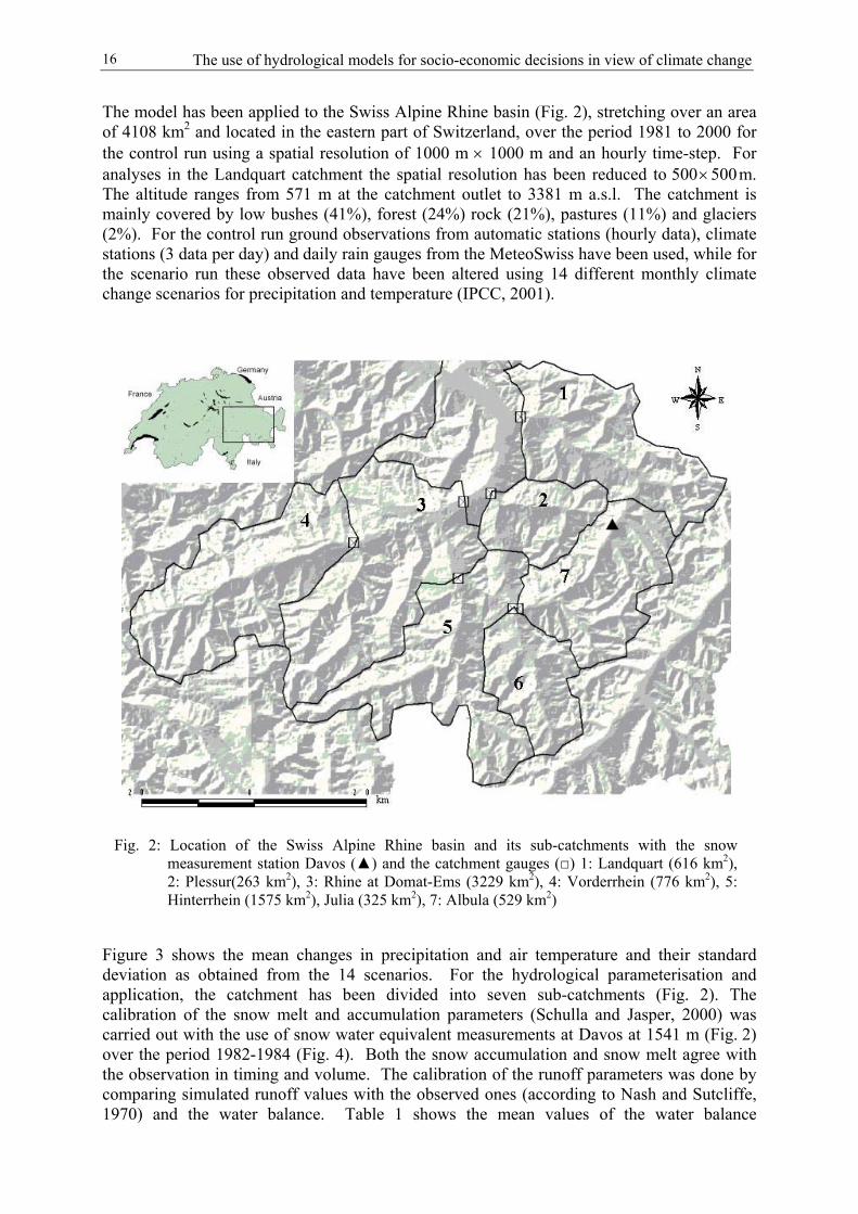
The model has been applied to the Swiss Alpine Rhine basin (Fig. 2), stretching over an areaof 4108 km2 and located in the eastern part of Switzerland, over the period 1981 to 2000 forthe control run using a spatial resolution of 1000 m × 1000 m and an hourly time-step. Foranalyses in the Landquart catchment the spatial resolution has been reduced to 500 × 500 m.The altitude ranges from 571 m at the catchment outlet to 3381 m a.s.l. The catchment ismainly covered by low bushes (41%), forest (24%) rock (21%), pastures (11%) and glaciers(2%). For the control run ground observations from automatic stations (hourly data), climatestations (3 data per day) and daily rain gauges from the MeteoSwiss have been used, while forthe scenario run these observed data have been altered using 14 different monthly climatechange scenarios for precipitation and temperature (IPCC, 2001).
Figure 3 shows the mean changes in precipitation and air temperature and their standarddeviation as obtained from the 14 scenarios. For the hydrological parameterisation andapplication, the catchment has been divided into seven sub-catchments (Fig. 2). Thecalibration of the snow melt and accumulation parameters (Schulla and Jasper, 2000) wascarried out with the use of snow water equivalent measurements at Davos at 1541 m (Fig. 2)over the period 1982-1984 (Fig. 4). Both the snow accumulation and snow melt agree withthe observation in timing and volume. The calibration of the runoff parameters was done bycomparing simulated runoff values with the observed ones (according to Nash and Sutcliffe,1970) and the water balance. Table 1 shows the mean values of the water balance
Fig. 2: Location of the Swiss Alpine Rhine basin and its sub-catchments with the snowmeasurement station Davos (▲) and the catchment gauges (□) 1: Landquart (616 km2),2: Plessur(263 km2), 3: Rhine at Domat-Ems (3229 km2), 4: Vorderrhein (776 km2), 5:Hinterrhein (1575 km2), Julia (325 km2), 7: Albula (529 km2)

Mark Verbunt and Joachim Gurtz 17
components of the Landquart catchment over 1981-2000 for the calibration and validationrun. The mean computed and observed runoff values correspond well with each other andalso the efficiencies show that the model is capable of simulating the hydrological processesin good quality.
For the investigation of the consequences of climate change on ski-resorts and cable-carcompanies it is assumed that the long-term survival of ski-resorts in Switzerland can be
Fig. 3: The mean changes in precipitation and air temperature as projected by the14 scenarios for the period 2081-2100 (IPCC, 2001) together with theiruncertainty
Fig. 4: Calibration of the snow parameters of the WaSiM-ETH using snow waterequivalent measurements at Davos (cf. Fig. 2) for the period 1986-1988

The use of hydrological models for socio-economic decisions in view of climate change18
guaranteed, in terms of snow conditions, if at least 70% of the ski seasons (1st December till15th April) have at least 100 days with good snow condition (Bürki et al., 2003). The sameauthors assume good ski conditions if at least 30-50 cm of snow depth is available.
Table 1: The mean water balance components in mm and the linear and logarithmic efficiencies in theLandquart catchment during the calibration period (1991-1994) and the validation period(1981-1990, 1995-2000) and the total period (1981-2000) for the control and scenario runs
Calibration period Validation period Control run Scenarios runPrecipitation 1578 1695 1668 1583
Simulated Runoff 1201 1338 1301 1091Observed Runoff 1202 1344 1299 -
Evapotranspiration 472 454 458 633Storage change -95 -97 -91 -141
R2lin 0.79 0.75 0.75 -
R2log 0.81 0.83 0.83 -
3 Results
The comparison of observed and simulated runoff proves the capability of the model tosimulate the hydrological processes in this alpine catchment. The underestimation of runoffin summer is caused by the inlet of water from another catchment for electricity production.The runoff distribution over the year alters as a result of climate change (Fig. 5). Thehydrological processes in this alpine catchment are dominated by snow accumulation andmelt and therefore react very sensitively to temperature changes. Due to higher temperatures,more precipitation falls as rain in winter and consequently runoff generation increases (Fig. 5,left) while less snow is stored (Fig. 5, right). A second reason for higher runoff values inwinter is the increase of snowmelt due to more frequent occurrences of hours exceeding thethreshold temperature for snow melt. Because runoff in summer and spring is mainly
Fig. 5: The change in mean daily runoff and snow water equivalent due to climatechange using the 5-day running average to smooth for the Landquartcatchment over a period of 20 years
Mark Verbunt and Joachim Gurtz 19
dominated by snowmelt, the above-mentioned decrease of snow accumulation, incombination with higher evapotranspiration values (Table 1), results in a considerabledecrease of runoff in summer. Besides a decrease in snow water equivalent, the highertemperatures in winter and spring extend the snow-free period.
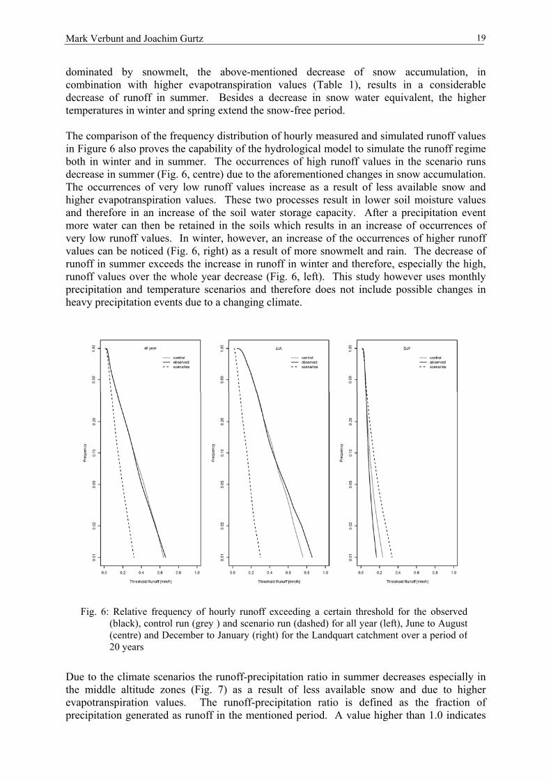
The comparison of the frequency distribution of hourly measured and simulated runoff valuesin Figure 6 also proves the capability of the hydrological model to simulate the runoff regimeboth in winter and in summer. The occurrences of high runoff values in the scenario runsdecrease in summer (Fig. 6, centre) due to the aforementioned changes in snow accumulation.The occurrences of very low runoff values increase as a result of less available snow andhigher evapotranspiration values. These two processes result in lower soil moisture valuesand therefore in an increase of the soil water storage capacity. After a precipitation eventmore water can then be retained in the soils which results in an increase of occurrences ofvery low runoff values. In winter, however, an increase of the occurrences of higher runoffvalues can be noticed (Fig. 6, right) as a result of more snowmelt and rain. The decrease ofrunoff in summer exceeds the increase in runoff in winter and therefore, especially the high,runoff values over the whole year decrease (Fig. 6, left). This study however uses monthlyprecipitation and temperature scenarios and therefore does not include possible changes inheavy precipitation events due to a changing climate.
Due to the climate scenarios the runoff-precipitation ratio in summer decreases especially inthe middle altitude zones (Fig. 7) as a result of less available snow and due to higherevapotranspiration values. The runoff-precipitation ratio is defined as the fraction ofprecipitation generated as runoff in the mentioned period. A value higher than 1.0 indicates
Fig. 6: Relative frequency of hourly runoff exceeding a certain threshold for the observed(black), control run (grey ) and scenario run (dashed) for all year (left), June to August(centre) and December to January (right) for the Landquart catchment over a period of20 years

The use of hydrological models for socio-economic decisions in view of climate change20
that more runoff is produced than precipitation has fallen. This is the case in spring and earlysummer when accumulated snow starts to melt in the Landquart catchment. As a consequenceof this increased evapotranspiration, soil moisture values decrease which increases the soilmoisture storage capacity and consequently decreases runoff generation. In contrast to thesummer season the runoff-precipitation ratio increases in winter as a result of more snowmeltand less solid precipitation. From these figures estimates for the water quantity and timingcan be made which is important information for hydropower plants. The results in changes ofthe precipitation-runoff ratio could contribute to the development of new release and storagemechanisms for reservoirs adapted to future climate.
The storage change (precipitation minus evapotranspiration minus runoff) in summer (June-August) is, especially in the middle and higher elevation zones, strongly negative in thecontrol run (Fig. 8, upper left). Snow which has been stored during winter melts in spring andsummer. In the lower areas, where the runoff generation is based on precipitation eventsbecause snow has already melted away before the beginning of summer, the storage change isonly slightly negative. The storage change in the scenario runs shows a less negative storagechange in summer (Fig. 8, upper right), despite an increase in evapotranspiration, indicatingthat, apart from the upper elevation zones, most snow has already melted away before thebeginning of June. These results clearly illustrate the decrease in water volume available forhydraulic electricity production in summer. During the winter months (December-February)water is accumulated in most parts of the catchment in the control run (Fig. 8, bottom left).Evapotranspiration values are very low because of an extended snow cover and low airtemperatures. Negative air temperatures further cause solid precipitation and therefore noimmediate runoff generation. Only in the lowest altitudes where temperatures exceed thethreshold temperature for snowmelt and liquid precipitation, is the storage change negative.The results of the climate scenarios show that the storage change is in larger part negative as aresult of more liquid precipitation and snowmelt and secondary by a small increase inevapotranspiration. This increase in evapotranspiration is caused by (i) higher air
Fig. 7: The spatial distribution of the runoff-precipitation ratio in the Landquartcatchment over a period of 20 years. Control run (left), scenario run (right),summer (upper) and winter (bottom)

Mark Verbunt and Joachim Gurtz 21
temperatures and (ii) by an earlier snow-free surface which increases the energy forevapotranspiration because of lower albedo values. The figures clearly demonstrate theincrease in water supply for hydraulic electricity production in winter. The results can beused to develop new release and storage mechanisms adapted to the shift in water supply overthe year.
Fig. 9: The relative frequency of the mean snow water equivalent in February inthe Swiss Alpine Rhine catchment exceeding a certain threshold over aperiod of 20 years. Control run (1981-2000; solid line) and scenario run(2081-2100; dashed line)
Fig. 8: The spatial distribution of the mean storage change (precipitation minus runoffminus evapotranspiration) in the Landquart catchment over a period of 20years. Control run (left), scenario run (right), summer (upper) and winter(bottom)
The use of hydrological models for socio-economic decisions in view of climate change22
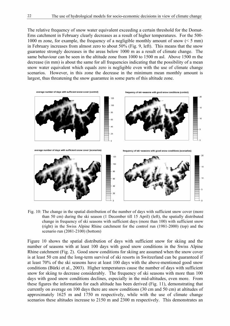
The relative frequency of snow water equivalent exceeding a certain threshold for the Domat-Ems catchment in February clearly decreases as a result of higher temperatures. For the 500-1000 m zone, for example, the frequency of a negligible monthly amount of snow (< 5 mm)in February increases from almost zero to about 50% (Fig. 9, left). This means that the snowguarantee strongly decreases in the areas below 1000 m as a result of climate change. Thesame behaviour can be seen in the altitude zone from 1000 to 1500 m asl. Above 1500 m thedecrease (in mm) is about the same for all frequencies indicating that the possibility of a meansnow water equivalent which equals zero is negligible even with the use of climate changescenarios. However, in this zone the decrease in the minimum mean monthly amount islargest, thus threatening the snow guarantee in some parts of this altitude zone.
Figure 10 shows the spatial distribution of days with sufficient snow for skiing and thenumber of seasons with at least 100 days with good snow conditions in the Swiss AlpineRhine catchment (Fig. 2). Good snow conditions for skiing are assumed when the snow coveris at least 50 cm and the long-term survival of ski resorts in Switzerland can be guaranteed ifat least 70% of the ski seasons have at least 100 days with the above-mentioned good snowconditions (Bürki et al., 2003). Higher temperatures cause the number of days with sufficientsnow for skiing to decrease considerably. The frequency of ski seasons with more than 100days with good snow conditions declines, especially in the mid-altitudes, even more. Fromthese figures the information for each altitude has been derived (Fig. 11), demonstrating thatcurrently on average on 100 days there are snow conditions (30 cm and 50 cm) at altitudes ofapproximately 1625 m and 1750 m respectively, while with the use of climate changescenarios these altitudes increase to 2150 m and 2300 m respectively. This demonstrates an
Fig. 10: The change in the spatial distribution of the number of days with sufficient snow cover (morethan 50 cm) during the ski season (1 December till 15 April) (left), the spatially distributedchange in frequency of ski seasons with sufficient days (more than 100) with sufficient snow(right) in the Swiss Alpine Rhine catchment for the control run (1981-2000) (top) and thescenario run (2081-2100) (bottom)

Mark Verbunt and Joachim Gurtz 23
upward shift of about 500 altitude meters. Also the altitude where 70% of the seasons (14)have at least 100 days with good snow conditions (30 cm and 50 cm) increases from 1700 mand 1850 m respectively to 2200 m and 2400 m asl respectively. This represents an upwardshift of approximately 500 meters for the long-term survival of ski resorts (according to snowconditions). From these model results it can be concluded that it will be necessary for thelower situated ski resorts especially to develop adaptation strategies for possibleconsequences of future climate change.
4 Discussion
This study investigated the possible consequences of climate change with the use of aspatially distributed hydrological model and demonstrated how these results can be used forsocio-economic decisions and adaptation strategies. From the results it can be stated that:
• The annual hydrological water balance will undergo considerable changes. Precipitationslightly decreases because of a decrease in maximum precipitation during the summermonths. Evapotranspiration shows a large increase assuming no change in the stomataresistance. This can be explained by the extended snow-free period and higher airtemperatures, which positively affect the evapotranspiration rate. As a result of lessprecipitation and higher evapotranspiration values, annual runoff decreases. Furthermore,the amount of solid precipitation decreases and consequently less precipitation is stored assnow. This, in combination with higher evapotranspiration values, accelerates the watercycle in this Alpine catchment.
• The change in the water cycle also affects the hydraulic electricity production in thisAlpine region. In winter more rain instead of snow consequently results in an increase inrunoff production. Storage reservoirs can fill up more rapidly or release more water inwinter compared to the current hydrologic regime and in-stream hydraulic plants can also
Fig. 11: The altitudinal distribution of the number of ski seasons with more than 100days exceeding 30 cm (grey) and 50 cm (black) snow (left) and the averagenumber of days in a ski season with at least 30 cm and 50 cm for the controlrun (1981-2000, solid) and the scenario run (2081-2100, dashed)

The use of hydrological models for socio-economic decisions in view of climate change24
profit from more runoff during the winter months. Currently, runoff generation andhydraulic electricity production are highest in summer, mainly as a result of snow melt.The summer electricity production in Switzerland exceeds the domestic electricitydemand which results in a net electricity export to the surrounding countries. This,however, could change in future as a result of a temporal shift in water supply. Modelresults show a drastic decrease of runoff in summer as a consequence of less building-upof the snowpack during the winter months and higher evapotranspiration values. This willlead to a decrease in summer electricity production of in-stream hydraulic plants. Thisshift in runoff supply will also force the release and storage mechanisms of reservoirs tobe adapted to the new situation. In addition, higher air temperatures in summer will causean increase in energy and water demand. The first is, for example, caused by more air-conditioning systems in offices and houses. More domestic energy consumption incombination with a decrease of electricity production will have consequences for theaforementioned electricity export in summer. A possible consequence could be anincrease in the use of other electricity generating facilities like nuclear and conventionalthermal power plants. These facilities, however, require water for cooling purposes andless river water in combination with higher water temperatures could limit theirproduction.
• Besides consequences for the energy sector, climate change could substantially impactwinter tourism in Alpine areas. Model results show not only a decrease in days with goodsnow condition for skiing purposes but also a decrease in the frequency of snow-reliableski seasons. The altitude which guarantees, in the view of snow conditions, the long-termsurvival of ski resorts shifts upwards by approximately 500 meters. This will force skiresorts, cable-car companies and also tourist offices in general to be aware of thesepossible consequences and to develop adaptation strategies. The results of hydrologicalmodels are of great use for this and should therefore be incorporated when making theseadaptation strategies.
• The relatively high uncertainty of the climate change scenarios is no reason to neglectpossible consequences. Continuous improvements are made in the physics of the GlobalCirculation Models (GCMs) and Regional Climate Models (RCMs) which generate theclimate change scenarios. It is, however, important that the societies and decision-makersare aware of these model uncertainties. Therefore, it is important that a range of scenariosis used for the hydrological assessment study in order to cover all possible outcomes.
• Not only hydrologic factors like water supply and snow availability will influence thetourism and energy sector in Switzerland. When making strategies or when taking long-term decisions it is, however, recommended to consider these changes in hydrology. Forthis purpose it is important to have spatially distributed hydrological models which haveproved their capabilities in the area to be investigated. The development of thehydrological models should be adjusted with the needs of the decision-makers and theindustries concerned. If necessary, local assessment studies can be carried out with amore detailed grid resolution to evaluate the socio-economic consequences of a changingclimate.
5 Conclusion
From the results of this study it can be concluded that climate change will impact thehydrological processes in the Swiss Alpine Rhine catchment. Snow accumulation and meltand consequently the runoff generation react very sensitively to changes in temperatures andtherefore a small increase in air temperature can result in large changes. The impact ofclimate change may not be neglected in this sensitive area and impact studies need to be

Mark Verbunt and Joachim Gurtz 25
carried out. This study further showed that spatially distributed hydrological models are veryuseful tools for climate impact assessment studies also for those with a socio-economicbackground. Water supply for hydraulic electricity production will change and wintertourism could be jeopardised due to less snow reliability. In the process of adaptationstrategies it is therefore recommended that the results of hydrological models be considered.To adjust hydrological models to the needs of the industries and authorities concerned, a goodand open communication between scientists and industry and authorities is desirable.
Acknowledgements
We would like to thank MeteoSwiss and the Swiss Federal Office for Snow and AvalancheResearch Davos (SLF-Davos) for providing the meteorological and snow measurements.Furthermore, I would like to thank F. Keller for reviewing an earlier draft of the paper.
References
BRONSTERT A., NIEHOFF D. and BÜRGER G. (2002): Effects of climate and land-usechange on storm runoff generation: present knowledge and modelling capabilities.Hydrological Processes 16, 509-529.
BÜRKI R., ELSASSER H. and ABEGG B. (2003): Climate change – Impacts on the TourismIndustry in Mountain Areas. 1st International Conference on Climate Change andTourism, Djerba, April 2003.
CHIEW F.H.S. and MCMAHON T.A. (2002): Modelling the impacts of climate change onAustralian streamflow. Hydrological Processes 16, 1235-1245.
GREEN W.H. and AMPT G. (1911): Studies of soil Physic. Part 1: The flow of air and waterthrough soils. Journal of the Agricultural Society 4, 1-24.
GURTZ J., ZAPPA M., JASPER K., LANG H., VERBUNT M., BADOUX A. andVITVAR T. (2003): A comparative study in modelling runoff and its components intwo mountainous catchments. Hydrological Processes 17 (2), 297-311.
HOCK R. (1999): Distributed temperature-index ice and snowmelt model including potentialdirect solar radiation. Journal of Glaciology 45 (149), 101-111.
IPCC, 2001: IPCC Third Assessment Report - Climate Change (2001): Impacts adaptationand Vulnerability. Available under www.ipcc.ch.
JASPER K., GURTZ J. and LANG H. (2002): Advanced flood forecasting in Alpinewatersheds by coupling meteorological observations and forecasts with a distributedhydrological model. Journal of hydrology 267, 40 - 52.
MENZEL L. and BÜRGER G. (2002): Climate change scenarios and runoff response in theMulde catchment (Southern Elbe, Germany). Journal of hydrology 267, 53-64.
MIDDELKOOP H, DAAMEN K, GELLENS D, GRABS W, KWADIJK J.C.J., LANG H,PARMET B.W.A.H., SCHADLER B, SCHULLA J. and WILKE K. (2001): Impact ofclimate change on hydrological regimes and water resources management in the Rhinebasin. Climatic change 49, 105-128.
NASH J.E. and SUTCLIFFE J.V. (1970): River flow forecasting through conceptual models.Part I: A discussion of principles. Journal of hydrology 10, 282-290.
PESCHKE G. (1987): Soil moisture and runoff components from a physically foundedapproach. Acta Hydrophysica 31, 191-205.
PHILIP J.R. (1969): The theory of infiltration. Advances in Hydrosciences, Academic Press,New York. V.T. Chow, Ed., 216-296.

The use of hydrological models for socio-economic decisions in view of climate change26
RICHARDS L.A. (1931): Capillary conduction of liquids through porous mediums. Physics1, 318-333.
SCHULLA J. (1997): Hydrologische Modellierung von Flussgebieten zur Abschätzung derFolgen von Klimaänderungen. Zürcher Geographische Schriften 69.
SCHULLA J. and JASPER K. (2000): Model Description WaSiM-ETH. IAC-ETH Zürich.Internet: http://www.iac.ethz.ch/en/research/riet/WaSiM.pdf.
SFOE, 2002: Schweizerische Elektrizitätsstatistik (2002): Swiss Federal Office for Energy,Bern.
VERBUNT M., GURTZ J., JASPER K., LANG H., WARMERDAM P. and ZAPPA M.,(2003): The hydrological role of snow and glaciers in alpine river basins and theirdistributed modelling. Journal of hydrology 282, 36-55.
Ladislav Holko and Pavik Miklánek 27
Mountain hydrology research in SlovakiaL. Holko and P. Miklánek
Institute of Hydrology, Slovak Academy of Sciences, Bratislava, Slovakia
Abstract
This paper gives an overview of research projects devoted in the last years to mountainhydrology in Slovakia. Experimental mountain hydrology research, i.e. research based onfield data collected in specifically equipped catchments or plots is performed only by a fewresearch units. Most projects are devoted to theoretical research, i.e. the research basedmostly on the data from the standard observation networks. The projects are typicallycovered by governmental funding through grant agencies or the end users (ministries,operationally oriented institutes).
The main research issues in mountain hydrology in Slovakia in recent years have beenassessment of the impact of climate change on hydrological processes and water resourcesmanagement, rainfall-runoff relationship including process studies and flood protection,regionalisation and water quality. Climate-change impact studies were focused on theanalysis of data time series, preparation of climate change scenarios, estimation of impacts inhydrology and water management, and proposal of basic adaptation strategies. Research ofrainfall-runoff relationship covered runoff formation, occurrence and analysis of the climaticand hydrological situation during floods, assessment of new rainfall design values, role offorest and groundwater storage during floods, and hydraulic research of the rivers.
Regionalisation concentrated on methods of determination of homogenous regions andcalculation of hydrological characteristics for individual regions. Water quality researchcomprised a wide range of studies devoted to stream water quality and balance of nutrients inthe hydrological cycle. It is expected that hydrological extremes including flood protection,assessment of climate change impacts and regionalisation will remain the most importantissues of mountain hydrological research in Slovakia also in the future. However, the role ofevapotranspiration, soils and seasonal snow cover in the hydrological cycle of mountainenvironment should also be targeted. The role of continuing monitoring, possibly in theupdated observation networks, should also not be forgotten.
1 Introduction
Slovakia is a mountainous country. Lowlands (with elevations of up to 300 m a.s.l.) coverjust 22% of the country. From this point of view, almost all the hydrological research inSlovakia is performed in the mountainous environment (Fig. 1).
Experimental hydrological research, i.e. the research using the data from the specificallyequipped mountain catchment is performed only at the Institute of Hydrology SAS. Extendedmonitoring of mountain environment in the High Tatras, i.e. the highest part of theCarpathians, which covers also climatic monitoring, is carried out by the High Tatras NationalPark Research Station. Other few experimental sites providing data on hydrologicalprocesses related to forest hydrology are maintained by the Faculty of Forestry of theTechnical University Zvolen.

Mountain hydrology research in Slovakia28
Theoretical research using standard data, i.e. the data collected in the standard networks of thehydrometeorological service, maps etc., sometimes extended by field campaigns, is performedat the Academy of Sciences (Institute of Hydrology, partially also Geographical Institute),universities (Slovak Technical University and Comenius University in Bratislava,Agricultural University in Nitra, Technical University in Zvolen) and other institutes (SlovakHydrometeorological Institute, Water Management Institute).
An important fact that affected hydrological research in Slovakia was the transition from theformer state-planned research to today’s grant system that has led to a more competitiveenvironment with higher responsibility for smaller research teams or even individuals. On theother hand, it has caused the atomisation of research.
Most of the recent projects in the field of mountain hydrology in Slovakia have been devotedto the assessment of climate change impacts on hydrology and water management, rainfall-runoff relationships including floods and regionalisation. Other research projects have dealtwith snow hydrology, evapotranspiration, water quality, river morphology and sedimenttransport including hydrobiological issues. The projects were typically supported bygovernmental funding, either by grant agencies or by the end users represented by ministriesor operationally oriented institutes like the Slovak Hydrometeorological Institute and theWater Management Institute. These research projects are listed at http://www.vega.sav.skand http://www.apvt.gov.sk. Relatively few research projects have been carried out as part ofinternational projects.
The aim of this paper is to give an overview of recent research projects devoted to mountainhydrology in Slovakia. The paper is based on the national report to IAHS (Szolgay, 2003) andthe state-of-the-art report on surface hydrology in Slovakia (Miklánek, 2003). Instead ofproviding a detailed description of all the projects and their results, we have concentrated onthe main issues.
Fig. 1: DEM of Slovakia and the parts of river basins where most mountain hydrology research tookplace: 1-the Jalovecky creek catchment, 2-Vah; 3-Kysuca, 4-Hron, 5-Nitra

Ladislav Holko and Pavik Miklánek 29
2 Main research issues in mountain hydrology in Slovakia
2.1 Impact of climate change on hydrological processes and water resourcesmanagement
The expected impact of climate change in general, vulnerability assessment and adaptationmeasures for Slovakia were summarised in the Third National Communication on ClimateChange (2001). An overview of impacts on climate-related sectors was given by Lapin et al.(2002); hydrological impacts were reviewed by Majerčáková (1999, 2000).
Generally, the research projects addressed the following issues:
• Analysis of time series of precipitation, runoff, groundwater regime (groundwater runoff,spring yields) and evapotranspiration data with the aim of detecting climate changesignals;
• Preparation of several analogous, incremental and GCM (General Circulation Model)based climate change scenarios for the 2010, 2030 and 2075 time horizons (monthly andannual time series of air temperature, precipitation and air humidity); preparation ofscenarios of extreme monthly and daily precipitation totals for selected time horizons(2010, 2030, 2075);
• Estimation of climate change impacts on the mean annual flow, mean monthly flow,yields of the main water reservoirs and changes in the hydrological regime including snowcover in mountains;
• Proposal of basic strategies for the adaptation processes in water resources managementto deal with climate change impacts.
Times series analyses revealed decreasing trends in groundwater runoff and spring yields (e.g.Fendeková, 2000) and time shift in the occurrence of runoff extremes (Pekárová and Pekár,2000). The analysis of historical floods (Halmová, 2001) indicated an increased extremalityof the flood regime in some regions (Pekárová and Miklánek, 2001). Climate scenarios (e.g.Lapin et al., 2000) expect significant increases of annual air temperature (2-4˚C), smallchanges in the long-term precipitation totals and significant increases of short-termprecipitation extremes by 20-50%. According to modelling exercises such a climate wouldlead to the increase of winter flows and decrease of spring and summer flows (e.g. Hlavčováet al., 2000). The increase of winter flows and decrease of spring flows are connected withchanges of seasonal snowpack. Seasonal snowpack would be one of the most seriouslyaffected components of the hydrological cycle (Kostka and Holko, 2000). The duration of thesnowpack in the mountains could be as much as one month shorter. Maximum snow-waterequivalent during winter seasons could reach only one half of its present values. Even in thehighest mountains the more pronounced seasonal snowpack as measured by the value of thesnow-water equivalent would last for longer periods only in the high elevations (Fig. 2).Generally, it is expected that the climate change would affect the northern part of Slovakialess than its southern part. Nevertheless, the whole country could become more vulnerable todrought in the summer and autumn. Water available in reservoirs could cover just 65-90% ofpresent maximum withdrawal. Simulated effects of the land-use change in natural mountaincatchments caused solely by the change of climate should not be so pronounced as theanticipated effects the climate change itself (Kostka and Holko, 2001).

Mountain hydrology research in Slovakia30
Ttiifs
•
•
•
1-XI
29-XI
27-XII
24-I
21-II
21-III
18-IV
16-V
13-VI
11-VII
8-VIII
5-IX
3-X
31-X
0
50
100
150
200
250
300
350
400
450
[mm]
1234
1-XI
29-XI
27-XII
24-I
21-II
21-III
18-IV
16-V
13-VI
11-VII
8-VIII
5-IX
3-X
31-X
0
50
100
150
200
250
300
350
400
450
[mm]
1234
A (800-1150 m a.s.l.)
B(1150-1500 m a.s.l.)
1-X
I
29-X
I
27-X
II
24-I
21-II
21-II
I
18-IV
16-V
13-V
I
11-V
II
8-V
III
5-IX 3-X
31-X
0
50
100
150
200
250
300
350
400
450
[ mm
]
1234
1-X
I
29-X
I
27-X
II
24-I
21-II
21-II
I
18-IV
16-V
13-V
I
11-V
II
8-V
III
5-IX 3-X
31-X
0
50
100
150
200
250
300
350
400
450
[ mm
]
1234
C(1500-1850 m a.s.l.)
D(above 1850 m a.s.l.)
Fig. 2: Mean daily values of snow-water equivalent [mm] simulated for the small mountaincatchment of the Jalovecky creek and elevation zones 800-1150 m (A), 1150-1500 m (B),1500-1850 m (C) and above 1850 m (D). Simulation according to present climaticconditions (1) and climate scenarios CCCM 2010 (2), CCCM 2030 (3) and CCCM 2075(4) (from Kostka and Holko 2000)
he main objective of the climate change related research is the application of knowledge inhe formulation of adaptation strategies. The basic adaptation strategies proposed in Slovakianclude the transformation of natural hydrologic resources into managed resources,nterannual and seasonal redistribution of water, revitalisation of watersheds, afforestation andorest protection (e.g. Szolgay and Hlavčová, 2000; Szolgay et al., 2002). The following toolshould be used:
Direct measures to control water consumption, e.g. reduction of specific consumption ofdrinking water by means of technical measures, decrease of water losses, utilisation ofnon-drinking water for specific purposes, etc.;
Indirect measures influencing the behaviour of water consumers: subventions, taxes andcharges in water management, better information of the population about possible climatechange impacts, improved attitude of population to water sources;
Institutional change leading to a more effective water use: full implementation of the newenvironmental legislation in the area of water management, implementation of the resultsof climate change research in strategic concepts of water management, municipal and landuse planning, etc.;
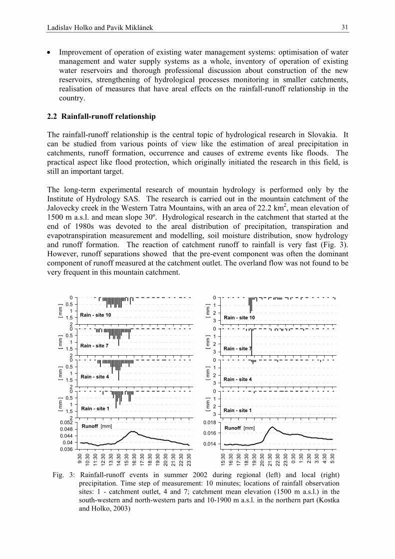
Ladislav Holko and Pavik Miklánek 31
• Improvement of operation of existing water management systems: optimisation of watermanagement and water supply systems as a whole, inventory of operation of existingwater reservoirs and thorough professional discussion about construction of the newreservoirs, strengthening of hydrological processes monitoring in smaller catchments,realisation of measures that have areal effects on the rainfall-runoff relationship in thecountry.
2.2 Rainfall-runoff relationship
The rainfall-runoff relationship is the central topic of hydrological research in Slovakia. Itcan be studied from various points of view like the estimation of areal precipitation incatchments, runoff formation, occurrence and causes of extreme events like floods. Thepractical aspect like flood protection, which originally initiated the research in this field, isstill an important target.
The long-term experimental research of mountain hydrology is performed only by theInstitute of Hydrology SAS. The research is carried out in the mountain catchment of theJalovecky creek in the Western Tatra Mountains, with an area of 22.2 km2, mean elevation of1500 m a.s.l. and mean slope 30º. Hydrological research in the catchment that started at theend of 1980s was devoted to the areal distribution of precipitation, transpiration andevapotranspiration measurement and modelling, soil moisture distribution, snow hydrologyand runoff formation. The reaction of catchment runoff to rainfall is very fast (Fig. 3).However, runoff separations showed that the pre-event component was often the dominantcomponent of runoff measured at the catchment outlet. The overland flow was not found to bevery frequent in this mountain catchment.
21.5
10.5
0
[ mm
]
21.5
10.5
0
[ mm
]
21.5
10.5
0
[ mm
]
9:30
10:3
011
:30
12:3
013
:30
14:3
015
:30
16:3
017
:30
18:3
019
:30
20:3
021
:30
22:3
023
:30
0.0360.04
0.0440.0480.052
21.5
10.5
0
[ mm
]
Rain - site 7
Rain - site 4
Rain - site 1
Rain - site 10
Runoff [mm]
3210
[ mm
]
3210
[ mm
]
3210
[ mm
]
15:3
016
:30
17:3
018
:30
19:3
020
:30
21:3
022
:30
23:3
00:
301:
302:
303:
304:
305:
30
0.014
0.016
0.018
3210
[ mm
]
Rain - site 7
Rain - site 4
Rain - site 1
Rain - site 10
Runoff [mm]
Fig. 3: Rainfall-runoff events in summer 2002 during regional (left) and local (right)precipitation. Time step of measurement: 10 minutes; locations of rainfall observationsites: 1 - catchment outlet, 4 and 7; catchment mean elevation (1500 m a.s.l.) in thesouth-western and north-western parts and 10-1900 m a.s.l. in the northern part (Kostkaand Holko, 2003)

Mountain hydrology research in Slovakia32
Rainfall amount seems to be the primary factor influencing the reaction of the Jaloveckycreek catchment runoff during the warm period of the year. This factor was superior to otherfactors taken into account like the soil moisture before the event. Rainfall-runoff data indicatethat the increase of discharge often did not occur unless certain value of "effective" rainfallwas exceeded (Kostka and Holko, 2003).
Majerčáková (2000) noted that the last years indicated partially increased extremality ofrunoff conditions in Slovakia. Mean values for the large river basins did not differ from thelong-term values. However, quite a number of regional and flash floods occurred. On theother hand, long-term droughts were observed. Flash floods caused by extremely intensiverainfall that have occurred recently in Slovakia were investigated individually. The formationof floods in ungauged basins was reconstructed using data from the on-site hydrologicalsurvey, data available from the standard hydrological and meteorological networks and radarand satellite data (Majerčáková and Škoda, 1998; Šťastný and Majerčáková, 2003). Theoccurrence of flash floods in Slovakia in 1997-2002 along with the analysis of catchmentcharacteristics was studied by Grešková (2003).
A number of studies with the data taken from standard networks or field campaigns wereperformed in mountain parts of the rivers Hron, Kysuca, Nitra and Vah. Lapin et al. (2001)and Šťastný et al. (2001) analysed weather conditions accompanying floods in the upper Hroncatchment. Analysis of annual and seasonal maxima of one to five-day rainfall depths in thesame catchment lead to the new design rainfall (e.g. Stehlová et al., 2001; Jurčová et al.,2002). Although the number of statistically acceptable distribution functions was found to berather high, the resulting design rainfall values estimated from the distribution functions didnot exhibit significant differences. Part of the above work was done within the project"Investigation of the anthropogenic factors effect on water systems" coordinated by the WaterResearch Institute in Bratislava. The project was initiated by the Ministry of Agriculture afterthe floods which occurred in Central Europe in 1997. One of the objectives of the project wasflood protection research in selected catchments. The research was focused on a number ofissues: inventory of current flood protection measures, dynamics of floods in small streamsand rivers, rainfall-runoff relationship and possible influence of climate change on the designvalues, influence of vegetation on runoff regime (runoff coefficient, temporal characteristicsof the flood), management of mountain streams and its influence on catchment runoffcharacteristics, increase of retention capacity of groundwater storage, analysis of economicaland ecological values of the inundation area and its protection against floods, design ofprotection measures based on computations of water levels during big floods, simulation ofdynamics of floods on the tributaries of the main rivers, assessment of effects of waterreservoirs and old river channels during floods, design discharge values for selected profiles(Holubec, 2003). The Hron river and the Kysuca river catchments were selected as studyareas. An overview of final results and proposals for future research are available athttp://www.vuvh.sk/projekty/27-34/27-34.html. The project brought many interesting results.Čaboun (2003) presented the results on the influence of forest on runoff and proposed suitablemanagement practices. Valtýni and Závacká (2003) reported on the role of small structures onmountain streams in flood protection. They documented that low dams (0.3 m high) onmountain streams could decrease culmination discharge by 10-15%. Numerical simulation ofriver hydraulics for the purpose of flood protection of selected cities and villages, andresearch of the role of old river channels in flood transformation was carried out by a numberof authors (e.g. Mišík and Lukáč, 2003; Matok, 2003). Kovalčík (2003) analysed potentialconflicts between technical measures and environmental interests in selected catchments.Petrovič (2003, 2003a) reported on the possibilities of utilisation of radar data and evaluated

Ladislav Holko and Pavik Miklánek 33
the application of LIDAR data in the flood risk assessment. Žilavý (2003) analysed the role ofpolders in flood protection of morphologically different environments.
The relationship between surface water and groundwater has been a research objective inrecent years. Fendeková and Fendek (2002) used stochastic modelling for the estimation ofthe relationship between surface waters and groundwater in the weathered zone of graniticrocks in the High Tatra Mountains, where very quick runoff and an immediate reaction ofgroundwater on external inputs were observed. Baranovičová (2003, 2003a) studied thepossibility of increase of retention capacity of groundwater storage in the Hron and Kysucariver basins and the relationship between surface water and groundwater during the flood.
In other projects, various risks associated with flooding were characterised by simple relationsbased on informative numerical values deduced from the actual conditions of the SlovakRepublic. Reduction of the flood risks achievable by geotechnical measures coveringstability increases in embankments, transport communications and buildings was suggestedby Hulla (2002).
2.3 Regionalisation
One of the tasks of operational hydrology is to provide end users with various hydrologicalcharacteristics. Because the characteristics are often needed for ungauged basins,regionalisation remains an important research issue with clear practical outputs. An overviewof hydrological and hydrogeographical typification and regionalisation in Slovakia was givenby Kohnová and Solín (2002). Hanušin (2003) presented regional classification of runoffregime. A recent compilation of an extensive database of the physiographic characteristics ofsmall basins in Slovakia (Solín et al., 2000) enabled the new hydrogeographical regionalclassification of Slovakia. Six regional types of minimum and mean annual runoff regimeswere identified using the mean annual precipitation and mean altitude of the basins asdifferentiating factors (Solín and Grešková, 2000; Solín and Cebecauer, 2001). Other studiesapplied statistical methods (Hosking and Wallis, regional frequency analysis, cluster analysis)in the analysis of runoff and precipitation data (e.g. Kohnová and Szolgay, 2001; Solín,2002). Various physiographic properties of basins, rainfall and flood runoff characteristicswere used as factors for the differentiation of homogeneous regions and regional types(pooling groups). Several methods for the definition of homogeneous regions and regionaltypes were tested. Aspects under which the concept of regional homogeneity can be used inregional frequency analysis of floods and extreme rainfall under the rather heterogeneousrunoff generating conditions in Slovakia were studied and discussed (Kohnová et al., 2000).The results of the last works showed that different combinations of independent variables canprovide statistically comparable results. The authors suggested that the idea of geographicalregions may be abandoned.
3 Water quality
The studies were focused on the impact of land use on stream water quality, balance ofnitrates in the water cycle, variability of suspended sediment loads, modelling of pollutantsloads, influence of water from urbanised areas on the quality of river water, identification ofthe main sources of diffuse pollution and management of water quality in the Vah, Hron andNitra river catchments.

Mountain hydrology research in Slovakia34
The results of the water quality research in the experimental basins of the Institute ofHydrology of the Slovak Academy of Sciences were summarised in a monograph byPekárová et al. (1999). Empirical exponential relationships were derived for the estimation ofmonthly nitrate concentrations and nitrate loads in small basins. The nitrate balance, definedas the difference between input by atmospheric water (precipitation) and output of the basin(runoff), showed typically positive values in the agricultural basin, while negative values werefound in a forested basin. These results indicate that the forested basins may have purifyingeffects on surface water (Koníček and Stančík, 1999). The data on insoluble matterconcentrations during diverse runoff events were used to derive empirical relationshipsbetween insoluble matter concentrations and specific yields (Bača, 2002).
Dian (2003) presented the methodology of the assessment of point source pollution of riverwater and the results of nutrients balance for several profiles on the river Hron. He alsoproposed the strategy of nutrients management in the catchment. Földešová and Výboch(2003) analysed sources of pollution in the upper Nitra river catchment. Hiller (2003) studiedthe transport of contaminants in the soil-water system. Kútnik and Baranovičová (2003) usedsimple runoff separation to determine the influence of diffuse pollution sources on river waterquality. Their results showed that 60-80% of river water pollution came from diffuse sources.Luther (2003) analysed the effect of water treatment plants on the improvement of river waterquality. He noted that municipal sewerage played a key role in the nutrients pollution of theriver Hron. Sokáč (2003) described a mathematical model of river water quality. Weigeltová(2003) analysed eutrophication of the rivers Hron and Nitra. Lichner et al. (2002) reported onthe system for the monitoring and early warning of water pollution that is being developedwithin the framework of the EC’s 5th Framework Programme Project.
Long-term research of the water quality of mountain lakes in the Tatra mountains is beingcarried out by Czech scientists (e.g. Kopáček et al., 2000, 2001). The ecosystem of CentralEurope experienced a large "experiment" connected with the drastic reduction of emissionsduring the 1990s in parts of Germany, Poland, Czech Republic and Slovakia (e.g. 80% and30% reductions of S and N emissions, respectively). Parallel decreases in deposition rates ofSO4, nitrate (NO3) and ammonium (NH4) have resulted in a relatively rapid improvement ofwater quality in acidified mountain lakes.
4 Future development
It is not easy to predict the development of society and its activities including research.However, it can be expected that the following issues will be the most important targets ofhydrological research in Slovakia in the near future:
• Hydrological extremes - understanding the generation of floods and droughts, statisticaltreatment of existing data series, modelling and predictions;
• Impacts of climate and land-use changes - scenarios of hydrological behaviour, simulationof probable impacts;
• Regionalisation - application of advanced methods (e.g. rainfall-runoff modelling in smallcatchments) to estimate hydrological characteristics for operational hydrology.
In January 2000, the Slovak government approved the programme of flood protection ofSlovakia until 2010 (project POVAPSYS). Although most funds were allocated to concretetechnical measures, a number of research projects should be supported to provide the

Ladislav Holko and Pavik Miklánek 35
knowledge necessary to mitigate the negative effects of floods. Nine partial research sub-projects, which will be co-ordinated by various institutes, were approved:
• Hydrological and climatic aspects of floods• Rainfall-runoff process and design values• Spatial structure of catchments, intensification of risk areas and factors• Interaction of surface, soil and groundwater during floods• Flood vulnerability in agriculture, forestry, water management and settlement• Flood situation in the rivers and technical measures• Role of reservoirs and dams in flood protection• Co-ordination of research projects
Extreme events, impacts of climate change and regionalisation are already "classical" topicsof mountain hydrology research. Results of research performed in these areas are oftendirectly applicable in practice. However, there are other topics like evapotranspiration and therole of soils or the weathered zone transforming rainfall into runoff where vegetation effectsshould not be omitted, and these are still studied very little in mountain environments.Without their better understanding, the hydrological cycle in mountains cannot be fullyunderstood. Snow hydrology research will be another topic of research in Slovakia in thenear future.
Research needs data. The need for data is the "never-ending story" of hydrology. This is trueespecially in mountains where data acquisition is not easy. However, without reliable dataeven the simplest calculations like the basic hydrological balance are ambiguous (Holko et al.,2001). Some data can be obtained during field campaigns, but long-term monitoring isessential. Several recent studies devoted to various tasks (hydrological balance, designvalues, flood protection, regionalisation) have indicated, for example, that a better network ofprecipitation stations in the mountains would be needed. Although new ways of dataacquisition and processing are under development, preservation and improvement (notinevitably extension) of current standard observation networks should not be forgotten.Otherwise, even the best models and statistical methods may be of little use.
References
BAČA P. (2002): Temporal variability of suspended sediment availability during rainfall-runoff events in a small agricultural basin. In: Holko, L., Miklánek, P., Parajka, J.,Kostka, Z. eds.: ERB and NE FRIEND Proj.5 Conf., Interdisciplinary Approaches inSmall Catchment Hydrology: Monitoring and Research, Slovak NC IHP UNESCO /IH SAS, 198-201.
BARANOVIČOVÁ Ľ. (2003): Increasing of retention capacity of the land by increasedamount of accumulated groundwater. (in Slovak) Investigation of the anthropogenicfactors effect on water systems. Presentation of project results, 23-24 April 2003,http://www.vuvh.sk/projekty/27-34/27-34.html.
BARANOVIČOVÁ Ľ. (2003a): Reaction of groundwater table to the instantaneous change ofboundary condition - river water table. (in Slovak) Investigation of the anthropogenicfactors effect on water systems. Presentation of project results, 23-24 April 2003,http://www.vuvh.sk/projekty/27-34/27-34.html.
ČABOUN V. (2003): Influence of forest ecosystems on catchment runoff. (in Slovak)Investigation of the anthropogenic factors effect on water systems. Presentation ofproject results, 23-24 April 2003, http://www.vuvh.sk/projekty/27-34/27-34.html.

Mountain hydrology research in Slovakia36
DIAN M. (2003): Nutrient management and point source pollution in the Hron catchment. (inSlovak) Investigation of the anthropogenic factors effect on water systems.Presentation of project results, 23-24 April 2003, http://www.vuvh.sk/projekty/27-34/27-34.html.
FENDEKOVÁ M. (2000): Changes in spring yield regime of selected hydrogeological unitsof Slovakia and prediction of their future development. (in Slovak). In: Bucek, J.,Tesar, M. eds.: Proceedings of the Conference: Hydrological days 2000: Newstimulation and visions for the next century, Praha, CHMI, 219-226.
FENDEKOVÁ M. and FENDEK M. (2002): Surface and groundwater relation in Studenýpotok brook catchment. Geologica Carpathica, 53, special issue, 8 pp., CD.
FŐLDEŠOVÁ K. and VÝBOCH M. (2003): Pollution sources in the upper Nitra catchmentand their influence on the quality of surface and subsurface water. (in Slovak)Investigation of the anthropogenic factors effect on water systems. Presentation ofproject results, 23-24 April 2003, http://www.vuvh.sk/projekty/27-34/27-34.html.
GREŠKOVÁ A. (2003): Occurrence of the flash floods in Slovakia in the years 1997-2002.Inst. of Geography SAS.
HALMOVÁ D. (2001): Critical flood situation in the Bodrog catchment. (in Slovak with anEnglish abstract) Acta Hydrologica Slovaca, 2, 2, 247-257.
HANUŠIN J. (2003): Regional typification of runoff regime. Inst. of Geography SAS. HILLER E. (2003): Transport of contaminants (As, chlortoluron) in the soil-water system. (in
Slovak) Investigation of the anthropogenic factors effect on water systems.Presentation of project results, 23-24 April 2003, http://www.vuvh.sk/projekty/27-34/27-34.html.
HLAVČOVÁ K., SZOLGAY J., PARAJKA J. and ČUNDERLÍK J. (2000): Modelling ofclimate change impact on runoff regime in Central Slovakia. (in Slovak with andextended English abstract), Publication of NCP of Slovak Republic, SHMI, ME SR,Bratislava, 9, 15-38.
HOLKO L., PARAJKA J., MAJERCAKOVA O. and FASKO, P. (2001): Hydrologicalbalance of selected catchments in the Tatra Mountains region in hydrological years1989-1998. (In Slovak with an English abstract.) J. Hydrol. Hydromech., 49, 3-4, 200-222.
HOLUBEC M. (2003): Investigation of the anthropogenic factors effect on water systems.Presentation of project results, 23-24 April 2003, http://www.vuvh.sk/projekty/27-34/27-34.html.
HULLA J. (2002): Flood Risk in the Danube Territory. In: 12th Danube-European ConferenceGeotechnical Engineering. VGE Essen, 77-80.
JURČOVÁ S., KOHNOVÁ S. and SZOLGAY J. (2002): On the choice of the optimaldistribution function for five days maximum precipitation totals. (in Slovak with andEnglish abstract) Acta Hydrologica Slovaca, 3, 2, 165-174.
KOHNOVÁ S., SCHNEIDER K. and SZOLGAY J. (2000): Untersuchungen zurAnwendbarkeit des Konzeptes der regionalen Homogenität für die Bestimmung vonBemessungs-Hochwassern in der Slowakei. In: Moehlmann, Ch. et al.: Berichte 11,TU Kaiserslautern.
KOHNOVÁ S. and SOLÍN Ľ. (2002): Hydrological and hydrogeographical pooling schemesfor Sovakia. (in Slovak) In: Majerčáková, O., ed.: 100 anniversary of academicianDub, Bratislava, SHMI.
KOHNOVÁ S. and SZOLGAY, J. (2001): Pooling catchments for the estimation of designvalues of summer flood discharges. In: Doležal, F., ed.: Sustainable use of land andwater. 19th European Regional Conference of ICID, ICID Prague-Brno, CzechRepublic, Brno, 8 pp., CD.

Ladislav Holko and Pavik Miklánek 37
KONÍČEK A. and STANČÍK S. (1999): Outflow of nitrates from agricultural catchmentRybárik. (in Slovak with an English abstract) J. Hydrol. Hydromech., 47, 6, 459-470.
KOPÁČEK J., STUCHLÍK E., STRAŠKRABOVÁ V. and PŠENÁKOVÁ P. (2000): Factorsgoverning nutrient status of mountain lakes in the Tatra Mountains. FreshwaterBiology, 43, 369-383.
KOPÁČEK J., VESELÝ J. and STUCHLÍK E. (2001): Sulphur and nitrogen fluxes andbudgets in the Bohemian Forest and Tatra Mountains during the Industrial Revolution(1850-2000). Hydrology and Earth System Sciences, 5(3), 391-405.
KOSTKA Z. and HOLKO L. (2000): Impact of climate change on runoff in a small mountaincatchment. (in Slovak with an English abstract), Publication of NCP of SlovakRepublic SHMI, ME SR, Bratislava, 8, 91-109.
KOSTKA Z. and HOLKO L. (2001): Vegetation change and hydrological regime of amountain catchment. (in Slovak with an English abstract), Publication of NCP ofSlovak Republic SHMI, ME SR, Bratislava, 10, 82-93.
KOSTKA Z. and HOLKO L. (2003): Analysis of rainfall-runoff events in a mountaincatchment. Interdisciplinary Approaches in Small Catchment Hydrology: Monitoringand Research, Proc of the 9th conf. of the ERB ( Eds. Holko, L., Miklánek, P.),Technical Documents in Hydrology, No. 67, UNESCO, Paris, 19-26.
KOVALČÍK B. (2003): Environmental-ecological approach to evaluation of potential impactsof flood protection measures in selected catchments (Podlužianka and Predmieranka)(in Slovak) Investigation of the anthropogenic factors effect on water systems.Presentation of project results, 23-24 April 2003, http://www.vuvh.sk/projekty/27-34/27-34.html.
KÚTNIK P. and BARANOVIČOVÁ Ľ. (2003): Groundwater runoff separation anddetermination of the influence of diffuse pollution sources on river water quality. (inSlovak) Investigation of the anthropogenic factors effect on water systems.Presentation of project results, 23-24 April 2003, http://www.vuvh.sk/projekty/27-34/27-34.html.
LAPIN M., MELO M., DAMBORSKÁ I., GERA M. and FAŠKO P. (2000): New ClimateChange Scenarios Based on Coupled General Circulation Model Outputs. (in Slovak)Publication of NCP of Slovak Republic SHMI, ME SR, Bratislava , 8, 5-34.
LAPIN M., ŠŤASTNÝ P., GAÁL L. and FAŠKO P. (2001): Investigation of theanthropogenic factors effect on water systems-analysis of flood system of the upperHron river. in Slovak, project report, 50-58.
LAPIN M., MAJERČÁKOVÁ O., MINĎÁŠ J., NIEPLOVÁ E., SZOLGAY J., ŠIŠKA B.,ŠŤASTNÝ P. and TAKÁČ J. (2002): Possible climate change impacts assessment onclimate-related sectors in Slovakia. ECAC-2002 Fourth European Conference onApplied Climatology, Brussels, Abstract Volume, 2 pp.
LICHNER Ľ., ČIPÁKOVÁ A. and ŠÍR M. (2002): Measuring techniques and equipments forcontaminant hydrology. In: Holko, L., Miklánek, P., Parajka, J., Kostka, Z. eds.: CD-ERB and NEFRIEND Proj.5 Conf. Interdisciplinary Approaches in Small CatchmentHydrology: Monitoring and Research, Slovak NC IHP UNESCO/IH SAS, 91-95.
LUTHER S. (2003): Management of water quality in surface stream basin. (in Slovak)Investigation of the anthropogenic factors effect on water systems. Presentation ofproject results, 23-24 April 2003, http://www.vuvh.sk/projekty/27-34/27-34.html.
MAJERČÁKOVÁ O. (1999): The hydrologists` contribution to national climate programmeof the Slovak Republic. Journal of Meteorology, II, 1.
MAJERČÁKOVÁ O. (2000): National Climate Programme: Hydrological monitoring andmodelling of possible monthly runoff change. (in Slovak with an English abstract)Publication of NCP of Slovak Republic SHMI, ME SR, Bratislava, 9, 5-14.

Mountain hydrology research in Slovakia38
MAJERČÁKOVÁ O. and ŠKODA P. (1998): Flash Floods in the North-East region ofSlovakia. (in Slovak) Vodohospodársky spravodajca, 41, 10, 18-19.
MATOK P. (2003): Computation of upper Hron water level during floods. (in Slovak)Investigation of the anthropogenic factors effect on water systems. Presentation ofproject results, 23-24 April 2003, http://www.vuvh.sk/projekty/27-34/27-34.html.
MIKLÁNEK P. (2003): Surface hydrology research in Slovakia. Hydrológia na prahu 21.storočia – vízie a realita. (in Slovak). Int. conf. organized by Institute of HydrologySAS, CD, 1-17.
MIŠÍK M. and LUKÁČ M. (2003): The role of old river channels in Váh river flood flowconveyance. (in Slovak) Investigation of the anthropogenic factors effect on watersystems. Presentation of project results, 23-24 April 2003,http://www.vuvh.sk/projekty/27-34/27-34.html.
PEKÁROVÁ P. and MIKLÁNEK P. (2001): Increase of floods extremality on Uh river.International Conference on Water and Nature Conservation in the Danube-TiszaRiver Basin, Magyar Hidrológiai Társaság, 469-480.
PEKÁROVÁ P., MIKLÁNEK P., KONÍČEK A. and PEKÁR J. (1999): Water Quality inExperimental Basins. SVH Publication, IH SAS and SVH, 4, 96 pp.
PEKÁROVÁ P. and PEKÁR J. (2000): Long-Term Runoff Analysis of Slovak Rivers. In:XXth Conference of the Danubian Countries on Hydrological Forecasting andHydrological Bases of Water Management, Bratislava, SHMI, 8 pp.
PETROVIČ P. (2003): The use of radar echo data for the flood wave development judgementin the Kysuca river basin. (in Slovak) Investigation of the anthropogenic factors effecton water systems. Presentation of project results, 23-24 April 2003,http://www.vuvh.sk/projekty/27-34/27-34.html.
PETROVIČ P. (2003a): Utilization of precise DTM (LIDAR) in modelling of flood risk ofprotected objects; summary information of the ANFAS project. (in Slovak),http://www.vuvh.sk/projekty/27-34/27-34.html.
SOLÍN Ľ. (2002): Regional flood frequency analysis: identification of physical regionaltypes. In: Weingartner, R., Sperafico, M., eds.: Proceedings of InternationalConference on Flood Estimation, CHR Report II-17, Bern, 687-697.
SOLÍN Ľ. and CEBECAUER T. (2001): Hydrogeographic regional types of the long-termmean annual runoff in Slovakia. (in Slovak) Journal of Geography, 53, 1, 21-48.
SOLÍN Ľ., CEBECAUER T., GREŠKOVÁ A. and ŠÚRI M. (2000): Small basins of Slovakiaand their physical characteristics. SVH Publication, SVH and IG SAS, 6, 80 pp.
SOLÍN Ľ. and GREŠKOVÁ A. (2000): Hydrogeographic regional types of the long-termmean annual minimum runoff in the territory of Slovakia. (in Slovak with an Englishabstract) J. Hydrol. Hydromech., 48, 6, 399-432.
SOKÁČ M. (2003): Modelling of surface stream water quality. (in Slovak) Investigation ofthe anthropogenic factors effect on water systems. Presentation of project results, 23-24 April 2003, http://www.vuvh.sk/projekty/27-34/27-34.html.
STEHLOVÁ K., KOHNOVÁ S. and SZOLGAY J. (2001): Regional analysis of two-dayprecipitation totals in the Hron Basin. (in Slovak with an English abstract) ActaHydrologica Slovaca, 2, 1, 167-174.
SZOLGAY J. and HLAVČOVÁ K. (2000): Model Solutions for the Estimation of ClimateChange Impact on Hydrological Cycle and Water Management. (in Slovak),Environment, XXXIV, 2, 75-80.
SZOLGAY J., HLAVČOVÁ K. and KALAŠ M. (2002): Estimation of climate change impacton runoff regime. (in Slovak with an English abstract), Journal of Hydrology andHydromechanics, 50, 4., 341-371.
SZOLGAY J. (2003): Slovak national Report to IAHS. Contributions to Geophysics &Geodesy, Vol. 33, Special issue.
Ladislav Holko and Pavik Miklánek 39
ŠŤASTNÝ P., FAŠKO P., LAPIN M. and GAÁL L. (2001): Investigation of theanthropogenic factors effect on water systems. Final report for the year of 2000.SHMI Bratislava, pp 25.
ŠŤASTNÝ P. and MAJERČÁKOVÁ O. (2003): The re-construction of the flood in Štrba inJuly 2001. (in Slovak with an English abstract), Acta Hydrologica Slovaca, Vol. 4,No 1.
VALTÝNI J. and ZÁVACKÁ M. (2003): Effect of the torrent control on the decrease of peakdischarge. (in Slovak) Investigation of the anthropogenic factors effect on watersystems. Presentation of project results, 23-24 April 2003,http://www.vuvh.sk/projekty/27-34/27-34.html.
WEIGELTOVÁ S. (2003): Eutrophication of rivers Hron and Nitra as a result of nutrientloads. (in Slovak) Investigation of the anthropogenic factors effect on water systems.Presentation of project results, 23-24 April 2003, http://www.vuvh.sk/projekty/27-34/27-34.html.
ŽILAVÝ M. (2003): Polders as active flood protection measure. (in Slovak) Investigation ofthe anthropogenic factors effect on water systems. Presentation of project results, 23-24 April 2003, http://www.vuvh.sk/projekty/27-34/27-34.html.


František Doležal, Tomáš Kvítek, Mojmír Soukup, Zbyněk Kulhavý and Martin Tippl 41
Czech highlands and peneplains and their hydrological role, with special regard to the Bohemo-Moravian Highland
František Doležal, Tomáš Kvítek, Mojmír Soukup, Zbyněk Kulhavý and Martin TipplResearch Institute for Soil and Water Conservation (RISWC), Prague, Czech Republic
Abstract
Typical Czech highlands or peneplains have broad flat hilltops on which arable agriculture ispractised, with altitudes between 300 and 800 m a.s.l. This paper discusses the hydrologicalrole in terms of water balance, runoff variability and structure, and water quality of highlandsand peneplains. The Bohemo-Moravian Highland (BMH) and many other Czech highlandsare formed of acid crystalline rocks. The other two major types are underlain by Precambrianand Palaeozoic metamorphic rocks and by the Carpathian Flysh formations. The smallcatchments in isolated highlands typically have runoff coefficients of about 0.3 and anaverage annual runoff about 100 to 400 mm. The crystalline rocks give rise to a rapidturnover and a short residence time of groundwater.
In the absence of environmental tracer studies, the information has been derived fromseasonal trends of nitrate concentrations. Similar trends were also observed in thePrecambrain (Palaeozoic) region, while measurements in the other geological environmentsare scarce. The Carpathian Flysh highland regions appear to have a lower baseflow to totalflow proportion and a faster groundwater turnover than the other regions. The rapid turnoverof water in BMH and other crystalline rock regions does not allow enough denitrification.The concentrations of nitrate in the streams of BMH and similar regions are high and reveal adistinct seasonal trend. The decomposition of runoff into three main components (direct flow,interflow and baseflow), in conjunction with a simple mixing model, suggest that theinterflow and, to a lesser extent, the baseflow, are the main carriers of nitrate. Thesubdrainage (tile drainage) water typically contains higher concentrations of nitrate than thestream water. The diffuse nitrate pollution problem can be tackled in two different ways:either by imposing limitations on agronomic practices or by a forced conversion of selectedarable lands into grasslands or forests. The drainage runoff from some subdrained sites has tobe retarded in order to increase the groundwater residence time.
1 Introduction
Central Europe in the broader sense comprises high mountains of the Alpine and theCarpathian systems as well as mountainous ranges of medium elevation (between about 800and 2000 m a.s.l.), e.g. those belonging to the Bohemian massif, still predominantly ofmountainous character. Both types of mountains act as ”water towers”. Their high elevationbrings about high precipitation and low evapotranspiration, and the resulting surplus of waterbalance feeds the large European rivers and other important water sources. Beside themountains, large areas of Central Europe are made up of highlands or peneplains of loweraltitude, in which the surplus of annual water balance is less noticeable, as well as of lowlandswith a passive water balance. Typical highlands, in contrast to mountains, have broad flathilltops on which arable agriculture is possible and, frequently, essential for the regions’economy. Figure 1 shows the regions of the Czech Republic lying between 500 and 800 m

Czech highlands and peneplains and their hydrological role, with special regard to the Bohemo-...42
a.s.l. The actual extent of highlands and peneplains is slightly larger than that indicated inFigure 1 because the same character of landscape can be found in many places even at lowerelevations, with hill tops as low as about 300 m a.s.l. and valley bottoms as low as about 200m a.s.l. This paper discusses the hydrological role of highlands and peneplains in the CzechRepublic, paying special regard to the Bohemo-Moravian Highland (Českomoravskávrchovina, denoted below as BMH), in which and near to which several small experimentalcatchments of the authors’ institute (RISWC) are located. The basic description is illustratedby some original results of RISWC research teams.
2 Highlands of the Czech Republic
Because of the limited extent of the paper, the picture described in this section is necessarilysimplified and reflects only the most relevant features of the main regions. The majority ofCzech highlands are similar to BMH in their geology, hydrogeology, orography andhydrology. They are predominantly formed of acid crystalline (deep igneous ormetamorphic) rocks of uncertain age, such as granite, granodiorite, granulite, orthogneiss,paragneiss and mica schist. This group of highlands comprises, in particular, the CentralBohemian Highland and the foothill zones of many mountain ranges in the western part of thecountry, such as Šumava (Bohemian Forest), Krušné hory (Ore Mountains), Krkonoše(Giants’ Mountains), Jizerské hory, Orlické hory and Hrubý Jeseník (Fig. 2).
Fig. 1: Altitudes between 500 and 800 m a.s.l. (Fuksa et al. 2003) in CzechRepublic. Mountains (above 800 m) and midlands and lowlands (below500m) are denoted as white.

František Doležal, Tomáš Kvítek, Mojmír Soukup, Zbyněk Kulhavý and Martin Tippl 43
The remaining Czech highlands are of a different nature. The Precambrian and Palaeozoicregions (such as Brdy and their foothill zones and the surroundings of the Plzeň basin in WestBohemia) are mainly formed of metamorphic sedimentary rocks (such as shales and phyllite).Roughly similar to them are also the Palaeozoic formations in the North and Central Moravia(Nízký Jeseník, Oderské vrchy and Drahanská vrchovina). Figure 3 shows the location ofthese two groups of formations. The southern and eastern regions of Moravia are occupied bythe Carpathian Flysh tertiary rocks (mainly sandstone and shales). The highlands in the Flyshregions are either foothill zones of the mountainous ranges of Bílé Karpaty and Beskydy orseparate highlands (e.g. Chřiby) (Fig. 4). Quite specific is the hydrologic behaviour ofcatchments in the remaining three minor groups of the Czech highlands, namely the north-eastBohemian cretaceous sandstone regions (in fact, rarely reaching the altitudes required toqualify them as highlands), the Palaeozoic karstic regions near Beroun and Blansko towns(highlighted in Figure 3) and the small volcanic, mainly basaltic formations of north and westBohemia. The cretaceous sandstone regions comprise deep and important aquifers, while thekarstic regions are characterised by a very rapid runoff through large underground conduitsand, on the other hand, dry plateaus on hilltops and slopes. The rocks, of which the volcanicregions are composed, have, as a rule, low permeability. These volcanic regions are smalland do not resemble typical highlands because their hilltops are usually steep and narrow andof little significance for arable agriculture. If the hard rocks of any category are overlain byfluvial terraces or aeolic (mainly loessial) quaternary deposits, a separate groundwaterturnover may develop in these deposits, thus modifying the hydrological functioning of thelandscape. This, however, rarely occurs in typical highlands. Neither the three above-mentioned minor geology types nor the cases of surface sedimentary deposits on hill tops aretreated in detail in this paper.
Fig. 2: Crystalline rock regions in Czech Republic (Fuksa et al. 2003)

Czech highlands and peneplains and their hydrological role, with special regard to the Bohemo-...44
3 Methods and materials
The highland regions of the Czech Republic are characterised below by their water balancepattern, runoff variability, runoff structure, i.e. the proportion between runoff components,and water quality. The information summarised below is based on standard published data(Horský, 1970). The maps in Figure 1-4 were taken from Fuksa et al. (2003). The standarddata are supplemented by results obtained in experimental catchments of the RISWC, which
Fig. 3: Precambrian and Palaeozoic formations in Czech Republic (Fuksa et al.,2003). Dark black spots denote karstic regions.
Fig. 4: Carpathian Flysh formations in Czech Republic (Fuksa et al., 2003)

František Doležal, Tomáš Kvítek, Mojmír Soukup, Zbyněk Kulhavý and Martin Tippl 45
are mainly located in or near the Bohemo-Moravian Highland (Table 1). Basic properties ofthese catchments were described by Doležal et al. (2002a, 2002b) and Kulhavý et al. (2002).
Table 1: Basic characteristics of the main RISWC experimental catchments
Catchmentname:
Cerhovickýpotok
Černičí Dolskýpotok
Kopaninskýtok
Kotelskýpotok
Žejbro*)
Av. latitude: 49o 51' E 49o 37' N 49o 47' N 49o 28' N 49o 47' N 49o 48' NAv. longitude: 13o 50' E 15o 04' E 15o 59' E 15o 17' E 15o 59' E 15o 59' EAltitude (m):min – max (av.)
390 – 572(481)
448 - 543(496)
456 - 676(566)
467 - 578(523)
438 - 663(551)
355-676(516)
Area (km2) 7.36 1.42 4.78 6.69 3.21 48.3% crop lands: 18 % 73 % 68 % 52 % 76 % 63 %% grasslands: 22 % 7 % 7 % 14 % 10 % 15 %% forests: 60 % 17 % 1 % 30 % 3 % 16 %% drained lands: 16 % 17 % 22 % 10 % 38 % 23 %Precipitation(mm/year):
617 722 764 665 764 764
Av. temperature(oC):
7.5 7.5 6.3 7.0 6.3 6.3
Main parentrock:
mica schist paragneiss phyllite paragneiss phyllite phyllite,deep
igneous,Cretaceoussediments
Geologicformation:
Pre-cambrian/Palaeozoic
crystallinerocks
mixed **) crystallinerocks
mixed **) mixed **)
*) Regular gauging site of the Czech Hydrometeorological Institute**) Dolský potok and Kotelský potok are twin catchments, sub-catchments of Žejbro, underlain by
deep igneous and Precambrian/Palaeozoic (mainly phyllite) rocks in their upper parts and byCretaceous sedimentary rocks in their downstream parts.
Selected stream flow data from the experimental catchments (see Table 2) were analysed as tothe probability of exceedance of average daily flow and the structure of runoff. The empiricalprobability of exceedance was estimated using the Hazen plotting position equation(Cunnane, 1989). The methods of runoff component separation used for this purpose weredescribed by Doležal et al. (2003). As a matter of fact, two methods, neither of thememploying any data other than the hydrographs, were applied, namely, the digital filtersuggested by Chapman and Maxwell (1996), referred to as Method 1 in Grayson et al. (1996)and an original method referred to as GROUND (Kulhavý et al., 2001), based on a simpleconceptual model. The digital filter was calibrated using two other runoff separation methodsby Kille (1970) and Kliner and Kněžek (1974). The GROUND method has not yet beencalibrated but is at least qualitatively validated by a successful comparison with the results ofa semi-distributed model (Jain, 1997). GROUND was used for separating the direct flowcomponent, and the digital filter for separating the baseflow component. The remainder ofthe flow was regarded as the interflow.
The regions not covered by experimental catchments can at the moment be described in broadterms only by using published data (Horský, 1970). These data refer to the period 1931-1960and may not therefore be fully adequate for the present situation. Nevertheless, they areuseful for comparisons between different regions and rivers, the more so that they are notaffected by the recently built dams and reservoirs and, therefore, reflect more fully the natural

Czech highlands and peneplains and their hydrological role, with special regard to the Bohemo-...46
conditions. Two sorts of data were taken from Horský (1970). Firstly, the long-term averageannual runoff coefficients (runoff/precipitation) for gradually expanding partial catchments ofselected rivers, starting from their headwaters, were plotted against the areas of the partialcatchments. Secondly, we tried to characterise the long-term average proportion of baseflowto the total flow by the ratio of the 180-day flow (i.e. the flow which is exceeded on 180 daysin an average year) to the average annual flow. The feasibility of this approach was tested onthe data from experimental catchments (see Table 2 and Fig. 5). The 180-day to averageannual flow ratio is certainly not equivalent to the average baseflow to total flow ratio but theformer is correlated to the latter and can therefore be used as a qualitative measure of theimportance of baseflow in a particular catchment or region.
Table 2: Runoff separation results, average flows and 180-day flows in the experimental catchments
Average proportion of
Stream, profile Period(s) selected Directrunoff
%
Interflow%
Baseflow%
Averageflow (l/s)
180-dayflow (%average)
Černičí, P1 06/01/98 - 22/07/01 29.8 47.5 22.7 5.42 27.04Kopaninský t., T7 25/06/91 - 31/10/00 23.0 39.0 38.0 27.19 76.40Cerhovický p., A1 23/10/96 - 29/11/00 32.0 34.6 33.4 21.88 46.93
Dolský p. 01/04/82 - 31/10/9301/11/96 - 31/03/00 35.6 43.0 21.4 20.67 31.05
Kotelský p. 01/04/82 - 31/10/9301/11/96 - 31/03/00 44.8 37.8 17.4 24.42 22.28
Žejbro 01/11/77 - 31/12/97 30.2 41.3 28.5 273.83 48.94
y = 2,4019x - 0,225R2 = 0,8884
10%
20%
30%
40%
50%
60%
70%
80%
10% 15% 20% 25% 30% 35% 40%
% baseflow in total flow (result of separation)
Long
-term
180
-day
flow
(in %
of l
ong-
term
ave
rage
ann
ual f
low
) Measured1:1Trend line
Fig 5: Relation between proportion of 180-flow to average total flow andproportion of baseflow to total flow for the experimental catchments. Thegraph corresponds to data in Table 2.
František Doležal, Tomáš Kvítek, Mojmír Soukup, Zbyněk Kulhavý and Martin Tippl 47
The application of the runoff separation methods allowed us to obtain separate daily flowhydrographs for each of the three runoff components (direct flow, interflow and baseflow). Inthe case of the Kopaninský tok catchment, these daily component flows were correlated to thenitrate concentration in stream water. In addition, an oversimplified but still useful modelwas adopted in order to investigate which of the three runoff components is the main carrierof nitrate. It was assumed that the water supplied to the stream by a particular flowcomponent has its characteristic constant concentration of nitrate. Then the averageconcentration of nitrate in the stream water would be a result of mixing, according to the massbalance equations:
iiitotali
itotali
itotal cQYcQYYQQ ==== ∑∑ ;; (1)
where Qtotal is the total stream discharge (e.g., in l.s-1), Qi is the stream discharge due to the i-th runoff component (in the same units), Ytotal is the total nitrate yield (e.g., in mg NO3.s-1), Yiis the nitrate yield due to the i-th runoff component (in the same units), c is the average nitrateconcentration in stream water (e.g., in mg NO3.l-1) and ci is the hypothetical constantconcentration of water brought in by the i-th runoff component (in the same units), wherein istands for direct runoff, interflow and baseflow, respectively.
From (1), the total nitrate yield Ytotal and the average nitrate concentration c can be estimatedas:
total
iii
iiitotal Q
cQccQY∑
∑ == ˆ;ˆ (2)
where the hat sign denotes an estimate of the true value. The unknown values of componentconcentrations ci were estimated by nonlinear optimisation, using the sum of squareddifferences (Ytotal - Ŷtotal)2 as an objective function to be minimised.
4 Results and discussion
4.1 Water balance
The water balance of a catchment can be characterised by the long-term average runoffcoefficient. The water balance patterns of Czech highlands and peneplains vary from locationto location, mainly depending on the regional climate, which in turn is essentially determinedby the elevation of the catchment. The term “highlands” will be used below to denote bothtypes of landscape. Furthermore, there is a big difference between the highland-like foothillregions of higher mountains and the isolated highlands not adjacent to higher mountains. Theheadwaters of streams and rivers in the former regions are often found in relatively highmountains and, because of the mountainous climate, show high runoff coefficients of up to0.8. Because of the abundant water supply, these streams usually preserve higher runoffcoefficients even in their downstream reaches. On the other hand, streams that originate inthe highland regions themselves are characterised by moderate values of runoff coefficients ofabout 0.3 in their headwaters as well as in their downstream reaches. Figure 5 depicts theaverage long-term runoff coefficients for several typical Czech rivers. The Labe riveroriginates in the highest Czech Giants’ Mountains which allows relatively high runoffcoefficients in the middle and downstream reaches to be preserved. Similarly, the Bečvaoriginates in the Beskydy Mountains.
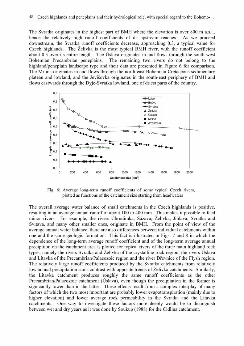
Czech highlands and peneplains and their hydrological role, with special regard to the Bohemo-...48
The Svratka originates in the highest part of BMH where the elevation is over 800 m a.s.l.,hence the relatively high runoff coefficients of its upstream reaches. As we proceeddownstream, the Svratka runoff coefficients decrease, approaching 0.3, a typical value forCzech highlands. The Želivka is the most typical BMH river, with the runoff coefficientabout 0.3 over its entire length. The Úslava originates in and flows through the south-westBohemian Precambrian peneplains. The remaining two rivers do not belong to thehighland/peneplain landscape type and their data are presented in Figure 6 for comparison.The Mrlina originates in and flows through the north-east Bohemian Cretaceous sedimentaryplateau and lowland, and the Jevišovka originates in the south-east periphery of BMH andflows eastwards through the Dyje-Svratka lowland, one of driest parts of the country.
The overall average water balance of small catchments in the Czech highlands is positive,resulting in an average annual runoff of about 100 to 400 mm. This makes it possible to feedminor rivers. For example, the rivers Chrudimka, Sázava, Želivka, Jihlava, Svratka andSvitava, and many other smaller ones, originate in BMH. From the point of view of theaverage annual water balance, there are also differences between individual catchments withinone and the same geologic formation. This fact is illustrated in Figs. 7 and 8 in which thedependence of the long-term average runoff coefficient and of the long-term average annualprecipition on the catchment area is plotted for typical rivers of the three main highland rocktypes, namely the rivers Svratka and Želivka of the crystalline rock region, the rivers Úslavaand Litavka of the Precambrian/Palaeozoic region and the river Dřevnice of the Flysh region.The relatively large runoff coefficients produced by the Svratka catchments from relativelylow annual precipitation sums contrast with opposite trends of Želivka catchments. Similarly,the Litavka catchment produces roughly the same runoff coefficients as the otherPrecambrian/Palaeozoic catchment (Úslava), even though the precipitation in the former issignicantly lower than in the latter. These effects result from a complex interplay of manyfactors of which the two most important are probably lower evapotranspiration (mainly due tohigher elevation) and lower average rock permeability in the Svratka and the Litavkacatchments. One way to investigate these factors more deeply would be to distinguishbetween wet and dry years as it was done by Soukup (1988) for the Cidlina catchment.
0,0
0,1
0,2
0,3
0,4
0,5
0,6
0,7
0,8
0,9
0 200 400 600 800 1000 1200 1400 1600 1800 2000
Catchment size (km 2)
Long
-term
ave
rage
runo
ff co
effic
ient
LabeBečvaSvratkaŽelivkaÚslavaMrlinaJevišovka
Fig. 6: Average long-term runoff coefficients of some typical Czech rivers,plotted as functions of the catchment size starting from headwaters
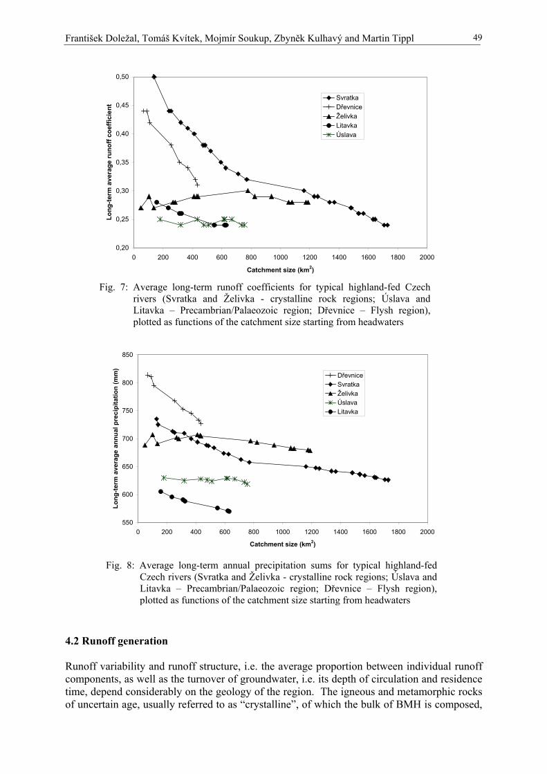
František Doležal, Tomáš Kvítek, Mojmír Soukup, Zbyněk Kulhavý and Martin Tippl 49
4.2 Runoff generation
Runoff variability and runoff structure, i.e. the average proportion between individual runoffcomponents, as well as the turnover of groundwater, i.e. its depth of circulation and residencetime, depend considerably on the geology of the region. The igneous and metamorphic rocksof uncertain age, usually referred to as “crystalline”, of which the bulk of BMH is composed,
0,20
0,25
0,30
0,35
0,40
0,45
0,50
0 200 400 600 800 1000 1200 1400 1600 1800 2000
Catchment size (km2)
Long
-term
ave
rage
runo
ff co
effic
ient
SvratkaDřevniceŽelivkaLitavkaÚslava
Fig. 7: Average long-term runoff coefficients for typical highland-fed Czechrivers (Svratka and Želivka - crystalline rock regions; Úslava andLitavka – Precambrian/Palaeozoic region; Dřevnice – Flysh region),plotted as functions of the catchment size starting from headwaters
550
600
650
700
750
800
850
0 200 400 600 800 1000 1200 1400 1600 1800 2000
Catchment size (km2)
Long
-term
ave
rage
ann
ual p
reci
pita
tion
(mm
)
DřevniceSvratkaŽelivkaÚslavaLitavka
Fig. 8: Average long-term annual precipitation sums for typical highland-fedCzech rivers (Svratka and Želivka - crystalline rock regions; Úslava andLitavka – Precambrian/Palaeozoic region; Dřevnice – Flysh region),plotted as functions of the catchment size starting from headwaters

Czech highlands and peneplains and their hydrological role, with special regard to the Bohemo-...50
are virtually impervious, except for faults and weathered zones. They therefore give rise to arapid turnover of groundwater in the shallow regolith and to a dense network of temporarysprings and minute perennial streams and fishponds. The portion of interflow in the totalrunoff is high (typically about 40 %), as demonstrated by Doležal et al. (2003) (see Table 2).
The residence time of groundwater in the crystalline rock catchments is small. Environmentalisotope tracer studies (e.g., FRIEND, 1997) suggest that the groundwater residence times insimilar catchments in other countries are of the order of one year or more. Unfortunately, notracer studies have yet been made in the experimental catchments listed in Table 1.Nevertheless, some information can be derived from the water quality monitoring as shownbelow. The seasonal trend of nitrate concentrations in the small stream water of thecrystalline rock region (Fig. 10) reveals a well defined maximum in the late winter and earlyspring months (January to April). Similar seasonal patterns have been observed in the othercrystalline rock, Precambrian/Palaeozoic and mixed geology experimental catchments witharable agriculture (Cerhovický potok, Černičí, Dolský potok and Kotelský potok). Theleaching of nitrate from arable lands mainly occurs in the autumn, winter and spring monthswhen the arable lands are either bare or the crops growing on them are not developed enough,while the amount of mineral nitrogen in the soil, mainly produced by the mineralisation oforganic matter in late summer and early autumn, is large (Armstrong and Burt, 1993). Theinterval between the usual time of maximum nitrate input into groundwater (September toDecember) and the time of its usual maximum concentration in the stream (January to April)does not exceed a few months. Hence, the nitrate acts as a sui generis environmental, even ifnon-conservative, tracer. Herrmann (2003) suggests that the transport of nitrate involves onlythe most superficial layers of groundwater and, therefore, the average residence time ofgroundwater, taking into account its deeper layers as well, must be longer than that derivedfrom the “nitrate pulse” travel time. Nevertheless, the nitrate tracing results may be used as arelative measure in comparisons of different environments as to their groundwater residencetimes. Some data for the forest subcatchments of the Cerhovický potok and the Kopaninskýtok suggest that the release of nitrate from a forest ecosystem into groundwater occurs mainlyin spring months when the increased temperatures favour the mineralisation of freshly createdforest litter. This leads to nitrate concentration maxima in forest stream and forest springwater in late summer and early autumn (Fig.11), without challenging the hypothesis of shortnitrate pulse travel times.
Measurements in the other geological environments are scarce. The standard data (Horský,1970) can be exploited to give a rough picture. In the absence of more accurate data such asthose obtained from environmental tracers studies, one can take the ratio of the 180-day flowto the long-term average flow as an indicator of the relative baseflow magnitude, as illustratedabove in Table 2 and Figure 5. Figure 9 shows these ratios as functions of the catchment sizefor typical rivers in main Czech highlands.
From these data it can be concluded that the groundwater turnover in most Precambrian andPalaeozoic formations is approximately equally fast as that in the crystalline rock regions.The discernibly lower baseflow proportions in the river Svratka (in comparison with the riversŽelivka, Úslava and Litavka, as well with the river Labe which in its upper 2000 km2 of thecatchment area drains crystalline, Palaeozoic and Cretaceous formations), correspond to theabove findings concerning the high runoff coefficients in the Svratka catchment. The riversof the Carpathian Flysh region (Bečva and Dřevnice) have apparently much lower baseflow tototal flow proportions. This is mainly due to low permeability of the underlying rocks and tosteep slopes of the hills. Both these factors contribute to fast runoff and low water retentionin the catchments. It is reasonable to assume, on the basis of these observations, that the

František Doležal, Tomáš Kvítek, Mojmír Soukup, Zbyněk Kulhavý and Martin Tippl 51
groundwater turnover in the Flysh region highlands is even faster and shallower than that inthe crystalline or the Precambrian/Palaeozoic regions. Of course, this assumption has to beverified by more detailed measurements.
30%
40%
50%
60%
70%
80%
0 200 400 600 800 1000 1200 1400 1600 1800 2000
Catchment size (km 2)
Long
-term
180
-day
flow
(in %
of l
ong-
term
ave
rage
ann
ual f
low
)
LabeŽelivkaÚslavaLitavkaSvratkaDřevniceBečva
Fig. 9: Ratio between 180-day flow and average long-term average total flow as afunction of the catchment size starting from headwaters for typical Czechhighlands rivers. Respective data of Labe and Bečva mountainous riversare shown for comparison.
Kopaninský tok, T7 (main stream), 10/6/1992-25/10/2000
0
10
20
30
40
50
60
70
80
0 50 100 150 200 250 300 350
Julian day
mg
NO
3/l
Data
Seasonaltrend
Fig. 10: Seasonal trend of nitrate concentrations in stream water of theKopaninský tok catchment (profile T7, 10/6/92-25/10/00)

Czech highlands and peneplains and their hydrological role, with special regard to the Bohemo-...52
4.3 Water quality generation
In terms of water quality, the rapid turnover of water in BMH and other crystalline rockregions does not allow enough denitrification. The residence time of groundwater is furtherreduced due to the effect of artificial subdrainage (tile drainage) systems on agricultural lands.Most sites in the crystalline rock regions are therefore highly vulnerable to the nitratepollution. They were labelled as such in the process of vulnerable zones delineation for thepurpose of application of the EU nitrate directive (Anonymous, 2003). The catchments whichare underlain by Precambrian and Palaeozoic metamorphic rocks in south-west Bohemiabehave in a similar way.
On average, the concentrations of nitrate in the streams of BMH and similar regions are high,and sometimes higher than the drinking water limit concentration of 50 mg NO3/l. Theyreveal a distinct seasonal trend (Kvítek et al., 2002b, see Figs. 10 and 11 as examples), asdiscussed above under runoff generation. The streams and springs that are recharged byforested lands have considerably lower concentrations of nitrate than those collecting waterfrom arable lands (see Fig. 11, Soukup et al., 2001; Soukup and Pilná, 2003; Kvítek andDoležal, 2003; Doležal and Kvítek, 2004).
The runoff components into which the total stream flow can be decomposed differ amongthemselves as to the reaction time on the precipitation events, to the depth of the soil/parentrock zone involved and to the distance (from the recipient) of the site where the runoff isgenerated. Therefore, it can be expected that different runoff components also play differentroles in the leaching, transportation, transformation and discharge of nitrogen. Suchinvestigation was done for the Kopaninský potok catchment in BMH (Kvítek and Doležal,2003, Doležal and Kvítek, 2004). The simple model, described by equations (1) and (2),provided rough estimates of average nitrate concentrations in the water of individual runoffcomponents: 37 mg NO3/l for the baseflow, 55 mg NO3/l for the interflow and 24 mg NO3/l
Average monthly nitrate concentrations, Cerhovický potok,
1986-1994 and 1998-2001
0
5
10
15
20
25
30
35
40
45
I. II. III. IV. V. VI. VII. VIII. IX. X. XI. XII.
NO
3 (m
g.l
-1)
Stream, wholecatchment A1 (CP)
Stream from forest B1
Fig. 11: Seasonal trends of nitrate concentrations in the stream water of theCerhovický potok catchment in 1986-1994 and 1998-2001 in theclosing profiles of the whole catchment (A1) and a forestedsubcatchment (B1; 3.15 km2 in size)

František Doležal, Tomáš Kvítek, Mojmír Soukup, Zbyněk Kulhavý and Martin Tippl 53
for the direct runoff. The results indicate that the interflow and, to a lesser extent, thebaseflow are the main carriers of nitrate towards the stream in agricultural catchments of thecrystalline rock region. This conclusion is, of course, only qualitative. No comparablestudies have been made up to now for the other highland regions in the Czech Republic.
Furthermore, the studies made in the experimental catchments confirm that the subdrainage(tile drainage) water contains higher concentrations of nitrate. Figure 12 compares nitrateconcentrations, plotted against their probabilities of exceedance which were estimated fromthe Hazen plotting position equation, for subdrainage water and for stream water in theDolský potok and Kotelský potok catchments. Similar results have been obtained in the otherexperimental catchments listed in Table 1. As stated above, the drainage systems provide ashort-cut for runoff and, thereby, reduce the opportunity for denitrification. The drainagesystems may therefore have a negative impact on the stream water quality, beside theirobvious positive effects on the ease and economy of agricultural production.
4.4 Practical implications
The Czech Republic is now in the process of implementation of the EU Nitrate Directive(Anonymous, 1991). The problem is being tackled in two different ways. One way is toallow arable agriculture on virtually all existing arable lands, but to impose limitations on theuse of fertilisers, on growing some crops (such as legumes, potatoes and silage maize) and onperforming some other farming operations (such as the incorporation of legumes and greenmanure). The limitations must be compulsorily observed in selected vulnerable regions(Anonymous, 2003). The other way would be a forced conversion of selected arable lands(such as the drained lands in the transitional zones and the most permeable and shallow soilsin the recharge zones) into non-intensive grasslands or forests, thus not imposing any seriousrestrictions on the remaining arable lands (Kvítek et al., 2002a). The problem is still open and
Dolský potok and Kotelský potok, 2001-2003
0
20
40
60
80
100
120
140
0 0.1 0.2 0.3 0.4 0.5 0.6 0.7 0.8 0.9 1
Probability of exceedance
mg
NO
3/l
Kotelský potokDolský potokSubdrainage PokřikovSubdrainage Kladno
Fig. 12: Empirical probability of exceedance curves of nitrate concentrations forthe stream water in the Dolský potok and Kotelský potok catchmentsand in the runoff from two tile drainage systems in the Dolský potokcatchment, 2001-2003

Czech highlands and peneplains and their hydrological role, with special regard to the Bohemo-...54
the actual outcome will probably be a compromise between the two approaches describedabove.
The waterlogged slopes and narrow valleys in the crystalline rock highland region weretraditionally used, if at all, as forests or meadows. Since the 1960s, many former meadowshave been drained by subsurface tile drainage systems and turned into arable lands. Theredox status of formerly waterlogged sites has thus been shifted towards the oxidation sidedue to drainage and tillage, rendering the removal of nitrogen from shallow groundwater bydenitrification less efficient. The combination of the diffuse pollution by nitrate in therecharge zones with the lack of opportunity for denitrification in the transitional and dischargezones makes the stream water excessively polluted. The actual pattern of runoff and waterquality generation in small agricultural catchments is still being studied in order to identifythe actual causes of the pollution and to propose the measures for improvement. In fact, somedrained arable lands on slopes, too difficult to cultivate, have already been spontaneouslyabandoned. In addition, the subdrainage runoff from these lands has to be retarded (Soukupet al., 1998, 2002) in order to increase the groundwater residence time and the opportunity forthe nitrate in groundwater to be removed by denitrification.
5 Conclusions
The water balance pattern of the Czech highlands, expressed by the long-term average runoffcoefficient, is less positive in terms of water surplus available for runoff than the “watertower”-like balance of mountains but more positive than that of lowlands whereevapotranspiration rates often exceeds precipitation amounts. The water balance of the Czechhighlands results in an average annual runoff about 100-400 mm. The actual water balancepattern mainly depends on the elevation and local climate but also, to some extent, on thegeology of the region. The runoff structure and runoff variability are perceptibly influencedby the geology. In general, however, the groundwater turnover in most Czech highlands isshallow and rapid and the residence time of water in catchments is small. The nitrate pulsetravel time is only few months. The groundwater turnover in the Precambrian/Palaeozoicregions is roughly equally fast as that in the crystalline rock regions, while it is reasonable toassume that this is faster in the Carpathian Flysh regions. It appears that the highland regionsother than those underlain by crystalline rocks have not yet been studied enough as to theirrunoff and water quality generation processes. This pertains in particular to the CarpathianFlysh regions.
Arable agriculture in Czech highlands is socially and economically important and cannot befully replaced by any other economic activity. However, it must be regulated, either byimposing limitations on agronomy on the existing arable lands or by reducing the area ofarable lands. The actual ways of regulation may differ from region to region, bearing in minddifferent geology, geomorphology and traditions of different regions. It seems inevitable toretard the tile drainage runoff from the recharge zones and the transitional zones of thecrystalline rock highland regions.
Acknowledgement
This study was made possible due to the RISWC programme MZE-M07-99-01 financed bythe Ministry of Agriculture of the Czech Republic, the National Agency for AgriculturalResearch projects RE 5501, EP 096006150, EP 9155, QC 0067 and QC 0242 and the GrantAgency of the Czech Republic projects 502/95/0826 and 103/99/1470. The substantial
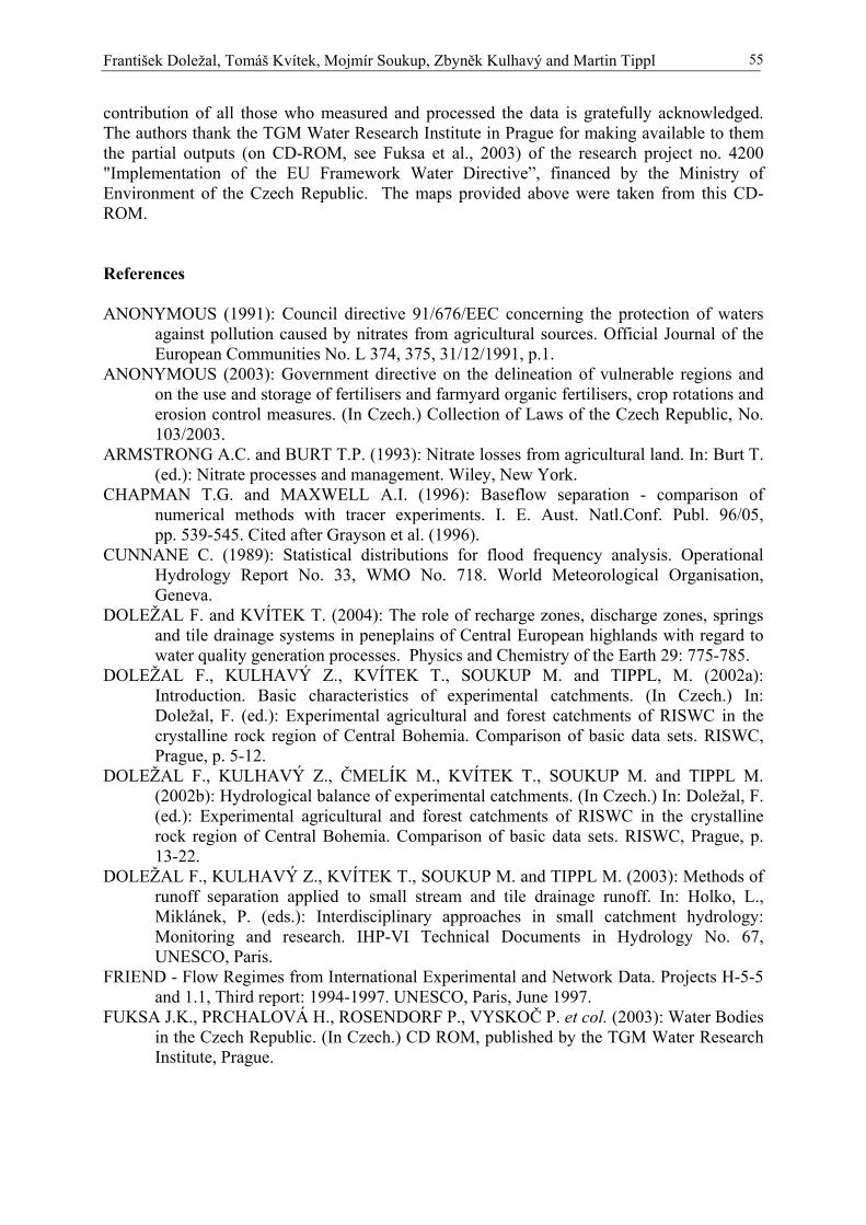
František Doležal, Tomáš Kvítek, Mojmír Soukup, Zbyněk Kulhavý and Martin Tippl 55
contribution of all those who measured and processed the data is gratefully acknowledged.The authors thank the TGM Water Research Institute in Prague for making available to themthe partial outputs (on CD-ROM, see Fuksa et al., 2003) of the research project no. 4200"Implementation of the EU Framework Water Directive”, financed by the Ministry ofEnvironment of the Czech Republic. The maps provided above were taken from this CD-ROM.
References
ANONYMOUS (1991): Council directive 91/676/EEC concerning the protection of watersagainst pollution caused by nitrates from agricultural sources. Official Journal of theEuropean Communities No. L 374, 375, 31/12/1991, p.1.
ANONYMOUS (2003): Government directive on the delineation of vulnerable regions andon the use and storage of fertilisers and farmyard organic fertilisers, crop rotations anderosion control measures. (In Czech.) Collection of Laws of the Czech Republic, No.103/2003.
ARMSTRONG A.C. and BURT T.P. (1993): Nitrate losses from agricultural land. In: Burt T.(ed.): Nitrate processes and management. Wiley, New York.
CHAPMAN T.G. and MAXWELL A.I. (1996): Baseflow separation - comparison ofnumerical methods with tracer experiments. I. E. Aust. Natl.Conf. Publ. 96/05,pp. 539-545. Cited after Grayson et al. (1996).
CUNNANE C. (1989): Statistical distributions for flood frequency analysis. OperationalHydrology Report No. 33, WMO No. 718. World Meteorological Organisation,Geneva.
DOLEŽAL F. and KVÍTEK T. (2004): The role of recharge zones, discharge zones, springsand tile drainage systems in peneplains of Central European highlands with regard towater quality generation processes. Physics and Chemistry of the Earth 29: 775-785.
DOLEŽAL F., KULHAVÝ Z., KVÍTEK T., SOUKUP M. and TIPPL, M. (2002a):Introduction. Basic characteristics of experimental catchments. (In Czech.) In:Doležal, F. (ed.): Experimental agricultural and forest catchments of RISWC in thecrystalline rock region of Central Bohemia. Comparison of basic data sets. RISWC,Prague, p. 5-12.
DOLEŽAL F., KULHAVÝ Z., ČMELÍK M., KVÍTEK T., SOUKUP M. and TIPPL M.(2002b): Hydrological balance of experimental catchments. (In Czech.) In: Doležal, F.(ed.): Experimental agricultural and forest catchments of RISWC in the crystallinerock region of Central Bohemia. Comparison of basic data sets. RISWC, Prague, p.13-22.
DOLEŽAL F., KULHAVÝ Z., KVÍTEK T., SOUKUP M. and TIPPL M. (2003): Methods ofrunoff separation applied to small stream and tile drainage runoff. In: Holko, L.,Miklánek, P. (eds.): Interdisciplinary approaches in small catchment hydrology:Monitoring and research. IHP-VI Technical Documents in Hydrology No. 67,UNESCO, Paris.
FRIEND - Flow Regimes from International Experimental and Network Data. Projects H-5-5and 1.1, Third report: 1994-1997. UNESCO, Paris, June 1997.
FUKSA J.K., PRCHALOVÁ H., ROSENDORF P., VYSKOČ P. et col. (2003): Water Bodiesin the Czech Republic. (In Czech.) CD ROM, published by the TGM Water ResearchInstitute, Prague.
Czech highlands and peneplains and their hydrological role, with special regard to the Bohemo-...56
GRAYSON R.B., ARGENT R.M., NATHAN R.J., MCMAHON T.A. and MEIN R.G.(1996): Hydrological recipes: estimation techniques in Australian hydrology.Cooperative Research Centre for Catchment Hydrology, Clayton, Victoria, Australia,125 p.
HERRMANN A. (2003), personal communication.HORSKÝ L. (ed.-in-chief) (1970): Hydrological conditions of the Czechoslovak Socialist
Republic. Part III. (In Czech.) Hydrometeorological Institute, Prague, 305 p.JAIN S.K. (1977): Evaluation of catchment management strategies by modelling soil erosion /
water quality in EPIC supported by GIS. M.Sc. thesis, Galway, National University ofIreland, Department of Engineering Hydrology.
KILLE K. (1970): Das Verfahren MoMNQ, ein Beitrag zur Berechnung der mittlerenlangjährigen Grundwasserneubildung mit Hilfe der monatlichen Niedrigwasser-abflüsse. Zeitschrift der Deutschen Geologischen Gesellschaft, SonderheftHydrogeologie and Hydrogeochemie, p. 89-95.
KLINER K. and KNĚŽEK M. (1974): The underground runoff separation method making useof the observation [of] groundwater table. (In Czech.) Vodohospodársky časopis23(5): 457-466.
KULHAVÝ Z., DOLEŽAL F. and SOUKUP M. (2001): Separation of drainage runoffcomponents and its use for classification of existing drainage systems. (In Czech.)Vědecké práce VÚMOP Praha, 2001, 12: 29-52.
KULHAVÝ Z., ČMELÍK M., KVÍTEK T., SOUKUP M. and TIPPL M. (2002): Extremerunoff events in experimental catchments and the probability of their occurrence. (InCzech.) In: Doležal, F. (ed.): Experimental agricultural and forest catchments ofRISWC in the crystalline rock region of Central Bohemia. Comparison of basic datasets. RISWC, Prague, p. 37-48.
KVÍTEK T. and DOLEŽAL F. (2003): Water and nutrient regime of the Kopaninský tokcatchment in the Bohemo-Moravian Highland. (In Czech.) Acta Hydrologica Slovaca4(2): 255-264.
KVÍTEK T. et al. (2002a): Application of an alternative system of land and water protectionmanagement in the landscape. (In Czech.) Annual report, project QC0242. RISWC,Prague, 151 p. + appendices.
KVÍTEK T., SOUKUP M., KULHAVÝ Z. and TIPPL M. (2002b): Trends of nitrateconcentrations in surface and drainage waters of RISWC experimental catchments. (InCzech.) In: Doležal, F. (ed.): Experimental agricultural and forest catchments ofRISWC in the crystalline rock region of Central Bohemia. Comparison of basic datasets. RISWC, Prague, p. 61-81.
SOUKUP M. (1988): An analysis of drainage impacts on some run-off characteristics in apart of the Cidlina river catchment area.. (In Czech.) Vědecké práce VÚZZP Praha 5:121-129.
SOUKUP M. and PILNÁ E. (2003): Development of nitrate concentrations in waters of theagricultural and forest part of experimental watershed of the Cerhovický stream. (InCzech.) Soil and Water (Scientific Studies RISWC) 2: 83-94.
SOUKUP M. et al. (1998): Scientific background of runoff regulation in agriculturalcatchments and methods of its evaluation. (In Czech.) Annual report, project EP0960006150, RISWC, Prague.
SOUKUP M., PILNÁ E. and DOLEŽAL F. (2001): Comparison of nitrate concentrations indrainage runoff and streamflow during an extreme flow event in the Cerhovický potokcatchment. (In Czech.) Vodohospodársky časopis 49(3-4): 223-236.
SOUKUP M., KYZLÍKOVÁ J. and PILNÁ E. (2002): Water regime of drained soils underretardation of drainage runoff. (In Czech.) Soil and Water (Scientific Studies RISWC)1: 103-114.
Miroslav Tesar, Miloslav Sir, Igor Jan Dvorak and Lubomir Lichner 57
Influence of vegetative cover changes on the soil water regimein headwater regions in the Czech Republic
Miroslav Tesar1, Miloslav Sir1, Igor Jan Dvorak2 and Lubomir Lichner3
1 Institute of Hydrodynamics, Academy of Sciences of the Czech Republic, Prague, Czech Republic2 Krkonose National Park Administration, Vrchlabi, Czech Republic
3 Institute of Hydrology, Slovak Academy of Sciences, Bratislava, Slovak Republic
Abstract
The influence of vegetative cover on the soil water regime in the Modry potok catchment inthe Giant Mts. (Krkonose) is studied in this paper. Several monitored plots located in thiscatchment in different positions (valley, slope) are covered by different kinds of vegetation(dwarf pine forest, spruce forest, meadows). The maximum retention capacity of thecatchment (about 70 mm) and the retention capacity of the soil surface (20 mm) are evaluatedin two contrast periods: the catastrophic flood in August 2002 and the long-term drought inAugust 2003. Based on soil moisture measurements in monitored plots fully covered byplants, it is shown that: (1) in wet conditions, when the plants can fully transpire, thevegetative cover composition does not influence the soil water regime; (2) in the course ofdroughts, the soil water regime is highly influenced by the plant cover composition. Based onthe monitoring of the water and heat regime in the growing season the homeostatic role of theplant transpiration was proved. Consequently, the water regime of a catchment during wetconditions (rainfall-runoff relationship) is independent of the species composition of the plantcover if the area of the transpiring vegetation remains unchanged. The monitoring networkwhich covers the main massifs of the Bohemian border is discussed here.
1 Introduction
Long-term attention is paid to the study of the relationship between the vegetation cover, andthe heat and water circulation in the landscape. The question of how the water regime of acatchment is influenced by forest has been studied in the Czech Republic since the beginningof the 20th century. The first research basins – Kychova and Zdechovka in the Beskydy Mts.– were established by Valek in 1928 (Valek, 1937). Precipitation and runoff measurement inthese basins has continued up to the present time. Another experiment was started in 1954 inthe Raztoka catchment (Beskydy Mts., drainage area 2.067 km2, elevation from 602 to 1084m a.s.l., mean annual precipitation 1269 mm, runoff 833 mm, bedrock formed of sandstone).Based on this experiment, it was found that the rainfall-runoff transformation is notsignificantly influenced when the spruce forest is replaced by beech forest. This conclusionwas derived using the double mass curve of precipitation and runoff (Chlebek and Jarabac,1988).
Now research activities are aimed at the mountainous regions covered by damaged forests.This interest has been invoked by a series of climatic and hydrological disasters like floods in1997, 1998 and 2002 or droughts in 2000 and 2003. A calamitous deforestation of theBohemian and partly Silesian border has caused such significant ecological damage that it isimpossible to rely on the remedial potential of the nature, and it is necessary to step up theactive renewal of the vegetation cover. The antecedent research was predominantly motivated

Influence of vegetative cover changes on the soil water regime in headwater regions in the Czech..58
by the effort to better recognise the hydric functions of the forest (Chlebek and Jarabac,1988). The majority of the affected mountains is situated in landscape-protected areas ornational parks. Therefore the use of the well-tried techniques for clear cutting of the damagedforest with subsequent afforestation of the clearings is questionable.
In addition, the research effort is complicated by the changing climatic of the last 50 yearsthat became a marked global warming during the course of the last decade. The annualaverage of the air temperature in the open landscape of the Czech Republic increased by about1.4 o C during the last 50 years (Bodri and Cermak, 1997). Taking into account a lapse rate of–0.66 K per 100 m, which is estimated for the Czech Republic, the warming represents anillusory decrease of the whole country of about 210 m, and thus, the shift of the mountains tothe climatic zone corresponding rather to highlands. This fact complicates the application ofolder results of hydrological research. These results were obtained in different climaticconditions compared to the present ones.
In this article typical results of the monitoring of the influence of various vegetation covers onsoil water regime and water retention will be shown. The contribution is based on themonitoring of the hydrological and meteorological data in the four experimental plots in theModry potok catchments in the Giant Mts. These plots differ in the type of vegetation (dwarfpine, spruce forest, meadows in the valley and meadows above the forest margin) and inposition (valley bottom and different slope positions). In two contrast periods, during thecatastrophic flood in August 2002 and during the long-term drought in August 2003, theretention capacities are estimated. The vegetation-cover influence on the soil water regime isdocumented with the help of soil moisture measurements.
2 Methodology
In order to study the water regime of mountainous forested catchments, three experimentalwatersheds were established: (1) the Liz basin (Sumava Mts. – southern Bohemia, brownpodzolic soil, moldanubic crystallinicum, paragneiss, prevailing type of tree: spruce aged upto 120 years); (2) the Uhlirska basin (the Jizerske hory Mts. – northern Bohemia; brownpodzolic soil, podzol, peat, Variscan igneous rocks of granite massif of the Krkonose-Jizerskehory crystalline complex, biotitic gneiss, prevailing type of tree: spruce aged up to 80 yearsfor 15 % and 15 years for 85 % of the area); (3) the Modry potok basin (the Giant Mts. –north-eastern Bohemia; ferrous humic podsole, brown podzolic soil, rocks of metamorphicaureole of Variscan granite pluton, mica schist, spruce and dwarf pine covering 62 % andmeadow 38 % of the area).
These experimental catchments are placed in the main massifs of the Bohemian bordermountains. They differ especially in the level of the anthropogenic impacts on vegetationcover. The Liz catchment represents a relatively healthy productive forest in a clearlandscape. The Uhlirska basin is situated in a formerly heavily polluted region of the so-called “Black Triangle”. At the beginning of the nineties the top parts of the Jizerske horyMts. were nearly completely deforested. At present the prevailing part of this catchment iscovered by regenerated forest. The Modry potok basin in the Giant Mts. represents theoriginal spruce forest in the lower part of the basin and the artic-alpine tundra with dwarf pinecovers the upper part above the timberline. Brief characteristics of the catchments arepresented in Tables 1, 2 and 3 and positions of the catchments are shown in Figure 1.

Miroslav Tesar, Miloslav Sir, Igor Jan Dvorak and Lubomir Lichner 59
The basic parameters (precipitation amount and intensity, air and soil temperatures, globalradiation, suction pressures and soil moistures, discharge in the closure profile) are recordedin all experimental catchments. Based on the measured data the actual transpiration andoutflow of water below the soil profile to the sloped subsoil horizont transporting water to thesmall brook are evaluated. Furthermore, the total retention capacity of the basin, retention ofwater on the soil surface, in the soil profile and in the subsoil layer are assessed. Themethodology of the measurement, data processing and evaluation have been published (Tesarand Sir, 1998; Tesar et al., 2001, 2003). The monitoring network is formed by twenty fullyautomatic stations. The network is operated jointly by the Institute of Hydrodynamics of theAcademy of Sciences of the Czech Republic in Prague, Faculty of Civil Engineering of theCzech Technical University in Prague, Czech Hydrometeorological Institute in Prague andHradec Kralove and Krkonose National Park Administration in Vrchlabi.
3 Experimental catchments and areas
3.1 The Sumava Mts.
The Liz catchment, Zabrod arable land and Zabrod meadow experimental areas are situated inthe mountainous and submontane region of the Sumava Mts. These localities lie in theVimperk Highlands that extend in its south-eastern part to the Landscape Protected Area andNational Park of the Sumava Mts. and are part of the Moldanubicum metamorphic complex.It is formed mainly by the metamorphosed rocks, paragneiss with smaller injected localities inthe northern part of the region. In valley bottoms all bedrock is covered by noncalcic (acid)sediments, in depressions and the middle parts of slopes also by quaternary sediments.
The clayey-sandy and sandy-clayey soils of middle depth represent the prevailing soil type.The forest soil type is mainly Eutric Cambisol (Stagno-slightly-gleyic Cambisol, Stagno-
Fig. 1: Location of the experimental plots in the Czech Republic

Influence of vegetative cover changes on the soil water regime in headwater regions in the Czech..60
gleyic Cambisol, Albic Luvisol). Relatively frequently the soil type is Ferro-humic Podzol.In the valleys close to the water courses Eutric Fluvisol, Gleyic Fluvisol and Eutric Histosoloccur. On the highest hilltops Lithosol can be found. Eutric Cambisol, Gleyic Fluvisol andpartly also Eutric Fluvisol are agriculturally exploited. The increased amount of precipitationtogether with lower temperatures has resulted in increased leaching intensity that jointly withan acid reaction causes significant accumulations of acid organic matter on the soil surface.The fleeter granularity composition of the bedrocks of the acid Eutric Cambisol and Ferro-humic Podzol eliminates the influence of the higher amount of precipitation so that thegleyzation does not appear. Only on the bottom part of the slopes and on the platforms withstratified deposited geest rock-forming material is a relatively lower permeable deluviumformed with various stage of gleyzation. Gleyic Fluvisol is significantly influenced by therelief feature and hydrological conditions.
The Liz catchment is located in the south-western part of the Vimperk Highland in the basinof the Zdikov brook that flows through the wider meadow depression. In its upper part thisbrook is formed on the northerly oriented forest slopes, with the Liz catchment here being at adistance of about 4 km from the village of Zdikov in the district of the town of Prachatice.The experimental areas of Zabrod arable land and Zabrod meadow are situated below theforested slopes. The Liz catchment is fully forested. Forest cover belongs to the acid sprucebeech type. The soil type is the oligotrophic forest Eutric Cambisol. The coordinates are13º40'01" – 13º41'00"E and 49º03'23" – 49º04'09"N. Maximum elevation is 1074 m a.s.l.,minimum elevation 828 m a.s.l., mean elevation 941.5 m a.s.l., average land slope 16.55 %,catchment length 1.45 km, length of streams 2.28 km. Table 1 gives the characteristics of theLiz catchment and Figure 2 describes its physical geographic situation. The Zabrod meadowexperimental area is exploited as a permanent meadow. In 1976 the locality was drained bypipe drainage. The soil type is the acid slightly gleyic Eutric Cambisol. The coordinates are
Fig. 2: Physical geographic situation of the Liz experimental catchment

Miroslav Tesar, Miloslav Sir, Igor Jan Dvorak and Lubomir Lichner 61
13º41'45"E and 49º04'15"N, elevation is 788 m a.s.l. The Zabrod arable land experimentalarea was exploited as arable land; now it is covered by permanent grass. In 1976 the localitywas drained by pipe drainage. The soil type is the acid podzolic Eutric Cambisol. Thecoordinates are 13º41'45"E and 49º04'13"N, and elevation is 789.5 m a.s.l.
Table 1: Characteristics of the Liz experimental catchment in the Sumava Mts.
District PrachaticeLand register of the village/town ZdikovGeographic position – E longitude of closingprofile
13º40'58"
Geographic position – N latitude of closingprofile
49º3'59"
Maximum elevation 1074.0 m a.s.l.Minimum elevation 828.0 m a.s.l.Drainage area 0.989 km2
Physical-geographic location Bohemian Highlands – mountainouscountry
Geomorphological unit The Sumava Mts. (Bohemian Forest)Hydrological order of the observed water body 1-08-02-013Sequence of streams to main river Zdikovsky potok brook – Stassky potok
brook – Spulka river – Volynka river –Otava river – Vltava river (Moldau)
Vegetation cover and land-use Mixed forest (spruce 87%, beech 6%, other7%), age up to 120 years old
Geological unit Moldanubic Crystalline Massif: gneiss,paragneiss
Soil type Podzolic Eutric CambisolMean annual air temperature 6.3 ºCMean air temperature in January –3.4 ºCMean air temperature in July 13.6 ºCMean annual precipitation 825 mmMean number of days with snow cover 92
The above-mentioned experimental stands are equipped with automatic monitoring stationsfor the continuous measurements of air and soil temperatures, suction pressures in the soil(water tensiometers), soil moisture (HFP soil moisture meters) and precipitation amount andintensity (rain gauge with a catchment area of 500 cm2). The HFP soil moisture meter is amicrocomputer-controlled device where the soil moisture is estimated using the high-frequency permittivity measurement. Measurement accuracy in field conditions is about 1%(vol.). In the closing profile of the Liz catchment the discharge is recorded. Next to thisclosing profile an automatic monitoring system for the gradient measurement of the heat andwater transfer in the surface layer of the atmosphere and soil is installed. The Liz catchmenthas been included in the GEOMON monitoring network (Geochemical Monitoring Network).GEOMON represents a network of small forested catchments in the territory of the CzechRepublic (Fottova, 2003). The monitoring has been coordinated by the Czech GeologicalSurvey since 1994. The deposition fluxes of the fifteen major ionic species based on bulkprecipitation and throughfall analyses have been calculated for the 1994–2002 period.
Influence of vegetative cover changes on the soil water regime in headwater regions in the Czech..62
3.2 The Giant Mts. (Krkonose)
The experimental locality Labska louka lies in the western part of the Giant Mts. close to theheadspring of the Elbe river. The Modry potok catchment is situated in the eastern part of theGiant Mts. with the highest point being Studnicni hora Mt. This region is formed by theKrkonose-Jizerske hory crystalline complex. The crystalline complex is found on thenorthern margin of the Bohemian Massif. Due to their type and age, the rocks forming thecrystalline complex are similar to the rocks of the Moldanubic Crystalline Massif in southBohemia. The bedrock differs in Labska louka and Modry potok. In the Labska louka thebedrock is formed by biotitic granite becoming coarse-grained granite on the southern marginof the given locality (Variscan granite pluton). In the Modry potok the bedrock is formed byrocks of the crystalline complex. These rocks form here the contact of the older rocks (pre-Cambrian) with granite rocks of the Paleozoic at the beginning of the Upper Carbon(metamorphic aureole). Rock types are presented by the mica-schist, phyllite, gneiss,amphibolites and sometimes quartzite and erlane.
The Labska louka lies in the western part of the arctic-alpine tundra of the Giant Mts. on itsnorthern margin close to the border with Poland, above the timberline. The climaticconditions correspond to the characteristics of the cold climatic zone (the average airtemperature in January of about –6 o C, in July between 10 o C and 12 o C). The total meanannual precipitation ranges from 1300 to 1400 mm. The Labska louka is situated on the flushsurface (peneplain) of the granite massif that is affected by the chemical weathering from thewarm period of the end of the Mesozoic era and Tertiary. This disintegrated surface wastabulated to the form of a peneplain. The content of the clayey minerals presents a testamentof the weathered surface of the granite pluton. The depth of the weathered zone ranges up totens of meters. The structure of the soil profile reflects relatively homogeneous geologicalbedrock with the occurrence of stony fields, detritus and stony streams with the occurrence ofsolifluction. The prevailing soil type is the mountainous humic and ferro-humic podsole withan admixture of peat (Dystric Histosol). Peat-bogs have developed in some places (e.g.Pancava peat-bog).
In the Labska louka, there are several experimental sites differing in vegetation cover (grassand dwarf pine stand). Each of the experimental sites is equipped with an automaticmonitoring station for continuous measurement of air and soil temperatures, suction pressuresin the soil, soil moisture, and precipitation amount and intensity.
The Modry potok catchment (upper part of the Modry dul) is located in the eastern part of theGiant Mts. It lies at a distance of about 5 km from the village of Pec pod Snezkou in thedistrict of Trutnov town. The drainage area of this catchment is 2.62 km2. The highest pointis the Studnicni hora Mt. (1554 m a.s.l.); minimum elevation of the closing profile is 1010 ma.s.l. This catchment lies in the centre of crystalline rocks. The coordinates of the closingprofile are 15º42'49"E and 50º42'48"N. In the upper part of the catchment, on the southernslope of the valley below the Modre saddle, there is an avalanche slope. On this south-facedslope with a nivation depression an extensive snow accumulation appears every year andcreates a big transverse snowpatch. The same situation is found in the upper closure of thevalley with long-lasting snowpatches. During the spring melt the big water storageaccumulated in the snow is released. Table 2 lists the characteristics of the Modry potokcatchment, and Figure 3 describes its physical geographic situation.
On the southern slope of the Studnicni hora Mt. there are extended stony fields and detritusformed mainly by the greyish white mica schist with quartzite and erlane, also gneiss. Along

Miroslav Tesar, Miloslav Sir, Igor Jan Dvorak and Lubomir Lichner 63
the Modry potok brook stream and sporadically along its tributaries fluvial or fluviodeluvialsediments are deposited and in some places peat-bogs have developed to a smaller extent.The soil types are mountainous humic and ferro-humic podsole and Lithosol with a very thinhumic layer; the deeper soil of about 60 cm can be found in the bottom part of the valley closeto the Modry potok brook. The climatic conditions correspond to the characteristics of thecold humid climatic zone. Mean annual precipitation ranges from 1200 to 1300 mm.
Table 2: Characteristics of the Modry potok experimental catchment in the Giant Mts.
District TrutnovLand register of the village/town Pec pod SnezkouGeographic position – E longitude Gr. ofclosing profile
15º42'49"
Geographic position – N latitude of closingprofile
50º42'48"
Maximum elevation 1554.0 m a.s.l.Minimum elevation 1010.0 m a.s.l.Drainage area 2.620 km2
Physical-geographic location Bohemian Highlands – mountainouscountry
Geomorphological unit The Giant Mts. (Krkonose)Hydrological order of the observed water body 1-01-02-001Sequence of streams to main river Modry potok brook – Upa river – Labe
river (Elbe)Vegetation cover and land-use Forest (spruce and dwarf pine) 62% and
mountainous meadows 38%Geological unit Krkonose-Jizerske hory Crystalline
Complex; mica-schist, phyllite, gneiss,amphibolites, quartzite, erlane
Soil type Mountainous Humic and Ferro-humicPodzol, Lithosols
Mean annual of air temperature 2.9 ºCMean air temperature in January –5.9 ºCMean air temperature in July 12.1 ºCMean annual precipitation 1261 mmMean number of days with snow cover 196
Automatic monitoring stations are installed at several localities differing in the type ofvegetation cover – in the grassland above the forest margin (in the figures denoted as uppermeadow), in the growth of dwarf pine, in the growth of mature spruce forest and in thegrassland below the spruce forest close to the bottom of the valley (in the figures denoted asvalley meadow). The discharge at the closing profile is continuously recorded. An automaticmeteorological station on the Studnicni hora Mt. represents the highest position of thecatchment. The Modry potok catchment has been included in the GEOMON monitoringnetwork. The mass balance has been measured since 1994: chemistry of the surface runoff,throughfall and bulk precipitation.

Influence of vegetative cover changes on the soil water regime in headwater regions in the Czech..64
3.3 Jizerske hory Mts.
The Uhlirska catchment is located in the western part of the Jizerske hory Mts. at a distance ofabout 7 km from the village of Bedrichov in the district of Jablonec nad Nisou town. It lies inthe Cerna Nisa basin. The region of the Jizerske hory Mts. is composed of granite andmonzogranite rocks of the Variscan granite pluton Massif. The basic rock type is porphyrymedium granular biotite granite. In the crystalline complex cover the metamorphic rocks ofthe Under-Proterozoic and Under-Paleozoic age occur. The quaternary cover sediments areshallow. They are predominantly formed by the slope detritus with weathered substratum,peat sediments and fluviodeluvial sandy loam often with an admixture of rock fragments.
In the Uhlirska catchment soil profiles can be split into two basic groups. The first is formedby the soil profiles in the upper part of the catchment which originates from the weatheredgranite substratum belonging to the Cambisols registered as acid Eutric Cambisol with DistricGleyic Cambisol soil sub-type. These are clayey-sandy and sandy-clayey soils with anadmixture of rock fragments partly very coarse without any marked structure. The soil profileis regularly formed by 5 cm of a vegetation cover, 15–20 cm of the peat humic black colouredlayer, 10 cm of the transitional gleyic greyish black clayey-loamy layer, 30 cm of the brownor ochre clayey-sandy layer and 30 cm of the eluvial yellow brownish layer which changessmoothly to weathered granite. Through the whole soil profile the emphatic disturbancesoccur in the form of connected vertical in-leaks of iron oxide. The second group is formed bythe soil profile at the valley bottom with alluvial deposit that is covered by peat layers ofdifferent depths. The soil profile is regularly formed by 5 cm of vegetation cover, 0.5–2.0 cmof peat, 0.5–1.0 m of clayey-gravelly, very compacted soil without any structure with a depthof a few meters. These peat regions cover 10% of the drainage area of the catchment. Theremaining area is formed by the soil profile of the Eutric Cambisol that changes peat in thewaterlogged spots.
Fig. 3: Physical geographic sitution of the Modry potok experimental catchment

Miroslav Tesar, Miloslav Sir, Igor Jan Dvorak and Lubomir Lichner 65
The drainage area of the Uhlirska basin is 1.87 km2. The coordinates of the closing profileare 15º08'54"E and 50º49'31"N. Maximum elevation of the catchment is 872 m a.s.l.,minimum elevation 774 m a.s.l. and mean elevation 822 m a.s.l., average slope of the thalweg2.3 %, catchment length 2.1 km, average width of the catchment 0.89 km. The mean lengthof the slopes is about 450 m. The Uhlirska catchment area was nearly completely deforestedat the beginning of the eighties. New forests are up to 20 years old. Table 3 summarises thecharacteristics of the Uhlirska catchment and Figure 4 describes its physical geographicsituation.
Table 3: Characteristics of the Uhlirska experimental catchment in the Jizerske hory Mts.
District Jablonec nad NisouLand register of the village/town BedrichovGeographic position – E longitude Gr. of closingprofile
15º08'54"
Geographic position – N latitude of closingprofile
50º49'31"
Maximum elevation 870.0 m a.s.l.Minimum elevation 774.0 m a.s.l.Drainage area 1.870 km2
Physical-geographic location Bohemian Highlands – mountainouscountry
Geomorphological unit The Jizerske hory Mts.Hydrological order of the observed water body 2-04-07-016Sequence of streams to main river Cerna Nisa river – Luzicka Nisa river –
Odra riverVegetation cover and land-use Forest (prevailing type is spruce 15%),
naked surface or spruce forest up to 15years old 85%
Geological unit Krkonose-Jizerske hory CrystallineComplex; porphyry medium granularbiotite granite
Soil type Podzolic Eutric Cambisol, Ferro-humicPodzol, Eutric Histosol, Distric Histosol
Mean annual of the air temperature 6.5 ºCMean air temperature in January –4.8 ºCMean air temperature in July 13.8 ºCMean annual precipitation total 1400 mmMean number of days with snow cover 172
The Uhlirska catchment lies in the area with the highest precipitation in the Czech Republic,amounting to more than 1300 mm per annum; the average air temperature is 6.5 o C. Thisarea represents the mountainous type region with an average elevation of 780 m a.s.l. Theresults of precipitation measurements for the time period 1901–1950 are: the totalprecipitation for the growth season (April – September) 781 mm and for the winter season(October–March) 598 mm. The hydrological data for the Cerna Nisa basin, the Uhlirskacatchment (time period 1931–1960) are: annual precipitation 1400 mm, runoff depth 1018mm, runoff loss 382 mm. Annual mean discharge is 63 l/s and specific discharge33.7 l/s km2.

Influence of vegetative cover changes on the soil water regime in headwater regions in the Czech..66
In the Uhlirska catchment the slope transect was chosen and instrumentally equipped. Theslope soil profile developed on the granite is very shallow, it reaches a depth of about 1 m onaverage and it is formed by the Eutric Cambisol with an important percentage of rockfragments. Conversion from the soil profile to the weathered zone of the granite is verygentle. At the valley bottom there is a surface layer of moist peat with a depth of 0.5–1.0 mwith clayey, ochre-coloured gravel below. On the monitored slope and on the forest stand thesets of the water tensiometers are installed.
Fig. 4: Physical geographic situation of the Uhlirska experimental catchment

Miroslav Tesar, Miloslav Sir, Igor Jan Dvorak and Lubomir Lichner 67
An automatic meteorological station is located in the upper part of the catchment. In theforest there are wo catching areas for the measurements of the throughfall. In the second thirdof this catchment a snow-monitoring station has been placed for the continuous monitoring ofthe snow cover depth and water equivalent, snow temperatures at various levels, and airtemperature and humidity at 2 m height. Five automatic rain gauges, two cloud and fog watercollectors have been placed here as well. In the closing profile an automatic station withdischarge, pH and conductivity records of the surface runoff is located. On the right bank andclose to the climatic station 32 plastic pipes for the measuring of soil moisture have beeninstalled. The Uhlirska catchment is part of the GEOMON monitoring network. The massbalance has been measured in this basin since 1994: chemistry of the surface runoff,throughfall and bulk precipitation.
4 Results and discussion
Soil moisture at a depth of 15 cm during August 2002 and 2003 at the measuring plots in theModry potok catchment are shown in Figures 5a, 5b and Figures 7a, 7b. Soil moistures above50 % (vol.) are biased due to non-linearity of the soil moisture sensors. The results presentedclearly illustrate how the soil moisture of the surface layer reacts to precipitation. Thecorresponding precipitation is depicted in Figure 6 and Figure 8. The highest soil moisturewas found below the dwarf pine cover due to the high content of peat in the soil. The lowestsoil moisture was found in both grassland locations: above the forest margin (denoted asupper meadow in the figures) and below the spruce forest close to the bottom of the valley(denoted as valley meadow). This is caused by the low retention capacity of the mainlymineral and simply structured soil. The peat soil below a dwarf pine cover largelyaccumulates water so that even a small precipitation input causes a marked soil moistureincrease (Fig. 5).
August 2003 was extraordinarily warm. Figures 7a and 7b show the continuous withdrawalof the soil moisture till the precipitation events on 18-19 August. The decrease of the soilmoisture at 15 cm is roughly the same as in each of the monitored plots. It proves thatdifferent vegetation cover transpires identically. The same phenomenon was observed afterthe infiltration of precipitation from 21 August to the end of the month.
The total catchment retention was derived as a difference of the cumulative precipitation andcumulative runoff (Czelis and Spitz, 2003). The maximum total catchment retention duringthe precipitation event of 18-19 August is evaluated in Figure 8. During this precipitationevent the maximum total retention was about 50 mm whereas precipitation amounted to 60mm at the moment of maximum retention. Surface runoff did not occur. A surplus of 10 mmprobably passed through the soil profile to the subsoil. Accordingly, the retention capacity ofthe surface layer was not reached by rain water.
During the extremely rainy month of August 2002 (Fig. 5) the maximum rainfall amount wasrecorded from 10-14 August. The maximum total catchment retention during thisprecipitation period can be estimated at 70 mm (Fig. 5). The precipitation reached 130 mmat the moment of maximum retention. During the rainfall event surface runoff occurredbecause the retention capacity of the surface layer of 20 mm was strongly exceeded. Thiscapacity can be estimated as a difference between a maximum total retention of 70 mm duringan extreme precipitation event and of 50 mm during maximum precipitation which does notcause any surface runoff.

Influence of vegetative cover changes on the soil water regime in headwater regions in the Czech..68
Fig. 5a: Soil moisture at a depth of 15 cm at two localities in the Modrypotok catchment (dwarf pine and spruce forest) during August 2002
Fig. 5b: Soil moisture at a depth of 15 cm at two localities in the Modry potokcatchment (upper meadow and valley meadow) during August 2002

Miroslav Tesar, Miloslav Sir, Igor Jan Dvorak and Lubomir Lichner 69
Fig. 6: Precipitation and water retention in the Modry potok catchmentduring August 2002
Fig. 7a: Soil moisture at a depth of 15 cm at two localities in the Modrypotok catchment (dwarf pine and spruce forest) during August 2003

Influence of vegetative cover changes on the soil water regime in headwater regions in the Czech..70
Fig. 7b: Soil moisture at a depth of 15 cm at two localities in the Modry potokcatchment (upper meadow and valley meadow) during August 2003
Fig. 8: Precipitation and water retention in the Modry potok catchmentduring August 2003

Miroslav Tesar, Miloslav Sir, Igor Jan Dvorak and Lubomir Lichner 71
5 Conclusions
To conclude, the actual knowledge about the influence of the vegetation cover and its changeson the regime of the soil and head water regimes of catchments, not only in the Giant Mts. butalso in the Sumava and Jizerske hory Mts., confirms the validity of the conclusions drawnfrom the long-term experimental research in the Beskydy Mts. According to the publication(Chlebek and Jarabac, 1988): “The research of the rainfall-runoff relationships in theexperimental catchments of the Beskydy Mts. provided a finding that the successive renewalintervention, affected less than 50% of a drainage area, did not influence the annual runoffdepth. Only after this percentage has been exceeded is it possible to observe a tendency to areasonable increase of the runoff depth, but the reasons for these changes cannot be exactlyidentified. The probable explanation means that the restriction of the evapotranspiration forthe benefit of the runoff arises when the whole ecosystem is suddenly affected. Underconditions of successive renewal of the vegetation cover, a natural compensatory tendencysupporting the stability of the water component of the forest environment can be applied long-term. It will be possible to apply the practical effects of this finding to the strategies of boththe forestry and water management after verification by further research”.
It is necessary to emphasise that a conclusion on the independency of the soil water regimefrom the vegetation cover diversity is not valid during droughts that are extreme from a plant-growing point of view. Under these conditions the diversity of the water-handling of theplants is expressed markedly between the individual vegetation cover as e.g. shown in thestudies of the water regime under the subtropical conditions when the lack of water representsa limiting factor of the plant growth (Scott and Lesch, 1997).
Under extreme precipitation such as 60 mm daily, the retention of water on the soil surfacestrongly depends on the species composition of the vegetation cover and on its evolutionarystage (Kurik, 2000). Approximately 20 mm of the maximum total retention of 70 mm can beinfluenced by the vegetation type in the Modry potok catchment.
AcknowledgementThe research was supported by the Academy of Sciences of the Czech Republic (Programmefor the Support of the Aimed Research No. IBS2060104, Programme of Basic Research – RAKSK3046108 and Institutional Research Plan – No. AV0Z2060917).
References
BODRI L. and CERMAK V. (1997): Climate changes of the last two millennia inferred fromborehole temperatures: results from the Czech Republic – Part II. Global and PlanetaryChange, 14, 163–173.
CHLEBEK A. and JARABAC M. (1988): Consequences of the forest renewal on the runofffrom the experimental catchments in the Beskydy Mts (in Czech). Forestry ResearchReports, 4, 7–12.
CZELIS R. and SPITZ P. (2003): Retention of water in the catchments during floods (inCzech). Acta Hydrologica Slovaca, 4(2), 233–241.
FOTTOVA D. (2003): Trends in sulphur and nitrogen deposition fluxes in the Geomonnetwork, Czech Republic, between 1994-2002. Water, Soil and Air Pollution, KluwerAcademic Publishers 150, 73-87.

Influence of vegetative cover changes on the soil water regime in headwater regions in the Czech..72
KURIK P. (2000): Influence of the forests on the extreme runoff (in Czech). ForestryResearch Reports, 45 (2), 33 – 37.
SCOTT D.F. and LESCH, W. (1997): Streamflow responses to afforestation with Eucalyptusgrandis and Pinus patula and to felling in the Mokobulaan experimental catchments,South Africa. J. Hydrol., 199, 360–377.
TESAR M. and SIR M. (1998): Influence of land use on the water regime of soil in theheadwater regions, Czech Republic. In: Haigh M. J., Krecek J., Rajwar G.S.,Kilmartin M.P. (eds), Proc. of the Fourth International Conference on HeadwaterControl "Headwater '98", Merano, Italy, April 1998. A.A. Balkema, Rotterdam,Brookfield, 357–363.
TESAR M., SIR M. and LICHNER L. (2003): Runoff formation in a small mountainouscatchment. Acta Hydrologica Slovaca, 4(2), 265–270.
TESAR M., SIR M., SYROVATKA O., PRAZAK J., LICHNER L. and KUBIK F. (2001):Soil water regime in head water regions – observation, assessment and modelling. J.Hydrol. Hydromech., 49, 6, 355–375.
VALEK Z. (1937): Research and observation results of the influence of the vegetation on therainfall-runoff formation in the head water Kychova and Zdechovka catchments in1928–1934. Proceedings of the Agriculture Research Institutes (In Czech), No. 144.

George Gergov, Elena Rafailova 73
Hydrological investigationsof experimental watershed basins
George Gergov1, Elena Rafailova2
1 National Institute of Meteorology and Hydrology, Sofia, Bulgaria2 University of Forestry, Sofia, Bulgaria
1 Introduction
The beginning of hydrological investigations in Bulgaria dates back to the early years of the20th century when the first specialised investigations were conducted in connection with theplanned construction of energy and melioration facilities along rivers in Central Bulgaria –the rivers Rossitsa, Topolnitsa and Tundja. Large dams and water power plants wereconstructed later on each of them. This motivated the establishment (after 1920) of a modernhydrological network of experimental watershed basins (EWBs) for the collection ofinformation required for the identification of the energy potential of the water resources andthe possibilities for their utilisation for irrigation and water supply, as well as for theresolution of problems related to their management and protection. Consequently, the need tocreate experimental hydrological basins for performing scientific investigations, complexmeasurements and student training was recognised (Fig. 1). Multi-annual, continuous andregular measurements were launched at some of these sites, which had served as the basis forregional or specialised studies, scientific publications and discussions on the water cycle, soilerosion, forest management issues, productivity of forests and agriculture, optimum efficiencyof protection activities and a range of other research and practical issues.
This paper contains a brief description of the major operating experimental basins and sites inBulgaria and their subordination to different research institutes. Several hydrologicalinvestigations are presented in brief with the aim of identifying the opportunities, which theyoffer.
2 Experimental watershed basins (EWBs)
A multitude of temporary EWB were set up in past decades in response to the needs ofempirical information by different research institutes and universities. Some of them havewon a lasting place in the programmes of their creators and have become part of the non-material stock for conducting profound research in the field of hydrology, forestry,environmental pollution, biomonitoring, protection of bio-diversity, etc. Even morenumerous are the experimental sites in the field of agriculture, investigation of the soilresources, etc. As a result of the financial constraints imposed during the recent 10-15 years,their number has significantly diminished and currently only the representative hydrologicalbasins shown in Figure 1 are still operating.
2.1 Yundola-based EWB of the Forestry University, Sofia
The EWB is situated in the Yundola location in the Rila Mountains in Central South Bulgariaon an area of 321 hectares at an altitude of 1500 m (Fig. 2). It includes 10 plots with different

Hydrological investigations of experimental watershed basins74
orientations, terrain gradients and densities of tree vegetation. The plots are equipped withcontrolled metering systems. The region is covered by mixed coniferous forests. The rivernetwork is dense and includes small permanent and numerous temporary streams running athigh velocity down steep gradients.
The EWB comprises ten water catchments (Fig. 3), eight partial and two general ones (UpperWater catchment and Bottom Water catchment), which embrace the former ones. Their majorhydrographic characteristics are shown in Table 1. A limnigraphic gauge is set up at theestuary of each water catchment as well as a network of six pluviographic gauges, threegauges located along the watershed divide and another three within the boundaries of theinvestigated hydrographic network. The observations of the precipitation rate and theresulting water runoff are carried out on a daily basis from the period of spring thawing (thebeginning of May) till the autumn freeze (the beginning of November).
In terms of geological-petrographic structure southern Bulgarian granites (granite-gneises)predominate in the area. The soils in the experimental plots are represented by one zonaltype: brown forest soils. According to the climatic division in the regions, the area of theEWB falls entirely under the medium-mountainous part of the mountain climatic region of thetransition continental subregion of the European continental climatic region. In terms ofvegetation cover the experimental plot belongs to the medium or mountainous belt consistingof mixed forests - Norway spruce, silver fir and beech.
Petrohan
Gabra
Govedartzi
Igralishte
Parangalitza
SozopolYundola
Fig. 1: Representative hydrological basins in Bulgaria

George Gergov, Elena Rafailova 75
Table 1: Range of fluctuation of the hydrographic characteristics of the partial Water catchments(according to Biolchev et al., 1970)
Wat
erca
tchm
ent
Are
a, k
m2
Coe
ffic
ient
of
exte
nsio
n of
the
wat
ersh
ed
Ave
rage
wid
th o
f the
wat
ersh
ed, k
m
Sym
met
ry o
fth
e w
ater
catc
hmen
tar
ea
Leng
th o
fhy
drog
raph
.ne
twor
k, k
m
Den
sity
of
hydr
ogra
phic
netw
ork
k/k
2
Ave
rage
grad
ient
, %
Mea
n al
titud
eab
ove
sea
leve
l, m
1 0.144 1.12 0.232 0.210 0.600 5.26 25.6 1.5482 0.222 1.43 0.500 0.198 1.100 4.97 14.1 1.5613 0.097 1.32 0.173 0.031 0.550 5.67 32.2 1.5514 0.324 1.13 0.330 0.429 1.200 3.45 20.0 1.5425 0.082 1.23 0.137 0.219 0.500 6.09 33.4 1.5386 0.245 1.15 0.288 0.429 0.850 3.49 23.9 1.472
Because of the high water-bearing capacity of this part of the Rila and Rhodopes Mountainsbig hydro-engineering facilities have been constructed here – large dams, surface andunderground water power plants, high-pressure pipelines and high-altitude mountain-watercollection channels, etc. Further construction works are underway at present as well.
Fig. 2: View of the Yundola locality in the Rhodopes Mountains

Hydrological investigations of experimental watershed basins76
The EWB was founded in 1961. Regular observations, however, started in 1965. It is part ofthe EWB of the Training Experimental Forestry Enterprise. The main purpose of the EWB isthe systematic study of the processes of liquid and solid runoff formation with specialemphasis on the role of forest ecosystems and the factors of coniferous forest management.In this connection studies have been made of the characteristics of soil and litter forest cover,the forest stand and regeneration, runoff chemistry and leaf mass biochemistry. Experimentshave been conducted with different modalities of fertilising. The influence of loggingtechnology on the water-bearing and soil protection functions of forests and precipitationchemistry in the case of air pollution have been studied. The information provides theopportunity of making "background" assessments of the effects of selection, shelter-wood andclear cuttings. Another major aim of the studies is to reveal the main factors, relationshipsand forms of manifestation of water-provoked erosion.
Many other studies and experiments, related to almost all the components of the forestecosystems, have been conducted here since the EWB was established in the early 1960s.The main users of the results of the scientific studies are expected to be the following:
• Forestry business entities which will be able to get recent information about the advanceof soil erosion, the appropriate erosion-preventive activities, the conditions for and risksof formation and spread of high drainage water quantities;
• Water and energy supply business entities for which the amount of available waterresources and the risk of rapid clogging of water reservoirs are of utmost significance.
Fig. 3: Schematic plan of the location of the experimental hydrological basins
George Gergov, Elena Rafailova 77
2.2 EWB at Petrohan of the Forestry University, Sofia
The EWB is situated in the West Stara Planina (the Balkan) Mountain Range in the region ofthe Petrohan locality and is characterised by a moderate continental climate and an averagealtitude of 1200 m above sea level. The annual amount of precipitation is 1060 mm, withApril-May maximum and January minimum. The average length of the vegetation period is6-7 months, from May till October.
The hydrological investigations at the Petrohan EWB are conducted in four temporaryexperimental water catchments with their characteristics shown in Table 2. The precipitationrates are metered according to the commonly applied methodology by means of the Vildrainfall meter and the runoff by means of Ponsele-type overflow devices, located at thebottom end of the water catchments.
Table 2: Characteristics of the water catchments at the Petrohan EWB (Management of water-bearingzones, Research team)
Indicators К1 К2 К3 К4
Area, ha 38.1 30.7 28.6 59.2Mean altitude abovesea level, m 1200 1400 1200 1100
Terrain gradient, о 32 28 29 24
Forest standcomposition Beech Beech Beech Beech
Comparative monitoring studies have been carried out on the EWB since 1986 with the aimof finding out the changes in the chemical composition and the acidity of precipitation whenpassing through the spruce and beech-tree crown, using natural and plastic trees for thatpurpose (Ignatova et al., 1997 ). In 1992 G. Gergov studied the formation of the surfacewater runoff for the purposes of water supply and energy generation. Regional water balanceshave been compiled and an assessment was made of the impact of human intervention on thestate of the environment and water resources in the area.
Other problems, related to forest research, have been studied in the EWB as well. Theycomprise the rate of natural recovery, the influence of logging on the water-bearing and soilprotection functions of forests, the impact of acidic precipitation on an open area and the areaunder the canopy, the lysimetric runoff, etc. The dynamics of heavy metal migration andenvironmental pollution has been studied as well for the period after 1926 on the basis ofdendrological analysis. For additional or comparative investigations meterings are conducted,whenever necessary, at the nearby Barziya EWB.
2.3 Experimental river section of the Forestry University, Sofia along the RiverDarvenishka
The River Darvenishka takes its source from the Vitosha Mountain and flows north, crossingthe south-eastern quarters of Sofia and discharging its water in the River Slatinska, a tributaryof the River Iskar. Its total catchment area is 20.9 km2. Investigations have been carried outalong the river course to determine the organic pollution by means of oxygen parameters:
Hydrological investigations of experimental watershed basins78
amount of dissolved О2, saturation with О2 in accordance with the accepted standard methods,etc. The leaching of K, Na, Ca and Mg from the adjacent bank strips has been studied aswell. The content of heavy metals such as Cd, Pb, Cu and Zn has been recorded and studiedusing an atom adsorption spectrophotometer, etc.
The river section is situated close to densely populated residential areas and this provides thepossibility of performing new specialised investigations on the formation of river pollutionunder urban conditions and on the migration of pollutants and their transformation as a resultof self-purification.
2.4 EWB of the Forest Research Institute in the Leeve locality
The EWB is situated within the boundaries of the "Yakoruda" forest farm in the Leevelocality, on the southern slopes of the Rila Mountain at an altitude 1400-1650 m. The soilcover is brown forest soil. The predominant type of rock is granite.
The main topic of the investigations carried out on the EWB is to determine the water balancein areas of limited size occupied by uniform representative vegetation, predominantly Scotspine. The investigations include the precipitation, interception and runoff from tree trunks.Regular observations and measurements of surface and interstitial soil underground runoffhave been organised and carried out for this purpose.
Descriptions of the investigations conducted and their major findings are given in articles bySerafimov (1974), Raev (1983), etc..
2.5 Gabra EWB of the Forest Research Institute
Coniferous plantations which were established for erosion-prevention purposes in the pastthree to four decades represent a large part of the forest ecosystems at altitudes below 800-900 m in Bulgaria. The investigations in these plantations have been carried out because ofthe interest in the plantations' ecological importance, their hydrological and soil-protectingroles, in particular.
The investigations of Scots and Austrian pine plantations, grasslands and fallow plots werestarted in the EWB of Gabra which was established for this purpose in the Sredna Gora(Central Mountains). It is situated on the south-facing slope, at an altitude of 850-900 m.The parent materials are mainly schist and the soil is Luvisol.
The investigations were carried out on drainage plots built up especially for this purpose.Their areas were of 150 and 300 m². Different trial variants were applied: pure and mixedplantations of Scots pine (Pinus sylvestris L.), Austrian pine (Pinus nigra Arn.), Norwayspruce (Picea abies (L.) Karst), birch (Betula sp.). Grass and fallow lands were left asreference plots.
The main results refer to interception, surface runoff and soil-losses. The effectiveness ofanti-erosion afforestation and the ways of managing the plots (grass-covered land and fallowland) has been evaluated based on a coefficient obtained as a ratio between the actual soil lossand the tolerable one under the same edaphic conditions. The amounts of eroded soil in theinvestigated forest plantations and grasslands were considerably smaller than the tolerable soil

George Gergov, Elena Rafailova 79
loss - the coefficient's values were lower than 0.1. For the fallow plots, the amounts oftolerable soil losses were larger than 5.0 times.
2.6 EWB of the Forest Research Institute on the Malashevska Mountain
The EWB is situated in south-west Bulgaria near the village of Igralishte, in the Blagoevgraddistrict. It is situated on the southern slopes at the upper end of the Malashevska Mountain atan altitude of about 700 – 800 m (Fig. 4). The EWB is intended for the determination of theconditions of water and solid runoff formation and its quantitative characteristics inrepresentative small catchment areas of the hydrographic network.
The EWB comprises four field plots, conventionally marked 1 to 4 and featuring differentvegetation cover and duty cycle of land-use. Their major characteristics are shown in Table 3(according to Mandev, 1984).
The major objective of the investigations is to identify the dynamics of the water and solidrunoff, its quantitative and duty cycle characteristics, and to determine the maximum andmean coefficient of the water runoff and the runoff turbidity. A study was conducted of soilerosion intensity under natural conditions at different gradients of the sites, under differentagricultural crops and forest plants, different technologies of cultivation and fertilising of thesurface cover, etc.
The quantity of surface water and solid runoff is established by means of permanent meteringwith genuine runoff collection devices. The floating solid runoff is determined on the basis ofaveraged water samples along the river course, while the summary quantity of river-bottomsediments is determined by means of precision metering of the sediments in specifically set-up “tanks”. The rainfall quantity is metered by means of raingraphs and conventionalrainmeters installed in the open, as well as below and among the tree crowns.
Fig. 4: Snapshot of part of the experimental sites
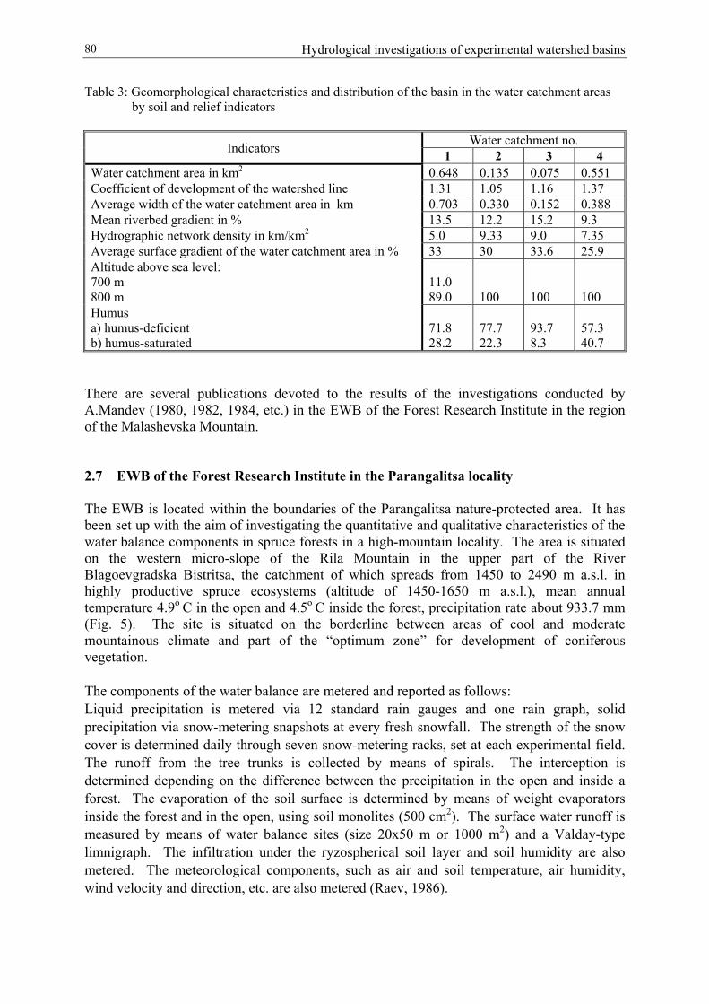
Hydrological investigations of experimental watershed basins80
Table 3: Geomorphological characteristics and distribution of the basin in the water catchment areasby soil and relief indicators
Water catchment no.Indicators 1 2 3 4Water catchment area in km2 0.648 0.135 0.075 0.551Coefficient of development of the watershed line 1.31 1.05 1.16 1.37Average width of the water catchment area in km 0.703 0.330 0.152 0.388Mean riverbed gradient in % 13.5 12.2 15.2 9.3Hydrographic network density in km/km2 5.0 9.33 9.0 7.35Average surface gradient of the water catchment area in % 33 30 33.6 25.9Altitude above sea level:700 m800 m
11.089.0 100 100 100
Humusa) humus-deficientb) humus-saturated
71.828.2
77.722.3
93.78.3
57.340.7
There are several publications devoted to the results of the investigations conducted byA.Mandev (1980, 1982, 1984, etc.) in the EWB of the Forest Research Institute in the regionof the Malashevska Mountain.
2.7 EWB of the Forest Research Institute in the Parangalitsa locality
The EWB is located within the boundaries of the Parangalitsa nature-protected area. It hasbeen set up with the aim of investigating the quantitative and qualitative characteristics of thewater balance components in spruce forests in a high-mountain locality. The area is situatedon the western micro-slope of the Rila Mountain in the upper part of the RiverBlagoevgradska Bistritsa, the catchment of which spreads from 1450 to 2490 m a.s.l. inhighly productive spruce ecosystems (altitude of 1450-1650 m a.s.l.), mean annualtemperature 4.9о С in the open and 4.5o C inside the forest, precipitation rate about 933.7 mm(Fig. 5). The site is situated on the borderline between areas of cool and moderatemountainous climate and part of the “optimum zone” for development of coniferousvegetation.
The components of the water balance are metered and reported as follows: Liquid precipitation is metered via 12 standard rain gauges and one rain graph, solidprecipitation via snow-metering snapshots at every fresh snowfall. The strength of the snowcover is determined daily through seven snow-metering racks, set at each experimental field.The runoff from the tree trunks is collected by means of spirals. The interception isdetermined depending on the difference between the precipitation in the open and inside aforest. The evaporation of the soil surface is determined by means of weight evaporatorsinside the forest and in the open, using soil monolites (500 cm2). The surface water runoff ismeasured by means of water balance sites (size 20х50 m or 1000 m2) and a Valday-typelimnigraph. The infiltration under the ryzospherical soil layer and soil humidity are alsometered. The meteorological components, such as air and soil temperature, air humidity,wind velocity and direction, etc. are also metered (Raev, 1986).
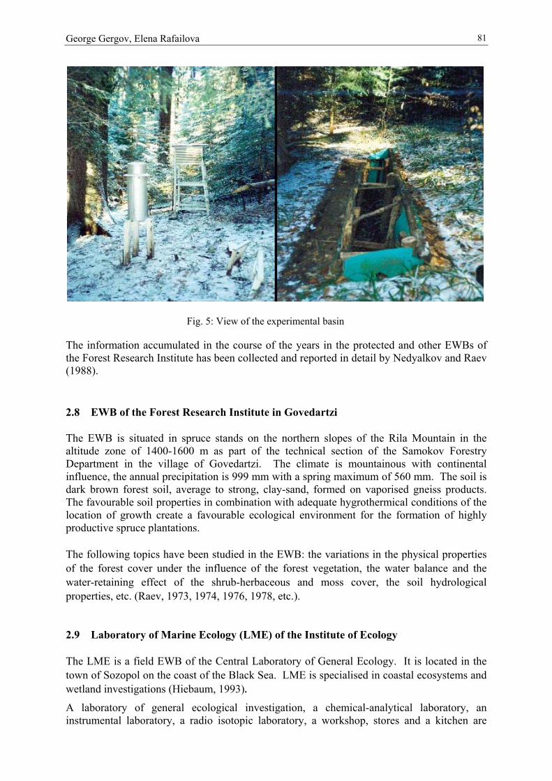
George Gergov, Elena Rafailova 81
The information accumulated in the course of the years in the protected and other EWBs ofthe Forest Research Institute has been collected and reported in detail by Nedyalkov and Raev(1988).
2.8 EWB of the Forest Research Institute in Govedartzi
The EWB is situated in spruce stands on the northern slopes of the Rila Mountain in thealtitude zone of 1400-1600 m as part of the technical section of the Samokov ForestryDepartment in the village of Govedartzi. The climate is mountainous with continentalinfluence, the annual precipitation is 999 mm with a spring maximum of 560 mm. The soil isdark brown forest soil, average to strong, clay-sand, formed on vaporised gneiss products.The favourable soil properties in combination with adequate hygrothermical conditions of thelocation of growth create a favourable ecological environment for the formation of highlyproductive spruce plantations.
The following topics have been studied in the EWB: the variations in the physical propertiesof the forest cover under the influence of the forest vegetation, the water balance and thewater-retaining effect of the shrub-herbaceous and moss cover, the soil hydrologicalproperties, etc. (Raev, 1973, 1974, 1976, 1978, etc.).
2.9 Laboratory of Marine Ecology (LME) of the Institute of Ecology
The LME is a field EWB of the Central Laboratory of General Ecology. It is located in thetown of Sozopol on the coast of the Black Sea. LME is specialised in coastal ecosystems andwetland investigations (Hiebaum, 1993).
A laboratory of general ecological investigation, a chemical-analytical laboratory, aninstrumental laboratory, a radio isotopic laboratory, a workshop, stores and a kitchen are
Fig. 5: View of the experimental basin

Hydrological investigations of experimental watershed basins82
situated on an area of 230 m2. The basic scientific instrumentation comprises aspectrophotometer and the corresponding devices for water analysis; an oxymeter and pH-meter, microscopes and devices for phytoplankton and microbiological investigations; aluminometer; a liquidscintillation counter for radio-izotopic measurements. There is a“microcosm” construction for investigations of water/sediment interactions in combinationwith the techniques applied in the laboratory for the fluxes of oxygen, organic carbon, andnutrients and polluted environment. In the coastal zone “mezocosm” constructions (50-200 I)can be used in investigations on the impact of different nutrients and other substances on theplanktonic community.
The main measurements (techniques/analyses) applied by the laboratory are directed to fix theabiotic parameters of the environment: temperature, wind, oxygen concentration,concentrations of NH4, NO2, NO3, PO4, Ntot, Norg, Corg in sediment as well as functionalparameters of the planktonic community: primary productions of glucose, amino acids,carbonic acids and other substrates.
2.10 The River Iskar area
The River Iskar is the longest Bulgarian river and the largest Bulgarian tributary of the RiverDanube. The catchment of the river from its springs to the town of Novi Iskar near Sofiacovers part of the central western part of Bulgaria and extends over an area of 3660 km2. Itsaverage multi-annual runoff is Wav = 737 million m3 (Fig. 6). Observations on the runoff ofthe river and its tributaries have been carried out in the course of a period of 40-80 years bymeans of 20 meteorological and five hydrometric gauges. The homogeneity of the statisticalhydrological series has, in the meantime, been disturbed by the construction of numerouswater abstraction facilities. The construction of the biggest dam on the Balkan Peninsula, theIskar Dam (effective capacity: 634 million m3), which provides the major portion of the watersupply for the city of Sofia and the surrounding area, was completed in 1954. Other dams,water power plants, derivations for water transfer, drinking water treatment plants and otherfacilities have been built throughout the years. Some of them transfer water from the Strumariver basin to the Iskar river basin and others from the River Iskar valley to the River Maritsacatchment.
The monitoring network in the River Iskar catchment is under the direction of the NationalInstitute on Meteorology and Hydrology and partially of the Ministry of Environment andWater. The river has been subjected to continuous specific and complex investigations bydifferent teams which have most often been connected with the effective management ofwater resources and their protection against pollution.
There are also other temporary field plots for stationary or temporary investigations, whichare of no interest for the study of the natural processes and the effect of anthropogenousimpacts.
The collected diverse information from the EWB investigations described above allowshigher attention to be paid to the development of the ecological models for assessment of theriver environment in Bulgaria and other related issues. The experimental activities in the fieldof water quality in Bulgaria is advancing well, also under laboratory conditions, performed bythe Modelling and Ecosystematic Approach team at the Institute of Environmental Protection.The subject of its activity is evaluation of the self-treatment and assimilation capacity of waterecosystems and the major trends in the dynamics of water quality, quantitative assessment of

George Gergov, Elena Rafailova 83
anthropogenous impact on water ecosystems, including point and diffuse pollution sources(Diadovski and Hristova, 2000; Diadovski, 2002).
Fig.6 – The River Iskar area
A physical laboratory model of a river course (“microcosm” system) with an automaticmicroprocessor oxymeter (OXI 96) has been constructed in the laboratory. The model maybe used for investigations of the dynamics of organic and non-organic pollution, of theinteraction between biotic and abiotic components of the river ecosystems and the dynamicsof the individual components under different degrees of impact. Investigations have beenmade on the dynamics of nitrogen and phosphorus compounds and the state of waterbiocenosism characterised by quantitative and qualitative indicators. The “macrocosm”system may be used also for assessments of the impact of river current velocity on theprocesses of dissolution of organic matter. Studies have been conducted to evaluate theimpact of harmful substances on the parameters of water biocenosis. A concept for thesustainable management of water quality and protection of the ecosystems has beendeveloped. Protection of waters from point and diffuse pollution is an important andindispensable requirement for sustainable water management. The ecological assessments ofwater quality and the dynamics of the ecosystems have been carried out by means of hydro-physical, hydro-chemical and hydro-biological standards, toxicity indexes and bioticparameters. Ecological criteria and indexes for quantitative evaluation of the interactionbetween man and the water ecosystems were taken into consideration.
River Iskar

Hydrological investigations of experimental watershed basins84
3 Hydrological investigations of the liquid runoff at Yundola EWB
Systematisation of the available hydrological information in the Yundola EWB wasperformed in a specially set-up information database, which contains data about the dailywater discharges and precipitation, air temperature and annual sediment runoff.
It was found out that:
• A downward trend was observed in the water quantities after 1980 (83) till 1994 (95)(Fig.7).
• The absence of active anthropogenous activity in the water catchment because of itsexperimental nature creates conditions for homogeneity of the statistical information,which is tested by appropriate statistical criteria, etc. Field plot no. 2 is the onlyexception because of its deforestation in 1985 as a consequence of a tornado and thefollowing clear cutting.
The same information has been used for studying the role of preliminary moistening in thewater runoff formation because of its poor investigation so far. Preliminary moistening of thecatchment (PMC) is a general concept, frequently used in hydrology for qualitativedetermination of water abundance in the region on the basis of assessment of river runoff,state of soil moisture, air humidity, presence or absence of temporary water streams and
plot 7
0
50
100
150
200
250
300
350
1970 1975 1980 1985 1990 1995 2000
year
plot 2
0
200
400
600
800
1967 1977 1987 1997year
plot 6
0200400600800
1000
1967 1977 1987 1997
year
Mea
n Q
m³/s
Mea
n Q
m³/s
Mea
nQ
m³/3
Fig. 7: Trends in the change of the water quantities
George Gergov, Elena Rafailova 85
puddles on the terrain or of cracked, dry soil cover, presence of easily blown fine dust on theearth's surface, withered vegetation, etc.
Different authors determine PMC quantitatively according to empirical formulas developedby them on the basis of personal experience and intuition. So, for example, there are formulasin the form of linear and parabolic polynomials, which include different percentages of thesum of precipitation during the preceding "n" days. Other authors use the total volume ofwater accumulated in the riverbed for quantitative determination of PMC. Under theconditions of small mountain rivers in the region this will be a very dynamic characteristic,which could neither be defined and measured correctly nor be used as an index of waterabundance or as a measure of the preliminary moistening due to the following considerations.Surface runoff as one of the major moistening sources of the basin ceases rapidly after the endof precipitation or snow thawing; soil runoff ceases rapidly because of insufficient soil coverthickness; underground runoff or the "basic" component of river runoff, is usually lowbecause of the hard volcanic rocks forming the high-mountain massifs and their low"potential" for accumulating surface water.
The lack of clear and generally accepted instructions on how to define the PMC value hasforced us to make our own choice in conformity with the object of the present study – theforested high-mountain catchment in the region (Yundola) subjected to Mediterraneanclimatic influence. Field observations have revealed that 2-3 days after rainfall the surfacesoil layer has already dried up and within another couple of days the herbaceous cover hasbecome withered. This proves that humidity in the region is very short-lasting and of low"capacity". For this reason, the statement that PMC is not visibly influenced by liquidprecipitation in the catchment for many days or even weeks seems to be correct. The durationof this "preceding" period is a variable number of days, which depends on the season andprecipitation intensity.
The observations and analyses of the hydrographs for the runoff sites in the explored areareveal that water discharges in the days immediately preceding the "benchmark" moment ofinvestigation are of decisive importance for the magnitude of the formed increase of flow rateor for the flood wave formation (Fig.8). For this reason, we assume the hypothesis that thewater discharge in the days preceding the benchmark moment of investigations can beaccepted as an integral characteristic parameter or a PMC index.
The sum of daily precipitation has been divided into four classes for convenience of dataprocessing: I – precipitation from 0 to 10 mm; II – from 10 to 20 mm; III – 20-30 mm and IV– precipitation higher than 30 mm.
The graphic dependence in the form of a family of curves has been plotted in the coordinatesystem Qi-n - ∆Qi having as third parameter Ni (Fig. 9). It is obvious that the curves are of thepower law type, i.e. the ∆Qi increment of each of them attenuates when rainfall increases.
The three-parameter graphic presentation of the relationship Qi-n - ∆Qi – Ni reveals that for anarbitrarily chosen PMC level the greater the fallen precipitation Ni, the greater the change ofthe river flow rate ∆Qi; and on the contrary, for a given precipitation Ni, the greater the valueof the PMC measure Qi-n, the greater the increase of the water quantity ∆Qi.
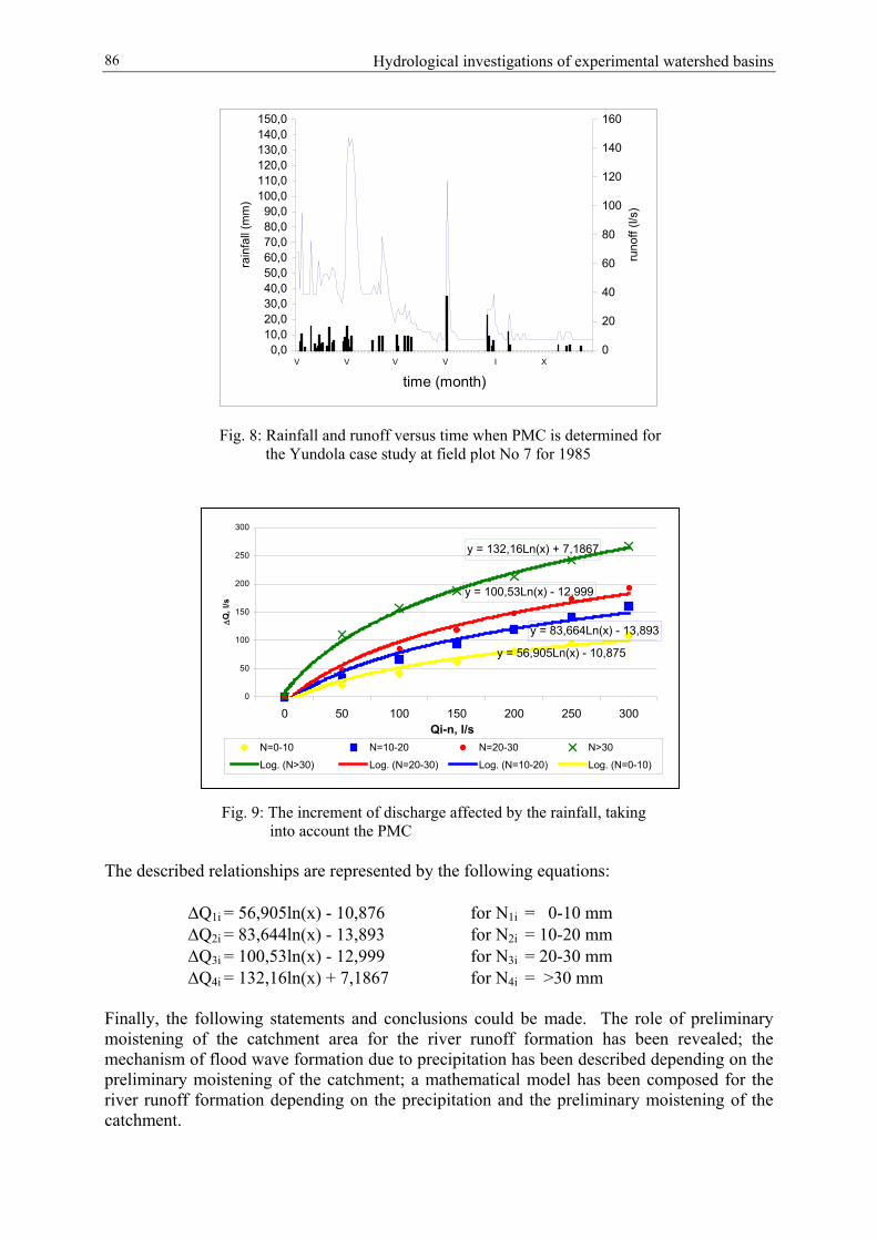
Hydrological investigations of experimental watershed basins86
0,010,020,030,040,050,060,070,080,090,0
100,0110,0120,0130,0140,0150,0
V V V V I X
time (month)
rain
fall
(mm
)
0
20
40
60
80
100
120
140
160
runo
ff (l/
s)
Fig. 8: Rainfall and runoff versus time when PMC is determined forthe Yundola case study at field plot No 7 for 1985
The described
∆Q∆Q∆Q∆Q
Finally, the fomoistening ofmechanism ofpreliminary mriver runoff focatchment.
300
Fig. 9: The increment of discharge affected by the rainfall, takinginto account the PMC
relationships are represented by the following equations:
1i = 56,905ln(x) - 10,876 for N1i = 0-10 mm2i = 83,644ln(x) - 13,893 for N2i = 10-20 mm3i = 100,53ln(x) - 12,999 for N3i = 20-30 mm4i = 132,16ln(x) + 7,1867 for N4i = >30 mm
llowing statements and conclusions could be made. The role of preliminary the catchment area for the river runoff formation has been revealed; the flood wave formation due to precipitation has been described depending on theoistening of the catchment; a mathematical model has been composed for thermation depending on the precipitation and the preliminary moistening of the
y = 132,16Ln(x) + 7,1867
y = 100,53Ln(x) - 12,999
y = 83,664Ln(x) - 13,893
y = 56,905Ln(x) - 10,875
0
50
100
150
200
250
0 50 100 150 200 250 300Qi-n, l/s
∆Q
, l/s
N=0-10 N=10-20 N=20-30 N>30
Log. (N>30) Log. (N=20-30) Log. (N=10-20) Log. (N=0-10)
George Gergov, Elena Rafailova 87
4 Investigations of the solid load of rivers
In hydrology the solid runoff is considered an integral component part of the river runoff. Itsinvestigation is of great importance for engineering, geological, ecological and economicpractice. The availability of vegetation diminishes the destructive effect of rainfall drops. Tosummarise, one may say that vegetation cover and trees play the role of buffer for the impactof rain on the soil particles.
On the basis of the available information collected in the course of almost 40 years at theEWB, some empirical relationships between the annual sum of precipitation and the resultingtotal sediment load (TSL) have been developed. In this way we have found out that the totalquantity of suspended sediments in the river waters in the EWB is low and does not changewithin broad limits at the different points, which indicates even development of soil erosionand homogeneity of the natural conditions in the area.
It has been discovered that the fluctuations of the module of the total annual sediment load foreach separate watershed basin usually oscillate around a permanent value, typical for therespective field plot, as follows:
MR(B1)m = 0.10 m3/ha.anMR(B3)m = 0.32 m3/ha.anMR(B2)m = 0.21 m3/ha.anMR(B4)m = 0.67 m3/ha.anMR(B6)m = 0.20 m3/ha.an
Evidently, the annual production of the sediment load remains constant for long periods oftime and in reality it is not affected by the precipitation. This may serve as an indicator foreffective long-term biological consolidation of the terrain to an extent which makes it non-susceptible to soil erosion. Provided this conclusion is corroborated by other studies, it maybecome an example for the perfect protection of the soil layer as a result of the consolidatingand regulating impact of afforestation activities.
The indicated values for MRm have been used to construct the empirical relationshipMRm – Imax because of its specific role, which helps identify the role of the maximum gradientof the water catchment basin and permits the prior definition of the anticipated sedimentrunoff of the rivers and the intensity of soil erosion in the case of high precipitation rates.This may have practical application in the performance of erosion-prevention activities.
If we assume that because of the closeness of the field plots to each other within the limitedboundaries of a mountainous area the natural conditions in all of them (geology, soil cover,percentage of vegetation cover, state of the surface cover, meteorological conditions) andanthropogenous impact (absence of any engineering and communication facilities,construction activities, residual products from manufacturing activities, etc) are almostidentical, then the main reasons for any possible differences in the MR values may be said tobe related to the orientation of the slope, the length of the slope and the maximum gradient ofthe field plot.
The use of GIS for the area gave us the opportunity to ascertain that among the three possiblesources of differences indicated it is the maximum gradient of the slopes of the watercatchment basins that changes within the broadest possible limits. The reason is that the highgradient predetermines a higher velocity and an increased transportation capacity of thecurrent, which in turn causes more intensive erosion and evacuation of larger quantities ofsediment matter from the watershed basin to the river.

Hydrological investigations of experimental watershed basins88
5 Instead of conclusion
EWB creates conditions for carrying out multi-annual investigation work which comprises thecollection of information and its consistent processing and storage as a modern database.Opportunities are provided for the launching and conducting of active experiments with broadforeign participation, thus creating conditions for more profound penetration into themechanism of the formation of surface runoff and soil erosion, which will help reveal moreclearly the influencing factors and the interaction between them.
EWBs are natural areas for the work and contribution of young researchers. They are aneffective operating school for the training of young professionals.
References
BIOLCHEV A.S., PIMPIREV, P. and KITIN B. (1970): Hydrological investigations in theexperimental plot of the “G. St. Avramov” Training Experimental Forest Enterprise,Scientific publications of the Higher Forest Engineering Institute, Vol. 18.
DIADOVSKI I. (2002): A model for assessment and prognosis of river water quality, AChemical and Biochemical Engineering Quarterly (16).
DIADOVSKI I. and HRISTOVA T. (2000): Analysis and modelling water quality of the IskarRiver in the Iskar dam catchment, Journal of Balkan Ecology (3) (I), 87-94.
HIEBAUM G. (1993): Optimization of the nutrient load of the Burgas Bay – management ofthe water quality and ecosystems “health”, In: Proc. of the Thurd ScientificConference Ecology, Economy and black sea environment, Varna, June 3-4.
IGNATOVA N., DAMBRINE E. and POLLIER B. (1997): An attempt to determine the dryoutlays and the non-water components extracted from the vegetation throughprecipitation by means of the use of natural spruce and plastic trees, LessovadskaMisal (Forest Engineering Thought), Vol. 2.
MANDEV A.K. (1980): Investigation of the downslope runoff at the Malashevska Mountain,Forest Economy Science, vol. 3.
MANDEV A.K. (1982): Water and solid runoff at the northern slopes of MalashevskaMountain, Forest Economy Science, vol. 4.
MANDEV A.K. (1984): Investigation of the water and solid runoff of small watersheds at theMalashevska Mountain, Forest Economy Science, vol. 3.
NEDYALKOV S. and RAEV I.T. (1988): The hydrological role of forest ecosystems. Sofia.RAEV I.T. (1973): Influence of the spruce stand canopy on certain physical properties of the
forest cover, Forest Economy Science, vol. 4.RAEV I.T. (1974): Relationship between the spruce stand canopy and the water-retaining
effect of the herbaceous cover, Forest Economy Science, vol. 6.RAEV I.T. (1976): Degeneration of spruce plantations and changes in certain hydrological
properties of forest soils, Forestry, vol. 9.RAEV I.T. (1978): Investigation of the water balance of forest cover at different spruce stand
canopy, Forest Economy Science, vol. 5.RAEV I.T. and DIMITROV E. (1978): Hydrological effect of soils in spruce plantation of
different age categories, Forest Economy Science, vol. 5.RAEV I.T. (1983): Investigation of the water balance of representative coniferous ecosystems
in Rila Mountain, Forest Economy Science.RAEV I.T. (1986): Water balance of high-productivity spruce ecosystems in the Parangalitza
Biosphere Reserve, Forest Economy Science, vol. 3.

George Gergov, Elena Rafailova 89
SERAFIMOV V.N. (1974): Hydrological role of coniferous forests in certain regions of RilaMountain.


V. Anselmo and E. Guiot 91
Influence of land use changes on peak discharges - Two case studies, Upper Tanaro River and Dora Riparia River, Piedmont, Italy
V. Anselmo and E. GuiotUniversity of Torino, School of Agriculture, Department of Agricultural, Forest and
Environmental Economics and Engineering – Section Hydraulics, Grugliasco, Italy
Abstract
The aim of this study is to evaluate the effect of land use changes which occurred in the lasttwo centuries, particularly forest increase, on peak flows. The attention is focused on theimpact on extreme flood events in two rivers in Piedmont (Italy), Tanaro and Dora Riparia.The Rivers Tanaro and Dora Riparia were severely affected by major floods during the lastten years. The change in land use in the last century was claimed to be one of the likelyfactors of the disaster.
The hydrologic model of the basins was built using Hec-1 and the precipitation lossessimulated according to the SCS method. Stream topology was derived from a DEM with a50x50 m grid using the Boss-WMS code. Hec-1 was run with two land use schemes,respectively corresponding to the actual land use and to the land use derived from maps anddata of about one century ago for Tanaro and two centuries ago for Dora Riparia. For boththe basins the present land use evidences an increase of forested areas compared to the past(from 30 to 39% of the whole basin area for Dora Riparia and from 52 to 69% for Tanaro).
Results seem to show that the peak flow response to forest increase is low. The reduction ofpeak flow at the outlet catchment on the occasion of major floods, like those that happened inNovember 1994 and in October 2000, is small.
1 Introduction
The Rivers Tanaro and Dora Riparia (Piedmont, Italy) were severely affected by major floodsduring the last ten years. The change in land use which occurred in the last century has beenclaimed as one of the likely factors of the disaster. In particular, it is the general opinion thatabandonment of the mountains and deforestation are the main causes of those extreme events.The general concern that climate change, urbanisation and forest loss in uplands can increaseflooding is widespread (DeWalle, 2003).
The contribution of forests in runoff generation was investigated during the past century in theUSA and in Europe. The results of American experience was summarised on severaloccasions (Hibbert, 1967; Colpi and Fattorelli, 1985). In the USA many experimental areaswere established to study the effects of forest management on watershed hydrology, but theanalyses were not focused on the impact of forests on large flood events. Only in recent yearshave a few authors revisited those data to investigate the peak flow response to forestpractices, focusing on large peak flow events (Beschta et al., 2000; Jones 2000). Theiranalyses “do not support the concept that relatively large peak flows are increased by forestpractices” (Beschta et al., 2000).

Influence of land use changes on peak discharges - Two study cases (Upper Tanaro River and ...92
Recently, European field researches (Cosandey, 1993, 1995) and official general reports(Calder, 2000; Fao, 2003) support the opinion that “extreme hydrological events are the resultof natural processes of erosion and sediment motion interacting with human systems”(Davies, 1997). Ives and Messerli (1989) outline that “the scale approach is a key issue in theunderstanding of highland-lowland linkages. Whereas on a micro-scale (small watershed) theeffects of human interventions such as forest cutting can be directly documented in terms ofhigher discharge peaks or higher sediment load, on a large scale natural processes aredominant”.
In Europe, studies of forested catchments generally investigated the impact of presence orabsence of forests and forest practices on water yield and water quality (Fohrer et al., 2002;Klöcking and Haberlandt, 2002; Krause, 2002; Naef et al., 2002). The impact of forests onpeak and low flows was recently studied in the framework of the FOREX Project (FORestand EXtreme events), collecting data from 28 small basins across Europe (Robinson et al.,2003). The study, in spite of specific local conditions, found a substantial homogeneity ofresults: the contribution of forests in peak flow reduction of extreme events seems to besmaller than has often been claimed (Robinson et al., 2003).
In Italy, at the beginning of modern hydraulics, Vincenzo Viviani (1684), one of the Galileo’sdisciples, considered forest clear cutting of the upper Arno to be a main cause of soil erosionand of the sedimentation in the lower part of the basin. The scale concept was also clear inthe mind of Carlo Giorgini (1854) whose opinion was that “it is likely that land use changesdue to deforestation and the increase of cultivated areas do not affect the volume of majorfloods which follow long-lasting and extensive rainfalls; […] but they affect the frequencyand volume of flash floods of torrents on the occasion of heavy storms of short duration,which occur over small areas in the mountains”. The same author outlined (p. 139 and 192)that Florence was severely flooded in 1177 and 1333, before deforestation, and in 1557 whendeforestation was not yet so severe as in the following centuries. More recent remarks aboutthe role of forests can be found in the stimulating discussions which took place at the ItalianAccademia Nazionale dei Lincei at the end of the 1960s (Susmel, 1967, 1971; Gherardelli andMarone, 1968, 1971; De Philippis, 1971). It was the time of catastrophes: the flooding ofVenice and Florence.
The aim of this study is to evaluate the effect of land use changes that occurred in the last twocenturies, particularly forest increase, on peak flows. The attention is focused on the impacton extreme flood events in two rivers in Piedmont (Italy), Tanaro and Dora Riparia.Unprecedented flows in 1994 (in the River Tanaro) and 2000 (in the River Dora Riparia)seriously affected both the tributaries and the main stream, causing the collapse of somebridges, severe erosions of main road embankments (in Tanaro) and extensive flooding in thelower catchment of Dora Riparia including Torino city centre. These events werecharacterised by long-lasting and heavy rainfalls.
The hydrologic model of the basins was built using Hec-1 and the precipitation lossessimulated according to the SCS method. Stream topology was derived from a DEM with a50x50 m grid using the Boss-WMS code.
Hec-1 was run with two land use schemes, respectively corresponding to the actual land useand to the land use derived from maps and data of about one century ago for Tanaro and twocenturies ago for Dora Riparia.

V. Anselmo and E. Guiot 93
2 The investigated basins: past and present land use
The River Tanaro headwater is located in the lower part of the Western Alps, near the borderof France (Fig 1): two mountain torrents Tanarello and Negrone make up the Tanaro Riverwhich flows in a narrow valley between steep side slopes, generally wood-covered withabandoned pastures at the higher elevations. Soil is shallow over limestone bedrock. Thestudy related to the upper part of the basin and the outlet was fixed at the Nucetto section,where discharges were measured by the Ufficio Idrografico of the River Po in the period1933-1965. There are three cross sections of interest: Ormea, Garessio and Nucetto (Fig. 1)
The Dora Riparia basin (Fig. 2) is located West of Torino (1300 km2 at Torino city and1060 km2 at the foot of the mountains) and originates from two torrents (Dora ofBardonecchia and Dora Riparia) which join at Oulx. The basin outlet, for this study, islocated at Susa, just upstream of the confluence with the Cenischia torrent, where the basinarea is 694 km2. There are four cross sections of interest: Dora Riparia (D1), Dora ofBardonecchia (D2), the confluence of the two reaches at Oulx (D1+D2) and the outlet at Susa(Fig. 2)
The main catchment characteristics are shown in Table 1.
Table 1: Main characteristics of Dora Riparia and Tanaro Rivers
DORA RIPARIA TANAROAREA (km2) 694 390
Average elevation (m a.s.l.) 1613 1227Maximum elevation (m a.s.l.) 3627 2651Minimum elevation (m a.s.l.) 385 450
Mean annual precipitation (mm) 752 1060
Fig. 1: Tanaro basin location with cross sections of interest and recording stations
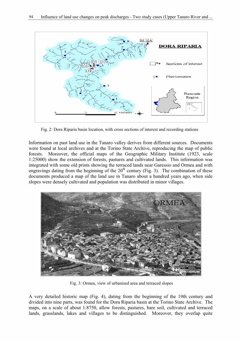
Influence of land use changes on peak discharges - Two study cases (Upper Tanaro River and ...94
Information on past land use in the Tanaro valley derives from different sources. Documentswere found at local archives and at the Torino State Archive, reproducing the map of publicforests. Moreover, the official maps of the Geographic Military Institute (1923, scale1:25000) show the extension of forests, pastures and cultivated lands. This information wasintegrated with some old prints showing the terraced lands near Garessio and Ormea and withengravings dating from the beginning of the 20th century (Fig. 3). The combination of thesedocuments produced a map of the land use in Tanaro about a hundred years ago, when sideslopes were densely cultivated and population was distributed in minor villages.
A very detailed historic map (Fig. 4), dating from the beginning of the 19th century anddivided into nine parts, was found for the Dora Riparia basin at the Torino State Archive. Themaps, on a scale of about 1:8750, allow forests, pastures, bare soil, cultivated and terracedlands, grasslands, lakes and villages to be distinguished. Moreover, they overlap quite
Fig. 2: Dora Riparia basin location, with cross sections of interest and recording stations
Fig. 3: Ormea, view of urbanised area and terraced slopes
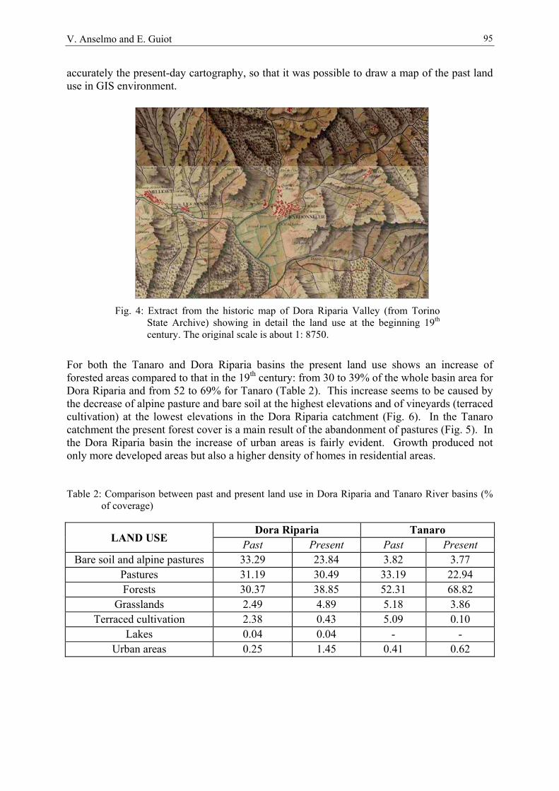
V. Anselmo and E. Guiot 95
accurately the present-day cartography, so that it was possible to draw a map of the past landuse in GIS environment.
For both the Tanaro and Dora Riparia basins the present land use shows an increase offorested areas compared to that in the 19th century: from 30 to 39% of the whole basin area forDora Riparia and from 52 to 69% for Tanaro (Table 2). This increase seems to be caused bythe decrease of alpine pasture and bare soil at the highest elevations and of vineyards (terracedcultivation) at the lowest elevations in the Dora Riparia catchment (Fig. 6). In the Tanarocatchment the present forest cover is a main result of the abandonment of pastures (Fig. 5). Inthe Dora Riparia basin the increase of urban areas is fairly evident. Growth produced notonly more developed areas but also a higher density of homes in residential areas.
Table 2: Comparison between past and present land use in Dora Riparia and Tanaro River basins (%of coverage)
Dora Riparia TanaroLAND USE Past Present Past Present
Bare soil and alpine pastures 33.29 23.84 3.82 3.77Pastures 31.19 30.49 33.19 22.94Forests 30.37 38.85 52.31 68.82
Grasslands 2.49 4.89 5.18 3.86Terraced cultivation 2.38 0.43 5.09 0.10
Lakes 0.04 0.04 - -Urban areas 0.25 1.45 0.41 0.62
Fig. 4: Extract from the historic map of Dora Riparia Valley (from TorinoState Archive) showing in detail the land use at the beginning 19th
century. The original scale is about 1: 8750.

Influence of land use changes on peak discharges - Two study cases (Upper Tanaro River and ...96
3 The hydrologic model
A hydrologic model of the two basins was built using Hec-1 and the precipitation lossessimulated according to the SCS (soil conservation service) method. Stream topology as wellas sub-catchment CN (curve number) values were derived from a DEM with a 50x50 m gridand land use maps in the framework of the Boss-WMS code.
The SCS runoff method relates accumulated rainfall to an empirical parameter CN. The CNis a function of land use, soil classification, hydrologic conditions and antecedent runoffconditions (Hoggan, 1989).
Soils are divided into four hydrological groups according to different infiltration rates: A, B,C and D, representing soils with high, moderate, low and very low infiltration rates. CNvalues can vary according to the antecedent moisture condition (AMC). AMC is expressed asa function of rainfall in the last five days (Table 3). CN values are usually given in tables forAMC II and then obtained for AMC I and AMC III with two equations (Ranzi and Rosso,1994):
T a n a r o R i v e r : c o m p a r i s o n p a s t - p r e s e n t l a n d u s e
- 1 5 . 0 0 %
- 1 0 . 0 0 %
- 5 . 0 0 %
0 . 0 0 %
5 . 0 0 %
1 0 . 0 0 %
1 5 . 0 0 %
2 0 . 0 0 %
F o r e s t s G r a s s l a n d B a r e s o i l P a s t u r e T e r r a c e d U r b a n
perc
enta
ge v
aria
tion
Fig 5: River Tanaro: deviation in % of present from past land use
D o r a R i p a r i a : c o m p a r i s o n p a s t - p r e s e n t l a n d u s e
- 1 2 . 0 0
- 1 0 . 0 0
- 8 . 0 0
- 6 . 0 0
- 4 . 0 0
- 2 . 0 0
0 . 0 0
2 . 0 0
4 . 0 0
6 . 0 0
8 . 0 0
1 0 . 0 0
F o r e s t s G r a s s l a n d B a r e s o i l P a s t u r e T e r r a c e d U r b a n
perc
enta
ge v
aria
tion
Fig. 6: River Dora Riparia: deviation in % of present from past land use

V. Anselmo and E. Guiot 97
For a given AMC, the CN value depends on hydrologic soil characteristics and land use.
The land use represents runoff-production potential. Seven land use classes were consideredfor this study: bare soil and alpine pastures (including rocks, landslides and riverbeds),pasture, forest, grasslands, terraced cultivation (vineyards), lakes and urban areas. Table 4shows CN for these classes and for each hydrologic soil type in AMC II condition (Hoggan,1989; Ranzi and Rosso, 1994).
Table 3: Definition of AMC classes
Total rainfall of the last five daysClasses AMC Plant dormancy Growing season
I < 13 mm < 36 mmII 13 ÷ 28 mm 36 ÷ 53 mmIII > 28 mm > 53 mm
Table 4: Runoff curve number for considered land use classes
CNLAND USE TYPE A TYPE B TYPE C TYPE DForest 36 60 73 79Pasture 49 69 79 84Grasslands 30 58 71 78Terraced cultivation 70 79 84 88Bare Soil 68 79 86 89Lakes 100 100 100 100Urban areas 77 85 90 92
Figure 7 schematises the WMS method to compute hydrographs at the basin outlets. Startingfrom a DEM of the basin, the WMS computes flow direction and flow accumulation withTOPAZ (TOpographic PArameteriZation programme of USDA-ARS, National AgriculturalWater Quality Laboratory). Once the watershed outlet and interior sub-basin outlets areidentified, it defines basins and computes basin geometric data such as area, slopes, runoffdistances. With geometric data, land use and soil type coverage, WMS computes CN for eachsub-basin by taking an area-weighted average of different CN values of different regions forsoil type and land use combinations in Table 4 within a basin (BOSS INT., 2000). CN is usedto compute the lag time, a parameter defined as the difference in time between the centre of
II
III CN
CNCN013.03.2 −
=
II
IIIII CN
CNCN
0057.043.0 +=
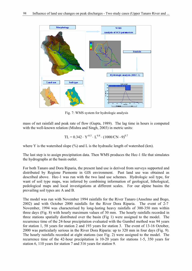
Influence of land use changes on peak discharges - Two study cases (Upper Tanaro River and ...98
mass of net rainfall and peak rate of flow (Gupta, 1989). The lag time in hours is computedwith the well-known relation (Mishra and Singh, 2003) in metric units:
TL = 0.342 ⋅ Y-0.5 ⋅ L0.8 ⋅ (1000/CN –9)0.7
where Y is the watershed slope (%) and L is the hydraulic length of watershed (km).
The last step is to assign precipitation data. Then WMS produces the Hec-1 file that simulatesthe hydrographs at the basin outlet.
For both Tanaro and Dora Riparia, the present land use is derived from surveys supported anddistributed by Regione Piemonte in GIS environment. Past land use was obtained asdescribed above. Hec-1 was run with the two land use schemes. Hydrologic soil type, forwant of soil type maps, was inferred by combining information of geological, lithological,pedological maps and local investigations at different scales. For our alpine basins theprevailing soil types are A and B.
The model was run with November 1994 rainfalls for the River Tanaro (Anselmo and Bogo,2002) and with October 2000 rainfalls for the River Dora Riparia. The event of 2-7 November, 1994 was characterised by long-lasting heavy rainfalls of 300-350 mm withinthree days (Fig. 8) with hourly maximum values of 30 mm. The hourly rainfalls recorded inthree stations spatially distributed over the basin (Fig 1) were assigned to the model. Therecurrence time of the 24-hour precipitation evaluated with the Gumbel method was 94 yearsfor station 1, 58 years for station 2 and 193 years for station 3. The event of 13-16 October,2000 was particularly serious in the River Dora Riparia: up to 320 mm in four days (Fig. 9).The hourly rainfalls recorded at eight stations (see Fig. 2) were assigned to the model. Therecurrence time of the 42-hour precipitation is 10-20 years for stations 1-5, 350 years forstation 6, 110 years for station 7 and 316 years for station 9.
Fig. 7: WMS system for hydrologic analysis

V. Anselmo and E. Guiot 99
The antecedent moisture condition (AMC) was calculated from rainfalls for the two basins,obtaining AMC II for the River Tanaro and AMC I for the River Dora Riparia.
Hec-1 was run with the two land use schemes.
0
50
100
150
200
250
300
350
0 20 40 60 80 100 120 140hours
mm
1 2 3
Fig. 8: Cumulated rainfall recorded at three stations (see Fig. 1) in theTanaro basin for the 2-6 November 1994 event
0
50
100
150
200
250
300
350
0 20 40 60 80hours
mm
1 2 3 4 5 6 7 8
Fig. 9: Cumulated rainfall recorded at eight stations (see Fig. 2) in the DoraRiparia basin for the 13-16 October 2000 event

Influence of land use changes on peak discharges - Two study cases (Upper Tanaro River and ...100
4 Results: impact of land use changes on peak flow
The results of the Hec-1 simulation with past and present land use do not show any significantdifference in peak flow at the outlet catchments (Table 5 and Table 6). The peak flow for theRiver Tanaro at the outlet of Nucetto is 1158 m3/s with the past land use and 1118 m3/s withthe present land use, corresponding to a decrease of 3.5%. The Dora Riparia basin shows thesame trend: the peak flow at the outlet of Susa is 391 m3/s with the past land use and 351 m3/swith the present land use. The decrease in flow is 10%.
Tab. 5: Comparison between peak flows obtained with present and past land use in TanaroRiver basin
TANARO RIVER Peak flow [m3/s]River Station Catchment area
(km2)Past land use Present land use
Ormea 188 707 703Garessio 255 1027 1010Nucetto 375 1158 1118
Tab. 6: Comparison between peak flows obtained with present and past land use in DoraRiparia River basin
DORA RIPARIA RIVER Peak flow [m3/s]River Station Catchment area
(km2)Past land use Present land use
Dora of Cesana(D1)
257.53 137 136
Dora ofBardonecchia (D2)
246.69 91 77
ConfluenceD1+D2
504.42 212 202
Dora at Susa 694.09 391 351
These results are consistent with the observed flow at the Ceva bridge, downstream fromNucetto, for the River Tanaro during the 1994 event. For the River Dora Riparia a peak flowof 106 m3/s was measured at Oulx (Dora of Cesana D1) and 400 m3/s were estimated at Susaduring the event of October 2000.
5 Conclusions
Land use changes in the last two centuries have been remarkable for both the Dora Ripariaand Tanaro river basins. Mountain depopulation and abandonment of pastures and terracedlands have caused an expansion of forests. Forests increased from 30 to 39 % of the wholebasin area in the Dora Riparia basin and from the 52 to 68 % in the Tanaro basin. Thereduction of peak flow at basin outlets on the occasion of major floods, like those thatoccurred in November 1994 and in October 2000, is small.
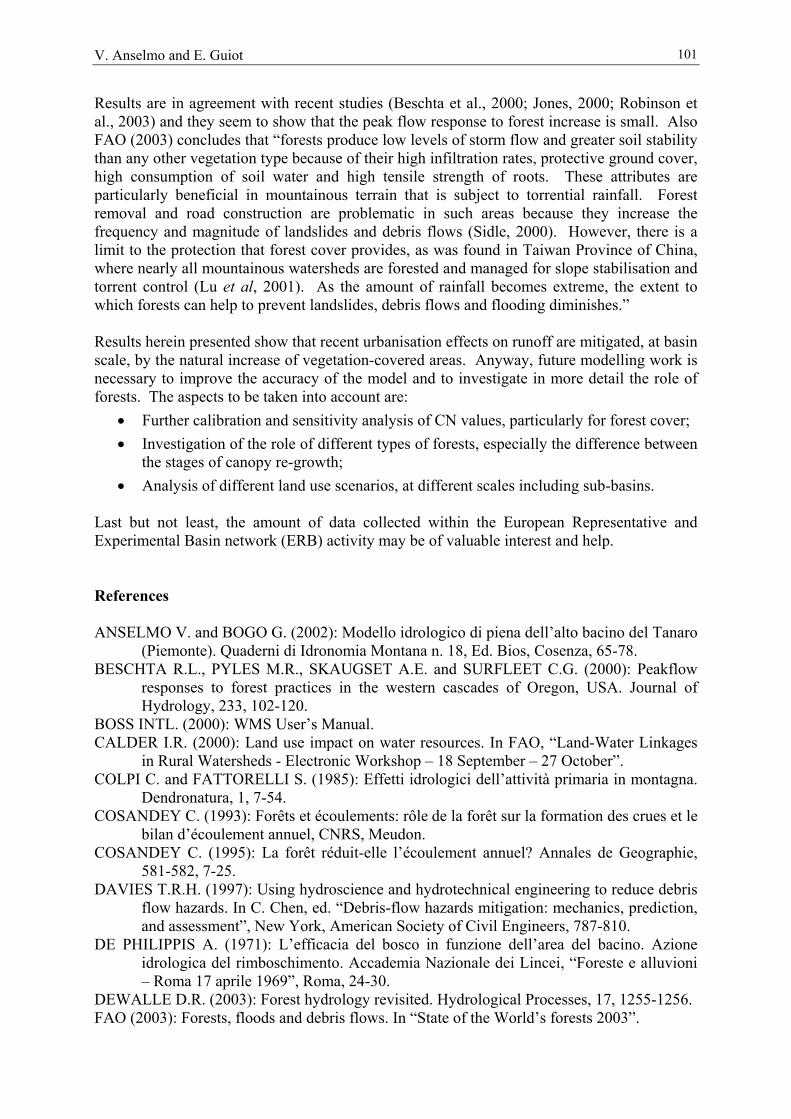
V. Anselmo and E. Guiot 101
Results are in agreement with recent studies (Beschta et al., 2000; Jones, 2000; Robinson etal., 2003) and they seem to show that the peak flow response to forest increase is small. AlsoFAO (2003) concludes that “forests produce low levels of storm flow and greater soil stabilitythan any other vegetation type because of their high infiltration rates, protective ground cover,high consumption of soil water and high tensile strength of roots. These attributes areparticularly beneficial in mountainous terrain that is subject to torrential rainfall. Forestremoval and road construction are problematic in such areas because they increase thefrequency and magnitude of landslides and debris flows (Sidle, 2000). However, there is alimit to the protection that forest cover provides, as was found in Taiwan Province of China,where nearly all mountainous watersheds are forested and managed for slope stabilisation andtorrent control (Lu et al, 2001). As the amount of rainfall becomes extreme, the extent towhich forests can help to prevent landslides, debris flows and flooding diminishes.”
Results herein presented show that recent urbanisation effects on runoff are mitigated, at basinscale, by the natural increase of vegetation-covered areas. Anyway, future modelling work isnecessary to improve the accuracy of the model and to investigate in more detail the role offorests. The aspects to be taken into account are:
• Further calibration and sensitivity analysis of CN values, particularly for forest cover;• Investigation of the role of different types of forests, especially the difference between
the stages of canopy re-growth;• Analysis of different land use scenarios, at different scales including sub-basins.
Last but not least, the amount of data collected within the European Representative andExperimental Basin network (ERB) activity may be of valuable interest and help.
References
ANSELMO V. and BOGO G. (2002): Modello idrologico di piena dell’alto bacino del Tanaro(Piemonte). Quaderni di Idronomia Montana n. 18, Ed. Bios, Cosenza, 65-78.
BESCHTA R.L., PYLES M.R., SKAUGSET A.E. and SURFLEET C.G. (2000): Peakflowresponses to forest practices in the western cascades of Oregon, USA. Journal ofHydrology, 233, 102-120.
BOSS INTL. (2000): WMS User’s Manual.CALDER I.R. (2000): Land use impact on water resources. In FAO, “Land-Water Linkages
in Rural Watersheds - Electronic Workshop – 18 September – 27 October”.COLPI C. and FATTORELLI S. (1985): Effetti idrologici dell’attività primaria in montagna.
Dendronatura, 1, 7-54.COSANDEY C. (1993): Forêts et écoulements: rôle de la forêt sur la formation des crues et le
bilan d’écoulement annuel, CNRS, Meudon.COSANDEY C. (1995): La forêt réduit-elle l’écoulement annuel? Annales de Geographie,
581-582, 7-25. DAVIES T.R.H. (1997): Using hydroscience and hydrotechnical engineering to reduce debris
flow hazards. In C. Chen, ed. “Debris-flow hazards mitigation: mechanics, prediction,and assessment”, New York, American Society of Civil Engineers, 787-810.
DE PHILIPPIS A. (1971): L’efficacia del bosco in funzione dell’area del bacino. Azioneidrologica del rimboschimento. Accademia Nazionale dei Lincei, “Foreste e alluvioni– Roma 17 aprile 1969”, Roma, 24-30.
DEWALLE D.R. (2003): Forest hydrology revisited. Hydrological Processes, 17, 1255-1256.FAO (2003): Forests, floods and debris flows. In “State of the World’s forests 2003”.
Influence of land use changes on peak discharges - Two study cases (Upper Tanaro River and ...102
FOHRER N., MÖLLER D. and STEINER N. (2002): An interdisciplinary modellingapproach to evaluate the effects of land use change. Physics and Chemistry of theEarth, 27, 655-662.
GHERARDELLI L. and MARONE V. (1968): Azione della vegetazione in particolare delbosco sulle piene dei corsi d’acqua. Accademia Nazionale dei Lincei, “Le scienzedella natura di fronte agli eventi idrogeologici – Roma 8-10 novembre 1967”, Roma,291-300.
GHERARDELLI L. and MARONE V. (1971): Il punto di vista degli idraulici sull’effetto delbosco sulle portate di piena. Accademia Nazionale dei Lincei, “Foreste e alluvioni –Roma 17 aprile 1969”, Roma, 24-30.
GIORGINI C. (1854): Sui fiumi nei tronchi sassosi e sull’Arno nel piano di Firenze.Tipografia delle Murate, Firenze.
GUPTA R.S. (1989): Hydrology and Hydraulics Systems. Prentice Hall, New Jersey.HIBBERT A.R. (1967): Forest treatment effects on water yield. In E. Sopper e H.W. Lull
(eds.): International Symposium on Forest Hydrology, Pergamon Press.HOGGAN D.H. (1989): Computer-Assisted Floodplain Hydrology and Hydraulics. Mc
Graw-Hill.IVES J.D. and MESSERLI B. (1989): The Himalayan dilemma. Reconciling development
and conservation. London, United Nations University Press.JONES J.A. (2000): Hydrologic processes and peak discharge response to forest removal, re-
growth, and roads in 10 small experimental basins, western Cascades, Oregon. WaterResources research, 36 (9), 2621-2642.
KLÖCKING B. and HABERLANDT U. (2002): Impact of land use changes on waterdynamics – a case study in temperate meso- and macroscale river basin. Physics andChemistry of the Earth, 27, 619-629.
KRAUSE P. (2002): Quantifying the impact of land use changes on the water balance of largecatchments using the J2000 model. Physics and Chemistry of the Earth, 27, 663-673.
LU S.Y., CHENG J.D. and BROOKS, K.N. (2001): Managing forests for watershedprotection in Taiwan. Forest Ecology and Management, 143, 77-85.
MISHRA S.K. and SINGH V.P. (2003): Soil Conservation Service Curve Number (SCS-CN)Methodology. Kluwer Acad. Publ., 222 p.
NAEF F., SCHERRER S. and WEILER M. (2002): A process based assessment of thepotential to reduce flood runoff by land use change. Journal of Hydrology, 267, 74-79.
RANZI R. and ROSSO R. (1994): FLEA - Manuale d’uso.ROBINSON M. et al. (2003): Studies of the impact of forests on peak flows and baseflow: a
European perspective. Forest Ecology and Management 186, 85-97.SIDLE R.C (2000): Watershed challenges for the 21st century: a global perspective for
mountainous terrain. In “Land stewardship in the 21st century: the contributions ofwatershed management”, Proceedings, Rocky Mountain Research Station, RMRS-P-13. Fort Collins, Colorado, USA, United States Department of Agriculture (USDA)Forest Service, 45-56.
SUSMEL L. (1967): Sull’azione regimante ed antierosiva della foresta. In AccademiaNazionale dei Lincei: “Le scienze della natura di fronte agli eventi idrogeologici –Roma 8-10 novembre 1967”, Roma, 301-432.
SUSMEL L. (1971): Il punto di vista dei forestali sull’efficacia antierosiva e regimante delbosco. In Accademia Nazionale dei Lincei, “Foreste e alluvioni – Roma 17 aprile1969”, Roma, 24-30.
VIVIANI V. (1684): Intorno al difendersi da’ riempimenti e dalle corrosioni de’ fiumiapplicate ad Arno in vicinanza della città di Firenze. In AA. VV. (1821-1826):“Raccolta d’autori italiani che trattano del moto delle acque”, Tipografia JacopoMarsigli, Bologna, volume III, 401-451.
103
Publications in the series IHP/HWRP-Berichte
The International Hydrological Programme (IHP) of UNESCO and the Hydrology and WaterResources Programme (HWRP) of WMO are administered in Germany by one nationalcommittee. Since March 2004 the national committee bears the name IHP/HWRP NationalCommittee (previously IHP/OHP National Committee) and its secretariat IHP/HWRPSecretariat. The publication series now has the ISSN 1614-1180.
Heft 1 Problematik der Wasserwirtschaftung der Insel FöhrF. Steinmann und H. Ketelsen, 74 S., Koblenz 2004
Heft 2 Studies in Mountain HydrologyEdited by Andreas Herrmann and Ulrich Schröder, 104 S., Koblenz 2004
104
Publications in the series IHP/OHP-Berichte
Publications Hefte 1 to 4 appeared in the series "Mitteilungen aus dem Tätigkeitsbereich derArbeitsgruppen des Nationalkomitees der Bundesrepublik Deutschland für das InternationaleHydrologische Programm der UNESCO und das Operationelle Hydrologische Programm derWMO" (ISSN 0724-7621).
As from Heft 5 (1985) the series is continued under the heading "IHP/OHP-Berichte" (ISSN0177-9915).
Hefte
Heft 1Out of print
Untersuchungen über die urbane Hydrologie und Entwicklungmathematischer Modelle für die Hydrologie urbaner Gebiete in derBundesrepublik DeutschlandSozio-ökonomische Aspekte der Hydrologie von SiedlungsgebietenEin Beitrag für die Stadt HannoverH. Massing, 90 S., Koblenz 1977
Heft 2Out of print
Metallanreicherungen in rezenten See-SedimentenGeochemischer Background und zivilisatorische EinflüsseU. Förstner, 66 S., Koblenz 1978
Heft 3Out of print
Haupttypen biotischer Veränderungen durch ausgewählte SchadstoffeGenerelle Charakteristika von Seen und StauseenG. Friedrich, 39 S., Koblenz 1981
Heft 4Out of print
Hydrologische Untersuchungsgebiete in der Bundesrepublik DeutschlandIHP-Arbeitsgruppe, 323 S., Koblenz 1983
Heft 5Out of print
Empfehlung für die Auswertung der Meßergebnisse von kleinenhydrologischen UntersuchungsgebietenIHP-Arbeitsgruppe, 92 S., Koblenz 1985
Heft 6Out of print
Wasser- und Materialbilanz der OstseeIHP-Arbeitsgruppe, 488 S., Koblenz 1985
Heft 7Out of print
Möglichkeiten der Niederschlagsvorhersage für hydrologische Zwecke– Statusbericht –H. Fleer, W. Franke, K. Lecher, 73 S., Koblenz 1986
Heft 8Out of print
Die Belastung des Grundwassers im urbanen und ländlichen Raum unterbesonderer Berücksichtigung kleiner EmissionenV. Schenk, 84 S., Koblenz 1988

105
Heft 9Out of print
Meteorologische Systeme für hydrologische AnwendungenIHP/OHP-Arbeitsgruppe, 176 S., Koblenz 1993
Heft 10 Empfehlung zu Einrichtung und Betrieb kleiner hydrologischerUntersuchungsgebieteIHP/OHP-Arbeitsgruppe, 156 S., Koblenz 1995
Heft 11Out of print
IHD/IHP/OHPDie Hydrologieprogramme von UNESCO und WMO in DeutschlandK. Hofius et al., 157 S., Koblenz 1998
Heft 12Out of print
International Glossary of Hydrology, Second Edition 1992, Version Englisch/DeutschDeutsches IHP/OHP-Nationalkomitee (Hrsg.), 243 S., Koblenz 1998
Heft 13 Hydrologische Dynamik im RheingebietProceedings Internationale Rhein-KonferenzDeutsches IHP/OHP-Nationalkomitee (Hrsg.), 233 S., Koblenz 1999
Heft 14 Hydrologische Untersuchungsgebiete in DeutschlandIHP/OHP-Arbeitsgruppe, 134 S., Koblenz 2003
Sonderhefte
Sonderheft 1Out of print
Hydrological Principles for the Deep-Well Disposal of Liquid Wastes andWastewatersH. Aust, K. Kreysing und mit einem Beitrag von M. Wallner, 100 S., Koblenz1985
Sonderheft 2Out of print
Statistical Analysis in HydrologyMaterial prepared for training coursesK. Hofius, H.-J. Liebscher, W. Löken, 155 S., Koblenz 1986
Sonderheft 3Out of print
On Tides and Storm Surges. Theory, Practice, InstrumentsMaterial prepared for workshopscompiled by W. Siefert, 312 S., Koblenz 1987
Sonderheft 4Out of print
Storm Surges, River Flow and Combined EffectsState of the Art Report. International Workshop "STORM 91"W. Siefert, T. S. Murty, 151 S., Koblenz 1991
Sonderheft 5Out of print
Interaction of River Flow and Tide as well as Storm SurgesSuphat Vongvisessomjai, 114 S., Koblenz 1994

106
Sonderheft 6 Early Warning Methodology for Surface and Groundwater QualityMonitoringGEMS/Water Expert Consultation, 34 S., Koblenz 1994
Sonderheft 7 Opportunities for Hydrological Data in Support of Climate Change StudiesNATO Advanced Research Workshop, 252 S., Koblenz 1994
Sonderheft 8 IHP-IV Project H-2-2: Hydrology, water management and hazard reductionin low-lying coastal regions and deltaic areas in particular with regard to sealevel changesJoint contribution of the IHP/OHP National Committees of Germany and theNetherlands, 122 S., Koblenz 1996
Sonderheft 9Out of print
The River Rhine – Development and Management100 S., Koblenz 1996
Sonderheft 10 River Flood DisastersICSU SC/IDNDR Workshop, 210 S., Koblenz 1997
Sonderheft 11 Floodplain Pollution Control Management (Vistula river, Poland)compiled by A. Magnuszewski, Z. Mikulski, W.L.F. Brinkmann, 109 S., Koblenz 2000
Sonderheft 12 Hydrological Challenges in Transboundary Water Resources ManagementProceedings of the international conference 2001, 487 S., Koblenz 2001
Sonderheft 13 Low-lying coastal areas – Hydrology and integrated coastal zonemanagementProceedings of the international symposium 2002, 424 S., Koblenz 2002
Sonderheft 14Out of print
Hydrological networks for integrated and sustainable water resourcesmanagementProceedings of the international workshop 2003, 140 S., Koblenz 2003