Embed Size (px)
Citation preview

Herman, G.C., Dooley, J. H., and Monteverde, D. H., 2013, Structure of the CAMP bodies and positive Bouger gravity anomalies of the New York Recess, in Benimoff, A. I., ed., Igneous processes during the assembly and breakup of Pangaea: Northern New Jersey and New York City: Proceedings of the 30th Annual Meeting of the Geological Association of New Jersey, College of Staten Island, N.Y., p. 103-142.
Structure of the CAMP Bodies and Positive Bouger Gravity Anomalies of the New York Recess
Gregory C. Herman, John H. Dooley, and Donald H. Monteverde, NJ Geological and Water Survey, Trenton, NJ [email protected]
Abstract Recent quadrangle-scale bedrock geology mapping by the NJ Geological and Water Survey in the center of the Newark basin near Lambertville, NJ has resulted in the delineation of a crustal dome with an estimated 65 km diameter and 3-5 km of structural relief that is centered on the Buckingham window in Bucks, County, Pa. A structural analysis of the orientation of igneous compositional layering in dolerite plutons in northwestern New Jersey shows that layer orientation can be used to help determine magmatic sources areas. The layering analysis points to a magmatic feeder system within the footwall block of the linked Flemington - Dilt’s Corner-Furlong-Chalfont fault systems where pre-Mesozoic basement is unroofed toward the basin center. This structure was previously interpreted to be an old Appalachian anticline that was simply exposed through erosion, but we illustrate how this structure is a thermal dome stemming from intrusive igneous activity of the widely recognized Central Atlantic Magmatic Province of earliest Jurassic age (CAMP). Maps and cross sections are used to show how this structure sits at a junction along the continental margin between west- and east-dipping dolerite dike swarms near the Delaware River on the New York recess part of the Eastern Appalachian Piedmont. The dike swarms are deeply penetrating, systematic tensile structures that help accommodate crustal extension and collapse in concert with large normal and transcurrent faults that are symmetrically disposed about the dome. The dikes also fed magma into the Newark basin sedimentary section in a manner that is consistent with the interpreted petrogenesis of CAMP bodies. The nature of the ‘Buckingham dome’ helps explain how pre-Mesozoic basement came to be elevated to its current position near the center of the basin, and why sills in the Delaware Valley step up section from the Lockatong into the Passaic Formation when moving toward the dome flanks. We also demonstrate that there is a close spatial association with exposed CAMP intrusions across the New York recess with broad-wavelength, regional, positive Bouger gravity anomalies and correlate these anomalies to well-known, regional basement Appalachian culminations and depressions. We show how these dikes and faults are arranged with respect to hypothetical, deep plutons that likely under plated the proto-Atlantic margin before being stretched and elongated during ensuing development of the passive margin. This work helps explain some of the peculiar intrusive geometry of the dolerite intrusive complexes in the Newark basin, helps tie together some long-held notions regarding Appalachian structural development, and serves as a basis for considering further how these thermal effects may vary from later epeirogenic strains.

IGNEOUS PROCESSES DURING THE ASSEMBLY AND BREAKUP OF THE PANGAEA: NORTHERN NEW JERSEY AND NEW YORK CITY GANJ XXX Conference and Field Trip
Rev. 01-06-2014 superseding the GANJ XXX printed volume 104
Introduction
This year's Geological Association of New Jersey (GANJ) meeting focuses on igneous processes during the assembly and break-up of Pangea as evidenced in northern New Jersey and New York. This paper covers both local and regional igneous and tectonic processes involved in the development of the Central Atlantic Magmatic Province (CAMP) the large-igneous province (LIP) that was emplaced at the onset of supercontinent breakup and the birth of the Atlantic Ocean basin (Marzoli and others, 1999). Local aspects are focused on dolerite (diabase and trap rock) dike and sill structures in the central part of the Newark basin in New Jersey (fig. 1). This work integrates stratigraphic and structural details from over a dozen geological studies involving six
Figure 1. Map of the Atlantic coastal margin of the New York recess showing the Newark and Hartford rift basins, known or suspected faults of Mesozoic age and the location of the suspected Buckingham and Graniteville magmatic feeder areas for the central and eastern parts of the Newark basin. Notice the symmetrical arrangement of large normal faults near Buckingham, Pa. Abbreviations: HB – Hartford Basin, NB - Newark Basin, PB – Pomperaug basin, NN – Narrow Neck.

IGNEOUS PROCESSES DURING THE ASSEMBLY AND BREAKUP OF THE PANGAEA: NORTHERN NEW JERSEY AND NEW YORK CITY GANJ XXX Conference and Field Trip
Rev. 01-06-2014 superseding the GANJ XXX printed volume 105
different dikes and sills in the area to illustrate how these intrusions formed, both internally with respect to the orientations of igneous compositional layering, and externally with respect to their structural position in enveloping Triassic sedimentary strata. Maps and cross sections are included that delineate a crustal dome about 65 km diameter with 3-5 km structural relief that is centered on the Buckingham window, Bucks County, Pennsylvania (figs. 2 and 3). This dome structure is shown to result from structural and thermal effects of dolerite dike and sill emplacement. We illustrate how conjugate dolerite dikes striking transverse to the Appalachian grain merge in the dome to feed the complex array of nearby sills that were emplaced outward into flanking areas at varying stratigraphic levels, then subsequently sheared, tilted, and stretched within the Flemington and Hopewell intrabasinal fault blocks (fig. 2). Spurred on by recognition of the Buckingham dome (Herman and others, in review), a more regional compilation and literature review was undertaken to find similar, corroborative structures elsewhere within the Atlantic margin. This resulted in a digital compilation of exposed CAMP features along the US Atlantic margin that was compared with mapped Bouger gravity and aeromagnetic anomalies From Gettysburg, Pa to Hartford Ct. (Geological Society of America, 1987a-b). From this work we show how sub-lithosphere plutons underlie widely-recognized crustal culminations by having direct correspondence with long-amplitude, regional, positive Bouger gravity anomalies.
This paper includes two parts. First, we demonstrate:
a) that igneous compositional layering within intrusive bodies is systematic and consistent with the structural dynamics of extensional fracturing,
b) that these relationships point to a magmatic source area within the ‘Buckingham dome’, a structural culmination near the basin center in eastern Pennsylvania that probably has a thermal origin stemming from the dike and sill emplacement, and
c) how the CAMP plumbing system structurally evolved in this region relative to this dome, the enveloping Triassic sedimentary strata, and large faults.
Secondly, we use the close spatial association between CAMP intrusions with long wavelength, positive, Bouger gravity anomalies distributed throughout the New York Recess to infer how a large CAMP body could have underplated and arched continental lithosphere before accelerated phases of stretching resulted in the regional dikes swarms tapping deep-seated magma chambers that pooled beneath the lithosphere before eventual intrusion and breakthrough as volcanic flows.
Detailed aspects of this paper focus on the structural characteristics of the CAMP intrusions in the Newark basin, and New Jersey in particular. Details pertaining to the geochemical nature of the intrusive system are only considered when addressing particular aspects of the timing and modes of dike emplacement and faulting within discreet phases of accelerated tectonic stretching. A significant part of this work is the use of igneous compositional layering to decipher magma injection directions that in turn, help point to magmatic source areas. Physical aspects of

IGNEOUS PROCESSES DURING THE ASSEMBLY AND BREAKUP OF THE PANGAEA: NORTHERN NEW JERSEY AND NEW YORK CITY GANJ XXX Conference and Field Trip
Rev. 01-06-2014 superseding the GANJ XXX printed volume 106
Figure 2. West-central part of the Newark basin centered on the Buckingham window in Bucks County, Pa showing locations of detailed studies in New Jersey. NJ 7-1/2' quadrangles are outlined in light green. Note the parallel alignment of the bold, black line tracing the foreland boundary of exposed Proterozoic basement rocks in Pennsylvania and the border-fault-parallel syncline immediately to the south in the basin. CM - Cushetunk Mountain, CHD – Copper Hill dike, RH – Rocky Hill dolerite, S – Silurian quartzite and conglomerate, TMR – Ten-Mile Run dolerite
mineralogical layering are based on visual inspection of the respective geological sections using the naked eye and a hand lens.

IGNEOUS PROCESSES DURING THE ASSEMBLY AND BREAKUP OF THE PANGAEA: NORTHERN NEW JERSEY AND NEW YORK CITY GANJ XXX Conference and Field Trip
Rev. 01-06-2014 superseding the GANJ XXX printed volume 107
Geological Review
The Atlantic margin of the North American continent is one of the most extensively studied geological systems in the world, serving as both an archetype orogenic belt (Hatcher and others, 1989) and rift-to-drift passive margin (Vogt and Tucholke, 1986; Manspeizer, 1988). The eastern US Mesozoic basins are an integral part of that system, marking centers of crustal extension stemming from Early Mesozoic transtentional rifting and crustal thinning that preceded continental drift and on lap of the Atlantic sea. Yet the origin of the Mesozoic rift basins on the eastern continental margin of North America still remain controversial after over a century of study and debate (Manspeizer and others, 1989). A large body of work has been generated on the distribution, composition, and geometry of outcropping CAMP bodies throughout the area and region (Puffer and others, 2009). In general, the physical composition and geochemical signatures of the different bodies are well understood, but there is only a sketchy understanding of how the various dikes and sills spatially interacted with each other and their enveloping rocks during injection from a deep magma source into a sedimentary basin undergoing tectonic extension.
The New Jersey part of the Newark basin has seen a steady stream of new map and hydrogeology studies by the NJ Geological & Water survey (NJGWS) over the past three decades (http://www.njgeology.org). On-going surface mapping has been augmented by shallow subsurface research on the various fractured-rock aquifers in the basin (Herman and Serfes, 2010). This work has provided opportunities to revisit old geological problems such as the structural expression of the CAMP intrusions in the center of the basin, where complex sets of Early Jurassic dolerite sills and dikes intruded Late Triassic sedimentary rocks that were subsequently segmented into three fault blocks (fig. 3). These bodies have been shown to have shared parent magma with the York Haven suite of large, transverse dikes cutting across the Pennsylvania Piedmont to the southwest that in places cross cut dolerite sills in the Passaic Formation in the Pennsylvania part of the basin (Smith and others, 1975). These bodies also have a geochemical and spatial connection to the Palisades sill (Husch 1984; Gottfried, 1991; Gottfried and others, 1992) as part of the Palisades Intrusive System (Puffer and others, 2009). Drake and others (1996) describe dolerite of the Palisades system as early Jurassic, medium- to coarse-grained, sub-ophitic diabase to coarse-grained, quartz-rich to albite-rich granophyre.
The Palisades sill is the most prominent and well known dolerite body in the New York recess, cropping out for approximately 90 km along the lower reaches of the Hudson River (fig. 1). This massive sheet reaches up to 350 m thickness (averaging ~300 m, Puffer and others, 2009) and probably continues along strike to the SW beneath Coastal Plain cover where it reemerges as the Princeton-Rocky Hill diabase sheet within the hanging wall of the Hopewell fault (fig. 3; Klewsaat and Gates, 1994). The second most prominent Jurassic intrusive body in New Jersey is the Lambertville-Sourland Mountain sill complex located in the center of the basin within hanging wall of the Flemington fault system (fig. 2). In addition to the two larger sill segments (Lambertville – SW and Sourland – NE, fig. 3), this complex body also has thick dike segments leading to a higher-level, thinner sills as part of a medial-saddle structure. A solitary, thin dike (CHD – fig. 2) branches
IGNEOUS PROCESSES DURING THE ASSEMBLY AND BREAKUP OF THE PANGAEA: NORTHERN NEW JERSEY AND NEW YORK CITY GANJ XXX Conference and Field Trip
Rev. 01-06-2014 superseding the GANJ XXX printed volume 108
off the top of the complex and cuts across the Passaic Formation east of the Sand Brook syncline (fig. 3), ending near the remnant basalt flow in Flemington (Darton, 1896; Herman, 2005b).
Subsurface depictions of how the different intrabasinal dikes and sills are connected and fed by sub-basin feeder systems widely vary. Bascom and others (1931) were among the first to depict the plumbing system with feeder components in a series of cross sections through the Quakertown-Doylestown district of Pa., and NJ. They depict sills reaching over 700 m thick that taper northeastward to about 200 m thick near where they spread laterally from a vertical feeder stock rising beneath an area close to the border fault system west of Quakertown, Pa (fig. 2).
Froelich and Gottfried (1984) developed schematic profiles of pre- and post-tilt stages of a typical, eastern US Mesozoic basin having large sills and lava flows. The dolerite intrusions are characterized as hypabyssal intrusions injected at high temperatures but under relatively low pressures that were fed by steeply-dipping pre-Mesozoic feeder dikes near the erosional, SE margins of the basins. The feeder dike branches upward into the Triassic section as conical ring dikes that funnel outward into conformable sills and branch upward to feed higher sections along steep, normal fault. Beddard and others (2012) described this process as fault-mediated melt ascent and illustrated examples of how it works. The injection of magma culminates where steep feeder dikes eventually intersect the paleosurfaces to feed lava flows. It is interesting to note that their Early Jurassic section shows kilometers of doming associated with the intruded sheets, and faults that are collinear with steeply ascending dike segments.
Schlische (1992) shows steeply-dipping magmatic feeder dikes near the southwest end of the basin where a ‘narrow neck’ of Triassic rocks connects the Newark and Gettysburg basins (NN on fig. 1). His schematic profile section depicts the Palisades sill in the northeast as spanning the basin width, and systematically stepping down to the southeast in a zigzag form, presumably influenced by synchronous normal faults.
Detailed cross-sections of the NJ region by Drake and others (1996) are similar to earlier ones by Lyttle and Epstein (1986) as both interpretations depict feeder systems rising from beneath the basins northwest, faulted margin and that cut upward steeply through pre-Mesozoic basement where they branch outward into gently convex sills within the upper Lockatong and mid-Passaic sections. Portraying feeder dikes beneath the border fault area is consistent with a crustal cross-section interpretation by Ratcliffe and Contain (1985) based on a deep seismic-reflection profile crossing the northwest basin margin depicting fault-parallel magma ascent into the basin. Drake and other's (1996) interpretations depict the feeder and sills as cut and offset by later normal faults, including one that tips out near the Green Pond syncline in the New Jersey Highlands, thereby portraying Mesozoic extension reaching into the Reading Prong foreland of the Mesozoic basin. In contrast, Lyttle and Epstein (1986) depict sills that cut across and post-date earlier normal faults, and they raise the possibility of having multiple, deep dikes feeding basin intrusions as their southwestern most section shows a different feeder system beneath the basin's southeast margin. Section D-D’ of Drake and other's (1996) sections depicts the Pennington Mt sill as positioned within the lower third of Passaic Formation with a convex geometry and a northwestern limb that

IGNEOUS PROCESSES DURING THE ASSEMBLY AND BREAKUP OF THE PANGAEA: NORTHERN NEW JERSEY AND NEW YORK CITY GANJ XXX Conference and Field Trip
Rev. 01-06-2014 superseding the GANJ XXX printed volume 109
curves gently upward to intersect the Hopewell fault. The convex geometry is most notably seen in the larger sills like the longitudinal section of the Palisades-Rocky Hill-Lambertville mega sheet noted by Van Houten (1969) and Husch (1990) and by Hotz (1952) for similar intrusions to the
Figure 3. Central part of the Newark basin centered on the Delaware Valley near the Buckingham window in Bucks County, Pa., showing the locations of studied trap-rock quarries and water wells. Arrows show the interpreted directions of magma-injection based on the orientations of compositional layering in the dolerite at each location.

IGNEOUS PROCESSES DURING THE ASSEMBLY AND BREAKUP OF THE PANGAEA: NORTHERN NEW JERSEY AND NEW YORK CITY GANJ XXX Conference and Field Trip
Rev. 01-06-2014 superseding the GANJ XXX printed volume 110
southwest in Pennsylvania. Husch and others (1988) also provided a schematic cross-strike profile interpretation of the Baldpate-Lambertville-Pennington Mt dolerite sheets as a large, continuous, northwest dipping sheet that was subsequently segmented by normal faults and eroded to give rise to their separated current forms. The restored dolerite sheet is shown to rise gently southeastward from a deep, sub-basin region near the Byram-Point Pleasant intrusion in the Lockatong section (B-PP in fig 3.), and climbs gently upward into the Passaic section. This configuration was proposed due to the more primitive, orthopyroxene-rich nature of the deep bodies in the Triassic section in contrast to the more highly fractionated and contaminated granophyres varieties occurring higher in the Passaic Formation.
Sanders and Merguerian (1997) depict a possible feeder dike for the Palisades-Lambertville-Rocky Hill sill complex in the vicinity of Graniteville, Staten Island, NY (fig. 1) where they found a fused, vertical xenolith with annular (cooling ?) joints that they suggest may stem from upward flow of magma close to a steeply inclined feeder channel. They show evidence for the emplacement of the sill away from this location towards the northeast , note that the Palisades sheet is thickest and reaches its lowest stratigraphic position near Graniteville, and that the body progressively thins as it migrates up section both to the northeast and to the southwest.
Ratcliffe and Burton (1988) conducted a detailed structural and geochemical study of the nature of the Furlong fault near the Buckingham window from two, continuous rock cores obtained near the western end of the Solebury Mt (fig. 3) that reached a maximum 110 m below land surface. Their data indicate that the Furlong fault is a complex zone of sub parallel faults and breccia that dip moderately southeast and bounds the core of the 'Buckingham anticline' where Lower Paleozoic and a smidge of Middle Proterozoic basement crop out to form an eye-shaped window near the center of the basin (figs. 2 and 3) . Both cores encountered Triassic red mudstone above 2 feet of highly altered fault breccias, overlying fine-to-coarse grained dolerite about 60 meters thick separated from underlying Middle Paleozoic dolostone and white quartzite by a thin (<3 cm) hematitic breccia. The faults were parallel, dip moderately southeast and were hydro-thermally altered along with associated country rocks by low-temperature secondary minerals (<300o C). From geological and structural considerations, they concluded that the dolerite intruded and chilled against faulted rocks, and that this fault sliver probably represents a partially down-dropped fragment from the upper part of the nearby Solebury-Lambertville sill. They also raised the possibility that the dolerite may have intruded the fault before fault movement ceased. As part of this same work, they map and describe granophyre intrusions occurring midway along the Flemington fault at the Sand Brook syncline (fig. 3) and near the fault’s northern tip where it connects with border faults near Cushetunk Mt (fig. 2; Herman and others, 1992). Kummel (1898) also thought that trap ascended along the Flemington fault even though back then it was “not conclusively proven”. It is clear from this work that fault segments comprising the Flemington fault system locally facilitated the ascent of dolerite melt. It is also clear the Ratcliff and Burton (1988) recognized the arching of basement into the Buckingham window as an anticline, but didn't postulate how it formed. Bascom and others (1931) thought that the anticline represents a breeched

IGNEOUS PROCESSES DURING THE ASSEMBLY AND BREAKUP OF THE PANGAEA: NORTHERN NEW JERSEY AND NEW YORK CITY GANJ XXX Conference and Field Trip
Rev. 01-06-2014 superseding the GANJ XXX printed volume 111
Paleozoic fold. Ratcliff and Burton (1988) concluded that "Faulting and late-stage igneous activity may have overlapped in the Furlong fault, but the bulk of the data appears to favor considerable faulting after intrusion of the diabase".
Structural Analyses of Compositional Layering in Dolerite Bodies in the Delaware Valley, NJ
The phrase ‘igneous compositional layering’ is used here to identify primary igneous mineral layering as opposed to mineral layering in metamorphic and metaigneous rocks elsewhere in the region. Steiner and others (1992) point out that various differentiation and flow processes have been identified to account for mineral layering in intrusive sills, including the Palisades sill. They show layered, chemostratigraphic horizons of varying mineral compositions that form within thick intrusions from magma mixing, crystal settling, in-situ crystallization and convection. Crystal settling and in-situ crystallization are cited as the most frequently applied and generally recognized explanations for mineralogical layering and crystal fractionation. Our focus here is not on the processes responsible for the layering, but simply how layers are oriented relative to the dominant fracture systems and the bounding limits of the intrusive body, in other words with respect to the tops, bottoms, and sides of an intrusion.
A systematic study of the orientation of igneous compositional layering in a few dolerite bodies is summarized below from integrating the results of different geological studies conducted in the New Jersey part of the Newark basin over the past decade (fig. 3). Most of this work was done in and near trap-rock quarries cut into land surface, and in water wells drilled into shallow bedrock in the 15 - 200 meter depth range (Herman, 2010). The trap-rock quarries are owned and operated by Trap Rock Industries, Inc. (TRI) of Kingston, NJ. The NJGWS was given supervised access to map in and around their Pennington, Moore's Station, and Lambertville facilities (figs. 3 to 6) as part of our regional bedrock geologic mapping work and to provide TRI with geology data that can be used to help implement best-management practices for minimizing environmental impacts from mining operations. Structural data from the surface quarries are combined with structural data stemming from fractured-bedrock aquifer studies to show how igneous compositional layering and systematic secondary fracture planes reflect the direction of magma injection, and hence the direction of their magmatic source area(s). First we'll look at structural relationships for the trap-rock quarries and then we'll cover structural data obtained in the subsurface using an optical borehole imaging (OBI) televiewer tool. The trap rock quarries are reviewed in a top-down sense with respect to looking at intrusions higher in the Triassic section, then lower. Uncertainty increases the deeper we go.
Trap-Rock Quarries
The surface quarries are cut into three separate dolerite bodies that are among the dozen such bodies distributed throughout the Delaware River valley including small remnants of the Orange Mt. basalt (fig. 3). Mapping of these quarries followed an introductory excursion into
IGNEOUS PROCESSES DURING THE ASSEMBLY AND BREAKUP OF THE PANGAEA: NORTHERN NEW JERSEY AND NEW YORK CITY GANJ XXX Conference and Field Trip
Rev. 01-06-2014 superseding the GANJ XXX printed volume 112
TRI's Kingston facility (point K in fig. 2) having the largest footprint of the facilities visited and requiring more study for reasons to be discussed below. The orientation of compositional layering in three other trap-rock quarries (P, M, and L in fig. 2) is summarized in figures 4 to 8. Compositional layering was taken where mineral layering was seen with the naked eye and sometimes examined with a hand lens. All of the quarries are located near the traces of large extensional faults having complex slip motions from fault blocks having been dropped down and incrementally stretched southeast to east (Herman, 2009). Consequently, igneous compositional layering is locally obliterated or obscured by secondary clusters of cross-cutting, densely-spaced factures and shear planes (Laney and Gates, 1996; Herman, and others, 2010). But compositional layering is locally seen where tectonic strains are minimal and mineral layering occurs in sub parallel alignment with pervasive sheet joints that curve gently, or 'horse tail' and abruptly terminate against the planar bases of adjacent layers (fig. 5B) or the enveloping Triassic sedimentary layers (fig. 4B ). This fracture geometry is the same at that reported for dolerite dikes of Mesozoic age in coastal Maine where extension fractures systematically flare outward and upward from the center of the intrusion toward enveloping surfaces (Swanson, 1992). This is also the same geometric pattern as plumose markings on the faces of ordinary rock joints in the Newark basin (Herman, 2005a; 2009). Extension fractures characteristically develop outward and upward radiating, plumose ridges or hackle marks on parted and exposed fracture surfaces that indicate their tensile origin (Hodgson, 1961; Pollard and Aydin, 1988). The medial axes for these plumose structures generally lay sub parallel to the long axes of the enveloping surface and parallel to the direction of fracture propagation, resembling the shafts of feathers.
Figure 9 illustrates this plumose geometry using a longitudinal cross-section cartoon of a sill having mineral layering and sub-parallel sheet joints systematically flaring outward from a central medial conduit. The relative structural position of Moore's Station and Pennington quarries are included to illustrate how the mapped structures vary in a quarry with respect to their position in a sill. The layers and sub parallel sheet joints have either convex (upward) or concave (downward) geometries relative to the body's enveloping surface. Sheet joints commonly show plumose structure on exposed surfaces (fig. 6) that likely arise from volume-loss changes occurring normal to layering from the pluton cooling (Balk, 1925). Sills, dikes, and joints are all different types of extension fractures that occur in transitional-tensile structural arrays and thereby impart brittle shear strains in crustal rocks as part of normal tectonic subsidence (Herman, 2009). Other secondary fractures locally occur in orthogonal arrangement to the primary layers that form polygonal cooling joints (fig. 6A) of similar form as those seen in the Watching basalts (Faust, 1978). In other places, thick compositional layers contain shear fractures with sigmoid shapes that indicate synchronous cooling and shearing (fig. 6B and Herman and others, 2010).
The Pennington Mountain and Baldpate Mountain dolerite bodies sit within the hanging wall of the Hopewell fault close to its surface trace (fig. 3). Both bodies have dike segments branching from their northwest boundaries that funnel toward and terminate against the Hopewell fault at high angles. These dikes segments probably represent feeder systems from up-dip parts of the Solebury-Lambertville-Sourland dolerite complex where the migrating magma front
IGNEOUS PROCESSES DURING THE ASSEMBLY AND BREAKUP OF THE PANGAEA: NORTHERN NEW JERSEY AND NEW YORK CITY GANJ XXX Conference and Field Trip
Rev. 01-06-2014 superseding the GANJ XXX printed volume 113
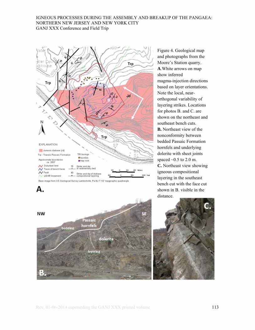
Figure 4. Geological map and photographs from the Moore’s Station quarry. A.White arrows on map show inferred magma-injection directions based on layer orientations. Note the local, near-orthogonal variability of layering strikes. Locations for photos B. and C. are shown on the northeast and southeast bench cuts. B. Northeast view of the nonconformity between bedded Passaic Formation hornfels and underlying dolerite with sheet joints spaced ~0.5 to 2.0 m. C. Northeast view showing igneous compositional layering in the southeast bench cut with the face cut shown in B. visible in the distance.

IGNEOUS PROCESSES DURING THE ASSEMBLY AND BREAKUP OF THE PANGAEA: NORTHERN NEW JERSEY AND NEW YORK CITY GANJ XXX Conference and Field Trip
Rev. 01-06-2014 superseding the GANJ XXX printed volume 114
Figure 5. Geological map (A.) and photographs (B. and C.) from the Pennington trap-rock quarry. White arrows on map show inferred injection directions based on layer orientation. B. West view of SE-dipping layering showing concave horse tailing of sheet joints against adjacent layers that are about 4-5 m thick. C. Detailed view of steeply dipping compositional layer showing mineral banding seen on a joint surface sheet joints oriented sub parallel to layering. Layer is about 1.5 m thick.
6A
6B

IGNEOUS PROCESSES DURING THE ASSEMBLY AND BREAKUP OF THE PANGAEA: NORTHERN NEW JERSEY AND NEW YORK CITY GANJ XXX Conference and Field Trip
Rev. 01-06-2014 superseding the GANJ XXX printed volume 115
Figure 6. Photographs showing compositional layering and jointing in the Pennington quarry (photos locations noted on figure 5A). A. Northwest view showing sheet joints and cooling joints. Sheet joints spaced about 0.5 m parallel to layering. Note the plumose markings on sheet-joint faces. Polygonal cooling joints are normal to layering. B. West showing massive layers (about 8-10 m thick) with cooling joints oriented at high angle to layering, and slickensided sigmoid fractures that may indicate synchronous cooling and shearing. The cooling joints are interpreted as occurring on the base of layers indicating injection and sill growth from the inside out.

IGNEOUS PROCESSES DURING THE ASSEMBLY AND BREAKUP OF THE PANGAEA: NORTHERN NEW JERSEY AND NEW YORK CITY GANJ XXX Conference and Field Trip
Rev. 01-06-2014 superseding the GANJ XXX printed volume 116
Figure 7. Geological map (A.) and cross section (B.) of the Lambertville quarry. C. Structural diagram showing the geometry of four sets of small-faults mapped in the quarry.
IGNEOUS PROCESSES DURING THE ASSEMBLY AND BREAKUP OF THE PANGAEA: NORTHERN NEW JERSEY AND NEW YORK CITY GANJ XXX Conference and Field Trip
Rev. 01-06-2014 superseding the GANJ XXX printed volume 117
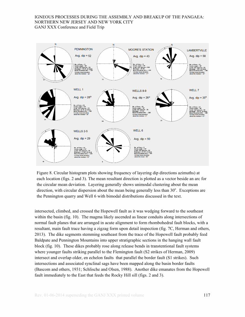
Figure 8. Circular histogram plots showing frequency of layering dip directions azimuths) at each location (figs. 2 and 3). The mean resultant direction is plotted as a vector beside an arc for the circular mean deviation. Layering generally shows unimodal clustering about the mean direction, with circular dispersion about the mean being generally less than 30o. Exceptions are the Pennington quarry and Well 6 with bimodal distributions discussed in the text.
intersected, climbed, and crossed the Hopewell fault as it was wedging forward to the southeast within the basin (fig. 10). The magma likely ascended as linear conduits along intersections of normal fault planes that are arranged in acute alignment to form rhombohedral fault blocks, with a resultant, main fault trace having a zigzag form upon detail inspection (fig. 7C, Herman and others, 2013). The dike segments stemming southeast from the trace of the Hopewell fault probably feed Baldpate and Pennington Mountains into upper stratigraphic sections in the hanging wall fault block (fig. 10). These dikes probably rose along release bends in transtentional fault systems where younger faults striking parallel to the Flemington fault (S2 strikes of Herman, 2009) intersect and overlap older, en echelon faults that parallel the border fault (S1 strikes). Such intersections and associated synclinal sags have been mapped along the basin border faults (Bascom and others, 1931; Schlische and Olsen, 1988). Another dike emanates from the Hopewell fault immediately to the East that feeds the Rocky Hill sill (figs. 2 and 3).

IGNEOUS PROCESSES DURING THE ASSEMBLY AND BREAKUP OF THE PANGAEA: NORTHERN NEW JERSEY AND NEW YORK CITY GANJ XXX Conference and Field Trip
Rev. 01-06-2014 superseding the GANJ XXX printed volume 118
The Lambertville quarry (fig. 7) is cut into the Stockton dolerite (diabase; Husch and others, 1988). This body intrudes the Lockatong Formation (Drake and others, 1996) but the geometric form of the intrusion is uncertain due to pervasive shear strains and associated rotations of primary structures as seen in the quarry. This body exhibits the highest tectonic strains of any of the bodies studied and is sandwiched between two large faults having normal and oblique slips (Ratcliffe and Burton; 1988, Houghton and others, 1992; Herman, 2005a). The contact between the dolerite and Lockatong Formation strikes about N40oE but the strike of enveloping beds is almost orthogonal to the contact (fig. 7). This indicates that this body locally cuts Triassic strata at a high angle, which is confirmed by drilling data near the western contact where diabase lies directly beneath the Lockatong Formation in the subsurface (fig. 7B), and yet is only a stone's throw away from shear faces of dolerite in outcrop. It's possible that the Stockton dolerite locally thickens within the fault zone as it gradually ascended from a lower stratigraphic section into a higher one to the southeast in a manner similar to that depicted by Husch and others (1988).
Recent bedrock geology mapping in the Lambertville quadrangle, Pa-NJ (fig. 2, and Herman and others, 2013) resolved some structural discrepancies between bedrock maps on either side of the Delaware River in Pennsylvania (Berg and others,1980) and New Jersey (Owens and others, 1998). The Belle Mountain (NJ)– Bowman Hill (Pa) dolerite body is mapped as a stock that rises up through the hinge zone of a footwall anticline in the Lockatong Formation, with its upper contact plunging gently westward beneath the lower section of the Passaic Formation across the river in Pennsylvania (fig. 3). This is consistent with Ratcliff and Burton's (1988) report of the Bowman Hill-Belle Mt. body being a stock-like feeder to Jericho Mountain (fig. 3).
Figure 9. Schematic profile of a sill fed by a moderately to steeply dipping dike ascending along linked fault segments having acute differences in strike. Igneous compositional layering and sub parallel sheet joints curve upward and outward from a medial plane lying midway between the top and bottom of the sill along which magma is fed away from the source toward the propagating tips. The propagation direction is opposite to the layering dip toward the top of the sill and with it towards its base. The locations and relative positions of the Moore's Station and Pennington quarries are boxed and labeled.

IGNEOUS PROCESSES DURING THE ASSEMBLY AND BREAKUP OF THE PANGAEA: NORTHERN NEW JERSEY AND NEW YORK CITY GANJ XXX Conference and Field Trip
Rev. 01-06-2014 superseding the GANJ XXX printed volume 119
Figure 10. A sequence of cartoon profiles illustrating how magma may interact with a fault during and after sill emplacement. A. Dolerite sill (UNIT 1) is injected into UNIT 2 from the NW toward the SE and approaches a pre-existing normal fault. B. Upon contact with the fault, the melt ascends along the fault and crosses into a higher stratigraphic level (UNIT 3). C. Melt injection stopped and ensuing fault slip offsets all three units.
The Stockton dolerite appears to have similar geometry to the Belle Mt. - Bowman Hill stock and may be the same body that is now segmented and translated southeastward from post-intrusion faulting. It is interesting to note that the Bowman Hill body includes a dike segment that veers toward the Hopewell fault with the same strike as the segment of Jericho Mt. immediately across the fault to the southeast (fig. 3). This relationship suggests that melt ascended along the Hopewell fault system to feed the Belle Mt.-Bowman Hill-Jericho Mt. complex as a single body as in the manner depicted in figures 9 and 10, but with up to three separate dike
sources. A fourth dike segment occurs along the Hopewell fault east of Pennington Mountain that feeds the Rocky Hill sheet (figs. 2 and 3). This dike is aligned with the dike segment of Sourland Mountain across the Hopewell fault to the northwest, and has been studied in the subsurface with a BTV record (Well 6, fig. 3; Herman and Curran, 2010). This is a natural segue into the orientation analyses of mineral compositional layering gained from subsurface OBI work.
Optical BTV Studies of Water-Well Boreholes
The orientations of igneous compositional layers in the subsurface are measured using an OBI system that photographs structures exposed in the boreholes of water wells having sections open to bedrock (Herman, 2010; Herman and Curran, 2010). Explanation of the methods of data acquisition and processing of OBI digital records is beyond the scope of this work, and the reader is referred to Herman (2010) for further explanation on the acquisition and interpretation of NJGWS BTV data. Figure 11 includes a section of Well 9 and a schematic diagram that illustrates how planar features are photographed and unrolled in order to measure their strike and dip. The stratigraphic and structural analysis of an optical BTV record includes the identification,

IGNEOUS PROCESSES DURING THE ASSEMBLY AND BREAKUP OF THE PANGAEA: NORTHERN NEW JERSEY AND NEW YORK CITY GANJ XXX Conference and Field Trip
Rev. 01-06-2014 superseding the GANJ XXX printed volume 120
Figure 11. A. Part of an optical BTV record of Well 9 (location shown on figs. 2 and 3). Layering dips 22 to 24o toward azimuths 335 to 359 o in this section. B. A series of schematic diagrams illustrate how a dipping, planar structure that is penetrated by a borehole makes an elliptical trace on the borehole wall that is photographed, unrolled, and flattened for measurement. In this latter case, the plane dips south.

IGNEOUS PROCESSES DURING THE ASSEMBLY AND BREAKUP OF THE PANGAEA: NORTHERN NEW JERSEY AND NEW YORK CITY GANJ XXX Conference and Field Trip
Rev. 01-06-2014 superseding the GANJ XXX printed volume 121
grouping, and measurement of primary and secondary structural planes. Compositional layering in igneous rocks is the only primary planar structure recorded in igneous rocks and is identified in OBI records where parallel planes of contrasting mineralogical composition produce alternating light- and dark-colored bands from the variable intensities of light from a diode source that is reflected off the borehole wall and captured by a digital camera (fig. 11A). Secondary structures that overprint compositional layering include tension fractures and shear planes that locally offset layering and other fractures (Herman and Curran, 2010). Tension fractures and shear planes sometimes have visible accumulations of secondary minerals that are interpreted as mineral veins if no associated strain slip is seen.
Herman and Curran (2010) include hydrogeological sections for wells 1 to 6 with stratigraphic sections having variable colors, textures, and fracture densities. Darker-colored sections are more mafic containing pyroxene, hornblende, and/or magnetite than lighter ones having proportionately more feldspar and quartz. Dolerite layers alternate from light-gray to dark-gray with varying degrees of fracturing but shade is seemingly unrelated to fracture density. Their shaded layers range in thickness from less than a meter to more than 30 meters whereas densely fractured sections range in thickness from about a meter to about 10 meters. Layering commonly shows unimodal distributions of orientation that resemble cross bedding in sedimentary rocks (fig. 8). These records have circular mean deviations about the median direction of layering that are generally less than 30o. Exceptions to this trend are seen for the Pennington quarry and well 6 that show bimodal distributions with circular deviations of over 60o (fig. 8). The bimodal nature of layering in the dike may result from the well having penetrated parts of both sides of the dike and therefore crossed layers and sheet joints of opposite orientations as depicted in figure 9; a well that penetrated only the upper or lower section where layering is consistently oriented in one direction would show a unimodal distribution, whereas a well fully penetrating the unit, or straddling the median conduit, would show a bimodal distribution. The latter scenario also probably applies to the Pennington quarry (fig. 8) and is the basis for positioning the extent of quarry workings in figure 9 as straddling both lower and upper sill sections.
Figure 12 summarizes the layer orientations that were obtained using the BTV records on a longitudinal, schematic profile through the Lambertville-Sourland Mt. dolerite complex. The orientations of compositional layers and sub parallel sheet fractures indicate southeast-directed injection at most points observed (fig. 3). One clear exception to this case is the Moore's Station quarry on the west end of Baldpate Mt. where injection from the east is consistent with having this body fed from the aforementioned dike segment located to the east along the Hopewell fault (figs. 2, and 3). A northwestern magmatic source is consistent with Husch and others (1988) observations that the comparatively mafic dolerite of the Byram-Point Pleasant body is close to a hypothetical feeder dike, and that this body probably was connected to the more felsic ones situated in higher stratigraphic sections to the southeast. This then leads us to the obvious question: where are the feeder dikes for this intrusive system?

IGNEOUS PROCESSES DURING THE ASSEMBLY AND BREAKUP OF THE PANGAEA: NORTHERN NEW JERSEY AND NEW YORK CITY GANJ XXX Conference and Field Trip
Rev. 01-06-2014 superseding the GANJ XXX printed volume 122
The Buckingham Dome
Large Early Jurassic dikes cut the Eastern US continental margin along its length from Georgia to Maine (King, 1961; 1971, Wiegand and Ragland, 1970, and McHone and others, 1987). In the vicinity of the New York recess, they commonly strike about N20o E to N30o E, lie mostly transverse with respect to older Appalachian structures in the region from Lancaster, Pa to Buckingham, Pa (fig. 1), and are portrayed as dipping steeply about the vertical (Berg and others, 1980). In the Hartford basin they are shown as steeply dipping to the west-northwest by Phillpotts and Martello (1986). The map traces of these dikes are commonly tens of kilometers in length, sometimes exceeding 100 km, but they are usually not wider than a few tens of meters (Smith and others, 1975). The only place where large, transverse dikes cut across the area of concern is where the Plumstead Hill dikes (Bascom and others, 1931) and the Solebury dike (Ratcliffe and Burton, 1988) strike toward convergence just west of the Buckingham window (figs. 1 and 2). As currently mapped by Berg and others (1980) these dikes terminate in the lower section of the Lockatong Formation after discordantly crossing pre-Mesozoic basement and the Stockton Formation from the south (fig. 2). But earlier geological maps show that these structures are more extensive than currently portrayed and probably connect to the Byram-Point Pleasant body (fig. 13).
Figure 12. Schematic, longitudinal cross section showing apparent layering orientations within the Lambertville-Sourland dolerite complex. Jo - Orange Mt. basalt, JTrp - Passaic Formation, Pal/Pz - Paleozoic and Proterozoic rocks undivided, Trl - Lockatong Formation, Trs - Stockton Formation.
IGNEOUS PROCESSES DURING THE ASSEMBLY AND BREAKUP OF THE PANGAEA: NORTHERN NEW JERSEY AND NEW YORK CITY GANJ XXX Conference and Field Trip
Rev. 01-06-2014 superseding the GANJ XXX printed volume 123
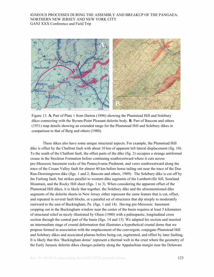
These dikes also have some unique structural aspects. For example, the Plumstead Hill dike is offset by the Chalfont fault with about 10 km of apparent left lateral displacement (fig. 10). To the south of the Chalfont fault, the offset parts of the dike (fig. 2) occupies a strange antiformal crease in the Stockton Formation before continuing southwestward where it cuts across pre-Mesozoic basement rocks of the Pennsylvania Piedmont, and veers southwestward along the trace of the Cream Valley fault for almost 40 km before horse tailing out near the trace of the Doe Run-Downingtown dike (figs. 1 and 2; Bascom and others, 1909). The Solebury dike is cut off by the Furlong fault, but strikes parallel to western dike segments of the Lambertville Sill, Sourland Mountain, and the Rocky Hill sheet (figs. 1 to 3). When considering the apparent offset of the Plumstead Hill dikes, it is likely that together, the Solebury dike and the aforementioned dike segments of the dolerite sheets in New Jersey either represent the same feature that is cut, offset, and repeated in several fault blocks, or a parallel set of structures that dip steeply to moderately eastward to the east of Buckingham, Pa. (figs. 1 and 14). Having pre-Mesozoic basement cropping out in the Buckingham window near the center of the basin requires at least 5 kilometers of structural relief as nicely illustrated by Olsen (1980) with a palinspastic, longitudinal cross section through the central part of the basin (figs. 14 and 15). We adapted his section and inserted an intermediate stage of crustal deformation that illustrates a hypothetical crustal dome that we propose formed in association with the emplacement of the convergent, conjugate Plumstead Hill and Solebury dikes and associated plutons before being cut, segmented, and offset by later faulting. It is likely that this ‘Buckingham dome’ represent a thermal welt in the crust where the geometry of the Early Jurassic dolerite dikes changes polarity along the Appalachian margin near the Delaware
Figure 13. A. Part of Plate 1 from Darton (1896) showing the Plumstead Hill and Solebury dikes connecting with the Byram-Point Pleasant dolerite body. B. Part of Bascom and others (1931) map details showing an extended range for the Plumstead Hill and Solebury dikes in comparison to that of Berg and others (1980).
A.
B.

IGNEOUS PROCESSES DURING THE ASSEMBLY AND BREAKUP OF THE PANGAEA: NORTHERN NEW JERSEY AND NEW YORK CITY GANJ XXX Conference and Field Trip
Rev. 01-06-2014 superseding the GANJ XXX printed volume 124
River, with predominately steep, northeast striking and west dipping dikes in Pennsylvania giving way to northwest striking and steep- to moderately east-dipping dikes in New Jersey (figs. 14 and 17). Intrabasinal doming is therefore proposed to have occurred in the basin during the Triassic
Figure 14. Longitudinal cross sections illustrating dolerite dikes and plutons relative to the Buckingham dome. A. The dome in Bi-Bi' is an intermediate-phase of crustal strain that's inserted between an adapted version of Olsen's (1980) current (B-B') and restored (B0 -B0') sections (map trace shown on fig. 15). B. An expanded range for the cross section in figure 12 showing the Lambertville-Sourland dolerite complex relative to the feeder dikes in the Buckingham dome. Abbreviations are the same as for figure 12.

IGNEOUS PROCESSES DURING THE ASSEMBLY AND BREAKUP OF THE PANGAEA: NORTHERN NEW JERSEY AND NEW YORK CITY GANJ XXX Conference and Field Trip
Rev. 01-06-2014 superseding the GANJ XXX printed volume 125
Figure 15. A. Map of the New York Recess showing exposed Early Mesozoic rift basins (gray polygons), and CAMP dikes (red lines) and exposed dolerite bodies (small, solid orange polygons in rift basins) in relationship to positive Bouger gravity anomalies. Positive anomalies are highlighted using white (0 mGal) and yellow (20 mGal) polylines. The broad-wavelength, >20 mGal anomalies are emphasized using semi-transparent orange polygons that probably indicate the locations of thick remnants of deep CAMP plutons. B. Longitudinal cross-section A1-A2 from Woodworth (1932) showing arching of the Taconic axis relative to rift basins and a Massachusetts trough. BCT - Baltimore Canyon Trough.

IGNEOUS PROCESSES DURING THE ASSEMBLY AND BREAKUP OF THE PANGAEA: NORTHERN NEW JERSEY AND NEW YORK CITY GANJ XXX Conference and Field Trip
Rev. 01-06-2014 superseding the GANJ XXX printed volume 126
period prior to Early Jurassic volcanism. This helps explain how primitive melts associated with the more mafic sills were emplaced within lower parts of the Triassic sedimentary section and climb up section into higher stratigraphic positions nearby. Therefore, rather than having a single, northwest-dipping dolerite sheet that later gets segmented and repeated by faulting (Husch and others, 1988), the convergent dikes in the Buckingham dome fed sill-like dolerite bodies laterally outward into increasingly higher stratigraphic levels into marginal sub basins that flanked the dome (fig. 14A). This scenario is different from prior tectonic interpretations of the Newark basin insofar
Figure 16. Woodworth's (1932) cross section image that is rotated, rendered semi-transparent, and placed on top of a non-annotated version of the GE compilation shown in figure 15. This shows the crustal arch overlying a 20mGal Bouger anomaly located between the Newark and Hartford basins.

IGNEOUS PROCESSES DURING THE ASSEMBLY AND BREAKUP OF THE PANGAEA: NORTHERN NEW JERSEY AND NEW YORK CITY GANJ XXX Conference and Field Trip
Rev. 01-06-2014 superseding the GANJ XXX printed volume 127
that thermal doming accompanying taphrogenesis has not been previously identified or incorporated into tectonic interpretations. The implications for this are far reaching, so we conducted a literature search and a map compilation of CAMP features in the region in order to gain corroborating or refuting evidence for testing the hypothesis. One strong line of evidence supporting the concept stems from comparing the CAMP bodies with regional Bouger gravity anomalies (Geological Society of America Committee for the Gravity Anomaly Map of North America, 1987).
Camp Bodies with Respect to Regional Bouger Gravity Anomalies
Earlier gravimetric studies of the eastern North American rift basins in the 1960s and 70s established the direct correlation of gravity anomalies with exposed diabase bodies (Sumner, 1977) because dolerite is mafic with a higher density than enveloping sedimentary rocks. Average density values of 3.0 and 2.6 gm/cm3 were used by Daniels (1985) for characterizing residual gravity anomalies in the Narrow Neck region of Pennsylvania. In a similar manner, geophysical studies of the continental margin assume comparative density values of 3100 and 2875 kg.m3 for mafic and felsic crustal blocks, respectively (Behn and Lin, 2000). Bouger-gravity-anomaly maps depict lateral variations in crustal densities after accounting for other gravitational effects stemming from shape irregularities of the Earth’s geoid, lateral elevation changes, surface irregularities, Earth tides, and isostatic corrections (Telford and others, 1976). For this study, we compared the locations and forms of positive Bouger gravity anomalies occurring along the Atlantic margin of the New York recess to exposed CAMP bodies including those in and outside of the basins.
A digital version of the gravity anomaly map of North America (Geological Society of America, 1987) was downloaded from the World-Wide-Web and combined with a digital compilation of CAMP bodies using Google Earth TM (GE). The comparison was facilitated by parsing and combining CAMP elements for the various States from digital geological map themes that were compiled and made available by the US Geological Survey (http://mrdata.usgs.gov/geology/state/). Figure 15A shows parts of this GE compilation for the area of the New York recess. This map shows a close spatial association of dolerite dike swarms with positive Bouger anomalies stretching from the Culpepper basin in the southwest to the Hartford basin in the northeast. The large, transverse suite of dikes near the Hartford basin is rooted above the center of a >20 mGal anomaly that spatially coincides with a regional crustal arch depicted by Woodworth (1932), that separates west-dipping strata in the Newark basin from the east-dipping strata in the Hartford basin (fig. 15B and 16). Moreover, the foreland edge of the positive Bouger anomaly (along the zero mGal isopleth) coincides with the southern terminus of the pervasive dike swarm distributed about the narrow neck of Early Mesozoic strata that connects the Gettysburg and Newark basins (figs 1 and 15A). These relationships are the basis for proposing a direct correlation of regional, long-wavelength, positive Bouger anomalies with deep, subsurface CAMP plutons that under plate the passive margin in their current, stretched and segmented form. The high-magnitude, long-wavelength Bouger anomalies probably correlate to

IGNEOUS PROCESSES DURING THE ASSEMBLY AND BREAKUP OF THE PANGAEA: NORTHERN NEW JERSEY AND NEW YORK CITY GANJ XXX Conference and Field Trip
Rev. 01-06-2014 superseding the GANJ XXX printed volume 128
thicker CAMP remnants, with one underlying New Jersey's inner Coastal Plain in addition to other areas of the recess where similar Bouger anomalies overlap marginal area of the Culpepper and Hartford basins (figs. 15A and 16). The 20 mGal anomaly underlying the NJ Coastal Plain is different from the others because it does not directly underlie parts of a rift basin (fig. 15). However, the southwest continuation of the Plumstead Hill dike parallel's the Cream-Valley fault for about 40 km length, and therefore provided a path for magma to have ascended from sub-lithosphere levels on the southeast margin of the basin towards the basin and into the foreland. This is another example of fault-mediated magmatic ascent of CAMP bodies along synthetic (SE-dipping) major, orogen-bounding faults as depicted by Harry and Sawyer (1992) for this area, for the Brevard zone in the Southern Appalachian orogenic belt (King, 1971), and elsewhere (Magee and others, 2013). It is important to remember that this entire margin has been elongated from regional rifting, and today's physical separation of the anomaly from the dike swarm in the NJ region was likely much less than it is today. In that respect two regional cross-sections were developed along longitudinal (fig. 17) and transverse (fig. 18) lines with respect to the Appalachian grain in the New York Recess in order to estimate how much the margin was extended. The longitudinal section incorporates the earlier sections of Woodworth (1932) and Olsen (1980), and the transverse section (fig. 18) used a profile framework from a deep, nearby seismic study of the continental margin (LASE study group, 1986). Both sections depict current crustal conditions relative to hypothetical, deep, sub-lithosphere dolerite bodies in various forms. The transverse section includes a restored (palinspastic, fig. 18B) interpretation that depicts the crustal structure at an earlier rift stage, before major extension and relaxation of the continental margin but after emplacement of a sub-lithosphere magma chambers that probably uplifted the overlying orogenic wedge comprising the lithosphere (fig. 18). This stage probably preceded an accelerated stage of rifting (S2 of Herman, 2009) when the large, transverse fractures cut the lithosphere and tapped these chambers to provide avenues for the magma to rise through the lithosphere as dolerite dikes feeding more hypabyssal rocks. The respective lengths of these two sections are compared in figure 18 to derive an estimate of the horizontal component of the finite stretch along the line of section (fig. 15A).
Discussion
These interpretations incorporate aspects of earlier ones in the region to portray how the CAMP dolerite dikes locally blistered the crust and operated in concert with large normal faults in the New York Recess and as it was being stretched, thinned, and intruded with magma. The associated strain effects are shown as reaching well into foreland regions beyond the rift basins. The geological implications of these hypotheses are provocative with respect to some popular notions surrounding continental tectonic rifting and evolution of this passive margin. Many of these considerations reach beyond the scope of this paper. For example, there has been much debate over the mantle plume versus non-plume origin of CAMP (McHone, 2000; Wilson, 1997, among others). One reason for this arguments is the prior lack of evidence for crustal arching and doming in this region that characteristically accompany taphrogenic LIPs elsewhere (for example,
IGNEOUS PROCESSES DURING THE ASSEMBLY AND BREAKUP OF THE PANGAEA: NORTHERN NEW JERSEY AND NEW YORK CITY GANJ XXX Conference and Field Trip
Rev. 01-06-2014 superseding the GANJ XXX printed volume 129
Neugebauer, 1978; Bott, 1981; Bell and others, 1988). But we have just shown where these characteristic structures occur in the New York recess, and that they likely stem from CAMP activity. Nevertheless, the focus of this discussion is on some complications and limitations of the methods that we used and some aspects of the model that need more work.
Using igneous layering and correlative sheet-joint orientations to infer injection directions hinges on the premise that the internal structure of the large, transverse dolerite dikes is governed by the same structural principles as small tension fractures. Most of the observations appear to substantiate this, but complications arise when observation points are positioned with respect to a complex body having structural segments that can be viewed either as a dike or sill for structural analysis. For example, well clusters 2-5 and 8-9 are both congruent to the northwest-striking dike segment that attaches the southwest termination of Sourland Mountain to the upper sill in the aforementioned structural saddle (fig. 3). Well 6 is clearly drilled into a dike segment and shows a bimodal population of layering dipping in opposite directions but layering strikes nearly normal to the trend of the igneous contact (fig. 3, and Herman and Curran, 2012, fig. 1C1). Most of the igneous layering was measured in small sections near the top and bottom of thick sills where they display a unimodal strike and dip direction but with generally steeper dips than their enveloping beds (figs. 4 and 5). Using these criteria, the Stockton dolerite appears to be more of a dike or plug than a sill. Another complication may arise from having cumulate layers formed near sill bases rather than solely from magmatic injection. For example, Herman and Curran (2012, fig. 1B7) show a ~3m section deep in well 5 at about 75 m depth where magnetic distortion obscures the OBI record from a probable magnetite cumulate layer. Having cumulate layering settling parallel to the lower igneous contact of a sill would therefore be one exception to the model. The layering for wells 2-5 are grouped in figure 8 and show a small deviation from the mean, but Herman and Curran (2012) show a syncline axis plunging gently north through the well field based on layering orientations mapped at each well site. This serves as a reminder that layering in these bodies are subjected to later tectonic strains that can complicate the use of a simple plumose geometric model for inferring magma injection trends.
One striking map pattern associated with the Buckingham dome is the symmetric arrangement of the Flemington-Chalfont fault system on its southeast side (fig. 1). This pattern suggests that the Chalfont-Flemington fault system simply allowed the hinterland and marginal flanks of the dome core, now represented as the Buckingham widow, to spall off and slump downward to the southeast relative to the footwall arch (figs. 2 and 14B). Mesozoic faults systematically curve around the dome, continuing well past the basin‘s northwest border into the pre-Mesozoic foreland in association with sub parallel, transverse folds that warp the crust (fig. 2). This viewpoint expands the Mesozoic rift strains into a broader region of Appalachian terrain than has been previously portrayed, and involves parts of the Appalachian foreland orogenic belts in the transtentional collapse of the eastern continental margin of the North American plate. Figure 2 also shows how the foreland trace of exposed Proterozoic rocks in the Reading Prong mimics the crenulated trend of major longitudinal synclines in the basin as additional proof of the strain continuum. In order for this hypothesis to be true, Mesozoic extension strains must be present in
IGNEOUS PROCESSES DURING THE ASSEMBLY AND BREAKUP OF THE PANGAEA: NORTHERN NEW JERSEY AND NEW YORK CITY GANJ XXX Conference and Field Trip
Rev. 01-06-2014 superseding the GANJ XXX printed volume 130
outcropping, pre-Mesozoic basement rocks in the foreland, but this remains unclear for areas northwest of the Newark basin. However, large, transverse dolerite dikes cut into more foreland rocks in the Narrow Neck region (fig. 2) and further along strike in the Appalachians to the southwest, making this scenario plausible.
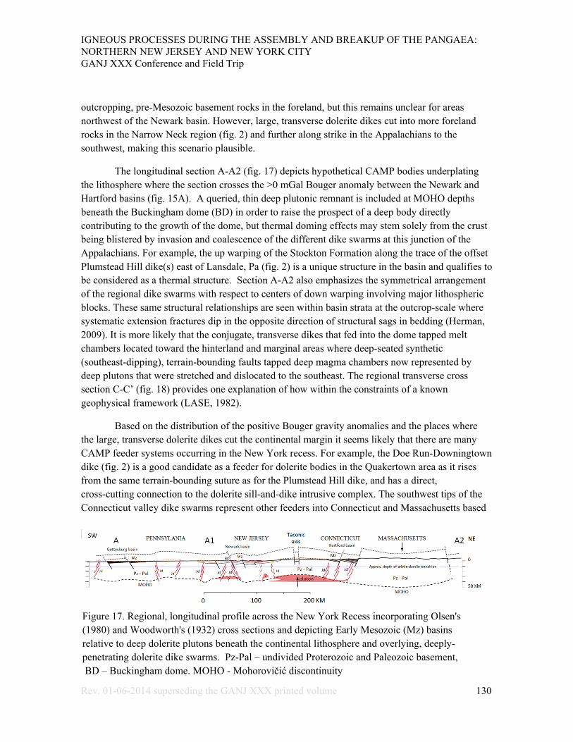
The longitudinal section A-A2 (fig. 17) depicts hypothetical CAMP bodies underplating the lithosphere where the section crosses the >0 mGal Bouger anomaly between the Newark and Hartford basins (fig. 15A). A queried, thin deep plutonic remnant is included at MOHO depths beneath the Buckingham dome (BD) in order to raise the prospect of a deep body directly contributing to the growth of the dome, but thermal doming effects may stem solely from the crust being blistered by invasion and coalescence of the different dike swarms at this junction of the Appalachians. For example, the up warping of the Stockton Formation along the trace of the offset Plumstead Hill dike(s) east of Lansdale, Pa (fig. 2) is a unique structure in the basin and qualifies to be considered as a thermal structure. Section A-A2 also emphasizes the symmetrical arrangement of the regional dike swarms with respect to centers of down warping involving major lithospheric blocks. These same structural relationships are seen within basin strata at the outcrop-scale where systematic extension fractures dip in the opposite direction of structural sags in bedding (Herman, 2009). It is more likely that the conjugate, transverse dikes that fed into the dome tapped melt chambers located toward the hinterland and marginal areas where deep-seated synthetic (southeast-dipping), terrain-bounding faults tapped deep magma chambers now represented by deep plutons that were stretched and dislocated to the southeast. The regional transverse cross section C-C’ (fig. 18) provides one explanation of how within the constraints of a known geophysical framework (LASE, 1982).
Based on the distribution of the positive Bouger gravity anomalies and the places where the large, transverse dolerite dikes cut the continental margin it seems likely that there are many CAMP feeder systems occurring in the New York recess. For example, the Doe Run-Downingtown dike (fig. 2) is a good candidate as a feeder for dolerite bodies in the Quakertown area as it rises from the same terrain-bounding suture as for the Plumstead Hill dike, and has a direct, cross-cutting connection to the dolerite sill-and-dike intrusive complex. The southwest tips of the Connecticut valley dike swarms represent other feeders into Connecticut and Massachusetts based
Figure 17. Regional, longitudinal profile across the New York Recess incorporating Olsen's (1980) and Woodworth's (1932) cross sections and depicting Early Mesozoic (Mz) basins relative to deep dolerite plutons beneath the continental lithosphere and overlying, deeply-penetrating dolerite dike swarms. Pz-Pal – undivided Proterozoic and Paleozoic basement, BD – Buckingham dome. MOHO - Mohorovičić discontinuity
IGNEOUS PROCESSES DURING THE ASSEMBLY AND BREAKUP OF THE PANGAEA: NORTHERN NEW JERSEY AND NEW YORK CITY GANJ XXX Conference and Field Trip
Rev. 01-06-2014 superseding the GANJ XXX printed volume 131
on the aforementioned spatial relationship with the positive gravity anomaly, but the location of a deep feeder for the Palisades Sill isn’t as apparent.
The common, saucer-shape geometry of sill-like plutons in the Newark basin is a well-known structural form of hypabyssal sills emplaced in the 0-6 km depth range at many places throughout the world (Malthe-Sorenssen and others, 2003). The upturned saucer form of Palisades Sill has a median point lying near Graniteville, NY (fig. 1) where Sanders and Merguerian (1997) found evidence to postulate a nearby, centralized magmatic source dike that fed the sill outward in opposing directions, like that portrayed in figure 9. We demonstrate that most of the dolerite bodies cropping out in the hanging walls of the intrabasinal faults were probably fed systematically away from the core of the Buckingham dome (figs. 2 and 3). This includes the saucer-shaped Rocky Hill dolerite (fig. 2) that joins to meet the southwest end of the Palisades sill just west of the Kingston quarry where an unusual, upward-flaring dike may occur as a result of sill reflect sill coalescence (Ten-Mile Run dolerite, fig. 2). The aforementioned >20mGal Bouger anomaly sitting between the Newark and Hartford basin has a small finger-like protrusion that reaches southwest close to the Graniteville location, the suspected feeder location for the Palisades. We simply may not have the tilted, eroded perspective that would reveal a deep-seated dike or dike system at this location. Although it is comfortable to place a suspected feeder source at a halfway mark along the strike of the Palisades Sill that would have efficiently served magma to both lateral margins, the source remains hidden and speculative for this well-known body at this time.
Kohn and others (1993) characterized the Mesozoic thermal regime for the Central Appalachian piedmont using evidence from Sphene and Zircon fission-track dating methods. Their findings indicate that pre-Mesozoic basement in the Piedmont of the New York recess experienced an anomalous thermal event with crustal temperature exceeding ~220o C beginning about 217-218 Mya. This Norian age corresponds with lower- to middle sections of the Passaic Formation in the Newark basin (Olsen and others, 1996). Their work also led them to postulate that the elevated, regional geotherm was probably associated with rift-related lithospheric thinning and associated mantle upwelling. Despite the fact that these dates are based on surface samples, and therefore deep-crustal temperatures exceeded those cited values, this information helps constrain the lower age limit of Late Triassic, positive structures, including thermal arches and domes stemming from the CAMP genesis and evolution. An upper age limit is provided by the radiometric-age dating of volcanism at 201-202 Mya (Sutter, 1988; Dunning and Hodyich, 1990). The volcanic stage reportedly lasted only about 600 Ka (Olsen and others, 2003). The lower and upper age limits provide a 20 Ma time interval from the CAMP genesis in this region to eventual culmination with continental volcanism. However, a narrower bracket of time on the order of about 3-10 my, has been reported for similar processes operating in analogous tectonic settings (He and others, 2003) and from the results of laboratory models (Griffiths and Campbell, 2012). We therefore need to closely inspect the Triassic sedimentary section for telltale stratigraphic variations that should be present as these regional arches and localized domes were developing during the Late Triassic. A currently held viewpoint is that structural inversion of this region post dates the CAMP volcanism and therefore occurred at late tectonic stages of basin development in the Jurassic (Bédard, 1985;
IGNEOUS PROCESSES DURING THE ASSEMBLY AND BREAKUP OF THE PANGAEA: NORTHERN NEW JERSEY AND NEW YORK CITY GANJ XXX Conference and Field Trip
Rev. 01-06-2014 superseding the GANJ XXX printed volume 132
Schlische and others, 2002). We need to be careful to separate positive inversion structures stemming from the CAMP thermal effects (Brodie and WHite, 1994) from other, later crustal inversions related to the compressive crustal states that we experience today (Goldberg and others, 2003).
A paired set of elongated, positive Bouger-gravity anomalies run parallel to the western Atlantic margin on either side of the Baltimore Canyon Trough (BCT - fig. 15A). One is the aforementioned set located on the margins of the rift basins with pockets locally exceeding 20 mGal. Another, more hinterland set of anomalies coincide with the continental shelf break before the continental-oceanic boundary (COB, fig. 15A.) These anomalies have been spatially associated and linked to other CAMP bodies characterized as seaward dipping (seismic) reflectors (SDRs) that may represent wedges of embryonic ocean crust (McHone and others, 2002; Benson, 2003). The positive Bouger anomalies along this margin are slightly segmented where regional section C-C’ crosses (fig. 15A). The discontinuous, elongate map pattern of these anomalies therefore suggests that the SDRs have variable thickness in the same manner as their more foreland CAMP counterparts. In the case of section C-C’, this wedge either has a minimum thickness or is absent. One can’t also help but notice the jig-saw nature of the trailing edge of the foreland set of positive anomalies with the leading edge of the hinterland set (Fig. 15A). The similar, paired nature of the 0 mGal isopleths makes reconnecting them a simple finite strain analysis. Although some attempts have been made along these lines, the scope of this work is limited to the field-based results and some regional considerations stemming from the more local breakthroughs (no pun intended).
One estimate of crustal stretching of the US Atlantic margin along regional section C-C’ in the New York region is 30% as illustrated in figure 18. This is a based on a simple two-dimensional model employing brittle, plane strains including rigid-block rotation and translation of a series of nested fault blocks that were under plated by a thick CAMP pluton (fig. 18). This interpretation was constrained by crustal structures outlined in the foreland (Herman, 1992) and hinterland parts of the section (LASE, 1982), but it lacks three-dimensionality and the accounting of deep, ductile strains that undoubtedly occurred. This section is therefore used only for deriving an minimum stretching estimate for the passive margin.
A casual survey of the variation of horizontal separation between the matched 0 mGal isolines measured normal to their traces along the eastern US margin shows ranges in distance of 30 to 230 km, with the greatest separations seen in the south. In the New York Recess, apparent horizontal separations are on the order of 30 to 160 km, with the minimum located within the Baltimore canyon trough off New Jersey, and the most in Massachusetts (Fig. 15A). These paired anomalies exhibit the same potential magnitude and complimentary geometric form, and are therefore assumed to correspond to segments of a larger, once-continuous CAMP system of bodies that may had both plutonic and volcanic, perhaps from the same elongate, complex chamber system underlying the orogenic axis. Perhaps, many of the gneiss domes and piedmont roots of the US Appalachian Mountains are arched upward and exposed as a result of the CAMP. The finite stretching and segmentation of the Atlantic passive margin appears to have left a taffy-like gravity

IGNEOUS PROCESSES DURING THE ASSEMBLY AND BREAKUP OF THE PANGAEA: NORTHERN NEW JERSEY AND NEW YORK CITY GANJ XXX Conference and Field Trip
Rev. 01-06-2014 superseding the GANJ XXX printed volume 133
fingerprint of how the margin evolved, with the maximum amount of stretching and thinning occurring beneath the Baltimore Canyon Trough in this region (Harry and Sawyer, 2010; ).
It's been over a decade since Withjack and others (1998) and Schlische (2003) provided critical summaries on the tectonic evolution of the Eastern North American rift system based on over a centuries worth of preceding geological studies. To summarize here, they outlined four tectonic phases:
1) Proto-Atlantic-margin crustal extension beginning in the Middle- to Late Triassic with half-graben basin formation.
2. Latest Triassic halt of basin subsidence in the southern United States.
Figure 18. Transverse cross-section B-B' across of the hinterland parts of the New York Recess depicting current lithosphere structures (A.) and a restored (palinspastic) version (B.) representing a prior stage when the CAMP melt had accumulated beneath the lithosphere before ensuing, accelerated extension and release to hypabyssal levels. The framework of the current section is constrained by LASE (1986).

IGNEOUS PROCESSES DURING THE ASSEMBLY AND BREAKUP OF THE PANGAEA: NORTHERN NEW JERSEY AND NEW YORK CITY GANJ XXX Conference and Field Trip
Rev. 01-06-2014 superseding the GANJ XXX printed volume 134
3. Earliest Jurassic NW-SE contraction in the southern US and coeval NW-SE extension in the northern US based on the systematic arrangement of Early Jurassic dike swarms along the margin (King, 1961; 1971).
4. General Middle Jurassic NW-SE contraction that persists today.
Forty years earlier Sanders (1963) outlined 4 tectonic stages of Mesozoic age that affected Late Triassic rocks of the mid-Atlantic states of Pennsylvania, New Jersey, New York and Connecticut:
1. Initial graben formation and infilling with more than 30,000 feet (~9 km) of non-marine sediment followed by intrusive and extrusive igneous activity.
2. Longitudinal crustal arching in the center of the graben, uplift, inversion of topography, erosion and drainage reversals, graben floor attains positive structural relief of more than 30,000 feet; no igneous activity or transverse folding
3. Second-generation graben subsidence, development of transverse folds northeast of Hunterdon Plateau, NJ with maximum structural relief exceeding 30,000 ft.; no igneous activity.
4. Offsetting of transverse folds by faults, some with strike-slip-displacement of up to 12 miles (~19 km) ; development of longitudinal Valley-and-Ridge type folds southwest of Hunterdon Plateau during strike-slip faulting; injection of porphyritic dolerite dikes into faults; formation of mineral deposits along faults.
Our findings support most of Sanders (1963) ideas, which incorporated long-held observations that the US Atlantic margin contains transverse arches and troughs of Mesozoic age as illustrated by Woodworth (1932). King (1961) provided an eloquent summary statement about this region after analyzing how the dike swarms along the US continental margin change orientation along the Appalachian grain from the southwest to the northeast:
“A different pattern is shown by the normal faults and sedimentary basins of the Newark group. These follow closely the strike of the older rocks amidst which they lie, and may have been conditioned by fracture and displacement along existing lines of weakness. Pairing of the major basins and associated faults on opposite sides of the central axis of the Appalachians suggests that this axis was again raised into a broad arch during Triassic time.”
Recent work by Herman (2012) shows that the eastern half of the Newark basin was repeatedly extended during three stages of overlapping extension strains that vary in a systematic, counterclockwise manner to reflect : 1) early SE stretching, 2) intermediate and accelerated stretching directed toward the ESE, and 3) a final stretch directed ENE prior to inversion of the

IGNEOUS PROCESSES DURING THE ASSEMBLY AND BREAKUP OF THE PANGAEA: NORTHERN NEW JERSEY AND NEW YORK CITY GANJ XXX Conference and Field Trip
Rev. 01-06-2014 superseding the GANJ XXX printed volume 135
crustal stress field at some later time from primary tension to primary compression that persists today (Goldberg and others, 2003). The exact causes and timing of the stress-field inversion from active to passive margin remain unproven with only abstract notions at this time (Herman, 2006). In conclusion, the structural nature of the passive, western Atlantic margin of the North American tectonic plate has been the focus of studies for over a century. But the nature and timing of positive, epeirogenic uplifts affecting this margin are still being refined and debated. We demonstrate that the structure of the CAMP bodies involved thermal uplifts during active rifting, both on a regional and more localized scale, and thereby lay the groundwork for differentiating between Early Mesozoic tectonic thermal uplifts from later epeirogenic ones. Our work offers a slightly different scenario on how this part of the US Atlantic margin and helps explain many geological conundrums arising from the geological map expression of the CAMP plumbing system. These views are in line with tectonic interpretations in analogous tectonic terrain but the conclusions should be tested further through continued field and laboratory work. To that end, this representation of the proto-Atlantic margin should be considered as a base model that incorporates some fundamental structural concepts and kinematic constraints that warrant consideration when advancing or refuting these ideas.
References
Balk, R., 1925, Primary structure of granite massives: Geological Society of America Bulletin, vol. 36, p. 679-696.
Bascom, F., Wherry, E. T., Stose, G. W., and Jonas, A. I., 1931, Geology and mineral resources of the Quakertown-Doylestown district, Pennsylvania and New Jersey: U.S. Geological Survey Bulletin 828, 69 p. Plate 1.
Bascom, F., Clark, W. B., Darton, N. H., Knapp, G. N., Kuemmel, H. B., Miller, B. L., and Salisbury, R.D, 1909, Philadelphia folio, Norristown, Germantown, Chester, and Philadelphia, Pennsylvania-New Jersey-Delaware: U.S. Geological Survey Folios of the Geologic Atlas: 162 p.
Bédard, J. H., 1985, The opening of the Atlantic, the Mesozoic New England igneous province, and mechanisms of continental breakup: Tectonophsysics, vol. 113, no. 3-4, p. 209-232.
Bédard, J. H. Naslund, H. R., P. Nabelek, P., Winpenny A., Hryciuk, M., Macdonald, W., Hayes, B., Steigerwaldt, K., Hadlari, T., Rainbird, R., Dewing, K., and Girard, É, 2012, Fault-mediated melt ascent in a Neoproterozoic continental flood basalt province, the Franklin sills, Victoria Island, Canada: Geological Society of America Bulletin vol. 124, no. 5/6, p. 723-736.
Behn, M.D. & Lin, J., 2000, Segmentation in gravity and magnetic anomalies along the US East Coast passive margin: implications for incipient structure of the oceanic lithosphere, Journal of
IGNEOUS PROCESSES DURING THE ASSEMBLY AND BREAKUP OF THE PANGAEA: NORTHERN NEW JERSEY AND NEW YORK CITY GANJ XXX Conference and Field Trip
Rev. 01-06-2014 superseding the GANJ XXX printed volume 136
Geophysical Research, v. 105, no. 25, p. 769–790.
Benson, R. N. , 2013, Age Estimates of the Seaward-Dipping Volcanic Wedge, Earliest Oceanic Crust, and Earliest Drift-Stage Sediments Along the North American Atlantic Continental Margin, in The Central Atlantic Magmatic Province: Insights from Fragments of Pangea, eds, W. Hames, J.G. Mchone, P. Renne and C. Ruppel, American Geophysical Union, Washington, D. C.. doi: 10.1029/136GM04
Berg, T. M., Edmunds, W. E., Geyer, A. R., and others, compilers, 1980, Geologic map of Pennsylvania: Pennsylvania Geological Survey, 4th ser., Map 1, 2nd ed., 3 sheets, scale 1:250,000.
Bott, M. H. P., 1981, Crtustal doming and the mechanism of continental rifting: Tectonophysics, vol. 73, iss. 1-2, p 1-8.
Brodie, L., and White, 1994, Sedimentary basin inversion caused by igneous underplating: Northwest European continental shelf: Geology v. 22, p. 147-150.
Daniels, D. L., 1985, Gravimetric character and anomalies in the Gettysburg basin, Pennsylvania – A preliminary appraisal, in Robinson, G. R., Jr., and Froelich, A. J., eds.,: U.S. Geological Survey Circular 946, p. 128 – 132.
Darton, N. H., 1896, The relations of the Traps of the Newark System in the New Jersey Region, U.S. Geological Survey Bulletin No. 67., 97 p., 1 plate, 1:538360 scale.
Drake, A. A., Jr., Volkert, R. A., Monteverde, D. H., Herman, G. C., Houghton, H. F., Parker, R. A., and Dalton, R. F., 1996, Bedrock geological map of northern New Jersey: U.S. Geological Survey Miscellaneous Investigation Series Map I-2540-A, scale 1:100,000, 2 sheets.
Dunning, G. R., and Hodych, J. D., 1990, U-Pb zircon and baddeleyite age for the Palisade and Gettysburg sills of northeast United States: Implications for the age of the Triassic-Jurassic boundary: Geology, v. 18, p. 795-798.
Faust, G. T., 1978, Joint systems in the Watchung Basalt flows, New Jersey USGS Professional Paper 864-B, 45 p.
Froelich, A. J., and Gottfried, D., 1984, Early Jurassic diabase sheets of the Eastern United States -- A preliminary overview, in Nonprofit sample and core repositories open to the public in the United States, by Schmoker, J. W., Michalski, T. C., and Worl, P. B., U.S Geological Survey Circular 942. Chapter 15, p 79-86.
Geological Society of America Committee for the Magnetic Anomaly Map of North America, 1987a, Magnetic anomaly map of North America: Geological Society of America, continent-scale map-003, scale 1:5,000,000, 4 sheets.

IGNEOUS PROCESSES DURING THE ASSEMBLY AND BREAKUP OF THE PANGAEA: NORTHERN NEW JERSEY AND NEW YORK CITY GANJ XXX Conference and Field Trip
Rev. 01-06-2014 superseding the GANJ XXX printed volume 137
Geological Society of America Committee for the Gravity Anomaly Map of North America, 1987b, Gravity Anomaly Map of North America(1:5,000,000), Boulder, Colorado, Geological Society of America, Continent-Scale Map-002 (5 sheets). URL: www.ngdc.noaa.gov/geomag/fliers/se-2004.shtml
Goldberg, D., Lupo, T., Caputi, M., Barton, C., and Seeber L., 2003, Stress Regimes in the Newark Basin Rift: Evidence from Core and Downhole Data, in: LeTourneau, P. M. and Olsen, P. E., eds.,The Great Rift Valleys of Pangea in Eastern North America, v.1, Tectonics, Structure, and Volcanism, Columbia University Press, New York, Chapter 7, p.
Gottfried, D., 1991, Geochemical data Jurassic diabase associated with early Mesozoic basins in the eastern United States: western Newark Basin, Pennsylvania and New Jersey, U.S., Geological Survey Open File Report 91-322-D, 26 p
Gottfried, D., Froelich, A. J., and Grossman, J. N., 1991a, Geochemical data Jurassic diabase associated with early Mesozoic basins in the eastern United States: eastern Newark Basin, New York, New Jersey, U.S., Geological Survey Open File Report 91-322-C, 6 p.
Harry, D. L., and Sawyer, D. S., 2010, A dynamic model of extension in the Baltimore Canyon Trough region: Tectonics, vol. 11, no. 2, p. 420-436.
Hatcher, R. D., Jr., Thomas, W. A., and Viele, G. W., 1989, eds., The Geological Society of America, Volume F2, The Appalachian-Ouachita Orogoen in the United States: The Geology of North America, Boulder Co., 767 p.
He, Bin, Yi-Gang Xu, Sun-Ling Chung, Xiao-Long Huang, and Ya-Mei Wang, 2003, Sedimentary evidence for a rapid kilometer-scale crustal doming prior to the eruption of the Emeishan flood basalts: Earth and Planetray Science Letters,vol.213, p.391-405.
Herman, G. C., 1992, Deep crustal structure and seismic expression of the central Appalachian orogenic belt: Geology, Vol. 20, No. 3, p. 275-278.
Herman, G. C., 2005a, Joints and veins in the Newark basin, New Jersey, in regional tectonic perspective: in Gates, A. E., editor, Newark Basin – View from the 21st Century, 22nd Annual Meeting of the Geological Association of New Jersey, College of New Jersey, Ewing, New Jersey, p. 75-116.
Herman, G. C., 2005b, Stratigraphy and structure of the Passaic Formation and Orange Mountain Basalt at Mine Brook Park, Flemington, New Jersey, in Gates, A. E., editor, Newark Basin - View from the 21st Century, 22nd Annual Meeting of the Geological Association of New Jersey, College of New Jersey, Ewing, New Jersey, p. 134-144.
Herman, G. C, 2006, Neotectonic setting of the North American Plate in relation to the Chicxulub impact: Geological Society America Abstracts with Programs, Vol. 38, No. 7, p. 415
IGNEOUS PROCESSES DURING THE ASSEMBLY AND BREAKUP OF THE PANGAEA: NORTHERN NEW JERSEY AND NEW YORK CITY GANJ XXX Conference and Field Trip
Rev. 01-06-2014 superseding the GANJ XXX printed volume 138
Herman, G.C. 2009, Steeply-dipping extension fractures in the Newark basin (5 MB PDF), Journal of Structural Geology, v. 31, p. 996-1011.
Herman, G.C. 2010, Hydrogeology and borehole geophysics of fractured-bedrock aquifers (5 MB PDF), in Herman, G.C., and Serfes, M.E., eds., Contributions to the geology and hydrogeology of the Newark basin: N.J. Geological Survey Bulletin 77, Chapter F., p. F1-F45.
Herman, G.C. and Curran, J., 2010, Borehole geophysics and hydrogeology studies in the Newark basin, New Jersey (38 MB PDF), in Herman, G.C., and Serfes, M.E., eds., Contributions to the geology and hydrogeology of the Newark basin: N.J. Geological Survey Bulletin 77, Appendixes 1-4, 245 p.
Herman, G.C., Dooley, J.H., and Mueller, L.F., 2010, Geology of the Pennington Trap Rock (Diabase) Quarry, Mercer County (6 MB PDF), in LaCombe, Pierre, ed., Geology of Trenton and its impact on the Capitol City: 27th Annual Meeting of the Geological Association of New Jersey, Trenton, NJ, p. 92-119.
Herman, G. C., Houghton, H. F., Monteverde, D. H., and Volkert, R. A., 1992, Bedrock geologic map of the Flemington and Pittstown 7-1/2' quadrangles, Hunterdon County, New Jersey: N.J. Geological Survey Open-file Map 10, 1:24,000 scale.
Herman, G.C., and Serfes, M.E., 2010, eds., Contributions to the geology and hydrogeology of the Newark basin: N.J. Geological Survey Bulletin 77, 6 chapters, 4 appendixes, 554 p.
Herman, G. C., Witte, R. W., Monteverde, D. H., and Stanford, S. D., in review, Geological map of the Lambertville quadrangle, Hunterdon and Mercer Counties, New Jersey: NJ Geological and Water Survey Open-File Map, scale 1:24,000.
Hodgson, R. A., 1961, Regional study of jointing in Comb ridge-Navajo Mountain Area, Arizona and Utah, American Association of Petroleum Geologists Bulletin, v. 45, p. 1-38
Hotz, P.E., 1952, The form of diabase sheets in southeastern Pennsylvania: American Journal of Science, v. 250, p. 375-388.
Houghton, H. F., Herman, G. C., and Volkert, R. A., 1992, Igneous rocks of the Flemington Fault zone: Geochemistry, structure, and stratigraphy, in Puffer J. H. and Ragland, P. C., eds., Eastern North American Mesozoic Magmatism, Geological Society of America Special Paper 268, p. 219-232
Husch, J., 1984, Mesozoic basaltic rocks from west-central New Jersey and Pennsylvania: Major and trace element geochemistry of whole-rock samples, in Puffer, J., ed., Igneous Rocks of the Newark Basin: Petrology, Mineralogy, Ore Deposits, and Guide to Field Trip: Field Guide and Proceedings of the First Annual Meeting of the Geological Association of New Jersey, Newark, NJ, p. 81-95

IGNEOUS PROCESSES DURING THE ASSEMBLY AND BREAKUP OF THE PANGAEA: NORTHERN NEW JERSEY AND NEW YORK CITY GANJ XXX Conference and Field Trip
Rev. 01-06-2014 superseding the GANJ XXX printed volume 139
Husch, J. M, 1990, The Palisades sill: Origin of the olivine zone by separate magmatic injection rather than gravity settling. Geology, v. 18, p. 699-702.
Husch, J. M., Bambrick,T. C., Eliason, W. M., Roth, E. A., Schwimmer, R. A., Sturgis, D. S., and Trione, C. W., 1988, A review of the petrology and geochemistry of Mesozoic diabase from the central Newark basin: New petrogenetic insights, in Husch, J. M. and Hozik, M. J., eds., Geology of the Central Newark Basin: Field Guide and Proceedings of the Fifth Annual Meeting of the Geological Association of New Jersey, Lawrenceville, NJ, p. 149-194
King, P. B., 1961, Systematic pattern of Triassic dikes in the Appalachian region: U.S. Geological Survey Professional Paper 424-B, p. B93-B95.
King, P. B., 1971, Systematic pattern of Triassic dikes in the Appalachian region - second report: US Geological Survey Professional Paper 750-D, p. 48-44.
Klewsaat, D. R, and Gates, A. E., 1994: Northeastern Geology, vol. 16, no. 3&4, p. 237-250.
Kohn, B. P., Wagner, M. E., Lutz, T. M., and Organist, G., 1993, Anomalous Mesozoic Thermal Regime, Central Appalachian Piedmont: Evidence from Sphene and Zircon Fission-Track Dating: Journal of Geology, vol. 101, no. 6, p. 779-794.
Kummel, H. B., 1898, The Newark system or red sandstone belt, New Jersey Geological Survey, Annual report of the State Geologist 1897, p.23-164.
Laney, S.E., and Gates, A.E., 1996, Three-dimensional shuffling of horses in a strike-slip duplex: An example from the Lambertville sill, New Jersey: Tectonophysics, v. 258, p. 53-70.
LASE Study Group, 1986, Deep structure of the U.S. East Coast passive margin from large aperture seismic experiments (LASE), Marine Petroleum Geology, vol. 3., p. 234-242.
Magee, C., Jackson, C. A., and Schofield, N., 2013, The influence of normal fault geometry on igneous emplacement and morphology: Geology, vol. 41, no. 3., p. 407-410.
Manspeizer, W., 1988, ed., Triassic-Jurassic rifting: Continental breakup and the origin of the Atlantic Ocean and passive margins: Elsevier, New York, NY., 998p.
Manspeizer, W., DeBoer, J., Costain, J. K., Froelich, A. J., Couruh, C., Olsen, P. E., McHone, G. J., Puffer, J. H., and Prowell, D. C., 1989, Post-Paelzoic activity, in Hatcher, R.D., Jr., Thomas, W. A., and Viele, G. W., eds., The Appalachian-Ouchita Orogen in the United States: Boulder, Colorado, Geological Society of America, The Geology of North America, v. F-2, p. 319-374.
Marzoli, A., Renne, P., Piccirillo, E., Ernesto, M., Bellieni, G., and De Min, A, 1999. Extensive 200-million-yearold continental flood basalts of the Central Atlantic Magmatic Province: Science v. 284, p. 616–618.
Malthe-Sorenssen, A.; Planke, S.; Svensen, H.; Jamtveit, B., 2003, Tectonic effects of sill

IGNEOUS PROCESSES DURING THE ASSEMBLY AND BREAKUP OF THE PANGAEA: NORTHERN NEW JERSEY AND NEW YORK CITY GANJ XXX Conference and Field Trip
Rev. 01-06-2014 superseding the GANJ XXX printed volume 140
emplacement: EGS - AGU - EUG Joint Assembly, Abstracts from the meeting held in Nice, France, April 6 - 11, atract #8645, http://adsabs.harvard.edu/abs/2003EAEJA.....8645MTectonic effects of sill emplacement
McHone, J. G., 2000, Non-plume magmatism and rifting during the opening of the central Atlantic Ocean: Tectonophysics, vol. 316, p. 287-296.
McHone, J.G., Ross, M.E., and Greenough, J.D., 1987, Mesozoic dyke swarms of eastern North America, in Halls, H.C. and Fahrig, W.H., eds., Mafic dyke swarms: Geological Association of Canada Special Paper 34, p. 102-111.
McHone, J. G., Talwani, M., Hames, W., Marzoli, A., Ragland, P., Turrin, B., Coffin, M., Barr, S., White, C., and Morris, D., 2002, Large igneous provinces, seaward dipping reflectors, and the Central Atlantic Magmatic province, in Olsen , P. E. and Kent, D. V. ,eds.,Climatic, Biotic, and Tectonic Pole-to-Pole Coring Transect of Triassic-Jurassic Pangea: International Continental Drilling Program.
Neugebauer, H. J., 1978, Crustal doming and the mechanism of rifting Part 1: Rift formation: Tectonophysics, vol. 45, issues 2-3, p. 159-186.
Lyttle, P. T., and Epstein, J. B., 1986, Geologic map of the Newark 1° x 2° quadrangle, New Jersey, Pennsylvania, and New York: U.S. Geological Survey Miscellaneous Geologic Investigations Map I-1715, scale 1:250 000, 2 sheets.
Olsen, P. E., 1980, Triassic and Jurassic formations of the Newark basin, in Manspeizer, W., ed., Field studies of New Jersey Geology and guide to field trips: 52nd annual meeting of the New York State Geologial association: Newark, New Jersey, Rutgers University, p. 278-311.
Olsen, P. E., Kent, D., Cornet, B., Witte, W. K., and Schlische, R. W., 1996, High-resolution stratigraphy of the Newark rift basin (early Mesozoic, eastern North America), Geological Society of America Bulletin, v. 108, p. 40-77.
Olsen, P. E., Kent, D. V., Et-Touhami, M., & Puffer, J., 2003, Cyclo-, magneto-, and bio-stratigraphic constraints on the duration of the CAMP event and its relationship to the Triassic-Jurassic boundary. Geophysical Monograph Series 136, p. 7-32.
Owens, J. P., Sugarman, P. J., Sohl, N. F., Parker, R. A., Houghton, H. F., Volkert, R. A., Drake, A. A., Jr., and Orndorff, R.C., 1998, Bedrock Geologic Map of Central and Southern New Jersey, U. S. Geological Survey Miscellaneous Investigation Series Map I-2540-B, scale 1:100,000, 4 sheets.
Pollard, D. D., and Aydin, A. A., 1988, Progress in understanding jointing over the past century: Geological Society of America Bulletin, v. 100, p. 1181-1204, p. 1181-1204.
Philpotts, A. R. and Martello, A., 1986, Diabase feeder dikes for the Mesozoic basalts in southern

IGNEOUS PROCESSES DURING THE ASSEMBLY AND BREAKUP OF THE PANGAEA: NORTHERN NEW JERSEY AND NEW YORK CITY GANJ XXX Conference and Field Trip
Rev. 01-06-2014 superseding the GANJ XXX printed volume 141
New England, American Journal of Science, v. 286, p. 105-126
Puffer J. H., Block, K. A., and Steiner, J. C., 2009, Transmission of flood basalts through a shallow crustal sill and the correlation of sill layers with extrusive flows: the Palisades Intrusive
Ratcliffe, N. M. and Burton, W. C., 1988, Structural analyses of the Furlong fault and the relation of mineralization to faulting and diabase intrusion, Newark basin, Pennsylvania in, Froelich, A. J. and Robinson, G. R. Jr., eds., U.S. Geological Survey Bulletin 1776, p. 176-193.
Ratcliffe, N. M., and Costain, J. K., 1985, Northeastern seismicity and tectonics, in Jacobson, M. L., and Rodriguez, T. R., compilers, National earthquake hazards reduction program, summaries of technical reports, Volume 20: U.S. Geological Survey Open-File Report 85-464, p. 54–58.
Sanders, J. E., 1963, Late Triassic tectonic history of northeastern United States: American Journal of. Science, v. 261, p. 501-524.
Sanders, J. E.; and Merguerian, C., 1997, Geology of the Palisades and Newark basin of New Jersey 14 September 1997: New York, NY, On the Rocks Field Trips sponsored by 92nd Street YMCA, 164 p.
Schlische, R. W., 1992, Structural and stratigraphic development of the Newark extensional basin, eastern North America: Evidence for growth of the basin and its bounding structures: Geological Society of America bulletin, vol. 104, p. 1246-1263.
Schlische, R. W., 2003. Progress in understanding the structural geology, basin evolution, and tectonic history of the eastern North American rift system, in LeTourneau, P. M., Olsen, P. E. , eds.: The Great Rift Valleys of Pangea in Eastern North America 1, Tectonics, Structure, and Volcanism. Columbia University Press, New York, pp. 21–64.
Schlische, R. W., Withjack, M. O., and Olsen, P. E., 2002, Relative timing of CAMP, rifting, continental breakup, and inversion: tectonic significance, in Hames, W.E., McHone, G. C., Renne, P. R., and Ruppel, C. R., eds., The Central Atlantic Magmatic Province: Insights from Fragments of Pangea: American Geophysical Union Monograph 136, p. 33-59.
Smith, R. C., II, Rose, A. W., Lanning, R. M., 1975, Geology and geochemistry of Triassic diabase in Pennsylvania: Geological Society of America Bulletin, v. 86, p. 943-955.
Steiner, J. C., Walker, R. J., Warner, R. D., and Olson, T. R., 1992, A cumulus-transport-deposition model for the differentiation of the Palisades sill, Geological Society of America Special Paper 268, p.193-217
Sumner, J. R., 1977, Geophysical investigation of the structural framework of the Newark-Gettysburg Triassic basin, Pennsylvania: Geological Society of America Bulletin, vol., 88, p. 935-942.

IGNEOUS PROCESSES DURING THE ASSEMBLY AND BREAKUP OF THE PANGAEA: NORTHERN NEW JERSEY AND NEW YORK CITY GANJ XXX Conference and Field Trip
Rev. 01-06-2014 superseding the GANJ XXX printed volume 142
Sutter, J. F., 1988, Innovative approaches to the dating of igneous events in the early Mesozoic basins of the eastern United States, in Froelich, A. J., and Robinson, G. R., Jr., eds., Studies of the early Mesozoic basins of the eastern United States: U.S. Geological Survey Bulletin 1776, p. 194-200.
Swanson, M. T., 1992, Structural sequence and tectonic significance of Mesozoic dikes in southern coastal Maine, in Puffer, J. H., and Ragland, P. C., eds., Eastern North American Mesozoic magmatism: Geological Society of America, Special Paper 268, p. 37-62.
Telford, W. M., Geldhart, L. P., Sheriff, R. E., and Keys, D. A., 1976, Applied Geophysics: Cambridge University Press, Cambridge, 860 p.
Van Houten, F. B., 1969, Late (sic) Triassic Newark Group, north-central New Jersey and adjacent Pennsylvania and New York, in Subitzky, Seymour, ed., Geology of selected areas in New Jersey and eastern Pennsylvania and guidebook of excursions: Geological Society of America, Annual Meeting, Atlantic City 1969: New Brunswick, NJ, Rutgers University Press, p. 314-347.
Vogt, P. R., and Tucholke, B. E., 1986, eds., The Geology of North America, Volume M, The western north Atlantic region: Geological Society of America, Boulder, Co., 696 p.
Wiegand, P. W., and Ragland, P. C., 1970, Geochemistry of Mesozoic dolerite dikes from eastern North America: Contributions to Mineralogy and Petrology 4. XII, vol. 29. no. 3, p. 195-214. 12
Wilson, M., 1997, Thermal evolution of the Central Atlantic passive margins: continental break-up above a Mesozoic super-plume: Journal of the Geological Society, vol. 154, no. 3, p. 491-495.
Woodworth, J. B., 1932, Contributions to the study of mountain building: American Journal of Science, series 5, vol. 23, no. 134, p. 155-171.