Embed Size (px)
Citation preview
LUSHS BIGHT GROUP
STRUCTUREThe area contains a single regional foliation that is
inhomogeneously developed. Within the Lushs Bight Groupthe foliation is restricted to tuffaceous units, pillow marginsand their interstices. The intensity of the foliation decreasesupward, and is weak to absent in the rocks overlying theLushs Bight Group. It is steeply dipping but may vary toeither side of vertical. The trend of the foliation, like thetrend of stratigraphic units, varies from predominantlynortheasterly in the west to southeasterly in the east, reflect-ing a late-stage open-folding about a north—south axis. Itusually is an L-S fabric associated with a steep stretchinglineation and is defined by fine-grained chlorite and fibrousamphibole.
The regionally developed foliation is interpreted to beaxial-planar to large-scale folds. The combination of localfacing directions and the distribution of stratigraphic units,allows the postulation of major structures although the lackof reliable geopetal structures and structural data makes therecognition of such structures difficult. Marten (1971a, b),on the basis of cleavage—bedding relationships, identifiedthe southwestern limb and axial region of a large-scale,northeast-plunging syncline in the Western Arm Group.Kennedy and DeGrace (1971) recognized the inverted lowerlimb of a slightly overturned, south-facing anticline to thesouth of King's Point. The predominantly south-facingsequences on Long Island and southwesterly on Little BayIsland have been documented by Kean (1973) and O'Brien(1975) (Figure 5). Despite the complications due to laterfolding and faulting, it can be deduced that the area wasfolded into a number of originally northeast-trending,antiforms and synforms.
Shallow northeast- to southeast-plunging folds havingsteep, locally overturned, northerly limbs and flat-lying,shallowly south-dipping limbs are well developed in therocks on Pilley's and Triton islands (Plate 20). These "mon-oclinal type" folds have been interpreted to be part of anantiformal stack related to north-directed thrusting and fold-ing (Szybinski, 1988). Later crenulations, kinks and openfolds occur in the Lushs Bight Group and in the overlyingsequences.
The Lushs Bight Group is characterized by the devel-opment of chlorite-schist zones that are parallel to subparal-lel to the regional trends. The chlorite-schist zones contain acomposite fabric resulting from the superimposition of aregionally developed fabric on an older inhomogeneouslydeveloped fabric, possibly in a shear zone (Kennedy and
DeGrace, 1972). This early fabric is apparently restricted tothe chlorite-schist zones within the Lushs Bight Group. It issuggested that the early fabric may represent early fault—shear zones developed in the rocks at or near their site ofdeposition. In many cases, these early zones of shearing andfaulting provide zones of weakness along which hydrother-mal fluids migrated. Subsequent deformations transposedthe earlier structures into the regional trend. (See EconomicGeology section, page 65)
Marten (1971 a, b) recognized a series of northeast-trending faults within the Western Arm Group, with appar-ent sinistral displacement, up to approximately 2400 m. Thefaults are subparallel to the regional cleavage. He noted thatthe cleavage intensifies in the fault zones, such that themafic rocks have been metamorphosed to chlorite schist. Heinterpreted the faults as possibly being related to the folding,i.e., slides. The faults or slides penetrate to higher strati-graphic levels within the Western Arm Group than does thecleavage and are probably related to or the same age as, gen-tly inclined, north-dipping, thrust faults within the LushsBight Group that parallel the regional foliation (seeKennedy and DeGrace, 1972). Some of the chlorite-schistzones within the Lushs Bight Group may have a similar ori-gin.
As stated earlier, there are at least three directions ofpost-folding faults. The age sequence from oldest toyoungest is: i) 045 -trending fault system, ii) 070 -trendingfault system, and iii) northwest-trending (320 ) fault system.Displacement of stratigraphic units and linears indicate thatboth sets of northeast-trending fault systems have a compo-nent of sinistral strike-slip movement (e.g., the ones south ofWestern Arm); however, many workers have suggested aconsiderable regional dextral component. For example, adextral wrench component of more than 1800 m is inferredfor the Southwest Brook fault based on the displacement ofthe Western Arm Group (MacLean, 1947). Marten, (1971a,b) also suggested dextral movement for the Western Armfault based on the sense of rotation of bedding and cleavagein the Harry's Harbour area. The Green Bay fault was inter-preted to have a dextral displacement of about 22 km; how-ever, Jenner and Szybinski (1987) proposed a sinistral dis-placement.
The relationship of the 070 -trending Gull Pond andSullivan Pond faults and the system of faults in the DavisPond area to the east—west-trending, bounding LobsterCove Fault is ambiguous. MacLean (1947) and Neale andNash (1963) interpreted the Davis Pond fault system todextrally offset the Lobster Cove Fault by about 4 km,
32
STRUCTURE AND METAMORPHISM
B.F. KEAN, D.T.W. EVANS AND G.A. JENNER
33
Fig
ure
5.R
egio
nal f
acin
g di
rect
ion
of r
ocks
in th
e Sp
ring
dale
Pen
insu
la a
rea.

LUSHS BIGHT GROUP
based on the outcrop pattern of the Springdale Group. How-ever, mapping by Jenner and Szybinski (1987) and Coyleand Strong (1986) indicate that the Lobster Cove Fault trun-cates these northeast-trending structures. A similar interpre-tation is made from the accompanying maps to this report.Szybinski (1988) and Szybinski et al. (1991) considered theeast—west-trending part of the Lobster Cove Fault to be astrike-slip wrench fault with a dextral movement; however,leading and trailing parts of the fault, as in the Springdalearea, display evidence for oblique strike-slip and easterlydirected thrusting.
Jenner and Szybinski (1987) interpreted the east—west-trending fault in the Ketches Pond area (Catchers Pondfault) to be a thrust fault juxtaposing the stratigraphicallylower rocks to the north against the younger rocks of theCatchers Pond and Springdale groups. The map-patternshows this fault truncating the northeast-trending strike-slipfaults. This thrusting is then younger than the thrust faultingdescribed by Kennedy and DeGrace (1972) in the areaimmediately to the north. It is probably the same age as theLobster Cove Fault.
Szybinski (1988) concluded, as previously postulated,that the northwest-trending MacLean and the east—west-trending Long Tickle faults are thrusts, characterized bywell-developed schistosities and downdip mineral lin-eations. He interpreted the Lushs Bight Group to havemoved northeasterly over the younger `overlying sequence'rocks on the south-dipping MacLean fault. The Long Ticklefault is essentially vertically dipping and is interpreted as a
steepened or folded thrust (Dean and Strong, 1977). Thisfault is probably a deep-seated structure as it brings ultra-mafic rocks against the Cutwell Group (Kean, 1973; Szy-binski, 1988). Szybinski (op. cit.) interpreted these to beearly faults, probably related to folding, in particular toantiformal stack structures.
METAMORPHISMThe main period of metamorphism in the Lushs Bight
Group predated the regional deformation and is character-ized by extensive epidotization. It is most strongly devel-oped in the pillow lavas and generally decreases in intensi-ty upward. Actinolite is generally more abundant in the`dense' sheeted-dyke complexes. In places, the top of theLushs Bight Group is less altered and generally more chlo-ritic. Metamorphism, related to the regional deformation,was mainly limited to growth of chlorite and fibrous amphi-bole along the foliation.
The "main facies" and overlying "black facies" recog-nized by Marten (1971a, b) represent metamorphism and notstratigraphic divisions. The "main facies" consists of greenand grey-green, epidotized mafic lavas whereas the "blackfacies" is composed of dark-grey to black, chloritic andfresh lava with epidote as veins and irregular patches.Hematization is common, and the rocks are locally magnet-ic.
The contact between the two facies is irregular and canbe either gradational or sharp; it is not related to the direc-tion or intensity of cleavage. Secondary minerals, such asepidote, are deformed and cleavage-defining minerals, suchas chlorite and fibrous hornblende, form augen around theepidote grains. Marten (1971a, b) considered the "mainfacies" alteration to be a sub-seafloor feature, rather thandeformation related.
Studies of metamorphism in ophiolites (e.g., Spoonerand Fyfe, 1973) indicate that intense alteration and meta-morphism of lower pillow lava units prior to deposition ofupper pillow lava units is a common phenomenon. This ispostulated to result from sub-seafloor hydrothermal meta-morphism at active spreading ridges. The alteration faciesdeveloped in the Lushs Bight Group is thus interpreted to bea sub-seafloor alteration feature developed during the for-mation of the group.
Recent studies of alteration and metamorphism inseafloor basalts and the role of seawater convected throughthem have emphasized the importance of the ratio of the vol-ume of seawater to the volume of rock permeated (e.g.,Mottl and Seyfried, 1980; Mottl, 1983; Bischoff and Dick-son, 1975; Hajash, 1975; Seyfried and Mottl, 1982).
34
Plate 20. Monoclinal fold in an antiformal stack, `Overly-ing Sequence', Triton Island.
B.F. KEAN, D.T.W. EVANS AND G.A. JENNER
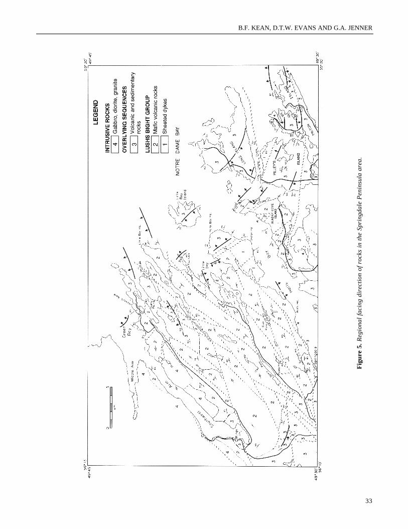
Furthermore, experiments and studies of ocean-floor basaltshave shown consistent relationships among the bulk chem-istry of the altered rocks and their secondary mineralogy,mineral abundances and mineral compositions, especiallyfor chlorite. The relationships have been interpreted in termsof the distribution of alteration with respect to time, temper-ature and most importantly seawater to rock ratios (Mottl,1983). Downwelling or recharge flow is diffused over alarge area, thus there is a low seawater to rock ratio, where-as upwelling or discharge flow is usually concentrated andfocused along faults, fractures and permeable zones result-ing in a high seawater to rock ratio. Basalts altered in thedescending limb of a convection system, i.e., at low to mod-erate seawater to rock ratios, would be characterized by anassemblage of chlorite—albite—epidote—actinolite—quartz at 300 C (Figure 6). This is the spilitic backgroundalteration assemblage present in most of the volcanic rocksof the Lushs Bight Group. The sheeted-dyke complexescontain more actinolite than the basalts; this probablyreflects a lower seawater to rock ratio due to their being lessporous and permeable. The epidote—albite—actinolite—(quartz) dominated alteration of the Lushs Bight Group isthus interpreted to result from seafloor alteration byrecharge flow at the time of formation. The areas within theLushs Bight Group characterized by chlorite—quartz-sul-phide assemblages are interpreted to represent areas of highseawater to rock ratios, i.e., upwelling flow.
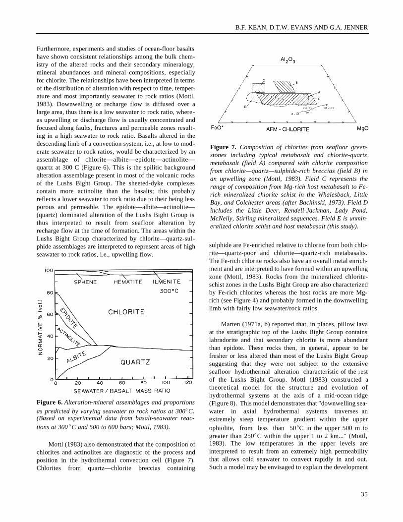
Mottl (1983) also demonstrated that the composition ofchlorites and actinolites are diagnostic of the process andposition in the hydrothermal convection cell (Figure 7).Chlorites from quartz—chlorite breccias containing
sulphide are Fe-enriched relative to chlorite from both chlo-rite—quartz-poor and chlorite—quartz-rich metabasalts.The Fe-rich chlorite rocks also have an overall metal enrich-ment and are interpreted to have formed within an upwellingzone (Mottl, 1983). Rocks from the mineralized chlorite-schist zones in the Lushs Bight Group are also characterizedby Fe-rich chlorites whereas the host rocks are more Mg-rich (see Figure 4) and probably formed in the downwellinglimb with fairly low seawater/rock ratios.
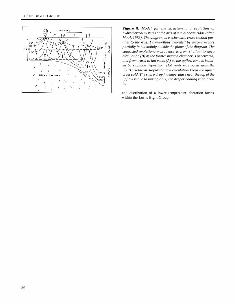
Marten (1971a, b) reported that, in places, pillow lavaat the stratigraphic top of the Lushs Bight Group containslabradorite and that secondary chlorite is more abundantthan epidote. These rocks then, in general, appear to befresher or less altered than most of the Lushs Bight Groupsuggesting that they were not subject to the extensiveseafloor hydrothermal alteration characteristic of the restof the Lushs Bight Group. Mottl (1983) constructed atheoretical model for the structure and evolution ofhydrothermal systems at the axis of a mid-ocean ridge(Figure 8). This model demonstrates that "downwelling sea-water in axial hydrothermal systems traverses anextremely steep temperature gradient within the upperophiolite, from less than 50EC in the upper 500 m togreater than 250EC within the upper 1 to 2 km..." (Mottl,1983). The low temperatures in the upper levels areinterpreted to result from an extremely high permeabilitythat allows cold seawater to convect rapidly in and out.Such a model may be envisaged to explain the development
35
Figure 6. Alteration-mineral assemblages and proportionsas predicted by varying seawater to rock ratios at 300EC.(Based on experimental data from basalt-seawater reac-tions at 300EC and 500 to 600 bars; Mottl, 1983).
Figure 7. Composition of chlorites from seafloor green-stones including typical metabasalt and chlorite-quartzmetabasalt (field A) compared with chlorite compositionfrom chlorite—quartz—sulphide-rich breccias (field B) inan upwelling zone (Mottl, 1983). Field C represents therange of composition from Mg-rich host metabasalt to Fe-rich mineralized chlorite schist in the Whalesback, LittleBay, and Colchester areas (after Bachinski, 1973). Field Dincludes the Little Deer, Rendell-Jackman, Lady Pond,McNeily, Stirling mineralized sequences. Field E is unmin-eralized chlorite schist and host metabasalt (this study).
LUSHS BIGHT GROUP
and distribution of a lower temperature alteration facieswithin the Lushs Bight Group.
36
Figure 8. Model for the structure and evolution ofhydrothermal systems at the axis of a mid-ocean ridge (afterMottl, 1983). The diagram is a schematic cross section par-allel to the axis. Downwelling indicated by arrows occurspartially in but mainly outside the plane of the diagram. Thesuggested evolutionary sequence is from shallow to deepcirculation (B) as the former magma chamber is penetrated,and from warm to hot vents (A) as the upflow zone is isolat-ed by sulphide deposition. Hot vents may occur near the300EC isotherm. Rapid shallow circulation keeps the uppercrust cold. The sharp drop in temperature near the top of theupflow is due to mixing only; the deeper cooling is adiabat-ic.