Embed Size (px)
Citation preview

Streamlining Survey Workflows Using GIS
John MackiewiczJustin Hansen

Geographic Information System Garden International School (Malaysia) Gas‐Insulated Switchgear Gastrointestinal SeriesGeeky Internal Stuff (databases) General Information ServicesGeneral Information Session General Investigative Section (Canada RCMP) Generalized Iterative Scaling Genome Institute of Singapore Gentran Integration Suite (Sterling Commerce) Geodata Interoperability Specification Geographic Imaging Solutions Geographic Information Services Geographic Information Solutions Geographical Imaging Software Geographical Information Services Geographical Information System Geographical Intelligent Survey Geographisches Informationssystem (German) Geophysical Information System Georeferenced Information System Geoscience Information Society Geospatial Information System
Geosynchronous Meteorological SatelliteGisborne, New Zealand (airport code) Global Inbound ServiceGlobal Indexing System Global Information Society Global Information Solutions Global Infrastructure Services Global Investment Systems Goddard Information SystemGoogle Image Search Government Information SystemGraphics Information System Greatness Is Simplicity Green Iguana Society Group Index and ScheduleGroup Information Session(s) Group Interference Suppression Groupe Interventional SpecialeGruppo d~ Intervento SpecialeGuaranteed Income Supplement Guidelines Implementation Staff Gunbound International Server
What is GIS?Don’t trust everything you hear. . .

Mainframe
Desktop
Mobile
Web BasedIntranet and Internet
The Future
Historic Perspective of GISChanges with computing platforms

• Capturing• Managing• Analyzing • Disseminating
GIS is a collection of computer hardware, software, and geographic data for . . .
all forms of geographically
referenced information

Visualization
Data Management
Spatial Analysis
Mobile
Data

Data
Data Model
Metadata
Workflows
Analysis/Models
Symbology
Tables andCharts

Cloud
Enterprise
Local
• Discover• Create• Manage• Visualize• Analyze• Collaborate
Web
Mobile
Desktop
GISA Complete System for Geographic
Information

. . . Adding Rich GIS Content and Analytic Services . . . In an Open and Interoperable Environment
Mashups
GIS is Evolving. . .WebEnabled With Search, Base Mapping, Standards………..and GIS Services
Web
Base Maps& Globes
GIS Content & Services
GIS
Search
GeoRSS
KML Content
+++
+
Mobile
ArcGIS Server

Mobile
Google Earth
MetadataISO 19139
OGC StandardsWMS, WFS,GML, . . .
KML
CAD
ImageIntegration
SOAP, XML, SQL
AutoCAD
BAE
MapInfo
GeoMedia
SAP
Ionic
GIS Server
Any Client
Open API’s
GIS Servers Supporting multiple read/write clients

Two Worlds Coming TogetherIntegration Using Standards
. . . Benefiting Everyone
GIS Clients
Consumers• Sharing • Accessing Authoritative Source• Seeing Up-to-date Data
Professionals• Sharing GIS Maps (stories)• Publishing Content for Wide Use• Analysis• Using Web for Collaboration
Web Clients
Base Map/Globes
Authoritative Source Professionals
GIS Content& Services
Search
Standards . . . KML
Positions
GeoRSS

Everything is Changing . . .(Right or Wrong)

Everything is Changing . . .(Right or Wrong)

Cost
Time / AccuracyTechnology is closing the gap

Types of Integrated Data• Weather• Monitors• Satellites• Aircraft• Gravity• Geophysical• Census• Demographic• Business• Infrastructure• Surveying• Real time Network
• Construction• Streams• Seismic• Tsunami• Lightning• RFID• Many more. . .
GIS Server
Geospatial Technology Convergence GIS is at the hub of integration

Data Integration Data integration requires accurate data

• Topological – how features relate to each other
• Attribute – non-graphical information about features
• Spatial – nearness to the true position
• Temporal – how current is it
• Relative – how accurate are things relative to each other
• Feature Identification – is it what we say it is
Types of Data AccuracyMeasures of data correctness
. . . .data maintained in a structured environment
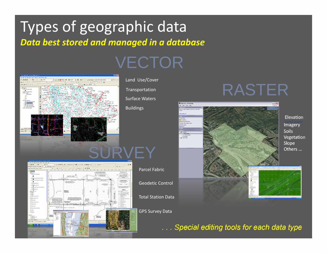
Buildings
Surface Waters
Transportation
Land Use/Cover
SoilsVegetationSlopeOthers …
Land coverImageryElevation
Parcel Fabric
Geodetic Control
Total Station Data
GPS Survey Data
. . . Special editing tools for each data type
VECTORRASTER
SURVEY
Types of geographic dataData best stored and managed in a database

RulesLocal streets and highways may not intersect
Components of geographic dataProperly structuring data powers new uses. . .
BEHAVIOR
ATTRIBUTES
GEOMETRY

Extracting value from geographic dataRequires modeling, management & georeferencing. . .
MAPS
INFORMATION
KNOWLEDGE
DATA
Maps Data Information Knowledge

Company AssetsMethodical processes for procurement
Considerations• Return On Investment (ROI)• Quality • Value• Liquidity• Cost• Reliability• Useful/Fit purpose• Maintenance Cost

• Accessibility• Relevance• Usability – Reusability• Durability• ROI• Know what is (and is not)
Data as an AssetTurning maps and data into information. . .
Contributes to better decisions…
Delivers competitive advantage…
Reduces duplicated efforts…

Internal Value of Data• Better decisions• More efficient work• Less duplicated effort• Accumulate
External Value of Data• New work• New markets• Deeper relationships• New Opportunities
Data as an AssetTurning maps and data into information. . .
. . . properly managed data adds value to your company . . .

GIS Data Connected to Survey NetworkGIS Data Incrementally Improves with Record Measurements

Parcel ManagementCity of Encinitas
Leveraging Survey Accuracy in GIS . . . . . Using GIS Tools for Survey Integration
The Next GenerationHigh accuracy GIS . . .

Connected, Integrated, Distributed. . . Author, Serve, Use
GIS Server
Author
Serve
Use
Position enabled
Standards based
GeoWeb 2.0

Special Thanks to Brent Jones, Esri
Questions?