Embed Size (px)
Citation preview

138
ABSTRACT
Wireline log and 3-D seismic data were integrated to define stratigraphic units and lithologic heterogeneity in theMannville Group of southeast Saskatchewan. The Mannville in this area is a stratigraphically complex unit formed of fluvial to marine deposits that, although non-prospective for hydrocarbons in this area, share many similarities with time-equivalent strata in areas of heavy oil production. Seismic sequence stratigraphic principles permitted us to subdivide the Mannville into three packages. The ability to visualize the 3-D seismic data in a variety of ways, includingarbitrary lines and stratal or horizon slicing techniques, helped us to define stratigraphic features that would affect fluidflow in hydrocarbon producing areas. These features include channels of various sizes and orientations, and channel elements such as scroll bars and lateral accretion surfaces, that are present within specific portions of the Group. Becausethe effectiveness of enhanced recovery methods such as steam-assisted gravity drainage depends on a development team’sability to recognize reservoir heterogeneity, similar integration of 3-D seismic, well logs and other data types would assistgreatly in developing the Mannville in heavy oil areas. There is close, but not one-to-one, correspondence between the stratigraphic units we defined and those established by regional log- and core-based correlations. Seismic resolutionproblems or log correlation styles could be responsible for the differences.
RÉSUMÉ
Des données de diagraphies différées et de sismiques en 3-D ont été intégrées pour définir les unités stratigraphiques etl’hétérogénéité lithologique présentes dans le Groupe de Mannville au sud-est de la Saskatchewan. Dans cette région, leMannville est une unité de stratigraphie complexe, formée de dépôts marins à fluviatiles qui, bien qu’ils n’y présentent pasde possibilités d’hydrocarbures, ont de nombreuses similitudes avec des strates de période équivalente dans des régions deproduction d’huile lourde. Des principes de séquences stratigraphiques en sismique nous ont permis de subdiviser leMannville en trois paquets. La capacité de visualiser les données sismiques en 3-D sous plusieurs angles, incluant les lignesarbitraires et les techniques de coupes stratales ou d’horizon nous ont aidés à définir les caractéristiques stratigraphiquesqui pourraient affecter le débit des fluides dans les zones de production d’hydrocarbures. Ces caractéristiques incluent descanaux de dimensions et d’orientations variables, et des éléments de canaux, tels que des bourrelets arqués et des surfacesd’accrétions latérales, qui sont présents à l’intérieur des portions spécifiques du Groupe. L’efficacité des méthodes derécupération assistée, tel que le drainage par gravité utilisant la vapeur, repose sur la faculté de l’équipe de développementà reconnaître l’hétérogénéité du réservoir. Ainsi, l’intégration de la sismique en 3-D similaire, avec les diagraphies etd’autres types de données pourraient aider grandement au développement du Mannville dans les zones d’huile lourde. Ilexiste une correspondance proche, mais non “une pour une”, entre les unités stratigraphiques que nous avons définies etcelles qui ont été établies à partir de corrélations régionales de diagraphies et de carottes. Les problèmes de résolutions sismiques ou les styles de corrélation avec les diagraphies peuvent être responsables des différences.
Traduction de Gabrielle Drivet
BULLETIN OF CANADIAN PETROLEUM GEOLOGYVOL. 54, NO. 2 (JUNE, 2006), P. 138-151
Stratigraphy and lithologic heterogeneity in the Mannville Group (southeast Saskatchewan) defined by integrating 3-D seismic and log data
SABRINA SARZALEJO
Department of Earth and Planetary SciencesMcGill University
Montreal, Quebec H3A [email protected]
BRUCE S. HART
Department of Earth and Planetary SciencesMcGill University
Montreal, Quebec H3A [email protected]

STRATIGRAPHY AND LITHOLOGY, MANNVILLE GROUP, SE SK 139
INTRODUCTION
The lower Cretaceous Mannville Group has been the focusof many previous studies because it is one of the most prolifichydrocarbon intervals within the Western CanadianSedimentary Basin. To date, geological studies of the MannvilleGroup in the province of Saskatchewan have been based on logsand core data. These studies (e.g., Christopher, 2003; Leckie etal., 1997) focused largely on depositional environments andstratigraphy at a regional scale. This paper will illustrate how 3-D seismic and well data may be integrated at a development-project scale to define stratigraphic units and depositional faciesin complex units such as the Mannville Group.
Seismic images derived from 3-D volumes have proven tobe very useful for imaging stratigraphic units and depositionalarchitecture (e.g., Brown, 1999; Posamentier, 2004). Despitethese successes elsewhere, we were unable to find previouspublications that specifically examined the stratigraphic archi-tecture of the Mannville Group using 3-D seismic data. In areaswhere enhanced recovery methods such as steam-assisted grav-ity drainage (SAG-D) or other methods are used, it is importantto be able to predict lithologic heterogeneity associated withdepositional features such as inclined heterolithic strata (IHS)and channel fills because these features potentially affect themovement of hydrocarbons and injected fluids. These featuresare best defined with the combined use of 3-D seismic andwell-log data and can be even better defined in heavy-oil devel-opment areas where the wells are closely spaced.
The study area is located in the southeastern region of theprovince of Saskatchewan, in Townships 6 to 7, Ranges 9 to10. The seismic and well data presented in this paper were col-lected to explore for and develop deeper targets — primarilyMississippian carbonates. The Mannville Group in the studyarea is wet, and is not considered to be a drilling target forhydrocarbon accumulations. Nevertheless, the seismic dataquality is very good at the Mannville level and the data allowus to image depositional features that are analogous to thosefound in heavy-oil producing areas. As a corollary objective,we established correlations between stratigraphic units definedthrough our integrated seismic/log interpretations and forma-tions identified by regional correlations (e.g., Christopher,2003).
GEOLOGICAL SETTING
The study area is in the northern part of the intra-cratonicWilliston Basin (Fig. 1). The interval of interest is the LowerCretaceous Mannville Group, which forms part of the LowerZuni Sequence that was deposited in the Western CanadianForeland Basin (Cant, 1989). Previous studies of theMannville Group divided it (from oldest to youngest) into theSuccess, Cantuar and Pense formations. Recent studies(Christopher, 2003) exclude the Success Formation (Jurassicto Neocomian) from the group and leave only the CretaceousAptian to Albian Cantuar and Pense formations as part of theMannville Group (Fig. 2).
Cant and Abrahamson (1996) interpreted the MannvilleGroup as a third-order sequence overlying a second-ordersequence boundary that represents a major reorganization ofthe foreland basin and the Cordillera. This Alberta-based inter-pretation divides the succession into transgressive and high-stand systems tracts with a maximum flooding surface placedat the base of the Clearwater shales (Fig. 2). The transgressiveportion in the Alberta region was defined as the LowerMannville, Dina and Cummings formations, with units abovethe Clearwater Formation being assigned to the highstand sys-tems tract.
The Williston Basin subsided during the Jurassic and thenduring Late Jurassic time the basin was filled and the areaexperienced regional uplift (Poulton et al., 1994). The S1Member of the Success Formation was deposited at this time.Neocomian tectonic uplift of the Swift Current Platform andSweetgrass Arch (Fig. 1) reversed the southerly topographicslope of the Jurassic Williston Basin, forming a major uncon-formity (Christopher, 1997). The S2 member of the SuccessFormation is separated from the S1 member by this regionalsub-Cretaceous unconformity (Fig. 2). The present patchy dis-tribution of the Success Formation is the result of later pre-Mannville erosion (Christopher, 2003).
The Williston Basin did not actively subside during theCretaceous, and Mannville deposition took place over top of aprofound unconformity that truncated Lower Cretaceous toPaleozoic strata (Hayes et al., 1994). During Aptian time, thesea invaded from the north and eventually covered the pre-Mannville topography. The Cantuar Formation, the lowest unitwithin the Mannville Group in this area, was deposited duringlate Aptian and early Albian time, and covers the underlyingtopography of pre-existing valleys and terraces (Christopher,2003). The Cantuar Formation, comprising six members insoutheast Saskatchewan (Fig. 2) with hiatuses and erosionaldiscontinuities, underwent several marine transgressions
Fig. 1. Location of the study area in southeastern Saskatchewan.The figure also shows the location of the main structural elements of theregion, including the approximate outline of the Williston Basin.

140 S. SARZALEJO and B.S. HART
Fig
. 2.
Cor
rela
tion
char
t of
the
Man
nvill
e G
roup
(m
odifi
ed f
rom
Chr
isto
pher
, 20
03).
Str
atig
raph
ic n
omen
clat
ure
for
sout
heas
t S
aska
tche
wan
is h
ighl
ight
ed b
y bo
x.

(Christopher, 2003). Uplift of the Punnichy Arch terminatedCantuar deposition and marine erosion removed poorly consol-idated sediments of the Cantuar in the early Albian. Marinedeposits of the Pense Formation were deposited above theCantuar Formation as the Pense seaway flooded acrossSaskatchewan during a period of sea-level rise during the middle Albian (Christopher, 1997).
DATABASE AND METHODOLOGY
The database for this project consists of a 3-D seismic surveycovering 56 square kilometres, digital well-logs for 47 wellsand paper logs for 16 additional wells (Fig. 3). The 3-D seismicsurvey has a bin size of 30 m by 30 m, a sample rate of 2 mil-liseconds, and a trace length of 3 seconds two-way time(TWT). The 30-fold seismic survey was acquired using a dyna-mite source in 1997. Seismic bandwidth ranges from 10 to85 Hz at the Mannville level with a peak frequency of approx-imately 50 Hz. The vertical resolution of the data (defined as 1/4
of the wavelength) is approximately 12 m, calculated usinglog-derived velocities of 2300 m/sec in the interval of interest.Gamma ray (GR) logs were available for some of the wells, butthe majority of the well correlations presented herein are basedon spontaneous potential (SP) and resistivity log signatures.
Synthetic seismograms, such as those shown in Figure 4,were generated for the 15 wells that had sonic logs. These wellties allowed stratigraphic units defined in the wells to be corre-lated to the seismic data, and seismically defined surfaces to beidentified in the wells. Well log cross-sections and correspon-ding seismic transects through the 3-D cube were interpretedthroughout the area to generate a stratigraphic framework.Time slices (i.e., planes of constant TWT), horizon slices(i.e., images showing amplitude variations along seismichorizons, also known as “amplitude maps”) and stratal slices(i.e., slices through the seismic cube that run parallel to over-lying or underlying seismic horizons, cf. Zeng et al., 1998,2000; stratal slices were termed “flattened time slices” byPosamentier, 2004) were extracted from the data volume tomap and observe the spatial geometry of features interpreted onvertical seismic transects and log cross-sections. The horizonsused to generate the stratal slices needed to be continuousthroughout the 3-D survey and to correspond to depositionalsurfaces that were originally nearly horizontal (i.e., floodingsurfaces can be appropriate choices, whereas unconformities orchannel bases are poor choices). Because they eliminate theeffects of regional dip (or other tectonic disturbance), stratalslices are preferred over simple timeslices for mapping strati-graphic features of interest.
Seismic stratigraphic and sequence stratigraphic principles,described by Mitchum et al. (1977), Vail et al. (1977),Posamentier et al. (1988), Bertram and Milton (1994) and oth-ers, were used to define key stratigraphic surfaces such asunconformities and flooding surfaces, and to establish thestratigraphic framework for the integration of seismic andwell-log data. As described below, some surfaces were defined
seismically as “candidate unconformities” based on truncatedand onlapping reflection terminations as shown in Figure 5a,whereas other stratigraphic surfaces were defined based on acombination of well-log and seismic information (Fig. 5b).Although the definition of “candidate unconformities” mightseem unusual, a true unconformity is associated with a signif-icant hiatus, something we cannot demonstrate with only logand seismic data. Flooding surfaces were identified withinmarine shale intervals based on the combination of highgamma ray (where present) and low resistivity log signatures.
No core data exist for the water-saturated Mannville Groupin the study area; consequently, and as illustrated below, weintegrated seismic geomorphology techniques (i.e., the study ofdepositional systems using 3D-seismic derived images;Posamentier, 2000) with seismic facies and wireline log shapesto infer lithology and depositional environments in this paper.Posamentier (2004) showed images of sedimentary featuresinterpreted as fluvial scroll bars and channels, which may beidentified by their morphology in timeslices and stratal slices.Other authors have also used this approach. For example,Brown (1999) presented examples of meandering channels,point bars and crevasse splays in slices through 3-D seismicvolumes.
INTERPRETATION
Christopher (2003) presented regional correlations of theMannville Group in Saskatchewan, and his correlations wereused in this study to identify the lithostratigraphic units presentin our study area. Figure 6 incorporates wells from cross-sections C–C′ and D–D′ of Christopher (2003) with wells from
STRATIGRAPHY AND LITHOLOGY, MANNVILLE GROUP, SE SK 141
Fig. 3. Base map showing outline of 3-D seismic survey and welllocations. Filled dots correspond to the wells used in the study. Locationof cross-section A–A′ is indicated in the map. Circled filled dots showthe wells in cross-section A–A′.

142 S. SARZALEJO and B.S. HART
Fig. 4. Examples of synthetic seismograms used to tie the well logs to the seismic data. Abbreviated formation names shown are: SSPK – Second White Speckled Shale, VKNG – Viking, MNVL – Mannville (corresponds to Surface IV in this study), UVNG – Upper Vanguard(corresponds to Surface II), LVNG – Lower Vanguard (Surface I), LGVB – Lower Gravelbourg, WTRS – Watrous.
Fig. 5. a) (upper image) Sample seismic transect showing the use of onlapping reflections to identify anunconformity. This unconformity corresponds to Surface IV (e.g., Fig. 8). b) (lower image) Example of thecombined use of logs and seismic data to define an unconformity. Reflection truncations correspond to thebase of a sharp-based sandbody. This surface (Surface II) corresponds to the sub-Cretaceous unconformitythat separates Jurassic rocks from overlying Cretaceous units of the Success Formation and MannvilleGroup. (e.g., Figs. 6–8).
our study area and intervening areas. The type log for the present study area (Fig. 7) shows the relationship between thelithostratigraphy of Christopher (2003) and the seismicallydefined surfaces picked in this study. As defined below, sevenmain surfaces, labeled I to VII, were defined in this study;each surface corresponds to a lithologic contact in logs. Thesechanges in lithology are associated with changes in rockphysical properties that generated the seismic reflectionsidentified in this study. Figure 8 shows a representative well-log cross-section and corresponding seismic transect acrossthe study area.
Surfaces I and VII underlie and overlie the MannvilleGroup, respectively. They were picked as stratigraphic mark-ers to “bracket” the Mannville and to generate stratal slices.Our synthetic seismograms show that Surface I corresponds tothe top of the Lower Vanguard (part of the Jurassic Systemshown in Fig. 2). This surface is located at the base of a shaleinterval (Fig. 7) and is a high-amplitude continuous reflectionseen in seismic transects (Fig. 8). Surface VII is a flooding sur-face in the Joli Fou Formation. In logs, this surface corre-sponds to high gamma ray log values (where this log isavailable) and a low-resistivity marker within this shale pack-age. Surfaces II and VI correspond to the base of theCretaceous section and top of the Mannville Group, respec-tively, according to our synthetic seismograms (Fig. 4) andcorrelations with the stratigraphic framework established by
Christopher (2003; Figs. 6, 7). Within the Mannville, the lowgamma ray (GR) or high spontaneous potential (SP) and low(lower than shale) resistivity values seen in the well-logs areinterpreted as water-saturated sands.
We identified three seismic packages within the MannvilleGroup that overlie a fourth Lower Cretaceous package. Thesepackages, labeled Units A to D, are shown in Figures 6 to 8 andtheir lithologic and stratigraphic character is described next.
UNIT A
Description
This unit is bounded by Surfaces II and III, and character-ized by a parallel to semi-parallel fill reflection pattern (Fig. 8).Surface II, the sub-Cretaceous unconformity (Figs. 2, 6–8)truncates underlying seismic reflections and does not corre-spond to a continuous seismic reflection. Seismic transects anda time-structure map (Fig. 9) show that Surface II cuts downtowards the east, defining the margin of an approximatelyNNE–SSW striking incision. The amount of incision is esti-mated to be up to 38 m from well log data. Logs through Unit Ashow that the incision is filled with sand and shale. Figures 8and 5b show the seismic and wireline log criteria, includingtruncation of underlying reflections and sharp-based sands inlogs, used to define Surface II as a candidate unconformity.Surface III is defined by the top of a discontinuous trough on
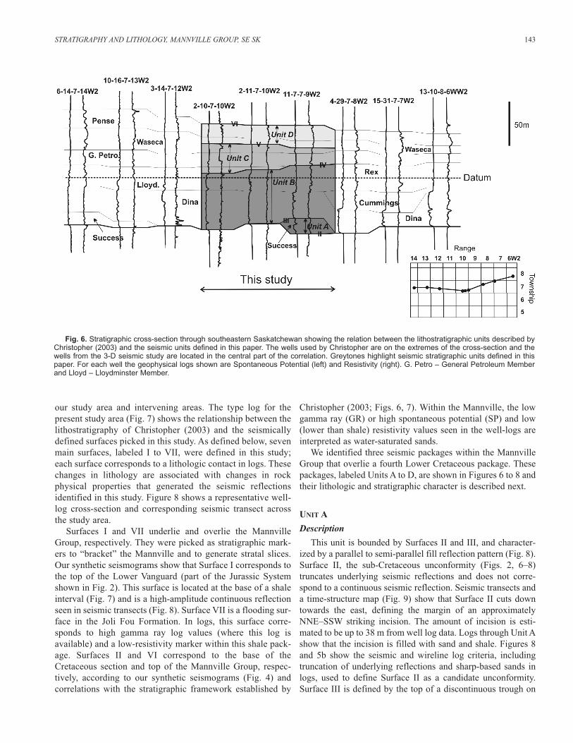
STRATIGRAPHY AND LITHOLOGY, MANNVILLE GROUP, SE SK 143
Fig. 6. Stratigraphic cross-section through southeastern Saskatchewan showing the relation between the lithostratigraphic units described byChristopher (2003) and the seismic units defined in this paper. The wells used by Christopher are on the extremes of the cross-section and thewells from the 3-D seismic study are located in the central part of the correlation. Greytones highlight seismic stratigraphic units defined in thispaper. For each well the geophysical logs shown are Spontaneous Potential (left) and Resistivity (right). G. Petro – General Petroleum Memberand Lloyd – Lloydminster Member.

the seismic data and by the well-log signature (see the base ofblocky sands in Figs. 7, 8). Surface III overlies Surface II in theincision, but the two surfaces merge outside of the incision tothe west.
Interpretation
Unit A, bounded by Surfaces II and III, is interpreted to bethe Success (S2) Formation. This formation has a patchy dis-tribution in the basin due to the unconformities that affected theregion (Christopher, 2003) and its presence within the incisionobserved in the study area seems reasonable. The incision at thebase of the unit (delineated by Surface II) is probably part ofthe Assiniboia drainage pattern that generated the pre-Mannville topography (Christopher, 1984) and our 3-D surveyappears to image part of the western margin of a larger incision.Surface III (Fig. 8) corresponds with the erosional surface thatcaps the Success S2 Member (Fig. 2), which has been observedin cores in southern Saskatchewan and was described byChristopher (1997) and Leckie et al. (1997).
UNIT B
Description
Unit B (Figs. 6–8) is bounded by Horizons III and IV, andshows a parallel fill in the western region and a more chaoticpattern in the central region of the study area. Logs indicate thatit ranges from 56 to 86 m thick and that the basal part of thesection is generally sandy. Well logs near the top of this pack-age show a heterolithic fill consisting of sands interbedded withshales and some intervals show bell-shaped log profiles. Thelithology changes laterally, in places over distances of hun-dreds of metres. A stratal slice in the middle of this unit(Fig. 10) shows amplitude lineaments that have variable widths(typically <300 m) and run in several directions. The linea-ments correspond to the stratigraphic level of the lithologicvariability seen in the logs.
Another stratal slice through the middle of Unit B shows aseries of arcuate features in the northeast part of the survey thatcorrespond to subtle north-dipping reflections in seismic tran-sects (Fig. 11). These features are traceable for approximately3 km in the stratal slice.
Interpretation
Unit B encompasses the Dina and Lloydminster members ofthe Cantuar Formation (the Cummings Member is generallyabsent in this area; Fig. 6) and part of the Rex Member. SurfaceIV falls within the Rex, as seen in Figures 6 and 7.
We interpret many of the features visible in the stratal slicesto be channels or channel elements. Posamentier (2004) showedchannels with morphologies similar to those seen in this unitthat he interpreted as Cretaceous fluvial systems in the WesternCanada Sedimentary Basin. Zeng et al. (1998, 2000), Hardageand Remington (1999) and Miall (2002) have also shown 3-Dseismic images of channel systems. The non-marine nature ofthe lower part of the Mannville Group has been established bothin Saskatchewan (Christopher, 1997; Leckie 1997; Smith, 1994)and Alberta (Cant and Abrahamson, 1996) and so the presenceof fluvial channels at this level is reasonable.
The arcuate features shown in Figure 11 are interpreted asscroll bars produced by point bar migration in a meanderingriver system. This interpretation is consistent with the dippingreflections seen in the seismic transect that are interpretable aslateral accretion surfaces. The curvature of the features seen inthe horizon slice together with the dip in the reflections in theseismic line, indicate point bar migration to the north. Well-logs that cut the feature (Fig. 11) show a bell-shaped log signa-ture (abrupt base and fining upward) 15 m thick (i.e., at orslightly above tuning thickness) that is typical of point bardeposits (Cant, 1992). The presence of point bar deposits (e.g., lateral accretion surfaces, scroll bars) in the upper part ofthe unit is consistent with the observations of Leckie et al.(1997) who noted that the upper portion of the Cantuar com-prises meander belt, floodplain and estuarine deposits in south-western Saskatchewan.
Seismic data show incision associated with Surface IV thatwould be consistent with it being an unconformity (Figs. 5, 8)
144 S. SARZALEJO and B.S. HART
Fig. 7. Type Log for the area showing (to the left of the logs) the relation with the lithostratigraphic units described by Christopher (2003)and (to the right of the logs) the surfaces and units defined in this study.

close to the top of the Rex Member. No unconformity has beenrecognized at this level on a regional basis (e.g., Christopher,2003), and so it appears that Surface IV corresponds to a localerosional surface of relatively minor stratigraphic significance.
UNIT C
Description
Unit C is between Surfaces IV and V, and shows a parallelfill pattern in some areas but in other areas (e.g., Fig. 12) it ischaracterized by an oblique-tangential reflection pattern. Astratal slice through Unit C (Fig. 12) displays several arcuate,semicircular features approximately 5 km long, at least 2.5 kmacross, and corresponds to an oblique-tangential reflection con-figuration on seismic transects that cross them. Figure 13shows a NW–SE to E–W oriented curvilinear amplitude anom-aly, approximately 400 m wide, that is present near the top ofthis unit in the southwestern part of the 3-D survey. The anom-aly is penetrated by a single well filled with sand at this inter-val. Elsewhere, this stratigraphic level is shaly.
Interpretation
Unit C encompasses the top of the Rex Member, the GeneralPetroleum Member and part of the Waseca Member (Figs. 6–8).Like the underlying Unit B, the seismic and well-log data for
this interval indicate a heterolithic fill dominated by channeldeposits of various types. The stratal slice and east-dippingreflections in the seismic transect (Fig. 12) suggest eastwardmigration of a point bar. Note that the log of the well in the westindicates that the base of this unit is sandy in the area of thescroll bars, whereas the well to the east shows the base of theunit to be shaly in that area. The feature shown in Figure 13 isinterpretable as a small channel. The channel has a positiverelief that is probably the result of differential compactionbetween a sandy fill and the shales around it.
Surface V corresponds to an unconformity close to the top ofthe Cantuar in our lithostratigraphic correlation (Fig. 6, 7).Although it does not correspond exactly with the Pense–Cantuarcontact, it is close and so Surface V could correspond to theunconformity of Christopher (2003) that locally eroded theentire Cantuar Formation. Wallace-Dudley et al. (1998) sug-gested that it is a ravinement surface or a sequence boundary.Toplap seen in Figure 12 supports the interpretation of this sur-face as an erosional unconformity.
UNIT D
Description
Unit D is between Surfaces V and VI, and displays a nearlyparallel fill in some areas, but also shows areas that are reflection
STRATIGRAPHY AND LITHOLOGY, MANNVILLE GROUP, SE SK 145
Fig. 8. Seismic transect and corresponding stratigraphic cross-section A-A′. The seismic and well log profiles show thekey surfaces interpreted in this study (labeled I to VII). Surfaces VII (a flooding surface in the Joli Fou) and I (a log markerseparating the Upper and Lower Vanguard units) are shown together with Surfaces II to VI and Units A–D. One-sided arrowshighlight reflection terminations typical of those used to define stratigraphic surfaces. Location of the A-A′ cross-section isshown in Figure 3. Surface I is the stratigraphic datum in both sections.

free (Mitchum, 1977). Unit D does not show significant ampli-tude trends in time slices or stratal slices, although a small,approximately N–S oriented, meandering channel is observednear the base of the unit (Fig. 14).
Interpretation
According to correlations presented here (Figs. 6–8), Unit Dcorresponds to the Pense and upper part of the Waseca forma-tions. The parallel to transparent fill and general lack of channelfeatures in seismic profiles through most of this interval is con-sistent with a shaly, shallow-marine depositional setting wherestratification is more continuous than in fluvial or estuarinedeposits. Wallace-Dudley et al. (1998) interpreted a maximumflooding surface in the lower part of the Pense Formation. Thechannel observed at the base of the unit must be below that sur-face and the overlying shallow-marine Pense deposits.
Surface VI corresponds to the top of the Mannville Group.According to Christopher (1997, 2003) there is a hiatus at thetop of the Mannville (Fig. 2) which corresponds to a regionalunconformity that can be observed over all the WesternCanadian Sedimentary Basin. However, Wallace-Dudley et al.
(1998) described the surface at the top of the Mannville (ourSurface VI) as a major flooding surface at the top of a regres-sive (highstand) systems tract. Our small 3-D seismic surveydoes not show evidence (e.g., erosional truncation, onlappingreflections) that would support either interpretation.
DISCUSSION
The data presented in this paper illustrate the value of 3-Dseismic data for pool-scale stratigraphic correlation and map-ping of depositional features, especially in heavy oil explora-tion and development areas where our results have mostrelevance. Although the Mannville is water saturated in ourstudy area, the seismic images and log profiles presented in thispaper show stratigraphic features similar to those interpretedfrom well logs and cores in heavy oil and oil sands areas (e.g., Van Hulten, 1984; Strobl et al., 1997). Additionally, thesize of the 3-D seismic survey studied in this paper is compa-rable to the size of SAG-D development projects. We frame theremainder of the discussion in terms of the utility (a) integrat-ing 3-D seismic data into stratigraphic studies, and (b) using 3-D seismic data for definition of stratigraphic features.
Leckie et al. (1995) stated that, in southern Saskatchewan,detailed stratigraphic correlations within the Mannville Groupbased on well-log control alone are imprecise and highly suspect.It is clear that, given the lateral facies variability seen withinchannelized deposits of the Cantuar Formation, detailed log-based correlations in the current study area would be ambiguousat best. The seismically defined stratigraphic packages showconsiderable internal lithologic heterogeneity and stratal slicesshow many stratigraphic features (e.g., channels) that are toonarrow and sinuous to be accurately mapped with logs.
There appears to be close, but not one-to-one, correspon-dence between the surfaces we defined, by integrating seismicand log data, and those defined through correlations with theregional stratigraphic framework of Christopher (2003).Possible reasons for these differences include the following:
a) Problems with log-based correlations – Similar to Leckieet al. (1995), our experience suggests that log-based correla-tions of the Mannville can be ambiguous in this area, especiallywhen they are based on different vintages and qualities of logs,and no corroborating core is present. Different correlationsfrom those presented in Figure 6 are possible using availablewell control and log quality, but we have attempted to followthe correlation style of Christopher (2003). If our log picks canbe changed, the stratigraphic units shown in that figure becomeless tabular (perhaps more realistic for fluvial/estuarine sys-tems?) and all of our surfaces can be tied to those ofChristopher (2003). Arguably, the stratigraphic geometries seenin the 3-D seismic data should influence correlation styles out-side of the seismic survey area.
b) Seismic resolution problems – Regardless of correlationstyles, it is clear that at least one of our units, defined by inte-grating 3-D seismic and log data, corresponds to more than onelithostratigraphically defined unit of the Mannville Group in
146 S. SARZALEJO and B.S. HART
Fig. 9. Time-structure map (top) and perspective view (below) ofSurface II, showing what may be the western margin of a valley of theAssiniboia drainage network. Map contours in seconds, two-way travel-time (TWT). Coordinates are UTM (Zone 13).

STRATIGRAPHY AND LITHOLOGY, MANNVILLE GROUP, SE SK 147
Fig. 11. Seismic images of a point bar. A) Uninterpreted (left) and interpreted (right) north-south seismic profile E–E′ shows a series of shin-gled troughs (yellow oval) that dip subtly to the right. Interpreted view highlights dipping reflections that represent lateral accretion surfaces.B) Same view as in A but with Gamma Ray log overlay. Note the fining-upward signature of the logs (arrows) in this interval. C) In a stratal slice,the lateral accretion surfaces correspond to arcuate amplitude trends that are similar in scale and shape to modern scroll bars. D) Example ofmodern scroll bars on the floodplain between the Apure and Apurito rivers in Venezuela; the distance between the asterisks is 3 km (Photo cour-tesy of R.H. Meade, USGS). Level of the stratal slice is indicated by the dashed line in the seismic profiles.
Fig. 10. Seismic lines C–C′ and D–D′ show the chaotic and semi-parallel fill reflections of Unit B as well as the location of the stratal slice (dotted line) through sand and shales of Unit B. Note the lateral variability in the log signature in Unit B, testifying to lateral lithologic heterogeneityin this interval. The stratal slice corresponds to a slice through the data 81 ms below Surface VII, and shows crossing and curvilinear amplitudetrends that are interpreted as fluvial channels that run in various directions through the area.

this area (i.e., Unit C corresponds to several members of theCantuar Formation). It is possible that the relative thinness ofthe members and low acoustic-impedance contrasts betweenthe deposits of some members combine to make the unitsunmappable using seismic data.
We argue that integration of 3-D seismic and log dataallows the identification and stratigraphic mapping of bound-ing surfaces in the Mannville with much more confidence thanis possible using either data type alone. Seismic surfaces andreflection configurations impose constraints and suggest logcorrelation options. We note that, because of its small size, the3-D survey used in this study may not show all the diagnosticreflection terminations that are useful for seismic-basedsequence stratigraphy (e.g., Mitchum et al., 1977; Emery andMyers, 1996). This will be a problem for other stratigraphicstudies that use similar-sized 3-D seismic surveys. Regionallog correlations help to determine whether erosion surfacesobserved in these data represent local incision or stratigraphi-cally significant surfaces (unconformities). Whatever their ori-gin, and because any of these surfaces can juxtaposedepositional facies associated with differing porosity and per-meability, their recognition would be relevant as they could beassociated with flow-unit boundaries in producing areas (e.g., Reynolds, 1996). The addition of core control wouldprovide further insights by aiding in the interpretation of depo-sitional facies (e.g., distinction between estuarine and fluvialchannels), providing (possibly) biostratigraphic control, and
with recognition of key stratigraphic surfaces. Unfortunatelyno core exists from the Mannville Group in the study area.
The other benefit of 3-D seismic data is the possibility ofusing seismic geomorphology and well logs to define and mapstratigraphic features that can act as lateral barriers, baffles orconduits for fluid flow. 3-D interpretation technology allows theuser to pick the orientation of seismic profiles that best imagesthe stratigraphic features of interest. For example, lateral accre-tion surfaces are best imaged in seismic profiles that are per-pendicular to them, and can be missed on profiles that haveother orientations. Stratal slices showing scroll bars can be usedto determine the optimum orientation for examining verticaltransects. The lateral accretion surfaces illustrated in this paperhave multiple orientations and are subtle in vertical transectsthrough the 3-D cube. However, their presence is supported bystratal slices showing scroll bars, and by the characteristic bell-shaped log signatures typical of point bar deposits. If a grid of2-D seismic lines is available from an area that has multiple ori-entations of point bars, it is highly probable that not all of thelateral accretion surfaces would be oriented perpendicular to theseismic lines, making their identification more difficult. Theability to extract time slices and stratal slices through 3-D volumes allows the interpreter to identify channels and morpho-logic features associated with channels, of various dimensions,that would probably be missed using logs or 2-D seismic data.These stratigraphic features are likely to have an impact on fluidflow (steam, hydrocarbons, etc.) in the subsurface.
148 S. SARZALEJO and B.S. HART
Fig. 12. Seismic profile F–F′ shows the oblique-tangential reflection configuration of Unit C and the location of a stratalslice that cuts across the features at its base. The stratal slice (53 ms below Surface VII) displays arcuate figures in the west-ern part of the survey that are interpreted to be scroll bars (e.g., Fig. 11) of a meandering channel system. The upper arrowhighlights possible toplap below Surface V. Unit C is located between Surfaces V and IV.

STRATIGRAPHY AND LITHOLOGY, MANNVILLE GROUP, SE SK 149
Fig
. 13
.S
eque
ntia
l sei
smic
tra
nsec
ts c
ross
ing
a po
sitiv
e-re
lief,
arcu
ate
chan
nel i
n U
nit
C.
Cha
nnel
loca
tion
is c
ircle
d in
all
tran
sect
s. O
ne w
ell (
show
n in
tra
nsec
t c–
c′)
pene
trat
esth
e ch
anne
l an
d sh
ows
the
chan
nel
to b
e sa
ndy
at t
hat
loca
tion.
Els
ewhe
re,
the
equi
vale
nt s
trat
igra
phic
lev
el i
s sh
aly
(e.g
., lo
gs i
n tr
anse
cts
b–b′
and
d–d′
). T
he p
ositi
ve r
elie
f is
, th
eref
ore,
tho
ught
to
be a
ssoc
iate
d w
ith d
iffer
entia
l com
pact
ion
betw
een
the
sand
-fill
ed c
hann
el a
nd t
he s
urro
undi
ng s
hale
s. T
he
stra
tal s
lice
loca
tion
is s
how
n w
ith a
das
hed
line
inth
e se
ism
ic p
rofil
es.
Uni
t C
is lo
cate
d be
twee
n S
urfa
ces
V a
nd I
V.

CONCLUSIONS
The integration of 3-D seismic data and well-log dataproved to be an excellent tool to display and interpret the com-plex stratigraphy of the Mannville group in southeasternSaskatchewan. Four candidate unconformities and one flood-ing surface were recognized and mapped for the MannvilleGroup and adjacent stratigraphic units. Definition of these sur-faces allowed us to divide the Mannville into three stratigraphicunits, with the S2 Member of the Success Formation forming afourth unit. Each unit displays different types of seismic faciesthat include parallel, semi-parallel, oblique-tangential, chaoticand reflection-free reflection patterns. Seismic facies from thevertical displays (traces and arbitrary lines) were combinedwith seismic geomorphology analysis of features seen in thehorizontal slices (time slices and stratal slices) and log facies tointerpret depositional features. Dimensions and aerial distribu-tion of these features were obtained from the integrated dataset.For example, meandering channels in the Mannville are inter-preted to vary in width between 100 and 600 m, and can be upto 30 m thick. Three kilometres of point bar migration, whichgenerates stratigraphic features that can strongly affect hydro-carbon movement, were recognized in the northeast corner ofthe study area. A maze of channels that run in several directionsthrough the study area, and characterize the middle strata of theMannville Group, was interpreted from seismic time slices andwell logs.
The channels, point bars, unconformities and other strati-graphic features identified in this study can affect the distribu-tion and movement of fluids in the subsurface. Detecting andmapping similar features is especially important in heavy oilareas where enhanced recovery techniques are employed tostimulate production from the Mannville. It is important to notethat integration of 3-D seismic and log datasets with core andproduction information would make the resultant reservoir
models even more robust; unfortunately, such integration wasnot possible in this study.
Although the primary goal of this study was to focus onreservoir-scale definition of stratigraphic features, our resultshave significance for the stratigraphy of the Mannville Groupin this area. The surfaces and units we defined using our inte-grated dataset do not correspond exactly to those definedthrough regional mapping. Although it is possible that seis-mic-resolution problems prevent us from identifying and map-ping existing stratigraphic units, it is also possible that thestratigraphic framework of the Mannville in this area needs tobe revisited.
ACKNOWLEDGMENTS
The seismic and well-log data used in this study were madeavailable by NAL Resources Ltd. Seismic and log interpreta-tions were undertaken using software donated by LandmarkGraphics Corporation. Funding for this work was partially pro-vided by an NSERC Discovery Grant to B. Hart. We thank allof these organizations for their continued support of ourresearch.
Reviewers B. Hayes, D. Uffen and Bulletin Editor GlenStockmal are thanked for their detailed and constructivereviews which helped improve the quality of this manuscript.
REFERENCES
Bertram, G.T. and Milton, N.J. 1994. Seismic stratigraphy. In: SequenceStratigraphy. D. Emery and K.J. Meyers (eds.). Blackwell, p. 45-60.
Brown, A. R., 1999. Interpretation of three-dimensional seismic data.American Association of Petroleum Geologists, Memoir 42, 514p.
Cant, D.J. 1989. Zuni Sequence: The Foreland Basin, Lower Zuni Sequence:Middle Jurassic to Middle Cretaceous. In: Western Canada SedimentaryBasin. B.D. Ricketts (ed.). Canadian Society of Petroleum Geologists,p. 251-267.
150 S. SARZALEJO and B.S. HART
Fig. 14. Stratal slice 5 ms above Surface V showing a curvilinear feature interpreted to be a channelaround 140 m wide at the eastern region of the seismic survey. The stratigraphic location of the stratal sliceand the feature are displayed in the seismic profile G–G′.

Cant, D.J. 1992. Subsurface Facies Analysis. In: Facies Model response to SeaLevel Change. R.G. Walker and N.P. James (eds.). Geological Associationof Canada, p. 27-45.
Cant, D.J. and Abrahamson, B. 1996. Regional distribution and internal stratig-raphy of the Lower Mannville. Bulletin of Canadian Petroleum Geology, v. 44, p. 508-529.
Christopher, J.E. 1984. The Lower Cretaceous Mannville Group, northernWilliston Basin region, Canada. In: The Mesozoic of middle NorthAmerica. D.F. Slott and D.J. Glass (eds.). Canadian Society of PetroleumGeologists Memoir 9, p. 109-126.
Christopher, J.E. 1997. Evolution of the Lower Cretaceous MannvilleSedimentary Basin in Saskatchewan. In: Petroleum geology of theCretaceous Mannville Group, Western Canada. S G. Pemberton and D.P.James (eds.). Canadian Society of Petroleum Geologists, Memoir 18,p. 191-210.
Christopher, J.E. 2003. Jura-Cretaceous Success Formation and LowerCretaceous Mannville Group of Saskatchewan. Report 223, SaskatchewanIndustry and Resources Saskatchewan Geological Survey. p. 128.
Emery, D. and Myers, K.J. 1996. Sequence Stratigraphy. Blackwell, p. 297Hardage, B. A. and Remington, R. L. 1999. 3-D seismic stratal-surface con-
cepts applied to the interpretation of a fluvial channel system deposited ina high-accommodation environment. Geophysics, v. 64, p. 609-620.
Hayes, B J. R., Christopher, J.E., Rosenthal, L., Los, G., Mckercher, B.,Minken, D.F., Tremblay, Y.M., Fennell, J. W. and Smith, D.G. 1994.Cretaceous Mannville Group of the Western Canada Sedimentary Basin. In:Geological atlas of the Western Canada Sedimentary Basin. G. Mossop andI. Shetsen (eds.). Canadian Society of Petroleum Geologists and AlbertaResearch Council, p. 317-334.
Leckie, D. A., Vanbeselaere, N. and James, D. P. 1995. Use of SequenceBounding Surfaces for Correlation and Mapping in Nonmarine, Incised-Valley Reservoirs. American Association of Petroleum Geologists Bulletin,v. 79, p. 1728-1729.
Leckie, D. A., Vanbeselaere, N. and James, D. P. 1997. Regional sedimentol-ogy, sequence stratigraphy and petroleum geology of the Mannville Group,southwestern Saskatchewan. In: Petroleum geology of the CretaceousMannville Group, Western Canada. S G. Pemberton and D.P. James (eds.).Canadian Society of Petroleum Geologists, Memoir 18, p. 211-262.
Miall, A.D. 2002. Architecture and sequence stratigraphy of Pleistocene fluvialsystems in the Malay Basin, based on seismic time slice analysis. AmericanAssociation of Petroleum Geologists Bulletin, v. 86, p. 1201-1215.
Mitchum, R.M, Vail, P.R. and Thompson, S. 1977. Seismic stratigraphy andglobal changes of sea level; Part 2, The depositional sequence as a basicunit for stratigraphic analysis. In: Seismic stratigraphy; applications tohydrocarbon exploration. C. E. Payton (ed.). American Association ofPetroleum Geologists, Memoir 26, p. 53-62.
Posamentier, H. W. 2000. Seismic stratigraphy into the next millennium: afocus on 3D seismic data. American Association of Petroleum GeologistsAnnual Conference, New Orleans, Louisiana, Program and Abstracts CD.
Posamentier, H.W. 2004. Seismic geomorphology: imaging elements of depo-sitional systems from shelf to deep basin using 3D seismic data: implica-tions for exploration and development. In: 3D Seismic Technology:Application to the Exploration of Sedimentary Basins. R.J. Davies, J.A.
Cartwright, S.A. Stewart, M. Lappin and J.R. Underhill (eds.) GeologicalSociety, Memoir 29, p. 11-24.
Posamentier, H.W., Jervey, M.T. and Vail, P.R. 1988. Eustatic controls on clas-tic deposition. I. Conceptual framework. In: C.K. Wilgus, B.S. Hastings,C.G.St.C. Kendall, H.W. Posamentier, C.A. Ross and J.C. Van Wagoner(eds.). Sea Level Changes –– An Integrated Approach, vol. 42. Society forSedimentary Geology, Special Publication, p. 109-124.
Poulton, T.P, Christopher, J.E., Hayes, B.J.R., Losert, L. Tittemore, J.,Gilchrist, R., Bezy, S., R. and McCabe, H. R. 1994. Jurassic and lowermostCretaceous strata of the Western Canada sedimentary basin. In: Geologicalatlas of the Western Canada sedimentary basin, G. Mossop and I. Shetsen(eds.). Canadian Society of Petroleum Geologists and Alberta ResearchCouncil, p. 297-316.
Reynolds, A.D. 1996. Paralic successions. In: Sequence Stratigraphy, D. Emeryand K.J. Myers (eds.). Blackwell, p. 134-177.
Smith D.G. 1994. Paleogeographic evolution of the Western CanadianForeland Basin. In: Geological atlas of the Western Canada sedimentarybasin. G. Mossop and I. Shetsen (eds.). Canadian Society of PetroleumGeologists and Alberta Research Council, p. 297-316.
Strobl, R.S., Wightman D.M., Walid, K.M., Darrell K.C. and LiPing Y. 1997.Application of Outcrop Analogues and detailed reservoir characterizationto the AOSTRA underground test facilities, McMurray Formation, NorthEastern Alberta. In: Petroleum geology of the Cretaceous Mannville Group,Western Canada. S G. Pemberton and D.P. James (eds.). Canadian Societyof Petroleum Geologists, Memoir 18, p. 375-391.
Vail, P.R., Mitchum, R.M., Todd, R.G., Widmier, J.M., Thompson, S., Sangree,J.B., Bubb, J.N. and Hatlelid, W.G. 1977. Seismic Stratigraphy and GlobalChanges of Sea Level. In: Seismic Stratigraphy-applications to hydrocar-bon exploration. C. E. Payton (ed.). American Association of PetroleumGeologists, Memoir 26, p. 49-212.
Wallace-Dudley, K.E., Leckie, D.A, Vanbeselaere, N. A. and James, D. P. 1998.Regional geology, sedimentary and sequence stratigraphic framework ofthe Albian Pense Formation, southwestern Saskatchewan. Bulletin ofCanadian Petroleum Geology, v. 46, p. 599-632.
Van Hulten, F.F.N. 1984. Petroleum geology of Pikes Peak heavy oil field,Waseca Formation, Lower Cretaceous, Saskatchewan. In: The Mesozoic ofmiddle North America. D. F. Stott and D. J. Glass (eds.). Canadian Societyof Petroleum Geologists, Memoir 9, p. 441-454.
Zeng H., Backus, M.M., Barrow, K.T. and Tyler, N. 1998. Stratal slicing, partI: realistic 3-D seismic model. Geophysics, v. 63, p. 502-513.
Zeng H., Tucker F. H. and Wood, L.J. 2000. Three-D Seismic Facies Imagingby Stratal Slicing of Miocene-Pliocene Sediments in Vermilion Block 50 -Tiger Shoal Area, Offshore Louisiana. American Association of PetroleumGeologists Annual Meeting, New Orleans, Louisiana, Program andAbstracts CD.
Manuscript received: May 10, 2005
Manuscript accepted: March 31, 2006
Associate editor: Brad Hayes
STRATIGRAPHY AND LITHOLOGY, MANNVILLE GROUP, SE SK 151