Embed Size (px)
Citation preview

Stowey Sutton Parish Council
Placemaking Plan
Parish Character Assessment
November 2013

Stowey Sutton Parish Council
i
Contents
Table of Figures ......................................................................................................................... iii
Table of Maps............................................................................................................................. v
Introduction ............................................................................................................................... 1
Community volunteers .............................................................................................................. 1
Summary .................................................................................................................................... 3
Woodcroft Estate ....................................................................................................................... 5
Church Lane ............................................................................................................................. 13
Sutton Hill Rd & Top Sutton ..................................................................................................... 19
Bonhill Lane & Bonhill Road ..................................................................................................... 27
Cappards Estate ....................................................................................................................... 33
Ham Lane & Stitchings Shord Lane .......................................................................................... 39
The Street, Wick Road, A368 ................................................................................................... 47
Hillside, Parkfield & High Mead Gardens ................................................................................. 55
Sutton Park ............................................................................................................................... 61
Stowey & Stowey Bottom ........................................................................................................ 67
Parish Rural Areas .................................................................................................................... 75


Stowey Sutton Parish Council
iii
Table of Figures
Picture 1 Community volunteers at Character Assessment launch meeting ............................ 1
Picture 2 Rendered finish, double roman roof tiles ................................................................ 10
Picture 3 Rendered finish, double roman roof tiles ................................................................ 10
Picture 4 Large gardens, good spacing between houses ......................................................... 10
Picture 5 Pedestrian paths ....................................................................................................... 11
Picture 6 Wide verges, tree planting for green aspect ............................................................ 11
Picture 7 View from Burledge, showing extensive tree planting throughout the development
.................................................................................................................................................. 11
Picture 8 Large front & rear gardens, well set back from the road ......................................... 18
Picture 9 Rendered finish, roman roof tiles ............................................................................. 18
Picture 10 Wide grass verges, houses set back & screened from road ................................... 18
Picture 11 Larger properties, set back from the road, well screened by walls & hedges ....... 24
Picture 12 Older properties, in local stone, well screened by trees & walls ........................... 24
Picture 13 Wide clear lane, grass verge, extensive planting to screen properties ................. 24
Picture 14 Flooding on Sutton Hill Rd November 2012 ........................................................... 25
Picture 15 Older terraced properties ....................................................................................... 25
Picture 16 Sutton Hill Rd & Top Sutton survey team ............................................................... 25
Picture 17 Bonhill Rd from A368, showing wide verges & extensive green outlook, rendered
buildings with clay roman roof tiles ......................................................................................... 32
Picture 18 Older terraced cottages showing use of local stone & clay roman roof tiles ........ 32
Picture 19 Detached property, limited room for screening to be planted.............................. 38
Picture 20 Modern terraced private property, off plot parking provided .............................. 38
Picture 21 Housing association terraced property, parking & fence design gives much less
open feeling than other areas ................................................................................................. 38
Picture 22 Ham Ln Large detached property, well set back with trees planted for screening44
Picture 23 Ham Ln modern detached property, local stone finish with trees planted for
screening .................................................................................................................................. 44
Picture 24 Terraced properties Stitching Shord Ln, set back & screened from road by
planting .................................................................................................................................... 44
Picture 25 Flooding Ham Lane November 2012 ...................................................................... 45

Stowey Sutton Parish Council
iv
Picture 26 Flooding Stitchingshord Ln November 2012 .......................................................... 45
Picture 27 Overflowing storm drain in Ham Ln after moderate rain October 2013 ............... 45
Picture 28 Bungalows on Wick Rd, set back, space for planted screening, wide grass verge 52
Picture 29 Older terraced properties on Wick Rd, front & rear gardens, allowing screening 52
Picture 30 Older property Wick Rd, set back from road, large, well screened front & rear
gardens ..................................................................................................................................... 52
Picture 31 Bishop Sutton Primary School ................................................................................ 53
Picture 32 Brents Garage on Wick Rd ...................................................................................... 53
Picture 33 Village Hall on Wick Rd ........................................................................................... 53
Picture 34 Hillside Gdns, showing wide pavement, large front gardens & space for planting
trees & shrubs for screening .................................................................................................... 60
Picture 35 Parkfield Gdns, showing open aspect & extensive planting to create a green
outlook ..................................................................................................................................... 60
Picture 36 Highmead Gdns, wide pavements & front gardens allowing extensive planting for
screenoing & natural aspect .................................................................................................... 60
Picture 37 Entrance to Sutton Park, with wide pavement, grass verges & extensive tree
planting .................................................................................................................................... 66
Picture 38 Detached larger properties in Sutton Park ............................................................. 66
Picture 39 Wide roadway & pavement, showing extensive street treescape ........................ 66
Picture 40 Stowey showing older terraced cottages, built in local stone, with clay roman roof
tiles & survey team .................................................................................................................. 73
Picture 41 Stowey, highlighting large pavements & gardens which permit extensive planting
for screening, with survey team .............................................................................................. 73
Picture 42 The Street, Stowey, illustrating pavements, high grassed banks & hedges........... 73
Picture 43Views of Barelegs Brake Valley ................................................................................ 82
Picture 44 Views looking west past Castle Wood .................................................................... 82
Picture 45 Views between Castle Wood & Broadwood .......................................................... 82
Picture 46 Burledge track way ................................................................................................. 83
Picture 47 Views of Bishop Sutton from Knowle Hill (picture by R Ward, Wikimedia
Commons Licence) ................................................................................................................... 83

Stowey Sutton Parish Council
v
Table of Maps
Map 1 Woodcroft Estate ............................................................................................................ 5
Map 2 Church Lane .................................................................................................................. 13
Map 3 Sutton Hill Road & Top Sutton ...................................................................................... 19
Map 4 Bonhill Road & Bonhill Lane ......................................................................................... 27
Map 5 Cappards Estate ............................................................................................................ 33
Map 6 Ham Lane & Stitchings Shord Lane ............................................................................... 39
Map 7 The Street, Wick Road & A368 ..................................................................................... 47
Map 8 Parkfield Gardens, Hillside Gardens & Highfield Gardens ............................................ 55
Map 9 Sutton Park ................................................................................................................... 61
Map 10 Stowey & Stowey Bottom ........................................................................................... 67
Map 11 Stowey Sutton Parish boundary illustrating rural areas ............................................. 75

Stowey Sutton Parish Council
1
Introduction
During November 2013 Stowey Sutton Parish Council worked with a number of community
volunteers to survey the character of the parish, identifying a number of distinct areas
within the parish with different characteristics, either open rural landscapes or sections of
the built environment with common characteristics.
The eleven areas identified are:
Woodcroft Estate
Church Lane
Sutton Hill & Top Sutton
Bonhill Lane & Bonhill Road
Cappards Estate
Ham Lane & Stitchings Shord Lane
The Street, Wick Road, A368
Hillside, Parkfield & High Mead
Gardens
Sutton Park
Stowey
The Rural areas outside the
current housing development boundary
The Project was moderated for the Parish Council by Chairman Keith Betton and Cllr
Heather Clewett. The Character assessment was reviewed and approved by full Parish
Council on 4th December 2013.
Community volunteers
Emma Robinson Wendy Sims Katie Sengupta
Pat Smith Wendy Bird Carrie Edwards
Ruth Glasspool Kate Alvis Kathryn Miller
Nikki Flemming Nicky Wake Tanya Southgate
Lucy Pover Katherine Scholtz Vanessa Watson
Deborah Heath Sally Monkhouse Sarah Jane Streatfield James
Sue Heathman
Picture 1 Community volunteers at Character Assessment launch meeting


Stowey Sutton Parish Council
3
Summary
The parish of Stowey Sutton, which includes the village of Bishop Sutton and hamlet of
Stowey, nestles into the Chew Valley, partially washed over by the green belt and The Forest
of Avon, with much of the rural part of the parish included in the Mendip Hills AONB, the
Chew Valley Lake and Burledge Sites of Special Scientific Interest
The settlements have developed slowly over a long period, with properties ranging from old
agricultural and mining cottages to modern estate developments.
The two settlements predominantly comprise of well-maintained older properties which,
regardless of size, are well spaced, with both front and rear gardens, generally good access
roads and minimal on road parking.
The settlements have maintained a good green infrastructure, with views of mature trees
visible from almost every vantage point, with the exception of one recent development,
where properties are at a much higher density, with less adequate access roads and off
street parking and very limited planting of trees to maintain the village’s character.
It is important to ensure that future development is more appropriately representative of
the overall character of the village of Bishop Sutton. This might be achievable through
encouraging the application of the Forest of Avon Garden Forest design principles, as they
closely match the existing built environment of these settlements.


Stowey Sutton Parish Council
5
Woodcroft Estate
Map 1 Woodcroft Estate


Stowey Sutton Parish Council
7
Character Area: Woodcroft Estate
Surveyor(s): Keith Betton and Heather Clewett
Date: 4th November 2013
Weather: Sunny and dry
1. Pattern
A. Topography
Flat.
B. Layout
An E-shaped small housing estate comprised of semi-detached houses and sheltered
accommodation bungalows built by the local authority but now mostly in private ownership.
Also included are the same style semi-detached houses opposite this estate along the main
A368 on north side. All houses have large front and rear gardens (min 20 feet max 70 feet
approximately). All houses have a minimum gap of 12 feet between.
The sheltered housing bungalows are terraced with a surrounding pathway. They have
south facing small garden areas.
There is a tarmac car parking area to the east side of the bungalows along with bus stop and
shelter area. Bungalows and housing which face the main road are all set back.
C. Spaces
The area has a sense of space with pavements and roads which are clear from parked
vehicles. It is an in/out estate without a through road.
D. Green & Natural Features
Gardens have privet hedging or picket fencing with shrubs and plants in gardens. Some
gardens have apple and fruit trees, together with other mature trees.
E. Wildlife & Ecology
No evidence.

Stowey Sutton Parish Council
8
F. Roads, Streets & Other Movement Routes
There are pavements on both sides of the roads on the main estate. A pavement runs in
front of the houses on the main road, this is set back from the road.
All houses on the E estate have space to park a minimum of 2 cars, either to the side or at
the rear. Many have erected garages. Some houses on the main road have limited off road
parking and no garaging.
G. Landmarks
None identified.
H. Views Out
Views from the south facing gardens towards the rural green hills.
I. Views In
From the hills and footpaths along Burledge.
2. Buildings & Details
A. Predominant Building Shape & Height
Semi-detached housing and terraced sheltered accommodation bungalows of one storey.
B. Roofs
Pitched roof with tiles of a double roman design.
C. Predominant Materials
Early semi-detached houses are of large size Bath Style constituted stone brick. Later built
houses are of brick and rendered finish. All are of a similar design and size with three
bedrooms upstairs and kitchen/living area on the ground floor.
D. Details
The houses are of a similar design, spaced and in good order.

Stowey Sutton Parish Council
9
3. Summary
A. In a few words or a sentence or two, what are for your group the key POSITIVE features
about this area? What makes it special?
Semi-detached houses with space, greenery, gardens, off road parking, pavements – all laid
out well with a sense of space.
B. In a few words or a sentence or two, what are for your group the key NEGATIVE
features about this area? What detracts from it?
None identified.

Stowey Sutton Parish Council
10
4. Photos
Picture 2 Rendered finish, double roman roof tiles
Picture 3 Rendered finish, double roman roof tiles
Picture 4 Large gardens, good spacing between houses

Stowey Sutton Parish Council
11
Picture 5 Pedestrian paths
Picture 6 Wide verges, tree planting for green aspect
Picture 7 View from Burledge, showing extensive tree planting throughout the development


Stowey Sutton Parish Council
13
Church Lane
Map 2 Church Lane


Stowey Sutton Parish Council
15
Character Area: Church Lane
Surveyor(s): Sarah Jane Streatfield James, Sue Heathman
Date: 21st November 2013
Weather: Overcast
1. Pattern
A. Topography
Gentle incline and flat
B. Layout
A quiet road about 400m in length. There is a very sharp 90 degree bend in the road midway
along. Approximately 40 residences in total. Properties are a mixture of very old miner’s
cottages, a farmhouse, large detached houses and bungalows, and semi-detached houses
and bungalows. Most have front and back gardens of a good size.
The properties are well spaced and predominantly well kept. The lower part of the lane has
grass verges to the front of the plots on the roadside, (privately maintained) no pavements.
C. Spaces
Church Lane has a sense of space, with houses set back from the lane by approximately 10
to 20 metres. All houses (except 2) have driveways and plentiful parking, contributing to a
very quiet area with very little through traffic. Occasional use of agricultural track (on sharp
bend mid-way) by farmers.
D. Green & Natural Features
Many houses have hedges or plants to the front of properties. A wide variety of vegetation,
with many beautiful mature trees and shrubs visible from the road. Some large and
exceptional gardens not obvious from the road but containing vegetable gardens, orchards
or fruit trees and ponds to the rear of these properties.
E. Wildlife & Ecology
Foxes seen recently after dark
F. Roads, Streets & Other Movement Routes
An L –shaped road, with no pavements, grass verges to the lower half of the lane. Some on
street parking on top part of road. Local traffic only, very quiet but sharp bend in road with

Stowey Sutton Parish Council
16
limited visibility. Road prone to flooding at the junction of Church Lane and Sutton Hill Road,
and also 20 metres further down lane (near Paysons Croft) where a small ditch carries
surface water.
G. Landmarks
Plum Tree Cottage, the oldest house in the village.
The Colliers, formerly miner’s public house (1785), now converted to residential use
H. Views Out
Views to Burledge Hill to the south and Chew Valley Lake to the north west.
I. Views In
From the hills and footpaths along Burledge Hill to the south.
2. Buildings & Details
A. Predominant Building Shape & Height
Large detached houses and bungalows, semi-detached houses and bungalows, old mining
cottages.
B. Roofs
Pitched roofs
C. Predominant Materials
Predominantly rendered properties, some old Bath stone. Tarmac driveways.
D. Details
A variety of well-kept properties in a quiet lane.
3. Summary
A. In a few words or a sentence or two, what are for your group the key POSITIVE features
about this area? What makes it special?
A tranquil area, properties are well spaced, with gardens to front and rear. Plentiful
greenery and variety of trees and shrubs. Off-street parking and grass verges. Close to
Primary School and local amenities.

Stowey Sutton Parish Council
17
B. In a few words or a sentence or two, what are for your group the key NEGATIVE
features about this area? What detracts from it?
Inadequate provision of surface water runoff drainage, particularly at the Sutton Hill Road
junction.

Stowey Sutton Parish Council
18
4. Photos
Picture 8 Large front & rear gardens, well set back from the road
Picture 9 Rendered finish, roman roof tiles
Picture 10 Wide grass verges, houses set back & screened from road

Stowey Sutton Parish Council
19
Sutton Hill Rd & Top Sutton
Map 3 Sutton Hill Road & Top Sutton


Stowey Sutton Parish Council
21
Character Area: Sutton Hill Rd & Top Sutton
Surveyor(s): Emma Robinson, Wendy Sims, Katie Sengupta
Date: 22nd November 2013
Weather: Cold, bright sunny day
1. Pattern
A. Topography
Gentle hill sloping up out of the village
B. Layout
Winding road; buildings well set back; front and rear gardens; large spacious, wide plots; no
obvious centre
C. Spaces
Large gaps between buildings; lots of green space; village events include street parties and
local 10k road race; hard spaces
D. Green & Natural Features
Generally a very rural area with abundant greenery, established and varied mature trees
and shrubs; large well-tended gardens wrap around houses. For 90% of the road’s length,
houses back straight onto fields with extended rural views and well-used footpaths
E. Wildlife & Ecology
A rural area well used by abundant local wildlife, especially birds due to proximity of nearby
SSSI Chew Valley Lake and local woodlands; pheasants, deer, squirrels, foxes, badgers all
regularly seen; horse riders use this route frequently
F. Roads, Streets & Other Movement Routes
Partial pavement; road narrow in part (not suitable for heavy traffic) and wider at village
end; well-maintained grass verges and scrubland sections with footpaths into fields beyond;
2 small cul-de-sacs; limited on-street parking; most houses have generous on-plot parking; 2
small parking courts

Stowey Sutton Parish Council
22
G. Landmarks
Community landmarks: village pub, village shop, recently restored fingerpost signs
Landmark buildings: old flour mill, The Elms (Grade 2 listed 18th century), original Colliers
Arms pub dated 1785 (now cottages), Sutton Farm, former miners’ cottages, 18th century
Mistletoe Cottage
H. Views Out
Many houses have views across Chew Valley Lake and up towards Burledge Hill (Mendip
AONB), and across surrounding fields and countryside.
I. Views In
Footpaths on Burledge Hill have views down to village
2. Buildings & Details
A. Predominant Building Shape & Height
The predominant building style is for large detached houses with wide frontages, both 1 & 2
storey properties of various styles; varied age of properties all built in sympathy with
surrounding period properties; prevalence of low stone walls
B. Roofs
Pitched roofs
C. Predominant Materials
The local pale rubble stone is the predominant material in period properties dotted
throughout this area. Newer properties are a mix of stone built and brick built with render;
roofs are tiled (some slate tiles); properties are largely secluded and private with distinct
physical boundaries such as stone walls and mature hedges; the ground surface is a mixture
of tarmac, lawns and paved areas.
D. Details
Many houses have porches and chimneys. Use of stone in houses and on the boundaries.
Period properties have smaller casement windows. Houses set back from road with large
frontages; large houses in large plots; abundant greenery (trees, shrubs, large hedges) in
keeping with a distinctly rural area

Stowey Sutton Parish Council
23
3. Summary
A. In a few words or a sentence or two, what are for your group the key POSITIVE features
about this area? What makes it special?
A peaceful, low traffic area with a mixture of architecture characterised by rural, period
stone built properties. It has a feeling of green open space with footpaths directly accessing
surrounding countryside.
B. In a few words or a sentence or two, what are for your group the key NEGATIVE
features about this area? What detracts from it?
The main issue is tendency to flood at junction with Church Lane which becomes impassable
and in danger of flooding properties in the area, due to inadequate provision of surface
water runoff drainage.

Stowey Sutton Parish Council
24
4. Photos
Picture 11 Larger properties, set back from the road, well screened by walls & hedges
Picture 12 Older properties, in local stone, well screened by trees & walls
Picture 13 Wide clear lane, grass verge, extensive planting to screen properties

Stowey Sutton Parish Council
25
Picture 14 Flooding on Sutton Hill Rd November 2012
Picture 15 Older terraced properties
Picture 16 Sutton Hill Rd & Top Sutton survey team


Stowey Sutton Parish Council
27
Bonhill Lane & Bonhill Road
Map 4 Bonhill Road & Bonhill Lane


Stowey Sutton Parish Council
29
Character Area: Bonhill Lane & Bonhill Road
Surveyor(s): Pat Smith, Wendy Bird
Date: 13th November 2013
Weather: Sunny and dry
1. Pattern
A. Topography
Flat
B. Layout
Bonhill Road and Bonhill Lane form an L shape on the edge east edge of the village. The
houses were formerly built by the local authority. They are semi-detached and all have a
driveway, front garden and sit within their own plot with rear garden.
At the northern edge of Bonhill Road there are terraced sheltered housing bungalows. An
off road layby for parking is present. All have a small front and rear garden. They are built in
a small L shape.
C. Spaces
There are driveways between the houses with the exception of the bungalows.
D. Green & Natural Features
Both Bonhill Lane and Road back onto an open field with mixed hedging, trees and season
brook following hedge line.
Front and rear gardens are green with shrubs etc.
E. Wildlife & Ecology
Four buzzards were seen during the survey
Deer
Foxes
Small bird’s including robins and blue tits

Stowey Sutton Parish Council
30
F. Roads, Streets & Other Movement Routes
Bonhill Road is narrow with insufficient room for two cars to pass. There is no pavement and
traffic is especially heavy between 8.00 and 9.00 am and 3.00 to 4.00 pm with school buses
and other cars travelling to and from schools.
Bonhill Road and Bonhill Lane do not have pavements.
The junction at the end of Bonhill Road with the A368 is busy, has restricted vision.
G. Landmarks
Knowle Hill is visible from the rear of the houses on the A368
Houses on Bonhill Road have views to the front over fields to other village housing.
H. Views Out
From the rear of houses on Bonhill Road there are views of countryside, trees, mixed hedge.
I. Views In
Housing is visible from Knowle Hill
2. Buildings & Details
A. Predominant Building Shape & Height
Two storey semi-detached houses built 1939.
Terraced cottages at the far end of Bonhill Road built possibly at the turn/early 20th century
Bonhill House detached
Bungalows terraced
B. Roofs
Some extensions of low slope/flat roofs
C. Predominant Materials
Bonhill – all rendered, tiled roofs
Driveways – grass, gravel, concrete, tarmac
Boundaries – fences, walls and some hedging

Stowey Sutton Parish Council
31
D. Details
Windows are square, houses have chimneys
3. Summary
A. In a few words or a sentence or two, what are for your group the key POSITIVE features
about this area? What makes it special?
Bonhill Road is a little attractive lane (especially so when there is no traffic) It is bounded by
mixed hedging
There are good long distance views from all back gardens
B. In a few words or a sentence or two, what are for your group the key NEGATIVE
features about this area? What detracts from it?
Walking along Bonhill Road without the safety of a pavement and crossing Bonhill Road to
get to the main part of the village can be difficult and dangerous, particularly at busy times.
These two roads are used as high volume traffic routes serving the Chew Valley and for
access to Bristol. These roads are not wide enough for two vehicles to pass whilst in motion
in several places and with no formal passing places vehicles are forced onto the verge and
into hedges, leading to long delays and potential accidents. This is exacerbated by the
number of larger lorries and school busses that use this route.
The Junction of Bonhill Road and the A368 is already very difficult for pedestrians and
vehicles to use safely. The sloping nature of the Bonhill side of the junction, coupled with
the limited visibility and high volume of traffic on the A368 add to the risk factors at this
junction.
The inappropriate addition of another junction within 20 metres for the new Barrett Homes
estate of 41 additional dwellings will add to the volume of traffic significantly.
Traffic volumes will also be increased by the 35 new homes permitted on the Cappards
Estate, just 360 metres from this junction.
Bonhill Road floods regularly between Little Bonhill House and the Chew Valley Fruit Farm,
frequently becoming impassable for several hours after heavy rain, both for pedestrians and
vehicles.
Any further significant development within Bishop Sutton should not be permitted without
major improvements to Bonhill Lane, Bonhill Road and the junction with the A368

Stowey Sutton Parish Council
32
4. Photos
Pictures on this page courtesy of Google Streetview.
Picture 17 Bonhill Rd from A368, showing wide verges & extensive green outlook, rendered buildings with clay roman roof tiles
Picture 18 Older terraced cottages showing use of local stone & clay roman roof tiles

Stowey Sutton Parish Council
33
Cappards Estate
Map 5 Cappards Estate

Stowey Sutton Parish Council
35
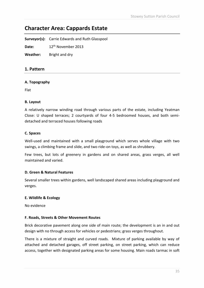
Character Area: Cappards Estate
Surveyor(s): Carrie Edwards and Ruth Glasspool
Date: 12th November 2013
Weather: Bright and dry
1. Pattern
A. Topography
Flat
B. Layout
A relatively narrow winding road through various parts of the estate, including Yeatman
Close: U shaped terraces; 2 courtyards of four 4-5 bedroomed houses, and both semi-
detached and terraced houses following roads
C. Spaces
Well-used and maintained with a small playground which serves whole village with two
swings, a climbing frame and slide, and two ride-on toys, as well as shrubbery.
Few trees, but lots of greenery in gardens and on shared areas, grass verges, all well
maintained and varied.
D. Green & Natural Features
Several smaller trees within gardens, well landscaped shared areas including playground and
verges.
E. Wildlife & Ecology
No evidence
F. Roads, Streets & Other Movement Routes
Brick decorative pavement along one side of main route; the development is an in and out
design with no through access for vehicles or pedestrians; grass verges throughout.
There is a mixture of straight and curved roads. Mixture of parking available by way of
attached and detached garages, off street parking, on street parking, which can reduce
access, together with designated parking areas for some housing. Main roads tarmac in soft

Stowey Sutton Parish Council
36
muted brick colour to blend with traditional renders of houses. Pedestrian access to
Stitchings Shord lane.
G. Landmarks
Some homes have views of the church and hills to the south of the village.
Small playground has become a landmark for the village.
H. Views Out
Various houses have views to open fields at the end of the estate (which has planning
permission for new housing development and will soon be lost).
I. Views In
From the hills at the south of Bishop Sutton (the top of Church Lane for example), it is
possible to see many of the village’s houses, including parts of the estate.
2. Buildings & Details
A. Predominant Building Shape & Height
All two storey, mix of detached, semi-detached and terraced. All built in similar modern
style, with slight variations but with a cohesive theme, although the social housing provided
in Yeatman Close is much more cramped than other areas, with no front gardens or shared
green space, poor screening for dustbins which for access reasons are generally stored at
the front of properties in this area.
B. Roofs
All pitched roofs, many houses with attached garages with different heights to main house.
C. Predominant Materials
All have tiled roofs, traditional renders in a variety of muted colours, stone walls around
some boundaries, wooden gates across courtyards and some drives.
Main thoroughfare has brick-coloured tarmac, with a brick pavement along one side.
D. Details
Many houses have porches, use of natural materials (including wooden doors and
windows), and muted colours of render which have aged well. Houses set slightly back from
the road, and built so as not to look into each other’s windows where possible. Landscaping
which has grown as the estate has aged into mature shrubs and a variety of trees.

Stowey Sutton Parish Council
37
The narrow frontages and low picket fences of Yeatman Close lead to a more enclosed
atmosphere than the older terraced properties in the village.
3. Summary
A. In a few words or a sentence or two, what are for your group the key POSITIVE features
about this area? What makes it special?
Fantastic sense of community (recently evidenced by street parties held for both the jubilee
and royal wedding).
Use of materials to ensure much of the estate blends with the rest of the community.
Safe roads for children, allowing them some freedom to visit friends without too great a risk
from traffic.
B. In a few words or a sentence or two, what are for your group the key NEGATIVE
features about this area? What detracts from it?
Planning permission granted for further extension, to include properties not in keeping with
the theme of the first phases (inclusion of flats), and the loss of green field outlooks. This
will increase traffic significantly on the, already limited, access road, and will negatively
impact on the estate’s quiet and safe current nature, by increasing traffic on the already
limited access road.

Stowey Sutton Parish Council
38
4. Photos
Picture 19 Detached property, limited room for screening to be planted
Picture 20 Modern terraced private property, off plot parking provided
Picture 21 Housing association terraced property, parking & fence design gives much less open feeling than other areas

Stowey Sutton Parish Council
39
Ham Lane & Stitchings Shord Lane
Map 6 Ham Lane & Stitchings Shord Lane


Stowey Sutton Parish Council
41
Character Area: Ham Lane & Stitchings Shord Lane
Surveyor(s): Kate Alvis and Kathryn Miller
Date: 24th November 2013
Weather: Cold and bright
1. Pattern
A. Topography
Flat
B. Layout
Winding lanes, properties well set back from the road, wide plots with front and back
gardens. No obvious centre.
C. Spaces
Spacious gaps between buildings, with lots of green spaces, including paddocks and fields of
grazing horses, cattle and sheep, also a small holding.
The lane is used by walkers and horse riders alike, as a thoroughfare to Chew Valley Lake
and the nearby nature trails.
There are several footpaths, as well a popular, established touring caravan park.
D. Green & Natural Features
A variety of trees and shrubbery, some mature species. Large gardens, with most properties
having boundary hedges. The majority of properties back onto fields/paddocks.
E. Wildlife & Ecology
Collared doves on roof tops, whilst assessing the area, with evidence of foxes, badgers and
other wildlife.
This is a rural lane adjacent to Chew Valley Lake. Wildlife regularly sighted, including deer,
badger, rabbits, foxes, squirrels, dragonflies, herons, ducks and other wildfowl.
F. Roads, Streets & Other Movement Routes
No pavements, limited grass verges, drainage ditch, narrow, curving, through road. One cul-
de-sac. Mostly on- plot parking.

Stowey Sutton Parish Council
42
Both Ham Lane and Stitchings Shord Lane are prone to flooding (Picture 25) both at their
junction and further along Ham Lane close to Whatley House. This is caused both by the lack
of local drains to adequately cope with surface water runoff from the immediate area as
well as the inadequate capacity of the underground storm drain which is quickly
overwhelmed in moderate rain, regularly leading to small fountains which escape from the
manhole at the junction of Ham Lane and the A368, which continue for days after the rain
subsides.
G. Landmarks
Whilst there are no specific landmarks, the agricultural use and rural nature of both
Stitchings Shord Lane and Ham Lane, so close to the heart of the village, should be
protected.
H. Views Out
Numerous views of Burledge Hill (AONB) and Knowle Hill, with views of Chew Valley Lake
from some properties.
I. Views In
Footpaths from both Knowle Hill and Burledge Hill.
2. Buildings & Details
A. Predominant Building Shape & Height
Predominantly large, four bedroom plus, detached properties, of 2 storeys with wide
frontages.
B. Roofs
Pitched
C. Predominant Materials
Predominantly stone properties, with a few rendered. Tiled roofs. Boundaries are made up
of low stone walls and mature hedges. Ground tarmac.
D. Details
Period stone built properties, including farm houses and cottages with a variety of window
shapes and period features.

Stowey Sutton Parish Council
43
Newer builds, from the late 70’s and early 80’s are stone faced and in keeping with the
surrounding area.
3. Summary
A. In a few words or a sentence or two, what are for your group the key POSITIVE features
about this area? What makes it special?
The proximity to Chew Valley Lake, an area designated as a Site of Special Scientific Interest
(SSSI), Special Protection Area (SPA) and a Site of Nature Conservation Interest (SNCI).
Well maintained, character properties, abundance of fields, footpaths and trees.
B. In a few words or a sentence or two, what are for your group the key NEGATIVE
features about this area? What detracts from it?
The flood risk, both to existing houses, some of which were flooded as recently as
November 2012, as well as the danger caused to vehicles and pedestrians when the road
becomes impassable.
The lack of pavements and street lighting in both of these rural lanes often makes it unsafe
for pedestrians due to the speed of traffic which uses Ham Lane as a local short cut to avoid
the traffic jams that occur in Bonhill Road.

Stowey Sutton Parish Council
44
4. Photos
Picture 22 Ham Ln Large detached property, well set back with trees planted for screening
Picture 23 Ham Ln modern detached property, local stone finish with trees planted for screening
Picture 24 Terraced properties Stitching Shord Ln, set back & screened from road by planting

Stowey Sutton Parish Council
45
Picture 25 Flooding Ham Lane November 2012
Picture 26 Flooding Stitchingshord Ln November 2012
Picture 27 Overflowing storm drain in Ham Ln after moderate rain October 2013


Stowey Sutton Parish Council
47
The Street, Wick Road, A368
Map 7 The Street, Wick Road & A368


Stowey Sutton Parish Council
49
Character Area: The Street, Wick Road, A368
Surveyor(s): Nikki Flemming, Nicky Wake, Tanya Southgate, Lucy Pover
Date: 22nd November 2013
Weather: Cold, fine & sunny
1. Pattern
A. Topography
Flat
B. Layout
Linear – buildings set well back with front and back gardens. Off street parking. A variety of
plot size – some large and some smaller. No clear village centre but several landmarks along
the main road.
C. Spaces
Several random green spaces along the main road – some privately owned, some attached
to cul-de-sacs. A lot of detached houses with green spaces between and in front of them.
Village hall with large front car park and large communal green space and play area behind.
Methodist Church and hall with car park to rear. Indian restaurant and public house – both
with green space and large car parks. Children’s play area with benches outside. All well
used. Millennium garden opposite Methodist Church– not so well used.
Behind the main road is the football field and cricket pitch – both in regular use.
D. Green & Natural Features
Lots of houses with front gardens with trees, shrubs and hedges. Variety of larger mature
trees. Large rear gardens sometimes visible from the main road. There is a lot of greenery in
the visual field as you look down the main road in either direction. There is general
background of greenery as you can see past the single row of dwellings that front the main
road towards the fields behind. On the other side of the road the houses back on to the
surrounding hillsides which are obviously green.
E. Wildlife & Ecology
None noted but signs of wildlife present in the hedgerows and gardens.

Stowey Sutton Parish Council
50
F. Roads, Streets & Other Movement Routes
Pavement (narrow) on one side of the road, nothing on the other side. Busy main “A” road.
Straight road with small cul-de-sacs to the sides. No on street parking near houses, some
noted near the school and shop. Several car parks attached to businesses (pub etc). Grassed
area at the Millennium Garden and on the corner of Bonhill Lane.
G. Landmarks
Many landmarks along the route surveyed: Village Hall, Football Club, Church, School, two
garages, hairdressers, Indian restaurant, pub, shop, Methodist Church and hall. Bus stops
and phone box. Several post boxes. Millennium Garden. Old Somerset road signs. Children’s
play area, benches. Footpath signs.
H. Views Out
Rural fields and hillside to one side. Fields to the other side.
I. Views In
From along the hills and footpaths along Burledge
2. Buildings & Details
A. Predominant Building Shape & Height
Variety of housing styles and ages. Ranging from rows of old terraced mining cottages to
large detached houses and business premises. Lots of older stone built buildings. Mixture of
houses and bungalows – ranging from 2 bed up to 5 bed properties. Business properties are
all in old stone buildings converted to current use.
B. Roofs
Predominantly pitched roofs with occasional flat roof section to some bungalows.
C. Predominant Materials
Stone walls. Slate and tile roofs. Mixture of hedges and boundary walls. Tarmac pavement.
D. Details
Stone used in buildings. Old road signs. Big old houses with attractive sash windows.
Virtually all properties have both front and rear gardens, with a very green outlook.

Stowey Sutton Parish Council
51
3. Summary
A. In a few words or a sentence or two, what are for your group the key POSITIVE features
about this area? What makes it special?
There is a good sense of space within this area. The road itself is wide and the buildings all
have a decent plot size and good sized front gardens. This affords good views of the
surrounding countryside and hillsides and the planting of trees and shrubs in both public
spaces and private gardens leads to a very green, rural outlook.
B. In a few words or a sentence or two, what are for your group the key NEGATIVE
features about this area? What detracts from it?
The A368 is a busy road with narrow, often uneven, pavements, with cars frequently parked
near the school and shop. There is a general lack of crossing facilities or traffic calming in
Bishop Sutton to make pedestrian journeys to school and village amenities safer. There is a
school time 20 mph aided crossing facility at the Primary school (Picture 31) but none at the
post office/Methodist Hal end of the village where the pre-school is held and where Chew
Valley children cross in the afternoon.

Stowey Sutton Parish Council
52
4. Photos
Picture 28 Bungalows on Wick Rd, set back, space for planted screening, wide grass verge
Picture 29 Older terraced properties on Wick Rd, front & rear gardens, allowing screening
Picture 30 Older property Wick Rd, set back from road, large, well screened front & rear gardens

Stowey Sutton Parish Council
53
Picture 31 Bishop Sutton Primary School
Picture 32 Brents Garage on Wick Rd
Picture 33 Village Hall on Wick Rd


Stowey Sutton Parish Council
55
Hillside, Parkfield & High Mead Gardens
Map 8 Parkfield Gardens, Hillside Gardens & Highfield Gardens


Stowey Sutton Parish Council
57
Character Area: Hillside, Parkfield & High Mead Gardens
Surveyor(s): Katherine Scholtz, Sally Monkhouse
Date: 25th November 2012
Weather: Sunny & dry
1. Pattern
A. Topography
A shallow slope in most places and flat in others.
B. Layout
Both developments are small crescent shaped housing estates, comprising mostly semi-
detached houses. Some detached bungalows and several detached houses. Some are split
level, due to the topography.
The estates were built in the 1970s, all privately owned and mostly freehold.
All dwellings have front and rear gardens, all of which are larger at the rear. The rear
gardens are approximately 40 feet square, but some have longer and narrower rear
gardens. The front gardens are the width of each property and are about 15 feet deep.
These all include driveways. Most have detached garages, where the dwellings have not
been altered and some have garages integrated within the ground floor of the property,
which tend to also be split level, again due to the gradient upon which they have been built.
The bungalows tend to be nearer to A368 with the houses further back towards the hills and
into the cul de sac areas on each end of the estates.
The developments have wide access roads, with plenty of room for 2 vehicles to pass easily,
the roads are through roads, with good pavements, providing a longer, alternative route
parallel to part of the A368.
C. Spaces
The area does feel spacious, due to gaps in between dwellings, which varies from the width
of a footpath to up to around 10-12 feet.
D. Green & Natural Features
All front gardens have a low wall, in the same stone as the dwellings, with hedges, in the
main, behind. There is some picket fencing on a few properties. Front gardens tend to be
filled with a combination of shrubs, hedge, trees and lawns. With some properties

Stowey Sutton Parish Council
58
benefitting from complete privacy, due to planting in the front garden. Most are fairly
open. The abundant planting both in the properties and the shared space, gives a green
outlook to the streets.
E. Wildlife & Ecology
Due to the location of both estates and the occasional footpath between houses, it is
inevitable that wildlife must pass through.
The local residents have mentioned the significant number of hedgehogs which are found in
the gardens of this area.
There were no important plants identified on the day of the survey.
F. Roads, Streets & Other Movement Routes
There are pavements on both sides of the roads on the estates and all dwellings have off
road parking, some of which has been expanded.
The estates make up a crescent shape, with a cul de sac in each corner. The crescent can be
accessed both ends via the main road.
All houses have garages, except where the dwelling has been modified.
The roads are wide enough for two cars to pass, in all places.
There are grass verges, but these are part of some of the front gardens.
G. Landmarks
It is possible to see hills both sides from the estates, the church tower and the lake from
some areas.
H. Views Out
Views from the south facing gardens towards the rural green hills. From some of these
properties it is also possible to see the lake. The houses on the north side of the street may
see hills from some windows upstairs, this is possibly partly obscured in properties that are
east or west facing.
I. Views In
From the hills and footpaths along Burledge (an SSSI).
2. Buildings & Details
A. Predominant Building Shape & Height

Stowey Sutton Parish Council
59
Semi-detached housing, with some detached houses and detached bungalows. All are two
storey, but some of the detached houses are split level. All have generous sized frontages.
B. Roofs
The chalet style roof, with dormer is apparent in almost all of these properties. The roofs
are all tiled and some have Velux windows, especially in the bungalows.
C. Predominant Materials
All are either stone and render, or have been fully rendered and painted, with some being
pebble dashed.
D. Details
Most of the semi-detached properties are of a similar design, well-spaced and in good order.
The bungalows and detached properties are also similar in design.
3. Summary
A. In a few words or a sentence or two, what are for your group the key POSITIVE features
about this area? What makes it special?
The estates give a sense of space and the backdrop of the hills, with the occasional view of
the lake is pleasing. There is uniformity in design and this is carried out through the stone
wall that creates a continuous border along the front gardens.
Each property has its own distinct boundary and driveway with sufficient space to park at
least one vehicle.
The properties and planting are mature and sit comfortably within the landscape.
B. In a few words or a sentence or two, what are for your group the key NEGATIVE
features about this area? What detracts from it?
Some of the pavements and roads are poorly maintained by the local council.

Stowey Sutton Parish Council
60
4. Photos
Picture 34 Hillside Gdns, showing wide pavement, large front gardens & space for planting trees & shrubs for screening
Picture 35 Parkfield Gdns, showing open aspect & extensive planting to create a green outlook
Picture 36 Highmead Gdns, wide pavements & front gardens allowing extensive planting for screenoing & natural aspect

Stowey Sutton Parish Council
61
Sutton Park
Map 9 Sutton Park


Stowey Sutton Parish Council
63
Character Area: Sutton Park
Surveyor(s): Vanessa Watson, Sally Monkhouse
Date: 18th November 2013
Weather: Sunny
1. Pattern
A. Topography
Flat
B. Layout
A “T” shaped small housing development comprising 21 detached executive homes. All
houses have large driveways with parking for several cars as well as double garages. They
have large front and rear gardens and the houses are generously spaced, with
approximately 10 metres between each other.
C. Spaces
There is a “Bradstone” walled entrance to the development followed by wide, well
maintained, verges (3 metres) either side of the road which continue for approximately 30
metres to the first house. It is a well-spaced area free of parked cars. The head of the T is
used for street parties and social events.
D. Green & Natural Features
Many of the houses are bordered by beech hedges, laurels and various other shrubs. The
gardens have mature trees varying from ash, cherry blossoms, silver birches, oaks plus many
others. Many of the properties have gated entrances bordered by hedges.
E. Wildlife & Ecology
Some of the gardens are used by foxes or badgers as there are signs of pathways and holes
through fencing.
A seasonal watercourse provides a corridor for wildlife and amphibians, lying on the eastern
boundary (moving south to north).

Stowey Sutton Parish Council
64
F. Roads, Streets & Other Movement Routes
There are pavements on both sides of the road at the entrance to the estate and then at the
point of the T there is one. The road is wide enough for 2 passing cars and there are no
vehicles parked in the road.
G. Landmarks
None
H. Views Out
The South West facing properties look out towards Blackdown and the Mendips.
I. Views In
From the hills and footpaths along Burledge (An SSSI).
2. Buildings & Details
A. Predominant Building Shape & Height
Wide fronted properties which are detached with 2 storeys and a consistent design theme
with individual variations. All were built by the same independent local developer one by
one from 1986 with the last one being completed in 2001.
B. Roofs
All properties have pitched roofs with terracotta coloured double roman style tiles.
C. Predominant Materials
All properties have “Bradstone” walls to the front and cream render to the rear. They have
tiled roofs and have mature hedges as boundaries. Some drives are tarmac and some block
paved.
D. Details
The houses are similar in design but certainly not the same. They vary from 4, 5 and 6
bedrooms and are well positioned to allow for maximum privacy for each property.

Stowey Sutton Parish Council
65
3. Summary
A. In a few words or a sentence or two, what are for your group the key POSITIVE features
about this area? What makes it special?
A lovely area with plenty of space, privacy and greenery. Safe for children to play without
the hazard of parked cars. Large attractive gardens and driveways to allow for visitors to
park on the plots.
B. In a few words or a sentence or two, what are for your group the key NEGATIVE
features about this area? What detracts from it?
None identified.

Stowey Sutton Parish Council
66
4. Photos
Picture 37 Entrance to Sutton Park, with wide pavement, grass verges & extensive tree planting
Picture 38 Detached larger properties in Sutton Park
Picture 39 Wide roadway & pavement, showing extensive street treescape

Stowey Sutton Parish Council
67
Stowey & Stowey Bottom
Map 10 Stowey & Stowey Bottom

Stowey Sutton Parish Council
69
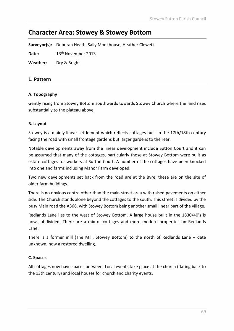
Character Area: Stowey & Stowey Bottom
Surveyor(s): Deborah Heath, Sally Monkhouse, Heather Clewett
Date: 13th November 2013
Weather: Dry & Bright
1. Pattern
A. Topography
Gently rising from Stowey Bottom southwards towards Stowey Church where the land rises
substantially to the plateau above.
B. Layout
Stowey is a mainly linear settlement which reflects cottages built in the 17th/18th century
facing the road with small frontage gardens but larger gardens to the rear.
Notable developments away from the linear development include Sutton Court and it can
be assumed that many of the cottages, particularly those at Stowey Bottom were built as
estate cottages for workers at Sutton Court. A number of the cottages have been knocked
into one and farms including Manor Farm developed.
Two new developments set back from the road are at the Byre, these are on the site of
older farm buildings.
There is no obvious centre other than the main street area with raised pavements on either
side. The Church stands alone beyond the cottages to the south. This street is divided by the
busy Main road the A368, with Stowey Bottom being another small linear part of the village.
Redlands Lane lies to the west of Stowey Bottom. A large house built in the 1830/40’s is
now subdivided. There are a mix of cottages and more modern properties on Redlands
Lane.
There is a former mill (The Mill, Stowey Bottom) to the north of Redlands Lane – date
unknown, now a restored dwelling.
C. Spaces
All cottages now have spaces between. Local events take place at the church (dating back to
the 13th century) and local houses for church and charity events.

Stowey Sutton Parish Council
70
D. Green & Natural Features
In the 18th century the village is described as largely being unseen due to stands of elm and
other trees. Today the village is set completely within the green belt with trees and other
greenery giving a very green outlook. It is surrounded by largely grazing fields which are
mostly used for sheep.
E. Wildlife & Ecology
The area in and around Stowey and Stowey Bottom supports many different wildlife species
including raptors, garden birds, and birds of passage.
Deer, rabbits, badgers; variety of rodents and insects.
A variety of wild flora due to the variety of habitats (woodland, hedges, pasture, streams).
The small ponds which are fed from the spring just to the south of Stowey Church support a
variety of ducks and other water birds as well as fresh water fish.
F. Roads, Streets & Other Movement Routes
There is no pavement access for Stowey Bottom or for the adjacent Redlands area. A high
level pavement starts at the Old Vicarage on the west side of the Street and continues to
the church. The road is largely straight (Picture 40) and narrows outside the Old Vicarage.
Stowey Bottom and Stowey are ‘cut through’ by the A368 and pedestrian access between
the two is not easy due to traffic both on the main road and on the Street through Stowey
which is used as a route from the A368 to the A37. A 30 mile an hour speed limit is in place
along the main street.
G. Landmarks
The Church and tower is visible from a distance. The area is made up of many smaller
feature buildings dating back to the 17th/18th century
The Old Vicarage is thought to date back in part from the 17th Century and was extensively
altered and extended in 1858. There is a former village school dating back to 1837 (built by
Lord Strachey a former owner of Sutton Court, for the village) now converted to a dwelling.
All are local landmarks.
The spring emerging to the south of the church is referenced by Collinson in 1791 as being
exceptionally pure and provided the water supply for the village. The small man-made
ponds fed by the spring are a local feature.
The wooded area on the incline to the south of the church called Castle Wood is purported
to be the former site of a wooden enclosure from the Iron Age. Earth works are visible from
the road.

Stowey Sutton Parish Council
71
Sutton Court is barely visible sitting within trees. It dates back to the 1600’s and is now
divided into separate apartments.
Stowey Mead was a former Dower house for Sutton Court and dates back to 1700’s
although was destroyed by a fire in the late 1800’s and rebuilt on the original site.
On the lane to the north and also to the west of Stowey Bottom are two fords. Work has
been recently undertaken around the ford to the east to alleviate flooding problems of local
properties.
The ford directly to the north of Stowey Bottom can be dry during the summer months, but
can become impassable to vehicles at times of heavy rainfall. This watercourse then passes
the Old Mill before flowing into the Chew Valley Reservoir.
H. Views Out
Situated in the Green Belt means there are far reaching views across fields, valleys and
beyond in all directions. The Chew Valley Reservoir is visible form the southern end of the
village.
I. Views In
The village can be seen from various footpaths and other vantage points including Folly
Farm (17th century farm and current wildlife centre) to the east.
2. Buildings & Details
A. Predominant Building Shape & Height
Much of the linear development dates back to 17th/18th Century; terraced cottages and
other notable buildings including the Old Vicarage. Several of the cottages have been
knocked into one and/or separated and all have side access and parking to the rear or side.
The predominant building stone is lias limestone probably quarried very locally.
Tiles are Roman clay tiles. One or 2 properties have been rendered.
Farms are detached and to the west of Stowey Bottom sits a detached Edwardian House
with three terraced cottages (date not verified but possibly 17th/18th century).
B. Roofs
Many of the cottages would have originally been thatched. Today they are pitched with
roman clay tiles.
Cottages in Stowey Bottom – notably ‘Dormers’ have dormer windows.

Stowey Sutton Parish Council
72
C. Predominant Materials
Lias limestone and roman roof clay tiles.
Cottages and other properties are fronted with stone walls.
D. Details
Stowey and Stowey Bottom all reflect a village character dating back to 17th/18th century.
There is a sense of age and history walking around the village.
3. Summary
A. In a few words or a sentence or two, what are for your group the key POSITIVE features
about this area? What makes it special?
Surrounded by Green Belt this is a village of age and history and the properties reflect this.
The Church dating back to the 13th century is an important feature as are other properties
as referred to above.
Although there are a few exceptions, development of properties has been in keeping with
the age of this village using local stone and same roof tiles and general design.
B. In a few words or a sentence or two, what are for your group the key NEGATIVE
features about this area? What detracts from it?
Heavy traffic through the Street. The two parts being split by the A368.

Stowey Sutton Parish Council
73
4. Photos
Picture 40 Stowey showing older terraced cottages, built in local stone, with clay roman roof tiles & survey team
Picture 41 Stowey, highlighting large pavements & gardens which permit extensive planting for screening, with survey team
Picture 42 The Street, Stowey, illustrating pavements, high grassed banks & hedges


Stowey Sutton Parish Council
75
Parish Rural Areas
Map 11 Stowey Sutton Parish boundary illustrating rural areas


Stowey Sutton Parish Council
77
Landscape Assessment: Parish Rural Areas
Surveyor(s): Sally Monkhouse, Heather Clewett
Date: 21st November 2013
Weather: Dry and bright
1. Pattern
A. Land Form
The rural area of the parish can be described as being of low level around the margins of
Chew Valley Reservoir (45 to 58 m above sea level) gently rising through the villages of
Bishop Sutton and Stowey/Stowey Bottom and then rising more steeply to Burledge and
Folly Farm which sit on escarpments at the edge of a plateau. Approximate height 168m at
highest point. Rain water which falls on the plateau runs towards Chew Valley Reservoir and
in doing so valleys or ‘drings’ (the local name for a valley which has water flowing at
different times of the year) have been formed. There are several springs which issue from
the escarpment which also flow into the Reservoir, notably Barelegs Brake. Waterfalls are in
evidence in particular to the east of Stowey as the stream flows towards Hollowbrook.
The land surrounding these valleys can be described as gently undulating.
The Parish extends into the reservoir encapsulating approx. two thirds of the surface area,
this reflects the boundary prior to the existence of the reservoir (man made in the early
1950’s and opened in1956). The Parish is bounded by 6 Parishes Chew Magna and Stanton
Drew to the north, Clutton and Cameley to the east and West Harptree and Hinton Blewett
to the south.
B. Land Cover
The rural areas of the Parish are varied but predominantly made up of farmland for grazing
sheep. There are wooded areas e.g. Folly Wood, Dowlings Wood, Castle Wood and
Strawberry Wood which are deciduous, other wooded areas such as Broad Wood are
planted with evergreen trees. Only a small area of farmland is used for agricultural purposes
such as barley.
Strawberry Wood is a ‘wet wood’ one of a limited number in England.
The area edging the reservoir is wetland and supports water birds and wetland habitat and
is designated SSSI and SPA.

Stowey Sutton Parish Council
78
C. Land Use
Mostly grazing for sheep although there is some cattle grazing and a small amount of arable
farming.
D. Field Boundaries
Fields are bounded by mixed hedgerows/sheep fencing with interspersed trees.
E. Field Sizes & Patterns
The size and shape of fields varies according to terrain and usage
The small fields to the west of Cappards housing development in Bishop Sutton probably
date back to the period of enclosure which took place in the late medieval period. They are
small, regular with hedges preserving the outlines of the earlier strip field system.
F. Route Ways
A368 runs east/west to the northern edge of the Parish. The road from Stowey crossroads
runs through Stowey village and provides a cut through route to the A37. Minor roads
connect farms along with track ways such as the one on Burledge. (Picture 46)
G. Buildings & Structures
The villages of Bishop Sutton and Stowey/Stowey Bottom are the main housing areas. Farms
and associated buildings are spread across the parish and vary in acreage size.
There is a group of buildings/linear development on Redlands Lane. Sutton Court is a
notable large house with estate built on the site of 14th century castle with sections built in
the 15th and 16th Century and then remodelled in 1858. It is a Grade II listed building as is
the lodge house located on the edge of the estate alongside the A368.
Stowey House is also Grade II listed and includes 17th century gables.
Stowey Quarry is to the south east of Bishop Sutton. It was previously quarried for lias
limestone (used to build many cottages in the parish). The current planning permission and
licence is for the landfill of inert waste. Planning permission was sought to landfill with
Stable Non-Reactive Hazardous Waste, including asbestos, this raised concern from the
Environment Agency and the application was changed to asbestos only at the start of an
appeal process. This permission was refused through the appeal process, with the decision
announced publicly on November 25th 2013.
Folly Farm in the north east corner of the Parish is a 17th Century farm and includes 2 SSSI’s.
It is now a residential study centre and wedding/ conference venue. Walks surround Folly
Farm some of which are accessible for wheelchair users.

Stowey Sutton Parish Council
79
Bishop Sutton had several working coal mines in the 18th, 19th and early 20th Centuries, small
slag heaps can be seen to the southern edge of the village. The mines are all referenced by
Strachey in his book of the 18th Century where he describes the various ‘veins’ of coal found
in Bishop Sutton and surrounding area.
H. Water & Drainage
Chew Valley Reservoir is located at the northern end of the Parish and many streams which
flow through the Parish feed into the reservoir. The Chew Valley Reservoir is a designated
Special Protection Area and SSSI. It is the 5th largest artificial reservoir in the UK, the largest
in the south west and, sitting in a bowl, can be seen from many of the surrounding hills.
Burledge has several SSSI areas along with designated high value meadow areas.
Drainage ditches are evident around many fields and flooding following rain is a concern in
lower lying areas.
Dew ponds are evident in various locations.
Man-made ponds are evident outside Stowey Church and the stream feeding these also
provides water for ponds to the rear of Manor Farm to the north of the church.
Water falls can be found on the stream leading into Sutton Court.
Kingfishers are often seen along stream edges and the presence of white clawed crayfish
has been recorded by Wessex Water.
Purity of the water issuing from a spring just above Stowey Church is referenced by
Collinson in his book 1791.
I. Enclosure & Scale
See previous sections
2. Views & Landmarks
A. Views
Views are extensive and sweeping from the southern escarpment looking to the north of the
parish towards and including the Chew Valley Reservoir.
There are many other viewing areas from the many footpaths which criss cross the parish
and sweeping views into and down valleys (Picture 43)
B. Landmarks
Castle Wood is purported to be the site of wooden enclosure from the Iron Age known as
Stowey Castle.

Stowey Sutton Parish Council
80
An encampment to the western edge of Burledge is present (Scheduled ancient monument).
The church at Stowey dates from the 13th century
Cottages in Stowey/Stowey Bottom date from 17th/18th century and were former cottages
of Sutton Court Estate workers.
Sutton Court dates from 15th/16th Century and there is evidence of estate waterside walks
(Victorian) and other related buildings of an historic nature.
There is a former mill to the west of Stowey Bottom.
Folly Farm and Round Hill can be viewed on the skyline when looking east.
3. Summary
A. Scenic Quality
The rural areas of Stowey Sutton Parish are green and tranquil with far reaching views.
Some areas have a sense of real age and of being unchanged for many centuries. Footpaths
provide access to woods, fields and viewing points including the Three Peaks Walk.
B. Activities & Associations
Footpaths are well used for leisure and also provide vantage points for photography and
painting – particularly of the Chew Valley Reservoir.
Local books have been written based on people’s memories and the history. Bird watching
and bird ringing take place at Chew Valley Reservoir where over 260 species of birds have
been recorded including rare over winter migrating birds. Ringing and bird watching also
take place at other locations. Sailing and fishing take place on the Reservoir.
Rare birds will often ‘stop over’ at the lake attracting twitchers.
Employment in the area is largely linked to agriculture. There is a busy farm shop and café,
an animal and related agricultural farm shop at Stowey, a small office unit development and
a sprawling fresh fruit veg delivery business to the west of Bishop Sutton. A coffee shop and
small visitor centre is at Chew Valley Reservoir. Chew Valley Caravan Park in Bishop Sutton
attracts many tourists to the area each year.
C. In a few words or a sentence or two, what are for you the key positive features about
this area? What makes it special?
Green, tranquil, views, many areas are unspoilt, sheep and cattle grazing

Stowey Sutton Parish Council
81
D. In a few words or a sentence or two, what are for you the key negative features about
this area? What detracts from it?
Other than traffic and the recorded concerns re Stowey Quarry none.

Stowey Sutton Parish Council
82
4. Photos
Picture 43Views of Barelegs Brake Valley
Picture 44 Views looking west past Castle Wood
Picture 45 Views between Castle Wood & Broadwood

Stowey Sutton Parish Council
83
Picture 46 Burledge track way
Picture 47 Views of Bishop Sutton from Knowle Hill (picture by R Ward, Wikimedia Commons Licence)


Stowey Sutton Parish Council
85