Embed Size (px)
Citation preview

United StatesEnvironmental ProtectionAgency
EPA 903-K-18-001 March 2018
STORM SMART CITIES Integrating Green Infrastructure into Local Hazard Mitigation Plans

ii
S T O R M S M A R T C I T I E S
AcknowledgmentsThis Storm Smart Cities Guide was made possible through assistance provided by the United States Environmental Protection Agency (EPA) Office of Wetlands, Oceans, and Watersheds and the United States Army Corps of Engineers’ (USACE) Silver Jackets Program.
Special Thanks to our Stakeholders and Planning Team:
Sherry Wilkins, Director | Huntington Stormwater Utility
Chris Chiles, Executive Director | Region 2 Planning & Development Council and KYOVA Interstate Planning Commission
Kathy Elliott | Region 2 Planning & Development Council and KYOVA Interstate Planning Commission
Beth Wild | KYOVA Interstate Planning Commission
Breanna Shell | Planning Director, Huntington City Planning
Rebecca Albert | U.S. Army Corps of Engineers Huntington District
Steve O’Leary | U.S. Army Corps of Engineers Huntington District
Joe Trimboli | U.S. Army Corps of Engineers Huntington District
Megan Thompson | U.S. Army Corps of Engineers Huntington District
Mari Radford | Federal Emergency Management Agency Region III, Mitigation Division
Kathryn Lipiecki | Federal Emergency Management Agency Region III, Mitigation Division
Matt McCullough | Federal Emergency Management Agency Region III, Mitigation Division
Michelle Price-Fay, Associate Director | U.S. Environmental Protection Agency, Region III, Water Protection Division
Ken Hendrickson, Green Infrastructure Lead | U.S. Environmental Protection Agency, Region III, Water Protection Division
Samantha Rachko | U.S. Environmental Protection Agency, Region III, Water Protection Division
Susan Spielberger | U.S. Environmental Protection Agency, Region III, Environmental Assessment and Innovation Division
Patricia Corbett | U.S. Environmental Protection Agency, Region III, Hazardous Site Cleanup Division
Jada Goodwin | U.S. Environmental Protection Agency, Region III, Water Protection Division
Diana Saintignon | U.S. Environmental Protection Agency, Region III, Water Protection Division
Daniel Taylor | U.S. Environmental Protection Agency, Region III, Water Protection Division
Special Thanks to:
Lisa Hair | U.S. Environmental Protection Agency, Office of Water
Laura Bachle | U.S. Environmental Protection Agency, Office of Water
Jamie Piziali | U.S. Environmental Protection Agency, Office of Water
Region III EPA Contract Support provided by:
CSRA International, Inc.
JH Consulting, LLC

iii
A G U I D E T O I N T E G R A T E G R E E N S T O R M W A T E R I N F R A S T R U C T U R E
ContentsAcknowledgments .................................................................................................................................................... ii
Foreword .................................................................................................................................................................... iv
Introduction .............................................................................................................................................................. iv
Background ...............................................................................................................................................................1
Understanding the Issues and Requirements ........................................................................................................1
Why did we Focus on Local Hazard Mitigation Planning? ................................................................................2
Stormwater, Flooding, and Green Infrastructure ................................................................................................ 3
Why Green Infrastructure? .............................................................................................................................................3
Evolution of Stormwater Management ....................................................................................................................5
Flooding and Green Infrastructure in Huntington, WV .......................................................................................6
Aligning Plans to Include Green Infrastructure ......................................................................................................8
How to Include Green infrastructure in the Local Hazard Mitigation Planning Process ..................... 11
Public Involvement ....................................................................................................................................................... 13
The Local Hazard Mitigation Plan Approval Process ......................................................................................... 13
WV Region 2 Local Hazard Mitigation Plan Crosswalk ..................................................................................... 14
Implementing Mitigation Projects ........................................................................................................................... 14
Lessons Learned ......................................................................................................................................................15
Conclusion ................................................................................................................................................................18
Appendix A: WV Region 2 Hazard Mitigation Plan / Green Infrastructure Crosswalk ................................19
Appendix B: Green Infrastructure & Local Hazard Mitigation Planning Resources ....................................23
Appendix C: References .........................................................................................................................................25
List of Acronyms ......................................................................................................................................................26
iv
S T O R M S M A R T C I T I E S
ForewordPublic health and environmental impacts affect people most significantly where they live; at the community level. Many of the EPA’s programs focus on providing support to communities, especially in environmentally overburdened, underserved, and economically distressed areas, which have the greatest needs.
Communities across the United States are facing a variety of challenges, from outdated infrastructure, to water quality protection, to the need to increase community resilience and mitigate the impacts of flooding and other hazards. These communities are looking for multi-purpose solutions to these challenges. Green infrastructure is one approach to improve water quality and address flooding challenges. Green infrastructure yields many benefits, including improved water quality, reduced flooding, infrastructure cost savings, and healthier communities. While green infrastructure alone may not fully address these issues, it adds capacity, flexibility, and resilience to other infrastructure systems and provides multiple community benefits.
Communities are also realizing the need for integrated planning; looking for overlap in the various plans they need to secure funding, meet regulations, ensure public safety, and encourage sustainable economic growth. When these plans interconnect, and include similar approaches and solutions, communities increase the likelihood that these plans will be realized. This approach also ensures that communities can take full advantage of available funding. As a result, communities across the United States are starting to look at how to integrate green infrastructure into their Local Hazard Mitigation Plans.
This Storm Smart Cities Guide examines how communities can integrate green infrastructure into their Local Hazard Mitigation Plan. It provides a case study of green infrastructure
integration efforts in the City of Huntington, West Virginia (WV) and the WV Region 2 Planning & Development Area.
This guide serves several purposes. It:
• ProvidesanoverviewofLocalHazardMitigation Planning;
• Capturesanapproachusedtoestablishaplanning team;
• Identifieslessonslearnedandimportantconsiderations for other communitiesinterested in pursuing this approach; and
• Providesacrosswalkbetweenthestepsin Local Hazard Mitigation Planning,considerations for integrating greeninfrastructure, and examples from theHuntington, West Virginia Case Study.
IntroductionIn the summer of 2016, the EPA Region III Water Protection Division, Office of State and Watershed Partnerships began organizing a group of local, regional, state, and federal agencies with the intent of understanding how to better integrate green infrastructure into local hazard mitigation planning. The effort focused on Huntington, WV and the surrounding area.
This group included representatives from:
• theHuntingtonStormwaterUtility(HSU);
• HuntingtonCityPlanning;
• TheWVRegion2Planning& Development Council (PDC2);
• TheKYOVAInterstatePlanningCommission;
• TheHuntingtonDistrictOfficeoftheUSACE;
• TheWestVirginiaDepartment of Environmental Protection (WVDEP);
• TheFederalEmergencyManagement Agency, Region III (FEMA); and
• EPARegionIII.

1
A G U I D E T O I N T E G R A T E G R E E N S T O R M W A T E R I N F R A S T R U C T U R E
While the initial focus of the group was to explore how to incorporate green infrastructure into the WV Region 2 Local Hazard Mitigation Plan, the overall goal was to better align plans and resources toward reducing the impact of flooding and helping to protect and improve local water quality. As an extension of early EPA outreach efforts, the team developed, and was approved for, additional support under the USACE “Silver Jackets” program creating the Huntington Silver Jackets Team.
As the Team was formed, the Region 2 Planning & Development Council was just beginning the process of updating its required Local Hazard Mitigation Plan. Through team meetings, stakeholder meetings and workshops, the team worked to:
• Developasharedunderstandingoflocalflooding issues;
• Betterunderstandgreeninfrastructureandframe it in the context of Huntington, WV;
• Identifyopportunitieswithinthelocalhazard mitigation planning process to betterincorporate green infrastructure as a tool forlocal flood hazard mitigation; and
• Identifynextstepstowardimplementinggreen infrastructure practices.
Background Understanding the Issues and RequirementsStormwater management is essential for healthy communities in the 21st century. Without it, pollution entering local waterbodies and the risk of flooding increases. Stormwater runoff is one of the largest sources of water pollution in urban and suburban areas. It presents many environmental, social, and economic challenges. Rain and snowmelt that flows over land or impervious surfaces, such as paved streets, parking lots and building rooftops, does not soak into the ground, generating stormwater runoff. The runoff picks up pollutants such as trash, chemicals, oils and dirt/sediment that harm rivers, streams, lakes and coastal waters. These pollutants directly impact water quality. Increases in stormwater runoff are not only a concern for water quality, it also directly contributes to urban flooding. Along with protecting their environmental health, communities must also plan for how they will reduce the threats from natural disasters. FEMA requires communities to develop a Local Hazard Mitigation Plan. These plans list all the potential hazards and natural disasters that a community might experience and describe the actions that the community will take to reduce or mitigate those threats. Flooding is one of the most common natural disasters that communities face and the impact to the community can be significant and costly.
The link between stormwater and flooding, and their associated planning and management requirements, provide communities with the opportunity to consider multi-benefit solutions. Green infrastructure is a prime example of a multi-benefit solution. It can be used to both improve water quality and reduce the amount of stormwater runoff.
Hazard Mitigation – the effort to reduce loss of life and property by lessening the impact of disasters (FEMA).

2
S T O R M S M A R T C I T I E S
In West Virginia, most local hazard mitigation plans are developed at a regional level through Regional Planning & Development Councils. This regional approach was adopted between 2011 and 2012, with the support of the West Virginia Department of Homeland Security and Emergency Management (WVDHSEM). The WVDHSEM is the state level emergency management agency in West Virginia responsible, along with FEMA, for approving local hazard mitigation plans. This regional planning approach adds capacity to communities that may not have the budget or personnel to develop individual plans. It promotes thinking across local political boundaries and seeks to mitigate hazards that have the potential to impact multiple communities at the same time.
The City of Huntington is part of the WV Region 2 planning district and includes Mason, Cabell, Wayne, Lincoln, Mingo, and Logan counties. The WV Regional Planning & Development Council (PDC2) represents 31 units of government and is responsible for developing the Region 2 Hazard Mitigation Plan (see Figure 1, below).
Figure 1: Map of West Virginia Regional Planning and Development Areas.
Why did we Focus on Local Hazard Mitigation Planning? FEMA has different types of funding that are available to states, tribes, and local communities to use for hazard mitigation. FEMA requires communities to develop a Local Hazard Mitigation Plan and update that plan every five years. Local Hazard Mitigation Plans should cover all types of hazards that a community might face, and discuss ways to reduce the impacts of each hazard. Local Hazard Mitigation Plans may be developed at the city, county, or regional level based on capacity and local preference. This Storm Smart Cities Guide highlights a Case Study focused on Local Hazard Mitigation Plans because they are developed by local stakeholders and reflect local priorities. This process of engaging local stakeholders, discussing the potential hazards in a community, and developing plans to address those hazards provides is an opportunity for communities to think strategically about aligning resources toward solving problems.
Huntington, West Virginia
3
A G U I D E T O I N T E G R A T E G R E E N S T O R M W A T E R I N F R A S T R U C T U R E
is also a rapid increase in the water levels in those streams. This increases the impacts of localized flooding, streambank erosion, destruction of property, and in some cases flash flooding.
These flooding events can be highly damaging even though they are localized. It is important to note that increases in impervious surface area in a community mean that even smaller storm events can lead to flooding because the overall volume of stormwater runoff increases. Trends show that storm intensity and frequency are increasing causing even greater concern. Western WV experienced an overall increase of 2% to 10% in annual precipitation volume between 1901 and 2015 (US EPA, 2016).
A green infrastructure approach to stormwater management and flood risk reduction seeks to capture rainwater as close to where it falls as possible and let that water soak back into the ground. It integrates multiple smaller practices throughout the watershed, encourages the preservation of existing green space, increases tree canopy cover, works to restore degraded natural areas, and adds green space where possible. All of this is done with consideration of traditional piped stormwater systems, so that the green infrastructure elements reduce the volume of runoff that streams and piped systems need to carry.
Green infrastructure includes natural systems and areas of land as well as practices that are engineered to mimic natural systems, using soils and vegetation, in a smaller area. These smaller practices can be integrated into the community, adding both aesthetic and functional benefits. Green infrastructure systems can also be flexible and adaptable. They can be installed in the community over
Stormwater, Flooding, and Green InfrastructureWhy Green Infrastructure?This collaborative planning effort focused on green infrastructure because of its ability to address multiple water related issues. In its simplest terms, green infrastructure is an approach to stormwater management and flood mitigation that provides areas for water to soak into the ground, or evaporate back into the air, rather than forming runoff and leading to flooding.
As communities historically developed, the amount of impervious surfaces such as roads, sidewalks, and parking lots within the community increased. These surfaces are referred to as impervious because they do not allow rainwater to soak into the ground. Community flood risk increases as the area of impervious surface increases. Since rainwater falling on impervious surfaces is not able to soak into the ground, it must either run off of that surface or collect in low-lying areas.
Most communities have some type of stormwater collection system comprised of storm drains and pipes. These systems are referred to as grey infrastructure because they are constructed of man-made materials and are engineered and designed to collect water and move rainwater rapidly out of the community. However, these systems are often undersized and outdated compared to the increases in impervious surfaces within the community over time. As these grey infrastructure systems become overwhelmed, they are no longer able to collect additional stormwater runoff. That excess runoff then flows across the surface of the community and collects in low-lying areas, leading to localized flooding.
Stormwater runoff in urban areas is also a major cause of water pollution. As rain water runs off the ground, it can collect and carry trash, bacteria, and heavy metals. These pollutants are ultimately carried to local streams and rivers. As high volumes of runoff enter local streams, there
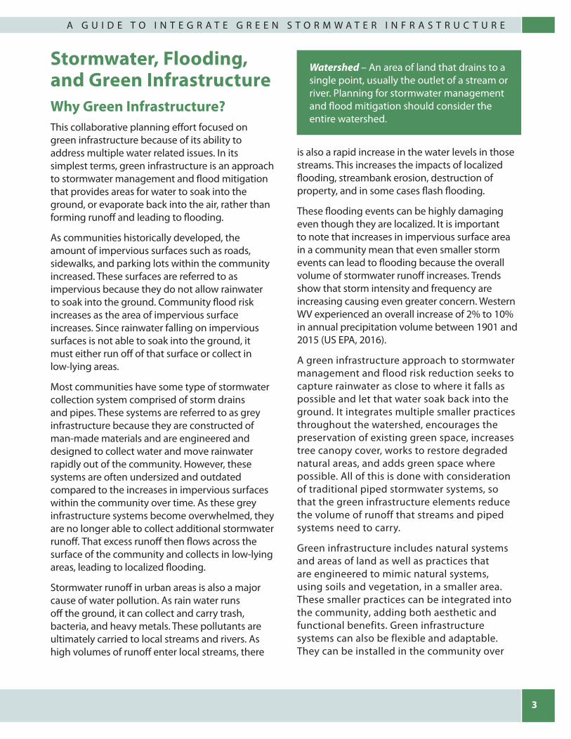
Watershed – An area of land that drains to a single point, usually the outlet of a stream or river. Planning for stormwater management and flood mitigation should consider the entire watershed.

4
S T O R M S M A R T C I T I E S
Downspout Disconnect – This simple practice reroutes rooftop drainage pipes from draining rainwater into the storm sewer to draining it into rain barrels, cisterns, or permeable areas. It can be used to store stormwater and/or allow stormwater to infiltrate into the soil.
Rainwater Harvesting – Rainwater harvesting systems collect and store rainfall for later use. When designed appropriately, they slow and reduce runoff and provide a source of water. This practice is particularly valuable in arid regions, where it could reduce demands on increasingly limited water supplies.
Rain Gardens – Rain gardens are versatile features that can be installed in almost any unpaved space. Also, known as bioretention, or micro-bioretention cells, these shallow, vegetated basins collect and absorb runoff from rooftops, sidewalks, and streets. This practice mimics natural hydrology by infiltrating, evaporating, and transpiring stormwater runoff.
Planter Boxes – Planter boxes are urban rain gardens with vertical walls and either open or closed bottoms. They collect and absorb runoff from roofs, sidewalks, parking lots, and streets and are ideal for space-limited school sites in dense urban areas.
Bioswales – Bioswales are vegetated, mulched, or xeriscaped channels that provide stormwater treatment and retention as it moves from one place to another. Vegetated swales slow, infiltrate, and filter stormwater flows. As linear features, they are particularly well suited to being placed along streets and parking lots.
Permeable Pavements – Permeable pavements infiltrate, treat, and/or store rainwater where it falls. They can be made of pervious concrete, porous asphalt, or permeable interlocking pavers. This practice could be particularly cost effective where land values are high and flooding or icing is a problem.
Green Roofs – Green roofs are covered with growing media and vegetation that enable rainfall infiltration and evapotranspiration of stored water. They are particularly cost-effective in dense urban areas where land values and stormwater management costs are likely to be high.
Urban Tree Canopy – Trees reduce and slow stormwater by intercepting precipitation in their leaves and branches. Many cities have set tree canopy goals to restore some of the benefits of trees that were lost when the areas were developed. Homeowners, businesses and community groups can participate in planting and maintaining trees throughout the urban environment.
Imag
es c
ourt
esy
the
Low
Impa
ct D
evel
opm
ent C
ente
r
Figure 2: Examples of Green Infrastructure Practices.

5
A G U I D E T O I N T E G R A T E G R E E N S T O R M W A T E R I N F R A S T R U C T U R E
time. Figure 2 (see previous page) provides some example green infrastructure practices and a description of how they are used.
Green infrastructure solutions can be as unique as the landscapes in which they are implemented. This flexibility is a major benefit of the approach. Many times, successful programs have locally-tailored guidance and standards that reflect community priorities and regulatory needs. Communities can easily integrate green infrastructure initiatives into other community improvement or capital projects such as transportation corridor upgrades, pedestrian safety upgrades, neighborhood revitalization efforts, road re-paving, and utility work. By integrating green infrastructure into these planned projects, communities can achieve significant cost savings as compared to retrofit projects focused solely on installing green infrastructure practices. Education for private developers can help them include green infrastructure into their designs.
In the past, green space has been viewed as something that may be aesthetically pleasing and nice to have, but it was not viewed as a valuable, functional part of a community. Communities are making the shift to recognize space as necessary for maintaining healthy social, ecological, and economic systems. Green infrastructure provides essential services to a community. These benefits include:
• Improvedwaterqualityandincreasedwatersupply;
• Reducedflooding;
• Increasedpropertyvalues;
• Reducedfiltrationcosts;
• Infrastructurecostsavings;
• Improvedairquality;
• Increasedcommunityresilience;
• Increasedhabitatimprovementandconnectivity; and
• Healthiercommunities.
Evolution of Stormwater ManagementPrior to the 1980s, the importance of treating stormwater runoff was not fully recognized. When passed in 1972, the Clean Water Act’s (CWA) primary emphasis was to reduce the amount of pollution discharging into waterways from wastewater treatment plants and industrial facilities. By the 1980s, regulators and others began to understand the importance of treating stormwater runoff from farmland, city streets, construction sites and suburban lawns. In 1987, Congress amended the CWA, which spurred new regulations and programs with requirements for different sized communities.
Issued in 1990, EPA established Phase I of the National Pollutant Discharge Elimination System (NPDES) Municipal Separate Storm Sewer System (MS4) regulations requiring MS4 operators serving populations of 100,000 or more to develop comprehensive stormwater management programs (SWMP) to reduce the discharge of pollutants from their storm sewer systems. In 1999, EPA extended regulations to cover smaller communities, known as Phase II MS4s. Phase II MS4 regulations apply to communities located in urbanized areas as defined by the Bureau of Census, or on a case-by-case basis by the NPDES permitting authority. Phase II requires smaller entities that operate MS4s in urban areas to obtain NPDES permits. Individual NPDES permits generally cover Phase I MS4s and general NPDES permits cover Phase II MS4s. NPDES permits for regulated MS4s require permittees to develop a SWMP, which describes the stormwater control practices that the permittee implements to comply with permit requirements and minimize the discharge of pollutants from the sewer system. Phase II permit holders must implement six minimum control measures to reduce polluted stormwater runoff. Together, the Phase I and Phase II regulations aim to keep harmful pollutants out of local waterbodies.
6
S T O R M S M A R T C I T I E S
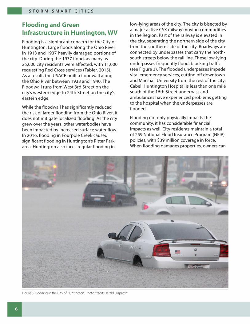
Flooding and Green Infrastructure in Huntington, WVFlooding is a significant concern for the City of Huntington. Large floods along the Ohio River in 1913 and 1937 heavily damaged portions of the city. During the 1937 flood, as many as 25,000 city residents were affected, with 11,000 requesting Red Cross services (Tabler, 2015). As a result, the USACE built a floodwall along the Ohio River between 1938 and 1940. The Floodwall runs from West 3rd Street on the city’s western edge to 24th Street on the city’s eastern edge.
While the floodwall has significantly reduced the risk of larger flooding from the Ohio River, it does not mitigate localized flooding. As the city grew over the years, other waterbodies have been impacted by increased surface water flow. In 2016, flooding in Fourpole Creek caused significant flooding in Huntington’s Ritter Park area. Huntington also faces regular flooding in
low-lying areas of the city. The city is bisected by a major active CSX railway moving commodities in the Region. Part of the railway is elevated in the city, separating the northern side of the city from the southern side of the city. Roadways are connected by underpasses that carry the north-south streets below the rail line. These low-lying underpasses frequently flood, blocking traffic (see Figure 3). The flooded underpasses impede vital emergency services, cutting off downtown and Marshall University from the rest of the city. Cabell Huntington Hospital is less than one mile south of the 16th Street underpass and ambulances have experienced problems getting to the hospital when the underpasses are flooded.
Flooding not only physically impacts the community, it has considerable financial impacts as well. City residents maintain a total of 259 National Flood Insurance Program (NFIP) policies, with $39 million coverage in force. When flooding damages properties, owners can
Figure 3: Flooding in the City of Huntington. Photo credit: Herald Dispatch
7
A G U I D E T O I N T E G R A T E G R E E N S T O R M W A T E R I N F R A S T R U C T U R E
make claims against their policies for losses. Historically, 173 losses have been paid, totaling $1.4 million. While this number is significant, it does not fully capture the magnitude of the flooding concerns in Huntington as there are most likely city residents who may not have flood insurance policies and/or may not have filed claims for losses.
HSU is the local agency responsible for managing both the floodwall along the Ohio River, and stormwater runoff within the city. HSU’s authority for managing stormwater runoff within the city comes from its responsibility to manage the city’s Phase II MS4 permit issued by the WVDEP.
Under the MS4 permit, the HSU implements the following components:
• publiceducationandoutreachregardingdevelopment permitting requirements;
• publicparticipationandinvolvementintheprocess;
• detectionandeliminationofillicitdischarges;
• runoffcontrolatconstructionsites;and
• post-constructionstormwatermanagement,and pollution prevention.
Under the MS4 permit, the HSU is responsible for maintaining and repairing existing stormwater infrastructure, but they are also responsible for educating the public and ensuring that stormwater runoff from redevelopment and new development sites is reduced, according to WVDEP requirements (see Figure 5). The WVDEP Stormwater Management and Design Guidance Manual, Chapter 2, specifies that all new and redevelopment sites (disturbing 1 acre or greater) must capture and manage on site the first inch of rainfall in a 24-hour storm using, “canopy interception, soil amendments, evaporation, rainfall harvesting, engineered infiltration, extended filtration and/or evapotranspiration and any combination of [these] practices.”
This regulatory requirement has been the primary driver for green infrastructure projects in the City of Huntington. As of 2017, the HSU had approved 29 green infrastructure projects. A list of completed projects is shown in Table 1. These practices are helping to reduce stormwater runoff and flooding in the City, while also improving water quality.
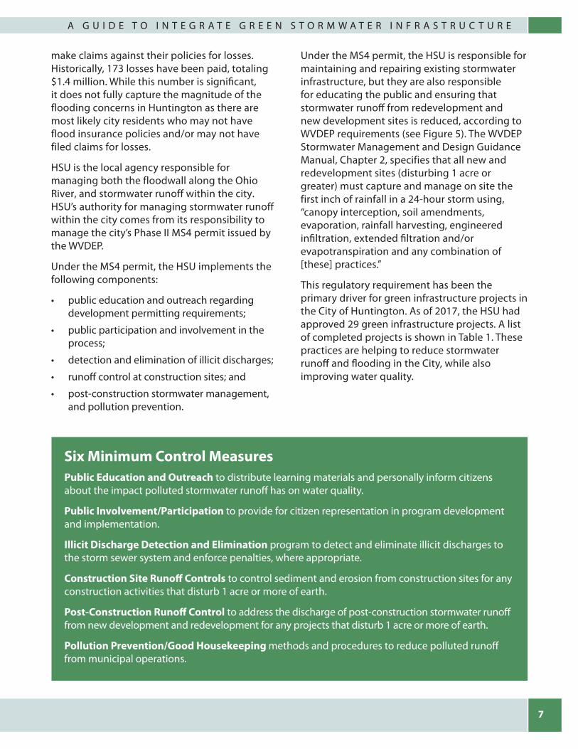
Six Minimum Control MeasuresPublic Education and Outreach to distribute learning materials and personally inform citizens about the impact polluted stormwater runoff has on water quality.
Public Involvement/Participation to provide for citizen representation in program development and implementation.
Illicit Discharge Detection and Elimination program to detect and eliminate illicit discharges to the storm sewer system and enforce penalties, where appropriate.
Construction Site Runoff Controls to control sediment and erosion from construction sites for any construction activities that disturb 1 acre or more of earth.
Post-Construction Runoff Control to address the discharge of post-construction stormwater runoff from new development and redevelopment for any projects that disturb 1 acre or more of earth.
Pollution Prevention/Good Housekeeping methods and procedures to reduce polluted runoff from municipal operations.

8
S T O R M S M A R T C I T I E S
Aligning Plans to Include Green InfrastructureIncorporating green infrastructure projects into hazard mitigation planning is not difficult. In fact, the federal guidelines outlining mitigation plan requirements strongly advocate that projects beyond those traditionally funded by FEMA be included in the plan to address vulnerabilities. Regulations guiding the hazard mitigation planning process require two-way alignment of mitigation with other planning efforts to helps support resiliency. Communities should integrate mitigation considerations into their other plans, and include measures suggested by the other plans in the hazard mitigation document. For example, a community’s comprehensive development, economic development and land use plans are applicable for integration. Other documents that focus on watershed protection and stormwater management plans may also apply. It is important to look for points of integration across regional-level plans as well as local-level plans. Regional plans allow for an examination of hazard impacts that cross jurisdictional lines, both from a mitigation perspective, and a green infrastructure perspective. Local level plans may provide more detail about local flood hazards or identify local projects that could incorporate
green infrastructure. Aligning plans at both the regional and local levels increases the likelihood that plan goals will be realized.
While the HSU’s management of the Huntington MS4 permit has led to multiple green infrastructure practices, the Huntington Silver Jackets Team realized that the Region 2 Local Hazard Mitigation Plan provided additional opportunities to advance green infrastructure in the city and throughout the Region. For Huntington, the plan broadens the applicability of the HSU’s green infrastructure efforts. Initially implemented as a response to the MS4 regulatory driver, the mitigation planning process allows HSU to explore green infrastructure program applicability beyond new and re-development efforts. A joint stormwater management-hazard mitigation focus can highlight green infrastructure options that benefit both water quality and flood mitigation.
For the other communities in the region, participating in the mitigation plan update process provides exposure to the green infrastructure approaches and practices and their benefits. It offers the chance for Huntington and the HSU to become regional leaders in planning and implementing green infrastructure. This leadership will be important in promoting regional awareness of green infrastructure and
Figure 4: Localized flooding at railway underpasses impacts traffic movement in the City of Huntington. Photo credit: Sherry Wilkins, HSU

9
A G U I D E T O I N T E G R A T E G R E E N S T O R M W A T E R I N F R A S T R U C T U R E
building stakeholder support. Huntington’s success will serve as an example to other local government representatives. The hazard mitigation planning process provides the opportunity for other community leaders in WV Region 2 to speak directly with, and learn from their peers. The planning process also serves as a starting point for expanding the conversation on multiple uses for green infrastructure.
One important benefit of aligning plans to address related issues is the potential to expand the sources of project funding and be strategic about the use of funding. When projects are linked to multiple outcomes – flood reduction, water quality improvement, public safety and property loss prevention – communities can seek funding from multiple agencies and organizations to realize project goals. FEMA has traditionally funded hazard mitigation efforts, while state and federal environmental agencies are likely to focus more on water quality. Other organizations may be interested in establishing wildlife habitat, protecting stream health, or creating safer routes for children to walk to school.
Green infrastructure can accomplish multiple goals. The same green infrastructure project that helps mitigate flooding might also protect water quality, provide habitat, and help control traffic patterns so students can more safely cross a busy intersection. This increases the likelihood that communities will be able to fund these projects. Communities have the opportunity to demonstrate responsible fiscal stewardship by choosing solutions that address multiple issues.
Plan alignment helps community leaders identify opportunities to reduce cost and deliver multiple benefits from all planned projects in their community. Planned road repaving or realignment projects may provide the opportunity to install green infrastructure within the public right-of-way. Utility or sewer upgrades may offer similar opportunities. The cost savings of adding green infrastructure to other planned infrastructure projects can be considerable when compared to installing green infrastructure as a stand-alone project. The key lesson is identifying those projects and opportunities early in the planning process.
Type of Project Name Location
Bioretention Cell
Amp Gymnastic Kinetic Park
Residential Apartments
10th Street
Cabell-Huntington Hospital Parking Lot
13th Avenue & Cypress St. 15th Street 16th Street
CVS Pharmacy Fifth Avenue
Dollar General Monroe Avenue
Family Dollar Waverly Road
RMS Pro Finishes Third Avenue
Sheetz Fifth Avenue
Beltone 6th Avenue
Fairfield Inn Kinetic Park
Residential Apartments
6th Avenue
Taco Bell Kinetic Park
Atomic Distribution
7th Avenue
Bimbo Bakery Parking Lot
14th Street West & Adams
St. Mary’s Hospital 1st Avenue
Texas Roadhouse US Route 60
Uptowner Inn Impoundment Lot
Madison Avenue & 16th Street W.
Infiltration System
Huntington Gardens
Doulton Avenue
Sheetz 6th Avenue
Porous Pavement
River Park Hospital Gym
6th Avenue
Sheetz 6th Avenue & 8th Street
Residential Apartments
6th Avenue
Buffalo Crossing Development
Third Avenue
Parking Lot First Street
Cookout Restaurant
25th Street
Stormwater Planters
Taco Bell Kinetic Park
Table 1: Completed Green Infrastructure Projects in Huntington

10
S T O R M S M A R T C I T I E S
Minimum Measure #5 contains provisions for watershed protection and site and neighborhood design (see Section 2.1). These provisions must translate into local codes, policies, and planning documents so that they become design standards for new development and redevelopment projects. The watershed protection provisions are likely to be incorporated into local zoning and/or subdivision codes because they relate to site design, reduction of impervious cover and protection of sensitive areas, trees and vegetation, and soils. The site and neighborhood design provisions can be incorporated into local zoning and/or subdivision codes or into a stand-alone stormwater or environmental code. This step is a prerequisite to having a functioning stormwater program that follows the stipulations of the MS4 general permit.
Part II, Section C.b.5.a.i of the MS4 General Permit outlines the Watershed Protection Elements of Minimum Measure #5. This section requires the MS4 or permittee to incorporate six watershed protection elements into local development codes, policies, and ordinances, as well as comprehensive and master plans for land use, transportation, and neighborhoods. The six elements include:
1. minimize impervious surfaces;2. preserve, protect, create and restore ecologically sensitive areas;3. prevent or reduce thermal impacts to streams;4. avoid or prevent hydromodification of streams and other waterbodies;5. protect trees and other vegetation; and6. protect native soils.
Part II, Section C.b.5.a.ii of the MS4 general permit outlines the site and neighborhood design elements of Minimum Measure #5. The general objectives of this section are stated as follows. “The permittee shall develop a program to protect water resources by requiring all new and redevelopment projects to control stormwater discharge rates, volumes, velocities, durations and temperatures. These standards shall apply at a minimum to all new development and redevelopment disturbing one acre or greater, including projects less than one acre that are part of a larger common plan of development or sale.” The specific performance standard of this section contains the primary design goal for post-construction stormwater designs and practices. “Site design standards for all new and redevelopment that require, in combination or alone, management measures that keep and manage on site the first one inch of rainfall from a 24-hour storm preceded by 48 hours of no measurable precipitation.” Runoff volume reduction can be achieved by canopy interception, soil amendments, evaporation, rainfall harvesting, engineered infiltration, extended filtration and/or evapotranspiration and any combination of the aforementioned practices.
Figure 5: West Virginia Stormwater Management and Design Guidance manual - Chapter 2
As the custodial agency of the regional mitigation plan in the Huntington area, the PDC2 has begun integrating mitigation projects, where appropriate, into its regional comprehensive economic development strategy (CEDS). The CEDS provides another way to raise awareness of mitigation efforts, and may provide a venue for sharing the economic benefits of green infrastructure.
As the PDC2 updates the region’s Hazard Mitigation Plan, Huntington is considering the integration of green infrastructure solutions to help address flooding in the Highlawn area
of the city, the underpasses on 1st, 8th, 10th, 16th, and 20th streets, US 60 near St. Mary’s Medical Center, at various Brownfields sites in the city, and along Fourpole Creek at Ritter Park. Local officials also continue to look for ways to integrate green infrastructure into other projects such as pedestrian walkways, intersection re-designs, urban revitalization, road repaving and utility work. To date, all green infrastructure projects in Huntington have been on privately owned property. However, local officials are eager to explore the feasibility of these projects on publicly held lands as well.

11
A G U I D E T O I N T E G R A T E G R E E N S T O R M W A T E R I N F R A S T R U C T U R E
How to Include Green Infrastructure in the Local Hazard Mitigation Planning Process The requirements for hazard mitigation planning are governed by 44 Code of Federal Regulation (CFR) Part 201 and FEMA is the agency that oversees the process. The regulations require that Hazard Mitigation Plans include two primary sections, 1. the hazard identification and risk assessment (HIRA) and 2. the mitigation strategy. The HIRA provides the building blocks and context for specific projects that are later described in the action plan.
It is important for the Local Hazard Mitigation Plan to make clear connections between identified hazards and recommended mitigation strategies and actions. Because the HIRA is used to identify hazards and justify the need
for future actions, planners should be familiar with potential mitigation strategies early in the HIRA phase. Therefore, to fully integrate green infrastructure into the plan, the core planning team must be aware of the types and benefits of green infrastructure projects as the HIRA is developed. The team should begin the planning process with a shared understanding of the opportunities that green infrastructure can provide. This may mean that the planning team will require training on green infrastructure before they start the planning process.
During the HIRA phase, planners “profile” the hazards that could impact their communities. These profiles provide a well-rounded overview of the hazard, ranging from dictionary-style definitions to detailed discussions on the extent of the hazard and the specific negative impacts the hazard could create in the community. Profiles list historical occurrences,
Figure 6: Green infrastructure in Huntington, West Virginia. Photo credit: Sherry Wilkins, HSU

12
S T O R M S M A R T C I T I E S
contain graphic risk maps, and often include loss estimates. In the context of green infrastructure, when HIRA planners establish a flooding profile, they should acknowledge stormwater-related flooding issues. This includes describing the connections between impervious surfaces, increases in stormwater runoff, and local flooding. Identifying areas with high concentrations of impervious surfaces in the HIRA phase, as well as identifying how and where green infrastructure might be effective in the community, provides a backdrop for the inclusion of green infrastructure projects later in the mitigation strategy phase.
The mitigation strategy phase of the planning process requires communities to set goals related to risk reduction and then further outline actions that work toward achieving those goals. It is important to understand that goals may be very broad and could be aspirational, such as “completely eliminating flood-related losses.” Actions, in this sense, identify specific mitigation projects.
Goals and actions should be based on the findings of the HIRA. As such, it is important to:
• acknowledgespecificfloodimpactareas;
• prioritizegreeninfrastructure-relatedactionsand goals; and
• describetheimplementationofgreeninfrastructure-related projects in the action plan.
This approach not only supports the cost and benefit of specific projects, it also helps to frame the thinking with respect to where green infrastructure projects should be located, and how those locations were determined.
Green infrastructure can be integrated in the plan as both a larger goal and as specific actions or projects. An example goal may be to “significantly reduce localized flooding by capturing stormwater runoff from impervious surfaces using green infrastructure.” A goal might also be more specific, such as identifying targeted geographic areas – “eliminate flooding in the Mapleview neighborhood by using green infrastructure to capture stormwater runoff along Highmark Road”. Actions could list specific programs through which this might be accomplished, or specific areas where green infrastructure practices would be installed.
It is important to note that the mitigation strategy does not need to include all the specific sites where green infrastructure might be installed. While identifying specific actions at specific sites can illustrate the intent of a strategy, planners are not expected to know every site where green infrastructure might be installed in their local area. It is more important for the mitigation strategy to include green infrastructure in goals, outline how specific actions will be determined, and provide examples of those actions.
Also, green infrastructure strategies might not all focus on direct construction of green infrastructure practices. The plan might also include green infrastructure strategies related to the adoption of ordinances, education and outreach, or partnership programs to increase the adoption of green infrastructure. Green infrastructure projects will likely be identified as potential subset of many other flood risk reduction efforts that are identified in the plan.
13
A G U I D E T O I N T E G R A T E G R E E N S T O R M W A T E R I N F R A S T R U C T U R E
Public Involvement Public involvement in the mitigation planning process is crucial. The plan itself serves as a mechanism for garnering input from the members of a community, especially those with diverse interests. The involvement requirement in the mitigation planning process includes both the general public and a select team of stakeholders. Stakeholders represent key organizations in a community, ranging from local governments, to education, non-profits and the private sector. Involvement should be via multiple means, including town hall meetings, document review, online surveying, social media, etc.
Incorporating green infrastructure into the Local Hazard Mitigation Plan will require consideration of the public involvement process. The public and stakeholder groups may need workshops or training to learn and understand more about what green infrastructure is, how it works, and how it relates to hazards identified in the plan. The core planning team should consider how to fold this training into the public outreach process. They should also allow time for the public to ask questions and discuss green infrastructure in the simplest of terms. In the case of the West Virginia Region 2 Local Hazard Mitigation Planning Process, the team held multiple stakeholder meetings, as well as public workshops, to build a shared understanding of green infrastructure and it’s use and application in southwest WV. Representatives from EPA, FEMA, USACE, HSU, and the PDC2 presented on the connections between stormwater, flooding, green infrastructure and hazard mitigation. Workshop attendees commented that it was helpful to hear from federal, state and local agencies in the same meeting.
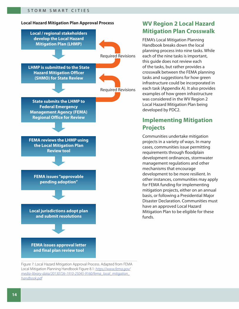
The Local Hazard Mitigation Plan Approval ProcessOnce the local planning team has completed the Local Hazard Mitigation Plan, it requires approval at both the state and federal levels. Figure 7 (see following page) provides an overview of the steps in the review process. State review is conducted by the State Hazard Mitigation Officer (SHMO), or State Mitigation Planner, at the state level emergency management agency. Prior to submitting the plan to the SHMO, the local planning team should ensure that the plan meets all requirements of Title 44 CFR 201.6. FEMA provides multiple guides and tools to assist local planners in developing their plan. The Local Mitigation Planning Handbook – provides overview and guidance on the steps in the planning process. The Local Mitigation Plan Review Tool - provides a checklist that can be used to identify where the local plan meets the regulations. Appendix B provides links to both documents.
After the SHMO has received the Local Hazard Mitigation Plan and is satisfied that it meets federal requirements, the state will send the plan to the FEMA Regional Office. FEMA will conduct its review within 45 days and provide a completed Local Mitigation Plan Review Tool to the state. In either of these steps, the SHMO may request additional clarification or revisions to the plan. Once the FEMA Regional office has approved the plan, they will notify the SHMO that the plan is, “approvable pending adoption” (APA). This means that once the local elected officials have formally adopted the plan, it will become the approved plan for that region. The final step is for the planning group to send documentation of formal adoption of the plan to the SHMO.
14
S T O R M S M A R T C I T I E S
WV Region 2 Local Hazard Mitigation Plan CrosswalkFEMA’s Local Mitigation Planning Handbook breaks down the local planning process into nine tasks. While each of the nine tasks is important, this guide does not review each of the tasks, but rather provides a crosswalk between the FEMA planning tasks and suggestions for how green infrastructure could be incorporated in each task (Appendix A). It also provides examples of how green infrastructure was considered in the WV Region 2 Local Hazard Mitigation Plan being developed by PDC2.
Implementing Mitigation ProjectsCommunities undertake mitigation projects in a variety of ways. In many cases, communities issue permitting requirements through floodplain development ordinances, stormwater management regulations and other mechanisms that encourage development to be more resilient. In other instances, communities may apply for FEMA funding for implementing mitigation projects, either on an annual basis, or following a Presidential Major Disaster Declaration. Communities must have an approved Local Hazard Mitigation Plan to be eligible for these funds.
Local Hazard Mitigation Plan Approval Process
Required Revisions
Required Revisions
FEMA issues approval letter and final plan review tool
Local / regional stakeholders develop the Local Hazard
Mitigation Plan (LHMP)
LHMP is submitted to the State Hazard Mitigation Officer (SHMO) for State Review
State submits the LHMP to Federal Emergency
Management Agency (FEMA) Regional Office for Review
FEMA reviews the LHMP using the Local Mitigation Plan
Review tool
FEMA issues “approvable pending adoption”
Local jurisdictions adopt plan and submit resolutions
Figure 7: Local Hazard Mitigation Approval Process. Adapted from FEMA Local Mitigation Planning Handbook Figure 8.1: https://www.fema.gov/media-library-data/20130726-1910-25045-9160/fema_local_mitigation_handbook.pdf

15
A G U I D E T O I N T E G R A T E G R E E N S T O R M W A T E R I N F R A S T R U C T U R E
Lessons LearnedHuntington’s experience with green infrastructure and this project contain lessons for other communities considering the approach. This section provides a list of those lessons along with a brief discussion.
1. Form a coalition of stakeholders -A coalition of stakeholders improves accountability and motivation. This project started by gathering a diverse group of local, regional, state, and federal stakeholders. Each stakeholder organization brought a unique perspective that helped the group to better understand the challenges and opportunities. State and federal stakeholders helped to provide the regulatory context for hazard mitigation planning, stormwater management and flood mitigation. They also helped the group understand technical and financial resources that could be used to support local activity. Local stakeholders provided input on impacts of flooding and stormwater in their communities. They understood local perspectives and local knowledge of green infrastructure. Regional stakeholders understood the similarities and differences across neighboring communities. As much of the planning takes place at both the local and regional levels, regional stakeholders provided insight on how local plans were developed, when they were developed, who was involved, and where there might be points of alignment between these plans.Communities interested in pursuing a similar effort should consider including representatives from the following organizations at the start of planning discussions:
• Thelocalutilityorauthorityresponsible for managing stormwater;
• Theorganizationresponsibleforlocal hazard mitigation planning;
• TheCity,County,andRegionalPlanning organizations;
Funding Mitigation ProjectsFEMA’s Local Hazard Mitigation Planning Handbook* lists the following funding opportunities:
• Hazard Mitigation Grant Program.FEMA’s Hazard Mitigation Grant Programassists in implementing long-termhazard mitigation measures followingPresidential disaster declarations.Funding may be authorized after adeclaration to implement projects inaccordance with State, Tribal, and localpriorities.
• Pre-Disaster Mitigation. FEMA’s Pre-Disaster Mitigation Grant Programprovides funds on an annual basisfor hazard mitigation planning andmitigation project implementationprior to a disaster. The goal of theprogram is to reduce overall risk to thepopulation and structures, while at thesame time also reducing reliance onFederal funding from actual disasterdeclarations.
• Flood Mitigation Assistance. FEMA’sFlood Mitigation Assistance Programprovides funds on an annual basis sothat communities can take measures toreduce or eliminate risk of flood damageto buildings insured under the NationalFlood Insurance Program (NFIP).
* FEMA Local Mitigation Planning Handbook: https://www.fema.gov/media-library-data/20130726-1910-25045-9160/fema_local_mitigation_handbook.pdf
16
S T O R M S M A R T C I T I E S
• Localfloodplainmanagers;
• Localwatershedassociationmanagers;
• CountyorRegionalConservationDistricts and/or agricultural offices;
• CommunityorNeighborhood associations;
• Localuniversitiesorotherlarge institutions;
• TheSHMOorStateMitigationPlanner;
• TheStateEnvironmentalProtection Agency (MS4/stormwater, green infrastructure, and watershed planning contacts);
• TheFEMARegionalMitigationPlanning Office; and
• TheEPARegionalgreeninfrastructure contact.
2. Identify local champions – In any local effort,it is important to have a local champion. Localchampions are more than just stakeholders;they are engaged and invested in the issues.They want a positive outcome for their localcommunity. Local champions understandlocal drivers and keep stakeholders engaged.Champions can emerge in several ways, andregulatory drivers may create conditionsfora local champion. In this effort, there weremultiple local champions. HSU is a championfor stormwater management and greeninfrastructure. The Huntington City PlanningOffice is a champion for a livable City. PDC2 is achampion for engaged planning that leads totangible results for the Region. Each of thesechampions was important to understandinglocal needs, involving local stakeholders, andkeeping this project moving forward. Theywere invested in both the process and theoutcomes for their community. Identifying andengaging local champions is an important steptoward success.
3. Build on previous successes – This effort started as an outgrowth of previous successes in Huntington, WV including the EPA “Making a Visible Difference” initiative, Brownfields revitalization efforts, stormwater management efforts, and other locally driven projects to promote a livable and economically successful city. The relationships formed during previous engagement helped build momentum and interest in this planning effort. Communities should look to build on their own previous successes, knowledge, understanding, and relationships when undertaking a similar effort. This engagement can help to reframe problems and keep stakeholders engaged in the process.
4. Understand local experience and capacity for green infrastructure –Each community will have a different level of understanding and capacity for green infrastructure. Local motivations or drivers for green infrastructure may differ across communities. In this effort, HSU and Marshall University were the primary organizations engaged in green infrastructure projects. This engagement was initially motivatedby regulatory MS4 drivers. This planning effort introduced new possibilities to expand interest in the benefits of green infrastructure. However, it was important to understand how flood mitigation strategies might align with processes already inplace and what new approaches were necessary to expand local capacity. New approaches might include; changes to the planning and implementation process for infrastructure maintenance and replacement (road repaving, water/sewer upgrades, etc.), adopting new policies or ordinances, establishing new partnerships, and creating new funding strategies.
17
A G U I D E T O I N T E G R A T E G R E E N S T O R M W A T E R I N F R A S T R U C T U R E
These considerations were important from both a planning and implementation perspective. Communities can consider the following questions as they work to understand local capacity:
• Willtheuseofgreeninfrastructureforflood hazard mitigation require newapproaches to get practices in theground?
• Whatisthecapacityofexistingorganizations to take on these newapproaches?
• Canexistingapproachestostormwatermanagement or flood mitigation bemodified or expanded?
• Willnewordifferentorganizationsneedto be engaged in order add capacity?
• Willtheexpandeduseofgreeninfrastructure require “new” technicalexpertise for project designs andconstruction?
• Howmayweneedtochangethewaythat we are working to integrate greeninfrastructure?
• Dowehavetherightpartnersandstakeholders engaged in the process?
Considering these questions can help planners understand local capacity, reframe the issues and consider alternative solutions.
Another important consideration is engaging the community to understand their level of knowledge and comfort with green infrastructure, how it works, and the benefits it can provide. The mechanics of stormwater
management, absorption and infiltration, water treatment, and the science behind green infrastructure are technical concepts that can be difficult to understand. As partners build support for their efforts, they need to find a way to connect the effort to something of value for communities. Providing scientific studies may not be the most effective tactic. Though effective for some, numbers and graphs may not convey the cultural fabric of a community, or what makes that community unique for its residents. Planners should be ready to connect green infrastructure benefits with community needs, preserving and supporting the unique characteristics of a community, its diversity and its history.
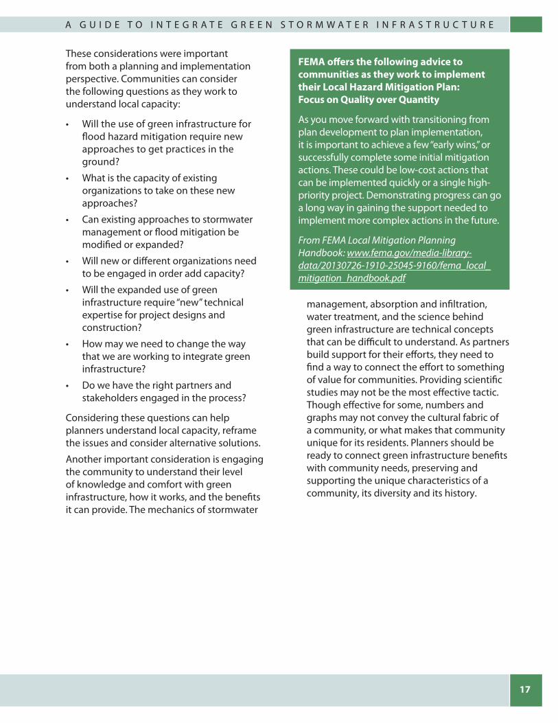
FEMA offers the following advice to communities as they work to implement their Local Hazard Mitigation Plan: Focus on Quality over Quantity
As you move forward with transitioning from plan development to plan implementation, it is important to achieve a few “early wins,” or successfully complete some initial mitigation actions. These could be low-cost actions that can be implemented quickly or a single high-priority project. Demonstrating progress can go a long way in gaining the support needed to implement more complex actions in the future.
From FEMA Local Mitigation Planning Handbook: www.fema.gov/media-library-data/20130726-1910-25045-9160/fema_local_mitigation_handbook.pdf

18
S T O R M S M A R T C I T I E S
ConclusionThis report provides any overview of efforts to include green infrastructure in the WV Region 2 Local Hazard Mitigation Plan. It is intended to share information on the processes used and lessons learned through this process, with communities and stakeholders interested in taking a similar approach. Though stormwater management and green infrastructure are not new ideas, including them in larger planning efforts represents a different way of thinking about concepts like mitigation. Community case studies provide opportunities for learning about green infrastructure successes and challenges, and highlight how communities identify, address, and overcome challenges. Like many communities, the City of Huntington is still on its journey to address stormwater management and flooding challenges. The integration of efforts presents the opportunity to better align resources and take full advantage of the multiple benefits that green infrastructure can provide.
Local stakeholders and communities can utilize FEMA’s hazard mitigation planning process, a regulatory requirement tied to eligibility for mitigation funding, to educate partners and build support for green infrastructure development. The planning process identifies risks that can be mitigated by green infrastructure solutions, provides opportunities for stakeholders to consider and prioritize implementation of green infrastructure, and outlines a mechanism by which communities can integrate the approach into their overall mitigation strategy. Appendix B of this report provides a list of additional tools that can be used to assist in these efforts. Stakeholders and communities are encouraged to take advantage of hazard mitigation guides and tools provided by FEMA along with tools provided by EPA and other organizations to better understand the potential to integrate green infrastructure in planning efforts.
Figure 8: Flooding in the City of Huntington. Photo credit: Chris Chiles, WV Region 2 Planning & Development Council
19
A G U I D E T O I N T E G R A T E G R E E N S T O R M W A T E R I N F R A S T R U C T U R E
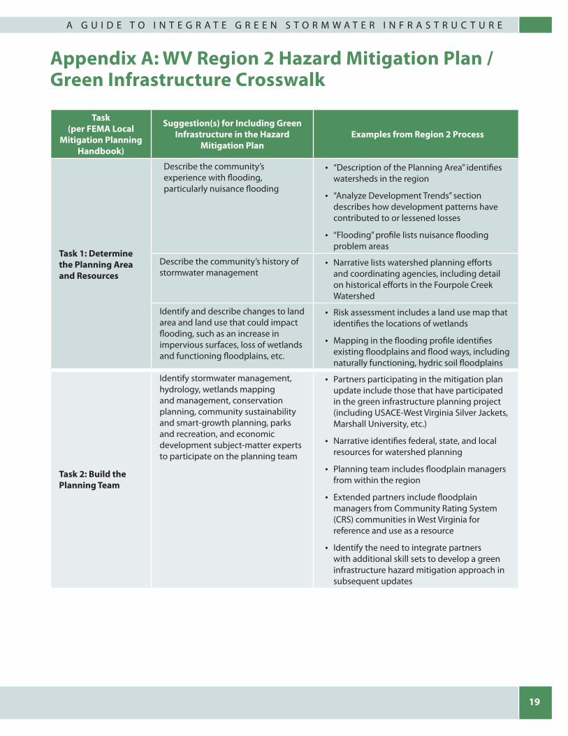
Appendix A: WV Region 2 Hazard Mitigation Plan / Green Infrastructure Crosswalk
Task (per FEMA Local
Mitigation Planning Handbook)
Suggestion(s) for Including Green Infrastructure in the Hazard
Mitigation PlanExamples from Region 2 Process
Task 1: Determine the Planning Area and Resources
Describe the community’s experience with flooding, particularly nuisance flooding
• “Description of the Planning Area” identifies watersheds in the region
• “Analyze Development Trends” section describes how development patterns have contributed to or lessened losses
• “Flooding” profile lists nuisance flooding problem areas
Describe the community’s history of stormwater management
• Narrative lists watershed planning efforts and coordinating agencies, including detail on historical efforts in the Fourpole Creek Watershed
Identify and describe changes to land area and land use that could impact flooding, such as an increase in impervious surfaces, loss of wetlands and functioning floodplains, etc.
• Risk assessment includes a land use map that identifies the locations of wetlands
• Mapping in the flooding profile identifies existing floodplains and flood ways, including naturally functioning, hydric soil floodplains
Task 2: Build the Planning Team
Identify stormwater management, hydrology, wetlands mapping and management, conservation planning, community sustainability and smart-growth planning, parks and recreation, and economic development subject-matter experts to participate on the planning team
• Partners participating in the mitigation plan update include those that have participated in the green infrastructure planning project (including USACE-West Virginia Silver Jackets, Marshall University, etc.)
• Narrative identifies federal, state, and local resources for watershed planning
• Planning team includes floodplain managers from within the region
• Extended partners include floodplain managers from Community Rating System (CRS) communities in West Virginia for reference and use as a resource
• Identify the need to integrate partners with additional skill sets to develop a green infrastructure hazard mitigation approach in subsequent updates

20
S T O R M S M A R T C I T I E S
Task (per FEMA Local
Mitigation Planning Handbook)
Suggestion(s) for Including Green Infrastructure in the Hazard
Mitigation PlanExamples from Region 2 Process
Task 2: Build the Planning Team (cont.)
Include funding specialists (i.e., grants, financing plans) on the planning team
• Planning team contains significant representation from the Region 2 Planning & Development Council, which routinely works with funding sources to compile project funding packages
• Include specialists in green infrastructure/low-impact development funding, such as CWSRF, 319 grants, watershed protection, and forestry/agriculture areas (these types of funding programs are new to this hazard mitigation planning process)
• Include overviews of programs from non-profit funding sectors like the Trust of Public Land and American Rivers
• Include exploratory efforts for creating public-private partnerships with green infrastructure resources
Task 3: Create an Outreach Strategy
Identify opportunities to educate stakeholders and the public about green infrastructure choices
• Narrative describes the August 29, 2017, public meeting on green infrastructure as part of the planning process
Add mitigation information to required outreach for other compatible initiatives (e.g., MS4 outreach, community and economic development planning public meetings, trade shows, etc.) to educate community members on how they can build mitigation, resilient construction, and green infrastructure into existing efforts
• Narrative describes how local authorities combine mitigation information with required MS4 outreach
Identify jurisdictions that would like to learn more about green infrastructure and low-impact development approaches
• Narrative recognizes Huntington Stormwater Utility as an “in-region” subject-matter expert to provide technical assistance to other communities in the region that are interested in green infrastructure approaches
• Action plan narrative includes projects for other jurisdictions in the region that have chosen to learn more about green infrastructure project implementation from Huntington
• Project list includes educating engineers and developers as to green infrastructure options

21
A G U I D E T O I N T E G R A T E G R E E N S T O R M W A T E R I N F R A S T R U C T U R E
Task (per FEMA Local
Mitigation Planning Handbook)
Suggestion(s) for Including Green Infrastructure in the Hazard
Mitigation PlanExamples from Region 2 Process
Task 4: Review Community Capabilities
Review any local-level MS4 or other relevant ordinances and plans (such as greenway plans, transportation development plans, land use plans, etc.)
• Narrative discusses the connections between stormwater regulations and flood mitigation
• Narrative outlines which communities participate in state-led stormwater management efforts
• Narrative outlines relevant partners (e.g., Huntington Stormwater Utility)
• Narrative discusses opportunities to integrate mitigation with watershed-based plans and non-point source plans; narrative identifies projects in those plans that benefit mitigation
• Narrative identifies potential for education on plan integration, instances where code reviews for consistency with mitigation tenants, etc. would be appropriate
Consider local abilities to implement tax or other credits for those that build green infrastructure
• Reach out to communities that have implemented these types of efforts to learn about the potential pitfalls associated with implementing them
• Recognize the coordination that will be necessary with state and other agencies regarding implementation of tax credits
Survey participating community capabilities (e.g., personnel with special skills, available volunteer organizations, public-private partnerships, etc.)
• Narrative describes partnerships with agencies that participated in the green infrastructure project
• Narrative includes integration of the USACE-West Virginia Silver Jackets’ GIS tool for locating areas suitable for green infrastructure projects
Task 5: Conduct a Risk Assessment
Identify instances of flooding, with potential causes, throughout the community
• Narrative differentiates between riverine flooding and flash flooding (as well as nuisance flooding)
• Narrative integrates findings from KYOVA study of streets, viaducts/underpasses, and stormwater
• Narrative describes recent efforts to refine flood mapping in the Guyandotte Watershed as an example of an initiative to consider flood mitigation at the watershed level
Describe the types of problems associated with nuisance flooding (e.g., flooded homes, blocked roads) and identify any resultant impacted critical facilities and infrastructure
• Narrative lists problem areas in City of Huntington and identifies/describes past green infrastructure projects and their benefits on flooding in those areas

22
S T O R M S M A R T C I T I E S
Task (per FEMA Local
Mitigation Planning Handbook)
Suggestion(s) for Including Green Infrastructure in the Hazard
Mitigation PlanExamples from Region 2 Process
Task 6: Develop a Mitigation Strategy
Engage green infrastructure subject matter experts for reviewing flood risk areas and potential project ideas
• Include green infrastructure expertise on all mitigation planning teams
• Create a plan review step where natural resources and stormwater staff are engaged in initial planning and final selection of flood mitigation projects
Add green infrastructure projects, where appropriate, to the mitigation project list (e.g., bioretention areas, bioswales, floodplain restoration, green streets, increasing natural or constructed features to slow and infiltrate stormwater, open space preservation, permeable pavement, restoration of upland forests, retention ponds, stream buggers, etc.)
• Action plan narrative includes completed green infrastructure projects and describes their benefits
• Narrative lists individual mitigation projects by jurisdiction, along with coordinating agencies and potential funding sources (to include non-FEMA funding sources)
• Action plan includes a short series of regional mitigation projects (either coordinated by the Region 2 Planning & Development Council or those that affect/impact/benefit a large area of the region)
• Project narratives identify potential supporting partners on a project-by-project basis
Describe how green infrastructure projects will lessen or eliminate flood losses (as a result of those projects)
• Green infrastructure projects in the action plan refer to specific listings of nuisance flooding and associated loss estimates in the flooding profile
Include a history of relevant projects, describe their status and the benefits that have been realized from them
• Narrative includes a list of previously-completed mitigation projects, including TMDL history, 319 grant/project history, USDA/NRCS water resource grant/projects history, etc.
• Action plan narrative includes general stormwater management planning projects at the jurisdictional level
Task 7: Keep the Plan Current
Frequently engage stormwater management, hydrology, etc. subject-matter experts
• Use new knowledge to incorporate green infrastructure as a routine component of local/regional mitigation planning
• “Plan Development & Maintenance” section notes continued partnership with WVSJ, HSU, etc.
• Narrative encourages future participation from relevant subject-matter experts from Marshall University
Invite subject-matter experts to annual mitigation plan review meetings
• PDC plans to invite green infrastructure project partners to annual Hazard Mitigation Plan reviews
23
A G U I D E T O I N T E G R A T E G R E E N S T O R M W A T E R I N F R A S T R U C T U R E
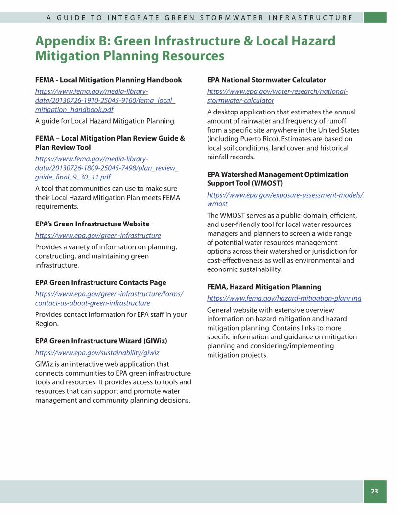
Appendix B: Green Infrastructure & Local Hazard Mitigation Planning Resources
FEMA - Local Mitigation Planning Handbookhttps://www.fema.gov/media-library-data/20130726-1910-25045-9160/fema_local_mitigation_handbook.pdf
A guide for Local Hazard Mitigation Planning.
FEMA – Local Mitigation Plan Review Guide & Plan Review Toolhttps://www.fema.gov/media-library-data/20130726-1809-25045-7498/plan_review_guide_final_9_30_11.pdf
A tool that communities can use to make sure their Local Hazard Mitigation Plan meets FEMA requirements.
EPA’s Green Infrastructure Websitehttps://www.epa.gov/green-infrastructure
Provides a variety of information on planning, constructing, and maintaining green infrastructure.
EPA Green Infrastructure Contacts Page https://www.epa.gov/green-infrastructure/forms/contact-us-about-green-infrastructure
Provides contact information for EPA staff in your Region.
EPA Green Infrastructure Wizard (GIWiz)https://www.epa.gov/sustainability/giwiz
GIWiz is an interactive web application that connects communities to EPA green infrastructure tools and resources. It provides access to tools and resources that can support and promote water management and community planning decisions.
EPA National Stormwater Calculator https://www.epa.gov/water-research/national-stormwater-calculator
A desktop application that estimates the annual amount of rainwater and frequency of runoff from a specific site anywhere in the United States (including Puerto Rico). Estimates are based on local soil conditions, land cover, and historical rainfall records.
EPA Watershed Management Optimization Support Tool (WMOST) https://www.epa.gov/exposure-assessment-models/wmost
The WMOST serves as a public-domain, efficient, and user-friendly tool for local water resources managers and planners to screen a wide range of potential water resources management options across their watershed or jurisdiction for cost-effectiveness as well as environmental and economic sustainability.
FEMA, Hazard Mitigation Planning https://www.fema.gov/hazard-mitigation-planning
General website with extensive overview information on hazard mitigation and hazard mitigation planning. Contains links to more specific information and guidance on mitigation planning and considering/implementing mitigation projects.

24
S T O R M S M A R T C I T I E S
FEMA, Hazard Mitigation Grant Programhttps://www.fema.gov/hazard-mitigation-grant-program
The purpose of this program is to help communities implement hazard mitigation measures following a Presidential Major Disaster Declaration in the areas of a state, tribe, or territory requested by a Governor or Tribal Executive. The key purpose of this grant program is to enact mitigation measures that reduce the risk of loss of life and property from future disasters.
FEMA, HAZUS-MH https://msc.fema.gov/portal/resources/hazus
HAZUS is a nationally-applicable standardized methodology that contains models for estimating potential losses from earthquakes, floods, and hurricanes. It uses geographic information systems technology to estimate physical, economic, and social impacts of disasters.
Georgetown Climate Center, Green Infrastructure Toolkithttp://www.georgetownclimate.org/adaptation/toolkits/green-infrastructure-toolkit/introduction.html
This resource analyzes common trends in the approaches various cities are taking to planning, implementing, and funding green infrastructure to manage stormwater. The toolkit is intended to aid local governments nationwide in comparing best practices across cities, drawing lessons from different approaches, and crafting similar policies for their own jurisdictions.
H2O Capture NRDC Green Infrastructure Benefits Calculatorhttp://www.adaptationclearinghouse.org/resources/h2o-capture-nrdc-green-infrastructure-benefits-calculator.html
H2O Capture is a green infrastructure benefits “calculator” that can estimate the benefits of a new project. It quickly presents benefits in a concrete numerical fashion meant to be a tool in deciding the feasibility of projects.
West Virginia Stormwater Management and Design Guidance Manual http://www.dep.wv.gov/WWE/Programs/stormwater/MS4/Pages/

25
A G U I D E T O I N T E G R A T E G R E E N S T O R M W A T E R I N F R A S T R U C T U R E
Appendix C: References1. Federal Emergency Management Agency,
National Flood Insurance Program. (2016). NFIP statistics. Retrieved from https://www.floodsmart.gov/floodsmart/pages/media_resources/stats.jsp
2. Federal Emergency Management Agency. (2013a). Flood risks nationwide. Washington, DC: Federal Government.
3. Federal Emergency Management Agency. (2013b). Local mitigation planning handbook. Washington, DC: Federal Government.
4. Federal Emergency Management Agency. (2013c). Mitigation ideas: A resource for reducing risk to natural hazards. Washington, DC: Federal Government.
5. Huntington, City of. (2017). City of Huntington dot com: The official website of Huntington, WV. Retrieved from http://www.cityofhuntington.com/
6. National Research Council. (2009). Urban stormwater management in the United States. Washington, DC: The National Academies Press. ISBN: 978-0-309-12539-0.
7. National Weather Service. (2017). Flood related hazards. Retrieved from http://www.floodsafety.noaa.gov/hazards.shtml
8. Region 2 Planning & Development Council. (2015). Home page. Retrieved from http://www.region2pdc.org/
9. United States Bureau of the Census. (2015). QuickFacts: Huntington city, West Virginia. Retrieved from https://www.census.gov/quickfacts/fact/table/huntingtoncitywestvirginia,WV/PST045216
10. United States Department of Homeland Security, Federal Emergency Management Agency. (2016). Hazard mitigation grant program. Retrieved from https://www.fema.gov/hazard-mitigation-grant-program
11. United States Environmental Protection Agency. (2009). Water quality scorecard (EPA 231B09001). Washington, DC: Federal Government.
12. United States Environmental Protection Agency. (2014). Planning for flood recovery and long-term resilience in Vermont: Smart growth approaches for disaster-resilient communities (EPA 231-R-14-003). Washington, DC: Federal Government.
13. United States Environmental Protection Agency. (2015). Tools, strategies, and lessons learned from EPA green infrastructure technical assistance projects (EPA 832-R-15-016). Washington, DC: Federal Government.
14. United States Environmental Protection Agency. (2017a). Benefits of green infrastructure. Retrieved from https://www.epa.gov/green-infrastructure/benefits-green-infrastructure
15. United States Environmental Protection Agency. (2017b). Stormwater discharges from municipal sources? Retrieved from https://www.epa.gov/npdes/stormwater-discharges-municipal-sources
16. United States Geological Survey. (2000). Significant floods in the United States during the 20th century – USGS measures a century of floods (USGS Fact Sheet 024-00). Retrieved from https://pubs.usgs.gov/fs/2000/0024/report.pdf
17. Villarreal, E. L., Semadeni-Davies, A., & Bengtsson, L. (2004). Inner city stormwater control using a combination of best management practices. Ecological Engineering, 22, 279-298.
18. West Virginia Department of Environmental Protection. (2012). West Virginia stormwater management and design guidance manual. Charleston, WV: State Government.
26
S T O R M S M A R T C I T I E S
19. West Virginia Department of Environmental Protection. (2017). Watershed plans. Retrieved from http://www.dep.wv.gov/WWE/Programs/nonptsource/WBP/Pages/planning.aspx
20. United States Environmental Protection Agency. (2016). Climate change indicators in the United States (4th edition). Washington, DC: Federal Government.
21. Tabler, D. (2015). The flood that convinced Huntington to build a flood wall. Appalachian History, online. Retrieved from http://www.appalachianhistory.net/2015/03/appalachias-katrina.html
22. United States Environmental Protection Agency. (2017). What is green infrastructure? Online. Retrieved from https://www.epa.gov/green-infrastructure/what-green-infrastructure
List of AcronymsAPA Approvable Pending Adoption
CEDS Comprehensive Economic Development Strategy
CFR Code of Federal Regulation
CWA Clean Water Act
EPA Environmental Protection Agency
FEMA Federal Emergency Management Agency
GIWiz Green Infrastructure Wizard
HIRA Hazard Identification and Risk Assessment
HSU Huntington Stormwater Utility
MS4 Municipal Separate Storm Sewer System
NFIP National Flood Insurance Program
NPDES National Pollutant Discharge Elimination System
PDC2 West Virginia Region 2 Planning & Development Council
SHMO State Hazard Mitigation Officer
SWMP Stormwater Management Program
USACE United States Army Corps of Engineers
WMOST Watershed Management Optimization Support Tool
WV West Virginia
WV-DEP West Virginia Department of Environmental Protection
WVDHSEM West Virginia Department of Homeland Security and Emergency Management

27
A G U I D E T O I N T E G R A T E G R E E N S T O R M W A T E R I N F R A S T R U C T U R E
Front and Back Cover Photos:Top photo: Green infrastructure in Huntington, West Virginia. Photo credit: Sherry Wilkins, HSU.
Bottom row, left to right: Flooding in Huntington, West Virginia.
Photo credit: Chris Chiles, WV Region 2 Planning & Development Council

United StatesEnvironmental ProtectionAgency