Embed Size (px)
Citation preview

Past Global Changes (PAGES)
Status Report andImplementation Plan
Edited byFrank Oldfield
Acknowledgements“I would like to thank Keith Alverson, Steve Colman, Leila Harris, and Bettina Jennyfor their invaluable help in compiling this Plan. Thanks are due also to the PAGESLeaders who have submitted material for inclusion, as well as contributed cruciallyto the success of PAGES by coordinating the Activities and Tasks for which they areresponsible. I am also grateful to the Executive Committee and Scientific SteeringCommittee members, especially Tom Pedersen, who reviewed parts of the text.The PAGES community as a whole owes a major debt of gratitude to the NationalScience Foundations of Switzerland and the United States for the financial supportprovided to run the International Project Office in Bern”.
IGBP REPORT 45
The International Geosphere-Biosphere Programme (IGBP): A Study of Global Changeof the International Council of Scientific Unions (ICSU)Stockholm, Sweden

The International planning and coordination of the IGBP is supported byNational Contributions and the International Council of Scientific Unions (ICSU)
Implementation Plan
This document describes an IGBP Implementation Plan approved by theScientific Committee for the International Geosphere-Biosphere Programme(SC-IGBP).
The IGBP Report Series is published as an annex to the Global Change NewsLetterand distributed free of charge to scientists involved in global change research.Both publications can be requested from the IGBP Secretariat, Royal SwedishAcademy of Sciences, Box 50005, S -104 05 Stockholm, Sweden
Cover Illustration: From the PAGES IPO photo archive
Layout and Technical Editing: Lisa Wanrooy-CronqvistCopyright © IGBP 1998. ISSN 0284-8015

3
Contents
Executive Summary ____________________________________ 7
Introduction ___________________________________________ 9
Project Objectives ______________________________________ 13
PAGES Priorities _______________________________________ 15
Project Organization ____________________________________ 17
History of PAGES ______________________________________ 19
Accomplishments of the Palaeoscience Community inAnticipation of PAGES __________________________________ 21
How has the Climate Varied in the Past – An Overview ________ 25
FOCUS I Palaeoclimates of the Northern and SouthernHemispheres (PANASH) ________________________ 31Activity 1 Palaeoclimates of the Americas Pole-Equator-Pole
(PEP I) 35Activity 2 Palaeoclimates of the Austral-Asian Transect (PEP II) 41Task 1 Baikal Drilling Project (BDP) 47Task 2 The Himalayan/Tibetan Plateau Interdisciplinary
Palaeoclimate Project (HIPP) 54Activity 3 The Afro-European Palaeoclimatic Transect
Pole-Equator-Pole (PEP III) 60Task 1 The International Decade for the East African Lakes
(IDEAL) 69Task 2 Palaeomonsoons Project (PM II) 74Activity 4 The Oceans 79Task 1 International Marine Global Change Study (IMAGES) 79Activity 5 PAGES/CLIVAR Interactions 87Task 1 Annual Records of Tropical Systems (ARTS) 91

4
FOCUS II Palaeoclimate and Environmental Variability inPolar Regions ________________________________ 95Activity 1 Arctic Programmes 95Task 1 Circum-Arctic PalaeoEnvironments (CAPE) 95Task 2 NANSEN Arctic Drilling Programme (NAD) 107Task 3a Greenland Ice-Core Project (GRIP) 112Task 3b The Greenland Ice Sheet Project Two (GISP2)
Ice-Core Record 117Task 4 Ice Core Circum-Arctic Palaeoclimate Programme
(ICAPP) 130Activity 2 Antarctic Programmes 137Task 1 International Trans-Antarctic Scientific Expedition
On 200 Years of Past Antarctic Climate andEnvironmental Change (ITASE) 138
Task 2 Late Quaternary Sedimentary Record of theAntarctic Ice Margin Evolution (ANTIME) 144
Activity 3 Bi-Polar Programmes 152Task 1 Palaeoenvironments from Ice Cores (PICE) 152
FOCUS III Human Interactions in Past Environmental Changes 159Activity 1 Human Impacts on Fluvial Systems 159Activity 2 Human Impacts on Terrestrial Ecosystems 164
FOCUS IV Climate System Sensitivity and Modelling_________165Activity 1 Climate Forcing and Feedbacks 165Task 1 Climate Impacts of Explosive Volcanism 165Task 2 Solar Influences on Climate 170Task 3 Greenhouse Gases and Aerosol Influences 171Task 4 Abrupt Climate Change and Internal Climate
System Dynamics 172Activity 2 Climate Model-Data Intercomparisons 175Task 1 Palaeoclimate Modelling Intercomparison Project
(PMIP) 173Task 2 Palaeoenvironmental Multiproxy Analysis and
Mapping Project (PMAP) 179Task 2a BIOME 6000 188
FOCUS V Cross-Project Analytical and Interpretive Activities _193Activity 1 Chronology 193Activity 2 Development of New Proxies 196Task 1 Isotope Calibration Study 196Task 2 Continental Drilling for Palaeoclimate Records 203Activity 3 International PalaeoData System 208Activity 4 Regional Education and Infrastructure Efforts (REDIE) 213

5
PAGES Management ____________________________________215PAGES Project Guidance and Administration 215
Interproject Scientific Activities___________________________219The BIOME 6000 / PMIP Collaboration withGAIM/GCTE/IGBP-DIS 219PAGES/CLIVAR 219PAGES/IGAC 220PAGES/BAHC/LOICZ 220PAGES/GAIM/IGAC 150k Year Challenge 220
Appendix I ____________________________________________221List of PAGES Workshop Reports and Other Publications 221
Acronyms and Abbreviations ____________________________223
List of IGBP Publications ________________________________229IGBP Report Series. List with Short Summary 229

6

7
Executive Summary
This document summarizes progress made thus far by the Past Global Changes(PAGES) programme element of the International Geosphere-Biosphere Programme(IGBP). The document also outlines the implementation plans for most of the Foci,Activities and Tasks currently within the PAGES remit. The plan first introduces thescope and rationale of PAGES science and explains how PAGES is organized struc-turally and scientifically to achieve its goals. For all of the palaeosciences relevant toIGBP goals, PAGES has sought to identify and create the organizational structuresneeded to support continued work and progress.
The objectives of the PAGES project are set out in the form of key questions relatedto overall IGBP objectives. These key questions in turn define the priorities de-scribed in the following sections. The text then proceeds to outline the way in whichPAGES has set about meeting these priorities and objectives. Current activities areset within a historical context. This includes both the sequence of meetings that ledto the creation of the PAGES project, as well as the scientific knowledge and under-standing that formed the basis upon which PAGES science was established. The textalso offers a very brief overview of our current state of knowledge about the way inwhich climate has varied in the geologically recent past.
From these general considerations emerge the Foci, Activities and Tasks that formthe main core of PAGES research. These are summarized in the Table of Contents.The widely distributed PAGES publications that have already emerged and arelinked to these are listed in Appendix I. The main body of the text comprises a sum-mary of progress and plans for implementation for each of the current Foci, Activi-ties and Tasks. Each section has been prepared, with relatively few constraints, byone or more of the research leaders responsible for that aspect of PAGES research.
The first sections, on ‘Global Palaeoclimate and Environmental Variability’ fall un-der the umbrella of the Palaeoclimates of the Northern and Southern Hemisphere(PANASH) and are prefaced by a section devoted to the overarching rationale.Thereafter, each of the Pole-Equator-Pole (PEP) Transects is considered, progress todate reviewed, and plans for the future described. The next section deals with theInternational Marine Global Change Study (IMAGES), a major initiative co-spon-sored by PAGES and the Scientific Committee on Oceanic Research (SCOR). This re-cently launched activity is the central contribution of PAGES to oceanographic re-search and emphasizes high resolution palaeorecords from key locations. The de-

8
scription of plans under Focus I closes with a consideration of high resolutionrecords mostly for the last few hundred years, the time frame of common interest forboth PAGES and the World Climate Research Programme (WCRP) through its Cli-mate Variability and Predictability (CLIVAR) initiative. A notable contribution to theCLIVAR programme is the task Annual Records of Tropical Systems (ARTS).
The second Focus, on polar studies, has given rise to a series of reports that rangefrom largely retrospective accounts, in the case of Greenland Ice Core Project (Euro-pean) (GRIP) and Greenland Ice Sheet Project Two (USA) (GISP 2), to outlines ofplans for new initiatives in both polar regions. The Antarctic initiatives are co-spon-sored with the Scientific Committee on Antarctic Research (SCAR). Overall, the po-lar programmes encompass major efforts designed to retrieve long, deep ice corerecords from both Greenland and Antarctica, as well as coordination exercises to in-tegrate palaeorecords from the many, diverse archives available in polar regions.
Thus far, Focus III within PAGES has received less attention relative to the initiativesdescribed above. Only the first Activity, concerned with “‘Human Impacts on Flu-vial Systems”’ has resulted in a comprehensive implementation plan.
Focus IV deals with “Climate System Sensitivity and Modelling” with emphasis onclimate forcing and feedbacks. Separate Tasks on volcanic, solar, and greenhousegas/ aerosol influences have been identified but only in the case of volcanic influ-ences has a detailed implementation plan been defined. Modelling aspects currentlyhinge on model intercomparisons, on model-data interaction, data ‘mapping’ andtime-slice reconstructions for model validation.
The final section (Focus V) deals with “Cross-Project Analytical and InterpretativeActivities”. These include a strong emphasis on chronology, on calibration, espe-cially with respect to stable isotope signatures, and on continental records ofpalaeoclimate. Thereafter follows a brief description of the educational, capacitybuilding, and infrastructural roles of PAGES.
The concluding part of the text provides an overall perspective on PAGES activitiesand their future scope.
Frank OldfieldExecutive OfficerPAGES International Project Office

9
Introduction
PAGES is the IGBP International Project charged with providing a quantitative un-derstanding of the Earth’s past environment and with defining the envelope of natu-ral environmental variability against and alongside which we can assess anthropo-genic impact on the Earth’s biosphere, geosphere, hydrosphere and atmosphere.
Models intended to predict future environmental changes must, in order to demon-strate their effectiveness, be capable of accurately reproducing conditions known tohave occurred in the past. Through the organization of coordinated national and in-ternational scientific efforts, PAGES seeks to obtain and interpret a variety ofpalaeoclimatic records and to provide the data essential for the validation of predic-tive climate models. PAGES activities include integration and intercomparison ofice, ocean and terrestrial palaeorecords and encourages the creation of consistentanalytical and data-base methodologies across the palaeosciences.
In accordance with the constitution of the IGBP, PAGES embraces the palaeoaspectsof the “... interactive physical, chemical and biological processes that regulate thetotal Earth system.” The overall priorities of the PAGES International Project focuson those global-scale processes and key interactions that may lead to significant en-vironmental change. A more complete understanding of these processes is crucialfor improving “... practical, predictive capability.”
PAGES emerged in the context of a palaeoresearch community that had traditionallybeen divided along continental-terrestrial, marine and polar lines, as well as in otherways reflecting the broad range of specializations and environmental archives em-ployed. In addition, several previous and/or ongoing palaeoinitiatives, such asGRIP and GISP2 (see below), evolved together with PAGES. Thus, one of the mostimportant initial activities of PAGES was the development of a coherent scientificplan that incorporated existing activities of global significance and also brought to-gether the marine, terrestrial and polar research communities.
Work of the type that has been incorporated within, and/or promoted by, PAGES isoften dependent on the availability of high quality, often unique, palaeoenvironmen-tal archives. The research carried out at many sites is very costly in terms of time,funds, and effort. This means that, while the implications of the research may bewide-ranging or even global, the research activity itself is often highly site-specificand often reflects a considerable and sustained investment over a long period oftime, not only in recovery of the palaeoarchive itself, but also in calibration and

10
analysis of the record. Any programme like PAGES, starting at a given point in time,can develop a range of responses to the ongoing research that reflects its core con-cerns and scientific remit. The role of PAGES in relation to projects developed dur-ing its life span has taken several forms, depending on the part PAGES has played indefining goals, stimulating particular projects, establishing guidelines, protocols,quality control mechanisms, priorities, or developing the infrastructure for the coor-dination and archiving of results. PAGES works by focusing and fostering the mostappropriate contributions possible from a wide range of palaeoscientists, rather thanby applying its efforts to more circumscribed research campaigns.
Much of PAGES science is “bottom-up”, driven by the realization among fellow re-searchers that adoption of an approach, definition of a problem, and acceptance of aset of criteria consistent with PAGES formulations improves possibilities both forfunding (since PAGES priorities are so widely recognized and respected at nationaland international levels) and for full recognition of the significance of the results.This widespread acceptance allows for a broad ranging definition of what consti-tutes PAGES science when defined by application of PAGES criteria to specificprojects or proposals. It also makes it both difficult and inappropriate to claimPAGES “ownership” for much of the ongoing research that satisfies PAGES criteria,has developed in response to PAGES agenda setting, or is actively fulfilling some ofwhat PAGES sets out to promote.
One of the most important roles of PAGES so far has been to set research agendasand thereby shift, sometimes even transform, the perceptions and priorities of thebroader scientific community. This process began with the first statements about pri-orities and time streams (see below) and has continued, reinforced by each succes-sive PAGES publication (listed in Appendix I). In this way, PAGES has taken thelead in achieving the integration of the research agendas of the terrestrial, marine,and polar palaeosciences.
One of the major achievements of PAGES to date is the increasing recognition of thePAGES agenda and of PAGES priorities by national and international funding agen-cies. PAGES has successfully created, within the wider field of palaeoscience, a se-ries of criteria and foci that define the PAGES mission. Many of these priorities havebeen explicitly referred to in the mission statements and research priorities gener-ated by both national and international funding agencies. In addition, national pro-grammes have been established in support of PAGES objectives. This widespreadand increasing acceptance transcends narrow definitions of specific projects and in-dividual scientists. Its effect has been to sharpen the focus of palaeoscience ontothose themes and problems of contemporary and future concern to humankind thatcan be addressed, in part, through an improved and coordinated palaeoperspective.
Notable examples of the impact of PAGES agenda setting are:
• The explicit modification of the science plans and priorities of both China andAustralia to support the needs of the PAGES PEP II Transect (see below)
• The establishment of the US NSF Earth System History initiative with a strongPAGES-oriented agenda

11
• The development of priority programmes both at international (e.g., EU) andnational (e.g., Germany) levels that reflect, often explicitly, the goals, criteria andtimeframes of PAGES Science
• The specification and implementation of the IMAGES programme, with its fo-cus on high resolution records often in areas where links with continentalrecords are possible, and the emphasis, in the current ODP Science Plan, onthemes of direct relevance to the PAGES agenda
• The establishment of the WDC-A for Palaeoclimatology with major involve-ment of PAGES in defining the standards and goals of the center’s activities.
Some of the major ways in which, during its period of operation, PAGES has ac-tively encouraged the science it supports include the organization and partial fund-ing of workshops and the subsequent distribution of a series of workshop reports,15 of which have been published so far (see Appendix I).
The roles of these workshops and of the subsequent publications have included:
- Defining the state of the art - Identifying research gaps and opportunities - Establishing priorities for future research.
Many of the Workshop Reports , (e.g., PANASH [Introduction], IMAGES [esp. pp.28–29], Global Palaeoenvironmental Data [pp. 11–27], Palaeoclimates of Arctic Lakesand Estuaries [PALE] and the Continental Drilling Workshop report), emphasize re-search protocols with a view to improving data quality, maximizing the informationretrievable from limited environmental archive material, increasing the degree ofcompatibility between the results of independently coordinated projects and facili-tating eventual data manipulation within major data bases.
In pursuit of its goals, PAGES has often worked in partnership with other interna-tional agencies. This cooperation is illustrated by the:
• Strong involvement of PAGES Scientific Steering Committee (SSC) members inmajor initiatives in polar research and the role they play in linking that researchto the broader PAGES global research agenda
• Growing links between PAGES and WCRP centered around the activities of thejoint PAGES/CLIVAR Working Group
• Involvement of PAGES in international initiatives like the International Decadefor East African Lakes (IDEAL ) and the Lake Baikal Drilling Programme (BDP),where the overall scientific goals go beyond the PAGES agenda but wherePAGES participation makes possible the achievement of important PAGES sci-ence objectives, at minimum additional cost, within the overall goals of the indi-vidual programmes

12
• Lead role PAGES has taken in seeking to strengthen the Global Network for Iso-topes in Precipitation (GNIP), administered up to the present by the Interna-tional Atomic Energy Agency (IAEA) and recognized to be of vital importancefor the calibration of stable isotope records of past changes in temperature, at-mospheric circulation, and hydrological regimes
• Lead role taken by present and former members of the PAGES SSC in the prepa-ration of Intergovernmental Panel on Climate Change (IPCC) reports on Cli-mate Change.
PAGES has already played a crucial role in the archiving, management and dissemi-nation of palaeodata. This is fully summarized in the recently published GlobalPalaeoenvironmental Data Workshop Report (95-2). The growing significance of thistype of activity is evidenced by the steep increase in consultation and use of the datacurrently in the public domain and accessible electronically, and by the growing im-portance of such data for model validation and intercomparison.

13
Project Objectives
The PAGES project focuses on specific sets of questions and issues:
• How have global climate and the environmental systems linked to it changed inthe past? What factors are responsible for these changes and how can we useour knowledge of them to improve insight into likely future climate and envi-ronmental change?
• To what extent have human activities modified climate and the global environ-ment? How can we disentangle anthropogenically induced change from naturalresponses to external forcing mechanisms and internal system dynamics? Whatwere the conditions of the Earth System prior to human intervention?
• What are the limits of natural greenhouse gas variation in the atmosphere andwhat are the natural feedbacks to the global climate system? In what sequence,in the course of environmental variation, do changes in greenhouse gas concen-trations, surface climate, and ecological systems occur?
• What are the important forcing factors that produce climate change on societaltime scales? What are the causes of abrupt climatic and environmental eventsand of the rapid transitions between quasi-stable climatic states that occur ondecadal to century time scales?

14

15
PAGES Priorities
From its inception, PAGES has established a set of priorities which ensure that im-portant scientific questions relevant to the goals of the IGBP will be addressed in acoherent manner. PAGES focuses on two “Temporal Streams” rather than on the en-tire record of past environmental change. Stream I concerns the last 2,000 years andStream II the last few glacial-interglacial cycles. It is within this temporal frameworkthat the information most appropriate to answering issues of fundamental concernto the IGBP will be found. Prioritizing these time streams and recognizing the tem-poral resolution required in each (see below) implies that a great deal of research atlower resolution, or concerned with earlier time periods, is less likely to contributesignificantly to the IGBP research agenda.
PAGES has identified specific criteria for its activities. They are applied for theevaluation and prioritization of research within the two timeframes. They are incor-porated specifically into the PANASH scientific strategy (see below and PAGES Re-port 95-1), but apply to all other observational activities within PAGES.
The main focus of PAGES observational activities will be on continuous, high resolu-tion records, with annual, or even seasonal, to decadal time resolution for Stream Istudies, and decadal to century scale resolution for Stream II studies (see below):
• All studies using proxy records will pay particular attention to chronology, toobtain the most accurate and detailed dating control possible
• Proxy records for palaeoclimate reconstruction will be well-calibrated, provid-ing a clearly understood palaeoclimate signal
• Wherever possible, multi-proxy studies will be carried out, to maximize the in-formation retrieved from a site and to provide mutually independent con-straints on any palaeoenvironmental reconstructions made
• Wherever possible, study sites will be selected to provide diagnostic evidencefor changes in large-scale sub-systems of climate
• Where appropriate, special attention will be given to the influence of human ac-tivity on the environment
• Special attention will be paid to the needs of data-model intercomparisons

16
• All PAGES data will ultimately be archived in the WDC-A for Palaeo-climatology in order to provide interested scientists with free and open accessto, and interchange of, palaeoclimate data and information.
17
Project Organization
The Earth’s environmental and ecological systems operate on a wide spectrum oftemporal and spatial scales. Therefore, palaeoenvironmental records are derivedfrom a great variety of natural archives such as: tree-rings; lake and oceansediments; wind-blown deposits; coral and ice cores; as well as historical accounts.The scientific community has recently developed a set of powerful analytical tech-niques to recover high resolution records of changes in environment and ecologyfrom these diverse sources. Through detailed analysis of “proxy” records, it is oftenpossible to distinguish annual changes over time spans of many thousands of years.It has become clear that the power of these techniques would be vastly increased bytheir coordinated application in multi-archive, multi-proxy studies. It is the task ofPAGES to organize the international scientific community to target critical scientificquestions, regions and time periods in a concerted effort to produce a coherent andquantitative record of the Earth’s natural history.
To that end, the PAGES Project is structured according to five research Foci. Three ofthese are research-observational Foci, other Foci include Climate Sensitivity and Mod-elling, and a cross-project Focus to address the broad analytical, data and communi-cation needs of the project. Within this framework, there are evolving research initia-tives designed to focus on specific regions and processes and to accomplish theoverall PAGES objectives.
The three research/observational Foci address the retrieval of high qualitymulti-proxy palaeorecords in a global network of field activities. This is an attemptto apply the full complement of operational and analytical methodologies to regionsessential for the completion of a coherent global environmental history. Within eachof these observational Foci, PAGES has designed two “temporal streams” which ad-dress the key scientific questions defined by the overarching needs of the IGBP, aswell as associated projects of the WCRP and International Human Dimensions Pro-gramme on Global Environmental Change (IHDP).
The objective of Stream I is to reconstruct the detailed history of climatic and envi-ronmental change for the entire globe for the period since 2,000 BP (Before Present),with temporal resolution that is at least decadal, and ideally annual or seasonal. Thisconstitutes the period of greatest human impact on the planet and the time of sig-nificant overlap between written records and the environmental information storedin natural archives.

18
With at least century-scale resolution, Stream II focuses on glacial-interglacial cyclesof the last several hundred thousand years and promotes the understanding of dy-namics that cause large-scale natural variation. Continued activities of this temporalstream will illuminate the interactive feedbacks among various components of theEarth system and their relation to external climatic forcing.
It should be noted that the goals related to both temporal streams are highly focusedwhen compared with the larger body of research which is at lower resolution ordeals with earlier time periods.
Within the sphere of “Human Interactions in Past Environmental Changes” (FocusIII), PAGES activities will highlight the impact of human activities on fluvial systemsand on terrestrial ecosystems.
A palaeoperspective is required in order to understand rates of change in these sys-tems at both regional and global scales - information which is of importance topresent day society.
The fourth PAGES Focus, “Climate System Sensitivity and Palaeoclimate Model-ling”, consists of activities designed to better understand the fundamental causes ofglobal climate change and the modelling of the Earth’s changing environmental sys-tems.
In addition, PAGES has established a fifth cross-cutting Focus which is required forthe advancement of all other Foci, “Cross-Project Analytical and Interpretative Ac-tivities”. This Focus addresses chronological control, measurement protocols, cali-bration and intercomparison studies, data management activities, fundamental labo-ratory studies, and regional and educational activities related to the effort of thejoint IGBP/IHDP/WCRP project Global Change System for Analysis, Research, andTraining (START).

19
History of PAGES
Throughout the last few decades, the scientific community has generated a wealth ofinformation from naturally occurring palaeorecords. These comprise a wide spec-trum of environmental parameters which reflect the evolution of earth systems. Thediscoveries made have been of unique relevance for the initiation of global changeresearch and have crystallized the need to include palaeoresearch within the IGBP.
In 1986, the final report of the International Council of Scientific Unions (ICSU) adhoc Planning Group recommended the initiation of the IGBP with a focus on interac-tive Earth system processes and with emphasis on processes that operate on timescales of decades to centuries (IGBP Report No. 11). The establishment of the IGBPwas a crucial step in the development of a holistic approach to studies of the Earthsystem. The IGBP has promoted a scientific culture within which interdisciplinaryprogrammes can flourish. By focusing attention on the importance of understandingphysical, chemical and biological processes on a global scale and within a definedtemporal framework, the IGBP has greatly enhanced the ability of the palaeosciencecommunity to develop the larger, international, and inter-disciplinary activitiesneeded to achieve maximum impact on global change related sciences.
One response to the ad hoc Planning Group’s recommendations was the establish-ment of a Working Group on Techniques for Extracting Environmental Data of thePast “... to assist in the interpretation of the history of the geosphere-biosphere”(IGBP Report No. 21). The Working Group met in Bern, Switzerland (July 1988) andprepared a report that outlined the problems and opportunities for cross-discipli-nary studies focusing on the potential contribution of palaeoscience to the globalchange effort (IGBP Report No. 61). Also in 1988, the Science Advisory Council(SAC) for IGBP “... expressed a firm statement of commitment to initiate as soon aspossible major new international research projects dealing with ... a coordinated ef-fort to recover information from natural archives that will illuminate connectionsbetween atmospheric composition, global temperature, ice extent, solar history, andthe distribution of land and oceanic organisms” (IGBP Report No. 7:11). The Councilestablished the Scientific Steering Committee (SSC) to develop the IGBP programmeelement entitled: “Global Changes of the Past” (PAGES).
Simultaneously, between 1986 and 1990 scientists involved in palaeoscience researchmet at a variety of Dahlem Conferences, workshops, and NATO conferences. Fromthese meetings, the concept of a coordinated programme of palaeostudies within the

20
framework of global change research was developed. A detailed plan for such a pro-gramme was described in Chapter 7 of IGBP Report No. 121 and led to the initiationof PAGES as a programme element of the IGBP.
With the endorsement of the IGBP, the initial PAGES Implementation Plan was for-mulated at the first meeting of the PAGES SSC (Mainz, Germany, 1991) and pub-lished as IGBP Report No. 191. This publication has served as a guide forpalaeostudies in the frame of global change research and as a guide for the imple-mentation of the PAGES organization. It also has been used for designing major seg-ments of national IGBP related research programmes.
In 1992, the National Science Foundations (NSF) of Switzerland and the US agreedto the joint support of the PAGES International Project Office (IPO) in Bern, Switzer-land, for a initial five-year period. Co-Directors from Switzerland and the US wereappointed. At the second meeting of the PAGES SSC (Bern, 1992), an ExecutiveCommittee (EXCOMM), composed of the Co-Directors and selected members of theSSC, was formed to administer the day-to-day business of the PAGES IPO and im-plement the scientific activities of PAGES.
1See List of IGBP Publications

21
Accomplishments of thePalaeoscience Community in
Anticipation of PAGES
In the initial phase of the IGBP, strong emphasis was given to Earth system model-ling. The general perception was that experiments with ever faster computers wouldeventually provide the answers to the questions posed. But many key questions dis-cussed within IGBP were raised because of information obtained from reconstruc-tions of past Earth system events. In attempting to understand the complex and in-teractive Earth system, knowledge of its past behaviour is critical. In addition to theobvious application of providing boundary conditions and validation tests for nu-merical models, the following results demonstrate that the evolution of the climatesystem provides the essential context within which to interpret model projections.
Pre-Industrial ConditionsAn urgent question posed in the 1970s concerned the pre-industrial concentrationsof greenhouse gases and the history of their early increase prior to the beginning ofdirect atmospheric measurements in the 1950s. Analysis of gases occluded in naturalice of known age demonstrates that the natural variability of gases, such as CO2,CH4 and N2O, during the last millennium was small compared to the increases dur-ing the last 200 years. This increase in greenhouse gas concentration, therefore, canbe attributed unambiguously to anthropogenic emissions. Atmospheric CO2 has in-creased by about 80 ppmv in the last 200 years, and the increase of the anthropo-genic greenhouse forcing at present is estimated to be between 2 and 2.5 W/m2.
Natural Greenhouse Gas Variations and their Relation toClimateAnalyses of the gas composition in ice cores reveal that the concentrations of thegreenhouse gases during the past glacial cycle changed in parallel with climate; dur-ing interglacial periods concentrations were high (CO2 ca. 280 ppmv) and duringglaciations they were low (CO2 ca. 200 ppmv). The change in CO2 concentration wasabout 80 ppmv and the difference in the greenhouse forcing was of the order of

22
2–2.5 W/m2, which is similar to the present anthropogenic contribution to the at-mosphere. Model experiments suggest that the changes in greenhouse gasses werepossibly responsible for the amplitude of the climatic (temperature) changes and forthe interhemispheric climatic coupling during past glacial cycles.
Reaction of Terrestrial Vegetation to Past ClimateChangeThe effects of both major and minor climate change on vegetation are recorded bythe change in pollen composition and other palaeoecological signatures in sedimentcores. Many other parameters measured in these cores, such as the oxygen isotopicratio of biogenically precipitated carbonate and the magnetic properties of thesediments, also reflect changes in environmental conditions. This information dem-onstrates that terrestrial vegetation tended to change on a global scale with the samerhythm as changes in the oceans and ice sheets. It contributes to the validation of cli-mate models by articulating spatial variability, and it also provides the basis for test-ing model simulations of vegetation change in response to climate forcing.
Changes in vegetation during major climate changes are also reflected in the varia-tions in atmospheric CO2 and its 13C/12C ratio, in atmospheric methane and in theisotopic signature of atmospheric CO2 as recorded in C4 plants. This information isused to reconstruct the history of atmospheric CO2 in terms of changes in the parti-tioning of carbon among the Earth’s reservoirs: atmosphere, biosphere, ocean andsediment.
Natural Climate VariabilityHigh-quality natural archives such as tree rings, annually banded corals, ice cores,and varved sediments provide annual or even finer resolution records for environ-mental parameters over the last few thousand years. Such records provide the onlyway to disentangle unambiguously the signal of anthropogenic climatic changefrom natural climate variability. These natural archives contain information on boththe history of climatic forcing (solar variations and volcanic eruptions) and the cor-responding climatic response superimposed on the internal system variability. Thenatural variability of system components, such as El Niño-Southern Oscillation(ENSO), North Atlantic oscillations, and monsoonal variations, is becoming increas-ingly evident through these archives.
Rapid and Unexpected Events in Past ClimatesRecent observations of rapid transitions of the climate system between well definedstates, as revealed by a broad spectrum of parameters in ocean sediments and icecores, has had a strong impact on the scientific community’s understanding of cli-mate variability. These changes are attributed to highly non-linear processes leadingto dramatic changes in system components, such as the formation of deep water inthe North Atlantic Ocean. Rapid changes in deep water formation in the North At-lantic, and the resulting large-scale changes in thermohaline circulation, are welldocumented for much of the last glacial period. They appear to have given rise to

23
temporally coherent but spatially differentiated climate changes on decadal tomillennial timescales at widely separated locations. Their hypothesized link toLaurentide ice sheet dynamics ties them to the conditions prevailing during coldstages. Both model simulations and somewhat controversial empirical evidence in-dicate at least the potential for similar instability in thermohaline circulation underwarm climate conditions. Possible warm-climate instabilities may be linked to dra-matic changes in the hydrological cycle in low latitudes and have the potential forstrong impact in large regions of the globe. Such changes and their likely impactscannot be ignored in any evaluation of future climate change.
Model-Data ComparisonsThat it is possible to reduce the complex processes of nature to fundamental lawsdoes not imply that it is also possible to completely describe nature by starting fromthese fundamental laws. The palaeorecord has demonstrated that new approacheswith different hierarchies are needed. Model studies of past and present environ-mental events are especially important for understanding the interactive physical,chemical, and biological control of Earth system processes.

24

25
How has the Climate Variedin the Past – An Overview
Although there is considerable uncertainty about the rate and magnitude of any fu-ture warming which may occur as a result of human activities, one thing is not indispute: any human-induced changes in climate will be superimposed on a back-ground of natural climatic variations. Hence, in order to understand future climaticchanges, it is necessary to have an understanding of how, why, and to what degreeclimates have varied in the past. Of particular relevance are: (i) climatic variations ofthe last few centuries leading up to the recent warming trends observed in instru-mental record; and (ii) rapid climatic changes that occurred at societal timescales,e.g., during the last ice age, the last glacial/interglacial (Holocene) transition andpossibly during the previous (Eemian) warm period. Two aspects of ocean surfacevariability are also of particular relevance to understanding long term climaticchange: (i) the variability of ENSO events; and (ii) variations in ice age tropical seasurface temperature.
Climate of the Past 2,000,000 YearsThe Pleistocene glacial-interglacial cycles characterize recent Earth history. This pe-riod, mostly cooler than at present, began about 2,400,000 years BP and was pre-ceded by a generally warmer and more stable climate. Over the last million years,these cycles occurred with a periodicity of about 100,000 years with long glacial pe-riods interrupted by interglacial periods of shorter duration. During the Last GlacialMaximum (LGM) (~20,000 BP), global surface temperatures were approximately 4oCcolder than at present. As a consequence of the build-up of continental ice sheetsover much of North America and Scandinavia, mean global sea-level was about 120metres below its present height. The timing of the recurring glaciations is believed tobe linked to variations in seasonal radiation receipts in the Northern Hemisphere.This insolation forcing, due to changes in the configuration of the Earth’s orbit, wasprobably further amplified by changes in the concentrations of greenhouse gasesand in the extent of continental ice cover.

26
Rapid Climate Changes During the Last GlacialInterglacial CycleRecent studies have brought new insight on the abruptness of climate changes dur-ing the last glacial-interglacial cycle. Large and rapid climatic changes occurred dur-ing the last ice age and the transition towards the present Holocene period. In thewell-documented North Atlantic region, as noted above, these changes appear to belinked to ice sheet dynamics and to the consequences of ice sheet changes for NorthAtlantic Deep Water formation and the thermohaline circulation. These changesmay have occurred within very few decades. They affected a large variety of cli-mate-related variables, such as: atmospheric temperature and circulation; precipita-tion patterns; and the temperature and dynamics of the ocean.
Much information on rapid climatic change has been obtained recently either from arefined interpretation of existing records or from new ice, ocean and continentalrecords. Of particular significance are those concerning the North Atlantic and adja-cent continents. The GRIP and GISP2 ice cores from central Greenland are more than3 km deep. They provide detailed climatic information extending back to the penul-timate glacial period. More numerous deep-sea records from the North Atlantic andcontinental records (lake sediments, pollen profiles, etc.) from Western Europe andNorth America provide further information on the last glacial period and subse-quent deglaciation.
Records confirm that the Younger Dryas (YD)/Preboreal transition that took place~ 11,500 years ago (11.5 ka BP) was very abrupt. Central Greenland temperatures in-creased by ~ 7oC in a few decades. There are indications of an even more rapidchange in precipitation with snow accumulation in central Greenland doublingwithin as little as one to three years and of rapid reorganization (< 5–20 years) of at-mospheric circulation. Changes in Sea Surface Temperature (SST) associated withsudden changes in the flow of warm Atlantic surface waters, also occurred in a fewdecades. In the Norwegian Sea, changes as great as 5oC occurred in less than 40years. The warming which marks the end of the LGM resulted in a 10oC temperatureincrease in the Northeast Atlantic in less than 400 years.
Numerous new deep-sea and continental records show that the YD cooling was feltthroughout the Northern Hemisphere. The last deglaciation was probably also atwo-step process in the Southern Hemisphere, but as seen from the East Antarctic icecore records, the return to cold conditions was much less pronounced and the subse-quent warming was much less abrupt than in the Northern Hemisphere.
The existence of rapid temperature oscillations discovered in Camp Century andDye-3 Greenland ice cores (now commonly known as “Dansgaard-Oeschgerevents”) has been confirmed by the central Greenland records. These events arecharacterized by rapid warmings, often by as much as half of the magnitude of theglacial-interglacial difference and taking place in a few decades. Evidence suggeststhat Dansgaard-Oeschger events are followed by periods of slower cooling and thena generally rapid return to glacial conditions. Approximately 20 such interstadials,lasting between 500 and 2,000 years, occurred during the last glacial period. Theyresemble the rapid changes documented in North Atlantic deep-sea core records andhave recently been identified in high resolution sediment sequences from the tropi-cal Atlantic and even in records from the Santa Barbara Basin in the Eastern Pacific.

27
The most prominent of these interstadials may be associated with the sedimentary“Heinrich” layers interpreted as reflecting massive iceberg discharge from NorthernHemisphere ice sheets. These discharges occurred at the end of the cooling cyclesand were followed by abrupt shifts to warmer SSTs .
During the last glacial period, continental records also indicate rapid changes.Moreover, a significant increase in atmospheric methane concentration is associatedwith the warm interstadials. This association may be due to variations in the hydro-logical cycle at low latitudes. This also suggests that the interstadials were at leasthemispheric in their extent. In addition, variability of precipitation has been impor-tant at low and mid-latitudes even when temperatures varied little.
The question of climatic instability during the last interglacial (Eemian) has alsobeen raised. For the period predating the last glacial stages (stages 2–4), isotopicrecords from central Greenland ice cores show a series of very abrupt changes, butthey are very different between the GRIP and GISP records, whereas the two cores,separated by only 28 km, are in excellent agreement throughout the glacial period.Furthermore, the comparison between the Antarctic and Greenland records of at-mospheric compounds which should be the same (CH4, atmospheric 18O) indicatesimportant differences. Interpreting the isotopic changes in the early parts of theGRIP and GISP ice cores in terms of climatic changes is therefore problematic. Thedivergence in the evidence from the two cores shows that ice flow may have alteredthe chronological sequences of the stratigraphy for the bottom part of one or both ofthe cores. The possibility that rapid climatic variations occurred during the Eemianrequires that the respective contribution of climate and ice flow in the GreenlandEemian signals be fully assessed. The identification of such apparently rapid eventsin other ice, oceanic or continental records would confirm their occurrence and indi-cate their spatial extent.
The existence of rapid climatic changes does not fundamentally modify our under-standing of glacial-interglacial cycles. However, it appears that the response to theinitial insolation forcing is highly non-linear, in particular in the North Atlantic andadjacent continents. These rapid events, which indicate a key climatic role for theocean, are relevant to understanding future climate because they affect all importantclimatic variables on a large geographical scale and they do so on timescales rel-evant to human society. This relevance to future climate will be even more direct ifthe existence of rapid changes in an interglacial period (the Eemian) is confirmed.
Tropical Sea Surface Temperatures (SSTs)The relationship between modern and past terrestrial and SSTs is still one of the ma-jor uncertainties involved in deriving the climate during the last ice age. The rela-tionship is important to general circulation models of the atmosphere, because manymodels prescribe SST, which then exerts strong control on the spatial pattern of heatflux to the atmosphere.
The project Climate Mapping, Analysis, and Prediction (CLIMAP) demonstratedthat oceanic sediment cores contain stratigraphically consistent sequences ofmicrofossils that indirectly record changes in SST. Recent work comparing CLIMAPSST estimates with nearby terrestrial surface temperature estimates show obviousdiscrepancies. Terrestrial temperature estimates derived from snow line lowerings

28
and pollen data on the mountains of New Guinea bring into question the earlierCLIMAP SST estimates, suggesting they may have been as much as 5oC too high.Palaeoclimate data from high altitude sites in equatorial East Africa and the BolivianAndes also point to significant snow line lowerings during the last glacial periodand suggest air temperature cooling of between 3o and 8oC. These estimates linksnowline depression to temperature change, without taking into account changes inprecipitation or humidity.
Although some recent results indicate that the continental cooling might have beensomewhat less than suggested earlier, the discrepancy between CLIMAP estimatesand terrestrial palaeodata is still significant and the inconsistencies between terres-trial and marine palaeotemperature reconstructions for the LGM remain unresolved.
Global Temperatures of the Past 1,000 YearsThe period of instrumental records is short, and longer records, extending back1,000 years or more, are required to determine how the rise in temperature over thelast century compares to records from earlier centuries. Historical, ice core, tree-ring,lake level and coral data are used for reconstructing the climate of the last millen-nium, but this is far from being as fully documented as the 20th century climate. An-nually resolved, precisely dated temperature histories from tree rings for the lastmillennium are still too sparse for hemispheric or global analysis, and must, in gen-eral, be interpreted in a regional context. Further, they usually only reflect changesin warm-season temperatures. Coral records occur in regions not represented bytree-rings and usually have annual resolution, but none extends back more than afew hundred years. The interpretation of ice-core records from polar ice-sheets andtropical glaciers may be in some cases limited by the noise inherent in thedepositional processes involved. Despite these limitations, a great deal of climaticinformation is available and records may be combined to produce consistent recon-structions of climate. For this last millennium, there are two periods of special focus,the Little Ice Age (LIA) and the Medieval Warm Period (MWP).
The term “Little Ice Age” is often used to describe a world-wide, 400–500 year long,synchronous cold interval. However, the climate of the last few centuries was morecomplex than this. It was a period of both warm and cold climatic anomalies whichvaried in importance geographically. For the Northern Hemisphere as a whole, thecoldest intervals of summer temperature were from 1570–1730 (especially 1600–1609) and during most of the l9th century, though individual records show varia-tions in this basic pattern. Although there were warm conditions commonly in theearly 16th century and in most of the 18th century for the entire hemisphere, condi-tions comparable to the decades from 1920 onward have not been experienced for atleast several hundred years.
It is important to recognize that the period of instrumental records, from which ourlimited view of “global warming” has been derived, began at one of the coldest peri-ods of the last few centuries. With a longer perspective on this period, alternativeviews of the temperature record of the last century emerge. On the one hand, thelong-term change of temperature could be interpreted as showing a gradual increasefrom the late 1500s, interrupted by cooler conditions in the l9th century. This warm-ing might be part of a longer (lower frequency) oscillation, with a period on the or-

29
der of a millennium. Alternatively, one could argue that temperatures fluctuatedaround a mean somewhat lower than the 1860–1959 average (punctuated by coolerintervals in the late 1500s, 1600s and 1900s) and then underwent pronounced, andunprecedented (e.g., since 1500) warming in the early 20th century. The developmentof appropriate strategies for detecting anthropogenic climate change depends on theresolution of such issues.
Recent studies have re-evaluated the climatic interval commonly known as theMWP in an attempt to assess the magnitude and geographical extent of any pro-longed warm interval between the 9th and 14th centuries. The available evidence islimited (geographically). A number of records do indeed show evidence of warmerconditions at some time during this interval, especially in the 11th and 12th centu-ries in parts of Europe. Other records are equivocal, or indicate that warmer condi-tions prevailed, but at different times. A clearer picture may emerge as an increasingnumber and better calibrated proxy records are produced. However, at this point, itis not yet possible to say whether, on a hemispheric scale, temperatures declinedfrom the 11–12th to the 16–17th century. There are also indications of changes in pre-cipitation patterns; indeed many records point to drought as the major characteris-tics of climate in this period. It is therefore not clear if the Medieval period can be auseful analogue for the altered climates expected under enhanced greenhouse gasconcentrations.
High Frequency Climate Change – El Niño-SouthernOscillation (ENSO)The ENSO phenomenon is the primary mode of climate variability in the 2–8 yeartime band and affects both tropical and extratropical regions. Release of latent heatassociated with eastern Pacific warming also affects global temperature, andchanges in upwelling influence atmospheric pCO2 levels.
Climate models suggest that the frequency of El Niño events may vary under higherlevels of greenhouse forcing, with a consequent possibility of ENSO perturbationsbeing superimposed on any regional climatic trend predicted by greenhouse mod-els. It is therefore important to understand the temporal variability of El Niño eventsin order to gauge future changes in terms of natural or forced variability.
As instrumental records for the ENSO extend only to about the beginning of the20th century, we must utilize various proxy approaches to derive the history ofENSO events over longer periods.
Because instrumental records indicate that ocean-atmosphere changes in the easternequatorial Pacific have the greatest potential for influencing climate far from that re-gion, it is instructive to assess the coral record for this region. A time series of oxy-gen isotope measurements from corals in the Galapagos indicates significantdecadal-scale variations in this key region. Of particular interest are cool events inthe late 17th and early l9th centuries that coincide with decadal-scale cool periods innorthern mid-latitudes. These two intervals represent two of the coldest periods inthe last 500 years. The abrupt warming at about AD 1700 is of special significancewith respect to the possibility of abrupt transitions in the climate system.

30
Analysis of the Galapagos time series indicates several shifts in dominant modes ofvariability over the last 400 years. At times, these have ranged from 4.6 to 7 yearsand at other times averaged 3.5 years. Tree ring records also indicate temporal varia-tions in some of the ENSO periods. Analysis of instrumental records also indicates asignificant biennial component to the ENSO periodicities. Coral records from theSouth Pacific include such a biennial component and, in addition, suggest higherlevels of variability in the l9th century.
Recent spatiotemporal analyses of global and regional sets of proxy data at annualresolution indicate that there may be interactions between the interannual,interdecadal and century- scales of variability, with the oceans playing an importantrole. These findings arise as mechanisms for multi-year and decadal scale variationare being proposed. As more well-understood annual resolution records are devel-oped, better quantitative descriptions of natural variability should emerge. This willfacilitate understanding of the underlying processes, and will contribute to estab-lishing a detection strategy for anthropogenically forced greenhouse warming.

31
FOCUS I
Palaeoclimates of the Northern andSouthern Hemispheres (PANASH)
(See PAGES Workshop Report 95-1 for which Spanish, Chinese, and French trans-lations are also available)
Project Leader: Ray S. Bradley
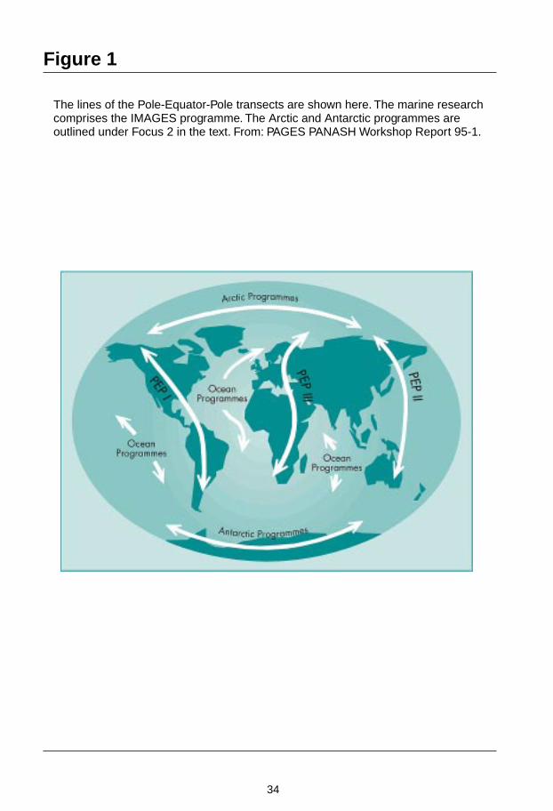
Background and RationaleThe PANASH project is designed to implement research on inter-hemispheric cli-matic mechanisms and coupling in order to improve understanding of how climatechange is linked in both hemispheres. To this end, a comprehensive study ofpalaeoclimate records from the Northern and Southern Hemispheres is being coor-dinated by PAGES along three broad PEP transects. These are:
PEP I: The Americas Transect
PEP II: Austral-Asian Transect
PEP III: Afro-European Transect
These transects involve both terrestrial and marine-based research projects, as ap-propriate to each region. A complementary set of studies (IMAGES) deals with thedeeper ocean records of palaeoclimate, and additional projects link with thetransects and focus on palaeoenvironments in polar regions (Focus II).
Scientific ObjectivesThe primary goals of the PANASH Project are to improve our understanding of glo-bal climatic change by:

32
• Documenting how climatic records from the two hemispheres are inter-related(in amplitude, phase and geographic extent)
• Determining the record of potentially important forcing factors which may af-fect each hemisphere
• Identifying the important feedbacks which operate to amplify, or reduce, theinfluence of changes occurring in a specific part of the climate system
• Identifying mechanisms of climate coupling between hemispheres.
These goals require that there be:
• Significant new research in data-poor regions to redress the geographic imbal-ance in palaeoclimatic information which currently exists
• Greater degree of collaboration between scientists of the Northern and theSouthern Hemispheres
• New research focus on North-South links, fostered by scientific meetings whichaddress observational projects, logistic coordination, and new methodologies(i.e., proxies, geochronology, data access).
Records of climatic change over the last 250,000 years are needed to document gla-cial-interglacial variations during two complete climatic cycles which appear to havehad very different characteristics (Stream II). Records of the last 2,000 years areneeded for resolving higher frequency changes in climate (Stream I). Although itmay not be possible to obtain many complete records with the necessary resolutionfor these time periods, a well-coordinated international effort focusing especially oncontinental records should greatly improve our understanding of climatic variationson a global scale.
Plan of Operations
Activities To DateAn initial series of workshops was held to develop research plans and priorities foreach of the PEP transects. For PEP I, meetings were held in Panama City, Panama;Mendoza, Argentina; and La Paz, Mexico (1993–1995). For PEP II, meetings wereheld in Taipei, Taiwan; Canberra, Australia; and Beijing, China (1993–1994). For PEPIII, meetings were held in Bern, Switzerland; and Sfax, Tunisia (1993–1995). Resultsof these discussions, and recommendations for future research, are summarized inPAGES Publications 93-1 and 95-1. These workshops have had an important impacton scientific planning in many countries by providing a conceptual framework forfuture palaeoclimatic research as a contribution to the international global changeresearch effort.
Future PlansAlthough a great many research projects have been launched within the PANASHframework, we highlight one cross-cutting initiative that is critical for futureprogress. A common recommendation of all workshops was the urgent need to re-
33
cover long sedimentary records from terrestrial sites along the PEP transects. Thischarge has been taken up by the PAGES Lake Drilling Task Force, which is coordi-nating efforts with the International Continental Drilling Project (ICDP). Initial sup-port for drilling in Lakes Qinghai, China; Poukawa, New Zealand; and Monticchio,Italy is expected. Initial site surveys of several lakes in Africa, Indonesia and SouthAmerica are also underway.
Specific workshops focused on different aspects of the PEP transects are planned byindividual project leaders and others pursuing specialized topics. For example, inthe PEP I region, the Inter-American Institute for Global Change Research (IAI) sup-ported several PEP-related workshops in 1995–1996, from which specific researchplans will evolve. In Japan, a PEP II meeting on Stream I climate variability was heldin November 1995 and a meeting on Stream II records was held in Brisbane, Aus-tralia in 1996. A workshop involving regional and national leaders from the PEP IIIregion was held in Paris in late 1996. Finally, there has been consultation withSTART in April 1996 to discuss how PAGES and START can cooperate to promoteresearch, training and infrastructure development to achieve the objectives of thePANASH project in each of the PEP regions.
These activities will carry forward the research effort through the next few years.However, there is a need to provide a forum for coordination and comparison of re-search being carried out in the different PEP regions. The PAGES Leaders meetingheld in Hilterfingen, Switzerland in November 1997 provided such a forum. Re-search scientists who are coordinating the PEP transects, as well as those leadingother PAGES projects which provide linkages between the transects, met and estab-lished much tighter levels of cooperation among the research programmes, includ-ing direct ties between marine and terrestrial initiatives. A PANASH Forum to bringtogether research scientists involved in the PEP transects, as well as those otherPAGES projects which provide linkages between the transects (e.g., Circum-ArcticPalaeoEnvironments [CAPE], ARTS, IMAGES, and bi-polar ice-core activities) is alsoplanned. Support will be sought from major institutions and national funding agen-cies.
Project ManagementOversight of the PANASH project is provided by the PAGES SSC. PEP leaders regu-larly attend PAGES SSC and EXCOMM meetings. Close contact is maintained withPEP leaders through the PAGES IPO.
Report prepared by Ray S. Bradley
Contact:Ray S. BradleyDepartment of Geosciences, Morill Science CenterUniversity of Massachusetts, Amherst, MA 01003-5820USATel: (1-413) 545 2120Fax: (1-413) 545 1200Email: [email protected]
34
Figure 1
The lines of the Pole-Equator-Pole transects are shown here. The marine researchcomprises the IMAGES programme. The Arctic and Antarctic programmes areoutlined under Focus 2 in the text. From: PAGES PANASH Workshop Report 95-1.

35
Focus 1Activity 1 Palaeoclimates of the Americas
Pole-Equator-Pole (PEP I)
Project Leader: Vera Markgraf
BackgroundThe PANASH transect in the Americas (PEP I) is particularly suited to detecting thesimilarity and degree of synchroneity of changes in both Northern and SouthernHemispheres because of similar poleward extent of land areas, similar distributionof mountains and lowlands, and comparable relationships to atmospheric and sur-face ocean circulation. The transect is also well placed to record Pacific climatic oc-currences in marine and terrestrial records at latitudes from 70oN–55oS. In recordsfrom the central portion of the transect, on the other hand, palaeoclimate recordswill provide evidence for the competing influence of the Atlantic climate forcing.Furthermore, the North American continent was the location of the largest continen-tal ice sheet during glacial times and its effects on Southern Hemisphere climatesneeds to be assessed.
This PAGES activity was initiated at two meetings (Boulder, USA, 1991 and PanamaCity, Panama, 1993) both of which included representatives of the palaeoclimatecommunity from throughout the Americas. These meetings formulated the primaryquestions and designed a plan for the implementation of an interhemisphericpalaeoclimate agenda (PAGES Report 95-1). The consensus that emerged from thesemeetings pointed to the linkages between terrestrial and marine palaeoclimaterecords placed along two intersecting transects: A north to south transect along thewest coast of the Americas from Alaska to Tierra del Fuego, Antarctica, comple-mented by an equatorial trans-Pacific transect to focus on Pacific climatic phenom-ena.
Interhemispheric palaeoclimate correlations will be examined with multiproxy cli-mate records in order to address the trans-equatorial extent of climate forcing fac-tors. This will be done by: (i) identifying changes in latitudinal and elevational tem-perature gradients through time; (ii) changes in intensity and location of upwellingand its relation to shifts in atmospheric circulation; and (iii) changes in the surfacecirculation of the Pacific ocean versus the North Atlantic ocean dynamics and theirrespective effects on tropical and extratropical climate teleconnections in the Ameri-cas.
Scientific Objectives• Determine the major modes of decadal scale climate variability revealed by the
instrumental record
• Determine the major modes of sub-decadal, decadal, and century-scale climatevariability during the last 2,000 years

36
• Identify the roles of the major potential forcing factors on these time scales –ENSO, solar variability, volcanic aerosols, human activity
• Determine the major modes of century and millennial scale climate variabilityduring the last 250,000 years and their cause(s) – e.g., solar radiation (insolation)
• Establish interhemispheric synchroneity of abrupt changes and their causes.
Project Strategy
Stage 1
1993–1996: Development of Cooperation and Science AgendaSeveral PEP I regional and international workshops were convened since 1993 tofoster scientific communication and collaboration within the palaeoclimate commu-nity of the Americas and to develop funding strategies:
- Panama City, Panama, October 1993 (PAGES Report 95-1)- Springfield, IL USA, November 1994 (Latin American Pollen Database)- Albuquerque, NM USA, January 1995, Earth Observing System (EOS),
v. 76:225-226)- Mendoza, Argentina, March 1995 (PAGES Newsletter 1995, v. 3:3)- Potsdam, Germany, June 1995, Earth Observing System (EOS) 12 September
1995, v. 76)- La Paz, Mexico, November 1995 (PAGES Newsletter 1995, v. 3:3).
Stage 2
1996–1998: Development of Collaborative OpportunitiesThe IAI provides an important administrative and financial element for the successof PEP I research. The PAGES-PEP I workshop in Mendoza (Argentina),cosponsored with IAI, and parts of the IAI planning meeting in Belem, Brazil weredirected towards the integration of palaeoclimate studies to the IAI core themes.These themes include: Impact of Climate Change on Biodiversity; ComparativeStudies of Temperate Terrestrial Ecosystems; High Latitude Processes; ENSO; andInterannual Climate Variability. As a consequence of these joint meetings researchproposals have been submitted from the PEP I community in the first round of IAIgrants. Several of the PEP I related proposals for workshops and research projectswere funded (see below), indicating that IAI will play a central role in the success ofthe PEP I research effort.
PEP I Related Projects Funded by the IAI in 1996Vegetation History from Fossil Rodent Middens in the Mid- latitude American Deserts(J.L. Betancourt, V. Markgraf, L. Graumlich).

37
Fossil rodent middens from the deserts in South America (Argentina, Bolivia, Chile,and Peru) will be collected and analyzed for comparison with packrat middens fromNorth American deserts (USA and Mexico) to resolve questions on: (i) human im-pacts on semi-arid rangelands; (ii) how climatic extremes and variability affect long-term vegetation dynamics, biogeography and biodiversity in deserts; and (iii) theinterhemispheric interrelation between climate change.
Ice-Core Study on the Environment and Climate of the Antarctic Peninsula and the South-ern Part of South America (Laboratorio de Estratigrafia Glaciar y Geoquimica del Agua y dela Nieve (Argentina); Laboratório de Pesquisas Antárticas e Glaciológicas (Brazil); Depart-ment of Geography, University of Calgary (Canada); Laboratoire Glaciologie et Géophysique(France).
Ice-core samples from the Antarctic Peninsula and the Patagonian Icefield will berecovered and analyzed at annual to decadal resolution to identify atmospheric andclimatic variability for the last 1,000 years.
PEP I Related Workshops Funded by the IAI in 1996
• Potential Use of Biological Proxy Data as Climatic Change Impact Indicators inSouth American Ecosystems (C. Villagrán [Chile], M. Paez, A. Prieto, andR. Villalba [Argentina], M.L. Lorscheitter [Brazil])
• The Assessment of Present, Past and Future Climate Variability from Tree-lineEnvironments in the Americas (B. Luckman, Canada)
• Fire and Global Change in Temperate Ecosystems of Western North and SouthAmerica (T. Veblen, USA)
• Comparative Studies on Oceanic and Coastal Processes in Temperate Zones ofthe Eastern Pacific (T. Baumgartner, USA)
• Large-Scale Biosphere-Atmosphere Experiment in Amazonia (LBA) (C. Nobreet al. Brazil)
• Dendrochronological Studies in Tropical South America with Special Emphasison Bolivian Forests (J. Boninsegna, R. Villalba, and F.A. Roig [Argentina],J. Argollo and S. Beck [Bolivia]).
The US NSF/National Oceanic and Atmospheric Administration (NOAA) EarthSystem History (ESH) programme presents another major source of support for PEPI activities. Following a call to help define the major research themes that would pro-vide information on the environment´s natural variability, the coupling of the com-ponents of the Earth system, and the biospheric interaction with changing globalsystems, the PEP I community was called upon to submit white papers to the Terres-trial Earth System History (TESH) steering committee for consideration in the TESHresearch plan.
One of the products from the La Paz, Mexico, 1995 PEP I workshop was the prepara-tion of several of these “white papers” focusing on specific aspects of the PEP Iagenda. The white papers invited for the presentation at the first TESH Workshop(Portland, USA, 1996) included: (i) evidence from intertropical regions for changes

38
in global water balance; (ii) Earth system sensitivity and variability␣ over interannualto millennial time scales from late Holocene coastal marine sediments along thePAGES PEP transect of the Americas; (iii) assessment of climate variability from al-pine tree-line sites in the Americas (Hughes et al.); (iv) late-glacial climate variabilityin the Americas – interhemispheric patterns and linkages; (v) modes of century tomillennial climate variability in the Americas – Lake Drilling Programme; and (vi)inter-American analyses of interannual to interdecadal ENSO variability using mul-tiple palaeoclimatic proxies. The purpose of the TESH workshop was to stimulatecollaborative and multi-disciplinary terrestrial palaeoclimate research for globalchange objectives.
International Continental Drilling Programme (ICDP)One of the major science objectives of the three PEP transects is the development oflong records (Stream II) of climate change and forcing. Recovery of such records re-quires logistic support and technological expertise which exceeds that availablethrough the standard terrestrial palaeoclimate research project and funding pro-grammes. A PAGES Workshop was convened in Potsdam, Germany (June 1995) todevelop protocols and logistic approaches for large lake drilling projects. Based oncommunity input, the outcome of the workshop was a five-year lake drilling planfor the three PEP transects submitted to ICDP for consideration. Several site specificproposals were also submitted.
Stage 3
1998: PEP I Science Meeting (see below)Planning for the first comprehensive PEP I science meeting is now well under way,including coordination of research presentations, to be published in book form, frommembers of the PEP I community working on specific topics of the PEP I scienceagenda. The targeted topics with ongoing collaborative, inter-American research ac-tivities include:
• Decadal scale climate variability – instrumental records in the Americas
• The last 2,000 years of climate history, based on correlation of high resolutionrecords from terrestrial and marine settings in the Americas
• Present and past ENSO-related teleconnection modes in the Americas
• Interhemispheric synchroneity of abrupt climatic events, especially during thelate-glacial
• Interhemispheric synchroneity of glacial climate patterns in the Americas.
Products1. In compliance with the PAGES objective to ensure preservation of all scientific
data compiled in context of past global change research a two year effort beganin 1995 to compile a Latin American Pollen Database (LAPD) to complement

39
the North American and European Pollen Databases. LAPD will be available inthe public domain through the NOAA WDC-A for Palaeoclimatology. An inven-tory listing geographical, bibliographical, and age information of all LatinAmerican pollen records is now available on the NOAA WDC-A World WideWeb as well as in hard copy.
2. The first comprehensive PEP I Science Meeting was held in Merida, Venezuela,16–20 March 1998. The major objective of this meeting was to provide a firstsynopsis of interhemispheric palaeoclimate in the Americas, patterns andcauses, to be published in book form. This synopsis will address topics, listedabove, which have already progressed sufficiently to approach the questions oninterhemispheric climate linkages, their mechanisms and forcings. At this stage,discussions will begin on how to link the PEP I information to that from otherPEP transects, especially to PEP II in context of the ENSO teleconnection objec-tive.
Project ManagementThe PEP I project office has been established at the Institute of Arctic and Alpine Re-search (INSTAAR), University of Colorado, USA; support has been secured for theperiod 1995–1998. The office will help in promoting inter-American communicationand in developing funding strategies. An international steering committee aids withthese efforts and meetings are regularly convened, in connection with PEP I work-shops. The PAGES Newsletter is considered the most widespread tool for communi-cation with the general science community.
Future DirectionsA number of international collaborative projects have resulted from the variousmeetings convened under the PEP I umbrella. Given the relationships developedwith several funding programmes, PEP I planning and research activities have flour-ished. Several workshops on specific themes related to the PEP I science agenda, asdefined by the community, have taken place or been convened for 1996 and 1997.These themes include: Ice-Core Studies in the Americas; Fire History in the Ameri-cas; Tree line in the Americas, Present and Past; Oceanic and Coastal Processes inTemperate Latitudes of the Eastern Pacific; and History of the American Deserts; etc.
Close communication will be maintained during the developmental stage of thesescience activities to ensure interaction among the activities in context of the overallPEP I goals. Communication will also be maintained with the leaders of the comple-mentary PEP transects, with other PAGES and IGBP initiatives, such as ARTS andthe PALAEOMONSOONS Project, and with other international global change pro-grammes, including Ecologie et Palaeoécologie des Forêts Intertropicales (ECOFIT,France), Institut Français de la Recherche Scientifique pour le Développement etCoopération (ORSTOM, France), Pan American Climate Studies (PACS-NOAA),Palaeoecology of Tropical America (Dutch NSF); and Southern Hemisphere Palaeo-and Neoclimates (IGCP 341).

40
Report prepared by Vera Markgraf
Contact:Vera MarkgrafINSTAARUniversity of ColoradoCampus Box 450, 1560 30th St.Boulder, CO 80309-6450USATel: (1-303) 492 5117Fax: (1-303) 492 6388Email: [email protected]

41
Focus IActivity 2 Palaeoclimates of the Austral-
Asian Transect (PEP II)
(See PAGES Workshop Report 93-1)
Project Leaders: John Dodson and Tungsheng Liu
IntroductionPEP II is the Pole-Equator-Pole transect which spans from western Asia (east of theUrals) through Australasia (east to the Date Line) and across the Southern Ocean toAntarctica. In April 1994 a meeting in Beijing (China) served to initiate the transectwith a series of papers, workshops and discussions. At this meeting participantsidentified the main features of the region, and the community focused on the impor-tant questions which described and identified the main global problems and proc-esses related to environmental change and variability in the region. In short, theprocess involved a distillation aimed at reducing the complexity of temporal globalenvironmental changes to the regional level, and at a scale which can be used to in-terface with the work of other PEP transects, in order to describe the features andfactors which control global environments.
Major tasks within the PEP II project include the Himalayan/Tibetan Plateau Inter-disciplinary Palaeoclimate Project (HIPP), which draws together scientists whowork in the Himalaya/Tibetan Plateau region, and the BDP, whose temporal objec-tives overlap to some extent with those of PEP II.
A second meeting of PEP II scientists was held in November 1995 in Nagoya (Japan)and focused on data and data interpretations of environmental variability andchange over the last 2,000 years. More meetings are planned.
PEP II research is important for many reasons, but perhaps the most critical amongthem is to decipher what impact the rate of environmental change in recent decadeshas had on many social and economic systems. Within the time frame of the nexttwo generations, environmental change may have extra significance for the PEP IIregion, where most of the world’s population resides and many economies aregrowing rapidly.
Scientific Objectives• Encourage scientists to look beyond local or national scale studies and to con-
sider the wider significance of their work, and to become more involved in thestudy and understanding of global environmental change
• Establish the role and significance of the important features of the transect indriving climate change
• Increase the level of knowledge of past environments within areas where thereare significant gaps

42
• Understand the relative importance of human impact and natural environmen-tal factors in driving climate change in the region
• Describe the environmental variability of the region over time, in particular toidentify the frequency and effects of socially and environmentally significantclimate phenomena
• Develop an understanding of how the synoptic scale elements of the climatesystem interact at the regional and global scales
• Contribute to the understanding of climate changes at a global scale.
Subsequent refinement of these has resulted in the following key themes:
• Identification of signals related to Dansgaard-Oeschger (D-O) cycles andHeinrich events (periods when icebergs deposit glacial sediments far south inthe Antarctic) in Asian terrestrial records
• Signatures of the Asian aeolian dust and aerosols in the North Pacific and in icecores
• Links of aeolian events between the Southern Hemisphere (Australia) andNorthern Hemisphere (China and Central Asia)
• Modern relationships of bio-geodata with climates and quantitative estimates ofpalaeoclimates
• Strength and interplay between the Australian monsoon and the Westerlies inthe region of the maritime continent, Australia, and New Zealand
• Role of tropical oceans in climate dynamics in the PEP II region
• The role of climate variability on changes in biodiversity across the region.
In addition, an initiative, High Resolution Reconstruction of East Asian Monsoon(HIREAM), has been launched, open to Chinese, Japanese and Korean scientists.This task will involve the study of palaeoclimates along a transect which runs fromthe border of the Tibetan Plateau to the western Pacific, traversing across the Sea ofJapan to Japan.
Implementation
AustraliaSeveral scientists have already established strong links with overseas organizationsand with scientists from New Zealand, New Guinea, the Pacific Islands, Indonesia,and China. Collaborative research projects on lakes through the ICDP (see below),speleothems, dendrochronological research, and studies of corals are planned.
China MainlandPriority is now being given to establishing state-level research projects. A project en-titled “History and mechanisms of environmental changes in Eastern China over thelate Quaternary” has recently been proposed to the National Natural Science Foun-

43
dation of China. The scientific issues to be addressed in the project are relevant forboth PAGES temporal streams. The main objectives are to reconstruct the high reso-lution (decade to century scales) history of palaeoclimates based on various records(varved lake sediments, loess and marine sediments, tree ring, speleothems and his-torical records), to investigate and map the spatial variability of palaeoclimates forselected timeslices (especially ca. 6 ka BP and ca. 21 ka BP1), to study the interactionsand potential mechanisms of the different components of atmospheric circulationprevailing in the Asian region; and to further develop the database of palaeoclimatesin China. This project is expected to run in parallel with another state-level project inconnection with the Global Change and Terrestrial Ecosystems Project (GCTE),which has also designed a transect study in the northeastern part of China. Theseparallel projects would provide a unique opportunity for the calibration of palaeo-data and quantitative estimates of palaeoclimates.
In addition, a number of international cooperative research projects are under con-sideration that would address several topics, such as the interhemispheric compari-son of aeolian records and aeolian signatures in the oceans and ice cores; the interac-tion of different atmospheric circulation components (Southwest summer monsoon,Southeast summer monsoon, Northwest winter monsoon and the Westerlies); theAsia-North Atlantic link etc. These international efforts are expected to be developedwithin the PEP II framework or as links between PEP II and other PAGES projects.
Taiwan RegionThe PAGES programme in the Taiwan region was initiated in March 1992. Atpresent, funding for the PAGES Programme has been in the range of 10–15% of thegeological programmes budget of the entire region.
Hong Kong RegionSome significant research activities on palaeoclimates in Hong Kong have been initi-ated since IGCP 396. These programmes are centered on the history of climatechanges, sea level changes, and storm events recorded in the region. Records includethose found in sediments on the shelf of the South China Sea off Hong Kong.
JapanThe main goals of the proposed HIREAM project are noted above.
Footnote:1 21 ka BP = 18 ka radiocarbon years BP

44
Other Priorities for PEP IIQinghai Lake (China), Lake Poukawa (New Zealand), and a lake to be selected inSulawesi are high priority sites for drilling on the PEP II transect.
Increasing the rate of progress for palaeoclimatic research along the transect will de-pend on securing dedicated support, on the success of PEP II in organizing the com-munity, and on progress towards highlighting critical research issues. Transect meet-ings are expected to be held every two years to address these issues. Financial sup-port for the analysis of key sites (e.g., ICDP), for training scientists in data poor ar-eas, and for encouraging other scientists to work in these fields must continue to re-ceive high priority. The steering committee has already agreed to focus attention onthese issues for the PEP II region in the coming years.
Linkages to the International Union for Quaternary Research (INQUA) must bestrengthened. At the 1995 INQUA meeting (Berlin) there was a large symposium de-voted to PANASH. The INQUA Holocene Commission has been asked to work onhigh resolution data sets and on the separation of human impact/natural variabilitysignals. Other activities important for PEP II include possible collaboration withSTART and Global Analysis, Interpretation, and Modelling (GAIM) as well as dis-cussions between PEP leaders and the scientific community such as those held inconjunction with the International Geological Congress (IGC) Global Change Sym-posium, Beijing, People´s Republic of China (August 1996).
OutputObjectives achieved to date include:
• Identification of major features of the transect
• Identification of important questions which can be investigated in the mediumterm (by 2,000 AD)
• Development of a science plan (in the PANASH document)
• Discussions of data within the framework and goals of PEP II held at meetingsin Beijing, Kathmandu, and Nagoya.
• Publication in Quaternary International of papers presented at recent meeting inBeijing
• Publication of a proceedings volume from the Nagoya meeting
• PEP II is now widely known across the region, and co-leaders are consulted asother meetings are held
• The ICDP has helped identify several key sites in the region that should help toachieve some of the goals of PEP II
• Publication in Global and Planetary Change of papers presented at IGC in Beijing
• Enhanced attention is being paid to some of the main data gaps identified alongthe transect

45
• Development of pollen and geomorphic databases in Australia, New Zealand,China, Japan and elsewhere to improve data availability to scientists across theregion and across the world
• Workshops are planned for Indonesia and Australia to enable scientists to worktogether to draw hemispheric and trans-hemispheric comparisons
• The modelling community is now more attuned to the value of regional synthe-ses enabled by palaeodata, and the possibilities for independently testing andcalibrating models.
Project ManagementThis project has a Steering Committee (SC) with the following membership:
Zhisheng An (China)John Dodson (Australia) (co-leader)Wayhoe Hantoro (Indonesia)Ping Mei Liew (ROC)Tungsheng Liu (PRC) (co-leader)Yugo Ono (Japan)One position vacant
The Project Office is located in the Institute of Geology, Beijing-China, andZhengtang Guo serves as the contact.
Funding support is ill-defined at present and has depended upon external input. Aprocess is underway to establish a “PEP II Foundation” to support research, meet-ings, and training, especially for scientists in developing countries.
The resources of the project management group are minimal. Scientists involvedwith PANASH/ PEP II are encouraged to use concepts outlined in the PANASHdocument to generate support through their respective national funding agencies.
Future DirectionsFuture scientific meetings and workshops are planned for Perth in Australia (1998)and Bali in Indonesia (1999). These workshops will focus on key issues outlined inthe PEP II chapter of the PANASH document. Other activities depend on availableresources and the overall funding base, (i.e., the success of the “PEP II Foundation”or similar support). The success of the “Drilling Task Force” group and ICDP arealso important elements for the success of the PEP II programme.

46
Report prepared by John Dodson
Contacts:John DodsonDepartment of GeographyUniversity of Western AustraliaPerth, WA 6907AustraliaTel: (61-8) 9380 2697Fax: (61-8) 9380 1054Email: [email protected]
Tungsheng LiuInstitute of GeologyChinese Academy of SciencePO Box 9825, Beijing 100029People´s Republic of ChinaTel: (86-10) 620 2766Fax: (86-10) 255 8066Email: its%[email protected]

47
Focus IActivity 2Task 1 Baikal Drilling Project (BDP)
Project Leaders: Mikhail I. Kuzmin, Takayoshi Kawai, andDouglas F. Williams
Introduction/BackgroundThe BDP is now a multi-national effort (Russia, Japan, Germany, USA) to extract therecord of global climate change and tectonic evolution of the Late Neogene from theLake Baikal sedimentary basin. BDP began in 1989 as a joint Russian/American sci-entific venture. In numerous meetings over a three year period participants agreedon a scientific programme and leadership structure, including a steering committee.These discussions led to several successful Russian and American coring-seismic ex-peditions (Lake Baikal Palaeoclimate Project Members, 1992) which laid theframework for actual drilling. This effort also included new multichannel seismicprofiling which indicated that sedimentary thickness exceeds 5–8 km in some partsof the Baikal basin.
In January 1993, the BDP team, in cooperation with the Nedra Drilling Enterprise ofYaroslavl, Russia, successfully deployed a light-weight drilling rig from a barge fro-zen into position over a topographic high in southern Baikal called the Buguldeikasaddle. With this system, the first long (>100 m) hydraulic piston cores were success-fully recovered from two holes in 354 m water depth.
The climate of the Baikal region is characterized by a high degree of continentality.In addition, Lake Baikal has never been glaciated in its 20–25 million year history.The palaeoclimate research at Lake Baikal is therefore important because it offersunparalleled opportunities to recover a relatively high latitude record of the conti-nental response to atmospheric forcing isolated from marine influences due to itsmid-continent position. The sedimentary record of Baikal is also extremely long andcontinuous with sedimentation rates varying from 1 cm/ka – 1 m/ka. The Baikalrecord therefore offers exciting opportunities to study palaeoclimate change on a va-riety of temporal scales and resolutions.
Scientific Objectives1. Develop and calibrate various proxies of palaeoclimate change in Lake Baikal
sediments
2. Develop an accurate geochronology for Lake Baikal sediments
3. Develop models for the response of Lake Baikal to palaeoclimate change overthe last 30–200 ka
4. Determine the relationship of this response to orbital forcing on Milankovitchtimescales (BDP-93)

48
5. Recover sediments from the Academician Ridge to determine Baikal’s responseto Northern Hemisphere glaciation in the late Pliocene-early Pleistocene (BDP-96)
6. Recover sediments to determine if sub-orbital responses exist in the Baikalrecord (BDP-97/98)
7. Recover sediments to determine how the Selenga River watershed of Baikal hasdeveloped over time (BDP-99)
8. Recover long sedimentary sequences to reveal important new informationabout the history and seismic stratigraphy of this rift sedimentary basin in re-sponse to the geologic history of the Baikal Rift Zone and uplift of the TibetanPlateau.
Project Implementation
1990–1992Russian/American coring and seismic expeditions to calibrate the sediment recordof Baikal and to define future drilling targets; development of the Baikal hydraulicpiston coring system by the Russian drilling enterprise (Nedra).
January 1993 BDP-93First deployment of the Baikal drilling rig from a barge frozen in southern Baikal(the Buguldeika saddle). Recovery of the first 100 m hydraulic piston cores with anaverage recovery of 90% and a complete composite hemipelagic section spanningthe last 500,000 years admixed with fine-grained materials from the Selenga Riverdrainage basin to the east of Lake Baikal. Magnetic susceptibility logging of holes 1and 2 reveals excellent core-to-core correlation. Variations in spore-pollen, diatoms,biogenic silica, rock magnetic properties, clay mineralogy and organic carbon reveala detailed record of how climate change impacted the Baikal limnological system,including the adjacent watershed.
January 1996 BDP-96Drilling was successfully completed on the Academician Ridge using an upgradeddrilling system. The objective was to obtain a complete palaeoclimatic record of thelast 2.5 to 3 Ma to test models of Tibetan Plateau uplift and development of northernhemisphere glaciation. The final length for the BDP-96 core recovery was 385 m inhole one with a maximum sub-bottom depth attained of 250 m for logging. Core re-covery to a depth of 119 m is 95%. Drilling in a second hole has recovered 100 m ofcores. BDP-96 cores have been magnetically logged in late April– early May 1996,and core descriptions and sampling were completed in early June.
January 1997 BDP-97The Nedra Drilling Enterprise is currently developing a 1,000 m coring system for afuture deep-water (900 m) drill at site 7 in the northern basin. Site 7 contains an ex-panded section equivalent in time to BDP-93 at Buguldeika. The first season will bedevoted to a high-resolution section down to 500 m sub-bottom.

49
January 1998 BDP-98Drilling will be completed at the northern basin site down to a depth of 500–1,000 msub-bottom.
January 1999For BDP-99 drilling is planned at site 13 on the Selenga Delta to a subbottom depthof 1 km in order to test models about lake level fluctuations and the development ofthe Selenga watershed which extends into northern Mongolia.
MethodologiesThe size and depth of Lake Baikal as a natural field laboratory for global changeresearch, and the logistical challenges of working in remote locations, demand amulti-institutional and multidisciplinary approach. A multidisciplinary approach isnecessary to exploit the rich potential of the Baikal sedimentary record as a naturalarchive of palaeoclimatic and palaeoenvironmental changes. The BDP team devel-oped new geochemical proxies (e.g., biogenic silica, organic matter indices), newenvironmental magnetic proxies and new palynological proxies. Currently the teamis testing the level of sensitivity of Asian continental palaeoclimate change toMilankovitch orbital forcing. Studies are underway to resolve new evidence for cli-matic decoupling between Siberia and North America during the Pleistocene. Newevidence for large scale and rapid changes in lake level during the Pleistocene hasbeen found. Dramatic changes in the spore-pollen signals in the Baikal sedimentsare providing key evidence for the response of the terrestrial biosphere of Siberia toglobal climate changes. The team is resolving the record of palaeo-pCO2 signals em-bedded in the organic carbon of Baikal sediments. The environmental magneticrecord contains a readily interpretable proxy signal of late Quaternary climatechange and three independent means of dating the sediment (climate proxy, relativegeomagnetic intensity, and geomagnetic direction).
LinkagesBDP is directly linked to the PANASH project through the PEP II Transect.
OutputObjectives 1–4 (listed above) have been accomplished and the results are now ap-pearing in many publications and meeting symposia. For example, the BDP teamhas developed and calibrated various proxies of palaeoclimate change in LakeBaikal sediments such as biogenic silica, magnetic and rock magnetic properties, etc.The team has also developed an accurate geochronology for Baikal sediments usingAccelerator Mass Spectrometry (AMS) radiocarbon dating for the last 30,000 ofEarth history and magnetic intensity patterns for the last 80,000 years. In addition,preliminary thermoluminescence dating and uranium series dating are promising inthe 0–500 ka window. BDP-96 cores from Academician Ridge should yield the firstunequivocal palaeomagnetic chronology. The team has also successfully demon-strated the response of Lake Baikal to palaeoclimate change over the last 30–200 kaon Milankovitch frequencies, and has successfully obtained two hydraulic piston-

50
cored sections from the Academician Ridge to determine Baikal’s response to north-ern hemisphere glaciation in the late Pliocene-early Pleistocene (BDP-96).
Plans are well developed to accomplish objective 6 and 7, namely to recoversediments from the northern basin site 7 to determine if sub-orbital responses existin the Baikal record (BDP-97-98) and to recover sediments from the Selenga Deltasite 13 to determine how the Selenga River watershed of Baikal has developed overtime (BDP-99).
Objective 8, to recover long sedimentary sequences to reveal important new infor-mation about the history and seismic stratigraphy of this rift sedimentary basin inresponse to the geologic history of the Baikal Rift Zone and uplift of the Tibetan Pla-teau, is dependent on successful completion of objectives 5–7.
All data from the BDP project will be maintained in a BDP database as well as sub-mitted to the PAGES palaeoclimate database.
Project ManagementThe BDP is managed and coordinated by a SC chaired by Mikhail I. Kuzmin, Direc-tor of the Institute of Geochemistry, Siberian Branch of Russian Academy of Sci-ences, Irkutsk, Russia. Other co-chairman are: Takayoshi Kawai, Japanese Associa-tion for Baikal International Research Programme; Douglas F. Williams, Universityof South Carolina; Martin Melles, Alfred Wegener Institute, Potsdam, Germany (anobserver of the committee); A. Goriglad, Kuzmin’s Institute (a financial official) isresponsible for BDP financial affairs as well as BDP expenditures and keeping finan-cial records on behalf of the BDP SC. Financial reports are made on a regular basis.The SC meets twice a year, usually in Irkutsk, but in November 1995 the SC meetingcoincided with the annual meeting of the Geological Society of America in New Or-leans, USA, and in February 1996 the SC met in Tsukuba, Japan at the VIIIth Interna-tional Drilling Symposium. At such meetings the BDP SC decides financial mattersand sets policies with regard to sampling, analytical and publication protocols.These BDP protocols are modelled closely on those of the Ocean Drilling Pro-gramme (ODP) and PAGES programme.
BDP coordination and planning meetings are held in Irkutsk twice a year, usuallypreceding the drilling and after drilling in order to set priorities for sampling distri-bution and analysis. Typically, summary protocols signed by all parties are pro-duced and available upon request.
Principal support for the 100 m and 300 m drilling in the BDP from 1990–1996 hascome from a consortium of institutions in four countries including: the Russian Min-istry of Science and Technology; Russian Ministry of Geology; the Science and Tech-nology Agency (STA) of Japan; the Japanese Association for Baikal International Re-search Programme (JABIRP); the Continental Dynamics Programme of the US NSF;the Global Climate Change Programme of the US Geological Survey; the SamuelFreeman Charitable Trust; and the Alfred Wegener Institute, Potsdam, Germany.
The planning and development for the 1,000 m drilling is currently supported bygrants from the STA of Japan to the JABIRP and from Roscom Nedra to the NedraDrilling Enterprise. A proposal has been submitted to the new ICDP to support theacquisition of a new barge as a drilling platform and to support other drilling opera-tions associated with 1,000 m drilling.

51
Future DirectionsAfter the 1996–1997 winter drilling (BDP-96) on Academician Ridge, the Baikal hy-draulic piston coring system is expected to be available for drilling on other lakesystems where a 300–400 ton barge is available and water depths do not exceed380 m.
A proposal has been submitted to ICDP for support of 1,000 m drilling, which is cur-rently supported by the STA of Japan and Roscom Nedra of Russia. It is also hopedthat the results from Lake Baikal will be extended into the carbonate-bearinglacustrine system of Lake Khubsugul in Mongolia.
Report prepared by Douglas F. Williams
Contacts:Douglas F. WilliamsDepartment of Geological SciencesUniversity of South CarolinaColumbia, SC 29208USATel: (1-803) 777 7525Fax: (1-803) 777 6304Email: [email protected]
Mikhail I. KuzminInstitute of GeochemistryIrkutskRussiaEmail: [email protected]
Takayoshi KawaiJapanese Association for Baikal International Research Program (JABIRP)National Institute for Environmental Studies16-2 Onogawa IbarakiTsukuba 305JapanTel: (81-298) 516 111 ext 288Fax: (81-298) 514 732

52
Participating Nations, Groups or Institutes
RussiaInstitute of Geochemistry, Siberian Branch, Russian Academy of Sciences, IrkutskLimnological Institute, SB-RAS, Irkutsk
United Institute of Geology, Geochemistry and Mineralogy, SB-RAS, Novosibirsk
Institute of the Earth’s Crust, SB-RAS, Irkutsk
Nedra Drilling Enterprise, Ministry of Geology, Yaroslavl
USAUniversity of South Carolina
University of Rhode Island
University of Massachusetts
University of Minnesota
University of Michigan
United States Geological Survey
JapanJapanese Association for Baikal International Research Programme (JABIRP),Tsukuba
GermanyAlfred Wegener Polar Institute, Potsdam
GeoForschungs Zantrum, Potsdam.

53
Figure 2
Biogenic silica, a measure of diatom productivity, from Lake Baikal compared toSPECMAP oxygen isotope record and modelled maximum summer temperature,from Colman et al. 19951. From: Continental Drilling for Palaeoclimate RecordsWorkshop Report 96-4, Ed. Steven Colman.
Footnote:1 Colman, S.M., Peck, J.A., Likhoshway, E.V., Granina, L.Z., Karabanov, E.B., Carter, S.J.,King, J.W., and Williams, D.F. 1995. Continental climate response to orbital forcing: Thediatom palaeoproductivity record from Lake Baikal, Siberia, Nature 378:769-771.
0
50
100
150
200
250
0
50
100
150
200
250-3 -2 -1 0 1 2 3 0 10 20 30 40 50 60 16 20 24 28
Standard Deviation Biogenic Silica (WT %) Temperature (°C)
Age (KA) Age (KA)Specmap δ 18O Baikal Core 340 Model Max Temp

54
Focus IActivity 2Task 2 The Himalayan/Tibetan Plateau
Interdisciplinary PalaeoclimateProject (HIPP)
(See PAGES Workshop Report 96-1)
Project Leaders: Cameron Wake and Paul Mayewski
IntroductionThe highlands of central Asia possess a diversity of natural archives from which de-tailed palaeoclimatic records can be developed (e.g., forests, glaciers, tree rings, icecores, lake sediments, loess, speleothems, geomorphologic features, peat deposits,etc.). Despite this potential there exists a paucity of terrestrial based records, on bothspatial and temporal scales, that can be used to describe palaeoclimate variability inthis region over time scales ranging from centuries to hundreds of thousands ofyears. This is especially significant given the critical role that the highlands of cen-tral Asia play in the development and intensity of the Asian monsoon, and the im-portance of the Asian summer monsoon in providing life sustaining rains to a con-siderable portion of the world´s population.
The HIPP initiative represents a multidisciplinary programme aimed at improvingour understanding of changes in the behaviour of the Indian and Plateau monsoonsover the past 2,000 years, 20,000 years, and beyond through the collection and analy-sis of high resolution, multi-variate palaeoclimatic records from the highlands ofcentral Asia. Due to the large population and the region’s vulnerability to droughtsand floods, an improved understanding of the variability associated with the sum-mer monsoon would be immensely beneficial.
The focus of this initiative is to characterize the details of climate change in the high-lands of central Asia in order to identify temporal and spatial variations in the link-ages between various climate systems in Asia, and determine the hierarchy of forcescontrolling climate change in the region.
The HIPP initiative was first presented to the PAGES community at the PEP II meet-ing in Beijing-China in April 1994. Subsequently, the International Himalayan/Ti-betan Plateau Palaeoclimate Workshop was convened by Sharad Adhikary, PaulMayewski, and Cameron Wake in Kathmandu, Nepal, from 2–7 April 1995 in orderto synthesize, organize, and stimulate a rigorous palaeoclimate programme in themountains of central Asia and to establish and foster linkages between scientistsworking in the region. Over 70 scientists from a wide range of disciplines represent-ing over 45 research institutions participated in the Kathmandu workshop. Coun-tries represented were: Australia; Bhutan; Canada; China; France; Germany; India;Japan; Nepal; Pakistan; Switzerland; the United Kingdom; and the USA.
55
Scientific Objectives and ImplementationIn order to obtain the most reliable records of past change from the highlands of cen-tral Asia, the primary goal of the HIPP initiative is to develop and foster an inte-grated, multidisciplinary, international approach towards the collection, calibration,and interpretation of high resolution palaeoclimatic records from several natural ar-chives (e.g., lake sediments, loess, speleotherms, pest deposits, forests and glaciers,and geomorphologic features) over the broad region defined by the Himalayan andTibetan Plateau. The main objectives listed below are divided on the basis of threetime periods: 0–200 years BP; 0–2,000 years BP; and 0–200,000 years BP.
0–200 Years BPThe Objective is:
• To understand current basic environmental processes, as well as develop datafor calibrating palaeoclimate records, by establishing a spatially coordinatednetwork of instrumental data collection sites.
The proposed network would “fill in the many gaps” of the existing network. Tothis end, two north-south and one east-west sub-transects are recommended for theregion. Within each transect there should be a number of key “flagship” stationswith high quality, standardized data collection procedures. A concerted effortshould be made to incorporate existing stations into any expanded network. (Forexample, an east-west transect of high elevation meteorological and hydrologicalstations spanning the Nepalese Himalaya has already been established by the Ger-man-Nepalese Snow and Glacier Hydrology Project. An aerosol and precipitationchemistry sampling programme has been established at one of these meteorologicalstations, and an expansion of this sampling network is planned for the near future.The investigation of the isotopic composition of precipitation and its relation to tem-perature is also underway in the northern and central regions of the Tibetan Pla-teau).
The main goals are to:
• Advance our understanding of current basic environmental processes and dy-namics through process-based field research programmes at “flagship” stations
• Establish national focal points (e.g., Himalayan Climate Centers (HCC) for or-ganizing and disseminating modern observational data. A HCC has alreadybeen established in Kathmandu and a center has been proposed for India
• Develop an information catalog of: (i) existing network and research data; and(ii) locations of current network and research observation stations.
0–2,000 Years BP
The objectives are:
• To describe how the Asian monsoon climate system has varied on annual tocentury time scales over the past 2,000 years through the collection and inter-pretation of high-resolution (e.g., annual to decadal) palaeoclimate records (e.g.,tree rings, ice cores, speleothems, lake sediments, etc.) and historical records.

56
Variability on this time-scale is likely to cover a wide range of climatic conditionsincluding those associated with the so-called LIA and MWP, as described in otherregions of the world. This time-scale is also likely to be the most relevant to naturalresources planning and utilization. In order to accomplish this, it is critical to di-rectly calibrate the palaeoclimatic records with instrumental climate records in orderto empirically define the palaeoclimatic signal. Doing so will require well-dated,high-resolution palaeoclimatic records because of the short time span of instrumen-tal records.
• To describe the spatial variability of the Asian monsoon (by area and altitude)over the Indian sub-continent and the Tibetan Plateau.
Climate variability is a joint space-time process, the dynamics of which can only beunderstood within this context. Therefore, it is important that the spatial dimensionof climate be emphasized as part of these objectives. In this regard, we need to ex-pand the geographic coverage of Himalayan/Tibetan Plateau high- resolutionpalaeoclimate records extending back ca. 2,000 years.
• To develop multi-proxy records for cross-calibration and comparison.
The Himalaya and the Tibetan Plateau have often been described at the “third pole”.The logistical difficulties and high cost of field work have limited the amount ofpalaeoclimatic research expeditions in the region. As a result, there are only a fewrecords that describe climate change over this vast region. In order to develop repre-sentative and reliable climate reconstructions, it is critical that we utilize records de-veloped from as many different sources as possible.
• To determine the relationship between Asian monsoon variability and variousforcing factors such as the quasi-biennial oscillation, the ENSO, solar cycles (i.e.,sunspot activity), Tibetan Plateau snow cover, explosive volcanic eruptions, andatmospheric dust loading.
Modern instrumental records have been used to identify a clear relationship be-tween ENSO and the Indian monsoon. However, it is not known how this relation-ship has behaved in the past when climate was distinctly different. The same uncer-tainty applies to other possible forcing factors on monsoonal variability. Therefore, itis presently not possible to say how the monsoon system reacts to changes in forc-ing. In order to answer these questions we need to investigate periods of increasedvolcanic activity and increased snow cover over the Tibetan Plateau. These investi-gations require longer climatic time series than are presently available. Longpalaeoclimatic time series will also allow for a more detailed study of putative linksbetween solar variability and the monsoon.
• To determine the climatic and anthropogenic impacts on key natural resourcesof water, forests, and air.
Global climate is thought to be increasingly influenced by greenhouse gases andsulfate aerosols as a result of anthropogenic emissions. Therefore, it is possible thatthe Asian monsoon is currently responding to greenhouse gas/sulfate aerosol forc-
57
ing. Instrumental records extend back only to the beginning of the industrial period.Hence, we need to use high resolution palaeoclimatic records to extend our under-standing of monsoon climate variability back into the pre-industrial period. In sodoing, it will be possible to determine if any change in the variability of the Asianmonsoon has occurred during the 20th century with respect to recent global climaticchanges.
• To contribute to the development of predictive models of Asian monsoon vari-ability through an improved understanding of the monsoon climate system.
Predicting the monsoon would have great socio-economic importance. By under-standing the past monsoon variability and its relationship to various forcing factors,it should be possible to improve our fundamental understanding of this dynamicsystem. This improved understanding will hopefully lead to the development of im-proved physically-based dynamic models having robust predictive capability.
0–200,000 Years BP
The objective is:
• To reconcile current widely-divergent views on the uplift history of the Ti-betan/Himalayan region through an independent measure of uplift, yieldingabsolute uplift values and discrimination of differentially uplifted zones.
Northeastern Tibet, southern Tibet and the Himalayas, and northwestern Tibet arecritical regions. Key data will be basin sedimentation, dated terrace and lake shore-line series, speleothem isotopes, heat flow and geodetic measurements, and loess -palaeosol series to the east of the region. By means of a dating database, the qualityand representativeness of all dates for the region should be evaluated as a first stepto an improved chronological base. As part of current PAGES time-scale mappingprogrammes, time slice maps for the region should be compiled for the periods 21–18 ka BP and 6 ka BP.
In addition, maps should be compiled for the LGM and the last interglacial, includ-ing examination of environment and complexity of the climate record in the loess -palaeosol series of the north-east margin of the Tibetan Plateau. Time series (con-tinuous records and dated sets) should be used to consider forcing mechanisms(Milankovitch, solar cycles, atmospheric chemistry, volcanic activity, ENSO), withspecial attention to leads, lags and feedbacks. High quality data should be used, par-ticularly from the loess, lacustrine and fluvial sedimentary records. Liaison with themarine coring community is essential (especially Bay of Bengal, Arabian Sea, ChinaSea) and groups researching foreland basin stratigraphies (e.g., Indo-Gangetic Plain).
Data Sharing
The objective is:
• To encourage data sharing among HIPP researchers and institutions.

58
In order to maximize the potential of the limited modern and palaeoclimatic datasets from the highlands of central Asia, both current and future, there is a criticalneed to develop a workable data-sharing framework. It is proposed that a distrib-uted HIPP data and information management network be established which buildson the existing capability of the International Center for Integrated Mountain Devel-opment (ICIMOD), Kathmandu, the HCCs, and the WDC-A for Palaeoclimatology/PAGES Data Coordination Center. The HCCs, which should be established in eachparticipating country (one of which has already been established in Nepal), couldalso serve as national focal points for PAGES data and information management.
Palaeoclimate Research in Nepal – An Example of HIPP ImplementationAs an example of the potential organization of HIPP, a group of researchers repre-senting several institutions within the US (i.e., University of New Hampshire,Lamont-Doherty Earth Observatory, University of Arizona, and the US NOAA) haveestablished a cooperative palaeoclimate research project in Nepal. A Memorandumof Understanding (MOU) developed through the Department of Hydrology andMeteorology, Ministry of Water Resources, His Majesty’s Government of Nepal pro-vides interested researchers with the opportunity to develop palaeoclimate and/orrelated studies in Nepal. Under the auspices of this MOU, palaeoclimate investiga-tions in Nepal have been undertaken in 1993, 1994, and 1995 via field investigationsof tree rings, glacier fluctuations and glacial geology, atmospheric chemistry, lakesediments, and snow and ice chemistry. Researchers from the Nepalese Departmentof Hydrology and Meteorology have participated in all of these field programmes.In addition, a collaborative study of hydrological and meteorological records fromNepal is being undertaken by personnel from the University of New Hampshire(UNH), USA, and the Nepalese Department of Hydrology and Meteorology (DHM),Nepal. Furthermore, several institutions have developed exchange programmes inorder to help scientists from the DHM study abroad. DHM also has a long-standingcollaborative programme with the Japanese-sponsored Glaciological Expedition toNepal. Recently, the HCC in Kathmandu has developed a cooperative research pro-gramme with scientists from the University of Iowa, USA, studying speleothems inNepal. Among other activities, the Kathmandu HCC aims to facilitate studies andresearch in the fields of climatology, glaciology, hydrology, atmospheric chemistry,biogeochemical cycling, palaeoclimatology. In addition, the HCC plans to provideadministrative support for field research in Nepal, as well as to promote the ex-change of ideas and data between scientists working in the region. The Nepal pro-gramme provides an example of a multinational, cooperative, palaeoclimate re-search project which has been a focal point for the initial development of HIPP(PAGES Workshop report 96-1).
ProductsThe main product to date is the report written as part of the Kathmandu Workshop(see IGBP Report 43). This report includes a review of palaeoclimatic research withan extensive reference list, a Science and Implementation Plan, and sections on datasharing and modelling of the monsoon. This report is available from the PAGES IPOand on the Internet at the following address:
http://www.grg.sr.unh.edu/hipp/hipphp.html

59
In addition, abstracts from the workshop presentations and an extensive bibliogra-phy are available at the same Internet address. In conjunction with the PAGES IPO,HIPP leaders are also planning to publish an annual newsletter which would reporton HIPP activities and events.
Project ManagementHIPP has been organized and is run by an ad-hoc SC consisting of Paul Mayewskiand Cameron Wake of the Climate Change Research Center, EOS, UNH, USA;Ed Cook and Paul Krusic of the Lamont-Doherty Earth Observatory, Columbia Uni-versity, USA; and Sharad Adhikary of the Himalayan Climate Center, Kathmandu.Information on the programme is available on the HIPP home page or fromCameron Wake. Primary communication with the HIPP community occurs via theweb page, workshops, and our proposed annual newsletter.
Future DirectionsA second HIPP workshop is planned. In addition, the HIPP planning committee isconsidering sponsoring a special HIPP/PEP II session at the 1998 American Geo-physical Union (AGU) Western Pacific Geophysics Meeting. In the near future, em-phasis will be placed on developing closer links with the Palaeomonsoons Project,INQUA, and GAIM activities.
Report prepared by Cameron Wake and Paul Mayewski
Contact:Cameron WakeClimate Change Research CenterEOS, University of New HampshireMorse Hall, 39 College RoadDurham, NH 03824USATel: (1-603) 862 2124Fax: (1-603) 862 2329Email: [email protected]: http://www.grg.sr.unh.edu/hipp/hipphp.html

60
Focus IActivity 3 The Afro-European Palaeoclimatic
Transect Pole-Equator-Pole(PEP III)
Project Leader: Françoise Gasse
IntroductionThe PEP III Activity was initiated in December 1993 at a meeting held in Bern, Swit-zerland, which brought together 13 scientists representative of different geographi-cal regions and scientific disciplines. The fundamental ideas developed during thismeeting have provided the basis for the PEP III project (PANASH Report). A com-munity workshop held in Sfax, Tunisia (April 1995) further refined the specific PEPIII objectives and established the background for PEP III organization. A third meet-ing, held in Bierville, France (September 1996) allowed for continued discussion onPEP III coordination with special attention to data requirements for the transect.
The primary PEP III goals are to document how climatic records from the major cli-matic regions are inter-related, and to provide the palaeoclimatic proxy data re-quired for evaluating the performance of climate models under changing boundaryconditions.
These goals require cooperation at an international level to:
• Redress the geographic imbalance in palaeoclimatic information which is par-ticularly crucial along the PEP III transect. It is evident that PEP III should focusactivities on central and eastern Europe, the Middle East and Africa to improvedata coverage. The development of an international framework may help to ad-vance research initiatives in these regions which are politically complex andwhere many countries suffer from weaknesses in their scientific infrastructure
• Encourage data acquisition on those types of records and methods that favourcomparisons and data integration between sites, hemispheres, oceans and conti-nents, palaeodata and models
• Assess and synthesize existing data
• Organize data management, and multivariate data assimilation, for a true inter-disciplinary, quantitative interpretation of palaeoclimatic records.
Scientific ObjectivesThe project aims to use the specific regional characteristics of the PEP III transect toprovide timely answers to many important global change questions, examples ofwhich are given below.

61
PAGES Temporal Stream I
1. Is it possible to determine the timing and magnitude of changes in vegetationand hydrology in Europe and Africa, and can the extent to which they havebeen induced by climate change or human activity be established?
2. What is the actual significance of the largely accepted, ubiquitous concepts ofthe LIA and the MWP?
3. How does the history of the Nile floods compare with data from Eastern Medi-terranean regions?
4. What are the consistencies/discrepancies between historical records on lake-level fluctuations of African lakes from the northern and southern tropics?
5. How did variations in solar radiation contribute to temperature changes? Arethe effects observed in Europe recognizable in records from Africa?
PAGES Temporal Stream II
1. How did northern Europe respond to climate change? How did the northernlatitude ice sheet modify the European climate and hydrology, the north Atlan-tic SST and the thermohaline circulation?
2. What was the magnitude of changes in precipitation and temperature from theAtlantic to eastern Europe in response to changes in the northern ice-sheet ex-tent and what is the range of these changes during the current interglacial?
3. How do inter- and intracontinental seas (Aral, Caspian, Black, and Mediterra-nean Seas) and the large East African lakes act on regional climate, and how didthey register global change?
4. How were the west-east/north-south gradients in precipitation over the Medi-terranean climatic domain modified in response to global boundary conditions?
5. What is the role of the Sahara-Arabia desert belt on aerosol loading, and howdid aeolian dust deplete incoming solar radiation in surrounding areas? Whatfeedback mechanisms may involve changes in soil moisture, albedo and atmos-pheric pressure over the desert?
6. How have African and Indian monsoon climates varied in the past, and werethe variations synchronous? How did changes in land surface conditions at lowlatitudes affect trace gas concentrations in the atmosphere?
7. How did Southern Africa respond to changes in: (i) the extent of the Antarcticaice sheet and sea-ice in the Southern Ocean; and (ii) the efficiency of the returnflow of the oceanic thermohaline conveyor belt?

62
Implementation Plan – Project StrategyThe PEP III Transect is implemented through:
• Coordination activities at the national/regional scale. A network of contact per-sons has been established and includes 25 scientists from 20 countries. Nationalworking groups are also being developed in several countries
• Thematic working groups act within the transect to encourage comparison anddata integration between all elements of the transect (sites, regions, oceans andcontinents, palaeodata and models). Within these groups, scientists work on themost pertinent archives and issues for the PEP III transect.
A PEP III Workshop took place in Paris, France (September 1996). The purpose ofthis meeting was to: (i) strengthen the development of disciplinary working groupsand establish a strategy to make working groups efficient in data acquisition; (ii) es-tablish protocols for interdisciplinary data management and integration; and (iii)stimulate the further development of regional PEP III coordination committees.
Meetings have already occurred within some PEP III thematic activities:
• Lake Sediment Records: The PAGES–GeoforshungZentrum Workshop(Potsdam, Germany, June 1995) and the PAGES–Lake Drilling Task Force meet-ing (Washington, USA, October 1995) helped to define standard methodologiesfor drilling and lacustrine core studies, to select high priority sites and developa 5-year plan for lake drilling along the PEP transects
• A special session on Quaternary palaeoclimate of Africa was held at the Ameri-can Geophysical Meeting (San Francisco, USA, December 1995)
• The first steering committee of the European Lake Drilling Program (ELDP)-(European Space Foundation (ESF)-/PEP III) (Strasbourg, France, March 1996)
• Palaeomonsoons: A workshop was held in conjunction with the INQUA Con-gress (Berlin, Germany, August 1995). A special issue of Climate Dynamics willresult from this workshop
• An initial meeting was held to discuss the opportunity for and feasibility of de-veloping an European-African diatom database (London, UK, February 1996)
• A meeting was held to organize an African pollen database (Bierville, France,September 1996).

63
MethodologiesSpecial attention will be paid within PEP III to the following tasks:
Developing Training Sets and Databases for Individual Biological Indicators
The goal is to develop transfer functions which can be easily applied by a largenumber of scientists and at large geographical scales for inferring past environmen-tal/ climatic variables, for example:
• Special effort is needed to combine the reference diatom data sets already avail-able for Europe and northern Africa, and to fill the gaps currently existing fortemperate and Mediterranean regions
• Chironomids also represent a powerful palaeoenvironmental tool
• Calibration data sets should be developed over the next few years
• An African pollen database should be constructed to complete geographicalcoverage of the Global Pollen Database, available at WDC-A.
Promoting Isotope Studies
Several initiatives are underway to promote the use of isotopic techniques:
• The isotopic composition (18O) of lacustrine diatom silica can be used to inferpast isotope composition of lake waters and possible evaporative rates (aridzones) and/or lake water temperature (temperate zones), and to complementstudies based on carbonate and organic matter stable isotopes
• Continental Isotope Indicators of Palaeoclimate (ISOMAP) is an internationalproject designed to map and model the isotopic composition of past and presentglobal precipitation. ISOMAP is seen as an opportunity to focus the efforts ofthe isotope hydrology and palaeoclimate community in order to make more ef-fective use of water isotope tracers in climate research, enhance interaction be-tween researchers, and promote stronger interaction with the climate modellingcommunity. This focus represents an important contribution to PEP III. (Pleaserefer to isotopes section, pages 196–202).
Specific Constraints for Stream I – Lake Studies
In many parts of the PEP III region the recent lake sediment record is strongly influ-enced by human impacts. Proxy methods for climate change, therefore, need to fo-cus on:
• Approaches that might be independent of human impact, e.g., stable isotopemeasurements)
• Sites where climate signals can be identified separately from human impact,e.g., diatom plankton variability and cycling
• Sites that are sufficiently remote that human impacts can be discounted, e.g.,mountain and arctic lakes.

64
Annually Laminated Lacustrine SedimentsBesides the importance of annually laminated sediments for providing absolutechronology (see PAGES Workshop Report 95-1), studies of varve thickness may pro-vide unique information for studying climatic variability. Lakes with annual lamina-tions are common along the PEP III transect, at least in the Northern Hemisphere.
The Multiproxy ApproachIt is essential that the multiproxy approach be developed and emphasized for sev-eral topics, for example:
• Integrating archaeological data on deforestation and pollen records, migrationof civilisations and palaeohydrological archives in arid zones
• Interpreting lake-level data in terms of palaeoclimate variables, through lakesystem modelling combined with water, salt and isotope budgets
• Constraining the modern pollen data set by lake level status, as has alreadydone for reconstructing European palaeoclimate at 6 ka BP
• Cross-checking of results, e.g., comparison of palaeoprecipitation values in-ferred from pollen transfer functions and lake modelling.
Stream I PrioritiesArising from discussions at the September 1996 Bierville Meeting, the following pri-orities were identified:
• A major focus of PEP III Stream I research should be on establishing the degreeto which 20th century climates are unprecedented. This must involve quantita-tive reconstruction of past mean climates on multi-decadal and centurytimescales as well as inter-annual variability and the frequency of extremes
• There remains a widespread preconception that the LIA and MWP were ubiqui-tous features of the climate history of the last two millennia. There is still a needto further clarify the definition of these concepts in terms of their character, ex-tent and precise timing, even within Europe. More research is required to estab-lish the extent to which the concepts of the LIA and MWP are valid or relevantin other areas of the transect. The relationship between climate variations acrossthe transect and the record of potentially important forcing factors should alsobe investigated. This should include studies of SST variations in relation to rain-fall anomalies, especially in the tropics. Future research must attempt to clarifywhether the LIA and MWP phenomena represent unique events within the last2,000 years, and, if possible, within the context of the Holocene as a whole
• Traditionally, high-resolution studies within the Stream I timeframe have beenconcentrated in the mid-to-high latitudes of the northern part of the PEP IIItransect. In part, this reflects genuine difficulty in locating datable, high-resolu-tion records in low latitudes and in the African part of the transect. The exist-ence of numerous, long tree-ring chronologies in Morocco is an important ex-ception. Some potential for other dendroclimatological studies in north and eastAfrica has been clearly demonstrated and the future development of this poten-tial should be explored

65
• Given the problems of identifying annually resolved palaeosources in Africa,there is a need to explore other less-well-resolved sources, particularly wherethey might be represented across wide areas of the transect. The concept of aspecific research initiative aimed at exploring climate proxies in the sedimentsof a series of African crater lakes along the East African section of the transect isconsidered worthy of prioritization and a future workshop is planned
• Even in Europe, there is important potential for identifying and processing his-torical and early meteorological records. Some palaeoseries, produced decadesago, now require updating
• More research is required in order to identify and gauge the significance of an-thropogenic environmental disturbance and the implications for palaeoclimateestimates calibrated against modern climate data
• Archaeological data have been underutilized in a palaeoclimatic context. Col-laboration between archaeologists and palaeoclimatologists, especially in areaswith a tradition of detailed high-resolution archaeological work and historicaland palaeoclimate proxies, should be promoted. Several regions, such as in theMediterranean, in monsoon areas (particularly in Egypt) and in the south of Af-rica, are potential focal areas for such efforts
• Intense attention to accurate chronology is encouraged in situations where ab-solute dating is not feasible. This might involve multiple dating proxies
• Work to establish a detailed network of tephra histories in the circum North At-lantic region and the possibility of developing a widely applicable tephra chro-nology to provide fixed dating points for many less-well-resolved data sourcesis underway
• It has been agreed that studies within time Stream I should not be constrainedby the 2,000 year limit if longer timescales within the Holocene can be embracedwith equivalent precision and accuracy.
LinkagesThe PEP III transect will benefit from close linkages with other international pro-grammes. Within IGBP, START has already provided substantial help.
PEP III has established close relationships with PMIP-PMAP. Collaborative projectsare currently underway with the International Atomic Energy Agency (IAEA, sec-tion of Isotope Hydrology, Vienna). Relationships with INQUA are strong, for exam-ple, through the INQUA Holocene Commission and the Palaeoclimates of the South-ern Hemisphere (PASH) project.
OutputsContinued attention will be paid to geographical gaps to redress the spatial imbal-ance in palaeoclimatic data. Progress towards this goal is planned for the next fewyears, especially through the GLDP.
• Assembly of a database for the PEP III transect:

66
(i) The pollen and lake status databases are already complete within other pro-grammes, but will be enlarged and refined in conjunction with PEP III. Integra-tion of diatom, lake sediment and groundwater data will be undertaken in thenear future.
(ii) Reconstruction of interannual- to multidecadal time-scale climate variabilityover Northern Eurasia through tree-ring work is planned for 1998.
• A better understanding of:
(i) The relative role of the competing effects of the three main variables that haveaffected Europe’s climate:- Variations in the amount and position of glacier ice (the dominant influ-
ence in the north); The northern ice-sheet growth and decay; and impactsof the northern ice-sheet fluctuations on global climate, through field andmodelling investigations
- Oceanic influences (mainly from the West and Southwest)- The continental influence.
Model-data intercomparisons are essential to understand the relative impor-tance of these influences.
(ii) The Indian and African monsoonal variability; publication of available proxiesand model-data intercomparisons.
(iii) The timing and geographical extent of short term climatic events during the gla-cial and the post glacial period; synchronism/diachronism of such events athigh and low latitudes.Syntheses and regional reconstructions, especially:
- Synthesis of quantified climatic variations over the past 130,000 yearsalong the west to east European transect in order to develop a basis fortesting and refining GCMs / European PalaeoEnvironment, Climate andCirculation Programme (EPECC)
- Holocene palaeoclimate reconstructions along a transect from the Barentsto the Caspian Sea (M. Antipov and collaborators)
- The southern part of the African continent (PASH-PEP III activities,J.Hamilton, T. Partridge et al.).
Time-series of environmental changes over the past 2 ka derived from differentindicators (tree rings, lakes, etc.) at least for some regions (e.g., northern Europe,South Africa)
For a few key sites (especially the priority sites targeted for lake drilling withinthe PAGES Lake Drilling Task Force), continuous, well-dated, quantified, multi-proxy palaeoclimatic data for the last climatic cycle in currently data-poor re-gions (Eastern Europe, Middle East, East and West Africa)
Vegetation and climatic maps (key periods 6, 21, and 126 ka BP) to evaluate theGCM palaeosimulations (PMIP)
Times series and time-slice maps of hydrological changes and palaeoclimaticvariations over the last climatic cycle.

67
Project Management/Guidance/ResourcesThere is no secured funding support at the moment for PEP III. PEP III workshops(Sfax and Bierville, France) and related secretarial costs have been supported byPAGES, ENRICH/European Union (EU), START, ESF (ELDP), US NSF, Centre Na-tional de la Recherche Scientifique (CNRS) (France), and MEDIterranée et AfriqueSubtropicale (MEDIAS) (France). START has provided a six month fellowship grantfor work on surface and groundwater palaeohydrology in the Sahel. Other activitiesare supported by National or EU funding.
Secure funding is needed and is being sought to bring together (at least once a year)the SSC, and (at least every two years) the leading scientists in the working groups.Secure funding is also needed for a wide range of regional and thematic meetingsand for data integration and management.
It is also crucial that scientists from many countries of Africa and Eastern-CentralEurope are given Internet access to involve them more fully in PEP III activities anddata integration. Obtaining and maintaining efficient analytical equipment also rep-resents a difficulty for many scientists in less developed countries. Fellowship grantsand opportunities to work with other scientists in European laboratories are also po-tentially beneficial options for scientists from developing countries. These and otheroptions will continue to be explored.
Drilling equipment is available from several countries. However, long drilling belowseveral tens or hundreds of metres cannot be supported by any single nation. Theshared contribution to ICDP and to the Global Lake Drilling Project is considered tobe critical for achieving PEP III goals.
Future DirectionsFrom 1998 onwards, leadership of PEP will be shared between Françoise Gasse andRick Batterbee, the latter concentrating mainly on promoting and coordinating re-search within the Stream I time-frame. Further iniatives will be to:
• Encourage specific actions along transects, e.g., the speleothem, crater lake,mountain glacier transects, in connection with GCTE transects where they exist
• Encourage specific actions in surface and groundwater palaeohydrology in aridand semi-arid regions, especially the Sahara and the Sahel. These studies will beimportant for understanding the timing and mechanisms of groundwater re-charge and monsoon variability. START and the IAEA also expect to participatein this focused study
• Reinforce interactions with IAEA to enlarge the network of stations recordingprecipitation and isotopic composition along the PEP III transect
• Reinforce interactions with climate modelling scientists
• Develop linkages with IGBP Projects: Global Change and Terrestrial Ecosystems(GCTE), Biospheric Aspects of the Hydrological Cycle (BAHC), Land Use/Cover Change (LUCC [IGBP/IHDP]), and Land-Ocean Interactions in theCoastal Zone (LOICZ).

68
Report prepared by Françoise Gasse, with contributions from Rick Battarbee,Björn Berglund, Keith Briffa, Joel Guiot, Suzanne Leroy, Jan Mangerud, andJörg Negendank.
Contacts:Françoise GasseLaboratoire d’Hydrologie et Geochimie IsotopiqueURA CNRS 723 Bat 504Université PARIS XI91405 ORSAYFranceTel: (33-1) 69 41 67 56Fax : (33-1) 64 46 59 38Email: [email protected]
Rick BattarbeeEnvironmental ChangeUniversity College London26 Bedford WayLondon WC1H 0APUnited KingdomTel: (44-171) 380 7582Fax: (44-171) 380 7565Email: [email protected]

69
Focus IActivity 3Task 1 The International Decade for the
East African Lakes (IDEAL)
(See PAGES Workshop Report 93-2)
Project Leaders: Thomas C. Johnson and Eric Odada
BackgroundThe large lakes of the East African Rift Valley are among the oldest on Earth, and arevital resources for the indigenous people populating their basins. They are uniqueamong the large lakes of the world in terms of their sensitivity to climatic change,their rich and diverse populations of endemic species, their circulation dynamicsand water-column chemistry, and their long, continuous, high-resolution records ofpast climatic change in the tropics.
More than 4 km of sediment underlie Lakes Tanganyika and Malawi, whose ages areestimated to be on the order of 10–15 million years, based on models of sedimenta-tion and compaction in rift basins. Some of the lakes of the rift valley are closed ba-sins (i.e., without outlets) and their surface levels fluctuate dramatically both season-ally and interannually in response to rainfall variability. Even the open-basin lakessuch as Tanganyika, Victoria and Malawi lose 80–90% of their water by evaporation.These lakes have fluctuated between closed- and open-basin status frequently in re-sponse to varying rainfall and evaporation, causing their levels, water chemistryand biota to shift significantly with climatic change.
IDEAL was first conceived at a workshop supported by the US NSF and the SwissNational Climate Programme in Bern, Switzerland (March 1990). Although the sci-entific focus of IDEAL originally was on the palaeoclimatic record archived in thebottom sediments of the rift-valley lakes, it has evolved into an investigation ofbiogeochemical processes in the large lakes of East Africa as well. IDEAL also carriesa major commitment to training for African scientists, students and technicians inthe aquatic sciences. The intention is to combine the talents and expertise of a multi-disciplinary group of limnologists and oceanographers to establish an infrastructurethat can support a sustained and comprehensive study of the large African lakesover the span of a decade.
The scientific issues to be addressed by IDEAL were conceived and discussed at theIDEAL Symposium on the Limnology, Climatology and Palaeoclimatology of theEast African Lakes, held in Jinja, Uganda (February 1993). More than 100 aquatic sci-entists from North America, Europe, Africa, Asia, and New Zealand attended thesymposium. The issues were restricted to five topical areas: climatology, physicallimnology, geochemistry, biological sciences, and palaeoclimatology. Papers result-ing from this symposium are published in The Limnology, Climatology andPalaeoclimatology of the East African Lakes, Gordon and Breach, Amsterdam (July1996). The IDEAL Science and Implementation Plan, also resulting from the Jinjiasymposium, was published as PAGES Workshop report 93-2.

70
For the purposes of this PAGES document, we are confining this particular descrip-tion of IDEAL to the palaeoclimate programme. The general goals of thepalaeoclimate programme of IDEAL closely parallel those of PAGES (IGBP 1990). Aprimary focus of IDEAL is the high-resolution climate change that has occurredwithin the past thousand years (comparable to PAGES Stream I) and on the lower-resolution examination of climate change over the past two cycles of glacial-intergla-cial conditions (PAGES Stream II). IDEAL researchers would like to extend thepalaeoclimate record back even further, i.e., into the Tertiary, on a time scale that co-incides with the evolution of Homo spp. Whether this will be achievable within thebudgetary constraints of IDEAL remains to be seen.
Research Questions• What is the tropical record of past climate change?
• How is this record linked to global climate on various time scales?
• What is the response and sensitivity of the African great lakes to climaticchange?
• Given the importance of the tropics to the global heat budget, do changes inEast African climate lead or lag behind other elements of the global climate sys-tem?
Time Intervals of Focus
A. The Last Millennium
• In what ways does the sediment record of the last century reflect historicalrecords of lake levels (e.g., the 1961 highstand event), ENSO variation, droughtrecurrence and intensity, rhythmic rainfall intensity and patterns, and seasonalvariation?
• Were the lakes affected by the climatic excursions responsible for the LIA or theMWP?
• Are there climatic links to the known human migrations?
• Do the lakes record the spread of exotic foods in Africa, the history of land useand burning, and the history of human changes in the catchment regions?
B. The LGM through Holocene
• What was the nature of the climatic transition from the LGM? The fine scale cli-matic structure of the African tropics appears complex – is there a coherent YDsignal?
• Does tropical African climate show evidence of centennial-scale oscillationssuch as those that occur in ice cores? What is the direction and magnitude ofchange over the tropical belt?

71
• Do the lake sediments show coherent records of rapid change events (thresh-olds)? Do they indicate multi-modal states of climate? What are the rates ofchange across transitions? Can precursor signals be identified that are useful inforecasting events?
• What is the evidence for climate stress as a factor in the development/collapseof prehistoric societies?
C. Multiple Glacial/Interglacial Cycles
• Is the fine structure of the last termination of a glacial cycle repeated in earlierterminations?
• What are the interactions of tectonic forcing and mesoclimates in tropical Af-rica?
• What is the record of volcanic eruptions linked with environmental dynamicsand, perhaps, human evolution?
• What are the leads and lags in the behaviour of lake systems in terms of theirrelationship to Milankovitch cycles?
• What are the origin and coherence of seismic sequence boundaries in the greatlakes, and what is their relationship to high latitude glacial/interglacial cycles?
The IDEAL project also includes a longer term perspective beyond the scope ofPAGES:
D. The Tertiary
• What is the coincidence of hominid evolution, culture, and environmental his-tory?
• Are the origins of the East African great lakes coupled with the onset or intensi-fication of the monsoon system?
• Do we see evidence of relative shifts in the importance of the different orbitalcycles?
ImplementationInvestigation of the East African great lakes presents special challenges in logisticsand technical support because the basins are of the scale of marginal seas but cannotbe accessed by the oceanographic research fleet. Some of the field requirements ofIDEAL can be served by regional facilities and local personnel trained at various lev-els. However, IDEAL supplements these efforts substantially by provision ofshoreside facilities, shared instrumentation, shipboard equipment, and technical ex-pertise that travels with the programme. Economies of both scale and efficiency canbe obtained by identifying equipment and facilities that will be needed to conductthe field work, and by planning for their general use in East Africa. IDEAL has aNorthern Hemisphere SC and an African SC, each consisting of 10–12 scientists whoprovide guidance to the programmes.

72
The IDEAL SC decided, for several reasons, that the first major focus in IDEALwould be Lake Victoria. A major expedition to the lake in March and April 1995 re-sulted in extensive coverage of the lake floor with an intermediate frequency (smallairgun) seismic reflection profiling system and recovery of seven piston cores fromthe central basin. These are being analyzed at the present time and the first manu-script has been submitted for publication. This expedition was a collaborative effortby American, Norwegian, Ugandan and Tanzanian scientists. Analysis of the pistoncores will provide answers for Lake Victoria to the questions provided in Time Inter-val of Focus B, above. A second expedition to Lake Victoria was completed in May1996. The focus on this expedition was on recovering high-quality short cores thathave an intact sediment-water interface to address questions in Time Interval of Fo-cus A, above. The Lake Victoria cores are archived at the Limnological ResearchCenter of the University of Minnesota in Minneapolis. Sediments are available forfurther analysis by researchers funded by federal palaeoclimate research pro-grammes, and can be accessed by contacting the Limnological Research Center.
With prospects of drilling operations evolving for palaeoclimatic studies of lakesworldwide, the IDEAL SC has ranked Lakes Edward, Malawi and Tanganyika as itstop priority targets in East Africa. Lake Edward is the highest priority because it islogistically the most feasible of the three lakes (relatively small, shallow and accessi-ble) and, at the same time, shows great promise for strong signals of past climaticvariability. A first reconaissance survey of the Lake Edward basin was undertaken inMay 1996. This will be followed by a more extensive seismic and coring programmein 1997, in preparation for drilling in 1998. Recovery of 100–200 m of sediment fromthe lake floor will, for the first time, provide opportunities for addressing the TimeInterval of Focus C, above, in tropical Africa.
IDEAL Project Offices are located in the Department of Geology of the University ofNairobi, Kenya, and at the Large Lakes Observatory, University of Minnesota, USA.Management and coordination of IDEAL is served by an Administrative Assistant inMadison, Wisconsin, USA. A modest level of support is provided for IDEAL man-agement by the US NSF through 1998.
IDEAL is developing a shared pool of instrumentation in East Africa. It currentlyconsists of an oceanographic winch, 12 kw generator, piston coring system and asso-ciated hardware. A four-wheel drive vehicle is also available for IDEAL researchers.Suitable research vessels are available on Lake Tanganyika and Lake Malawi, butnot on Lake Victoria. (IDEAL used the R/V Ibis of the Ugandan Fisheries ResearchInstitute for its current operations, but the vessel lacks suitable space, power andnavigational equipment to be an acceptable vessel for most operations.) The otherlarge lakes in East Africa (e.g., Edward, Turkana, Kivu) do not have vessels suitablefor palaeoclimatological research. Drilling operations will probably be accomplishedunder contract to commercial drilling companies in East Africa, with technical guid-ance from engineers with experience in scientific drilling.
Funding support for Lake Victoria is secured, at least for the field work and initialanalyses of the sediment cores. No funding has yet been generated for the reconnais-sance survey or drilling on Lake Edward. IDEAL investigators are proposingpalaeoclimate studies on the other large lakes in East Africa at present, most notablyTanganyika and Malawi, with proposals under review.

73
IDEAL is an element of the PEP III Transect and, as a result of PEP III Workshops, iscommunicating with other programmes on the African continent (e.g., ORSTOMprojects in West Africa and the Sahel). Other European palaeoclimate initiatives inEast Africa, including the French Recherche sur l´environnement et le climatintertropical en Afrique (ERICA) Project in Ethiopia and the European Commission(EC) project on Lake Rukwa, are in communication with IDEAL (Marseille Meeting,1994), but this could be improved. The PEP III Workshops are probably the bestmechanism for this.
Report prepared by Thomas C. Johnson
Contact:Thomas C. JohnsonLarge Lakes ObservatoryUniversity of MinnesotaDuluth, MN 55812USATel: (1-218) 726 8128Fax: (1-218) 726 6979Email: [email protected]

74
Focus IActivity 3Task 2 Palaeomonsoons Project (PM II)
(See PAGES/START Workshop Report 94-2)
Project Leader: Stefan Kroepelin
BackgroundChanging monsoon precipitation has a tremendous impact on the tropical environ-ment, and monsoons are of critical importance to human populations. Roughly halfof the Earth’s population lives in the monsoon zone, including sub-Saharan Africaand the world’s two most populated countries, China and India. The economies ofthese regions are largely dependent on agriculture; therefore, monsoon rains are cru-cial for both their present and future means of existence.
The records of earlier climatic and environmental changes, stored in biogeologicalarchives, still provide the most reliable scenarios of possible future climatic develop-ment in the tropics and subtropics. A better understanding of past monsoon varia-tion is imperative. PM II was initiated as a joint project of PAGES and INQUA to co-ordinate and contribute to palaeomonsoon research.
Scientific Objectives
• To promote the retrieval, interpretation and critical assessment of high-resolu-tion climate-proxy records of palaeomonsoon phenomena and providepalaeoanalogues for predictive efforts for the densely populated tropical belt
• To promote international and interdisciplinary cooperation through a better ex-change of relevant data from terrestrial, marine and atmospheric palaeoclimaticresearch; to enhance the communications of scientists through the organizationof and participation in workshops and the coordination of publications.
ImplementationPM II held its initial planning meeting in Mombasa, Kenya (December 1993) as ajoint workshop with the START Africa programme. Approximately 40 representa-tives of leading research groups from Africa, Asia, Australia, Europe, and the USAmet to discuss the means to facilitate the retrieval and interpretation of high-resolu-tion climate-proxy records of palaeomonsoon phenomena on a 200,000 year time-scale (PAGES Temporal Stream II). The resulting recommendations for research on“Palaeomonsoons in Africa and surrounding oceans: The last 200,000 years” werepublished as a PAGES Workshop Report (Series 94-2).
75
LinkagesTaking into account the limits in accuracy of current means of dating, recent marineand terrestrial palaeoresearch suggests synchronous variations in Holocenemonsoon circulation that affected the lower latitudes of the northern hemispherefrom the Atlantic to central Asia and beyond. Palaeomonsoon dynamics thereforeprovide a link between the PANASH Pole-Equator-Pole transects PEP II (Australia-Asia) and PEP III (Afro-European), and also to PEP I (The Americas).
There is close interaction with PEP III on monsoon variations in Africa north andsouth of the equator, and with the Palaeoclimate Modelling Intercomparison Project(PMIP) on a palaeodata/model comparison for the monsoon domain.
Other PAGES and IGBP projects in Africa, IDEAL and the Northern Africa RegionalCommittee for START (NAFCOM), also contribute to the objectives of PM II.
From its initiation, this project has worked closely with IGCP “Desert margins andpalaeomonsoons of the northern hemisphere old world: 135,000 years BP to thepresent (IGCP 349)” on both national and international levels.
Scientific MeetingsThe project has been presented and discussed at international conferences and meet-ings in: Niamey (Niger); Canberra (Australia); Taipei (Republic of China); Marseille,Dourdan, Gif-sur-Yvette, and Paris (France); Hamburg, Berlin, Cologne, Giessen,Ludwigshafen, Potsdam, Üeberlingen, and Garmisch-Partenkirchen (Germany);Xian (People´s Republic of China); Kemer (Turkey); Venice (Italy); Sfax (Tunisia);Cairo and Khartoum (Egypt); Boulder and Flagstaff (USA), among other places.
The complexity of the monsoonal history of each continent and its surroundingoceans necessitates a region-by-region approach. Previous workshops in Kenya,China, and Germany focused geographically on the palaeomonsoon systems of Af-rica and Asia and their adjacent oceans.
August 14–23, 1994A symposium on desert margins and palaeomonsoons of the old worlds of theNorthern Hemisphere 135,000 years BP to the present was held in Xian, People´s Re-public of China, and organised by the Chinese, IGCP 349 “Palaeomonsoon varia-tions in the Old World desert margins”.
The papers presented provided insights into the substantial progress achieved byscientists from China and elsewhere in the study of past variations of the East Asianwinter and summer monsoon circulation. Other contributions were devoted to pastmonsoon dynamics in the South China Sea and to India, Africa and Australia.
August 1–2, 1995Joint Writers’ Workshop with PEP III and IGCP 349, Berlin, Germany.
Twenty participants from Europe, Asia, and the USA were invited to the workshopto discuss their palaeomonsoon research. The workshop’s aim was a critical assess-ment of the current knowledge concerning palaeomonsoon variations in Africa andAsia and their surrounding oceans, particularly with respect to the extent and inten-

76
sity of monsoonal rainfall. The workshop sought to contribute to PAGES’ goal of es-tablishing a concise and time-controlled basis for climate model improvementthrough palaeodata/ model comparison. This meeting was part of cross-project ac-tivities and intensified interaction with PEP III and PMIP. A compilation of paperswill be published in a forthcoming special issue of Global and Planetary Change.
August 9, 1995Symposium #10 “Palaeomonsoon Variations and Global Change during the LateQuaternary” as part of the XIV INQUA Congress, Berlin, Germany.
The symposium was held and sponsored by the Palaeomonsoons Project. In addi-tion to the papers presented and discussed at the writers’ workshop some of thecontributions included: Late Holocene monsoon variation in the Sahel and Sahara;abrupt palaeomonsoon decline in China; and monsoon modelling for Africa andAsia.
August 10, 1995Business Meeting for the German members of PAGES and the PalaeomonsoonsProject, Berlin, Germany.
The meeting was intended to increase awareness of the need to include studies ofmonsoon variations in current and future research activities in the lower latitudes.
August 11–14, 1995Archaeoclimatology Workshop, Berlin, Germany.
The goal of this workshop, headed by Reid Bryson, Center for Climatic Research atthe University of Wisconsin, Madison (USA), was to provide field scientists withhands-on experience with high-resolution, site-specific monsoon modelling for thelast 15,000 years.
January 11–22, 1997Continental Signals of Palaeomonsoon Dynamics in Africa: Inter-Hemispheric Per-spectives, Siwa, Egypt.
Output
1. Improved exchange of palaeomonsoon research through workshops, meetings,newsletters, Internet-correspondence, etc.
2. Successful implementation of new research programmes
3. Special issue of Global and Planetary Change
4. Compilation of a global directory of scientists engaged in palaeomonsoon re-search with a comprehensive bibliography, under preparation in cooperationwith IGCP 349

77
Project Management/Guidance/ResourcesThe German Ministry for Education and Research (BMBF) allocated funds for anIPO for an initial three-year period: 1994–1997. The secretariat was set up at the De-partment of Geosciences, Free University of Berlin, and allows for a translator/sec-retary, a scientific assistant, annual workshops, publications, etc. The office is ac-tively engaged in various coordination activities. The office is currently moving tothe University of Cologne, where it will be more closely linked to the ACACIA ini-tiative described below.
Future DirectionsNumerous new important palaeomonsoon-related projects have been developed inChina, India, tropical Africa and Australia and surrounding oceans.
In Germany, for example, a new large scale cooperative research project – Arid Cli-mate, Adaptation and Cultural Innovation in Africa (ACACIA) has been establishedat the University of Cologne (Sonderforschungsbereich [SFB] 389). The research pro-gramme is funded by the Deutsche Forschungsgemeinschaft (DFG). It offers a 12–15year perspective for multidisciplinary fieldwork in Northeast and Southwest Africa.The project also provides the opportunity to compare the climatic, environmentaland cultural evolution on both hemispheres of the continent during the last 10,000years.
Research will include the socio-economic implications of climatic and environmentalchange, such as the human response to deteriorating living conditions through thedevelopment of survival strategies and changes in land use. Geoscientific work willcontribute to focus topics of the PAGES, such as the metachronicity of past monsoonvariations.
Marine research related to palaeomonsoons is also underway in the South ChinaSea. Another new programme focuses on monsoonal influences at the southernfringe of the Central Sahara.
Recent and Future Meetings
July 1–8, 1996Joint Meeting with the UNESCO project Climate of the Past (CLIP), Punta Cardon,Paraguana, Venezuela.
Focus was on past monsoon variations in the Americas during the last glacial-inter-glacial cycle. The joint workshop will evaluate proxy records from Central America,a region often neglected in the context of palaeomonsoons.
November 19–22, 1996Centennial of the Geological Survey of Egypt in Cairo, Session on “Present-daydeserts and palaeomonsoons: Records from the Eastern Sahara”’.

78
January 1997Joint workshop with MEDIAS and other organizations on “Continental signals ofpalaeomonsoons in Africa: an interhemispheric comparison” Siwa Oasis, Egypt.
Report prepared by Stefan Kroepelin and Leigh Love
Contact:Stefan KroepelinSFB 389Heinrich-Barth InstitutUniversität zu KölnJennerstrasse 8Köln 50823GermanyTel: (49-22) 155 6680Fax: (49-22) 155 2303Email: S.Kroe@uni_koeln.de

79
Focus IActivity 4 The OceansTask 1 International Marine Global
Change Study (IMAGES)(Co-sponsored by SCOR)
(See PAGES Workshop Report 94-3)
Project Leader: Laurent Labeyrie
IntroductionThere is now abundant evidence that significant natural variations in the ocean andclimate system have occurred on time scales of oceanic and cryospheric processes.Over of tens to hundreds of thousands of years (glacial to interglacial time scales)changes in the distribution of solar radiation due to the Earth’s orbital parameters(the Milankovitch hypothesis) have provided an important external forcing to theclimate system. While the response to this forcing can be documented in a wide vari-ety of oceanic and climatic records, the processes which control the sensitivity of theclimate system to such forcing are still largely unknown. The ice-core records docu-ment major changes (100 ppm) in atmospheric CO2 concentration on the 10,000 yeartime scale. The ocean is the only natural reservoir capable of absorbing and releasinglarge amounts of CO2 over such short intervals. Evidence is now emerging that sig-nificant climatic changes can occur within a few hundred years. Sea surface tem-peratures have varied over a range up to 15oC on the 10,000 year time scale, but re-cent evidence indicates that at least in some parts of the oceans major temperaturechanges occurred much faster, within a few centuries. It is clear that internal feed-back mechanisms, including natural variations in atmospheric greenhouse gases,play a critical role in controlling the sensitivity of the climate system to external forc-ing. The international scientific community is poised to take the next major step inimproving our understanding of the global climate system, and especially, the rolethat the ocean plays in controlling long-term climate variability. A worldwide cam-paign is necessary to understand natural mechanisms for transferring CO2 and heatinto and out of the oceans.

80
For this study, palaeoceanographical records must be examined with a time resolu-tion compatible with the time scales characteristic of oceanic processes (up to 103
year) and ice sheet dynamics (up to 104 year), taking into account that those rapidchanges are superimposed on climate variability at Milankovitch periodicities (20,40, and 100 ka). Long records (several hundred thousand years) are necessary todocument changes related to well-known astronomically-driven changes in insola-tion. The complexity of the climatic system and the limited capabilities of availablesedimentary proxies to monitor most of the climatic processes require that a majoreffort be devoted to multiproxy development and analyses. This research requiressignificant improvements in:
• The capability to map the sea floor and, using high-resolution acoustic tech-niques, to image the sediment cover of the ocean floor
• The capability to document very high resolution variability in marine sedimentrecords by using continuous, non-destructive analysis techniques
• High-resolution dating techniques and advanced analytic instrumentation thatallow rapid, high precision analysis of geo-chemical parameters which providenew methods to extract quantitative estimates of past ocean properties.
Scientific ObjectivesDuring the past few years several international workshops have been held by thepalaeoceanographic community to define major global change questions that canonly be answered through the study of the marine geologic record of past climate.The over-riding IMAGES science issue is to quantify climate and chemical variabil-ity of the ocean on time scales of oceanic and cryospheric processes; to determine theoceans’ sensitivity to internal and external forcings; and to determine its role in con-trolling atmospheric CO2.
Under these major scientific objectives, IMAGES proposes to coordinate a globalprogramme to collect and study marine sediment records to address three funda-mental questions:
• How have changes in surface ocean properties controlled the evolution of glo-bal heat transfer through the deep and surface ocean and thereby modified cli-mate?
• How have changes in ocean circulation, ocean chemistry, and biological activityinteracted to generate the observed record of atmospheric pCO2 over the past300 ka?
• How closely has continental climate been linked to ocean surface and deep wa-ter properties?

81
Project StrategyThe programme consists of four major tasks :
Sediment Coring CruisesThe designation of the essential geographic areas and the retrieval of the appropri-ate samples and data needed to reconstruct the natural variability of the oceanic sys-tem over the last several hundred thousand years with the necessary spatial resolu-tion.
Palaeoceanographic Data AcquisitionThe acquisition, analysis and sharing of the large amount of quantitativepalaeoceanographic data needed to characterize past oceanographic conditions.
Sample and Data ManagementManagement and protocols for sample recovery and data management to optimizethe investigative efforts and promote collaboration among researchers.
ModellingTreatment of the palaeoclimatic data in order to make them accessible to climatemodellers as well as definition of the physical and geochemical processes whichmay be significant for long term climatic changes.
The major scientific issues presented above can only be achieved through the exami-nation of the records preserved in ocean sediments. At least thirty dedicated oceano-graphic expeditions will be necessary over the next decade to collect appropriatesediment samples and supporting data. To obtain the necessary temporal resolutionfor IMAGES objectives requires sampling regions of the ocean where sedimentationrates range from 5–10 cm/ka and higher. This, combined with the necessity for300,000 year records, requires core sample lengths of no less than 15 m. For manyareas, core lengths of at least 30 m and as great as 50–75 m will be necessary.
Current and Longer Term Plans
1. Scientific OperationsThe Namibia/Angola Upwelling System and the Indian Connection to AustralAtlantic (NAUSICAA) cruise (September–October 1996) took place around thesouthern tip of Africa. Its two main objectives were: (i) to study the variability of thewestern boundary currents (Agulhas Current) and eastern boundary currents(Benguela Current) around South Africa; and (ii) to study the variability of the highproductivity zones (Walvis upwelling). Scientists from seven countries participatedin this cruise (France, Germany, The Netherlands, Portugal, South Africa, Taiwan,and the UK). During this cruise, 30 giant piston cores were retrieved. Several re-search proposals were submitted at the European programme “Environment andClimate” Délégation Général XII (DGXII) in January 1997.

82
An IMAGES cruise (R/V Marion Dufresne) in the eastern Indian Ocean and WesternPacific area (Autumn 1997), initiated by France, Australia, and New Zealand hasalso been undertaken.
2. Information and Data ManagementAn IMAGES home page has been set up on the World Wide Web (Address:http://www.images.cnrs-gif.fr. This page provides a general presentation ofIMAGES (scientific objectives, organization, contacts, etc.) for scientists interested inparticipating in the programme, and gives monthly up-dated information concern-ing specific IMAGES palaeoceanographic cruises (proposals, schedule, significantresults).
An IMAGES database will be organized and made available though FTP. This data-base will contain:
• Measurements and observations obtained during the IMAGES cruises (access tothese data will be limited to shipboard and shore-based cruise participants fortwo years after the cruise and will be made available to the entire communitythereafter)
• Published data obtained on IMAGES projects.
A post-doctoral position will be created to develop this database with links to theNational Geophysical Data Center (NGDC) WDC in Boulder, USA.
3. Planning MeetingsMeetings (1992–1995) were held as part of SCOR Working Group 100 (WG 100). TheScientific Committee for IMAGES (SCICOM) will meet at least once a year. Scien-tific meetings will be organized on an ad hoc basis for each of the IMAGES activities.The International Conference on Palaeoceanography (ICP), which meets each threeyears, will serve as general forum. The next ICP is planned for Lisbon, Portugal(1998) to be hosted by the Portuguese Geological Service.
Methodology
1. Site Survey and CoringThe major requirement of the project is the availability of sufficiently long sedimentcores (no less than 15 m) to allow the study of the last several hundred thousandyears in areas of high sedimentation rates in which high temporal resolution can beobtained. For many areas, core lengths of at least 30 m and as great 50–75 m will benecessary. At the present time, only the R/V Marion Dufresne is able to retrievelarge diameter, piston cores that exceed 50 m in length.
Recent high resolution seismic and sea floor mapping techniques are required to ef-ficiently locate good quality coring sites. Additional data should include ahydrographic profile, including measurement of conductivity, temperature, anddepth (CTD) and near-bottom water samples.

83
2. Palaeoenvironmental ProxiesIn order to address the IMAGES objectives it is essential to extract quantitative esti-mates of past ocean and climate properties from the preserved sedimentologicalrecord. Proxies are available to estimate most of the major oceanic properties, but allrequire continued development. Several of these tracers are especially important forthe reconstruction of palaeohydrology and the carbon cycle in the oceans:
• Micropalaeontological transfer functions and biomarkers provide estimates ofpast sea surface temperature. It appears possible to reconstruct sea surface sa-linity from the planktic foraminifera 18O/16O ratio by correcting the temperaturedependency of the isotopic fractionation, with sea surface temperature esti-mated at the same locations. This should allow the construction of past surfacedensity fields
• 13C/12C and Cd/Ca ratio in foraminifera shells, flux of biogenic skeletons andorganic carbon, δ13C and δ15N of organic matter, and the distribution of carbon-ate in the sediments are all important proxies for the reconstruction of the car-bon cycle.
3. Chronology and StratigraphyStratigraphy and chronology will require that important efforts should be devotedto the acquisition of high-resolution δ18O records. Furthermore, recent developmentsin the acquisition of near-continuous records of sediment physical properties (e.g.,density, magnetic remnant intensity, colour reflectance) hold great promise in thedevelopment of high resolution chronostratigraphy (at least century-scale).
Absolute dating of key periods is mandatory. More AMS 14C analyses offoraminifera are necessary for precise dating of the oceanic history over the last40 ka. Other material may be dated and correlated within palaeoceanographicrecords: U/Th of corals (sea level); and K/Ar of volcanic material (tephro-chronology). This should allow progressive extension of the absolute time scale overthe last several thousand years.
Development of improved methods for correlation between ocean, continent, andice palaeorecords is also essential.
Facilities and Drilling RequirementsAlthough some essential analytical facilities are widely available (e.g., stable isotopemass spectrometry), other analytical techniques are often available only in a fewcenters. It will be necessary in some cases to set up new facilities, and in others tosupport a facility at such a level that it can provide sufficient data for internationaldemand.
There is a limited number of coring platforms that are able to perform giant coring(>15 m) routinely. At present, only one ship (the R/V Marion Dufresne) has the ca-pability to take cores longer than 50 m. Improvement of the coring capabilities onadditional platforms will be necessary to fulfil the objectives of IMAGES.

84
LinkagesIMAGES is cosponsored by IGBP and SCOR through PAGES. Linkages with na-tional or multi-national projects: Earth System History (ESH/Marine Earth SystemHistory (MESH) in the US; Environment and Climate (DGXII at the EU); as well asinternational programmes (Ocean Drilling Program [ODP] for example) will be es-sential to provide the funding and/or access to the sediment and laboratory analy-ses necessary to attain the IMAGES objectives.
Output/Results
IMAGES First Test Cruise: Marion Dufresne MD 101 May–July 1995A cruise of the French R/V Marion Dufresne has been completed from Brest(France) to Marseille (France) to test the feasibility of IMAGES goals and policies. Itsmain scientific objective was the collection of giant piston cores on rapidlysedimenting drifts and continental margins of the North Atlantic ocean and Norwe-gian Sea, along the track of the main thermohaline circulation. The cruise crossed theNorth-East Atlantic margins, the Feni drift, the Scottish, North Faroe and Norwe-gian margins (to 72oN), the Iceland South-East margins, the Gardar Drift, the NorthAtlantic Mid Ocean (NAMOC) Channel, the Newfoundland margin, the Bermudarise, the mid Atlantic ridge, and the Azores and Iberian margins. Seventy scientistsfrom 22 institutes (nine countries) participated in at least one of the three legs. Fund-ing for the programme came from agencies in France, Canada, Germany, and theUS, with Norway, the UK, and Spain as additional participants. The cruise collected43 long, large diameter (11 cm) piston cores at 41 locations with sedimentation ratesbetween 5–50 cm/ka. Twenty-eight of the cores were over 30 m in length. The long-est core, MD 95-2036 (52.64 m), was retrieved at 4461 m water depth on the BermudaRise. It covers about 150 ka with a sedimentation rate over 30 cm/ka. The cores wereanalyzed on board for physical properties, and partly sampled at 1 cm intervals.This cruise proved that the IMAGES model for international cooperation is work-able and has great potential in achieving its goals. Six presentations of preliminaryresults from cruise IMAGES MD101 were made to the ICP V (Halifax, Canada, Octo-ber 1995). Nineteen presentations were also made at the AGU Autumn Meeting (SanFrancisco, USA, December 1996).
Images Management
1. Administration and Management of IMAGESThe IMAGES programme was initiated in 1995 by IGBP-PAGES and SCOR WG 100.After the success of the first test cruise in the summer of 1995 (under the control ofSCOR WG 100), the IMAGES programme started in 1996. Both the Executive Direc-tor and the Chairman of the SCICOM have been appointed. The Secretariat is beingorganized by the Centre des Faibles Radioactivités, Laboratoire Mixte du CentreNational de la Recherche Scientifique et du Centre de l’Energie Atomique (CFR-Gif),France. The initial SCICOM, derived from SCOR WG 100, will be modified with thearrival of new partners.

85
2. ParticipationIMAGES research relies on the principle that samples and data be made readilyavailable to the international community. Acceptance of this principle is a require-ment for participation in IMAGES. IMAGES partners include scientific institutes, ornational/multi-national programmes which participate in the activity and fundingof the programme. Partners have a key role in the IMAGES structure, and serve asfundamental links between management and scientists. Each partner is entitled toappoint one member to the SC.
Developing countries or countries with very limited involvement in palaeocean-ography are welcome to participate in IMAGES as “invited” partners. These part-nerships are granted by the IMAGES SCICOM.
An independent role is given, on an ad hoc basis, to the Principal Investigators whoco-finance specific international oceanographic cruises in accordance with IMAGESprinciples. Principal Investigators have a leading role in the planning, participation,coordination and exploitation of these specific cruises.
The IMAGES SCICOM, EXCOMM and Secretariat have the responsibility to coordi-nate the various tasks necessary to reach the goals of the programme. Sample anddata management are essential parts of the Secretariat activity, as is optimization ofresearch efforts and promotion of collaboration. The Secretariat will provide a cen-tral information database of field programmes being conducted by IMAGES partici-pants. The IMAGES EXCOMM and Secretariat will directly organize, support andcoordinate a small number (about 10) international coring expeditions in the differ-ent oceans, on platforms which allow collection of giant cores (over 35 m). They willhelp to organize about 20 other expeditions, mostly supported at the national level.Such nationally supported cruises are entitled to become “associated with IMAGES”on the condition that they have international participation and follow IMAGES ob-jectives and policies (especially concerning coring and analytical strategies as well assample and data sharing), as outlined in the IMAGES report (IGBP-PAGES docu-ment 94-3).
3. IMAGES Science PlanningOverall science planning and prioritization is done through a science planning com-mittee, which meets at least once a year. The SCICOM took its final form in 1997,with partnership representatives and delegates nominated by the parent pro-grammes SCOR and PAGES.
4. IMAGES Executive CommitteeMajor functions:Advice to the Executive Director; implement decisions of the SCICOM.
Coordination:Ensure genuine international collaboration and promote international funding forIMAGES; interact with national funding agencies and scientific community (liaison);help coordinate proposals between funding agencies at the international level.
Appointed:From and by the SCICOM for terms of three years. The final EXCOMM was estab-lished in 1997 when all partners and their representative members to the SCICOMhave been determined.

86
5. Secretariat ActivitiesOperations:Organize IMAGES operations and daily tasks, including funding for SCICOM andEXCOMM activities; oversee, accumulate, collate and distribute data; monitorproper deposition of data in archives; administer and coordinate requests for sam-ples; maintain IMAGES world wide web information page (including research shipschedules); coordinate IMAGES cruise plans and cruises.
Reporting/Publicity:Report, through SCICOM, to SCOR-PAGES; organize IMAGES publicity; informingscientific community of IMAGES activities (e.g., newsletter).
Appointed:By EXCOMM on recommendation of SCICOM, for a term of three years.
Leadership:Secretariat is headed by the Executive Director. Laurent Labeyrie has been desig-nated as the first Executive Director. The Secretariat is located in CFR-Gif-Yvette,France. Franck Bassinot (CEA-France) serves as Deputy Director, and NicholasPisias is the initial Chair of the Scientific Committee.
Report prepared by Laurent Labeyrie and Frank Bassinot
Contact:Laurent LabeyrieCFR-Laboratoire mixteCNRS-CEA Domaine du CNRS91198 Gif-Yvette cedexFranceTel: (33-1) 69 82 35 68Fax: (33-1) 69 82 35 68Email: [email protected]: http://www.images.cnrs-gif.fr

87
Focus IActivity 5 PAGES/CLIVAR Interactions
(See PAGES/CLIVAR Workshop Report “The PAGES/CLIVAR Intersection” 1996.Edited by Jean-Claude Duplessy and Jonathan Overpeck. Available from the PAGESIPO)
Project Leader: Jean-Claude Duplessy
IntroductionPAGES and CLIVAR share many common objectives. In particular, CLIVAR requiresa reconstitution of global climate and environmental changes over the last severalcenturies. This is one of the central objectives of the PAGES project. Both projectsalso aim to improve our understanding of the natural processes that invoke globalclimatic changes at interannual and decadal to centennial time scales. Diagnosticstudies of natural climate variability rely upon palaeoclimatic proxy-data derivedfrom biogeological archives. To achieve these goals, CLIVAR and PAGES are cooper-ating to assemble the detailed palaeoclimatic information needed to study the varia-tions of the Earth’s climate over the last 100–1,000 years. In addition, palaeo-climatologists have identified a variety of striking climatological events on decadalto century time-scales. These insights highlight the need for further interpretativestudies based on existing palaeoclimatic evidence and model simulations of past cli-matic states.
Scientific Objectives
Dynamics of Low-Latitude Climate ChangeOver interannual-decadal time scales, tropical ocean-atmosphere systems orches-trate global climate variability, and the tropical ocean is the primary source of en-ergy and water vapour to the global atmosphere. To gain insight on the intrinsicvariability of tropical systems, palaeoclimatic records from all pertinent archives willbe generated to:
• Extend the observational baseline of tropical variability and document the sen-sitivity of these systems to past changes in forcings
• Determine the intrinsic variability of the spatial and temporal signatures thatcharacterize modern tropical climate variability
• Provide the database required to reconstruct the long-term variability in ENSOand its teleconnections, and the interannual-decadal monsoonal variability
• Determine the role of tropical variability in extratropical climate.

88
Global Ocean Thermohaline VariabilityThe Gulf Stream circulation and surficial gyre systems transport warm water intothe North Atlantic. This water is cooled almost to the freezing point before sinkingto great depths. The heat flux released to the atmosphere by this process enhancesthe solar radiation received by the troposphere over the northern Atlantic and helpsto maintain mild climatic conditions over western Europe. However, this heat trans-port varied significantly in the past. To document these variations, more detailedpalaeoclimatic records will be needed, such as:
• Long high-resolution geochemical profiles (e.g., δ18O, δ14C, trace elements) oflarge coral heads and molluscs to obtain seasonal reconstructions of SST, salin-ity, ventilation and nutrient content of North Atlantic waters
• Geochemical tracers in ice cores from Greenland and Arctic Canada and tree-ring records to establish information on atmospheric parameters influenced di-rectly by the North Atlantic variability
• High-resolution geochemical and micropalaeontological records from North At-lantic sediment cores to reconstruct past variations of SST and salinity andchanges in deep water fluxes.
This information will be used to help fix the causes of thermohaline circulation vari-ability (e.g., changes in the water cycle budget, the advection of low latitude salinewater and mixing with high latitude water, the flux of fresh North Pacific waterthrough the Bering Strait into the northern North Atlantic, and massive iceberg dis-charge from melting of large continental ice sheets and release into subpolar waters).
Regional- to Global-Scale Hydrologic VariabilityThe objective is to document the range of climate and hydrological variability overthe continents at the regional- to sub-continental-scale, and to exploit any predict-ability associated with this variability. The research includes:
• Compilation and integration of seasonally- to annually-resolved palaeoclimatictime series into broad-scale networks suitable for synoptic analysis
• Investigation of hypothesized climate system interactions and forcing
• Evaluation of predictive climate and hydrologic models.
Abrupt Climatic ChangeThe instrumental record contains only a subset of possible climate system behav-iours. Palaeoclimatic evidence show that the climate system repeatedly switched, ina matter of years to decades, between significantly different climatic modes duringthe last glacial period, and perhaps also during interglacial conditions. Careful workis needed to map out the spatial-temporal patterns of change associated with suchpast abrupt events, to determine their causes, and to determine if they are predict-able. Related research foci include:
• Past abrupt climatic events with hypothesized oceanic causes
• Past abrupt climatic events without known forcing
• The possible abrupt events of the last interglacial.

89
Model Evaluation and ImprovementA major intersection of PAGES and CLIVAR objectives falls in the area of climatemodelling. The research area includes:
• Simulation of extreme climate conditions (6 ka, 21 ka BP) in collaboration withthe PMIP model evaluation framework and using ocean and coupled ocean-at-mosphere models
• Simulation of natural variability
• Simulation of abrupt change.
Climate Change DetectionGenerate centuries-long reconstructions of hypothesized natural climate forcing(e.g., solar, volcanic, trace gas, and ENSO). This can be combined with the modelsimulations to recognize the climatic “finger prints” of natural climate variability.A global network of centuries-long palaeoclimatic time series can then be calibratedand integrated with available instrumental data, and with appropriate statisticalmethods, to isolate the roles of natural and anthropogenic climate change.
ImplementationThe CLIVAR and PAGES projects sponsored a joint workshop to bring togetherpalaeoclimatologists involved in the quantitative reconstruction of past climates andphysicists studying climate dynamics. The aim of this workshop was to: (i) informpalaeoclimatologists of the data/analyses that are required to reach the objectives ofCLIVAR; (ii) inform climate physicists of the relevant palaeodata which may be ob-tained by palaeoclimatologists; and (iii) establish a research programme whichwould strengthen the interactions between palaeoclimatologists and the modellingcommunity. This workshop was held in Venice, Italy, 16–20 November 1994.
A Formal PAGES/CLIVAR Programme and Working GroupCoordination between PAGES and CLIVAR will be enhanced with the establishmentof a formal PAGES/CLIVAR Working Group (P/C WG), with the following terms ofreference:
• To formulate and promote a programme of palaeoclimatic reconstructions pro-viding long-term records of palaeodata with seasonal to interannual resolutionin areas which are of direct relevance to CLIVAR
• To formulate and promote a programme for collecting, analyzing, and integrat-ing palaeodata to provide patterns of variability within the climate system overseasonal to century time scales
• To formulate and promote the use of palaeodata in evaluating predictive cli-mate models as well as the use of inverse models to understand the variabilitypresent in the palaeoclimatic and palaeoceanographic record.

90
Joint Workshops, Short Courses, and ResearchPAGES/CLIVAR interactions include both a planning mode and meetings whereboth communities can interact on a routine basis. In addition to encouraging cross-disciplinary joint research proposals, the PAGES/CLIVAR WG encourages work-shops, such as annual investigators meetings, that are specifically focused onPAGES/CLIVAR goals. In the early years of the PAGES/CLIVAR programme thePAGES/CLIVAR WG also sponsored short courses designed to educate the PAGESand CLIVAR communities in the methods, data requirements and formats, modelsand strategies used by the other community.
Data Management and AccessInstrumental and palaeoenvironmental observations provide the foundation forboth the PAGES and CLIVAR programmes. All data generated by, or used in,PAGES activities will eventually be shared freely via the WDC-A for Palaeo-climatology in Boulder, USA. Non-palaeoenvironmental data used and generated bythe CLIVAR programme will also all be safely archived and shared via electronicmeans in a distributed fashion. A key to the success of joint PAGES/CLIVAR interac-tion is the existence of well tested data sharing mechanisms.
TimetableThe report of the PAGES/CLIVAR Workshop (Venice) is available from the PAGESIPO. The PAGES/CLIVAR Working Group met for the first time in October 1996.
Report prepared by Jean-Claude Duplessy
Contact:Jean-Claude DuplessyCentre des Faibles RadioactivitesLaboratoire mixte CNRS-CEAF-91198 Gif sur Yvette, CedexFranceTel: (33-1) 69 82 35 26Fax: (33-1) 69 82 35 68Email: [email protected]

91
Focus IActivity 5Task 1 Annual Records of Tropical
Systems (ARTS)
Project Leaders: Julia E. Cole and Robert B. Dunbar
IntroductionTropical ocean-atmosphere systems orchestrate climate variability worldwide overinterannual-decadal time scales. In addition, the tropical ocean is an importantsource of energy and water vapour to the global atmosphere. Intensive observa-tional programmes such as The Tropical Ocean and Global Atmosphere Project –Coupled Ocean Atmosphere Response Experiment (TOGA-COARE) and The Tropi-cal Ocean and Global Atmosphere Project – Tropical Atmosphere and Ocean(TOGA-TAO) have focused on improving our empirical basis for understanding andmodelling the tropical ocean-atmosphere. However, most instrumental observationsof tropical climate span only the past few decades, and only a handful of instrumen-tal records from the tropics predate the turn of the century. Thus, most state-of-the-art predictive models are based only on the information available from the past sev-eral decades. The new PAGES ARTS activity is fundamentally motivated by theneed to understand the natural spatio-temporal dynamics of tropical climate sys-tems over interannual-century time scales in order to improve long-term climatepredictability.
Large-scale ocean-atmosphere systems play a key role in the variability of all majortropical ocean basins and their adjacent continents. Of particular interest withinARTS are the ENSO system, tropical moisture convergence zones, the monsoons ofAfrica, Asia, and Australia, and regions of large-scale, coherent SST anomalies.These systems evolve between extreme states over periods of months to seasons,and anomalies usually persist for one year or less. Thus our records must have atleast annual resolution. Continuous records of these systems from the past millen-nium will extend our observational baseline of climate information in the tropicaloceans, providing a solid foundation for the analysis and modelling of decade-cen-tury scale variability and the response of the tropics to specified forcings.
In the tropical oceans, where long climate records are scarce, the development ofmulti-century, subseasonally resolved climate records from corals are providing newinformation about the functioning of the tropical ocean-atmosphere systems on theinterannual-century time scales relevant to society. For example, recent results fromlong-lived Pacific corals indicate the persistence of decadal patterns of variability inthe ENSO that are unrecognizable from the instrumental data in hand and are notsimulated by the current generation of numerical models. Records from varvedsediments, tree rings, and ice cores have the potential to provide similar informa-tion. To be most useful, these records must be annually dated and quantitativelycalibrated to instrumental climatic data. Long-term changes in the variability oftropical ocean-atmosphere systems would have profound effects on extratropical cli-mate variability and may influence boundary conditions such as the atmosphericwater vapour content.

92
Developing these records from the best sites requires a combination ofclimatological insight, local expertise, and logistical and analytical facilities. ARTS isa new PAGES activity designed to facilitate these interactions and expand ourknowledge of the behaviour of the tropical ocean-atmosphere, with seasonal-annualresolution, over periods of years to centuries. This initiative will comprise the firstdetailed examination of the PAGES Stream I time interval (the past 2,000 years) inthe tropics and will link the three north-south PEP I (Pole-Equator-Pole) palaeo-climate transects through the reconstruction and analysis of common processes anddynamics. ARTS also provides a strong link to the CLIVAR programme of theWCRP.
Scientific Objectives• To define the range of natural variability the tropical ocean-atmosphere systems
over the past millennium, and the relationship between this variability andextratropical changes, external climate forcings, and internal system feedbacks
• To evaluate the response of tropical ocean-atmosphere systems to large changesin global climate boundary conditions over the past 30,000 years
• To analyze the interactions between key tropical climate systems (e.g., ENSO,the Asian monsoon, tropical Atlantic moisture convergence) over interannualand longer time scales.
• To document the stability of observed teleconnection patterns between the trop-ics and extratropics through time, especially in the face of long-term tropicalvariations
• To define the role of the tropical oceans in establishing past climate boundaryconditions (e.g., water vapour concentrations) and past extratropical climatevariability
• To utilize quantitative reconstructions of tropical variability to evaluate the skillof numerical climate simulations and constrain mechanisms by which tropicalsystems respond to or enhance extratropical changes.
Implementation PlanARTS received approval as a PAGES activity in early 1995, and in late 1995, the USNSF granted the coorganizers US participant support for an ARTS planning work-shop. PAGES contributed to international participation in this workshop which tookplace in Autumn 1996, organized by: J. Cole, R. Dunbar, and M. Gagan (Australia);and J. Recy (France). Planning this workshop served as a catalyst for developing in-ternational collaborative research projects focused on tropical climate variability.
Workshop participants have produced a consensus science and implementation planfor ARTS research. This document includes specific projects that: (i) address ARTSscience priorities; (ii) involve collaboration among climate researchers whose per-spectives include instrumental data, models, and paleoclimatic resource; and (iii) arebased on international collaboration. Projects described are sufficiently specific toprovide a focus for future proposals to national funding agencies. Participation inthese projects is not limited to workshop invitees. This planning meeting was in-

93
tended to initiate research programmes focused on ARTS priorities. All research ef-forts described can be expanded to include other interested parties as desired. TheARTS Science and Implementation Plan will be published and will be distributedinternationally as a PAGES Report during 1998.
Project StrategyARTS was conceived as an interdisciplinary, international programme to facilitateinteraction among those with climatological, oceanographic, palaeoclimatic, andlogistical expertise, and to focus this diverse expertise on specific questions relatedto tropical climate variability. We expect to include palaeoclimatologists workingwith a variety of proxy climate records, as well as oceanographers, climatologists,and numerical modellers, in the development of the ARTS science and implementa-tion plan. Members of CLIVAR are involved in all aspects of programme coordina-tion to maximize the likelihood of programme success.
ARTS will address the history of tropical variability associated with the boundarycondition changes of the past 30,000 years, using isolated but well-dated sequencesthat allow annual or better resolution. Large coral colonies, spanning several dec-ades to centuries, are commonly penetrated by cores drilled through fossil reefs;other sources of information might include varved sediment sequences, ice cores,and subfossil wood chronologies. These studies will provide the best way to test thesensitivity of tropical systems to known large changes in climate boundary condi-tions, with implications for future predictability. This approach has a strong prec-edent in earlier successful workshops convened on coral records of climate variabil-ity (Puerto Rico, 1992) and on PAGES/CLIVAR interactions (Venice, Italy, 1994).From the palaeoclimatic side, coral records will form a primary basis for this initia-tive, but records from other sources, such as varved sediments, tree rings, and icecores, will be incorporated to the extent that they address ARTS priorities. Theserecords will be particularly important in linking oceanic variability with its impactson adjacent continents. The ARTS planning workshop convened in 1996 drew from abroad international scientific community with interests in tropical variability. Suchinternational participation is vital for the combination of expertise required toachieve ARTS’ goals.
Expected OutputWe envision that ARTS will provide the focus for international collaboration neededfor fresh insight into long-term (interannual-century scale) tropical climate sensitiv-ity and dynamics. We expect to develop, through priority ARTS projects, climate re-constructions valuable to a range of projects. ARTS will facilitate development ofcalibrated climate reconstructions from networks of sites that will provide importanttests and constraints for numerical simulations. For example, one such effort alreadyunder discussion involves a coral ENSO index that would extend the instrumentalENSO indices back by several centuries. Similar indices could be developed formany regions and systems. These reconstructions, once published by the primaryinvestigators, will be shared through the WDC-A for Palaeoclimatology. In additionto the development of tropical climate reconstructions, we expect ARTS to facilitatethe use of these records in evaluating linkages among different regions and different

94
systems, and to promote the synergistic interplay between the researchers develop-ing the records and those exploring these climate systems from the perspective ofinstrumental observations and numerical models.
Project ManagementAs a new activity within PAGES, ARTS is currently under the informal guidance ofits two initial proponents, Julia Cole and Robert Dunbar. At the ARTS planningworkshop, in addition to defining scientific priorities, further options for ARTS man-agement were discussed. It is envisioned that the projects defined as priorities at thisworkshop will define their own working groups and that, in the near term, futureARTS activities will coalesce around these specific projects. As ARTS scienceprogresses, broader activities will again become necessary to integrate and synthe-size results from specific regions.
The published outcomes from the planning meeting will determine the need for sci-entific resources for ARTS. Facilities that would benefit ARTS research include ocea-nographic ship time for drilling projects and access to remote locations, support forlong-term monitoring designed to improve palaeoclimate record calibrations, ana-lytical instrumentation support, and the development of funding avenues for me-dium scale projects.
Report prepared by Julia Cole
Contact:Julia ColeGeological Sciences – INSTAARUniversity of ColoradoCampus Box 450Boulder, CO 80309USATel: (1-303) 492 0595Fax: (1-303) 492 6388Email: [email protected]

95
FOCUS II
Palaeoclimate and EnvironmentalVariability in Polar Regions
Activity 1 Arctic ProgrammesTask 1 Circum-Arctic PalaeoEnvironments
(CAPE)
(See Workshop Report 94-1 “Research Protocols for PALE – Palaeoclimates ofArctic Lakes and Estuaries”)
Project Leaders: Gifford Miller and Anders Elverhøi
Mandate for CAPECAPE is proposed as a Task within PAGES through which international and na-tional Arctic palaeoclimate research programmes are coordinated to address globalchange issues. “Arctic” includes present and past northern limits of the boreal forest,the tundra-boreal forest ecotone, all vegetation/climatic zones north of tree line, andthe adjacent shallow marine environment. The primary emphasis of CAPE is to fa-cilitate scientific integration of palaeoenvironmental research on terrestrial environ-ments and adjacent continental margins covering the last 250,000 years of Earth his-tory, particularly those tasks that cannot be easily achieved by individual investiga-tors or even regionally-focused research teams. CAPE would serve primarily to pro-mote hemispheric syntheses, enhance data compilation and exchange, coordinatemodelling efforts, and to facilitate linkages and integration with ongoing related

96
programmes. Through focused international meetings and workshops, key mem-bers of the data and modelling communities will be brought together to synthesizeavailable evidence, integrate modelling efforts, and identify key geographic regionsof climate variables requiring additional primary data acquisition. Particular empha-sis will be given to the synthesis of circum-polar environmental reconstructions overPAGES Streams I and II: the last 250 ka (particularly century-scale changes duringthe last 20 ka), and annual records for the last 2 ka.
Scientific Objectives
1. What are the timing, rates, magnitudes, spatial patterns and controls of Arcticclimate variability?- What is the basic record of environmental change in the Arctic over the
past 2,000, 20,000 and 250,000 years?- How have large-scale processes governed climatic variations in the Arctic
on these time scales?
2. What are the climatic controls over continental ice sheet inception, mass balancevariation, and recession?
3. What is the linkage and impact of the Arctic climate system on the global sys-tem?- What are the amplifying or stabilizing feedbacks to the global system that
originate in the Arctic?- What are the unique features of the temporal variability of the Arctic cli-
mate system that would influence global systems?
Long-Term GoalsTo address these scientific questions requires a circumpolar network of well datedsites for which the palaeoclimate proxies (i.e., pollen, foraminifera, diatoms, stableisotopes, tree rings, etc.) are either quantitatively calibrated with modern climatedatasets or qualitatively assessed through an understanding of key ecological and/or process relationships. The pattern of change for key boundary conditions for at-mospheric general circulation models (AGCMs), particularly ice sheet margins andelevations, seasonal distribution of sea ice, position of tree line, distribution of per-mafrost, continental shorelines, and river patterns through time are required.Palaeoclimate patterns derived from the proxy data may then be compared toAGCM predictions or conceptual models of climate change to elucidate possiblemechanisms and feedbacks responsible for the observed changes. This coupled ap-proach of documenting “what happened” based on fossil data, and deriving expla-nations utilizing data-model comparisons (i.e., “why the observed patterns oc-curred”), is the core of the CAPE objectives. Such an undertaking necessitates inter-national collaboration between those researchers who acquire the primary proxydata, and the palaeoclimate, glaciological, and vegetational modelling communities.These interactions are intended to address the following issues:

97
• Mass balance of former ice sheets, their dynamically/isostatically consistent re-construction, and the problem of ice sheet initiation
• Past vegetation change and the role of vegetation-induced climate feedbacks inthe boreal/Arctic zone
• The role of Arctic Basin runoff on past sea ice changes
• The role of unforced decadal-to-century scale climate variability arising fromatmosphere-ocean interactions in explaining climate variability over the past2,000 years
• The potential for applying down-scaling techniques to global climate modellingresults. Methods for enhancing the utility of GCM output at smaller spatialscales, such as imbedded regional circulation models or down-scaling usingneural networks, have not been exploited in palaeoclimatic research. Many re-gional proxy datasets require improved model simulations of topography andocean currents before they can be fully utilized for model validation
• The use of time-dependent modelling of ice sheet dynamics, where the role offast glacier flow in ice streams is assessed and the basal boundary condition (in-cluding sediment deformation and hydrology) is specified explicitly
• The potential for using ice dynamics models to calculate the rate of sedimentdelivery to the marine margins of ice sheets reaching the continental shelf break
• The use of hydro-geological models to calibrate the oxygen isotopic record con-tained in marine sedimentary deposits
• The need to develop an understanding of the dynamics of Heinrich-type glacialevents and their imprint on the sedimentary record
• The use of modelling to perform sensitivity analyses on the proxy climate sig-nals contained within the physical properties and architecture of sedimentarydeposits affected by both steady and abrupt climatic change
• Defining landscape evolution during standard time periods (e.g., 21 ka BP) thathave been chosen for developing comprehensive palaeoenvironmental recon-structions.
Short-Term GoalsCAPE proposes to take advantage of several ongoing and proposed research thrustsin the Arctic. The group will attain its goals of integration and synthesis by holdinghighly focused international meetings approximately every other year with identi-fied objectives clearly spelled out in advance. It is anticipated that these meetingswill require significant advance planning so that state-of-the-art compilation of spe-cific datasets can be accomplished, and integrated with the modelling communities.The first meeting took place in Lammi, Finland, April 1997. A primary goal of themeeting was to define the spatial variability of Holocene environmental changeacross the Arctic in thousand year time slices.
98
Project Implementation
Palaeoenvironmental ReconstructionsLocal to regional-scale palaeoenvironmental reconstructions for the Arctic are thefocus of several ongoing and proposed research programmes. Because they containa variety of proxy indicators and are characterized by rapid sedimentation rates,Arctic lake sediments and sediments from the adjacent shelf/slope are valuable re-positories from which past environments may be reconstructed. Several pro-grammes are designed to retrieve, analyze, and interpret sediment cores from Arcticlakes and adjacent continental margins.
Advances in radiocarbon dating allow more precise ages to be determined usingdramatically smaller increments of core. Efforts to calibrate biotic and abiotic proxiesto specific climate variables have improved the reliability of palaeoclimate interpre-tations. These advances allow the community to make significant advances in thesystematic reconstruction of site-specific time-series of climate change. As this net-work of high-quality data expand, it will be possible to develop circum-Arctic syn-theses of palaeoenvironmental reconstructions through PAGES Streams I and II. Al-though the primary acquisition and interpretation of high-quality records is gener-ally under the purview of focused research teams, it is the aim of CAPE to facilitatethese efforts by serving as a conduit for communication between research groups.
Modelling ActivitiesNumerical modelling is an important methodology being used to make predictionsin global change research. Palaeoenvironmental research is important to climatemodelling and related modelling research because it provides a means for testingmodels against climatic conditions substantially different from today. CAPE willcontribute to the understanding of global climate change by providing enhanced un-derstanding of, and access to, palaeoenvironmental Arctic data. The Arctic emphasisof CAPE is particularly relevant to the modelling community because the Arctic issensitive to climate forcing and, through strong feedback mechanisms, has a sub-stantial influence on the climate of lower latitudes.
Numerical modelling will make use of palaeoenvironmental data supplied by CAPEresearchers in two ways: (i) as input data to the models such as boundary conditionson ice extent, topography, vegetation types and coverage, or surface meteorology; or(ii) as validation datasets to test the model’s performance. For category (i), datasetswill need to be gridded or otherwise processed to be used as input in the models.The validation data, which is potentially the larger category, need not be as con-strained. It is sufficient for many validation purposes that the data be geo-referencedand calibrated for a given site rather than gridded. If enough sites are available, andthey are calibrated so as to be comparable, then a pointwise model-data inter-comparison can be performed. Similarly, it is not necessary in many cases thatpalaeodata have high precision to be useful. For example, the presence or absence ofland ice in a model grid cell, or a simple “warmer” or “colder” quantification for apalaeoclimate reconstruction may suffice.

99
CAPE should facilitate the work of small, multidisciplinary associations of observa-tional researchers and numerical modellers. The interaction of climate modellers atthe National Center for Atmospheric Research (NCAR) USA, with other researcherswithin the PALE programme is an example of the type of integrative work thatshould be encouraged. An advantage of such group efforts is that each involved dis-cipline receives the benefits of iterative interactions on problems of mutual interest.Examples include the ability of palaeoenvironmental researchers to test hypothesesby having direct access to modelling teams and the development of more realisticmodelling scenarios through access to up-to-date observational information.
Numerical Models: Of the wide range of numerical models applied in global changeresearch, three types are of particular interest to CAPE:
• General Circulation Models (GCMs), which simulate the circulation of the at-mosphere and, in some cases, the ocean. They form the basis of most climateprediction research
• Ice Sheet Models, which calculate the dynamic behavior of large ice masses
• Hydro-Geological Models, which calculate the sediment loads and runoff of riv-ers and the effects of sediment depositional patterns in lakes, estuaries and oncontinental margins.
When applied in palaeoclimatic research, these models require palaeoenvironmentaldata for boundary or initial conditions. Examples include ice sheet configurationand vegetation cover for climate models, sea level for ice sheet models, and sedi-ment properties and patterns for hydro-geological models. Moreover, it is antici-pated that these types of models will be linked in the future in such a way that cli-mate models provide data to ice sheet models which together provide the necessaryinput to hydro-geological models.
Interactions Among Observational Researchers and ModellersA key to the success of CAPE will be the productive interaction among numericalmodellers and researchers who collect and analyze palaeoenvironmental data. TheCLIMAP and the Cooperative Holocene Mapping Project (COHMAP) projects pro-vide evidence that the climate modelling community will make use ofpalaeoclimatic reconstructions to help validate models. Indeed, PMIP is designed touse palaeoclimatic reconstructions to evaluate the performance of state-of-the-artclimate models.
PMIP was established to provide a framework for evaluating state-of-the-art atmos-pheric climate models by comparing the performance of 17 models in simulatingpalaeoclimate conditions significantly different from today. The next stage of PMIPcalls for model comparisons with palaeoclimatic reconstructions. CAPE will interactwith PMIP in two important ways:
• The circum-Arctic synthesis of palaeoclimatic data to be used in model valida-tion. CAPE will coordinate the creation of truly circum-Arctic palaeoclimaticreconstructions for the PMIP standard times of 21 ka and 6 ka BP

100
• Advising on the design of future PMIP modelling protocols. CAPE will contrib-ute to the design of PMIP modelling protocols whenever possible (e.g., by gen-erating improved boundary conditions). Through its component organizations,CAPE will also be in a position to suggest alternative model experiments for en-hanced realism or to better test hypotheses.
Palaeoenvironmental Multiproxy Analysis and Mapping Project (PMAP) is focusedon the use of multiproxy data to document past change, to understand changes interrestrial environments, to examine global climate processes and variability, and tovalidate Earth system models. PMAP has been designed to work within the PAGESframework to maximize coordination among ongoing data compilation efforts andeliminate unnecessary duplication among various research groups, including CAPE.
Within CAPE, palaeoenvironmental data have two major inputs to the modelling ofpast climates:
• Establishing boundary conditions for simulations of specific times
• Reconstructing past climates in a form that can be used to validate (evaluate)palaeoclimate and palaeoceanographic simulations.
GeochronologyA common concern throughout palaeoenvironmental research is the development ofa secure independent geochronology for each time-series of proxy climate indica-tors. There is broad agreement that many past studies of lake and estuarine recordssuffer from inadequate temporal control, both in terms of the number and quality ofdates. This is particularly true in the Arctic, where low levels of organic carbon re-quire large sections of core for conventional radiocarbon dating. To rectify this situa-tion CAPE recommends protocols be established that define the appropriate numberand type of dates per core for primary datasets, and encourages basic research in ra-diocarbon, luminescence, and cosmogenic dating methods.
0–250 ka Stream
Advances in thermal ionization mass spectrometry for uranium-series dating,cosmogenic exposure dating and refinement of the luminescence methods offer ad-ditional means to better date past environmental change. The luminescence familyof dating methods and cosmogenic surface exposure dating (particularly 10Be, 26Al,and 36Cl) currently offer the greatest promise. CAPE endorses the need for supportof basic research in these technologies.
0–20 ka Stream
Accurately dating time series of Arctic environmental change by radiocarbon hasbeen difficult, due to the low rates of primary productivity, which, combined withlow rates of organic matter decomposition, often result in the incorporation of sig-nificant levels of “old” carbon in lacustrine and marine sediments. The refinement ofcarbon extraction procedures, coupled with the dramatic reduction in sample sizerequirements accompanying the development of AMS, has fundamentally improvedthe accuracy and potential resolution of environmental reconstructions by radiocar-bon dating. In most instances AMS 14C dating is capable of providing dating accu-racy within 500 years throughout the last 20 ka.

101
For most deposits AMS 14C dating will provide the primary␣ dating control; however,there may be lakes for which radiocarbon is␣ inappropriate. In these instances, lumi-nescence methods may be capable of␣ providing a low-resolution chronology (ca. 1 karesolution), although␣ uncertainties in the “zeroing” of waterlain sediment compro-mise the accuracy␣ of the technique. Additional basic research may resolve the uncer-tainties.
0–2 ka Stream
Over much of this interval, especially the last 500 yr, variations in 14C productionrates preclude reasonable time control from radiocarbon dating. Verification of an-nual laminations can often be accomplished by 210Pb and 137Cs dating.
Multiproxy IndicatorsNot only has temporal control improved, but the tools by which environmentalchange may be quantified have been refined in recent years. Rather than rely on asingle proxy of past environments, most studies now integrate several different pa-rameters. These multiproxy studies often include variables that have been largelyignored in the past, including diatoms, Chironomidae, Chrysophyta, and light stableisotopes from such diverse media as plant macrofossils, dissolved organic matter,and inorganic carbonates. Advances in the preparation and analyses of many ofthese parameters now allow more rapid and more precise measurements than werepreviously possible. For some environmental proxies, there have been substantialadvances in the calibration of the proxy data in the modern environment to themodern climatology, allowing a more precise estimate of past climate conditions.
Calibration of Proxy DataThere is need to improve the calibration of proxy data used in the Arctic with addi-tional modern observations and process studies, particularly in remote areas. CAPEproposes to facilitate this effort by providing opportunities for sharing of modernmaterials (e.g., surface water and sediment samples, plant and invertebrate speci-mens), establishing lines of communication to assist in shared logistics, and compila-tion of databases on relevant environmental parameters (e.g., gridded modern cli-mate data, species distribution ranges).
The calibration effort requires a variety of modern studies in order to convert the di-verse proxy data of CAPE into qualitative or quantitative forms usable by modellinggroups. A further requirement is provision of a standardized means of display ofspatial and temporal data to enable the comparison of various proxy and environ-mental data. The community would benefit from access to GIS and similar spatialdisplay systems (e.g., PMAP).
Palaeoenvironmental proxies can be divided into biological and physical groups.These may be further subdivided into:

102
Biological
• Limnic e.g., diatoms, Chironomidae, Chrysophyta
• Marine e.g., forams, Mollusca, Ostracoda, vertebrates
• Terrestrial e.g., pollen, plant macrofossils, tree rings, Insecta.
Physical
• Geochemistry e.g., stable isotopes, trace elements, organic carbon, gas inclusions
• Morphological indicators e.g., shorelines (marine and freshwater), moraines,permafrost
• Sedimentological e.g., facies, provenance indicators, varves, sequencestratigraphic boundaries.
The basic contribution of the calibrated proxy data is to provide a network of sites ingrid format that provide information on meteorology, topography, and albedo ef-fects, which can be used for either model specification or evaluation. Potentialpalaeoenvironmental variables that can be addressed are listed in Table 1 pages 126–127.
Data Management IssuesCAPE data storage and compilation needs will vary depending on the nature of thetasks undertaken by the project members. For this reason, CAPE must develop aflexible data plan that allows a wide range of resource tasks. The primary CAPEdata management will be done by the CAPE members and the projects in whichthey participate. Furthermore, CAPE-member projects should stipulate data man-agement plans and allocate resources for data management at their inception. Thispolicy eliminates the need for a multinational data effort sponsored under CAPE,and leaves the critical data management issues up to the individual researchersand/or projects. Some of these issues are data policy, exclusive use periods, andwhich data are important to archive. Perhaps the largest benefit of leaving the datamanagement up to the individual researcher/project is that it provides the expertiseneeded for data handling, thereby allowing the specific problems related to certainproxies to be handled within the disciplines. Many proxy data used by the CAPEparticipants are being collected in independent database efforts. Where possible,CAPE should utilize these existing database tools. However, if no such databasesexist, CAPE strongly encourages the development of a new database.
Data ProtocolsIt is important to ensure that CAPE proxy data are internally consistent. To accom-plish this, CAPE will need to identify specific research and data protocols for eachtype of proxy record it generates. Where possible, CAPE members will use existingdata and research protocols. However, if no such protocols exist, CAPE strongly en-courages the establishment of new protocols wherever they are needed.

103
Data RequirementsTo accomplish its goals, CAPE must make its data available in a form that is easilyaccessible and easy to use. The data must be in their primary form (e.g., raw counts),and must be accompanied by the necessary metadata (data about the data) to makethem generally useful. The metadata should include: location data (latitude, longi-tude, elevation, etc.), contact person, relevant publications, spatial resolution of theproxy, and temporal resolution and coverage (accuracy and length of record). Sec-ondary and tertiary data will be stored for CAPE purposes, but only if the primarydata are also archived. However, for some data (e.g., spatially defined geomorphicfeatures) it may not be practical to store the primary data used to generate therecords. In these cases, the documentation of the process used to generate the datamust be sufficient to allow the reproduction of the original interpretation, or the re-interpretation of the data.
Data StorageThe CAPE data archive will be held at the WDC-A for Palaeoclimatology in Boulder,CO, USA. The WDC-A can help individual researchers and projects and provide along-term archive for CAPE data. It will also provide data management for CAPEonce the data are established at the WDC-A. Through on site data coordination ef-forts, it will also provide an efficient means for executing multi-proxy data searches.It should be noted that once the CAPE data are contributed to the permanent ar-chive at the WDC-A for Palaeoclimatology, they are freely accessible to the generalresearch community. There may be a need within CAPE for a data coordinator, but aspecific CAPE data manager is not required.
Project ManagementAt the initial organizing meeting in 1995, a 10-person SC was elected to guide theorganization. The SC was intended to reflect a balance of national and disciplinaryinterests from which a smaller four-person ExComm was chosen to attend to practi-cal aspects of the organization. The SC is charged with identifying important topics,appointing an Organizing Committee for biannual CAPE meetings, establishingshort-term objectives, and bringing longer-term objectives before the community atthe biannual meetings.
Future DirectionsThe following topics were identified at the September 1995 CAPE meeting in Copen-hagen, Denmark, to be the focus of meetings in coming years. Further considerationis currently being given to the closer incorporation of the dendroclimatology re-search community into CAPE and to the relationship between CAPE and the Ice-Coring Circum-Arctic Palaeoclimate Program (ICAPP).

104
Holocene Spatial and Temporal Patterns ofEnvironmental ChangeThe Holocene period offers possibilities for palaeoenvironmental reconstruction lev-els of precision unavailable for earlier periods. It includes the interval of instrumen-tal and written records, thus allowing a firmly-based calibration of proxy data interms of climate variables. It also overlaps with the period of increased CO2 contentin the atmosphere, a significant feature when predicting future climate change.
The range of proxy data available for the Holocene is both rich (e.g., pollen, diatoms,Chironomids, Coleoptera, areal plankton, tree rings and physical and chemical vari-ables) and exists as a continuous long series with a potential for high resolution re-constructions. It also has good chronological control which, in the case of tree ringsand varves, can be dated annually, and for radiocarbon, is frequently dated withcentury-scale resolution.
Because the spatial coverage of these high-resolution records are increasingly com-prehensive, availability of multi-proxy data in the circum-Arctic is increasing and a“critical mass” of researchers is now available, making regional and global synthesesincreasingly feasible.
Such syntheses for a selection of time slices, including the 6 ka BP window which iscentral to PAGES programmes, could focus on:
• Location of the tree line
• Temperature (summer, winter)
• Precipitation
• Glacier margins and elevations
• Sea ice cover
• Coastline changes.
This collection of high-resolution data would permit a close examination of rates ofchange during the Holocene. The improved coverage allows an assessment of thespatial variations of environmental response to climate change. The availablepalaeoenvironmental data suggest dramatic differences in the timing, rates andmagnitude of environmental change across the Arctic. A synthesis of these data willprovide a more substantive basis from which to evaluate the heterogeneity of envi-ronmental change across the Arctic.
Timing and Extent of Maximum Ice Sheet Post IsotopeStage 5eBoth the timing and extent of the LGM are debated over significant areas of the Arc-tic (e.g., western Siberia, high Canadian Arctic). This uncertainty extends to whetherthe maximum occurred during the Early or Late Weichselian/Wisconsinan/Valdaian. Reconstructions of ice sheet dimensions at the maximum also vary by anorder of magnitude or more in some regions.

105
CAPE proposes to re-examine existing stratigraphical, sedimentological and chrono-logical data on ice distributions across the Arctic. From this, a status report will beproduced containing the following:
• A reconstruction of the geometry of Arctic ice masses for 21 ka BP, which will beused as a boundary condition in GCM modelling under the PMIP programme.This reconstruction will also include physical and biological parameters frombeyond the ice sheet margins (e.g., tree line, permafrost limits, shorelines)
• An assessment of the spatial variability in timing of the LGM
• Glacier reconstruction for the earlier Wisconsinan/Weichselian/Valdaian, espe-cially for areas where this represents the maximum extent of post Stage 5e ice.
Holocene vs. Eemian: Interglacial ContrastsThe present (Holocene) and the last (Eemian; ca. 130–120 ka ago) interglacials arepronounced warm intervals following rapid terminations from a time of extensivecontinental glaciation. For the well-being of the densely populated and highly in-dustrialized subarctic countries, it is appropriate to ask whether these two latestinterglacials are comparable and typical. Do we live at the end of an interglacial?Are we already experiencing the onset of a new ice age? Can we learn to predict fu-ture climates, especially with respect to the impact of any anthropogenic “green-house” effect and interactions with natural climate variability?
The two interglacials resemble each other in that they are both relatively short (ca. 10ka). They were both heralded by an oscillative, although still rather abrupt termina-tion of the preceding glacials, with YD-type temporal glacial recoveries during thetransition interval. The climate development during the interglacials culminatedwith a thermal optimum, after which came a gradual/stepwise deterioration to-wards the next glacial. In the current interglacial, the thermal maximum occurred inthe early to middle Holocene. Beginning at least 5,000 years ago, and acceleratingabout 2,500 years ago, the high latitudes cooled. The significance of the modestwarming in the current century remains uncertain. During both the current and pre-vious interglacials much heat was advected northwards, via oceanic currents and airmasses, allowing the limits of sub-Arctic marine and terrestrial biota to advance farinto what are today distinctively Arctic areas. These marine and terrestrialsediments with extralimital boreal molluscs, plant remnants, etc. bear witness tothese warm pulses. Similarly, Eemian (5e) beds often serve as marker horizons.
Among the differences between the Eemian and Holocene, one of the most impor-tant is that temperatures during the Eemian optimum were 2–3oC higher than thewarmest period of the present interglacial. As a result of this, ice sheets were smallerand sea levels higher. Meridional and latitudinal gradients were apparently differentduring the Holocene, and this points to significant qualitative and quantitative dif-ferences in the global pattern of atmospheric and oceanic circulation. Thus, whilenorthern Eurasia was more than 5oC warmer, there were areas in the northeasternAtlantic region, notably Fram Strait, which were considerably colder. Major differ-ences in surface boundary conditions include, besides the smaller ice sheets, the ex-istence during the Eemian of large epicontinental seas along the Russian and Sibe-rian coasts and a sea connection from the Baltic to the White Sea, which may alsohave influenced the northwards transport of warm Atlantic water into the Arctic

106
Ocean. Although the general succession of ecosystems through the two interglacialswere principally the same, there were marked differences in the species composi-tions of both terrestrial and marine biotas.
In recent years, ice-core data have suggested that the Eemian climatic developmentwas very different from that of the Holocene and was interrupted by several periodsof drastic cooling. The true nature of these climatic oscillations is still not clearly un-derstood, but the circumpolar Arctic rims (lowlands and shelves) are superblysuited to investigate the characteristics these interglacials.
Report PreparationMost of this document was written by the CAPE community at the first organizingmeeting held in Copenhagen, Denmark, 1–3 September 1995. Gifford H. Miller com-bined and integrated the text, with written comments from Anders Elverhøi,Svante Bjoerck, and Jörn Thiede. Robin Webb provided the PMAP section.
Contacts:Gifford H. MillerINSTAARUniversity of ColoradoBoulder, CO 80309-0450USATel: (1-303) 492 2330Fax: (1-303) 492 6388Email: [email protected]
Anders ElverhøiDepartment of GeologyUniversity of OsloOsloNorwayTel: (47) 316 0510Fax: (47) 2285 4015Email: [email protected]

107
Focus IIActivity 1Task 2 NANSEN Arctic Drilling
Programme (NAD)
Project Leader: Leonard Johnson
IntroductionThe Arctic system is a sensitive indicator of environmental changes. Understandingthe evolution of Arctic climate as well as its feedbacks to the global system is neces-sary to decipher processes controlling climatic changes. Before simulating the futuredevelopment of the Earth’s climate, with appropriate consideration of the green-house effect, it is necessary to reconstruct the Arctic environment through recentgeologic time. The Arctic Ocean may therefore offer good opportunities for real-timemonitoring of global change. A quantitative analysis of past Arctic climate variabil-ity will also contribute to an assessment of short to mid-long term environmentalchanges and the impacts of such changes on ecosystems of the Arctic Ocean as wellas surrounding shelves and continents.
NAD was initiated to deeply probe the marine sedimentary record of the ArcticOcean. NAD was established during the IGC in Washington, USA, in 1989. A scienceplan has been published in NAD Science Committee “The Arctic Ocean Record: Keyto Global Change”, Polarforschung 61:1-102 (1992).
Scientific ObjectivesThe long term goals of NAD are to understand the climatic and palaeoceanographicevolution of the Arctic region and its effects on global climate, the biosphere and thedynamics of the world ocean and atmosphere with an emphasis on the last two gla-cial-interglacial cycles, and to include understanding of relevant forcing functions.
Specific objectives are to study:
• The evolution of the Arctic sea ice cover and water masses
• The history of circum-Arctic ice sheets
• The evolution and adaptation of the biota to extreme shifts in environment
• The forcing processes which cause the rapid shifts in climate as seen in the icecores
• The relationship between the marine, terrestrial, and ice-core palaeo-environmental records of the region.

108
Implementation PlansAfter careful analysis of technology to determine the feasibility of Arctic drilling,NAD then undertook site surveys and long sediment cores from the POLARSTERN.Eventually the Laptev Sea was chosen as the initial site. For further definition, a firstLaptev Sea drilling workshop (November 1994), hosted by the Arctic and AntarcticResearch Institute (AARI), was held in St. Petersburg, Russia. At this meeting, Rus-sian scientists and institutions agreed enthusiastically to participate in the pro-gramme. Scientists at the meeting also affirmed the technical feasibility of the pro-gramme. Cores from onshore suggest that dating of the sequences will be possibledue to the presence of calcareous fossils.
The initial drilling programme will focus on sampling the uppermost 200–300 m ofsedimentary cover with continuous coring and recovery of undisturbed core sam-ples. Candidate drill platforms at present are the drill vessel Bavenit (AMIGE,Murmansk, Russia), Skate 11 a jackup for marine geotechnical investigations(ARKTIKMORNEFTEGAZRAZVEDKA-AMNGR, Murmansk, Russia), and a Baikal“mobile unit” (Nedra, Yaroslavl, Russia) which has been used in the Baikal LakeDrilling Project. The first two would drill in the summer ice free time; the latter fromland fast ice in the spring.
During the summer of 1996, the Swedish Icebreaker ODEN attempted wire-linedrilling on the flank of Lomonosov Ridge. The plan was to drill to a depth of 50 m ina step fashion up the flank of the ridge to sample the outcropping seismic reflectorswhich should reflect the Cenozoic history of the Arctic Basin. Drilling was abortedwhen an obstruction in the riser was encountered, and time available expired. Ulti-mately drilling in the deep Arctic will require an ice reinforced drill platform likeSHASHIN with icebreaker support. The workshop held October 1996 in St.Petersburg, resulted in a scientific implementation plan, now available from theNAD Secretariat.
AccomplishmentsOcean Drilling Programme (ODP) Leg 151 co-chief scientist, Joern Thiede, is a NADrepresentative on the science committee and obtained the first samples in the NorthAtlantic Gateway to the Arctic: the Fram Strait. POLARSTERN cruises starting in1991 and continuing through 1995 have obtained long cores in the Arctic, as well assedimentologic data from the Laptev Sea as part of the joint German/Russian Pro-gramme “Laptev Sea”. The latter is essential prior to any drilling programme.
LinkagesAs a longer-term objective Quaternary and older palaeostratigraphy of the deepArctic must be obtained to tie the Arctic to the global system. NAD would providethe northern link to the IMAGES programme. NAD is currently an ODP LiaisonGroup, allowing for ODP to communicate with national and internationalgeoscience programmes with interest in ocean drilling. A proposal was submitted toODP to provide NAD with an infrastructure of management, science advice and co-ordination, and a potential working system of repositories through access to thosecomponents of ODP. Both the Policy Committee (PCOM)/ODP and EXCOMM/ODP gave favourable responses.

109
NAD is a coordinated programme with the Russian Arctic Land-Shelf Interactions(RASE), a proposed new initiative initially supported by the US NSF. The marine ge-ology working group of the International Arctic Science Committee (IASC) has sci-entific drilling as one of its methodologies for solving questions related to the Arcticpalaeoenvironment.
Project ManagementNAD has a contributing membership of seven nations: Canada, France, Germany,Japan, Norway, Russia, the UK, and the USA. Observer Nations are: Denmark, Ice-land, Sweden, and The Netherlands. Annual dues are used to maintain a formal sec-retariat with the Joint Oceanographic Institution (JOI) Inc., Washington, USA andpublication of a biannual newsletter The Nansen Icebreaker.
A proposal for the field programme of scientific drilling, as an integral component ofthe Arctic Grand Challenges Programme, was submitted to the European Commit-tee on Ocean and Polar Science (ECCOP). Due to the cost of the programme it wasdecided to delay funding for one year. A proposal for support of the Laptev Sea DrillSites as well as for site surveys was submitted in spring 1997 for field work in 1998and drilling in 1999.
Future DirectionsAfter shallow drilling on the continental margin, plans are to shift the programme todeeper water initially by use of land sediment cores.
Report prepared by Leonard Johnson and Heidi Kassens
Contacts:Garrett BrassArctic Research Commission4350 N. Fairfax Drive, Suite 630Arlington, VA 22203USATel: (1-703) 525 0111Fax: (1-703) 525 0114Email: [email protected]
Yngve KristoffersenChair, Science Committeelnstitute of Solid Earth PhysicsSeismological ObservationUniversity of BergenBergen, N-5014NorwayTel: (47-55) 23407Fax: (47-55) 32009Email: [email protected]

110
Alister SkinnerChair, Technology CommitteeMarine Geology and OperationBritish Geological SurveyMurchison House, West Mains RoadEdinburgh EH3LAUKTel: (44-131) 667 1000Fax: (44-131) 668 4140
Andrea JohnsonNAD SecretariatJOI Suite 8001755 Massachusetts Ave. NWWashington, DC, 20036-2102USATel: (1-202) 232 3900Fax: (1-202) 232 8203Email: [email protected]

111
Figure 3
Inspiration for the Nansen Arctic Drilling programme came from the F. Nansen, thegreat Norwegian polar explorer, who prepared, organized and executed the wellknown expedition to the Arctic Ocean. The illustration by Nansen shows the FRAMdrifting in the sea ice. Courtesy of NAD (project leader‚ Leonard Johnson).
112
Focus IIActivity 1Task 3a Greenland Ice-Core Project (GRIP)
Project Leader: Bernhard Stauffer
Goals, Structure of the Project, and Field WorkThe analysis of polar ice cores, consisting of well stratified layers of precipitationfrom the last several hundred thousand years, allows very detailed reconstruction ofclimatic as well as of some very important environmental parameters. Interestingresults have been available from previous ice cores drilled in Antarctica and Green-land. However, very important questions relating to the nature, rates, amplitude andspatial expression of climatic change remained unanswered by these cores. Theavailable Greenland ice cores had the disadvantage that evidence for fast and drasticclimatic variations during the last glacial period was found in the deepest parts ofthe cores where stratigraphic disturbances could not be excluded. Therefore, a newdrilling programme in the central part of the Greenland ice sheet was needed.
Europe has a number of influential glaciological laboratories which are leaders inimportant aspects of ice-core analyses, as well as agencies which have the logisticinfrastructure and expertise for polar operations. These laboratories, distributedthroughout the continent, asked the ESF to provide an umbrella for a better collabo-ration. The general assembly of the ESF accepted in Autumn 1988 the “EuropeanGlaciological Programme” as an “European Science Foundation Associate Pro-gramme”. The first project defined within this programme was GRIP with the goalto investigate the climatic and environmental changes of the past 250,000 years bydrilling and analysis of an ice core from the central part of the Greenland ice sheet.
Laboratories from eight European nations decided to participate in the project: Den-mark, Switzerland, France, Germany, the UK, Italy, Iceland, and Belgium. An inter-national SC provided guidance for the project with advice from a managementgroup. Funding was provided by national funding agencies of the participating na-tions and by the EC.
The task for the logistics (transport, camp construction and maintenance) and for thedrilling operation was contracted to the GRIP Operation Center (GOC), establishedfor this purpose at the Geophysical Institute of the University of Copenhagen, Den-mark.
Fieldwork started at Summit (72o37’33"N, 37o37’37"W) in summer of 1989 with theconstruction of the camp infrastructure. The ice cover at Summit is approximately3,000 m thick, the mean annual air temperature -32oC and the present mean annualaccumulation rate 0.21 m water equivalent. Summit was selected because:
• The location is on a summit at present and has not been far from a summit inearlier climatic epochs. This makes ice flow modelling easier

113
• The bedrock topography is relatively flat according to radar measurements,which simplifies ice flow modelling and age calculations and reduces the risk ofstratigraphic disturbances
• Ice deposited during the transition from the last glaciation to the Holocene wasexpected to be found at about half the depth of the core, allowing investigationof this key period with a very good resolution
• The bedrock temperature never reached the ice melting point
• Extensive surface melting can be excluded based on the present low mean an-nual air temperature.
Drilling started in summer 1990 and was continued during the summer field sea-sons 1991 and 1992. A version of the drill ISTUK, constructed in Denmark and usedalready by the Danish/Swiss/US GISP at Dye 3, was used. ISTUK is an electrome-chanical drill, 11 m long. During drilling it hangs on a thin steel cable. The drill holehas to be filled with a thin oil of the same density as the ice to counteract the hydro-static pressure, which would otherwise quickly close the hole. The functions of thedrill are controlled by electrical signals transmitted through thin wires in the cable toa microprocessor in the drill itself.
During hoisting and lowering the drill (which at great depth takes 50 minutes eachway) a charging current is sent through the same wires to the batteries in the drill.These batteries carry the power needed for the actual drilling. This arrangement al-lows use of a cable of only 7.2 mm diameter. Once the drill has been brought upagain, it is tilted into horizontal position for easy maintenance and core removal.
The average progress was 150 m a week, and the core came up in sections of 2.4 m ata time. In the 1990 field season ISTUK reached a depth of 710 m, where the ice is3840 years old. In 1991 it reached 2320 m depth, where the ice is approximately40,000 years old, and on 12 July 1992, drilling was stopped at a depth of 3028.8 m,because the cutting knives were destroyed by hitting gravel and stones close to thebottom. The last core sections were yellow with bedrock material.
One of the characteristic features of GRIP was that a whole sequence of analyses onthe ice cores was performed immediately in the field. Measurements in the fieldwere done to select samples for special and very urgent analyses and to minimizethe risk of contamination, such as from formaldehyde, ammonium and organic ac-ids. Continuous measurements along the core included dielectric properties andelectrical conductivity (related to the concentration of hydrogen ions and total neu-tral salt) and the concentration of micro particles, ammonium, nitrate, hydrogen per-oxide, formaldehyde and calcium. Many of these parameters show seasonal varia-tions and allow identification of annual layers well down into the last glaciation.The analyses in the field had the additional advantage that the scientists from thevarious laboratories had the opportunity to work closely together. The collaborationbetween the scientists was also stimulated by annual workshops, during which sci-entists had the opportunity to compare their results and to prepare common publi-cations.

114
The US partner project, GISP 2, was underway 30 km west of Summit. The partnerproject was carried out with similar objectives to those of GRIP. The collaborationbetween the two projects in the field was strong and helped to maximize economiesfor both projects. To ensure collaboration between the scientists for the ice-coreanalyses and the interpretation of results, the steering bodies of the two projects de-cided to organize two common workshops. The first was held in April 1993 inAnnecy, France, the second in September 1995 in Wolfeboro, New Hampshire, USA.
The scientific results have been published primarily as individual articles in interna-tional scientific journals. Several of the articles have received great attention by thelarger scientific community. References and abstracts are available from world wideweb address:
www.nerc-bas.ac.uk/public/icd/grip//griplist.html
The results of the common GISP 2/GRIP workshops will be published in a specialissue of the Journal of Geophysical Research. This special issue will give a very compre-hensive overview of the results of both ice-core projects. In addition, collaborationbetween GRIP and GISP 2 scientists is planned in order to publish a monograph-style book to reach a wider audience.
The workshop in Wolfeboro brought the main phase of the GRIP project to an end.The remaining ice cores are stored in a cold room at the Geophysical Institute of theUniversity of Copenhagen, Denmark. The ice-core curator and an advisory commit-tee will ensure that they are used according to the GRIP guidelines.
Selected ResultsThe δ18O records confirm large and rapid temperature oscillations through most ofthe last 110,000 years. They are of a scale which has not been experienced during thepast 10,000 years, since the development of modern human society. A few of thesestadial/interstadial oscillations, such as the YD cold period, have already been evi-denced from pollen and other records. Similar evidence was also found in previousGreenland ice cores (Camp Century, Dye 3). However, for these earlier cores, most ofthe oscillations were found in ice close to bedrock where stratigraphic disturbancescould not be excluded. In the Summit ice core the past 110,000 years are representedin ice far enough above bedrock to rule out such disturbances. The perfect agree-ment of the records of the GRIP and the GISP 2 ice cores down to this depth is fur-ther evidence for the climatic character of the δ18O records. One of the more aston-ishing results is the very short time necessary for major warmings. For example, theice-core data indicates that a temperature increase of 5oC can occur in as little as afew decades.
The δ18O and δ2H values of water vapour and water in air masses are depleted whenmoving to colder regions. In Greenland and in Antarctica, a linear relationship be-tween the delta values of an annual snow layer and the local mean annual surfacetemperature is observed. This empirical linear relationship observed at present forlocations with different surface temperature is the basis for reconstructing past tem-perature. The linear relationship can be explained qualitatively through simpleRayleigh type isotopic models, but there is no guarantee that exactly the same em-pirical relationship was valid in earlier climatic epochs. With the two ice cores from

115
Summit it is now possible to make a kind of calibration of the stable isotope basedtemperature records. Although it is influenced by heat conduction and heat pro-duced by friction, the temperature at a certain depth in the borehole still reflects thesurface temperature at the time the layer was deposited as snow. Borehole tempera-tures lack the high time resolution of isotopic records, but they are relatively insensi-tive to factors other than surface temperature at the time of snow deposition. Theidea of this calibration is not new, but it can only be applied with accuracy when theice providing evidence for the transition from the last glaciation to the Holocene oc-curs far above bedrock. Two independent calibrations, using separate data sets anddifferent techniques, agree closely in yielding much larger glacial-interglacial tem-perature changes than assumed based on the delta records and the present relation-ship between delta values and temperature. The temperature increase from thecoldest part of the last glaciation to the Holocene is about 21oC, roughly double thevalue assumed based on a constant relationship between δ18O values and tempera-ture. The question of whether only the long term variations follow a changed rela-tion or whether the fast climatic variations are also larger than hitherto assumed re-mains open.
The fast climatic variations observed in the δ18O record of the Greenland ice coreswould attract limited attention if they were of only local character. But, there is am-ple evidence that these fast climatic fluctuations are events which also affected re-gions far away from Greenland. There is a good correlation between some of the fastclimatic variations observed in the Greenland ice cores and variations observed indeep sea sediment cores from the North Atlantic. Therefore, it is assumed that thedeep water formation in the North Atlantic plays a key role in the fast climatic varia-tions. However, the climatic signal is not only seen in the North Atlantic region. Thefact that methane shows a good correlation with the variations, with high methaneconcentrations in mild periods, shows that low latitude regions (the main source formethane at this time) were also influenced by these fast variations. After the δ18Oanalyses performed on O2 extracted from air bubbles demonstrated synchroneity be-tween the time scales of Greenland ice cores and Antarctic ice cores, it became alsoevident that the major events also are recorded in the isotopic temperature recordfrom the Vostok core, although with apparently smaller amplitude and moreramped appearance than in Greenland.
The CO2 concentrations measured along the core also confirmed earlier findings: anincrease of the atmospheric CO2 concentration from about 200 ppmv at the end ofthe last glaciation to about 280 ppmv at the beginning of the Holocene and a drasticincrease coinciding with the beginning of industrialization approximately 200 yearsago. The section representing the last glacial period is similar to that from Dye 3with elevated CO2 concentrations during mild climatic phases (Dansgaard-Oeschgerevents). No CO2 variations of the same magnitude are found in Antarctic ice coresand the differences are too large to be explained by interhemispheric atmosphericgradients. A possible explanation for the differences is a production of smallamounts of CO2 in the ice by acid-carbonate reactions (mainly in Greenland ice withits higher carbonate concentrations). This hypothesis requires further investigation.
Methane is an indicator of bioactivity with its main source in low latitude wetlandsduring the last glacial period and the early Holocene. Other parameters which arealso bioindicators have been measured on the GRIP ice core, such as ammonium and

116
organic acids. The comparison of the records of these parameters is puzzling atpresent. The records deviate considerably from each other, indicating that each pa-rameter is sensitive to other characteristics of bioactivity or influenced by variationsin different regions. While methane shows a distinct concentration minimum duringthe YD period, NH4
+ shows a maximum. The source for methane is assumed to be allwetlands in low latitudes, the source for NH4
+ the soil bioactivity of parts of NorthAmerica. The interpretation of these parameters is not well developed, but the in-vestigations on the GRIP ice core show clearly that ice cores have the potential toprovide information on past biospheric activity.
The GRIP ice-core data suggests that rapid climatic oscillations similar to those dur-ing the ice age persisted during the previous warm period (the Eemian period). TheGISP 2 core also shows rapid oscillations during that period, but with different tim-ing and character. Therefore, the question was raised if one or both cores are affectedby stratigraphic disturbances. Careful physical examinations of both cores showedthat significant structural disturbances occurred in both cores even above the depthwhere differences between the two cores were clearly evidenced (ca. 2,800 m belowsnow surface corresponding to an age of about 110,000 years). The results frommethane and δ18O measurements on O2 from bubbles and their comparison with re-sults from Antarctic ice cores show that the ice is at least partly representing theEemian period but they give also indications for stratigraphic disturbances affectingat least some of the rapid variations. However, an explanation in terms of strati-graphic disturbances is insufficient as long as ice flow modellers are not able to ex-plain the mechanisms for such disturbances. This will be a difficult task, especiallyfor the very short cold periods where the ice layer, with completely different charac-teristics, is only about 0.2 m thick. Scientists remain hopeful that much can belearned about the Eemian climate from the existing two cores through additionalanalyses. Ultimately, just as these cores were needed to validate the rapid oscilla-tions observed already in the Camp Century and Dye 3 cores, a new core, where theEemian period is farther above bedrock, will be needed to provide insights intosome of these important questions.
Report prepared by Bernhard Stauffer
Contact:Bernhard StaufferInstitute of PhysicsUniversity of BernSidlerstrasse 5CH-3012 BernSwitzerlandTel: (41-31) 631 44 67Fax: (41-31) 631 44 05Email: [email protected]: www.nerc-bas.ac.uk/public/icd/grip//griplist.html

117
Focus IIActivity 1Task 3b The Greenland Ice Sheet Project
Two (GISP2) Ice-Core Record
(The GISP2 “Near Final” Report)
Project Leader: Paul Mayewski
IntroductionOn 1 July 1993 the GISP2 project successfully completed drilling through the base ofthe Greenland Ice Sheet and another 1.55 m into bedrock at a site in the Summit re-gion of central Greenland (72.6oN; 38.5oW; 3200 masl). In so doing GISP2 recoveredthe deepest ice-core record in the Northern Hemisphere (3053.44 m). GISP2 and itsEuropean companion project GRIP (the Greenland Ice-Core Project, sited 30 km tothe east of GISP2), which penetrated the ice sheet to a depth of 3028.8 m one yearearlier, have now developed the longest palaeoenvironmental record, >100,000years, available from the Northern Hemisphere.
The Summit region has proven to be an ideal site from which to recover deep␣ icecores. The ~ -31oC mean annual air temperature at Summit and minimal␣ occurrenceof melt layers throughout the record assure the in situ preservation␣ of a broad rangeof gaseous, soluble and insoluble measures of the␣ palaeoenvironment. The ~ -9oC icetemperature measured at the base of the two␣ cores assures that the ice sheet in thisregion is frozen to its bed. This in combination with only gently sloping localbedrock␣ topography and surface siting close to the current ice␣ divide minimize (butdo not eliminate) the possibility of any ice flow␣ deformation (other than verticalthinning), that would disrupt the original␣ depositional order of the record. Theseconditions hold true for most of the thickness of the ice␣ sheet in this region.
The δ18O of ice has classically provided the basic stratigraphy and palaeoclimatologyof ice cores. Independent calibrations of the oxygen isotope-temperature relation-ship have been developed through the analysis of GISP2 borehole temperature, al-lowing conversion of isotope-derived surface-temperature histories to temperature-depth profiles. Grootes et al. (1993) measured the δ18O of ice in the GISP2 core andcompared their record with the previously published record for GRIP. Down to adepth of 2790 m in GISP2 (corresponding to an age of about 110 ka BP) the GISP2and GRIP records are nearly identical in general shape and in most of the details.The same interpretation was developed by Taylor et al. (1993a) based on a compari-son of the electrical conductivity records from the two sites. The electrical conductiv-ity of ice has been widely measured in ice-coring programmes because it allows therapid characterization of certain chemical properties of the core.
The similarity of the GISP2 and GRIP records is compelling evidence that thestratigraphy of the ice is reliable and unaffected by extensive folding, intrusion, orhiatuses from the surface to 2790 m. This agreement (between the two cores sepa-rated by 30 km, or ~ 10 times the depth of each of the cores) provides strong support

118
for the climatic origin of even the minor features of the records and implies that in-vestigations of subtle environmental signals (e.g., rapid climate change events with1–2 year onset and termination) can be rigorously pursued.
Dating GISP2The depth/age relationship for the GISP2 core has been developed from a variety ofcore parameters including: annual layer counting of visual stratigraphy; electricalconductivity; laser light scattering of dust; stable isotopes; major anions and cations;insoluble particles; 210Pb; total beta activity; δ14C from occluded CO2; and ice dynam-ics modelling. The current, conservative, estimated age error is 2% for 0–11.64 ka BP,5% for 11.64–17.38 ka BP years ago and 10% for 17.38–40.5 ka BP years ago. Whilethe age scale back to 40.5 ka BP comes from a variety of techniques, below 40 ka BPthe chronology comes from correlating GISP2 into the Vostok chronology of Sowerset al. (1993) derived using the δ18O of O2. This approach to correlation invokes thefact that the δ18O of atmospheric O2 varies with time but, at one time, is constantthroughout the atmosphere. Recently, annual layer counts based on visualstratigraphy and solid laser light scattering have been extended back to ~110 ka.
GISP2 MeasurementsAs evident in Table 1 (pages 126–127) a variety of projects and a total of 42 types ofmeasurements comprised the GISP2 deep drilling effort as of the completion of drill-ing, and a total of nine additional projects provided direct information necessary forthe interpretation of the resultant record (e.g., atmospheric sampling, automaticweather stations, surface glaciology, modelling). A general description of these ac-tivities has already been presented. For purposes of this report we will focus only onhighlights of the environmental record thus far deduced.
The Anthropogenic EraPreviously identified increases in sulfate and nitrate seen in south Greenland icecores and attributed to anthropogenic activity have been identified in the GISP2 coreand contrasted to the pre-anthropogenic atmosphere. An observed increase in excesschloride at GISP2 as of the 1940s, is believed to be a by-product of the increased lev-els of anthropogenically-derived HNO3 and H2SO4, since the latter are believed toaid in the volatilization of HCl from seasalt aerosol. Additional confirmation of therole that anthropogenic pollutants may have on perturbing the chemistry of the at-mosphere comes from the coincidence of increased sulfate levels and depression ofNorth Atlantic temperatures between ~1940–1970, which has been demonstrated bya comparison of GISP2, south Greenland and Yukon Territory ice cores with tem-perature change records.
Examination of a 217 m temperature profile developed from a site near the GISP2borehole reveals a recent warming in near-surface firn which is within the range ofnatural variability, providing no definitive evidence of anthropogenically-inducedgreenhouse gas warming.
The LIA and MWPThe Little Ice Age (LIA) and Medieval Warm Period (MWP) environments (the mostrecent analogs for conditions cooler and warmer, respectively, than the present cen-tury) can be characterized by interpreting the multi-parameter GISP2 series (e.g.,

119
CO2, stable isotopes, major ions, accumulation rate, particles). The LIA appears tospan the period ~AD 1350 or 1450 to ~AD 1900 depending upon measurement type(since each may respond to climate change differently).
GISP2 temperature records modelled from oxygen isotopes reveals a relatively sub-dued temperature effect at this site for the LIA period. However, year-to-year corre-lations between the GISP2 isotopic record and sea surface and land temperaturesover the North Atlantic, covering the period AD 1840–1970, have revealed changesin atmospheric circulation patterns, such as the seesaw pattern of the North AtlanticOscillation, demonstrating the sensitivity of the isotopic record. Accumulation rate,which is indicative of transport distance from the open ocean plus temperature enroute, is generally lower during the LIA than the MWP.
Levels of continental source dusts and marine seasalts increased during the LIA inresponse to increased meridional circulation. The LIA is one of several glacio-chemically identifiable climate events in the Holocene record that correlate withother palaeoclimate records and interestingly the LIA is characterized by the mostrapid onset of any of these Holocene cold periods.
Initial measurements of CO2 in air bubbles of the GISP2 core indicate that betweenAD 1530–1810 atmospheric CO2 levels remained relatively constant at 280+/- ppmv.After this period concentrations rise rather abruptly and smoothly connect to the at-mospheric observations at Mauna Loa.
Non-seasalt (nss) sulfate (reflecting primarily volcanic source SO2) does not appearto be a major forcing agent on multi-decadal scale climate. Individual volcanic eventsignatures have been studied in the GISP2 core by the measurement of electricalconductivity and the presence of both volcanic source sulfate and particles. Exam-ples of specific events that have been described include: local eruptions (e.g., the AD1362 Oraefajokull (Iceland) eruption, Palais et al. 1991), intrahemispherically distrib-uted eruptions (e.g., the AD 1479 Mt. St. Helen’s (Washington) eruption, Fiacco et al.1993) and interhemispherically distributed eruptions (e.g., the AD 1259 eruption pos-sibly produced by El Chichon (Mexico), Palais et al. 1992). Zielinski et al. (1994) pro-vide a complete description of the Holocene volcanic event history developed fromcontinuous, high resolution sampling of sulfate in the GISP2 record, which is nowavailable for the entire 110 ka record (JGR Special Issue 1997).
The YD and Other Rapid Climate Change Events Over the Last 110 kaThe YD was the most significant rapid climate change event that occurred duringthe last deglaciation of the North Atlantic region. Previous ice-core studies have fo-cused on the abrupt termination of this event because this transition marks the endof the last major climate reorganization during the deglaciation. Most recently theYD has been redated using precision, sub-annually resolved multivariate measure-ments from the GISP2 core as a 1300+/-70 year duration event that terminatedabruptly, as evidenced by an ~7oC rise in temperature and a twofold increase in ac-cumulation rate, at ~11.64 ka BP. The transition into the Preboreal (PB), the PB/YDtransition, and the YD/Holocene transition were all remarkably fast, each occurringover a period of a decade or so.

120
The isotopic temperature records show 23 interstadial (or Dansgaard/Oeschger)events first recognized in the GRIP record and verified in the GISP2 record, between110–15 ka BP. These millennial-scale events represent quite large climate deviations:probably many degrees C in temperature; twofold changes in snow accumulation;order-of-magnitude changes in wind-blown dust and sea-salt loading; roughly 100ppbv in methane concentration, etc.; and with cold, dry, dusty, and low-methaneconditions correlated.
These events are regional to global since they are observed in local climatic indica-tors such as snow accumulation rate and the isotopic composition of snow linked totemperature; in regional climatic indicators such as wind-blown sea salt and conti-nental dust; and in regional-to-global indicators such as atmospheric concentrationsof methane, nitrate and ammonium. Some events are readily identified in the ocean-sediment record in regions critical to global ocean circulation. Furthermore, new cor-relation techniques involving the gaseous composition of the atmosphere demon-strate that the major events also are recorded in the isotopic temperature record ofthe Vostok core from central East Antarctica, although with apparently smaller am-plitude and a more ramped appearance than in Greenland.
GISP2 and GRIP Records Prior to 110 ka BPThe climatic significance of the deeper part of the GISP2 ice core, below 2790 mdepth and 110 ka BP age, is a matter of considerable investigation and controversy.The isotopic temperature records and electrical conductivity records of GISP2 andGRIP, so similar for younger ice, are very different in the lower part. Ice in GISP2 be-low 2790 m depth is folded and tilted, and shows evidence of unconformities. Theδ18O of O2 in GISP2 above 2790 m matches almost perfectly with the Vostok record;below it is far noisier and the smoothed Vostok signal cannot be aligned with GISP2.These features all suggest that ice age changes discontinuously in the deepest part ofGISP2 as a result of folding, extensive boudinage (squeezing out of layers of ice),and/or intrusion. Bender et al. (1994) concluded that the bottom ~ 200 m of ice atGISP2 may be correctly ordered but discontinuous and extremely condensed, per-haps extending back to several hundred ka BP. Alternatively, the core may contain adisordered sequence of much younger ice, perhaps largely from marine stages 5c–5e(about 115–130 ka BP).
Initially the climate proxy records from the deepest part of the GRIP ice core wereinterpreted as being properly ordered and continuous. They observed large andrapid changes in isotopic temperature with depth and concluded that these featuresrepresented rapid changes in climate during marine isotopic stage 5e, the warmestpart of the previous interglacial period. Such a conclusion has extremely importantimplications for climate because, together with the Dansgaard-Oeschger events, itsuggests that rapid cooling events are possible during the current interglacial pe-riod. Evidence for rapid climate change during Stage 5e rests on the assumption thatthe deep part of the GRIP ice core is continuous, in contrast to GISP2. GRIP is lo-cated over the present ice divide, while GISP2 is 30 km to the west. Therefore GRIPmay in fact be more likely to be continuous, although a recent modelling study hasshown that the divide itself has probably migrated. Continuity of the deep part ofthe GRIP core has not yet been definitively demonstrated. Until this is done by dem-onstrating that gas composition records at GRIP are identical with those at Vostok orby some other approach, the evidence for rapid climate change in Greenland duringthe last interglacial remains equivocal.
121
What Next?With the completion of the two ice-coring programmes (GISP2 and GRIP) in SummitGreenland, a new era in palaeoenvironmental investigation has been opened. Theserecords are of extreme significance to our understanding of environmental changebecause they not only provide the highest resolution, continuous, multi-parameterview produced thus far but, as importantly, the two records can be used to validateeach other (e.g., dating, presence of events, length of the environmental record, pres-ence or lack of discontinuities), the only such experiment of this magnitude in ice-core research.
Now that the longest ice-core record from the Northern Hemisphere is a reality, it istime to develop new ice-core records for the Southern Hemisphere and fill in re-gional details across the Earth. Future deep drilling in the Antarctic promises newapproaches to our understanding of environmental change. For example, the recov-ery of ice cores from Antarctic sites with accumulation rates similar to those atGISP2 (e.g., interior West Antarctica) will provide equivalent (continuous, high reso-lution and multi-parameter) and comparable records from which bipolar studies ofclimate change (response and forcing) can be investigated. In addition, the recoveryof ice cores from Antarctic sites with lower accumulation rates and thicker ice thanthat at GISP2 (e.g., interior East Antarctica) will eventually provide the longest ice-core records (spanning several glacial/interglacial cycles) available on Earth. In ad-dition to planning future GISP2/GRIP scale deep drilling efforts in Antarctica it isimperative that ice-coring activities also continue throughout the Arctic (e.g., northGreenland, the Arctic Islands) and low to middle latitude/high elevation sites (e.g.,Asia and South America). These efforts will be essential to our understanding of re-gional scale climate change events and to the eventual linkage to existing ice-corerecords.
AcknowledgementsWe thank the Office of Polar Programmes, US NSF for their support and encourage-ment, the Polar Ice Coring Office of the University of Alaska, Fairbanks for drillingand logistic support, the 109th Air National Guard (Scotia, New York, USA) formany years of close cooperation, support and enthusiasm, the GISP2 Science Man-agement Office of the University of New Hampshire, USA, for their scientific andlogistic coordination and our GRIP colleagues for the seasons we shared as neigh-bours in central Greenland. The Greenlandic and Danish Governments kindlygranted permission for GISP2 to work in Greenland. Finally we would like to thankall of our GISP2 colleagues (scientists, drillers, support crews) for their unflinchingdedication, efforts and camaraderie over the duration of the GISP2 field reconnais-sance (1987–1988) and drilling seasons (1989–1993).

122
Appendix A
Surface Investigations Related to the Summit Ice CoresThe GISP2 and GRIP deep drilling programmes at Summit, Greenland, includedsupport (both logistical and scientific) of extensive investigation of atmospherictransport and air-snow exchange processes of gases and particles relevant to the in-terpretation of the ice-core records (Table 2, page 128–129). Much of the sampling forthese investigations was conducted at a unique solar-powered camp and was char-acterized by a high degree of international cooperation.
During the early phases the focus was primarily on aerosol-associated species andtheir incorporation into the snow plus studies related to the spatial distribution ofchemical species and understanding stable isotope, chemical and physical signals inaerosols and snow. Since 1993 increasing effort has also been devoted to the bi-direc-tional exchange of several reactive gases between air and snow. Parallel study of theexchange of mass and energy driving early metamorphism of the snowpack has al-lowed development of models (ranging from simple empirical estimation up to full3-dimensional representation of the top few metres of the firn) to simulate the cou-pled exchange of energy and mass (of water and reactive chemical species) betweenthe atmosphere and snow. At present, we can predict seasonal concentrations of sev-eral species in the snowpack, given prescribed atmospheric concentrations and con-ditions, to well within a factor of two. The more important (and difficult) inverseproblem is the next step.
Results of these investigations have been presented in more than 40 papers to date.Recent review papers summarize and provide access to this growing body of litera-ture (Mayewski et al. 1994, Jaffrezo et al. 1995, Dibb 1996, Dibb and Jaffrezo 1996).Field data and modelling results are archived on an ftp server maintained at theUniversity of Arizona, USA. Access is presently limited to the group of active inves-tigators. We are transferring data to the National Snow and Ice Data Center (NSIDC)as the data sets are published and expect that all of the data will eventually reside atthis public archive.
The investigators of air-snow exchange were active participants in the annual GISP2and GRIP workshops and in the joint workshops in Annecy (France) and Wolfeboro(USA). We have continued to hold annual workshops since the successful comple-tion of the drilling projects, meeting in Tucson, USA, in 1994 and Cambridge, UK, in1995. We were also well represented at the NATO ARW on “Processes of ChemicalExchange between the Atmosphere and Polar Snow” at Il Ciocco in March, 1995.
Key ReferencesDibb, J.E. 1996. Overview of field data on the deposition of aerosol-associated spe-cies to the surface snow of polar glaciers, particularly recent work in GreenlandChemical Exchange Between the Atmosphere and Polar Snow. E. Wolff and Roger C.Bales (eds), NATO ASI Series 43:249-274.
Dibb, J.E. and Jaffrezo, J.-L. 1997. Air-snow investigations at Summit: An overview.Journal of Geophysical Research C 102, 26, 795-26, 807.

123
Fiacco, R.J. Jr., Palais, J.M., Germani, M.S., Zielinski, G.A., and Mayewski, P.A. 1993.Charactersitics and possible source of a 1479 A.D. volcanic ash layer in a Greenlandice core. Quaternary Research 39: 267-273.
Greenland Summit Ice Cores – GISP2/GRIP. 1997. Journal of Geophysical Research 102,C12.
Jaffrezo, J.-L., Dibb, J.E., Bales, R.C., and Neftel, A. 1995. Current status of atmos-pheric studies at Summit (Greenland) and implications for future research. In:Delmas, R.J., Ice Core Studies of Global Biogeochemical Cycles, NATO ASI Series I,Vol. 30, pp. 427-458, Springer-Verlag.
Mayewski, P.A., Meeker, L.D., Whitlow, S., Twickler, M.S., Morrison, M.C., Grootes,P.M., Bond, G.C., Alley, R.B., Meese, D.A., Gow, A.J., Taylor, K.C., Ram, M. andWumkes, M. 1994. Changes in atmospheric circulation and ocean ice cover over theNorth Atlantic during the last 41,000 years. Science 263: 1747-1751.
Palais J.M., Germani, M.S., and Zielinski, G.A. 1992. Interhemispheric transport ofvolcanic ash from a 1259 A.D. volcanic eruption to the Greenland and Antarctic icesheets. Geophysical Research Letters 19: 801-804.
Sowers, T., Bender, M., Labeyrie, L., Martinson, D., Jouzel, J., Raynaud, D., Pichon,J.J., and Korotkevich, Y.S. 1993. A 135,000-year Vostok-Scpemap common temporalframework. Paleoceanography 8: 737-766.
Zielinski, G.A., Mayewski, P.A., Meeker, L.D., Whitlow, S.I., Twickler, M.S.,Morrison, M.C., Meese, D., Alley, R., and Gow, A.J. 1994. Record of volcanism since7000 BC from the GISP2 Greenland ice core and implications for the volcano-climatesystem. Science 264: 948-952.
Report prepared by Paul Mayewski
Contact:Paul MayewskiClimate Change Research CenterInstitute for the Study of Earth, Oceans, and SpaceUniversity of New HampshireDurham, NH 03824USATel: (1-603) 862 3146Fax: (1-603) 862 2124Email: [email protected]

124
Figure 4
Inside the GISP2 drill dome, logging the ice core. Courtesy of GISP2 (project leader;Paul Mayewski).

125
Figure 5
GISP2 drill dome at Summit, Greenland. Courtesy of GISP2 (project leader;Paul Mayewski).

126
Table 1
GISP2 Activities.
Investigators US Institutions Properties
Alley, Richard * Penn State Univ. Physical properties of core.Continuous visual logging of core,density, texture, and fabric
Bales, Roger Univ. of Arizona Snow-atmosphere transfer functionfor hydrogen peroxide
Barry, Roger * Univ. of Colorado Data storage and public distributionArmstrong, Richard *
Bender, Michael * Univ. of Rhode Island Occluded gas analyses. δ18O of O2,δ15N of N2, O2/Ar ratio, N2/Ar ratio
Bolzan, John Ohio State Univ. Regional surface strain net, velocity,accumulation, ice flow modelling
Borys, Randy Desert Research Institute Crystal habits and rime chemistry
Boyle, Ed * MIT Trace metal chemistry
Craig, Harmon * Scripps Inst. of Oceanog. Helium isotopes
Davidson, Cliff Carnegie Mellon Univ. Major ions and trace metals of aerosolsand snow
Dibb, Jack Univ. of New Hampshire Radionuclides in aerosol and snow
Gow, Tony * Cold Regions Research and Physical properties of core. AnnualMeese, Debra * Engineering Laboratory layering, core relaxation mechanisms,
precision density measurements,crystal fabrics and basal debris
Grootes, Pieter * Univ. of Washington δ18O record of iceStuiver, Minze *
Hodge, Steve US. Geological Survey Airborne ice radar determination ofSt. Olaf College. the surface and bed topography
Cont ...

127
Mayewski, Paul * Univ. of New Hampshire GISP2 Science Management Office
Mayewski, Paul * Univ. of New Hampshire Major anions and cations, total acidity,and ionic balance
Mosher, Byard Univ. of New Hampshire INAA analysis of aerosols and snow
Nishiizumi, Kunihiko* Univ. of California -Berkeley Cosmogenic Radionuclides, 10Be,Arnold, James * Lawrence Livermore Lab. 26Al,36ClFinkel, Robert *
Ram, Michael * State Univ. of NY-Buffalo Continuous particulate concentrations
Saltzman, Eric * Univ. of Miami Methanesulfonate (MSA) and iodine(iodide and iodate) in ice
Stearns, Charles Univ. of Wisconsin Automatic Weather Stations
Taylor, Kendrick * Desert Research Institute Continuous electroconductivity ofcore
Waddington, Edwin Univ. of Washington Temperature history inference frombore-hole temperature measurementsice flow modelling, local strain net, iceflow velocity
Wahlen, Martin * Scripps Inst. of Oceanography, CO2/Air ratios, δ13CO2 in occludedBroecker, Wallace * Lamont-Doherty Earth gas, total gas content, CH4 and N2O
Observatory concentrations, bubble volume
White, James * Univ. of Colorado δD (2H/1H ratio) of ice
Wilson, Alex * Univ. of Arizona 14C dating of core from occluded CO2
Donahue, D. J. *
Wilson, Alex * Univ. of Arizona Concentration and δ13C of CO2 inoccluded gas
Zielinski, Greg * Univ. of New Hampshire Insoluble particles. Massconcentration, size distribution,chemical composition, andmorphology
* Denotes GISP2 deep drilling investigators
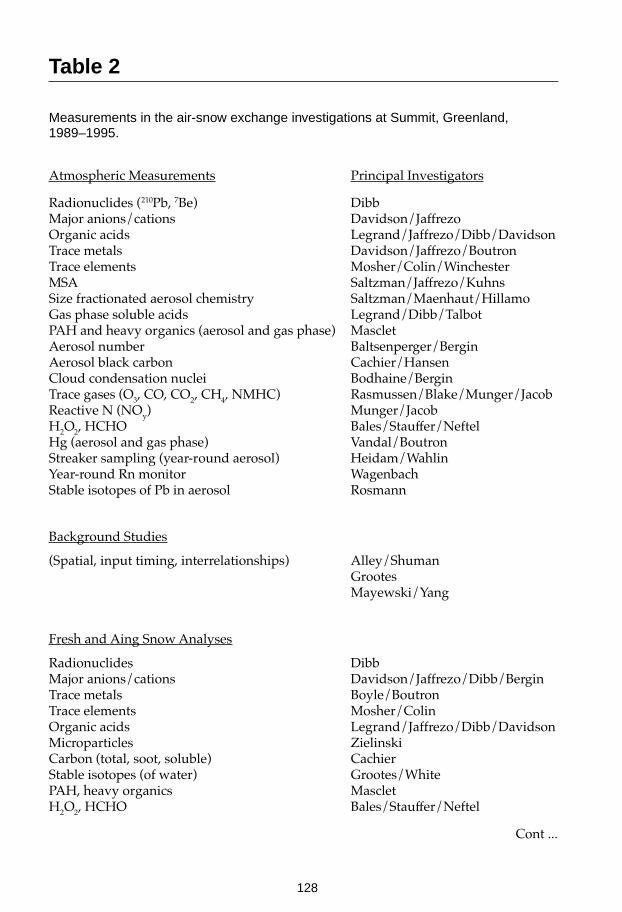
128
Table 2
Measurements in the air-snow exchange investigations at Summit, Greenland,1989–1995.
Atmospheric Measurements Principal Investigators
Radionuclides (210Pb, 7Be) DibbMajor anions/cations Davidson/JaffrezoOrganic acids Legrand/Jaffrezo/Dibb/DavidsonTrace metals Davidson/Jaffrezo/BoutronTrace elements Mosher/Colin/WinchesterMSA Saltzman/Jaffrezo/KuhnsSize fractionated aerosol chemistry Saltzman/Maenhaut/HillamoGas phase soluble acids Legrand/Dibb/TalbotPAH and heavy organics (aerosol and gas phase) MascletAerosol number Baltsenperger/BerginAerosol black carbon Cachier/HansenCloud condensation nuclei Bodhaine/BerginTrace gases (O3, CO, CO2, CH4, NMHC) Rasmussen/Blake/Munger/JacobReactive N (NOy) Munger/JacobH2O2, HCHO Bales/Stauffer/NeftelHg (aerosol and gas phase) Vandal/BoutronStreaker sampling (year-round aerosol) Heidam/WahlinYear-round Rn monitor WagenbachStable isotopes of Pb in aerosol Rosmann
Background Studies
(Spatial, input timing, interrelationships) Alley/ShumanGrootesMayewski/Yang
Fresh and Aing Snow Analyses
Radionuclides DibbMajor anions/cations Davidson/Jaffrezo/Dibb/BerginTrace metals Boyle/BoutronTrace elements Mosher/ColinOrganic acids Legrand/Jaffrezo/Dibb/DavidsonMicroparticles ZielinskiCarbon (total, soot, soluble) CachierStable isotopes (of water) Grootes/WhitePAH, heavy organics MascletH2O2, HCHO Bales/Stauffer/Neftel
Cont ...

129
Snow Related Studies
Snowflake habit Borys/Albert/DavisFog droplet size distribution BorysChemistry of occult deposition Borys/Davidson/JaffrezoIsotopic composition of vapor/fog/rime Grootes/WhiteAccumulation network Dibb/Jaffrezo/Gow/MeeseSnowpack microphysics Albert/Davis(permeability, energy budget)
Meteorology
AWS network and echo sounder StearnsTether sonde profiling KahlBack trajectory calculations Harris/KahlMicrometeorology Albert/Davis/Munger/Jacob(energy balance, eddy correlation)

130
Focus IIActivity 1Task 4 Ice Core Circum-Arctic
Palaeoclimate Programme (ICAPP)
Project Leaders: R.M. (Fritz) Koerner and Greg Zielinski
IntroductionMany climate models have suggested that the Arctic is one of the most sensitive re-gions of the globe to any anthropogenically-induced climate change. Continuedmodelling to further test this hypothesis and checks on the validity of past modelruns should rely on boundary conditions established by the palaeoclimatic recordsavailable from throughout the Arctic region.
The ICAPP initiative is an international project that will use existing and newly ob-tained palaeoclimatic records from the circum-Arctic region, with particular refer-ence to ice-core records, to evaluate the variability in past climate change on timescales ranging from hundreds to tens of thousands of years. In addition, more recentsnow and ice sampling will allow for the evaluation of the magnitude and spatialvariability of natural and anthropogenic pollutants reaching the Arctic. This will beuseful in discerning transport paths to and circulation systems within the Arctic. Inaddition, detailed records of past climate change from the circum-Arctic may bereadily linked to the PEP initiatives within PAGES. One of the basic concepts ofICAPP is that circumpolar climatic change will not be understood from the Green-land record alone. Smaller ice caps give lower resolution records but are essential toa broad-based understanding of the linkages between the polar and temperate re-gions.
History of the ProgrammeOver much of the last two decades, the collection of ice cores from the Arctic regionoutside of Greenland has been uncoordinated. The former Soviet Union has drilledcores from ice caps in Severnaya Zemlya and from Spitsbergen. Most of this workhas been published in Russian and not in the international network of journals.These data need to be re-examined and some sites re-drilled. The Japanese NationalInstitute of Polar Research (NIPR) has drilled cores from the Norwegian Arctic,Spitsbergen, and Greenland. The Glaciology group now with the Geological Surveyof Canada has been responsible for the palaeoclimatic records derived from coresthey drilled on Meighen, Devon and Agassiz (Northern Ellesmere Island) ice caps,providing the basis for much of our present understanding of climate change in theCanadian Arctic. The Glacier Research Group at UNH, USA, has been involved withthe analysis and drilling of short ice cores from Mt. Logan, Yukon Territory andsouthern Greenland prior to their lead in GISP2.

131
The development of an international programme to evaluate the ice core basedrecord of climate change across the Arctic resulted from meetings on a cooperativeice-coring project on the Penny Ice Cap, Baffin Island, among individuals in the Ter-rain Sciences Division of the Geological Survey of Canada (R. Koerner andD. Fisher), NRC of Canada (A. Kudo), and the Glacier Research Group of the UNH,USA (G. Zielinski, C. Wake, and P. Mayewski). An initial meeting to introduce theconcept to interested members of the glaciological and palaeoclimatic communitieswas organized by R. Koerner and D. Fisher at the International Glaciological SocietySymposium in Columbus, Ohio, USA, August 1994. The interest in ICAPP generatedat this organizational meeting indicates the need and desire to formally developcomposite palaeoclimatic record across the Arctic through the compilation andre-evaluation of all existing ice-core records and the collection of new ice cores.The concept was further discussed and presented initially by R. Koerner andO. Watanabe (NIPR, Japan) at a meeting of the working group on Glaciology of theIASC in Poland, October 1994, and again at the IASC/ICAPP meetings in Germany,December 1995. ICAPP was then included as a linked part of the IASC “Mass bal-ance of Arctic Glaciers and Ice sheets in relation to Climate and Sea level change”(MAGICS) programme.
Scientific ObjectivesThe primary objective of ICAPP is to integrate all ice-core records (new and old)across the entire Arctic region into composite records that will define the spatial andtemporal variability of climate change. These records will provide important infor-mation addressing climate variability within Temporal Stream I (last two millennia)and II (glacial/interglacial transition) of the PAGES programme. The driving forcefor the development of this programme is based on the premise that no single icecore from the Northern Hemisphere provides a complete picture of past climatechange, especially on time scales through the Holocene. Individual objectives are asfollows:
• To develop fundamental connections among the ice-core records from smallerice caps throughout the Arctic and link them with those recently developedfrom the Summit region of Greenland (i.e., GISP2 and GRIP cores). Existing ice-core records will be re-examined and new ones obtained. The existing coresplus the new ones from Penny Ice Cap on Baffin Island, Academy of SciencesIce Cap in Severnaya Zemlya, one from the Franz Josef Land and cores fromHans Tausen and NE Greenland will provide the information needed to morecompletely understand the spatial variability of changes across the entire re-gion.
• To provide guidance to individuals working in the Arctic that will lead to thedevelopment of compatible data sets for comparisons between the eastern andwestern Arctic and along north-south gradients. Ice-core records may then becompared to other proxy data in the circum-Arctic region; for example to tree-ring chronologies and Arctic lake records. Detailed correlations drawn betweencontinuous records derived from the Palaeoclimates of Arctic Lakes and Estuar-ies (PALE) initiative and ICAPP further typifies the cooperative research oppor-tunities available through ICAPP.

132
• To construct detailed records of episodic events that may have a short, but in-tense, influence on the climate and other aspects of the Arctic atmosphere, forexample explosive volcanic eruptions and large biomass burning events. Com-piling spatially and temporally extensive records of such events as availablefrom ice cores and surface snow studies will be critical to establishing theirwidespread effects on the Arctic environment.
• To establish the existence of discernible climatic events (like the Little Ice Age)and possibly establish the changes in the intensity of their signals across the re-gion. Newly-developed statistical methods applied to all ice-core time- series,including existing data sets, will greatly enhance the ability to identify time pe-riods with consistent signals.
• To determine the present distribution of parameters to be studied in the icecores and fully utilize the ice-core records in our palaeoclimate reconstructions.A survey of pollen, chemistry, microparticle, stable isotope, and trace metalfluxes in the surface snow pack on five Russian Arctic island ice caps, four siteson the Arctic Ocean sea ice between Russia and Canada and on six Canadian icecaps is presently under way. This survey has been extended in 1996 and in 1997.
• To determine the effect of Laurentide ice sheet surges (Heinrich events). Theonly part of this ice sheet remaining today is towards the base of the Barnes IceCap. A core from this ice cap could provide vital information (along with thatfrom Penny Ice Cap) of the nature of these events.
• To determine ice-cap topography and thickness for ice-core interpretation anddrill site selection. NASA (R. Thomas) extended its Greenland airborne, laseraltimeter/radar ice-depth sounding to the Canadian ice caps in spring 1995.NASA plans to extend the flights to the Russian ice caps covered under ICAPP.
Implementation
Methodology — Ice-Core Parameters
• Ice caps in the circum-polar area withstand a varying degree of surface summermelting. Study of ice layering in the cores provides a detailed picture of sum-mer climate changes to complement the traditional stable isotope (annual tem-perature) approach.
• Major ion suites measured in ice cores are representative of the majority of thechemical compounds found in the atmosphere. The development of robust sta-tistical techniques to deconvolute the various sources of individual ion speciesin a single sample as well as identify the relationships among all ions measuredwithin these multiparameter data sets has greatly improved the environmentalrecords available from the chemical time series. Discrete events, such as vol-canic eruptions and biomass burning events, are recorded by anomalous peaksin specific ions or groups of ions.
• Insoluble microparticles provide extremely detailed information on palaeo-environmental conditions that affect continental dust transport to the polar icecaps.

133
• Quick scanning of major parameters in ice cores is now available using moderntechnology. Changes in the acidity, conductivity (both liquid and solid), andmicroparticle concentrations in the cores can be determined ‘on site’. Thesemeasurements provide pointers to events or periods of interest that requiremeasurements of the complete ion suite.
• Studies of the temporal and spatial variability of pollen found in ice cores hasnot been readily undertaken in the past. The results of the proposed analysis ofpollen by the GSC will be used to postulate changes in latitudinal tree line rela-tive to the particular coring site and provide details on the presence of tracer-species that may be used to discern changes in circulation patterns.
• Dating of cores from small ice caps is more problematic than those from the drysnow zone elevations of Greenland and Antarctica. Radiometric methods willbe used; Canadian National Research Council (NRC) has developed a new ap-proach in the previously undatable basal layers based on a combination of the36Cl/129I ratio and 36Cl using the Atomic Energy of Canada Accelerated MassSpectrometer. Bedrock will be cored (University of Arizona, USA) to date thetime of ice-cap inception, again using 36Cl.
• Stable Isotopes (Oxygen-18) will be analyzed at the Geophysical Isotope Labo-ratory of the University of Copenhagen, Denmark. The 18O series is the primarytime series against which other parameters are interpreted. Co-isotopes (18O anddeuterium) will be done by the Geology Department of the University ofOttawa, Canada.
Principal Organizations that have Expressed Interest in ICAPP
Canada- Geological Survey of Canada (GSC): Koerner; Fisher; Bourgeois- National Research Council (NRC): Kudo; Zheng
USA- Climate Change Research Center, Institute for the Study of Earth, Oceans,
and Space, University of New Hampshire (UNH): Mayewski; Wake; Zielinski- Byrd Polar Research Center, (Ohio State University): Thompson;
Mosely-Thompson- National Aeronautics and Space Association (NASA): Thomas (PARCA)
Japan- National Institute of Polar Research (NIPR): Watanabe- Nagaoka Institute of Snow and Ice Studies (NISIS): Goto-Azuma
Russia- Arctic and Antarctic Institute, St Petersburg (AARI): Savatyugin; Potapenko- Institute of Geography, Russian Academy of Sciences (IG): Glazovski
GermanyAlfred Wegener Institute (AWI): Miller; Hubberton

134
DenmarkGeophysical Isotope Laboratory, University of Copenhagen (GIL): Hammer
UKBritish Antarctic Survey (BAS): Pasteur
Proposed and Completed Ice-Cap Sites
Canada
- Penny Ice Cap: Surface-to-bed core April/May 1995. The GSC drilled 334 m tothe bed on Penny Ice Cap . UNH, NIPR, NISIS, AARI participated in the field.A second borehole to 180 m was drilled from a separate top-of-the-flow-linesite in April 1996 by the GSC with NISIS and NIPR from Japan. Both cores arebeing analysed by the cooperating agencies
- Barnes Ice Cap: A prospective site to examine Heinrich event effects in theremnants of the Laurentide ice sheet near its base. To be drilled by the GSC.
Spitsbergen
- Vestfonna; May 1995: NIPR, Japan, drilled a borehole in this ice cap in May1995. They are completing the core analysis in house.
Russia
- Franz Josef Land: An ice core was drilled from Graham Bell Ice Cap, July/August 1996 in a cooperative project between the Byrd Polar Research Center,(USA) and the Institute of Geography (Moscow). The project has alreadytaken and analysed shallow cores from some of these ice caps for multi-parameter analysis
- The Academy of Sciences Ice Cap (Severnaya Zemlya) was drilled in 1987, butthe various agencies will undertake to drill a new core using an AARI drill.This drill will be built specifically for this project using funding from some ofthe ICAPP agencies. The GSC has already completed surface studies at a pro-spective site where an automatic weather station was established in 1993.
Greenland
- Part of the European Science Programme plans. The GIL (Denmark) haverequested inclusion of their proposed Hans Tavsen and NE Greenland coresunder the ICAPP umbrella.
Project Management and ResourcesICAPP was included in the plans of the IASC at a general IASC meeting inHannover, Germany, in 1995. Presently the funding of joint projects like the Pennydrilling are made by independent application of the groups to their domestic fund-ing agencies. The Penny operation was well funded by the participating groups atlevels proportional to their scientific/logistical input. This approach to funding willcontinue to be used.

135
The logistics, drilling and analyses of samples for this project cost a total of $950k(USD), including salaries. About 70% of the analysis work has been completed byMarch 1996. An ICAPP workshop was held in Ottawa, Canada, in June 1996 to dis-cuss and plan the publication of the results from the 1995 Penny Ice Cap drilling.
Report prepared by R.M. (Fritz) Koerner and David A. Fisher
Contacts:R.M. (Fritz) Koerner and David A. FisherTerrain Sciences DivisionGeological Survey of Canada601 Booth St, Ottawa Ontario K1A 0E8CanadaTel: (1-613) 996 7623Fax: (1-613) 996 5448Email: [email protected], [email protected]

136
Figure 6
Drilling for the ICAPP in Northern Canada. Courtesy of ICAPP (project leader;R.M. Koerner).
137
SCAR Global Change Programme Office
Antarctic CRC, University of Tasmania, Hobart, Tasmania, Australia
Focus IIActivity 2 Antarctic Programmes
IntroductionAntarctic programmes are jointly sponsored by PAGES and SCAR´s Global Changein Antarctica (GLOCHANT). Hence their scientific agendas are determined from theobjectives of both organisations. However, SCAR has the responsibility under ICSUfor the organisation of scientific programmes in the Antarctic, and through its closerelationship with the Council of Managers of National Antarctic Programmes(COMNAP) determines strategies for the implementation and logistic support ofthese scientific programmes, largely through the resources of SCAR national andmulti-national projects. Thus individual projects must first obtain national approvaland eligibility for logistic support to work in the Antarctic. Projects that are pro-posed for remote locations in the ice sheet interior, or in coastal locations far fromestablished bases, require long planning times and often multi-national support be-fore they can be implemented.

138
Focus IIActivity 2Task 1 International Trans-Antarctic
Scientific ExpeditionOn 200 Years of Past AntarcticClimate and Environmental Change(ITASE)
Project Leader: Paul Mayewski
ProjectCoordinator: Ian Goodwin
IntroductionThe broad aim of ITASE is to establish how the modern atmospheric environment(climate and atmospheric composition) is represented in the upper layers of the Ant-arctic ice sheet. Primary emphasis is placed on the last ~200 years of the record. Thistime period was chosen for study because it is relatively simple to recover many icecores covering this period on oversnow traverses, and to develop a spatially signifi-cant study. Even more importantly, this time period covers the onset of major an-thropogenic involvement in the atmosphere, and the end of the LIA.
History of the ProgrammeThe ITASE programme was endorsed by the SCAR Working Group on Glaciologyand approved by the XXII SCAR Delegates at Bariloche (Argentina) in 1992, and wassubsequently endorsed by SCAR Delegates as a core programme of SCAR-GLOCHANT in August 1996. ITASE was formally approved and adopted by PAGESwithin Focus II on Antarctic Palaeoenvironments. It is also forms a contribution toIGAC under their focus on Polar Atmospheric Snow and Chemistry (PASC), and itlinks to Southern Ocean Joint Global Ocean Flux Study (SO-JGOFS) and potentiallyto WCRP-CLIVAR. Some ITASE oversnow traverses have been completed by na-tional programmes, including those of the Chinese, British and the Swedish/Norwe-gian programmes, since 1992.
An international ITASE workshop was held in Cambridge, UK, 2–3 August 1996,prior to XXIV SCAR. The workshop was cosponsored by PAGES, GLOCHANT, andthe US NSF. The purpose of the workshop was to develop a science and implemen-tation plan. This plan (PAGES Workshop Report 97-1) is now available from thePAGES IPO.

139
Rationale and Scientific ObjectivesAntarctica plays a critical role in the dynamic linkages that couple the spatially andtemporally complex components of the Earth system (atmosphere, biosphere,anthroposphere, hydrosphere, cryosphere, lithosphere and cosmogenic input). How-ever, our knowledge of the functioning of Antarctica within the global system and ofthe spatial and temporal complexity of Antarctic climate is poor. This is largely dueto the limited quantity and the short period of observational and instrumental dataon Antarctic climatic variables, collected over the last 30–40 years. Fundamentalquestions unresolved by the instrumental record include: How typical of Antarcticclimatic history are the last 30–40 years? Has Antarctica experienced a typical spatialclimate pattern over the last few centuries to thousands of years, as suggested forother regions of the globe (e.g., the LIA and MWP).
To complicate matters, Antarctica exhibits significant regional contrasts in presentday climate. As an example, evidence from instrumental records suggest somedecoupling of climate change on decadal scales between different parts of the conti-nent. Large areas of the interior of the ice sheet are influenced by the continentaltemperature inversion while other portions of the interior and the coastal regions areinfluenced by the incursion of cyclonic systems that circle the continent. As a conse-quence, these coastal regions are mainly connected with lower tropospheric trans-port whereas high altitude regions in the interior are more likely influenced by verti-cal transport from the upper troposphere and stratosphere. As a result the coastalregions experience higher climatic variability than those regions in the interior.
Ice-coring studies have shown that Antarctica has experienced millennial to decadalscale climatic variability associated with changes in temperature, snow accumula-tion, wind-blown dust, sea-salt loading and methane composition. Such studieshave highlighted the possibility that dramatic shifts in the patterns of atmosphericcirculation may explain the rapidity and magnitude of the change in the above pa-rameters. High frequency climatic changes also occur on interannual timescales, andhave been attributed to the ENSO and other regional to global scale factors that areassociated with atmospheric blocking, sea-ice variations and volcanic event inducedshielding.
ITASE is focused on fundamental issues of spatial and temporal climatic variability,through the key scientific objectives:
• To determine the spatial variability of Antarctic climate (e.g., snow accumula-tion, air temperature, atmospheric circulation) over the last 200 years and wherepossible 1000+ years. These variations include: extreme events such as volcaniceruptions, dust storms, drought; major atmospheric phenomena (e.g., ENSO);and snow accumulation variations. This comprehensive programme for thecontinent of Antarctica will provide an unrivalled, extended climatic depictionfor the world’s major atmospheric heat sink, a land mass comprising 10% of theEarth’s land surface
• To determine the environmental variability in Antarctica over the last 200 yearsand where possible 1000+ years. Environmental proxies could include: sea icevariation, ocean productivity, anthropogenic impacts, and other extra-Antarcticcontinental influences. Because of the remoteness of the continent, Antarctica isan ideal location to monitor biogeochemical cycles and global scale changes.

140
In fulfilling these objectives ITASE will: (i) produce continental scale “environmentalmaps”; (ii) elucidate transfer functions between components of the atmosphere andsnow/ice; (iii) verify atmospheric models; and (iv) interpolate spatial time-series de-termined from satellite remote sensing.
ImplementationITASE intends, over a period of several years, to sample an extensive geographicarea of the Antarctic ice sheet, including many of the proposed drilling sites and asampling of much of the topography and climate of the Antarctic ice sheet. The fieldplanning of ITASE has been designed to build upon existing national programmesand their plans for oversnow traverses for the period 1996–2002. The majority ofproposed traverse routes are already planned to establish and resupply the deepdrilling programmes. In this manner ITASE plans to build upon traverses of ‘oppor-tunity’ for the collection of shallow ice cores at intervals of 100 km along theseroutes. A major product of ITASE will be a continental-scale map of several environ-mental parameters. This surface coverage will be extended over the time domain(~200 years) by a series of cores collected every ~100 km along selected traverseroutes. Several segments of the overall traverse plan may be conducted during a sin-gle season. The preliminary oversnow traverse plan is shown in Figure 8.
Several key properties have already been identified as part of the sampling pro-gramme: chemistry (major anions and cations, H2O2, trace metals); isotopes; 10 mtemperatures; stratigraphy; and high resolution radar and gravity. Additionally,traverses could include the installation of automatic weather stations (AWS), and themeasurement of properties (e.g., dielectric, reflectivity) and deployment of experi-ments valuable for providing ground truth in remote sensing missions.
Participants at the 1996 international workshop in Cambridge, UK, determined thatITASE should comprise four research phases, as follows:
Phase 1: Remote sensing, meteorology, geophysics.
Phase 2: Ground-based sampling (e.g., ice cores, snowpits, ground truth, highresolution snow radar).
Phase 3: Associated studies (e.g., surface glaciology, AWS deployment, aerosolmonitoring).
Phase 4: Modelling and interpretation.
Proposed Ice Core MeasurementsIt was agreed that a standardized suite of measurements would be collected fromsurface snow samples and shallow ice cores on oversnow traverses.

141
Table 3
Standardized ITASE ice core properties.
Accumulation rate
Gamma-ray and beta detection
Electrical conductivity measurements (ECM)
Physical properties (size, shape, arrangement of grains, c-axis fabrics, depth-densityanalyses, melt layers, visible strata)
Stable isotopes (δD, δ18O and deuterium excess)
Major chemistry (Ca, Mg, Na, NH4, K, Cl, SO4, NO3)
Microparticles
Other chemistry (F, I, Br, MSA, H2O2, HCHO)
Temperature
Table 4
ITASE opportunities for research.
Cosmogenic isotopes (10Be, 36Cl, 26Al)
Radionuclides
Tephra
Trace metals (Se, Pb, Hg, V, Mn)
Trace elements (Cs, Rb, Ba, Sr)
Isotopes (Nd, Sr, Pb)
Gases (CO2, CH4, N2O, CFCs, CO, methyl-halides)
Biological particles (pollen, diatoms)
Biogenic compounds (DMSO, DMSO2)
Organic acids

142
30 WEST 30 EAST
75
85
80
75
0
60
120
150 150
60
70
120
180
90 90
Australia
Brazil
China
France
Germany
Italy
Japan
Norway
Sweden
Russia
United Kingdom
United States
0 50 0 1000 KM
Figure 7
Map of planned and proposed national and multi-national ITASE traverses for the pe-riod 1997-2003.. From: PAGES ITASE Workshop Report 97-1.

143
Figure 8
Traverse in Western Antarctica. Courtesy of ITASE (project leader; Paul Mayewski).

144
Focus IIActivity 2Task 2 Late Quaternary Sedimentary
Record of the Antarctic Ice MarginEvolution (ANTIME)
ProjectCoordinator: Ian Goodwin
IntroductionThe physical and dynamical processes controlling the nature of the Antarctic icesheet and the surrounding oceans have been found to be highly variable, both geo-graphically and temporally, on interannual to inter-decadal timescales. Because ofthis large background variability and because instrumental records span such ashort time span, it is difficult to predict the responses of the ice sheet to futureforcings such as global warming. Attempts to determine this variability on century-to-millennial time scales by medium depth ice-core drilling and analysis have beenonly partially successful. Ice cores have provided detailed historical information onclimatic variability, with respect to changes in temperature, relative humidity, mois-ture source, and atmospheric circulation. They cover periods from the last few hun-dred years to the last 10,000 years, at Law Dome and Taylor Dome, East Antarctica,and Dyer Plateau, Antarctic Peninsula, and over the past ~250,000 years at Vostokand Dome C, in the East Antarctic interior. The new Law Dome summit core mayprovide a detailed climatic record over the Holocene and perhaps the LatePleistocene transition, while the proposed Siple Dome and Byrd Basin cores mayalso provide a detailed Holocene climatic and late glacial history of the West Antarc-tic ice sheet. In addition, the present and proposed deep drilling activities that formthe Palaeoenvironments from Ice Cores (PICE) programme will result in new ice-core records covering multiple glacial-interglacial cycles. However, the ice-coringprojects to date have experienced significant difficulties in absolute dating and inproviding temporal data on changes in ice-sheet elevation and fluctuations in ice dy-namics during the Holocene and Late Pleistocene. This information is vital if we areto understand the response of the ice sheet to climatic variability as well as otherforcing mechanisms (i.e., rising sea-level and deformation of the bed on which theice sheet rests).
This difficulty might be overcome by utilizing the geological record. The Antarcticsedimentary record in the marine, coastal, lacustrine, and glacial environments hasalready yielded high-resolution information on palaeoenvironmental andpalaeoclimatic changes, particularly on ice marginal and outlet glacier fluctuations,climatic variability, and lacustrine and marine ecological and biogeochemicalchanges. The coordinated SCAR-GLOCHANT and PAGES initiative on the LateQuaternary Antarctic sedimentary record of the ANTIME will provide a circum-po-lar palaeoenvironmental perspective on the Late Quaternary (last 250,000 years)record. ANTIME will include a detailed component on the last 20,000 years and the

145
very high-resolution Holocene records. This will provide a solid basis for the under-standing of present and future variability in the Antarctic, when combined with theice-core records (PICE). It will also provide the foundation for a PAGES sponsoredbipolar examination of palaeoenvironmental changes when combined with theICAPP programme on the Arctic. ANTIME together with PICE will also complementthe PAGES/SCOR IMAGES transects in the circum-Antarctic regions.
History of the ProgrammeGLOCHANT has developed a joint initiative with PAGES on coordinating Antarcticand Arctic ice-core drilling and the analysis of ice-core records, known as PICE. Itwas the original intention of GLOCHANT in 1991 to also develop a sister projectsuch as ANTIME on Palaeoenvironments from the Antarctic sedimentary record.Delegates at XXIV SCAR held at Cambridge, UK, in August 1996, approved theANTIME initiative. The PAGES SSC formally approved the activity at its March 1997meeting. Thus, it is now incorporated as a joint GLOCHANT and PAGES pro-gramme.
Rationale and Scientific ObjectivesAt present, Quaternary research is conducted around the Antarctic ice margin by sci-entists from a number of nations. Quaternary sequences have been cored on the con-tinental shelf by marine geological programmes and have been partially recorded byseismic surveys conducted by the Antarctic Offshore Stratigraphy (ANTOSTRAT)programme of SCAR, although the later surveys were optimized for the pre- Qua-ternary, Cenozoic strata. However, most of the Late Quaternary and Holocene re-search has been focused on the inner continental shelf, in the coastal zone in fjordsand beach sequences, and in the vicinity of the terrestrial ice margin and adjacentlakes. As with the PICE programme on ice coring, there is a strong need to coordi-nate international research on the variability and evolution of the Antarctic ice mar-gin to maximize international resources and target the Antarctic areas of mutual in-terest. It is also important to recognize that a multi-disciplinary approach includinggeology, glaciology, chemistry, and biology is required to fully develop a compre-hensive palaeoenvironmental history.
ANTIME will focus on two streams: Stream I (last 20,000 years) on the last deglaci-ation and interglacial environmental, climatic, and ice-sheet variability; and Stream II(last 250,000 years) on the environmental, climatic, and ice-sheet response to glacial-interglacial cycles. These are slightly different from the PAGES timescales used inthe PEP transects, but are considered to be more appropriate to circumpolar studies.
Key scientific themes that will be followed by ANTIME are:
The Extent, Timing and Regional Differences of the LGM in AntarcticaOur present state of knowledge on the timing of the LGM in Antarctica is scant andcontradictory. Investigations of the marine sedimentary record on the continentalshelf in East Antarctica and in the Weddell and Ross Seas suggest that the ice sheetmay have been grounded near the continental shelf break sometime during the lastglacial cycle. The East Antarctic onshore geologic record of isostatic and relative sea-
146
level changes and glacial fluctuations indicates that a much smaller ice-sheet expan-sion occurred at the time of the Northern Hemisphere LGM around 18,000–20,000years BP. In fact, the maximum post-glacial emergence is an order of magnitude lessthan in the Arctic since the LGM. Were the glacial maxima of the East Antarctic andWest Antarctic Ice Sheets in phase or were they regionally offset? This is also a cru-cial question for the resolution of global sea-level fluctuations and the calibration ofice-sheet models that are used to predict the future response of the ice sheets to glo-bal warming.
What Rapid or Episodic Events Occurred During the Late Quaternary ?The emerging bipolar data sets are suggesting that rapid change and episodic eventshave characterized the Late Quaternary environment, rather than slow transforma-tions from interglacial to glacial climates. These events have been associated with arapid response of the polar ice sheets to abrupt climatic changes over much shorterintervals than the orbitally modulated 20–100 ka Milankovitch insolation cycles andinclude:
• Dansgaard-Oeschger glacial interstadial (warm) events with a duration of 200–2,500 years.
• Rapid sea-level changes
• Abrupt temperature changes such as during the YD event, now believed tohave been global
• Pulses of (ice-rafted) glaciomarine sedimentation, known as Heinrich events, inthe North Atlantic Ocean
• Ice surges and fast flow events in the Northern Hemisphere and in the AntarcticPeninsula region.
However, we do not know how many, if any, of these episodic and rapid events oc-curred in mainland Antarctica, nor do we know whether they are triggered by glo-bal forcings. A coordinated effort in West and East Antarctica is required to addressboth the regional and bipolar climatic and sea-level histories. This is a large under-taking and will significantly benefit from a coordinated multinational effort.
What are the Key Forcings and Feedbacks that Influence the Retreat andReadvance of the Antarctic Ice Sheet ?We know little of the forcing mechanisms that control the retreat, readvance, andstability of the Antarctic ice sheets. It is imperative that we understand these mecha-nisms if we are to predict the response of the ice sheet to any future global warming.These mechanisms include: eustatic sea-level changes; warm deepwater incursionson the shelf; isostatic loading and unloading in equilibrium or disequilibrium withthe ice-sheet status; glacial bed conditions and deformation; ocean circulation; andclimatic changes. Only scant evidence for the timing of the post-glacial retreat, fromthe emergence of coastal bedrock and Holocene raised marine shorelines, has beencollected at present. However, these data suggest that the isostatic response aroundAntarctica differed widely between regions and that the drainage basins may haveresponded to different forcings.

147
We need to develop an understanding of the regional evidence, style, rates, extent,and timing of post-glacial retreat. It is important to approach this problem by focus-ing on:
• Stratigraphic correlation of glacial marine retreat deposits around Antarctica
• Correlation of all emerged marine shoreline data around Antarctica and plan-ning for additional fieldwork in unsurveyed regions.
What Changes in the Ice Shelves and Outlet Glaciers Have Occurred Duringthe Holocene ?Little is known of the Holocene climatic record in Antarctica. How have the Antarc-tic ice sheet, outlet glaciers, and ice shelves responded to small climatic fluctuationsduring the Holocene? Do our modern observations of ice behaviour reflect thesepast, rather than modern, climatic fluctuations? The marine sedimentary record isproving to be an important source of data on Holocene climatic change. This haslargely been due to the significant advancement in the high-resolution dating ofHolocene deposits using AMS 14C techniques and to the identification of inner shelfand fjord locations with high sedimentation rates, which have made it possible todefine decadal-to-century scale variability, such as the 200 year cycles interpreted inthe Antarctic Peninsula sediments.
Detailed onshore geological studies have demonstrated that the ice margin and out-let glaciers have fluctuated on the timescales of 10–1,000 years during the Holocenein response to changes in mass balance. Similarly, direct observations of the modernice grounding zones using submersible remotely operated vehicles (ROVs) are al-lowing a picture to develop on the physical, sedimentological and oceanographicprocesses controlling the location of the ice margin. The sedimentary record can alsoprovide boundary conditions on the history of Antarctic ice-shelf bottom water pro-duction, the history of shelf break mixing, and the occurrence of coastal and offshorepolynyas. In this way, ANTIME has a potential contribution to the history of Antarc-tic bottom water production and a linkage with deep-sea geological investigationsundertaken by the IMAGES programme in the Southern Ocean and South AtlanticOcean.
Correlation of Late Quarternary Antarctic Environmental History and Deep-Ocean Sedimentary RecordsA key need for the understanding of the relationships between Antarctic glacial his-tory and the record of past global change is for nearshore sedimentary records to betied to continuous, well-dated, offshore sections. The advantage of this type of inte-grated approach is that it would maximize the benefits and cover for the shortcom-ings of both types of sequences. The offshore drilling and coring targets currentlyunder consideration by ODP and IMAGES provide continuous Neogene records towhich a battery of proven chronostratigraphic tools can be applied, including mag-neto- and biostratigraphy and orbital tuning of high-resolution isotopic, litho-stratigraphic, and physical properties measurements of whole cores and discretesamples. In the late Quaternary, these types of palaeoceanographic records provideimportant stratigraphic tiepoints between marine and ice-core chronologies. A par-ticularly glaring need is for nearshore-offshore transects in the Pacific Sector of theAntarctic. The Southern Ocean may show considerable regional variability, espe-

148
cially if the near-field effects of ice-sheet dynamics play an important role in South-ern Ocean circulation (a Southern Hemisphere counterpoint to the Heinrich eventsof the North Atlantic). In this case the East and West Antarctic ice sheets may behavequite differently and independently and drive sector-scale variability in the flux ofmeltwater and ice-rafted debris.
It is proposed that linkages between the ANTIME, IMAGES, and ODP programmeswill optimize the possibilities for the correlation of the Antarctic and deep SouthernOcean sedimentary records.
ImplementationTo rectify gaps in our present understanding, and our divergent views of circum-Antarctic palaeoclimatic and palaeoenvironmental change, it is necessary to broadenthe geographic coverage of investigations. This, in turn, requires international par-ticipation in onshore and marine programmes. ANTIME will provide the opportu-nity for international cooperation in marine geological and geophysical surveys: onthe East Antarctic shelf basins, including the Mertz-Ninnis Trough, the TottenTrough, Prydz Bay, Lutzow-Holm Bay, and the Rennick Trough; in the Ross Sea; inWest Antarctica at Pine Island Bay and along the west coast of Graham Land; and onthe South Orkney Plateau. An international effort focusing on high-resolution seis-mic surveys using a sparker and 3.5 kHz equipment is required, together with thedrilling of long sediment cores and more detailed work on the recognition ofglaciomarine, iceberg turbate, and subglacial diamicton facies transitions. TheANTOSTRAT project has led to the collection and establishment of a detailed seis-mic library on the continental shelf stratigraphy. However, the Late Quaternary isnot well represented because it is a shallow sequence and is often located in the bub-ble pulse of the ANTOSTRAT seismic surveys, which were optimized for the earlierCenozoic record.
It will be necessary to focus onshore studies of Late Quaternary glacial geology,palaeobiology, and geochemistry in the priority regions adjacent to high-resolutionseismic surveys and marine coring sites, to enable correlations to be made and togain a better understanding of the nature and mechanisms of palaeoenvironmentalchange. Regional analysis of the onshore and offshore sedimentary records, togetherwith data on postglacial relative sea-level change and isostatic rebound, will enablethe nature and extent of the coastal ice-sheet expansion to be established. It is neces-sary to correlate the palaeogeography and timing of the coastal ice-sheet expansionduring the last glacial cycle with the marine geological evidence, to understand theresponse of the Antarctic drainage basins to climatic and sea-level change.
It is difficult to draw continent-wide conclusions from regional ice-shelf and outlet-glacier fluctuations, particularly in regard to the climatic and oceanographicforcings, especially because the East and West Antarctic ice sheets may have re-sponded independently. Consequently, a coordinated international effort is requiredto ensure a focused and representative regional coverage. Suitable sites include:
149
• Prydz Bay and the Vestfold Hills
• Vincennes Bay and the Law Dome
• Palmer Deep and Livingston Island, Antarctic Peninsula
• Western Ross Sea and the Trans-Antarctic Mountains.
Our knowledge of past glacial and climatic events would also be enhanced if tech-nological aspects could be coordinated amongst SCAR nations. The following as-pects will be addressed in proposed workshops:
• Continent-wide chronological comparisons of glacial and climatic events havebeen difficult due to the uncertainty in the radiocarbon 14C reservoir correctionsand their changes with time throughout the Late Pleistocene and Holocene. It isimportant to develop a strategy to determine calibrated reservoir corrections forthe terrestrial and marine Antarctic environments with respect to thepalaeoceanographic circulation
• Improvements in seismic stratigraphy and stratigraphic interpretations could bemade through a technology comparison of international high-resolution sub-bottom imaging techniques
• Similarly, an international approach to the standardization of sedimentologicaldescription in Antarctic terrestrial, lacustrine, and marine environments wouldpermit the continent-wide comparison and correlation of geological events
• Planning the cooperative use of submersible ROV and the further developmentof this technology would significantly increase our knowledge of the morphol-ogy and sedimentation at modern grounding zones and beneath ice shelves
• Ship platforms and the capability to drill long sediment cores are highly special-ized. The planning of international cruises and the sharing of technologyamongst SCAR nations would significantly increase the potential for solvingmany of the key scientific questions.
This initiative began by holding a GLOCHANT/PAGES sponsored InternationalWorkshop, in Hobart, Australia from 6–11 July 1997, in conjunction with the Sympo-sium on Antarctica and Global Change. The aim of the workshop was to: discuss thestate-of-the-art palaeoenvironmental data on the Late Quaternary in Antarctica; planfuture multi-national field programmes; and plan for the coordination of technologyand stratigraphic correlations. Representatives from all the marine and glacial geo-logical programmes in SCAR countries participated in the workshop, together withrepresentatives from PAGES projects with an interest in Antarctica.

150
Report prepared by Ian D. Goodwin
Contact:Ian D. GoodwinSCAR Global Change Programme CoordinatorAntarctic CRCUniversity of TasmaniaGPO Box 252-80Hobart 7001, TasmaniaAustraliaTel: (61-3) 6226 7544Fax: (61-3) 6227 7650Email: [email protected]
SCAR Global Change Programme Home Page:URL: http://www.antcrc.utas.edu.au/scar/

151
12
1
2 3
4
11
10
98
76
5
Figure 9
Map showing the twelve areas selected as priorities for ANTIME research.Courtesy of ANTIME (project leader; Ian Goodwin).

152
Focus IIActivity 3 Bi-Polar ProgrammesTask 1 Palaeoenvironments from Ice
Cores (PICE)
Project Leaders: Dominique Raynaud and David Peel
IntroductionPalaeoenvironmental records derived from the analysis of polar ice cores are uniquein several ways. Polar ice-core records are the only archives which, along withhighly resolved evidence of past climate change, including air temperature andsnowfall rate, also preserve information on the atmospheric concentration of theprincipal greenhouse gases, on the concentration of atmospheric aerosols, and on awide range of major and minor chemical constituents in the atmosphere. Antarcticice is the most suitable for extending the ice record back to cover several completeglacial cycles and for investigating past atmospheric CO2 changes. However, a bipo-lar approach is needed to clarify linkages and climate coupling between the North-ern and Southern Hemispheres.
Ice-core research has already made substantial contributions to our understandingof the mechanisms driving global climatic changes. For instance, ice cores from bothAntarctica and Greenland provide strong evidence that the atmospheric concentra-tion of greenhouse gases has closely paralleled pre-anthropogenic global climaticchanges throughout the last glacial to interglacial cycle. These studies have providedthe only firm data to demonstrate the increase of greenhouse gases since the pre-in-dustrial period. Also, several discoveries were totally unexpected, and had not beenpredicted by any models. Thus ice cores from Greenland have revealed the existenceof a series of major, abrupt climatic shifts both during and at the end of the last gla-ciation. Major shifts are found to have occurred during time intervals of a fraction ofa human life.
Comparison with results from deep-sea sediments suggests that the ice-sheet-sur-face-changes were connected with a re-ordering of the deep-ocean circulation, andtherefore may have global implications. Based on the methane record from bothGreenland and Antarctic ice, and on growing evidence from deep-sea and terrestrialclimate records, it can be concluded that these climate fluctuations not only affectedthe North Atlantic and adjacent regions, but also mid-lower latitude regions.
PICE has drawn together proposals for a series of national and multinationalprojects over the next decade involving deep ice-core drilling in different parts ofEast and West Antarctica and in Greenland.
Taken together, the various proposals aim to ensure that representative climaterecords are achieved for the principal climatic zones of the polar ice sheets, and thatthese records will give maximum resolution during the two time-streams identifiedas priority targets by PAGES. These encompass high-resolution reconstructions ofthe Holocene and long-range reconstruction of climate and related changes in at-

153
mospheric chemistry through the more extreme climate changes occurring over gla-cial cycles. This coordinated effort (GLOCHANT/PAGES) should lead to major ad-vances that will reduce the uncertainty in predicting future global environmentalchange.
History of the ProgrammeDeep-ice coring on the Antarctic Ice Sheet has been part of several national pro-grammes since the late 1960s. In 1993 GLOCHANT established a planning group tocorrelate ice-core data on palaeoenvironmental changes. It was the original intentionthat this planning group would focus on palaeoenvironmental changes in Antarc-tica, as deduced from ice cores and the marine and terrestrial sedimentary record, asoutlined in the original SCAR Report (1993), ‘The Role of Antarctica in Global Change’.As a first step towards this goal, PICE was established under the chairmanship ofDominique Raynaud, Laboratoire de Glaciologie and Geophysique de l’Environ-nement, St. Martin d’Hères, France. The other members of PICE are: D. Peel (Secre-tary, UK), J. White (USA), V. Morgan (Australia), V. Lipenkov (Russia), J. Jouzel(France), and O. Watanabe, H. Shoji (Japan). The members held their first meeting inCambridge, UK, on the 4–5th September 1993. The second meeting was held in Colde Porte, France on the 24–25th February 1994. It was decided at the latter meetingthat there was a considerable overlap between the group’s objectives and those ofPAGES. Consequently, a proposal was prepared and submitted to the PAGES SSCfor joint sponsorship of the group. This was approved in late 1994.
Rationale and Scientific ObjectivesDuring 1995, the members of PICE began work on a science and implementationplan for an international strategy for ice-core drilling in Antarctica. This was a focusof the third annual meeting of PICE in Boston, USA, on 15–16th September 1995. Atthe Boston meeting it was recognized that ice coring in Antarctica needed to be inte-grated with ice-coring activities in Greenland and the Arctic, both from a logisticalviewpoint, and because many of the ice-coring expertise and much of the drillingequipment was used in both regions. Issues related to data analysis also under-scored this need. Thus, a GLOCHANT bi-polar document has recently been com-pleted, “An International Strategy for Ice-Core Drilling in Antarctica and Greenland –Reducing Uncertainty in Global Environmental Change.”
The scientific objectives of PICE relate to: climate variability; forcing factors,feedbacks and mechanisms; coupling between the Northern and Southern Hemi-spheres; and ice sheet stability and control on global sea level. Some key questionsare:
Climate VariabilityAre the rapid climate changes of the last climatic cycle global events, or have theybeen restricted to a region of the Northern Hemisphere? Are rapid climate changesalso observed in previous climatic cycles? What factors can contribute to the speedof the climate changes observed in Greenland? Is the apparent stability of theHolocene climate in Greenland an exception for the past 500,000 years?

154
Forcing Factors, Feedbacks and MechanismsWhat are the causes of natural variations in greenhouse gas concentration observedduring the last and earlier glacial-interglacial cycles and to what extent was globalclimate driven by these changes? How has atmospheric chemistry changed in re-sponse to climate? Is there evidence of any feedback via, for example, interferencewith the oxidation capacity of the atmosphere, that regulates the levels of certaingreenhouse gases such as methane? How important are the marine biogenic aerosolsof the Southern Ocean in climate forcing?
Coupling Between the Northern and Southern HemispheresWhat is the phasing of climate between the Northern and Southern Hemispheres inthe various stages of the last glacial cycle? Are global climate changes triggered inthe Northern Hemisphere or is the opposite sequence possible? How are global cli-mate changes coupled between the two hemispheres? What is the link between icecore and marine sediment records from other latitudes?
Ice-Sheet Stability and Control on Global Sea LevelWhat were the long-term linkages between climate, snowfall rates, and ice sheet his-tory, and how are these related to global sea level?
The answers to these questions are important for the prediction of future climate.New ice cores from optimal locations both in Antarctica and Greenland are neededto complement the existing records. For instance, additional Antarctic records willenable us to investigate the rapid climate events in a global context. Considering thecomplex structure of the atmosphere over Antarctica and the interactions with thesurrounding ocean, ice cores from several locations will be needed to answer theseimportant questions. These archives will also provide unique evidence related to cli-mate forcings (such as: greenhouse gases; atmospheric oxidation capacity; atmos-pheric turbidity; biogenic feedbacks; and solar variability), climate variability, cli-mate mechanisms, the long term climate/ice sheet interactions, and the role of Ant-arctica in sea-level change. These ice-coring activities are planned as national andmultinational enterprises and are listed in Table 5 below.
Implemention
Strategy for Future Drilling/MethodologyThe Antarctic ice sheet spans an area larger than the USA and comparable to Europe.Thus it covers a wide range of both climatological and glaciological regimes. No sin-gle site can be presumed to deliver a climate record that is representative of thewhole continent, nor can it yield a record of optimal resolution of both climate pa-rameters and gas mixing ratios across the whole time range of interest. Alternativesites possess a variety of physical attributes that determine the resolution and long-term stability of the records attainable. Different sites also experience different sensi-tivities to climate/circulation changes in adjacent ocean and continental areas. Sig-nificant differences have been observed already in, for example, the characteristicsof the deglaciation sequence recorded in different Antarctic cores. These differencesmay have important implications for coupling the Antarctic and Greenland records.Plans are being formulated for a series of national and multinational drilling projects

155
during the next decade in different parts of East and West Antarctica, the recordsfrom which cover time-scales ranging from centuries up to several hundreds ofthousands of years. The existing and planned ice-coring activities are listed inTable 5.
AntarcticaThe major dome sites in East Antarctica have been targeted to achieve the longestpossible records, benefiting from a combination of very low annual snow accumula-tion rate and minimal long-term ice flow disturbance. Such sites will also providethe best opportunity to correlate the ice-core records with the marine sedimentrecords and other terrestrial records, contributing to a more coherent global picture.The Vostok core, already at 3,350 m in depth as of January 1996, the deepest ice coreand the longest continuous ice-core record so far achieved, has led to many majoradvances in ice-core research. Although there are still 350 m to be drilled, the recordextends through at least four complete glacial cycles. As the depth increases, correc-tions for ice-flow also increase, and the record may become more difficult to inter-pret unambiguously. Furthermore, drilling must be terminated about 25 m above asubglacial lake.
Table 5
Existing and planned Antarctic ice-coring activities.
Project Nations Region Timelines
1. WAISCORES (Siple Dome), USA W. Antarctic [1995–1998]
2. Berkner Island, G/UK W. Antarctic (coastal) [1995–1996]
3. Vostok, Russia E. Antarctic (plateau) [1990–1997]
4. Dome Fuji, Japan E. Antarctic (central) [1995–1998]
5. EPICA Dome Concorde, Euro E. Antarctic (Pacific/Indian) [1996–2000]
6. EPICA Dronning Maud Land, Euro E. Antarctic (Atlantic) [2000–2005]
7. Wilkes Land, Australia E. Antarctic (plateau) [>2000]
8. WAISCORES (Byrd Basin), USA W. Antarctic [1996–2099]

156
Planned drilling in West Antarctica and in Dronning Maud Land is more closelyfocussed on the last glacial cycle and is designed to achieve records of comparableresolution to the Greenland records. These records will be especially valuable fordocumenting the amplitude and phasing of Antarctic climate shifts through the se-quence of Dansgaard/Oeschger events and the deglacial and early Holocene se-quences. These sites are likely to be most sensitive to changes in the extent of theWest Antarctic ice sheet and are likely to provide the strongest evidence on ques-tions relating to the stability of the West Antarctic ice sheet and its relationship toclimate. Such sites are not located near existing manned stations, which were se-lected for logistic reasons, and will require much more demanding logistics to estab-lish. These planned activities include two major programmes; European Ice Coringin Antarctica (EPICA); and the US West Antarctic Ice Sheet Initiative (WAISCORES2000).
The EPICA programme involves a consortium of 10 European nations: Belgium,Denmark, France, Germany, the UK, Italy, the Netherlands, Norway, Sweden, andSwitzerland. EPICA is a long-term (ca seven years) project to derive high resolutionrecords of climate and atmospheric composition through several glacial-interglacialcycles. The project is designed to complement the highly successful central Green-land projects and it will allow extension and full documentation of the East Antarc-tic record, so far essentially limited to the analysis of the Vostok core. Thus the focusof EPICA is the cooperative site survey and deep ice coring at two locations in EastAntarctica: a 3,500 m ice core at Dome Concorde in Wilkes Land in the Indian Oceansector; and in Dronning Maud Land in the Atlantic Ocean sector.
The US WAISCORES programme will address several fundamental questions whichrevolve around the nature and causes of climate change, the past variability of cli-mate, and the stability of the West Antarctic ice sheet. The goals of WAIS are to: (i)improve the understanding of how instabilities in the West Antarctic ice sheet maycause a rise in sea level; and (ii) improve the understanding of the climate andpalaeoclimate of West Antarctica, and the interhemispheric timing and characteris-tics of climate change. The WAISCORES programme will involve the retrieval ofseveral shallow (150 m) ice cores and a deep ice core (1,000 m) in the coastal SipleDome area, which should contain a >100,000 year palaeoenvironmental record. Fol-lowing the Siple Dome ice coring, a deep ice core will be retrieved from an inlandsite along the Byrd divide in West Antarctica. The Byrd divide core should span atleast one to two glacial cycles.
Greenland and the ArcticFurther deep drilling is also planned in North Greenland in an effort to discoverwhether an undistorted stratigraphic record of the last interglacial can be found inanother part of the Greenland ice sheet, to allow proper comparison with the Ant-arctic records. Evidence from a recent combined study of the GRIP and GISP2 icecores from Summit, Greenland, now strongly suggests that the deepest parts of bothcores, extending before 110,000 years ago, have been disturbed by ice flow. Whilst itis believed that ice from marine isotope stage 5e, the Eemian period, can be identi-fied in both cores, the prospects for establishing an unambiguous and detailedstratigraphic record of Eemian climate from these cores are remote. Nevertheless,there appears to be some corroborative evidence for structure in the Eemian climatein several marine sediment sequences from the eastern North Atlantic region and

157
the Nordic seas. If climate instability in this previous warm period is real, then thiswould have major significance for understanding present climate. Renewed effortsare now needed to obtain an independent high resolution record of the Eemian cli-mate in Greenland, suitable for comparison with the Antarctic records. A new deepdrilling project in Northern Greenland (North GRIP), mainly funded by Denmark, isnow underway. A German geophysical survey has located an optimum drilling sitein an area of lower accumulation rate (15 cm ice/year), where it is anticipated thatthe Eemian ice will lie significantly further above bedrock compared with Summit. Itshould offer the best opportunity for achieving an undistorted Eemian record and aresolution of the uncertainties at Summit. The prospect of extending the ice-corerecords through two glacial cycles should also be pursued in order to match theavailable Antarctic records.
Outside Greenland, the collection of ice cores from the Arctic region has been untilnow largely un-coordinated, yet modelling studies indicate that this region is glo-bally one of the regions most sensitive to anthropogenic forcing. ICAPP (see pages130–136) aims to address these issues, through the integrated evaluation of existingand newly-drilled ice-core records in the circum-Arctic region (particularly the Ca-nadian and Russian Arctic records). ICAPP will focus on the characterization of pastclimate variability, on time-scales ranging from centuries to tens of thousands ofyears.
Contact:Domique RaynaudLCGE/CNRSBP 9638402 Saint Martin d´HèresCedexFranceTel: (33-4) 76 82 42 45Fax: (33-4) 76 82 42 01Email: [email protected]
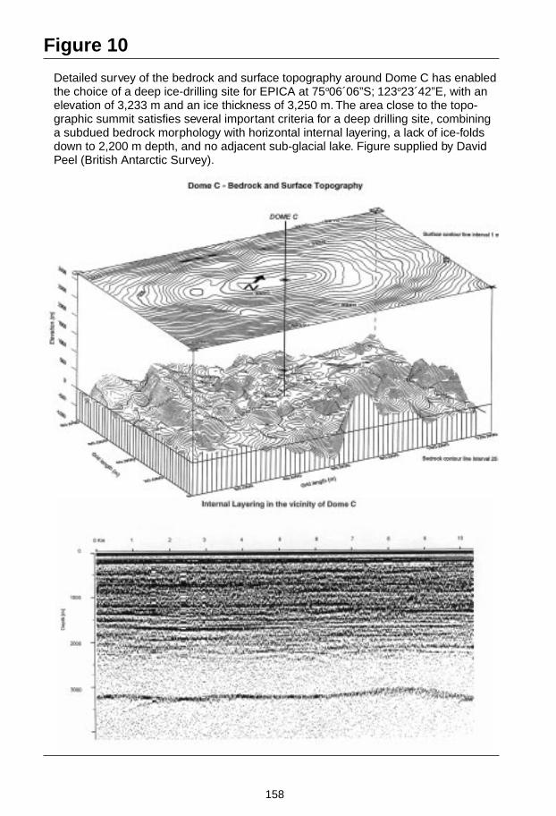
158
Figure 10
Detailed survey of the bedrock and surface topography around Dome C has enabledthe choice of a deep ice-drilling site for EPICA at 75o06´06”S; 123o23´42”E, with anelevation of 3,233 m and an ice thickness of 3,250 m. The area close to the topo-graphic summit satisfies several important criteria for a deep drilling site, combininga subdued bedrock morphology with horizontal internal layering, a lack of ice-foldsdown to 2,200 m depth, and no adjacent sub-glacial lake. Figure supplied by DavidPeel (British Antarctic Survey).
159
FOCUS III
Human Interactions in PastEnvironmental Changes
Activity 1 Human Impacts on Fluvial Systems
(See PAGES Workshop Report 96-2)
Project Leader: Robert J. W asson
IntroductionGlobal change is both systemic (involving changes to whole-Earth systems such asthe atmosphere and oceans) and cumulative (involving many local and/or regionalchanges that in aggregate have a global effect). Land use and climate change are in-ter-related, with land cover changes contributing to systemic changes by means ofgas exchanges and horizontal riverine transport of C, N, P and sediment with an ef-fect on the fertility of oceans; and climate change affecting both the possible rangeand productivity of particular land uses and the hydrology of the continents. Land-use/cover changes, modulated by climate change, are of direct concern to the entirehuman population, with profound effects on terrestrial and coastal ecosystems.
Fluvial systems play a key role in both systemic and cumulative human impacts.Rivers are the primary agents of horizontal transport of biogeochemically importantmaterials from the land to coasts. The fluvial system is also susceptible to changes ofland use and climate, reflecting adjustments to the hydrological cycle and fluxes ofmaterials such as sediment and nutrients.

160
The key role of the fluvial system in the horizontal transport of water andbiogeochemically important materials in the Earth system has been recognized byPAGES, BAHC, LOICZ, and GCTE. This recognition is reflected in planning meet-ings held in 1994 for PAGES and 1995 for BAHC, LOICZ, and PAGES. Two scienceplans have been produced from these meetings: P1 “Land Use and Climate Impactson Fluvial Systems During the Period of Agriculture” (PAGES Workshop Report96-2), and P2 “Modelling the Transport and Transformation of Terrestrial Materialsto Freshwater and Coastal Ecosystems” (BAHC, PAGES, LOICZ). (See IGBP Reportno. 39).
Scientific ObjectivesFor both planning meetings, the key scientific objectives were formulated within thefollowing general framework:
• To quantify landform change and river-borne fluxes of water, sediment,micronutrients, C, N, and P, both today and in the past
• To identify the controls on the fluxes of these materials in the catchment cas-cade, both today and in the past
• To identify the feedback on human society and biogeochemical cycles ofchanges in the fluxes of these materials.
PAGES activities will contribute to defining the temporal trends of landform changeand fluvial fluxes, controls, and feedbacks, paying particular attention to the interac-tion of climate change and land-use change during the period of greatest human im-pact on the planet – the agricultural period. P1 is concerned with sediment andthose biogeochemically important materials that leave a palaeorecord, namely P andC. Specifically, the scientific questions identified by the PAGES planning meetingare:
• What is the sensitivity to climatic change of the spatial distribution of sediment,P and C fluxes in different climatic/vegetation regions?
• How do sediment, P and C flux sensitivities to land use under climatic shiftsreflect stages of land-use history?
• How are fluvial system response sensitivities under various land uses influ-enced by the direction of climatic change?
• What are the thresholds and response times of fluvial systems for different com-binations of land use and climatic change?
• How do engineering and other human related modifications, including damsand reservoirs, channel morphology alteration, and wetland drainage, enhanceor suppress climatic impacts on sediment flux in various climate/vegetation re-gions?

161
Operating PlanThe planning meetings of PAGES, BAHC, and LOICZ have identified key scientificquestions and some of the strategies and methods for answering these questions.The two projects (P1 and P2) will be managed concurrently, while maintaining thedistinct character of each project.
The operating plan for P1 has the following components:
• A global classification of fluvial catchments based on relief and stage of regionalenvironmental transformation has been constructed. This classification will beused to both organize existing data relevant to the project and to choose repre-sentative catchments for case studies
• The leaders of existing relevant research groups will be invited to participate inthe project. The currently targeted areas for case studies are: India; China; Rus-sia; USA; Switzerland; Sweden; Australia; South Africa; West Africa; New Zea-land; UK and/or Italy. Others will be added to this list if appropriate
• A small working group meeting was held in Bern, Germany, March 1997. Thisidentified potential leaders for many of the case studies currently proposed andit was agreed to plan a Workshop for 1999 at which the leaders of the case stud-ies will be asked to agree on (at least) the following matters:- Protocol of studies so that case studies can be compared, additional case
studies- Reporting method and schedule for work- Strategy for synthesis of the case studies- Modelling strategy to both generalize the results and provide a catalogue
of fluvial system responses to future land use and climate that can beused to estimate future responses
• A symposium will be held three years after the project starts, at which resultsare presented. A monograph will be produced from this symposium, along witha version suitable for policy-makers
• Each research group will be responsible for its own management and funding,but assistance may be provided by the convenors to stimulate fund raising. Anewsletter will be provided each six months to maintain contact among projectmembers.
Methods1. Each case study will be based on a mass balance of the major components of
catchments that act as sources, sinks or transit zones for sediment, P and C. His-tories of either each or groups of these components will be constructed usingstratigraphic and documentary evidence. Catchment outputs will be recon-structed by using lake, estuarine, or coastal deposits. Good chronologies will beessential, demanding considerable reliance upon high resolution techniquessuch as optically stimulated luminescence dating.
2. Reconstruct land-use/cover changes in the case study catchments using pollen,microfossils, documentary evidence.

162
3. Reconstruct climate in the case study catchments using whatever proxy data areappropriate.
4. Analyze each of the series (of catchment components, land use, and climate) fortheir covariance. Using models of the most likely interactions between these se-ries, interpret the covariance causally. This is not a simple exercise, and the kindof analysis will depend upon local circumstances and quality of time series. Afirst step towards standardization of methods was taken at the March 1997workshop. The most likely analytical framework will center on the sensitivity oflandscape elements to changes in the external variables of climate and land use,and to combinations of these variables.
5. The analysis of external (forcing) variables and of the consequent responses ofcatchments and their components will be related to the catchment classification,outlined in section 6 (Project Strategy) of the workshop report. But this is notsufficient to produce a truly global analysis. For this project, global models arerequired. The data gathered for this project will be used to test and extend exist-ing global models, e.g., total terrestrial fluxes to the oceans of sediments andbiogeochemically important materials; and relationships between land use andexports of nutrients. Importantly, a new kind of global model will be con-structed, indicating the expected responses to changes of land use and climateof different types of fluvial systems. This model will be based on the concept oflandscape sensitivity, whereby responses to external forces (climate and landuse) of fluvial systems will be documented, and their time constants and re-sponse types used as the basis of quantitative models. All of these models willbe of benefit to policy-makers trying to anticipate the direction and rate of sig-nificant global changes.
LinkagesAttention has already been given to linkages between PAGES, BAHC, LOICZ, andGCTE. These are likely to remain the strongest linkages with this project. However,linkages have also been established with IAHS, UNESCO, IAEA, and IHDP/IGBPLUCC.
OutputsAlready completed studies from various parts of the world have demonstrated thatit is feasible to carry out the individual case studies required by this project. The ma-jor new output of this project will be a globally coherent set of documented re-sponses to land use and climate change that, by analogy at least, will provide ameans of anticipating (if not predicting) future global changes in fluvial systems.
In addition, truly global models of the major biogeochemical cycles will be testedand their terrestrial component will be enhanced through provision of greater tem-poral depth and resolution. Global biogeochemical databases will also be enhanced.A new global model based on landscape sensitivity will also be developed.

163
The strategy of building a global picture from regional case studies allows capacitybuilding in various parts of the world while not losing the global perspective. It alsoallows what might be otherwise parochial case studies to take on a global signifi-cance. This is akin to the philosophy adopted by PANASH.
Project ManagementThe convenors of the PAGES planning meetings (R.J. Wasson, D.E. Walling,A.Yu. Sidorchuk) have agreed to act as the managers and steering committee for theproject. The leader of P2, C. Vorosmarty, is liaising with R.J. Wasson to ensure con-current development of the two projects. Funds are currently being sought for a finalplanning workshop in 1999, and for providing the linkage between case studygroups. Resources for each of the case studies will be sought nationally.
Repor t prepared b y Rober t J . Wasson
Contact:Rober t J . WassonDepartment of GeographySc hool of Resour ces and En vironmental Mana gementAustralian National UniversityCanberra, ACT 0200AustraliaTel: (61-6) 6249 2745Fax: (61-6) 6249 3770Email: rober t.wasson@an v.edu.au

164
Focus IIIActivity 2 Human Impacts on Terrestrial
Ecosystems
The details of this Activity have still to de defined and agreed. One of the firstiniatives within this Activity is the proposed PAGES contribution to the large-scaleBiosphere-Atmosphere Experiment in Amazonia (LBA). A joint initiative in this areawith BAHC and GCTE was discussed at the Siberian Transect Workshop inKrasnoyarsk, Russia, September 1997.
The proposed initiative will link PAGES research more closely to the IGBP Transectswhere GCTE is currently working. The following are the some of the objectives thatwill be considered:
• Reconstruction of the immediate antecedants of the present day terrestrial veg-etation, including the use of pollen assemblages to identify and reconstruct thedistribution of key functional types following the GCTE typology
• Reconstruction of pollution, erosion and soil degradation histories for the re-cent past. This requires multi-disciplinary sediment study using a wide range ofanalytical methods. One outcome of such work can be some quantification ofthe changing biogeochemical fluxes associated with the changes identified un-der 1. In this aspect of the research, there is inevitably a close connection be-tween the implications of the results for both terrestrial and aquatic ecosystemsand for their coupling
• Fire histories from charcoal and, under more restricted circumstances, mineralmagnetic analysis
• Past incidence, periodicity and impact of extreme events like floods and ero-sional hazards
• Extension of the climate record beyond the 'instrumental' period, where suitablepalaeothermometers exist
• Reconstructions of variations in past carbon sequestration in peatlands
• Historical insight into biodiversity issues.

165
FOCUS IV
Climate System Sensitivityand Modelling
Activity 1 Climate Forcing and FeedbacksTask 1 Climate Impacts of Explosive
Volcanism
(See PAGES Workshop Report 96-3)
Project Leader: James E. Beget
IntroductionVolcanic eruptions play an important role in modulating global climates. The recentvolcanic eruptions of El Chichon (Mexico) in 1982 and Pinatubo (the Philippines) in1991, both with Volcanic Explosivity Index (VEI) of 5, were accompanied by El Niñoevents and have been linked to global weather and climate disturbances which fol-lowed each eruption for 2–3 years. Older large eruptions during the past 200 yearswhich produced large stratospheric aerosol layers, including Tambora (Indonesia) in1815, Krakatau (Indonesia) in 1883, and Katmai (Alaska) in 1912 (all VEI=6), pro-duced significant but less well- documented climatic effects.
In order to understand and model the evolution of climate since 1880, an intervalduring which global average climate warmed by more than 0.5 oC concomitant withanthropogenic increases in atmospheric CO2 and other greenhouse gases, it is neces-sary to fully understand the effect of volcanic eruptions on climate. Indeed, indi-

166
vidual large volcanic eruptions can produce transient cooling of greater magnitudethan the warming produced by all anthropogenic greenhouse gases in the atmos-phere today.
The question of the impact of volcanic eruptions on climate has attracted much at-tention across multiple scientific disciplines, including meteorology, volcanology, icecore studies, palaeoecology, and palaeoclimatology. A series of international meet-ings involving interdisciplinary groups of scientists have been convened over thelast several years. Among them, a workshop was convened by the Commission onTephrochronology (COT) of the International Union for Quaternary Research(INQUA) and hosted by Meiji University, Tokyo, in Tokyo, Japan (1–5 December1993). This meeting was also sponsored by PAGES and financially supported by theUS NSF.
Scientific AimsAn important opportunity now exists to document both the record of past explosivevolcanic eruptions and the climatic effects of these eruptions through a carefulanalysis of multiple varieties of high-resolution palaeoclimatic records, and numeri-cal modelling studies of the effects of their aerosols on the climate system. Studies ofsuch records have the potential to reveal a detailed history of volcano-climate inter-actions on annual time scales during the last two millennia, through most of the last10,000 years of the Holocene, and at lesser resolution through the last 150,000 yearsof the most recent glacial-interglacial cycle. Of particular interest are those prehis-toric eruptions which are larger than any yet seen during the last few hundred years(i.e., VEI = 7), as the magnitude and duration of climatic effects associated with sucheruptions are not well documented. Therefore, this project seeks to:
• Determine age and magnitude of major volcanic eruptions around the world
• Determine chemical characteristics of major eruptions and resultant aerosols
• Test correlations between individual volcanic eruptions and apparent climateresponse
• Test correlations between specific volcanic eruptions and annual proxy climaterecords in ice cores, tree rings, and corals, and also high-resolution palynologyand other palaeoclimatic data sets
• Improve understanding of mechanisms of volcanic impact on atmosphere andclimate
• Develop new models for volcanic impact on atmosphere, ocean, and climate.
Project StrategyPast workshop meetings and conferences have been designed to facilitate the com-munication and collaboration across national and disciplinary boundaries necessaryto understand the impacts of volcanic eruptions on global climate change. Over thenext three years we have the following goals:

167
• Document globally for selected major tephra eruptions:- Stratigraphy- Chronology- Mineralogy- Geochemistry- Distribution- Eruption magnitude and volume- Climatic impact.
• Address these topics by ongoing working groups within COT, including:- Database of widespread tephra layers (CATALOG)- Microtephra identification techniques and evaluation- Climatic impacts of tephra eruptions- High resolution dating of tephras- Reconstructing palaeoenvironments using tephrochronology- Tephra record and education in developing countries- Hazards and impacts from tephra eruptions.
It is important to note that while some geographic areas are well studied and thecharacteristics of their major tephra layers are well known, e.g., Japan, Western Eu-rope, coterminous US, New Zealand, and Iceland. Some important areas are muchin need of additional work, especially Indonesia, central and southern America,former USSR, Alaska, the Philippines, and Africa.
• Support complementary efforts to elucidate the impact of tephra eruptions onclimate which are going on in many venues. Volcanologists at the SmithsonianInstitution (USA), within the International Association for the Study ofVolcanism and the Chemistry of the Earth’s Interior (IAVCEI), and the QueensUniversity in Belfast (Northern Ireland), are all producing catalogs of explosivevolcanic activity with differing emphases.
The new GRIP and GISP2 cores from Greenland represent major advances in obtain-ing high resolution records of past climate and volcanism. Annual and even seasonalvariation are recorded farther back in time than in previous ice cores, and detailedrecords of global volcanism are present in aerosols preserved in the ice. A similardeep coring project in Queen Maud Land in east Antarctica is underway.
Climate model experiments of the effects of volcanoes on climate are just beginning.Models have only recently had the capability to include the effects of aerosols on cli-mate. Model runs calibrated with instrumental estimates of aerosol loading pro-duced during the Pinatubo and El Chichon eruptions are in general agreement withthe magnitude of observed climate effects. In climate modelling, a standardized vol-cano experiment with all existing climate models, i.e., a Volcano ModellingIntercomparison Project (VMIP), would be useful.
Dendrochronologists are encouraged to use the International Tree Ring Data Bank(ITRDB), held at the WDC-A for Palaeoclimatology, as a repository for their datasets. This practice facilitates the comparison of multiple tree-ring records, and alsoallows intercomparisons of tree rings with other proxy climate records, including icecores.

168
Palynologists are just beginning to look at volcanic effects. In general, most pollenrecords from bogs or lakes do not have annual resolution, although with carefulwork decadal time scales may be attainable. The sensitivity of pollen records toshort-term climate events associated with volcanic eruptions is also not well known.
Research on the degassing of sulfur and other volatiles during explosive eruptions isin its infancy, and needs major strengthening, with emphasis on building up a data-base on sulfur and other gas emissions from important eruptions. This continues tobe a major emphasis of work independently done as a focus of IAVCEI.
Outputs
Results to Date
• Field conference on tephrochronology, Mt. Tateyama, Japan (1992), convened byH. Machida, K. Okumura, and S. Fujii
• PAGES-COT workshop on “Climatic Impact of Explosive Volcanism”, Tokyo,Japan (1993), convened by H. Machida and J. Beget
• United Kingdom/European Biannual Tephra Meetings, Belfast, Northern Ire-land (1992), convened by V. Hall; and Cheltenham (1994) convened by J. Hunt
• Multidisciplinary meeting and field conference, “Tephra, Loess, Palaeosols”,Hamilton, New Zealand (1994), convened by D. Lowe
• XIV INQUA Congress, Symposium on “The Importance of Tephrochronologyfor Reconstructing Climatic History and Environmental Changes in the Quater-nary” Berlin, Germany (1995), convened by H. Machida and J. Beget
• INQUA Congress excursion, “Quaternary Volcanism” Eifel, Germany (1995),convened by P. Bogaard
• Dedicated volume of Quaternary International (vol. 12/14) on “Applications ofTephra” (1992), guest editor, J. Westgate
• Dedicated volume of Quaternary International (1996, in press) of “Tephra, Loess,and Palaeosols — An Integration”, guest editor D. Lowe
• Pages Working Group Series, “Climatic Impact of Explosive Volcanism,” recom-mendations of the Tokyo Meeting (in press), edited by J. Beget, D. Lowe, andH. Machida
• Commission on Tephrochronology Newsletters No. 1–3 (1992–1994).

169
Planned Activities
• “Modern Techniques in Tephrochronology,” (1998), a workshop meeting andfield conference planned for Italy in 1998 (organizer, E. Juvigne)
• Publication in Quaternary International of results of workshop meetings in 1997and 1998
• Continued compilation of tephra baseline data by the working group on data-base of widespread tephra layers (catalogue of widespread tephra layers in theworld, commonly known as CATALOG)
• Continued compilation of data and dissemination of information from other on-going working groups: Microtephra identification techniques and evaluation;Climatic impacts of tephra eruptions; High resolution dating of tephras; Recon-structing palaeoenvironments using tephrochronology; Tephra record and edu-cation in developing countries; and Hazards and impacts from tephra erup-tions.
Project GuidanceThis project was overseen by H. Machida (Japan), President of COTAV from 1992–1996. In 1996 J. Beget (USA) was elected the President, V. Hall (Northern Ireland)was elected Secretary, and E. Juvigne (Belgium) was elected Vice-President, with acommitment to continuing this project. The Commission on Tephrochronology wasrenamed the Commission on Tephrochronology and Volcanism (COTAV).
A small amount of funding is available from INQUA to support the efforts ofCOTAV, which acts as a clearing house and facilitator for the separate workinggroups. Dedicated research support has principally come from country grants to in-dividual investigators associated with the project and the commission. Research fa-cilities and resources also reside in universities and national research laboratoriesassociated with or accessible to individual investigators.
Repor t prepared b y James E. Beg et
Contact:James E. BegetDepartment of Geology and GeophysicsPresident, Commission on Tephrochronology and Volcanism (CO TAV-INQUA)University of AlaskaFairbanks, AK 99775-5780USATel: (1-907) 474 5301Fax: (1-907) 474 5163Email: FFJEB1@aur ora.alaska.edu

170
Focus IVActivity 1Task 2 Solar Influences on Climate
Although a central feature of the PAGES project since its inception, the task on SolarInfluences on Climate has not as yet had an initiating workshop and a Science andImplementation Plan has not been written.
This Task addresses the modulation of the geosystem due to intrinsic variations ofthe Sun as a star. There has been a growing interest within the science community inexploring the relationship between solar variability and its impact on climate. Re-cent studies of changes in global temperature and in solar irradiance over the last400 years point to significant linkage, though by no means perfect coupling. A grow-ing number of studies of longer-term climate proxies, in systems where annual reso-lution and precise chronologies are possible, also record signatures that can belinked to solar cycles. The palaeosciences will have a key role in establishing adeeper understanding of the long-term record of this elusive but potentially signifi-cant relationship. This Task also addresses the effects of orbitally-induced variationsin insolation through the Milankovitch effect and related feedback mechanisms.PAGES hopes to move forward with this Task in the near future.
Key ReferencesAnderson, R.Y. 1992. Possible connection between surface winds, solar activity andthe Earth’s magnetic field. Nature 358: 51-53.
Barnston, A.G. and Liveyey, R.E. 1989. A closer look at the effect of the 11-year solarcycle and the quasi-biennial oscillation in the Northern Hemisphere 700 MB heightand extra tropical North American surface temperature. Journal of Climate 2: 1295-1313.
Beer, J., Siegenthaler, U., Bonani, G., Finkel, R.C., Oeschger, H., Sutter, M., andWolfli, W. 1988. Information on past solar activity and geomagnetism from 10-Be inthe Camp Century ice core. Nature 332: 657-679.
Crowley, T.J and Kim, K.Y. 1996. Comparison of proxy records of climate change andsolar forcing. Geophysical Research Letters 23 : 359.
Imbrie, J., et al. 1992. On the structure and origin of major glaciation cycles, 1. Linearresponses to Milankovitch forcing. Palaeoceanography 7: 701-738.
Kerr, R.A. 1996. New dawn for sun-climate links? Science 271: 1360-1361.
Lean, J., Beer, J., and Bradley, R. 1995. Reconstruction of solar irradiance since 1610:Implications for climate change. Geophysical Research Letters 22: 3195-3198.
Lean, J., Skumanich, A., and White, O. 1992. Estimating the sun’s radiative outputduring the Maunder Minimum. Geophys. Res. Ltrs.
Stuiver, M. and Brayiunas, T.F. 1988. The solar component of the atmospheric 14-Crecord. In: Secular Solar and Geomagnetic Variations in the Last 10,000 Years,Stephenson, F.R. and Wolfendale,A.W. (eds). Kluwer Academic ubs, Dorchredt, p.245-266.

171
Focus IVActivity 1Task 3 Greenhouse Gases and Aerosol
Influences
This Task will be subsummed within the GAIM/PAGES/IGAC “PalaeotracegasChallenge” initiative to be coordinated by Colin Prentice. A joint workshop is beingplanned for the Northern Hemisphere autumn of 1998 in Jena, Germany.

172
Focus IVActivity 1Task 4 Abrupt Climate Change and
Internal Climate System Dynamics
The first steps towards undertaking this Task are outlined in the Workshop Report ofthe joint IGBP/WCRP Workshop held in Venice, Italy, November 1994, THE PAGES/CLIVAR INTERSECTION, notably in Section 2 of the Report that includes sub-sec-tions on: “Dynamics of low-latitude climate change”; “Global ocean thermohalinevariability”; “Regional- to global-scale hydrologic variability”; and “Dynamics of abruptevents”. Further consideration is given to these themes in the Section on PAGES/CLIVAR Interactions, Focus 1, Activity 5.

173
Focus IVActivity 2 Climate Model-Data
IntercomparisonsTask 1 Palaeoclimate Modelling
Intercomparison Project (PMIP)
Project Leaders: Sylvie Joussaume and Karl E. Taylor
IntroductionAtmospheric general circulation models are continually improving in their ability tosimulate the major features of today’s climate. Many of these models are being usedto predict future climate change and although there is broad agreement among themodels, there are also many differences in the details of their predictions. In order todetermine whether some models can better simulate climatic conditions much dif-ferent from today, the models can be used to simulate palaeoclimates, and palaeo-data can be used to evaluate the results. PMIP was initiated in order to coordinateand encourage the systematic study of AGCMs and to assess their ability to simulatelarge changes of climate such as those that occurred in the distant past. It also servesto encourage the preparation of global reconstructions of palaeoclimates that can beused to evaluate climate models.
The PMIP effort developed out of a NATO Advanced Research Workshop, convenedin 1991, which led to a cooperative and coordinated effort to compare model simula-tions using palaeoclimate data. The workshop participants agreed to focus initiallyon two specific periods in the past, the LGM and the mid-Holocene.
The first years of the project were devoted to the definition of the common bound-ary conditions to be used in the numerical experiments. An important boundarycondition for the LGM is ice sheet extent and thickness, which was agreed upon fol-lowing a workshop sponsored by the US NSF through COHMAP. The data werethen archived at the NGDC in Boulder, USA, and have been electronically distrib-uted to the PMIP modelling groups.
The first step to develop a strategy for coordinating the collection, analysis, and syn-thesis of palaeoclimate data to expand its usefulness to PMIP was taken in the au-tumn of 1993 when a NATO Advanced Research Workshop was convened inAussois, France.
The project is now well under way, and first results have been discussed at a work-shop sponsored by NOAA and the EU in Collonges la Rouge, France in October1995, where the participants in PMIP decided on a strategy for further analysis.PMIP results from the individual modelling groups have been presented at variousscientific conferences, including the European Geophysical Society (EGS) meeting in1995 and a special session at the AGU meeting in December 1995.

174
Scientific ObjectivesProject aims are to:
• Identify common responses of AGCMs to imposed palaeoclimate “boundaryconditions” and understand how different representations of physical processesin models can lead to differences in simulated climates. This intercomparison ofmodels under palaeoclimate conditions complements other GCMintercomparison projects (notably, AMIP)
• Compare model simulations with palaeoclimate data to identify and under-stand the consistencies and inconsistencies, and to provide climate model out-put to help in the interpretation of palaeoenvironmental data. Results shouldhelp to better understand the range of the uncertainty of current estimates ofclimate sensitivity. They will also help to identify regions of the globe where in-tensified efforts to refine palaeoclimate reconstructions might be most useful inevaluating climate models.
Implementation StrategyThe PMIP project is organized around the study of the climates of the LGM and themid-Holocene. Model simulations of these periods (with specified glacial ice distri-bution, carbon dioxide concentration, and insolation pattern) are being collected andintercompared. The model output will be compared with palaeodata.
The number of modelling groups participating in PMIP has grown to eight: USA,Canada, France, the UK, Germany, P.R. of Korea, Japan, and Australia. Some groupsare carrying out all the PMIP simulations, while others will limit their participationto only one of the two PMIP time periods.
For the next two years, the project efforts will be devoted to the analysis of themodel results. As with any complex numerical experiment, careful examination ofthe model results is necessary to verify that in fact the simulations were properlycarried out. Thus, the initial PMIP effort focuses on model-model comparisons, fromwhich will be derived an understanding of which simulated features are robust andunderstood, and which are model dependent and uncertain. This intercomparison ofmodel results is being organized through the formation of individual sub-projectsdealing with climate sensitivity, monsoon changes at 6 ka BP, mid-latitude circula-tion changes at both 6 and 21 ka BP as well as impact of simulated changes on theocean and ice sheet mass balance. First results were discussed at a second model-model workshop held in San Francisco in November 1997. At the same time, pre-liminary comparisons between model output and palaeoclimate reconstructionswere initiated. The methodologies appropriate for model-data comparisons will beapplied, first by a small group coordinated by the PMIP Data-Model subcommittee,but expanding to a much wider community as a general understanding of the modelresults is reached. Model diagnostics will be produced in a way that allows for di-rect comparison with palaeodata.
After the initial comparisons between palaeoclimate data and models have been car-ried out using existing data, a much broader effort to improve the palaeoclimate re-constructions should develop. This effort will involve an increasing number of sci-

175
entists from the palaeodata community. A first model-data workshop was held inDourdan, France, in May 1996 focusing on the climates of Europe and Africa, organ-ized within the framework of the EU climate programme. A second workshop opento the palaeodata community is planned when a summary of the model-model com-parisons should be available.
Related to PMIP’s interest in model-data comparisons, links are developing withother PAGES projects devoted to data acquisition and synthesis for the two key peri-ods considered.
On the modelling side, PMIP is also endorsed by the relevant committees within theWCRP (currently, Working Group on Numerical Experimentation [WGNE] and po-tentially in the future, CLIVAR). These committees recognize the role thatpalaeoclimate modelling can play in improving our knowledge of climate models.
OutputMost of the participating groups have now performed the PMIP simulations and themodel output is being archived at the Programme for Climate Model Diagnosis andIntercomparison (Lawrence Livermore National Laboratory [LLNL], USA). In orderto check and analyze model results before they are more widely distributed, the da-tabase will initially be accessible only to PMIP contributors and to scientists in-volved in sub-projects. Individual modelling groups have begun to publish resultsof their simulations, and a paper containing a synthesis of the PMIP model resultswill be prepared soon.
Project Management/GuidanceCoordination is the responsibility of Sylvie Joussaume (Laboratoire de Modelisationdu Climat et de l´Environnement [LMCE] Saclay, France) and Karl Taylor (Pro-gramme for Climate Model Diagnosis and Intercomparison [PCMDI], Livermore,USA). Both may be reached by email at: [email protected]
Guidance is being provided by an Advisory Committee, which includes scientistsinvolved in climate modelling and in palaeodata analyses (ocean, lake levels andpollen/biomes).
Larry Gates (PCMDI, Livermore, USA)John Kutzbach (CCR1, Madison, USA)Suki Manabe (GFDL1, Princeton, USA)John Mitchell (UKMO1, Bracknell, UK)David Rind (GISS1, New York, USA)Colin Prentice (Lund University, Sweden)Alayne Street-Perrot (University of Oxford, UK)Warren Prell (Brown University, Providence, USA)
1 See List of Acronyms

176
To strengthen the data-model intercomparison component of PMIP and to providean interface for facilitating interaction between the PMIP modellers and the datacommunity, a Data-Model Intercomparison Sub-committee has been formed:
Sandy Harrison (Lund University, Sweden)Joel Guiot (LBHP, Marseille, France)Pat Bartlein (University of Oregon, USA)Dominique Jolly (Lund University, Sweden)Stefan Kroepelin (Free University of Berlin, Germany)Anne de Vernal (Geotop, Canada)
Support is provided by the EU for the European contributors to PMIP (includingmodellers and the data-model sub-committee).
Supplemental support was provided by US NOAA for the organization of the firstPMIP workshop in Collonges la Rouge, France. PCMDI is contributing to the devel-opment and maintenance of the PMIP model output archive and NGDC collects anddistributes palaeoclimate data needed for model boundary conditions and modelevaluation. Individual groups participating in PMIP are supported through theirown funding. Support for future planned workshops will have to be found if theproject is to continue to be a success.
Electronic newsletters keep the PMIP participants formally informed of the status ofthe project. Anyone interested in receiving this newsletter should contact the projectcoordinators.
Future DirectionsModel-data comparisons for the 6 ka BP and 21 ka BP periods, which are being stud-ied within PMIP, will require expanded data synthesis efforts, such as Biome 6,000,PMAP, and the NOAA plan to develop a global lake level data base.
It is also crucial for simulations of the LGM to construct within the next two years arevised version of the CLIMAP (1981) dataset of sea surface temperatures and seaice. This would help in understanding possible inconsistencies between observedand modelled tropical sea surface temperatures.
Repor t prepared b y Sylvie Joussaume and K erry E. Taylor
Contact:Sylvie JoussaumeLaboratoire de Modelisation du Climat et de l’En vironnement (LOD YC)Diréction des Sciences de la Matière ( DSM)Orme des Merisiers, Bat 709, CE Saclay91191 Gif sur Yvette Cede xFranceTel: (33-1) 69 08 56 74Fax : (33-1) 69 08 77 16Email: [email protected] CLAY.CEA.FR

177
Figure 11a
For the mid-Holocene climate, 6,000 years BP, changes in temperature are averagedover the Northern Hemisphere continents only. All 15 models display a consistentamplification of the seasonal contrast between summer and winter, followingchanges in Earth´s orbital parameters. Courtesy of PMIP (project leaders; SylvieJoussaume and Karl Taylor).
surface air temperature change at 6k BPnorthern hemisphere - land only
bmrc
ccc2.0
ccm3
ccsr1
cnrm-2
csiro
echam3
gen2 gfdl
giss-iip
lmcelmd4
lmcelmd5mri2
ugamp
uiuc11
ukmo
yonu
models
-1.5
-1.0
-0.5
0.0
0.5
1.0
1.5
°C

178
Figure 11b
For the LGM, 21,000 years BP, all the simulations simulate a global mean cooling,for all seasons, due both to glacial ice sheets and the lowering of atmospheric CO
2concentration. Differences between models are, however, less for eight simulationsperformed with prescribed sea surface temperatures (SST) estimated from CLIMAP(1981) [CLIMAP Project Members. 1981. Seasonal Reconstruction of the Earth´sSurface at the Last Glacial Maximum. GSA Map and Chart Series MC-36,Geological Society of America, Boulder, Colorado] (the eight first ones on the left)rather than for the six models coupled to a mixed layer ocean model (six ones onthe right). Courtesy of PMIP (project leaders; Sylvie Joussaume and Karl Taylor).
Global surface air temperature - 21kBP-control
ccsr1
-10.0
-8.0
-6.0
-4.0
-2.0
0.0
CLIMAP SSTs COMPUTED SSTs
ccsr1
echam3
gen2
lmcelmd4
lmcelmd5mri2
ugamp
ccc2.0
ccm1
gen1
gen2 gfdl
lmcelmd4mri2
ugamp
ukmo
models
-10.0
-8.0
-6.0
-4.0
-2.0
0.0
°C
179
Focus IVActivity 2Task 2 Palaeoenvironmental Multiproxy
Analysis and Mapping Project(PMAP)
Science/ProjectLeaders: Robert S. Webb and Joel Guiot
IntroductionThe overarching goal of the palaeoenvironmental multiproxy analysis and mappingproject is to advance the understanding of the climate system, and thus contribute tothe development of a reliable climate prediction capability for both seasonal-to-interannual and longer-term forecasts. This capability requires an understanding ofthe full range of possible climate dynamics; determination of how the climate sys-tem responds to significantly altered forcing; and use of the knowledge gained toimprove predictive models. The interdisciplinary nature of the palaeoenvironmentalmultiproxy approach provides an important means to extend our understanding ofmodern climate dynamics beyond the relatively short instrumental record, and toevaluate the ability of models to simulate climate change and variability in responseto the significantly altered forcing of the past. In addition, the palaeoenvironmentalmultiproxy approach plays an important role in the evaluation of climate models byhighlighting areas where the palaeoclimate reconstructions are more uncertain.
BackgroundA first planning meeting for the PMAP activity was held in San Francisco, CA, USA,in early December 1994. The goal of the meeting was to bring a cross-section of in-ternational scientists together to assess the current status of multiproxy palaeo-environmental mapping. This meeting concentrated on the compilation of Stream IImultiproxy data. Attention was focused on designing a framework that will helpmaximize coordination among on-going data compilation efforts while working toeliminate unnecessary duplication. It was recognized that many groups both withinPAGES, INQUA, IGCP, and UNESCO, and as part of national efforts, independentlyand sometimes redundantly, spend considerable expense and effort to generate thebasic datasets they need to reconstruct palaeoenvironmental conditions.
Some sharing of datasets is common, and data coordination efforts through PAGES,the WDC-A for Palaeoclimatology, and many national geological surveys are oftentapped for compilation of the best datasets. However, complete access to all data isnot uniformly available to all groups. Many of the groups are already focusingfunded data compilation efforts on time intervals of specific interest to PAGES andPMIP: the LGM; the mid-Holocene; and the last interglacial. However, the research-driven data compilation for these targeted time periods is often designed to satisfy

180
immediate needs and thus extracts only snapshots of derived secondary and tertiarylevel data. Out of this initial planning meeting PMAP was established, a documentwas drafted describing the goals of the project, and Robert Webb and Joel Guiotwere appointed as co-chairs of the project.
A second planning meeting was held in San Francisco, CA, USA, in early December1995, to assess on-going multiproxy palaeoenvironmental mapping activities forNorth America in support of PMIP. At this second meeting, the draft of the PMAPdocument was reviewed, results of the recent PMIP workshop in central Francewere presented, and discussions focused on how to generate the value-added sci-ence products from multiproxy palaeoenvironmental data that will be useful forevaluating late Quaternary palaeoclimate simulations.
PMAP Scientific Objectives
• To document past change and to understand changes in terrestrial environ-ments, to examine global climate processes and variability, and to validate Earthsystem models
• To help maximize coordination among on-going data compilation efforts andeliminate unnecessary duplication among various research groups within theinternational community
• To establish standards for the use and acceptability of multiproxy palaeo-environmental data that will meet the needs of all five PAGES Foci andsubactivities at both Stream I and II resolutions
• To provide leadership in the compilation of global maps of past biome distribu-tions, in the reconstruction of past environmental and climate conditions andvariability, and in the analysis of global scale vegetation dynamics and ecosys-tem responses to both continuous and abrupt palaeoclimate change.
GoalsA consistent set of high standards will be necessary to ensure that the resulting pri-mary data (e.g., fossil pollen or diatom counts, raw tree-ring measurements, isotopicmeasurements), secondary data developed from the raw data (e.g., tree-ring chro-nologies, fossil percentages, isotopic ratios as a function of age), and tertiary infor-mation inferred from the primary and secondary data (e.g., palaeoclimate estimates,sea-surface temperature or palaeovegetation reconstructions) are acceptable acrossall PAGES multiproxy activities.
The compiled datasets will need to be stored digitally in formats that are easilyavailable, and convertible, to meet the needs of the different research activities.PMAP compilation, archiving, and distribution activities can be achieved in collabo-ration with the PAGES Data Coordination Center at the WDC-A forPalaeoclimatology.
Objective methods for rescaling the various palaeoenvironmental multiproxy indica-tors into estimates of climate variability must be developed to enable data integra-tion, analysis, and mapping.

181
The maps generated as part of the PMAP effort must contain data and informationabout the data at discrete locations. The resulting generalized maps based on inter-pretation of the data from a collection of sites will be the product of individual re-search projects or researchers.
PMAP Stream I activities will need to focus on coordinating interaction among re-search groups working around the world to ensure compatibility of global digitalproxy datasets and interpretations of historical records.
As part of the Stream II activities, PMAP will work to ensure that the specificpalaeoenvironmental data requirements (both data and scientific expertise) for theevaluation of PMIP through data-model comparisons are met in a timely manner.
Implementation and StrategyPMAP will not only play a role in facilitating the compilation, analysis, and map-ping of palaeoenvironmental data, but must play an essential role within PAGES asthe link between various on-going palaeoenvironmental data compilation projectsand the climate modelling community. PMAP should focus on archiving primary(raw) palaeoenvironmental data. For most Stream II data, these take the form of in-formation from a single geographic point with associated latitude, longitude, eleva-tion, good chronostratigraphic control (radiocarbon dates or better), and data refer-enced to stratigraphic depth. A primary concern for PMAP is the establishment of asystematic approach to carefully evaluate each archived proxy data record in orderto ensure standardization of the quality of the information inferred. The followingcriteria have been identified as essential information required to consistently evalu-ate the different proxy types and avoid mixing incompatible proxy data types in theanalysis and mapping of these data.
Age ControlHow well can a record or sample of a data type be dated given the limits of thechronostratigraphic technique used?
Spatial ResolutionWhat is the geographic range monitored by the data type?
Temporal ResolutionWhat are the temporal limits of the data type (the recording system and the moderncalibration of the proxy data) to accurately resolve changes in the environment orclimate?
Spatial/Geographic CoverageOver how much of the world is the data type available for use in PMAP?
Temporal CoverageOver what time span is the data type available for use in PMAP?
182
Environmental SignalWhat type(s) of palaeoenvironmental information (quantitative and qualitative) canbe inferred from the data type?
Climate SignalWhat type(s) of palaeoclimate information (quantitative and qualitative) can be in-ferred from the data type?
Honest reporting of this essential information for each data type/palaeoenviron-mental record used in a PAGES Activity or Task will allow for the informed use ofthe range of multiproxy data by other Task or Activities without having to deter-mine a priori the suitability of proxy types for archiving by PMAP. This approach al-lows individuals or groups using the PMAP archive to select which data to use, andwhich to exclude, based on criteria related to the specific needs of an individual Ac-tivity or Task.
In most cases PMAP will sanction the archiving of secondary and tertiary (value-added derived information developed from the primary data) palaeoenvironmentaldata only if the primary data is archived as well. For most Stream II data, these areeither data such as a record containing percentage values with a preferred chronol-ogy based on interpolation between radiocarbon dates, or areal interpolation of ageologic feature and related features which are contiguous with one or more sitesthat contain primary data (e.g., moraine, sand dunes, palaeosols, elevated beach de-posits). For many spatially defined geomorphic features, and some stratigraphicallyinferred records (e.g., lake status records), it is not practical to archive the primarydata that are used to generate the palaeoenvironmental record. Interpretative sec-ondary data without the accompanying primary data can be considered acceptableby PMAP only if accompanied by explicit narratives describing the primary datasources, latitudes, longitudes, elevations, chronostratigraphic control, and methodsof interpretation. These explicit narratives must provide sufficient information to al-low any investigator to reproduce the interpretation or develop an alternative inter-pretation (for examples see “Lake Status Records from the Former Soviet Union andMongolia: Database Documentation”, Tarasov et al. 1994, or “Lake Status Recordsfrom Europe: Database Documentation”, Yu and Harrison, 1995).
Modern calibration datasets for all multiproxy data are essential and a high priorityfor PMAP. An effort must be made to compile the most up-to-date and accurate cli-mate and environmental datasets and provide gridded datasets for use in calibrationexercises. Careful attention must be paid to the temporal and the spatial compatibil-ity of multiproxy datasets and the modern calibration data to ensure common timeperiods, microclimates, and environments.
Schedule – Current PlansTwo workshops are planned to expedite PMAP goals:
183
PAGES PMAP Stream I Workshop (Last 2,000 Years)Ever increasing attention is focused on climatic change of the last 2,000 years as akey to understanding and predicting future climatic change. In addition to the im-portant work of many individual investigators, larger synthetic efforts focused onthe climate dynamics of the last several centuries are becoming more numerous.Emerging efforts such as the PAGES/CLIVAR initiative are now working to utilizeseasonally- to annually-dated palaeoclimate time series to develop an understand-ing of the seasonal to century-scale variability. Efforts such as these will be most con-cerned with climates of the last several centuries. A key aspect of these Stream Iprojects will be to improve our understanding of the full range of natural variabilityin the ENSO and the African/Asian and American monsoon systems, the oceanthermohaline system and its relation to climate, and the hydrologic system at re-gional to global scales. Interest in the hydrologic system includes its relation toENSO, monsoon systems, and ocean thermohaline circulation. These palaeoclimatedata will also play an important role in the detection of significant environmentalchange, in particular ongoing efforts focused on early detection of anthropogenic-induced climate change with emphasis on the attribution of observed changes tospecific natural and non-natural forcings. Many of these Stream I data are now avail-able in digital format, although not necessarily in the public-domain, and climatemodelling groups are increasingly using their models to investigate the patterns andcauses of climatic change during the last millennium. Note that the goal of thisworkshop will be expressly scientific – to build an international group of scientiststo meet PAGES goals. The workshop objectives will be to:
• Identify palaeoclimate time series that may be of use for mapping the patternsof climatic variability over the last 2,000 years; these data include time series ofhypothesized forcing
• Determine how best to document these time series in a public-domain databasefor use by the PAGES community
• Determine the best ways for getting data into the public domain, building onlinks between existing database efforts
• Use the data to reconstruct global climate variability for specific time intervals(e.g., the last 400 years)
• Compare reconstructed climates with those simulated using climate models,and attributing observed changes to known causes.
A goal of the workshop could be to provide a state-of-the-art assessment of whetherthe observed global temperature increase of the last 150 years can be attributed tonatural climate variability. Other scientific goals would be identified and group re-search strategies planned as incentives to gain participation and data sharing ofleading scientists around the world.

184
PAGES PMAP Stream II Workshop(Palaeoclimate reconstructions for PMIP model-data comparisons).A challenge to the global climate models being applied to simulate future climate iswhether these models have the sensitivity to simulate the climate conditions in-ferred from the geologic record. PMIP GCM simulations for the mid-Holocene (6 kaBP) and the LGM (21 ka BP)2. The 6 ka climate represents a time of significantchanges in the seasonal distribution of the solar forcing with only minimal changesin terrestrial ice sheets. Modelling 6 ka climate is an important test of land-surfaceparameterizations and the ability of climate models to accurately simulate the en-ergy and moisture fluxes that strongly influence continental climates. Terrestrialdata for 6 ka is abundant and accurately dated, permitting detailed comparisons be-tween palaeoenvironmental data and climate models. A persistent challenge inpalaeoclimate modelling has been to simulate the 21 ka climate using known bound-ary conditions. Though not as abundant as for 6 ka, palaeoenvironmental data for21 ka are plentiful for this period. Many of these Stream II data are now available indigital format through efforts of PAGES and the WDC-A for Palaeoclimatology, al-though not necessarily in a format that is easily compared with climate model simu-lations. The workshop objectives will be to:
• Characterize the record of conditions for specific geographic areas identified tobe of primary interest based on the results of the initial intercomparisons
• Evaluate the sensitivity and consistency of model simulated changes from a glo-bal synthesis of data
• Determine how best to take advantage of new and upcoming developments inGeographic Information System (GIS) technology to generate synthesis maps ofmultiproxy data for use by the PAGES community
• Generate a global map showing the geographic distribution of signal-to-noiseestimates for palaeoenvironmental multiproxy data that can be used to guidefuture model-model comparisons and palaeoenvironmental data acquisition.
MethodologiesThe multiproxy approach is an extension of the now widely accepted approach tomultivariate analysis elegantly presented by Imbrie and Kipp (1971) for quantitativepalaeoclimate reconstructions. Instead of using multiple taxa of the same type of or-ganism as described by the above authors, the multiproxy approach uses a suite offaunal, floral, and geologic environmental indicators. Combining all available indi-cators from the complete range of bioclimatic regimes will ensure not only morecomplete global coverage, but also reconstructions that should be more continuousacross steep environmental gradients, and thus in time and space as conditions havechanged in the past. The preferred multiproxy approach is to use indicators ex-tracted from the same stratigraphic sequence (e.g., same sediment sample); however,blending palaeoenvironmental information from proxy indicators collected sepa-rately can prove to be equally effective.
Footnote2 21 ka BP = 18 ka radiocarbon years BP
185
The value of the multiproxy approach to climatic reconstructions is that the com-bined effect of using a number of data types: (i) can solve the problems (e.g., indeter-minacy: extrinsic-climate; intrinsic-proxy) encountered when one uses individualpalaeoclimate indicators that respond to several loosely correlated climatic vari-ables; and (ii) should result in more robust reconstructions than those based on anindividual palaeoclimate indicator.
Objective methods for rescaling the various palaeoenvironmental multiproxy indica-tors into estimates of climate variables must be developed to enable data integration,analysis, and mapping.
LinkagesThe PMAP goal of assembling a global database of multiproxy palaeoenvironmentaldata will reduce redundant compilation activities of the same data. This goal canonly be met by setting high minimum standards for the basic multiproxy data, andfor information about the data. In this way the needs of individual groups or re-search projects may be met. Although these high minimum standards will require amore conscientious effort in the initial compilation of data that may exceed theneeds of specific research objectives, the extra work in meeting a common set of ar-chiving standards for PMAP data will ultimately be more efficient. Not only willcurrent projects using the exact same data for different purposes be able to capitalizeon each others´ efforts, but subsequent projects not yet designed or establish can usepreviously archived data as a starting point for improving the global coverage ofmultiproxy data. The overall objective of this effort is to assemble ‘atmospheric sci-entist /climate modeller-friendly’ data bases. In particular, a multi-parameter ap-proach is important for highlighting areas where the palaeoclimate reconstructionsare less certain.
The PMAP effort will ensure access to high quality data while maintaining a centralfocus on the basic PAGES scientific research questions. This activity will directlycontribute to a better overall understanding of:
• The spatial and temporal changes recorded in palaeoenvironmental data for thelast 125,000 years, and thus the spatial and temporal changes in Earth systemdynamics over this time period
• Climate model performances by using terrestrial palaeoenvironmental data inthe evaluation and validation of Earth system model simulations of pastchange, 125,000 to present.
Within Stream I, there is the recognized opportunity for PMAP to contribute to thePAGES/CLIVAR initiative by identifying all palaeoclimate time series that may beof use for mapping the patterns of climatic variability over the last 2,000 years; thesedata include time series of hypothesized forcing. The data can then be used to recon-struct global climate variability for specific time intervals (e.g., the last 200 or 400years), compare reconstructed climates with those simulated using climate models,and improve capabilities for attribution of observed changes to known causes. Agoal will be to provide a state-of-the-art assessment of whether the observed globaltemperature increase of the last 150 years can be attributed to natural climate vari-ability.

186
A second Stream I PMAP effort will be to provide a 400–500 year long global datasetof change in land use/land cover based on multiple palaeoenvironmental proxies.An IGBP-DIS effort is underway to generate a 200 year long global dataset of changein land use/land cover based on the historical record. PMAP and thepalaeoenvironmental community have an important role to play by taking the leadin providing the extended database of land-use/land-cover change.
PMAP can also play an important role by generating Stream II inferred climate prod-ucts for 6 ka BP and LGM that will be immediately useful for PMIP. Paralleling theBIOME 6000 vegetation reconstruction, PMAP can generate temperature, precipita-tion, precipitation-minus-evaporation, wind strength, and other parameters usingmultiproxies. These global reconstructions will be able to capitalize on a number ofalready successful on-going efforts such as: (i) the global database of lake status re-constructions and inferred precipitation-minus-evaporation; and (ii) the US NSF-sponsored Testing Earth System Models with Palaeoenvironmental Observations(TEMPO) consortium project.
OutputsPublication of the PMAP document summarizing the effort is a very near term goalof the project leaders.
A longer-term goal is the publication of maps that are in a digital format showinginformation at individual site locations. This will be useful in data-model compari-sons. The expectation of PMAP is that there will more than one set of maps gener-ated from the data compilation under the auspices of PMAP, and that differentgroups or individuals will probably choose to use different subsets of the totalmultiproxy data available to address specific scientific questions. PMAP will encour-age the publication of maps based on multiproxy data in peer review journals.
Project Management/Guidance
LeadershipRobert Webb and Joel Guiot
Steering CommitteeE. Grimm, Sun Xiangjun, A. Velichko, G. Hope, S. Harrison
The data management needs in support of PMAP will be met by the WDC-A forPalaeoclimatology in Boulder, Colorado, USA.
Key ReferencesImbrie, J. and Kipp, N.G. 1971. A new micropalaeontological method for palaeo-climatology: Application to a Late Pleistocene Caribbean Core. In: The Late CenozoicGlacial Ages. Turekian, K.K. (ed.). Yale University Press, New Haven, p. 1-81.

187
Tarasov, P.E., Harrison, S.P., Saarse, L., Pushenko, M. Ya., Andreev, A.A.,Aleshinskaya, Z.V., Davydova, N.N., Dorofeyuk, N.I., Efremov, Yu. V.,Khomutova, V.I., Sevastyanov, D.V., Tamosaitis, J., Uspenskaya, O.N.,Yakushko, O.F., and Tarasov, I.V. 1994. Lake status records from the Former SovietUnion and Mongolia: Database documentation. Palaeoclimatology Publication SeriesReport No. 2, WDC-A For Palaeoclimatology NOAA-NGDC Palaeoclimatology Pro-gram, Boulder, Colorado, USA.
Yu, G. and Harrison, S.P. 1995. Lake status records from Europe: Database documen-tation. Palaeoclimatology Publication Series Report No. 3, WDC-A ForPalaeoclimatology NOAA-NGDC Palaeoclimatology Program, Boulder, Colorado,USA.
Repor t prepared b y Rober t S. Webb
Contact:Rober t S. WebbNOAA Palaeoc limatology Pr ogramNGDC E/GC325 Br oadwayBoulder , CO 80303USATel: (1-303) 497 6967Fax: (1-303) 497 6513Email: [email protected]
188
Focus IVActivity 2Task 2a BIOME 6000
(Jointly sponsored by IGBP-DIS, GAIM, GCTE, and PAGES)
Project Leader: Colin Prentice
BackgroundBiogeophysical feedbacks in the climate system arise because energy and waterfluxes across the land-atmosphere interface are mediated by vegetation. Recentwork on the sensitivity of climate models to changes in vegetation distribution hasestablished that biogeophysical feedbacks can be of major significance. Modelling ofLate Quaternary climate allows the possibility of quantifying the importance ofthese feedbacks by comparing three-dimensional model “snapshot” simulationswith palaeoenvironment data, e.g., on sea-surface temperatures, lake levels, and veg-etation for key times such as 6,000 year BP. Various modelling activities (includingPMIP) have focused on the 6,000 year BP time slice because the boundary conditionsare well defined (known orbital forcing; ice sheets as present; atmospheric composi-tion close to pre-industrial). The GAIM 6,000 year BP experiment aims to usepalaeodata for 6,000 year BP as the yardstick by which to compare simulations of thefirst effects of orbital forcing, as in PMIP, with simulations that incorporatebiogeophysical feedback through interactive coupling of climate and ecosystemmodels. Thus, both the PMIP and the GAIM 6,000 year BP experiments call for sys-tematically constructed and properly documented global palaeodata sets, which canbe used to carry out rigorous comparative evaluations of model results.
The GAIM 6,000 year BP experiment spawned the data project, BIOME 6000, as ananswer to this call. The need for a global synthesis of palaeovegetation data (prima-rily pollen, but also plant macrofossil data) is especially acute because of the mani-fest inadequacy of published palaeovegetation maps, the dispersed nature of publi-cation in palaeoecology, the lack of a global repository for palaeoecological observa-tions, and the need for regional floristic knowledge in order to interpretpalaeoecological information in a globally applicable framework for plant functionaltypes and biomes.
The inaugural workshop of BIOME 6000 was held in Hörby, Sweden, in May 1994.An excellent cross-section of palaeoecological experts representing all the continentsattended the workshop. A report from the workshop will appear shortly.
Aims and ApproachThe primary aim of BIOME 6000 is to assemble the existing palaeovegetation datafor 6,000 year BP on all of the continents, and to use these data to construct apalaeobiome map using a standard “biomization” method to assign a biome to eachdata point. The method is based on prior assignments of taxa to Plant FunctionalTypes (PFTs) in consultation with regional experts.

189
Looking ahead to likely future cross-cutting IGBP projects concerned with ecosys-tem changes and trace-gas composition during glacial as well as interglacial times,BIOME 6000 has adopted a secondary aim of developing a palaeobiome map for theLGM using the same methods.
ImplementationThe following is an updated summary of the main points of the plan adopted at theHörby workshop.
• Only those data sources that directly record plants will be used as evidence forpast vegetation, because other systems (e.g., lakes, geomorphic systems) re-spond to different aspects of the environment than do plants. BIOME 6000 isthus envisaged as complementary to other proxy mapping activities
• The target dates far data extraction will be 6,000 and 18,000 radiocarbon years BP,for consistency with previous data compilation efforts
• Primary data (e.g., actual pollen counts) will be used to the greatest extent possi-ble. For some regions the data will be obtained through collaboration with themanagers of existing data repositories, such as the European Pollen Data Base.For regions lacking such organizations, data assembly will rely on a network ofindividual scientists and laboratories
• The most appropriate techniques to identify the sample or samples closest toeach target date may vary with sedimentation conditions, and will involvesome investigator judgement
• Biome reconstructions will be carried out at Lund University, Sweden, or else-where, according to agreements made between the project coordinator and theregional contact persons. An operational PFT classification will developed. Theregional contact persons will provide the required information on the assign-ments of initial biome reconstructions
• The evolving products of the project will be accessible to active participantsthroughout. The first global product for 6,000 year BP is available for compari-son with model results.
ProductsThe main products will be two data sets, one for 6,000 and one for 18,000 year BP, inwhich each site is assigned a database reference number, geographic coordinates,and a biome. Backing up these products will be: (i) a database containing the pri-mary data used to create the products; and (ii) a meta-database including documen-tation of source, dating control and biomization procedure. 6,000 year BP palaeo-biome data sets already exist for Europe and Africa, and are under construction forAustralia and eastern North America.
Primary publication will be in a special issue of a Quaternary science journal, hierar-chically structured with articles from each of 20–30 regions and short summary arti-cles for each continent. In addition, a multi-authored “flagship” publication is ex-pected to arise out of collaboration with palaeoclimate modellers.

190

191

192

193
FOCUS V
Cross-Project Analytical andInterpretive Activities
Activity 1 Chronology
IntroductionThis Activity has remained in the background during the early stages of PAGES im-plementation, although chronology underlies most PAGES work. A very importantmeeting was held in conjunction with the 15th International Radiocarbon Confer-ence at Glasgow, Scotland, August 1994 at which many of the chronological tech-niques relevant to PAGES were reviewed. The papers presented at this meeting ap-peared in Radiocarbon (1996).
The importance of chronology is now coming to the forefront with the progress ofthe PEP transects. Many of the questions concerning leads and lags between thehemispheres will require an accurate chronology in both hemispheres. This may bepossible in Stream II using orbital parameters, but in the short timescale, where theStream I aims are for an annual resolution, accurate chronology will be more of aproblem. At present there is not even a Southern Hemisphere radiocarbon calibra-tion – this must surely be a priority for the PEP transect projects. The SouthernHemisphere tree-ring projects are making good progress in New Zealand, Tasmania,South Africa, and South America. These new chronologies will provide someneeded precise annual time control for the PEPs but will likely not provide the linkto pollen and other studies. For this radiocarbon still has an important role to play.

194
An exciting recent advance has been the finding of micro-tephras in organic depositsin many parts of the world, including the major ice caps. These marker layers openup the possibility of correlation directly from land to ice without depending on ex-isting chronologies and also provides a precise time control in deposits such as peatswhere this has traditionally been difficult.
Objectives
Near Term
• To gain a greater understanding of the global variability of radiocarbon and theproduction of local calibration curves. This in turn depends of the completion oflong, continuous, tree-ring chronologies in appropriate areas.
• To develop a global grid of microtephra information that will allow correlationover long distances combined with the essential geochemistry that will permitthe accurate identification of such layers.
Long Term
• A search for further global time markers such as cosmic dust and sub-microntephras that will allow correlation of deposits that otherwise have no possibilityof annual resolution.
ImplementationRapid progress is being made by a number of groups. It would be appropriate tohold another PAGES workshop at the next radiocarbon conference specifically ad-dressing the problem of global correlation using radiocarbon. PAGES could assistwith the advancement of microtephra work by holding a meeting in 1998 or 1999 todraw together work by terrestrial and ice-core researchers and to look for North-ern/Southern Hemisphere tephra links along the PEP transects.
OutputThe outcome of the radiocarbon calibration work will be series of calibration curvesappropriate to different areas (or at least separate Northern and Southern Hemi-sphere calibrations. (The results of the tephra studies will appear in the Tephrabase(see data handbook [Global Palaeoenvironmental Data. PAGES Workshop Report95-2]).

195
Repor t prepared b y Jon Pilc her
Contact:Jon PilcherPalaeoecology CentreSchool of GeosciencesThe Queen’s University of BelfastBelfast BT7 1NNNorthern IrelandTel: (44-1232) 335 143Fax: (44-1232) 321 280Email: [email protected]

196
Focus VActivity 2 Development of New ProxiesTask 1 Isotope Calibration Study
(See “GNIP – Global Network for Isotopes in Precipitation” Booklet, jointly publishedby PAGES, IAEA, WMO, and IAHS)
Project Leaders: Thomas Edwards
IntroductionThe first precise determinations of stable isotope ratios of oxygen (18O/16O) and hy-drogen (2H/1H) in meteoric waters, performed in the early 1950s, revealed largevariability in the isotopic composition of precipitation both in time and space. Since1961, the IAEA in cooperation with the WMO has conducted a world-wide survey ofthe isotopic composition of monthly precipitation. The programme was launchedwith the primary objective of collecting systematic data on the isotope content ofprecipitation on a global scale, characterizing spatial and temporal variability and,consequently, providing basic isotope data for the use of environmental isotopes inhydrological investigations. It was soon apparent that the data collected were alsouseful in other fields such as oceanography, hydrometeorology and climatology.
The data gathered during three decades of operation of the global IAEA/WMO net-work, supplemented by numerous local studies, provide a fairly detailed picture ofspatial and temporal variability of isotopic composition of meteoric waters world-wide. This variability is controlled by numerous, mutually related factors includingsurface air temperature, relative humidity of the atmosphere, amount of precipita-tion, latitude, distance from the coast and the elevation of the given area above sealevel. Like many other atmospheric properties, the isotopic composition of precipita-tion exhibits a broad spectrum of variations.
Scientific Objectives
• To assess the potential contributions of isotope studies in the hydrological cycleto PAGES and to the other global change programmes of the IGBP and WCRP
• To interpret quantitatively isotope records preserved in continental archives inorder to support model simulations.
The Global Network for Isotopes in Pr ecipitationThe first of these objectives places strong emphasis on GNIP. A number of GNIPplanning and coordination meetings have been held:
PAGES/IAEA Workshop on Monitoring Climate Change by Isotope Measure-ments in the Hydrological Cycle. Vienna, Austria, 18 April 1993.

197
The main aims of this meeting were to:
- Make a first attempt at coordinating present and planned monitoring activi-ties within the ongoing global change programmes, with the main focus onlinking the GNIP to these programmes
- Plan interaction and cooperation regarding monitoring activities of the watercycle
- Make recommendations to the global change monitoring programmes.
PAGES/WMO/IAEA/IAHS Workshop on Tracing Isotopic Composition of Pastand Present Precipitation – Opportunities for Climate and Water Studies.Rüttihubelbad, Germany, 23–25 January 1995.
The recommendations of the working groups formed during the meeting addressed,among other issues, the following:
- There should be close liaison with WMO stations that measure other atmos-pheric parameters. Cooperation with such programmes as Global Atmos-pheric Watch and Global Climate Observing System was recommended. Iso-tope monitoring of river outflow from major continental basins should beinitiated. This could be realized in cooperation with the UNEP-World HealthOrganization (WHO) Global Environmental Monitoring System-Water Programme
- Funding agencies should be approached to provide funds for strengtheningGNIP and national networks which could in turn contribute to the globaldata archives.
As a direct outcome of the Rüttihubelbad meeting, a booklet “Global Network Iso-topes in Precipitation (GNIP)” was produced in 1996 with financial support fromPAGES, IAEA, and WMO.
IAEA Consultants’ Group Meeting on Operational Aspects of the Global Net-work Isotopes in Precipitation. Vienna. Austria, 7–10 November 1995.
This meeting focused on:
- Specific steps to be taken towards implementation of the recommendationsof the Rüttihubelbad meeting
- Strengthening the operation of the network by ensuring broader participa-tion and the support of national and international bodies dealing with waterand climate
- Drafting a Memorandum of Understanding on the joint operation of GNIP.
IAEA/WMO-WCRP/IGBP-PAGES Meeting on the Reorganization of GNIP.Geneva, Switzerland, 25–26 June 1996.
The main purpose of this Meeting was to set up the GNIP SSC and to agree upon thememorandum of understanding. It also allowed discussion of proposed referencestations for the GNIP core network.

198
Implementation and OutputThe first key proposal is for securing and enhancing the network of ‘isotopes in pre-cipitation’ measurements. These form the main point of reference and calibration fortranslating stable isotope records from major palaeoarchives into quantitatively de-fined parameters of the water cycle (temperature, precipitation, evaporation, re-charge mechanisms etc.).
The SSC, established in 1996, is responsible for ensuring that the network is properlydesigned, operated and maintained.
The organizations represented on the SSC include the specialized UN agenciesIAEA, WMO, UNEP, WHO; the global change research programmes IGBP (most di-rectly through PAGES) and WCRP; and the scientific union IAHS. The participatingorganizations would be responsible for the following:
IAEAAnalytical aspects, quality assurance and control, laboratory intercalibrations, dataarchiving and management.
WMOPrecipitation sampling, station maintenance, provision of samples to laboratories,liaison with national agencies.
WMO/UNEP/WHORiver sampling, station maintenance.
IGBP-PAGES/WCRPAlong with other members of the GNIP SSC, conduct reviews at three to five yearintervals to re-assess the network and ensure that it is of maximum relevance to glo-bal change research.
Calibrating Continental Archives: The Role of ISOMAPAchieving the second of the objectives defined above requires not only a strengthen-ing of GNIP, but also a complementary emphasis on the factors that modify isotopicsignatures in precipitation as they become recorded in natural archives ranging fromgroundwaters and sediments to speleothems and tree rings.
There is a spectrum of complexity and consequent uncertainty within the field de-pending on how far the archive material is removed by chemical and/or biologicalprocesses from the initial stable isotope signature in the water molecule. In the caseof non-melting polar ice at one extreme, the case is relatively more simple. Moreo-ver, the presence of both oxygen and deuterium measurements allows for mutuallyconstrained inferences based on isotopes alone. Complexity and uncertainty bothincrease as one passes from seasonal or periodical melting and/or carbonate-con-taminated ice, through marine biogenic carbonates (where a different set of rela-tively simple assumptions seems to be operationally viable), to groundwaters and toarchives like speleothems, lake sediments, peat and aggradational soils and treerings where eventually not only does one often lose the deuterium-based informa-tion, but the system becomes increasingly complicated by ecophysiological proc-

199
esses. PAGES priorities with respect to these calibration issues favour making thebest possible use of the more complex signatures, since relatively coherent and effec-tive research communities are already dealing with the relatively more straightfor-ward systems.
This provides a strong rationale for emphasizing continental archives, especiallysince they will inevitably receive more prominence as palaeoscientists learn to copewith, integrate and ultimately benefit from their diversity. In these archives, themain sources of error and uncertainty are often not those linked to instrumental pre-cision or statistical treatment, but those requiring a fuller understanding of the envi-ronmental and ecophysiological systems involved. Moreover, in these contexts, iso-topes alone will rarely form a satisfactory basis for quantitative inferences; theyneed to be seen as part of a multi-proxy approach to palaeoenvironmental recon-struction.
The ISOMAP (Isotope Mapping) group has recently been identified as the PAGESleaders for these aspects of isotope calibration. The first step will be to hold a work-shop that addresses the problems outlined above with respect to at least the follow-ing archives:
• Lake sediments (a) non-biogenic carbonates(b) biogenic carbonates (ostracods etc.)(c) organic matter(d)diatom silica
• Groundwater (a) unsaturated zone(b) saturated zone – stable isotopes – noble gases
• Tree rings and organic matter in aggradational soils
• Glacier Ice Cores
• Speleothems
• Corals (since they provide high resolution records that link closely with conti-nental sequences).
The main outcome of this workshop is expected to be a series of articles devoted tostable isotope signatures in different continental environmental archives. These arti-cles could be collected into a special issue or published as a book, but all should bepeer reviewed to meet the high international standards. Moreover, these articles willemphasize definition of the state of the art in each area of isotope application forpalaeoresearch rather than presentation of individual case studies.
The ultimate aim of the group is to develop a mapping capability for key periods inthe past based on an evolving database so that the isotope records for thesetimeslices can be used to constrain and validate model simulations of isotopic ratiosfor the same time intervals.

200
Repor t prepared b y Hans Oesc hger, Ulrich Sc hotterer , Frank Oldfield, and ThomasEdwards
Contact:Thomas Ed wardsDepartment of Earth SciencesUniversity of Waterloo200, University Ave. WestWaterloo, ONT N2L 3GlCanadaTel: (1-519) 888 4567 ext 3231Fax: (1-519) 746 0183Email: [email protected]

201
Figure 12a
Composite trend curves of oxygen-18 and atmospheric temperature (expressed asdeviations from the long-term mean after removing the seasonal trend) fromselected European GNIP stations. The close correlation indicates that changes inprecipitation patterns or seasonality are of little significance. From: PAGES/WMO/IAEA Publication Global Network for Isotopes in Precipitation (GNIP) 1996 (leadauthor; Ulrich Schotterer).

202
Figure 12b
The global relationship between δ18O in precipitation and mean annual temperatureshows a linear trend for many samples. Where the relationship breaks down, forexample in the tropics and in continental interiors, the δ18O signal often reflects theinfluence of different moisture sources rather than of atmospheric temperature. Theimplications of δ18O measurements are therefore just as important in studies of thehydrological cycle as in studies of temperature variations. From: PAGES/WMO/IAEAPublication Global Network for Isotopes in Precipitation (GNIP) 1996 (lead author;Ulrich Schotterer).

203
Focus VActivity 2Task 2 Continental Drilling for
Palaeoclimate Records
(See PAGES Workshop Report 96-4)
Project Leader: Steven M. Colman
IntroductionThis Task developed from a growing need for continental palaeoclimate recordswithin the PAGES Project. A global network of palaeoclimate records, including con-tinental areas, is necessary to achieve truly global reconstructions of past climates. Inaddition, continental palaeoclimate records reveal changes on temporal and spatialscales that are pertinent to human activities, and they provide a record of how cli-mate change has affected landscapes, fauna, and vegetation.
Long, high-resolution cores for palaeoclimatic reconstructions have been obtained inmany different environments, but the results of studies based on marine and ice-sheet cores have been particularly visible and influential in palaeoscience. For com-pleteness and for relevance to human activities, it is essential that long, high-qualitypalaeoclimate records be retrieved from terrestrial locations as well. Finally, as cli-mate-simulation models become more advanced and marine and ice-core recordsimprove, a network of high-quality, continental palaeoclimate records is especiallyimportant.
This Task is largely a support function for other PAGES scientific objectives andprojects, especially those related to the PANASH project (PAGES Focus I) and itsPEP transects. Part of the impetus for the activity was generated by the proposal andimplementation of the ICDP, originally intended to be a continental analog of theOcean Drilling Project. One of seven themes for ICDP is “Earth History and Cli-mate.”
Scientific ObjectivesThe primary scientific objectives of the continental drilling activity are to facilitatethe acquisition of long, high-resolution palaeoclimate records from the continentsby:
• Preparing the international continental palaeoclimate community to participatein research requiring large-scale, multi-disciplinary efforts
• Developing an operational framework for the collection of palaeoclimaterecords in the three PEP transects

204
• Creating recommendations and guidelines for all phases of coring and drillingprojects, including coordination and planning efforts; drilling operations; corehandling and archiving; and sampling, analytical, data, and publicationprotocols.
Additional objectives of this activity are to:
• Develop strategies for initial organization of drilling projects
• Consider ways of developing technology related to continental drilling
• Encourage national support for drilling projects aimed at global change objec-tives.
Project ImplementationA small, international group of scientists representing 15 countries met in Potsdam,Germany, from June 30 – July 2, 1995 for the main organizational workshop for thisTask. The workshop focused on the scientific objectives listed above and producedmaterial for a report (PAGES Workshop Report Series 96-4).
The workshop participants decided to focus on lake sediments, because of their rela-tive continuity, time resolution, and sensitivity to climate change, and because of thegeneral ability to compare ancient lake sediments with their modern counterparts inthe same lake.
A significant outcome of the workshop was the formation of a Lake Drilling TaskForce to plan a global network of lake drilling sites. The Task Force solicited initialplanning documents for lake drilling sites from the international continentalpalaeoclimate community and met in October 1995 to begin to develop a 5–10 yearprogramme for retrieving 50–500 m of continuous cores from a wide variety of con-tinental archives, including drilling sites in remote areas. The planning documentsand expanded materials were compiled into a prospectus and submitted to the ICDPin 1996.
The Lake Drilling Prospectus was well received by the ICDP but did not fit well intotheir structure and operational plans. Consequently, ICDP convened a workshop atLamont Doherty Earth Observatory in December 1996 to facilitate coordination be-tween ICDP and PAGES lake drilling interests. This workshop greatly benefited pro-posals that were among the first submitted for funding by ICDP in January, 1997.The workshop recommended that a member of the PAGES community be includedin the ICDP Advisory Group, which reviews proposals, and Steve Colman was ap-pointed to that task. During 1997, Colman also gave presentations concerning thesedevelopments to workshops associated with the Eastern Asia Continental DrillingProgramme (China) and the US Continental Drilling Programme. Based on reviewof 1997 ICDP proposals, ICDP funded a workshop in Florida, USA, in October 1997,to develop engineering plans for lake drilling systems.
The most direct linkages encouraged by this Task are between the three PAGES PEPtransects and the ICDP. The Task will also foster linkages between the PEP transectsand many other PAGES projects, such as CAPE and IMAGES. Actual drilling opera-tions are likely to involve connections with regional global change networkinggroups such as IAI and START.

205
Output (accomplishments or expected results)Short Report on the Potsdam Workshop— “Researchers Advance Continental Drill-ing for Palaeoclimate Records”: EOS, Transactions of the American Geophysical Union,12 September 1995 (76:364).
Short Report on the Lake Drilling Task Force and call for proposals—”Lake DrillingSites for Continental Palaeoclimate Research Sought”: EOS, Transactions of the Ameri-can Geophysical Union, 26 September 1995 (76:388).
The report from the Potsdam Workshop (PAGES Workshop Report Series 96-4) con-tains recommendations that serve as a set of guidelines or “templates” for continen-tal drilling projects aimed at the recovery of palaeoclimatic records. These guidelinesprovide several things to the global change community, including:
• A basis for evaluating proposed drilling projects by the scientific organizationsand by funding agencies
• An incentive for advance planning and coordination
• Support for the scientific synergy that emerges from large, interdisciplinaryprojects.
A preliminary 5–10 year prospectus for retrieving long, continuous drill cores from awide variety of lakes has been developed and the drill sites have been prioritized. Apreliminary version of this prospectus was submitted to the International Continen-tal Drilling Programme at its founding meeting in Tsukuba, Japan, in February 1996.
Project ManagementOn-going operations of this Task are being conducted by the Lake Drilling TaskForce. Members are Vera Markgraf (PEP I), John Dodson and Liu Tungsheng (PEPII), Françoise Gasse (PEP III), Doug Williams (BDP), Jorg Negendank (ELDP),Suzanne Leroy (PAGES), Tom Johnson (IDEAL), and Steve Colman (PAGES andUSGS). The Task Force leader is Steve Colman (see address below). The Task Forcehas required only modest resources for a planning meeting (October 1995) and pro-posal reviews. The group met at the Lamont workshop in December 1996, and occa-sional meetings of the Task Force are anticipated.
Future DirectionsFuture directions depend largely on the development of mechanisms for logistics,operations, and technology for continental drilling projects, preferably in conjunc-tion with ICDP. An ideal arrangement would involve co-funding of large, interna-tional drilling projects by ICDP and by national and international science agencies.In such an arrangement, ICDP would provide operational support for projects, in-cluding drilling equipment, technical expertise, and actual drilling operations. Somesupport might also be provided for pre-drilling site surveys. Scientific support, in-cluding salaries and travel for scientists and all expenses related to analysis of therecovered drill cores, would be provided by national or international science agen-cies. ICDP is an increasingly recognized programme with growing activity and

206
membership. It will provide funding along the lines described above for lake-drill-ing projects. Other arrangements could be made for operational support of drillingprojects, for example, by establishing operational capabilities at one or more scien-tific laboratories. The Task Force intends to pursue these and other options. How-ever, centralized drilling operations seem most efficient and cost-effective, and giventhe mandate of ICDP, the suggested partnership is the first choice.
Repor t prepared b y Ste ven M. Colman
Contact:Steven M. ColmanUS Geological Survey384 Woods Hole Rd.Woods Hole , MA 02543USATel: (1-508) 457 2341Fax: (1-508) 457 2310Email: [email protected]

207
Figure 13
World map showing lake drilling sites identified by PAGES Lake Drilling Task Forcealong with initial priorities. Modified from: Continental Drilling for PalaeoclimateRecords Workshop Report 96-4, Ed. Steven Colman.
L. Ca
rdiel
Grea
t Salt
L.Py
rami
d L.
L. Gr
egor
y
L. Le
froy
Dead
Sea
L. Bo
sumt
wi
1998
Lake
Titic
aca
Lake
s on S
ulawe
siL.
Sent
ani
L. Ha
bbem
a
L. Ab
heZiw
ay-S
hala
lake b
asin
L. Ed
ward
Tritri
vake
ly
1997
1996
L. Qi
ngha
i
L. Mo
nticc
hio
L. Kh
ubsu
gul
L. Va
lencia
L. Ca
ri La
ufqu
en G
rand
e
Salin
as de
l Beb
eder
o
L. ba
sin of
TMVBNE
Gre
at B
asin
Harri
son L
.
Salaa
r de U
yuni
E-Pat
agon
ian L.
Amaz
on B
asin
Alas
kan L
akes
L. Ni
cara
gua
L. Elg
ygyt
gyn
L. Ja
ck Lo
ndon
Lake
s of S
iberia
n Nor
th
Tengg
er &
Bad
ain Ja
ran d
eser
ts Crat
er la
kes
Maar
lake
s
L. Ga
lich
L. La
doga
L. Ne
roW-
Eifel
lakes
Maar
lake
s
Padu
l Bas
in
Danu
be D
elta
& B
lack
Sea
L. Elt
on &
Ba
skun
tchak
Casp
ian Se
aTig
almam
ine se
quen
ce
L. Ba
romb
i Mbo
L. Fa
guibi
ne
L. Ru
kwa
Rung
we Vo
lcanic
Field
L. Tan
gany
ika
L. Ma
lawi
L. Vic
toria
L. Tu
rkan
Preto
ria Sa
ltpan
Fayu
m
L. Oh
ridAr
al Se
aBa
lkhas
h L.
L. Kh
anka
L. Da
laiL.
Ubsu
New
Zeala
nd la
kes
comp
osed
by H
endr
ich, G
FZ
Prop
osed
Dril
ling

208
Focus VActivity 3 International PalaeoData System
(See PAGES Workshop Report 95-2)
Project Leader: Jonathan Overpeck
BackgroundAt the earliest stages of PAGES planning, it was clear that a strong palaeoenviron-mental data management foundation would be key for the success of PAGES. Manydata needed by PAGES already existed and had to be made available in a usefulform. It became clear that PAGES efforts to fortify a palaeodata system would resultin a rich legacy of new palaeoenvironmental data and information. It was in re-sponse to this early need that the WDC-A for Palaeoclimatology was established in1992, and formally designated as the PAGES Data Coordination Center in 1993.Thus, PAGES included a strong and active commitment to data management fromthe onset of the project.
Since 1992 a great deal of progress has been made as the PAGES InternationalPalaeoData System became fully implemented. Dozens of regional, national, andtopical database efforts from around the world are now coordinated. Public-domaindata from over 7,000 sites around the globe are now available, along with many ob-served and simulated (e.g., by 3-D climate models) regional to global arrays of data.Both raw data and information derived from the raw data are widely available. Allof the data are available over the Internet, as well as on a range of magnetic media.User data requests exceed 2,500 per month, and have been received from scientistsin over 60 countries.
The success of the PAGES International PalaeoData System stems, to a large degree,from the broad involvement of the PAGES science community. Numerous regionaland topical data management workshops have been held, and most PAGES plan-ning workshops included discussions of data management needs. Planning culmi-nated with the 1993 PAGES-sponsored workshop on “Global PalaeoenvironmentalData,” co-convened by Jonathan Overpeck and Jonathan Pilcher. The results of thisworkshop, including a detailed PAGES data management plan, have been publishedas Report 95-2 of the PAGES Workshop Report Series 95-2. However, PAGES datamanagement activities continue to be updated, expanded and improved via the in-volvement of PAGES scientists, numerous data-specific advisory panels, and ex-change of ideas with other IGBP and WDC data management efforts. What followsin this report is a summary from PAGES Report 95-2, as updated where appropriateby more recent improvements. It is estimated that the current PAGES InternationalPalaeoData System has benefited from input provided by hundreds of scientistsfrom dozens of countries.
The most recent status of the PAGES International PalaeoData System can be ob-tained via URL: http://www.ngdc.noaa.gov/paleo/paleo.html; by contacting thePAGES IPO; or:

209
WDC-A for PaleoclimatologyNational Geophysical Data Center325 Broadway E/GCBoulder, CO 80303USATel: (1-303) 497 6146Fax: (1-303) 497 6513Email: [email protected]
Scientific Objectives• Provide easy, well-documented and free access to all forms of
palaeoenvironmental data and information
• Provide assistance to regional, topical or national palaeoenvironmental data-base efforts
• Coordinate with regional, topical or national database efforts to provide an inte-grated global and interdisciplinary database
• Provide data support and advice to all ICSU, IGBP, and WCRP science effortsproducing or using palaeoenvironmental data
• Work with the PAGES community to ensure that data are acquired, managed,and distributed in the way that best serves the global change community.
Operating Plan/Project StrategyThe PAGES International PalaeoData System is fully functional and already servinga wide range of PAGES Activities and Tasks, each of which has a specific data man-agement plan that includes overall coordination by the WDC-A forPalaeoclimatology. The WDC and PAGES both adhere to ICSU and WDC principlesthat have been proposed and accepted by the SC-IGBP. In abbreviated form, theseinclude commitments to:
• Establishment, maintenance, validation, description, accessibility and distribu-tion of high-quality, long-term datasets
• Full and open sharing of all data – with no restrictions
• Long-term safe archive of all data
• Clear and widely available information about data holdings
• Data quality standards as set by the scientific community
• Distribution of data at the lowest possible cost – all PAGES data is free over theInternet, or available at the cost of reproduction on magnetic and optical media
• Limiting any exclusive use periods for data from one to three years.

210
Recognizing the importance of raw as well as derived data, the PAGES/WDC dataholdings are organized to distinguish several levels and types of data:
• Primary (“raw”) data (e.g., raw tree-ring measurements, fossil counts, isotopicmeasurements)
• Secondary data developed from the raw data (e.g., tree-ring chronologies, fossilpercentages, other time series)
• Tertiary information inferred from the primary and secondary data (e.g., quanti-tative palaeoclimate estimates, sea-surface temperature or palaeovegetation re-constructions)
• Modern calibration data needed to convert primary and secondary data intoquantitative estimates of past climate, ocean, or biosphere conditions
• Time series of hypothesized climate forcing (e.g., solar, volcanic, trace-gas, orastronomical changes)
• Climate boundary conditions through time (e.g., ice extent and height, land sur-face characteristics)
• Output from atmosphere, ocean and biosphere models
• Metadata (documentation) regarding all of the data holdings.
Although PAGES/WDC data management efforts focus primarily on data relevantto the PAGES temporal streams, data holdings are not restricted to the late Quater-nary. Instead, the WDC-A serves to facilitate the exchange and archiving of allpalaeoenvironmental data relevant to understanding past climate system (i.e., at-mosphere, ocean, biosphere, cryosphere) dynamics. The WDC-A manages data fromall sources, including:
Cave and spring calciteCoralsEolian depositsFluvial depositsFossil insectsFossil pollenGlacier mass balanceHistorical documentsIce coresIce wedge/periglacial featuresLake level variationsLoess
Long instrumental recordsMolluscsNoble gases in groundwaterOcean sedimentsPackrat middensPalaeolimnological dataPalaeosolsPlant macrofossilsSea level variationsTree-ring dataTreeline movement data

211
Up-to-date descriptions of data, guidelines for data submission, and methods fordata exchange should be obtained from the WDC-A for Palaeoclimatology. TheWDC is also committed to providing tools for easy data access, both over the Inter-net, as well as via magnetic or optical media. The hope is that PAGES data and infor-mation can be available to all scientists of the world, not just those with the mostmodern electronic capability.
The PAGES International PalaeoData System and WDC-A for Palaeoclimatologywere established to serve many national and international palaeoenvironmental re-search efforts, including those of the IGBP and WCRP. Funding for the WDC-A forPalaeoclimatology is provided by the US NOAA, but funding for the many regional,national, and topical palaeoenvironmental data efforts comes from other agencies,both within the US and in other countries. It is the goal of PAGES that internationalcoordination of palaeodata management efforts becomes even stronger in the com-ing years, perhaps with the establishment of additional WDCs focused onpalaeoenvironmental data in several regions of the world.
Repor t prepared b y Jonathan Overpec k
Contact:Jonathan OverpeckWDC-A for PalaeoclimatologyNational Geophysical Data Center325 Br oadway E/GCBoulder , CO 80303USATel: (1-303) 497 6146Fax: (1-303) 497 6513Email: [email protected]

212
Figure 14
Global Databases.
Another unique achievement of PAGES has been the development of a successfulglobal palaeoenvironmental data management system. The coordination of scientificand database efforts around the world will continue to grow, and will provide a keyresource for PAGES/CLIVAR interaction. From: World Data Centre A (WDC-A) forPalaeoclimatology.

213
Focus VActivity 4 Regional Education and
Infrastructure Efforts (REDIE)
IntroductionThis Cross-Project Activity was established by the PAGE SSC in 1994. It brings to-gether efforts in diverse areas designed to strengthen the broad palaeoscience com-munity and to encourage national support for PAGES-related research.
A major goal of PAGES is to understand natural palaeoenvironmental variability ona global scale. This requires an understanding of past environmental variability overall continental regions. Such a goal cannot be realized without the involvement ofscientists from many of the developing countries. Under the broader umbrella ofIGBP, and with support from START and IAI, PAGES encourages scientists from allparts of the world to be involved in palaeoenvironmental research.
ObjectivesSince much of the REDIE effort focuses on developing regions, the objectives tend tobe long-term and open-ended. The objectives of REDIE are:
• To enlist scientists and technicians to strengthen the cadre ofpalaeoenvironmental scientists
• To encourage national support for regional and educational efforts
• To educate and inform the public on the rationale, objectives and accomplish-ments of the PAGES project
• To promote long-term development of infrastructure within the developingcountries.
ImplementationNo single implementation meeting will suffice for the REDIE activity. Rather, spe-cific regions or educational activities will be targeted for planning and implementa-tion efforts. As appropriate, these efforts will be in association with START and IAI.An example of this is the PAGES/START Workshop on Past Global Changes in Af-rica held in Mombasa, Kenya, in 1993. The workshop report (October 1994) deline-ates the requirements for educational, infrastructure and regional research for theadvancement of PAGES-related activities in Africa.
Because of the IGBP, PAGES has been able to organize the internationalpalaeoscience community to plan and implement global-scale scientific efforts. ThePEP I research activity has already brought scientists together from South and NorthAmerica for a major planning exercise in Panama and a regional science meeting inArgentina in association with a meeting of the PAGES SSC. PEP II has developedthrough planning meetings in Taiwan, Australia, P.R. of China (two meetings), and a
214
workshop in Nepal. The PEP III activity has brought regional scientists together inKenya and Uganda, as well as Switzerland and France. Circum-polar research hasbeen advanced by a PALE meeting in eastern Russia. In each of these meetings, theIGBP has enabled scientists from developing countries to work together as partnerswith the wider scientific community, a strategy that will permit greater collaborationin the future. PAGES has further enhanced these international linkages by promot-ing a global data management system that is accessible to scientists in all countries(not just those with routine Internet access).
Future Directions“New Ideas” are difficult to identify in the context of a service-oriented activity.IDEAL is an example of a PAGES project that has included a strong training and de-velopment focus as part of its mandate. IDEAL has two primary goals. The first ispalaeoclimate research, the second is:
“Providing a comprehensive training programme for African students and sci-entists that will result in collaborative efforts between African and NorthernHemisphere limnologists and palaeoclimatologists, and provide the scientificinfrastructure within East Africa to facilitate the proper monitoring and guardi-anship of the East African lakes after the termination of IDEAL.”
The first steps in this direction have recently been taken through the establishmentof the Nyanza Project, funded by the US NSF. This is an African Lake Study Pro-gramme in which US university undergraduate students and young African re-searchers will study tropical lake science in a summer programme based in Tanza-nia, on the shores of Lake Tanganyika, for the next five years. This Research Experi-ence for Undergraduates programme will be based on Tanzania Fisheries ResearchInstitute facilities at Kigoma, Tanzania. At the same time, the programme facultywill run an identical course for young African scientists with funding and researchsupport from the United Nations Global Environmental Facility. The joint NyanzaProject fulfils part of the training mission of IDEAL.
The clear identification of educational and infrastructure objectives within a majorinternational research project provides a valuable and instructive paradigm for otherfield projects within developing regions. In association with IAI, PEP I is also mov-ing in this direction.
Contact for REDIE:Frank OldfieldPAGES IPOBärenplatz 2CH-3011 BernSwitzerlandTel: (41-31) 312 3133Fax: (41-31) 312 3168Email: [email protected]
Contact for IDEAL Nyanza Project:Andrew CohenDepartment of GeosciencesUniversity of ArizonaTucson, AZ 85721USATel: (1-520) 621 4691Fax: (1-520) 621 2672Email: [email protected]

215
PAGES Management
PAGES Project Guidance and Administration
The PAGES Project is guided by an international SSC which is appointed by the SC-IGBP. Members are chosen from active scientists who represent the major disciplinesin the palaeosciences and also provide regional/geographic representation. Meet-ings of the PAGES SSC are held once per year; specialists and project leaders areroutinely invited to take part in these meetings to provide additional expertise andto expand geographic representation.
The PAGES SSC has created, from within its membership, a PAGES EXCOMM to acton its behalf between regular meetings, especially when a rapid response is re-quired. In addition, PAGES proposes to convene a group comprising the main Activ-ity and Task leaders as a “Leaders Group” with the mission to implement and dis-seminate PAGES science and to promote closer interaction and integration betweenthe different Activities. This Group met for the first time in November 1997.
The NSF of Switzerland and of the USA have agreed to support a jointly-funded IPOfor PAGES which began operation in Bern, Switzerland, in early 1992. The jointagreement was renewed for a further five years from 1 January 1996. Under the re-view of the SSC and EXCOMM, the PAGES IPO performs the following functions:
• Initiates and organizes planning meetings and international workshops to im-plement scientific activities of the project
• Provides day-to-day scientific oversight, as needed, for organized PAGESproject activities
• Publishes a periodic newsletter and distributes it internationally
• Compiles and issues scientific reports describing the activities and results of theproject
• Advises national funding agencies, as appropriate, regarding proposed indi-vidual, national and international initiatives that may relate to the project

216
• Composes general and review articles for scientific journals that report aimsand opportunities to aid in recruiting scientists and technicians to work in theproject
• Acts as a multi-national advocate for the project
• Maintains active contact with national programmes that will work to imple-ment PAGES activities
• Organizes and maintains an active international directory of scientists and insti-tutions relevant to PAGES activities
• Assists in establishing data repositories for various types of palaeodata that canbe readily accessed by the international scientific community
• Serves as the point of contact for PAGES activities with the IGBP Secretariat andwith the IPOs of other IGBP, IHDP, and WCRP projects
• Provides facilities, and if possible salary support, for visiting scientist to workon PAGES planning and scientific activities.
The PAGES IPO works with within the IGBP structure to integrate and coordinateresearch activities with corresponding project offices for the other IGBP programmeelements, the projects of the IHDP and WCRP, and the START International Secre-tariat. PAGES liaison activities with other global change projects encourages collabo-rative research efforts which are deemed valuable at the international level.
The PAGES IPO provides the administrative functions that are essential for the coor-dination of palaeoscience research on global scale and ensures that the complex ofinternational projects are well-focused and well-coordinated without duplicative ef-forts. The PAGES IPO is engaged in developing a modern communications networkwith the international palaeoscience and global change research community. A func-tioning directory-mailing list has been established which currently lists over 2,200scientists participating in the activities of the PAGES Project.
Organizing the participation of key scientists to focus on global issues and the en-couragement of multi-disciplinary interaction is an essential function of the PAGESIPO. To advance its goal, PAGES supports community workshops and publishes theresulting recommendations and implementation plans. These are listed in AppendixI (pages 221–222). PAGES publishes its Newsletter approximately three times peryear. The first Newsletter of 1997 marked a new departure. It expanded in size fromsix to 16 pages and now includes a much greater emphasis on reporting PAGES sci-ence. This reflects the shift in emphasis within PAGES from agenda-setting towardsimplementation. All scientists listed on our mailing list have, to date, received copiesof the PAGES Newsletter as well as copies of all other PAGES publications. Becauseof the great expense of distribution, we now propose to make the expanded News-letter the main vehicle for general circulation and to develop a more targeted ap-proach for PAGES reports, which are more specialized or regional in character.

217
The public and the global change community may access PAGES information (in-cluding Newsletters) via the PAGES Home Page:
http://www.pages.unibe.ch/pages.html
or through the “palaeo-page” of the WDC-A:
http://www.ngdc.noaa.gov/paleo/paleo.html
Plans are in progress, linked to computer upgrades in the PAGES IPO, to house andfurther develop the PAGES web site there.
The establishment of a palaeoscience data repository is generally regarded as thekey element in encouraging a unified multi-proxy approach to the global changeproblem. PAGES and the WDC-A for Palaeoclimatology have established a closeworking relationship to continue to provide this essential service, in a readily acces-sible format, for the entire scientific community.
PAGES Director: Bruno MesserliPAGES Ex ecutive Director: Frank OldfieldPAGES P ast-Chairman: Hans Oeschger

218

219
Interproject Scientific Activities
The BIOME 6000 / PMIP Collaboration withGAIM/GCTE/IGBP-DIS
One of the PAGES Activities (4.2) focuses on the use of palaeoenvironmental data toevaluate the performance of state-of-the-art predictive models. Toward this end,PAGES has established two Tasks – PMAP and PMIP. Crucial to these tasks is thecomparison of modeled palaeoclimates to palaeoclimate proxy data retrievedthrough observation and analysis. One of the most promising approaches is beingpioneered by a joint PAGES/GCTE/GAIM/IGBP-DIS effort to convert globalpalaeovegetation data, being assembled by PMAP, into the linkage of climate modeloutput and through a vegetation model being developed as part of GAIM andGCTE. At present, 13 climate modelling groups are participating in PMIP and standto benefit from this interdisciplinary IGBP interaction.
PAGES/CLIVAR
The goal of CLIVAR is to determine the variability and predictability of the physicalclimate system on time-scales of seasons to a century. This cannot be accomplishedwithout the PAGES palaeoclimate perspective, both for understanding the totalrange of natural climate system variability and for evaluating how well predictivemodels simulate this variability. For this reason, PAGES and CLIVAR have spon-sored the first joint IGBP/WCRP workshop as a first step toward defining and im-plementing joint research activities. As part of a collaborative research endeavour,the CLIVAR Programme will focus climate dynamics expertise on palaeo-environmental problems central to PAGES.

220
PAGES/IGAC
“The Role of Polar Regions in the Changing Atmospheric Composition” is a compo-nent of the IGAC Core Project. Its goals are to: (i) achieve a comprehensive under-standing of atmospheric chemical processes in the polar regions; (ii) understand therelationship between the composition of air and that of snow and ice; and (iii) de-duce records of the past chemical climate of the atmosphere from glacial deposits. Itis clear that these goals are closely related to PAGES activities and, in particular, toice core studies from the polar ice sheets. PAGES and IGAC are currently exploringmutually beneficial linkages between the projects for defining scientific programmesand their implementation. Both projects are cooperating with SCAR in developingglobal change research in the Antarctic. In addition to this, PAGES has been in con-tact with IASC to explore global change research in the circum-Arcticregion.
PAGES/BAHC/LOICZ
In the field of landscape/fluvial system coupling, PAGES co-sponsored a workshopon modelling the delivery of terrestrial materials to freshwater and coastal ecosys-tems. The workshop was designed to develop a cooperative science and implemen-tation plan focusing on the mobilization, transport and processing of constituentsthrough the aquatic domain. PAGES participates in this collaborative effort throughits Fluvial Systems Activity.
PAGES/GAIM/IGAC 150k Year Challenge
Current plans for all three project elements include a joint focus on the reconstruc-tion of trace gas behaviour over the last 150k years. The thrust of this joint initiativewill be to improve our understanding of the role trace gases have played during pe-riods of major, rapid climate change and to provide a better basis for modelling theirrole in future climate change. Such a task involves a wide range of scientists con-cerned with, for example, the behaviour of trace gases in the atmosphere, the icecore record of both trace gases and atmospheric temperature, the role of the oceansand the terrestrial biosphere in the global carbon dioxide and methane budgets andthe modelling implications of new insights as they arise from all the work now inprogress.

221
Appendix I
List of PAGES Workshop Reports and OtherPublications
Some reports and PAGES newsletters available from PAGES homepage:
http://www.pages.unibe.ch/pages.html
Copies ma y be obtained fr om:
PAGES IPOBärenplatz 2CH-3011 BernSwitzerlandTel: (41-31) 312 3133Fax: (41-31) 312 3168Email: [email protected]
93-1High Resolution Record of Past Climate from Monsoon Asia: The last 2,000 Yearsand Beyond. Edited by R. Bradley, 1993.
93-2An International Decade for the East African Lakes (IDEAL). Edited byT.C. Johnson, 1993.
94-1Research Protocols for PALE (Palaeoclimates of Arctic Lakes and Estuaries). Issuedby PALE Steering Committee, 1993.

222
94-2INQUA/PAGES Workshop, Palaeomonsoons in Africa and Surrounding Oceans:The last 2,000 Years. Edited by S. Kroepelin
PAGES/START Workshop, Past Global Changes in Africa. Edited by Eric O. Odada.
94-3International Marine Global Change Study (IMAGES) Science and ImplementationPlan. Issued by IMAGES Planning Committee.
95-1The PANASH Project, Palaeoclimates of Northern and Southern Hemispheres.Edited by PANASH leaders. Available in English, Spanish, French, and Chinese.
95-2GLOBAL PALAEOENVIRONMENTAL DATA, A report from the workshop spon-sored by Past Global Changes (PAGES). Edited by D.M. Anderson. Organized byJ.T. Overpeck and J. Pilcher.
1996The PAGES/ CLIVAR Intersection. Providing the palaeoclimatic perspective neededto understand climate variability and predictability. Edited and Co-organized byJ.-C. Duplessy and J. Overpeck.
1996Global Network for Isotopes in Precipitation (GNIP). Edited by U. Schotterer.
96-1Himalayan Interdisciplinary Palaeoclimate Project - Science and ImplementationPlan. Edited by C.P. Wake and P.A. Mayewski.
96-2Land Use and Climate Impacts on Fluvial Systems During the Period of Agriculture.Edited by R.J. Wasson.
96-3Climate Effects of Explosive Volcanism. Edited by J. Beget et al.
96-4Continental Drilling for Palaeoclimate Records. Edited by S. Colman.
1997IGBP Report 39 Workshop Report: Modelling the Transport and Transformation ofTerrestrial Materials to Freshwater and Coastal Ecosystems (BAHC, PAGES,LOICZ).
97-1ITASE workshop report (International Trans-Antarctic Scientific Expedition).
97-1PEP III. The Pole-Equator Pole Transect through Europe and Africa

223
Acronyms and Abbreviations
AARI Arctic and Antarctic Research Institute (Russia)
ACACIA Arid Climate, Adaptation and Cultural Innovation in AfricaAGCM Atmospheric General Circulation ModelAGU American Geophysical UnionAMIGO America’s Interhemisphere Geo-Biosphere OrganizationAMIP Atmosphere Model Intercomparison ProjectAMNGR Arctic Marine Oil Gas Reconnaissance (Russia)AMS Accelerator Mass SpectrometryANTIME Antarctic Ice Margin EvolutionANTOSTRAT Antarctic Offshore Stratigraphy (SCAR)ANU Australian National UniversityARTS Annual Records of Tropical SystemsARW Advanced Research Workshop (NATO)AWI Alfred Wegener Institute (Germany)AWS Automatic Weather Stations
BAHC Biospheric Aspects of the Hydrological Cycle (IGBP)
BAS British Antarctic SurveyBDP Lake Baikal Drilling ProjectBMBF Bundesministerium für Bildung, Wissenschaft, Forschung und
Technologie (Germany)BP Before PresentBPRC Byrd Polar Research Center
CAPE Circum-Arctic PalaeoEnvironments
CCR Center for Climatic Research (USA)CEA Commissariat à l‘Energie AtomiqueCEREGE Centre Européen de Recherche et d’Enseignement de
Géosciences de l’ Environnement (France)

224
CFR Centre des Faibles Radioactivités, Laboratoire Mixte du CentreNational de la Recherche Scientifique et du Centre de l’EnergieAtomique (France)
CLIMAP Climate Mapping, Analysis, and PredictionCLIP Climates of the PastCLIVAR Climate Variability and Predictability Research Programme
(WCRP)CNRS Centre National de la Recherche Scientifique (France)COHMAP Cooperative Holocene Mapping ProjectCOMNAP Council of Managers of National Antarctic ProgrammeCOT Commission on Tephrochronology and Volcanism (INQUA)
(Formally “Commission on Tephrochronology” (INQUA))COTAV Commission on Tephrochronology and Volcanism (INQUA)CTD Oceanographic instrument measuring Conductivity,
Temperature and Depth
DFG Deutsche Forschungsgemenischaft (Germany)
DGXII Délégation Générale XII (EU)DHM Department of Hydrology and Meteorology (Nepal)DIS Data and Information SystemDSM Diréction des Sciences de la Matière
EC European Commission
ECCOP European Committee on Ocean and Polar ScienceECM Electrical Conductivity MeasurementsECOFIT Ecologie et Palaeoécologie des Forêts Intertropicales (an
ORSTOM, France Research Initiative)EGS European Geophysical SocietyELDP European Lake Drilling ProgramENRICH European Network for Research in Global ChangeENSO El Niño-Southern OscillationEOS Earth Observing SystemEPA Environmental Protection Agency (USA)EPECC European PalaeoEnvironment, Climate and Circulation
ProgrammeEPICA European Programme for Ice Coring in AntarcticaERICA Recherche sur l´environnement et le climate intertropical en
AfriqueESF European Science FoundationESH Earth System HistoryEXCOMM Executive CommitteeEU European Union
FSU Former Soviet Union
FTP Fast Transfer Protocol

225
GAIM Global Analysis, Interpretation and Modelling (IGBP)
GCM General Circulation ModelGCTE Global Change and Terrestrial Ecosystems (IGBP)GFDL Geophysical Fluid Dynamic Laboratory (USA)GFZ GeoForschungs ZentrumGIL Geophysical Isotope Laboratory (Denmark)GIS Geographic Information SystemGISP 2 Greenland Ice Sheet Project Two (USA)GISS Goddard Institute for Space Studies (USA-NASA)GLOCHANT Global Change in Antarctica (SCAR)GNIP Global Network for Isotopes in PrecipitationGOC GRIP Operation CenterGRIP Greenland Icecore Project (European)GSC Geological Survey of Canada
HCC Himalayan Climate Center
HIPP Himalayan Interdisciplinary Palaeoclimate ProjectHIREAM High Resolution Reconstruction of East Asian Monsoon
IAEA International Atomic Energy Agency
IAHS International Association of Hydrological SciencesIAI Inter-American Institute for Global Change ResearchIASC International Arctic Science CommitteeIAVCEI International Association for the Study of Volcanism and the
Chemistry of the Earth’s InteriorICAPP International Icecore Circum-Arctic Palaeoclimate ProgramICDP International Continental Drilling ProjectICIMOD International Center for Integrated Mountain DevelopmenICP International Conference on PalaeoceanographyICSU International Council of Scientific UnionsIDEAL International Decade for the East African LakeIG Institute of GeographyIGAC International Global Atmospheric Chemistry ProjectIGBP International Geosphere Biosphere ProgrammeIGC International Geological CongressIGCP International Geological Correlation ProgramIHDP International Human Dimensions Programme on Global
Environmental ChangeIMAGES International Marine Past Global Changes StudyINAA Instrumental Neutron Activation AnalysisINQUA International Union for Quaternary ResearchINSTAAR Institute of Arctic and Alpine Research (USA)IOS Institute of Oceanographic Science

226
IPCC Intergovernmental Panel on Climate ChangeIPO International Project Office (formally Core Project Office of the
IGBP (CPO))IPPCCE International Project on Palaeolimnology and Late Cenozoic
ClimateISOMAP Continental Isotope Indicators of PalaeoclimateITASE International Trans-Antarctic Scientific ExpeditionITRDB International Tree-Ring Data Ban
JABIRP Japanese Association for Baikal International Research Program
JGR Journal of Geophysical ResearchJGOFS Joint Global Ocean Flux Study (IGBP/SCOR)JOI INC. Joint Oceanographic Institution (USA)
KVA Kungliga VetenskapsakademienRoyal Swedish Academy of Sciences (translation)
LAPD Latin American Pollen Data Base
LBA Large-Scale Biosphere Atmosphere Experiment in AmazoniaLBHP Laboratoire de Botanique Historque et de Palynologie (France)LGGE Laboratoire de Glaciologie et Geophysique de l’Environnement
(France)LGM Last Glacial MaximumLIA Little Ice AgeLLNL Lawrence Livermore National Laboratory (USA)LMCE Laboratoire de Modelisation du Climat et de l’Environnement
(France)LOICZ Land-Ocean Interactions in the Coastal Zone (IGBP)LODYC Laboratoire d’Oceanographie Dynamique et de Climatologie
(France)LUCC Land-Use / Land-Cover Change (IHDP-IGBP)
MAGICS Mass balance of Arctic Glaciers and Ice sheets in relation toClimate and Sea level change (IASC)
MEDIAS MEDIterranée et Afrique SubtropicaleRegional Research Network for the Mediterranean Basin andSubtropical Africa (translation)
MESH Marine Earth System HistoryMIT Massachusetts Institute of TechnoloyMOU Memorandum of UnderstandingMSA MethanesulfonateMWP Medieval Warm Period
NAD Nansen Arctic Drilling ProgramNAFCOM Northern Africa Committee (START)

227
NAMOC North Atlantic Mid OceanNASA National Aeronautics and Space Association (USA)NATO North Atlantic Treaty OrganizationNAUSICAA Namibia/Angola Upwelling System and the Indian Connection
to Austral AtlanticNCAR National Center for Atmospheric Research (USA)NGDC National Geophysical Data CenterNIPR National Institute of Polar Research (Japan)NISIS Nagaoka Institute of Snow and Ice Studies (Japan)NOAA National Oceanic and Atmospheric Administration
(USA)NRC National Research CouncilNSF National Science FoundationNSIDC National Snow and Ice Data CenterNSS Non Seasalt Sulfate
ODP Ocean Drilling ProgramORSTOM Institut Français de la Recherche Scientifique pour le
Développement et Coopération
P/C WG PAGES/CLIVAR Working Group
PACS Pan American Climate StudiesPAGES Past Global ChangesPALE PalaeoClimates of Arctic Lakes and EstuariesPANASH Palaeoclimates of the Northern and Southern HemispheresPARCA Programme in Arctic Regional Climate Assessment (USA)PASC Polar Atmospheric Snow and Chemistry (IGAC)PASH Palaeoclimates of the Southern HemispherePB PreBorealPCMDI Programme for Climate Model Diagnosis and IntercomparisonPCOM Policy Committee (ODP)PEP (North-South) Pole-Equator-Pole (Transects)PEP I The American TransectPEP II The Austral-Asian TransectPEP III The Afro-European TransectPFT Plant Functional TypesPICE Palaeoenvironments from Ice Cores (SCAR-GLOCHANT
/IGBP-PAGES)PM II Palaeomonsoons Project TwoPMAP Palaeoenvironmental Multiproxy Analysis and Mapping ProjectPMIP Palaeoclimate Modelling Intercomparison ProjectPPBV Parts per Billion VolumePPM Parts per Million

228
PPMV Parts per Million Volume
RASE Russian Arctic Landshelf Interaction
REDIE Regional, Education and Infrastructure EffortsROV Remotely Operated VehiclesB-RAS Siberian Branch, Russian Academy of Sciences
SC Scientific Committee (IGBP)
CICOM or SCC - Scientific Committee for IMAGESSCAR Scientific Committee on Antarctic ResearchSCOR Scientific Committee on Oceanic Research (ICSU/UNESCO)SFB Sonderforschungsbereich (Cooperative Research Project)SO-JGOFS Southern Ocean Joint Global Ocean Flux Study (IGBP/SCOR)SSC Scientific Steering CommitteeSST Sea Surface TemperatureSTA Science and Technology Agency of JapanSTART Global Change System for Analysis Research and Training
(IGBP, IHDP, and WCRP)
TEMPO Testing Earth System Models with PalaeoenvironmentalObservations
TESH Terrestrial Earth System HistoryTOGA The Tropical Ocean and Global Atmosphere Project (WCRP)TOGA-COARE TOGA Coupled Ocean Atmosphere Response ExperimentTOGA-TAO TOGA Tropical Atmosphere and Ocean
UKMO UK Meteorological Office
UNEP United Nations Environment ProgramUNESCO United Nations Educational, Scientific, and Cultural
OrganizationUNH University of New Hampshire(USA)USGS United States Geological Survey
VEI Volcanic Explosivity Index
VMIP Volcano Modelling Intercomparison Project
WAISCORE 2000 US West Antarctic Ice Sheet Initiative
WCRP World Climate Research ProgramWDC-A World Data Center-AWG 100 Working Group 100WGNE Working Group on Numerical ExperimentationWHO World Health OrganizationWMO World Meteorological Organization
YD Younger Dryas

229
List of IGBP Publications
IGBP Report Series. List with Short Summary
IGBP Reports are available free of charge from:IGBP Secretariat, Royal Swedish Academy of Sciences, Box 50005, S-104 05 Stockholm,Sweden. Tel: 46-8 16 64 48; Fax: 46-8 16 64 05; E-mail: [email protected]
Report Nos. 1-11 and reports marked * are no longer available.
Report Nos. 12-19 are available in limited numbers.
Reports marked ** are currently under production.
No. 20*Improved Global Data for Land Applications: A Proposal for a New High Resolution DataSet, Report of the Land Cover Working Group of IGBP-DIS. Edited byJ.R. Townshend (1992). IGBP Secretariat, Stockholm, 75 pp.This report outlines a proposal to produce a global data set at a spatial resolution of1 km derived from the Advanced Very High Resolution Radiometer primarily forland applications. It defines the characteristics of the data set to meet a number ofrequirements of IGBP’s science plan and outlines how it could be created. It presentsthe scientific requirements for a 1 km data set, the types and uses of AVHRR data,characteristics of a global 1 km data set, procedures, availability of current AVHRR 1km data, and the management needs.
No. 21*Global Change and Terrestrial Ecosystems: The Operational Plan. Edited by W.L. Steffen,B.H. Walker, J.I. Ingram and G.W. Koch (1992). IGBP Secretariat, Stockholm, 97 pp.The objectives of GCTE are: to predict the effects of changes in climate, atmosphericcomposition, and land use on terrestrial ecosystems, including agricultural and pro-duction forest systems, and to determine how these effects lead to feedbacks to theatmosphere and the physical climate system. The research plan is divided into fourfoci: ecosystem physiology, change in ecosystem structure, global change impact onagriculture and forestry, and global change and ecological complexity. Researchstrategies are presented.

230
No. 22Report from the START Regional Meeting for Southeast Asia. Arranged by The Interna-tional Geosphere-Biosphere Programme: A Study of Global Change (IGBP), in col-laboration with Human Dimensions of Global Environmental Change (HDGEC)Programme (1992). IGBP Secretariat, Stockholm, 114 pp.The report presents general recommendations on global change research in the re-gion, thematic studies relating to IGBP Core Project science programmes, globalchange research in studies of eight countries in the area, and conclusions from work-ing groups on the participation of the region in research under the five establishedIGBP Core Projects and the related HDGEC programme.
No. 23Joint Global Ocean Flux Study: Implementation Plan. Jointly published with the Scien-tific Committee on Oceanic Research (SCOR) (1992). IGBP Secretariat, Stockholm,78 pp. (JGOFS Report No. 9)The Report describes how the aims of JGOFS are being, and will be, achievedthrough global synthesis, large scale surveys, process studies, time series studies,investigations of the sedimentary record and continental margin boundary fluxes,and the JGOFS data management system.
No. 24Relating Land use and Global Land-Cover Change: A Proposal for an IGBP-HDP CoreProject. A report from the IGBP/HDP Working Group on Land-Use/Land-CoverChange. Edited by B.L. Turner, R. H. Moss, and D.L. Skole (1993). IGBP Secretariat,Stockholm, 65 pp. (Human Dimensions of Global Environmental Change Pro-gramme, HDP Report No. 5).The report presents the main findings of the joint Working Group of the IGBP andthe International Social Science Council on Land-Use/Land-Cover Change; it de-scribes the research questions defined by the group and identifies the next stepsneeded to address the human causes of global land-cover change and to understandits overall importance. It calls for the development of a system to classify land-coverchanges according to the socioeconomic driving forces. The knowledge gained willbe used to develop a global land-use and land-cover change model that can belinked to other global environmental models.
No. 25Land-Ocean Interactions in the Coastal Zone (LOICZ) Science Plan. Edited byP.M. Holligan and H. de Boois, with the assistance of members of the LOICZ CoreProject Planning Committee (1993). IGBP Secretariat, Stockholm, 50 pp.The report describes the new IGBP Core Project, giving the scientific backgroundand objectives, and the four research foci. These are: the effects of global change(land and freshwater use, climate) on fluxes of materials in the coastal zone; coastalbiogeomorphology and sea-level rise; carbon fluxes and trace gas emissions on thecoastal zone; economic and social impacts of global change on coastal systems. TheLOICZ project framework includes data synthesis and modelling, and implementa-tion plans cover research priorities and the establishment of a Core Project office inthe Netherlands.
231
No. 26*Towards a Global Terrestrial Observing System (GTOS): Detecting and Monitoring Changein Terrestrial Ecosystems. Report of the Fontainebleau Workshop. Edited byO.W. Heal, J.-C. Menaut and W.L. Steffen (1993). Paris: MAB, 71 pp. (UNESCO Manand the Biosphere Digest 14).The Fontainebleau Workshop, July 1992, defined a strategy to initiate a global terres-trial monitoring system for the IGBP project on Global Change and Terrestrial Eco-systems, the French Observatory for the Sahara and the Sahel, and the UNESCOMan and the Biosphere programme, in combination with other existing and plannedmonitoring programmes. The report reviews existing organisations and networks,and drafts an operational plan.
No. 27*Biospheric Aspects of the Hydrological Cycle. The Operational Plan. Edited by BAHCCore Project Office, Berlin (1993). IGBP Secretariat, Stockholm, 103 pp.A presentation of the mandate, scope, principal subjects and structure of the BAHCresearch plan is followed by a full description of the four BAHC Foci: 1) Develop-ment, testing and validation of 1-dimensional soil-vegetation-atmosphere transfer(SVAT) models; 2) Regional-scale studies of land-surface properties and fluxes; 3)Diversity of biosphere-hydrosphere interactions; 4) The Weather Generator Project.
No. 28*The IGBP in Action: The Work Plan 1994-1998. 1994. IGBP Secretariat, Stockholm,151 pp.This Report provides an overview of the global change research to be carried out un-der the aegis of the International Geosphere-Biosphere Programme over the nextfive years. It represents a follow-up to IGBP Report No. 12 (1990) that described thebasic structure of the global change research programme, the scientific rationale forits component Core Projects and proposals for their development. The IGBP CoreProjects and Framework Activities present their aims and work programme in anup-to-date synthesis of their science, operational and implementation plans.
No. 29Africa and Global Change. A Report from a Meeting at Niamey, Niger, 23-27November, 1992. (1994). IGBP Secretariat, Stockholm. (English and French under thesame cover) 55 pp.A summary is given of the conference arranged by the Global Change System forAnalysis, Research and Training (START) on behalf of the IGBP, the Human Dimen-sions of Global Environmental Change Programme (HDP), and the Joint ResearchCentre of the Commission of the European Communities (CEC) that describe theglobal change scientific research situation in Africa today.
No. 30IGBP Global Modelling and Data Activities, 1994-1998. Strategy and ImplementationPlans for Global Analysis, Interpretation and Modelling (GAIM) and the IGBP Dataand Information System (IGBP-DIS) (1994). IGBP Secretariat, Stockholm, 86 pp.This report sets out the goals and directions for GAIM and IGBP-DIS over the nextfive years, expanding on the recent overview of their activities within IGBP Report28 (1994). It describes the work within IGBP-DIS directed at the assembly of globaldatabases of land surface characteristics, and within GAIM, directed at modellingthe global carbon cycle and climate-vegetation interaction.
232
No. 31African Savannas and the Global Atmosphere. Research Agenda. Report of a joint IGBP/START/IGAC/GCTE/GAIM/DIS Workshop on African Savannas, Land use andGlobal Change: Interactions of Climate, Productivity and Emissions, 1-5 June 1993,Victoria Falls, Zimbabwe. Edited by C. Justice, B. Scholes and P. Frost (1994). IGBPSecretariat, Stockholm, 53 pp.The workshop focused on interactions between African savannas and the global at-mosphere, specifically addressing land-atmosphere interactions, with emphasis onsources and sinks of trace gases and aerosol particles. The report discusses the ecol-ogy of African savannas, the research issues related to carbon sequestration, ongoingand proposed activities, and gives a research agenda.
No. 32International Global Atmospheric Chemistry (IGAC) Project. The Operational Plan. 1994.IGBP Secretariat, Stockholm, 134 pp.The goals of IGAC are to: develop a fundamental understanding of the processesthat determine atmospheric composition; understand the interactions between at-mospheric chemical composition and biospheric and climatic processes, and predictthe impact of natural and anthropogenic forcings on the chemical composition of theatmosphere. The Operational Plan outlines the organisation of the project. The plandescribes the seven Foci, their related Activities and Tasks, including for each thescientific rationale, the goals, strategies.
No. 33Land-Ocean Interactions in the Coastal Zone. Implementation Plan. Edited byJ.C. Pernetta and J.D. Milliman (1995). IGBP Secretariat, Stockholm, 215 pp.LOICZ is that component of the IGBP which focuses on the area of the Earth’s sur-face where land, ocean and atmosphere meet and interact. The implementation plandescribes the research , its activities and tasks, and the management and implemen-tation requirements to achieve LOICZ ‘s science goals. These are, to determine at re-gional and global scales: the nature of these dynamic interactions, how changes invarious compartments of the Earth system are affecting coastal zones and alteringtheir role in global cycles, to assess how future changes in these areas will affecttheir use by people, and to provide a sound scientific basis for future integratedmanagement of coastal areas on a sustainable basis.
No. 34BAHC-IGAC-GCTE Science Task Team. Report of First Meeting. Massachusetts Institute ofTechnology, Cambridge, Massachusetts, USA, 10-12 January, 1994 (1995). IGBP Secre-tariat, Stockholm, 45 pp.The Science Task Team discussed and developed recommendations for multi-CoreProject collaboration within the IGBP under three headings: process studies in ter-restrial environments, integrated modelling efforts, and partnership with develop-ing country scientists. Three interrelated themes considered under process studiesare: transects and large-scale land surface experiments, fire, and wetlands. Methodsfor implementation and projects are identified.

233
No. 35Land-Use and Land-Cover Change. Science/Research Plan. Edited by B.L. Turner II,D. Skole, S. Sanderson, G. Fischer, L. Fresco and R. Leemans (1995). IGBP Secre-tariat, Stockholm, HDP Secretariat, Geneva, (IGBP Report 35/HDP Report 7) 132 pp.The Science/Research Plan presents land-use and land-cover change and ties it tothe overarching themes of global change. It briefly outlines what is currently knownand what knowledge will be necessary to address the problem in the context of thebroad agendas of IGBP and HDP. The three foci address by the plan are: (i) land-use dynamics, land-cover dynamics - comparative case study analysis, (ii) land-cover dynamics - direct observation and diagnostic models, and (iii) regional andglobal models - framework for integrative assessments.
No. 36The IGBP Terrestrial Transects: Science Plan. Edited by G.W. Koch, R.J. Scholes,W.L. Steffen, P.M. Vitousek and B.H. Walker (1995). IGBP Secretariat, Stockholm,53. pp. Also available in Chinese.The IGBP Terrestrial Transects are a set of integrated global change studies consist-ing of distributed observational studies and manipulative experiments coupled withmodelling and synthesis activities. The transects are organised geographically,along existing gradients of underlying global change parameters, such as tempera-ture, precipitation, and land use. The initial transects are located in four key regions,where the proposed transects contribute to the global change studies planned ineach region.
No. 37IGBP Northern Eurasia Study: Prospectus for an Integrated Global Change ResearchProject. Edited by W.L. Steffen and A.Z. Shvidenko (1996). IGBP Secretariat, Stock-holm, 95 pp. Also available in Russian.This report was prepared by scientists representing BAHC, IGAC, and GCTE. It is aprospectus for an integrated hydrological, atmospheric chemical, biogeochemicaland ecological global change study in the tundra/boreal region of Northern Eurasia.The unifying theme of the IGBP Northern Eurasia Study is the terrestrial carbon cy-cle and its controlling factors. Its most important overall objective is to determinehow these will alter under the rapidly changing environmental conditions.
No. 38Natural Disturbances and Human Land Use in Dynamic Global Vegetation Models.A report of a workshop co-convened by the GAIM, GCTE, LUCC, and IGBP-DIS Pro-gramme Elements of the IGBP. Edited by F.I. Woodward and W.L. Steffen (1997). IGBPSecretariat, Stockholm, 49 pp.This report summarises the findings and recommendations of an International Geo-sphere-Biosphere Programme (IGBP) Workshop which aimed to develop an ap-proach to modelling landscape-scale disturbances in the context of global vegetationchange.

234
No. 39Modelling the Transport and Transformation of Terrestrial Materials to Freshwater andCoastal Ecosystems. A workshop report and recommendations for IGBP Inter-ProgrammeElement Collaboration. Edited by C.J. Vörosmarty, R. Wasson and J. Richey (1997).IGBP Secretariat, Stockholm, 84 pp.This report is the major product of a three-day workshop entitled: “Modelling theDelivery of Terrestrial Materials to Freshwater and Coastal Ecosystems” held inDurham, NH, USA from 5-7 December 1994.
No. 40Global Ocean Ecosystem Dynamics. Science Plan. Final editing by: R. Harris and themembers of the GLOBEC Scientific Steering Committee (SSC) (1997). IGBP Secre-tariat, Stockholm, 83 pp.Based on a draft plan written by the SCOR/IOC SSC for GLOBEC in 1994. That planwas itself based on a number of scientific reports generated by GLOBEC workinggroups and on discussions at the GLOBEC Strategic Planning Conference (Paris,July 1994). This document was presented to the Executive Committee of the Scien-tific Committee on Ocean Research (SC-SCOR) for approval (Cape Town, November14-16 1995), and was approved by the SC-IGBP at their meeting in Beijing in October1995. The members of the SCOR/IGBP CPPC were: B.J. Rothschild (Chair),R. Muench (Chief Editor), J. Field, B. Moore, J. Steele, J.-O. Strömberg, andT. Sugimoto.
No. 41Causes and Consequences of Land Use and Land Cover Change in Central African MiomboEcosystems: Strategy for an IGBP LUCC Miombo Network. Workshop Report. Edited byP.V. Desanker, P.G.H. Frost, C.O. Justice and R.J. Scholes (1997). IGBP Secretariat,Stockholm, 109 ppThis report describes a science and implementation plan for the Miombo NetworkInitiative, developed at an IGBP intercore-project workshop in Malawi in December1995 and further refined during the LUCC Open Science Meeting in January, 1996.
No. 42The Kalahari Transect: Research on Global Change and Sustainable Development inSouthern Africa. Workshop Report. Edited by R.J. Scholes and D.B. Parsons with contri-butions from A. Kamuhuza, G. Davis, R. Ringrose, J. Gambiza, and E. Chileshe(1997). IGBP Secretariat, Stockholm, 61 ppThis report is the basis for the proposed Kalahari Transect proposed as one of theIGBPs Mega Transects.
No. 43Predicting Global Change Impacts on Mountain Hydrology and Ecology: Integrated Catch-ment Hydrology/Altitudinal Gradient Studies. Workshop Report. Edited by A. Beckerand H. Bugmann (1997). IGBP Secretariat, Stockholm, 61 pp.This report is the result of a workshop on IGBP mountain research issues held inKathmandu, Nepal, from 30 March to 2 April 1996.

235
No. 44START Implementation Plan, 1997-2002. Edited by R. Fuchs, H. Virji, and C. Flemming(1998). IGBP Secretariat, Stockholm, 80 pp.This report describes the Implementation of START (Global Change System forAnalysis, Research and Training). START involves the establishment of a system ofregional networks with particular emphasis on the developing regions. The primarymission of these networks is: (i) to conduct research on regional aspects of globalchange; (ii) to assess the impacts of the regional findings; and (iii) to provide region-ally important integrated and evaluated information to policy-makers and govern-ments. START’s overall objective is to build, through regional research activities, aworld-wide indigenous capacity to tackle the scientific and policy aspects of environ-mental changes and sustainable development.
No. 45Past Global Changes (PAGES): Implementation Plan. Edited by F. Oldfield (1998). IGBPSecretariat, Stockholm, 237 pp.This report summarizes progress made thus far by the Past Global Changes (PAGES)programme element of the IGBP. The document also outlines the implementationplans for most of the Foci, Activities and Tasks currently within the PAGES remit.The plan first introduces the scope and rationale of PAGES science and explainshow PAGES is organized structually and scientifically to achieve its goals.
No. 46**Global Wetland Distribution and Functional Characterization: Trace Gases and theHydrologic Cycle. Report from the joint GAIM/IGBP-DIS/IGAC/LUCC workshop. Editedby D. Sahagian and H. Melack (1998). IGBP Secretariat, Stockholm.The IGBP Core Projects BAHC, LUCC and IGAC, in conjunction with FrameworkActivities GAIM and IGBP-DIS held a joint workshop to identify data and researchneeds for characterizing wetlands in terms of their role in biogeochemical andhydrologic cycles.
Book of AbstractsBook of Abstracts. Natural and Anthropogenic Changes: Impacts on Global BiogeochemicalCycles. Asian Change in the Context of Global Change. Beijing, 23-25 October, 1995.IGBP Secretariat, Stockholm, 107 pp.This book of abstracts is a result of materials presented at the scientific symposiumheld in conjunction with the Fourth Scientific Advisory Council for the IGBP (SAC)held in Beijing, 23-25 October, 1995.
IGBP Booklet*IGBP Booklet A Study of Global Change (1989). Edited by IGBP Secretariat, Stockholm,9pp.IGBP Booklet A Study of Global Change (1998). Edited by IGBP Secretariat, Stockholm,12pp.
Global Change: Reducing UncertaintiesPrepared by P. Williamson, with editorial assistance from the Scientific Committee forthe IGBP (June, 1992; reprint August 1993), IGBP Secretariat, Stockholm, 40 pp.

236
IGBP DirectoryIGBP Directory. No. 1, February 1994. Edited by IGBP Secretariat, StockholmIGBP Directory. No. 2, October 1995. Edited by IGBP Secretariat, StockholmIGBP Directory Update: 1996, April 1996. Edited by IGBP Secretariat, StockholmIGBP Directory 1997, February 1997. Edited by IGBP Secretariat, StockholmIGBP Directory 1998, February 1998. Edited by IGBP Secretariat, Stockholm
IGBP NewsLetterGlobal Change NewsLetter. Quarterly, No. 1, 1989. Edited by IGBP Secretariat,Stockholm (latest issue No. 33, March 1998)
IGBP Science No. 1The Terrestrial Biosphere and Global Change: Implications for Natural and ManagedEcosystems. A Synthesis of GCTE and Related Research. Edited by B. Walker andW. Steffen (1997). IGBP Secretariat, Stockholm, 31 pp.This executive summary presents the major findings of the synthesis of the first sixyears of the Global Change and Terrestrial Ecosystem (GCTE) Core Project of theIGBP. It begins by identifying the major components and drivers of global change.It then outlines the important ecosystem interactions with global change, focusingon the functioning of ecosystems and the structure and composition of vegetation.The executive summary then discusses the implications of these ecosystem inter-actions with global change in terms of impacts in three key areas: managed pro-duction systems, biodiversity and the terrestrial carbon cycle. The full synthesisresults and conclusions, with a complete reference list, are presented as a volumein the IGBP Book Series No. 4, published by Cambridge University Press (Walkeret al. (In Press). Here key references only are included.