Embed Size (px)
Citation preview

STATUS OF THE GEODETIC INFRASTRUCTURE OF THE
PHILIPPINES Charisma Victoria D. Cayapan
National Mapping and Resource Information Authority Lawton Ave., Fort Andres Bonifacio, Taguig City

Inception and Development
Philippine Reference System of 1992 – the datum (1989-1992)
A local geodetic datum established in 1992 using GPS
Modification of the old Luzon Datum of 1911
Reference Ellipsoid: Clarke Spheroid of 1866 Origin: Station Balanacan Latitude 13⁰33’41.000” N Longitude 121⁰52’03.000” E Reference Azimuth (from South)
9⁰12’37.000” (to Sta. Baltasar) Geoid-Spheroid Separation 0.34 m
A local WGS84 was defined to facilitate the processing of GPS observations and adjustment of the network (approximates the WGS84 to within 6m in latitude, longitude and height)
Transformation parameters available to relate the local WGS84 to PRS92 and vice versa

Inception and Development
Philippine Reference System of 1992 – the Project (2007-2010)
Full-scale Implementation of PRS92 as standard reference system Densification of the geodetic control network Recovery and re-observation of 1st order geodetic
control points Data integration of old surveys and maps
Upgrading of PRS92 Establishment of zero order control network Levelling with inter-island benchmark connections Gravity observations Establishment and upgrading of tide stations Establishment of the Philippine Active Geodetic
Network i-systems development support Research and development Policy formulation

Inception and Development
Philippine Reference System of 1992 – the Project (2007-2010)
Zero Order Network 1st Order GCPs 2nd-4th Order GCPs
PASSIVE (HORIZONTAL)
ACTIVE
PageNET .
Order of Accuracy Zero 1st 2nd 3rd 4th
1992-2006 318 723 2,218 -
2007-2010 65 - 1,471 1,376 23,213 TOTAL 65 318 2,194 3,594 23,213

Inception and Development
Philippine Reference System of 1992 – the Project (2007-2010)
PASSIVE (VERTICAL)
ACTIVE
PageNET Provides WGS84 ellipsoidal heights. Seven (7)
stations with orthometric heights from geodetic leveling.
Vertical Control Network Accurate orthometric height differences of 20,000 km.
of benchmarks

Inception and Development
Philippine Reference System of 1992 – the Project (2007-2010)
PASSIVE (GRAVITY)
Gravity Stations Currently consists of 80 1st Order and 1200 2nd
Order Gravity Stations all over the country. Data from this will be applied as correction to
the national network of levels and in the determination of a geoid model for the country.

Inception and Development
Philippine Active Geodetic Network (PageNET)
2007 – Establishment of the PageNET • Support the implementation of the PRS92
Project • Provide a modern fundamental referencing
infrastructure
2008 – 2 ground-based and 4 roof-based stations installed
2009 – Real-time and post-process services made available to the public
2010 – 5 ground-based and 2 roof-based stations installed
2011 – PTAG was included in the IGS Network
2012 – 4 roof-based stations installed
– Launched 1-yr. free access promo PageNET
Currently has 17 CORS or AGS nationwide.

Manager/Organization National Mapping and Resource Information Authority (NAMRIA)
Central mapping agency of the Philippines Mandated to establish and maintain the
National Geodetic Network including the PageNET
Data Policy PageNET data and services are free for
government sectors With minimal fee for private users

The Active Geodetic Stations
Typical AGS installation
Roof-based Installation Pillars are anchored on reinforcement
bars of the building using four (4) 20mm expansion bolts.
Ground-based Installation Made of concrete pillar
embedded on a ~3m-deep drilled hole. Polymer c-bar reinforcement assembly is
also embedded on the concrete pillar for stability.

The Active Geodetic Stations
Typical AGS installation
GNSS Antenna
Tilt Sensor Met Sensor
Pillar
Modem
UPS Online
GNSS Receiver
Back-up
Batteries
Sensors a. GNSS Antenna Leica AT504GG Leica AR25 Trimble Zephyr Goedetic b. Tilt Sensor Leica Nivel 210 c. Meteorological Sensor Paroscientific Met3
Equipment Panel a. Dual-frequency GNSS Receiver Leica GRX1200 Series Trimble NetR9 b. Modem Wireless or leased lines (at least 64kbps) c. Solar Panel or UPS Online d. Back-up Batteries
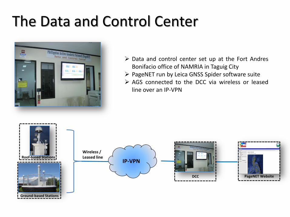
The Data and Control Center
Roof-based Stations
Ground-based Stations
IP-VPN
PageNET Website
Wireless / Leased line
DCC
Data and control center set up at the Fort Andres Bonifacio office of NAMRIA in Taguig City
PageNET run by Leica GNSS Spider software suite AGS connected to the DCC via wireless or leased
line over an IP-VPN

Geodetic Services
Inter-island Benchmark Connection
Zero Order Network
Development of geodetic datum a. In support of PRS92 Project b. Adjustment of Zero Order Control Network c. Adjustment of 1st-4th Order Control Network d. Adjustment of Inter-island benchmark connection
Primary source for control surveys a. Land surveying b. Deformation monitoring c. Utilities mapping d. Aerial photography
17 Nov 2010 04 Dec 2012

PageNET Services
Multi-GNSS Services 1. RINEX download for post-processing 2. Coordinate computation 3. Single-base Real Time Kinematic Service
- will be upgraded to Network RTK for Mega Manila area
User access o Through the internet at
http://pagenet.namria.gov.ph

PageNET Users
NAMRIA a. Datum development b. Surveying and mapping
Goverment a. Land surveying b. Deformation monitoring c. Utilities mapping d. Aerial photography
Private a. Land surveying b. Utilities mapping c. Aerial photography

Issues to be resolved PageNET a. Datum issues (local datum b. Power and Communication Reliability c. Cost recovery schemes
Need to strengthen geodesy not just within NAMRIA but for the whole country as well
Infrastructure Research and development Human resource component

Future Direction Road Map to a Modern National Geodetic System

Future Direction Road Map to a Modern National Geodetic System
Migration to a Geocentric Datum
(PRS2020)
Development of the Philippine Geoid Model
(PGM2020)
Unification of the National Vertical Control
Network
(PVD2020)
Modern National Geodetic System