Embed Size (px)
Citation preview
State Route 269 Bridge Project
Fresno County, California
06–FRE–269 (PM 10.4-12.5)
06-0002-0595
SCH# 2015021089
Initial Study with Mitigated Negative Declaration/ Environmental Assessment with Finding of No Significant Impact
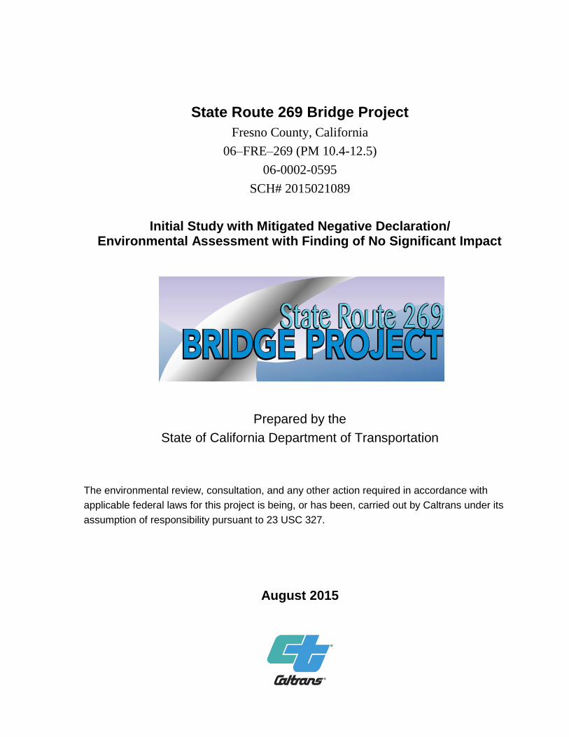
Finding of No Significant Impact
Prepared by the
State of California Department of Transportation
The environmental review, consultation, and any other action required in accordance with
applicable federal laws for this project is being, or has been, carried out by Caltrans under its
assumption of responsibility pursuant to 23 USC 327.
August 2015

General Information About This Document
For individuals with sensory disabilities, this document can be made available in Braille, in large print, on
audiocassette, or on computer disk. To obtain a copy in one of these alternate formats, please call or write to
Caltrans, Attn: Michelle Ray, Environmental Planning, 855 M Street, Suite 200, Fresno, CA 93721,
(559) 445-5286 (Voice), or use 711.


State Route 269 Bridge Project vii
Table of Contents
Mitigated Negative Declaration ........................................................................................... v Table of Contents vii List of Figures ix List of Tables x
Chapter 1 Project ..................................................................................................... 1
1.1 Introduction ............................................................................................................ 1 1.2 Purpose and Need .................................................................................................. 1
1.2.1 Purpose ........................................................................................................... 1 1.2.2 Need ................................................................................................................ 1
1.3 Project Description ................................................................................................ 4 1.4 Project Alternatives ................................................................................................ 4
1.4.1 Build Alternative ............................................................................................ 4 1.4.2 No-Build (No-Action) Alternative ................................................................. 5 1.4.3 Alternatives Considered but Eliminated from Further Discussion Prior to
Draft Environmental Document .................................................................................... 5
1.4.4 Identification of Preferred Alternative ........................................................... 5 1.5 Permits and Approvals Needed .............................................................................. 6
Chapter 2 Affected Environment, Environmental Consequences, and Avoidance,
Minimization, and/or Mitigation Measures .......................................................................... 7
2.1 Human Environment .............................................................................................. 8 2.1.1 Farmland ......................................................................................................... 8 2.1.2 Relocations and Real Property Acquisition .................................................. 10
2.1.3 Utilities and Emergency Services ................................................................. 11
2.1.4 Traffic and Transportation/Pedestrian and Bicycle Facilities ...................... 12 2.1.5 Visual/Aesthetics .......................................................................................... 14
2.2 Cultural Resources ............................................................................................... 15
2.3 Physical Environment .......................................................................................... 17 2.3.1 Hydrology and Floodplain ............................................................................ 17
2.3.2 Water Quality and Storm Water Runoff ....................................................... 18 2.3.3 Hazardous Waste and Materials ................................................................... 24
2.4 Biological Environment ....................................................................................... 27 2.4.1 Natural Communities .................................................................................... 27 2.4.2 Wetlands and Other Waters .......................................................................... 30
2.4.3 Plant Species ................................................................................................. 33 2.4.4 Animal Species ............................................................................................. 35 2.4.5 Threatened and Endangered Species ............................................................ 41
2.4.6 Invasive Species ........................................................................................... 50 2.5 Climate Change .................................................................................................... 52
Chapter 3 Comments and Coordination ................................................................. 64
Chapter 4 List of Preparers .................................................................................... 69
Appendix A California Environmental Quality Act Checklist .................................. 71
Appendix B Title VI Policy Statement ...................................................................... 81
Appendix C Farmland Conservation Impact Rating ................................................. 83

State Route 269 Bridge Project viii
Appendix D Species Survey Data within Biological Study Area .............................. 85
Appendix E U.S. Fish and Wildlife Service Species List, CNPS Species List and
CNDDB Query 91
Appendix F Minimization and/or Mitigation Summary ......................................... 106
Appendix G List of Proposed Species and Critical Habitat Potentially Occurring or
Known to Occur in the Project Area ................................................................................ 116
Appendix H San Joaquin Kit Fox Protection Measures .......................................... 118
Appendix I Comments and Responses ................................................................... 128
Appendix J U.S. Fish and Wildlife Service Letter of Concurrence ....................... 142
Appendix K Project Photos and Mapping ............................................................... 151
List of Technical Studies .................................................................................................. 159

State Route 269 Bridge Project ix
List of Figures
Figure 1-1 Project Vicinity Map .......................................................................................... 2 Figure 1-2 Project Location Map ......................................................................................... 3 Figure 2-1 California Greenhouse Gas Forecast ................................................................ 56 Figure 2-2 Mobility Pyramid ............................................................................................. 57
State Route 269 Bridge Project x
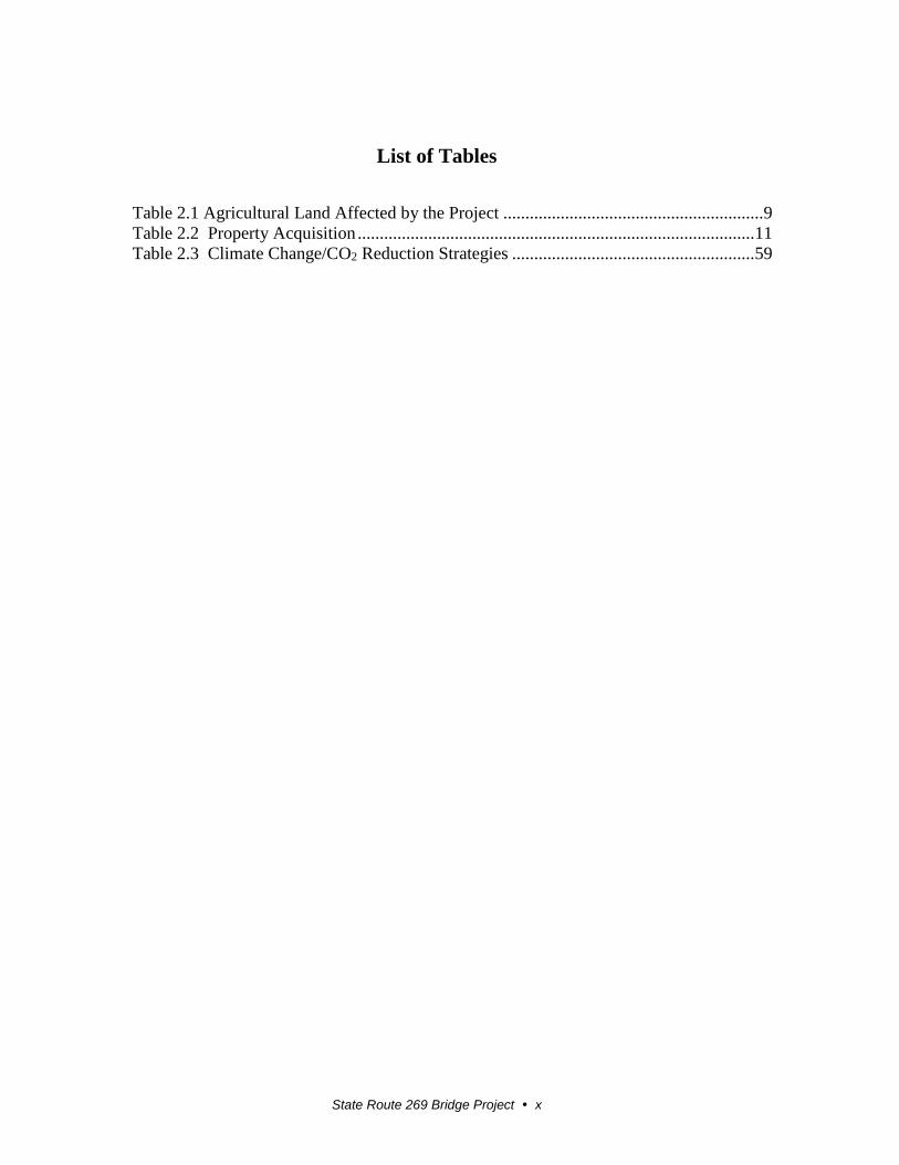
List of Tables
Table 2.1 Agricultural Land Affected by the Project ........................................................... 9 Table 2.2 Property Acquisition .......................................................................................... 11 Table 2.3 Climate Change/CO2 Reduction Strategies ....................................................... 59

State Route 269 Bridge Project 1
Chapter 1 Project
1.1 Introduction
The California Department of Transportation (Caltrans) is the lead agency under the
National Environmental Policy Act (NEPA). Caltrans is the lead agency under the
California Environmental Quality Act (CEQA). State Route 269 north of the City of
Huron is subject to flooding every year from the Arroyo Pasajero Creek. When the
highway floods, motorists must detour around the closed section of highway for a
distance of approximately 23.5 miles. Caltrans will address the flooding by raising the
existing highway up to approximately 15 feet above the existing roadway and
constructing three bridges. A new bridge will be built over the Arroyo Pasajero Creek
at post mile 11.23. This new structure will accommodate a 100-year flood and be
approximately 11.5 feet above the existing ground. A second new bridge will be built
about 580 feet south of the Arroyo Pasajero Creek at post mile 11.11. The existing
bridge at post mile 12.23 will be replaced with a new bridge to allow 3 feet of
additional clearance. A temporary detour road will be constructed west of the existing
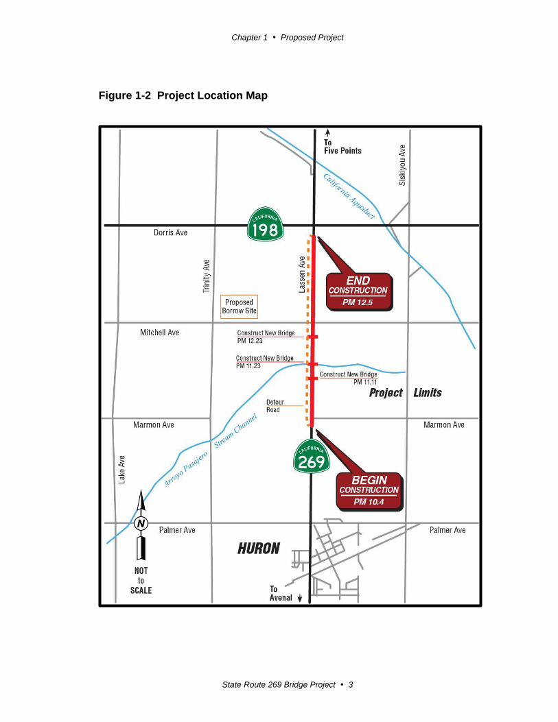
highway to accommodate traffic during construction. See Figures 1-1 and 1-2 and
Appendix I “Project Photos and Mapping.”
State Route 269 is a conventional two-lane undivided highway that runs from State
Route 33 in Kings County to State Route 145 in Fresno County. The project sits just
north of the City of Huron between Palmer Avenue and State Route 198. State Route
269 is a major corridor in the middle of a productive agricultural region and also
provides access to the City of Huron.
The estimated cost of the project is $18.9 million. The capital costs for the project are
funded using Measure C funds from the Fresno County Transportation Authority.
Support costs are funded through the State Highway Operations and Protection
Program. This project is included in the Council of Fresno County Governments
(COFCG) 2013 Federal Transportation Improvement Program (FTIP) and the 2014
Regional Transportation Plan as a financially constrained project.
1.2 Purpose and Need
1.2.1 Purpose
The purpose of the project is to prevent the closure of State Route 269 due to flooding
north of the City of Huron.
1.2.2 Need
The flooding of State Route 269 during winter storms creates hazardous conditions
resulting in the closure of the highway and restricting travel in and out of Huron.
Flooding has caused the highway to be closed an average of 29 days a year since
1978.

Chapter 1 Proposed Project
State Route 269 Bridge Project 2
Figure 1-1 Project Vicinity Map
Chapter 1 Proposed Project
State Route 269 Bridge Project 3
Figure 1-2 Project Location Map

Chapter 1 Proposed Project
State Route 269 Bridge Project 4
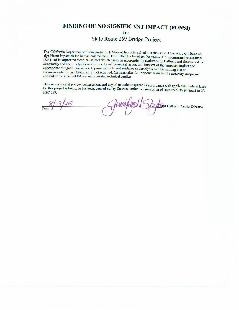
1.3 Project Description
Within the limits of the project, State Route 269 is a two-lane undivided highway.
Caltrans will raise the profile of State Route 269 and construct three new bridges to
prevent closure of the highway due to flooding at nearby Arroyo Pasajero Creek.
1.4 Project Alternatives
One Build Alternative and a No-Build Alternative were considered.
1.4.1 Build Alternative
The Build Alternative is located on State Route 269 between Palmer Avenue and
State Route 198 from post miles 10.4 to 12.5. The details of the Build Alternative are
shown in Appendix I and include the following:
Raise the existing highway up by approximately 15 feet.
Replace the existing highway with two 12-foot lanes and 8-foot shoulders.
Replace Bridge #42-0376 at post mile 12.23 with a new bridge approximately
110 feet long by 43 feet wide to allow 3 feet of additional clearance under the
bridge.
Construct a new bridge over Arroyo Pasajero Creek at post mile 11.23 with a
span of approximately 500 feet long by 43 feet wide. The new structure will
accommodate a 100-year flood and is approximately 11.5 feet above the
existing ground.
Construct a dike in the channel approximately 880 feet long (540 feet
upstream and 340 feet downstream of the new bridge) and approximately 6
feet deep with 4:1 side slopes to direct water to the Arroyo Pasajero Bridge.
Construct a new bridge approximately 580 feet south of Arroyo Pasajero
Creek at post mile 11.11 with a span of 44 feet long by 42 feet wide. The new
bridge will be approximately 15 feet above the existing ground.
Potentially use an existing borrow site for the import of fill material as
needed.
Construct a temporary detour road west of the existing highway to
accommodate traffic during construction when the highway is closed.
Construct retaining walls at post mile 12.25 to protect an existing agricultural
water well.
The project is anticipated to begin construction in 2017 and will open to traffic in
2019.
Chapter 1 Proposed Project
State Route 269 Bridge Project 5
1.4.2 No-Build (No-Action) Alternative
The No-Build Alternative would keep the existing highway and bridge at their current
profile, resulting in continued flooding of the highway. The No-Build Alternative
does not meet the project purpose and need because it would not correct the flooding
problem on State Route 269 at Arroyo Pasajero Creek.
1.4.3 Alternatives Considered but Eliminated from Further Discussion Prior to Draft Environmental Document
The following build alternatives (Alternative 2 and Alternative 3) were considered
but eliminated.
Alternative 2 proposed to shorten the detour 9 miles by extending Butte
Avenue from Gale Avenue to State Route 198. Also, the segment of Gale
Avenue between Butte Avenue and State Route 269 would have to be
improved and rehabilitated. This alternative would require a new bridge
across Arroyo Pasajero Creek.
This alternative was eliminated because of inadequate bridge length and
unstable, steep channel banks, which make new abutments more susceptible to
washouts.
Alternative 3 proposed to shorten the detour 9 miles by constructing a detour
along the east side of the California Aqueduct from State Route 198 to Gale
Avenue. The segment along Gale Avenue would be rehabilitated to meet
county standards. A structure overcrossing with the Southern Pacific Railroad
would be required.
This alternative was eliminated because Gale Avenue lies within the flood
path of Arroyo Pasajero Creek and would still be susceptible to closure during
heavy flooding.
1.4.4 Identification of Preferred Alternative
On July 22, 2015, the Caltrans project development team met to discuss the project
alternatives and comments made on the draft environmental document. The Build
Alternative was selected as the preferred alternative because it meets the purpose and
need for the project. Raising the profile of the highway and constructing three bridges
will have the greatest benefit in regard to preventing flooding of State Route 269
north of the City of Huron. This will eliminate hazardous flooding conditions that
often close the highway and restrict travel in and out of Huron.
Chapter 1 Proposed Project
State Route 269 Bridge Project 6
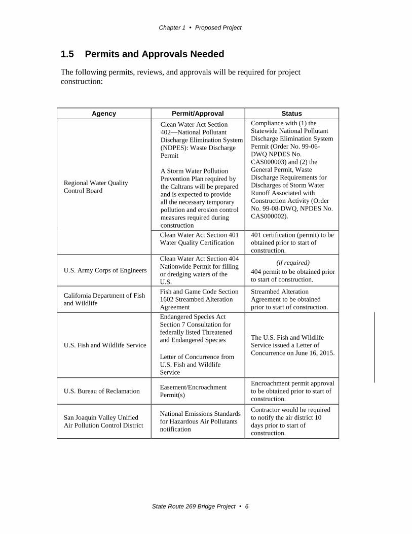
1.5 Permits and Approvals Needed
The following permits, reviews, and approvals will be required for project
construction:
Agency Permit/Approval Status
Regional Water Quality
Control Board
Clean Water Act Section
402—National Pollutant
Discharge Elimination System
(NDPES): Waste Discharge
Permit
A Storm Water Pollution
Prevention Plan required by
the Caltrans will be prepared
and is expected to provide
all the necessary temporary
pollution and erosion control
measures required during
construction
Compliance with (1) the
Statewide National Pollutant
Discharge Elimination System
Permit (Order No. 99-06-
DWQ NPDES No.
CAS000003) and (2) the
General Permit, Waste
Discharge Requirements for
Discharges of Storm Water
Runoff Associated with
Construction Activity (Order
No. 99-08-DWQ, NPDES No.
CAS000002).
Clean Water Act Section 401
Water Quality Certification
401 certification (permit) to be
obtained prior to start of
construction.
U.S. Army Corps of Engineers
Clean Water Act Section 404
Nationwide Permit for filling
or dredging waters of the
U.S.
(if required)
404 permit to be obtained prior
to start of construction.
California Department of Fish
and Wildlife
Fish and Game Code Section
1602 Streambed Alteration
Agreement
Streambed Alteration
Agreement to be obtained
prior to start of construction.
U.S. Fish and Wildlife Service
Endangered Species Act
Section 7 Consultation for
federally listed Threatened
and Endangered Species
Letter of Concurrence from
U.S. Fish and Wildlife
Service
The U.S. Fish and Wildlife
Service issued a Letter of
Concurrence on June 16, 2015.
U.S. Bureau of Reclamation Easement/Encroachment
Permit(s)
Encroachment permit approval
to be obtained prior to start of
construction.
San Joaquin Valley Unified
Air Pollution Control District
National Emissions Standards
for Hazardous Air Pollutants
notification
Contractor would be required
to notify the air district 10
days prior to start of
construction.
State Route 269 Bridge Project 7
Chapter 2 Affected Environment, Environmental Consequences, and Avoidance, Minimization, and/or Mitigation Measures
As part of the scoping and environmental analysis done for the project, the following
environmental issues were considered, but no adverse impacts were identified. So, there
is no further discussion of these issues in this document.
Land Use—The project is consistent with existing and future land use and with state,
regional, and local plans: the 2013 State Highway Operation and Protection Program,
the Fresno County General Plan, and the City of Huron General Plan. The project is
not near a coastal zone, and Arroyo Pasajero Creek is not designated as a wild and
scenic river.
Growth—The project will not induce growth because the project will only raise the
existing highway profile and construct three bridges to mitigate frequent flooding.
Community Impacts—The project will not affect community character or cohesion or
result in any relocation of businesses or residences because no one lives in the project
area.
Environmental Justice—No identified minority or low-income populations will be
adversely affected by the project. No one lives in the project area.
Paleontology—Test pits were excavated and inspected for potential paleontological
resources at the borrow site on September 23, 2014. No further studies are required
because paleontological resources are unlikely to be encountered. If another borrow
site is selected or if excavation for fill material is expected to exceed 5 feet, another
Paleontological Identification Report will be prepared. (Paleontological Identification
Report, September 30, 2014)
Air Quality—The project falls under the category of “widening narrow pavements or
reconstructing bridges (no additional travel lanes)” and is exempt from a requirement
that a conformity determination be made per 40 Code of Federal Regulations Section
93.126 Table 2. Caltrans standard specifications pertaining to dust control and dust
palliative requirements will reduce and control emission impacts during construction.
(Air Quality Compliance Memo, July 21, 2014)
Noise and Vibration—The project is considered a Type I project, but there are no
receptors present in the area. With implementation of temporary construction noise
mitigations measures, additional noise investigation in accordance with Caltrans
Traffic Noise Analysis Protocol is not required. (Noise Study Compliance Memo,
September 19, 2014)
Chapter 2 Affected Environment, Environmental Consequences, and Avoidance, Minimization, and/or Mitigation Measures
State Route 269 Bridge Project 8
Geology, Soils, Seismicity and Topography—No project impacts related to geology,
soils, seismicity or topography are anticipated. Groundwater data within the project
area reflected a deep water level. Due to the soil types in the area, the potential for
liquefaction in the project area is low to moderate. There are no major topographic or
geologic features within the project area. The project will be designed to meet current
seismic standards.
Mineral Resources—The project will not affect mineral resources because there are
no known resources in the area and none are delineated on a local general plan,
specific plan, or other land use plan.
Population and Housing—The project will not affect population or housing because it
will not induce growth or displace any housing or people.
Public Services—The project will not negatively affect public services including
schools and parks and recreation. The project will prevent the closure of State Route
269 due to flooding, which would benefit access to these public services in the City of
Huron.
2.1 Human Environment
2.1.1 Farmland
Regulatory Setting
The National Environmental Policy Act and the Farmland Protection Policy Act (FPPA,
7 U.S. Code 4201-4209; and its regulations, 7 Code of Federal Regulations Part 658)
require federal agencies such as the Federal Highway Administration to coordinate with
the Natural Resources Conservation Service if there is a chance federal agency activities
might convert farmland (directly or indirectly) to nonagricultural use. For purposes of the
Farmland Protection Policy Act, farmland includes prime farmland, unique farmland, and
land of statewide or local importance.
The California Environmental Quality Act requires the review of projects that would
convert Williamson Act contract land to nonagricultural uses. The Williamson Act is
designed to preserve agricultural land and to encourage open-space preservation and
efficient urban growth. The Williamson Act provides incentives to landowners—through
reduced property taxes—to deter the early conversion of agricultural and open-space
lands to other uses.
Affected Environment
The Natural Resources Conservation Service Farmland Conversion Impact Rating was
completed for the project in September 2014 (see Appendix C). Farmland surrounds the
entire project area. The area is used mostly to grow seasonal crops. The Bureau of Land
Management property in the area is generally fallow in and near the Arroyo Pasajero
Creek channel. The direct impact area surrounding the Arroyo Pasajero Creek Bridge
does not include active cropland. A small area of permanent crops sits near the north end
Chapter 2 Affected Environment, Environmental Consequences, and Avoidance, Minimization, and/or Mitigation Measures
State Route 269 Bridge Project 9
of the project at the intersection of State Routes 269 and 198. Farmland improvements
including water wells and irrigation ditches may potentially be affected by the project. A
total of 12 parcels lie within the project area. Four of these parcels are under Williamson
Act contract.
Soils in the project area are composed of Excelsior sandy substratum-westhaven
association, Excelsior sandy loam and Cerini clay loam. The Excelsior sandy substratum-
westhaven association soil is considered non-prime; the Excelsior sandy loam and Cerini
clay loam soils are considered prime.
Environmental Consequences
The Farmland Conversion Impact Rating determines the relative value of farmland to be
converted by using a formula that weighs farmland classification, soil characteristics,
irrigation, acreage, creation of non-farmable land, availability of farm services, and other
factors. The Natural Resources Conservation Service uses only prime/unique and
statewide/local importance-classified land on the Farmland Conversion Impact Rating form
found in Appendix C. If the rating is more than 260 points for a corridor-type project,
Caltrans considers measures to minimize or mitigate farmland impacts. The rating for the
project is 145 points.
Approximately 23 acres of permanent new right-of-way will be converted from
designated agricultural land with approximately 2.25 acres being classified as prime
farmland. About 24 additional acres will be acquired for a temporary construction
easement that will include a detour road to accommodate traffic during construction.
Four of the parcels needed for construction of the proposed project (see Table 2.1) are
under Williamson Act contract. It was not feasible to avoid Williamson Act parcels,
however, the partial acquisition from parcels under contract will not reduce any parcel
below the minimum size required to remain under contract. Once the project is approved
and the exact acreages of land to be converted have been determined, the Director of the
Department of Conservation will be notified of the number of acres of agricultural land
being converted for the project and the number of acres under the Williamson Act being
converted.
Table 2.1 Agricultural Land Affected by the Project
APN Proposed Acquisition Acreage Total Acres (before acquisition)
07503206S 0.95 58.36
07503205S 0.95 158.79
068111074S 0.24 238.02
068111073S 0.08 238.02

Chapter 2 Affected Environment, Environmental Consequences, and Avoidance, Minimization, and/or Mitigation Measures
State Route 269 Bridge Project 10
Avoidance, Minimization, and/or Mitigation Measures
Once the project is approved and the exact acreages of land to be converted have been
determined, the Director of the Department of Conservation will be notified of the
conversions. The project will go through the public acquisition process per GC §51291, or
Caltrans will submit a petition for partial cancellation to Fresno County for the land that is
required for the project.
Property owners will be compensated for any displaced improvements, including trees,
irrigation wells, ditches, and bare land during the right-of-way acquisition process.
Acquisitions will be minimized to allow for the continued farming of adjacent properties.
2.1.2 Relocations and Real Property Acquisition
Regulatory Setting
Caltrans makes every effort to acquire property interests expeditiously in accordance with
the Uniform Relocation Assistance and Real Property Acquisition Policies Act. Offers to
purchase land and easements are based on a departmentally approved appraisal that
determines the fair market value of the property rights being sought. It is Caltrans’ goal to
settle these transactions in a fair, equitable and expeditious manner, thereby avoiding the
condemnation process.
Affected Environment
The area affected by the acquisition of real property and temporary easements is located
along the east and west sides of State Route 269 between Palmer Avenue and State Route
198, just north of the City of Huron. All property needed for the construction of the
project is agricultural land, much of which is fallow. There are no residences within the
construction limits of the proposed project area.
Environmental Consequences
Under the No-Build Alternative, no acquisition of property or need for long-term or
temporary construction easements will occur.
The Build Alternative will not result in the acquisition of any homes or businesses.
Right-of-way will be purchased from 13 parcels of which 6 will be purchased in fee, and
6 will be acquired through permits from the U.S. Bureau of Reclamation. A temporary
easement will be acquired from two private landowners and the U.S. Bureau of
Reclamation for a detour road.
The project will require the acquisition of right-of-way for the permanent highway
improvements totaling approximately 23 acres and temporary easements totaling
approximately 24 acres. The property breakdown of permanent acquisitions and
temporary easements is shown in Table 2.2, and maps detailing the acquisitions are
provided in Appendix I.
All properties are agricultural. There are no residential acquisitions.

Chapter 2 Affected Environment, Environmental Consequences, and Avoidance, Minimization, and/or Mitigation Measures
State Route 269 Bridge Project 11
Table 2.2 Property Acquisition
Owner
APN
Proposed Acquisition Acreage
Acquisition Type
Private 07503206S 0.95 Permanent
Bureau of Reclamation 0681114ST 3.74 Permanent
Bureau of Reclamation 06811113T 1.84 Permanent
Bureau of Reclamation 06811103ST 6.33 Temporary easement
3.05 Permanent
Bureau of Reclamation 06811158ST 3.19 Permanent
Bureau of Reclamation 06811122ST 0.28 Permanent
Private 06811162S 0.30 Permanent
Private 07503205S 2.65 Temporary easement
0.95 Permanent
Bureau of Reclamation 068111052T 13.49 Temporary easement
7.52 Permanent
Bureau of Reclamation 06811105ST 0.60 Temporary easement
0.46 Permanent
Private 068111072S 0.04 Temporary Easement
Private 068111073S 0.33 Temporary Easement
0.08 Permanent
Private 068111074S 0.24 Temporary Easement
0.37 Permanent
Avoidance, Minimization, and/or Mitigation Measures
Caltrans will acquire needed property in accordance with the Uniform Relocation
Assistance and Real Property Acquisition Policies Act of 1970. Acquisitions for the
construction easement are temporary and will be returned to their preconstruction
condition after completion of construction.
2.1.3 Utilities and Emergency Services
Affected Environment
Utilities Four utility companies operate within the project limits: Pacific Gas and Electric
Company, Southern California Gas, Pacific Bell, and SBC Communications, Inc. The
affected utilities may involve, but are not limited to, electricity, gas, water, fiber optics
and telephone.
Emergency Services The Fresno County Fire Protection District provides fire protection, emergency medical
and rescue service to the area. The Fresno County Sheriff’s Department provides law
enforcement to the area and uses State Route 269 to access its rural areas of jurisdiction
in western Fresno County. The California Highway Patrol is responsible for traffic
enforcement on State Route 269.
Chapter 2 Affected Environment, Environmental Consequences, and Avoidance, Minimization, and/or Mitigation Measures
State Route 269 Bridge Project 12
Environmental Consequences
Utilities
Utilities within the project area will have to be relocated for construction of the project.
Electricity, gas, water, fiber optics and telephone utilities will be relocated along State
Route 269 in the project area. Caltrans will work with affected companies including
Pacific Gas and Electric Company, Southern California Gas, Pacific Bell, and SBC
Communications, Inc. to determine where utilities will be relocated.
Emergency Services The project will have a beneficial impact on fire protection, law enforcement, and
emergency services by providing an improved highway that is not subject to being closed
due to flooding. The detour required from the closure of the highway due to flooding
requires approximately 23.5 miles of out-of-direction travel. During construction, traffic
will travel on the temporary detour road.
Avoidance, Minimization, and/or Mitigation Measures The following avoidance and minimization measures will prevent temporary impacts to
utilities and emergency services:
Utilities
Utilities will be relocated to accommodate construction of the project. All utility
relocation work will be done by the affected utility companies. Utility users will
be informed of the date and time in advance of any service disruptions.
Emergency Services
A traffic management plan will be developed to minimize delays and maximize
safety during construction. The traffic management plan may include, but is not
limited to, the following:
1. Release of information through brochures and mailers, press releases, and
notices from the Caltrans public information office.
2. Use of fixed and portable changeable message signs.
3. Incident management through the Construction Zone Enhancement
Enforcement Program and the transportation management plan.
2.1.4 Traffic and Transportation/Pedestrian and Bicycle Facilities
Regulatory Setting
Caltrans, as assigned by the Federal Highway Administration, directs that full
consideration should be given to the safe accommodation of pedestrians and bicyclists
during the development of federal-aid highway projects (see 23 Code of Federal
Regulations 652). It further directs that the special needs of the elderly and the disabled
must be considered in all federal-aid projects that include pedestrian facilities. When
Chapter 2 Affected Environment, Environmental Consequences, and Avoidance, Minimization, and/or Mitigation Measures
State Route 269 Bridge Project 13
current or anticipated pedestrian and/or bicycle traffic presents a potential conflict with
motor vehicle traffic, every effort must be made to minimize the detrimental effects on all
highway users who share the facility.
In July 1999, the U.S. Department of Transportation (USDOT) issued an Accessibility
Policy Statement pledging a fully accessible multimodal transportation system.
Accessibility in federally assisted programs is governed by the USDOT regulations (49
Code of Federal Regulations Part 27) implementing Section 504 of the Rehabilitation Act
(29 U.S. Code 794). The Federal Highway Administration has enacted regulations for the
implementation of the 1990 Americans with Disabilities Act (ADA), including a
commitment to build transportation facilities that provide equal access for all persons.
These regulations require application of the 1990 Americans with Disabilities Act
requirements to federal-aid projects, including Transportation Enhancement Activities.
Affected Environment
State Route 269 is a conventional two-lane undivided highway that runs from State Route
33 in Kings County to State Route 145 in Fresno County. The project sits just north of the
City of Huron between Palmer Avenue and State Route 198.
State Route 269 is a major corridor in the middle of a productive agricultural region and
also provides access to the City of Huron. The highway is open to local and regional
bicycle and pedestrian travel. The current shoulders on State Route 269 are about 3 feet
wide.
Environmental Consequences
The project will prevent the closure of State Route 269 due to flooding by raising the
profile of the highway and constructing three bridges. The project will not result in an
increase in traffic on the highway. The segment of highway and the bridges will be
constructed to Caltrans standards, giving bicyclists and pedestrians more room to
maneuver on the shoulders. Although construction of the project may result in short
traffic delays, a temporary detour road next to State Route 269 will provide continued
access to the surrounding area during construction. The project is expected to start
construction in 2017 and open to traffic in 2019.
Avoidance, Minimization, and/or Mitigation Measures
A traffic management plan will be developed to minimize delays and maximize safety for
motorists. The traffic management plan may include, but is not limited to, the following:
Release of information through brochures and mailers, press releases, and
advertisements managed by the public information office.
Use of fixed and portable changeable message signs.
Incident management through the Construction Zone Enhancement Enforcement
Program and the transportation management center.
Use of one-way traffic control.
Chapter 2 Affected Environment, Environmental Consequences, and Avoidance, Minimization, and/or Mitigation Measures
State Route 269 Bridge Project 14
Bridge railing will be required as appropriate for the safe travel of bicyclists.
Construction of a detour road for use during construction.
2.1.5 Visual/Aesthetics
Regulatory Setting
The National Environmental Policy Act of 1969, as amended, establishes that the federal
government use all practicable means to ensure all Americans safe, healthful, productive,
and aesthetically and culturally pleasing surroundings (42 U.S. Code 4331[b][2]). To
further emphasize this point, the Federal Highway Administration in its implementation
of the National Environmental Policy Act (23 U.S. Code 109[h]) directs that final
decisions regarding projects are to be made in the best overall public interest taking into
account adverse environmental impacts, including among others, the destruction or
disruption of aesthetic values.
Likewise, the California Environmental Quality Act establishes that it is the policy of the
state to take all action necessary to provide the people of the state “with…enjoyment of
aesthetic, natural, scenic and historic environmental qualities” (California Public
Resources Code Section 21001[b]).
Affected Environment
A Visual Impact Assessment was completed in October 2014. The project is in a rural
area that is undeveloped and used mostly for agriculture. Most of the agricultural land in
the area is either fallow or planted in seasonal crops. Small amounts of land on the north
and south ends of the project are planted with permanent crops. The surrounding
topography is gently rolling natural rural landscape, while the highway is generally flat.
Arroyo Pasajero Creek runs through the project site across State Route 269; it carries
floodwater during winter storms.
State Route 269 is a two-lane conventional highway that has no median and does not
include any highway landscaped vegetation. Roadside vegetation is composed mostly of
shrubs, grasses and crops. Also, no segment of State Route 269 is listed as officially
designated scenic or eligible scenic highway.
Environmental Consequences
No qualifying scenic resources will be affected by the construction of the proposed
project. To accommodate the three bridge structures and channels, some existing slopes
will be either cut or filled. It is estimated that 75,000 cubic yards of fill will be placed
within the project footprint. Depending on the placement and slope of the fill, visual
inconsistency to the natural landscape might occur. Although the new bridge structures
and railing might create a more urban look if not designed in keeping with the rural
environment, State Route 269 will remain passable during and after any flooding. The
Visual Impact Assessment anticipates there will be a low public concern regarding the
project design features such as new bridge structures and railings.

Chapter 2 Affected Environment, Environmental Consequences, and Avoidance, Minimization, and/or Mitigation Measures
State Route 269 Bridge Project 15
Avoidance, Minimization, and/or Mitigation Measures
The following will ensure that the visual quality of this segment of State Route 269 is
preserved:
Bridge and railings design features would be in keeping with the rural environment to
minimize visual impacts.
Slopes should not exceed a gradient of 1:3. Slopes that are designed at gradients of
1:2 or steeper will require the written concurrence of the District Landscape
Architect, Maintenance, and the Storm Water Coordinator.
Tops and toes of slopes should be rounded to create a natural appearance.
All exposed disturbed soil areas will require permanent erosion control application,
which will restore the disturbed project area to natural vegetation.
2.2 Cultural Resources
Regulatory Environment The term “cultural resources” as used in this document refers to all “built environment”
resources (structures, bridges, railroads, water conveyance systems, etc.), culturally
important resources, and archaeological resources (both prehistoric and historic),
regardless of significance. Laws and regulations dealing with cultural resources include:
The National Historic Preservation Act (NHPA) of 1966, as amended, sets forth national
policy and procedures for historic properties, defined as districts, sites, buildings,
structures, and objects included in or eligible for listing in the National Register of
Historic Places. Section 106 of the National Historic Preservation Act requires federal
agencies to take into account the effects of their undertakings on historic properties and to
allow the Advisory Council on Historic Preservation the opportunity to comment on
those undertakings, following regulations issued by the Advisory Council on Historic
Preservation (36 Code of Federal Regulations 800). On January 1, 2004, a Section 106
Programmatic Agreement between the Advisory Council, the Federal Highway
Administration, State Historic Preservation Officer (SHPO), and Caltrans went into effect
for Caltrans projects, both state and local, with Federal Highway Administration
involvement. The Section 106 Programmatic Agreement implements the Advisory
Council’s regulations, 36 Code of Federal regulations 800, streamlining the Section 106
process and delegating certain responsibilities to Caltrans. The Federal Highway
Administration’s responsibilities under the Programmatic Agreement have been assigned
to Caltrans as part of the Surface Transportation Project Delivery Program (23 U.S. Code
327).
The Archaeological Resources Protection Act (ARPA) applies when a project may
involve archaeological resources located on federal or tribal land. This act requires that a
permit be obtained before excavation of an archaeological resource on such land can take
place.

Chapter 2 Affected Environment, Environmental Consequences, and Avoidance, Minimization, and/or Mitigation Measures
State Route 269 Bridge Project 16
Affected Environment A Historic Property Survey Report was completed in November 2014 to comply with
Section 106 of the National Historic Preservation Act. None of the architectural or
structural resources identified within the project area required evaluation. Efforts to
identify archaeological resources within the project area included archival research, a
pedestrian archaeological survey, and consultation with knowledgeable local Native
American groups and individuals. A cultural resource records search by California
Historical Resources Information System staff at the Southern San Joaquin Valley
Information Center (SSJVIC), California State University, Bakersfield identified the
presence of an ethnographic village, Golon, in the vicinity of the project area (Huron,
California).
Environmental Consequences
The Archaeological Survey Report with archival research was prepared in October 2014
and identified no archaeological resources within the area of potential effects for the
project. Two small portions of the project area could not be accessed during the
pedestrian survey because Caltrans did not have a right to enter those properties. These
areas will be surveyed before the project is constructed. The Santa Rosa Rancheria Tachi
Yokuts Tribe requested that it be consulted throughout the length of the project. The tribe
also made a request to monitor construction activities.
The project area is considered to be sensitive for archaeological resources due to the
Southern San Joaquin Valley Information Center records search identification of the
ethnographic Village of Golon. The hydrology of the area and geoarchaeological
information also indicate high sensitivity. In consideration of these factors, an Extended
Phase I/geoarchaeological investigation was conducted. The Santa Rosa Rancheria was
consulted regarding the geoarchaeological studies. These investigations were conducted
to determine the presence or absence of buried archaeological deposits within the
proposed project impact areas. Seventeen trenches were excavated across the project area
where subsurface/construction impacts are planned. No archaeological materials or
buried Late Pleistocene or Holocene soils were encountered. No historic properties were
identified within the project area except for the inaccessible areas discussed above.
Avoidance, Minimization, and/or Mitigation Measures
Consulting Native American tribes and a Caltrans archaeologist will monitor
construction activities involving excavation as needed and determined by the
Caltrans archeologist and Caltrans Native American Coordinator. If buried
cultural materials are encountered during construction, work will stop in that area
until a qualified archaeologist can evaluate the nature and significance of the find.
If human remains are exposed during project activities, State Health and Safety
Code Section 7050.5 states that no further disturbance should occur until the
county coroner has made the necessary findings as to the origin and disposition
pursuant to Public Resources Code 5097.98.

Chapter 2 Affected Environment, Environmental Consequences, and Avoidance, Minimization, and/or Mitigation Measures
State Route 269 Bridge Project 17
2.3 Physical Environment
2.3.1 Hydrology and Floodplain
Regulatory Setting
Executive Order 11988 (Floodplain Management) directs all federal agencies to refrain
from conducting, supporting, or allowing actions in floodplains unless it is the only
practicable alternative. The Federal Highway Administration requirements for
compliance are outlined in 23 Code of Federal Regulations 650 Subpart A. To comply,
the following must be analyzed:
Practicability of alternatives to any longitudinal encroachments.
Risks of the action.
Impacts on natural and beneficial floodplain values.
Support of incompatible floodplain development.
Measures to minimize floodplain impacts and to preserve/restore any beneficial
floodplain values affected by the project.
The base floodplain is defined as the area subject to flooding by the flood or tide having a
1 percent chance of being exceeded in any given year. An encroachment is defined as an
action within the limits of the base floodplain.
Affected Environment
A Location Hydraulic Study was completed in July 2014, and a Floodplain Evaluation
was completed in August 2014. An addendum to the Location Hydraulic Study was also
prepared in April 2015. Arroyo Pasajero Creek crosses State Route 269 in Fresno
County, just north of the City of Huron. The stream course within the project area is a
wide, naturally winding channel. State Route 269 was accepted into the state highway
system in 1976. At that time, the roadway was over 3 feet higher than the surrounding
topography. Today, this section of the roadway is 3 or more feet lower than the existing
topography, so the highway is affected by seasonal flooding just north of Huron.
Due to the topography and sediment load, anytime the Arroyo Pasajero waters cross State
Route 269, the sediment is deposited on the roadway. Flooding and the resulting
sedimentation often require the closing of the highway. The highway has been closed due
to flooding an average of 29 days a year over a 19-year period (1978 to 1998). In addition
to the flooding of State Route 269, floods have occurred in the City of Huron area in
1958, 1963, 1966, 1969, and 1978.
The project is located in both Federal Emergency Management Agency (FEMA) Flood
Zone AO (post mile 10.4/12.227) and Flood Zone A (post mile 12.227/12.5) as shown on
Flood Insurance Rate Map (FIRM) #06019C3255H and FIRM #06019C3100H, dated
February 18, 2009. Zone AO is defined as an area where “Flood Depths of 1 to 3 feet
(usually sheet flow on sloping terrain); average depths determined.” Zone A is defined as
“No Base Flood Elevations determined.” The project does not constitute a significant

Chapter 2 Affected Environment, Environmental Consequences, and Avoidance, Minimization, and/or Mitigation Measures
State Route 269 Bridge Project 18
floodplain encroachment as defined in 23 Code of Federal Regulations 650.105 and is not
a longitudinal encroachment.
Before construction of the California Aqueduct, floodwater flowed northeasterly toward
Lassen Avenue and then north to State Route 198. In 1967, the segment of the California
Aqueduct near State Route 269 was constructed under joint participation of the U.S.
Bureau of Reclamation and the State Department of Water Resources. This segment of
the aqueduct intercepted the Arroyo Pasajero Creek. It was known that the construction
of the aqueduct would impound water upstream of the aqueduct. However, the magnitude
of water and the sediment load were underestimated significantly. The floodwater volume
from a 100-year flood is five times greater than the original estimate, and the average
annual sedimentation is four times greater than the original estimate.
Environmental Consequences
With the raising of State Route 269 on an embankment within the floodplain area and the
construction of three bridges, it is anticipated that flood flows would be able to follow
their historic patterns, eliminating flooding of the highway. The project does not
constitute a significant floodplain encroachment, is not a longitudinal encroachment, and
would not substantially affect the base flood elevation.
Avoidance, Minimization, and/or Mitigation Measures
No mitigation is required. Raising the profile of State Route 269 and constructing three
new bridges will prevent the highway from being flooded and sediment from being
deposited onto the highway.
2.3.2 Water Quality and Storm Water Runoff
Regulatory Setting
In 1972, Congress amended the Federal Water Pollution Control Act, making the addition
of pollutants to the waters of the U.S. from any point source unlawful unless the
discharge is in compliance with a National Pollutant Discharge Elimination System
permit. Known today as the Clean Water Act, the act has been amended by Congress
several times. In the 1987 amendments, Congress directed dischargers of stormwater
from municipal and industrial/construction point sources to comply with the National
Pollutant Discharge Elimination System permit scheme. The following are important
Clean Water Act sections:
Sections 303 and 304 require states to tell the public about water quality standards,
criteria, and guidelines.
Section 401 requires an applicant for a federal license or permit to conduct any
activity that may result in a discharge to waters of the U.S. to obtain certification
from the state that the discharge would comply with other provisions of the Clean
Water Act. Section 401 compliance is most frequently required in tandem with a
Section 404 permit request (see below).
Section 402 establishes the National Pollutant Discharge Elimination System, a
permitting system for the discharge (except for dredge or fill material) of any

Chapter 2 Affected Environment, Environmental Consequences, and Avoidance, Minimization, and/or Mitigation Measures
State Route 269 Bridge Project 19
pollutant into waters of the U.S. Regional Water Quality Control Boards administer
this permitting program in California. Section 402(p) requires permits for discharge
of stormwater from industrial/construction and municipal separate storm sewer
systems.
Section 404 establishes a permit program for the discharge of dredge or fill material
into waters of the U.S. This permit program is administered by the U.S. Army Corps
of Engineers.
The objective of the Clean Water Act is to restore and maintain the chemical, physical,
and biological integrity of the nation’s waters.
The U.S. Army Corps of Engineers issues two types of 404 permits: General and
Standard permits. There are two types of General permits: Regional permits and
Nationwide permits. Regional permits are issued for a general category of activities when
they are similar in nature and cause minimal environmental effect. Nationwide permits
are issued to authorize a variety of minor project activities with no more than minimal
effects.
Ordinarily, projects that do not meet the criteria for a Nationwide Permit may be
permitted under one of the U.S. Army Corps of Engineers’ Standard permits. There are
two types of Standard permits: Individual permits and Letters of Permission. For
Standard permits, the U.S. Army Corps of Engineers decision to approve is based on
compliance with the U.S. Environmental Protection Agency’s Section 404 (b)(1)
Guidelines (Code of Federal Regulations 40 Part 230), and whether permit approval is in
the public interest.
The Section 404(b)(1) Guidelines were developed by the U.S. Environmental Protection
Agency in conjunction with the U.S. Army Corps of Engineers and allow the discharge of
dredged or fill material into the aquatic system (waters of the U.S.) only if there is no
practicable alternative that would have less adverse effects. The guidelines state that the
U.S. Army Corps of Engineers may not issue a permit if there is a least environmentally
damaging practicable alternative to the proposed discharge that would have lesser effects
on waters of the U.S. and not have any other significant adverse environmental
consequences. As stated in the guidelines, documentation is needed that a sequence of
avoidance, minimization, and compensation measures has been followed, in that order.
The guidelines also restrict permitting activities that violate water quality or toxic effluent
standards, jeopardize the continued existence of listed species, violate marine sanctuary
protections, or cause significant degradation to waters of the U.S. In addition every
permit from the U.S. Army Corps of Engineers, even if not subject to the Section
404(b)(1) Guidelines, must meet general requirements (see 33 Code of Federal
Regulations 320.4).
State Requirements: Porter-Cologne Water Quality Control Act
California’s Porter-Cologne Act, enacted in 1969, provides the legal basis for water
quality regulation within California. This act requires a “Report of Waste Discharge” for
any discharge of waste (liquid, solid, or gaseous) to land or surface waters that may
Chapter 2 Affected Environment, Environmental Consequences, and Avoidance, Minimization, and/or Mitigation Measures
State Route 269 Bridge Project 20
impair beneficial uses for surface and/or groundwater of the state. It predates the Clean
Water Act and regulates discharges to waters of the state. Waters of the state include
more than just Waters of the U.S. like groundwater and surface waters not considered
Waters of the U.S. Also, the Porter-Cologne Act prohibits discharges of waste as defined
and this definition is broader than the Clean Water Act definition of pollutant. Discharges
under the Porter-Cologne Act are permitted by Waste Discharge Requirements and may
be required even when the discharge is already permitted or exempt under the Clean
Water Act.
The State Water Resources Control Board and Regional Water Quality Control Boards
are responsible for establishing the water quality standards (objectives and beneficial
uses) required by the Clean Water Act and regulating discharges to ensure compliance
with the water quality standards. Details regarding water quality standards in a project
area are contained in the applicable Regional Water Quality Control Board’s Basin Plan.
States designate beneficial uses for all water-body segments, and then set criteria
necessary to protect these uses. Consequently, the water quality standards developed for
particular water segments are based on the designated use and vary depending on such
use. In addition, each state identifies waters failing to meet standards for specific
pollutants. These waters are then state-listed in accordance with the Clean Water Act
Section 303(d). If a state determines that waters are impaired for one or more
constituents, and the standards cannot be met through point source controls, the Clean
Water Act requires the establishment of total maximum daily loads that specify allowable
pollutant loads from all sources (point, non-point, and natural) for a given watershed.
State Water Resources Control Board and Regional Water Quality Control
Boards
The State Water Resources Control Board administers water rights, water pollution
control, and water quality functions throughout the state. Regional Water Quality Control
Boards are responsible for protecting beneficial uses of water resources within their
regional jurisdiction using planning, permitting, and enforcement authorities to meet this
responsibility.
National Pollution Discharge Elimination System Program
Section 402(p) of the Clean Water Act requires the issuance of National Pollution
Discharge Elimination System permits for five categories of storm water dischargers,
including municipal separate storm sewer systems. The U.S. Environmental Protection
Agency defines municipal separate storm sewer systems as any conveyance or system of
conveyances—roads with drainage systems, municipal streets, catch basins, curbs,
gutters, ditches, human-made channels, and storm drains—owned or operated by a state,
city, town, county, or other public body having jurisdiction over storm-water
conveyances designed or used for collecting or moving storm water. The State Water
Resources Control Board has identified Caltrans as an owner/operator of municipal
separate storm sewer systems. The National Pollution Discharge Elimination System
permit covers all Caltrans rights-of-way, properties, facilities, and activities in the state.
The State Water Resources Control Board or the Regional Water Quality Control Board

Chapter 2 Affected Environment, Environmental Consequences, and Avoidance, Minimization, and/or Mitigation Measures
State Route 269 Bridge Project 21
issues National Pollution Discharge Elimination System permits for five years. Permit
requirements remain active until a new permit has been adopted.
The Caltrans Municipal Separate Storm Sewer Systems Permit, under revision at the time
of this update, contains three basic requirements:
Caltrans must comply with the Construction General Permit (see below).
Caltrans must use a year-round program throughout the state to effectively control
stormwater and non-stormwater discharges.
Caltrans stormwater discharges must meet water quality standards through the use of
permanent and temporary (construction) best management practices and other
measures.
To comply with the permit, Caltrans developed the Statewide Stormwater Management
Plan to address stormwater pollution controls related to highway planning, design,
construction, and maintenance activities throughout California. The Statewide
Stormwater Management Plan assigns responsibilities within Caltrans for using
stormwater management procedures and practices as well as training; public education
and participation; monitoring and research; program evaluation; and reporting activities.
The Statewide Stormwater Management Plan describes the minimum procedures and
practices Caltrans uses to reduce pollutants in stormwater and non-stormwater
discharges. The water management plan outlines procedures and responsibilities for
protecting water quality, including the selection and implementation of best management
practices. The proposed project would be programmed to follow the guidelines and
procedures outlined in the latest Statewide Stormwater Management Plan to address
stormwater runoff.
Construction General Permit
The Construction General Permit (Order No. 2009-009-DWQ), adopted on September 2,
2009, became effective on July 1, 2010. The permit regulates stormwater discharges from
construction sites that result in a disturbed soil area of 1 acre or greater, and/or are
smaller construction sites that are part of a larger common plan of development. By law,
all stormwater discharges associated with construction activity where clearing, grading,
and excavation results in soil disturbance of at least 1 acre must comply with the
provisions of the General Construction Permit.
Construction activity that results in soil disturbances of less than 1 acre is subject to this
Construction General Permit if there is potential for significant water quality impairment
as determined by the Regional Water Quality Control Board. Operators of regulated
construction sites are required to develop stormwater pollution prevention plans; use
sediment, erosion, and pollution prevention control measures; and obtain coverage under
the Construction General Permit.
Chapter 2 Affected Environment, Environmental Consequences, and Avoidance, Minimization, and/or Mitigation Measures
State Route 269 Bridge Project 22
The 2009 Construction General Permit separates projects into Risk Levels 1, 2, or 3. Risk
levels, determined during the planning and design phases, are based on potential erosion
and transport to receiving waters. The risk level determines the requirements. For
example, a Risk Level 3 (highest risk) project would require the following: compulsory
stormwater runoff pH and turbidity monitoring; and before- and after-construction
aquatic biological assessments during specified seasonal windows. For all projects
subject to the Construction General Permit, applicants are required to develop and use an
effective Stormwater Pollution Prevention Plan. In accordance with the Caltrans Standard
Specifications, a Water Pollution Control Plan is necessary for projects with disturbed
soil areas less than 1 acre.
Section 401 Permitting
Under Section 401 of the Clean Water Act, any project requiring a federal license or
permit that may also discharge to a water body must obtain a 401 Certification that
certifies the project would be in compliance with state water quality standards. The most
common federal permits triggering 401 Certification are Clean Water Act Section 404
permits issued by the U.S. Army Corps of Engineers. Depending on project location, 401
Certification is obtained from the appropriate Regional Water Quality Control Board.
Certification is required before the U.S. Army Corps of Engineers issues a 404 permit.
In some cases, the Regional Water Quality Control Board may have specific concerns
with discharges associated with a project. As a result, the Regional Water Quality Control
Board may issue Waste Discharge Requirements under the State Water Code. The water
codes define activities such as the inclusion of specific features, effluent limitations,
monitoring, and plan submittals to be used for protecting or benefiting water quality.
Waste Discharge Requirements can be issued to address both permanent and temporary
discharges of a project.
Affected Environment
A Water Quality Assessment Report was completed in September 2014. The project area
sits on a portion of a 450-square-mile alluvial fan created by the Arroyo Pasajero channel
as it flows eastward from the Diablo Coast Range. Arroyo Pasajero Creek is the only
watercourse found within the project area. It is a temporary channel that is normally dry,
but does flood during heavy rains. Floodwaters travel east toward the San Luis Canal
where the channel ends as it fans out and enters an area of detention basins and then the
San Luis Canal.
The main topographic features on the project site are the constructed dike along the
Arroyo Pasajero flood control channel. The purpose of the dike is to direct flood flows
away from the private agricultural land to the north and keep flood waters from entering
the aqueduct. The agricultural fields that surround the Department of Water Resources
property are generally flat, but the fields are bisected by small irrigation ditches and dirt
access roads.
Groundwater throughout the basin is suitable for agricultural water supply and industrial
use. Generally, the water quality within the Arroyo Pasajero Creek is moderate to good.
During floods, the Arroyo Pasajero Creek carries large quantities of sediments onto State
Chapter 2 Affected Environment, Environmental Consequences, and Avoidance, Minimization, and/or Mitigation Measures
State Route 269 Bridge Project 23
Route 269, north of the City of Huron. Floodwaters deposit large amounts of sediment,
causing the sediment basins to fill over time. There are some areas of the Arroyo Pasajero
Creek floodplain where large concentrations of asbestos in the deposited sediments are
prevalent.
The Clean Water Act requires the identification of water bodies that are considered
impaired, which means the water body does not meet water quality standards. These
water bodies must then be placed on the “Clean Water Act Section 303(d) List of Water
Quality Limited Segments.” Arroyo Pasajero Creek is not listed as being impaired in the
Environmental Protection Agency’s 2010 303 (d) list.
Environmental Consequences
Short-term impacts to water quality within the area may occur during project
construction. Long-term impacts to water quality impacts associated with the project may
occur from pollutants entering Arroyo Pasajero Creek through stormwater runoff.
Increased pollutant discharges from the road surface during storms could affect local
water bodies. Uncontrolled water flow from the highway surface may cause erosion that
could alter the stream and create gullies. To protect water quality, control erosion and
prevent washout within the project area, rock slope protection would be used on the
banks along the channel and at the Arroyo Pasajero Creek Bridge. The scope of work
would not alter the river creek-sectional area, and it would not change the 100-year flood
elevation because it is not changing the hydraulics of the creek. Due to the design,
permitting, and site-specific conditions of this project, however, the potential long-term
impacts to water quality are not considered adverse.
Avoidance, Minimization, and/or Mitigation Measures
Design Features
To protect water quality, control erosion and prevent washout within the project area, a
training dike with rock slope protection along the dike embankments will be used to
protect the banks of the Arroyo Pasajero channel east and west of the bridge.
Temporary Construction Measures
Standard temporary construction site and permanent design pollution prevention and
permanent stormwater treatment best management practices will be used during and after
project construction to control potential discharges of pollutants to surface water. Best
management practices will be designed to control general gross pollutants and
sedimentation/siltation, depending on location.
Stormwater Best Management Practices
A National Pollutant Discharge Elimination System Stormwater Permit is required for the
project along with any subsequent permit in effect at the time of construction. The
contractor must comply with the requirements of the General National Pollutant
Discharge Elimination System Permit for Construction Activities. The contractor will use
best management practices as specified in the Caltrans Stormwater Management Plan.
Chapter 2 Affected Environment, Environmental Consequences, and Avoidance, Minimization, and/or Mitigation Measures
State Route 269 Bridge Project 24
Prepare and Implement a Stormwater Pollution Prevention Plan
The contractor will be required to develop an acceptable Stormwater Pollution Prevention
Plan. The plan will contain best management practices that have demonstrated
effectiveness in reducing stormwater pollution. The plan will address all construction-
related activities, equipment, and materials with the potential to affect water quality. All
construction site best management practices will follow the latest edition of the
Stormwater Quality Handbooks and Construction Site Best Management Practices
Manual to control and minimize the impacts of construction-related pollutants. The
Stormwater Pollution Prevention Plan will include best management practices to control
pollutants, sediment from erosion, stormwater runoff, and other construction-related
impacts. In addition, the Stormwater Pollution Prevention Plan will include the use of
specific stormwater effluent-monitoring requirements based on the project’s risk level to
ensure that the best management practices are effective in preventing the degradation of
any water quality standards.
2.3.3 Hazardous Waste and Materials
Regulatory Setting
Hazardous materials, including hazardous substances and wastes, are regulated by many
state and federal laws. Statutes govern the generation, treatment, storage and disposal of
hazardous materials, substances, and waste, and also the investigation and mitigation of
waste releases, air and water quality, human health and land use.
The main federal laws regulating hazardous wastes/materials are the Comprehensive
Environmental Response, Compensation and Liability Act of 1980 (CERCLA) and the
Resource Conservation and Recovery Act of 1976 (RCRA). The purpose of the
Comprehensive Environmental Response, Compensation and Liability Act, often referred
to as “Superfund,” is to identify and clean up abandoned contaminated sites so that public
health and welfare are not compromised. The Resource Conservation and Recovery Act
provides for “cradle to grave” regulation of hazardous waste generated by operating
entities. Other federal laws include the following:
Community Environmental Response Facilitation Act (CERFA) of 1992
Clean Water Act
Clean Air Act
Safe Drinking Water Act
Occupational Safety and Health Act (OSHA)
Atomic Energy Act
Toxic Substances Control Act (TSCA)
Federal Insecticide, Fungicide, and Rodenticide Act (FIFRA)
Chapter 2 Affected Environment, Environmental Consequences, and Avoidance, Minimization, and/or Mitigation Measures
State Route 269 Bridge Project 25
In addition to the acts listed above, Executive Order 12088, Federal Compliance with
Pollution Control Standards, mandates that necessary actions be taken to prevent and
control environmental pollution when federal activities or federal facilities are involved.
California regulates hazardous materials, waste, and substances under the authority of the
California Health and Safety Code and is also authorized by the federal government to
implement the Resource Conservation and Recovery Act in the state. California law also
addresses specific handling, storage, transportation, disposal, treatment, reduction,
cleanup and emergency planning of hazardous waste.
The Porter-Cologne Water Quality Control Act also restricts disposal of wastes and
requires cleanup of wastes that are below hazardous waste concentrations but could
impact groundwater and surface water quality. California regulations that address waste
management and prevention and cleanup contamination include Title 22 Division 4.5
Environmental Health Standards for the Management of Hazardous Waste, Title 23
Waters, and Title 27 Environmental Protection.
Worker and public health and safety are key issues when addressing hazardous materials
that may affect human health and the environment. Proper management and disposal of
hazardous material are vital if it is found, disturbed, or generated during project
construction.
Affected Environment An Initial Site Assessment/Hazardous Waste Compliance Memo, completed in December
2012, consisted of a site visit and a database records search. The resource agency
databases included, but are not limited to: Department of Toxic Substances Control’s
EnviroStor, State Water Resources Control Board’s Geotracker, and CalRecycle’s Solid
Waste Information System. Three open cases were listed on the Geotracker website and
are in the process of identifying the extent of soil contamination on their respective
properties. Although these facilities are potential hazardous waste risks, construction
activities would not occur south of Palmer Avenue in the vicinity of the leaking gas
stations. No other sites were listed within project boundaries. A Preliminary Site
Investigation was recommended to address lead-based paint and asbestos-containing
materials on the bridge proposed to be removed and replaced (Huron Dike Bridge #42-
0376).
A Preliminary Site Investigation was conducted for the project by Geocon Consultants,
Inc. on behalf of Caltrans on March 26, 2014 and April 9, 2014 and was reported on in
May 2014. Huron is not an area that contains ultramafic/serpentinite rock. However,
there was a potential risk of naturally occurring asbestos existing in the Arroyo Pasajero
Creek (owned by the Bureau of Reclamation/Department of Water Resources) and
adjacent soils from surface runoff/erosion. Asbestos-containing material and lead-based
paint samples were taken from Huron Dike Bridge. Soil samples were taken at various
locations along State Route 269 for aerially deposited lead and naturally occurring
asbestos. Naturally occurring asbestos samples were also taken at the borrow site (owned
by the Department of Water Resources) to determine if soil could be used as fill material
for the project. A Naturally Occurring Asbestos Survey (addressing Bureau of

Chapter 2 Affected Environment, Environmental Consequences, and Avoidance, Minimization, and/or Mitigation Measures
State Route 269 Bridge Project 26
Reclamation/Department of Water Resources parcels), an Asbestos and Lead-Containing
Paint Survey Report, and an Aerially Deposited Lead and Naturally Occurring Asbestos
Report were completed in May 2014.
Environmental Consequences
Information in this section is based on the Preliminary Site Investigation Results Memo
(dated May 30, 2014).
Asbestos-Containing Materials/Lead-Based Paint
A Bridge Survey was conducted on Huron Dike (#42-0376). A total of six bulk asbestos
samples representing three suspect materials (expansion joint material, bearing pad, and
concrete) were collected. Asbestos was not detected in any of the samples.
The bridge structure itself is not painted. However, one sample of intact graffiti paint was
sampled from under the bridge, and the total lead concentration was 4.4
milligrams/kilogram (mg/kg). It would not be classified as a California hazardous waste
or Federal Resource Conservation and Recovery Act waste based on lead content if
stripped, blasted, or otherwise separated from the substrate.
Aerially Deposited Lead
Twenty-four direct-push borings were drilled with samples collected at 0.0 to 1.0 foot,
1.0 to 2.0 feet, and 2.0 to 3.0 feet below ground surface, yielding a total of 72 soil
samples. Samples were taken from the unpaved shoulders of the highway every 800 to
1,000 feet from Palmer Avenue to State Route198.
Total lead concentrations ranged from 2.3 milligrams/kilogram (mg/kg) to 45 mg/kg, less
than 50 mg/kg (10 times the Soluble Threshold Limit Concentration of 5
milligrams/liter). The average total lead value was 7.47 mg/kg, well below regulatory
levels. Therefore, soil would be considered non-hazardous and could be reused onsite,
relinquished to the contractor, and/or disposed of as non-hazardous soil.
Naturally Occurring Asbestos
Within the U.S. Bureau of Reclamation/Department of Water Resources right-of-way 14
hand-auger borings were collected: 6 next to the Arroyo Pasajero Creek and 8 at the
potential borrow site at the intersection of Mitchell and Trinity avenues. Soil samples
were collected at approximate depth intervals of 0.0 to 1.0 foot, 1.0 to 2.0 feet and 2.0 to
3.0 feet. The samples were analyzed for asbestos by the California Air Resources Board
Method 435 (CARB 435) using polarized light microscopy (PLM). A total of 42 samples
were analyzed from U.S. Bureau of Reclamation/Department of Water Resources
property. All of the samples were reported to contain chrysotile asbestos below the
California Air Resources Board’s regulatory level of 0.25% for use as a surfacing
application/fill material. All samples were found to be non-fibrous asbestos. Soil from
these areas may be reused onsite or disposed of in a landfill without restriction.
Chapter 2 Affected Environment, Environmental Consequences, and Avoidance, Minimization, and/or Mitigation Measures
State Route 269 Bridge Project 27
In addition to the samples taken on the U.S. Bureau of Reclamation/Department of Water
Resources property, 72 aerially deposited lead soil samples were collected within the
Caltrans right-of-way, 24 of those were randomly selected to also be analyzed for
naturally occurring asbestos. Results within project boundaries indicate that levels were
generally below the permitted threshold. However, along the northbound shoulder from
Palmer Avenue to Marmon Avenue, 3 samples were at or above the 0.25% limit for
chrysotile asbestos. Soil from this area may not be used as surfacing application or
uncovered fill material and is considered a Restricted Material. Also, two of the three
samples were at or greater than the permitted threshold of 1.0% asbestos; soil could
potentially be considered a hazardous waste if disposed of offsite. If soil from Palmer
Avenue to Marmon Avenue cannot be encapsulated within the project area by placing 6
inches of clean soil or paving over it, the soil will need to be excavated to a depth of 1
foot and hauled off as a hazardous waste. Using the soil to raise the profile or as a
surfacing material while leaving it uncovered where it could be disturbed or kicked up
could cause asbestos exposure to the public or workers.
Two personal air samples were taken by Geocon Consultants during the April 2014
sampling activities. Results were analyzed in accordance with National Institute for
Occupational Safety and Health and were below the California Occupational Safety and
Health Administration’s Permissible Exposure Limits (PEL) for asbestos. Results were
further analyzed to better evaluate the presence of asbestos fibers in the air samples; no
asbestos fibers were reported.
Based on the personal air samples, soil-disturbing activities will not be expected to result
in worker exposures greater than the regulatory thresholds, provided that engineering
controls (wetting the area for dust suppression) are properly implemented.
Avoidance, Minimization, and/or Mitigation Measures
Special provisions will be included in the construction contract addressing the
potential hazardous materials/hazardous waste issues for lead and asbestos to ensure
proper handling, disposal, and worker/public safety.
Soil from Palmer Avenue to Marmon Avenue, with asbestos levels exceeding the
regulatory threshold of 1.0%, will be encapsulated within the project area by placing
6 inches of clean soil or paving over it, or the soil will be excavated to a depth of 1
foot and hauled off as a hazardous waste.
2.4 Biological Environment
2.4.1 Natural Communities
This section of the document discusses natural communities of concern. The focus of this
section is on biological communities, not individual plant or animal species. This section
also includes information on wildlife corridors and habitat fragmentation. Wildlife
corridors are areas of habitat used by wildlife for seasonal or daily migration. Habitat
Chapter 2 Affected Environment, Environmental Consequences, and Avoidance, Minimization, and/or Mitigation Measures
State Route 269 Bridge Project 28
fragmentation involves the potential for dividing sensitive habitat and thereby lessening
its biological value.
Critical habitat under the Federal Endangered Species Act is discussed in Threatened and
Endangered Species, Section 2.4.5. Wetlands and other waters are discussed in Section
2.4.2.
Affected Environment
A Natural Environment Study was completed in December 2014. The project impact area
is defined as the area directly affected, plus adjacent areas that may be indirectly affected.
The biological study area consists of a 200-foot-wide buffer along the approximate 2-
mile-long segment of State Route 269 that would be disturbed during construction, the
Arroyo Pasajero Creek Bridge site, a potential borrow site, and easements including a
temporary detour road.
The biological study area contains habitat from the following natural communities:
Fremont cottonwood forest alliance—This natural community sits along the margins
of the Arroyo Pasajero channel and represents a riparian-type habitat. True riparian
characteristics of this habitat on the site are poorly developed and degraded due to the
very dry soil conditions and high amount of disturbance.
Mulefat scrub alliance—Mulefat scrub is associated with riparian soils, which can
occur on alluvial systems that experience periodic flooding. Mulefat scrub occurs in
the eastern portion of the Department of Water Resources drainage basin, with only a
very small portion overlapping the biological study area boundary on the north side of
the Arroyo Pasajero channel.
Saltbrush (Quailbrush) scrub alliance—Saltbrush scrub habitat consists of open
stands of dry and/or salty soil-adapted scrub species in areas of the San Joaquin
Valley that are associated with low precipitation, low humidity, high summer
temperatures, and cool winters but with high levels of solar radiation year-round.
Saltbrush scrub habitat is found within the biological study area mostly south of the
Arroyo Pasajero channel, west of State Route 269.
Aquatic Resources—The project area does not contain any features that would
provide permanent aquatic or wetland habitat. Ephemeral pools can occur in the area,
sufficient to maintain populations of spadefoot toads (Spea hammondii), which have
been observed in the Westside Detention Basin in the recent past. The only creek
within the project area, the Arroyo Pasajero, is normally dry, experiencing flows only
in response to significant precipitation in the Coast Ranges to the west of the project
site. Some of these floods can be severe, and the Department of Water Resources has
removed up to 41,000 cubic yards of soil from the channel to maintain a clear path for
floods (DWR 2012). Between 1978 to 1997, State Route 269 was closed an average
of 29 days per year due to floods (Caltrans data). The only other aquatic features in
the area are irrigation ditches that surround the agricultural fields to the north, west,
and south of the project area. State Route 269 crosses such ditches near the north and
south ends of the project area.
Chapter 2 Affected Environment, Environmental Consequences, and Avoidance, Minimization, and/or Mitigation Measures
State Route 269 Bridge Project 29
Five other habitat types found in the biological study area do not have a “natural
community” classification:
Tamarisk—This community dominates the northeast portion of the project area, with
a smaller stand also located along the west side of State Route 269 in the northern end
of the biological study area. It is a result of the 1995 flood depositing seeds on the
site. Before that event, there were no tamarisk trees in the area.
(Ruderal) Annual grasslands—This natural community is found south of the Arroyo
Pasajero channel on both sides of State Route 269. The annual grasslands here are
dominated by non-native species, and areas of this habitat type exhibit varying
degrees of disturbance and invasion by ruderal species.
Ruderal—These areas dominate the center-west portion of the biological study area
and the shoulders of State Route 269, including areas that undergo frequent
disturbance, such as the informal parking areas around the Arroyo Pasajero channel.
Bare Ground—The flood control channel portion of the Arroyo Pasajero channel is
routinely cleaned out and maintained by Department of Water Resources personnel.
Sediments deposited by flood flows are removed and placed onto the control dikes
along the channel. So, the ground in these areas is mostly bare, with only a scattered
growth of Russian thistle and other ruderal species. This habitat type is located in the
center portion of the biological study area where the new Arroyo Pasajero Bridge will
be located.
Agricultural Lands—Crops are actively cultivated in all areas surrounding the
Department of Water Resources property. This includes the far northern and southern
portions of the biological study area in areas where the temporary detour road is
proposed. A plot of land cultivated by the California Department of Fish and Wildlife
for wildlife purposes sits on Department of Water Resources land about a quarter
mile west of the project area and a quarter mile south of the proposed borrow site.
All other croplands are outside of the Department of Water Resources property.
Environmental Consequences
No natural communities of special concern were identified within or near the biological
study area for the project. There is no designated critical habitat within the biological
study area for the State Route 269 Bridge project.
The project would permanently affect 0.18 acre of saltbush scrub due to the widening of
State Route 269. The detour road and installation of the training dikes would result in an
additional 0.59 acre of temporary impacts to saltbrush scrub.
The project may also permanently affect up to 0.04 acre and temporarily impact up to
0.74 acre of cottonwood riparian habitat. The actual amount of impact will be refined at
the design stage (Plans, Specifications and Estimates phase) of the project.

Chapter 2 Affected Environment, Environmental Consequences, and Avoidance, Minimization, and/or Mitigation Measures
State Route 269 Bridge Project 30
Avoidance, Minimization, and/or Mitigation Measures
Mitigation Measures
In areas where saltbush scrub or cottonwood riparian habitat would be temporarily
affected by construction, mitigation will be required by way of reseeding and/or
revegetating the areas where the vegetation was removed. The temporary impact areas
will be restored to original grade and planted with native saltbrush and/or cottonwood
vegetation, where appropriate, after construction. Revegetation of the saltbrush scrub will
be required by the U.S. Fish and Wildlife Service per the San Joaquin Kit Fox Protection
Measures listed in Appendix H.
2.4.2 Wetlands and Other Waters
Regulatory Setting
A Natural Environment Study was completed in January 2015. Wetlands and other
waters are protected under a number of laws and regulations. At the federal level, the
Federal Water Pollution Control Act, more commonly referred to as the Clean Water Act
(33 U.S. Code 1344) is the main law regulating wetlands and surface waters. The Clean
Water Act regulates the discharge of dredged or fill material into waters of the U.S.,
including wetlands. Waters of the U.S. include navigable waters, interstate waters,
territorial seas, and other waters that may be used in interstate or foreign commerce. To
classify wetlands for the purposes of the Clean Water Act, a three-parameter approach is
used that includes the presence of: hydrophytic (water-loving) vegetation, wetland
hydrology, and hydric soils (soils formed during saturation/inundation). All three
parameters must be present under normal circumstances for an area to be designated as a
jurisdictional wetland under the Clean Water Act.
Section 404 of the Clean Water Act establishes the following regulatory program:
discharge of dredged or fill material cannot be permitted if a practicable alternative exists
that is less damaging to the aquatic environment or if the nation’s waters would be
significantly degraded. The Section 404 permit program is run by the U.S. Army of
Corps of Engineers with oversight by the U.S. Environmental Protection Agency.
The U.S. Army of Corps of Engineers issues two types of 404 permits: General and
Standard permits. Nationwide permits, a type of General permit, authorizes a variety of
minor project activities with no more than minimal effects. Ordinarily, projects that do
not meet the criteria for a Nationwide Permit may be permitted under one of U.S. Army
of Corps of Engineers Standard permits.
For Standard permits, the U.S. Army of Corps of Engineers decision to approve is based
on compliance with the U.S. Environmental Protection Agency’s Section 404(b)(1)
Guidelines (40 Code of Federal Regulations Part 230), and whether permit approval is in
the public interest. The Section 404 (b)(1) Guidelines were developed by the U.S.
Environmental Protection Agency in conjunction with U.S. Army of Corps of Engineers,
and allow the discharge of dredged or fill material into the aquatic system (waters of the
U.S.) only if there is no practicable alternative that would have fewer adverse effects. The
guidelines state that the U.S. Army of Corps of Engineers may not issue a permit if there
is a least environmentally damaging practicable alternative to the proposed discharge that

Chapter 2 Affected Environment, Environmental Consequences, and Avoidance, Minimization, and/or Mitigation Measures
State Route 269 Bridge Project 31
would have fewer effects on waters of the U.S., and there would not be any other
significant adverse environmental consequences.
The executive order for the Protection of Wetlands (Executive Order 11990) also
regulates the activities of federal agencies with regard to wetlands. Essentially, this order
states that a federal agency, such as the Federal Highway Administration and/or Caltrans,
as assigned, cannot undertake or provide assistance for new construction located in
wetlands unless the head of the agency finds: 1) there is no practicable alternative to the
construction; and 2) the proposed project includes all practicable measures to minimize
harm.
At the state level, wetlands and waters are regulated mainly by the California Department
of Fish and Wildlife, the State Water Resources Control Board, and the Regional Water
Quality Control Boards. In certain circumstances, the Coastal Commission (or Bay
Conservation and Development Commission or Tahoe Regional Planning Agency) may
also be involved. Sections 1600 to 1607 of the California Fish and Wildlife Code require
any agency that proposes a project that will substantially divert or obstruct the natural
flow of or substantially change the bed or bank of a river, stream, or lake to notify the
California Department of Fish and Wildlife before beginning construction. If the
California Department of Fish and Wildlife determines that the project may substantially
and adversely affect fish or wildlife resources, a Lake or Streambed Alteration
Agreement will be required. California Department of Fish and Wildlife jurisdictional
limits are usually defined by the tops of the stream or lake banks, or the outer edge of
riparian (streamside) vegetation, whichever is wider. Wetlands under jurisdiction of the
U.S. Army Corps of Engineers may or may not be included in the area covered by a
Streambed Alteration Agreement obtained from the California Department of Fish and
Wildlife.
The Regional Water Quality Control Boards were established under the Porter-Cologne
Water Quality Control Act to oversee water quality. The Regional Water Quality Control
Boards also issue water quality certifications for impacts to wetlands and waters in
compliance with Section 401 of the Clean Water Act. See the Water Quality section for
additional details.
Affected Environment
Arroyo Pasajero Creek is a seasonal stream that flows east through the project site.
Jurisdictional waters of the United States are defined as those waters used—currently, in
the past, or in the future—for interstate commerce, including all waters subject to the ebb
and flow of the tide and all interstate waters including interstate wetlands. This definition
also includes interstate lakes, rivers, streams (including seasonal streams), mudflats, sand
flats, wetlands, sloughs, prairie potholes, wet meadows, and playa lakes, or natural ponds
where the use, degradation, or destruction of which could affect interstate or foreign
commerce.
Wetlands can fall under the jurisdiction of the U.S. Army Corps of Engineers, California
Regional Water Quality Control Board and California Department of Fish and Wildlife.
Jurisdictional wetlands generally include swamps, marshes, bogs, natural drainage
Chapter 2 Affected Environment, Environmental Consequences, and Avoidance, Minimization, and/or Mitigation Measures
State Route 269 Bridge Project 32
channels, and seasonal wetlands. The project area does not contain any features that
would provide permanent aquatic or wetland habitat. No wetlands are located within the
project area.
No coordination with regulatory agencies has taken place at this point in the project
planning process. Coordination with these regulatory agencies, as well as determination
of agency jurisdiction of the Arroyo Pasajero Creek, would take place during the Plans,
Specifications and Estimates phase of the project.
Environmental Consequences
During construction of the project, Arroyo Pasajero Creek will be disturbed by equipment
used to construct the new Arroyo Pasajero Creek bridge and the dikes. At this point in the
project’s development, the exact acreage of impacts are not known and will be finalized
during the Plans, Specifications and Estimates phase. Therefore, preliminary estimates
indicate that there will be 1.15 acres of temporary impacts, and 0.66 acre of permanent
impacts to potentially jurisdictional waters of the United States.
Temporary impacts are due to the operation of construction equipment within the creek
channel. These areas would be restored to original grade after construction. Permanent
impacts are due to the removal of one existing channel under State Route 269, the
installation of training dikes, and the footprint of the new bridge columns within the
waterway.
Avoidance, Minimization, and/or Mitigation Measures Best management practices would be included so the smallest practical footprint would
be in place to minimize temporary, indirect, and permanent impacts to potential waters of
the United States to prevent impacts related to degradation of the Arroyo Pasajero Creek.
Work will take place only when Arroyo Pasajero Creek is dry.
If Arroyo Pasajero Creek is determined to be jurisdictional, Caltrans will obtain permits
from the U.S. Army Corps of Engineers (404 Nation Wide Permit), California Regional
Water Quality Control Board (401 Certification), and California Department of Fish and
Wildlife (Streambed Alteration Agreement). These permits will identify measures to
mitigate impacts to the Arroyo Pasajero Creek. All proposed permits are listed in section
1.5 “Permits and Approvals Needed” in this report.
To ensure no net loss of potential waters of the United States, one or more of the following
options could compensate for the permanent loss of waters if Arroyo Pasajero Creek is
determined to be jurisdictional:
In-lieu fee payments to compensate for impacts to jurisdictional waters.
Dedication of mitigation lands for impacts to jurisdictional waters.
Development of an alternative mitigation plan for impacts to jurisdictional waters.

Chapter 2 Affected Environment, Environmental Consequences, and Avoidance, Minimization, and/or Mitigation Measures
State Route 269 Bridge Project 33
2.4.3 Plant Species
Regulatory Setting
The U.S. Fish and Wildlife Service and California Department of Fish and Wildlife have
regulatory responsibility for the protection of special-status plant species. Special-status
species are selected for protection because they are rare and/or subject to population and
habitat declines. “Special status” is a general term for species that are provided varying
levels of regulatory protection. The highest level of protection is given to threatened and
endangered species; these are species that are formally listed or proposed for listing as
endangered or threatened under the Federal Endangered Species Act (FESA) and/or the
California Endangered Species Act (CESA). See the Threatened and Endangered Species
section (2.4.5) in this document for detailed information about these species.
This section of the document discusses all the other special-status plant species, including
California Department of Fish and Wildlife species of special concern, U.S. Fish and
Wildlife Service candidate species, and California Native Plant Society rare and
endangered plants. The regulatory requirements for the Federal Endangered Species Act
can be found at U.S. Code 16, Section 1531, et seq. See also 50 Code of Federal
Regulations Part 402. The regulatory requirements for the California Endangered Species
Act can be found at California Fish and Game Code, Section 2050, et seq. Department
projects are also subject to the Native Plant Protection Act, found at California Fish and
Game Code, Section 1900-1913, and the California Environmental Quality Act,
California Public Resources Code, Sections 2100-21177.
Affected Environment
A Natural Environment Study for the project was completed in December 2014. The
biological study area consisted of a 200-foot-wide buffer of the approximately 2-mile-
long segment along State Route 269, the Arroyo Pasajero Creek Bridge site, and a
potential borrow site east of the highway. Easements, including a temporary detour road,
were also included in the biological study area.
The project area lies within the Arroyo Pasajero Westside Detention Basin. This basin
was created to alleviate flood threats to the California Aqueduct east of the project and
also to protect the City of Huron. The surrounding lands adjacent to the Arroyo Pasajero
Creek were cultivated in the past, allowed to go fallow, and have since recovered to
include saltbrush scrub and grassland vegetation types with a large component of
invasive plant species.
Hoover’s eriastrum (Eriastrum hooveri)
Hoover’s eriastrum (Eriastrum hooveri) is an annual herb that is part of the Phlox family
(Polemoniaceae). This plant has white tub-like flowers with flat end petals. Leaves are
tread-like and woolly. This herb blooms from March through July. Hoover’s eriastrum
has been delisted (2003) from federal status. The Hoover’s eriastrum is included in the
California Native Plant Society inventory of rare and endangered plants.
Focused botanical surveys of the Westside Detention Basin were performed by the
Department of Water Resources in 2003; more generalized plant surveys were performed
Chapter 2 Affected Environment, Environmental Consequences, and Avoidance, Minimization, and/or Mitigation Measures
State Route 269 Bridge Project 34
from 1999 to 2002. No Hoover’s eriastrum populations were found onsite during those
efforts. The closest known occurrences are about 18 miles west, southwest of the project
area, near Coalinga, and date from 1955 and 1987. Given the level of habitat disturbance
and abundance of non-native invasive species on the project site, the potential that the
species will occur is low.
Recurved larkspur (Delphinium recurvatum)
The recurved larkspur (Delphinium recurvatum) is an endemic perennial herb that is part
of the Ranunculus family (Ranunculaceae). This plant has light blue and white flowers,
with lateral petals and a spur. This herb blooms from March through June. The recurved
larkspur is included in the California Native Plant Society inventory of rare and
endangered plants.
Focused botanical surveys of the Westside Detention Basin were performed in 2003, and
more generalized plant surveys were performed by the Department of Water Resources
from 1999 to 2002. No recurved larkspur populations were found onsite during those
efforts. The closest known occurrences are about 11.5 miles northwest of the project area
and date from 2001. Given the distance to the closest known occurrence, the level of
habitat disturbance, and abundance of non-native invasive species on the project site, the
potential that the species will occur is low.
San Joaquin bluecurls (Trichostema ovatum)
The San Joaquin bluecurls (Trichostema ovatum) is an endemic annual herb that is part of
the mint family (Lamiaceae). This plant has blue to purple flowers and woolly stems.
This herb blooms from July through October. The San Joaquin bluecurls is included in
the California Native Plant Society inventory of rare and endangered plants.
Focused botanical surveys of the Westside Detention Basin were performed by the
Department of Water Resources in 2003, and more generalized plant surveys were
performed from 1999 to 2002. No San Joaquin bluecurls populations were found onsite
during those efforts. The closest known occurrences are about 20.8 miles south of the
project area and date from 1937 (Calflora, 2014). Given the distance to the closest known
occurrence, the level of habitat disturbance, and abundance of non-native invasive
species on the project site, the potential that the species will occur is low.
Environmental Consequences
The Natural Environment Study evaluated the potential of Hoover’s eriastrum, recurved
larkspur, and San Joaquin bluecurls to occur within the project area. There is an estimated
4.52 acres of habitat that will be permanently affected by the project and 57.71 acres that
will be temporarily affected. Based on the available survey data, it was determined that
the potential of these species occurring in the project area is low.
Avoidance, Minimization, and/or Mitigation Measures
The following measures will be required for the protection of plant species identified in
the Natural Environment Study prepared for the project.

Chapter 2 Affected Environment, Environmental Consequences, and Avoidance, Minimization, and/or Mitigation Measures
State Route 269 Bridge Project 35
Preconstruction surveys will be completed during the appropriate blooming periods
prior to groundbreaking activities.
If Hoover’s eriastrum, recurved larkspur, or San Joaquin bluecurls is observed onsite,
Caltrans will notify the California Department of Fish and Wildlife to discuss
conservation measures to be implemented.
2.4.4 Animal Species
Regulatory Setting
Many state and federal laws regulate impacts to wildlife. The U.S. Fish and Wildlife
Service, National Oceanic and Atmospheric Administration’s National Marine Fisheries
Service (NOAA Fisheries Service), and California Department of Fish and Wildlife are
responsible for implementing these laws. This section discusses potential impacts and
permit requirements associated with animals not listed or proposed for listing under the
federal or state Endangered Species Act. Species listed or proposed for listing as
threatened or endangered are discussed in Section 2.4.5. All other special-status animal
species are discussed here, including California Department of Fish and Wildlife fully
protected species and species of special concern, and U.S. Fish and Wildlife Service or
NOAA Fisheries Service candidate species.
Federal laws and regulations relevant to wildlife include the following:
National Environmental Policy Act
Migratory Bird Treaty Act
Fish and Wildlife Coordination Act
State laws and regulations relevant to wildlife include the following:
California Environmental Quality Act
Sections 1600–1603 of the California Fish and Game Code
Sections 4150 and 4152 of the California Fish and Game Code
Affected Environment
A Natural Environment Study was completed in December 2014. The biological study
area consisted of a 200-foot-wide buffer of the approximately 2-mile-long segment of
State Route 269, the Arroyo Pasajero Creek Bridge site, and a potential borrow site east
of the highway. Easements, including a temporary detour road, were also included in the
biological study area.
The following species have the potential to occur in the project area:
Chapter 2 Affected Environment, Environmental Consequences, and Avoidance, Minimization, and/or Mitigation Measures
State Route 269 Bridge Project 36
Western spadefoot (Spea hammondii)
The western spadefoot (Spea hammondii) toad is a California species of special concern.
This small, nocturnal toad is highly terrestrial, entering water only to breed. It inhabits a
variety of habitats with sandy or gravelly soils, but requires temporary rain pools or
vernal pools for breeding.
Biological surveys performed in 2001 by Department of Water Resources biologists
found four instances of juvenile spadefoot toads leaving rain pools within the Westside
Detention Basin property. One such occurrence was near the north end of the survey area
on the west side of State Route 269, within the project area. A second occurrence was
near the northeast corner of the proposed borrow site. The other two occurrences were
not within the biological study area.
No western spadefoot toads have been observed by Caltrans biologists during surveys in
2012, 2013, and 2014. Because the spadefoot toad spends most of the year in
underground burrows and is active for only short periods following rains, it is difficult for
surveys to determine where or how many toads may occur within the project area.
San Joaquin whipsnake (Masticophis flagellum ruddocki)
The San Joaquin whipsnake (Masticophis flagellum ruddocki) is a California species of
special concern. The San Joaquin whipsnake can range from 3 to 8 feet long. Coloration
is highly variable—light yellow, olive brown, or occasionally reddish above, with a few
faint or no neck bands.
Biological surveys performed in 2005 and 2008 by Department of Water Resources
biologists provided two observations of this species outside of, but in proximity to, the
project biological study area. However, no San Joaquin whipsnakes were observed onsite
during surveys performed by Caltrans biologists in 2012, 2013, and 2014. The biological
study area and project impact area both contain potentially suitable habitat for this
species. San Joaquin whipsnakes are likely to be present in the biological study area
because they have been observed near there within the last six years.
Burrowing owl (Athene cunicularia)
The burrowing owl (Athene cunicularia) is a California species of special concern. It is
the only owl in North America that nests in underground burrows. The burrowing owl
has long legs and spends a great deal of time standing on the ground or on a small mound
near the burrow entrance, or perched on low perches such as brush and fence posts.
Burrowing owls can be active during the day or night.
Previous survey efforts by Department of Water Resource biologists found burrowing
owls within the Westside Detention Basin in May 2001, about 0.65 mile west of the
project site and south of the proposed borrow site. Owls were also seen outside of the
biological study area, about 1 mile northeast of Huron.
Level II protocol burrowing owl surveys were conducted across the project site and
proposed borrow site by Caltrans biologists in January 2014. No burrowing owls or signs
Chapter 2 Affected Environment, Environmental Consequences, and Avoidance, Minimization, and/or Mitigation Measures
State Route 269 Bridge Project 37
of occupancy were found. The habitat within the biological study area is suitable for
burrowing owls.
Loggerhead shrike (Lanius ludovicianus)
The loggerhead shrike (Lanius ludovicianus), a songbird, is a California species of
special concern and is also protected by the Migratory Bird Treaty Act. Loggerhead
shrikes were observed twice on the project site during Caltrans biological survey efforts,
on January 28, 2014 and March 26, 2014. On both occasions, they were in the
cottonwood trees next to the Arroyo Pasajero channel, 100 to 200 yards west of State
Route 269, perched, singing, and hunting. Loggerhead shrikes have also been seen
periodically during survey efforts for other species performed by Department of Water
Resources biologists from 2002 to 2012. The loggerhead shrikes have not been observed
nesting in the project area.
American badger (Taxidea taxus)
The American badger (Taxidea taxus) is a California species of special concern. The
closest recording of the American badger is about 1 mile south of the project site near
Huron. The California Natural Diversity Database record for this sighting does not
provide a date. The record notes do indicate that a specimen was “collected” and thus
may refer to a road-killed individual.
While no surveys specifically for the American badger have been performed onsite,
annual surveys for small mammals, blunt-nosed leopard lizards, and other species
performed by Department of Water Resources biologists since 1999, and several
biological surveys performed by Caltrans biologists from 2012 to 2014, have all failed to
observe any sign of badger activity within the biological study area. However, the habitat
appears to be suitable, and a prey base of relatively abundant small mammals is also
available. Based on the proximity of recorded sightings, habitat suitability, and available
prey, the presence of American badgers is possible within the biological study area.
Migratory birds
According to the Natural Environment Study completed in January 2015, bird species
protected by the Migratory Bird Treaty Act of 1918 and California Department of Fish
and Game Code Section 3511 use the study area for roosting, nesting, and foraging year-
round. Birds covered by the Migratory Bird Treaty Act are protected from hunting,
taking, capture, killing, possession, sale, purchase, shipment, transportation, carriage, or
export of any bird, or any part nest or egg. State fully protected species (including their
parts) may not be taken or possessed at any time. Birds within California have an
approximate breeding and nesting season from February 15 to September 1. See
Appendix D for a list of the species observed within the proposed project area.
Environmental Consequences
Western spadefoot
The project area does contain suitable habitat for the western spadefoot, and the species
has been observed in the area within the last 14 years. Any excavation, grading, or
compaction of suitable soils within the project area has the potential to injure or kill
Chapter 2 Affected Environment, Environmental Consequences, and Avoidance, Minimization, and/or Mitigation Measures
State Route 269 Bridge Project 38
underground western spadefoots by crushing or entombment. The proposed project is
anticipated to affect 67.12 acres of suitable habitat; of these, 5.22 acres will be permanent
impacts associated mostly with the widening of State Route 269 and the installation of
the new bridge and training dikes. The remaining 61.9 acres are temporary impacts, due
mainly to the temporary detour road and borrow site. The species may attempt to breed in
any pools that form within the project area should significant rain occur during
construction. In that case, eggs, tadpoles, or dispersing juvenile metamorphs could be
killed by vehicles, equipment, or personnel traveling through or near breeding pools.
After construction, affected habitat would be expected to regain suitability as vegetation
recovers and soils stabilize.
San Joaquin whipsnake
The project site contains suitable habitat and an appropriate prey base for the San Joaquin
whipsnake. The project is anticipated to affect 67.12 acres of suitable habitat; of these,
5.22 acres would be permanent impacts associated mostly with the widening of State
Route 269 and the installation of the new bridge and training dikes. The remaining 61.9
acres are temporary impacts, due mainly to the temporary detour road and borrow site.
These areas would be restored after construction is complete. Snakes taking refuge in
rodent burrows may be entombed or crushed by vehicles and heavy equipment.
Disturbance to whipsnakes may result from equipment noise, motion, vibrations, dust,
and human presence. Snakes moving along the ground can move very quickly and can
avoid disturbance and are less likely to be harmed by construction equipment.
Burrowing owl
The project is expected to affect approximately 67.12 acres of potentially suitable
foraging and nesting habitat for the burrowing owl; of these, 5.22 acres will be permanent
impacts associated mostly with the widening of State Route 269 and the installation of
the new bridge and training dikes. The remaining 61.9 acres are temporary impacts, due
mainly to the temporary detour road and borrow site.
Construction activity may cause disturbance impacts to hunting areas along the State
Route 269 corridor, and potentially to nesting areas within 500 feet of State Route 269
and the new bridge site. Disturbance may result from equipment noise, motion,
vibrations, dust, and human presence. However, construction activities that would disturb
small prey species (such as lizards and mice) could enhance hunting opportunities for the
burrowing owl as prey species may flee the area and become exposed. However, the most
current surveys have not located any indications that burrowing owls occur within or next
to the biological study area. The potential that burrowing owls would be affected by the
proposed project is very low.
Loggerhead shrike
It is not anticipated that the project would have any direct habitat impacts to the
loggerhead shrike because no trees are anticipated to be removed. Construction activities
may cause disturbance impacts to hunting areas along the State Route 269 corridor.
Disturbance may result from equipment noise, motion, vibrations, dust, and human
presence. However, construction activities that would disturb small prey species (such as

Chapter 2 Affected Environment, Environmental Consequences, and Avoidance, Minimization, and/or Mitigation Measures
State Route 269 Bridge Project 39
lizards and mice) could enhance hunting opportunities for the shrike as the prey species
may flee the area and become exposed.
American badger
The project is within the historical range for this species, and badgers may occur in the
area. The project is anticipated to affect 67.12 acres of potentially suitable habitat; of
these, 5.22 acres would be permanent impacts associated mostly with the widening of
State Route 269 and the installation of the new bridge and training dikes. The remaining
61.9 acres are temporary impacts, due mainly to the temporary detour road and borrow
site.
Heavy equipment would compact soils and possibly collapse any existing burrows within
the work area. Disturbance may also result from equipment noise, motion, vibrations,
dust, and human presence. This would affect both badgers and their prey species
(kangaroo rats and ground squirrels) within and next to the work area. With
implementation of the avoidance and minimization measures, no direct impacts to the
American badger are expected to occur.
Migratory birds
No tree removal is anticipated for construction of the project. However, suitable nesting
habitat for migratory birds is present within the biological study area and the project area.
Avoidance, Minimization, and/or Mitigation Measures
No compensatory mitigation is required. The following are avoidance and minimization
measures for each species:
Western spadefoot
A preconstruction survey would be performed within 30 days prior to construction if a
rain sufficient to result in persistent puddles occurs in the biological study area. Persistent
puddles are those that would pool for 3 to 7 consecutive days.
Persistent rain pools discovered during the preconstruction surveys, or forming during
construction, will be designated as an Environmentally Sensitive Area (ESA) and
avoided where possible.
A qualified biological monitor will be present onsite during initial ground
disturbance.
Ground-disturbing night work may be restricted, especially on nights during or
following rains of sufficient intensity to result in persistent puddles and pools.
San Joaquin whipsnake
Preconstruction surveys will be conducted to avoid potential impacts to this species.
A qualified biologist will be present at the construction site during initial ground-
disturbing activities.
Chapter 2 Affected Environment, Environmental Consequences, and Avoidance, Minimization, and/or Mitigation Measures
State Route 269 Bridge Project 40
Requiring low speed limits within the construction site will lessen the probability that
snakes could be run over by vehicles and equipment.
Burrowing owl
Preconstruction surveys will be performed within 500 feet of the project impact area
no more than 30 days prior to the start of construction to determine any presence or
sign of burrowing owl occupancy.
Active burrowing owl burrows will be protected by a 150-foot-radius
Environmentally Sensitive Area (ESA) outside of the nesting season (September 1 to
January 31).
Active burrowing owl burrows will be protected by a 500-foot-radius
Environmentally Sensitive Area during the nesting season (February 1 to August 31).
If active burrows are located within a construction area that cannot be avoided by a
protection buffer, passive relocation efforts will be implemented by installing one-
way exclusion doors on burrow entrances, and providing artificial burrows
constructed nearby (within 50 to 100 yards if possible). A minimum of 6.5 acres of
contiguous foraging habitat will be available within a 300-foot radius around the new
burrow site per owl pair or resident single bird. All passive relocation work will be
performed by qualified biologists.
Occupied burrowing owl burrows discovered during the preconstruction surveys
and/or those protected by Environmentally Sensitive Area buffers will be monitored
by a qualified biologist during construction activities occurring in proximity to the
Environmentally Sensitive Area buffer.
All burrowing owl avoidance and minimization guidelines will conform to the
“Burrowing Owl Survey Protocol and Mitigation Guidelines” (California Burrowing
Owl Consortium, 1993).
Loggerhead shrike
Nesting surveys will be conducted during the nesting season (February 15 to
September 1) prior to the start of construction to determine if any loggerhead shrikes
are nesting within 250 feet of the project impact area.
If nesting loggerhead shrikes are observed onsite, a 250-foot-radius Environmentally
Sensitive Area will be established around the nest until it has been determined by a
qualified biologist that the young have fledged.
A qualified biologist will monitor active nests during construction activities within
the project 250-foot-radius Environmentally Sensitive Area.
A special provision for migratory birds will be included to ensure that no potential
nesting migratory birds are affected during construction.
Removal of trees within the project impact area will be done outside of the nesting
season, if tree removal is needed. At this time, tree removal is not anticipated for
construction of the proposed project.

Chapter 2 Affected Environment, Environmental Consequences, and Avoidance, Minimization, and/or Mitigation Measures
State Route 269 Bridge Project 41
American badger
A preconstruction survey will be performed by a qualified biologist no more than 30
days prior to the start of construction. If badgers are determined to be living and/or
foraging within the biological study area during surveys, avoidance measures, such as
Environmental Sensitive Area fencing, will be implemented where feasible.
A qualified biological monitor will be present during initial ground-disturbing
activity. Any badgers discovered during project activity would be allowed to leave
the area free of harassment.
Migratory birds Nesting surveys will be conducted during the nesting season (February 15 to
September 1) prior to the start of construction to determine what migratory birds are
nesting within 100 feet of the project impact area.
If nesting migratory birds are observed onsite, a qualified biologist will determine if
an Environmentally Sensitive Area is required.
If an Environmentally Sensitive Area is required, a qualified biologist will monitor
active nests during construction activities within the project. A 100-foot-radius
Environmentally Sensitive Area could be implemented.
A special provision for migratory birds will be included to ensure that no potential
nesting migratory birds are affected during construction.
Removal of trees within the project impact area will be done outside of the nesting
season. At this time, tree removal is not anticipated for construction of the proposed
project.
2.4.5 Threatened and Endangered Species
Regulatory Setting
The main federal law protecting threatened and endangered species is the Federal
Endangered Species Act (16 U.S. Code Section 1531, et seq.) Also see 50 Code of
Federal Regulations Part 402. This act and subsequent amendments provide for the
conservation of endangered and threatened species and the ecosystems upon which they
depend. Under Section 7 of this act, federal agencies such as the Federal Highway
Administration are required to consult with the U.S. Fish and Wildlife Service and the
National Oceanic and Atmospheric Administration’s National Marine Fisheries Service
to ensure that no undertaking, funding, permitting or authorizing actions are likely to
jeopardize the continued existence of listed species or destroy or adversely modify
designated critical habitat. Critical habitat is defined as geographic locations critical to
the existence of a threatened or endangered species. The outcome of consultation under
Section 7 is a Biological Opinion or an Incidental Take statement. Section 3 of Federal
Endangered Species Act defines “take” as “harass, harm, pursue, hunt, shoot, wound, kill,
trap, capture or collect or any attempt at such conduct.”

Chapter 2 Affected Environment, Environmental Consequences, and Avoidance, Minimization, and/or Mitigation Measures
State Route 269 Bridge Project 42
California has enacted the California Endangered Species Act, California Fish and
Wildlife Code, Section 2050, et seq. The California Endangered Species Act emphasizes
early consultation to avoid potential impacts to rare, endangered, and threatened species
and to develop appropriate planning to offset project-caused losses of listed species
populations and their essential habitats. The California Department of Fish and Wildlife
is the agency responsible for implementing the California Endangered Species Act.
Section 2081 of the Fish and Wildlife Code prohibits “take” of any species determined to
be an endangered species or a threatened species. Take is defined in Section 86 of the
Fish and Wildlife Code as “hunt, pursue, catch, capture, or kill, or attempt to hunt,
pursue, catch, capture, or kill.”
The California Endangered Species Act allows for take incidental to otherwise lawful
development projects; for these actions, an incidental take permit is issued by the
California Department of Fish and Wildlife. For species listed under both the Federal
Endangered Species Act and California Endangered Species Act requiring a Biological
Opinion under Section 7 of the Federal Endangered Species Act, the California
Department of Fish and Wildlife may also authorize impacts to the California
Endangered Species Act species by issuing a Consistency Determination under Section
2080.1 of the California Fish and Wildlife Code.
Another federal law, the Magnuson-Stevens Fishery Conservation and Management Act
of 1976, was established to conserve and manage fishery resources found off the coast, as
well as anadromous species and continental shelf fishery resources of the United States,
by exercising (A) sovereign rights for the purposes of exploring, exploiting, conserving,
and managing all fish within the exclusive economic zone established by Presidential
Proclamation 5030, dated March 10, 1983, and (B) exclusive fishery management
authority beyond the exclusive economic zone over such anadromous species, continental
shelf fishery resources, and fishery resources in special areas.
Affected Environment A Natural Environment Study was completed in December 2014. The biological study
area consisted of a 200-foot-wide buffer of the 2-mile-long segment of State Route 269,
the Arroyo Pasajero Creek Bridge site, and a potential borrow site east of the highway.
Easements, including a temporary detour road, were also included in the biological study
area. A current U.S. Fish and Wildlife Service species list for the project is provided in
Appendix E.
Study methods included a review of resource agency databases, inventories of special-
status species, agency coordination, field studies, assessment of vegetation and habitat
characteristics, and evaluation of impacts to identified resources. These methods were
designed to meet both state and federal regulations, and are described in the Natural
Environment Study completed for the proposed project.
The surrounding lands adjacent to the Arroyo Pasajero Creek were cultivated in the past,
allowed to go fallow, and have since recovered to include saltbrush scrub and grassland
vegetation types with a large component of invasive plant species.
Chapter 2 Affected Environment, Environmental Consequences, and Avoidance, Minimization, and/or Mitigation Measures
State Route 269 Bridge Project 43
California jewel-flower (Caulanthus californicus)
The California jewel-flower (Caulanthus californicus), a federal and state listed
endangered species, is also in the California Native Plant Society inventory of rare and
endangered plants. The California jewel-flower is an annual herb that is part of the
mustard family (Brassicaceae). California jewel-flower are pouch-like at the base with
white and purplish flowers and oval-shaped clasping leaves. They typically bloom from
February through May.
San Joaquin woolly-threads (Monolopia congdonii)
The San Joaquin woolly-threads (Monolopia congdonii) is a federal listed endangered
species and is also in the California Native Plant Society inventory of rare and
endangered plants. The San Joaquin woolly-threads is an annual herb that is part of the
sunflower family (Asteraceae). This species is found in sandy grasslands and alkali sink
habitats. The San Joaquin woolly-threads is 2 to 12 inches long and loosely woolly.
These plants have wavy, narrow, oblong leaves and yellow flower heads clustered at
their branch tips. They typically bloom from February through May.
Although the San Joaquin woollythreads was not found during Department of Water
Resources surveys from 1999 to 2003, the project site does contain suitable habitat for
this species.
Blunt-nosed leopard lizard (Gambelia sila)
The blunt-nosed leopard lizard (Gambelia sila) is federal listed and state listed as
endangered, and is a fully protected species. The blunt-nosed leopard lizard is a scarce
resident of sparsely vegetated alkali and desert scrub habitats. Blunt-nosed leopard lizards
are active during the day, hibernating in the winter months and active from March to June
or July. The nearest recorded observations are 7.9 miles southwest of the project site and
date from 1979. Within the region, there are no records of blunt-nosed leopard lizards
recorded anywhere east of the Interstate 5 corridor.
Full protocol surveys for the blunt-nosed leopard lizard have been performed annually by
Department of Water Resources biologists since 2000 and are currently ongoing. These
surveys have been performed over various areas within the Westside Detention Basin
property; large portions of the proposed project area, including the Arroyo Pasajero
channel and areas both east and west of State Route 269, have been included. Blunt-
nosed leopard lizards have not been seen during these surveys. The proposed borrow site
is not considered suitable blunt-nosed leopard lizard habitat due to the high vegetation
density.
Swainson’s hawk (Buteo swainsoni)
The Swainson’s hawk (Buteo swainsoni) is state listed as threatened and is protected by
the Migratory Bird Treaty Act. Swainson’s hawks have been observed nesting, soaring,
and hunting within and near the Westside Detention Basin for several years. Department
of Water Resources biologists recorded nesting Swainson’s hawks in 2002 and each year
from 2008 through 2012 within proximity to the project area. Swainson’s hawks have
consistently nested in cottonwood trees; nesting in tamarisks has not been observed.

Chapter 2 Affected Environment, Environmental Consequences, and Avoidance, Minimization, and/or Mitigation Measures
State Route 269 Bridge Project 44
While most of the nesting activity appears to take place along the California Aqueduct
east of Huron (well outside of the biological study area), there is a nesting location that
has been used frequently just west of State Route 269, next to the Arroyo Pasajero
channel. This nesting site is potentially within 500 to 600 feet of the construction site for
the new Arroyo Pasajero Creek Bridge.
Caltrans biologists performed nine Swainson’s hawk and raptor surveys of the biological
study area in 2013 and 2014. While these surveys did not observe any Swainson’s hawk
nesting within the biological study area, the species (both single hawks and pairs) was
frequently observed flying around the area. Given these sightings, there is potential for
Swainson’s hawk to nest near or within the project area.
San Joaquin antelope squirrel (Ammospermophilus nelsoni)
The San Joaquin antelope squirrel (Ammospermophilus nelsoni), also known as the
Nelson’s antelope squirrel, is state listed as threatened. The closest recording for the
antelope squirrel is about 1 mile south of the project, near Huron, but the sighting was in
1893. The Department of Water Resources did small mammal trapping surveys at the
Westside Detention Basin from 1999 to 2003. No antelope squirrels were observed or
caught during these surveys. None were observed during the general biological surveys
performed by Caltrans biologists from 2012 to 2014.
Giant kangaroo rat (Dipodomys ingens)
The giant kangaroo rat (Dipodomys ingens), the largest kangaroo rat species in
California, is federal and state listed as endangered. The closest recording of the giant
kangaroo rat is 23.4 miles northwest of the project and dates from 1967. Department of
Water Resources biologists did small mammal trapping surveys within various portions
of the Westside Detention Basin from 1999 to 2003. No giant kangaroo rats were
observed or caught during these surveys. No giant kangaroo rats or signs of occupancy
have been observed during the general biological surveys performed by Caltrans
biologists from 2012 to 2014.
Tipton kangaroo rat (Dipodomys nitratoides nitratoides)
The Tipton kangaroo rat (Dipodomys nitratoides nitratoides) is one of three subspecies of
the San Joaquin kangaroo rat (D. nitratoides). It is listed as federal and state endangered.
The closest recording of the Tipton kangaroo rat is 16 miles due east of the project area
and dates from 2008. Department of Water Resources biologists did small mammal
trapping surveys in various portions of the Westside Detention Basin from 1999 to 2003.
No Tipton kangaroo rats were observed or caught during these surveys. Only common
deer mice, pocket mice, and Heerman’s kangaroo rats have been located within the
Westside Detention Basin. The presence of the Heerman’s kangaroo rat makes it more
unlikely that Tipton kangaroo rat would also occur there because the Heerman’s
kangaroo rat directly competes with the Tipton kangaroo rat. No Tipton kangaroo rats
were observed within the biological study area during the general biological surveys
performed by Caltrans biologists from 2012 to 2014.

Chapter 2 Affected Environment, Environmental Consequences, and Avoidance, Minimization, and/or Mitigation Measures
State Route 269 Bridge Project 45
Fresno kangaroo rat (Dipodomys nitratoides exilis)
The Fresno kangaroo rat (Dipodomys nitratoides exilis) is the second of three subspecies of
the San Joaquin kangaroo rat (Dipodomys nitratoides) that has the potential to occur within
the project area. It is listed as federal and state endangered. There have been no sightings of
the Fresno kangaroo rat in Fresno County since 1992. The most recent sighting was at the
Alkali Sink Ecological Reserve east of Mendota, almost 35 miles north of the project area.
The closest recorded observation of the Fresno kangaroo rat was 11.6 miles northeast of the
project area near the Lemoore Naval Air Station. The date of this sighting is not known, but it
was before 1992.
Department of Water Resources biologists did small mammal trapping surveys in various
portions of the Westside Detention Basin from 1999 to 2003. No Fresno kangaroo rats were
observed or caught during these surveys. No Fresno kangaroo rats were observed within the
biological study area during the general biological surveys performed by Caltrans biologists
from 2012 to 2014. Given the absence of sightings of this species throughout Fresno County
over the previous 22 years, it is highly unlikely to occur on or near the project site.
San Joaquin kit fox (Vulpes macrotis mutica)
The San Joaquin kit fox (Vulpes macrotis mutica) is federal listed as endangered and state
listed as threatened. The San Joaquin kit fox is the smallest canid species in North
America. The San Joaquin kit fox is found in the southern half of the state in annual
grassland or grassy open stages of vegetation dominated by scattered shrubs and brush.
The Endangered Species Recovery Program classifies the habitat within the Westside
Detention Basin as “sub-optimal” for San Joaquin kit fox, due mainly to the density of
invasive vegetation such as Russian thistle (Salsola tragus). The area is also isolated from
the nearest suitable San Joaquin kit fox habitat in the Pleasant Valley region, 6.6 miles to
the southwest.
Department of Water Resources biologists performed San Joaquin kit fox spotlighting
and camera station surveys throughout the Westside Detention Basin in 2001 and 2003.
Canids observed during spotlighting included coyotes, feral dogs, red foxes, and one
possible unconfirmed sighting of a San Joaquin kit fox. No photos of any San Joaquin kit
fox were taken from any of the camera stations. Three burrows of the appropriate size for
foxes were located within the biological study area by Caltrans biologists during the
Phase II burrowing owl survey in 2014. None of the burrows had signs of recent
occupancy, and the biologists were unable to determine whether kit foxes had dug the
burrows or some other species (red foxes, coyotes) had done so.
Environmental Consequences
A Biological Assessment was prepared and a Section 7 informal consultation was
initiated with the U.S. Fish and Wildlife Service for potential effects to federal listed
species. A letter of concurrence was issued by the U.S. Fish and Wildlife Service on June
16, 2015 (see Appendix J). The Service concurred that the project will have no effect on
the California jewel-flower and the Fresno kangaroo rat, and that it is reasonably likely
that effects to individual San Joaquin wooly-threads, blunt-nosed leopard lizards, giant
and Tipton kangaroo rats, and San Joaquin kit foxes will be discountable, and that effects

Chapter 2 Affected Environment, Environmental Consequences, and Avoidance, Minimization, and/or Mitigation Measures
State Route 269 Bridge Project 46
to habitat for the species will be insignificant and thus the project is not likely adversely
affect these five species.
The following plant species were evaluated:
California jewel-flower (Caulanthus californicus)
The Natural Environment Study evaluated the presence of the endangered plant species
California jewel-flower. This species is typically found in undisturbed habitat. The
project site contains disturbed habitat. In its letter dated June 16, 2015 (see Appendix J),
the U.S. Fish and Wildlife Service concurred with Caltrans that the project will have no
effect on the California jewel-flower.
San Joaquin woolly-threads (Monolopia congdonii).
The Natural Environment Study evaluated the presence of the endangered plant species
San Joaquin woolly-threads. Based on the available survey data, it was determined that
the potential of this species occurring in the area is low. The U.S. Fish and Wildlife
Service concurred that it is reasonably likely that effects to individual San Joaquin
wooly-threads will be discountable, and that effects to habitat for the species will be
insignificant and thus the project is not likely adversely affect this species.
The following animal species were evaluated:
Blunt-nosed leopard lizard
The project would affect 43.82 acres of habitat potentially suitable for the blunt-nosed
leopard lizard; of these, 5.22 acres would be permanent impacts associated mostly with
the widening of State Route 269 and installation of the new bridge and training dikes.
The remaining 38.6 acres are temporary impacts, due mainly to the temporary detour
road and installation of the training dikes. These areas would be restored after
construction is complete. The species has not been located within the biological study
area during multiple years of protocol survey efforts. No take of this species is
anticipated with the implementation of the avoidance and minimizations measures,
though potential habitat would be affected by construction of the proposed project. The
U.S. Fish and Wildlife Service concurred that it is reasonably likely that effects to Blunt-
nosed leopard lizards will be discountable, and that effects to habitat for the species will
be insignificant and thus the project is not likely adversely affect this species.
Swainson’s hawk
The project is not expected to have significant habitat impacts because no trees are
planned to be removed. The project is expected to result in 0.04 acre of permanent and
0.74 acre of temporary impacts to cottonwood riparian habitat due to the construction of
the training dikes. Construction activity would cause disturbance impacts to hunting areas
along the State Route 269 corridor and potentially to nesting areas within 600 feet of
State Route 269 and the bridge site. Disturbance may result from equipment noise,
motion, vibrations, dust, and human presence. However, construction activities that
would disturb small prey species (such as lizards and mice) could enhance hunting
opportunities for the Swainson’s hawk as the prey species may flee the area and become

Chapter 2 Affected Environment, Environmental Consequences, and Avoidance, Minimization, and/or Mitigation Measures
State Route 269 Bridge Project 47
exposed. The disruption and scattering of prey species allows the Swainson’s hawk to
forage in recently harvested or disked agricultural fields, often while disking and/or
harvesting activities are occurring.
San Joaquin antelope squirrel
The project would affect 43.82 acres of potentially suitable habitat for the San Joaquin
antelope squirrel; of these, 5.22 acres would be permanent impacts associated mainly
with the widening of State Route 269 and the installation of the new bridge and training
dikes. The remaining 38.6 acres are temporary impacts, due mainly to the temporary
detour road and installation of the training dikes. These areas would be restored after
construction is complete. However, no San Joaquin antelope squirrels have been
observed during any survey from 1999 to present. With implementation of the avoidance
and minimization measures, no impacts to the San Joaquin antelope squirrel are
anticipated, though potential habitat would be affected by construction of the proposed
project.
Giant kangaroo rat and Tipton kangaroo rat
The project is within the historical range for these species, but the giant kangaroo rat and
Tipton kangaroo rat are not expected to occur in the area. The project would affect 43.82
acres of potentially suitable habitat; of these, 5.22 acres would be permanent impacts
associated mostly with the widening of State Route 269 and the installation of the new
bridge and training dikes. The remaining 38.6 acres are temporary impacts, due mainly to
the temporary detour road and installation of the training dikes. These areas would be
restored after construction is complete. With implementation of the avoidance and
minimization measures, no direct impacts to these species are expected to occur because
no sightings have been recorded since 1992 or closer than 11.6 miles to the project. The
U.S. Fish and Wildlife Service concurred that it is reasonably likely that effects to Giant
and Tipton kangaroo rats will be discountable, and that effects to habitat for the species
will be insignificant and thus the project is not likely adversely affect this species.
Fresno kangaroo rat (Dipodomys nitratoides exilis)
The Fresno kangaroo rat (Dipodomys nitratoides exilis) is listed as federal and state
endangered. Because this species has been determined to be extirpated in Fresno County,
Caltrans determined that the project will have no effect on the species. In its letter dated
June 16, 2015 (see Appendix J), the U.S. Department of Fish and Wildlife concurred with
Caltrans that the project will have no effect on the Fresno kangaroo rat.
San Joaquin kit fox Habitat within the study area contains suitable San Joaquin kit fox foraging habitat with
an appropriate prey base and potential den sites. The project has the potential to affect up
to 43.82 acres of sub-optimal San Joaquin kit fox habitat; of these acres, 5.22 acres are
permanent impacts and 38.6 acres are temporary in that they would be restored to original
grade and revegetated. Construction activity has the potential to disturb individual kit
foxes due to the destruction of burrows and associated noise, vibration, dust, and the
presence of workers and active equipment. This potential for disturbance would be
greater during any work performed at night because the species is primarily nocturnal.

Chapter 2 Affected Environment, Environmental Consequences, and Avoidance, Minimization, and/or Mitigation Measures
State Route 269 Bridge Project 48
However, due to the lack of recent sightings or evidence of occupancy on the project site,
the potential for San Joaquin kit fox to be present on the project site is low. The U.S. Fish
and Wildlife Service concurred that it is reasonably likely that effects to San Joaquin kit
foxes will be discountable, and that effects to habitat for the species will be insignificant
and thus the project is not likely adversely affect this species.
Avoidance, Minimization, and/or Mitigation Measures
There is not compensatory mitigation required for the project.
San Joaquin woolly-threads
Implementation of the following avoidance and minimization measures will reduce the
potential for adverse effects to the San Joaquin woolly-threads:
Caltrans will conduct preconstruction botanical surveys of the project footprint, plus
an additional 100-foot area outside the footprint using the California Department of
Fish and Wildlife’s (CDFW) Protocols for Surveying and Evaluating Impacts to
Special-Status Native Plant Populations and Natural Communities, dated November
24, 2009, or the most recent guidelines.
If the San Joaquin woolly-threads is observed onsite, Caltrans will notify the U.S.
Fish and Wildlife Service and California Department of Fish and Wildlife to discuss
any additional conservation measures that should be implemented.
Blunt-nosed leopard lizard
Implementation of the following avoidance and minimization measures will reduce the
potential for adverse effects to the blunt-nosed leopard lizard:
Caltrans will conduct preconstruction surveys of the project footprint, plus an
additional 200-foot area outside the footprint using the California Department of Fish
and Wildlife’s May 2004 Approved Survey Methodology of the Blunt-nosed Leopard
Lizard in the year prior to the start of construction. The California Department of
Water Resources also plans to conduct surveys for the species in 2015 and 2016. To
avoid duplication of effort, Caltrans and the California Department of Water
Resources’ proposed survey areas will not overlap. The two agencies will coordinate
and share data concerning these future surveys. If the species is found within the
project area by either agency, Caltrans will contact the Service to discuss measures to
avoid take of the blunt-nosed leopard lizard.
A qualified biologist will be onsite during initial ground-disturbing activities.
Caltrans will enforce low speed limits (maximum 10 miles per hour) within the
project area, which will reduce the risk that the blunt-nosed leopard lizard may be run
over by construction vehicles/equipment.
Swainson’s hawk
With implementation of the following avoidance and minimization measures, no direct
impacts to the Swainson’s hawk are expected to occur:
Chapter 2 Affected Environment, Environmental Consequences, and Avoidance, Minimization, and/or Mitigation Measures
State Route 269 Bridge Project 49
Protocol nesting surveys will be conducted during the nesting season prior to the start
of construction to determine if any Swainson’s hawks are nesting in proximity to the
proposed project.
Coordination and data-sharing with Department of Water Resources personnel
regarding their Swainson’s hawk survey efforts in 2015 and 2016 will be ongoing.
If nesting Swainson’s hawks are observed, the nest site will be designated an
Environmentally Sensitive Area within a 600-foot radius around the nest until it has
been determined by a qualified biologist that the young have fledged.
A qualified biologist will monitor active nests during construction activities.
A special provision for migratory birds will be included to ensure that no potential
nesting migratory birds are affected during construction.
Removal of trees within the project impact area will be done outside of the nesting
season (tree removal is not anticipated at this time).
San Joaquin antelope squirrel
With implementation of the following avoidance and minimization measures, no impacts
to an individual San Joaquin antelope squirrel are expected to occur:
Preconstruction surveys will be performed within 30 days prior to construction to
determine if the species occurs in the project area. If occupied suitable habitat is
observed during surveys, avoidance measures, such as Environmentally Sensitive
Area fencing, will be implemented where feasible.
A qualified biological monitor will be present at the construction site during initial
ground-disturbing activities. A U.S. Fish and Wildlife Service-approved biologist will
relocate San Joaquin antelope squirrels if necessary.
Giant kangaroo rat and Tipton kangaroo rat
Implementation of the following avoidance and minimization measures will reduce the
potential for adverse effects to the giant kangaroo rat and Tipton kangaroo rat:
Trapping surveys will be conducted no more than 30 days prior to construction. If
occupied suitable habitat is observed during the surveys, Caltrans will discuss the
implementation of avoidance measures with the U.S. Fish and Wildlife Service.
A qualified biologist will be present onsite during initial ground-disturbing activities.
If either of the two species is detected and requires removal from the project site, the
biologist must hold a current Section 10(a)(1)(A) permit for the particular kangaroo
rat species identified.
San Joaquin kit fox
Implementation of the following avoidance and minimization measures will reduce the
potential for adverse effects to the San Joaquin kit fox:
Chapter 2 Affected Environment, Environmental Consequences, and Avoidance, Minimization, and/or Mitigation Measures
State Route 269 Bridge Project 50
Preconstruction surveys will be conducted no less than 14 days and no more than 30
days prior to the beginning of ground disturbance and/or construction activities.
Surveys for the San Joaquin kit fox and its dens will be performed throughout the
project footprint as well as within 200 feet of the footprint.
A qualified biologist will conduct an environmental awareness training program for
all construction personnel, covering the status of the San Joaquin kit fox, the
importance of avoiding impacts to the species, and the penalties for not complying
with minimization requirements. New construction personnel who are added to the
project after the training is first conducted also will be required to take the training.
A qualified biologist will be present onsite during initial ground-disturbing activities.
To the extent possible, the biologist also will be available on an “on-call” basis when
not present onsite.
Disturbance to all San Joaquin kit fox dens will be avoided to the maximum extent
possible.
- Potential and atypical dens that are located at least 50 feet from construction will
be protected with a 50-foot zone. Known dens that are located at least 100 feet
from construction will be protected with a 100-foot zone. In instances where 50-
foot or 100-foot exclusion zones cannot be maintained, potential and/or known
dens will be monitored; once these dens are verified to be unoccupied, they will
be blocked temporarily (via sandbagging or a one-way door) for the duration of
the project.
- If a natal/pupping den is discovered either within the project footprint or within
200 feet of the footprint, Caltrans will notify the U.S. Fish and Wildlife Service
immediately.
All food-related trash items such as wrappers, cans, bottles, and food scraps will be
disposed of in closed containers and removed daily from the project site to reduce the
potential for attracting predator species.
No pets or firearms will be allowed on the project site.
The U.S. Fish and Wildlife Service Standard Measures for Protection of the San
Joaquin Kit Fox for Prior to or During Ground Disturbance, Construction and On-
Going Operational Requirements will also be implemented (Appendix H).
2.4.6 Invasive Species
Regulatory Setting
On February 3, 1999, President Bill Clinton signed Executive Order 13112 requiring
federal agencies to combat the introduction or spread of invasive species in the United
States. The order defines invasive species as “any species, including its seeds, eggs,
spores, or other biological material capable of propagating that species, that is not native
to that ecosystem whose introduction does or is likely to cause economic or
environmental harm or harm to human health.” Federal Highway Administration
guidance issued August 10, 1999 directs the use of the state’s invasive species list

Chapter 2 Affected Environment, Environmental Consequences, and Avoidance, Minimization, and/or Mitigation Measures
State Route 269 Bridge Project 51
maintained by the California Invasive Species Council to define the invasive species that
must be considered as part of the National Environmental Policy Act analysis for a
proposed project.
Affected Environment
A Natural Environment Study was completed for the project in December 2014. The
biological study area consisted of an approximate 2-mile-long segment along State Route
269, the Arroyo Pasajero Creek Bridge and a potential borrow site east of the highway.
Easements, including a temporary detour road, were also included in the study area.
The surrounding lands next to the Arroyo Pasajero Creek were cultivated in the past,
allowed to go fallow, and have since been recovered to include saltbrush scrub and
grassland vegetation types with a large component of invasive plant species.
The following invasive plant species were identified within the biological study area:
Centaurea melitensis – tocolote
Lepidium latifolium – perennial peppergrass
Bassia hyssopifolia – fivehook bassia
Salsola tragus – Russian thistle
Convolvulus arvensis – orchard bind-weed
Malvella leprosa – alkali mallow
Arundo donax – giant reed
Bromus madritensis ssp. rubens – red brome
Sorghum halepense – Johnson grass
Tamarix ramosissima – tamarisk (salt-cedar)
Environmental Consequences
No species on the California list of invasive species are used by Caltrans for erosion
control or landscaping. All equipment and materials would be inspected for the presence
of invasive species.
Avoidance, Minimization, and/or Mitigation Measures
In compliance with the executive order on invasive species (Executive Order 13112) and
guidance from the Federal Highway Administration, the landscaping and erosion control
included in the project would not use species listed as invasive. In areas of particular
sensitivity, extra precautions would be taken if invasive species are found in or next to
the construction areas. These include the inspection and cleaning of construction
equipment and eradication strategies to be implemented should an invasion occur.
To prevent the introduction and spread of invasive species, Caltrans has issued policy
guidelines that provide a framework for addressing roadside vegetation management
issues for construction activities and maintenance programs. The Caltrans invasive
species policy guidelines, Standard Special Provisions, and best management practices
Chapter 2 Affected Environment, Environmental Consequences, and Avoidance, Minimization, and/or Mitigation Measures
State Route 269 Bridge Project 52
would minimize the potential that this project would introduce, transport, or spread
invasive species to and/or from the project site.
2.5 Climate Change
Climate change refers to long-term changes in temperature, precipitation, wind patterns,
and other elements of the earth’s climate system. An ever-increasing body of scientific
research attributes these climatological changes to greenhouse gas emissions, particularly
those generated from the production and use of fossil fuels. While climate change has
been a concern for several decades, the establishment of the Intergovernmental Panel on
Climate Change (IPCC) by the United Nations and World Meteorological Organization
in 1988 has led to increased efforts devoted to greenhouse gas emissions reduction and
climate change research and policy. These efforts are mainly concerned with the
emissions of greenhouse gases generated by human activity including carbon dioxide
(CO2), methane (CH4), nitrous oxide (N2O), tetrafluoromethane, hexafluoroethane, sulfur
hexafluoride (SF6), HFC-23 (fluoroform), HFC-134a (s, s, s, 2-tetrafluoroethane), and
HFC-152a (difluoroethane).
In the U.S., the main source of greenhouse gas emissions is electricity generation,
followed by transportation. In California, however, transportation sources (including
passenger cars, light-duty trucks, other trucks, buses, and motorcycles make up the
largest source of greenhouse gas-emitting sources. The dominant greenhouse gas emitted
is CO2, mostly from fossil fuel combustion.
There are typically two terms used when discussing the impacts of climate change:
“greenhouse gas mitigation” and “adaptation.” “Greenhouse gas mitigation” is a term for
reducing greenhouse gas emissions to reduce or “mitigate” the impacts of climate change.
“Adaptation” refers to the effort of planning for and adapting to impacts resulting from
climate change (such as adjusting transportation design standards to withstand more
intense storms and higher sea levels)1.
There are four main strategies for reducing greenhouse gas emissions from transportation
sources: 1) improving the transportation system and operational efficiencies, 2) reducing
travel activity, 3) transitioning to lower greenhouse gas-emitting fuels, and 4) improving
vehicle technologies/efficiency. To be most effective, all four strategies should be
pursued cooperatively. 2
Climate change refers to long-term changes in temperature, precipitation, wind patterns,
and other elements of the earth’s climate system. An ever-increasing body of scientific
research attributes these climatological changes to greenhouse gas emissions, particularly
those generated from the production and use of fossil fuels.
1 http://climatechange.transportation.org/ghg_mitigation/ 2 http://www.fhwa.dot.gov/environment/climate_change/mitigation/

Chapter 2 Affected Environment, Environmental Consequences, and Avoidance, Minimization, and/or Mitigation Measures
State Route 269 Bridge Project 53
Regulatory Setting
State
With passage of several pieces of legislation, including state senate and assembly bills
and executive orders, California launched an innovative and proactive approach to
dealing with greenhouse gas emissions and climate change.
Assembly Bill 1493 (AB 1493), Pavley, Vehicular Emissions: Greenhouse Gases, 2002:
This bill requires the California Air Resources Board (ARB) to develop and implement
regulations to reduce automobile and light truck greenhouse gas emissions. These stricter
emissions standards were designed to apply to automobiles and light trucks beginning
with the 2009-model year.
Executive Order S-3-05 (June 1, 2005): The goal of this order is to reduce California’s
greenhouse gas emissions to 1) year 2000 levels by 2010, 2) year 1990 levels by 2020,
and 3) 80 percent below the year 1990 levels by 2050. In 2006, this goal was further
reinforced with the passage of Assembly Bill 32.
Assembly Bill 32 (AB 32), Núñez and Pavley, The Global Warming Solutions Act of
2006: AB 32 sets the same overall greenhouse gas emissions reduction goals as outlined
in Executive Order S-3-05, while further mandating that the Air Resources Board create a
scoping plan and implement rules to achieve “real, quantifiable, cost-effective reductions
of greenhouse gases.”
Executive Order S-20-06 (October 18, 2006): This order established the responsibilities
and roles of the Secretary of the California Environmental Protection Agency (Cal/EPA)
and state agencies with regard to climate change.
Executive Order S-01-07 (January 18, 2007): This order set forth the low carbon fuel
standard for California. Under this order, the carbon intensity of California’s
transportation fuels is to be reduced by at least 10 percent by 2020.
Senate Bill 97 (SB 97) Chapter 185, 2007, Greenhouse Gas Emissions: This bill required
the Governor’s Office of Planning and Research to develop recommended amendments
to the California Environmental Quality Act Guidelines for addressing greenhouse gas
emissions. The amendments became effective on March 18, 2010.
Senate Bill 375 (SB 375), Chapter 728, 2008, Sustainable Communities and Climate
Protection: This bill required the California Air Resources Board (CARB) to set regional
emissions reduction targets from passenger vehicles. The Metropolitan Planning
Organization (MPO) for each region must then develop a “Sustainable Communities
Strategy” (SCS) that integrates transportation, land-use, and housing policies to plan for
the achievement of the emissions target for its region.
Senate Bill 391 (SB 391) Chapter 585, 2009 California Transportation Plan: This bill
requires the State’s long-range transportation plan to meet California’s climate change
goals under AB 32.

Chapter 2 Affected Environment, Environmental Consequences, and Avoidance, Minimization, and/or Mitigation Measures
State Route 269 Bridge Project 54
Federal
Although climate change and greenhouse gas reduction are concerns at the federal level,
currently no regulations or legislation has been enacted specifically addressing
greenhouse gas emissions reductions and climate change at the project level. Neither the
U.S. Environmental Protection Agency (U.S. EPA) nor the Federal Highway
Administration has issued explicit guidance or methods to conduct project-level
greenhouse gas analysis.3 The Federal Highway Administration supports the approach
that climate change considerations should be integrated throughout the transportation
decision-making process—from planning through project development and delivery.
Addressing climate change mitigation and adaptation up front in the planning process
will assist in decision-making and improve efficiency at the program level, and will
inform the analysis and stewardship needs of project-level decision-making. Climate
change considerations can be integrated into many planning factors, such as supporting
economic vitality and global efficiency, increasing safety and mobility, enhancing the
environment, promoting energy conservation, and improving the quality of life.
The four strategies outlined by the Federal Highway Administration to lessen climate
change impacts correlate with efforts that the State is undertaking to deal with
transportation and climate change; these strategies include improved transportation
system efficiency, cleaner fuels, cleaner vehicles, and a reduction in travel activity.
Climate change and its associated effects are also being addressed through various efforts
at the federal level to improve fuel economy and energy efficiency, such as the “National
Clean Car Program” and Executive Order 13514 - Federal Leadership in Environmental,
Energy and Economic Performance.
Executive Order 13514 (October 5, 2009): This order is focused on reducing greenhouse
gases internally in federal agency missions, programs and operations, but also directs
federal agencies to participate in the Interagency Climate Change Adaptation Task Force,
which is engaged in developing a national strategy for adaptation to climate change.
The U.S. EPA’s authority to regulate greenhouse gas emissions stems from the U.S.
Supreme Court decision in Massachusetts v. EPA (2007). The Supreme Court ruled that
greenhouse gases meet the definition of air pollutants under the existing Clean Air Act
and must be regulated if these gases could be reasonably anticipated to endanger public
health or welfare. Responding to the court’s ruling, the U.S. EPA finalized an
endangerment finding in December 2009. Based on scientific evidence, it found that six
greenhouse gases constitute a threat to public health and welfare. So, it is the Supreme
Court’s interpretation of the existing act and the EPA’s assessment of the scientific
evidence that form the basis for EPA’s regulatory actions. The U.S. EPA in conjunction
with the National Highway Traffic Safety Administration (NHTSA) issued the first of a
3 To date, no national standards have been established regarding mobile source greenhouse gases, nor has U.S. EPA established any ambient standards, criteria or thresholds for greenhouse gases resulting from mobile sources.

Chapter 2 Affected Environment, Environmental Consequences, and Avoidance, Minimization, and/or Mitigation Measures
State Route 269 Bridge Project 55
series of greenhouse gas emission standards for new cars and light-duty vehicles in April
2010.4
The U.S. EPA and the National Highway Traffic Safety Administration are taking
coordinated steps to enable the production of a new generation of clean vehicles with
reduced greenhouse gas emissions and improved fuel efficiency from on-road vehicles
and engines. These next steps include developing the first-ever greenhouse gas
regulations for heavy-duty engines and vehicles, as well as additional light-duty vehicle
greenhouse gas regulations.
The final combined standards that made up the first phase of this national program apply
to passenger cars, light-duty trucks, and medium-duty passenger vehicles, covering
model years 2012 through 2016. The standards implemented by this program are
expected to reduce greenhouse gas by an estimated 960 million metric tons and 1.8
billion barrels of oil over the lifetime of the vehicles sold under the program (model years
2012-2016).
On August 28, 2012, the U.S. EPA and National Highway Traffic Safety Administration
issued a joint Final Rulemaking to extend the national program for fuel economy
standards to model year 2017 through 2025 passenger vehicles. Over the lifetime of the
model year 2017-2025 standards, this program is projected to save approximately four
billion barrels of oil and two billion metric tons of greenhouse gas emissions.
The complementary U.S. EPA and National Highway Traffic Safety Administration
standards that make up the Heavy-Duty National Program apply to combination tractors
(semi-trucks), heavy-duty pickup trucks and vans, and vocational vehicles (including
buses and refuse or utility trucks). Together, these standards will cut greenhouse gas
emissions and domestic oil use significantly. This program responds to President Barack
Obama’s 2010 request to jointly establish greenhouse gas emissions and fuel efficiency
standards for the medium- and heavy-duty highway vehicle sector. The agencies estimate
that the combined standards will reduce CO2 emissions by about 270 million metric tons
and save about 530 million barrels of oil over the life of model year 2014 to 2018 heavy-
duty vehicles.
Project Analysis
An individual project does not generate enough greenhouse gas emissions to significantly
influence global climate change. Rather, global climate change is a cumulative impact.
This means that a project may contribute to a potential impact through its incremental
change in emissions when combined with the contributions of all other sources of
greenhouse gas.5 In assessing cumulative impacts, it must be determined if a project’s
4 http://www.c2es.org/federal/executive/epa/greenhouse-gas-regulation-faq 5 This approach is supported by the AEP: Recommendations by the Association of Environmental Professionals on How to Analyze GHG Emissions and Global Climate Change in CEQA Documents (March 5, 2007), as well as the South Coast Air Quality Management District (Chapter 6: The CEQA Guide, April 2011) and the U.S. Forest Service (Climate Change Considerations in Project Level NEPA Analysis, July 13, 2009).
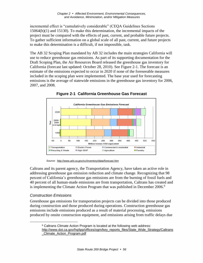
Chapter 2 Affected Environment, Environmental Consequences, and Avoidance, Minimization, and/or Mitigation Measures
State Route 269 Bridge Project 56
incremental effect is “cumulatively considerable” (CEQA Guidelines Sections
15064(h)(1) and 15130). To make this determination, the incremental impacts of the
project must be compared with the effects of past, current, and probable future projects.
To gather sufficient information on a global scale of all past, current, and future projects
to make this determination is a difficult, if not impossible, task.
The AB 32 Scoping Plan mandated by AB 32 includes the main strategies California will
use to reduce greenhouse gas emissions. As part of its supporting documentation for the
Draft Scoping Plan, the Air Resources Board released the greenhouse gas inventory for
California (forecast last updated: October 28, 2010). See Figure 2-1. The forecast is an
estimate of the emissions expected to occur in 2020 if none of the foreseeable measures
included in the scoping plan were implemented. The base year used for forecasting
emissions is the average of statewide emissions in the greenhouse gas inventory for 2006,
2007, and 2008.
Figure 2-1 California Greenhouse Gas Forecast
Source: http://www.arb.ca.gov/cc/inventory/data/forecast.htm
Caltrans and its parent agency, the Transportation Agency, have taken an active role in
addressing greenhouse gas emission reduction and climate change. Recognizing that 98
percent of California’s greenhouse gas emissions are from the burning of fossil fuels and
40 percent of all human-made emissions are from transportation, Caltrans has created and
is implementing the Climate Action Program that was published in December 2006.6
Construction Emissions
Greenhouse gas emissions for transportation projects can be divided into those produced
during construction and those produced during operations. Construction greenhouse gas
emissions include emissions produced as a result of material processing, emissions
produced by onsite construction equipment, and emissions arising from traffic delays due
6 Caltrans Climate Action Program is located at the following web address: http://www.dot.ca.gov/hq/tpp/offices/ogm/key_reports_files/State_Wide_Strategy/Caltrans_Climate_Action_Program.pdf
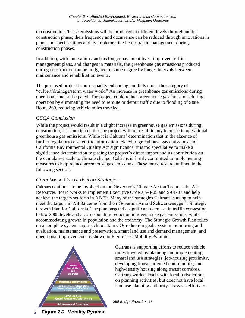
Chapter 2 Affected Environment, Environmental Consequences, and Avoidance, Minimization, and/or Mitigation Measures
State Route 269 Bridge Project 57
to construction. These emissions will be produced at different levels throughout the
construction phase; their frequency and occurrence can be reduced through innovations in
plans and specifications and by implementing better traffic management during
construction phases.
In addition, with innovations such as longer pavement lives, improved traffic
management plans, and changes in materials, the greenhouse gas emissions produced
during construction can be mitigated to some degree by longer intervals between
maintenance and rehabilitation events.
The proposed project is non-capacity enhancing and falls under the category of
“culvert/drainage/storm water work.” An increase in greenhouse gas emissions during
operation is not anticipated. The project could reduce greenhouse gas emissions during
operation by eliminating the need to reroute or detour traffic due to flooding of State
Route 269, reducing vehicle miles traveled.
CEQA Conclusion
While the project would result in a slight increase in greenhouse gas emissions during
construction, it is anticipated that the project will not result in any increase in operational
greenhouse gas emissions. While it is Caltrans’ determination that in the absence of
further regulatory or scientific information related to greenhouse gas emissions and
California Environmental Quality Act significance, it is too speculative to make a
significance determination regarding the project’s direct impact and its contribution on
the cumulative scale to climate change, Caltrans is firmly committed to implementing
measures to help reduce greenhouse gas emissions. These measures are outlined in the
following section.
Greenhouse Gas Reduction Strategies
Caltrans continues to be involved on the Governor’s Climate Action Team as the Air
Resources Board works to implement Executive Orders S-3-05 and S-01-07 and help
achieve the targets set forth in AB 32. Many of the strategies Caltrans is using to help
meet the targets in AB 32 come from then-Governor Arnold Schwarzenegger’s Strategic
Growth Plan for California. The plan targeted a significant decrease in traffic congestion
below 2008 levels and a corresponding reduction in greenhouse gas emissions, while
accommodating growth in population and the economy. The Strategic Growth Plan relies
on a complete systems approach to attain CO2 reduction goals: system monitoring and
evaluation, maintenance and preservation, smart land use and demand management, and
operational improvements as shown in Figure 2-2: Mobility Pyramid.
Caltrans is supporting efforts to reduce vehicle
miles traveled by planning and implementing
smart land use strategies: job/housing proximity,
developing transit-oriented communities, and
high-density housing along transit corridors.
Caltrans works closely with local jurisdictions
on planning activities, but does not have local
land use planning authority. It assists efforts to
Figure 2-2 Mobility Pyramid

Chapter 2 Affected Environment, Environmental Consequences, and Avoidance, Minimization, and/or Mitigation Measures
State Route 269 Bridge Project 58
improve the energy efficiency of the transportation sector by increasing vehicle fuel
economy in new cars, and light- and heavy-duty trucks. Caltrans is doing this by
supporting ongoing research efforts at universities, supporting legislative efforts to
increase fuel economy, and participating on the Climate Action Team. It is important to
note, however, that control of fuel economy standards is held by the U.S. EPA and Air
Resources Board.
Caltrans is also working toward enhancing the State’s transportation planning process to
respond to future challenges. Similar to requirements for regional transportation plans
under Senate Bill 375 (Steinberg 2008), Senate Bill 391(Liu 2009) requires the State’s
long-range transportation plan to meet California’s climate change goals under AB 32.
The California Transportation Plan (CTP) is a statewide long-range transportation plan to
meet our future mobility needs and reduce greenhouse gas emissions. The California
Transportation Plan defines performance-based goals, policies, and strategies to achieve
our collective vision for California’s future statewide integrated multimodal
transportation system.
The purpose of the California Transportation Plan is to provide a common policy
framework that will guide transportation investments and decisions by all levels of
government, the private sector, and other transportation stakeholders. Through this policy
framework, the California Transportation Plan 2040 will identify the statewide
transportation system needed to achieve maximum feasible greenhouse gas emission
reductions while meeting the State’s transportation needs.
Table 2.3 summarizes the departmental and statewide efforts that Caltrans is
implementing to reduce greenhouse gas emissions. More detailed information about each
strategy is included in the Climate Action Program at Caltrans (December 2006).
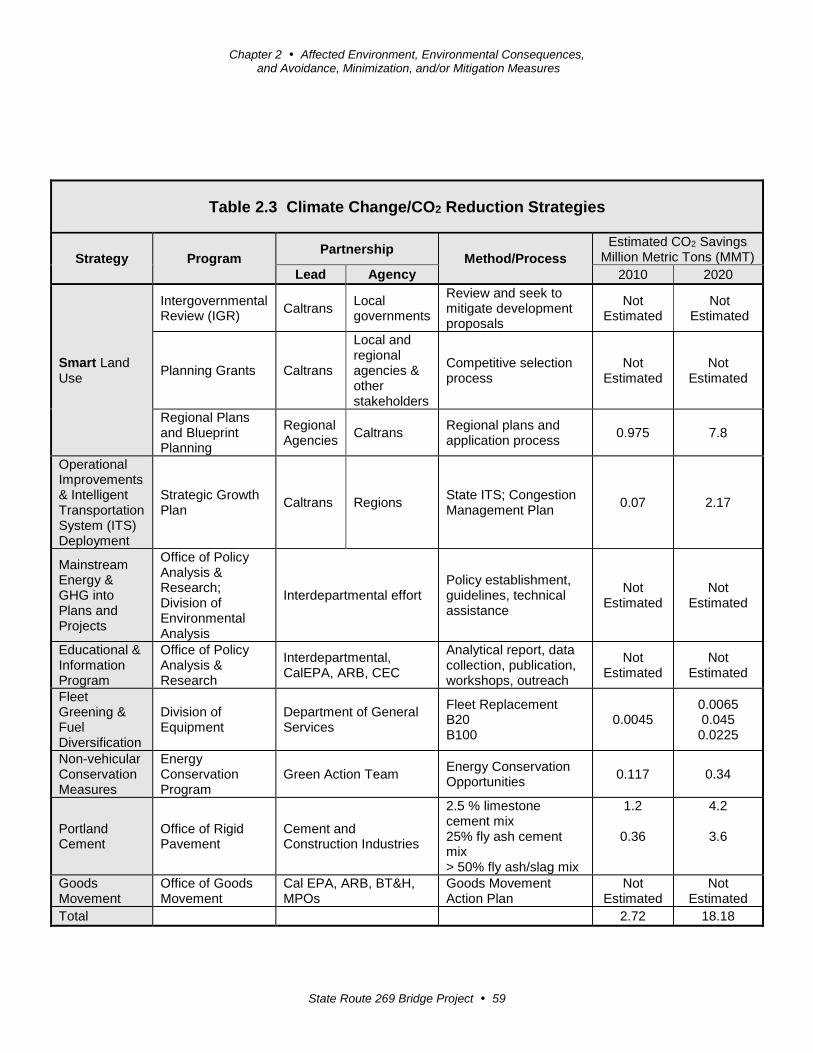
Chapter 2 Affected Environment, Environmental Consequences, and Avoidance, Minimization, and/or Mitigation Measures
State Route 269 Bridge Project 59
Table 2.3 Climate Change/CO2 Reduction Strategies
Strategy Program Partnership
Method/Process
Estimated CO2 Savings Million Metric Tons (MMT)
Lead Agency 2010 2020
Smart Land Use
Intergovernmental Review (IGR)
Caltrans Local governments
Review and seek to mitigate development proposals
Not Estimated
Not Estimated
Planning Grants Caltrans
Local and regional agencies & other stakeholders
Competitive selection process
Not Estimated
Not Estimated
Regional Plans and Blueprint Planning
Regional Agencies
Caltrans Regional plans and application process
0.975 7.8
Operational Improvements & Intelligent Transportation System (ITS) Deployment
Strategic Growth Plan
Caltrans Regions State ITS; Congestion Management Plan
0.07 2.17
Mainstream Energy & GHG into Plans and Projects
Office of Policy Analysis & Research; Division of Environmental Analysis
Interdepartmental effort Policy establishment, guidelines, technical assistance
Not Estimated
Not Estimated
Educational & Information Program
Office of Policy Analysis & Research
Interdepartmental, CalEPA, ARB, CEC
Analytical report, data collection, publication, workshops, outreach
Not Estimated
Not Estimated
Fleet Greening & Fuel Diversification
Division of Equipment
Department of General Services
Fleet Replacement B20 B100
0.0045 0.0065 0.045 0.0225
Non-vehicular Conservation Measures
Energy Conservation Program
Green Action Team Energy Conservation Opportunities
0.117 0.34
Portland Cement
Office of Rigid Pavement
Cement and Construction Industries
2.5 % limestone cement mix 25% fly ash cement mix > 50% fly ash/slag mix
1.2
0.36
4.2
3.6
Goods Movement
Office of Goods Movement
Cal EPA, ARB, BT&H, MPOs
Goods Movement Action Plan
Not Estimated
Not Estimated
Total 2.72 18.18
Chapter 2 Affected Environment, Environmental Consequences, and Avoidance, Minimization, and/or Mitigation Measures
State Route 269 Bridge Project 60
Caltrans Director’s Policy 30 (DP-30) Climate Change (June 22, 2012) is intended to
establish a department policy that will ensure coordinated efforts to incorporate climate
change into departmental decisions and activities.
Caltrans Activities to Address Climate Change (April 2013)7 provides a comprehensive
overview of activities undertaken by Caltrans statewide to reduce greenhouse gas
emissions resulting from agency operations.
The following measures would also be included in the project to reduce greenhouse gas
emissions and potential climate change impacts from the project:
1. Caltrans and the California Highway Patrol are working with regional agencies to
implement Intelligent Transportation Systems (ITS) to help manage the efficiency of
the existing highway system. Intelligent Transportation Systems commonly consist of
electronics, communications, or information processing used singly or in combination
to improve the efficiency or safety of a surface transportation system.
2. According to Caltrans’ Standard Specifications, the contractor must comply with all
local Air Pollution Control District (APCD) rules, ordinances, and regulations for air
quality restrictions. Construction measures to reduce greenhouse gas emissions
include watering exposed surfaces for parking, staging areas, soil piles, graded areas
and unpaved roads; limiting speeds on unpaved roads to 15 miles per hour;
minimizing idling time of construction equipment when not in use by shutting off
equipment or limiting idling time to 5 minutes; and maintaining equipment in
accordance with manufacturers’ specifications.
3. Climate Change/CO2 Reduction Strategies are identified in Table 2.3.
Adaptation Strategies
“Adaptation strategies” refer to how Caltrans and others can plan for the effects of
climate change on the State’s transportation infrastructure and strengthen or protect the
facilities from damage. Climate change is expected to produce increased variability in
precipitation, rising temperatures, rising sea levels, variability in storm surges and
intensity, and the frequency and intensity of wildfires. These changes may affect the
transportation infrastructure in various ways, such as damage to roadbeds from longer
periods of intense heat; increasing storm damage from flooding and erosion; and
inundation from rising sea levels. These effects will vary by location and may, in the
most extreme cases, require that a facility be relocated or redesigned. There may also be
economic and strategic ramifications as a result of these types of impacts to the
transportation infrastructure.
7 http://www.dot.ca.gov/hq/tpp/offices/orip/climate_change/projects_and_studies.shtml

Chapter 2 Affected Environment, Environmental Consequences, and Avoidance, Minimization, and/or Mitigation Measures
State Route 269 Bridge Project 61
At the federal level, the Climate Change Adaptation Task Force, co-chaired by the White
House Council on Environmental Quality (CEQ), the Office of Science and Technology
Policy (OSTP), and the National Oceanic and Atmospheric Administration (NOAA),
released its interagency task force progress report on October 28, 20118, outlining the
federal government’s progress in expanding and strengthening the nation’s capacity to
better understand, prepare for, and respond to extreme events and other climate change
impacts. The report provides an update on actions in key areas of federal adaptation,
including building resilience in local communities, safeguarding critical natural resources
such as freshwater, and providing accessible climate information and tools to help
decision-makers manage climate risks.
Climate change adaptation must involve the natural environment as well. Efforts are
underway on a statewide level to develop strategies to cope with impacts to habitat and
biodiversity through planning and conservation. The results of these efforts will help
California agencies plan and implement mitigation strategies for programs and projects.
On November 14, 2008, then-Governor Arnold Schwarzenegger signed Executive Order
S-13-08, which directed a number of state agencies to address California’s vulnerability
to sea level rise caused by climate change. This order set in motion several agencies and
actions to address the concern of sea level rise.
In addition to addressing projected sea level rise, the California Natural Resources
Agency (Resources Agency) was directed to coordinate with local, regional, state and
federal public and private entities to develop the California Climate Adaptation Strategy
(December 2009)9, which summarizes the best-known science on climate change impacts
to California, assesses California’s vulnerability to the identified impacts, and then
outlines solutions that can be implemented within and across state agencies to promote
resiliency.
The strategy outline is in direct response to Executive Order S-13-08 that specifically
asked the Resources Agency to identify how state agencies can respond to rising
temperatures, changing precipitation patterns, sea level rise, and extreme natural events.
Numerous other state agencies were involved in the creation of the Adaptation Strategy
document, including the California Environmental Protection Agency; Business,
Transportation and Housing; Health and Human Services; and the Department of
Agriculture. The document is broken down into strategies for different sectors that
include public health; biodiversity and habitat; ocean and coastal resources; water
management; agriculture; forestry; and transportation and energy infrastructure. As data
continues to be developed and collected, the State’s adaptation strategy will be updated to
reflect current findings.
8 http://www.whitehouse.gov/administration/eop/ceq/initiatives/adaptation 9 http://www.energy.ca.gov/2009publications/CNRA-1000-2009-027/CNRA-1000-2009-027-F.PDF
Chapter 2 Affected Environment, Environmental Consequences, and Avoidance, Minimization, and/or Mitigation Measures
State Route 269 Bridge Project 62
The National Academy of Science was directed to prepare a Sea Level Rise Assessment
Report10 to recommend how California should plan for future sea level rise. The report
was released in June 2012 and included the following:
Relative sea level rise projections for California, Oregon and Washington, taking into
account coastal erosion rates, tidal impacts, El Niño and La Niña events, storm surge
and land subsidence rates.
Range of uncertainty in selected sea level rise projections.
Synthesis of existing information on projected sea level rise impacts to state
infrastructure (such as roads, public facilities and beaches), natural areas, and coastal
and marine ecosystems.
Discussion of future research needs regarding sea level rise.
In 2010, interim guidance was released by the Coastal Ocean Climate Action Team (CO-
CAT) as well as Caltrans as a method to initiate action and discussion of potential risks to
the State’s infrastructure due to projected sea level rise. Subsequently, CO-CAT updated
the Sea Level Rise guidance to include information presented in the National Academy’s
study.
All state agencies that are planning to construct projects in areas vulnerable to future sea
level rise are directed to consider a range of sea level rise scenarios for the years 2050
and 2100 to assess project vulnerability and, to the extent feasible, reduce expected risks
and increase resiliency to sea level rise. Sea level rise estimates should also be used in
conjunction with information on local uplift and subsidence, coastal erosion rates,
predicted higher high water levels, storm surge and storm wave data.
All projects that have filed a Notice of Preparation (NOP) as of the date of Executive
Order S-13-08, and/or are programmed for construction funding from 2008 through 2013,
or are routine maintenance projects may, but are not required to, consider these planning
guidelines. The proposed project is outside the coastal zone, and direct impacts to
transportation facilities due to projected sea level rise are not expected.
Executive Order S-13-08 also directed the Business, Transportation, and Housing Agency
to prepare a report to assess vulnerability of transportation systems to sea level rise
affecting safety, maintenance and operational improvements of the system, and economy
of the state. The department continues to work on assessing the transportation system
vulnerability to climate change, including the effect of sea level rise.
Currently, Caltrans is working to assess which transportation facilities are at greatest risk
from climate change effects. However, without statewide planning scenarios for relative
sea level rise and other climate change effects, Caltrans has not been able to determine
what change, if any, may be made to its design standards for its transportation facilities.
10 Sea Level Rise for the Coasts of California, Oregon, and Washington: Past, Present, and Future (2012) is available at http://www.nap.edu/catalog.php?record_id=13389.
Chapter 2 Affected Environment, Environmental Consequences, and Avoidance, Minimization, and/or Mitigation Measures
State Route 269 Bridge Project 63
Once statewide planning scenarios become available, Caltrans will be able review its
current design standards to determine what changes, if any, may be needed to protect the
transportation system from sea level rise.
Climate change adaptation for transportation infrastructure involves long-term planning
and risk management to address vulnerabilities in the transportation system from
increased precipitation and flooding; the increased frequency and intensity of storms and
wildfires; rising temperatures; and rising sea levels. Caltrans is an active participant in the
efforts being conducted in response to Executive Order S-13-08 and is mobilizing to be
able to respond to the National Academy of Science Sea Level Rise Assessment Report.

State Route 269 Bridge Project 64
Chapter 3 Comments and Coordination
Early and continuing coordination with the general public and appropriate public
agencies is an essential part of the environmental process to determine the scope of
environmental documentation, the level of analysis, potential impacts and mitigation
measures, and related environmental requirements. Agency consultation and public
participation for this project have been accomplished through a variety of formal and
informal methods that include, but is not limited to, project development team meetings
and interagency coordination meetings.
This chapter summarizes the results of Caltrans’ efforts to identify, address, and resolve
project-related issues through early and continuing coordination.
Agency Coordination
The following agency coordination has occurred:
Karen Dulik, Environmental Program Manager, South Central Region of California
Department of Water Resources
February 6, 2014: Caltrans provided Ms. Dulik a memorandum describing the
required Extended Phase I geoarcheological study onsite, consisting of the excavation
by backhoe of 20 trenches approximately 10 feet long by 3 feet wide and up to 10 feet
deep to investigate the potential cultural resources in the project area.
Christa Collin, Department of Water Resources Biologist
March 10, 2014: Phone message responding to a query regarding the coordination of
the Department of Water Resources and Caltrans’ blunt-nosed leopard lizard surveys.
July 24, 2014: Email responding to further questions regarding the Department of
Water Resources’ plans for biological surveys in and near the project area in 2015
and 2016.
Thomas Leeman, U.S. Fish and Wildlife Service Chief, San Joaquin Valley Division
June 6, 2014: Mr. Thomas Leeman issued a Letter of Concurrence (LOC) in response
to informal consultation regarding the need for excavation of test pits on the project
site as required to perform an Extended Phase 1/geoarcheological survey.
June 16, 2015: Mr. Thomas Leeman issued a Letter of Concurrence as part of the
Section 7 informal consultation process.
Jen Schofield, U.S. Fish and Wildlife Service Biologist, Sacramento Office (Caltrans
Liaison)
July 23, 2014: Email stating concurrence with Caltrans’ proposal to coordinate
biological survey efforts with Department of Water Resources biologists during

Chapter 3 Comments and Coordination
State Route 269 Bridge Project 65
future field seasons within the project area. Jen Schofield, United States Fish and
Wildlife Service Biologist, San Joaquin Valley Division (Caltrans Liaison)
Laura Peterson-Diaz, California Department of Fish and Wildlife Environmental
Scientist, Fresno Office (Caltrans Liaison)
Spring 2014: Ms. Peterson-Diaz informed Caltrans by phone that a 1602 permit
would not be required for the Extended Phase I/geoarcheological surveys if no pits
were located within the bed, bank, or berm of the Arroyo Pasajero channel.
March 26, 2014: Ms. Peterson-Diaz issued a Verification Request Form (VRF) as part
of the programmatic maintenance 1602 Agreement with Caltrans to permit hand
auguring of soil test pits required to test for naturally occurring asbestos on the
project site.
July 23, 2014: Email stating concurrence with Caltrans’ proposal to coordinate
biological survey efforts with Department of Water Resources biologists during
future field seasons within the project area.
Coordination with Native American Groups
In October 2012, a Sacred Lands Inventory Search was submitted to the Native American
Heritage Commission requesting that the commission conduct a search of its files for any
resources not previously identified during the archaeological records search conducted at
the Southern San Joaquin Valley Information Center. The Native American Heritage
Commission provided a list of potential Native American contacts.
Initial consultation was conducted in June 2013 with letters being sent to the tribes
identified by the Native American Heritage Commission. Eleven tribes or tribal contacts
were sent letters indicating that Caltrans was conducting environmental studies that
would include ground-disturbing activities associated with Extended Phase I/
geoarchaeological investigations.
In accordance with 36 Code of Federal Regulations Part 800.2 (c)(1-4), the tribes were
requested to comment regarding resources that may be affected by the proposed project.
The letters were sent to various Yokuts and Mono tribes associated with Fresno County
and the San Joaquin Valley or surrounding foothills, and included the project description,
the available maps, and attachments.
Records on file indicated that Caltrans had established, in consultation with Santa Rosa
Rancheria, that the project area was culturally sensitive for buried deposits (Nissen 2003).
In response to the current request for comments, Santa Rosa Rancheria again responded
to Caltrans confirming its concerns for the project. Santa Rosa Rancheria cultural
resources staff initially asked to participate in the archaeological field surveys, but
Caltrans arranged for them to attend a field visit separate from the survey. The field
review was conducted on or around July 29, 2013. Caltrans was able to discuss the
available mapping and project boundaries, including the proposed borrow site located
west of the State Route 269. Subsequent emails and phone calls between Caltrans and the
Chapter 3 Comments and Coordination
State Route 269 Bridge Project 66
Santa Rosa Rancheria staff were exchanged to discuss the project schedule, the maps and
the proposed testing and their intent to monitor the project as previously arranged.
The Santa Rosa Rancheria staff requested to be involved with and were included as
participants in the Extended Phase I/geoarchaeological investigation. Consultation with
the Santa Rosa Rancheria Tachi Yokuts tribe is ongoing.
Coordination with the Public
The public Notice of Intent to adopt a Mitigated Negative Declaration for the project was
published in the Hanford Sentinel newspaper on Tuesday, March 3, 2015. The public
review period started March 3, 2015 ended April 3, 2015. An opportunity for a public
hearing was provided but no one requested a hearing. The document was made available
for public review at the Caltrans District 6 office in Fresno and the Fresno County
Central Branch and the Huron Branch libraries. It was also available on the Caltrans
District 6 website. During this 30-day review period, Caltrans received comments from
two members of the public and three agencies. The public comments were from two
adjacent property owners regarding potential impacts to a water well they share to irrigate
orchards; they also commented about continued access to their properties. Agency
comments were in regard to the Williamson Act from the Department of Conservation,
Flood Zone designation from the Department of Water Resources, and compliance with
CEQA from the State Clearinghouse. The comments and Caltrans responses to the
comments are provided in Appendix I “Comments and Responses.”
In May 2015, Caltrans Design and Environmental staff met with two property owners
who own orchards next to the project. The owners submitted comments during the
circulation period for the draft environmental document expressing concern about the
impact on their agricultural operations. Their concerns were based on potential impacts to
a water well and related irrigation system, onsite farm roads, and direct access to the
properties from State Route 269. After reviewing the property owners’ comments and
meeting with them, Caltrans staff agreed to modify the project throughout the design
phase to avoid or minimize impacts to these properties. Caltrans Design staff will
continue to coordinate with the property owners.
In June 2015, Caltrans received an inquiry from the Central California Environmental
Justice Network regarding the status of the environmental document and whether a Dust
Mitigation Plan was approved by the San Joaquin Valley Unified Air Pollution Control
District. Caltrans indicated that the final environmental document anticipated approval in
August 2015 and the proposed level of the document would be a Mitigated Negative
Declaration (CEQA) with a Finding of No Significant Impact (NEPA). Caltrans
explained that the contractor will be responsible for submitting a Dust Control Plan to the
Air District prior to start of construction. If the project disturbs more than 5 acres of land
or the project requires more than 2,500 cubic yards of dirt removal for at least 3 days,
Caltrans will include a Non-Standard Special Provisions in the bid package which tells
the contractor he or she will need to submit a dust plan to the Air District. If the project
does not meet this criteria, a dust plan is not required, though basic measures and best
management practices must be used during construction, which is planned to begin in

Chapter 3 Comments and Coordination
State Route 269 Bridge Project 67
2017. The final environmental document will be sent to the Central California
Environmental Justice Network.

State Route 269 Bridge Project 69
Chapter 4 List of Preparers
This document was prepared by the following Caltrans Central Region staff:
Neil Bretz, Senior Transportation Engineer, P.E. B.S., Civil Engineering, California
State University, Fresno; 26 years of experience in transportation with
Caltrans, including 16 years in Project Management. Contribution: Project
Manager.
Diego Caldera, Civil Engineer, P.E. B.S., Civil Engineering, California State
University, Fresno; 10 years of Hydraulics/Hydrology experience.
Contribution: Hydraulics Report.
Phil Chick, Research Analyst II (GIS). B.A., Anthropology, California State
University, Fresno; 14 years of environmental and GIS experience.
Contribution: Prepared graphics for the environmental document.
Ronald Cummings, Principle Scientist, Parsons Corporation. Staff Augmentation
Biologist for Caltrans. B.S., General Biology, Oregon State University,
Corvallis, Oregon; 25 years of wildlife management and environmental
assessment experience. Contribution: Completed the Natural Environment
Study and Biological Assessment.
Rajeev Dwivedi, Associate Engineering Geologist. Ph.D., Environmental
Engineering, Oklahoma State University, Stillwater; more than 20 years of
environmental technical studies experience. Contribution: Completed the
Water Quality Assessment Report, Noise Compliance, and Air Quality
Compliance Memos.
Manny T. Marcos, Transportation Engineer, P.E. B.S., Civil Engineering, California
State University, Fresno; 16 years of Design and 1 year of Construction
experience with Caltrans. Contribution: Project Design Engineer.
Mandy Marine, Associate Environmental Planner/Native American Coordinator,
Archaeologist. B.A., Anthropology, California State University, Fresno; more
than 20 years of California archaeology experience. Contribution:
Coordinated Native American outreach for the project.
Michelle Miller, Environmental Planner (Archaeology). B.A., Anthropology,
California State University, Fresno; 7 years of environmental planning
experience. Contribution: Cultural Coordinator. Completed the Historical
Property Survey Report/Archeological Survey Report for the project.
Michelle Ray, Senior Environmental Planner. B.S., Environmental Toxicology and
Biology, University of California, Riverside; 9 years of planning experience
and 3 years biology experience. Contribution: Branch Chief of the Sierra
Pacific Environmental Analysis Branch.

Chapter 4 List of Preparers
State Route 269 Bridge Project 70
Jane Sellers, Research Writer. B.A., Journalism—News-Editorial Sequence,
California State University, Fresno; more than 25 years of writing/editing,
media, corporate communications, Request for Proposal, and public relations
experience. Contribution: Reviewed and edited the final environmental
document.
Jeff Sorensen, Associate Environmental Planner (Generalist). B.A., Business
Administration, California State University, Fresno; 34 years of land use,
transportation and environmental planning experience. Contribution:
Completed the Initial Study/Environmental Assessment and coordinated the
environmental process for the project.
Lea Spann, Associate Environmental Planner. B.A., Environmental Studies,
University of California, Santa Barbara; 21 years of hazardous waste/materials
experience and 5 years of environmental planning experience. Contribution:
Completed the Initial Site Assessment/Hazardous Waste Compliance memo
and the Preliminary Site Investigation Results memo for the project.
Richard C. Stewart, Engineering Geologist, P.G. B.S., Geology, California State
University, Fresno; more than 25 years of hazardous waste, water quality and
geology experience; 13 years of paleontology experience. Contribution:
Prepared the paleontology memo for the project.
Route 269 Bridge Project 71
Appendix A California Environmental Quality Act Checklist
This checklist identifies physical, biological, social and economic factors that might be affected by the proposed project. In many cases, background studies performed in connection with the projects indicate no impacts. A NO IMPACT answer in the last column reflects this determination. Where there is a need for clarifying discussion, the discussion is included either following the applicable section of the checklist or is within the body of the environmental document itself. The words "significant" and "significance" used throughout the following checklist are related to CEQA, not NEPA, impacts. The questions in this form are intended to encourage the thoughtful assessment of impacts and do not represent thresholds of significance.
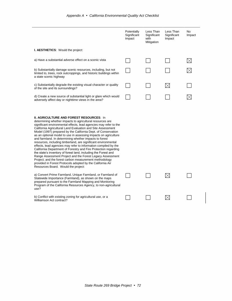
Appendix A California Environmental Quality Act Checklist
State Route 269 Bridge Project 72
Potentially Significant Impact
Less Than Significant with Mitigation
Less Than Significant Impact
No Impact
I. AESTHETICS: Would the project:
a) Have a substantial adverse effect on a scenic vista
b) Substantially damage scenic resources, including, but not limited to, trees, rock outcroppings, and historic buildings within a state scenic highway
c) Substantially degrade the existing visual character or quality of the site and its surroundings?
d) Create a new source of substantial light or glare which would adversely affect day or nighttime views in the area?
II. AGRICULTURE AND FOREST RESOURCES: In determining whether impacts to agricultural resources are significant environmental effects, lead agencies may refer to the California Agricultural Land Evaluation and Site Assessment Model (1997) prepared by the California Dept. of Conservation as an optional model to use in assessing impacts on agriculture and farmland. In determining whether impacts to forest resources, including timberland, are significant environmental effects, lead agencies may refer to information compiled by the California Department of Forestry and Fire Protection regarding the state’s inventory of forest land, including the Forest and Range Assessment Project and the Forest Legacy Assessment Project; and the forest carbon measurement methodology provided in Forest Protocols adopted by the California Air Resources Board. Would the project:
a) Convert Prime Farmland, Unique Farmland, or Farmland of Statewide Importance (Farmland), as shown on the maps prepared pursuant to the Farmland Mapping and Monitoring Program of the California Resources Agency, to non-agricultural use?
b) Conflict with existing zoning for agricultural use, or a Williamson Act contract?
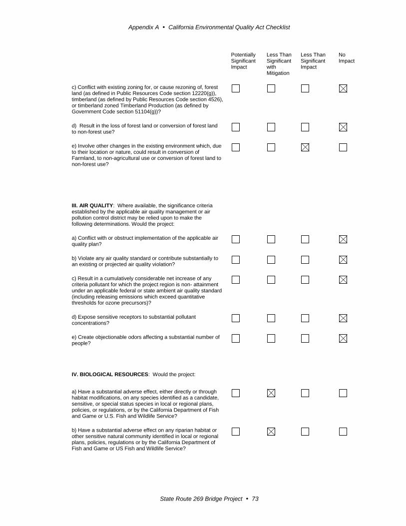
Appendix A California Environmental Quality Act Checklist
State Route 269 Bridge Project 73
Potentially Significant Impact
Less Than Significant with Mitigation
Less Than Significant Impact
No Impact
c) Conflict with existing zoning for, or cause rezoning of, forest land (as defined in Public Resources Code section 12220(g)), timberland (as defined by Public Resources Code section 4526), or timberland zoned Timberland Production (as defined by Government Code section 51104(g))?
d) Result in the loss of forest land or conversion of forest land to non-forest use?
e) Involve other changes in the existing environment which, due to their location or nature, could result in conversion of Farmland, to non-agricultural use or conversion of forest land to non-forest use?
III. AIR QUALITY: Where available, the significance criteria established by the applicable air quality management or air pollution control district may be relied upon to make the following determinations. Would the project:
a) Conflict with or obstruct implementation of the applicable air quality plan?
b) Violate any air quality standard or contribute substantially to an existing or projected air quality violation?
c) Result in a cumulatively considerable net increase of any criteria pollutant for which the project region is non- attainment under an applicable federal or state ambient air quality standard (including releasing emissions which exceed quantitative thresholds for ozone precursors)?
d) Expose sensitive receptors to substantial pollutant concentrations?
e) Create objectionable odors affecting a substantial number of people?
IV. BIOLOGICAL RESOURCES: Would the project:
a) Have a substantial adverse effect, either directly or through habitat modifications, on any species identified as a candidate, sensitive, or special status species in local or regional plans, policies, or regulations, or by the California Department of Fish and Game or U.S. Fish and Wildlife Service?
b) Have a substantial adverse effect on any riparian habitat or other sensitive natural community identified in local or regional plans, policies, regulations or by the California Department of Fish and Game or US Fish and Wildlife Service?

Appendix A California Environmental Quality Act Checklist
State Route 269 Bridge Project 74
Potentially Significant Impact
Less Than Significant with Mitigation
Less Than Significant Impact
No Impact
c) Have a substantial adverse effect on federally protected wetlands as defined by Section 404 of the Clean Water Act (including, but not limited to, marsh, vernal pool, coastal, etc.) through direct removal, filling, hydrological interruption, or other means?
d) Interfere substantially with the movement of any native resident or migratory fish or wildlife species or with established native resident or migratory wildlife corridors, or impede the use of native wildlife nursery sites?
e) Conflict with any local policies or ordinances protecting biological resources, such as a tree preservation policy or ordinance?
f) Conflict with the provisions of an adopted Habitat Conservation Plan, Natural Community Conservation Plan, or other approved local, regional, or state habitat conservation plan?
V. CULTURAL RESOURCES: Would the project:
a) Cause a substantial adverse change in the significance of a historical resource as defined in §15064.5?
b) Cause a substantial adverse change in the significance of an archaeological resource pursuant to §15064.5?
c) Directly or indirectly destroy a unique paleontological resource or site or unique geologic feature?
d) Disturb any human remains, including those interred outside of formal cemeteries?
VI. GEOLOGY AND SOILS: Would the project:
a) Expose people or structures to potential substantial adverse effects, including the risk of loss, injury, or death involving:
i) Rupture of a known earthquake fault, as delineated on the most recent Alquist-Priolo Earthquake Fault Zoning Map issued by the State Geologist for the area or based on other substantial evidence of a known fault? Refer to Division of Mines and Geology Special Publication 42?
ii) Strong seismic ground shaking?
iii) Seismic-related ground failure, including liquefaction?

Appendix A California Environmental Quality Act Checklist
State Route 269 Bridge Project 75
Potentially Significant Impact
Less Than Significant with Mitigation
Less Than Significant Impact
No Impact
iv) Landslides?
b) Result in substantial soil erosion or the loss of topsoil?
c) Be located on a geologic unit or soil that is unstable, or that would become unstable as a result of the project, and potentially result in on- or off-site landslide, lateral spreading, subsidence, liquefaction or collapse?
d) Be located on expansive soil, as defined in Table 18-1-B of the Uniform Building Code (1994), creating substantial risks to life or property?
e) Have soils incapable of adequately supporting the use of septic tanks or alternative waste water disposal systems where sewers are not available for the disposal of waste water?
VII. GREENHOUSE GAS EMISSIONS: Would the project:
a) Generate greenhouse gas emissions, either directly or indirectly, that may have a significant impact on the environment?
An assessment of the greenhouse gas emissions and climate change is included in the body of environmental document. While Caltrans has included this good faith effort in order to provide the public and decision-makers as much information as possible about the project, it is Caltrans determination that in the absence of further regulatory or scientific information related to GHG emissions and CEQA significance, it is too speculative to make a significance determination regarding the project’s direct and indirect impact with respect to climate change. Caltrans does remain firmly committed to implementing measures to help reduce the potential effects of the project. These measures are outlined in the body of the environmental document.
b) Conflict with an applicable plan, policy or regulation adopted for the purpose of reducing the emissions of greenhouse gases?
VIII. HAZARDS AND HAZARDOUS MATERIALS: Would the project:
a) Create a significant hazard to the public or the environment through the routine transport, use, or disposal of hazardous materials?
b) Create a significant hazard to the public or the environment through reasonably foreseeable upset and accident conditions involving the release of hazardous materials into the environment?
c) Emit hazardous emissions or handle hazardous or acutely hazardous materials, substances, or waste within one-quarter mile of an existing or proposed school?
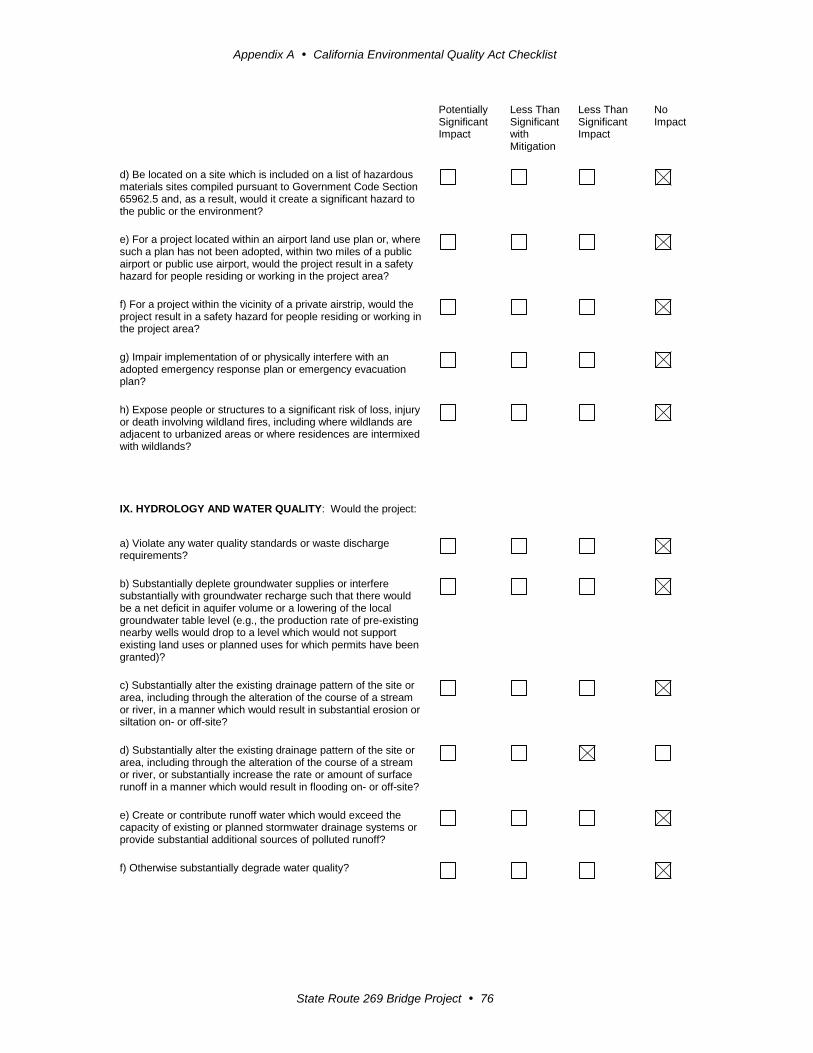
Appendix A California Environmental Quality Act Checklist
State Route 269 Bridge Project 76
Potentially Significant Impact
Less Than Significant with Mitigation
Less Than Significant Impact
No Impact
d) Be located on a site which is included on a list of hazardous materials sites compiled pursuant to Government Code Section 65962.5 and, as a result, would it create a significant hazard to the public or the environment?
e) For a project located within an airport land use plan or, where such a plan has not been adopted, within two miles of a public airport or public use airport, would the project result in a safety hazard for people residing or working in the project area?
f) For a project within the vicinity of a private airstrip, would the project result in a safety hazard for people residing or working in the project area?
g) Impair implementation of or physically interfere with an adopted emergency response plan or emergency evacuation plan?
h) Expose people or structures to a significant risk of loss, injury or death involving wildland fires, including where wildlands are adjacent to urbanized areas or where residences are intermixed with wildlands?
IX. HYDROLOGY AND WATER QUALITY: Would the project:
a) Violate any water quality standards or waste discharge requirements?
b) Substantially deplete groundwater supplies or interfere substantially with groundwater recharge such that there would be a net deficit in aquifer volume or a lowering of the local groundwater table level (e.g., the production rate of pre-existing nearby wells would drop to a level which would not support existing land uses or planned uses for which permits have been granted)?
c) Substantially alter the existing drainage pattern of the site or area, including through the alteration of the course of a stream or river, in a manner which would result in substantial erosion or siltation on- or off-site?
d) Substantially alter the existing drainage pattern of the site or area, including through the alteration of the course of a stream or river, or substantially increase the rate or amount of surface runoff in a manner which would result in flooding on- or off-site?
e) Create or contribute runoff water which would exceed the capacity of existing or planned stormwater drainage systems or provide substantial additional sources of polluted runoff?
f) Otherwise substantially degrade water quality?

Appendix A California Environmental Quality Act Checklist
State Route 269 Bridge Project 77
Potentially Significant Impact
Less Than Significant with Mitigation
Less Than Significant Impact
No Impact
g) Place housing within a 100-year flood hazard area as mapped on a federal Flood Hazard Boundary or Flood Insurance Rate Map or other flood hazard delineation map?
h) Place within a 100-year flood hazard area structures which would impede or redirect flood flows?
i) Expose people or structures to a significant risk of loss, injury or death involving flooding, including flooding as a result of the failure of a levee or dam?
j) Inundation by seiche, tsunami, or mudflow
X. LAND USE AND PLANNING: Would the project:
a) Physically divide an established community?
b)Conflict with any applicable land use plan, policy, or regulation of an agency with jurisdiction over the project (including, but not limited to the general plan, specific plan, local coastal program, or zoning ordinance) adopted for the purpose of avoiding or mitigating an environmental effect?
c) Conflict with any applicable habitat conservation plan or natural community conservation plan?
XI. MINERAL RESOURCES: Would the project:
a) Result in the loss of availability of a known mineral resource that would be of value to the region and the residents of the state?
b) Result in the loss of availability of a locally-important mineral resource recovery site delineated on a local general plan, specific plan or other land use plan?
XII. NOISE: Would the project result in:
a) Exposure of persons to or generation of noise levels in excess of standards established in the local general plan or noise ordinance, or applicable standards of other agencies?
b) Exposure of persons to or generation of excessive groundborne vibration or groundborne noise levels?
c) A substantial permanent increase in ambient noise levels in the project vicinity above levels existing without the project?
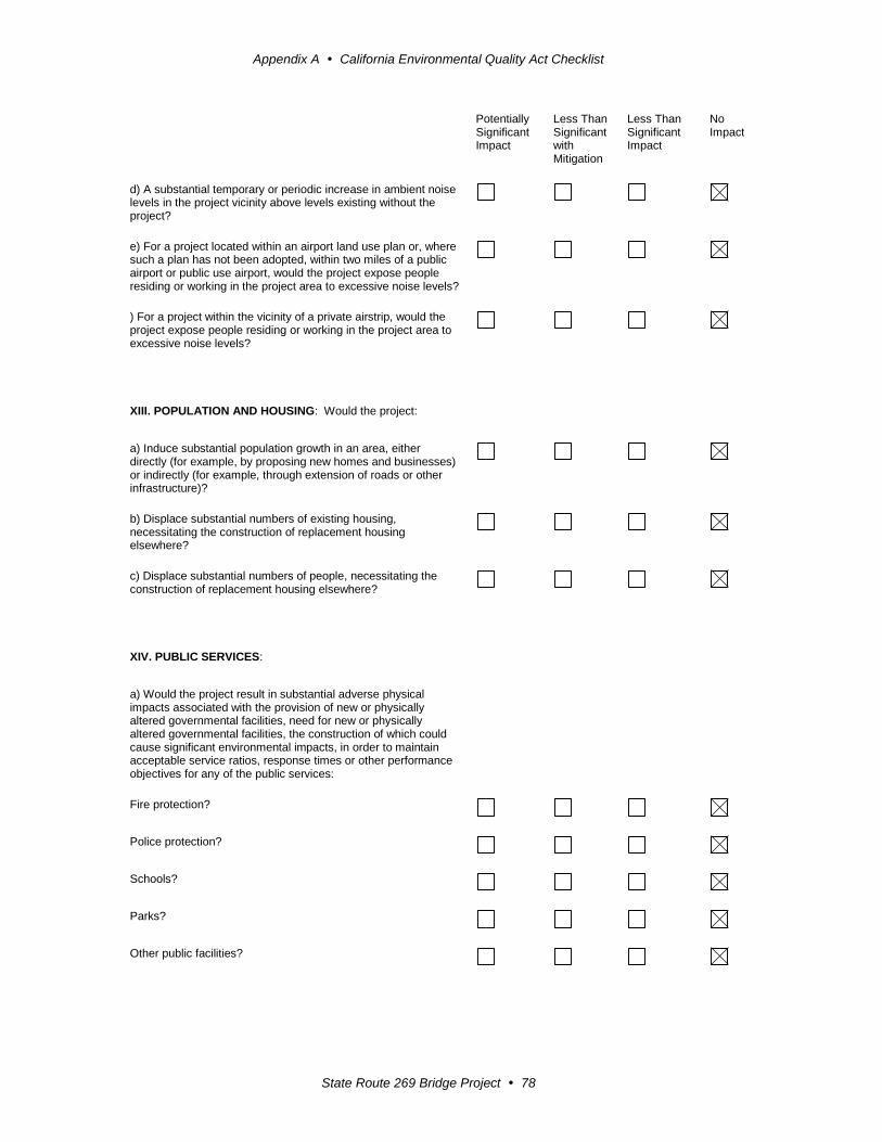
Appendix A California Environmental Quality Act Checklist
State Route 269 Bridge Project 78
Potentially Significant Impact
Less Than Significant with Mitigation
Less Than Significant Impact
No Impact
d) A substantial temporary or periodic increase in ambient noise levels in the project vicinity above levels existing without the project?
e) For a project located within an airport land use plan or, where such a plan has not been adopted, within two miles of a public airport or public use airport, would the project expose people residing or working in the project area to excessive noise levels?
) For a project within the vicinity of a private airstrip, would the project expose people residing or working in the project area to excessive noise levels?
XIII. POPULATION AND HOUSING: Would the project:
a) Induce substantial population growth in an area, either directly (for example, by proposing new homes and businesses) or indirectly (for example, through extension of roads or other infrastructure)?
b) Displace substantial numbers of existing housing, necessitating the construction of replacement housing elsewhere?
c) Displace substantial numbers of people, necessitating the construction of replacement housing elsewhere?
XIV. PUBLIC SERVICES:
a) Would the project result in substantial adverse physical impacts associated with the provision of new or physically altered governmental facilities, need for new or physically altered governmental facilities, the construction of which could cause significant environmental impacts, in order to maintain acceptable service ratios, response times or other performance objectives for any of the public services:
Fire protection?
Police protection?
Schools?
Parks?
Other public facilities?

Appendix A California Environmental Quality Act Checklist
State Route 269 Bridge Project 79
Potentially Significant Impact
Less Than Significant with Mitigation
Less Than Significant Impact
No Impact
XV. RECREATION:
a) Would the project increase the use of existing neighborhood and regional parks or other recreational facilities such that substantial physical deterioration of the facility would occur or be accelerated?
b) Does the project include recreational facilities or require the construction or expansion of recreational facilities which might have an adverse physical effect on the environment?
XVI. TRANSPORTATION/TRAFFIC: Would the project:
a) Conflict with an applicable plan, ordinance or policy establishing measures of effectiveness for the performance of the circulation system, taking into account all modes of transportation including mass transit and non-motorized travel and relevant components of the circulation system, including but not limited to intersections, streets, highways and freeways, pedestrian and bicycle paths, and mass transit?
b) Conflict with an applicable congestion management program, including, but not limited to level of service standards and travel demand measures, or other standards established by the county congestion management agency for designated roads or highways?
c) Result in a change in air traffic patterns, including either an increase in traffic levels or a change in location that results in substantial safety risks?
d) Substantially increase hazards due to a design feature (e.g., sharp curves or dangerous intersections) or incompatible uses (e.g., farm equipment)?
e) Result in inadequate emergency access?
f) Conflict with adopted policies, plans or programs regarding public transit, bicycle, or pedestrian facilities, or otherwise decrease the performance or safety of such facilities?
XVII. UTILITIES AND SERVICE SYSTEMS: Would the project:
a) Exceed wastewater treatment requirements of the applicable Regional Water Quality Control Board?
b) Require or result in the construction of new water or wastewater treatment facilities or expansion of existing facilities, the construction of which could cause significant environmental effects?
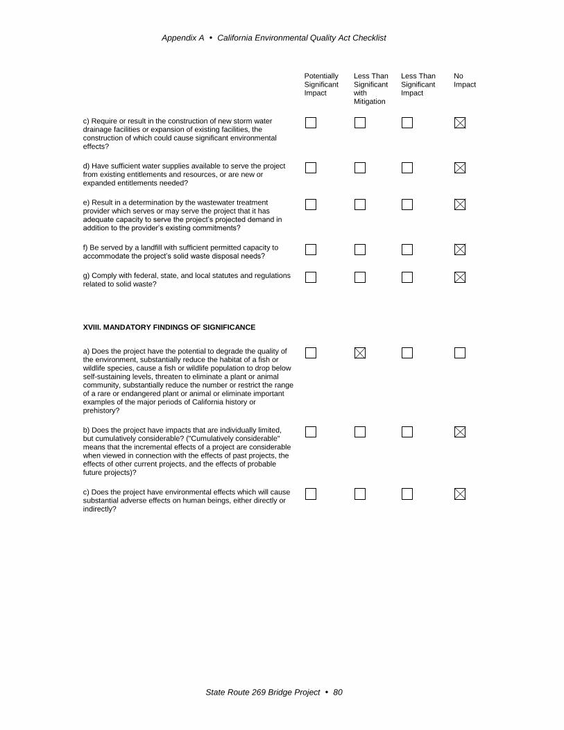
Appendix A California Environmental Quality Act Checklist
State Route 269 Bridge Project 80
Potentially Significant Impact
Less Than Significant with Mitigation
Less Than Significant Impact
No Impact
c) Require or result in the construction of new storm water drainage facilities or expansion of existing facilities, the construction of which could cause significant environmental effects?
d) Have sufficient water supplies available to serve the project from existing entitlements and resources, or are new or expanded entitlements needed?
e) Result in a determination by the wastewater treatment provider which serves or may serve the project that it has adequate capacity to serve the project’s projected demand in addition to the provider’s existing commitments?
f) Be served by a landfill with sufficient permitted capacity to accommodate the project’s solid waste disposal needs?
g) Comply with federal, state, and local statutes and regulations related to solid waste?
XVIII. MANDATORY FINDINGS OF SIGNIFICANCE
a) Does the project have the potential to degrade the quality of the environment, substantially reduce the habitat of a fish or wildlife species, cause a fish or wildlife population to drop below self-sustaining levels, threaten to eliminate a plant or animal community, substantially reduce the number or restrict the range of a rare or endangered plant or animal or eliminate important examples of the major periods of California history or prehistory?
b) Does the project have impacts that are individually limited, but cumulatively considerable? ("Cumulatively considerable" means that the incremental effects of a project are considerable when viewed in connection with the effects of past projects, the effects of other current projects, and the effects of probable future projects)?
c) Does the project have environmental effects which will cause substantial adverse effects on human beings, either directly or indirectly?
State Route 269 Bridge Project 81
Appendix B Title VI Policy Statement

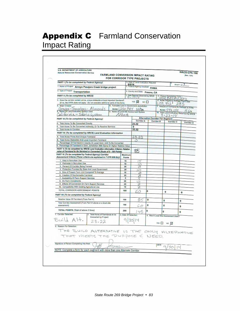
State Route 269 Bridge Project 83
Appendix C Farmland Conservation Impact Rating

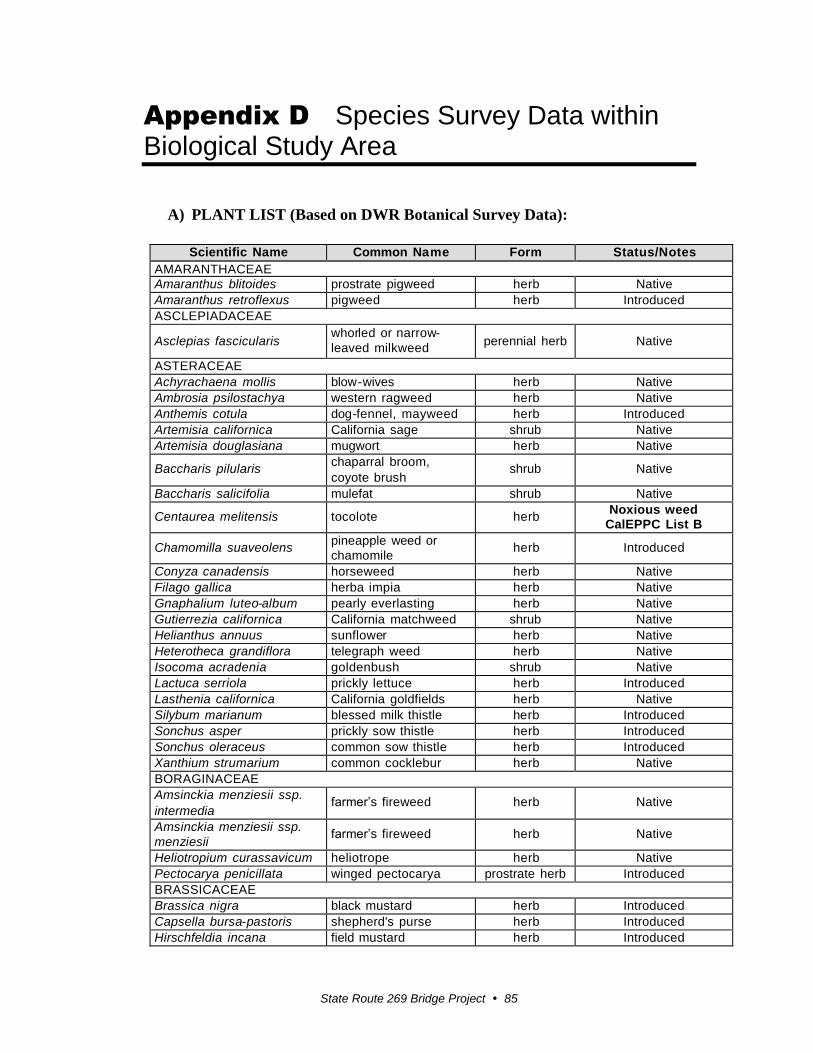
State Route 269 Bridge Project 85
Appendix D Species Survey Data within Biological Study Area
A) PLANT LIST (Based on DWR Botanical Survey Data):
Scientific Name Common Na me Form Status/Notes
AMARANTHACEAE
Amaranthus blitoides prostrate pigweed herb Native
Amaranthus retroflexus pigweed herb Introduced
ASCLEPIADACEAE
Asclepias fascicularis whorled or narrow-
leaved milkweed
perennial herb
Native
ASTERACEAE
Achyrachaena mollis blow-wives herb Native
Ambrosia psilostachya western ragweed herb Native
Anthemis cotula dog-fennel, mayweed herb Introduced
Artemisia californica California sage shrub Native
Artemisia douglasiana mugwort herb Native
Baccharis pilularis chaparral broom,
coyote brush shrub Native
Baccharis salicifolia mulefat shrub Native
Centaurea melitensis tocolote herb Noxious weed
CalEPPC List B
Chamomilla suaveolens pineapple weed or
chamomile herb Introduced
Conyza canadensis horseweed herb Native
Filago gallica herba impia herb Native
Gnaphalium luteo-album pearly everlasting herb Native
Gutierrezia californica California matchweed shrub Native
Helianthus annuus sunflower herb Native
Heterotheca grandiflora telegraph weed herb Native
Isocoma acradenia goldenbush shrub Native
Lactuca serriola prickly lettuce herb Introduced
Lasthenia californica California goldfields herb Native
Silybum marianum blessed milk thistle herb Introduced
Sonchus asper prickly sow thistle herb Introduced
Sonchus oleraceus common sow thistle herb Introduced
Xanthium strumarium common cocklebur herb Native
BORAGINACEAE
Amsinckia menziesii ssp.
intermedia farmer’s fireweed herb Native
Amsinckia menziesii ssp.
menziesii farmer’s fireweed herb Native
Heliotropium curassavicum heliotrope herb Native
Pectocarya penicillata winged pectocarya prostrate herb Introduced
BRASSICACEAE
Brassica nigra black mustard herb Introduced
Capsella bursa-pastoris shepherd's purse herb Introduced
Hirschfeldia incana field mustard herb Introduced
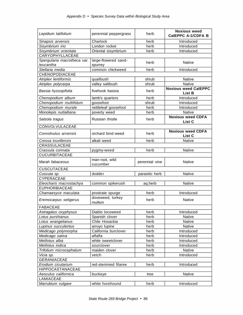
Appendix D Species Survey Data within Biological Study Area
State Route 269 Bridge Project 86
Lepidium latifolium
perennial peppergrass
herb Noxious weed
CalEPPC A-1/CDFA B
Sinapsis arvensis Charlock herb Introduced
Sisymbrium irio London rocket herb Introduced
Sisymbrium orientale Oriental sisymbrium herb Introduced
CARYOPHYLLACEAE
Spergularia macrotheca var.
leucantha
large-flowered sand -
spurrey
herb
Native
Stellaria media common chickweed herb Introduced
CHENOPODIACEAE
Atriplex lentiformis quailbush shrub Native
Atriplex polycarpa valley saltbush shrub Native
Bassia hyssopifolia
fivehook bassia
herb Noxious weed CalEPPC
List B
Chenopodium album lamb's quarters herb Introduced
Chenopodium multifidum goosefoot shrub Introduced
Chenopodium murale nettleleaf goosefoot herb Introduced
Monolepis nuttalliana poverty weed herb Native
Salsola tragus
Russian thistle
herb Noxious weed CDFA
List C
CONVOLVULACEAE
Convolvulus arvensis
orchard bind -weed
herb Noxious weed CDFA
List C
Cressa truxillensis alkali weed herb Native
CRASSULACEAE
Crassula connata pygmy-weed herb Native
CUCURBITACEAE
Marah fabaceous man-root, wild
cucumber
perennial vine
Native
CUSCUTACEAE
Cuscuta sp. dodde r parasitic herb Native
CYPERACEAE
Eleocharis macrostachya common spikerush aq.herb Native
EUPHORBIACEAE
Chamaesyce maculata prostrate spurge herb Introduced
Eremocarpus setigerus doveweed, turkey
mullein
herb
Native
FABACEAE
Astragalus oxyphysus Diablo locoweed herb Introduced
Lotus purshianus Spanish clover herb Native
Lotus wrangelianus Chile Hosackia herb Native
Lupinus succulentus arroyo lupine herb Native
Medicago polymorpha California burclover herb Introduced
Medicago sativa alfalfa herb Introduced
Melilotus alba white sweetclover herb Introduced
Melilotus indica sourclover herb Introduced
Trifolium microcephalum maiden clover herb Native
Vicia sp. vetch herb Introduced
GERANIACEAE
Erodium cicutarium red-stemmed filaree herb Introduced
HIPPOCASTANACEAE
Aesculus californica buckeye tree Native
LAMIACEAE
Marrubium vulgare white horehound herb Introduced
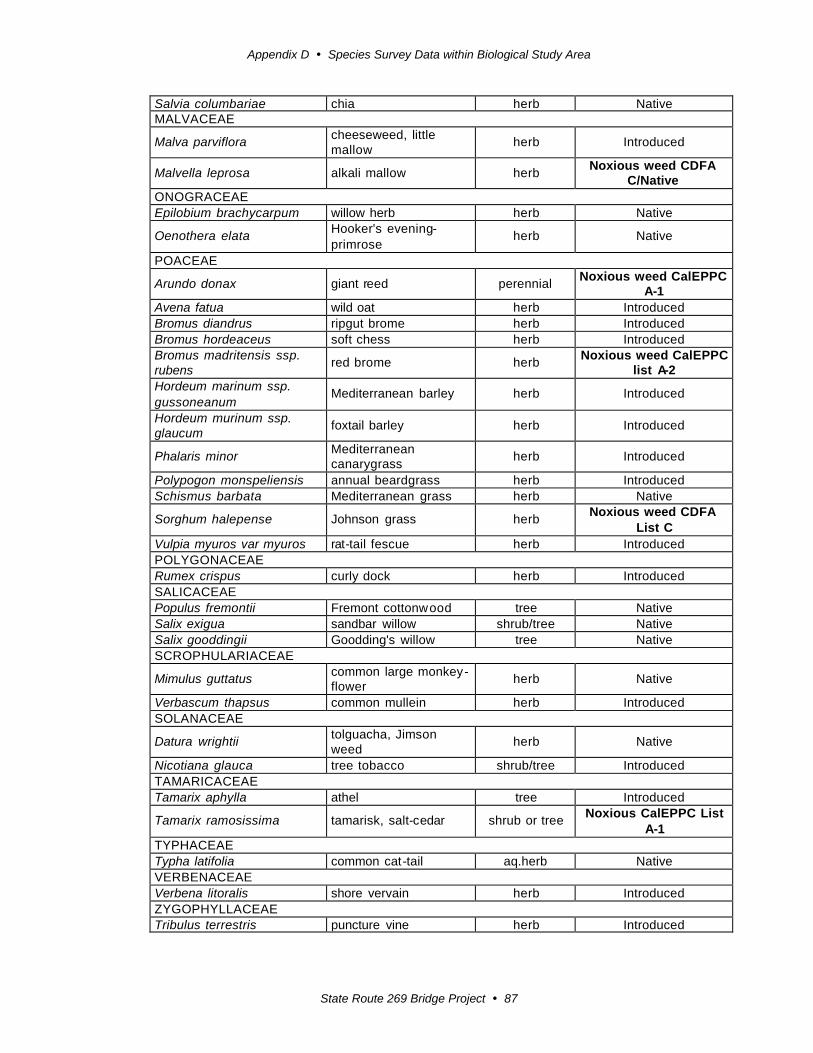
Appendix D Species Survey Data within Biological Study Area
State Route 269 Bridge Project 87
Salvia columbariae chia herb Native
MALVACEAE
Malva parviflora cheeseweed, little
mallow
herb
Introduced
Malvella leprosa
alkali mallow
herb Noxious weed CDFA
C/Native
ONOGRACEAE
Epilobium brachycarpum willow herb herb Native
Oenothera elata Hooker's evening-
primrose
herb
Native
POACEAE
Arundo donax
giant reed
perennial Noxious weed CalEPPC
A-1
Avena fatua wild oat herb Introduced
Bromus diandrus ripgut brome herb Introduced
Bromus hordeaceus soft chess herb Introduced
Bromus madritensis ssp.
rubens
red brome
herb Noxious weed CalEPPC
list A-2
Hordeum marinum ssp.
gussoneanum
Mediterranean barley
herb
Introduced
Hordeum murinum ssp.
glaucum
foxtail barley
herb
Introduced
Phalaris minor Mediterranean
canarygrass
herb
Introduced
Polypogon monspeliensis annual beardgrass herb Introduced
Schismus barbata Mediterranean grass herb Native
Sorghum halepense
Johnson grass
herb Noxious weed CDFA
List C
Vulpia myuros var myuros rat-tail fescue herb Introduced
POLYGONACEAE
Rumex crispus curly dock herb Introduced
SALICACEAE
Populus fremontii Fremont cottonw ood tree Native
Salix exigua sandbar willow shrub/tree Native
Salix gooddingii Goodding's willow tree Native
SCROPHULARIACEAE
Mimulus guttatus common large monkey -
flower
herb
Native
Verbascum thapsus common mullein herb Introduced
SOLANACEAE
Datura wrightii tolguacha, Jimson
weed
herb
Native
Nicotiana glauca tree tobacco shrub/tree Introduced
TAMARICACEAE
Tamarix aphylla athel tree Introduced
Tamarix ramosissima
tamarisk, salt-cedar
shrub or tree Noxious CalEPPC List
A-1
TYPHACEAE
Typha latifolia common cat -tail aq.herb Native
VERBENACEAE
Verbena litoralis shore vervain herb Introduced
ZYGOPHYLLACEAE
Tribulus terrestris puncture vine herb Introduced

Appendix D Species Survey Data within Biological Study Area
State Route 269 Bridge Project 88
B) ANIMAL LIST (Combined data from DWR and Caltrans Surveys)
Scientific Name Common Name Special Status(1)
AMPHIBIANS
Bufo boreas Western toad
Spea hammondii Spadefoot toad CSC
REPTILES
Pituophis melanoleucus Gopher snake
Masticophis flagellum ruddocki San Joaquin whipsnake CSC
Lampropeltis getulus Common kingsnake
Lampropeltis getulus californiae California kingsnake
Cnemidophorus tigris Western whiptail
Sceloporus magister Desert spiny lizard
Sceloporus occidentalis Western fence lizard
Uta stansburiana Common side-blotched lizard
BIRDS
Cathartes aura Turkey vulture
Circus cyaneus Northern harrier
Buteo jamaicensis Red-tailed hawk
Buteo swainsoni Swainson’s hawk CSC
Falco sparverius American kestrel
Geococcyx californianus Greater roadrunner
Bubo virginianus Great horned owl
Tyto alba Barn owl
Athene cunicularia Burrowing owl CSC
Charadrius vociferus Killdeer
Callipepla californica California quail
Zenaida macroura Mourning dove
Columba liva Rock dove
Corvus corax Common raven
Corvus brachyrhynchos American crow
Petrochelidon pyrrhonota Cliff swallows
Hirundo rustica Barn swallow
Molothrus ater Brown-headed cowbird
Agelaius phoeniceus Red-winged blackbird
Euphagus cyanocephalus Brewer’s blackbird
Sturnella neglecta Western meadowlark
Myiarchus cineracens Ash-throated flycatcher
Lanius ludovicianus Loggerhead shrike CSC
Mimus polyglottos Northern mockingbird
Piranga ludoviciana Western tanager
Dendroica coronata Yellow-rumped warbler
Passer domesticus House sparrow

Appendix D Species Survey Data within Biological Study Area
State Route 269 Bridge Project 89
Zonotrichia leucophrys White-crowned sparrow
Sturnus vulgaris European starling
Archilochus alexandri Black-chinned hummingbird
Thryomanes bewickii Bewick’s wren
Turdus migratorius American robin
Guiraca caerulea Blue grosebeak
Tyrannus verticalis Western kingbird
Icterus bullockii Bullock’s oriole
Cardulis lawrencei Lawrence’s goldfinch
Carpodacus mexicanus House finch
MAMMALS
Felis catus Feral cat
Lynx rufus bobcat
Canis familiaris Feral dog
Canis latrans Coyote
Vulpes vulpes Red fox
Order: Chiroptera Unknown bat species
Thomomys bottae Botta’s pocket gopher
Mus musculus House mouse
Peromyscus maniculatus Deer mouse
Chaetodipus californicus California pocket mouse
Dipodomys heermanni Heerman’s kangaroo rat
Lepus californicus Black-tailed jackrabbit
Sylvilagus auduboni Desert cottontail
Procyon lotor Raccoon (tracks)
Otospermophilus beecheyi California ground squirrel


State Route 269 Bridge Project 91
Appendix E U.S. Fish and Wildlife Service Species List, CNPS Species List and CNDDB Query

Appendix E U.S. Fish and Wildlife Service Species List, CNPS Species List and CNDDB Query
State Route 269 Bridge Project 92
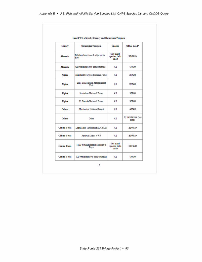
Appendix E U.S. Fish and Wildlife Service Species List, CNPS Species List and CNDDB Query
State Route 269 Bridge Project 93
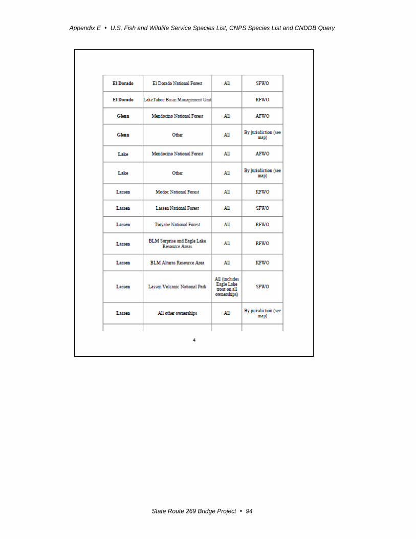
Appendix E U.S. Fish and Wildlife Service Species List, CNPS Species List and CNDDB Query
State Route 269 Bridge Project 94
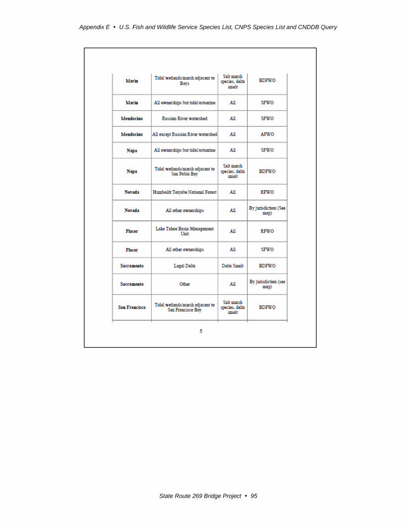
Appendix E U.S. Fish and Wildlife Service Species List, CNPS Species List and CNDDB Query
State Route 269 Bridge Project 95

Appendix E U.S. Fish and Wildlife Service Species List, CNPS Species List and CNDDB Query
State Route 269 Bridge Project 96
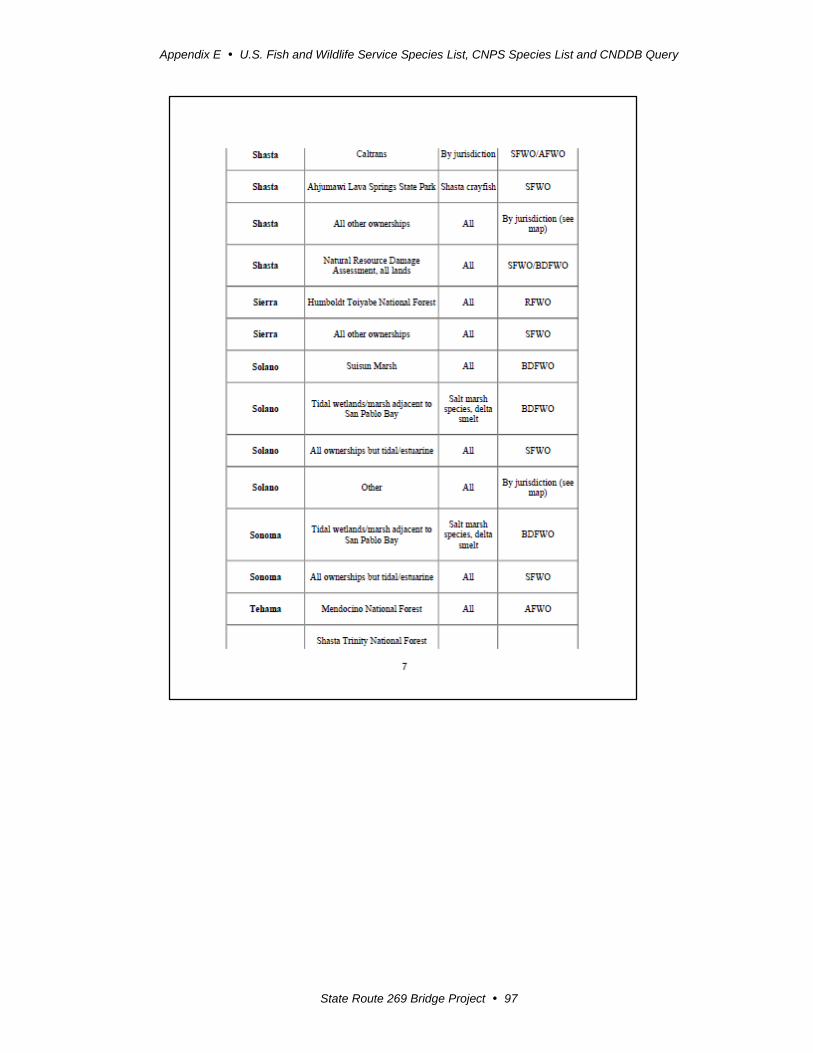
Appendix E U.S. Fish and Wildlife Service Species List, CNPS Species List and CNDDB Query
State Route 269 Bridge Project 97
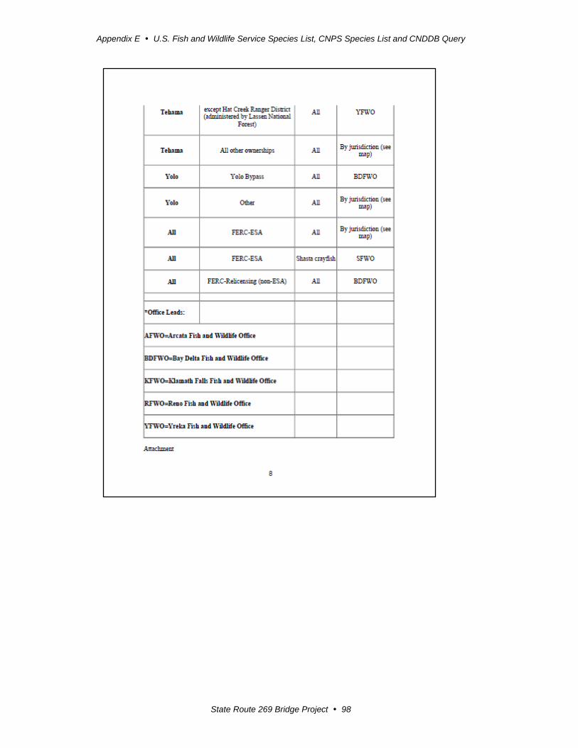
Appendix E U.S. Fish and Wildlife Service Species List, CNPS Species List and CNDDB Query
State Route 269 Bridge Project 98

Appendix E U.S. Fish and Wildlife Service Species List, CNPS Species List and CNDDB Query
State Route 269 Bridge Project 99
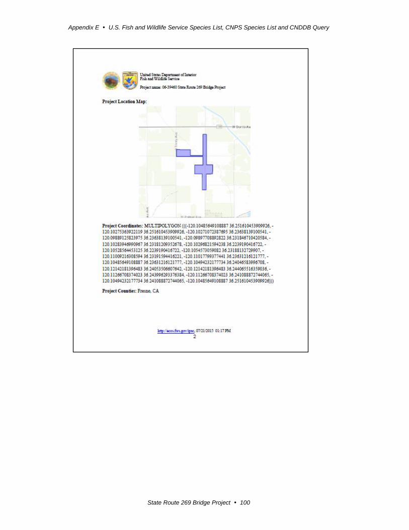
Appendix E U.S. Fish and Wildlife Service Species List, CNPS Species List and CNDDB Query
State Route 269 Bridge Project 100
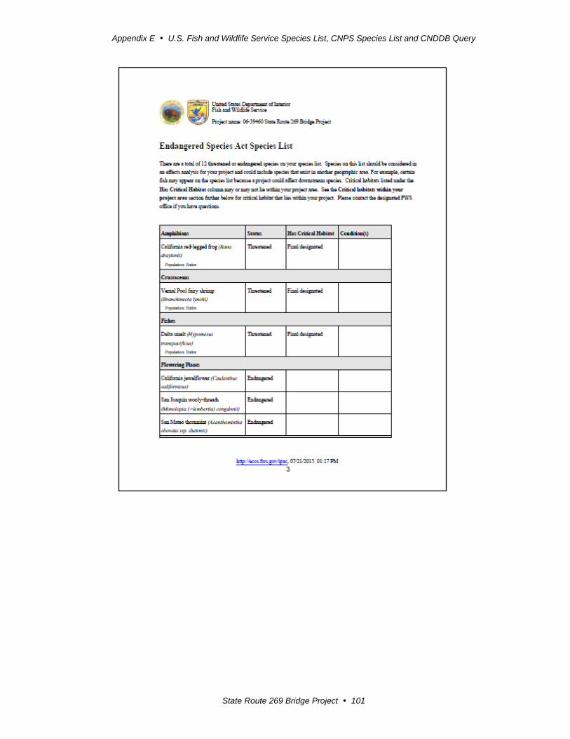
Appendix E U.S. Fish and Wildlife Service Species List, CNPS Species List and CNDDB Query
State Route 269 Bridge Project 101
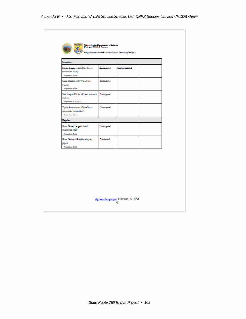
Appendix E U.S. Fish and Wildlife Service Species List, CNPS Species List and CNDDB Query
State Route 269 Bridge Project 102
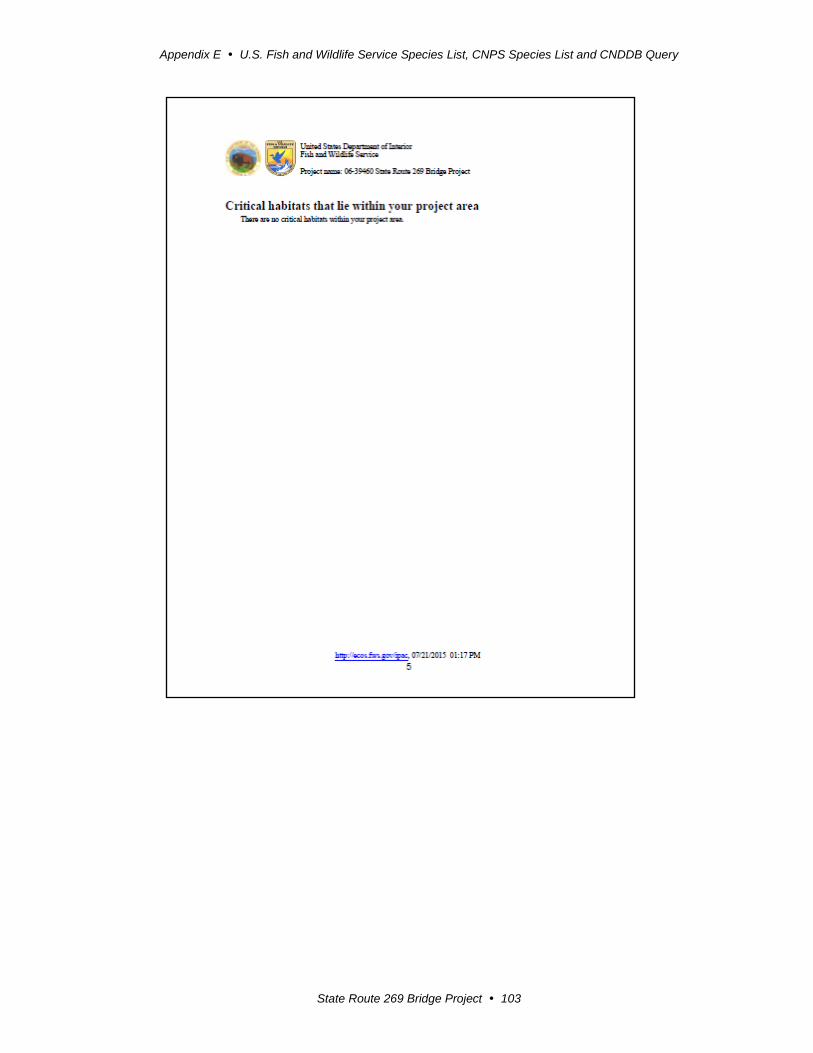
Appendix E U.S. Fish and Wildlife Service Species List, CNPS Species List and CNDDB Query
State Route 269 Bridge Project 103
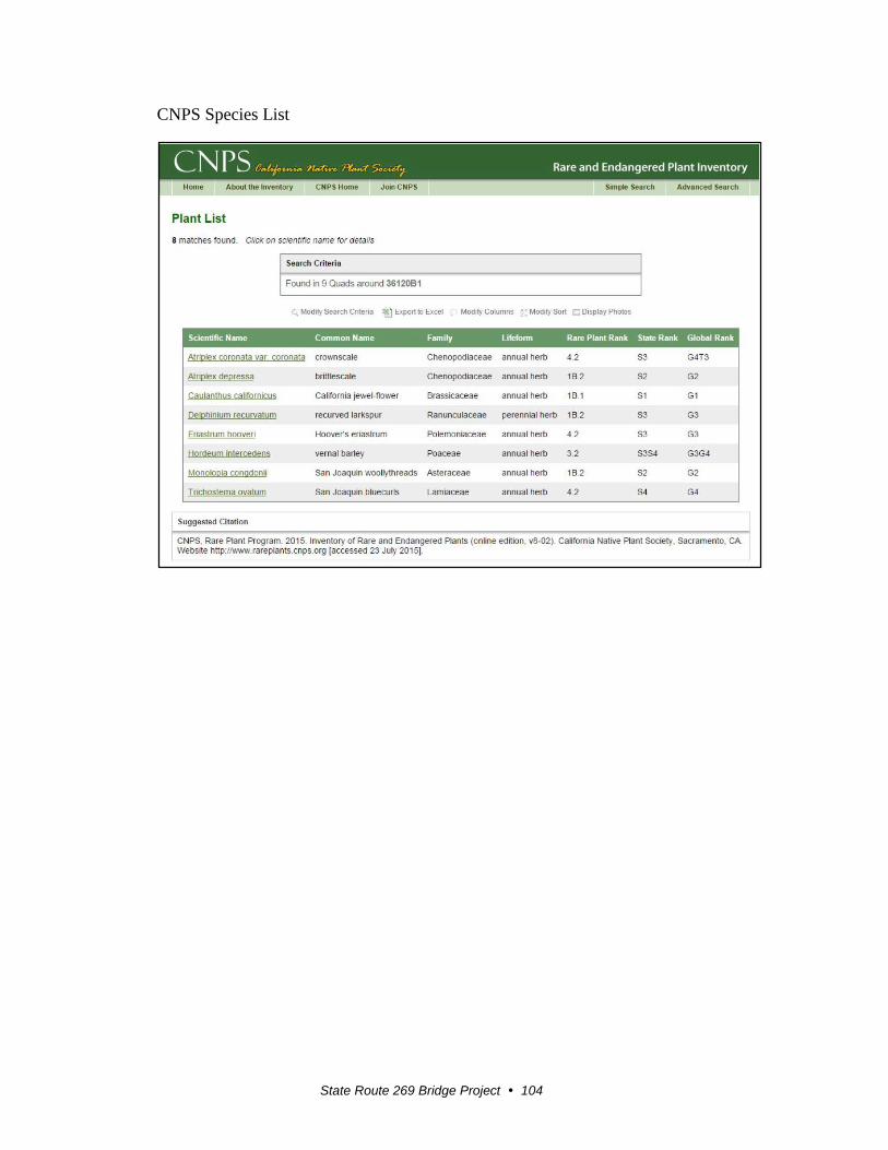
State Route 269 Bridge Project 104
CNPS Species List
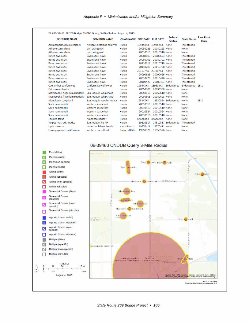
Appendix F Minimization and/or Mitigation Summary
State Route 269 Bridge Project 105
Appendix F Minimization and/or Mitigation Summary
State Route 269 Bridge Project 106
Appendix F Minimization and/or Mitigation Summary
The following section describes the avoidance, minimization and/or mitigation
measures that would be required for construction of the project.
Farmland
Acquisition of Williamson Act Contract land will require the following:
- Comply with the public acquisition process per GC §51291, or submit a
petition for partial cancellation to Fresno County for land required for the
project.
Utilities
All utility relocation work will be done by the affected utility companies. Utility
users will be informed of the date and time in advance of any service disruptions.
Emergency Services
A traffic management plan will be developed to minimize delays and maximize
safety during construction. The traffic management plan could include, but is not
limited to, the following:
- Release of information through brochures and mailers, press releases, and
advertisements managed by the public information office.
- Use of fixed and portable changeable message signs.
- Incident management through the Construction Zone Enhancement
Enforcement Program and the transportation management plan.
Traffic and Transportation/Pedestrian and Bicycle Facilities
A traffic management plan including, but not limited to the following:
Release of information through brochures and mailers, press releases, and
advertisements managed by the public information office.
Use of fixed and portable changeable message signs.
Incident management through the Construction Zone Enhancement Enforcement
Program and the transportation management center.
Use of one-way traffic control.
Construction of a detour road for use during construction.

Appendix F Minimization and/or Mitigation Summary
State Route 269 Bridge Project 107
Bridge railing required as appropriate for the safe travel of bicyclists.
Visual/Aesthetics
Provide bridge types and railings in keeping with the rural environment to
minimize visual impacts.
Slopes should not exceed a gradient of 1:3. Slopes that are designed at gradients
of 1:2 or steeper will require the written concurrence of the District Landscape
Architect, Maintenance, and the Stormwater Coordinator.
Tops and toes of slopes should be rounded to create a natural appearance.
All exposed disturbed soil areas will require permanent erosion control
application, which will restore the disturbed project area to natural vegetation.
Cultural Resources
Consulting Native American tribes and a Caltrans archaeologist will monitor
construction activities involving excavation as needed and determined by the
Caltrans archaeologist and Caltrans Native American Coordinator. If buried
cultural materials are encountered during construction, work will stop in that area
until a qualified archaeologist could evaluate the nature and significance of the
find.
If human remains are exposed during project activities, State Health and Safety
Code Section 7050.5 states that no further disturbance should occur until the
county coroner has made the necessary findings as to origin and disposition
pursuant to Public Resources Code 5097.98.
Water Quality and Stormwater Runoff
Design Features
To protect water quality, control erosion and prevent washout within the project
area, a training dike with rock slope protection along the dike embankments will
be used to protect the banks of the Arroyo Pasajero channel east and west of the
bridge.
Temporary Construction Measures
Standard temporary construction site measures—Pollution prevention
stormwater treatment best management practices will be used during and after
project construction to control potential discharges of pollutants to surface water.
Best management practices will be used to control general gross pollutants and
sedimentation/siltation, depending on location.
Stormwater Best Management Practices—A National Pollutant Discharge
Elimination System Stormwater Permit is required for the project along with any
subsequent permit in effect at the time of construction. The contractor must
comply with the requirements of the General National Pollutant Discharge
Appendix F Minimization and/or Mitigation Summary
State Route 269 Bridge Project 108
Elimination System Permit for Construction Activities. The contractor will use
best management practices as specified in the Caltrans Stormwater Management
Plan.
Prepare and Implement a Stormwater Pollution Prevention Plan—The
contractor will be required to develop an acceptable Stormwater Pollution
Prevention Plan. The Stormwater Pollution Prevention Plan will contain best
management practices that have demonstrated effectiveness at reducing
stormwater pollution. The Stormwater Pollution Prevention Plan will address all
construction-related activities, equipment, and materials with the potential to
affect water quality. All construction site best management practices will follow
the latest edition of the Stormwater Quality Handbooks and Construction Site
Best Management Practices Manual to control and minimize the impacts of
construction-related pollutants. The Stormwater Pollution Prevention Plan will
include best management practices to control pollutants, sediment from erosion,
stormwater runoff, and other construction-related impacts. In addition, the
Stormwater Pollution Prevention Plan will include the use of specific stormwater
effluent monitoring requirements based on the project’s risk level to ensure that
the best management practices are effective in preventing the degradation of any
water quality standards.
Hazardous Waste and Materials
The proposed project would have no significant adverse effect on hazardous waste
and materials because the following measures would reduce potential effects to
insignificance:
Special provisions would be included in the construction contract addressing the
potential hazardous materials/hazardous waste issues for lead and asbestos to
ensure proper handling, disposal, and worker/public safety.
Asbestos levels exceeded the regulatory threshold of 1.0%. Soil from Palmer
Avenue to Marmon Avenue will be encapsulated within the project area by
placing 6 inches of clean soil or paving over it, or the soil will be excavated to a
depth of 1 foot and hauled off as a hazardous waste.
Biological Resources—Natural Communities
Mitigation Measures (by way of reseeding)
In areas where saltbush scrub or cottonwood riparian habitat will be temporarily
affected by construction, mitigation will be required by way of reseeding and/or
revegetating the areas where the vegetation was removed. The temporary impact
areas will be restored to original grade and planted with native saltbrush and/or
cottonwood vegetation, where appropriate, after construction. Revegetation of the
saltbrush scrub will be required by the U.S. Fish and Wildlife Service per the San
Joaquin Kit Fox Protection Measures listed in Appendix H.
Appendix F Minimization and/or Mitigation Summary
State Route 269 Bridge Project 109
Wetlands and Other Waters
Avoidance, Minimization, and Mitigation Measures
Best management practices will be included so the smallest practical footprint will be
in place to minimize temporary, indirect, and permanent impacts to potential waters
of the United States. Work will take place only when Arroyo Pasajero Creek is dry.
In addition, the proposed project will incorporate standard Caltrans best management
practices to prevent impacts related to degradation of the Arroyo Pasajero Creek.
If Arroyo Pasajero Creek is determined to be jurisdictional, Caltrans will obtain
permits from the U.S. Army Corps of Engineers (404 Nationwide Permit), California
Regional Water Quality Control Board (401 Certification) and California Department
of Fish and Wildlife (1602 Streambed Alteration Agreement). These permits will
identify measures to mitigate impacts to the Arroyo Pasajero Creek. All proposed
permits are listed in section 1.5 “Permits and Approvals Needed” in this report.
To ensure no net loss of waters of the United States, one or more of the following
options can compensate for the permanent loss of waters, if Arroyo Pasajero Creek is
determined to be jurisdictional:
In-lieu fee payments may be required to compensate for impacts to jurisdictional
waters.
Dedication of mitigation lands for impacts to jurisdictional waters.
Development of an alternative mitigation plan for impacts to jurisdictional waters.
Plant Species Avoidance and Minimization Measures
Hoover’s eriastrum, recurved larkspur, and San Joaquin bluecurls
Preconstruction surveys will be completed during the appropriate blooming
periods prior to groundbreaking activities.
If a Hoover’s eriastrum, recurved larkspur, or San Joaquin bluecurls is observed
onsite, Caltrans will notify the California Department of Fish and Wildlife to
discuss conservation measures to be implemented.
Animal Species
Avoidance and Minimization Measures
Western spadefoot
A preconstruction survey will be performed within 30 days prior to construction if
a rain event sufficient to result in persistent puddles occurs in the biological study
area. Persistent puddles are those that would pool for 3 to 7 consecutive days.
Persistent rain pools discovered during the preconstruction surveys, or forming
during construction, will be designated as an Environmentally Sensitive Area
(ESA) and avoided where possible.

Appendix F Minimization and/or Mitigation Summary
State Route 269 Bridge Project 110
A qualified biological monitor will be present onsite during initial ground
disturbance.
Ground-disturbing night work may be restricted, especially on nights during or
following rain events of sufficient intensity to result in persistent puddles and
pools.
San Joaquin whipsnake
Preconstruction surveys will be conducted to avoid potential impacts to this
species.
A qualified biologist will be present at the construction site during initial ground-
disturbing activities.
Requiring low speed limits within the construction site will lessen the probability
that snakes could be run over by vehicles and equipment.
Burrowing owl
Preconstruction surveys will be performed within 500 feet of the project impact
area no more than 30 days prior to the start of construction to determine any
presence or sign of burrowing owl occupancy.
Active burrowing owl burrows will be protected by a 150-foot-radius
Environmentally Sensitive Area outside of the nesting season (September 1 to
January 31).
Active burrowing owl burrows will be protected by a 500-foot-radius
Environmentally Sensitive Area during the nesting season (February 1 to August
31).
If active burrows are located within a construction area that cannot be avoided by
a protection buffer, passive relocation efforts will be implemented by installing
one-way exclusion doors on burrow entrances, and providing artificial burrows
constructed nearby (within 50-100 yards if possible). A minimum of 6.5 acres of
contiguous foraging habitat will be available within a 300-foot radius around the
new burrow site per owl pair or resident single bird. All passive relocation work
will be performed by qualified biologists.
Occupied burrowing owl burrows discovered during the preconstruction surveys
and/or those protected by Environmentally Sensitive Area buffers will be
monitored by a qualified biologist during construction activities occurring in
proximity to the Environmentally Sensitive Area buffer.
All burrowing owls avoidance and minimization guidelines will conform to the
“Burrowing Owl Survey Protocol and Mitigation Guidelines” (California
Burrowing Owl Consortium, 1993).
Appendix F Minimization and/or Mitigation Summary
State Route 269 Bridge Project 111
Loggerhead shrike
Nesting surveys will be conducted during the nesting season (February 15 to
September 1) prior to the start of construction to determine if any loggerhead
shrikes are nesting within 250 feet of the project impact area.
If nesting loggerhead shrikes are observed onsite, then a 250-foot-radius
Environmentally Sensitive Area, will be established around the nest until it has
been determined by a qualified biologist that the young have fledged.
A qualified biologist will monitor active nests during construction activities
within the project 250-foot-radius Environmentally Sensitive Area.
A special provision for migratory birds will be included to ensure that no potential
nesting migratory birds are affected during construction.
Removal of trees within the project impact area will be done outside of the
nesting season. At this time, tree removal is not anticipated for construction of the
project.
American badger
A preconstruction survey will be performed by a qualified biologist no more than
30 days prior to the start of construction. If badgers are determined to be living
and/or foraging within the biological study area during surveys, avoidance
measures, such as Environmental Sensitive Area fencing, will be implemented
where feasible.
A qualified biological monitor will be present during initial ground-disturbing
activity. Any badgers discovered during project activity will be allowed to leave
the area free of harassment.
Migratory birds
Nesting surveys will be conducted during the nesting season (February 15 to
September 1) prior to the start of construction to determine what migratory birds
are nesting within 100 feet of the project impact area.
If nesting migratory birds are observed onsite, a qualified biologist will determine
if an Environmentally Sensitive Area is required.
If an Environmentally Sensitive Area is required, a qualified biologist will
monitor active nests during construction activities within the project. A 100-foot-
radius Environmentally Sensitive Area may be implemented.
A special provision for migratory birds will be included to ensure that no potential
nesting migratory birds are affected during construction.
Removal of trees within the project impact area will be done outside of the
nesting season. At this time, tree removal is not anticipated for construction of the
proposed project.
Appendix F Minimization and/or Mitigation Summary
State Route 269 Bridge Project 112
Threatened and Endangered Species
Avoidance and Minimization Measures
San Joaquin woolly-threads
Implementation of the following avoidance and minimization measures will reduce
the potential for adverse effects to the San Joaquin woolly-threads:
Caltrans will conduct preconstruction botanical surveys of the project footprint,
plus an additional 100-foot area outside the footprint using the California
Department of Fish and Wildlife’s Protocols for Surveying and Evaluating
Impacts to Special-Status Native Plant Populations and Natural Communities,
dated November 24, 2009, or the most recent guidelines.
If the San Joaquin woolly-threads is observed onsite, Caltrans will notify the U.S.
Fish and Wildlife Service and California Department of Fish and Wildlife to
discuss any additional conservation measures that should be implemented.
Blunt-nosed leopard lizard
Implementation of the following avoidance and minimization measures will reduce
the potential for adverse effects to the blunt-nosed leopard lizard:
Caltrans will conduct preconstruction surveys of the project footprint, plus an
additional 200-foot area outside the footprint using the California Department of
Fish and Wildlife’s May 2004 Approved Survey Methodology of the Blunt-nosed
Leopard Lizard in the year prior to the start of construction. The California
Department of Water Resources also plans to conduct surveys for the species in
2015 and 2016. To avoid duplication of effort, Caltrans and the California
Department of Water Resources’ proposed survey areas will not overlap. The
two agencies will coordinate and share data concerning these future surveys. If
the species is found within the project area by either agency, Caltrans will
contact the Service to discuss measures to avoid take of the blunt-nosed leopard
lizard.
A qualified biologist will be onsite during initial ground disturbing activities.
Caltrans will enforce low speed limits (maximum 10 miles per hour) within the
project area, which will reduce the risk that the blunt-nosed leopard lizard is run
over by construction vehicles/equipment.
Swainson’s hawk
With implementation of the following avoidance and minimization measures, no
direct impacts to the Swainson’s hawk are expected to occur:
Protocol nesting surveys will be conducted during the nesting season prior to the
start of construction to determine if any Swainson’s hawks are nesting in
proximity to the proposed project.
Appendix F Minimization and/or Mitigation Summary
State Route 269 Bridge Project 113
Coordination and data-sharing with Department of Water Resources personnel
regarding their Swainson’s hawk survey efforts in 2015 and 2016 will be ongoing.
If nesting Swainson’s hawks are observed, the nest site will be designated an
Environmentally Sensitive Area within a 600-foot radius around the nest until it
has been determined by a qualified biologist that the young have fledged.
A qualified biologist will monitor active nests during construction activities.
A special provision for migratory birds will be included to ensure that no potential
nesting migratory birds are affected during construction.
Removal of trees within the project impact area will be done outside of the
nesting season (tree removal is not anticipated at this time).
San Joaquin antelope squirrel
With implementation of the following avoidance and minimization measures, no
impacts to an individual San Joaquin antelope squirrel are expected to occur:
Preconstruction surveys will be performed within 30 days prior to construction to
determine if the species occurs in the project area. If occupied suitable habitat is
observed during surveys, avoidance measures, such as Environmentally Sensitive
Area fencing, will be implemented where feasible.
A qualified biological monitor will be present at the construction site during
initial ground-disturbing activities. A California Department of Fish and Wildlife-
approved biologist will relocate San Joaquin antelope squirrels if necessary.
Giant kangaroo rat and Tipton kangaroo rat
Implementation of the following avoidance and minimization measures will reduce
the potential for adverse effects to the giant kangaroo rat and Tipton kangaroo rat:
Trapping surveys will be conducted no more than 30 days prior to construction. If
occupied suitable habitat is observed during the surveys, Caltrans will discuss the
implementation of avoidance measures with the U.S. Fish and Wildlife Service.
A qualified biologist will be present onsite during initial ground-disturbing
activities. If either of the two species is detected and requires removal from the
project site, the biologist must hold a section 10(a)(1)(A) permit for the particular
kangaroo rat species identified.
San Joaquin kit fox
Implementation of the following avoidance and minimization measures will reduce
the potential for adverse effects to the San Joaquin kit fox:
Preconstruction surveys will be conducted no less than 14 days and no more than
30 days prior to the beginning of ground disturbance and/or construction
Appendix F Minimization and/or Mitigation Summary
State Route 269 Bridge Project 114
activities. Surveys for the San Joaquin kit fox and its dens will be performed
throughout the project footprint as well as within 200 feet of the footprint.
A qualified biologist will conduct an environmental awareness training program
for all construction personnel, covering the status of the San Joaquin kit fox, the
importance of avoiding impacts to the species, and the penalties for not
complying with minimization requirements. New construction personnel who are
added to the project after the training is first conducted also will be required to
take the training.
A qualified biologist will be present onsite during initial ground-disturbing
activities. To the extent possible, the biologist also will be available on-call when
not present onsite.
Disturbance to all San Joaquin kit fox dens will be avoided to the maximum
extent possible.
- Potential and atypical dens that are at least 50 feet from construction will be
protected with a 50-foot zone. Known dens that are located at least 100 feet
from construction will be protected with a 100-foot zone. In instances where
50-foot or 100-foot exclusion zones cannot be maintained, potential and/or
known dens will be monitored; once these dens are verified to be unoccupied,
they will be blocked temporarily (via sandbagging of a one-way door) for the
duration of the project.
- If a natal/pupping den is discovered either within the project footprint or
within 200 feet of the footprint, Caltrans will notify the U.S. Fish and Wildlife
Service immediately.
All food-related trash items such as wrappers, cans, bottles, and food scraps will
be disposed of in closed containers and removed daily from the project site to
reduce the potential for attracting predator species.
No pets or firearms will be allowed on the project site.
The U.S. Fish and Wildlife Service Standard Measures for Protection of the San
Joaquin Kit Fox for Prior to or During Ground Disturbance, Construction and
On-Going Operational Requirements will also be implemented (Appendix H).
Invasive Species
Avoidance and Minimization Measures
In compliance with the Executive Order on Invasive Species, Executive Order
13112, and guidance from the Federal Highway Administration, the landscaping
and erosion control included in the project will not use species listed as invasive.
In areas of particular sensitivity, extra precautions will be taken if invasive
species are found in or next to the construction areas. These include the inspection
and cleaning of construction equipment and eradication strategies to be
implemented should an invasion occur.
Appendix F Minimization and/or Mitigation Summary
State Route 269 Bridge Project 115
To prevent the introduction and spread of invasive species, Caltrans has issued
policy guidelines that provide a framework for addressing roadside vegetation
management issues for construction activities and maintenance programs. The
Caltrans invasive species policy guidelines, Standard Special Provisions, and best
management practices would minimize the potential that this project would
introduce, transport, or spread invasive species to and/or from the project site.
Climate Change/Air Quality
Caltrans Standard specifications pertaining to dust control and dust palliative
requirements will reduce and control emission impacts during construction.

State Route 269 Bridge Project 116
Appendix G List of Proposed Species and Critical Habitat Potentially Occurring or Known to Occur in the Project Area
Species Status(1) Possible in
Which Habitat Type
Ac. Habitat Impacts
Perm/Temp
Species Impacts
Expected After AMMs(2)?
FESA Determination
California jewel-
flower FE, SE
Ruderal, but not
in alkaline soils 3.79/47.71
No, unlikely to
occur onsite. No effect.
San Joaquin
woolly-threads FE
Ruderal and salt-
brush 3.97/53.61
No, unlikely to
occur onsite.
May affect, not
likely to adversely
affect.
Vernal pool fairy
shrimp FT Vernal pools 0
No, no habitat
onsite. No effect.
Valley elderberry
longhorn beetle FT
Elderberry
bushes, usually
in riparian areas
0 No, no habitat
onsite. No effect.
Delta smelt FT
Semi-saline
aquatic habitat in
the Bay Delta
region
0
No, no habitat
onsite, not
upstream of
suitable habitat.
No effect.
California tiger
salamander, central
population
FT
Vernal pools in
open grasslands
and brushy
habitats
0 No, no habitat
onsite. No effect.
California red-
legged frog FT
Pools, ponds,
slow streams and
adjacent riparian
areas
0 No, no habitat
onsite. No effect.
Blunt-nosed
leopard lizard
FE, SE,
FP
Entire project
area except
borrow site
(vegetation too
dense)
5.22/38.6 No, unlikely to
occur onsite.
May affect, not
likely to adversely
affect.
Giant garter snake FT
Marshes and
aquatic habitats
with slow water,
and adjacent
uplands
0 No, no habitat
onsite. No effect.
Giant kangaroo rat FE, SE
Entire project
area except
borrow site
(vegetation too
dense)
5.22/38.6 No, unlikely to
occur onsite.
May affect, not
likely to adversely
affect.

Appendix G List of Proposed Species and Critical Habitat Potentially Occurring or Known to Occur in the Project
State Route 269 Bridge Project 117
Species Status(1) Possible in
Which Habitat Type
Ac. Habitat Impacts
Perm/Temp
Species Impacts
Expected After AMMs(2)?
FESA Determination
Fresno kangaroo rat FE, SE
Entire project
area except
borrow site
(vegetation too
dense)
5.22/38.6 No, unlikely to
occur onsite. No affect.
Tipton kangaroo rat FE, SE
Entire project
area except
borrow site
(vegetation too
dense)
5.22/38.6 No, unlikely to
occur onsite.
May affect, not
likely to adversely
affect.
San Joaquin kit fox FE, ST
Entire project
area except
borrow site
(vegetation too
dense)
5.22/38.6
Possible. Species
not observed but
may occur
onsite.
May affect, not
likely to adversely
affect.
State Route 269 Bridge Project 118
Appendix H San Joaquin Kit Fox Protection Measures
U.S. FISH AND WILDLIFE
SERVICE STANDARDIZED
RECOMMENDATIONS
FOR PROTECTION OF THE ENDANGERED SAN
JOAQUIN KIT FOX PRIOR TO OR DURING GROUND
DISTURBANCE
Prepared by the Sacramento Fish and Wildlife
Office
January
2011
INTRODUCTION
The following document includes many of the San Joaquin kit fox (Vulpes macrotis
mutica) protection measures typically recommended by the U. S. Fish and Wildlife
Service (Service), prior to and during ground disturbance activities. However,
incorporating relevant sections of these guidelines into the proposed project is
not the only action required under the Endangered Species Act of 1973, as
amended (Act) and does not preclude the need for section 7 consultation or a
section 10 incidental take permit for the proposed project. Project applicants
should contact the Service in Sacramento to determine the full range of
requirements that apply to your project; the address and telephone number are
given at the end of this document. Implementation of the measures presented in
this document may be necessary to avoid violating the provisions of the Act,
including the prohibition against "take" (defined as killing, harming, or harassing a
listed species, including actions that damage or destroy its habitat). These
protection measures may also be required under the terms of a biological opinion
pursuant to section 7 of the Act resulting in incidental take authorization
(authorization), or an incidental take permit (permit) pursuant to section 10 of the
Act. The specific measures implemented to protect kit fox for any given project
shall be determined by the Service based upon the applicant's consultation with the
Service.
The purpose of this document is to make information on kit fox protection
strategies readily available and to help standardize the methods and definitions
currently employed to achieve kit fox protection. The measures outlined in this
document are subject to modification or revision at the discretion of the Service.
Appendix H San Joaquin Kit Fox Protection Measures
State Route 269 Bridge Project 119
IS A PERMIT NECESSARY?
Certain acts need a permit from the Service which includes destruction of any
known (occupied or unoccupied) or natal/pupping kit fox dens. Determination
of the presence or absence of kit foxes and /or their dens should be made during the
environmental review process. All surveys and monitoring described in this
document must be conducted by a qualified biologist and these activities do not
require a permit. A qualified biologist (biologist) means any person who has
completed at least four years of university training in wildlife biology or a related
science and/or has demonstrated field experience in the identification and life
history of the San Joaquin kit fox. In addition, the biologist(s) must be able to
identify coyote, red fox, gray fox, and kit fox tracks, and to have seen a kit fox in
the wild, at a zoo, or as a museum mount. Resumes of biologists should be
submitted to the Service for review and approval prior to an6y survey or
monitoring work occurring.
SMALL PROJECTS
Small projects are considered to be those projects with small foot prints, of
approximately one acre or less, such as an individual in-fill oil well,
communication tower, or bridge repairs. These projects must stand alone and not
be part of, or in any way connected to larger projects (i.e., bridge repair or
improvement to serve a future urban development). The Service recommends that
on these small projects, the biologist survey the proposed project boundary and a
200-foot area outside of the project footprint to identify habitat features and utilize
this information as guidance to situate the project to minimize or avoid impacts. If
habitat features cannot be completely avoided, then surveys should be conducted
and the Service should be contacted for technical assistance to determine the extent
of possible take.
Preconstruction/preactivity surveys shall be conducted no less than 14 days and no
more than 30 days prior to the beginning of ground disturbance and/or construction
activities or any project activity likely to impact the San Joaquin kit fox. Kit foxes
change dens four or five times during the summer months, and change natal dens
one or two times per month (Morrell 1972). Surveys should identify kit fox habitat
features on the project site and evaluate use by kit fox and, if possible, assess the
potential impacts to the kit fox by the proposed activity. The status of all dens
should be determined and mapped (see Survey Protocol). Written results of
preconstruction/preactivity surveys must be received by the Service within five
days after survey completion and prior to the start of ground disturbance and/or
construction activities.
If a natal/pupping den is discovered within the project area or within 200-feet
of the project boundary, the Service shall be immediately notified and under
no circumstances should the den be disturbed or destroyed without prior
authorization. If the preconstruction/preactivity survey reveals an active
Appendix H San Joaquin Kit Fox Protection Measures
State Route 269 Bridge Project 120
natal pupping or new information, the project applicant should contact the
Service immediately to obtain the necessary take authorization/permit.
If the take authorization/permit has already been issued, then the biologist may
proceed with den destruction within the project boundary, except natal/pupping den
which may not be destroyed while occupied. A take authorization/permit is
required to destroy these dens even after they are vacated. Protective exclusion
zones can be placed around all known and potential dens which occur outside the
project footprint (conversely, the project boundary can be demarcated, see den
destruction section).
OTHER PROJECTS
It is likely that all other projects occurring within kit fox habitat will require a take
authorization/permit from the Service. This determination would be made by the
Service during the early evaluation process (see Survey Protocol). These other
projects would include, but are not limited to: Linear projects; projects with large
footprints such as urban development; and projects which in themselves may be
small but have far reaching impacts (i.e., water storage or conveyance facilities that
promote urban growth or agriculture, etc.).
The take authorization/permit issued by the Service may incorporate some or all of
the protection measures presented in this document. The take authorization/permit
may include measures specific to the needs of the project and those requirements
supersede any requirements found in this document.
EXCLUSION ZONES
In order to avoid impacts, construction activities must avoid their dens. The
configuration of exclusion zones around the kit fox dens should have a radius
measured outward from the entrance or cluster of entrances due to the length of
dens underground. The following distances are minimums, and if they cannot be
followed the Service must be contacted. Adult and pup kit foxes are known to
sometimes rest and play near the den entrance in the afternoon, but most above-
ground activities begin near sunset and continue sporadically throughout the night.
Den definitions are attached as Exhibit A.
Potential den** - 50feet
Atypical den** - 50 feet
Known den* - 100 feet
Natal/pupping den (occupied and unoccupied) - Service must be contacted
Appendix H San Joaquin Kit Fox Protection Measures
State Route 269 Bridge Project 121
*Known den: To ensure protection, the exclusion zone should be demarcated by
fencing that encircles each den at the appropriate distance and does not prevent
access to the den by kit foxes. Acceptable fencing includes untreated wood particle-
board, silt fencing, orange construction fencing or other fencing as approved by the
Service as long as it has openings for kit fox ingress/egress and keeps humans and
equipment out. Exclusion zone fencing should be maintained until all construction
related or operational disturbances have been terminated. At that time, all fencing
shall be removed to avoid attracting subsequent attention to the dens.
**Potential and Atypical dens: Placement of 4-5 flagged stakes 50 feet from the den
entrance(s) will suffice to identify the den location; fencing will not be required, but
the exclusion zone must be observed.
Only essential vehicle operation on existing roads and foot traffic should be
permitted. Otherwise, all construction, vehicle operation, material storage, or
any other type of surface- disturbing activity should be prohibited or greatly
restricted within the exclusion zones.
DESTRUCTION OF DENS
Limited destruction of kit fox dens may be allowed, if avoidance is not a
reasonable alternative, provided the following procedures are observed. The value
to kit foxes of potential, known, and natal/pupping dens differ and therefore, each
den type needs a different level of protection. Destruction of any known or
natal/pupping kit fox den requires take authorization/permit from the
Service.
Destruction of the den should be accomplished by careful excavation until it is
certain that no kit foxes are inside. The den should be fully excavated, filled with
dirt and compacted to ensure that kit foxes cannot reenter or use the den during the
construction period. If at any point during excavation, a kit fox is discovered inside
the den, the excavation activity shall cease immediately and monitoring of the den
as described above should be resumed. Destruction of the den may be completed
when in the judgment of the biologist, the animal has escaped, without further
disturbance, from the partially destroyed den.
Natal/pupping dens: Natal or pupping dens which are occupied will not be
destroyed until the pups and adults have vacated and then only after consultation
with the Service. Therefore, project activities at some den sites may have to be
postponed.
Known dens: Known dens occurring within the footprint of the activity must be
monitored for three days with tracking medium or an infra-red beam camera to
determine the current use. If no kit fox activity is observed during this period, the
den should be destroyed immediately to preclude subsequent use.

Appendix H San Joaquin Kit Fox Protection Measures
State Route 269 Bridge Project 122
If kit fox activity is observed at the den during this period, the den should be
monitored for at least five consecutive days from the time of the observation to
allow any resident animal to move to another den during its normal activity. Use of
the den can be discouraged during this period
by partially plugging its entrances(s) with soil in such a manner that any resident
animal can escape easily. Only when the den is determined to be unoccupied may
the den be excavated under the direction of the biologist. If the animal is still
present after five or more consecutive days of plugging and monitoring, the den
may have to be excavated when, in the judgment of a biologist, it is temporarily
vacant, for example during the animal's normal foraging activities. The Service encourages hand excavation, but realizes that soil conditions
may necessitate the use of excavating equipment. However, extreme caution
must be exercised.
Potential dens: If a take authorization/permit has been obtained from the Service,
den destruction may proceed without monitoring, unless other restrictions were
issued with the take authorization/permit. If no take authorization/permit has been
issued, then potential dens should be monitored as if they were known dens. If any
den was considered to be a potential den, but is later determined during monitoring
or destruction to be currently, or previously used by kit fox (e.g., if kit fox sign is
found inside), then all construction activities shall cease and the Service shall be
notified immediately.
CONSTRUCTION AND ONGOING OPERATIONAL REQUIREMENTS
Habitat subject to permanent and temporary construction disturbances and other
types of ongoing project-related disturbance activities should be minimized by
adhering to the following activities. Project designs should limit or cluster
permanent project features to the smallest area possible while still permitting
achievement of project goals. To minimize temporary disturbances, all project-
related vehicle traffic should be restricted to established roads, construction areas,
and other designated areas. These areas should also be included in
preconstruction surveys and, to the extent possible, should be established in
locations disturbed by previous activities to prevent further impacts.
1. Project-related vehicles should observe a daytime speed limit of 20-mph
throughout the site in all project areas, except on county roads and State and
Federal highways; this is particularly important at night when kit foxes are most
active. Night-time construction should be minimized to the extent possible.
However if it does occur, then the speed limit should be reduced to 10-mph. Off-
road traffic outside of designated project areas should be prohibited.
2. To prevent inadvertent entrapment of kit foxes or other animals during the
construction phase of a project, all excavated, steep-walled holes or trenches more
than 2-feet deep should be covered at the close of each working day by plywood or

Appendix H San Joaquin Kit Fox Protection Measures
State Route 269 Bridge Project 123
similar materials. If the trenches cannot be closed, one or more escape ramps
constructed of earthen-fill or wooden planks shall be installed. Before such holes
or trenches are filled, they should be thoroughly inspected for trapped animals. If
at any time a trapped or injured kit fox is discovered, the Service and the
California Department of Fish and Game (CDFG) shall be contacted as noted
under measure 13 referenced below.
3. Kit foxes are attracted to den-like structures such as pipes and may enter stored
pipes and become trapped or injured. All construction pipes, culverts, or similar
structures with a diameter of 4-inches or greater that are stored at a construction
site for one or more overnight periods should be thoroughly inspected for kit foxes
before the pipe is subsequently buried, capped, or otherwise used or moved in any
way. If a kit fox is discovered inside a pipe, that section of pipe should not be
moved until the Service has been consulted. If necessary, and under the direct
supervision of the biologist, the pipe may be moved only once to remove it from
the path of construction activity, until the fox has escaped.
4. All food-related trash items such as wrappers, cans, bottles, and food scraps
should be disposed of in securely closed containers and removed at least once a
week from a construction or project site.
5. No firearms shall be allowed on the project site.
6. No pets, such as dogs or cats, should be permitted on the project site to
prevent harassment, mortality of kit foxes, or destruction of dens.
7. Use of rodenticides and herbicides in project areas should be restricted. This is
necessary to prevent primary or secondary poisoning of kit foxes and the depletion
of prey populations on which they depend. All uses of such compounds should
observe label and other restrictions mandated by the U.S. Environmental Protection
Agency, California Department of Food and Agriculture, and other State and
Federal legislation, as well as additional project-related restrictions deemed
necessary by the Service. If rodent control must be conducted, zinc phosphide
should be used because of a proven lower risk to kit fox.
8. A representative shall be appointed by the project proponent who will be the
contact source for any employee or contractor who might inadvertently kill or
injure a kit fox or who finds a dead, injured or entrapped kit fox. The
representative will be identified during the employee education program and their
name and telephone number shall be provided to the Service.
9. An employee education program should be conducted for any project that has
anticipated impacts to kit fox or other endangered species. The program should
consist of a brief presentation by persons knowledgeable in kit fox biology and
legislative protection to explain endangered species concerns to contractors, their
employees, and military and/or agency personnel involved in the project. The
Appendix H San Joaquin Kit Fox Protection Measures
State Route 269 Bridge Project 124
program should include the following: A description of the San Joaquin kit fox
and its habitat needs; a report of the occurrence of kit fox in the project area; an
explanation of the status of the species and its protection under the Endangered
Species Act; and a list of measures being taken to reduce impacts to the species
during project construction and implementation. A fact sheet conveying this
information should be prepared for distribution to the previously referenced people
and anyone else who may enter the project site.
10. Upon completion of the project, all areas subject to temporary ground
disturbances, including storage and staging areas, temporary roads, pipeline
corridors, etc. should be re-contoured if necessary, and revegetated to promote
restoration of the area to pre- project conditions. An area subject to "temporary"
disturbance means any area that is disturbed during the project, but after project
completion will not be subject to further disturbance and has the potential to be
revegetated. Appropriate methods and plant species used to revegetate such
areas should be determined on a site-specific basis in consultation with the
Service, California Department of Fish and Game (CDFG), and revegetation
experts.
11. In the case of trapped animals, escape ramps or structures should be installed
immediately to allow the animal(s) to escape, or the Service should be
contacted for guidance.
12. Any contractor, employee, or military or agency personnel who are responsible
for inadvertently killing or injuring a San Joaquin kit fox shall immediately report
the incident to their representative. This representative shall contact the CDFG
immediately in the case of a dead, injured or entrapped kit fox. The CDFG
contact for immediate assistance is State Dispatch at (916)445-0045. They will
contact the local warden or Mr. Paul Hoffman, the wildlife biologist, at (530)934-
9309. The Service should be contacted at the numbers below.
13. The Sacramento Fish and Wildlife Office and CDFG shall be notified in writing
within three working days of the accidental death or injury to a San Joaquin kit fox
during project related activities. Notification must include the date, time, and
location of the incident or of the finding of a dead or injured animal and any other
pertinent information. The Service contact is the Chief of the Division of
Endangered Species, at the addresses and telephone numbers below. The CDFG
contact is Mr. Paul Hoffman at 1701 Nimbus Road, Suite A, Rancho Cordova,
California 95670, (530) 934-9309.
14. New sightings of kit fox shall be reported to the California Natural Diversity
Database (CNDDB). A copy of the reporting form and a topographic map clearly
marked with the location of where the kit fox was observed should also be
provided to the Service at the address below.

Appendix H San Joaquin Kit Fox Protection Measures
State Route 269 Bridge Project 125
Any project-related information required by the Service or questions
concerning the above conditions or their implementation may be directed in
writing to the U.S. Fish and Wildlife Service at:
Endangered Species Division
2800 Cottage Way, Suite W2605
Sacramento, California 95825-1846
(916) 414-6620 or (916) 414-6600
EXHIBIT “A” - DEFINITIONS
"Take" - Section 9 of the Endangered Species Act of 1973, as amended (Act) prohibits
the "take" of any federally listed endangered species by any person (an individual,
corporation, partnership, trust, association, etc.) subject to the jurisdiction of the United
States. As defined in the Act, take means "to harass, harm, pursue, hunt, shoot, wound,
kill, trap, capture, or collect, or attempt to engage in any such conduct". Thus, not only
is a listed animal protected from activities such as hunting, but also from actions that
damage or destroy its habitat.
"Dens" - San Joaquin kit fox dens may be located in areas of low, moderate, or steep
topography. Den characteristics are listed below, however, the specific characteristics of
individual dens may vary and occupied dens may lack some or all of these features.
Therefore, caution must be exercised in determining the status of any den. Typical dens
may include the following: (1) one or more entrances that are approximately 5 to 8
inches in diameter; (2) dirt berms adjacent to the entrances; (3) kit fox tracks, scat, or
prey remains in the vicinity of the den; (4) matted vegetation adjacent to the den
entrances; and (5) manmade features such as culverts, pipes, and canal banks.
"Known den" - Any existing natural den or manmade structure that is used or has
been used at any time in the past by a San Joaquin kit fox. Evidence of use may
include historical records, past or current radiotelemetry or spotlighting data, kit fox
sign such as tracks, scat, and/or prey remains, or other reasonable proof that a given
den is being or has been used by a kit fox. The Service discourages use of the terms
”active” and “inactive” when referring to any kit fox den because a great percentage
of occupied dens show no evidence of use, and because kit foxes change dens often,
with the result that the status of a given den may change frequently and abruptly.
"Potential Den" - Any subterranean hole within the species’ range that has entrances
of appropriate dimensions for which available evidence is insufficient to conclude
that it is being used or has been used by a kit fox. Potential dens shall include the
following: (1) any suitable subterranean hole; or (2) any den or burrow of another
species (e.g., coyote, badger, red fox, or ground squirrel) that otherwise has
appropriate characteristics for kit fox use.
Appendix H San Joaquin Kit Fox Protection Measures
State Route 269 Bridge Project 126
"Natal or Pupping den" - Any den used by kit foxes to whelp and/or rear their pups.
Natal/pupping dens may be larger with more numerous entrances than dens occupied
exclusively by adults. These dens typically have more kit fox tracks, scat, and prey
remains in the vicinity of the den, and may have a broader apron of matted dirt and/or
vegetation at one or more entrances. A natal den, defined as a den in which kit fox pups
are actually whelped but not necessarily reared, is a more restrictive version of the
pupping den. In practice, however, it is difficult to distinguish between the two,
therefore, for purposes of this definition either term applies.
"Atypical den" - Any manmade structure which has been or is being occupied by a San
Joaquin kit fox. Atypical dens may include pipes, culverts, and diggings beneath
concrete slabs and buildings.

State Route 269 Bridge Project 127

State Route 269 Bridge Project 128
Appendix I Comments and Responses
This appendix contains the comments received during the public review and
comment period. A Caltrans response follows each comment.

State Route 269 Bridge Project 129
1
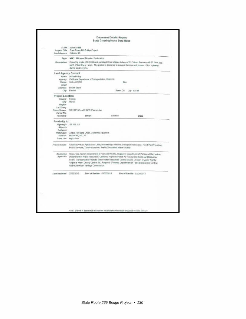
State Route 269 Bridge Project 130

State Route 269 Bridge Project 131
Response to Comments from the Governor’s Office of Planning and Research, State Clearinghouse and Planning Unit
Thank you for your comments on the project.
Response to comment 1: The State Clearinghouse confirmed that the Draft
Mitigated Negative Declaration was submitted to selected State agencies for
review and no comments were received. The Clearinghouse acknowledges
that Caltrans complied with the review requirements for the draft
environmental document pursuant to the California Environmental Quality
Act.
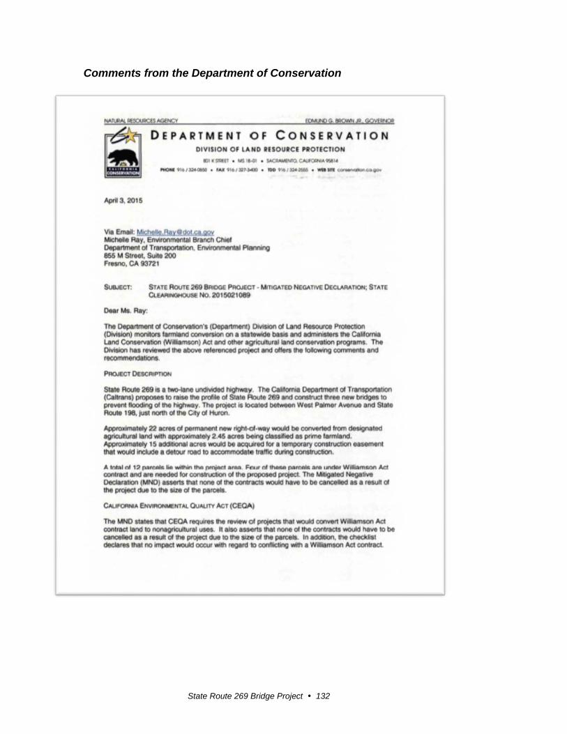
State Route 269 Bridge Project 132
Comments from the Department of Conservation

State Route 269 Bridge Project 133
1
2
3
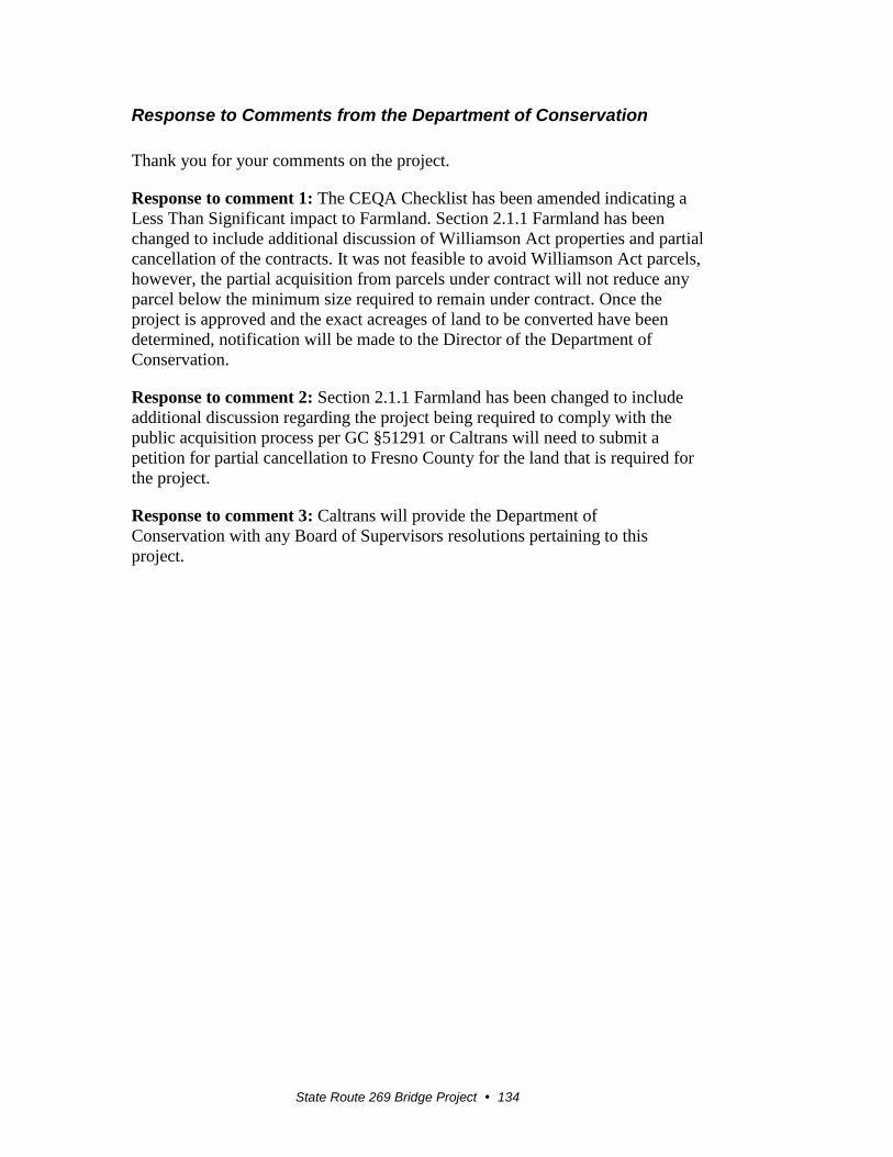
State Route 269 Bridge Project 134
Response to Comments from the Department of Conservation
Thank you for your comments on the project.
Response to comment 1: The CEQA Checklist has been amended indicating a
Less Than Significant impact to Farmland. Section 2.1.1 Farmland has been
changed to include additional discussion of Williamson Act properties and partial
cancellation of the contracts. It was not feasible to avoid Williamson Act parcels,
however, the partial acquisition from parcels under contract will not reduce any
parcel below the minimum size required to remain under contract. Once the
project is approved and the exact acreages of land to be converted have been
determined, notification will be made to the Director of the Department of
Conservation.
Response to comment 2: Section 2.1.1 Farmland has been changed to include
additional discussion regarding the project being required to comply with the
public acquisition process per GC §51291 or Caltrans will need to submit a
petition for partial cancellation to Fresno County for the land that is required for
the project.
Response to comment 3: Caltrans will provide the Department of
Conservation with any Board of Supervisors resolutions pertaining to this
project.
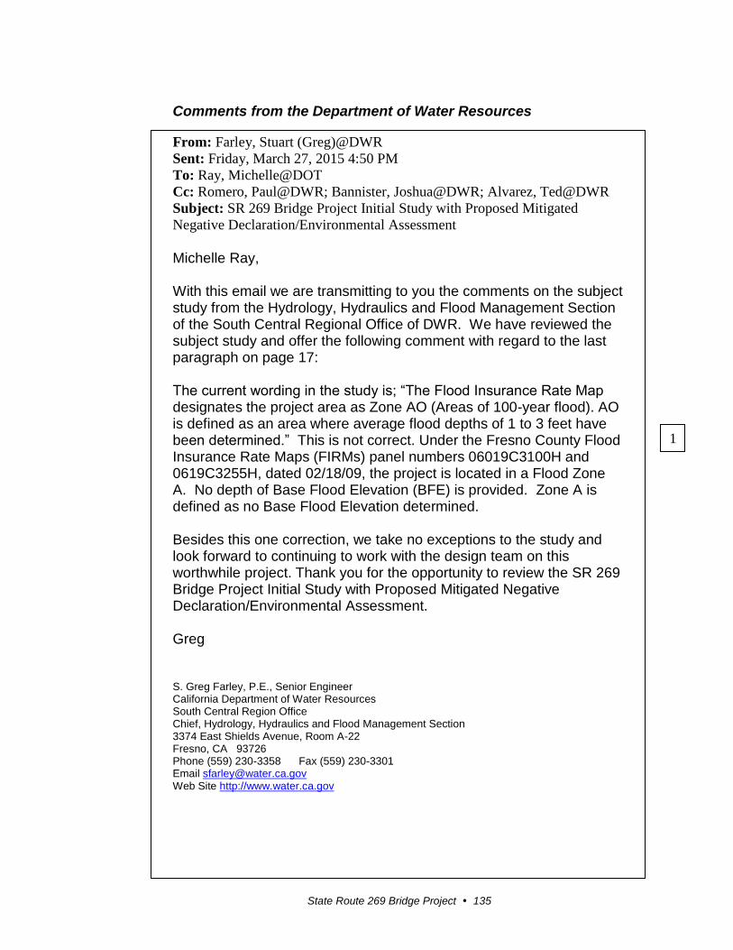
State Route 269 Bridge Project 135
Comments from the Department of Water Resources
From: Farley, Stuart (Greg)@DWR
Sent: Friday, March 27, 2015 4:50 PM
To: Ray, Michelle@DOT
Cc: Romero, Paul@DWR; Bannister, Joshua@DWR; Alvarez, Ted@DWR
Subject: SR 269 Bridge Project Initial Study with Proposed Mitigated
Negative Declaration/Environmental Assessment
Michelle Ray, With this email we are transmitting to you the comments on the subject study from the Hydrology, Hydraulics and Flood Management Section of the South Central Regional Office of DWR. We have reviewed the subject study and offer the following comment with regard to the last paragraph on page 17: The current wording in the study is; “The Flood Insurance Rate Map designates the project area as Zone AO (Areas of 100-year flood). AO is defined as an area where average flood depths of 1 to 3 feet have been determined.” This is not correct. Under the Fresno County Flood Insurance Rate Maps (FIRMs) panel numbers 06019C3100H and 0619C3255H, dated 02/18/09, the project is located in a Flood Zone A. No depth of Base Flood Elevation (BFE) is provided. Zone A is defined as no Base Flood Elevation determined. Besides this one correction, we take no exceptions to the study and look forward to continuing to work with the design team on this worthwhile project. Thank you for the opportunity to review the SR 269 Bridge Project Initial Study with Proposed Mitigated Negative Declaration/Environmental Assessment. Greg
S. Greg Farley, P.E., Senior Engineer California Department of Water Resources South Central Region Office Chief, Hydrology, Hydraulics and Flood Management Section 3374 East Shields Avenue, Room A-22 Fresno, CA 93726 Phone (559) 230-3358 Fax (559) 230-3301 Email [email protected] Web Site http://www.water.ca.gov
1

State Route 269 Bridge Project 136
Response to Comments from the Department of Water Resources
Thank you for your comments on the project.
Response to comment 1: It has been determined that the project is located in
both Flood Zone AO and Flood Zone A as shown on Flood Insurance Rate Map
(FIRM) #06019C3255H and FIRM #06019C3100H, dated February 18, 2009.
Zone AO (post miles 10.4 to 12.227) is defined as an area with “Flood Depths of
1 to 3 feet (usually sheet flow on sloping terrain); average depths determined. For
areas of alluvial fan folding, velocities also are determined. Zone A (Post Mile
12.227/12.5) is defined as No Base Flood Elevations determined.
Section 2.3.1 Hydrology and Floodplain has been amended to include the
clarification regarding the flood zones. An addendum to the Location Hydraulic
Study is identified in the memorandum attached to the study in the technical
appendices of the final environmental document.
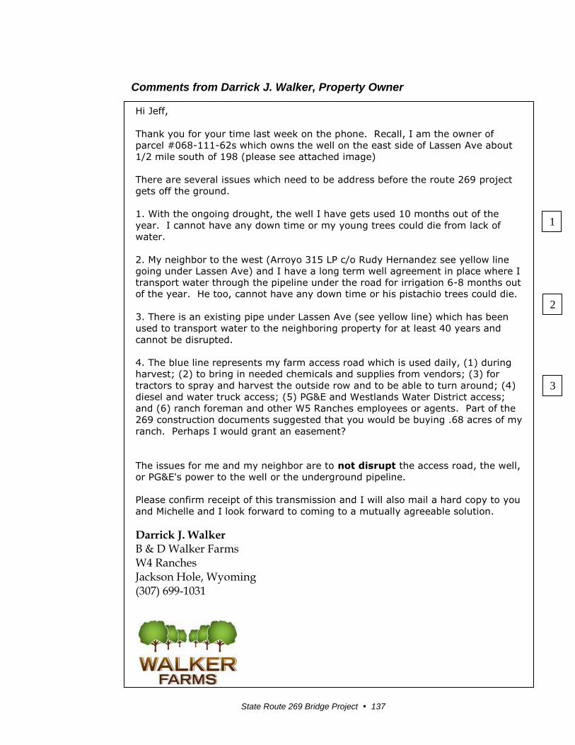
State Route 269 Bridge Project 137
Comments from Darrick J. Walker, Property Owner
Hi Jeff,
Thank you for your time last week on the phone. Recall, I am the owner of
parcel #068-111-62s which owns the well on the east side of Lassen Ave about
1/2 mile south of 198 (please see attached image)
There are several issues which need to be address before the route 269 project
gets off the ground.
1. With the ongoing drought, the well I have gets used 10 months out of the
year. I cannot have any down time or my young trees could die from lack of
water.
2. My neighbor to the west (Arroyo 315 LP c/o Rudy Hernandez see yellow line
going under Lassen Ave) and I have a long term well agreement in place where I
transport water through the pipeline under the road for irrigation 6-8 months out
of the year. He too, cannot have any down time or his pistachio trees could die.
3. There is an existing pipe under Lassen Ave (see yellow line) which has been
used to transport water to the neighboring property for at least 40 years and
cannot be disrupted.
4. The blue line represents my farm access road which is used daily, (1) during
harvest; (2) to bring in needed chemicals and supplies from vendors; (3) for
tractors to spray and harvest the outside row and to be able to turn around; (4)
diesel and water truck access; (5) PG&E and Westlands Water District access;
and (6) ranch foreman and other W5 Ranches employees or agents. Part of the
269 construction documents suggested that you would be buying .68 acres of my
ranch. Perhaps I would grant an easement?
The issues for me and my neighbor are to not disrupt the access road, the well,
or PG&E's power to the well or the underground pipeline.
Please confirm receipt of this transmission and I will also mail a hard copy to you
and Michelle and I look forward to coming to a mutually agreeable solution.
Darrick J. Walker B & D Walker Farms W4 Ranches Jackson Hole, Wyoming (307) 699-1031
3
1
2
State Route 269 Bridge Project 138

State Route 269 Bridge Project 139
Response to Comments from Darrick J. Walker
Thank you for your comments on the project.
Response to comment 1: The project design has been changed to include
a retaining wall that will avoid impacts to the water well site and irrigation
system. The well production will not be interrupted during construction of
the State Route 269 project.
Response to comment 2: The project design has been changed to avoid
impacts to the distribution pipeline under State Route 269 serving the
Arroyo 315 LP property. The distribution pipeline will not be interrupted
during construction of the State Route 269 project. If needed, a new
pipeline under State Route 269 will be constructed to current standards.
Response to comment 3: The project design has been changed to
minimize the amount of right-of-way that that would be acquired along the
farm road. The project will provide for continued access as needed for
farming operations and others that use the road both during and after
construction.
State Route 269 Bridge Project 140
Comments from Rudy Hernandez, Property Owner
From: rudy [mailto:[email protected]] Sent: Monday, March 23, 2015 9:05 PM To: Sorensen, Jeff@DOT Cc: Ray, Michelle@DOT; Bretz, Neil E@DOT; Marcos, Manny T@DOT Subject: RE: HWY 269 land owned by W5 Ranches Jeff, I am the neighbor (Arroyo 315) mentioned in the emails. Attached are the documents I received. I am unclear as to the exact scope of this project and the purported effect on my property. There appears to be a proposal to purchase parts of my property, I would like clarity on which particular area is marked for the temporary and permanent acquisitions. Would you be able to provide a better map depicting this area, then be available to answer questions? Thank you, Rudy Hernandez Managing Partner Arroyo 315
1

State Route 269 Bridge Project 141
Response to Comments from Rudy Hernandez
Thank you for your comments on the project.
Response to comment 1: The project plans are being revised to minimize
the impacts to the adjacent properties. Acquisitions will be minimized to
the extent feasible. Compensation will be provided for permanent
acquisitions and temporary easements that are necessary for the project.
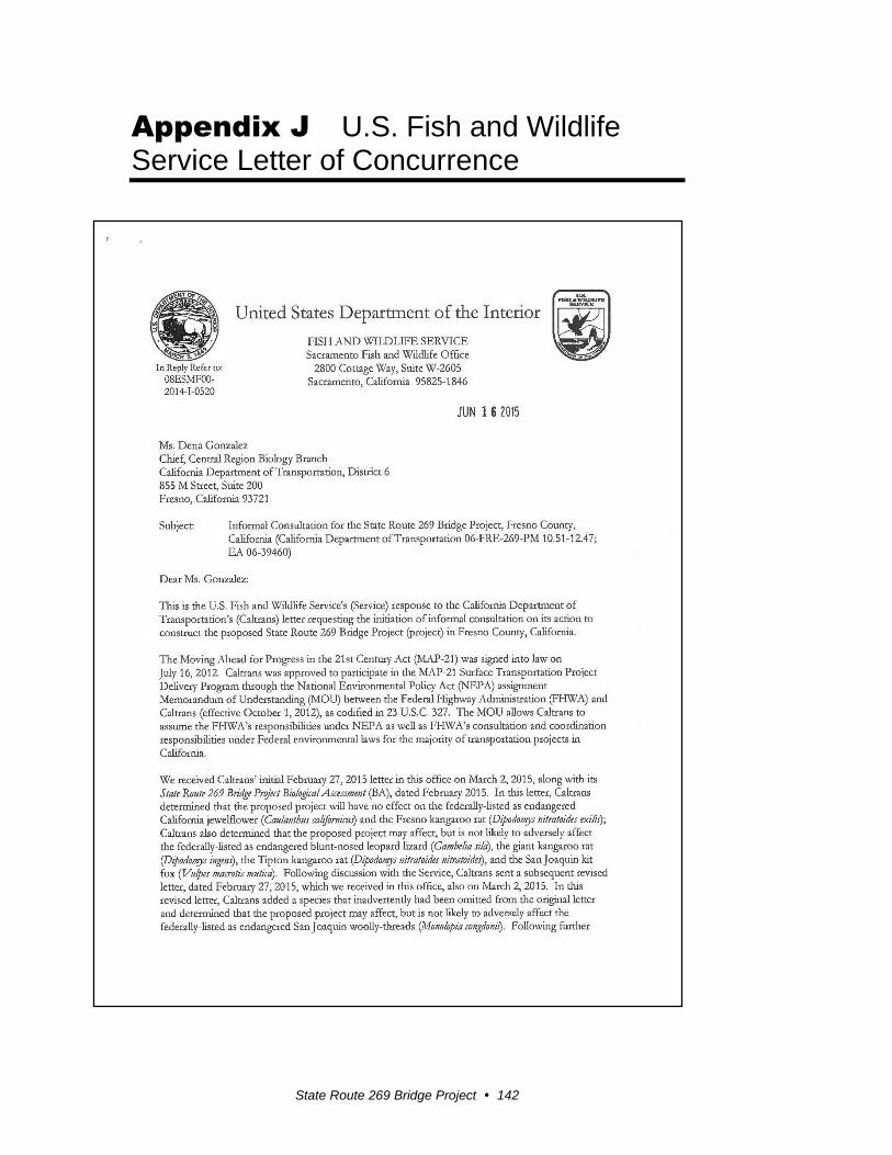
State Route 269 Bridge Project 142
Appendix J U.S. Fish and Wildlife Service Letter of Concurrence

State Route 269 Bridge Project 143

State Route 269 Bridge Project 144

State Route 269 Bridge Project 145

State Route 269 Bridge Project 146

State Route 269 Bridge Project 147
State Route 269 Bridge Project 148
State Route 269 Bridge Project 149

State Route 269 Bridge Project 150
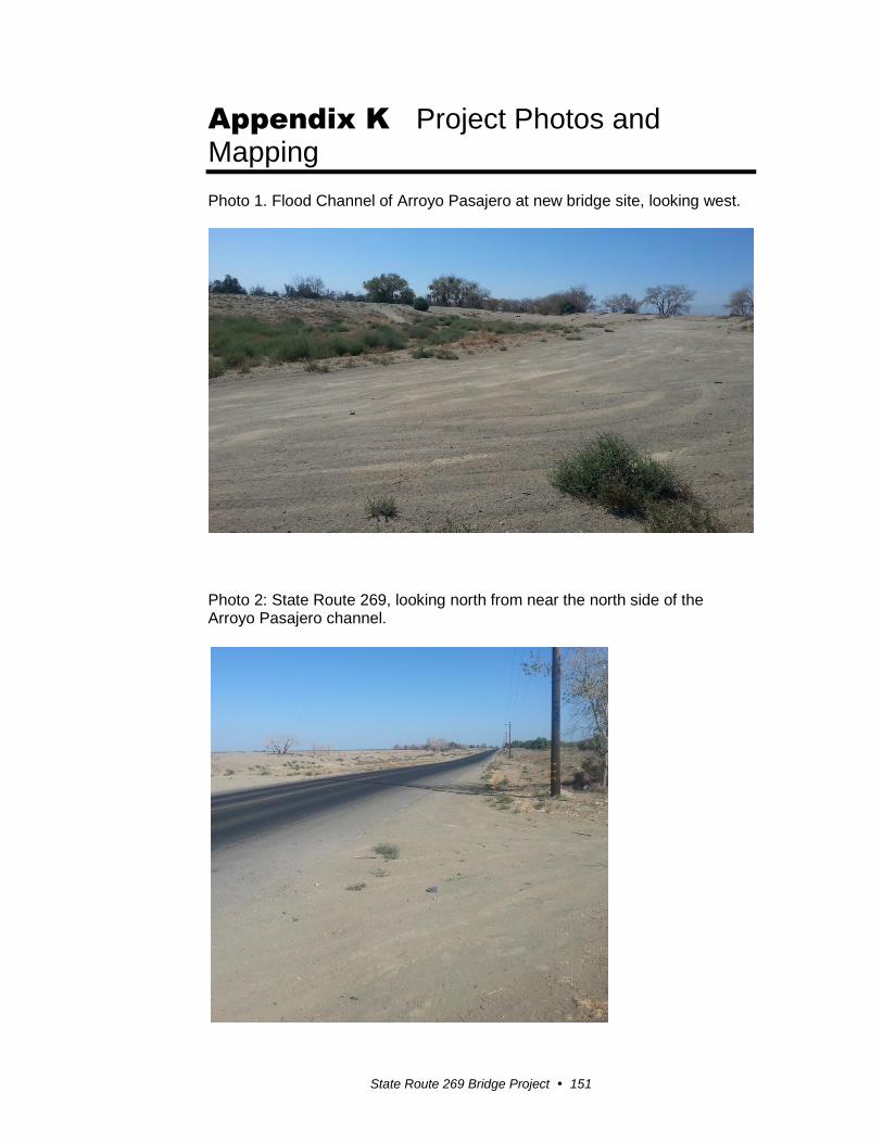
State Route 269 Bridge Project 151
Appendix K Project Photos and Mapping
Photo 1. Flood Channel of Arroyo Pasajero at new bridge site, looking west.
Photo 2: State Route 269, looking north from near the north side of the Arroyo Pasajero channel.

Appendix I Project Photos and Mapping
State Route 269 Bridge Project 152

Appendix I Project Photos and Mapping
State Route 269 Bridge Project 153
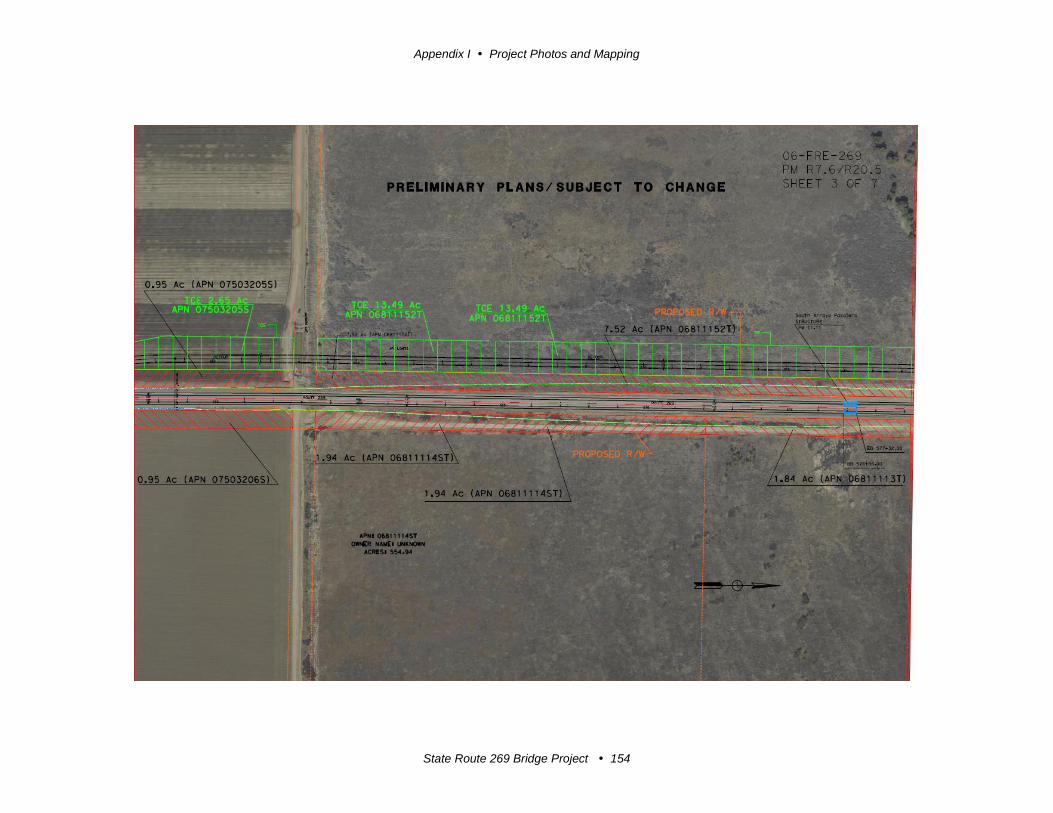
Appendix I Project Photos and Mapping
State Route 269 Bridge Project 154

Appendix I Project Photos and Mapping
State Route 269 Bridge Project 155
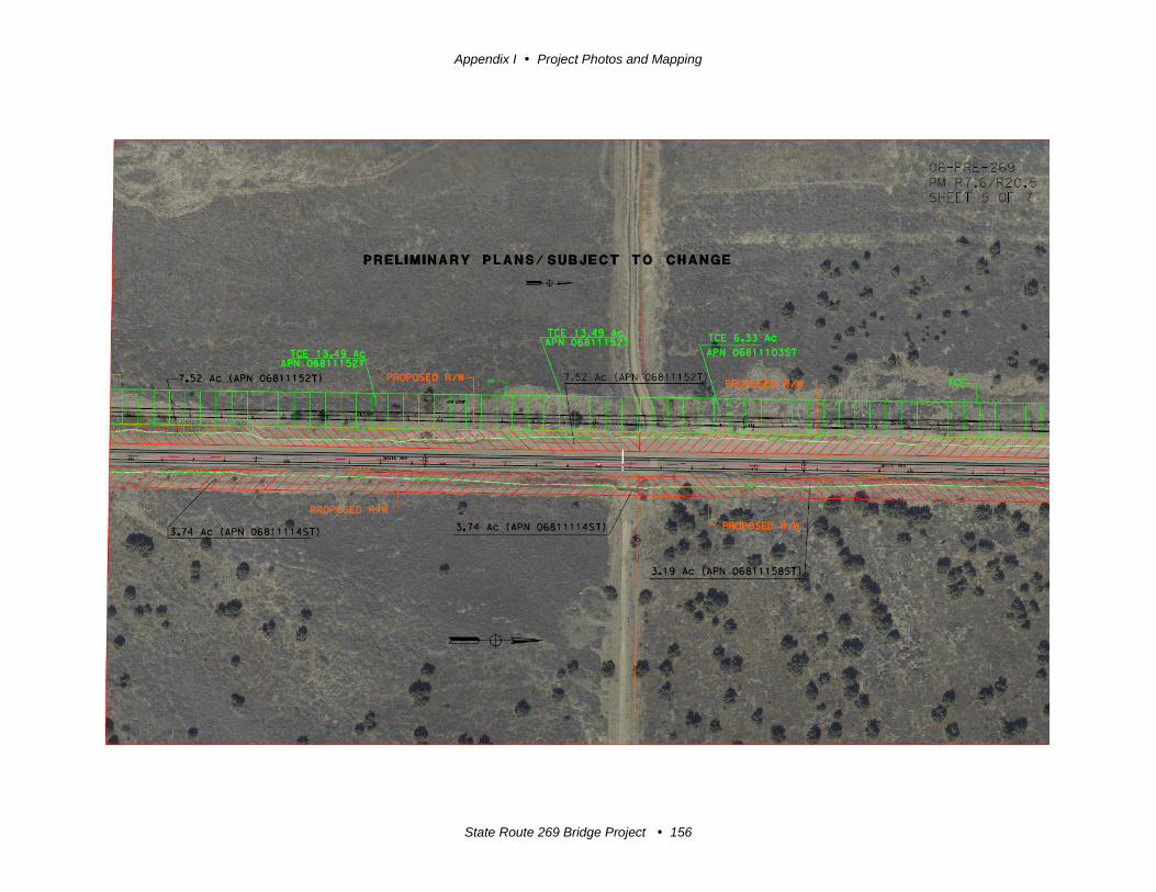
Appendix I Project Photos and Mapping
State Route 269 Bridge Project 156

Appendix I Project Photos and Mapping
State Route 269 Bridge Project 157
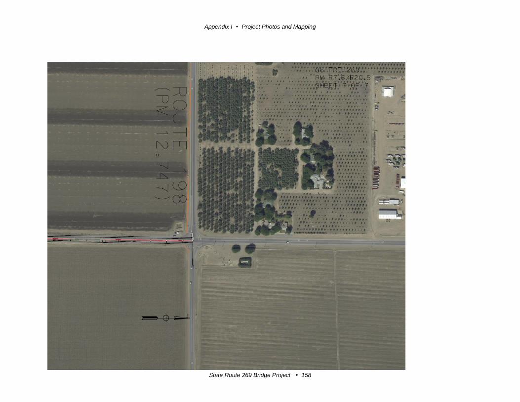
Appendix I Project Photos and Mapping
State Route 269 Bridge Project 158
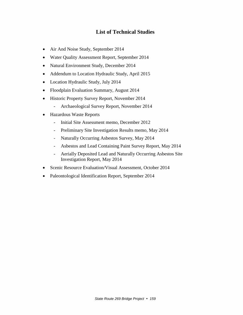
State Route 269 Bridge Project 159
List of Technical Studies
Air And Noise Study, September 2014
Water Quality Assessment Report, September 2014
Natural Environment Study, December 2014
Addendum to Location Hydraulic Study, April 2015
Location Hydraulic Study, July 2014
Floodplain Evaluation Summary, August 2014
Historic Property Survey Report, November 2014
- Archaeological Survey Report, November 2014
Hazardous Waste Reports
- Initial Site Assessment memo, December 2012
- Preliminary Site Investigation Results memo, May 2014
- Naturally Occurring Asbestos Survey, May 2014
- Asbestos and Lead Containing Paint Survey Report, May 2014
- Aerially Deposited Lead and Naturally Occurring Asbestos Site
Investigation Report, May 2014
Scenic Resource Evaluation/Visual Assessment, October 2014
Paleontological Identification Report, September 2014