Embed Size (px)
Citation preview
State Planning Policy – state interest guidance material
Emissions and hazardous activities
February 2018
State interest guidance material – Emissions and hazardous activities
The State of Queensland, July 2017. First published by the Department of Infrastructure, Local Government and Planning, 1 William Street, Brisbane Qld 4000, Australia.
Licence: This work is licensed under the Creative Commons CC BY 4.0 Australia licence. To view a copy of the licence, visit http://creativecommons.org/licenses/by/4.0/. Enquiries about this licence or any copyright issues can be directed to the department by email to
[email protected] or in writing to PO Box 15009, City East, Qld 4002. Attribution: The State of Queensland, Department of State Development, Manufacturing, Infrastructure and Planning. The Queensland Government supports and encourages the dissemination and exchange of information. However, copyright protects this publication. The State of Queensland has no objection to this material being reproduced, made available online or electronically but only if it is recognised as the owner of the copyright and this material remains unaltered.
The Queensland Government is committed to providing accessible services to Queenslanders of all cultural and linguistic backgrounds. If you have difficulty understanding this publication and need a translator, please call the Translating and Interpreting Service (TIS National) on 131 450 and ask them to telephone the Department of State Development, Manufacturing, Infrastructure and Planning on 13 QGOV (13 74 68).
Disclaimer: While every care has been taken in preparing this publication, the State of Queensland accepts no responsibility for decisions or actions taken as a result of any data, information, statement or advice, expressed or implied, contained within. To the best of our knowledge, the content was correct at the time of publishing. Any references to legislation are not an interpretation of the law. They are to be used as a guide only. The information in this publication is general and does not take into account individual circumstances or situations. Where appropriate, independent legal advice should be sought. An electronic copy of this report is available on the Department of State Development, Manufacturing, Infrastructure and Planning website at https://planning.dilgp.qld.gov.au/

State interest guidance material – Emissions and hazardous activities
Contents
Using the SPP state interest guidance material ................................................................ 1 Part 1: Understanding the state interest ............................................................................ 2 Part 2: Integrating the state interest policies ..................................................................... 5 Part 3: Mapping .............................................................................................................. 13 Part 4: Applying assessment benchmarks ...................................................................... 14 Part 5: Example planning scheme provisions .................................................................. 15 Part 6: Supporting information ........................................................................................ 20
State interest guidance material – Emissions and hazardous activities 1
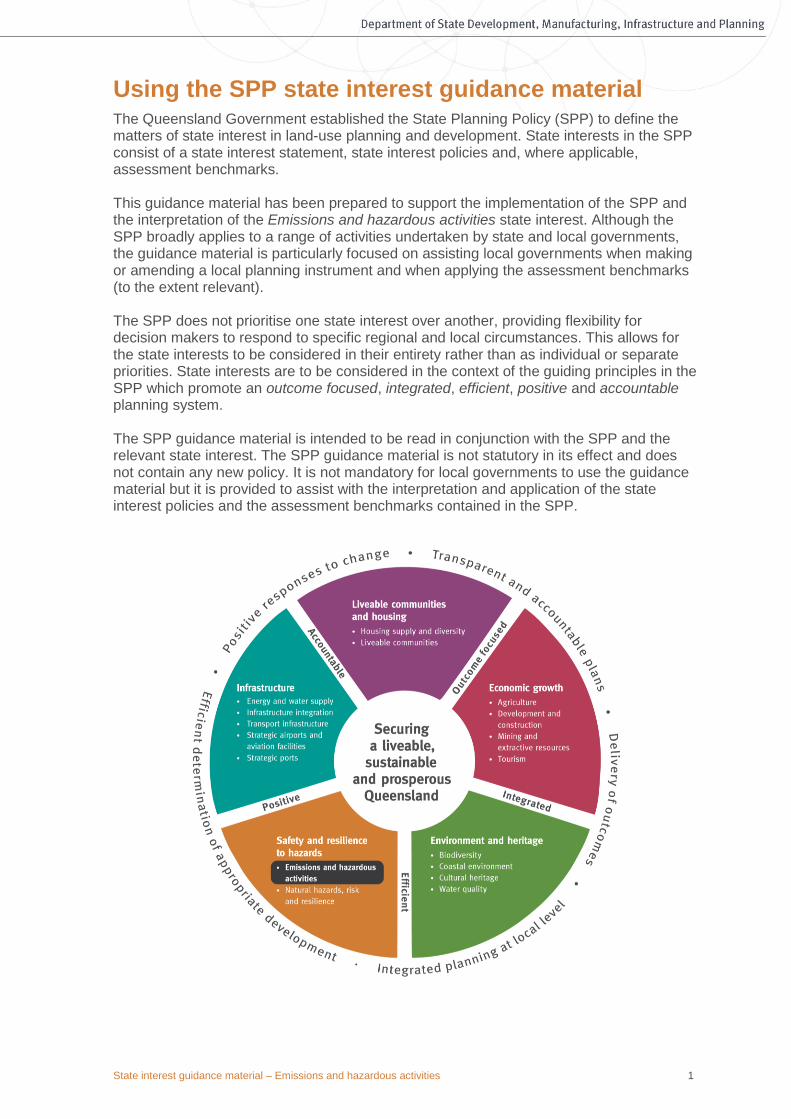
Using the SPP state interest guidance material The Queensland Government established the State Planning Policy (SPP) to define the matters of state interest in land-use planning and development. State interests in the SPP consist of a state interest statement, state interest policies and, where applicable, assessment benchmarks. This guidance material has been prepared to support the implementation of the SPP and the interpretation of the Emissions and hazardous activities state interest. Although the SPP broadly applies to a range of activities undertaken by state and local governments, the guidance material is particularly focused on assisting local governments when making or amending a local planning instrument and when applying the assessment benchmarks (to the extent relevant). The SPP does not prioritise one state interest over another, providing flexibility for decision makers to respond to specific regional and local circumstances. This allows for the state interests to be considered in their entirety rather than as individual or separate priorities. State interests are to be considered in the context of the guiding principles in the SPP which promote an outcome focused, integrated, efficient, positive and accountable planning system. The SPP guidance material is intended to be read in conjunction with the SPP and the relevant state interest. The SPP guidance material is not statutory in its effect and does not contain any new policy. It is not mandatory for local governments to use the guidance material but it is provided to assist with the interpretation and application of the state interest policies and the assessment benchmarks contained in the SPP.

State interest guidance material – Emissions and hazardous activities 2
The SPP guidance material is structured as follows: Part 1: Understanding the state interest – This section briefly explains why a particular matter is a matter of state interest, describes the purpose of the relevant state interest statement and defines the core concepts associated with the state interest. Part 2: Integrating the state interest policies – This section provides background and further explanation for each of the state interest policies defined in the SPP. It also provides examples and options regarding how to appropriately integrate each state interest policy into a local planning instrument. Part 3: Mapping – This section identifies and explains the mapping layers contained in the SPP Interactive Mapping System (IMS) relevant to a particular state interest. It also clarifies how a local government can locally refine state mapping in certain instances and outlines where online mapping for the state interest can be accessed (if relevant). Part 4: Applying assessment benchmarks – In accordance with the Planning Regulation, an assessment manager or referral agency must have regard to the SPP when assessing a development application. For some state interests, there are also specific assessment benchmarks that must be used by a local government for development assessment. This section outlines the development applications to which the assessment benchmarks apply and how a development application may demonstrate compliance with these benchmarks, to the extent that these are relevant. The assessment benchmarks contained in the SPP will apply to assessable development in addition to any assessment benchmarks contained in a local planning instrument, to the extent of any inconsistency. Part 5: Example planning scheme provisions – This section provides example planning scheme provisions that a local government may choose to adopt, or to adapt, for its planning instrument. It is important to note that the example planning scheme provisions provided may only be in relation to a particular aspect of a state interest, rather than addressing all of the particular state interest policy requirements. Part 6: Supporting information – This section provides a list of technical resources that a local government may wish to consider when preparing for making or amending a planning scheme. This section also provides a glossary of terms and acronyms used throughout the SPP guidance material. Where text in this guidance material is in a coloured text box, it is an excerpt from the SPP and is either the state interest statement, state interest policy or the assessment benchmarks applicable to the Emissions and hazardous activities state interest. Any queries related to the SPP guidance material or the SPP should be sent to [email protected].

State interest guidance material – Emissions and hazardous activities 2
Pa
rt 1
Un
de
rsta
nd
ing th
e s
tate
inte
rest
Part 1: Understanding the state interest
The sustainable operation of industrial development and major infrastructure is essential to Queensland’s economy. Equally as important to community wellbeing are the diverse sport and recreational activities enjoyed by many Queenslanders. There are some sport and recreational activities (such as shooting and motor sports), infrastructure and industrial activities that also have the potential to cause adverse impacts on communities, particularly sensitive land uses, where proper consideration has not been given to their location. Conversely, incompatible development may impact detrimentally on the above activities where encroachment risks their long-term viability from health and safety, economic, and employment perspectives.
Core concepts
Sensitive land use
This term describes land uses that are potentially sensitive to emissions and hazards from industry and infrastructure, including dwelling houses, childcare facilities, retirement accommodation etc. It is defined in the Planning Regulation 2017.
Industrial development
Industrial development typically generates noise, air or odour emissions, and can involve the storage of flammable or combustible substances. Medium impact, high impact and special industry, as defined under the Planning Regulation 2017, are generally required to manage potential impacts on surrounding land uses. Some industrial development also requires an environmental authority under the Environmental Protection Act 1994 (EP Act) to regulate the environmental emissions from the activity at the site.
Hazardous chemicals and materials
Activities that involve the storage, handling, processing or disposal of prescribed hazardous chemicals and materials with potential noticeable, significant or extreme off-site impacts require on-site controls to avoid such risks. Improper mitigation of the risks could lead to fire, explosions or toxic release. A ‘hazardous chemical facility’ is a facility at which a prescribed hazardous chemical is present or likely to be present in a quantity that exceeds 10 per cent of the chemical’s threshold quantity under the Work Health and Safety Regulation 2011, schedule 15. An ‘explosives facility’ means a premises or place described in an explosives authority under the Explosives Act 1999 where explosives are manufactured, stored, tested or
State interest statement Community health and safety, and the natural and built environment, are protected from potential adverse impacts of emissions and hazardous activities. The operation of appropriately established industrial development, major infrastructure, and sport and recreation activities is ensured.
State interest guidance material – Emissions and hazardous activities 3
Pa
rt 1
Un
de
rsta
nd
ing th
e s
tate
inte
rest
disposed of. These facilities, along with government explosives reserves, are essential to mining, construction and other industries, but present significant risks to community safety in the unlikely event of an explosion. Technical advice on the location and potential impacts of these facilities and reserves can be obtained from the Explosives Inspectorate, Department of Natural Resources Mines and Energy. Land-use planning has a role to play in ensuring that these hazardous activities are appropriately located and that new sensitive land uses do not encroach upon them. These activities are generally located in medium-impact, high-impact or special industry zones (as defined under the Planning Regulation 2017). Note: Development applications involving a ‘hazardous chemical facility’ require referral to the State Assessment Referral Agency (SARA) as a concurrence agency (see Figure 1), with technical advice obtained from the Hazardous Industries and Chemicals Branch of the Office of Industrial Relations, Queensland Treasury.
Major infrastructure
Major infrastructure in the context of the Emissions and hazardous activities state interest relates to waste management facilities, sewage treatment plants, and high-pressure gas pipelines. High-pressure gas pipelines are mainly located underground and transmit bulk gas from gasfields to end users over long distances. Pipelines are authorised under the Petroleum and Gas (Production and Safety) Act 2004 and designed and operated in accordance with Australian Standard (AS) 2885: Pipelines – Gas and Liquid Petroleum. Though a serious incident has not occurred in Australia, land-use planning has a role to play in reducing the risk to communities should a catastrophic event occur (for example, through damage caused by construction and maintenance activities). Major infrastructure should be protected from incompatible encroachment to avoid adverse community safety and amenity impacts.
Former mining activities
Many of Queensland’s local government areas have a mining history. The remaining landforms and infrastructure associated with past mining activities can pose a range of hazards to people and property. The particular hazards will depend on the nature and scale of the mining that has occurred. Potential hazards may also extend off-site, such as contaminated or low-quality water leaving the site. Understanding the potential impacts or risks to people and new development in areas affected by former mining activities is a key consideration for local planning.
Contaminated land
Contaminated land is defined in schedule 4 of the EP Act. Contaminated land refers to land contaminated by hazardous substances that may pose a risk to human health or the environment, and may include land formally used for industrial, military, mining, waste disposal, explosives testing or chemical application activities. The Planning Regulation 2017 prescribes when particular development on contaminated land is ‘prohibited’, or ‘accepted’ where it meets certain requirements. Planning scheme provisions have no effect where they are inconsistent with the regulation. Where possible, land contamination should be considered early in the plan-making process to prevent poor land-use outcomes. Queensland’s Environmental Management Register and Contaminated Land Register (EMR/CLR) are public registers that identify contaminated or potentially contaminated land.

State interest guidance material – Emissions and hazardous activities 4
Pa
rt 1
Un
de
rsta
nd
ing th
e s
tate
inte
rest
Acid sulfate soils
Acid sulfate soils are coastal soils and sediments containing iron sulfides (mainly pyrite). They cover approximately 2.3 million hectares of land and occur naturally along the Queensland coast, usually where land elevation is less than 5 metres Australian Height Datum (AHD). Soil or sediment containing highly acidic soil horizons (or layers) affected by the oxidation of iron sulfides is known as ‘actual acid sulfate soils’. Soil or sediment containing iron sulfides or other sulfide material that has not been exposed to air and oxidised is known as ‘potential acid sulfate soil’. The term ‘acid sulfate soils’ includes both. The exposure of potential acid sulfate soil to oxygen (e.g. through dewatering, excavation or filling) results in the production of sulfuric acid and soluble iron, which can be released into receiving waters. The acid corrodes concrete and steel infrastructure and, together with the metal contaminants, can kill fish, other aquatic organisms, native vegetation and crops, and affect human health (e.g. if groundwater supplies are used for urban and domestic drinking water). Appropriate planning and development controls can minimise these risks. However, avoiding the disturbance of these soils is always the preferred strategy.

State interest guidance material – Emissions and hazardous activities 5
Pa
rt 2
Inte
gra
ting
the s
tate
inte
rest p
olic
es
Part 2: Integrating the state interest policies When making or amending a local planning instrument, each local government is required to consider all state interests in the SPP and appropriately integrate those state interests applicable to their local area. Appropriately integrating a state interest requires all state interest policies to be considered by a local government, but it does not necessarily mean a local government must address each and every state interest policy when making or amending a local planning instrument. For example, if a local government needs to balance competing state interests in a local planning instrument, it may not be possible to address all policies. This balancing of state interests may mean that the planning scheme preferences one state interest policy over another. This outcome will be considered as part of the state interest review. Ministerial approval means the approach taken by the local government in balancing the state interest polices is endorsed by the state.
Industry, major sport and entertainment facilities, and major infrastructure (such as high-pressure gas pipelines and sewerage-treatment facilities) provide valuable economic and social benefits for communities throughout Queensland. It is important to recognise these benefits while ensuring appropriate measures are in place to protect sensitive land uses, community wellbeing and the natural environment.
How to appropriately integrate the policy
1.1 Identify suitable areas in the planning scheme for industrial land uses, major infrastructure, and major sport and recreation activities, considering the following:
• The scale of the development to be accommodated.
• The types of emissions likely to be released and potential community safety risks.
• Existing or potential sensitive land uses. Proximity of sensitive land uses in adjoining local government areas should also be considered where necessary)
• environmental and topographical features that may influence the dispersal of emissions (e.g. direction of dominant prevailing winds, hills, valleys, watercourses).
• Appropriate setbacks or buffer distances based on industry best-practice, Australian Standards, and/or after consultation with relevant industry bodies.
• Significant nearby waterways.
• Matters of national and state environmental significance.
1.2 Include policy statements within the strategic framework that discourage the development of industrial land uses, major infrastructure, and major sport and recreation activities near existing or future sensitive land uses, and highlight the importance of locating these activities to protect the community and the natural environment.
State interest policy (1) Industrial development, major gas, waste and sewerage infrastructure, and sport and recreation activities are located, designed and managed to avoid or mitigate adverse impacts of emissions on sensitive land uses and the natural environment.

State interest guidance material – Emissions and hazardous activities 6
Pa
rt 2
Inte
gra
ting
the s
tate
inte
rest p
olic
es
Consider land-use strategies to avoid, mitigate and manage the adverse impacts of emissions such as:
• Clustering high-impact and incompatible land uses in areas away from sensitive land uses (e.g. industrial estates).
• Locating uses of progressively lesser impact around zones of highest impact (e.g. low-impact industry surrounding medium-impact industry, surrounding high-impact industry).
• Locating other uses between the activities that generate emissions and sensitive land uses in order to buffer potential impacts (e.g. special industry or waste management facilities buffered by rural land or state forest).
1.3 Consider including assessment benchmarks that require development for industry, major infrastructure, and major sport and recreation activities to avoid adverse impacts on sensitive land uses and the natural environment.
Where impacts cannot be avoided, consider mitigation and management strategies to achieve the relevant acoustic and air quality objectives of the Environmental Protection (Noise) Policy 2008 and the Environmental Protection (Air) Policy 2008 at the nearest sensitive use receptor. These strategies may include reduced hours of operation, vegetation buffers etc. Note: The Planning Regulation 2017 applies to the Wyaralong Off-Road Motorcycling Facility.
Development involving hazardous chemicals and materials carries a level of risk associated with their storage, handling and use. While licensing and environmental regulations are aimed at managing the operational aspects of this risk, land-use planning can assist in identifying appropriate locations for these activities. Risk analysis or hazard assessment is the primary tool for identifying potential hazards and demonstrating whether risk from an activity is tolerable when considering surrounding land uses. Plan-making and risk analysis should also consider that other industry and industrial related development may not be compatible with various hazardous activities, and approvals of nearby hazardous developments may create cumulative risks, for example where a number of high-impact and special industry uses are co-located.
How to appropriately integrate the policy
2.1 Within the strategic framework, consider including policy statements requiring the appropriate siting of new development involving the use, storage and disposal of hazardous materials and chemicals in order protect community health and safety.
2.2 Within zone or overlay codes, consider strategies that manage risks created by development involving hazardous chemicals and materials (including increasing an existing risk) proportionately to the sensitivity of the surrounding land use or zones.
State interest policy (2) Protection from emissions and hazardous activities: Activities involving the use, storage and disposal of hazardous materials and prescribed hazardous chemicals, dangerous goods, and flammable or combustible substances are located and managed to minimise the health and safety risks to communities and individuals.

State interest guidance material – Emissions and hazardous activities 7
Pa
rt 2
Inte
gra
ting
the s
tate
inte
rest p
olic
ies
2.3 Require that a hazard assessment be provided with a development application for land uses involving these activities.
Consider locating development involving explosives facilities and hazardous chemical facilities may need to be located outside of developed urban areas so that risks can be adequately mitigated.
Floodwaters can move, bury or damage hazardous chemical containers and expose hazardous materials, causing them to end up in various and sometimes unexpected locations, often outside the boundary of the facility where they were originally held. Given historical flood events in Queensland have seen widespread impacts and the relatively high frequency of flooding events, it is important and appropriate that new development involving the storage of hazardous chemicals consider the potential for flooding and mitigate the impacts.
How to appropriately integrate the policy
3.1 Consult flood hazard areas found on local council mapping and/or the SPP Interactive Mapping System when determining the likelihood of the proposed development being inundated by floodwaters.
3.2 Where there is a known flood hazard, consider including assessment benchmarks
aimed at minimising the risk of a chemical spill from the storage of prescribed hazardous chemicals.
Impacts from previous land uses, such as former mining activities, former landfill and refuse sites and contaminated land, can result in risks to community health and safety if not properly managed. In some cases, land may have been contaminated, mined or used for activities not known to be dangerous at the time, often involving chemicals that have since been banned or are now subject to stricter controls.
State interest policy (4) Protection from emissions and hazardous activities: Sensitive land uses are protected from the impacts of previous activities that may cause risk to people or property including: (a) former mining activities and related hazards (e.g. disused underground
mines, tunnels and shafts) (b) former landfill and refuse sites. (c) contaminated land.
State interest policy (3) Protection from emissions and hazardous activities: Prescribed hazardous chemicals, stored in a flood hazard area (where exceeding the hazardous chemicals flood hazard threshold), are located to minimise the risk of inundation and dispersion.
State interest guidance material – Emissions and hazardous activities 8
Pa
rt 2
Inte
gra
ting
the s
tate
inte
rest p
olic
ies
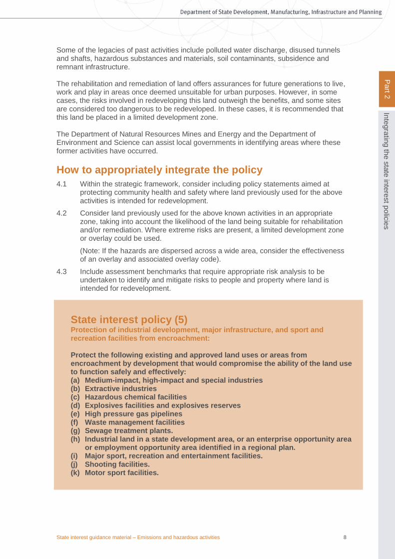
Some of the legacies of past activities include polluted water discharge, disused tunnels and shafts, hazardous substances and materials, soil contaminants, subsidence and remnant infrastructure. The rehabilitation and remediation of land offers assurances for future generations to live, work and play in areas once deemed unsuitable for urban purposes. However, in some cases, the risks involved in redeveloping this land outweigh the benefits, and some sites are considered too dangerous to be redeveloped. In these cases, it is recommended that this land be placed in a limited development zone. The Department of Natural Resources Mines and Energy and the Department of Environment and Science can assist local governments in identifying areas where these former activities have occurred.
How to appropriately integrate the policy
4.1 Within the strategic framework, consider including policy statements aimed at protecting community health and safety where land previously used for the above activities is intended for redevelopment.
4.2 Consider land previously used for the above known activities in an appropriate zone, taking into account the likelihood of the land being suitable for rehabilitation and/or remediation. Where extreme risks are present, a limited development zone or overlay could be used.
(Note: If the hazards are dispersed across a wide area, consider the effectiveness of an overlay and associated overlay code).
4.3 Include assessment benchmarks that require appropriate risk analysis to be undertaken to identify and mitigate risks to people and property where land is intended for redevelopment.
State interest policy (5) Protection of industrial development, major infrastructure, and sport and recreation facilities from encroachment: Protect the following existing and approved land uses or areas from encroachment by development that would compromise the ability of the land use to function safely and effectively: (a) Medium-impact, high-impact and special industries (b) Extractive industries (c) Hazardous chemical facilities (d) Explosives facilities and explosives reserves (e) High pressure gas pipelines (f) Waste management facilities (g) Sewage treatment plants. (h) Industrial land in a state development area, or an enterprise opportunity area
or employment opportunity area identified in a regional plan. (i) Major sport, recreation and entertainment facilities. (j) Shooting facilities. (k) Motor sport facilities.
State interest guidance material – Emissions and hazardous activities 9
Pa
rt 2
Inte
gra
ting
the s
tate
inte
rest p
olic
ies
Encroachment by sensitive land uses and other incompatible development on the existing or approved uses listed in policy 5 may adversely impact on the operation of these uses and may create or expose health and safety risks for the encroaching development. It is important for local governments to address these concerns so that the long-term viability of industrial development, including state development areas, and major infrastructure and sport and recreation facilities, is not jeopardised and the health and wellbeing of the community is adequately protected.
How to appropriately integrate the policy
5.1 When identifying land for the existing and approved uses listed in policy (5), and appropriate buffers/interfaces between surrounding land uses, consider using strategic framework map, zone or overlay map, depending on the nature of the industry or infrastructure and the size of the required buffer/interface area.
5.2 Within the strategic framework, consider including policy statements that acknowledge the community and economic value of these land uses, and support their ongoing and safe operation through protection from encroachment by sensitive land uses and other incompatible development.
5.3 Consider code or impact assessment for land uses (particularly sensitive land uses) within this interface area, which may be incompatible near industry or infrastructure (except where ancillary to a particular land use). Where the risks of adverse impacts upon new sensitive land uses are significant, impact assessment may be appropriate and a comprehensive risk assessment may be required.
5.4 Consider assessment benchmarks that protect existing and future land uses and infrastructure listed in policy (5) from encroachment by identifying appropriate separation/buffer distances based on industry best-practice and Australian Standards. If appropriate, code provisions could seek to achieve relevant acoustic and air quality objectives in the Environmental Protection (Noise) Policy 2008 and Environmental Protection (Air) Policy 2008 for new sensitive land uses.
Locally relevant information will assist in determining the ongoing operational needs of industry or a particular facility, and developing appropriate zoning, interface and assessment benchmarks. Local governments should consult with relevant regulatory bodies and operators early in the plan-making process.
In many local government areas there are industrial land uses and major infrastructure and sporting facilities near zones that permit sensitive land uses and other incompatible development, making it difficult to achieve the outcomes identified in policy (5). Adverse impacts should be avoided. Where this is not possible, local planning schemes should encourage new development to be appropriately designed to minimise potential adverse impacts.
State interest policy (6) Mitigation of adverse impacts from emissions and hazardous activities: Development that is incompatible with the existing and approved land uses or areas included in policy 5 above, is located to avoid any adverse impacts of environmental emissions, or health and safety risks, and where impacts cannot be practicably avoided, development is designed to minimise the impacts.
State interest guidance material – Emissions and hazardous activities 10
Pa
rt 2
Inte
gra
ting
the s
tate
inte
rest p
olic
ies
How to appropriately integrate the policy
6.1 Select zones for the buffer/interface area that are compatible with the existing and approved land uses and areas included in policy (5). Within these zones, sensitive land uses should generally be discouraged. For some higher risk activities, such as explosive reserves, surrounding land uses generally should not increase the number of people gathering for significant periods of the day.
The ongoing operational needs, risks and hazards of each land use or infrastructure will differ between facilities and operators. Locally relevant information will greatly assist in determining appropriate zoning.
Where risks to community health and safety are significant, consider evacuation routes and means of access. For example, if a new suburb is being developed beside a high-pressure gas pipeline, a park or vegetation buffer could be placed between the pipeline and new housing, with a means of access away from the pipeline area.
Note: For specific information about potential risks from high-pressure gas pipelines and appropriate design responses, consult the pipeline operator.
6.2 Consider identifying an interface or buffer area in an overlay or precinct to assist in avoiding and mitigating the adverse impacts from the land uses and infrastructure outlined above under policy (5).
Within this interface area, consider code assessment for the intensification of sensitive uses and code provisions that encourage appropriate siting and design responses consistent with the type of impacts and level of risk. Where appropriate, this may include the achievement of the relevant acoustic and air quality objectives of the Environmental Protection (Noise) Policy 2008 and Environmental Protection (Air) Policy 2008.
Examples of possible siting and design responses include placing habitable rooms away from the source of the emissions/risk, or building an acoustic wall. However, siting and design provisions should not duplicate or conflict with the building assessment provisions.
In some cases where there is significant ongoing conflict between land uses, consider limiting the further intensification of sensitive land uses in this area, or encourage high-impact or special industrial areas to transition to lower-impact industries where alternative industrial land is available.
Acid sulfate soils are environmentally benign if they remain in an anoxic (oxygen-free) water-logged environment. If they are disturbed and exposed to oxygen, the iron sulfides can oxidise, releasing sulfuric acid and soluble iron. The acid can mobilise aluminium and
State interest policy (7) Acid sulfate soil affected areas: Protect the natural and built environment, and human health from potential adverse impacts of acid sulfate soils by: (a) identifying areas with high probability of containing acid sulfate soils (b) providing preference to land uses that will avoid, or where avoidance is not
practicable, minimise the disturbance of acid sulfate soils (c) including requirements for managing the disturbance of acid sulfate soils to
avoid or minimise the mobilisation and release of acid, iron or other contaminants.

State interest guidance material – Emissions and hazardous activities 11
Pa
rt 2
Inte
gra
ting
the s
tate
inte
rest p
olic
ies
heavy metals, if present in the soil which can be released into receiving waters. As surface and groundwater interactions are linked, groundwater impacts can result in risks to surface water bodies. Management of acid sulfate soils disturbance can be costly for the built and natural environment, and even minor disturbances may require expensive management to protect assets from corrosion. Acid sulfate soils disturbance can also adversely affect human health. The disturbance of acid sulfate soils should be avoided, but where avoidance is not possible, the acid sulfate soils should be adequately investigated to determine whether the impacts can be managed to prevent the release of acid, soluble iron and other contaminants to the surrounding environment. Local government areas identified as having a high probability of containing acid sulfate soils are identified in the glossary of the SPP (Part F), under the definition for 'acid sulfate soil affected area'.
How to appropriately integrate the policy
7.1 In acid sulfate soils affected areas, identify – ideally in overlay form – areas where development is to be assessed for disturbance. Use the following, where appropriate: (a) an overlay identifying areas at or below 5 metres AHD where the natural ground level is less than 20 metres AHD; or
(b) project-based acid sulfate soils maps produced by the Queensland Government, where available; or
(c) where project-based acid sulfate soils mapping is not available, the following criteria may provide an indication of broad areas where the soils may be located:
• land with elevation less than 5m AHD
• soil and sediment of recent geological age (Holocene)
• marine or estuarine sediments and tidal lakes
• low-lying coastal wetlands or back swamp areas, waterlogged or scalded areas, interdune swales or coastal sand dunes
• coastal alluvial valleys
• areas where the dominant vegetation is tolerant of salt, acid and/or water-logging conditions, e.g. mangroves, salt couch, swamp-tolerant reeds, rushes, grasses (e.g. Phragmites australis), paperbarks (Melaleuca spp.) and swamp oak (Casuarina spp.)
• areas identified in geological descriptions or in maps as bearing sulfide minerals, coal deposits or marine shales/sediments and deep older estuarine sediments below ground surface.
Areas under development pressure should be prioritised for further acid sulfate soils investigation due to the possible impacts on future development.
7.2 Zone land identified as having high probability of acid sulfate soils to minimise the impacts from disturbance of these soils. Land uses that avoid or minimise the disturbance of these soils include environmental and recreation zones, low-density development with no deep excavation or dewatering during or after construction.
Land uses that should be directed away from acid sulfate soils include but are not limited to:
• marinas, canal estates, and golf courses involving deep excavations
• multi-storey commercial and residential development involving deep basements
• agriculture involving extensive drainage and/or retention systems (e.g. rice farming, aquaculture)
• extractive industries (e.g. sand and gravel mining).

State interest guidance material – Emissions and hazardous activities 12
Pa
rt 2
Inte
gra
ting
the s
tate
inte
rest p
olic
ies
7.3 Design assessment benchmarks to provide for minimal ground disturbance or dewatering in acid sulfate soils affected areas. When buried deep within the soil profile, some disturbances for trenching or construction footings may be appropriate, provided these disturbances remain shallow and do not disturb the acid sulfate soils.
7.4 Design assessment benchmarks to ensure that where disturbance to acid sulfate soils cannot be avoided, an appropriate investigation and environmental management plan is used to identify and manage potential adverse impacts.
Activities that disturb land in a manner likely to oxidise these soils include open excavation, permanent or temporary dewatering, and filling. Impacts from these activities can be extremely difficult and costly to remediate.
A site investigation that conforms with the latest Queensland Sampling Guidelines and soil analyses (according to the Laboratory Methods Guidelines or Australian Standard 4969) would identify the location and depth of acid sulfate soils.
Appropriate environmental management techniques that are consistent with the Soil Management Guidelines include:
• neutralising existing acidity and preventing the generation of acid and metal contaminants
• preventing mobilisation and release of acid, iron or other pollutants into surface or groundwater
• preventing in situ oxidation of acid sulfate soils through appropriate groundwater management
• undertaking appropriate treatment before disposal whether or not that disposal occurs offsite
• documenting management strategies and reporting requirements in an acid sulfate soils environmental management plan.
Note: Applicants also have a ‘general environmental duty’ under section 319 of the Environmental Protection Act 1994 to prevent environmental harm from occurring. In relation to infrastructure works in acid sulfate soils-affected areas, this also requires documentation of management activities, generally through an Environmental Management Plan (EMP) and associated record keeping.
State interest guidance material – Emissions and hazardous activities 13
Pa
rt 3
Ma
pp
ing
Part 3: Mapping To support the SPP, wherever possible and to the extent relevant, matters of state interest are spatially represented as layers included in the SPP IMS. The mapping is necessary to help local government, the community and industry understand and interpret where and how state interest policies and assessment benchmarks included in the SPP apply. Several mapping layers contained in the SPP IMS are prepared by entities other than the Department of State Development, Manufacturing, Infrastructure and Planning and may serve an additional purpose outside the Queensland planning system. Where relevant, the SPP IMS represents the single point of truth for the spatial representation of the state interests expressed in the SPP. Appendix 1 of the SPP identifies three categories of mapping layers provided or referred to in the SPP IMS that are intended to be used in one of the following ways:
Category 1 – State mapping layers that must be appropriately integrated in a local planning instrument in a way that achieves the relevant state interest policy.
Category 2 – State mapping layers that must be appropriately integrated, and can be locally refined by a local government in a local planning instrument in a way that achieves the relevant state interest policy.
Category 3 – State mapping layers that are provided for local government information purposes only.
The SPP IMS is located at: https://planning.dilgp.qld.gov.au/maps. Any queries related to the SPP mapping should be sent to [email protected]. This section provides clarity regarding the mapping layers on the SPP IMS relevant to the Emissions and hazardous activities state interest.
Mapping layers
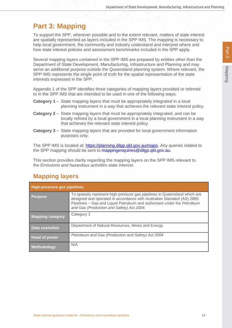
High-pressure gas pipelines
Purpose To spatially represent high-pressure gas pipelines in Queensland which are designed and operated in accordance with Australian Standard (AS) 2885: Pipelines – Gas and Liquid Petroleum and authorised under the Petroleum and Gas (Production and Safety) Act 2004.
Mapping category Category 1
Data custodian Department of Natural Resources, Mines and Energy
Head of power Petroleum and Gas (Production and Safety) Act 2004
Methodology N/A

State interest guidance material – Emissions and hazardous activities 14
Pa
rt 4
Ap
ply
ing a
ssessm
ent b
en
chm
ark
s
Part 4: Applying assessment benchmarks The SPP does not contain any specific assessment benchmarks for the Emissions and hazardous activities state interest. However, under the Planning Regulation 2017 the assessment manager must have regard to the SPP (including the Emissions and hazardous activities state interest statement and policies) wherever the planning scheme has not appropriately integrated the state interest. The SPP applies as a matter to have regard to where the assessment manager considers these matters are relevant to the proposed development and only to the extent of any inconsistency with the planning scheme.

State interest guidance material – Emissions and hazardous activities 15
Pa
rt 5
Exa
mp
le p
lann
ing s
ch
em
e p
rovis
ions
Part 5: Example planning scheme provisions Example planning scheme provisions for the Emissions and hazardous activities state interest have been prepared which a local government may choose to adopt or otherwise adapt, when making or amending a planning scheme. The example planning scheme provisions should not be seen as the only way to reflect the Emissions and hazardous activities state interest appropriately. Where a local government seeks to adopt the example planning scheme provisions, variations will be required to reflect the local circumstances, opportunities and aspirations of each local government area.
Strategic outcomes
• Community wellbeing and the natural environment are protected from the adverse impacts of noise, air, odour and industrial activities through effective location and mitigation strategies
• Industrial areas, major infrastructure and major sport and recreation facilities are protected from incompatible land uses that may adversely affect their role in supporting the local and regional economy
• Community safety and the natural environment are protected from the impacts of former mining and industrial activities, and other hazards, including acid sulfate soils, which may adversely affect health and amenity.
Specific outcomes
• Industrial activities meet high public safety and environmental performance standards, and the levels of amenity experienced in different parts of the local government area are appropriate to the uses and development intensity planned for that part of the local government area.
• Interface areas between industry, major infrastructure, major sport and recreation facilities and sensitive uses are effectively managed in terms of industrial hazards, air, noise and odour impacts and community safety.
• Industrial areas, major infrastructure, and major sport and recreation facilities are protected to ensure their integrity and effective operation through the appropriate location and design of incompatible land uses.
• Local amenity considerations are balanced with the requirements of land uses that are essential to the economic development and function of the local government area.
• Hazardous chemicals in flood hazard areas are managed appropriately.
• People and property are not exposed to unacceptable risks from contaminated land, former mining activities and former landfill and refuse sites.
• The disturbance of acid sulfate soils is avoided and managed to protect the environment, people and property.
Overlays
It may be appropriate to develop several overlays for this state interest, including an overlay related to an industrial buffer/protection area, major infrastructure such as high-pressure gas pipelines, and acid sulfate soils.

State interest guidance material – Emissions and hazardous activities 16
Pa
rt 5
Exa
mp
le p
lann
ing s
ch
em
e p
rovis
ions
Where there is limited mapping available for acid sulfate soils, an overlay should identify areas under 5 metres AHD, and areas between 5 metres and 20 metres AHD.
Categories of assessment
The category of assessment for different aspects of this state interest will vary widely. It is recommended that the planning scheme assign a category of assessment appropriate to the level of risk.
Example code: Emissions and hazardous activities
Application
This code applies to assessable development within an industrial buffer overlay code/regional infrastructure overlay code/acid sulfate soil overlay. For acid sulfate soils, the following development should be assessable against the acid sulfate soils overlay code (or alternative assessment provisions): 1) Works, not associated with a material change of use, on land below 5m AHD, where
such works involve either:
• excavating or otherwise removing 100m3 or more of soil or sediment, or
• filling of land involving 500m3 or more of material with an average depth of 0.5m or greater.
2) Works, not associated with a material change of use, on land between 5m and 20m AHD where such works involve excavating or otherwise removing 100m3or more of soil or sediment at or below 5m AHD.
3) Material change of use on land within the overlay area where any associated works as described by items 1 and 2 above are a component of the use.
Figure 1: Recommended assessable development trigger for acid sulfate soils
Note: The above triggers for assessment development related to excavation and filling may be adjusted according to local geological/geomorphic conditions.
Purpose
The purpose of the code is to ensure that:
• community health and safety, and the natural and built environment, are protected from potential adverse impacts of emissions and hazardous activities
• the safe operation of appropriately established industrial development, major infrastructure, and sport and recreation activities continues.
State interest guidance material – Emissions and hazardous activities 17
Pa
rt 5
Exa
mp
le p
lann
ing s
ch
em
e p
rovis
ions
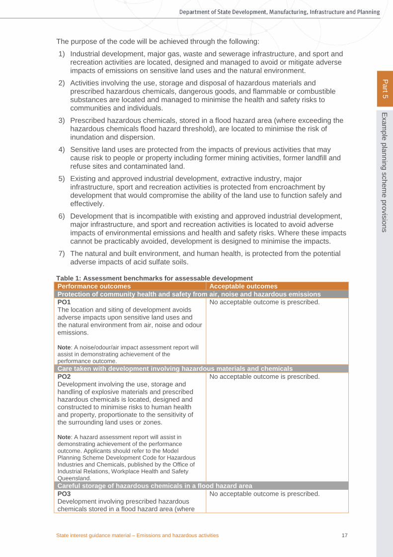
The purpose of the code will be achieved through the following:
1) Industrial development, major gas, waste and sewerage infrastructure, and sport and recreation activities are located, designed and managed to avoid or mitigate adverse impacts of emissions on sensitive land uses and the natural environment.
2) Activities involving the use, storage and disposal of hazardous materials and prescribed hazardous chemicals, dangerous goods, and flammable or combustible substances are located and managed to minimise the health and safety risks to communities and individuals.
3) Prescribed hazardous chemicals, stored in a flood hazard area (where exceeding the hazardous chemicals flood hazard threshold), are located to minimise the risk of inundation and dispersion.
4) Sensitive land uses are protected from the impacts of previous activities that may cause risk to people or property including former mining activities, former landfill and refuse sites and contaminated land.
5) Existing and approved industrial development, extractive industry, major infrastructure, sport and recreation activities is protected from encroachment by development that would compromise the ability of the land use to function safely and effectively.
6) Development that is incompatible with existing and approved industrial development, major infrastructure, and sport and recreation activities is located to avoid adverse impacts of environmental emissions and health and safety risks. Where these impacts cannot be practicably avoided, development is designed to minimise the impacts.
7) The natural and built environment, and human health, is protected from the potential adverse impacts of acid sulfate soils.
Table 1: Assessment benchmarks for assessable development
Performance outcomes Acceptable outcomes
Protection of community health and safety from air, noise and hazardous emissions
PO1 The location and siting of development avoids adverse impacts upon sensitive land uses and the natural environment from air, noise and odour emissions. Note: A noise/odour/air impact assessment report will assist in demonstrating achievement of the performance outcome.
No acceptable outcome is prescribed.
Care taken with development involving hazardous materials and chemicals
PO2 Development involving the use, storage and handling of explosive materials and prescribed hazardous chemicals is located, designed and constructed to minimise risks to human health and property, proportionate to the sensitivity of the surrounding land uses or zones. Note: A hazard assessment report will assist in demonstrating achievement of the performance outcome. Applicants should refer to the Model Planning Scheme Development Code for Hazardous Industries and Chemicals, published by the Office of Industrial Relations, Workplace Health and Safety Queensland.
No acceptable outcome is prescribed.
Careful storage of hazardous chemicals in a flood hazard area
PO3 Development involving prescribed hazardous chemicals stored in a flood hazard area (where
No acceptable outcome is prescribed.

State interest guidance material – Emissions and hazardous activities 18
Pa
rt 5
Exa
mp
le p
lann
ing s
ch
em
e p
rovis
ions
Performance outcomes Acceptable outcomes
exceeding the hazardous chemicals flood hazard threshold) is located and designed in a manner that minimises the likelihood of inundation of flood waters from creeks, rivers, lakes or estuaries.
Locating development outside contaminated land and former mining/landfill activity
PO4 Development is located and designed so people and property are not exposed to unacceptable levels of contaminants and hazards from former mining and landfill activities. Note: A geotechnical assessment report prepared by a suitably qualified and experienced person will assist in demonstrating the achievement of the performance outcome.
A04.1 Buildings and infrastructure are located outside of the mining influence and landfill influence areas on the development site OR A04.2 For a site on the Contaminated Land Register, a compliance permit has been obtained from the Department of Environment and Heritage Protection.
Using design to protect industrial land uses, extractive industry, major infrastructure and major sport and recreation facilities from encroachment, and to mitigate adverse impacts
PO5 Development that is incompatible with existing and approved industrial uses, extractive industry, major infrastructure and major sport and recreation facilities is located to avoid adverse impacts, and where this is not possible, development is designed to minimise the impacts. Note: A noise/odour/air impact assessment report will assist in demonstrating the achievement of this performance outcome.
No acceptable outcome is prescribed.
PO6 Development within the buffer area surrounding an explosives reserve or high-pressure gas pipeline does not create a risk to life or property and does not compromise the safe operation of an explosive reserve or high-pressure gas pipeline.
AO6.1 Development does not compromise the safe operation of the explosive reserve or high-pressure gas pipeline in accordance with the written confirmation of the operator. OR AO6.2 Development is for a boundary realignment only and does not increase the number of persons likely to reside or work on the site.
Acid Sulfate Soils
PO7 Areas within the development site containing acid sulfate soils are accurately identified.
A07.1 Acid sulfate soils within the development site are identified by undertaking an acid sulfate soils investigation conforming to the latest Queensland Sampling Guidelines and soil analyses according to the Laboratory Methods Guidelines or Australian Standard AS 4969.
PO8 Development avoids disturbing acid sulfate soils or, where this cannot be achieved, disturbances are managed to prevent the release of acid, iron and associated pollutants into the environment. Note: If acid sulfate soils are to be disturbed, Council may request an Environmental Management Plan (EMP) outlining how the proposed development will ensure that the mobilisation and release of acid, iron
AO8.1 The development avoids disturbing acid sulfate soils by:
• not excavating or otherwise removing soil or sediment identified as containing acid sulfate soils
• not permanently or temporarily dewatering that results in the oxygenation of previously saturated acid sulfate soils
• not undertaking filling that results in:

State interest guidance material – Emissions and hazardous activities 19
Pa
rt 5
Exa
mp
le p
lann
ing s
ch
em
e p
rovis
ions
Performance outcomes Acceptable outcomes and other associated pollutants into the environment will be prevented. The EMP should use strategies documented in the latest Queensland Soil Management Guidelines.
- actual acid sulfate soils being moved below the water table,
- previously saturated acid sulfate soils being aerated
State interest guidance material – Emissions and hazardous activities 20
Pa
rt 6
Su
pp
ortin
g in
form
atio
n
Part 6: Supporting information
Abandoned mines
Historic information relating to abandoned mines is held by the Department of Natural Resources, Mines and Energy (DNRME). Information about specific historic mining sites can be obtained from the Abandoned Mines Unit [email protected] or by contacting 13QGOV (13 74 68). Visit the Queensland Government website for more information on abandoned mines www.qld.gov.au/environment/land/abandoned-mines/
Acid sulfate soils
General information about acid sulfate soils can be found at: www.qld.gov.au/environment/land/soil/acid-sulfate/ Technical manuals can be found at: https://publications.qld.gov.au:
• Queensland Acid Sulfate Soil Technical Manual: Soil Management Guidelines - Department of Science, Information Technology, Innovation and the Arts
• Guidelines for Sampling and Analysis of Lowland Acid Sulfate Soils (ASS) in Queensland - Queensland Government.
• Acid Sulfate Soils: laboratory methods guidelines, V2.1 - Department of Natural Resources, Mines and Energy
• Australian Standard AS4969 - Analysis of Acid Sulfate Soils
Contaminated land
• Queensland Auditor Handbook for Contaminated Land— Department of Environment and Heritage Protection www.qld.gov.au/environment/pollution/management/contaminated-land/auditor-handbook/
• Environmental Management and Contaminated Land Register search form—Department of Environment and Heritage Protection www.qld.gov.au/environment/pollution/management/contaminated-land/registers/
Explosives facilities and explosive reserves
• Australian Standard AS2187 Part 1: Explosives – Storage
• AEISG storage and handling of UN3375 (Ammonium Nitrate Emulsions)
• Explosives Information Bulletin 53 - Storage requirements for security sensitive ammonium nitrate (SSAN)
To discuss explosives facilities and explosives reserves contact the Explosives Inspectorate in the Department of Natural Resources, Mines and Energy [email protected] or by contacting 13 25 23
Hazardous chemicals
• Model Planning Scheme Development Code for Hazardous Industries and Chemicals: www.worksafe.qld.gov.au/data/assets/pdf_file/0009/82935/model-planning-scheme-development- code-haz-industries-chemicals.pdf
High-pressure gas pipelines
• Australian Standard AS2885 Pipelines – Gas and Liquid Petroleum
• Pipeline operator contact details can be found on the Australian Pipelines & Gas Association website, www.apga.org.au/

State interest guidance material – Emissions and hazardous activities 21
Pa
rt 6
Su
pp
ortin
g in
form
atio
n
Industrial and sensitive land uses
• Guideline: Odour impact assessment from developments — Department of Environment and Heritage Protection www.ehp.qld.gov.au/licences-permits/business-industry/pdf/guide-odour-impact-assess-developments.pdf
Major sport, recreation and entertainment facilities
• Planning for shooting and motor sport facilities (2013) fact sheet—Department of Environment and Science www.npsr.qld.gov.au/recreation/pdf/facilities-planning.pdf

State Planning Policy PO Box 15009 City East Qld 4002 tel 13 QGOV (13 74 68) email [email protected] https://planning.dilgp.qld.gov.au/