Embed Size (px)
Citation preview

STATE PLANNING POLICIES FOR SOUTH AUSTRALIA SPECIAL LEGISLATIVE SCHEMES27 May 2019 Prepared by Minister for Planning

2 Version 1 - Published on 27 May 2019 This instrument is certified pursuant to section 52(1) of the Planning, Development and Infrastructure Act 2016
State Planning Policies Special Legislative Schemes27 May 2019PRINT: 978-0-7590-0305-7ONLINE: 978-0-7590-0306-4
These State Planning Policies are issued by the Minister for Planning under section 63 of the Planning, Development and Infrastructure Act 2016.
DPTI-13
2

State Planning Policies
3Version 1 - Published on 27 May 2019 This instrument is certified pursuant to section 52(1) of the Planning, Development and Infrastructure Act 2016
Disclaimer: While every reasonable effort has been made to ensure that this document is correct at the time of publication, the Minister for Planning, the State of South Australia, its agencies, instrumentalities, employees and contractors disclaim any and all liability to any person in respect to anything or the consequence of anything done or omitted to be done in reliance upon the whole or any part of this document.
© Government of South Australia. Published 2019. All rights reserved.

4 Version 1 - Published on 27 May 2019 This instrument is certified pursuant to section 52(1) of the Planning, Development and Infrastructure Act 2016
The Government of South Australia and the State Planning Commission wish to acknowledge the traditional owners of all lands and waters across the state of South Australia, to pay respects to their Elders past and present and to extend that respect to other Aboriginal and Torres Strait Islander people who are living within our state today.
We recognise and respect their cultural heritage, beliefs and relationship with the land and waters throughout South Australia and acknowledge that they are of continuing importance to the people living today.

State Planning Policies
5Version 1 - Published on 27 May 2019 This instrument is certified pursuant to section 52(1) of the Planning, Development and Infrastructure Act 2016
CONTENTS
Photos throughout this document are courtesy of the Department of Planning, Transport and Infrastructure, the South Australian Tourism Commission, Renewal SA, the Office for Design and Architecture SA and City of Adelaide.
CONTENTS .......................................................................................................................................................... 5
INTRODUCTION .......................................................................................................................................................... 6
SUMMARY OF THE STATE PLANNING POLICIES FOR SPECIAL LEGISLATIVE SCHEMES ....................................... 7
State Planning Policy 17: SPECIAL LEGISLATIVE SCHEME RIVER MURRAY ACT 2003 ............................................................................................8
State Planning Policy 18: SPECIAL LEGISLATIVE SCHEME ADELAIDE DOLPHIN SANCTUARY ACT 2005 .......................................................................10
State Planning Policy 19: SPECIAL LEGISLATIVE SCHEME MARINE PARKS ACT 2007 ..........................................................................................12
State Planning Policy 20: SPECIAL LEGISLATIVE SCHEME ARKAROOLA PROTECTION ACT 2012 ...................................................................................14
State Planning Policy 21: SPECIAL LEGISLATIVE SCHEME CHARACTER PRESERVATION (BAROSSA VALLEY) ACT 2012 .........................................16
State Planning Policy 22: SPECIAL LEGISLATIVE SCHEME CHARACTER PRESERVATION (MCLAREN VALE) ACT 2012 ............................................18
Glossary ........................................................................................................................................................21

6 Version 1 - Published on 27 May 2019 This instrument is certified pursuant to section 52(1) of the Planning, Development and Infrastructure Act 2016
INTRODUCTION
These State Planning Policies (SPPs) are the highest order policy document in South Australia’s planning system. They outline matters of importance to the state in land use planning and development and provide a policy environment aimed at enhancing our livability, sustainability and prosperity.
By expressing all state interests in land use planning and development in a single location, the SPPs provide efficiency, consistency and certainty in planning for South Australia’s future. The SPPs build on the objectives and principles of good planning set out in the Planning, Development and Infrastructure Act 2016 (the Act) and ensure these are embedded in all future decision making.
The SPPs are given effect through the creation of planning instruments, including Regional Plans and the Planning and Design Code. The policies will also be considered when establishing new infrastructure schemes or when preparing an Environmental Impact Statement for impact assessable development applications. They will not have a role in the assessment of individual applications.
The Act prescribes that a set of SPPs relating to Special Legislative Schemes must be prepared by the Minister for Planning. Special Legislative Schemes are laws that have a direct link to the planning system and are of significant environmental importance to the state.
The following Special Legislative Schemes are declared under the Act:
1. River Murray Act 2003
2. Adelaide Dolphin Sanctuary Act 2005
3. Marine Parks Act 2007
4. Arkaroola Protection Act 2012
5. Character Preservation (Barossa Valley) Act 2012
6. Character Preservation (McLaren Vale) Act 2012
As prescribed by the Act, SPPs will be applied throughout South Australia and must be considered when:
• preparing or amending a designated planning instrument such as a Regional Plan or the Planning and Design Code (the Code)
• preparing and assessing Environmental Impact Statements
• preparing Infrastructure Scheme proposals.
HOW THE STATE PLANNING POLICIES WERE DEVELOPED
State Planning Policies (SPPs) take into consideration contemporary opportunities and challenges across the state. They have been introduced into the planning system to enable South Australia to better respond to future growth and change by building upon our commitment for well-planned regions, urban areas and townships. Orderly transitions between land uses and a focus on high quality, integrated design is also an important focus. For further details about some of the background material that was used to inform the development of the SPPs, please refer to the Blueprint for South Australia’s Planning and Design Code Introductory Paper available at ww.saplanningportal.sa.gov.au
Consultation Process
In accordance with the Act, the Minister for Planning is responsible for consulting the Minister responsible for each Act, prior to their approval. The Minister for Planning consulted the Minister for Environment and Water who is responsible for the following laws:
1. River Murray Act 2003
2. Adelaide Dolphin Sanctuary Act 2005
3. Marine Parks Act 2007
4. Arkaroola Protection Act 2012
The Minister for Planning is responsible for the following laws:
• Character Preservation (Barossa Valley) Act 2012
• Character Preservation (McLaren Vale) Act 2012

State Planning Policies
7Version 1 - Published on 27 May 2019 This instrument is certified pursuant to section 52(1) of the Planning, Development and Infrastructure Act 2016
SUMMARY OF THE STATE PLANNING POLICIES FOR SPECIAL LEGISLATIVE SCHEMES
This section includes the State Planning Policies (SPPs) that have been legislated under the Act. They are in addition to the SPPs approved on 31 January 2019.
The SPPs are to be read as individual policies which have been brought into a policy ‘suite’ for ease of reference.
The SPPs have been prepared with the Principles of Good Planning in mind and align with the requirements set out within the Act (see below).
SPECIAL LEGISLATIVE SCHEME RIVER MURRAY ACT 2003The River Murray Act 2003 provides for the protection, restoration and enhancement of the River Murray, ecosystems, related areas and river heritage. The Murray River provides essential water for irrigation, industry, domestic and recreation use and our precious wetlands and floodplains.
SPECIAL LEGISLATIVE SCHEME ADELAIDE DOLPHIN SANCTUARY ACT 2005The Adelaide Dolphin Sanctuary Act 2005 establishes a sanctuary to protect the dolphin population of the Port Adelaide River estuary and Barker Inlet and to protect the habitat on which they rely. The ADS is located in an area that is economically, socially, culturally and historically important.
SPECIAL LEGISLATIVE SCHEME MARINE PARKS ACT 2007South Australia’s coastal, estuarine and marine environments are unique and precious resources, containing some of the most biologically diverse waters in the world. These environments are also valuable resources for both state and regional economies, supporting an array of activities from fishing and aquaculture to shipping and mining, while at the same time providing important tourism, recreational and cultural opportunities.
SPECIAL LEGISLATIVE SCHEME ARKAROOLA PROTECTION ACT 2012The Arkaroola Protection Act 2012 (the Act) enables the protection of the cultural, natural and landscape values of Arkaroola, including internationally significant geological and geomorphological values. It establishes the Arkaroola Protection Area and provides a framework for the future management of that area. The Act also specifically prohibits all forms of mining activities within the Arkaroola Protection Area.
SPECIAL LEGISLATIVE SCHEME CHARACTER PRESERVATION (BAROSSA VALLEY) ACT 2012The Character Preservation (Barossa Valley) Act 2012 provides that the special character of the Barossa Valley is recognised, protected and enhanced while providing for the economic, physical and social wellbeing of the communities within the district.
SPECIAL LEGISLATIVE SCHEME CHARACTER PRESERVATION (MCLAREN VALE) ACT 2012The Character Preservation (McLaren Vale) Act 2012 This legislation provides that the special character of McLaren Vale is recognised, protected and enhanced while providing for the economic, physical and social wellbeing of the communities within the district.
17SPP
18SPP
19SPP
20SPP
21SPP
22SPP

8 Version 1 - Published on 27 May 2019 This instrument is certified pursuant to section 52(1) of the Planning, Development and Infrastructure Act 2016
STATE PLANNING POLICY 17: SPECIAL LEGISLATIVE SCHEME RIVER MURRAY ACT 2003
CitationThis is a State Planning Policy made under the Planning, Development and Infrastructure Act 2016. This policy may be cited as State Planning Policy 17 Special Legislative Scheme River Murray Act 2003.
PurposeSpecial Legislative Schemes are defined under the Planning, Development and Infrastructure Act 2016. The River Murray Act 2003 is recognised as having an integral role within the planning system.
The River Murray Act 2003 provides for the protection, restoration and enhancement of the River Murray, ecosystems, related areas and river heritage.
South Australians live in the driest state in the driest inhabited continent in the world. The River Murray is the lifeblood of the state, providing essential water for irrigation, industry, domestic and recreational use and our precious wetlands and floodplains.
17
In South Australia, during an average rainfall year, the majority of water taken from the River Murray is used for primary production. This includes water for livestock, piggeries, dairies and wineries and for the irrigation of crops such as citrus, stone fruit, almonds, pasture, vegetables and other niche crops.
Other water uses include water supply for towns and metropolitan Adelaide, the environment and recreation.
The river is also a popular place for residents and tourists to visit and enjoy the beautiful locations, unique plants and wildlife, quality food and wine and outdoor activities.
Over time, the health of the River Murray and other basin water resources has been significantly affected through regulating the use of the river, over-use of water resources and drought.
The South Australian planning system provides a mechanism to ensure that development along the River Murray and its tributary areas can be undertaken in a sustainable manner and sympathetic to the natural resources of the River Murray system, including biodiversity, water resources, cultural heritage and amenity.

State Planning Policies
9Version 1 - Published on 27 May 2019 This instrument is certified pursuant to section 52(1) of the Planning, Development and Infrastructure Act 2016
ObjectiveTo protect, restore and enhance the River Murray in order to sustain the physical, economic and social well-being of the community and facilitate the economic development of the state.
Policies17.1 Apply the principles of ecologically sustainable
development to future lands uses to ensure the future health of the River Murray.
17.2 Recognise and respect the interests of Aboriginal people and the wider community in relation to the use and management of the River Murray.
17.3 Protect and effectively manage the natural resources (including but not limited to ecosystems, water, minerals, heritage and amenity) associated with the River Murray.
17.4 Support sustainable regional development and productive industries associated with the River Murray.
Principles for Statutory InstrumentsRegional Plans should implement State Planning Policies by identifying areas that require protection, restoration and/or enhancement. The short and long term water infrastructure requirements should also be identified to understand future irrigation requirements and/or water resource protection. The extent of the River Murray Protection Areas should be mapped.
The Planning and Design Code should implement State Planning Policies through the inclusion of an overlay to ensure the impacts of development on the River Murray Protection Area are mitigated. The Code should also include policy for the facilitation of the protection of local and state heritage places, people and property from riverine flooding and for areas where future settlements and associated infrastructure is appropriate. The Code should also promote the enhancement of the River Murray where appropriate.
Related State Planning Policies• Design Quality• Biodiversity• Climate Change• Primary Industry• Natural Hazards• Water Security and Quality
Related legislation and instruments• National Parks and Wildlife Act 1972• Coast Protection Act 1972• Historic Shipwrecks Act 1981• Native Vegetation Act 1991• Wilderness Protection Act 1992• Environment Protection Act 1993• Harbors and Navigation Act 1993• Environmental Protection and Biodiversity
Conservation Act 1999 (Federal)• Aquaculture Act 2001• Natural Resources Management Act 2004• Fisheries Management Act 2007• Crown Land Management Act 2009

10 Version 1 - Published on 27 May 2019 This instrument is certified pursuant to section 52(1) of the Planning, Development and Infrastructure Act 2016
STATE PLANNING POLICY 18: SPECIAL LEGISLATIVE SCHEME ADELAIDE DOLPHIN SANCTUARY ACT 2005
CitationThis is a State Planning Policy made under the Planning, Development and Infrastructure Act 2016. This policy may be cited as State Planning Policy 18 Special Legislative Scheme Adelaide Dolphin Sanctuary Act 2005.
PurposeSpecial Legislative Schemes are defined under the Planning, Development and Infrastructure Act 2016. The Adelaide Dolphin Sanctuary Act 2005 is recognised as having an integral role within the planning system.
The Adelaide Dolphin Sanctuary Act 2005 establishes a sanctuary to protect the dolphin population of the Port Adelaide River estuary and Barker Inlet and to protect the habitat on which they rely.
The Adelaide Dolphin Sanctuary (ADS) covers an area of 188km along the eastern shore of the Gulf St Vincent from Outer Harbor and the inner reaches of the Port River, northward to Port Gawler.
The ADS is located in an area that is economically, socially, culturally and historically important. It contains infrastructure, industries, the State’s major port, significant redevelopment and European and Aboriginal heritage. It is also an important area for a range of water related recreational activities. It is one of the most intensively used marine environments in the State and one of the few places in the world where bottlenose dolphins live in such close proximity to a major city.
The Act provides a mechanism to manage and regulate the cumulative effect of the combination of uses to ensure efficient and appropriate planning and the ecological sustainability of the area. Development undertaken within or adjacent the sanctuary needs to be cognisant of and consistent with the objectives of the Act and its Management Plan.
18

State Planning Policies
11Version 1 - Published on 27 May 2019 This instrument is certified pursuant to section 52(1) of the Planning, Development and Infrastructure Act 2016
ObjectiveThe Adelaide Dolphin Sanctuary is protected from the adverse impacts of development.
Policies18.1 Development in or adjacent to the Adelaide
Dolphin Sanctuary will not adversely impact on the dolphin population and their habitat.
18.2 Development that results in significant discharge into the waters, requires the removal of vegetation or alters the water flow regime of the sanctuary should be avoided.
18.3 Good stormwater management should ensure the ongoing and long term protection of the Adelaide Dolphin Sanctuary through appropriate water sensitive urban design.
Principles for Statutory InstrumentsRegional Plans should implement the State Planning Policies by identifying areas to be preserved and protected from further development and areas for the intensification of development. Areas for ongoing protection, including mangroves and seagrass beds should also be identified and where possible mapped. Areas suitable for continued recreation activities, fishing, mooring/boating facilities and access to the Port River should also be identified.
The Planning and Design Code should implement the State Planning Policies through appropriate zoning and relevant policy that supports the ongoing protection and conservation of the Adelaide Dolphin Sanctuary together with an overlay identifying the spatial extent.
Policies within the Code should also provide guidance about stormwater and discharge into the Port River. The Code should also include policy relating to any expansion of Outer Harbor and associated activities to avoid adverse impacts on the Adelaide Dolphin Sanctuary.
Related State Planning Policies• Biodiversity• Climate Change• Natural Hazards• Coastal Environment• Strategic Transport Infrastructure • Water Security and Quality• Emissions and Hazardous Activities
Related legislation and instruments• National Parks and Wildlife Act 1972• Coast Protection Act 1972• Native Vegetation Act 1991• Environmental Protection and Biodiversity
Conservation Act 1999 (Federal)• Natural Resources Management Act 2004

12 Version 1 - Published on 27 May 2019 This instrument is certified pursuant to section 52(1) of the Planning, Development and Infrastructure Act 2016
STATE PLANNING POLICY 19: SPECIAL LEGISLATIVE SCHEME MARINE PARKS ACT 2007
CitationThis is a State Planning Policy made under the Planning, Development and Infrastructure Act 2016. This policy may be cited as State Planning Policy 19 Special Legislative Scheme Marine Parks Act 2007.
PurposeSpecial Legislative Schemes are defined under the Planning, Development and Infrastructure Act 2016. The Marine Parks Act 2007 is recognised as having an integral role within the planning system.
South Australia’s coastal, estuarine and marine environments are unique and precious resources, containing some of the most biologically diverse waters in the world.
The majority of southern Australia’s marine plants and animals are not found anywhere else in the world. These environments are also valuable resources for both state and regional economies, supporting an array of activities from fishing and aquaculture to shipping and mining, while at the same time providing important tourism, recreational and cultural opportunities.
19
Effective management is needed to protect these environments, and the plants and animals that depend on them, from increasing human pressures whilst ensuring opportunities for ecologically sustainable development, use and enjoyment.
The Marine Parks Act 2007 provides for a network of 19 marine parks to protect and conserve examples of all marine habitats and the wide diversity of plants and animals that depend on them. This includes marine mammals, hundreds of fish species, thousands of invertebrates, as well as the extensive variety of marine flora.
The primary object of the Marine Parks Act is to protect and conserve marine biological diversity and habitats by declaring and providing for the management of a comprehensive, adequate and representative system of marine parks. The Act also supports the maintenance of the natural function of coastal, estuarine and marine ecosystems and their interdependence. Fundamental to this is the ability for marine parks to assist in building resilience and flexibility to adapt to the emerging impacts of climate change.
The marine parks management plans and zoning regulations provide spatial and legislative requirements for activities occurring within marine parks.

State Planning Policies
13Version 1 - Published on 27 May 2019 This instrument is certified pursuant to section 52(1) of the Planning, Development and Infrastructure Act 2016
Objective To protect and conserve marine, coastal and estuarine biodiversity and habitats from the adverse impacts of development.
Policies19.1 Development in or adjacent to marine parks is
undertaken in an ecologically sustainable manner so that marine ecosystems are protected and conserved.
19.2 Development is consistent with marine parks zoning which provides for varying levels of conservation, recreation and commercial use.
Principles for Statutory InstrumentsRegional Plans should implement the State Planning Policies by identifying areas to be preserved and protected from further development and areas for the intensification of development. Areas for ongoing protection within the marine environment should also be identified and where possible mapped. Areas suitable for coast related recreation activities, aquaculture, recreational fishing, jetties, mooring/boating facilities should also be identified and mapped.
The Planning and Design Code should implement the State Planning Policies through appropriate zoning and relevant policy that supports the ongoing protection and conservation of the Marine Parks. An overlay should identify where the marine parks and zones are located.
Related State Planning Policies• Biodiversity• Climate Change• Natural Hazards• Coastal Environment• Primary Industry• Strategic Transport Infrastructure• Water Security and Quality
Related legislation and instruments• National Parks and Wildlife Act 1972• Coast Protection Act 1972• Native Vegetation Act 1991• Wilderness Protection Act 1992• Environmental Protection and Biodiversity
Conservation Act 1999• Natural Resources Management Act 2004
14 Version 1 - Published on 27 May 2019 This instrument is certified pursuant to section 52(1) of the Planning, Development and Infrastructure Act 2016
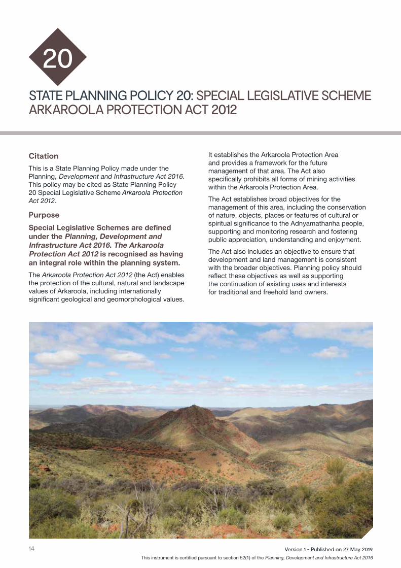
STATE PLANNING POLICY 20: SPECIAL LEGISLATIVE SCHEME ARKAROOLA PROTECTION ACT 2012
CitationThis is a State Planning Policy made under the Planning, Development and Infrastructure Act 2016. This policy may be cited as State Planning Policy 20 Special Legislative Scheme Arkaroola Protection Act 2012.
PurposeSpecial Legislative Schemes are defined under the Planning, Development and Infrastructure Act 2016. The Arkaroola Protection Act 2012 is recognised as having an integral role within the planning system.
The Arkaroola Protection Act 2012 (the Act) enables the protection of the cultural, natural and landscape values of Arkaroola, including internationally significant geological and geomorphological values.
20
It establishes the Arkaroola Protection Area and provides a framework for the future management of that area. The Act also specifically prohibits all forms of mining activities within the Arkaroola Protection Area.
The Act establishes broad objectives for the management of this area, including the conservation of nature, objects, places or features of cultural or spiritual significance to the Adnyamathanha people, supporting and monitoring research and fostering public appreciation, understanding and enjoyment.
The Act also includes an objective to ensure that development and land management is consistent with the broader objectives. Planning policy should reflect these objectives as well as supporting the continuation of existing uses and interests for traditional and freehold land owners.

State Planning Policies
15Version 1 - Published on 27 May 2019 This instrument is certified pursuant to section 52(1) of the Planning, Development and Infrastructure Act 2016
ObjectiveTo protect the cultural, natural and landscape assets within the Arkaroola Protection Area.
Policies20.1 Land uses are consistent with the zoning
applied to the Arkaroola Protection Area by the adopted Arkaroola Protected Area Management Plan.
Principles for Statutory InstrumentsRegional Plans should implement the State Planning Policies by identifying and mapping the Arkaroola Protection Area and any significant environmental and geological sites where appropriate.
The Planning and Design Code should implement the State Planning Policies by depicting the Arkaroola Protection Area in an overlay. The Code policy should also endeavour to prohibit mining within this area. Transport impacts should also be taken into consideration and any inappropriate land use activities should be restricted and discouraged.
Related State Planning Policies• Biodiversity• Natural Hazards• Cultural Heritage• Key Resources
Related legislation and instruments• National Parks and Wildlife Act 1972• Aboriginal Heritage Act 1988• Native Vegetation Act 1991• Wilderness Protection Act 1992• Native Title (South Australia) Act 1994• Environmental Protection and Biodiversity
Conservation Act 1999 (Federal)• Natural Resources Management Act 2004

16 Version 1 - Published on 27 May 2019 This instrument is certified pursuant to section 52(1) of the Planning, Development and Infrastructure Act 2016
STATE PLANNING POLICY 21: SPECIAL LEGISLATIVE SCHEME CHARACTER PRESERVATION (BAROSSA VALLEY) ACT 2012
CitationThis is a State Planning Policy made under the Planning, Development and Infrastructure Act 2016. This policy may be cited as State Planning Policy 21 Character Preservation (Barossa Valley) Act 2012.
Purpose
Special Legislative Schemes are defined under the Planning, Development and Infrastructure Act 2016. The Character Preservation (Barossa Valley) Act 2012 is recognised as having an integral role within the planning system.
The Character Preservation (Barossa Valley) Act 2012 became operational on 18 January 2013.
This legislation provides that the special character of the Barossa Valley is recognised, protected and enhanced while providing for the economic, physical and social wellbeing of the communities within the district. It restricts the creation of additional residential development in the rural areas of the district to halt urban sprawl to the north of Adelaide’s built-up area, thereby seeking to provide for continued farming and primary production activities.
21
Planning policy should reinforce character values so that development does not detract from the special character of the district.
The special character of the district should be considered in terms of the five character values identified in the legislation:
• the rural and natural landscape and visual amenity of the district
• the heritage attributes of the district• the built form of the townships as they relate
to the district• the viticultural, agricultural and associated
industries of the district• the scenic and tourism attributes of the district.It is acknowledged that character is continuous, and the character of the district extends beyond the boundary defined by the character preservation legislation; however the district – (external boundaries, rural living boundaries and township boundaries) – have been defined by the legislation for the purposes of the character preservation considerations.

State Planning Policies
17Version 1 - Published on 27 May 2019 This instrument is certified pursuant to section 52(1) of the Planning, Development and Infrastructure Act 2016
Objective To continue the protection of the Barossa Valley Character Preservation District by reinforcing their character values and supporting primary industries.
Policies21.1 Facilitate flexible farming practices to
allow producers to respond to changing environmental and market conditions.
21.2 Development that supports the viticultural, agricultural and associated industries of the district.
21.3 Well-designed development that is integrated and enhances places, heritage buildings and streetscapes.
21.4 Rural and natural landscape including areas that contribute to biodiversity are enhanced and protected.
21.5 Areas with recognised biodiversity and conservation values, including areas of native bushland, remnant vegetation and essential habitat are protected.
21.6 Investment in new tourism initiatives which enhance the scenic and tourism attributes and values of the district.
Principles for Statutory InstrumentsRegional Plans should implement the State Planning Policies by ensuring that additional residential development within the Barossa Valley Character Preservation Area is restricted and that areas for expansion of our primary industries, tourism activities and heritage areas are identified.
The Planning and Design Code should implement the State Planning Policies by developing assessment pathways and policies that create supportive conditions for primary industry activities while avoiding incompatible land uses. Policy should also provide greater consistency and clarity within the character preservation district for:• Envisaged primary production value-adding
and tourism activities• Boundary realignments• Design guidance• Land use interfaces. The Barossa Valley Character Preservation Areas should be defined in an overlay.
Related State Planning Policies• Integrated Planning• Biodiversity• Climate Change• Cultural Heritage• Primary Industry• Key Resources• Employment Lands• Water Security and Quality• Strategic Transport Infrastructure
Related legislation and instrumentsNil.

18 Version 1 - Published on 27 May 2019 This instrument is certified pursuant to section 52(1) of the Planning, Development and Infrastructure Act 2016
STATE PLANNING POLICY 22: SPECIAL LEGISLATIVE SCHEME CHARACTER PRESERVATION (MCLAREN VALE) ACT 2012
CitationThis is a State Planning Policy made under the Planning, Development and Infrastructure Act 2016. This policy may be cited as State Planning Policy 22 Character Preservation (McLaren Vale) Act 2012.
PurposeSpecial Legislative Schemes are defined under the Planning, Development and Infrastructure Act 2016. The Character Preservation (McLaren Vale) Act 2012 is recognised as having an integral role within the planning system.
The Character Preservation (McLaren Vale) Act 2012 became operational on 18 January 2013.
This legislation provides that the special character of McLaren Vale is recognised, protected and enhanced while providing for the economic, physical and social wellbeing of the communities within the district. It restricts the creation of additional residential development in the rural areas of the district to halt urban sprawl to the south of Adelaide’s built-up area, thereby seeking to provide for continued farming and primary production activities.
Planning policy should reinforce character values so that development does not detract from the special character of the district.
22
The special character of the district should be considered in terms of the five character values identified in the legislation:
• the rural and natural landscape and visual amenity of the district
• the heritage attributes of the district• the built form of the townships as they relate
to the district• the viticultural, agricultural and associated
industries of the district• the scenic and tourism attributes of the district.It is acknowledged that character is continuous, and the character of the district extends beyond the boundary defined by the character preservation legislation; however the district – (external boundaries, rural living boundaries and township boundaries) – have been defined by the legislation for the purposes of the character preservation considerations.

State Planning Policies
19Version 1 - Published on 27 May 2019 This instrument is certified pursuant to section 52(1) of the Planning, Development and Infrastructure Act 2016
ObjectiveTo protect the cultural, natural and landscape assets within the Arkaroola Protection Area.
Policies22.1 Facilitate flexible farming practices to allow
producers to respond to changing environmental and market conditions.
22.2 Development that supports the viticultural, agricultural and associated industries of the district.
22.3 Well-designed development that is integrated and enhances places, heritage buildings and streetscapes.
22.4 Rural and natural landscape including areas that contribute to biodiversity are enhanced and protected.
22.5 Areas with recognised biodiversity and conservation values, including areas of native bushland, remnant vegetation and essential habitat are protected.
22.6 Investment in new tourism initiatives which enhance the scenic and tourism attributes and values of the district.
Principles for Statutory InstrumentsRegional Plans should implement the State Planning Policies by ensuring that additional residential development within the Barossa Valley Character Preservation Area is restricted and that areas for expansion of our primary industries, tourism activities and heritage areas are identified.
The Planning and Design Code should implement the State Planning Policies by developing assessment pathways and policies that create supportive conditions for primary industry and avoidance of incompatible land uses. Policy should also provide for greater consistency and clarity within the character preservation district for:• Envisaged primary production value-adding
and tourism activities• Boundary realignments• Design guidance• Land use interfaces. The McLaren Vale Character Preservation Areas should be defined in an overlay.
Related State Planning Policies• Integrated Planning• Biodiversity• Climate Change • Cultural Heritage• Primary Industry• Key Resources• Employment Lands• Water Security and Quality• Strategic Transport Infrastructure
Related legislation and instrumentsNil.

20 Version 1 - Published on 27 May 2019 This instrument is certified pursuant to section 52(1) of the Planning, Development and Infrastructure Act 2016

State Planning Policies
21Version 1 - Published on 27 May 2019 This instrument is certified pursuant to section 52(1) of the Planning, Development and Infrastructure Act 2016
The definitions included in this Glossary are for the purpose of the State Planning Policies only.
Affordable HousingAffordable Housing is an Inclusionary Policy that incorporates land and dwellings that are appropriate to the needs of households with low and moderate incomes (that is, up to 120% of gross annual median income). The criteria for Affordable Housing (including price points) is determined under regulation 4 of the South Australian Housing Trust (General) Regulations 1995 and associated Government Gazette.
Affordable LivingAffordable living expands upon affordable housing to include transportation costs. By taking into account the combined costs of housing and transportation associated with the location of the home, it provides a more complete understanding of affordability. Affordable living also takes into account indirect costs such as accessing employment areas, services and facilities; household expenditure on electricity, gas and water; and the costs of adaptable housing for older people or people with a disability.
Assessment PathwaysThe assessment pathways are: exempt, accepted, code assessed and impact assessed. Their use will help increase certainty for simple, standard developments and provide a tailored approach for more complex developments. The assessment pathways also link to public notification requirements.
Carbon Sequestration and StorageCarbon sequestration/storage is the general term used for the capture and long-term storage of carbon dioxide. Capture can occur at the point of emission (e.g. from power plants) or through natural processes (such as photosynthesis), which remove carbon dioxide from the earth’s atmosphere and which can be enhanced by appropriate management practices. Sequestration methods include:
• enhancing the storage of carbon in soil (soil sequestration)
• enhancing the storage of carbon in forests and other vegetation (plant sequestration)
• storing carbon in underground geological formations (geosequestration)
• storing carbon in the ocean (ocean sequestration)
• subjecting carbon to chemical reactions to form inorganic carbonates (mineral carbonation).
Community InfrastructureIncludes open space, community sporting facilities/ hubs, indoor recreation centres, trails and public realm improvements or installations.
CharacterAll areas have a character that can be analysed and described. Character is a value-neutral concept that captures the interrelationship between built form, vegetation and topography in the public and private domains that distinguishes one place from another.
The concept of character is broader than merely architectural style or the era of development. It is also about the recognition of distinctive characteristics or urban forms and the relationship to surrounding topography, vegetation and other features (ie the buildings and the spaces and features around them and how they relate to each other).
GLOSSARY

22 Version 1 - Published on 27 May 2019 This instrument is certified pursuant to section 52(1) of the Planning, Development and Infrastructure Act 2016
Climate Smart DevelopmentAn approach for transforming and reorienting development under the new realities of climate change. Climate Smart Development aims to slow the onset of adverse changes in climate while continuing to promote the objectives of economic growth and development. Climate-sensitive developments include as the adoption of clean transport technologies and the construction of energy-efficient buildings.
Cultural HeritageCultural heritage describes the legacy of physical artifacts and intangible attributes of a group or society that is inherited from past generations.
Cultural heritage includes tangible culture (such as buildings, monuments, landscapes, books, works of art and artifacts), intangible culture (such as folklore, traditions, language and knowledge), and natural heritage (including culturally significant landscapes and biodiversity).
Density (low, medium and high density)Density is a measure of the population (persons) or the number of dwelling units (du) in a given area (usually hectares).
• Low density = fewer than 35 dwelling units per hectare (du/ha)
• Medium density = 35-70 du/ha
• High density = more than 70 du/ha.
Employment LandsEmployment lands are those lands where development is focused on creating places for people to work. Employment lands generally have an industrial flavour and support business innovation, growth and investment.
Environmental Impact Statements (EISs)A document prepared to assess the likelihood of possible effects a development or project might have on the environment. A decision is made as to whether or not the development should proceed and if so what conditions need to be attached.
Essential Infrastructure(a) infrastructure, equipment, structures, works and
other facilities used in or in connection with—
(i) the generation of electricity or other forms of energy; or
(ii) the distribution or supply of electricity, gas or other forms of energy; and
(b) water infrastructure or sewerage infrastructure within the meaning of the Water Industry Act 2012; and
(c) transport networks or facilities (including roads, railways, busways, tramways, ports, wharfs, jetties, airports and freight handling facilities); and
(d) causeways, bridges or culverts; and
(e) embankments, walls, channels, drains, drainage holes or other forms of works or earthworks; and
(f) testing or monitoring equipment; and
(g) coast protection works or facilities associated with sand replenishment; and
(h) communications networks; and
(i) health, education or community facilities; and
(j) police, justice or emergency services facilities; and
(k) other infrastructure, equipment, buildings, structures, works or facilities brought within the ambit of this definition by the regulations.
Freight NetworksRoad and rail corridors, bridges, ferries, ports, airports and other facilities and infrastructure which, when for the movement of freight.
Green InfrastructureThe network of green spaces and water systems that delivers multiple environmental, social and economic values and services to urban communities.
Green TechnologiesThe use of technology that makes products and processes more environmentally friendly, for example, by reducing CO2 emissions or by making products more biodegradable. Overall, green technology aims at contributing to environmental sustainability.

State Planning Policies
23Version 1 - Published on 27 May 2019 This instrument is certified pursuant to section 52(1) of the Planning, Development and Infrastructure Act 2016
HeritageHeritage has an established international frame of reference (ICOMOS / Burra Charter) and is about how a place represents history and evolution of an area and its people or activities that have taken place. Heritage and cultural significance is embodied in the fabric and setting of the place.
Impact Assessable DevelopmentRequired where there is a need to consider the potential impacts of the proposal. As a general rule, a change of use of a premises is impact assessable, unless stated otherwise.
InfrastructureThe facilities, systems and equipment required to provide public services and support private sector economic activity including network infrastructure (e.g. roads, bridges, water and wastewater systems, large information technology systems), buildings (e.g. hospitals, schools, courts), and machinery and equipment (e.g. medical equipment, research equipment).
Infrastructure SchemesThe introduction of a contemporary way of managing infrastructure through Basic and General Infrastructure Schemes. They will supplement existing schemes such as planning conditions, deeds and bonding arrangements and may replace the need for complex infrastructure agreements with individual landowners, which has slowed administration processes considerably. They will provide additional tools to help unlock investment and create a transparent process that enables new infrastructure to be delivered to our communities.
Integrated Decision MakingA single process for determining needs and decision making rather than the traditional approach that uses separate processes.
Joint Planning BoardA Joint Planning Board constitutes between 3 and 7 members and is a body corporate. A Joint Planning Board is primarily tasked with overseeing its agreed functions.
A committee has an advisory role to the joint planning board on a particular matter; and a subsidiary undertakes the task assigned to it by the Joint Planning Board.
OverlaysA mechanism within the Planning and Design Code that address defined issues applying to any zone or subzone, identifying areas where there is a particular sensitivity to development (e.g. a heritage place), a constraint on land or development outcomes (e.g. bushfire risk), or where a particular opportunity or outcome for development is sought.
Overlays are the primary mechanism to spatially express State Planning Policies and are the mechanism to pick up planning issues of state interest. Referrals can largely be expected to be contained in overlays where specialised assessment expertise is required to protect a matter of state interest.
Performance Based PlanningDevelopment proposals are judged on their merit and are in keeping with strategic policy outcomes. Performance based outcomes provide a flexible approach to achieving the outcomes desired.
Planning and Design CodeThe State Planning Commission will be responsible for preparing and maintaining the Planning and Design Code, which will require a new approach to the drafting, presentation and interpretation of zoning rules. The new code will be based on a more design-orientated style of zoning that focuses on built form and mixed-use development.
The Code will set out a comprehensive set of planning rules for development assessment purposes, classified into Zones, Subzones and Overlays. These will be applied in each region in a manner consistent with the relevant region plan. This will make the Code the single point of reference for development assessment.
Planning InstrumentsPlanning instruments include State Planning Policies, Regional Plans, the Planning and Design Code and Design Standards. Instruments can be prepared by the Minister for Planning, the State Planning Commission or a Joint Planning Board.

24 Version 1 - Published on 27 May 2019 This instrument is certified pursuant to section 52(1) of the Planning, Development and Infrastructure Act 2016
Planning RegionThe Planning, Development and Infrastructure Act 2016 2016 provides for the state to be divided into ‘planning regions’. One of the regions must be designated as ‘Greater Adelaide’ (replacing the definition of ‘Metropolitan Adelaide’ in the previous Act).
Planning, Development and Infrastructure Act 2016 (the Act)An Act to provide for matters that are relevant to the use, development and management of land and buildings.
A planning system to regulate development within the state, with rules in respect to the design, construction and use of buildings, and other initiatives to facilitate development of infrastructure, facilities and environments that will benefit the community.
Planning, Development and Infrastructure RegulationsThe Planning, Development and Infrastructure Regulations (yet to be drafted) fall under the Planning, Development and Infrastructure Act 2016. Regulations may be made on a variety of building-related topics including the performance standard or form of building work, and fire safety and other designated safety features. They also stipulate the type of assessment and assessment streams required.
Principles of Good PlanningPrinciples of Good Planning are outlined in the Act. These principles have a long-term focus and respond to emerging challenges, encourage the renewal of existing suburbs, promote walking and cycling, support the livability of suburbs, facilitate investment, promote the development of public transport, and promote cooperation and integration between and among state government agencies and local government.
Regional PlansThe State Planning Commission must prepare a Regional Plan for each planning region. These plans must be consistent with relevant state planning policies and include:
a. A long-term vision (over 15 to 30 year period) for the region or area, including provisions about the integration of land use, transport infrastructure and the public realm
b. Maps and plans that relate to the long-term vision
c. Contextual information about the region or area, including forward projections and statistical data and analysis as determined by the State Planning Commission or required by a practice direction
d. Recommendations about zoning and a framework for development or management of infrastructure and the public realm.
Regional plans may be divided into parts relating to sub-regions, and may include structure plans, master plans, concept plans or other similar documents. Regional plans prepared by a joint planning board must comply with any practice direction issued by the Commission.
Sensitive Land Uses Types of land uses sensitive to emissions and impacts from industry and infrastructure. Sensitive land uses include residential development, hospitals, hotels, motels, hostels, caravan parks, schools, nursing homes, child care facilities, shopping centres, playgrounds and some public buildings. Some commercial, institutional and industrial land uses which require high levels of amenity or are sensitive to particular emissions may also be considered “sensitive land uses”. Examples include some retail outlets, offices and training centres, and some types of storage and manufacturing.
Social Infrastructure Social infrastructure is the interdependent mix of facilities, places, spaces, programs, projects, services and networks that maintain and improve the standard of living and quality of life in a community. Examples of Social Infrastructure Assets include schools, universities, hospitals, prisons and community housing.

State Planning Policies
25Version 1 - Published on 27 May 2019 This instrument is certified pursuant to section 52(1) of the Planning, Development and Infrastructure Act 2016
Special Legislative SchemesAre a character preservation law, part of any of the following Acts: The River Murray Act 2003, The Adelaide Dolphin Sanctuary Act 2005, The Marine Parks Act 2007, The Arkaroola Protection Act 2012 or something that declared by the regulations to be a special legislative scheme.
State Adaptive Reuse GuidelinesThese relate to re-using existing buildings for new functions and include exploring the options that lie between the extremes of demolition and turning a site into a museum.
The principles of the guidelines are based on memory and place, planning controls, social sustainability, environmental sustainability, efficiency and authenticity.
State Interest PoliciesSpecific matters of state interest in land-use planning and development controlled by specific policy.
State Planning CommissionThe Planning, Development and Infrastructure Act 2016 creates a new State Planning Commission reporting to the Minister. Its responsibilities include provisions of independent policy advice to government guidance to councils and professionals; and coordination of planning with infrastructure delivery. The Commission will also serve as an assessment authority for prescribed classes of development applications.
State Planning Policies (SPPs)Set out the government’s overarching goals and requirements for the planning system. These policies are to be taken into account when preparing other statutory instruments such as Regional Plans and design standards. They are not to be taken into account for the purpose of any assessment decision or application.
State Policy MattersProvide integration between state and local policy and allow for easier implementation of new policy. They are simpler and clearer planning rules for local government and community and industry applicants.
State-significant Operations and IndustriesIndustries and other industrial/commercial activity of major economic significance to South Australia. This term is most often used in reference to certain physical facilities, plant or industrial operations which are ongoing in an area, for example the Port Pirie metals smelting facility, the Whyalla steelworks, the Port Lincoln-based fish and seafood processing industries, defence manufacturing at Edinburgh Parks and the wine grape production industry clusters in the Barossa Valley, McLaren Vale, Riverland and Coonawarra/Padthaway regions.
Strategic Employment LandsEmployment lands which have strategic significance due to their size, location and contribution to the state’s economy.
Strategic Intermodal FacilitiesAn intermodal facility is any site or facility along the supply chain that contributes to an intermodal movement by providing efficient transfer of goods from one mode of transport to another. Strategic intermodal facilities have a crucial role to play in the transport network and in supporting the anticipated increases in transport uses.
Structure PlansStructure Plans provide a broad spatial expression of the desired development outcomes for an area and can include transit corridors, centres, renewal areas or greenfield sites. Structure plans may also be used to identify the regional distribution of targets, policies or actions relevant to an area and infrastructure and governance issues that will require resolution to facilitate the desired development outcomes of an area.
Sustainable DevelopmentForms of development that meet the needs of the present without compromising the ability of future generations to meet their needs.
Transit CorridorsTransit corridors are the walking catchments of light rail mass transit and high frequency bus routes. They are well serviced with infrastructure and when fully developed will contain a mix of housing including medium to high density and mixed use developments. Strategic transit corridors are major movement corridors of state or regional significance

26 Version 1 - Published on 27 May 2019 This instrument is certified pursuant to section 52(1) of the Planning, Development and Infrastructure Act 2016
Transport RoutesThe corridors or important linkages used for the movement of people and goods around South Australia. These routes consist of a range of typologies, modes and features ranging from bicycle and walking paths at the local level, to main roads at the metropolitan or regional level, to shipping routes, ferry crossings, aviation routes and tunnels across land, water and air.
Universal DesignRefers to the design of products, environments, programs and services to be usable by all people of different ages and abilities over time, to the greatest extent possible, without the need for adaptation or specialised design.
Value AddingValue adding involves economically adding value to a raw material through processing or altering characteristics of that material.
A specific example is the improvement or refinement of an agricultural product (such as wheat) by processing it into a product (such as flour) desired by customers (such as bread bakers).
Value-based FrameworkProvides a way of approaching policy problems and analysing potential initiatives to address these with a strategic base.
ZonesZones are the primary organising layer of the Planning and Design Code. All land within South Australia will be included within a zone. Zones set out policies and rules primarily relating to the land use, land use intensity and built form characteristics that are anticipated for an area – in effect outlining ‘what’ can happen in an area.
Zones also identify procedural matters including Categories of Development, assessment pathways, public notification requirements and, where relevant, referrals.
For further information visit www.saplanningportal.sa.gov.au

State Planning Policies
27Version 1 - Published on 27 May 2019 This instrument is certified pursuant to section 52(1) of the Planning, Development and Infrastructure Act 2016

For further information visit
Issued by the Minister for Planning on 27 May 2019.