Embed Size (px)
Citation preview

State of the Lake Environment Report
2011
White Lake

2
White Lake
Easy steps to improve water quality
Build at least 30 metres (100 feet) away from the shoreline Keep your lot well treed
Preserve or replant native vegetation along the shoreline Pump out your septic tank every three to five years
Reduce water usage Use phosphate free soaps and detergents Keep the size of your lawn to a minimum
Limit use of fertilizers, herbicides and pesticides
Why Watershed Watch?
The Ribbon of Life is the shallow waters and first 10 metres of shore land around our lakes where the land meets the water. This ribbon—where land meets the water—is where much of the lake life is born, raised and fed. Many landowners, unaware of the importance of this area, have cleared the shorelines of native vegetation and replaced it with lawns, non-native ornamental vegetation, retaining walls and boathouses. This has had a negative effect fish and wildlife habitat and water quality. Natural vegetation retained or restored along the shoreline helps prevent erosion and improves water quality by binding nutrients before they can enter the lake.
Mississippi Valley Conservation (MVC) has long recognized the recreational and aesthetic value of lakes within the watershed and is committed to maintaining and protecting water quality and fish habitat. MVC has joined together with volunteer lake stewards throughout the watershed to take steps to protect and restore water quality by launching the Watershed watch program in 1998. Watershed Watch is an environmental monitoring and awareness program. The objectives of the program are to collect reliable environmental data to document current water quality conditions and use the data as an essential educational tool to encourage residents to adopt sound stewardship practices aimed at preserving and protecting water quality. Together we will encourage and assist shoreline residents. both seasonal and permanent, to become personal stewards of their lake by taking an active role in restoring and enhancing their shoreline to maintain water quality and a healthy lake environment.

2011 State of the Lake Report 3
Wh
ite
La
ke

4
White Lake
How Does White Lake Measure Up?
* Mean based on less than 6 measurements ** Includes Recreational Lakes Program Data. Chlorophyll a data prior to 1985 has been adjusted to reflect new lab procedures in filtering resulting in an increase in chla concentrations by 35%
Located in the Townships of Central Frontenac. A Designated Fish Sanctuary, White Lake hosts the Ministry of Natural Resources fish hatchery. Elevation of 213 metres above sea level. Lake perimeter is 8.1 kilometres. Deepest point is 29.6 metres. Warm water fishery, particularly Walleye, Northern Pike, Yellow Perch, Small and Largemouth Bass. As of 1970, there were 14 cottages and on the lake.
White Lake
1976 – 2011 WATER QUALITY RESULTS – MAIN BASIN
Sample Year Secchi Disc Total Phosphorus Total Phosphorus Chlorophyll a
Mean Depth Euphotic Zone 1 Metre off Bottom Composite
(Metres) (Micrograms/litre) (Micrograms/litre) (Micrograms/litre)
**1976 5 32 14
2001 4.1 6.3 25.9 1.9
*2006 4 4 11.67 2.6
*2011 4 15.7 61.7 2.9
n 4 4 4 3
Mean 4.275 14.5 28.3 2.5
Standard Deviation 0.485626743 12.71717998 23.11107725 0.513160144

5
White Lake
White Lake Main Basin Annual Mean Secchi Disc Measurements (Metres)
Interpreting SECCHI DISC Results
Secchi Reading Lake Nutrient Status
Over 5 metres Oligotrophic - unenriched, few nutrients
3.0 to 4.9 metres Mesotrophic – moderately enriched, some nutrients
Less than 2.9 metres Eutrophic – enriched, higher levels of nutrients
Secchi Disc Measurements
A Secchi Disc is a black and white coloured disc used to determine water clarity. The disc is lowered into the water. The point, at which you can no longer distinguish the black and white, is called the Secchi depth. The higher the Secchi Disc measurement, the more clear your lake.
Lakes are classified as oligotrophic, mesotrophic, or eutrophic depending on age and whether they have little, some, or a lot of life, respectively. Oligotrophic lakes are the youngest and, usually, least fertile lakes; they tend to be
deep with sparse aquatic vegetation and few fish. Mesotrophic lakes are middle-aged lakes that are less deep and more fertile than oligotrophic lakes. And eutrophic lakes (the oldest lakes) are most fertile and even more shallow than mesotrophic lakes.
Eutrophic lakes eventually reach the point where demand for oxygen exceeds the oxygen supply. Eutrophic lakes have many aquatic life forms that eventually die and decompose; decomposition uses up oxygen that could have supported additional life. Decomposing material, detritus, collects on the lake's bottom making the lake shallower. As oxygen becomes sparse, lakes approach senescence, full maturity to death.
0
1
2
3
4
5
6
1976 2001 2006 2011
2011 State of the Lake Report 6
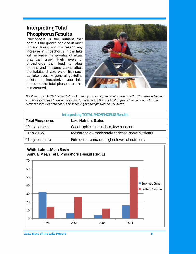
Interpreting TOTAL PHOSPHORUS Results
Total Phosphorus Lake Nutrient Status
10 ug/L or less Oligotrophic - unenriched, few nutrients
11 to 20 ug/L Mesotrophic – moderately enriched, some nutrients
21 ug/L or more Eutrophic – enriched, higher levels of nutrients
Interpreting Total Phosphorus Results Phosphorus is the nutrient that controls the growth of algae in most Ontario lakes. For this reason any increase in phosphorus in the lake will increase the quantity of algae that can grow. High levels of phosphorus can lead to algal blooms and in some cases affect the habitat of cold water fish such as lake trout. A general guideline exists to characterize your lake based on the total phosphorus that is measured.
The Kremmerer Bottle (pictured above ) is used for sampling water at specific depths. The bottle is lowered with both ends open to the required depth, a weight (on the rope) is dropped, when the weight hits the bottle the it causes both ends to close sealing the sample water in the bottle.
0
10
20
30
40
50
60
70
1976 2001 2006 2011
Euphotic Zone
Bottom Sample
White Lake Main Basin Annual Mean Total Phosphorus Results (ug/L)

2011 State of the Lake Report 7
Evaluating Chlorophyll a Results: Water clarity is influenced by the amount of phytoplankton or microscopic algae present in the water. Chlorophyll a is the green pigment in phytoplankton. The lower the chlorophyll a density in your lake, the clearer your lake is. Chlorophyll a is directly affected by the amount of total phosphorus in your lake. The more phosphorus there is in the water, the more algal growth will occur.
Interpreting CHLOROPHYLL A Results
Chlorophyll a Reading Lake Nutrient Status
Up to 2 ug/L - low algal density Oligotrophic - unenriched, few nutrients
2-4 ug/L - moderate algal density Mesotrophic - moderately enriched, some nutrients
More than 4 ug/L- high algal density Eutrophic - enriched, higher levels of nutrients
The Composite Sampler (pictured above) is used for water samples similar to a core sample. The tin is dropped into the water. When it reached the required depth it is slowly pulled back to the surface. The tube is filled as water enters one tube while air escapes the other. It is essential that some air is left in the tin to ensure collection throughout the entire haul to the surface.
White Lake Main Basin Annual Mean Chlorophyll a Results (ug/L)
0
0.5
1
1.5
2
2.5
3
3.5
2001 2006 2011
8
White Lake
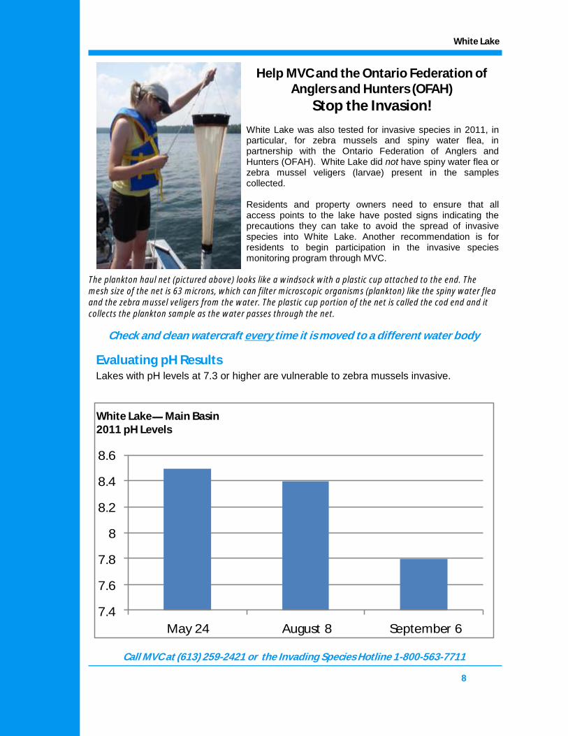
Evaluating pH Results
Lakes with pH levels at 7.3 or higher are vulnerable to zebra mussels invasive.
Check and clean watercraft every time it is moved to a different water body
White Lake was also tested for invasive species in 2011, in particular, for zebra mussels and spiny water flea, in partnership with the Ontario Federation of Anglers and Hunters (OFAH). White Lake did not have spiny water flea or zebra mussel veligers (larvae) present in the samples collected. Residents and property owners need to ensure that all access points to the lake have posted signs indicating the precautions they can take to avoid the spread of invasive species into White Lake. Another recommendation is for residents to begin participation in the invasive species monitoring program through MVC.
Help MVC and the Ontario Federation of Anglers and Hunters (OFAH)
Stop the Invasion!
Call MVC at (613) 259-2421 or the Invading Species Hotline 1-800-563-7711
The plankton haul net (pictured above) looks like a windsock with a plastic cup attached to the end. The mesh size of the net is 63 microns, which can filter microscopic organisms (plankton) like the spiny water flea and the zebra mussel veligers from the water. The plastic cup portion of the net is called the cod end and it collects the plankton sample as the water passes through the net.
7.4
7.6
7.8
8
8.2
8.4
8.6
May 24 August 8 September 6
White Lake Main Basin 2011 pH Levels

2011 State of the Lake Report 9
White Lake Main Basin #11-01 May 24, 2011 10:30 AM
Sampling Results Main Basin
Depth
(Metres)
Temperature
(Degree Celsius)
Dissolved Oxygen
(Milligrams / Litre)
Percent %
Saturation
Thermal
Stratification
0.1 15.8 10.60 107.0
1 15.8 10.60 106.9 Epilimnion
2 15.8 10.59 106.8
3 15.4 10.71 107.3
4 14.0 11.22 108.8 Thermocline 1
5 13.3 11.33 108.4
6 12.6 11.25 105.8
7 12.2 11.24 104.8 Thermocline 2
8 11.6 11.10 102.2
9 10.9 10.99 99.2
10 8.9 10.35 89.2 Thermocline 3
11 8.4 10.28 87.7
12 7.9 10.08 84.8
13 7.5 9.85 82.2
14 7.2 9.59 7.94
15 6.9 9.43 77.3
16 6.7 8.91 72.6
17 6.6 8.60 70.2
18 6.5 8.56 69.6 Hypolimnion
19 6.5 8.52 69.1
20 6.4 8.52 69.2
21 6.3 8.44 68.2
22 6.2 8.24 66.5
23 6.2 8.11 65.6
24 6.1 7.80 62.8
25 6.1 7.49 60.2
26 6.1 7.28 58.6
27 6.0 6.22 49.9
28 Bottom Bottom Bottom
Warm Water Fisheries Habitat (Bass, Walleye, Pike, Perch) = DO > 4 mg/L at < 25°C

10
White Lake
White Lake Main Basin # 11-01 August 8, 2011 10:30 AM
Sampling Results Main Basin
Depth
(Metres)
Temperature
(Degree Celsius)
Dissolved Oxygen
(Milligrams / Litre)
Percent %
Saturation
Thermal
Stratification
0.1 25.14 7.95 96.1
1 25.15 8.69 106.1
2 25.14 8.89 108.0
3 25.11 9.00 109.1 Epilimnion
4 25.10 9.05 109.9
5 25.07 9.10 110.3
6 25.01 9.14 110.8
7 19.49 9.73 105.8
8 15.38 9.60 95.7
9 12.04 8.15 75.5 Thermocline
10 10.79 7.33 65.7
11 9.70 6.16 54.3
12 9.07 5.62 48.3
13 8.47 4.88 41.2
14 7.89 3.77 31.5
15 7.41 3.04 24.9
16 7.14 2.18 17.3
17 6.94 1.58 13.0
18 6.70 1.47 12.0
19 6.57 1.33 10.8 Hypolimnion
20 6.39 1.01 8.2
21 6.30 0.55 4.4
22 6.25 0.29 2.2
23 6.20 0.20 1.6
24 6.16 0.18 1.4
25 6.14 0.17 1.4
26 6.10 0.15 1.2
27 6.08 0.15 1.2
28 6.00 0.15 1.2
29 5.99 0.16 1.3
30 5.99 0.15 1.2
31 5.99 0.16 1.3
32 Bottom Bottom Bottom
2011 State of the Lake Report 11
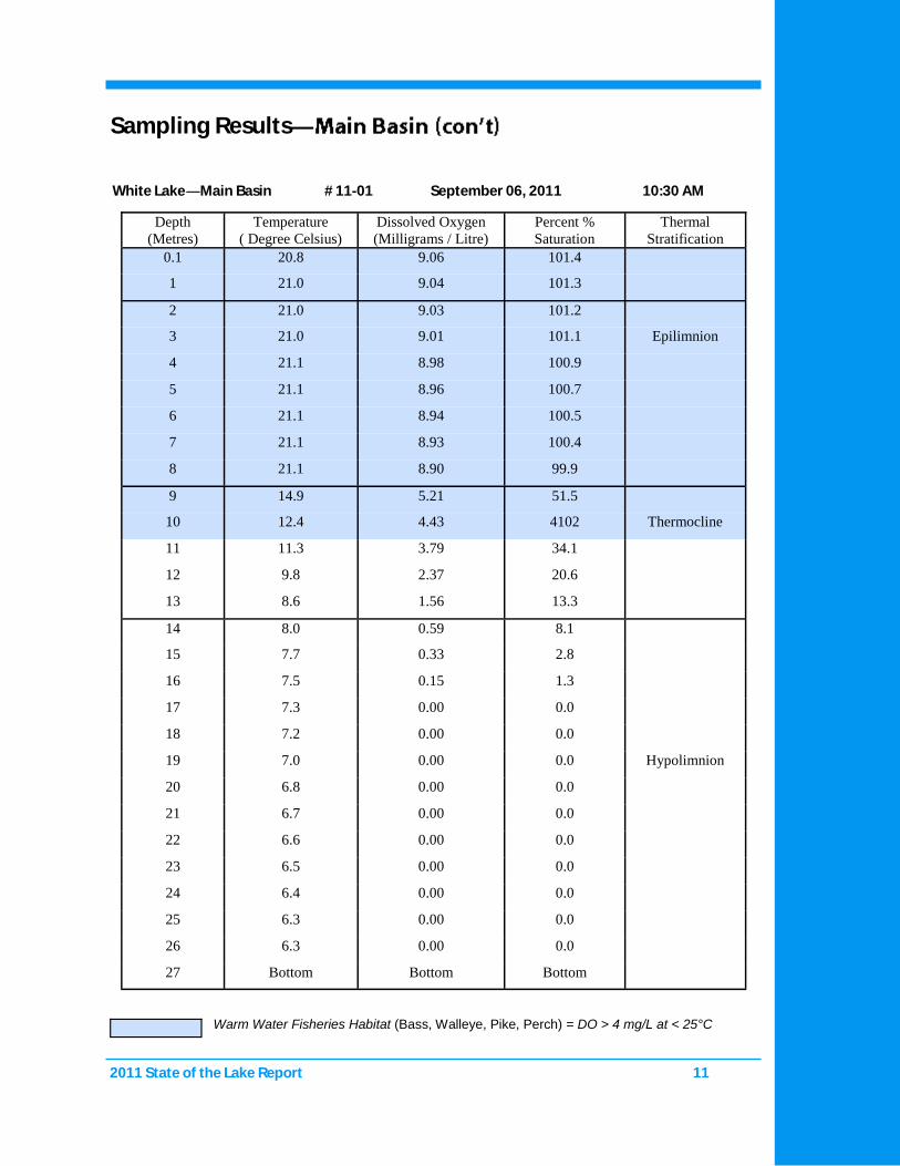
White Lake Main Basin # 11-01 September 06, 2011 10:30 AM
Sampling Results
Warm Water Fisheries Habitat (Bass, Walleye, Pike, Perch) = DO > 4 mg/L at < 25°C
Depth
(Metres)
Temperature
( Degree Celsius)
Dissolved Oxygen
(Milligrams / Litre)
Percent %
Saturation
Thermal
Stratification
0.1 20.8 9.06 101.4
1 21.0 9.04 101.3
2 21.0 9.03 101.2
3 21.0 9.01 101.1 Epilimnion
4 21.1 8.98 100.9
5 21.1 8.96 100.7
6 21.1 8.94 100.5
7 21.1 8.93 100.4
8 21.1 8.90 99.9
9 14.9 5.21 51.5
10 12.4 4.43 4102 Thermocline
11 11.3 3.79 34.1
12 9.8 2.37 20.6
13 8.6 1.56 13.3
14 8.0 0.59 8.1
15 7.7 0.33 2.8
16 7.5 0.15 1.3
17 7.3 0.00 0.0
18 7.2 0.00 0.0
19 7.0 0.00 0.0 Hypolimnion
20 6.8 0.00 0.0
21 6.7 0.00 0.0
22 6.6 0.00 0.0
23 6.5 0.00 0.0
24 6.4 0.00 0.0
25 6.3 0.00 0.0
26 6.3 0.00 0.0
27 Bottom Bottom Bottom

2011 State of the Lake Report 12
Seine netting by hand is a way of sampling fish species that may live or visit the near shore areas of a waterbody. A seine net is a type of fishing net that has floats along one edge and weight along the other edge, to keep it upright in the water. It is then dragged through a section of water, encircling it, thus collecting all the fish within that area. The depth of the testing area is limited to areas wadeable by the field crew. This method has a very limited impact on the health of the fish sampled and is affordable, easy to do, and portable. Seine netting was conducted at the boat launch sites of all the watershed watch lakes of the 2011 field season to help expand our knowledge of each lake beyond just its chemistry. Netting was conducted in July and August to avoid disturbing sensitive nesting, and breeding sites. However; no seine took place on White Lake due to the protection of the fish hatchery. The majority of the individual fish captured with the seine net are bait fish such as minnows and cyprinids; some juvenile and adult game fish were also caught. Both groups (bait fish and juvenile game fish) tend to stick close to shore to avoid predation from larger fish that can be found in deeper waters. Near shore areas may also contain aquatic vegetation which is ideal camouflage for all sizes of fish that are either hiding from predators, or waiting to surprise prey, explaining why some adult game fish were caught. It is important to note that if something was not caught in the seine we cannot conclude that the fish species is not in the lake rather that the species was not in the sampling zone when the sampling was done.
Most stakeholder interest in fish species within a water body has to do with game fish. However, baitfish far outnumber game fish and thus play a critical role within their ecosystem and the food chain. It is important to take note of their presence, and provide them the same consideration you would for larger fish. If you are curious about learning more about baitfish, and how to identify the different species, please refer to the Department of Fisheries and Oceans “Baitfish Primer”, it is available online and at the MVC office.
Seine Netting

For more information about the MVC Monitoring Program
please call: 613.259.2421 ext. 235 or email: [email protected] or
visit: www.mvc.on.ca
We are located at 4175 Hwy 511 Lanark Ontario
K0G 1K0
MVC would like to thank the many dedicated volunteers and the Lake
Steward Network for their assistance with and support of the Watershed
Watch program.
community • environment • balance