Embed Size (px)
Citation preview

State Cartographer’s Office 550 N. Park St., UWMadison
384 Science Hall, Madison, WI 53703
Wisconsin Consolidated Geodetic Control OGC-WFS Service Project
Establishing Framework Data Services using the OpenGIS Web Feature Service
FINAL TECHNICAL REPORT October, 2006
AJ Wortley Jared Chapiewsky Brenda Hemstead
Wisconsin State Cartographer’s Office
U.S. Geological Survey Agreement #: 04HQAG0167

WI SCO CAP04 – Consolidated Geodetic Control OGCWFS Service Final Report
2
Table of Contents I. Summary ……………………………………………… 3 II. Successes and Challenges………..…………………… 4 III. Technical Details……………………………………... 5 IV. Strengths and Weaknesses…………………………… 6 V. Conclusions and Future Activities…………………… 6
Appendix A – WFS Service URLs Appendix B – MapServer WFS Configuration File and Notes Appendix C – Geodetic Control Schemas
Agreement Number: 04HQAG0167
Final Report
Title: Wisconsin Consolidated Geodetic Control OGCWFS Service Project
Geographic Extent Served by Project: State of Wisconsin
Organization: Wisconsin State Cartographer’s Office (SCO) 384 Science Hall 550 N. Park Street Madison, WI 537061491
Project Leader: AJ Wortley – Outreach Specialist – SCO Ph. (608) 2658106 Fax (708) 2625205 EMail – [email protected]
Collaborating Organizations: Various organizations have and/or continue to collaborate with us to make
geodetic control accessible. Our closest collaborators include Wisconsin’s NGS State Advisor, the USGS Wisconsin liaison, the Wisconsin Department of Transportation, and many Wisconsin counties.

WI SCO CAP04 – Consolidated Geodetic Control OGCWFS Service Final Report
3
I. Summary
We oriented our goals for this project along two tracks: an institutional model for partnering, demonstration and education of emerging data exchange technologies and standards; and a technical model for geodetic control framework data integration and delivery. Our institutional model looks at a hybrid approach for framework data integration providing outreach and education to a range of partners from those who would contribute their data in native format to those who would author it from the source as a standards- compliant OGC web service. Our technical model involves exploration and demonstration of open standards and technologies for delivery from both a centralized data model as well as pass-through publishing of information directly from data custodians via cascading web services. Such models hold promise for further solidifying Wisconsin’s emerging spatial data infrastructure. To that end (that never ends) we divided each of the institutional and technical activities into subcategories of effort.
From the institutional perspective, we identified the need for a) online application and desktop client support for these types of standards-based feature services; and b) investigation to find local, regional, or state partners through which to demonstrate the ability to cascade these types of services through neutral needs-based community schemas, whether content standards for federal exchange or state application; and c) compelling cases at the state or federal level for accelerating this activity.
More specifically on the technical framework side, through authoring our geodetic control point web feature service, we looked at a) open source software support for open web services of neutral federal content standards expressed as XML schemas as well as b) incremental automation of the contribution process while relaying best practices for data/metadata maintenance to custodians; and c) ultimately, pursuit of partnering opportunities for direct web services delivery of control from local custodians to an integrated portal application.
Below are outlined our specific successes; technical capabilities; strengths and weaknesses; and finally, future directions as we continue to work harder than ever on these efforts while always seeking wider collaboration and consensus.

WI SCO CAP04 – Consolidated Geodetic Control OGCWFS Service Final Report
4
II. Successes and Challenges
Specific accomplishments with noted challenges in institutional partnering and collaboration include: Partnering
o Contacted 31 nonpartnering counties resulting in 10 contributing partners as well as identification of 7 counties that submit control directly to NGS;
o To 21 current and inprogress contributors, provided information and advice on data quality documentation and format maintenance for exchange with applications;
o Prioritized remaining potential contributors in conjunction with and weighted against ramping up PLSS integration effort (see Workflow/application support);
o Strengthened relationship with county partners, WI DOT regional offices and local surveying community as consumers of control point information from the ControlFinder (http://www.sco.wisc.edu/geocat/) application;
o Challenge: Did not contact all remaining counties due to unforeseen obstacles in both determining appropriate point of contact as well as time to address broad ranging questions ranging from privacy/security to standard content definitions;
o Challenge: Did not follow up on initial invitation to communicate with NGS IT regarding NGS delivery of control – this is discussed in Future Activities.
Workflow/application support o Adapted ControlFinder to more specific and changing GPS and workflowbased
output formats as segue to finding WFS position in workflow chain; o Noted inclusion of ControlFinder in WI Dept. of Transportation regional training
video for survey workflow; o Investigated some commercial, open source and online clients for WFS
consumption and demonstration including ArcGIS 8.x9.1, Gaia 1.02.x, Udig 1.0x and while no direct web client demonstrations were performed, we continue to pursue this goal;
o Effectively incorporated Online Condition Reports for communication back to data custodians; as well as uplift of local partners through data passback in updated format with metadata file;
o Are driving force behind Wisconsin Coordinate System Task Force – while this is an ancillary activity, it has been instrumental in clarifying, correcting and enabling quality control point information integration across County coordinate systems independent of software platform;
o Extended partnering model to create integrated application view of PLSS corner information, often from same contributing partners – a prototype exists and is under development for release in early 2007;
o Challenge: We continue to watch for better commercial software support as well as compelling use case scenario for WFS service provision or consumption from state or federal initiatives.

WI SCO CAP04 – Consolidated Geodetic Control OGCWFS Service Final Report
5
OGC Services Outreach – o Gave presentations at the 2004 Great Lakes Regional Data Exchange (RDX),
Wisconsin Land Information Association, Wisconsin Society of Land Surveyors, UW campus and Madison Area Surveyors’ Council;
o Continue collaboration, discussion and demonstration within Wisconsin DNR, more recently with the DNR’s Great Lakes Office with respect to our Great Lakes Strategy as well as in observing DNR prototyping of XMLbased exchange of data with EPA via their Exchange Network initiative;
o Actively work with UW Sea Grant and UW Environmental Remote Sensing Center in overseeing parallel projects under Institute for Application of Geospatial Technologies (IAGTAuburn, NY) and Great Lakes Commission (GLCAnn Arbor, MI) for multijurisdictional and regional integration efforts.
III. Technical Details
Specific data management and web service details include: Data management status
o Framework data theme service: consolidated geodetic control, PLSS in work; o Framework data volume: ~25,000 control point records, further divided up as:
10,650 NGS records – 2950 of which are further identified as Wisconsin Height Modernization points; 10,400 USGS 3 rd order vertical control; and 3250 local control records; stored in a PostGIS spatial database;
o Primary partnering organizations providing data include NGS, WI Dept. of Transportation and ~ 20 Wisconsin counties;
o Hardware/software configuration: Apple OS X server running Apache web server, PostGIS/Postgresql spatial database, MapServer for web services authoring, and custom scripts for schema manipulation.
WFS status o WFS server registration: not yet registered with geodata.gov o Access experience: Our experience has been that there is not yet wellfounded
support for WFS services in existing clients – clientside or serverside. We continue to pursue demonstration of utility inside our own application as demonstration for other potential application clients.
o WFS user base: There is not yet demand for this sophisticated level of feature based data delivery, at least for geodetic control here in Wisconsin.
Project Management o Project continuance: This project has and will continue into the foreseeable future
as a core function of the State Cartographer’s Office. o The next phases in this project are discussed below under next steps but are
detailed briefly here as: 1) Installation and testing of Geoserver software as WFS services authoring
framework with MapServer providing coupled WMS support;

WI SCO CAP04 – Consolidated Geodetic Control OGCWFS Service Final Report
6
2) Expansion of framework uplift effort for survey control to include PLSS; 3) Expansion of partnering network to be more comprehensive and
incorporate advanced examples of serverbased data exchange possibly with NGS, particularly after publishing the new adjustment.
IV. Strengths and Weaknesses
Our continuing primary strength is our longterm connection with and communication paths to local government geospatial data producers in Wisconsin. As our outreach work progresses, we are confident that there are many potential contributors who are yet untapped and willing to collaborate. The other major strength of this project is our ability to sustain the work begun under this grant beyond the end date. This remains a primary activity to which office resources are allocated.
That said, our primary weakness and obstacle to more rapid progress is a lack of official coordination and guidance at the State level in areas such as updated standards for geospatial content and exchange. Wisconsin now has a Geographic Information Officer to spearhead wider adoption and integration of efforts across the state enterprise and recent progress has been made on a Strategic Plan for GIS in Wisconsin as well as recommendations for a statelevel geographic coordination council to guide state efforts.
In lieu of concerted state support for OGCbased delivery of geographic information, we have focused on highlighting, where possible, multistate regional and federal initiatives to which WFSbased exchange may sooner apply and provide more compelling use case scenarios for our efforts.
Recent work in the State ranging from Census review of local data for TIGER modernization, to FEMA floodplain mapping efforts, to a DNR/EPA data exchange (CDX) project have highlighted the need for interoperable featurelevel data exchange standards and catalog services and show promise of increased activity in pursuing these standards in the near future.
V. Conclusions and Future Activities
Our next steps in this initiative fall into 3 categories: expanded partnering and OGC service howto documentation and outreach; continued demonstration of current open source software as part of a web services authoring framework; and extension of the partnering model for PLSS integration. Brenda Hemstead is the point of contact for existing and new partnering agencies. She continues to pursue new partners, educate them on current status of standards and activities, and generate documentation for undocumented collections. Brenda will also pursue automated integration of NGS data updates in ControlFinder in a demonstrated effort to encourage local web service updates as well. Our outreach efforts with respect to OGC services have been ongoing in the form of lectures, conference presentations, demonstrations, advice to agencies, and

WI SCO CAP04 – Consolidated Geodetic Control OGCWFS Service Final Report
7
collaboration with other campus units. Whether through outside funding or gradual assembly, one of our goals remains to provide a stepbystep roadmap to authoring and testing OGC web services, particularly for framework applications.
With respect to future technology, our immediate goals are to implement Geoserver software for Web Feature Service delivery from PostGIS spatial database storage. In conjunction, we continue to pursue demonstration of combining OGC services from commercial and open source outlets in both commercial and open source clients to demonstrate communitywide utility.
Finally, our efforts in providing a unified framework service for federal and local geodetic control have led us to adapt our approach to Public Land Survey System control that has been remonumented by local agencies. PLSS control point information often lies with the same points of contact; has wider potential local appeal and application; and provides a bridge from looking at pointbased feature services delivery to building cadastral framework services from local information.
Feedback on Cooperative Agreements Program What are the program strengths and weaknesses? In our experience with the CAP program over the years, its primary strength lies in its seed funding approach. The requirement and leveraging of matching funds/effort, and more recently, the evolving nature of grant categories to facilitate relevance in other coordination and integration activities, particularly at the federal level, have been very important. One major weakness is visibility that these efforts are considered timely and important to concurrent federal agency geospatial data exchange/integration efforts. Example efforts that seemingly run parallel but do not yet appear to be fully “plugged in” to the NSDI web services framework would include Census’ TED/TIGER modernization efforts, EPA CDX project prototyping efforts, and FEMA Map Modernization efforts. We hope that current efforts to address Geospatial Enterprise Architecture within Federal Enterprise Architecture will result in much improved and more consistent standards promotion, points of contact, and exchange requirements. This enables us to gain better traction locally with standards efforts.
Where does the program make a difference? The CAP program makes a difference in Wisconsin in subsidizing outreach and education as part of project efforts, often an underfunded component of standards and technology demonstration and promotion. Also, the CAP program is different (and has made a difference) in seed funding information infrastructure whereas many sources of external funding emphasize specific applied areas, many of which could benefit from but do not yet have the advantage of a shared spatial data infrastructure approach within the state.
Was the assistance you received sufficient or effective ? For this project, the assistance was both sufficient in amount and effective in facilitating our continuing efforts in metadata/data exchange, web services, and clearinghouse technologies outreach in a forwardlooking way. Also, FGDC’s flexibility in extending

WI SCO CAP04 – Consolidated Geodetic Control OGCWFS Service Final Report
8
grant deadlines is of great assistance to us to realize project goals after the initial deadline.
What would you recommend doing differently ? No comments.
Are there factors that are missing or need to consider that were missed ? No comments.
Are there program management concerns that need to be addressed? Time frame? It is true that it can be difficult to gauge the timeframe for forwardlooking infrastructure efforts. When we began this effort, I think we expected a quicker, greater demand for WFSstyle services as part of state or federal activities. So while our development efforts under this activity are complete, the outreach and education component often takes a few years in followup.
If you were to do this again, what would you do differently? No comments.

WI SCO CAP04 – Consolidated Geodetic Control OGCWFS Service Final Report
9
Appendix A
WFS URLs
NGS Geodetic Control Points from Mapserver
These links provide responses to requests directly to the MapServer WFS server.
WFS GetCapabilities http://maps.sco.wisc.edu/cgi bin/scowfs3.gc?service=wfs&version=1.0.0&typename=ngs&request=GetCapabilities
WFS DescribeFeatureType http://maps.sco.wisc.edu/cgi bin/scowfs3.gc?service=wfs&version=1.0.0&typename=ngs&request=DescribeFeatureType
WFS GetFeature http://maps.sco.wisc.edu/cgi bin/scowfs3.gc?service=wfs&version=1.0.0&typename=ngs&request=GetFeature
Transformed WFS Service
These links provide the same WFS as above with the output transformed to meet the framework data content standard.
WFS GetCapabilities (GML 2.1.2) http://maps.sco.wisc.edu/cgibin/fullwfs.pl?service=wfs&version=1.0.0&request=GetCapabilities
WFS DescribeFeatureType (GML 2.1.2) http://maps.sco.wisc.edu/cgibin/fullwfs.pl?service=wfs&version=1.0.0&request=DescribeFeatureType
WFS GetFeature (GML 2.1.2) http://maps.sco.wisc.edu/cgibin/fullwfs.pl?service=wfs&version=1.0.0&request=GetFeature
WFS GetCapabilities (GML 3.1.1) http://maps.sco.wisc.edu/cgibin/fullwfs3.pl?service=wfs&version=1.0.0&request=GetCapabilities
WFS DescribeFeatureType (GML 3.1.1) http://maps.sco.wisc.edu/cgibin/fullwfs3.pl?service=wfs&version=1.0.0&request=DescribeFeatureType
WFS GetFeature (GML 3.1.1) http://maps.sco.wisc.edu/cgibin/fullwfs3.pl?service=wfs&version=1.0.0&request=GetFeature

WI SCO CAP04 – Consolidated Geodetic Control OGCWFS Service Final Report
10
Appendix B
Mapserver Configuration File
NAME cfmapwfs STATUS ON SIZE 400 400 SYMBOLSET "./data/symbols/symbols.sym" EXTENT 94.88922 42.4918 84.764 47.08095 UNITS dd SHAPEPATH "./data/" IMAGECOLOR 255 255 255
WEB IMAGEPATH "./data/tmp/" METADATA "wfs_title" "Wisconsin National Geodetic Survey (NGS) Control Points" "wfs_onlineresource" "http://maps.sco.wisc.edu/cgibin/scowfs3.gc?" “wfs_namespace_uri" "http://www.fgdc.gov/framework/geodeticControl" "wfs_namespace_prefix" "gc" "wfs_srs" "EPSG:4326 EPSG:4269 EPSG:4152 EPSG:26915 EPSG:26916" "ows_abstract" "The dataset contains National Geodetic Survey (NGS)
control points for the state of Wisconsin. The Wisconsin State Cartographer's Office serves as the custodian of this WFS. Currently only 50 points may be returned at a time from a single request."
"ows_fees" "none" "ows_accessconstraints" "none" "ows_contactorganization" "Wisconsin State Cartographer's office" "ows_contactposition" "IS Resource Technician" "ows_addresstype" "mailing and physical" "ows_address" "550 N. Park St." "ows_city" "Madison" "ows_stateorprovince" "WI" "ows_postcode" "53706" "ows_country" "USA" "ows_contactvoicetelephone" "6082634371" "ows_contactfacsimiletelephone" "6082625205" "ows_electronicmailaddress" "[email protected]" "ows_keywordlist" "survey control, geodetic control" "ows_schemas_location" "http://schemas.opengis.net" "gml_include_items" "all" "wfs_maxfeatures" "50"
END END
WI SCO CAP04 – Consolidated Geodetic Control OGCWFS Service Final Report
11
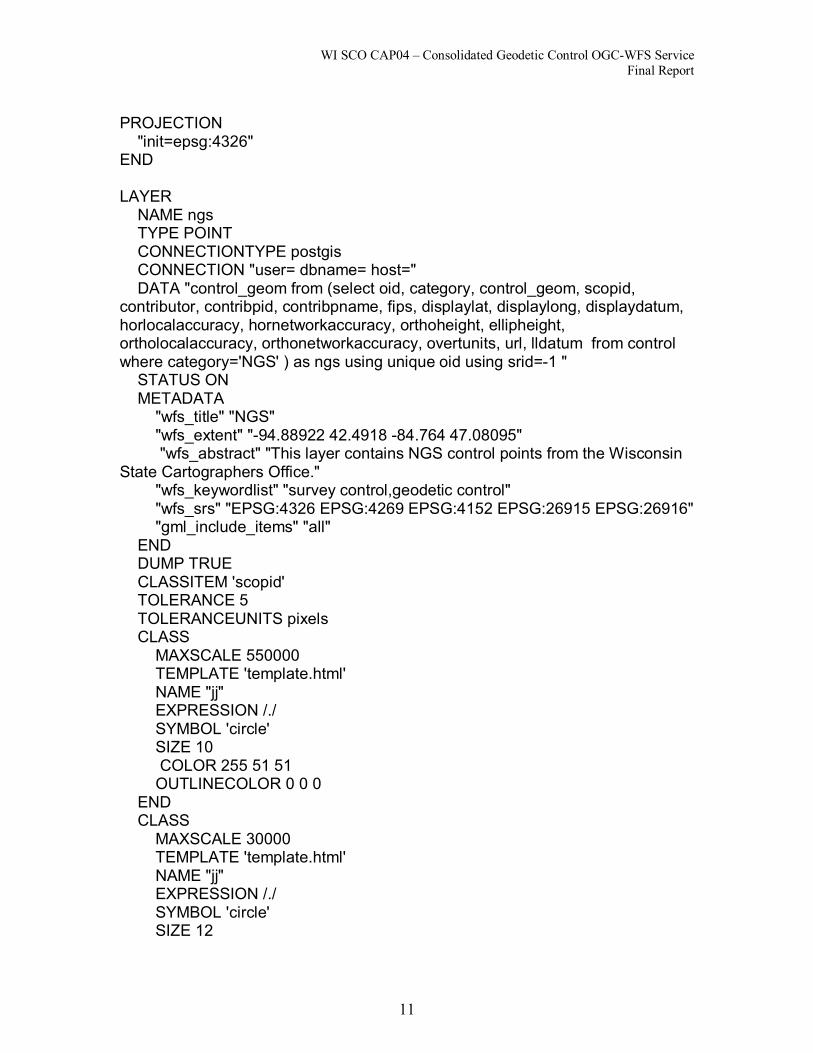
PROJECTION "init=epsg:4326"
END
LAYER NAME ngs TYPE POINT CONNECTIONTYPE postgis CONNECTION "user= dbname= host=" DATA "control_geom from (select oid, category, control_geom, scopid,
contributor, contribpid, contribpname, fips, displaylat, displaylong, displaydatum, horlocalaccuracy, hornetworkaccuracy, orthoheight, ellipheight, ortholocalaccuracy, orthonetworkaccuracy, overtunits, url, lldatum from control where category='NGS' ) as ngs using unique oid using srid=1 " STATUS ON METADATA "wfs_title" "NGS" "wfs_extent" "94.88922 42.4918 84.764 47.08095" "wfs_abstract" "This layer contains NGS control points from the Wisconsin
State Cartographers Office." "wfs_keywordlist" "survey control,geodetic control" "wfs_srs" "EPSG:4326 EPSG:4269 EPSG:4152 EPSG:26915 EPSG:26916" "gml_include_items" "all"
END DUMP TRUE CLASSITEM 'scopid' TOLERANCE 5 TOLERANCEUNITS pixels CLASS MAXSCALE 550000 TEMPLATE 'template.html' NAME "jj" EXPRESSION /./ SYMBOL 'circle' SIZE 10 COLOR 255 51 51 OUTLINECOLOR 0 0 0
END CLASS MAXSCALE 30000 TEMPLATE 'template.html' NAME "jj" EXPRESSION /./ SYMBOL 'circle' SIZE 12

WI SCO CAP04 – Consolidated Geodetic Control OGCWFS Service Final Report
12
COLOR 153 51 0 BACKGROUNDCOLOR 0 0 0 OUTLINECOLOR 255 255 255
END CLASS MINSCALE 550000 TEMPLATE 'template.html' NAME "jj" EXPRESSION /./ SYMBOL 'circle' SIZE 2 COLOR 255 51 51
END PROJECTION "init=epsg:4152"
END END
END #End of Mapfile

WI SCO CAP04 – Consolidated Geodetic Control OGCWFS Service Final Report
13
Appendix C Geodetic Control Schemas UML Diagram from 12/06/05

Geodetic Control Schema for GML3
<?xml version="1.0" encoding="ISO88591"?> <schema xmlns="http://www.w3.org/2001/XMLSchema" xmlns:xs="http://www.w3.org/2001/XMLSchema" xmlns:gml="http://www.opengis.net/gml" xmlns:gc="http://www.fgdc.gov/framework/gc" targetNamespace="http://www.fgdc.gov/framework/gc" elementFormDefault="qualified" version="0520050.1">
<import namespace="http://www.opengis.net/gml" schemaLocation="http://schemas.opengis.net/gml/3.1.1/base/gml.xsd"/>
<! =========================================================== >
<element name="ControlPoints" type="gc:ControlPoints" substitutionGroup="gml:_Feature"/> <complexType name="ControlPoints"> <complexContent> <extension base="gml:AbstractFeatureType"> <sequence> <element name="ControlPoint" type="gc:ControlPoint"
maxOccurs="unbounded"/> </sequence>
</extension> </complexContent>
</complexType>
<! =========================================================== >
<element name="ControlPoint" type="gc:ControlPoint" substitutionGroup="gml:_Feature"/> <complexType name="ControlPoint"> <complexContent> <extension base="gml:AbstractFeatureType"> <sequence> <element name="uniqueID" type="gc:uniqueID"/> <element name="horizontalPosition"
type="gml:PointPropertyType"/> <element name="localHorizontalAccuracy"
type="gc:DQ_PositionalAccuracy"/> <element name="networkHorizontalAccuracy"
type="gc:DQ_PositionalAccuracy"/> <element name="horizontalReferenceSystem"
type="gc:MD_CRS"/> <element name="link" type="gc:ExternalResource"
minOccurs="0"/> <element name="vertical" type="gc:verticalInformation"
minOccurs="0"/> <element name="attribute" type="gc:attribute" minOccurs="0"
maxOccurs="unbounded"/> </sequence>
</extension> </complexContent>
</complexType>

WI SCO CAP04 – Consolidated Geodetic Control OGCWFS Service Final Report
15
<! =========================================================== >
<complexType name="uniqueID"> <sequence> <element name="identifier" type="xs:string"/> <element name="idAuthority" type="xs:string" minOccurs="0"/> <element name="description" type="xs:string" minOccurs="0"/>
</sequence> </complexType>
<! =========================================================== >
<complexType name="authority"> <sequence> <element name="individualName" type="xs:string" minOccurs="0"/> <element name="organisationName" type="xs:string" minOccurs="0"/> <element name="positionName" type="xs:string" minOccurs="0"/> <element name="contactInfo" type="xs:string" minOccurs="0"/> <element name="roleCode" type="xs:string" minOccurs="0"/>
</sequence> </complexType>
<! =========================================================== >
<complexType name="attribute"> <sequence> <element name="authority" type="xs:string"/> <element name="link" type="xs:string" minOccurs="0"/> <element name="name" type="xs:string"/> <element name="type" type="xs:string"/> <element name="value" type="xs:string"/>
</sequence> </complexType>
<! =========================================================== >
<complexType name="MD_CRS"> <sequence> <element name="projection" type="gc:RS_Identifier"
minOccurs="0"/> <element name="ellipsoid" type="gc:RS_Identifier" minOccurs="0"/> <element name="datum" type="gc:RS_Identifier" minOccurs="0"/>
</sequence> </complexType>
<! =========================================================== >
<complexType name="RS_Identifier"> <sequence> <element name="code" type="xs:string" /> <element name="codespace" type="xs:string" minOccurs="0"/> <element name="version" type="xs:string" minOccurs="0"/>
</sequence> </complexType>
<! =========================================================== >

WI SCO CAP04 – Consolidated Geodetic Control OGCWFS Service Final Report
16
<complexType name="verticalInformation"> <sequence> <element name="height" type="gml:MeasureType"/> <element name="heightType" type="gc:HeightType"/> <element name="localVerticalAccuracy"
type="gc:DQ_PositionalAccuracy"/> <element name="networkVerticalAccuracy"
type="gc:DQ_PositionalAccuracy"/> <element name="verticalReferenceSystem" type="gc:MD_CRS"/>
</sequence> </complexType>
<! =========================================================== >
<simpleType name="HeightType"> <restriction base="string"> <enumeration value="orthometric"/> <enumeration value="ellipsoidal"/>
</restriction> </simpleType>
<! =========================================================== >
<complexType name="ExternalResource"> <sequence> <element name="url" type="anyURI"/> <element name="urlType" type="gc:ResourceTypesEnumerationType"
minOccurs="0"/> <element name="urlDescription" type="string" minOccurs="0"/>
</sequence> </complexType>
<! =========================================================== >
<simpleType name="ResourceTypesEnumerationType"> <restriction base="string"> <enumeration value="database"/> <enumeration value="documentation"/> <enumeration value="DTD"/> <enumeration value="metadata19115_19139"/> <enumeration value="metadataFGDC"/> <enumeration value="webPage"/> <enumeration value="webSite"/> <enumeration value="XMLSchema"/>
</restriction> </simpleType>
<! =========================================================== >
<complexType name="ExtendedAttributesType"> <sequence> <element name="authority" type="string"/> <element name="link" type="gc:ExternalResource" minOccurs="0"/> <element name="name" type="string"/> <element name="type" type="gc:DataTypes"/> <element name="value" type="string"/>
</sequence>

WI SCO CAP04 – Consolidated Geodetic Control OGCWFS Service Final Report
17
</complexType>
<! =========================================================== >
<simpleType name="DataTypes"> <restriction base="string"> <enumeration value="Real"/> <enumeration value="Number"/> <enumeration value="Integer"/> <enumeration value="CharacterString"/> <enumeration value="Date"/> <enumeration value="DateTime"/> <enumeration value="Time"/> <enumeration value="Boolean"/>
</restriction> </simpleType>
<! =========================================================== >
<element name="DQ_PositionalAccuracy" type="gc:DQ_PositionalAccuracy"/> <complexType name="DQ_PositionalAccuracy"> <sequence> <element name="DQ_Element" type="gc:DQ_Element"/>
</sequence> </complexType>
<! =========================================================== >
<complexType name="DQ_Element"> <sequence> <element name="nameOfMeasure" type="xs:string" minOccurs="0"
maxOccurs="unbounded"/> <element name="measureIdentification" type="xs:string"
minOccurs="0"/> <element name="measureDescription" type="xs:string"
minOccurs="0"/> <element name="evaluationMethodType"
type="gc:DQ_EvaluationMethodType" minOccurs="0"/> <element name="evaluationMethodDescription" type="xs:string"
minOccurs="0"/> <element name="evaluationProcedure" type="xs:string"
minOccurs="0"/> <element name="dateTime" type="xs:string" minOccurs="0"/> <element name="result" type="xs:string" maxOccurs="2"/>
</sequence> </complexType> <complexType name="DQ_EvaluationMethodType"> <sequence> <element name="codeList" type="anyURI" minOccurs="0"
maxOccurs="unbounded"/> <element name="codeListValue" type="xs:string" minOccurs="0"/> <element name="codeSpace" type="xs:string" minOccurs="0"/>
</sequence> </complexType>
</schema>


![CIT 384: Network AdministrationSlide #1 CIT 384: Network Administration Routing ][](https://img.dokumen.tips/doc/110x75/56649f4a5503460f94c6bec3/cit-384-network-administrationslide-1-cit-384-network-administration-routing.jpg)


