Embed Size (px)
Citation preview

STANFORD ALPINE CLUBJOURNAL
1 9 5 8
STANFORD, CALIFORNIA


r
,
i-.,
' j
m «/ V


Club Officers
1956-57
John Harlin, President
John Mathias, Vice President
Karl Hufbauer, Secretary
William Pope, Treasurer
1957-58
Michael Roberts, President
Karl Hufbauer, Vice-President
Sidney Whaley, Secretary-
Ivan Weightman, Treasurer
ADVISORY COUNCIL
John Maling, Chairman
Winslow Briggs
Henry Kendall
Hobey DeStaebler
Journal Staff
Michael Roberts, Editor
Henry Kendall, Photography
Sidney Whaley
Lenore Lamb


Contents
First Ascent of the East Peak of Mount Logan 1
Out of My Journal (Peru, 1955) 10
Battle Range, 1957 28
The SAC Trans-Sierra Tour 40
Climbing Notes 51
frontispiece: Dave Sowles enroute El Cafitan Tree, Yosemite Valley.Photo by Henry Kendall
Grateful acknowledgement is made to the following:Mr. Richard Keeble, printing consultantBadger Printing Co., Appleton, Wise., photographic
plates, press work and binding.Miss Mary Vogel, Appleton, Wise., composition
and printing of text.Fox River Paper Corporation, Appleton, Wise.,
paper for text and photographs.


FIRST ASCENT OF THE EAST PEAKOF MOUNT LOGAN
by GILBERT ROBERTS
Mount Logon. North America's second highest peak at19,850 feet, is also one of the world's largest mountainmasses. Located in the wildest part of the St. EliasRange, it has seen little mountaineering activity. In1925, the first ascent was accomplished by a route fromthe Ogilvie Glacier which gained the long ridge leadingto the summit from King Col. This ascent had gone downas one of the great efforts in mountaineering history.McCarthy, Foster, Lambert, Carpe, Read, and Taylor ulti-mately reached the central summit after months of effortincluding the relaying of loads by dog sled in the longYukon winter--a far cry from the age of the air drop.In 1950 their route was repeated by two parties withinnine days of each other. First by Norman Read (of thefirst ascent party) and Andre Roch, and later by threeUniversity of Alaska students; Herried, Christenson, andPaige.
In 1953 McGowan, Mohling, Miller, Kelly, and Longscouted the eastern aspect of Logan in hopes of findinga new route. They discovered a promising ridge leadingto the 16,000 foot summit beneath the east peak. Unfort-unately, Long developed appendicitis and had to beevacuated. The four remaining members pressed on in poorweather and were able to reconnoiter the ridge to about10.500 feet. Their report in the 1954 AAC Journal was ofgreat interest to members of our group.
In the fall of 1956, I began contacting people foran attempt on Logan's East Ridge and found Dave Collinsvery enthusiastic. However, the expedition did not act-ually take shape until a few weeks prior to departure.We had done much letter writing but were still short-handed; fortunately Don Monk and Kermit Ross had been

considering a similar venture and we joined forces. Thelast week of June saw five of us gathered in Yakutat,,
Alaska, Monk from Danville, Calif, is a math grad stu-dent at the Univ. of California. Ross is a patent at-
torney for the Navy. Cecil Ouellette. recently escapedfrom the mountain troops, was preparing to study geog-
raphy. Collins was doing graduate work in engineering atthe University of Washington. I am a medical student at
Stanford Hospital in San Francisco. No leader waschosen. All decisions were the result of group discus-
sion and a system which proved thoroughly satisfactory,despite the fact that only two of us had climbed to-
gether previously. Our gear was shipped air freight toYakutat; with some discretion exercised, this method
proved economically feasible. Needless to say, we wereall guite warmly dressed when we boarded the plane in
Seattle; our pockets full of pitons and other feather-weight items.
At Yakutat we became better acquainted during theusual three day wait for flying weather. Finally, on
June 25th, we made two air drop flights to the base of
the East Ridge and the party was landed about nine miles
down the Hubbard Glacier in three trips by ski equippedSuper Cub. Next morning the plane came in with one more
load of food and equipment and we were on our own.
Because of our isolated situation any mishaps would
have to be handled by ourselves. We had been unable to
arrange radio communication. It was a hundred miles of
difficult glacier travel to the coast of Yakutat Bay and
once there it might be several days before we could
attract the attention of a passing plane. We planned on
a conservative course. Mindful of the first ascent
party's difficulty in one of Logan's notorious storms,
we resolved to always have adequate caches of food and
fuel on the ridge so that we would not be placed in the
position of having to retreat in bad weather. We also
planned to place fixed ropes in hazardous locations that
we would be crossing repeatedly with loads. (Almost 2000
feet of 5/16" manila were used for this purpose before
we were through.)The two days after our landing were spent collect-
ing gear and hauling it up through an icefall to the
base of the East Ridge where Camp I was set up. The sun
was scorching, situated as we were between three wallsof ice and snow, and we worked mostly at night. An alum-
inum ski sled fabricated by Ross was of great aid inthis work and again later on during our long walk out.
After Cecil and Don climbed the steep rock at thebase of the ridge, we established an A frame andpulley
system off the crest and hauled our gear up a 400 foot
ice slope to the ridge. Carrying loads to the berg-
schrund and pullying them up occupied two more days.June 30th saw us all on the ridge with supplies for at
least a month. During the hauling we used a small tent
platform, christened Camp 2, but we soon moved up the
ridge about one hour to a larger perch. Camp 3, at about9000 feet. This was to serve as our big supply dump and
advance base camp.On July 2nd, we carried loads about six hours up
ridge to Camp 4 at 11,000 feet. This portion of the
ridge was loose and exposed but not technically diffi-
cult. Still, a couple of fixed ropes were used. Afteranother day of relaying loads, we spent July 4th in
camp, with the first storm howling outside. Kermit andDave made a reconnaissance above Camp 4 during one lull,
but it was the evening of July 7th before the three
below could move up with the last loads to Camp 4. The
storm continued next day, but one trip down ridge wasmade to replace a stove that had gone over the side.
July 9th was also stormy but everyone finally set out
with loads and the weather cleared in the afternoon.
Climbing above Camp 4 was much more difficult. The
south side of the ridge presented steep rotten rock with
patchy snow and outsloping slabs. The north side was
primarily high angle ice. We left several fixed ropes
and stayed close to the crest except for one traverse
out onto a series of ledges on the south face of the
ridge. At 12,000 feet, Kermit and Dave had placed a

cache. Above this the ridge was a knife edge of ice for350 feet with 4000 foot drops to the upper Hubbard oneither side. The cold wind numbed us as Kermit and Cecilwent ahead to cut steps suitable for men with forty tofifty pound packs, using ice pitons for the first timeon the mountain. Finally we reached a broad portion ofthe ridge in the lee of a large ice cliff and establish-ed Camp 5 at 12,300 feet. After some hasty platformdigging we all hurried down to warm up.
By July llth, everyone was settled with supplies inCamp 5 and the route had been scouted for 1200 feetfurther. The next day we got about two hours further upthe ridge but were forced to cache our loads and retreatwhen what looked like a minor flurry of snow and misttook a turn for the worse. Snow and high winds held usin Camp 5 for three days. By now we were out of readingmatter and attention was given to preparing new culinarydelights. One0 the "Logan TV breakfast,' was withoutdoubt the worst thing any of us had ever eaten.
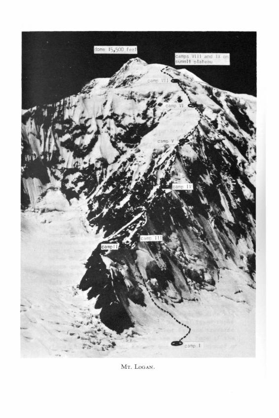
On July 15th the weather cleared once again and wedecided to make our moves from camp to camp in one dayto avoid being stranded above or below our supplies.Also, a series of shorter double carries would solve theproblem of steps drifting in between trips. Carrying outthis plan we made two carries to Camp 6, situated in arather exposed position on the lower lip of a crevasseat about 13,500 feet. The route from 5 to 6 involvedsteep ice covered slabs, where more fixed ropes wereplaced, and another narrow ridge covered with soft snowwhich the advance party removed in an hour's shoveling.Above 13.000 feet the ridge began to widen and ultimate-ly merged into the face of the 15,500 foot dome risingto the edge of the summit plateau. We now traded rockand narrow ridge for steep snow slopes with crevassesand avalanche worries.
One false start of two hundred feet above Camp 6ended on the wrong side of a large crevasse. Removingour tubular aluminum pickets and fixed line we triedagain, and after a traverse on the south below the crest
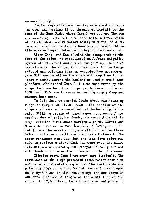
MT. LOGAN.

CAMP 6. AT TOP OF RIDGE NEAR 13,500 FT.
RELAYING LOADS ON RIDGE BETWEEN CAMPS 3 AND 4.

and a few more problems in a small ice fall, we made
Camp 7 on the face of the dome a bit above 14,000 feet.We were almost even with unclimbed McArther across the
way. On the way around, we had our only avalanche scare.Where we had traversed below the crest, the slope ava-
lanched to a depth of three feet. We had appreciated thepossibility of a slide and had stayed on the crest
wherever possible, but here we were moving close to atransverse crevasse. One man was swept off his feet but
scrambled to safety even before the rope went tight fromthose above the fracture line. We had observed dozens of
avalanches on the faces around us during our three weeksin the area, but this one took on a special significance
as we watched it sweep down the face and out onto theglacier 6000 feet below.
On July 17th we made two carries over the dome to
establish Camp 8. Our route was on high angle snow for
the most part and forced us to make two long traverses
to avoid crevasses and avalanche slopes. It was a big
day for us--we got our first look at the unclimbed EastPeak since the landing on the Hubbard. Set back several
miles from the edge of the plateau, it had been hiddenfrom us on the ridge. Below only the higher peaks could
be seen piercing a layer of cloud. Camp 8 was the firstsite we did not have to level ourselves. We felt
isolated but optimistic in the knowledge that we had
enough food for ten days or more.
Next morning the weather was discouraging; we moved
on with heavy packs in mist and snow. Soon we were in
the lee of a small peak on the edge of the plateau and
the drifts were thigh deep. At three we decided we had
gone far enough. Camp 9 was placed at 16,000 feet about
two miles from the base of the East Peak. The sky looked
bad but we were prepared to wait up to five days. No oneslept much that night; at five a.m. it was windy and
socked in. Finally at nine we decided that the weather
had improved enough to justify a summit try.
We headed for the southeast ridge of the East Peak,still slogging in deep snow but making better time with-

out packs„ Below the ridge an ice slope forced us to usecrampons. Once on the ridge the climbing was hard snowwith occasional islands of rock. As we moved upward theweather improved--we had our first view of mighty SaintElias. At four p.m. all five of us finally reachedLogan's East Summit. Stepping gingerly at first until thecornice seen from below had been investigated, we weresoon milling about in a mess of 'rope salad.* The entireSt. Elias Range spread out on all sides of us as we shotpictures with complete abandon and tried to decide whichof Logan's peaks was highest. The central peak about twomiles away had been climbed the three previous ascentsfrom the other side. Sighting with an ice axe left roomfor question. In the end we were pretty much in agreementwith others who have debated the question. The two peaksare very close in elevation; if anything, the centralpeak is perhaps 50-100 feet higher. The long ridge drop-ping to 18,000 feet and then rising to the central peakwas tempting, but we were already on a long limb. Theweather had been good too long and clouds were rising.We had never seriously considered carrying one or twomore camps over the East Peak; we were happy to be wherewe were. It was cold (one camera shutter froze). and alltoo soon the five of us started down.
We made good time going down, glissading in a fewplaces, and reached Camp 9 at seven p.m. None of us feltthe altitude particularly (19,800 ft at the top). butall were tired and thirsty. The temperature was elevenbelow zero as we began melting soup water.
Next morning everyone moved in slow motion; ourlast five days of heavy going were beginning to tell.Finally we broke camp and started down, leaving our tentwhere it stood. Soon heavy mist closed in and we werethankful for the flagged wands we had placed on the wayup. Camp by camp we decended, pausing just long enoughto reclaim personal gear and eat any particularly tempt-ing food. We were very hungry, despite an adequatesupply of food on the ascent. Poor visibility and drift-ed powder snow made for crevasse problems; between Camps

u«>o
aJU


6 and 5 the lead man suddenly disappeared from view butwas soon extricated unhurt. On this portion of ridge we
were also treated to the view of air beneath a particu-
larly deep step and moved a bit further below the
corniced ridge. Our fixed ropes were still in place andproved valuable on several occasions. We were all re-
lieved when the narrow ice ridge below Camp 5 was
passed. At Camp 4 we cooked an enormous meal and spent
the night.
Next day we continued down the rocky ridge. There
was less snow here now and more trouble with rollingloose rocks. In some places we moved one at a time until
all were out of range. Camp 3 with all the canned goodsalmost stopped us--ham, sardines, peanut butter, honey,
roast beef, canned fruit. Late in the afternoon we push-
ed on and heavily laden internally and externally, we
made the final 400 foot rappel off the ridge and over
the bergschrund into a thick mist.
A heavy snow storm held us in camp for a day and ahalf, but the rest was welcome. When it eased a bit, we
meandered down the icefall making many crevasse detours
in the 100 foot visibility. At the foot of the icefall
we played 'cache, cache, where's the cache.' The weatherwas still foul and pulling the sled in soft snow a real
effort. We camped and next morning things cleared some-what. Behind us the East Ridge was covered with white--
luck had been with us.
One hundred miles lay between us and the coast as
we started down the Hubbard Glacier on July 24th.
Traveling on snowshoes and pulling our loaded sled we
made about 15 miles the first day. The next day we pull-
ed and carried over Water Pass and viewed the enormous
Seward Glacier. Logan's huge southern facescame into
view and far above the Central and East Peaks emerged
from the clouds. That night the fog closed in and we
traveled by compass across the Seward neve toward Seward
Trough, a fantastically broken channel where the Seward
funnels down to the Malispina between Mounts Augusta and
Cook. Late on the afternoon of the 26th, we heard a rock

fall and our voices echoed off something close to ourleft—Cook Nunatak, we were right on course. Next morn-ing the fog began to lift and we started threading ourway through the crevasses at the entrance to the trough.These crevasses were the biggest any of us had seen.Many were bottle shaped; with snow bridges fifty tosixty feet wide. Further along the trough was too brokento travel. Here we went along the left hand marginthrough little bays of dead ice and up and down overintervening ridges, each of which meant unloading thesled. Still these ridges had flowers, heather for beds,and running water; all very welcome indeed after nothingbut snow and rock for a month. At Point Glorious we hadour first contact with civilization when a Yakutat pilotspotted our signal mirror. He buzzed us and we signalledthat all was well. Continuing down along the edge of thetrough and passing between Seward Rock and the HitchcockHills, we reached the Malispina Glacier on the eveningof July 29th. From here we took a bearing of 150 degreesmagnetic for the coast 35 miles away. The Malispina is avast wasteland of dirty ice, moraines, and pressureridges. About half way across it, we abandoned our sled(snowshoes had been left behind halfway down thetrough.) On July 30th we had our only casualty, when asmall crevasse covered with snow and an eighty poundpack combined to produce a shoulder dislocation. Fort-unately, it reduced easily and proved to be a minor dis-ability. We continued our up and down course, gettinghigh enough to see the ocean only twice during the day.By the evening of the 31st, we could hear the surf. Butwe were low on food and faced the biggest problem of theentire walk out, a system of lakes and channels par-alleling the beach. On the flight in we had seen acorridor through the lakes, but on the ground it seemedto have disappeared. The thought of miles of morainesand ice hills covered with sliding debris leading aroundthe lakes was a strong incentive and the next day pro-duced a dubious route through the mess. It involved muchiceberg jumping, a swim on our air mattresses and a high
8


line for equipment. The morning of August 2nd found usat the Satsuma Maru--a sixty year old Japanese wreckwhose three masts still protrude from the sand. Thatafternoon two Cessnas landed on the beach. Our trip wasover except for one last look at Logan rising acrossYakutat Bay and the joy that comes with new friendshipsand a thoroughly successful mountain adventure.
FOOD AND EQUIPMENT NOTES:All members of the expedition used the Korea in-
sulated rubber boots above Camp 4 and two men used themexclusively throughout the trip. They were excellent andno one suffered from cold feet although temperaturesprobably reached twenty below on occasion. We had thethick soles ground down and regular vibram soles cement-ed on. These were a great help and proved adequate forall rock climbing encountered. We used crampons most ofthe time above Camp 4. even on icy rock. They were verycarefully bent to an exact fit and we had no troublewith them sliding around on the boots. We found a thinslippery polyethylene bag helpful in getting the bootson on cold mornings.
Ice pitons of notched Aluminum 'T1 stock were good,as were tubular aluminum rappel pickets in three andfour foot lengths. Some of the party did not use airmattresses and found that packframes, extra gear, snow-shoes, etc., were warmer and more comfortable.
Our main items of diet high on the mountain weredried beef, Bovril, pemmican, instant potato, and thecheese and candy. In general, we had too much candy andsweets and would have welcomed more meat, especiallysuch things as salami and thuringer. Our food was packed
in six-man-day lots in large polyethylene bags averagingabout seventeen pounds per lot.
>UT OF MY JOURNAL (PERU, 1955)by DAVID SOWLES
July 16:....Slept soundly. It was 4:00 already. Ihauled out my little climbing pack and put 400 feetof nylon line in it for:fixed line. Thought ofclimb a mixture of apprehension and desire. Straw-berry jello down, Ralston down. Crampons now,straps loose and supple this morning! Then down-jacket and into Bill's pack. Hooded pullover on,pack on, rope, sling, gloves. Bill is about ready,the others a little behind. Well, ready. And witha headlamp on, I moved off in the dark, 4:25! Goingtoo fast. I slowed down. At the top of the hill be-fore the col-slope we both stopped. By this time alight beginning to move away from camp. With theheadlamp I led up to the rock. Decided Bill go onand I would shine light on slopes. After a momentBill found he could see the steps - where theyweren't ruined by the others rappeling down theslope --and I turned out the light. I moved out asBill hit the end of the rope. We were slower thanwe figured because of the dark and a good wind thatwas getting harder as we approached the col. Fin-ally we were on it and a very strong cold windstung our faces. Slowly up the ridge. 'Let's goover to the bivouac cave.* We did. And I said I wasgoing in to put on my wind parka and on my handsand knees, pack and all, I crawled in and Billfollowed. We were there ten or fifteen minutes ,savoring the silence and the relief from the wind.It was a good little place and would be warm withfour. Well! out we went. I forgot my ax momentarilyand crawled half in and got it. We went on in anasty wind, toward the schrund. I got to it and
10

belayed Bill the last few feet. Then I worked onthe bridge to the first rope and up the steps. Billhad to move before I reached the rocks-nearlystraight above. He came on. About this time theother three appeared at the top of the col. Theroute goes up beside the rocks a few feet thenacross to a corner and around up a slope diagonallyto another set of rocks. This was another lead andBill had a little trouble with the aluminum picketson the corner, sticking out of the pack. From hereI missed the route and went nearly straight upusing the rope and noted at the top the route ofsteps further to the left - I mentioned this toBill after I reached the piton to belay him from.We were about three and half rope lengths or moreabove the schrund at this point. Bill came up andwent on, fully on rock now - 4th class withcrampons. He led on and off ice and rock and wentup around a corner finally. We were almost beside alarge mushroom cornice now. 'On Belay1 came float-ing down in the wind. It was very strong still, andcold - I hadn't been so cold before. I came up andjust beyond the cornice was Bill, cold and be-laying. The clouds were minor-clear over the moun-tain. The steps from here led up along the shoulderof Nevada Angeles to the schrund, then down to thecol below North Pucahirca...
The 16th of July began as I've written above, atleast it did according to the journal I kept the summerof 1955. Bill McMannis and I climbed North Pucahircathat day. This was the culmination of what I like tocall Section I of the 1955 Cordillera Blanca Expedition.Section II involves the ascent of Huascaran and thatstory had been told elsewhere. Here I would like to givea vague idea of Section I. I say vague because until onestands in the square of Yungay, and looking up at thebulk of Huascaran and the beauty of Nevada Huandoy, setsout to climb, the immensity of and the magnificence of
11

these mountains can only be a vague apprehension. Thisarticle will only do a little to dispel that feeling. Isuggest that there is only one adequate solution - leavefor Lima tomorrow!
Section I: Yungay - Nevado Pucahirca - Yungay.There were eight of us and four porters and twentyburros and two horses and three burro drivers. It is nottoo clear who was running the show. Perhaps it wasEmilio and Eugenio and Victorino Angeles, the porters,or Juan Ramirez, the porter-interpreter, or possiblyHarvey Platts and Dave Gagliardo and Harold Walton, fromBoulder. Maybe Andy Kauffman or Nick Clinch or I led themob. It might have been Bill McMannis or Ray Hopponen ofKansas. It was never too clear, and that's a good thing,I guess.
The eight norte americanos had all flown to Limaand driven north and east up the Santa Valley, betweenthe barren Cordillera Negra on the west and the snow-covered Cordillera Blanca on the east. The objectiveevolved into an attempt on the two unclimbed peaks ofNevado Pucahirca. This mountain is on the northern endof the Cordillers Blanca and to reach it we had to crossthe range, turn north and traverse several interveningvalleys and then turn west up the Quebrado Jancapampa(Quebrado: deep gorge or canyon) at the head of whichstand the Pucahircas. There is a shorter way to thepeaks, but it is unpassable for the very necessaryburros. Our walk began on June 26:
Lunch at El Pinquino (a local restaurant). When wegot back to the mules, everything was packed andready to go. Pictures, goodbys, get your pack andcamera, and finally a triumphal procession throughthe town and the beginning of the long walk. Theline of burros stretched out. Andy and I forgedahead and began to gain altitude. Yungay disappear-ed and Huascaran gleaming in the noon sun, came andwent behind the hills. Behind us Harold began tocatch up, moving at a very good pace. After he came
12

HU-
o
PiO8<D
ffiH


we moved on - the trail rising steadily and easily,sometimes on grass, mostly rock and earth. Wecrossed a level plateau and came to a division inthe trail. One way led up to the right steeply, Alittle boy and girl sitting under a shelter told usit was a shortcut to the Yancanuco. We took it.It went slowly and when it rejoined a major trail,the three of us stopped for a while. Yungay wasgone and we were high above the valley...Nick andDave arrived and sat down. 'Where were the burros,*No one knew. 'Were they ahead or behind?' Wecouldn't see them, and so finally moved o f f . It wasa long time before we regained the main trail...itwas across the valley and bushwacked down toand across some wheat fields, the last cultivationbefore the Quebrado. And here we really had bush -and a stream to cross! Back on the trail we satresting. We met a mule driver. 'Si... there aremany gringos and burros up in the Quebrado...Circa la laguna.* That was it. A three hour walk.We moved up with not as much vigor. Hike-Hike-Hike!It grew darker and the last rise to the lake stayedin the distance. Harold and I walked in theevening. We stopped twice in the moonlight. Sudden-ly voices - then a fire - and a Coleman lantern!Soup was on the stove and I sat down and ate anorange.
Our first camp was beside a small lake, seven mileseast of Yungay,, deep in the Quebrado Yancanuco. Everyonewas very tired and that night no one slept well. Thenext day, June 27, we headed for the major pass over therange, Puerto Chuelo.
'Buenos dios, Nino! ' - Einilio had taken to callingme "Nino* because I'm the youngest of the group.This is sometimes altered by 'super nino' and'bueno nino*.I lay on my sack - very comfortable by the way •
13

for some time, rolling a few times. There was adeep orange glow now on Huascaran Norte. Finally Igot up. Ray was making Ralston. He had put the milkin the cereal, an oversight to be changed for sure.The sugar on top rougher in grain than usual -Peruvian. I finished it barely and went up androlled my bag and air mattress up and brought themdown and with a little difficulty stuffed it all inmy duffel. The sun was on our camp now and thearrieros were beginning to bring the burros in andsaddle and load them. I took my towel and toiletgear and went down to the stream. A few minutes andI found a place where the water was slow - Cold!hand, face, teeth Cold! I sat down in the sun -cool wind moving down the valley - and began towrite. It was about 8:00...noticing Nick takingmovies, Andy and Ray packing up - and later Andygoing down to the bridge over the stream to keepthe burros from moving away. Dave came over and cutoff the top of his boots because they were alreadytearing, and we talked about the altitude to gaintoday, 2600 feet; the altitude gained yesterday,5280 feet! We'll go higher than any climb I've everdone. Finally all was ready - Victorino gave me anorange and I stuck it in a pocket for lunch.
Ha! Burro!, etc. Move along. We were off! Wecame out beside the lake, a turquoise green shim-mering in the morning sun, and then paralleled it,sometimes over a steep up and down rocky trail, 50feet above the lake. Perhaps the color was lapis-lazulis. it reminded me of what I thought theglacial lakes of Canada were like. The horses weresetting a good slow pace, now and then one havingto be slightly repacked. We soon contoured the endof the first lake and crossed a marshy plain be-tween the two lakes, following the stream to thesecond lake, a smaller one. We moved out into abroad marshy plain that filled the valley from sideto side. We went far out into the middle of it and
14
the burros spread out to feed. I caught the burro
with the lunch sack and most of us gathered around
the lunch. Nick and Harold were quiet and tired.They ate only a little lunch, and subject of the
"happiness pills' came up. Nick and Andy and Haroldfinally decided to take one. Ray sunbathed. Emilio
slept with his shoes off. Dave rested, and I lay on
the barely wet ground and wrote. Well, let's go.
Juan and I walked slowly across the meadow to-
gether and went around a group of houses on a small
hill. We paced along with Andy on the right side ofthe valley and later crossed a bridge and rested on
the far side. We walked for about 40 minutes andAndy stopped to rest, so I stopped and got out the
water. Ray caught up and I pointed out the summittip of Chacraraju over a hill. The peak had filled
the sky all day. God, what a peak! Now we could seeHuascaran's two peaks so high and close. The burros
came steadily on. I looked high above and decidedto reach a switchback I could see. It had a green
border and a long scree slope below it. At thefirst snow I scratched HELLO and moved on. The col
not far now. Then the trail swung left! Away from
the obvious route. The trail came slowly out to a
corner and there was Chacraraju! The final pass wasonly a few hundred yards! I moved over the top and
sat down. I had walked steadily and I felt good,breathing fully in the thin air 15,600. I got out
my orange and ate it greedily. It was 3:45. Toocold here. Into the sun on the other side and lay
happily in the sun. Andy came over the horizon.
°Sit down.' We sat talking. Juan came slowly up and
sat down beside us. The conversation turned to thelack of faith and peace in the world. 'We do not
live as our God would like.' said Juan. Pasa! Pasa!and the first burro came over the hill - with my
sack! followed by the burro driver chewing his wad
of coca leaves.
We just sat - enjoying our non-nobility.
15

Coming down from the pass we decided to move the
loads to a small lake where we could camp. Theburros and loads were all spread among the rocks,
some distance above the lake! 'Caramba', says Dave,
Everything has to be moved down to the lake. Un-
happy burro driver. We all loaded burros and led
them to the lake. By six we were all settled. The
stoves were started and three pots of water heat-ing. It took a long time. Dinner: noodles and meat.
More water boiling. More tea. Complete dark sincesix and the Coleman and flashlights for light. Moon
brighter tonight, very cold, perhaps freezing. Themoon shone in my face and I was hot from the down
hood and the past day's sun. I slept for half thenight, dozed and turned the rest.
For three days more we walked up and down the land
of the Quechua Indian. There is one level place of ahundred feet or so, but I've forgotten where it is. One
day was much like the one before, except for the morning
that we burned half a hillside of grass to keep warm. We
would light a tuft and then move on when it had been re-
duced to ashes. Luckily for Peru, the sun came over the
hill early. On the 30th of June we met the advancedparty of Bill, Harv and Eugenio. They were camped at the
head of the Jancapampa and led us up a subsidiary
valley, the Quebrado Yanajanca,, to base camp, at 12,900.
We put up a large open canvas tent and a smaller sheep-
herder* s tent and a cover for the supplies and built a
fireplace and sat on the grass in the afternoon and made
our plans.
Our first high camp was just below the glacier on a
ledge overlooking the upper Yanajanca. The general line
of our route was from east to west, to the main ridge of
the Pucahircas, and from there south to the summits. The
glacier we traveled was a minor one - more accurate-
ly described as a finger of the main ice field. It began
on the slopes of the northernmost peak of the Pucahircas,
an unnamed snow summit that we named Nevada Angeles. We
16

r~
THE MIDDLE AND NORTH PEAKS OF NEVADO PUCAHIRCA AND NEVADO ANGELES.PHOTO BY DAVE SOWLES.


set up Camp I, at 15,500, on the 2nd of July, build-
ing three platforms in the gravel of a moraine: oneLogan tent and two mountain tents. On the 3rd, the
Angeles brothers carried a second load to Camp I and the
rest of the party sat in Base Camp organizing food and
equipment * We were all ready to go on the 4th - there
were even some firecrackers available - and under a
broken overcast the complete party, twelve of us, climb-
ed slowly up the grass covered slopes toward the line of
snow on the horizon.
Near the top of the first hill I had to stop;I could look down and see Base Camp and three
porters just leaving. In the upper valley I couldsee three people. The last pull to the saddle
above camp was a beatout. It was 12:00. We set upthe camp and I began looking over the food. Bill
and Andy decided they would spend the afternoon
going through the ice fall, so they got their gear
and took off. Nick returned from somewhere and we
watched them work up the ice. Andy in the lead.
Harv and Dave arrived, and later Harold and Ray -with a big pack. The sun came out for a while. At
dinner the weather was still indifferent. Thencame the discussion of things. Divide the party?
who to set up the camps? It finally came out that
everyone thought we all should concentrate on the
Pucahircas (I have forgotten to mention that Taul-liraju, since climbed by Lionel Terray, was a
possible objective, within reach of our Base Camp,
and the idea of making an attempt on it had been
mentioned. One look at it and we let it slip our
minds.) All set up Camp II and all climb. So that
was it. Further talk was speculation on what Andy
and Bill had seen in their long hike up the
glacier. They had reached approximately 17,000 and
had picked out a shoulder of the east ridge of
North Pucahirca which might take us to the summit.
I finished a selection from D.H. Lawrence's
17

"Women in Love', took two sleeping pills, and
turned out my light.
In the process of learning what this mountain waslike and where we should go if we wanted to climb it,
several days were spent properly positioning Camp II, sothat we could work for the summits from there. I was
about to say summit. Middle Pucahirca is still unclimbed
and I suspect will remain so for a while. We attempted
to find a route for it till the last day. But from ourposition it was impossible (and I use that word fully
realizing the danger involved) and for our party it was
unfeasible. So if I seem to forget it in the ensuing
narrative, I hope you will understand.
Well, the position of Camp II occupied us for five
days following the holiday. Lacking experience in bigmountains, we neglected to divide the party in two or
three groups and explore the limited possibilities - I'd
say now that there were three open to consideration.
Eventually all of these were examined, but it took us a
while. My journal is not noticeably introspective, so
many of the reasons for this won"t be found in it. And I
won't go into it in any detail. But it seems important
for me to mention one thing. If anything impeded our
progress, it was the simple fact that within the party
of eight every degree of talent and experience in the
mountains was represented. Combining this with our not
being originally a party of friends going into the moun-
tains together but rather a group of mountaineers organ-
ized for the purpose of going to Peru to climb, producedan obstacle that we never quite surmounted. The fact
that we did reach the summit of two fine peaks is apartfrom this. A fine accomplishment but it didn't make the
trip a success.Getting back to the establishment of Camp II, the
essential factor involved was that, wherever it was
finally placed, we must be able to reach the col between
North Pucahirca and Nevada Angeles. The two peaksappeared climbable only from that col. Leading to it was
18
the east ridge of North Pucahirca. It dropped down to
the glacier at a point west and south of Camp I. And onthis ridge we made our first move toward the summit.
Through the tent door I saw mist drifting
past. It floated in the valley and up on theglacier. Andy and I roped up and put on our crampr
ons just below the ice. I led and felt the load andthe altitude. Then as we worked up and drifted left
through the glacier, things improved. After thesecond stop I had it - move the left foot and
breath in, put the left down and breath out. It
wasn't a bad walk and when the mists broke and the
peaks appeared, it was an immensely striking scene.As we neared Andy and Bill's high point there was
increased crevassing and we dipped and swooped andtwisted and finally sat by their highest willow
wand. Lunch. We heard nothing of the others. Themist folded in deeply then and we sat resting and
waiting for it to clear. It did and I took the
lead, up on the shoulder from which we could gain
the east ridge of North Pucahirca. It was a long
steep rise and I sat gratefully at the top. The
mist closed down to 25 feet. On a belay I exploredfurther. O.K. A steep slope appeared...we could cut
under and by some cornices and gain the ridge. We
kicked on up the slope. I told Andy I thought it
would level above and we could camp there. He came
up and went up over a crevasse smoothly and on,
disappearing in the mist. "Can you give me 20feet?1 Andy asked. 'No.' 'Well,, come on up then.'
I led 30 feet up a short rise and saw an ice tower
blocking the ridge just beyond. But it was level
for a bit and not directly under the tower, so here
was camp.
It looked like there might be room for threetents. We started to stamp out a tent space. We
couldn't have picked a more spectacular place for a
camp. Corniced slightly on two sides, dropping off
19

to the glaciers below, the ridge dropping off atone end and a ridge above guarded by gendarmes ofice and snow. By this time four others had arrivedand Andy suggested he and I turn the tower to seehow it would go. It was rotten snow but it was o.k.We plowed up to the top of a small mound and lookedat the rest of the ridge. It didn't look easy butit would probably go - with work. We came back,emptied our packs, and started the trek down toGimp I. In the descending I prepared my evening'swork, slashing three holes in my trousers with mycrampons. We went down and down and back and forth.It seemed a long way. Finally the Logan appeared.In the hazy light of dusk we sat on rocks aroundthe Coleman stoves and ate rice and meat and drankhot jello. Tomorrow everyone would go up to Camp IIto stay.
On the 6th of July we carried personal gear andfood and stoves to Camp II, at 17„500, and sang HappyBirthday to Ray. In the afternoon Andy and Harold and Iworked along the ridge. It wasn't promising. In the eve-ning we had an informal meeting and decided that Andyand I would try and see if it would go in the morning.
Just before dark...struggled out of the tentand stood looking...absolutely clear below us.Lights and a fire glow orange in the JancapampaValley. Moon to the southeast rides above a fewtinted layers of clouds...a few stars and a windnot too cold.
Andy and I came back from the ridge - in lousyweather - after deciding the ridge was just not our cupof tea. It would be long and difficult. The swirling fogand blowing snow didn't help. The result of our re-connaissance was to divide the party into four groups.One group explored the ice fall to the left, south ofthe ridge; one explored the glacier to the right, north
20

<«
.< HA ~J Jx< B
g «»Z O< H


of the ridge; another descended to Base to bring up
supplies, and the fourth stayed at Camp II, ready to re-turn to Camp I to pass on the information if either of
the two reconnasissance parties found a feasible route.Bill and I were the lucky ones„ By early afternoon
of the 8th we had a route through the glacier north ofthe ridge, to a point just short of the final slope to a
col on the main north-south ridge of the Pucahircas. The
whole scene is much like the West Cwm of Everest, except
infinitely smaller and the ice fall at the end drops in
a straight line to the moraine and Camp I. The slope at
the head of the Cwm is perhaps a 500 foot rise with amaximum angle of 60 degrees. By reaching this lower col.
it seemed to us that you could then, turning south,
either bypass Nevado Angeles to either side, or even
climb over its east shoulder and make your way to theupper col between it and North Pucahirca. To reach
Middle Pucahirca it might be necessary to climb overNorth. After returning to Camp II, which was now being
called Ila, we found Nick and Harold had found nothing
to the south, so our route was accepted. By the evening
of the 9th, Bill, Harold, Nick and I were established inCamp lib, at about 18.000- Below, in Camp I, the rest of
the party was ready to carry loads to Camp lib the nextday. On the 10th Bill and I were on the slope to the
Lower col at 8:00 in the morning. It was too late.Debris came off the slope as the sun rose. We set up one
fixed rope and descended to return much earlier the next
day. July 11:
...then I scrunched up and began getting readyto emerge into the silent cold world of snow. ' Get
up, you b s, the cereal is ready, 'saidHarold. With much effort we got 125 feet of quarter
inch nylon off the coil and put it in my pack. Istarted off in the lead and as the streak of light-
ed sky broadened, we pulled up to the bergshrund at
the base of the slope. Over it easily and by stages
to the high point. Then I start cutting - easy tocut and reasonably far apart. The fixed rope-line
21

falls out on my pack...but Bill catches it. Rest,
cut - about ten feet - 'Victory is in sight* - comeon up. So I belay him up 2/3rds of the rope and go
on. Near the end of the rope again. Harold and Nickare nearing the slope now -as I look down past
Bill, smiling calmly up. It was about 7:45 when we
got to the top of the col. First of all notice the
horribly corniced ridge of the small peak to thenorth. There's one peak we won't climb! Bill's toes
are cold. We alternate up the ridge till we getjust under the bergshrund on Nevada Angeles. Still
cold, blowing, exasperating. The places for traver-sing to the left and right are impossible. The
route over the shrund is tenuous. I move down, geta belay on Bill. Suddenly - boom! There he goes!
The belay came taut and he stopped himself. A hatsailing off toward Alpamayo. 'You o.k.?' 'Let's go
look over here to the right. * We worked down theshrund and looked at a bridge, where the snow was
stained brown with rock falls. Nick and Haroldarrived and Nick moved up to try it. He had turned
to say something...when debris started down on*us.
Soon it stopped and we hauled ourselves out of the
crevasse and exclaimed over the experience. Wetalked it over. Harold was the only one who was
eager to go any further. We decided to call it a
day. So we worked down to the col - a long tiring
business. Finally down we plodded back to camp.
Noon. Andy and three porters arrived. We all
watched Harold and Nick on the col slope.
With the perspective of three years, I still cannothelp feel that we didn't do the best we could. There
are several explanations for our failure that day to
push the route over Nevada Angeles to the Upper col, as
the party the next day was able to do, but none of themsatisfy me. We could have done better, and as Bill and I
and three of the porters descended to Camp I, the dis-appointment I felt in myself filled my thoughts. But
22
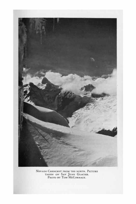
NEVADO CHENCHEY FROM THE NORTH. PICTURETAKEN ON SAN JUAN GLACIER.
PHOTO BY TOM MCCORMACK.

on a magnificently clear day in Peru, with four fine
companions, it's hard to be unhappy.
We went down quickly, stopping twice to removeclothes under the glacier heat. I had a great time
without crampons glissading. Somewhere I decided togo to Base. Bill was staying in I. In the upper
valley I outstared a herd of bulls and scrambleddown the last switchbacks. Juan was there - and
lonely - and we talked, sitting in the sun as thegrass waved in the breeze and the stream flashed
and sparkled. We ate a huge dinner and talked ofthe United States. Very late I lay down to sleep.
Clouds and mist above, but the Southern Cross stillvisible, just over the high hill, where Juan had
seen a grand deer.
It was the 13th before I was in Camp I again. Mostof that day and the next. Bill and I lay in the Logan
smoking our pipes and having one of those extraordinaryconversations that cover everything, decide everything,
and of which you never remember a word. Just after lunchon the 14th Harv and Dave appeared. Their news was a
mixture of melodrama and success. On the 12th they hadpushed the route over Nevado Angeles, setting up fixed
ropes, and reaching the Upper col, the key to the Northand the lower peak. There had been just time enough in
the growing dusk and thickening fog to make a first as-cent of Nevado Angeles. After Ray and Harold came down,
they hurried down toward the Lower col. They didn't
reach it.
In the dark Harold fell over a cornice. The belayheld, but a moment later the people above, trying to
pull Harold up, felt the rope come loose and hauling itin, found a frayed end. Eventually Harold's light
appeared on the slope below and he made his way to aplace where the rope could be thrown down to him. He had
cut the rope because of the pressure on his ribs! They
stopped at that point and bivouacked, building a cave in
23
the snow.
Meanwhile down in Camp lib, Nick and Andy waited.In the morning, the 13th, the two groups met at the fix-
ed rope just below the Lower col and all returned tocamp for many hours of making water and drinking every
hot drink imaginable. Before dawn on the 14th Nick andAndy were up and on their way to try and make the ascent
of North Pucahirca. Harv and Dave had seen them at theUpper col at 9:00, so their chances were excellent. That
afternoon Bill and I sat talking over the trip. Tomorrowwe would go up to II again, hoping to make our try on
the peak on the 16th. Harv and Dave were on their way toa local village at the end of the Quebrado Jancapampa,
to arrange for burros to carry us back to civilization.July 15:
My God! not a cloud in all the distance, no
mists, no, nothing. 'Say, this is the best we'vehad, isn't it?' But we waited for the valley mists
to rise. Happily they didn't and we packed for theclimb. 'We'll get there by lunch, so just a couple
of candy bars, eh Dave?' 'Sure.' 'Emilio carried my
pack over to below the ice and watched as we donned
our crampons. There a last goodby. You're up on the
glacier much sooner it seems„ and the peaks come in
sight with a rush. Up and over a hill and therewere 3 figures! coming down! We stopped and waited
for them. Ray and Harold and Andy. 'We made it! Wemade it!'said Andy.
Andy described the remainder of the route for us
and we talked over the possibilities of making a try forMiddle Pucahirca. They were poor. Andy and I would meet
in Camp I on the 18th to make an ascent of a small rockand snow peak just above camp. And Harold and Ray were
coming back to Camp II, to follow us up in the morning.
They had come down to pick up some camera gear for Nick.
By late afternoon we were all at Camp lib again, eating,as we usually did when there was nothing else to do.
24

NEVADO CAYESH, ONE OF THE SHARPEST PEAKS IN THECORDILLERA BLANCA AND STILL UNCLIMBED.
PHOTO BY TOM McCoRMACK.


And so, here we are back where we started, on the
16th of July, when Bill McMannis and I climbed NorthPucahirca. Reaching the Upper col, we looked across to
the last 500 feet. They were worthy of a 20,000 foot
mountain.
...a terrible wind blowing. 3 hours to the
col. The route that Andy had led went up in themiddle of the slope to a brow, and then swung left
and up to under a bergshrund. At the shrund therewas a picket driven into the snow up to its head
and there I belayed Bill. Just beyond was the highangle 'avalanche slope', as Nick had described it.
It looked loose...wind still bad and cold but inthe lee of the shrund it was better. Bill went on
belay and I carefully crossed the bridge. Your axedid very little good; the snow was too soft. I
moved up toward the fixed line that Andy hadplaced. The slope is steep, about 60 degrees or
more and seems to be held up - being bottomlesslysoft in composition - by interlacing bands of ice.
Curious. 120 feet out, the rope hanging beside me,I was still on the slope. I put in the axe as deep
as it would go - beyond the head - and brought Billup. The steepest section was just above, where the
steps go left over a rib and the angle is probably70 degrees. This section above the schrund is con-
tinually under the figurative and later literal
shadow of the most extraordinary cornice I've ever
seen. It bulges out over the slope, unsupported, atleast fifteen feet, curving up like a huge mushroom
head.Bill came up and went on, reached a point
where he was right up under the mushroom andbrought me up. We were about as high as we could
get. Leaving Bill, I traversed left and up a fewfeet. All the plans for climbing over the cornice
faded slowly as I stepped up and out over Andy'slast steps. They were cut in ice and were out from
25
the cornice. I cut a step or two higher. The sunwas full on us and icicles were melting and the
snow in the vertical wall in front of me was softand unstable. 'Bill.' 'Yah?''This is as far as
we're going* I set my axe and gloves in the nichewhere Andy had thought you could put a belayer and
leaning around the corner, took a picture of Bill.I could see Ray and Nick and Harold at the Uppercol. We rappeled down the fixed line....into thecold vicious wind...
Bill and Harold and I climbed Nevada Angeles and
from the summit you could see most of the northernCordillera Blanca. We were back at Camp lib at 3:30 and
another adventure was done. Andy was at Camp I when Billand I arrived there the next day. In the morning Bill
left us, mumbling something about food as he went towardBase Camp. Pico Sin Nombre - as we named it - was a
lovely peak. Andy and I came down happy that we hadgiven a day to it. We were at Base for dinner. It took
three days to dismantle the high camps and organize ourequipment for the hike out. On the 22nd of July the pack
horses stamped into camp with Eugenic riding herd. Thelast came down and the last pictures were taken.
Three days of the usual roller coaster trail andthen we clattered over a great wooden bridge and found
our way into the center of the village of Pasacancha.The road began here. We waited through the day for a
truck to carry us back to Yungay.
...the truck arrived a little after three inthe morning. Within seconds a horde of Indians
appeared out of the night. It wouldn't have beentoo crowded if they hadnot added those twenty
sacks of potatoes. I fell asleep, encased in mysleeping bag, standing, it seemed,, upright between
a potato sack and Ray...they looking up and pastthe silent figures of my fellow passengers and
across the deepest valley and then back along
26
the road we were churning down and watching a gra]dawn light touch the highest slopes above us.
Reaching the lower end of the Santa Valley - act-
tally an extraordinary gorge called the Canon de Patare switched to another truck and rode on through th«
lust and tunnels of the 'highway', which had once been <•ailroad cut into the west wall of the canyon. After <
short stop in Caras, we were off on the last leg of ou:xlyssey.
Then around the shoulder of a hill appeare<
Nevado Huandoy and I forgot I was tired and hungryThen another hill passed and there was Huascaran
an old friend now, and we swung under the shadow othe cemetery of Yungay and down the narrow stree
to the square.
There was set before me a mighty hill,
And long days I climbedThrough regions of snow.
When I had before me the summit-view.It seemed that my labour
Had been to see gardensLying at impossible distances.
—Stephen Crane
Editor's Note: With the exception of the Pttcahircshot, all the pictures accompanying this articlwere taken by the 1957 Hudson Expedition, whicincluded SAC members Tom McCormack, Rich TidrichNick Clinch.
27

BATTLE RANGE - 1957by HENRY KENDALL
The Battle Mountains, a small group of summits in
the Selkirk Range of the Interior Ranges of British
Columbia, are rarely visited because of their inaccessi-
bility. Only one expedition in recent years has succeed-ed in reaching them: one in 1947 led by Andy Kauffman,
which came from the south up the Incomappleux River.Possibly as many as 8 or 10 attempts have been made from
the north and east - we know of 6 groups who have triedunsuccessfully to gain access to the range. The frustra-
tions are many: heavy snows en route, alder thickets inwhich a day's travel may be only a mile or two, the al-
most necessary reliance on unreliable air drops, or the
alternatives of crushingly heavy packs or endless re-
laying of supplies.The Battle Range, just south of Glacier National
Park, lies about 30 miles airline south of Glacier,B.C.,but is separated from it by three ranges of mountains
and narrow steep-sided valleys or by two extensive icefields: The Illecillewaet and Deville neves. No route
from the north had yet been successful when two othermembers of the Stanford Alpine Club, Hobey DeStaebler,
John Harlin, and I, together with a member of the SierraClub, Gary Hemming, decided that we would try to find
one by craft and foresight. Using the old GlacierNational Park map of 1934 and advance prints of new maps
being prepared by the Canadian Department of Mines andTechnical Surveys, we determined that we might push far
south along an old trail, recently cleared in part,which started at the railroad stop of Stoney Creek, B.
C., NE of Glacier, and ran at relatively low altitude(3000-4000 feet) along the Beaver River in the mighty
depression known as the Purcell Trench. To reach the
28

Battle Range we would have to find a break in themassive west rampart of the trench - a continuous row ofsummits ranging from 9000 to 11,000 feet in height. TheBeaver Glacier seemed like the best approach; map com-parison showed it to have extended in years past nearlyto the Beaver River, yet it had receded so fast that im-penetrable alder thickets might not yet be in existence.This glacier gave access to a pass which we called theBeaver Pass (9200 fee t ) , which in turn led into BattleValley. We then proposed to contour south at an altitudeof about 7000 feet, keeping well out of the steep valleyof Battle Brook which would lie nearly 4000 feet belowus. Six miles south of the pass we would set up basecamp at the north foot of Holways Peak, north of Mt.Butters, the highest of the Battle Mountains, in a passat 7600 feet, which connected the Battle Brook regionwith the Trench, via another diff icult steep valleyhousing Nemo Creek. From base camp a series of shorttrips to the south would make all the peaks of theBattle Range easily accessible.
The distance from Stoney Creek to base camp wasapproximately 35 miles, and a double air drop seemednecessary to allow us to carry packs of reasonableweight ( i .e. , less than 60 Ib.) . We contacted a manexperienced in these matters in Kelowna, B.C. We wereto go first to the airport and accompany the plane in todrop the supplies, before the expedition started, at theselected places. We proposed to carry in 6 x 4 man-daysof back-pack rations plus 2 x 4 man-days of emergencyrations. Drop I would leave 6 x 4 man-days of back-packrations on a large level area halfway up the BeaverGlacier„ estimated as three days' travel from StoneyCreek.This drop on snow or ice was to be marked by spec-ially prepared, weighted poles designed to stick up-right in either snow or ice. Drop II on the pass at BaseCamp would consist of 6 x 4 man-days of luxurious living- a variety of carefully chosen canned goods. An alter-native plan, in case this air drop was frustrated bypoor weather, was for us to shoulder the extra pack
29
ration and have the plane come and meet us en route,near base camp and drop the heavy rations.
As the air drop was frustrated by poor weather, the
expedition found itself, lonely and forsaken, at 3:30
p.m., Tuesday. July 30, 1957„ standing by the shackwhich was the whole of Stoney Creek, B.C.,looking
aghast at its packs which, ready to go, weighed 75 Ibs.
apiece. We had over a tenth of a mile of rope, ice and
snow pitons, carabiners, slings, and assorted climbinggear, plus food, clothing, and equipment for existing on
snow and ice. Food for 14 days came to about 30 Ibs. perman.
We made 6 miles south that afternoon along anicely-cleared trail, gaining elevation very slowly. We
made camp at dusk in a thick cloud of mosquitoes, blackflies, and no-see-ums, which fortunately responded well
to head nets and 6-12,.Up the next morning at 4:30, we started off at 6:30
over more cleared trail, walking through lovely ever-green stands and winding along the river. The weather
was pleasant, with scattered cumulus, and we had a fine
view of the Trench and of the impressive west wall. We
covered about 15 miles, although the trail had vanishedtoward the end of the trek and we were essentially bush-
whacking. Made camp about 5 o'clock at a point estimatedas 4 miles north of the Beaver Glacier. The packs made
their impression that day, and aching muscles were therule. It rained lightly during the night, and bushwack-
ing through the underbrush the next day left us allsoaking after a few hours. The trail was by then non-
existent, and the going more difficult. We crossed theBeaver River on two logs which failed to meet over the
center of the stream by about 2 feet. This delicate bitof foolishness over safely, we hurried over to the
bottom of the Beaver Glacier, arriving in time to havelunch and build a big fire to dry out. The glacier was
a bit of a surprise - it had receded as we had expected,but its lower reaches consisted of a stupendously
shattered icefall tumbling down a 45 degree rock cliff.
30

(K HO "5)M «
H Qw 2;a -<H ~
IS^ sX <JW ftW iJ
H H
00< Pf!W 0w g


We successfully bypassed this unclimbable section by atraverse up behind the northern lateral moraine, throughsome alder thickets and up steeply along the sids of theupper part of the icefall. We made camp at 7000 feet, onsloping ground overlooking the icefall.
The next morning dense fog and light rain dampenedour enthusiasm, and we started off at a late 8:30. Wecould see that we would soon be on the relatively flatmiddle portion of the glacier and that another icefallseparated us f rom the easy going near the pass. Theweather began to close in more and more, and by the timewe had reached the second icefall it was snowing. Itlooked as though we could force a route right up throughthe middle of the fall, so we started o f f , up a 35 de-gree snow slope, kicking or cutting steps for our cramp-ons as we passed from snow to ice. We were a singlerope of four , which I led. We soon came to the brokenice and were immediately involved in the complex diff i -culties of route-finding through crevasses, under over-hanging ice seracs, over underhanging ice seracs, andthen back the same route. We were finally stopped utter-ly by a sheer vertical wall of ice, extending apparent-ly across the whole glacier, which was so shattered atits base that it was nearly impossible even to travelparallel to it. Climbing this wall with our burdenswould have required all our energies„ and there was noguarantee that it was the last obstacle. Exhaustion wasbeginning to play around the edges of the expedition,and the fresh snow and cold wind made the climbing in-creasingly difficult. At 1:30 we decided to pull out andat 2:30 stopped for lunch in a sheltered spot, as thesun broke through for the first time. We traversed left(south) , losing altitude whenever necessary to keep agood route and, in a few hours, were able to traverseright around our friend, the icefall, and out and up on-to the upper snowfields, just out of reach of the im-pressive hanging glacier on Beaver Mountain to thesouth. By about 5:00 we had reached Beaver Pass at 9200feet, after slogging through new snow all the way. We
31

looked out on a breathtaking view of glacier-coveredmountains that extended from Holways Peak in the southto Mts. Wheeler and Kilpatrick in the north, and to theabsolute horizon in the west. There were scores of peaksclearly visible under a high broken ceiling of clouds,with streamers of sunlight here and there, accentuatingnow this mountain, now that. At our feet, nearly 5000feet below, lay the headwaters of Battle Brook. We couldsee our goal.
We had some trouble getting down from the pass ontothe glacier remnants, a thousand or so feet lower. Themap hadn't shown the contours in sufficient detail, andthe only feasible route required much step-kicking inthe fresh soft snow and both rock and ice belays for allmembers of the party. We camped on snow at about 8:30and were in our sleeping bags by 10:00.
The night was the coldest of the trip - the ther-mometer must have reached 20 degrees F, and we were alla bit chilly.
Saturday dawned crystal clear, with no wind and astunning view. This was the first day on which we wereto expect our air drop, so we were up at 4:30 and offwithout breakfast, to find a suitable site. By 6:30 wehad descended to about 7000 feet, to an excellent droparea and had staked out markers. John and Gary stood by,ready to wave the tent, Hobey managed the signal mirrorwhile I, as munitions officer, was prepared to actuatetwo red railroad flares. The air drop never came. Fin-ally we quit standing at the alert and cooked breakfast,speculating just what reasons would eventually be setforth for the failure. We finally packed up and left forthe base campsite.
We puttered along the rest of the day. figurativelypicking daisies along the glacier remnants as we con-toured south. The map route we had laid out was impossi-ble to follow, and we dropped down off the snow onto wetrock ledges and then over precarious talus and screeslopes. We finally dropped 'way down onto a blue iceglacier which we tentatively and wrongly identified as
32

aPQ
Q
2
u
SQ
ffs


the Escalade Glacier. We were nevertheless in the rightplace and by 3:30, having followed the glacier up nearits end, in a light rain, we were at our base campsitein the pass north of Holways Peak. We now could lookeast down a steep snow slope at a glacial lake and thehead of one branch of Nemo Creek. We found a grassy spotfor the tents and were able to collect wood and builda fire.
One glance at the Battle Range, whose norther ex-tensions were right under our noses now showed us thatour map reading, as before, had been deceiving. The peakhad a northeast face and a northwest face. They werereal Alpine north-faces, each feeding man-size faces,,each feeding man-size glaciers, one of which turned andflowed west toward Battle Brook, the other east, formingthe source of our offshoot of Nemo Creek. The steep un-broken walls bounding the south of both glaciers extend-ed for miles in both directions; what small breaksexisted in the walls were avalanche chutes which werebusy discharging rocks and ice onto well-developed ava-lanche cones on the glaciers below. There would be noeasy jaunts at all. We wanted, above all, to climb thispeak - climb over it if possible, but climb it at anyrate. The only route we could see was the very sharpridge between the NE and the NW faces. It was notcertain that it could be climbed - we were sure it hadnever been tried. In fact, we felt that no one had beenin the pass we camped in. We had seen none of thecharacteristic cairns of rocks usually constructed byclimbers, on summits and passes.
The ridge was broken in several places by verticalnicks which foretold serious difficulties, and the sum-mit pitch looked vertical. It was, however, the onlyfeasible route, and we resolved to tackle it the firstclear day.This day did not arrive at once. It rained allnight and most of the next day, which we spent mostunhappily in our sleeping bags, mopping out the tents.The sun broke through at 5:00 p.m., and we dried out andprepared for the big climb.
33
Monday, August 5: Up at 4:00 a.m. for a summit try.The weather was clear, with clouds on the horizon, windwest 3-5mph, temperature about 40 degrees F. Cooked ahurried breakfast and left at 5:20, carrying two 150-foot climbing ropes, ice axes, ice and rock pitons,Prussik slings, and food and clothing for a possiblebivouac in case we were benighted. By 7:15 we had climb-ed well above camp, up a broad, soft snow slope, whichgradually narrowed to a fine snow ridge, leading SW,then gave way to rocks. A traverse onto the rocky eastface of the ridge and we were soon on the summit of aminor peak, due north of the summit, looking straightinto the basins of both glaciers and the ferocious-look-ing NE and NW faces. We could see where the NW facebulged out somewhat above us and plunged down to itsglacier, overhanging for nearly 1000 feet. The ridge wewere on turned south from the minor summit. We descendeda short way on lichen-covered rocks and soon came to thefirst vertical impasse in the ridge. We were able to by-pass this easily - we roped up and with John in thelead, cut and kicked steps in the side of a bowl ofwindblown snow, which very conveniently bridged the gap.The snow was steep but firm. The crampons and ice axessoon gave way to rubber soles and rock belays as Johntraversed left across some muddy ledges and up a rockychimney to the base of more steep snow still on theridge. He led up this steep snow, which in places rest-ed gently on blue ice and required some step-cutting inaddition to the very careful belaying of second man,Hobey. Gary was third on the rope, while I held up lastposition, taking one photograph af ter another. Theweather was by now assuming spectular form. Great massesof cumulus cloud rushed over, under, and around us - wewould be in sunlight one minute, fog the next - thenthe clouds would form a dense overcast and break belowus, giving us a view of the great chasms to our left andright, and of Battle Brook now over a mile below us. Wehad been working somewhat to our left as the ridge be-came more and more d i f f i cu l t . We had several times
34

traversed back to the ridge and once more John triedthis only now to find the ridge unclimbable. The wordcame back, 'Swap leads and out onto the NE face.' I putaway the camera, and with Gary now belaying, moved outand up on the alternating rocks and soft snow of theface. We kept trying to regain the ridge because thesnow on the face was soft and required very deep stepsto be kicked before the crampons bit reassuringly intofirm snow. We all had to be very careful - the leader aswell as the others, for no one could afford to dislodgeeither rocks or snow. The climbing went slowly, and itwas already afternoon when we made a successful traverseback to a saddle on the ridge, just under what turnedout to be the summit pitch. The face was out of thequestion, since it was too steep and treacherous. Theridge ended at our feet - above us three vertical rockchimneys appeared to be the only way up. Facing duenorth,they were icy and formed in part of rotten, crumb-ling yellow rock. The right hand one was overhanging. Itried the middle one and got about halfway up, clearingice from the hand holds with my ice axe. John was watch-ing from a good observation spot and advised that itprobably wouldn't go all the way, so I returned, usingsome tension from an upper belay over a rock outcrop-ping. I couldn't get into the last chimney until John,again from his vantage spot, found part of a route whichmight 'go*. Time was running out, but with help fromHobey and John route-finding, two pitons and a tensiontraverse (Tension by Gary Hemming), I found myself inthe last chimney. One piton and ten minutes later I wason the summit, in the clouds. At 2:10 the whole partywas on top, and we were feverishly distributing lunch,building a cairn to hold our poly bagged summit message,and setting a rappel. We had little doubt that we werein for an unpleasant night somewhere on the mountain. Wehad been en route nearly nine hours and had less thansix hours of light left. At 2:40 we started rappelling,one by one, down into the fog. The close damp air gave afeeling of desolation to the summit area, which dropped
35

spirits, and little was said as the next and then the
next rappels were run off. A few anxious seconds camewhen the second rappel 'hung up', and it looked as
though someone would have to climb up to retrieve it ?thus insuring a bivouac on the mountain - but we pulled
it free by brute force. Not long after the third rappelthe sun broke through, cheering everyone considerably
and speeding us on our way. The view down nearly 8000feet into Battle Brook was very impressive. We were
climbing well then, and the descent went faster. Therocks and lichen were dry and the lower snow slopes
soft. A monstrous glissade, nearly one-fourth mile, onthe lower snow slopes, went wonderfully fast and even
the rain, starting as we neared camp, didn't shake ourgood mood. We reached our tents at 7:45 just as dusk was
falling. We had just barely made it, and we were tired.Hobey and I sharing a tent, rigged a fly sheet as
John and Gary had done previously, and the intermittentrain during the night bothered us little. The expedition
slept soundly and late - breakfast was not over until11:30 a.m., when we started to break camp. By 2:30 we
were just about to shoulder our packs and start, when asnow, hail, and sleet sguall moved in very suddenly with
dense fog and a strong chill wind. We dropped our packsand took shelter in a cave nearby„ debating on the mean-
ing of the sudden turn in the weather. We were all wetand uncomfortable almost anywhere, so we might as well
be on our way. We contoured at the 7000 foot level backtowards Beaver Pass in intermittent rain, dropping down
once about 500 feet to cross a spine of rocks. By 6:30we were above the blue ice bottom of the retreating ice
field, and had found a comparatively level spot on
sodden fresh snow. We made a hasty meal and put up the
tents in the rain. It rained most of the night and the
expedition reached its low point in comfort. We were all
cold, with wet sleeping bags, and no one slept much. Thenext morning at 4:30 the weather was no more reassuring:
fog and overcast. We packed up and got an early start,
however, and by mid-morning we were on the steepening
36

snow, leading up to Beaver Pass. There was about a footof fresh snow, and it began to snow as we began tobelay. The last lead was too steep for safe steps to bekicked in the fresh snow - the snow had to be clearedlaboriously away and about 40 steps cut in the blue iceunderneath. A final short delicate section up the steep,icy split in the rocks put us onto a soft snow slopeleading to the pass. It was snowing hard by now, and wewere feeling the bite of the wind through our wet cloth-ing and boots. We hurried up over the pass and didn'tstop until we were well over and down out of the wind.The weather appeared much better on the east side of thepass.
We were moving much faster now, and the route-find-ing experience of the trip up was paying dividends. Bylunch time we were at the lower icefall, and by eveninghad crossed the Beaver River over the two logs whichfailed to meet over the center. This time we took theprecaution of shoving a third across as positive insur-ance against a slip. We made camp by the river a shortway below the 'bridge' and built two fires with an ex-tensive cantilever system of poles, ice axes, and packlines to dry, simultaneously, all our wet clothing.
The next morning it was raining again. We were soonsoaked as we bushwhacked through the under brush, so wedecided„ in the interest of comfort to try to forcemarch out to a cabin north of the Beaver Cabin oppositeGlacier Circle. This cabin, known as 14 mile Cabin, wasactually 10 miles south of Stoney Creek and would putus at a good point from which to make the 3:30 trainfrom Stoney Creek. At 6:30 we arrived and soon had afire in the stove and our sleeping bags on the bunks.
We had a leisurely trek the next day, broken by ahuge lunch given us by the trail crew whom we met atabout 10:30, leisurely starting out to work. They hadworked several hours the day before so they knocked offand summoned the cook. We took about an hour and a halfo f f , and over bread, jam,, peanut but ter , sardines,
37

cheese, oranges, and coffee, discussed life in the
Selkirks. In spite of this, we made the train rather
handily, arriving at the Warden's house in Stoney Creek
in the inevitable rain.
EQUIPMENT NOTES:Our packs were too heavy: due in part to the fail-
ure of the air drop. 75 Ibs. is certainly an upper limit
when it is necessary for a party, somewhat out of con-dition, to engage in ice and snow climbing at altitudes
to 9000 feet. The equipment for the trip was wellchosen, and there did not seem to be any alterations in
dicated. Personal clothing was not always the most suit-able - it is hard to say just what clothing is best for
the combination of snow and rain we met. Hobey and Iused heavy cotton army fatigue pants with pucker strings
at the bottom. They were as satisfactory as any, butweighed a bit too much.
A careful calorie count indicated we were getting
about 3300 calories per day. This is definitely on the
short side, as our appetites at the end of the trip in-
dicated. The calorie intake could have been increased to
possibly 3700 per day by several minor modifications inthe menu, without exceeding two pounds of food per man-
day. The cheese allotment for lunches could have been
cut down; lunches were certainly excessive, if anything.
Breakfast needed to be increased slightly - from the
1 cup of cereal per man to about 1% cups per man. The
extra calories should be added principally in the formof butter, margarine, or peanut butter, which can be
mixed with many dishes - e.g., cereal.
In planning calorie intake, a complete set of data
on foods is extremely useful and holds many surprises.
A booklet of about 100 pages, Nutritional Data, publish-
ed and distributed free by the H.J. Heinz Company, Box
57, Pittsburgh, Penn., was found, ex post facto, to be
very useful.
Entire meals, and perhaps whole days' supplies of
food, should be sealed together in heavy polyethylene
38
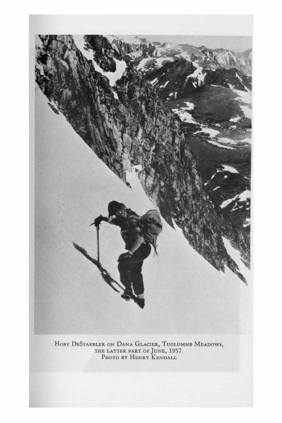
HOBY DESTAEBLER ON DANA GLACIER, TUOLUMNE MEADOWS,THE LATTER PART OF JuNE, 1957.
PHOTO BY HENRY KENDALL


bags. 'The packaging you can do, beforehand, in theconvenience of your kitchen, is time saved in preparingmeals under adverse conditions.' This dictum could havebeen extended to include„ for example, a breakfastcereal complete with powdered whole milk, salt, and somebrown sugar.
The book, Food Packing for Back Packing, by A. andG. Cunningham, published by the Gerry MountaineeringEquipment Company, Ward, Colorado, suggests the use ofsupplementary or extra rations to be used when the partyis extra hungry. This device could have been exploredmore for this trip.
39
THE SAC TRANS-SIERRA TOURby MICHAEL ROBERTS
I stood in the deep snow, breathing heavily after
stamping out a ten foot circle with my skis, and watchedthe little red plane circle and come back over. 'All
right; I'll be back in an hour with the helicopter.'yelled Bob Symons out of the door of his Piper Cub,
steering with his knees forty feet off the snow. Thus
began the final phase of a trip that received nationwide
publicity before it was over, yet had started innocentlyenough the previous January over several hot buttered
rums in a ski lodge at Reno's Slide Mountain. BartHooley and I had both nurtured hopes of making a trans-
Sierra crossing this winter for some time; however, it
was chance that put us to talking about it one weekend.
I had thought of a crossing from west to east through
Tuolumne Meadows, while Bart wanted to go east to west
from June Lake to Yosemite Valley. Eventually we decidedthat the east-west crossing offered more mountaineering
opportunities, and also had the advantage of reachingthe crest after only 12 miles, whereas the west-east
route was nearly 35 miles to the crest. Margi Meyer and
Lennie Lamb were immediately included in the trip, part-
ly because Bart and I had climbed and skied with thempreviously, partly because they had been at Alta and Sun
Valley with me at Christmas, as well as skiing competi-tively for Stanford, and conseguently were in excellent
shape. Bill Pope and Max Allen were later asked to comealong to strengthen the party.
As our plans progressed, Bart one day happened tomention the trip to a friend and fellow skier, 'Newt
Thompson. Newt suggested that perhaps the National Guardgroup with whom he flew on weekends might be interested
in doing an air drop for us near the crest, so that we
40

would be spared the necessity of hauling fifty or sixtypounds of food some 5000 vertical feet. The NationalGuard was indeed interested and eventually undertook topack and drop ninety pounds of food and equipment to usmidway in the trip.
The pains of packing and making final arrangementsfor a trip of this magnitude while at the same time tak-ing final exams cannot truly be realistically described;suffice to say that it was with six heartfelt sighs ofrelief that we finally left Palo Alto the night of March21. 1958.
On a winter mountaineering trip a year earlier intothe Palisades. I had experienced ideal weather and hardsnow, and hoped for a repeat this year. However, thestorms continued to roll in all during March, and whenwe left Palo Alto in a downpour, it was with thethought„ 'Well, we can't just let this thing die here atschool,, we'd better go over there and take a look.'Twelve hours later we stood in the road next to theSilver Lake powerhouse in brilliant sunshine and gazedup at the mountains, off whose steep flanks the previousday's snow had freshly avalanched. Considering thedramatic improvement in the weather no less than a man-date from above, we hurriedly made final adjustments topacks and skis, parked the car off the road, and startedup the initial slope to Agnew Lake at noon. The snowhad consolidated rapidly in the warm sun and we madegood time, gaining 1300 feet in two hours. We traversedto the far end of the lake and, faced with another steepslope and tired from the all night drive, we made camp.
The next day was uneventful, except for deep snowand slower going than we had anticipated. Travel wasstraightforward, up over Gem Lake, then to Waugh Lake -all three of the lakes being part of the hydroelectricsystem for the powerhouse at Silver Lake. That night wespent in a sheltered spot at the lower end of the RushCreek Basin, very near where the John Muir Trail crossesthe basin on its way to Thousand Island Lake and theMinarets. The snow was deep under the trees and had to
41

be packed extensively before we could set up the tents.
The next morning was clear and beautiful, with the
peaks of the crest. now only three miles away, mostly
hidden by streamers of mist. It had snowed during thenight, and our train was more than a foot deep, even
with skis. By noon we had gained the main ridge leading
to the Rodgers-Lyell saddle, where we meant to cross the
crest, but were moving very slowly dead into a fortymile an hour wind. At about 10;000 feet we decided to
leave the ridge and traverse a quarter of a mile to asaddle which led to Lower Marie Lake. The slope looked
dubious in the deep snow, and we were strung out about200 feet apart, with Bart leading, when a whole section
of snow opened into small cracks just ahead of Bart.Evidently our deep transverse track had weakened the
slope. We returned hastily to the ridge and followed itfor another half mile before being able to safely move
down onto the lake.This day, Monday, was scheduled to be the first air
drop attempt - our original calculation being that we
could gain the crest by noon of the third day. However,
we were still more than a day's travel from the crest,and hoped that the plane would follow our prearranged
plan and, seeing us lying down in the snow, drop to ourpresent position. When, about one p.m.„ we heard the
drone of engines and sighted the black bottom of theGuard plane (a C-46), we quickly dumped a can of red
poster paint out on the snow and lay down in a largecircle. Max dug the signal mirror out of his pack and
tried to catch the plane in its beam. For the next hour
and a half we lay freezing in the cold and wind, while
the plane, alternately damned and praised, continued tomake passes directly over us and into the mist covering
the crest. Our conclusion was that they did not want tomake a drop run over us and into the mist with such a
big, unmaneuverable plane, and would return the next
day. Actually, they never saw us that day, poster paint
and signal mirror to the contrary, and were looking on
the other side of the crest in the original drop spot.
42

STARTING OUT THE FIRST DAY FROM SILVER LAKE.
CAMP THE FIRST NIGHT ON AGNEW LAKE.
PHOTOS BY L. LAMB.


By the time they finally left, we were too cold andtired to go on and made camp on the lake about three.A chance prod with one of the ice axes discovered theastonishing presence of water only eighteen inches belowthe surface, despite the 10,500 foot elevation. This wasa welcome surprise, as it obviated the necessity ofmelting snow: a slow, laborious process at best. Billand I decided that the deep snow cover prevented thelake ice from becoming more than a few inches deep, andthat capillary action pulled water toward the surface.Except for the night in Rush Creek Basin, we made allour camps on lakes, which proved very satisfactory, asthey offered easier access to water when it was avail-able and were generally better protected against ava-lanche danger.
The wind had subsided by the next morning and wegot an early start. I led off up a slope toward UpperMarie Lake, which lies just below the Rodgers-Lyellsaddle. It was steep and open, forcing us to climbstraight up to minimize the avalanche danger. We wereringed round on three sides by jagged mountain peakslying vividly black and white in the early morning sun -the Lyell massif on the right, Mts. Rodgers and Davisto the left, and dead ahead the saddle toward which wehad now struggled for three days.
Promptly at eleven the plane was back. The partywas strung out along the ridge which parallels the southside of Upper Marie Lake with Bart in the lead and Billbringing up the rear. (Bill and Max had waited at thebottom of the slope leading out of camp until Lennie andI had gotten to the top, nearly 500 feet above.) Barthad on his red down jacket and dashed ahead in an effortto reach the crest so that the plane could drop on theother side. However, it was to Max who, nearly a halfmile behind, was using the signal mirror, that the dropwas made. Hampered by a turbulent wind over the crest,the plane was forced to drop from five thousand feetabove us - the two parcels fortunately came down on theedge of Upper Marie Lake and not several miles away as
43

they easily might have. We descended to the lake and
spent the rest of the afternoon rearranging the foodsacks and gorging on canned orange juices, beer, and
spaghetti. Needless to say, we were all beginning to
feel the altitude (11,500 feet), and no one's appetite
was very large, so that 'gorged1 might more properly bereplaced by 'nibbled'. Bart and Bill felt active enough,
however, to start a game of ice hockey on the wind-blown ice of the lake, using ice axes and beer cans. The
rest of us lay on air mattresses in the shelter of somerocks and watched, feeling more tired by the minute.
We were now camped at the foot of Mt. Rodgers
(13,056 feet). whose rocky east ridge offered an easy
route to the summit. It was decided Wednesday morningthat Max and Bart would climb the peak while the rest of
the party remained in camp to act as support and toprepare for the crossing of the crest later in the day.
About noon, as the two climbers were well on their waydown, Lennie, Margi, Bill and I set out across the lake
and up the twenty-five degree slope that reached thesaddle 800 feet above. In general, the higher we went,
the better the snow got and this slope was no exception.
The surface was well settled and crusted so hard in
places that our skis barely marked the snow as we side-
stepped up.
The long, slow climb finally brought us out on topof the narrow ridge and into a vicious wind. After
assuring myself that the others were following, I be-layed Lennie down the first 120 feet, a steep snow cou-
loir lying between two ribs of broken rock, and leaving
the rope in place, followed her in a controlled gliss-
ade. The view to the west as we trudged down on foot the
first thousand feet below the saddle revealed a great
expanse of snow covered peaks - Clark, Triple Divide.
Cloud's Rest, Hoffman, Foerster - now overlaid by a
thick cloud that indicated a change in the good weath-er we had been having.
Lennie and I arrived at Rodgers Lake, at the headof the Lyell Fork of the Merced, about four o'clock and
44

BART, BILL, MIKE, AND MAX CONSULTING THE TOPO.PHOTO BY L. LAMB.
,SKIRTING AN AVALANCHE WITH PEAKS OF SIERRA CREST HIDDEN IN THE MIST.PHOTO BY L. LAMB.


began stamping out our camp for the night. Behind, theother four members of the group could be seen slowlydescending, with Bill and Max still near the top. Maxtried to come down on his skis and presented a hilariousfigure when a long traverse was abruptly terminated by aheadfirst tumble into the snow. The situation was givena more serious turn, however, when Bart reached camp andreported that Bill had lost all his strength at the topof the climb and had had to be helped the last fiftyfeet over the ridge. Now it became obvious why Bill andMax were so far behind. When they got in shortly afterfive Bill was completely exhausted and having troublebreathing. All of us were fatigued by the exertion andaltitude and felt that although Bill was in the worstshape, the loss of two thousand feet the next day on theway down would alleviate his respiratory problem.
Thursday dawned cloudy and blowing; we were sotired that no one made any effort to break camp untilafter eight and it was nearly ten before we were under-way. Bill was extremely weak and coughing a good deal,but we still felt the best treatment would be to get himdown out of the altitude. Shortly after we started outthe weather closed in completely, leaving us stumblinggenerally southwestward in heavy snow. About noon Billcould not go any further and a conference was held amongBart, Max, and myself. Bart and Max had worked forseveral summers in Yosemite and knew the terrain overwhich we were traveling quite well; the decision wasthat they would continue on in the storm and try toreach the Valley for help, since it was apparent thatBill was very seriously ill. The girls and I would re-main in our present position and care for Bill.
The next tro days were anxious ones for the threeof us. The storm continued, and Bill's condition did notimprove. In spite of the antibiotic which was begunThursday morning, he was delirious most of Thursday andFriday. And there was the question of Bart and Max,whose progress in the storm was a complete unknown. How-ever, with the supplies that the two of them had left
45

behind, we had food and fuel for almost a week, and
antibiotic for five days. Our diagnosis of the illnesswas acute pneumonia - a common enough ailment at high
altitude - and our hope was that the antibiotic wouldwork, since it is considered specific for the disease.
(It turned out later on that he actually suffered from
viro-myocarditis, an infection of the lining of the
heart, and this was complicated by a comparatively minorcase of pneumonia. In any case, antibiotic and rest is
the only known treatment.)
Saturday morning brought a dramatic change in
events. I had fully recovered from a stomach ailment at-
tributable to altitude from which I had suffered earlier
in the week and had decided that we would make a strongeffort to move Bill down that day if the weather improv-
ed. When the day began sunny and clear, and Bill awaken-ed fully coherent, it seemed as though our luck was
beginning to take hold again. I busied myself making a
sled for Bill out of his pack frame, two ice axes, and
his skis, while the girls helped Bill out of the tent
and into his sleeping bag laid on an air mattress, and
then broke camp.
About ten o'clock, just as we were making the
initial effort to move the sled, we heard a plane enginequite close, and almost momentarily a Piper Cub flew
overhead from down the valley. There was no mistakingthat this was help: Bart and Max had gotten out in two
days, and the rescue was underway. The pilot dropped a
note identifying himself as Bob Symons and urging us to
try to get Bill down about two miles further where there
was evidently a place that he could land. While he was
gone we endeavored to comply with the request, but found
the snow too soft for the strength of three people. At
one Bob was back, this time with a message saying that ahelicopter rescue effort was under way and that they
would be at our position about two. We were now to move
Bill to the top of a knoll about a mile away, since the
helicopter could not land on the lake upon which we were
camped. At the same time more small planes appeared,
46

dropping gas, food, and more antibiotic. Our efforts tomove Bill were frustrated again, however, by theweather, which closed in and began to snow. We hastilyset up the tents again and crawled in out of the storm.
The clouds cleared away later in the afternoon andabout five Symons flew over with another message wrappedin the usual roll of toilet paper. This one was to theeffect that the helicopter had been prevented by theweather from getting close to us, and that another ef-fort was scheduled early the next morning. The messagealso asked if we wanted oxygen, and if so, to make an 0in the snow. I considered this for a moment, standingout in the cold wind in the middle of the small lakesurrounded by the harsh peaks of the crest - Lyell,Rodgers, Electro - and decided that Bill's condition hadimproved so much that it was no longer necessary, andwould be difficult to administer in the crowded„ filthyinterior of the tent in which he had now spent threefull days. Unbeknownst to us, this caused consternationamong the doctors in Yosemite, who assumed that thismeant Bill was dead.
Sunday was to be a rescue day; however, anotherstorm moved in and blizzarded during the night and allthrough the next day as we lay in our tents, warm andwell-fed, but frustrated. The snow fell very heavily, Ispent an hour in the afternoon scraping snow away fromthe sides of the tents. By evening it was above my kneesas I stood on the level of the original platform.
Knowing that the first clear moment would bring theplanes and helicopter back. Lennie and I were up beforelight Monday, staring at the brilliant early morningstars. It had cleared off and turned cold, perhaps thecoldest of the trip - near zero, I think. My boots re-quired extensive heating with the Borde before theywould go on, and it was just after six that I stood out-side the tents and heard the faint drone of a plane. Bobmade one pass and dropped a message 'If all members ofparty are still alive stamp an 0 in the snow. If somemember is dead, stamp an X'. I hurriedly made an 0 with
47

my skis...and we are back where this narrative began.
The helicopter arrived before we were quite ready; Ihad stamped a track to the top of a nearby hill, re-
turned, and sent Lennie up the two hundred feet to markout the spot with crepe paper that had been dropped to
us. Margi helped Bill into his boots; I worked on thebindings of his skis. At last we began the long trudge
up the hill, Bill stopping every twenty feet or so to
regain his breath. One of the pilots came down the hill
and grabbed Bill's other arm, together we struggled up.Margi and the other pilot quickly thrust as much of our
gear as they could into two packs and followed us up.
Then we were inside, the door bolted shut, and the noise
of the motors drowning out any conversation. An anxiousmoment and we were airborne. Scarcely ten minutes later
the Army deposited us in the Old Village parking lot,Yosemite Valley, into the hands of the relieved Park
Service, anxious and annoyed parents, and publicity,
with a capital P.
Epilogue
Bart and Max spent two days in the hospital re-
covering from dilated hearts suffered as a result of the
exertion of the forced march out; I spent a day in the
hospital waiting for my blood pressure to go down; Bill
Pope spent two weeks there while his heart and lungscame back to normal. The girls left the day of the
rescue for school, apparently unscathed by the experi-
ence. The two helicopter pilots are in the process of
receiving Distinguished Flying Crosses. Bob Symons is
dead, the victum of a glider accident two weeks after
the rescue. The rangers are back at their assigned
tasks, perhaps meditating on the folly of those who
brave the vicissitudes of Sierra weather.
Twenty years ago if we hadn't gotten out on our
own, we wouldn't have gotten out. Today the stranded
mountaineer has hundreds of men and their equipment as
far away as the nearest phone. A rescue operation such
as we were involved in endangers the lives of countless
48

other people. Mountaineering projects must necessarilynow assume more than the burden of the individualmembers' lives, leaving the climber with the soberingproblem of not can he climb, but ought he to climb?
Equipment Notes:Planning for this trip occupied the best part of
three months and was quite extensive. We purchasedaerial photos of the area from the USGS and althoughhelpful, they were taken in October, when the snow coveris least extensive, and consequently did not give anaccurate picture of the terrain. An aerial reconnais-sance was made with the National Guard the week beforewe went in and was quite revealing. The route lookedfeasible from the air, there were no signs of avalanchein the general area, and visibility of objects on theground was excellent. We used the eighty foot contourseries of topo maps on the trip and found them verygood. Five of us went on a twenty mile tour over Wash-ington's Birthday to the Ostrander Lake Ski Hut (8500feet), near the Badger Pass ski area in Yosemite, totest tents, packs, and cooking equipment. All workedsatisfactorily. We took two Co-op two man mountain tentsand one Army mountain tent. Two sets of skis and polesare exactly sufficient to set up the Co-op tent so thatit will stay up in any storm. Condensation was a minorproblem, which indicates that the fabric used in thetents breathes adequately.
A great deal of thought went into the food planningand packing with the following results: Menus were madeup on a six day basis by tent. Each tent was given fourrubberized nylon food bags, one for Breakfast, Lunch,Dinner and Miscellaneous. This comprised all the foodfor six days except for the five or six tins of tuna andhash that were taken along. All the food was taken outof the original containers and repackaged in polyethyl-ene freeze bags, according to meal and to tent. Wenormally had one cup of cereal and one cup of hot drinkfor breakfast; jam, cheese, meat, crackers and candy forlunch; and soup, a main course, and hot drink for
49
dinner. We preferred Minute Rice to Instant Potato andused it exclusively. Lipton's Soup, although lacking inflavor is by far the easiest of the dehydrated soups touse at high altitude. The final weight averaged tenpounds per person per six day menu. We were neverhungry, which perhaps is the best indication of whetheror not our planning worked.
Part of the success of the menu planning was theresult of using the Borde burner and cookset. Thesehandy little stoves are without question the easiest andquickest to start and use of any on the market. Theyare, however, not adequate for more than two people,lacking the heat to cook food in the larger cooksets.
Our medical supplies included two Ace bandages,splinting materials, disinfectant, empirin-codeine,percadan, and antibiotic. Despite the legal restrictionson their use, we feel that any mountaineering expeditionmust carry the last two mentioned items, as the use ofacromycin on our trip indicates.
50
CLIMBING NOTES
MINARETS
An SAC climbing camp was held in the Minarets June12-18. 1957. with twelve members participating. Basecamp was made under some trees at Lake Ediza whichoffered the only dry ground in the area. Snow stillblanketed the ground around the lake, as well as theapproaches to the surrounding peaks. Early starts werenecessary to gain altitude while the snow was stillfrozen. Many ascents were made in the brilliant sunnyweather which prevailed during the trip, some of themost important of which were:Banner Peak, East Face, Class 4 - A party led by BillPope arrived at the base of the climb at 9 a .m. , but be-cause of continuous roped 4th class pitches (over 20) ,the two three man ropes did not reach the summit until8 p . m . , just in time to catch the vivid sunset. A ropedglissade was made back to camp in the moonlight.Minarets: Ascents of Waller, Jensen, Turner, Leonard,and Dawson minarets were made by various parties.
CANADA
Inspite of the worst summer weather in years, sev-eral SAC parties in addition to the Battle Range groupwere active in the Rockies and Selkirks during 1957. OnAugust 18, Mary Kay Pottinger, Bill and Ben Pope madethe only ascent of the season on Sir Donald via theNW arete. The climb took eighteen hours from the roadand was slowed by rain during the descent. The previous
day Bill and Ben had done a traverse of the neighboringpeaks of Avalanche. Eagle, and Uto. On the 19th, Earl
51

Cilley and Mike Roberts arrived at Lake O'Hara to at-
tempt Victoria from the west. The ranger bade them acheery hello and commented that the beautiful day on
which they arrived had been only the eighth such sincethe middle of June. After a night in the hut at Abbot
Pass, the party set out for the summit. Arriving at the
South Peak, it was discovered that a warm southwest wind
of the night before had turned the summit ridge toslush. A reluctant descent was made from this point.
Hoping for better luck in the Selkirks, the in-trepid duo took train for Glacier Station, arriving
simultaneously with a new storm. The benevolent care-taker of the ACC hut took pity and for the next five
days Mike and Earl stared gloomily out at the rain andsome ninety wretched Sierra Clubbers attempting to cope
with the mud and wet. Finally deciding that Canadianclimbing was not 'that' good, they rode back to Golden
and began the long trek to fairer climbing country.Although questioning of the participants brings
forth only incoherent mutterings of "willow wands''whiteout,' and 'ice cave,' it appears that Jack
Weicker, Sandy Cole, and Leigh and Irene Ortenburger
spent an interesting several weeks on the Columbia Ice-
field during July and August. Nearly all the attempted
ascents were turned back by abominable weather, and on
two occasions the group was forced to spend the nightout.
CASCADES
The Battle Range party held a preliminary trip over
the 4th of July weekend on Mount Rainier. Taking ad-vantage of the warm, sunny weather, they spent one day
practicing 6th class climbing and rescue technique onthe Nisqually Icefall and the next climbing the mountain
via the Ingraham-Emmons Glacier route.
Labor Day saw the ascent of Mount Shuksan by Earl
Cilley and Mike Roberts. From an overnight camp at Lake
Ann, the party climbed up through the Fisher Chimneys
52
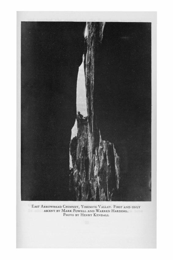
EAST ARROWHEAD CHIMNEY, YOSEMITE VALLEY. FIRST AND ONLYASCENT BY MARK POWELL AND WARREN HARDING.
PHOTO BY HENRY KENDALL


and reached the summit via the Hourglass variation,which offered a strenuous, overhanging bergschrund.Winnie's Slide was a good deal steeper than the previousyear, when the same party had been on the mountain, andforced step cutting on the way up. Near the top, amanila line was discovered half buried in the ice lead-ing down from the edge of the slope. Not wanting totrust old manila lines. Earl continued to cut higher,until it was discovered that the line was fastened to aniceaxe which had been left buried to the head by a prev-ious party. The summit register subsequently disclosedthat a party of sixteen beginners had been up the weekbefore and evidently used it as anchor for a fixed lineon the descent.
YOSEMITE VALLEY
Following upon several highly successful practiceclimbs, two trips to the Valley were made in^November,1957, in which a variety of climbs were done. Perhapsthe most notable of these was Henry Kendall and HobeyDeStaeblers' ascent of El Capitan Tree. The fourth re-corded party to complete the climb, they encountered noserious difficulty, but were forced to do the 120' freerappel in the dark on %" nylon, which promptly set fireto their rappel patches and provided a warm ride, indeed.On the last trip of Fall Quarter the club encounteredsome of its usual trouble with the leader-second manratio, and a party of nine ended up on Lower CathedralRock in the rain, while warm and dry kibitzers offeredadvice from cars parked on the road below. On the pre-vious day, Kendall and DeStaebler had again demonstratedtheir ambition by attacking the West Arrowhead Chimneysuccessfully. Henry succinctly characterized it as'long, dry, dirty, and thin.'
The club continues to focus its practice climbsupon preparation for Valley climbing, and the success ofthis emphasis is easily visible in the climbing records.In addition to the ascents recorded above, there have
53

been three climbs of the Direct Route, three of LowerSpire, two of Higher Spire, and four of Lower Cathedral
Rock--among others--on club trips during the past year.
54

HoBY DfiSTAEBLER ON OVERHANGING 1ST PITCH,EL CAPITAN TREE, OCTOBER, 1957.
PHOTO BY ANN DAVIDSON