Embed Size (px)
Citation preview

Standard Operating Procedure for
GIS Implementation in Mahatma Gandhi NREGA Contents
1. Executive Summary
2. Scope of Work
3. Audience & Stakeholders
4. Strategy
4.1. GIS Solution Phases
4.2. Roles and Responsibilities
4.3. NRSC, ISRO
4.4. Ministry of Rural Development
4.5. NIC- DoRD
4.6. C-GARD NIRD
5. Roll out
5.1. Roll out phases for software development
5.2. Phase-I
5.3. Data Flow Diagram
5.4. Phase-II
5.5. Phase-III
5.6. Scheduling
5.7. Rollout Waves for GIS implementation
5.8. Roll out stages of training and capacity building
5.9. Training Calendar
5.10. Training Modules
6. Organisation & Team
6.1. Central Level
6.2. State Level
7. Mobile Hardware
7.1. SOP for Mobile Device
8. Acronyms & Definitions

Standard Operating Procedure for
GIS Implementation in Mahatma Gandhi NREGA
Executive Summary Mahatma Gandhi National Rural Employment Guarantee Act
(MGNREGA) aims at livelihood security of people in rural areas by
guaranteeing hundred days of wage-employment in a financial year to a
rural household whose adult members volunteer to do unskilled labour work.
The Mahatma Gandhi NREGA sponsors various schemes for helping rural
people below the poverty-line for creation of wage employment and
productive assets. As per the information available with NREGASoft, around
30 lakh assets are created annually during a financial year under Mahatma
Gandhi NREGA. Ministry of Rural Development proposes to use GIS solutions
to visualize, analyze and explore such asset related data and also manage
them more effectively along with better understanding of their impact/
outcome.
Government agencies like Department of Land Revenue, PMKSY etc.
have taken advantage of information technology and widely used it to store
and maintain asset information.
Remote Sensing (RS) and Geographical information system (GIS) can
be effectively used to collect, store and analyze Mahatma Gandhi NREGA
assets (Watershed locations, Farm ponds, percolation tanks, check dams,
road layer, Irrigation Channels etc) . With the use of GIS in the area of asset
management, it is possible to visualize and understand the geographical
1 / 32
context of an asset and improve the efficiency of asset management. Spatial
location is a major common aspect of all the asset data and GIS can map all
the assets along with information for visualization and proper decision
making.
The Mahatma Gandhi NREGA GIS Solution intends to provide a single
and integrated view of asset information system pan rural India. GIS enabled
portal (e-Governance) will act as a gateway to facilitate and coordinate the
exchange and sharing of geospatial data between stakeholders from various
jurisdictional levels in the spatial data community. This will facilitate to
search, locate and publish geospatial data wherein end users can access,
share and publish (with appropriate log-in authenticity) in response to the
needs of diverse user groups. The GIS enabled portal will maintain, process,
store, distribute and improve the utilization of geospatial data for planners,
decision makers and public.
Scope of Work An interactive web GIS-based management System will maintain entire
information of MGNREGA assets. The system will allow users to create new
data, update existing data related to assets, generate queries, spatial query
such as buffer, reports, maps, etc. This will help the Department in
possessing a valuable digital database (both spatial and non-spatial) for the
entire country. Properly defined customized queries will also be made
available for day-to-day planning and management of the MGNREGA assets.
The broad scope of work for Mahatma Gandhi NREGA Geographical
information system is
● Geo-referencing of satellite images and scanned images (assigning
real world coordinates)
2 / 32

● GIS Mapping - Creation of Digital data (Assets) for pan rural India for
specified works as specified in schedule I of MGNREGA Act.
● Design and Development of Centralized GIS Data Model (Spatial and
Non-Spatial Layers) to store spatial and attribute information.
● Facilitate periodic capturing / updation / maintenance of existing asset
information using Mobile GIS platform
● Geotagging of images and integrating with respective assets
● Publishing of the asset information using Web Mapping Service (WMS)
for Citizens to visualize and give feedback in a crowdsourcing
architecture.
Audience & Stakeholders 1. Mahatma Gandhi NREGA workers: They will be able to get information
about work availability in the near locations, work site location information,
real time transparent attendance, and payment information.
2. Citizens: By enabling Geo Portal for MGNREGA assets, the solution will
generate demands, suggestions, critiques and data for both citizen and
agency involved. This will enhance concurrent social audit by citizen and
facilitate feed back information on work, quality validation, etc. to the DPC/
State Government who are implementing the program.
3. Central Government/ State Government/ PRIs/ Other PIAs/ District
Programme Coordinators/ Programme Officers: Incorporation of
geo-fencing of assets will allow setting up of triggers for these set of
stakeholders. When the Government Officer with appropriate GPS enabled
simple device enters (or exits) the boundaries defined by the MGNREGA
asset, a text message or email alert is sent. All stakeholders can see the
geographical location of assets on a map in the web management system.
The Geo-NOC will enable audit and easy management assets.
3 / 32

With an integrated real time Geospatial database of the rural assets a
composite map of the village can be seen with data from Census, Land
Records, IWMP, Schools and all other Ministries. This will help in integrated
planning for works (labour budgets), optimised convergence plans and
facilitate effective monitoring of implementation of works and creation of
assets.
Strategy There are two dependencies for the implementation of the GIS Project. Software and State Rollout. Software are demarcated as Phases and Rollout is demarcated as Waves. Both Phases and Waves are independent tracks.
GIS Solution Phases
4 / 32

Roles and Responsibilities
NRSC, ISRO
1. An exclusive Bhuvan–MGNREGA Geo-portal for DoRD will be developed and deployed, with geotagged assets data and report generating tools.
2. A customized Android Mobile App for geo-tagging of completed assets will be developed and provided for field level usage.
3. Standard Operating Procedure (SOP) will be provided by Bhuvan, in consultation with NIC-DoRD and DoRD for Moderation/ Validation of Geotagged content on the Bhuvan platform
4. Work towards realization of an operational interface for exchange of data / services with NIC-DoRD with regard to the MGNREGA and 14th Finance Commission requirements.
5. Preparation of User Manuals and imparting training for TOT participants.
Ministry of Rural Development
1. DoRD will provide specific requirements of the project to realise Bhuvan-MGNREGA Geo-portal
2. Facilitate the integration of NREGASoft data with Bhuvan geoportal, including sustained flow to Bhuvan
3. Coordination with State Agencies for required Data Flow including moderation and capacity building
4. Resolve issues with regard to Data Quality, with stakeholders, from time to time.
5. Jointly review/ monitor the implementation/ roll out of GIS under MGNREGA with NRSC.
NIC DoRD
DORD is the nodal organization / focal point for interaction with NIC for the following activities:
1. Provide initial data dump of all work-ids and corresponding names 2. Ensure Data Push from NREGASoft to Bhuvan-MGNREGA on a regular
basis, as required by the project
5 / 32

3. Enable smooth data services between NIC-DoRD and Bhuvan including data logging for completeness and trigger for incomplete transaction
4. Provide necessary requirements for formulation of Mobile App, as required by MORD
5. Provide services of the Administrative units (state, district, block, panchayat, village) year-wise, for mapping the assets
6. Provide service covering location codes including Unicode representation of local place names
7. Provide list of Work Categories, Sub Categories, Work Type and Asset Details
8. Provide asset IDs in NREGASoft for all completed assets. 9. Share the user database comprising of role (spatial enumerator or
moderator), credentials, user ID, area of responsibility, mobile number, IMEI number of device, for mapping the assets,
10.Share the domain and subdomain relations
CGARD NIRD
A. C-GARD, NIRD will provide short term and long term opportunities in skills development in the form of regular Academic Programmes, seminars, workshops and open house presentations and Exhibitions for GIS implementation of Mahatma Gandhi NREGA.
B. C-GARD, NIRD will also undertake user interaction and stakeholders symposia at regular (annual / biannual) intervals for promotion of openness and transparency in implementation and operations.
C. Training and capacity building upto GRS, Technical Assistant and PO level through SIRDs and Development of Citizen Centric Mobile Application to be integrated with the GIS solution of MGNREGA. NRSC will provide easy to and fro data exchange for implementation of CAMA.
D. The C-GARD will setup the PMU for GIS implementation, initially for two years. This PMU will be manned by sufficient number of consultants and executives. The C-GARd will also setup the help desk.
6 / 32

Roll out There are three simultaneous streams of roll outs viz.
1. Roll out phases for software development 2. Roll out waves for GIS implementation 3. Roll out stages for training and capacity building
Roll out phases for software development
PhaseI
Mobile based Geo-tagging of approximately 30 lakhs assets, annually, along with photographs, created under Mahatma Gandhi NREGA w.e.f 1st April 2016.
1. Information on Assets that are identified as completed by the respective State authority, will be pushed to Bhuvan platform along with work details from the NREGASoft on regular basis as part of operational mechanism.
2. Through Bhuvan Mobile Platform, completed assets will be Geo-tagged along with photograph by Gram Rozgar Sahayak/ Technical Assistant/ Junior Engineer.
3. After moderation/ validation by Programme Officer at the Block level, the assets will be displayed on Bhuvan Web Platform in public domain. Towards this a moderation interface will be provided on Bhuvan Platform for respective level of functionaries.
7 / 32

Data Flow Diagram
8 / 32

PhaseII
● Citizen centric Mobile Application for crowd-sourcing of information to create visibility and feedback mechanism to strengthen social audit mechanism.
● This phase will expand the GIS Application with comprehensive Geoprocessing of MGNREGA works by covering all stages of MGNREGA from initiation of work, muster roll, measurement of work to closure of work for better monitoring of MGNREGA functionaries performance and creation of assets, better tracking and better reporting of location-specific events through time and location stamping to improve the bottom line. This will integrate textual and spatial records and help in easy verifications of contours and boundaries of MGNREGA asset to perform various Spatial correlation and MIS functions.
PhaseIII
●Publish e-Government Interoperability Frameworks to create single window-access to spatial / non spatial data for full integration of geospatial data with various existing databases of Government. ● Creation of Common Asset Register at Panchayat level consisting of assets
from all Ministries ● Integration of GIS Asset data with Decision Support System for integrated
National Resource Planning at District level.
Scheduling
Sno
Title Start End
1 Signing of MoU between MoRD and NRSC 24/06/16 24/06/16
2 Phase I 27/06/16 26/07/16
3 Web Services 27/06/16 15/07/16
4 Daily Handshake establishment from NIC to 27/06/16 11/07/16
9 / 32

NRSC
5 Development of web services 27/06/16 14/07/16
6 Finalisation of Web Services 15/07/16 15/07/16
7 Development of Mobile App 27/06/16 21/07/16
8 Beta version development 27/06/16 04/07/16
9 Display of Mobile App to MoRD 05/07/16 05/07/16
10 Final Version 06/07/16 21/07/16
11 Development of Web Portal 27/06/16 21/07/16
12 Alpha version 27/06/16 14/07/16
13 Display of Portal to MoRD by NRSC 14/07/16 14/07/16
14 Final Version of Portal 15/07/16 21/07/16
15 Development of User Manual 27/06/16 25/07/16
16 Submission of draft Manual 27/06/16 21/07/16
17 Finalisation of Manual 22/07/16 22/07/16
18 Printing of Manual 25/07/16 25/07/16
19 Release of Mobile App, Web Portal and User Manual
26/07/16 26/07/16
20 Wave I 27/06/16 30/09/16
21 Submission of Implementation SOP 27/06/16 27/06/16
22 Approval of SOP 28/06/16 28/06/16
23 Submission of file for financial concurrence for training and PMU
29/06/16 04/07/16
24 Concurrence of Finance for training and pmu 05/07/16 08/07/16
25 Selection of Waves Districts 29/06/16 08/07/16
10 / 32

26 Issue of letter from MoRD 29/06/16 29/06/16
27 Nomination of GPD, Wave II Districts and training calendar by States
30/06/16 08/07/16
28 STAGE 1 National workshop of GIS 27/06/16 26/07/16
29 Finance Proposal for the workshop submission 27/06/16 04/07/16
30 Finance Approval 05/07/16 08/07/16
31 Invitation for the GIS Conference to States 27/06/16 04/07/16
32 Invitation to NRSC, NIC , NIRD for the workshop
27/06/16 04/07/16
33 National Workshop 26/07/16 26/07/16
34 STAGE 2: GIS MGNREGA Regional Resource Person (GMRRP) Training
11/07/16 29/07/16
35 Nomination of officials from SIRD for GMRRP 11/07/16 21/07/16
36 Nomination of MSE & GAS from GPDT 11/07/16 21/07/16
37 GMRRP Training at NIRD 28/07/16 29/07/16
38 GMRRP Training completion 29/07/16 29/07/16
39 Pilots 01/08/16 31/08/16
40 Pilots in 34 Districts 01/08/16 31/08/16
41 Completion of Pilots 31/08/16 31/08/16
42 Stage 3: GIS MGNREGA Block Champion Training for Wave I
11/07/16 05/08/16
43 Training calendar submission by SIRD for Wave I
11/07/16 21/07/16
44 Letter to States for nomination of GPDC from each block of GPD
22/07/16 22/07/16
11 / 32

45 Nomination of GPDC by States 25/07/16 29/07/16
46 Training of GPDC, DGNO at SIRD 01/08/16 05/08/16
47 GPDC Training Completion 05/08/16 05/08/16
48 Stage 4: GIS MGNREGA Block Level Training for Wave I
08/08/16 31/08/16
49 GIS MGNREGA Block Level Training of Wave I completion
31/08/16 31/08/16
50 RollOut of Wave 1 in GPD 1 and GPD 2 01/09/16 30/09/16
51 Completion of Wave 1 rollout 30/09/16 30/09/16
52 Wave II 08/08/16 01/11/16
53 Stage 5: GIS MGNREGA Block Champion Training for Wave II
08/08/16 30/08/16
54 GIS MGNREGA Block Champion Training for Wave II completion
30/08/16 30/08/16
55 Stage 6: GIS MGNREGA Block Level training for Wave II
01/09/16 28/10/16
56 Rollout of Wave II 01/11/16 01/11/16
57 Phase II 01/09/16 01/12/16
58 Development of Citizen Centric Mobile Application
01/09/16 01/09/16
59 Interoperability framework 01/09/16 01/12/16
12 / 32

Rollout Waves for GIS implementation
Rollout Phases Summary 1. The rollout is spread into two Waves, i.e. Wave I and Wave II. Wave I are
the selected Districts of the State which are geared and predisposed towards GIS implementation at the early stage. Hence these GIS Districts are called as GIS Pioneering Districts (GPD). A total of 100 Districts have been selected across all States as GPDs. These GPDs will be nominated by State Government based on the site readiness both in terms of resources, connectivity and manpower preparedness. No mobile hardware will be supplied to the District and States will have to manage locally. The preferable method is Bring your own device (BYOD) concept. However, the mobile device so used, should match the hardware specifications prescribed in this document.
2. These GPDs are further divided into Districts where Pilots will be conducted. These Pilot GPDs are called as GIS Pioneering Testing Site
13 / 32

District (GPTSD). Each of GPTSD will inturn choose one Gram Panchayat from their District which will become testing sites for the GIS Implementation. These Gram Panchayat will be called as GIS Pioneering Testing Site Gram Panchayats (GPTSG) and its corresponding block will be called as GIS Pioneering Testing Site Block (GPTSB). Thus there will be 34 GPTSDs with 34 Gram Panchayat Testing Sites.
3. The Wave I be launched in 100 GPDs (all Gram Panchayats) after successful completion of pilots in 34 testing sites. Wave I will thus include all Gram Panchayats one that is chosen as Testing sites (GPD 1) and also those chosen under GPD 2. This stage will mark the Project as ‘GO-LIVE’. The GIS Project will be inaugurated and launched on this day.
4. After successful implementation in Wave-I in each of the GPD, implementation of Wave- II will be done in all GPs of the remaining 561 districts as per the timelines prescribed by the Ministry.
State Wave Rollout Strategy
S
No
.
States / UTs
No Of
District
s
No Of
Panchayat
s
Pilot
s Wave I
Wave II
GPD GPD GPD II Total
1 2 3 4 5 6 7 8 9
1 ANDHRA PRADESH
13 13084 1 1 1 2 11
2 ARUNACHAL PRADESH
20 1827 1 1 2 3 17
3 ASSAM 27 2644 1 1 2 3 24 4 BIHAR 38 8529 1 1 3 4 34 5 CHHATTISGARH 27 10971 1 1 2 3 24 6 GOA 2 190 1 1 1 2 0 7 GUJARAT 33 14330 1 1 4 5 28 8 HARYANA 21 6314 1 1 2 3 18
9 HIMACHAL PRADESH
12 3251 1 1 1 2 10
10 JAMMU AND KASHMIR
22 4206 1 1 2 3 19
14 / 32

11 JHARKHAND 24 4422 1 1 2 3 21 12 KARNATAKA 30 6019 1 1 3 4 26 13 KERALA 14 941 1 1 2 3 11
14 MADHYA PRADESH
51 22827 1 1 4 5 46
15 MAHARASHTRA 34 28670 1 1 5 6 28 16 MANIPUR 9 3133 1 1 1 2 7 17 MEGHALAYA 11 6206 1 1 1 2 9 18 MIZORAM 8 876 1 1 1 2 6 19 NAGALAND 11 1200 1 1 1 2 9 20 ODISHA 30 6211 1 1 3 4 26 21 PUNJAB 22 13110 1 1 2 3 19 22 RAJASTHAN 33 9896 1 1 3 4 29 23 SIKKIM 4 176 1 1 1 2 2 24 TAMIL NADU 31 12524 1 1 3 4 27 25 TELANGANA 9 8831 1 1 1 2 7 26 TRIPURA 8 1178 1 1 1 2 6
27 UTTAR PRADESH
75 59177 1 1 6 7 68
28 UTTARAKHAND 13 7997 1 1 1 2 11 29 WEST BENGAL 20 3347 1 1 2 3 17
30 ANDAMAN AND NICOBAR
3 83 1 1 1 2 1
31 DADRA & NAGAR HAVELI
1 11 1 1 0 1 0
32 DAMAN & DIU 2 10 1 1 1 2 0 33 LAKSHADWEEP 1 10 1 1 0 1 0 34 PUDUCHERRY 2 10 1 1 1 2 0
Total Count 661 262211 34
34 66 100 561
Roll out stages of training and capacity building
Training and capacity building are an integral part of the GIS implementation
primarily because of the IT based dependence. Therefore, change
management for creating and updating Assets through GIS based mobile
15 / 32

application requires detailed training manual and handholding support. To
this effect a complete training and capacity building plan has been prepared.
Once the GIS Solution is developed, as per the MoU between MoRD and NRSC,
NRSC will develop the detailed training manual for the usage of the mobile
application, validation of the data and then usage of the web GIS portal.
CGARD NIRD will be the apex organisation which has the capability of both
GIS technology and operations, will coordinate and eventually execute the
training to all the relevant functionaries. MoRD will provide necessary
operational guidelines, funds and support to NIRD for effecting the complete
training. The training program under GIS Implementation has been
simplified and structured into 6 stages to ensure that all the functionaries
given sufficient training are made aware about the operations of the software
and its usage.
1. Stage 1: National Workshop on GIS Implementation in MGNREGA: A one
day National Level GIS Workshop will be held inviting all respective
Principal Secretaries / Secretaries (in charge of MGNREGA), MGNREGA
Commissioners, State GIS Nodal Officer (SGNO) and District Collectors,
District GIS Nodal Officers (DGNO) of districts selected under Wave-I
i.e GPD 1 and GPD 2. This workshop will orient all the State
Government about the various facets of Assets creation and
Geo-tagging. This will be jointly conducted by MoRD, NIRD and NRSC.
The detailed operating Manual will also be released which will be
prepared by NRSC.
2. Stage 2: GIS MGNREGA Regional Resource Person (GMRRP) Training: One
day Training of Trainers programme will be organised by NIRD & NRSC
for training the GIS MGNREGA Regional Resource Persons (GMRRP).
These RRPs will be selected by SIRD. These RRP will inturn give
training at the State Levels for MSE / GAS.
Secondly, as detailed in the Roll Out plan, before the GO-LIVE Stage,
16 / 32

the solution will be tested and Pilots conducted in the 34 Gram
Panchayats of GPDs called as GIS Pioneering Testing Sites Gram
Panchayats (GPTSG). Each of the GPTSG have a corresponding GIS
Pioneering Testing Site Block (GPTSD). These MSE (GRS / Technical
Assistants/ Others) and GAS (PO at Block level) functionaries from
GPTSG and GPTSD are called as GIS Pioneering District Testers (GPDT).
These GPDTs will also be trained in the same workshop at NIRD. They
will be required to bring their own mobile phone under Bring Your Own
Device (BYOD) plan during the training session organised at NIRD
Hyderabad. NRSC will prepare a Training Manual for the users.
3. Stage 3: GIS MGNREGA Block Champion Training for Wave I: GPD 1 and
GPD 2 will nominate one resource person from each of the Block who
will be designated as GPDC (GIS Pioneering District Champions).
GMRRP along with NRSC and GPDT will impart training to GPDC, DGSNO &
SGNO at the regional level in the SIRDs as per the detailed plan
attached with this document.
4. Stage 4 GIS MGNREGA Block Level Training for Wave I: GIS Pioneering
District Champions (GPDC) will in-turn train all the MGNREGA Spatial
Emulators (MSE) i.e. GRS/ Technical Assistants & GIS Asset Supervisor
(GAS) i.e. PO at block level of their respective District either at the
District or at the block level.
5. Stage 5: GIS MGNREGA Block Champion Training for Wave II: State
GMRRP along with NRSC and GPDT will impart training to GPDC, DGSNO &
SGNO at the regional level in the SIRDs as per the detailed plan
attached with this document for all Districts covered under Wave II.
6. Stage 6: GIS MGNREGA Block Level training for Wave II: The GPDCs of
Wave II will inturn give training to all MSE and GAS for their respective
block either at the block or district level.
17 / 32

Training Calendar
Stage Name Date Organiser Participants Numbe
r
Durati
on
Stage 1 National
Workshop on
GIS
Implementati
on in
MGNREGA
26.07.201
6
MoRD State Principal
Secretaries /
Secretaries
MGNREGA
34 1 Day
Commissioner
MGNREGA
34
Wave I Districts 100
SGNO 34
DGNO 100
NIRD and SIRD 50
NRSC 10
MORD 50
Subtotal 412
Stage
2
GIS
MGNREGA
Regional
Resource
Person
(GMRRP)
Training
28 & 29
July 2016
CGARD
NIRD &
NRSC
SIRD & State
Nominations
35 1 Day
GPTSG MSE 34
GPTSB GAS 34
Sub Total 103
18 / 32

Stage
3
GIS
MGNREGA
Block
Champion
Training for
Wave I
1st
August
to 5th
August
2016
NRSC, RRP
& GPDT in
11 SIRD &
NIRD
District
Champions
(One Per Block
of each District
of Wave I)
Each
State
will
work
out the
calend
ar
1 Day
Per
Batch
DGNO
Stage
4
GIS
MGNREGA
Block Level
Training for
Wave I
8th
August
to 30
August
2016
GIS
Champion
s
MSE & GAS of
Wave I
Each
State
will
work
out the
calend
ar
1 Day
per
batch
Stage
5
GIS
MGNREGA
Block
Champion
Training for
Wave II
8th
August
to 30
August
2016
NRSC, RRP
& GPDT in
11 SIRD &
NIRD
Block
Champions
(One Per Block
of Each District
of Wave II)
Stage
6
GIS
MGNREGA
Block Level
training for
Wave II
1st Sept
to 30 Oct
2016
GIS
Champion
s
MSE & GAS of
Wave II
Each
State
will
work
out the
calend
ar
1 Day
per
batch
19 / 32

Training Modules
The Training Module will have two components, one in which the Trainees
are exposed to the Geospatial Technology Basic Concepts, Tools, Techniques,
Processes/ Methodology, data capturing, integration of data, positional data
through GPS/ Smartphone, asset geo-tagging, etc and in the use of
Geographic Information System (GIS), Satellite Remote Sensing, Global
Position System etc. The second aspect is rigorous hand holding in practical
applications in Mobile Data Collection, Use of Mobile Data Capturing for Asset
Geotagging and other applications related to the project. The training
programme will include theory, hand holding and practical demonstration
and usage of the Mobile for field data capturing.
● Basics about GIS and GEO Tagging, handling geo information over web
● Asset Creation on NREGASoft
● Use of Bhuvan Mobile Application
● Use of Bhuvan Mahatma Gandhi NREGA geoportal
● Moderation/Validation of the uploaded photographs on Bhuvan platform
● Use of satellite images & handling geo information over web
Organisation & Team The implementation of the GIS will be governed at the Central and the State level.
Central Level
The Programme Division Mahatma Gandhi NREGA will steer the complete implementation of the GIS Solution for Mahatma Gandhi NREGA. To ensure effective and timely rollout of the Mahatma Gandhi NREGA GIS Solution following monitoring mechanism will be set up:
20 / 32
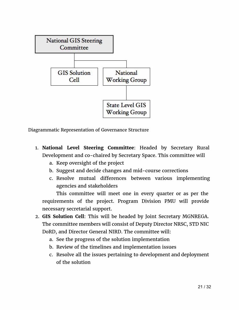
Diagrammatic Representation of Governance Structure
1. National Level Steering Committee: Headed by Secretary Rural Development and co-chaired by Secretary Space. This committee will
a. Keep oversight of the project b. Suggest and decide changes and mid-course corrections c. Resolve mutual differences between various implementing
agencies and stakeholders This committee will meet one in every quarter or as per the
requirements of the project. Program Division PMU will provide necessary secretarial support.
2. GIS Solution Cell: This will be headed by Joint Secretary MGNREGA. The committee members will consist of Deputy Director NRSC, STD NIC DoRD, and Director General NIRD. The committee will:
a. See the progress of the solution implementation b. Review of the timelines and implementation issues c. Resolve all the issues pertaining to development and deployment
of the solution
21 / 32

This committee will meet on a fortnightly basis or as decided by the chairman. The Program Division PMU will provide necessary Secretarial Support.
3. National Working Group: This committee will be headed by Joint Secretary MGNREGA. The members will consist of Commissioner MGNREGA from each State, and State GIS Nodal Officers.
a. This committee will take stalk of the implementation at the State level
b. Feedback from the States requiring solution changes c. Monitoring and directions to the state for implementation.
The committee will meet on a monthly basis over Video Conferencing or as decided by the Chairman of the Committee. Program Division PMU will provide necessary secretarial support.
4. Monitoring of Implementation of GIS: To execute the same, MoRD will augment the Section handing the GeoMGNREGA Project with requisite technical outsourced manpower who are specialised in GIS. A total of Senior Consultant with 10 re more years of experience in GIS will be the technical resource person and will be assisted by a GIS Project Executive with 3-5 years of offhand experience of GIS implementation in the Government Projects. These will be hired on the contractual basis.
As the implementation of the GIS Solution is of phenomenal scale but the timelines are very short, it entails coordinated activities among NRSC, ISRO, NIRD, NIC and State Governments. Therefore, appropriate manpower support for coordination and implementation is vital. In this regard, NIRD C-GARD was requested to examine the requirements. NIRD has submitted the proposal. Accordingly, CGARD, NIRD will augment GeoMGNREGA Project with Program Management Unit with 14 outsourced technical staff with varied specialised and program Management skills. Following will be the role of the PMU:
a. These initial work will be very vital in the faster rollout of the programme. Each of the GPD will then undergo roll out under Wave-I to be followed with Wave-II. PMU will ensure effective
22 / 32

monitoring of the implementation with strict adherence to timelines.
b. Preparation of PERT and GANTT Chart for each of the District c. A team of 2 or 3 persons from PMU will be associated with group
of states. (Six state groups can be formed i.e., Northern, Southern, Western, Eastern, Middle, North-East States).
d. The Technical manpower at PMU would be used to verify the data uploaded from the field and coordinate with state level implementing agency in resolving any inaccuracies.
e. Software & Hardware Deployment: Each of the executive will be entrusted with the job of:
i. Identification and documentation of GPD from each of the State
ii. Deployment and activation of mobile devices in the Gram Panchayats
iii. Deployment and initiation of mobile application up to the Gram Panchayat level.
iv. Installation of the Software in the Mobile devices v. Troubleshooting of any problems in the installation,
upgradation and maintenance. vi. All operative issues relating to the Mobile hardware like
anti-virus, Operating system upgrade, installation of third party applications will be handled by the PMU.
vii. All exception reports from the GP will be compiled and presented to the respective decision making authority.
viii. All training and orientation material will be managed and effectively distributed in a timely manner to each of the GPD.
ix. Training & handholding Support: PMU will organise periodic training on GIS application to the functionaries in centre and state governments. The support desk will be setup and manned by PMU resource persons.
23 / 32

State Level
State Level GIS Working Group: Each State will setup GIS Working Group headed by Principal Secretary / Secretary looking after Mahatma Gandhi NREGA as the chairman. The committee will:
1. Decide the rollout strategy 2. Conduct meeting with District Collectors/ DM DGNO and other officials
of the State 3. Monitor the progress of the implementation 4. Resolve issues arising out in the field level. 5. Keep an oversight of the quality of the photographs. 6. Setup and review the asset creation, correct Geo-tagging issues and
publishing details on the portal. 7. Submit the report to the Program Division MGNREGA of the
proceedings of the meeting and provide details as and when required by the MoRD.
8. Review the training schedule and suggest improvement. The committee will meet every month or as frequently as decided
by the chairman. SGNO will provide the secretarial Support for the committee.
Following will be implementing agencies and their designations at the State Level:
i. Level 1: There will be designated MGNREGA Spatial Enumerator (MSE) for each Gram Panchayat who will capture the asset photographs with GPS location of completed assets. The Gram Rozgar Sahayak (GRS)/ Technical Assistant (TA) will be designated by the respective State Government considering the local conditions and requirements. There can be multiple MSEs under one GP.
ii. Level 2: State shall designate officers above GRS/ TA as GIS Asset Supervisor (GAS) who will validate and approve the asset photograph. The Programme Officer (PO) or any other concerned officer at the Block level will be designated by the respective State Government considering the local conditions and requirements.
24 / 32

iii. Training & Hand Holding: Each of the GPDs will nominate one suitable person from each of the block to be trained as GPD Champions (GPDC) who will in-turn train all the GRS/ Technical Assistants working as MSE (MGNREGA Spatial Enumerators) and GAS (GIS Asset Supervisor). These GPDCs will be given training at the level of SIRD. As they are from the block level, not only they would be able to provide the training, but they will also provide handholding support, validation of GIS data & Asset photographs, user account management e.t.c.
iv. Coordination level 1: State will designate District GIS Nodal Officer (DGNO) for each district. DGNO will be responsible for coordination of issues relating to the district.
v. Coordination Level 2: Each State will immediately nominate State GIS Nodal Officer (SGNO) under Commissioner Mahatma Gandhi NREGA, who will be responsible for coordination and rollout. All issues pertaining to geo coordinates, assets mapping and photograph validation in a state will be rectified at this level.
Mobile Hardware Based upon the experience of various State Governments during the implementation of GIS solution in their state the following minimum mobile device hardware specifications is suggested. These specifications should be subjected to the requirements of mobile application to be deployed to ensure matching of specification to that of requirement.
CPU 1.3 GHz
OS Android 4.4
Display TFT capacitive touch screen 3.5”
Connectivity GPRS, GPS and A-GPS, Wi-Fi
3G enabled Yes
Rear Camera 5 MP
RAM 2 GB RAM
Internal memory 8 GB
External Storage compatibility 16 GB
25 / 32

SOP for Mobile Device
A. There will be one mobile device on each Gram Panchayat to upload the data through the mobile software application.
B. Only authorised person by the State Government can upload the data on the website.
C. Central Government will provide one time grant for the purchase of the mobile device for the implementation of the GIS in MGNREGA.
D. The device should be allotted to the Mobile Spatial Emulator (MSE) only. The device cannot be allotted or used by any other person.
E. There will be specific instructions by the Central Government for installation / un-installation of mobile applications.
F. The Mobile device Operating System should not be pirated/ jailbroken. Only applications available in the Mobile store can be installed on the device.
G. The mobile should be maintained in good condition free of dust and moisture.
H. As the device will be used for the official purpose for the Geo-tagging of the assets, it is imperative that proper security is maintained for the device and is not misused.
I. If the device is stolen or broken, the same shall be reported immediately to the concerned DPC and should be replaced/ repaired at the expenses of the State Government. No further funds will be made available for the maintenance and damages by the Central Government.
J. The State Government shall be responsible for maintaining an inventory of the procured devices as well as their maintenance in good condition.
K. Each of the device so procured will be linked with the GIS Server, and therefore Central Government will be aware of the total procurement and deployment status of the mobile devices in a timely manner.
26 / 32

L. However, in case where the State Government are already using Mobile phones for capturing GIS data for other schemes, the same can be used in the GIS tagging. (Provided that it meets the basic minimum hardware specifications).
M. The cost of the SIM and data plan will have to be borne by the respective State Government.
N. The maintenance cost of the mobile devices is not included in the Central Government allotment of fund for the procurement.
27 / 32

Acronyms & Definitions
Acronym Full Description
GIS Geographic Information System
Database for spatial and non spatial data
MoRD Ministry of Rural Development A branch of the Government of India, is entrusted with the task of accelerating the socio-economic development of rural India
NRSC National Remote Sensing Centre
Monitoring using satellite data, Spatial and thematic maps, part of Indian Space Research Organisation
CGARD Centre for Geo-informatic Applications in Rural Development
Design and develop Geomatics Applications for Rural Development Sector and develop the skill and knowledge levels in Geomatics technology and tools among the development functionaries from the Government
NIRD National Institute for Rural Development
Indian institute for research in rural development
ISRO Indian Space Research Organisation
The space agency of the Indian government
GPD GIS Pioneer Districts First District where GIS will be implemented
GPDTS GIS Pioneer District Testing Site
First Gram Panchayat selected within GPD for PILOT execution of GIS application
GPDT GIS Pioneer District Tester Gram Panchayats
28 / 32

functionaries working MSE and GAS in GPDTS
GPDC GIS Pioneer District Champion Nominate by GPD, one resource person from each Block, he/she will in-turn train all the GRS/ Technical Assistants/ PO of their respective District
GPSTD GIS Pioneer Testing Site District
GPTSB GIS Pioneering Testing Site Block
GPTSG GIS Pioneering Testing Site Gram Panchayat
RRP Regional Resource Persons Selected by SIRD/NIRD, to be first trained in MGNREGA GIS under Training of Trainers(ToT) in Stage-2.
PMU Programme Management Unit PMU is a group to ensure effective implementation and monitoring
MSE MGNREGA Spatial Emulator At Gram Panchayat level, who will capture the asset photographs with GPS location
GAS GIS Asset Supervisor At Block level, who will validate and approve the asset photograph
DGNO District GIS Nodal Officer At District Level, coordinate and monitor the implementation
SGNO State GIS Nodal Officer At State Level, Coordinate and monitor the implementation
29 / 32

NREGASoft MIS for MGNREGA
NIC National Informatics Centre
SIRD State Institute of Rural Development
Autonomous Institute under State Government for Training & Research in Rural Development
GRS Gram Rojgar Sevak At Gram Panchayat level, official manages the MGNREGA work
PO Program Officer At Block level, official manages the MGNREGA work.
PERT Program Evaluation Review Technique
To find the critical path for project management.
GANTT Horizontal chart bar chart to monitor the progress of program.
TA Technical Assistant
PILOT GIS Implementation in small group of people from selected pioneer districts.
WAVE -I GIS Implementation in one district selected in each state, comprising a total of 34 districts
WAVE-II GIS Implementation of all other Districts after Wave-I
PHASE-I Rollout phase, development of Bhuvan mobile and web applications, and integrating with NREGASoft
PHASE-II Rollout phase, Development of Citizen centric Mobile Application
PHASE-III Rollout phase, Publish e-Government Interoperability Frameworks to create single window-access to spatial / non spatial data for full integration
Stage-1 Training for National Level GIS Orientation Workshop
Stage-2 Training for Regional Resource Persons
30 / 32

Stage-3 Training for GIS MGNREGA Block Champion Training for Wave I
stage-4 Training for GIS MGNREGA Block Level Training for Wave I
Stage-5 Training for GIS MGNREGA Block Champion Training for Wave II.
State-6 Training for GIS MGNREGA Block Level training for Wave II
31 / 32


![Untitled-1 [nrega.nic.in]€¦ · Title: Untitled-1 Created Date: 1/9/2018 5:35:30 PM](https://img.dokumen.tips/doc/110x75/5f535da7e9ce7627b311265d/untitled-1-nreganicin-title-untitled-1-created-date-192018-53530-pm.jpg)


