Embed Size (px)
Citation preview

Staithes Coastal Strategy
Appendix K
Technical Report #3 – Cliff Overview

1. Introduction
This report describes the behaviour of the cliffs within the Study Area. It has been subdivided into two frontages, namely: (1) the Redcar & Cleveland Borough Council frontage, covering Cowbar Nab; and (2) the Scarborough Borough Council frontage, covering the cliffs to the east of Staithes. These two frontages are separated by Staithes Harbour.
2. Cowbar Nab (Redcar & Cleveland Borough Council)
Background
Cowbar Nab is characterised by broad, gently sloping (1 in 40) stepped, inter-tidal rock platform which extends below the low water mark and a 45-60m high near-vertical sea cliff developed Lower and Middle Jurassic rocks. These comprise a variable sequence of shales, ironstones, siltstones, mudstones and sandstones. The sea cliffs are capped by 5-26m of glacial till. The frontage has been sub-divided into distinct Cliff Behaviour Units (Figure 1).
Figure 1 – Cliff Behaviour Units of Cowbar Nab
Erosion
This part of the coastline has been extensively mined and quarried for over 400 years, with the cliffs around Boulby being mined historically for ironstone and presently for potash. Monitoring of subsidence has been undertaken with a (decreasing) rate of 1 to 8mm/year recorded. It has been reported previously that wave energy at the cliff toe may have increased by 2-4% at Cowbar and up to 30% in the Redhouse Nab area, where subsidence has been greatest, although there has been no reported evidence of this correlating with accelerated erosion rates (Environmental Technology Consultants Ltd, 1998).
Eroding cliffs at Cowbar Nab threaten parts of Cowbar Lane, with the potential to affect Cowbar Cottages and sever the road and utility services and the only vehicular access from Cowbar Cottages to Cowbar Bank and Northside in Staithes Harbour (including to the inshore RNLI lifeboat station).

Gradual (regular) recession of the cliffs by marine erosion at the toe can trigger (infrequent) instability in the glacial till in the upper cliff. The erosion mechanisms are for wave attack at the base of the cliff (along with weathering) to cause small rock falls and topples from the rock face. The resulting debris is usually removed relatively quickly by wave action (Figure 2). Due to the pattern of joints, there is also potential for a large rock fall (greater than 2m3). The shore platform also experiences low rates of lowering due to wave attack. The erosion rate in the rock is therefore very slow, generally <0.1m/year. When erosion in the rock undermines the base of the glacial till in the upper section of cliff, it can trigger rotational slides. Periods of heavy rainfall (or broken drainage) can also trigger mudslides. Generally, after failure the glacial till slope attains short-term stable angles of repose of 35 to 50°.
Figure 2 – Cliff Failure Mechanisms (from High Point Rendel, 1999)
Monitoring by Durham University (Rosser, 2018) has captured such changes in the vicinity of the access path to the National Trust’s land at the Nab during a rockfall event in May 2016 (Figure 3). This event was also recorded by the Cell 1 Regional Coastal Monitoring Programme’s 2-yearly walkover inspections in 2016 (Box 1).
Figure 3 - Rockfall in May 2016

In addition to the failure mode caused by marine erosion at the toe of the cliff, Preferential Erosion due to weathering of the weaker beds and joints in the mid and upper cliff faces is also occurring. This is resulting in a series of concave erosion zones between harder beds and joints, with the toe of the cliff protruding seawards of these eroding soft mid and upper bands, as can be seen from the images below in Figure 4 below.
Figure 4 – Preferential Erosion due to weathering of weaker beds and joints in the mid and upper cliffs.
This type of erosion is more typical of the cliffs to the west side of Cowbar Nab / Harbour.
Formatted: English (United States)

Box 1 – Extract from 2016 Walkover Inspections

In the 92 months of monitoring from January 2011 to August 2018, around 4,000m3 of material had been lost from the cliff face in 120,320 separate rock fall events. The majority of these are small, with decreasing frequency of increasingly large events.
Cliff erosion rates at Cowbar Nab derived from previous studies are shown in Table 1, with platform lowering rates in Table 2.
Table 1 – Erosion rates at Cowbar Nab
Rate Comment Source 5m erosion between 1856 and 1960 in rock
Equivalent to long term erosion rate of 0.05m/year
Agar 1960
0.28 m/year in till Agar 1960 Single events of 5m every 100 years
Equivalent to long term erosion rate of 0.05m/year
High Point Rendel 1999
Cliff face (rock) 0.08 – 0.4 m/year (Angling Wyke) 0.01 – 0.03 m/year (Cowbar Cottages)
High Point Rendel 1999
Cliff top (till) 0.15 – 0.46 m/year
High Point Rendel 1999
Average erosion rate (future) 0.25m/year to allow for uncertainty over subsidence effects and sea level rise
Used in Cowbar (Coast Protection & Cliff Stabilisation) Strategic Study in 1999
High Point Rendel 1999
0.025 m/year SMP rates, based upon Durham University monitoring results to 2006 (Lim, 2006)
Royal Haskoning 2007
General = 0.0007m/year Focus zone = 0.08m/year
Focus zone is immediately below Cowbar Lane and Cowbar Cottages
Rosser 2018
Table 2 – Erosion rates at Cowbar Nab
Rate Comment Source 0.0011 m/year Robinson 1977

Management Reponses
Cowbar Lane has been realigned on at least two occasions in the 1980s and, as part of one of these realignments, No. 1 Cowbar Cottages was demolished to allow safe passage of vehicles via Cowbar Lane.
Redcar & Cleveland Borough Council previously purchased a strip of land adjacent to the road, so that adaptation to coastal change could be implemented in the form of further re-location of the road (Figure 54).
Figure 54 – Council-owned Land (from High Point Rendel, 1999)
The previous Cowbar (Coast Protection & Cliff Stabilisation) Strategic Study in 1999 identified four locations along Cowbar Lane where either the road was close to the cliff top or where the angle of repose was over-steep and proposed a rock revetment and cliff top stabilisation (soil reinforcement using mini piles and soil nails, with erosion control matting and deep and shallow drainage measures) (Figures 5 to 7).
Figure 65 – Photos of two rock revetments from Sandy Wyke to the turn of the road into Cowbar Bank
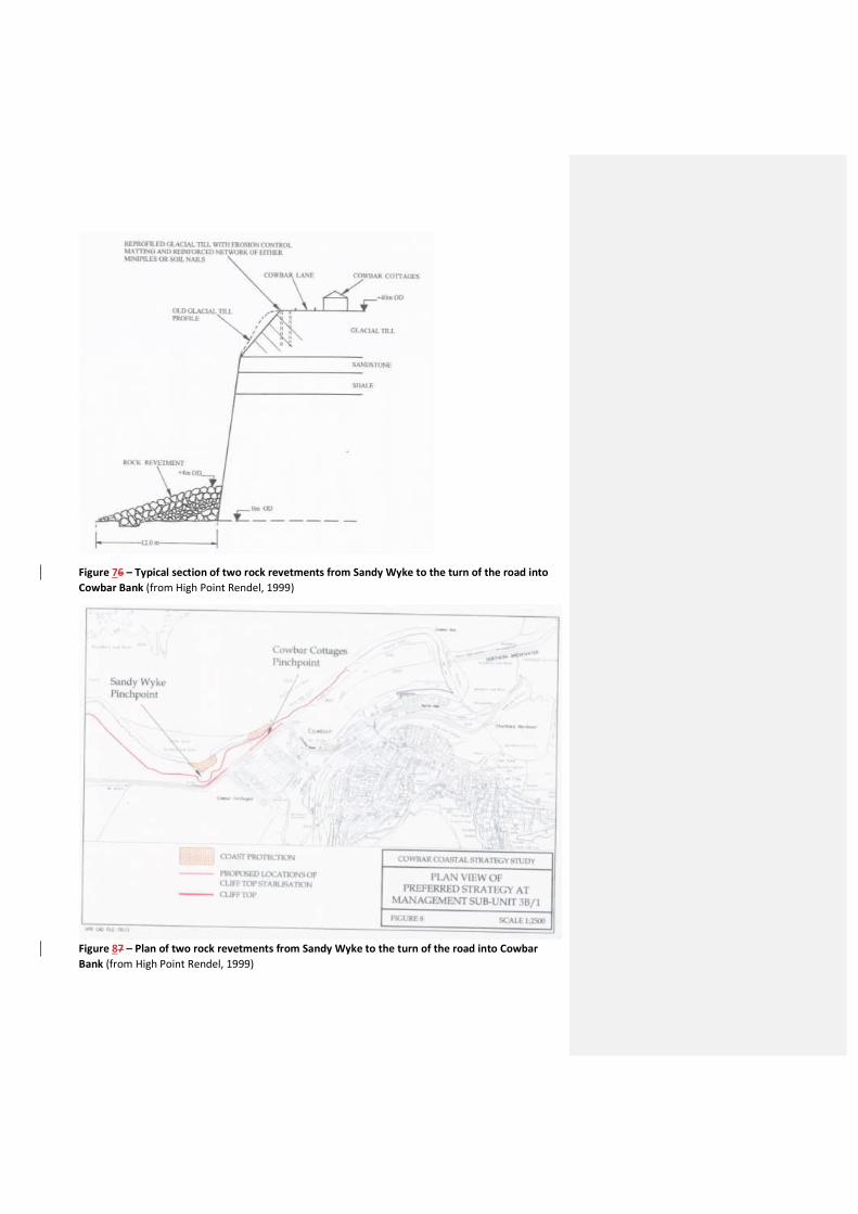
Figure 76 – Typical section of two rock revetments from Sandy Wyke to the turn of the road into Cowbar Bank (from High Point Rendel, 1999)
Figure 87 – Plan of two rock revetments from Sandy Wyke to the turn of the road into Cowbar Bank (from High Point Rendel, 1999)

The Huntcliff (Saltburn) to Flamborough Head Shoreline Management Plan (SMP1) (Mouchel, 1997) had the following shoreline management policies for the Cowbar frontage:
Management Unit 3B – Boulby Rockhole Hill to Cowbar Do Nothing for the majority of the unit, but with continued landward relocation of the access road to Cowbar.
In the area of Cowbar, the SMP included the recommendation for additional measures to manage the cliff retreat in a controlled manner, including possible coast protection measures such as a limited rock revetment.

The Cowbar (Coast Protection & Cliff Stabilisation) Strategic Study / Engineer’s Report (High Point Rendel, 1999) then sub-divided the Boulby to Cowbar Nab (~3km) frontage into three Management Units (Figure 8) and developed the following approaches:
o Management Sub-unit 3B/I – Boulby Rockhole Hill to Red House Nab (high landslide hazard and risk to a few isolated properties) Do nothing (the isolated properties are > 20m from cliff edge except one, which is >5 m back)
o Management Sub-unit 3B/II – Red House Nab to Sandy Wyke (high landslide hazard and high risk to road) Managed retreat (i.e. road diversion as and when necessary) with a monitoring/early-warning system; frequency of road diversion strategy to be reviewed every 5 – 10 years based on monitoring feedback
o Management Sub-unit 3B/III – Sandy Wyke to Cowbar Nab (high landslide hazard and high risk to property and road) Recessions rates identified that approximately 655m of Cowbar Lane would be lost during the next 50 years (from 1999), with four vulnerable locations within 5m of the cliff top (potentially lost during a single failure in the glacial till slope).
There was particular concern at oversteepened slope at Cowbar Cottages, which could fail within 2-5 years (of 1999). Should this fail there would be insufficient space to realign the road without demolition of at least one end terrace property at Cowbar Cottages.
Coast protection with a rock revetment and cliff top stabilisation (soil reinforcement using mini piles and soil nails, with erosion control matting and deep and shallow drainage measures)
Figure 98 – Management Units in the Cowbar (Coast Protection & Cliff Stabilisation) Strategic Study/Engineer’s Report (from High Point Rendel, 1999)

The River Tyne to Flamborough Head SMP2 (Royal Haskoning, 2007) had the following policies for Management Areas 18 and 19 (Figures 9 and 10):
Figure 109 – Management Area 18 of SMP2 (from Royal Haskoning, 2007)

Figure 101 – Management Area 19 of SMP2 (from Royal Haskoning, 2007)
The principal aim of this plan is to maintain protection to the village of Staithes. In the short to medium term no further works are envisaged in the area of the Cowbar Cottages beyond review and maintenance of the existing defence. As the adjacent cliff line retreats there will be a need to review this policy with the expectation that these defences would be reinforced. With respect to the Harbour, it is expected that further works would be required to maintain this structure as slow erosion of Cowbar Nab continues. There will be a need to review detailed aspects of defence to the Village as a whole, which would draw together an overall strategy for the whole management area.
From present day: To hold the line in all areas currently defended. Monitor the retreat of adjacent cliffs and relocate the Cowbar Lane to the west of the Cottages as necessary.
Medium term: As retreat of the cliff to the east of Cowbar Cottages continues works may be required to reinforce the existing defences. In other areas existing defences would be maintained or replaced, subject to the need being identified by monitoring.
Long-term: Defence would be maintained beneath Cowbar Cottages and in maintaining the integrity of the north breakwater. Other defences to Staithes would be retained.

3. Cliffs East of Staithes (Scarborough Borough Council)
Background
The cliffs east of Staithes are less well studied than those at Cowbar Nab because, in general, there are fewer management issues (the land use is less developed) and the foreshore access is more remote. Whereas the Cowbar cliffs are composed of beds of the Lower and Middle Lias, the frontage east of Staithes has variably Lower, Middle and Upper Lias exposed in the cliff face. The cliffs immediately west of the harbour arm are sandstone and prone to occasional rock falls, whilst it is known that the cliffs immediately east of the harbour arm contain several distinctive ironstone layers and faults can be seen running out from the cliff across the foreshore, etched out by the sea as narrow channels (Eccleston & Eccleston, 1998). Fossils are regularly found in the Penny Steel foreshore beneath the Penny Nab cliffs. Jet Wyke and Brackenbury Wyke contain some very good examples of faults and caves, with mine adits also found along Brackenbury Wyke. The frontage has been sub-divided into distinct Cliff Behaviour Units (Figure 11).
Figure 121 – Cliff Behaviour Units East of Staithes

Erosion
Cliff erosion rates along the cliffs to the east of Staithes from previous studies are shown in Table 3.
Table 3 – Cliff Erosion Rates East of Staithes
Rate Comment Source 0.1 m / year SMP rates Royal Haskoning 2007
Management Responses
Due to the paucity of assets at risk from erosion, there has been little management intervention required along the cliffs to the east of Staithes, other than occasional signs warning of cliff rock falls.
The River Tyne to Flamborough Head SMP2 (Royal Haskoning, 2007) had the following policies for Management Area 20 (specifically only Policy Unit 20.1 is within the present Study Area) (Figures 11):
Figure 103 – Management Area 20 of SMP2 (from Royal Haskoning, 2007)
The overall management intent for the area is to maintain the naturalness and natural evolution of the coast in support of the objectives of the National Park and Heritage Coast.

In response to the tragic death of a 9-year old girl, Harriet Forster, from a rock fall which occurred to the immediate west of the harbour arm during a day out with her mother on the beach at Staithes on 8th August 2018 (Box 2), the Coroner for North Yorkshire (Eastern District) made the following recommendations in his Regulation 28 Report:
1. There needs to be more signage warning visitors of the dangerous condition of the cliffs and the keep away from the base of the cliffs due to falling rocks.
2. Consideration should be given to whether some type of barrier could be erected at the base of the cliffs preventing people from walking immediately adjacent to the cliffs; and
3. Consideration should be given to erecting another walkway so as to avoid the necessity for people having to walk immediately under the cliffs.
During July and August 2018 some high-profile incidents of cliff activity occurred along the coastline within the north of the borough, including the collapse of a section of cliff to the east of Staithes on 8th August, where tragically a young child was killed. These units are classed as Locally Active and as such are expected to experience some localised occurrences of activity and indeed there are warning signs erected on the cliff face to this effect.
Box 2 – Extract from 2018 Walkover Inspections
In response to the first recommendation, increased signage has been erected at Staithes by Scarborough Borough Council. For the second and third recommendations combined, Scarborough Borough Council has installed a new permanent barrier early in 2019.
References
Agar, R., 1960. Postglacial erosion of the North Yorkshire coast from the Tees estuary to Ravenscar. Proc. Yorkshire Geol. Soc.
Eccleston, J. & Eccleston, P., 1998. A History and Geology of Staithes. ISBN 0 9534644 0 7.
Environmental Technology Consultants Ltd, 1998. Assessment of Coastal Processes: Boulby toCowbar Nab: Internal Report, May 1998 for Cleveland Potash Ltd.
Lim, M., 2006. Coastal cliff evolution with reference to Staithes, North Yorkshire. Unpublished PhDThesis, University of Durham, September 2006.
Robinson, L.A., 1977. Erosive processes on the shore platform of north-east Yorkshire, England.Marine Geology, 23,339-361.
Rosser, N., 2018. Coastal cliff monitoring – Cowbar Nab, Staithes, N. Yorkshire. Durham UniversityReport, August 2018.