Embed Size (px)
Citation preview

Staff report for action – Final Report – Ward 18 Study 1
STAFF REPORT ACTION REQUIRED
Local Area Study – Lands along the CN rail tracks from Queen Street West to Dupont Street – Ward 18 - Final Report
Date: November 4, 2013
To: Toronto and East York Community Council
From: Director, Community Planning, Toronto and East York District
Wards: Ward 18 - Davenport
Reference Number:
11 170983 SPS 00 TM
SUMMARY
In March 2011, Toronto and East York Community Council requested City Planning to conduct a review of lands abutting the CN railway, which form the western boundary of Ward 18. The Study did not look at land use as this was being considered through the Municipal Comprehensive Review, but focused on opportunities to improve this area and better connect it to the surrounding neighbourhood. The result will help the City to proactively respond to any development proposals in the area and plan for the long-term investment and revitalization of these lands. The Study responds to a unique combination of factors including relatively large industrial sites lacking local infrastructure immediately bounded by stable neighbourhoods. In addition, the area is under increasing development pressures.
City staff, the Ward Councillor and members of the community have worked together to develop a vision for new development and direct infrastructure investment within the Study Area. In addition, an inter-divisional staff team worked on the project and were involved in developing the recommendations. The Study outlines short-term and long-term recommendations pertaining to parks, the transportation network (including new roads, bikeways, parking and walkways), heritage

Staff report for action – Final Report – Ward 18 Study 2
buildings, urban design and community services and facilities.
RECOMMENDATIONS
The City Planning Division recommends that:
1. City Council adopt the Study, entitled "Besides the Tracks: Knitting the Rail Corridor Back to the Community", attached at Attachment 1 to the report (November 4, 2013), from the Director, Community Planning Toronto and East York District.
2. City Council direct City Staff to use this framework to review development applications as well as infrastructure investment in the long-term for the lands within the Study Area.
3. City Council request the Director, Community Planning, Toronto and East York District, in consultation with appropriate City Divisions to report back in the first quarter of 2014 on an implementation strategy, including quick hits to move forward with elements of the "Besides the Tracks" Study.
Financial Impact The recommendations in this report have no financial impact.
DECISION HISTORY At its meeting on March 22, 2011 Toronto and East York Community Council (Agenda Item No. TE5.53) requested City Planning to carry out a study for the lands abutting the CN railway that forms the western boundary of Ward 18, which would include a review of parkland, the transportation network (new road, bikeways and walkways), heritage buildings, urban design and community services and facilities.
The motion can be found through the following website link: http://app.toronto.ca/tmmis/viewAgendaItemHistory.do?item=2011.TE5.53
A webpage has been created for this Study. It is found at the following website link: http://www.toronto.ca/planning/ward18-study.htm
ISSUE BACKGROUND
Purpose of the Study The purpose of this Study is to set priorities and develop a framework to help guide future development applications and infrastructure investment within the Study Area.
Community Consultation The community consultation strategy that was implemented for this Study included a combination of community meetings and community walks. The community meetings were held on June 6, 2011 for the northern portion of the Study Area and on June 13, 2011 for the southern portion. The community walks were held on July 18 and July 19, 2011. The purpose of using a

Staff report for action – Final Report – Ward 18 Study 3
variety of consultation means and multiple meetings was to ensure interactions with the varied groups of residents, local business owners and developers.
The community meetings featured 'working maps' which highlighted different aspects of the Study Area, such as open spaces, heritage buildings, bike paths, pedestrian routes, community facilities, and road network as well as new developments and relevant planning applications. The attendees were asked to indicate their concerns and desires for the Study Area using these 'working maps' which were placed around the room in an open house format. Appropriate staff were at each map to answer questions and comments were placed on the maps using post-its and coloured markers. All public comments and notes were compiled and reviewed by Staff to formulate priorities that the Study should focus on. The following is a summary of suggestions that came out of the community consultations:
Parks: Increase the landscaping and furnishings such as benches, garbage receptacles etc. and improve the general maintenance of existing facilities and parks.
Transportation: A number of new roads and crosswalks were suggested, as well public transit shelters and streetcar stops needing improvement were indicated. The West Toronto Railpath Extension Study Environmental Assessment will determine the preferred route to extend the recreational path and is schedule to be completed in Spring 2014.
Heritage: The heritage buildings existing in the Study Area, such as the Toronto Hydro-Electric System Substation, Gladstone Hotel, should be preserved and other buildings that have heritage features should be considered for listing or designation.
Urban Design: New development should have underground parking, green roofs, commercial uses at grade where appropriate, and should incorporate the "Front Porch character" of the Study Area.
The above public comments were reviewed by an inter-divisional committee for the Study, which included Staff from Parks, Transportation Planning, Strategic Initiatives and Policy Planning, Urban Design and Heritage. The comments were then analyzed and distilled to form recommendations. An additional public meeting was held on October 19, 2011 in order to report back to the community on the final recommendations. Final reporting on the "Besides the Tracks" Study was timed to allow City Planning Staff to ensure that these recommendations are informed by the Municipal Comprehensive Review (MCR), which is being reported to Planning and Growth Management Committee on November 21, 2013.
Final Recommendations The following recommendations that are being put forward for the Study Area:
Parks Forestry and Recreation Recommendations
Short-term Recommendations: o Improve the general condition and maintenance of all facilities.

Staff report for action – Final Report – Ward 18 Study 4
o Build and maintain convenient amenities such as washrooms and waste receptacles at all parks.
o Increase tree coverage and shaded areas for Dovercourt Park. o Increase seating at Perth Parkette. o Maintain sport facilities such as tennis courts at West Toronto Collegiate and basketball
court at MacGregor Park. o Change the hours the McCormick Park wading pool is available to the public. o Establish a green network by planting more street trees and landscaped areas to extend
the natural heritage system. o Continue to encourage the provision of green roofs in new developments in order to
increase open space amenities.
Long-term Recommendations: o Increase access to large outdoor facilities that serve the community. o Further investigate the prospect of a land swap in order to relocate the Dundas– St.
Claren's Parkette to the southwest corner of the Dundas Street and St. Claren's Avenue intersection.
Transportation and Public Realm Recommendations
Short-term Recommendations: o Introduce stop signs and painted zebra stripes at select intersections to improve safety
measures and visibility, such as the Florence Street and Brock Avenue. o Upgrade and/or replace transit shelters that are in a state of disrepair. o Maintain informal pedestrian pathways such as the trail behind West Toronto Collegiate
and ensure adequate lighting is provided. o Ensure parking permissions are consistent on all streets through signage and enforcement. o Install post and ring locks for bicycles especially along Dupont Street and Gladstone
Avenue. o Encourage new development to incorporate underground parking into the design of the
buildings.
Long-term Recommendations: o Redevelopment of large blocks of lands in the Study Area should include the provision of
new public roads. o Realign some streets to help foster a more pedestrian friendly and safer environment,
such as the Bloor, Symington and Sterling intersection. o Install street lights and improve access to pedestrian crossing areas and sidewalks, for
example at the Bloor Symington and Sterling intersection. o Revitalize Lansdowne subway station. o Upgrade sidewalks and extend/alter the widths of the pavements in the Study Area that
are lacking. o Investigate the introduction of sharrows on select streets with narrow widths in the Study
Area. o Extend the bike network in the Study Area and include informal bike pathways. o Create more connections over the rail corridors.

Staff report for action – Final Report – Ward 18 Study 5
Heritage Recommendations Short-term Recommendations:
o Ensure that new developments protect and conserve heritage resources. o List or designate all properties with heritage or historical value.
Urban Design Recommendations Short-term Recommendations
o Implement policies and guidelines that encourage landscaping. o Encourage commercial uses at grade on main streets that are in keeping with the uses and
character of the area. o Recognize the prevailing pattern of front porches as an established feature in the Study
Area and retain or replicate wherever possible. o Promote and secure funds for public art through new development.
ConclusionsThe Study for lands along the CN rail tracks from Queen Street West to Dupont Street in Ward 18 presents a number of opportunities for investment, some of which may be implemented in the short-term and others that can be achieved in the long-term. Future redevelopment in the Study Area should occur in a way that respects the existing characteristics, such that the "Front Porch" character, while accommodating new growth.
The Study of the lands along the rail corridor at the westerly limit of Ward 18 has identified a number of short and long-term opportunities for the area. The framework outlined in the attached "Besides the Tracks: Knitting the Rail Corridor back to the Community" Study provides a blueprint against which new development applications and planning for infrastructure can be proactively assessed and begin to knit these areas into the surrounding community.
CONTACT Charlene Miranda, Planner Tel. No. (416) 392-9434 Fax No. (416) 392-1330 E-mail: [email protected]
SIGNATURE
_______________________________
Gregg Lintern, MCIP, RPP Director, Community Planning Toronto and East York District
(P:\2013\Cluster B\pln\TEYCC\28977930056.doc) - ca (P:\2013\Cluster B\pln\TEYCC\Beside the Tracks Study.pdf) - ca

Staff report for action – Final Report – 1 South District Study 6 V.05/13
ATTACHMENTS
Attachment 1: "Besides the Tracks: Knitting the Rail Corridor back to the Community"

Staff report for action – Final Report – 1 South District Study 7 V.05/13
Attachment 1: Besides the Tracks: Knitting the Rail Corridor back to the Community

NOVEMBER|2013
BESIDE THE TRACKS: KNITTING THE RAIL CORRIDOR BACK TO THE COMMUNITY - WARD 18

Copyright © Novemeber 2013 City of TorontoPublished by: City of Toronto, City Planning - Toronto and East York District

BESIDE THE TRACKS: Knitting the Rail Corridor back to the Community | 3
Executive Summary 5
Introduction 8
Existing Conditions 16
Parks, Forestry and Recreation 28
Transportation and Public Realm 34
Heritage 44
Urban Design 48
Community Services and Facilities 50
Conclusion 58
TABLE OF CONTENTS1

4 | BESIDE THE TRACKS: Knitting the Rail Corridor back to the Community

BESIDE THE TRACKS: Knitting the Rail Corridor back to the Community | 5
Like most of Toronto’s inner city rail corridors, the Georgetown Rail Corridor along the west edge of Ward 18 has been evolving and needs a new blueprint for the 21st century. This area reflects the general character and demographics of Ward 18. It is diverse in its uses, building forms, range of housing and rich cultural communities. Increasingly new development is beginning to fill in some of the vacant and underutilized lots.
At the request of City Council, City Planning, in consultation with other Divisions, has conducted an area-wide review of lands abutting the CN railway that forms the western boundary of Ward 18. The Study:
• identifies potential locations for new parks and open spaces and/or the expansion of existing parks and open spaces;
• reviews the transportation network, including the potential for reconfiguration and expansion of the public road network;
• reviews potential improvements to the pedestrian and bicycle network, including the expansion of, and connections to, the West Toronto Rail Path;
• identifies deficiencies in community services in the area; and
• is complementary to the Municipal Comprehensive Review now underway as part of the 5-year Official Plan review.
City staff will use this framework to respond proactively to any development proposals in the area and plan for long term investment in, and revitalization of Employment Areas and other land use designations.
Community Consultation meetings were held on June 6 and June 13, 2011 and Community Walks were conducted on July 18 and July 19, 2011 to gather input from residents, local businesses and developers in the area. A final public meeting was held on October 19, 2011 to present the recommendations to the community.
A historical review of the area was conducted through the study of the following documents (Industry in the Junction Study Area; Junction Triangle – Neighbourhood Plan Proposals and Development Plan and Final Recommendations; Dundas-Dufferin Redevelopment Plan Phase I and Phase II; Bloor-Junction Community Services and Facilities Needs Assessment; Bloor/Junction Land Use Policy Review; Bloor Lansdowne Avenue Study; Junction Triangle Part II Plan; Junction Triangle Precinct Plan; and Bloor-Dundas Avenue Study.)
The lands along the rail corridor include Mixed Use Areas, Neighbourhoods, Parks and Open Space Areas, Employment Areas, and Utility Corridors. The zoning provisions are reflective of the designations with site specific zones that are primarily Residential (R); Commercial Residential (CR); Employment (E); Employment Light Industrial (EL); Open Space Recreation (OR); Open Space (O); and Utility and Transportation (UT). The area is primarily low-density residential dwellings with distinct porch character but there are also mid-rise buildings as well as large former and operating industrial sites.
EXECUTIVE SUMMARY00
WARD 18 - LOCAL AREA STUDY
C N R
C N R / C P R
/ C P R
C N R
C P R
C N R
C N R / C P R
C N R
C P R
C N R
C P R
C N R
/ C P R
C N R / C P R
C N R / C P R DUPONT ST
DU
ND
AS ST W
QUEEN ST W
COLLEGE ST
DUNDAS ST W
RON
CESVALLES AVE
OSSIN
GTO
N AVE
BATHU
RST ST
CHRISTIE ST
DUPONT ST
DU
ND
AS ST W
QUEEN ST W
COLLEGE ST
DUNDAS ST W
RON
CESVALLES AVE
OSSIN
GTO
N AVE
BATHU
RST ST
CHRISTIE ST
BLOOR ST WBLOOR ST W BLOOR ST WBLOOR ST W
DUPONT ST DUPONT ST

6 | BESIDE THE TRACKS: Knitting the Rail Corridor back to the Community
The Study provides short-term and long-term recommendations for Parks, Forestry and Recreation, Transportation and Public Realm, Heritage and Urban Design in order to manage development applications and plan for new City services. The following recommendations are firmly grounded in the invaluable input of the community.
Park, Forestry and Recreation Recommendations
Short-term Recommendations• Improve the general condition and maintenance of all
facilities.• Build and maintain convenient amenities such as
washrooms and waste receptacles at all parks. • Increase tree coverage and shaded areas for Dovercourt
Park.• Increase seating at Perth Parkette. • Maintain sport facilities such as tennis courts at West
Toronto Collegiate and basketball court at MacGregor Park.
• Change the hours the McCormick Park wading pool is available to the public.
• Establish a green network by planting more street trees and landscaped areas to extend the natural heritage system.
• Continue to encourage the provision of green roofs in new developments in order to increase open space amenities.
Long-term Recommendations• Increase access to large outdoor facilities that serve the
community.• Further investigate the prospect of a land swap in order
to relocate the Dundas– St. Claren’s Parkette to the southwest corner of the Dundas Street and St. Claren’s Avenue intersection.
Transportation and Public Realm Recommendations
Short-term Recommendations• Short-term Recommendations• Introduce stop signs and painted zebra stripes at select
intersections to improve safety measures and visibility, such as the Florence Street and Brock Avenue.
• Upgrade and/or replace transit shelters that are in a state of disrepair.
• Maintain informal pedestrian pathways such as the trail behind West Toronto Collegiate and ensure adequate lighting is provided.
• Ensure parking permissions are consistent on all streets through signage and enforcement.
• Install post and ring locks for bicycles especially along Dupont Street and Gladstone Avenue.
• Encourage new development to incorporate underground parking into the design of the buildings.
Long-term Recommendations• Redevelopment of large blocks of lands in the Study Area
should include the provision of new public roads.• Realign some streets to help foster a more pedestrian
friendly and safer environment, such as the Bloor, Symington and Sterling intersection.
• Install street lights and improve access to pedestrian crossing areas and sidewalks, for example at the Bloor Symington and Sterling intersection.
• Revitalize Lansdowne subway station.• Upgrade sidewalks and extend/alter the widths of the
pavements in the Study Area that are lacking.• Investigate the introduction of sharrows on select streets
with narrow widths in the Study Area.• Extend the bike network in the Study Area and include
informal bike pathways.• Create more connections over the rail corridors.

BESIDE THE TRACKS: Knitting the Rail Corridor back to the Community | 7
Heritage Recommendations
Short-term Recommendations• Ensure that new developments protect and conserve
heritage resources.• List or designate all properties with any heritage or
historical value.
Urban Design Recommendations
Short-term Recommendations• Implement policies and guidelines that encourage
landscaping.• Encourage commercial uses at grade on main streets that
are in keeping with the uses and character of the area.• Recognize the prevailing pattern of front porches as
an established feature in the Study Area and retain or replicate wherever possible.
• Promote and secure funds for public art through new development.
8 | BESIDE THE TRACKS: Knitting the Rail Corridor back to the Community
1.1 WHAT IS THE STUDY AREA?
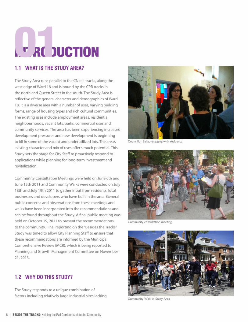
The Study Area runs parallel to the CN rail tracks, along the west edge of Ward 18 and is bound by the CPR tracks in the north and Queen Street in the south. The Study Area is reflective of the general character and demographics of Ward 18. It is a diverse area with a number of uses, varying building forms, range of housing types and rich cultural communities. The existing uses include employment areas, residential neighbourhoods, vacant lots, parks, commercial uses and community services. The area has been experiencing increased development pressures and new development is beginning to fill in some of the vacant and underutilized lots. The area’s existing character and mix of uses offer’s much potential. This Study sets the stage for City Staff to proactively respond to applications while planning for long-term investment and revitalization.
Community Consultation Meetings were held on June 6th and June 13th 2011 and Community Walks were conducted on July 18th and July 19th 2011 to gather input from residents, local businesses and developers who have built in the area. General public concerns and observations from these meetings and walks have been incorporated into the recommendations and can be found throughout the Study. A final public meeting was held on October 19, 2011 to present the recommendations to the community. Final reporting on the “Besides the Tracks” Study was timed to allow City Planning Staff to ensure that these recommendations are informed by the Municipal Comprehensive Review (MCR), which is being reported to Planning and Growth Management Committee on November 21, 2013.
1.2 WHY DO THIS STUDY?
The Study responds to a unique combination of factors including relatively large industrial sites lacking
INTRODUCTION01
Councillor Bailao engaging with residents
Community consultation meeting
Community Walk in Study Area

BESIDE THE TRACKS: Knitting the Rail Corridor back to the Community | 9
LAN
SD
OW
NE
RO
NC
ES
VA
LLE
S
BLOOR
DUPONT
DAVENPORT
OS
SIN
GTO
N
DO
VE
RC
OU
RT
LAN
SD
OW
NE
DU
FFE
RIN
KE
ELE
PA
RK
SID
E
CH
RIS
TIE
BA
THU
RS
TB
ATH
UR
ST
HARBORD
COLLEGE
DUNDAS
QUEEN
KING
GARDINER EX
LAKE SHORE
STR
AC
HA
N
LAKE ONTARIO
ST CLAIR AVE WEST
DUNDAS
BLOOR
OLD
WE
STO
N
LAN
SD
OW
NE
RO
NC
ES
VA
LLE
S
BLOOR
DUPONT
DAVENPORT
OS
SIN
GTO
N
DO
VE
RC
OU
RT
LAN
SD
OW
NE
DU
FFE
RIN
KE
ELE
PA
RK
SID
E
CH
RIS
TIE
BA
THU
RS
TB
ATH
UR
ST
HARBORD
COLLEGE
DUNDAS
QUEEN
KING
GARDINER EX
LAKE SHORE
STR
AC
HA
N
LAKE ONTARIO
ST CLAIR AVE WEST
DUNDAS
BLOOR
OLD
WE
STO
N
Study Area Ward 18 Study Area

10 | BESIDE THE TRACKS: Knitting the Rail Corridor back to the Community
local infrastructure immediately bounded by stable neighbourhoods. In addition, the area is under increasing development pressures.
The intent of this Study is for City Planning, in consultation with other Divisions, to conduct an area wide review of lands abutting the CN railway that forms the western boundary of Ward 18. The Study:
• identifies potential locations for new parks and open spaces and/or the expansion of existing parks and open spaces;
• reviews the transportation network, including the potential for reconfiguration and expansion of the public road network;
• reviews potential improvements to the pedestrian and bicycle network, including the expansion of, and connections to, the West Toronto Rail Path;
• identifies deficiencies in community services in the area; and
• is complementary to the Municipal Comprehensive Review now underway as part of the 5-year Official Plan review.
City Planning staff are completing the 5-year review of the Official Plan including a Municipal Comprehensive Review (MCR) of all Employment Lands. A number of these Employment Lands are within the general Study Area. These lands continue to support employment, including the Nestlé plant with over 475 employees. To complement the MCR, it is important that the City consider the physical and community infrastructure of the area along with the potential to better connect these lands to the surrounding area. This Study does not comment on land use as this was being considered through the MCR.
1.3 HISTORICAL EVOLUTION OF STUDY AREA
There are numerous planning documents that have been prepared over the last several decades, by the City or under the supervision of the City, for areas surrounding the rail tracks. The Studies and Plans, briefly described below, intersect with the general area identified for the Beside the Tracks Study.
Working Map on New Development that residents placed their comments on

BESIDE THE TRACKS: Knitting the Rail Corridor back to the Community | 11
1.3.1 Previous Studies
Industry in the Junction Study Area, 1977This report notes the significance of the industrial activity in the Junction and its ongoing role for the area in the City’s industrial future. At the time, there were 11,500 jobs with a large percentage of employees living in or near the area. Some of the key problems encountered by industries in the area were insufficient room for expansion, traffic congestion, inadequate access to highways, insufficient parking space, inadequate buildings, and unfavourable community attitudes. This report concludes that a mix of residential and industrial uses has the potential to create conflicts in the form of trucking and pollution. Vacant sites that have potential to be redeveloped as residential developments, presumably due to a higher rate of return, could further destabilize the industrial community. The report recommends that residential development should not be permitted to occur in employment areas, as this creates disturbances to employment uses, causing more industries to relocate out of the City.
Junction Triangle – Neighbourhood Plan Proposals and Development Plan, 1979; Final Recommendations, 1980One of the key recommendations of this Plan was a pedestrian bridge over the rail tracks at Paton Road to improve connectivity, and help to address isolation of the communities caused by the rail tracks. The Plan also identified a lack of new community services and recommended the construction of a new community centre in the area.
Like the 1977 Industry in the Junction Study, this report recognized that employment uses conflict with residential uses in the area. However, the Plan also stated that employment space in the neighbourhood should be retained. The Plan suggests that only light industrial uses should be located near residential areas and heavy industrial uses should be located closer to the rail lines. It was also noted that parks were not well maintained and that the neighbourhood was generally lacking in foliage.
Dundas-Dufferin Redevelopment Plan, Phase I - 1980 and Phase II - 1982These plans recommend that existing recreational open space be improved and that programming at community centres
Working Map on Heritage Buildings that residents placed their comments on
Residents participating in the community consultation

12 | BESIDE THE TRACKS: Knitting the Rail Corridor back to the Community
should better fit the needs of the residents. Improvements to the streetscape are also seen as necessary, especially along the major arterials. The Plans also noted that traffic speed on neighbourhood streets should be more effectively monitored and controlled via traffic calming measures.
Bloor-Junction Community Services and Facilities Needs Assessment, 1991The Community Services and Facilities Needs Assessment reached the conclusion that upgrades were needed in terms of capacity of elementary schools, accessibility of community centre space which is currently hindered by the railway tracks and lack of appropriate programming, provision of daycare centres, and amount of library and park space. The Assessment notes that such upgrades are of the utmost importance in the event of significant population growth in the area.
Bloor/Junction Land Use Policy Review, 1991The Bloor/Junction Land Use Policy Review notes that opportunities for mixed-use and residential projects should only be considered along major avenues. This has the potential to positively alter the discontinuous built form which has resulted from the closing of large industrial operations. However, an increase in population should be predicated on an increase in community services. Services mentioned were increased community space and an improved streetscape. The Policy Review also recognized the importance of protecting industrial lands in the neighbourhood, and states that industrial lands should not be subject to residential or commercial development, which could potentially provide a disincentive for continued operation in the area.
Bloor Lansdowne Avenue Study, 2001The Bloor Lansdowne Study found that mixed use should be allowed on Bloor Street West in order to make use of high order transit and encourage the redevelopment of large vacant industrial lots. The Study amended the Zoning By-law to allow for increased height and density under certain conditions on four underutilized sites.
Junction Triangle Part II PlanThe Junction triangle Part II Plan required that future residential development in the area be primarily for low to moderate income households; physically complement the low rise, street-related nature of the existing residential buildings; Bloor-Lansdowne Avenue Study, 2001

BESIDE THE TRACKS: Knitting the Rail Corridor back to the Community | 13
be environmentally compatible with adjacent industrial and railway uses; and be adequately buffered from industrial and railway uses by fencing, berms, walls or landscaping. The Plan recommended that new development in the area should be of a height and scale that reinforces the present low rise character of the area and must provide sufficient off-street parking. Furthermore, the Plan recommended that Council retain lands for and encourage the retention of compatible industrial uses as well as address the barriers created by the railway corridors and the lack of access from the area to community facilities and parks outside of the Junction Triangle. This plan was not adopted as part of the new City of Toronto Official Plan in 2006.
Junction Triangle Precinct Plan, 2011This Plan was prepared by students in the Faculty of Environmental Studies at York University as part of a Bioregional Planning Workshop.
Some of the key recommendations included a pedestrian connection over the rail lines at Paton Road to overcome problems with connectivity across the rail; a safer crossing at Olser Road; introduction of new parks and improvements to existing parks; and the separation of industrial and residential traffic to decrease conflicts between industry and residential uses. This study has no formal status.
Bloor-Dundas Avenue Study, 2009Covering lands west of the rail corridor, the study made a number of recommendations for built form in the area, including overall height and massing, setbacks and step-backs. These built form recommendations were implemented through a new Zoning By-law for the area. Among other recommendations were the potential long and short-term reconfigurations of the road right-of-way to promote pedestrian and cycling activity, open and green space improvements as well as community facilities and services recommendations.
The study also provided conceptual designs for soft sites in the area, including the potential for new buildings, roads and open spaces.
Bloor-Dundfas Avenue Study, 2009

14 | BESIDE THE TRACKS: Knitting the Rail Corridor back to the Community
1.3.2 Other Relevant Studies - Current & Ongoing
Although the Beside the Tracks Study is not making any recommendations for changes in land use, the Official Plan Review and the Municipal Comprehensive Review are on-going and may have recommendations that impact the Study Area.
Metrolinx conducted a Mobility Hub Study for the Dundas West-Bloor area and will be implementing some of the key recommendations from this Study, most notable are upgrades and improvements to the Bloor West GO station and work associated with the Air-Rail link.
City of Toronto Official Plan Review & Municipal Comprehensive ReviewSection 26 of the Planning Act requires municipalities to review all the policies contained within their in-force Official Plans every five years. As part of the five year review process, Section 26 (1) (b) of the Planning Act municipalities are required to revise the Official Plan if it contains policies dealing with areas of employment, including, without limitation, the designation of areas of employment in the Official Plan and policies dealing with the removal of land from areas of employment, to ensure that those policies are confirmed or amended.
The Final Report for the Municipal Comprehensive Review (MCR) will be presented to the Planning and Growth Management Committee on November 21, 2013.
Metrolinx Dundas West - Bloor Mobility Hub StudyMetrolinx completed the Mobility Hub Study for the Dundas West – Bloor Mobility Hub in June 2011. Mobility Hubs are defined as major transit station areas with significant levels of planned transit service and high residential and employment development potential within a radius of approximately 800 metres of the rapid transit station.
The Study develops a long-term vision for the area where the Bloor GO Station, Union-Pearson Air Rail Link, the Dundas West TTC station and the West Toronto Railpath converge. The Study includes recommendations to integrate the various transit services and improve connections from adjacent neighbourhoods.
Metrolinx rendering of Bloor-Dundas Mobility Hub
Metrolinx rendering of Union Pearson Air Rail Link entrance

BESIDE THE TRACKS: Knitting the Rail Corridor back to the Community | 15
The Study recommends a number of redevelopment and streetscape enhancements that are primarily focused on making the GO/Air Rail Link entrance pedestrian friendly, a direct accessible weather-proof connection between the GO platforms and Dundas Street West, redevelopment of the Loblaws property on the east side of Dundas Street West into a variety of development blocks, public parks and open spaces and pedestrian connections, as well as improvements to high rise apartment buildings on the northeast corner such that a continuous street façade is established, with active at grade uses.
The Dundas West - Bloor Mobility Hub Study prepared by the City of Toronto elaborated on the development potential further by illustrating concepts for the station area and several sites within the immediate area surrounding the station.
West Toronto Railpath ExtensionThe West Toronto Railpath, completed in 2009, is a multi-use asphalt trail located in the Study Area, that runs along the rail corridor from Cariboo Avenue (north of Dupont Street) to the Dundas Street West overpass.
The purpose of the West Toronto Railpath Extension Study is to determine the preferred route to extend the recreation path from the Dundas Street West overpass (at Sterling Road) along the Georgetown GO Transit rail corridor to Strachan Avenue and the proposed Fort York Pedestrian and Cycle Bridge. It is envisioned that the Study will develop a continuous trail system and provide opportunities for connections, through street and rail corridor bridge crossings, to surrounding communities.
The West Toronto Railpath Extension Study Environmental Assessment commenced in June 2013 and is scheduled to be completed in Spring 2014. The City of Toronto held a Public Open House on June 26, 2013, which was the first of a number of public consultation sessions for the EA Study. At present, consultations are underway with Metrolinx for the section between Dundas Street and Queen Street and with City councillors and staff for the section between Queen Street and Strachan Avenue. The preferred extension route will be determined by November 2013.
Bloor GO Station along the Georgetown Rail Corridor
West Toronto Railpath walking and bike trails

16 | BESIDE THE TRACKS: Knitting the Rail Corridor back to the Community
2.1 OFFICIAL PLAN & LAND USE DESIGNATIONS
Within the Study Area, on the Official Plan Urban Structure Map 2, Bloor Street, Dundas Street West, and Queen Street West are identified as Avenues.
The properties within the Study Area encompass almost every type of land use identified on Official Plan Map 18, Land Use Plan, including Mixed Use Areas, Neighbourhoods, Parks and Open Space Areas, Employment Areas, and Utility Corridors.
Employment Areas: Employment Areas are intended to be places for business and economic activity. The Official Plan contains development criteria that aims to ensure these areas work well and are attractive.
Mixed Use Areas: Mixed-Use Areas in the Official Plan are designed to accommodate a broad range of retail, residential and institutional uses. New development in Mixed Use Areas should provide an appropriate transition between diverse built forms and provide high quality employment opportunities wherever possible. Mixed Use Areas should also provide a diverse range of housing, both in form, tenure and affordability.
Neighbourhoods: Areas designated as Neighbourhoods within the Official Plan are generally not intended for intensification. They are intended to be stable areas where redevelopment must respect and reinforce the existing built form. Heights over four storeys are not permitted within areas designated Neighbourhoods.
Apartment Neighbourhoods: Apartment Neighbourhoods are areas of the City where larger buildings are permitted. These areas are made up of apartment buildings and parks, local institutions, cultural and recreation facilities and small scale retail service and office uses that serve the needs of the area residents. According to the Official Plan significant growth
is not intended within these areas, however compatible infill development may be permitted on underutilized sites provided good quality of life is maintained for all residents.
Parks and Open Space Areas: Development is generally prohibited within Parks and Open Space designated areas, however these areas should be examined as part of the study to determine how they function and how they can be improved.
Utility Corridors: Utility Corridors mainly consist of rail and hydro rights of-way. These linear corridors are a defining element of the fabric of the City and many of these corridors also serve important local functions as parkland, sport fields, pedestrian and cycling trails and transit facilities. Within the Study Area, this utility corridor serves as an active rail line. A significant portion of the corridor also serves as the West Toronto Rail Path.
2.2 ZONING
Similar to the Official Plan’s land use designations that vary greatly within the Study Area, so to do the Zoning and Height regulations within The City of Toronto’s By-law No. 569-2013. The lands within the Study Area have a number of site specific zones that are generally Residential (R); Commercial Residential (CR); Employment (E); Employment Light Industrial (EL); Open Space Recreation (OR); Open Space (O); and Utility and Transportation (UT).
EXISTING CONDITIONS02