Embed Size (px)
DESCRIPTION
Â
Citation preview

St Anne’s Neighbourhood Development Plan i
CONTENTSPage
1.0 Introduction 1.1
2.0 Location & Spatial Context2.1 Location and Boundaries 2:1
2.2 Current Land Uses 2:1
2.3 Adjoining Land Uses 2:1
2.4 Key Issues 2:2
3.0 Existing and Emerging Planning Policy Context
3.1 Introduction 3:1
3.2 The NPFF 3:1
3.3 The Development Plan 3:3
3.4 The Emerging Local Plan 3:43.5 Minerals and Waste 3:63.6 Other Planning Documents 3:63.7 Key Issues 3:6
4.0 Community Profile4.1 Introduction 4:14.2 Age and Population 4:14.3 Household Composition 4:24.4 Health 4:34.5 Occupation 4:44.6 Industry 4:54.7 Qualifications 4:64.8 Benefit Dependency 4:74.9 Indices of Multiple Deprivation 4:94.10 Ethnicity 4:104.11 Potential Population Change 4:114.12 Key issues 4:12
Appendix 4.1:Ward and Census Lower Super Output Boundaries
Page
5 Heritage5.1 Introduction 5:15.2 Initial development of the Town - Late
19th Century5:4
5.3 Later Stages of Development 5:45.4 Porritt House Style 5:55.5 Survival 5:55.6 Listed Buildings 5:55.7 Scheduled Monuments 5:55.8 Conservation Areas 5:55.9 Registered Gardens 5:65.10 Other Evidence Documents 5.85.11 Planning Policy Context -Heritage
Assets5:9
5.12 Key Issues 5:12
6 Design and the Built Environment6.1 Introduction 6:16.2 Existing Design Guidance 6:16.3 Planning Policy Context- Design and
the Built Environment6:2
6.4 Key issues 6:4
7 Housing7.1 Introduction 7:17.2 Existing Housing Stock 7:17.3 Housing Tenure 7:17.4 Housing Size and Occupation 7:37.5 Housing Age and Condition 7:47.6 Demographic and Economic Trends 7:67.7 Housing Market Trends 7:67.8 Recent Development Trends 7:77.9 Housing Needs 7:87.10 Affordable Housing 7:87.11 Specific Housing Needs 7:97.12 Other Evidence Documents 7:9
Page
7.13 Current Housing Land Availability 7:117.14 The NPPF 7:117:15 Key issues 7:17
Appendix 7.1: Residential Planning Permissions at 31 March 2013 (including loss of residential)Appendix 7.2: SHLAA Sites within the St. Anne’s NDP Area
8 Economy8.1 Introduction 8:18.2 Existing Employment Overview 8:18.3 Proposed Improvements 8:18.4 Evidence Documents 8:48.5 Planning Policy Context-Economy 8:98.6 Key issues 8:14
9 The Natural Environment9.1 Introduction 9:19.2 Landscape and Topography 9:19.3 Agricultural Land Quality 9:19.4 Habitats 9:19.5 Fylde Sand Dunes Management
Action Plan9:4
9.6 Ribble Coast and Wetlands Regional Park
9:4
9.7 Air Quality 9:49.8 Water Bathing beaches 9:59.9 The Fylde Coast Masterplan-Draft 9:59.10 Green Infrastructure 9:79.11 Planning Policy Context- Natural
Environment 9:10
9.12 Key Issues 9:15

ii Neighbourhood Profile ~ February 2015
Page10 Climate Change10.1 Introduction 10:110.2 Understanding Local Flood Risk 10:110.3 Renewable Energy 10:610.4 Other Evidence Documents 10:810.5 Fylde Coast Masterplan - Draft
Consultation Strategy10:13
10.6 Planning Policy Context-Climate Change
10.13
10.7 Key Issues 10:16
11 Transport and Movement11.1 Introduction 11:111.2 Existing Transport and Movement
Infrastructure
11:1
11.3 Proposed Transport Infrastructure
Improvements
11:1
11.4 Evidence Documents 11:111.5 Planning Policy Context-Transport and
Movement11:6
11.6 Key Issues 11:10
12 Culture and Community Infrastructure
12.1 Introduction12.1 Cultural Facilities 12:112.2 Education provision 12:112.3 Health Provision 12:212.4 Recreation and Open Space 12:312.5 Evidence Documents 12.412.6 Planning Policy Context-Culture and
Community Infrastructure12.12
12.7 Key Issues 12.21
Page13 Utilities and Physical Infrastructure13.1 Introduction 13:113.2 Flood Defence 13:113.3 Foul and Surface Water 13:113.4 Water Supply 13:313.5 Telecommunications 13:313.6 Gas 13:313.7 Electricity 13:413.8 Community Infrastructure Levy 13:413.9 Minerals and Waste 13:413.10 Shale Gas 13:613.11 Waste Capacity 13:613.12 Planning Policy Context-Utilities and
Physical Infrastructure13:6
13.13 Key Issues 13:9

St Anne’s Neighbourhood Development Plan
Chapter 1
Introduction

Chapter iv Neighbourhood Profile ~ February 2015

St Anne’s Neighbourhood Development Plan Chapter 1:1
1.1 This Neighbourhood Profile Document has been prepared as part of the first stages of the preparing the St. Anne’s Neighbourhood Development Plan 2015 to 2030, and is intended to:
Describe the locational context and•boundaries of the NDP;Present an up to date demographic profile of•St Anne’s;Explain current and emerging local planning•policy;Capture and summarise relevant baseline•“evidence” relating to the range of issueswhich the NDP may seek to address andIdentify key issues for achieving a•sustainable vibrant St. Anne’s in the future.
1.2 Structure of Document
The document is structured as follows:
Chapter 1.0 Introduction
Chapter 2.0 Location and Spatial Context
Chapter 3.0 Existing and Emerging Planning Policy Context
Chapter 4.0 Community Profile
Chapter 5.0 History and Heritage
Chapter 6.0 Built Environment
Chapter 7.0 Housing
Chapter 8.0 The Economy
Chapter 9.0 The Natural Environment
Chapter 10.0 Climate Change
Chapter 11.0 Transport and Movement
Chapter 12.0 Culture and Community Infrastructure
Chapter 13.0 Utilities and Physical Infrastructure
1.3 Each section contains information on current baseline information and emerging key issues together with key references.
Future Updates
1.4 In the event that additional evidence documents or national or local planning policy changes are published, these will be included in an addendum or separate update report.
1.0 Introduction

Chapter 1:2 Neighbourhood Profile ~ February 2015

St Anne’s Neighbourhood Development Plan
Chapter 2
Location & Spatial Context

Neighbourhood Profile ~ February 2015

St Anne’s Neighbourhood Development Plan Chapter 2:1
2.1 Location and Boundaries
2.1.1 St. Anne’s on the Sea is located on the Fylde Coast, four miles south of Blackpool. To the north the town is bounded by the A5230, Squires Gate, and includes Blackpool International Airport. To the southeast it abuts the townships of Andsell and Lytham. Its Irish Sea coastline lies at the northern edge of the estuary of the River Ribble, whilst inland the town includes part of the agricultural Lytham Moss.
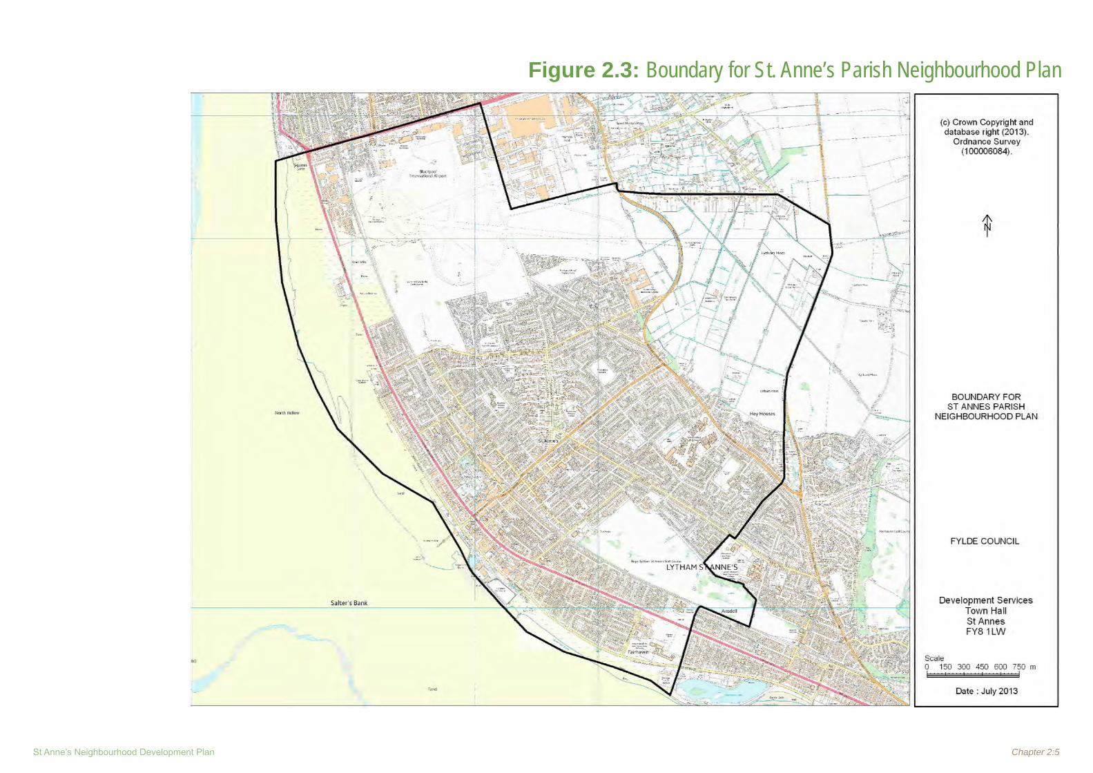
2.1.2 The locational context of the Neighbourhood Development Plan Area is shown in Figure 2.1, and the detailed boundary is shown in Figure 2.2.
2.0 Location and Spatial Context2.2 Current Land Uses
2.2.1 St. Anne’s is a large seaside town and Figure 2.2 shows the current major land uses from which it can be seen that the predominant land uses are:
existing urban, predominantly residential • development;Blackpool International Airport; • Open countryside to the east; • A substantial town centre and retail core; • The Royal Lytham St. Anne’s and St. Anne’s • Old; Links Golf Courses; and The Railway Corridor.•
2.2.2 Other larger land uses include:
Large residential site (Former Pontins • Holiday Camp Site);Hey Houses Lane Employment Site• 1;Arnold King Edward School;• Vacant Site (Former Blackpool Council • Offices at junction of Squires Gate Lane and Clifton Drive North).
1- 2/3 of the EDL site has planning permission: Outline Permission for up to 335 dwg, with Reserved Matters on 162dwg, Booths supermarket and pub.
Fylde BC propose through the emerging Local Plan that 1/3 of remaining site should remain in employment use.
2.3 Adjoining Land Uses
2.3.1 The key adjoining land uses are:Open countryside to the east;• The southern residential suburb of Blackpool • and the new Blackpool Tram Depot at Squires Gate to the North. The Squires Gate (A5230) corridor is a key access route into the NDP area from the M55. The junction at Squires Gate Lane, and Clifton Drive North is an important visual gateway into the NDP area. The township of Lytham conjoins the NDP • boundary to the south. Lytham’s urban character is very similar to that of St Anne’s. The beach and Irish Sea to the west provide • a dramatic setting for St. Anne’s and are key environmental, leisure and visual assets.

Chapter 2:2 Neighbourhood Profile ~ February 2015
2.4 Key Issues
Ref Key Issues Comments / Possible Options
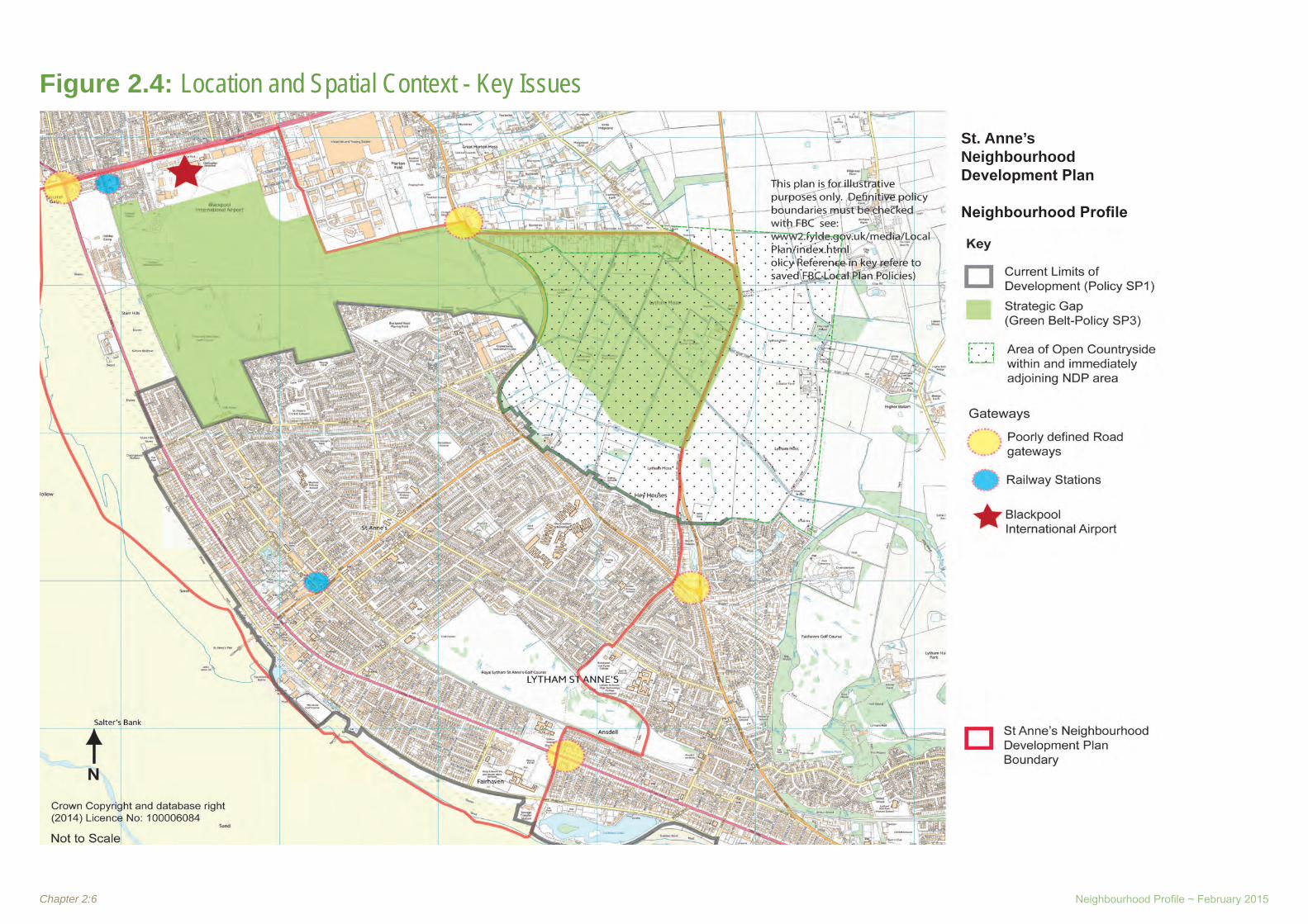
1Maintaining the Strategic Gap between St. Anne’s and Blackpool
The Blackpool International Airport site serves as an important role as a gap between the settlements of Blackpool and St •Anne’s preventing their merging. The gap between St. Anne’s and the larger Resort town of Blackpool to the north is important in preserving the Character of St Anne’s as a distinct place.The gap which extends eastwards onto the Lytham Moss is currently designated as Green Belt by saved Local plan Policy SP3 •(Development in Green Belt). Maintaining the overall integrity of this gap whilst addressing demands for growth in the town and the Airport will be a key issue for the NDP.
2 Countryside
The eastern part of the NDP area comprises the Lytham Moss area of open countryside. The majority of the open countryside •within the NDP boundary is also designated as Green Belt, forming part of the Gap between St Anne’s and the southern part of Blackpool (with Blackpool Aiport). The protection and potential improved access to this area for recreation purposes (having regard to the existing large Queensway •Planning permission, and the proposed M55- Heyhouses Link Road ) could be addressed by the NDP.
3 The Beach and Irish SeaThe beach and sea are obviously key elements of the original character and Raison d’être of the Town, and its economy. They •are key resources, providing opportunities for recreation, well-being, green infrastructure and possibly a renewed economic driver which should be explored through the NDP.
4 Gateways
The five major access points/ corridors to St Anne’s are currently : •Clifton Drive (A584) (from the South via Lytham) •Clifton Drive/(A584)/ Squires Gate Lane (from North Via Blackpool and M55) •Queensway/ Heyhouses Lane (from north east Blackpool and M55); and •South Fylde Railway; and Blackpool International Airport •
In terms of “Gateways” to the Town they currently contribute little to the identity and character of the town. •Blackpool International Airport provides a unique gateway to the Town •The proposed M55 Link Road will provide a new direct link to the Town from the M55. The construction of the road offers an •opportunity to define the character and quality of the town along its route and especially at its junction with Heyhouses Lane.

St Anne’s Neighbourhood Development Plan Chapter 2:3
Figure 2.1: St. Anne’s NDP Location & Spatial ContextSt. Anne’s Neighbourhood Development Plan
Neighbourhood Profile

Chapter 2:4 Neighbourhood Profile ~ February 2015
Figure 2.2: Key Land Issues
St. Anne’s Neighbourhood Development Plan
Neighbourhood Profile
St Anne’s Neighbourhood Development Plan Chapter 2:5
Figure 2.3: Boundary for St. Anne’s Parish Neighbourhood Plan
Chapter 2:6 Neighbourhood Profile ~ February 2015
Figure 2.4: Location and Spatial Context - Key Issues
St. Anne’s Neighbourhood Development Plan
Neighbourhood Profile

St Anne’s Neighbourhood Development Plan
Chapter 3
Existing & Emerging
Planning Policy Context

Neighbourhood Profile ~ February 2015

St Anne’s Neighbourhood Development Plan Chapter 3:1
3.1 Introduction
3.1.1 The National Planning Policy Framework (NPPF) sets out the Government’s economic, environmental and social planning policies for England and how these are expected to be applied. The policies set out in this framework apply to the preparation of local and neighbourhood plans and to development management decisions. There is a separate waste planning policy statement which remains in place until the National Waste Management Plan is published.
3.1.2 Section 38(6) of the Planning and Compulsory Purchase Act 2004 requires that
“where in making any determination under the Planning Acts, regard is to be had to the development plan, the determination shall be made in accordance with the plan unless material consideration indicates otherwise.”
3.1.3 The Development Plan for Fylde Comprises the following:
Saved policies of Fylde Borough Local • Plan, adopted May 2003. ie: all were saved except Policy TR9: Car Parking within New Developments;Saved policies of Alterations Review to the • Fylde Borough Local Plan, adopted October 2005. ie: all were saved except Policy HL1: The Quantitative Housing Issue / Affordable Housing;Saved Policy 29 of the Joint Lancashire • Structure Plan 2001-2016: Sites for Gypsy and Traveller Families, adopted March 2005;Joint Lancashire Minerals and Waste • Development Framework Core Strategy Development Plan Document, adopted February 2009; and
Joint Lancashire Minerals and Waste Local • Plan: Site Allocations and Development Management Policies, adopted September 2013.
3.1.4 Paragraph 215 of the NPPF indicates that relevant policies in existing plans will be given weight according to their degree of consistency with the NPPF.
3.2 The NPPF
3.2.1 The National Planning Policy Framework says, in Paragraph 7, that there are 3 dimensions to sustainable development. These are an economic role (contributing to the economy), a social role (supporting communities) and an environmental role (protecting and enhancing the natural and built environment). Paragraph 8 says that these factors are mutually dependent.
3.2.2 Paragraph 9 says that sustainable development includes making it easier for jobs to be created, replacing poor design with better design and widening the choice of high quality homes.
3.2.3 Paragraph 14 says that there is a presumption in favour of sustainable development. For plan making this means that:
Local planning authorities should positively • seek opportunities to meet the development needs of their area;Local Plans should meet objectively • assessed needs, with sufficient flexibility to adapt to rapid change, unless:
any adverse impacts of doing so would • significantly and demonstrably outweigh the benefits, when assessed against
the policies in the Framework taken as a whole; or specific policies in the Framework indicate development should be restricted.
3.2.4 Paragraph 15 says that Policies in Local Plans should follow the approach of the presumption in favour of sustainable development so that it is clear that development which is sustainable can be approved without delay. All plans should be based upon and reflect the presumption in favour of sustainable development, with clear policies that will guide how the presumption should be applied locally.
3.2.5 Paragraph 16 says that the application of the presumption will have implications for how communities engage in neighbourhood planning. Critically, it will mean that neighbourhoods should:
develop plans that support the strategic • development needs set out in Local Plans, including policies for housing and economic development; plan positively to support local development, • shaping and directing development in their area that is outside the strategic elements of the Local Plan; andidentify opportunities to use Neighbourhood • Development Orders to enable developments that are consistent with their neighbourhood plan to proceed.
3.2.6 Paragraph 17 sets out the core principles of planning:
be genuinely plan-led, empowering local • people to shape their surroundings, with succinct local and neighbourhood plans setting out a positive vision for the future of the area. Plans should be kept up-to-date,
3.0 Existing and Emerging Planning Policy Context

Chapter 3:2 Neighbourhood Profile ~ February 2015
and be based on joint working and co-operation to address larger than local issues. They should provide a practical framework within which decisions on planning applications can be made with a high degree of predictability and efficiency;not simply be about scrutiny, but instead be a • creative exercise in finding ways to enhance and improve the places in which people live their lives;proactively drive and support sustainable • economic development to deliver the homes, business and industrial units, infrastructure and thriving local places that the country needs. Every effort should be made objectively to identify and then meet the housing, business and other development needs of an area, and respond positively to wider opportunities for growth. Plans should take account of market signals, such as land prices and housing affordability, and set out a clear strategy for allocating sufficient land which is suitable for development in their area, taking account of the needs of the residential and business communities;always seek to secure high quality design • and a good standard of amenity for all existing and future occupants of land and buildings;take account of the different roles and • character of different areas, promoting the vitality of our main urban areas, protecting the Green Belts around them, recognising the intrinsic character and beauty of the countryside and supporting thriving rural communities within it;support the transition to a low carbon future • in a changing climate, taking full account of flood risk and coastal change, and encourage the reuse of existing resources,
including conversion of existing buildings, and encourage the use of renewable resources (for example, by the development of renewable energy);contribute to conserving and enhancing the • natural environment and reducing pollution. Allocations of land for development should prefer land of lesser environmental value, where consistent with other policies in this Framework;encourage the effective use of land by • reusing land that has been previously developed (brownfield land), provided that it is not of high environmental value;promote mixed use developments, and • encourage multiple benefits from the use of land in urban and rural areas, recognising that some open land can perform many functions (such as for wildlife, recreation, flood risk mitigation, carbon storage, or food production);conserve heritage assets in a manner • appropriate to their significance, so that they can be enjoyed for their contribution to the quality of life of this and future generations;actively manage patterns of growth to make • the fullest possible use of public transport, walking and cycling, and focus significant development in locations which are or can be made sustainable; andtake account of and support local strategies • to improve health, social and cultural wellbeing for all, and deliver sufficient community and cultural facilities and services to meet local needs.
3.2.7 In the remainder of the document, the NPPF sets out guidance on plan making and decision taking as well as detailed policies and guidance on the following topics:1. Building a strong, competitive economy2. Ensuring the vitality of town centres3. Supporting a prosperous rural economy4. Promoting sustainable transport5. Supporting high quality communications
infrastructure 6. Delivering a wide choice of high quality
homes7. Requiring good design8. Promoting healthy communities9. Protecting Green Belt land10. Meeting the challenge of climate change,
flooding and coastal change11. Conserving and enhancing the natural
environment12. Conserving and enhancing the historic
environment13. Facilitating the sustainable use of minerals
3.2.8 With regard to Neighbourhood Planning:
Paragraph 183 says that: “Neighbourhood planning gives communities
direct power to develop a shared vision for their neighbourhood and deliver the sustainable development they need. Parishes and neighbourhood forums can use neighbourhood planning to:
set planning policies through • neighbourhood plans to determine decisions on planning applications; and
St Anne’s Neighbourhood Development Plan Chapter 3:3
grant planning permission through • Neighbourhood Development Orders and Community Right to Build Orders for specific development which complies with the order.
Paragraph 184 says that Neighbourhood planning provides a powerful set of tools for local people to ensure that they get the right types of development for their community. The ambition of the neighbourhood should be aligned with the strategic needs and priorities of the wider local area. Neighbourhood plans must be in general conformity with the strategic policies of the Local Plan. To facilitate this, local planning authorities should set out clearly their strategic policies for the area and ensure that an up-to-date Local Plan is in place as quickly as possible. Neighbourhood plans should reflect these policies and neighbourhoods should plan positively to support them. Neighbourhood plans and orders should not promote less development than set out in the Local Plan or undermine its strategic policies.
Paragraph 185 says that outside these strategic elements, neighbourhood plans will be able to shape and direct sustainable development in their area. Once a neighbourhood plan has demonstrated its general conformity with the strategic policies of the Local Plan and is brought into force, the policies it contains take precedence over existing non-strategic policies in the Local Plan for that neighbourhood, where they are in conflict. Local planning authorities should avoid duplicating planning processes for non-strategic policies where a neighbourhood plan is in preparation.
3.2.9 The Government has produced National Planning Practice Guidance to set out its approach to planning.
3.3 The Development Plan
3.3.1 The Fylde Borough Local Plan (As Altered) (Oct 2005) is an amalgamation of two documents:
The Fyld• e Borough Local Plan 1996-2006The Fylde Borough Local Plan Alterations • Review 2004-2016
3.3.2 The Alterations Review was published due to a number of matters that arose in the period leading up to, and since the adoption of the earlier Local Plan, which argued strongly in favour of reviewing the housing chapter and some limited aspects of other parts of the plan.
Saved Local Plan Policies
3.3.3 The current Planning Policy Context (Key Saved Policies) is set out on Figure 3 (overleaf)
Fylde Borough Local Plan, May 2003
3.3.4 In order to retain specified policies in the Fylde Borough Local Plan (FBLP) beyond 28th September 2007, the Council was required to seek the Secretary of State’s agreement to issue a direction. The Direction under paragraph 1(3) of schedule 8 to the Planning and Compulsory Purchase Act 2004, in respect of the FBLP, was issued by the Secretary of State on 18th September 2007.
3.3.5 All policies in the FBLP were saved, except Policy TR9: Car Parking Within New Developments. This policy related to Appendix 7 which was deleted from the FBLP by means of the Alterations Review, and that car parking standards were provided by the adopted Joint Lancashire Structure Plan 2001-2016.
Fylde Borough Local Plan Alterations Review, October 2005
3.3.6 The 9 policies introduced in the Alterations Review were saved until 9th October 2008. In order to retain specified policies in the Alterations Review beyond this date, Fylde Borough Council were required to seek the Secretary of State’s agreement to issue a direction. The Direction under paragraph 1(3) of schedule 8 to the Planning and Compulsory Purchase Act 2004, in respect of the FBLP, was issued by the Secretary of State on 2nd October 2008.
The Fylde Borough Local Plan 1996 – 2006, • adopted on 19th May 2003, and prepared in general conformity with the Lancashire Structure Plan 1991 – 2006 (LSP); andThe Fylde Borough Local Plan Alterations • Review 2004 – 2016, adopted on 10th October 2005, and prepared in general conformity with the Joint Lancashire Structure Plan 2001 – 2016 (JLSP).
3.3.7 All policies in the Alterations Review were saved, except Policy HL1: The Quantitative Housing Issue/ Affordable Housing.
3.3.8 The Fylde Borough Local Plan remains a relevant policy document where it is consistent with the NPPF.

Chapter 3:4 Neighbourhood Profile ~ February 2015
3.3.9 The Local Plan (as altered) sets out the General Development Principles for Fylde in a series of policies:
SP1 - Development within Settlements: Establishes the settlement hierarchy, permitting development, subject to other plan policies, within the ‘limits of development’ set out on the Proposals Map. The main concentration of development is expected to occur in the urban area of Lytham and St. Anne’s.
SP2 - Development in Countryside Areas: seeks to restrict development in the countryside.
SP3 - Development in Green Belt: Seeks to restrict development in the Green Belt to defined ‘appropriate’ development and in ‘very special circumstances’.
SP4 - Kirkham Prison
SP5&6 - Conversion of Existing Buildings Outside Settlements: Sets out the circumstances where conversion of buildings would be acceptable.
SP7 - Large Developed Sites in Countryside
SP8 - Expansion of Existing Businesses and Commercial Operations: Sets out the criteria for permitting the expansion of existing businesses in the countryside.
SP9 - Diversification of the Rural Economy
SP10,11 & 12 - Agricultural Workers Dwellings
SP13 & 14- Stables and Equestrian Centres, Kennels and Catteries
SP15 - British Aerospace Airfield
SP16 - Weeton Camp
3.3.10 Subsequent Chapters of the Local Plan deal with detailed policies on the following topics. Where relevant these are dealt with in the chapters below:
Housing• Employment & Industry• Transportation• Tourism & Recreation• Environmental Protection & Conservation• Town Centres & Retail Developments• Co• mmunity Services & Infrastructure
3.4 The Emerging Local Plan
3.4.1 The Fylde Borough Local Plan is dated, and work is being carried out on its replacement, which will look at the period to 2030. Fylde had commenced work on its new Local Plan. A consultation exercise was undertaken over summer 2013 on the ‘Preferred Option’ of the Part 1 to this Plan which included strategic locations for development.
3.4.2 The Council decided in late 2014 to abandon the 2 stage process and instead prepare a single Local Plan. The revised Preferred Options Consultation is currently scheduled to commence in late 2015. Consequently very little weight can be given to the policies of the emerging plan; they are however indicative of the direction of Fylde’s policy approach
3.5 Minerals and Waste
3.5.1 The Joint Lancashire Minerals and Waste Local Plan contains mineral and waste specific policies for use in determining planning applications for waste or quarry developments in Lancashire, including those areas administered by the Unitary Authorities of Blackburn with Darwen Borough Council and Blackpool Borough Council (the Joint Plan area). The Local Plan forms part of an area’s development plan.
3.5.2 The Minerals and Waste Local Plan contains the following documents:
Core Strategy• : Sets out the long-term spatial vision for the local planning authority area, the spatial objectives, and outlines the strategic policies required to deliver that vision.Site Allocations and Development Control • Policies: Policies will identify specific locations for development, any specific requirements for individual proposals, and a series of criteria-based policies which ensure that all development within the area meets the spatial vision and spatial objectives set out in the Core Strategy.

St Anne’s Neighbourhood Development Plan Chapter 3:5
Figure 3.1: Existing Planning Policy Context
St. Anne’s Neighbourhood Development Plan
Neighbourhood Profile

Chapter 3:6 Neighbourhood Profile ~ February 2015
3.6 Other Planning Documents
3.6.1 Fylde Borough Council operates an Interim Housing Policy (Revised 13th February 2013) to inform decisions on planning applications for housing. It should be noted that this is an informal document and does not form part of the development plan for the Borough.
3.6.2 Fylde Borough Council has adopted a number of Supplementary Planning Guidance (SPG) notes, which are not part of the development plan but provide planning guidance and are used in making development management decisions. The SPGs relevant to St. Anne’s are:
Policy • for New Flat Development - June 1989;Land at Queensway - January 2000;• Windows, Doors and Architectural Joinery - • February 2003;Policy for Shop Front Design Guide - • September 2004;St. Anne’s Renaissance Design Guide - • September 2004;The• Conversion of Fylde’s Traditional Farm Buildings - September 2004;606 Clifton Drive North (Revised • Development Brief) - September 2004;Extending Y• our Home - November 2007.
3.7 Key Issues
Ref Key Issues Comments / Possible Options
1Timescale for adopting the emerging local Plan - may extend beyond 2015.
Without an up to date Local Plan, there is a risk of speculative •planning applications, in particular for housing which will then be subject to appeal decisions.Potential lack of strategic planning policy context for the •Neighbourhood Development plan
REFERENCES & DOCUMENTS REVIEWED
1. The National Planning Policy Framework – DCLG-20122. National Planning Practice Guidance-DCLG-20143. Fylde Borough Local Plan, May 20034. Fylde Borough Local Plan Alterations Review, October 20055. Fylde Local Plan to 2030: Part 1 - Preferred Options-June 20136. The Joint Lancashire Minerals and Waste Local Plan-Adopted Sept 2013 – Lancs CC7. Fylde Interim Housing Policy (Revised 13th February 2013)8. Various Supplementary Planning Documents adopted by Fylde Borough Council:
Policy for New Flat Development - June 1989;• Land at Queensway - January 2000;• Windows, Doors and Architectural Joinery - February 2003;• Policy for Shop Front Design Guide -September 2004;• St. Anne’s Renaissance Design Guide -September 2004;• The Conversion of Fylde’s Traditional Farm Buildings - September 2004;• 606 Clifton Drive North (Revised Development Brief) - September 2004;• Extending Your Home (SPD) - November 2007•

St Anne’s Neighbourhood Development Plan
Chapter 4
Community Profile

Neighbourhood Profile ~ February 2015

St Anne’s Neighbourhood Development Plan Chapter 4:1
4.0 Community Profile 4.1 Introduction
4.1.1 This section provides a picture of the socio-economic makeup of the St. Anne’s Neighbourhood Development Plan (NDP)area today. The data is sourced from the 2011Census data, which provides the most up-to-date and comprehensive material.
Lower Super Output Areas 4.1.2 The information set out in this section is based
on data from the 2011 census and collated at the Lower Super Output Area Level (LSOA) which is the most detailed analysis provided by the Census. Figure A4.1 in Appendix 1 shows the 19 LSOAs which best match the NDP area .
4.2 Age and Population
4.2.1 In March 2011 the population of the St. Anne’s NDP area was 27,105 which comprised 35.7% of the total population of Fylde Borough Council. This figure represents an increase of 1362 persons or 5.2% since the previous Census in 2011.
4.2.2 Figure 4.1 shows a comparison of the different age groups within the NDP, as compared to Fylde, and the rest of the country. From this it can be seen that as per the rest of England the majority of the population are within the age groups 30-40, and 45-59 years of age (comprising 16.2% and 21.3% respectively).
4.2.3 However, the percentage of population the 30-44 age group is lower than in the rest of Fylde, the North West and England, The 45-50 age group is lower than the rest of Fylde but higher than the North West or England.
4.2.4 The age profile also shows a lower percentage of younger people (in the age range 0 to 17) and a higher percentage of elderly people (aged 65 and over) than the rest of the Fylde and England. The mean age of the NDP area population, being 46.6 years of age, compares with 44.9, and 39.3 years of age for Fylde and England respectively.
Source: 2011 Census
Figure 4.1:Comparison of Population Age profile (%)

Chapter 4:2 Neighbourhood Profile ~ February 2015
4.3 Household Composition
4.3.1 In March 2011 there were some 13455 households in the St. Anne’s NDP area. Figure 4.2 shows a comparison of the different household types within the NDP area compared to Fylde, the North West and England. From this it can be seen that prevalence of one person households, in particular those aged 65 and above is significantly higher than Fylde and elsewhere. Figure 4.2:
Comparison of Household Composition (%)
Source: 2011 Census

St Anne’s Neighbourhood Development Plan Chapter 4:3
4.4 Health
4.4.1 Figure 4.3 shows a comparison of the responses given in the 2011 census to the question relating to health between the St. Anne’s NDP area, Fylde, the North West and England. From this it would appear that a significantly lower percentage of the population described themselves as being in good health when compared to Fylde, the North West and England. There was also a slightly higher percentage of the population of the NDP area describing themselves as in bad health. Figure 4.3:
Comparison of Health (%)
Source: 2011 Census

Chapter 4:4 Neighbourhood Profile ~ February 2015
4.5 Occupation
4.5.1 Figure 4.4 shows a comparison of occupations of people in the age groups 16 to 74 in Employment between the St. Anne’s NDP area, Fylde, the North West and England. From this it can be seen that both the NDP area and Fylde have a higher percentage of people who described themselves as being Managers and Directors, Professionals and in Administrative, Carting, Leisure and other service occupations than in the North West and England. Figure 4.4:
Comparison of People Aged 16-74 in Employment
Source: 2011 Census

St Anne’s Neighbourhood Development Plan Chapter 4:5
Figure 4.4: Comparison of People Aged 16-74 in Employment
Source: 2011 Census
4.6 Industry
4.6.1 Figure 4.5 shows the percentage of residents aged 16 to 74 in employment, by the industry in which they work, for St. Anne’s NDP area, Fylde, the North west and England in 2011. This shows that the highest percentage of people worked in Human Health and Social Work, followed by Wholesale and Retail, fManufacturing, Public Admin/ Defence, and Food and Accommodation.
Figure 4.5:Percentage of Residents Aged 16-74 in Employment by Industry

Chapter 4:6 Neighbourhood Profile ~ February 2015
Figure 4.6: Percentage of residents aged 16 and over by highest qualification
4.7 Qualifications
4.7.1 Figure 4.6 shows the percentage of residents aged 16 and over by their highest level of
qualification. This shows that the population of the St. Anne’s NDP area has comparable levels of qualifications compared to England as a whole.
4.7.2 It has a slightly higher percentage of population with no qualification (22.7%) than Fylde (21.2%), and a slightly lower percentage of population with the highest level of qualification (Level 4 and above) (28.0) compared to Fylde (29.8%).
Source: 2011 Census

St Anne’s Neighbourhood Development Plan Chapter 4:7
4.8 Benefit Dependency
Job Seeker Allowance (JSA) Claimants
4.8.1 Figure 4.7 shows the percentage of residents aged 16-64 claiming JSA in February 2014.
This shows that the percentage of JSA claimants in St. Anne’s NDP area was approx 1% higher than the rest of Fylde, but comparable to that for GB.
4.8.2 Figure 4.8 shows the % of the population aged 16-64 claiming JSA within St. Anne’s NDP area in February 2014 (by Ward). This shows the concentration of claimants within the Central Ward.
Figure 4.8:Percentage of the population aged 16-64 claiming JSA within St. Anne’s NDP Area
Figure 4.7: Percentage of residents aged 16-64 claiming JSA

Chapter 4:8 Neighbourhood Profile ~ February 2015
Job Seeker Allowance by Duration
4.8.3 Figure 4.9 shows the percentage of residents aged 16-64 claiming JSA in February 2014 (NOMIS)by duration. This shows that the percentage of long terms
JSA claimants (over 12 months) stood at 21.8% of claimants and was slightly higher than for Fylde (21.2%) but lower than that for the rest of the UK (28.8).
Job Seeker Allowance by Age
4.8.4 Figure 4.10 shows the percentage of residents aged 16-64 claiming JSA in February 2014 by age. This shows that the percentage of JSA claimants in the St. Anne’s NDP area within the age group 18-24 (23.6%) was lower than for Fylde (26.2%) and the UK (25.3%). The percentage of JSA claimants within the 50 years and older age group was however, higher in St. Anne’s (23.5%), than for Fylde (21.4) and the UK (18.3%) reflecting the age profile of the area.
Total Department for Work and Pensions Benefit Claimants
4.8.5 Figure 4.11 shows the percentage of residents aged 16-64 claiming the range of DWP benefits (August 2013 NOMIS). From this is can be seen that the % percentage of claimants is higher in the St. Anne’s NDP area (14.4%) than for Fylde (11.7%), and the UK (13.6). This higher level of claimants may be accounted for by higher levels of JSA/Incapacity Benefit claimants within St. Anne’s NDP area.
Figure 4.11: Percentage of residents aged 16-64 claiming the range of DWP benefits
Figure 4.10: Percentage of
residents aged 16-64 claiming
JSA by age
Figure 4.9: Percentage of
residents aged 16-64 claiming
JSA by duration
Source: NOMIS
Source: NOMIS
Source: NOMIS

St Anne’s Neighbourhood Development Plan Chapter 4:9
4.9.3 Fylde has 21 wards broken into 51 lower-layer super output areas (LSOAs), of which none are in the most deprived category and a third of which are in the top third of areas nationally.
Fylde’s overall rank is 235 out of 326 districts, placing it in the top 3rd least deprived areas. After Ribble valley with such areas as Clitheroe, Whalley and Ribchester, Fylde is placed at the top end of the scale in Lancashire, with the least amount of deprivation of any kind and the least amount of hot spots of deprivation. Similarly, Fylde is 36 places higher than the national average.
4.8.6 Figure 4.12 shows the percentage of residents aged 16-64 claiming the range of DWP benefits within the St. Anne’s NDP area (by Ward). The percentage of claims in the Central Ward is significantly higher than other wards.
Figure 4.12: Percentage of residents aged 16-64 claiming the range of DWP benefits
4.9 Indices of Multiple Deprivation 4.9.1 The Indices of Multiple Deprivation 2010
combines a number of indicators, chosen to cover a range of economic, social and housing issues, into a single deprivation score for each small area in England. This allows each area to be ranked relative to one another according to their level of deprivation.
4.9.2 The Indices are used widely to analyse patterns of deprivation, identify areas that would benefit from special initiatives or programmes and as a tool to determine eligibility for specific funding streams.
Source: NOMIS

Chapter 4:10 Neighbourhood Profile ~ February 2015
4.9.4 Figure 4.13 shows the 2010 Indices of Deprivation at Fylde Ward and LSOA level. It is evident that parts of the Central, Kilnhouse, Ashton, Fairhaven, St Leonards and Park Wards which are within the St. Anne’s NDP are within the 10 lowest ranked LSOAs in Fylde.
4.10 Ethnicity 4.10.1 Figure 4.14 shows the ethnic make up of the
population of St. Anne’s NDP area in 2011 as compared to the rest of Fylde, the North West and England. From this it can be seen that over 97% of the NDP area’s population describe themselves as being of White ethnic background.
Appendix B: The table provides information of the latest Indices of Multiple Deprivation 2010 at ward and lower super output level.
IMD LSOA 2010 IMD 2010
High is improve
d
Low is improve
dE01024994 Fairhaven 31828 -1,876 51 -12E01025019 Ribby-with-Wrea 31479 -83 50 -2E01025016 Park 31096 153 49 2E01025007 Kirkham North 30819 -899 48 -3E01025008 Kirkham North 30663 -1,530 47 -1E01024981 Ansdell 30216 -2,552 46 -4E01024992 Clifton 30083 -337 45 5E01025015 Newton and Treales 29239 430 44 0E01024997 Freckleton East 28957 416 43 -10E01024985 Ashton 28605 -166 42 -10E01025023 St Johns 28578 40 41 -3E01025012 Medlar-with-Wesham 28515 -1,000 40 1E01025010 Kirkham South 28438 -2,994 39 1E01025018 Park 28005 -658 38 11E01025021 St Johns 27976 -301 37 6E01024991 Clifton 27970 -695 36 -24E01025000 Freckleton West 27181 -1,783 35 1E01024983 Ansdell 26466 -631 34 -18E01024995 Fairhaven 25862 -1 33 -7E01024990 Clifton 24817 493 32 -24E01025029 Warton and Westby 24768 587 31 -1E01025003 Heyhouses 24323 385 30 1E01025004 Kilnhouse 24047 1,380 29 -5E01024993 Elswick and Little Eccleston 23483 1,485 28 9E01025027 Staining and Weeton 23396 -843 27 -7E01024984 Ashton 23380 -1,582 26 -4E01025028 Staining and Weeton 23238 -1,031 25 10E01025022 St Johns 23117 13 24 4E01025014 Newton and Treales 21455 -858 23 -4E01025026 St Leonards 20960 -1,306 22 -13E01025005 Kilnhouse 20677 3,214 21 26E01024999 Freckleton West 19879 1,796 20 3E01024982 Ansdell 18564 983 19 10E01025002 Heyhouses 17774 1,233 18 -11E01025031 Warton and Westby 17130 -1,181 17 10E01025030 Warton and Westby 16783 73 16 1E01025025 St Leonards 16426 1,894 15 -4E01024989 Central 16341 -178 14 -8E01025020 Singleton and Greenhalgh 15544 1,249 13 12E01025009 Kirkham North 15445 753 12 2E01025001 Heyhouses 15388 -2,449 11 10E01024988 Central 14223 -2,556 10 -5E01025013 Medlar-with-Wesham 13919 1,503 9 4E01024998 Freckleton East 13259 -1,216 8 26E01025024 St Leonards 12705 3,805 7 8E01025017 Park 12430 104 6 12E01025011 Kirkham South 11553 127 5 -1E01024996 Fairhaven 9791 1,745 4 -1E01024986 Ashton 9097 -1,300 3 -1E01025006 Kilnhouse 5253 1,797 2 8E01024987 Central 4612 -38 1 0
Key Key
<3249 Bottom 10% Worse
<8121 Bottom 25% Good
<10720 Bottom 33%
>21439 Top 33%
>24362 Top 25%
>29233 Top 10%
*High is good
**High is good
Indices of Deprivation National & Local Overall Comparison
LSOA CODE WardVariance Variance
National Local
*32,482 Lower Super Output Areas (SOAs) in whole of England
**Total of 51 Wards in Fylde. In the UK there are 326 districts, 36 metropolitan boroughs, 32 London boroughs, 201 non-metropolitan districts, 55 unitary authorities
Fig 4.13:2010 Indices of Deprivation
Fig 4.14: Ethnicity
Source: 2011 CensusSource: Fylde Profile 2012; Fylde BC

St Anne’s Neighbourhood Development Plan Chapter 4:11
4.11 Potential Population Change 4.11.1 Table 4.1 shows an analysis of potential population change arising from the
development of already committed housing sites. This shows that there is the potential for the population to grow by over 16% (excluding any natural population change). The time scale for this change will depend on the buoyancy of the housing market but a change of this scale would have implications for social and physical infrastructure provision and adequacy. This figure does not take account of any further housing allocations which may be made through the emerging Local Plan.
Table 4.1: Analysis of Potential Population Change
Committed Housing Site Total Dwellings
Fylde Average Household Size (2011 Census)
Potential Additional Population
Queen Mary School, Clifton Drive South, St. Anne’s
169 2.1 354.9
Land to rear 11-63 (odds), Westgate Road, St. Anne’s
70 2.1 147.0
Training Centre, St David’s Road North, Lytham St Anne’s
32 2.1 67.2
Land South of Queensway St. Anne’s
1150 2.1 2415.0
Heyhouses Data Systems 335 2.1 703.5Former Pontin’s Site 348 2.1 730.8
Total 2104 4418.4St. Anne’s 2011 Population
27105.0
Potential Additional Population from committed housing sites
4418.4
Potential % Population Change
16.3
Actual % Population Change 2001 to 2011
5.2

Chapter 4:12 Neighbourhood Profile ~ February 2015
4.12: Key Issues
Ref Key Issues Comments / Possible Options
1
Age Structure:
The current population profile of St Anne’s has a higher percentage of people aged over 65 than in Fylde and the rest of England-reflecting the attractiveness of the town as a place to retire. This figure may rise if current population ageing trends continue
Consider specific policies such as Targeted Housing products, community/health •facilities
2
Potential Impact of Population growth:
Based on current sites with planning permission for housing within the St Anne’s NDP area, there is a potential for the existing (2011) population to grow by 16%, depending on local housing market conditions. This excludes natural population change, further planning approvals and any additional housing allocations identifies through the emerging FBC Local Plan.
REFERENCES & DOCUMENTS REVIEWED
1. 2011 Census - ONS2. 2010 Indices of Deprivation - DCLG-20113. NOMIS - Office for National Statistics

St Anne’s Neighbourhood Development Plan Chapter 4:13
APPENDIX 4.1
Ward & Census Lower Super Output Boundaries

Chapter 4:14 Neighbourhood Profile ~ February 2015

St Anne’s Neighbourhood Development Plan Chapter 4:15
Figure A4.1: Ward Boundaries
St. Anne’s Neighbourhood Development Plan
Neighbourhood Profile

Chapter 4:16 Neighbourhood Profile ~ February 2015
Figure A4.2: 2011 Census-Lower Super Output Area BoundariesSt. Anne’s Neighbourhood Development Plan
Neighbourhood Profile

St Anne’s Neighbourhood Development Plan
Chapter 5
Heritage

Neighbourhood Profile ~ February 2015

St Anne’s Neighbourhood Development Plan Chapter 5:1
5.0 Heritage5.1 Introduction
5.1.1 This Chapter describes the historical development of the Town, and the important built heritage legacy which are key elements of the character of St. Anne’s today.
Figure 5.1:St. Anne’s Historic Urban Development
The information set out in this chapter is largely taken from the comprehensive study by Lancashire County Council, “Lancashire Historic Town Survey-Lytham St Anne’s” 2006. Peter Shakeshaft’s book “St Anne’s on Sea A History”-2008 was another important source.
5.1.2 St. Anne’s on the Sea still retains much of its Victorian garden town character of tree-lined streets of detached and semi-detached villas set in extensive grounds. The fine Promenade, spacious ‘Square’ and Ashton Gardens are the town’s most prominent assets.
5.1.3 Figure 5.1 shows the main phases of historical development of St Anne’s. By the 1840’s there had been only scattered and limited rural development; by the 1890’s the core of the resort town had been built; with later phases spreading along the coast and inland. The impact of large scale inter war/immediate post war (1918 to 1950’s) development can also be seen.

Chapter 5:2 Neighbourhood Profile ~ February 2015
Figure 5.2: Historical Development of St. Anne’s
1912-14 1930-33
5.1.4 Figure 5.2 shows a series of historic maps illustrating the growth of St Anne’s.
1955-56 1970-82

St Anne’s Neighbourhood Development Plan Chapter 5:3
1982
Figure 5.3: St. Anne’s Historic Townscape
5.1.5 Figure 5.3 shows the key Historic Townscape Character areas of the town. The original core areas of middle class housing and commercial core which contribute significantly can clearly be seen.
Chapter 5:4 Neighbourhood Profile ~ February 2015
railway station which was completed soon after the hotel. By 1876 an asphalt promenade had been built, 3,000ft in length and 180ft in width. The entire town was planned to be well built and to cater for the middle classes.
5.2.8 The design quality of the resort was a noted selling point in the early twentieth century. In a booklet reviewing Britain’s seaside resorts it was stated that “the streets are very wide, the property well built and of excellent design” (Anon 1906, 179).
5.2.9 Further detailed information on the historic development of St. Anne’s is set out in “St. Anne’s on Sea - A History” by local historian Peter Shakeshaft (200*) and the study by Lancashire County Council ,“Lancashire Historic Town Survey Lytham St Anne’s” 2006.
5.3 Later Stages of Development
Inter & Immediate Post War Housing (1918 to c1950)
5.3.1 This character type is spread throughout St. Anne’s and mainly comprises large housing estates in St Anne’s. These estates tend to feature formal layouts of semi-detached houses and short rows, all with individual front and rear gardens, although there are examples of flats and maisonettes.
Later Post-War Housing (c1950 to c1970)
5.3.2 Residential development of the 1950s and 1960s is concentrated in Lytham and is of a tremendously varied character. The larger estates form part of the wider twentieth century suburban development of St. Anne’s, and lie adjacent to earlier and later residential areas.
5.2 Initial Development of the Town - Late 19th Century
5.2.1 The land on which the town of St Anne’s now stands was, historically, the “West End” of the ancient Parish of Lytham, where a settlement, centred around the present day town of Lytham, had almost certainly existed since Anglo- Saxon times. The “West End” included the hamlet of Heyhouses which was farmed, by the monks of Lytham Priory, from at least the 14th century.
5.2.2 As early as 1850 the “West End” was viewed by the squire of Lytham, John Talbot Clifton, as land which was ‘the raw material from which, like the manufacturers, we are bound to get the greatest return’. And, under the guidance of his land agent, James Fair, a new town was envisaged. In 1862 James Fair was succeeded, as land agent, by his son, Thomas Fair.
5.2.3 In the following year (1863), the Blackpool and Lytham Railway Company, promoted by interests favourable to and under the influence
of the Clifton family estate, began to operate a single track railway between Lytham and Blackpool. It was an essential stage towards the new town’s creation. In 1870 the Clifton estate agreed with the railway company where a new station should be located to serve a new town.
5.2.4 A decision had already been made by the Clifton family to build a new church in the area to serve the people of Heyhouses, but it seems obvious now that it was part of a grand plan for the establishment of a new town. On the 4th of June 1872 the foundation stone was laid for this church, which was dedicated to St. Anne. The church thus provided the name for the new town. In the same year a road, the present day Clifton Drive, South, was constructed by the Clifton estate.
5.2.5 Two years later, with the linking of the
Blackpool and Preston branch lines through Lytham, Elijah Hargreaves, an east Lancashire businessman, approached the Clifton estate for the lease of one square mile of land focused on the railway to the south-west of the church (Ramsbottom 1998b). In response, John Talbot Clifton gave a lease of 1,100 years to the St Anne’s-on-Sea Land and Building Company for the purpose of building a new resort, including a hotel, railway station, pier and promenade.
5.2.6 The developers were convinced that the new Victorian middle classes, who had become wealthy as a result of the Industrial Revolution, would want to holiday in and retire to a pleasant resort and set about developing St. Anne’s on the Sea into a planned ‘garden town by the sea’.
5.2.7 The first building to be erected in 1875 was the St. Anne’s Hotel. This was situated near the
St. Anne’sPier

St Anne’s Neighbourhood Development Plan Chapter 5:5
early years of the twenty-first century and estates may extend beyond the defined survey area.
5.3.5 Some areas represent redevelopment of the former sites of industrial premises or terraced housing. The larger estates, situated towards the edges of the survey area, tend to be built on previously undeveloped land.
5.4 The Porritt Housing Style
5.4.1 As part of the masterplan the businessman William Porritt ploughed the profits from his family’s mills into developing the fine stone-built residential villas along North Promenade now known locally as the ‘Porritt Houses”. Strict covenants were enforced by the Land and Building Company to ensure all development was of the highest standard.
5.4.2 Today, the “Porritt” style has become recognised by locals as a strong, popular high quality architectural vernacular.
5.5 Survival
5.5.1 Much of the nineteenth century development in St. Anne’s has never been affected by redevelopment, although along the sea front it has not fared so well, losing some of its key buildings like the Majestic Hotel (see http://www.youtube.com/watch?v=E4Jc2H3CqMY).
5.5.2 The quality of the buildings of St. Anne’s has ensured that most have survived. The building stock is generally in a good condition; a facet of the town’s continuing relative wealth. Many of the nineteenth century luxury villas have been converted, however, from private homes to multiple occupancy retirement and care homes or holiday accommodation.
5.6 Listed Buildings
5.6.1 There are no listed buildings Graded I within the defined urban area of St. Anne’s NDP.
5.6.2 There are 19 Grade II Listed structures within the St. Anne’s NDP area as set out in Figure 5.4 (overleaf) and Table 5.1 (over page).
What it Means
5.6.3 Listing is not a preservation order, preventing any change. Listing is an identification stage where buildings are recognised as having exceptional architectural or historic special interest, to be considered at the planning stage which may decide a building’s future.
5.6.4 Listing does not mean that buildings cannot be altered. Listed building consent must be obtained in order to make any changes to that building which might affect its special interest.
5.6.5 Listed buildings can be altered, extended and sometimes even demolished, if the necessary consent has been obtained
The Porritt Housing Style
5.3.3 The layouts of the larger estates generally include long avenues, and house-types tend to be homogeneous, although areas of semi-detached houses can include small groups that are detached and vice versa. Houses built in short rows are also present. The detached houses are often set close together. Individual dwellings may have a front and a rear garden, or may have a garden only to the rear.
Late Twentieth Century Housing (c1970 to 2003)
5.3.4 There are a number of late twentieth century housing areas in St. Anne’s and these are found throughout the survey area. Some areas contain detached houses, often quite close together, whilst others contain a mix of detached and semi-detached dwellings. There are also flats, sheltered accommodation, staggered rows of houses or garaging within these areas. This character type includes areas of very recent development, built in the

Chapter 5:6 Neighbourhood Profile ~ February 2015
5.7 Scheduled Monuments
5.7.1 There are no scheduled monuments within St. Anne’s NDP Area.
5.8 Conservation Areas
5.8.1 There are three conservation areas within the defined urban area for Lytham St. Anne’s (see Figure 5.4).
5.8.2 In St. Anne’s, the area of original development, along St. Anne’s Road West, The Crescent and immediate surrounding area forms the Central Town Centre Conservation Area and comprises mainly shops, along with the St. Anne’s Hotel.
5.8.3 The St. Anne’s Road East conservation area adjoins this to the north-east, and is made up of the late nineteenth and early twentieth century middle-class houses which line the road, as well as St. Anne’s Church.
5.8.4 The late nineteenth century area of Porritt Houses and Ashton Gardens is also a conservation area, adjoining the commercial centre to the north-west.
Type Status Name PRN
BANDSTAND Listed gd II South Promenade, St Anne’s 18344
BANK (FINANCIAL) Listed gd II Midland Bank, St. Anne’s Road West, St Anne’s 18353
BOUNDARY WALL Listed gd II Grand Hotel, South Promenade, St Anne’s 18345
CHURCH Listed gd II Church of St Anne, St. Anne’s Road East, St Anne’s 18351
CHURCH Listed gd II Church of St Thomas, St Thomas Road, St Anne’s 18354
Listed gd II South Promenade, St Anne’s 18347
HOTEL Listed gd II St. Anne’s Hotel, St. Anne’s Road West, St. Anne’s 8674
HOTEL Listed gd II Grand Hotel, South Promenade, St Anne’s 18346
HOUSE Listed gd II Nos 1 and 2, Regent Avenue, St Anne’s 18355
INSTITUTE Listed gd II Public Library, Lytham Institute and Hewitt Lecture Room 18280
LIBRARY Listed gd II District Central Library, No 254 Clifton Drive South, St Anne’s 18343
LYCH GATE Listed gd II Churchyard of Church of St. Anne’s, St. Anne’s Road East, St Anne’s 18352
OFFICE Listed gd II 292-294 Clifton Drive South, Lytham St Anne’s 16333
PIER Listed gd II St. Anne’s Pier, (South West side), South Promenade, St. Anne’s 3643
SHELTER Listed gd II South Promenade, St Anne’s 18348
SHELTER Listed gd II South Promenade, St Anne’s 18349
SCHOOL Listed gd II Queen Mary School, Clifton Drive, Lytham 7941
SHELTER Listed gd II South Promenade, St Anne’s 18350
WAR MEMORIAL Listed gd II Ashton gardens, St Anne’s 18342
Table 5.1: Listed Buildings within St. Anne’s NDP Area

St Anne’s Neighbourhood Development Plan Chapter 5:7
Figure 5.4: Heritage AssetsSt. Anne’s Neighbourhood Development Plan
Neighbourhood Profile

Chapter 5:8 Neighbourhood Profile ~ February 2015
maintained but the general infrastructure requires restoration and repair. It is intended to fully restore the gardens in line with available resources. The cost of full refurbishment is considerable and could be undertaken on a phased basis.
What it Means
5.9.4 The main purpose of The English Heritage ‘Register of Historic Parks and Gardens of Special Historic Interest in England’ is to celebrate designed landscapes of note, and encourage appropriate protection. It is hoped that, by drawing attention to sites in this way, English Heritage will increase awareness of their value and encourage those who own them, or who otherwise have a role in their protection and their future, to treat these special places with due care” (English Heritage http://www.english-heritage.org.uk/caring/listing/registered-parks-and-gardens/)
5.9.5 Registration is a ‘material consideration’ in the planning process, meaning that planning authorities must consider the impact of any proposed development on the landscapes’ special character.
What it Means
5.8.5 Conservation Areas are designated for their special architectural and historic interest, and special procedures apply to owners who want to make changes to their properties within these areas in order to help protect its character.
Property Alterations: Owners of properties may need permission from the Council before making alterations such as cladding, inserting windows, installing satellite dishes and solar panels, adding conservatories or other extensions, laying paving or building walls.
A Council can change the types of alterations that need permission by making Article 4 Directions and it is advisable that owners contact the Council before making arrangements to starting any work.
Trees: The Council must be notified at least six weeks in advance of any tree felling or pruning work. This is to give the Council time to assess the contribution the tree makes to the character of the conservation area and decide whether to make a Tree Preservation Order. Demolition or substantial demolition of a building within a conservation area will usually require permission from the Council.
5.8.6 Fylde Council is required to prepare character appraisals and subsequent management plans for conservation areas. These are aimed at evaluating their essential characteristics and to subsequently identify future proposals for preserving and enhancing the area. They become important planning documents. None have so far been prepared for the St. Anne’s NDC area.
5.9 Registered Gardens
5.9.1 There are two registered gardens within St. Anne’s both Grade II. These are Ashton Gardens, laid out in 1874-5, and the Promenade, established as a garden in 1914 (see Figure 5.4 opposite).
5.9.2 Ashton Gardens has been the subject to extensive refurbishment and was the recipient of a significant Lottery Grant in addition to funding support from the Council. It is also supported by the community group, The Supporters of Ashton Gardens. The completed
scheme is an important and integral element of the broader regeneration programme for St. Anne’s on Sea.
5.9.3 The Promenade Gardens, St. Anne’s, occupies
a pivotal position on the sea front and is an impressive landscape laid out in the late nineteenth century. It contains open landscape, a rockery, grotto and waterfall, formal areas of lawn with bedding and a number of artefacts including decorative shelters, many of which are listed buildings in their own right. In 2008, a restoration and management plan was prepared and approved in principle by the Borough Council. The gardens are very well

St Anne’s Neighbourhood Development Plan Chapter 5:9
5.10 Other Evidence Documents
Planning Policy Context - Heritage Assets
What the NPPF says
5.10.1 The NPPF advises LPAs to set out ‘a positive strategy for the conservation and enjoyment of the historic environment’ in their Local Plan. Emphasis is placed on ‘sustaining and enhancing the significance of heritage assets’ and recognising that heritage assets are an ‘irreplaceable resource’ and should be conserved ‘in a ‘manner appropriate to their significance’.
5.10.2 Heritage assets are defined in the NPPF as:
“A building, monument, site, place, area or landscape identified as having a degree of significance meriting consideration in planning decisions, because of its heritage interest”.
“Heritage assets includes designated heritage assets and assets identified by the local planning authority (including local listing)”.
5.10.3 Heritage assets not designated under statutory regimes, but recognised by the LPA as having heritage significance, do merit consideration in planning matters; with the LPA taking a balanced judgement having regard to the scale of any harm or loss and the significance of the heritage asset.
Local Heritage Listing
5.10.4 Local heritage listing is a means for a community and a local authority to jointly identify heritage assets that are valued as distinctive elements of the local historic environment. It provides clarity on the location
of assets and what it is about them that is significant, guaranteeing that strategic local planning properly takes account of the desirability of their conservation.
5.10.5 In dealing with conserving and enhancing the historic environment Paragraph 126 says that local planning authorities should set out in their Local Plan a positive strategy for the conservation and enjoyment of the historic environment, including heritage assets most at risk through neglect, decay or other threats. In doing so, they should recognise that heritage assets are an irreplaceable resource and conserve them in a manner appropriate to their significance. In developing this strategy, local planning authorities should take into account:
the desirability of sustaining and enhancing • the significance of heritage assets and putting them to viable uses consistent with their conservation;the wider social, cultural, economic and • environmental benefits that conservation of the historic environment can bring;the desirability of new development making • a positive contribution to local character and distinctiveness; andopportu• nities to draw on the contribution made by the historic environment to the character of a place.
5.10.6 Paragraph 127 says that when considering the designation of conservation areas, local planning authorities should ensure that an area justifies such status because of its special architectural or historic interest, and that the concept of conservation is not devalued through the designation of areas that lack special interest.
Localism
5.10.7 The Localism Act came into force in November 2011. The new Act has the potential to increase the role of communities in determining how planning decisions are made at the local level, including those involving heritage assets. Communities have the potential to play a key role through preparing neighbourhood plans to establish the general planning policies for the development and use of land in a neighbourhood.
5.10.8 The Act also requires local authorities to maintain a list of assets of community value that have been nominated by the local community. As long as they meet the requirements set out in the Act, assets on a local heritage list may also qualify as assets of community value. Further information on the Localism Act can be found on the Communities and Local Government web site: http://www.communities.gov.uk/localgovernment/decentralisation/localismbill/
5.10.9 The Victoria Pub in St. Anne’s is currently the only registered community asset in Fylde
5.10.10 Whilst it is the responsibility of Fylde Borough Council as the Local Planning Authority to prepare a Local Heritage List, in conjunction with the Local plan or a Supplementary Planning Document, however, it is appropriate for the Neighbourhood Plan to identify potential Heritage Assets for consideration by the Council, and for such assets to be possibly recognised as Assets of Community Value.
Fylde Local Plan (As Altered: October 2005)
5.10.11 Local Plan policy seeks to achieve in Fylde Borough the necessary balance between the need for development and the protection
Chapter 5:10 Neighbourhood Profile ~ February 2015
and enhancement of the environment. The Borough Council takes the view that the aim should be to achieve high environmental standards in all built-up areas irrespective of their planning status.
5.10.12 Policy EP1 says that within the urban areas, environmental conditions will be maintained and improved through the development control process. Environmental improvement schemes will be undertaken in the following locations:
1. St. Anne’s town centre 2. Lytham town centre 3. Kirkham town centre 4. Freckleton village centre 5. Wesham town centre 6. Elswick village centre 7. Designated conservation areas 8. Council owned parks and gardens 9. Other environmentally important areas
5.10.13 Policy EP2 says that development will not be permitted upon open spaces, defined on the proposals map, which are considered to be essential to the setting, character or visual amenities of towns and villages.
5.10.14 Policy EP3 says that new development within, or affecting the setting of a designated conservation area will only be permitted where the character or appearance of the area, and its setting, are appropriately conserved or enhanced.
5.10.15 Proposed development should be appropriately designed and should respect the quality of the total environment including: the physical setting of the area, settlement form, townscape, the character of buildings and other structures, the character of open spaces, and any views into or out of the area.
5.10.16 The introduction of new uses or buildings
will not be permitted where these would be prejudicial to the character or appearance of the area.
5.10.17 The demolition of buildings or other built elements will not be permitted where this would involve the loss of an historic or visually important element of townscape except where:1. The applicant is able to demonstrate
convincing evidence that all reasonable efforts have been made to sustain existing uses or find viable new uses, including charitable or community uses and these efforts have failed; or
2. The building is wholly beyond economic repair; or
3. Its demolition and redevelopment would produce such substantial benefits for the community that these would decisively outweigh the loss resulting from the demolition;
4. Where the principle of demolition is accepted by the council, consent to demolish will only be given after a scheme of redevelopment or restoration has been agreed with the applicant and a contract for the carrying out of those works has been entered into.
5.10.18 Policy EP4 says that changes of use, external or internal alterations or additions to a listed building, where there would be an adverse effect on its architectural or historic character, or where the development would prejudice its setting will not be permitted.
5.10.19 Policy EP5 says that the total or substantial demolition of a listed building will not be permitted, unless:1. It can be demonstrated by the applicant
that every possible effort has been made to continue the present use; and
2. No suitable alternative use for the building including charitable or community use, is practicable; and
3. The building is wholly beyond repair or its demolition and redevelopment would produce substantial benefits for the community which would decisively outweigh the loss resulting from the demolition;
4. A detailed scheme for the redevelopment or reinstatement of the site has been agreed and a contract for the carrying out of those works has been entered into.
5.10.20 Policy EP6 says that development within a designated historic park or garden will not be permitted where this would prejudice its quality, character or appearance. Development outside an historic park or garden which would harm its setting will not be permitted.
5.10.21 Policy EP7 seeks to avoid that the removal of local features of quality or craftsmanship will be avoided.
5.10.22 Policy EP8 says that the removal or significant alteration of original or existing shop fronts of particular character and quality will not be permitted and encouragement will be given to their proper repair and restoration.

St Anne’s Neighbourhood Development Plan Chapter 5:11
Development or re-development proposals for commercial frontages will only be permitted where they are compatible with the character of the building of which they form a part and are complementary to the street scene in general.
5.10.22 Policy EP9 says that advertisement designs will only be permitted where they respect the character and architectural details of the buildings on which they are proposed. The proposed signage must respect the character of the building and the surrounding area in terms of scale, details, siting and the method of illumination.
The Emerging Local Plan
5.10.23 The Fylde Local Plan to 2030 Part 1- Preferred Options paper sets out the following policies relating to preserving and enhancing the built environment.
5.10.24 Policy ENV5 - Heritage Assets: says that heritage assets within Fylde will be protected and enhanced, in line with the relevant policies in the NPPF. The Council will protect and seek opportunities to enhance heritage assets, by:a) Safeguarding heritage assets from
inappropriate development;b) Supporting development or other
initiatives that protect and enhance the local character, sense of place, setting, management and historic significance of heritage assets, with particular support for initiatives that improve any assets that are recognised as being in poor condition;
c) Supporting development which provides opportunities for learning and regeneration;
d) Developing a Built Heritage Strategy and Action Plan for Fylde;
e) Undertaking Conservation Area Character Appraisals and Management Plans;
f) Identifying and adopting a local list of heritage assets;
g) Developing policies in relation to other heritage assets.
Built Heritage Strategy for Fylde 2014 – 2020 5.10.25 The Heritage Strategy for Fylde was published
in February 2014. It gives a clear indication of a potential strategy to meet the objective of conserving and enhancing the built heritage of St. Anne’s.
5.10.26 The objectives of the strategy are stated as:To bring about an understanding as to why • it important to have a Heritage Strategy for the Borough from an economic, social and cultural perspective. To bring about a general awareness of the • meaning of ‘heritage asset’ in the context of the Strategy and to affirm the Council’s commitment to protecting existing and potential assets that together will comprise the built heritage of the Borough. To promote a general awareness of • legislation, planning policy and the important responsibilities and roles of national bodies and organisations in built heritage matters.To bring about an appreciation of the diverse • heritage assets of the Borough and the steps needed to create a framework for the protection and conservation of these important assets.To promote community participation in • heritage matters, including the role that
community groups, amenity bodies and individuals might play in the stewardship, promotion and appreciation of the built heritage of the Borough.To draw together a series of key issues • from the Strategy to form the basis of an implementation programme and action plan to bring about plans, policies and projects aimed at identifying, protecting, managing, conserving and enhancing the heritage assets of the Borough.
5.10.27 The Strategy considers the importance of heritage and introduces the concept of the ‘heritage asset’. A review of national planning policy is undertaken and a resume of the major national amenity bodies – and those of a more local nature – who have a direct interest in the conservation and management of the historic environment is set out. The role of the Council, particularly in planning matters, is discussed. The Strategy then reviews the heritage assets of the Borough identifying particular issues relating to them.
5.10.28 Emerging from this broad review are the ‘key themes’ which identify the principal issues that the strategy addresses and subsequently translates into specific actions for implementation.

Chapter 5:12 Neighbourhood Profile ~ February 2015
5.12 Key Issues
Ref Key Issues Comments / Possible Options
1 Listed Buildings:Update list of ‘listed buildings •Identify’ at risk’ buildings •Policy to protect the character of listed buildings. •
2Ensuring adequate protection for non-designated heritage assetsShould a ‘local list of buildings’ be identified?
Develop a local list; •Policy identifying buildings on the list and protecting them. •
3Conservation Areas:Are current Conservation Area boundaries correct or do they need revising?
Undertake a ‘characterisation study’ of St. Anne’s to assess the potential for new •conservation area designations, extensions to existing areas or other amendments to boundaries. Consider designation of new Conservation Areas •Conservation area appraisals and management plans need to be put in place. •Ensuring that policies are in place that protect the character of conservation areas. •
4
Regeneration Schemes:Are adequate provisions in place to protect and enhance the conservation area based around St. Anne’s town centre, the management plan should specifically include proposals aimed at enhancing the economy, vibrancy and vitality of the centre and include proposals for upgrading and managing the public realm. How will further public realm improvements in town centre conservation areas be funded?
Specific policy to protect and secure enhancement for the town centre conservation •areaPolicy requiring potential funding contributions from relevant development proposals •through Section 106 contributionsProposal in the Implementation Plan to ensure use of Community Infrastructure Levy •Include proposals for the delivery and implementation of a management plan in the •Implementation Plan.No action •
5Historic Parks and Gardens:Ensuring the future preservation and enhancement of historic parks and gardens
Proposal to carry out the assessment in the Implementation Plan •Specific policy to protect the character of historic parks and gardens •Proposal in the Implementation Plan to ensure use of Community Infrastructure Levy •Include proposals for the delivery and implementation of a management plan, •including funding arrangements and options in the Implementation Plan.No action •
6Archaeological Sites:Ensure adequate protection of archaeological sites
Include specific policy •No action •
6Should the NDP identify Assets of Community Value?If so, what protection should it give to them?
Consider specific policy to identify Assets of Community Value •Proposal in Implementation Plan - consider CIL funding •

St Anne’s Neighbourhood Development Plan Chapter 5:13
7
Community participation:Work with Fylde Heritage Forum (if set up), local societies, schools and community/voluntary groups to maximise the opportunity for all sections of the community to actively participate in the development of heritage awareness and inclusion within the development of particular projects.
Inclusion in implementation plan •
8
Heritage promotion and publicity:Work with Fylde BC and local societies to develop e.g. guidance notes, exhibitions, heritage open days, web based resources etcThe development of an awards scheme to celebrate high standards of design and sensitivity within the historic environment or to specific listed buildings. Consider appointment of heritage champion
Inclusion in implementation plan •Inclusion in implementation plan •Inclusion in implementation plan •
REFERENCES & DOCUMENTS REVIEWED
1. Lancashire Historic Town Survey - Lytham St. Anne’s- Lancs CC - 20062. Built Heritage Strategy for Fylde 2014-20 (Consultation Draft)3. The National Planning Policy Framework – DCLG-20124. Fylde Borough Local Plan, May 20035. Fylde Borough Local Plan Alterations Review, October 20056. Fylde Local Plan to 2030: Part 1 - Preferred Options - July 20137. National planning Practice Guidance-DCLG-204

Chapter 5:14 Neighbourhood Profile ~ February 2015

St Anne’s Neighbourhood Development Plan
Chapter 6
Design of the Built
Environment

Neighbourhood Profile ~ February 2015
St Anne’s Neighbourhood Development Plan
6.1.6 To do that we need to change our approach to how we develop the built environment in response to quality design and sustainable construction.
6.2 Existing Design Guidance
6.2.1 Section 6.3 below describes the existing (saved Local Plan policies) and emerging Local Plan built environment and design related policies. These policies are not detailed, and are not specifically related to the St. Anne’s context
6.2.2 The saved policies of the Local Plan are augmented by a number of Supplementary Planning Documents as described in Table 6.1 overleaf (see also http://www.fylde.gov.uk/business/planning/advice/supplementary-planning-guidance-supplementary-plan/)
6.0 Design and the Built Environment6.1 Introduction
6.1.1 St. Anne’s is one of the most attractive, popular places to live in the North West of England. As one of the key urban centres in Fylde it is facing significant pressures for growth. The challenge is how to accommodate new development, whilst at the same time enhancing the qualities that make St. Anne’s so attractive.
6.1.2 The issues are not just about how the town should grow and where and how to accommodate new development, but what will be the impact of this development on the character and appearance of St Anne’s. What kind of town? What kind of neighbourhood’s are we creating? Are they safe and attractive? Do they add to the quality and local character of St Anne’s? Are they sustainable? Are they well connected to the rest of the town? It is important that new development should stand the test of time.
6.1.3 Over recent decades planning policies generally across the country have failed to prevent standard approaches to new development, and housing in particular. Developers have tended to adopt homogenous designs which have harmed the intrinsic character of towns across the country. To some degree this has also happened to St Anne’s.
6.1.4 The agenda is now changing. The Government is now committed to good design and sustainable development, in particular through the preparation of Neighbourhood Development Plans. The creation of quality environments within our towns and cities where people will want to live is seen as one of the most important planning goals of Planning in the 21st Century.
6.1.5 For its part, St. Anne’s Town Council is committed to improving the quality of new development and ensuring that community safety and sustainability are key considerations in the design of new places in the town. This means developing places that are safe, attractive, sustainable and well kept. It wishes to promote the principles that have worked well in the past to produce the best and popular vernacular architecture and townscape. However, the Town Council appreciates that this desire to promote good design consistent with the best from our past, needs to be combined with developing principles which allow for genuine contemporary quality and innovation and help conserve resources, reduce waste and prevent pollution.
Photo 6.1: The Contrasting Design Qualities of 19th Century and Late 20th Century Architecture
Chapter 6:2 Neighbourhood Profile ~ February 2015
6.3 Planning Policy Context - Design and the Built Environment
What the NPPF says
6.3.1 The NPPF states that:
“the Government attaches great importance to the design of the built environment. Good design is a key aspect of sustainable development, is indivisible from good planning, and should contribute positively to making places better for people.”
“It is important to plan positively for the achievement of high quality and inclusive design for all development, including individual buildings, public and private spaces and wider area development schemes.”
“Local and neighbourhood plans should develop robust and comprehensive policies that set out the quality of development that will be expected for the area. Such policies should be based on stated objectives for the future of the area and an understanding and evaluation of its defining characteristics.”
Planning policies and decisions should aim to ensure that developments:
will function well an• d add to the overall quality of the area, not just for the short term but over the lifetime of the development;establish a strong sense of place, using • streetscapes and buildings to create attractive and comfortable places to live, work and visit; optimise the potential of the site to • accommodate development, create and
Table 6.1: Existing Fylde BC Supplementary Planning Guidance Documents
Document Specific Relevance to St Anne’s
Date Comments
Policy for New Flat Developments
Borough Wide June 1989 Much of guidance still relevant, but in need of update, including modern presentation, legislation and review of success of implementation of guide.
Land Off Queensway Development Brief
Yes Jan 2000 No masterplan requirement-limited design guidance, eg, elevations, materials, road layout.
Windows, Doors and Architectural Joinery
Borough Wide, particularly Conservation Areas
Nov 2001 Update needed in respect reference to Government Policy (new NPPF) and review of success of implementation of guide
Queen Mary School Yes September 2002
Development Complete
Policy for Shop Front Design Guide
Borough wide with particular reference to Lytham Conservation Area
September 2004
Still relevant, but would benefit from update and review based on review of success of implementation, modern presentation and materials etc.
St. Anne’s Renaissance Design Guide
Yes September 2004
606 Clifton Drive North (Revised Development Brief)
Yes September 2004
Development Complete
The Conversion of Fylde’s Traditional Farm Buildings
Borough Wide September 2004
Much of design guidance still relevant but in need of updating to take account of sustainability issues and legislative/ policy changes.
Extending Your own Home
Borough Wide Nov 2007 Much of design guidance still relevant but needs updating to take account of subsequent changes to permitted development/ and sustainability issues.

St Anne’s Neighbourhood Development Plan Chapter 6:3
sustain an appropriate mix of uses (including incorporation of green and other public space as part of developments) and support local facilities and transport networks; respond to local character and history, and • reflect the identity of local surroundings and materials, while not preventing or discouraging appropriate innovation; create safe and accessible environments • where crime and disorder, and the fear of crime, do not undermine quality of life or community cohesion; and are visually attractive as a result of good • • architecture and appropriate landscaping.
“Local planning authorities should consider using design codes where they could help deliver high quality outcomes. However, design policies should avoid unnecessary prescription or detail and should concentrate on guiding the overall scale, density, massing, height, landscape, layout, materials and access of new development in relation generally. Planning policies and decisions should not attempt to impose architectural styles or particular tastes and they should not stifle innovation, originality or initiative through unsubstantiated requirements to conform to certain development forms or styles. It is, however, proper to seek to promote or reinforce local distinctiveness. Although visual appearance and the architecture of individual buildings are very important factors, securing high quality and inclusive design goes beyond aesthetic considerations. Therefore, planning policies and decisions should address the connections between people and places and the integration of new development into the natural, built and historic environment.
Local planning authorities should have local design review arrangements in place to provide assessment and support to ensure high standards of design”.
Fylde Local Plan
6.3.2 The Adopted Local Plan does not contain any general design policies; it does however detail specific design policies in relation to some of the plan topics, such as housing (Policies HL2, HL5 and HL6) and heritage (see above).
The Emerging Local Plan
6.3.3 The Fylde Local Plan to 2030 Part 1- Preferred Options paper proposes the following policies relating to preserving and enhancing the built environment.
6.3.4 Policy ENV6 - Good Design in New Development: says that new development will be expected to be of the highest standard of design, taking account of the character and appearance of the local area, including the following:a) Siting, layout, massing, scale, design,
materials, building to plot ratio and landscaping.
b) Safeguarding and enhancing the built and historic environment.
c) Being sympathetic to surrounding land uses and occupiers, and avoiding demonstrable harm to the amenities of the local area.
d) Ensuring parking areas are safe, accessible and sympathetic to the character of the surrounding area and that highway safety is not compromised.
e) Ensuring densities of new residential development reflect the character of the surrounding area.
f) Ensuring that the amenities of occupiers of the new development will not be adversely affected by neighbouring uses and vice versa.
g) Minimising opportunity for crime and maximising natural surveillance.
h) Providing landscaping as an integral part of the development, protecting existing landscape features and natural assets, providing open space and enhancing the public realm.
i) Making provision for the needs of specific groups in the community such as the elderly and those with disabilities, in line with the Equalities Act.
j) Conforming to Building for Life 12 standards for well designed homes and neighbourhoods.
6.3.5 Advertisement designs should respect the character and architectural details of the buildings on which they are proposed in terms of scale, details, siting and method of illumination.
6.3.6 The effects of climate change should be mitigated by the incorporation of energy and water efficiency in new and existing buildings, ‘grey’ water and rainwater harvesting and storage for waste and recyclables.

Chapter 6:4 Neighbourhood Profile ~ February 2015
6.4 Key Issues
Ref Key Issues Comments / Possible Options
1
Improving the quality of design in new developmentsThere is no specific up to date sustainable design guide/s to protect and enhance St. Anne’s special character covering:• Housing/ New Build and Extensions• Employment/ Commercial• Community facilities• Public Realm/ street furniture/ Signage• Shop fronts• Car parking
Develop a design guide for St. Anne’s •Consider the need for Supplementary Planning documents or heritage based design •guidanceAdopt a design code for new development and areas of public realm •Masterplanning/design code for all major development •
2 Reducing clutter and improve design of street furniture Adopt a Design code for areas of public realm (include in general design code) •Include in design guide for St. Anne’s •
REFERENCES & DOCUMENTS REVIEWED
1. Various Supplementary Planning Documents adopted by Fylde Borough Council:Policy for New Flat Development – June 1989;• Land at Queensway - January 2000;• Queen Mary School-2002• Windows, Doors and Architectural Joinery - February 2003;• Policy for Shop Front Design Guide -September 2004;• St. Anne’s Renaissance Design Guide -September 2004;• The Conversion of Fylde’s Traditional Farm Buildings - September 2004;• 606 Clifton Drive North (Revised Development Brief) - September 2004;• Extending Your Home (SPD) - November 2007•
2. The National Planning Policy Framework – DCLG-20123. Fylde Borough Local Plan, May 20034. Fylde Borough Local Plan Alterations Review, October 20055. Fylde Local Plan to 2030: Part 1 - Preferred Options- July 20136. The National planning practice Guidelines-DCLG-2014

St Anne’s Neighbourhood Development Plan
Chapter 7
Housing

Neighbourhood Profile ~ February 2015

St Anne’s Neighbourhood Development Plan Chapter 7:1
7.1 Introduction
7.1.1 This chapter sets out information on the existing housing stock (type, tenure, size, occupation and condition) in the St. Anne’s Neighbourhood Development Plan area (NDP), on housing market and development trends, on need for both market and affordable housing, and on committed proposals for new housing development. Where possible it relates to the St. Anne’s NDP) area but in many cases it makes use of studies undertaken at the Lytham St. Anne’s, Fylde Borough or Fylde coast level which cannot be broken down for St. Anne’s.
7.2 Existing Housing Stock
7.2.1 In 2011 there were 14,561 dwellings within St. Anne’s, comprising 28% of the Fylde Borough total. The housing stock had grown significantly over the 10 years since the previous census, with 2,286 new homes in Lytham St. Anne’s of which 1,412 (62%) were flats, with the rest distributed between detached, semi-detached and terraced house types (343, 244 and 305 respectively)1. Further information on recent development in St. Anne’s is set out below.
7.2.2 Figure 7.1 (overleaf) shows a comparison of dwelling types between St. Anne’s, Fylde, the North West and England as a whole. St. Anne’s has a higher percentage of households in flats, maisonettes and apartments (both in purpose built blocks and in converted or shared houses) than Fylde, the North West and England. The substantial delivery of flats in Lytham & St. Anne’s has resulted in almost
1-A significant proportion of flats in Lytham St. Anne’s is from con-version of large period properties.
7.0 Housing90% of the borough’s flatted stock being located within this area.
7.2.3 St. Anne’s has a lower percentage of terraced housing than Fylde, and very much lower than the North West and England. The proportion of detached houses is significantly lower than in Fylde and slightly lower than in England. The proportion of semi-detached houses is similar to elsewhere.
7.2.4 Figures 7.2. and 7.3 (overleaf) show types of dwelling within St. Anne’s by referring to Census Lower Super Output Areas (LSOA). This shows that LSOAs F004C (Frobisher Drive/St. Anne’s Cricket Club area) and F005E (Heyhouses Lane/Clifton Primary School area) have a high proportion of detached houses. LSOAs F004A, F004E, F005A, F005C, F006B, F008F and F008G are characterized by a semi-detached housing. These lie in the area between the two detached housing areas, north and east of the town centre and away from the coast.
7.2.5 Terraced housing is concentrated in LSOAs F005B, F006F (both immediately north-east of the town centre), F004B and F004E. Flats in converted and shared houses are even more concentrated, being found mainly in LSOAs F006G, F006D, F006C and F006E, which cover the town centre and the area to its south and west, including the seafront area. Purpose built flats predominate in this area (especially F006C and F006E) as well as being numerous in F004D, F004B, F005A, F006A, F008G and F008D.
7.3 Housing Tenure
7.3.1 Figure 7.4 (overleaf) shows housing tenure for St. Anne’si n 2011 as compared to Fylde, North West England and England. From this the following key points can be seen:
St. Anne’s and Fylde have a much higher • percentage of dwellings owned outright than the North West and England; St. Anne’s has a slightly lower percentage of • dwellings owned with a mortgage than the Fylde, the North West and England; St. Anne’s has a higher percentage of private • rented housing compared to the Fylde, the North West and England; Social renting is much lower in St. Anne’s • and the Fylde than elsewhere in England.
7.3.2 Figures 7.5 and 7.6 (overleaf) show the general distribution of different forms of housing tenure across St. Anne’s by LSOA. From these it can be seen that private ownership (outright or with a mortgage) is the dominant tenure in all LSOAs apart from LSOA F006D (which is the town centre). The levels of privately rented tenure are relatively high in LSOAs F006C, F006E AND F006G, which adjoin the town centre and are characterized by a high proportion of flats in converted and shared houses.
7.3.3 The level of private rented housing has increased significantly (by 1,596 households) in the 10 years since the previous census. The only other significant change was the increase in the number of households owning their homes outright (367), together with a corresponding reduction in the number of owner occupiers with a mortgage (419), a

Chapter 7:2 Neighbourhood Profile ~ February 2015
Figure 7.1: Comparison of Housing Typology -% of household spaces (2011 Census)
Figure 7.2: Dwelling Types within St. Anne’sNDP Area (2011 Lower Super Output Areas)
reflection of both the ageing population and its relative prosperity2. The number of households in social rented accommodation increased by 112 over the 10 year period.
7.4 Housing Size and Occupation
7.4.1 On average, households in Fylde contain 2.76 bedrooms. Property sizes, measured by the number of rooms, have grown on average between 2001 and 2011. In 2011, around 35% of the housing stock contained 4 or more bedrooms, and consequently overcrowding is infrequent, with almost 80% of households under-occupied (often occupied by older couples or single elderly persons).
Owned properties are typically larger, with the rented sector containing a higher proportion of smaller properties. Lytham & St. Anne’shas a higher than average number of larger properties (15.8% of all properties have 4 bedrooms and 5.1% have 5 bedrooms or more) and of one and 2 bedroom homes (13.3% and 31.2% respectively), although there is a shortage of 3 bedroom properties (constituting 34.3% compared with 42.6% on the Fylde coast and 41.2% in England).
7.4.2 In October 2013, 688 properties in Fylde had been empty for longer than six months, representing a vacancy rate of 1.6%. 65% of such properties were located in Lytham & St. Anne’s.
7.4.3 The 2011 Census shows that Lytham St. Anne’s contains a relatively high proportion of shared households, 70 in all constituting 14% of all shared households on the Fylde coast.
2-The ageing population is also added to from affluent older people from elsewhere in the north west who come to retire.
Source: Housing Land Availability (SHLAA 2013)

St Anne’s Neighbourhood Development Plan Chapter 7:3
Figure 7.3: Dwelling Types within St. Anne’s NDP Area (2011 Census Lower Super Output Areas)St. Anne’s Neighbourhood Development Plan
Neighbourhood Profile
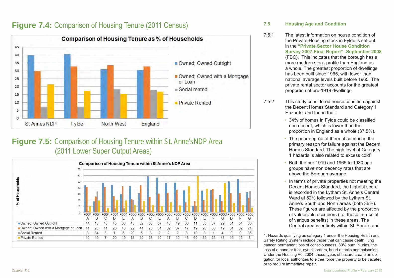
Chapter 7:4 Neighbourhood Profile ~ February 2015
Figure 7.4: Comparison of Housing Tenure (2011 Census)
Figure 7.5: Comparison of Housing Tenure within St. Anne’sNDP Area (2011 Lower Super Output Areas)
7.5 Housing Age and Condition
7.5.1 The latest information on house condition of the Private Housing stock in Fylde is set out in the “Private Sector House Condition Survey 2007-Final Report” -September 2008 (FBC). This indicates that the borough has a more modern stock profile than England as a whole. The greatest proportion of dwellings has been built since 1965, with lower than national average levels built before 1965. The private rental sector accounts for the greatest proportion of pre-1919 dwellings.
7.5.2 This study considered house condition against the Decent Homes Standard and Category 1 Hazards and found that:
• 34% of homes in Fylde could be classified non decent, which is lower than the proportion in England as a whole (37.5%). The poor degree of thermal comfort is the • primary reason for failure against the Decent Homes Standard. The high level of Category 1 hazards is also related to excess cold3. Both the pre 1919 and 1965 to 1980 age • groups have non decency rates that are above the Borough average. In terms of private properties not meeting the • Decent Homes Standard, the highest score is recorded in the Lytham St. Anne’s Central Ward at 52% followed by the Lytham St. Anne’s South and North areas (both 36%). These figures are affected by the proportion of vulnerable occupiers (i.e. those in receipt of various benefits) in these areas. The Central area is entirely within St. Anne’s and
1. Hazards qualifying as category 1 under the Housing Health and Safety Rating System include those that can cause death, lung cancer, permanent loss of consciousness, 80% burn injuries, the loss of a hand or foot, eye disorders, heart attacks and poisoning. Under the Housing Act 2004, these types of hazard create an obli-gation for local authorities to either force the property to be vacated or to require immediate repair.
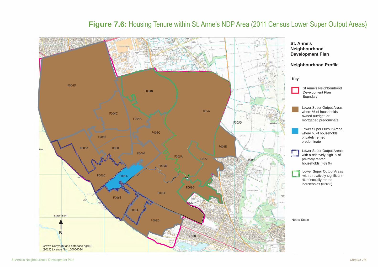
St Anne’s Neighbourhood Development Plan Chapter 7:5
Figure 7.6: Housing Tenure within St. Anne’s NDP Area (2011 Census Lower Super Output Areas)
St Anne’sNeighbourhood Development Plan
Neighbourhood Profile
Key
St Anne’s Neighbourhood Development PlanBoundary
Not to Scale
Crown Copyright and database right (2014) Licence No: 100006084
Lower Super Output Areas where % of households privately rented predominate
Lower Super Output Areas with a relatively high % of privately rented households (>39%)
Lower Super Output Areas where % of households owned outright or mortgaged predominate
Lower Super Output Areas with a relatively significant % of socially rented households (>20%)
N
F004A
F004D
F004E
F004C
F004B
F005A
F005E
F005E
F005A
F005C
F005B
F008F
F008G
F006F
F006BF006A
F006C F006D
F006G
F006E
F008D
F008E
F005D
F005D
St. Anne’s Neighbourhood Development Plan
Neighbourhood Profile

Chapter 7:6 Neighbourhood Profile ~ February 2015
so is most of the North area. Only a small part of the South area (part of Fairhaven Ward) is within St Anne’s. Category 1 hazards are more strongly • associated with privately rented dwellings than other tenures. The highest concentration of properties having category 1 hazards was in Lytham St. Anne’s Central area, where the rate is 27%.
7.6 Demographic and Economic Trends
7.6.1 The Fylde Coast Strategic Housing Market Assessment (SHMA) Final Report (Feb 2014) describes the following:
• The population of Lytham St. Anne’s has grown by 2,279 (5.5%) between 2001 and 2011, contributing all but 260 of the 3.5% population growth in Fylde. Over this ten year period, there has been a consistent level of net in-migration, both internal and international, masking decline caused by natural change, although international migration has fallen since 2007. Fylde has the strongest migratory • relationship with Blackpool, with a net inflow of residents from the authority across all age groups; there are also strong links with Wyre and Preston; migration patterns show a retention of people in all age groups with the exception of a loss of 15-19 year olds where there is a significant outflow. Fylde’s population profile shows a relatively • old population with a loss of 30-39 year olds in the last 10 years; it is expected to see a further significant increase in the older population over the period to 2030.
Although Fylde had a moderate population • growth between 2001 and 2011, there was a significant (7.8%) increase in the number of households, up by 2,516; this is reflected in the smaller average household size which went down from 2.19 to 2.12, a faster rate than seen nationally. Around 60% of residents also work in Fylde, • while 80% work within the Fylde Coast. Outside of this area Lancaster and Preston are important employment destinations for Fylde residents.Between 2001 and 2011, 530 (1.2%) jobs • were lost in Fylde, with over 7,200 job losses in the manufacturing sector in the borough. There has, though, been growth in professional and other service activities, as well as accommodation and food. Despite net job loss, unemployment is • relatively low, compared to the other Fylde Coast authorities. Forecasts are consistent in anticipating net • job creation between 2011 and 2030, with the creation of between 990 and 2,807 jobs. The latter forecast expects further growth in the professional, scientific and technical activities sector, as well as retail, allied to further job losses in manufacturing. These forecasts do not take into account policy and strategic objectives such as employment creation associated with the Enterprise Zone at Warton. Residents of Fylde have the highest average • household income of the Fylde Coast authorities, with benchmarks indicating that property remains among the least affordable in the area across all tenures and sizes.
7.7 Housing Market Trends
7.7.1 The SHMA found that there has been a decline in housing market activity since 2007 but that house prices are high in Fylde, relative to the rest of the Fylde Coast, with properties on average invoking a premium of at least £40,000 over comparable properties elsewhere. Lytham St. Anne’s has some of the highest house prices on the Fylde coast with a median house price of £175,000 (between March and July 2013) being approximately the same as Garstang and exceeded only by two rural areas (rural east and rural SW) where the market information was skewed. The prices are even higher than other rural areas where there is a predominance of detached housing and significantly exceed the Fylde coast median price of £120,000. The lower quarterly of prices in Lytham St. Anne’s is also high with a price of £125,0000 compared to the Fylde coast figure of £87,500 and exceeded only by Garstang and the rural areas.
7.7.2 These high prices are evident in all house types in Fylde, with even terraced houses and flats being sold at relatively high prices.
7.7.3 Rental market values are also relatively high in Fylde, but nevertheless lower than the national average. The median rent for all properties in Fylde is £550 per month and the lower quarterly rent is £450 per month. A one bedroom property in Fylde has a median rent of £400 per month, while 4 bed plus properties have a median rent of £995.

St Anne’s Neighbourhood Development Plan Chapter 7:7
7.8 Recent Development Trends
7.8.1 The SHMA states that Fylde has on average delivered 200 net dwellings per annum over the 10 year period 2003/04 to 2012/13. Unlike the other two Fylde coast authorities, Fylde has returned to pre-recession house building levels, with the completion of 162 dwellings in 2012/13 surpassing the 142 dwellings delivered in 2003/04. Between the 2007/08 peak and the most recent figures in 2012/13, Fylde has experienced a 60% reduction in net completions, greater than the other two Fylde coast authorities; but this was from very high levels of building in 2007-8 (394 dwellings) and 2008-9 (305 dwellings). Between 2003/04 and 2011/12, the proportion of housing delivered by conversions in Fylde ranged from 5% in 2006/07 to 26% in 2007/08. On average, over this nine year period, 14% of net housing completions in Fylde are attributable to conversions.
7.8.2 Of the 16 sub-areas in the Fylde coast SHMA, Lytham St. Anne’s has seen the greatest absolute change in housing stock over the inter-Census years with the creation of 2,286 household spaces, reflecting the town’s growth and especially the increase in flats, with over 95% of Fylde’s new flats being in this sub area, many of them in St. Anne’s.
7.8.3 Fylde’s Housing Land Availability Schedule sets out what growth has occurred and the following information for Lytham St. Anne’s in Table 7.1 is extracted from it. Further analysis would be required to break this down into the figures for St Anne’s.
7.8.4 The table shows that housing development has reached a low in the last three years and that the highest level of development was experienced in 2002-03, 2004-05, 2007-08 and 2008-09, with an average of about 21 dwellings being built each month in these years. The first 6 years of the decade were characterized by a large amount of development on both brownfield and greenfield land, the latter mostly accounted for by one large (32 hectare site) which was begun in 1999 (application ref 5/96/0814) and produced over 600 houses. After that date there was hardly any greenfield development, presumably as a result of the moratorium on new development included in the local plan as a result of over- provision in relation to regional planning targets. Instead this encouraged even higher levels of brownfield development, mostly for flats. It should also be noted that a substantial proportion of new housing comes from small sites and from conversions and changes of use.
Table 7.1: Housing Completions in Lytham St. Anne’s2001-201301-02 02-03 03-04 04-05 05-06 06-07 07-08 08-09 09-10 10-11 11-12 12-13 01-13
Gross Total 147 276 139 235 109 145 292 271 133 166 36 72 2021Dwelling Losses 2 0 6 6 19 1 12 36 41 97 8 7 235Net Total 145 276 133 229 90 144 280 235 92 69 28 65 1786Monthly Average 16 22 11 19 8 12 23 20 8 6 2 5 11.5Gross Total New Flats 47 140 131 79 49 126 171 149 39 84 16 0 1031Gross Total on Small Sites 58 114 44 134 44 27 65 57 53 25 9 2 632Gross Total from Conversion/Change of Use 31 22 15 33 20 6 61 30 44 31 5 47 345
Brownfield completions (net) 97 180 40 130 51 76 280 235 92 69 28 62 1340Greenfield completions (net) 98 96 93 99 39 68 1 0 0 0 0 3 497

Chapter 7:8 Neighbourhood Profile ~ February 2015
7.9 Housing Needs
7.9.1 The SHMA report includes a detailed analysis of modelling undertaken to understand the potential changing future housing needs across the Fylde Coast and within the individual authorities, linked to the key drivers of the housing market. This takes account of considerations in the NPPF and the then emerging NPPG, as well as other available guidance to assessing ‘objectively assessed need’ (PAS/LGA, 2013). These include:
the implications of changing population • growth based on demographic factors and historic trends; the impact of employment change on future • migration and population growth or decline; market signals, including the scale of the • need for affordable housing and how this aligns with the overall scale of need; and that need should not be constrained by • supply or capacity factors.
7.9.2 In line with these considerations, the SHMA presented a range of potential dwelling requirements linked to demand generated from household growth. These take account of a range of factors identified as having a direct bearing on the establishment of the objectively assessed needs for housing across the Fylde Coast. This gives an objectively assessed need for between 300 and 420 dwellings per annum in Fylde.
7.9.3 A simple apportionment pro-rata to existing dwellings (28%) would put objectively assessed need for St. Anne’s at 84 to 118 per annum, or 1260 to 1770 dwellings over a 15 year plan period.
7.9.4 However, a simple apportionment of this type is an over-simplified approach in that it does not take account of the specific characteristics of St. Anne’s, such as the need for affordable housing and for smaller and specialist units to cater for an ageing population. Indeed it might be argued that St. Anne’s is not an appropriate basis for such an assessment since it does not constitute a stand-alone housing market area or sub-area and that it can only be considered in the context of the wider area, be that Lytham St. Anne’s, Fylde Borough or the whole Fylde coast. Only in this way can it be ensured that the neighbourhood makes its appropriate contribution to the social and economic needs of the area.
7.9.5 This is a complex matter as illustrated by the SHMA when discussing where within the above range the objectively assessed housing need for the Borough and the sub-region should be set. The SHMA states that:
“Due to the complexities of the housing market and the various factors and assumptions which feed into the modelling of future needs, there is no single number which can be identified as conclusively representing the objectively assessed housing needs within the Fylde Coast. The scenarios of population and household change in the SHMA represent a range of alternative futures based upon the application of alternative assumptions relating to the housing market demand and need. They assume that the current economic profile will remain unchanged, in terms of labour force and commuting rates.
Therefore, alternative scenarios were considered to illustrate the impact that adjusting these assumptions would have.
However, for these to be considered further, additional work would be required on the economic prospects of the authorities, particularly Blackpool, and the impact of the spatial delivery of employment opportunities.”
7.10 Affordable Housing Needs
7.10.1 The SHMA states that “There is a significant level of demand for non-market housing in the Fylde Coast, as evidenced by waiting list data. This relates primarily to higher proportions of lower income households, particularly in urban areas, in the context of rising prices and rents. This has been further compounded by the impact of the recession, with subsequent reductions in income and job losses.”
7.10.2 The SHMA found that there is an estimated need for 203 affordable homes per year in Fylde, with the majority of this need located in Lytham & St. Anne’s. There are currently 138 households on the housing register in priority need for affordable housing across in Fylde, again concentrated in Lytham & St. Anne’s. These include households classified as homeless or in temporary accommodation, but exclude existing social tenants requesting a transfer from their current social dwelling.
7.10.3 283 (gross per year) households will require Affordable Housing over the short-term (five years) in Fylde. This does not, however, take account of the supply of stock to absorb demand. The housing needs analysis undertaken for the SHMA indicates that Fylde will need to provide for a net annual Affordable Housing Need of 207 dwellings per annum.
7.10.4 In order to meet the level of affordable housing need in full within a five year time horizon, the rate of development would need to far exceed

St Anne’s Neighbourhood Development Plan Chapter 7:9
any single year’s provision as seen over the last ten years. This is extremely unlikely to be realised, and therefore this level of provision should not be reasonably expected to be delivered, although the private rented sector does play an important role in absorbing affordable need.
7.10.5 The analysis in the SHMA has shown that, currently and in the short-term, while a large proportion of need can only be addressed through traditional social housing, there are a number of households in need who could have their needs met in other ways. These could include a limited role for various ‘Intermediate’ housing products, providing an important step onto the housing ladder in the future. However, the traditional shared ownership model is favourable as delivery would reduce the reliance on social rented housing. This must be balanced with the challenging viability of delivering this product, due to low value returns.
7.11 Specific Housing Needs
7.11.1 Specific housing needs identified in the SHMA are:
Older people – the population of 65+ • residents is expected to grow, with increases of 41.2% in Fylde from 2011 to 2030. There is particular proportional growth forecast in the 85+ age bracket, which will necessitate the provision of specialised accommodation. The tenure of older persons housing also provides an indication of the kind of housing required, with older persons typically opting to own their own home – at a higher rate than seen nationally. There is also a lower level of reliance on the social rented sector for older persons’ accommodation, although there are more instances of private renting;
Households with support needs – a strategic • approach will be necessary to ensure that the continued needs of households with support needs including those with a learning difficulty and age related support requirement are met, with sufficient capacity for specialist accommodation where required; Gypsies, Travellers and Travelling Show • people – the Fylde Coast authorities have commissioned a separate study which will consider the specific needs of Gypsies, Travellers and Travelling Show People.
7.12 Other Evidence Documents
Fylde Housing Action Plan 2010
7.12.1 This presents a vision for Fylde linked to the Fylde Coast Housing Strategy 2009. The vision for Fylde is developed around the latter’s themes of Quantity, Quality and People and includes the following relevant issues:
Quantity
7.12.2 In respect of Lytham St. Anne’s the issues are:T• he need to provide a broad mix of housing types within larger new developments;Some low cost housing for sale;• High need for social rented housing;• Maintain and expand upon the upturn in the • provision of new affordable housing; Priority for social rented homes is for more 2 • bed and larger homes;
7.12.3 In Fylde it is difficult for local people on modest incomes to be able to afford to buy or rent a suitable home. These problems especially effect young people looking for their first home, exacerbating the trend of young people
leaving. Young working people find it difficult to afford owner occupation and require some lower cost housing for sale. High cost areas increasingly become enclaves of the old and wealthy, reducing the viability of local services and community life.
7.12.4 The major growth in house prices and rents since 2000 has far outstripped income growth, making housing less affordable to local people, especially in Lytham St Anne’s. In the long term, there remains an underlying trend of a lack of sufficient housing to meet total demand from households, suggesting a continuing long term trend of price rises.
7.12.5 The supply of social housing properties falls far short of demand. Fylde has a very small social housing stock at 6% of all and the demand for social housing is currently very high. The amount of properties required to fully meet the current priority needs for social rented housing can never be provided but the work to deliver more affordable homes, meeting clear needs for social renting, will continue. With limited options available the housing benefit subsidised private rented housing stock plays a large and increasing role in housing people on low incomes.
Delivering appropriate, high quality, new developments that support economic prosperity and high quality of life
7.12.6 An appropriate balance of new housing development is needed in terms of quantity, location and types of units, while enabling high quality design, so that the developments contribute to prosperity and quality of life for decades to come. The Local Authority has a critical role to play in setting clear policies and standards, and actively promoting high

Chapter 7:10 Neighbourhood Profile ~ February 2015
quality development. The introduction and use of effective planning policies is a key priority, informed by an understanding of long term goals, the local economy, demographics, and the local housing market.
7.12.7 Actions relating to affordability will not only include a commitment to the provision of more affordable homes through the planning system, through RSLs and the HCA, but also to working with local communities, landowners and local charitable trusts to develop affordable housing for local people.
Quality
7.12.8 Concentrations of deprivation on social housing estates and in Central Ward St Anne’s.
7.12.10 One of the two most significant concentrations of deprivation and highest turnover on social housing estates is found in Kilnhouse Lane St. Anne’s, where there are still major challenges to improve the neighbourhood environment. Actions are to be developed as part of the work on Area Delivery plans with partner RSLs.
7.12.11 Central ward St. Anne’s remains a priority to help deliver one of the key aims of the shaping the place project, namely to improve the quality of the housing stock, working with Houses in Multiple Occupation (HMO) landlords to improve standards in Central ward. Further developments on actions relating to neighbourhood renewal will be influenced by decisions on the roll- out of the shaping the place project.
People
Meeting the growing and changing housing support needs of older people
7.12.12 Fylde has an old and ageing population, and this has a significant impact on housing market trends. Older people are a highly diverse group, with very different levels of health, incomes, integration within local communities, work, locations and housing conditions. This variation means that provision of housing options will have to be equally varied, and consider the requirements of older people who are active as well as those who are relatively frail. Irrespective of people coming to the area to retire, the number of older people is set to grow significantly as people generally live longer.
7.12.13 Services to deliver physical adaptations for older and disabled people and assist with repairs play a valuable role in helping people to lead independent lives within their own homes. However, a significant minority require specialist accommodation.
7.12.14 These needs are changing over time because of local population dynamics, but also because of changing preferences and the development of new models of support. Actions include supporting the provision of more housing with care and determining the need for other specialist accommodation options.
Lack of specialist housing and support for “socially excluded” groups
7.12.15 Helping people with chaotic lives, such as those with drug and alcohol misuse problems, offenders, and mental health issues is essential to underpin objectives live reducing crime and increasing economic prosperity.
There is a lack of specialist accommodation for many of these groups. We need to determine the type of specialist support required and the extent to which this should be based on specialist accommodation and then address the current under-provision.
Meeting the needs of young people
7.12.16 Helping meet the needs of young people runs through all aspects of the People theme. A key issue for Fylde is the recognition of the specific housing needs of economically active young people. Delivery on this aspect will be through the Quantity theme of the action plan, as well as through the delivery of homelessness strategies and appropriate access to social housing.
Strategic Housing Land Availability
Assessment (SHLAA) March 2012
7.12.17 The SHLAA examines the amount and location of land which is potentially suitable for housing development over the next fifteen years. It is very important to recognise that the SHLAA is not in itself a plan or policy document and will have limited weight within the planning application process. In particular, the inclusion of a site as ‘developable’ in the SHLAA does not necessarily mean that it will obtain planning permission for housing. The SHLAA identifies potential sites for housing in St. Anne’s in the form of:
Sites within settlements;• Redevelopment of redundant and vacant • employment sites; Settlement extensions;• ‘Suitable’ sites which are subject to • constraints and recommendations to overcome identified constraints.

St Anne’s Neighbourhood Development Plan Chapter 7:11
7.12.18 These sites are listed in Appendix 7.1 to this Chapter. It should be noted that not all sites with a SA prefix in the SHLAA are within the NDP area. These have therefore been excluded from the list.
7.12.19 Some of these sites already have planning permission. Indeed, in defining what should be included in the 5 year land supply, the SHLAA sets a very high test, requiring sites to have planning permission. There is substantial case law to say that this is not necessary and that a land allocation in an adopted or submitted Local Plan together with substantial progress towards implementation is sufficient.
7.12.20 Excluding sites for 5 or fewer dwellings (in accordance with Fylde’s methodology) and completions, the SHLAA contains suitable, deliverable and currently developable sites for 2,460 dwellings in St. Anne’s, of which 1,787 already have planning permission.
7.13 Current Housing Land Availability
7.13.1 There are several large housing sites with planning permission within the NDP area, with a permitted capacity of 2,168 net of existing dwellings. These are set out in Table 7.2 and illustrated on the map in Figure 7.7. One site (Queen Mary School) is nearly complete but has been included to give a full picture. Excluding dwellings completed, outstanding planning permissions on large sites have an approved capacity of 1985 dwellings.
Table 7.2: Strategic Housing Sites with Planning Permission (31st December 2013)
Plan
Ref
Loca
tion
Net
No
of
Dw
ellin
gs
Site
Are
a (h
a ap
prox
)
Type
of
App
.
Pl. A
pp. R
ef.
Affo
rdab
le
Dw
ellin
gs
to b
e pr
ovid
ed
Com
men
ts
A
Queen Mary School, Clifton Drive South, St. Anne’s
169 2.9 Full 03/0157 08/0539
Yes Com-muted sum
163 dwellings complete6 dwellings under construction/not start-ed
BLand to rear 11-63 (odds), Westgate Road, St. Anne’s
70 0.9 Full 08/0992 12/0499 30%
12/499 is for an extension of time for 08/0992 which has been approved pending a Section106 agreement.
CTraining Centre, St David’s Road North, St Anne’s
32 0.6O/LFull 09/0502
12/0537100% RSL scheme
DLand South of Queensway, St. Anne’s
1150 36O/LRM
08/005813/0257 0% - 10% See above
EElectronic Data Systems, Hey-houses
335 7.3
O/LFullFull
12/046513/044813/0635 10%
Outline for 335 dwellings (12/0465). Reserved matters for 162 dwellings & food store (13/0448). A3/A4 Public house (13/0635)
FFormer Pontins Site, Clifton Drive North
348 15.6 O/L 10/0877 08/1049 30%
Two outline applications approved for up to 275 and up to 73 dwellings. Re-served matters application submitted and withdrawn for 238 dwellings in rela-tion to 08/1049.
G
Conservative Club site, 353 Clifton Drive North / St Georges Road
34 0.25 Full 08/260 11/0312 No
20 dwellings complete14 dwellings under construction/ not started
H The Gables, 35-39 Orchard Road 19 0.13 Full 05/0648 see com-
mentsPurchase of 12 open market properties, refurb and disposed to RSL
I 7-8 St Georges Square 11 0.09 Full 10/891 5% contri-
butionTotal For Large Sites 2168
Total For Large Sites, excluding completions
1985

Chapter 7:12 Neighbourhood Profile ~ February 2015
Figure 7.7: Major Housing Development Proposals
St. Anne’s Neighbourhood Development Plan
Neighbourhood Profile

St Anne’s Neighbourhood Development Plan Chapter 7:13
7.13.2 The largest site at Queensway has outline permission for 1,150 dwellings. A reserved matters application (13/0257) has been received for Phase 1 for 110 dwellings, which includes a new roundabout access from Queensway. The application has been deferred, at Development Management Committee (22/01/14) for applicant and Natural England to resolve ecological matters. The Queensway development is to fund the Heyhouses Link road to the M55 through a Section 106 agreement containing triggers for construction of phases of the road as dwellings are built.
7.13.3 In addition there are some 28 small sites with a total capacity of 41 dwellings gross (23 net of existing dwellings). Of these 6 proposals for flats would provide 19 dwellings. The rest are sites for individual dwellings. Full details of these sites are given in Appendix 2 to this Chapter.
7.14 Planning Policy Context - Housing
What the NPPF says
7.14.1 Paragraph 17 of the NPPF lists as one of 12 core planning principles that planning should proactively drive and support sustainable economic development to deliver the homes, business and industrial units, infrastructure and thriving local places that the country needs. Every effort should be made objectively to identify and then meet the housing, business and other development needs of an area, and respond positively to wider opportunities for growth. Plans should take account of market signals, such as land prices and housing affordability, and set out a clear strategy for allocating sufficient land which is suitable for development in their area, taking account
of the needs of the residential and business communities. It further advises that planning should encourage the effective use of land by reusing land that has been previously developed (brownfield land), provided that it is not of high environmental value.
7.14.2 Paragraph 47 says that to boost significantly the supply of housing, local planning authorities should ensure that their Local Plan meets the full, objectively assessed needs for market and affordable housing in the housing market area; identifying key sites which are critical to the delivery of the housing strategy over the plan period; identify and update annually a supply of specific deliverable sites over the plan period; for market and affordable housing, illustrate the expected rate of housing delivery through a housing trajectory for the plan period and set out a housing implementation strategy for the full range of housing describing how they will maintain delivery of a five-year supply of housing land to meet their housing target; and set out their own approach to housing density to reflect local circumstances.
7.14.3 Paragraph 48 advises that local planning authorities may make an allowance for windfall sites in the five-year supply.
7.14.4 Paragraph 49 says that housing applications should be considered in the context of the presumption in favour of sustainable development. Relevant policies for the supply of housing should not be considered up-to-date if the local planning authority cannot demonstrate a five-year supply of deliverable housing sites.
7.14.5 Paragraph 50 says that to deliver a wide choice of high quality homes, widen opportunities for home ownership and create sustainable, inclusive and mixed communities, local planning authorities should:
plan for a mix of housing based on current • and future demographic trends, market trends and the needs of different groups in the community; identify the size, type, tenure and range • of housing that is required in particular locations, reflecting local demand; and where they have identified that affordable • housing is needed, set policies for meeting this need on site, unless off-site provision or a financial contribution of broadly equivalent value can be robustly justified.
7.14.6 Paragraph 51 says that local planning authorities should identify, and bring back into residential use, empty housing and buildings in line with local housing and empty homes strategies and, where appropriate, acquire properties under compulsory purchase powers. They should normally approve planning applications for change to residential use and any associated development from commercial buildings (currently in the B use classes) where there is an identified need for additional housing in that area, provided that there are not strong economic reasons why such development would be inappropriate.
7.14.7 Paragraph 52 advises that the supply of new homes can sometimes be best achieved through planning for larger scale development.
7.14.8 Paragraph 53 says that local planning authorities should consider the case for setting out policies to resist inappropriate development of residential gardens.

Chapter 7:14 Neighbourhood Profile ~ February 2015
Fylde Local Plan
7.14.9 The Fylde Local Plan (As Altered) (2005) advises that Fylde is a popular area in which to live and consequently there is high pressure for housing development in the Borough. Its popularity arises from the attractive nature of the Borough, its proximity to large centres of employment and services, its relatively buoyant economy and good communication links. The Borough and in particular Lytham St. Anne’s is also very popular for retirement which has been reflected in the high level of retirement flat development.
7.14.10 Policy HL2 outlines the criteria against which housing proposals allowed under PoliciesHL1 will be considered.
7.14.11 (Policies HL3 and 4 relate to rural areas and are not relevant to St. Anne’s).
7.14.12 Policy HL5 sets out the criteria for considering planning applications for house extensions.
7.14.13 Policy HL6 deals with design and says that well designed housing schemes which respect the character of the area and provide an attractive, safe and crime free environment for residents will be permitted. Proposals which involve poor designs and/or layouts which would prejudice the character of the area or public safety, or increase the potential for crime will not be permitted.
Interim Housing Policy
7.14.14 The Interim Housing Policy (IHP) was adopted on 28th July 2008, as an informal policy document. It is a material consideration for the determination of planning applications for new housing. Guidance is included in the IHP to inform discussion and negotiation for
infrastructure provision for affordable housing, public open space and public realm. The IHP operates an urban and a rural option. The Urban Option applies in St. Anne’s. This states that planning permission for residential development will be granted subject to all the following criteria: 1. The application site is within the
settlement boundary as defined in the Fylde Borough Local Plan (As Altered) (Oct 2005);
2. The application site is not designated for other purposes or protected by policies in the Local Plan;
3. In respect of greenfield sites, the applicant is able to show that there is a need for the development of the site (i.e. that there is less than a 5 year supply of land within the borough as a whole and that the application under consideration would not increase the supply beyond 7 years);
4. The development of the site would not significantly harm the character of the settlement or any other planning interest;
5. In respect of proposals involving 10 dwellings or more, where appropriate, the mix of housing types, sizes and tenures reflects local housing requirements, and is consistent with the findings of the Fylde Housing Needs and Demand Study of January 2008, and the Fylde Coast Strategic Housing Market Assessment. The Council will encourage the provision of low cost market housing as part of the normal mix of market housing.
6. In respect of proposals involving 14 or less dwellings the Council will negotiate for a financial contribution of 5% of the open market value of each dwelling towards the facilitation of affordable housing within the borough. Financial contributions will not be sought in respect of affordable dwellings and conversions to dwellings of spaces above existing premises in defined town centres;
7. In respect of proposals of 15 or more dwellings, the Council will negotiate for 30% of the dwellings to be affordable unless the developer can demonstrate by means of verifiable evidence that the development would not be viable with that percentage. Normally, all the affordable units should be provided as socially rented homes through a named Registered Social Landlord (RSL);
8. Whilst the priority will nearly always be to provide social rented housing (consistent with the findings of the Fylde Housing Needs and Demand Study of January 2008, and the Fylde Coast Strategic Housing Market Assessment) an element of intermediate affordable housing may be appropriate (subject to it being provided at genuinely affordable rents and prices) where the development is:
in an area that already has a high • proportion of socially rented homes such that this would not be the priority for provision; for 100% affordable housing and is • either submitted by a Registered Social Landlord or has financial support by the Housing Corporation.

St Anne’s Neighbourhood Development Plan Chapter 7:15
The Emerging Local Plan
7.14.15 In common with many local authority areas, Fylde has witnessed a reduction in housing completion rates and rising house prices. Even with falling house prices, housing prices remain significantly high in relation to incomes. There are widening disparities between the areas with the highest house prices, such as Lytham, and parts of St. Anne’s which contain homes in multiple occupation and are in the bottom ten percent nationally in relation to the Indices of Multiple Deprivation. Fylde does not have a history of industrialisation and there is, therefore, a lack of brownfield land, resulting in a requirement to develop some greenfield sites for housing.
7.14.16 The Fylde Local Plan to 2030 Part 1- Preferred Options paper sets out the following policies relating to Housing.
7.14.17 Strategic Objective 1 is: To Create Sustainable Communities. It says that all development will be located in sustainable locations in order to minimise the use of private transport and avoid areas at risk of flooding. New development will follow sustainable design principles and incorporate sustainable building practices by reducing carbon emissions, maximising water and waste efficiency and ensuring that they are resilient to the effects of climate change. Previously developed sites will be used in preference to greenfield and the quality of the openness of the Green Belt maintained. Developer contributions will be used to ensure development is in line with the objectives of sustainable development.
7.14.18 A sustainable approach to housing will be taken. This will:1) improve access for all to well designed,
good quality, affordable and resource efficient homes across the Borough;
2) meet the specific housing needs of all sections of the community (including affordable, special needs housing and the needs of gypsies and travellers) by providing the right housing type and mix to secure sustainable communities and to improve housing choice. In particular, to provide more homes suitable for families;
3) bring forward a flexible and responsive supply of housing land and buildings in sustainable locations to meet housing requirements;
4) make the best use of previously developed land and buildings, subject to appropriate site investigation and remediation where required, to reduce the loss of greenfield land.
7.14.19 Policy SL1 details strategic locations for development in Lytham St. Anne’s, namely (see Figure 7.7):
H1 - Land at Queensway H2 - Land West of North Houses Lane H3 - Land North of Moss Hall Lane H4 - Former EDS Site, Heyhouses Lane
7.14.20 Policy SL2 details strategic locations for development in the ‘Blackpool Periphery’, including housing development at the former Pontins Holiday Centre.
7.14.21 Policy H1 - Density, Mix and Design of New Residential Development: says that densities of new residential development will reflect the character of the surrounding area. Residential development within Fylde Borough will normally have a minimum density of 25 dwellings per hectare (dph) net, subject to specific issues relating to the site. Densities of less than 25 dph net will only be permitted where special circumstances are demonstrated. Higher densities (40- 60 dph net or more) will be expected on sites with good access to public transport facilities and services. When considering a proposal for higher density development, the Council will seek to ensure that there is no unacceptable impact on local infrastructure or highway safety, and that adequate open space and car parking can be provided. The achievement of higher density should not be at the expense of good design or the amenity of the occupiers of the proposed or existing neighbouring properties.
7.14.22 A broad mix of dwelling types, sizes and tenures, including private rented and buy- to-let, will be required on all large housing sites of over 100 units to reflect the demographics of the Borough as set out in the Fylde Coast Strategic Housing Market Assessment (SHMA). Homes that are affordable to people working within the local community, and those with strong links to the local area, will be encouraged in order to promote the vitality of local businesses and community life.
7.14.23 To reflect the demographics of the Borough, specialist retirement accommodation will be permitted if a need is demonstrated within or adjacent to a town centre or strategic location for development, where a range of services is available. This should conform to other policies within the Local Plan.

Chapter 7:16 Neighbourhood Profile ~ February 2015
7.14.24 On smaller sites of under 100 units the Council will require a mix that makes a positive contribution to the vitality of the local community. In St. Anne’s 2-3 bedroom family homes with private amenity space should be included in the mix, as there is a lack of family accommodation within the existing stock.
7.14.25 Conversion of traditional homes to flats and apartments will be resisted in the Lytham and St. Anne’s seafront area.
7.14.26 When considering proposals for residential development on garden land, stringent caveats will be applied relating to design, character, access, amenity and other issues deemed appropriate by the local authority. Development on garden land should not result in any of the homes relying on what was previously a front garden for all of their private amenity space
7.14.27 Design of new residential development will be assessed against paragraphs 56-68 of the NPPF, Policy ENV 6: Good Design in New Development and Building for Life 12. As a minimum, all new housing developments should meet the Homes and Communities Agency ‘Design and Quality Standards’ which are currently in force.
7.14.28 Within new developments of more than 15 homes, at least 25% of market homes should be built to the Lifetime Homes Standards as set out in the Code for Sustainable Homes, unless it is demonstrated that this would render the development unviable.
7.14.29 Community Self Build schemes will be encouraged and the Council will reserve the right to refrain from requesting developer contributions for these developments, in order to promote their viability.
7.14.30 Policy H2 - Conversions and Change of Use to Residential: says that conversions and change of use of redundant buildings to residential use will be permitted where the Council has identified a need for additional housing through the Strategic Housing Market Area Assessment or other later evidence. When considering proposals for residential conversions, careful attention should be paid to the amenity of nearby residents, the character of the immediate area, access to the nearest services, parking provision and design. Residential conversions should protect existing amenity space and should not result in any of the homes relying on what was previously a front garden for all of their private amenity space.
7.14.31 Policy H3 - Affordable Housing: says that all urban market housing schemes of 15 homes or more and rural market housing schemes of 4 homes or more will be required to provide a minimum of 30% affordable housing, subject to viability testing. Normally this housing should be provided on site. For residential developments within or adjacent to the urban areas, including St. Anne’s, the provision of affordable housing will be to meet borough wide requirements.
7.14.32 The Council will usually expect the following:
Tenure - the majority of affordable housing provided on a particular scheme should comprise 2 and 3 bedroom social rented or affordable rented homes, with the remainder intermediate.
Lifetime Homes – 25% of all affordable homes
will be built to Lifetime Homes standards (these will be in addition to the 25% of market homes as required by policy H1).
7.14.34 The Council will take account of viability when assessing individual schemes.
7.14.35 Policy H4 - Gypsies, Travellers and Travelling Show people’s Sites: says that planning applications will be permitted where stated criteria can be met.
7.14.36 Policy H5 - Isolated New Homes in the Countryside: says that isolated new homes in the countryside will only be permitted in certain stated circumstances.

St Anne’s Neighbourhood Development Plan Chapter 7:17
7.15 Key Issues
Ref Key Issues Comments / Possible Options
1 Number of Houses Needed
1.1
To establish the amount of housing required and assess whether any further land allocations are necessary given the substantial amount of existing planning permissions.
Consideration would need to be given to how to establish the total housing requirement for the Neighbourhood over the plan period. Is St. Anne’s a meaningful area in which to assess housing need? Is it appropriate to merely apportion the assessed need for the Borough (from the SHMA) pro rata to the existing population?
There is already sufficient land to meet local needs, but the NDP must •be in general conformity with the emerging Local Plan, which includes two further sites for new housing.Possible conflict with Fylde BC Emerging Local Plan •
1.2
Are existing commitments meeting needs both from within and from outside St. Anne’s? Is it appropriate to do so? If so, to what extent?
There is a need to determine a trajectory of housing provision over the plan period so that St. Anne’s needs are met as well as making a fair contribution to those of the wider area throughout the plan period.
Should the plan seek to allocate land for housing to meet wider needs in the Fylde Coast area?
Consider the potential for additional housing to facilitate a more sustainable community, e.g. could additional housing pay for/ bring forward key infrastructure?
The plan could consider whether allocations should be made on larger sites (to the east of the town or at Blackpool Airport or on a number of smaller sites.
The situation seems more extreme because FBC have gone from a •moratorium on building, to now having a large increase.
1.3What is the nature of the housing need over the plan period? What type of housing, size and tenure is required? Is there a need for a local housing survey to establish this? If so, how will it find out needs in 10-15 years’ time?
Allocations policies are being changed to favour working families. •
1.4 Addressing high house prices Little scope in the plan other than identifying new housing allocations •and in addressing affordable housing needs (see below)
2 Type of Housing Needed
2.1Affordability for home buyers, especially young people / first time buyers who can be out-competed by older people / those with existing equity, including people moving into the area for the first time.
Good design is no more expensive than bad design. •Influencing the prices would mean involvement at a very early stage. •

Chapter 7:18 Neighbourhood Profile ~ February 2015
2.2 Rising needs of the large population of older people for level access homes and adaptations as mobility deteriorates, and for specialist housing with support.
There are more over 60s since the last census so demand is greater •for these types of property.Specify support needs – not just elderly, also adults in general. •
2.3
The range of homes available is skewed towards large houses, and smaller flats, with relatively few medium sized family homes A shortage of 3 bed houses has been identified.
Have too many flats been provided in development over recent years. Should such development be restricted in future?
Can specific areas in which flat development could be restricted be •identified? - YES
2.4 Localised deprivation and concentrated poor conditions in parts of the Central ward of St. Anne’s. Relatively high number of shared households.
“Fylde Borough Council should address homelessness issues” •statement to be put in neighbourhood plan.Stigmas of hostels being provided as residents don’t want them near •them.Homelessness to be referred to the Community Health theme group. •Restriction of number of takeaways, betting shops and charity shops to •be referred to Economy theme group.
2.5Over-dependence on private rented sector. High cost of privately rented accommodation. Increase in this form of tenancy. Lack of social rented housing. Housing benefit changes likely to increase problems
A landlords’ accreditation scheme was suggested for the Town Council •to work with FBC in adopting it. However the Town Council does not have the resources to pursue this.
2.6Challenge to improve thermal efficiency and property conditions in the existing housing stock, including the relatively large private rented sector which has worse conditions on average than other forms of tenure
2.7 Relatively high number (688) of long term vacancies (Empty properties).Hard to identify empty homes due to high level of private landlords. •Possible overlap with Fylde BC •
2.8 Improving the quality and design of new housing High value placed on heritage in our town. •
2.9Location of new housing
New Housing should be met through mix of high quality brownfield and edge of settlement developments
2.10 Unsightly appearance of Pontin’s Site (Existing planning permission for housing) Site already has PP for housing. Could request Fylde Bc to use S215 •powers to improve appearance?
REFERENCES & DOCUMENTS REVIEWED
1. 2011 census2. Private Sector House Condition Survey 2007-Final Report3. The Fylde Coast Strategic Housing Market Assessment (SHMA) Final
Report (Feb 2014) 4. Strategic Housing Land Availability Assessment (SHLAA) Oct 201235. Fylde Housing Action Plan 2010
6. NPPF7. The Fylde Local Plan (As Altered) (2005)8. Fylde BC Interim Housing Policy9. The Fylde Local Plan to 2030 Part 1- Preferred Options Paper - July 2013

St Anne’s Neighbourhood Development Plan
APPENDIX 7.1
Residential Planning Permissions

Neighbourhood Profile ~ February 2015
APPENDIX 7.1: Residential Planning Permissions at 31 March 2013 (including loss of residential) (Housing Land Availability Study - base date 31 March 2013)
Site No. Location Previous Use Proposed Use
No.
Dw
ellin
gsG
ross
Exis
ting
Dw
ellin
gsN
o. D
wel
lings
Net
Dw
l. C
ompl
.G
ross
Dw
l. U
nder
Con
st. G
ross
Dw
l. N
otSt
arte
d G
ross
Site
A
rea
Type
of A
pp.
Plan
ning
App
. R
ef.
Bro
wnfi
eld
Gre
enfie
ld
Affo
rdab
le
Dw
ellin
gs to
be
pro
vide
d?
Large Sites
1A439* Queen Mary School, Clifton Drive South School Flats/Houses 169 0 169 163 6 0 2.87 Full 03/157 08/539 B Yes C/S
1A594* The Gables, 35-39 Orchard Road Hotel Flats 19 0 19 0 19 0 0.13 Full 05/648 B Yes H/U
1A658* 353 Clifton Drive North/St Anthony’s House, St Georges Road
Conservative Club/ Vacant Offices
Apartments / food-store/ Cons Club 34 0 34 0 34 0 0.25 Full 08/260
11/0312 B Yes - CS
1A677 Land to rear 11-63 (odds), Westgate Road Houses Houses/Flats 72 2 70 0 0 72 0.88 Full 08/992 12/499 B Yes
Former Pontins Holiday Camp, Clifton Road North Holiday Camp Houses 348 0 348 0 0 348 O/L 08/1049
10/0877 B
1A755 7-8 St Georges Square House Apartments 12 1 11 0 0 12 0.093 Full 10/891 B Yes1A760 7-8 St Georges Square House Apartments 12 1 11 0 0 12 0.093 Full 10/891 B Yes
1A782 Land South of Queensway Land Houses 1150 0 1150 0 0 1150 35.7 O/L 08/0058 G 0% - 10%
1A783 Electronic Data Systems Heyhouses Employment Land/ Buildings Houses 335 0 335 0 0 335 7.28 O/L 12/465 B Yes -
30%Total For Large Sites 2171 3 2168 163 59 1949
Small Sites
1A364 76 North Promenade, Land House/ Curtilage 1 0 1 0 1 0 0.1 Full03/0144 04/0246 07/187
G Yes - CS
1A385 22 All Saints Road Guest House House 1 0 1 0 1 0 0.02 Full 03/0568 B No
1A441 Moss View Farm, Queensway, St. Anne’s House Replacement House 1 1 0 0 0 1 0.015 Full04/1198 08/336 11/116
B No
1A552 3 St. Davids Road South Flat Flat 1 1 0 0 1 0 0.018 Full 05/360 07/673 B No
1A645 117 Heyhouses Lane House Replacement House 1 1 0 0 1 0 0.075 Full 07/1078 B No1A679 26 St Davids Road South 2 Flats 1 Flat 1 2 -1 0 0 1 0.02 Full 09/0086 B No1A685 18 Fairhaven Road 2 Flats 1 House 1 2 -1 0 1 0 0.074 Full 09/469 B No1A720 271 Clifton Drive South 1 House Care Home 0 1 0 0 0 0 0.09 Full 10/0185 B No1A721 25 Park Road Flat 1 0 1 0 0 1 0.034 Full 10/0067 B Yes /CS

St Anne’s Neighbourhood Development Plan
Site No. Location Previous Use Proposed Use
No.
Dw
ellin
gsG
ross
Exis
ting
Dw
ellin
gsN
o. D
wel
lings
Net
Dw
l. C
ompl
.G
ross
Dw
l. U
nder
Con
st. G
ross
Dw
l. N
otSt
arte
d G
ross
Site
A
rea
Type
of A
pp.
Plan
ning
App
. R
ef.
Bro
wnfi
eld
Gre
enfie
ld
Affo
rdab
le
Dw
ellin
gs to
be
pro
vide
d?
1A734 37-39 St Andrews Road South Restaurant 5 Flats 5 0 5 0 5 0 0.104 Full 10/380 12/630 B Yes /CS
1A736 14-16 St Andrews Road South & 2-4 Wood Street 2 Flats 2 0 2 0 0 2 0.025 Full 10/0076 B Yes /CS
1A737 16 St Georges Road Office 3 Flats 3 0 3 0 0 3 0.03 Full 10/478 B No1A757 357 Clifton Drive North Garages Mews House 1 0 1 0 0 1 0.02 Full 11/0027 B Yes1A758 28 Derbe Road Holiday Flats Perm Flats 4 0 4 0 4 0 0.028 Full 11/0149 B No
1A759 The Mews Cottage, Back 373 Clifton Drive North C3 Dwelling 1 1 0 0 0 1 0.007 Full 11/225 B No
1A785 Leach Lodge Farmhouse, 102, Leach Lane Land Dwelling House 1 0 1 0 1 0 0.086 Full 08/455 12/506 G Yes /CS
1A787 31 Wood Street 1st & 2nd Floors Flats 4 0 4 1 3 0 0.024 Full 11/229 B No1A788 41 Clarendon Road Dwelling Replacement House 1 1 0 0 0 1 0.057 Full 11/758 B No1A789 35 Bromley Road Shared House Flats 3 1 2 0 3 0 0.023 Full 12/319 B Yes/CS1A790 4 North Houses Lane Land Dwelling House 1 0 1 0 1 0 0.028 Full 11/266 G No
1A792 Land between 48 to 50 St Patricks Road South Land Dwelling House 1 2 -1 0 0 1 0.061 Full 12/632 B No
1A799 40 Heyhouses Lane 2 Flats Dwelling House 1 1 0 0 0 1 0.088 Full 12/655 B No1A801 2 Sandgate Dwelling Replacement House 0 1 -1 0 0 0 0.054 Full 12/673 B No1A802 21 Derbe Road and 11 Alexandria Drive Flat Pharmacy 1 2 -1 0 0 1 0.072 Full 12/692 B No1A803 1 Links Gate Flats Dwelling House 1 2 -1 0 0 1 0.072 Full 12/692 B No
1A805 Rear of 4 Curzon Road Offices Dwelling House 1 0 1 0 1 0 0.021 Full 12/526 12/254 B Yes/CS
1A807 20 Lightburne Avenue Flat 2 Flats 2 1 1 0 0 1 0.025 Full 5/13/50 B No Total for Small Sites 41 19 23 1 23 16 Total For All Sites 2212 22 2191 164 82 1965

Neighbourhood Profile ~ February 2015

St Anne’s Neighbourhood Development Plan
APPENDIX 7.2
SHLAA Sites within the St. Anne’s NDP Area

Neighbourhood Profile ~ February 2015
APPENDIX 7.2: Sites Within The Settlement
Deliverable/ Committed / CompleteBP03 Pontins Holiday Centre, Clifton Drive North, 348SA50 Electronic Data Systems (EDS), Heyhouses Lane, 250 SA69 Land rear of Pilling Avenue & Grassington Road, 31 completeSA32 353 Clifton Drive North & St Anthony’s House, St Georges Road, 34 20 completeSA65 Queen Mary School, Clifton Drive South, 169 163 complete SA66 The Gables, 35-39 Orchard Road, 19
DevelopableBP02 Council Car Park & Airport Parking Site, rear 11-63 Westgate Road, 72 SA05 Land rear of 3-17 Heyhouses Lane, 8 SA09 Depot, St Davids Road North, 26 SA10 Fairways Garage, Heeley Road, 20 SA12 Town Hall, South Promenade, 12 SA13 Public Offices, Clifton Drive South, 14 SA23 Land adj. Links Grange, Greenways, 8 SA39 Former Kwik Save, St Davids Road South, 32 SA43 60 & 62 North Promenade, 7 SA46 157 & 159 Inner Promenade, 6 SA57 7 Links Gate, 9 SA70 Newfield House, 5 Fleet Street 7 SA76 Lytham Delivery Office, 270 Clifton Drive South 7
228Not Currently DevelopableBP01 Land off Bridgeside, 13 SA11 Beach Car Park, Clifton Drive North, 19 SA80 YMCA, St Albans Road, 16 SA82 Victoria Hotel, Church Road, 40
Redundant/Vacant Employment SitesSA75 Land east of Queensway Industrial Estate, Queensway, (EMP1) 82 SA83Pt Queensway Industrial Estate, Queensway, (EMP2) 23
UnsuitableSA25 Land rear of 18, 20 & 19 Lancaster Avenue, 7 SA75 Land east of Queensway Industrial Estate, Queensway, 82 SA78 Playing Fields, Blackpool Road North, St Anne’s 183 SA83 FBC Depot & LCC Waste Recycling Centre, Snowdon Rd, 23
Small SitesSA01 Land rear of 52 Highbury Road East, 1 SA02 Land rear of 52 Leach Lane, 1 SA03 Land rear of 60-70 Blackpool Road North, 2 SA04 Land rear of 2 Walter Avenue, 2 SA06 Land east of 37 Knowles Road, 2 SA07 Land east of 70 Glen Eldon Road, 2 SA08 Land adj Keenans Mill, Lord Street, 2 SA14 Warehouse, Avon Street, 2 SA15 Land rear of 18-24 Fairhaven Road, 3 SA16 Land adj. 133 St Andrews Road South, 1 SA17 Land between 5 & 5a Beauclerk Road, 3 SA18 208 Road East, 4 SA19 Land between 54 & 56 Heyhouses Lane, 3 SA22 Land rear of 24 Gisburn Avenue, 1 SA24 Land rear of 33 & 35 Haymarket, 2 SA28 Clinic, Back Headroomgate Road, 5 SA29 Land between 54 & 58 Dorset Road, 2 SA30 Land rear of 39 & 41 Boston Road, 2 SA33 31 St Davids Road South, 1 SA34 50 North Promenade, 4 SA35 Training Centre, corner St Albans Road/Sefton Road, 4 SA36 Land north of Preesall Close, 4 SA37 Land west of Preesall Close, 1 SA38 Land adj. 11 & 12 Nateby Close, 1 completeSA40 Goodwins Garage, 1-5 St Albans Road, 3 SA41 155 St Andrews Road South, 4 SA42 58 North Promenade, 4 SA44 17 Links Gate, 2 SA45 Land rear of 8 Moorland Road, 1 SA47 Allotment gardens, rear of 1-13 Blundell Road, 4 SA48 Land rear of 182 St Albans Road, 1 SA49 136 St Albans Road, 1 SA58 17 Durham Avenue, 2

St Anne’s Neighbourhood Development Plan
SA59 32 Derbe Road, 2 SA60 70 Walter Avenue, 1 SA61 Rear of 33 St Andrews Road South, 1 SA62 67 Clarendon Road, 1 SA63 Rear of 111 Church Road, 1 SA64 Land to side of 43 & 45 Boston Road, 2 SA67 CMVU Depot, Heeley Road, 5 SA71 Vogue Nightclub, Back West Crescent, FY8 1SQ 1 SA72 Rear of 12 Curzon Road, 1 SA73 357 Clifton Drive North, 1 SA74 199 Heyhouses Lane, 1 completeSA79 Land rear of 116 Headroomgate Road & adjacent 3 Kilnhouse Lane, 1 SA81 61A St Patricks Road North, (Adj. 27 Ryeheys Road) 1 SA84 Land between 48 & 50 St Patricks Road South, Lytham 1
Settlement Extensions
CommittedSA51 Land at Queensway, 1150 Potentially SuitableSA54 Land west of North Houses Lane, 340
UnsuitableSA52 Moss View Farm, Queensway, 97 SA53 Land north of Queensway, 146 SA77 Land west side of Leach Lane, 139 SA88 Land corner of Division Lane & Queensway, 12

Neighbourhood Profile ~ February 2015
St Anne’s Neighbourhood Development Plan
Chapter 8
Economy

Neighbourhood Profile ~ February 2015

St Anne’s Neighbourhood Development Plan Chapter 8:1
8.0 Economy8.1 Introduction
8.1.1 This Chapter examines the current economic and employment situation in the study area and identifies key economic sectors and drivers. It reviews the wide range of existing economic strategies and policies, and identifies potential key economy issues which the NDP could address.
8.2 Existing Employment Overview
8.2.1 The Fylde Council area is relatively affluent with little evidence of deprivation. Skill levels are above wider area averages and a comparatively high proportion of people work in professional occupations.
8.2.2 Manufacturing accounts for over 30% of employment in Fylde, with advanced manufacturing a particular strength through aerospace and nuclear fuels processing. The area also contains growth orientated service sectors, such as computer and business services, alongside the traditionally strong sectors of tourism, agriculture and the rural economy. Since 1999 Fylde has experienced employment growth of 12.7%, exceeding national and regional comparisons over this period. Unemployment is currently low, with a claimant count rate of 2.1%, the second lowest in Lancashire, and relatively low levels (11.3%) of the working age population claim out of work benefits. The Borough has none of the high levels of deprivation seen in some areas in Lancashire.
8.2.3 Along with Wyre and Blackpool, Fylde is part of the Fylde Coast Sub-region and there are strong commuting flows between the three areas. Strategic employment sites,
such as the Enterprise Zone at Warton Blackpool International Airport , Whitehills and Westinghouse, could provide extensive employment opportunities and support growth in other parts of Fylde.
8.2.4 Councils must support and encourage economic growth including the provision, initially through planning policy, of sufficient employment land and premises. This must be of the right scale, type, location, be readily available for development and be well related to the strategic or local highway network according to the nature of the site and the function of the settlement. Fylde BC now have an up to date Employment Land Review (2012). Within the Fylde Coast area there is a recognised shortfall in employment land, particularly in Blackpool and hence Fylde is proposing to meet the shortfall. Duty to cooperate between the 3 authorities will be required to ensure an employment strategy and policies which reflect the needs and aspirations of the sub region.
8.2.5 Within the NDP area the key employment activities include as illustrated in Figures 8.1 and 8.2: Blackpool Airport and associated business parks; Queensway Industrial Estate; town centre retail; and the tourism economy. Whitehills Park is sub regional priority site and is located just outside the NDP area at the end of the M55.
8.2.6 Retail is an important part of the Fylde economy. As town centres provide employment and a centre for leisure, cultural and social activities, the range and quality of the retail offer can contribute directly to the vibrancy of town centres and affect their vitality and viability. Increased mobility and car ownership
has meant people are more likely to travel further to meet their shopping needs, which has resulted in retail centres facing increasing competition from neighbouring centres. The growth of out-of-town centres and the rising level of internet shopping have also increased competition.
8.2.7 St. Anne’s is a well maintained and vibrant centre with a strong convenience base, reflected in a relatively high localised convenience goods retention rate. In the comparison goods sector clothing and footwear are slightly under-represented and there are a number of charity shops.
8.2.8 Unfortunately, sites such as the former Pontins Leisure complex have been lost to tourism (74 jobs) and will become residential, and the current redevelopment of the EDS Heyhouses site will see a further loss of employment/offices to retail and residential. Closure of the Island Site (entertainment complex) located on the seafront at St Anne’ s saw the loss of 24 jobs and is the main undercover leisure facility in St Anne’s.
8.3 Proposed Improvements
8.3.1 The Enterprise Zone at Warton, only 6.5 miles from the NDP area, will be a major investment priority and opportunity for the local area, creating new accommodation and jobs.
8.3.2 Whitehills (Industrial) Park, just outside the NDP area is earmarked for further expansion and investment and access will be further improved as a result of the M55 Heyhouses link road.

Chapter 8:2 Neighbourhood Profile ~ February 2015
Figure 8.1: Key Local Employment Sites/Economic Drivers
St. Anne’s Neighbourhood Development Plan
Neighbourhood Profile
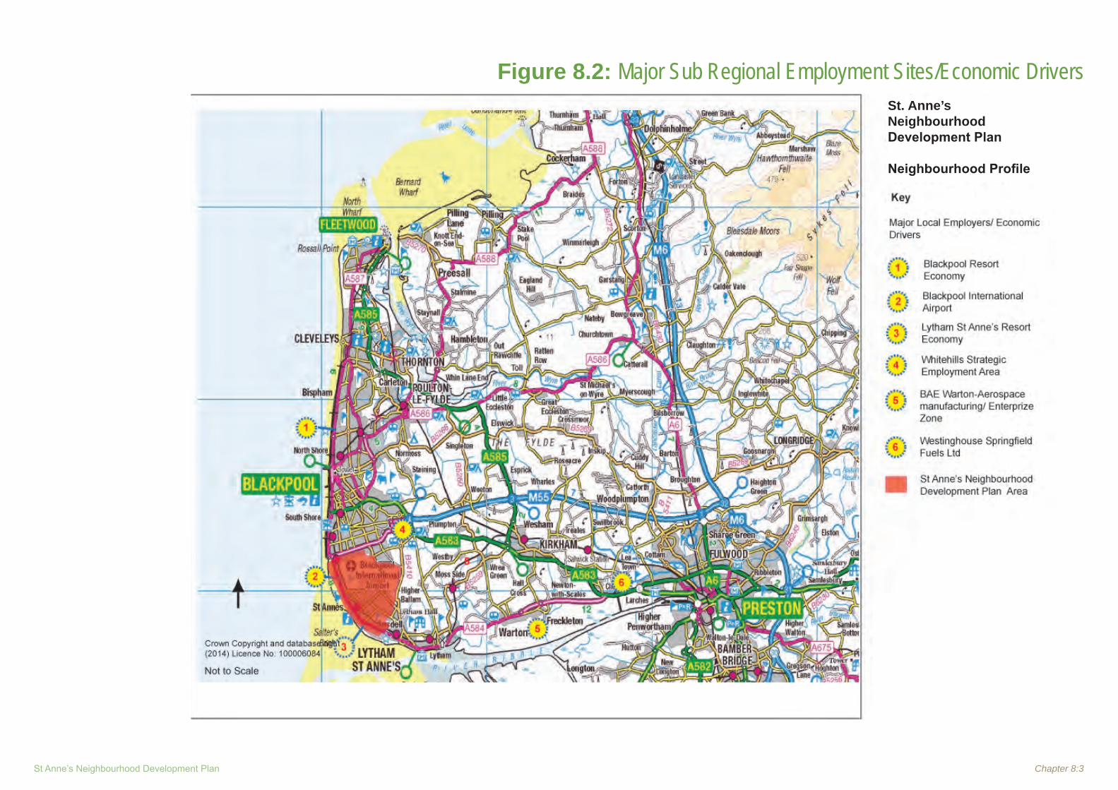
St Anne’s Neighbourhood Development Plan Chapter 8:3
Figure 8.2: Major Sub Regional Employment Sites/Economic Drivers St. Anne’s Neighbourhood Development Plan
Neighbourhood Profile

Chapter 8:4 Neighbourhood Profile ~ February 2015
8.4 Evidence Documents
8.4.1 There is a wide range of economic strategies and action plans available affecting the Fylde coastal area and with some impact on the NDP area. A brief summary of each is included below.
8.4.2 In general the strategies recognise the importance of major employers in the local area such as BAE Systems and Westinghouse and Fylde’s strategic importance in linking the conurbations of Blackpool and Preston. Fylde provides a key role in supporting the economic development of Blackpool, through ongoing development at major employment sites such as Whitehills Park and Blackpool International Airport. Whitehills Park and (land around) Blackpool Airport are the main sub-regionally/regionally significant employment areas within the Borough. Other office and industrial sites cater primarily for the needs of local firms. Both St. Anne’s and Lytham (along with land off the M55, close to the Blackpool boundary) are a focus for development in Fylde Borough.
8.4.3 22 existing business and industrial areas are identified in the Local Plan and these are focused in St. Anne’s, Lytham and Kirkham but there are also a number of edge of settlement and rural employment areas, many in use by single large employers.
Draft Fylde Coastal Masterplan – Fylde BC (2014)
8.4.4 The purpose of the plan is to collate and coordinate all current strategies and policy objectives for coastal protection, water quality, nature conservation, habitat improvement and landscape enhancement, conservation of the built and natural heritage, culture, leisure sport and recreation, tourism and the visitor
economy, access and transportation and develop high level actions to address the major issues affecting the Fylde Coast.
8.4.5 The coast is split into 6 zones, Zone 2 cover St Anne’s. Following a review of the Coastal resorts of the NW in 2003 a number were identified as ‘regional gems’, and worthy of the accolade of the ‘Classic Resort’, and these included St. Anne’s and Lytham. The Classic Resort prototype was due to be trialled in St. Anne’s through funding from the former North West Development Agency (NWDA) but the Agency was wound up in 2012. The Lytham St. Anne’s 2020 Vision document contains a methodology as to how the concept could be taken forward, which would be a unique way of devising a Quality Accreditation scheme for a resort. This idea is considered to be worthy of developing along with the local business community to result in a ‘Classic Charter’ which sets out how this quality offer would be developed and implemented. It is considered that there could be significant marketing potential attracted by this idea and ultimately significant economic benefits.
8.4.6 With regard to tourism and the visitor economy the masterplan identifies the key issues of protection of the coastal gem; maintaining a vibrant retail sector; promoting the Green tourism offer; restoration of history and heritage assets; offering something different to Blackpool but similar to Wyre; and poor rail transport links.
8.4.7 Leisure, culture and tourism make up an important industry in Fylde, accounting for 1 in 10 jobs. The Borough attracts over 3m visitors each year, generating nearly £220m spending in the local economy through a total of 4.25m tourist days. More than 75% of these visitors are day-trippers to the traditional seaside
resorts of St. Anne’s and Lytham, the attractive market town of Kirkham and the picturesque villages.
8.4.8 The Local Plan is designed to enable appropriate development and flexibility for leisure, culture and tourism operators so that they can invest in or respond to changes in visitor and leisure preferences, whilst protecting the primary holiday areas and seafront locations in order to maintain the character and appearance of this predominantly tourist area. Fylde offers a more traditional, low key tourist offer than its neighbouring resort of Blackpool. Whilst its offer is different from Blackpool, there are obvious mutual benefits for the wider Fylde coast through the greater range of destination types and experiences on offer.
8.4.9 St. Anne’s as a traditional seaside town is perfect for young families and discerning visitors who want a more serene break than offered by its neighbour Blackpool.
8.4.10 There is potential to build upon the rural tourism economy and develop greater links with other areas. There are aspirations to develop the Ribble Coast and Wetlands area into a Regional Park and, of particular importance to Fylde, to develop the Coastal Parkway. The Coastal Parkway will develop new opportunities for local people, visitors and businesses to benefit from the area. The Lytham and St. Anne’s 2020 Vision and St. Anne’s Seafront Master Plan set out the Council’s leisure, culture and tourism proposals for Lytham and St. Anne’s, including the Classic Resort concept. The Coastal Parkway Masterplan is also emerging for the coastal strip from Starr Gate to Freckleton Marshes.

St Anne’s Neighbourhood Development Plan Chapter 8:5
8.4.11 The key actions are: to maintain a vibrant, diverse visitor economy; and to work in partnership with Visit Lancashire.
8.4.12 In terms of implementation for St. Anne’s Town Centre the document sets out the key projects. It recognises that it has been the subject of a significant regeneration programme over the last 15 years and this will continue until complete. The area incorporates the principal holiday accommodation allocation based around The Promenade and Clifton Drive. The objectives for the area include:
Completion of the public realm regeneration • programme for the town centre of St. Anne’s through the preparation and implementation of a resort master plan; Development of the Classic Resort concept • for the resort area and an implementation programme through the formation of a partnership; Seek to restore the Grade II listed • Promenade Gardens; Re-evaluate the Development Brief for the • Island Site and consider proposals for the further development of the site with the appropriate form of development; Restore and rejuvenate the Grade II listed St. • Anne’s Piers; Develop the Leisure and Recreational • Facilities; Continue to develop the management plan • for Ashton Gardens.
8.4.13 Retail Study – 2013 Update (Peter Brett Associates)
Fylde currently has a requirement for an additional 3,369 sq.m of comparison goods sales area floorspace in the period to 2030. This leads to negative requirements for new sales floorspace in the period up to 2021 and modest requirements thereafter in the period to 2030. The figures calculated by our assessment should be treated as a guide and, given the inherent uncertainty over longer term forecasts, we would advise the Borough Council to allow for a reasonable amount of flexibility. This should also allow the Council to take account of any physical and environmental constraints within individual centres. We therefore present our recommended floorspace allowance figures as a range and suggest that the Council should make provision for additional comparison goods sales floorspace over the 2013 to 2030 period as follows:
1,000 to 1,500 sq.m in the town centres of St Annes and Lytham;
500 to 1,000 sq.m in Kirkham Town Centre; and
250 to 500 sq.m for provision across the
Borough’s district and local centres (this is a global figure and not an allowance for each individual centre).
St Anne’s: A well maintained and vibrant centre with a strong convenience retail base. At the time of the 2011 study there was an undetermined planning application for a new foodstore at an out-of-centre location at Heyhouses Lane. Permission has now been granted for this scheme and we understand that this is to be occupied by
Booths following the closure of its store in St Annes Town Centre. There may therefore be a future qualitative requirement for additional convenience goods floorspace within St Annes Town Centre to support its vitality and viability.
In terms of comparison goods, St Annes was considered to be slightly under-represented in the clothing and footwear sub-category and contained a high proportion of charity shops. The vacancy rate in the town centre fell below the national average but some vacant units occupied prominent locations and it was recommended that these were modernised to promote a more diverse mix of retailers in the centre. Our updated assessment indicates that St Annes should provide between 1,000 and 1,500 sq. m of additional comparison goods sales floorspace over the period to 2030. This would allow for the development of a number of good-sized new units to meet the requirements of comparison retailers.
Business and Industrial Land Schedule – Fylde BC (updated March 2013)
8.4.14 This updates the 2012 ELR and covers recent permissions, land lost to other uses, land allocated and completed projects. Notably for the St. Anne’s area these include the following key sites:
With planning permission/under construction: Queensway Industrial Estate (off Snowden
Road) – policies EMP 1 and EMP 2 (existing and allocated employment areas)
Site 10: 2.9has residual land for expansion, has planning permission but has expired;
Site 10a: 0.9has. Application for new office development;

Chapter 8:6 Neighbourhood Profile ~ February 2015
Site 13: 0.09has (JM services), proposed warehouse and workshop
Granted planning permission for other uses:
Site 32: EDS 7.28has, Heyhouses Lane – retail (Booths) and residential;
Non-designated sites:
Site 17: Town Hall 0.39has, extension and alterations;
Site 30: 300 Clifton Drive South, B1 use,
0.09has, change of use from non residential D1 to B1.
8.4.15 In summary terms the borough still has 19.6has of allocated/designated land but perhaps more striking is that since 2001 some 23.8has of employment land has been lost to other uses, with the recent EDS site (7.3has 2/3 for mixed use, 1/3 to remain in employment use) representing 30% of that total.
Employment Land and Premises Study – Fylde BC (2012)
8.4.16 This report assesses the demand, supply and need for employment land and premises (Use Class B) in Fylde and comprises five main elements: an assessment of the local economy; review of the current portfolio of employment land and premises; identification and appraisal of additional potential employment land which could be used to meet the Borough’s future land needs; assessment of the potential impact of major public and private sector development proposals, notably the Warton EZ; and recommendations on the future allocation of employment land and premises to maintain the Borough’s economic growth.
8.4.17 The Study covers all industrial, warehousing and distribution uses, as well as offices. For offices it recognises that the current trend is for smaller office suites as average business sizes fall. There are two strands to this: Micro-businesses (those with less than ten employees) want serviced offices or similar types of easy-in, easy-out schemes that lower their risk of exposure. Whilst small businesses (with 10-49 employees) are looking for offices in the region of 150-300m2, often they are satellite facilities for larger companies.
8.4.18 In terms of research and consultation the study includes site visits, interviews with stakeholders and a survey of 230 local businesses (of which 126 responded, 55%), Parish and Town Councils and key public sector agencies.
8.4.19 Some key findings: • Fylde is an affluent area with little evidence of deprivation. Skill levels are above wider area averages • and a comparatively high proportion of people work in professional occupations. Unemployment has increased over recent • years but the rate of increase has been far less than elsewhere in Lancashire and the North West. The manufacturing sector employs the • highest proportion of people in Fylde, with much of this accounted for by employment at BAE Systems, Warton and Toshiba Westinghouse’s nuclear fuel production facility at Salwick. The population of Fylde is relatively self-• contained. In 2001, 66% of the population both lived and • worked in the Borough.
There is a strong pattern of in-commuting, • with inflow to Fylde exceeding outflow in the case of every Lancashire local authority area.
Warton Enterprise Zone
8.4.20 Around 75ha of the BAE Systems site at Warton is now an Enterprise Zone, along with its sister facility at Samlesbury. The Enterprise Zone proposal is to develop around 15,000 sqm of new B1 and B2 premises at Warton by 2015 (creating 500 new jobs). This accommodation will be directed at attracting advanced manufacturing (and related) inward investment into Fylde. Development phasing beyond 2015 has yet to be determined, pending the completion of the Enterprise Zone Masterplan.
8.4.21 Private sector commercial property agents report that there is a lack of good quality industrial options in the Borough. Requirements are for smaller units of 500m2
or less. Office demand is predominantly local and for small, good quality modern suites. Whitehills Park is the most popular business location although there may also be demand for small offices in Kirkham and Lytham.
8.4.22 Properties enquiries, received via Blackpool Council’s Blackpool Unlimited website (outside of the NDP area but used as a source of information by the study) , are dominated by the industrial sector. Companies want office and industrial units of 0-464m2; and sites of 4ha or more. The majority of enquiries come from companies already based in the Fylde Coast sub-region. The company survey has identified modest demand from local businesses for industrial premises of 0-1000m2 and offices of 0-500m2, primarily in Lytham and St Anne’s. There are ample

St Anne’s Neighbourhood Development Plan Chapter 8:7
vacant premises in the Borough to meet these requirements. The only possible shortage is for larger (+1,000m2) office units.
8.4.23 Fylde is bordered by the two other Fylde
Coast local authority areas, as well as the City of Preston. At present, the greatest impact comes from Blackpool, which has a shortage of employment land and lacks the available space to provide new employment allocations within its boundaries. Blackpool will have to look to its neighbours to meet the shortfalls. In Fylde, Whitehills Park could meet some of this need.
8.4.24 At 31st March 2012 there was a headline supply of 22.32ha of available employment land, made up of 24 sites. Almost half this land is at Whitehills Park or Blackpool and Fylde Industrial Estate, with six of the sites at Whitehills Park in bank ownership after being repossessed from a local developer. An additional 26.28ha is required based on past take-up rates. The other four forecast models suggest the Borough has a significant oversupply of employment land. This would mean that much of the current land supply is surplus to requirements and could be used for other activities. However these methods take no account of pent-up demand, failures in the property market or land supply constraints in neighbouring Blackpool. They are frequently contradicted by empirical evidence generated by this study, i.e. consultations with property specialists.
8.4.25 The key recommendations are: The Borough Council should protect existing • employment sites that are not the subject of consents for alternative uses;
The Council should allocate a further 26-• 33has of employment land for the period 2012-2030 - this additional provision does not include demand that might be generated by the increasingly constrained development position in Blackpool. However, Fylde’s role as an economic and employment centre serving a wider Fylde Coast area needs to be recognised;The Council should work with Blackpool • and Wyre Councils, who are yet to complete updated Employment Land Reviews, to ensure, as directed by the NPPF, that there is a robust employment land evidence base for the Fylde Coast sub-region;The land supply should meet the needs of all • the established settlements of Fylde and this includes the provision of freehold land and premises. Areas of search for new supply should initially concentrate upon the west of the Borough (capitalising on Junction 4, M55 and Blackpool Airport) and around Kirkham; There is a need to provide locations for new • office sector activity, particularly in the urban areas of Lytham and St Anne’s; Continue to encourage rural diversification by • allowing the conversion of agricultural space for employment uses. This may require public sector support; Homeworking is an important local • employment sector and effective broadband infrastructure is vital and both Lancashire CC and Fylde BC must ensure that Fylde is appropriately served in this respect; Review and monitor this position and • undertake the study again in five years, 2030 is a long time into the future, and much will happen before then.
Lancashire Economic Assessment: Lancashire CC (2011)
8.4.26 This is no longer a statutory document, but the LEA provides an overview of Lancashire’s local economy and plays a role in informing the development of economic strategies and interventions in order to support sustainable economic growth in Lancashire.
8.4.27 It reports that Lancashire has not benefited from the shift towards office base service sector employment. There is a lack of office space in the County and therefore a need to increase the number of office developments in locations where there is demand, in order to capture a greater share of service sector employment in the future.
8.4.28 There remains a large amount of industrial space, some of which has become redundant due to the long term decline of manufacturing employment. There is a need to reutilise redundant space and provide appropriate premises to enable existing businesses to diversify and develop higher value activities, as well as to attract higher value companies to the area.
8.4.29 The Assessment highlights the lack of suitable employment sites in strategic locations which has limited economic growth and hindered inward investment. Many existing employment sites have been developed on an ad-hoc basis, rather than through strategic or economic considerations and as a result are not sufficient for higher value uses. Warton is identified as a key strategic site, critical to diversifying the economic base and creating more jobs.

Chapter 8:8 Neighbourhood Profile ~ February 2015
Fylde Regeneration Framework – Fylde BC (2010)
8.4.30 Draws together the various regeneration projects and proposals and is a regeneration vision for the Borough presenting the known schemes whilst at the same time allowing individuals, community groups or town and parish councils to propose new schemes for consideration.
8.4.31 For St. Anne’s it covers the eight year programme of physical regeneration of the public realm (including the building fabric) of the town centre. Significant public sector support has been engaged up to 2010 (£5.6m), however, much of the original masterplan remains to be implemented. Since its inception in late 1999 the project has sought to improve the economic circumstance of the town centre through improvements to the public realm. It links to the Resort Action Plan (2001); the St. Anne’s Seafront Masterplan (2008); and the Lytham St. Anne’s 2020 Vision (Draft) (2010).
Fylde Sub-Region Employment Land Review: Summary Statement – Blackpool Council, Fylde BC and Wyre BC (2010)
8.4.32 This document highlights 7 key sites that should be the focus of future employment development, three in Fylde (Whitehills Park, BAE Systems at Warton, and Dock Road, Lytham and one in Fylde/Blackpool, the Airport Business Area.
8.4.33 The review states that new employment allocation in the sub-region is likely to focus on Fylde, and as a result of this Blackpool will have increased dependence on Fylde.
Lancashire Economic Strategy Framework of Priorities: Lancashire CC (2010)
8.4.34 This is an overarching framework to direct LCC’s approach to economic development over future years it is structured around five strategic priorities which are deemed critical to Lancashire’s future economic success; Economic Growth, Knowledge and Innovation; Spatial; Skills and Employment; Infrastructure; and Partner Development.
8.4.35 Under economic growth, knowledge and innovation, there is a recognition of a shortage of new business accommodation and the need to improve the visitor economy offer.
8.4.36 In order to improve the prospects of Lancashire it identifies a number of specific steps that LCC needs to take to ensure the priorities are achieved including ensuring that planning departments work more effectively with businesses, making sure strategic policy supports the achievement of priorities, and taking a more active role in strategic land assembly and the development of investment vehicles.
Lytham St. Anne’s 2020 Vision – Fylde BC (2009)
8.4.37 Sets out a short and medium term vision for the development of the economy of Lytham St. Anne’s as an important constituent element of the Borough of Fylde and the wider region. It includes an overview as to how the coastal towns will engage with the development of the Fylde Coast, particularly in the context of the Visitor Economy and help achieve ambitious targets for visitor growth set out by the sub regional Tourist Board. It sets out some of the key strategic issues. It is prompted
by the signing of the Fylde Coast MAA, the conclusion to the Visitor Economy Pilot studies for the Northwest, the emergence of the Ribble Coast and Wetlands Regional Park and the economic opportunities presented by the hosting of the 2012 Open Golf Championship.
8.4.38 It looks at more detailed projects, particularly public realm improvements in St. Anne’s in line with the ‘Classic Resort’ ambition, a term introduced by NWDA who are on longer in existence.
8.4.39 The document provides a useful backdrop to the physical improvement both proposed and achieved up to 2009 when funding was available.
Fylde Coast Visitor Accommodation Study (2009)
8.4.40 This is a joint study covering the three Fylde Coast authorities. It is a detailed analysis of to provide an evidence base to underpin future planning policy relating to the provision of visitor accommodation on the Fylde Coast. It looks into the quality, quantity and location of visitor accommodation within the Fylde Coast sub-region compared to current demand levels, as well as an appraisal of the future need for visitor accommodation under a number of different scenarios: 1 A marginal increase in staying visitor numbers; 2 A slight decrease in staying visitor numbers; 3 A significant decrease in staying visitor numbers. The report demonstrates that there are more than twice as many serviced and non-serviced bed spaces in Blackpool, Fylde and Wyre as any comparable resort area in the UK, however, based on demand there is an oversupply, particularly in Blackpool, much of which in unaccredited.

St Anne’s Neighbourhood Development Plan Chapter 8:9
8.4.41 Fylde attracts in excess of 3m visitors per year, generating £213M in spending in the local economy. More than three-quarters of these visitors were day-trippers. Nevertheless, the 670,000 staying visitors to the resort generate more than 1.9m visitor nights – broadly in line with regional averages. There was an increase post the 2012 Golf Open. The majority of identified accommodation is in St Anne’s.
8.4.42 The document is useful for information but does not provide any major policy recommendations or proposals.
St. Anne’s Seafront Masterplan – Fylde BC (2008)
8.4.43 Sets out to begin the process of reversing the decline of the study area; to analyse the existing character of the area; to identify constraints and opportunities; and to propose a range of possible solutions, which will form the basis of a new future for St. Anne’s seafront.
Fylde Economic Development Strategy and Action Plan 2008-2021 – Fylde BC (2006)
8.4.44 This strategy outlines a number of economic challenges facing the Borough and includes: a skills gap at the lower end of the occupation scale resulting in a reliance on economic migrants to fill low skill/salary and seasonal employment opportunities; out-migration of the more skilled workforce; a lack of modern office and industrial premises, with most dating from the 1970’s and 1980’s; a number of employment sites have been lost to residential development in recent years; employment land supply is constrained, with no margin for expansion and additional suitable land is therefore needed to meet future demand; poor north-south connectivity and the South Fylde railway line is underutilised.
8.4.45 It also highlights a number of opportunities such as: a skilled and mobile workforce; the regeneration of Blackpool is likely to create employment and increase visitor spend in Fylde’s economy. Fylde has the opportunity to provide a complementary tourism offer focusing on high-value tourism and the image of settlements such as Lytham and St. Anne’s as traditional Victorian resorts; development of Blackpool Airport is both strategically and locally important, offering the opportunity to diversify the economy and provide a catalyst to development; development of the M55 to Heyhouses Link Road will enhance access to Whitehills Park employment site, and improve linkages overall.
8.4.46 The Strategy states that the three drivers of The Fylde Coast’s economy (which includes Blackpool and the Wyre) are: Blackpool Regeneration; Blackpool Airport and St. Anne’s Classic Resort.
8.4.47 Regeneration in Blackpool will act as a catalyst for wider regeneration across the Fylde Coast. Investment at Blackpool Airport will enhance its economic contribution and employment potential. Future investment at St. Anne’s is expected to provide further opportunity for businesses to establish and successfully operate.
8.4.53 The Strategy states that it is important to retain marketable, economically viable employment land. Where sites are no longer economically viable, employment use should be incorporated into mixed-use development, to retain the economic viability of Fylde overall.
8.5 Planning Policy Context - Economy
What the NPPF says 8.5.1 Paragraph 17 lists as one of 12 core planning
principles that planning should proactively drive and support sustainable economic development to deliver the homes, business and industrial units, infrastructure and thriving local places that the country needs. Every effort should be made objectively to identify and then meet the housing, business and other development needs of an area, and respond positively to wider opportunities for growth. Plans should take account of market signals, such as land prices and housing affordability, and set out a clear strategy for allocating sufficient land which is suitable for development in their area, taking account of the needs of the residential and business communities. It further advises that planning should encourage the effective use of land by reusing land that has been previously developed (brownfield land), provided that it is not of high environmental value.
8.5.2 Paragraph 18 says that the Government is committed to securing economic growth in order to create jobs and prosperity, building on the country’s inherent strengths, and to meeting the twin challenges of global competition and of a low carbon future.
8.5.3 Paragraph19 says that the Government is committed to ensuring that the planning system does everything it can to support sustainable economic growth. Planning should operate to encourage and not act as an impediment to sustainable growth. Therefore significant weight should be placed on the need to support economic growth through the planning system.

Chapter 8:10 Neighbourhood Profile ~ February 2015
8.5.4 Paragraph 20 says that to help achieve economic growth, local planning authorities should plan proactively to meet the development needs of business and support an economy fit for the 21st Century. Planning policies should recognise and seek to address potential barriers to investment, including a poor environment or any lack of infrastructure, services or housing. In drawing up Local Plans, local planning authorities should:
set out a clear economic vision and strategy • for their area which positively and proactively encourages sustainable economic growth; set criteria, or identify strategic sites, for local • and inward investment to match the strategy and to meet anticipated needs over the plan period; support existing business sectors, taking • account of whether they are expanding or contracting and, where possible, identify and plan for new or emerging sectors likely to locate in their area. Policies should be flexible enough to accommodate needs not anticipated in the plan and to allow a rapid response to changes in economic circumstances; plan positively for the location, promotion • and expansion of clusters or networks of knowledge driven, creative or high technology industries; identify priority areas for economic • regeneration, infrastructure provision and environmental enhancement; and facilitate flexible working practices such as • the integration of residential and commercial uses within the same unit.
8.5.5 Paragraph 21 says Investment in business should not be over-burdened by the combined requirements of planning policy expectations. Planning policies should recognise and seek to address potential barriers to investment, including a poor environment or any lack of infrastructure, services or housing. In drawing up Local Plans, local planning authorities should:
set out a clear economic vision and • strategy for their area which positively and proactively encourages sustainable economic growth; set criteria, or identify strategic sites, for local and inward investment to match the strategy and to meet anticipated needs over the plan period; support existing business sectors, taking • account of whether they are expanding or contracting and, where possible, identify and plan for new or emerging sectors likely to locate in their area. Policies should be flexible enough to accommodate needs not anticipated in the plan and to allow a rapid response to changes in economic circumstances; plan positively for the location, promotion • and expansion of clusters or networks of knowledge driven, creative or high technology industries; identify priority areas for economic • regeneration, infrastructure provision and environmental enhancement; and facilitate flexible working practices such as • the integration of residential and commercial uses within the same unit.
8.5.6 Paragraph 22 advises that planning policies should avoid the long term protection of sites allocated for employment use where there is no reasonable prospect of a site being used for that purpose. Land allocations should be regularly reviewed. Where there is no reasonable prospect of a site being used for the allocated employment use, applications for alternative uses of land or buildings should be treated on their merits having regard to market signals and the relative need for different land uses to support sustainable local communities.
8.5.7 Paragraph 23 says that planning policies should be positive, promote competitive town centre environments and set out policies for the management and growth of centres over the plan period. In drawing up Local Plans, local planning authorities should:
recognise town centres as the heart of their • communities and pursue policies to support their viability and vitality; define a network and hierarchy of centres • that is resilient to anticipated future economic changes; define the extent of town centres and primary • shopping areas, based on a clear definition of primary and secondary frontages in designated centres, and set policies that make clear which uses will be permitted in such locations; promote competitive town centres that • provide customer choice and a diverse retail offer and which reflect the individuality of town centres; retain and enhance existing markets and, • where appropriate, re-introduce or create new ones, ensuring that markets remain attractive and competitive;
St Anne’s Neighbourhood Development Plan Chapter 8:11
allocate a range of suitable sites to meet the • scale and type of retail, leisure, commercial, office, tourism, cultural, community and residential development needed in town centres. It is important that needs for retail, leisure, office and other main town centre uses are met in full and are not compromised by limited site availability. Local planning authorities should therefore undertake an assessment of the need to expand town centres to ensure a sufficient supply of suitable sites; allocate appropriate edge of centre sites • for main town centre uses that are well connected to the town centre where suitable and viable town centre sites are not available. If sufficient edge of centre sites cannot be identified, set policies for meeting the identified needs in other accessible locations that are well connected to the town centre; set policies for the consideration of proposals • for main town centre uses which cannot be accommodated in or adjacent to town centres; recognise that residential development can • play an important role in ensuring the vitality of centres and set out policies to encourage residential development on appropriate sites; and where town centres are in decline, local • planning authorities should plan positively for their future to encourage economic activity.
8.5.8 Paragraphs 24 to 27 advise on the need to apply a sequential test to planning applications for main town centre uses that are not in an existing centre and are not in accordance with an up-to-date Local Plan. They further advise that when assessing applications for retail, leisure and office development outside
of town centres, which are not in accordance with an up-to-date Local Plan, local planning authorities should require an impact assessment if the development is over a proportionate, locally set floorspace threshold (if there is no locally set threshold, the default threshold is 2,500 sq m).
8.5.9 Paragraph 28 advises that planning policies should support economic growth in rural areas in order to create jobs and prosperity by taking a positive approach to sustainable new development.
Fylde Local Plan
8.5.10 The Fylde Local Plan (As Altered) (2005) states that economic growth and development, the production of goods and services and the creation of jobs are all vital to the well being of the local community. The importance of the local economy is recognised at all levels of Government and it has been policy for many years to facilitate economic growth in ways that do not prejudice environmental objectives.
8.5.11 Policy SP1 sets out an urban concentration strategy, identifying Lytham St. Anne’s as a ‘first tier settlement where a large proportion of development in the Borough will be concentrated.
8.5.12 Policy EMP1 allocates land for business and industrial development, including land at Blackpool Fylde Industrial Estate, Whitehills Park (phase 2) and Queensway, St. Anne’s.
8.5.13 Policy EMP2 seeks to retain defined business and industrial areas for business and industrial use.
8.5.14 Policy EMP3 sets out the criteria to be used for consideing planning applications for business and industrial development outside the defined business and industrial areas.
8.5.15 Policy EMP4 states that business and industrial development will only be permitted subject to the provision of landscaped buffer zones on the relevant boundaries where the site abuts residential development, open countryside or other sensitive land uses. Business and industrial development will not be permitted within a minimum distance of 30 metres from an existing dwelling or other sensitive land-use. Conversely new dwellings will not be permitted within a minimum distance of 30 metres from a business or industrial building. A greater separation distance will be required where class b2 land uses are involved.
8.5.16 Policy EMP5 says that in relation to development proposals for new hazardous installations or for new developments in the vicinity of existing notifiable installations, the health and safety executive will be consulted to determine the likely level of risk involved and to obtain its advice on that risk. New development which would unnecessarily increase the numbers of persons at risk from hazardous installations, will not be permitted.
8.5.17 Policy SH3 seeks to protect the primary shopping frontages at St. Anne’s, as defined on the proposals map, by restricting non-Class A1 (retail shop) uses.
8.5.18 Policy SH4 seeks to restrict the secondary shopping frontages at St. Anne’s, as defined on the proposals map to town centre uses, including Class A1 (shops) Class A2 (financial and professional services) and Class A3 (food and drink).
Chapter 8:12 Neighbourhood Profile ~ February 2015
8.5.19 Policy SH5 sets out the criteria for use of upper floors and basements in the primary and secondary frontages in St. Anne’s.
8.5.20 Policy SH6 says that within that part of Wood Street identified on the proposals map, redevelopment or changes of use to restaurants, cafes and public houses, or extensions to such existing uses will be permitted, subject to any external works being in keeping with the character and amenities of the town centre.
8.5.21 Policy SH10 says that within the local shopping centres and villages, the development of small-scale shopping and other local facilities which would improve the diversity and vitality of the local centre will be permitted.
8.5.22 Policy SH12 seeks to restrict non-retail uses in local shopping centres and villages.
8.5.23 Policy SH13 applies a sequential approach to large new retail development to restrict out of town and edge of centre development, unless specified criteria are met. It also seeks to limit large new retail development in business and industrial areas.
8.5.24 Policy SH14 says that In addition to meeting the requirements of Policy SH13, large new retail developments will be required to meet all the following criteria:-1. There is no significant adverse impact on
the character or visual amenities of the area;
2. The development will not be detrimental to the amenities of adjacent or nearby residents;
3. The location is served by a satisfactory existing level of public transport, or, as a result of investment by the developer, is brought to a satisfactory level of service, before the development is first occupied;
4. The local road network is able to accommodate predicted traffic levels;
5. The site has good access for vehicles, pedestrians and cyclists;
6. The development can be demonstrated to have no adverse effect on overall travel patterns and will not lead to increased dependence on, and use of the motor car.
8.5.25 Policy SH15 says that small-scale retail uses in locations outside existing retail centres will not be permitted unless the proposed use has special locational requirements
8.5.26 Policy SH16 permits the development of restaurants, café’s and hot food shops within town centres, local centres and village centres providing that specified criteria can be met.
The Emerging Local Plan
8.5.27 In common with many local authority areas, Fylde has witnessed a reduction in housing completion rates and rising house prices. Even with falling house prices, housing prices remain significantly high in relation to incomes. There are widening disparities between the areas with the highest house prices, such as Lytham, and parts of St. Anne’s which contain homes in multiple occupation and are in the bottom ten percent nationally in relation to the Indices of Multiple Deprivation. Fylde does not have a history of industrialisation and there is, therefore, a lack of brownfield land, resulting in a requirement to develop some greenfield sites for housing and employment.
8.5.28 The Fylde Local Plan to 2030 Part 1- Preferred Options paper sets out the following policies relating to Housing.
8.5.29 Strategic Objective 4 is: to diversify and grow the local economy by:1. Diversifying the Borough’s economic base
in order to reduce reliance on a small number of large employers.
2. Making provision for high quality and readily available sites in sustainable locations that will facilitate the growth of existing local firms and be attractive to new inward investment, including high technology uses.
3. Recognising the importance of the Enterprise Zone as a means of achieving economic growth and diversifying and protecting existing employment land and premises, where appropriate.
4. Enhancing town centres through the promotion of mixed uses and focussing on development that attracts a large number of people.
5. Developing a distinctive image of the Borough as a business location, based on existing assets such as BAE Systems, Whitehills and Blackpool International Airport, and developing a vibrant cultural and creative community that will drive economic growth, attract inward investment, develop skills and innovation, create and sustain jobs and support regeneration.
6. Developing a widely recognised image of the Borough as a quality regional tourism destination, based on existing assets such as the high quality hotels and the open coastline (including the emerging Regional Park and the championship golf courses). Maximising the potential of the Visitor Economy.

St Anne’s Neighbourhood Development Plan Chapter 8:13
7. Promoting the classic resort image/initiative for St Anne’s.
8. Promoting the continuing improvement of the vitality and viability of the town centres.
9. Supporting and protecting agricultural and farming operations as a key element
of the local economy.
8.5.30 Policy SL2 details strategic locations for development in the ‘Blackpool Periphery’, including employment development at Blackpool Airport.
8.5.31 Policy EC1 - Overall Provision of Employment Land: allocates land for employment development at Blackpool Airport and seeks to protect existing (identified) employment sites unless it is demonstrated that there is no reasonable prospect of the site being used for employment purposes. No other employment allocations are proposed within the NDP area.
8.5.32 Policy EC2 - Managing Development of Employment Land: sets out the criteria for assessing all development proposals for employment uses.
8.5.33 Policy EC3 - The Rural Economy: supports the sustainable growth and expansion of all types of business in the rural areas where this is in accordance with other policies in the Local Plan; seeks to retain continued employment use of existing employment sites; protects the best and most versatile agricultural land outside settlement boundaries; supports the roll out of high speed broadband in line with the Lancashire Broadband Plan; and encourages the promotion and enhancement of rural tourism through rural diversification to create small-scale, sensitively designed visitor attractions and accommodation.
8.5.34 Policy EC4 - Maintaining Vibrant Town and Local Centres: says that retail and other appropriate town centre development will be encouraged within the defined town centres. Proposals for such development in ‘edge of centre’ or ‘out-of-centre’ locations will be considered in line with the National Planning Policy Framework.
8.5.35 The Council will produce Town Centre
Management Plans which will address the function and accessibility of each town centre, including appropriate public realm schemes. Within the district and local centres, retail and other appropriate town centre uses will be supported where they are appropriate to the scale, role and function of the centre.
8.5.36 Within the primary shopping frontages defined in the adopted FBLP, proposals for the change of use from retail (Class A1 of the Use Classes Order) to other uses will be required to meet the following criteria:a) The proposal retains a pedestrian-level
shop front with windows and display; b) Any proposed non-A1 use at pedestrian
level should, wherever possible, have operational hours that include at least a part of traditional opening times (9am – 5pm). Uses that involve operational hours in the evening or night should not create inappropriate disturbance to residents or other users of the centre and surrounding areas;
c) Within the primary and secondary shopping frontages policies SH1, SH2, SH3, SH4, SH5, SH7 and SH8 apply until such time as they are replaced by the Local Plan Part 2: Site Allocations to 2030.
d) Within that part of Wood Street, St. Anne’s, identified as food and drink establishments, FBLP Policy SH6 will apply. It shall apply until such time as it is replaced by the Local Plan Part 2: Site Allocations to 2030.
8.5.37 Policy EC5 - Leisure, Culture and Tourism Development says that the Council will plan for leisure, culture and tourism by: a) Promoting St. Anne’s as a ‘classic resort’.b) Supporting physical regeneration of
Lytham and St. Anne’s seafront area to maintain the hotel market and support wider tourism and the local economy.
c) Promoting improvement and enhancement of the man made coastal defences at Pleasure Island, Fairhaven Lake and Church Scar in order to encourage tourism and help maintain flood defences
d) Encouraging daytime and evening business, leisure, cultural and heritage based tourism facilities, such as hotels, restaurants, cinemas, theatres, museums, swimming pools and leisure centres within the town centres.
e) Protecting existing tourism, cultural and leisure assets, such as golf courses and the seaside resort facilities, with a view to helping them to adapt to new challenges.f) Promoting public art and public realm works within settlements and seeking developer contribution funding where appropriate.
g) Promoting beach leisure, activities and events.

Chapter 8:14 Neighbourhood Profile ~ February 2015
8.5.38 Policy EC6 - Leisure, Culture and Tourism Accommodation: says that serviced tourism accommodation (hotels) will be permitted in the primary holiday areas in St. Anne’s, as defined on the inset map. Non serviced tourism accommodation uses in these areas will be resisted. Leisure and tourism development will be encouraged in the North Promenade and South Promenade Sea Front area of St. Anne’s and at Fairhaven Lake Sea Front area of Ansdell/Fairhaven, as defined on the inset map. Non leisure, culture and tourism uses will be resisted in these areas. A limited increase in static and touring caravan and camping pitches will be permitted in order to enable environmental improvements. Holiday caravan pitches should remain in their original use.
8.6 Key Issues
Ref Key Issues Comments / Possible Options
1 Office Accommodation
1.1Addressing the increasing lack of good quality office accommodation in the St. Anne’s area
Inenco moved to Lytham – future • of building Offices above shops at 1st/2nd floor space not being let •Lack of car park at town centre offices •Physical access to offices above shops •Issue of Absentee Landlords •Internet influence •
1.2 Further protection is required to preserve the key office sites following the loss of the EDS site
Need to discuss with Fylde BC •Cost of land in town centre is much more expensive than land outside of town – Whitehills •development For the size of town, quite over developed office market •Consider redeveloping 1st/2nd floor sites above shops •
1.3 Provision of car parking at offices There is a requirement for adequate car parking to be provided at all business parks and business •premises
2 Links to Warton EZ
2.1 As the EZ develops how can the local St. Anne’s best benefit from the jobs created Potential for 2000 new jobs by 2030 •
3 Employment Land
3.1
Ensuring the provision of adequate of employment land required?Is there a requirement for additional employment land, if so, or what type of employment uses?
Fylde LL already identified larger sites in St. Annes •10 hectares at Blackpool Airport to become available for business space. • Should investigate the use of smaller sites (additional evidence required) •Set u • p dialogue with a land owners
St Anne’s Neighbourhood Development Plan
4 Development of Blackpool Airport
4.1 Is sufficient land available for the Airport to expand either operationally or with complementary development?
Airport physically no need to e • xpand – no more land needed, est. 1 million passengers per annum to 2030, growth has not been achieved Surplus Land – talks of removing the cross runway on Southern part of Airport •What is protected/what isn’t protected •Green belt between Blackpool + St. Anne’s is protected – sufficient land on edge of Green belt •within airport can be used by 2030 By 2030 St. Anne’s will be developed to the maximum •St. Anne’s or Fylde? If houses developed, is the infrastructure going to be built to deal with • demand and lessen pressure on St. Anne’s?
4.2 Should land at the Airport be released for non-Airport uses Neighbourh • ood Plan cannot conflict with Local Plan
4.3 Improving the quality of the environment at the Airport and its environs? Green belt land within Pontins site (nature reserve/allotments) •
5 Town Centre
5.1 Securing continued and new public realm and other town centre improvements
What • improvements can be made? Charity shops do increase footfall •
5.2 Should the town centre boundary be revised? FBC Local Plan to revisit as part of Local Plan •
5.3 Should the boundaries of the primary and secondary shopping areas be revised?
Nee • ds Revising: Primary: Retail •Secondary: Betting shops etc •
5.4Is there a need to ‘future proof’ the town centre in terms of flexibility in the use of vacant space e.g. secure uses in the upper floors above town centre shops/premises
This is already being undertaken by FBC •
5.5 Are there too many charity shops?6 Tourism Economy
6.1 Securing future beneficial use at the Island site
What plans are in the pipeline from FBC? •Possible overlap with Fylde BC •FBC main landlords of site •Fylde have a casino license •2008 market test of Hotel on site – failed •Provision for motor home parking points for overnight – tourism economy – removes parking off •road

Neighbourhood Profile ~ February 2015
6.2 Accreditation of hotel accommodationShould/can the Town Council pursue this? •An aspiration for the future i.e. Accreditation + Tourist Information provision •
6.3 Should the boundary of the primary holiday area be revised? Likely overlap with Fylde BC •
REFERENCES & DOCUMENTS REVIEWED
1. Draft Fylde Coastal Masterplan - Fylde BC (March 2014)2. Retail Study Update (2014)3. Business and Industrial Land Schedule – Fylde BC (updated March 2013)4. Employment Land and Premises Study – Fylde BC (2012) 5. Lancashire Economic Assessment: Lancashire CC (2011) 6. Fylde Regeneration Framework – Fylde BC (2010)7. Fylde Sub-Region Employment Land Review: Summary Statement – Blackpool Council, Fylde BC and Wyre BC (2010) 8. Lancashire Economic Strategy Framework of Priorities: Lancashire CC (2010)9. Lytham St. Anne’s 2020 vision – Fylde BC (2009)10. Fylde Coast Visitor Accommodation Study (2009)11. St. Anne’s Seafront Masterplan – Fylde BC (2008)12. Employment Land Strategy for Lancashire West (Draft Report): Lancashire Economic Partnership (2006)13. Fylde Economic Development Strategy and Action Plan 2008-2021 – Fylde BC (2006)14. The National Planning Policy Framework –DCLG-201215. Fylde Borough Local Plan, May 200316. Fylde Borough Local Plan Alterations Review, October200517. Fylde Local Plan to 2030: Part 1 - Preferred Options-July 201318. national planning Practice Guidelines-DCLG-2014

St Anne’s Neighbourhood Development Plan
Addendum: March 2015
Blackpool Airport Enterprize Zone
In March 2015 the Government designated part of the Blackpool Airport Site as an Enterprise Zone. At the time of inserting this addendum the implications for future uses on the site or possible simplified planning regime were not known and will be explored during consultation on the Pre Submission Plan

Neighbourhood Profile ~ February 2015

St Anne’s Neighbourhood Development Plan
Chapter 9
The Natural Environment

Neighbourhood Profile ~ February 2015

St Anne’s Neighbourhood Development Plan Chapter 9:1
9.1 Introduction
9.1.1 This chapters describes the natural assets, constraints and opportunities which need to be addressed by the Neighbourhood Plan.
9.2 Landscape and Topography
9.2.1 The study area is set on the Irish Sea Coast within a flat, low lying (less than 8M above sea level) landscape. The key landscape character areas as described in Landscape Strategy for Lancashire Landscape Character Assessment 2004 (Lancashire CC) are Coastal Dunes, Urban and Suburban Settlement, surrounded by the South Fylde Mossland as described below.
Local Landscape Character Assessment
9.2.2 The local landscape areas and types that are within the NDP area are set out in Table 9.1 below:
Table 9.1: Local Landscape Character Assessment
Local Character Area
Local Character Type
Description
16 Mosslands 16b South Fylde Mosses
Lytham Moss, on the eastern edges of Lytham St. Anne’s is influenced by the proximity of the urban areas. Pylons running from east to west across the landscape to Blackpool dominate the horizon, with trees providing a backdrop and sense of scale in the landscape. Lytham Hall is also an important, established landscape feature as the landscaped grounds contain many trees.
19 Coastal Dunes
19a Fylde Coast Dunes
The coastal dunes occur between the sea and either farmland or urban areas. They comprise small area of a once extensive system. The dunes are located in open and exposed sites.
Urban Industrial Age/ Suburban
No description
9.3 Agricultural Land Quality
9.3.1 The undeveloped Countryside along the eastern edge of the NDP Area is predominantly Grade 3, with some Grade 2 - and Grade 4 (source Magic Maps).
9.4 Habitats
9.4.1 Due to the developed nature of the Fylde Coast, much of the area has less natural habitat interest than elsewhere along the North West England coastline; however, areas immediately adjacent to the urban area of Lytham and St. Anne’s have significant habitat value.
9.4.2 In terms of conservation interest, the main designation is the Lytham St. Anne’s Dunes Site of Special Scientific Interest (SSSI) and those immediately adjacent to the study area, including the Ribble estuary Special Protection Area (SPA) and Ramsar site, and the Ribble Estuary SSSI (see Table 9.2 and Figure 9.1 overleaf).
9.0 The Natural Environment

Chapter 9:2 Neighbourhood Profile ~ February 2015
Local Non Statutory Designations
9.4.3 In addition to statutorily protected sites, six non-statutory sites of nature conservation interest have been identified through a partnership scheme initiated by Lancashire County Council, Lancashire Wildlife Trust and English Nature (see Table 9.3 below). These sites are set out and are termed Biological Heritage Sites and are identified in saved policies of the adopted Fylde Local Plan (Policy EP17).
Table 9.3: Biological Heritage Sites (Saved Policy EP17 of Adopted Fylde Local Plan) (see Figure 9.1)
Plan Ref
Name/ Location Comment
A Lytham Foreshore Dunes and Saltmarsh Coastal HabitatsFlowering Plants and FernsButterflies and MothsMosses and LiverwortsMolluscs
B St. Anne’s Old Links Golf Course and Blackpool South Railway Line
Coastal HabitatsFlowering Plants and Ferns
C Royal Lytham St. Anne’s, Golf Coastal Habitats, Flowering Plants and FernsD Clifton Hospital Site Coastal Habitats Flowering Plants and Ferns, Mosses
and Liverworts, MolluscsE King Edward VII and Queen Mary School
Playing Field MarginsCoastal Habitats
F Lytham Moss Copses, Lytham St Anne’s Birds
Table 9.1: Statutory Environmental Designations within and Adjoining St. Anne’s NDP Area
Plan Ref
Statutory Designation
Name Hectares Description
1 SSSI LYTHAM St. Anne’s DUNES
4.89 http://www.sssi.naturalengland.org.uk/special/sssi/unit_details.cfm?situnt_id=1011667
2 SSSI LYTHAM St. Anne’s DUNES
3.7 http://www.sssi.naturalengland.org.uk/special/sssi/unit_details.cfm?situnt_id=1011667
3 SSSI LYTHAM St. Anne’s DUNES
16.08 http://www.sssi.naturalengland.org.uk/special/sssi/unit_details.cfm?situnt_id=1011674
4 SSSI RIBBLE ESTUARY
13491.36 http://www.sssi.naturalengland.org.uk/special/sssi/unit_details.cfm?situnt_id=1011738
9.4.4 The aims of the Biological Heritage Sites Project are firstly to compile and maintain a definitive list of non-statutory sites which make a significant contribution to the bio-diversity of Lancashire and secondly to protect and conserve these sites through the planning system and by co-operation with site owners, occupiers and managers.
Local Nature Reserve
9.4.5 The Lytham St. Anne’s Dunes include the area of sand dunes at Starr Hills together with land
on its seaward side. The sand dunes at Starr Hills have been designated as a Local Nature Reserve since 1968.
9.4.6 The sand dunes of the Fylde coast may only
be a fragment of a once extensive dune system but they still provide a habitat for a wealth of wildlife. Over 280 different plant species have been recorded on the dunes from the mobile dunes on the coast to the fixed dunes of the Local Nature Reserve. This includes internationally rare plants such as the Isle of Man cabbage and the Dune Helleborine which only grow in Great Britain.
9.4.7 For further information see: www.ribblecoastandwetlands.com/att_lytham_NNR
Lancashire Biodiversity Action Plan
9.4.8 The UK Biodiversity Action Plan (BAP) describes the biological resources of the UK and provides detailed plans for conservation of these resources at national and devolved levels. Action plans for the most threatened species and habitats have been set out to aid recovery. Lancashire’s local BAP (LBAP) sets out the action plans key species for and habitats encountered in Lancashire.

St Anne’s Neighbourhood Development Plan Chapter 9:3
Figure 9.1: Environmental Contraints
St. Anne’s Neighbourhood Development Plan
Neighbourhood Profile

Chapter 9:4 Neighbourhood Profile ~ February 2015
9.5.2 The main areas under consideration in this document are the coastal habitats from Squire’s Gate in the north (at the northern limit of the Fylde Borough boundary), continuing southwards and eastwards around the coast to the western edge of Lytham Green; most of which is owned by Fylde Borough Council or Blackpool Borough Council.
9.5.3 Brief consideration is also given to the inland, and privately owned, sand dunes of the golf courses, Clifton Hospital and the King Edward & Queen Mary School.
9.5.4 The main aims for management of the Fylde Sand Dunes are to:
enhance the nature conservation interest of • the coastal habitats;improve the efficiency of the dunes and • saltmarsh as soft sea-defence (with associated cost savings in maintenance of hard sea-defences); and enhance public appreciation and enjoyment • of the dunes.
9.5.5 These aims will be addressed under the more specific operational objectives listed below:1. Enhance the nature conservation value of
the sand dune and other natural coastal habitats, including the shingle bed and accreting saltmarsh.
2. Increase the area of sand dune and saltmarsh habitats where appropriate, particularly by allowing conditions for natural seaward accretion.
3. Maintain and, where appropriate, enhance sea defences, with natural accretion of sand dune and saltmarsh forming the primary defence and repairs to hard defences only undertaken where current or potential soft defence is not adequate.
4. Promote knowledge, understanding and appreciation of the ecological value of the sand dunes and other natural coastal habitats, and of their key role in coastal flood defence.
5. Enable safe recreational use of the dunes and beach where this does not significantly compromise the nature conservation or flood-defence properties of the dunes and other natural coastal habitats.
Ten Year Action Plan
9.5.5 A ten year action plan is set out in the document.
9.6 Ribble Coast and Wetlands Regional Park
9.6.1 The Lytham St. Anne’s Nature Reserve forms the northern extent of the Ribble Coast and Wetlands Regional park (see www.ribblecoastandwetlands.com/home)
9.7 Air Quality
9.7.1 Local authorities in the UK have statutory duties for managing local air quality under Part IV of the Environment Act 1995 (HMSO, 1995). The Act required the preparation of a national Air Quality Strategy (AQS) which set air quality standards and objectives for specified pollutants. The Act also outlined measures to be taken by local planning authorities (LPAs) in relation to meeting these standards and objectives (the Local Air Quality Management (LAQM) system). If a local authority finds any places where the objectives are not likely to be achieved, it must declare the area an Air Quality Management Area (AQMA).
9.4.9 Lancashire County Council’s LBAP is developed and implemented by several organisations including Lancashire County Council and the Wildlife Trust. Identification of areas through the LBAP ensures sites receive appropriate management to deliver biodiversity objectives. The Lancashire LBAP habitats and species relevant to the study area are set out in Table 9.4 below
Table 9.4: LBAP habitats and species relevant to the study area (BARS, 2010).
Habitats Species
Habitat Species
Arable farm land Bats (order Chiroptera) Broad leaved and mixed woodland
Bird-eye primrose (Primula farinose)
Saltmarsh and estuarine rivers
Black-tailed godwit (Limosa limosa)
Sand dune Great crested newt (Triturus cristatus)
Golf courses Lapwing (Vanellus vanellus)
Rivers and streams
Skylark (Alauda arvensis) Twite (Carduelis flavirostris)
9.5 Fylde Sand Dunes Management Action Plan
9.5.1 The Fylde Sand Dunes Management Action Plan (2008) was commissioned by the Fylde Sand Dune Project Steering Group in order to evaluate the importance of the Fylde Sand Dunes and other natural coastal habitats and to suggest management proposals in order to maintain or enhance the key features. Funding for the project was provided by the Local Strategic Partnership (LSP).

St Anne’s Neighbourhood Development Plan Chapter 9:5
9.7.2 Fylde Borough Council has not declared any AQMAs.
9.8 Water Bathing Beaches
9.8.1 The objective of the Bathing Waters Directive (EU Bathing Water Directive (2006/7/EC) is to protect public health and the environment from faecal pollution in areas designated as bathing waters. Designated bathing waters require regular water quality monitoring, carried out by the Environment Agency, throughout the bathing season (15th May to 30th September) to ascertain whether they meet mandatory or guideline standards. Guideline standards are 20 times stricter than the mandatory standard. Meeting the guideline standard is one of the main criteria for the award of European blue flag status.
9.8.2 In September 2013 the bathing water quality for St. Anne’s and St. Anne’s North was “Minimum”, “Minimum” means that at least 95% of the samples meet the mandatory standards of the cBWD Directive (76/0160/EEC). (see http://environment.data.gov.uk/bwq/explorer/info.html?_search=)
9.9 The Fylde Coast Masterplan-Draft
9.9.1 The Draft Fylde Coast Masterplan was published for consultation by Fylde BC in March 2014. The document includes a number of key themes which are relevant to this Chapter.
Key Theme: Nature Conservation, Habitat Improvement and Landscape Enhancement is a key theme of the masterplan which states:
The Issue
The 18k (12 mile) stretch of the Fylde Coastline contains some of the most
important landscape types and unique habitats within the Borough incorporating
beach, foreshore, dune lands and the northern fringes of the Ribble Estuary which require protection and sensitive management.
The main issues affecting the beach, foreshore, dune lands and Ribble Estuary
Include: Loss of Dune habitat.• 24 hectares of dune habitat in an • unfavourable condition. Rising sea levels erosion and flood risk.• Sand extraction.• Saltmarsh accretion stopped dredging of the • channel.
Beach
The wide sandy beaches of the Lytham St. Anne’s Coast absorb much of the wave energy before it reaches the dunes or sea walls. The beaches are part of a dynamic coastal system that extends out to the sub-tidal zone and inland to the dunes and saltmarshes.
The beaches are a marine habitat rich in the invertebrate food which supports bird populations in internationally important numbers. They are important in the context of Shoreline Management Planning
The beaches are a major asset to local tourism, and enjoy a busy summer season, helping to support local businesses and seasonal employment; these beaches are also a place of solitude away from areas of population. People enjoy walking on the beaches all year round.
The beach and foreshore need to satisfy many requirements ranging from numerous leisure activities to local industries such as fishing and shell fish harvesting.
In general terms estuaries and coasts, with their unique features, provide great diversity of opportunities for recreation and tourism. Commercial organisations, recreational groups and individuals all use the coast for enjoyment through a wide variety of activities. Activities can range from traditional recreational pastimes such as enjoying the views, sightseeing and beach games to more active ones such as kite surfing and sand karting. A beach management plan is currently being developed to manage the activities. The needs of the various beach users require balancing with the sensitive management of the natural environment.
Historically sand has been extracted from
Salters Bank on St. Anne’s beach. This operation is currently under review.
Foreshore
Areas of the foreshore are designated by English Nature as Sites of Specific Scientific Interest (SSSI). This brings considerable responsibility to manage the beach and foreshore in an ecologically sound and sustainable manner.
Chapter 9:6 Neighbourhood Profile ~ February 2015
scarce orchids. In the summer butterflies, moths and bees collect nectar from the wildflowers that flourish on the dunes. The dunes are not only important for wildlife, they are also important for the local community.
The dunes are nature’s defence from the sea, providing protection from high tides and storm surges, which are predicted to increase with climate change. They also provide an important recreational resource for picnics, dog walking and horse riding.
Sand dunes are complex and dynamic systems which must be managed to ensure the health of the system. Dunes are vulnerable to increased disturbance and invasive plant species, as well as weather and sea conditions.
An important part of the network of sand dunes on the Fylde Coast is the Starr Hills Local Nature Reserve (LNR) at St Anne’s. This is the only LNR in the Borough and forms part of the Lytham St. Anne’s Dunes Site of Special Scientific Interest (SSSI).
The site is situated off Clifton Drive and contains a nature reserve building which is used by volunteers and the sand dunes officer. (See above)
Landscape
The Fylde Coast is recognised by its gentle undulating landscapes which contrasts dramatically with the high level fells of the Forest of Bowland and the Pennines to the East. The landscape provides a range of functions and services which are important to people and wildlife. However, the landscape is constantly evolving through natural and man-made interventions. It is important that such
change is managed in a way that maintains and enhances the landscape’s unique and special qualities.
Proposed Key ActionsImplement the sand dunes management • action plan.Develop and implement beach management • plan. Review the benefits of sand extraction•
Key Theme : Water Quality
The Issue The Fylde Coast is home to one of the
Country’s most visited coastlines with the stunning beaches of Lytham St Anne’s. On a number of occasions the beaches have failed to achieve the minimum European bathing water standards. Two of the main reasons for unsatisfactory bathing water is that the existing sewer and drainage systems often struggle to cope with the amount of water and waste water after heavy rainfall and the impact of diffused pollution from farming.
Bathing Water Directive The revised Bathing Water Directive (2006/7/
EC) came into force on 24th March 2006 and replaces the current Bathing Water Directive (76/1160/EEC). The overall objective of the revised Directive is the protection of public health whilst bathing, but it also offers an opportunity to improve management practices at bathing waters and to standardize the information provided to bathers across Europe. The Directive introduces a new classification system with more stringent water quality standards and puts emphasis on providing information to the public.
Dune Lands
An important element of the coast is the sand dunes, which is an important habitat for a variety of specialist plants and animals. They also form part of the flood defence system and provide a tourism and recreational resource.
The North West England and North Wales Shoreline Management Plan 2 (2011) provides a large-scale assessment of the risks associated with erosion and flooding at the coast. It also presents policies to help manage these risks. The Plan gives a short term policy of Managed Realignment of the dune system with a policy of Hold the Line in the medium and long term. Managed Realignment of the dune system in the short term was chosen to allow for the management of the dunes as a natural defence system and important habitat. Through management the dune system is expected to accrete and improve the dune habitat.
The Blackpool and Fylde Coast Protection Strategy (Consultation Draft 2011) gives a
primary approach to management of the upper foreshore and dune management to maintain the defence and amenity value of the area
Alongside the Blackpool and Fylde Coast
Protection Strategy, a detailed Fylde Sand Dunes Management Action Plan (2008) has been adopted and continues to be delivered.
The dunes are home to a wide variety of specialist plants and animals which are perfectly adapted to life in sand. Marram grass is known for its long roots and dune stabilisation properties and there are rare plants such as the Isle of Man Cabbage and Dune Helleborine, as well as a variety of

St Anne’s Neighbourhood Development Plan Chapter 9:7
The first report on water quality under the revised directive will be in 2015, other parts of the directive must be implemented earlier and some are already in place.
The Environment Agency are responsible
for implementation of the bathing waters directives, monitoring and reporting on water quality and insuring action is taken to meet the appropriate standards for the directives throughout the UK. They also regulate discharges to the aquatic environment.
Bathing water operators and bathing water controllers are responsible for the management of beach facilities’ and the publication of information to the public.
Fylde Peninsula Water Management Group (FPWMG)
In 2011 the Coastal Authorities of Blackpool, Fylde, Wyre and Lancashire County Council, the Environment Agency, United Utilities and Keep Britain Tidy formed a partnership called the Fylde Coast Peninsula Water Management Group.
The partnership aims to:Improve Coastal Protection• Improve the quality of bathing water and • beaches. Reduce the risk of surface water flooding.• The group has developed a 10 point action • plan to improve bathing waters across the Fylde Peninsula.
Fylde Bathing Waters
Fylde Borough Council operates two controlled bathing waters one at St. Anne’s Pier and the other is St. Anne’s North opposite the Thursby Nursing Home and are responsible for the provision of public information about the bathing waters being displayed in an easily acceptable place in the vicinity of the bathing waters. This includes the provision of public information to prevent exposure to pollution during short term incidents and advise against bathing where the bathing water does not meet the sufficient standard.
In 2013 Fylde suffered heavy rainfall on a number of days and wet weather is a key factor influencing bathing water quality. The more rain the more pollution is washed from land into the River Ribble catchment and onto the designated bathing waters. This was the main cause of the bathing waters failing the mandatory standard of the current bathing water Directive (cbwD).
The main sources of pollution causing the bathing waters to not meet the mandatory standards include:
Rain water which contains bacteria running • off farmland. Storm discharges from waste water • treatment due to increased flow from rainfall.Water draining from populated area’s which• contains pollution from a variety of sources, including bird and other animal faeces can affect bathing water as they often contain high levels of bacteria (much higher than human waste).Domestic sewage –wrongly connected • drains and leaking septic tanks can pollute surface water systems.
Pollution from all these sources increases with increasing rainfall.
On the Fylde we are working closely with other local authorities, farmers, land managers and water companies. Through this partnership approach we are improving bathing water quality, taking a catchment wide approach to tackle sources of diffuse pollution and monitoring the impact of wet weather and storm events on pollution.
Proposed Key Actions
Implement the new bathing water directive.• Support the Implementation of the Fylde • Coast Water Peninsula Management 10 point action plan.Develop and Implement the beach • management plan for the Fylde Coastline.
9.10 Green Infrastructure
9.10.1 The NPPF describes Green infrastructure as A network of multi-functional green space, urban and rural, which is capable of delivering a wide range of environmental and quality of life benefits for local communities.
Lancashire Green Infrastructure Strategy
9.10.2 The Lancashire Economic Partnership is working with a range of partners in Lancashire and the North West to develop a Green Infrastructure (GI) Framework to fully develop the potential of this key Lancashire asset.
9.10.2 The Strategy is based upon a clear understanding of GI and its potential to contribute to social and economic regeneration whilst simultaneously creating an improved natural environment in urban and rural settings

Chapter 9:8 Neighbourhood Profile ~ February 2015
Make cycle routes more attractive by • providing green cover to shelter cyclists from prevailing winds and simultaneously establish new wildlife corridors. Any investment to improve north/ south • road linkages must incorporate GI thinking in route selection and implementation so as to minimise its impact on existing GI assets (e.g. habitat) and provide multifunctional spaces with planting and landscaping which can act as enhanced replacement habitat and provide Sustainable Drainage. Investigate increasing recreational trails and • accessible greenspace so as to encourage people to live healthier, more active lifestyles and provide space for outdoor natural play for children and families.
Culture, Tourism & Heritage
Ashton Gardens and Promenade Gardens in • St. Anne’s are important high quality heritage assets that should be promoted and used as platforms for greening the surrounding environment. They also represent an opportunity to expand the diversity of flora, e.g. through historically accurate gardens and trialling future/alternative plant species akin to a botanical garden. Programme of Park improvements and • expansion should ensure a holistic approach to GI is incorporated into the masterplanning process. Ongoing projects to promote and enhance • Lytham St. Anne’s as a vibrant yet traditional Victorian resort and the Ribble Estuary Park as a major wildlife site attraction provide vital opportunities to secure funding to expand and reinforce GI.
Green routes and key tourist destinations • alongside urban gateways to visually enhance their aesthetic appearance, add vitality and create a lasting impression, as has been successfully implemented in the Lytham St. Anne’s public realm works.
Biodiversity & Landscape
Strategic gaps in GI provision e.g. between • Lytham and Clifton along the A584 should be addressed. Potential to accommodate and sustain • woodland planting is greatest within the Fylde Coastal Plain. Historic areas of semi-natural ancient deciduous woodlands should be the priority for habitat conservation management and extension. Broad hedgerow restoration and woodland planting projects should be concentrated adjacent to existing ancient woodland, creating corridors of woodland habitat that link to adjacent hedgerows, copses and woodlands.
Climate Change & Food Scarcity
Flood risk is an issue, including areas of risk along the Rivers Ribble and Wyre and areas of mossland to the north east of Lytham. Protection, preservation and, where necessary, restoration of sand dunes as natural coastal flooding defence/attenuation.
Promote better, and expand, local food initiatives. Explore converting unused land in the urban footprint to allotments where development has stalled/ or permission is extant.
based upon investment in the creation and maintenance of high quality, networked, multifunctional green spaces and green assets (ECOTEC, 2007).
The Fylde Green Infrastructure Strategy 2011
9.10.3 This document sets out a Green Infrastructure Strategy for the District and identifies four key tenets of Green Infrastructure in particular that present significant opportunities that could benefit Fylde (and St .Anne’s):
Habitat expansion; • Linking of green space; • Enhancing accessibility to and amenity of • green space; and Climate change mitigation.•
9.10.4 The document identified the potential opportunities in terms of existing environmental and social assets described elsewhere in this document for establishing an Integrated Green infrastructure Network in Fylde and within St. Anne’s as follows:
Recreation, Health, Travel & The Economy Opportunities:
Ensure agri-environmental practices and • greenspace management in parks, football pitches and golf courses only use natural/organic fertilisers and pesticides – as nitrogen leaching and pesticides can have a wider negative impact on biodiversity. Establish a protocol agreement to do this? Lead with an argument of being a step ahead of future regulatory practices.

St Anne’s Neighbourhood Development Plan Chapter 9:9
Figure 9.2: Fylde Green Infrastructure Strategy-Priority Action Area 1: Clifton Drive
Examine existing tree and vegetation cover in key public spaces (e.g.high street) and built-up areas (focusing on areas of highest density first) to assess whether there is sufficient natural shade already available that can counter urban heat vulnerability.
The strategy sets out a number of priority areas including Priority Action Area 1: Clifton Drive between Lytham and Squires Gate (see Figure 9.2)
The strategy sets out three options for this Priority Action Area , do nothing, promotion of private interventions, and the recommended option of a publically led Green Corridor along this key route.
Investment of GI in this area is perfectly justifiable based on its prominence and connectivity of the major A-road. Distributing street tree plantation evenly along the road on both sides would be the key objective of the proposal but further additions of street furniture such as planter boxes could compliment the project.
The creation of a green corridor can provide an area with many benefits that have been discussed throughout the project analysis and give a strong notable impression on all that access it. An example of strong green corridors that have yielded internationally recognised results is the La Rambla in Barcelona. The corridor that could be created along Clifton Drive will evidently never measure up to such a prolific project but similar benefits such as increased tourism and a strong sense of place can be achieved.

Chapter 9:10 Neighbourhood Profile ~ February 2015
If Clifton Drive can identify itself further as a ‘Garden Town by the Sea’ as suggested in St. Anne’s on the Sea Regeneration Programme by incorporating existing GI with the corridor of trees it could prove an attractive sea-side resort and attract private investors into the area.
Improvements could also spread into adjoining streets.
9.11 Planning Policy Context - the Natural Environment
What the NPPF says
9.11.1 Paragraph 73 advises that access to high quality open spaces and opportunities for sport and recreation can make an important contribution to the health and well-being of communities. Planning policies should be based on robust and up-to-date assessments of the needs for open space, sports and recreation facilities and opportunities for new provision. The assessments should identify specific needs and quantitative or qualitative deficits or surpluses of open space, sports and recreational facilities in the local area. Information gained from the assessments should be used to determine what open space, sports and recreational provision is required.
9.11.2 Paragraph 74 says that existing open space, sports and recreational buildings and land, including playing fields, should not be built on unless:
an assessment has been undertaken which • has clearly shown the open space, buildings or land to be surplus to requirements; or the loss resulting from the proposed • development would be replaced by equivalent or better provision in terms of quantity and quality in a suitable location; or
the development is for alternative sports and • recreational provision, the needs for which clearly outweigh the loss.
9.11.3 Paragraph 75 says that planning policies should protect and enhance public rights of way and access. Local authorities should seek opportunities to provide better facilities for users, for example by adding links to existing rights of way networks including National Trails.
9.11.4 Paragraph 76 says that local communities through local and neighbourhood plans should be able to identify for special protection green areas of particular importance to them. By designating land as Local Green Space local communities will be able to rule out new development other than in very special circumstances. Identifying land as Local Green Space should therefore be consistent with the local planning of sustainable development and complement investment in sufficient homes, jobs and other essential services. Local Green Spaces should only be designated when a plan is prepared or reviewed, and be capable of enduring beyond the end of the plan period.
9.11.5 Paragraph 77 advises that Local Green Space designation will not be appropriate for most green areas or open space. The designation should only be used:
where the green space is in reasonably close • proximity to the community it serves; where the green area is demonstrably • special to a local community and holds a particular local significance, for example because of its beauty, historic significance, recreational value (including as a playing field), tranquillity or richness of its wildlife; and
where the green area concerned is local in • character and is not an extensive tract of land.
9.11.6 Paragraph 78 says that local policy for managing development within a Local Green Space should be consistent with policy for Green Belts.
9.11.7 Paragraph 109 says that the planning system should contribute to and enhance the natural and local environment by:
protecting and enhancing valued landscapes, • geological conservation interests and soils; recognising the wider benefits of ecosystem • services; minimising impacts on biodiversity and • providing net gains in biodiversity where possible, contributing to the Government’s commitment to halt the overall decline in biodiversity, including by establishing coherent ecological networks that are more resilient to current and future pressures; preventing both new and existing • development from contributing to or being put at unacceptable risk from, or being adversely affected by unacceptable levels of soil, air, water or noise pollution or land instability; and remediating and mitigating despoiled, • degraded, derelict, contaminated and unstable land, where appropriate.
9.11.8 Paragraph 110 advises that in preparing plans to meet development needs, the aim should be to minimise pollution and other adverse effects on the local and natural environment. Plans should allocate land with the least environmental or amenity value, where consistent with other policies in this Framework.
St Anne’s Neighbourhood Development Plan Chapter 9:11
9.11.9 Paragraph 111 advise that planning policies and decisions should encourage the effective use of land by re-using land that has been previously developed (brownfield land), provided that it is not of high environmental value. Local planning authorities may continue to consider the case for setting a locally appropriate target for the use of brownfield land.
9.11.10 Paragraph 112 says that local planning authorities should take into account the economic and other benefits of the best and most versatile agricultural land. Where significant development of agricultural land is demonstrated to be necessary, local planning authorities should seek to use areas of poorer quality land in preference to that of a higher quality.
9.11.11 Paragraph 113 says that local planning authorities should set criteria based policies against which proposals for any development on or affecting protected wildlife or geodiversity sites or landscape areas will be judged. Distinctions should be made between the hierarchy of international, national and locally designated sites, so that protection is commensurate with their status and gives appropriate weight to their importance and the contribution that they make to wider ecological networks.
9.11.12 Paragraph 114 says that local planning authorities should:
set out a strategic approach in their Local • Plans, planning positively for the creation, protection, enhancement and management of networks of biodiversity and green infrastructure; and
maintain the character of the undeveloped • coast, protecting and enhancing its distinctive landscapes, particularly in areas defined as Heritage Coast, and improve public access to and enjoyment of the coast.
9.11.13 Paragraph 115 says that great weight should be given to conserving landscape and scenic beauty in National Parks, the Broads and Areas of Outstanding Natural Beauty.
9.11.14 Paragraph 116 says that planning permission should be refused for major developments in these designated areas except in exceptional circumstances and where it can be demonstrated they are in the public interest.
9.11.15 Paragraph 117 says that to minimise impacts on biodiversity and geodiversity, planning policies should:
plan for biodiversity at a landscape-scale • across local authority boundaries; identify and map components of the • local ecological networks, including the hierarchy of international, national and locally designated sites of importance for biodiversity, wildlife corridors and stepping stones that connect them and areas identified by local partnerships for habitat restoration or creation; promote the preservation, restoration and • re-creation of priority habitats, ecological networks and the protection and recovery of priority species populations, linked to national and local targets, and identify suitable indicators for monitoring biodiversity in the plan; aim to prevent harm to geological • conservation interests; and
where Nature Improvement Areas are • identified in Local Plans, consider specifying the types of development that may be appropriate in these Areas.
9.11.16 Paragraph 118 sets out the principles for conserving and enhancing biodiversity when determining planning applications.
9.11.17 Paragraph 119 says that the presumption
in favour of sustainable development does not apply where development requiring appropriate assessment under the Birds or Habitats Directives is being considered, planned or determined.
9.11.18 Paragraph 120 says that to prevent unacceptable risks from pollution and land instability, planning policies and decisions should ensure that new development is appropriate for its location. The effects (including cumulative effects) of pollution on health, the natural environment or general amenity, and the potential sensitivity of the area or proposed development to adverse effects from pollution, should be taken into account. Where a site is affected by contamination or land stability issues, responsibility for securing a safe development rests with the developer and/or landowner.
9.11.19 Paragraph 121 says that planning policies and decisions should also ensure that:
the site is suitable for its new use taking • account of ground conditions and land instability, including from natural hazards or former activities such as mining, pollution arising from previous uses and any proposals for mitigation including land remediation or impacts on the natural environment arising from that remediation;

Chapter 9:12 Neighbourhood Profile ~ February 2015
after remediation, as a minimum, land • should not be capable of being determined as contaminated land under Part IIA of the Environmental Protection Act 1990; and adequate site investigation information, • prepared by a competent person, is presented.
9.11.20 Paragraph 122 explains the different roles of planning (land use) controls and other pollution control regimes.
9.11.21 Paragraph 123 says that planning policies and decisions should aim to:
avoid noise from giving rise to significant • adverse impacts on health and quality of life as a result of new development; mitigate and reduce to a minimum other • adverse impacts on health and quality of life arising from noise from new development, including through the use of conditions; recognise that development will often create • some noise and existing businesses wanting to develop in continuance of their business should not have unreasonable restrictions put on them because of changes in nearby land uses since they were established; and identify and protect areas of tranquillity • which have remained relatively undisturbed by noise and are prized for their recreational and amenity value for this reason.
9.11.22 Paragraph 124 says that planning policies should sustain compliance with and contribute towards EU limit values or national objectives for pollutants, taking into account the presence of Air Quality Management Areas and the cumulative impacts on air quality from individual sites in local areas. Planning decisions should ensure that any new
development in Air Quality Management Areas is consistent with the local air quality action plan.
9.11.23 Paragraph 125 says that by encouraging good design, planning policies and decisions should limit the impact of light pollution from artificial light on local amenity, intrinsically dark landscapes and nature conservation.
9.11.24 Paragraph 165 says that planning policies and decisions should be based on up-to-date information about the natural environment and other characteristics of the area including drawing, for example, from River Basin Management Plans. Working with Local Nature Partnerships where appropriate, this should include an assessment of existing and potential components of ecological networks. A sustainability appraisal which meets the requirements of the European Directive on strategic environmental assessment should be an integral part of the plan preparation process, and should consider all the likely significant effects on the environment, economic and social factors.
9.11.25 Paragraph 166 says that Local Plans may require a variety of other environmental assessments, including under the Habitats Regulations where there is a likely significant effect on a European wildlife site (which may not necessarily be within the same local authority area), Strategic Flood Risk Assessment and assessments of the physical constraints on land use. Wherever possible, assessments should share the same evidence base and be conducted over similar time scales, but local authorities should take care to ensure that the purposes and statutory requirements of different assessment processes are respected.
9.11.26 Paragraph 167 says that assessments should be proportionate, and should not repeat policy assessment that has already been undertaken. Wherever possible the local planning authority should consider how the preparation of any assessment will contribute to the plan’s evidence base. The process should be started early in the plan-making process and key stakeholders should be consulted in identifying the issues that the assessment must cover.
9.11.27 Paragraph 168 says that Shoreline Management Plans should inform the evidence base for planning in coastal areas. The prediction of future impacts should include the longer term nature and inherent uncertainty of coastal processes (including coastal landslip), and take account of climate change.
Fylde Local Plan
9.11.28 Local Plan policy seeks to achieve in Fylde Borough the necessary balance between the need for development and the protection and enhancement of the environment. The Borough Council takes the view that the aim should be to achieve high environmental standards in all built-up areas irrespective of their planning status.
9.11.29 Policy EP1 says that within the urban areas, environmental conditions will be maintained and improved through the development control process. Environmental improvement schemes will be undertaken in the locations including:
St. Anne’stown centre• Designated conservation areas;• Council owned parks and gardens;• Other environmentally important areas.•
St Anne’s Neighbourhood Development Plan Chapter 9:13
9.11.30 Policy EP2 seeks to protect open spaces, defined on the proposals map, which are considered to be essential to the setting, character or visual amenities of towns and villages.
9.11.31 Policy EP10 seeks to protect the distinct character and important habitats of Fylde borough both in terms of its coastal and inland elements. In particular, priority will be given to the protection of important landscape and habitat features, including sand dunes, mud flats, marine marshes, beaches, broad leaved woodland, scrub meadows, hedgerows, wetlands, ponds and watercourses.
9.11.32 Appropriate management of these features will be encouraged generally and particularly by the imposition of planning conditions, by the use of planning agreements and by entering into management agreements with landowners and developers where appropriate.
9.11.33 Policy EP11 says that new development in rural areas should be sited in keeping with the distinct landscape character types identified in the landscape strategy for Lancashire and the characteristic landscape features defined in Policy EP10. Development must be of a high standard of design. Matters of scale, features and building materials should reflect the local vernacular style.
9.11.34 Policy EP12 seeks to protect trees, woodlands and hedgerows which individually or in groups make a significant contribution to townscape or landscape character, quality and visual amenity.
9.11.35 Policy EP13 says that the council will continue through appropriate schemes to plant young trees and maintain them where these will improve townscape, villages and the rural environment. It will encourage the planting of young trees and hedgerows in accordance with overall planting and management schemes, in locations where it is considered that their future can be reasonably assured. In rural areas the council will require the planting of native and other trees characteristic of the local countryside in preference to those of a more decorative or exotic nature.
9.11.36 Policy EP14 seeks to ensure that development schemes make suitable provision for landscape planting.
9.11.37 Policies EP15 - 17 seek to protect important European protected nature conservation sites, Sites of Special Scientific Interest , biological heritage sites and geological heritage sites.
9.11.38 Policy EP18 says that existing natural features should be retained where possible, within development schemes and where appropriate, additional features should be created as part of the development scheme.
9.11.39 Policy EP19 seeks to protect species specifically protected under schedules 1, 5 or 8 of the wildlife and countryside act 1981, (as amended) and their habitats..
9.11.40 Policy EP20 says that development in the remaining stretches of open coastline including the estuaries will not be permitted except where development is essentially required for the following purposes and a location inland or within the developed coast is not possible:
1. Fisheries2. Sea defence and coastal protection3. Navigation purposes4. Informal recreation and amenity proposals5. Renewable energy projects
9.11.41 Development proposals for off-shore or shoreline mineral extraction will be considered having regard to the policies of the Lancashire waste and minerals local plan.
9.11.42 Policy EP21 says that in considering development proposals, particular regard will be given to the archaeological significance of the area. Proposals affecting the site or setting of remains of national importance will not be permitted. In relation to proposals affecting remains of local importance, consideration will be given to the merits of the case taking into account the importance of the remains and the need for the proposed development.
9.11.43 Policy EP22 says that development will not be permitted which would involve the permanent loss of the best and most versatile agricultural land (grades 1, 2 and 3a) where it could reasonably take place on previously developed sites, on land within the boundaries of existing developed areas or on poorer quality agricultural land.
9.11.44 Policy EP23 says that development will not be permitted which would adversely affect the quality of coastal waters, rivers, canals, lakes, ponds and other bodies of water. Development which would be likely to give rise to pollution of inland surface water or coastal waters will not be permitted.

Chapter 9:14 Neighbourhood Profile ~ February 2015
7. Protecting the best and most versatile agricultural land and increasing UK food security.
8. Protecting existing areas of Green Belt. It is not intended that there will be a strategic review of the Green Belt within Fylde during the plan period.
9. Promoting sustainable renewable and low carbon energy, in order to reduce carbon emissions.
10. Supporting the Regional Park Plan for the Ribble Coast and Wetlands.
11. Ensuring that infrastructure is available to enable new development, whilst protecting and enhancing the natural and built environment.
12. Retaining the identity, character and setting of the rural villages.
9.11.52 Policy ENV1 - says in relation to Landscape and Biodiversity that development will have regard to its landscape and biodiversity context and the landscape type in which it is situated. It says in relation to Areas of Open Coastline, that the open and coastal character of the Areas of Open Coastline, will be protected. Development in the Areas of Open Coastline and the Coastal Parkway, as defined in the Coastal Parkway Masterplan, will only be permitted in specified circumstances.
9.11.53 Policy ENV2 - Protecting Existing Open Space and Green Infrastructure says that The existing open space and green infrastructure network in Fylde will be protected, unless development is permitted as part of the Local Plan, the landscape, biodiversity and water management requirements of the Local Plan are met and the requirements set out in this policy are met.
9.11.45 Policy EP24 seeks to protect the quality of ground water and the ability to utilise existing or potential resources within the borough.
9.11.46 Policy EP25 seeks to secure adequate foul sewers and sewage treatment facilities in new development. Development which would overload available facilities where pollution of homes, other property or watercourses would result, or which would exacerbate existing problems of pollution and flooding will not be permitted.
9.11.47 Policy EP26 says that development will not be permitted which is likely to give rise to unacceptable levels of air pollution where this would prejudice other adjacent or nearby communities or land uses. Where polluting or potentially polluting industrial or waste disposal operations already exist, new residential, or other sensitive developments will not be permitted in nearby locations where there is a risk of the development being subjected to air pollution.
9.11.48 Policy EP27 says that development which would unnecessarily and unacceptably result in harm by way of noise pollution will not be permitted.
9.11.49 Policy EP28 says that proposals should avoid or minimise harm relating to loss of local character, loss of amenity or reduction in highway safety from light pollution.
9.11.50 Policy EP29 says that development on land known or suspected of being contaminated will only be permitted providing the following criteria are met:1. The proposed development is an acceptable
land-use in principle;
2. The applicant can demonstrate the degree of contamination, if any, and where appropriate can identify acceptable measures to remove or treat the source/s of contamination commensurate with the proposed use;
3. The treated land and the measures necessary to achieve it do not produce any unacceptable risks to human health or the wider environment, including the contamination of surface water, ground water or sewers.
The Emerging Local Plan
9.11.51 The Fylde Local Plan to 2030 Part 1- Preferred Options paper sets out the following policies relating to the Natural Environment
Strategic Objective 2 is:
Objective 2: To improve the environment by:1. Protecting, enhancing and restoring the
quality, character and distinctiveness of the biodiversity and landscape of Fylde Borough.
2. Expanding biodiversity resources, including improving habitat connectivity, particularly away from the coastal edge.
3. Promoting green infrastructure throughout the urban and rural areas.
4. Improving access to the natural environment.
5. Protecting and enhancing the built and historic environment and requiring new development to meet the highest quality urban design.
6. Minimising the risk of flooding, both tidal and fluvial, to existing and new development and improving bathing water quality.
St Anne’s Neighbourhood Development Plan Chapter 9:15
9.11.54 Policy ENV3 - Provision of Open Space and Green Infrastructure Amenity Open Space says that within new housing developments comprising ten or more dwellings (excluding flats and residential caravan parks) the provision of amenity open space with facilities for children’s play, where appropriate, will be required in line with minimum standards set out in the policy.
9.11.55 It says that Financial contributions will be sought through the Community Infrastructure Levy to assist schemes for other open space and green infrastructure where there is an identified need, including the provision of
allotments, trees and woodland. Opportunities to link green infrastructure resources to create a multi-functional green infrastructure network will be maximised. Financial contributions will be sought through the Community Infrastructure Levy to assist such schemes.
9.11.56 The provision of a new country park in the grounds of Lytham Hall, or an alternative location that meets Fylde’s deficit in park and garden provision, will be supported and contributions will be sought through the Community Infrastructure Levy.
9.11.57 Policy ENV4 - Management and Enhancement of Open Space and Green Infrastructure says that financial contributions will be sought through the Community Infrastructure Levy for the management and enhancement of open space and green infrastructure, including the Ribble Coast and Wetlands and the Coastal Parkway. This includes enhancing the functionality, quality, connectivity and accessibility of open space and green infrastructure. Developer contributions will also be sought for other schemes that will result in the enhancement of the functionality, quality, connectivity and accessibility of open space and green infrastructure in Fylde.
9.12 Key Issues
Ref Key Issues Comments / Possible Options
1 Protecting and Enhancing Environmental Assets
1.1
There are a number of important statutory and non-statutory environmental designations located within, and adjoining the town. The beach, sand dunes, and inland assets (golf courses) are also important recreation resources. How should the NDP respond to these compared to the existing saved policies of the Local Plan, the emerging Local Plan, and various existing Strategies and Action plans?
How can the potential economic and recreational benefits of these assets be maximized?
Consider Specific policies •
1.2 Can any additional green spaces be Identified that need protection through the NDP?
Identify sites •Policy to ensure adequate protection •
1.3 Is habitat protection at the right level? Should it be enhanced? Consider specific policies •2 The Beach and Dunes
2.1
How should the Beach and Dunes environmental assets be managed, protected, but utilised as an important recreational resource?The 2008 FBC Open Space study recommends that the beach be developed and managed as a Country Park-Can/ should the NDP promote thisHow can the sand dunes management action plan be implemented?
Potential designation of Beach and Dunes as a Country Park? •Include proposal for the implementation of the the sand dunes •management action plan in the Implementation Plan

Chapter 9:16 Neighbourhood Profile ~ February 2015
2.2 Review the benefits of sand extraction Consider specific policies •2.3 Improve bathing water quality Consider specific policies •3.0 Green Infrastructure
3.1Drawing on the Fylde Green Infrastructure Strategy and the evidence from various sections for this Neighborhood Profile there is clearly an opportunity for the Neighborhood Plan to develop its own Plan or strategy?
Policy to develop local green infrastructure network, linking recreational •areas
3.2Ensure environmental practices and greenspace management in parks, football pitches and golfEstablish a protocol agreement to do this?
Include proposal in the Implementation Plan •
3.3 Make cycle routes more attractive by providing green cover to shelter cyclists from prevailing winds and simultaneously establish new wildlife corridors.
Consider specific policies relating to facilitating through new development •and public realm improvementsInclude proposal in the Implementation Plan •
3.4Ensure that any investment to improve north/south road linkages contributes to and improve Green infrastructure. Which routes should be improved?
Identify routes • Consider specific policies relating to facilitating through new development •and public realm improvementsInclude proposal in the Implementation Plan •
3.5
Make greenspace more accessible e.g. improved network of recreational trails and space for outdoor natural play for children and families.Where are trails needed? Can a comprehensive safe off/ on street network be identified?How much outdoor play space is needed, and where?
Identify requirement •Consider specific policies relating to facilitating through new development •and public realm improvementsInclude proposal in the Implementation Plan •
3.6Improvements to existing parks, including Ashton Gardens and Promenade Gardens which are important high quality heritage assets Which parks are a priority for improvement?
Identify requirement •Consider specific policies relating to facilitating through new development •and public realm improvementsInclude proposal in the Implementation Plan •
3.7Improve environmental value of the spaces around and connecting areas of Green InfrastructureWhich areas need improvement?
Identify requirement •Consider specific policies relating to facilitating through new development •and public realm improvementsInclude proposal in the Implementation Plan •
3.8Enhance ‘green routes’ and key tourist destinations alongside urban gateways Which routes and destinations need enhancement?
Identify requirement •Consider specific policies relating to facilitating through new development •and public realm improvementsInclude proposal in the Implementation Plan •

St Anne’s Neighbourhood Development Plan Chapter 9:17
3.9 Ensure that ongoing projects to promote and enhance St Annes make the most of opportunities to secure funding to expand and reinforce Green Infrastructure. Include proposal in the Implementation Plan •
3.10Provide new Green Infrastructure• What is needed?
Identify requirement •Consider specific policies relating to facilitating through new development •and public realm improvementsInclude proposal in the Implementation Plan •
REFERENCES & DOCUMENTS REVIEWED
1. Landscape Strategy for Lancashire-Landscape Character Assessment 2004 (Lancashire CC)2. Lancashire Biodiversity Action Plan-Lancashire Biodiversity Partnership3. The Fylde Sand Dunes Management Action Plan -20084. Draft Fylde Coastal Masterplan - Fylde BC -March 2014 5. Lancashire Green Infrastructure Strategy-20076. The Fylde Green Infrastructure Strategy-20117. The National Planning Policy Framework –DCLG-20128. Fylde Borough Local Plan-May 20039. Fylde Borough Local Plan Alterations Review-October200510. Fylde Local Plan to 2030: Part 1 - Preferred Options-July 201311. National Planning Practice Guidance-DCLG-2014

Chapter 9:18 Neighbourhood Profile ~ February 2015
Addendum: Feb 2015
Queensway Development
AD1.1 In September 2014 Kensington Developments submitted a Habitat Creation Plan and Farmland Conservation Area Management Plan in accordance with Condition 6 of the Outline Planning Permission (Ref 5/2008/0058) and Condition 27 of the M55 LInk Road Planning Permission).
AD1.2 These document sets out details for the creation and management of habitats related to a proposed Nature Park and Farm Conservation Area (see Figure AD1.1)
Figure AD1.1: Lytham Moss Farm Conservation Area and Nature Park

St Anne’s Neighbourhood Development Plan
Addendum: March 2015
Biological Heritage Sites
AD2.1 The latest boundaries of BHS sites within and adjoining the NDP boundart were published in Spring 2015 (see Figure AD2.1)
Figure AD2.1: Biological Heritage Sites : 2015

Neighbourhood Profile ~ February 2015
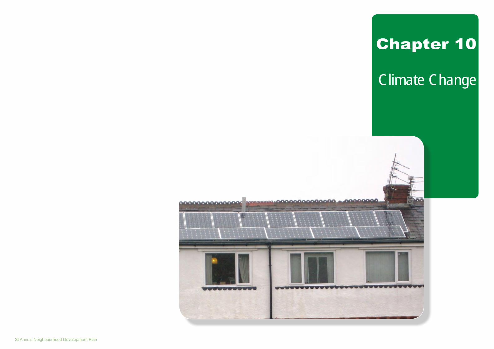
St Anne’s Neighbourhood Development Plan
Chapter 10
Climate Change

Neighbourhood Profile ~ February 2015

St Anne’s Neighbourhood Development Plan Chapter 10:1
10.1 Introduction
10.1.1 This Chapter provides the current background and context to addressing Climate Change, and in particular flood risk and renewable energy.
10.2 Understanding Local Flood Risk
10.2.1 The Environment Agency produce Flood Risk Maps which are updated quarterly . The definitions of flood zones are set out in the government’s National Planning Practice Guidance.
10.2.2 There are two sources of potential flooding; from Rivers and the Sea, and from Surface Water. These are examined below:
A - Flood Risk from Rivers and the Sea
The current flood risk for the study area for Rivers and the Sea is shown in Figure 10.1. From this it can be seen that the main urban area of St. Anne’s lies within Flood Zone 1. The Plan also shows that the sea front and some agricultural land to the eastern edge of the study area lie within Flood Zone 2. The land use implications for these areas is explained in Table 10.1 below:
10.0 Climate Change
Table 10.1: Flood Risk Zones affecting St. Anne’s NDP
Flood Zone Definition Appropriate Uses Flood Risk Assessment Requirements Policy Aims
Flood Zone 1:Low Probability
This zone comprises land assessed as having a less than 1 in 1,000 annual probability of river or sea flooding (<0.1%).
All uses of land are appropriate in this zone.
For development proposals on sites comprising one hectare or above the vulnerability to flooding from other sources as well as from river and sea flooding, and the potential to increase flood risk elsewhere through the addition of hard surfaces and the effect of the new development on surface water run-off, should be incorporated in a flood risk assessment. This need only be brief unless the factors above or other local considerations require particular attention.
In this zone, developers and local authorities should seek opportunities to reduce the overall level of flood risk in the area and beyond through the layout and form of the development, and the appropriate application of sustainable drainage systems.
Flood Zone 2: Medium Probability
This zone comprises land assessed as having between a 1 in 100 and 1 in 1,000 annual probability of river flooding (1% – 0.1%), or between a 1 in 200 and 1 in 1,000 annual probability of sea flooding (0.5% – 0.1%) in any year.
Essential infrastructure and the water-compatible, less vulnerable and more vulnerable uses, are appropriate in this zone. The highly vulnerable uses are only appropriate in this zone if the Exception Test is passed.
All development proposals in this zone should be accompanied by a flood risk assessment.
In this zone, developers and local authorities should seek opportunities to reduce the overall level of flood risk in the area through the layout and form of the development, and the appropriate application of sustainable drainage systems.

Chapter 10:2 Neighbourhood Profile ~ February 2015
Figure 10.1: Flood Risk from Sea and Rivers
Source: Environment Agency

St Anne’s Neighbourhood Development Plan Chapter 10:3
Figure 10.2a: Surface Water Flood Risk
Source: Environment Agency

Chapter 10:4 Neighbourhood Profile ~ February 2015
Figure 10.2b: Surface Water Flood Risk
Source: Environment Agency
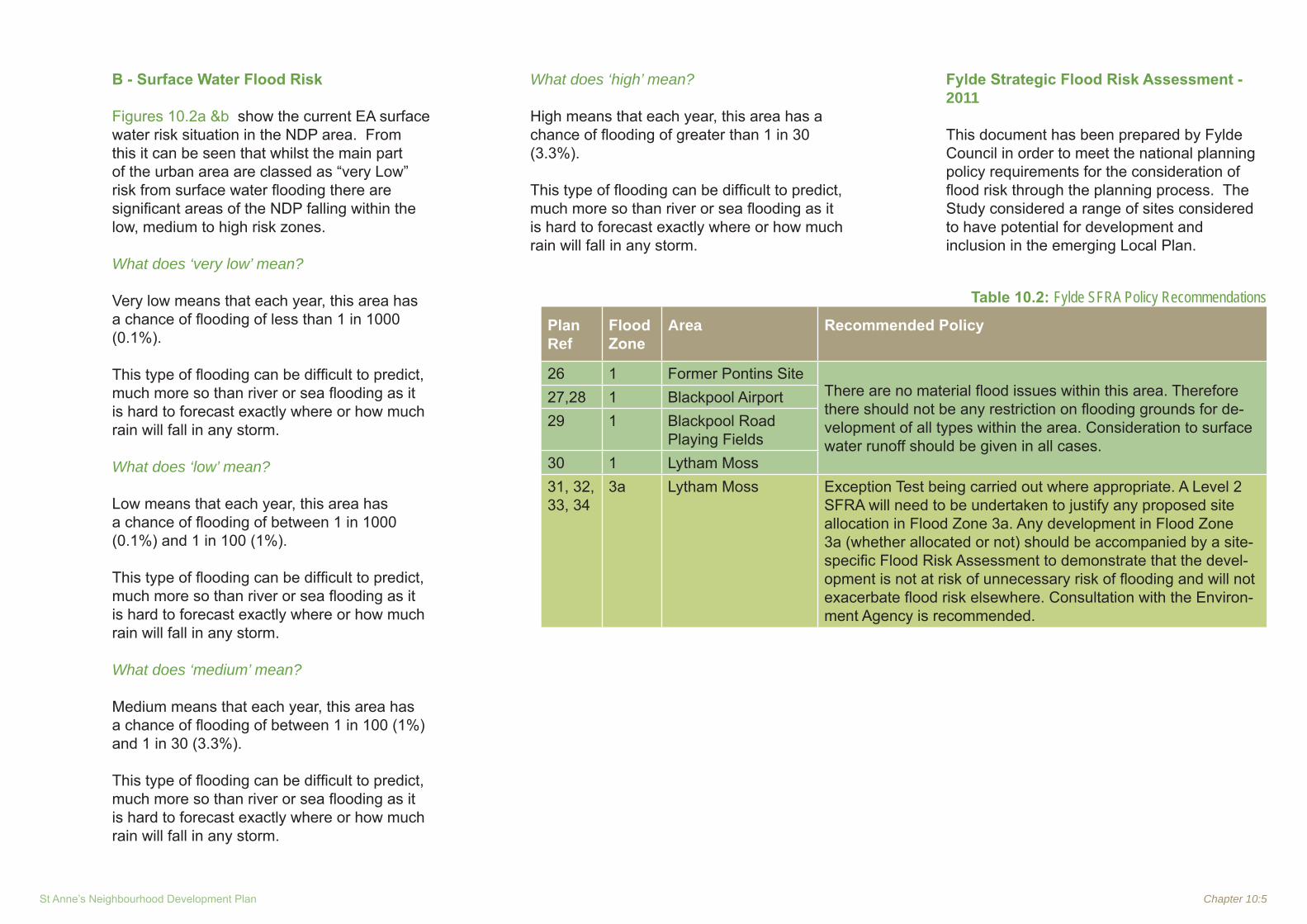
St Anne’s Neighbourhood Development Plan Chapter 10:5
B - Surface Water Flood Risk
Figures 10.2a &b show the current EA surface water risk situation in the NDP area. From this it can be seen that whilst the main part of the urban area are classed as “very Low” risk from surface water flooding there are significant areas of the NDP falling within the low, medium to high risk zones.
What does ‘very low’ mean?
Very low means that each year, this area has a chance of flooding of less than 1 in 1000 (0.1%).
This type of flooding can be difficult to predict, much more so than river or sea flooding as it is hard to forecast exactly where or how much rain will fall in any storm.
What does ‘low’ mean?
Low means that each year, this area has a chance of flooding of between 1 in 1000 (0.1%) and 1 in 100 (1%).
This type of flooding can be difficult to predict, much more so than river or sea flooding as it is hard to forecast exactly where or how much rain will fall in any storm.
What does ‘medium’ mean?
Medium means that each year, this area has a chance of flooding of between 1 in 100 (1%) and 1 in 30 (3.3%).
This type of flooding can be difficult to predict, much more so than river or sea flooding as it is hard to forecast exactly where or how much rain will fall in any storm.
What does ‘high’ mean?
High means that each year, this area has a chance of flooding of greater than 1 in 30 (3.3%).
This type of flooding can be difficult to predict,
much more so than river or sea flooding as it is hard to forecast exactly where or how much rain will fall in any storm.
Fylde Strategic Flood Risk Assessment - 2011
This document has been prepared by Fylde
Council in order to meet the national planning policy requirements for the consideration of flood risk through the planning process. The Study considered a range of sites considered to have potential for development and inclusion in the emerging Local Plan.
Table 10.2: Fylde SFRA Policy Recommendations
Plan Ref
Flood Zone
Area Recommended Policy
26 1 Former Pontins SiteThere are no material flood issues within this area. Therefore there should not be any restriction on flooding grounds for de-velopment of all types within the area. Consideration to surface water runoff should be given in all cases.
27,28 1 Blackpool Airport29 1 Blackpool Road
Playing Fields30 1 Lytham Moss31, 32, 33, 34
3a Lytham Moss Exception Test being carried out where appropriate. A Level 2 SFRA will need to be undertaken to justify any proposed site allocation in Flood Zone 3a. Any development in Flood Zone 3a (whether allocated or not) should be accompanied by a site-specific Flood Risk Assessment to demonstrate that the devel-opment is not at risk of unnecessary risk of flooding and will not exacerbate flood risk elsewhere. Consultation with the Environ-ment Agency is recommended.

Chapter 10:6 Neighbourhood Profile ~ February 2015
Figure 10.3 shows those sites within the NDP area considered as part of the SFRA study.
10.3 Renewable Energy
The Lancashire Renewable Energy Study 2011 (Lancashire CC)
10.3.1 This study was commissioned by Lancashire CC and aimed to identify the deployment potential for onshore renewable energy to inform the development of future local planning policies by:
Bringing the information contained in • the North West Renewable and Low Carbon Energy Capacity and Deployment Study(2010) to a local level; andProviding further technical advice to each • Local Authority.North West and sub-Regional Context•
10.3.2 The North West study identified the overall renewable energy capacity for Lancashire to be 9,929 MW-just under 25% of the North West Region’s total capacity. The key components of this are set out in Table 10.3 below:
Table 10.3: Renewable Energy Resource Potential for Lancashire
Renewable Energy Source Capacity (MW electricity and heat)
Wind (commercial and small scale)
6,698
Plan Biomass 43Animal Biomass 51Waste 87Hydropower 10Micro generationTotal 9,929
Source: Northwest Renewable and Low carbon energy capacity and deployment project report, 2010.
Figure 10.3:Sites Assessed in the Fylde Strategic Flood Risk Assessment - 2011
Source: FBC Strategic Flood Risk Assessment -2011

St Anne’s Neighbourhood Development Plan Chapter 10:7
10.3.2 The study concludes that Fylde has the deployable resource potential of 61 MW by 2030, the equivalent of 5% of Lancashire’s deployable potential. Table 10.4 below provides the breakdown of Fylde’s deployable potential by technology. Commercial scale wind provides the highest deployable potential in Fylde.
Table 10.4: Fylde Deployable Potential in 2020 and 2030 by Technology
Technology Existing Deployment at 2011
Total Deployment 2020
Total Deployment 2030
Commercial Wind 0.0 28.5 37.8Microgeneration - Small scale wind 0.0 0.8 1.4Plant biomass 2.1 2.2 2.2Animal biomass 0.6 1.1 1.4Energy from waste (Anaerobic Digestion) 3.3 2.8 1.0
Small scale hydro 0.0 0.0 0.0Microgeneration - Solar 0.1 4.5 11.1Microgeneration - heatpumps 0.0 2.7 5.8Total 6 43 61
Source: The Lancashire Sustainable Energy Study 2012 (SQW)

Chapter 10:8 Neighbourhood Profile ~ February 2015
10.4 Other Relevant Evidence Documents
10.4.1 Table 10.5 below sets out a brief summary of other relevant evidence documents/ studies
Table 10.5: Other relevant Evidence Documents/Studies
Document/Study Potential NDP Action/ Requirement
Blackpool and Fylde Coast Protection Strategy Strategic Environmental Assessment: Scoping Consultation Document - 2011
Blackpool Borough Council adopted their existing Shoreline Strategy Plan (SSP) in 1995 to manage coastal flood and erosion risk along their coastal frontage. A full review of the plan was undertaken in 2000, with an economic update carried out in 2004.
This Strategy is now in need of a further review to take account of the coastal defence policies developed by the recently produced North Wales and North West SMP2. There is no current or past SSP for the management of Fylde Borough Council’s coastal frontage. Previously, a procedure of reactive management along their coastline has been undertaken, with repairs to the most urgent locations as necessary. As a result of the major linkages and interdependences that exist between Blackpool and Fylde Borough Councils, a joint SSP is being produced to create a more holistic strategy for this part of the Fylde Coast.
The updated SSP will review the technical, economic and environmental appraisal of options, and the choice of preferred option, with the specific intent of establishing a viable long-term Strategy to manage coastal flood and erosion risk for this frontage. The Strategy’s objectives are to: 1. develop a strategic approach to minimise coastal flood and erosion risk to property and other assets within the jurisdiction of Blackpool and Fylde
Councils over the next 100 years; 2. investigate opportunities to enhance and improve the area’s natural, cultural and amenity value; and, 3. comply with all statutory obligations arising from national and international nature conservation designations and related legislation in the area.
There are no planned work to the hard coast defences in the St. Anne’s Parish area in the next twenty years.
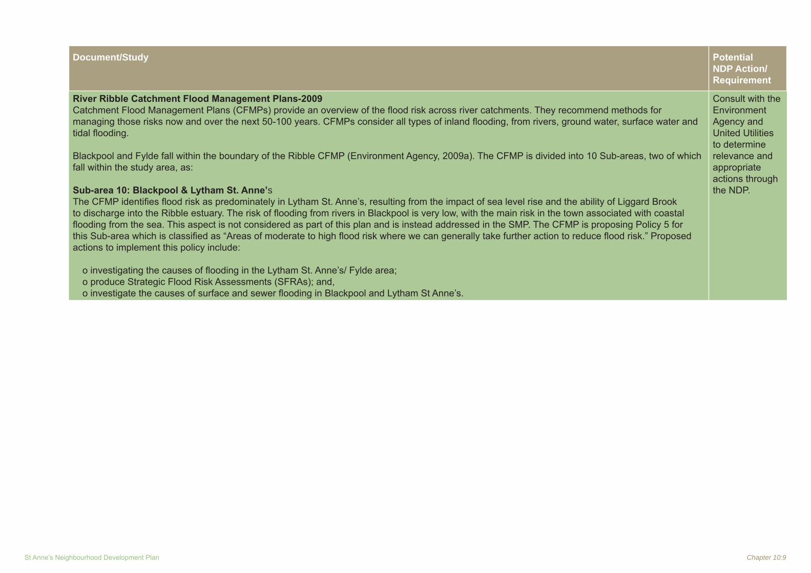
St Anne’s Neighbourhood Development Plan Chapter 10:9
Document/Study Potential NDP Action/ Requirement
River Ribble Catchment Flood Management Plans-2009Catchment Flood Management Plans (CFMPs) provide an overview of the flood risk across river catchments. They recommend methods for managing those risks now and over the next 50-100 years. CFMPs consider all types of inland flooding, from rivers, ground water, surface water and tidal flooding.
Blackpool and Fylde fall within the boundary of the Ribble CFMP (Environment Agency, 2009a). The CFMP is divided into 10 Sub-areas, two of which fall within the study area, as:
Sub-area 10: Blackpool & Lytham St. Anne’sThe CFMP identifies flood risk as predominately in Lytham St. Anne’s, resulting from the impact of sea level rise and the ability of Liggard Brook to discharge into the Ribble estuary. The risk of flooding from rivers in Blackpool is very low, with the main risk in the town associated with coastal flooding from the sea. This aspect is not considered as part of this plan and is instead addressed in the SMP. The CFMP is proposing Policy 5 for this Sub-area which is classified as “Areas of moderate to high flood risk where we can generally take further action to reduce flood risk.” Proposed actions to implement this policy include:
o investigating the causes of flooding in the Lytham St. Anne’s/ Fylde area; o produce Strategic Flood Risk Assessments (SFRAs); and, o investigate the causes of surface and sewer flooding in Blackpool and Lytham St Anne’s.
Consult with the Environment Agency and United Utilities to determine relevance and appropriate actions through the NDP.

Chapter 10:10 Neighbourhood Profile ~ February 2015
Document/Study Potential NDP Action/ Requirement
North West England and North Wales Shoreline Management Plan SMP2(SMP2) The SMP aims to identify the best ways to manage flood and erosion risk to people and the developed, historic and natural environment, and to identify opportunities where shoreline managers can work with others to make improvements. The SMP does not set policy for anything other than coastal defence management. The Strategy frontage is covered by Sub-Cell 11b of the North West and North Wales SMP2 (Halcrow Group Ltd., 2010), which is divided into:
1. The Ribble Estuary; and, 2. St. Anne’s to Rossall Point.
This Sub-Cell is further divided into a series of policy units, Units 1.14 to 1.21 and 2.1 to 2.5, each with an individual policy. The policies are presented over three epochs (0 to20 years; 20 to 50 years; and, 50 to 100 years) to enable realistic and sustainable management of the coastline. Four key policies are considered within the SMP: Hold the Line (HTL) - this option involves fixing the shoreline position by the provision or maintenance of coastal defences. • Advance the Line (ATL) - this involves building new defences seaward of the original defences and is limited to areas where significant land
reclamation is being considered. • No Active Intervention (NAI) - a decision not to invest in providing or maintaining defences. • Managed Realignment (MR) - allowing the shoreline to move backwards, with management to control / limit the extent of landward retreat.
The preferred policies for the Strategy area are predominately HTL, by maintaining the existing defences throughout all three epochs of the SMP. Exceptions include Policy Unit 2.1 St. Anne’s (northern boundary) to Squires Gate, which is MR for the first epoch, by managing the dunes and determining the requirements for a second line of defences set back by Clifton Drive North. The policy changes to HTL for the second and third epochs.
Consult with Environment Agency to determine relevance to NDP

St Anne’s Neighbourhood Development Plan Chapter 10:11
Document/Study Potential NDP Action/ Requirement
The North West Regional Coastal Strategy The North West Regional Coastal Strategy 2008 - 2032 (North West Coastal Forum, 2008) is designed as a non-statutory resource for all involved in policy, planning and management of the North West’s coast. Consultation on the Strategy was undertaken towards the end of 2008; however, the Strategy has yet to be finalised. The Strategy outlines six key outcomes that comprise its building blocks, each with a series of priorities for action, as:
1. well-integrated planning and management of the coastal zone including achieving coherence between adjacent terrestrial and marine spatial plans; 2. the economic potential of the North West coast achieved in ways which safeguard, enhance, restore and sustainably use our natural and cultural
assets; 3. improved well being of coastal communities; 4. improved recreational opportunities and visitor experience; 5. a high quality natural and built coastal environment able to adapt to climate and other change; and, 6. raised appreciation of the coast, its value and its needs. The Strategy identifies the regeneration of Blackpool as essential in achieving the economic potential of the North West coast. Blackpool and Lytham are recognised as key tourism and recreational locations.
Consider need to protect and enhance important coastal natural assets whilst considering opportunities for tourism and recreation use.
Lancashire Climate Change Strategy The Lancashire Climate Change Strategy 2009 to 2020, sets out the long-term vision that Lancashire is “low carbon and well adapted by 2020”. Lancashire is aiming to reduce its carbon dioxide emissions by at least 30% (relative to 1990). This Strategy was adopted in February 2009. The Strategy acknowledges that the implications of climate change on the marine environment and coastal structures should be assessed, and that there are consequences of sea level rise and a need to understand coastal realignment. The Strategy also identifies sea level rise and increased coastal risk from storm surges as having a negative affect on (The Lancashire Climate Change Partnership, 2009a):
• commercial developments (some include housing & leisure); • housing developments; • transportation projects; • tourism & leisure; and,• quality of place. Critical actions identified in the associated action plan includes the reduction of carbon dioxide emissions by 30% and the inclusion of other greenhouse gases, monitoring of existing actions, assessing gaps in delivery and development of new actions to achieve tighter targets, and to develop an understanding of UK climate projections scenarios and to identify impacts for Lancashire (The Lancashire Climate Change Partnership, 2009b).
Consider appropriate policies within NDP to complement emerging Local Plan policies, consult with EA regarding potential flood risks and appropriate actions within NDP.
Chapter 10:12 Neighbourhood Profile ~ February 2015
10.5 Fylde Coast Masterplan-Draft Consultation Strategy
10.5.1 The Draft Fylde Coast Masterplan was published for consultation by Fylde BC in March 2014. Then document includes the following relevant key themes:
Coastal Protection
The Issues
10.5.2 The Fylde Coastline consists of a mixture of natural and built defences that are at risk for coastal erosion and flooding. At the Northern end, a long wide stretch of sandy dunes provides protection. However, these sandy dunes, while accreting in some places are eroding in others. If left unmanaged a flow route for coastal flooding would form. The southern end is a mixture of both sand dunes supported by 3 strategic headlands. The shoreline is in need of major investment. The 3 strategic headlands generally maintain good beach levels between them fronting properties, and also provide erosion protection to the Ribble Estuary.
Policy and Strategy
10.5.3 The aim of a Shoreline Management Plan (SMP2) is to identify policies to manage risks. The SMP policy for the Fylde Coast is to “hold the line”; this means strengthening, maintaining or rebuilding the existing defences to maintain the existing shoreline. The strategy appraisal report for the Fylde shoreline strategy has recently been accepted by the Environment Agency. The key purpose for this strategy is to provide a long term 100 year plan for the management of the Fylde shore line. Whilst the shore line within the District is in need of major investment the strategy and a
number of key projects are identified- none are within the NDP area:
10.6 Planning Policy Context - Climate Change
What the NPPF says
10.6.1 Paragraph 93 says that planning plays a key role in helping shape places to secure radical reductions in greenhouse gas emissions, minimising vulnerability and providing resilience to the impacts of climate change, and supporting the delivery of renewable and low carbon energy and associated infrastructure. This is central to the economic, social and environmental dimensions of sustainable development.
10.6.2 Paragraph 94 says that local planning authorities should adopt proactive strategies to mitigate and adapt to climate change, taking full account of flood risk, coastal change and water supply and demand considerations.
10.6.3 Paragraph 95 says that to support the move to a low carbon future, local planning authorities should:
plan for new development in locations • and ways which reduce greenhouse gas emissions; actively support energy efficiency • improvements to existing buildings; and when setting any local requirement for a • building’s sustainability, do so in a way consistent with the Government’s zero carbon buildings policy and adopt nationally described standards.
10.6.4 Paragraph 96 and 98 sets out the relevant considerations to be taken into account in determining planning applications.
10.6.5 Paragraph 97 says that to help increase the use and supply of renewable and low carbon energy, local planning authorities should recognise the responsibility on all communities to contribute to energy generation from renewable or low carbon sources. They should:
have a positive strategy to promote energy • from renewable and low carbon sources;design their policies to maximise renewable • and low carbon energy development while ensuring that adverse impacts are addressed satisfactorily, including cumulative landscape and visual impacts; consider identifying suitable areas for • renewable and low carbon energy sources, and supporting infrastructure, where this would help secure the development of such sources; support community-led initiatives for • renewable and low carbon energy, including developments outside such areas being taken forward through neighbourhood planning; identify opportunities where development can • draw its energy supply from decentralised, renewable or low carbon energy supply systems and for co-locating potential heat customers and suppliers.
10.6.6 Paragraph 99 says that Local Plans should take account of climate change over the longer term, including factors such as flood risk, coastal change, water supply and changes to biodiversity and landscape. New development should be planned to avoid increased vulnerability to the range of impacts arising from climate change. When new development is brought forward in areas which are vulnerable, care should be taken to ensure

St Anne’s Neighbourhood Development Plan Chapter 10:13
that risks can be managed through suitable adaptation measures, including through the planning of green infrastructure.
10.6.7 Paragraph 100 says that inappropriate development in areas at risk of flooding should be avoided by directing development away from areas at highest risk, but where development is necessary, making it safe without increasing flood risk elsewhere. Local Plans should be supported by Strategic Flood Risk Assessment and develop policies to manage flood risk from all sources, taking account of advice from the Environment Agency and other relevant flood risk management bodies, such as lead local flood authorities and internal drainage boards. Local Plans should apply a sequential, risk-based approach to the location of development to avoid where possible flood risk to people and property and manage any residual risk, taking account of the impacts of climate change, by:
applying the Sequential Test; • if necessary, applying the Exception Test; • safeguarding land from development that • is required for current and future flood management; using opportunities offered by new • development to reduce the causes and impacts of flooding; and where climate change is expected to • increase flood risk so that some existing development may not be sustainable in the long-term, seeking opportunities to facilitate the relocation of development, including housing, to more sustainable locations.
10.6.8 Paragraphs 101 to 104 set out the requirements for a sequential test to steer new development to areas with the lowest probability of flooding and set out the relevant considerations for determining planning applications.
10.6.9 Paragraph 105 says that in coastal areas, local planning authorities should take account of the UK Marine Policy Statement and marine plans and apply Integrated Coastal Zone Management across local authority and land/sea boundaries, ensuring integration of the terrestrial and marine planning regimes.
10.6.10 Paragraph 106 says that local planning authorities should reduce risk from coastal change by avoiding inappropriate development in vulnerable areas or adding to the impacts of physical changes to the coast. They should identify as a Coastal Change Management Area any area likely to be affected by physical changes to the coast, and:
be clear as to what development will be • appropriate in such areas and in what circumstances; and make provision for development and • infrastructure that needs to be relocated away from Coastal Change Management Areas.
10.6.11 Paragraphs 107 and 108 set out the relevant considerations for determining planning applications.
Fylde Local Plan (adopted 2005)
10.6.12 Policy EP30 says that development will not be permitted which would:1. Itself be subject to an unacceptable risk of
flooding;2. Create an unacceptable increase in the risk
of flooding within the development site, or elsewhere;
3. Adversely affect the water environment as a result of an increase in surface water run-off;
4. Prejudice the capability of the coast to form a natural sea defence;
5. Result in excessive culverting;6. Prejudice essential access requirements to
watercourses or flood defence.
10.6.11 Policy EP31 says that development will not be permitted which requires abstraction of water from the Fylde aquifer where this would be likely to lead to low flows in local rivers, where it would adversely affect existing abstractions or where it would damage aquatic features.
The Emerging Local Plan
10.6.12 The Fylde Local Plan to 2030 Part 1- Preferred Options paper sets out the following policies relating to the Natural Environment.
10.6.13 Strategic Objective 2 is:
To improve the environment by:1. Protecting, enhancing and restoring the
quality, character and distinctiveness of the biodiversity and landscape of Fylde Borough.

Chapter 10:14 Neighbourhood Profile ~ February 2015
2. Expanding biodiversity resources, including improving habitat connectivity, particularly away from the coastal edge.
3. Promoting green infrastructure throughout the urban and rural areas.
4. Improving access to the natural environment.
5. Protecting and enhancing the built and historic environment and requiring new development to meet the highest quality urban design.
6. Minimising the risk of flooding, both tidal and fluvial, to existing and new development and improving bathing water quality.
7. Protecting the best and most versatile agricultural land and increasing UK food security.
8. Protecting existing areas of Green Belt. It is not intended that there will be a strategic review of the Green Belt within Fylde during the plan period.
9. Promoting sustainable renewable and low carbon energy, in order to reduce carbon emissions.
10. Supporting the Regional Park Plan for the Ribble Coast and Wetlands.
11. Ensuring that infrastructure is available to enable new development, whilst protecting and enhancing the natural and built environment.
12. Retaining the identity, character and setting of the rural villages.
10.6.14 Policy CL1 - Flood Alleviation and Water Efficiency: says that planning decisions should follow the sequential, risk-based approach to the location of development, as required
under paragraph 100 of the NPPF. All new development is required to minimise flood risk impacts on the environment and mitigate against the likely effects of Climate Change on present and future generations. This will be achieved by:
a) Ensuring that new development incorporates Sustainable Drainage Systems (SuDS), where such development will generate surface water run-off.
b) Supporting the retrofitting of SuDS in locations that generate surface water run-off.
c) Improving water efficiency standards by minimising the use of potable mains water in new development and incorporating measures to recycle and conserve water resources.
d) Ensuring that new development is directed away from areas at high risk of flooding and incorporating appropriate mitigation against flooding in areas of lower risk.
e) Ensuring that watercourses, which are important habitats for water voles and other species, are protected from encroachment and adverse impacts and that water quality is maintained and improved.
f) Seeking to maximise the potential of Green Infrastructure within developments to contribute to flood relief.
g) Ensuring that new development does not adversely affect the quality of groundwater.
10.6.15 Developer contributions will be required for the provision and maintenance of SuDS, where this is not provided as part of the development.
Contributions will be made through Section 106 agreements or the Community Infrastructure Levy, as set out in Policy INF2. Developer contributions will be required for the repair or replacement of the coastal flood defences and the maintenance of the dunes system. Contributions will be made through the Community Infrastructure Levy.
10.6.16 Policy CL2 - Renewable and Low Carbon Energy Generation: says that renewable and low carbon energy development potential is significant within Fylde. Developers of commercial, small and medium sized renewable and low carbon energy
developments will be required to provide evidence, to the satisfaction of the local
authority, in support of their proposals by considering the following:a) Singular or cumulative impacts on
landscape and townscape character and value;
b) Impact on local residents (including noise, odour and visual amenity, such as flicker noise and shadow flicker);
c) Ecological impact, including migration routes of protected bird species;
d) Impacts on land resources, including agricultural land and areas of deep peat;
e) Impacts on the historic environment and assets;
f) Community, economic and environmental benefits of the proposal;
g) Impacts on aviation and defence navigation systems and communications, particularly Blackpool International Airport, Warton Aerodrome and MOD Radio Inskip; and
h) Impacts on highway safety and capacity from movements associated with the development.

St Anne’s Neighbourhood Development Plan Chapter 10:15
10.6.16 The evidence will be required to demonstrate that any impacts can be satisfactorily
addressed but need only be proportional to the scale and type of development.
10.6.16 Renewable and low carbon energy proposals within the Green Belt and Area of Separation will need to demonstrate that any adverse impacts of granting permission will not significantly and demonstrably outweigh the benefits, when assessed against the policies in the NPPF as a whole, specific policies in that Framework, or other policies in the Local Plan.
Applicants will not be required to justify the overall need for renewable and low carbon energy development, either in a national, regional or local context.
10.6.17 Policy CL3 - Decentralised Energy Networks and District Heating Systems: says that Small scale decentralised energy schemes will be encouraged within development schemes and as part of community-led initiatives. All major developments will be required to explore the potential for decentralised energy supply and district heating/cooling systems. Major developments located where a decentralised
energy supply or district heating/cooling system is planned to be sited will be required to allow for future connectivity at a later date or phase.
10.6.18 Policy CL4 - Sustainability Statements: says that measures to improve the energy performance of buildings will be encouraged.
10.7 Key Issues
Ref Key Issues Comments / Possible Options
1 Protecting and Enhancing Environmental Assets
1.1Flood Risk:How should the NDP respond to the issue of widespread surface water flooding throughout the town?
Consider specific policies e.g. SUDS •
2 Renewable Energy
2.1 How should/ can the NDP encourage the adoption of appropriate renewable energy technologies?
Consider specific policy •Consider an NDO to facilitate greater take up of domestic/commercial •small scale renewable energy schemesPromote a district heating scheme (include proposal in Implementation •Plan and consider specific policy)
2.2Improving the thermal efficiency of existing housing stock.The relatively poor thermal efficiency of the existing housing stock has been identified as an issue under Housing.
Consider specific policy to encourage improvements •

Chapter 10:16 Neighbourhood Profile ~ February 2015
REFERENCES & DOCUMENTS REVIEWED
1. Environment Agency-web based Flood Risk Mapping (2014)2. Fylde Strategic Flood Risk Assessment - 20113. The Lancashire Renewable Energy Study 2011 (Lancashire CC)4. Blackpool and Fylde Coast Protection Strategy Strategic Environmental Assessment: Scoping Consultation Document – 20115. North West England and North Wales6. Shoreline Management Plan SMP2(SMP2)7. The North West Regional Coastal Strategy 2008 – 20328. The Lancashire Climate Change Strategy 2009 to 20209. Draft Fylde Coastal Masterplan - Fylde BC - March 2014 10. Lancashire Green Infrastructure Strategy - 200711. The Fylde Green Infrastructure Strategy - 201112. The National Planning Policy Framework – DCLG-201213. Fylde Borough Local Plan - May 200314. Fylde Borough Local Plan Alterations Review - October200515. Fylde Local Plan to 2030: Part 1 - Preferred Options - July 201316. National Planning Practice Guidance-DCLG-2014

St Anne’s Neighbourhood Development Plan
Chapter 11
Transport and Movement

Neighbourhood Profile ~ February 2015

St Anne’s Neighbourhood Development Plan Chapter 11:1
11.1 Introduction
11.1.1 This Chapter describes the current and proposed transport and movement infrastructure serving the St. Anne’s NDP area. It explains the current and emerging planning policy context, and identifies key transport and movement issues which the NDP could address.
11.2 Existing Transport and Movement Infrastructure
11.2.1 Figure 11.1 (overleaf) provides the overall context to the area and how it is served by road and rail, the location of Blackpool Airport and the NDP boundary.
11.2.2 The NDP area is located directly to the south of Blackpool and north of Lytham and includes the Blackpool Airport site to the north. Highway access from the end of the M55 is currently via the A5230 (Progress Way) turning into either the B5261 (Queensway becoming Heyhouses Lane) or the A584 (Clifton Drive) as North Houses Lane is closed to through traffic. The A584 (Clifton Drive) runs through the area linking Blackpool to the north with Lytham to the south. The B5233 (St. Anne’s Road) provides the main link between Queensway to the north east and Clifton Road to the south west and is the main gateway access to the town centre and railway station.
11.2.3 Within this framework of main roads the area consists of a predominantly grid iron structure of roads serving the older areas of housing and cul de sac structure in the more modern housing layouts. Access by road both to and within the area is relatively easy and straightforward and there have been few changes in recent years.
11.2.4 The area is also served by the South Fylde railway line which links Blackpool South station with Preston with stations in the centre of St. Anne’s, and at Squires Gate Lane to the north.
11.2.5 In addition to road and rail transport the area has a network of cycleways, footpaths and bridleways as shown on Figure 11.2
11.2.6 Public transport is primarily rail (station at St. Anne’s with services to Blackpool South and Preston), and bus as shown in Figure 11.3 (overleaf). The most frequent bus services are along the coast (Clifton Drive being the busiest bus route).
11.2.7 For visitors coming to St. Anne’s, in addition to public transport (road and rail) many use private cars and car parking is a major issue for the town. The Borough Council operates a car parking strategy and controls a number of key pay and display car parks in the centre of St. Anne’s as shown in Figure 11.3 (overleaf). On street parking is controlled by the County Council’s Highways department.
11.3 Proposed Transport Infrastructure
Improvements
11.3.1 The Draft Developing Infrastructure Delivery Plan for Fylde (2013) sets out the key infrastructure improvements anticipated and proposed within the Fylde Council area. All such projects require significant levels of funding from a range of government bodies in addition to the local council, and unless indicated there is currently no funding in place.
11.3.2 Those affecting the NDP area are as follows:
Highways - funding is in place for the M55 to Heyhouses link as shown on Figures 11.1 and 11.4 and is under the control of the Highways Agency;
Railways - South Fylde line, possible layover near Kirkham and Wesham, new loop to allow trains to pass. Network Rail’s next ‘control period’ which indicates projects and funding is 2015-2019 and details are due towards the end of 2014;
Tram - there is a suppressed demand for continuation of the existing Blackpool tram network into St. Anne’s and Lytham. Blackpool Tram network has received EU funding via the SINTROPHER project but there is currently no funding for a further extension south;
Cycleways - completion of the link between St. Anne’s and Lytham and links north towards Blackpool beyond the airport, along Queensway, Midgeland Road and Wilding Lane.
11.4 Evidence Documents
Developing Infrastructure Delivery Plan (2013)
11.4.1 The IDP covers much more than just transport, rail, road etc – it also covers utilities, minerals and waste, flooding, education, emergency services, community facilities and there is a section on ‘Green Infrastructure’.
11.0 Transport and Movement

Chapter 11:2 Neighbourhood Profile ~ February 2015
Figure 11.1: Transport and Movement ContextSt. Anne’s Neighbourhood Development Plan
Neighbourhood Profile
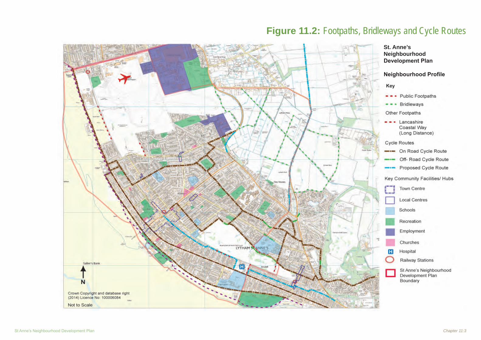
St Anne’s Neighbourhood Development Plan Chapter 11:3
Figure 11.2: Footpaths, Bridleways and Cycle RoutesSt. Anne’s Neighbourhood Development Plan
Neighbourhood Profile

Chapter 11:4 Neighbourhood Profile ~ February 2015
11.4.2 The strategic road network is controlled by the Highways Agency. The key project for the NDP area is the M55 to Heyhouses link Road (see Figures 11.1 and 11.4). The link road has planning permission as part of the 1,150 dwellings at Queensway. It will improve access to and from junction 4 of the M55 and St. Anne’s, and accommodate the additional traffic generated by the Queensway development. It will be wholly funded through developer contributions with an estimated cost of £21 Million. It is scheduled for completion in 2016.
11.4.3 For public transport the IDP recognises that bus services are easier and quicker to upgrade than rail services. The most frequent services are understandably along the coast. Railways serving the area are operated by Network Rail. The next control period1 is 2015-2019 and is due towards the end of 2014 which will indicate projects and funding. Blackpool North to Preston is to be electrified in 2015. The Park and Ride idea at Kirkham and Wesham has dropped off the priority list.
11.4.4 Services on the South Fylde line are recognised as both infrequent and unreliable but no facts are provided to support the statement of unreliability. Ideas for improvement include a layover near Kirkham and Wesham – therefore removing current blockage and helping journey times to Preston, and a new loop to allow trains to pass. The Council supports ideas but would not be responsible for implementation.
1 Network Rail Control Periods are the 5-year timespans
into which Network Rail, the owner and operator of most of the rail infrastructure in Great Britain, works for financial and other planning purposes. Each Control Period begins on 1 April and ends on 31 March to coincide with the financial year.
11.4.5 The Council recognises a “suppressed demand” for continuation of the tram network into St. Anne’s and Lytham and refers to the EU funded SINTROPHER project but provides no details.
11.4.6 The Airport is recognised as important to the local economy but is itself currently making a loss. The 2009 masterplan is currently being updated. The 5ha site (Site E2 in the Emerging Local Plan) on the north side has been put forward for specialised employment uses.
11.4.7 The IDP recognises that cycling can reduce congestion and emissions and encourage health and wellbeing but needs to be safe, attractive and convenient. The route between St. Anne’s and Lytham is not currently complete and improvements need to be made to links north towards Blackpool beyond the airport and lists Queensway, Midgeland Road and Wilding Lane.
11.4.8 In relation to flood risk and coastal defence there are issues along the St. Anne’s frontage. The preferred strategy between Fairhaven Lake and St. Anne’s is to replace the existing hard defences thereby creating a new wider promenade which in turn could attract more visitors. Work could start in 2014 but funding is required. CIL funding could be used for ongoing dune management.
11.4.9 The term ‘Green Infrastructure’ is included at the end of the Plan and refers to parks and other greenspaces and how they are linked and used. The Council maintains parks and gardens in Lytham and St. Anne’s but in some other areas they have been passed to Town Councils. Ashton Gardens in St. Anne’s has recently been refurbished. Funding is being
sought for the ‘Rock and Water Gardens’. In addition the current Open Space, Sport and Recreation Assessment (2008) is planned for an update. The Council recognises that the Starr Hills Local Nature Reserve (LNR) is in need of improvement and overall recognises a deficiency in trees and woodlands.
Draft Fylde Coast Highways and Transport Masterplan (2015)
11.4.10 Lancashire County Council is producing five Highways and Transport Masterplans that reflect the county’s economic areas, one of which is the Fylde Coast, produced in cooperation with Blackpool Council and covering Blackpool, Fylde and Wyre. The masterplans set out a cohesive highways and transport strategy for the whole county, linking economic development, spatial planning and public health priorities to the wider policy objectives of the County Council, Blackburn with Darwen Council and Blackpool Council.
11.4.11 For St Anne’s the Draft Masterplan includes the following key projects:
• M55 to Heyhouses link South Fylde Rail line study• Improved Cycle routes•
11.4.12 The M55 to Heyhouses link, through the Growth Deal negotiated by the Lancashire Enterprise Partnership, should start in 2015/16. The new link will provide a direct route fit for all users between the M55 at junction 4 and A583 Preston New Road to the B5261 Blackpool Road in St. Anne’s, using an initial section of link road that was completed a number of years ago. It will give better access to development sites, including Whitehills and Blackpool International Airport, to new housing

St Anne’s Neighbourhood Development Plan Chapter 11:5
Figure 11.3: Public Transport and Main Car ParksSt. Anne’s Neighbourhood Development Plan
Neighbourhood Profile

Chapter 11:6 Neighbourhood Profile ~ February 2015
at Heyhouses and for tourism, including future hosting of the R&A Open Golf Championships. The scheme will also provide some congestion relief and allow Wild Lane to be used as a sustainable transport link by pedestrians, cyclist and equestrians.
11.4.13 Through an extension to the original SINTROPHER project, LCC have been able to secure further funding to carry out a study on the South Fylde Line, to take place during 2014/15. It will look at the future role of the line, the best way to enhance the role of the line in providing a southern gateway to Blackpool and to establish what the most viable and cost effective way of linking the line and the Blackpool Tramway would be and what benefits such a link would bring. The plan recognises that the line does not provide an effective commuter service and is underutilised when compared to rail lines serving similar populations. The service on the line is infrequent and the rolling stock poor. The two lines lie only 300m apart in places, but if they were to be connected, then the Fylde Coast would have a through rail service from end to end, making rail travel easy for both commuters and tourists.
11.4.14 The Fylde Coast Cycle Network will build on work already undertaken between Fleetwood and Starr Gate and in St Anne’s, as well as the Blackpool Explorer routes and initiatives that are underway such as Blackpool Green Corridors. Key to the network will be the completion of the Fylde Coastal Way, the towpaths of the Lancaster Canal and the creation of Explorer Mini-wheels, family friendly, multi user circular routes aimed at the leisure and tourist market and Green Spokes that will allow safe access by cycle to key employment destinations.
Local Transport Plan 2011 – 2021 LCC (2011) 11.4.15 The Local Transport Plan (LTP) is produced by the County Council and
covers a 10 year period for the whole county. The new ‘Fylde Coast Highways and Transport Masterplan’ referred to above, is being produced by the Council. It is part of a series of 5 masterplans covering 12 districts. This provides a more up to date vision for the county and specific schemes and projects affecting the NDP area and reflect more recent activities.
Fylde Car Parking Strategy (updated 2013)
11.4.16 Fylde BC owns 20 car parks, representing 1,585 spaces, but this does not include on street parking which is controlled by Lancashire CC and
This Map is reproduced from Ordnance Survey material with the permission of Ordnance Survey on behalf of the controller of Her Majesty's Stationery Office (C)Crown Copyright. Unauthorised reproduction infringes Crown Copyright and may lead to Prosecution or civil proceedings.
Lancashire County Council Licence No. 1000233201:15,000
Proposed highway
05/10/0779 CONSTRUCTION OF NEW HIGHWAY (COMPLETION OF M55 TO HEYHOUSES LINK)AND IMPROVEMENTS TO EXISTING HIGHWAYS
Figure 11.4: Route of proposed M55 to Heyhouses Link Road

St Anne’s Neighbourhood Development Plan Chapter 11:7
there are other operators in the area such as NCP.
11.4.17 The Council owned car parks located in the area are shown on Figure11.3 and are:
Wood Street CP• St Anne’s Square CP• Council offices and town hall CP• North Promenade• St Anne’s Pool• St Alban’s Road•
11.4.18 The strategy recognises that it is important to get the balance right for the users such as residents, shoppers and visitors and also to serve the needs of the disabled, coach parking etc. Operating and maintenance of the Council’s car parks is covered by the revenue derived.
11.4.19 Car parks require a competitive tariff and the Council considers current tariffs to be correct. Pay and display is the current option. Pay on foot has been considered but rejected as not easy to implement and too costly.
11.4.20 Signage is important and needs to be clear so as to help visitors. There is a recognised lack of cycle and coach parking which needs to be addressed.
The Lancashire Rights of Way Improvement Plan (ROWIP) 2005
11.4.21 Produced to meet the requirements of the Countryside and Rights of Way (CROW) Act 2000. Assesses the extent to which rights of way meet the present and likely future needs of the public, the opportunities provided by
rights of way for exercise and other forms of open air recreation and enjoyment, and the accessibility of rights of way to blind and partially sighted persons and others with mobility problems.
11.5 Planning Policy Context - Transport and Movement
What the NPPF says
11.5.1 NPPF provides a general background and desire for sustainable communities. Transport is important both for wider sustainability and health objectives. Stresses safe environments, cycling, pedestrian movement, public transport etc as one would expect.11.5.2 Paragraph 17 lists as one of the core planning principles that planning should actively manage patterns of growth to make the fullest possible use of public transport, walking and cycling, and focus significant development in locations which are or can be made sustainable.
11.5.3 Paragraph 29 advises that transport policies have an important role to play in facilitating sustainable development but also in contributing to wider sustainability and health objectives. Smarter use of technologies can reduce the need to travel. The transport system needs to be balanced in favour of sustainable transport modes, giving people a real choice about how they travel. However, the Government recognises that different policies and measures will be required in different communities and opportunities to maximise sustainable transport solutions will vary from urban to rural areas.
11.5.4 Paragraph 30 says that encouragement should be given to solutions which support reductions in greenhouse gas emissions and
reduce congestion. In preparing Local Plans, local planning authorities should therefore support a pattern of development which, where reasonable to do so, facilitates the use of sustainable modes of transport.
11.5.5 Paragraph 31 advises that local authorities should work with neighbouring authorities and transport providers to develop strategies for the provision of viable infrastructure necessary to support sustainable development, including large scale facilities such as rail freight interchanges, roadside facilities for motorists or transport investment necessary to support strategies for the growth of ports, airports or other major generators of travel demand in their areas. The primary function of roadside facilities for motorists should be to support the safety and welfare of the road user.
11.5.6 Paragraph 32 advises that plans and decisions should take account of whether:
the opportunities for sustainable transport • modes have been taken up depending on the nature and location of the site, to reduce the need for major transport infrastructure; safe and suitable access to the site can be • achieved for all people; and improvements can be undertaken within the • transport network that cost effectively limit the significant impacts of the development. Development should only be prevented or refused on transport grounds where the residual cumulative impacts of development are severe.
11.5.7 Paragraph 33 says that when planning for ports, airports and airfields that are not subject to a separate national policy statement, plans should take account of their growth and role in serving business, leisure, training and

Chapter 11:8 Neighbourhood Profile ~ February 2015
emergency service needs. Plans should take account of the Framework as well as the principles set out in the relevant national policy statements and the Government Framework for UK Aviation.
11.5.8 Paragraph 34 says that plans and decisions should ensure developments that generate significant movement are located where the need to travel will be minimised and the use of sustainable transport modes can be maximised. However this needs to take account of policies set out elsewhere in the Framework, particularly in rural areas.
11.5.9 Paragraph 35 advises that plans should protect and exploit opportunities for the use of sustainable transport modes for the movement of goods or people. Therefore, developments should be located and designed where practical to:
• accommodate the efficient delivery of goods and supplies; give priority to pedestrian and cycle • movements, and have access to high quality public transport facilities; create safe and secure layouts which • minimise conflicts between traffic and cyclists or pedestrians, avoiding street clutter and where appropriate establishing home zones; incorporate facilities for charging plug-in and • other ultra-low emission vehicles; and consider the needs of people with disabilities • by all modes of transport.
11.5.10 Paragraph 37 says that planning policies should aim for a balance of land uses within their area so that people can be encouraged to minimise journey lengths for employment, shopping, leisure, education and other activities.
11.5.11 Paragraph 38 advises that for larger scale residential developments in particular, planning policies should promote a mix of uses in order to provide opportunities to undertake day-to-day activities including work on site. Where practical, particularly within large-scale developments, key facilities such as primary schools and local shops should be located within walking distance of most properties.
11.5.12 Paragraph 39 says that if setting local parking standards for residential and non-residential development, local planning authorities should take into account:
the accessibility of the development;• the type, mix and use of development; • the availability of and opportunities for public • transport; local car ownership levels; and • an overall need to reduce the use of high-• emission vehicles.
11.5.13 Paragraph 40 advises that local authorities should seek to improve the quality of parking in town centres so that it is convenient, safe and secure, including appropriate provision for motorcycles. They should set appropriate parking charges that do not undermine the vitality of town centres. Parking enforcement should be proportionate.
11.5.14 Paragraph 41 advises that local planning authorities should identify and protect, where there is robust evidence, sites and routes which could be critical in developing infrastructure to widen transport choice.
Fylde Local Plan (adopted 2005)11.5.15 Policy TR5 says that large scale new
developments, involving over 100 dwellings or
over 3 hectares of land, will only be permitted where:
1. The location is served by a satisfactory existing level of public transport, or, as a result of investment by the developer, is brought to a satisfactory level of service, before the development is first occupied;
2. Adequate bus stopping, waiting and turning facilities exist, or are provided by the developer in or near the development.
11.5.16 Where necessary, the council will negotiate an agreement with the developer to secure the level of service and/or facilities referred to.
11.5.17 Policy TR6 seeks to retain specified car parks in their existing use. These are: NCP multi-storey car park; North Promenade, St. Anne’s Pier; and Wood street
11.5.18 Policy TR7 says that the development of additional on street parking will be permitted within the town centre at St. Anne’s Road West (The Square), Orchard Road and Park Road.
11.5.19 Policy TR10 sets out criteria for development which includes car parks
11.5.20 Policy TR13 safeguards a corridor of land for the proposed Heyhouses to M55 link.
11.5.21 Policy TR14 says that the open lands of the airport will be safeguarded from development under Policy SP3. The continuing operation and viability of the airport as a sub-regional facility will be supported. Development required in relation to the operation of the airport will be located in the areas outside the green belt identified on the proposals map.

St Anne’s Neighbourhood Development Plan Chapter 11:9
The Emerging Local Plan
11.5.22 The Fylde Local Plan to 2030 Part 1- Preferred Options paper sets out the following policies relating to Transport and Movement.
11.5.23 Strategic Objective 3 is: Making services accessible by:1. Taking an integrated approach to the
location of development with improved accessibility to key facilities (by walking, cycling and public transport) in order to provide the opportunity for reduced reliance on the private car.
2. Reducing rural isolation and social exclusion through the protection and provision of public transport, key services and facilities such as local shops and doctors’ surgeries. This may be linked to limited amounts of new housing in the rural villages.
3. Promoting the South Fylde Rail Line and its Community Rail Partnership status, including improved access to Blackpool International Airport and supporting proposals for a link to a new junction 2 of the M55 motorway.
4. Facilitating appropriate development at Blackpool International Airport.
5. Encouraging the improvement/construction of the M55/Heyhouses Link Road.
6. Continuing the Council’s involvement in key decisions seeking to improve congestion on the A585 trunk road, particularly seeking to deliver the M55 to Norcross Link Road.
7. Improving access and provision of Park and Ride and a pedestrian lift at Kirkham
and Wesham Railway Station.11.5.24 Policy T1 - Strategic Highway Improvements:
says that a corridor of land within Fylde Borough, including the option south of Mains Lane, is proposed for the route of the M55 – Norcross Link Road (the Blue Route), as shown on the FBLP Proposals Map. Development which would prejudice the future implementation of the road scheme will not be permitted. The following strategic highway improvements will be supported: a) The M55 to Norcross Link Road b) The M55 to Heyhouses Link Road c) The M55 junction 2 and Preston Western Distributor. The A585(T) Corridor Study will also be supported.
11.5.25 Policy T2 - Blackpool International Airport: says that the open lands of the airport identified on the FBLP Proposals Map will be safeguarded from non airport related development and the continuing operation and viability of the airport as a sub-regional facility will be supported. Further development required in relation to the operation of the airport, or development of ancillary leisure uses, will be located in the areas outside the Green Belt identified on the FBLP Proposals Map, unless there are overriding operational requirements that constitute very special circumstances and which justify development in the Green Belt.
11.5.26 Policy T3 - Enhancing Sustainable Transport Choice: says that in order to secure the long term viability of the Borough and allow for the increased movement of people and goods, the Council will work with neighbouring authorities and transport providers to improve accessibility, safety and quality of life for residents and reduce the Borough’s carbon footprint. Over the Local Plan period the
Council will seek to:
a) Improve community health and wellbeing by providing alternative means of transport such as walking and cycling. This will be achieved through the provision of additional footpaths, cycleways and bridleways, where appropriate, and locating new development where they are currently available;
b) Reduce the environmental impact of transport through suitable mitigation and design;
c) Reduce transport emissions, such as carbon dioxide and other greenhouse gases, by encouraging greater usage of public transport facilities;
d) Reduce congestion in the Borough’s key service centres to promote competitiveness and enhance the tourism economy;
e) Actively promote travel plans for all new developments, in accordance with Department for Transport guidance on transport assessments;
f) Improve public transport to rural parts of the Borough and, where appropriate, support and implement innovative rural transport initiatives;
g) Provide a Park and Ride scheme at Kirkham and Wesham station, along with improved access to station platforms; and
h) Improve and upgrade the South Fylde railway line.

Chapter 11:10 Neighbourhood Profile ~ February 2015
11.5.27 Policy T4 - Parking Standards: says that the Council will apply the parking standards included in Appendix 4 until such time as they are reviewed locally. A flexible approach will be applied, dependent on the location of the development concerned.
11.6 Key Issues
Ref Key Issues Comments / Possible Options
1 Public Transport
1.1Additional bus services will be required linked to areas of new housing development. Fylde BC is encouraging green travel plans with new applications
Identify requirements •Policy requiring new development to consider public •transport provision and address any deficiencyInclude proposal in the Implementation Plan •
1.2 Can current overall bus services be improved Policy requiring new development to consider public •transport provision and address any deficiency
2 Rail
2.1
South Fylde Line – layoverNeed to consider what potential there is for action, options may be limited.Probably little can do directly- but consider necessary improvements to existing railway stations, including potential need for additional park and ride parking.Assess new ‘control period ‘ funding once available in 2014May not be any funding in new plan period – usage levels may need to increase significantly before further investment in the line
Policy to encourage station improvements/park and ride •Proposal in Implementation Plan - consider CIL funding •
2.2
South Fylde Line – loopAssess new ‘control period ‘ funding once available in 2014May not be any funding in new plan period – usage levels may need to increase significantly before further
Proposal in Implementation Plan - consider CIL funding •
2.3 Extension of Blackpool LRT southInvestigate status of SINTROPHER Project funding before •considering specific policies or proposalsImplementation Plan •

St Anne’s Neighbourhood Development Plan Chapter 11:11
3 Cycling
3.1Improvements to St. Anne’s to Lytham cycle routesAre there notable gaps, small scale minor improvements which will make a big difference overall?
Policy to facilitate improvements •Proposal in Implementation Plan - consider CIL funding •
3.2 Improvements to routes north to Blackpool including Queensway, Midgeland Road and Wilding LanePolicy to facilitate improvements •Proposal in Implementation Plan - consider CIL funding •
4 Pedestrians
4.1 Opportunities for improved wider promenade as a result of coastal defence workPolicy to facilitate improvements •Proposal in Implementation Plan - consider CIL funding •
4.2Is there potential for a Community Activity Trail- an integrated pedestrian/ cycle network-linking key recreation and social infrastructure assets, including linking new peripheral developments with town core. Potential health, lifestyle and economic benefits
Policy to facilitate improvements •Proposal in Implementation Plan - consider CIL funding •
5 Car Parking
5.1Current level of public parking – is it sufficient based on projected population increase? Will there be sufficient spaces to “capture”/ serve the new population (in particular on edge of settlement) at local and town centre’s to prevent leakage of trade?
Consider specific policies to encourage new car park •provision
5.2 Are the current boundaries of the town centre on-street parking area correct?Review boundaries •Consider specific policy in relation to new boundaries •
5.3 Improved signage Proposal in Implementation Plan - consider CIL funding •5.4 Enforcement of parking restrictions in town centre-impacting on businesses Management Issue •6 Blackpool International Airport
6.1 Are there any issues relating to the operation/ future development of Blackpool Airport International Airport which the NDP could /should address?
7 M55 Link Road
7.1
At present the only two routes into St. Anne’s are Queensway (B5261) or Clifton Drive North (A584) North Houses Lane (the “moss” road) is closed indefinitely.Both roads are already heavily used and the closure of one in the event of roadwork’s etc has a severe impact on the other route.
The developers of the new Queensway estate have •agreed to provide a link road from the development to the M55 near B&Q. Construction has not yet started and discussions are •ongoing.

Neighbourhood Profile ~ February 2015
REFERENCES & DOCUMENTS REVIEWED
1. Lancashire Local Transport Plan – 2011 to 2021
2. The Lancashire Rights of Way Improvement Plan (ROWIP) 2005.
3. Fylde Car Parking Strategy (2009); 4. The National Planning Policy Framework –
DCLG-20125. Fylde Borough Local Plan-May 20036. Fylde Borough Local Plan Alterations Review -
October20057. Fylde Local Plan to 2030: Part 1 - Preferred
Options - July 20138. Developing Infrastructure Development Plan –
Fylde BC- (2013)9. National Planning Practice Guidance-DCLG-
201410. Draft Fylde Coast Highways and Transport
Masterplan (2015)

St Anne’s Neighbourhood Development Plan
Chapter 12
Culture & Community
Infrastructure

Neighbourhood Profile ~ February 2015

St Anne’s Neighbourhood Development Plan Chapter 12:1
12.1 Introduction
12.1.1 This section describes the existing provision of cultural, recreational and other social infrastructure in the St. Anne’s area, and explains the current planning policy context.
12.2 Cultural Facilities
12.2.1 Table 12.1 below lists the Key cultural related facilities within the NDP Area (see also Figure 12.1):
Table 12.1: Key Cultural Facilities
Name of Facility Address Comments/
Issues
St. Anne’s Library
254 Clifton Drive South, St. Anne’son Sea, LancsFY8 1NR
Lancashire County Council
Island Cinema
S PromenadeLytham St Anne’sLancs FY8 1LY
Private
Lowther Pavillion Theatre
Lowther TerraceLytham St. Anne’s FY8 5QQ
Located Just outside NDP Area
12.2.2 Table12.2 sets out current education facilities within the St. Anne’s NDP Area. It should be noted that catchment areas for these schools may extend beyond the NDP boundary.
Table 12.2: Education Facilities
Plan Ref School Name Address Type
Latest OFSTED Overall Assessment Report
1 Heyhouses Endowed C Of E Primary School
Clarendon Road North, Lytham St Anne’sFY8 3EE
Primary Outstanding
2 Lytham St. Anne’s Mayfield Primary School
St. Leonards Road East, Lytham St. Anne’s, FY8 2HQ Primary Good
3Our Lady Star Of The Sea Catholic Primary School Lytham St Anne’s
Kenilworth RoadAddress4: St. Anne’s Lytham St Anne’sFY8 1LB
Primary Outstanding
4 Oak Tree Children’s CentreSydney Street Lytham St. Anne’sFY8 1TR
Primary
5 St Thomas Ce Primary School
St Thomas RoadSt Anne’sFY8 1JN
Primary Good
6 Clifton Primary School
Clitheroe RoadAnsdellLytham St Anne’sFY8 3PY
Primary Good
7
Lytham St. Anne’s TechnologyAnd Performing Arts College
Worsley Rd, Lytham St. Anne’s, FY8 4DG Secondary Good
8
Arnold Keqms (“Aks”), Clifton Drive South, Lytham St. Anne’s, Lancashire. Fy8 1DT Tel: 01253 784100
Private, Age 2 to 18
9 St. Anne’s College Grammar School
293 Clifton Drive South, Lytham St. Anne’s, Lancashire. Fy8 1hn Tel: 01253 725815
Private, Age 2 to 18
12.0 Culture & Community Infrastructure

Chapter 12:2 Neighbourhood Profile ~ February 2015
Figure 12.1: Cultural & Social Assets St. Anne’s Neighbourhood Development Plan
Neighbourhood Profile

St Anne’s Neighbourhood Development Plan Chapter 12:3
Capacity Issues
12.2.3 The Fylde BC document Developing Infrastructure Delivery Plan for Fylde (June 2013) states that whilst there is an overall surplus of primary school places in Lytham and St. Anne’s, several schools are at capacity, namely:
Clifton Primary School • Ansdell Primary School • Heyhouses Endowed Church of England • Primary School St Peter’s Catholic Primary School (outside • NDP area)Lytham Hall Park Primary School (outside • NDP Area)
Lancashire County Council has projected that there will be a significant overall shortfall of primary school places within the next five years, taking account of the recent expansion of Lytham Hall Park Primary School and the assumption that the proposed expansion of Heyhouses Endowed CE Primary School is approved. LCC has identified the Lytham and St. Anne’s area as a hot spot where additional places are likely to be needed in the near future.
The Section 106 agreement in place for the Queensway site will provide for a new primary school, but this will predominantly serve the Queensway development. Therefore, there will be further primary school provision required if housing demand and births continue to increase at the same rate.
Given the potential additional new housing provision identified in Chapter 8: Housing (in addition to that at Queensway) there may need
to be additional primary school provision in the area. The timing of the proposed new primary school on the Queensway site will also be critical if existing local primary schools are not to be placed under greater pressure.
12.3 Health Provision
Primary Health Services
12.3.1 Primary health care provision in the NDP area is the responsibility of the NHS Fylde and Wyre Clinical Commissioning Group (CCG). Table 12.3 lists the current GP services available for the area:
Table 12.3: GP Medical Practices
Name Address
Old Links Surgery
104 Highbury Road, FY8 2LY
Popular House Surgery
24/26 St. Anne’s Road East, FY8 1UR
Park Medical Practice
St. Anne’s Health Centre, Durham Ave, FY8 2EP
Clifton Medical Practice
St. Anne’s Health Centre, Durham Ave, FY8 2EP
Andsell Medical Centre Albany Road, FY84GW
The Strategic priorities of the CCG are stated as being (source web site: http://www.fyldeandwyreccg.nhs.uk/)
We have developed our commissioning priorities based on the health need of our local population and extensive consultation with local people.
Our priorities focus on three areas:Supporting people with long-term conditions;• Preventing ill health;• Commissioning safe, quality services.•
Supporting people with long-term conditions
This includes:Developing more socio-medical model of • care (ie where social and environmental factors are considered as well as medical ones);Red• ucing hospital admissions;Red• ucing cancer deaths;Improving outcomes for people who have • had a stroke;Improving diabetes, heart failure, COPD, • Mental Health, use of AQUA.
Preventing ill Health
This includes:Ensuring a better start in life for children;• Reducing the number of children who are • obese;Reducing the• number of mothers who smoke.
Commissioning safe, quality services
This includes:Impro• ving urgent care services;Provide better care at home and in the • community for at-risk patients;Improving access to a GP;• Ensuring equality of access and choice to • patients undergoing planned procedures
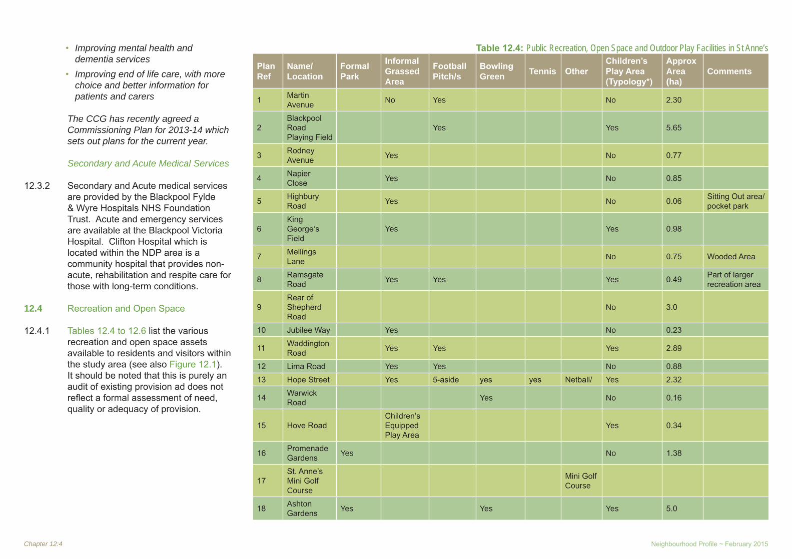
Chapter 12:4 Neighbourhood Profile ~ February 2015
Improving mental health and • dementia servicesImpro• ving end of life care, with more choice and better information for patients and carers
The CCG has recently agreed a Commissioning Plan for 2013-14 which sets out plans for the current year.
Secondary and Acute Medical Services
12.3.2 Secondary and Acute medical services are provided by the Blackpool Fylde & Wyre Hospitals NHS Foundation Trust. Acute and emergency services are available at the Blackpool Victoria Hospital. Clifton Hospital which is located within the NDP area is a community hospital that provides non-acute, rehabilitation and respite care for those with long-term conditions.
12.4 Recreation and Open Space
12.4.1 Tables 12.4 to 12.6 list the various recreation and open space assets available to residents and visitors within the study area (see also Figure 12.1). It should be noted that this is purely an audit of existing provision ad does not reflect a formal assessment of need, quality or adequacy of provision.
Table 12.4: Public Recreation, Open Space and Outdoor Play Facilities in St Anne’s
Plan Ref
Name/Location
Formal Park
Informal Grassed Area
Football Pitch/s
Bowling Green Tennis Other
Children’s Play Area (Typology*)
Approx Area (ha)
Comments
1 Martin Avenue No Yes No 2.30
2Blackpool Road Playing Field
Yes Yes 5.65
3 Rodney Avenue Yes No 0.77
4 Napier Close Yes No 0.85
5 Highbury Road Yes No 0.06 Sitting Out area/
pocket park
6King George‘s Field
Yes Yes 0.98
7 Mellings Lane No 0.75 Wooded Area
8 Ramsgate Road Yes Yes Yes 0.49 Part of larger
recreation area
9Rear of Shepherd Road
No 3.0
10 Jubilee Way Yes No 0.23
11 Waddington Road Yes Yes Yes 2.89
12 Lima Road Yes Yes No 0.88
13 Hope Street Yes 5-aside yes yes Netball/ Yes 2.32
14 Warwick Road Yes No 0.16
15 Hove RoadChildren’s Equipped Play Area
Yes 0.34
16 Promenade Gardens Yes No 1.38
17St. Anne’s Mini Golf Course
Mini Golf Course
18 Ashton Gardens Yes Yes Yes 5.0

St Anne’s Neighbourhood Development Plan Chapter 12:5
Table 12.5: Private Sports Pitches and Facilities in St Anne’s
Plan Ref Name/Location Formal
Park
Informal Grassed Area
Football Pitch/s
Bowling Green Tennis Other Comments
i St. Anne’s Cricket Ground Cricket
iiSt. Anne’s Lawn tennis and Squash Club
Yes
Table 12.6: Public and Private Indoor Sports Facilities in St Anne’s
Plan Ref
Name/Location
Formal Park
Informal Grassed Area
Football Pitch/s
Bowling Green Tennis Other Comments
a
St. Anne’s Lawn tennis and Squash Club
Squash
b YMCASwimming, Gym, MultiSports
The Beach and Sand Dunes
12.4.2 In addition to the inland recreational facilities the large expanse of Beach and Sand Dunes represent a major, and perhaps under exploited recreational resource (subject to environmental considerations).
12.5 Fylde Borough Council Open Space, Sport And Recreation Study: Strategy and Action Plan-2008
12.5.1 This document which undertook an assessment of the needs and adequacy of provision of Open Space and Outdoor playing facilities in Fylde was prepared as a requirement of the now revoked Planning Policy Guidance 17: Planning for Open space, Sport and Recreation and was completed in 2008.
12.5.2 The Study (see Table 12.7 overleaf):identifies St. Anne’s as a Category 1 • Settlement in its hierarchy of open space and recreation provision;sets out recommended aspirational standard • of provision (per 1,000) population for the various typologies; andsets out a recommended acces• sibility standard for each typology; and identifies notional deficiencies.

Chapter 12:6 Neighbourhood Profile ~ February 2015
Table 12.7: Summary of Findings of Fylde Borough Council Open Space, Sport and Recreation Study: Strategy and Action Plan-2008 for St Anne’s
Typology
Recommended Aspirational Standard (ha per 1,000 pop)
Accessibility Notional Deficiency Identified in 2008
Parks and gardens 0.79
All residents to be within 400m of a local park and/or 1,200m of district park and/or 3,200m of a borough park
Accessibility gap to Amenity Green space for residents in northern (squires Gate) part of NDP area. Because of Airport impacting on accessibility and linkages with other parts of St. Anne’s-no action recommended
Natural/semi natural greenspaces
0.60All residents to be within 1,000 metres of natural/semi natural greenspace.
Amenity greenspaces 1.04
All residents to be within 1,000 metres of amenity greenspace provision.
Allotments 0.16All residents to be within 1,000 metres of high quality allotment provision
Notional deficiency of 0.6 ha
Cemeteries 0.15 N/A
Children’s play areas 0.10
All Category 1 and 2 settlements within 400m of a LEAP; provision of a NEAP, casual play area and youth facility in each analysis area
Accessibility gap to Children’s play space provision in northern (squires Gate) part of NDP area. Because of Airport impacting on accessibility and linkages with other parts of St. Anne’s-no action recommended
Civic Spaces 0.02
All residents in Category 1 and 2 settlements to be within 1,000 metres of high quality civic space provision.
Green corridors N/A
Outdoor sports facilities
0.23 All teams to have access to appropriate site at relevant time.

St Anne’s Neighbourhood Development Plan Chapter 12:7
12.5.4 A summary of other key relevant findings of the study in relation to St. Anne’s are:
Parks and Gardens
Report Findings Comment/ Potential Relevance to NDP
Sustainable means of investment needs to be put in place before the parks lose their ability to meet current user needs. The Borough has a legacy of historic Parks and Gardens, which require significant investment. These require full restoration management plans and relevant funding strategies
There is a Ashton gardens 2013-2023 Management and Maintenance plan and further info on current work/proposals to restore waterfall feature as per 1920 design. http://www.fylde.gov.uk/resident/gardens/ashtongardens/Parks and open spaces require a hierarchical approach to their management, maintenance and provision. This will determine the major sites as high priorities due to their location, use and historic designations.
This could be linked to green infrastructure and community activity trail
Parks and open spaces have a significant part to play in the local economy with regards to Tourism income, and in consequence it is essential that a higher than average standard be maintained in these areas with subsequent increased management and maintenance implications.
Noted-Future improvements and linkages between spaces could enhance the visitor experience.
In many areas improving and enhancing the accessibility and quality of existing provision will be more important than new provision.
Potential link to green infrastructure and community activity trail
Residents believe that the provision of parks and gardens is adequate in Lytham and St Anne’s.
This should be reviewed in context of potential population growth.
Residents believe that all parks and gardens in Fylde should be of a similar high standard to Lowther Gardens or Park View Road, which offer a range of amenities for users. (There is a Ashton gardens 2013-2023 management and maintenance plan and further info on current work/proposals to restore waterfall feature as per 1920 design)http://www.fylde.gov.uk/resident/gardens/ashtongardens/
Check with FBC re recent improvements to Aston Gardens.
Parish and Town councils require strategic assistance to develop their community parks and recreation grounds to meet the needs of the community.
12.5.2 The study concludes in respect of St. Anne’s that it has no overall deficiencies, other than in allotment provision (this has subsequently been partly addressed by the Town Council through the provision of a new allotment at Blundell Road in 2011),and the gap in accessibility to green space and children’s play areas to the residential areas on Squires Lane in the northern part of the study area.

Chapter 12:8 Neighbourhood Profile ~ February 2015
Natural/Semi Natural Greenspace
Report Findings Comment/ Potential Relevance to NDP
The role of the 7.5Km stretch of beach, foreshore and dune lands from Starr Gate to Freckleton marshes must be recognised as Country Park designation. This needs to be reflected in the future service management objectives.
Noted-the beach and dunes represent potential major recreation assets as part of green infrastructure strategy and linked by community activity trail.
High value is placed upon semi-natural sites due to their biodiversity and ecological value. They are also valued for the variety of opportunities that they offer to users such as informal play, health, well being and social inclusion benefit and amenity/sense of place.
These sites within the NDP should be afforded additional protection as appropriate through the NDP. They should be incorporated into the Green Infrastructure strategy-linked to additional promotion/ management to maximise access and protection.
Consultation suggests that although there is a significant provision of semi-natural greenspace, the sites are not sufficiently open and accessible. Through greater community engagement and education this perception could be diminished. The coastal nature of Fylde is highly regarded. The coast provides a valuable open space resource for both residents and visitors to the Borough.
Noted-the beach and dunes represent potential major recreation assets as part of green infrastructure strategy and linked by community activity trail.
There is demand for greater publicity about the potential of sand dunes as an important resource which can meet the needs of a variety of users including walkers, children and young people.
Noted-the beach and dunes represent potential major recreation assets as part of green infrastructure strategy and linked by community activity trail.
The conservation, educational, health and tourism value of these sites could be massively improved with the creation of a Coast and Countryside Service. .
The development of a signature building on the gateway to the beach foreshore and dunes system would give a better focus for community activity and improve tourism. The local nature reserve situated adjacent to Pontins Holiday Camp requires a long term vision and master plan.
Consultation with FBC-Potential to incorporate into Green Infrastructure Strategy for NDP
Resources must be identified to implement the sand dunes action plan. Fydle BC Dunes offcier Appointed. Green Corridors Summary
Report Findings Comment/ Potential Relevance to NDP
The role of the 7.5Km stretch of beach, foreshore and dune lands from Starr Gate to Freckleton marshes must be recognised as Country Park designation. This needs to be reflected in the future service management objectives.
Noted-the beach and dunes represent potential major recreation assets as part of green infrastructure strategy and linked by community activity trail.
High value is placed upon semi-natural sites due to their biodiversity and ecological value. They are also valued for the variety of opportunities that they offer to users such as informal play, health, well being and social inclusion benefit and amenity/sense of place.
These sites within the NDP should be afforded additional protection as appropriate through the NDP. They should be incorporated into the Green Infrastructure strategy-linked to additional promotion/ management to maximise access and protection.
St Anne’s Neighbourhood Development Plan Chapter 12:9
Consultation suggests that although there is a significant provision of semi-natural greenspace, the sites are not sufficiently open and accessible. Through greater community engagement and education this perception could be diminished. The coastal nature of Fylde is highly regarded. The coast provides a valuable open space resource for both residents and visitors to the Borough.
Noted-the beach and dunes represent potential major recreation assets as part of green infrastructure strategy and linked by community activity trail.
There is demand for greater publicity about the potential of sand dunes as an important resource which can meet the needs of a variety of users including walkers, children and young people.
Noted-the beach and dunes represent potential major recreation assets as part of green infrastructure strategy and linked by community activity trail.
The conservation, educational, health and tourism value of these sites could be massively improved with the creation of a Coast and Countryside Service. The development of a signature building on the gateway to the beach foreshore and dunes system would give a better focus for community activity and improve tourism. The local nature reserve situated adjacent to Pontins Holiday Camp requires a long term vision and master plan.
Consultation with FBC-Potential to incorporate into Green Infrastructure Strategy for NDP
Resources must be identified to implement the sand dunes action plan. Sand Dune Officer appointed by Fylde BC
Amenity Greenspace
Report Findings Comment/ Potential Relevance to NDP
Consultation indicates that Public Rights of Way (PROW) across the Borough are generally of good quality. In particular users commend the implementation of reporting systems that are in place across the Borough for footpaths and cycle paths. However, there is a perception that bridleways require more attention particularly along Lytham Moss.
PROW network is not extensive within the NDP area-potential for new linkages to be explored as part of community activity trail.
Residents suggest that improvements are required to the PROW network in terms of connectivity. Users believe that access is limited and that neighbouring authorities are better served by PROW. There are aspirations to establish better links across the Borough and greater off-road provision
PROW network is not extensive within the NDP area-potential for new linkages to be explored as part of community activity trail.

Chapter 12:10 Neighbourhood Profile ~ February 2015
Children’s Play Areas
Report Findings Comment/ Potential Relevance to NDP
The quality of play areas varies across the Borough. The highest scoring quality sites offer a range of opportunities for children of a variety of ages, whilst low quality sites are rated as such because of the lack of facilities.
Consultation and update from FBC required on this section.
Consultation identified a shortfall in provision for over 11’s and also of formal play opportunities across the Borough. Subjec to Fylde BC Open Space update study 2015?
A problem pertaining to play areas across the Borough is the lack of variety of equipment. Residents highlight difficulties taking children of different ages to play areas as there is often insufficient equipment to accommodate a cross section of age groups. It is in this respect that Park View Road is regarded to be one of the best play areas in the Borough accommodating children and young people all of ages. Consultation further highlighted the need to fully implement the Borough Play Strategy. Securing external funding and fully utilising developers’ section 106 contributions should be fully maximised. Children’s play must be accelerated up the political agenda. Improved marketing and promotion will increase the profile of Children’s play.
Allotment
Report Findings Comment/ Potential Relevance to NDP
Management of allotment sites is split between respective town/parish councils, FBC and allotment associations. There is a lack of strategic management of provision across the Borough. However, this does not appear to impact on the quality or usage of provision.
The Town Council have responsibility for Allotment provision within St. Anne’ parish. Due to effective management the waiting list now totals 18 people waiting with average waiting time for a plot is 6-8 months.
Users are, in the main, content with the quality and management of allotments. However, consultation and waiting list figures indicate that current provision is not meeting demand.
No demand for additional allotments at the moment, but review in conjunction with any future planning applications for major residential development.
Cemeteries
Report Findings Comment/ Potential Relevance to NDP
Consultation identifies few quality issues impacting upon the usage of sites. Opportunities exist to utilise sites for greater amenity value and to encourage greater use of sites as an open space resource. There is also an opportunity to engage local communities and schools to explore the educational benefits offered by the sites in terms of their historical/heritage value. Additional burial land beyond the existing site boundary must be secured for future burials. N/A

St Anne’s Neighbourhood Development Plan Chapter 12:11
Civic Space
Report Findings Comment/ Potential Relevance to NDP
No shortfall in provision has been identified through consultation, suggesting that there is no specific need for additional civic space in Fylde. Civic spaces are highly valued and play an important role in facilitating town centre community events. In particular, these include the two areas within St. Anne’s Square that are used for civic entertainment and farmers markets etc and the Market Square at Kirkham.
Noted
Bowls
Report Findings Comment/ Potential Relevance to NDP
No latent demand was identified for additional provision. Review in context of population growthThere is opportunity to improve the existing facilities through external funding .The bowling clubs must be supported and encouraged to apply for this.
Golf
Report Findings Comment/ Potential Relevance to NDP
There are five golf courses in Fylde. They are privately owned and managed. Potential for incorporation into Green Infrastructure Strategy and Community Activity Trail?
No latent demand was identified for additional provision. The pitch and putt course on the promenade requires investment. Private sector partnerships should be explored. Consult/ check with FBC
Tennis
Report Findings Comment/ Potential Relevance to NDP
No latent demand was identified through consultation with clubs. Current levels of demand are already met. It is envisaged that any future demand can be accommodated by existing facilities where there appears to be significant capacity available. Floodlighting sites, which are operating at over current capacity, will alleviate overplay and enable clubs to take on new members. According to Sport England’s Active Places Power analysis of demand, there is generally good provision in terms of quantity of indoor facilities in Fylde. The analysis takes account of swimming pools and sports halls.

Chapter 12:12 Neighbourhood Profile ~ February 2015
The analysis suggests an over supply of sports halls in the Borough and there is no apparent need for additional provision. However, a review of access to schools is required, as access is considered to be limited. The analysis does not take account of quality issues.
Subject to Fylde BC Open Space and Playing Pitch update
The analysis suggests an over supply of swimming pools in the Borough and there is no apparent need for additional provision. However, a review of access to private provision (hotels in particular) is required, as it is considered to be limited. The analysis does not take account of quality issues. Swimming pool provision is concentrated in the more urban areas of St. Anne’s and Kirkham. According to KKP’s analysis of demand, Fylde is significantly under-provided in terms of fitness provision, both in terms of current and future demand. Anticipated demand by 2016 equates to the need for an additional 114 fitness stations.
Subject to Fylde BC Open Space and Playing Pitch update
Indoor Sports
Report Findings Comment/ Potential Relevance to NDP
No latent demand was identified through consultation with clubs. Current levels of demand are already met. It is envisaged that any future demand can be accommodated by existing facilities where there appears to be significant capacity available. Floodlighting sites, which are operating at over current capacity, will alleviate overplay and enable clubs to take on new members. According to Sport England’s Active Places Power analysis of demand, there is generally good provision in terms of quantity of indoor facilities in Fylde. The analysis takes account of swimming pools and sports halls. The analysis suggests an over supply of sports halls in the Borough and there is no apparent need for additional provision. However, a review of access to schools is required, as access is considered to be limited. The analysis does not take account of quality issues.
Subject to Fylde BC Open Space and Playing Pitch update
The analysis suggests an over supply of swimming pools in the Borough and there is no apparent need for additional provision. However, a review of access to private provision (hotels in particular) is required, as it is considered to be limited. The analysis does not take account of quality issues. Swimming pool provision is concentrated in the more urban areas of St. Anne’s and Kirkham. According to KKP’s analysis of demand, Fylde is significantly under-provided in terms of fitness provision, both in terms of current and future demand. Anticipated demand by 2016 equates to the need for an additional 114 fitness stations.
Subject to Fylde BC Open Space and Playing Pitch update

St Anne’s Neighbourhood Development Plan Chapter 12:13
12.5.9 Key Theme 6 of the Draft Masterplan relates to: Culture, Leisure, Sport and Recreation. The Issues which the masterplan seeks to address are:
• Potential future opportunities in the creative and cultural sectors – to grow the sector as an employer and increase its value-adding role for tourism, place, and well-beingU• nder-connected cultural and creative sector, with low levels of capacity and issues of limited growth, productivity and talent attraction.Heritage assets in need of restoration.• Future potential of the sports facilities.• Future potential of local national and • international events.F• uture potential of the Leisure assets
Proposed Key Actions
To work with the Cultural Partnership to • develop a strategic framework tomaximise arts opportunities across the • Fylde Coast and identify opportunities for investment.To ensure that the LEP growth plan • recognises Culture, Creative Industries and the Visitor Economy as key economic drivers.To work in partnership with Sport England to • Develop a sport plan.
Blundell Road Allotments (O.12 ha)
12.5.5 The Town Council created Blundell Road Allotments in 2011. It purchased the land and created around 30 plots. Part of these are let as small allotment plots at a nominal rent to the residents of St. Anne’s. Part are available for community groups at no charge.
12.5.6 The award winning site is very popular because the plots are smaller than the larger ones available at Shepherd Road Allotments (that the Town Council also own/manage).
Other Public and Private Facilities
12.5.7 The area’s schools provide additional indoor and outdoor sports facilities. In addition, several hotels provide private gym and swimming pool facilities which are available to non- residents.
Draft Fylde Coastal Masterplan-March 2014
12.5.8 The purpose of the Fylde Coastal Master plan initiative is to collate and coordinate all current strategies and policy objectives for coastal protection, water quality, nature conservation, habitat improvement and landscape enhancement, conservation of the built and natural heritage, culture, leisure sport and recreation, tourism and the visitor economy, access and transportation and develop high level actions to address the major issues affecting the Fylde Coast.
To work in partnership with the major leisure • providers and clubs and organisations to ensure sustainable facilities and varied and diverse sports activities.
12.6 Planning Policy Context-Culture and Social Infrastructure
What the NPPF says
12.6.1 Paragraph 17 of the NPPF states that planning should proactively drive and support sustainable economic development, and this includes the delivery of infrastructure. It also states that planning should take account of and support local strategies to improve health, social and cultural wellbeing for all, and deliver sufficient community and cultural facilities and services to meet local needs; and should identify priority areas for infrastructure provision.
12.6.2 Paragraph 21 requires that planning policies should recognise and seek to address potential barriers to investment, including any lack of infrastructure
12.6.3 Paragraph 23 says that planning policies should be positive, promote competitive town centre environments and set out policies for the management and growth of centres over the plan period. In drawing up Local Plans, local planning authorities should allocate a
Outdoor Sports
Report Findings Comment/ potential relevance to NDP
Outdoor pitch management needs to follow the Playing Pitch Strategy. External funding and new partnerships need to be explored to improve the Boroughs premier sites: Park View Playing Fields, Segar Hodgson and Blackpool Road Playing Fields.

Chapter 12:14 Neighbourhood Profile ~ February 2015
range of suitable sites to meet the scale and type of retail, leisure, commercial, office, tourism, cultural, community and residential development needed in town centres.
12.6.4 Paragraph 42 says that the development of high speed broadband technology and other communications networks also plays a vital role in enhancing the provision of local community facilities and services.
12.6.5 Paragraph 69 says that the planning system can play an important role in facilitating social interaction and creating healthy, inclusive communities. Local planning authorities should create a shared vision with communities of the residential environment and facilities they wish to see. To support this, local planning authorities should aim to involve all sections of the community in the development of Local Plans and in planning decisions, and should facilitate neighbourhood planning. Planning policies and decisions, in turn, should aim to achieve places which promote:
op• portunities for meetings between members of the community who might not otherwise come into contact with each other, including through mixed-use developments, strong neighbourhood centres and active street frontages which bring together those who work, live and play in the vicinity; safe and accessible environments where • crime and disorder, and the fear of crime, do not undermine quality of life or community cohesion; and safe and accessible developments, • containing clear and legible pedestrian routes, and high quality public space, which encourage the active and continual use of public areas.
12.6.6 Paragraph 70 says that to deliver the social, recreational and cultural facilities and services the community needs, planning policies and decisions should:
plan positively for the provision and use of • shared space, community facilities (such as local shops, meeting places, sports venues, cultural buildings, public houses and places of worship) and other local services to enhance the sustainability of communities and residential environments; guard against the unnecessary loss of valued • facilities and services, particularly where this would reduce the community’s ability to meet its day-to-day needs; ensure that established shops, facilities and • services are able to develop and modernise in a way that is sustainable, and retained for the benefit of the community; and ensu• re an integrated approach to considering the location of housing, economic uses and community facilities and services.
12.6.7 Paragraph 71 says that local planning authorities should take a positive and collaborative approach to enable development to be brought forward under a Community Right to Build Order, including working with communities to identify and resolve key issues before applications are submitted.
12.6.8 Paragraph 72 says that the Government attaches great importance to ensuring that a sufficient choice of school places is available to meet the needs of existing and new communities. Local planning authorities should take a proactive, positive and collaborative approach to meeting this requirement, and to development that will widen choice in education. They should:
give great weight to the need to create, • expand or alter schools; andwork with • schools promoters to identify and resolve key planning issues before applications are submitted.
12.6.9 Paragraph 73 says that access to high quality open spaces and opportunities for sport and recreation can make an important contribution to the health and well-being of communities. Planning policies should be based on robust and up-to-date assessments of the needs for open space, sports and recreation facilities and opportunities for new provision. The assessments should identify specific needs and quantitative or qualitative deficits or surpluses of open space, sports and recreational facilities in the local area. Information gained from the assessments should be used to determine what open space, sports and recreational provision is required.
12.6.10 Paragraph 74 says that existing open space, sports and recreational buildings and land, including playing fields, should not be built on unless:
an assessment has been undertaken which • has clearly shown the open space, buildings or land to be surplus to requirements; orthe loss resulting from the proposed • development would be replaced by equivalent or better provision in terms of quantity and quality in a suitable location; or th• e development is for alternative sports and recreational provision, the needs for which clearly outweigh the loss.

St Anne’s Neighbourhood Development Plan Chapter 12:15
12.6.15 Local Green Space designation is for use in Local Plans or Neighbourhood Plans. These plans can identify on a map (‘designate’) green areas for special protection.
12.6.16 Designating any Local Green Space will need to be consistent with local planning for sustainable development in the area. In particular, plans must identify sufficient land in suitable locations to meet identified development needs and the Local Green Space designation should not be used in a way that undermines this aim of plan making.
12.6.16 Local Green Space designation will rarely be appropriate where the land has existing planning permission for development. Exceptions could be where the development would be compatible with the reasons for designation or where planning permission is no longer capable of being implemented.
12.6.17 The green area will need to meet the criteria set out in Paragraph 77 of the National Planning Policy Framework. Whether to designate land is a matter for local discretion. For example, green areas could include land where sports pavilions, boating lakes or structures such as war memorials are located, allotments, or urban spaces that provide a tranquil oasis.
12.6.18 Land designated as Local Green Space may potentially also be nominated for listing by the local authority as an Asset of Community Value. Listing gives community interest groups an opportunity to bid if the owner wants to dispose of the land.
Fylde Local Plan
12.6.19 The Fylde Local Plan (As Altered) (2005) says that modern day society depends upon a range of community services and facilities, responsibility for which broadly lies outside the Borough Council. Lancashire County Council is responsible for state education, social services, police, fire, libraries and museums. The Blackpool, Wyre and Fylde Community Health Services NHS Trust and the North West Lancashire Health Authority (now Fylde and Wyre CCG) are responsible for health service provision. A range of other services including cultural, private, social, religious and private education are provided by private institutions and companies.
12.6.20 Part of the value of the local plan is to identify for service providers where the main areas of new development are to be located so that this information can be used effectively to plan investment and capital works. As such service providers are consulted on the main development proposals. This also helps to ensure that development takes place in areas that are capable of sustaining growth in terms of existing and planned infrastructure. Where service providers can identify land needs for new facilities e.g. new roads, schools, hospitals, cemeteries, safeguarding proposals can be included in the plan to facilitate their development.
12.6.21 Development by statutory undertakers and public service providers can sometimes have a significant effect on the environment and it is important that where such development requires planning permission it is carried out in an acceptable way in terms of location, siting, design, materials and landscaping. It is also important that where facilities are to be visited by the community at large, they should be
12.6.11 Paragraph 75 says that planning policies should protect and enhance public rights of way and access. Local authorities should seek opportunities to provide better facilities for users, for example by adding links to existing rights of way networks including National Trails.
12.6.12 Paragraph 162 says that local planning authorities should work with other authorities and providers to:
a• ssess the quality and capacity of infrastructure for transport, water supply, wastewater and its treatment, energy (including heat), telecommunications, utilities, waste, health, social care, education, flood risk and coastal change management, and its ability to meet forecast demands; and take account of the need for strategic • infrastructure including nationally significant infrastructure within their areas.
12.6.13 Paragraph 171 says that local planning authorities should work with public health leads and health organisations to understand and take account of the health status and needs of the local population (such as for sports, recreation and places of worship), including expected future changes, and any information about relevant barriers to improving health and well-being.
Local Green Space Designation
12.6.14 Local Green Space designation (para 76) is a way to provide special protection against development for green areas of particular importance to local communities.
Chapter 12:16 Neighbourhood Profile ~ February 2015
well-related to existing urban development and easily accessible to the population they serve, not only in terms of private transport but also in terms of access by foot, cycle and public transport.
12.6.22 Policy CF1 says that development involving the provision, extension or improvement of community or utility services will be permitted, subject to the following criteria:1. The development is located within a
settlement except where necessarily required to provide a service to a rural area;
2. The development is appropriately located having regard to adjacent and nearby land uses and would not prejudice residential amenity;
3. The development is appropriately sited, designed and landscaped and would not prejudice visual amenities or the character of the area;
4. Adequate vehicular access, parking, loading and manoeuvring areas for vehicles can be provided;
5. Satisfactory foul and surface water drainage disposal arrangements can be provided.
12.6.23 Policy CF3 says that the redevelopment of redundant school sites and other redundant educational establishments will be permitted providing that:-1. The proposed land use is acceptable
having regard to the nature of the site, adjacent and nearby land-uses and it would not prejudice residential amenity;
2. The development is appropriately sited, designed and landscaped and would not prejudice visual amenities or the character of the area;
3. Satisfactory vehicular access, parking, loading and manoeuvring facilities can be provided where appropriate;
4. Satisfactory foul and surface water drainage disposal arrangements can be provided.
12.6.24 The development of playing fields attached to redundant schools will not be permitted where they have special significance in terms of their recreational value or potential; or where they have a high amenity value and make a special contribution to the green space of an urban area; or where the area has a shortage of public open space or recreational play space.
12.6.25 Policy CF4 advises that Children’s day nursery schools provide a valuable function in today’s society. Whilst these are normally acceptable, in principle, in residential areas, they can cause noise disturbance, additional traffic, vehicle manoeuvring and car parking problems. The policy says that to avoid such loss of amenities to local residents the Council considers that nurseries are best located in detached properties with large private gardens or other large buildings where the effect of their day to day operations would not have significant effect on neighbouring and nearby properties. It will be important that adequate on site car parking and dropping off areas are provided.
12.6.26 Policy CF5 advises that residential care homes (including nursing homes, elderly persons’ homes and other special care homes) are residential in character and appropriately located within residential areas. Development of such facilities can be by way of new-build or from conversion of large existing dwellings or
other buildings. Where residential care facilities are proposed, the amenities of residents in the locality need to be protected, and that undue disturbance or adverse change in character of the neighbourhood does not take place. Good design, adequacy of curtilage areas, landscaping and car parking are all important aspects of an acceptable scheme. Whilst residential in nature, the Council recognises that the development of an over-concentration of such uses could lead to a change of character in a locality and will seek to avoid this situation.
12.6.27 Policy CF6 says that the community use of school facilities will be permitted providing that:-1. The amenities of nearby or adjacent
premises are not prejudiced;2. Vehicular access and car and cycle
parking facilities are adequate.
The justification text says that the Borough Council will support appropriate use of school facilities for community purposes and will encourage the County Council as local education authority and other private educational establishments to make facilities available where possible.
12.6.28 Policy TREC 10 says that development proposals for rural recreational purposes in the countryside areas will be permitted provided that they do not prejudice agriculture, nature conservation and other environmental interests, or conflict with the quiet enjoyment of other recreational users of the countryside.
St Anne’s Neighbourhood Development Plan Chapter 12:17
12.6.32 Policy TREC 15 says that The golf courses at the St. Anne’s Old Links, Fairhaven, Lytham Green Drive And The Royal Lytham St. Anne’s Golf Clubs will remain in their existing use. Development proposed within the golf courses will not be permitted unless it is associated with golf or sport or it is ancillary to the existing golf course use.
12.6.33 Policy TREC 16 says that in countryside areas and green belts, the development of new golf courses and other outdoor recreational facilities requiring extensive areas of open land will be permitted subject to specified criteria being met.
12.6.34 Policy TREC 17 says that within housing developments, the provision of an amenity open space with facilities for children’s play, where appropriate, will be required to follow specified minimum standards.
12.6.35 Unless otherwise agreed the open space must be provided as a single central useable facility. For housing proposals that would produce or contribute to a development of 100 dwellings or more, the provision of twice the above requirements will be required. Arrangements will have to be made by developers to provide for effective future maintenance of areas of open space provided in accordance with this policy. Where the standards would require the provision of an open space of less than 0.2 ha or where for other reasons it is agreed between the developer and the council that the open space would be better provided off site, payment of a commuted sum will be sought to help provide additional or improved open space or other recreational facilities nearby where the benefits would serve the occupiers of the new development.
12.6.36 Policy TREC 18 says that development on allotment gardens will not be permitted unless it can be demonstrated that little demand exists and the allotments are substantially under-used or that alternative equivalent or improved facilities will be provided in the same locality.
The Emerging Local Plan
12.6.37 The Fylde Local Plan to 2030 Part 1- Preferred Options paper says that a vital element of sustainable development is the provision and delivery of local services and infrastructure.
12.6.38 The Council is producing an Infrastructure Delivery Plan (IDP) which will identify the infrastructure required to deliver the Local Plan and how it will be delivered. In doing this, it will identify obstacles to the delivery of the Local Plan and how these will be overcome. The IDP will also identify gaps in funding, and will therefore inform the Community Infrastructure Levy (CIL), which is a levy the Council may use to charge on new developments. More information on CIL is set out in Policy INF2.
12.6.39 The Fylde Local Plan to 2030 Part 1- Preferred Options paper sets out the following policies relating to utilities and physical infrastructure.
Strategic Objective 2 is: to improve the environment by, inter alia, ensuring that infrastructure is available to enable new development, whilst protecting and enhancing the natural and built environment.
12.6.29 Policy TREC 12 says that all existing indoor public and private sport and recreation facilities will be retained. Proposals for the redevelopment of such facilities for other purposes will not be permitted. Proposals to provide additional or improved sports and recreation facilities will be permitted within settlements providing the following criteria can be met
12.6.30 Policy TREC 13 says that all existing areas of public open space will be safeguarded from development unless as a result of development, equivalent or improved provision would be achieved in the locality.
12.6.31 Policy TREC 14 says that playing fields and recreational facilities, including the following facilities, will be safeguarded from development. Planning permission for development on playing fields and other recreational facilities will not be permitted unless certain specified criteria are met.
• Bowling Green, Warwick Road, St Anne’s; Bowling Green, Hornby Road, St Anne’s; • Cricket Ground, Vernon Way, St Anne’s; • Tennis Courts, Avondale Road, St Anne’s;• Playing Field, Blackpool Road North, St. • Anne’s; Blackpool Football Club Training Ground, • Martin Avenue, Squires Gate; Bowling Greens, Ashton Gardens, St • George’s Road, St Anne’s; Tennis Courts, Bowling Greens, Fairhaven • Lake, Inner Promenade, Lytham St Anne’s; School Playing Fields.•

Chapter 12:18 Neighbourhood Profile ~ February 2015
a) Make the most of existing infrastructure by focusing on sustainable locations with the best infrastructure capacity;
b) Mitigate any negative impacts on the quality of the existing infrastructure as a result of new development;
c) Where appropriate, contribute towards improvements to existing infrastructure and provision of new infrastructure, as required to support the needs of the development;
d) Where appropriate, demonstrate how access to services will be achieved by means other than the car; and where appropriate, demonstrate how the range of local social and community services and facilities available will be suitable and accessible for the intended user(s) of the development; and
e) Where new development is proposed in the areas of the Blackpool Periphery; Kirkham and Wesham; Lytham and St Anne’s; and Warton that are affected by limitations on waste water treatment, they should be phased to ensure delivery of the development coincides with the delivery of an appropriate solution which meets the standards of the Council, the Statutory Undertaker and the Regulators.
12.6.43 The Council will support delivery of broadband in line with the Lancashire Broadband Plan and communications technology to all parts of the Borough and will encourage and facilitate its use in line with national policy.
12.6.44 Policy INF 2 - Developer Contributions recognises that all development, regardless of size and scale, places additional demands on services and facilities, impacting on their
Strategic Objective 5 is: to develop socially cohesive, diverse and healthy communities by1. Engaging and empowering local
communities to be involved in local matters that shape their areas.
2. Ensuring that new development seeks to address pockets of deprivation.
3. Increasing and enhancing open space provision throughout the Borough.
4. Promoting good health and wellbeing by providing accessible high quality open space in association with new developments.
5. Incorporating crime prevention measures into the design and layout of new development.
6. Reducing urban isolation and rural exclusion through the promotion of appropriate tenure mixes in new developments and improved accessibility to key services and facilities.
7. Promoting access to and support for lifelong learning opportunities and providing adequate school places.
8. Facilitating access to community facilities, including health and social facilities and developing socially cohesive, diverse and healthy communities by investment in existing and the provision of new formal sports facilities across the Borough.
12.6.40 Health and wellbeing considerations are referenced throughout the Local Plan. Policy HW1 concentrates on three particular aspects, namely the provision of health care services, access to healthy food and the requirement for Health Impact Assessments. It says that the Council will integrate public health principles and planning and help to reduce health inequalities by:
a) Working with health care commissioners to support healthcare facilities and particularly to improve primary care and mental health care access and facilities;
b) Where required by the priorities of Lancashire County Council and health care commissioners, identifying sites for new facilities reflecting the spatial distribution of need and the importance of accessibility and public transport provision;
c) Seeking contributions, where appropriate and viable, towards new or enhanced facilities from developers where new housing results in a shortfall or worsening of provision;
d) Safeguarding and encouraging the role of allotments, garden plots within developments and small scale agriculture and farmers markets in providing access to healthy, affordable locally produced food options.
12.6.41 Policy INF 1 - Service Accessibility and Infrastructure advises that the Infrastructure Delivery Plan identifies particular infrastructure requirements within the Borough that are needed to support the Local Plan and ensure delivery of sustainable communities.
12.6.42 The Policy states that new development will be required to provide essential site service and communications infrastructure and demonstrate that it will support infrastructure requirements as set out in the Infrastructure Delivery Plan.
In order for Fylde to protect and create sustainable communities, proposals for development should:

St Anne’s Neighbourhood Development Plan Chapter 12:19
Charging Schedule. The types of infrastructure that developments may be required to provide contributions towards include, but are not limited to: a) Utilities and Waste (where the provision
does not fall within the utility providers legislative obligations);
b) Flood prevention and sustainable drainage measures (see policy CL1);
c) Transport (highway, rail, bus and cycle / footpath network, canal and any associated facilities);
d) Community Infrastructure including health, education, libraries, public realm and community facilities (see glossary);
e) Green Infrastructure (such as outdoor sports facilities, open space, parks, allotments, play areas, enhancing and conserving biodiversity and management of environmentally sensitive areas) (see policies ENV3 and ENV4);
f) Climate change and energy initiatives through allowable solutions; and
g) Affordable housing. Where appropriate, the Council will permit developers to provide the necessary infrastructure themselves as part of their development proposals, rather than making financial contributions.
12.6.49 Policy ENV2 - Protecting Existing Open Space and Green Infrastructure says that the existing open space and green infrastructure network in Fylde will be protected, unless development is permitted as part of the Local Plan, the landscape, biodiversity and water management requirements of the Local Plan are met and the requirements set out in this policy are met:
a) Existing public open space, including sports and playing pitches, will be protected unless the requirements of paragraph 74 of the NPPF are met.
b) Development that results in the loss of registered Historic Parks and Gardens of national importance, as set out below, will not be permitted. Development within a registered Historic Park or Garden, or development that affects its setting, will not be permitted where this would prejudice its quality, character or appearance.
c) Development will not be permitted on areas of open space which are considered essential to the setting, character or visual amenities of towns and villages. Specific sites will be identified in the Fylde Local Plan Part 2: Site Allocations to 2030.
d) Development that results in the loss of school playing fields will only be permitted if the development is for the necessary extension of an existing school and an adequate area of playing field is retained.
e) Development that results in the loss of land used for allotments will only be permitted when:i. Suitable, alternative provision is made
that is at least equivalent in size and quality to that which will be lost; or
ii. It can be demonstrated that there is no longer a community need for the allotments.
f) Fylde’s Public Rights of Way network, byways, cycleways and bridleways will be safeguarded and opportunities to extend the networks will be supported where this improves access to key green infrastructure assets, including areas of Green Belt and the Area of Separation.
ability to meet the needs of the community. The Community Infrastructure Levy (CIL) will create a system which will pass the cost of infrastructure improvements on to those developments above 100 m2 which are considered to be of a type viable to charge CIL. This will allow the Council greater autonomy over expenditure and ensure strategic infrastructure aims are met along with localised objectives.
12.6.45 The introduction of a CIL charging schedule will not remove the requirement for Section 106 planning obligations which will continue to be used in accordance with the tests set out within the CIL regulations. Planning obligations are a key delivery tool, providing the opportunity to secure financial contributions which mitigate against the localised impacts of development which would otherwise render the proposal unacceptable in planning terms.
12.6.46 The Infrastructure Delivery Plan identifies particular infrastructure requirements within the Borough that are needed to support the Local Plan and ensure delivery of sustainable communities. The CIL and Section 106 agreements will be vital in supporting the delivery of infrastructure, along with other funding streams.
12.6.47 The Policy states that new development will normally be expected to contribute towards the mitigation of its impact on infrastructure, services and the environment and contribute towards the requirements of the community. This may be secured as a planning obligation through a Section 106 agreement, where the development would otherwise be unacceptable, or through the Community Infrastructure Levy (CIL), at such time as the Council has prepared a Standard 12.6.48

Chapter 12:20 Neighbourhood Profile ~ February 2015
12.6.52 Policy EC5 Leisure, Culture and Tourism Development says that the Council will plan for leisure, culture and tourism by: a) Promoting St. Anne’s as a ‘classic resort’. b) Supporting physical regeneration of
Lytham and St. Anne’s seafront area to maintain the hotel market and support wider tourism and the local economy.
c) Promoting improvement and enhancement of the man made coastal defences at Pleasure Island, Fairhaven Lake and Church Scar in order to encourage tourism and help maintain flood defences (see Policy CL1).
d) Encouraging daytime and evening business, leisure, cultural and heritage based tourism facilities, such as hotels, restaurants, cinemas, theatres, museums, swimming pools and leisure centres within the town centres.
e) Protecting existing tourism, cultural and leisure assets, such as golf courses and the seaside resort facilities, with a view to helping them to adapt to new challenges.
f) Promoting public art and public realm works within settlements and seeking developer contribution funding where appropriate.
g) Promoting beach leisure, activities and events.
12.6.50 Policy ENV3 - Provision of Open Space and Green Infrastructure. Amenity Open Space says that within new housing developments comprising ten or more dwellings (excluding flats and residential caravan parks) the provision of amenity open space with facilities for children’s play, where appropriate, will be required in line with minimum standards set out in the policy. It says that Financial contributions will be sought through the Community Infrastructure Levy to assist schemes for other open space and green infrastructure where there is an identified need, including the provision of allotments, trees and woodland. Opportunities to link green infrastructure resources to create a multi-functional green infrastructure network will be maximised. Financial contributions will be sought through the Community Infrastructure Levy to assist such schemes. The provision of a new country park in the grounds of Lytham Hall, or an alternative location that meets Fylde’s deficit in park and garden provision, will be supported and contributions will be sought through the Community Infrastructure Levy.
12.6.51 Policy ENV4 - Management and Enhancement of Open Space and Green Infrastructure says that financial contributions will be sought through the Community Infrastructure Levy for the management and enhancement of open space and green infrastructure, including the Ribble Coast and Wetlands and the Coastal Parkway. This includes enhancing the functionality, quality, connectivity and accessibility of open space and green infrastructure. Developer contributions will also be sought for other schemes that will result in the enhancement of the functionality, quality, connectivity and accessibility of open space and green infrastructure in Fylde.
12.6.53 Policy EC6 Leisure, Culture and Tourism Accommodation says that serviced tourism accommodation (hotels) will be permitted in the primary holiday areas in St. Anne’s, as defined on the inset map. Non serviced tourism accommodation uses in these areas will be resisted. Leisure and tourism development will be encouraged in the North Promenade and South Promenade Sea Front area of St. Anne’s and at Fairhaven Lake Sea Front area of Ansdell/Fairhaven, as defined on the inset map.

St Anne’s Neighbourhood Development Plan Chapter 12:21
12.7 Key Issues
Ref Key Issues Comments / Possible Options
1. Health
1
There is anecdotal evidence of pressures on existing GP practices, with difficulty in arranging convenient appointments.
The potential impact of additional population growth arising from committed new housing sites may require additional GP provision.
Proposal in Implementation Plan - consider CIL funding or •to influence CCG fundingConsider specific policies e.g. to ensure GP practices •provide access for all residents within a reasonable distance and/or that any new Development would require the provision of a new practice •or an extension of one or more of the existing practices
1.2 There is no provision for out of hours Dr’s/health provision within the Town. Currently residents must travel to Blackpool for any out of hours care.
Consider a policy on the provision of out of hours Drs/ •health provision for the residents of St. Annes, in St. Anne’s.
2 Education
2.1 There is evidence of existing capacity issues for primary school provision in the NDP area. These capacity pressures may be increased with already committed housing development.
Allocate land for new primary school •Proposal in Implementation Plan - consider CIL funding •
2.2 The timing of the proposed Primary School at Queensway will be critical if adequate primary school provision is to be available to new and existing residents of the Town
Consider specific policy to promote the early provision of •the proposed primary school
2.3 Potential requirement for new secondary school provision3 Assets of Community Value
3.1Should the NDP identify Assets of Community Value?If so, what protection should it give to them?
Consider specific policy to identify Assets of Community •ValueProposal in Implementation Plan - consider CIL funding •
3.2Should the NDP identify Assets of Community Value?If so, what protection should it give to them?
Consider specific policy to identify Assets of Community •ValueProposal in Implementation Plan - consider CIL funding •
3.3Should the NDP identify Assets of Community Value?If so, what protection should it give to them?
Consider specific policy to identify Assets of Community •ValueProposal in Implementation Plan - consider CIL funding •
4 Encouraging an Active and Healthy Lifestyle
4.1 Is there potential for the NDP to promote an active lifestyle for all age groups, e.g. through a new community activity trail linking key recreation and social infrastructure assets?
Consider specific policy to promote provision of community •activity trail
5 Supported Accommodation

Chapter 12:22 Neighbourhood Profile ~ February 2015
5.1Is there a requirement for supported accommodation for families with children in need?Is there a need for more supported housing accommodation due to the age of the town’s population?
Consider specific policy to promote provision of housing •accommodation for both families with children in need and the aging population
6 New Community Hub6.1 Is there a requirement for a new community Hub?7 Childrens and Youth Facilities7.1 Is there a requirement for better activity and play facilities for children and young people?8 Open Space, Recreation and Leisure
8.1
Address potential shortfall /accessibility to Amenity Green space/ Children’s play space provision in northern (Squires Gate) part of NDP area.How should this shortfall be addressed?Can a suitable site be identified?
Consider specific policy requiring specific provision/ •accessibility improvements as part of new developmentAllocate a specific site for new provision; •Proposal in Implementation Plan - consider CIL funding •
8.2
Address potential shortfall/Civic space along outer edges of St. Anne’sEnsure provision in new outer development areas.- Possibly through a country park designationThe FBC Preferred Options Document shows a potential large open space allocation on open countryside to the east of the town. This could potentially be developed as a country park, linked by footpath and cycle routes to rest of town
Consider specific policy requiring specific provision/ •accessibility improvements as part of new developmentAllocate a specific site for new provision •Consider country park designation •Proposal in Implementation Plan - consider CIL funding •
8.3 Is a specific NDP Green Space Strategy requiredDeliver a Green Space Strategy •Policy relating to Green space Strategy •
8.4 Maintenance and management of existing facilities. Proposal in Implementation Plan - consider CIL funding •
8.5 Need for Improved Linkages between existing Recreation and Open SpacesConsider specific Policy to develop new footpath and •cycle links, e.g. as part of Green Infrastructure Strategy/ Community Activity Trail
8.6Potential Beach and Dunes Country Park:The Beach and Dunes are a major environmental and recreational resource. The FBC Open Space 2008 study recommends that the beach and dunes be designated and managed as a country park.
Consider specific policy requiring specific provision/ •accessibility improvements as part of new developmentAllocate a specific site for new provision •Consider country park designation •Proposal in Implementation Plan - consider CIL funding •
8.7
Local Green Space Designation:Existing Green spaces can be protected by being designated as Local Green Space (para 76 of NPPF). They may also be included in the Community Asset Register. Should the NDP identify Local Green Spaces, and if so, which?
An audit of existing green spaces can be prepared to •consider and justify designation of existing open space areas (against criteria set out in NPPF and Guidance) as Local Green Space and included as a specific policy in the NDP

St Anne’s Neighbourhood Development Plan Chapter 12:23
8.8
Address potential shortfall /accessibility to Amenity Green space/ Children’s play space provision in northern (Squires Gate) part of NDP area.How should this shortfall be addressed?Can a suitable site be identified?
Consider specific policy requiring specific provision/ •accessibility improvements as part of new developmentAllocate a specific site for new provision; •Proposal in Implementation Plan - consider CIL funding •
8.9
Address potential shortfall/Civic space along outer edges of St. Anne’sEnsure provision in new outer development areas.- Possibly through a country park designationThe FBC Preferred Options Document shows a potential large open space allocation on open countryside to the east of the town. This could potentially be developed as a country park, linked by footpath and cycle routes to rest of town
Consider specific policy requiring specific provision/ •accessibility improvements as part of new developmentAllocate a specific site for new provision •Consider country park designation •Proposal in Implementation Plan - consider CIL funding •
8.10 Is a specific NDP Green Space Strategy requiredDeliver a Green Space Strategy •Policy relating to Green space Strategy •
8.11 Maintenance and management of existing facilities. Proposal in Implementation Plan - consider CIL funding •
8.12 Need for Improved Linkages between existing Recreation and Open SpacesConsider specific Policy to develop new footpath and •cycle links, e.g. as part of Green Infrastructure Strategy/ Community Activity Trail
8.13 Is there need to protect proposed open space provision approved as part of Queensway-possibly through designation as a country park?
9 Potential impact of Population Growth
9.1 a-Within existing urban area, increased populations could place pressure on existing facilitiesSpecific policies including, protection of open space, •Specific policy to upgrade existing facilities, all new •housing development to provide appropriate open space
9.2 b-New development outside current boundaries will require new comprehensive provision Specific policy to make appropriate on site provision (in •accordance with open space hierarchy / requirement)
REFERENCES & DOCUMENTS REVIEWED
1. Fylde Borough Council Open Space, Sport and Recreation Study: Strategy and Action Plan-20082. The National Planning Policy Framework –DCLG-20123. Fylde Borough Local Plan-May 20034. Fylde Borough Local Plan Alterations Review-October20055. Fylde Local Plan to 2030: Part 1 - Preferred Options-July 20136. Developing Infrastructure Development Plan – Fylde BC- 2013

Chapter 12:24 Neighbourhood Profile ~ February 2015

St Anne’s Neighbourhood Development Plan
Chapter 13
Utilities & Physical
Infrastructure

Neighbourhood Profile ~ February 2015
St Anne’s Neighbourhood Development Plan Chapter 13:1
13.1 Introduction
13.1.1 This chapters describes the physical infrastructure and minerals constraints and opportunities which need to be addressed by the Neighbourhood Plan
13.1.2 Physical infrastructure includes transport, utilities and energy. Transport is dealt with separately in Chapter 11: Transport and Movement.
13.1.3 As part of work on the emerging Local Plan, Fylde Council is engaging with infrastructure providers to determine the key infrastructure capacity issues and infrastructure projects that impact upon Fylde. An Infrastructure Delivery Plan (IDP) will be produced, which will provide details of the infrastructure needed to support the Local Plan, who will provide it and what it will cost. The Developing Infrastructure Delivery Plan for Fylde was published for consultation in June 2013, in support of the consultation on the The Local Plan to 2030: Part 1: Preferred Options.
13.2 Flood Defence
13.3.1 The draft Blackpool and Fylde Coast Protection Strategy 2011 provides a long term plan (100 years) for the management of the flood defences along the Blackpool and Fylde coast. The Strategy highlights the poor condition of much of the man-made coastal defences and the erosion of the dune system.
13.3.2 The Council is responsible for undertaking coastal defence inspections and maintenance works on flood defences from Squires Gate to the former Land Registry building at the southern end of Lytham Green. The
Environment Agency is responsible for maintaining most of the defences from the former Lytham Land Registry building to Naze Point, near Freckleton.
13.3.3 The Borough’s dunes act as a natural form of
defence, and are generally in good condition. The IDP notes that there is evidence of roll-back at the dunes between Squires Gate and St. Anne’s Pier, and that the presence of the coastal road and residential and commercial properties is hindering this natural process. There are also a number of unmanaged access points through the dunes which has resulted in erosion of parts of the dune system. The IDP notes that, one of the aims of the Fylde Sand Dunes Management Plan 2008 is to improve the efficiency of the dunes and saltmarsh as soft sea-defence (with associated cost savings in maintenance of hard sea-defences). The IDP further notes that if no action is taken, the hard flood defences at Pleasure Island will fail, resulting in flooding to residential and commercial properties, tourism assets, infrastructure and services. In addition, the ceasing of dune management activities would increase the risk of a breach of the dunes leading to potential flooding of properties and infrastructure.
13.3.4 Further guidance is available in the Blackpool
and Fylde Coast Protection Strategy 2011.
13.3.5 The preferred strategy identified in the IDP between St. Anne’s Pier and Fairhaven Lake is to replace the existing hard defences. This would include a wide promenade and set back flood wall. Such an approach would have the additional benefit of encouraging more visitors to the frontage, bringing economic benefits to the area and regeneration benefits to the frontage.
13.3.6 The IDP notes that the cost of providing the necessary infrastructure to improve coastal defences could exceed £100 Million. In addition to these costs, there are a number of other associated costs, including the design and supervision of the works and the maintenance of the structures. It advises that Fylde Borough Council will bid for funding for the replacement of the flood defences at Pleasure Island and Church Scar. The IDP notes that CIL contributions will be considered for dune management
13.3 Foul and Surface Water
13.3.1 Fylde’s sewer system is a combined system, which means that it takes foul and surface water. Most of Fylde’s foul and surface water is transported via the pumping stations to the wastewater treatment works at Clifton Marsh, near Preston.
13.3.2 The IDP advises that the wastewater pumping stations at Fairhaven and Lytham are generally operating in line with their design control principle, but they are close to capacity. This is mainly due to the amount of surface water that enters the sewer system. It means that any further development that enables large flows of surface water to enter the network in the Lytham St. Anne’s area will increase the risk of spillage into the Ribble estuary. In particular, storm surges can overwhelm the system with surface water, resulting in spillage into the estuary. The bathing waters at St. Anne’s are failing the current bathing water standards and under the revised Bathing Water Directive, which comes into force in 2016, there could be advice against bathing from 2016 onwards, with disastrous implications for tourism.
13.0 Utilities & Physical Infrastructure

Chapter 13:2 Neighbourhood Profile ~ February 2015
13.3.3 These issues highlight the requirement that new development in the Lytham St. Anne’s area should not discharge further surface water into the sewer network. Fylde has watercourses which could potentially carry away surface water, thus preventing it from entering the sewer network. However, these generally connect to Liggard Brook and Main Drain, which discharge into the Ribble Estuary at Lytham, where there are significant flood risk issues.
13.3.4 The IDP advises that options for dealing with surface water and its removal from the existing network will need to be explored. United Utilities recommend that any proposals for housing development will need to consider in detail the use of Sustainable Urban Drainage Systems (SuDS) and other water attenuation methods such as balancing ponds, as part of any future planning application.
13.3.5 The IDP identifies the priority options for the
management of surface water as follows: Continue and/or mimic the site’s current • natural discharge process; Store for later use; • Discharge into infiltration systems located in • porous sub soils; Divert flows into green engineering solutions • such as ponds; swales or other open water features for gradual release to a watercourse and/or porous sub soils; Store flows in tanks or sealed systems for • gradual release to a watercourse; Direct discharge to a watercourse; • Direct discharge to a surface water sewer; • and
Only as a last resort after all other op• tions have been discounted, including evidence of an assessment, controlled discharge into the combined sewerage network.
13.3.6 The IDP advises that in terms of major
infrastructure within the Fylde area, the Clifton Marsh wastewater treatment works (WwTW) treats all flows arriving from the Fylde area, with the exception of the small villages of Weeton and Elswick. The treatment works at Clifton Marsh takes flows from several large ‘last in line’ pumping stations from the Preston, Fylde and Penwortham area. Clifton Marsh WwTW is currently adequately sized for the potential future development that could occur in the local authority areas of Fylde and Preston. This is based on the separation of further surface water from developments and the receipt of only foul flows.
13.3.7 The following strategic pumping stations serve
Fylde:Watery Lane Pumping Station, Preston • Lea Gate Pumping Station, Preston • Freckleton Pumping Station , Fylde• Lytham Pumping Station, Fylde • Fairhaven Pumping Station, Fylde• Penwortham Pumping Station, South Ribble•
13.3.8 The IDP advises that due to the limited size
of the network historically, the catchment is served by numerous storm overflows, particularly in respect of the pumping stations. The three strategic pumping stations in Fylde have storm overflows which have the capability of discharging storm sewage during heavy rainfall. These pumping stations were designed to achieve a target of no more than three spills
into the Ribble estuary per Bathing Season (May to September). However, Fairhaven and Lytham pumping stations are known to spill in excess of this spill target. This has been due to the amount of development in the catchment along with more frequent and intense rainfall during the summer months, both of which are contributing to increased sewer flows. Any further development which seeks to connect additional large surface water flows would increase the risk of additional spills into the Ribble estuary.
13.3.9 Spills from UU’s assets in the Preston and
southern Blackpool area are also believed to have an impact upon the two St. Anne’s bathing water sites and the southern Blackpool bathing water sites. In order to minimise the impact of spillages from United Utilities’ assets on bathing water quality, there is a need to ensure that such assets remain reliable and are operating in line with their design requirements. There is also a need to ensure that development is managed in line with pinch points in the sewer network that serves the area.
13.3.10 Some of the pumping stations in Fylde have
been subject to improvement works. The enhancement of these assets is designed to restrict storm spill flows and ensure screening of storm discharges. The enhancements have been based on additional foul water from development only, with potential adequate capacity of surface water drainage using existing dykes and watercourses.
13.3.11 In respect of development across the Fylde
coast, the aim of United Utilities is to minimise further risk of storm spills. As a consequence, United Utilities insist that foul flows only are connected to the public sewer system and that

St Anne’s Neighbourhood Development Plan Chapter 13:3
Further significant development in these areas will create a large demand for water and this will adversely affect water pressure. Water network modelling would be required to determine the network reinforcements to support significant growth in these areas.
13.4.2 There is production capacity at the water treatment works supplying the Fylde area. However, delivery of the proposed strategic development sites in Fylde will create a large demand for water, and this could potentially affect water pressure in the Borough. In particular, there is limited available capacity within the water network to accommodate larger developments at Lytham, St. Anne’s and the Blackpool Periphery. The network would therefore need to be heavily reinforced in order to supply strategic sites in these areas with water at the adequate pressure. The water storage tank at Westby is the principal source of water for these areas, and needs to be operated in a strict regime in order to maintain required pressure levels.
13.5 Telecommunications
13.5.1 Demand for telecommunications infrastructure is expected to grow in line with housing and employment growth over the plan period.
13.5.2 The IDP advises that the lack of access to reliable, high speed electronic communication has been identified as an issue in the borough. Lancashire County Council is proposing that 97% of the County will be able to benefit from superfast broadband by the end of 2014. Lancashire Superfast Broadband is a joint project between Lancashire County Council (LCC), the two unitary Authorities of Blackpool and Blackburn with Darwen and the twelve district authorities of Lancashire. Lancashire
surface water from greenfield development is separated, with no connection of these flows to the combined sewer system. In relation to brownfield sites, United Utilities request that developers consider the separation of surface water to reduce the amount of run-off from existing sites.
13.3.12 Every five years water sewerage companies assemble and submit a business case for capital investment to the regulator Ofwat for approval. The outcome defines what, where and when capital investment is undertaken over those five years. The current five year capital investment programme, known as the
Asset Management Plan, runs from 1 April 2010 to 31 March 2015. To inform the business case for the next Asset Management Plan, UU is assembling a business case to submit to Ofwat by identifying future supply and demand needs across the North West in relation to water supply and wastewater. However, UU cannot guarantee Ofwat will support and / or approve UU’s business case. Future planned development is an important element of UU’s business case. UU has stated that further strengthening and reinforcement of pumping stations and rising mains is likely to be required to provide for the levels of growth set out in the Fylde Local Plan.
13.4 Water Supply
13.4.1 The IDP notes that Fylde’s relatively flat landscape creates water pressure issues in the west of the borough, as the water supply system relies on gravity to maintain constant pressure. The IDP notes that in the Lytham St. Anne’s and Squires Gate areas, along with land at the Blackpool boundary around junction 4 of the M55, United Utilities are close to minimum service levels with current demand.
County Council has agreed to implement the Coalition Government’s target of ensuring that the UK has the best superfast broadband network in Europe by 2015. BT has been appointed as LCC’s delivery partner, and together they form the LCC and BT Broadband Partnership. The authorities have entered into a partnership with BT Broadband, with the following aims:
To deploy superfast broadband to areas in • Lancashire that are currently uneconomical for private sector investment alone (“white areas”). To promote superfast broadband across the • whole of Lancashire. To enhance the provision of superfast • broadband across those areas outside of white areas to ensure that Lancashire achieves its overall vision for the take up and use of superfast broadband.
13.5.3 The completion of the part of the project that covers Fylde is expected in 2014.
13.6 Gas 13.6.1 National Grid owns and operates the
high pressure gas transmission system in England, Scotland and Wales. There are two
high pressure gas transmission pipelines within Fylde, and these are situated east of Kirkham. The IDP advises that National Grid has stated that extra growth within Fylde is unlikely to have a significant effect upon National Grid’s gas transmission infrastructure, given the scale of the gas transmission network.
13.6.2 National Grid Gas Distribution (NGGD) owns
and operates the local gas distribution network in Fylde Borough. Within the gas distribution system there are sections that operate at

Chapter 13:4 Neighbourhood Profile ~ February 2015
• Moorside Power Station – A new 3,200 Megawatt (MW) nuclear power station proposed near Sellafield (see Map 6 for location). Windfarm projects – Two offshore windfarm • projects are contracted for. the North West to connect to Heysham • Power Station.
13.7.3 Whilst National Grid operates the electricity transmission network, it does not distribute electricity to individual premises. In the Fylde area, Electricity North West is the electricity distribution company.
13.8 Community Infrastructure Levy 13.8.1 Fylde Borough Council is investigating
the viability of preparing a Community Infrastructure Levy (CIL) Standard Charging Schedule. The Council has commissioned a viability study of the Fylde Local Plan to 2030: Part 1 – Preferred Options consultation document to inform this process. The viability study is expected in 2014.
13.8.2 The CIL is the Government’s response to the need for development to contribute to the provision of infrastructure either directly or indirectly related to the development in question; and the view that the planning obligations (S106) provisions provided only a partial and variable response to capturing funding contributions for infrastructure.
13.8.3 Under the CIL, local authorities are
empowered to set a charge for most developments, through a formula related to the scale and type of the scheme. The monies must be spent on local and sub-regional infrastructure which supports the development of the area.
different pressures. Generally, the closer the gas gets to a customer, the smaller the pipe diameter and the lower the pressure. The IDP advises that reinforcements and developments of the local distribution network are generally as a result of overall demand in a region, rather than site specific developments. Nevertheless, NGGD has undertaken a basic analysis for Fylde Borough Council which indicates for each of the strategic sites in Fylde whether reinforcements would be required to the low pressure gas distribution network. NGGD’s analysis indicates that reinforcement may be required before the estimated load generated by the development of the strategic sites can be taken.
13.7 Electricity
13.7.1 National Grid is the operator of the high voltage electricity transmission system for Great Britain and its offshore waters, and the owner of the high voltage transmission system in England and Wales. Currently, National Grid’s high voltage electricity transmission lines within Fylde consist of the 400kV line that runs from Stanah substation in Wyre district, running south west through Fylde to the west of Kirkham, through to the Penwortham substation in South Ribble. The IDP advises that National Grid has stated that extra growth within Fylde is unlikely to have a significant effect upon National Grid’s electricity transmission infrastructure, given the scale of the electricity transmission network.
13.7.2 The IDP notes that a substantial amount of new electricity generation is planned to connect to the system in the region over the next few years. The key projects are:
13.8.4 The Infrastructure Delivery Plan identifies particular infrastructure requirements within the Borough that are needed to support the Local Plan and ensure delivery of sustainable communities. Planning Obligations through S106 agreements will still continue alongside CIL, but they will only be available for a restricted number of purposes.
13.8.4 Whilst CIL is expected to provide significant
additional monies for infrastructure, it will not replace existing mainstream funding. Core public funding will continue to bear the main burden, and local authorities will need to utilise CIL alongside other funding streams to deliver infrastructure plans locally.
13.8.5 Parishes with a neighbourhood plan will receive 25% of any Community Infrastructure Levy arising from developments in their area compared to parishes without a neighbourhood plan who will receive 15%.
13.9 Minerals and Waste Minerals
13.9.1 Lancashire County Council (LCC) is the Minerals and Waste authority for Lancashire, and is responsible for preparing planning policy and identifying sites for minerals and waste in Lancashire and the unitary authorities of Blackpool and Blackburn with Darwen.
13.9.2 The Joint Lancashire Minerals and Waste Local Plan contains mineral and waste specific policies for use in determining planning applications for waste or quarry developments in Lancashire. The Local Plan forms part of the development plan for Fylde.

St Anne’s Neighbourhood Development Plan Chapter 13:5
Two main area\s are identified in the Neighbourhood Plan area, that is, at Lytham Moss and off the coast. In addition, land to the west of Moss Hall Lane is identified as a peat safeguarding area (see Figure 13.1) below.
13.9.3 The Minerals and Waste Local Plan contains the following documents:
Core Strategy: Sets out the long-term spatial • vision for the local planning authority area, the spatial objectives, and outlines the strategic policies required to deliver that vision. Site Allocations and Development Control • Policies: Policies will identify specific locations for development, any specific requirements for individual proposals, and a series of criteria-based policies which ensure that all development within the area meets the spatial vision and spatial objectives set out in the Core Strategy.
13.9.4 The adopted Lancashire Minerals and Waste Site Allocations and Development Policies provides site specific policies and allocations, and detailed development management policies for minerals and waste planning in Lancashire.
13.9.5 There are three sites allocated in Fylde, none
of which are located within the Neighbourhood Plan area.
13.9.6 Mineral planning authorities are required by national policy (Minerals Planning Statement 1) to ensure that unworked mineral deposits are safeguarded from development that would hinder their potential exploitation in the future. Mineral Safeguarding Areas (MSA) are included within the emerging Minerals and Waste Site Allocations and Development Policies DPD. Policy M2 of the DPD does not allow new development in these areas unless it can be demonstrated that any of the exceptions listed in the policy can be met.
Figure 13.1: Mineral Safeguarding Areas
Source: Joint Lancashire Minerals & Waste Development Framework
Chapter 13:6 Neighbourhood Profile ~ February 2015
13.9.7 The Minerals and Waste Site Allocations and Development Management Policies DPD indicates that there is no requirement for any new mineral extraction sites to be developed in Lancashire at least up to 2021. If a need for additional mineral extraction sites in the Borough emerges over the Local Plan period, any requirement for new infrastructure to deliver the minerals site will be incorporated into future updates of the Infrastructure Delivery Plan.
13.10 Shale Gas
13.10.1 The potential for shale gas exploration has been identified across the Fylde coast area. This could have major positive impacts on the Fylde economy but there have been some concerns about the safety of shale gas exploration. Companies seeking to undertake exploratory investigations, and to subsequently test for and extract onshore oil or gas, including shale gas, must apply for planning permission from Lancashire County Council (LCC).
13.10.2 Current activity is to test for shale gas. So far, whilst a number of permitted sites have been developed or are being developed, and boreholes have been drilled, operations have only been carried out at one site on two occasions during 2011. Due to a correlation between shale gas operations and earth movements, the Department of Energy and Climate Change (DECC) asked the operator to suspend activities.
13.10.3 Lancashire CC are producing a SPD on fracking, with consultation on draft expected Autumn 2014
13.11 Waste Capacity 13.11.1 Thornton Waste Recovery Park treats 225,000
tonnes of household waste from Blackpool, Fylde and Wyre and some areas of Lancashire each year. The facility processes all waste indoors, making it the UK’s first fully enclosed waste treatment facility.
13.12 Planning Policy Context -Utilities and Physical Infrastructure
What the NPPF says 13.12.1 Paragraph 17 of the NPPF states that
planning should proactively drive and support sustainable economic development, and this includes the delivery of infrastructure. It also states that planning should identify priority areas for infrastructure provision.
13.12.2 Paragraph 21 requires that planning policies
should recognise and seek to address potential barriers to investment, including any lack of infrastructure
13.12.3 Paragraph 42 says that advanced, high quality communications infrastructure is essential for sustainable economic growth. The development of high speed broadband technology and other communications networks also plays a vital role in enhancing the provision of local community facilities and services.
13.12.4 Paragraph 43 says that in preparing Local Plans, local planning authorities should support the expansion of electronic communications networks, including telecommunications and high speed broadband. They should aim to keep the numbers of radio and telecommunications masts and the sites for
such installations to a minimum consistent with the efficient operation of the network. Existing masts, buildings and other structures should be used, unless the need for a new site has been justified. Where new sites are required, equipment should be sympathetically designed and camouflaged where appropriate.
13.12.5 Paragraphs 44 to 46 set out the approach for dealing with planning applications for communications infrastructure
13.12.6 Paragraph 162 says that local planning authorities should work with other authorities and providers to:
assess the quality and capacity of • infrastructure for transport, water supply, wastewater and its treatment, energy (including heat), telecommunications, utilities, waste, health, social care, education, flood risk and coastal change management, and its ability to meet forecast demands; and take account of the need for strategic • infrastructure including nationally significant infrastructure within their areas.
Fylde Local Plan
13.2.7 The Fylde Local Plan (As Altered) (2005) states that society depends on the provision of infrastructure services including highways, sewers, water, gas, electricity, postal and telephone services. The provision of these services is undertaken by a number of public authorities and private companies. Part of the value of the local plan is to identify for service providers where the main areas of new development are to be located so that this information can be used effectively to plan investment and capital works. As such service providers are consulted on the main
St Anne’s Neighbourhood Development Plan Chapter 13:7
13.12.12 In other locations, telecommunications developments will be permitted provided that:-1. The proposal represents the best
environmental solution taking into account technical constraints and all other material considerations including environmental issues and the need for appropriate landscaping;
2. All opportunities for the sharing of equipment, masts and sites have been examined;
3. All opportunities for alternative siting, including the siting of antennae on buildings or existing structures have been examined;
4. Proposals for the fixing of antennae and satellite dishes on residential or other property minimise the effect on visual amenity and the character of the building.
13.12.13 Policy CF9 says that proposals for the development of wind turbines will be permitted provided that all of the following criteria are met:-1. The site is located outside the urban areas
and the development would not prejudice residential or other amenities by way of noise, shadow flicker, radio or electro- magnetic interference;
2. The development, by itself or in combination with other proposed or committed wind turbine developments, would not have a significant impact on the character of the landscape or on the visual amenities of the area;
3. The site is not within or adjacent to a site of special scientific interest, a local nature reserve, a biological heritage site and the development would not prejudice nature conservation interests;
4. Adequate vehicular access, parking, loading and manoeuvring areas for vehicles can be provided;
5. Satisfactory foul and surface water drainage disposal arrangements can be provided.
13.12.10 Policy CF7 - says that the use of overhead low voltage power and telephone lines within conservation areas or their settings, within the settings of listed buildings or within new urban developments will not be permitted except where the developer or service provider can demonstrate that their installation underground is not a technically practical option. Where existing overhead low voltage lines harm the character of conservation areas, their settings or those of listed buildings, their replacement with underground lines will be sought through discussions with the utility company.
13.12.11 Policy CF8 says that proposals for major telecommunications development will not be permitted within or adjacent to the following areas if alternative suitable sites are available elsewhere:-
Sites of special scientific interest;• National or local nature reserves;• Biological heritage sites;• Conservation areas and their settings;• Listed buildings and their settings;• Scheduled ancient monuments; and• Sites of national archaeological importance.•
development proposals. This also helps to ensure that development takes place in areas that are capable of sustaining growth in terms of existing and planned infrastructure. Where service providers can identify land needs for new facilities e.g. new roads, schools, hospitals, cemeteries, safeguarding proposals can be included in the plan to facilitate their development.
13.12.8 Development by statutory undertakers and public service providers can sometimes have a significant effect on the environment and it is important that where such development requires planning permission it is carried out in an acceptable way in terms of location, siting, design, materials and landscaping. It is also important that where facilities are to be visited by the community at large, they should be well-related to existing urban development and easily accessible to the population they serve, not only in terms of private transport but also in terms of access by foot, cycle and public transport.
13.12.9 Policy CF1 says that development involving the provision, extension or improvement of community or utility services will be permitted, subject to the following criteria:-1. The development is located within a
settlement except where necessarily required to provide a service to a rural area;
2. The development is appropriately located having regard to adjacent and nearby land uses and would not prejudice residential amenity;
3. The development is appropriately sited, designed and landscaped and would not prejudice visual amenities or the character of the area;

Chapter 13:8 Neighbourhood Profile ~ February 2015
4. The development would not prejudice the character or setting of a conservation area or a listed building;
5. Appropriate vehicular access arrangements can be provided.
The Emerging Local Plan
13.12.14 The Fylde Local Plan to 2030 Part 1- Preferred Options paper says that a vital element of sustainable development is the provision and delivery of local services and infrastructure.
13.12.15 The Council is producing an Infrastructure Delivery Plan (IDP) which will identify the infrastructure required to deliver the Local Plan and how it will be delivered. In doing this, it will identify obstacles to the delivery of the Local Plan and how these will be overcome. The IDP will also identify gaps in funding, and will therefore inform the Community Infrastructure Levy (CIL), which is a levy the Council may use to charge on new developments. More information on CIL is set out in Policy INF2.
13.12.16 The Fylde Local Plan to 2030 Part 1- Preferred Options paper sets out the following policies relating to utilities and physical infrastructure.
13.12.17 Strategic Objective 2 is: to improve the environment by, inter alia, ensuring that infrastructure is available to enable new development, whilst protecting and enhancing the natural and built environment.
13.12.18 Policy INF 1 - Service Accessibility and Infrastructure advises that the Infrastructure Delivery Plan identifies particular infrastructure requirements within the Borough that are needed to support the Local Plan and ensure delivery of sustainable communities.
13.12.19 The Policy states that new development will be required to provide essential site service and communications infrastructure and demonstrate that it will support infrastructure requirements as set out in the Infrastructure Delivery Plan.
13.12.20 In order for Fylde to protect and create sustainable communities, proposals for development should: a) Make the most of existing infrastructure
by focusing on sustainable locations with the best infrastructure capacity;
b) Mitigate any negative impacts on the quality of the existing infrastructure as a result of new development;
c) Where appropriate, contribute towards improvements to existing infrastructure and provision of new infrastructure, as required to support the needs of the development;
d) Where appropriate, demonstrate how access to services will be achieved by means other than the car; and where appropriate, demonstrate how the range of local social and community services and facilities available will be suitable and accessible for the intended user(s) of the development; and
e) Where new development is proposed in the areas of the Blackpool Periphery; Kirkham and Wesham; Lytham and St Anne’s; and Warton that are affected by limitations on waste water treatment, they should be phased to ensure delivery of the development coincides with the delivery of an appropriate solution which meets the standards of the Council, the Statutory Undertaker and the Regulators.
13.12.21 The Council will support delivery of broadband in line with the Lancashire Broadband Plan and communications technology to all parts of the Borough and will encourage and facilitate its use in line with national policy.
13.12.22 Policy INF 2 - Developer Contributions recognises that all development, regardless of size and scale, places additional demands on services and facilities, impacting on their ability to meet the needs of the community. The Community Infrastructure Levy (CIL) will create a system which will pass the cost of infrastructure improvements on to those developments above 100 m2 which are considered to be of a type viable to charge CIL. This will allow the Council greater autonomy over expenditure and ensure strategic infrastructure aims are met along with localised objectives.
13.12.23 The introduction of a CIL charging schedule will not remove the requirement for Section 106 planning obligations which will continue to be used in accordance with the tests set out within the CIL regulations. Planning obligations are a key delivery tool, providing the opportunity to secure financial contributions which mitigate against the localised impacts of development which would otherwise render the proposal unacceptable in planning terms.
13.12.24 The Infrastructure Delivery Plan identifies particular infrastructure requirements within the Borough that are needed to support the Local Plan and ensure delivery of sustainable communities. The CIL and Section 106 agreements will be vital in supporting the delivery of infrastructure, along with other funding streams.

St Anne’s Neighbourhood Development Plan Chapter 13:9
13.12.25 The Policy states that new development will normally be expected to contribute towards the mitigation of its impact on infrastructure, services and the environment and contribute towards the requirements of the community. This may be secured as a planning obligation through a Section 106 agreement, where the development would otherwise be unacceptable, or through the Community Infrastructure Levy (CIL), at such time as the Council has prepared a Standard Charging Schedule. The types of infrastructure that developments may be required to provide contributions towards include, but are not limited to: a) Utilities and Waste (where the provision
does not fall within the utility providers legislative obligations);
b) Flood prevention and sustainable drainage measures (see policy CL1);
c) Transport (highway, rail, bus and cycle / footpath network, canal and any associated facilities);
d) Community Infrastructure including health, education, libraries, public realm and community facilities (see glossary);
e) Green Infrastructure (such as outdoor sports facilities, open space, parks, allotments, play areas, enhancing and conserving biodiversity and management of environmentally sensitive areas) (see policies ENV3 and ENV4);
f) Climate change and energy initiatives through allowable solutions; and
g) Affordable housing. Where appropriate, the Council will permit developers to provide the necessary infrastructure themselves as part of their development proposals, rather than making financial contributions.
13.13 Key Issues
Ref Key Issues Comments / Possible Options
1Lack of up to date Local Plan, accompanying Infrastructure delivery Plan, and CIL.
Without an up to date Local Plan with Infrastructure •Delivery Plan and CIL there is no certainty of adequate provision of infrastructure.
References & Documents Reviewed
1. The Blackpool and Fylde Coast Protection Strategy 20112. The National Planning Policy Framework – DCLG - 20123. Fylde Borough Local Plan, May 20034. Fylde Borough Local Plan Alterations Review, October 20055. Fylde Local Plan to 2030: Part 1 - Preferred Options - July 20136. The Joint Lancashire Minerals and Waste Local Plan - Adopted Sept 2013 – Lancs CC7. Developing Infrastructure Development Plan – Fylde BC - 2013

Neighbourhood Profile ~ February 2015