Embed Size (px)
Citation preview
Indian Institute of Technology Kharagpur
Revised Land Use &Development Control Plan forSriniketan – Santiniketan Planning Area
cygn
usa
dve
rtis
ing.
in |
98
30
16
13
50
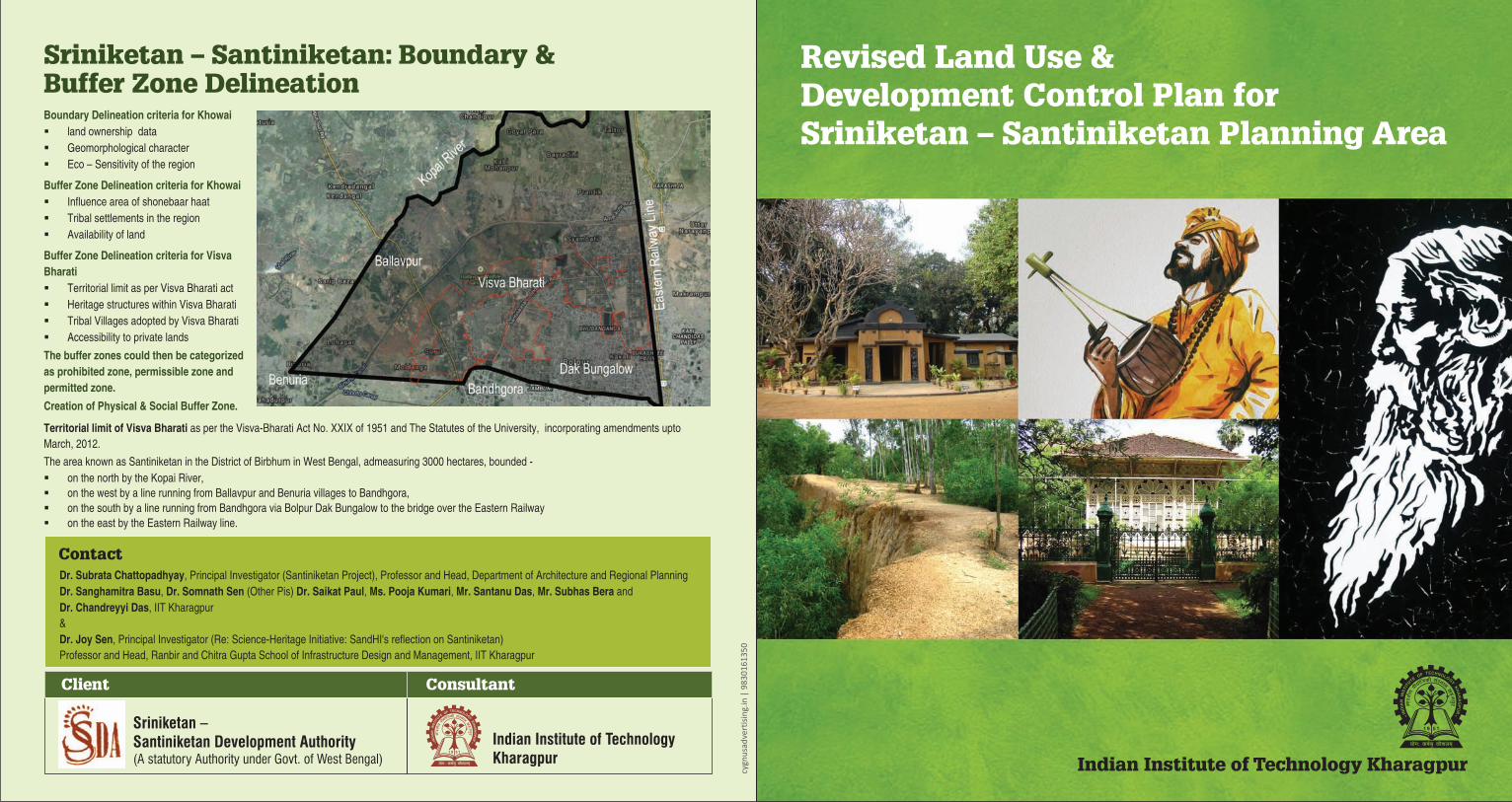
Sriniketan – Santiniketan: Boundary &Buffer Zone Delineation
Contact
Boundary Delineation criteria for Khowai
Buffer Zone Delineation criteria for Khowai
Buffer Zone Delineation criteria for Visva
Bharati
§ land ownership data
§ Geomorphological character
§ Eco – Sensitivity of the region
§ Influence area of shonebaar haat
§ Tribal settlements in the region
§ Availability of land
§ Territorial limit as per Visva Bharati act
§ Heritage structures within Visva Bharati
§ Tribal Villages adopted by Visva Bharati
§ Accessibility to private lands
The buffer zones could then be categorized
as prohibited zone, permissible zone and
permitted zone.
Creation of Physical & Social Buffer Zone.
Dr. Subrata Chattopadhyay, Principal Investigator (Santiniketan Project), Professor and Head, Department of Architecture and Regional Planning
Dr. Sanghamitra Basu, Dr. Somnath Sen (Other Pis) Dr. Saikat Paul, Ms. Pooja Kumari, Mr. Santanu Das, Mr. Subhas Bera and
Dr. Chandreyyi Das, IIT Kharagpur
&
Dr. Joy Sen, Principal Investigator (Re: Science-Heritage Initiative: SandHI's reflection on Santiniketan)
Professor and Head, Ranbir and Chitra Gupta School of Infrastructure Design and Management, IIT Kharagpur
Territorial limit of Visva Bharati as per the Visva-Bharati Act No. XXIX of 1951 and The Statutes of the University, incorporating amendments upto
March, 2012.
The area known as Santiniketan in the District of Birbhum in West Bengal, admeasuring 3000 hectares, bounded -
§ on the north by the Kopai River,
§ on the west by a line running from Ballavpur and Benuria villages to Bandhgora,
§ on the south by a line running from Bandhgora via Bolpur Dak Bungalow to the bridge over the Eastern Railway
§ on the east by the Eastern Railway line.
Client Consultant
Indian Institute of TechnologyKharagpur
Sriniketan –Santiniketan Development Authority(A statutory Authority under Govt. of West Bengal)

Background Land Use Map:Creation of Parcel Level Geo Database for Land Use and Infrastructure
Focused Group Survey Issue of buffer zonesand Khowai boundary
§ Shantiniketan is the living legacy
of Rabindranath Tagore.
§ Various heritage buildings and
structures symbolizing the cultural
renaissance of undivided Bengal.
§ Khoai land, a rare geological
phenomenon created by the
natural process of running rain
water for millennia. which if
destroyed, cannot be restored
even with the help of science and
thus requires preservation.
§ Traditional Craft - Kantha is an
indigenous household craft,
made by the rural women in West
Bengal; it is a specialty of Bolpur -
Santiniketan and the most creative
of all embroidery styles in this part
of India.
Area of Interest ofrevised LUDCP§ Total area of SSPA i.e. 108.08 Sq.Km.
§ Major concern – 11 mouzas adjoining
Visva Bharati
(Bolpur, Bandhgora, Surul, Benuria,
Ballavpur, Kabimohanpur, Goalpara,
Bayradihi, Shyambati, Madhusudanpur,
Taltore)
METHODOLOGY
§
§ Projecting the vector Data to a Coordinate System.
Stitching of the vector mouza maps. § Superimposing and Spatial Adjustment of Mouza Maps w.r.t the
satellite Imagery.
Khowai Area
Visva Bharati
Ballavpur Wildlife Sanctuary
§ Construction in and around Khowai affecting the natural
drainage pattern
§ Land Conversion leading to unplanned development
§ Various types & height of building around the Visva Bharati
affecting its character
§ Landownership conflicts within Visva Bharati - access to
private lands through Visva Bharati area
§ Public thoroughfare within visva bharati campus
§ Commercial setups in vicinity of and with access from Visva
Bharati creating traffic problems.
§ Encroachment issues at various location
§ Issue of illegal construction in recent times in vicinity of deer
park
§ Issue of conversion of lake within deer park as water park
§ Reclamation of land by filling up of existing water bodies in
the region is also a matter of concern.
O360
Boul
Stakeholders
SHGs
Builders
Touristguide
NGOs
Healthworkers
Hoteliers
Tradeassociation
Bus &Truckowner
association