Embed Size (px)
Citation preview
ALTERNATE ROUTING INFORMATION SYSTEM (ARIS)
Final Report 513 Prepared by: Jerome P. Breyer, P.E. Works Consulting, LLC 425 West Guadalupe Rd, Suite 109 Gilbert, Arizona 85233 June 2002 Prepared for: Arizona Department of Transportation 206 S. 17th Avenue Phoenix Arizona 85007 in cooperation with: The US Department of Transportation Federal Highway Administration
The contents of the report reflect the views of the authors who are responsible for the facts and the accuracy of the data presented herein. The contents do not necessarily reflect the official views or policies of the Arizona Department of Transportation or the Federal Highways Administration. This report does not constitute a standard, specification, or regulation. Trade or manufacturer's names which may appear herein are cited only because they are considered essential to the objectives of the report. The U.S. Government and the State of Arizona do not endorse products or manufacturers.
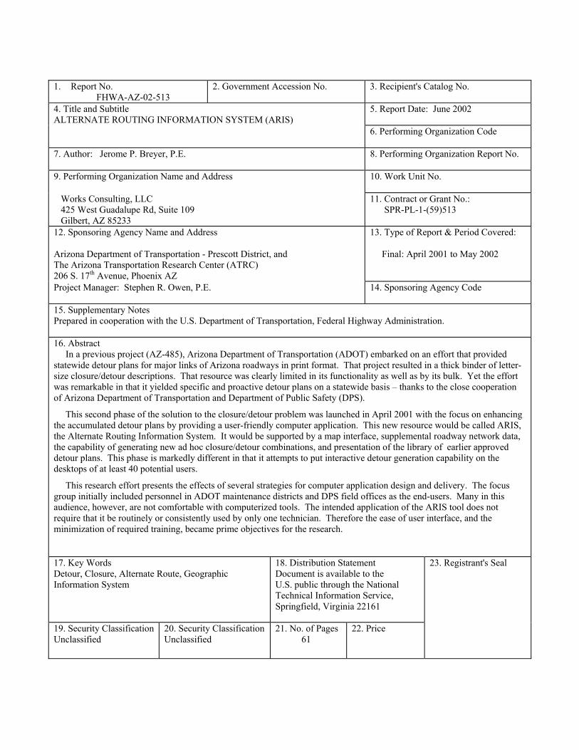
1. Report No. FHWA-AZ-02-513
2. Government Accession No.
3. Recipient's Catalog No.
4. Title and Subtitle ALTERNATE ROUTING INFORMATION SYSTEM (ARIS)
5. Report Date: June 2002
6. Performing Organization Code
7. Author: Jerome P. Breyer, P.E. 8. Performing Organization Report No.
9. Performing Organization Name and Address 10. Work Unit No.
Works Consulting, LLC 425 West Guadalupe Rd, Suite 109 Gilbert, AZ 85233
11. Contract or Grant No.: SPR-PL-1-(59)513
12. Sponsoring Agency Name and Address Arizona Department of Transportation - Prescott District, and The Arizona Transportation Research Center (ATRC) 206 S. 17th Avenue, Phoenix AZ
13. Type of Report & Period Covered: Final: April 2001 to May 2002
Project Manager: Stephen R. Owen, P.E. 14. Sponsoring Agency Code
15. Supplementary Notes Prepared in cooperation with the U.S. Department of Transportation, Federal Highway Administration. 16. Abstract In a previous project (AZ-485), Arizona Department of Transportation (ADOT) embarked on an effort that provided statewide detour plans for major links of Arizona roadways in print format. That project resulted in a thick binder of letter-size closure/detour descriptions. That resource was clearly limited in its functionality as well as by its bulk. Yet the effort was remarkable in that it yielded specific and proactive detour plans on a statewide basis – thanks to the close cooperation of Arizona Department of Transportation and Department of Public Safety (DPS).
This second phase of the solution to the closure/detour problem was launched in April 2001 with the focus on enhancing the accumulated detour plans by providing a user-friendly computer application. This new resource would be called ARIS, the Alternate Routing Information System. It would be supported by a map interface, supplemental roadway network data, the capability of generating new ad hoc closure/detour combinations, and presentation of the library of earlier approved detour plans. This phase is markedly different in that it attempts to put interactive detour generation capability on the desktops of at least 40 potential users.
This research effort presents the effects of several strategies for computer application design and delivery. The focus group initially included personnel in ADOT maintenance districts and DPS field offices as the end-users. Many in this audience, however, are not comfortable with computerized tools. The intended application of the ARIS tool does not require that it be routinely or consistently used by only one technician. Therefore the ease of user interface, and the minimization of required training, became prime objectives for the research.
17. Key Words Detour, Closure, Alternate Route, Geographic Information System
18. Distribution Statement Document is available to the U.S. public through the National Technical Information Service, Springfield, Virginia 22161
23. Registrant's Seal
19. Security Classification Unclassified
20. Security Classification Unclassified
21. No. of Pages 61
22. Price
SI* (MODERN METRIC) CONVERSION FACTORS
APPROXIMATE CONVERSIONS TO SI UNITS APPROXIMATE CONVERSIONS FROM SI UNITS Symbol When You Know Multiply By To Find Symbol Symbol When You Know Multiply By To Find Symbol
LENGTH LENGTH
in inches 25.4 millimeters mm mm millimeters 0.039 inches in
ft feet 0.305 meters m m meters 3.28 feet ft yd yards 0.914 meters m m meters 1.09 yards yd mi miles 1.61 kilometers km km kilometers 0.621 miles mi AREA AREA
in2 square inches 645.2 square millimeters mm2 mm2 Square millimeters 0.0016 square inches in2
ft2 square feet 0.093 square meters m2 m2 Square meters 10.764 square feet ft2
yd2 square yards 0.836 square meters m2 m2 Square meters 1.195 square yards yd2 ac acres 0.405 hectares ha ha hectares 2.47 acres ac mi2 square miles 2.59 square kilometers km2 km2 Square kilometers 0.386 square miles mi2
VOLUME VOLUME fl oz fluid ounces 29.57 milliliters mL mL milliliters 0.034 fluid ounces fl oz gal gallons 3.785 liters L L liters 0.264 gallons gal ft3 cubic feet 0.028 cubic meters m3 m3 Cubic meters 35.315 cubic feet ft3
yd3 cubic yards 0.765 cubic meters m3 m3 Cubic meters 1.308 cubic yards yd3
NOTE: Volumes greater than 1000L shall be shown in m3. MASS MASS
oz ounces 28.35 grams g g grams 0.035 ounces oz lb pounds 0.454 kilograms kg kg kilograms 2.205 pounds lb T short tons (2000lb) 0.907 megagrams
(or “metric ton”) mg
(or “t”) Mg megagrams
(or “metric ton”) 1.102 short tons (2000lb) T
TEMPERATURE (exact) TEMPERATURE (exact) ºF Fahrenheit
temperature 5(F-32)/9
or (F-32)/1.8 Celsius temperature ºC ºC Celsius temperature 1.8C + 32 Fahrenheit
temperature ºF
ILLUMINATION ILLUMINATION fc foot candles 10.76 lux lx lx lux 0.0929 foot-candles fc fl foot-Lamberts 3.426 candela/m2 cd/m2 cd/m2 candela/m2 0.2919 foot-Lamberts fl FORCE AND PRESSURE OR STRESS FORCE AND PRESSURE OR STRESS
lbf poundforce 4.45 newtons N N newtons 0.225 poundforce lbf lbf/in2 poundforce per
square inch 6.89 kilopascals kPa kPa kilopascals 0.145 poundforce per
square inch lbf/in2
SI is the symbol for the International System of Units. Appropriate rounding should be made to comply with Section 4 of ASTM E380
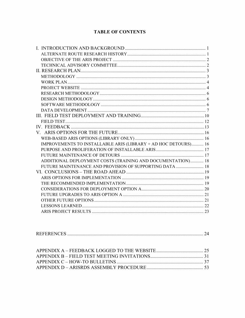
TABLE OF CONTENTS I. INTRODUCTION AND BACKGROUND ................................................................... 1
ALTERNATE ROUTE RESEARCH HISTORY....................................................................... 1 OBJECTIVE OF THE ARIS PROJECT .................................................................................... 2 TECHNICAL ADVISORY COMMITTEE................................................................................ 2
II. RESEARCH PLAN........................................................................................................ 3 METHODOLOGY ..................................................................................................................... 3 WORK PLAN............................................................................................................................. 4 PROJECT WEBSITE ................................................................................................................. 4 RESEARCH METHODOLOGY................................................................................................ 6 DESIGN METHODOLOGY...................................................................................................... 6 SOFTWARE METHODOLOGY ............................................................................................... 6 DATA DEVELOPMENT........................................................................................................... 7
III. FIELD TEST DEPLOYMENT AND TRAINING.....................................................10 FIELD TEST............................................................................................................................. 12
IV. FEEDBACK ...............................................................................................................13 V. ARIS OPTIONS FOR THE FUTURE........................................................................16
WEB-BASED ARIS OPTIONS (LIBRARY ONLY) .............................................................. 16 IMPROVEMENTS TO INSTALLABLE ARIS (LIBRARY + AD HOC DETOURS)........... 16 PURPOSE AND PROLIFERATION OF INSTALLABLE ARIS ........................................... 17 FUTURE MAINTENANCE OF DETOURS ........................................................................... 17 ADDITIONAL DEPLOYMENT COSTS (TRAINING AND DOCUMENTATION)............ 18 FUTURE MAINTENANCE AND PROVISION OF SUPPORTING DATA ......................... 18
VI. CONCLUSIONS – THE ROAD AHEAD .................................................................19 ARIS OPTIONS FOR IMPLEMENTATION .......................................................................... 19 THE RECOMMENDED IMPLEMENTATION...................................................................... 19 CONSIDERATIONS FOR DEPLOYMENT OPTION A........................................................ 20 FUTURE UPGRADES TO ARIS OPTION A ......................................................................... 21 OTHER FUTURE OPTIONS................................................................................................... 21 LESSONS LEARNED.............................................................................................................. 22 ARIS PROJECT RESULTS ..................................................................................................... 23
REFERENCES ................................................................................................................. 24 APPENDIX A – FEEDBACK LOGGED TO THE WEBSITE....................................... 25 APPENDIX B – FIELD TEST MEETING INVITATIONS............................................ 31 APPENDIX C – HOW-TO BULLETINS ........................................................................ 37 APPENDIX D – ARISRDS ASSEMBLY PROCEDURE............................................... 53
LIST OF FIGURES Figure 1 - Original Study Report Released In December 1999....................................................... 1 Figure 2 - Project Schedule ............................................................................................................. 4 Figure 3 - Website Screenshot......................................................................................................... 5 Figure 4 - Web Feedback Input Form ............................................................................................. 6 Figure 5 - Scenes From The Prescott Workshop........................................................................... 10 Figure 6 - Example Of Help Interface ........................................................................................... 11 LIST OF TABLES Table 1 - Cost Summary................................................................................................................ 19 PROJECT ACRONYMS ADOT Arizona Department of Transportation AML Arc Macro Language ARIS Alternate Route Information System ARISRDS ARIS Roadways (Arc Info Coverage of Arizona and Neighbor Counties) ATIS Arizona Transportation Information System ATISRDS ATIS Roadways (Arc Info Coverage of Arizona) ATRC Arizona Transportation Research Center CD Compact Disc DPS Department of Public Safety ESRI Environmental Systems Research Institute GIS Geographic Information System(s) HCRS Highway Closure and Restriction System HPMS Highway Performance Monitoring System IMS Internet Map Service IT Information Technology ITG Information Technology Group JPG Joint Photographic Experts Group LRS Linear Referencing System MP Milepost PC Personal Computer SPR State Planning & Research TAC Technical Advisory Committee TIGER Topologically Integrated Geographic Encoding and Referencing TOC Traffic Operations Center (at I-17 and Durango in Phoenix) TPD Transportation Planning Group TTG Transportation Technology Group VMS Variable Message Sign WWW World Wide Web
1
I. INTRODUCTION AND BACKGROUND The Alternate Routing Information System (ARIS) is a new phase in ongoing efforts by the Arizona Department of Transportation (ADOT) to provide a statewide detour resource for maintenance and operation personnel. The key goal of this research project (SPR-513) is to provide ADOT with a new software tool in a uniform format for determining the best detour options when a roadway closure or restriction occurs.
ALTERNATE ROUTE RESEARCH HISTORY This new ARIS detour research program evolved from a previous project performed for the Arizona Transportation Research Center (ATRC) in 1999. Project SPR-485, the Arizona Statewide Alternate Route Plan [1] was the initial effort that provided statewide detour plans for major links of Arizona roadways in print format. That project resulted in a three-inch thick binder of 8½” by 11” closure / detour descriptions. That resource was clearly limited in its functionality as well as by its bulk. The effort was remarkable in that it yielded specific and proactive detour plans on a statewide basis – thanks to the close cooperation of Arizona Department of Transportation (ADOT) and Department of Public Safety (DPS).
Figure 1 - Original Study Report Released In December 1999.
In Project 485, GIS software was used to develop the original detours, but GIS maturity and the limited budget were two key factors that limited the outcome. The detour database consisted of a Microsoft Access 97 container with an information retrieval form (pictured in Figure 1) and reporting functionality to create 750 pages of printouts. ADOT and DPS need a tool such as a detour generator and library. Easily retrievable detour plans are necessary to minimize road closure impacts and delays to the traveling public, by providing a consistent and documented plan to respond to closures. This is the fundamental reason why project SPR-485 was originally conducted.
2
It is also extremely important that the library of detour plans should be created, to ensure the continuity of existing local detour knowledge that may reside in just one key person’s head.
OBJECTIVE OF THE ARIS PROJECT With sponsorship from the ADOT Districts, sections, and other key partners, a new research project was soon funded to provide the missing element of manageable, user-friendly access to the detour data, and to allow “what-if” alternate routing flexibility. This second phase of the solution to the closure/detour problem was launched in April 2001 with the focus on enhancing the accumulated detour plans by providing a user-friendly computer application. This new resource would be called ARIS, and it would be supported by a map interface, supplemental roadway network data, an ad hoc capability of generating new closure/detour combinations, and presentation of the library of project SPR-485 approved detour plans. This phase is markedly different in that it attempts to put interactive detour generation capability on the desktops of at least 40 potential users.
TECHNICAL ADVISORY COMMITTEE The ATRC established a Technical Advisory Committee for the ARIS project to support and guide the research effort. The stakeholder focus group was eventually expanded to include DPS management, ADOT district engineers, and other staff to keep them informed of project progress. The result of this SPR-513 effort has received overall support from the 90 participants of the study – with several key strong supporters and virtually no dissenters. Active feedback and participation from the majority of the group were not as good as desired for several reasons. However, the enthusiasm of key staff and management was very encouraging, and this will contribute toward a future deployment that could have a lasting effect on institutional policies, and that should result in better public service. The project concept was sponsored by Tom Foster, the District Engineer with ADOT’s Prescott District. The Technical Advisory Committee consisted of:
Tom Foster ADOT - Prescott District Roy Alvis ADOT - Prescott District Ron Casper ADOT - Safford District Steve Puzas ADOT - Safford District Tim Wolfe ADOT - Transportation Technology Group Manny Agah ADOT - Transportation Technology Group Glenn Jonas ADOT - Transportation Technology Group Lydia Warnick ADOT - Transportation Technology Group Kathie Beshoner ADOT - Transportation Technology Group Jerry Pfeifer ADOT - Transportation Technology Group Cdr. Terry Tometich Lt. Brian Wilcox Lt. Frank Lopez
Arizona Dept of Public Safety – Southern Region Arizona Dept of Public Safety – Casa Grande Arizona Dept of Public Safety – Prescott
Jami Garrison ADOT - Transportation Planning Division Wayne Rich ADOT - Transportation Planning Division Kurt Mueller ADOT - Information Technology Group Howard Boice ADOT - Community Relations Office Alan Hansen Federal Highway Administration Jennifer Brown Federal Highway Administration Steve Owen Arizona Transportation Research Center
3
II. RESEARCH PLAN This research effort involved several strategies for computer application design and delivery. The focus group initially included personnel in ADOT maintenance districts and DPS field offices as the end-users. Many in this audience, however, are not comfortable with computerized tools. The ARIS tool serves a purpose that would not necessitate routine or consistent use by the same technician. Therefore the ease of interface and the minimization of required training became prime objectives for the research. The investment that ADOT and staff made toward the SPR-485 detour library was a significant effort that resulted in the first ever standardized detour documentation for Arizona. This project aims to resolve the problems and enact the recommendations of SPR-485. Maps and a graphic user interface are important elements recommended in SPR-485 that will ultimately make detour planning easier. Usability and flexibility are key goals for ARIS. This ARIS research provides a method for making the SPR-485 detour library more useful, and offers different GIS databases to supplement the raw detours with auxiliary information. This research report aims to weigh the necessary against the unnecessary and provide smart and economical options for carrying the Alternate Route Information System to implementation.
METHODOLOGY The methodology of this project was essentially an execution of the recommendations of the prior research effort SPR-485. Several TAC members continued their involvement from the prior project. The TAC met numerous times prior to selection of Works Consulting as the second phase contractor, and five times during the 9-month duration of development, deployment, and field testing. This effort was unique in that the ADOT project manager met with the research team to review the proposed work plan and granted the team a five-week development period prior to the first post-award meeting of the entire TAC. The application development team effectively drafted 80% of the working functionality of the application by the time the full TAC convened during the contract period. This resulted in an enthusiastic reception to the product at that first meeting. The excitement carried over to the drafting of several beta users within the TAC who began using the program immediately and offered continual feedback until a larger crowd of end users were involved in the later field test program. The work plan included a beta testing phase which occurred during application development following the second TAC meeting, when beta CDs were shipped to volunteer TAC members. The emphasis during this phase was on generating ad hoc detours and storing them in the database. The beta test lasted through late October. Beta testers were supported by the research team using the project website, subsequent TAC meetings, and occasional telephone conversations. A distinctly separate field testing phase commenced in late October, when an installable version of the ARIS application was distributed with the detour library sufficiently complete. These CDs were mailed in groups of four to the ADOT districts. Some were held back and handed out at the upcoming field test deployment meetings. The field test lasted through mid-January. Field testers were a large group that included many field supervisors who know their detours by heart. Field testers were supported through introductory field test meetings that demonstrated the full
4
create/save/recall features of ARIS. Field testers could also avail themselves of the project website and “how-to” bulletins provided by the research team.
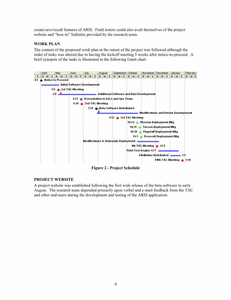
WORK PLAN The content of the proposed work plan at the outset of the project was followed although the order of tasks was altered due to having the kickoff meeting 5 weeks after notice-to-proceed. A brief synopsis of the tasks is illustrated in the following Gantt chart.
Figure 2 - Project Schedule
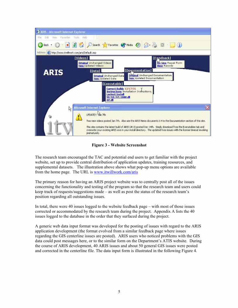
PROJECT WEBSITE A project website was established following the first wide release of the beta software in early August. The research team depended primarily upon verbal and e-mail feedback from the TAC and other end-users during the development and testing of the ARIS application.
5
Figure 3 - Website Screenshot
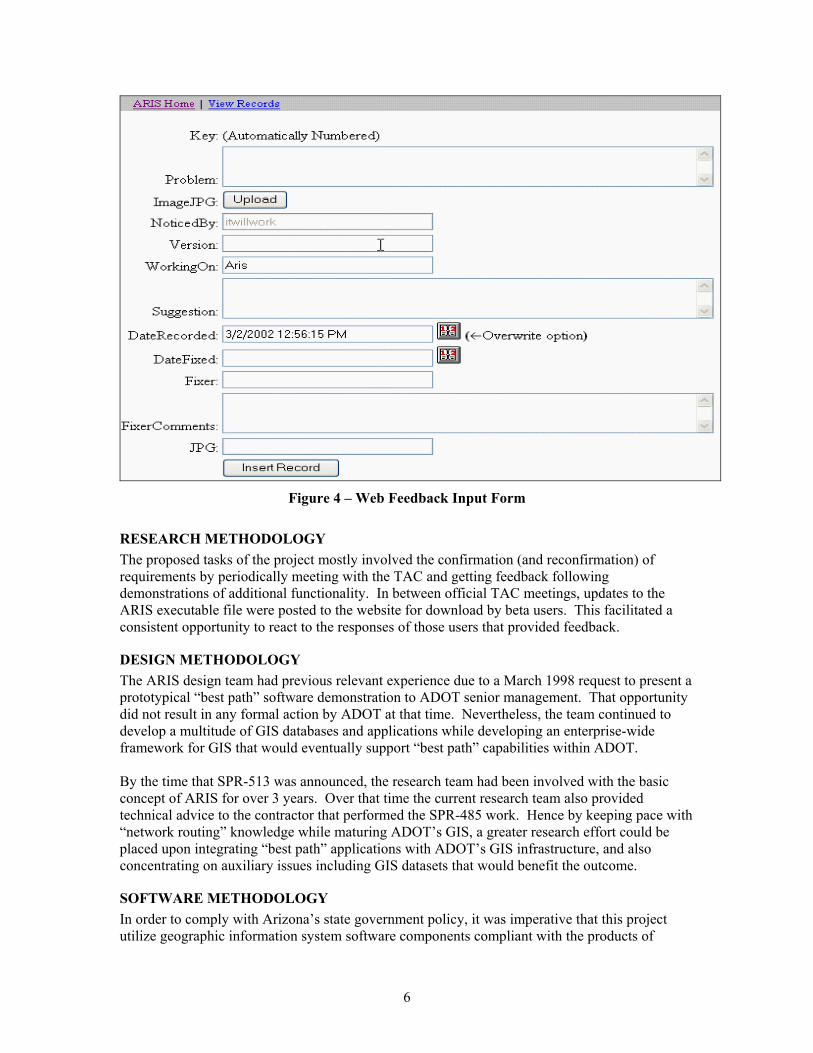
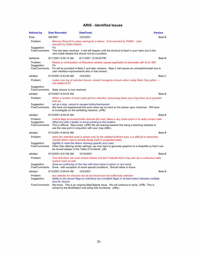
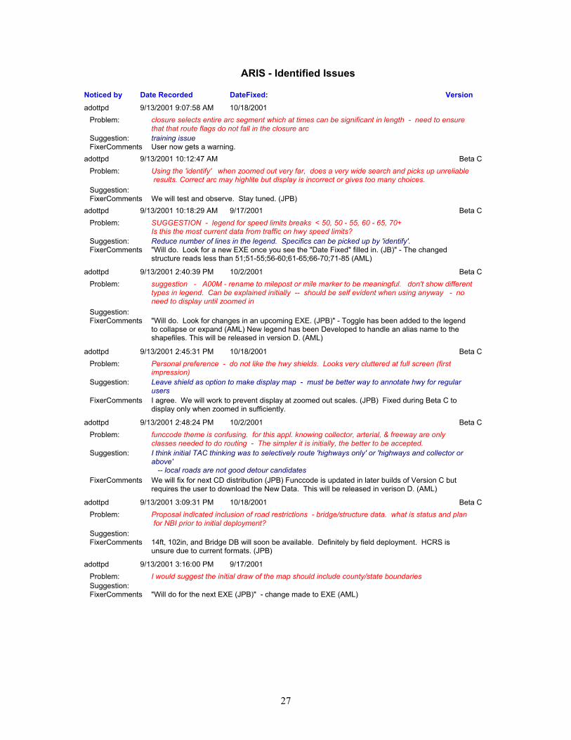
The research team encouraged the TAC and potential end users to get familiar with the project website, set up to provide central distribution of application updates, training resources, and supplemental datasets. The illustration above shows what pop-up menu options are available from the home page. The URL is www.itwillwork.com/aris The primary reason for having an ARIS project website was to centrally post all of the issues concerning the functionality and testing of the program so that the research team and users could keep track of requests/suggestions made – as well as post the status of the research team’s position regarding all outstanding issues. In total, there were 40 issues logged to the website feedback page – with most of those issues corrected or accommodated by the research team during the project. Appendix A lists the 40 issues logged to the database in the order that they surfaced during the project. A generic web data input format was developed for the posting of issues with regard to the ARIS application development (the format evolved from a similar feedback page where issues regarding the GIS centerline issues are posted). ARIS users who noticed problems with the GIS data could post messages here, or to the similar form on the Department’s ATIS website. During the course of ARIS development, 40 ARIS issues and about 50 general GIS issues were posted and corrected in the centerline file. The data input form is illustrated in the following Figure 4.
6
Figure 4 – Web Feedback Input Form
RESEARCH METHODOLOGY The proposed tasks of the project mostly involved the confirmation (and reconfirmation) of requirements by periodically meeting with the TAC and getting feedback following demonstrations of additional functionality. In between official TAC meetings, updates to the ARIS executable file were posted to the website for download by beta users. This facilitated a consistent opportunity to react to the responses of those users that provided feedback.
DESIGN METHODOLOGY The ARIS design team had previous relevant experience due to a March 1998 request to present a prototypical “best path” software demonstration to ADOT senior management. That opportunity did not result in any formal action by ADOT at that time. Nevertheless, the team continued to develop a multitude of GIS databases and applications while developing an enterprise-wide framework for GIS that would eventually support “best path” capabilities within ADOT. By the time that SPR-513 was announced, the research team had been involved with the basic concept of ARIS for over 3 years. Over that time the current research team also provided technical advice to the contractor that performed the SPR-485 work. Hence by keeping pace with “network routing” knowledge while maturing ADOT’s GIS, a greater research effort could be placed upon integrating “best path” applications with ADOT’s GIS infrastructure, and also concentrating on auxiliary issues including GIS datasets that would benefit the outcome.
SOFTWARE METHODOLOGY In order to comply with Arizona’s state government policy, it was imperative that this project utilize geographic information system software components compliant with the products of
7
Environmental Systems Research Institute (ESRI – Redlands, California). ADOT has been using ESRI software for GIS since 1991. Network analysis is a subcomponent of geographic information systems technology that provides best path solutions for linear transportation networks. ESRI supports network analysis through at least 3 products (Network for Arc/Info, Network Analyst for ArcView, or NetEngine components for developers). NetEngine is the basis of both Network for Arc/Info and Network Analyst for ArcView. NetEngine provides the network analysis algorithms through licensed components that can be integrated into the overall ARIS solution. ESRI provides other licensed software components called MapObjects for embedding map interfaces into custom applications. Hence standard input forms could be replaced by a user interface that allows the user to scan maps, click on maps to select start/stop points, and ultimately allow the resultant detour to be presented as a map. Given that ADOT’s GIS infrastructure is based on ESRI products, it was determined that a “standalone” ARIS best path application would obviously utilize NetEngine and MapObjects sewn together with Visual Basic. Arc IMS (for internet map server) was another potential solution for making the interactive detour generation application work over an internet connection. In fact ESRI has a product called RouteMapIMS that integrates IMS and network routing. However, the project specification called for the closure/detour service maps to be available on mobile computers in vehicles that are disconnected from wide area network access. Hence the IMS option was not a primary focus of the research.
DATA DEVELOPMENT The data requirements of the project called for many supporting ADOT databases to be accessed from the interface of ARIS, as detailed below.
Highway Centerlines The fundamental dataset of the project was the centerline file that ADOT’s Transportation Planning Division (TPD) maintains for inventory, safety, and planning activities. This database (called ATISRDS) is an ESRI Arc/Info coverage database that was undergoing significant upgrades during the previous SPR-485 project. The database had been fixed to support the needs of this SPR-513 project, and approximately 50 additional changes were made during this project to allow the topology of ADOT’s centerline file to support the 750 routes that would be stored using the program. Out-of-state centerlines were acquired from Census Bureau TIGER files. Only primary routes were extracted for all counties that bordered Arizona and contained primary routes that were the first out-of-state option for detouring. Where TIGER files couldn’t adequately support real conditions, the local authorities were contacted to provide centerlines. The ATISRDS centerlines were combined with the out-of-state centerlines to create what was called the ARISRDS centerline database. The methodology for combining these two datasets was summarized in a memo with Arc Macro Language (AML) code. The re-combination of files can occur at any future date by simply repeating the steps contained in the memo.
Bridge Points The bridge database was acquired from the Bridge Technical Group at ADOT and geocoded so that each bridge would be represented by a shape point on an electronic map.
8
Regulation Speed Segments The speed regulation database was acquired from the Traffic Studies Group at ADOT and geocoded so that each unique segment would be represented by a shape arc on an electronic map. Many segments of roads had two shape arcs (one for each direction of travel).
Functional Classification Segments The functional classification database was acquired from the Transportation Planning Division at ADOT and geocoded so that each unique classified segment would be represented by a shape arc on an electronic map. This database included roads off of the State Highway System. Since the speed regulation database did not contain speed limits on non-State roads, the functional classification was translated into an equivalent travel speed.
Height and Width Restrictions The project team acquired the Arizona Administrative Rules for height, length, and width restrictions on Arizona state highways. The Rules were read and interpreted into a height-restricted shapefile and a width-allowed shapefile for use as geographic map overlays in ARIS. Many location descriptions suggested that the Rules had not been updated in several years. For example, statewide US 666 and Tucson US 89 routes are frequently called out in the restrictions although these routes have been renumbered many years ago. The ARIS research team made suggestions to the Motor Vehicle Department of the corrections that should be made.
Variable Message Sign Locations VMS locations were gathered from the Transportation Planning Division – Data Section, who in turn get the information from Transportation Technology Group on an annual basis for the HPMS (Highway Performance Monitoring System) submittal. These data are already maintained by the Data Section in a shapefile format. The project team simply updated the status of each VMS location with information from personnel at the Traffic Operations Center.
Highway Closures and Restrictions Sample events of the updated HCRS database incidents were gathered from the HCRS team for the purpose of integrating them to ARIS. The data is being stored in (x,y) State Plane coordinates rather than in ATIS linear referencing system (LRS) attributes. The research team feels that the usefulness of HCRS incidents (for ARIS detouring) will depend on the definition of location stored in the HCRS database. Incidents represented by point shapes will be able to be accurately interpreted – but not without significant additional programming to make HCRS events compliant with the ATIS linear referencing system. ARIS is built to make advanced use of ATIS-compliant linear referencing. The HCRS locations will have to be interpreted differently than other ADOT databases – resulting in less than full functional interpretations for HCRS incidents by other ADOT data systems.
ARIS Routing Functions and the SPR-485 Detours It is important to understand the functional design of the ARIS resource, which is based upon its best-path search capabilities. ARIS is designed to analyze the roadway network segments with their travel speed attributes on each segment to determine the shortest distance between two points, as well as the quickest path. In the case of the existing core database of SPR-485 detours, the “approved” path was already determined by previous ADOT and DPS review. This pre-approved path was often different
9
from the quickest, or the shortest, or both paths. Many times the reason for this was that the “approved” path was constrained to use ADOT roadways only. ARIS does have a function key that will provide a solution without using any non-ADOT roads, but some “approved” detours could not be replicated even with that technique. In such cases, the detour was replicated by simply placing intermediate stop points as needed between the two closure endpoints, thereby forcing the detour through a specific path. The resulting pre-approved detour in ARIS format could then be saved, printed, or otherwise applied for traffic control.
Validation of the SPR 485 Detour Database Once the ARIS application matured to the point where it could save a generated closure / detour pair, the research team data technicians began the fundamental process of reviewing the existing 750 different closure / detour combinations from the SPR-485 workbook. This process was a key aspect of the research project’s validation process for the ARIS routing tool. The effort was particularly difficult to complete uniformly due to the scheduling constraints of the project. On one hand, the detours needed to be logged into the database so that the beta testers and field test users could access them as early as possible in the project. On the other hand, additional feedback during the course of the beta and field tests would prompt potential changes of certain aspects of what the application should store in its database. This dichotomy precipitated several times early in the design where the data technicians went back to the first detours and re-recorded them each time the design team realized a design change was necessary. There was also a point later in the development when the team realized that yet another design change might be a good idea, but the schedule couldn’t accommodate another return to the beginning of the workbook. The latest change involved the saving of the explicit directions and the solution parameters with each stored closure / detour pair. Storage of the solution parameters and detour directions was believed to be unnecessary because the ARIS application could regenerate these with relative ease. Eventual feedback showed how some users were confused by this. Hence, the late change was accommodated. Only the last 51 stored detours have a full complement of solution attributes. Remaining early detours can be updated with their solution attributes through the natural process of detour review that is prescribed in the project team’s recommendations for deployment and ongoing maintenance.
10
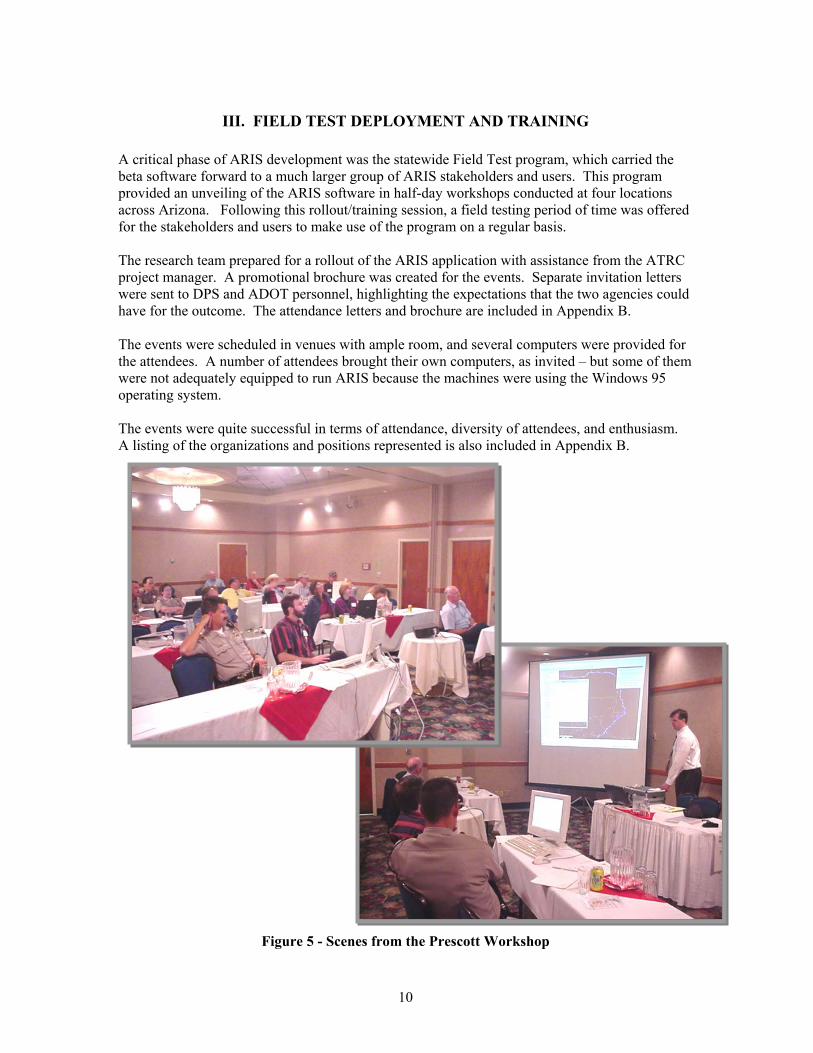
III. FIELD TEST DEPLOYMENT AND TRAINING A critical phase of ARIS development was the statewide Field Test program, which carried the beta software forward to a much larger group of ARIS stakeholders and users. This program provided an unveiling of the ARIS software in half-day workshops conducted at four locations across Arizona. Following this rollout/training session, a field testing period of time was offered for the stakeholders and users to make use of the program on a regular basis. The research team prepared for a rollout of the ARIS application with assistance from the ATRC project manager. A promotional brochure was created for the events. Separate invitation letters were sent to DPS and ADOT personnel, highlighting the expectations that the two agencies could have for the outcome. The attendance letters and brochure are included in Appendix B. The events were scheduled in venues with ample room, and several computers were provided for the attendees. A number of attendees brought their own computers, as invited – but some of them were not adequately equipped to run ARIS because the machines were using the Windows 95 operating system. The events were quite successful in terms of attendance, diversity of attendees, and enthusiasm. A listing of the organizations and positions represented is also included in Appendix B.
Figure 5 - Scenes from the Prescott Workshop
11
In all, 60 additional attendees (beyond the TAC members) were introduced to ARIS in the half-day demonstration at each site. The Prescott meeting on November 1st (Figure 5) was the fourth meeting in eight days. The fully evolved application was “hands-on” demonstrated in about 150 minutes, including a refreshment break. A concerted effort was made to prepare each user with a “getting started” tutorial CD consisting of 35 individual digital videos that could be played back through a standard computer’s media player. The videos comprised a total of 45-minutes of randomly recallable topics involving the fundamentals of ARIS. The topics consisted of the progressive steps of starting the application, loading closure/detour pairs from the library of approved detours, and printing, as well as generating ad hoc detours for any closure in the road network. All of the supporting geographic information system (GIS) databases were described. Participants indicated that the training videos effectively supplemented the relatively easy-to-use application interface. In short, the delivered package could be used by any computer operator without requiring a dedicated training course. If true, this is a significant accomplishment for an application that will be used only occasionally, thereby minimizing the cost of re-familiarization each time it is used.
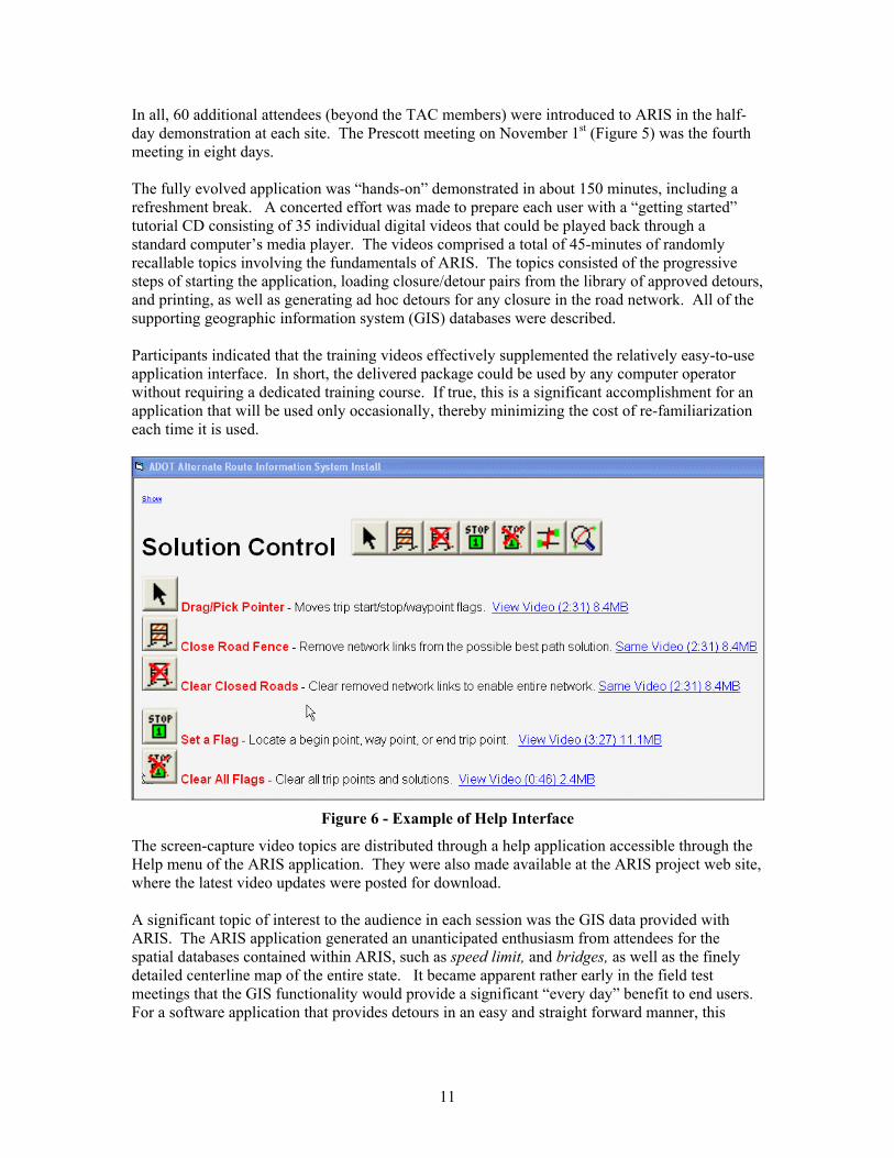
Figure 6 - Example of Help Interface
The screen-capture video topics are distributed through a help application accessible through the Help menu of the ARIS application. They were also made available at the ARIS project web site, where the latest video updates were posted for download. A significant topic of interest to the audience in each session was the GIS data provided with ARIS. The ARIS application generated an unanticipated enthusiasm from attendees for the spatial databases contained within ARIS, such as speed limit, and bridges, as well as the finely detailed centerline map of the entire state. It became apparent rather early in the field test meetings that the GIS functionality would provide a significant “every day” benefit to end users. For a software application that provides detours in an easy and straight forward manner, this
12
added GIS functionality of ARIS is considered – by many in the large group of potential users – to be as appealing as the ARIS detour functionality itself.
FIELD TEST Following the regional deployment meetings, the attendees were provided with compact discs to have the application installed on their desktop and laptop personal computers, beginning what was programmed to be a six-week field test period. The field test period was delayed for approximately a month, however, because an incompatibility problem surfaced with standard ADOT PCs, which had not been evidenced in the prior development and beta testing. The research team relied heavily on ADOT’s Information Technology Group to assist in the effort of getting ARIS installed on all of the PCs requested by potential end users. This proved to be a difficult task since the fast-track, contractor-led, ARIS development cycle didn’t include testing of every software release by ADOT ITG staff on typical ADOT PC systems. The fast-track bypass of standard ADOT testing requirements led to unexpected difficulties when the ARIS installations began to fail on standard ADOT PCs with the 26th build of the 4th beta release (i.e. the first field test release). Although earlier versions of the ARIS program had already been proven to work fine on standard ADOT PCs, this particular build caused problems because it was created on a development PC that was running Windows XP operating system. It turned out that Microsoft provided a DLL file that was no longer backward compatible to previous operating systems. Furthermore, they didn’t inform ESRI, yet ESRI specified that the MapObjects components must have this particular DLL as part of the ARIS installation package. The end solution was that the research team ignored ESRI’s specification because ADOT preferred that the subject DLL not be overwritten with ESRI’s recommended version. This action effectively voided ESRI’s warranteed support for the functionality of the MapObjects components, but testing proved that ESRI’s tight specification was probably unwarranted. Still other problems surfaced as ADOT ITG staff responded to all potential end-user requests for installation. Some users wanted the program to work on their Windows 95 laptop – but that machine did not meet the minimum specification set by the TAC for the design team. The program was developed to run on PCs with minimum 64MB memory and a 166 MHz processor running Windows NT4. Once it was apparent that the potential end users were indeed supported with working versions of the application, the team began the formalized feedback process. Five separate bulletins were designed to be short exercises that would solicit useful feedback responses. These “how-to” bulletins are contained in Appendix C. They cover the following topics:
1. Making .JPG Images Using the GIS 2. Recalling a Detour For A Given Closure 3. Creating Your Own Ad-hoc Detour 4. Introduction to Web-distributed GIS powered by an Internet Map Server (IMS) 5. Using the Internet to Access a Detour Map
The first four bulletins were e-mailed to ADOT participants and faxed to most DPS participants. The e-mail (or fax cover sheet) introduced each bulletin and solicited feedback from respondents by answering 1-5 questions per bulletin. The questions, and the project team’s answers to the questions, are detailed in the next section.
13
IV. FEEDBACK Although there was a concerted effort to encourage written feedback through the website, email, and fax, in many cases it was easier to get verbal responses as to the user issues and the acceptability of the ARIS tool. Many of the comments were in phone conversations and during the regional deployment meetings. The general nature of the verbal comments parallels the written comments that were generated by the first four technical bulletins, which appear below: Issue #1-1 -- Current-ness of the centerline file. What sense of completeness would you demand from your data. You'll notice discrepancies in the Beta E ARIS data. But be assured that ADOT has updated the centerlines in the main GIS.
• Don't know what you mean by correctness. As far as I see the centerlines look fine! - Prescott • Access is too complicated. Too many steps. Especially alternate routes should be accessed separately. State, County, city,
Forest. – Payson • I would need concrete reassurances as to how often the data is updated. - Safford
Issue #1-2 -- Should ARIS have more self-contained drawing tools for annotating maps prior to making a JPG in ARIS? For example, should there be a labeler tool?
• Yes, a label tool would be good since I have trouble making a JPEG file connect with Paint. - Prescott • No - Payson • Not necessary - Safford
Issue #1-3 – Should we streamline the attachment of the electronic image to e-mail? You might know that Windows allows you to right-click a file and then choose Send To Email Recipient, whereby your email application opens with the file already attached. Should we have an option in ARIS that simply loads the view image as an attachment to your e-mail?
• No, the e-mail process worked fine. - Prescott • Yes - Payson
Issue #1-4 -- Should the legend editor (double-click on any theme in the Table of Contents) have more ability for customizing the colors of the lines, etc. Should this capability be fully implemented?
• No, the colors are good as they are. It is easy to designate differences from one theme from another. – Prescott • No - Payson
Issue #2-1 -- Loading closures - would it be easier for you to load a closure/detour by supplying a route name and milepost?
• Yes. – Payson • Yes, but map is also OK – Tucson • It's okay, but route name and milepost option would be nice too. - Safford
Issue #2-2 -- Printing - should the specific parameters of a print layout be saved with a detour/closure? In other words, should the paper size, orientation, and individual component sizes and positions on paper be preserved for those who wish to recall a detour for quick printing?
• Yes - Tucson • Yes - Payson
Issue #2-3 -- Should the Print Layout include the directions component of the detour? Currently, the application allows for directions to be printed on a separate sheet of paper by clicking the Print menu on the Directions dialog.
• Yes - Tucson • Yes - Payson
Issue #3-1 -- Interface Design - Do you understand the buttons and terminology? In other words, is ARIS easy enough to use? • No - Payson • Yes - Flagstaff • Yes – Tucson DPS • Yes – Casa Grande DPS • Yes, I am learning them. I don't get into the program often enough to really get familiar with it. But when I do, I am
amazed with the way it works. - Prescott • Yes - Safford
Issue #3-2 -- Training Delivery - Is ARIS easy enough to learn? • Yes - Tucson DPS
14
• Yes - Casa Grande DPS • Yes - Flagstaff • Yes - Payson • Yes - Prescott • Yes - Safford
Issue #3-3 -- Do you anticipate using (or needing to use) ARIS in the future for alternate route issues? • No - Tucson DPS • Yes, on occasion. – Casa Grande DPS • Yes - Flagstaff • Yes - Payson • Yes, I expect that I will use the program when requested to do so. - Prescott • Yes - Safford
Issue #3-4 – Do you anticipate using ARIS in the future for more general GIS data issues?
• No - Tucson DPS • No, but it makes a great map! - Casa Grande DPS • Yes - Payson • Yes - Flagstaff • No, the GIS seems more complicated than just the re-routing. - Prescott • Yes - Safford
Issue #3-5 - If yes (to Issue #3-4) , which data is important?
• Maintenance planning (Area description) - Payson • I find it a great highway resource for developing Intergraph DGN files. - Flagstaff • I anticipate using the GIS features a great deal in the future. The most important data to me is the features along the
ADOT maintained routes, i.e.: the mileposts, the ramps and their designations, the TI's and the like. - Safford Issue #4 - Comments on the Web Site revealed in Bulletin #6
• This is a very cool site! - Prescott • This is nice. Asset Management (ITG) • This was fun to play with! - Casa Grande DPS • I enjoyed my journey through the Web site. I am sure it would be useful to myself and the other maintenance analysts,
especially the print feature. - Safford
General Comments • For the Globe District the printed routes could be done and then kept on file with the directions for quick copying for
distribution if this is needed. We do not have enough alternate route possibilities to make the program itself viable. Most all our detours would cause significant reroute delays so consideration is given to that even before posting an alternate route. The one time printing can be done and then the program is just lots of benefit for not much call. This is very viable if more alternative routes are available, but in our case we are very limited so the program is much more than we need. - Globe District
• I believe this will have some benefits to the maintenance Orgs and their difficult response locations. It will not provide
more paved detours or more lanes , which is what we need more. It is much more efficient than the old hard-copy maps. Most of our field people know detours available to them, just not in the detail available with this program. It seems user-friendly after a short learning curve. The GIS map-making aspect is a bonus. I would try it "as-is" and not expand until more feed back is unleashed. - Prescott District
• From Tucson District
1. It doesn't have all the up dates of new routes in the District, Frontage roads, etc. Could be a problem of keeping the system up dated.
2. Manual for use would be good, it is not to easy to use. 3. Do not think it would be used in the field, it is hard to use, more in District. Hard to learn and retain for field use, to
retain you would have to use a lot. 4. Would be nice to have detours programmed into system that a person could just run when he needed a detour for
closures at different mileposts. 5. Need easy to follow instructions. 6. Programs loads real slow and that makes it hard to use. 7. Detail of maps is good.
• The only comment that I have is that the ARIS needs to identify if the detour is suitable for trucks or just light vehicles on
the secondary roads. - Kingman

15
• I feel the ARIS is a great program that should be at desks of district, maintenance, support orgs that are involved in road closures. In the northern region we have both accident and weather related closures. This program is easy to use and should be available to all (i.e. ADOT, DPS and local governments). - Flagstaff
• ARIS is a good tool but it is not practical for my use as a field commander. I do not have a modem in my vehicle to access
this program. I do not have Internet Access at my office due to the limited lines and I have one staff person who is busy doing other duties. Tucson DPS
• We know basically what the detour directions might be, but when we give this to the public, they might not. It would take
longer for us to add the extra stuff. If it is in the directions component it would save time and be easier to understand. - Tucson
• It seems as though it would be useful for ADOT supervisor in the field and at ADOT office and DPS office if we want to
send a copy of the closure to the media or to our duty office (or ADOT TOC). Practical field use by DPS troops would be minimal due to a lack of laptops in the field. The program has come a long way from version 1. – Casa Grande DPS
16
V. ARIS OPTIONS FOR THE FUTURE Installable ARIS is the viable working deliverable of this research project. It exists for the purpose of creating, viewing, and updating the official detour library for the State of Arizona. As such, its contribution to future efficient detour operations is critical at present, as well as into the near future. The longevity of an effective detour program will depend on the ability to maintain and revise the detour library efficiently. ARIS is designed, and works, with all of this in mind. There are, however, a number of important considerations with regard to the choices for possible future ARIS implementation by ADOT. These various “decision factors” are based on feedback from the several user groups represented in the Field Test phase. Significant guidance was also incorporated from the project’s Technical Advisory Committee. Possible future upgrades, and deployment issues, are listed in the following sections.
WEB-BASED ARIS OPTIONS (LIBRARY ONLY) Web-based ARIS is defined as the delivery of the ARIS closures and detours to any user with a web connection. No installations of the Visual Basic application would be required. Unlike installable ARIS, the user would not be able to generate ad-hoc detours or revise existing detours. Based on user feedback, installable ARIS is a successful product but it is not anticipated to be as useful on disconnected laptops away from the office, as the project goal was originally conceived. Operations personnel have stated they would generally call back to a dispatcher to get a detour plan when needed. Given that fact, the most beneficial future improvement for ARIS may be to make the library of closures and detours available through a web interface on the ADOT Intranet, or through an access-protected World Wide Web resource. Such a plan would enable the contents of the massive closure / detour workbook that originated in the SPR-485 project to be available to all web-equipped ADOT users, and for DPS as well. Based upon the positive reaction received from the Internet Map Server tool unveiled in the final feedback bulletin (Appendix C-5), it should be very cost effective to provide the “approved” detour library across this web medium to an unlimited number of authorized users. In the event that Arc IMS is deployed for the alternate route library, the ad hoc routing capability could then be limited to a small group of up to 40 licensed trained users. They would generate (and update) detours district-wide or statewide as the need arises. These newly generated detours could be integrated into the master detour database that displays on the Internet Map Server.
IMPROVEMENTS TO INSTALLABLE ARIS (LIBRARY + AD HOC DETOURS) The suggested improvements that were logged to the installable ARIS application are detailed on the feedback website, which will be maintained for a limited time at www.itwillwork.com. Most of those suggestions were accomplished by the project team during the final release of the program prior to Field Test deployment. Other suggestions, however, would be quite significant in terms of development manpower required. Some beneficial alterations that are recommended to be accomplished in the future include:
• Full development of the legend editor to enhance mapping capability
• Provision of a labeling tool to enhance ad hoc mapping capability
• Load a closure/detour by Route/MP designation (rather than map click)
17
• Detour signing plan symbols to annotate detour setups
• Provide automatic selection of detours with respect to HCRS or valid locally owned roadway databases.
None of the above recommended improvements are absolutely necessary. For the most part, the suggestions come from the design team’s perspective of the tool. Installable ARIS is a working tool capable of being utilized by staff who need only be mildly determined to successfully maintain and improve the official library of detours.
PURPOSE AND PROLIFERATION OF INSTALLABLE ARIS The installable ARIS routing application carries a one-time cost of $300 per copy with ADOT anticipating the use of 40 copies. This special rate covers the licensing of both MapObjects ($100/seat) and NetEngine ($200/seat for the 40 research licenses only). It was quoted by ESRI specifically for this research effort. ADOT had already allocated the funds for this proposed purchase under the present SPR-513 project budget. However, based on research project feedback, ADOT probably should not deploy ARIS seats in excess of the original expectation of 40. Additional ARIS deployments will be costly due to the additional sublicensing of the MapObjects and NetEngine components on a per seat basis. The research team believes there is more potential satisfaction for the ARIS detour library to be disseminated to detour users over a web interface – leaving the 40 installable applications for the limited set of ADOT regional users and the Department of Public Safety. Environmental Systems Research Institute (ESRI) has already provided the software to compile the electronic shapefile library of detours without receiving compensation. If ADOT decides to make use of the present project’s ARIS GIS library, then the original order of 40 licensed seats would be secured and ESRI would be compensated for their contribution to this project with the previously allocated budget.
FUTURE MAINTENANCE OF DETOURS Individual closure and detour additions or updates to the master database can be provided by district or centralized ADOT employees who are adept at using the installable ARIS application. The ARIS website can be maintained and a list-server or e-mail community can be established so that the non-web users of ARIS can acquire the updated master database by Internet download or CD request whenever there is a change. The Internet version of ARIS would always contain the most up-to-date master database. There would be an additional cost issue if ADOT decided to deploy ARIS as the definitive resource for approved detours. The original SPR-485 detours have been catalogued but not updated since the original project in 1998. Therefore, any further progress should include the formal review of those detours by ADOT staff to determine their current effectiveness. Realignments like the SR-89A airport realignment in the Prescott District, and the new Yavapai County road known as the SR 89/69 connector, illustrate that detour options have greatly changed in some areas since SPR-485 concluded. The ARIS master database should therefore be updated to reflect current conditions, before commencing an ongoing maintenance program. This update cost should be differentiated from the cost of subsequent piecemeal annual master database maintenance. Based on known resource constraints, it may be most advantageous for ADOT that future maintenance of the
18
master database of detours be accomplished continuously as an annual or on-call agreement with an appropriate third-party experienced development group.
ADDITIONAL DEPLOYMENT COSTS (TRAINING AND DOCUMENTATION) In the course of the research project, the research team has been responsible for the current transformed condition of the master detour databases as well as support for making the ARIS application work on ADOT PCs. Technical support from ADOT’s Information Technology Group (ITG) has been limited to participation on the TAC, providing a testing environment, reviewing functionality documentation, and provision of support technicians to assist end-users with installation of the ARIS application. If the installable version of ARIS is going to be maintained in the future by ADOT personnel, there will be significant costs in further documenting the technical and functional workings of the application beyond their current state. ADOT should specify requirements for train-the-trainer training and other documentation, should that be required.
FUTURE MAINTENANCE AND PROVISION OF SUPPORTING DATA Other users that have a broad-based mission of GIS support within ADOT should maintain other supporting GIS databases. Maintenance costs of all GIS data will be minimized as supporting databases continue to evolve in compliance with the GIS model of the Arizona Transportation Information System (ATIS). The most critical and fast-changing database is the centerline database. This database has been maintained by ADOT’s GIS personnel in the Transportation Planning Division, and the research team of this project has assisted that effort since 1996. About fifty updates to the centerline database were performed by (or by request of) the ARIS research team. These centerline edits would not have happened efficiently without the good cooperation of the TPD GIS Group, and if the ARIS research team were not already intimately familiar with the ongoing GIS program at ADOT. In order to keep the ARIS centerlines updated from ongoing changes to the ATISRDS database, a documented procedure appears as Appendix C. The single biggest difference between the ARISRDS and ATISRDS databases is that ARIS contains out-of-state centerlines. Other data issues were raised during the project. A significant recurring issue involved how ADOT operations personnel could know which locally-maintained roads could handle truck traffic. This data will evolve if ARIS users continue to demand it. Using ADOT’s robust GIS data generating capability, a separate database to detail intergovernmental agreements could be captured for these purposes and easily illustrated next to detour options. Another obvious opportunity for integration would be the provision of Highway Closure and Restriction System (HCRS) data to the ARIS application. The potential for doing this during the SPR-513 project was emphasized to the TAC by the research team. In the event that any one of several potential supporting databases should affect the selection outcome of detours, that capability should be added to ARIS based on user demand. For the meantime, the manual interpretation of whether a detour is affected by other temporal events (short-term restrictions or roadway limitations) is available by simply comparing the detour options against the best available copy of those other databases. The last chapter describes ARIS implementation options for ADOT, and details the approach recommended by the Technical Advisory Committee, as well as results and lessons learned.
19
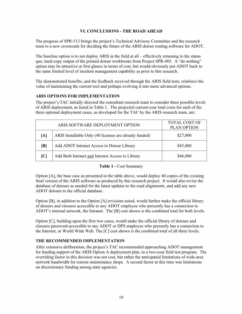
VI. CONCLUSIONS - THE ROAD AHEAD The progress of SPR-513 brings the project’s Technical Advisory Committee and the research team to a new crossroads for deciding the future of the ARIS detour routing software for ADOT. The baseline option is to not deploy ARIS in the field at all – effectively returning to the status quo, hard-copy output of the printed detour workbooks from Project SPR-485. A “do nothing” option may be attractive at first glance in terms of cost, but would obviously put ADOT back to the same limited level of incident management capability as prior to this research. The demonstrated benefits, and the feedback received through the ARIS field tests, reinforce the value of maintaining the current tool and perhaps evolving it into more advanced options.
ARIS OPTIONS FOR IMPLEMENTATION The project’s TAC initially directed the consultant research team to consider three possible levels of ARIS deployment, as listed in Table 1. The projected current-year total costs for each of the three optional deployment cases, as developed for the TAC by the ARIS research team, are:
ARIS SOFTWARE DEPLOYMENT OPTION TOTAL COST OF PLAN OPTION
[A] ARIS Installable Only (40 licenses are already funded) $27,000
[B] Add ADOT Intranet Access to Detour Library $43,000
[C] Add Both Intranet and Internet Access to Library $46,000
Table 1 - Cost Summary
Option [A], the base case as presented in the table above, would deploy 40 copies of the existing final version of the ARIS software as produced by this research project. It would also revise the database of detours as needed for the latest updates to the road alignments, and add any new ADOT detours to the official database. Option [B], in addition to the Option [A] revisions noted, would further make the official library of detours and closures accessible to any ADOT employee who presently has a connection to ADOT’s internal network, the Intranet. The [B] cost shown is the combined total for both levels. Option [C], building upon the first two cases, would make the official library of detours and closures password-accessible to any ADOT or DPS employee who presently has a connection to the Internet, or World Wide Web. The [C] cost shown is the combined total of all three levels.
THE RECOMMENDED IMPLEMENTATION After extensive deliberation, the project’s TAC recommended approaching ADOT management for funding support of the ARIS Option A deployment plan, in a two-year field test program. The overriding factor in this decision was not cost, but rather the anticipated limitations of wide-area network bandwidth for remote maintenance shops. A second factor at this time was limitations on discretionary funding among state agencies.
20
Forty licenses, or seats, of installable ARIS are already budgeted in this ADOT research project, and this cost is not part of Table 1. These seats are proposed to be distributed among key ADOT and DPS organizations upon implementation as follows:
• Each of 9 ADOT Districts – 2 seats each • ADOT Traffic Operations Center – 4 seats • AZ DPS Phoenix Headquarters – 3 seats • ADOT Phoenix campus – 6 seats remaining • Up to 9 DPS Regional and Field Offices – 1 seat each
Since DPS has a vital role in coordinating closures and alternate routes with ADOT, it is reasonable to provide an appropriate number of ARIS licenses to key DPS patrol districts, as a joint planning and incident management resource. This cooperative approach is similar to the successful joint deployment of HCRS workstations to DPS by ADOT in recent years. The detailed ARIS deployment plan presented to ADOT management is a separate document from this research report. The plan is supported by DPS with an active interest, but with only limited initial participation. As a separate agency, the same issues exist of deployment funding and IT infrastructure capability. The DPS information technology staff may choose to first observe the progress of the ADOT deployment, before initiating a significant parallel effort.
CONSIDERATIONS FOR DEPLOYMENT OPTION A The TAC’s recommendation is for Option A, the two-year trial deployment of the existing installable ARIS application. This decision recognizes the following factors:
• Option A will not deliver any additional new enhancements to ARIS. The licenses are already paid for in the research budget. The bulk of the cost is for the contractor to make the ARIS databases up-to-date with the most recent changes in road alignments that would affect detour options. Also required is a contractor-led program to solicit post-Project 485 detour updates from ADOT field staff, thereby making the library up-to-date. ADOT field staff time to review and comment on the adequacy of existing detours is not included in the cost. Reasonable estimates of additional software quality testing and technical documentation (beyond the Project SPR-513 deliverable) as required by ADOT-ITG are included in the cost.
• In Year Two and beyond, ongoing database maintenance costs for Option A assume an estimated 24 detour updates per year will be required by ADOT at a contractor cost of $100 per update. Cost of ADOT field staff time to review and comment on the adequacy of the ongoing detours is not included.
Option A as selected has the following pros and cons:
Pro: No necessary additional cost to utilize the application once the budgeted license fees have been transferred from the existing SPR-513 budget to ESRI. Virtually no impact on ADOT’s existing network bandwidth.
Con: Formal classroom training is not provided, but help videos are supplied, making the use of ARIS dependent on the ease of the interface and/or the diligence of the local user to self-train. Use is limited to 40 license holders – which appears to be enough – and new detour books can be printed by licensed users for others who desire a printed library.
21
Further alternate route enhancement in the form of the planned blanket review and update of the routes and detours offers yet more advantages, with the following conditions:
Pro: Up-to-date detours in ARIS format, compliant with newer roadway alignments and more current operating policies. Encourages users to get familiar with ARIS for the purpose of making it more beneficial for everyday use – as well as for its primary, necessary use.
Con: Requires another round of ADOT and DPS review – perhaps similar to the earlier project SPR-485 effort. Would still need to develop better information on non-ADOT roads that may be conditionally available as alternate routes.
FUTURE UPGRADES TO ARIS OPTION A The other suggested implementation enhancements, Options B and C, may be given further consideration in the future. This second-phase decision would depend upon the successful completion by ADOT forces of the recommended two-year Option A field test program. As shown in Table 1, options B and C provide certain additional ARIS capabilities, services and applications, each at some level of increased cost. They would also require some level of expansion of system and/or communications capacity by ADOT. For any such future decision, the key cost factors for possible upgrades of ARIS beyond Option A are detailed as follows:
• Option B consists of development costs to make tabular detour sheets and companion sheet maps available on separate print pages from a browser interface. Intranet solutions can tend to be more costly than Internet applications when higher local area bandwidth enables more potential capabilities. Conversely, the Intranet solution can also be less expensive, because security / accessibility is normally already provided by the local area network.
• Annual maintenance cost estimates in Table 1 for either Option B or C assume twelve (12) transmissions of database updates (from the contractor to ADOT) annually at $100 each, the same as with Option A.
• Option C (Internet) assumes that ADOT in the future would host both internal and external services which are already existing, and no additional compensation is provided to the contractor by funding from the ARIS research project.
• With Option C, if the contractor were to continue to host the Internet site rather than ADOT, the annual maintenance cost estimate would remain stable, the same as for Option B, to cover the contractor’s hosting obligation.
OTHER FUTURE OPTIONS During the course of this ARIS project, it was necessary to concentrate on existing technology to produce the specified software product. However, developing technology continued to bring new options to the forefront as both ESRI and Microsoft-based solutions appeared during this study. ESRI announced the ArcIMS 3.1 Route Server Extension in late 2001. Even though a web-based solution was not programmed at the onset of this study, the ARIS deployment options specified above do include future web-based dissemination of closure/detour information. A solution that includes online dissemination of stored detours and ad hoc “best path” detours can be available using ArcIMS 3.1 Route Server Extension. There are some apparent limitations currently that will likely be erased by advancing technology and even lower prices as time goes by. The project team recommends to ADOT that its best eventual option for long-term deployment of ARIS may include the Route Server Extension by ESRI, or a subsequent technology.
22
The Microsoft activity in detour routing involves their MapPoint 2002, an off-the-shelf product. The project team has used MapPoint and has investigated the MapPoint developer’s website. There is good alternate route functionality available in the off-the-shelf program. It remains to be seen how difficult it would be to provide ADOT’s centerline, closure and detour data, and functionality requirements with Microsoft’s architecture. Nevertheless, it is important to state that alternate route functionality is available in a standardized format using off-the-shelf installable software containing generic data.
LESSONS LEARNED In the course of this project, problems, issues and opportunities arose for the consultant and the Technical Advisory Committee. These are relevant lessons for similar efforts in the future:
• The project work was initiated immediately, several weeks before the TAC group first met, so that a draft product could be showcased to the sponsors at that first meeting. This led to increased support and produced several TAC volunteers for the first-phase beta testing.
• A very successful password-protected project website was developed specifically for ARIS software troubleshooting, for feedback and comments, and for updates and training files.
• The initial beta testing concept allowed for several ARIS versions to run on a variety of computers, and this solved a number of problems before the field testing was initiated.
• The field test phase was kicked off with four regional workshops which were very valuable to introduce the local-level users and stakeholders to ARIS, and to win their full support.
• Tutorial videos were developed to lead the users through each step of learning ARIS.
• A series of “how-to” bulletins with ARIS sample problems and user questions were sent at intervals to all ADOT and DPS field testers, which helped to keep their interest level high.
• Despite the success of the beta phase, some hardware problems arose in the field testing with a few of the numerous revisions of the software; an earlier QA/QC phase is indicated.
• Problems arose for some ADOT users with Windows 95 on older laptops, that would not run the ARIS system because the TAC set the minimum specifications as Windows NT4.
• There was a back-compatibility problem with a newly-developed Microsoft DLL file that made it difficult to install the ESRI-based ARIS system on some computers.
• ADOT districts have flexibility to apply their limited computer equipment funds in various ways, so that not all the maintenance sub-districts even use laptops at the local level. This led to a shift in focus for the ARIS resource, to ADOT’s local field office workstations.
• The route database should include county and local roads, because current agreements or future new detour plans at the local level may depend on these links in certain cases.
• The route database should include main highways in a halo zone beyond a state’s borders, to allow full flexibility in detouring traffic in and through the border regions.
• Some ADOT databases were not fully current, due to long-term resource shortfalls. This was true for some local or out-of-state routes also. The variable status of the databases indicates that the best judgment and local knowledge of the ADOT and DPS users in the field must be a vital part of the detour decision process.
23
ARIS PROJECT RESULTS As noted in the preceding sections, the Project 513 team successfully created the ARIS program as the practical working deliverable and primary objective of the research. The key project goal was to provide ADOT field personnel in the districts with a new software tool, in a uniform and user-friendly format, to determine the best detour options for a roadway closure or restriction. A side benefit of the project was the interest created in GIS data in general, as many of the training participants were not aware of the usefulness and ease of use of GIS applications. A critical factor for the ARIS project was the prior alternate routing reseach performed several years earlier for ADOT. That Project 485 had made a very significant effort to define the key routes and approved detours, and to build the detour database. The key benefit to the ARIS program was the arduous but successful process of consensus, by which ADOT and DPS agreed on preferred detours for all of the most critical highway system segments in Arizona. The ARIS consultant was able to build effectively on the Project 485 data, and to reinforce its established consensus between the core agencies. The choice of the ARIS consultant was a second key factor in the success of the research project. The consultant was well versed in GIS concepts and ESRI software resources, and already had extensive recent experience with the core ADOT databases. This enabled the new ARIS product to be both accurate and functional. The consultant team was able to develop the user-friendly, interactive detour software in exactly the form originally envisioned by the project sponsors. In light of these aspects of the project’s history, the circumstances that enabled ARIS to be developed so effectively for Arizona may be relatively unique. A key consideration in future similar efforts is the timing of such a program. Although ADOT saw the need for such a routing resource several years earlier, neither the tools nor the databases were sufficiently developed at that time. Another key factor is cost, and time and technology do tend to bring costs down, leading to better solutions in less time and at less cost. For ADOT, the prior project results, the quality of data, and the consultant experience combined at the right time for this project. The potential of ARIS to support future efficient detour planning and execution is proven, both now and into the near future. However, the longevity of an effective detour program will depend on the ability to maintain and revise the detour library efficiently, and to communicate this to all users. ARIS has been designed, and it will work for ADOT, with all of these factors in mind.

24
REFERENCES 1. Wall, Henry B. III, and Kolcz, Andrew, Arizona Statewide Alternate Route Plan, Report
Number FHWA-AZ99-485, Arizona Department of Transportation, December 1999.
25
APPENDIX A – FEEDBACK LOGGED TO THE WEBSITE
26
ARIS - Identified Issues Noticed by Date Recorded DateFixed: Version fhwa 9/6/2001 10/2/2001 Beta B Problem: Memory Read Error when solving for a detour. First reported by FHWA. Later reported by Globe District. Suggestion: Fix FixerComments This has been resolved. It will still happen until the shortcut is fixed in your menu but in the next install release this should not be a problem. itwillwork 9/11/2001 9:35:14 AM 9/11/2001 12:30:00 PM Beta B Problem: Resize or minimization of Directions window causes application to terminate with Error 384. Suggestion: Fix FixerComments Fix will be provided in Beta C and later versions. Beta C will require an uninstall/reinstall due to user interface improvements also in that version. adottpd 9/13/2001 8:43:05 AM 10/2/2001 Beta C Problem: routes over top of selected closure, doesn't recognize closure when using State Only option -- not related to #7 Suggestion: FixerComments State closure is now resolved. adottpd 9/13/2001 8:44:02 AM Beta B Problem: When a number of local roads get box selected, processing takes very long times up to possible lock up. Suggestion: set up a stop, cancel or escape button/mechanism FixerComments We have not experienced this even when we try hard on the slower spec machines. Will have to investigate on the exhibiting machine. (JPB) adottpd 9/13/2001 8:46:34 AM Beta B Problem: control flags as boxes/circles obscure the road, takes a very close zoom in to verify correct road. Suggestion: offset box with a leader or arrow pointing to the location FixerComments This is difficult. Stay tuned. (JPB) We are leaning towards this being a teaching obstacle to use the view port in conjuction with your map (AML) adottpd 9/13/2001 8:48:52 AM Beta B Problem: when the selected route is shown only by the shaded buffered area, it is difficult to determine visually which road is actually being used in congested areas Suggestion: highlite or mark the detour showing specific arcs used FixerComments Other than altering render settings, we may have to generate graphics to a shapefile so that it can be moved deeper in the Table of Contents. (JB) adottpd 9/13/2001 8:51:56 AM 10/18/2001 Beta B Problem: Text directions use local named streets and don't indicate that it may also be a continuous state system route as well Suggestion: show as continuing on the hwy with local name in paren or vice versa FixerComments Done - with exception of some special conditions. Should refine in future. adottpd 9/13/2001 8:56:04 AM 10/2/2001 Beta B Problem: box selector for closures can be too broad and not sufficiently selective Suggestion: ability to set closure flags on individual arcs (multiple flags) or at least select (deselect multiple arcs for closure FixerComments We know. This is an ongoing MapObjects issue. We will continue to solve. (JPB) This is solved by the MultiSelect now being fully functional. (AML)
27
ARIS - Identified Issues Noticed by Date Recorded DateFixed: Version adottpd 9/13/2001 9:07:58 AM 10/18/2001 Problem: closure selects entire arc segment which at times can be significant in length - need to ensure that that route flags do not fall in the closure arc Suggestion: training issue FixerComments User now gets a warning. adottpd 9/13/2001 10:12:47 AM Beta C Problem: Using the 'identify' when zoomed out very far, does a very wide search and picks up unreliable results. Correct arc may highlite but display is incorrect or gives too many choices. Suggestion: FixerComments We will test and observe. Stay tuned. (JPB) adottpd 9/13/2001 10:18:29 AM 9/17/2001 Beta C Problem: SUGGESTION - legend for speed limits breaks < 50, 50 - 55, 60 - 65, 70+ Is this the most current data from traffic on hwy speed limits? Suggestion: Reduce number of lines in the legend. Specifics can be picked up by 'identify'. FixerComments "Will do. Look for a new EXE once you see the "Date Fixed" filled in. (JB)" - The changed structure reads less than 51;51-55;56-60;61-65;66-70;71-85 (AML) adottpd 9/13/2001 2:40:39 PM 10/2/2001 Beta C Problem: suggestion - A00M - rename to milepost or mile marker to be meaningful. don't show different types in legend. Can be explained initially -- should be self evident when using anyway - no need to display until zoomed in Suggestion: FixerComments "Will do. Look for changes in an upcoming EXE. (JPB)" - Toggle has been added to the legend to collapse or expand (AML) New legend has been Developed to handle an alias name to the shapefiles. This will be released in version D. (AML)
adottpd 9/13/2001 2:45:31 PM 10/18/2001 Beta C Problem: Personal preference - do not like the hwy shields. Looks very cluttered at full screen (first impression) Suggestion: Leave shield as option to make display map - must be better way to annotate hwy for regular users FixerComments I agree. We will work to prevent display at zoomed out scales. (JPB) Fixed during Beta C to display only when zoomed in sufficiently. adottpd 9/13/2001 2:48:24 PM 10/2/2001 Beta C Problem: funccode theme is confusing. for this appl. knowing collector, arterial, & freeway are only classes needed to do routing - The simpler it is initially, the better to be accepted. Suggestion: I think initial TAC thinking was to selectively route 'highways only' or 'highways and collector or above' -- local roads are not good detour candidates FixerComments We will fix for next CD distribution (JPB) Funccode is updated in later builds of Version C but requires the user to download the New Data. This will be released in verison D. (AML) adottpd 9/13/2001 3:09:31 PM 10/18/2001 Beta C Problem: Proposal indicated inclusion of road restrictions - bridge/structure data. what is status and plan for NBI prior to initial deployment? Suggestion: FixerComments 14ft, 102in, and Bridge DB will soon be available. Definitely by field deployment. HCRS is unsure due to current formats. (JPB) adottpd 9/13/2001 3:16:00 PM 9/17/2001 Problem: I would suggest the initial draw of the map should include county/state boundaries Suggestion: FixerComments "Will do for the next EXE (JPB)" - change made to EXE (AML)
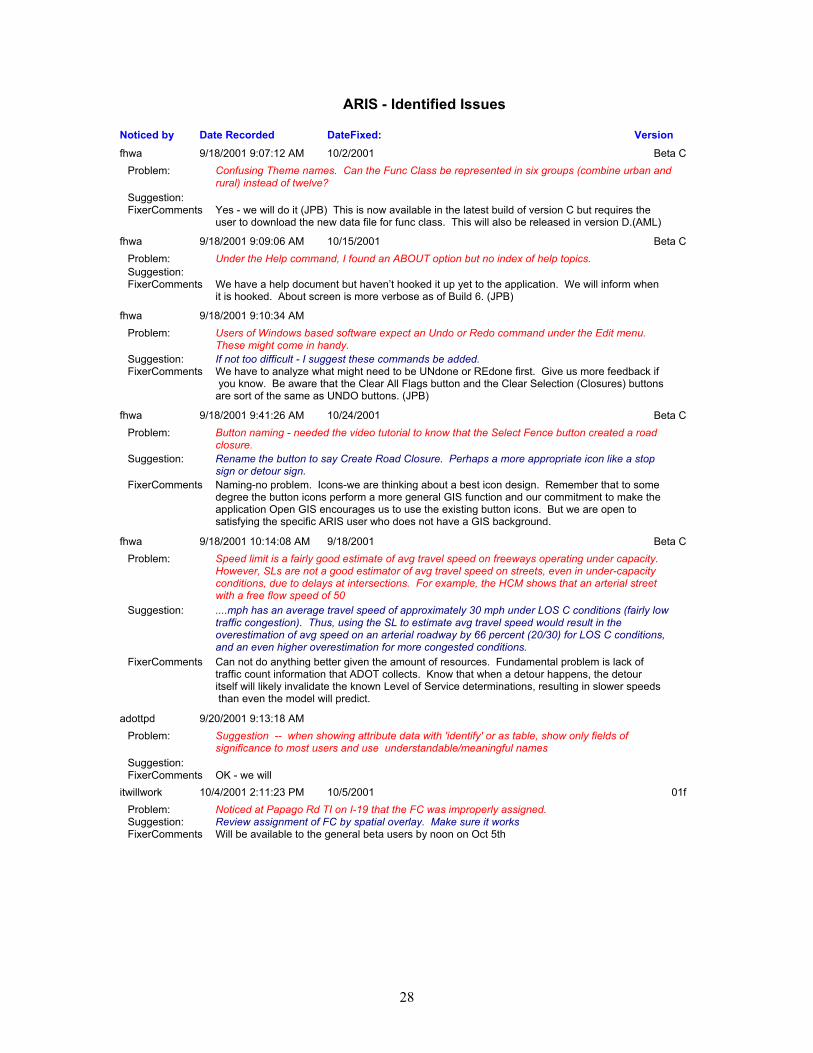
28
ARIS - Identified Issues Noticed by Date Recorded DateFixed: Version fhwa 9/18/2001 9:07:12 AM 10/2/2001 Beta C Problem: Confusing Theme names. Can the Func Class be represented in six groups (combine urban and rural) instead of twelve? Suggestion: FixerComments Yes - we will do it (JPB) This is now available in the latest build of version C but requires the user to download the new data file for func class. This will also be released in version D.(AML) fhwa 9/18/2001 9:09:06 AM 10/15/2001 Beta C Problem: Under the Help command, I found an ABOUT option but no index of help topics. Suggestion: FixerComments We have a help document but haven’t hooked it up yet to the application. We will inform when it is hooked. About screen is more verbose as of Build 6. (JPB) fhwa 9/18/2001 9:10:34 AM Problem: Users of Windows based software expect an Undo or Redo command under the Edit menu. These might come in handy. Suggestion: If not too difficult - I suggest these commands be added. FixerComments We have to analyze what might need to be UNdone or REdone first. Give us more feedback if you know. Be aware that the Clear All Flags button and the Clear Selection (Closures) buttons are sort of the same as UNDO buttons. (JPB)
fhwa 9/18/2001 9:41:26 AM 10/24/2001 Beta C Problem: Button naming - needed the video tutorial to know that the Select Fence button created a road closure. Suggestion: Rename the button to say Create Road Closure. Perhaps a more appropriate icon like a stop sign or detour sign. FixerComments Naming-no problem. Icons-we are thinking about a best icon design. Remember that to some degree the button icons perform a more general GIS function and our commitment to make the application Open GIS encourages us to use the existing button icons. But we are open to satisfying the specific ARIS user who does not have a GIS background.
fhwa 9/18/2001 10:14:08 AM 9/18/2001 Beta C Problem: Speed limit is a fairly good estimate of avg travel speed on freeways operating under capacity. However, SLs are not a good estimator of avg travel speed on streets, even in under-capacity conditions, due to delays at intersections. For example, the HCM shows that an arterial street with a free flow speed of 50 Suggestion: ....mph has an average travel speed of approximately 30 mph under LOS C conditions (fairly low traffic congestion). Thus, using the SL to estimate avg travel speed would result in the overestimation of avg speed on an arterial roadway by 66 percent (20/30) for LOS C conditions, and an even higher overestimation for more congested conditions. FixerComments Can not do anything better given the amount of resources. Fundamental problem is lack of traffic count information that ADOT collects. Know that when a detour happens, the detour itself will likely invalidate the known Level of Service determinations, resulting in slower speeds than even the model will predict.
adottpd 9/20/2001 9:13:18 AM Problem: Suggestion -- when showing attribute data with 'identify' or as table, show only fields of significance to most users and use understandable/meaningful names Suggestion: FixerComments OK - we will itwillwork 10/4/2001 2:11:23 PM 10/5/2001 01f Problem: Noticed at Papago Rd TI on I-19 that the FC was improperly assigned. Suggestion: Review assignment of FC by spatial overlay. Make sure it works FixerComments Will be available to the general beta users by noon on Oct 5th
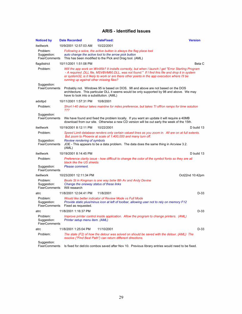
29
ARIS - Identified Issues Noticed by Date Recorded DateFixed: Version itwillwork 10/9/2001 12:57:03 AM 10/22/2001 Problem: Following a solve, the active button is always the flag place tool Suggestion: auto change the active tool to the arrow pick button FixerComments This has been modified to the Pick and Drag tool. (AML) flagdistrict 10/11/2001 1:51:08 PM Beta C Problem: Will the app work on Win95b? It installs correctly, but when I launch I get "Error Starting Program - A required .DLL file, MSVBVM60.DLL, was not found." If I find this file and drop it in system or system32, is it likely to work or are there other points in the app execution where I'll be running up against other missing files? Suggestion: FixerComments Probably not. Windows 95 is based on DOS. 98 and above are not based on the DOS architecture. This particular DLL it seems would be only supported by 98 and above. We may have to look into a substitution. (AML)
adottpd 10/11/2001 1:57:31 PM 10/8/2001 Problem: Short I-40 detour takes mainline for miles preference, but takes TI off/on ramps for time solution ??? Suggestion: FixerComments We have found and fixed the problem locally. If you want an update it will require a 40MB download from our site. Otherwise a new CD version will be out early the week of the 15th. itwillwork 10/19/2001 8:12:11 PM 10/22/2001 D build 13 Problem: Speed Limit database renders only certain valued lines as you zoom in. All are on at full extents. But zoom to Phoenix at scale of 1:400,000 and many turn off. Suggestion: Review rendering of symbols FixerComments JOE - This appears to be a data problem. The data does the same thing in Arcview 3.2. (AML) itwillwork 10/19/2001 8:14:45 PM D build 13 Problem: Preference clarity issue - how difficult to change the color of the symbol fonts so they are all black like the US shields Suggestion: Please comment. FixerComments itwillwork 10/23/2001 12:11:34 PM Oct22nd 10:42pm Problem: Beale St in Kingman is one way betw 8th Av and Andy Devine Suggestion: Change the oneway status of these links FixerComments Will research atrc 11/8/2001 12:04:41 PM 11/8/2001 D-33 Problem: Would like better indicator of Review Mode vs Full Mode Suggestion: Provide static plus/minus icon at left of toolbar, allowing user not to rely on memory F12 FixerComments Fixed as requested. atrc 11/8/2001 1:16:37 PM D-33 Problem: Improve printer control inside application. Allow the program to change printers. (AML) Suggestion: Printer setup menu item. (AML) FixerComments atrc 11/8/2001 1:25:04 PM 11/10/2001 D-33 Problem: The state (F2) of how the detour was solved on should be saved with the detour. (AML) The resolve ("Find Best Path") can return different directions. Suggestion: FixerComments Is fixed for det/clo combos saved after Nov 10. Previous library entries would need to be fixed.
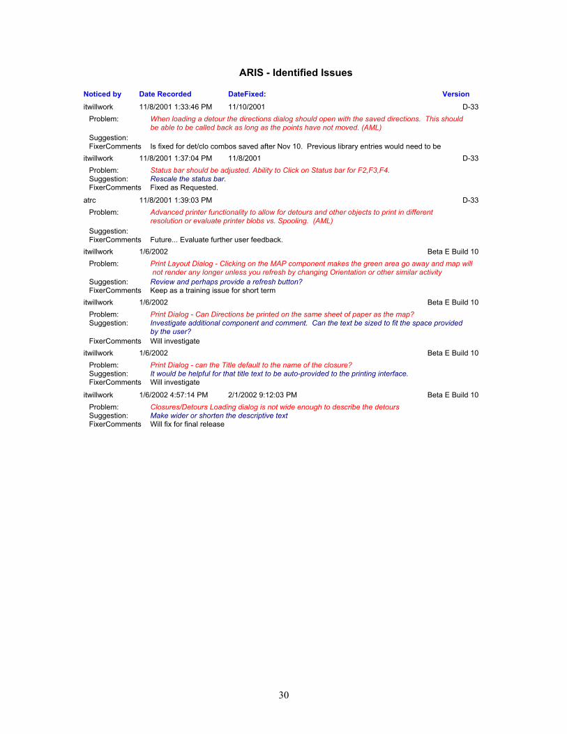
30
ARIS - Identified Issues Noticed by Date Recorded DateFixed: Version itwillwork 11/8/2001 1:33:46 PM 11/10/2001 D-33 Problem: When loading a detour the directions dialog should open with the saved directions. This should be able to be called back as long as the points have not moved. (AML) Suggestion: FixerComments Is fixed for det/clo combos saved after Nov 10. Previous library entries would need to be itwillwork 11/8/2001 1:37:04 PM 11/8/2001 D-33 Problem: Status bar should be adjusted. Ability to Click on Status bar for F2,F3,F4. Suggestion: Rescale the status bar. FixerComments Fixed as Requested. atrc 11/8/2001 1:39:03 PM D-33 Problem: Advanced printer functionality to allow for detours and other objects to print in different resolution or evaluate printer blobs vs. Spooling. (AML) Suggestion: FixerComments Future... Evaluate further user feedback. itwillwork 1/6/2002 Beta E Build 10 Problem: Print Layout Dialog - Clicking on the MAP component makes the green area go away and map will not render any longer unless you refresh by changing Orientation or other similar activity Suggestion: Review and perhaps provide a refresh button? FixerComments Keep as a training issue for short term itwillwork 1/6/2002 Beta E Build 10 Problem: Print Dialog - Can Directions be printed on the same sheet of paper as the map? Suggestion: Investigate additional component and comment. Can the text be sized to fit the space provided by the user? FixerComments Will investigate itwillwork 1/6/2002 Beta E Build 10 Problem: Print Dialog - can the Title default to the name of the closure? Suggestion: It would be helpful for that title text to be auto-provided to the printing interface. FixerComments Will investigate itwillwork 1/6/2002 4:57:14 PM 2/1/2002 9:12:03 PM Beta E Build 10 Problem: Closures/Detours Loading dialog is not wide enough to describe the detours Suggestion: Make wider or shorten the descriptive text FixerComments Will fix for final release
31
APPENDIX B – FIELD TEST MEETING INVITATIONS
B-1 INVITATION TO ADOT DISTRICT PERSONNEL B-2 INVITATION TO DPS COMMANDERS B-3 FIELD TEST MEETING BROCHURE B-4 FIELD TEST MEETING ATTENDEES
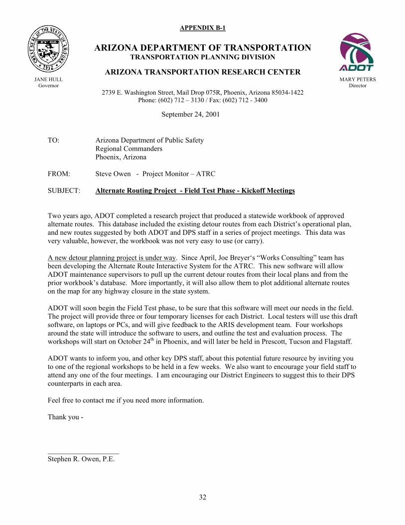
APPENDIX B-1
ARIZONA DEPARTMENT OF TRANSPORTATION TRANSPORTATION PLANNING DIVISION
ARIZONA TRANSPORTATION RESEARCH CENTER
JANE HULL MARY PETERS Governor Director 2739 E. Washington Street, Mail Drop 075R, Phoenix, Arizona 85034-1422 Phone: (602) 712 – 3130 / Fax: (602) 712 - 3400
September 24, 2001
32
TO: Arizona Department of Public Safety Regional Commanders
Phoenix, Arizona
FROM: Steve Owen - Project Monitor – ATRC SUBJECT: Alternate Routing Project - Field Test Phase - Kickoff Meetings Two years ago, ADOT completed a research project that produced a statewide workbook of approved alternate routes. This database included the existing detour routes from each District’s operational plan, and new routes suggested by both ADOT and DPS staff in a series of project meetings. This data was very valuable, however, the workbook was not very easy to use (or carry). A new detour planning project is under way. Since April, Joe Breyer‘s “Works Consulting” team has been developing the Alternate Route Interactive System for the ATRC. This new software will allow ADOT maintenance supervisors to pull up the current detour routes from their local plans and from the prior workbook’s database. More importantly, it will also allow them to plot additional alternate routes on the map for any highway closure in the state system. ADOT will soon begin the Field Test phase, to be sure that this software will meet our needs in the field. The project will provide three or four temporary licenses for each District. Local testers will use this draft software, on laptops or PCs, and will give feedback to the ARIS development team. Four workshops around the state will introduce the software to users, and outline the test and evaluation process. The workshops will start on October 24th in Phoenix, and will later be held in Prescott, Tucson and Flagstaff. ADOT wants to inform you, and other key DPS staff, about this potential future resource by inviting you to one of the regional workshops to be held in a few weeks. We also want to encourage your field staff to attend any one of the four meetings. I am encouraging our District Engineers to suggest this to their DPS counterparts in each area. Feel free to contact me if you need more information. Thank you - Stephen R. Owen, P.E.
APPENDIX B-2
ARIZONA TRANSPORTATION RESEARCH CENTER TRANSPORTATION PLANNING DIVISION
ALTERNATE ROUTE INTERACTIVE SYSTEM (ARIS)
RESEARCH PROJECT No. 513
33
MEMORANDUM
DATE: September 24, 2001
TO: District Engineers / Maintenance Engineers / Maintenance Superintendents
CC: Joe Breyer – Works Consulting SUBJECT: ARIS Project - Field Test Phase - Kickoff Meeting Two years ago, the ATRC completed a research project which produced a statewide workbook of approved alternate routes. This database included the existing detour routes from each District’s operational plan, and new routes suggested by both ADOT and DPS staff in a series of project meetings. This data was very valuable, however, the workbook was not very easy to use (or carry). A new detour planning project is under way. Since April, a “Works Consulting” team led by Joe Breyer has been developing the Alternate Route Interactive System for the ATRC. This new tool is a software which will allow ADOT maintenance supervisors to pull up the current detour routes from their local plans and from the prior workbook database. More importantly, it will also allow them to plot additional alternate routes on the map for any highway closure in the state system. We need the help of each District to prove that this new portable routing tool will work, and that it will meet your needs in the field. The project is approaching the Field Test phase and we have three or four temporary licenses for each District. We need local testers to use this software, on your laptops or PCs, and to provide your reactions and suggestions to the development team. There will be four workshops around the state to introduce the software to users, and to outline the test and evaluation process. These workshops will start on October 24th in Phoenix, and will also be scheduled soon in Prescott, Tucson and Flagstaff. The ATRC needs for each District to identify the future users who could assist with the Field Test, starting with the regional workshops in a few weeks. Please provide me with the names of your District staff who will take part in this Field Test activity, and which of the four workshops they would want to attend. We need to know how big a meeting room is required. We want to reach your field supervisors and district-level operations staff, and we also welcome any of your DPS partners who want to see what this system could do in the field. Feel free to contact me if you need more information. Thank you - Steve Owen / ATRC 602-712-6910
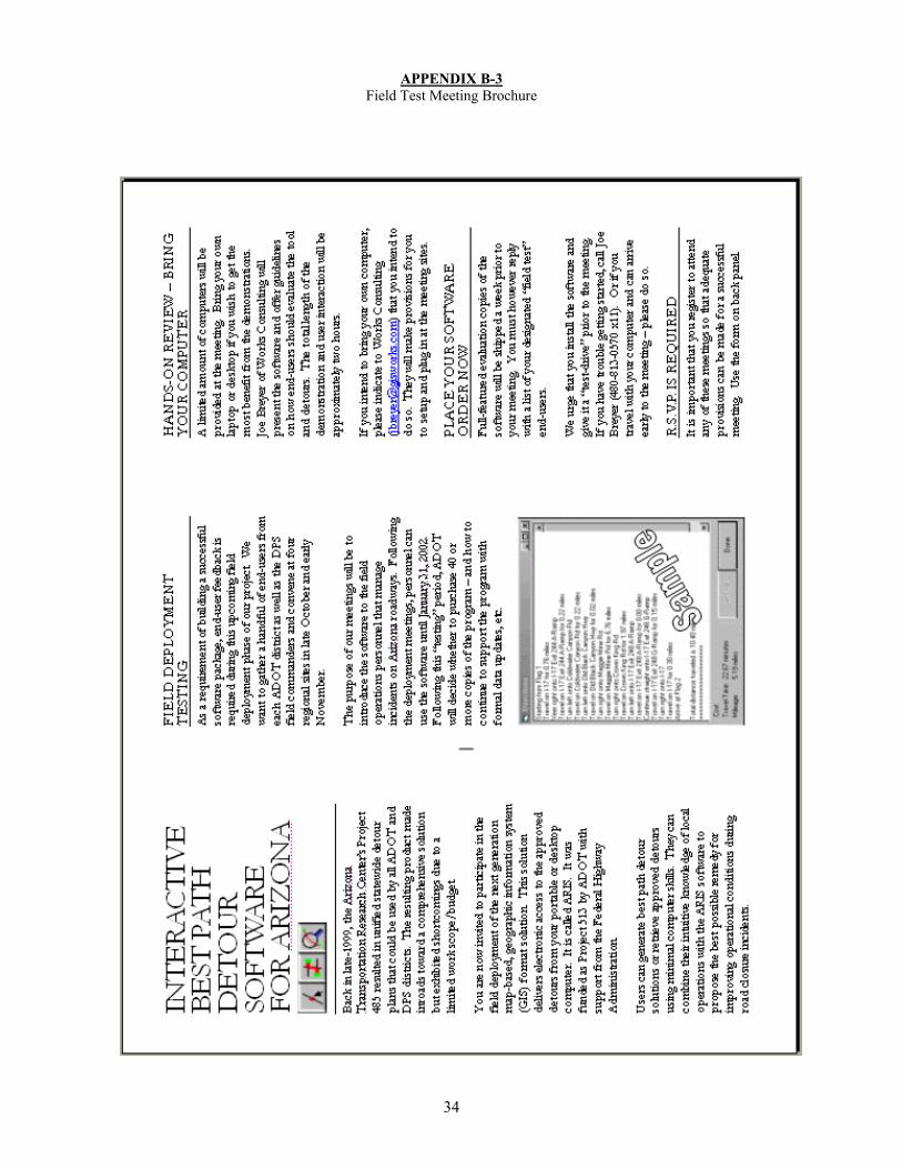
APPENDIX B-3
Field Test Meeting Brochure
34
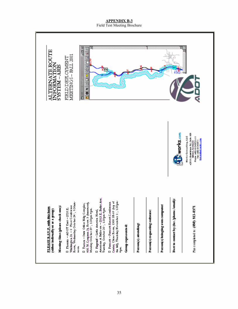
APPENDIX B-3
Field Test Meeting Brochure
35
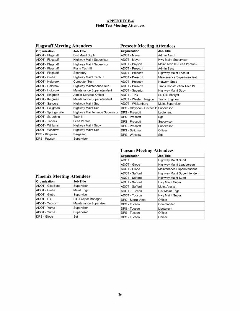
APPENDIX B-4
Field Test Meeting Attendees
36
Flagstaff Meeting Attendees Organization Job TitleADOT - Flagstaff Dist Maint SuptrADOT - Flagstaff Highway Maint SupervisorADOT - Flagstaff Highway Maint SupervisorADOT - Flagstaff Plans Tech IIIADOT - Flagstaff SecretaryADOT - Globe Highway Maint Tech IIIADOT - Holbrook Computer TechADOT - Holbrook Highway Maintenance Sup.ADOT - Holbrook Maintenance SuperintendentADOT - Kingman Admin Services OfficerADOT - Kingman Maintenance SuperintendentADOT - Sanders Highway Maint SupADOT - Seligman Highway Maint SupADOT - Springerville Highway Maintenance SupervisorADOT - St. Johns Tech IIIADOT - Topock Lead PersonADOT - Williams Highway Maint SupvADOT - Winslow Highway Maint SupDPS - Kingman SergeantDPS - Payson Supervisor Phoenix Meeting Attendees Organization Job TitleADOT - Gila Bend SupervisorADOT - Globe Maint EngrADOT - Globe SupervisorADOT - ITG ITG Project ManagerADOT - Tucson Maintenance SupervisorADOT - Yuma SupervisorADOT - Yuma SupervisorDPS - Globe Sgt
Prescott Meeting Attendees Organization Job TitleADOT - Mayer Admin Asst IADOT - Mayer Hwy Maint SupervisorADOT - Payson Maint Tech III (Lead Person)ADOT - Prescott Admin SecyADOT - Prescott Highway Maint Tech IIIADOT - Prescott Maintenance SuperintendentADOT - Prescott Network SpecADOT - Prescott Trans Construction Tech IVADOT - Superior Highway Maint SupvrADOT - TPD Sr. GIS AnalystADOT - Western Region Traffic EngineerADOT - Wickenburg Maint SupervisorDPS - Claypool - District 11SupervisorDPS - Prescott LeutenantDPS - Prescott SgtDPS - Prescott SupervisorDPS - Prescott SupervisorDPS - Seligman OfficerDPS - Winslow Sgt Tucson Meeting Attendees Organization Job TitleADOT Highway Maint SuprtADOT - Globe Highway Maint LeadpersonADOT - Globe Maintenance SuperintendentADOT - Safford Highway Maint SuperintendentADOT - Safford Highway Maint SuprtADOT - Safford Hwy Maint SuperADOT - Safford Maint AnalystADOT - Tucson Dist Maint EngrADOT - Tucson Hwy Maint SuperDPS - Sierra Vista OfficerDPS - Tucson CommanderDPS - Tucson LieutenantDPS - Tucson OfficerDPS - Tucson Officer
37
APPENDIX C – HOW-TO BULLETINS
C-1 USING ARIS TO GENERATE AN ELECTRONIC MAP IMAGE C-2 MAKING A PRINTOUT OF A STORED CLOSURE / DETOUR C-3 GENERATE A CLOSURE AND FIND A DETOUR C-4 ACCESSING GIS (AND PERHAPS ARIS) DATA ON THE WEB C-5 USING THE INTERNET TO ACCESS A DETOUR MAP
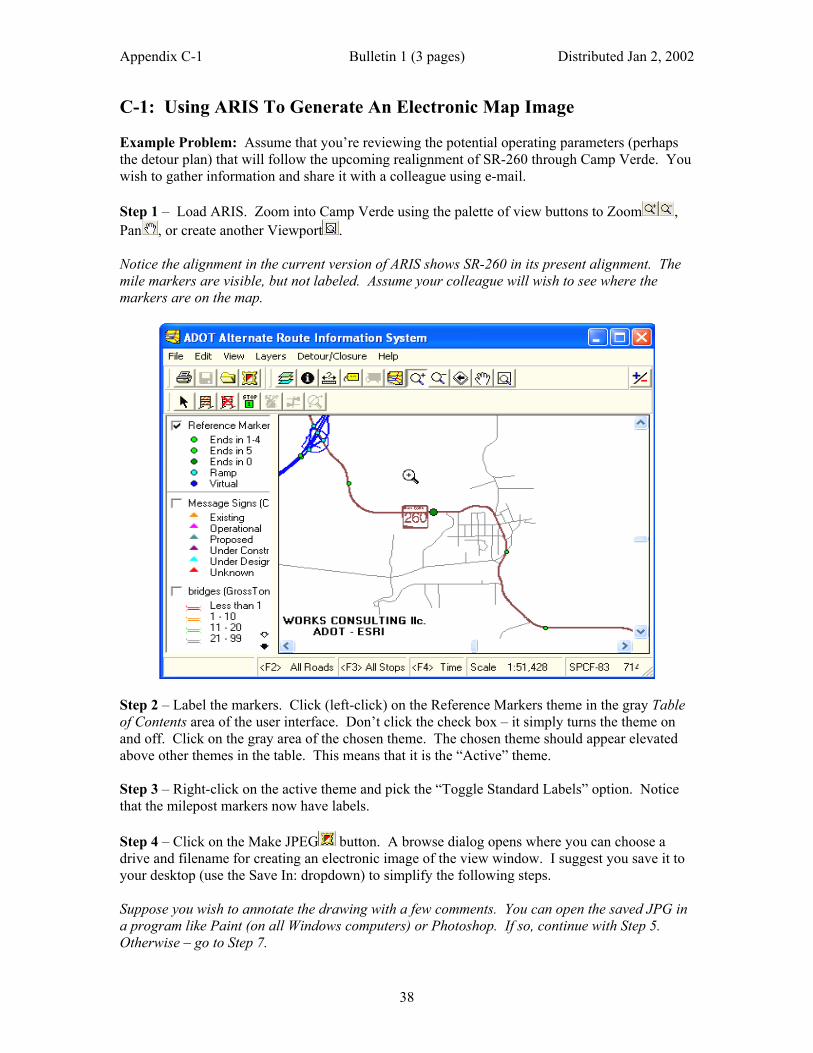
Appendix C-1 Bulletin 1 (3 pages) Distributed Jan 2, 2002
38
C-1: Using ARIS To Generate An Electronic Map Image Example Problem: Assume that you’re reviewing the potential operating parameters (perhaps the detour plan) that will follow the upcoming realignment of SR-260 through Camp Verde. You wish to gather information and share it with a colleague using e-mail. Step 1 – Load ARIS. Zoom into Camp Verde using the palette of view buttons to Zoom , Pan , or create another Viewport . Notice the alignment in the current version of ARIS shows SR-260 in its present alignment. The mile markers are visible, but not labeled. Assume your colleague will wish to see where the markers are on the map.
Step 2 – Label the markers. Click (left-click) on the Reference Markers theme in the gray Table of Contents area of the user interface. Don’t click the check box – it simply turns the theme on and off. Click on the gray area of the chosen theme. The chosen theme should appear elevated above other themes in the table. This means that it is the “Active” theme. Step 3 – Right-click on the active theme and pick the “Toggle Standard Labels” option. Notice that the milepost markers now have labels. Step 4 – Click on the Make JPEG button. A browse dialog opens where you can choose a drive and filename for creating an electronic image of the view window. I suggest you save it to your desktop (use the Save In: dropdown) to simplify the following steps. Suppose you wish to annotate the drawing with a few comments. You can open the saved JPG in a program like Paint (on all Windows computers) or Photoshop. If so, continue with Step 5. Otherwise – go to Step 7.
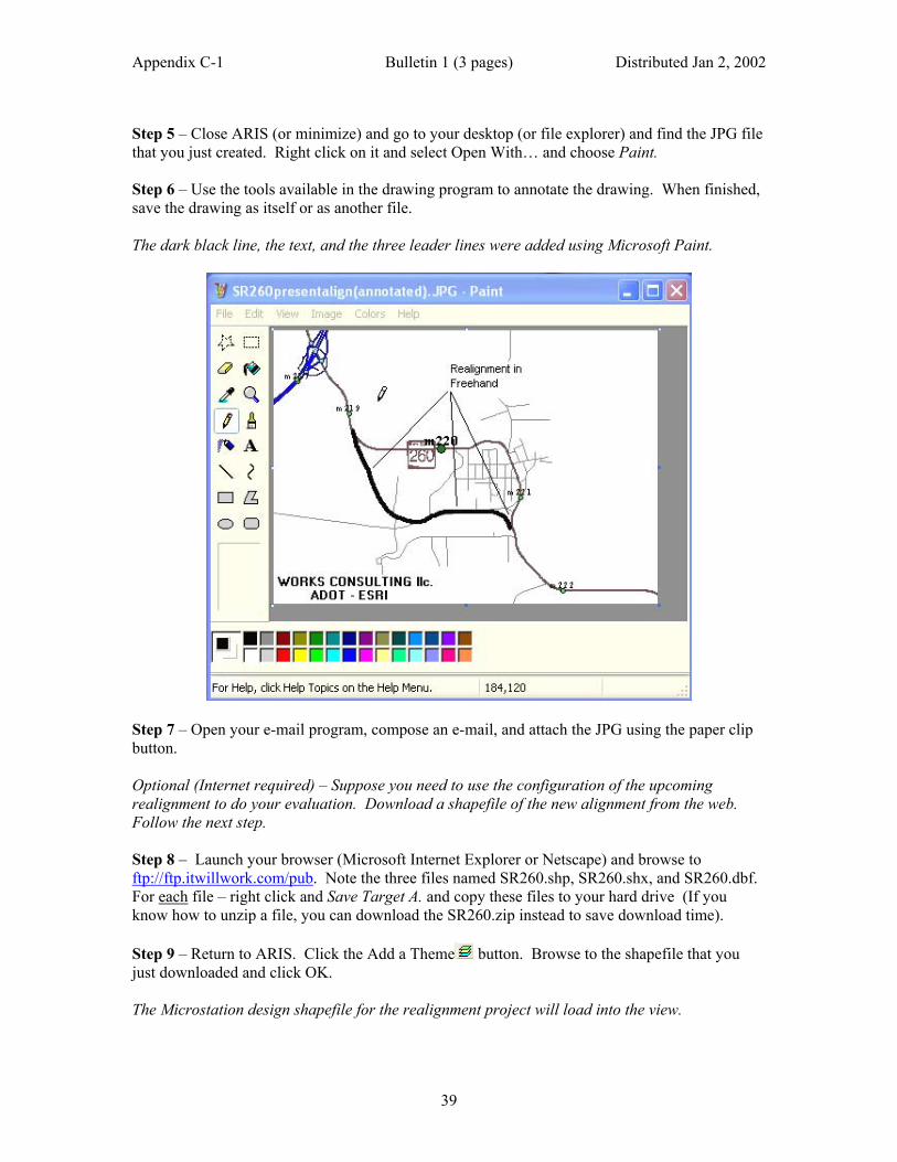
Appendix C-1 Bulletin 1 (3 pages) Distributed Jan 2, 2002
39
Step 5 – Close ARIS (or minimize) and go to your desktop (or file explorer) and find the JPG file that you just created. Right click on it and select Open With… and choose Paint. Step 6 – Use the tools available in the drawing program to annotate the drawing. When finished, save the drawing as itself or as another file. The dark black line, the text, and the three leader lines were added using Microsoft Paint.
Step 7 – Open your e-mail program, compose an e-mail, and attach the JPG using the paper clip button. Optional (Internet required) – Suppose you need to use the configuration of the upcoming realignment to do your evaluation. Download a shapefile of the new alignment from the web. Follow the next step. Step 8 – Launch your browser (Microsoft Internet Explorer or Netscape) and browse to ftp://ftp.itwillwork.com/pub. Note the three files named SR260.shp, SR260.shx, and SR260.dbf. For each file – right click and Save Target A. and copy these files to your hard drive (If you know how to unzip a file, you can download the SR260.zip instead to save download time). Step 9 – Return to ARIS. Click the Add a Theme button. Browse to the shapefile that you just downloaded and click OK. The Microstation design shapefile for the realignment project will load into the view.
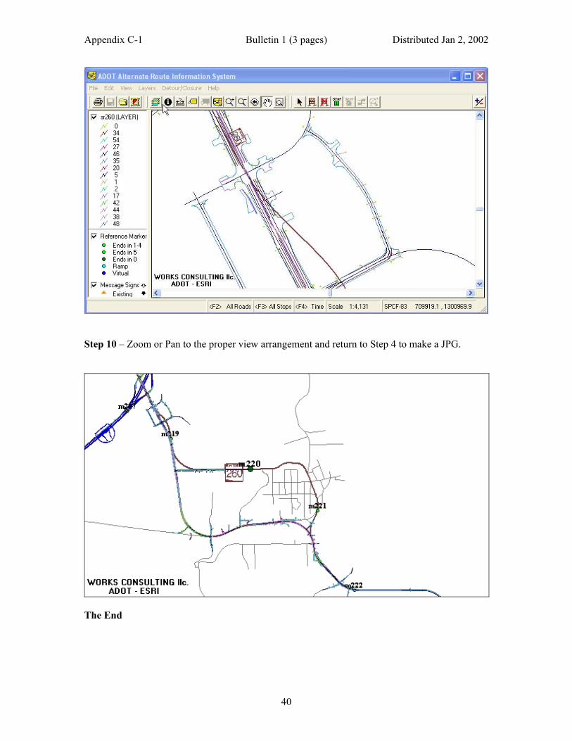
Appendix C-1 Bulletin 1 (3 pages) Distributed Jan 2, 2002
40
Step 10 – Zoom or Pan to the proper view arrangement and return to Step 4 to make a JPG.
The End
Appendix C-2 Bulletin 2 (3 pages) Distributed Jan 7, 2002
41
C-2: Making a Printout of a Stored Closure/Detour Example: Assume that you’ve been instructed to review the existing detour plans in your district and prepare a booklet of the plans with maps and directions for each prescribed roadway segment on the State Highway System. Step 1 – Start ARIS. After all of the geographic data is loaded, the system presents a view that includes all of Arizona. Tip: If your PC takes too long to refresh the view, consider dismissing the non-essential geographic data by right-clicking anywhere on the table of contents and choosing Remove Non-Critical Layers from the popup menu. Step 2 – Use the Zoom , Pan , or Viewport buttons to navigate to the particular area of interest. As you zoom inwards, ARIS reveals greater detail in the local street network. Tip: If you prefer to view road name labels, right-click on the LRS Routes layer in the Table of Contents and chose Layer Standard Labels from the popup menu. Step 3 – Click the Load Closure/Detour button. A dialog box appears (see right) that shows all of the pre-determined roadway segments in the current view extents. This length of the list is controlled by zooming in (list gets shorter) or out (list gets longer). Step 4 – Click on any of the itemized closures in the top portion of the dialog box. Notice how the appropriate link flashes in the map view. Also notice how the listing of detours in the bottom left of the dialog box changes as you click on different closures in the top list. Note: For every closure there can be multiple detours. This is especially the case for undivided highway segments where the road closure is always assumed to be in both directions. Step 5 – Once you’ve established a closure and a detour to load, click on the Load button. The Closures/Detours Loading dialog box will disappear and the view will be annotated with the closed road segment (with X’s through the closed road) and the chosen detour path (highlighted bandwidth around the path). Tip: You have access to customize the patterns/colors of the closures and detours through the Edit...Customize... dropdown menu.
Appendix C-2 Bulletin 2 (3 pages) Distributed Jan 7, 2002
42
Note: The Directions dialog will appear upon loading. If it is empty, the detour was logged at a time earlier when the application was not storing the text directions or the
parameters of the solution. Simply dismiss the Directions dialog if it is empty. It can be regenerated with full directions in the next step. Step 6 – The detour directions can be regenerated by setting the F2, F3, and F4 parameters and clicking on the Solve button. If the Solve button is not part of your interface, click on the Expand/Collapse Toolbar button to reveal the full toolbar. If the Solve button is grayed out , you don’t have start and stop flags set (i.e. a closure/detour is not loaded). Tip: If you notice that the detour changes upon re-solving, the current F2, F3, F4 parameters are not set consistent with the parameters of the official solution. This is possible if the saved detour was saved early in the project before the application was storing the solution parameters. Take note of the settings for F2, F3, and F4 and re-solve until the stored detour results. If you forget the path of the stored detour, simply reload it with the Load Closure/Detour button.
Step 7 – Assuming that the loaded closure and detour do not fall entirely within the view, click on the Zoom to Solution button to center the view about the loaded detour/closure. Note: It is an important step to “Zoom to Solution ” before printing. You can also change the shape of the extents by resizing the application window, hence controlling the aspect ratio (width vs. height) of the view extents.
Appendix C-2 Bulletin 2 (3 pages) Distributed Jan 7, 2002
43
Step 8 – Click the Print button. The Layout dialog box will appear. Step 9 – Choose a Landscape or Portrait orientation. The size of the paper is limited to letter (8.5x11) at the present time. Step 10 – Alter the size and postion of specific components of the Layout dialog. Use the Manipulate Frames radio buttons to Select, Move, or Resize the frame component of interest. Be careful to have the Select Frame button clicked if you wish to switch from one component to another. Moving and resizing will only occur to the selected (i.e. green) component. Step 11 – Toggle the Compose and Preview radio buttons to view the map or alter its components or layout. When ready, click on the Print Now button, making sure that the print Setup button is directing the output to the preferred printer. Switching between Compose and Preview effectively refreshes the print layout. Step 12 – If your printout is satisfactory, press the Clear Closures button and the Clear All Flags button and resume with the next closure/detour. The End
Appendix C-3 Bulletin 3 (2 pages) Distributed Jan 14, 2002
44
C-3: Generate a Closure and Find a Detour Example: An incident on a state highway causes the roadway to be shut down for hours. Traffic on either side of the incident needs to be detoured. Your job is to evaluate the alternative routes available and provide maps and directions for travelers in both directions. Step 1 – Start ARIS . Use the map interface zoom , pan , or viewport buttons to close in on the area of concern. We will zoom to Cottonwood in this example. Step 2 – Right-click in the table of contents in the area of the LRS Routes theme. A popup menu will appear. Select the option to “Toggle Standard Labels”. Road names will appear to enhance the map. Step 3 – Make sure your user interface is fully available by clicking on the Expand/Collapse Toolbar button to make sure that the closure/detour group of buttons is visible. Step 4 – Click on the Select (Close Road) button and then use the pointer to pick a road (or many road segments) on the map to close. The selected road will appear differently with X’s along its centerline. (You can customize the color under the Edit.. Customize.. dialog available through the dropdown menu). Step 5 – Click on the Add a Flag button. Then successively place a couple of flags at either end of the closure to indicate where travelers are and where they wish to be.
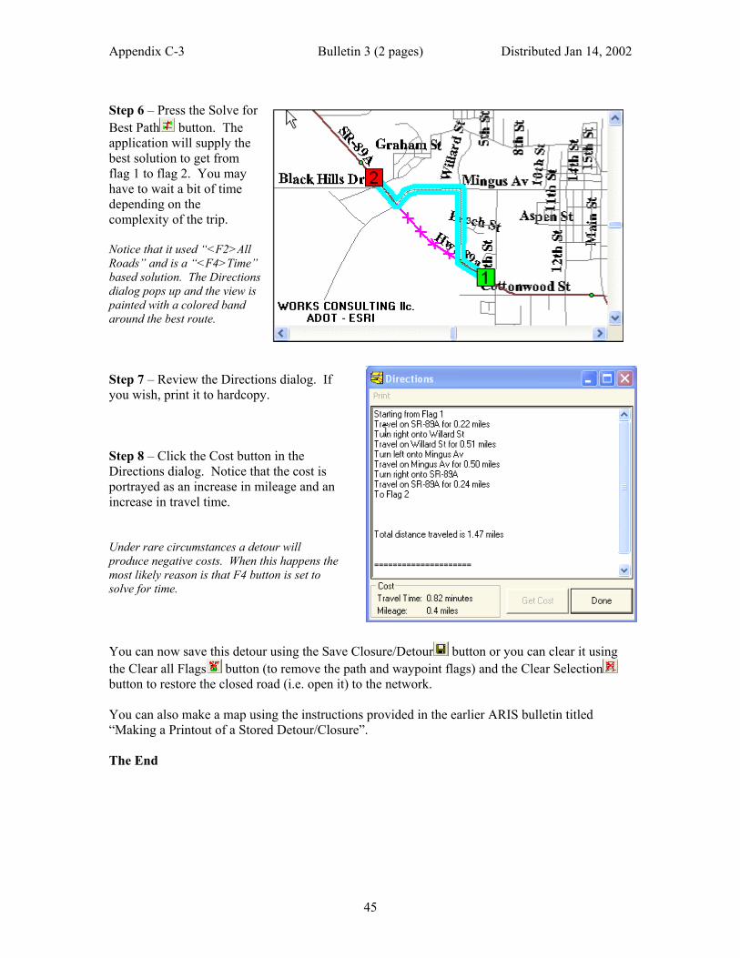
Appendix C-3 Bulletin 3 (2 pages) Distributed Jan 14, 2002
45
Step 6 – Press the Solve for Best Path button. The application will supply the best solution to get from flag 1 to flag 2. You may have to wait a bit of time depending on the complexity of the trip. Notice that it used “<F2>All Roads” and is a “<F4>Time” based solution. The Directions dialog pops up and the view is painted with a colored band around the best route. Step 7 – Review the Directions dialog. If you wish, print it to hardcopy. Step 8 – Click the Cost button in the Directions dialog. Notice that the cost is portrayed as an increase in mileage and an increase in travel time. Under rare circumstances a detour will produce negative costs. When this happens the most likely reason is that F4 button is set to solve for time. You can now save this detour using the Save Closure/Detour button or you can clear it using the Clear all Flags button (to remove the path and waypoint flags) and the Clear Selection button to restore the closed road (i.e. open it) to the network. You can also make a map using the instructions provided in the earlier ARIS bulletin titled “Making a Printout of a Stored Detour/Closure”. The End
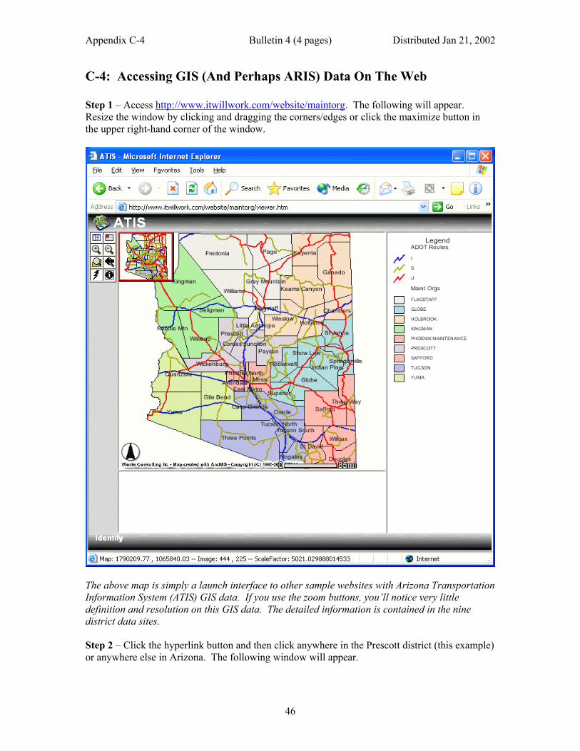
Appendix C-4 Bulletin 4 (4 pages) Distributed Jan 21, 2002
46
C-4: Accessing GIS (And Perhaps ARIS) Data On The Web Step 1 – Access http://www.itwillwork.com/website/maintorg. The following will appear. Resize the window by clicking and dragging the corners/edges or click the maximize button in the upper right-hand corner of the window.
The above map is simply a launch interface to other sample websites with Arizona Transportation Information System (ATIS) GIS data. If you use the zoom buttons, you’ll notice very little definition and resolution on this GIS data. The detailed information is contained in the nine district data sites. Step 2 – Click the hyperlink button and then click anywhere in the Prescott district (this example) or anywhere else in Arizona. The following window will appear.
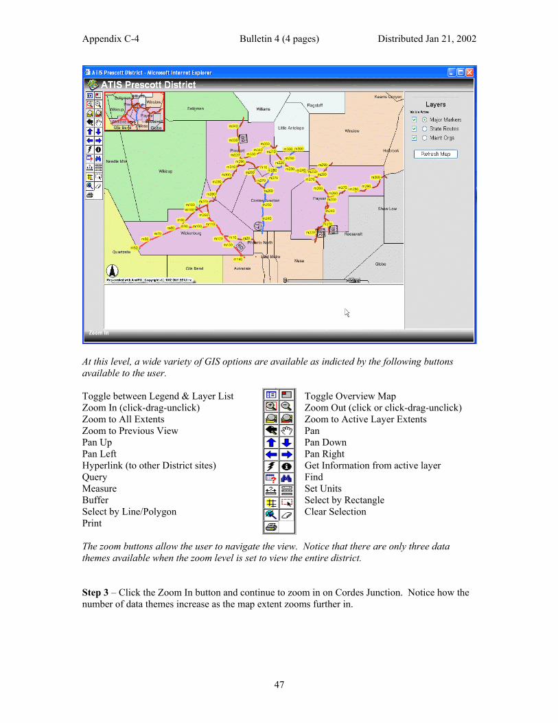
Appendix C-4 Bulletin 4 (4 pages) Distributed Jan 21, 2002
47
At this level, a wide variety of GIS options are available as indicted by the following buttons available to the user. Toggle between Legend & Layer List Toggle Overview Map Zoom In (click-drag-unclick) Zoom Out (click or click-drag-unclick) Zoom to All Extents Zoom to Active Layer Extents Zoom to Previous View Pan Pan Up Pan Down Pan Left Pan Right Hyperlink (to other District sites) Get Information from active layer Query Find Measure Set Units Buffer Select by Rectangle Select by Line/Polygon Clear Selection Print The zoom buttons allow the user to navigate the view. Notice that there are only three data themes available when the zoom level is set to view the entire district. Step 3 – Click the Zoom In button and continue to zoom in on Cordes Junction. Notice how the number of data themes increase as the map extent zooms further in.
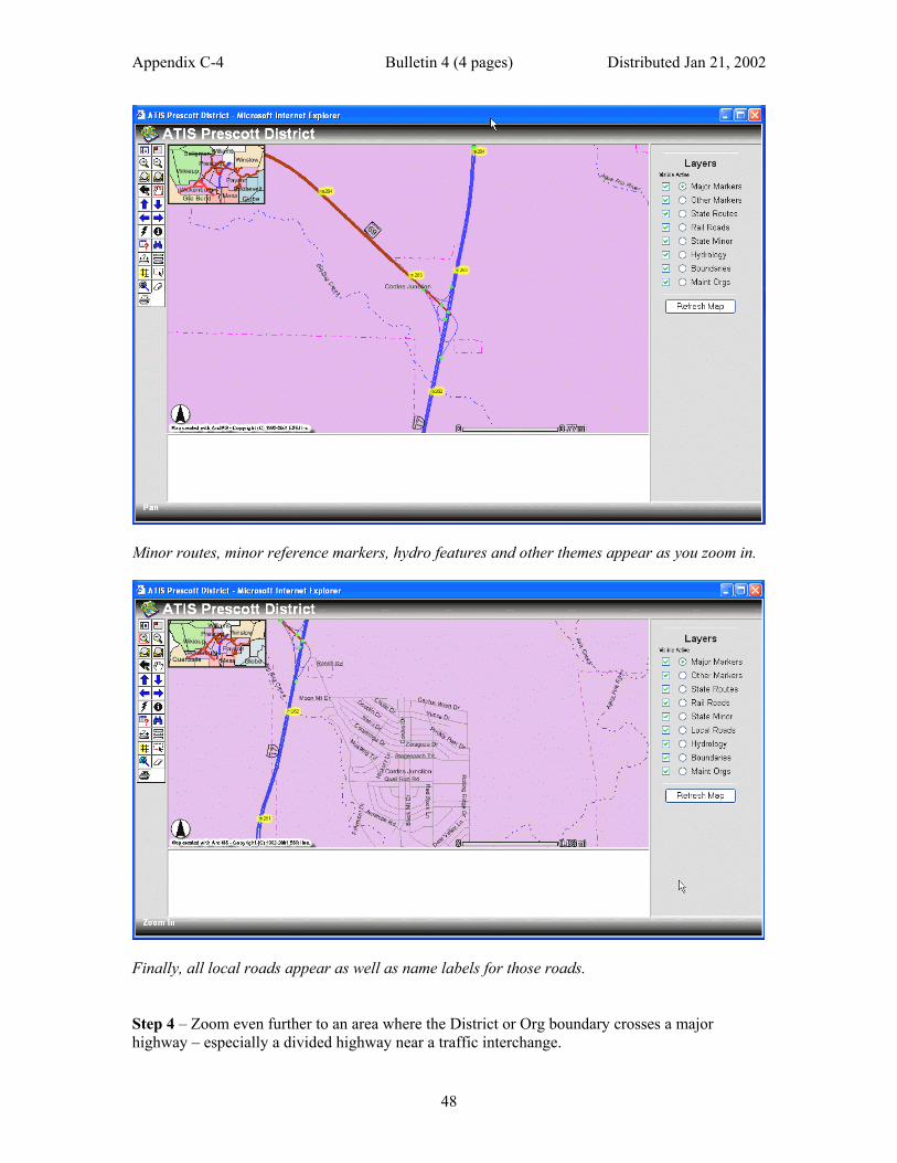
Appendix C-4 Bulletin 4 (4 pages) Distributed Jan 21, 2002
48
Minor routes, minor reference markers, hydro features and other themes appear as you zoom in.
Finally, all local roads appear as well as name labels for those roads. Step 4 – Zoom even further to an area where the District or Org boundary crosses a major highway – especially a divided highway near a traffic interchange.
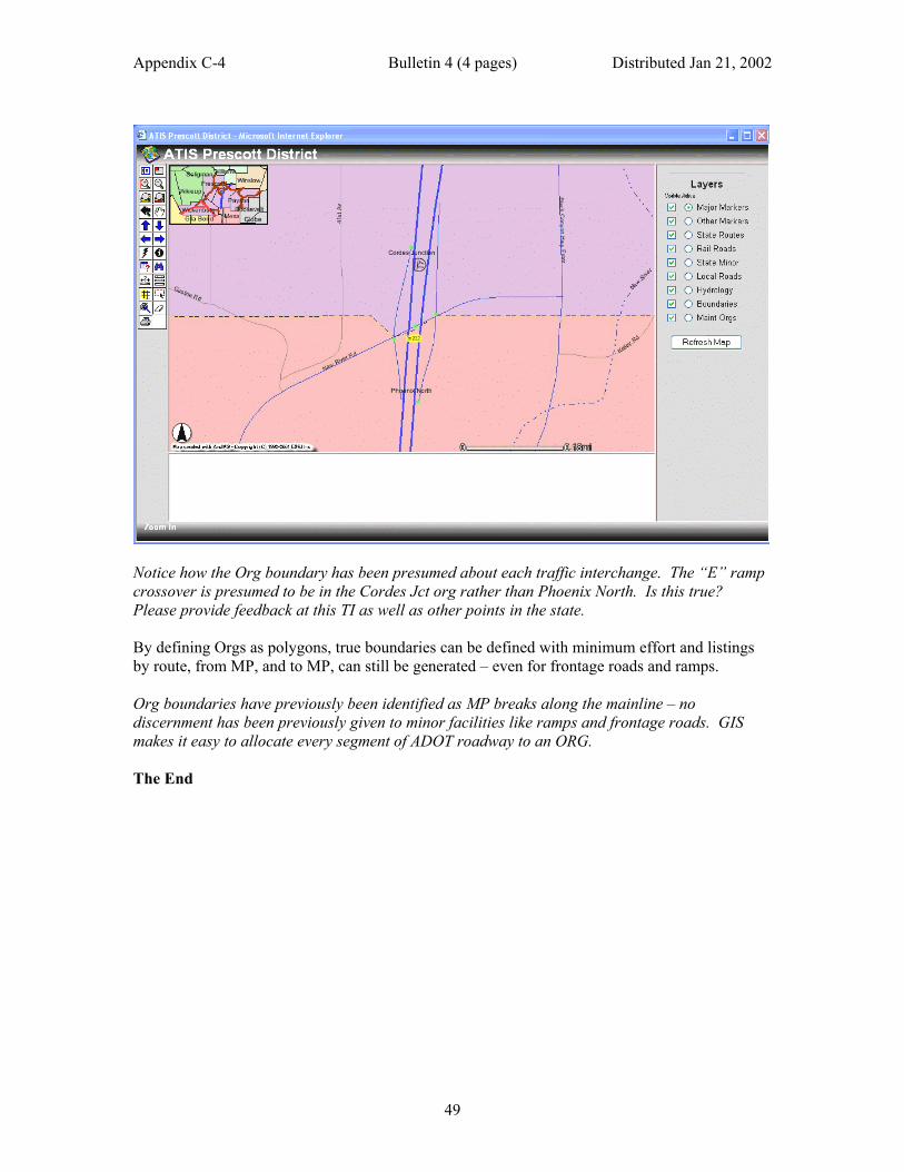
Appendix C-4 Bulletin 4 (4 pages) Distributed Jan 21, 2002
49
Notice how the Org boundary has been presumed about each traffic interchange. The “E” ramp crossover is presumed to be in the Cordes Jct org rather than Phoenix North. Is this true? Please provide feedback at this TI as well as other points in the state. By defining Orgs as polygons, true boundaries can be defined with minimum effort and listings by route, from MP, and to MP, can still be generated – even for frontage roads and ramps. Org boundaries have previously been identified as MP breaks along the mainline – no discernment has been previously given to minor facilities like ramps and frontage roads. GIS makes it easy to allocate every segment of ADOT roadway to an ORG. The End
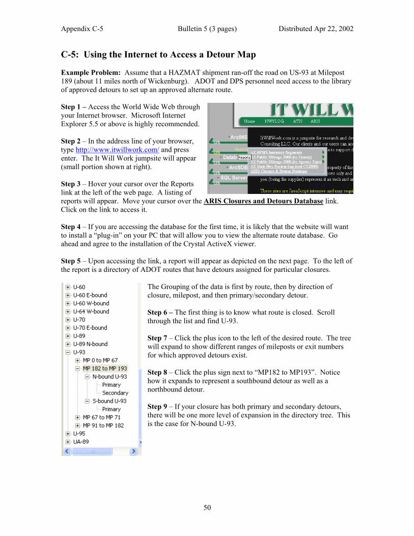
Appendix C-5 Bulletin 5 (3 pages) Distributed Apr 22, 2002
50
C-5: Using the Internet to Access a Detour Map Example Problem: Assume that a HAZMAT shipment ran-off the road on US-93 at Milepost 189 (about 11 miles north of Wickenburg). ADOT and DPS personnel need access to the library of approved detours to set up an approved alternate route. Step 1 – Access the World Wide Web through your Internet browser. Microsoft Internet Explorer 5.5 or above is highly recommended. Step 2 – In the address line of your browser, type http://www.itwillwork.com/ and press enter. The It Will Work jumpsite will appear (small portion shown at right). Step 3 – Hover your cursor over the Reports link at the left of the web page. A listing of reports will appear. Move your cursor over the ARIS Closures and Detours Database link. Click on the link to access it. Step 4 – If you are accessing the database for the first time, it is likely that the website will want to install a “plug-in” on your PC that will allow you to view the alternate route database. Go ahead and agree to the installation of the Crystal ActiveX viewer. Step 5 – Upon accessing the link, a report will appear as depicted on the next page. To the left of the report is a directory of ADOT routes that have detours assigned for particular closures.
The Grouping of the data is first by route, then by direction of closure, milepost, and then primary/secondary detour. Step 6 – The first thing is to know what route is closed. Scroll through the list and find U-93. Step 7 – Click the plus icon to the left of the desired route. The tree will expand to show different ranges of mileposts or exit numbers for which approved detours exist. Step 8 – Click the plus sign next to “MP182 to MP193”. Notice how it expands to represent a southbound detour as well as a northbound detour. Step 9 – If your closure has both primary and secondary detours, there will be one more level of expansion in the directory tree. This is the case for N-bound U-93.
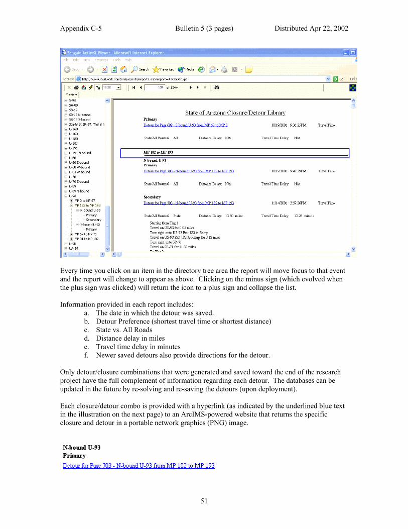
Appendix C-5 Bulletin 5 (3 pages) Distributed Apr 22, 2002
51
Every time you click on an item in the directory tree area the report will move focus to that event and the report will change to appear as above. Clicking on the minus sign (which evolved when the plus sign was clicked) will return the icon to a plus sign and collapse the list. Information provided in each report includes:
a. The date in which the detour was saved. b. Detour Preference (shortest travel time or shortest distance) c. State vs. All Roads d. Distance delay in miles e. Travel time delay in minutes f. Newer saved detours also provide directions for the detour.
Only detour/closure combinations that were generated and saved toward the end of the research project have the full complement of information regarding each detour. The databases can be updated in the future by re-solving and re-saving the detours (upon deployment). Each closure/detour combo is provided with a hyperlink (as indicated by the underlined blue text in the illustration on the next page) to an ArcIMS-powered website that returns the specific closure and detour in a portable network graphics (PNG) image.
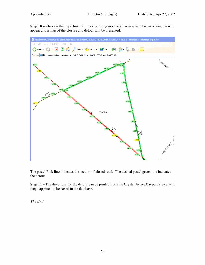
Appendix C-5 Bulletin 5 (3 pages) Distributed Apr 22, 2002
52
Step 10 – click on the hyperlink for the detour of your choice. A new web browser window will appear and a map of the closure and detour will be presented.
The pastel Pink line indicates the section of closed road. The dashed pastel green line indicates the detour. Step 11 – The directions for the detour can be printed from the Crystal ActiveX report viewer – if they happened to be saved in the database. The End

53
APPENDIX D – ARISRDS ASSEMBLY PROCEDURE
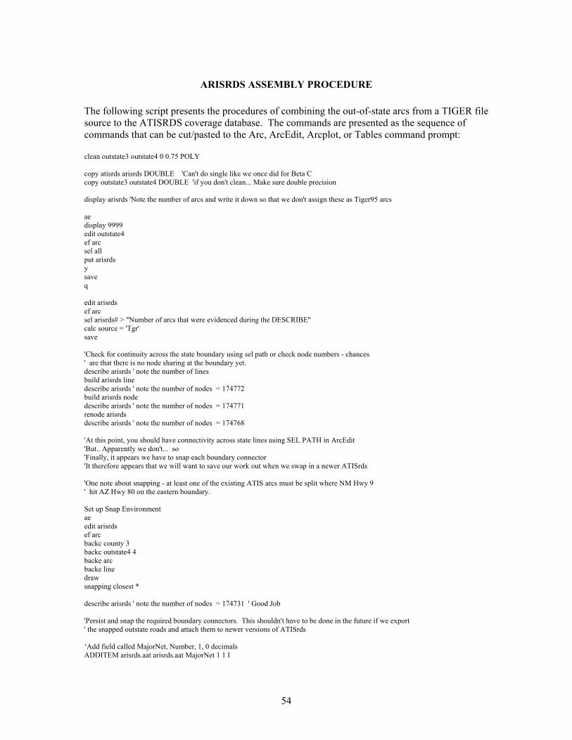
54
ARISRDS ASSEMBLY PROCEDURE The following script presents the procedures of combining the out-of-state arcs from a TIGER file source to the ATISRDS coverage database. The commands are presented as the sequence of commands that can be cut/pasted to the Arc, ArcEdit, Arcplot, or Tables command prompt: clean outstate3 outstate4 0 0.75 POLY copy atisrds arisrds DOUBLE 'Can't do single like we once did for Beta C copy outstate3 outstate4 DOUBLE 'if you don't clean... Make sure double precision display arisrds 'Note the number of arcs and write it down so that we don't assign these as Tiger95 arcs ae display 9999 edit outstate4 ef arc sel all put arisrds y save q edit arisrds ef arc sel arisrds# > "Number of arcs that were evidenced during the DESCRIBE" calc source = 'Tgr' save 'Check for continuity across the state boundary using sel path or check node numbers - chances ' are that there is no node sharing at the boundary yet. describe arisrds ' note the number of lines build arisrds line describe arisrds ' note the number of nodes = 174772 build arisrds node describe arisrds ' note the number of nodes = 174771 renode arisrds describe arisrds ' note the number of nodes = 174768 'At this point, you should have connectivity across state lines using SEL PATH in ArcEdit 'But.. Apparently we don't... so 'Finally, it appears we have to snap each boundary connector 'It therefore appears that we will want to save our work out when we swap in a newer ATISrds 'One note about snapping - at least one of the existing ATIS arcs must be split where NM Hwy 9 ' hit AZ Hwy 80 on the eastern boundary. Set up Snap Environment ae edit arisrds ef arc backc county 3 backc outstate4 4 backe arc backe line draw snapping closest * describe arisrds ' note the number of nodes = 174731 ' Good Job 'Persist and snap the required boundary connectors. This shouldn't have to be done in the future if we export ' the snapped outstate roads and attach them to newer versions of ATISrds ‘Add field called MajorNet, Number, 1, 0 decimals ADDITEM arisrds.aat arisrds.aat MajorNet 1 1 I
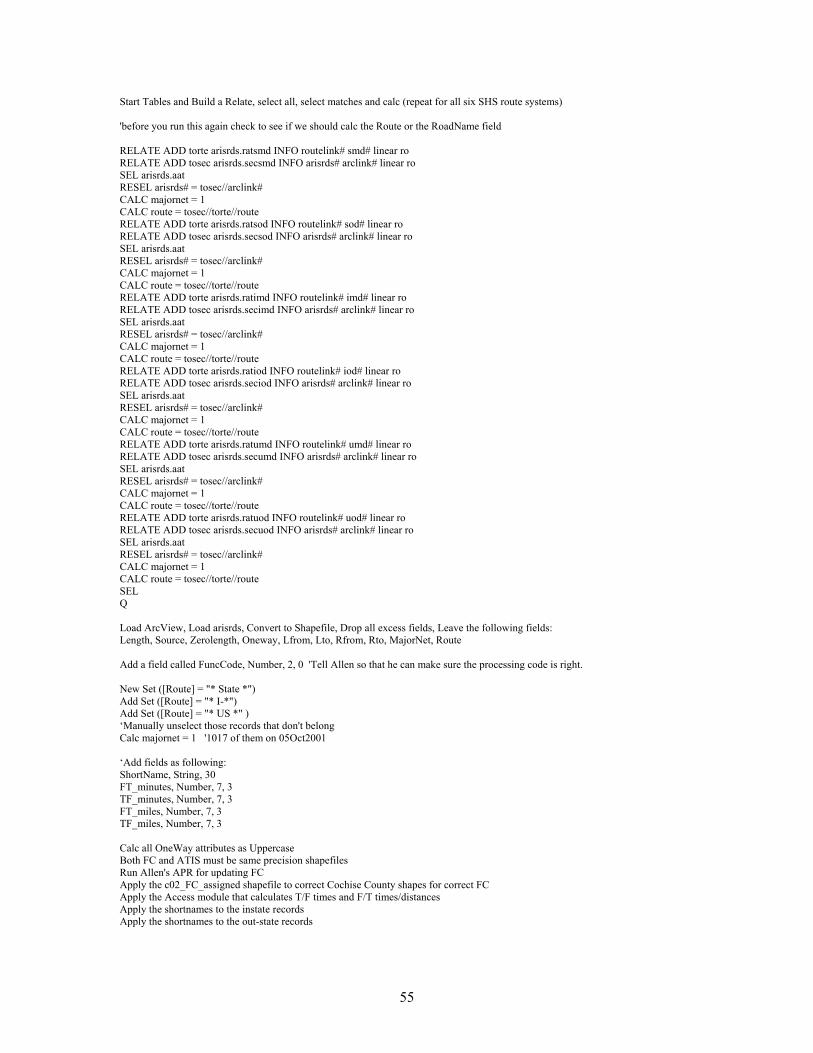
55
Start Tables and Build a Relate, select all, select matches and calc (repeat for all six SHS route systems) 'before you run this again check to see if we should calc the Route or the RoadName field RELATE ADD torte arisrds.ratsmd INFO routelink# smd# linear ro RELATE ADD tosec arisrds.secsmd INFO arisrds# arclink# linear ro SEL arisrds.aat RESEL arisrds# = tosec//arclink# CALC majornet = 1 CALC route = tosec//torte//route RELATE ADD torte arisrds.ratsod INFO routelink# sod# linear ro RELATE ADD tosec arisrds.secsod INFO arisrds# arclink# linear ro SEL arisrds.aat RESEL arisrds# = tosec//arclink# CALC majornet = 1 CALC route = tosec//torte//route RELATE ADD torte arisrds.ratimd INFO routelink# imd# linear ro RELATE ADD tosec arisrds.secimd INFO arisrds# arclink# linear ro SEL arisrds.aat RESEL arisrds# = tosec//arclink# CALC majornet = 1 CALC route = tosec//torte//route RELATE ADD torte arisrds.ratiod INFO routelink# iod# linear ro RELATE ADD tosec arisrds.seciod INFO arisrds# arclink# linear ro SEL arisrds.aat RESEL arisrds# = tosec//arclink# CALC majornet = 1 CALC route = tosec//torte//route RELATE ADD torte arisrds.ratumd INFO routelink# umd# linear ro RELATE ADD tosec arisrds.secumd INFO arisrds# arclink# linear ro SEL arisrds.aat RESEL arisrds# = tosec//arclink# CALC majornet = 1 CALC route = tosec//torte//route RELATE ADD torte arisrds.ratuod INFO routelink# uod# linear ro RELATE ADD tosec arisrds.secuod INFO arisrds# arclink# linear ro SEL arisrds.aat RESEL arisrds# = tosec//arclink# CALC majornet = 1 CALC route = tosec//torte//route SEL Q Load ArcView, Load arisrds, Convert to Shapefile, Drop all excess fields, Leave the following fields: Length, Source, Zerolength, Oneway, Lfrom, Lto, Rfrom, Rto, MajorNet, Route Add a field called FuncCode, Number, 2, 0 'Tell Allen so that he can make sure the processing code is right. New Set ([Route] = "* State *") Add Set ([Route] = "* I-*") Add Set ([Route] = "* US *" ) ‘Manually unselect those records that don't belong Calc majornet = 1 '1017 of them on 05Oct2001 ‘Add fields as following: ShortName, String, 30 FT_minutes, Number, 7, 3 TF_minutes, Number, 7, 3 FT_miles, Number, 7, 3 TF_miles, Number, 7, 3 Calc all OneWay attributes as Uppercase Both FC and ATIS must be same precision shapefiles Run Allen's APR for updating FC Apply the c02_FC_assigned shapefile to correct Cochise County shapes for correct FC Apply the Access module that calculates T/F times and F/T times/distances Apply the shortnames to the instate records Apply the shortnames to the out-state records