Embed Size (px)
Citation preview

VTA’S BART SILICON VALLEY— PHASE II EXTENSION PROJECT SPECIAL-STATUS SPECIES LISTS
P R E P A R E D F O R :
Santa Clara Valley Transportation Authority
U.S. Department of Transportation
Federal Transit Administration
P R E P A R E D B Y :
ICF
75 E Santa Clara Street, Suite 300
San Jose, CA 95113
November 2016

ICF 2016. VTA’s BART Silicon Valley—Phase II Extension Project Special-
Status Species Lists. November. San Jose, CA. Prepared for the Santa Clara
Valley Transportation Authority, San Jose, CA, and the Federal Transit
Administration, Washington, D.C.

Special-Status Plants with Potential to Occur in the Project Footprint Page 1 of 2
Scientific and Common Name
Status: Federal/
State/ CNPS Geographic Distribution Habitat Requirements
Blooming Period
Potential to Occur in BART Extension Footprint
Balsamorhiza macrolepis Big-scale balsamroot
–/–/1B.2 Scattered occurrences in the Coast Ranges and Sierra Nevada foothills.
Chaparral, cismontane woodland, valley and foothill grassland, 295 to 5,100 feet above mean sea level (MSL)
Mar–June None; BART Extension footprint is below species elevation range.
California macrophylla Round-leaved filaree
–/–/1B.1 Alameda, Butte, Contra Costa, Colusa, Fresno, Glenn, Kings , Kern, Lake, Lassen, Los Angeles, Merced, Monterey, Napa, Riverside, Santa Barbara, San Benito, Santa Clara, San Diego, San Joaquin, San Luis Obispo, San Mateo, Solano, Sonoma, Stanislaus , Tehama, Tulare, Ventura, and Yolo counties and Santa Cruz Island.
Cismontane woodland, valley and foothill grassland, 50 to 3,940 feet above MSL
Mar–May None; no suitable habitat within the BART Extension footprint. There are no CNDDB documented occurrences within 2 miles of the BART Extension footprint.
Centromadia parryi ssp. congdonii Congdon's tarplant
–/–/1B.1 East San Francisco Bay Area, Salinas Valley, Los Osos Valley
Annual grassland, on lower slopes, flats, and swales, sometimes on alkaline or saline soils, below 700 feet above MSL
Jun–Nov None; no suitable habitat within the BART Extension footprint. There is one CNDDB documented occurrences within 2 miles of the BART Extension footprint. Presence of this occurrence is extirpated.
Chorizanthe robusta var. robusta Robust spineflower
E/–/1B.1 Alameda, Monterey, Marin, Santa Clara, Santa Cruz, San Francisco, and San Mateo counties
Chaparral, cismontane woodland, coastal dunes, coastal scrub, 10 to 980 feet above MSL
Apr–Sep None; no suitable habitat within the BART Extension footprint and considered extirpated in Santa Clara County. There is one CNDDB occurrence documented less than a mile from the area of potential effects, however the species was last seen in 1882 at this location and the area has been highly developed and urbanized.
Cirsium fontinale var. campylon Mt. Hamilton fountain
thistle
–/–/1B.2 Alameda, Santa Clara, and Stanislaus counties.
Chaparral, cismontane woodland, valley and foothill grassland, 330 to ,2920 feet above MSL
Apr–Oct None; BART Extension footprint is below species elevation range.

Special-Status Plants with Potential to Occur in the Project Footprint Page 2 of 4
Scientific and Common Name
Status: Federal/
State/ CNPS Geographic Distribution Habitat Requirements
Blooming Period
Potential to Occur in BART Extension Footprint
Collinsia multicolor San Francisco collinsia
–/–/1B.2 Monterey, Santa Cruz, San Francisco, and San Mateo Counties.
Northern coastal scrub and closed-cone pine forest, 100 to 820 feet above MSL
March–May None; no suitable habitat within the BART Extension footprint. There are no CNDDB documented occurrences within 2 miles of the BART Extension footprint.
Dudleya abramsii ssp. setchellii Santa Clara Valley dudleya
E/–/1B.1 Santa Clara County Cismontane woodland, valley and
foothill grassland, serpentinite,
rocky, 195 to 1,490 feet above
MSL
Apr–Oct None; BART Extension footprint is below species elevation range.
Fritillaria liliacea
Fragrant fritillary
–/–/1B.2 Alameda, Contra Costa,
Monterey, Marin, Santa Clara,
San Mateo, San Francisco, San
Benito, Solano, and Sonoma.
Coastal prairie, valley grassland,
northern coastal scrub, and
wetland-riparian, 10 to 1,345 feet
above MSL
Feb–Apr None; no suitable habitat within the BART Extension footprint. There are no CNDDB documented occurrences within 2 miles of the BART Extension footprint.
Hoita strobilina
Loma Prieta hoita
–/–/1B Alameda, Contra Costa, Santa
Clara, and Santa Cruz counties.
Chaparral, cismontane woodland,
riparian woodland, usually
serpentinite, mesic, from 100 to
2,800 feet above MSL
May–July None; no suitable habitat within the BART Extension footprint. There are no CNDDB documented occurrences within 2 miles of the BART Extension footprint.
Lasthenia conjugens
Contra Costa goldfields
E/–/1B.1 Alameda, Contra Costa,
Mendocino, Monterey, Marin,
Napa Santa Barbara, Santa
Clara, Solano, and Sonoma
counties
Cismontane woodland, playas,
valley and foothill grassland, vernal
pools/mesic, from 0 to 1,540 feet
above MSL
Mar–June None; no suitable habitat within the BART Extension footprint. There are no CNDDB documented occurrences within 2 miles of the BART Extension footprint.
Malacothamnus arcuatus
Arcuate bush mallow
–/–/1B.2 Santa Cruz, San Mateo, and
Santa Clara.
Chaparral, cismontane woodland,
from 50 to 1,165 above MSL
April–Sep None; no suitable habitat within the BART Extension footprint. There is one CNDDB documented occurrence ~0.5-mile west of the BART Extension footprint that was last observed in1961 and is considered possibly extirpated.
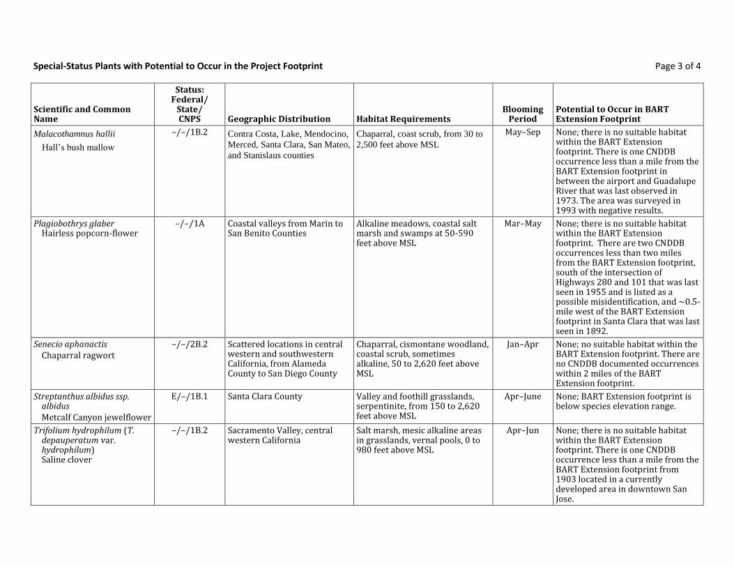
Special-Status Plants with Potential to Occur in the Project Footprint Page 3 of 4
Scientific and Common Name
Status: Federal/
State/ CNPS Geographic Distribution Habitat Requirements
Blooming Period
Potential to Occur in BART Extension Footprint
Malacothamnus hallii
Hall’s bush mallow
–/–/1B.2 Contra Costa, Lake, Mendocino,
Merced, Santa Clara, San Mateo,
and Stanislaus counties
Chaparral, coast scrub, from 30 to
2,500 feet above MSL
May–Sep None; there is no suitable habitat within the BART Extension footprint. There is one CNDDB occurrence less than a mile from the BART Extension footprint in between the airport and Guadalupe River that was last observed in 1973. The area was surveyed in 1993 with negative results.
Plagiobothrys glaber Hairless popcorn-flower
–/–/1A Coastal valleys from Marin to San Benito Counties
Alkaline meadows, coastal salt marsh and swamps at 50-590 feet above MSL
Mar–May None; there is no suitable habitat within the BART Extension footprint. There are two CNDDB occurrences less than two miles from the BART Extension footprint, south of the intersection of Highways 280 and 101 that was last seen in 1955 and is listed as a possible misidentification, and ~0.5-mile west of the BART Extension footprint in Santa Clara that was last seen in 1892.
Senecio aphanactis Chaparral ragwort
–/–/2B.2 Scattered locations in central western and southwestern California, from Alameda County to San Diego County
Chaparral, cismontane woodland, coastal scrub, sometimes alkaline, 50 to 2,620 feet above MSL
Jan–Apr None; no suitable habitat within the BART Extension footprint. There are no CNDDB documented occurrences within 2 miles of the BART Extension footprint.
Streptanthus albidus ssp. albidus Metcalf Canyon jewelflower
E/–/1B.1 Santa Clara County Valley and foothill grasslands, serpentinite, from 150 to 2,620 feet above MSL
Apr–June None; BART Extension footprint is below species elevation range.
Trifolium hydrophilum (T. depauperatum var. hydrophilum) Saline clover
–/–/1B.2 Sacramento Valley, central western California
Salt marsh, mesic alkaline areas in grasslands, vernal pools, 0 to 980 feet above MSL
Apr–Jun None; there is no suitable habitat within the BART Extension footprint. There is one CNDDB occurrence less than a mile from the BART Extension footprint from 1903 located in a currently developed area in downtown San Jose.
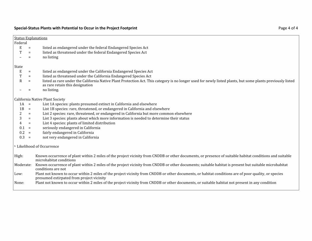
Special-Status Plants with Potential to Occur in the Project Footprint Page 4 of 4
Status Explanations Federal
E = listed as endangered under the federal Endangered Species Act T = listed as threatened under the federal Endangered Species Act – = no listing
State
E = listed as endangered under the California Endangered Species Act T = listed as threatened under the California Endangered Species Act R = listed as rare under the California Native Plant Protection Act. This category is no longer used for newly listed plants, but some plants previously listed
as rare retain this designation – = no listing.
California Native Plant Society
1A = List 1A species: plants presumed extinct in California and elsewhere 1B = List 1B species: rare, threatened, or endangered in California and elsewhere 2 = List 2 species: rare, threatened, or endangered in California but more common elsewhere 3 = List 3 species: plants about which more information is needed to determine their status 4 = List 4 species: plants of limited distribution 0.1 = seriously endangered in California 0.2 = fairly endangered in California 0.3 = not very endangered in California
b Likelihood of Occurrence High: Known occurrence of plant within 2 miles of the project vicinity from CNDDB or other documents, or presence of suitable habitat conditions and suitable
microhabitat conditions Moderate: Known occurrence of plant within 2 miles of the project vicinity from CNDDB or other documents; suitable habitat is present but suitable microhabitat
conditions are not Low: Plant not known to occur within 2 miles of the project vicinity from CNDDB or other documents, or habitat conditions are of poor quality, or species
presumed extirpated from project vicinity None: Plant not known to occur within 2 miles of the project vicinity from CNDDB or other documents, or suitable habitat not present in any condition

Special-Status Fish and Wildlife with Potential to Occur in Project Footprint Page 1 of 5
Scientific and Common Name
Status: Federal/State
California Distribution Habitats Potential to Occur within BART Extension Footprint
Invertebrates
Adela oplerella Opler’s longhorn moth
--/-- Marin County and Oakland area on the inner coast ranges south to Santa Clara County.
Serpentine substrates that support the host plant, cream cups (Platystemon californicus)
None; no suitable habitat within the BART Extension footprint. There are no CNDDB documented occurrences within 2 miles of the BART Extension footprint.
Euphydryas editha bayensis Bay checkerspot butterfly
T/-- Disjunct occurrences in San Mateo and Santa Clara Counties.
Associated with specific host plants that typically grow on serpentine soils.
None; no suitable habitat within the BART Extension footprint. There are no CNDDB documented occurrences within 2 miles of the BART Extension footprint.
Microcina homi Hom’s micro-blind
harvestman
--/-- Santa Clara County in xeric habitats. Serpentine rocks None; no suitable habitat within the BART Extension footprint. There are no CNDDB documented occurrences within 2 miles of the BART Extension footprint.
Fish
Hypomesus transpacificus Delta smelt
T/T Primarily in the Sacramento–San Joaquin Estuary, but has been found as far upstream as the mouth of the American River on the Sacramento River and Mossdale on the San Joaquin River; range extends downstream to San Pablo Bay.
Occurs in estuary habitat in the Delta where fresh and brackish water mix in the salinity range of 2–7 parts per thousand (Moyle 2002).
None; outside on known range.
Oncorhynchus mykiss Central California coast and Central Valley steelhead
T/-- (both) Coastal drainages along the central California coast. Sacramento and San Joaquin River and their tributaries.
Cold, clear water with clean gravel of appropriate size for spawning. Most spawning occurs in headwater streams. Steelhead migrate to the ocean to feed and grow until sexually mature. Occurs in well-oxygenated, cool, riverine habitat with water temperatures from 7.8 to 18°C (Moyle 2002). Habitat types are riffles, runs, and pools.
High; documented occurrences in Coyote Creek, Guadalupe River, Los Gatos Creek, and Lower Silver Creek.
Oncorhynchus tshawytscha Central Valley and Sacramento River Chinook salmon
T (spring run)/- E (winter run)/- C (fall)/-
Sacramento and San Joaquin River and their tributaries.
Occurs in well-oxygenated, cool, riverine habitat with water temperatures from 8.0 to 12.5°C. Habitat types are riffles, runs, and pools. (Moyle 2002)
None for winter- or spring-run; outside of known occurrence. High for fall-run; documented occurrences in Coyote Creek, Guadalupe River and Los Gatos Creek

Special-Status Fish and Wildlife with Potential to Occur in Project Footprint Page 2 of 5
Scientific and Common Name
Status: Federal/State
California Distribution Habitats Potential to Occur within BART Extension Footprint
although may be hatchery strays.
Amphibians and Reptiles
Ambystoma californiense California tiger salamander
T/T Central Valley, including Sierra Nevada foothills, up to approximately 1,000 feet above MSL, and coastal region from Sonoma County south to Santa Barbara County
Small ponds, lakes, or vernal pools in grasslands and oak woodlands for larvae; rodent burrows, rock crevices, or fallen logs for cover for adults and for summer dormancy.
None; no suitable habitat within the BART Extension footprint. There is one CNDDB documented occurrence within 2 miles of the BART Extension footprint last observed in 1895 and is located in downtown San Jose. This occurrence is considered extirpated.
Rana draytonii California red-legged frog
T/SSC Found along the coast and coastal mountain ranges of California from Mendocino County to San Diego County and in the Sierra Nevada from Butte County to Stanislaus County.
Permanent and semipermanent aquatic habitats, such as creeks and cold-water ponds, with emergent and submergent vegetation; may aestivate in rodent burrows or cracks during dry periods
Low; suitable migratory habitat occurs within Guadalupe Creek, but there are no CNDDB documented occurrences within 2 miles of the BART Extension footprint.
Emys marmorata Western pond turtle
–/SSC The western pond turtle is uncommon to common in suitable aquatic habitat throughout California, west of the Sierra-Cascade crest and absent from desert regions, except in the Mojave Desert along the Mojave River and its tributaries.
Occupies ponds, marshes, rivers, streams, and irrigation canals with muddy or rocky bottoms and with watercress, cattails, water lilies, or other aquatic vegetation in woodlands, grasslands, and open forests. Nests are typically constructed in upland habitat within 0.25 mile of aquatic habitat.
High; there are two CNDDB occurrences documented within 2 miles of the BART Extension footprint. However, suitable habitat is limited to Creeks and their floodplains by intense urban development.
Birds
Accipiter cooperii Cooper’s hawk
--/-- Throughout California except high altitudes in the Sierra Nevada. Winters in the Central Valley, southeastern desert regions, and plains east of the Cascade Range.
Nests in a wide variety of habitat types, from riparian woodlands and digger pine-oak woodlands through mixed conifer forests.
Low; there is potential nesting habitat along riparian corridors is the creeks that cross the BART Extension footprint. However, there are no CNDDB documented occurrences within 2 miles of the BART Extension footprint.
Athene cunicularia hypugaea Western burrowing owl
--/SSC Lowlands throughout California, including the Central Valley, northeastern plateau, southeastern deserts, and coastal areas; rare along south coast
Level, open, dry, heavily grazed or low stature grassland or desert vegetation with available burrows
Moderate; there are five CNDDB documented occurrences within 2 miles of the BART Extension footprint at the San Jose Airport. The occurrences are separated from the BART Extension footprint and much of the site does not offer suitable

Special-Status Fish and Wildlife with Potential to Occur in Project Footprint Page 3 of 5
Scientific and Common Name
Status: Federal/State
California Distribution Habitats Potential to Occur within BART Extension Footprint
foraging habitat.
Buteo swainsoni Swainson’s hawk
--/T Lower Sacramento and San Joaquin Valleys, the Klamath Basin, and Butte Valley. Highest nesting densities occur near Davis and Woodland, Yolo County.
Nests in oaks or cottonwoods in or near riparian habitats. Forages in grasslands, irrigated pastures, and grain fields.
Low; there is one occurrence documented within one mile of the BART Extension footprint. However, the occurrence was documented in 1889.
Falco peregrinus anatum American peregrine falcon
-/-, FP Permanent resident along the north and south Coast Ranges. May summer in the Cascade and Klamath Ranges and through the Sierra Nevada to Madera County. Winters in the Central Valley south through the Transverse and Peninsular Ranges and the plains east of the Cascade Range.
Nests and roosts on protected ledges of high cliffs, usually adjacent to lakes, rivers, or marshes that support large prey populations.
Low (foraging only); there are no CNDDB documented occurrences within 2 miles of the BART Extension footprint.
Rallus longirostris obsoletus California clapper rail
E/E,FP Found along the Pacific Coast in Monterey and San Luis Obispo Counties.
From tidal mudflats to tidal sloughs None; no suitable habitat within the BART Extension footprint. There are no CNDDB documented occurrences within 2 miles of the BART Extension footprint.
Sternula antillarum browni California least tern
E/E Found along the Pacific Coast of California from San Francisco to Baja California
Nest on open beaches kept free of vegetation by natural scouring from tidal action
None; no suitable habitat within the BART Extension footprint. There are no CNDDB documented occurrences within 2 miles of the BART Extension footprint.
Mammals
Antrozonous pallidus Pallid bat
--/SSC Widespread throughout California Roosts in fissures in caves, tunnels, mines, hollow trees, and locations with stable temperatures.
Low (non-maternal roosts only); habitat exist within and adjacent to the BART Extension footprint and species is widespread. However, there is one CNDDB occurrence within 2 miles of the BART Extension footprint from 1943 in downtown San Jose. The BART Extension footprint is surrounded by intense urban and commercial development.

Ambystoma californienseCalifornia tiger salamander
Element Code: AAAAA01180
Federal:
State:
Threatened
Threatened
Listing Status: CNDDB Element Ranks: Global:
State:
G2G3
S2S3
Other: CDFW_SSC-Species of Special Concern, IUCN_VU-Vulnerable
General: CENTRAL VALLEY DPS FEDERALLY LISTED AS THREATENED. SANTA BARBARA & SONOMA COUNTIES DPS FEDERALLY LISTED AS ENDANGERED.
Micro: NEED UNDERGROUND REFUGES, ESPECIALLY GROUND SQUIRREL BURROWS, & VERNAL POOLS OR OTHER SEASONAL WATER SOURCES FOR BREEDING.
Habitat:
32892EO Index:41Occurrence No. 37885Map Index: 1895-01-09Element Last Seen:
1895-01-09Site Last Seen:NoneOcc. Rank:
Natural/Native occurrenceOcc. Type:
ExtirpatedPresence:
UnknownTrend: 2001-11-14Record Last Updated:
San Jose East (3712137), San Jose West (3712138), Calaveras Reservoir (3712147), Milpitas (3712148)Quad Summary:
Santa ClaraCounty Summary:
37.33789 / -121.89131Lat/Long:
Zone-10 N4132933 E598210UTM:
T07S, R01E, Sec. 08 (M)PLSS:
5 milesAccuracy:
85Elevation (ft):
0.0Acres:
SAN JOSE.Location:
NO OTHER LOCATIONAL INFORMATION GIVEN.Detailed Location:
Ecological:
HISTORIC RECORD. MUSEUM COLLECTION SU 879. JENNINGS CONSIDERS THIS SITE EXTIRPATED.General:
UNKNOWNOwner/Manager:
5643EO Index:229Occurrence No. 25521Map Index: 1993-04-05Element Last Seen:
1993-04-05Site Last Seen:NoneOcc. Rank:
Natural/Native occurrenceOcc. Type:
Possibly ExtirpatedPresence:
UnknownTrend: 2009-06-17Record Last Updated:
San Jose East (3712137)Quad Summary:
Santa ClaraCounty Summary:
37.29051 / -121.85875Lat/Long:
Zone-10 N4127710 E601158UTM:
T07S, R01E, Sec. 27 (M)PLSS:
specific areaAccuracy:
125Elevation (ft):
21.4Acres:
SOUTH SIDE OF SPRR TRACKS, APPROXIMATELY 1 MILE SOUTH OF THE MONTEREY ROAD INTERSECTION WITH CURTNER ROAD, SAN JOSE.
Location:
FOUND IN THE VICINITY OF HILLSDALE MINE 1993. M. JENNINGS HAS GENERAL RECORDS FROM THE AREA BETWEEN CURTNER AVE, CAPITOL EXPWY & W MONTEREY HWY FROM 1980, 1981, 1983 & 1984.
Detailed Location:
HABITAT IS TEMPORARY DITCHES, SEASONAL PONDS, & QUARRY POND, WITHIN AN ACTIVE QUARRY. WATER IS PUMPED FROM THE QUARRY POND TO TANKS FOR USE IN THE QUARRY. 2007 AERIAL PHOTO SHOWS A REMNANT OPEN SPACE COMPLETELY SURROUNDED BY DEVELOPMENT.
Ecological:
NUMEROUS LARVAE WERE OBSERVED, SOME CAPTURED AND RELEASED, DURING A SITE VISIT ON 5 APRIL 1993.General:
PVTOwner/Manager:
Quad is (San Jose East (3712137) or San Jose West (3712138))Query Criteria:
Report Printed on Tuesday, December 08, 2015
Page 1 of 44Commercial Version -- Dated December, 1 2015 -- Biogeographic Data Branch
Information Expires 6/1/2016
Multiple Occurrences per PageCalifornia Department of Fish and Wildlife
California Natural Diversity Database

5645EO Index:230Occurrence No. 25520Map Index: 1993-03-24Element Last Seen:
1993-03-24Site Last Seen:NoneOcc. Rank:
Natural/Native occurrenceOcc. Type:
Possibly ExtirpatedPresence:
UnknownTrend: 2009-05-29Record Last Updated:
San Jose East (3712137)Quad Summary:
Santa ClaraCounty Summary:
37.29035 / -121.86212Lat/Long:
Zone-10 N4127689 E600859UTM:
T07S, R01E, Sec. 28 (M)PLSS:
80 metersAccuracy:
275Elevation (ft):
0.0Acres:
0.15 MILE SOUTH OF THE SPRR TRACKS, APPROX 1 MILE SOUTH OF THE INTERSECTION OF CURTNER ROAD AND MONTEREY ROAD, SAN JOSE.
Location:
FOUND ON THE NORTHEAST-FACING SLOPE OF COMMUNICATION HILL 1993. JENNINGS HAS GENERAL RECORDS FROM THE AREA BETWEEN CURTNER AVE, CAPITOL EXPWY & W MONTEREY HWY FROM 1980, 1981, 1983 & 1984.
Detailed Location:
HABITAT CONSISTS OF ANNUAL GRASSLAND. 2007 AERIAL PHOTO SHOWS ONLY A REMNANT OPEN SPACE COMPLETELY SURROUNDED BY DEVELOPMENT.
Ecological:
2 ADULTS OBSERVED DURING LIGHT RAIN, AT APPROX 11:00 PM, MOVING IN THE DIRECTION OF A SEASONAL POND/QUARRY POND, WHERE 10 LARVAE WERE OBSERVED. ADULTS MEASURED 3.75 AND 4.00 INCHES SNOUT-VENT LENGTH.
General:
PVTOwner/Manager:
16990EO Index:392Occurrence No. 33481Map Index: 1995-02-14Element Last Seen:
2002-11-18Site Last Seen:NoneOcc. Rank:
Natural/Native occurrenceOcc. Type:
ExtirpatedPresence:
UnknownTrend: 2004-06-23Record Last Updated:
San Jose East (3712137)Quad Summary:
Santa ClaraCounty Summary:
37.28919 / -121.76271Lat/Long:
Zone-10 N4127671 E609673UTM:
T07S, R02E, Sec. 28 (M)PLSS:
80 metersAccuracy:
360Elevation (ft):
0.0Acres:
JUST EAST OF SAN FELIPE ROAD, ~0.8 MILES SE OF SAN FELIPE ROAD X YERBA BUENA CREEK, SAN JOSE.Location:
Detailed Location:
1995: HABITAT CONSISTS OF A SMALL, REMNANT STOCK POND. 2002: AREA IS MAINLY DEVELOPED.Ecological:
10 LARVAE OBSERVED ON 14 FEBRUARY 1995. HABITAT GONE WHEN SITE CHECKED ON 18 NOV 2002.General:
PVTOwner/Manager:
Report Printed on Tuesday, December 08, 2015
Page 2 of 44Commercial Version -- Dated December, 1 2015 -- Biogeographic Data Branch
Information Expires 6/1/2016
Multiple Occurrences per PageCalifornia Department of Fish and Wildlife
California Natural Diversity Database

33738EO Index:431Occurrence No. 38731Map Index: 1998-04-19Element Last Seen:
1998-04-19Site Last Seen:NoneOcc. Rank:
Natural/Native occurrenceOcc. Type:
ExtirpatedPresence:
UnknownTrend: 2009-06-18Record Last Updated:
San Jose East (3712137)Quad Summary:
Santa ClaraCounty Summary:
37.28917 / -121.80421Lat/Long:
Zone-10 N4127621 E605994UTM:
T07S, R02E, Sec. 30 (M)PLSS:
80 metersAccuracy:
375Elevation (ft):
0.0Acres:
0.3 MILE EAST OF HWY 101, 0.75 MILE NORTH OF THE COYOTE CREEK CROSSING, ON THE SOUTH EDGE OF SAN JOSE.Location:
POND IS LOCATED ON A HILL JUST NORTH OF THE GRAVEL PITS, ABOUT 1 MILE EAST OF SYLVANDALE SCHOOL.Detailed Location:
HABITAT CONSISTS OF AN ARTIFICIAL POND, FILLED WITH WATER FROM EVERGREEN CANAL, SURROUNDED BY GRAZED GRASSLAND/INTRODUCED TREES, ON A SERPENTINE HILL. 2007 AERIAL PHOTO SHOWS THAT THE AREA HAS BEEN COMPLETELY DEVELOPED.
Ecological:
2 LARVAE COLLECTED (MRJ #1372) ON 19 APR 1998 AND DEPOSITED AT CAS (CAS #207145).General:
PVTOwner/Manager:
35560EO Index:445Occurrence No. 40553Map Index: 2000-01-22Element Last Seen:
2000-01-22Site Last Seen:NoneOcc. Rank:
Natural/Native occurrenceOcc. Type:
ExtirpatedPresence:
UnknownTrend: 2009-06-18Record Last Updated:
San Jose East (3712137)Quad Summary:
Santa ClaraCounty Summary:
37.29537 / -121.80453Lat/Long:
Zone-10 N4128309 E605957UTM:
T07S, R01E, Sec. 25 (M)PLSS:
80 metersAccuracy:
190Elevation (ft):
0.0Acres:
0.9 MILE SE OF THE CAPITAL EXPWY & HIGHWAY 101 INTERCHANGE, ~1 NNE OF HELLYER PARK SAN JOSE.Location:
GOOD ESTIVATION HABITAT BUT BREEDING POND RARELY PONDS AND HOLDS WATER THROUGH LARVAL DEVELOPMENT.
Detailed Location:
HABITAT CONSISTS OF AN OLD STOCK POND IN GRAZED GRASSLANDS, AT THE BASE OF A LARGE HILL. 2007 AERIAL PHOTO SHOWS THAT THE SITE HAS BEEN COMPLETELY DEVELOPED.
Ecological:
DOZENS OF JUVENILES OBSERVED ON 14 JUN 1998. 14 OBSERVED, 10 ADULTS & 4 JUVENILES (1 SENT TO CAS), 1999. 1/22/2000: CAS #211677 (JAW-1228), SUBADULT.
General:
PVTOwner/Manager:
Report Printed on Tuesday, December 08, 2015
Page 3 of 44Commercial Version -- Dated December, 1 2015 -- Biogeographic Data Branch
Information Expires 6/1/2016
Multiple Occurrences per PageCalifornia Department of Fish and Wildlife
California Natural Diversity Database

44129EO Index:498Occurrence No. 44129Map Index: 1996-05-03Element Last Seen:
1996-08-02Site Last Seen:NoneOcc. Rank:
Natural/Native occurrenceOcc. Type:
ExtirpatedPresence:
UnknownTrend: 2009-06-18Record Last Updated:
San Jose East (3712137)Quad Summary:
Santa ClaraCounty Summary:
37.30457 / -121.79089Lat/Long:
Zone-10 N4129345 E607153UTM:
T07S, R02E, Sec. 19 (M)PLSS:
specific areaAccuracy:
280Elevation (ft):
8.9Acres:
GREYSTONE HOMES SITE, JUST S OF TWIN FALLS COURT, 0.7 MILE S OF ABORN & WHITE RROADS, SILVER CREEK PORTION OF SAN JOSE.
Location:
MAN MADE POND AND ADJACENT RUDERAL GRASSLAND.Detailed Location:
RUDERAL GRASSLAND, DOMINANT VEGETATION: AVENA FATUA, BROMUS DIANDRUS, EREMOCARPUS SETEGERUS, BRASSICA NIGRA. 2007 AERIAL PHOTO SHOWS THAT THE SITE HAS BEEN DEVELOPED.
Ecological:
LARVAE FOUND IN THE POND, 1996. CAS #203273 (MRJ-1156), LARVA.General:
PVTOwner/Manager:
45817EO Index:537Occurrence No. 45817Map Index: 1970-05-XXElement Last Seen:
2002-11-18Site Last Seen:NoneOcc. Rank:
Natural/Native occurrenceOcc. Type:
ExtirpatedPresence:
UnknownTrend: 2004-06-23Record Last Updated:
San Jose East (3712137)Quad Summary:
Santa ClaraCounty Summary:
37.31411 / -121.79054Lat/Long:
Zone-10 N4130404 E607170UTM:
T07S, R02E, Sec. 19 (M)PLSS:
1/5 mileAccuracy:
200Elevation (ft):
0.0Acres:
SE OF SAN JOSE. 0.5 MILES NW OF EVERGREEN.Location:
LOCATED ALONG ABORN ROAD, 1 MILE EAST OF INTERSECTION OF ABORN ROAD AND CAPITOL EXPRESSWAY.Detailed Location:
2002: AREA COMPLETELY DEVELOPLED - PRIMARILY HOUSING TRACTS.Ecological:
MAY 1970: CAS #187392, LARVA. SAN JOSE UNIVERSITY COLLECTION.General:
UNKNOWNOwner/Manager:
45822EO Index:538Occurrence No. 45822Map Index: 1981-11-XXElement Last Seen:
1981-11-XXSite Last Seen:NoneOcc. Rank:
Natural/Native occurrenceOcc. Type:
ExtirpatedPresence:
UnknownTrend: 2001-11-14Record Last Updated:
San Jose East (3712137)Quad Summary:
Santa ClaraCounty Summary:
37.31044 / -121.84394Lat/Long:
Zone-10 N4129938 E602443UTM:
T07S, R01E, Sec. 22 (M)PLSS:
nonspecific areaAccuracy:
95Elevation (ft):
13.1Acres:
COYOTE CREEK NEAR TULLY ROAD. SE AREA OF SAN JOSE, 3.4 MILES DIRECTLY WEST OF EVERGREEN.Location:
Detailed Location:
Ecological:
NOV 1981: CAS #187397, ADULT. JENNINGS CONSIDERS THIS SITE EXTIRPATED.General:
UNKNOWNOwner/Manager:
Report Printed on Tuesday, December 08, 2015
Page 4 of 44Commercial Version -- Dated December, 1 2015 -- Biogeographic Data Branch
Information Expires 6/1/2016
Multiple Occurrences per PageCalifornia Department of Fish and Wildlife
California Natural Diversity Database

45868EO Index:548Occurrence No. 45868Map Index: 1977-XX-XXElement Last Seen:
1977-XX-XXSite Last Seen:NoneOcc. Rank:
Natural/Native occurrenceOcc. Type:
ExtirpatedPresence:
UnknownTrend: 2009-06-18Record Last Updated:
San Jose East (3712137)Quad Summary:
Santa ClaraCounty Summary:
37.30061 / -121.78607Lat/Long:
Zone-10 N4128911 E607586UTM:
T07S, R02E, Sec. 29 (M)PLSS:
nonspecific areaAccuracy:
350Elevation (ft):
25.6Acres:
SOUTH END OF CADWALLADER AVE. SE OF SAN JOSE, 0.5 MILES SSW OF EVERGREEN.Location:
Detailed Location:
1977 RECORD GIVES BREEDING HABITAT AS A "CATTLE TANK." 2007 AERIAL PHOTO SHOWS THAT THIS AREA HAS BEEN COMPLETELY DEVELOPED.
Ecological:
NOV 1968: CAS #187390, ADULT; MAY 1971 CAS #187391, JUVENILE. 1968-1972 RECORDS FROM SAN JOSE UNIVERSITY COLLECTIONS. 1977 RECORD FROM M. JENNINGS FIELD NOTES.
General:
UNKNOWNOwner/Manager:
45893EO Index:551Occurrence No. 45893Map Index: 1992-04-06Element Last Seen:
1992-04-06Site Last Seen:NoneOcc. Rank:
Natural/Native occurrenceOcc. Type:
Possibly ExtirpatedPresence:
UnknownTrend: 2009-05-29Record Last Updated:
San Jose East (3712137)Quad Summary:
Santa ClaraCounty Summary:
37.29249 / -121.86557Lat/Long:
Zone-10 N4127923 E600550UTM:
T07S, R01E, Sec. 28 (M)PLSS:
1/10 mileAccuracy:
175Elevation (ft):
0.0Acres:
SAN JOSE, 1.8 MILES NW OF THE INTERSECTION OF THE CAPITOL EXPRESSWAY AND HWY 82.Location:
SW SIDE OF RAILROAD TRACKS 1992. M. JENNINGS HAS GENERAL RECORDS FROM THE AREA BETWEEN CURTNER AVE, CAPITOL EXPWY & W MONTEREY HWY FROM 1980, 1981, 1983 & 1984.
Detailed Location:
HABITAT CONSISTS OF A VERNAL POOL. 2007 AERIAL PHOTO SHOWS ONLY A REMNANT OPEN SPACE COMPLETELY SURROUNDED BY DEVELOPMENT.
Ecological:
CAS #197605, 1 LARVA COLLECTED BY M.R. JENNINGS.General:
UNKNOWNOwner/Manager:
46406EO Index:606Occurrence No. 46406Map Index: 1969-XX-XXElement Last Seen:
1969-XX-XXSite Last Seen:NoneOcc. Rank:
Natural/Native occurrenceOcc. Type:
ExtirpatedPresence:
UnknownTrend: 2001-11-06Record Last Updated:
San Jose East (3712137)Quad Summary:
Santa ClaraCounty Summary:
37.31326 / -121.79625Lat/Long:
Zone-10 N4130303 E606666UTM:
T07S, R02E, Sec. 19 (M)PLSS:
1/5 mileAccuracy:
200Elevation (ft):
0.0Acres:
NEAR THE JUNCTION OF ABORN ROAD AND KETTMANN AVENUE. SOUTHEAST OF SAN JOSE.Location:
Detailed Location:
VERNAL POOLS.Ecological:
UNKNOWN NUMBER COLLECTED SPRING 1969. SJSU SPECIMENS. JENNINGS CONSIDERS THIS SITE EXTIRPATED.General:
UNKNOWNOwner/Manager:
Report Printed on Tuesday, December 08, 2015
Page 5 of 44Commercial Version -- Dated December, 1 2015 -- Biogeographic Data Branch
Information Expires 6/1/2016
Multiple Occurrences per PageCalifornia Department of Fish and Wildlife
California Natural Diversity Database

Accipiter cooperiiCooper's hawk
Element Code: ABNKC12040
Federal:
State:
None
None
Listing Status: CNDDB Element Ranks: Global:
State:
G5
S4
Other: CDFW_WL-Watch List, IUCN_LC-Least Concern
General: WOODLAND, CHIEFLY OF OPEN, INTERRUPTED OR MARGINAL TYPE.
Micro: NEST SITES MAINLY IN RIPARIAN GROWTHS OF DECIDUOUS TREES, AS IN CANYON BOTTOMS ON RIVER FLOOD-PLAINS; ALSO, LIVE OAKS.
Habitat:
51557EO Index:85Occurrence No. 51557Map Index: 2003-06-13Element Last Seen:
2003-06-13Site Last Seen:FairOcc. Rank:
Natural/Native occurrenceOcc. Type:
Presumed ExtantPresence:
UnknownTrend: 2003-06-17Record Last Updated:
San Jose West (3712138)Quad Summary:
Santa ClaraCounty Summary:
37.29633 / -121.92925Lat/Long:
Zone-10 N4128283 E594901UTM:
T07S, R01W, Sec. 25 (M)PLSS:
nonspecific areaAccuracy:
175Elevation (ft):
38.4Acres:
NE OF THE INTERSECTION OF BASCOM AVENUE AND HAMILTON AVENUE, SAN JOSE.Location:
Detailed Location:
HABITAT CONSISTS OF A MIX OF ORNAMENTAL REDWOOD, PINE, AND BIRCH TREES IN A COMMERCIAL PARKING LOT; SURROUNDED BY A MIX OF COMMERCIAL AND RESIDENTIAL.
Ecological:
2 ADULTS OBSERVED NESTING ON 13 JUN 2003; AN UNKNOWN NUMBER OF JUVENILES PRESENT IN THE NEST.General:
UNKNOWNOwner/Manager:
Report Printed on Tuesday, December 08, 2015
Page 6 of 44Commercial Version -- Dated December, 1 2015 -- Biogeographic Data Branch
Information Expires 6/1/2016
Multiple Occurrences per PageCalifornia Department of Fish and Wildlife
California Natural Diversity Database

Buteo swainsoniSwainson's hawk
Element Code: ABNKC19070
Federal:
State:
None
Threatened
Listing Status: CNDDB Element Ranks: Global:
State:
G5
S3
Other: BLM_S-Sensitive, IUCN_LC-Least Concern, USFWS_BCC-Birds of Conservation Concern
General: BREEDS IN GRASSLANDS WITH SCATTERED TREES, JUNIPER-SAGE FLATS, RIPARIAN AREAS, SAVANNAHS, & AGRICULTURAL OR RANCH LANDS WITH GROVES OR LINES OF TREES.
Micro: REQUIRES ADJACENT SUITABLE FORAGING AREAS SUCH AS GRASSLANDS, OR ALFALFA OR GRAIN FIELDS SUPPORTING RODENT POPULATIONS.
Habitat:
91540EO Index:2570Occurrence No. 28363Map Index: 1889-04-30Element Last Seen:
1889-04-30Site Last Seen:NoneOcc. Rank:
Natural/Native occurrenceOcc. Type:
Possibly ExtirpatedPresence:
UnknownTrend: 2013-10-22Record Last Updated:
San Jose West (3712138)Quad Summary:
Santa ClaraCounty Summary:
37.34871 / -121.94696Lat/Long:
Zone-10 N4134077 E593267UTM:
T07S, R01W, Sec. 02 (M)PLSS:
1 mileAccuracy:
50Elevation (ft):
0.0Acres:
SANTA CLARA.Location:
SPECIMEN LOCALITY GIVEN AS "SANTA CLARA, CAL...IN 'FERGUSON'S SWAMP;" THE LATTER PLACE NAME UNKNOWN, SO MAPPED GENERALLY TO TOWN OF SANTA CLARA. EXACT COLLECTION LOCATION UNKNOWN.
Detailed Location:
REFURBISHED STICK NEST LINED SPARSELY WITH LEAVES AND DRY GRASS FOUND 45' UP IN A SYCAMORE. THIS HISTORICAL OCCURRENCE IS OUTSIDE WHAT IS GENERALLY CONSIDERED TO BE THE PRESENT BREEDING RANGE OF THE SPECIES IN CALIFORNIA.
Ecological:
BIRD FLUSHED FROM NEST, 2 EGGS COLLECTED ON 30 APR 1889.General:
UNKNOWNOwner/Manager:
Report Printed on Tuesday, December 08, 2015
Page 7 of 44Commercial Version -- Dated December, 1 2015 -- Biogeographic Data Branch
Information Expires 6/1/2016
Multiple Occurrences per PageCalifornia Department of Fish and Wildlife
California Natural Diversity Database

Falco peregrinus anatumAmerican peregrine falcon
Element Code: ABNKD06071
Federal:
State:
Delisted
Delisted
Listing Status: CNDDB Element Ranks: Global:
State:
G4T4
S3S4
Other: CDF_S-Sensitive, CDFW_FP-Fully Protected, USFWS_BCC-Birds of Conservation Concern
General: NEAR WETLANDS, LAKES, RIVERS, OR OTHER WATER; ON CLIFFS, BANKS, DUNES, MOUNDS; ALSO, HUMAN-MADE STRUCTURES.
Micro: NEST CONSISTS OF A SCRAPE OR A DEPRESSION OR LEDGE IN AN OPEN SITE.
Habitat:
70087EO Index:33Occurrence No. 69305Map Index: 2007-05-17Element Last Seen:
2007-05-17Site Last Seen:UnknownOcc. Rank:
Natural/Native occurrenceOcc. Type:
Presumed ExtantPresence:
UnknownTrend: 2011-05-12Record Last Updated:
San Jose West (3712138)Quad Summary:
Santa ClaraCounty Summary:
Lat/Long:
UTM:
PLSS:
80 metersAccuracy:
85Elevation (ft):
0.0Acres:
*SENSITIVE* LOCATION INFORMATION SUPPRESSED.Location:
PLEASE CONTACT THE CALIFORNIA NATURAL DIVERSITY DATABASE, CALIFORNIA DEPARTMENT OF FISH AND WILDLIFE, FOR MORE INFORMATION: (916) 322-2493
Detailed Location:
HIGH RISE OFFICE BUILDING. THE SANTA CRUZ PREDATORY BIRD RESEARCH GROUP PROVIDED A NEST BOX IN 2006.Ecological:
General:
Owner/Manager:
* SENSITIVE *
Athene cuniculariaburrowing owl
Element Code: ABNSB10010
Federal:
State:
None
None
Listing Status: CNDDB Element Ranks: Global:
State:
G4
S3
Other: BLM_S-Sensitive, CDFW_SSC-Species of Special Concern, IUCN_LC-Least Concern, USFWS_BCC-Birds of Conservation Concern
General: OPEN, DRY ANNUAL OR PERENNIAL GRASSLANDS, DESERTS & SCRUBLANDS CHARACTERIZED BY LOW-GROWING VEGETATION.
Micro: SUBTERRANEAN NESTER, DEPENDENT UPON BURROWING MAMMALS, MOST NOTABLY, THE CALIFORNIA GROUND SQUIRREL.
Habitat:
Report Printed on Tuesday, December 08, 2015
Page 8 of 44Commercial Version -- Dated December, 1 2015 -- Biogeographic Data Branch
Information Expires 6/1/2016
Multiple Occurrences per PageCalifornia Department of Fish and Wildlife
California Natural Diversity Database

9205EO Index:132Occurrence No. 21008Map Index: 1992-04-01Element Last Seen:
1992-04-01Site Last Seen:FairOcc. Rank:
Natural/Native occurrenceOcc. Type:
Presumed ExtantPresence:
UnknownTrend: 2003-03-10Record Last Updated:
San Jose West (3712138), Milpitas (3712148)Quad Summary:
Santa ClaraCounty Summary:
37.37451 / -121.92095Lat/Long:
Zone-10 N4136965 E595538UTM:
T06S, R01W, Sec. 25 (M)PLSS:
1/10 mileAccuracy:
40Elevation (ft):
0.0Acres:
NW OF THE JUNCTION OF KARINA COURT AND NORTH FIRST STREET, SAN JOSE.Location:
Detailed Location:
HABITAT CONSISTS OF FAIRLY OPEN ULAND/RUDERAL, MADE UP PRIMARILY OF ANNUAL GRASSES. CHUNKS OF CONCRETE AT THE SITE SERVE AS PERCHES. MANY GROUND SQUIRRELS INHABIT THE SITE.
Ecological:
SITE APPEARS TO HAVE BEEN DISKED PRIOR TO 1992, BUT NO DISKING HAD TAKEN PLACE AS OF 12 APRIL 1992. TWO ADULT BIRDS OBSERVED.
General:
PVTOwner/Manager:
6556EO Index:184Occurrence No. 24670Map Index: 1993-08-28Element Last Seen:
1993-08-28Site Last Seen:NoneOcc. Rank:
Natural/Native occurrenceOcc. Type:
Possibly ExtirpatedPresence:
UnknownTrend: 2009-12-22Record Last Updated:
San Jose West (3712138)Quad Summary:
Santa ClaraCounty Summary:
37.36948 / -121.92050Lat/Long:
Zone-10 N4136407 E595584UTM:
T06S, R01W, Sec. 35 (M)PLSS:
80 metersAccuracy:
45Elevation (ft):
0.0Acres:
0.2 MILE NE OF THE INTERSECTION OF AIRPORT PARKWAY AND GUADALUPE PARKWAY, EAST OF SAN JOSE MUNICIPAL AIRPORT.
Location:
TWO BURROWS LOCATED ABOUT 10 FEET APART IN A MOWED, UNIRRIGATED STRIP BETWEEN PARKING LOTS OF AN OFFICE PARK.
Detailed Location:
BURROW SITES ARE LOCATED IN A STRIP MEASURING 200 X 1000 FEET, WITH DAISY BUSHES AND EARTH BERMS AROUND THE EDGES THAT SERVE AS PERCHES. 2009 AERIAL PHOTO SHOWS THAT THE SITE HAS BEEN COMPLETELY DEVELOPED.
Ecological:
4 ADULTS AND 2 JUVENILES OBSERVED IN TOTAL FOR BOTH BURROW SITES ON 28 AUGUST 1993. 9 OWLS (2 ADULTS, 7 JUVENILES) WERE BANDED BY BARCLAY IN 1993.
General:
PVTOwner/Manager:
Report Printed on Tuesday, December 08, 2015
Page 9 of 44Commercial Version -- Dated December, 1 2015 -- Biogeographic Data Branch
Information Expires 6/1/2016
Multiple Occurrences per PageCalifornia Department of Fish and Wildlife
California Natural Diversity Database

5644EO Index:211Occurrence No. 25520Map Index: 1993-03-10Element Last Seen:
1993-03-10Site Last Seen:GoodOcc. Rank:
Natural/Native occurrenceOcc. Type:
Presumed ExtantPresence:
UnknownTrend: 1994-08-05Record Last Updated:
San Jose East (3712137)Quad Summary:
Santa ClaraCounty Summary:
37.29035 / -121.86212Lat/Long:
Zone-10 N4127689 E600859UTM:
T07S, R01E, Sec. 28 (M)PLSS:
80 metersAccuracy:
175Elevation (ft):
0.0Acres:
0.15 MILE SOUTH OF THE SPRR TRACKS, APPROX 1 MILE SOUTH OF THE INTERSECTION OF MONTEREY ROAD AND CURTNER ROAD, SAN JOSE.
Location:
Detailed Location:
HABITAT CONSISTS OF ANNUAL GRASSLAND ON A NORTHEAST-FACING SLOPE.Ecological:
ONE BURROW WITH OWL PELLETS AND WHITEWASH OBSERVED; NO OWLS SEEN.General:
PVTOwner/Manager:
42084EO Index:341Occurrence No. 42084Map Index: 2009-07-08Element Last Seen:
2009-07-08Site Last Seen:ExcellentOcc. Rank:
Natural/Native occurrenceOcc. Type:
Presumed ExtantPresence:
StableTrend: 2009-12-23Record Last Updated:
San Jose West (3712138), Milpitas (3712148)Quad Summary:
Santa ClaraCounty Summary:
37.36360 / -121.92987Lat/Long:
Zone-10 N4135746 E594762UTM:
T06S, R01W, Sec. 36 (M)PLSS:
nonspecific areaAccuracy:
56Elevation (ft):
868.1Acres:
SAN JOSE INTERNATIONAL AIRPORT, SAN JOSE.Location:
SITE IS AN ON-GOING MONITORING/MGMT PROGRAM (SINCE 1990), W/ OWLS UTILIZING ARTIFICIAL & NATURAL BURROWS. SITES PRIMARILY AROUND PERIMETER OF RUNWAYS TO THE NORTHWEST & SOUTH; T06S R01W SEC 35 EAST, T07S R01W SEC 1 NE. OWLS COLOR BANDED.
Detailed Location:
HABITAT CONSISTS OF MOWED HERBACEOUS VEGETATION BETWEEN THE RUNWAYS AND TAXIWAYS OF THE AIRPORT. AIRPORT IS SURROUNDED BY URBAN DEVELOPMENT.
Ecological:
YR:JUV/AD (RATIO). 90:19/28(0.7). 91:11/12(0.9). 97:68/30(2.3). 98:92/50(1.8). 99:101/48(2.1). 00:90/42(2.1). 01:129/62(2.1). 02:126/82(1.5). 03:70/57(1.2). 04:109/49(2.2). 05:87/47(1.9). 06:64/50(1.3). 08:38/16(2.4). 09:40/19(2.1).
General:
CITY OF SAN JOSEOwner/Manager:
Report Printed on Tuesday, December 08, 2015
Page 10 of 44Commercial Version -- Dated December, 1 2015 -- Biogeographic Data Branch
Information Expires 6/1/2016
Multiple Occurrences per PageCalifornia Department of Fish and Wildlife
California Natural Diversity Database

42530EO Index:354Occurrence No. 42530Map Index: 2000-03-02Element Last Seen:
2000-03-02Site Last Seen:GoodOcc. Rank:
Natural/Native occurrenceOcc. Type:
Presumed ExtantPresence:
UnknownTrend: 2000-03-13Record Last Updated:
San Jose East (3712137)Quad Summary:
Santa ClaraCounty Summary:
37.28055 / -121.78599Lat/Long:
Zone-10 N4126686 E607622UTM:
T07S, R02E, Sec. 32 (M)PLSS:
80 metersAccuracy:
800Elevation (ft):
0.0Acres:
SILVER CREEK HILLS, BETWEEN SILVER CREEK AND COYOTE CREEK, SAN JOSE.Location:
Detailed Location:
BURROW IS LOCATED ON A SW-FACING SLOPE; SURROUNDED BY SERPENTINE GRASSLAND.Ecological:
OWL OBSERVED ON THE GROUND NEAR A POSSIBLE BURROW SITE ON 2 MAR 2000.General:
PVTOwner/Manager:
44368EO Index:395Occurrence No. 44368Map Index: 1990-10-24Element Last Seen:
1990-10-24Site Last Seen:FairOcc. Rank:
Natural/Native occurrenceOcc. Type:
Presumed ExtantPresence:
UnknownTrend: 2000-11-21Record Last Updated:
Lick Observatory (3712136), San Jose East (3712137)Quad Summary:
Santa ClaraCounty Summary:
37.27278 / -121.74452Lat/Long:
Zone-10 N4125872 E611309UTM:
T08S, R02E, Sec. 03 (M)PLSS:
1 mileAccuracy:
800Elevation (ft):
0.0Acres:
KRUZE PROPERTY, EVERGREEN NEAR SILVER CREEK ROAD AND SAN FELIPE ROAD, EAST SAN JOSE.Location:
1 BURROW IN GRASSLAND.Detailed Location:
GRAZED GRASSLAND, SLOPE SOUTHWEST ASPECT, MID-SLOPE WITH RELATIVELY STEEP TOPOGRAPHY, GROUND SQUIRREL COLONY ON SLOPE.
Ecological:
PELLETS AND DROPPINGS OBSERVED NEAR BURROW ENTRANCE.General:
PVTOwner/Manager:
Report Printed on Tuesday, December 08, 2015
Page 11 of 44Commercial Version -- Dated December, 1 2015 -- Biogeographic Data Branch
Information Expires 6/1/2016
Multiple Occurrences per PageCalifornia Department of Fish and Wildlife
California Natural Diversity Database

45368EO Index:401Occurrence No. 45368Map Index: 2002-04-18Element Last Seen:
2008-05-29Site Last Seen:PoorOcc. Rank:
Natural/Native occurrenceOcc. Type:
Presumed ExtantPresence:
DecreasingTrend: 2009-09-02Record Last Updated:
San Jose East (3712137)Quad Summary:
Santa ClaraCounty Summary:
37.33112 / -121.81428Lat/Long:
Zone-10 N4132264 E605043UTM:
T07S, R01E, Sec. 13 (M)PLSS:
specific areaAccuracy:
135Elevation (ft):
6.6Acres:
SE END OF REID-HILLVIEW AIRPORT, JUST WEST OF CAPITOL EXPY AT TULLY ROAD (SWIFT LANE ON TOPO), SAN JOSE.Location:
BURROW SITE IS LOCATED IN A BARE VACANT LOT, SURROUNDED BY A SMALL-AIRCRAFT AIRPORT, URBAN ROADS, SHOPPING CENTER (EASTRIDGE), AND A PUBLIC PARK (RAGING WATERS/LAKE CUNNINGHAM), AT THE NW CORNER OF A MAJOR INTERSECTION.
Detailed Location:
HABITAT CONSISTS OF APPROXIMATELY 1 ACRE OF FLAT GROUND AROUND THE BURROW SITE, WHICH IS NEARLY DEVOID OF VEGETATION. SITE QUALITY = FAIR TO POOR.
Ecological:
2 ADULTS OBS, 19 JUN 1999. 2 AD/3 JUV OBS, 21 JUN 2000. 2 AD/3 JUV OBS, 1 JUL 2001. ON 18 APR 2002, 5 AD WERE OBS (2 PAIRS; 1 PREVIOUSLY BANDED IN 2001 AT SAN JOSE INT'L AIRPORT). NONE WERE OBS ON 29 MAY 2008.
General:
CITY OF SAN JOSEOwner/Manager:
46956EO Index:428Occurrence No. 46956Map Index: 2001-07-01Element Last Seen:
2009-06-26Site Last Seen:PoorOcc. Rank:
Natural/Native occurrenceOcc. Type:
Presumed ExtantPresence:
DecreasingTrend: 2009-12-23Record Last Updated:
San Jose West (3712138)Quad Summary:
Santa ClaraCounty Summary:
37.37336 / -121.91451Lat/Long:
Zone-10 N4136845 E596109UTM:
T06S, R01W, Sec. 36 (M)PLSS:
80 metersAccuracy:
40Elevation (ft):
0.0Acres:
SOUTH SIDE OF DEVCON COURT, NEAR N 1ST STREET & HWY 101, SAN JOSE.Location:
BURROWS LOCATED UNDER THE SIDEWALK ON THE SOUTH SIDE OF DEVCON COURT.Detailed Location:
HABITAT CONSISTS OF MIXED RUDERAL VEGETATION ON A FLAT, VACANT SITE (ABOUT 7 HECTARES) SURROUNDED BY BUSSINESS PARKS AND HIGH VOLUME ROADS. SITE QUALITY = FAIR TO POOR.
Ecological:
4 ADULTS & 4 JUVENILES OBSERVED USING 2 BURROWS DURING MONITORING FROM 17 APR - 4 SEP 2001. 2 OWLS FOUND DEAD IN JUL 2001, LIKELY KILLED BY FERAL ANIMALS. 2 ADULTS OBS 12 JUN 2008. NO OWLS OBS ON 5, 10, & 26 JUN 2009.
General:
UNKNOWNOwner/Manager:
Report Printed on Tuesday, December 08, 2015
Page 12 of 44Commercial Version -- Dated December, 1 2015 -- Biogeographic Data Branch
Information Expires 6/1/2016
Multiple Occurrences per PageCalifornia Department of Fish and Wildlife
California Natural Diversity Database

46972EO Index:429Occurrence No. 46972Map Index: 2009-06-26Element Last Seen:
2009-06-26Site Last Seen:FairOcc. Rank:
Natural/Native occurrenceOcc. Type:
Presumed ExtantPresence:
UnknownTrend: 2009-12-29Record Last Updated:
San Jose East (3712137)Quad Summary:
Santa ClaraCounty Summary:
37.31892 / -121.81387Lat/Long:
Zone-10 N4130912 E605096UTM:
T07S, R01E, Sec. 13 (M)PLSS:
nonspecific areaAccuracy:
140Elevation (ft):
45.0Acres:
JUST NORTH OF MEADOWFAIR PARK, 0.5 MILE NORTH OF THE INTERSECTION OF ABORN ROAD AND KING ROAD, SAN JOSE.
Location:
BURROW LOCATED ON VACANT LAND NORTH OF MEADOWVIEW PARK (MAYBE PART OF PARK). SITE IS BOUNDED ON THE NORTH BY QUIMBY RD AND EASTRIDGE SHOPPING MALL, ON THE EAST BY CAPITOL EXPY, AND ON THE WEST AND SOUTH BY RESIDENTIAL DEVELOPMENT.
Detailed Location:
HABITAT CONSISTS OF UNMOWED, MIXED HERBACEOUS VEGETATION ON A FLAT SITE; SURROUNDED BY AN URBAN PARK, A SCHOOL, AND RESIDENTIAL DEVELOPMENT. SITE QUALITY = GOOD TO FAIR.
Ecological:
2 ADULT OWLS OBSERVED AT NEST SITE ON 3 VISITS IN JUL 2001. 10 ADULTS & 4 JUVENILES OBS ON 29 JUN 2004. 1 NESTING PAIR OBS 5 JUN - 8 JUL, & 1 JUV OBS 8 JUL 2008. 2 ADULTS & 3 JUVENILES (2.5 WKS OLD) OBS ON 26 JUN 2009.
General:
PVTOwner/Manager:
58543EO Index:724Occurrence No. 58507Map Index: 2004-07-15Element Last Seen:
2008-05-29Site Last Seen:PoorOcc. Rank:
Natural/Native occurrenceOcc. Type:
Presumed ExtantPresence:
DecreasingTrend: 2009-12-23Record Last Updated:
San Jose East (3712137)Quad Summary:
Santa ClaraCounty Summary:
37.33801 / -121.81523Lat/Long:
Zone-10 N4133028 E604949UTM:
T07S, R01E, Sec. 12 (M)PLSS:
80 metersAccuracy:
125Elevation (ft):
0.0Acres:
SOUTH SIDE OF CUNNINGHAM AVENUE, JUST EAST OF EAST CAPITOL EXPRESSWAY, SAN JOSE.Location:
NW CORNER OF LAKE CUNNINGHAM PARK ALONG BERM. MAPPED TO PROVIDED MAP.Detailed Location:
HABITAT CONSISTS OF RUDERAL/NON-NATIVE GRASSLAND, ON A SLOPE ABOVE CUNNINGHAM AVENUE. SITE QUALITY = FAIR TO POOR.
Ecological:
1 ADULT OBSERVED PERCHED NEAR BURROW AND ON BARBED WIRE FENCE SEVERAL DAYS IN JULY 2004 (5TH, & 13TH-15TH). NO OWLS WERE OBSERVED ON 29 MAY 2008.
General:
SJ CITY-LAKE CUNNINGHAM PARKOwner/Manager:
Report Printed on Tuesday, December 08, 2015
Page 13 of 44Commercial Version -- Dated December, 1 2015 -- Biogeographic Data Branch
Information Expires 6/1/2016
Multiple Occurrences per PageCalifornia Department of Fish and Wildlife
California Natural Diversity Database

71930EO Index:1034Occurrence No. 71012Map Index: 2007-12-06Element Last Seen:
2007-12-06Site Last Seen:GoodOcc. Rank:
Natural/Native occurrenceOcc. Type:
Presumed ExtantPresence:
UnknownTrend: 2008-06-26Record Last Updated:
San Jose East (3712137)Quad Summary:
Santa ClaraCounty Summary:
37.29383 / -121.86389Lat/Long:
Zone-10 N4128073 E600697UTM:
T07S, R01E, Sec. 28 (M)PLSS:
80 metersAccuracy:
175Elevation (ft):
0.0Acres:
0.30 MI SW OF OAK HILL MEMORIAL PARK CEMETERY.Location:
Detailed Location:
HABITAT IS A GRASSY HILLSIDE WITHOUT MUCH VEGETATION, NEXT TO A RECENTLY LANDSCAPED AREA. ACROSS RAILROAD TRACKS FROM SIGNIFICANTLY BETTER HABITAT.
Ecological:
1 ADULT BUOW WAS OBSERVED AT A BURROW ON 6 DEC 2007.General:
UNKNOWNOwner/Manager:
Myotis evotislong-eared myotis
Element Code: AMACC01070
Federal:
State:
None
None
Listing Status: CNDDB Element Ranks: Global:
State:
G5
S3
Other: BLM_S-Sensitive, IUCN_LC-Least Concern, WBWG_M-Medium Priority
General: FOUND IN ALL BRUSH, WOODLAND & FOREST HABITATS FROM SEA LEVEL TO ABOUT 9000 FT. PREFERS CONIFEROUS WOODLANDS & FORESTS.
Micro: NURSERY COLONIES IN BUILDINGS, CREVICES, SPACES UNDER BARK, & SNAGS. CAVES USED PRIMARILY AS NIGHT ROOSTS.
Habitat:
79614EO Index:108Occurrence No. 78658Map Index: 2007-08-14Element Last Seen:
2007-08-14Site Last Seen:FairOcc. Rank:
Natural/Native occurrenceOcc. Type:
Presumed ExtantPresence:
UnknownTrend: 2010-04-26Record Last Updated:
San Jose East (3712137)Quad Summary:
Santa ClaraCounty Summary:
37.33325 / -121.76681Lat/Long:
Zone-10 N4132555 E609245UTM:
T07S, R02E, Sec. 09 (M)PLSS:
80 metersAccuracy:
570Elevation (ft):
0.0Acres:
ALONG BISHOP PRICE WAY ABOUT 0.2 MILES NORTH OF INTERSECTION WITH QUIMBY ROAD, SAN JOSE.Location:
MAPPED TO PROVIDED CORRECTED COORDINATES.Detailed Location:
EDGE OF SUBURBAN DEVELOPMENT WITH ADJACENT GRASSLANDS IN GENTLY ROLLING HILLS. STRUCTURES STILL PRESENT IN 2009 AERIAL IMAGES, BUT RENOVATION STATUS UNKNOWN.
Ecological:
PRE-PROJECT SURVEY OF STRUCTURES ON 27 JUN 2008 REVEALED ONE ADULT FEMALE AND ONE YOUNG.General:
PVTOwner/Manager:
Lasiurus cinereushoary bat
Element Code: AMACC05030
Federal:
State:
None
None
Listing Status: CNDDB Element Ranks: Global:
State:
G5
S4
Other: IUCN_LC-Least Concern, WBWG_M-Medium Priority
General: PREFERS OPEN HABITATS OR HABITAT MOSAICS, WITH ACCESS TO TREES FOR COVER & OPEN AREAS OR HABITAT EDGES FOR FEEDING.
Habitat:
Report Printed on Tuesday, December 08, 2015
Page 14 of 44Commercial Version -- Dated December, 1 2015 -- Biogeographic Data Branch
Information Expires 6/1/2016
Multiple Occurrences per PageCalifornia Department of Fish and Wildlife
California Natural Diversity Database

Micro: ROOSTS IN DENSE FOLIAGE OF MEDIUM TO LARGE TREES. FEEDS PRIMARILY ON MOTHS. REQUIRES WATER.
68859EO Index:96Occurrence No. 68531Map Index: 1988-11-15Element Last Seen:
1988-11-15Site Last Seen:UnknownOcc. Rank:
Natural/Native occurrenceOcc. Type:
Presumed ExtantPresence:
UnknownTrend: 2007-03-19Record Last Updated:
Los Gatos (3712128), San Jose West (3712138)Quad Summary:
Santa ClaraCounty Summary:
37.24691 / -121.96088Lat/Long:
Zone-10 N4122769 E592158UTM:
T08S, R01W, Sec. 10 (M)PLSS:
1 mileAccuracy:
Elevation (ft):
0.0Acres:
LOS GATOS.Location:
MAPPED ACCORDING TO LAT/LONG COORDINATES PROVIDED BY MANIS, WITH UNCERTAINTY OF 3288.688 M.Detailed Location:
Ecological:
1 FEMALE SPECIMEN (MVZ #182427) COLLECTED BY WILLIAM E. RAINEY ON 15 NOV 1988.General:
UNKNOWNOwner/Manager:
68861EO Index:98Occurrence No. 68532Map Index: 1990-12-04Element Last Seen:
1990-12-04Site Last Seen:UnknownOcc. Rank:
Natural/Native occurrenceOcc. Type:
Presumed ExtantPresence:
UnknownTrend: 2007-03-19Record Last Updated:
San Jose East (3712137), San Jose West (3712138)Quad Summary:
Santa ClaraCounty Summary:
37.32404 / -121.89103Lat/Long:
Zone-10 N4131397 E598252UTM:
T07S, R01E, Sec. 17 (M)PLSS:
1 mileAccuracy:
Elevation (ft):
0.0Acres:
SAN JOSE.Location:
MAPPED ACCORDING TO LAT/LONG COORDINATES PROVIDED BY MANIS, WITH UNCERTAINTY OF 16093.44 M.Detailed Location:
Ecological:
1 FEMALE SPECIMEN (MVZ #182428) COLLECTED BY WILLIAM E. RAINEY ON 4 DEC 1990.General:
UNKNOWNOwner/Manager:
68862EO Index:99Occurrence No. 28363Map Index: 1893-05-01Element Last Seen:
1893-05-01Site Last Seen:UnknownOcc. Rank:
Natural/Native occurrenceOcc. Type:
Presumed ExtantPresence:
UnknownTrend: 2007-03-19Record Last Updated:
San Jose West (3712138)Quad Summary:
Santa ClaraCounty Summary:
37.34871 / -121.94696Lat/Long:
Zone-10 N4134077 E593267UTM:
T07S, R01W, Sec. 02 (M)PLSS:
1 mileAccuracy:
Elevation (ft):
0.0Acres:
SANTA CLARA.Location:
EXACT LOCATION UNKNOWN. MAPPED AS BEST ESTIMATE CENTERED ON SANTA CLARA.Detailed Location:
Ecological:
LACM #1373 COLLECTED BY J.M. HYDE ON 1 MAY 1893.General:
UNKNOWNOwner/Manager:
Report Printed on Tuesday, December 08, 2015
Page 15 of 44Commercial Version -- Dated December, 1 2015 -- Biogeographic Data Branch
Information Expires 6/1/2016
Multiple Occurrences per PageCalifornia Department of Fish and Wildlife
California Natural Diversity Database

Corynorhinus townsendiiTownsend's big-eared bat
Element Code: AMACC08010
Federal:
State:
None
Candidate Threatened
Listing Status: CNDDB Element Ranks: Global:
State:
G3G4
S2
Other: BLM_S-Sensitive, CDFW_SSC-Species of Special Concern, IUCN_LC-Least Concern, USFS_S-Sensitive, WBWG_H-High Priority
General: THROUGHOUT CALIFORNIA IN A WIDE VARIETY OF HABITATS. MOST COMMON IN MESIC SITES.
Micro: ROOSTS IN THE OPEN, HANGING FROM WALLS & CEILINGS. ROOSTING SITES LIMITING. EXTREMELY SENSITIVE TO HUMAN DISTURBANCE.
Habitat:
93482EO Index:417Occurrence No. 92372Map Index: 1933-08-02Element Last Seen:
1933-08-02Site Last Seen:UnknownOcc. Rank:
Natural/Native occurrenceOcc. Type:
Presumed ExtantPresence:
UnknownTrend: 2014-05-13Record Last Updated:
San Jose East (3712137)Quad Summary:
Santa ClaraCounty Summary:
37.31146 / -121.78377Lat/Long:
Zone-10 N4130117 E607774UTM:
T07S, R02E, Sec. 20 (M)PLSS:
1 mileAccuracy:
240Elevation (ft):
0.0Acres:
EVERGREEN, ABOUT 2.4 MI WNW OF KUHN 624 DAM, EAST SAN JOSE.Location:
EXACT LOCATION UNKNOWN. MAPPED GENERALLY TO LOCALITY OF "OLD TOWN HALL, EVERGREEN."Detailed Location:
Ecological:
3 SPECIMENS COLLECTED ON 2 AUG 1933 BY L. WILSON (MVZ #71919, 71620, 71744).General:
UNKNOWNOwner/Manager:
93484EO Index:418Occurrence No. 66585Map Index: 1943-04-24Element Last Seen:
1943-04-24Site Last Seen:UnknownOcc. Rank:
Natural/Native occurrenceOcc. Type:
Presumed ExtantPresence:
UnknownTrend: 2014-05-13Record Last Updated:
San Jose West (3712138)Quad Summary:
Santa ClaraCounty Summary:
37.33910 / -121.89534Lat/Long:
Zone-10 N4133063 E597851UTM:
T07S, R01E, Sec. 08 (M)PLSS:
1 mileAccuracy:
90Elevation (ft):
0.0Acres:
SAN JOSE.Location:
EXACT LOCATION UNKNOWN. MAPPED IN THE GENERAL VICINITY OF SAN JOSE.Detailed Location:
Ecological:
1935: 1 FEMALE 10 MAY (UBCBBM #M000069), 4 FEMALES & 1 MALE 13 MAY (MVZ #M000067, M000068, M017230, M017231, UBCBBM #M00069, M017229). 1942: 1 FEMALE 22 MAR (LACM #8920). 1943: 5 COLLECTED 24 APR (UAM #3447, LACM #69485-69487,69525).
General:
UNKNOWNOwner/Manager:
Report Printed on Tuesday, December 08, 2015
Page 16 of 44Commercial Version -- Dated December, 1 2015 -- Biogeographic Data Branch
Information Expires 6/1/2016
Multiple Occurrences per PageCalifornia Department of Fish and Wildlife
California Natural Diversity Database

Antrozous palliduspallid bat
Element Code: AMACC10010
Federal:
State:
None
None
Listing Status: CNDDB Element Ranks: Global:
State:
G5
S3
Other: BLM_S-Sensitive, CDFW_SSC-Species of Special Concern, IUCN_LC-Least Concern, USFS_S-Sensitive, WBWG_H-High Priority
General: DESERTS, GRASSLANDS, SHRUBLANDS, WOODLANDS & FORESTS. MOST COMMON IN OPEN, DRY HABITATS WITH ROCKY AREAS FOR ROOSTING.
Micro: ROOSTS MUST PROTECT BATS FROM HIGH TEMPERATURES. VERY SENSITIVE TO DISTURBANCE OF ROOSTING SITES.
Habitat:
66722EO Index:255Occurrence No. 66585Map Index: 1943-04-24Element Last Seen:
1943-04-24Site Last Seen:UnknownOcc. Rank:
Natural/Native occurrenceOcc. Type:
Presumed ExtantPresence:
UnknownTrend: 2006-10-04Record Last Updated:
San Jose West (3712138)Quad Summary:
Santa ClaraCounty Summary:
37.33910 / -121.89534Lat/Long:
Zone-10 N4133063 E597851UTM:
T07S, R01E, Sec. 08 (M)PLSS:
1 mileAccuracy:
90Elevation (ft):
0.0Acres:
SAN JOSE.Location:
EXACT LOCATION UNKNOWN. MAPPED IN THE GENERAL VICINITY OF SAN JOSE.Detailed Location:
Ecological:
5 FEMALES COLLECTED BY STAGER 14 & 23 APR 1942, LACM #8922-8926. 5 MALES & 5 FEMALES COLLECTED 14 APR, 6, 13, 20 & 26 MAY 1942, LACM #69449, 11659-11667, 3 MALE, 1 FEMALE & 1 UNK. COLLECTED 24 APR 1943, LACM #69528-69531, BY CONSTANTINE.
General:
UNKNOWNOwner/Manager:
79603EO Index:421Occurrence No. 78658Map Index: 2007-08-14Element Last Seen:
2007-08-14Site Last Seen:FairOcc. Rank:
Natural/Native occurrenceOcc. Type:
Presumed ExtantPresence:
UnknownTrend: 2010-04-26Record Last Updated:
San Jose East (3712137)Quad Summary:
Santa ClaraCounty Summary:
37.33325 / -121.76681Lat/Long:
Zone-10 N4132555 E609245UTM:
T07S, R02E, Sec. 09 (M)PLSS:
80 metersAccuracy:
570Elevation (ft):
0.0Acres:
ALONG BISHOP PRICE WAY ABOUT 0.2 MILES NORTH OF INTERSECTION WITH QUIMBY ROAD, SAN JOSE.Location:
MAPPED TO PROVIDED CORRECTED COORDINATES.Detailed Location:
EDGE OF SUBURBAN DEVELOPMENT WITH ADJACENT GRASSLANDS IN GENTLY ROLLING HILLS. STRUCTURES STILL PRESENT IN 2009 AERIAL IMAGES, BUT RENOVATION STATUS UNKNOWN.
Ecological:
PRE-PROJECT SURVEY OF BARN ON 27 JUN 2008 REVEALED PALLID BAT FECAL, URINE, & PREY ITEM REMAINS IDENTIFIED BY AN EXPERT BAT BIOLOGIST. BASED ON THE REALLY LARGE PILES OF QUANO, THIS ROOST HAD BEEN USED FOR MANY, MANY YEARS.
General:
PVTOwner/Manager:
Emys marmoratawestern pond turtle
Element Code: ARAAD02030
Federal:
State:
None
None
Listing Status: CNDDB Element Ranks: Global:
State:
G3G4
S3
Other: BLM_S-Sensitive, CDFW_SSC-Species of Special Concern, IUCN_VU-Vulnerable, USFS_S-Sensitive
Report Printed on Tuesday, December 08, 2015
Page 17 of 44Commercial Version -- Dated December, 1 2015 -- Biogeographic Data Branch
Information Expires 6/1/2016
Multiple Occurrences per PageCalifornia Department of Fish and Wildlife
California Natural Diversity Database

General: A THOROUGHLY AQUATIC TURTLE OF PONDS, MARSHES, RIVERS, STREAMS & IRRIGATION DITCHES, USUALLY WITH AQUATIC VEGETATION, BELOW 6000 FT ELEVATION.
Micro: NEED BASKING SITES AND SUITABLE (SANDY BANKS OR GRASSY OPEN FIELDS) UPLAND HABITAT UP TO 0.5 KM FROM WATER FOR EGG-LAYING.
Habitat:
44338EO Index:176Occurrence No. 44338Map Index: 1998-03-25Element Last Seen:
1998-03-25Site Last Seen:UnknownOcc. Rank:
Natural/Native occurrenceOcc. Type:
Presumed ExtantPresence:
UnknownTrend: 2000-11-16Record Last Updated:
San Jose East (3712137)Quad Summary:
Santa ClaraCounty Summary:
37.36513 / -121.85482Lat/Long:
Zone-10 N4135994 E601406UTM:
T06S, R01E, Sec. 34 (M)PLSS:
nonspecific areaAccuracy:
100Elevation (ft):
19.2Acres:
OVERFELT PERCOLATION PONDS, OVERFELT GARDENS, CORNER OF MCGEE RD & EDUCATIONAL PARK DR, 0.5 MILE SW OF I-680, SAN JOSE.
Location:
MAPPED ALL THE PONDS SINCE THE FORM INDENTIFIED THE PONDS AS "1, 2, 3" AND THE MAP LABELED THE PONDS AS "A, B, C".
Detailed Location:
PERCOLATION PONDS.Ecological:
2 OBSERVED IN POND 3, 1998.General:
SCL COUNTYOwner/Manager:
46405EO Index:189Occurrence No. 46405Map Index: 2001-09-06Element Last Seen:
2001-09-06Site Last Seen:GoodOcc. Rank:
Natural/Native occurrenceOcc. Type:
Presumed ExtantPresence:
UnknownTrend: 2001-11-06Record Last Updated:
San Jose East (3712137)Quad Summary:
Santa ClaraCounty Summary:
37.28319 / -121.81430Lat/Long:
Zone-10 N4126947 E605108UTM:
T07S, R01E, Sec. 36 (M)PLSS:
80 metersAccuracy:
175Elevation (ft):
0.0Acres:
COYOTE CREEK, JUST SOUTH OF HELLYER AVENUE, HELLYER COUNTY PARK.Location:
Detailed Location:
HABITAT CONSISTS OF DEEP, SLOW-MOVING, ALGAE-FILLED WATER, WITH DEAD WOOD PILES SCATTERED ALONG ITS LENGTH; SURROUNDED BY DENSE TO SPRAWLING RIPARIAN.
Ecological:
2 ADULTS OBSERVED ON 6 SEP 2001.General:
SCL COUNTY-HELLYER PARKOwner/Manager:
Report Printed on Tuesday, December 08, 2015
Page 18 of 44Commercial Version -- Dated December, 1 2015 -- Biogeographic Data Branch
Information Expires 6/1/2016
Multiple Occurrences per PageCalifornia Department of Fish and Wildlife
California Natural Diversity Database

62468EO Index:301Occurrence No. 62431Map Index: 1997-03-11Element Last Seen:
1997-03-11Site Last Seen:FairOcc. Rank:
Natural/Native occurrenceOcc. Type:
Presumed ExtantPresence:
UnknownTrend: 2005-08-30Record Last Updated:
San Jose West (3712138)Quad Summary:
Santa ClaraCounty Summary:
37.26934 / -121.87861Lat/Long:
Zone-10 N4125341 E599425UTM:
T08S, R01E, Sec. 05 (M)PLSS:
specific areaAccuracy:
160Elevation (ft):
23.1Acres:
GUADALUPE RIVER, VICINITY OF ALMADEN EXPRESSWAY UPSTREAM TO THE BRANHAM LANE CROSSING, SAN JOSE.Location:
Detailed Location:
HABITAT CONSISTS OF AN URBAN STREAM WITH ENGINEERED BANKS IN SOME REACHES; DOMINATED BY STREAMSIDE RIPARIAN, EMERGENT VEGETATION, AND RUDERAL VEGETATION.
Ecological:
3 ADULTS OBSERVED DURING SALMON REDD SURVEYS ON 11 MAR 1997.General:
PVT-SANTA CLARA VALLEY WDOwner/Manager:
Bombus caliginosusobscure bumble bee
Element Code: IIHYM24380
Federal:
State:
None
None
Listing Status: CNDDB Element Ranks: Global:
State:
G4?
S1S2
Other: IUCN_VU-Vulnerable
General: COASTAL AREAS FROM SANTA BARABARA COUNTY TO NORTH TO WASHINGTON STATE.
Micro: FOOD PLANT GENERA INCLUDE BACCHARIS, CIRSIUM, LUPINUS, LOTUS, GRINDELIA AND PHACELIA.
Habitat:
97970EO Index:133Occurrence No. 37885Map Index: 1954-04-12Element Last Seen:
1954-04-12Site Last Seen:UnknownOcc. Rank:
Natural/Native occurrenceOcc. Type:
Presumed ExtantPresence:
UnknownTrend: 2015-07-15Record Last Updated:
San Jose East (3712137), San Jose West (3712138), Calaveras Reservoir (3712147), Milpitas (3712148)Quad Summary:
Santa ClaraCounty Summary:
37.33789 / -121.89131Lat/Long:
Zone-10 N4132933 E598210UTM:
T07S, R01E, Sec. 08 (M)PLSS:
5 milesAccuracy:
100Elevation (ft):
0.0Acres:
SAN JOSE.Location:
EXACT LOCATION UNKNOWN. MAPPED BY CNDDB IN GENERAL VICINITY OF SAN JOSE.Detailed Location:
Ecological:
COLLECTED 12 APR 1954.General:
UNKNOWNOwner/Manager:
Report Printed on Tuesday, December 08, 2015
Page 19 of 44Commercial Version -- Dated December, 1 2015 -- Biogeographic Data Branch
Information Expires 6/1/2016
Multiple Occurrences per PageCalifornia Department of Fish and Wildlife
California Natural Diversity Database

Bombus crotchiiCrotch bumble bee
Element Code: IIHYM24480
Federal:
State:
None
None
Listing Status: CNDDB Element Ranks: Global:
State:
G3G4
S1S2
Other:
General: COASTAL CALIFORNIA EAST TO THE SIERRA-CASCADE CREST AND SOUTH INTO MEXICO.
Micro: FOOD PLANT GENERA INCLUDE ANTIRRHINUM, PHACELIA, CLARKIA, DENDROMECON, ESCHSCHOLZIA, AND ERIOGONUM.
Habitat:
98636EO Index:23Occurrence No. 37885Map Index: 1903-04-15Element Last Seen:
1903-04-15Site Last Seen:UnknownOcc. Rank:
Natural/Native occurrenceOcc. Type:
Presumed ExtantPresence:
UnknownTrend: 2015-10-15Record Last Updated:
San Jose East (3712137), San Jose West (3712138), Calaveras Reservoir (3712147), Milpitas (3712148)Quad Summary:
Santa ClaraCounty Summary:
37.33789 / -121.89131Lat/Long:
Zone-10 N4132933 E598210UTM:
T07S, R01E, Sec. 08 (M)PLSS:
5 milesAccuracy:
100Elevation (ft):
0.0Acres:
SAN JOSE.Location:
EXACT LOCATION UNKNOWN. MAPPED BY CNDDB IN THE GENERAL VICINITY OF SAN JOSE.Detailed Location:
Ecological:
COLLECTIONS WERE MADE IN THIS VICINITY ON 28 MAR 1896, 2 APR 1903, AND 15 APR 1903.General:
UNKNOWNOwner/Manager:
Report Printed on Tuesday, December 08, 2015
Page 20 of 44Commercial Version -- Dated December, 1 2015 -- Biogeographic Data Branch
Information Expires 6/1/2016
Multiple Occurrences per PageCalifornia Department of Fish and Wildlife
California Natural Diversity Database

Adela oplerellaOpler's longhorn moth
Element Code: IILEE0G040
Federal:
State:
None
None
Listing Status: CNDDB Element Ranks: Global:
State:
G2
S2
Other:
General: FROM MARIN CO & THE OAKLAND AREA ON THE INNER COAST RANGES SOUTH TO SANTA CLARA CO. ONE RECORD FROM SANTA CRUZ CO.
Micro: ALL BUT SANTA CRUZ SITE IS ON SERPENTINE GRASSLAND. LARVAE FEED ON PLATYSTEMON CALIFORNICUS.
Habitat:
42583EO Index:6Occurrence No. 42583Map Index: 1999-XX-XXElement Last Seen:
1999-XX-XXSite Last Seen:GoodOcc. Rank:
Natural/Native occurrenceOcc. Type:
Presumed ExtantPresence:
UnknownTrend: 2012-11-01Record Last Updated:
San Jose East (3712137)Quad Summary:
Santa ClaraCounty Summary:
37.27968 / -121.78700Lat/Long:
Zone-10 N4126588 E607533UTM:
T07S, R02E, Sec. 32 (M)PLSS:
80 metersAccuracy:
500Elevation (ft):
0.0Acres:
"SILVER CREEK HILLS" SITE, IN UPPER HELLYER CANYON, BETWEEN SILVER CREEK AND HIGHWAY 101, SE EDGE OF SAN JOSE.
Location:
Detailed Location:
HABITAT CONSISTS OF GRAZED SERPENTINE GRASSLAND. SITE IS SURROUNDED BY A BUTTERFLY PRESERVE, HOUSING DEVELOPMENT, AND A GOLF COURSE. ENCROACHING DEVELOPMENT VISIBLE IN AIR PHOTOS FROM 1998 - 2010, BUT SPECIFIC SITE UNDEVELOPED.
Ecological:
PARATYPES: 2 MALES COLLECTED 12 APR & 6 FEMALES COLLECTED 20 APR 1962 ON PLATYSTEMON CALIFORNICUS. ACTIVE SITE 1990 TO 1995 AND 1997 TO 1999. NO INFORMATION FOR 1996.
General:
PVTOwner/Manager:
Report Printed on Tuesday, December 08, 2015
Page 21 of 44Commercial Version -- Dated December, 1 2015 -- Biogeographic Data Branch
Information Expires 6/1/2016
Multiple Occurrences per PageCalifornia Department of Fish and Wildlife
California Natural Diversity Database

Euphydryas editha bayensisBay checkerspot butterfly
Element Code: IILEPK4055
Federal:
State:
Threatened
None
Listing Status: CNDDB Element Ranks: Global:
State:
G5T1
S1
Other: XERCES_CI-Critically Imperiled
General: RESTRICTED TO NATIVE GRASSLANDS ON OUTCROPS OF SERPENTINE SOIL IN THE VICINITY OF SAN FRANCISCO BAY.
Micro: PLANTAGO ERECTA IS THE PRIMARY HOST PLANT; ORTHOCARPUS DENSIFLORUS & O. PURPURSCENS ARE THE SECONDARY HOST PLANTS.
Habitat:
33622EO Index:13Occurrence No. 38615Map Index: 1999-04-30Element Last Seen:
1999-04-30Site Last Seen:GoodOcc. Rank:
Natural/Native occurrenceOcc. Type:
Presumed ExtantPresence:
UnknownTrend: 2011-02-22Record Last Updated:
San Jose East (3712137)Quad Summary:
Santa ClaraCounty Summary:
37.28802 / -121.79364Lat/Long:
Zone-10 N4127506 E606933UTM:
T07S, R02E, Sec. 31 (M)PLSS:
nonspecific areaAccuracy:
500Elevation (ft):
795.4Acres:
"SILVER CREEK HILLS" SITE, BETWEEN SILVER CREEK AND HWY 101, SE EDGE OF SAN JOSE.Location:
POPULATION THOUGHT EXTIRPATED IN 1977 DUE TO GRAZING AND SEVERE DROUGHT.Detailed Location:
HABITAT CONSISTS OF SERPENTINE GRASSLAND, WITH ROCK OUTCROPS AND SOME SEEPS. HABITAT QUALITY VARIES FROM GOOD TO SEVERELY DEGRADED. OTHER RARE TAXA THAT OCCUR HERE INCLUDE ADELA OPLERELLA, DUDLEYA SETCHELLII, AND CIRSIUM CAMPYLON.
Ecological:
2 COLL IN 1968, & 6 IN 1973. ADULTS IN THE LOW 10K'S IN 1993. 22,500 ADULTS IN 1994. 950 LARVAE IN 1995. 3 ADULTS BETWEEN 18 FEB-MAY 1997 (10+ VISITS). 0 ADULTS IN 1998. 5 ADULTS IN 1999. SITE PARTLY DEVELOPED AFTER 2000 (AERIALS).
General:
PVTOwner/Manager:
Report Printed on Tuesday, December 08, 2015
Page 22 of 44Commercial Version -- Dated December, 1 2015 -- Biogeographic Data Branch
Information Expires 6/1/2016
Multiple Occurrences per PageCalifornia Department of Fish and Wildlife
California Natural Diversity Database

Microcina homiHom's micro-blind harvestman
Element Code: ILARA47020
Federal:
State:
None
None
Listing Status: CNDDB Element Ranks: Global:
State:
G1
S1
Other:
General: KNOWN ONLY FROM SANTA CLARA COUNTY IN XERIC HABITATS.
Micro: KNOWN ONLY FROM SERPENTINE ROCKS IN GRASSLAND HABITATS.
Habitat:
58619EO Index:3Occurrence No. 58583Map Index: 1966-02-27Element Last Seen:
1966-02-27Site Last Seen:UnknownOcc. Rank:
Natural/Native occurrenceOcc. Type:
Presumed ExtantPresence:
UnknownTrend: 2004-12-14Record Last Updated:
San Jose East (3712137)Quad Summary:
Santa ClaraCounty Summary:
37.27354 / -121.76090Lat/Long:
Zone-10 N4125938 E609855UTM:
T08S, R02E, Sec. 04 (M)PLSS:
nonspecific areaAccuracy:
460Elevation (ft):
27.7Acres:
SAN JOSE, WEST SIDE OF SILVER CREEK RD, 5 MILES SE OF TULLY ROAD.Location:
7 MALES & 3 FEMALES COLLECTED FROM MARSHY SLOPE ON WEST SIDE OF SILVER CREEK RD. LOCATION GIVEN AS "5 MILES SW OF TULLY" MAY BE FROM THIS LOCALITY W/ ERRONEOUS LABEL DATA OR TYPO IN ARTICLE.
Detailed Location:
Ecological:
2 MALE, 12 FEMALE PARATYPES COLLECTED BY BRIGGS & HOM, DEPOSITED IN CAS. FOUND WITH SITALCINA SERPENTINEA UNDER THE SAME ROCKS. THIS POPULATION WAS ORIGINALLY CONSIDERED TO BE CALICINA MINOR.
General:
UNKNOWNOwner/Manager:
Report Printed on Tuesday, December 08, 2015
Page 23 of 44Commercial Version -- Dated December, 1 2015 -- Biogeographic Data Branch
Information Expires 6/1/2016
Multiple Occurrences per PageCalifornia Department of Fish and Wildlife
California Natural Diversity Database

Balsamorhiza macrolepisbig-scale balsamroot
Element Code: PDAST11061
Federal:
State:
None
None
Listing Status: CNDDB Element Ranks: Global:
State:
G2
S2
Other: Rare Plant Rank - 1B.2, BLM_S-Sensitive, USFS_S-Sensitive
General: CHAPARRAL, VALLEY AND FOOTHILL GRASSLAND, CISMONTANE WOODLAND.
Micro: SOMETIMES ON SERPENTINE. 90-1555 M.
Habitat:
53396EO Index:21Occurrence No. 53396Map Index: 2010-04-19Element Last Seen:
2010-04-19Site Last Seen:UnknownOcc. Rank:
Natural/Native occurrenceOcc. Type:
Presumed ExtantPresence:
UnknownTrend: 2013-08-13Record Last Updated:
San Jose East (3712137)Quad Summary:
Santa ClaraCounty Summary:
37.29408 / -121.80666Lat/Long:
Zone-10 N4128164 E605769UTM:
T07S, R01E, Sec. 25 (M)PLSS:
80 metersAccuracy:
300Elevation (ft):
0.0Acres:
EAST OF COYOTE CREEK. 0.85 MILE SE OF THE CAPITAL EXPRESSWAY & HIGHWAY 101 INTERCHANGE, SAN JOSE.Location:
ABOUT 0.3 MILE NNW OF RADIO TOWER, ON HILL SOUTH OF SILVER CREEK JUST EAST OF HIGHWAY 101.Detailed Location:
GROWING IN NON-NATIVE GRASSLAND OVER SERPENTINE SUBSTRATE, ON NORTHWEST FACING 50% SLOPE. ASSOCIATES INCLUDE PHACELIA SPP., ESCHSCHOLZIA CALIFORNICA, SCROPHULARIA CALIFORNICA, AND TRITELEIA LAXA IN ADDITION TO AVENA SPP. AND BROMUS SPP.
Ecological:
5 PLANTS SEEN IN 1999. GRADING AND DEVELOPMENT NEARBY IN 2001, THOUGH AREA IN IMMEDIATE VICINITY OF GIVEN COORDINATES APPEARS UNTOUCHED ACCORDING TO AERIAL PHOTOGRAPHY. 2010 AKULOVA PHOTO FROM "SE OF SAN JOSE" IS ALSO ATTRIBUTED HERE.
General:
PVTOwner/Manager:
Cirsium fontinale var. campylonMt. Hamilton fountain thistle
Element Code: PDAST2E163
Federal:
State:
None
None
Listing Status: CNDDB Element Ranks: Global:
State:
G2T2
S2
Other: Rare Plant Rank - 1B.2, BLM_S-Sensitive
General: CISMONTANE WOODLAND, CHAPARRAL, VALLEY AND FOOTHILL GRASSLAND.
Micro: IN SEASONAL AND PERENNIAL DRAINAGES ON SERPENTINE. 100-890 M.
Habitat:
Report Printed on Tuesday, December 08, 2015
Page 24 of 44Commercial Version -- Dated December, 1 2015 -- Biogeographic Data Branch
Information Expires 6/1/2016
Multiple Occurrences per PageCalifornia Department of Fish and Wildlife
California Natural Diversity Database
9145EO Index:22Occurrence No. 10525Map Index: 2007-07-19Element Last Seen:
2007-07-19Site Last Seen:GoodOcc. Rank:
Natural/Native occurrenceOcc. Type:
Presumed ExtantPresence:
UnknownTrend: 2014-06-23Record Last Updated:
San Jose East (3712137)Quad Summary:
Santa ClaraCounty Summary:
37.28262 / -121.79760Lat/Long:
Zone-10 N4126903 E606589UTM:
T07S, R02E, Sec. 31 (M)PLSS:
specific areaAccuracy:
480Elevation (ft):
31.0Acres:
HELLYER CANYON, EAST SIDE OF HIGHWAY 101; SOUTH OF SAN JOSE. ABOUT 2.0 MILES NE OF EDENVALE.Location:
2 POLYGONS. MOST PLANTS IN CANYON; SMALL CLUMP OF ~130 PLANTS 1/4 MI SOUTH, NE OF IRRIGATION PUMPING STATION IN 1988. SEED WAS SPREAD AND PLANTS TRANSPLANTED FROM OCC #44 IN PORTIONS OF UNOCCUPIED SUITABLE HABITAT DURING MITIGATION EFFORTS.
Detailed Location:
ON GRASSY HILLSIDE & IN SPRING-FED DRAINAGES ON SERPENTINE ALLUVIUM. WITH SCIRPUS SP, COTULA CORONOPIFOLIA, MIMULUS GUTTATUS, JUNCUS SPP, POLYPOGON MONSPELIENSIS. NEAR OTHER RARE PLANTS: DUDLEYA SETCHELLII, S. ALBIDUS ALBIDUS, F. LILIACEA.
Ecological:
>15,000 PLANTS SEEN IN 1988, >18,000 IN 1992, 22,420 PLANTS AT THIS SITE AND OCC #44 IN 1993. SEEN IN 1997 & 1999. 1700 PLANTS IN 1998, 3800 IN 2001, 3500 IN 2002, 1406 IN 2003, 3568 IN 2004, 1616 IN 2005, 2373 IN 2006, 3060 IN 2007.
General:
CITY OF SAN JOSEOwner/Manager:
3357EO Index:43Occurrence No. 31114Map Index: 1993-06-02Element Last Seen:
1993-06-02Site Last Seen:GoodOcc. Rank:
Natural/Native occurrenceOcc. Type:
Presumed ExtantPresence:
UnknownTrend: 1995-05-03Record Last Updated:
San Jose East (3712137)Quad Summary:
Santa ClaraCounty Summary:
37.27090 / -121.75670Lat/Long:
Zone-10 N4125649 E610232UTM:
T08S, R02E, Sec. 04 (M)PLSS:
specific areaAccuracy:
550Elevation (ft):
19.4Acres:
SILVER CREEK VILLAGE, WETLAND MITIGATION SITE ADJACENT TO GOLF COURSE.Location:
PLANTS NEAR HOLE NUMBER 14 (NAMED "WETLANDS").Detailed Location:
WETLAND AREA WITH MIMULUS, POLYPOGON MONSPELIENSIS, RUMEX CRISPUS.Ecological:
6 PLANTS IN 1993. SITE WAS GRADED IN 1990; THIS SITE APPARENTLY SET ASIDE AND PROTECTED(?). WHAT ARE EFFECTS OF NEARBY DEVELOPMENT?
General:
PVTOwner/Manager:
Report Printed on Tuesday, December 08, 2015
Page 25 of 44Commercial Version -- Dated December, 1 2015 -- Biogeographic Data Branch
Information Expires 6/1/2016
Multiple Occurrences per PageCalifornia Department of Fish and Wildlife
California Natural Diversity Database

3358EO Index:44Occurrence No. 31113Map Index: 2007-07-19Element Last Seen:
2007-07-19Site Last Seen:GoodOcc. Rank:
Natural/Native occurrenceOcc. Type:
Presumed ExtantPresence:
UnknownTrend: 2014-06-25Record Last Updated:
San Jose East (3712137)Quad Summary:
Santa ClaraCounty Summary:
37.29244 / -121.78891Lat/Long:
Zone-10 N4128002 E607345UTM:
T07S, R02E, Sec. 30 (M)PLSS:
specific areaAccuracy:
350Elevation (ft):
19.0Acres:
WEST SIDE OF SILVER CREEK, APPROXIMATELY 1.9-2.4 MILES NNW OF NEW NORTH ALMADEN MINE.Location:
SEVERAL CLUMPS OF PLANTS; MAPPED AS 3 POLYGONS. DURING MITIGATION EFFORTS, 988 PLANTS WERE TRANSPLANTED FROM THIS SITE TO UNOCCUPIED PORTIONS OF OCCS #22 & #59 IN 1999. IN 2005, SEED WAS SPREAD IN PORTIONS OF UNOCCUPIED SUITABLE HABITAT.
Detailed Location:
ON BANKS AND IN SWALES ALONG CREEK; IN SEEPS AND OPENINGS IN COAST LIVE OAK FOREST. WITH UMBELLULARIA CAL, SAMBUCUS MEXICANA, RUBUS, & NON-NATIVE GRASSES. MONTARA ROCKY CLAY LOAM (SERPENTINE BEDROCK) SOILS. OTHER RARE PLANTS MAPPED NEARBY.
Ecological:
TOTAL OF ~4500 PLANTS IN 1992, 22,420 PLANTS AT THIS SITE AND OCC #22 IN 1993. SEEN IN AREA IN 1995, 1997, AND 1999. 1300 PLANTS IN 1998, 660 IN 2001, 500 IN 2002, 1007 IN 2003, 1502 IN 2004, 1450 IN 2005, 1745 IN 2006, AND 2526 IN 2007.
General:
CITY OF SAN JOSEOwner/Manager:
94017EO Index:59Occurrence No. 92863Map Index: 2007-07-19Element Last Seen:
2007-07-19Site Last Seen:UnknownOcc. Rank:
Introduced Back into Native Hab./Range
Occ. Type:
Presumed ExtantPresence:
UnknownTrend: 2014-06-24Record Last Updated:
San Jose East (3712137)Quad Summary:
Santa ClaraCounty Summary:
37.29205 / -121.80471Lat/Long:
Zone-10 N4127941 E605945UTM:
T07S, R01E, Sec. 25 (M)PLSS:
specific areaAccuracy:
250Elevation (ft):
3.0Acres:
NORTHERN TRIBUTARY OF SILVER CREEK, ~0.2 AIR MILE NE OF RADIO TOWER.Location:
MAPPED BASED ON MAP DETAIL PROVIDED BY WRA ENVIRONMENTAL CONSULTANTS, IN THE NE 1/4 OF THE SE 1/4 OF SECTION 25. THIS SITE WAS PREVIOUSLY UNOCCUPIED, SUITABLE HABITAT FOR THIS SPECIES; PLANTS HERE ARE TRANSPLANTS & PLANTED FROM SEED.
Detailed Location:
Ecological:
PLANTS WERE TRANSPLANTED HERE IN 1999 FROM SILVER CREEK (EO #44) IMPACT AREAS; ONLY A FEW SURVIVED. 29 PLANTS IN 2001, 22 IN 2002, 3 IN 2003, 20 IN 2004. SEED WAS SPREAD IN 2005; 30 PLANTS IN 2005, 42 PLANTS IN 2006, 37 PLANTS IN 2007.
General:
CITY OF SAN JOSEOwner/Manager:
Report Printed on Tuesday, December 08, 2015
Page 26 of 44Commercial Version -- Dated December, 1 2015 -- Biogeographic Data Branch
Information Expires 6/1/2016
Multiple Occurrences per PageCalifornia Department of Fish and Wildlife
California Natural Diversity Database

Centromadia parryi ssp. congdoniiCongdon's tarplant
Element Code: PDAST4R0P1
Federal:
State:
None
None
Listing Status: CNDDB Element Ranks: Global:
State:
G3T2
S2
Other: Rare Plant Rank - 1B.1, BLM_S-Sensitive, SB_RSABG-Rancho Santa Ana Botanic Garden
General: VALLEY AND FOOTHILL GRASSLAND.
Micro: ALKALINE SOILS, SOMETIMES DESCRIBED AS HEAVY WHITE CLAY. 0-230 M.
Habitat:
42346EO Index:40Occurrence No. 42346Map Index: 1908-09-19Element Last Seen:
1998-10-04Site Last Seen:NoneOcc. Rank:
Natural/Native occurrenceOcc. Type:
ExtirpatedPresence:
UnknownTrend: 2000-02-07Record Last Updated:
Santa Teresa Hills (3712127), Los Gatos (3712128), San Jose East (3712137), San Jose West (3712138), Calaveras Reservoir (3712147), Milpitas (3712148)
Quad Summary:
Santa ClaraCounty Summary:
37.31441 / -121.86207Lat/Long:
Zone-10 N4130359 E600832UTM:
T07S, R01E, Sec. 21 (M)PLSS:
5 milesAccuracy:
100Elevation (ft):
0.0Acres:
EAST SAN JOSE.Location:
EXACT LOCATION NOT KNOWN. MAPPED IN GENERAL AREA OF EASTERN SAN JOSE. TOPOGRAPHY AND SOILS OF AREA AROUND ALUM ROCK AVENUE AND SILVER CREEK ARE APPROPRIATE FOR C. PARRYI SSP. CONGDONII (R. PRESTON 1998).
Detailed Location:
Ecological:
SITE BASED UPON 1908 COLLECTION BY MCMURPHY. AREA SEARCHED IN 1998 BUT HABITAT IS GONE.General:
UNKNOWNOwner/Manager:
Report Printed on Tuesday, December 08, 2015
Page 27 of 44Commercial Version -- Dated December, 1 2015 -- Biogeographic Data Branch
Information Expires 6/1/2016
Multiple Occurrences per PageCalifornia Department of Fish and Wildlife
California Natural Diversity Database

Lasthenia conjugensContra Costa goldfields
Element Code: PDAST5L040
Federal:
State:
Endangered
None
Listing Status: CNDDB Element Ranks: Global:
State:
G1
S1
Other: Rare Plant Rank - 1B.1, SB_UCBBG-UC Berkeley Botanical Garden
General: VALLEY AND FOOTHILL GRASSLAND, VERNAL POOLS, ALKALINE PLAYAS, CISMONTANE WOODLAND.
Micro: VERNAL POOLS, SWALES, LOW DEPRESSIONS, IN OPEN GRASSY AREAS. 1-470 M.
Habitat:
16730EO Index:14Occurrence No. 10426Map Index: 1958-03-23Element Last Seen:
1958-03-23Site Last Seen:NoneOcc. Rank:
Natural/Native occurrenceOcc. Type:
ExtirpatedPresence:
UnknownTrend: 2009-07-22Record Last Updated:
San Jose East (3712137)Quad Summary:
Santa ClaraCounty Summary:
37.34466 / -121.82412Lat/Long:
Zone-10 N4133756 E604153UTM:
T07S, R01E, Sec. 11 (M)PLSS:
1/5 mileAccuracy:
110Elevation (ft):
0.0Acres:
WEST OF CAPITOL AVE AT JUNCTION WITH CORNWALL STREET, EAST OF HIGHWAY 101, SAN JOSE.Location:
BETWEEN CORNWALL STREET AND POWER LINES, FOSTER VILLAGE.Detailed Location:
EXTREMELY LARGE PLANTS IN PASTURE. IN WATER AND SLIMY CLAY ASSOCIATED WITH LEPIDIUM CALIFORNICUM AND COTULA.
Ecological:
1903 ELMER COLLECTION FROM "SAN JOSE" ATTRIBUTED TO THIS OCCURRENCE. INCLUDES FORMER OCCURRENCE #15.
General:
PVTOwner/Manager:
Report Printed on Tuesday, December 08, 2015
Page 28 of 44Commercial Version -- Dated December, 1 2015 -- Biogeographic Data Branch
Information Expires 6/1/2016
Multiple Occurrences per PageCalifornia Department of Fish and Wildlife
California Natural Diversity Database

Lessingia micradenia var. glabratasmooth lessingia
Element Code: PDAST5S062
Federal:
State:
None
None
Listing Status: CNDDB Element Ranks: Global:
State:
G2T2
S2
Other: Rare Plant Rank - 1B.2
General: CHAPARRAL, CISMONTANE WOODLAND.
Micro: SERPENTINE; OFTEN ON ROADSIDES. 120-420 M.
Habitat:
94107EO Index:41Occurrence No. 92952Map Index: 2011-07-XXElement Last Seen:
2011-07-XXSite Last Seen:UnknownOcc. Rank:
Natural/Native occurrenceOcc. Type:
Presumed ExtantPresence:
UnknownTrend: 2014-06-27Record Last Updated:
San Jose East (3712137)Quad Summary:
Santa ClaraCounty Summary:
37.26623 / -121.76531Lat/Long:
Zone-10 N4125121 E609475UTM:
T08S, R02E, Sec. 04 (M)PLSS:
specific areaAccuracy:
700Elevation (ft):
1.0Acres:
YOUNG RANCH; ~0.75 AIR MILE ENE OF NEW NORTH ALMADEN MINE, SOUTHEAST OF SAN JOSE.Location:
MAPPED BASED ON MAP DETAIL PROVIDED BY WRA ENVIRONMENTAL CONSULTANTS, IN THE SW 1/4 OF THE NW 1/4 OF SECTION 4.
Detailed Location:
SERPENTINE BUNCHGRASS AND NON-NATIVE ANNUAL GRASSLAND.Ecological:
A TOTAL OF 23,330 PLANTS OBSERVED ON A TOTAL OF 80.2 ACRES IN 2011 AMONG THIS OCCURRENCE AND OCCURRENCES #3 AND #42.
General:
PVTOwner/Manager:
94108EO Index:42Occurrence No. 92953Map Index: 2011-07-XXElement Last Seen:
2011-07-XXSite Last Seen:UnknownOcc. Rank:
Natural/Native occurrenceOcc. Type:
Presumed ExtantPresence:
UnknownTrend: 2014-06-27Record Last Updated:
San Jose East (3712137)Quad Summary:
Santa ClaraCounty Summary:
37.26404 / -121.78205Lat/Long:
Zone-10 N4124859 E607993UTM:
T08S, R02E, Sec. 05 (M)PLSS:
specific areaAccuracy:
400Elevation (ft):
1.0Acres:
YOUNG RANCH; ~0.27 AIR MILE NW OF NEW NORTH AMADEN MINE, SOUTHEAST OF SAN JOSE.Location:
MAPPED BASED ON MAP DETAIL PROVIDED BY WRA ENVIRONMENTAL CONSULTANTS, IN THE NE 1/4 OF THE SW 1/4 OF SECTION 5.
Detailed Location:
SERPENTINE BUNCHGRASS AND NON-NATIVE ANNUAL GRASSLAND.Ecological:
A TOTAL OF 23,330 PLANTS OBSERVED ON A TOTAL OF 80.2 ACRES IN 2011 AMONG THIS OCCURRENCE AND OCCURRENCES #3 AND #41.
General:
PVTOwner/Manager:
Report Printed on Tuesday, December 08, 2015
Page 29 of 44Commercial Version -- Dated December, 1 2015 -- Biogeographic Data Branch
Information Expires 6/1/2016
Multiple Occurrences per PageCalifornia Department of Fish and Wildlife
California Natural Diversity Database
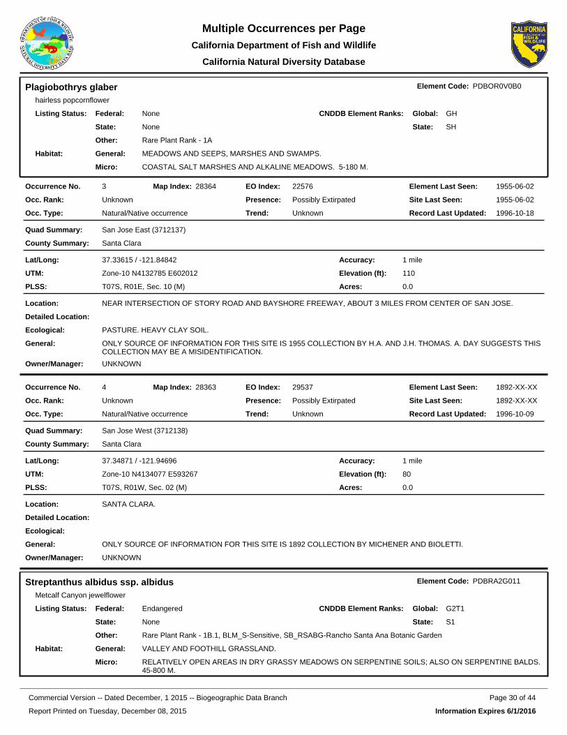
Plagiobothrys glaberhairless popcornflower
Element Code: PDBOR0V0B0
Federal:
State:
None
None
Listing Status: CNDDB Element Ranks: Global:
State:
GH
SH
Other: Rare Plant Rank - 1A
General: MEADOWS AND SEEPS, MARSHES AND SWAMPS.
Micro: COASTAL SALT MARSHES AND ALKALINE MEADOWS. 5-180 M.
Habitat:
22576EO Index:3Occurrence No. 28364Map Index: 1955-06-02Element Last Seen:
1955-06-02Site Last Seen:UnknownOcc. Rank:
Natural/Native occurrenceOcc. Type:
Possibly ExtirpatedPresence:
UnknownTrend: 1996-10-18Record Last Updated:
San Jose East (3712137)Quad Summary:
Santa ClaraCounty Summary:
37.33615 / -121.84842Lat/Long:
Zone-10 N4132785 E602012UTM:
T07S, R01E, Sec. 10 (M)PLSS:
1 mileAccuracy:
110Elevation (ft):
0.0Acres:
NEAR INTERSECTION OF STORY ROAD AND BAYSHORE FREEWAY, ABOUT 3 MILES FROM CENTER OF SAN JOSE.Location:
Detailed Location:
PASTURE. HEAVY CLAY SOIL.Ecological:
ONLY SOURCE OF INFORMATION FOR THIS SITE IS 1955 COLLECTION BY H.A. AND J.H. THOMAS. A. DAY SUGGESTS THIS COLLECTION MAY BE A MISIDENTIFICATION.
General:
UNKNOWNOwner/Manager:
29537EO Index:4Occurrence No. 28363Map Index: 1892-XX-XXElement Last Seen:
1892-XX-XXSite Last Seen:UnknownOcc. Rank:
Natural/Native occurrenceOcc. Type:
Possibly ExtirpatedPresence:
UnknownTrend: 1996-10-09Record Last Updated:
San Jose West (3712138)Quad Summary:
Santa ClaraCounty Summary:
37.34871 / -121.94696Lat/Long:
Zone-10 N4134077 E593267UTM:
T07S, R01W, Sec. 02 (M)PLSS:
1 mileAccuracy:
80Elevation (ft):
0.0Acres:
SANTA CLARA.Location:
Detailed Location:
Ecological:
ONLY SOURCE OF INFORMATION FOR THIS SITE IS 1892 COLLECTION BY MICHENER AND BIOLETTI.General:
UNKNOWNOwner/Manager:
Streptanthus albidus ssp. albidusMetcalf Canyon jewelflower
Element Code: PDBRA2G011
Federal:
State:
Endangered
None
Listing Status: CNDDB Element Ranks: Global:
State:
G2T1
S1
Other: Rare Plant Rank - 1B.1, BLM_S-Sensitive, SB_RSABG-Rancho Santa Ana Botanic Garden
General: VALLEY AND FOOTHILL GRASSLAND.
Micro: RELATIVELY OPEN AREAS IN DRY GRASSY MEADOWS ON SERPENTINE SOILS; ALSO ON SERPENTINE BALDS. 45-800 M.
Habitat:
Report Printed on Tuesday, December 08, 2015
Page 30 of 44Commercial Version -- Dated December, 1 2015 -- Biogeographic Data Branch
Information Expires 6/1/2016
Multiple Occurrences per PageCalifornia Department of Fish and Wildlife
California Natural Diversity Database

1299EO Index:15Occurrence No. 21194Map Index: 2013-05-29Element Last Seen:
2013-05-29Site Last Seen:FairOcc. Rank:
Natural/Native occurrenceOcc. Type:
Presumed ExtantPresence:
UnknownTrend: 2013-09-30Record Last Updated:
San Jose East (3712137)Quad Summary:
Santa ClaraCounty Summary:
37.28579 / -121.79469Lat/Long:
Zone-10 N4127257 E606843UTM:
T07S, R02E, Sec. 31 (M)PLSS:
specific areaAccuracy:
600Elevation (ft):
30.0Acres:
VICINITY OF THE RANCH GOLF CLUB; FROM JUST E OF GRAVEL PIT EXTENDING E FOR 0.6 MI & SE FOR 0.8 MI, WEST OF SILVER CREEK.
Location:
MAPPED AS FOUR POLYGONS. PREVIOUSLY WITHIN CERRA PLATA DEVELOPMENT; PLANTS NOW ON CITY OF SAN JOSE PROPERTY. IN 2013, PLANTS WERE SCATTERED THROUGHOUT SERPENTINE BETWEEN GOLF CART PATHS AND IN VICINITY OF CLUBHOUSE. INCLUDES FORMER EO #14.
Detailed Location:
ON ROCKY, STEEP S-FACING SERPENTINE SLOPE ABOVE BRANCH IN DIRT ROAD. ASSOCIATED WITH AVENA FATUA, BROMUS MOLLIS, CHLOROGALUM POMERIDIANUM, ARTEMISIA CALIFORNICA, PHACELIA IMBRICATA, BRODIAEA PULCHELLA, AND NEAR OTHER RARE PLANT TAXA.
Ecological:
OVER 700 PLANTS SEEN IN 1988. BETWEEN OCC #15 & #18: >9000 IN 1992, 9065 IN 1993, 75,000 IN 1998, NONE IN 1999, <100 IN 2000, 13,200 IN '01, 5800 IN '02, 8700 IN '03, 8300 IN '04, 9888 IN '05, 8620 IN '06, 17,395 IN '07. ~120 HERE IN 2013.
General:
CITY OF SAN JOSEOwner/Manager:
25391EO Index:17Occurrence No. 21226Map Index: 2013-06-13Element Last Seen:
2013-06-13Site Last Seen:PoorOcc. Rank:
Natural/Native occurrenceOcc. Type:
Presumed ExtantPresence:
DecreasingTrend: 2013-09-30Record Last Updated:
San Jose East (3712137)Quad Summary:
Santa ClaraCounty Summary:
37.27455 / -121.82519Lat/Long:
Zone-10 N4125977 E604154UTM:
T07S, R01E, Sec. 35 (M)PLSS:
specific areaAccuracy:
270Elevation (ft):
2.0Acres:
RIDGE NORTH OF DANNA ROCK PARK, 0.7 MILE SOUTHEAST OF JUNCTION OF MONTEREY HIGHWAY AND CAPITOL EXPRESSWAY, SAN JOSE.
Location:
ON STEEP SOUTH-FACING SLOPE. MAPPED BY CNDDB AROUND THE AREA STREPTANTHUS WAS OBSERVED IN 2013; UNCLEAR IF STREPTANTHUS OCCURS THROUGHOUT THIS PROPERTY OR ONLY IN A PORTION OF PROPERTY.
Detailed Location:
WEEDY SERPENTINE GRASSLAND DOMINATED BY AVENA BARBATA. ALSO WITH FESTUCA PERENNIS, LACTUCA SERRIOLA, ERIOGONUM NUDUM, BROMUS DIANDRUS, ESCHSCHOLZIA CALIFORNICA, CHLOROGALUM POMERIDIANUM, B. MADRITENSIS, PLANTAGO ERECTA, DICHELOSTEMMA, ETC.
Ecological:
2667 PLANTS SEEN IN 1991. 281 PLANTS OBSERVED IN 1996. 0 IN 2012. APPROXIMATELY 75 PLANTS OBSERVED IN 2013; PLANTS MOSTLY IN FRUIT & HARD TO SEE. THE RARE DUDLEYA ABRAMSII SSP. SETCHELLII AND ERIGONUM LUTEOLUM VAR. CANINUM ALSO OCCUR HERE.
General:
PVT-VALLEY CHRISTIAN SCHOOLOwner/Manager:
Report Printed on Tuesday, December 08, 2015
Page 31 of 44Commercial Version -- Dated December, 1 2015 -- Biogeographic Data Branch
Information Expires 6/1/2016
Multiple Occurrences per PageCalifornia Department of Fish and Wildlife
California Natural Diversity Database

1301EO Index:18Occurrence No. 26622Map Index: 2013-05-29Element Last Seen:
2013-05-29Site Last Seen:FairOcc. Rank:
Natural/Native occurrenceOcc. Type:
Presumed ExtantPresence:
UnknownTrend: 2013-09-26Record Last Updated:
San Jose East (3712137)Quad Summary:
Santa ClaraCounty Summary:
37.29250 / -121.80345Lat/Long:
Zone-10 N4127993 E606057UTM:
T07S, R02E, Sec. 30 (M)PLSS:
specific areaAccuracy:
400Elevation (ft):
18.0Acres:
NORTH PART OF THE RANCH GOLF CLUB, 1.2 MILES NE OF CHRISTOPHER SCHOOL, BETWEEN BAYSHORE HWY & SILVER CREEK RD, SAN JOSE.
Location:
PREVIOUSLY WITHIN CERRA PLATA DEVELOPMENT; PLANTS NOW ON CITY OF SAN JOSE PROPERTY.Detailed Location:
SERPENTINE GRASSLAND DOMINATED BY AVENA BARBATA, BROMUS HORDEACEUS, AND FESTUCA PERENNIS. ALSO PRESENT WITH DUDLEYA ABRAMSII SSP. SETCHELLII, LACTUCA SERRIOLA, ERIOGONUM NUDUM, ESCHSCHOLZIA CALIFORNICA, STIPA PULCHRA, CHLOROGALUM, ETC.
Ecological:
BETWEEN OCC #15 & #18: >9000 IN 1992, 9065 IN 1993, 75,000 IN 1998, NONE IN 1999, <100 IN 2000, 13,200 IN '01, 5800 IN '02, 8700 IN '03, 8300 IN '04, 9888 IN '05, 8620 IN '06, 17,395 IN '07. ~61 AT JUST THIS OCCURRENCE IN 2013.
General:
CITY OF SAN JOSEOwner/Manager:
1303EO Index:19Occurrence No. 26621Map Index: 1994-05-19Element Last Seen:
2013-06-13Site Last Seen:PoorOcc. Rank:
Natural/Native occurrenceOcc. Type:
Presumed ExtantPresence:
UnknownTrend: 2013-09-27Record Last Updated:
San Jose East (3712137)Quad Summary:
Santa ClaraCounty Summary:
37.28350 / -121.84613Lat/Long:
Zone-10 N4126946 E602286UTM:
T07S, R01E, Sec. 34 (M)PLSS:
80 metersAccuracy:
170Elevation (ft):
0.0Acres:
EAST SIDE OF COMMUNICATION HILL, JUST NORTH OF INTERSECTION OF HILLSDALE AVE AND HILLCAP AVE, SW OF HWY 82, SAN JOSE.
Location:
Detailed Location:
ON CUT SERPENTINE SLOPE ASSOCIATED WITH BROMUS MADRITENSIS RUBENS, ESCHSCHOLZIA CALIFORNICA, MELILOTUS INDICA, PLANTAGO ERECTA, LOTUS HUMISTRATUS, PLAGIOBOTHRYS SP, AND EPILOBIUM SP.
Ecological:
100 PLANTS ESTIMATED IN 1994. NO PLANTS OBSERVED IN 2013; AREA HEAVILY ALTERED BY QUARRY. INCLUDES FORMER OCCURRENCE #1.
General:
PVTOwner/Manager:
Report Printed on Tuesday, December 08, 2015
Page 32 of 44Commercial Version -- Dated December, 1 2015 -- Biogeographic Data Branch
Information Expires 6/1/2016
Multiple Occurrences per PageCalifornia Department of Fish and Wildlife
California Natural Diversity Database

91580EO Index:24Occurrence No. 90468Map Index: 2009-05-19Element Last Seen:
2009-05-19Site Last Seen:GoodOcc. Rank:
Natural/Native occurrenceOcc. Type:
Presumed ExtantPresence:
UnknownTrend: 2013-09-26Record Last Updated:
San Jose East (3712137)Quad Summary:
Santa ClaraCounty Summary:
37.25999 / -121.77445Lat/Long:
Zone-10 N4124418 E608673UTM:
T08S, R02E, Sec. 05 (M)PLSS:
specific areaAccuracy:
550Elevation (ft):
10.0Acres:
NW PORTION OF YOUNG RANCH; JUST SE OF NEW NORTH ALMADEN MINE ABOUT 0.5 AIR MI ESE OF HELLYER AVE/SILVER CRK RD JUNCTION.
Location:
MOSTLY IN THE SOUTH HALF OF THE SE 1/4 OF SECTION 5.Detailed Location:
SERPENTINE DERIVED SOILS OR SERPENTINE OUTCROPS. MOSTLY ON THIN SOILED SERPENTINE BARRENS. CO-OCCURS WITH DUDLEYA SETCHELLII AND MALACOTHAMNUS HALLII AT THIS SITE.
Ecological:
APPROXIMATELY 2000 INDIVIDUALS WERE OBSERVED IN 2009 BETWEEN THIS OCCURRENCE AND OCCURRENCE #25.General:
PVTOwner/Manager:
91581EO Index:25Occurrence No. 90469Map Index: 2009-05-19Element Last Seen:
2009-05-19Site Last Seen:GoodOcc. Rank:
Natural/Native occurrenceOcc. Type:
Presumed ExtantPresence:
UnknownTrend: 2013-09-26Record Last Updated:
San Jose East (3712137)Quad Summary:
Santa ClaraCounty Summary:
37.26426 / -121.78310Lat/Long:
Zone-10 N4124883 E607901UTM:
T08S, R02E, Sec. 05 (M)PLSS:
specific areaAccuracy:
400Elevation (ft):
1.0Acres:
NW PORTION OF YOUNG RANCH; NW OF NEW NORTH ALMADEN MINE, 0.3 MI NNE OF HELLYER AVE/SILVER CRK RD JUNCTION, SAN JOSE.
Location:
IN THE NORTH HALF OF THE SW 1/4 OF SECTION 5.Detailed Location:
SERPENTINE DERIVED SOILS OR SERPENTINE OUTCROPS. MOSTLY ON THIN SOILED SERPENTINE BARRENS. DUDLEYA SETCHELLII AND LESSINGIA MICRADENIA VAR. GLABRATA OCCUR NEARBY.
Ecological:
APPROXIMATELY 2000 INDIVIDUALS WERE OBSERVED IN 2009 BETWEEN THIS OCCURRENCE AND OCCURRENCE #24.General:
PVTOwner/Manager:
Report Printed on Tuesday, December 08, 2015
Page 33 of 44Commercial Version -- Dated December, 1 2015 -- Biogeographic Data Branch
Information Expires 6/1/2016
Multiple Occurrences per PageCalifornia Department of Fish and Wildlife
California Natural Diversity Database

91582EO Index:26Occurrence No. 90470Map Index: 2013-05-29Element Last Seen:
2013-05-29Site Last Seen:GoodOcc. Rank:
Natural/Native occurrenceOcc. Type:
Presumed ExtantPresence:
UnknownTrend: 2013-09-27Record Last Updated:
San Jose East (3712137)Quad Summary:
Santa ClaraCounty Summary:
37.27878 / -121.80120Lat/Long:
Zone-10 N4126473 E606275UTM:
T07S, R02E, Sec. 31 (M)PLSS:
specific areaAccuracy:
200Elevation (ft):
5.0Acres:
HELLYER AVE APPROXIMATELY 0.48 ROAD MILE SE OF ITS JUNCTION WITH US 101, SE OF SAN JOSE.Location:
MAPPED BY CNDDB AROUND THE SERPENTINE ROADCUT INDICATED. IN THE NORTH HALF OF THE SW 1/4 OF SECTION 31.
Detailed Location:
ROADCUT WITH SERPENTINE BARREN/GRASSLAND. ASSOCIATED WITH AVENA BARBATA, BROMUS MADRITENSIS, CENTAUREA SOLSTITIALIS, ERIOGONUM NUDUM, E. ROSEUM, CRYPTANTHA FLACCIDA, FESTUCA PERENNIS, ESCHSCHOLZIA CALIFORNICA, CHLOROGALUM POMERIDIANUM, ETC.
Ecological:
APPROXIMATELY 240 INDIVIDUALS OBSERVED IN 2013; MORE 2012 SKELETONS PRESENT THAN LIVE 2013 PLANTS.General:
UNKNOWNOwner/Manager:
Dudleya abramsii ssp. setchelliiSanta Clara Valley dudleya
Element Code: PDCRA040Z0
Federal:
State:
Endangered
None
Listing Status: CNDDB Element Ranks: Global:
State:
G4T2
S2
Other: Rare Plant Rank - 1B.1, SB_RSABG-Rancho Santa Ana Botanic Garden
General: VALLEY AND FOOTHILL GRASSLAND, CISMONTANE WOODLAND.
Micro: ON ROCKY SERPENTINE OUTCROPS AND ON ROCKS WITHIN GRASSLAND OR WOODLAND. 60-455 M.
Habitat:
27281EO Index:7Occurrence No. 20912Map Index: 2013-05-29Element Last Seen:
2013-05-29Site Last Seen:GoodOcc. Rank:
Natural/Native occurrenceOcc. Type:
Presumed ExtantPresence:
DecreasingTrend: 2014-07-10Record Last Updated:
San Jose East (3712137)Quad Summary:
Santa ClaraCounty Summary:
37.28655 / -121.79431Lat/Long:
Zone-10 N4127342 E606875UTM:
T07S, R02E, Sec. 31 (M)PLSS:
specific areaAccuracy:
600Elevation (ft):
211.0Acres:
RIDGE BETWEEN BAYSHORE HIGHWAY (HWY 101) AND SILVER CREEK ROAD, 1.2-2.3 MILES SOUTH OF ABORN ROAD, SE END OF SAN JOSE.
Location:
MANY POLYGONS MAPPED ALONG NW END OF RIDGE. PROPOSED CERRA PLATA DEVELOPMENT SITE. MOST OF AREA NOW HASSLER RANCH PRES. PLANTS HAVE BEEN MOVED/TRANSPLANTED INTO OTHER AREAS IN 1999-2003; OF 2900+ TRANSPLANTS IN 2000, 725 SURVIVED BY 2007.
Detailed Location:
IN WEATHERED SERPENTINE ROCKS W/AVENA FATUA, A. BARBATA, BROMUS MOLLIS, B. DIANDRUS, NASSELLA PULCHRA, POA SCABRELLA, AND CALOCHORTUS VENUSTUS. OTHER RARE PLANTS IN AREA: STREPTANTHUS ALBIDUS ALBIDUS, CIRSIUM CAMPYLON, FRITILLARIA LILIACEA.
Ecological:
20,000+ PLANTS IN 1992, 20,869 IN 1993, 21,947 IN 1998. POP #S NOT INCLUDING TRANSPLANTS: 19,083 IN 2000, 22,058 IN 2001, 24,096 IN 2002, 23,949 IN 2004, 26,951 IN 2005, 16,553 IN 2006, 15,356 IN 2007. OBSERVED WITH STREPTANTHUS IN 2013.
General:
PVT, CITY OF SAN JOSEOwner/Manager:
Report Printed on Tuesday, December 08, 2015
Page 34 of 44Commercial Version -- Dated December, 1 2015 -- Biogeographic Data Branch
Information Expires 6/1/2016
Multiple Occurrences per PageCalifornia Department of Fish and Wildlife
California Natural Diversity Database

22303EO Index:8Occurrence No. 20911Map Index: 2009-04-19Element Last Seen:
2009-04-19Site Last Seen:PoorOcc. Rank:
Natural/Native occurrenceOcc. Type:
Presumed ExtantPresence:
DecreasingTrend: 2010-08-02Record Last Updated:
San Jose East (3712137)Quad Summary:
Santa ClaraCounty Summary:
37.28473 / -121.85992Lat/Long:
Zone-10 N4127068 E601061UTM:
T07S, R01E, Sec. 34 (M)PLSS:
specific areaAccuracy:
300Elevation (ft):
25.0Acres:
ALONG AZORES STREET, BATISTA DRIVE, ADELINE AVENUE, AND CASSELINO DRIVE, COMMUNICATIONS HILL, SAN JOSE.
Location:
MAPPED AS FOUR POLYGONS. MOST OF OCCURRENCE HAS BEEN CONVERTED TO HOUSING DEVELOPMENT. FAR WESTERN POLYGON MAPPED BASED ON 2009 OBSERVATION OF A SITE WHICH WAS PART NATURAL, PART PLANTED FOR MITIGATION BECAUSE OF NEARBY DEVELOPMENT.
Detailed Location:
ON SERPENTINE OUTCROPS WITHIN SERPENTINE GRASSLAND. ON WEST TO SE-FACING SLOPES WITH NASSELLA PULCHRA, LOLIUM SP., PHACELIA SP., AND ESCHSCHOLZIA CALIFORNICA. TIGER SALAMANDER ALSO HERE.
Ecological:
APPROXIMATELY 50 PLANTS OBSERVED IN 1990. 1750 WERE SEEN IN 1992 IN THE 3 EASTERN POLYGONS. 4574 WERE PLANTED AT WESTERN POLYGON (ALONG WITH SOME NATURAL PLANTS) BUT ONLY 268 COULD BE FOUND IN 2009, MOST OF THESE APPEARED TO BE NATURAL.
General:
PVTOwner/Manager:
26475EO Index:12Occurrence No. 67512Map Index: 2013-06-13Element Last Seen:
2013-06-13Site Last Seen:FairOcc. Rank:
Natural/Native occurrenceOcc. Type:
Presumed ExtantPresence:
UnknownTrend: 2014-07-10Record Last Updated:
San Jose East (3712137)Quad Summary:
Santa ClaraCounty Summary:
37.27465 / -121.82552Lat/Long:
Zone-10 N4125987 E604124UTM:
T07S, R01E, Sec. 35 (M)PLSS:
specific areaAccuracy:
270Elevation (ft):
10.0Acres:
NORTH OF DANA ROCK PARK, 0.7 MILE SOUTHEAST OF THE JUNCTION OF MONTEREY HIGHWAY AND CAPITOL EXPRESSWAY, SAN JOSE.
Location:
VALLEY CHRISTIAN SCHOOL SITE AND ADJACENT HOME LOT. MAPPED BY CNDDB ACCORDING TO 2006 AND 2013 COORDINATES. SITE MAY BE MORE EXTENSIVE WITHIN VALLEY CHRISTIAN SCHOOL PROPERTY BUT MAP DETAIL NOT PROVIDED.
Detailed Location:
ON RIDGE ON SERPENTINE ROCK OUTCROPS AND GRASSLAND ON NORTH AND SOUTH-FACING SLOPES WITH STREPTANTHUS ALBIDUS ALBIDUS AND ERIOGONUM CANINUM.
Ecological:
VALLEY CHRISTIAN SCHOOL SITE: 1836 PLANTS SEEN IN 1991, 8449 PLANTS IN 1996, OBSERVED DURING SURVEYS FOR STREPTANTHUS ALBIDUS IN 2013. WESTERN POLYGON: 820 OBSERVED IN 2006.
General:
PVT-VALLEY CHRISTIAN SCHOOLOwner/Manager:
Report Printed on Tuesday, December 08, 2015
Page 35 of 44Commercial Version -- Dated December, 1 2015 -- Biogeographic Data Branch
Information Expires 6/1/2016
Multiple Occurrences per PageCalifornia Department of Fish and Wildlife
California Natural Diversity Database

41782EO Index:28Occurrence No. 41782Map Index: 2000-05-10Element Last Seen:
2000-05-10Site Last Seen:PoorOcc. Rank:
Natural/Native occurrenceOcc. Type:
Presumed ExtantPresence:
UnknownTrend: 2000-11-17Record Last Updated:
San Jose East (3712137)Quad Summary:
Santa ClaraCounty Summary:
37.28197 / -121.86901Lat/Long:
Zone-10 N4126752 E600259UTM:
T07S, R01E, Sec. 33 (M)PLSS:
specific areaAccuracy:
250Elevation (ft):
11.2Acres:
HILLS SOUTHWEST OF SANTA CLARA COUNTY FAIRGROUNDS, BETWEEN CANOAS GARDEN AVE AND HILLSDALE AVE, SAN JOSE.
Location:
2 COLONIES ON TOP AND SOUTHERN SLOPE OF HILL JUST WEST OF HWY 87. N COLONY BETWEEN SENIOR APARTMENT HOUSING PARKING LOT & CALTRANS RIGHT-OF-WAY AT TOP OF CUT SLOPE ADJACENT TO HWY 87. S COLONY 1500 FT NW OF JCT OF HILLSDALE & NARVAIS ROADS.
Detailed Location:
GROWING AMONG SERPENTINE ROCK OUTCROPS WITHIN REMNANT SERPENTINE GRASSLAND COMMUNITY. ASSOCIATES INCLUDE AVENA, BROMUS HORDEACEUS, ESCHSCHOLZIA CALIFORNICA, CHLOROGALUM, AND PLANTAGO ERECTA. MONTARA SERIES SOILS.
Ecological:
1762 PLANTS OBSERVED IN SOUTH COLONY IN 1997, 45 PLANTS IN NORTH COLONY IN 1998. ABOUT 35 PLANTS OBSERVED AT NORTH COLONY IN 2000. NORTH COLONY BASICALLY AT TOP OF HIGHWAY CUTSLOPE.
General:
SAN JOSE WATER CO, UNKNOWNOwner/Manager:
44492EO Index:38Occurrence No. 44492Map Index: 2009-05-19Element Last Seen:
2009-05-19Site Last Seen:FairOcc. Rank:
Natural/Native occurrenceOcc. Type:
Presumed ExtantPresence:
UnknownTrend: 2014-07-16Record Last Updated:
San Jose East (3712137)Quad Summary:
Santa ClaraCounty Summary:
37.26212 / -121.77995Lat/Long:
Zone-10 N4124648 E608183UTM:
T08S, R02E, Sec. 05 (M)PLSS:
specific areaAccuracy:
400Elevation (ft):
47.0Acres:
VICINITY OF NEW NORTH ALMADEN MINE, NORTH OF TENNANT ROAD, EAST OF HIGHWAY 101, SAN JOSE.Location:
MAPPED BY CNDDB AS MANY POLYGONS ACCORDING TO 2004 HILLMAN DIGITAL DATA AND A 2012 WRA ENVIRONMENTAL CONSULTANTS MAP.
Detailed Location:
ROCKY SERPENTINE SLOPE AND ROCKY OUTCROPPINGS. ASSOCIATED WITH ARTEMISIA CALIFORNICA, AVENA BARBATA, LOLIUM MULTIFLORUM, CENTAUREA SOLSTITALIS, AND ERIOGONUM SP.
Ecological:
POPULATION NUMBERS ARE FOR PORTIONS OF OCCURRENCE: 250 PLANTS IN 1998, ~120 PLANTS IN 2004. APPROXIMATELY 1000 PLANTS OBSERVED IN 2009 IN VICINITY OF EO #38 AND 67. INCLUDES FORMER OCCURRENCES #53 AND 54.
General:
SANTA CLARA VALLEY WATER DISTOwner/Manager:
Report Printed on Tuesday, December 08, 2015
Page 36 of 44Commercial Version -- Dated December, 1 2015 -- Biogeographic Data Branch
Information Expires 6/1/2016
Multiple Occurrences per PageCalifornia Department of Fish and Wildlife
California Natural Diversity Database
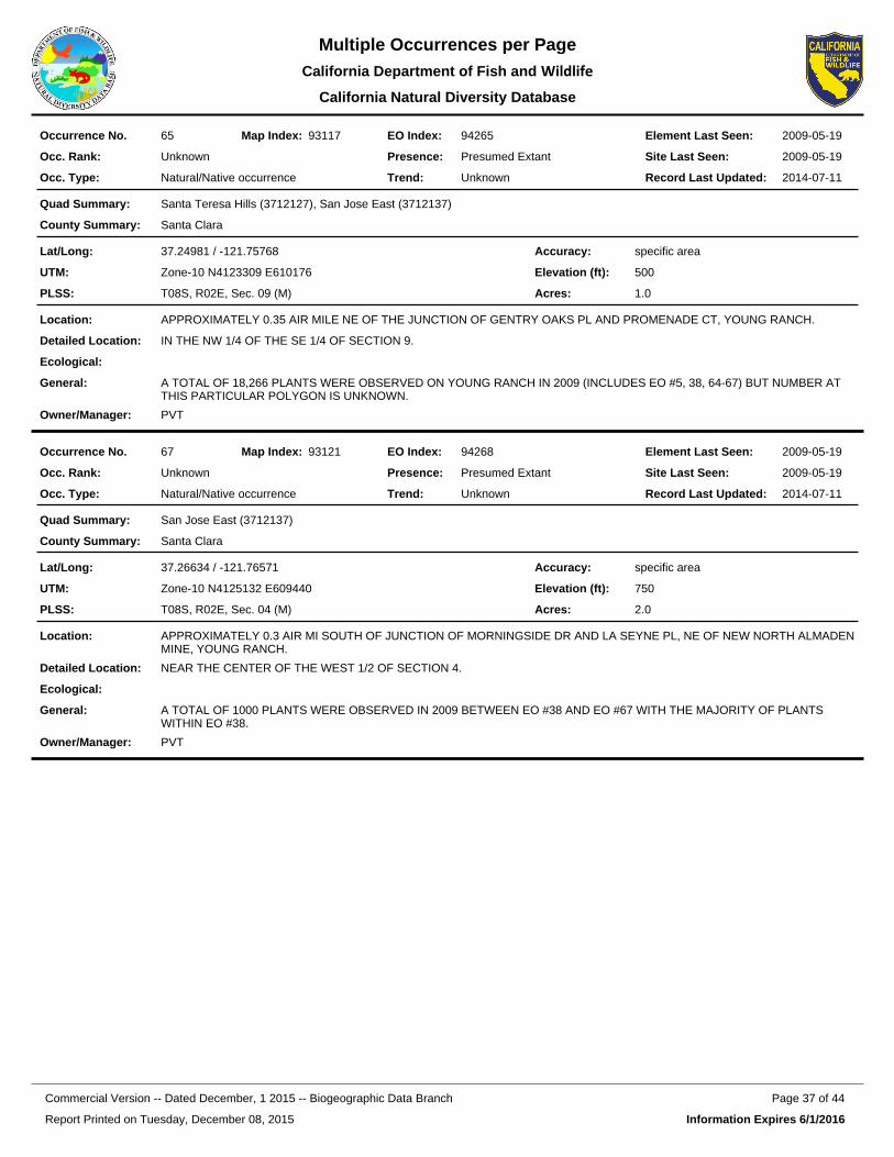
94265EO Index:65Occurrence No. 93117Map Index: 2009-05-19Element Last Seen:
2009-05-19Site Last Seen:UnknownOcc. Rank:
Natural/Native occurrenceOcc. Type:
Presumed ExtantPresence:
UnknownTrend: 2014-07-11Record Last Updated:
Santa Teresa Hills (3712127), San Jose East (3712137)Quad Summary:
Santa ClaraCounty Summary:
37.24981 / -121.75768Lat/Long:
Zone-10 N4123309 E610176UTM:
T08S, R02E, Sec. 09 (M)PLSS:
specific areaAccuracy:
500Elevation (ft):
1.0Acres:
APPROXIMATELY 0.35 AIR MILE NE OF THE JUNCTION OF GENTRY OAKS PL AND PROMENADE CT, YOUNG RANCH.Location:
IN THE NW 1/4 OF THE SE 1/4 OF SECTION 9.Detailed Location:
Ecological:
A TOTAL OF 18,266 PLANTS WERE OBSERVED ON YOUNG RANCH IN 2009 (INCLUDES EO #5, 38, 64-67) BUT NUMBER AT THIS PARTICULAR POLYGON IS UNKNOWN.
General:
PVTOwner/Manager:
94268EO Index:67Occurrence No. 93121Map Index: 2009-05-19Element Last Seen:
2009-05-19Site Last Seen:UnknownOcc. Rank:
Natural/Native occurrenceOcc. Type:
Presumed ExtantPresence:
UnknownTrend: 2014-07-11Record Last Updated:
San Jose East (3712137)Quad Summary:
Santa ClaraCounty Summary:
37.26634 / -121.76571Lat/Long:
Zone-10 N4125132 E609440UTM:
T08S, R02E, Sec. 04 (M)PLSS:
specific areaAccuracy:
750Elevation (ft):
2.0Acres:
APPROXIMATELY 0.3 AIR MI SOUTH OF JUNCTION OF MORNINGSIDE DR AND LA SEYNE PL, NE OF NEW NORTH ALMADEN MINE, YOUNG RANCH.
Location:
NEAR THE CENTER OF THE WEST 1/2 OF SECTION 4.Detailed Location:
Ecological:
A TOTAL OF 1000 PLANTS WERE OBSERVED IN 2009 BETWEEN EO #38 AND EO #67 WITH THE MAJORITY OF PLANTS WITHIN EO #38.
General:
PVTOwner/Manager:
Report Printed on Tuesday, December 08, 2015
Page 37 of 44Commercial Version -- Dated December, 1 2015 -- Biogeographic Data Branch
Information Expires 6/1/2016
Multiple Occurrences per PageCalifornia Department of Fish and Wildlife
California Natural Diversity Database

Trifolium hydrophilumsaline clover
Element Code: PDFAB400R5
Federal:
State:
None
None
Listing Status: CNDDB Element Ranks: Global:
State:
G2
S2
Other: Rare Plant Rank - 1B.2
General: MARSHES AND SWAMPS, VALLEY AND FOOTHILL GRASSLAND, VERNAL POOLS.
Micro: MESIC, ALKALINE SITES. 0-300 M.
Habitat:
84579EO Index:25Occurrence No. 66585Map Index: 1903-06-01Element Last Seen:
1903-06-01Site Last Seen:UnknownOcc. Rank:
Natural/Native occurrenceOcc. Type:
Presumed ExtantPresence:
UnknownTrend: 2011-09-07Record Last Updated:
San Jose West (3712138)Quad Summary:
Santa ClaraCounty Summary:
37.33910 / -121.89534Lat/Long:
Zone-10 N4133063 E597851UTM:
T07S, R01E, Sec. 08 (M)PLSS:
1 mileAccuracy:
Elevation (ft):
0.0Acres:
SAN JOSE.Location:
EXACT LOCATION UNKNOWN. MAPPED BY CNDDB IN GENERAL VICINITY OF SAN JOSE BUT COLLECTION LOCALITY IS VERY VAGUE.
Detailed Location:
Ecological:
ONLY SOURCE OF INFORMATION FOR THIS OCCURRENCE IS A 1903 COLLECTION BY ELMER. NEEDS FIELDWORK.General:
UNKNOWNOwner/Manager:
California macrophyllaround-leaved filaree
Element Code: PDGER01070
Federal:
State:
None
None
Listing Status: CNDDB Element Ranks: Global:
State:
G3?
S3?
Other: Rare Plant Rank - 1B.2, BLM_S-Sensitive, SB_RSABG-Rancho Santa Ana Botanic Garden, SB_SBBG-Santa Barbara Botanic Garden
General: CISMONTANE WOODLAND, VALLEY AND FOOTHILL GRASSLAND.
Micro: CLAY SOILS. 15-1200 M.
Habitat:
67126EO Index:93Occurrence No. 66977Map Index: 1955-04-11Element Last Seen:
1955-04-11Site Last Seen:UnknownOcc. Rank:
Natural/Native occurrenceOcc. Type:
Presumed ExtantPresence:
UnknownTrend: 2006-11-07Record Last Updated:
San Jose East (3712137)Quad Summary:
Santa ClaraCounty Summary:
37.28826 / -121.79654Lat/Long:
Zone-10 N4127530 E606674UTM:
T07S, R02E, Sec. 30 (M)PLSS:
1 mileAccuracy:
Elevation (ft):
0.0Acres:
SILVER CREEK HILLS, CIRCA 6 MILES SOUTHEAST OF SAN JOSE.Location:
EXACT LOCATION UNKNOWN. MAPPED BY CNDDB AS BEST GUESS.Detailed Location:
OPEN GRASSY SLOPE.Ecological:
ONLY SOURCE OF INFORMATION FOR THIS OCCURRENCE IS A 1955 COLLECTION BY MYERS. NEEDS FIELDWORK.General:
UNKNOWNOwner/Manager:
Report Printed on Tuesday, December 08, 2015
Page 38 of 44Commercial Version -- Dated December, 1 2015 -- Biogeographic Data Branch
Information Expires 6/1/2016
Multiple Occurrences per PageCalifornia Department of Fish and Wildlife
California Natural Diversity Database

Malacothamnus halliiHall's bush-mallow
Element Code: PDMAL0Q0F0
Federal:
State:
None
None
Listing Status: CNDDB Element Ranks: Global:
State:
G2
S2
Other: Rare Plant Rank - 1B.2, BLM_S-Sensitive
General: CHAPARRAL, COASTAL SCRUB.
Micro: SOME POPULATIONS ON SERPENTINE. 10-730 M.
Habitat:
30516EO Index:8Occurrence No. 96214Map Index: 2007-05-22Element Last Seen:
2007-05-22Site Last Seen:GoodOcc. Rank:
Natural/Native occurrenceOcc. Type:
Presumed ExtantPresence:
UnknownTrend: 2015-07-02Record Last Updated:
San Jose East (3712137)Quad Summary:
Santa ClaraCounty Summary:
37.28564 / -121.79838Lat/Long:
Zone-10 N4127237 E606515UTM:
T07S, R02E, Sec. 31 (M)PLSS:
80 metersAccuracy:
600Elevation (ft):
0.0Acres:
"SILVER CREEK HILLS" BETWEEN SILVER CREEK AND HWY 101; ~0.6 AIR MI NE OF HELLYER AVE/101 JUNCTION, SE EDGE OF SAN JOSE.
Location:
MAPPED BY CNDDB ACCORDING TO 2007 LAZAROTTI COORDINATES, IN THE NE 1/4 OF THE NW 1/4 OF SECTION 31. SITE WAS PRIVATELY OWNED IN 2007 BUT NOW LOOKS TO BE OWNED BY THE CITY OF SAN JOSE.
Detailed Location:
DIABLAN SAGE SCRUB. THE RARE STREPTANTHUS ALBIDUS ALBIDUS AND DUDLEYA SETCHELLII ALSO OCCUR AT THIS SITE.
Ecological:
50-100 PLANTS IN 1998, UNKNOWN # IN 2001, 100 IN 2002, 275 IN 2003, 200 IN 2005, 100 IN 2006 AND 2007. 1953 COLLECTION BY HOWELL FROM SOUTH OF EVERGREEN ATTRIBUTED TO THIS SITE; SOME HERBARIA HAVE ID AS M. FREMONTII OR M. FASCICULATUS.
General:
CITY OF SAN JOSEOwner/Manager:
30509EO Index:9Occurrence No. 28970Map Index: 1976-10-20Element Last Seen:
1993-07-24Site Last Seen:NoneOcc. Rank:
Natural/Native occurrenceOcc. Type:
Possibly ExtirpatedPresence:
UnknownTrend: 1997-03-19Record Last Updated:
San Jose West (3712138)Quad Summary:
Santa ClaraCounty Summary:
37.35508 / -121.91338Lat/Long:
Zone-10 N4134817 E596232UTM:
T07S, R01E, Sec. 06 (M)PLSS:
1/5 mileAccuracy:
40Elevation (ft):
0.0Acres:
EAST SIDE OF GUADALUPE CREEK JUST NORTH OF HIGHWAY 17, SAN JOSE.Location:
25 YARDS EAST OF THE CREEK AND 200 YARDS NORTH OF THE HIGHWAY.Detailed Location:
OBSERVED IN 1976 WITH BACCHARIS AND WEEDY FORBS. IN 1993 SITE VEGETATED WITH BACCHARIS, TYPHA, CAREX, POPULUS FREMONTII, AND WEEDY FORBS. DISTURBED CREEKBED WITH LEVEES BUILT UP ON BOTH SIDES.
Ecological:
SITE BASED ON A 1976 PATTON COLLECTION. CHANDIK SEARCHED THIS AREA IN 1993 BUT NO MALACOTHAMNUS WERE OBSERVED. ID OF COLLECTION NEEDS CONFIRMATION; M. ARCUATUS ALSO OCCURS NEARBY.
General:
UNKNOWNOwner/Manager:
Report Printed on Tuesday, December 08, 2015
Page 39 of 44Commercial Version -- Dated December, 1 2015 -- Biogeographic Data Branch
Information Expires 6/1/2016
Multiple Occurrences per PageCalifornia Department of Fish and Wildlife
California Natural Diversity Database

68216EO Index:31Occurrence No. 68066Map Index: 2009-05-XXElement Last Seen:
2009-05-XXSite Last Seen:GoodOcc. Rank:
Natural/Native occurrenceOcc. Type:
Presumed ExtantPresence:
UnknownTrend: 2015-07-02Record Last Updated:
San Jose East (3712137)Quad Summary:
Santa ClaraCounty Summary:
37.25914 / -121.77652Lat/Long:
Zone-10 N4124321 E608491UTM:
T08S, R02E, Sec. 05 (M)PLSS:
specific areaAccuracy:
400Elevation (ft):
15.0Acres:
ALONG COYOTE CANAL EXTENSION, NEAR THE INTERSECTION OF PIERCY ROAD AND HELLYER AVE, NEAR NEW NORTH ALMADEN MINE.
Location:
ON BOTH SIDES OF THE CANAL AND ALONG ROAD CUT. MAPPED BY CNDDB AS 7 POLYGONS ACCORDING TO 2004 HILLMAN DIGITAL DATA AND A MAP IN A 2012 WRA REPORT.
Detailed Location:
ROCKY SERPENTINE SOIL. ASSOC WITH ARTEMISIA CALIFORNICA, BROMUS MADRITENSIS RUBENS, ESCHSCHOLZIA CALIFORNICA, MELICA TORREYANA, LOLIUM MULTIFLORUM, VULPIA MYUROS, CHENOPODIUM SP, PLANTAGO ERECTA, AND KOELERIA SP. SOUTH & WEST-FACING SLOPES.
Ecological:
38 PLANTS OBSERVED IN PORTION OF OCCURRENCE IN 2004. FEWER THAN 98 PLANTS OBSERVED IN 2009. AN 1891 COLLECTION FROM "SERPENTINE HILLS AT EDENIALE (EDENVALE?), 300 FEET" IS ALSO ATTRIBUTED TO THIS SITE.
General:
UNKNOWNOwner/Manager:
80650EO Index:35Occurrence No. 79659Map Index: 2007-08-07Element Last Seen:
2007-08-07Site Last Seen:PoorOcc. Rank:
Natural/Native occurrenceOcc. Type:
Presumed ExtantPresence:
UnknownTrend: 2010-08-17Record Last Updated:
San Jose East (3712137)Quad Summary:
Santa ClaraCounty Summary:
37.28389 / -121.85304Lat/Long:
Zone-10 N4126983 E601672UTM:
T07S, R01E, Sec. 34 (M)PLSS:
80 metersAccuracy:
420Elevation (ft):
0.0Acres:
SOUTH SIDE OF COMMUNICATIONS HILL, IN DRAW ABOVE COMMUNICATIONS HILL BLVD, SAN JOSE.Location:
Detailed Location:
GRASSY SLOPE RESHAPED WITH CONCRETE DRAINAGE CHANNELS ASSOCIATED WITH ROAD DEVELOPMENT. SERPENTINE OUTCROPS IN VICINITY. ASSOCIATED WITH SALSOLA TRAGUS, ANNUAL GRASSES AND ESCHSHOLZIA CALIFORNICA.
Ecological:
ONE PLANT OBSERVED IN 2007.General:
PVTOwner/Manager:
Report Printed on Tuesday, December 08, 2015
Page 40 of 44Commercial Version -- Dated December, 1 2015 -- Biogeographic Data Branch
Information Expires 6/1/2016
Multiple Occurrences per PageCalifornia Department of Fish and Wildlife
California Natural Diversity Database

97396EO Index:43Occurrence No. 96236Map Index: 2009-05-XXElement Last Seen:
2009-05-XXSite Last Seen:UnknownOcc. Rank:
Natural/Native occurrenceOcc. Type:
Presumed ExtantPresence:
UnknownTrend: 2015-05-29Record Last Updated:
San Jose East (3712137)Quad Summary:
Santa ClaraCounty Summary:
37.25300 / -121.75660Lat/Long:
Zone-10 N4123663 E610267UTM:
T08S, R02E, Sec. 09 (M)PLSS:
specific areaAccuracy:
700Elevation (ft):
19.0Acres:
APPROXIMATELY 1.7 AIR MILES NORTH OF THE JUNCTION OF US 101 AND METCALF ROAD, YOUNGS RANCH.Location:
MAPPED BY CNDDB AS 3 POLYGONS ACCORDING TO A MAP IN A 2012 WRA REPORT.Detailed Location:
Ecological:
A TOTAL OF 2608 PLANTS WERE OBSERVED ACROSS YOUNGS RANCH (EO #31, 41-44), PRESUMABLY IN 2009.General:
SCL COUNTYOwner/Manager:
97397EO Index:44Occurrence No. 96237Map Index: 2009-05-XXElement Last Seen:
2009-05-XXSite Last Seen:UnknownOcc. Rank:
Natural/Native occurrenceOcc. Type:
Presumed ExtantPresence:
UnknownTrend: 2015-05-29Record Last Updated:
San Jose East (3712137)Quad Summary:
Santa ClaraCounty Summary:
37.26891 / -121.77912Lat/Long:
Zone-10 N4125403 E608247UTM:
T08S, R02E, Sec. 05 (M)PLSS:
specific areaAccuracy:
500Elevation (ft):
1.0Acres:
APPROXIMATELY 0.5 AIR MILE NORTH OF THE NEW NORTH ALMADEN MINE, YOUNGS RANCH.Location:
MAPPED BY CNDDB AS 2 POLYGONS ACCORDING TO A MAP IN A 2012 WRA REPORT.Detailed Location:
Ecological:
FEWER THAN 98 PLANTS WERE OBSERVED, PRESUMABLY IN 2009.General:
SCL COUNTYOwner/Manager:
Report Printed on Tuesday, December 08, 2015
Page 41 of 44Commercial Version -- Dated December, 1 2015 -- Biogeographic Data Branch
Information Expires 6/1/2016
Multiple Occurrences per PageCalifornia Department of Fish and Wildlife
California Natural Diversity Database

Clarkia concinna ssp. automixaSanta Clara red ribbons
Element Code: PDONA050A1
Federal:
State:
None
None
Listing Status: CNDDB Element Ranks: Global:
State:
G5?T3
S3
Other: Rare Plant Rank - 4.3
General: CISMONTANE WOODLAND, CHAPARRAL.
Micro: ON SLOPES AND NEAR DRAINAGES. 90-1500 M.
Habitat:
341EO Index:10Occurrence No. 34569Map Index: 1922-06-03Element Last Seen:
1922-06-03Site Last Seen:UnknownOcc. Rank:
Natural/Native occurrenceOcc. Type:
Presumed ExtantPresence:
UnknownTrend: 1996-02-08Record Last Updated:
San Jose East (3712137), Calaveras Reservoir (3712147)Quad Summary:
Santa ClaraCounty Summary:
37.36839 / -121.81080Lat/Long:
Zone-10 N4136403 E605299UTM:
T06S, R01E, Sec. 36 (M)PLSS:
1 mileAccuracy:
300Elevation (ft):
0.0Acres:
ALUM ROCK - SYCAMORE CANYON ROAD.Location:
CANNOT LOCATE SYCAMORE CANYON OR SYCAMORE CANYON ROAD IN THE VICINITY OF ALUM ROCK. SITE MAPPED JUST EAST OF ALUM ROCK.
Detailed Location:
Ecological:
ONLY SOURCE OF INFORMATION FOR THIS SITE IS 1922 COLLECTION BY SMITH.General:
UNKNOWNOwner/Manager:
Chorizanthe robusta var. robustarobust spineflower
Element Code: PDPGN040Q2
Federal:
State:
Endangered
None
Listing Status: CNDDB Element Ranks: Global:
State:
G2T1
S1
Other: Rare Plant Rank - 1B.1, BLM_S-Sensitive
General: CISMONTANE WOODLAND, COASTAL DUNES, COASTAL SCRUB, CHAPARRAL.
Micro: SANDY TERRACES AND BLUFFS OR IN LOOSE SAND. 9-245 M.
Habitat:
41067EO Index:19Occurrence No. 37885Map Index: 1882-XX-XXElement Last Seen:
1882-XX-XXSite Last Seen:NoneOcc. Rank:
Natural/Native occurrenceOcc. Type:
Possibly ExtirpatedPresence:
UnknownTrend: 2015-08-31Record Last Updated:
San Jose East (3712137), San Jose West (3712138), Calaveras Reservoir (3712147), Milpitas (3712148)Quad Summary:
Santa ClaraCounty Summary:
37.33789 / -121.89131Lat/Long:
Zone-10 N4132933 E598210UTM:
T07S, R01E, Sec. 08 (M)PLSS:
5 milesAccuracy:
Elevation (ft):
0.0Acres:
SAN JOSE.Location:
EXACT LOCATION UNKNOWN. MAPPED IN GENERAL VICINITY OF SAN JOSE.Detailed Location:
Ecological:
ONLY SOURCE OF INFORMATION FOR THIS SITE IS AN 1882 COLLECTION BY PARRY. NEEDS FIELDWORK.General:
UNKNOWNOwner/Manager:
Report Printed on Tuesday, December 08, 2015
Page 42 of 44Commercial Version -- Dated December, 1 2015 -- Biogeographic Data Branch
Information Expires 6/1/2016
Multiple Occurrences per PageCalifornia Department of Fish and Wildlife
California Natural Diversity Database

Collinsia multicolorSan Francisco collinsia
Element Code: PDSCR0H0B0
Federal:
State:
None
None
Listing Status: CNDDB Element Ranks: Global:
State:
G2
S2
Other: Rare Plant Rank - 1B.2, SB_RSABG-Rancho Santa Ana Botanic Garden
General: CLOSED-CONE CONIFEROUS FOREST, COASTAL SCRUB.
Micro: ON DECOMPOSED SHALE (MUDSTONE) MIXED WITH HUMUS; SOMETIMES ON SERPENTINE. 30-250 M.
Habitat:
56852EO Index:2Occurrence No. 56836Map Index: XXXX-XX-XXElement Last Seen:
XXXX-XX-XXSite Last Seen:UnknownOcc. Rank:
Natural/Native occurrenceOcc. Type:
Presumed ExtantPresence:
UnknownTrend: 2004-09-20Record Last Updated:
San Jose East (3712137)Quad Summary:
Santa ClaraCounty Summary:
37.26551 / -121.81802Lat/Long:
Zone-10 N4124981 E604802UTM:
T08S, R01E, Sec. 01 (M)PLSS:
4/5 mileAccuracy:
200Elevation (ft):
0.0Acres:
EDENVALE.Location:
EXACT LOCATION UNKNOWN. MAPPED AS BEST GUESS BY CNDDB, IN THE VICINITY OF EDENVALE, NEAR SAN JOSE.Detailed Location:
Ecological:
ONLY INFORMATION FOR THIS SITE IS REFERENCE IN 1961 "A FLORA OF THE SANTA CRUZ MOUNTAINS OF CALIFORNIA". UNKNOWN DATE OF SITE VISIT. NEEDS FIELDWORK.
General:
UNKNOWNOwner/Manager:
Report Printed on Tuesday, December 08, 2015
Page 43 of 44Commercial Version -- Dated December, 1 2015 -- Biogeographic Data Branch
Information Expires 6/1/2016
Multiple Occurrences per PageCalifornia Department of Fish and Wildlife
California Natural Diversity Database

Fritillaria liliaceafragrant fritillary
Element Code: PMLIL0V0C0
Federal:
State:
None
None
Listing Status: CNDDB Element Ranks: Global:
State:
G2
S2
Other: Rare Plant Rank - 1B.2, USFS_S-Sensitive
General: COASTAL SCRUB, VALLEY AND FOOTHILL GRASSLAND, COASTAL PRAIRIE, CISMONTANE WOODLAND.
Micro: OFTEN ON SERPENTINE; VARIOUS SOILS REPORTED THOUGH USUALLY CLAY, IN GRASSLAND. 3-400 M.
Habitat:
6266EO Index:32Occurrence No. 25034Map Index: 2007-XX-XXElement Last Seen:
2007-XX-XXSite Last Seen:FairOcc. Rank:
Natural/Native occurrenceOcc. Type:
Presumed ExtantPresence:
DecreasingTrend: 2014-08-14Record Last Updated:
San Jose East (3712137)Quad Summary:
Santa ClaraCounty Summary:
37.28623 / -121.78910Lat/Long:
Zone-10 N4127313 E607337UTM:
T07S, R02E, Sec. 31 (M)PLSS:
specific areaAccuracy:
700Elevation (ft):
6.0Acres:
RIDGE BETWEEN HIGHWAY 101 AND SILVER CREEK ROAD, ABOUT 1.5 AIR MILES SOUTH OF THE TOWN OF EVERGREEN.Location:
TWO COLONIES WITHIN THE RANCH ON SILVER CREEK PRESERVE. MAPPED WITHIN THE SE 1/4 OF SE 1/4 OF SECTION 30 AND THE NE 1/4 OF THE NE 1/4 OF SECTION 31. SITE QUALITY RANGED FROM EXCELLENT TO POOR.
Detailed Location:
HABITAT DESCRIBED AS "NON-NATIVE SERPENTINE GRASSLAND" DOMINATED BY AVENA BARBATA AND BROMUS MOLLIS. ASSOCIATES INCLUDE NASSELLA PULCHRA, POA SCABRELLA, DUDLEYA SETCHELLII, CIRSIUM CAMPYLON, AND STREPTANTHUS ALBIDUS SSP. ALBIDUS.
Ecological:
~185 PLANTS SEEN DURING 1990-1992 SURVEYS. POSSIBLY SEEN DURING 1991-1995 BUTTERFLY SURVEYS. N COLONY: 76 IN 1998, 8 IN 2000, 3 IN 2001, 20 IN 2002. NO PLANTS SEEN IN 2003 & 2004. 18 PLANTS IN 2005, 15 IN 2006, 5 IN 2007.
General:
CITY OF SAN JOSEOwner/Manager:
Report Printed on Tuesday, December 08, 2015
Page 44 of 44Commercial Version -- Dated December, 1 2015 -- Biogeographic Data Branch
Information Expires 6/1/2016
Multiple Occurrences per PageCalifornia Department of Fish and Wildlife
California Natural Diversity Database

Special-Status Fish and Wildlife with Potential to Occur in Project Footprint Page 4 of 5
Scientific and Common Name
Status: Federal/State
California Distribution Habitats Potential to Occur within BART Extension Footprint
Corynorhinus townsendii Townsend’s big-eared bat
--/SSC Coastal regions from Del Norte County south to Santa Barbara County
Roosts in caves, tunnels, mines, and dark attics of abandoned buildings. Very sensitive to disturbances and may abandon a roost after one onsite visit
None; the BART Extension footprint and surrounding areas are highly developed. There is no suitable habitat within the BART Extension footprint.
Lasiurus cinereus Hoary bat
--/-- Widespread throughout California Roosts in trees, typically within forests.
Moderate (non-maternal roosts only); habitat exists within the BART Extension footprint within existing dense stands of trees. There is one CNDDB occurrence documented within 2 miles of the BART Extension footprint from 1992 that was located at the intersection of Interstate 87 and Highway 280.
Myotis evotis Long-eared myotis
--/-- Occurs throughout California except the southeastern deserts and the Central Valley.
Occurs primarily in high elevation coniferous forests, but also found in mixed hardwood/conifer, high desert, and humid coastal conifer habitats.
None; no suitable habitat within the BART Extension footprint and there are no CNDDB occurrences documented within 2 miles of the BART Extension footprint.
Vulpes macrotis mutica San Joaquin kit fox
E/T Principally occurs in the San Joaquin Valley and adjacent open foothills to the west; recent records from 17 counties extending from Kern County north to Contra Costa County
Saltbush scrub, grassland, oak, savanna, and freshwater scrub
None; no suitable habitat within the BART Extension footprint and there are no CNDDB occurrences documented within 2 miles of the BART Extension footprint.

Special-Status Fish and Wildlife with Potential to Occur in Project Footprint Page 5 of 5
Scientific and Common Name
Status: Federal/State
California Distribution Habitats Potential to Occur within BART Extension Footprint
Status Explanations Federal
E = listed as endangered under the ESA T = listed as threatened under the ESA PT = proposed for federal listing as threatened under the ESA C = species for which USFWS has on file sufficient information on biological vulnerability and threat(s) to support issuance of a proposed rule to list, but
issuance of the proposed rule is precluded D = delisted – = no listing
State E = listed as endangered under CESA T = listed as threatened under CESA FP = fully protected under the California Fish and Game Code SSC = species of special concern in California D = delisted – = no listing
Potential Occurrence in the Study area High: Known occurrences of the species within the study area, or CNDDB, or other documents, records the occurrence of the species within a 2-mile radius of the
study area; suitable habitat is present within the study area Moderate: CNDDB, or other documents, records the known occurrence of the species within a 2-mile radius of the study area; poor quality suitable habitat is present
within the study area Low: CNDDB, or other documents, does not record the occurrence of the species within a 2-mile radius of the study area; suitable habitat is present within the
study area

U.S. Fish & Wildlife Service
VTA BART Silicon ValleyPhase II Extension ProjectIPaC Trust Resource ReportGenerated September 24, 2015 10:45 AM MDT
This report is for informational purposes only and should not be used for planning oranalyzing project-level impacts. For projects that require FWS review, please return tothis project on the IPaC website and request an official species list from the RegulatoryDocuments page.

WQ4JK-O2RWR-ATPBV-WBAPS-XTZ7O4IPaC Trust Resource Report
09/24/2015 10:45 Page 2 Information for Planning and ConservationIPaCVersion 2.2.7
US Fish & Wildlife Service
IPaC Trust Resource Report
Project DescriptionNAME
VTA BART Silicon Valley Phase IIExtension Project
PROJECT CODE
WQ4JK-O2RWR-ATPBV-WBAPS-XTZ7O4
LOCATION
Santa Clara County, California
DESCRIPTION
Installation of BART stations andassociated infrastructure in San JoseCA
U.S. Fish & Wildlife Contact InformationSpecies in this report are managed by:
Sacramento Fish And Wildlife OfficeFederal Building2800 COTTAGE WAY, ROOM W-2605Sacramento, CA 95825-1846 (916) 414-6600

WQ4JK-O2RWR-ATPBV-WBAPS-XTZ7O4IPaC Trust Resource Report
09/24/2015 10:45 Page 3 Information for Planning and ConservationIPaCVersion 2.2.7
Endangered
Endangered
Threatened
Threatened
Endangered SpeciesProposed, candidate, threatened, and endangered species that are managed by the
and should be considered as part of an effect analysisEndangered Species Programfor this project.
This unofficial species list is for informational purposes only and does not fulfill therequirements under of the Endangered Species Act, which states that FederalSection 7agencies are required to "request of the Secretary of Interior information whether anyspecies which is listed or proposed to be listed may be present in the area of aproposed action." This requirement applies to projects which are conducted, permittedor licensed by any Federal agency.
A letter from the local office and a species list which fulfills this requirement can beobtained by returning to this project on the IPaC website and requesting an officialspecies list on the Regulatory Documents page.
Amphibians California Red-legged Frog Rana draytonii
CRITICAL HABITAT
There is critical habitat designated for this species.final
https://ecos.fws.gov/speciesProfile/profile/speciesProfile.action?spcode=D02D
California Tiger Salamander Ambystoma californiense
CRITICAL HABITAT
There is critical habitat designated for this species.final
https://ecos.fws.gov/speciesProfile/profile/speciesProfile.action?spcode=D01T
Birds California Clapper Rail Rallus longirostris obsoletus
CRITICAL HABITAT
has been designated for this species.No critical habitat
https://ecos.fws.gov/speciesProfile/profile/speciesProfile.action?spcode=B04A
California Least Tern Sterna antillarum browni
CRITICAL HABITAT
has been designated for this species.No critical habitat
https://ecos.fws.gov/speciesProfile/profile/speciesProfile.action?spcode=B03X

WQ4JK-O2RWR-ATPBV-WBAPS-XTZ7O4IPaC Trust Resource Report
09/24/2015 10:45 Page 4 Information for Planning and ConservationIPaCVersion 2.2.7
Endangered
Endangered
Threatened
Endangered
Endangered
Endangered
Threatened
Threatened
Fishes Delta Smelt Hypomesus transpacificus
CRITICAL HABITAT
There is critical habitat designated for this species.final
https://ecos.fws.gov/speciesProfile/profile/speciesProfile.action?spcode=E070
Steelhead Oncorhynchus (=Salmo) mykiss
CRITICAL HABITAT
There is critical habitat designated for this species.final
https://ecos.fws.gov/speciesProfile/profile/speciesProfile.action?spcode=E08D
Flowering Plants Contra Costa Goldfields Lasthenia conjugens
CRITICAL HABITAT
There is critical habitat designated for this species.final
https://ecos.fws.gov/speciesProfile/profile/speciesProfile.action?spcode=Q122
Metcalf Canyon Jewelflower Streptanthus albidus ssp. albidus
CRITICAL HABITAT
has been designated for this species.No critical habitat
https://ecos.fws.gov/speciesProfile/profile/speciesProfile.action?spcode=Q222
Santa Clara Valley Dudleya Dudleya setchellii
CRITICAL HABITAT
has been designated for this species.No critical habitat
https://ecos.fws.gov/speciesProfile/profile/speciesProfile.action?spcode=Q32V
Insects Bay Checkerspot Butterfly Euphydryas editha bayensis
CRITICAL HABITAT
There is critical habitat designated for this species.final
https://ecos.fws.gov/speciesProfile/profile/speciesProfile.action?spcode=I021
San Bruno Elfin Butterfly Callophrys mossii bayensis
CRITICAL HABITAT
has been designated for this species.No critical habitat
https://ecos.fws.gov/speciesProfile/profile/speciesProfile.action?spcode=I00Q
Mammals San Joaquin Kit Fox Vulpes macrotis mutica
CRITICAL HABITAT
has been designated for this species.No critical habitat
https://ecos.fws.gov/speciesProfile/profile/speciesProfile.action?spcode=A006

WQ4JK-O2RWR-ATPBV-WBAPS-XTZ7O4IPaC Trust Resource Report
09/24/2015 10:45 Page 5 Information for Planning and ConservationIPaCVersion 2.2.7
Critical HabitatsPotential effects to critical habitat(s) within the project area must be analyzed along withthe endangered species themselves.
Steelhead Critical Habitat Final designated
https://ecos.fws.gov/speciesProfile/profile/speciesProfile.action?spcode=E08D#crithab

WQ4JK-O2RWR-ATPBV-WBAPS-XTZ7O4IPaC Trust Resource Report
09/24/2015 10:45 Page 6 Information for Planning and ConservationIPaCVersion 2.2.7
Bird of conservation concern
Bird of conservation concern
Bird of conservation concern
Bird of conservation concern
Bird of conservation concern
Bird of conservation concern
Bird of conservation concern
Bird of conservation concern
Bird of conservation concern
Bird of conservation concern
Bird of conservation concern
Bird of conservation concern
Bird of conservation concern
Migratory BirdsBirds are protected by the and the Bald and Golden EagleMigratory Bird Treaty ActProtection Act.
Any activity which results in the of migratory birds or eagles is prohibited unlesstakeauthorized by the U.S. Fish and Wildlife Service ( ). There are no provisions for1allowing the take of migratory birds that are unintentionally killed or injured.
You are responsible for complying with the appropriate regulations for the protection ofbirds as part of this project. This involves analyzing potential impacts and implementingappropriate conservation measures for all project activities.
Allen's Hummingbird Selasphorus sasin
Season: Breeding
Bald Eagle Haliaeetus leucocephalus
Year-roundhttps://ecos.fws.gov/speciesProfile/profile/speciesProfile.action?spcode=B008
Bell's Sparrow Amphispiza belli
Year-roundhttps://ecos.fws.gov/speciesProfile/profile/speciesProfile.action?spcode=B0HE
Black Swift Cypseloides niger
Season: Breedinghttps://ecos.fws.gov/speciesProfile/profile/speciesProfile.action?spcode=B0FW
Black-chinned Sparrow Spizella atrogularis
Season: Breeding
Burrowing Owl Athene cunicularia
Year-round
California Spotted Owl Strix occidentalis occidentalis
Year-roundhttps://ecos.fws.gov/speciesProfile/profile/speciesProfile.action?spcode=B08L
Costa's Hummingbird Calypte costae
Season: Breeding
Fox Sparrow Passerella iliaca
Season: Wintering
Lawrence's Goldfinch Carduelis lawrencei
Season: Breedinghttps://ecos.fws.gov/speciesProfile/profile/speciesProfile.action?spcode=B0J8
Least Bittern Ixobrychus exilis
Season: Breeding
Lesser Yellowlegs Tringa flavipes
Season: Wintering
Lewis's Woodpecker Melanerpes lewis
Season: Wintering

WQ4JK-O2RWR-ATPBV-WBAPS-XTZ7O4IPaC Trust Resource Report
09/24/2015 10:45 Page 7 Information for Planning and ConservationIPaCVersion 2.2.7
Bird of conservation concern
Bird of conservation concern
Bird of conservation concern
Bird of conservation concern
Bird of conservation concern
Bird of conservation concern
Bird of conservation concern
Bird of conservation concern
Bird of conservation concern
Bird of conservation concern
Bird of conservation concern Loggerhead Shrike Lanius ludovicianus
Season: Winteringhttps://ecos.fws.gov/speciesProfile/profile/speciesProfile.action?spcode=B0FY
Long-billed Curlew Numenius americanus
Season: Winteringhttps://ecos.fws.gov/speciesProfile/profile/speciesProfile.action?spcode=B06S
Marbled Godwit Limosa fedoa
Season: Winteringhttps://ecos.fws.gov/speciesProfile/profile/speciesProfile.action?spcode=B0JL
Nuttall's Woodpecker Picoides nuttallii
Year-round
Oak Titmouse Baeolophus inornatus
Year-round
Olive-sided Flycatcher Contopus cooperi
Season: Breedinghttps://ecos.fws.gov/speciesProfile/profile/speciesProfile.action?spcode=B0AN
Peregrine Falcon Falco peregrinus
Year-roundhttps://ecos.fws.gov/speciesProfile/profile/speciesProfile.action?spcode=B0FU
Short-billed Dowitcher Limnodromus griseus
Season: Wintering
Short-eared Owl Asio flammeus
Season: Winteringhttps://ecos.fws.gov/speciesProfile/profile/speciesProfile.action?spcode=B0HD
Swainson's Hawk Buteo swainsoni
Season: Breedinghttps://ecos.fws.gov/speciesProfile/profile/speciesProfile.action?spcode=B070
Tricolored Blackbird Agelaius tricolor
Year-roundhttps://ecos.fws.gov/speciesProfile/profile/speciesProfile.action?spcode=B06P

WQ4JK-O2RWR-ATPBV-WBAPS-XTZ7O4IPaC Trust Resource Report
09/24/2015 10:45 Page 8 Information for Planning and ConservationIPaCVersion 2.2.7
RefugesAny activity proposed on lands must undergo a 'CompatibilityNational Wildlife RefugeDetermination' conducted by the Refuge. If your project overlaps or otherwise impacts aRefuge, please contact that Refuge to discuss the authorization process.
There are no refuges within this project area

WQ4JK-O2RWR-ATPBV-WBAPS-XTZ7O4IPaC Trust Resource Report
09/24/2015 10:45 Page 9 Information for Planning and ConservationIPaCVersion 2.2.7
210.0 acres
WetlandsImpacts to and other aquatic habitats from your project may be subject toNWI wetlandsregulation under Section 404 of the Clean Water Act, or other State/Federal Statutes.
Project proponents should discuss the relationship of these requirements to their projectwith the Regulatory Program of the appropriate .U.S. Army Corps of Engineers District
DATA LIMITATIONS
The Service's objective of mapping wetlands and deepwater habitats is to produce reconnaissance level informationon the location, type and size of these resources. The maps are prepared from the analysis of high altitude imagery.Wetlands are identified based on vegetation, visible hydrology and geography. A margin of error is inherent in the useof imagery; thus, detailed on-the-ground inspection of any particular site may result in revision of the wetlandboundaries or classification established through image analysis.
The accuracy of image interpretation depends on the quality of the imagery, the experience of the image analysts,the amount and quality of the collateral data and the amount of ground truth verification work conducted. Metadatashould be consulted to determine the date of the source imagery used and any mapping problems.
Wetlands or other mapped features may have changed since the date of the imagery or field work. There may beoccasional differences in polygon boundaries or classifications between the information depicted on the map and theactual conditions on site.
DATA EXCLUSIONS
Certain wetland habitats are excluded from the National mapping program because of the limitations of aerialimagery as the primary data source used to detect wetlands. These habitats include seagrasses or submergedaquatic vegetation that are found in the intertidal and subtidal zones of estuaries and nearshore coastal waters.Some deepwater reef communities (coral or tuberficid worm reefs) have also been excluded from the inventory.These habitats, because of their depth, go undetected by aerial imagery.
DATA PRECAUTIONS
Federal, state, and local regulatory agencies with jurisdiction over wetlands may define and describe wetlands in adifferent manner than that used in this inventory. There is no attempt, in either the design or products of thisinventory, to define the limits of proprietary jurisdiction of any Federal, state, or local government or to establish thegeographical scope of the regulatory programs of government agencies. Persons intending to engage in activitiesinvolving modifications within or adjacent to wetland areas should seek the advice of appropriate federal, state, orlocal agencies concerning specified agency regulatory programs and proprietary jurisdictions that may affect suchactivities.
Freshwater Forested/shrub WetlandPFOA

Plant List127 matches found. Click on scientific name for details
Search Criteria
FESA is one of [Endangered, Threatened, Species of Concern], CESA is one of [Endangered, Threatened, Rare]
Scientific Name Common Name Family LifeformRare Plant Rank
State Rank
Global Rank
Acanthomintha duttonii San Mateo thorn-mint Lamiaceae annual herb 1B.1 S1 G1
Acanthomintha ilicifolia San Diego thorn-mint Lamiaceae annual herb 1B.1 S1 G1
Acmispon dendroideus var. traskiae
San Clemente Island lotus Fabaceae perennial shrub 1B.3 S3 G4T3
Allium munzii Munz's onion Alliaceae perennial bulbiferous herb 1B.1 S1 G1
Amsinckia grandiflora large-flowered fiddleneck Boraginaceae annual herb 1B.1 S1 G1
Arabis mcdonaldiana McDonald's rockcress Brassicaceae perennial herb 1B.1 S3 G3
Arctostaphylos montana ssp. ravenii Presidio manzanita Ericaceae perennial evergreen
shrub 1B.1 S1 G3T1
Arctostaphylos pallida pallid manzanita Ericaceae perennial evergreen shrub 1B.1 S1 G1
Arenaria paludicola marsh sandwort Caryophyllaceae perennial stoloniferous herb 1B.1 S1 G1
Astragalus claranus Clara Hunt's milk-vetch Fabaceae annual herb 1B.1 S1 G1
Astragalus magdalenae var. peirsonii Peirson's milk-vetch Fabaceae perennial herb 1B.2 S2 G3G4T2
Astragalus pycnostachyus var. lanosissimus
Ventura marsh milk-vetch Fabaceae perennial herb 1B.1 S1 G2T1
Astragalus tener var. titi coastal dunes milk-vetch Fabaceae annual herb 1B.1 S1 G2T1
Baccharis vanessae Encinitas baccharis Asteraceae perennial deciduous shrub 1B.1 S1 G1
Berberis nevinii Nevin's barberry Berberidaceae perennial evergreen shrub 1B.1 S1 G1
Berberis pinnata ssp. insularis island barberry Berberidaceae perennial evergreen
shrub 1B.2 S1 G5T1
Blennosperma bakeri Sonoma sunshine Asteraceae annual herb 1B.1 S1 G1
Brodiaea filifolia thread-leaved brodiaea Themidaceae perennial
bulbiferous herb 1B.1 S2 G2
Brodiaea pallida Chinese Camp brodiaea
Themidaceae perennial bulbiferous herb
1B.1 S1 G1
Page 1 of 5CNPS Inventory Results
9/24/2015http://www.rareplants.cnps.org/result.html?adv=t&fesa=FE:FT:FC&cesa=CE:CT:CR

Calochortus persistens Siskiyou mariposa lily Liliaceae perennial bulbiferous herb 1B.2 S1 G2
Calochortus tiburonensis Tiburon mariposa lily Liliaceae perennial bulbiferous herb 1B.1 S1 G1
Calystegia stebbinsii Stebbins' morning-glory Convolvulaceae perennial
rhizomatous herb 1B.1 S1 G1
Castilleja affinis var. neglecta Tiburon paintbrush Orobanchaceae perennial herb
(hemiparasitic) 1B.2 S1 G4G5T1
Castilleja campestris var. succulenta succulent owl's-clover Orobanchaceae annual herb
(hemiparasitic) 1B.2 S2 G4?T2
Castilleja grisea San Clemente Island paintbrush Orobanchaceae perennial herb
(hemiparasitic) 1B.3 S3 G3
Caulanthus californicus California jewel-flower Brassicaceae annual herb 1B.1 S1 G1
Ceanothus ophiochilus Vail Lake ceanothus Rhamnaceae perennial evergreen shrub 1B.1 S1 G1
Ceanothus roderickii Pine Hill ceanothus Rhamnaceae perennial evergreen shrub 1B.1 S1 G1
Cercocarpus traskiae Catalina Island mountain-mahogany Rosaceae perennial evergreen
shrub 1B.1 S1 G1
Chlorogalum purpureum var. reductum
Camatta Canyon amole Agavaceae perennial
bulbiferous herb 1B.1 S1 G2T1
Chloropyron maritimum ssp. maritimum salt marsh bird's-beak Orobanchaceae annual herb
(hemiparasitic) 1B.2 S1 G4?T1
Chloropyron molle ssp. molle soft bird's-beak Orobanchaceae annual herb
(hemiparasitic) 1B.2 S1 G2T1
Chloropyron palmatum palmate-bracted bird's-beak Orobanchaceae annual herb
(hemiparasitic) 1B.1 S1 G1
Chorizanthe howellii Howell's spineflower Polygonaceae annual herb 1B.2 S1 G1
Chorizanthe orcuttiana Orcutt's spineflower Polygonaceae annual herb 1B.1 S1 G1
Chorizanthe parryi var. fernandina
San Fernando Valley spineflower Polygonaceae annual herb 1B.1 S1 G2T1
Chorizanthe valida Sonoma spineflower Polygonaceae annual herb 1B.1 S1 G1
Cirsium fontinale var. fontinale
Crystal Springs fountain thistle Asteraceae perennial herb 1B.1 S1 G2T1
Cirsium fontinale var. obispoense
San Luis Obispo fountain thistle Asteraceae perennial herb 1B.2 S2 G2T2
Cirsium scariosum var. loncholepis La Graciosa thistle Asteraceae perennial herb 1B.1 S1 G5T1
Clarkia franciscana Presidio clarkia Onagraceae annual herb 1B.1 S1 G1
Clarkia imbricata Vine Hill clarkia Onagraceae annual herb 1B.1 S1 G1
Clarkia speciosa ssp. immaculata Pismo clarkia Onagraceae annual herb 1B.1 S1 G4T1
Clarkia springvillensis Springville clarkia Onagraceae annual herb 1B.2 S2 G2
Cordylanthus tenuis ssp. capillaris Pennell's bird's-beak Orobanchaceae annual herb
(hemiparasitic) 1B.2 S1 G4G5T1
Deinandra conjugens Otay tarplant Asteraceae annual herb 1B.1 S1 G1
Deinandra increscens ssp. villosa Gaviota tarplant Asteraceae annual herb 1B.1 S2 G4G5T2
Delphinium bakeri Baker's larkspur Ranunculaceae perennial herb 1B.1 S1 G1
Page 2 of 5CNPS Inventory Results
9/24/2015http://www.rareplants.cnps.org/result.html?adv=t&fesa=FE:FT:FC&cesa=CE:CT:CR

Delphinium luteum golden larkspur Ranunculaceae perennial herb 1B.1 S1 G1
Delphinium variegatum ssp. kinkiense
San Clemente Island larkspur Ranunculaceae perennial herb 1B.1 S2 G4T2
Dodecahema leptoceras slender-horned spineflower Polygonaceae annual herb 1B.1 S1 G1
Dudleya cymosa ssp. marcescens marcescent dudleya Crassulaceae perennial herb 1B.2 S2 G5T2
Dudleya nesiotica Santa Cruz Island dudleya Crassulaceae perennial herb 1B.1 S1 G1
Dudleya stolonifera Laguna Beach dudleya Crassulaceae perennial stoloniferous herb 1B.1 S1 G1
Dudleya traskiae Santa Barbara Island dudleya Crassulaceae perennial herb 1B.2 S1 G1
Eriastrum densifolium ssp. sanctorum
Santa Ana River woollystar Polemoniaceae perennial herb 1B.1 S1 G4T1
Eriodictyon altissimum Indian Knob mountainbalm Boraginaceae perennial evergreen
shrub 1B.1 S1 G1
Eriodictyon capitatum Lompoc yerba santa Boraginaceae perennial evergreen shrub 1B.2 S2 G2
Eriogonum apricum var. apricum Ione buckwheat Polygonaceae perennial herb 1B.1 S1 G2T1
Eriogonum apricum var. prostratum Irish Hill buckwheat Polygonaceae perennial herb 1B.1 S1 G2T1
Eriogonum kelloggii Kellogg's buckwheat Polygonaceae perennial herb 1B.2 S2 G2
Eriophyllum latilobum San Mateo woolly sunflower Asteraceae perennial herb 1B.1 S1 G1
Eryngium aristulatum var. parishii
San Diego button-celery Apiaceae annual / perennial
herb 1B.1 S1 G5T1
Eryngium constancei Loch Lomond button-celery Apiaceae annual / perennial
herb 1B.1 S1 G1
Erysimum capitatum var. angustatum
Contra Costa wallflower Brassicaceae perennial herb 1B.1 S1 G5T1
Erysimum menziesii Menzies’ wallflower Brassicaceae perennial herb 1B.1 S1 G1
Erysimum teretifolium Santa Cruz wallflower Brassicaceae perennial herb 1B.1 S2 G2
Fremontodendron decumbens Pine Hill flannelbush Malvaceae perennial evergreen
shrub 1B.2 S1 G1
Fremontodendron mexicanum Mexican flannelbush Malvaceae perennial evergreen
shrub 1B.1 S1 G1
Galium buxifolium box bedstraw Rubiaceae perennial deciduous shrub 1B.2 S1 G1
Galium californicum ssp. sierrae El Dorado bedstraw Rubiaceae perennial herb 1B.2 S1 G5T1
Gilia tenuiflora ssp. arenaria Monterey gilia Polemoniaceae annual herb 1B.2 S2 G3G4T2
Hazardia orcuttii Orcutt's hazardia Asteraceae perennial evergreen shrub 1B.1 S1 G1
Hesperocyparis abramsiana var. abramsiana Santa Cruz cypress Cupressaceae perennial evergreen
tree 1B.2 S1.1 G1T1
Hesperocyparis abramsiana var. butanoensis Butano Ridge cypress Cupressaceae perennial evergreen
tree 1B.2 S1 G1T1
Hesperolinon congestum Marin western flax Linaceae annual herb 1B.1 S2 G2
Page 3 of 5CNPS Inventory Results
9/24/2015http://www.rareplants.cnps.org/result.html?adv=t&fesa=FE:FT:FC&cesa=CE:CT:CR

Holocarpha macradenia Santa Cruz tarplant Asteraceae annual herb 1B.1 S1 G1
Lasthenia burkei Burke's goldfields Asteraceae annual herb 1B.1 S1 G1
Layia carnosa beach layia Asteraceae annual herb 1B.1 S2 G2
Lessingia germanorum San Francisco lessingia Asteraceae annual herb 1B.1 S1 G1
Lilium occidentale western lily Liliaceae perennial bulbiferous herb 1B.1 S1 G1
Lilium pardalinum ssp. pitkinense Pitkin Marsh lily Liliaceae perennial
bulbiferous herb 1B.1 S1 G5T1
Limnanthes floccosa ssp. californica
Butte County meadowfoam Limnanthaceae annual herb 1B.1 S1 G4T1
Limnanthes vinculans Sebastopol meadowfoam Limnanthaceae annual herb 1B.1 S1 G1
Lithophragma maximum San Clemente Island woodland star Saxifragaceae perennial
rhizomatous herb 1B.1 S1 G1
Lupinus nipomensis Nipomo Mesa lupine Fabaceae annual herb 1B.1 S1 G1
Lupinus tidestromii Tidestrom's lupine Fabaceae perennial rhizomatous herb 1B.1 S1 G1
Malacothamnus clementinus San Clemente Island bush-mallow Malvaceae perennial deciduous
shrub 1B.1 S2 G2
Malacothamnus fasciculatus var. nesioticus
Santa Cruz Island bush-mallow Malvaceae perennial deciduous
shrub 1B.1 S1 G4T1Q
Monardella viminea willowy monardella Lamiaceae perennial herb 1B.1 S1 G1
Nasturtium gambelii Gambel's water cress Brassicaceae perennial rhizomatous herb 1B.1 S1 G1
Navarretia leucocephala ssp. pauciflora
few-flowered navarretia Polemoniaceae annual herb 1B.1 S1 G4T1
Navarretia leucocephala ssp. plieantha
many-flowered navarretia Polemoniaceae annual herb 1B.2 S1 G4T1
Neostapfia colusana Colusa grass Poaceae annual herb 1B.1 S2 G2
Nitrophila mohavensis Amargosa nitrophila Amaranthaceae perennial herb 1B.1 S1 G1
Oenothera californica ssp. eurekensis
Eureka Dunes evening-primrose Onagraceae perennial
rhizomatous herb 1B.2 S2 G4?T2
Oenothera deltoides ssp. howellii
Antioch Dunes evening-primrose Onagraceae perennial herb 1B.1 S1 G5T1
Opuntia basilaris var. treleasei Bakersfield cactus Cactaceae perennial stem
succulent 1B.1 S1 G5T1
Orcuttia californica California Orcutt grass Poaceae annual herb 1B.1 S1 G1
Orcuttia inaequalis San Joaquin Valley Orcutt grass Poaceae annual herb 1B.1 S1 G1
Orcuttia pilosa hairy Orcutt grass Poaceae annual herb 1B.1 S1 G1
Orcuttia tenuis slender Orcutt grass Poaceae annual herb 1B.1 S2 G2
Orcuttia viscida Sacramento Orcutt grass Poaceae annual herb 1B.1 S1 G1
Packera layneae Layne's ragwort Asteraceae perennial herb 1B.2 S2 G2
Pentachaeta bellidiflora white-rayed pentachaeta Asteraceae annual herb 1B.1 S1 G1
Pentachaeta lyonii Lyon's pentachaeta Asteraceae annual herb 1B.1 S1 G1
Page 4 of 5CNPS Inventory Results
9/24/2015http://www.rareplants.cnps.org/result.html?adv=t&fesa=FE:FT:FC&cesa=CE:CT:CR

Search the InventorySimple Search
Advanced Search
Glossary
InformationAbout the Inventory
About the Rare Plant Program
CNPS Home Page
About CNPS
Join CNPS
ContributorsThe Calflora Database
The California Lichen Society
Phlox hirsuta Yreka phlox Polemoniaceae perennial herb 1B.2 S1 G1
Plagiobothrys strictus Calistoga popcorn-flower Boraginaceae annual herb 1B.1 S1 G1
Poa napensis Napa blue grass Poaceae perennial herb 1B.1 S1 G1
Pogogyne abramsii San Diego mesa mint Lamiaceae annual herb 1B.1 S1 G1
Pogogyne nudiuscula Otay Mesa mint Lamiaceae annual herb 1B.1 S1 G1
Polygonum hickmanii Scotts Valley polygonum Polygonaceae annual herb 1B.1 S1 G1
Potentilla hickmanii Hickman's cinquefoil Rosaceae perennial herb 1B.1 S1 G1
Pseudobahia bahiifolia Hartweg's golden sunburst Asteraceae annual herb 1B.1 S2 G2
Pseudobahia peirsonii San Joaquin adobe sunburst Asteraceae annual herb 1B.1 S1 G1
Rorippa subumbellata Tahoe yellow cress Brassicaceae perennial rhizomatous herb 1B.1 S1 G1
Sedella leiocarpa Lake County stonecrop Crassulaceae annual herb 1B.1 S1 G1
Sidalcea oregana ssp. valida Kenwood Marsh checkerbloom Malvaceae perennial
rhizomatous herb 1B.1 S1 G5T1
Sidalcea pedata bird-foot checkerbloom Malvaceae perennial herb 1B.1 S1 G1
Streptanthus glandulosus ssp. niger Tiburon jewel-flower Brassicaceae annual herb 1B.1 S1 G4T1
Swallenia alexandrae Eureka Valley dune grass Poaceae perennial
rhizomatous herb 1B.2 S2 G2
Thelypodium stenopetalum slender-petaled thelypodium Brassicaceae perennial herb 1B.1 S1 G1
Trifolium trichocalyx Monterey clover Fabaceae annual herb 1B.1 S1 G1
Tuctoria greenei Greene's tuctoria Poaceae annual herb 1B.1 S1 G1
Tuctoria mucronata Crampton's tuctoria or Solano grass Poaceae annual herb 1B.1 S1 G1
Verbena californica Red Hills vervain Verbenaceae perennial herb 1B.1 S2 G2
Verbesina dissita big-leaved crownbeard Asteraceae perennial herb 1B.1 S1 G2G3
Suggested Citation
CNPS, Rare Plant Program. 2015. Inventory of Rare and Endangered Plants (online edition, v8-02). California Native Plant Society, Sacramento, CA. Website http://www.rareplants.cnps.org [accessed 24 September 2015].
© Copyright 2010-2014 California Native Plant Society. All rights reserved.
Page 5 of 5CNPS Inventory Results
9/24/2015http://www.rareplants.cnps.org/result.html?adv=t&fesa=FE:FT:FC&cesa=CE:CT:CR