Embed Size (px)
Citation preview

NATIONAL ENERGY TECHNOLOGY LABORATORY
Albany, OR • Anchorage, AK • Houston, TX • Morgantown, WV • Pittsburgh, PA
BACKGROUNDAs new technologies are developed and energy exploration pushes into more remote and extreme environments, concerns related to safe development and production have also increased. To support risk reduction efforts, spatio-temporal and geostatistical approaches can be utilized to detect data trends, reduce geologic uncertainty, identify knowledge gaps, and evaluate environmental risks for systems such as geologic carbon storage and conventional and unconventional hydrocarbons. The U.S. Department of Energy’s (DOE) National Energy Technology Laboratory (NETL) has created several spatio-temporal and geostatistical tools and approaches in support of DOE’s mission to produce science-based evaluations of engineered and natural systems to ensure sustainable, environmentally responsible access to domestic resources. These tools and approaches include NETL’s Subsurface Databook, Subsurface Trend Analysis, Cumulative Spatial Impact Layers, Spatially Weighted Impact Model, Spatially Integrated Multivariate Probability Assessment tool, and the Variable Grid Method. Used together or separately, these powerful, data-driven tools and approaches can be applied to various regions and at multiple scales to support risk assessment, risk prevention, and a range of scientific analytical or regulatory decision making needs. While originally developed in association with projects spanning multiple NETL portfolios, many of these approaches are flexible and adaptable for a wider range of uses and needs.
DESCRIPTIONSSUBSURFACE DATABOOKAll tools, models, and methods require a foundation of solid data in order to output meaningful results. The Subsurface Databook (Databook) is a compilation of geologic and subsurface information and data developed as a result of NETL’s research efforts to support reducing subsurface uncertainty about domestic regions of interest. The original databook was started by NETL’s Geology and Geospatial Analysis team for the U.S. Gulf of Mexico (GOM).
SPATIO-TEMPORAL TOOLS AND GEOSTATISTICAL APPROACHES FOR ENGINEERED-NATURAL SYSTEMS RISK REDUCTIONAssessing Trends to Support Environmental Risk Reduction and Reduce Geologic Uncertainty for Carbon Storage and Hydrocarbon Related Systems
R&D201, December 2018
www.NETL.DOE.gov
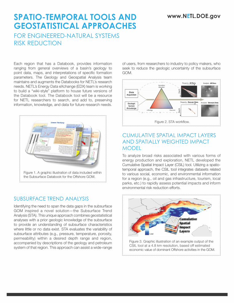
of users, from researchers to industry to policy makers, who seek to reduce the geologic uncertainty of the subsurface GOM.
CUMULATIVE SPATIAL IMPACT LAYERS AND SPATIALLY WEIGHTED IMPACT MODELTo analyze broad risks associated with various forms of energy production and exploration, NETL developed the Cumulative Spatial Impact Layer (CSIL) tool. Utilizing a spatio-temporal approach, the CSIL tool integrates datasets related to various social, economic, and environmental information for a region (e.g., oil and gas infrastructure, tourism, local parks, etc.) to rapidly assess potential impacts and inform environmental risk reduction efforts.
Each region that has a Databook, provides information ranging from general overviews of a basin’s geology to point data, maps, and interpretations of specific formation parameters. The Geology and Geospatial Analysis team maintains and augments the Databooks for NETL’s research needs. NETL’s Energy Data eXchange (EDX) team is working to build a “wiki-style” platform to house future versions of the Databook tool. The Databook tool will be a resource for NETL researchers to search, and add to, preserving information, knowledge, and data for future research needs.
SUBSURFACE TREND ANALYSISIdentifying the need to span the data gaps in the subsurface GOM inspired a novel solution—the Subsurface Trend Analysis (STA). This unique approach combines geostatistical analyses with a prior geologic knowledge of the subsurface to provide an understanding of subsurface characteristics where little or no data exist. STA evaluates the variability of subsurface attributes (e.g., pressure, temperature, porosity, permeability) within a desired depth range and region, accompanied by descriptions of the geology and petroleum system of that region. This approach can assist a wide-range
Figure 1. A graphic illustration of data included within the Subsurface Databook for the Offshore GOM.
Figure 2. STA workflow.
Figure 3. Graphic illustration of an example output of the CSIL tool at a 4.8 km resolution, based off estimated economic value of dominant Offshore activities in the GOM.
SPATIO-TEMPORAL TOOLS AND GEOSTATISTICAL APPROACHESFOR ENGINEERED-NATURAL SYSTEMS RISK REDUCTION
www.NETL.DOE.gov
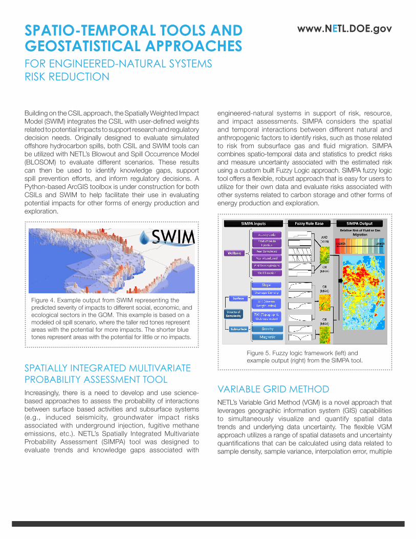
Building on the CSIL approach, the Spatially Weighted Impact Model (SWIM) integrates the CSIL with user-defined weights related to potential impacts to support research and regulatory decision needs. Originally designed to evaluate simulated offshore hydrocarbon spills, both CSIL and SWIM tools can be utilized with NETL’s Blowout and Spill Occurrence Model (BLOSOM) to evaluate different scenarios. These results can then be used to identify knowledge gaps, support spill prevention efforts, and inform regulatory decisions. A Python-based ArcGIS toolbox is under construction for both CSILs and SWIM to help facilitate their use in evaluating potential impacts for other forms of energy production and exploration.
SPATIALLY INTEGRATED MULTIVARIATE PROBABILITY ASSESSMENT TOOLIncreasingly, there is a need to develop and use science-based approaches to assess the probability of interactions between surface based activities and subsurface systems (e.g., induced seismicity, groundwater impact risks associated with underground injection, fugitive methane emissions, etc.). NETL’s Spatially Integrated Multivariate Probability Assessment (SIMPA) tool was designed to evaluate trends and knowledge gaps associated with
Figure 4. Example output from SWIM representing the predicted severity of impacts to different social, economic, and ecological sectors in the GOM. This example is based on a modeled oil spill scenario, where the taller red tones represent areas with the potential for more impacts. The shorter blue tones represent areas with the potential for little or no impacts.
engineered-natural systems in support of risk, resource, and impact assessments. SIMPA considers the spatial and temporal interactions between different natural and anthropogenic factors to identify risks, such as those related to risk from subsurface gas and fluid migration. SIMPA combines spatio-temporal data and statistics to predict risks and measure uncertainty associated with the estimated risk using a custom built Fuzzy Logic approach. SIMPA fuzzy logic tool offers a flexible, robust approach that is easy for users to utilize for their own data and evaluate risks associated with other systems related to carbon storage and other forms of energy production and exploration.
VARIABLE GRID METHODNETL’s Variable Grid Method (VGM) is a novel approach that leverages geographic information system (GIS) capabilities to simultaneously visualize and quantify spatial data trends and underlying data uncertainty. The flexible VGM approach utilizes a range of spatial datasets and uncertainty quantifications that can be calculated using data related to sample density, sample variance, interpolation error, multiple
SPATIO-TEMPORAL TOOLS AND GEOSTATISTICAL APPROACHESFOR ENGINEERED-NATURAL SYSTEMS RISK REDUCTION
Figure 5. Fuzzy logic framework (left) and example output (right) from the SIMPA tool.

www.NETL.DOE.gov
Contacts
simulations, etc., to create an integrated visualization of data and uncertainty. The intuitive manner of the VGM helps communicate the relationship between uncertainty and spatial data to effectively guide research, support advanced computation analyses, and help inform research, management, and policy decisions. The VGM approach is being developed into a Python Add-in extension and toolbar for ArcGIS, providing users the capabilities to utilize the VGM for their datasets, analysis, and models in support of their decision making needs.
Jennifer BauerPrincipal Investigator Geospatial [email protected]
Brian DresselSupervisor, Geo-Analysis & Monitoring TeamGeological & Environmental [email protected]
Figure 6. The workflow above summarizes how the VGM can be applied to spatial data (left) to produce an output that communicates both the data and any uncertainty information. By representing data trend (using colors) and uncertainty (using grid cell sizes) simultaneously, either as an overlay on top of a more traditional continuous raster interpolation (middle) or by associating the data values with the grid cells (right).
BENEFITSNETL’s Geology and Geospatial analysis team continues to advance these and other spatio-temporal and geostatistical tools and approaches to support DOE’s mission and goals for safe, reliable, and enduring access to domestic energy resources. In addition, these approaches complement NETL’s existing capabilities such as NETL’s BLOSOM, to provide robust analyses, enhance applications of NETL’s Energy Data eXchange (EDX) and web mapping application, Geocube, and provide efficient, flexible, data-driven methods to assess and reduce risks related to various forms of energy exploration and production.
AECOM | Oak Ridge Institute for Science and Education (ORISE) | Oregon State University | Pacific Northwest National Laboratory
Research Partners
SPATIO-TEMPORAL TOOLS AND GEOSTATISTICAL APPROACHESFOR ENGINEERED-NATURAL SYSTEMS RISK REDUCTION