Embed Size (px)
Citation preview

Abstract. The use of object-orientation for both spatial data and spatialprocess models facilitates their integration, which can allow explorationand explanation of spatial-temporal phenomena. In order to betterunderstand how tight coupling might proceed and to evaluate the possiblefunctional and efficiency gains from such a tight coupling, we identify fourkey relationships affecting how geographic data (fields and objects) andagent-based process models can interact: identity, causal, temporal andtopological. We discuss approaches to implementing tight integration,focusing on a middleware approach that links existing GIS and ABMdevelopment platforms, and illustrate the need and approaches withexample agent-based models.
Key words: Object-orientation, Agent-based models, Spatial-temporal mod-eling, Topology
1 Introduction
This paper addresses the representation of both form and process, asspatial data models and spatial process models, respectively, and howrelationships between these representations might be structured to betterfacilitate scientific inquiry and application. Raper and Livingstone (1995)
The authors acknowledge financial support from the U.S. National Science Foundation under
the Biocomplexity in the Environment Program, Coupled Human-Natural Systems, grant #
BCS-0119804. Pam Sydelko of Argonne National Laboratory contributed greatly to the
description of the Red-Cockaded Woodpecker Model. The Center for the Study of Complex
Systems at the Univesity of Michigan provided computer resources and other support. Daniel
Miller, also of Argonne National Laboratory, contributed to the description of the Infrastruc-
ture SymSuite. Argonne National Laboratory, a U.S. Department of Energy Office of Science
laboratory, is operated by The University of Chicago under contract W-31-109-Eng-38. We
thank Kevin Johnston at ESRI for his support and encouragement.
J Geograph Syst (2005) 7:25–47
DOI: 10.1007/s10109-005-0148-5
Spatial process and data models:Toward integration of agent-based models and GIS
Daniel G. Brown1,3, Rick Riolo3, Derek T. Robinson1,3,
Michael North2, and William Rand
3
1 School of Natural Resources and Environment, University of Michigan, 430 E. University,
Ann Arbor, MI 48109-1115,USA (e-mail: [email protected])2 Argonne National Laboratory3 Center for the Study of Complex Systems, University of Michigan
Received: 13 November 2003 / Accepted: 25 October 2004
addressed this same issue in the context of geomorphological processes andphenomena. Their definitions of process and data models suffice for ourpurposes. ‘‘Process models generally express theories predicting the natureof the exchange of energy and mass within systems, over time.’’ (Raperand Livingstone 1995; P. 361). In a broader context, this definition couldbe expanded to include exchange of ideas, culture, viruses, etc. ‘‘Bycontrast, data models express theories predicting the structure of the real-world domains in terms of entities and their attributes organized in inter-related sets. One of the basic problems encountered when ‘coupling’environmental models with GIS is that the former are specified as processmodels while the latter are specified as data models’’ (Raper andLivingstone 1995; P. 361). In addition, they argue that progress inobject-oriented data modeling presents a tremendous opportunity forcoupling with object-oriented process models. This is an argument wepursue here.Geographic information systems (GIS) use multiple spatial data models
for representing and storing information about phenomena with spatiallocation and/or extent (Lo and Yeung 2002). The focus of data models inGIS has been on spatial, at the expense of temporal, dimensions (Peuquet2002). Space and time can be defined in absolute or relative terms (Blaut1961; Couclelis 1997; Wachowicz 1999; Goodchild 2002). Whereasabsolute space and time offer a rigid geometric structure within whichphenomena are referenced, the relative view references location largely interms of relationships, topological and temporal, between features(Peuquet 2002). Object-oriented data models, which have grown increas-ingly sophisticated in GIS (Leung et al. 1999), assign location as anattribute of features rather than of the space itself, and allow represen-tation of relative space. In contrast to GIS, process models make use ofsophisticated representations of time and behavior, often at the expense ofsophisticated representations of space and spatial relationships. Byassigning temporal behavior as an attribute of objects rather than ofthe environment, object-oriented process models (e.g., individual-basedand agent-based models) allow for a relative view of time, in whichobjects are updated asynchronously (Westervelt and Hopkins 1999), asopposed to updating all at once (i.e., synchronously).In this paper we address the coupling of GIS-based data models with
agent-based process models. After reviewing fundamental types of data andprocess models and implications for their coupling, we review the successesachieved in coupling synchronous models of change with raster-based GIS.Next, we identify the largely unrealized opportunities for coupling object-based spatial process models with multiple GIS data models. We describefour key relationships that affect the interactions between geographic data(fields and objects) and agent-based (i.e., object-oriented) process models.We describe some alternative approaches to implementing GIS-ABMintegration, focusing on an approach that involves development ofmiddleware to manage connections between agents and spatial features,and some implementation issues. Then, the relationships and some of theimplementation approaches are illustrated by describing four models thatmake use of them in common combinations.
26 D. G. Brown et al.

2 Spatial data models
Spatial data models describe two fundamentally different conceptions ofspace. The field view represents space as a continuously varying distributionof geographic variables, and the raster data model is often used toapproximate this view by discretizing an absolute space and subdividing itin regular intervals. In contrast, the object view focuses on discrete entities,which have location, some level of spatial extension and attributes, and areusually represented as spatial features (i.e., points, lines or polygons) using avector data model. Though many phenomena can be reasonably representedas either fields or objects, some geographic phenomenon have both field andobject characteristics, and might require a combination of these views. Oneexample is an aggregation of many discrete objects, created as outputs froman optimization algorithm, that represents a solution space as a field ofobjects (Cova and Goodchild 2002). Alternatively, an object, like a stormcell, can exhibit continuous spatial variation (e.g., wind speed) within itsspatial extent (Yuan 2001).Object-oriented data models, which make use of hierarchically nested
entity definitions that encapsulate behaviors (e.g., about allowable entries inthe database) and inherit data characteristics from higher levels, havebecome mainstream within commercial GIS, for example in the form of thegeodatabase structure within ArcGIS (ESRI 2004). In addition to facilitatinga closer conceptual relationship between features in the database anddiscernible entities in the real-world, object-orientation also facilitates theimplementation of relative space. One way to represent relative locationusing object-oriented GIS is through topological rules that can proscribecertain kinds of spatial relationships and require others. For example, atopological rule can specify that a spatial feature in one layer (e.g., a house)may not overlap a spatial feature in another layer (e.g., a lake). Thesetopological rules describe certain logical characteristics of the physical worldthat can prevent erroneous placement of features.Several researchers have proposed extensions to existing spatial data
models to provide richer representations of time. These extensions have used(a) spatio-temporal objects to represent evolution of the geometry, proper-ties, and location of entities through time (Worboys 1994), (b) eventsequences on a grid to keep track of how a process evolves (Peuquet andDuan 1995), (c) events and processes to describe spatio-temporal phenomenathat possess both field and object characteristics (Yuan 2001) and (d)versioning, through the use of ‘‘amendment vectors,’’ to represent boundarychanges (Langran 1992). By explicitly including time, these extended spatial-temporal data models facilitate visualization and analysis of dynamicattributes and features defined with spatial and temporal extension.However, even with inclusion of temporal referencing or time-basedattributes, these data models have not (with few exceptions; Raper andLivingstone 1995) included explicit representations of the processes (i.e.,sequences of operations) by which spatial features change and move,focusing instead on representing the changing structure of the phenomena.Representations of process are important, however, in explaining why thestructures change as they do and are also required if analytical operations areto be implemented across space and time, for example if we desire to
Integrating agent-based models and GIS 27
interpolate features and/or attributes across time. Such representations ofprocess, then, interact with and extend the capabilities of spatio-temporaldata models.
3 Spatial process models
A variety of approaches exist to represent dynamics in process-based models.We borrow, in a general sense, two conceptual views of spatial processes fromthe Eulerian and Lagrangian views of fluid dynamics. The Eulerian viewdescribes the processes that influence properties (e.g., temperature) at fixedlocations, and thus is a description of change. The Lagrangian perspective,on the other hand, tracks the changing location of particles through spaceand, therefore, is a description of movement. Many processes in the realworld could be reasonably described as either Eulerian or Lagrangian. Forexample, as a cold air mass moves (described as Lagrangian motion) over alocation it causes the temperature at that location to drop, affecting anEulerian change. The duality between models of change versus movementcan be extended to describe nearly any geographic process, and the choice ofwhich approach to take for representing any given process is made on thebasis of both conceptual and practical considerations. Here, we describe howchange and movement models interact differently with spatial data models.
3.1 GIS-based change models
Perhaps the simplest models of change are based on the Markov process, inwhich the state of a random variable at a location in the future is onlydependent on its current state (Sheynin 1988). For example, many earlycomputer simulations of land-use change were based on Markov formula-tions (Burnham 1973, Bell 1974). A variety of cellular models have enhancedthese Markov formulations by incorporating spatial interactions into thecalculation of probabilities of change at locations (e.g. Verburg et al. 1999;Brown et al. 2000). For example, to investigate diffusion of innovation andits effects on regional-level behavior and spatial patterns, Hagerstrand (1967)developed cellular models using local interaction rules. The probabilities offuture states were based on the surrounding states within some window.Tobler’s (1970; 1975; 1979) ‘‘cellular geography’’ built on Hagerstrand’sapproach, and perhaps on the work of Burks (1970) who was a contempo-rary of Tobler’s at the University of Michigan, to model change in a varietyof systems, including urban development in Detroit (Batty 1997). The workof Burks (1970), his mentor von Neumann (1966), and others (Ulam 1962)resulted in the development of cellular automata (CA), which use simplerules to represent complex dynamics resulting from social, physical,biological and computational processes (Toffoli and Margolus 1987). Intheir purest form, CA represent change on a lattice deterministically, usingrules that relate the current state at a location and at immediatelysurrounding locations with the next state at that location.The logic of integrating field-based spatial data models with change-based
spatial process models is strong (Kemp 1997) and, for this reason, has beenexploited in a variety of GIS. Eastman (2001) introduced into a recent
28 D. G. Brown et al.

version of Idrisi, a raster GIS system, a spatial modeling component thatcombines a Markov process representation of state changes with a cellularmodel to introduce spatial interactions. In addition, Idrisi now includes agraphical modeling environment, in which the ‘‘map algebra’’ functionscommon in raster GIS (Tomlin 1990) can be applied iteratively to maps indiscrete time steps to implement change processes. It is relatively simple, forexample, to employ spatial filtering and map reclass operations iteratively toimplement simple cellular automata within this environment. Burrough andcolleagues at Utrecht University (Van Duersen 1995; Wesseling et al. 1996)developed a system, called PCRaster, that extends the map algebra to includerepresentations of time and dynamics. The system maintains a timer to trackthe progression of time in discrete steps, and includes explicit representationof change and transport processes.Discrete-state spatial models of change processes operate on a discrete
representation of continuous space and employ discrete time steps andsynchronous updating to represent time. Models of flow and transportprocesses based on fluid mechanics, such as those used to representhydrological flow and atmospheric processes, are based on continuousnotions of space and time (e.g., through the use of differential equations).However, their implementation with GIS usually involves a discretization ofspace and time similar to the discrete state models above (Maidment 1996).The processes in this discretized environment are commonly represented asfinite difference or finite element models, which essentially represent thefuture state at a location, in terms of the quantity or flux of the fluid ormaterials, as a function of its current state and flux and its surrounding statesand fluxes. These common discrete numerical solutions create fluid modelsthat interact with spatial data models in very similar ways to the discrete-state models.
3.2 GIS-based movement models
The most common GIS-based movement models involve models of flow andtransport, e.g., hydrological flow and transport of pollutants. However,while flow and transport models represent the dynamics of movement, theunderlying implementation is usually expressed in terms of updating (orchanging) states, which can include fluxes, at fixed locations and over discretetime steps. Similarly, though CA and other cellular models focus onmodeling changes in state, emergent features can appear to ‘‘move’’ in space.Conway, in developing his ‘‘Game of Life’’ illustrated the emergence ofmoving features (i.e. ‘‘gliders’’) on the basis of simple local change rules(Gardner 1971). Fire is another emergent feature that seems to spread acrossa landscape as a result of the interactions encoded in the individual statechanges (Clarke et al. 1994). So, by explicitly representing how states changeat a location, some types of movement can be captured implicitly. Animportant limitation of this approach, however, is that geographic features(e.g., in an object-based spatial data model) are not represented explicitly inthe model. Moreover, the movement is implicit in the change rules, andcannot be queried directly. As a result, the relationship between the processas observed in the real-world (i.e., movement) and its representation in themodel is not always clear.
Integrating agent-based models and GIS 29

GIS, in general, do not include operators that explicitly describe movementof features (De Vasconcelos et al. 2002; Westervelt and Hopkins 1999). Forthis reason, it is relatively more difficult to implement object-orientedmovement models than change models in close coupling with spatial data.However, such coupling is a logical next step in merging spatial data withspatial process representations.
3.3 Agent-based models and object-based movement
Object-oriented process models, which include individual-based models(IBM) commonly used in ecology (DeAngelis and Gross 1992) andagent-based models (ABM) common in the social sciences (Epstein andAxtell 1996), allow for modeling movement and have developed indepen-dently of GIS. The object-oriented framework of ABM involves identifi-cation of agents and of a temporal framework within which those agentsperform actions. While many different types of agents can exist, thefollowing general definition is common: an agent is a self-directed object,i.e., it has the ability to satisfy internal goals or objectives through actionsand decisions based on a set of internal rules or strategies (Iglesias et al.1999). These agents may be dynamic in either state (i.e., change) or space(i.e., movement) and may, through their actions, change the state orlocation of other objects, processes, or environments around them. Agentdynamics are most naturally implemented in an ABM by a set of behaviors(‘‘methods’’) that can include conditional decision making and other (non-linear) rules that distinguish them from mathematically continuous models(Parunak et al., 1998). The ability for Lagrangian motion (i.e., agentmovement) distinguishes ABM and other object-oriented modeling frame-works from the change-based spatial models described above. It alsocreates additional challenges for integrating these models with GIS, asdescribed in more detail below.ABM dynamics are defined at the level of (a) agent behaviors that result in
change and movement, and (b) the independent dynamics, if any, of non-agent objects. Thus to represent dynamics, ABMs are implemented asdiscrete event simulations (Zeigler et al. 2000), in which some kind of‘‘scheduling’’ mechanism handles the sequencing of agent behaviors andevents. An ABM may implement scheduled events in three ways:
– Events may be sequenced in a synchronous step-wise fashion. Forexample, each agent, set of agents or non-agent object is signaled toperform its tasks once at each time step or once every n time steps.
– An event may be scheduled to occur only once at some time step n. Anynumber of different events may be scheduled to occur in this fashionproviding a predetermined history of events to take place.
– The model may encapsulate ‘event-driven’ processes whereby model agentsmay trigger events to occur or may add events to the schedule or queue ofevents to take place (Ropella et al. 2002).
The choice of both an event-scheduling approach and a temporalresolution (i.e., frequency of time steps) can have serious consequences forthe behavior of the model (Liu and Andersson 2004). Though more research
30 D. G. Brown et al.

is surely needed on the consequences of these choices, they make it clear thatABMs have significant flexibility with respect to their handling of time.On the other hand, ABMs often use relatively limited representations of
space. For example, ABMs frequently use hypothetical spaces based onsquare or hexagonal tessellations, and only recently have ABMs begun to usereal-world spatial data. To avoid edge effects on the performance of somemodels, researchers commonly use a toroidal representation of space, whichwraps around from top-bottom, left-right, and vice versa. The rich temporalrepresentations (agents and processes) of agent-based models, thereforecomplement the spatial data representations (fields, objects and functions) ofGIS. The object-oriented nature of both presents tremendous opportunitiesfor their integration.
4 Relationships affecting process-data coupling
Given the complementarities of spatial data models (fields and objects) andagent-based (i.e., object-oriented) process models, and their combinedpotential to improve on integrated representations of spatial patterns andtemporal processes, we argue that tight coupling of models and data withinABM and GIS, respectively, can reap benefits in terms of both efficiency,through reduced computing times, and capability, through new functional-ity. Attempts to integrate ABM and GIS techniques have raised severalconceptual and technical questions (Gimblett 2002). These issues broadly fallinto questions of ontology and process, i.e., how are entities and processesrepresented, and how do those representations interact, respectively. As aninstance of the former, Bian (2003) concluded that the environment within anindividual-based model can be represented as either patch-based (i.e., object-based), maintaining object-orientation in both the model and data, or field-based, such that object-oriented individuals interact with a discretizedenvironment of attributes. She discounts the value of treating all cells in agrid-based environment as objects on both technical (i.e., due to inefficien-cies) and ontological (i.e., poor match to conceptual view of fields) grounds.More generally, developing models that make use of both GIS and ABM
techniques requires the specification and implementation of relationshipsbetween agent-level processes and spatial data. In order to facilitate betterunderstanding of the technical and conceptual issues that can arise whencreating models that tightly couple GIS and ABM techniques, we presentbelow a description of four key relationships that affect the integration of adynamic GIS data base and an agent-based process model (Fig. 1). Wedescribe how the relationships affect representations of dynamic geograph-ical systems with the goal of better understanding how ABM and GIStechniques can be coupled to treat spatial and temporal dynamics equallywell. Approaches to implementing these relationships are taken up in a latersection.
4.1 Identity Relationships (Fig. 1a)
By defining an identity relationship between an agent and a spatial feature orfeatures, GIS techniques can be used to store the geographic extent and
Integrating agent-based models and GIS 31

attributes of the feature, while ABM techniques represent the behavior of theagent and the change in associated feature(s). Thus (a) spatial featuresassociated with agents can move or change, and (b) attributes of featuresassociated with agents can change. The spatial features that are associatedwith agents can be stored in the GIS as polygons, lines, points, or cells in araster. It is possible for an agent to be associated with only one spatialfeature (i.e., a one-to-one relationship) or more than one spatial feature (i.e.,a one-to-many relationship). In any given model, there also can be somespatial features that are not related to agents and some agents that are notrelated to spatial features. One example of an identity association is vehiclesrepresented as agents, with movement rules, that are associated with pointsand attributes in a spatial database (Deadman and Gimblett 1994). Thepoints move when the vehicles move and the attributes of the points changeas the vehicles change (e.g., their fuel levels change). As a given model
Fig. 1. Conceptual illustration of four key relationships that affect the interaction of spatial data
models and their associated techniques and agent-based process models and their associated
techniques. The four relationships are (a) Identity Relationships, (b) Causal Relationships, (c)
Temporal Relationships, and (d) Topological Relationships. The graphic portrays the
relationships conceptually and is not meant to describe any particular implementation
32 D. G. Brown et al.

progresses, the agents might update their own locations, shapes, and/orattributes, affecting changes in a spatial database and/or graphic display. Thebehavior of an agent can interact with (i.e., affect or be affected by) otheragents, whether or not they have associated spatial features. For some typesof movement or spatial interactions, however, it might be necessary tocompute the spatial relationships among features (see item 4 below).
4.2 Causal relationships (Fig. 1b)
In many models, agents have the ability to take actions that affect spatialfeatures and/or their attributes, even if there is no identity associationbetween the agent and the spatial feature(s) it is acting on (i.e., non-agentfeatures). Agents can take actions that result in changed locations orattributes of features, or they can take actions that change the values of anattribute on a field (e.g., a raster). For example, a public health agency (i.e.,agent) could implement a disease control strategy that involves treatingwetlands (i.e., polygon feature) with mosquitocides or draining them toreduce the prevalence of mosquito-borne diseases. The actions of the agencyaffect the attributes (i.e., mosquito abundance) and/or spatial expression(i.e., through draining) of the polygon features representing the wetlands.Note that the behavior of other agents, e.g., nearby households, might besubsequently affected by the changes in the spatial features, makingappropriate handling of temporal dynamics important.
4.3 Temporal relationships (Fig. 1c)
Two types of actions in a coupled process-data model are fundamentallytime-sensitive: (a) the actions of the agents and (b) the updating of attributesor locations of features in a database or display. Either can be handled usingsynchronous or asynchronous approaches. When actions are handledsynchronously, the coordination of these dynamics is relatively straightfor-ward. All agent actions can be carried out at once, and changes to featuresand attributes are written to the database (and to the display) at the sameinstance. (Note: In non-parallel computer implementations, such modelscarry out the changes in series, but they represent processes that areinstantaneous.) To record the history of the process, the model might createa new attribute, set of spatial features, or raster layer, which is saved to adatabase along with some indicator of the time. There is little value in usingasynchronous updates to a database, when the model runs synchronously,because the model does not change the features or attributes between discretetime steps. However, synchronous database updates can be made lessfrequently than synchronous model time steps.When agent actions are asynchronous, database updates can be made
either synchronously or asynchronously. When handled synchronously,database updates reflect snapshots of a model run taken at regular timeintervals and are made in a similar manner as a synchronous model,described above. However, asynchronous model actions used together withsynchronous database updates can complicate issues associated with the‘‘speed of light’’ problem. The problem is, if an agent requests a change in
Integrating agent-based models and GIS 33
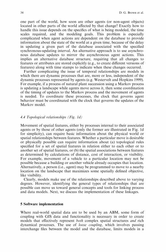
one part of the world, how soon are other agents (or non-agent objects)located in other parts of the world affected by that change? Exactly how tohandle this issue depends on the specifics of what is being modeled, the timescales required, and the modeling goals. This problem is especiallycomplicated when agent actions are dependent on the database to provideinformation about the state of the world at a given time, because of the delayin updating a given part of the database associated with the specifiedsynchronous-updating interval. An alternative approach is to use asynchro-nous database updates to mirror the asynchronous agent actions. Thisimplies an alternative database structure, requiring that all changes tofeatures or attributes are stored explicitly (e.g., to create different versions offeatures) along with time stamps to indicate when these changes occurred.Further complicating the issue of temporal relationships are models in
which there are dynamic processes that are, more or less, independent of thedynamic processes represented by agents (e.g. Westervelt and Hopkins 1999).For example, if a process of natural plant succession using a Markov processis updating a landscape while agents move across it, then some coordinationof the timing of updates to the Markov process and the movement of agentsis needed. To coordinate these processes, the clock that governs agentbehavior must be coordinated with the clock that governs the updates of theMarkov model.
4.4 Topological relationships (Fig. 1d)
Movement of spatial features, either by processes internal to their associatedagents or by those of other agents (only the former are illustrated in Fig. 1dfor simplicity), can require basic information about the physical world orspatial relationships between features. Whether a particular move is desirableor physically possible can require information about (a) topological rulesspecified for a set of spatial features in relation either to each other or toanother set of spatial features, or (b) the spatial associations between featuresas determined by calculations of distance, cost of interaction, or visibility.For example, movement of a vehicle to a particular location may not bepossible because a building or another vehicle already occupies that location.Alternatively, a person (i.e., agent) may be programmed to move to a nearbylocation on the landscape that maximizes some spatially defined objective,like visibility.Clearly, models make use of the relationships described above to varying
degrees. However, identifying the general types of relationships that arepossible can move us toward general concepts and tools for linking processand data models. Next, we discuss the implementation of these linkages.
5 Software implementation
Where real-world spatial data are to be used by an ABM, some form ofcoupling with GIS data and functionality is necessary in order to createmodels that effectively represent both complex spatial structures and richdynamical processes. The use of loose coupling, which involves passinginterchange files between the model and the database, limits models in a
34 D. G. Brown et al.

variety of ways. First, computational efficiency is low because of the costs ofinput and output. Because many models are very computationally demand-ing, this is an important issue. Secondly, loose coupling precludes direct useof existing database query and analysis functions within the models(Gimblett 2002) and direct use of modeling functions with the database.For these reasons, more tightly coupled models are desirable. While tightercoupling provides many advantages, such coupling also raises a number ofimplementation issues, which we discuss next.Implementing tightly coupled process-data models requires choosing an
appropriate architectural platform. Initial attempts to tightly couple ABMand GIS functionality (several of which are described in the Examplessection) have taken an ABM-centric approach. One of these approaches hasinvolved the use of software libraries of GIS functions within ABMs and theencapsulation of features and attributes with the agents, where there areidentity relationships. For example, the GeoTools Java library (http://www.geotools.org), which includes GIS data management and visualizationfunctionality, is available for use by models developed with the RePast ABMdevelopment platform (University of Chicago 2003). It is also possible toimplement (i.e., write code for) spatial data management and analysisfunctions within a model. However, the costs of this strategy increasedramatically as a model’s use of frequent updates to spatial data andcomplicated spatial analysis functions grow. Functions that are readilyavailable within the GIS framework need to be written, debugged, tested,and documented within the ABM framework; thus the development timeincreases. Also, code developed in the ABM to perform GIS-like tasks maynot be as efficient as that within a GIS. This is partly because ABM platformsare not built to handle primarily spatial interactions, but also because GISsystems have developed over many years with attention to increasedefficiency. Additionally, use of standard GIS tools for spatial analysisimproves functional transparency of a model, as the model makes use orwell-known and understood algorithms.A GIS-centric approach to coupling, i.e., implementing ABM functions
and models within a GIS system and user interface, is an attractivealternative. A GIS-centric coupling would allow such models to runinteractively within the graphical user interface of a GIS package. Giventhe large GIS user base, such accessibility could expand the potential userbase for any given model. A complement of the ABM-centric approach, GIS-centric coupling can be carried out using software libraries of ABM functionsaccessed through the GIS interface. To fully embed ABMs within a GISwould require the ability to encapsulate a wide range of agent behaviors withspatial features and a means of keeping and coordinating time. The obviousdifficulties of this approach arise because GIS do not usually provide thesecapabilities. They therefore lack the most basic tools required for agent-based model creation and use. We know of no existing implementation of anABM embedded completely within a GIS environment.
5.1 Integrated systems
A third broad approach to integration is centered on neither ABM nor GIS,but makes use of the functionality available in both environments. One
Integrating agent-based models and GIS 35

alternative is to build such an integrated system from the ground up. Forexample, Torrens and Benenson (In Press) argue for the implementation ofgeographic automata systems (GAS), which tightly couple spatial data andprocess models within a single, integrated system. They demonstrate theObject Based Environment for Urban Systems (OBEUS), which is a modeldevelopment environment, like RePast (Collier 2000) and Swarm (Minaret al. 1996), but with particular emphasis on spatial interactions.In contrast to building a completely new system from the ground up, an
intermediate ‘‘middleware’’ alternative builds on existing platforms andinvolves the development of software to handle the identity and causalrelationships between the agents within an ABM environment and spatialfeatures within a GIS environment, as well as the temporal and topologicalrelationship issues that arise in the model. Such middleware could allow amodel to make use of the tools that are most appropriate for a given task.Rather than providing all functionality within one system, the middlewaremanages connections between systems, so that the relationships describedabove can be implemented. An important advantage of this approach is thatmodels can both be developed using an ABM platform and run andvisualized within a GIS platform. It also takes advantage of the substantialinvestments in developing existing GIS and ABM environments. Althoughthis approach does not take full advantage of the ontological and practicalbenefits of encapsulation within an object-oriented framework, the fact thatboth ABM and GIS are object-oriented makes the coupling possible.Further, we see this as a practical direction for short- to medium-termdevelopment, because the approach requires only linking existing systems,rather than building new ones.A potential disadvantage of creating a model that relies on both GIS and
ABM toolsets is increased start-up costs, because of the added complexityrequired to handle both software environments and their integration. It isimportant to avoid the temptation to use tools that are more sophisticatedthan necessary for a given model. For example, if a model requires onlyminimal spatial analysis and interaction with real spatial data, tight couplingmay be unnecessary. Another disadvantage can be the dependence of a
Fig. 2. A composite diagram showing all relationships between process models and spatial data
models as they are displayed separately in Fig 1 (legend is the same)
36 D. G. Brown et al.

model on two toolsets instead of one. A model is more likely to sufferobsolescence because of changes in either the GIS or ABM platforms.Platform dependence might also turn off potential users who do not have orlike one or both of the choices of platforms.An example of this approach, implemented to link RePast and ArcGIS, is
illustrated in the Infrastructure SymSuite example described below. Themodel developer simply names a class of agents to match the name of afeature layer within ArcGIS, and names agent properties to match the namesof attributes in the layer. When the model is run, the middleware creates anagent for each feature and sets the agent properties according to the featureattributes. Changes in agent properties also cause updates to the attributes ofGIS features.
5.2 Handling the four relationships through middleware
Implementing a middleware approach between ABM and GIS first requiresestablishment of identity relationships between agents and features. Torepresent identity relationships, a software mapping is required to identifyobject ID(s) in the GIS database associated with each agent, and vice versa.As agents perform actions, they implement a change, or send messages to theGIS software that requests a change, in the location and/or attributes of thespatial features that are written to a graphical output and/or to the database.To implement causal relationships, in which the state of the GIS affects the
behavior of agents and the behavior of the agents may affect the state of theGIS, agents in the ABM query the GIS for objects (some of which might beassociated with other agents) with particular locational or attribute charac-teristics and may affect changes to their location or attributes.Because ABM development platforms (like Swarm and RePast) have the
potential for richer representations of time, and have better mechanisms forimplementing dynamical processes and relationships at various time-scales,coordination of temporal relationships should be managed by the commontemporal reference maintained by the ABM. This can be implemented byeither directly requesting the GIS to carry out updates at particular (ABM)time steps, or by communicating time-step references to the GIS as needed.The simplest cases are those in which all dynamics are represented in theABM, and the GIS is primarily used as a database and graphic displaytool. One way to implement coordination of time, when the GIS platformincludes an autonomous process model (like the Markov model describedin the discussion of temporal relationships) is to have the ABM send amessage to the GIS indicating that so many ticks on the ABM clock haveelapsed and that it is time for the GIS model to advance and update thelandscape maps. This, of course, requires careful coordination of themeaning of time steps.Because GIS have more sophisticated representations of space, topology,
and spatial relationships, the topological relationships should be handledwithin the GIS. Communicating topological and spatial relationships suchthat they provide constraints on agent behavior could be implemented by (a)having agents query the GIS each time a move is attempted, or (b) havingagents that want to move act by sending a ‘‘try to move’’ message to the GIS,for example using feature editing functions. In the latter case, the GIS could
Integrating agent-based models and GIS 37

respond in turn by either moving the agent as requested (and thus updatingthe GIS database and associated graphical displays), or by returning amessage to the agent about why the move could not be executed (e.g., thelocation was already occupied).
6 Examples
Here we describe several models to illustrate interactions between spatialdata and spatial processes and, therefore, the different requirements forintegrating ABM and GIS functionality. The specific cases were selected toreflect commonly encountered types of models. These examples demonstratemultiple types of models, in terms of the four relationships listed above, andimplementation strategies. Focusing on the middleware developmentapproach used in the last example, we address future developments neededto improve on the existing implementation.
6.1 Urban land-use change
In a project on land-use change at the urban-rural fringe, called SLUCE(http://www.cscs.umich.edu/sluce), we are studying how individual decision-making drives land-use decisions that affect and are affected by environ-mental systems. The investigation utilizes an ABM called SOME (SLUCE’sOriginal Model for Exploration) to model the residential location decisionprocess (Rand et al. 2003; Brown et al. 2005). This model incorporates twokinds of agents: homebuyers and service centers. It also incorporates severalspatial data layers that characterize aesthetic quality, roads, and locations ofcurrent development.Agents have no identity relationships with spatial features in this model,
though the service centers and homebuyers do participate in the land-changeprocesses. The primary relationships that exist in this model are causal. Theagents affect change in attributes on a grid-based landscape and theirdecisions are affected by the attribute values on that landscape. The residentsmake decisions about where to locate based on features such as aestheticquality, distance to service centers, and nearby density. Service centers areprogrammed to enter at specified intervals and to locate near recentresidential development. Thus, homebuyers are affected by environmentalqualities and then influence the behavior of the service centers, which in turninfluences the behavior of future homebuyers by changing the distances toservice centers. This model uses the simplest class of temporal relationships,i.e., all agents entering the system each time step perform their actions and theABM updates the raster database before the next time step begins.Topological relationships include checking if development is prohibited at alocation because other agents have already developed it or because develop-ment is not possible, e.g. lakes or greenbelts. Also, nearby density of a givencell is calculated using a kernel calculation of the number of developmentsaround each cell, and distance to service centers is calculated for each cell.The existing implementation of this model uses elements of both loose and
ABM-centric coupling. The grids of initial conditions are read frominterchanges file that are produced by the GIS. Results from the ABM,
38 D. G. Brown et al.

i.e., maps showing cells occupied by residents and service centers (Fig. 3a),are then written to the same interchange format that can be read into the GISfor viewing and analysis. Functions written within the model are used tohandle the spatial data, including special functions written to carry outspatial analyses (e.g., window operations and checking for occupiedlocations, and distance calculations). Because of the relatively simple typesof interaction between the model and the database (Fig. 3b), the biggestbenefits of tighter integration would come from enhanced availability ofspatial analysis functionality (from the GIS) within the model.
6.2 Military mobile communications
The goal of the Tactical Sensor and Ubiquitous Network Agent-ModelingInitiative (TSUNAMI) is to directly support a shift toward ‘‘information
Fig. 3. The SOME model. aMap showing cells that are occupied by residents (black) and service
centers (gray) at a particular time during the run of the SOMEmodel. b Conceptual relationships
between process and spatial data models
Fig. 4. The TSUNAMI Model. a Local battle space visualization with geography and agent
locations. The agent locations and geography are for illustrative purposes only. b Conceptual
relationships between process and spatial data models. Only jeeps and tanks are shown for
illustration, though other agents are also present
Integrating agent-based models and GIS 39

superiority and dispersed, networked force capabilities’’ within the US Navy(Clark 2002) by simulating military mobile communications in and aroundamphibious landing areas. TSUNAMI simulates battle space motion andinteraction over real terrain data, applies rule sets to simulate message traffic,simulates quality of service protocols, and simulates exercise data manage-ment choices on a case-by-case basis, to model traffic loading using realistictactical network architectures. The TSUNAMI simulation tracks the currentstate of global and local battle spaces (Fig. 4a)In this model, all agents (including soldiers, tanks, jeeps, airplanes, and
ships) have identity relationships with spatial features (i.e., points) (Fig. 4b).Attributes of the agents include location, current heading, fuel or batterylevels, communications equipment, a communications routing capability thatuses specific protocols, differing sensing capabilities, ranges of mobility, andsets of fuel and battery lifetimes. Causal relationships are described throughthe agents’ abilities to move, to sense surroundings, and to communicate.Each of these basic behaviors has appropriate variations that add detail andfidelity. For example, agents move throughout the space in three differentways: (a) responsive motion to fight, follow, or flee other agents; (b) scriptedmotion defined by the model users before a simulation run; and (c) randommotion when no other options are available. The agents move across thelandscape and surrounding waterways and react to one another. The agentscan change their attributes based on the other agents they encounter as wellas the features of the terrain. For example, a tank may increase the poweroutput of one of its radios if it is obscured in mountainous terrain but has amessage for an allied aircraft circling nearby. Temporal relationships arehandled within the model through asynchronous event scheduling. As eachevent occurs, the agents determine their new status and then update the GISaccordingly (i.e., asynchronously). Topological relationships are utilized whenthe agents query the GIS to determine the locations of neighboring agentsand the type of terrain surrounding them. The model makes use of spatialanalysis functions within the GIS to carry out these queries, the results ofwhich are passed back to the model. By querying the landscape for allowablemoves, the model makes use of topological rules that are coded within theABM, but implemented with the help of GIS queries. A communicationsnetwork topology is constructed by the agents (i.e., within the ABM) usingselected self-configuring protocols.
Fig. 5. The IDLAMS model. a RePast Interface. b Conceptual relationships between process
and spatial data models
40 D. G. Brown et al.

This model is implemented through a tight coupling of the RePast platformand the Java-based OpenMap GIS (http://openmap.bbn.com). The couplingtakes an ABM-centric approach, in which GIS components were accessedthrough the ABM program. The grid-based landscape is currently handledwithin the ABM to avoid inefficiencies in converting this information backand forth from the GIS to the ABM. A more balanced integration of GIS andABM could provide for better handling and updating of raster layers.
6.3 Integrated dynamic landscape analysis and modeling system (IDLAMS)
The Integrated Dynamic Landscape Analysis and Modeling System (IDL-AMS) is an individual-based, spatially-explicit model of red-cockaded
Fig. 6. The Infrastructure SymSuite. a ArcGIS interface, with electric power infrastructure
locations, natural gas infrastructure locations and hypothetical critical components. The
infrastructure information shown in the example is for illustrative purposes only. b Conceptual
relationships between process and spatial data models
Integrating agent-based models and GIS 41

woodpecker populations (Fig. 5a). The goal of this system is to integrateecological models with decision support tools to allow military landmanagers and decision makers to balance mission preparedness with adiverse set of multiple land-use goals (Rewerts et al. 2000).In particular,there is a need to protect endangered species that find refuge from urbanencroachment on military bases.All agents in this model (i.e., representing individuals of the red-cockaded
woodpecker [Picoides borealis] and pieces of military equipment) have identityrelationships with spatial features (i.e., points for birds and areas for militaryequipment) (Fig. 5b). The causal relationships involve movement of birds andother agents and changes in the birds’ attributes as they grow and are affectedby other features and attributes. Military equipment (e.g., jeeps and tanks)affects the landscape as it moves across the terrain, including changing thesuitability of habitat for the birds and, potentially, destroying nest sites.Movement of birds from one place to the next characterizes nesting, breedingand feeding behaviors, based on Letcher et al.(1998). For example, the birdscan find open lands with appropriate trees for nesting and then choose thesetrees as nesting sites. This decision causes a change in an attribute of the agent(i.e., life cycle changes from non-nesting to nesting). This also affects a changein the raster landscape (i.e., from suitable nesting site to nest).Temporalrelationships in the model are handled in the ABM asynchronously. Themodel reads initial environmental data in the form of a grid and handles thisinformation within the ABM.The GIS is updated as events cause changes (i.e.,asynchronously) to the attributes and locations of features and to attributeson the grid-based landscape.The history of the processes is not saved, but thelast location and state are written to the GIS. Topological relationships, forexample when a bird evaluates nearby or all locations for possible movement,and are handled exclusively within the ABM.The model, like TSUNAMI, uses an ABM-centric tight coupling, using
functionality from the GIS (i.e., Java-based JeoViewer developed at ArgonneNational Lab) in a model written with RePast. Like the other models,IDLAMS maintains and updates the grid-based landscape map using spatialanalysis functions and asynchronous updating tools within RePast. Becausethe history of the process is not stored asynchronous updates to the GIS donot require time stamps, which would complicate the process. A moreintegrated approach could take advantage of GIS-based functions forupdating and analyzing raster layers.
6.4 Infrastructure simulation
The goal of the infrastructure simulation suite (Infrastructure SymSuite) is torepresent the operation of interdependent infrastructure systems such aselectric power grids, natural gas systems and telecommunications networks(Thomas et al.2003). The system models the complex interplay betweeninfrastructures to evaluate the effects of changes in one on the other andoverall system vulnerability (Fig. 6a)All agents in this model (including electric power lines, power generators,
power demands, natural gas pipelines, gas sources, gas storage, gasconsumption, and telecommunications systems) have identity relationshipswith spatial features (Fig. 6b). The feature attributes can change, but the
42 D. G. Brown et al.

features themselves do not move. All causal relationships, including effects ofone agent on another, are implemented within the ABM. For example,the unexpected rupture of a natural gas main will cause a drop in pressure atthe pipe’s endpoints. This drop in pressure in turn will slow and then stop thedelivery of natural gas to the destination endpoint of the pipe. This may in turnreduce or curtail the output of a natural gas-fired electric generator connectedto the pipe’s destination. The attributes within the GIS database of the gasmain, pipe endpoints, and generator are updated by the associated agents. TheABM handles all temporal relationships, including asynchronous processes,but the agents update the GIS database synchronously at fixed intervals, tosimplify the temporal data structure. The GIS database provides informationon the initial topological relationships between all features. Any changes to thetopology, e.g., a power line down, are modeled exclusively within the ABMand are not written back to the GIS because most such changes are temporary.The model uses tight coupling, in which updates to the GIS database and
the graphic interface are in real-time, as the model runs. The implementationuses middleware to manage the identity mapping between agent identifiersand spatial feature identifiers. In addition, it takes advantage of the fact thatthe GIS can store topological information, in addition to features’ locationsand attributes. The topological changes, as with all of the dynamics of themodel, are integrated by the ABM, written with RePast. An earlier version ofthis model, based on ArcSDE, used versioning within the GIS to allow theABM to store asynchronous, rather than synchronous, updates.
6.5 Future middleware development
A reasonable path for future development of such middleware is to furtherdevelop the causal, temporal, and topological relationships described above.For example, the application for which Infrastructure SymSuite wasdeveloped did not require that the agents and their associated features beable to move. An obvious extension is to allow the agents and their featuresto move. Moreover, topological connections between agents are read initiallyfrom the GIS and subsequently managed within the agent model. Anotherextension, then, would be to develop more dynamic links between thetopology of the agents and the topology of the features. Similarly, manymodels use neighborhood calculations on a grid-based environment, some ofwhich are implemented within the ABM. Because these calculations arecommon within GIS, it makes sense to implement them using the GISplatform. This extension is challenging because the common approach inGIS to performing a grid-based operation is to update the entire mapsimultaneously (i.e., synchronous updating). It is more efficient, in manycases, for an agent to update a cell value when needed, rather than updatingall cells simultaneously. Finally, a means to communicate information aboutthe clock of the ABM to the GIS, for the purposes of coordinating withagent-independent processes, if there are any, is needed.In addition to functional extensions, the middleware approach could be
written to accommodate multiple alternative GIS and ABM platforms. Sucha general system requires a very clear specification of the generic architectureof these linkages, which is beyond the scope of this paper.
Integrating agent-based models and GIS 43
7 Conclusions
The integration of spatial process and data models described in this papercan facilitate spatio-temporal inquiry into processes at the level of agents orindividuals and data about specific cases and places. For example, incorpo-rating real spatial heterogeneity into agent-based models will improve ourability to draw conclusions about the behavior of complex systems in realisticenvironments, which may be different from conclusions drawn with artificialenvironments. Model calibration and validation can be facilitated byproviding a platform to test the broad outcomes of a model and the specificmechanisms that produce intermediate results (like the placement of afeature at a particular point in time). Specific claims of scenarios orpredictions can gain acceptance when compared with data about specificplaces. Finally, descriptions of process afforded by ABM techniques canenrich the descriptions of form provided by GIS. For example, processdescriptions in ABM could be used to facilitate spatial-temporal interpola-tion, to query a database for the location of feature/agent at a time inbetween two times stored in the database.Object-orientation provides new opportunities for the integration of
spatial process and data models, especially those that involve movement.While there are many ways to achieve such integration, we have advocatedtight coupling of agent-based modeling and geographic information systems.We have discussed the kinds of relationships that need to be considered andimplemented to achieve such coupling, and discussed issues and approachesto implementing these relationships. Among the possible approaches to tightintegration, which include those we call ABM-centric, GIS-centric, andintegrated approaches, we focused on an integrated approach that usesmiddleware to link existing GIS and ABM software systems. This approachprovides a mapping from one system to the other, takes advantage of thepast development efforts in object-oriented ABM and GIS software systems,and may be a reasonable short-term approach to implementing models thatintegrate sophisticated representations of form and process. A disadvantageis that the approach does not fully encapsulate spatial features and theirbehaviors. Among four example models that we present, one implements themiddleware approach for simulation of infrastructure. Though we acknowl-edge that the middleware approach is not the only, nor necessarily the best,approach to implementing integrated GIS and ABM, it offers an approachthat has practical advantages and should be pursued in parallel with otherapproaches.
References
Batty M (1997) Cellular automata and urban form: A primer. Journal of the American Planning
Association 63(2): 266-274
Bell EJ (1974) Markov analysis of land use change: Application of stochastic processes to
remotely sensed data. Socioeconomic Planning Sciences 8: 311–316
Benenson I, Torrens PM (2004) Geosimulation: object-based modeling of urban phenomena.
Computers Environment and Urban Systems, 28(1–2): 1–8
Bian L (2003) The representation of the environment in the context of individual-based
modeling. Ecological Modelling 159: 279–296
44 D. G. Brown et al.

Blaut JM (1961) Space and Process. The Professional Geographer 13(4):1–7
Brown DG, Pijanowski BC, and Duh J-D (2000) Modeling the relationships between land-use
and land-cover on private lands in the Upper Midwest, USA. Journal of Environmental
Management 59: 247–263
Brown DG, Page SE, Riolo RL, Zellner M, Rand W (In Press) Path dependence and the
validation of agent-based spatial models of land-use. International Journal of Geographical
Information Science,
Burks A, ed. (1970) Essays on Cellular Automata. University of Illinois Press, Champaign, IL
Burnham BO (1973) Markov intertemporal land use simulation model. Southern Journal of
Agricultural Economics July: 253–258
Clark V (2002) Sea Power 21: Projecting decisive joint capabilities. Proceedings of the Naval
Institute, U.S. Naval Institute, Annapolis, MD
Clarke KC, Brass JA, Riggan PJ (1994) A cellular automaton model of wildfire propagation and
extinction. Photogrammetric Eng. and Remote Sensing 60(11): 1355–1367
CouclelisH (1997)Fromcellular automata tourbanmodels: newprinciples formodel development
and implementation. Environment and Planning B: Planning and Design 24: 165–174
Cova TJ, Goodchild MF (2002) Extending geographical representation to include fields of
spatial objects. International Journal of Geographical Information Science 16(6): 509–532
Deadman P, Gimblett RH (1994) A Role for Goal-Oriented Autonomous Agents in Modeling
People-Environment Interactions in Forest Recreation. Mathematical and Computer Model-
ling 20(8): 121–133
DeAngelis DL, Gross LJ (1992) Individual-basedModels and Approaches in Ecology : Populations,
Communities, and Ecosystems. Chapman and Hall, New York
De Vasconcelos MJP, Goncalves A, Catry FX, Paul JU, Barros F (2002) A working prototype of
a dynamic geographic information system. International Journal of Geographical Information
Science 16(1): 69–91
Eastman JR (2001) IDRISI32 Release 2 [IDRISI for Windows Version 3.0]. Clark University,
Worcester MA
Epstein JM, Axtell RL (1996) Growing Artificial Societies: Social Science from the Bottom Up.
MIT Press, Cambridge, MA
ESRI (2004) ArcGIS v. 9.0. Environmental Systems Research Institute, Redlands, CA
Gahegan M (2003) Is inductive machine learning just another wild goose (or might it lay the
golden egg)? International Journal of Geographical Information Science 17 (1): 69–92
Gardner M (1970) Mathematical games. Scientific American 223: 120–123
Gimblett RH (2002) Integrating Geographic Information Systems and Agent-Based Modeling
Techniques for Simulating Social and Ecological Processes. Oxford University Press, New York
Goodchild MF (2002) Measurement-based GIS, in W Shi, PF Fisher, MF Goodchild (eds)
Spatial Data Analysis. Taylor & Francis, New York
Hagerstrand T (1967) Innovation Diffusion as a Spatial Process. University of Chicago Press,
Chicago
Holland JH (1995) Hidden Order: How Adaptation Builds Complexity. Addison-Wesley,
Reading, MA
Iglesias CA, Garijo M, Gonzalez JC (1999) A survey of agent-oriented methodologies. In JP
Muller, MP Singh, AS Rao (eds), Intelligent Agents V-Proceedings of the Fifth International
Workshop on Agent Theories, Architectures, and Languages (ATAL-98), Lecture notes in
Artificial Intelligence. Heidelberg, Springer-Verlag
Kemp KK (1997) Fields as a framework for integrating GIS and environmental process models.
Part one: Representing spatial continuity. Transactions in GIS 1(3): 219–234
Langran G (1992) Time in Geographic Information Systems. Taylor and Francis, Bristol, PA
Letcher BH, Priddy JA, Walters JR, Crowder LB (1998) An individual-based, spatially-explicit
simulation model of the population dynamics of the endangered red-cockaded woodpecker,
Picoides borealis. Biological Conservation 86: 1–14
Leung Y, Leung KS, He JZ (1999) A generic concept-based object-oriented geographical
information system. International Journal of Geographical Information Science 13(5): 475–498
Liu XH, Andersson C (2004) Assessing the impact of temporal dynamics on land-use change
modeling. Computers Environment and Urban Systems, 28: 107–124
Integrating agent-based models and GIS 45

Liverman D, Moran EF, Rindfuss RR, Stern PC (1998) People and Pixels: Linking Remote
Sensing and Social Science. National Academy Press, Washington, DC
Maidment DR (1996) Environmental modeling within GIS. In: MF Goodchild, LT Steyaert, BO
Parks, C Johnston, D Maidment, M Crane and S Glendinning (eds) GIS and Environmental
Modelling: Progress and Research Issues. Fort Collins, GIS World. pp. 315–324
Minar N, Burkhart R, Langton, C, Askenazi M (1996) The Swarm simulation system: A toolkit
for building multi-agent simulations. Working paper Santa Fe: Santa Fe Institute
Parunak HVD, Savit R, Riolo RL (1998) Agent-based modeling vs. equation-based modeling: A
case study and user’s guide. Proceedings of Multi-agent systems and Agent-based Simulation
(MABS’98), Springer
Peuquet DJ (2002) Representations of Space and Time. Guilford Press, New York
Peuquet DJ, Duan N (1995) An event-based spatiotemporal data model (ESTDM) for temporal
analysis of geographical data. International Journal of Geographical Information Systems 9(1):
7–24
Rand W, Brown DG, Page SE, Riolo R, Fernandez LE, Zellner M (2003) Statistical validation
of spatial patterns in agent-based models. Proceedings, Agent Based Simulation, Montpellier,
France, April 2003
Raper J, Livingstone D (1995) Development of a geomorphological spatial model using object-
oriented design. International Journal of Geographical Information Systems 9(4): 359–383
Rewerts CC, Sydelko PJ, Dolph JE, Shipiro AM, Taxon TN (2000) An object-oriented,
individual-based, spatially explicit environmental model: A discussion of the approach to
implementing the system. 4th International Conference on Integrating GIS and Environmental
Modeling (GIS/EM4): Problems, Prospects and Research Needs, Banff, Alberta Canada. Sept.
2–8, 2000
Ropella GE, Railsback SF, Jackson SK (2002) Software engineering considerations for
individual-based models. Natural Resource Modeling 15(1): 5–22
Sheynin OB (1988) A A Markov’s work on probability. Archive for History of Exact Science 39:
337–377
Thomas WH, North MJ, Macal CM, Peerenboom JP, (2003) From physics to finances: Complex
adaptive systems representation of infrastructure interdependencies. Naval Surface Warfare
Center Technical Digest, Naval Surface Warfare Center, Dahlgren, VA pp. 58–67
Tobler WR (1970) A computer movie simulating urban growth in the Detroit region. Economic
Geography 46(Supplement: Proceedings, International Geographical Union. Commission on
Quantitative Methods): 234–240
Tobler W (1975) Linear operators applied to areal data. In: JC Davis, MJ McCullagh (eds)
Display and Analysis of Spatial Data, North Atlantic Treaty Organization. Scientific Affairs
Division., Kansas Geological Survey. and University of Nottingham. Dept. of Geography.
London, Wiley and Sons, New York, pp. 14–37
Tobler WR (1979) Cellular geography. In: S Gale, G Olsson, D Reidel (eds) Philosophy in
Geography. Kluwer, Dordrecht, pp. 379–386
Toffoli T, Margolus N (1987) Cellular Automata Machines: A New Environment for Modeling.
MIT Press, Cambridge, Mass
Tomlin CD (1990) Geographic Information Systems and Cartographic Modeling. Prentice Hall,
Englewood Cliffs, NJ
Torrens PM, Benenson I (In Press) Geographic automata systems. International Journal of
Geographical Information Science
Turner BL, Skole D, Sanderson S, Fischer G, Fresco L, Leemans R (1995) Land-Use and Land-
Cover Change Science/Research Plan. Joint publication of the International Geosphere-
Biosphere Programme (Report No. 35) and the Human Dimensions of Global Environmental
Change Programme (Report No. 7). Royal Swedish Academy of Sciences, Stockholm
Ulam S (1962) On some mathematical problems connected with patterns of growth of Figures.
Applied Mathematics 14: 215–24
University of Chicago (2003) RePast 2.0. (Software). Chicago: Social Science Research
Computing Program. Available at http://repast.sourceforge.net
Van Duersen WPA (1995) Geographical Information Systems and Dynamic Models. PhD
Thesis, Faculty of Spatial Sciences, University of Utrecht. Utrecht, The Netherlands
46 D. G. Brown et al.

Verburg PH, de Koning GHJ, Kok K, VeldKamp A, Bouma J (1999) A spatial explicit
allocation procedure for modeling the pattern of land use change based upon actual land use.
Ecological Modelling 116: 45–61
Von Neumann J (1966) Theory of Self-Reproducing Automata. Edited and completed by A. W.
Burks. University of Illinois Press, Urbana, Illinois
Wachowicz M (1999) Object-oriented design for temporal GIS. Taylor and Francis
Wesseling CG, Karssenberg D, Van Deursen WPA, Burrough PA (1996) Integrating dynamic
environmental models in GIS: the development of a Dynamic Modelling language.
Transactions in GIS 1: 40–48
Westervelt JD, Hopkins LD (1999) Modeling mobile individuals in dynamic landscapes,
International Journal of Geographical Information Science 13(3): 191–208
Worboys MF (1994) A unified model of spatial and temporal information. The Computer
Journal, 37(1): 26–34
Yuan M (2001) Representing complex geographic phenomena in GIS. Cartography and
Geographic Information Science 28(2): 83–96.
Zeigler BP, Praehofer H, Kim TG (2000) Theory of Modeling and Simulation: Integrating
Discrete Event and Continuous Complex Dynamic Systems, 2nd Edition. Academic Press, New
York
Integrating agent-based models and GIS 47