Embed Size (px)
Citation preview

Spatial Prediction of Human Population
Change
Branislav Bajat1, Nikola Krunić
2, Milan Kilibarda
1, Mileva
Samardžić-Petrović1
1 University of Belgrade, Faculty of Civil Engineering, Institute for Geodesy
and Geoinformatics [email protected], [email protected], [email protected] 2Institute for Architecture and Urban Planning of Serbia, [email protected]
(corresponding author)
INTRODUCTION
In recent demographic researche, quantitative methods have been generally
used for analysing changes in population growth without consideration of the
spatial aspects of population distribution. The problem of population flows, the
phenomena and processes by which it is determined, is often not sufficiently
dealt with in traditional demographic analysis, especially on the strategic level,
and in most cases, it is reduced to the simple statistic analysis. The links and
relations that exist between certain population structures and natural-geographic
characteristics of a region are not researched in such analyses. However, the
population of a certain area, primarily by its activity, relations and links that are
the result of these activities, largely defines the development, manner of
utilization and organization of territory. Contemporary urbanization processes,
which are expressed by the formation of centers and zones of
(over)concentrated population in a specific geospace, by function and capital on
one hand, and big parts of the territory that remain demographically, and
thereby, functionally empty on the other, have the strong impact on the
transformation of the specific national/regional geospace.
In the theory and practice of urban geography and spatial/regional planning,
there are many models based on the center-periphery relation, in which the role
of the nucleus play the poles of growth and development (urban settlements of
varied hierarchical rank and importance), and are linked by axes of
development (transport corridors). In these spatial models, the dynamics of
population migration represent the key baseline of the entire system and have a
great effect on the (un)predictability of its behavior.
Statistical data of population are available at the level of the spatial
poligons, like census blocks in the United States, enumeration districts in the
United Kingdom, or Census Designation Places (CDPs) in Serbia. The size of
these polygons is very heterogeneous across the space, hence this level of
spatial resolution may be insufficient in many cases for planning or modelling
purposes (Gallego & Peedell, 2001). The objective is to downscale population
data, taking into account the analysis of spatial correlation, the correlation

AGILE 2011, April 18-22: Branislav Bajat, Nikola Krunić, Milan Kilibarda,
Mileva Samardžić-Petrović
2
between population change index and chosen spatial indicators, such as digital
terrain models (DTM), road networks, and slopes of terrain, as well as,
CORINE 2000 entity classes. The feasibility of using stated indicators as
auxiliary variables in spatial prediction of population change index was tested
in the case study region of South Pomoravlje in Republic of Serbia, by three
different techniques; multiple regression, geographically weighted regression
and regression kriging.
MATERIALS AND METHODS
Population Change Index
This work is focused on spatial estimation of the Population Change
Index (PCI), which represents the ratio of change in the number of inhabitants
at certain location for an observed period between two censuses:
%1001
2 ×=P
PPCI (1)
P1 represents the population at the beginning of the observed period, and P2 is
the population at the end of the observed period. Index values range from 0 to
∞; values below 1 (i.e. less than 100%) are considered to be negative, i.e. the
number of inhabitants has decreased during the observed period. Usually, the
inventory of human populations has been drawn up through decennial censuses,
which spatially refer to some administrative districts or the census block level,
called Census Designation Places (CDPs) in Serbia. In this case study, the
beginning (1961) can be considered as the year when a massive planned
industrialization started. This was caused mainly by uncontrolled urbanization,
which led to the formation of zones of intensive concentration of population,
economy, transportation and capital (Krunić, et al., 2009). For the case study
area, the index value ranges from 0 (for settlements that are population-wise
totally desolate) to 6.32 (or 632%) for once suburban villages, and now parts of
urban agglomerations and residential zones. The PCI for the period from 2002
to 2027 is based on the planned projection of the region's population, obtained
by analytical method of components (Booth, (2006), O’Neill et al. (2001)).
The main geographic and socio-economic characteristics of the region
Region of South Pomoravlje (hereinafter, the region) includes 13
municipalities of the southeastern part of the Republic of Serbia. According to
last census (year 2002), the region has over 468,500 inhabitants distributed in
699 settlements and its total surface is 6,289 km2.
There is an evident center-periphery dichotomy, at the regional, as well as
on the subregional levels. About 6.2% of the total population of Serbia lives in
the region. The average density of population is 75 inh/km2, which is less than
the Serbian average (85 inh/km2). The level of urbanization increases, but even
at the current level of 41.4% in 2002, it is far less than the Republic average.
The region’s population increased from 1948 to 1981 by the average of 2.5% in
every intercensus period, and the first decrease in the total number of
inhabitants (by 1.6%) was between 1981 and 1991. During the latest
Spatial Prediction of Human Population Change
3
intercensus period (1991-2002), even a greater drop in the number of
inhabitants was registered, of 5% (index 95.9 using the census methodology).
(Petrić&Krunić, 2009; Petrić&Milijić, 2010)
Most village settlements are permanently losing their population, while the
municipal centers and suburban villages are growing demographically. The
process of expansion of urban influence of the urban nuclei onto the villages in
their vicinity has started from the 1980s. Because of a lack of development
land, insufficiently developed public-social and communal infrastructure, then
suprastructure in the urban nucleuses, suburban villages become destinations
for migrants. This has led to their demographic growth followed by intensive
residential building and socio-economic transformation, marked by a drop in
the share of agricultural population in the total and active population, by an
increase in the number of non-agricultural households and combined sources of
income.
The relations that exist between certain population structures, the impacts of
the socio-economic and psychological factors, and especially natural-
geographic characteristics of a region are omitted from the analyses.
Prediction models
The utilized prediction models are classified as statistical (probability)
models, where the model parameters are commonly estimated in an objective
way, following probability theory. The main disadvantage for these models is
that input data set usually needs to satisfy strict statistical assumptions.
Multiple Regression
One of the mature prediction techniques based on the set of auxiliary
variables is multiple regression.
A linear multiple regression models could be expressed as:
nixy iik
m
k
ki ,...1 ,1
0 =++= ∑=
εββ (2)
where yi represents depended (target) variable, xik (k=1,…m) is the set of
independent variables (predictors) and εi is the residual term, all at location i.
(Bourennane et al. 2000).The regression coefficients β are usually determined
by ordinary least-squares methods.
Geographically Weighted Regression
GWR is a method of modeling the relationships between variables using
standard regression but allowing the regression coefficients to vary spatially.
GWR represents an extension of the conventional multiple regression
framework, by addressing the issue of non-stationary processes:

AGILE 2011, April 18-22: Branislav Bajat, Nikola Krunić, Milan Kilibarda,
Mileva Samardžić-Petrović
4
nixvuvuy iik
m
k
iikiii ,...1 ,),(),(1
0 =++= ∑=
εββ (3)
where (ui, vi) are the coordinates for i-th point, βk((ui, vi) are the realizations of
continuous function βk((u, v) at the same location, xi1, xi2,…,xim are the
explanatory variables at point i and εi are error terms.
)yW(XX))W(X()(ˆ -1 iii TT=β (4)
W(i) is a matrix of weights for particular location i such that observations
nearer to i are given greater weight than observations further away.
[ ]inii wwwdiagi ,...,,)(W 21= (5)
win is the weight related to data point n for the estimate of the local parameters
at location i. Several types of parameterized weight functions may be used
(Fotheringham et al. 2002). A common choice is the Gaussian curve that has
the form:
−=
2
2
2exp
b
dw
ij
ij (6)
here, dij is the distance between observation point i and the realization points j,
and b is the parameter called bandwidth which must be determined.
To calculate the parameters associated with a weight function, such as the
bandwidth, the GWR methodology utilizes a calibration process. This
calculates the parameter so as to form an appropriate trade-off between bias and
standard error in the prediction of the overall model.
Regression Kriging
Kriging is a synonym for geostatistical methods for spatial prediction. One
of the most commonly used types of Kriging techniques is ordinary Kriging
(OK), which assumes weak stationarity of the data. In the case where data are
with changing mean and the trend is considered as a function of spatial
coordinates, the Universal Kriging (UK) is used as an extension of ordinary
Kriging. UK represents a combination of multiple-linear regression and
ordinary kriging. If the trend is defined as a linear function of auxiliary
variables than prediction techniques such as Kriging with External Drift (KED)
or Regression Kriging (RK) are usually used. Generally, KED and RK are
applied to merge different sources of information: a target variable that is well
known at sparsely sampled observations; and ancillary variables that are not
precise but they are available everywhere in the spatial domain. Although those
two methods are similar and provide same results, there are some differences in
methodology (Hengl et al. 2003).

Spatial Prediction of Human Population Change
5
Let measured values of the target variable be symbolized as Z(si), i=1…n,
where si represents spatial location and n number of realized measurements.
The system of equations that estimates values of target variables )( 0sZ∧
at
location s0 is:
)()()( 000 sesmsZ∧∧∧
+=
1)(
);()()()(
00
01
00
0
=
⋅+⋅= ∑∑==
∧∧
sq
seswsqsZ i
n
iik
p
kkβ
(7)
where )( 0sm∧
is the fitted deterministic part, )( 0se∧
is the interpolated residual,
k
∧
β are estimated deterministic model coefficient, wi are ordinary kriging
weights resolved by the spatial structure of residuals e(si). Regression
coefficients k
∧
β could be obtained by some fitting method, like ordinary least
squares (OLS) or, generalized least squares (GLS), which is more
recommended:
zCqq)Cq( 1-T1-1-T ⋅⋅⋅⋅⋅=∧
GLSβ (8)
hence GLSβ̂ is the vector of estimated regression coefficients, C covariance
matrix of residuals, q is matrix of predictors at the sampling location and z is
the vector of measured values of target variable. The estimation of
GLSβ̂ coefficients presents, in essence, a special case of geographically
weighted regression. Estimated variable value )( 0sZ∧
at the location s0,
obtained by regression Kriging, is commonly written in matrix notation as:
⋅−⋅+⋅=
∧∧∧
GLSGLSRK zZ βλβ qq)s(T0
T00 (9)
where q0 is the vector of p+1 predictors and λ0 is the vector of n kriging
weights used for interpolation of residuals (Hengl, 2009).
All utilized methods were implemented using the open-source R statistical
computing environment (R Development Core Team, 2009) with gstat and
spgwr packages (Bivand et al. 2008) intended for modeling and prediction, as
well as sp package, which provides classes and methods for dealing with spatial
data in R (Pebesma, 2004). The results obtained in R can easily be converted
into any of the standard GIS formats, which afterwards enable the manipulation
and analysis of results in commercial GIS packages.
There are also several open source or commercial software packages with
associated GWR methods. Unfortunately, GWR is computationallly time

AGILE 2011, April 18-22: Branislav Bajat, Nikola Krunić, Milan Kilibarda,
Mileva Samardžić-Petrović
6
consuming procedure, especially in the case of large datasets, like census data
for the whole country. However, it is possible to solve this problem by using
Grid computing (Harris et al. 2010). The spgwr pacakage used in R
environment has been also adopted for use on Grid based systems.
Data layers
Census Designation Places (CDPs). The number of CDPs in the region is
699, which is equal to the number of settlements that are followed by the
Statistical Office of the Republic of Serbia (2003). CDPs are presented here as
points (observed sites), even though they physically depicted as polygonal
features. In the area of the region, there are over 1100 settlements that are of
dispersed type, smaller or bigger hamlets, or groupings of houses, and they can
be seen even on topographic map of the scale 1: 100,000. However, these small
settlements „statistically“ belong to one central settlement, that „statistic“
settlement (in which are also included other small villages hamlets, and
groupings of houses) has helped here with the identification of location and the
adding PCI value. (Fig. 1, left)
Figure 1: The position of CDPs and population size of settlements
Roads network. In the cover of the region, there are 5 roads of first
category with an approximate total length of 306 km (including the motorway
E-75, European corridor 10), then 26 roads of the 2nd category in the
approximate length of 982 km. Roads are particularly indicative predictor
because of their vital role in human settlements with or without other forms of
traffic connections. Distances to 1st and 2nd categories roads networks were
calculated independently and treated as separable environmental grids. (Fig.2)

Spatial Prediction of Human Population Change
7
Digital Elevation model (DEM) was produced based on digitalized
contours from topographic maps of the scale 1:25000. The resolution of DEM
is 200×200 m. (Fig. 3.) The most dominant landscape features are mountains
and valleys. A dissected relief is noticeable, with altitudes from 195 m in the
northern part up to about 1930 m in the eastern part. Same DEM was used to
obtain slopes data layer.
Figure 2: Distances from roads of 1st and 2nd rank

AGILE 2011, April 18-22: Branislav Bajat, Nikola Krunić, Milan Kilibarda,
Mileva Samardžić-Petrović
8
Figure 3: DEM of South Pomoravlje in Republic of Serbia
Land cover. The data based on Corine 2000 database are from the year
2000. The Corine Land Cover categories of land use were agregated in three
layers (1. Artificial surfaces, 2. Agricultural land 3. Forest, water and other) in
accordance with studies dealing with population distribution in Europe (Gallego
& Peedell, 2001). The structure of land use of the Region is dominated by
forest, water and other land with ca. 4,207 km2 (67% of the total surface of the
Region), then the agricultural land with ca. 2,030 km2 (32%) and artificial
surfaces with ca. 51 km2 (less than 1%). (Fig. 4)

Spatial Prediction of Human Population Change
9
Figure 4: Land cover classes of South Pomoravlje in Republic of Serbia
RESULTS AND DISCUSIONS
One of the basic assumptions before applying regression techniques is that
data fulfill central distribution. The distribution of PCI follows the Poisson
distribution (Fig. 5.) and log-transformation (Hengl, 2009) of input PCI values
is necessary for both time intervals.

AGILE 2011, April 18-22: Branislav Bajat, Nikola Krunić, Milan Kilibarda,
Mileva Samardžić-Petrović
10
Figure 5: Histograms of the index of population change (before and after
lognormal transformation) for the periods 1961-2002 and 2002-2027.

Spatial Prediction of Human Population Change
11
Figure 6: Predicted maps of PCI for the period 1961-2002.
The models of spatial predictions of PCI were carried out firstly for the data
referring to the period 1961-2002. Predicted PCI values are mapped at Fig. 6.
The number 1 represents trade-off value for PCI (values less than 1 indicate
trends of depopulation, values bigger than 1 indicate population growth).
At first glance, the results look identical and therefore the performance of
each prediction method was evaluated using leave-one-out cross-validation
AGILE 2011, April 18-22: Branislav Bajat, Nikola Krunić, Milan Kilibarda,
Mileva Samardžić-Petrović
12
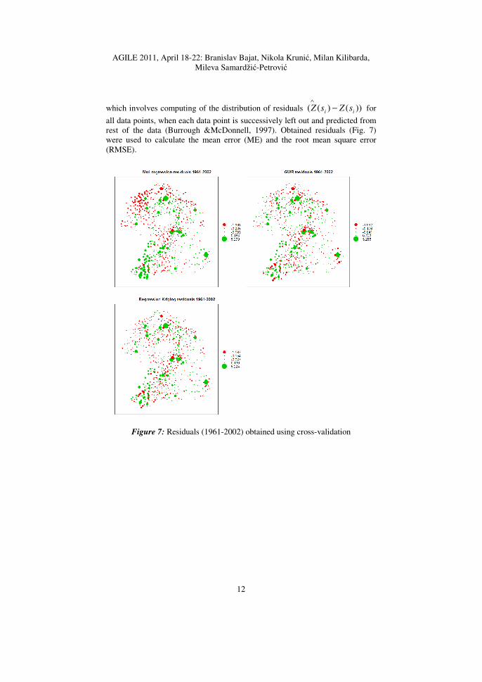
which involves computing of the distribution of residuals ))()(( ii sZsZ −∧
for
all data points, when each data point is successively left out and predicted from
rest of the data (Burrough &McDonnell, 1997). Obtained residuals (Fig. 7)
were used to calculate the mean error (ME) and the root mean square error
(RMSE).
Figure 7: Residuals (1961-2002) obtained using cross-validation

Spatial Prediction of Human Population Change
13
Figure 8: Predicted maps of PCI for the period 2002-2027.
Based on calculated values for ME and RMSE (Table 1.), RK method gives
the best results.
1961-2002 2002-2027
ME RMSE ME RMSE
multiple regression 0.294 0.502 0.066 0.117
geog. weighted regression 0.253 0.458 0.058 0.110

AGILE 2011, April 18-22: Branislav Bajat, Nikola Krunić, Milan Kilibarda,
Mileva Samardžić-Petrović
14
regression kriging 0.240 0.443 0.066 0.117
Table 1: Calculated ME and RMSE for periods 1961-2002 and 2002-2027.
The same was done for the period 2002-2027; the mapped values of PCI
show again the similar prediction results between different methods (Fig 8.).
Spatially balanced values of PCI in this period resulted with lower value of
residuals (Fig. 9.) and therefore ME and RMSE values are significantly lower.
Based on the results given in Tab. 1, it can be concluded that regression kriging
model performs better than other used models when abrupt changes are
presented in input data set values, whereas GWR shows best performance in the
case of spatially balanced data sets.
Comparison of prediction map for 2002-2007 with the map related to period
1961-2002 points to obvious depopulation trends, especially in areas that are
distant from roads and regional centers.
Figure 9: Residuals (2002-2027) obtained using cross-validation
CONCLUSIONS
Nowadays, new methods of spatial data modeling are based on utilization of
ancillary predictors, and that becomes more important since the layers with

Spatial Prediction of Human Population Change
15
ancillary predictors can be found in databases that are web accessible and free
of charge. It is obvious that all methods have the same spatial uncertainty
pattern, apparently at locations close to regional or subregional urban centers
where residual values are at the highest. However, the estimation of spatial
trends in population changes can be effectively done. As expected, GWR
methods and regression kriging give better results because they take into
consideration the locational component of observed values.
This analysis determines dependence between the settlement process and
environmental factors with use of spatial regression models. Observed and
projected values of PCI were used to model the process of urbanization and
identification of its intensity and spatial locations of urban concentration zones
(agglomerations). An effective visualization of complex and long urbanization
process was achieved by creation of maps. In this way, complex demographic
processes which are mapped become an important factor in defining strategic
decisions at regional and national levels.
Acknowledgments This work was supported by the Ministry of Science of the Republic of Serbia
(Contracts No. III 47014 and ТR 36035).
BIBLIOGRAPHY Booth, H. (2006). Demographic Forecasting: 1980 to 2005 in Review. Working
Papers in Demography No. 100. Canberra: The Australian National
University.
Bivand, R., Pebesma, E., and Rubio, V. (2008). Applied Spatial Data Analysis
with R. Use R Series. Springer, Heidelberg ISBN 978-0-387-78170-9.
pp.374.
Bourennane, H., King, D., and Couturier, A. (2000). Comparison of kriging
with external drift and simple linear regression for predicting soil horizon
thickness with different sample densities. Geoderma 97, 255–271.
Burrough, A.P., and McDonnell, A.R. (2000) Principles of Geographical
Information Systems,2nd ed. Spatial Information Systems and Geostatistics.
Oxford University Press. pp. 333
Fotheringham, A.S., Brunsdon, C., and Charlton, M. (2002) Geographically
Weighted Regression: The analysis of spatially varying relationships.
Wiley, Chicester. ISBN 0-471-49616-2.pp.265.
Gallego F.J., Peedell S. (2001) Using CORINE Land Cover to map population
density. Towards Agri-environmental indicators, Topic report 6/2001
European Environment Agency, Copenhagen, 92-103.
Harris, R., Singleton, A., Grose, D., Brunsdon, C., and Longley, P. (2010) Grid-
enabling Geographically Weighted Regression: A Case Study of

AGILE 2011, April 18-22: Branislav Bajat, Nikola Krunić, Milan Kilibarda,
Mileva Samardžić-Petrović
16
Participation in Higher Education in England. Transactions in GIS, Vol.
14, no. 1, 43–61.
Hengl, T., Heuvelink G., and Stein A. (2003) Comparison of kriging with
external drift and regression kriging. Technical report. International
Institute for Geo-information science and Earth Obeservation (ITC)
Enchede. http://www.itc.nl/library/Academic_output/
Hengl, T. (2009). A Practical Guide to Geostatistatistical Mapping. Office for
Official Publications of the European Communities, Luxembourg, pp.270.
Krunić, N; Tošić D; Milijić, S (2009): Problems of spatial-functional
organization of Južno pomoravlje Region`s network of settlements
SPATIUM 19, 56-68.
O'Neill, B. C., Balk, D., Brickman, M., and Markos, E. (2001). A Guide to
Global Population Projections. Demographic Research 4 , 203-288.
Pebesma, E., J., 2004. Multivariable geostatistics in S: the gstat package. Comp.
Geosci. 30, 683–691.
Petrić, J., Krunić, N. (2009): Regional disproportion encapsulated – Case
studies of Južno pomoravlje and Timočka krajina regions of Serbia,
Conference Proceedings. Košice: Technical University of Košice, Faculty
of Economics and Institute of Regional and Community Development,
Košice, Slovakia; p. 694-703.
Petric, J., Milijić, S. (2010) Latest experience of regional planning in Serbia -
case studies of Juzno Pomoravlje and Timocka krajina regions of Serbia,
Territorial aspects of development of Serbia and neighbouring countries,
International conference proceedings, Belgrade: University of Belgrade,
Faculty of Geography, Serbia; p.143-149.
R Development Core Team, (2009) R: A language and environment for
statistical computing. R Foundation for Statistical Computing, Vienna,
Austria.
Statistical Office of the Republic of Serbia (2003). 2002 Census of Populations,
Households and Dwellings (in Serbian). Belgrade: Statistical office of the
Republic of Serbia.


![INDEX []Chaunsath Yogini Gaavat, Nritya Karat Bhairon, Baajat Tab Mridanga, Aur Bajat Damru, Jai Ambe Gauri Maiyaa, Jai Shyaama Gauri Tum Ho Jag Ki Maataa, Tum Hi Ho Bhartaa, Bhaktan](https://img.dokumen.tips/doc/110x75/5e3f1f0e2a0cce210a7c3b56/index-chaunsath-yogini-gaavat-nritya-karat-bhairon-baajat-tab-mridanga-aur.jpg)