Embed Size (px)
Citation preview
INDUSTRY STANDARD MAPPING SOLUTIONSMAPublisher® is a powerful suite of plug-in tools for Adobe Illustrator, leveraging its superior graphics capabilities for high-quality map creation.
MAPublisher adds over 50 map and data import, export and editing tools to Adobe Illustrator so that anybody can create great looking maps.
Import the most widely used GIS data formats, including those from Esri, MapInfo, FME Desktop, AutoCAD, Google and the US government with all attributes and georeferencing intact.
Retain fully functional and editable maps to merge data sets, change projection and scale, crop, label, add legends, index, automate tools in a workflow, and register raster imagery. Even create interactive web maps in HTML5 and Flash to share online, and export to Geospatial PDF.
MAPUBLISHER BENEFITSEnhanced map editing and outputWork with GIS map data in a graphic design environment. Enjoy the design, editing and output power of Adobe Illustrator while enjoying the value of maintaining accurate world coordinates, precise map scale control and ability to edit attribute data.
Create custom maps from any dataImport industry standard data formats from major GIS applications including Esri geodatabases. Work with multiple map data files at the same time to build maps. Convert coordinate systems to georef-erence and overlay data from different sources.
Export to web, Geospatial PDF and GIS formatsMake vector and database edits, data edits, addi-tions and save your changes back to a variety of GIS data formats. Export to web or geospatial PDF and publish maps online to share.
Design oriented mapping toolsOver 50 GIS and cartographic tools to create scale bars, join features, place points, create map themes and styles, create grids and graticules, and more. MAPUBLISHER / GEOGRAPHIC IMAGER USERS
Private-sector, government and academic organizations worldwide rely on Geographic Imager and MAPublisher in order to create appealing, accurate and content-rich maps from their GIS data and spatial imagery.
GovernmentGovernment agencies at all levels including the U.S. Geological Survey, UK Ordnance Survey, Central Intelligence Agency, City of Amsterdam, Land Victoria (Australia) and the National Geospatial-Intelligence Agency.
AcademicMajor learning institutions such as Michigan State University, Universiti Teknologi MARA (Malaysia), Beuth University of Berlin and the Smithsonian Institution.
PublishingAtlas and map publishers including National Geographic and the California Automobile Association. Also, leading media publications, journals and news agencies including Forbes, The New York Times, Bloomberg Financial and The Toronto Star.
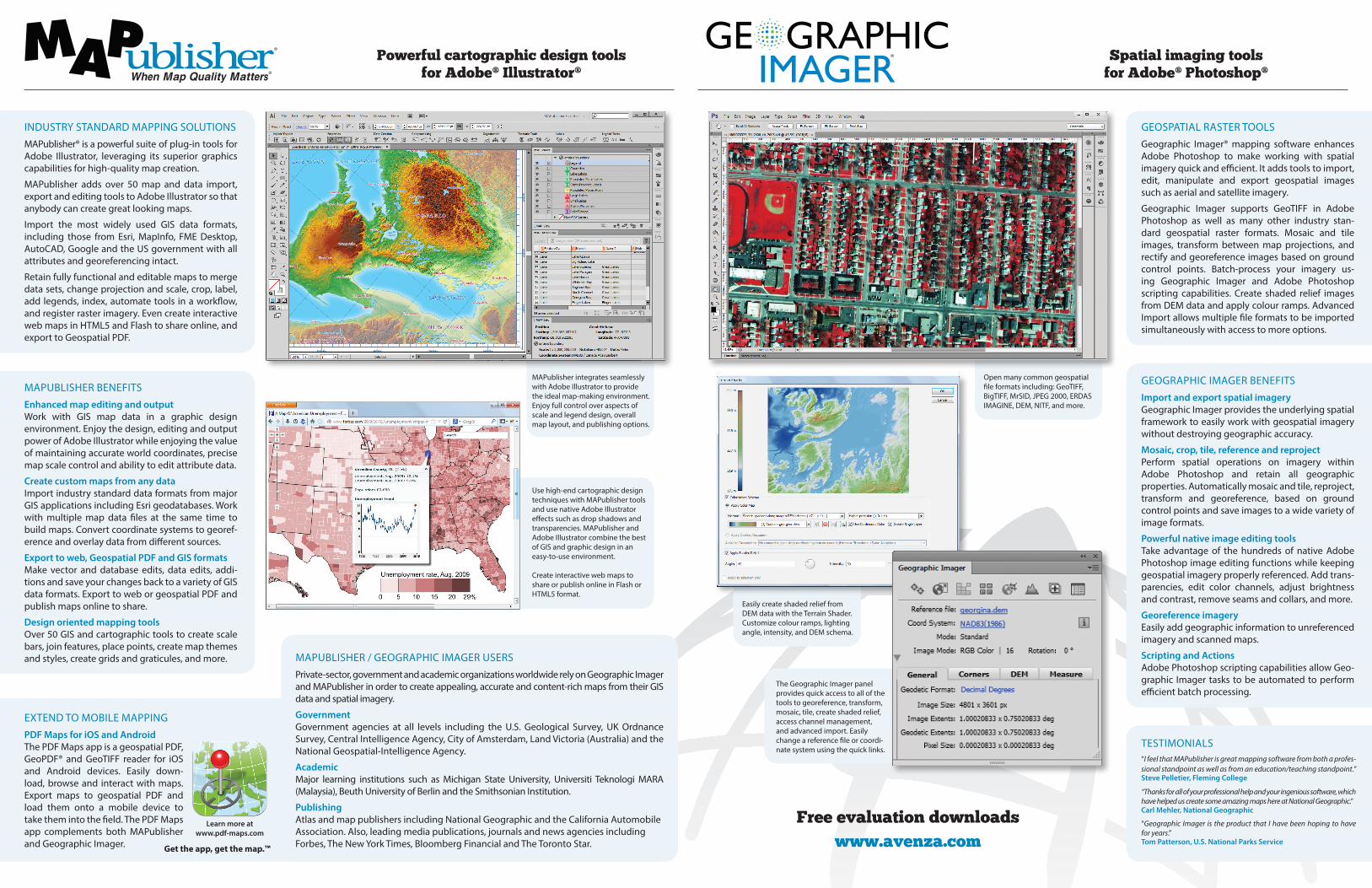
MAPublisher integrates seamlessly with Adobe Illustrator to provide the ideal map-making environment. Enjoy full control over aspects of scale and legend design, overall map layout, and publishing options.
Open many common geospatial file formats including: GeoTIFF, BigTIFF, MrSID, JPEG 2000, ERDAS IMAGINE, DEM, NITF, and more.
Use high-end cartographic design techniques with MAPublisher tools and use native Adobe Illustrator effects such as drop shadows and transparencies. MAPublisher and Adobe Illustrator combine the best of GIS and graphic design in an easy-to-use environment.
Create interactive web maps to share or publish online in Flash or HTML5 format.
The Geographic Imager panel provides quick access to all of the tools to georeference, transform, mosaic, tile, create shaded relief, access channel management, and advanced import. Easily change a reference file or coordi-nate system using the quick links.
GEOSPATIAL RASTER TOOLSGeographic Imager® mapping software enhances Adobe Photoshop to make working with spatial imagery quick and efficient. It adds tools to import, edit, manipulate and export geospatial images such as aerial and satellite imagery.
Geographic Imager supports GeoTIFF in Adobe Photoshop as well as many other industry stan-dard geospatial raster formats. Mosaic and tile images, transform between map projections, and rectify and georeference images based on ground control points. Batch-process your imagery us-ing Geographic Imager and Adobe Photoshop scripting capabilities. Create shaded relief images from DEM data and apply colour ramps. Advanced Import allows multiple file formats to be imported simultaneously with access to more options.
GEOGRAPHIC IMAGER BENEFITSImport and export spatial imageryGeographic Imager provides the underlying spatial framework to easily work with geospatial imagery without destroying geographic accuracy.
Mosaic, crop, tile, reference and reprojectPerform spatial operations on imagery within Adobe Photoshop and retain all geographic properties. Automatically mosaic and tile, reproject, transform and georeference, based on ground control points and save images to a wide variety of image formats.
Powerful native image editing toolsTake advantage of the hundreds of native Adobe Photoshop image editing functions while keeping geospatial imagery properly referenced. Add trans-parencies, edit color channels, adjust brightness and contrast, remove seams and collars, and more.
Georeference imageryEasily add geographic information to unreferenced imagery and scanned maps.
Scripting and ActionsAdobe Photoshop scripting capabilities allow Geo-graphic Imager tasks to be automated to perform efficient batch processing.
Free evaluation downloadswww.avenza.com
TESTIMONIALS“I feel that MAPublisher is great mapping software from both a profes-sional standpoint as well as from an education/teaching standpoint.”Steve Pelletier, Fleming College
“Thanks for all of your professional help and your ingenious software, which have helped us create some amazing maps here at National Geographic.”Carl Mehler, National Geographic
“Geographic Imager is the product that I have been hoping to have for years.”Tom Patterson, U.S. National Parks Service
Powerful cartographic design tools for Adobe® Illustrator®
Easily create shaded relief from DEM data with the Terrain Shader. Customize colour ramps, lighting angle, intensity, and DEM schema.
EXTEND TO MOBILE MAPPINGPDF Maps for iOS and AndroidThe PDF Maps app is a geospatial PDF, GeoPDF® and GeoTIFF reader for iOS and Android devices. Easily down-load, browse and interact with maps. Export maps to geospatial PDF and load them onto a mobile device to take them into the field. The PDF Maps app complements both MAPublisher and Geographic Imager. Get the app, get the map.™
The Geographic Imager floating panel displays all the relevant geospatial information about your image.
Spatial imaging tools for Adobe® Photoshop®
Learn more atwww.pdf-maps.com
Spatial imaging tools for Adobe Photoshop124 Merton Street, Suite 400, Toronto, Ontario, Canada M4S 2Z2Tel +1-416-487-5116 · Fax +1-416-487-7213 · Toll-free (in North America) [email protected] · www.avenza.com© 2013 Avenza Systems Inc. All rights reserved. MAPublisher® and When Map Quality Matters® are registered trademarks of Avenza Systems Inc. All other trademarks are the property of their respective owners. Front map credits (clockwise from left): © MapRelief, © QA International, © GeoBase. Inside map credits (clockwise from top left): © Avenza Systems, © City of Buffalo, © GeoBase, © Forbes.com.
®
® ®®
Powerful cartographic design tools for Adobe Illustrator
PAR TIAL SUMMARY OF TOOLS AND FEATURESFeature Description
Import and Export
Import: Esri Geodatabases, SHP, e00, GEN, GeoPDF®, geospatial PDF, MIF, TAB, DGN, DXF/DWG, SDTS, TIGER/Line, CSV/TSV/TXT, DLG, GPX, GML/XML, KML/KMZ, S-57, XLS, WMS, WFS and images with reference. Include FME Desktop support with the MAPublisher FME Auto add-on. Export: SHP, e00, GEN, TAB, DGN, DXF, DWG, GML/XML, KML/KMZ, MIF, GeoTIFF with reference, geospatial PDF. Export interactive Flash and HTML5 web maps for online publishing. Maps can include hover callouts, pop-ups, layer controls, and pan and zoom controls. Highly customizable using JavaScript API and CSS references.
Projections and Coordinate Systems
Support for thousands of unique coordinate systems including user-defined and custom systems. Perform drag-and-drop coordinate system and projection transformations. Automatically detect projection upon import and perform simultaneous multi-layer reprojection. Advanced coordinate system editor for easy, on-the-fly editing of existing coordinate system database. Add georeferencing to unreferenced data.
Map Properties
Organize and manage MAP Views. Copy MAP Objects from other documents, scale, project and shift map data with the ability to preview both thumbnails and coloured extents for more precise map placement. View and navigate map attribute data in easy to read tables. Edit, create, delete, join and query (using an expression builder) attribute data and tables. View geographic extents and coordinates in the MAP Info panel. Create MAP Locations to reference artboard and real world locations.
Data CreationPlot points, lines and areas with high geographic precision (projected units, decimal degrees, or Degrees Minutes Seconds). Plot coordinates to draw lines, include direction and distance. Use MAP Locations with Georeferencer tool to reference map documents interactively.
Geoprocessing Join areas, join lines, join points, simplify art, vector crop, buffer art and flip lines. MAPublisher supports Bezier curves when importing from other formats. Douglas-Peucker algorithm preserves line topology.
OrganizationCreate MAP Selections (spatial, attribute and selection filters) to effectively select and query data. Build and store queries in the Expression Library. Split features into separate layers based on attributes. Merge separate layers into a single layer based on attributes.
Thematic ToolsCreate and manage MAP Themes to apply Adobe Illustrator graphic styles and symbology based on map data attributes. Create halos around features including text. Scale and rotate features independently or together using attributes. Fine-tune dash offsets with precision.
Labeling
Automatic feature labelling using map attributes or tag individual map objects, label text along paths, and label with leader lines using preferences such as label position, text size and alignment (along lines of latitude). Create label masks or knockouts to easily hide labels placed on lines. For more control over labelling, use MAPublisher LabelPro®, a collision-free, rule-based text placement add-on.
Legend Tools Create highly customizable indexes, grids and graticules for any projected or geodetic MAP View. Easily export an index of features to a text file. Create and customize north arrows and scale bars.
Compatibility Adobe Illustrator on Windows and Mac (see Avenza website for latest compatibility requirements).
Feature Description
Import and Export
Raster/Reference formats: (Import & Export) BigTIFF, ERDAS IMAGINE Raster, ECW, geospatial PDF, GeoTIFF, JPEG 2000, MrSID*, NITF; (Import only) BSB, BIL, GeoPDF®, MrSID/MG4 LiDAR, PCI EASI/PACE, SGI, Web Map Service. DEM formats: ESRI Grid, ERDAS IMAGINE, Grayscale DEM GeoTIFF, USGS SDTS, DEM, DTED, SRTM. External Reference formats: World (TFW, TIFW, WLD, JPGW, JGW, PGW, SDW, EWW, BLW, GFW, DMW, BPW), RSF, TAB, ERS. Advanced Import allows for multiple file import with many options.
Georeference Import or add ground control points for accurate georeferencing of images with multiple transformation types supported. Save GCP data as reference files and quickly reference using only one or two tie-points.
Transform Extensive support for thousands of geographic and projected coordinate systems to transform and reproject with the ability to save custom definitions for future use.
Mosaic Mosaic individual images to create a seamless image.
Tile Tile an image into multiple images by tile size or count. Save tiles to various image formats.
GeoCrop Crop images by pixel, geodetic or projected extents while maintaining georeferencing properties.
Terrain Shader Apply customizable and adjustable colour ramps to DEMs, including terrain shading/lighting options.
Compatibility Adobe Photoshop on Windows and Mac (see Avenza website for latest compatibility requirements).
Licensing Options Both MAPublisher and Geographic Imager offer flexible licensing options including single, commercial, academic, multi-user and floating (networked) licenses.
Certain features are not present in all versions. See website for details.*Export with LizardTech GeoExpress installed.
® ®