Embed Size (px)
Citation preview
State of California The Resources Agency
Department of Water Resources
SP-T7 PROJECT EFFECTS ON NOXIOUS TERRESTRIAL AND AQUATIC
PLANT SPECIES DRAFT FINAL REPORT
Oroville Facilities Relicensing FERC Project No. 2100
JUNE 2004
ARNOLD SCHWARZENEGGER
Governor State of California
MIKE CHRISMAN
Secretary for Resources The Resources Agency
LESTER A. SNOW Director
Department of Water Resources
SP-T7 Noxious Terrestrial and Aquatic Plant Species Oroville Facilities P-2100 Relicensing
Preliminary Information – Subject to Revision – For Collaborative Process Purposes Only
Oroville Facilities Relicensing Team 6/18/2004 C:\Documents and Settings\Alvarez\Desktop\EWG 6-23-04\Reports\T7weeds_draftfinalreport_6-15-04.doc
State of California The Resources Agency
Department of Water Resources
SP-T7 PROJECT EFFECTS ON NOXIOUS TERRESTRIAL AND AQUATIC
PLANT SPECIES DRAFT FINAL REPORT
Oroville Facilities Relicensing FERC Project No. 2100
This report was prepared under the direction of
Dale Hoffman-Floerke ....................................... Environmental Program Manager I, DES Terry J. Mills...................................................... Environmental Program Manager I, DES
by Gail Kuenster ................................................... Environmental Scientist, Northern District
Assisted by Barbara Castro................................................. Environmental Scientist, Northern District Lawrence Janeway........................................... Environmental Scientist, Northern District Gavin Blosser.............................................Graduate Student Assistant, Northern District Christine Hantelman...................................Graduate Student Assistant, Northern District

SP-T7 Noxious Terrestrial and Aquatic Plant Species Oroville Facilities P-2100 Relicensing
Preliminary Information – Subject to Revision – For Collaborative Process Purposes Only i
Oroville Facilities Relicensing Team 6/18/2004 C:\Documents and Settings\Alvarez\Desktop\EWG 6-23-04\Reports\T7weeds_draftfinalreport_6-15-04.doc
REPORT SUMMARY Land management activities, the associated clearing of land within the project boundaries, and the altered hydrology within Lake Oroville and downstream Feather River from the Oroville Facilities have the potential to enhance the establishment and spread of noxious weeds. Non-native invasive plant species can have a significant impact on both human and environmental resources. Areas where vegetation and soils have been disturbed are much more susceptible to invasion by noxious weeds than natural environments. Aggressive noxious weeds crowd out native vegetation and alter the natural environment and habitat for wildlife species, as well as impacting agricultural water-use efficiency and recreational land values. They can adversely impact native plant species and communities and wildlife habitat (including State and federally listed species) through competition. The study area includes the Oroville Facilities Relicensing FERC Project boundary and the portions of the lower Feather River floodplain downstream from the Fish Barrier Dam to the Sacramento River. Although noxious and invasive weed species were known to occur throughout the Project area, relatively little was known about their distribution and density. These study results are needed to provide sufficient information on noxious weed occurrences and distributions within the study area for analysis of impacts to botanical and wildlife habitats within the Project Area as well as downstream natural and agricultural resources; to supply weed data to land management agencies (USFS and BLM); and to provide information that can be used to identify opportunities for enhancement of plant and wildlife habitats
A review of existing literature, databases, and reference material indicates the project area may support 64 noxious or invasive plant species rated by the California Department of Food and Agriculture, the California Invasive Plant Council, the U.S. Department of Agriculture, and the Plumas National Forest. Approximately 9900 acres were surveyed for noxious and invasive weed species during the 2002 and 2003 field studies. Thirty-nine of the 64 target weed species were identified and mapped within the Project area covering approximately 518 acres. Thirty-three of these species (483 acres) were found below Oroville Dam in the OWA and in and around the Thermalito Complex. Twenty-four of the species (35 acres) were found around Lake Oroville. Overall 219 species of non-native plants from 63 different families were identified in the Project area. Noxious weeds and non-native invasive species occur throughout the Project area. Although a large number of weed species occur within the upland areas, the wetland margins and riparian areas tend to be the most heavily infested areas. The frequent fluctuations of the Thermalito Afterbay and Thermalito Forebay have created optimal conditions for the rapid invasion of purple loosestrife within the drawdown zone of the

SP-T7 Noxious Terrestrial and Aquatic Plant Species Oroville Facilities P-2100 Relicensing
Preliminary Information – Subject to Revision – For Collaborative Process Purposes Only ii
Oroville Facilities Relicensing Team 6/18/2004 C:\Documents and Settings\Alvarez\Desktop\EWG 6-23-04\Reports\T7weeds_draftfinalreport_6-15-04.doc
reservoir. Approximately 85 of the ~900 acres of wetland/riparian margin of the Thermalito Afterbay contain varying densities of purple loosestrife. This species impacts both native vegetation and wintering waterfowl nesting habitat. Species of concern near the Afterbay, Forebay, and Diversion pool include purple loosestrife, giant reed, tree of heaven, starthistle, scarlet wisteria, medusahead, and many other herbaceous and woody species. Within the grasslands, starthistle and medusahead are the most widespread and have most likely impacted native plant species to the greatest extent. Noxious weed species are most prolific in the OWA. The species of greatest concern to native plant communities and wildlife habitat in this area include giant reed, tree of heaven, scarlet wisteria, parrots feather, and Himalayan blackberry. Tree of heaven is intermingled with the valley elderberry (Sambucus mexicanus), habitat for the federally threatened valley elderberry longhorn beetle, in approximately 250 acres of the OWA. Although water primrose (Ludwigia peploides) is not listed as an important invader of agricultural and/or natural lands by CDFA or Cal-IPC, its invasion into a number of ponds in the OWA has caused adverse ecological impacts to a number of fish species. It has, however, increased habitat for the federally and State listed giant garter snake. Over 400 acres of water primrose were mapped in the Project area. Numerous noxious weed species occur around Lake Oroville, primarily in disturbed areas near roads, trails, and facilities, and in the immediate vicinity of the spillway and the associated power facilities. The species identified as those of greatest concern are skeleton weed; French, Spanish, and Scotch brooms; Himalayan berry; and tree of heaven. Other species include edible fig, and starthistle. Continued Project operations have the potential to facilitate the spread of noxious and invasive plant species, both within the Project area and into downstream waterways. Fluctuating water levels in the Thermalito Complex and in Lake Oroville and managed flows in the Low Flow Channel of the Feather River encourage the proliferation of non-native noxious weed species along the wetland margins, river banks, and in the adjacent floodplain. Maintenance and other land disturbing activities have been identified as an aid in the spread of invasive plant species in upland and wetland/riparian areas. However, both historical and present-day land use within the Project area and adjacent lands contribute to the non-native noxious or invasive weed distribution and proliferation. Removal of noxious and invasive weed species within the Project area would enhance native plant communities and wildlife habitats and help control their spread into downstream waters. Many of the noxious/invasive weed species found in the Project area are so widespread that eradication, control, and/or management is unlikely. Management efforts that address those species considered highest priority, combined with restoration and replanting with native species, could lessen their impact to native

SP-T7 Noxious Terrestrial and Aquatic Plant Species Oroville Facilities P-2100 Relicensing
Preliminary Information – Subject to Revision – For Collaborative Process Purposes Only iii
Oroville Facilities Relicensing Team 6/18/2004 C:\Documents and Settings\Alvarez\Desktop\EWG 6-23-04\Reports\T7weeds_draftfinalreport_6-15-04.doc
species and habitats and halt or slow their spread within, adjacent, and downstream of the Project area. A weed management plan for the Project area and Project-affected area should be developed that addresses control and/or management of those species considered highest priority species.

SP-T7 Noxious Terrestrial and Aquatic Plant Species Oroville Facilities P-2100 Relicensing
Preliminary Information – Subject to Revision – For Collaborative Process Purposes Only iv
Oroville Facilities Relicensing Team 6/18/2004 C:\Documents and Settings\Alvarez\Desktop\EWG 6-23-04\Reports\T7weeds_draftfinalreport_6-15-04.doc
TABLE OF CONTENTS
1.0 INTRODUCTION...............................................................................................1-1
1.1 Background Information..........................................................................1-1 1.1.1 Statutory/Regulatory Requirements ............................................1-1 1.1.2 Study Area ..................................................................................1-2
1.2 Description of Facilities ...........................................................................1-2 1.3 Current Operational Constraints .............................................................1-6
1.3.1 Downstream Operation ...............................................................1-6 1.3.1.1 Instream Flow Requirements.........................................1-6 1.3.1.2 Temperature Requirements...........................................1-7 1.3.1.3 Water Diversions ...........................................................1-8 1.3.1.4 Water Quality.................................................................1-8
1.3.2 Flood Management .....................................................................1-8 2.0 NEED FOR STUDY...........................................................................................2-1 3.0 STUDY OBJECTIVE(S).....................................................................................3-1
3.1 Application of Study Information .............................................................3-1 3.1.1 Environmental Documentation ....................................................3-1 3.1.2 Settlement Agreement.................................................................3-1
4.0 METHODOLOGY ..............................................................................................4-1 4.1 Study Design ..........................................................................................4-1
4.1.1 Review of Existing Literature.......................................................4-1 4.1.2 Surveys .......................................................................................4-5 4.1.3 GIS and Data Management.......................................................4-10 4.1.4 Evaluation .................................................................................4-10
5.0 STUDY RESULTS.............................................................................................5-1 5.1 Review of Existing Literature ..................................................................5-1
5.1.1 Purple loosestrife (Lythrum salicaria) ..........................................5-1 5.1.2 Giant reed (Arundo donax) ..........................................................5-3 5.1.3 Tree of heaven (Ailanthus altissima) ...........................................5-5 5.1.4 Scarlet wisteria (Sesbania punicea) ............................................5-7 5.1.5 Skeleton weed (Chondrilla juncea)..............................................5-8 5.1.6 Yellow starthistle (Centaurea solstitialis) .....................................5-9 5.1.7 Himalayan blackberry (Rubus discolor).....................................5-10 5.1.8 Parrot’s feather (Myriophyllum aquaticum) ................................5-12 5.1.9 Pampas grass (Cortaderia selloana) .........................................5-13 5.1.10 Medusahead (Taeniatherum caput-medusae) ........................5-13 5.1.11 Spanish, French, and Scotch brooms .....................................5-15 5.1.12 Edible fig (Ficus carica) ...........................................................5-17 5.1.13 Black locust (Robinia pseudoacacia).......................................5-17 5.1.14 Water primrose (Ludwigia peploides) ......................................5-18
5.2 Current Weed Management in Project Area .........................................5-19 5.3 Survey Results......................................................................................5-20

SP-T7 Noxious Terrestrial and Aquatic Plant Species Oroville Facilities P-2100 Relicensing
Preliminary Information – Subject to Revision – For Collaborative Process Purposes Only v
Oroville Facilities Relicensing Team 6/18/2004 C:\Documents and Settings\Alvarez\Desktop\EWG 6-23-04\Reports\T7weeds_draftfinalreport_6-15-04.doc
5.3.1 Target species distribution within Project area .........................5-23 5.3.1.1 Purple loosestrife (Lythrum salicaria) ..........................5-23 5.3.1.2 Giant reed (Arundo donax) ..........................................5-23 5.3.1.3 Tree of heaven (Ailanthus altissima) ...........................5-23 5.3.1.4 Scarlet wisteria (Sesbania punicea) ............................5-24 5.3.1.5 Skeleton weed (Chondrilla juncea) ..............................5-24 5.3.1.6 Yellow starthistle (Centaurea solstitialis) .....................5-24 5.3.1.7 Himalayan blackberry (Rubus discolor) .......................5-24 5.3.1.8 Parrot’s feather (Myriophyllum aquaticum) ..................5-25 5.3.1.9 Pampas grass (Cortaderia selloana) ...........................5-25 5.3.1.10 Medusahead (Taeniatherum caput-medusae)...........5-25 5.3.1.11 Spanish broom (Spartium junceum), French broom (Genista monspessulana), and Scotch broom (Cytisus scoparius) .. ..................................................................................5-25 5.3.1.12 Edible fig (Ficus carica) .............................................5-26 5.3.1.13 Black locust (Robinia pseudoacacia) .........................5-26 5.3.1.14 Water primrose (Ludwigia peploides) ........................5-26
6.0 ANALYSES........................................................................................................6-1 6.1 Existing Conditions/Environmental Setting .............................................6-1 6.2 Project Related Effects ...........................................................................6-2
7.0 SUMMARY AND RECOMMENDATIONS .........................................................7-1 8.0 REFERENCES..................................................................................................8-1
APPENDICES APPENDIX A................................................................................................................A-2 APPENDIX B..............................................................................................................A-20

SP-T7 Noxious Terrestrial and Aquatic Plant Species Oroville Facilities P-2100 Relicensing
Preliminary Information – Subject to Revision – For Collaborative Process Purposes Only vi
Oroville Facilities Relicensing Team 6/18/2004 C:\Documents and Settings\Alvarez\Desktop\EWG 6-23-04\Reports\T7weeds_draftfinalreport_6-15-04.doc
LIST OF TABLES Table 4.1-1. Noxious weed species potentially occurring in the Project area..............4-2 Table 5.1-1. Target weed species identified within Project area. ..............................5-21
LIST OF FIGURES
Figure 1.2-1 Oroville Facilities FERC Project Boundary...................................1-5 Figure 4.1-1 Index map. Noxious weed survey areas. ....................................4-6 Figure 4.1-2 Noxious weeds – survey areas 2002-2003. ............................................4-7 Figure 4.1-3 Noxious weeds – survey areas 2002-2003. ............................................4-8 Figure 4.1-4 Noxious weeds – survey areas 2002-2003. ............................................4-9 Figure 5.1-1 Purpleloosestrife (a) in flower; (b) around Thermalito Afterbay. ..............5-1 Figure 5.1-2 Giant reed along the Low Flow Channel of the Feather River.................5-4 Figure 5.1-3 Tree of heaven (a) along LFC; (b) replacing cottonwoods following a burn
in the OWA............................................................................................................5-6 Figure 5.1-4 Scarlet wisteria (a) along LFC; (b) numerous flowers and seed pods. ....5-7 Figure 5.1-5 Skelton weed. .........................................................................................5-8 Figure 5.3-1 Purple loosestrife – Thermalito Afterbay. ..............................................5-27 Figure 5.3-2 Purple loosestrife – Thermalito Forebay. ..............................................5-28 Figure 5.3-3 Purple loosestrife – Thermalito Diversion Pool / Low Flow Channel. ....5-29 Figure 5.3-4 Purple loosestrife – Oroville Wildlife Area / Low Flow Channel.............5-30 Figure 5.3-5 Giant reed – Thermalito Afterbay / Oroville Wildlife Area. .....................5-31 Figure 5.3-6 Tree of heaven –Oroville Wildlife Area / Thermalito Afterbay /..............5-32 Low Flow Channel......................................................................................................5-32 Figure 5.3-7 Tree of heaven –Thermalito Diversion Pool / Low Flow Channel..........5-33 Figure 5.3-8 Scarlet wisteria –Oroville Wildlife Area / Thermalito Forebay /..............5-34 Low Flow Channel......................................................................................................5-34 Figure 5.3-9 Noxious / invasive species – Middle/South Forks, Lake Oroville. ........5-35 Figure 5.3-10 Noxious / invasive species – West Branch, Lake Oroville..................5-36 Figure 5.3-11 Noxious / invasive species – Oroville Dam, Lake Oroville..................5-37 Figure 5.3-12 Noxious / invasive species – North Fork, Lake Oroville. ....................5-38 Figure 5.3-13 Noxious / invasive species – Thermalito Diversion Pool / ..................5-39 Low Flow Channel......................................................................................................5-39 Figure 5.3-14 Noxious / invasive species – Thermalito Forebay, Afterbay /.............5-40 Oroville Wildlife Area / Low Flow Channel..................................................................5-40 Figure 5.3-15 Brooms – West Branch / North Fork, Lake Oroville. ..........................5-41 Figure 5.3-16 Brooms – Middle Fork / South Fork, Lake Oroville.............................5-42 Figure 5.3-17 Brooms – Lake Oroville / Thermalito Diversion Pool / ........................5-43 Low Flow Channel......................................................................................................5-43 Figure 5.3-18 Water primrose – Thermalito Afterbay / Oroville Wildlife Area ............5-44

SP-T7 Noxious Terrestrial and Aquatic Plant Species Oroville Facilities P-2100 Relicensing
Preliminary Information – Subject to Revision – For Collaborative Process Purposes Only 1-1
Oroville Facilities Relicensing Team 6/18/2004 C:\Documents and Settings\Alvarez\Desktop\EWG 6-23-04\Reports\T7weeds_draftfinalreport_6-15-04.doc
1.0 INTRODUCTION
1.1 BACKGROUND INFORMATION Land management activities, the associated clearing of land within the project boundaries, and the altered hydrology within Lake Oroville and downstream Feather River from the Oroville Facilities have the potential to enhance the establishment and spread of noxious weeds. Non-native invasive plant species can have a significant impact on both human and environmental resources. Areas where vegetation and soils have been disturbed are much more susceptible to invasion by noxious weeds than natural environments. Aggressive noxious weeds crowd out native vegetation and alter the natural environment and habitat for wildlife species, as well as impacting agricultural water-use efficiency and recreational land values. They can adversely impact native plant species and communities and wildlife habitat (including State and federally listed species) through competition. The federal Endangered Species Act requires an evaluation of project-related impacts to federally listed species through competition and habitat degradation. This includes land disturbances and other project operations that encourage non-native species over listed species and project operations that influence the dispersal of noxious weed species into downstream waters. 1.1.1 Statutory/Regulatory Requirements In 1999, Executive Order 13112 was signed establishing the National Invasive Species Council to help prevent the introduction of invasive species and provide for their control and to minimize the economic, ecological, and human health impacts that invasive species cause. The Federal Noxious Weed Act of 1974 (as amended) requires federal land managing agencies to establish and fund programs to manage undesirable plants. The California Food and Agriculture Code Section 403 requires that Department to “prevent the introduction and spread of injurious insect and animal pest, plant diseases, and noxious weeds” and Senate Bill 1740 addresses noxious weed control, mapping, and education In Butte County, the Weed Management Area (BWMA), under direction of the County Agricultural Commissioner’s Office, is coordinating efforts to control aggressive weed expansion, increase public awareness, and establish a database of weed locations throughout the county. The Department of Water Resources is working with the BWMA in its efforts to prevent the spread of and to control noxious weeds. Non-native plant species can adversely impact native plant species and communities (including State and federally listed species) through competition. The federal Endangered Species Act requires an evaluation of project-related impacts to federally listed species through competition and habitat degradation. The California Endangered
SP-T7 Noxious Terrestrial and Aquatic Plant Species Oroville Facilities P-2100 Relicensing
Preliminary Information – Subject to Revision – For Collaborative Process Purposes Only 1-2
Oroville Facilities Relicensing Team 6/18/2004 C:\Documents and Settings\Alvarez\Desktop\EWG 6-23-04\Reports\T7weeds_draftfinalreport_6-15-04.doc
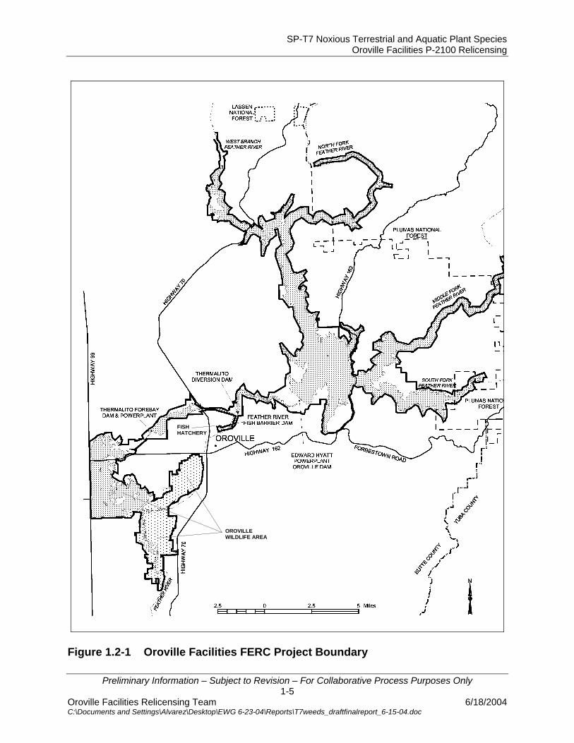
Species Act (CESA) also requires assessment of the proposed project’s impact on listed species. This includes land disturbances and other project operations that favor non-native species over listed species and project operations that influence the dispersal of noxious weed species into downstream waters. Both CEQA and NEPA require assessment of a project’s impacts on State and federally listed species and their habitats. Both federal land management agencies have an obligation to insure that project operations do not adversely affect sensitive species on federal lands and have regulations that address the spread and control of noxious weeds. 1.1.2 Study Area The study area for this investigation includes the Oroville Facilities Relicensing FERC Project boundary and the lower Feather River floodplain downstream from the Fish Barrier Dam to the Sacramento River. 1.2 DESCRIPTION OF FACILITIES The Oroville Facilities were developed as part of the State Water Project (SWP), a water storage and delivery system of reservoirs, aqueducts, power plants, and pumping plants. The main purpose of the SWP is to store and distribute water to supplement the needs of urban and agricultural water users in northern California, the San Francisco Bay area, the San Joaquin Valley, and southern California. The Oroville Facilities are also operated for flood management, power generation, to improve water quality in the Delta, provide recreation, and enhance fish and wildlife. FERC Project No. 2100 encompasses 41,100 acres and includes Oroville Dam and Reservoir, three power plants (Hyatt Pumping-Generating Plant, Thermalito Diversion Dam Power Plant, and Thermalito Pumping-Generating Plant), Thermalito Diversion Dam, the Feather River Fish Hatchery and Fish Barrier Dam, Thermalito Power Canal, Oroville Wildlife Area (OWA), Thermalito Forebay and Forebay Dam, Thermalito Afterbay and Afterbay Dam, and transmission lines, as well as a number of recreational facilities. An overview of these facilities is provided on Figure 1.2-1. The Oroville Dam, along with two small saddle dams, impounds Lake Oroville, a 3.5-million-acre-feet (maf) capacity storage reservoir with a surface area of 15,810 acres at its normal maximum operating level. The hydroelectric facilities have a combined licensed generating capacity of approximately 762 megawatts (MW). The Hyatt Pumping-Generating Plant is the largest of the three power plants with a capacity of 645 MW. Water from the six-unit underground power plant (three conventional generating and three pumping-generating units) is discharged through two tunnels into the Feather River just downstream of Oroville Dam. The plant has a generating and pumping flow capacity of 16,950 cfs and
SP-T7 Noxious Terrestrial and Aquatic Plant Species Oroville Facilities P-2100 Relicensing
Preliminary Information – Subject to Revision – For Collaborative Process Purposes Only 1-3
Oroville Facilities Relicensing Team 6/18/2004 C:\Documents and Settings\Alvarez\Desktop\EWG 6-23-04\Reports\T7weeds_draftfinalreport_6-15-04.doc
5,610 cfs, respectively. Other generation facilities include the 3-MW Thermalito Diversion Dam Power Plant and the 114-MW Thermalito Pumping-Generating Plant. Thermalito Diversion Dam, four miles downstream of the Oroville Dam creates a tail water pool for the Hyatt Pumping-Generating Plant and is used to divert water to the Thermalito Power Canal. The Thermalito Diversion Dam Power Plant is a 3-MW power plant located on the left abutment of the Diversion Dam. The power plant releases a maximum of 615 cubic feet per second (cfs) of water into the river. The Power Canal is a 10,000-foot-long channel designed to convey generating flows of 16,900 cfs to the Thermalito Forebay and pump-back flows to the Hyatt Pumping-Generating Plant. The Thermalito Forebay is an off-stream regulating reservoir for the 114-MW Thermalito Pumping-Generating Plant. The Thermalito Pumping-Generating Plant is designed to operate in tandem with the Hyatt Pumping-Generating Plant and has generating and pump-back flow capacities of 17,400 cfs and 9,120 cfs, respectively. When in generating mode, the Thermalito Pumping-Generating Plant discharges into the Thermalito Afterbay, which is contained by a 42,000-foot-long earth-fill dam. The Afterbay is used to release water into the Feather River downstream of the Oroville Facilities, helps regulate the power system, provides storage for pump-back operations, and provides recreational opportunities. Several local irrigation districts receive water from the Afterbay. The Feather River Fish Barrier Dam is downstream of the Thermalito Diversion Dam and immediately upstream of the Feather River Fish Hatchery. The flow over the dam maintains fish habitat in the low-flow channel of the Feather River between the dam and the Afterbay outlet, and provides attraction flow for the hatchery. The hatchery was intended to compensate for spawning grounds lost to returning salmon and steelhead trout from the construction of Oroville Dam. The hatchery can accommodate 15,000 to 20,000 adult fish annually. The Oroville Facilities support a wide variety of recreational opportunities. They include: boating (several types), fishing (several types), fully developed and primitive camping (including boat-in and floating sites), picnicking, swimming, horseback riding, hiking, off-road bicycle riding, wildlife watching, hunting, and visitor information sites with cultural and informational displays about the developed facilities and the natural environment. There are major recreation facilities at Loafer Creek, Bidwell Canyon, the Spillway, North and South Thermalito Forebay, and Lime Saddle. Lake Oroville has two full-service marinas, five car-top boat launch ramps, ten floating campsites, and seven dispersed floating toilets. There are also recreation facilities at the Visitor Center and the OWA. The OWA comprises approximately 11,000-acres west of Oroville that is managed for wildlife habitat and recreational activities. It includes the Thermalito Afterbay and surrounding lands (approximately 6,000 acres) along with 5,000 acres adjoining the

SP-T7 Noxious Terrestrial and Aquatic Plant Species Oroville Facilities P-2100 Relicensing
Preliminary Information – Subject to Revision – For Collaborative Process Purposes Only 1-4
Oroville Facilities Relicensing Team 6/18/2004 C:\Documents and Settings\Alvarez\Desktop\EWG 6-23-04\Reports\T7weeds_draftfinalreport_6-15-04.doc
Feather River. The 5,000 acre area straddles 12 miles of the Feather River, which includes willow and cottonwood lined ponds, islands, and channels. Recreation areas include dispersed recreation (hunting, fishing, and bird watching), plus recreation at developed sites, including Monument Hill day use area, model airplane grounds, three boat launches on the Afterbay and two on the river, and two primitive camping areas. California Department of Fish and Game’s (DFG) habitat enhancement program includes a wood duck nest-box program and dry land farming for nesting cover and improved wildlife forage. Limited gravel extraction also occurs in a number of locations.
SP-T7 Noxious Terrestrial and Aquatic Plant Species Oroville Facilities P-2100 Relicensing
Preliminary Information – Subject to Revision – For Collaborative Process Purposes Only 1-5
Oroville Facilities Relicensing Team 6/18/2004 C:\Documents and Settings\Alvarez\Desktop\EWG 6-23-04\Reports\T7weeds_draftfinalreport_6-15-04.doc
FISH HATCHERY
OROVILLE WILDLIFE AREA
Figure 1.2-1 Oroville Facilities FERC Project Boundary
SP-T7 Noxious Terrestrial and Aquatic Plant Species Oroville Facilities P-2100 Relicensing
Preliminary Information – Subject to Revision – For Collaborative Process Purposes Only 1-6
Oroville Facilities Relicensing Team 6/18/2004 C:\Documents and Settings\Alvarez\Desktop\EWG 6-23-04\Reports\T7weeds_draftfinalreport_6-15-04.doc
1.3 CURRENT OPERATIONAL CONSTRAINTS Operation of the Oroville Facilities varies seasonally, weekly and hourly, depending on hydrology and the objectives DWR is trying to meet. Typically, releases to the Feather River are managed to conserve water while meeting a variety of water delivery requirements, including flow, temperature, fisheries, recreation, diversion and water quality. Lake Oroville stores winter and spring runoff for release to the Feather River as necessary for project purposes. Meeting the water supply objectives of the SWP has always been the primary consideration for determining Oroville Facilities operation (within the regulatory constraints specified for flood control, in-stream fisheries, and downstream uses). Power production is scheduled within the boundaries specified by the water operations criteria noted above. Annual operations planning is conducted for multi-year carry over. The current methodology is to retain half of the Lake Oroville storage above a specific level for subsequent years. Currently, that level has been established at 1,000,000 acre-feet (af); however, this does not limit draw down of the reservoir below that level. If hydrology is drier than expected or requirements greater than expected, additional water would be released from Lake Oroville. The operations plan is updated regularly to reflect changes in hydrology and downstream operations. Typically, Lake Oroville is filled to its maximum annual level of up to 900 feet above mean sea level (msl) in June and then can be lowered as necessary to meet downstream requirements, to its minimum level in December or January. During drier years, the lake may be drawn down more and may not fill to the desired levels the following spring. Project operations are directly constrained by downstream operational constraints and flood management criteria as described below. 1.3.1 Downstream Operation An August 1983 agreement between DWR and DFG entitled, “Agreement Concerning the Operation of the Oroville Division of the State Water Project for Management of Fish & Wildlife,” sets criteria and objectives for flow and temperatures in the low flow channel and the reach of the Feather River between Thermalito Afterbay and Verona. This agreement: (1) establishes minimum flows between Thermalito Afterbay Outlet and Verona which vary by water year type; (2) requires flow changes under 2,500 cfs to be reduced by no more than 200 cfs during any 24-hour period, except for flood management, failures, etc.; (3) requires flow stability during the peak of the fall-run Chinook spawning season; and (4) sets an objective of suitable temperature conditions during the fall months for salmon and during the later spring/summer for shad and striped bass. 1.3.1.1 Instream Flow Requirements The Oroville Facilities are operated to meet minimum flows in the Lower Feather River as established by the 1983 agreement (see above). The agreement specifies that Oroville Facilities release a minimum of 600 cfs into the Feather River from the

SP-T7 Noxious Terrestrial and Aquatic Plant Species Oroville Facilities P-2100 Relicensing
Preliminary Information – Subject to Revision – For Collaborative Process Purposes Only 1-7
Oroville Facilities Relicensing Team 6/18/2004 C:\Documents and Settings\Alvarez\Desktop\EWG 6-23-04\Reports\T7weeds_draftfinalreport_6-15-04.doc
Thermalito Diversion Dam for fisheries purposes. This is the total volume of flows from the diversion dam outlet, diversion dam power plant, and the Feather River Fish Hatchery pipeline. Generally, the instream flow requirements below Thermalito Afterbay are 1,700 cfs from October through March, and 1,000 cfs from April through September. However, if runoff for the previous April through July period is less than 1,942,000 af (i.e., the 1911-1960 mean unimpaired runoff near Oroville), the minimum flow can be reduced to 1,200 cfs from October to February, and 1,000 cfs for March. A maximum flow of 2,500 cfs is maintained from October 15 through November 30 to prevent spawning in overbank areas that might become de-watered. 1.3.1.2 Temperature Requirements The Diversion Pool provides the water supply for the Feather River Fish Hatchery. The hatchery objectives are 52°F for September, 51°F for October and November, 55°F for December through March, 51°F for April through May 15, 55°F for last half of May, 56°F for June 1-15, 60°F for June 16 through August 15, and 58°F for August 16-31. A temperature range of plus or minus 4°F is allowed for objectives, April through November. There are several temperature objectives for the Feather River downstream of the Afterbay Outlet. During the fall months, after September 15, the temperatures must be suitable for fall-run Chinook. From May through August, they must be suitable for shad, striped bass, and other warmwater fish. The National Marine Fisheries Service has also established an explicit criterion for steelhead trout and spring-run Chinook salmon. Memorialized in a biological opinion on the effects of the Central Valley Project and SWP on Central Valley spring-run Chinook and steelhead as a reasonable and prudent measure; DWR is required to control water temperature at Feather River mile 61.6 (Robinson’s Riffle in the low-flow channel) from June 1 through September 30. This measure requires water temperatures less than or equal to 65°F on a daily average. The requirement is not intended to preclude pump-back operations at the Oroville Facilities needed to assist the State of California with supplying energy during periods when the California ISO anticipates a Stage 2 or higher alert. The hatchery and river water temperature objectives sometimes conflict with temperatures desired by agricultural diverters. Under existing agreements, DWR provides water for the Feather River Service Area (FRSA) contractors. The contractors claim a need for warmer water during spring and summer for rice germination and growth (i.e., 65°F from approximately April through mid May, and 59°F during the remainder of the growing season). There is no obligation for DWR to meet the rice
SP-T7 Noxious Terrestrial and Aquatic Plant Species Oroville Facilities P-2100 Relicensing
Preliminary Information – Subject to Revision – For Collaborative Process Purposes Only 1-8
Oroville Facilities Relicensing Team 6/18/2004 C:\Documents and Settings\Alvarez\Desktop\EWG 6-23-04\Reports\T7weeds_draftfinalreport_6-15-04.doc
water temperature goals. However, to the extent practical, DWR does use its operational flexibility to accommodate the FRSA contractor’s temperature goals. 1.3.1.3 Water Diversions Monthly irrigation diversions of up to 190,000 (July 2002) af are made from the Thermalito Complex during the May through August irrigation season. Total annual entitlement of the Butte and Sutter County agricultural users is approximately 1 maf. After meeting these local demands, flows into the lower Feather River continue into the Sacramento River and into the Sacramento-San Joaquin Delta. In the northwestern portion of the Delta, water is pumped into the North Bay Aqueduct. In the south Delta, water is diverted into Clifton Court Forebay where the water is stored until it is pumped into the California Aqueduct. 1.3.1.4 Water Quality Flows through the Delta are maintained to meet Bay-Delta water quality standards arising from DWR’s water rights permits. These standards are designed to meet several water quality objectives such as salinity, Delta outflow, river flows, and export limits. The purpose of these objectives is to attain the highest water quality, which is reasonable, considering all demands being made on the Bay-Delta waters. In particular, they protect a wide range of fish and wildlife including Chinook salmon, Delta smelt, striped bass, and the habitat of estuarine-dependent species. 1.3.2 Flood Management The Oroville Facilities are an integral component of the flood management system for the Sacramento Valley. During the wintertime, the Oroville Facilities are operated under flood control requirements specified by the U.S. Army Corps of Engineers (USACE). Under these requirements, Lake Oroville is operated to maintain up to 750,000 af of storage space to allow for the capture of significant inflows. Flood control releases are based on the release schedule in the flood control diagram or the emergency spillway release diagram prepared by the USACE, whichever requires the greater release. Decisions regarding such releases are made in consultation with the USACE. The flood control requirements are designed for multiple use of reservoir space. During times when flood management space is not required to accomplish flood management objectives, the reservoir space can be used for storing water. From October through March, the maximum allowable storage limit (point at which specific flood release would have to be made) varies from about 2.8 to 3.2 maf to ensure adequate space in Lake Oroville to handle flood flows. The actual encroachment demarcation is based on a wetness index, computed from accumulated basin precipitation. This allows higher levels in the reservoir when the prevailing hydrology is dry while maintaining adequate flood protection. When the wetness index is high in the basin (i.e., wetness in the

SP-T7 Noxious Terrestrial and Aquatic Plant Species Oroville Facilities P-2100 Relicensing
Preliminary Information – Subject to Revision – For Collaborative Process Purposes Only 1-9
Oroville Facilities Relicensing Team 6/18/2004 C:\Documents and Settings\Alvarez\Desktop\EWG 6-23-04\Reports\T7weeds_draftfinalreport_6-15-04.doc
watershed above Lake Oroville), the flood management space required is at its greatest amount to provide the necessary flood protection. From April through June, the maximum allowable storage limit is increased as the flooding potential decreases, which allows capture of the higher spring flows for use later in the year. During September, the maximum allowable storage decreases again to prepare for the next flood season. During flood events, actual storage may encroach into the flood reservation zone to prevent or minimize downstream flooding along the Feather River.

SP-T7 Noxious Terrestrial and Aquatic Plant Species Oroville Facilities P-2100 Relicensing
Preliminary Information – Subject to Revision – For Collaborative Process Purposes Only 2-1
Oroville Facilities Relicensing Team 6/18/2004 C:\Documents and Settings\Alvarez\Desktop\EWG 6-23-04\Reports\T7weeds_draftfinalreport_6-15-04.doc
2.0 NEED FOR STUDY Relicensing participants have identified land management practices, clearing of land within the project boundary, and altered hydrology downstream of the Oroville Facilities as activities that have the potential to affect the spread of noxious weeds. Non-native weed species can adversely impact native plant species and communities (including State and federally listed species) through competition. The federal Endangered Species Act requires an evaluation of project-related impacts to federally listed species through competition and habitat degradation. This includes land disturbances and other project operations that encourage non-native species over listed species and project operations that influence the dispersal of noxious weed species into downstream waters. California and federal land management agencies (USFS and BLM) within the project area have regulations that address the spread and control of noxious weeds. Information from this study will help address effects to native plant and wildlife habitats and riparian resources from water fluctuations, recreation, and other project-related activities.

SP-T7 Noxious Terrestrial and Aquatic Plant Species Oroville Facilities P-2100 Relicensing
Preliminary Information – Subject to Revision – For Collaborative Process Purposes Only 3-1
Oroville Facilities Relicensing Team 6/18/2004 C:\Documents and Settings\Alvarez\Desktop\EWG 6-23-04\Reports\T7weeds_draftfinalreport_6-15-04.doc
3.0 STUDY OBJECTIVE(S) 3.1 APPLICATION OF STUDY INFORMATION 3.1.1 Environmental Documentation The objectives of this study are to:
• provide information on noxious weed occurrences and distributions within the study area
• provide sufficient information on noxious weed data to land management agencies (USFS and BLM)
• provide information for habitat analysis of species listed under the Endangered Species acts
• provide sufficient information to allow State and federal agencies to comply with State and federal noxious weed regulations
• provide information that can be used to identify opportunities for enhancement of botanical and wildlife habitats
3.1.2 Settlement Agreement This study provides information that will be used to develop those Resource Actions that address noxious weed management in the Project area.

SP-T7 Noxious Terrestrial and Aquatic Plant Species Oroville Facilities P-2100 Relicensing
Preliminary Information – Subject to Revision – For Collaborative Process Purposes Only 4-1
Oroville Facilities Relicensing Team 6/18/2004 C:\Documents and Settings\Alvarez\Desktop\EWG 6-23-04\Reports\T7weeds_draftfinalreport_6-15-04.doc
4.0 METHODOLOGY 4.1 STUDY DESIGN 4.1.1 Review of Existing Literature A list of noxious weed species that have potential for occurring in the study area (Table 4.1-1) was compiled from a variety of sources, including the California Department of Food and Agriculture (CDFA Website [1]), California Invasive Plant Council (Cal-IPC Website), the U.S. Department of Agriculture (USDA Website [1]), and the Plumas National Forest (USFS 1998). This list was updated periodically throughout the study to include additions and/or status changes. Although water primrose (Ludwigia peploides) is not listed as an important invader of agricultural and/or natural lands by CDFA or Cal-IPC, its proliferation into a number of ponds in the OWA has been identified as an invasive species of concern. This species was not added to the noxious weed list but was treated similarly in this study and was included with the literature review and GIS mapping. Species descriptions and distributions were obtained from the Manual of the Vascular Plants of Butte County California (Oswald 1994), The Jepson Manual (Hickman 1993), web based and printed articles, and discussions with local authorities. The California State University Chico (CSUC) Biological Sciences Herbarium database (CSUC 2003) Cal Flora (Cal Flora Website) and the Natural Resources Conservation Service Plants Database (USDA Website [2]) were queried for local habitat and range information. The information included the biology and ecology of each species, including its dispersal mechanisms in relation to project operations, appropriate control measures, and current management activities within and near the project area.

SP-T7 Noxious Terrestrial and Aquatic Plant Species Oroville Facilities P-2100 Relicensing
Preliminary Information – Subject to Revision – For Collaborative Process Purposes Only 4-2
Oroville Facilities Relicensing Team 6/18/2004 C:\Documents and Settings\Alvarez\Desktop\EWG 6-23-04\Reports\T7weeds_draftfinalreport_6-15-04.doc
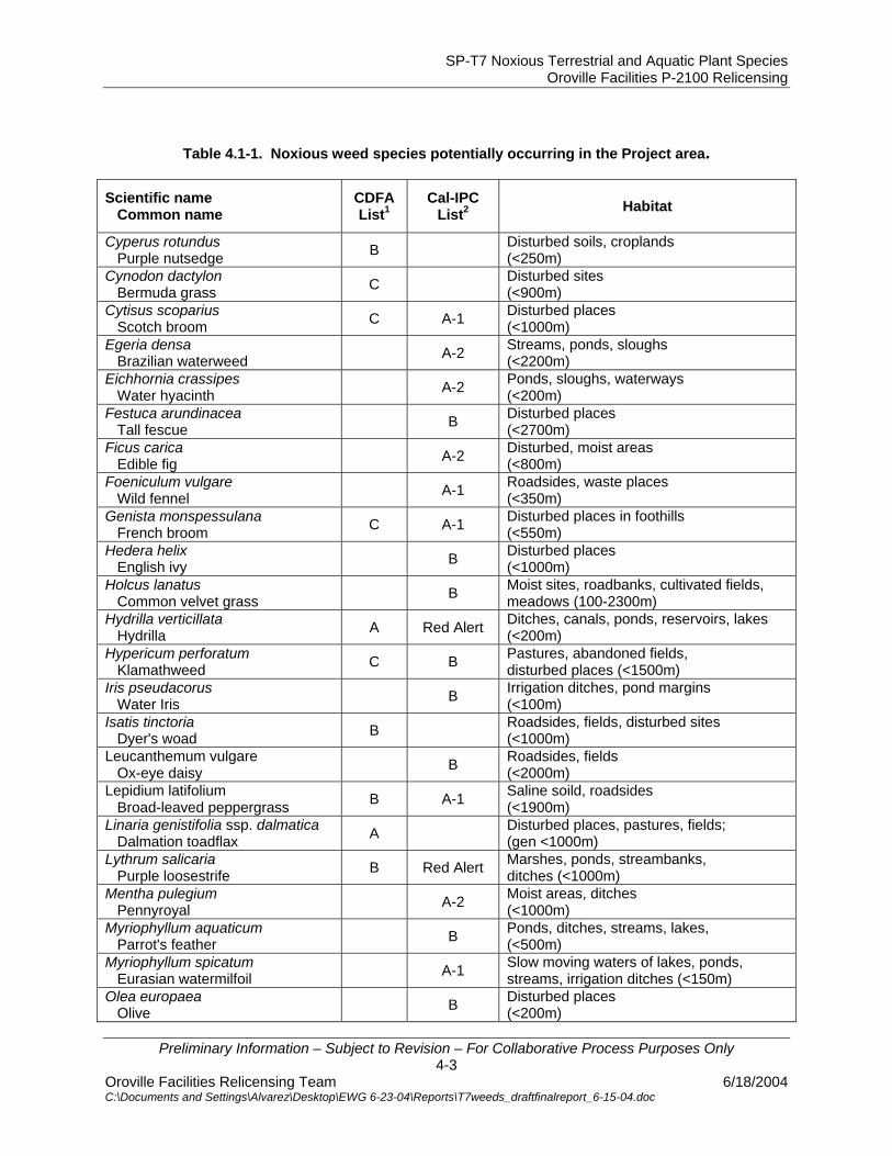
Table 4.1-1. Noxious weed species potentially occurring in the Project area.
Scientific name Common name
CDFA List1
Cal-IPC List2 Habitat
Aegilops cylindrical Jointed goatgrass B Disturbed dry sites, cultivated fields
(<1500m) Aegilops triuncialis Barbed goatgrass B Disturbed sites, cultivated fields,
roadsides (<1000m) Ailanthus altissima Tree of heaven A-2 Disturbed urban areas, waste places,
riparian areas, grasslands (<1250m) Arundo donax Giant reed A-1 Moist places, seeps, ditchbanks
(<500m) Bassia hyssopifolia Five-horn bassia B Disturbed sites, fields, roadsides
(<1200m) Brassica nigra Black mustard B Fields, disturbed areas
(<1500m) Bromus madritensis ssp. rubens Red brome A-2 Open, disturbed places
(<2200m) Bromus tectorum Cheat grass A-1 Open, disturbed places
(<2200m) Cardaria chalepensis Lens-podded hoarycress B B Disturbed, gen saline soils,
fields (<1500m) Cardaria pubescens Whitetop B Saline soils, fields, ditchbanks
(<2000m) Carduus pycnocephalus Italian thistle C B Roadsides, pastures, waste areas
(<1000m) Centaurea calcitrapa Purple star-thistle B B Disturbed places
(<1000m) Centaurea maculosa Spotted knapweed A Red Alert Disturbed areas
(<2000m) Centaurea melitensis Tocalote B Disturbed fields, open woods
(<2200m) Centaurea solstitialis Yellow starthistle C A-1 Pastures, roadsides, disturbed
grassland or woodland (<1300m) Chondrilla juncea Skeleton weed A Disturbed places
(<600m) Cirsium arvense Canada thistle B B Disturbed places
(<1800m) Cirsium vulgare Bull thistle B Disturbed places
(<2300m) Conium maculatum Poison hemlock B Moist, disturbed places
(<1000m) Convolvulus arvensis Field bindweed C Orchards, gardens
(gen <1500m) Coronopus squamatus Swine cress B Disturbed places, fields
(<2300m) Cortaderia selloana Pampas grass A-1 Disturbed sites
(<300m) Cyperus esculentus Yellow nutsedge B Croplands, disturbed places
(<1000m)
SP-T7 Noxious Terrestrial and Aquatic Plant Species Oroville Facilities P-2100 Relicensing
Preliminary Information – Subject to Revision – For Collaborative Process Purposes Only 4-3
Oroville Facilities Relicensing Team 6/18/2004 C:\Documents and Settings\Alvarez\Desktop\EWG 6-23-04\Reports\T7weeds_draftfinalreport_6-15-04.doc
Table 4.1-1. Noxious weed species potentially occurring in the Project area.
Scientific name Common name
CDFA List1
Cal-IPC List2 Habitat
Cyperus rotundus Purple nutsedge B Disturbed soils, croplands
(<250m) Cynodon dactylon Bermuda grass C Disturbed sites
(<900m) Cytisus scoparius Scotch broom C A-1 Disturbed places
(<1000m) Egeria densa Brazilian waterweed A-2 Streams, ponds, sloughs
(<2200m) Eichhornia crassipes Water hyacinth A-2 Ponds, sloughs, waterways
(<200m) Festuca arundinacea Tall fescue B Disturbed places
(<2700m) Ficus carica Edible fig A-2 Disturbed, moist areas
(<800m) Foeniculum vulgare Wild fennel A-1 Roadsides, waste places
(<350m) Genista monspessulana French broom C A-1 Disturbed places in foothills
(<550m) Hedera helix English ivy B Disturbed places
(<1000m) Holcus lanatus Common velvet grass B Moist sites, roadbanks, cultivated fields,
meadows (100-2300m) Hydrilla verticillata Hydrilla A Red Alert Ditches, canals, ponds, reservoirs, lakes
(<200m) Hypericum perforatum Klamathweed C B Pastures, abandoned fields,
disturbed places (<1500m) Iris pseudacorus Water Iris B Irrigation ditches, pond margins
(<100m) Isatis tinctoria Dyer's woad B Roadsides, fields, disturbed sites
(<1000m) Leucanthemum vulgare Ox-eye daisy B Roadsides, fields
(<2000m) Lepidium latifolium Broad-leaved peppergrass B A-1 Saline soild, roadsides
(<1900m) Linaria genistifolia ssp. dalmatica Dalmation toadflax A Disturbed places, pastures, fields;
(gen <1000m) Lythrum salicaria Purple loosestrife B Red Alert Marshes, ponds, streambanks,
ditches (<1000m) Mentha pulegium Pennyroyal A-2 Moist areas, ditches
(<1000m) Myriophyllum aquaticum Parrot's feather B Ponds, ditches, streams, lakes,
(<500m) Myriophyllum spicatum Eurasian watermilfoil A-1 Slow moving waters of lakes, ponds,
streams, irrigation ditches (<150m) Olea europaea Olive B Disturbed places
(<200m)

SP-T7 Noxious Terrestrial and Aquatic Plant Species Oroville Facilities P-2100 Relicensing
Preliminary Information – Subject to Revision – For Collaborative Process Purposes Only 4-4
Oroville Facilities Relicensing Team 6/18/2004 C:\Documents and Settings\Alvarez\Desktop\EWG 6-23-04\Reports\T7weeds_draftfinalreport_6-15-04.doc
Table 4.1-1. Noxious weed species potentially occurring in the Project area.
Scientific name Common name
CDFA List1
Cal-IPC List2 Habitat
Phalaris aquatica Harding grass B Wet areas, ditches
(<1200m) Polygonum amphibium var emersum Swamp smartweed
C Shallow lakes, streams, shores (<1500m)
Potamogeton crispus Crispate-leaved pondweed B Shallow water, ponds, reservoirs, streams
(<2100m) Robinia pseudoacacia Black locust B Roadsides, canyon slopes, stream banks
(50-1900m) Rubus discolor Himalayan blackberry A-1 Distrubed moist areas
(<1600m) Salsola tragus Common russian thistle C Disturbed places
(<2700m) Sapium sebiferum Chinese tallow tree Red Alert Along streams, wetlands
(<100m) Saponaria officinalis Bouncing bet A-2 Roadsides, oak woodlands,streambeds,
disturbed areas (<1500m) Senecio jacobaea Tansy ragwort B B Pastures, disturbed places
(<1600m) Sesbania punicea Scarlet wisteria tree Red Alert Banks of ditches and streams; wet
roadsides (30-330m) Solanum elaeagnifolium White horsenettle B Dry, disturbed places
fields (<1200m) Sorghum halepense Johnson grass C Disturbed areas, ditchbanks,
roadsides (<800m) Spartium junceum Spanish broom B Disturbed areas
(<600m) Taeniatherum caput-medusae Medusa-head C A-1 Grassy slopes and flats
Tamarix parviflora, T. ramosissima Tamarisk, salt cedar A-1 Washes, streambanks, ditches
(<800m) Tribulus terrestris Puncturevine C Roadsides, railways, vacant lots,
dry, disturbed areas (<100m) Verbascum thapsus Wooly mullein B Disturbed areas
(<2200m) Vinca major Periwinkle B Sheltered places, especially along
streams (2-200m) 1California Department of Food & Agriculture List of Noxious Weeds: List A - Most invasive wildland pest plants - eradication, containment or other holding action at the state-county level; List B – Includes species less widespread and more difficult to contain - eradication, containment, control or other holding action at the discretion of the Commissioner: List C - Weeds that are so widespread that the agency does not endorse state or county-funded eradication except in nurseries. 2California Invasive Plant Council List of Exotic Pest Plants of Greatest Ecological Concern: List A-1 – Most invasive wildland pest plants, widespread; List A-2 - Most invasive wildland pest plants, regional; List B: Wildland pest plants of lesser invasiveness; List Red Alert: Species with potential to spread explosively, infestation currently restricted.
SP-T7 Noxious Terrestrial and Aquatic Plant Species Oroville Facilities P-2100 Relicensing
Preliminary Information – Subject to Revision – For Collaborative Process Purposes Only 4-5
Oroville Facilities Relicensing Team 6/18/2004 C:\Documents and Settings\Alvarez\Desktop\EWG 6-23-04\Reports\T7weeds_draftfinalreport_6-15-04.doc
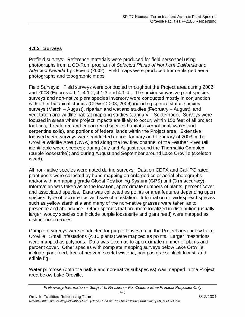
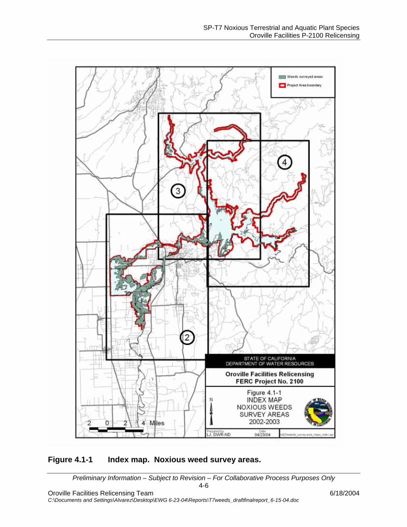
4.1.2 Surveys Prefield surveys: Reference materials were produced for field personnel using photographs from a CD-Rom program of Selected Plants of Northern California and Adjacent Nevada by Oswald (2002). Field maps were produced from enlarged aerial photographs and topographic maps. Field Surveys: Field surveys were conducted throughout the Project area during 2002 and 2003 (Figures 4.1-1, 4.1-2, 4.1-3 and 4.1-4). The noxious/invasive plant species surveys and non-native plant species inventory were conducted mostly in conjunction with other botanical studies (CDWR 2003, 2004) including special status species surveys (March – August), riparian and wetland studies (February – August), and vegetation and wildlife habitat mapping studies (January – September). Surveys were focused in areas where project impacts are likely to occur, within 150 feet of all project facilities, threatened and endangered species habitats (vernal pool/swales and serpentine soils), and portions of federal lands within the Project area. Extensive focused weed surveys were conducted during January and February of 2003 in the Oroville Wildlife Area (OWA) and along the low flow channel of the Feather River (all identifiable weed species); during July and August around the Thermalito Complex (purple loosestrife); and during August and September around Lake Oroville (skeleton weed). All non-native species were noted during surveys. Data on CDFA and Cal-IPC rated plant pests were collected by hand mapping on enlarged color aerial photographs and/or with a mapping grade Global Positioning System (GPS) unit (3 m accuracy). Information was taken as to the location, approximate numbers of plants, percent cover, and associated species. Data was collected as points or area features depending upon species, type of occurrence, and size of infestation. Information on widespread species such as yellow starthistle and many of the non-native grasses were taken as to presence and abundance. Other species that are more localized in distribution (usually larger, woody species but include purple loosestrife and giant reed) were mapped as distinct occurrences. Complete surveys were conducted for purple loosestrife in the Project area below Lake Oroville. Small infestations (< 10 plants) were mapped as points. Larger infestations were mapped as polygons. Data was taken as to approximate number of plants and percent cover. Other species with complete mapping surveys below Lake Oroville include giant reed, tree of heaven, scarlet wisteria, pampas grass, black locust, and edible fig. Water primrose (both the native and non-native subspecies) was mapped in the Project area below Lake Oroville.
SP-T7 Noxious Terrestrial and Aquatic Plant Species Oroville Facilities P-2100 Relicensing
Preliminary Information – Subject to Revision – For Collaborative Process Purposes Only 4-6
Oroville Facilities Relicensing Team 6/18/2004 C:\Documents and Settings\Alvarez\Desktop\EWG 6-23-04\Reports\T7weeds_draftfinalreport_6-15-04.doc
Figure 4.1-1 Index map. Noxious weed survey areas.
SP-T7 Noxious Terrestrial and Aquatic Plant Species Oroville Facilities P-2100 Relicensing
Preliminary Information – Subject to Revision – For Collaborative Process Purposes Only 4-7
Oroville Facilities Relicensing Team 6/18/2004 C:\Documents and Settings\Alvarez\Desktop\EWG 6-23-04\Reports\T7weeds_draftfinalreport_6-15-04.doc
Figure 4.1-2 Noxious weeds – survey areas 2002-2003.

SP-T7 Noxious Terrestrial and Aquatic Plant Species Oroville Facilities P-2100 Relicensing
Preliminary Information – Subject to Revision – For Collaborative Process Purposes Only 4-8
Oroville Facilities Relicensing Team 6/18/2004 C:\Documents and Settings\Alvarez\Desktop\EWG 6-23-04\Reports\T7weeds_draftfinalreport_6-15-04.doc
Figure 4.1-3 Noxious weeds – survey areas 2002-2003.

SP-T7 Noxious Terrestrial and Aquatic Plant Species Oroville Facilities P-2100 Relicensing
Preliminary Information – Subject to Revision – For Collaborative Process Purposes Only 4-9
Oroville Facilities Relicensing Team 6/18/2004 C:\Documents and Settings\Alvarez\Desktop\EWG 6-23-04\Reports\T7weeds_draftfinalreport_6-15-04.doc
Figure 4.1-4 Noxious weeds – survey areas 2002-2003.

SP-T7 Noxious Terrestrial and Aquatic Plant Species Oroville Facilities P-2100 Relicensing
Preliminary Information – Subject to Revision – For Collaborative Process Purposes Only 4-10
Oroville Facilities Relicensing Team 6/18/2004 C:\Documents and Settings\Alvarez\Desktop\EWG 6-23-04\Reports\T7weeds_draftfinalreport_6-15-04.doc
4.1.3 GIS and Data Management Data from field maps were entered into GIS. GIS maps were produced of the locations of noxious and invasive plant species that are rated by the Department of Food and Agriculture and/or the California Invasive Plant Council. A list was compiled of all aquatic and terrestrial noxious plant species mapped in the Project area during these surveys. 4.1.4 Evaluation Information from the literature review and mapped occurrence data was used to evaluate the effects of project operations, maintenance activities, and recreational use patterns on the distribution and dispersal of the target plant species.
SP-T7 Noxious Terrestrial and Aquatic Plant Species Oroville Facilities P-2100 Relicensing
Preliminary Information – Subject to Revision – For Collaborative Process Purposes Only 5-1
Oroville Facilities Relicensing Team 6/18/2004 C:\Documents and Settings\Alvarez\Desktop\EWG 6-23-04\Reports\T7weeds_draftfinalreport_6-15-04.doc
5.0 STUDY RESULTS 5.1 REVIEW OF EXISTING LITERATURE
A review of existing literature, databases, and reference material indicates the project area may support 64 noxious or invasive plant species rated by the California Department of Food and Agriculture, the California Invasive Plant Council, the U.S. Department of Agriculture, and the Plumas National Forest.
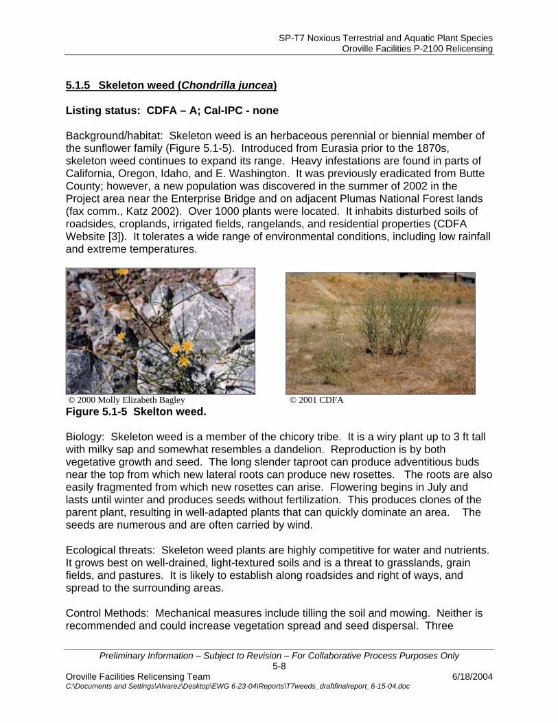
Information relating to the biology and ecology, dispersal mechanisms, control measures, and current management activities of individual species of greatest concern within the Project area is included below. A key to listing status can be found at the bottom of Table 4.1-1.
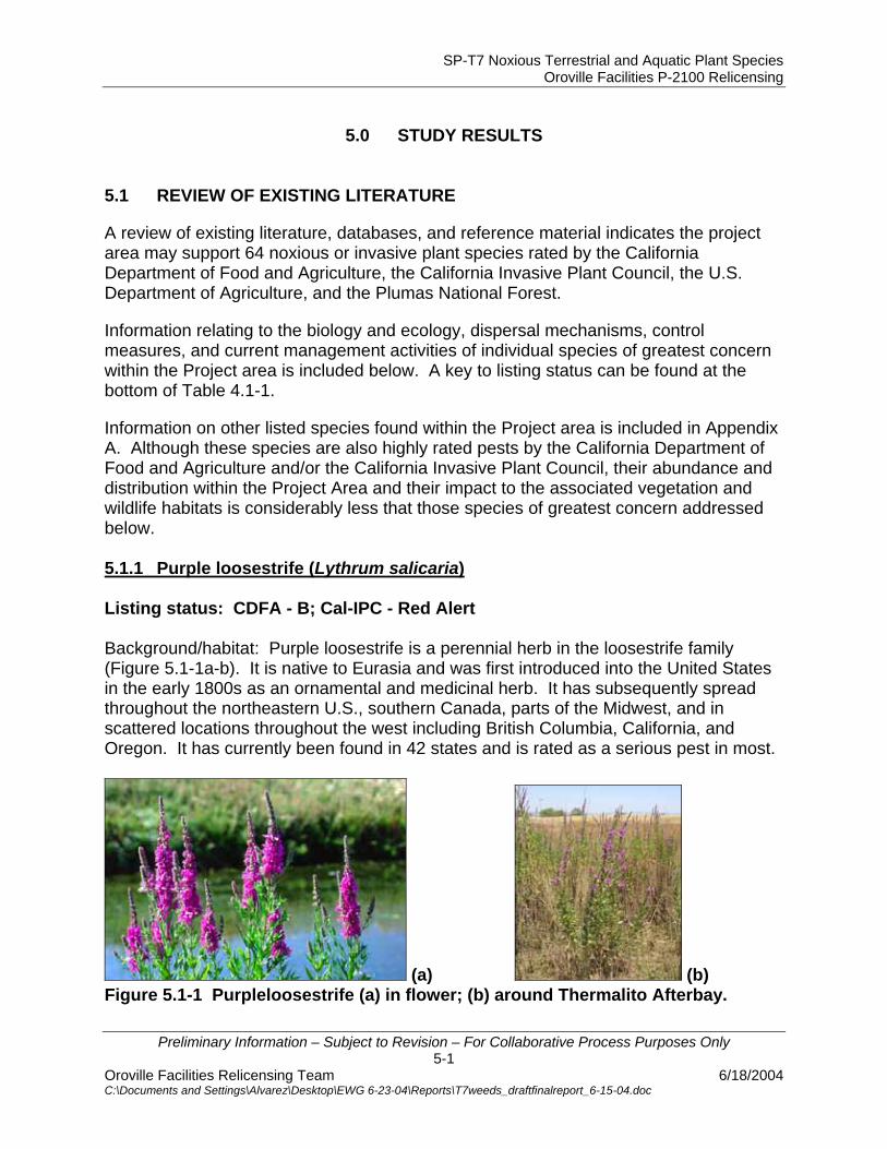
Information on other listed species found within the Project area is included in Appendix A. Although these species are also highly rated pests by the California Department of Food and Agriculture and/or the California Invasive Plant Council, their abundance and distribution within the Project Area and their impact to the associated vegetation and wildlife habitats is considerably less that those species of greatest concern addressed below. 5.1.1 Purple loosestrife (Lythrum salicaria) Listing status: CDFA - B; Cal-IPC - Red Alert Background/habitat: Purple loosestrife is a perennial herb in the loosestrife family (Figure 5.1-1a-b). It is native to Eurasia and was first introduced into the United States in the early 1800s as an ornamental and medicinal herb. It has subsequently spread throughout the northeastern U.S., southern Canada, parts of the Midwest, and in scattered locations throughout the west including British Columbia, California, and Oregon. It has currently been found in 42 states and is rated as a serious pest in most.
(a) (b) Figure 5.1-1 Purpleloosestrife (a) in flower; (b) around Thermalito Afterbay.
SP-T7 Noxious Terrestrial and Aquatic Plant Species Oroville Facilities P-2100 Relicensing
Preliminary Information – Subject to Revision – For Collaborative Process Purposes Only 5-2
Oroville Facilities Relicensing Team 6/18/2004 C:\Documents and Settings\Alvarez\Desktop\EWG 6-23-04\Reports\T7weeds_draftfinalreport_6-15-04.doc
Biology: Purple loosestrife is typically 1-5 ft tall but in nutrient-rich soils may reach 10 ft in height. The showy spike-like inflorescence consists of numerous rose-purple flowers and blooms from July to September. It spreads primarily by seed but will also spread by the resprouting of cut stems or roots (Ducks Unlimited Canada Website). Each plant produces numerous tiny seeds that are transported along waterways. It tolerates a wide range of environmental conditions including fluctuating water levels. Ecological threats: Purple loosestrife is common in disturbed wetland habitats including stream and river banks, edges of ponds, lakes, and reservoirs, flooded area, ditches and roadsides as well as marshes, wet prairies, meadows, and bogs (Bossard et al. 2000). Its rapid growth and enormous reproductive capacity allow it to spread rapidly and outcompete native plants. In its native range, natural predators control population spread. In the U.S., purple loosestrife replaces native plant species and forms dense stands that are unsuitable as cover, food, or nesting sites for a wide range of native animal species (State of Iowa Website). Control methods: Control of purple loosestrife depends on the age and size of the infestation, the importance of impacts to non-targeted species, and the type and amount of resources available. All methods require appropriate timing and follow-up control and monitoring. Physical control may be used in areas with small localized stands (up to 100 plants). The plants may be pulled or dug up by the roots. Cutting or burning is not effective and may result in loosestrife reestablishment. Several biological control agents have the potential to aid in the control of purple loosestrife. These include both a root-mining weevil, a flower-feeding beetle, and two species of leaf-eating beetles (Galerucella spp.). These have shown positive results, however, further research on Galerucella spp. in California is necessary before large-scale release is approved. In other states, it has taken four to six years for Galerucella spp. to become fully established (Bossard et al. 2000). Glyphosate (Rodeo/Roundup®) is the most common herbicide used to control purple loosestrife. Glyphosate is a non-selective herbicide that kills all of the vegetation, including surrounding native vegetation that is critical in the recolonization of the site. Broadcast spraying of non-selective herbicides could result in an increase in loosestrife density (TNC 1987). Glyphosate can be applied by hand sprayers which decreases the impact to surrounding vegetation, however, this method is more time consuming and labor intensive. The herbicide triclopyr (Garlon 3A or Renovate) has undergone evaluation and has been approved for use in aquatic environments. The advantage of triclopyr is it is selective for broadleaf plants and does not harm grasses and most other monocots, such as rushes and sedges, which are important in wetland habitats. Local management measures specific to purple loosestrife: CDFA - Studies have been conducted using biological agents in the project area by the California Department of Food and Agriculture (CDFA Website [2]). In 1996 and 1997,
SP-T7 Noxious Terrestrial and Aquatic Plant Species Oroville Facilities P-2100 Relicensing
Preliminary Information – Subject to Revision – For Collaborative Process Purposes Only 5-3
Oroville Facilities Relicensing Team 6/18/2004 C:\Documents and Settings\Alvarez\Desktop\EWG 6-23-04\Reports\T7weeds_draftfinalreport_6-15-04.doc
eggs of a root-boring weevil were placed in cut stems of purple loosestrife in the project vicinity. Establishment of the insects has not been confirmed. Significant flooding may have adversely affected their establishment. Additionally, the leaf-feeding beetles (Galerucella spp.) have been released into loosestrife stands in the project area in 1998, 2000, and 2001. In May and June of 2004, CDFA will again collect and release Galerucella spp. into a number of sites around the Thermalito Afterbay. California Department of Parks and Recreation (DPR) – With funds provided by SB 1740 and in-kind services provided by CDFA, DPR has conducted mapping and control efforts for purple loosestrife in the area of the Thermalito Forebay, the Diversion Pool, and the area between the Diversion Pool and the Fish Barrier Dam. In August 2000, the shoreline and riparian areas were mapped. In July 2001, approximately 3.0 miles of Thermalito Forebay and Diversion Pool shoreline were treated with the herbicide Rodeo by use of a Gator-mounted 50-gallon spray rig and an airboat provided and operated by CDFA. In 2002, the area was again sprayed by airboat. The loosestrife was found in roughly the same shoreline distribution, but much reduced in number. The total herbicide use in 2002 was less than half of that used in 2001 (CDPR 2001, 2002, 2003). California Department of Fish and Game (DFG) – With funds provided by SB 1740 and in-kind services provided by CDFA, DWR, and the Butte County Agriculture Department, DFG conducted loosestrife treatment around the Thermalito Afterbay and portions of the Oroville Wildlife Area (OWA). In July 2002, the shoreline of the Thermalito Afterbay was treated by helicopter with the herbicide Rodeo. Two weeks later, purple loosestrife was spot sprayed by boat along both sides of the Feather River from the Hwy 162 Bridge south to the end of the OWA (pers. comm., Stone 2003). No official pre- or post-monitoring has been conducted to rate the effectiveness of the application or its effect on associated plant species or habitat. 5.1.2 Giant reed (Arundo donax) Listing status: CDFA A; Cal-IPC A-1 Background/habitat: Giant reed is a tall perennial cane-like grass that grows in moist places such as ditches, streams, and riverbanks (Figure 5.1-2). It grows best in well-drained soils but tolerates both high salinity and harsh soil types. It is believed to be native to freshwater areas of eastern Asia, but has been cultivated throughout the Mediterranean region for thousands of years. It was introduced to California in the 1820s in the Los Angeles area as an erosion-control agent in drainage canals. It is cultivated as an ornamental and widely planted for erosion control throughout the south. Giant reed is an invasive pest throughout the warmer coastal freshwater areas of the U.S. from Maryland to northern California. It has a variety of uses including medicinal, basketry, fishing rods, and music. (Bell 1997; NPS Website; TNC 1986a; The Santa Margarita and San Luis Rey Watersheds Management Area Website).
SP-T7 Noxious Terrestrial and Aquatic Plant Species Oroville Facilities P-2100 Relicensing
Preliminary Information – Subject to Revision – For Collaborative Process Purposes Only 5-4
Oroville Facilities Relicensing Team 6/18/2004 C:\Documents and Settings\Alvarez\Desktop\EWG 6-23-04\Reports\T7weeds_draftfinalreport_6-15-04.doc
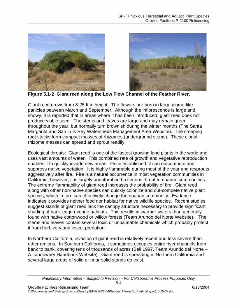
Figure 5.1-2 Giant reed along the Low Flow Channel of the Feather River. Giant reed grows from 8-25 ft in height. The flowers are born in large plume-like panicles between March and September. Although the inflorescence is large and showy, it is reported that in areas where it has been introduced, giant reed does not produce viable seed. The stems and leaves are large and may remain green throughout the year, but normally turn brownish during the winter months (The Santa Margarita and San Luis Rey Watersheds Management Area Website). The creeping root stocks form compact masses of rhizomes (underground stems). These clonal rhizome masses can spread and sprout readily. Ecological threats: Giant reed is one of the fastest growing land plants in the world and uses vast amounts of water. This combined rate of growth and vegetative reproduction enables it to quickly invade new areas. Once established, it can outcompete and suppress native vegetation. It is highly flammable during most of the year and resprouts aggressively after fire. Fire is a natural occurrence in most vegetation communities in California, however, it is largely unnatural and a serious threat to riparian communities. The extreme flammability of giant reed increases the probability of fire. Giant reed along with other non-native species can quickly colonize and out-compete native plant species, which in turn can effectively change the riparian community. Evidence indicates it provides neither food nor habitat for native wildlife species. Recent studies suggest stands of giant reed lack the canopy structure necessary to provide significant shading of bank-edge riverine habitats. This results in warmer waters than generally found with native cottonwood or willow forests (Team Arundo del Norte Website). The stems and leaves contain several toxic or unpalatable chemicals which probably protect it from herbivory and insect predation. In Northern California, invasion of giant reed is relatively recent and less severe than other regions. In Southern California, it sometimes occupies entire river channels from bank to bank, covering tens of thousands of acres (Bell 1997, Team Arundo del Norte – A Landowner Handbook Website). Giant reed is spreading in Northern California and several large areas of solid or near-solid stands do exist.
SP-T7 Noxious Terrestrial and Aquatic Plant Species Oroville Facilities P-2100 Relicensing
Preliminary Information – Subject to Revision – For Collaborative Process Purposes Only 5-5
Oroville Facilities Relicensing Team 6/18/2004 C:\Documents and Settings\Alvarez\Desktop\EWG 6-23-04\Reports\T7weeds_draftfinalreport_6-15-04.doc
Control Methods: Control of giant reed usually involves more than one method and is dependent on the size of the infestation and the presence of native vegetation. All methods require follow-up control and monitoring. Manual control involves cutting the stems above the base and removing the biomass. Plants can also be dug up to remove the roots. This method disturbs the soil and may help cause erosion. Roots that were missed or cut can also sprout or be carried downstream. The chemical glyphosate (Roundup® or Rodeo®) is the most commonly used herbicide on giant reed. This systemic herbicide is absorbed by plant leaves and stems and is transported to the plant’s root system where it kills the entire plant. According to Bell (1986), application is most effective during mid-August to early November when the plants are actively translocating nutrients to the rootmass in preparation for winter dormancy. In taller or large stands of giant reed, one approach is to cut the stalks and remove the biomass, wait three to six weeks for the plants to grow and then apply a foliar spray of herbicide. This requires less herbicide and has less chance of overspray onto associated native plant species. This approach may require more follow up applications. Another effective herbicide application involves cutting the stalks and applying undiluted glyphosate directly to the stump. Little is known about the use of various pathogens and insects on the growth and reproduction of giant reed in California. The USDA has not approved any biological control agents for use against giant reed in California. All methods require removal or disposal of the cut cane since they are still viable and capable of reestablishment. These can be stacked for composting, chipped, burned, or hauled away from the site. Local management measures specific to giant reed: none known. 5.1.3 Tree of heaven (Ailanthus altissima) Listing status: CDFA – none; Cal-IPC B Background/habitat: Tree of heaven is a rapidly growing, deciduous tree in the mostly tropical family Simaroubaceae (Figure 5.1-3a-b). Native to China, it was first introduced in the U.S. in 1784 and by 1840 was commonly available from nurseries. During the gold rush, Chinese miners are thought to have brought seeds with them as they settled in California. It was planted throughout the U.S. during the last century; however, its popularity as an ornamental has declined. In California it is widely naturalized in cismontane areas of the Coast Range, Sierran foothills, and Central Valley below 6,600 ft in elevation. It is found mainly in wastelands and disturbed, semi-natural habitats, however, it also occurs in riparian and other naturally disturbed habitats (Bossard et al. 2000).

SP-T7 Noxious Terrestrial and Aquatic Plant Species Oroville Facilities P-2100 Relicensing
Preliminary Information – Subject to Revision – For Collaborative Process Purposes Only 5-6
Oroville Facilities Relicensing Team 6/18/2004 C:\Documents and Settings\Alvarez\Desktop\EWG 6-23-04\Reports\T7weeds_draftfinalreport_6-15-04.doc
(a) (b) Figure 5.1-3 Tree of heaven (a) along LFC; (b) replacing cottonwoods following a burn in the OWA. Biology: Tree of heaven reproduces both sexually and asexually. Flowering occurs in late spring; seeds ripen in the fall; and may persist on the plants through the next winter. Seedlings establish themselves by producing a well-formed taproot in less than three months. Trees can also produce numerous suckers from the roots and resprout vigorously from cut stumps and root fragments (NPS Website; Bossard et al. 2000; TNC 1988a). Ecological threats: Tree of heaven is a prolific seed producer, grows rapidly, and resprouts vigorously. It can successfully out-compete native vegetation, especially in riparian areas, and can quickly take over a site. It produces toxic chemicals that inhibit the establishment of other species. In urban areas, it can disrupt sidewalks, parking lots, and streets. Control methods: Control methods for tree of heaven usually require more than one method, multiple-year treatments, and follow-up monitoring. Physical controls involve hand pulling; cutting or girdling the trees; hand digging to remove all parts of the tree including the roots; and prescribed burns. Because these trees are prolific stump and root sprouters, additional control measures are necessary with each of these treatments. Chemical control involves application to the leaves, basal bark, cut stumps, or injected into wounds or cuts. Foliar sprays should not be used where non-target species are nearby. Applying herbicides directly to the tops of freshly cut stumps is probably the most effective technique with little chance for damage to adjacent vegetation. Bossard et al. (2000) recommends wiping the stumps within several minutes of cutting with full strength, 41 percent glyphosate. Biological control of tree of heaven is not addressed to any extent in any of the literature. No insects or diseases are known to significantly affect tree of heaven. All types of control should include a revegetation plan for the disturbed sites. Local management measures specific to tree of heaven: none known.

SP-T7 Noxious Terrestrial and Aquatic Plant Species Oroville Facilities P-2100 Relicensing
Preliminary Information – Subject to Revision – For Collaborative Process Purposes Only 5-7
Oroville Facilities Relicensing Team 6/18/2004 C:\Documents and Settings\Alvarez\Desktop\EWG 6-23-04\Reports\T7weeds_draftfinalreport_6-15-04.doc
5.1.4 Scarlet wisteria (Sesbania punicea) Listing status: CDFA – none; Cal-IPC - Red Alert Background/habitat: Scarlet wisteria is a deciduous riparian shrub or small tree in the legume family (Figure 5.1-4a-b). It is native to South America and is sold as an ornamental. It is considered a serious pest in South Africa. In the U.S., it has invaded native habitats in Florida, Georgia to E. Texas, and recently in the central valley of California. This species range is expanding and has only recently been added to the Cal-IPC list. In Butte County, it is known to occur in both the OWA and along the Feather River near Oroville (Oswald 1994, Hickman 1993). Available information on this species is limited, however, efforts are underway throughout its current range to map and control the current infestation before it expands further.
(a) (b) Figure 5.1-4 Scarlet wisteria (a) along LFC; (b) numerous flowers and seed pods. Biology: Scarlet wisteria can grow up to 13 ft. tall. It has showy bright red flowers and produces hundreds of seedpods throughout the summer and fall. These persist after leaf fall through the winter. Once the pods fall, they are dispersed by water. Ecological threats: Scarlet wisteria forms solid stands along riverbanks, displacing native vegetation and wildlife habitat. Each plant produces numerous seeds, which in turn can potentially travel great distances by water. All parts of the plant, particularly the seeds, are poisonous to mammals, birds, and reptiles. Control methods: Mechanical measures include pulling young plants by hand or with a weed wrench. Larger trees can be cut and the stumps treated with an herbicide. Three biocontrol agents are used against scarlet wisteria in South Africa, but no information is available for California. (TNC Website; The San Joaquin River Parkway and Conservation Trust Website; pers. comm. Fallscheer 2002). Local management measures specific to scarlet wisteria: none known.
SP-T7 Noxious Terrestrial and Aquatic Plant Species Oroville Facilities P-2100 Relicensing
Preliminary Information – Subject to Revision – For Collaborative Process Purposes Only 5-8
Oroville Facilities Relicensing Team 6/18/2004 C:\Documents and Settings\Alvarez\Desktop\EWG 6-23-04\Reports\T7weeds_draftfinalreport_6-15-04.doc
5.1.5 Skeleton weed (Chondrilla juncea) Listing status: CDFA – A; Cal-IPC - none Background/habitat: Skeleton weed is an herbaceous perennial or biennial member of the sunflower family (Figure 5.1-5). Introduced from Eurasia prior to the 1870s, skeleton weed continues to expand its range. Heavy infestations are found in parts of California, Oregon, Idaho, and E. Washington. It was previously eradicated from Butte County; however, a new population was discovered in the summer of 2002 in the Project area near the Enterprise Bridge and on adjacent Plumas National Forest lands (fax comm., Katz 2002). Over 1000 plants were located. It inhabits disturbed soils of roadsides, croplands, irrigated fields, rangelands, and residential properties (CDFA Website [3]). It tolerates a wide range of environmental conditions, including low rainfall and extreme temperatures.
© 2000 Molly Elizabeth Bagley © 2001 CDFA
Figure 5.1-5 Skelton weed. Biology: Skeleton weed is a member of the chicory tribe. It is a wiry plant up to 3 ft tall with milky sap and somewhat resembles a dandelion. Reproduction is by both vegetative growth and seed. The long slender taproot can produce adventitious buds near the top from which new lateral roots can produce new rosettes. The roots are also easily fragmented from which new rosettes can arise. Flowering begins in July and lasts until winter and produces seeds without fertilization. This produces clones of the parent plant, resulting in well-adapted plants that can quickly dominate an area. The seeds are numerous and are often carried by wind. Ecological threats: Skeleton weed plants are highly competitive for water and nutrients. It grows best on well-drained, light-textured soils and is a threat to grasslands, grain fields, and pastures. It is likely to establish along roadsides and right of ways, and spread to the surrounding areas. Control Methods: Mechanical measures include tilling the soil and mowing. Neither is recommended and could increase vegetation spread and seed dispersal. Three

SP-T7 Noxious Terrestrial and Aquatic Plant Species Oroville Facilities P-2100 Relicensing
Preliminary Information – Subject to Revision – For Collaborative Process Purposes Only 5-9
Oroville Facilities Relicensing Team 6/18/2004 C:\Documents and Settings\Alvarez\Desktop\EWG 6-23-04\Reports\T7weeds_draftfinalreport_6-15-04.doc
organisms have been released for control of skeleton weed in California – two gall mites and a rust. The rust has demonstrated considerable success in California (CDFA Website [3]). There are few herbicides available for use on skeleton weed. Repeat treatments are necessary to be effective. Local management measures specific to skeleton weed: Butte County and the California Department of Parks and Recreation (DPR) have targeted the infestations along Lumpkin Road near the Enterprise Bridge both within the Project area and along the County road. This infestation has been sprayed with the herbicide Transline®. 5.1.6 Yellow starthistle (Centaurea solstitialis) Listing status: CDFA C; Cal-IPC A-1 Background/habitat: Yellow starthistle is a deep-taprooted winter annual or occasionally a short-lived perennial member of the composite family (Asteraceae). It thrives in areas with hot, dry summers and well-drained soils, especially where disturbance has occurred. A native of Eurasia, it was first collected in Oakland, California in 1869. By 1917 it had become a serious weed in the Sacramento Valley, spreading rapidly (Bossard et al. 2000). It had spread to over a million acres of California by the late 1950s and nearly two million acres by 1965. In 1985, it was estimated to cover eight million acres and over 10 million acres a decade later. Yellow starthistle is established in 23 states, but is most problematic in California. Human activities are the primary mechanisms for seed transport (Bossard et al. 2000). Biology: Yellow starthistle grows from 6 – 72 inches in height. The inflorescence is produced in late May to December and consists of one to many solitary spiny yellow-flowered heads. Plants are able to regrow and produce flowers after mowing or grazing. Seed output can be high with about 95 percent of the seed being viable. Most seeds germinate the following year after the first fall rains, but can persist as viable seed in the soil for up to 10 years (TNC 1992). Seed dispersal is mainly by humans and animals; the stiff hair-like barbs on the fruit adhere to clothing and to the hair and fur of animals. Ecological threats: Yellow starthistle infestations displace native plants and decrease wildlife habitat. Once it colonizes an area, it can quickly spread. Often after control measures have been implemented, it will recolonize the area from adjacent infested lands, developed seed banks, and/or lack of competitive vegetation. Recent studies indicate it also significantly depletes soil moisture reserves in annual grasslands (UC Davis Weed Research and Information Center Website). It is a pest in agricultural lands, reduces pasture production, and is toxic to horses under long-term use.
SP-T7 Noxious Terrestrial and Aquatic Plant Species Oroville Facilities P-2100 Relicensing
Preliminary Information – Subject to Revision – For Collaborative Process Purposes Only 5-10
Oroville Facilities Relicensing Team 6/18/2004 C:\Documents and Settings\Alvarez\Desktop\EWG 6-23-04\Reports\T7weeds_draftfinalreport_6-15-04.doc
Control Methods: No individual method will control yellow starthistle and multiple treatments and persistence is required. Mechanical methods of control involve tilling, mowing, and prescribed burning. Tilling the land can expose more disturbed surface area to invasion by the starthistle. Mowing and burning can be beneficial if conducted at the proper time of year, usually after native plants have dispersed their seeds, and prior to starthistle setting seed. Burning is the preferred control technique by many agencies and organization. A number of biological control agents have been established in California. These include three weevils and three flies. All attack the flower heads and the larvae feed on the developing seeds. However, these insects do not appear to have significantly reduced the yellow starthistle populations. Other agents that are currently being studied include a root-attacking flea beetle and three fungal pathogens. Grazing by cattle, sheep, and goats can reduce biomass and seed production and dense revegetation with legumes and/or grasses may restrict starthistle expansion. Several non-selective pre-emergence herbicides registered in California will control yellow starthistle, however, these can only be used on right-of-ways or industrial sites and cannot be used in natural ecosystems. A limited number of post-emergence herbicides are registered for use in natural ecosystems and rangelands in California (Bossard et al. 2000; UC Davis Weed Research and Information Center Website). Local management measures specific to yellow starthistle: No large scale management is known in the area that specifically targets yellow starthistle. The California Department of Transportation (Cal Trans) and Butte County regularly spray roadsides for a number of weeds including yellow starthistle. The California Waterfowl Association has conducted trials on starthistle removal in areas around the Thermalito Afterbay. Biocontrol agents have been released in the Loafer Creek Recreation Area by CDFA. 5.1.7 Himalayan blackberry (Rubus discolor) Listing Status: CDFA – none; Cal-IPC – A-1 Background/habitat: Himalayan blackberry is a mostly evergreen shrub in the rose family. It is native to Western Europe and was first introduced as a crop plant in 1885. Since introduction, the plant has naturalized along the east coast, Ohio, and by 1945 the west coast of the United States. Himalayan blackberry has established in areas receiving adequate precipitation and elevations up to 6,000 feet. It is capable of growing on a variety of soils, both alkaline and acidic. Once established this blackberry is shade tolerant, but initial recruitment requires sunlight. In a given area Himalayan blackberry tends to colonize wetter areas, particularly after disturbance and can dominate range and pasture lands if not controlled. Pastures, drainages, roadsides, forest plantations, depressions, irrigation canals, and wetland margins are particularly susceptible to infestation by the Himalayan blackberry (Bossard et al. 2000; TNC 1989).
SP-T7 Noxious Terrestrial and Aquatic Plant Species Oroville Facilities P-2100 Relicensing
Preliminary Information – Subject to Revision – For Collaborative Process Purposes Only 5-11
Oroville Facilities Relicensing Team 6/18/2004 C:\Documents and Settings\Alvarez\Desktop\EWG 6-23-04\Reports\T7weeds_draftfinalreport_6-15-04.doc
Biology: Himalayan blackberry is an evergreen to semi-evergreen cane forming shrub that often forms impenetrable thickets under favorable conditions. Canes bear stout prickles and exhibit dimorphism. Some canes are erect reaching heights of 10 feet while other canes are decumbent to trailing and may reach lengths to 40 feet. Vegetative spread can be rapid as trailing canes form roots at the apex or as adventitious shoots arise from roots. Flowers appear in the spring on one or more year old canes. The white to light rose flowers are followed by the fruit, an aggregation of single seeded drupelets changing from green to red and finally ripening to black over an extended period from midsummer to fall. Seed production requires a certain amount of sunlight, as plants growing in dense shade do not produce seed. Seeds remain viable in the soil for several years. Seeds germinate in the spring with recruitment dependent upon sufficient sunlight (approximately 50% or greater). Seed dispersal is facilitated by the many birds and mammals that feed on the fruit (Bossard et al. 2000; TNC 1989). Ecological threats: Himalayan blackberry is a strong competitor and aggressively displaces native plant species. The dense, impenetrable thickets formed by Himalayan blackberry can prevent animals from reaching drinking water sources and choke out native vegetation. The interior of the thicket accumulates litter and dead canes resulting in a fire hazard in drier areas. Control methods: Control of Himalayan blackberry is difficult due to cane prickles, aggressive sprouting from root and cane fragments, copious seed production, and large energy reserves in the root system. Removal of the plant can be employed for small infestations, but is laborious and requires removal of all root and cane fragments. Herbicides, mowing, or burning kills the above ground canes but new canes quickly regenerate from the roots. Mechanized mowing or burning followed by application of herbicide to the root crown has been successful. Mowing or burning without supplemental herbicide use is best conducted during flowering to ensure low reserves in the root system. There is great resistance to introduction of insect controls as they would most likely damage closely related native and crop blackberries as well as Himalayan blackberry. Grazing has proven very effective at controlling spread of established thickets, but does not greatly reduce the size of an infestation. Goats have been most effective in both control of spread and reduction in size, especially when fenced in with Himalayan blackberry infestations at high density. Local management measures specific to Himalayan blackberry: No large-scale removal of Himalayan blackberry is known in the Project vicinity. The Oroville Field Division uses chemical treatment where infestations become a problem. Butte College initiated a grazing control program along Clear Creek within the Butte College campus. Goats are used to browse in the riparian areas and target a number of noxious weeds including Himalayan blackberry. This program has been very successful.

SP-T7 Noxious Terrestrial and Aquatic Plant Species Oroville Facilities P-2100 Relicensing
Preliminary Information – Subject to Revision – For Collaborative Process Purposes Only 5-12
Oroville Facilities Relicensing Team 6/18/2004 C:\Documents and Settings\Alvarez\Desktop\EWG 6-23-04\Reports\T7weeds_draftfinalreport_6-15-04.doc
5.1.8 Parrot’s feather (Myriophyllum aquaticum) Listing Status: CDFA – none; Cal-IPC – B Background/habitat: Parrot’s feather is a robust rhizomatous aquatic plant that forms dense mats in slow moving waters. It is native to freshwater drainages and impoundments in South America, but has become naturalized worldwide, particularly in warmer climates. The first confirmed report of naturalized parrot’s feather in the United States occurred near Washington D.C. in 1890. It is now found throughout much of the U.S. from New England to Florida and westward to California and Washington (Bossard et al. 2000). In northern and central California, it is found in freshwater lakes and ponds, and canals with slow-moving waters. It is commercially sold for use in indoor and outdoor aquaria (WSDOE Website). Biology: In the U.S. parrot’s feather reproduces solely from vegetative reproduction. Nearly all plants are female, even in its native range. The stems root freely from lower nodes and fragment easily. These fragments can settle in sediments and produce new plants. These fragments are easily spread by boats, trailers, waterfowl, other wildlife, and moving water. Stems of parrot’s feather, unlike other milfoils (Myriophyllum spp.) may grow as much as eight inches above the water surface (Bossard et al. 2000). Rhizome fragments stored moist for over a year in refrigerators are still viable as propagules. The tough, resilient rhizomes allow the plant to survive water fluctuations and draw downs in irrigation canal systems. While parrot’s feather is most often rooted in sediment, it can survive as a floating mass in nutrient rich water. Ecological threats: A 1985 California survey reported parrot’s feather had infested 600 miles of waterways and over 500 surface acres (Bossard et al. 2000). Dense growth can have severe indirect effects. Shading of algae and other photosynthetic producers can disrupt nutrient levels and food chains within aquatic ecosystems. The plant slows water movement resulting in changes in drainage characteristics and providing excellent habitat for mosquito larva. The high tannin content makes the plant unpalatable to most herbivores, thus removing and holding many nutrients. Control methods: Parrot’s feather is difficult to remove from aquatic systems once it becomes established. It has been removed by mechanical harvesters, but this often results in the spread of the propagule fragments. Because of parrot’s feather high tannin content, most grazers such as grass carp do not find it palatable. Potential insect and fungal control agents are under study, but are not approved at present. Herbicide use has had limited success. The thick waxy cuticle necessitates the use of heavy wetting agents for proper penetration of herbicides. The mats of emergent foliage promptly sink under the weight and the herbicide is washed away. In other cases in which the foliage did not sink, the emergent foliage was killed but the plants had recovered within two weeks.

SP-T7 Noxious Terrestrial and Aquatic Plant Species Oroville Facilities P-2100 Relicensing
Preliminary Information – Subject to Revision – For Collaborative Process Purposes Only 5-13
Oroville Facilities Relicensing Team 6/18/2004 C:\Documents and Settings\Alvarez\Desktop\EWG 6-23-04\Reports\T7weeds_draftfinalreport_6-15-04.doc
Local management measures specific to parrot’s feather: No known management measures are known in the immediate Project vicinity. Residents of the town of Berry Creek have tried a number of methods for parrot’s feather control in Madrone Lake. This small lake is on Berry Creek (a tributary to the North Fork arm of Lake Oroville). This pond has been heavily infested with parrot’s feather. Treatments have included hand pulling (using scuba equipment) and mechanical harvesters. 5.1.9 Pampas grass (Cortaderia selloana) Listing Status: CDFA – none; Cal-IPC – A-1 Background/habitat: Pampas grass is a perennial grass that is native to Argentina, Brazil, and Uruguay (Bossard et al. 2000). It was introduced into California around 1848. Commercial production of this species began in 1874 for ornamental use as well as dryland forage and erosion prevention. It has been used extensively for ornamental plantings in the U.S. for many years. In California it has escaped cultivation in many areas below 1,000 feet in elevation. Biology: Pampas grass is typically 6-13 feet in height. It has long leaves and a tall plumed inflorescence. Flowering usually occurs from late August through September. This dioecious species (male and female flowers on separate plants) produces small wind dispersed seeds. The seedlings germinate in the spring, however seedling survival is low in shaded areas or in competition with grasses (Bossard et al. 2000). In California this species produces mainly from fragmented basal shoots. Ecological threats: Pampas grasses are robust competitors with a large biomass that tie up water and minerals. Rapid establishment, fast growth, and large size also provide a competitive edge over many natives. The large, dry biomass of older plants creates a fire hazard. Control methods: Control of pampas grass is best achieved by treatment with herbicides such as glyphosate, preferably in the fall. Fire and mowing do little to control established plants unless repeated before seed set to drain root reserves and depress seed bank levels. No biological control agents are known. Digging up individual plants can be effective if the crown and all rhizomes are removed. Local management measures specific to pampas grass: none known. 5.1.10 Medusahead (Taeniatherum caput-medusae) Listing Status: CDFA – C; Cal-IPC – A-1
SP-T7 Noxious Terrestrial and Aquatic Plant Species Oroville Facilities P-2100 Relicensing
Preliminary Information – Subject to Revision – For Collaborative Process Purposes Only 5-14
Oroville Facilities Relicensing Team 6/18/2004 C:\Documents and Settings\Alvarez\Desktop\EWG 6-23-04\Reports\T7weeds_draftfinalreport_6-15-04.doc
Background/habitat: Medusahead grass is a winter annual that is native to the Mediterranean region of Eurasia. It was introduced to the United States in the 1880’s and was first documented near Roseburg, Oregon in 1887 (TNC 1988b). Medusahead has the ability to spread rapidly and has become a major pest in Oregon, California, Washington, and Idaho with populations also established in Nevada and Utah. It has been reported from most of northern California where it infests grasslands, oak savannahs and woodlands and chaparral communities. It has proven most troublesome in interior valleys with relatively well developed clay soils, mild winters, and at least ten inches of precipitation annually. Biology: Medusahead is a decumbent to erect annual grass ranging from .5 – 2 ft tall depending on conditions. Each head contains 5 to 9 seeds bearing a long awn which facilitates long distance dispersal in the coats of livestock and wildlife. Proximal dispersal may occur via wind or water. Seed viability can be as high as 98% under ideal conditions and germination percentages increase with temperature. The high silica content of this grass slows decomposition and makes it unpalatable to most herbivores. Seeds are rarely utilized by gramnivores. Seeds mostly germinate in the fall followed by rapid primary root growth throughout the winter. Arial growth usually begins in May followed by flowering from mid-June to early July. Ecological threats: This species can out-compete native grasses and forbs. Plant density for medusahead may reach 2000 plants per square foot in well developed, high clay valley soils. Such density coupled with the thick decay resistant thatch and extremely effective extraction of available soil moisture imparts a competitive advantage resulting in the displacement of grassland natives. Slow decay ties up nutrients and the thatch reduces germination and recruitment of native species as well as increasing fire danger. It is unpalatable to livestock and native wildlife except during the early growing season. Initial establishment of populations is most common where native vegetation is relatively sparse or in areas disturbed by overgrazing, human activities, or fire. Control methods: Physical control methods include mowing along or in combination with grazing. Plowing and discing were also effective in controlling medusahead (Bossard et al. 2000). Prescribed burns have also been shown to an effective control measure especially when timed in late spring after seed set but before the seed heads have shattered. Presently biological controls are limited to establishment of effective native bunchgrass competitors. This approach has provided limited success. The thatch layer must be removed and the quantity of competing annual invasives must be reduced prior to bunchgrass introduction. No insect or fungal control agents are known. Heavy flash grazing of infested areas using sheep after thatch clearing offers a degree of control. Timing is very important to ensure the livestock will eat the small, soft green stage of medusahead before silica levels peak followed by prompt removal before seed maturation to avoid dispersal. The herbicide Atrazine has been used to some success to control medusahead infestations. Unfortunately, many native species are also impacted.

SP-T7 Noxious Terrestrial and Aquatic Plant Species Oroville Facilities P-2100 Relicensing
Preliminary Information – Subject to Revision – For Collaborative Process Purposes Only 5-15
Oroville Facilities Relicensing Team 6/18/2004 C:\Documents and Settings\Alvarez\Desktop\EWG 6-23-04\Reports\T7weeds_draftfinalreport_6-15-04.doc
Local management measures specific to medusahead: none known. 5.1.11 Spanish, French, and Scotch brooms Spanish broom (Spartium junceum) Listing status: CDFA – none; Cal-IPC – B French broom (Genista monspessulana) Listing status: CDFA – C; Cal-IPC – A-1 Scotch broom (Cytisus scoparius) Listing status: CDFA – C; Cal-IPC – A-1 Background/habitat: Spanish broom, French broom, and Scotch broom are perennial shrubs in the pea family. Spanish broom and French broom are native to the Mediterranean region and the Canary and Azores Islands. Scotch broom is native to southern Europe and northern Africa (Bossard et al. 2000). All three broom species were first introduced into California in the mid-1800s by the horticultural trade, Spanish broom in 1858, French broom in 1871, and Scotch broom in the 1860s. Besides being used as ornamental plants, the brooms, especially Spanish and Scotch brooms, were commonly used to stabilize soils along highways through most of the first half of the 1900s. Spanish broom was first reported as an escaped exotic in El Dorado County in 1954. Although Spanish broom is now reported from 13 California counties, from sea level to 2000 ft elevation, it is not considered as invasive as Scotch or French brooms. French broom had escaped cultivation and become naturalized in California by 1944. French broom is the most widespread of the brooms in the state, with naturalized populations in 22 counties. Scotch broom became naturalized in the U.S. along the east coast in the 1800s, and in California its weedy tendencies were noted as early as 1925. It is now well-established along the inland valleys of the Pacific Northwest from British Columbia to central California. It is now a serious pest in the state, having spread to 17 counties and infesting more than 600,000 acres (CalFlora Website; CDFA Website [4]; TNC 1986b). Biology: The brooms are long-lived woody shrubs up to 10 feet tall, with green stems and yellow pea-like flowers. The resulting pods are several-seeded, and often explosively burst open when dry, dispersing the seeds a short distance from the parent plant and thus facilitating dispersal and spread. Seeds have a hard coat, are long lived, have high viability, and are stimulated by fire. A single Scotch broom plant can produce 15,000 seeds annually with a viability of 98%. Brooms also readily stump sprout and can regain their original size in one to two years. The ability to form symbiosis with nitrogen-fixing bacteria allows broom to grow effectively in poor soils. Germination of a seed crop occurs over many years; stored seed of Scotch broom has remained viable

SP-T7 Noxious Terrestrial and Aquatic Plant Species Oroville Facilities P-2100 Relicensing
Preliminary Information – Subject to Revision – For Collaborative Process Purposes Only 5-16
Oroville Facilities Relicensing Team 6/18/2004 C:\Documents and Settings\Alvarez\Desktop\EWG 6-23-04\Reports\T7weeds_draftfinalreport_6-15-04.doc
for 81 years. Brooms readily colonize open disturbed sites and can also invade more or less undisturbed grasslands, woodlands, and open forests. Except for French Broom, they do not tolerate heavy shade. They are drought resistant. Scotch and Spanish brooms are sometimes used medicinally for their various compounds including alkaloids and hydroxytramine, but are considered to be unsafe by the U.S. Food and Drug Administration (CDFA Website [4]). Ecological threats: The often dense growth habit of broom effectively displaces native plants and animals, especially in areas of disturbance. As plants get old, many of the old stems senesce, resulting in a dangerous fire hazard. Broom plants contain alkaloids and hydroxytyramine at various concentrations and are toxic to wildlife. These compounds make the plant unpalatable to most herbivores. Nearly any disturbed area with adequate moisture and mild winters is susceptible to invasion by the brooms. Control methods: Manual removal of broom has been successfully employed in some areas. To avoid stump-sprouting, major roots must also be removed. A special tool, called “the weed wrench” has been developed to help pull out whole broom plants along with their roots, and is quite effective at helping to remove plants up to 2½ inches in diameter. A certain amount of soil disturbance is an inevitable result of physical removal of broom and, along with the opening of the canopy, results in a surge of seedlings from the seed bank. Broom may be cut or mowed to limit the amount of flowers and seeds produced, but most of the cut plants will re-sprout so cutting must be repeated several times. It is best to cut when the energy reserves in the root system are at their lowest, when the plants begin to flower. Burning rarely affects the root system and also promotes sprouting of seedlings. Burning can be effective if combined with other measures such as herbicide treatment of stumps or planting fast growing native species. Scotch and Spanish broom are only moderately shade tolerant so the use of fast growing, taller natives are beneficial after removal. Grazing with goats has been effective in California in areas where existing broom stands have been cut to the ground. The goats control stump sprouts and new seedlings, but native shrubs and small trees in the area must be protected from the goats. Only Scotch broom has any biological agents (insects) approved for use in California, but these have only resulted in limited control. A number of herbicides are effective at controlling broom, but some re-sprouting may occur and follow-up is also necessary for the flushes of seedlings that follow. The effect of herbicides on adjacent vegetation is a concern (CDFA Website [4]; TNC 1986b). Local management measures specific to Scotch, French, and Spanish brooms: No known management measures are known in the immediate Project area. Residents of Berry Creek have cleared an approximate six acre site within the Berry Creek Cemetery (within one mile of the Project area). This has been accomplished using weed wrenches, chain saws, and treatment with herbicides.
SP-T7 Noxious Terrestrial and Aquatic Plant Species Oroville Facilities P-2100 Relicensing
Preliminary Information – Subject to Revision – For Collaborative Process Purposes Only 5-17
Oroville Facilities Relicensing Team 6/18/2004 C:\Documents and Settings\Alvarez\Desktop\EWG 6-23-04\Reports\T7weeds_draftfinalreport_6-15-04.doc
5.1.12 Edible fig (Ficus carica) Listing status: CDFA – none; Cal-IPC A-2 Background/habitat: The edible fig is a deciduous shrub or large tree in the mulberry family. It is native to western Asia but has been widely planted around the world as a crop and to a lesser extent as an ornamental. It was first introduced into the New World in the West Indies by Spanish and Portuguese missionaries and then into the United States in 1575. It was introduced into California by the Spanish missionaries in 1769 (Bossard et al. 2000). Many varieties were brought into California for food and ornamental plantings after 1850. It has naturalized in at least 16 counties in California. Distribution within the United States is limited by cold. In California, fig occurs in riparian zones, upland depressions, intermittent drainages, damp meadows, or any other area where supplemental water is available for at least part of the dry season. The plant can be found at elevations up to 2,600 feet. Biology: Mature fig trees often have multiple trunks and may grow to thirty feet tall (Bossard et al. 2000). They can reproduce via seed or spread vegetatively by root sprouts, forming dense thickets. Naturally broken or cut stems can sprout to regenerate the plant either in situ or distally if carried by water currents to a new site. A single plant can continually produce new shoots from the root system to produce large colonies. The monoecious flowers are pollinated by small wasps. The fruit is a fleshy receptacle containing many small achenes. Birds and small mammals eat the fruits and facilitate dispersal of the small seeds. Ecological threats: Fig grows in dense colonies that produce very dense shade, particularly in riparian zones. The dense character can effectively displace both understory and canopy natives in riparian zones. Under ideal conditions fig can spread rapidly. Control methods: No effective control measures have been developed for fig trees. Cutting can be used to control figs, but must be repeated or used in combination with herbicides to eradicate the plant due to its ability to root sprout. Herbicide application should be restricted to direct application to cut surfaces or via injection to avoid damage to surrounding native vegetation. Biocontrol methods are not an option as figs are produced commercially within California. Local management measures specific to edible fig: none known. 5.1.13 Black locust (Robinia pseudoacacia) Listing Status: CDFA – none; Cal-IPC – B
SP-T7 Noxious Terrestrial and Aquatic Plant Species Oroville Facilities P-2100 Relicensing
Preliminary Information – Subject to Revision – For Collaborative Process Purposes Only 5-18
Oroville Facilities Relicensing Team 6/18/2004 C:\Documents and Settings\Alvarez\Desktop\EWG 6-23-04\Reports\T7weeds_draftfinalreport_6-15-04.doc
Background/habitat: Black locust is large tree in the pea family that originated in the Southeastern U.S. It has been planted throughout the world as a timber source, ornamental, and/or to stabilize road cuts or reclamation sites. It has naturalized in many parts of the world and grows best where moisture is adequate, competition is low, and soils are moderately to well-drained. Black locust has naturalized in over 30 counties and is widespread in Northern California below 6,300 feet. Biology: Black locust reproduces by both seed and root sprouts. Seedlings grow quickly but are intolerant of shade and herbaceous competition (Bossard et al. 2000). It begins seed production at about six years. The stems are armed with a pair of stipular spines at each node, particularly on fast growing stems. Drooping racemes of fragrant, white flowers appear in the spring followed by flattened pods carrying several seeds. Seeds have a very tough seed coat that degrades slowly before water can be imbibed to stimulate germination. Reproduction by seed appears rare. Black locust produces abundant root suckers and stump sprouts. Symbiosis with nitrogen fixing bacteria facilitates survival in poor soils. It tolerates a relatively narrow range of ecological conditions and does not compete well with grasses in dry areas or with trees in wooded areas (TNC 1984). Ecological threats: Black locust rarely causes ecological problems in California. It can displace native vegetation and its seeds, leaves, and bark are toxic to humans and livestock (Hickman 1993). Control methods: Vigorous root and stump sprouts limit the utility of cutting or burning, unless the root systems are removed or supplemental herbicides are applied to the stumps. Seed germination increases after burning. Black locust has several natural enemies that may be used as controls. These include locust borer, locust leaf miner, locust twig borer, and heart rot. Infestations of black locust are mostly small in California and the need to implement control measures is rare. The species, cultivars, and hybrids with other Robinia species are widely sold by the horticultural industry. Local management measures specific black locust: none known. 5.1.14 Water primrose (Ludwigia peploides) Listing status: CDFA – none; Cal EPPC - considered but not listed Background/habitat: Water primrose is a perennial aquatic plant with two subspecies occurring in California. Subspecies montevidensis is native to southern South America, and is known to have invaded natural areas in Louisiana and California. Presently this plant is documented as naturalized in seven California counties and has a suspected range encompassing 25 additional counties. The plant is very similar in appearance to the native subspecies peploides, which occurs in at least 26 counties, southwestern
SP-T7 Noxious Terrestrial and Aquatic Plant Species Oroville Facilities P-2100 Relicensing
Preliminary Information – Subject to Revision – For Collaborative Process Purposes Only 5-19
Oroville Facilities Relicensing Team 6/18/2004 C:\Documents and Settings\Alvarez\Desktop\EWG 6-23-04\Reports\T7weeds_draftfinalreport_6-15-04.doc
states and Louisiana. Water primrose is restricted to aquatic habitats, usually still backwaters, and can be emergent in standing water or form mats on saturated soils. Biology: Water primrose reproduces sexually by seed and asexually by fragmentation, and spreads locally via nodal rooting of its creeping stems. Both subspecies’ flowering stems can rise up to three feet above the water surface with bright yellow 5-petaled flowers. The exotic subspecies is slightly larger in all parts, bears glands at the leaf tips, and has spreading hairy surfaces, while the native is hairless. Both the native and non-native subspecies form the extensive mats of water primrose observed in the project area. Ecological threats: The obvious threat imposed by this plant is the thick mat-like growth which may exclude native plant species, reduce habitat quality for native fish and wildlife, obstruct and reduce flow in irrigation channels, and disrupt recreational access and uses. Within the project area little difference in ecological impacts is apparent between the native and exotic subspecies. Both forms are fostered by flow manipulations and changes in floodplain dynamics which are typical project management practices. In relation to waterfowl management within the project area, there is probably no difference in the two taxa. In addition, the possibility of hybridization could effectively eliminate the genetic integrity of the native taxon. Control methods: Little information was located regarding control of water primrose. Several herbicides are effective against the plant but use is complicated by the wetland habitat and equal effectiveness against native plants. Dredging may be used to control large infestations but introduces a large disturbance that may promote growth of other exotics. If the sloughs and backwaters in the project area dried up in the summer, as they would naturally without flow manipulation, this plant would not be a problem. Local management measures specific to water primrose: none known. 5.2 CURRENT WEED MANAGEMENT IN PROJECT AREA Currently the Oroville Field Division conducts weed abatement in the spring and fall. These treatments occur over a number of months. Target areas include Project facilities, roads, levees, canals, parking lots and other Project-related areas. A pre-emergent herbicide is applied in the fall. Herbidices include Surflan®, Rodeo®, Oust®, and Garlon®. The Department of Parks and Recreation also treats weeds within the Project Area, including roadsides, parking lots, bases of ornamental trees, etc. DPR has had an active purple loosestrife abatement program for the past three years. The perimeter of the Thermalito Forebay and the Diversion Pool have been treated with Aquamaster® during July and August. Other important weed species such as scarlet wisteria have also been treated.

SP-T7 Noxious Terrestrial and Aquatic Plant Species Oroville Facilities P-2100 Relicensing
Preliminary Information – Subject to Revision – For Collaborative Process Purposes Only 5-20
Oroville Facilities Relicensing Team 6/18/2004 C:\Documents and Settings\Alvarez\Desktop\EWG 6-23-04\Reports\T7weeds_draftfinalreport_6-15-04.doc
5.3 SURVEY RESULTS Approximately 9,900 acres were surveyed for noxious and invasive weed species during the 2002 and 2003 field studies. Thirty-nine of the 64 target weed species were identified and mapped within the Project area covering approximately 518 acres (Table 5.1-1). Thirty-three of these species (483 acres) were found below Oroville Dam in the OWA and in and around the Thermalito Complex. Twenty-four of the species (35 acres) were found around Lake Oroville. Overall 219 species of non-native plants from 63 different families were identified in the Project area (Appendix B).

SP-T7 Noxious Terrestrial and Aquatic Plant Species Oroville Facilities P-2100 Relicensing
Preliminary Information – Subject to Revision – For Collaborative Process Purposes Only 5-21
Oroville Facilities Relicensing Team 6/18/2004 C:\Documents and Settings\Alvarez\Desktop\EWG 6-23-04\Reports\T7weeds_draftfinalreport_6-15-04.doc
Table 5.1-1. Target weed species identified within Project area.
Genus species Common name Cal-IPC
List CDFA List
Around lake
Below dam
Aegilops cylindrica Jointed goatgrass B x x Aegilops triuncialis Barbed goatgrass B x Ailanthus altissima Tree-of-heaven A-2 x x Arundo donax Giant-reed A-1 x Bromus madritenis ssp. rubens Foxtail chess A-2 x x Carduus pycnocephalus Italian thistle B C x x Centaurea melitensis Tocalote B x Centaurea solstitialis Yellow starthistle A-1 C x x Chondrilla juncea Skeleton weed A x Cirsium vulgare Bull thistle B x x Convolvulus arvensis Bindweed C x Cortaderia selloana Pampasgrass A-1 x Cynodon dactylon Bermuda grass C x x Cytisus scoparius Scotch broom A-1 C x Eucalyptus globulus Blue-gum euclayptus A-1 x Ficus carica Edible fig A-2 x x Foeniculum vulgare Fennel A-1 x x Genista monspessulana French-broom A-1 C x x Holcus lanatus Common velvetgrass B x x Hypericum perforatum Klamathweed B C x x Iris psuedacorus Yellow water-iris B x Lythrum salicaria Purple loosestrife RedAlrt B x Mentha pulegium Pennyroyal A-2 x Myriophyllum aquaticum Parrot’s feather B x Myriophyllum spicatum Eurasian milfoil A-1 x Olea europaea Olive B x Phalaris aquatica Harding-grass B x x Robinia pseudoacacia Black locust B x x Rubus discolor Himalyan blackberry A-1 x x Sapium sebiferum Chinese tallow tree RedAlrt x Saponaria officinalis Bouncing-bet A-2 x Schinus molle Peruvian pepper tree B x Sesbania punicea Scarlet wisteria RedAlrt x Sorghum halapense Johnsongrass C x x Spartium junceum Scotch broom B x Taeniatherum caput-medusae Medusa-head A-1 C x x Verbascum thapsus Woolly mullein B x x Vinca major Periwinkle B x

SP-T7 Noxious Terrestrial and Aquatic Plant Species Oroville Facilities P-2100 Relicensing
Preliminary Information – Subject to Revision – For Collaborative Process Purposes Only 5-22
Oroville Facilities Relicensing Team 6/18/2004 C:\Documents and Settings\Alvarez\Desktop\EWG 6-23-04\Reports\T7weeds_draftfinalreport_6-15-04.doc
Noxious and invasive weed species occur in all parts of the Project area, although invasive species were much more prevalent below the Dam than around Lake Oroville. Much of the natural areas around Lake Oroville are less infested than those near recreation areas, Project facilities, or other types of disturbance. Species that are most invasive to both natural and human communities around Lake Oroville include Scotch, French, and Spanish brooms, yellow starthistle, and Himalayan blackberry. Other important species are skeleton weed and edible fig. Most are associated with some type of disturbance such as along roadsides. Below Lake Oroville, the degree of past and present disturbance is much greater and the number and quantity of invasive species per area is also higher. Species that are of greatest concern include purple loosestrife, giant reed, scarlet wisteria, tree of heaven, Himalayan blackberry, yellow starthistle, and parrot’s feather. Purple loosestrife is a particular problem around the wetlands margins of the Thermalito Afterbay and Forebay. Tree of heaven, giant reed, scarlet wisteria, and Himalayan blackberry impact riparian areas within the OWA and along the river channel. Tree of heaven grows with the valley elderberry plant in much of the OWA. Other important species below the Dam include edible fig, pampas grass, medusahead, and black locust. Most are of greatest concern in wetland and riparian areas. Yellow starthistle and medusahead impact grasslands and the associated native species. Yellow starthistle is especially invasive along roadways and other disturbed areas.
SP-T7 Noxious Terrestrial and Aquatic Plant Species Oroville Facilities P-2100 Relicensing
Preliminary Information – Subject to Revision – For Collaborative Process Purposes Only 5-23
Oroville Facilities Relicensing Team 6/18/2004 C:\Documents and Settings\Alvarez\Desktop\EWG 6-23-04\Reports\T7weeds_draftfinalreport_6-15-04.doc
5.3.1 Target species distribution within Project area Information on the distribution of the most invasive or target species within the Project area is included below. 5.3.1.1 Purple loosestrife (Lythrum salicaria) Purple loosestrife occurs within the Project area downstream of the Dam. No plants were found around Lake Oroville. This species invades wetland habitats and is especially abundant around the margins of the Thermalito Afterbay and Forebay. Approximately 85 of the ~900 acres of wetland/riparian margin of the Thermalito Afterbay contain varying densities of purple loosestrife (Figure 5.3-1), with another 20 acres around the Thermalito Forebay (Figure 5.3-2). There are also a few scattered locations around the Diversion Pool (Figure 5.3-3), along the low flow channel of the Feather River, and in the Oroville Wildlife Area (Figure 5.3-4). 5.3.1.2 Giant reed (Arundo donax) Giant reed occurs in the Project area below the Dam. No plants were found within the Project area around Lake Oroville, although one plant was mapped adjacent to the Project area near the Ponderosa Dam on the south fork arm of the Feather River. Approximately four acres of giant reed in 163 separate infestations were mapped within and immediately adjacent to the Project area (Figure 5.3-5). This species was found mainly in the OWA (117 sites). Forty-five sites were found around the Thermalito Afterbay with only one found along the low flow channel outside the Project area. No plants were found around the Thermalito Forebay or Diversion Pool. 5.3.1.3 Tree of heaven (Ailanthus altissima) Tree of heaven occurs in the Project area both above and below the Dam, but most prevalent below the Dam in the Oroville Wildlife Area and along the low flow channel of the Feather River. Approximately 990 separate infestations of tree of heaven occur within or immediately adjacent to the Project area. Infestations range from one to many dozens of trees. Above the Dam, three of the four mapped sites occur near Ponderosa Dam and the fourth occurs near the Lime Saddle boat ramp. Below the Dam, approximately 350 acres of tree of heaven (in varying densities) occur in the OWA (Figure 5.3-6) and along the Thermalito Diversion Pool (Figure 5.3-7) with a few additional locations around the Thermalito Afterbay (Figure 5.3-6) and Lake Oroville. Tree of heaven is intermingled with the valley elderberry (Sambucus mexicanus), habitat for the federally threatened valley elderberry longhorn beetle, in approximately 250 of the 350 acres. No tree of heaven was seen in the vicinity of the Thermalito

SP-T7 Noxious Terrestrial and Aquatic Plant Species Oroville Facilities P-2100 Relicensing
Preliminary Information – Subject to Revision – For Collaborative Process Purposes Only 5-24
Oroville Facilities Relicensing Team 6/18/2004 C:\Documents and Settings\Alvarez\Desktop\EWG 6-23-04\Reports\T7weeds_draftfinalreport_6-15-04.doc
Forebay. When mapped as separate infestations, this species occupies approximately 30 acres within the Project area. 5.3.1.4 Scarlet wisteria (Sesbania punicea) Scarlet wisteria occurs in the Project area below the Dam (Figure 5.3-8). Approximately 4.5 acres were mapped within the OWA, Thermalito Forebay, and along the low flow channel of the Feather River. No plants were seen around the Thermalito Forebay and Lake Oroville. Approximately one acre of 134 small occurrences was mapped in the OWA, another 18 occurrences were found around the Thermalito Forebay. More than three acres of scarlet wisteria occurs along the low flow channel near the water’s edge. 5.3.1.5 Skeleton weed (Chondrilla juncea) Skeleton weed was mapped in or adjacent to the Project area near the south fork arm of Lake Oroville (Figure 5.3-9). Approximately 1.4 acres (31 separate infestations) were found growing on either road or dam fill material. Skeleton weed was concentrated in the vicinity of Ponderosa Dam and along Lumpkin Road just south of Enterprise Bridge. Two additional sites were mapped on the north side of Enterprise Bridge along a side road. 5.3.1.6 Yellow starthistle (Centaurea solstitialis) Yellow starthistle occurs throughout the Project area. It is found mainly in open grasslands and in and around disturbed areas such as roadsides and project facilities. Approximately 25 acres were mapped around the Lake, especially along the South Fork (Figure 5.3-9), West Branch (Figure 5.3-10), and Bidwell Canyon (Figure 5.3-11). Smaller occurrences were mapped in the North Fork branch of Lake Oroville (Figure 5.3-12). The most concentrated occurrence of yellow starthistle was found immediately below the Dam (Figure 5.3-11) and around the Thermalito Diversion Pool (Figure 5.3-13) inhabiting over 15 acres in 144 occurrences. In the OWA, 45 large occurrences were mapped, most over 0.1 acre and five over one acre in size. Yellow starthistle was also abundant in the grasslands around the Thermalito Afterbay (Figure 5.3-14). 5.3.1.7 Himalayan blackberry (Rubus discolor) Himalayan blackberry occurs throughout the Project area. It was mapped in 392 separate infestations covering approximately 68 acres. Around Lake Oroville, 130 occurrences were located in all arms of the lake but especially along the West Branch and South Fork (Figure 5.3-9). In the West Branch, Himalayan blackberry is concentrated along the lake edge and the flume in the Lime Saddle area. Along the South Fork, it was concentrated along the Miner’s Ranch Canal. The most extensive infestations were found below the Dam (Figure 5.3-11). Over 35 acres were mapped in the OWA, 9 acres along the Thermalito Diversion Pool, and 15 acres along the low flow
SP-T7 Noxious Terrestrial and Aquatic Plant Species Oroville Facilities P-2100 Relicensing
Preliminary Information – Subject to Revision – For Collaborative Process Purposes Only 5-25
Oroville Facilities Relicensing Team 6/18/2004 C:\Documents and Settings\Alvarez\Desktop\EWG 6-23-04\Reports\T7weeds_draftfinalreport_6-15-04.doc
channel of the Feather River. In addition, 21 small sites (1.1 acres) were mapped around Thermalito Afterbay and 10 (0.4 acres) around the northeast corner of the Thermalito Forebay. 5.3.1.8 Parrot’s feather (Myriophyllum aquaticum) Parrot’s feather occurs in the Project area in the OWA (Figure 5.3-14). Approximately two acres occurs in ponded areas of Ruddy Creek in the northwest corner of the OWA. No parrot’s feather was observed around Lake Oroville, although the Lake Madrone infestation is on a tributary upstream of the North Fork arm and less than one mile from the Project area. 5.3.1.9 Pampas grass (Cortaderia selloana) Pampas grass occurs in the Project area primarily below the Dam (Figure 5.3-14). It was found mainly in the OWA (54 sites). It was also found around the Thermalito Forebay (35 sites), along the low flow channel (5 sites), and around the Thermalito Diversion Pool (5 sites). No plants were observed around the Thermalito Afterbay. Around Lake Oroville, pampas grass was mapped only near the Bidwell Canyon campground, although it has been observed in additional locations. 5.3.1.10 Medusahead (Taeniatherum caput-medusae) Medusahead was mapped in the Project area only below the Dam although it was observed around Lake Oroville during other studies (Figure 5.3-14). Approximately 3.3 acres was mapped near the Dam spillway, in the Thermalito Forebay picnic area, and in the moister grassland areas around the Thermalito Afterbay. No medusahead was mapped around the Thermalito Diversion Pool, OWA, or along the low flow channel. 5.3.1.11 Spanish broom (Spartium junceum), French broom (Genista
monspessulana), and Scotch broom (Cytisus scoparius) Spanish broom was observed throughout the Project area, in approximately equal extent above and below the Dam. Above the Dam, 26 sites were observed in the vicinity of the Lime Saddle area and from the Dam east to old Ponderosa Way along the South Fork arm of the lake (Figures 5.3-15 and 5.3-16). Approximately 1.4 acres were mapped below the Dam, consisting of one to 80 plants (Figure 5.3-17). These plants were found around Project facilities below the Dam and along the low flow channel. This species was is common above the Dam especially in disturbed riparian habitats. French broom was observed throughout the Project area but is mainly concentrated above the Dam. Approximately 4.6 acres (153 separate infestations) were mapped, consisting of one to 50 plants per occurrence. Most sites above the Dam were concentrated around the Lime Saddle boat ramp in the West Branch area and along the

SP-T7 Noxious Terrestrial and Aquatic Plant Species Oroville Facilities P-2100 Relicensing
Preliminary Information – Subject to Revision – For Collaborative Process Purposes Only 5-26
Oroville Facilities Relicensing Team 6/18/2004 C:\Documents and Settings\Alvarez\Desktop\EWG 6-23-04\Reports\T7weeds_draftfinalreport_6-15-04.doc
south fork arm of the lake. Below the Dam, French broom occurs near the powerhouse/substation, and along the Thermalito Diversion Pool. Scotch broom is less common in the Project area than Spanish and French brooms. Ten separate infestations were mapped near the Enterprise Bridge, along the Miner’s Ranch Canal in the south fork arm of the lake. No Scotch broom was observed below the Dam. 5.3.1.12 Edible fig (Ficus carica) Edible fig was observed throughout the Project area (Figure 5.3-10, 5.3-11, 5.3-12, 5.3-13, and 5.3-14). It was most prevalent in disturbed wet areas, including riparian zones. Approximately 3.6 acres (211 separate infestations) were mapped. The majority occur below the Dam. Ninety sites were mapped within the first mile of the Thermalito Diversion Pool and another 34 sites along the low flow channel. Edible fig was also abundant in the OWA (46 sites) and scattered around the Thermalito Afterbay. No fig was found around the Thermalito Forebay. Above the Dam, fig was mapped mainly in the West Branch below the Lime Saddle area flume, with scattered locations along the western edge of the lake. 5.3.1.13 Black locust (Robinia pseudoacacia) Black locust was observed in locations both above and below the Dam (Figures 5.3-9, 5.3-10, 5.3-11, 5.3-13, and 5.3-14). It was most prevalent below the Dam around the Thermalito Diversion Pool (6 sites) and low flow channel (18 sites). Black locust occurred in scattered locations around the Thermalito Afterbay and within the OWA. No plants were mapped in the Thermalito Forebay area. Above the Dam, most sites were observed in the vicinity of Ponderosa Dam. Approximately 2.3 acres of black locust were mapped in the Project area. 5.3.1.14 Water primrose (Ludwigia peploides) Within the project area, both subspecies ssp. peploides and ssp. montevidensis were encountered mostly in sloughs, impoundments, and backwaters of the Feather River. Over 400 acres of water primrose were mapped for this project in “Area D” of the Oroville Wildlife Area (Figure 5.1-18).
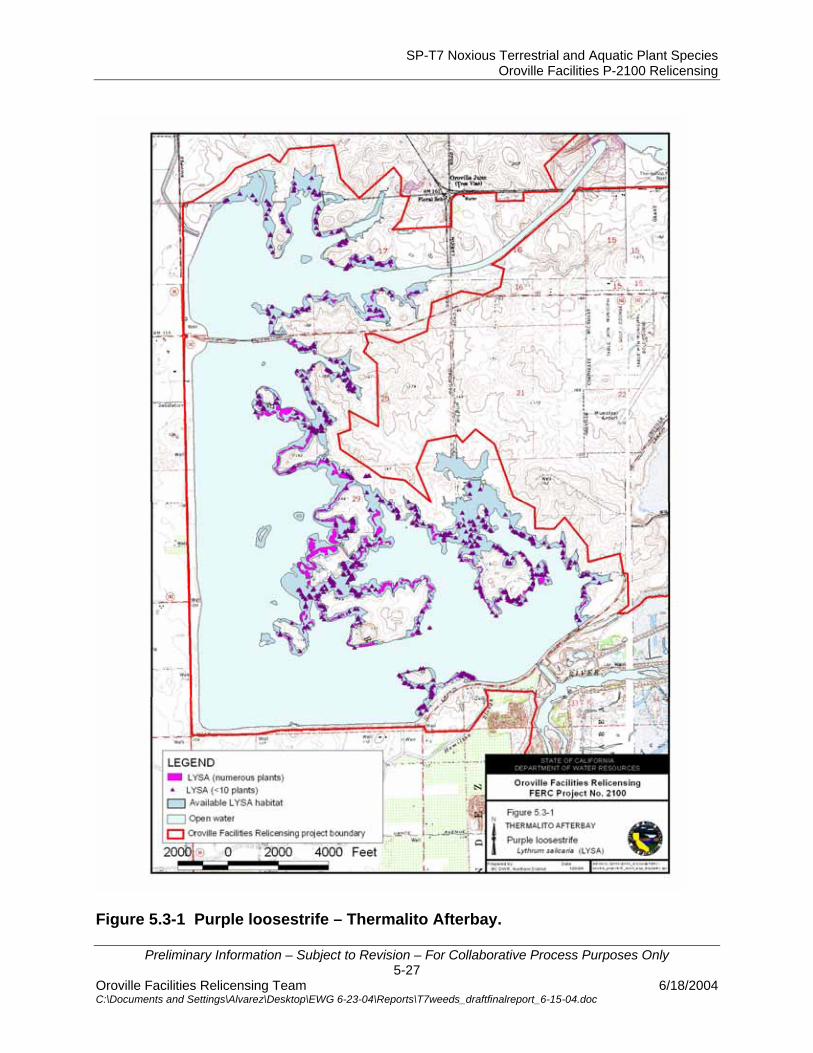
SP-T7 Noxious Terrestrial and Aquatic Plant Species Oroville Facilities P-2100 Relicensing
Preliminary Information – Subject to Revision – For Collaborative Process Purposes Only 5-27
Oroville Facilities Relicensing Team 6/18/2004 C:\Documents and Settings\Alvarez\Desktop\EWG 6-23-04\Reports\T7weeds_draftfinalreport_6-15-04.doc
Figure 5.3-1 Purple loosestrife – Thermalito Afterbay.
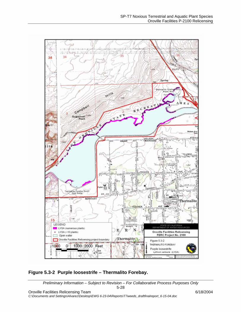
SP-T7 Noxious Terrestrial and Aquatic Plant Species Oroville Facilities P-2100 Relicensing
Preliminary Information – Subject to Revision – For Collaborative Process Purposes Only 5-28
Oroville Facilities Relicensing Team 6/18/2004 C:\Documents and Settings\Alvarez\Desktop\EWG 6-23-04\Reports\T7weeds_draftfinalreport_6-15-04.doc
Figure 5.3-2 Purple loosestrife – Thermalito Forebay.
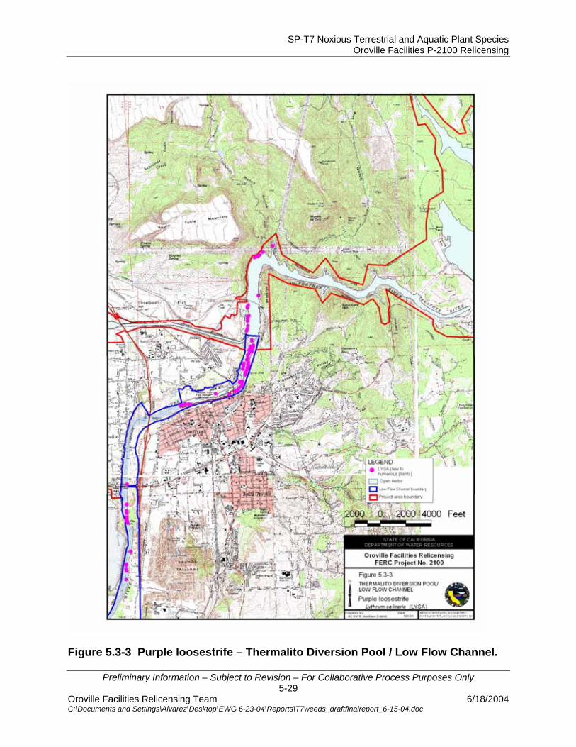
SP-T7 Noxious Terrestrial and Aquatic Plant Species Oroville Facilities P-2100 Relicensing
Preliminary Information – Subject to Revision – For Collaborative Process Purposes Only 5-29
Oroville Facilities Relicensing Team 6/18/2004 C:\Documents and Settings\Alvarez\Desktop\EWG 6-23-04\Reports\T7weeds_draftfinalreport_6-15-04.doc
Figure 5.3-3 Purple loosestrife – Thermalito Diversion Pool / Low Flow Channel.

SP-T7 Noxious Terrestrial and Aquatic Plant Species Oroville Facilities P-2100 Relicensing
Preliminary Information – Subject to Revision – For Collaborative Process Purposes Only 5-30
Oroville Facilities Relicensing Team 6/18/2004 C:\Documents and Settings\Alvarez\Desktop\EWG 6-23-04\Reports\T7weeds_draftfinalreport_6-15-04.doc
Figure 5.3-4 Purple loosestrife – Oroville Wildlife Area / Low Flow Channel.

SP-T7 Noxious Terrestrial and Aquatic Plant Species Oroville Facilities P-2100 Relicensing
Preliminary Information – Subject to Revision – For Collaborative Process Purposes Only 5-31
Oroville Facilities Relicensing Team 6/18/2004 C:\Documents and Settings\Alvarez\Desktop\EWG 6-23-04\Reports\T7weeds_draftfinalreport_6-15-04.doc
Figure 5.3-5 Giant reed – Thermalito Afterbay / Oroville Wildlife Area.

SP-T7 Noxious Terrestrial and Aquatic Plant Species Oroville Facilities P-2100 Relicensing
Preliminary Information – Subject to Revision – For Collaborative Process Purposes Only 5-32
Oroville Facilities Relicensing Team 6/18/2004 C:\Documents and Settings\Alvarez\Desktop\EWG 6-23-04\Reports\T7weeds_draftfinalreport_6-15-04.doc
Figure 5.3-6 Tree of heaven –Oroville Wildlife Area / Thermalito Afterbay / Low Flow Channel.
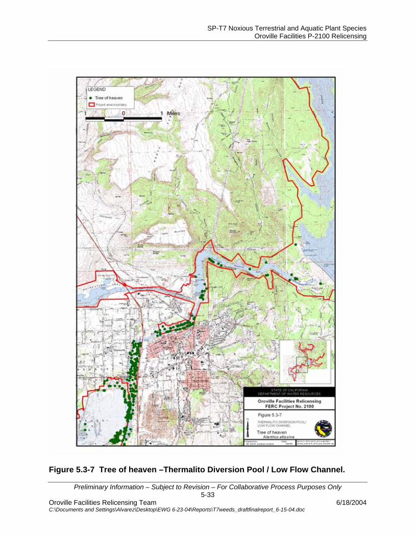
SP-T7 Noxious Terrestrial and Aquatic Plant Species Oroville Facilities P-2100 Relicensing
Preliminary Information – Subject to Revision – For Collaborative Process Purposes Only 5-33
Oroville Facilities Relicensing Team 6/18/2004 C:\Documents and Settings\Alvarez\Desktop\EWG 6-23-04\Reports\T7weeds_draftfinalreport_6-15-04.doc
Figure 5.3-7 Tree of heaven –Thermalito Diversion Pool / Low Flow Channel.
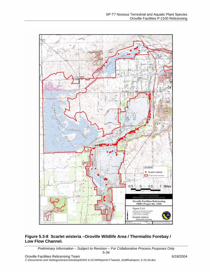
SP-T7 Noxious Terrestrial and Aquatic Plant Species Oroville Facilities P-2100 Relicensing
Preliminary Information – Subject to Revision – For Collaborative Process Purposes Only 5-34
Oroville Facilities Relicensing Team 6/18/2004 C:\Documents and Settings\Alvarez\Desktop\EWG 6-23-04\Reports\T7weeds_draftfinalreport_6-15-04.doc
Figure 5.3-8 Scarlet wisteria –Oroville Wildlife Area / Thermalito Forebay / Low Flow Channel.
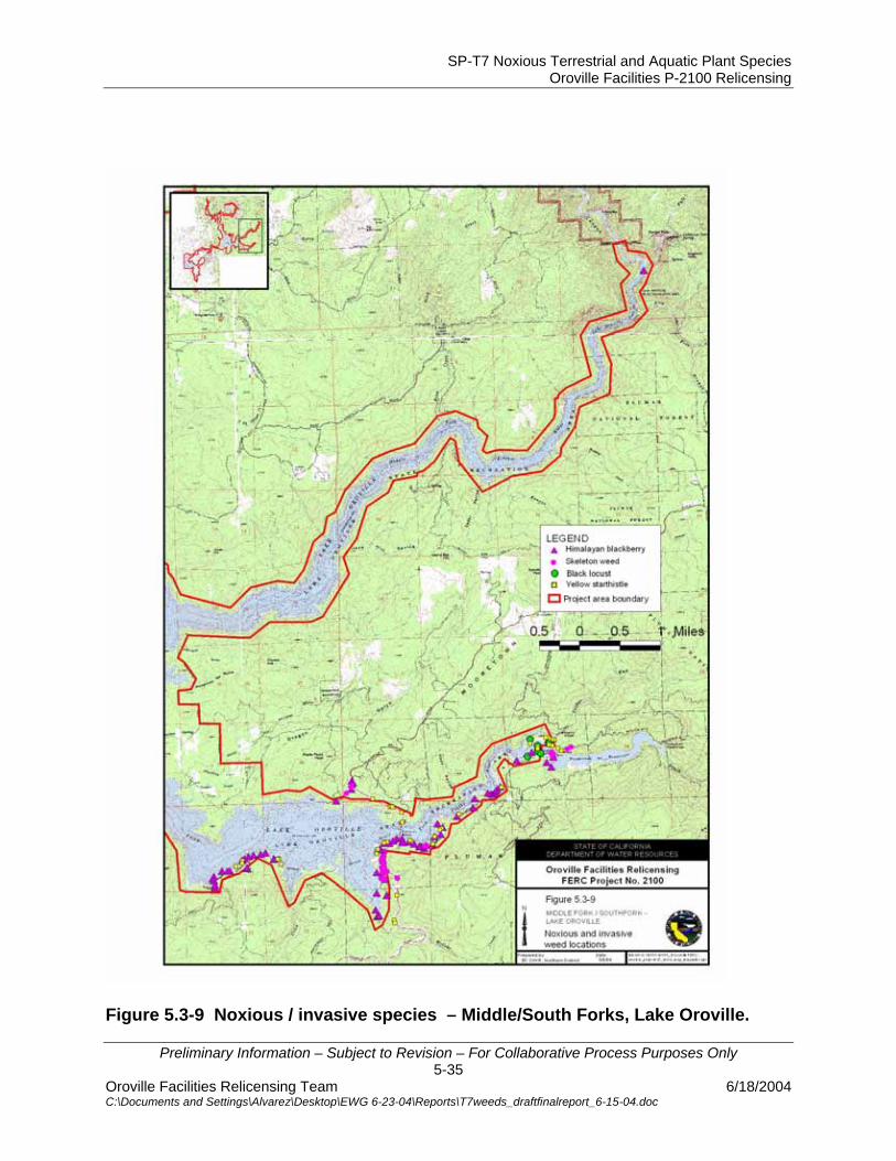
SP-T7 Noxious Terrestrial and Aquatic Plant Species Oroville Facilities P-2100 Relicensing
Preliminary Information – Subject to Revision – For Collaborative Process Purposes Only 5-35
Oroville Facilities Relicensing Team 6/18/2004 C:\Documents and Settings\Alvarez\Desktop\EWG 6-23-04\Reports\T7weeds_draftfinalreport_6-15-04.doc
Figure 5.3-9 Noxious / invasive species – Middle/South Forks, Lake Oroville.

SP-T7 Noxious Terrestrial and Aquatic Plant Species Oroville Facilities P-2100 Relicensing
Preliminary Information – Subject to Revision – For Collaborative Process Purposes Only 5-36
Oroville Facilities Relicensing Team 6/18/2004 C:\Documents and Settings\Alvarez\Desktop\EWG 6-23-04\Reports\T7weeds_draftfinalreport_6-15-04.doc
Figure 5.3-10 Noxious / invasive species – West Branch, Lake Oroville.

SP-T7 Noxious Terrestrial and Aquatic Plant Species Oroville Facilities P-2100 Relicensing
Preliminary Information – Subject to Revision – For Collaborative Process Purposes Only 5-37
Oroville Facilities Relicensing Team 6/18/2004 C:\Documents and Settings\Alvarez\Desktop\EWG 6-23-04\Reports\T7weeds_draftfinalreport_6-15-04.doc
Figure 5.3-11 Noxious / invasive species – Oroville Dam, Lake Oroville.

SP-T7 Noxious Terrestrial and Aquatic Plant Species Oroville Facilities P-2100 Relicensing
Preliminary Information – Subject to Revision – For Collaborative Process Purposes Only 5-38
Oroville Facilities Relicensing Team 6/18/2004 C:\Documents and Settings\Alvarez\Desktop\EWG 6-23-04\Reports\T7weeds_draftfinalreport_6-15-04.doc
Figure 5.3-12 Noxious / invasive species – North Fork, Lake Oroville.
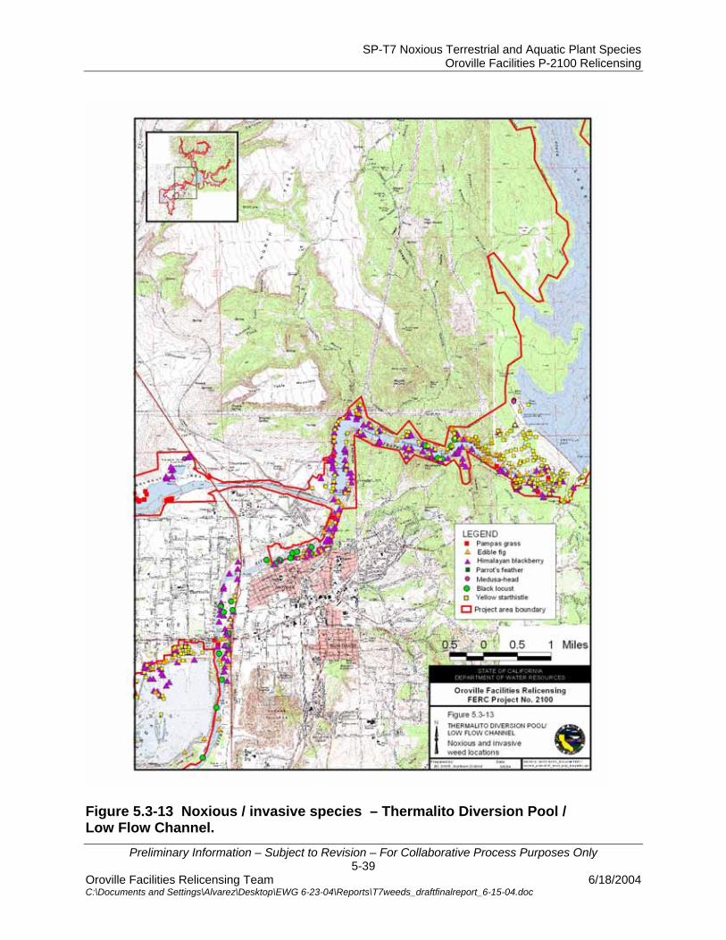
SP-T7 Noxious Terrestrial and Aquatic Plant Species Oroville Facilities P-2100 Relicensing
Preliminary Information – Subject to Revision – For Collaborative Process Purposes Only 5-39
Oroville Facilities Relicensing Team 6/18/2004 C:\Documents and Settings\Alvarez\Desktop\EWG 6-23-04\Reports\T7weeds_draftfinalreport_6-15-04.doc
Figure 5.3-13 Noxious / invasive species – Thermalito Diversion Pool / Low Flow Channel.
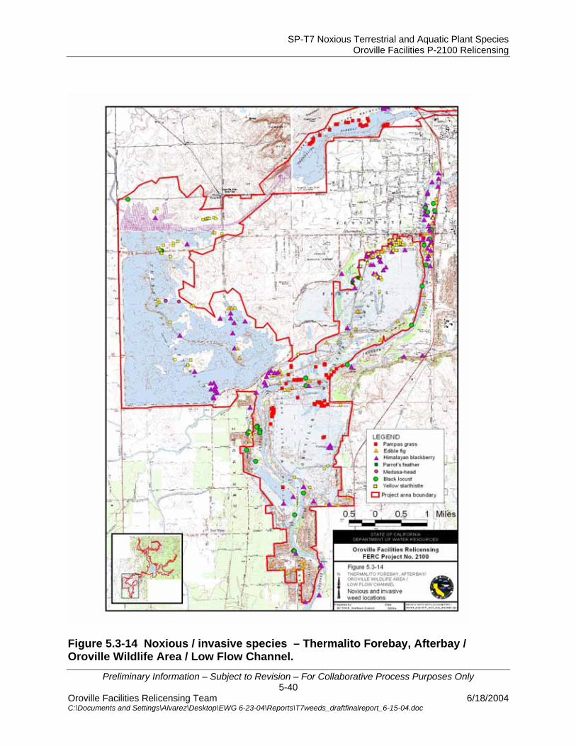
SP-T7 Noxious Terrestrial and Aquatic Plant Species Oroville Facilities P-2100 Relicensing
Preliminary Information – Subject to Revision – For Collaborative Process Purposes Only 5-40
Oroville Facilities Relicensing Team 6/18/2004 C:\Documents and Settings\Alvarez\Desktop\EWG 6-23-04\Reports\T7weeds_draftfinalreport_6-15-04.doc
Figure 5.3-14 Noxious / invasive species – Thermalito Forebay, Afterbay / Oroville Wildlife Area / Low Flow Channel.
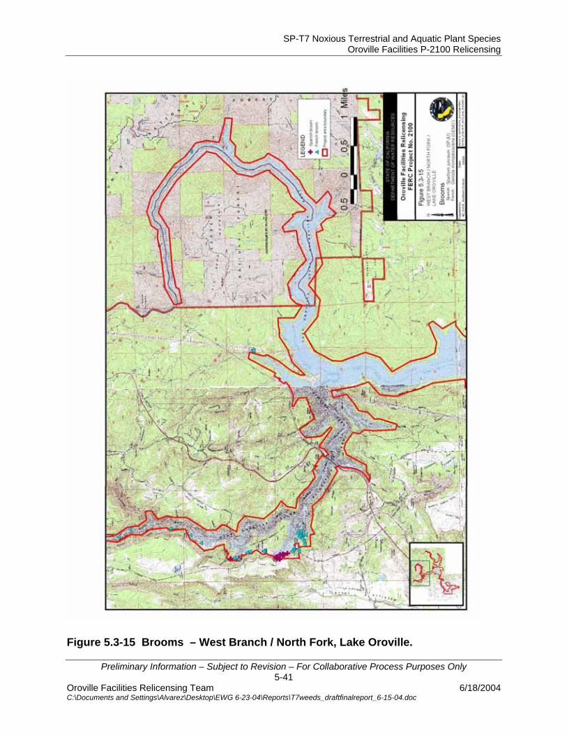
SP-T7 Noxious Terrestrial and Aquatic Plant Species Oroville Facilities P-2100 Relicensing
Preliminary Information – Subject to Revision – For Collaborative Process Purposes Only 5-41
Oroville Facilities Relicensing Team 6/18/2004 C:\Documents and Settings\Alvarez\Desktop\EWG 6-23-04\Reports\T7weeds_draftfinalreport_6-15-04.doc
Figure 5.3-15 Brooms – West Branch / North Fork, Lake Oroville.
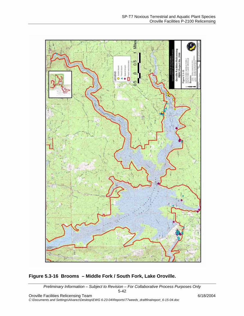
SP-T7 Noxious Terrestrial and Aquatic Plant Species Oroville Facilities P-2100 Relicensing
Preliminary Information – Subject to Revision – For Collaborative Process Purposes Only 5-42
Oroville Facilities Relicensing Team 6/18/2004 C:\Documents and Settings\Alvarez\Desktop\EWG 6-23-04\Reports\T7weeds_draftfinalreport_6-15-04.doc
Figure 5.3-16 Brooms – Middle Fork / South Fork, Lake Oroville.
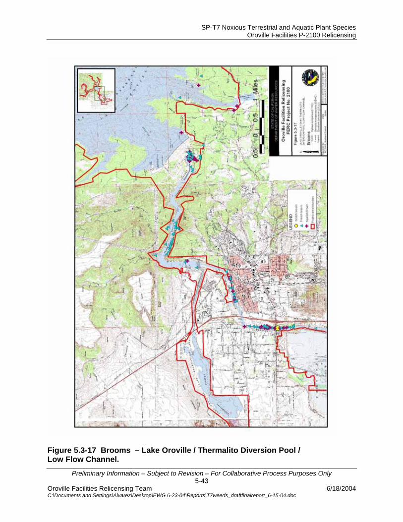
SP-T7 Noxious Terrestrial and Aquatic Plant Species Oroville Facilities P-2100 Relicensing
Preliminary Information – Subject to Revision – For Collaborative Process Purposes Only 5-43
Oroville Facilities Relicensing Team 6/18/2004 C:\Documents and Settings\Alvarez\Desktop\EWG 6-23-04\Reports\T7weeds_draftfinalreport_6-15-04.doc
Figure 5.3-17 Brooms – Lake Oroville / Thermalito Diversion Pool / Low Flow Channel.

SP-T7 Noxious Terrestrial and Aquatic Plant Species Oroville Facilities P-2100 Relicensing
Preliminary Information – Subject to Revision – For Collaborative Process Purposes Only 5-44
Oroville Facilities Relicensing Team 6/18/2004 C:\Documents and Settings\Alvarez\Desktop\EWG 6-23-04\Reports\T7weeds_draftfinalreport_6-15-04.doc
Figure 5.3-18 Water primrose – Thermalito Afterbay / Oroville Wildlife Area

SP-T7 Noxious Terrestrial and Aquatic Plant Species Oroville Facilities P-2100 Relicensing
Preliminary Information – Subject to Revision – For Collaborative Process Purposes Only 6-1
Oroville Facilities Relicensing Team 6/18/2004 C:\Documents and Settings\Alvarez\Desktop\EWG 6-23-04\Reports\T7weeds_draftfinalreport_6-15-04.doc
6.0 ANALYSES
6.1 EXISTING CONDITIONS/ENVIRONMENTAL SETTING Noxious weeds and non-native invasive species occur throughout the Project area. Although a large number of weed species occur within the upland areas, the wetland margins and riparian areas tend to be the most heavily infested areas. Many of the weed species are widespread species that occur throughout California and have been in the Project area for a number of years. Others, such as scarlet wisteria have appeared only recently and are beginning to spread. Species on the CDFA and Cal-IPC lists are rated as pests for different reasons; some may be important agricultural pests, other specifically impact habitat important for special status species. Almost all impact native plant community structure and wildlife habitat, including riparian and wetland communities. A few of the target species that occur in the Project area are included in State-wide eradication efforts. These include giant reed and purple loosestrife. The Thermalito Afterbay and the Thermalito Forebay are shallow reservoirs with gently sloping banks. The Afterbay is operated as a temporary storage pool for pump-back operations, resulting in frequent water surface fluctuations. These frequent fluctuations have created optimal conditions for the rapid invasion of purple loosestrife within the drawdown zone of the reservoir. Approximately 85 of the ~900 acres of wetland/riparian margin of the Thermalito Afterbay contain varying densities of purple loosestrife. This species impacts both native vegetation and wintering waterfowl nesting habitat. Species of concern near the Afterbay, Forebay, and Diversion pool include purple loosestrife, giant reed, tree of heaven, starthistle, scarlet wisteria, medusahead, and many other herbaceous and woody species. Around the Thermalito Complex, concentrations of non-native woody species are highest in the southern portion of the Afterbay, probably related to old homesteads. Although the majority of these species are not widespread, many are concentrated enough to impact native vegetation and wildlife habitat and have potential to expand. Within the grasslands, starthistle and medusahead are the most widespread and have most likely impacted native plant species to the greatest extent. Other important noxious weed species are found throughout the Project area, but are most concentrated in the OWA. The species of greatest concern to native plant communities and wildlife habitat in this area include giant reed, tree of heaven, scarlet wisteria, parrots feather, and Himalayan blackberry. Tree of heaven is intermingled with the valley elderberry (Sambucus mexicanus), habitat for the federally threatened valley elderberry longhorn beetle, in approximately 250 acres of the OWA. Other noxious weed species of concern found within the OWA include parrots feather, Pampas grass,

SP-T7 Noxious Terrestrial and Aquatic Plant Species Oroville Facilities P-2100 Relicensing
Preliminary Information – Subject to Revision – For Collaborative Process Purposes Only 6-2
Oroville Facilities Relicensing Team 6/18/2004 C:\Documents and Settings\Alvarez\Desktop\EWG 6-23-04\Reports\T7weeds_draftfinalreport_6-15-04.doc
edible fig, black locust, yellow starthistle, and Himalayan blackberry. These species are common throughout the OWA, but not as widespread. Scarlet wisteria is an example of a species that has recently begun to spread. It is rapidly invading riparian vegetation along the Feather River and is reported as a problem in the Delta and along the American and San Joaquin Rivers. Control efforts for scarlet wisteria are currently underway along both the American and San Joaquin Rivers. Portions of the gravel bars along the Low Flow Channel have extensive linear stands of scarlet wisteria along the water’s edge. The consistent flow in this reach may enable the plant to establish and thrive under these conditions. This species is found in scattered locations along the Feather River below the Thermalito Outlet, although not along the water’s edge as is found in the Low Flow Channel. Approximately 400 acres of water primrose occur in the Project Area. During the 1997 floods, the OWA levee failed, flooding the “D section”. Following repair of this levee, water has been passing through a culvert allowing a year-round water supply and increasing levels of standing water. This increase in year-round water levels has not only killed a majority of the Fremont cottonwood trees but has also enabled water primrose to dramatically increase its density throughout the area. Numerous noxious weed species occur around Lake Oroville, primarily in disturbed areas near roads, trails, and facilities, and in the immediate vicinity of the spillway and the associated power facilities. The species identified as those of greatest concern are skeleton weed; French, Spanish, and Scotch brooms; Himalayan blackberry; and tree of heaven. Other species include edible fig and starthistle. The majority of these species are widespread and occurs both within and outside the Project area. A few species such as scarlet wisteria, giant reed, and purple loosestrife do not have large adjacent or upstream populations. However, all of these species occur downstream of the Project area. 6.2 PROJECT RELATED EFFECTS Continued Project operations have the potential to facilitate the spread of noxious and invasive plant species, both within the Project area and into downstream waterways. Fluctuating water levels in the Thermalito Complex and in Lake Oroville and managed flows in the Low Flow Channel of the Feather River encourage the proliferation of non-native noxious weed species along the wetland margins, river banks, and in the adjacent floodplain. The lack of periodic flushing flows promotes non-native species encroachment into riparian/wetland habitats and inhibits native riparian /wetland species from establishing. Periodic flushing flows along the Low Flow Channel will most likely not be enough to remove deeply rooted species that have had many years to become established.

SP-T7 Noxious Terrestrial and Aquatic Plant Species Oroville Facilities P-2100 Relicensing
Preliminary Information – Subject to Revision – For Collaborative Process Purposes Only 6-3
Oroville Facilities Relicensing Team 6/18/2004 C:\Documents and Settings\Alvarez\Desktop\EWG 6-23-04\Reports\T7weeds_draftfinalreport_6-15-04.doc
Maintenance and other land disturbing activities promote the proliferation of invasive plant species in upland and wetland/riparian areas. Weed populations within the Project area can be spread by Project-related vehicular traffic, water movement, recreational use, and any ground-disturbing activities. However, both historical and present-day land use within the Project area and adjacent lands contribute to the non-native noxious or invasive weed distribution and proliferation. Although the Department may manage the invasion and distribution of noxious and invasive weed within the Project area, adjacent land use activities will continue to influence the degree of success and/or failure of weed management.

SP-T7 Noxious Terrestrial and Aquatic Plant Species Oroville Facilities P-2100 Relicensing
Preliminary Information – Subject to Revision – For Collaborative Process Purposes Only 7-1
Oroville Facilities Relicensing Team 6/18/2004 C:\Documents and Settings\Alvarez\Desktop\EWG 6-23-04\Reports\T7weeds_draftfinalreport_6-15-04.doc
7.0 SUMMARY AND RECOMMENDATIONS
Removal of noxious and invasive weed species within the Project area would enhance native plant communities and wildlife habitat. Management of important weed species will help to reduce the number of seeds and/or plant parts that are flushed downstream and invade other sensitive resources and habitats. Many of the noxious weed species found within the Project area are so widespread that management and/or control is probably not feasible. These include yellow starthistle, medusahead grass, fig, and French, Spanish, and Scotch brooms. Species that are less widespread and do not pose as high a threat to native vegetation and wildlife habitats include species such as black locust and those included in Appendix A. Highest priority species for management efforts include purple loosestrife, giant reed, scarlet wisteria, tree of heaven, pampas grass, parrot’s feather, Himalayan blackberry, and skeleton weed. Although eradication of most of these species from the Project area is most likely impossible because of adjacent populations, management efforts could lessen their impact to native species and habitats. Species such as scarlet wisteria and skeleton weed are less widespread and are mostly concentrated in the Project area. Eradication efforts for these species have a better chance for success and ultimately lessen invasion into downstream waters. A weed management plan for the Project area and Project-affected area should be developed using an adaptive management strategy and address those species identified as high priority species. Any management plan should include management goals and objectives, priorities, implementation strategies, cost and time estimates, restoration, and monitoring to assess impacts of management activities and effectiveness of methods. Although widespread species and those of lesser invasiveness may not be addressed in a project-wide management plan, these species can be addressed on an individual project-by-project basis, where removal of weeds and enhancement of native vegetation and wildlife habitats are desirable. Restoration/planting with native species may be an important part of any weed control program. Removal of weed species and replanting with native plants may help reduce erosion and speed up the restoration process, as well as shade out seedlings of non-native species and help prevent reestablishment.
SP-T7 Noxious Terrestrial and Aquatic Plant Species Oroville Facilities P-2100 Relicensing
Preliminary Information – Subject to Revision – For Collaborative Process Purposes Only 8-1
Oroville Facilities Relicensing Team 6/18/2004 C:\Documents and Settings\Alvarez\Desktop\EWG 6-23-04\Reports\T7weeds_draftfinalreport_6-15-04.doc
8.0 REFERENCES Bell, Gary. 1997. Ecology and management of Arundo donax, and approaches to riparian habitat restoration in Southern California. In Brock, J.H., Wade, M., Pysek, P., and Green, D. (Eds.): Plant Invasions: Studies from North America and Europe. Blackhuys Publishers, Leiden, The Netherlands, pp. 103-113. Bossard, C. C., J. M. Randall, and M. C. Hoshovsky (eds.). 2000. Invasive Plants of California’s Wildlands. University of California Press. Berkeley, California. CalFlora Database. Information on California plants for education, research and conservation. Berkeley, California. Site accessed 2003, 2004. URL = http://www.calflora.org/ Cal-IPC (California Invasive Plant Council). Cal-IPC List - Exotic Pest Plants of Greatest Ecological Concern in California. Site accessed 2001, 2002, and 2003. URL = http://groups.ucanr.org/ceppc/Pest_Plant_List/ CDFA [1] (California Department of Food and Agriculture). Division of Plant Health and Pest Prevention Services. Enclycloweedia. Pest ratings of noxious weed species and noxious weed seeds. Site accessed 2001, 2002, and 2003. URL = http://www.cdfa.ca.gov/phpps/ipc/encycloweedia/encycloweedia_hp.htm CDFA [2] (California Department of Food and Agriculture). Biological Control of Purple Loosestrife. Site accessed August 1, 2001. URL = http://plant.cdfa.ca.gov/biocontrol/wees/pls/83pls-biocontrol.html CDFA [3] (California Department of Food and Agriculture). Rush Skeletonweed. Site accessed March 25, 2003. URL = http://pi.cdfa.ca.gov/weedinfo/CHONDRIL2.htm CDFA [4}(California Department of Food and Agriculture). EncycloWeedia: The Noxious Weed Data Sheets. Site accessed 4/2004. URL = http://www.cdfa.ca.gov/phpps/ipc/encycloweedia/encycloweedia_hp.htm. CDPR (California Department of Parks and Recreation). 2001, 2002, 2003. Northern Buttes District. Report to the Butte County Weed Management Area. Dempsey, James. CDWR (California Department of Water Resources). 2003. Draft Final Report SP-T4: Biodiversity, Vegetation Communities and Wildlife Habitat Mapping. Sacramento, California. December 2003.

SP-T7 Noxious Terrestrial and Aquatic Plant Species Oroville Facilities P-2100 Relicensing
Preliminary Information – Subject to Revision – For Collaborative Process Purposes Only 8-2
Oroville Facilities Relicensing Team 6/18/2004 C:\Documents and Settings\Alvarez\Desktop\EWG 6-23-04\Reports\T7weeds_draftfinalreport_6-15-04.doc
CDWR (California Department of Water Resources). 2004. Draft Final Report SP-T2: Project Effects on Special Status Plant Species. Sacramento, California. March 2004. CERES (California Environmental Resources Evaluation System). California Forest Stewardship Program. Getting a handle on broom. Site accessed 1/2003. URL = http://ceres.ca.gov/foreststeward/html/broom2.html. CSUC (California State University Chico). 2003. Biological Sciences Herbarium Database. Site accessed 2002, 2003, and 2004. URL = csuchico.edu/boil/Herb/database.html. Ducks Unlimited Canada. Purple Loosestrife. Site accessed Oct. 18, 2000. URL = http://www.ducks.ca/purple/ Fallscheer, Robin. Botanist, California Department of Fish and Game. Personal communication. August, 2002. Hickman, J. C. ed. 1993. The Jepson Manual: higher plants of California. University of California Press, Berkeley, California. Katz, Robert. Botanist, USFS Feather River Ranger District. Fax communication. October 21, 2002. NPS (National Park Service). Plant Conservation Alliance. Alien Plant Working Group/ Giant Reed. Site accessed January 21, 2003. URL = http://www.nps.gov/plants/alien/fact/ardo1.htm Oswald, Vern H. 1994. Manual of the Vascular Plants of Butte County, California. California Native Plant Society. Sacramento, California. Oswald, Vernon H. 2002. Selected plants of Northern California and adjacent Nevada. CD-Rom. Studies from the Herbarium. California State University, Chico. Santa Margarita and San Luis Rey Watersheds Management Area. Biology of Arundo donax (Giant reed, giant reed). Site accessed March 24, 2003. URL = http://smslrwma.org/ADBiology.htm State of Iowa. Department of Natural Resources. Nuisance Species, Purple Loosestrife. Site accessed October 18, 2000. URL = http://www.iowadnr.com/fish/news/exotics/loose.html Stone, Byron. Biologist, California Department of Fish and Game. Personal communication. 3/2003.
SP-T7 Noxious Terrestrial and Aquatic Plant Species Oroville Facilities P-2100 Relicensing
Preliminary Information – Subject to Revision – For Collaborative Process Purposes Only 8-3
Oroville Facilities Relicensing Team 6/18/2004 C:\Documents and Settings\Alvarez\Desktop\EWG 6-23-04\Reports\T7weeds_draftfinalreport_6-15-04.doc
Team Arundo del Norte. Arundo donax – A Landowner Handbook. Site accessed March 24, 2003. URL = http://teamarundo.org/education/index.html#handbook TNC (The Nature Conservancy). 1984. Element Stewardship Abstract for Robinia psuedoacacia. Converse, C.K. Arlington, Virginia TNC (The Nature Conservancy). 1986a. Element Stewardship Abstract for Arundo donax. Hoshovsky, Marc. Arlington, Virginia. TNC (The Nature Conservancy). 1986b. Element Stewardship Abstract for Cytisus scoparius and Genista monspessulanus. Hoshovsky, Marc. Arlington, Virginia. TNC (The Nature Conservancy). 1987. Element Stewardship Abstract for Lythrum salicaria. Bender, J. Arlington, Virginia. TNC (The Nature Conservancy). 1988a. Element Stewardship Abstract for Ailanthus altissima. Hoshovsky, Marc. Arlington, Virginia. TNC (The Nature Conservancy). 1988b. Element Stewardship Abstract for Taeniatherum caput-medusae. Mauer, T., M.J. Russo, and A. Godell. Arlington, Virginia. TNC (The Nature Conservancy). 1989. Element Stewardship Abstract for Rubus discolor. Hoshovsky, M. Arlington, Virginia. TNC (The Nature Conservancy). 1992. Element Stewardship Abstract for Centaurea solstitialis. Randall, J. and P. Herzog. Arlington, Virginia. TNC (The Nature Conservancy). Wildland Invasive Species Team. Weed Alert – Sesbania punicea. Site accessed August 22, 2002. URL = http://tncweeds.ucdavis.edu/alert/alrtsesb.html The San Joaquin River Parkway and Conservation Trust. Parkway Invader Alert – Sesbania punicea. Site accessed March 25, 2003. URL = http://www.riverparkway.org/html/invasiveses.html University of California Davis Weed Research and Information Center. Yellow Starthistle Information. Site accessed March 25, 2003. URL = http://wric.ucdavis.edu/yst/intro/introduction.html USDA [1](United States Department of Agriculture. Animal and Plant Health Inspection Service. Federal Noxious Weed List. Site accessed 2001 and 2003. URL = http://www.aphis.usda.gov/ppq/permits/fnwsbycat-e.PDF

SP-T7 Noxious Terrestrial and Aquatic Plant Species Oroville Facilities P-2100 Relicensing
Preliminary Information – Subject to Revision – For Collaborative Process Purposes Only 8-4
Oroville Facilities Relicensing Team 6/18/2004 C:\Documents and Settings\Alvarez\Desktop\EWG 6-23-04\Reports\T7weeds_draftfinalreport_6-15-04.doc
USDA [2] (United States Department of Agriculture). Natural Resource Conservation Service Plants Database. Site accessed 2003. URL = http://plants.usda.gov./ USFS (United States Forest Service). 1998. Plumas National Forest Known or Potential Noxious Weeds. Compiled by L. Hanson, Forest Botanist. March 10, 1998. WSDOE (Washington State Department of Ecology). Non-native Freshwater Plants; Technical information about Parrot’s feather (Myriophyllum aquaticum). Site accessed 12/02. URL = http://www.ecy.wa.gov/programs/wq/plants/weeds/aqua003.html

SP-T7 Noxious Terrestrial and Aquatic Plant Species Oroville Facilities P-2100 Relicensing
Preliminary Information – Subject to Revision – For Collaborative Process Purposes Only
Oroville Facilities Relicensing Team 6/18/2004 C:\Documents and Settings\Alvarez\Desktop\EWG 6-23-04\Reports\T7weeds_draftfinalreport_6-15-04.doc
APPENDICES
SP-T7 Noxious Terrestrial and Aquatic Plant Species Oroville Facilities P-2100 Relicensing
Preliminary Information – Subject to Revision – For Collaborative Process Purposes Only
Oroville Facilities Relicensing Team 6/18/2004 C:\Documents and Settings\Alvarez\Desktop\EWG 6-23-04\Reports\T7weeds_draftfinalreport_6-15-04.doc
APPENDIX A
NOXIOUS/INVASIVE WEED SPECIES LITERATURE REVIEW Mapped locations of the following species can be found in Figures A-1 and A-2. Jointed goatgrass (Aegilops cylindrica) Listing Status: CDFA – B; Cal-IPC – none Barbed goatgrass (Aegilops triuncialis) Listing Status: CDFA – B; Cal-IPC – none Barbed goatgrass and jointed goatgrass are annual grasses that originated in Eurasia and the Mediterranean region. Barbed goatgrass is now naturalized in three northeastern states and 22 counties in Northern California. Jointed goatgrass is now naturalized in most of the continental United States, including 10 California counties (MSU Website; CalFlora Website). Both species spread by seed, aided by jointed spikelets and long, barbed awns, that can be dispersed by wind, animal fur, floating in water, or falling in place. Both goatgrass species are usually found in disturbed open sites, from low to high elevations, and primarily infest pastures and grazed grasslands, including open oak woodlands, as well as roadsides and cultivated fields (CalFlora Website; CDFA Website; Hickman 1993; MSU Website; NRCS Website). In cultivated fields, jointed goatgrass can hybridize with winter wheat. Barbed goatgrass tolerates serpentine soils; both species tolerate dry conditions and hard, shallow or gravelly soils. Both goatgrass species’ persistent, hard spikelet joint coverings protect the mature seed from fires; this and long seed dormancy make goatgrasses aggressive competitors with many agricultural and native species (CDFA Website). Where present in Butte County, barbed goatgrass tends to form dense stands (Oswald 1994). As part of the 2002/2003 surveys for this Project, barbed goatgrass was mapped below the Dam in two locations. Jointed goatgrass was observed both above and below the Dam, although specific locations were not mapped. One infestation of barbed goatgrass was observed at the edge of the Oroville Wildlife Area, and a second by an impoundment near the Thermalito Diversion Pool, a total of 0.6 acres. Control of both grasses has been accomplished to some degree with combinations of carefully timed and repeated applications of hand pulling, early summer burning, tillage, mowing during early flower, herbicides, and reseeding of desired vegetation. There are currently no selective herbicides for goatgrass control. Jointed goatgrass may be controlled in part with some non-selective herbicides in combination with reseeding (MSU Website, CDFA Website).
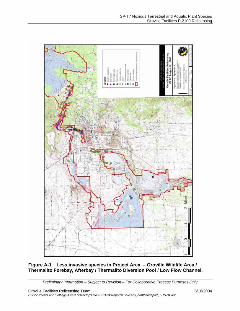
SP-T7 Noxious Terrestrial and Aquatic Plant Species Oroville Facilities P-2100 Relicensing
Preliminary Information – Subject to Revision – For Collaborative Process Purposes Only
Oroville Facilities Relicensing Team 6/18/2004 C:\Documents and Settings\Alvarez\Desktop\EWG 6-23-04\Reports\T7weeds_draftfinalreport_6-15-04.doc
Figure A-1 Less invasive species in Project Area – Oroville Wildlife Area / Thermalito Forebay, Afterbay / Thermalito Diversion Pool / Low Flow Channel.
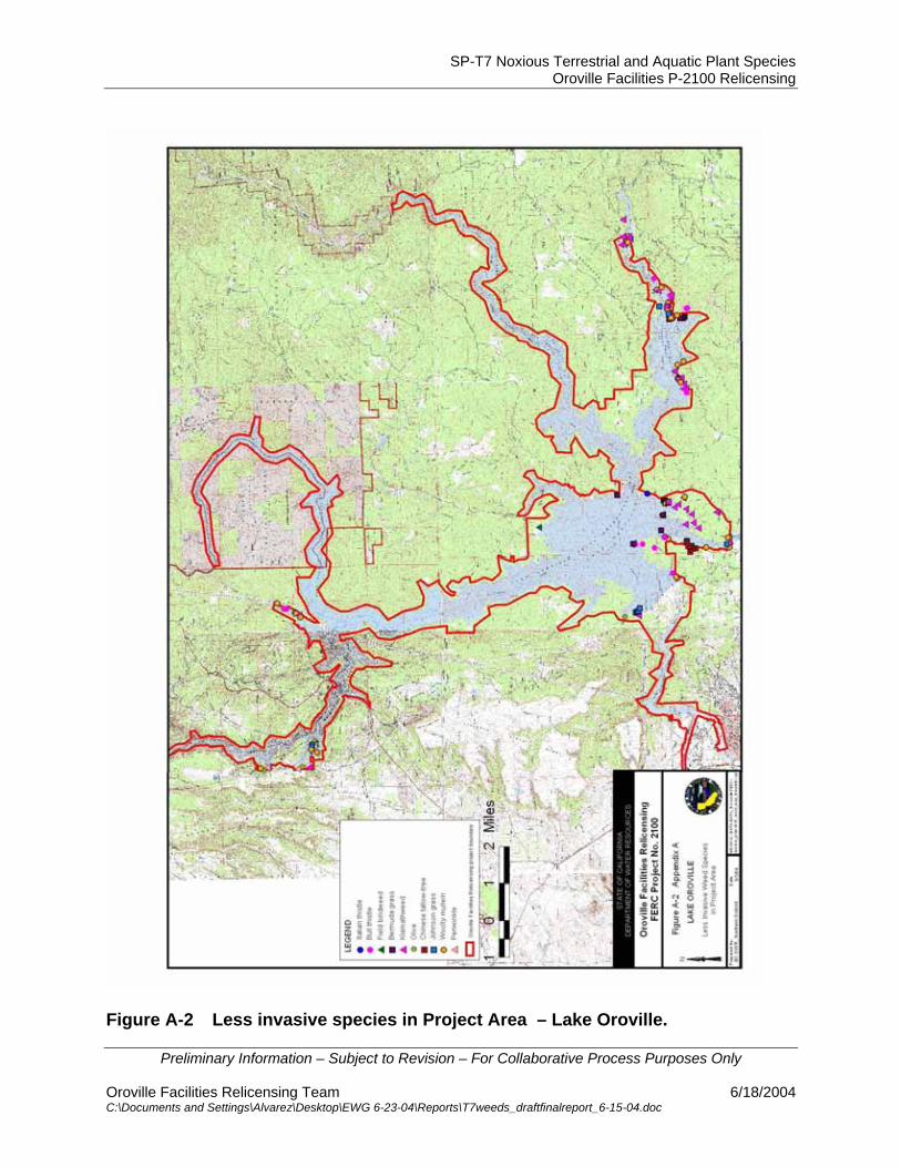
SP-T7 Noxious Terrestrial and Aquatic Plant Species Oroville Facilities P-2100 Relicensing
Preliminary Information – Subject to Revision – For Collaborative Process Purposes Only
Oroville Facilities Relicensing Team 6/18/2004 C:\Documents and Settings\Alvarez\Desktop\EWG 6-23-04\Reports\T7weeds_draftfinalreport_6-15-04.doc
Figure A-2 Less invasive species in Project Area – Lake Oroville.
SP-T7 Noxious Terrestrial and Aquatic Plant Species Oroville Facilities P-2100 Relicensing
Preliminary Information – Subject to Revision – For Collaborative Process Purposes Only
Oroville Facilities Relicensing Team 6/18/2004 C:\Documents and Settings\Alvarez\Desktop\EWG 6-23-04\Reports\T7weeds_draftfinalreport_6-15-04.doc
Italian thistle (Carduus pycnocephalus) Listing Status: CDFA – C; Cal-IPC – B Italian thistle is an erect annual to biennial herbaceous species that originated in the Mediterranean region and is now naturalized in much of the rest of the world. It was introduced into the U.S. in the 1930s and is established mainly in Texas and California. It now occurs in most California counties west of the Sierra Nevada crest. It spreads by seed in dimorphic fruits that can be dispersed by wind or animals or can be propagated in place by falling in the dried flowerhead. This species is usually found in disturbed, often moist sites, in many habitat types, from low to high elevations. Although Italian thistle can invade natural open woodland, canyon, and riparian areas, it thrives mainly in areas of disturbance, particularly in grazed grassland, old fields, roadsides and ditches (CalFlora website; Hickman 1993; Wilken and Hannah 1998). This species’ overwintering basal rosette, fall-to-early spring growth period, broad range of germination conditions, and mucilaginous (adhesive) seed give it a competitive advantage over many native species (TNC 1988). Italian thistle was mapped in only one location, near Bidwell Bar Bridge, during this study, but was noted in other locations both above and below the Dam. Control of Italian thistle has been difficult due to its ability to resprout from the root and form seeds in cut plant tops. Methods used with some success include combinations of carefully timed hand pulling, cultivation and cropping, grazing, and some herbicide applications. A rust specific to Italian thistle and several species of insects may also provide biological control (TNC Website). Tocalote (Centaurea melitensis) Listing Status: CDFA – none; Cal-IPC – B Tocalote is an erect annual to biennial herbaceous species in the same genus as starthistle. It originated in southern Europe and now occurs throughout the Western U.S., some mid-western and eastern states, and Hawaii. Tocalote has naturalized in most California counties (CalFlora Website). It spreads by seed that can be either windblown or dispersed by attachment to animals, people, or vehicles. This species is usually found in open disturbed sites in many habitat types, from low to high elevations. Although it does invades natural open woodlands, it thrives mainly in areas of disturbance in full sun, particularly in grazed grassland, old fields, roadsides and ditches (Hickman 1993; Donaldson and Rafferty 2002). This species was noted during surveys in locations above the Dam, but was not mapped and entered into the GIS files. It has been collected by local botanists from

SP-T7 Noxious Terrestrial and Aquatic Plant Species Oroville Facilities P-2100 Relicensing
Preliminary Information – Subject to Revision – For Collaborative Process Purposes Only
Oroville Facilities Relicensing Team 6/18/2004 C:\Documents and Settings\Alvarez\Desktop\EWG 6-23-04\Reports\T7weeds_draftfinalreport_6-15-04.doc
scattered locations throughout the Project area, including dry sites in the foothills near Lime Saddle Powerhouse, Kunkle Reservoir, and Forbestown Road (CSUC Website). Although information on the control of Tocalote was not readily available, effective methods in controlling localized infestations of yellow starthistle should help control Tocalote infestations. These include combinations of carefully timed tillage, mowing, grazing, burning, and chemical control. Biological control may include a rust specific to Tocalote (Donaldson and Rafferty 2002). Bull thistle (Cirsium vulgare) Listing Status: CDFA – none; Cal-IPC – B Bull thistle is an erect biennial or perennial herbaceous species that originated in Eurasia and now occurs throughout the world. It has naturalized in all California counties. It spreads primarily by windblown seed. It requires insect pollinators to set seed, but has many different pollinators. This species has broad ecological tolerances and can be found in many habitat types. Although it occasionally invades natural areas, it thrives mainly in areas of disturbance in full sun, particularly in heavily grazed or recently clearcut sites (FS Website). This species’ prolific seed production, formation of a very large-diameter basal rosette, and rapid subsequent growth can give it a temporary competitive advantage over many native species, persisting over many years if ground disturbance is repeated. Bull thistle was observed in scattered pockets throughout the Project area and was most prevalent in disturbed areas with late season moisture, wetlands, or riparian zones. Approximately 2/3 acre (60 separate infestations) of bull thistle were mapped within the Project area during the 2002/2003 surveys. The majority of the sites were observed around the edges of the low flow channel and Thermalito Diversion Pool. Bull thistle was also observed above the Dam on Kelly Ridge and along the South Fork arm of Lake Oroville. Control of bull thistle has been accomplished with mechanical methods involving cutting below the soil line, or at the soil surface for four to five years in succession. Various herbicides have been effective when applied to rosettes (not broadcast) combined with burning and/or revegetation with natives to provide competition (FS Website). Field bindweed (Convolvulus arvensis) Listing Status: CDFA – C; Cal-IPC – none Field bindweed is a prostrate, mat-forming perennial vine that originated in Eurasia and now occurs throughout the temperate to tropical regions of the world (TNC 1998). It spreads by seeds and rhizomes as well as creeping deep roots. This species requires

SP-T7 Noxious Terrestrial and Aquatic Plant Species Oroville Facilities P-2100 Relicensing
Preliminary Information – Subject to Revision – For Collaborative Process Purposes Only
Oroville Facilities Relicensing Team 6/18/2004 C:\Documents and Settings\Alvarez\Desktop\EWG 6-23-04\Reports\T7weeds_draftfinalreport_6-15-04.doc
strong sunlight and moderate to low moisture for optimal growth. It tolerates a wide range of soil types and conditions, including droughts, fog, irrigation, and low temperatures. The seeds cannot tolerate soil saturation during germination. It thrives in areas of disturbance and does not normally invade natural grasslands or forest vegetation (TNC Website). Bindweed's deep roots and thick mat-like structure can inhibit the growth or spread of many native plant species, and its long-lived seeds and climbing habit make it difficult to control (UCD Website). It is best documented as a pest of agricultural fields and native revegetation plots. Although only one location was mapped during these surveys, it was noted throughout the Project area. This species is common in fields, orchards, and roadsides from the valley floor, foothills, and mountains in Butte County, and has been observed in many plant community types (Oswald 1994). Control of field bindweed has been accomplished using combinations of aboveground biomass removal measures (tilling, pulling, burning, shade material, or herbicide application) and installation of competing vegetation. The control processes must be repeated to ensure permanent removal of root systems and all seedlings (TNC Website; UCD Website). Bermuda grass (Cynodon dactylon) Listing Status: CDFA – List C; Cal-IPC – none Bermuda grassis a prostrate, perennial grass that originated in southeast Africa and now occurs throughout the warmer regions of the world. It spreads primarily by rhizome or stolon fragments which can regenerate rapidly. This species requires a period of high temperature and ample sunlight to establish and be competitive. It tolerates a wide range of soil types and conditions, including droughts and alkaline conditions. Bermuda grass can withstand long periods of flooding, but growth is limited by inadequate soil aeration. It thrives in areas of disturbance and does not normally invade natural grasslands or forest vegetation (TNC Website). Bermuda grass contains alleopathic substances, which depress the growth or establishment of competing plants. In addition, it is very effective at acquiring soil moisture and nutrients and forms a thick mat-like system that inhibits many native plant species. Bermuda grass was observed throughout the Project area, but was most prevalent within the fluctuation zone of Lake Oroville, in disturbed areas around Project facilities, and within the floodplain of the Feather River. Approximately 3 acres (14 separate infestations) of Bermuda grass were mapped within the Project area during the 2002/2003 surveys. Most of the mapped observations are located above the Dam, from Kelly Ridge to the Enterprise Bridge in the South Fork.
SP-T7 Noxious Terrestrial and Aquatic Plant Species Oroville Facilities P-2100 Relicensing
Preliminary Information – Subject to Revision – For Collaborative Process Purposes Only
Oroville Facilities Relicensing Team 6/18/2004 C:\Documents and Settings\Alvarez\Desktop\EWG 6-23-04\Reports\T7weeds_draftfinalreport_6-15-04.doc
Control of Bermuda grass has been accomplished using combinations of tilling, desiccation, burning, herbicides, mowing and clipping, and shading under various conditions. Installation of shade material and native plants immediately after eradication is essential to prevent resprouting of any remaining rhizomes (TNC Website). Blue-gum (Eucalyptus globulus) Listing Status: CDFA – none; Cal-IPC – A-1 Blue-gum is a tall evergreen tree that originated in Australia and was introduced into the U.S. as an ornamental. It has naturalized in warmer, more humid temperate parts of the world, including coastal California and Hawaii (TNC Website, CalFlora Website). It spreads by prolific seed. This species seems to need either high rainfall or some degree of coastal fog influence in order to establish. It tolerates a wide range of soil types, but requires good drainage, moderately deep soils, and low salinity. Blue-gum is generally found spreading beyond original plantings only in coastal areas of California. It can invade adjacent natural wooded areas if an adequate moisture environment is available. Once established in a suitable environment, blue-gum can quickly fill the space, excluding all other vegetation with its tall, dense monotypic stands which produce allelopathic soil chemicals (Bossard et al 2000). Blue-gum groves create a low-diversity habitat in which few native plant species can exist. The extensive root system is also extremely efficient at consuming (and thereby depleting) any available water (TNC Website). Eucalyptus trees were observed in southern portions of the Project area, but were most abundant below the Dam around the Thermalito Afterbay and Oroville Wildlife Area, with some scattered along the low-flow channel. These trees were not easily identifiable to species, but some could potentially be blue-gum. Above the Dam, eucalyptus was mapped only along Bidwell Canyon Road. Altogether, approximately 10 acres (231 separate infestations) of eucalyptus (not identified to species) were mapped within or immediately adjacent to the Project area during the 2002/2003 surveys. Efforts to control of Blue-gum have been only partially effective, and include incompletely tested combinations of repeated mechanical removal, burning, and some limited herbicide application (TNC Website). The most effective way to limit the spread of the species in inland valleys, where the species does not effectively reseed itself, may be to limit new introductions. Common velvetgrass (Holcus lanatus) Listing Status: CDFA – none; Cal-IPC – B Common velvetgrass is a perennial grass that originated in the Iberian peninsula of Europe, and is now naturalized in much of the world, including over 27 counties in

SP-T7 Noxious Terrestrial and Aquatic Plant Species Oroville Facilities P-2100 Relicensing
Preliminary Information – Subject to Revision – For Collaborative Process Purposes Only
Oroville Facilities Relicensing Team 6/18/2004 C:\Documents and Settings\Alvarez\Desktop\EWG 6-23-04\Reports\T7weeds_draftfinalreport_6-15-04.doc
California . It spreads by seed and stem joints which root with ground contact. This species is usually found in moist disturbed open sites, from low to high elevations, and can tolerate very wet as well as moderate drought conditions in a wide range of soil types. Common velvetgrass primarily infests moist roadbanks, cultivated fields, ditches and reservoir edges as well as streambeds and meadows (Hickman 1993; NRCS Website; TNC Website). Its rapid growth rate, copious seed production, large seedbank, and possible allelopathic chemical production, make common velvetgrass an aggressive competitor with many agricultural and native species. Common velvetgrass was not mapped as part of the 2002/2003 surveys, but was observed in locations both above and below the Dam. Control of common velevetgrass has been accomplished with combinations of carefully timed and repeated applications of hand pulling, early summer burning, tillage, grazing, and some herbicides (TNC Website). Klamathweed (Hypericum perforatum) Listing Status: CDFA – C; Cal-IPC – B Klamathweed (or St. Johnswort) is a perennial herbaceous species that originated in the Eurasia and Northern Africa. It was introduced into North America in 1696 as a medicinal herb, and now has naturalized in the eastern and northwestern U.S. and over 35 California counties. This species spreads by seed and short stolons. It tolerates a relatively wide range of ecological conditions, doing best in full sun and well-drained soils. Klamathweed is not considered a competitive plant, but can be locally invasive in foothill elevations along roadsides, in gravel bars and fields, and edges of oak savanna. The large quantity, long viability, and animal dispersal of its sticky seeds, and ability to spread by stolons, enable Klamathweed to establish monotypic stands in disturbed sites, displacing native species in favorable conditions (CalFlora Website; Oswald 1994; Krueger and Sheley 2002). Klamathweed was observed throughout the Project area both around Lake Oroville and below the Dam. It was found mostly in disturbed areas along trails and roads and at the high waterlines in riparian areas and around the Lake. Above the Dam, most sites were observed from the Dam east to the Ponderosa Dam in the South Fork. Below the Dam, most Klamathweed was found around Thermalito Diversion Pool. Approximately 0.3 acre (72 separate infestations) of Klamathweed were mapped within the Project area during the 2002/2003 surveys. Control of Klamathweed has been accomplished most effectively by introduction of the leaf-feeding beetle Chrysolina quadrigermina, as well as cultivation, application of herbicides, fertilizers and reseeding with desired vegetation, and/or mechanical removal

SP-T7 Noxious Terrestrial and Aquatic Plant Species Oroville Facilities P-2100 Relicensing
Preliminary Information – Subject to Revision – For Collaborative Process Purposes Only
Oroville Facilities Relicensing Team 6/18/2004 C:\Documents and Settings\Alvarez\Desktop\EWG 6-23-04\Reports\T7weeds_draftfinalreport_6-15-04.doc
(Krueger and Sheley 2002). Some measures such as burning or mowing stimulate the root system and increase the infestation of this species. Yellow water-iris (Iris pseudacorus) Listing Status: CDFA – none; Cal-IPC – B Yellow water-iris is a rhizomatous perennial aquatic forb that originated in Eurasia, was introduced repeatedly as an ornamental, and has naturalized in almost all of Europe, New Zealand, Canada and the continental U.S. except for the Rocky Mountains and parts of the midwest (TNC Website; UF Website). It is reported from 13 counties in California (CalFlora Website). It spreads both by seeds and vegetatively by underground rhizomes. Yellow water-iris requires shallow water for seed germination and growth. It grows mostly in intermittent streambeds, ditches, pond edges, and all kinds of freshwater wetlands (Hickman 1993). Its thicket-forming habit and fast growth result in displacement of native riparian species in stream environments. Yellow water-iris was observed in a few sites in the Project area, primarily around an impoundment south of the Thermalito Diversion Pool. Approximately 0.1 acre (3 separate infestations) of yellow water-iris were mapped within the Project area during the 2002/2003 surveys. Control of yellow water-iris is difficult due to its vigorously resprouting rhizome system. Repeated physical removal or specific herbicides are the only effective means of removal once this species’ extensive rhizome system becomes well established (TNC Website). Pennyroyal (Mentha pulegium) Listing Status: CDFA – none; Cal-IPC – A-2 Pennyroyal is a creeping, rhizomatous perennial forb that originated in Europe, was introduced into the U.S. as a medicinal herb. It has naturalized along the Pacific coast, in three states on the Atlantic coast (NRCS Website), Hawaii, and Australia (WADA Website). It spreads primarily vegetatively by rhizomes and root fragments, as well as seed dispersal. Pennyroyal requires very moist soil conditions, especially for seed germination. It thrives in areas of disturbance such as ditches, pond, or field edges, but can also invade natural riparian areas, streambeds, sloughs and springs (Hickman 1993). This species’ vigorous growth from root fragments and rhizomes enables it to spread beyond areas originally planted, such as around old homesteads or towns. Transport of propagules (including seed), and their deposit in favorably wet sites, is facilitated by pennyroyal’s occurrence at edges of waterways or seasonally flooded habitats.
SP-T7 Noxious Terrestrial and Aquatic Plant Species Oroville Facilities P-2100 Relicensing
Preliminary Information – Subject to Revision – For Collaborative Process Purposes Only
Oroville Facilities Relicensing Team 6/18/2004 C:\Documents and Settings\Alvarez\Desktop\EWG 6-23-04\Reports\T7weeds_draftfinalreport_6-15-04.doc
Pennyroyal was not mapped as part of the 2002/2003 surveys for this Project, but was noted in locations below the Dam. Information regarding control of pennyroyal is not readily available. Many of Pennyroyal’s characteristics limit the effectiveness of the usual control or eradication options, such as burning (not effective in wet sites), pulling/tilling (brittle stems and root-sprouting would cause regrowth), grazing (the species is highly unpalatable), insect control (species contains toxic compounds), and chemical control (herbicides would harm native wetland plants). Research is needed on control of this species (Bossard et al 2000). Eurasian milfoil (Myriophyllum spicatum) Listing Status: CDFA – none; Cal-IPC – A-1 Eurasian milfoil is a rhizomatous rooted perennial aquatic forb that forms dense floating mats. This species originated in Eurasia (including North Africa and Greenland), and may have been introduced into the U.S. in ships’ ballast in the 1940s. It is now an aquatic weed worldwide, and has naturalized in much of the U.S, including Alaska (Bossard et al 2000, UF Website). Eurasian milfoil is reported from 7 counties in California, including Butte County, and suspected in several more (CalFlora Website; Oswald 1994). It spreads vegetatively by plant fragments such as brittle stem pieces and detaching axillary buds. Colonies expand locally by stolons. Eurasian milfoil requires shallow water for best growth, but tolerates a wide range of substrates and water conditions (temperatures, salinities) and thrives in waters with a high nutrient load (UF Website). It is found mostly in quiet lakes, ponds, canals, irrigation ditches and all kinds of freshwater wetlands (Oswald 1994; Bossard et al 2000). Its dense mat-forming habit, brittle stems, and fast growth result in disruption of boat traffic and recreational uses, blocking of irrigation water, and displacement and shading-out of native riparian species in slow-moving stream environments. Decaying mats of this species also depress oxygen levels in the water column, degrading wildlife habitat values (UF Website). Eurasian milfoil was not mapped during these surveys but was observed in the Project area ponds in the OWA. Control of Eurasian milfoil is difficult due to its vigorously resprouting rhizome system. Repeated physical removal can be combined with other measures such as underwater vacuuming, water level drawdown, and insect or fish biocontrols (UF Website). No selective chemical control agents legal for use in California are available which would be effective for removal of Eurasian milfoil without also removing native aquatic or riparian species (Bossard et al 2000, UCD COOP Website).
SP-T7 Noxious Terrestrial and Aquatic Plant Species Oroville Facilities P-2100 Relicensing
Preliminary Information – Subject to Revision – For Collaborative Process Purposes Only
Oroville Facilities Relicensing Team 6/18/2004 C:\Documents and Settings\Alvarez\Desktop\EWG 6-23-04\Reports\T7weeds_draftfinalreport_6-15-04.doc
Olive (Olea europaea) Listing Status: CDFA – none; Cal-IPC – B Olive is an evergreen orchard tree that originated in the Mediterranean region and has been widely introduced as a crop worldwide. It is now naturalized in many areas with mild Mediterranean-type climates, including Hawaii and over 17 counties in California (CalFlora Website). It spreads by seed and is dispersed mainly by birds. This species is usually found alongside valley and foothill streams and foothill canyon slopes (Oswald 1994). Olive establishes and persists easily in Mediterranean climates with winter temperatures remaining above freezing and to a lesser degree in slightly colder areas. In mild, mesic climates olive does not naturalize well except in disturbed areas with reasonable soil drainage. The main ecological threat to native plants posed by olive is a dense canopy and the ability to form thickets, particularly when root and crown sprouts proliferate (PIER Website). Olive was mapped in 115 separate locations, both above and below the Dam. Most sites were individual trees. Only four small sites were mapped around Lake Oroville, mostly along the western side. Seven small sites were mapped around the Thermalito Forebay, seven around the Thermalito Afterbay, and 16 in the Oroville Wildlife Area. Fifty-two occurrences were located along the low-flow channel. The largest infestation of olive occurs around the Thermalito Diversion Pool. Twenty-nine sites were mapped in this area, mostly around an impoundment of its south edge. This infestation occupies over 13 acres out of a total of 15 acres of olive infestations in the project vicinity. Saplings of olive are easily killed by the herbicide triclopyr. Mature trees can be eliminated using a variety of herbicides applied through wounds; however, repeat applications are necessary to overcome olive’s propensity to produce numerous, vigorous crown and root sprouts. Foliar and soil herbicides tested to date are ineffective on mature trees. Grazing has been shown to effectively depress seedling recruitment (PIER Website). Harding-grass (Phalaris aquatica) Listing status: CDFA – none; Cal-IPC – B Harding-grass is a clump-forming perennial grass that originated in the Mediterranean region and is now naturalized in eight states of the southern and southwestern U.S., including most of the low elevations in California. It spreads by seed and short rhizomes. It has been widely spread by humans as a seeded forage range grass in valley and foothill grasslands and oak woodlands. It has also been used for revegetation after fires. This species is usually found in moist disturbed open sites such as moist roadbanks and cultivated fields and ditches. It has been found beside streams. This species tolerates both wet and dry conditions and a wide range of soil types. Its tall height and deep roots can enable harding-grass to form dense stands

SP-T7 Noxious Terrestrial and Aquatic Plant Species Oroville Facilities P-2100 Relicensing
Preliminary Information – Subject to Revision – For Collaborative Process Purposes Only
Oroville Facilities Relicensing Team 6/18/2004 C:\Documents and Settings\Alvarez\Desktop\EWG 6-23-04\Reports\T7weeds_draftfinalreport_6-15-04.doc
which dominate and displace neighboring vegetation in localized sites, and be an aggressive competitor once established (Bossard et al 2000; CalFlora Website; Hickman 1993; NRCS Website; TNC Website). It is not known to pose a major threat to healthy natural grassland or other communities (TNC Website). Harding-grass was not mapped as part of the 2002/2003 surveys for this Project, but was observed during these surveys in locations both above and below the Dam. Control of harding-grass has been accomplished with combinations of carefully timed and repeated applications of burning, mowing, irrigation, grazing, herbicides, and introduction of desired vegetation (Bossard et al 2000). Chinese tallow tree (Sapium sebiferum) Listing status: CDFA – none; Cal-IPC – Red Alert Chinese tallow tree is a fast-growing deciduous tree native to China and Japan. The seeds of the tree have been a seed oil crop in Asia for 1500 years. It has been widely distributed around the world as both a crop species and an ornamental. First introduced into the U.S. in South Carolina in the late 1700s, Chinese tallow tree has spread to all coastal southeastern states. It is listed as a noxious weed in Louisiana and Florida where it has displaced native trees and shrubs to the point of canopy dominance and in some instances forms single species stands (TNC Website). Chinese tallow tree was first reported seeding in from ornamental plantings in California as recently as 1994 (CalFlora Website; Oswald 1994). Even more recently it has been reported as naturalized in Sacramento, Placer, and Yolo Counties, including many plants in constructed wetlands. Chinese tallow tree grows rapidly, begins reproduction when only 3 years old, produces abundant seeds that are spread by birds and that may float for great distances, and can stump sprout and reproduce from root fragments and cuttings. It can establish in disturbed and undisturbed sites, in full sun and under closed canopies, but needs extra moisture such as in riparian areas; it can survive periodic inundation (TNC Website). Chinese tallow tree is very popular with landscapers because of its rapid growth, pest resistance, and fall color; nearly all nurseries in the area offer the plant for sale. Chinese tallow tree was observed in only one part of the Project area during the 2002/2003 surveys, above the Dam in Bidwell Canyon. Eight occurrences of Chinese tallow tree, 13 trees in all, were mapped in this location; all consisted of one tree except for one occurrence of 6 trees. Two young trees are located along the lake high-water line, 7 trees (4 of them fruiting) are located along a small spring-fed drainage 75-200 ft from the lake edge, and 4 widely separated trees (3 of them large, mature, fruiting trees, probably planted as ornamentals around houses) are close to but outside of the Project area. All of these trees are located in a band approximately 0.3 miles long by less than 0.1 wide. All of the 9 trees within the Project area and one tree immediately adjacent to
SP-T7 Noxious Terrestrial and Aquatic Plant Species Oroville Facilities P-2100 Relicensing
Preliminary Information – Subject to Revision – For Collaborative Process Purposes Only
Oroville Facilities Relicensing Team 6/18/2004 C:\Documents and Settings\Alvarez\Desktop\EWG 6-23-04\Reports\T7weeds_draftfinalreport_6-15-04.doc
the Project area, have apparently seeded in, apparently from the planted trees above them. The only effective control of Chinese tallow tree has been accomplished by the application of an herbicide as a cut-stump treatment or as a basal bark paint. Mechanical control alone, such as cutting, is ineffective due to vigorous re-sprouting from the roots and from cut surfaces. The efficacy of fire is still under study, but re-sprouting is an issue. Sheep and goats will eat the leaves, but Chinese tallow tree is toxic to cattle. Controlling Chinese tallow tree in the early stages of an infestation has the greatest potential for success, while the potential for control of an established infestation is probably low (TNC Website). Bouncing bet (Saponaria officinalis) Listing Status: CDFA – none; Cal-IPC – A-2 Bouncing bet is a perennial herbaceous species that originated in southern Europe, was introduced as an ornamental, and has naturalized in much of North America, including the entire continental U.S. (NRCS Website). It spreads primarily by seed and rhizomes. This species is found in moist, disturbed habitats. It thrives in areas of disturbance such as roadsides, by railroads, ditches and reservoirs, and also invades natural riparian areas, streambeds, and edges of oak woodland (Hickman 1993; Missouriplants Website). This species’ prolific seed production and rhizomatous growth enable it to spread beyond areas originally planted, such as around old homesteads or towns. Bouncing bet was not mapped as part of the 2002/2003 surveys for this Project, but was noted as part of those surveys in locations below the Dam. It has also been observed by local botanists, and herbarium specimens collected, from scattered pockets throughout the Project area, including streambed sites in the foothills and near Poe Powerhouse on the North Fork Feather River. No information regarding control of bouncing bet was available. Peruvian peppertree (Schinus molle) Listing Status: CDFA – none; Cal-IPC – B Peruvian peppertree is a deciduous, sometimes shrubby tree that originated in South America and was introduced into the U.S. as an ornamental. It now occurs in two bands worldwide (TNC Website), including much of interior California (Hickman 1993). Peruvian peppertree (and its close relative, Brazilian peppertree, S. terebinthifolius, referred to in some sources as synonymous with S. molle) spreads primarily by seed. Its berry-like fruits are ingested and dispersed by mammals and birds. Information about ecological tolerances for this species is not available in most sources; however,
SP-T7 Noxious Terrestrial and Aquatic Plant Species Oroville Facilities P-2100 Relicensing
Preliminary Information – Subject to Revision – For Collaborative Process Purposes Only
Oroville Facilities Relicensing Team 6/18/2004 C:\Documents and Settings\Alvarez\Desktop\EWG 6-23-04\Reports\T7weeds_draftfinalreport_6-15-04.doc
the Brazilian peppertree does best in warm temperatures and moist conditions, and seems to require full sun exposure (as an upper canopy, not understory tree) to be competitive. Although fire, drought, and flooding kill the seedlings, the adult tree tolerates fire or cutting and is a vigorous root and/or crown sprouter. It thrives best in areas of disturbance, but can also invade natural grasslands, washes or other communities (TNC Website). Its prolific seed production, high seed viability and seedling survivorship, rapid growth rate in sunny sites, and root and crown sprouting make it a potentially aggressive species which can shade out other vegetation. Peruvian peppertree was observed around the Thermalito Diversion Pool in two separate infestations (0.01 acres). Control of Peruvian peppertree is not discussed in treatments of this species; however, information for the Brazilian peppertree indicates control is best achieved from soil-applied spot herbicide applications and mechanical uprooting and removal. Root systems must be killed completely or regeneration will occur (TNC Website). Johnsongrass (Sorghum halepense) Listing Status: CDFA – C; Cal-IPC – none Johnsongrass is a perennial grass that originated in the Mediterranean region, and is now naturalized in at least 53 countries, including nearly every state in the U.S. and over 37 counties in California. It spreads by seed as well as vegetatively by an extensive rhizome system and rhizome fragments. This species is usually found in disturbed open sites, from sea level to about 2500 feet elevation. Johnsongrass primarily infests moist areas such as ditches, impoundments and canals, as well as disturbed floodplains or other riparian edges, fields, orchards, and lawns (CalFlora Website; Oswald 1994; TNC Website). Johnsongrass tolerates flooding and is adapted to many soil types. This species’ highly prolific seed production, persistent and fast-growing rhizomes, resprouting rhizome fragments, tall growth, possible allelopathy, and long seed viability in animal digestive tracts and in the soil make it an aggressive competitor with many agricultural and native species (CDFA Website; TNC Website). Johnsongrass was mapped in 31 separate locations in the Project area. Eleven sites were mapped around Lake Oroville, mostly in the southern end; four were mapped around the Thermalito Diversion Pool, and four around the Thermalito Afterbay. By far the most concentrated infestations of Johnsongrass were 12 sites mapped along the low-flow channel. Control of Johnsongrass is difficult, but methods that focus on exhausting underground energy reserves have some success. These include combinations of carefully timed and repeated cultivation or mowing and herbicides, followed by revegetation with desired species. Burning and intensive grazing have also been used in combination

SP-T7 Noxious Terrestrial and Aquatic Plant Species Oroville Facilities P-2100 Relicensing
Preliminary Information – Subject to Revision – For Collaborative Process Purposes Only
Oroville Facilities Relicensing Team 6/18/2004 C:\Documents and Settings\Alvarez\Desktop\EWG 6-23-04\Reports\T7weeds_draftfinalreport_6-15-04.doc
with other methods. There are currently no selective herbicides for Johnsongrass control, but glyphosphate has often been applied (TNC Website). Woolly mullein (Verbascum thapsus) Listing Status: CDFA – none; Cal-IPC – B Woolly mullein is a biennial herbaceous species that originated in Eurasia. It was introduced into North America in the 1700s, and now has naturalized in the entire U.S., including almost all California counties. This species spreads only by seed. It does best in full sun but tolerates a relatively wide range of soils and ecological conditions. Woolly mullein thrives in areas of disturbance, and does not normally invade natural grasslands or undisturbed wooded areas. This species is not considered a competitive plant, but can be locally abundant in moist disturbed sites such as gravel bars, meadow edges, etc. (CalFlora Website; Oswald 1994; TNC Website). The large quantity and long viability of its seeds enable woolly mullein to proliferate in disturbed sites and to form a persistent seed bank. However, the population is usually short-lived, and persists only with repeated ground disturbance. Woolly mullein does not generally form dense stands or displace native species other than those also requiring bare disturbed soil (TNC Website). Woolly mullein was observed throughout the Project area, in moist disturbed sites including near the high water line of Lake Oroville, gravel and sand bars, and seepage areas from canals. It was most abundant below the Dam around Thermalito Diversion Pool and the low-flow channel. Above the Dam, most woolly mullein sites were observed from Oroville Dam east to Ponderosa Dam in the South Fork. Approximately 0.7 acre (143 separate infestations) of woolly mullein were mapped within the Project area during the 2002/2003 surveys. Control of woolly mullein has seldom been necessary, but the most effective control is hand pulling prior to formation of a large rosette (young juveniles), repeated cutting of adult stalks, and installation of competing native vegetation, with minimum disturbance of the soil (TNC Website). Periwinkle (Vinca major) Listing Status: CDFA – none; Cal-IPC – B Periwinkle is a perennial herbaceous vine that originated in Switzerland. It now occurs throughout the world and has naturalized in 12 California counties (TNC Website). It spreads primarily by rapidly-growing stolons which root at the tips. This species requires moist, shady conditions to establish and be competitive. It tolerates drought and is limited by exposure to full sun, dry soils and cold temperatures. This species’
SP-T7 Noxious Terrestrial and Aquatic Plant Species Oroville Facilities P-2100 Relicensing
Preliminary Information – Subject to Revision – For Collaborative Process Purposes Only
Oroville Facilities Relicensing Team 6/18/2004 C:\Documents and Settings\Alvarez\Desktop\EWG 6-23-04\Reports\T7weeds_draftfinalreport_6-15-04.doc
vining habit and rapid growth allow it to create solid monotypic stands, displacing much of the existing understory. Periwinkle was observed in scattered pockets throughout the Project area and was often near other weeds such as fig or Himalayan blackberry. Approximately 1 acre (17 separate infestations) of periwinkle were mapped within the Project area during the 2002/2003 surveys. The majority of the sites were observed around the edges of the Thermalito Diversion Pool (one site was nearly ½ acre in extent). Infestation sites above the Dam were observed only at the Project area’s northern ends along the West Branch and North Fork arms of the lake. Control has been difficult since periwinkle’s waxy leaf surface coating prevents absorption of chemical agents such as Roundup. However, mowing and application of the herbicide Roundup when conditions are warm and dry, but soil is moist, may be effective (TNC Website).
SP-T7 Noxious Terrestrial and Aquatic Plant Species Oroville Facilities P-2100 Relicensing
Preliminary Information – Subject to Revision – For Collaborative Process Purposes Only
Oroville Facilities Relicensing Team 6/18/2004 C:\Documents and Settings\Alvarez\Desktop\EWG 6-23-04\Reports\T7weeds_draftfinalreport_6-15-04.doc
APPENDIX A
REFERENCES Bossard, C. C., J. M. Randall, and M. C. Hoshovsky, eds. 2000. Invasive Plants of California’s Wildlands. University of California Press, Berkeley. CalFlora. Species Information (a database query). Site accessed 12/2003, 3/2004, 4/2004. URL = http://www.calflora.org/species/index.html. Cal-IPC (California Invasive Plant Council). The Cal-IPC List of Exotic Pest Plants of Greatest Ecological Concern (1999). URL = http://groups.ucanr.org/ceppc/Pest_Plant_List/. CDFA (California Department of Food and Agriculture). EncycloWeedia: The Noxious Weed Data Sheets. Site accessed 4/2004. URL = http://www.cdfa.ca.gov/phpps/ipc/encycloweedia/encycloweedia_hp.htm. CSUC (California State University Chico). Biological Sciences Herbarium Database (a web-based query). Site accessed 3/2004, 4/2004. URL = http://www.csuchico.edu/biol/Herb/database.html. Donaldson, S., and D. Rafferty. 2002. Identification and Management of Malta Starthistle (Centaurea melitensis L.). University of Nevada, Reno, Cooperative Extension, Publication No. FS02-86. Available at URL = http://www.unce.unr.edu/publications/FS02/FS0286.pdf. FS (U.S. Department of Agriculture, Forest Service). Fire Effects Information System: Invasive Plants. Site accessed 1/2003. URL = http://www.fs.fed.us/database/feis/plants/weed/weedpage.html. Hickman, J. C., ed. 1993. The Jepson Manual: Higher Plants of California. University of California Press, Berkeley. Krueger, J., and R. Sheley. 2002. St. Johnswort (Hypericum perforatum). Montana State University Extension Service, Publication No. MT 199810 AG. Available at URL = http://www.montana.edu/wwwpb/pubs/mt9810.pdf. Missouriplants (“Missouriplants.com”). Photographs and descriptions of the flowering and non-flowering plants of Missouri, USA. Site accessed 1/2003. URL = http://www.missouriplants.com/index.html.
SP-T7 Noxious Terrestrial and Aquatic Plant Species Oroville Facilities P-2100 Relicensing
Preliminary Information – Subject to Revision – For Collaborative Process Purposes Only
Oroville Facilities Relicensing Team 6/18/2004 C:\Documents and Settings\Alvarez\Desktop\EWG 6-23-04\Reports\T7weeds_draftfinalreport_6-15-04.doc
MSU (Montana State University). Montana State Weed Science: Cropland Weed Management. Site accessed 1/2003. URL = http://scarab.msu.montana.edu/CropWeeds/Extension/CropWeedExtension.htm. NRCS (U.S. Department of Agriculture, Natural Resources Conservation Service). National Plant Data Center: Plants Database. Site accessed 3/2004. URL = http://plants.usda.gov/ Oswald, Vern H. 1994. Manual of the Vascular Plants of Butte County, California. California Native Plant Society, Sacramento. PIER (Pacific Island Ecosystems at Risk). Plant Threats to Pacific Ecosystems. Site accessed 1/2003. URL = http://www.hear.org/pier/threats.htm. TNC (The Nature Conservancy). Wildland Invasive Species Program: Element Stewardship Abstracts. Site accessed 1/2003, 4/2004. URL = http://tncweeds.ucdavis.edu/esadocs.html. UCD (University of California, Division of Agriculture and Natural Resources). UC IPM Online: Statewide Integrated Pest Management Program: How to Manage Pests in Landscapes, Gardens, and Turf. Site Accessed 3/2004. URL: http://www.ipm.ucdavis.edu/PMG/selectnewpest.landscape.html. UCD COOP (UC Davis Cooperative Extension). Weed Research and Information Center. Aquatic weeds herbicide susceptibility table. Site accessed 4/2004. URL = http://wric.ucdavis.edu/information/information.html. UF (University of Florida). Non-native invasive aquatic and wetland plants in the United States. Sea Grant (National Invasive Aquatic Plant Outreach and Research Initiative). Site accessed 1/2003, 4/2004. URL = http://plants.ifas.ufl.edu/seagrant/aquinv.html. WADA (Western Australia Department of Agriculture). Site Accessed 1/2003. URL = http://www.agric.wa.gov.au/programs/app/. Wilken, D., and L. Hannah. 1998. Carduus pycnocephalus L. (Asteraceae). Santa Barbara Botanic Garden, a report for Channel Islands National Park (National Park Service), December 1998.
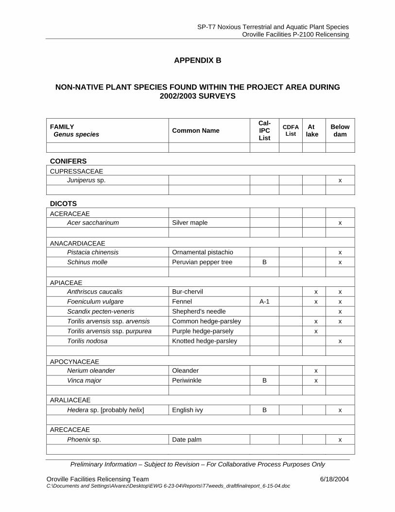
SP-T7 Noxious Terrestrial and Aquatic Plant Species Oroville Facilities P-2100 Relicensing
Preliminary Information – Subject to Revision – For Collaborative Process Purposes Only
Oroville Facilities Relicensing Team 6/18/2004 C:\Documents and Settings\Alvarez\Desktop\EWG 6-23-04\Reports\T7weeds_draftfinalreport_6-15-04.doc
APPENDIX B
NON-NATIVE PLANT SPECIES FOUND WITHIN THE PROJECT AREA DURING
2002/2003 SURVEYS FAMILY Genus species Common Name
Cal-IPC List
CDFA List
At lake
Below dam
CONIFERS CUPRESSACEAE
Juniperus sp. x
DICOTS
ACERACEAE
Acer saccharinum Silver maple x
ANACARDIACEAE
Pistacia chinensis Ornamental pistachio x
Schinus molle Peruvian pepper tree B x
APIACEAE
Anthriscus caucalis Bur-chervil x x
Foeniculum vulgare Fennel A-1 x x
Scandix pecten-veneris Shepherd's needle x
Torilis arvensis ssp. arvensis Common hedge-parsley x x
Torilis arvensis ssp. purpurea Purple hedge-parsely x
Torilis nodosa Knotted hedge-parsley x
APOCYNACEAE
Nerium oleander Oleander x
Vinca major Periwinkle B x
ARALIACEAE
Hedera sp. [probably helix] English ivy B x ARECACEAE
Phoenix sp. Date palm x
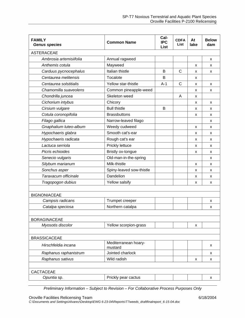
SP-T7 Noxious Terrestrial and Aquatic Plant Species Oroville Facilities P-2100 Relicensing
Preliminary Information – Subject to Revision – For Collaborative Process Purposes Only
Oroville Facilities Relicensing Team 6/18/2004 C:\Documents and Settings\Alvarez\Desktop\EWG 6-23-04\Reports\T7weeds_draftfinalreport_6-15-04.doc
FAMILY Genus species Common Name
Cal-IPC List
CDFA List
At lake
Below dam
ASTERACEAE
Ambrosia artemisiifolia Annual ragweed x
Anthemis cotula Mayweed x x
Carduus pycnocephalus Italian thistle B C x x
Centaurea melitensis Tocalote B x
Centaurea solstitialis Yellow star-thistle A-1 C x x
Chamomilla suaveolens Common pineapple-weed x x
Chondrilla juncea Skeleton weed A x
Cichorium intybus Chicory x x
Cirsium vulgare Bull thistle B x x
Cotula coronopifolia Brassbuttons x x
Filago gallica Narrow-leaved filago x
Gnaphalium luteo-album Weedy cudweed x x
Hypochaeris glabra Smooth cat's-ear x x
Hypochaeris radicata Rough cat's ear x x
Lactuca serriola Prickly lettuce x x
Picris echioides Bristly ox-tongue x x
Senecio vulgaris Old-man-in-the-spring x
Silybum marianum Milk-thistle x x
Sonchus asper Spiny-leaved sow-thistle x x
Taraxacum officinale Dandelion x x
Tragopogon dubius Yellow salsify x x
BIGNONIACEAE
Campsis radicans Trumpet creeper x
Catalpa speciosa Northern catalpa x
BORAGINACEAE
Myosotis discolor Yellow scorpion-grass x
BRASSICACEAE
Hirschfeldia incana Mediterranean hoary-mustard x
Raphanus raphanistrum Jointed charlock x
Raphanus sativus Wild radish x x
CACTACEAE
Opuntia sp. Prickly pear cactus x
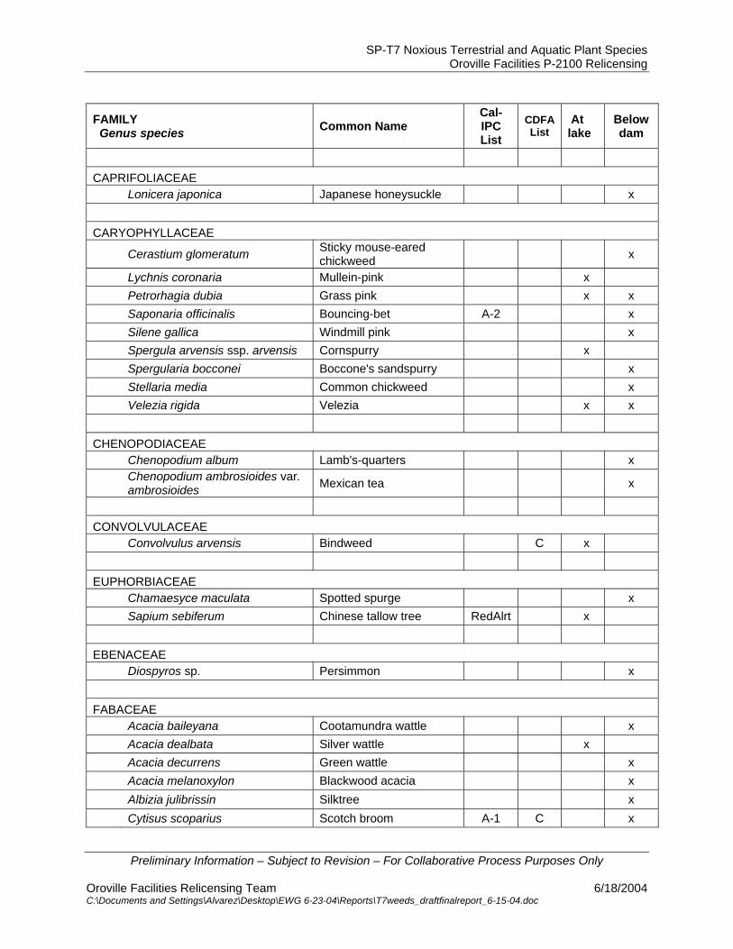
SP-T7 Noxious Terrestrial and Aquatic Plant Species Oroville Facilities P-2100 Relicensing
Preliminary Information – Subject to Revision – For Collaborative Process Purposes Only
Oroville Facilities Relicensing Team 6/18/2004 C:\Documents and Settings\Alvarez\Desktop\EWG 6-23-04\Reports\T7weeds_draftfinalreport_6-15-04.doc
FAMILY Genus species Common Name
Cal-IPC List
CDFA List
At lake
Below dam
CAPRIFOLIACEAE
Lonicera japonica Japanese honeysuckle x
CARYOPHYLLACEAE
Cerastium glomeratum Sticky mouse-eared chickweed x
Lychnis coronaria Mullein-pink x
Petrorhagia dubia Grass pink x x
Saponaria officinalis Bouncing-bet A-2 x
Silene gallica Windmill pink x
Spergula arvensis ssp. arvensis Cornspurry x
Spergularia bocconei Boccone's sandspurry x
Stellaria media Common chickweed x
Velezia rigida Velezia x x
CHENOPODIACEAE
Chenopodium album Lamb's-quarters x
Chenopodium ambrosioides var. ambrosioides Mexican tea x
CONVOLVULACEAE
Convolvulus arvensis Bindweed C x
EUPHORBIACEAE
Chamaesyce maculata Spotted spurge x
Sapium sebiferum Chinese tallow tree RedAlrt x
EBENACEAE
Diospyros sp. Persimmon x
FABACEAE
Acacia baileyana Cootamundra wattle x
Acacia dealbata Silver wattle x
Acacia decurrens Green wattle x
Acacia melanoxylon Blackwood acacia x
Albizia julibrissin Silktree x
Cytisus scoparius Scotch broom A-1 C x

SP-T7 Noxious Terrestrial and Aquatic Plant Species Oroville Facilities P-2100 Relicensing
Preliminary Information – Subject to Revision – For Collaborative Process Purposes Only
Oroville Facilities Relicensing Team 6/18/2004 C:\Documents and Settings\Alvarez\Desktop\EWG 6-23-04\Reports\T7weeds_draftfinalreport_6-15-04.doc
FAMILY Genus species Common Name
Cal-IPC List
CDFA List
At lake
Below dam
Genista monspessulana French-broom A-1 C x x
Gleditsia tricanthos Honey-locust x
Lathyrus tingitanus Tangier pea x
Lotus corniculatus Bird-foot trefoil x x
Medicago polymorpha California bur-clover x x
Melilotus albus White sweetclover x
Melilotus officinalis Yellow sweetclover x x
Pisum sativum Garden pea x x
Robinia pseudoacacia Black locust* B x x
Sesbania punicea Scarlet wisteria RedAlrt x
Spartium junceum Scotch broom B x
Trifolium campestre Hop clover x
Trifolium dubium Little hop clover x x
Trifolium glomeratum Sessile-headed clover x
Trifolium hirtum Rose clover x x
Trifolium incarnatum Crimson clover x
Trifolium repens White clover x
Trifolium subterraneum Subterranean clover x
Trifolium tomentosum Woolly-fruited clover x
Vicia sativa ssp. sativa Spring vetch x x
Vicia villosa Winter vetch x
FAGACEAE
Quercus suber Cork oak x
GERANIACEAE
Erodium cicutarium Red-stemmed filaree x x
Erodium botrys Long-beaked stork's-bill x x
Erodium moschatum White-stemmed filaree x x
Geranium dissectum Cut-leaved geranium x x
Geranium pusillum Small geranium x
HAMAMELIDACEAE
Hamamelis vernalis Witchazel x
HALORAGACEAE
Myriophyllum spicatum Eurasian milfoil A-1 x
Myriophyllum aquaticum Parrot’s feather B x
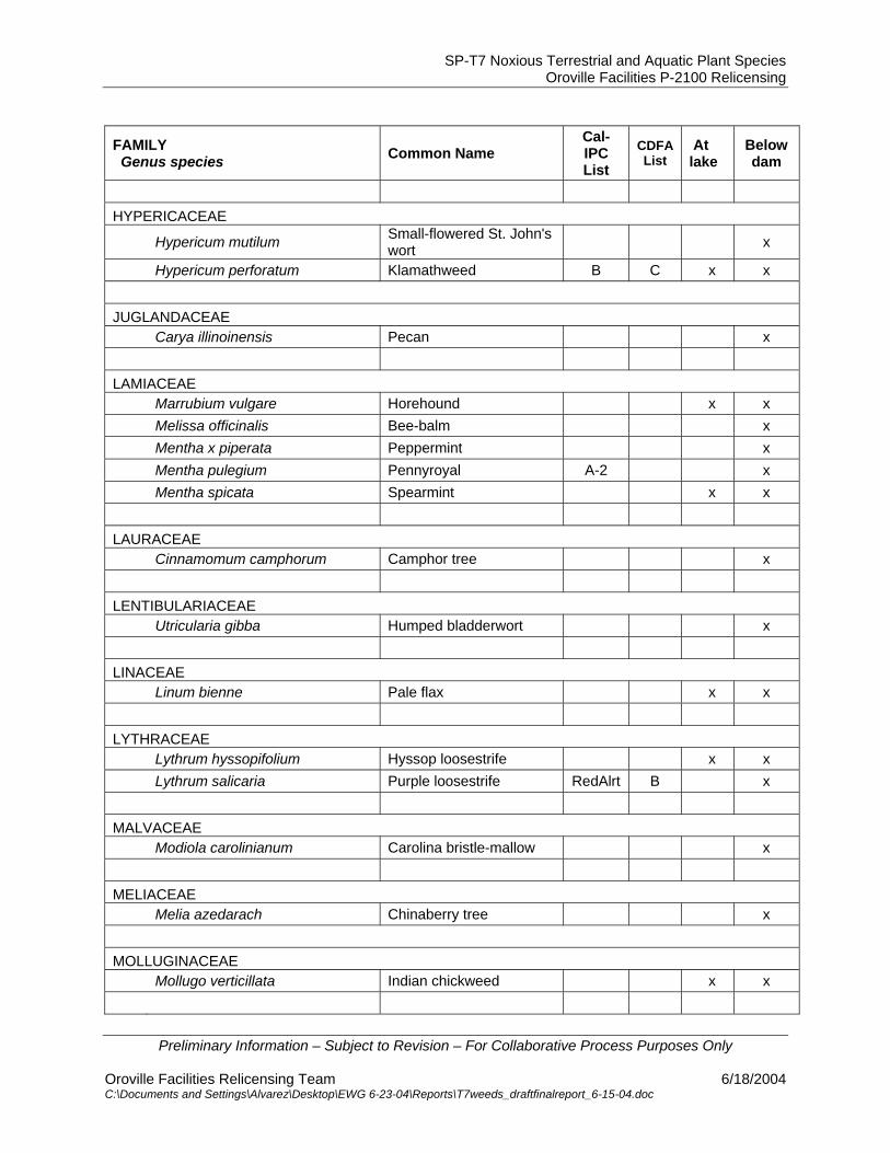
SP-T7 Noxious Terrestrial and Aquatic Plant Species Oroville Facilities P-2100 Relicensing
Preliminary Information – Subject to Revision – For Collaborative Process Purposes Only
Oroville Facilities Relicensing Team 6/18/2004 C:\Documents and Settings\Alvarez\Desktop\EWG 6-23-04\Reports\T7weeds_draftfinalreport_6-15-04.doc
FAMILY Genus species Common Name
Cal-IPC List
CDFA List
At lake
Below dam
HYPERICACEAE
Hypericum mutilum Small-flowered St. John's wort x
Hypericum perforatum Klamathweed B C x x
JUGLANDACEAE
Carya illinoinensis Pecan x
LAMIACEAE
Marrubium vulgare Horehound x x
Melissa officinalis Bee-balm x
Mentha x piperata Peppermint x
Mentha pulegium Pennyroyal A-2 x
Mentha spicata Spearmint x x
LAURACEAE
Cinnamomum camphorum Camphor tree x
LENTIBULARIACEAE
Utricularia gibba Humped bladderwort x
LINACEAE
Linum bienne Pale flax x x
LYTHRACEAE
Lythrum hyssopifolium Hyssop loosestrife x x
Lythrum salicaria Purple loosestrife RedAlrt B x
MALVACEAE
Modiola carolinianum Carolina bristle-mallow x
MELIACEAE
Melia azedarach Chinaberry tree x
MOLLUGINACEAE
Mollugo verticillata Indian chickweed x x
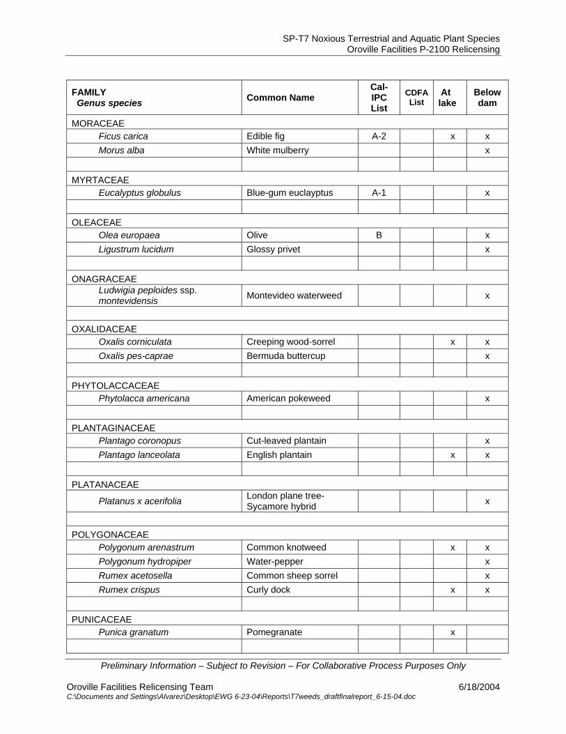
SP-T7 Noxious Terrestrial and Aquatic Plant Species Oroville Facilities P-2100 Relicensing
Preliminary Information – Subject to Revision – For Collaborative Process Purposes Only
Oroville Facilities Relicensing Team 6/18/2004 C:\Documents and Settings\Alvarez\Desktop\EWG 6-23-04\Reports\T7weeds_draftfinalreport_6-15-04.doc
FAMILY Genus species Common Name
Cal-IPC List
CDFA List
At lake
Below dam
MORACEAE
Ficus carica Edible fig A-2 x x
Morus alba White mulberry x
MYRTACEAE
Eucalyptus globulus Blue-gum euclayptus A-1 x
OLEACEAE
Olea europaea Olive B x
Ligustrum lucidum Glossy privet x
ONAGRACEAE
Ludwigia peploides ssp. montevidensis Montevideo waterweed x
OXALIDACEAE
Oxalis corniculata Creeping wood-sorrel x x
Oxalis pes-caprae Bermuda buttercup x
PHYTOLACCACEAE
Phytolacca americana American pokeweed x
PLANTAGINACEAE
Plantago coronopus Cut-leaved plantain x
Plantago lanceolata English plantain x x
PLATANACEAE
Platanus x acerifolia London plane tree- Sycamore hybrid x
POLYGONACEAE
Polygonum arenastrum Common knotweed x x
Polygonum hydropiper Water-pepper x
Rumex acetosella Common sheep sorrel x
Rumex crispus Curly dock x x
PUNICACEAE
Punica granatum Pomegranate x

SP-T7 Noxious Terrestrial and Aquatic Plant Species Oroville Facilities P-2100 Relicensing
Preliminary Information – Subject to Revision – For Collaborative Process Purposes Only
Oroville Facilities Relicensing Team 6/18/2004 C:\Documents and Settings\Alvarez\Desktop\EWG 6-23-04\Reports\T7weeds_draftfinalreport_6-15-04.doc
FAMILY Genus species Common Name
Cal-IPC List
CDFA List
At lake
Below dam
PRIMULACEAE
Anagallis arvensis Scarlet pimpernel x x
RANUNCULACEAE
Ranunculus arvensis Field buttercup x
Ranunculus muricatus Prickle-seeded buttercup x
RHAMNACEAE
Ziziphus jujuba Common jujube x
ROSACEAE
Chaenomeles speciosa Flowering quince x
Malus sylvestris apple x
Prunus cerasifera Cherry plum x
Prunus dulcis almond x
Prunus sp. cultivated plum x
Pyracantha fortuneana Chinese firethorn x
Pyrus calleryana Callery pear x
Pyrus communis Common pear x
Rosa sp. Landscaping rose x
Rubus discolor Himalyan blackberry A-1 x x
Rubus pensilvanicus Pennsylvania blackberry x x
RUBIACEAE
Crucianella angustifolia Crosswort x x
Galium divaricatum Lamarck's bedstraw x
Sherardia arvensis Field madder x x
RUTACEAE
Citrus sp. Orange, lemon, etc.
SCROPHULARIACEAE
Parentucellia viscosa Yellow parentuchellia x x
Paulownia tomentosa [= imperialis] Princesstree x
Verbascum blattaria Moth mullein x x
Verbascum thapsus Woolly mullein B x x
Veronica anagallis-aquatica Great water speedwell x x
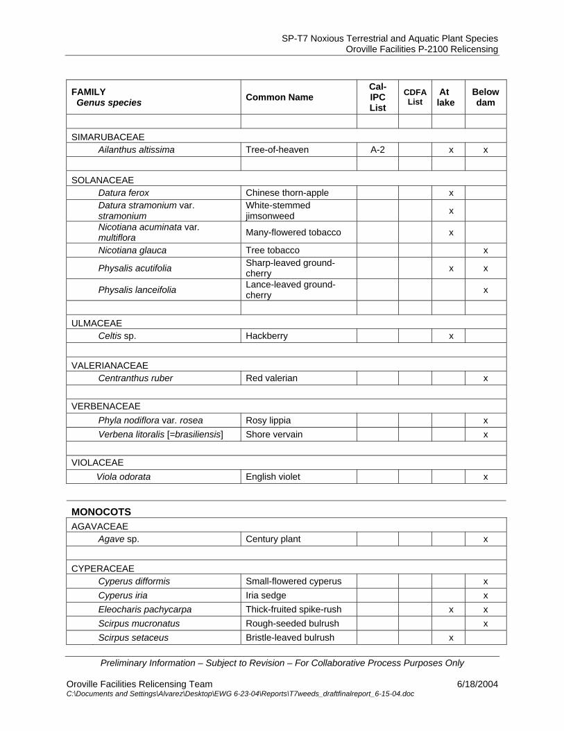
SP-T7 Noxious Terrestrial and Aquatic Plant Species Oroville Facilities P-2100 Relicensing
Preliminary Information – Subject to Revision – For Collaborative Process Purposes Only
Oroville Facilities Relicensing Team 6/18/2004 C:\Documents and Settings\Alvarez\Desktop\EWG 6-23-04\Reports\T7weeds_draftfinalreport_6-15-04.doc
FAMILY Genus species Common Name
Cal-IPC List
CDFA List
At lake
Below dam
SIMARUBACEAE
Ailanthus altissima Tree-of-heaven A-2 x x
SOLANACEAE
Datura ferox Chinese thorn-apple x
Datura stramonium var. stramonium
White-stemmed jimsonweed x
Nicotiana acuminata var. multiflora Many-flowered tobacco x
Nicotiana glauca Tree tobacco x
Physalis acutifolia Sharp-leaved ground-cherry x x
Physalis lanceifolia Lance-leaved ground-cherry x
ULMACEAE
Celtis sp. Hackberry x
VALERIANACEAE
Centranthus ruber Red valerian x VERBENACEAE
Phyla nodiflora var. rosea Rosy lippia x
Verbena litoralis [=brasiliensis] Shore vervain x VIOLACEAE
Viola odorata English violet x
MONOCOTS
AGAVACEAE
Agave sp. Century plant x
CYPERACEAE
Cyperus difformis Small-flowered cyperus x
Cyperus iria Iria sedge x
Eleocharis pachycarpa Thick-fruited spike-rush x x
Scirpus mucronatus Rough-seeded bulrush x
Scirpus setaceus Bristle-leaved bulrush x

SP-T7 Noxious Terrestrial and Aquatic Plant Species Oroville Facilities P-2100 Relicensing
Preliminary Information – Subject to Revision – For Collaborative Process Purposes Only
Oroville Facilities Relicensing Team 6/18/2004 C:\Documents and Settings\Alvarez\Desktop\EWG 6-23-04\Reports\T7weeds_draftfinalreport_6-15-04.doc
FAMILY Genus species Common Name
Cal-IPC List
CDFA List
At lake
Below dam
IRIDACEAE
Iris psuedacorus Yellow water-iris B x
JUNCACEAE
Juncus capitatus Leafy-bracted dwarf rush x x
Juncus diffusissimus Diffuse rush x
LILIACEAE
Asparagus officinalis Garden asparagus x
POACEAE
Aegilops cylindrica Jointed goatgrass B x x
Aegilops triuncialis Barbed goatgrass B x
Agrostis viridis Water bentgrass x
Aira caryophyllea Silver European hairgrass x x
Andropogon virginicus var. virginicus Broomsedge bluestem x x
Arundo donax Giant-reed A-1 x
Avena barbata Slender wild oat x x
Avena fatua Wild oat x x
Brachypodium distachyon False brome x x
Briza maxima Greater quaking grass x x
Briza minor Lesser quaking grass x x
Bromus arenarius Australian brome x
Bromus catharticus Rescuegrass x
Bromus diandrus Ripgut grass x x
Bromus hordeaceus Softchess x x
Bromus madritenis ssp. rubens Foxtail chess A-2 x x
Cortaderia selloana Pampasgrass A-1 x
Crypsis vaginiflora African pricklegrass x
Cynodon dactylon Bermuda grass C x x
Cynosurus echinatus Hedgehog dogtail x x
Dactylis glomerata Orchardgrass x
Digitaria ischaemum Smooth crabgrass x
Digitaria sanguinalis Hairy crabgrass x x
Echinochloa crus-galli Barnyard grass x
Elytrigia sp. Wheatgrass A? x

SP-T7 Noxious Terrestrial and Aquatic Plant Species Oroville Facilities P-2100 Relicensing
Preliminary Information – Subject to Revision – For Collaborative Process Purposes Only
Oroville Facilities Relicensing Team 6/18/2004 C:\Documents and Settings\Alvarez\Desktop\EWG 6-23-04\Reports\T7weeds_draftfinalreport_6-15-04.doc
FAMILY Genus species Common Name
Cal-IPC List
CDFA List
At lake
Below dam
Gastridium ventricosum Nitgrass x x
Holcus lanatus Common velvetgrass B x x
Hordeum marinum ssp. gussoneanum Mediterranean barley x x
Hordeum murinum ssp. leporinum Hare wall barley x x
Leersia oryzoides Rice cutgrass x x
Lolium multiflorum Italian ryegrass x x
Panicum dichotomiflorum Smooth witchgrass x
Paspalum dilatatum Dallisgrass x x
Phalaris aquatica Harding-grass B x x
Phalaris caroliniana Carolina canarygrass x
Phalaris minor Lesser canarygrass x
Poa annua Annual bluegrass x x
Poa bulbosa Bulbous bluegrass x
Polypogon australis Southern beardgrass x
Polypogon maritimus Mediterranean beardgrass x
Polypogon monspeliensis Annual beardgrass x x
Setaria viridis Green bristlegrass x x
Sorghum halapense Johnsongrass C x x
Taeniatherum caput-medusae Medusa-head A-1 C x x
Vulpia myuros var. myuros Rattail fescue x x
POTAMOGETONACEAE
Potamogeton sp. [some plts prob. P.crispus] Pondweed x