Embed Size (px)
Citation preview

Copyright © 2014 Kristen Rabideau
Southwest States Lapbook Instructions I recommend using gluestick for all pieces requiring gluing.
Print state matchbooks two sided (flip along the long side of the paper)
Print State features two sided (flip along the long side of the paper).
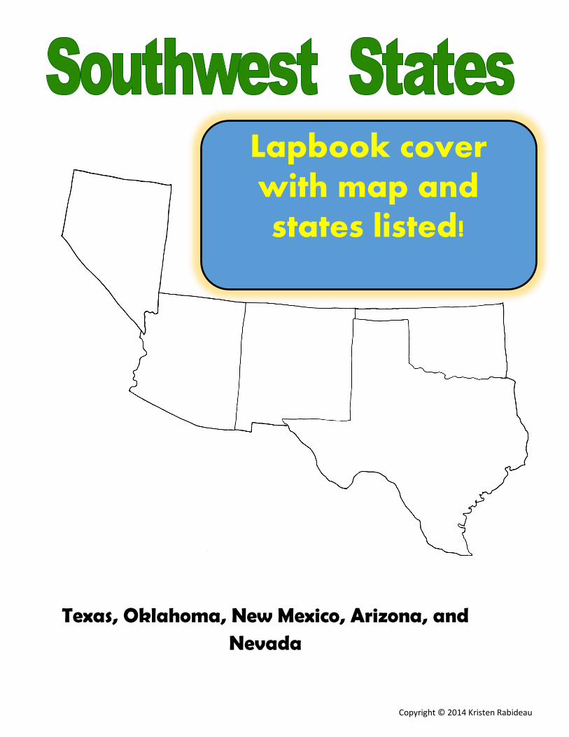
Print the southeast states map and the cover .
Laminate the map and glue or tape into the middle section of the lapbook.
Fold the state matchbooks along the dotted lines and glue into the lapbook. (the order or posi-tion really doesn’t matter)
Fold the State Features along the solid lines and glue into the lapbook.
Pictures show one way to configure your lapbook.
Use the laminated map in the middle for students to quiz themselves using a dry erase marker. They can test themselves on the state names, capitals, or even birds and flowers. Alternatively, you could not laminate it, and just allow students to color, and label states and capitals. Extra space was left in the matchbooks so your students can add any extra state info they find interesting! Con-sider adding state trees, songs, patron saints, etc!
Instructions with pictures of completed
project included

Copyright © 2014 Kristen Rabideau
Print the cover for your lapbook:
Glue it to the front of the two side flaps. (I glue the page to one side, then use the edge of the file folder as a guide to cut on).
(Pictures are to illustrate the instructions. They may not be pictures of the exact lapbook you purchased.)
Then to make it fit into your Geography 3 ring
binder, use some packing or duct tape. Run
the tape down the outside of the left side of the
Lapbook. Fold it over onto itself, so that about
1/2 of tape is sticking to itself, and the rest to
the lapbook. Hole punch through the tape and
store in your binder!
Instructions with pictures of completed
project included
Copyright © 2014 Kristen Rabideau
Common Core:
National Geography Standards
NSS-G.K-12.1 THE WORLD IN SPATIAL TERMS
Understand how to use maps and other geographic representations, tools, and technologies to acquire, process, and report
information from a spatial perspective.
Understand how to use mental maps to organize information about people, places, and environments in a spatial context.
Understand how to analyze the spatial organization of people, places, and environments on Earth's surface.
NSS-G.K-12.2 PLACES AND REGIONS
Understand the physical and human characteristics of places.

Copyright © 2014 Kristen Rabideau
Ok
la
ho
ma
Tex
as
Ne
w M
ex
ic
o
Arizo
na
Nevada
Matchbooks show
highlighted state within the whole
US for spatial
recognition

Copyright © 2014 Kristen Rabideau
Abbre
via
tio
n:
AZ
Capita
l: P
hoe
nix
Flo
wer:
S
agu
aro
Cactu
s
Blo
sso
m
Bird:
Cactu
s W
ren
Abbre
via
tio
n:
NM
Capita
l: S
anta
Fe
Flo
wer:
Yucca F
low
er
Bird:
Roadru
nner
Abbre
via
tio
n:
TX
Capita
l: A
ustin
Flo
wer:
Blu
ebo
nnet
Bird:
Mockin
gbir
d
Abbreviation: NV
Capital: Carson City
Flower: Sagebrush
Bird: Mountain Blue-
bird
Abbre
via
tio
n:
OK
Capita
l: O
kla
hom
a
City
Flo
wer:
Mis
tleto
e
Bird:
scis
sor-
taile
d
Fly
catc
her
State
F
la
g
State
F
la
g
State
F
la
g
State
F
la
g
State Flag
Matchbooks are filled in with basic
information, pictures of flags, and
have blank space for
adding your own fun details!

Copyright © 2014 Kristen Rabideau
The Painted
Desert
Guadalupe
Mountains Glue to lapbook
Glue to lapbook
The Painted Desert is in the Four
Corners area of the US (where
Arizona, New Mexico, Utah and
Colorado meet).
The Guadalupe Mountains are in
western Texas and Southeastern
New Mexico.
Big
Bend
Glue to lapbook
Fo
ur
Cor
n
ers
Glu
e to
lap
bo
ok
Flip pages for regional
features have
information filled in and
pictures

Copyright © 2014 Kristen Rabideau
Fossils of plants and animals
(including dinosaurs) have been
found in the Painted Desert!
Wind and rain have eroded the
painted desert over many years,
exposing the layers of beautifully
colored rock.
Three major ecosystems exists in the area: desert, canyons, and alpine uplands. This mountain
range also has many caves!
The highest point in the Guadalupe Mountains is
Guadalupe Peak at 8,749ft tall!
Big Bend is a National Park
in Western Texas along the
Rio Grand. This park
has a diverse wildlife population
supported by the diverse habitats of
deserts, rivers, and mountains.
Big Bend covers 801,163; that’s bigger
than the whole state of Rhode Island!
Fou
r Co
rners is th
e on
ly place in
ou
r
cou
ntry w
here yo
u can
stand
on
fou
r
diff
erent states at th
e same ti
me! It is
located
in p
art of a larger area called
the
Co
lorad
o P
lateau, w
hich
is mo
stly rural,
rugged
terrain.
Arizon
a
Uta
h
New
Mexico
Colora
do
Flip pages for regional
features have
information filled in and
pictures

Copyright © 2014 Kristen Rabideau
Grand
Rio Grande River
Glue to lapbook
Glue to lapbook

Copyright © 2014 Kristen Rabideau
The Grand Canyon is a
The Rio Grande is a large river that starts in Colorado, flows along the boarder between Texas and Mexico and empties into the Gulf
of Mexico. It has been critical to exploration, trading, irrigation and wildlife throughout history.

Copyright © 2014 Kristen Rabideau
Large regional map for students to color and label
themselves!
Laminate to label and erase over
and over!
Copyright © 2014 Kristen Rabideau
Texas, Oklahoma, New Mexico, Arizona, and Nevada
Lapbook cover with map and states listed!