Embed Size (px)
Citation preview

SOUTHERN SPENCER GULF MARINE PARK
MANAGEMENT PLAN 2012


Marine park management is important… The Southern Spencer Gulf Marine Park spans waters from Hardwicke Bay around the peninsula to Hillock Point and across Investigator Strait to the north coast of Kangaroo Island. It is one of 19 marine parks contributing to the South Australian Representative System of Marine Protected Areas. This management plan has been made in accordance with section 14 of the Marine Parks Act 2007. It sets out a zoning scheme and management strategies for the Southern Spencer Gulf Marine Park. The plan provides for the protection of marine and coastal biodiversity and life-sustaining ecological processes, the protection of natural, European and Aboriginal cultural heritage, as well as providing for ongoing ecologically sustainable development and use. Community stewardship of marine parks is one of the keys to their success and this plan contains strategies to assist with community education, involvement and enjoyment of the park. Many pieces of information and advice have informed the development of this management plan. I wish to thank members of the Western Yorke Peninsula and Kangaroo Island Marine Park Local Advisory Groups, whose task was to facilitate early community advice to the Government to assist in the development of the zoning contained in this management plan. Members of the local community, peak stakeholders, the Marine Parks Council of South Australia, the Scientific Working Group and staff from South Australian Government agencies have also provided important advice. I commend this plan to you. Further information about this plan and the background to its development are available on the Marine Parks website at www.marineparks.sa.gov.au or freecall 1800 006 120. Hon Paul Caica MP Minister for Sustainability, Environment and Conservation


Table of Contents 1. INTRODUCTION..................................................................................................... 1
1.1. Commitment to NRSMPA..........................................................................1 1.2. Planning context ........................................................................................1
1.2.1. Management planning process .................................................1 1.2.2. Management plans and supporting documents ....................2
1.3. Legislative context .....................................................................................2 1.4. Management context ..............................................................................3
1.4.1. Management tools ........................................................................3 1.4.2. Other management considerations...........................................3 1.4.3. Other policies, plans and strategies ...........................................4
2. DESCRIPTION OF SOUTHERN SPENCER GULF MARINE PARK.......................... 5 2.1. Location description..................................................................................5 2.2. Environmental, economic and social values........................................5
2.2.1. Environmental values ....................................................................6 2.2.2. Economic values............................................................................6 2.2.3. Social values ...................................................................................6
3. MANAGEMENT CHALLENGES IN THE SOUTHERN SPENCER GULF MARINE PARK........................................................................................................ 8 3.1. What are the particular management challenges?...........................8
4. MANAGEMENT PRIORITIES AND STRATEGIES .................................................... 9 4.1. Protection ....................................................................................................9 4.2. Stewardship through community involvement...................................10 4.3. Performance assessment, knowledge and review............................10 4.4. Compliance..............................................................................................11
5. GUIDELINES FOR PERMITS .................................................................................. 11
6. ZONING SCHEME FOR THE SOUTHERN SPENCER GULF MARINE PARK ....... 13 6.1. Zoning.........................................................................................................13
6.1.1. General Managed Use Zones....................................................13 6.1.2. Habitat Protection Zones............................................................14 6.1.3. Sanctuary Zones...........................................................................14 6.1.4. Restricted Access Zones .............................................................14
6.2. Special Purpose Areas ............................................................................14 6.2.1. Meaning of Special Purpose Area............................................14 6.2.2. Special Purpose Areas (harbor activities)................................14 6.2.3. Special Purpose Areas (shore-based recreational line
fishing) ............................................................................................15 6.3. Boundary Definition Maps ......................................................................15
7. REFERENCES ........................................................................................................ 16 Appendix 1 Boundary Definition Maps .......................................................17


1. INTRODUCTION
1.1. Commitment to NRSMPA
The South Australian Government has developed the South Australian Representative System of Marine Protected Areas (SARSMPA) as part of the National Representative System of Marine Protected Areas (NRSMPA). Overarching policy documents for the SARSMPA include South Australia’s Strategic Plan 2011, the Living Coast Strategy for South Australia (DEH 2004b) and the Blueprint for the South Australian Representative System of Marine Protected Areas (DEH 2004a). In conjunction with the community, the Government has designed a network of 19 marine parks encompassing the major ecosystems and habitat types found within South Australian waters as a significant contribution to the NRSMPA.
1.2. Planning context
1.2.1. Management planning process Late in 2009, 13 marine park local advisory groups (MPLAGs) were established across South Australia to provide an opportunity for communities to have early (pre-draft) input into the management planning process. The Great Australian Bight Marine Park Consultative Committee, with two additional members, also formed the equivalent of a MPLAG for the Far West Coast Marine Park, bringing the total number of local advisory groups to 14. The Western Yorke Peninsula and Kangaroo Island MPLAGs provided advice in relation to the Southern Spencer Gulf Marine Park. The establishment of MPLAGs reflects the Government’s commitment to involve regional communities in the planning of marine parks in their local waters. MPLAGs were non-statutory, community-based advisory bodies set up to provide local advice to Government for the development of draft management plans. To help facilitate communications between the Government and regional communities, MPLAG meetings were open to the public. The MPLAG process provided invaluable advice relating to local uses of the marine environment and possible zoning arrangements for consideration in developing draft management plans. In addition, peak stakeholder groups contributed advice both to MPLAG discussions and directly to Government. At a peak stakeholder forum on 11 and 12 April 2012, leaders from the conservation, recreational and commercial fishing sectors identified a series of priority areas for conservation and reached an agreement on the zoning approach for South Australia’s network of marine parks. Based on the collective advice from MPLAGs, other community members, peak stakeholders and discussions across relevant agencies, the Government developed draft management plans with zoning for each of the 19 marine parks for public review.
1

An eight week consultation process was conducted between 26 August and 22 October 2012. During this period written submissions were received from individuals and organisations in response to the draft zoning and management arrangements. These submissions have been considered in finalising this management plan. 1.2.2. Management plans and supporting documents This marine park management plan provides the statutory basis for the management of the Southern Spencer Gulf Marine Park. It is a strategic document that defines the boundaries of the various zones and special purpose areas and sets out strategies to address management challenges over the next 10 years or more. An implementation plan will guide day-to-day management of the Southern Spencer Gulf Marine Park in accordance with this management plan. The South Australian Marine Parks Network Explanatory Document (DEWNR 2012) also provides: relevant context regarding the marine parks network; and an explanation of the challenges, priorities and strategies set out in South
Australia’s marine park management plans. A Values Statement (DENR 2010) summarises the key environmental, economic and social values of the region.
1.3. Legislative context
The Marine Parks Act 2007 provides the legislative basis for marine parks. The Act establishes the management objectives for the network of marine parks and requires the development of management plans for each park. The Act states that management plans: must be consistent with the objects of the Act, set out strategies for
achieving those objects and establish the various types of zones for each marine park; and
may define special purpose areas, direct the day-to-day management of issues associated with marine parks and provide guidelines for the granting of permits for various activities within marine parks.
All management activities within marine parks must be consistent with and seek to further the objects of the Marine Parks Act, which are:
(a) to protect and conserve marine biological diversity and marine habitats by declaring and providing for the management of a comprehensive, adequate and representative system of marine parks; and
(b) to assist in—
(i) the maintenance of ecological processes in the marine environment; and
2

(ii) the adaptation to the impacts of climate change in the marine environment; and
(iii) protecting and conserving features of natural or cultural heritage significance; and
(iv) allowing ecologically sustainable development and use of marine environments; and
(v) providing opportunities for public appreciation, education, understanding and enjoyment of marine environments.
1.4. Management context
1.4.1. Management tools Multiple-use zoning Marine parks in South Australia have been zoned for multiple uses, providing for varying levels of conservation, recreational and commercial use. Zoning provides the basis for the management of marine parks, in accordance with the objects of the Marine Parks Act 2007. General Managed Use Zones (GMUZ) enable areas to be managed to provide protection for habitats and biodiversity, while allowing ecologically sustainable development and use. Habitat Protection Zones (HPZ) enable areas to be managed to provide protection for habitats and biodiversity, while allowing for activities and uses that do not harm habitats or the functioning of ecosystems. Sanctuary Zones (SZ) enable areas to be managed to provide protection and conservation for habitats and biodiversity, especially by prohibiting the removal or harm of plants, animals or marine products. Restricted Access Zones (RAZ) enable areas to be managed by limiting access to them. (For further information see the zoning tables specifying restrictions in zones, available in the South Australian Marine Parks Network Explanatory Document or at www.marineparks.sa.gov.au) Special Purpose Areas (SPA) are areas within marine parks overlaying a zone, or part of a zone, which allow specified activities in that area that would otherwise not be allowed. Section 6 of this document identifies the type of zones and special purpose areas in this marine park. 1.4.2. Other management considerations Government policy commitments have informed the design of the zoning for the Southern Spencer Gulf Marine Park. These commitments were made to
3

ensure that, wherever possible, marine park design for conservation minimised impacts on existing uses and activities in the marine environment. A complete list of the commitments is available in the South Australian Marine Parks Network Explanatory Document or at www.marineparks.sa.gov.au 1.4.3. Other policies, plans and strategies The following matters have been taken into account in preparing this management plan, in accordance with section 13(2) of the Marine Parks Act 2007:
• the State’s Strategic Plan; • the Planning Strategy and relevant Development Plans under the
Development Act 1993; • the State NRM plan and any relevant regional NRM plans under the
Natural Resources Management Act 2004; • relevant environment protection policies under the Environment
Protection Act 1993; • relevant indigenous land use agreements; and • provisions of any statutory instruments under related operational Acts.
Management actions within the Southern Spencer Gulf Marine Park will be conducted in accordance with this management plan, as required by section 12 of the Marine Parks Act 2007, and all relevant laws of the State.
4

2. DESCRIPTION OF SOUTHERN SPENCER GULF MARINE PARK
2.1. Location description
Spanning across transition zones of three bioregions (Spencer Gulf, Eyre and Gulf St Vincent), the Southern Spencer Gulf Marine Park covers 2,972 km2 and extends around the western tip of Yorke Peninsula and across to the central north coast of Kangaroo Island. The marine park overlays the Althorpe Islands Conservation Park and parts of Innes National Park, Leven Beach Conservation Park and Western River Wilderness Area (DENR 2010).
Location of Southern Spencer Gulf Marine Park
2.2. Environmental, economic and social values
The following sections briefly summarise the key environmental, economic and social values of the region. A more comprehensive description of the values of this marine park can be found in Environmental, Economic and Social Values of the Southern Spencer Gulf Marine Park, available at www.marineparks.sa.gov.au
An atlas of maps containing environmental, economic and social/cultural information for this marine park has been produced as Part 2 of the Values Statement. The maps provide details specific to this park in a user-friendly
5

visual format and may be viewed and downloaded from the marine parks website.
2.2.1. Environmental values The Southern Spencer Gulf Marine Park is influenced by varying seafloor depths and wind and wave exposures, which have shaped the changing coastline. Low energy beaches backed by extensive sand dunes, shallow embayments dominated by seagrass meadows and low profile reefs dominate the habitats on the north coast of the park from Hardwicke Bay to Corny Point (Baker 2004). The remainder of the park from Corny Point to Foul Bay and part of the North coast of Kangaroo Island comprises various habitats from exposed cliffs, offshore islands and headlands fronted by high energy intertidal reefs and rocky shore platforms to both sheltered and high energy sand beaches backed by sand dunes (Baker 2004). The sheltered embayment of Hardwicke Bay containing extensive seagrass meadows is a significant feature of this park. The long expansive beach is home to nesting hooded plovers. The Althorpe Islands Conservation Park includes a haul out site for the vulnerable Australian sea lion and the New Zealand fur seal (Goldsworthy & Page 2009; Shaughnessy & Goldsworthy 2007). Cliff habitats throughout the park provide important nesting sites for endangered seabirds (DENR 2010). 2.2.2. Economic values Commercial fisheries operating in the Southern Spencer Gulf Marine Park include the Spencer Gulf Prawn Fishery, the Central Zone Abalone Fishery, the Northern Zone Rock Lobster Fishery, the Sardine Fishery, the Marine Scalefish Fishery and the Charter Fishery. Tourism is an important economic contributor to the region. Key activities include recreational and charter fishing, charter sailing, recreational diving and expedition cruise ships. 2.2.3. Social values The Narungga Aboriginal people have traditional associations with areas of the marine park. An Indigenous Land Use Agreement (ILUA) exists over areas of the marine park and a fishing ILUA is also under development. The Ngarrindjeri and Kaurna Aboriginal people may have had traditional associations with Kangaroo Island. During the nineteenth century, Ngarrindjeri, Kaurna and Tasmanian Aboriginal women were brought to the island by sealers for their knowledge and labour to assist with the hunting. This renewed an Aboriginal link with the island that had been broken for approximately 5000 years (DENR 2010). The Southern Spencer Gulf marine park is rich in European history and many ships were wrecked in Investigator strait or the south west coast of Yorke Peninsula. At least 40 known shipwrecks lie in the park, 26 of which are included in the Investigator Strait Maritime Heritage Trail. The lighthouse keepers’ cottages, jetty and flying fox on Althorpe Island are listed in the State Heritage Register.
6

The coastline of the Southern Spencer Gulf Marine Park is among the highest ranked areas of coastal scenic quality in the state (Lothian 2005).
7

3. MANAGEMENT CHALLENGES IN THE SOUTHERN SPENCER GULF MARINE PARK
The management of our marine parks faces some important challenges, both natural and human induced. Key management challenges and threats to marine biodiversity are discussed broadly in South Australia’s Marine Parks Network Explanatory Document. The management challenges set out below were identified following consideration of the key environmental, economic and social values of the region as set out in the Values Statement for the Southern Spencer Gulf Marine Park (DENR 2010). The strategies identified in section 4 guide marine park managers, stakeholders and the community in addressing the challenges. Ultimately, marine park management state-wide will seek to address the broader conservation challenge: to maintain natural systems, processes and the biodiversity they support.
3.1. What are the particular management challenges?
• Ensuring effective conservation of protected species and ecological communities.
• Providing community education and opportunities for community
involvement in marine park management. • Ensuring effective compliance with this plan. • Meeting Aboriginal community aspirations. • Making the most of the visitor appeal of the region and managing
visitation. • Ensuring inflows from the land and the effects of development to meet
increasing population needs do not have a detrimental effect on habitats and biodiversity.
8

4. MANAGEMENT PRIORITIES AND STRATEGIES
Management objectives for South Australia’s marine parks are set out in the objects of the Marine Parks Act 2007 (refer section 1.3 of this document). The Act requires management plans to set out strategies for achieving those objects in relation to the marine park. Management plans for South Australia’s marine parks have been developed around four management priorities with associated strategies, to directly support the achievement of the objects of the Marine Parks Act 2007. The strategies will guide marine park managers and inform the development of an implementation plan for each marine park, which will include more specific actions for day-to-day management.
4.1. Protection
Marine park zones are the principal tool under the Marine Parks Act 2007 for managing both current and future activities that take place in marine parks. Management activities will be integrated to achieve multiple-use outcomes, in accordance with the objects and the four types of zones established by the Act. Strategies
1. Manage activities and uses in the marine park in accordance with zoning and special purpose area provisions.
2. Actively influence activities and uses within and adjacent to the marine park to help mitigate threats to marine biodiversity and marine habitats.
3. Consider additional protections and/or temporary restrictions where necessary in circumstances of urgency —
(a) to protect a listed species1 of plant or animal, or threatened ecological community; or
(b) to protect a feature of natural or cultural heritage significance; or
(c) to protect public safety. 4. Introduce a permitting system to provide for the following activities
(where not otherwise authorised): − scientific research in a sanctuary or restricted access zone; − tourism operations in a sanctuary zone; − competitions and organised events in a sanctuary zone; − commercial film-making (including sound recording and
photography) in a sanctuary zone; and − installation of vessel moorings in a sanctuary zone.
1 “listed species” and “threatened ecological community” refers to species or ecological communities of conservation concern listed under the Environment Protection and Biodiversity Conservation Act 1999 (Commonwealth), the National Parks and Wildlife act 1972 or the Fisheries Management Act 2007.
9

4.2. Stewardship through community involvement
Providing opportunities for public appreciation, involvement, education, understanding and enjoyment of marine environments is central to the success of South Australia’s marine parks network and is integral to the implementation of marine park management plans. Strategies
5. Provide for public appreciation, understanding and enjoyment of the marine park.
6. Create and promote opportunities for sustainable nature-based tourism in the marine park.
7. Provide education to support the implementation of marine parks. 8. Seek to involve local communities and stakeholders in the day-to-day
management and monitoring of the marine park. 9. Work cooperatively with Aboriginal communities to conserve country,
plants, animals and culture.
4.3. Performance assessment, knowledge and review
A monitoring, evaluation and reporting (MER) program will be implemented to assess the effectiveness of this plan in achieving the objects of the Marine Parks Act 2007. Under the Act, the Minister is required to review marine park management plans within a 10 year period. The MER Program will provide critical environmental, economic and social information to inform management plan review. The marine environment is complex and challenging to study. It also supports a range of uses that fill diverse community needs. Good marine park management decisions are informed by an in-depth understanding of the environment and the impacts of the activities that take place within it. Strategies
10. Develop and implement a monitoring, evaluation and reporting (MER) program that measures the effectiveness of this marine park management plan and its contribution to South Australia’s marine parks network (2011 baseline), and that: − is designed to measure the effectiveness of the management plan
in delivering the predicted outcomes to inform adaptive management;
− includes linkages to relevant state, national and international monitoring, evaluation and reporting frameworks;
− sets out targets and indicators linked to strategies and outcomes for monitoring, which include ecological, socio-economic, environmental and management elements;
− monitors the delivery of education, research and governance mechanisms; and
− assesses the effectiveness of compliance activities.
10
11. Foster partnerships to support the implementation of the MER Program incorporating opportunities for community and stakeholder involvement.
12. Ensure outcomes of the MER Program and research outcomes are made publicly available and inform decision making and periodic review of this management plan.
13. Conduct priority research and foster research partnerships to assess the integrity of knowledge frameworks that underpin the predicted outcomes.
14. Encourage Aboriginal people, local communities and stakeholders to preserve traditional and historic knowledge and, where appropriate, share this knowledge with others.
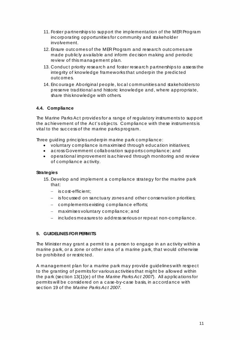
4.4. Compliance
The Marine Parks Act provides for a range of regulatory instruments to support the achievement of the Act’s objects. Compliance with these instruments is vital to the success of the marine parks program. Three guiding principles underpin marine park compliance:
• voluntary compliance is maximised through education initiatives; • across Government collaboration supports compliance; and • operational improvement is achieved through monitoring and review
of compliance activity. Strategies
15. Develop and implement a compliance strategy for the marine park that: − is cost-efficient; − is focussed on sanctuary zones and other conservation priorities; − complements existing compliance efforts; − maximises voluntary compliance; and − includes measures to address serious or repeat non-compliance.
5. GUIDELINES FOR PERMITS
The Minister may grant a permit to a person to engage in an activity within a marine park, or a zone or other area of a marine park, that would otherwise be prohibited or restricted. A management plan for a marine park may provide guidelines with respect to the granting of permits for various activities that might be allowed within the park (section 13(1)(e) of the Marine Parks Act 2007). All applications for permits will be considered on a case-by-case basis, in accordance with section 19 of the Marine Parks Act 2007.
11

Favourable consideration should be given to the granting of permits for the following activities within the marine park:
• scientific research in a sanctuary zone or restricted access zone; • competitions and organised events in a sanctuary zone; • tourism operations in a sanctuary zone; • commercial film making (including sound recording and photography)
in a sanctuary zone; and • installation of vessel moorings in a sanctuary zone.
Permits for other activities will be considered on merit, against the management objectives for the marine park.
12

6. ZONING SCHEME FOR THE SOUTHERN SPENCER GULF MARINE PARK
The Marine Parks Act 2007 (section 13(1)) requires that management plans: • must establish the various types of zones within the park and define their
boundaries; and • may identify and define the boundaries of special purpose areas within
the park and set out the activities that will be permitted in the areas. The following section, along with the boundary definition maps in Appendix 1, fulfils this requirement.
6.1. Zoning
For the purposes of the Marine Parks Act 2007, a zone is an area within a marine park that:
(a) has boundaries defined by the management plan for the marine park; and
(b) is identified by the management plan as a particular type of zone depending on the degree of protection required within the area.
The Marine Parks Act 2007 makes provision for the following types of marine park zones:
(a) a general managed use zone – being a zone established so that an area may be managed to provide protection for habitats and biodiversity within a marine park, while allowing ecologically sustainable development and use – refer section 6.1.1;
(b) a habitat protection zone – being a zone primarily established so that an area may be managed to provide protection for habitats and biodiversity within a marine park, while allowing activities and uses that do not harm habitats or the functioning of ecosystems – refer section 6.1.2;
(c) a sanctuary zone – being a zone primarily established so that an area may be managed to provide protection and conservation for habitats and biodiversity within a marine park, especially by prohibiting the removal or harm of plants, animals or marine products – refer section 6.1.3; and
(d) a restricted access zone – being a zone primarily established so that an area may be managed by limiting access to the area - refer section 6.1.4.
The prohibitions or restrictions on activities and uses in the various zones are set out in the zoning tables, available in the South Australian Marine Parks Network Explanatory Document or at www.marineparks.sa.gov.au 6.1.1. General Managed Use Zones The following areas are identified as general managed use zones in accordance with section 13(1)(b) of the Marine Parks Act 2007:
(a) the area defined in map 03 and referred to as GMUZ-1; (b) the area defined in map 03 and referred to as GMUZ-2; and (c) the area defined in map 02 and referred to as GMUZ-3;
13

6.1.2. Habitat Protection Zones The following areas are identified as habitat protection zones in accordance with section 13(1)(b) of the Marine Parks Act 2007:
(a) the area defined in map 03 and referred to as HPZ-1; (b) the area defined in map 02 and referred to as HPZ-2; and (c) the area defined in map 02 and referred to as HPZ-3.
6.1.3. Sanctuary Zones The following areas are identified as sanctuary zones in accordance with section 13(1)(b) of the Marine Parks Act 2007:
(a) the area defined in map 01 and referred to as SZ-1; (b) the area defined in map 02 and referred to as SZ-2; and (c) the area defined in map 02 and referred to as SZ-3.
6.1.4. Restricted Access Zones The following areas are identified as restricted access zones in accordance with section 13(1)(b) of the Marine Parks Act 2007:
(a) the area defined in map 01 and referred to as RAZ-1.
6.2. Special Purpose Areas
6.2.1. Meaning of Special Purpose Area In accordance with the Marine Parks Act 2007, a special purpose area is an area within a marine park, identified as a special purpose area and with boundaries defined by the management plan for the marine park, in which specified activities, that would otherwise be prohibited or restricted as a consequence of the zoning of the area, will be permitted under the terms of the management plan. For the purposes of this management plan, the following type of special purpose area is identified:
special purpose area (harbor activities) – refer section 6.2.2.; and special purpose areas (shore-based recreational line fishing) – refer
section 6.2.3. 6.2.2. Special Purpose Areas (harbor activities) The following area is identified as a special purpose area (harbor activities) in accordance with section 13(1)(c) of the Marine Parks Act 2007:
(a) the area defined in map 03 and referred to as SPA-1. Notwithstanding the zoning of the area, the following activities will be permitted in the special purpose area (harbor activities) listed above:
(a) activities undertaken by or on behalf of the Minister responsible for the administration of the Harbors and Navigation Act 1993, or a port operator, for the purposes of maintaining or improving a harbor or port. (Harbor, port and port operator have the same meanings as in the Harbors and Navigation Act 1993.)
14

6.2.3. Special Purpose Areas (shore-based recreational line fishing) The following area is identified as a special purpose area (shore-based recreational line fishing) in accordance with section 13(1)(c) of the Marine Parks Act 2007:
(a) the area within 100m seaward of the line defined in map 01 and referred to as SPA-2;
Notwithstanding the zoning of the area, the following activities will be permitted in the special purpose areas (shore-based recreational line fishing) listed above:
(a) recreational fishing from the shore by use of a hand line or rod and line. (Hand line, recreational fishing and rod and line have the same respective meanings as in the Fisheries Management Act 2007.)
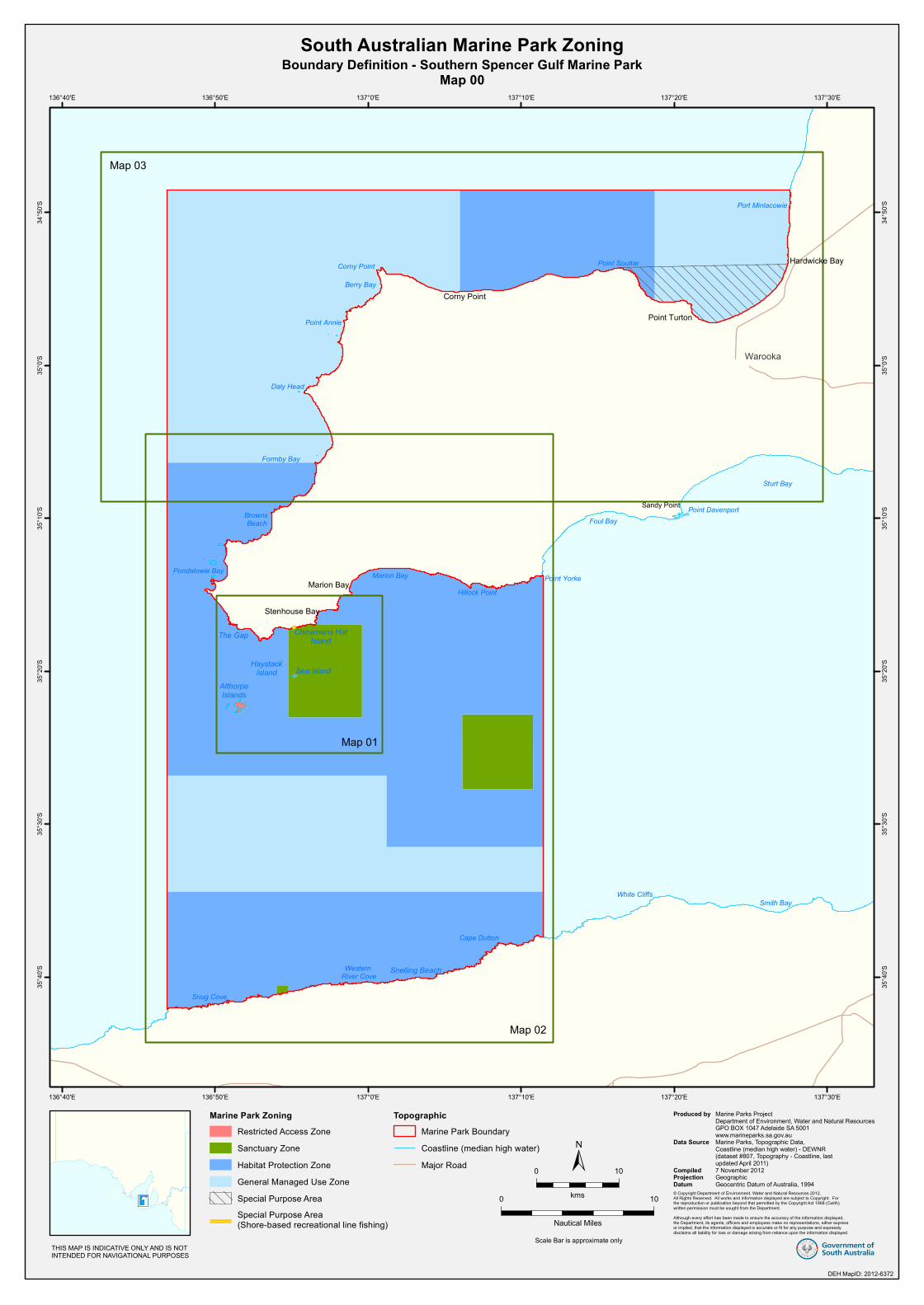
6.3. Boundary Definition Maps
The zones and special purpose areas identified above are defined in Boundary Definition Southern Spencer Gulf Marine Park Maps 00 – 03 (refer Appendix 1).
15

7. REFERENCES
Baker, J.L. 2004 Towards a System of Ecologically Representative Marine Protected Areas in South Australian Marine Bioregions - Technical Report. Prepared for Coast and Marine Conservation Branch, Department for Environment and Heritage, South Australia. Department for Environment and Heritage 2004a Blueprint for the South Australian Representative System of Marine Protected Areas. Department for Environment and Heritage, Adelaide, South Australia. Department of Environment and Heritage 2004b Living Coast Strategy for South Australia. Prepared by Coast and Marine Conservation Branch, Natural and Cultural Heritage, Department for Environment and Heritage for the Government of South Australia. Department of Environment and Natural Resources 2010 Environmental, Economic and Social Values of the Southern Spencer Gulf Marine Park Part 1. Department of Environment and Natural Resources, South Australia. Department of Environment, Water and Natural Resources 2012 South Australia’s Marine Parks Network Explanatory Document. Department of Environment, Water and Natural Resources, South Australia. Department of the Premier and Cabinet 2011 South Australia’s Strategic Plan 2011. Department of the Premier and Cabinet, Adelaide, South Australia. Goldsworthy, S.D. and Page, B. 2009 A review of the distribution of seals in South Australia. Report to the Department of the Environment, Water, Heritage and Arts. SARDI Publication Number F209/000368-1. SARDI Research Report Series Number 373. Lothian, A. 2005 Coastal Viewscapes of South Australia. Report for the Coast Protection Branch, SA Department for Environment and Heritage. Shaughnessy, P.D. and Goldsworthy S.D. 2007 Population assessment of fur seal and sea lions at some colonies in South Australia, 2006-2007. Final report to the Department for Environment and Heritage, South Australia and the South Australian Wildlife Conservation Fund. SARDI Aquatic Sciences Publication Number: F2007/000750-1. SARDI Research report Series Number: 236, 43pp.
16

Appendix 1 Boundary Definition Maps
17
Snelling Beach
Chinamans HatIsland
HaystackIsland
AlthorpeIslands
The Gap
Map 01
Corny Point
Daly Head
Foul Bay
Smith Bay
Berry Bay
Snug Cove
Sturt Bay
Formby Bay
Point Souttar
Marion Bay
Cape Dutton
Point Yorke
Point Annie
Seal Island
Browns Beach
White Cliffs
Hillock Point
Pondalowie Bay
Point Davenport
Port Minlacowie
Western River Cove
Warooka
Stenhouse Bay
Marion Bay
Sandy Point
Corny Point
Point Turton
Hardwicke Bay
Map 03
Map 02
137°30'E
137°30'E
137°20'E
137°20'E
137°10'E
137°10'E
137°0'E
137°0'E
136°50'E
136°50'E
136°40'E
136°40'E
34°5
0'S
34°5
0'S
35°0
'S
35°0
'S
35°1
0'S
35°1
0'S
35°2
0'S
35°2
0'S
35°3
0'S
35°3
0'S
35°4
0'S
35°4
0'S
South Australian Marine Park ZoningBoundary Definition - Southern Spencer Gulf Marine Park
Map 00
DEH St andar d
Marine Park ZoningRestricted Access ZoneSanctuary ZoneHabitat Protection ZoneGeneral Managed Use ZoneSpecial Purpose AreaSpecial Purpose Area(Shore-based recreational line fishing)
TopographicMarine Park BoundaryCoastline (median high water)Major Road
DEH MapID: 2012-6372
© Copyright Department of Environment, Water and Natural Resources 2012.All Rights Reserved. All works and information displayed are subject to Copyright. Forthe reproduction or publication beyond that permitted by the Copyright Act 1968 (Cwlth)written permission must be sought from the Department.Although every effort has been made to ensure the accuracy of the information displayed,the Department, its agents, officers and employees make no representations, either expressor implied, that the information displayed is accurate or fit for any purpose and expresslydisclaims all liability for loss or damage arising from reliance upon the information displayed.
Produced by
Data Source
Compiled Projection Datum
Marine Parks ProjectDepartment of Environment, Water and Natural ResourcesGPO BOX 1047 Adelaide SA 5001www.marineparks.sa.gov.auMarine Parks, Topographic Data,Coastline (median high water) - DEWNR (dataset #807, Topography - Coastline, lastupdated April 2011)7 November 2012GeographicGeocentric Datum of Australia, 1994
0 10
kms
Scale Bar is approximate only
0 10
Nautical Miles
THIS MAP IS INDICATIVE ONLY AND IS NOTINTENDED FOR NAVIGATIONAL PURPOSES

! !
!!
! Chinamans HatIsland
Seal Island
HaystackIsland
RAZ-1 is Althorpe Islands Prohibited Area DCDB parcels
as indicated
D31579 A1H844000 S70
D31579 A2H849000 S71
H840100 S13H840100 S61
H840100 S13H840100 S61
Reef Head
Marion Bay
Rhino Head
Cape Spencer
Royston Head
Penguin Point
Stenhouse Bay
Cable HutBay
Pondalowie Bay
Inneston
Marion Bay
Stenhouse Bay
PondalowieBay
InnesNational Park
Althorpe IslandsConservation Park
SZ-1RAZ-1
136° 54.781' E35° 23.035' S
136° 59.598' E35° 23.035' S
136° 59.598' E35° 16.943' S
35° 16.943' S136° 54.781' E
137°0'E
137°0'E
136°58'E
136°58'E
136°56'E
136°56'E
136°54'E
136°54'E
136°52'E
136°52'E
136°50'E
136°50'E
35°1
2'S
35°1
2'S
35°1
4'S
35°1
4'S
35°1
6'S
35°1
6'S
35°1
8'S
35°1
8'S
35°2
0'S
35°2
0'S
35°2
2'S
35°2
2'S
35°2
4'S
35°2
4'S
South Australian Marine Park ZoningBoundary Definition - Southern Spencer Gulf Marine Park
Map 01 - Restricted Access Zone 1, Sanctuary Zone 1, Special Purpose Area 2
DE H S ta n da rd
Marine Park ZoningRestricted Access ZoneSanctuary ZoneHabitat Protection ZoneSpecial Purpose Area(Shore-based recreational line fishing)
TopographicBuilt Up AreaExisting Reserves under other ActsMarine Park BoundaryDCDB ParcelCoastline (median high water)JettySealed RoadUnsealed RoadVehicular Track
Explanatory Notes:1. The coastal boundary of the park is the median high water mark (including the median high water mark of any estuaries), except where- (a) the boundary extends inland from median high water mark to include in the park the areas specified in Schedules 1 and 2 of Rack Plan 1924; and (b) the boundary extends seaward from median high water mark to exclude from the park the areas specified in Schedule 3 of Rack Plan 1924.2. Unless otherwise specified, the seaward boundary of the park is the seaward boundary of the coastal waters of the State.
DEH MapID: 2012-6373
!
!
Marion Shipwreck
Chinamans HatIsland
136° 54.918' E
136° 55.289' ESPA-2
0 2
kms
±
Scale Bar is approximate only
0 2
Nautical Miles
THIS MAP IS INDICATIVE ONLY AND IS NOTINTENDED FOR NAVIGATIONAL PURPOSES
© Copyright Department of Environment, Water and Natural Resources 2012.All Rights Reserved. All works and information displayed are subject to Copyright. Forthe reproduction or publication beyond that permitted by the Copyright Act 1968 (Cwlth)written permission must be sought from the Department.Although every effort has been made to ensure the accuracy of the information displayed,the Department, its agents, officers and employees make no representations, either expressor implied, that the information displayed is accurate or fit for any purpose and expresslydisclaims all liability for loss or damage arising from reliance upon the information displayed.
Produced by
Data Source
Compiled Projection Datum
Marine Parks ProjectDepartment of Environment, Water and Natural ResourcesGPO BOX 1047 Adelaide SA 5001www.marineparks.sa.gov.auMarine Parks, NPWSA, Topographic Data,Coastline (median high water) - DEWNR (dataset #807, Topography - Coastline, lastupdated April 2011)DCDB - DPTI1 November 2012GeographicGeocentric Datum of Australia, 1994
Inset
Inset

! !
!
!
!
!!
! !
!
!
!
!
!
!
See Map 01
Cape Dutton
Snelling Beach
Snug Cove
WarrenbenConservation Park
HPZ-2
HPZ-3
GMUZ-3
SZ-2
Foul Bay
Marion Bay
Middle River
Stenhouse Bay
Pondalowie BayWest Cape
Formby Bay
Marion Bay
Rhino Head
Cape Forbin
Point Yorke
CapeSpencer
Royston Head
Cape Torrens
Hillock Point
Point Margaret
Pondalowie Bay
South WestRock
HaystackIsland
Western River Cove
InnesNational Park
Western RiverWilderness
Protection Area
WarrenbenConservation Park
Althorpe IslandsConservation Park
136° 46.879' E35° 6.372' S
137° 6.155' E35° 22.844' S
137° 6.155' E35° 27.715' S
137° 1.217' E35° 31.493' S
137° 1.217' E35° 26.837' S
136° 46.879' E35° 26.837' S
35° 6.372' S
137° 10.782' E35° 22.844' S
137° 10.782' E35° 27.715' S
137° 11.423' E35° 31.493' S
137° 11.423' E35° 34.418' S
136° 46.879' E35° 34.418' S
136° 46.879' E
137° 11.423' E
137° 11.423' E
137°15'E
137°15'E
137°10'E
137°10'E
137°5'E
137°5'E
137°0'E
137°0'E
136°55'E
136°55'E
136°50'E
136°50'E
136°45'E
136°45'E
35°5
'S
35°5
'S
35°1
0'S
35°1
0'S
35°1
5'S
35°1
5'S
35°2
0'S
35°2
0'S
35°2
5'S
35°2
5'S
35°3
0'S
35°3
0'S
35°3
5'S
35°3
5'S
35°4
0'S
35°4
0'S
35°4
5'S
35°4
5'S
South Australian Marine Park ZoningBoundary Definition - Southern Spencer Gulf Marine Park
Map 02 - Sanctuary Zone 2, 3, Habitat Protection Zones 2, 3, General Managed Use Zone 3
DE H S ta n da rd
Marine Park ZoningRestricted Access ZoneSanctuary ZoneHabitat Protection ZoneGeneral Managed Use ZoneSpecial Purpose Area(Shore-based recreational line fishing)
TopographicExisting Reserves under other ActsMarine Park BoundaryDCDB ParcelCoastline (median high water)Sealed RoadUnsealed RoadVehicular Track
Explanatory Notes:1. The coastal boundary of the park is the median high water mark (including the median high water mark of any estuaries), except where- (a) the boundary extends inland from median high water mark to include in the park the areas specified in Schedules 1 and 2 of Rack Plan 1924; and (b) the boundary extends seaward from median high water mark to exclude from the park the areas specified in Schedule 3 of Rack Plan 1924.2. Unless otherwise specified, the seaward boundary of the park is the seaward boundary of the coastal waters of the State.
DEH MapID: 2012-6374
! !
!
!
136° 54.763' E35° 40.567' S
136° 54.025' E35° 40.567' S
136° 54.763' E136° 54.025' E
SZ-3
Inset
Inset
0 5
kms
±
Scale Bar is approximate only
0 5
Nautical Miles
THIS MAP IS INDICATIVE ONLY AND IS NOTINTENDED FOR NAVIGATIONAL PURPOSES
© Copyright Department of Environment, Water and Natural Resources 2012.All Rights Reserved. All works and information displayed are subject to Copyright. Forthe reproduction or publication beyond that permitted by the Copyright Act 1968 (Cwlth)written permission must be sought from the Department.Although every effort has been made to ensure the accuracy of the information displayed,the Department, its agents, officers and employees make no representations, either expressor implied, that the information displayed is accurate or fit for any purpose and expresslydisclaims all liability for loss or damage arising from reliance upon the information displayed.
Produced by
Data Source
Compiled Projection Datum
Marine Parks ProjectDepartment of Environment, Water and Natural ResourcesGPO BOX 1047 Adelaide SA 5001www.marineparks.sa.gov.auMarine Parks, NPWSA, Topographic Data,Coastline (median high water) - DEWNR (dataset #807, Topography - Coastline, lastupdated April 2011)DCDB - DPTI2 November 2012GeographicGeocentric Datum of Australia, 1994

GMUZ-2
HPZ-1
Gleesons LandingRock Lobster
Sanctuary CarribieConservation Park
WarrenbenConservation Park
Point DavenportConservation Park
InnesNational Park
PortMinlacowie
HardwickeBay
Warooka
Flaherty CornerPoint Turton
Point Souttar
Corny Point
Marion Bay
Stenhouse Bay
Leven BeachConservation Park
Sturt Bay
Point DavenportSandy PointFoul Bay
Point Yorke
Shell Beach
Middle Island
West Cape
Chinamans HatIsland
Formby Bay
Daly Head
Point Annie
Corny Point Burners BeachGalway Bay
Hardwicke Bay
Port Minlacowie
Parsons Beach
Brown Point
The Pines
GMUZ-1
Port Rickaby
SPA-1Harbor of Point Turton
137° 6.000' E34° 48.533' S
136° 46.879' E35° 6.372' S
137° 18.738' E34° 48.533' S
136° 46.879' E34° 48.533' S
35° 6.372' S
34° 48.533' S
137° 6.000' E137° 18.738' E
137°25'E
137°25'E
137°20'E
137°20'E
137°15'E
137°15'E
137°10'E
137°10'E
137°5'E
137°5'E
137°0'E
137°0'E
136°55'E
136°55'E
136°50'E
136°50'E34
°45'S
34°4
5'S
34°5
0'S
34°5
0'S
34°5
5'S
34°5
5'S
35°0
'S
35°0
'S
35°5
'S
35°5
'S
35°1
0'S
35°1
0'S
35°1
5'S
35°1
5'S
South AustralianMarine Park
ZoningBoundary Definition
Southern Spencer GulfMarine Park
Map 03Habitat Protection Zone 1
General Managed Use Zones 1,2Special Purpose Area 1
DEH St andar d
Marine Park ZoningSanctuary ZoneHabitat Protection ZoneGeneral Managed Use ZoneSpecial Purpose AreaSpecial Purpose Area(Shore-based recreational line fishing)
TopographicBuilt Up AreaExisting Reserves under other ActsRock Lobster SanctuaryMarine Park BoundaryDCDB ParcelCoastline (median high water)Sealed RoadUnsealed RoadVehicular Track
Explanatory Notes:1. The coastal boundary of the park is the median high water mark (including the median high water mark of any estuaries), except where- (a) the boundary extends inland from median high water mark to include in the park the areas specified in Schedules 1 and 2 of Rack Plan 1924; and (b) the boundary extends seaward from median high water mark to exclude from the park the areas specified in Schedule 3 of Rack Plan 1924.2. Unless otherwise specified, the seaward boundary of the park is the seaward boundary of the coastal waters of the State.
DEH MapID: 2012-6375
THIS MAP IS INDICATIVE ONLY AND IS NOTINTENDED FOR NAVIGATIONAL PURPOSES
Scale Bar is approximate only
0 5
Kms0 5
Nautical Miles
© Copyright Department of Environment, Water and Natural Resources 2012.All Rights Reserved. All works and information displayed are subject to Copyright. Forthe reproduction or publication beyond that permitted by the Copyright Act 1968 (Cwlth)written permission must be sought from the Department.Although every effort has been made to ensure the accuracy of the information displayed,the Department, its agents, officers and employees make no representations, either expressor implied, that the information displayed is accurate or fit for any purpose and expresslydisclaims all liability for loss or damage arising from reliance upon the information displayed.
Produced by
Data Source
Compiled Projection Datum
Marine Parks ProjectDepartment of Environment, Water and Natural ResourcesGPO BOX 1047 Adelaide SA 5001www.marineparks.sa.gov.auMarine Parks, NPWSA, Rock Lobster Sanctuary,Topographic Data, Coastline (median high water) - DEWNR (dataset #807, Topography - Coastline, lastupdated April 2011)DCDB - DPTI7 November 2012GeographicGeocentric Datum of Australia, 1994