Embed Size (px)
Citation preview

SOUTHERNRegional Transport PlanMarch 2014

CONTENTS
MINISTERS’ MESSAGE 1
YOUR REGION 2
DELIVERING CHANGE 8
CHALLENGES IDENTIFIED IN THE NSW LONG TERM 17 TRANSPORT MASTERPLAN
PUTTING THE CUSTOMER FIRST 19
TRAVEL TO AND FROM THE SOUTHERN REGION 22
TRAVEL WITHIN THE SOUTHERN REGION 26
TRAVEL IN MAJOR CENTRES AND TOWNS 34
IMPLEMENTATION AND DELIVERY 46
WE LISTENED 47
Southern Regional Transport PlanMarch 2014ISBN: 978-1-922030-56-6© State of New South Wales through Transport for NSW, 2014.
Transport for NSW18 Lee Street, Chippendale NSW 2008.
DisclaimerWhile every reasonable effort has been made to ensure that this document is correct at the time of printing, the State of NSW, its agents and employees, disclaim any and all liability to any person in respect of anything or the consequences of anything done or omitted to be done in reliance upon the whole or any part of this document.

SOUTHERN REGIONAL TRANSPORT PLANMARCH 2014
1
MINISTERS’ MESSAGE
When we came to Government, one of our first priorities was to develop a clear direction for transport in NSW over the next 20 years.
The NSW Long Term Transport Master Plan was released in December 2012 to provide a comprehensive blueprint for the future, complete with more than 220 short, medium and long term actions.
To support the Master Plan, we recognise that the state’s 14 key regional centres have more specific local transport needs and priorities which should be considered and planned for.
The Southern Regional Transport Plan outlines specific actions to address the unique challenges of the area and includes the things you told us were important to you during consultation in 2012.
The plan looks at the steady growth of the population in the Southern region, and the increasing population of people aged 65 and over who will need to access services in larger regional centres.
The plan includes upgrades to the road network to enhance travel within the region as well as improving long haul journeys for cars and trucks between Sydney, Melbourne and the Port of Eden.
In the longer term, the Southern region will benefit by our continued investment into the Rural Highway Program which will address unsafe areas and capacity constraints on the Princes, Barton, Kings, Federal, Monaro and Snowy Mountain highways as well as planned improvements to public transport to meet the needs of the region’s residents and businesses.
Thank you to the community who took the time to contribute to this planning process. We look forward to working with you as we continue to improve and develop our state’s transport system.
Gladys Berejiklian Duncan Gay Minister for Transport Minister for Roads and Ports

2
SOUTHERN REGIONAL TRANSPORT PLANMARCH 2014
YOUR REGION
The Southern region is the south eastern region of NSW, bordered by the east coast, the Illawarra, Central West and Murray-Murrumbidgee regions of NSW, and by Victoria in the south. The Australian Capital Territory (ACT) is fully contained within the region.
The Hume, Federal, Monaro and Princes highways provide north-south connections into Victoria, Canberra, Sydney and the Illawarra region.
The Barton, Kings and the Snowy Mountains highways provide east-west road connections into the Murray-Murrumbidgee region and Canberra from the eastern part of the Southern region. The Southern Rail Line provides access from the Southern Highlands into Sydney, Canberra and through to Victoria.
The escarpment, mountainous terrain and large national parks have an influence on the safety and convenience of trips within the region, and significantly constrain development of the road network.
Travel demand varies from long haul with trips from Sydney to Melbourne, to more localised movements from Queanbeyan to Canberra or within the major towns and centres of the region.
The ACT, whilst not part of the region, is located within its boundaries, and is the location of employment for a large number of people in the Southern region.
The region includes the Major Regional Centres of Queanbeyan, Moss Vale- Bowral-Mittagong and Goulburn.
The population and economic activity is concentrated in the corridor between Sydney and Canberra and on the east coast.
Access to health services, education and employment, predominantly located in the larger centres of the region, is reliant on the transport network connecting villages and centres.
Customers in the Southern region have told us that connections to the ACT and Canberra are important, and that there is a need to effectively connect between the coastal region along the Princes Highway and the hinterland. They also told us we need to maintain freight connections to support economic productivity in the region, including to the Port of Eden.

SOUTHERN REGIONAL TRANSPORT PLANMARCH 2014
3
Figure 1 Southern region

4
SOUTHERN REGIONAL TRANSPORT PLANMARCH 2014
The Southern region has a population of around 257,000. Approximately 35 percent of the population is concentrated within the major regional centres of:
• Queanbeyan – 15 percent of region’s population (37,400)
• Moss Vale-Bowral-Mittagong – 11 percent of the region’s population (27,000)
• Goulburn – 9 percent of the region’s population (22,400).
Queanbeyan is the region’s major town with a population of over 37,000. The rest of the population is dispersed across a number of smaller towns and villages.
The travel demand generated by this type of settlement is difficult to serve by public transport and is often more suited to the private car.
The population of the Southern region is expected to grow to 306,000 over the next 20 years. Canberra is also expected to grow at over 2 percent per annum.
The Southern region’s population is also an ageing one, with the proportion of people aged 65 or over expected to increase from 18 percent to 27 percent over the next 20 years (compared to the NSW average of 15 percent today and forecasted to reach 20 percent in 2031). These population changes will require a range of transport responses.
Health and aged care services are generally concentrated in larger regional centres. Canberra and the Illawarra region also contain major health facilities that serve the Southern region. Older members of the community will require much greater access to health and aged care services in regional centres as well as public and community transport services that provide access to them.
The Southern region includes some areas of social disadvantage. Factors that contribute to this relative disadvantage may include geographical isolation, high youth unemployment rates, and a higher percentage of vulnerable community members, including the young, aged, Aboriginal people and people with a disability.
Regional employment is relatively self- contained, with around 72 percent of the employed population living and working in the region. This rises to 95 percent if the ACT is included, demonstrating the need for efficient transport connections to the ACT (Figure 2).
More than 58 percent of the working population of Queanbeyan commute to Canberra. Significant commuting into Canberra also occurs from other towns, such as Yass, Goulburn and Cooma. There is also significant movement of school student transport from NSW into the ACT.

SOUTHERN REGIONAL TRANSPORT PLANMARCH 2014
5
Figure 2 Journey to work origins and destinations in the Southern region
6
SOUTHERN REGIONAL TRANSPORT PLANMARCH 2014
Approximately four percent of journeys to work from the Southern region are to locations within the Sydney Metropolitan Area. Travel for work between the Southern region and Victoria is relatively minor.
Improving the productivity of the freight network is a priority for the Southern region. Freight travelling through the region connects to the Illawarra and Port Kembla, Port Botany, the ACT, and the Central West and Western NSW. There is a need to ensure that the road network supports higher productivity vehicles (HPV), which includes reducing height and weight restrictions on major routes.
The timber industry around Tumut and Tumbarumba requires raw product to be transported within the region to the coast and in from the Central West region. Finished products are then transported out of the region via rail and road, including to the Port of Eden.
The Port of Eden services the NSW south east hinterland and south coast and is home to one of the largest fishing fleets in NSW. The port’s major trade is the export of woodchips, supplemented by exports of softwood logs and general cargo.
The Coastal Harbours of the Southern region, which include Batemans Bay, Narooma and Bermagui, cater for the commercial fishing industry, local tourism and recreational boating and provide a departure point for charter boats. A limited amount of freight is transported through these coastal harbours.
Tourism is an important transport demand generator for the Southern region. The south coast (both the Illawarra and Southern regions) received approximately 8.2 million visitors a year in 2010 and 2011, of which 5.1 million were domestic day visitors. The south coast is the third most visited region in NSW for domestic overnight visitors.
Eurobodalla is the second most visited destination within the region by domestic overnight tourists and along with Bega the second and third most visited destinations by international tourists during 2010 and 2011. The Snowy Mountains is also a top destination within the region for tourists with over a million people visiting during the same period. An efficient transport system is required to support the tourism industry and ensure the Southern region remains a key tourist destination.
Peak transport demands in the region can be seasonal. The tourist centres along the east coast, including Batemans Bay, Moruya, Narooma and Merimbula, attract a high number of visitors and greater travel demand during the summer months.
This can lead to localised traffic congestion, and higher traffic volumes on weekends and in the middle of the day. It can also generate demand for late night transport in tourist centres.
Ski fields are also located in the Southern region around Jindabyne and act as a primary tourist attraction during the winter months. For the alpine areas of the Southern region, key issues relate to perceptions of road quality and road durability as well as seasonal demand on the Monaro and the Snowy Mountains highways.
Of the region’s three airports with regular passenger services, Canberra Airport is the main airport providing regular services to most major domestic destinations. There were 3.2 million passenger movements through the airport in 2010-11, which is expected to increase to 6.1 million by 2030-31.
The specific population, employment and land use characteristics of the Southern region have implications for the transport network, as follows:

SOUTHERN REGIONAL TRANSPORT PLANMARCH 2014
7
Table 1 Regional characteristics and transport implications
Characteristic Transport implication
Population growth • Greater travel demand as population increases
• Requirement for managing demand and operations as a priority, with eventual expansion of infrastructure and services to meet this demand, as required
Ageing population • Greater demand to travel for healthcare, medical and recreation reasons and less demand for travel to/from work and within peak periods
• Need for more specialist transport services to cater for limited mobility and to reduce social isolation
• Need for research and pilot projects to determine the best ways to transition people from cars to public transport and to community transport to reduce car dependency
Social disadvantage
• Limited public transport services increase levels of isolation and disadvantage
• High proportion of socially and economically disadvantaged people who do not own a car or hold driver licences are further disadvantaged by a lack of public transport options
• Higher public transport fares in rural and regional NSW can reduce access jobs and services
Significant population dispersed in small settlements
• Reduce car dependency
• Dispersed trip patterns that works against public transport
• Flexible and innovative arrangements to serve people in small settlements
• Need to provide adequate transport for travel within the region
Cross-border connections between Southern region, the ACT and Victoria
• Need for integrated public transport services
• Quality transport links between the three regions need to be facilitated jointly by transport jurisdictions
Employment clustered in major centres
• Transport services to/from major towns and cities are critical, including into the ACT
Domestic and international tourism
• Seasonal tourism demands can exceed local network capacity which is otherwise adequate for most of the year
• Increase in demand and congestion on strategic and local road network during peak holiday travel periods
Road safety • Heavy truck crashes in the Southern region are typically concentrated along the Hume Highway. There is a concentration around Batemans Bay on the Princes Highway and also a cluster around the township of Adelong.
• Pedestrian casualty crashes are clustered around the Southern Highlands townships, Goulburn, Queanbeyan and Batemans Bay

8
SOUTHERN REGIONAL TRANSPORT PLANMARCH 2014
DELIVERING CHANGE
Some of the initiatives already underway in the Southern region include:
• The introduction of NSW TrainLink which operates services to the Southern region, and for the first time provides a dedicated organisation focused on improving services for our rail customers in regional NSW
• Continued improvements to the Country Rail Network including installation of steel sleepers, improving the stability of cuttings and embankments and track resurfacing
• The Southern region will receive a share in $389 million for rural and regional bus services
• The Southern region will benefit from close to $441,757 for the Community Transport Program, as part of $7.5 million in funding to local providers across the state
• An acceleration of the school zone flashing lights program, to ensure every school in NSW has a set of flashing lights by December 2015
• A new commuter car park with 50 additional spaces recently opened at Moss Vale
• Accessibility upgrades at Marulan, Mittagong and Bundanoon
• Upgrades including new drop off and pick up areas for the transport interchange at Batemans Bay
• New cycle facilities and pedestrian crossing for the transport interchange at Goulburn
• Investigating ways to improve the transport interchange at Queanbeyan
• Improvements to the drop off and pick up zone, new pedestrian crossing, cycle facilities and signage for the transport interchange at Yass
• Completion of a number of upgrades to intersections along the Princes Highway
• Completion of a number of upgrades to intersections along the Monaro Highway
• Installation of advanced warning signs in Batemans Bay on the Princes Highway
• Completion of restoration work on Rossi Bridge at Goulburn
• Investment of $208 million over the next decade to install seatbelts on almost 1,700 dedicated school buses as part of a suite of initiatives to improve school bus safety in regional NSW.

SOUTHERN REGIONAL TRANSPORT PLANMARCH 2014
9
2012-13 SOUTHERN ROAD NETWORK MAINTENANCE PROGRAMIn the 2012-13 financial year we spent $79.7 million on upgrading and maintaining over 1,895 kilometres of major roads in the Southern region, including works on pavement and corridors. We also spent $12.8 million on upgrading and maintaining over 580 bridges in the region.
We provided $32.2 million to the local councils within the Southern region to assist with road restoration after natural disaster damage and $15.1 million for maintenance and improvement of their road networks.
The works undertaken on major roads and bridges included road resurfacing of over 2,000,000m2 of roads and rebuilding 208,000m2 of roads at a cost of $16.7 million and $15.5 million respectively.
Other major works undertaken in the Southern region included upgrading works on the Monaro Highway, construction of noise walls on Kings Highway in Queanbeyan, safety barriers and drainage upgrades across the region and recently slope repairs on Kings Highway at Clyde Mountain.
Transport Access Program
Focus area Location ProjectsCompletion date
Status
Interchanges Yass Interchange upgrade Anticipated late 2014
Planning
Batemans Bay Interchange upgrade Anticipated Mid 2014
Construction
Goulburn Interchange upgrade December 2013
Open to public
Queanbeyan Interchange upgrade Anticipated late 2014
Planning
Easy Access Bundanoon Ramps between platform / Street Anticipated late 2014
Planning
Marulan Ramps between platform / Street Anticipated late 2014
Construction
Mittagong Ramps between platform / Street Anticipated late 2014
Planning
Moss Vale Commuter Car Park December 2013
Open to Public

10
SOUTHERN REGIONAL TRANSPORT PLANMARCH 2014
Country Passenger Transport Infrastructure Grant SchemeLGA Improvement YearEurobadalla Bus shelter, The Manor, Catalina 2011-12
Bus shelter, southbound, Denhams Beach 2011-12
Bus shelter, southbound, Bodalla 2011-12
Bus shelter, northbound, Bodalla 2011-12
Wingecarribee Wingecarribee Public Transport Access Improvement Program – Robertson; New Berrima; Exeter; Colo Vale; Hill Top; Berrima Village; Mittagong
2011-12
Yass Valley Country passenger bus stop – Yass 2011-12
Eurobodalla Bus shelter installation at Beach Road – Catalina 2012-13
Bus Shelter Installation at Beach Road – Denhams Beach 2012-13
Bus shelter upgrade at Grant Street – Broulee 2012-13
Bus shelter upgrade at Berrima Parade – Surfside 2012-13
Bus shelter upgrade at Harrington Road – Narooma 2012-13
Wingecarribee Bus shelter installation at Moss Vale Road (2), Bowral; Illawarra Highway, Robertson; Willow Road, Moss Vale
2012-13
Traffic Management and Road Safety ProgramLGA Projects Financial year Status Cost ($)
Bus priority on strategic corridors
Eurobodalla Bus bay on Princes Highway at Noggarula Drive north bound
2011-12 Completed 155,971
Active transport
Eurobodalla Off-road walking and cycling path Wharf Road north Batemans Bay
2012-13 Completed 165,000
Off-road walking and cycling path HW1 Ford & Vulcan Moruya: construction of a 2.5 metre wide concrete off-road walking and cycling path along the northern side of Princes Highway between Ford Street and Vulcan Street, Moruya (200 metres)
2013-14 Anticipated start mid
2014
25,000
Off-road walking and cycling path Heath & Massy Street, Broulee: construction of a 2.5 metre wide concrete off-road walking and cycling path along the south eastern side of Grant Street from Heath Street to Massy Street, Broulee (350 metres)
2013-14 Anticipated start mid
2014
90,000

SOUTHERN REGIONAL TRANSPORT PLANMARCH 2014
11
LGA Projects Financial year Status Cost ($)Eurobodalla Off-road walking and cycling
path Durras Lake Road stage 2: stage 2 construction of 2.5 metre wide concrete off-road walking and cycling path along the eastern side of Durras Lake Road from Big 4 Park access, Durras Lake to Durras Drive, South Durras (300 metres)
2013-14 Completed 15,000
Queanbeyan Off-road walking and cycling path Morrisset Street-Yass Road Queanbeyan: upgrade of existing footpaths to and construction of a 2.5 metre wide concrete off-road walking and cycling path along the north eastern side from Morriset Street from the low level bridge over the Queanbeyan River to Wanniassa Street; along the northern side of Wanniassa Street from Morriset Street to High Street; through Taylor Park Reserve from High Street to Yass Road; and along the western side of Yass Road from Bungendore Road to Thurralilly Street, Queanbeyan (960 metres)
2013-14 Commenced August 2013
71,000
Wingecarribee Off-road walking and cycling path Stanley Park Bowral: construction of a 2.5 metre wide concrete off-road walking and cycling path through Stanley Park from Bowral Street, north east corner of the park 10 metres west of the Albert Street road corridor, to the existing off-road walking and cycling path along the northern side of Mittagong Creek, just north of Farmborough Close, Bowral – inclusive of a new 2.5 metre wide shared bridge over Mittagong Creek (120 metres)
2013-14 Commenced February
2014
92,000
Off-road walking and cycling path Robertson Stage 3
2011-12 Completed 136,108

12
SOUTHERN REGIONAL TRANSPORT PLANMARCH 2014
LGA Projects Financial year Status Cost ($)Upper Lachlan Off-road walking and cycling
path Carrington Road Crookwell Street: stage 2 construction of 2.5 metre wide concrete off-road walking and cycling path along the southern side of Carrington Street west towards Northcott Street, Crookwell (400 metres)
2013-14 Anticipated start May
2014
27,000
Wollondilly Off-road walking and cycling path missing link Warragamba construction of a 2.5 metre wide concrete off-road walking and cycling path along the eastern side of Weir Road from 50 metres northeast of Farmsworth Avenue to Fourth Street; the south western side of Fourth Street from Weir Road to Farmsworth Avenue; and the north western side of Farnsworth Avenue from Fourth Street to 55 metres southwest of Fourth Street, Warragamba (500 metres)
2013-14 Anticipated start April
2014
150,000
Palerang Braidwood town centre pedestrian investigations: investigation and design of two pedestrian refuges on Wallace Street between Duncan Street and Lascelles Street at Braidwood. The refuges will incorporate kerb extensions to narrow the crossing distance, act as traffic calming and better connect land use including schools, reserves and shops. The refuges are proposed as part of the local Pedestrian Access and Mobility Plan
2013-14 Commenced August 2013
100,000
Palerang Off-road walking and cycling path Majara Street Bungendore
2013-14 Anticipated start March
2014
130,000
Journey reliability
Bega Valley Install permanent variable message signs and CCTV for south bound in Yallah
2011-12 Completed 102,368
Eurobodalla Junction improvements on Princes Highway and Jigamy Farm Entrance
2013-14 Commenced July 2013
1,800,000

SOUTHERN REGIONAL TRANSPORT PLANMARCH 2014
13
LGA Projects Financial year Status Cost ($)Eurobodalla Junction improvements on
Princes Highway and South Head Road in Moruya
2013-14 Commenced July 2013
800,000
Install roundabout at intersection of Princes Highway, Bluewater Drive, McMillan Road and Bowen Street, in Narooma Flat, Narooma
2013-14 Commenced August 2013
1,069,000
Queanbeyan Planning and designs for safety and traffic improvement works in Queanbeyan
2013-14 Commenced August 2013
3,514,000
Roundabout upgrade at Tompsitt Drive in Jerrabomberra
2013-14 Commenced November
2013
450,000
Snowy River Alpine Incident Management Plan and works for Wilsons Valley
2013-14 Commenced July 2013
200,000
Chain removal bay in Wilsons Valley on Kosciuszko Road
2013-14 Commenced July 2013
250,000
Bega Valley Upgrade of loading ramps at Bega Saleyards
2013-14 Commenced August 2013
103,355
Road freight safety and productivity
Eurobodalla Install new heavy vehicle rest area in Malabar Creek, 3km north of Moruya on Princes Highway
2013-14 Completed 1,900,000
Road safety
Eurobodalla Install median right turn at Bays Beach Road in Batehaven
2011-12 Completed 118,465
Install median 2.3km South Cranbrook Road and Princes Highway in Batemans Bay
2011-12 Completed 2,544,142
Improve road pavement, install safety barrier, curve alignment markers on George Bass Drive, from Grandfathers Gully Road to Denise Drive in Lilli Pilli
2012-13 Completed 198,000
Install right turn bays at Tomakin Road and Ainsley Parade, and realign access driveway to fuel station away from Tomakin Road and George Bass Drive, Tomakin
2012-13 Completed 300,000
Install guardrail and improve shoulders on Kings Highway, south of Lyons Road, Nelligen (Federally funded)
2013-14 Commenced September
2013
500,000
Install safety barrier at Kings Highway in Buckenbowra
2013-14 Commenced July 2013
491,000

14
SOUTHERN REGIONAL TRANSPORT PLANMARCH 2014
LGA Projects Financial year Status Cost ($)Eurobodalla Curve improvements at
Tomakin Road in Mogo 2013-14 Commenced
December 2013
220,675
Safety improvements on Princes Highway in Bodalla
2013-14 Anticipated start March
2014
155,000
Wingecarribee Road safety treatments on the Hume Highway, Bendooley Hill in Berrima
2012-13 Completed 756,352
Install slow vehicle turn-out lane on Moss Vale Road in Barrengarry
2012-13 Completed 202,996
Install bridge screens for Sallys Corner on Hume Highway
2012-13 Completed 364,204
Road realignment Mt Broughton Road in Werai
2011-12 Completed 570,000
Install guardrail on Hume Highway between Illawarra Highway and Paddys River
2013-14 Commenced December
2013
250,000
Install safety barrier on Illawarra Highway and Tourist Road in Robertson
2013-14 Commenced December
2013
100,000
Improve road pavement on Illawarra Highway and Wilsons Road in Burrawang
2013-14 Commenced February
2014
100,000
Install bridge screens on Hume Highway, Hoddles Crossroads
2013-14 Commenced July 2013
390,000
Goulburn- Mulwaree
Install curve alignment markers between Goulburn and Ilford
2012-13 Completed 205,254
Profile line marking on Federal Highway and Thornford Road
2013-14 Commenced October 2013
210,000
Yass Valley Road safety works on Lachlan Valley Way
2012-13 Completed 247,536
Safety improvements on Sutton Road in Gundaroo
2013-14 Anticipated start April
2014
800,000
Yass Valley Shoulder Widen on Hume Highway and Burley Griffin Way
2013-14 Commenced September
2013
500,000
Widen and seal shoulder and install safety barrier, install curve alignment markers and guideposts, improve sight distance restrictions at the intersection, and improve location of advisory signage at Murrumbateman Road and Dicks Creek Road in Nanima
2012-13 Completed 265,000

SOUTHERN REGIONAL TRANSPORT PLANMARCH 2014
15
LGA Projects Financial year Status Cost ($)Tumut Safety improvements in
Lacmalac Road in Bombowlee2011-12 Completed 1,072,952
Palerang Hazard reduction, between Batemans bay and Queanbeyan in Braidwood
2012-13 Completed 254,446
Road side safety improvements on the approaches to Braidwood Town, Kings Highway in Braidwood
2013-14 Commenced July 2013
1,261,150
Safety improvements on Nerriga Road Durran Durra
2013-14 Anticipated start April
2014
1,170,000
Bega Valley Improve shoulders and install high friction asphalt seal and curve alignment markers on Princes Highway, near Quarantine Bay Road in Eden
2013-14 Commenced November
2013
345,000
Bega Valley Install roundabout at Merimbula Drive and Sapphire Coast Drive in Merimbula
2013-14 Anticipated start March
2014
300,000
Bega Valley Curve improvements at Princes Highway and Tathra Road in Jellat Jellat
2013-14 Completed 200,000
Snowy River Curve improvements between Cooma and Charlottes Pass in Jindabyne
2013-14 Anticipated start March
2014
140,000
Install guard rail and improve line marking at MR286 in Avonside
2013-14 Anticipated start April
2014
150,000
Widen shoulder, extend guardrail and install curve advisory signs on the Alpine Way, 10km west of Kosciuszko Road, Crackenback (Federally funded)
2013-14 Commenced November
2013
263,000
Queanbeyan Improve horizontal alignment, install safety barrier on roadside and remove roadside hazards at Old Cooma Road in Googong Dam
2013-14 Completed 250,000
Install roundabout at the intersection of Donald Road and Southbar Road in Karabar
2013-14 Commenced December
2013
308,000

16
SOUTHERN REGIONAL TRANSPORT PLANMARCH 2014
Better Boating Program
LGA Improvement Year CostBega Valley Bega Valley Boating Infrastructure Plan 2011-12 10,000
Merimbula Lake boat ramp upgrade and new pontoon (additional funding 2)
2011-12 70,370
Mogareeka boat ramp pontoon reconstruction 2011-12 33,772
Shire-wide general boat ramp upgrade, Bega Valley 2012-13 50,000
Wonboyn Lake Boat Ramp & Jetty Upgrade 2013-14 245,000
Bombala Black Lake boat ramp precinct upgrade, Bibbenluke 2012-13 32,642
Apex Park boat ramp pontoon, Narooma (Wagonga Inlet)
2012-13 100,000
Hanging Rock boat ramp pontoon, Batemans Bay (additional funding)
2012-13 68,000
Moruya town wharf pontoon (additional funding) 2012-13 48,000
The Loop boat ramp replacement, Narooma 2011-12 33,977
Tuross Head boat ramp relocation (investigation and design)
2011-12 15,000
Eurobodalla Tuross River Bridge boat ramp replacement, Bodalla 2011-12 15,000
Batemans Bay Regional Waterways Infrastructure Plan
2013-14 30,000
Old Punt Road Boat Ramp Upgrade (Stage 1), Batemans Bay
2013-14 75,000
Yass Valley Yass River boat ramp upgrade (Burrai Place), Yass 2011-12 21,800

SOUTHERN REGIONAL TRANSPORT PLANMARCH 2014
17
CHALLENGES IDENTIFIED IN THE NSW LONG TERM TRANSPORT MASTERPLAN
The NSW Long Term Transport Master Plan identified the main transport challenges facing regional NSW as:
• Delivering better transport links to and within regional cities, including links to Canberra
• Improving accessibility through a better mix of transport options across regional NSW
• Providing convenient, reliable and safe travel by getting the best use out of our transport networks through providing better road connections, rail passenger services and public transport within and between regional centres
• Making sure our State roads can support the needs of customers, communities and regional industries through improved road maintenance and safety
• Finding workable transport solutions that will protect the vitality, amenity and character of country towns
• Making walking and cycling easier and safer and giving customers choice when travelling within their towns
• Facilitating access to vital services for an ageing population and people with disabilities
• Identifying and preserving key transport corridors.
The NSW Long Term Transport Master Plan identifies a range of actions for the Southern Region to address the challenges and meet the transport planning objectives for the region.

18
SOUTHERN REGIONAL TRANSPORT PLANMARCH 2014
SPECIFIC ACTIONS IDENTIFIED FOR THE SOUTHERN REGION IN THE NSW LONG TERM TRANSPORT MASTER PLAN
Short term• Princes Highway improvements to safety
and capacity will offer an opportunity to strengthen the connections between centres along the coast from Nowra, in the Illawarra region to Eden, in the Southern region. Our focus will be to develop a system that offers these communities a high quality bus system with improved levels of operation.
• We know that people in the region cross the border into Victoria and ACT to transact personal business. Improving transport options is complicated by the various jurisdictional regulatory arrangements and operations. The NSW Government will continue to work with the Victorian and ACT governments to achieve a better outcome that makes travelling to Melbourne, Canberra and Victoria easier and more convenient.
• We will look for opportunities to strengthen bus operations in the region’s major centres, as well as improve connections between regional communities. The Country Passenger Rail Services Strategy and bus operator contract renewals provide opportunities to create a service structure that meets the needs of communities along the south coast, Queanbeyan and the Southern Highlands. The bus contract renewal process offers the opportunity to ensure that emerging customer needs are reflected in new bus contracts. We will plan a system that operates services linking larger centres along the Princes, Kings and Hume highways, supported by local services within each centre and connections to smaller outlying settlements. An integrated system will require suitable interchange locations, which will need to be identified and developed.
Medium to longer term• The Rural Highway Program will continue
investment in the Princes, Barton, Kings, Federal, Monaro and Snowy Mountain highways to address capacity constraints and unsafe areas as they emerge.
• We will identify and provide improvements to the corridor between Mittagong and Bowral to reduce congestion and provide safer facilities for walking and cycling.
• We will work with community groups, regional transport coordinators, local councils and local bus operators to continue to enhance the public transport system to make sure that it meets the needs of the region’s residents and businesses. We will continue to integrate local and regional buses with rail services to create a seamless public transport network throughout the Southern region.
• We will protect a corridor between Sydney and Canberra so high speed rail can be delivered when required.
• The Bridges for the Bush Program part one identified the Bemboka River Bridge on the Snowy Mountains Highway for upgrade to create a Higher Mass Limit (HML) route between the coast and the Hume Highway.
• We will investigate upgrades to Gocup Road to accommodate modern freight demands and address vehicle safety requirements.

SOUTHERN REGIONAL TRANSPORT PLANMARCH 2014
19
PUTTING THE CUSTOMER FIRST
The NSW Government is committed to putting the customer first by delivering a transport system that:
• Provides more reliable services
• Gets people in NSW’s regions where they need to go
• Delivers a safe, clean and comfortable public transport environment
• Provides a safer road transport system
• Provides integrated timetables and more frequent and reliable public transport services to match customer needs
• Reduces travel times for all travellers
• Enables businesses and services to operate efficiently and prosper in regional areas.
This plan will ensure the transport system in the Southern region is effective in meeting the needs of the community by responding to the goals expressed by them, tackling the transport challenges and addressing the expected changes over the next 20 years.
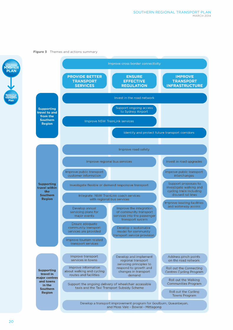
The plan will pursue this vision by developing actions around the three key themes of:
1 Providing better transport services
2 Ensuring effective regulation
3 Improving transport infrastructure
The Southern Regional Transport Plan will improve the customer experience for travel to and from other regions, within the region, within towns and centres and for visitors to the region.
Demand management and infrastructure solutions focused on the region’s road network will enable customers to reach their destination more reliably and more safely. For public transport users, passengers will see service improvements and better connections to key destinations.
This plan includes actions and projects that will deliver better transport services; ensure effective regulation; and improve transport infrastructure over the short (0-5 years), medium (5-10 years) and long (10-20 years) term.
WHAT YOU TOLD USYou told us that there is a common set of goals for transport in regional NSW. While the priority of these goals will vary for each specific region, these goals are:
• Addressing cross-border connectivity issues
• Improving accessibility to transport for everyone
• Appreciating the importance of intra and inter regional connectivity
• Recognising the importance of air travel
• Recognising the growing freight task and its impact
• Making sure that the transport solutions for the regions support growth and development, whilst protecting the viability and amenity of centres and towns.
20
SOUTHERN REGIONAL TRANSPORT PLANMARCH 2014
Figure 3 Themes and actions summary

SOUTHERN REGIONAL TRANSPORT PLANMARCH 2014
21
The NSW Long Term Transport Master Plan sets the strategic direction for transport in the state. The Southern Regional Transport Plan provides more detail for the region.
The Regional Transport Plans link to other plans, including NSW 2021, the Department
of Premier and Cabinet’s Regional Actions Plans for the South East, Southern Highlands and Tablelands, and Illawarra / South Coast, and the Department of Planning and Infrastructure’s South Coast Regional Growth Plan and Sydney – Canberra Corridor Regional Strategy (Figure 4).
Figure 4 Inter-relationships of plans

22
SOUTHERN REGIONAL TRANSPORT PLANMARCH 2014
TRAVEL TO AND FROM THE SOUTHERN REGION
The Southern region is strategically located between Sydney and Melbourne. Its southern boundary adjoins with Victoria while its northern boundary meets the west border of the Illawarra region and Sydney region, and to the west it borders with the Central West region.
The Pacific Ocean forms the eastern boundary, with the Murray-Murrumbidgee region to the west and the Central West.
The Australian Capital Territory (ACT), while not part of the region, is located within its boundaries and is a major travel destination. Canberra provides key services, the primary airport for the region and is a key employment generator.
The key road and rail connections to and from surrounding regions include (Figure 5):
• The Illawarra region via the Princes Highway, the Southern rail line (freight and passenger) and the Moss Vale to Unanderra line (freight)
• The Central West region via Lachlan Valley Way
• The Murray-Murrumbidgee region via the Sturt Highway
• Sydney via the Princes and Hume highways and the Main South rail line (freight and passenger)
• Victoria via the Hume, Monaro and Princes highways
Figure 5 Major corridors to and from the region

SOUTHERN REGIONAL TRANSPORT PLANMARCH 2014
23
• ACT via Barton, Federal, Kings and Monaro highways and the Goulburn to Canberra line (freight and passenger).
Transport challenges for travel to and from the Southern region are:
• Providing cross-border connectivity with the ACT and Victoria
• Supporting road safety and freight efficiency through improvements to the road network
• Integrating train and coach services for travel to and from the region with regional travel needs
• Maintaining convenient access to Sydney by air.
The actions to support travel to and from the Southern region address the following issues:
• Improve cross-border connectivity
• Invest in the road network
• Improve NSW TrainLink services
• Support ongoing access to Sydney Airport
• Identify and protect future transport corridors.
Our actions will focus on making the most of our existing assets by managing demand and operations as a priority. Expansion of infrastructure and services will be planned for over time in line with growth in population and industry within the region.
Action: Improve cross-border connectivityWe will continue to work with the ACT Government to make travelling to and from Canberra and the ACT easier and more convenient.
Travel to the ACT is integral to economic growth and prosperity for the Southern region, as employment, education, health, the airport and higher order services for some communities are located in Canberra.
Integrated planning approaches and reciprocal investment decision making for shared corridors and key connecting infrastructure is supported by the ACT – NSW Land Use and Infrastructure Framework.
We will continue work with the ACT Government to develop a Strategic Regional Direction Statement regarding the opportunities for economic development in the regions. The NSW Government has also appointed a Cross-Border Commissioner to provide advocacy for businesses, organisations and residents in border communities.
There is a large daily movement of workers and school students between NSW and the ACT, such as from Murrumbatemen.
Communities on both sides of the border have raised the need for better integration of transport services with the NSW Cross Border Commissioner.
Connectivity by bus between Queanbeyan and Canberra will be a priority of our work with the ACT Government. This will build on the Cross Border Public Transport Issues Options Paper in 2010.
The NSW Government is committed to providing community transport services where they are needed most across NSW. We have recently allocated funding for a new Monaro Transconnect Bus service, which commenced servicing in March 2014. This bus service will improve access to services in Canberra for the communities of Bombala, Cooma-Monaro and the Snowy River via a daily return service.
Through our partnership with Young Shire Council we are able to continue the widely successful flexible bus service trial between Young, Murringo, Boorowa, Yass and Canberra, for a further two years. This service will provide same day return links to Canberra for the mostly rural communities along the transport corridor.

24
SOUTHERN REGIONAL TRANSPORT PLANMARCH 2014
Action: Invest in the road networkWe will continue our program of upgrades to the road network providing connections to and from the Southern region, focusing on improving safety, increasing accessibility and enhancing freight efficiency.
The Southern region includes the busiest freight corridor in Australia, from Sydney to Melbourne via the Hume Highway. With the Hume Highway duplication now complete the most important road focus for the region is undertaking safety improvements and overtaking lanes on the Princes Highway along the coast of the Southern region to the Victorian border.
The Rural Highway Program will continue investment in the Princes, Barton, Kings, Federal, Monaro and Snowy Mountain highways to improve road safety.
The Barton Highway is strategically significant for connections within the Southern region. It provides an important north-south connection between the ACT, the Riverina and Central West NSW and the Hume Highway to Yass.
Given the high cost of duplicating the highway and the relatively modest traffic volume, there are no current proposals to duplicate the highway. We will develop a corridor strategy to identify and progress potential interim measures that could be implemented to improve the highway.
In the short term this will include:
• Needs analysis of upgrades for the Barton Highway – considering road safety, traffic flow and freight needs
• Options development to identify potential upgrade options and prioritise these upgrades
• Development of a Barton Highway improvements program that builds on our current investments.
In the medium to long term, we will investigate upgrades to Gocup Road to accommodate modern freight demands and address vehicle safety requirements. This road provides a critical link between Tumut and Gundagai to the Hume Highway, and is significant for the timber industry.
We will also investigate the extension of the upgrade to Main Road 92 west of Nerriga in the medium to longer term.
Action: Improve NSW TrainLink servicesWe will develop a future NSW TrainLink service plan for the Southern region and incorporate this into the development of a long term plan for regional rail.
The plan will consider how to improve rail services and create better connections to regional centres as well as to Sydney, Canberra and Melbourne. The plan will also be aligned with coach services operating in the region.
Daily trains connect Southern Highlands towns between Goulburn and Menangle Park to Sydney via Campbelltown to provide a local service between these centres.
The NSW TrainLink passenger rail network in the Southern region connects Mittagong, Bowral, Moss Vale, Goulburn, Tarago and Bungendore with Canberra three times a day. It also connects Moss Vale and Goulburn with Melbourne via Wagga Wagga and Albury twice a day.
There are also NSW TrainLink coaches connecting many other towns and villages to the rail network, providing connections between Southern region communities to/from Sydney and Melbourne. Private coaches also operate along the Princes Highway.
Local bus routes operate within the Canberra- Queanbeyan metropolitan area, providing connections between Queanbeyan and Canberra City Centre, Fyshwick, Canberra Airport, Brindabella Business Park and Woden.

SOUTHERN REGIONAL TRANSPORT PLANMARCH 2014
25
We will examine opportunities to realign train and coach timetables to:
• Improve connections and service frequency
• Improve the range of travel opportunities
• Improve customer access to printed and electronic timetable and travel information for regional rail and coach travel
• Improve the integration between local and regional bus services and NSW TrainLink / V/Line services across the region.
We will invest in improvements to the NSW TrainLink fleet to improve service levels and customer experience. Actions will include:
• Reviewing fleet maintenance and stabling locations, to improve overall reliability and availability of the fleet
• Ensuring the current NSW TrainLink fleet receives maintenance to ensure reliability
• Fleet replacement to help boost flexibility in the design of services and offer greater passenger comfort. This will be managed in line with a NSW TrainLink Fleet and Maintenance Strategy that will program future rolling stock investment.
Action: Support ongoing access to Sydney Airport Regional flight slots at Sydney Airport determine the convenience of air travel for regional communities accessing Sydney by air.
We will support the maintenance of the 20 percent of flight slots allocated to regional NSW services and will seek a greater allocation in the peak periods.
As well as maintaining the current services into Sydney, Transport for NSW licences routes that operate with less than 50,000 passengers per annum including Merimbula and Moruya. The current licences will run until 2018 and grant exclusive rights of operation on the route for the term of the licence.
Charter and private flights from NSW’s regional, rural and remote airports allow those who work and live outside the major cities to access the specialist health, education, commercial and recreational facilities that are not economically available where they normally reside; allow travel by health professionals to the regional community, and enable regional residents to maintain relationships with distant families and friends.
Having passenger services at regional airports also strengthens the viability of these airports and allows them to service some freight and general aviation including urgent medical deliveries and some freight access.
Charter and private flights to Cooma Airport improves accessibility to one of the Southern region’s most popular tourism destinations: the NSW ski fields of Thredbo and Perisher.
Action: Identify and protect future transport corridorsWe will continue to work with the Department of Planning and Infrastructure, and the Australian Government Department of Infrastructure and Regional Development, to identify and protect a future high speed rail corridor between Melbourne and Sydney.
The second phase of the High Speed Rail Study (April 2013), commissioned by the Australian Government, identifies potential stations in the Southern Highlands and Canberra connecting to Sydney, Melbourne and Brisbane. High Speed Rail between Brisbane and Melbourne could provide an opportunity for the Southern region, if connections to the services can be made convenient.
Other potential future corridors that may be investigated include Princes Highway corridor bypass studies and the Barton Highway corridor study.

26
SOUTHERN REGIONAL TRANSPORT PLANMARCH 2014
TRAVEL WITHIN THE SOUTHERN REGION
Goulburn, Queanbeyan (on the border of the ACT) and Moss Vale- Bowral-Mittagong are the main centres for employment, education and health services in the Southern region. Major corridors for travel within the region are identified in Figure 6.
Improving transport outcomes for travel within the Southern region relies on the transport network being planned and managed in an integrated fashion.
Buses, taxis, community transport, active transport, trains and roads play a part in the transport system. Each component has strengths that help meet the transport needs of the region.
Transport challenges for travel within the Southern region are:
• Improving road safety
• Ensuring connections between smaller towns and village to regional centres
• The lack of single comprehensive source of public transport information
• High public transport fares in comparison to those in metropolitan areas
• A high demand for urban growth and rural lifestyle housing in those areas closest to the cites of Sydney and Canberra
• A decline in the rural communities and centres located away from the high growth areas.
Actions to support travel within the Southern region include measures to:
• Improve road safety
• Improve boating facilities and waterway access
• Invest in road upgrades
• Improve regional bus services
• Integrate NSW TrainLink coach services with regional bus services
• Improve public transport interchanges
• Improve public transport customer information
• Investigate flexible or demand responsive transport
• Ensure adequate community transport services are provided
• Improve the integration of community transport into the passenger transport system
• Develop a sustainable model for community transport service provision
• Support proposals to investigate walking and cycling trails including disused rail lines
• Develop annual servicing plans for major events
• Improve tourism-related transport services.

SOUTHERN REGIONAL TRANSPORT PLANMARCH 2014
27
Figure 6 Major corridors within the Southern region

28
SOUTHERN REGIONAL TRANSPORT PLANMARCH 2014
Action: Improve road safetyWe will continue to progress the actions of The NSW Road Safety Strategy 2012-21 to achieve the NSW 2021 target of reducing fatalities to 4.3 per 100,000 population by 2016.
In the Southern region, priority actions related to the strategy include:
• Installation of clear zones, safety barriers on Kings Highway, Eurobodalla, and implementation of other safety works arising from the Kings Highway Safety Review
• Providing safer roads by implementing treatments that target head-on and run-off crashes, including improving alignment and installation of safety barriers on Old Cooma Road, Queanbeyan.
• Continuing to deliver Nation Building and State programs with road safety objectives
• Safer road infrastructure on state and local roads leading to Aboriginal communities to enhance road safety
• Improving pedestrian crossing safety, including reviewing signal phasing for pedestrians, lower speed limits, traffic calming measures and maintenance and upgrade of pedestrian facilities
• Working with NSW Police to strengthen random breath and drug testing programs including a focus in rural NSW
• Developing revised education communications and programs, to address drink driving including alcohol interlocks
• Supplementing heavy vehicle driver fatigue programs with a strategy to address light vehicle driver fatigue
• Deterring speeding through high visibility police enforcement and automated speed camera activities
• Providing consistent application of the general urban 50km/h speed limit
• Improving heavy vehicle compliance through targeted enforcement to address speeding, fatigue, drug impairment and distraction
• Provision of rest areas to meet heavy vehicle needs on major routes.
In addition to specific black spot treatments, the NSW Road Safety Strategy 2012-21 will address more systemic challenges. This strategy recognises that road geometry is only part of the challenge and it aims to achieve safer vehicles, safer speeds and safer people, in addition to safer roads.
Young people (17-25 years old) are over- represented in fatalities and casualty crashes. Since July 2013, the Safer Drivers Course has been available to provide learner drivers with driving strategies, such as speed management, gap selection, hazard awareness and safe following distances, so they are more prepared when they drive unsupervised on their provisional licences.
Other programs including targeted safety works, rural highway upgrades, major arterial road upgrades in growing areas, and bypasses of town centres will contribute to major improvements in road safety.
Action: Improve boating facilities and waterway accessWe will develop a new Boating Infrastructure Partnership Program to build on the Roads and Maritime Services’ successful Better Boating Program. The new funding program will provide grants to local councils and will be informed by a comprehensive audit of waterways to identify priority boating safety, access and infrastructure projects.

SOUTHERN REGIONAL TRANSPORT PLANMARCH 2014
29
Action: Invest in road upgrades We will continue our program of upgrades to the Southern region road network.
Princes Highway improvements to safety and capacity will offer an opportunity to strengthen the connections between centres along the coast from Nowra in the Illawarra region to Eden.
The Bridges for the Bush Program is a NSW Government commitment of $145 million to upgrade or replace regional bridges to improve the resilience and freight capacity of the regional road network.
Within the Southern region, the Bemboka River Bridge on the Snowy Mountains Highway will be upgraded to create a Higher Mass Limit (HML) route between the coast and the Hume Highway and will also provide ongoing safe service levels.
The Queanbeyan to Batemans Bay Corridor Strategy identifies the key transport demands in the corridor over the next 25 years and assesses the performance of the transport infrastructure in serving the needs of the corridor. We will continue to deliver the short term and long term priorities identified in the corridor strategy, including:
• Progressively addressing sections with narrow lane and shoulder widths, particularly between Clyde Mountain and Warrumbucca Creek
• Working with councils to support appropriate pedestrian, cycling and public transport initiatives
• Improving opportunities west of Braidwood
• Responding to new developments and changes in land use.
Action: Improve regional bus servicesWe will work in partnership with local bus operators to introduce a more robust contractual framework for local and regional buses.
We will work with the bus operators to develop routes and timetables which improve services for customers. We will develop a service framework that matches routes, coverage, hours of operation and vehicles with specific local needs.
Bus services provide the majority of public transport services for travel within the Southern Region. These regional bus services provide connections to the region’s major centres from towns and villages (such as Eden to Bega) and between the major centres (Mittagong to Moss Vale).
Our new framework for inter-town buses will target improvements designed to:
• Improve the frequency and hours of operation for inter-regional routes
• Define base service requirements for village to town services including at least morning, afternoon and early evening return trip opportunities
• Consolidate routes to increase the range of destinations provided without the need to transfer between services
• Create a connected network of intra- regional services supported by local services within each centre and by connections to smaller villages.
Bus services for school children in the Southern region will continue to be provided as these services are an essential public transport service in the region.

30
SOUTHERN REGIONAL TRANSPORT PLANMARCH 2014
Action: Integrate NSW TrainLink coach services with regional bus services We will review timetables and service levels for train and coach services as part of the long term plan for regional rail. This will identify opportunities to incorporate improved intra- regional connectivity in addition to long distance train connections.
Coach services are primarily part of a system that provides for travel to destinations outside the region. However, in using the major roads in the region, they also make connections to major centres. The long term plan for regional rail will advance planning for the integration of these services.
As far as it is possible we will aim to use coach services as part of the regional bus system as well as serving travel to destinations outside the region.
One initiative that will be investigated is for NSW TrainLink coach services to pick up and set down at multiple key destinations in the major centres and towns. These may include the airport and the main shopping centre as well as the traditional stop at the railway station. A recent community transport trial in the Young to Canberra transport corridor indicated a high level of demand for access to Canberra Airport.
Other opportunities include investigating the stopping patterns of existing services from Canberra to Bombala to possibly include Jindabyne via Cooma.
Action: Improve public transport interchangesInterchanges are an important part of the public transport network.
We will ensure that major transport interchange points across NSW are assessed and benchmarked against interchange standards. We will develop a program of interchange improvements works to ensure that our interchanges meet passengers’ needs.
We will make interchanging between public transport services easier by taking a customer centred view. We will work to integrate public transport services by:
• Ensuring major interchanges are clean, well lit, with comfortable seating, and shelter for passengers
• Ensuring that services are available at interchanges
• Coordinating timetables to make interchange seamless between all modes, including buses and trains
• Improving wayfinding, signage and the physical cues people use to find their way around interchanges
• Improving customer information including service information, ticketing and timetables.
We are planning interchange improvements at locations in the Southern region including Yass, Batemans Bay, Goulburn and Queanbeyan.
We will also continue to roll out Country Passenger Transport Infrastructure Grants.

SOUTHERN REGIONAL TRANSPORT PLANMARCH 2014
31
Country Passenger Transport Infrastructure Grants Transport for NSW administers annual rounds of the Country Passenger Transport Infrastructure Grants Scheme (CPTIGS), which provides support funding to projects that improve the amenity of passenger transport infrastructure for rural, regional and remote communities of NSW.
Local government, incorporated community groups, transport operators and other interested organisations with a current Australian Business Number can apply. To be successful the proponents must demonstrate the proposal:
• Would benefit non-private vehicle, rural and regional transport passengers
• Is financially and economically sound and has sufficient community support
• Can be part-funded or materially contributed to by other parties
• Is likely to obtain relevant approvals, especially local government
• There is adequate capacity to design, deliver and maintain the infrastructure
• The proposal overall is credible and comprehensive.
Action: Improve public transport customer information We will improve online public transport customer information for Southern region.
The Country Transport website provides bus timetable information town by town, but there is no single information point for bus trips that require an interchange, or map that describes services across the Southern region.
We will develop an integrated and comprehensive source of transport timetables, maps, fares and information to help customers understand options for travel in and around Southern region.

32
SOUTHERN REGIONAL TRANSPORT PLANMARCH 2014
Action: Investigate flexible or demand responsive transport We will investigate the applicability of flexible or demand responsive transport solutions for the Southern region and work to identify and implement these services in appropriate locations.
We will investigate a range of delivery models for flexible transport to determine what works best for different areas of the Southern region. These delivery models may include:
• Fully demand responsive services, providing a door to door service for pre-booked trips
• Partially demand responsive services, providing a door to door service, with pre-bookings as well as ‘turn up and go’ at designated times and places
• Standard route services with the capacity to divert within designated areas on request
• Services operating on a fixed route from, for example, a town centre to a designated point, after which they provide a flexible ‘roaming’ services across a designated zone
• Services operating at set times to/from a designated point, but to a variable, non- fixed route which is dependent on pre–bookings and determined by the driver.
We will work with local bus operators, taxi operators and community transport providers to make the best use of available transport resources and to provide the most appropriate mode and delivery model for different needs, and for different times of the day or week.
We will also support local initiatives that provide flexible transport opportunities, such as carpool schemes.
Action: Ensure adequate community transport services are provided We will continue to work with community transport providers to ensure that future demand for community transport can be met.
The growing and ageing population of the Southern region is likely to increase future demand for community transport services.
We need to provide adequate services to support the mobility of people who are experiencing transport disadvantage, providing them with access to services and facilities across the region.
Action: Improve the integration of community transport services into the passenger transport systemWe will work to better integrate community transport services into the overall transport system to more efficiently meet a broader range of needs.
The NSW Government funds several community transport programs including:
• Community Transport Program
• Regional Transport Coordination Program
• Country Passenger Transport Infrastructure Grants Scheme
• Home and Community Care program (jointly funded State and Australian Government initiative).
Public transport in the region should be understood in the broadest sense to include local taxi services and community transport, to ensure that an alternative to private car use is identified and provided to all residents, including people who experience transport disadvantage and have limited access to services in more isolated areas.
More efficient operation of these services may allow a high level of service and greater flexibility. Examples of these services range from a local community mini-bus that takes older people who are frail or people with disabilities to social activities, through to small charter aircraft provided to fly specialist doctors to a town on a regular basis.
We will work with community transport providers, taxi operators and with traditional bus operators to help deliver a fully integrated transport system. This integration effort will focus on how we can deliver the most appropriate type of service for the Southern region.

SOUTHERN REGIONAL TRANSPORT PLANMARCH 2014
33
Action: Develop a sustainable model for community transport service provision Along with integrating community transport into the overall transport service offering, we will work with local organisations, councils and the Australian Government to ensure the long term viability of the community transport sector. We will investigate options that allow the transport task to be carried out by the providers who are best placed to do so, regardless of mode.
With a growing and ageing population and in response to individually-based service delivery that will flow from reforms such as DisabilityCare Australia, we will work with our customers and providers to ensure an appropriate level of service is provided in an operationally sustainable manner.
Action: Support proposals to investigate walking and cycling trails including disused rail linesWe will support community proposals for investigations into the feasibility of converting non-operational rail lines into tourist or active transport corridors.
The Southern region has two lines which have been identified as having the potential for re-use:
• Molonglo Valley from Captains Flat to Bungendore, 42 kilometres (Captains Flat Branch Line)
• Goulburn to Crookwell and villages in Upper Lachlan Shire, 54 kilometres (Crookwell Branch Line).
Action: Develop annual servicing plans for major events We will work with local councils and festival organisers to develop service plans to encourage public transport use to connect to festivals and other events in the Southern region.
Some areas of the Southern region show significant seasonality in transport demand. This is driven particularly by the tourism focus of the Snowy Mountains and coastal regions.
The key challenge for these areas is to identify seasonal transport solutions that address the capacity shortages efficiently. For example, by ensuring that peak season public transport services are appropriately targeted at peak sources of transport demand.
Effectively meeting peak season demand is critical, both during summer on the coast, and winter in the Snowy Mountains area. Managing road and fleet capacity at peak times will contribute to unlocking greater industry and tourism opportunities for the region, and allow infrastructure investments to be fully utilised for a greater proportion of the year.
Festival and event service plans will be developed in conjunction with local councils, festival organisers and transport providers (including airports). Service plans will outline the services required to for festivals and events and will outline the responsibilities of all parties.
Action: Improve tourism-related transport servicesThe influx of visitors during holiday periods puts temporary pressure on transport systems and services. There is an opportunity to develop a holistic approach to providing transport services for holiday periods through initiatives such as:
• Branding of public transport services
• Raising awareness of travel options through brochures and websites
• Seasonal transport options such as holiday bus services and/or park & ride services.
Cross-regional connections will also be considered and provided, if demand requires.
We will work with local councils to investigate opportunities to use seasonal parking fees to subsidise better local tourist public transport services drawing on the experience of other tourist areas around Australia.
34
SOUTHERN REGIONAL TRANSPORT PLANMARCH 2014
TRAVEL IN MAJOR CENTRES AND TOWNS
Major centres and towns in the Southern region, and the key destinations within them, are illustrated in Figure 7. These towns act as regional focal points, providing access to jobs, shops, education, community services, health care and tourism facilities.
Transport challenges for travel within the major centres and towns of the Southern region are:
• The growth of Major Regional Centres and the need to enhance the transport network
• Increasing congestion levels in and around major towns
• Existing transport networks entrench car dependence and do not meet the needs of non-drivers or those with no access to a motor vehicle
• Levels of public transport provision vary between major towns.
Addressing these challenges is important to improve regional accessibility.
Actions to support travel within the major towns and centres of the Southern Region are:
• Address pinch points on the road network
• Improve transport services in towns
• Develop and implement regional transport servicing principles to respond to growth and changes in transport demand
• Support the ongoing delivery of wheelchair accessible vehicles and the Taxi Transport Subsidy Scheme
• Roll out the Walking Communities Program
• Connecting Centres Cycling Program
• Roll out the Cycling Towns Program
• Improve information about walking and cycling routes and facilities.

SOUTHERN REGIONAL TRANSPORT PLANMARCH 2014
35
Figure 7 Major towns and cities the Southern region
36
SOUTHERN REGIONAL TRANSPORT PLANMARCH 2014
Action: Address pinch points on the road networkWe will work with local councils to develop solutions for addressing localised congestion points on the road network. We will align local environmental planning with transport goals.
Increasing traffic volumes around regional towns associated with growth are creating localised pinch points which impact on the movement of people around the region and reduce the efficiency of freight movements.
Addressing the congestion impacts of growth, requires an integrated transport planning response that includes improvements to bus services, and walking and cycling networks.
Pinch points create additional congestion during peak tourist season when traffic volumes increase significantly. It is not efficient to build additional road capacity for a limited period of the year. This issue is best addressed by specific management plans during tourist peaks.
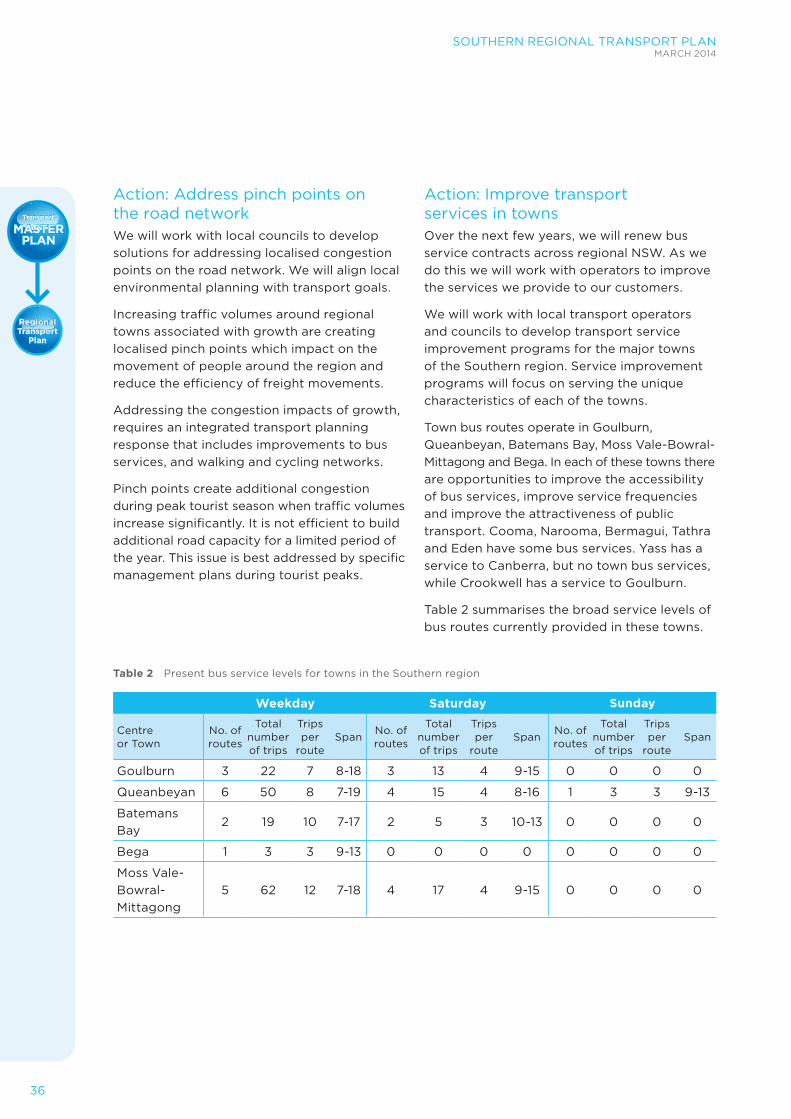
Action: Improve transport services in townsOver the next few years, we will renew bus service contracts across regional NSW. As we do this we will work with operators to improve the services we provide to our customers.
We will work with local transport operators and councils to develop transport service improvement programs for the major towns of the Southern region. Service improvement programs will focus on serving the unique characteristics of each of the towns.
Town bus routes operate in Goulburn, Queanbeyan, Batemans Bay, Moss Vale-Bowral-Mittagong and Bega. In each of these towns there are opportunities to improve the accessibility of bus services, improve service frequencies and improve the attractiveness of public transport. Cooma, Narooma, Bermagui, Tathra and Eden have some bus services. Yass has a service to Canberra, but no town bus services, while Crookwell has a service to Goulburn.
Table 2 summarises the broad service levels of bus routes currently provided in these towns.
Table 2 Present bus service levels for towns in the Southern region
Weekday Saturday Sunday
Centre or Town
No. of routes
Total number of trips
Trips per
routeSpan
No. of routes
Total number of trips
Trips per
routeSpan
No. of routes
Total number of trips
Trips per
routeSpan
Goulburn 3 22 7 8-18 3 13 4 9-15 0 0 0 0
Queanbeyan 6 50 8 7-19 4 15 4 8-16 1 3 3 9-13
Batemans Bay
2 19 10 7-17 2 5 3 10-13 0 0 0 0
Bega 1 3 3 9-13 0 0 0 0 0 0 0 0
Moss Vale-Bowral-Mittagong
5 62 12 7-18 4 17 4 9-15 0 0 0 0

SOUTHERN REGIONAL TRANSPORT PLANMARCH 2014
37
Action: Develop and implement regional transport servicing principles to respond to growth and changes in transport demandRegional transport servicing principles will provide a strategic framework to underpin the services provided to regional centres and towns. These principles will inform ongoing improvements to services and service plans that will be regularly updated to meet the changing travel needs of each town. In turn, the strategic framework will inform the development of any future integrated transport service planning guidelines.
We will work with local transport providers to develop and apply the regional transport servicing principles to put the customer first and continue to work to broaden the range of services to meet local travel needs, with similar service standards applied to towns of broadly similar size and urban form.
Based on the regional transport planning principles, we will update the current service guidelines for town services to set a clearly defined target for service coverage (that 85 percent of households within the town are within 400 metres of a bus route), without prescribing the span of hours or route frequencies, weekend or late night servicing requirements. We will also examine opportunities to simplify the service guidelines by categorising town routes in accordance with their function and the market they serve, rather than by distance from the town centre.
The principles will simplify the current arrangements where separate guidelines apply where the terminus of a route is less than two kilometres from the town centre, compared to those where the terminus is more than two kilometres from the centre.
Through the process of contracting bus services, we will identify short-term priorities for each major centre or town including changes to services. Beyond the five year horizon, the transport services planning principles will identify medium to longer- term service needs, ongoing integration of services with land use and any supporting infrastructure.
Action: Support the ongoing delivery of wheelchair accessible vehicles and the Taxi Transport Subsidy SchemeThe 24 hour nature of the taxi network and its ability to provide an immediate response to individual needs provides opportunities not afforded by bus.
To ensure that this service is available across the community we will continue to support the provision of wheelchair accessible vehicles in the taxi fleets in towns in the Southern region.
We will maintain the Taxi Transport Subsidy Scheme and support the better availability of services on weekends and outside core business hours.
We will investigate ways of increasing taxi numbers in the Southern region. This will also ensure that people with disabilities have access to taxis during school start and finish times, which has been identified as a capacity issue in the Southern region.

38
SOUTHERN REGIONAL TRANSPORT PLANMARCH 2014
Walking and cyclingMany regional towns in NSW are ideal for walking and cycling for transport. Almost 90 percent of people in regional NSW live within easy walking or cycling distance of a local centre, with access to shops, schools, and workplaces.
Wider streets, lower traffic volumes and safe routes in regional centres will make walking and cycling safer and more convenient transport options.
We will work to ensure that any transport project or land use development includes appropriate provision for walking and cycling from the design stage.
We will also assist councils to integrate walking and cycling into their ten-year Community Strategic Plans to ensure there is more provision for walking and cycling and promote this approach with Regional Organisations of Councils.
Action: Roll out the Walking Communities Program The Walking Communities Program will deliver state infrastructure investments and contribute to local government initiatives to help boost rates of walking.
Figure 8 Southern walking and cycling catchments

SOUTHERN REGIONAL TRANSPORT PLANMARCH 2014
39
We will provide dedicated funding to help local councils improve walking infrastructure within two kilometre catchments of centres and transport interchanges.
Action: Connecting Centres Cycling ProgramWe will work with councils and other stakeholders to identify bicycle network gaps and pinch points in the five kilometre catchments that surround regional towns.
The Connecting Centres Program will help councils to complete local cycle networks to regional centres in partnership with local councils. We will also work with councils and bicycle user groups to get more people riding on this network and provide better information to customers.
Action: Roll out the Cycling Towns Program The Cycling Towns Program will focus bicycle infrastructure provision and encouragement in a small number of regional centres with the aim to rapidly increase rates of cycling in these areas.
Two regional centres will be selected for initial investment in the Cycling Towns Program by the NSW Government, to be delivered in partnership with local councils. Candidate towns must demonstrate that a range of destinations is within easy cycling distance from their residential centres. They will require political support, and a commitment to maintain new infrastructure and complementary promotion measures.
Cycling Towns Programs may include bicycle network construction and bicycle parking facilities, complemented by local government funded encouragement programs, and support for tourist routes and information for visitors.
Action: Improve information about walking and cycling routes and facilitiesWe will get people walking and cycling more by promoting the benefits of active transport, improving customer information, and developing guidelines and resources for local government. This will include improved online resources, such as trip planning, as well as other programs to promote walking and cycling for transport.
We will also continue to sponsor events and community programs, such as NSW Bike Week, which promote active transport.
Figure 9 Goulburn walking and cycling catchments

40
SOUTHERN REGIONAL TRANSPORT PLANMARCH 2014
GoulburnGoulburn is a Major Regional Centre for the northern part of the Southern region. It is a regional focal point providing high levels of commercial and administrative services, employment and housing.
It supports and services key industries that include health services, hospitality, retail and education.
The Sydney – Canberra Corridor Regional Strategy prepared by the Department of Planning and Infrastructure nominates Goulburn as one of the three major regional centres that will accommodate the majority of the region’s commercial and retail growth (the other towns are Queanbeyan and Moss Vale-Bowral-Mittagong). These centres will be a focal point for the region’s road and transport networks.
Action: Improve public transport servicesThe transport service improvement program for Goulburn will support the growth of Goulburn and its role as a major regional centre by identifying:
• Opportunities for improved service frequencies to key destinations
• Opportunities to extend hours of operation to include earlier and later services on weekdays, and later services on Saturdays
• The potential for the introduction of Sunday services
• Opportunities to improve the infrastructure that supports public transport services, such as bus stops and shelters, terminal facilities and customer information
• Opportunities for coverage gaps to be provided by flexible/demand responsive routes.
Action: Improve opportunities for walking and cyclingWe support the implementation of better facilities for walking and cycling, including the provision of cycle parking facilities at transport interchanges, centres, schools and hospitals.
Goulburn Mulwaree Council also has opportunities to seek support for new walking and cycling links through our funding mechanisms.

SOUTHERN REGIONAL TRANSPORT PLANMARCH 2014
41
Figure 10 Goulburn town map
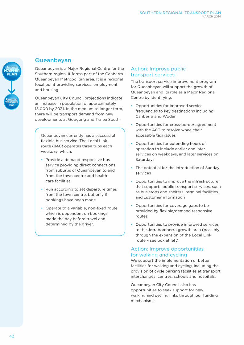
42
SOUTHERN REGIONAL TRANSPORT PLANMARCH 2014
QueanbeyanQueanbeyan is a Major Regional Centre for the Southern region. It forms part of the Canberra- Queanbeyan Metropolitan area. It is a regional focal point providing services, employment and housing.
Queanbeyan City Council projections indicate an increase in population of approximately 15,000 by 2031. In the medium to longer term, there will be transport demand from new developments at Googong and Tralee South.
Queanbeyan currently has a successful flexible bus service. The Local Link route (840) operates three trips each weekday, which:
• Provide a demand responsive bus service providing direct connections from suburbs of Queanbeyan to and from the town centre and health care facilities
• Run according to set departure times from the town centre, but only if bookings have been made
• Operate to a variable, non-fixed route which is dependent on bookings made the day before travel and determined by the driver.
Action: Improve public transport servicesThe transport service improvement program for Queanbeyan will support the growth of Queanbeyan and its role as a Major Regional Centre by identifying:
• Opportunities for improved service frequencies to key destinations including Canberra and Woden
• Opportunities for cross-border agreement with the ACT to resolve wheelchair accessible taxi issues
• Opportunities for extending hours of operation to include earlier and later services on weekdays, and later services on Saturdays
• The potential for the introduction of Sunday services
• Opportunities to improve the infrastructure that supports public transport services, such as bus stops and shelters, terminal facilities and customer information
• Opportunities for coverage gaps to be provided by flexible/demand responsive routes
• Opportunities to provide improved services to the Jerrabomberra growth area (possibly through the expansion of the Local Link route – see box at left).
Action: Improve opportunities for walking and cyclingWe support the implementation of better facilities for walking and cycling, including the provision of cycle parking facilities at transport interchanges, centres, schools and hospitals.
Queanbeyan City Council also has opportunities to seek support for new walking and cycling links through our funding mechanisms.

SOUTHERN REGIONAL TRANSPORT PLANMARCH 2014
43
Figure 11 Queanbeyan town map

44
SOUTHERN REGIONAL TRANSPORT PLANMARCH 2014
Moss Vale–Bowral–MittagongMoss Vale, Bowral and Mittagong collectively function as one urban centre for the northern part of the Southern region.
Bowral provides major retail and commercial services. Mittagong has an important role as a local retail and service centre, and Moss Vale provides an administrative and rural service role.
The Sydney – Canberra Corridor Regional Strategy prepared by the Department of Planning and Infrastructure nominates Moss Vale-Bowral-Mittagong as one of the three major regional centres that will accommodate the majority of the region’s commercial and retail growth.
Action: Improve public transport services The transport service improvement program for Moss Vale-Bowral-Mittagong will develop transport initiatives to improve the attractiveness of public transport.
These improvements may include:
• Opportunities for improved service frequencies to key destinations
• Opportunities for extending hours of operation to include earlier and later services on weekdays, and later services on Saturdays – this may include additional services to ensure all rail services have connecting buses
• The potential for the introduction of Sunday services
• Improvements to route consistency
• Opportunities for the introduction of clock- face timetables
• Improvements to route directness and legibility
• Opportunities to improve the infrastructure that supports public transport services, such as bus stops and shelters, terminal facilities and customer information
• Opportunities for coverage gaps to be provided by flexible/demand responsive routes.
Action: Improve opportunities for walking and cycling We support the implementation of better facilities for walking and cycling, including the provision of cycle parking facilities at transport interchanges, shopping centres, schools and hospitals.
Wingecarribee Council also has opportunities to seek support for new walking and cycling links through our funding mechanisms.

SOUTHERN REGIONAL TRANSPORT PLANMARCH 2014
45
Figure 13 Moss Vale-Bowral-Mittagong town map

46
SOUTHERN REGIONAL TRANSPORT PLANMARCH 2014
IMPLEMENTATION AND DELIVERY
An Implementation and Delivery Plan will be developed to support this Regional Transport Plan.
This will provide the detail to inform how the Regional Transport Plan is being delivered.
As well as the Implementation and Delivery Plan, the NSW Government will continue to invest in transport infrastructure as part of our ongoing investment program.
Investing in the regionDelivering improvements to transport will require sustained investment. This investment will come from the NSW Government, from local councils and from the Australian Government in major projects.
Transport for NSW will continue to work in partnership with local government and the Australian Government on delivering transport improvements.
Delivering for the regionThe Southern Regional Transport Plan supports the NSW Long Term Transport Master Plan, released in December 2012.
The Southern Regional Transport Plan is as much about planning and investing for the long term as it is about short term action. Work is already underway and detailed planning and design on many of these projects has already commenced. In addition, we will continue to work to identify and prioritise actions for the future, so that they may be delivered as funding becomes available.
The Southern Regional Transport Plan will be closely aligned to the Department of Planning and Infrastructure’s South Coast Regional Growth Plan and Sydney to Canberra Corridor Regional Strategy.
Inputs will include future road corridor definitions and other programs to support future changes in land use, population and development.
The NSW Government is working hard to ensure that our regional land use and transport plans are aligned, ensuring the greatest benefit from our investment and for our transport customers.
Taking actionConsistent with the NSW Long Term Transport Master Plan, Transport for NSW will focus on delivering the Southern Regional Transport Plan.
This focus on delivering the planning will include:
• Providing an annual update of the Regional Transport Plan including detailed reports on the progress of implementing the initiatives contained in this plan
• Reviewing the Regional Transport Plan every five years
• A commitment to ensure decisions are founded on a solid evidence base
• Continued collaboration with South East Regional Organisation of Councils, Far South Coast Regional Development Australia, Southern Inland Regional Development Australia, local councils and other stakeholders to support delivery of the Regional Transport Plan and to respond to future planning needs
• A commitment to extensive community engagement and customer consultation as we develop the initiatives in the Regional Transport Plan.

SOUTHERN REGIONAL TRANSPORT PLANMARCH 2014
47
WE LISTENED
Our commitment to customers involves listening to people in the Southern region. The feedback we have includes the extensive consultation that informed the NSW Long Term Transport Master Plan and from direct customer feedback through the pilot of the Regional Household Travel Survey.
Feedback on the NSW Long Term Transport Master PlanMore than 1,200 submissions were received during the development of the NSW Long Term Transport Master Plan including specific submissions identifying transport issues in the Southern region.
A Regional Forum was held on 4 May 2012 in Goulburn with more than 90 people in attendance following the release of the NSW Long Term Transport Master Plan Discussion Paper. In addition, meetings were held with local, state and Australian government representatives during mid 2013.
Specific suggestions were made throughout the consultation process to improve transport within the Southern region including:
• Facilitating access to vital services for an ageing population
• Identifying and preserving key transport corridors
• Maintaining regional air services into Sydney Airport
• Improving cross border integration and connectivity of transport with the ACT
• Thinking about alternative ways to transport people
• Partnering with local councils on freight access and town bypasses
• Improving road safety.
This Regional Transport Plan builds on these issues and identifies a number of more detailed actions necessary to enable growth within the Southern region.
RESULTS FROM THE REGIONAL HOUSEHOLD TRAVEL SURVEY PILOTThe Regional Household Travel Survey Pilot was undertaken by Transport for NSW during 2012 to help us understand what influences the transport decisions of people.
This survey was a pilot with a relatively small sample size. However, the results provide insight that informs this plan.
The top three reasons for travel in the Southern region are for recreation purposes (31 percent), shopping (22 percent) and for commuting to work (10 percent).

48
SOUTHERN REGIONAL TRANSPORT PLANMARCH 2014