Embed Size (px)
Citation preview

Southern Ocean Basin report to GSOP-1NCAR, Boulder CO, November 2004
Kevin Speer and Steve Rintoul
with input from M. Sparrow, E. Zambianchi, M. Meredith, and theInternational CLIVAR/CliC/SCAR Southern Ocean Panel
1. IntroductionThe GSOP requests the following information from each majorocean basin CLIVAR panel:
(1) Describe regional enhancements to sustained global observationsplanned or implemented in this basin. What sustainedmeasurements of boundary currents are planned or implemented inthis basin?
(2) Are the sustained ocean observations adequate for describingclimate-relevant variability on basin-scale?
(3) Are the sustained ocean observations adequate to provide thecontext for regional process studies planned during CLIVAR?
(4) Are there sustained observations relevant to CLIVAR that areoutside of CLIVAR’s influence?
(5) Is data tracking, data availability, and data quality sufficient forCLIVAR research?
The Southern Ocean climate system includes ocean and ice-covered regions,with both free and fast sea-ice as well as ice shelves extending into theocean. Important processes overlap with the interests of other scientificorganizations and for this reason the CLIVAR Southern Ocean panel is jointwith CliC and SCAR, and advises all three SSGs. Therefore the sustainedobservations reported here may be carried out under three separateumbrellas. A further consideration is the approaching International PolarYear. Numerous parties are preparing plans to supplement the observingsystem or install new elements. At this point it is difficult to separate thewishful thinking from likely proposals; some information about the overallstructure is nevertheless provided here.

Key climate research questions that will be investigated by sustainedobservations in the Southern Ocean include:
• ACC transport variation, relation to the AAO/SAM and other patterns,and the transmission of anomalies between oceans
• Vertical structure of heat and fresh-water anomalies and transportprocesses in the ocean
• Dense water formation and the transmission of climate signals byboundary currents
• Ice shelf stability and the heat and fresh-water balance of the ocean-ice system
• The role of the Southern Ocean and ice system in setting the ocean’sbackground state and mean ocean-atmosphere-ice seasonal cycle
• Intrinsic variability and teleconnections of the Antarctic Oscillation,Pacific-South-American Anomaly (PSA 1&2), the AA Dipole, andAntarctic Circumpolar Wave
• Coupled response of atmosphere, ocean, and ice to low-latitude ENSOand other variability
• Carbon uptake, biogeochemistry, and the CO2 feedback• Support of process studies and model development
Sustained measurements (except for satellite measurements, mostly beyondthe scope of this report, and ARGO, discussed separately) have beenextracted from the full set of ongoing and planned observational components(Fig. 1). These demonstrate commitments for sampling on time scales fromnearly continuous (moorings, tide gauges, bottom pressure) to seasonal(XBT, XCTD), to decadal (repeat hydrography). Table 1 summarizes thecombination of platforms and techniques required to achieve a sustainedocean observing system.
No new fields have appeared since Table 1 was first constructed for the 1999Ocean Observations discussion, but biochemical fields should be added inthe future. Oxygen will likely become a routine long-term measurement, forinstance. The ARGO program has grown dramatically, and great progresshas been achieved with XBT lines, repeat hydrography, and satellite-basedwind estimates. The satellite data on some fields is in danger of degrading orhas already decreased, and efforts are needed to promote the role they playin climate research for all branches of the Earth system.

Figure 1. Sustained observational components of the Southern Ocean observingsystem; note that ARGO is discussed separately.

Table 1: The combination of platforms and techniques required to provide sustained observations of eachof the key fields. Specific recommendations are given in the text. (OT = overturning circulation, BW =Antarctic Bottom Water, SO = Southern Ocean, DWBC = deep western boundary current, ACC = AntarcticCircumpolar Current, SSH = sea surface height, SST = sea surface temperature, SSS = sea surface salinity.)
Fields Platforms
StratificationT(x,z), S(x,z)
- z < 2000 m- z > 2000 m
Argo; repeat hydrography; repeat XBTRepeat hydrography
SO-subtropicalexchange
Argo; repeat hydrography/tracers; repeat XBT;boundary current moorings; satellite altimetry
Air-sea flux Flux observatories; improved VOSmeasurements (e.g. IMET); SLP from driftersfor assimilation in NWP models; SST fromdrifters, satellite, and VOS thermosalinograph
Wind Satellite scatterometer; improved re-analysisproducts obtained by assimilating additionalSST and SLP data; regional models
Tracers/CO2 Repeat hydrography; VOS for pCO2ACC transport Repeat hydrography; high density XBT;
moored arrays; end-point monitoring; satellitealtimetry
SSH Satellite altimetry and gravity missions, sealevel gauges
SST Satellite (IR + MW); surface drifters; VOSthermosalinograph; Argo
SSS Argo; VOS thermosalinograph; repeathydrography; drifters?; satellite (?)
DWBC-overflowtransport
Repeat hydrography; current meter mooringsacross AABW outflow
Sea ice extent,volume, motion
Satellite (various); upward looking echosounders for ice thickness; ice drifters

2. Regional enhancements to sustained measurements
2.1 ARGO
As of November 2004 there are 306 ARGO floats south of 30 S. Figure 2shows the latest distribution of floats, and Fig. 3 shows this distribution inrelation to the AAO. Compared to the situation just a year ago the coveragehas improved substantially. Large areas of the South Pacific sector are nowcovered, and gaps are starting to arise in previously well-sampled areassimply because floats are drifting away from their deployment region. Atotal of 306 floats are active (4 Nov. 2004), while 88 floats have died, for anet production of 13,526 profiles.
Major new deployments are expected south of Australia (Australia, 46floats), in the Weddell Sea (Germany, 30 floats), and in the South Pacific(US, ~60 floats).
Figure 2. Distribution of ARGO floats in the Southern Ocean.

Two funded efforts are underway to enhance ARGO coverage in thesubantarctic mode waters of the southern Indian Ocean (FLOSTRAL,France) and southeast Pacific Ocean (during SAMFLOC, US). The FrenchFLOSTRAL program has provided regular re-seeding of the Crozet-Kerguelen-Amsterdam area, but future resources are unclear. TheSAMFLOC process experiment in the southeast Pacific will have extrafloats for enhanced coverage during the period of the experiment.
The ARGO program did not originally plan for the region of seasonal sea-ice coverage, and this has become the largest gap in the ARGO observingsystem in the Southern Ocean. A German project is underway in theWeddell Sea to develop floats that survive the winter sea-ice cover, and toextend the positioning capabilities via acoustic networks. A similar programis pending on the US side (EAUSTRAL), focusing on the Ross Gyre region.Year-round profiling and positioning in the sea-ice zone is the objective.
A number of ARGO floats enter the sea-ice zone by chance, and some ofthese survive the winter and re-appear the following summer. There havebeen examples of data return from, e.g. a float that survived, for 2 years,such an encounter. These observations are few but quite valuable for the newinformation they provide on the upper ocean heat and fresh-water balancewithin the sea-ice zone.
Fig. 3 ARGO floats distribution overlaid on the AAO(first EOF) pattern.

2.2 Current meter moorings
A component of the observational system long thought to be important is aset of transport measurements at the three main “chokepoints”: DrakePassage, a line south of Africa, and a line south of Australia. More recently,outflow arrays on the continental boundary: the Weddell Sea, the Ross Sea,the Princess Elizabeth Trough, and Adelie are being planned as componentsof the system, and have the advantage of being more practical. Only theDrake Passage is approaching adequate sampling to resolve the seasonalcycle of total transport, and perhaps higher frequencies, depending on thepresence of additional moorings during a process study.
Measurements from fixed points are required to monitor ocean transport.Repeat sections are necessary, but not sufficient: the sampling in time is toocoarse to avoid aliasing. In the future these transport measurements shouldincorporate altimetry data as well to improve sampling.
Fixed-point time series have a key role in:
– boundary current signals
– absolute velocity and transport
2.2.1 ACC and Agulhas transport
Boundary current/ACC moorings are showing some progress, but not for fullACC transport. Some monitoring of Agulhas (under ASTEX) has occurred,but this is not likely to be sustained. A French plan for Drake Passage isunderway, but current meters are not likely to be coherent, and therefore fulltransport estimates are unlikely. German moorings are being maintainedover a long time frame (c. 10 yrs) at southern end of the Africa-Antarcticaline, but these are really designed to measure the Weddell gyre, not theACC, with a wide spacing between moorings.
2.2.2 Outflow arrays

A few arrays are planned or happening, mostly in the process-study mode.Attempts are being made to convert these to monitoring arrays by variousmeans. Arrays or moorings are in place in the NW Weddell Sea, theGreenwich meridian, and the Ross Sea outflow. Planned Princess ElizabethTrough, Kerguelen DWBC, and Adelie depression moorings also fit in thiscategory.
A goal has been put forward to have at least three to four outflow arrays inplace for long-term measurements of bottom water formation. Two of these(Weddell and Ross) are started. These would be the initial array needed toascertain synchronous behavior and make the link to circumpolar patterns ofvariability.
2.3 Repeat XBT lines
Repeat XBT is reasonably good, in the sense that probably everything thatcould be done is being done (Table 2). The Drake Passage is in good shape.The Tasmanian line is 6x/year, but only in an October - March timeframe, sothe annual sampling is biased. The GOODHOPE project is spinning up andhelping to fill the gap south of Africa, but still some improvement is needed.The initiation of zonal lines in subtropics will be an important contribution.
Table 2. XBT lines in the Southern OceanTasmania Line: SURVOSTRAL 6x/year but only Oct-MarchS. Atlantic zonal: (AX18, 32 S) 0-2x per yearDrake Passage Line: started at 6-8x per year, now up to 2x per month.Africa Line (GOODHOPE): AX25 1-2x per year?Circumpolar (China): 0.5x per yearNew Zealand Line (Italy): 1x per year?
A map (Fig. 4 from SOOP) of all sampled locations over the period Oct2003 – Sept 2004 shows the coverage for this month, as an indication of netannual sampling.

Fig. 4 One year of reported XBT observations.
2.4 Repeat hydrography
Repeat hydrography is in good shape, essentially all recommended stationshave been done or have commitments. Most of this achievement is due tothe work of the carbon community.
The long time scales of repeat sections requires long lead times forplanning, so the frequency of sampling is not always known on a givensection (Fig. 1).
2.5 Other repeat transits
The southern Indian Ocean sector is monitored by surface CO2 chemistry,meteorology, and ADCP, 2 occupations/yr under the OISO program. Otherunderway programs exist but are less regular.
2.6 Sea-level, bottom pressure recorders
Bottom pressure recorders (BPRs) and tide gauges have been shown to beextremely useful tools in monitoring the Antarctic circumpolar transportvariability on timescales from sub-seasonal to inter-annual. BPRs have been

maintained at around 1000m depth in Drake Passage by the UK since 1988,with measurements from the south side of the passage representing the keyproxy for transport variability. These BPR deployments are due to continuefor the foreseeable future, and will also complement the larger French-led(LODYC) project to instrument Drake Passage with current meter mooringsalong a JASON track. Other BPR deployments in the vicinity of DrakePassage will be made, including deployment of the UK’s 4-year MYRTLEsystem. Previous BPR deployments outside Drake Passage include thoseclose to SANAE (near the Greenwich meridian) and Dumont d’Urville (near135E).
Tide gauge data are available from a range of sites around the Antarcticcoast, including (clockwise from the Antarctic Peninsula) gauges at Rothera,Faraday/Vernadsky, Syowa, Mawson, Davis, Casey, Dumont d’Urville andCape Roberts. Faraday/Vernadsky is the longest series, and has shown itselfto be extremely valuable as an indicator of inter-annual changes in transport;maintaining this gauge is thus of great importance, as is protecting the othertide gauge series so that the longitudinal distribution of transport variabilityon inter-annual timescales can be investigated.
Various tide gauges exist at islands in the Southern Ocean, including the UKgauge at Signy, and the French gauges at Kerguelen, Amsterdam and Crozet(deployed as part of the ROSAME network, along with the Antarctic gaugeat Dumont). It is, however, less clear how these island gauges relate totransport variability – recent investigations have suggested that the sea levelvariability they reflect can owe more to local forcing by wind stress curl thanthe circumpolar transport variability around Antarctica. This does notdiminish the importance of monitoring sea level in these most remote ofregions however.
The UK has plans to upgrade Faraday/Vernadsky within the next couple ofyears, and also install either Orbcomm or Iridium at its Antarctic gauge sitesto enable real-time data return as part of a Southern Ocean monitoringsystem. Equipping other sites the same way would be most desirable, butobviously requires funding. The big weakness at present in the Antarctic tidegauge network is the gap in instrumentation between the Ross Sea area(around 170E) and the Antarctic Peninsula (around 65W). This largelyreflects the absence of bases and suitable sites where gauges could beinstalled, and the relative infrequency of visits by ship to this area, whichhinders deployments or recoveries of BPRs.

2.7 Sea-ice
There has been little or no progress to date in determining sea-ice thicknessin a sustained manner. Note that while the use of ice-tethered platforms, icethickness sonar from floats, etc., is under rapid development for the Arctic,the thin, divergent, and short-lived sea ice in the Southern Ocean makes theAntarctic region more challenging.
2.8 Meteorological buoys
Open ocean buoys.
At OOPC-8 Reynolds presented an analysis of the impact of the number ofbuoys in the Southern Ocean. Work has continued on this, in the direction ofadding ARGO near-surface temperature as SST observations. Tests arebeing conducted to verify the nature of the ARGO SST value.
An indication of the sampling presently occurring is shown by theSeptember 2004 buoys reporting to jcommops (Fig. 5).
Figure 5. Drifting and moored buoys reporting Sept 2004 (jcommops).
Future enhancements to the system are needed, especially maintainingadequate coverage. Continental stations and buoys have been known tosuffer from rejection in the operational system because of large, presumablyreal, differences between the observation and the model.
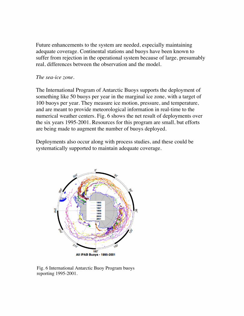
The sea-ice zone.
The International Program of Antarctic Buoys supports the deployment ofsomething like 50 buoys per year in the marginal ice zone, with a target of100 buoys per year. They measure ice motion, pressure, and temperature,and are meant to provide meteorological information in real-time to thenumerical weather centers. Fig. 6 shows the net result of deployments overthe six years 1995-2001. Resources for this program are small, but effortsare being made to augment the number of buoys deployed.
Deployments also occur along with process studies, and these could besystematically supported to maintain adequate coverage.
Fig. 6 International Antarctic Buoy Program buoysreporting 1995-2001.

2.9 Time-series stations and air-sea fluxes
The technical feasibility of air-sea flux buoys in the Southern Ocean has notyet been demonstrated. There are US plans to request a time-series platformfor the region of high winds in the southern Indian Ocean sector, but theprocess is still at a very early stage.
3. Summary of the Adequacy and Evolution of the Observing System
Needed enhancements:
1. SEA-ICE• Extension of profiling floats to sea-ice zone, with positioning.• Sea-ice thickness (echo sounders) and Met buoys in the sea-ice
zone for sea-ice dynamics.
2. SURFACE METEOROLOGY• Enhance IMET coverage. In situ sampling of the diurnal cycle of
SST and wind will help with interpretation of sun synchronoussatellite observations.
• Meteorological buoys in the seasonal sea-ice zone (Tair, wind…).• AWS on subantarctic islands.• Surface Time-series stations in SE Indian (high mean wind
conditions) - and Pacific-AA (synoptic variability) sectors. -sometechnological buoy development required.
3. DRIFTERS• ARGO spatial coverage in areas opening up from initial
deployment.• Surface drifters – enhance coverage following Reynolds scheme
4. TRANSPORT ARRAYS• Coherent circumpolar array in Weddell outflow/Ross
outflow/Princess Elizabeth Trough/Adelie
5. XBT• Retain high sampling rates or improve sampling rates

4. Special opportunities – International Polar Year 07/08
An overarching theme is freshwater fluxes between air-sea-ice components.The implementation of the following observing systems is recommended asthe highest priority, and agrees with IPY guiding themes.
• Observations in the sea-ice zone: profiling floats and Met buoys.
• Air-sea flux improvements via IMET, time-series stations.
• Simultaneous transport arrays to reveal internal modes of oceanvariability, synoptic sections.
5. Data management
Data management is an area in which CLIVAR is still weak. As far asocean data goes, CLIVAR has a number of Data Assembly Centers (the oldWOCE DACS plus a few new ones) to manage specific data streams. Linksto these DACs and details of their responsibilities can be found at:http://www.clivar.org/data/. There are no specifically Southern Ocean datacenters or archives under CLIVAR, although the CLIVAR IPO keeps trackof hydrographic cruises at:http://www.clivar.org/carbon_hydro/hydro_table.php, and of other elementsof the Southern Ocean observing system at:http://www.clivar.org/organization/southern/CLIVAR_CliC_Obs.html.
A number of data management items are being worked on:
• The IPY people have data as a high priority. Although the DACSare good for storing data it might well be that some sort of DataInformation Centers are needed, especially for the amalgamationof contributions to the sustained system from various programs,e.g. iAnZone, and to a certain extent IPY.
• The data from the Japanese Antarctic Research Expeditions (tillMarch 2001) were submitted to J-DOSS, and are freely available

online at http://www.jodc.go.jp/service.htm. However, othercountries have made similar steps to data availability.
• Contact with Raytheon is being made to encourage submission ofunderway data collected on US ships (e.g. thermosalinograph) tothe Coriolis Data Center.
5. Final remarks
The recurring question for CLIVAR researchers is the poor quality of thereanalysis in the Southern Ocean, and the means to improve it. Additionaldata helps only if it is assimilated. Some steps have been made by thecenters but systematic comparisons between the products and the data arestill few, and their impact is unclear given the center’s focus.
We recommend that a focused effort be undertaken to produce an Antarcticreanalysis, encompassing the Southern Ocean. A high-resolution regionalatmospheric model might be the basis to initiate such an effort, including,for example, the ability to represent katabatic winds. High-resolutionforward atmospheric and oceanic models are in use, and are starting to becoupled. Progress in assessing climate models will require closecomparisons and links with observations, and these are not satisfactory inthe present reanalysis programs.