Embed Size (px)
Citation preview

SouthWaikatoDistrictCouncil
South Waikato District Plan
Volume 2Part E - Appendices A to D
and F to k
OPERATIVE 1 JULY 2015
South Waikato District CouncilDistrict Plan Reviewwww. southwaikato.govt.nz07 885 0340

South Waikato District Council District Plan- Operative Version July 2015
this page intentionally left blank
South Waikato District Council District Plan - Operative Version July 2015
APPENDIX A SCHEDULE OF DESIGNATIONS
DocSetID: 344069 Appendices A-K Page 1 of 176
Contents
Appendix A Schedule of Designations ................................................................................................................. 3
Appendix B Built Heritage Inventory .................................................................................................................. 14
Appendix C Schedule of Outstanding Natural Features and Landscapes, and Significant Amenity Landscapes .................................................................................................................................. 151
Appendix D Cultural Heritage Sites .................................................................................................................. 153
Appendix F Criteria for Determining Significance of Heritage Features ........................................................... 154
Appendix G Hazardous Substances................................................................................................................. 157
Appendix H High-Impact Industrial Activities .................................................................................................... 163
Appendix I Airport Approach Slopes ............................................................................................................... 165
Appendix J Catchment Stream Patterns and Land Use .................................................................................. 166
Appendix K National Environmental Standards for Assessing and Managing Contaminants in Soil to Protect Human Health Regulations 2011 .................................................................................................. 169
Appendix E - Signficant Natural Areas: Refer to Volume 3 of the Operative District Plan.
South Waikato District Council District Plan- Operative Version July 2015
Appendices A-K DocSerID: 344069 Page 2 of 176
this page intentionally left blank

South Waikato District Council District Plan - Operative Version July 2015
APPENDIX A SCHEDULE OF DESIGNATIONS
DocSetID: 344069 Appendices A-K Page 3 of 176
Appendix A Schedule of Designations
Requiring Authority: South Waikato District Council: Des No.
Map No.
Name of Works Location Legal Description
Purpose Underlying Zone
D1 28 Tokoroa Waste Water Treatment Plant
Whakauru St, Tokoroa
Pt Lot 6 DP 23866
Waste Water Treatment Plant
Rural
D2 18, 19 Putāruru Waste Water Treatment Plant
Peace St, Putāruru
Pt Lot 1 DP 18021, Public Road
Waste Water Treatment Plant
Putāruru Business and Rural
D3 17 Tirau Waste Water Treatment Plant
SH 27, Tirau Pt Lot 106, DP 5043
Waste Water Treatment Plant
Industrial
D4 40 Arapuni Waste Water Treatment Plant
Powerhouse Rd, Arapuni
Lot 109 DPS 64351
Waste Water Treatment Plant
Rural
D5 39 Waste Water Treatment Plant Drainage Field
Powerhouse Rd, Arapuni
Stopped Road SO 4682
Waste Water Treatment Plant Drainage Field
Electricity Generation
D6 40 Montgomerie Tank Arapuni Rd, Arapuni
Lot 108 DPS 64353
Sewage Treatment
Arapuni Village
D7 28 Sewage Pump Station
Off West Parkdale St, Tokoroa
Lot 3 DPS 31442 Sewage Pump Station
Rural
D8 10 Sewage Pump Station
Northfield Pl, Tokoroa
Pt Lot 201 DPS 14341
Sewage Pump Station
Rural
D9 27 Sewage Pump Station
Tasman Dr, Tokoroa
Lot 88 DPS 11783
Sewage Pump Station
Tokoroa Residential
D10 28 Sewage Pump Station
Croad Pl, Tokoroa Pt Lot 7 DPS 18609
Sewage Pump Station
Tokoroa Business
D11 30 Sewage Pump Station
Baird Rd, Tokoroa Pt Lot 95 DPS 11784 and public road
Sewage Pump Station
Tokoroa Residential
D12 25 Sewage Pump Station
Chartwell Dr, Tokoroa
Lot 129 DPS 18497
Sewage Pump Station
Tokoroa Residential
D13 31, 32 Sewage Pump Station
Mossop Rd, Tokoroa
Pt Lot 6 DPS 2424
Sewage Pump Station
Rural
D14 19 Sewage Pump Station
Galway Cr, Putāruru
Section 102 Sewage Pump Station
Rural
D15 18 Sewage Pump Station
Buckland St, Putāruru
Lot 1 DPS 8360 Sewage Pump Station
Putāruru Residential
D16 22 Sewage Pump Station
Grey St, Putāruru Lot 11 DPS 5800 Sewage Pump Station
Putāruru Residential
D17 20 Sewage Pump Station
Overdale St, Putāruru
Lot 21 DPS 8634 Sewage Pump Station
Putāruru Residential
D18 20 Sewage Pump Station
Market St, Putāruru
Public Road Sewage Pump Station
Industrial
D19 21 Sewage Pump Station
Taupo St, Putāruru
Pt 1 DPS 17490 Sewage Pump Station
Rural

South Waikato District Council District Plan- Operative Version July 2015
APPENDIX B BUILT HERITAGE INVENTORY RECORDS
Appendices A-K DocSetID: 344069 Page 4 of 176
Des No.
Map No.
Name of Works Location Legal Description
Purpose Underlying Zone
D20 17 Sewage Pump Station
Bear St, Tirau Public Road Sewage Pump Station
Tirau Residential
D21 17 Sewage Pump Station
Depot St, Tirau Pt Sec 46 Sewage Pump Station
Industrial
D22 26 Tokoroa Refuse Disposal Site
Newell Rd, Tokoroa
Pt Lot 2 DP 34291
Refuse Disposal and Recycling Site and Hazardous Waste Transfer Station.
Rural
D23 23 Putāruru Refuse Disposal Site
SH1, Putāruru Part Section 39 Refuse Disposal Site
Industrial
D24 17 Tirau Refuse Disposal Site
SH1, Tirau Pt Lot 1 Sec 3, Pt Lot 15 DP5043, Pt Lot 100 DP 5043, Lot 3 DPS 13028
Refuse Disposal Site
Rural
D25 31 Water Supply Reservoir and Treatment Station
Billah St, Tokoroa Pt Lot 52 Lots 53 and 54 DPS 3892
Water Supply Reservoir and Treatment Station
Tokoroa Residential
D26 28 Water Supply Reservoirs (2)
Lion Drive, Tokoroa
Pt Lot 3 DP 22967 Lot 1 DPS 27686
Water Supply Reservoirs
Rural
D27 4 Water Supply Reservoir
Pinedale Rd, Putāruru
Pt Lot 1of Sec 36 Water Supply Reservoir
Rural
D28 20 Water Supply Reservoir
Reservoir St, Putāruru
Pt 1 DP 15603 Water Supply Reservoir
Putāruru Residential
D29 17 Water Supply Reservoir
Fairview St, Tirau DP 27220 Water Supply Reservoir
Rural
D30 40 Water Supply Reservoir
Pioneer Cres, Arapuni
Lot 100 DPS 64358
Water Supply Reservoir
Arapuni Village
D31 24 Water Supply Bore Ngatira Rd, Lichfield
Pt Lot 7, Blk VI Water Supply Rural
D33 30 Water Supply Headworks
Princess Beatrix Ave, Tokoroa
Lot 1 DPS 30711 Water Supply Headworks
Rural
D34 30 Water Supply Headworks
Elizabeth Dr, Tokoroa
Pt Lot 40 DPS 9464 and Pt 11 DPS 4637
Water Supply Headworks
Tokoroa Residential
D36 17 Water Supply Headworks
SH1, Tirau Public Road Water Supply Headworks
Rural
D37 41 Water Supply Headworks
Arapuni Rd, Arapuni
SO 59585 Water Supply Headworks
Rural
D39 40 Water Supply Booster Pump House
Pioneer Cres, Arapuni
Lot 77 DPS 64359
Water Supply Booster Pump House
Arapuni Village
D40 4 Blue Spring Water Supply
Leslie Rd, Putāruru
Public Road Water Supply Rural
D41 3 Stormwater Detention Dam
SH1, Putāruru Pt Section 19 Stormwater Detention Dam
Rural
D42 3 Stormwater Detention Dam
SH1, Putāruru Pt Section 19, Lot 1 DP 34653
Stormwater Detention Dam
Rural

South Waikato District Council District Plan - Operative Version July 2015
APPENDIX A SCHEDULE OF DESIGNATIONS
DocSetID: 344069 Appendices A-K Page 5 of 176
Des No.
Map No.
Name of Works Location Legal Description
Purpose Underlying Zone
D43 22 Stormwater Detention Dam
Kennedy Dr, Putāruru
Pt 3 DPS 21758 Stormwater Detention Dam
Rural Residential
D44 37 Stormwater Detention Dam
Grampian St, Tokoroa
Pt 1 DPS 44913 Stormwater Detention Dam
Rural
D45 34 Stormwater Detention Dam
St Andrews Dr, Tokoroa
Pt 1983 DPS 9267
Stormwater Detention Dam
Tokoroa Residential
D46 33 Lake Moana-nui Dam
Arawa Cres, Tokoroa
Pt Lot 1 DPS 17335, Pt Lot 514 DPS 15337
Dam Rural
D47 35 Amisfield Cemetery Dumfries Rd, Tokoroa
Lots 30 and 31 DPS 2883, and Part Lot 1 DPS 82621
Cemetery Rural
D48 18 Old Putaruru Cemetery
Tirau St, Putāruru Section 98 Cemetery Putāruru Residential
D49 23 Domain Rd Cemetery
Domain Rd, Putāruru
Pt Secs 38, 39 Cemetery Industrial
D50 1 Tirau Cemetery Okoroire Rd, Tirau
Lots 1 and 2 DPS 13602
Cemetery Rural
D51 20 Putāruru Office and Library
Overdale St, Putāruru
Pt Secs 13 and 14
Office and Library
Putāruru Business
D52 17 Sewage Pump Station
Parapara Rd, Tirau
Public Road Sewage Pump Station
Rural Residential
D53 34 Sewage Pump Station
Satco Drive, Tokoroa
Lot 1 DPS 408179
Sewage Pump Station
Industrial
D54 17 Stormwater Detention Area
Goodwin St, Tirau Lot 9 DPS 407499
Stormwater Detention Area
Tirau Residential
D55 20 Stormwater Detention Area
Bent St, Putāruru Lot 2 DP 34983 Stormwater Detention Area
Putāruru Residential
D56 22 Stormwater Detention Area
Barnett St, Putāruru
Pt 21 DPS 7103, Lot 4 DPS 64289, Lot 2 DPS 76668
Stormwater Detention Area
Rural Residential
D57 37 Stormwater Detention Area
Strathmore Park /Huttloc Drive, Tokoroa
Lot 5 DP 407781, Lots 1-3 DPS 44913
Stormwater Detention Area
Rural and Industrial
D58 34 Proposed Road Extension
Pellikan Place, Tokoroa
Lot 12 DP 377392
Proposed Road Rural Residential
NB - Designation D58 has a lapse period of 10 years (instead of the standard 5-year timeframe).

South Waikato District Council District Plan- Operative Version July 2015
APPENDIX B BUILT HERITAGE INVENTORY RECORDS
Appendices A-K DocSetID: 344069 Page 6 of 176
Requiring Authority : Minister of Justice: Des No.
Map No.
Name of Works Location Legal Description
Purpose Underlying Zone
D103 31 Courthouse Bridge St, Tokoroa Section 72, Block VIII Patetere South Survey District
Courthouse Tokoroa Town Centre
Requiring Authority : Minister of Education: Des. No.
Map No.
Name of Works Location Legal Description Purpose Underlying Zone
D201 34, 35 Amisfield Primary Moffat Rd, Tokoroa
Lot 2 DP 398824 Education Purposes
Rural
D203 33, 36 Te Kura Kaupapa Maori O Te Hirianga
Tainui St, Tokoroa
Lot 244 DPS 12639 Residential
D205 37 Cargill Open Plan Primary
Grampian St, Tokoroa
Lots 5, 254 and 255 DPS 22091
Residential
D206 33 David Henry Primary Thompson Rd, Tokoroa
Lot 1 DPS 11809 Residential
D207 30 Forest View High Baird Rd, Tokoroa
Pt Lot 34 DP 23867 (comprised of 8.0927ha)
Rural
D208 24 Lichfield Primary Lichfield Rd, Putāruru
Section 27 Blk XV Patetere North SD.
Rural
D209 18 Te Wharekura o Te Kaokaoroa o Patetere
117 Buckland St, Putāruru
Pt Section 97 Blk VI Patetere North SD, Pts Lots 27-29 DP 15900 and Section 196 Blk VI Patetere North SD.
Putāruru Residential
D211 18, 19 Putāruru High Junction St, Putāruru
Lot 10 DP 18021, Pt Lot 11 DP 18021 (comprising 0.0930ha), Lots 12-72 DP 18021, Sec 16 Blk VI Patetere North SD, Pt Section 97A SO 14762, CLOSED Road SO 39064, Land on DP 18453 being Pt Section 99 Blk VI Patetere North SD
Putāruru Residential
D213 22 Putāruru Primary Kennedy Drive, Putāruru
Pt Section 16 Blk X Patetere North SD
Putāruru Residential
D215 34 Strathmore Primary Strathmore Drive, Tokoroa
Lot 1984 DPS 9267 Tokoroa Residential
D216 36 Tainui Full Primary Tainui St, Tokoroa
Pt Lot 2 DP 28403 and Pt Lot 19 DP 23865
Tokoroa Residential
D219 6 Te Waotu Primary Te Waotu Pt Waotu North 2B Rural D220 17 Tirau Primary 69 Main Rd,
Tirau Lot 2 DP 306234, Pt Lot 106 DP 5043
Tirau Residential

South Waikato District Council District Plan - Operative Version July 2015
APPENDIX A SCHEDULE OF DESIGNATIONS
DocSetID: 344069 Appendices A-K Page 7 of 176
Des. No.
Map No.
Name of Works Location Legal Description Purpose Underlying Zone
D221 31 Tokoroa Central Primary
Clyde St, Tokoroa
Pt Lot 698 DPS 2051
Education Purposes
Tokoroa Residential
D223 31, 34 Tokoroa High SH 32, Tokoroa Pt Lot 2 DP 32554 AND Lots 8 and 9 DPS 5674
Tokoroa Residential
D224 31, 33, 34
Tokoroa Intermediate SH 32, Tokoroa Pt Lot 2 DP 32554 and Lots 8 and 9 DPS 5674
Tokoroa Residential
D225 27 Tokoroa North Primary
Paraonui Rd, Tokoroa
Pt Lot 6 DP 23866 Tokoroa Residential
D227 2 Kuranui School Waiomou Rd, Okoroire
Allotment 4 of Section 68 XV Tapapa SD.
Rural
Requiring Authority : Telecom NZ Ltd: Des No. Map
No. Name of Works
Location Legal Description
Purpose Underlying Zone
D257 31 Tokoroa 29-31 Logan St, Tokoroa
Lot 1 DPS 54346 Telecommunication and Radiocommunication and Ancillary Purposes (this is a joint designation with Chorus NZ Ltd.)
Tokoroa Town Centre
Conditions The designation conditions applying to the use of site D257 are as follows:
Masts and Antennas
1. The height of any mast and associated antennas shall not exceed 20m
2. Antennas mounted on the roof of buildings shall not extend more than 5m above the maximum height of the roof of any existing building.
Noise
3. Any new noise generating equipment (excluding any electricity alternator required for emergency backup power generation) shall not exceed the following noise limits:
At the boundary with any Town Centre or Business zoned land:
At any time on any day:
Leq 55dBA
At the boundary with any residential zoned land:
7am – 10pm on any day:
Leq 50dBA

South Waikato District Council District Plan- Operative Version July 2015
APPENDIX B BUILT HERITAGE INVENTORY RECORDS
Appendices A-K DocSetID: 344069 Page 8 of 176
10pm – 7am on any day:
Leq 40dBA.
4. Any new noise generating equipment (excluding any electricity alternator required for emergency backup power generation) shall cumulatively in combination with any other noise generating equipment on the site not result in any increase in existing noise levels received at any other property boundary where the noise levels in Condition 3 are exceeded. A noise assessment shall be submitted as part of any outline plan to confirm the existing noise levels and predicted new noise levels to confirm compliance with this condition.
5. For any changes or additions to any electricity alternators on the site, where the noise from all electricity alternators exceeds the noise limits in Condition 3, an outline plan shall be required which demonstrates how the equipment and any mitigation is the best practicable option (BPO) to ensure that noise levels do not exceed a reasonable level, and do not exceed existing noise levels.
Radiofrequency Fields
6. Any equipment transmitting radiofrequency energy shall comply with the exposure levels stated in New Zealand Standard NZS2772.1:1999 at any place where the public has reasonable access.
Outline Plan of Works That an Outline Plan of works shall not be required for any internal building works (excluding equipment generating external noise), like for like replacement of equipment, or for the replacement of any antennas of similar size provided that there is no overall increase in the overall height of the facility.

South Waikato District Council District Plan - Operative Version July 2015
APPENDIX A SCHEDULE OF DESIGNATIONS
DocSetID: 344069 Appendices A-K Page 9 of 176
Requiring Authority : Chorus NZ Ltd: Des No.
Map No.
Name of Works
Location Legal Description
Purpose Underlying Zone
D251 42 Puketurua Pearson Rd, Puketurua
Pt Sec 5, Blk VI Puketurua Township, Blk IX Patetere North SD
Telecommunication and Radiocommunication and Ancillary Purposes
Rural
D252 6 Waotu Waotu Road, Waotu
Pt Lot 2 DP 31897 Blk XIII Patetere North SD
Rural
D253 2 Okoroire Okoroire Road, Okoroire
Pt Sec 67, Blk XV Tapapa SD
Rural
D254 20 Putāruru Tirau Rd, Putāruru
Pt Secs 8 and 9, Blk V Putaruru Village, Blk VI Patetere North SD
Putāruru Business
D255 17 Tirau Cnr Rose St and Main St, Tirau
Section 2 SO 57617
Tirau Town Centre Zone
D256 24 Lichfield Ngatira Road, Lichfield
Pt Sec 9 Blk VI Lichfield Village, Blk XV Patetere SD
Rural
D257 31 Tokoroa 29-31 Logan St, Tokoroa
Lot 1 DPS 54346
Telecommunication and Radiocommunication and Ancillary Purposes (this is a joint designation with Telecom NZ Ltd)
Tokoroa Town Centre
Conditions The designation conditions applying to the use of sites D251 to D257 are as follows:
Site Name Conditions Putaruru, Tirau, and Tokoroa Masts and Antennas
1. The height of any mast and associated antennas shall not exceed 20m
2. Antennas mounted on the roof of buildings shall not extend more than 5m above the maximum height of the roof of any existing building.
Noise
3. Any new noise generating equipment (excluding any electricity alternator required for emergency backup power generation) shall not exceed the following noise limits:
At the boundary with any Town Centre or Business zoned land: At any time on any day: Leq 55dBA At the boundary with any residential zoned land:
South Waikato District Council District Plan- Operative Version July 2015
APPENDIX B BUILT HERITAGE INVENTORY RECORDS
Appendices A-K DocSetID: 344069 Page 10 of 176
Site Name Conditions 7am – 10pm on any day: Leq 50dBA 10pm – 7am on any day: Leq 40dBA.
4. Any new noise generating equipment (excluding any electricity alternator required for emergency backup power generation) shall cumulatively in combination with any other noise generating equipment on the site not result in any increase in existing noise levels received at any other property boundary where the noise levels in Condition 3 are exceeded. A noise assessment shall be submitted as part of any outline plan to confirm the existing noise levels and predicted new noise levels to confirm compliance with this condition.
5. For any changes or additions to any electricity alternators on the site, where the noise from all electricity alternators exceeds the noise limits in Condition 3, an outline plan shall be required which demonstrates how the equipment and any mitigation is the best practicable option (BPO) to ensure that noise levels do not exceed a reasonable level, and do not exceed existing noise levels.
Radiofrequency Fields
6. Any equipment transmitting radiofrequency energy shall comply with the exposure levels stated in New Zealand Standard NZS2772.1:1999 at any place where the public has reasonable access.
Outline Plan of Works
7. That an Outline Plan of works shall not be required for any internal building works (excluding equipment generating external noise), like for like replacement of equipment, or for the replacement of any antennas of similar size provided that there is no overall increase in the overall height of the facility.
Putāruru and Tirau only Masts and Antennas No part of any new structure shall protrude through a plane rising at an angle of 45 degrees commencing at an elevation of 3 metres at the boundary of a Residential Zone.
Puketurua, Waotu, Okoroire, and Lichfield Masts and Antennas
The height of any mast and associated antennas shall not exceed 25m Antennas mounted on the roof of buildings shall not extend more than 5m above the maximum height of the roof of any existing building.
Noise Any new noise generating equipment (excluding any electricity alternator required for emergency backup power generation) shall not exceed the following noise limits: At the notional boundary 20m from the facade of any dwelling on other land: 7am – 10pm on any day: Leq 50dBA 10pm – 7am on any day: Leq 40dBA Any new noise generating equipment (excluding any electricity alternator required for emergency backup power generation) shall cumulatively in combination with any other noise generating equipment on the site not result in any increase in existing noise levels received at any other property boundary where the noise levels in Condition 3 are exceeded. A noise assessment shall be submitted as part of any

South Waikato District Council District Plan - Operative Version July 2015
APPENDIX A SCHEDULE OF DESIGNATIONS
DocSetID: 344069 Appendices A-K Page 11 of 176
Site Name Conditions outline plan to confirm the existing noise levels and predicted new noise levels to confirm compliance with this condition. For any changes or additions to the electricity alternators on the site, where the noise from all electricity alternators exceeds the noise limits in Condition 3, an outline plan shall be required which demonstrates how the equipment and any mitigation is the best practicable option (BPO) to ensure that noise levels do not exceed a reasonable level, and do not exceed existing noise levels.
Radiofrequency Fields Any equipment transmitting radiofrequency energy shall comply with the exposure levels stated in New Zealand Standard NZS2772.1:1999 at any place where the public has reasonable access.
Outline Plan of Works That an Outline Plan of works shall not be required for any internal building works (excluding equipment generating external noise), like for like replacement of equipment, or for the replacement of any antennas with antennas of similar size provided that there is no overall increase in the overall height of the facility.
Requiring Authority : Transpower New Zealand Ltd: Des No.
Map No.
Name of Works Location Legal Description
Purpose Underlying Zone
D351 40 Arapuni Outdoor Switchyard
Arapuni Section 1 Block XII, Maungatautari SD, SO 59581
Outdoor Switchyard
Electricity Generation
D352 1 Hinuera Substation Cnr Lake Rd/SH 27
Pt Lot 6 DP 4987 Electricity Substation
Rural
D353 10, 43 Kinleith Substation Old Taupo Road Lot 1 DPS 62238 Electricity Substation
Industrial
D354 9 Waipapa Outdoor Switchyard
Waipapa Lot 1 DPS 89582 Outdoor Switchyard
Electricity Generation
D355 3, 6, 9,12, 39
Brownhill Road - Whakamaru North A 400KV Transmission Line
Whakamaru north to Waipa District boundary north of Arapuni.
Various Electricity transmission and ancillary purposes.
Rural
Requiring Authority : NZ Railways Corporation: Des No. Map No. Name of
Works Location Legal
Description Purpose Underlying Zone
D401 1, 3, 4, 7, 10, 17, 18, 20, 23 to 25, 28, 31, 34, 37, 38
Kinleith Branch Railway
From the northern boundary of the District to Kinleith
Various Railway As per adjoining zones
South Waikato District Council District Plan- Operative Version July 2015
APPENDIX B BUILT HERITAGE INVENTORY RECORDS
Appendices A-K DocSetID: 344069 Page 12 of 176
D402 4, 7, 8, 21, and 23
Rotorua Branch Railway
From Putāruru to the eastern boundary of the District.
Various Railway Rural
Requiring Authority : NZ Transport Agency: Des No. Map No. Name of
Works Location Legal
Description Purpose Underlying Zone
D451 1, 3, 4, 7,10, 13, 17 to 21, 23 to 25, 28, 31 and 34
State Highway 1
From the boundary with Matamata-Piako District, south to the boundary with Taupo District
N/A
To undertake all statutory requirements in accordance with the Land Transport Management Act 2003 and the Government Roading Powers Act 1989.
As per zoning of adjoining land.
D452 3, 4, 5, and 17
State Highway 5
From the intersection with SH1, east to the boundary with Rotorua District.
Rural
D453 1, 17 State Highway 27
From the intersection with SH1, north to the boundary with Matamata-Piako District.
As per zoning of adjoining land.
D454 2,3,4 and 19
State Highway 28
From the intersection with SH1, north to the boundary with Matamata-Piako District.
Rural
D455 13, 14, 15 State Highway 30
From the intersection with SH32, east to the boundary with Rotorua District.
Rural
D456 10, 12, 13, 15, 31, 33, 34
State Highway 32
From the intersection with SH1, south to the boundary with Taupo District
As per zoning of adjoining land.
Requiring Authority : Powerco Ltd: Des No.
Map No.
Name of Works Location Legal Description
Purpose Underlying Zone
D501 22, 3 Zone Substation Arapuni St, Putāruru
Lot 1 DPS 8454 and being Pt Sec 14 Selwyn Settlement
Putāruru Substation
Rural

South Waikato District Council District Plan - Operative Version July 2015
APPENDIX A SCHEDULE OF DESIGNATIONS
DocSetID: 344069 Appendices A-K Page 13 of 176
D502 20 Distribution Substation
Market St, Putāruru
Pt Mangakaretu No 1 Block
Distribution Substation
Putāruru Business
D503 20 Distribution Substation
Duke St – Arapuni St, Putāruru
Pt Lot 45 DPS 14428
Distribution Substation
Putāruru Business
D505 28 Zone Substation 20 Whakauru St, Tokoroa
Lot 1 DPS 8532 Baird Rd substation
Tokoroa Business
D506 33 Zone Substation State Highway 32 and Aotea Cres, Tokoroa
Lot 1 DPS 10546
Maraetai Rd substation
Tokoroa Residential
D507 17 Zone Substation Okoroire St, Tirau Lot 1 DPS 60650
Tirau substation
Industrial
D508 10, 43 Ripple Injection Load Control Plant
Old Taupo Rd, Kinleith
SO 45546 Kinleith Ripple Control Plant
Industrial
D509 12 Zone Substation Landing Rd, Maraetai
Undivided portion of Lot 1 – 2 DP 20269.
Lakeside Pump Substation
Rural
D510 13 Zone Substation Kopakorahi Rd, Kinleith
Undivided portion of DP 19831, DP 19832, DP 19833.
Midway Substation
Rural
Requiring Authority : Radio New Zealand Ltd: Des No.
Map No.
Name of Works Location Legal Description
Purpose Underlying Zone
D601 6 Wiltsdown Transmitter Site
Wiltsdown Rd, Tokoroa
Part Lot 1 DP 13665, Block II Patetere South SD.
Radiocommunication Telecommunication (including broadcasting) and ancillary purposes and land uses.
Rural

South Waikato District Council District Plan- Operative Version July 2015
APPENDIX B BUILT HERITAGE INVENTORY RECORDS
Appendices A-K DocSetID: 344069 Page 14 of 176
Appendix B Built Heritage Inventory NB – Appendix B had immediate legal effect under Section 86B (3) of the Act from the date of public notification of this Proposed Plan.
ADVISORY NOTE: the relevant criteria for determining significance of heritage features is listed in Appendix F.
Index Description Map Number
1 Arapuni Suspension Bridge, Arapuni Road 40 2 Arapuni Power House, Powerhouse Road, Arapuni 40 3 Arapuni Dam, Arapuni Road 41 4 Bakehouse/Dairy, 12 Kinloch Road, Lichfield 24 5 Skimming Factory, Cnr Kinloch & Lichfield Roads 24 6 Water Tower, Pepperill Road, Lichfield 24 7 Vintage Car Club Building, 6 Pepperill Road, Lichfield 2 8 Okoroire Hot Springs Golf Club Pavilion, 18 Somerville Road, Okoroire 1 9 Main Estate Woolshed, Okoroire Road, Tirau 1 10 Main Estate Stables, Okoroire Road, Tirau 1 11 Stone Kitchen, 69 Horahora Road, Piarere 1 12 Stone House & Outbuildings, 56 Arapuni Street, Putāruru 20 13 Stone House & Garage, 74 Kensington Street, Putāruru 20 14 District Council Office and Library (former school), Overdale Street, Putāruru 20 15 Stone House, 83 Tirau Street, Putāruru 20 16 Stone House, 85 Tirau Street, Putāruru 20 17 Stone House, 87 Tirau Street, Putāruru 20 18 Putaruru Courthouse, 67 Tirau Street, Putāruru 20 19 Assembly of God Church, 65 Tirau Street, Putāruru 20 20 Okoroire Hot Springs Hotel, 18 Somerville Road, Okoroire 2 21 Okoroire Hot Springs Hotel - staff accommodation, 18 Somerville Road 2 22 House (formerly Raparahi Hotel), 1338 Wiltsdown Road, Waotu 6 23 Waotu-Puketurua Play Centre Building, 1262 Waotu Road, Waotu 6 24 Hodderville Homestead, 978 Old Taupo Road, Waotu 6 25 The Marble Monument on Heteri, Lake Arapuni Road, Waotu 6 26 Water Tower, Ngatira Road, Ngatira 7 27 Walsh Rhyolite House, 64 Papanui Street, Tokoroa 31 28a Lower Crimp Tram Tunnel 7 28b Tunnel Road – Western Tram Tunnel 4 28c Tunnel Road – Eastern Tram Tunnel 4 29 Drovers' Trough, SH 5, Tapapa 4 30 Barnett Homestead, 1690 Wiltsdown Road, Waotu 6 31 Te Waotu Post Office, Waotu-Putāruru Road 6 32 Putaruru Post Office, cnr Kensington/Tirau Streets, Putāruru 20 33 Water Tower, Prospect Tce, Tirau 17 34 Motai Niu Pole, Kakoahu Road, Kuranui 2

South Waikato District Council District Plan - Operative Version July 2015
APPENDIX B BUILT HERITAGE INVENTORY
DocSetID: 344069 Appendices A-K Page 15 of 176
Index Description Map Number
35 Stockmans Hut, 2670 SH 5, Tirau 27 36 Te Whetu School Room, 4 Paraonui Road, Tokoroa 20 37 BNZ Putaruru, Princes St, Putāruru 20 38 Putāruru Hotel, Princes St/Arapuni Street 20 39 Woodstock Homestead, 208 Somerville Road 2 40 WDFF Building, Overdale St, Putāruru 20 41 Oxford Royal Hotel, SH1/Hillcrest St, Tirau 17 42 Tirau Post Office (former) SH1/Rose St, Tirau 17
Rule B1 - Signage on the Built Heritage features Listed in the Inventory and on the Sites where Those Features are Located.
B1.1 Permitted Activities The following signs shall be permitted activities on buildings/structures listed in Appendix B-Built Heritage Inventory, and on the sites where those buildings/structures are located,
a) Official Signs
b) Signs providing information or interpretation of the Heritage Feature concerned.
c) Other Signs, provided they comply with the Performance Standards set out in Rule B1.3 below:
B1.2 Restricted Discretionary Activities Signs on buildings/structures listed in Appendix B - Built Heritage Inventory, and on the sites where those buildings/structures are located, that do not comply with Rule B1.3 are a restricted discretionary activity.
The specific matters where discretion is reserved are identified in Rules 8.3.3 and 8.3.4 and shall be used when considering a resource consent application for a restricted discretionary activity in respect of signage on a Built Heritage feature or the site of a Built Heritage feature.
B1.3 Performance Standards
a) Standards Applying in all zones
1. The sign must advertise the name of a business located on the property or otherwise relate to activities located on the property.
2. If on the building, the sign shall be on the ground floor level of the building, and shall not:
a) Be internally illuminated or made of reflective materials,
b) Be placed over features for which the building is noted in Appendix B Built Heritage Inventory, or any building names, plaster detailing or fretwork
c) Cover any window or door, or
d) Protrude beyond the verandah or roof of the building.
e) If hung on the body of the building, the sign shall be hung at right angles to the building to avoid covering the façade.

South Waikato District Council District Plan- Operative Version July 2015
APPENDIX B BUILT HERITAGE INVENTORY RECORDS
Appendices A-K DocSetID: 344069 Page 16 of 176
3. If on the building, the sign shall be attached by methods appropriate to the building structure, being Anka-screws or chemset anchors or similar product for concrete/stone or brick buildings, and by a support system for a wooden building.
b) Standards Applying in Residential zones
1. If on the site, the maximum height of a freestanding sign shall be 2m.
2. There shall be no more than one sign of no greater than 0.5m² on a building/structure or the site listed in Appendix B - Built Heritage Inventory, to denote the name, or purpose of the activity undertaken on the site.
c) Standards Applying in Rural and Rural Residential zones
1. If on the site, the maximum height of a freestanding sign shall be 2m
2. The amount of signage on a building/structure shall not exceed 10% of the building/structure façade, while total signage on the building/structure and the site listed in Appendix B-Built Heritage Inventory shall not exceed 3m²
d) Standards Applying in Town Centre and Business zones
1. If on the site, the maximum height of a freestanding sign shall be 4m.
2. The amount of signage on a building/structure shall not exceed 10% of the building/structure façade, while total signage on the building/structure and the site listed in Appendix B-Built Heritage Inventory shall not exceed 10m²

South Waikato District Council District Plan - Operative Version July 2015
APPENDIX B BUILT HERITAGE INVENTORY RECORDS
DocSetID: 344069 Appendices A-K Page 17 of 176
Built Heritage Inventory Record Page Reference HINV01: Arapuni Suspension Bridge ............................................................................................................ 19 HINV02: Arapuni Power House ..................................................................................................................... 22 HINV03: Arapuni Dam ................................................................................................................................... 25 HINV04: Bake House - Dairy......................................................................................................................... 29 HINV05: Skimming Factory ........................................................................................................................... 32 HINV06: Lichfield Water Tower ..................................................................................................................... 36 HINV07: Vintage Car Club Building ............................................................................................................... 39 HINV08: Okoroire Hot Springs Golf Club Pavilion ......................................................................................... 42 HINV09: Main Estate Woolshed .................................................................................................................... 45 HINV10: Main Estate Stables ........................................................................................................................ 48 HINV11: Stone Kitchen ................................................................................................................................. 51 HINV12: Stone House and Stone Outbuildings ............................................................................................. 54 HINV13: Stone House and Stone Garage ..................................................................................................... 57 HINV14: District Council Office and Library (Former School) ....................................................................... 60 HINV15: Stone House ................................................................................................................................... 63 HINV16: Stone House 85 Tirau Street Putāruru............................................................................................ 66 HINV17: Stone House 87 Tirau Street Putāruru............................................................................................ 69 HINV18: Putāruru Courthouse ...................................................................................................................... 72 HINV19: Assembly Of God Church ............................................................................................................... 74 HINV20: Okoroire Hot Springs Hotel ............................................................................................................. 77 HINV21: Okoroire Hot Springs Hotel – Staff Accommodation ....................................................................... 80 HINV22: House (Formerly Raparahi Hotel) ................................................................................................... 83 HINV23: Waotu-Puketurua Play Centre Building .......................................................................................... 86 HINV24: Hodderville Homestead, Boys’ Home And Training Farm (Front Part Of Main T-Building Only) .... 89 HINV25: The Marble Monument on Heteri .................................................................................................... 93 HINV26: Water Tower - Ngatira .................................................................................................................... 95 HINV27: Walsh Rhyolite House .................................................................................................................... 98 HINV28A: Lower Crimp Tram Tunnel ............................................................................................................ 101 HINV28B: Tunnel Road – Western Tram Tunnel........................................................................................... 104 HINV28C: Tunnel Road – Eastern Tram Tunnel............................................................................................ 107 HINV29: Drover's Trough ............................................................................................................................ 110 HINV30: Barnett Homestead ....................................................................................................................... 113 HINV31: Te Waotu Post Office - Telegraph Office ...................................................................................... 115 HINV32: Putāruru Post Office ..................................................................................................................... 118 HINV33: Water Tower - Prospect Avenue ................................................................................................... 121 HINV34: Motai Niu Pole (T15/193) .............................................................................................................. 124 HINV35: Stockmans Hut ............................................................................................................................. 128

South Waikato District Council District Plan- Operative Version July 2015
APPENDIX B BUILT HERITAGE INVENTORY RECORDS
Appendices A-K DocSetID: 344069 Page 18 of 176
HINV36: Te Whetu School / Tokoroa Red Cross Hall ................................................................................. 131 HINV37: BNZ Bank - Putāruru .................................................................................................................... 136 HINV38: Putāruru Hotel .............................................................................................................................. 139 HINV39: Woodstock Homestead and Farm Complex ................................................................................. 142 HINV40: WDFF Building, Putāruru .............................................................................................................. 145 HINV41: Tirau Hotel (Oxford Royal Hotel) .................................................................................................. 148

South Waikato District Council District Plan - Operative Version July 2015
APPENDIX B BUILT HERITAGE INVENTORY RECORDS
DocSetID: 344069 Appendices A-K Page 19 of 176
HINV01: Arapuni Suspension Bridge
Date of Photograph: 29/10/2008
Location and Zoning Information Address Arapuni Domain
Current Owner Mighty River Power Limited
Legal Description
Zoning Electricity Generation Zone
Valuation Number 0541223500
Google Maps Link Lat:38.070629, Long:175.644805
Architecture Date of Construction 1925-1926
Materials Concrete anchors and foundation; One concrete tower and one steel; steel cables; suspender rods and angles; timber joists & wooden decking. (HNZPT) 480-500 ft long. 320ft east end, 274ft west end above sea level.
Architecture/Engineer/Builder Architect: Armstrong, Whitworth & Co Ltd (Newcastle) Builder: David Rowell & Co. Ltd of Westminster, UK. (HNZPT)
Condition Good condition and high level of integrity. (HNZPT). Signs on the bridge limit the number of people crossing at any one time. Mighty River Power undertakes regular condition assessments, and reserves the right to close off the bridge for safety or maintenance reasons. (Mighty River Power, Feb 2001).

South Waikato District Council District Plan- Operative Version July 2015
APPENDIX B BUILT HERITAGE INVENTORY RECORDS
Appendices A-K DocSetID: 344069 Page 20 of 176
Original Site Recommendation HNZPT Ref: 4168. Heritage Advisor, HNZPT. Additional information can be found in "The History of Arapuni" I.J. Southward.
Current Use Recreation Suspension Bridge - pedestrian access. Enables view of Arapuni Powerhouse and electricity generation site.
Statement of Significance (1 Historical) - was associated with events, persons or ideas of importance in South Waikato history. Powerhouse associated with first state built hydro dam on Waikato River. Public works. (3 Community Association) - has important community association and public esteem, used by workers to gain access to powerhouse (and associated infrastructure) construction site. (6 Educational) - has the potential to educate public about the history of South Waikato, item on a heritage trail, school programme potential, study of technology. (9 Technological) - is an important example of construction using particular construction methods, was important in the development of technology, technological innovation or technological processes, ancillary structure that supported NZ's largest civil engineering project. Possibly shipped prefabricated. (11 Context) - forms part of a wider historical and cultural complex, Arapuni Power Station and township. Visual aspects that relate to history and setting. (13 Integrity) - has a good level of integrity, good condition, no additions or major alterations and an addition based on advice from HNZPT concerning these alterations.
District Plan Rules Demolition - Non-complying. Protection focus - 1, 6, 9 and 11. Mitigate the effects of demolition by requiring the applicant to provide Historical Building Documentation (HBD) which should include: the structure history, photographic documentation and measurements of the item prior to removal.
Alterations necessary for the primary purpose of improving structural performance, fire safety or physical access - Controlled. Other Additions/Alterations - Discretionary. Protection focus - 9, 11 and 13.
Repair of the Structure - Permitted. Refer to Rule 30.3.1. Protection focus - 6, 9, 11 and 13. Building Materials Rule: If repair of the structure is proposed theatricals used for the exterior walls and elements should be similar in type, dimensions and profile as the existing fabric of the building. Design Rule: Repair or replication work should match the existing design and profile of the element.
Re-use/Change of Use - Permitted. Refer to Rule 30.3.1. Protection focus - 6, 11 and 13.
Internal Changes - Not applicable.
Relocation - Discretionary. Protection focus - 6, 11 and 13.Mitigate the effects by 1) Consultation with the community, and/or consultation with Iwi or special interest groups, 2) Relocate to a similar setting, 3) Documentation (HBD).
Disturbance of the site surface/earthworks - Note: Any place that was associated with human activity prior to 1900 and is able to provide evidence relating to the history of New Zealand is an 'archaeological site' (refer to definition of 'archaeological site' in Section 2 of the Heritage New Zealand Pouhere Taonga Act 2014). All archaeological sites are protected under the Heritage New Zealand Pouhere Taonga Act 2014 and approval from Heritage New Zealand must be obtained prior to destroying, damaging or modifying any site. Accordingly, where this site on which a building is located is an 'archaeological site' and the building is to be repaired, added to, relocated or demolished and this involves disturbance to the surface and/or subsurface of the site, approval from Heritage New Zealand is required.
History Pedestrian bridge for use in association with dam construction. The suspension bridge has a span of 152m across the Arapuni Gorge one mile from the dam. Deck 1.2m wide and descends at a grade of 1 in 10 from the eastern bank of the river. The deck is approximately 50m above the water. It is an important ancillary structure

South Waikato District Council District Plan - Operative Version July 2015
APPENDIX B BUILT HERITAGE INVENTORY RECORDS
DocSetID: 344069 Appendices A-K Page 21 of 176
to what was New Zealand's largest civil engineering undertaking at the time. Structure likely to have been shipped prefabricated from England and erected by British Contractors, Armstrong Whitford. It connected "Top Camp", eventually to become the permanent township of Arapuni, with the western side of the gorge. Top Camp accommodated workers employed on the construction of the spillway, power station, penstock and outdoor station. The bridge still provides essential access between Arapuni and the Hydro Electric installation. (HNZPT). In 1926, a pipe suspension bridge was constructed to convey water to the construction site, for access to the site by workers. The bridge still carries a water pipe that conveys potable water to the outdoor switchyard. The bridge also carries communications cables. (Mighty River Power, Feb 2001).
Additional Photographs

South Waikato District Council District Plan- Operative Version July 2015
APPENDIX B BUILT HERITAGE INVENTORY RECORDS
Appendices A-K DocSetID: 344069 Page 22 of 176
HINV02: Arapuni Power House
Date of Photograph: 29 October 2008
Location and Zoning Information Address Powerhouse Rd, Arapuni
Current Owner Mighty River Power Ltd
Legal Description
Zoning Electricity Generation Zone
Valuation Number 0541223500
Google Maps Link Lat:38.070914, Long:175.643912
Architecture Date of Construction 1924 - Completed 1929
Materials Steel frame reinforced concrete walls. Galvanised steel frame windows glazed with glass at least 21lbs per sq ft. Roof flat concrete slab to 100lb per sq. ft. Generator floor mass concrete, others reinforced concrete. (HNZPT).
Architecture/Engineer/Builder F.W. Furkett, Engineer-In-Chief. Frederick Templeton Manheim Kissel - Engineer. Builder: Sir William G. Armstrong, Whitworth and Co. Ltd of Newcastle-On-Tyne 1924-Dec 1927. NZ Public Works Department Dec 1927-1929, (HNZPT)
Condition Good condition and high level of integrity. (HNZPT). Extensions (new superintendent's office of reinforced concrete and roof waterproof) commenced Aug 1934, completed 1938. Further units commissioned 1945. (HNZPT). Security fencing limits access to the site. No particular protection other than

South Waikato District Council District Plan - Operative Version July 2015
APPENDIX B BUILT HERITAGE INVENTORY RECORDS
DocSetID: 344069 Appendices A-K Page 23 of 176
routine building maintenance. (Mighty River Power, Feb 2001).
Original Site Recommendation HNZPT Ref: 4376. Heritage Advisor, HNZPT. Additional information can be found in "The History of Arapuni" I. J. Southward.
Current Use Hydro-electricity generation
Statement of Significance
(1 Historical) - was associated with events, persons, organisation, institutions or ideas of importance in South Waikato history, Chief Engineer FW Furkett; availability of public power; dairy industry links. Powerhouse associated with first state built hydro dam on the Waikato River, public works. Reflects important or representative aspects of South Waikato and New Zealand history, hydroelectric power scheme in NZ. (6 Educational) - has the potential to educate public about the history of South Waikato, item on a potential heritage trail, school programme potential - study of technology. (9 Technological) - was important in the development of technology, technological innovation or technological processes, constructed in two parts, designed so the generation capacity could be expanded up to eight generators. (11 Context) - forms part of a wider historical and cultural complex, Arapuni Power Station and Township. (13 Integrity) - has a good level of integrity, good condition. No additions or major alterations.
District Plan Rules Demolition - Non-Complying. Protection focus - 1, 6, 9 and 11. Mitigate the effects of demolition by requiring the applicant to provide Historical Building Documentation (HBD) which should include: the structure history, photographic documentation and measurements of the item prior to removal.
Alterations necessary for the primary purpose of improving structural performance, fire safety or physical access - Controlled. Other Additions/Alterations - Discretionary. Protection focus - 6, 9, 11 and 13. Effects can be mitigated/remedied through; a) HBD - See mitigating the effects of demolition. b) Design rules: 1.The overall visual character/shape of the original building should be identifiable. The addition should not dominate the existing building. 2. New work should be restricted to the rear of the building and not be evident from the road frontage. 3. The following special elements that are associated with the rarity or architectural uniqueness or craftsmanship of the structure should be retained: Elements of the structure that should be retained are those elements associated with the structures historic character, use, rarity, landmark values, and craftsmanship etc. i.e. façade, exterior walls, openings, landscape and any other special elements identified in the HBD. c) Building Materials Rule: If repair of the buildings is proposed the materials used for the exterior walls and elements should be similar in type, dimensions and profile as the existing exterior fabric of the building.
Repair of the Structure - Permitted. Refer to Rule 30.3.1. Protection focus - 6, 9, 11 and 13. Building Materials Rule: If repair of the buildings is proposed the materials used for the exterior walls should be similar in type, dimensions and profile as the existing exterior fabric of the building. Design Rule: Repair or replication work should match the existing design and profile of element.
Re-use/Change of Use - Permitted. Refer to Rule 30.3.1. Protection focus - 1, 6 and 13.
Internal Changes - Permitted. Protection focus - 1 and 9.
Relocation - Discretionary. Protection focus - 1, 11 and 13.
Disturbance of the site surface/earthworks - Note: Any place that was associated with human activity prior to 1900 and is able to provide evidence relating to the history of New Zealand is an 'archaeological site' (refer to definition of 'archaeological site' in Section 2 of the Heritage New Zealand Pouhere Taonga Act 2014). All archaeological sites are protected under the Heritage New Zealand Pouhere Taonga Act 2014 and approval from Heritage New Zealand must be obtained prior to destroying, damaging or modifying any site. Accordingly, where this site on which a building is located is an 'archaeological site' and the building is to be repaired,

South Waikato District Council District Plan- Operative Version July 2015
APPENDIX B BUILT HERITAGE INVENTORY RECORDS
Appendices A-K DocSetID: 344069 Page 24 of 176
added to, relocated or demolished and this involves disturbance to the surface and/or subsurface of the site, approval from Heritage New Zealand is required.
History First state built hydro dam on Waikato River. For many years New Zealand's largest dam at 157,000KW. Length 136.33m width 22.87m, tailrace water level to roof 21.96m. The Arapuni complex (Dam, Powerhouse & associated works) was of an unprecedented magnitude in New Zealand engineering. Public doubts were raised about the Public Works Department ability to undertake the project. In the end the Department's layout and design were adopted but overseas contractors, Armstrong, Whitford & Co Ltd, carried out construction. Powerhouse was constructed in two parts - the north end of the building between 1924 and 1929, and the south end was added between 1934 and 1946. (Mighty River Power Feb 2001). The first electricity from Arapuni was delivered on 4 June 1929. Power generation was stopped in 1930 when damage to the station was sustained as a result of significant rock movement. Remedial works were carried out by the Public Works Department and the generation of electricity resumed in April 1932.(HNZPT).
Additional Photographs
South Waikato District Council District Plan - Operative Version July 2015
APPENDIX B BUILT HERITAGE INVENTORY RECORDS
DocSetID: 344069 Appendices A-K Page 25 of 176
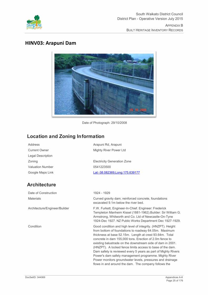
HINV03: Arapuni Dam
Date of Photograph: 29/10/2008
Location and Zoning Information Address Arapuni Rd, Arapuni
Current Owner Mighty River Power Ltd
Legal Description
Zoning Electricity Generation Zone
Valuation Number 0541223500
Google Maps Link Lat:-38.082369,Long:175.639177
Architecture Date of Construction 1924 - 1929
Materials Curved gravity dam; reinforced concrete, foundations excavated 9.1m below the river bed.
Architecture/Engineer/Builder F.W. Furkett, Engineer-In-Chief. Engineer: Frederick Templeton Manheim Kissel (1881-1962).Builder: Sir William G. Armstrong, Whitworth and Co. Ltd of Newcastle-On-Tyne 1924-Dec 1927. NZ Public Works Department Dec 1927-1929.
Condition Good condition and high level of integrity. (HNZPT). Height from bottom of foundations to roadway 64.05m. Maximum thickness at base 52.15m. Length at crest 93.64m. Total concrete in dam 155,000 tons. Erection of 2.0m fence to existing balustrade on the downstream side of dam in 2001. (HNZPT). A locked fence limits access to base of the dam. Dam safety is reviewed every 5 years as part of Mighty Rivers Power's dam safety management programme. Mighty River Power monitors groundwater levels, pressures and drainage flows in and around the dam. The company follows the

South Waikato District Council District Plan- Operative Version July 2015
APPENDIX B BUILT HERITAGE INVENTORY RECORDS
Appendices A-K DocSetID: 344069 Page 26 of 176
guidelines of the NZ Society of Large Dams. A gas pipeline runs along the downstream face of the dam. (Mighty River Power, Feb 2001).
Original Site Recommendation HNZPT Ref: 4154. Heritage Advisor, HNZPT. Additional information can be found in "The History of Arapuni" I.J. Southward.
Current Use Hydro-electricity generation
Statement of Significance (1 Historical) - was associated with events, persons, organisation, institutions or ideas of importance in South Waikato History, Chief Engineer FW Furkett. Reflects important or representative aspects of South Waikato and New Zealand history, hydro electric power scheme in NZ, first state hydro dam on the Waikato River, public works. (6 Educational) has the potential to educate public about the history of South Waikato, item on a potential heritage trail, school programme potential/study of technology/engineering. (9 Technological) - was important in the development of technology, technological innovation or technological processes, unprecedented engineering project, scale larger than anything attempted before, geological problems had to be solved. (11 Context) - forms part of a wider historical and cultural complex, Arapuni Power Station and township. (13 Integrity) has a good level of integrity, good condition, no additions or major alterations.
District Plan Rules Demolition - Non-Complying. Protection focus - 1, 6, 9 and 11. Mitigate the effects of demolition by requiring the applicant to provide Historical Building Documentation (HBD) which should include: the structure history, photographic documentation and measurements of the item prior to removal.
Alterations necessary for the primary purpose of improving structural performance, fire safety or physical access - Controlled. Other Additions/Alterations - Discretionary. Protection focus - 1, 9, 11 and 13.
Repair of the Structure - Permitted. Refer to Rule 30.3.1. Protection focus - 9, 11 and 13. Building Materials Rule: If repair of the buildings is proposed the materials used for the exterior walls should be similar in type, dimensions and profile as the existing exterior fabric of the building. Design Rule: Repair and replication work should match the existing design and profile of the element.
Re-use/Change of Use - Permitted. Refer to Rule 30.3.1. Protection focus - 1, 9 and 13.
Internal Changes - Not applicable.
Relocation - Not applicable.
Disturbance of the site surface/earthworks - Note: Any place that was associated with human activity prior to 1900 and is able to provide evidence relating to the history of New Zealand is an 'archaeological site' (refer to definition of 'archaeological site' in Section 2 of the Heritage New Zealand Pouhere Taonga Act 2014). All archaeological sites are protected under the Heritage New Zealand Pouhere Taonga Act 2014 and approval from Heritage New Zealand must be obtained prior to destroying, damaging or modifying any site. Accordingly, where this site on which a building is located is an 'archaeological site' and the building is to be repaired, added to, relocated or demolished and this involves disturbance to the surface and/or subsurface of the site, approval from Heritage New Zealand is required.
History The Arapuni complex (Dam, Powerhouse and associated works) proposal was of an unprecedented magnitude in New Zealand engineering. Public doubts were raised about the Public Works Department ability to undertake the project. In the end the Department's layout and design were adopted but overseas contractors, Armstrong, Whitford & Co Ltd, carried out construction. The first electricity from the dam was delivered on 4 June 1929. Power generation was stopped in 1930 when damage to the station was sustained

South Waikato District Council District Plan - Operative Version July 2015
APPENDIX B BUILT HERITAGE INVENTORY RECORDS
DocSetID: 344069 Appendices A-K Page 27 of 176
as a result of significant rock movement. The geology of the site was not well understood and in 1930, following the filling of dam, water under pressure invaded the fractured rhyolitic breccia of the gorge walls, causing significant movement of the rock, and damage particularly to the powerhouse. The station was closed down and the lake level was lowered. Remedial work carried out by the Public Works Department including extensive concrete grouting of the abutment and foundation rock, sealed off the water and the rock largely returned to its original state, and structural damage to the power station was repaired. Generation of electricity resumed in April 1932. (HNZPT).
Additional Photographs

South Waikato District Council District Plan- Operative Version July 2015
APPENDIX B BUILT HERITAGE INVENTORY RECORDS
Appendices A-K DocSetID: 344069 Page 28 of 176

South Waikato District Council District Plan - Operative Version July 2015
APPENDIX B BUILT HERITAGE INVENTORY RECORDS
DocSetID: 344069 Appendices A-K Page 29 of 176
HINV04: Bake House - Dairy
Date of Photograph: 25/08/2008
Location and Zoning Information Address 12 Kinloch Rd, Lichfield
Located behind main house
Current Owner JA & MA McCarthy
Legal Description Pt Lot 2 DP 34725 Blk X Patetere Nth SD
Zoning Rural Residential
Valuation Number 0541304200
Google Maps Link Lat:-38.101283, Long:175.814227
Architecture Date of Construction circa 1884
Materials Rectangular structure with hipped roof. Walls made of local Volcanic Tuff (Hinuera Stone); roof is corrugated iron. (NZHPT).
Architecture/Engineer/Builder Unknown
Condition In very poor condition. Stonework damage. Roof requires repairing. Building overgrown with rampant climbing plant. (HNZPT).
Original Site Recommendation HNZPT Ref: 4237. Heritage Advisor, HNZPT and A. Simmons.
Current Use Farm storage shed

South Waikato District Council District Plan- Operative Version July 2015
APPENDIX B BUILT HERITAGE INVENTORY RECORDS
Appendices A-K DocSetID: 344069 Page 30 of 176
Statement of Significance
(1 Historical) - dates from periods of early settlement in South Waikato, (ca 1880-1885) and reflects important or representative aspects of South Waikato history. Represents a planned community; Thames Valley Land Company's planned town, Lichfield. Associated with the large homestead of Mr A Holcombe. Homestead has burnt down; the Bakery/Dairy marks the homestead site. Bake house/Dairy is an important example of construction using particular material, example of local construction using a Waikato stone type as a construction material. (6 Educational) - has the potential to provide knowledge of the South Waikato and New Zealand history, and has the potential to educate the public about the history of South Waikato. Potential heritage trail/school programme - example of an early Lichfield building; remains of a homestead complex; unusual farm factory combination of a bake house and dairy in the same building; is a building constructed from Hinuera Stone/local material. (7 Archaeological Pre 1900) - the site is protected under the Historic Places Act and has the potential through archaeological investigation to provide information about New Zealand and the South Waikato District history. (10 Architecture) - an example of the use of a particular building material, Hinuera stone. (12 Rarity) - is rare type of historic place; an unusual combined use in one building, i.e. a bake house and dairy (not aware of other examples of a building in NZ that had a combined functional use as Bake house/Dairy combined - A. Simmons pers comm.).
District Plan Rules Demolition - Discretionary. Protection focus - 1, 6 and 12. Mitigate the effects of demolition by requiring the applicant to provide Historical Building Documentation (HBD) which should include: the structure history, photographic documentation and measurements of the item prior to removal. To mitigate the loss of a rare building type - Bake house/Dairy - emphasis should be placed on recording how the building operated as a Bake house/Dairy and recording any internal or external features that relate to use.
Alterations necessary for the primary purpose of improving structural performance, fire safety or physical access - Controlled. Other Additions/Alterations - Discretionary. Protection focus - 6, 10 and 12. Effects can be mitigated/remedied through; a) HBD - See mitigating the effects of demolition. b) Design Rules: 1.The overall visual character/shape of the original building should be identifiable. The addition should not dominate the existing building. 2.New work should be restricted to the rear of the building and not be evident from the road frontage. 3. The following special elements that are associated with the rarity or architectural uniqueness or craftsmanship of the structure should be retained: Elements of the Bake house/Dairy that should be retained are those elements associated with its historic use as a rare type of building, i.e. exterior walls, openings to the Bake house and Dairy, Bake house chimney, and any other elements identified in the Historic Building Documentation. c) Building Materials Rule: The new work (addition) does not need to be constructed in Hinuera stone.
Repair of the Structure - Permitted. Refer to Rule 29.3.1. Protection focus - 10 and stone. If repair of the buildings is proposed the materials used for the exterior walls should be similar in type, dimensions and profile as the existing exterior fabric of the building.
Re-use/Change of Use - Permitted. Refer to Rule 29.3.1. Protection focus - 1, 3 and 6
Internal Changes - Discretionary.
Relocation - Discretionary. Protection focus - 1 and 12.
Disturbance of the site surface/earthworks - Note: Any place that was associated with human activity prior to 1900 and is able to provide evidence relating to the history of New Zealand is an 'archeological site' (refer to definition of 'archeological site' in Section 2 of the Heritage New Zealand Pouhere Taonga Act 2014). All archaeological sites are protected under the Heritage New Zealand Pouhere Taonga Act 2014 and approval from Heritage New Zealand must be obtained prior to destroying, damaging or modifying any site. Accordingly, where this site on which a building is located is an 'archeological site' and the building is to be repaired, added to, relocated or demolished and this involves disturbance to the surface and/or subsurface of the site, approval from Heritage New Zealand is required.

South Waikato District Council District Plan - Operative Version July 2015
APPENDIX B BUILT HERITAGE INVENTORY RECORDS
DocSetID: 344069 Appendices A-K Page 31 of 176
History This building was constructed during the first five years of the town of Lichfield. The land on which Lichfield now stands was bought by the Thames Valley Land Co in 1879. It was planned to set up a city of 8000 people with a cathedral similar to that in Lichfield England. In the 1880's a number of buildings sprung up, including a large homestead for Mr A Holcombe. The bake house/dairy was built directly behind this homestead (which has since burnt down). The building was associated with the process of dairy product and bread manufacture in the 1880's. The dairy was in the left hand side of the building and the bake house in the right. The building is a rare early example of construction using local Hinuera stone. (HNZPT).
Additional Photographs

South Waikato District Council District Plan- Operative Version July 2015
APPENDIX B BUILT HERITAGE INVENTORY RECORDS
Appendices A-K DocSetID: 344069 Page 32 of 176
HINV05: Skimming Factory
Date of Photograph: 25/08/2008
Location and Zoning Information Address 831 Lichfield Rd, Lichfield
Corner Kinloch and Lichfield Rds R D 2 PUTĀRURU
Current Owner NV & JF Hannay
Legal Description Sec 21A Selwyn Settlement Blk X Patetere North SD
Zoning Rural Residential
Valuation Number 0541304400
Google Maps Link Lat:-38.104824, Long:175.817805
Architecture Date of Construction 1910
Materials Heart totara weatherboard with iron roof in original portion of house.
Architecture/Engineer/Builder Unknown
Condition Generally good. New roof 2001. Owners undertaking repairs and restoration. Converted to residence by Lowe family in 1923. Some additions (including bedroom near veranda) made however date unknown. (HNZPT).
Original Site Recommendation HNZPT Ref: 4236. Heritage Advisor, HNZPT.
Current Use Private residence

South Waikato District Council District Plan - Operative Version July 2015
APPENDIX B BUILT HERITAGE INVENTORY RECORDS
DocSetID: 344069 Appendices A-K Page 33 of 176

South Waikato District Council District Plan- Operative Version July 2015
APPENDIX B BUILT HERITAGE INVENTORY RECORDS
Appendices A-K DocSetID: 344069 Page 34 of 176
Statement of Significance
(1 Historical) - reflects important or representative aspects of South Waikato history. Structure dates from period of early settlement in South Waikato and early dairy history in South Waikato. (11 Context) - Forms part of a wider historical landscape.
District Plan Rules Demolition - Discretionary. Protection focus - 1. Mitigate the effects of demolition by requiring the applicant to provide Historical Building Documentation (HBD) which should include: the structure history, photographic documentation and measurements of the item prior to removal. To mitigate the loss of a rare building type - Skimming factory - emphasis should be placed on recording how the building operated as a Skimming factory and recording any internal or external features that relate to use.
Alterations necessary for the primary purpose of improving structural performance, fire safety or physical access - Controlled. Other Additions/Alterations - Discretionary. Protection focus - 1 & 11. Effects can be mitigated/remedied through; a) HBD - See mitigating the effects of demolition. b) Design Rules: 1.The overall visual character/shape of the original building should be identifiable. The addition should not dominate the existing building. The parts of the front and side elevations visible from the street should be retained. Additions should be to the rear of the building.
Repair of the Structure - Permitted. Refer to Rule 29.3.1. Protection focus - 11. If repair to the structure is proposed the materials used for the exterior walls should be similar in type, dimensions and profile as the existing exterior fabric of the building.
Re-Use/Change of Use - Permitted. Refer to Rule 29.3.1. Protection focus - 1.
Internal Changes - Permitted.
Relocation - Discretionary. Protection focus 1 and 11.
Disturbance of the site surface/earthworks - Note: Any place that was associated with human activity prior to 1900 and is able to provide evidence relating to the history of New Zealand is an 'archaeological site' (refer to definition of 'archaeological site' in Section 2 of the Heritage New Zealand Pouhere Taonga Act 2014). All archaeological sites are protected under the Heritage New Zealand Pouhere Taonga Act 2014 and approval from Heritage New Zealand must be obtained prior to destroying, damaging or modifying any site. Accordingly, where this site on which a building is located is an 'archaeological site' and the building is to be repaired, added to, relocated or demolished and this involves disturbance to the surface and/or subsurface of the site, approval from Heritage New Zealand is required.
History The skimming factory was constructed in 1910 for the NZ Dairy Association. First skimming factory built in the region, operated for three seasons and closed with the advent of home separation. The Lowe family converted the building into a family home in 1923. Joseph Lowe farmed 10 acres and worked for the Taupo Totara Timber Co. (HNZPT). Also known as DewDropInn.

South Waikato District Council District Plan - Operative Version July 2015
APPENDIX B BUILT HERITAGE INVENTORY RECORDS
DocSetID: 344069 Appendices A-K Page 35 of 176
Additional Photographs
South Waikato District Council District Plan- Operative Version July 2015
APPENDIX B BUILT HERITAGE INVENTORY RECORDS
Appendices A-K DocSetID: 344069 Page 36 of 176
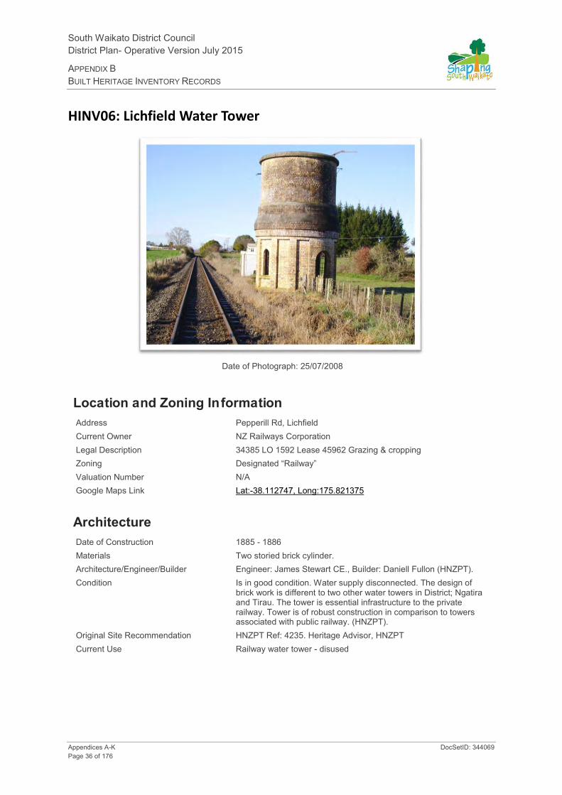
HINV06: Lichfield Water Tower
Date of Photograph: 25/07/2008
Location and Zoning Information Address Pepperill Rd, Lichfield Current Owner NZ Railways Corporation Legal Description 34385 LO 1592 Lease 45962 Grazing & cropping Zoning Designated “Railway” Valuation Number N/A Google Maps Link Lat:-38.112747, Long:175.821375
Architecture Date of Construction 1885 - 1886 Materials Two storied brick cylinder. Architecture/Engineer/Builder Engineer: James Stewart CE., Builder: Daniell Fullon (HNZPT). Condition Is in good condition. Water supply disconnected. The design of
brick work is different to two other water towers in District; Ngatira and Tirau. The tower is essential infrastructure to the private railway. Tower is of robust construction in comparison to towers associated with public railway. (HNZPT).
Original Site Recommendation HNZPT Ref: 4235. Heritage Advisor, HNZPT Current Use Railway water tower - disused

South Waikato District Council District Plan - Operative Version July 2015
APPENDIX B BUILT HERITAGE INVENTORY RECORDS
DocSetID: 344069 Appendices A-K Page 37 of 176
Statement of Significance
(1 Historical) - reflects important or representative aspects of South Waikato history, 1885-1886, transportation and rail history in South Waikato. Dates from periods of early settlement in South Waikato, (6 Educational) - has the potential to provide knowledge and educate public about history of South Waikato and New Zealand. Potential heritage trail/school programme use; transportation, railways in the South Waikato. (7 Archaeology, pre 1900) - the site is protected under the Heritage New Zealand Pouhere Taonga Act 2014, has the potential through archaeological investigation to provide information about NZ and the South Waikato history. (11 Context) - forms part of a wider historical and cultural complex. (12 Rarity) - it is a rare type of historic place, only a few 1880's railway water towers remain in NZ. (13 Integrity) - has a good level of integrity, structure is not compromised by additions.
District Plan Rules Demolition - Discretionary. Protection focus - 1, 6, 7, 10, 12 and 13. Mitigate the effects of demolition by requiring the applicant to provide Historical Building Documentation (HBD) which should include: the structure history, photographic documentation, and measurements of the item prior to removal.
Visual aspects to consider that relate to history, landscape/landmark value.
Alterations necessary for the primary purpose of improving structural performance, fire safety or physical access - Controlled. Other Additions/Alterations - Discretionary. Protection focus - 1, 6, 10, 12 and 13. Effects can be mitigated/remedied through; a) HBD - See mitigating the effects of demolition. b) Design Rules: 1.The overall visual character/shape of the original building should be identifiable. The addition should not dominate the existing building. 2. New work should be restricted to the rear of the building and not be evident from the road frontage. 3. The following special elements that are associated with the rarity or architectural uniqueness or craftsmanship of the structure should be retained: Those elements associated with the structures historic character, use, rarity, landmark values, craftsmanship and any other special elements identified in the HBD. c) Building materials rule: If repair of the buildings is proposed the materials used for the exterior walls and elements should be similar in type, dimensions and profile as the existing fabric of the building.
Repair of the Structure - Permitted. Refer to Rule 28.3.1. Protection focus - 1, 6, 10, 12 and 13. Building Materials Rule: If repair of the buildings is proposed the materials used for the exterior walls and elements should be similar in type, dimensions and profile as the existing exterior fabric of building. Design Rule: Repair or replication work should match the existing design and profile of element.
Re-use/Change of Use - Permitted. Refer to Rule 28.3.1. Protection focus - 1, 6, 12 and 13.
Internal Changes - Not applicable.
Relocation - Discretionary. Protection focus - 1, 12 and 13.
Disturbance of the site surface/earthworks - Note: Any place that was associated with human activity prior to 1900 and is able to provide evidence relating to the history of New Zealand is an 'archaeological site' (refer to definition of 'archaeological site' in Section 2 of the Heritage New Zealand Pouhere Taonga Act 2014). All archaeological sites are protected under the Heritage New Zealand Pouhere Taonga Act 2014 and approval from Heritage New Zealand must be obtained prior to destroying, damaging or modifying any site. Accordingly, where this site on which a building is located is an 'archaeological site' and the building is to be repaired, added to, relocated or demolished and this involves disturbance to the surface and/or subsurface of the site, approval from Heritage New Zealand is required.
History Originally constructed for the Thames Valley & Rotorua Railway Company to serve as a water storage tower. Water was pumped up from the Ngutuwera Creek using a large Hydraulic ram. The water supplied was sufficient for both the railway and the township. Water pipes to the creek have been removed. A stone shed that used to house the intake valves still stands today. Other associated buildings - three cottages for railway staff, and a large engine room - were relocated to Putāruru. The two storey brick towers of this private railway are a contrast to the iron tanks and trestles that serve for water towers in most of the government built lines. (HNZPT).
South Waikato District Council District Plan- Operative Version July 2015
APPENDIX B BUILT HERITAGE INVENTORY RECORDS
Appendices A-K DocSetID: 344069 Page 38 of 176
Additional Photographs
South Waikato District Council District Plan - Operative Version July 2015
APPENDIX B BUILT HERITAGE INVENTORY RECORDS
DocSetID: 344069 Appendices A-K Page 39 of 176
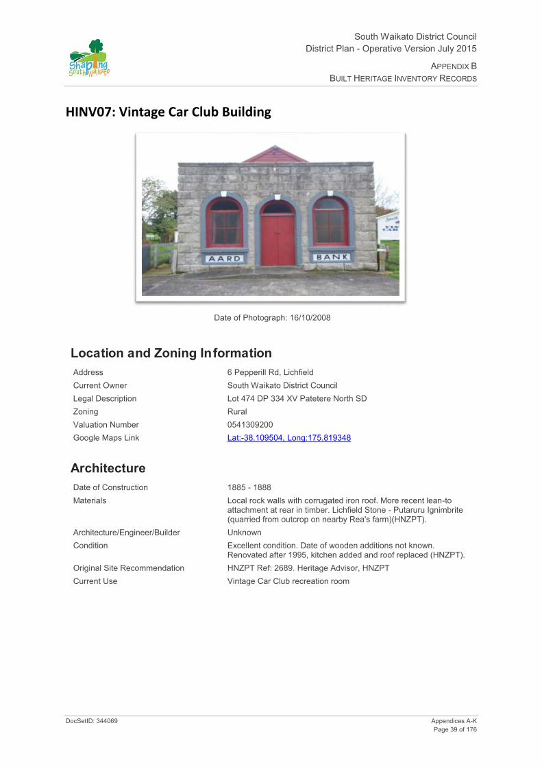
HINV07: Vintage Car Club Building
Date of Photograph: 16/10/2008
Location and Zoning Information Address 6 Pepperill Rd, Lichfield Current Owner South Waikato District Council Legal Description Lot 474 DP 334 XV Patetere North SD Zoning Rural Valuation Number 0541309200 Google Maps Link Lat:-38.109504, Long:175.819348
Architecture Date of Construction 1885 - 1888 Materials Local rock walls with corrugated iron roof. More recent lean-to
attachment at rear in timber. Lichfield Stone - Putaruru Ignimbrite (quarried from outcrop on nearby Rea's farm)(HNZPT).
Architecture/Engineer/Builder Unknown Condition Excellent condition. Date of wooden additions not known.
Renovated after 1995, kitchen added and roof replaced (HNZPT). Original Site Recommendation HNZPT Ref: 2689. Heritage Advisor, HNZPT Current Use Vintage Car Club recreation room

South Waikato District Council District Plan- Operative Version July 2015
APPENDIX B BUILT HERITAGE INVENTORY RECORDS
Appendices A-K DocSetID: 344069 Page 40 of 176
Statement of Significance
(1 Historical) - aspect of history, constructed in 1885 for Mr Heany; history of continued use for commercial and community functions, currently clubrooms. Dates from early periods of settlement in South Waikato. (3 Community Association) - has important community association and public esteem, store, church (Interdenominational Church Soc. Presbyterian, Methodist, Anglican), referred to as a bank but never used as a bank, local landmark. (6 Educational) - has potential to educate public about history of South Waikato, heritage trail/school programme, potential to educate the public about the history of South Waikato and early Lichfield. (7 Archaeology pre 1900) - site can be investigated using archaeological methods to obtain information concerning NZ and South Waikato history. (10 Architectural) - is an important example of construction using particular material, example of construction of a building from quarried volcanic Ignimbrite (quarried at Rea's farm). Exterior visual aspects: facade is a strong visual element, writing on facade had people believe the building was once a bank, openings (windows/doorway) fanlights etc. support the visual character of the facade. Visual aspects to consider that relate to history, community association, architecture and integrity - façade, construction materials landscape. (13 Integrity) - has a good level of integrity, the building has had few alterations and is in good condition.
District Plan Rules Demolition - Discretionary. Protection focus - 1,3, 6, 7 and 10. Mitigate the effects of demolition by requiring the applicant to provide Historical Building Documentation (HBD) which should include: the structure history, photographic documentation and measurements of the item prior to removal.
Alterations necessary for the primary purpose of improving structural performance, fire safety or physical access - Controlled. Other Additions/Alterations - Discretionary. Protection focus - 6, 10, 13 and stone. Effects can be mitigated/remedied through; a) HBD - See mitigating the effects of demolition. b) Design Rules: 1.The overall visual character/shape of the original building should be identifiable. The addition should not dominate the existing building. 2. New work should be restricted to the rear of the building and not be evident from the road frontage. 3. The following special elements that are associated with the rarity or architectural uniqueness or craftsmanship of the structure should be retained: Elements of the structure that should be retained are those elements associated with its historic use as a rare type of building, i.e. façade, exterior walls, openings, landscape and any other elements identified in the Historic Building Documentation. c) Building materials rule: If the repair of the buildings is proposed the materials used for the exterior walls should be similar in type, dimensions and profile as the existing exterior fabric of the building.
Repair of the Structure - Permitted. Refer to Rule 28.3.1. Protection focus - 3, 6, 10, 13 and stone. Discretionary - stone. Building Materials Rule: If repair of the buildings is proposed the materials used for the exterior walls and elements should be similar in type, dimensions and profile as the existing exterior fabric of the building. Design Rule: Repair and replication work should match the existing design and profile of element. The window and door surround frames should be retained and be repaired with the materials that match the existing fabric. The windows should be repaired or replicated to retain the historic four-light configuration. The words under the window "AARD" and "BANK" should be retained.
Re-use/Change of Use - Permitted. Refer to Rule 28.3.1. Protection focus - 1, 3, 6 and 13.
Internal Changes - Discretionary.
Relocation - Discretionary. Protection focus - 1, 13.
Disturbance of the site surface/earthworks - Protection focus - 7. Note: Any place that was associated with human activity prior to 1900 and is able to provide evidence relating to the history of New Zealand is an 'archaeological site' (refer to definition of 'archaeological site' in Section 2 of the Heritage New Zealand Pouhere Taonga Act 2014). All archaeological sites are protected under the Heritage New Zealand Pouhere Taonga Act 2014 and approval from Heritage New Zealand must be obtained prior to destroying, damaging or modifying any site. Accordingly, where this site on which a building is located is an 'archaeological site' and the building is to be repaired, added to, relocated or demolished and this involves disturbance to the surface and/or subsurface of the site, approval from Heritage New Zealand is required.
History The oldest building known constructed of local rock; known as Hinuera or Putāruru stone. The building is often cited as an example of the durability of the local rock because weathering is so slight that the tool marks of

South Waikato District Council District Plan - Operative Version July 2015
APPENDIX B BUILT HERITAGE INVENTORY RECORDS
DocSetID: 344069 Appendices A-K Page 41 of 176
workmen on the stone are still clearly visible. Is of historical interest because of its age and of particular interest to builders and architects. Building constructed behind a hotel on Penridge Street in 1885 from Lichfield stone for Mr Heaney by two stonemasons owing him a debt for their lodgings. The building was initially used as a billiard room then a general store and bank and then as a residence, until it was renovated and dedicated as a church in 1946. Words AARD BANK on front of structure however historical data notes structure has never been used as a bank - further research needed to establish origin and significance of these words. It is currently used as a clubrooms for the Tokoroa Vintage Car Club. Bush in area now cleared and replaced by farm land. Timber mills moved elsewhere. (HNZPT).
Additional Photographs

South Waikato District Council District Plan- Operative Version July 2015
APPENDIX B BUILT HERITAGE INVENTORY RECORDS
Appendices A-K DocSetID: 344069 Page 42 of 176
HINV08: Okoroire Hot Springs Golf Club Pavilion
Date of Photograph: 16/10/2008
Location and Zoning Information Address 18 Somerville Rd, Okoroire
(Located opposite main entrance to Okoroire Hot Springs Hotel) Current Owner Okoroire Hot Springs Hotel Ltd Legal Description Pt Lots 1 & 2 DP 14395, Pt Whaitikuranui 2E2 West 2B Blk XV
Tapapa SD Zoning Rural – Part of SAL4 (Okoroire Precinct) Valuation Number 0541107400 Google Maps Link Lat:-37.953347, Long:175.804432
Architecture Date of Construction 1912 - 1913
Materials Corrugated iron.
Architecture/Engineer/Builder Unknown
Condition Good
Original Site Recommendation HNZPT Ref: 4351. Heritage Advisor, HNZPT.
Current Use Recreational - Golf Club pavilion
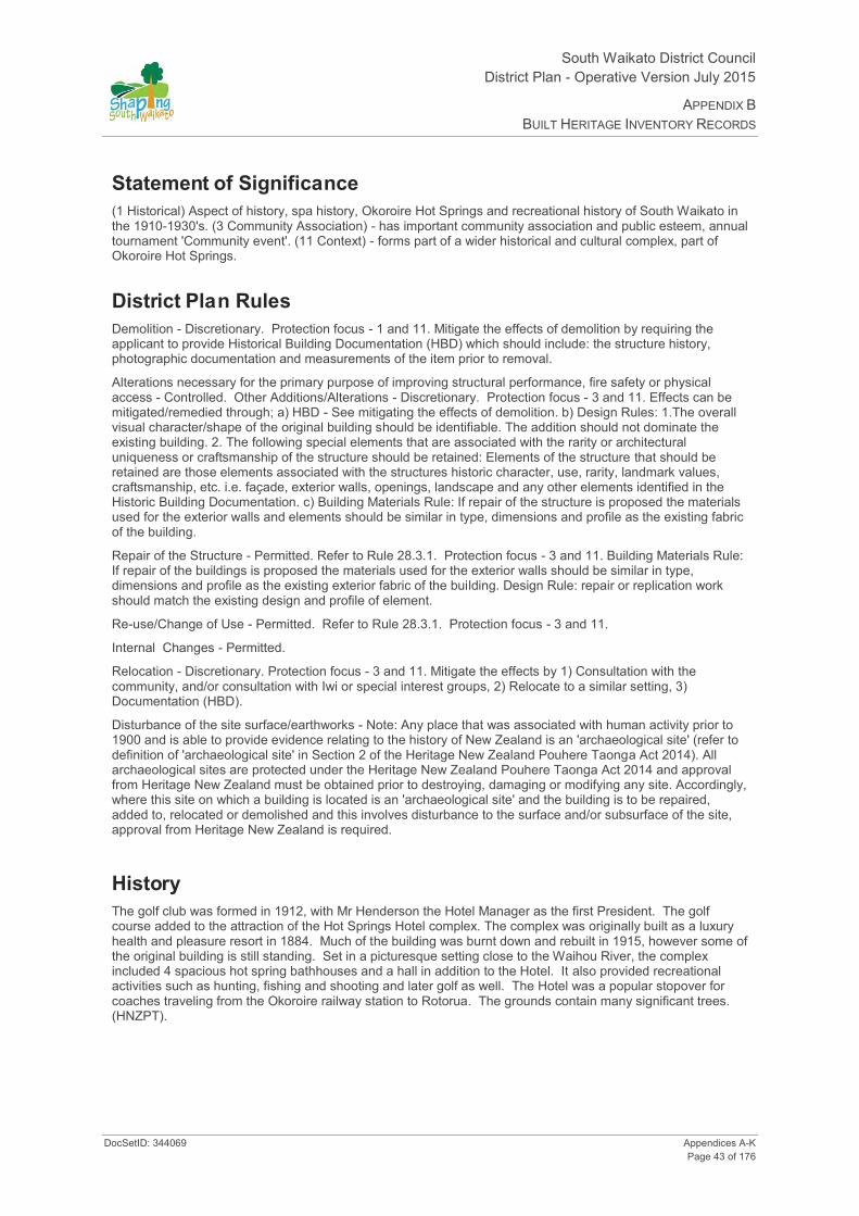
South Waikato District Council District Plan - Operative Version July 2015
APPENDIX B BUILT HERITAGE INVENTORY RECORDS
DocSetID: 344069 Appendices A-K Page 43 of 176
Statement of Significance
(1 Historical) Aspect of history, spa history, Okoroire Hot Springs and recreational history of South Waikato in the 1910-1930's. (3 Community Association) - has important community association and public esteem, annual tournament 'Community event'. (11 Context) - forms part of a wider historical and cultural complex, part of Okoroire Hot Springs.
District Plan Rules Demolition - Discretionary. Protection focus - 1 and 11. Mitigate the effects of demolition by requiring the applicant to provide Historical Building Documentation (HBD) which should include: the structure history, photographic documentation and measurements of the item prior to removal.
Alterations necessary for the primary purpose of improving structural performance, fire safety or physical access - Controlled. Other Additions/Alterations - Discretionary. Protection focus - 3 and 11. Effects can be mitigated/remedied through; a) HBD - See mitigating the effects of demolition. b) Design Rules: 1.The overall visual character/shape of the original building should be identifiable. The addition should not dominate the existing building. 2. The following special elements that are associated with the rarity or architectural uniqueness or craftsmanship of the structure should be retained: Elements of the structure that should be retained are those elements associated with the structures historic character, use, rarity, landmark values, craftsmanship, etc. i.e. façade, exterior walls, openings, landscape and any other elements identified in the Historic Building Documentation. c) Building Materials Rule: If repair of the structure is proposed the materials used for the exterior walls and elements should be similar in type, dimensions and profile as the existing fabric of the building.
Repair of the Structure - Permitted. Refer to Rule 28.3.1. Protection focus - 3 and 11. Building Materials Rule: If repair of the buildings is proposed the materials used for the exterior walls should be similar in type, dimensions and profile as the existing exterior fabric of the building. Design Rule: repair or replication work should match the existing design and profile of element.
Re-use/Change of Use - Permitted. Refer to Rule 28.3.1. Protection focus - 3 and 11.
Internal Changes - Permitted.
Relocation - Discretionary. Protection focus - 3 and 11. Mitigate the effects by 1) Consultation with the community, and/or consultation with Iwi or special interest groups, 2) Relocate to a similar setting, 3) Documentation (HBD).
Disturbance of the site surface/earthworks - Note: Any place that was associated with human activity prior to 1900 and is able to provide evidence relating to the history of New Zealand is an 'archaeological site' (refer to definition of 'archaeological site' in Section 2 of the Heritage New Zealand Pouhere Taonga Act 2014). All archaeological sites are protected under the Heritage New Zealand Pouhere Taonga Act 2014 and approval from Heritage New Zealand must be obtained prior to destroying, damaging or modifying any site. Accordingly, where this site on which a building is located is an 'archaeological site' and the building is to be repaired, added to, relocated or demolished and this involves disturbance to the surface and/or subsurface of the site, approval from Heritage New Zealand is required.
History The golf club was formed in 1912, with Mr Henderson the Hotel Manager as the first President. The golf course added to the attraction of the Hot Springs Hotel complex. The complex was originally built as a luxury health and pleasure resort in 1884. Much of the building was burnt down and rebuilt in 1915, however some of the original building is still standing. Set in a picturesque setting close to the Waihou River, the complex included 4 spacious hot spring bathhouses and a hall in addition to the Hotel. It also provided recreational activities such as hunting, fishing and shooting and later golf as well. The Hotel was a popular stopover for coaches traveling from the Okoroire railway station to Rotorua. The grounds contain many significant trees. (HNZPT).

South Waikato District Council District Plan- Operative Version July 2015
APPENDIX B BUILT HERITAGE INVENTORY RECORDS
Appendices A-K DocSetID: 344069 Page 44 of 176
Additional Photographs

South Waikato District Council District Plan - Operative Version July 2015
APPENDIX B BUILT HERITAGE INVENTORY RECORDS
DocSetID: 344069 Appendices A-K Page 45 of 176
HINV09: Main Estate Woolshed
Date of Photograph: 23/10/2008
Location and Zoning Information Address Okoroire Rd, Tirau
(Located in paddock behind house) Current Owner J Gibson & A Candy Legal Description Part Lot 22 DP 3612 Pt DP 3606 Blk XIV Tapapa SD Blk II
Patetere SD Zoning Rural Valuation Number 0541010200 Google Maps Link
Architecture Date of Construction 1881 - 1882 Materials Weatherboard with corrugated iron roofs. Architecture/Engineer/Builder Unknown Condition Poor condition. Lean-to removed. HNZPT Original Site Recommendation HNZPT Ref: 4231. Heritage Advisor, HNZPT. Current Use Farm sheds
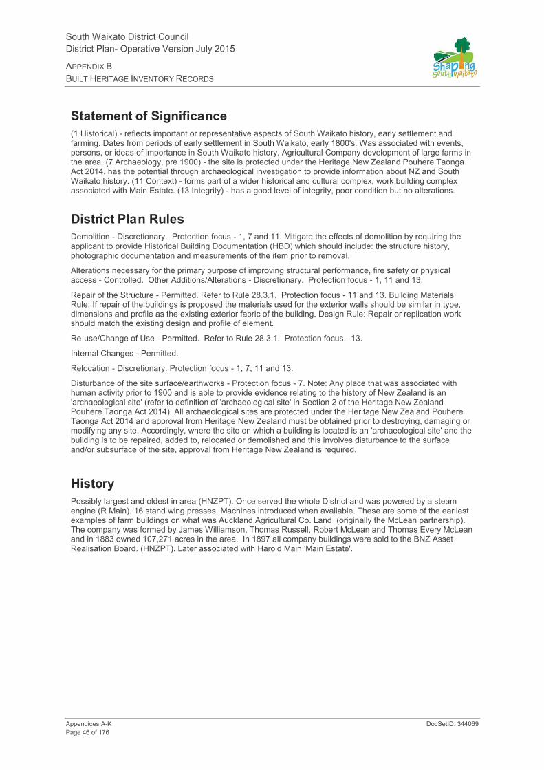
South Waikato District Council District Plan- Operative Version July 2015
APPENDIX B BUILT HERITAGE INVENTORY RECORDS
Appendices A-K DocSetID: 344069 Page 46 of 176
Statement of Significance
(1 Historical) - reflects important or representative aspects of South Waikato history, early settlement and farming. Dates from periods of early settlement in South Waikato, early 1800's. Was associated with events, persons, or ideas of importance in South Waikato history, Agricultural Company development of large farms in the area. (7 Archaeology, pre 1900) - the site is protected under the Heritage New Zealand Pouhere Taonga Act 2014, has the potential through archaeological investigation to provide information about NZ and South Waikato history. (11 Context) - forms part of a wider historical and cultural complex, work building complex associated with Main Estate. (13 Integrity) - has a good level of integrity, poor condition but no alterations.
District Plan Rules Demolition - Discretionary. Protection focus - 1, 7 and 11. Mitigate the effects of demolition by requiring the applicant to provide Historical Building Documentation (HBD) which should include: the structure history, photographic documentation and measurements of the item prior to removal.
Alterations necessary for the primary purpose of improving structural performance, fire safety or physical access - Controlled. Other Additions/Alterations - Discretionary. Protection focus - 1, 11 and 13.
Repair of the Structure - Permitted. Refer to Rule 28.3.1. Protection focus - 11 and 13. Building Materials Rule: If repair of the buildings is proposed the materials used for the exterior walls should be similar in type, dimensions and profile as the existing exterior fabric of the building. Design Rule: Repair or replication work should match the existing design and profile of element.
Re-use/Change of Use - Permitted. Refer to Rule 28.3.1. Protection focus - 13.
Internal Changes - Permitted.
Relocation - Discretionary. Protection focus - 1, 7, 11 and 13.
Disturbance of the site surface/earthworks - Protection focus - 7. Note: Any place that was associated with human activity prior to 1900 and is able to provide evidence relating to the history of New Zealand is an 'archaeological site' (refer to definition of 'archaeological site' in Section 2 of the Heritage New Zealand Pouhere Taonga Act 2014). All archaeological sites are protected under the Heritage New Zealand Pouhere Taonga Act 2014 and approval from Heritage New Zealand must be obtained prior to destroying, damaging or modifying any site. Accordingly, where the site on which a building is located is an 'archaeological site' and the building is to be repaired, added to, relocated or demolished and this involves disturbance to the surface and/or subsurface of the site, approval from Heritage New Zealand is required.
History Possibly largest and oldest in area (HNZPT). Once served the whole District and was powered by a steam engine (R Main). 16 stand wing presses. Machines introduced when available. These are some of the earliest examples of farm buildings on what was Auckland Agricultural Co. Land (originally the McLean partnership). The company was formed by James Williamson, Thomas Russell, Robert McLean and Thomas Every McLean and in 1883 owned 107,271 acres in the area. In 1897 all company buildings were sold to the BNZ Asset Realisation Board. (HNZPT). Later associated with Harold Main 'Main Estate'.
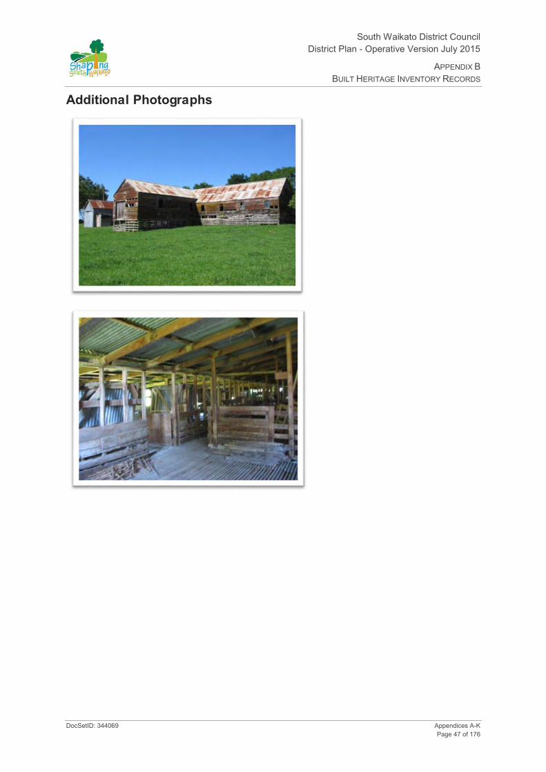
South Waikato District Council District Plan - Operative Version July 2015
APPENDIX B BUILT HERITAGE INVENTORY RECORDS
DocSetID: 344069 Appendices A-K Page 47 of 176
Additional Photographs

South Waikato District Council District Plan- Operative Version July 2015
APPENDIX B BUILT HERITAGE INVENTORY RECORDS
Appendices A-K DocSetID: 344069 Page 48 of 176
HINV10: Main Estate Stables
Date of Photograph: 23/10/2008
Location and Zoning Information Address Okoroire Rd, Tirau
(Located in paddock behind house) Current Owner J Gibson & A Candy Legal Description Part Lot 22 DP 3612 Pt DP 3606 Blk XIV Tapapa SD Blk II
Patetere SD Zoning Rural Valuation Number 541010200 Google Maps Link
Architecture Date of Construction 1881 - 1882 Materials Weatherboard with corrugated iron roofs. Architecture/Engineer/Builder Unknown Condition Poor condition. (HNZPT). Original Site Recommendation HNZPT Ref: 4232. Heritage Advisor, HNZPT. Current Use Farm sheds

South Waikato District Council District Plan - Operative Version July 2015
APPENDIX B BUILT HERITAGE INVENTORY RECORDS
DocSetID: 344069 Appendices A-K Page 49 of 176
Statement of Significance
(1 Historical) - reflects important or representative aspects of South Waikato history, early settlement and farming. Dates from periods of early settlement in South Waikato, early 1800's. Was associated with events, persons, or ideas of importance in south Waikato history, Agricultural Company development of large farms in the area. (7 Archaeology, pre 1900) - the site is protected under the Heritage New Zealand Pouhere Taonga Act 2014, has the potential through archaeological investigation to provide information about NZ and South Waikato history. (11 Context) - forms part of a wider historical and cultural complex, work building complex associated with Main Estate. (13 Integrity) - has a good level of integrity, poor condition but no alterations.
District Plan Rules Demolition - Discretionary. Protection focus - 1 and 11. Mitigate the effects of demolition by requiring the applicant to provide Historical Building Documentation (HBD) which should include: the structure history, photographic documentation and measurements of the item prior to removal.
Alterations necessary for the primary purpose of improving structural performance, fire safety or physical access - Controlled. Other Additions/Alterations - Discretionary. Protection focus - 1, 11 and 13.
Repair of the Structure - Permitted. Refer to Rule 28.3.1. Protection focus - 11 and 13. Building Materials Rule: If repair of the buildings is proposed the materials used for the exterior walls should be similar in type, dimensions and profile as the existing exterior fabric of the building. Design Rule: Repair or replication work should match the existing design and profile of element.
Re-use/Change of Use - Permitted. Refer to Rule 28.3.1. Protection focus - 13.
Internal Changes - Permitted.
Relocation - Discretionary. Protection focus - 1, 7, 11 and 13.
Disturbance of the site surface/earthworks - Protection focus - 7. Note: Any place that was associated with human activity prior to 1900 and is able to provide evidence relating to the history of New Zealand is an 'archaeological site' (refer to definition of 'archaeological site' in Section 2 of the Heritage New Zealand Pouhere Taonga Act 2014). All archaeological sites are protected under the Heritage New Zealand Pouhere Taonga Act 2014 and approval from Heritage New Zealand must be obtained prior to destroying, damaging or modifying any site. Accordingly, where this site on which a building is located is an 'archaeological site' and the building is to be repaired, added to, relocated or demolished and this involves disturbance to the surface and/or subsurface of the site, approval from Heritage New Zealand is required.
History Possibly largest and oldest in area. These are some of the earliest examples of farm buildings on what was Auckland Agricultural Co. Land (originally the McLean partnership). The company was formed by James Williamson, Thomas Russell, Robert McLean and Thomas Every McLean and in 1883 owned 107,271 acres in the area. In 1897 all company buildings were sold to the BNZ Asset Realisation Board. (HNZPT). The present wooden floor has been lowered and once formed a loft where chaff was fed down shoots into each separate pen for a horse. Part of the loft floor remains in place. When the floor was lowered it was used for storing and mixing manure which came in bags. (R Main).

South Waikato District Council District Plan- Operative Version July 2015
APPENDIX B BUILT HERITAGE INVENTORY RECORDS
Appendices A-K DocSetID: 344069 Page 50 of 176
Additional Photographs

South Waikato District Council District Plan - Operative Version July 2015
APPENDIX B BUILT HERITAGE INVENTORY RECORDS
DocSetID: 344069 Appendices A-K Page 51 of 176
HINV11: Stone Kitchen
Date of Photograph: 25/08/2008
Location and Zoning Information Address 69 Horahora Rd, Piarere
(Located at bottom of Karapiro rock range surrounded by established trees in deer paddock)
Current Owner B & J Watkins Legal Description Pt Lot 22 DP 3076, Pt Lot 1 DP 12694 Blk XVI Zoning Rural Valuation Number 541005400 Google Maps Link
Architecture Date of Construction 1880s Materials Karapiro Stone. Rare example. Stone is very young
compared to Hinuera Stone. HNZPT. Quarried on site. Original windows present. A number of additional sheds (currently used for farm machinery storage) attached to stone kitchen.
Architecture/Engineer/Builder Unknown Condition Poor Original Site Recommendation HNZPT Ref: 4229. Heritage Advisor, HNZPT. Current Use Redundant farm machinery storage shed.

South Waikato District Council District Plan- Operative Version July 2015
APPENDIX B BUILT HERITAGE INVENTORY RECORDS
Appendices A-K DocSetID: 344069 Page 52 of 176
Statement of Significance
(1 Historical) - reflects important or representative aspects of South Waikato history, represents Agricultural Company development of the South Waikato. Land conflict Agricultural Company military camp, transportation point on road to Tirau, Dates from periods of early settlement in South Waikato, early history ca 1880. (7 Archaeological pre 1900) - site can be investigated using archaeological methods to obtain information concerning NZ and South Waikato history. (10 Architecture) - is an important example of construction using particular material, Karapiro sandstone. (12 Rarity) - is a rare type of historic place, kitchen and blockhouse.
District Plan Rules Demolition - Discretionary. Protection focus - 1, 7, 10 and 12. Mitigate the effects of demolition by requiring the applicant to provide Historical Building Documentation (HBD) which should include: the structure history, photographic documentation and measurements of the item prior to removal.
Alterations necessary for the primary purpose of improving structural performance, fire safety or physical access - Controlled. Other Additions/Alterations - Discretionary. Protection focus - 10 and 12. Effects can be mitigated/remedied through; a) HBD - See mitigating the effects of demolition. b) Design Rules: 1.The overall visual character/shape of the original building should be identifiable. The addition should not dominate the existing building. 2. The following special elements that are associated with the rarity or architectural uniqueness or craftsmanship of the structure should be retained: Elements of the structure that should be retained are those elements associated with its historic use as a rare type of building, i.e. exterior walls, openings, kitchen chimney, and any other elements identified in the Historic Building Documentation. c) Building Materials Rule: The new work (addition) does not need to be constructed in Karapiro stone.
Repair of the Structure - Permitted. Refer to Rule 28.3.1. Protection focus - 10, 13 and stone. Stone - Discretionary. Building Materials Rule: If repair of the building is proposed the materials used for the exterior walls should be similar in type, dimensions and profile as the existing exterior fabric of the building. Design Rule: Repair or replication work should match the existing design and profile of element.
Re-use/Change of Use - Permitted. Refer to Rule 28.3.1. Protection focus - 1.
Internal Changes - Permitted.
Relocation - Discretionary. Protection focus - 1, 7 and 10.
Disturbance of the site surface/earthworks - Protection focus - 7. Note: Any place that was associated with human activity prior to 1900 and is able to provide evidence relating to the history of New Zealand is an 'archaeological site' (refer to definition of 'archaeological site' in Section 2 of the Heritage New Zealand Pouhere Taonga Act 2014). All archaeological sites are protected under the Heritage New Zealand Pouhere Taonga Act 2014 and approval from Heritage New Zealand must be obtained prior to destroying, damaging or modifying any site. Accordingly, where this site on which a building is located is an 'archaeological site' and the building is to be repaired, added to, relocated or demolished and this involves disturbance to the surface and/or subsurface of the site, approval from Heritage New Zealand is required.
History Probably used for first coach passengers to Tirau. Associated with Auckland Agricultural Company and Paeroa Station. Stone skillfully worked from nearby site (apart from weathered chimney). The structure was originally attached to a homestead and was also designed to be used as a blockhouse if needed. Adjacent house burnt in 1920's and replacement joined to kitchen which was then lined. The Armed Constabulary camped at the site for a period of time during the land wars. HNZPT.

South Waikato District Council District Plan - Operative Version July 2015
APPENDIX B BUILT HERITAGE INVENTORY RECORDS
DocSetID: 344069 Appendices A-K Page 53 of 176
Additional Photographs

South Waikato District Council District Plan- Operative Version July 2015
APPENDIX B BUILT HERITAGE INVENTORY RECORDS
Appendices A-K DocSetID: 344069 Page 54 of 176
HINV12: Stone House and Stone Outbuildings
Date of Photograph: 07/08/2008
Location and Zoning Information Address 56 Arapuni St, Putāruru Current Owner S Thom & B Baldwin Legal Description Pt Sec 15 Blk X Patetere Nth SD Zoning Putāruru Residential Valuation Number 0541715500 Google Maps Link Lat:-38.055175, Long:175.77574
Architecture Date of Construction 1930s Materials Ngutuwera Stone from Guillard's Quarry Lichfield. Two storey house. Floor
plan similar on both levels. Garages and outbuildings of stone also. (HNZPT).
Architecture/Engineer/Builder Unknown
Condition Good
Original Site Recommendation HNZPT Ref: 4279. Heritage Advisor, HNZPT.
Current Use Private residence
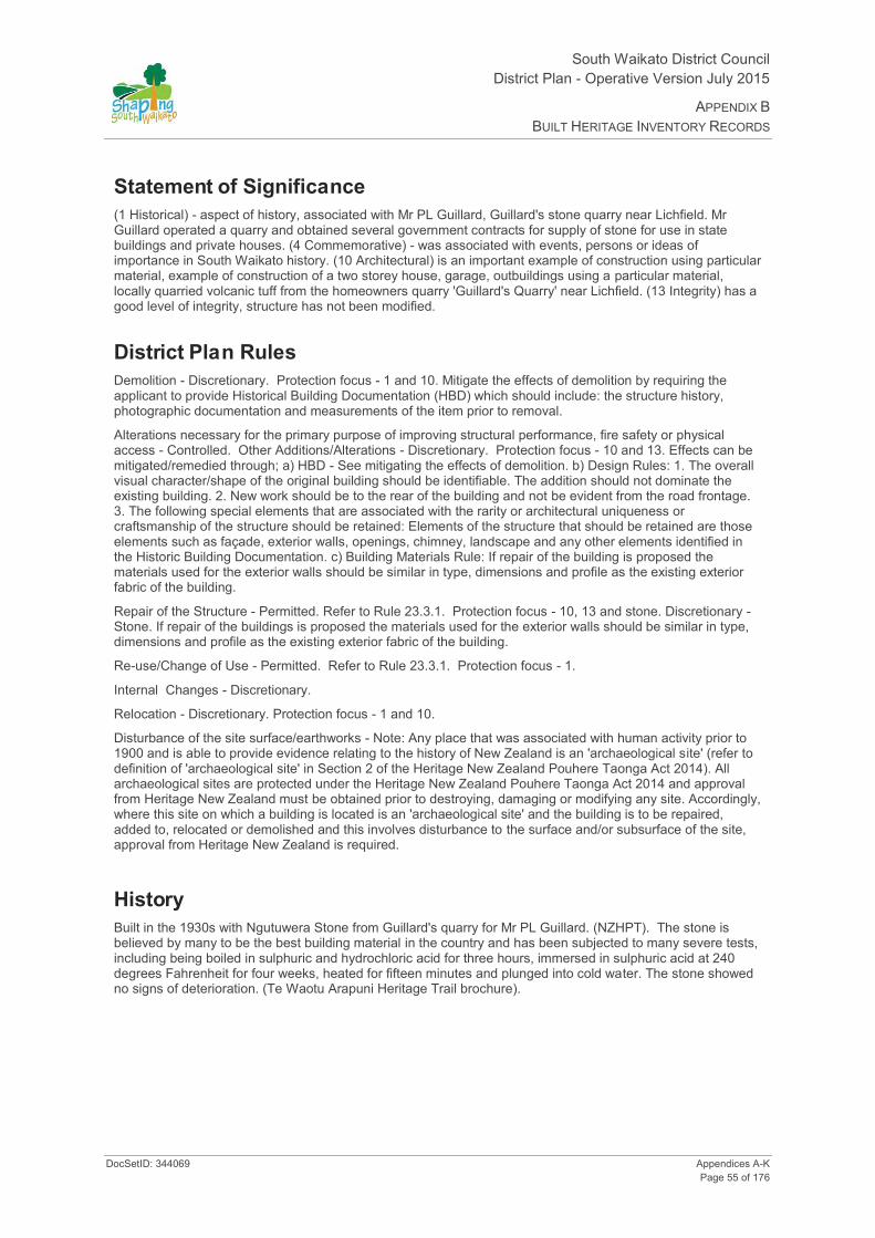
South Waikato District Council District Plan - Operative Version July 2015
APPENDIX B BUILT HERITAGE INVENTORY RECORDS
DocSetID: 344069 Appendices A-K Page 55 of 176
Statement of Significance
(1 Historical) - aspect of history, associated with Mr PL Guillard, Guillard's stone quarry near Lichfield. Mr Guillard operated a quarry and obtained several government contracts for supply of stone for use in state buildings and private houses. (4 Commemorative) - was associated with events, persons or ideas of importance in South Waikato history. (10 Architectural) is an important example of construction using particular material, example of construction of a two storey house, garage, outbuildings using a particular material, locally quarried volcanic tuff from the homeowners quarry 'Guillard's Quarry' near Lichfield. (13 Integrity) has a good level of integrity, structure has not been modified.
District Plan Rules Demolition - Discretionary. Protection focus - 1 and 10. Mitigate the effects of demolition by requiring the applicant to provide Historical Building Documentation (HBD) which should include: the structure history, photographic documentation and measurements of the item prior to removal.
Alterations necessary for the primary purpose of improving structural performance, fire safety or physical access - Controlled. Other Additions/Alterations - Discretionary. Protection focus - 10 and 13. Effects can be mitigated/remedied through; a) HBD - See mitigating the effects of demolition. b) Design Rules: 1. The overall visual character/shape of the original building should be identifiable. The addition should not dominate the existing building. 2. New work should be to the rear of the building and not be evident from the road frontage. 3. The following special elements that are associated with the rarity or architectural uniqueness or craftsmanship of the structure should be retained: Elements of the structure that should be retained are those elements such as façade, exterior walls, openings, chimney, landscape and any other elements identified in the Historic Building Documentation. c) Building Materials Rule: If repair of the building is proposed the materials used for the exterior walls should be similar in type, dimensions and profile as the existing exterior fabric of the building.
Repair of the Structure - Permitted. Refer to Rule 23.3.1. Protection focus - 10, 13 and stone. Discretionary - Stone. If repair of the buildings is proposed the materials used for the exterior walls should be similar in type, dimensions and profile as the existing exterior fabric of the building.
Re-use/Change of Use - Permitted. Refer to Rule 23.3.1. Protection focus - 1.
Internal Changes - Discretionary.
Relocation - Discretionary. Protection focus - 1 and 10.
Disturbance of the site surface/earthworks - Note: Any place that was associated with human activity prior to 1900 and is able to provide evidence relating to the history of New Zealand is an 'archaeological site' (refer to definition of 'archaeological site' in Section 2 of the Heritage New Zealand Pouhere Taonga Act 2014). All archaeological sites are protected under the Heritage New Zealand Pouhere Taonga Act 2014 and approval from Heritage New Zealand must be obtained prior to destroying, damaging or modifying any site. Accordingly, where this site on which a building is located is an 'archaeological site' and the building is to be repaired, added to, relocated or demolished and this involves disturbance to the surface and/or subsurface of the site, approval from Heritage New Zealand is required.
History Built in the 1930s with Ngutuwera Stone from Guillard's quarry for Mr PL Guillard. (NZHPT). The stone is believed by many to be the best building material in the country and has been subjected to many severe tests, including being boiled in sulphuric and hydrochloric acid for three hours, immersed in sulphuric acid at 240 degrees Fahrenheit for four weeks, heated for fifteen minutes and plunged into cold water. The stone showed no signs of deterioration. (Te Waotu Arapuni Heritage Trail brochure).

South Waikato District Council District Plan- Operative Version July 2015
APPENDIX B BUILT HERITAGE INVENTORY RECORDS
Appendices A-K DocSetID: 344069 Page 56 of 176
Additional Photographs

South Waikato District Council District Plan - Operative Version July 2015
APPENDIX B BUILT HERITAGE INVENTORY RECORDS
DocSetID: 344069 Appendices A-K Page 57 of 176
HINV13: Stone House and Stone Garage
Date of Photograph: 07/08/2008
Location and Zoning Information Address 74 Kensington St, Putāruru Current Owner Vanessa Van Zyl Legal Description Lot 2 DP 25989 Zoning Putāruru Residential Valuation Number 0541757600 Google Maps Link Lat:-38.04826, Long:175.777653
Architecture Date of Construction Late 1930s Materials Stone from Guillard's Quarry Lichfield. Garage of stone also.
House features curved window frames. Architecture/Engineer/Builder Unknown Condition Good Original Site Recommendation HNZPT Ref: 4278. Heritage Advisor, HNZPT. Current Use Private residence
South Waikato District Council District Plan- Operative Version July 2015
APPENDIX B BUILT HERITAGE INVENTORY RECORDS
Appendices A-K DocSetID: 344069 Page 58 of 176
Statement of Significance
(1 Historical) - was associated with events, persons, or ideas of importance in South Waikato history. (10 Architecture) - is an important example of house and garage construction using a particular material, locally quarried volcanic tuff from the homeowners quarry, 'Guillard's Quarry' near Lichfield. Use of curved window frames. (13 Integrity) - has a good level of integrity, structure has not been modified.
District Plan Rules Demolition - Discretionary. Protection focus - 1, 10. Mitigate the effects of demolition by requiring the applicant to provide Historical Building Documentation (HBD) which should include: the structure history, photographic documentation and measurements of the item prior to removal.
Alterations necessary for the primary purpose of improving structural performance, fire safety or physical access - Controlled. Other Additions/Alterations - Discretionary. Protection focus - 10. Effects can be mitigated/remedied through; a) HBD - See mitigating the effects of demolition. b) Design Rules: 1. The overall visual character/shape of the original building should be identifiable. The addition should not dominate the existing building. 2. New work should be restricted to the rear of the building and not be evident from the road frontage. 3. Special elements that are associated with the rarity or architectural uniqueness or craftsmanship of the structure should be retained: Elements of the structure that should be retained are those elements associated with its historic use as a rare type of building, i.e.: façade, exterior walls, curved window frames, openings, chimney, landscape and any other special elements identified in the HBD. c) Building Materials Rule: 1. If repair of the building is proposed, the materials used for the exterior walls should be similar in type, dimensions, and profile as the existing exterior fabric of the building. 2. The profile of the existing curved window frames should not be altered. Repairs should be carried out using material that match existing fabric of building.
Repair of the Structure - Permitted. Refer to Rule 23.3.1. Protection focus - 10 and stone. Discretionary - stone Buildings Materials Rule: If repair of the buildings is proposed the materials used for the exterior walls should be similar in type, dimensions and profile as the existing exterior fabric of the building. Design Rule: Repair or replication work should match the existing design and profile of element. Note: the curved window frames.
Re-use/Change of Use - Permitted. Refer to Rule 23.3.1. Protection focus - 1.
Internal Changes - Discretionary.
Relocation - Discretionary. Protection focus - 1 and 10.
Disturbance of the site surface/earthworks - Note: Any place that was associated with human activity prior to 1900 and is able to provide evidence relating to the history of New Zealand is an 'archaeological site' (refer to definition of 'archaeological site' in Section 2 of the Heritage New Zealand Pouhere Taonga Act 2014). All archaeological sites are protected under the Heritage New Zealand Pouhere Taonga Act 2014 and approval from Heritage New Zealand must be obtained prior to destroying, damaging or modifying any site. Accordingly, where this site on which a building is located is an 'archaeological site' and the building is to be repaired, added to, relocated or demolished and this involves disturbance to the surface and/or subsurface of the site, approval from Heritage New Zealand is required.
Surrounds - Protection extends to cover silver beech (nothofagus menziesii) and strawberry tree (arutus unedo) (original plantings) - Discretionary consent required for tree removal. (Normal gardening, pruning and maintenance of tree health is permitted).
History Built in the late 1930's for Mr Guillard with Ngutuwera Stone from the Guillard's quarry. Associated with Mr PL Guillard who owned a stone quarry near Lichfield and operated a quarry and obtained several Government contracts for supply of stone for use in state buildings and private houses. (HNZPT)

South Waikato District Council District Plan - Operative Version July 2015
APPENDIX B BUILT HERITAGE INVENTORY RECORDS
DocSetID: 344069 Appendices A-K Page 59 of 176
Additional Photographs

South Waikato District Council District Plan- Operative Version July 2015
APPENDIX B BUILT HERITAGE INVENTORY RECORDS
Appendices A-K DocSetID: 344069 Page 60 of 176
HINV14: District Council Office and Library
(Former School)
Date of Photograph: 24/04/2008
Location and Zoning Information Address Overdale St, Putāruru Current Owner South Waikato District Council Legal Description Pt Sec 14 Blk X Patetere Nth SD Zoning Designated “Office and Library” Valuation Number 0541728100 Google Maps Link Lat:-38.051016, Long:175.777827
Architecture Date of Construction 1906 Materials Timber and corrugated roof iron. Double hung joinery.
Architecture/Engineer/Builder Architect & Engineer: Unknown. Builder: Thomas Henry Sloane and William Ernest Bennett from Rotorua.
Condition Excellent (HNZPT).
Original Site Recommendation HNZPT Ref: 4280. Heritage Advisor, HNZPT.
Current Use District Council and Library Offices
South Waikato District Council District Plan - Operative Version July 2015
APPENDIX B BUILT HERITAGE INVENTORY RECORDS
DocSetID: 344069 Appendices A-K Page 61 of 176
Statement of Significance
(1 Historical) - dates from periods of early settlement in South Waikato, early settlement 1906, oldest public building in Putāruru. (3 Community Association) - has important community association and public esteem, oldest public building in Putāruru, history of municipal use. (6 Educational) - has the potential to educate the public about the history of South Waikato. (13 Integrity) - good level of integrity.
District Plan Rules Demolition - Discretionary. Protection focus - 1, 3 and 6. Mitigate the effects of demolition by requiring the applicant to provide Historical Building Documentation (HBD) which should include: the structure history, photographic documentation and measurements of the item prior to removal.
Alterations necessary for the primary purpose of improving structural performance, fire safety or physical access - Controlled. Other Additions/Alterations - Discretionary. Protection focus - 1 and 3. Effects can be mitigated/remedied through; a) HBD - See mitigating the effects of demolition. b) Design Rules: 1.The overall visual character/shape of the original building should be identifiable. The addition should not dominate the existing building. 2.New work should be restricted to the rear of the building and not be evident from the road frontage. 3. The following special elements that are associated with the rarity or architectural uniqueness or craftsmanship of the structure should be retained: Elements of the structure that should be retained are those elements associated with its historic use as a rare type of building, i.e. façade, exterior walls, openings, landscape (protection of surrounds and street frontage) and any other elements identified in the Historic Building Documentation. c) Building materials rule: If repair of the structure is proposed the materials used for the exterior walls and elements should be similar in type, dimensions and profile as the existing exterior fabric of the building.
Repair of the Structure - Permitted. Refer to Rule 22.3.1. Protection focus - 1.
Re-use/Change of Use - Permitted. Refer to Rule 22.3.1. Protection focus - 1 and 3.
Internal Changes - Discretionary.
Relocation - Discretionary. Protection focus - 1 and 3.
Disturbance of the site surface/earthworks - Note: Any place that was associated with human activity prior to 1900 and is able to provide evidence relating to the history of New Zealand is an 'archaeological site' (refer to definition of 'archaeological site' in Section 2 of the Heritage New Zealand Pouhere Taonga Act 2014). All archaeological sites are protected under the Heritage New Zealand Pouhere Taonga Act 2014 and approval from Heritage New Zealand must be obtained prior to destroying, damaging or modifying any site. Accordingly, where this site on which a building is located is an 'archaeological site' and the building is to be repaired, added to, relocated or demolished and this involves disturbance to the surface and/or subsurface of the site, approval from Heritage New Zealand is required.
Surrounds - Protection extends to cover trees between building and Overdale Road (Common ash (fraxinus excelsior), magnolia grandiflora, rimu (dacrydium cupressinum), common beech (fagus sylvatica), english oak (quercus robur), silver birch (betulas pendula), totara (podocarpus totara), and pahautea (libocedrus bidwillii)). Discretionary consent required for tree removal. (normal pruning and maintenance of tree health is permitted)
History Built shortly after the establishment of Putāruru in 1906 this is one of the oldest public buildings in Putāruru. The building was originally constructed as a school. Classrooms added 1910, 1922, 1926, 1928, 1930, 1935. Three eastern classrooms destroyed by fire in 1945. Additions at rear of building. (HNZPT).

South Waikato District Council District Plan- Operative Version July 2015
APPENDIX B BUILT HERITAGE INVENTORY RECORDS
Appendices A-K DocSetID: 344069 Page 62 of 176
Additional Photographs

South Waikato District Council District Plan - Operative Version July 2015
APPENDIX B BUILT HERITAGE INVENTORY RECORDS
DocSetID: 344069 Appendices A-K Page 63 of 176
HINV15: Stone House
Date of Photograph: 07/08/2008
Location and Zoning Information Address 83 Tirau St, Putāruru Current Owner S Thomas Legal Description Lot 3 DPS 535 Zoning Putāruru Business Valuation Number 0541835000 Google Maps Link Lat:-38.047233, Long:175.781136
Architecture Date of Construction Started May 1939 and occupied March 1940. Materials Stone (volcanic tuff) block with tile roof. Architecture/Engineer/Builder Architect: Government department architect. Builders: Harper,
Rayson and O'Toole. Bricklayer: W Bush of Matamata Condition Good. Fully fenced. Stone has been painted over. (HNZPT). Original Site Recommendation HNZPT Ref: 4274. Heritage Advisor, HNZPT. Current Use Private residence
South Waikato District Council District Plan- Operative Version July 2015
APPENDIX B BUILT HERITAGE INVENTORY RECORDS
Appendices A-K DocSetID: 344069 Page 64 of 176
Statement of Significance
(1 Historical) - reflects important or representative aspects of South Waikato history, Labour government social programme; associated with Labour Government housing scheme 1935-1950. (4 Commemorative) - Event person or idea; local builders Harper, Rayson and O'Toole, bricklayer W Bush. (10 Architectural) - is an important example of construction using particular material, example of construction of this type of house using a particular material, locally quarried volcanic tuff. Design not altered. Special elements - tile roof and volcanic tuff. (11 Context) - forms part of a wider historical and cultural complex, one of three state houses (83, 85, 87 Tirau St) forming a streetscape complex. (12 Rarity) - unique to the area. (13 Integrity) - has a good level of integrity of construction materials, not altered except painting of stone.
District Plan Rules Demolition - Discretionary. Protection focus - 1, 3, 10, 11 and 12. Mitigate the effects of demolition by requiring the applicant to provide Historical Building Documentation (HBD) which should include: the structure history, photographic documentation and measurements of the item prior to removal.
Alterations necessary for the primary purpose of improving structural performance, fire safety or physical access - Controlled. Other Additions/Alterations - Discretionary. Protection focus - 10, 11, 12 and 13. Effects can be mitigated/remedied through; a) HBD - See mitigating the effects of demolition. b) Design rules: 1.The overall visual character/shape of the original building should be identifiable. The addition should not dominate the existing building. 2.New work should be restricted to the rear of the building and not be evident from the road frontage. 3. Special elements that are associated with the rarity or architectural uniqueness or craftsmanship of the structure should be retained. c) Building Materials Rule: If repair of the buildings is proposed the materials used for the exterior walls should be similar in type, dimensions and profile as the existing exterior fabric of the building.
Repair of the Structure - Discretionary - stone (volcanic tuff) and tiles. Permitted - all other materials. Refer to Rule 22.3.1. Protection focus - 10. Building Materials Rule: If repair of the buildings is proposed the materials used for the exterior walls should be similar in type, dimensions and profile as the existing exterior fabric of the building. Note: Replacement of the roof should be with tile roofing. Design Rule: Repair or replication work should match the existing design and profile of element.
Re-use/Change of Use - Permitted. Refer to Rule 22.3.1. Protection focus - 1.
Internal Changes - Permitted.
Relocation - Discretionary. Protection focus - 1, 11 and 12.
Disturbance of the site surface/earthworks - Note: Any place that was associated with human activity prior to 1900 and is able to provide evidence relating to the history of New Zealand is an 'archaeological site' (refer to definition of 'archaeological site' in Section 2 of the Heritage New Zealand Pouhere Taonga Act 2014). All archaeological sites are protected under the Heritage New Zealand Pouhere Taonga Act 2014 and approval from Heritage New Zealand must be obtained prior to destroying, damaging or modifying any site. Accordingly, where this site on which a building is located is an 'archaeological site' and the building is to be repaired, added to, relocated or demolished and this involves disturbance to the surface and/or subsurface of the site, approval from Heritage New Zealand is required.
Surrounds - Protection extends to cover Silk Tree (albizia julibrissin) and American Arbor-Vitae (thuja occidentalis). Discretionary consent required for tree removal. (normal gardening, pruning and maintenance of tree health is permitted)
History Built in 1939 these state houses are unique to the area as they are constructed from locally quarried volcanic tuff. (HNZPT). The house was built for the dam workers. The stones came from the creek near the (now) Lichfield Dairy Co. (Public consultation).
Built to standard plan by local builder from State Advances Corp design book plans referenced from Building the NZ Dream, G Fergusson 1994.
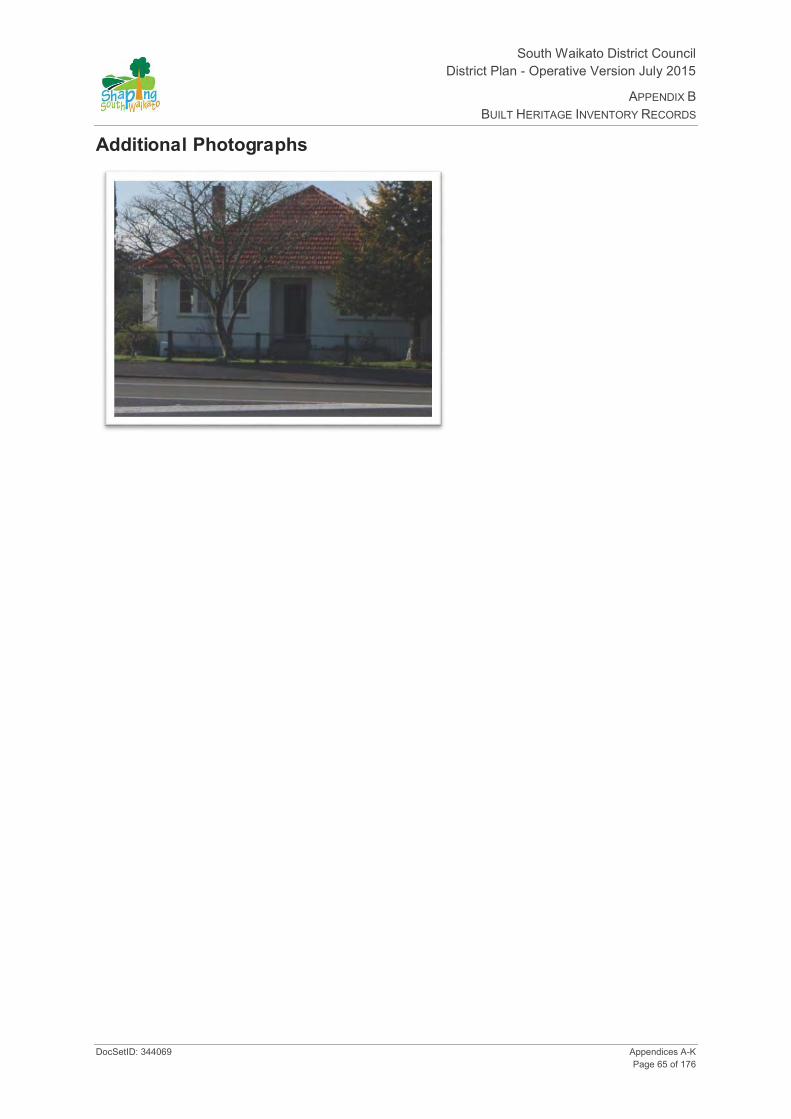
South Waikato District Council District Plan - Operative Version July 2015
APPENDIX B BUILT HERITAGE INVENTORY RECORDS
DocSetID: 344069 Appendices A-K Page 65 of 176
Additional Photographs

South Waikato District Council District Plan- Operative Version July 2015
APPENDIX B BUILT HERITAGE INVENTORY RECORDS
Appendices A-K DocSetID: 344069 Page 66 of 176
HINV16: Stone House 85 Tirau Street Putāruru
Date of Photograph: 07/08/2008
Location and Zoning Information Address 85 Tirau St, Putāruru Current Owner G Warrender Legal Description Lot 2 DPS 535 Zoning Putāruru Business Valuation Number 0541835100 Google Maps Link Lat:-38.047086, Long:175.781292
Architecture Date of Construction Started May 1939 and occupied March 1940. Materials Stone (volcanic tuff) block with tile roof. Architecture/Engineer/Builder Architect: Government Department Architect. Builders: Harper,
Rayson and O'Toole. Bricklayer: W Bush of Matamata Condition Good. Stone remains in natural state. Original Site Recommendation HNZPT Ref: 4275. Heritage Advisor, HNZPT. Current Use Residential

South Waikato District Council District Plan - Operative Version July 2015
APPENDIX B BUILT HERITAGE INVENTORY RECORDS
DocSetID: 344069 Appendices A-K Page 67 of 176
Statement of Significance
(1 Historical) - reflects important or representative aspects of South Waikato history, Labour Government social programme; associated with Labour Government Housing Scheme 1935-1950. (4 Commemorative) - Event person or idea; local builders Harper, Rayson and O'Toole, bricklayer W Bush. (10 Architectural) - is an important example of construction using particular material, example of construction of this type of house using a particular material, locally quarried volcanic tuff. Design not altered. Special elements - tile roof and volcanic tuff. (11 Context) - forms part of a wider historical and cultural complex, one of three state houses (83, 85, 87 Tirau St) forming a streetscape complex. (12 Rarity) - unique to the area. (13 integrity) - has a good level of integrity of construction materials, not altered.
District Plan Rules Demolition - Discretionary. Protection focus - 1, 3, 11 12 and 13. Mitigate the effects of demolition by requiring the applicant to provide Historical Building Documentation (HBD) which should include: the structure history, photographic documentation and measurements of the item prior to removal.
Alterations necessary for the primary purpose of improving structural performance, fire safety or physical access - Controlled. Other Additions/Alterations - Discretionary. Protection focus - 10, 11, 12 and 13. Effects can be mitigated/remedied through; a) HBD - See mitigating the effects of demolition. b) Design Rules: 1.The overall visual character/shape of the original building should be identifiable. The addition should not dominate the existing building. 2.New work should be restricted to the rear of the building and not be evident from the road frontage. 3. Special elements that are associated with the rarity or architectural uniqueness or craftsmanship of the structure should be retained. c) Building Materials Rule: If repair of the buildings is proposed the materials used for the exterior walls should be similar in type, dimensions and profile as the existing exterior fabric of the building.
Repair of the Structure - Discretionary - stone (volcanic tuff) and tiles. Permitted - all other materials. Refer to Rule 22.3.1. Protection focus - 10. Building Materials Rule: If repair of the buildings is proposed the materials used for the exterior walls should be similar in type, dimensions and profile as the existing exterior fabric of the building. Note: Stone should be left in a natural state. Replacement of the roof should be with tile roofing. Design Rule: Repair or replication work should match the existing design and profile of element.
Re-use/Change of Use - Permitted. Refer to Rule 22.3.1. Protection focus - 1.
Internal Changes - Permitted.
Relocation - Discretionary. Protection focus - 1 and 11.
Disturbance of the site surface/earthworks - Note: Any place that was associated with human activity prior to 1900 and is able to provide evidence relating to the history of New Zealand is an 'archaeological site' (refer to definition of 'archaeological site' in Section 2 of the Heritage New Zealand Pouhere Taonga Act 2014). All archaeological sites are protected under the Heritage New Zealand Pouhere Taonga Act 2014 and approval from Heritage New Zealand must be obtained prior to destroying, damaging or modifying any site. Accordingly, where this site on which a building is located is an 'archaeological site' and the building is to be repaired, added to, relocated or demolished and this involves disturbance to the surface and/or subsurface of the site, approval from Heritage New Zealand is required.
Surrounds - Protection extends to cover kahikatea tree (sophora tetraptera). Discretionary consent required for tree removal. (Normal gardening, pruning and maintenance of tree health is permitted)
History Built in 1939 these state houses are unique to the area as they are constructed from locally quarried volcanic tuff. (HNZPT)
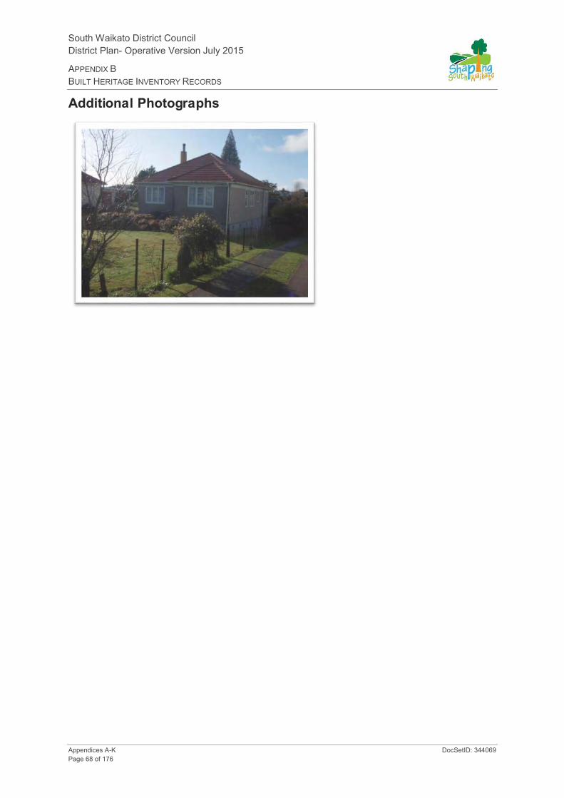
South Waikato District Council District Plan- Operative Version July 2015
APPENDIX B BUILT HERITAGE INVENTORY RECORDS
Appendices A-K DocSetID: 344069 Page 68 of 176
Additional Photographs

South Waikato District Council District Plan - Operative Version July 2015
APPENDIX B BUILT HERITAGE INVENTORY RECORDS
DocSetID: 344069 Appendices A-K Page 69 of 176
HINV17: Stone House 87 Tirau Street Putāruru
Date of Photograph: 07/08/2008
Location and Zoning Information Address 87 Tirau St, Putāruru Current Owner A Parker Legal Description Lot 1 DPS 535 Zoning Putāruru Business Valuation Number 541835200 Google Maps Link Lat:-38.046891, Long:175.781287
Architecture Date of Construction Started May 1939 and occupied March 1940. Materials Stone (volcanic tuff) block with tile roof. Architecture/Engineer/Builder Architect: Government Department Architect. Builders: Harper,
Rayson and O'Toole. Bricklayer: W Bush of Matamata Condition Good. Stone has been painted over. (HNZPT). Original Site Recommendation HNZPT Ref: 4276. Heritage Advisor, HNZPT. Current Use Private residence

South Waikato District Council District Plan- Operative Version July 2015
APPENDIX B BUILT HERITAGE INVENTORY RECORDS
Appendices A-K DocSetID: 344069 Page 70 of 176
Statement of Significance
(1 Historical) - reflects important or representative aspects of South Waikato history, Labour Government social programme; associated with Labour Government housing scheme 1935-1950. (4 Commemorative) - Event person or idea; local builders Harper, Rayson and O'Toole, bricklayer W Bush. (10 Architectural) - is an important example of construction using particular material, example of construction of this type of house using a particular material, locally quarried volcanic tuff. Design not altered. Special elements - tile roof and volcanic tuff. (11 Context) - forms part of a wider historical and cultural complex, one of three state houses (83, 85, 87 Tirau St) forming a streetscape complex. (12 Rarity) - unique to the area. (13 Integrity) - has a good level of integrity of construction materials, not altered except painting of stone.
District Plan Rules Demolition - Discretionary. Protection focus - 1 and 11. Mitigate the effects of demolition by requiring the applicant to provide Historical Building Documentation (HBD) which should include: the structure history, photographic documentation and measurements of the item prior to removal.
Alterations necessary for the primary purpose of improving structural performance, fire safety or physical access - Controlled. Other Additions/Alterations - Discretionary. Protection focus - 10 and 11. Effects can be mitigated/remedied through; a) HBD - See mitigating the effects of Demolition. b) Design Rules: 1.The overall visual character/shape of the original building should be identifiable. The addition should not dominate the existing building. 2.New work should be restricted to the rear of the building and not be evident from the road frontage. 3. Special elements that are associated with the rarity or architectural uniqueness or craftsmanship of the structure should be retained. c) Building Materials Rule: If repair of the buildings is proposed the materials used for the exterior walls should be similar in type, dimensions and profile as the existing exterior fabric of the building.
Repair of the Structure - Discretionary - stone (volcanic tuff) and tiles. Permitted - all other materials. Refer to Rule 22.3.1. Protection focus - 10. Building Materials Rule: If repair of the buildings is proposed the materials used for the exterior walls should be similar in type, dimensions and profile as the existing exterior fabric of the building. Note: Replacement of the roof should be with tile roofing. Design Rule: Repair or replication work should match the existing design and profile of element.
Re-use/Change of Use - Permitted. Refer to Rule 22.3.1. Protection focus - 1.
Internal Changes - Permitted.
Relocation - Discretionary. Protection focus - 1 and 11.
Disturbance of the site surface/earthworks - Note: Any place that was associated with human activity prior to 1900 and is able to provide evidence relating to the history of New Zealand is an 'archaeological site' (refer to definition of 'archaeological site' in Section 2 of the Heritage New Zealand Pouhere Taonga Act 2014). All archaeological sites are protected under the Heritage New Zealand Pouhere Taonga Act 2014 and approval from Heritage New Zealand must be obtained prior to destroying, damaging or modifying any site. Accordingly, where this site on which a building is located is an 'archaeological site' and the building is to be repaired, added to, relocated or demolished and this involves disturbance to the surface and/or subsurface of the site, approval from Heritage New Zealand is required.
Surrounds - Protection extends to cover rimu tree (dacrydium cupressinum). Discretionary consent required for tree removal. (normal gardening, pruning and maintenance of tree health is permitted)
History Built in 1939 these state houses are unique to the area as they are constructed from locally quarried volcanic tuff.(HNZPT)

South Waikato District Council District Plan - Operative Version July 2015
APPENDIX B BUILT HERITAGE INVENTORY RECORDS
DocSetID: 344069 Appendices A-K Page 71 of 176
Additional Photographs
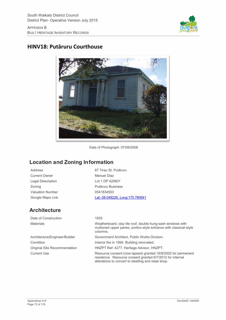
South Waikato District Council District Plan- Operative Version July 2015
APPENDIX B BUILT HERITAGE INVENTORY RECORDS
Appendices A-K DocSetID: 344069 Page 72 of 176
HINV18: Putāruru Courthouse
Date of Photograph: 07/08/2008
Location and Zoning Information Address 67 Tirau St, Putāruru Current Owner Manuel Diaz Legal Description Lot 1 DP 420601 Zoning Putāruru Business Valuation Number 0541834503 Google Maps Link Lat:-38.048226, Long:175.780841
Architecture Date of Construction 1935 Materials Weatherboard, clay tile roof, double hung sash windows with
mullioned upper panes, portico-style entrance with classical-style columns.
Architecture/Engineer/Builder Government Architect, Public Works Division. Condition Interior fire in 1994. Building renovated. Original Site Recommendation HNZPT Ref: 4277. Heritage Advisor, HNZPT. Current Use Resource consent (now lapsed) granted 16/8/2002 for permanent
residence. Resource consent granted 6/7/2012 for internal alterations to convert to dwelling and retail shop.

South Waikato District Council District Plan - Operative Version July 2015
APPENDIX B BUILT HERITAGE INVENTORY RECORDS
DocSetID: 344069 Appendices A-K Page 73 of 176
Statement of Significance
(1 Historical) - reflects important or representative aspects of South Waikato history, presence of the justice system in South Waikato. (3 Community Association) - has important community association and public esteem, landmark presence, well-known public building. Associated with Justice system. Constructed as a courthouse in 1935. Similar to other courthouses from this era. (13 Integrity) - has good level of integrity, interior is pretty intact despite fire, no additions or modifications to character of exterior.
District Plan Rules Demolition - Discretionary. Protection focus - 1, 3, 10 and 13. Mitigate the effects of demolition by requiring the applicant to provide Historical Building Documentation (HBD) which should include: the structure history, photographic documentation and measurements of the item prior to removal.
Alterations necessary for the primary purpose of improving structural performance, fire safety or physical access - Controlled. Other Additions/Alterations - Discretionary. Protection focus - 3, 10 and 13. Effects can be mitigated/remedied through; a) HBD - See mitigating the effects of demolition. b) Design rules: 1.The overall visual character/shape of the original building should be identifiable. The addition should not dominate the existing building. 2.New work should be restricted to the rear of the building and not be evident from the road frontage. 3. The following special elements that are associated with the rarity or architectural uniqueness or craftsmanship of the structure should be retained: Elements of the structure that should be retained are those elements associated with the structures historic character, use, rarity, landmark values, craftsmanship etc i.e.: façade, exterior walls, openings landscape, and any other elements identified in the Historic Building Documentation. c) Building Materials Rule: If repair of the structure is proposed the materials used for the exterior walls and elements should be similar in type, dimensions and profile as the existing exterior fabric of the building.
Repair of the Structure - Permitted. Refer to Rule 22.3.1. Protection focus - 3, 10 and 13. Building Materials Rule: If repair of the buildings is proposed the materials used for the exterior walls should be similar in type, dimensions and profile as the existing exterior fabric of the building. Design Rule: repair and replication work should match the existing design and profile of element.
Re-use/Change of Use - Permitted. Refer to Rule 22.3.1. Protection focus - 3 and 13.
Internal Changes - Discretionary. Courtroom is intact panelling etc and other spaces too - if this area was to be altered HPT would want to record it.
Relocation - Discretionary. Protection focus - 1,3, 6 and 13. Mitigate the effects of relocation by 1) Consultation with the community and/or consultation with Iwi or special interest groups. 2) Relocate to a similar setting. 3) Documentation (HBD).
Disturbance of the site surface/earthworks - Note: Any place that was associated with human activity prior to 1900 and is able to provide evidence relating to the history of New Zealand is an 'archaeological site' (refer to definition of 'archaeological site' in Section 2 of the Heritage New Zealand Pouhere Taonga Act 2014). All archaeological sites are protected under the Heritage New Zealand Pouhere Taonga Act 2014 and approval from Heritage New Zealand must be obtained prior to destroying, damaging or modifying any site. Accordingly, where this site on which a building is located is an 'archaeological site' and the building is to be repaired, added to, relocated or demolished and this involves disturbance to the surface and/or subsurface of the site, approval from Heritage New Zealand.
Surrounds - Protection extends to require consent for new outbuildings, to manage effects on original site layout, (eg control where a garage would go and what happens in front of building). Discretionary consent required.
History Prior to construction in 1935 court proceedings were carried out in a privately owned building. The courthouse building was erected on a portion of the Police reserve. (HNZPT). Courthouse services resumed in 1994 after fire renovations, however by end of 1995 all services transferred to Tokoroa Courthouse.

South Waikato District Council District Plan- Operative Version July 2015
APPENDIX B BUILT HERITAGE INVENTORY RECORDS
Appendices A-K DocSetID: 344069 Page 74 of 176
HINV19: Assembly Of God Church
Date of Photograph: 07/08/2008
Location and Zoning Information Address 65 Tirau St, Putāruru Current Owner Putāruru Assembly of God Trust Board Legal Description Lot 1 DPS 13608 Zoning Putāruru Business Valuation Number 0541834400 Google Maps Link Lat:-38.048364, Long:175.780815
Architecture Date of Construction 1919 Materials Weatherboard walls and corrugated iron roof.
Architecture/Engineer/Builder Architect: Unknown. Building construction supervised by A Adams of Matamata.
Condition Good. Interior renovations in 1938 resulted in the rear wall being moved back and a new pulpit installed. In 1958 the Church was moved back on section. (HNZPT).
Original Site Recommendation HNZPT Ref: 4462. Heritage Advisor, HNZPT.
Current Use Assembly of God Church

South Waikato District Council District Plan - Operative Version July 2015
APPENDIX B BUILT HERITAGE INVENTORY RECORDS
DocSetID: 344069 Appendices A-K Page 75 of 176
Statement of Significance
(1 Historical) (6 Educational) (3 Community Association) - has important community association and public esteem, community involved in building, community use. Has symbolic or commemorative value, was built in a single day. (4 Commemorative) and (5 Symbolic) - Community participation - built in a single day. (11 Context) - forms part of a wider historical and cultural complex.
District Plan Rules Demolition - Discretionary. Protection focus - 3, 4, 5 and 11. Mitigate the effects of demolition by requiring the applicant to provide Historical Building Documentation (HBD) which should include: the structure history, photographic documentation and measurements of the item prior to removal.
Alterations necessary for the primary purpose of improving structural performance, fire safety or physical access - Controlled. Other Additions/Alterations - Discretionary. Protection focus - 4, 5 and 11. Effects can be mitigated/remedied through; a) HBD - See mitigating the effects of demolition. b) Design Rules: 1.The overall visual character/shape of the original building should be identifiable. The addition should not dominate the existing building. 2.New work should be restricted to the rear of the building and not be evident from the road frontage. 3. The following special elements that are associated with the rarity or architectural uniqueness or craftsmanship of the structure should be retained: Elements of the structure that should be retained are those elements associated with the structures historic character, use rarity, landmark values, craftsmanship etc. i.e.: façade, exterior walls, openings, landscape and any other elements identified in the Historic Building Documentation. c) Building materials rule: If repair of the structure is proposed the materials used for the exterior walls and elements should be similar in type, dimensions and profile as the existing exterior fabric of the building.
Repair of the Structure - Permitted. Refer to Rule 22.3.1. Protection focus - 4, 5 and 11. Building Materials Rule: If repair of the building is proposed the materials used for the exterior walls and elements should be similar in type, dimensions and profile as the existing exterior fabric of the building. Design Rule: Repair or replication work should match the existing design and profile of element. Note: The existing openings evident from the street should not be altered.
Re-use/Change of Use - Permitted. Refer to Rule 22.3.1. Protection focus - 3 , 4, 5 and 11.
Internal Changes - Discretionary. Even though altered in 1938 may still require protection.
Relocation - Discretionary. Protection focus - 3, 4, 5 and 11. Mitigate the effects of relocation by 1) Consultation with the community and/or consultation with Iwi or special interest groups. 2) Relocate to a similar setting. 3) Documentation (HBD).
Disturbance of the site surface/earthworks - Note: Any place that was associated with human activity prior to 1900 and is able to provide evidence relating to the history of New Zealand is an 'archaeological site' (refer to definition of 'archaeological site' in Section 2 of the Heritage New Zealand Pouhere Taonga Act 2014). All archaeological sites are protected under the Heritage New Zealand Pouhere Taonga Act 2014 and approval from Heritage New Zealand must be obtained prior to destroying, damaging or modifying any site. Accordingly, where this site on which a building is located is an 'archaeological site' and the building is to be repaired, added to, relocated or demolished and this involves disturbance to the surface and/or subsurface of the site, approval from Heritage New Zealand is required.
Surrounds - Protection extends to cover Lawson's Cypress (chamaecyparis lawsonii) and American Arbor-Vitae Trees (thuja occidentalis). Discretionary consent required for tree removal. (Normal gardening, pruning and maintenance of tree health is permitted).
History Mr JC Allen gifted a quarter acre section of land in Putāruru for the construction of the Methodist Church. Built in 1919 the Methodist (St John's ) Church was the first Protestant Church in the town. The Church was erected in a single day by a team of approximately 30 men under the direction of Mr A Adams. (HNZPT)

South Waikato District Council District Plan- Operative Version July 2015
APPENDIX B BUILT HERITAGE INVENTORY RECORDS
Appendices A-K DocSetID: 344069 Page 76 of 176
Additional Photographs

South Waikato District Council District Plan - Operative Version July 2015
APPENDIX B BUILT HERITAGE INVENTORY RECORDS
DocSetID: 344069 Appendices A-K Page 77 of 176
HINV20: Okoroire Hot Springs Hotel
Date of Photograph: 29/04/2008
Location and Zoning Information Address 18 Somerville Rd, Okoroire Current Owner Okoroire Hot Springs Hotel Ltd Legal Description Pt Lots 1 2 DP14395 & Pt Whaitikuranui 2E2 West 2B Blk XV
Tapapa SD Zoning Rural – Part of SAL4 (Okoroire Precinct) Valuation Number 0541107400 Google Maps Link Lat:-37.953413, Long:175.803689
Architecture Date of Construction 1884 and rebuilt in 1915 after fire. Materials Timber and corrugated iron. Architecture/Engineer/Builder Unknown Condition Some of the original hotel still standing. Some parts burnt down
and rebuilt in 1915. Small shed at back and chimney are original and are also protected (HNZPT).
Original Site Recommendation HNZPT Ref: 4234. Heritage Advisor, HNZPT. Current Use Hotel

South Waikato District Council District Plan- Operative Version July 2015
APPENDIX B BUILT HERITAGE INVENTORY RECORDS
Appendices A-K DocSetID: 344069 Page 78 of 176
Statement of Significance
(1 Historical) - reflects important or representative aspects of South Waikato history, spa history, Okoroire Hot Springs and recreational history of South Waikato, coach stopover for coaches from the Okoroire railway station to Rotorua. Dates from periods of early settlement in South Waikato, (3 Community Association) - has important community association and public esteem, bathing and employment in the district (tourism). (7 Archaeology, pre 1900) - the site is protected under the Historic Places Act and has the potential through archaeological investigation to provide information about NZ and South Waikato history. (11 Context) - forms part of a wider historical and cultural complex, part of Okoroire Hot Springs.
District Plan Rules Demolition - Discretionary. Protection focus - 1, 3, 7 and 11. Mitigate the effects of demolition by requiring the applicant to provide Historical Building Documentation (HBD) which should include: the structure history, photographic documentation and measurements of the item prior to removal.
Alterations necessary for the primary purpose of improving structural performance, fire safety or physical access - Controlled. Other Additions/Alterations - Discretionary. Protection focus - 3 and 11. Effects can be mitigated/remedied through; a) HBD - See mitigating the effects of Demolition. b) Design rules: 1.The overall visual character/shape of the original building should be identifiable. The addition should not dominate the existing building. 2.New work should be generally to the rear of the building (I.e. deck out front is Ok) and not be evident from the road frontage. 3. The following special elements that are associated with the rarity or architectural uniqueness or craftsmanship of the structure should be retained: Elements of the structure that should be retained are those elements associated with its historic character, use, rarity, landmark values, craftsmanship, etc i.e. façade, exterior walls, openings, chimney, landscape and any other elements identified in the Historic Building Documentation. c) Building materials rule: If repair of the structure is proposed the materials used for the exterior walls and elements should be similar in type, dimensions and profile as the existing exterior fabric of the building.
Repair of the Structure - Permitted. Refer to Rule 28.3.1. Protection focus - 3 and 11. Building Materials Rule: If repair of the buildings is proposed the materials used for the exterior walls should be similar in type, dimensions and profile as the existing exterior fabric of the building. Design Rule: Repair and replication work should match the existing design and profile of element.
Re-use/Change of Use - Permitted. Refer to Rule 28.3.1. Protection focus - 3 and 11.
Internal Changes - Discretionary, interior is intact and worth retaining - does not rule out adaption however, has to function as hotel.
Relocation - Discretionary. Protection focus - 3 and 11. Mitigate the effects by 1) Consultation with the community and/or consultation with Iwi or special interest groups, 2) Relocate to a similar setting, 3) Documentation (HBD).
Disturbance of the site surface/earthworks - Protection focus - 7. Note: Any place that was associated with human activity prior to 1900 and is able to provide evidence relating to the history of New Zealand is an 'archaeological site' (refer to definition of 'archaeological site' in Section 2 of the Heritage New Zealand Pouhere Taonga Act 2014). All archaeological sites are protected under the Heritage New Zealand Pouhere Taonga Act 2014 and approval from Heritage New Zealand must be obtained prior to destroying, damaging or modifying any site. Accordingly, where this site on which a building is located is an 'archaeological site' and the building is to be repaired, added to, relocated or demolished and this involves disturbance to the surface and/or subsurface of the site, approval from Heritage New Zealand is required.
Surrounds - Protection extends to cover entire site to protect context, original site layout, existing and proposed outbuildings and the following large trees -
Sweet chestnuts (castanea sativa) along road frontage Phoenix palms (phoenix canariensis) near tennis courts Bull bay magnolias (magnolia grandiflora) at main entrance Avenue of cypresses (chamaecyparis lawsonii, cuppress lusianica) between carpark and river. Avenue of plane trees (platanus x hispanica) along road frontage of golf course.
Discretionary consent required for tree removal. (normal gardening, pruning and maintenance of tree health is permitted)

South Waikato District Council District Plan - Operative Version July 2015
APPENDIX B BUILT HERITAGE INVENTORY RECORDS
DocSetID: 344069 Appendices A-K Page 79 of 176
History The complex was originally built as a luxury health and pleasure resort in 1884. Much of the main building was burnt down and rebuilt in 1915, however some of the original building is still standing. Set in a picturesque setting close to the Waihou River, the complex included 4 spacious hot spring bathhouses and a hall in addition to the hotel. It also provided recreational activities such as hunting, fishing and shooting and later golf as well. The hotel was a popular stopover for coaches traveling from the Okoroire railway station to Rotorua. The grounds contain many significant trees. (HNZPT)
Additional Photographs

South Waikato District Council District Plan- Operative Version July 2015
APPENDIX B BUILT HERITAGE INVENTORY RECORDS
Appendices A-K DocSetID: 344069 Page 80 of 176
HINV21: Okoroire Hot Springs Hotel – Staff Accommodation
Okoroire Hot Springs Hotel – Staff accommodation
Date of Photograph: 16/10/2008
Location and Zoning Information Address 18 Somerville Rd, Okoroire
(Located behind main hotel building) Current Owner Okoroire Hot Springs Hotel Ltd Legal Description Pt Lots 1 2 DP14395 & Pt Whaitikuranui 2E2 West 2B Blk XV
Tapapa SD Zoning Rural – Part of SAL4 (Okoroire Precinct) Valuation Number 541107400 Google Maps Link
Architecture Date of Construction 1884 Materials Timber and corrugated iron. Architecture/Engineer/Builder Unknown Condition Good. Repairs undertaken to staff accommodation. Original Site Recommendation HNZPT Ref: 4233. Heritage Advisor, HNZPT. Current Use Accommodation and storage.
South Waikato District Council District Plan - Operative Version July 2015
APPENDIX B BUILT HERITAGE INVENTORY RECORDS
DocSetID: 344069 Appendices A-K Page 81 of 176
Statement of Significance
(1 Historical) - reflects important or representative aspects of South Waikato history, spa history, Okoroire Hot Springs and recreational history of South Waikato, coach stopover for coaches from the Okoroire railway station to Rotorua. Dates from periods of early settlement in South Waikato, (3 Community Association) - has important community association and public esteem, bathing and employment in the district (tourism). (7 Archaeology, pre 1900) - the site is protected under the Historic Places Act and has the potential through archaeological investigation to provide information about NZ and South Waikato history. (11 Context) - forms part of a wider historical and cultural complex, part of Okoroire Hot Springs. (13 Integrity) - good level of integrity.
District Plan Rules Demolition - Discretionary. Protection focus - 1, 3, 7 and 11. Mitigate the effects of demolition by requiring the applicant to provide Historical Building Documentation (HBD) which should include: the structure history, photographic documentation and measurements of the item prior to removal.
Alterations necessary for the primary purpose of improving structural performance, fire safety or physical access - Controlled. Other Additions/Alterations - Discretionary. Protection focus - 3 and 11. Effects can be mitigated/remedied through; a) HBD - See mitigating the effects of demolition. b) Design rules: 1.The overall visual character/shape of the original building should be identifiable. The addition should not dominate the existing building. 2.New work should be restricted to the rear of the building and not be evident from the road frontage. 3. The following special elements that are associated with the rarity or architectural uniqueness or craftsmanship of the structure should be retained: Elements of the structure that should be retained are those elements associated with its historic character, use, rarity, landmark values, craftsmanship, etc i.e. façade, exterior walls, openings chimney, landscape and any other elements identified in the Historic Building Documentation. c) Building materials rule: If repair of the structure is proposed the materials used for the exterior walls and elements should be similar in type, dimensions and profile as the existing exterior fabric of the building.
Repair of the Structure - Permitted. Refer to Rule 28.3.1. Protection focus - 3 and 11. Building Materials Rule: If repair of the buildings is proposed the materials used for the exterior walls should be similar in type, dimensions and profile as the existing exterior fabric of the building. Design Rule: Repair and replication work should match the existing design and profile of element.
Re-use/Change of Use - Permitted. Refer to Rule 28.3.1. Protection focus - 3 and 11.
Internal Changes - Discretionary - simple building intact warrants control over interior changes.
Relocation - Discretionary. Protection focus - 1, 3, 7 and 11. Mitigate the effects by 1) Consultation with the community and/or consultation with Iwi or special interest groups, 2) Relocate to a similar setting, 3) Documentation (HBD).
Disturbance of the site surface/earthworks - Protection focus - 7. Note: Any place that was associated with human activity prior to 1900 and is able to provide evidence relating to the history of New Zealand is an 'archaeological site' (refer to definition of 'archaeological site' in Section 2 of the Heritage New Zealand Pouhere Taonga Act 2014). All archaeological sites are protected under the Heritage New Zealand Pouhere Taonga Act 2014 and approval from Heritage New Zealand must be obtained prior to destroying, damaging or modifying any site. Accordingly, where this site on which a building is located is an 'archaeological site' and the building is to be repaired, added to, relocated or demolished and this involves disturbance to the surface and/or subsurface of the site, approval from Heritage New Zealand is required.
Surrounds - Part of a wider complex. Needs protection for context including open space and the trees identified in HINV20. Would want to manage effects on context of adding extra buildings Discretionary consent required (normal gardening, pruning and maintenance of tree health is permitted)
History Built for accommodation of staff working at the Okoroire Hot Springs Hotel. The complex was originally built as a luxury health and pleasure resort in 1884. Much of the main building was burnt down and rebuilt in 1915, however some of the original building is still standing. Set in a picturesque setting close to the Waihou River, the complex included 4 spacious hot spring bathhouses and a hall in addition to the hotel. It also provided recreational activities such as hunting, fishing and shooting and later golf as well. The hotel was a popular

South Waikato District Council District Plan- Operative Version July 2015
APPENDIX B BUILT HERITAGE INVENTORY RECORDS
Appendices A-K DocSetID: 344069 Page 82 of 176
stopover for coaches travelling from the Okoroire railway station to Rotorua. The grounds contain many significant trees. (HNZPT).
Additional Photographs

South Waikato District Council District Plan - Operative Version July 2015
APPENDIX B BUILT HERITAGE INVENTORY RECORDS
DocSetID: 344069 Appendices A-K Page 83 of 176
HINV22: House (Formerly Raparahi Hotel)
Date of Photograph: 23/10/2008
Location and Zoning Information Address 1338 Wiltsdown Rd
Corner of Wiltsdown and Stringer Roads Waotu Current Owner D Graham Legal Description Lot 1 DPS 23922 Blk I Patetere Sth SD Zoning Rural Valuation Number 0541247000 Google Maps Link Lat:-38.16574, Long:175.713384
Architecture Date of Construction 1882 - 1883 Materials Totara framing, sawn weatherboards, chimney of sawn rhyolite,
corrugated iron roof, shingles underneath on earlier part. (HNZPT) Architecture/Engineer/Builder Unknown Condition Interior reorganised around 1930, reconditioned 1963 and now
farmhouse. Fully fenced. Excellent condition. More research required regarding what remains as orginal and what has undergone alteration
Original Site Recommendation HNZPT Ref: 4239. Heritage Advisor, HNZPT. Current Use Private residence.

South Waikato District Council District Plan- Operative Version July 2015
APPENDIX B BUILT HERITAGE INVENTORY RECORDS
Appendices A-K DocSetID: 344069 Page 84 of 176
Statement of Significance
(1 Historical) - reflects important or representative aspects of South Waikato history, early settlement history 1882, transportation history in South Waikato. Dates from periods of early settlement in South Waikato. (7 Archaeology, pre 1900) - the site is protected under the Historic Places Act, has the potential through archaeological investigation to provide information about NZ and the South Waikato history.
District Plan Rules Demolition - Discretionary. Protection focus - 1 and 7. Mitigate the effects of demolition by requiring the applicant to provide Historical Building Documentation (HBD) which should include: the structure history, photographic documentation and measurements of the item prior to removal.
Alterations necessary for the primary purpose of improving structural performance, fire safety or physical access - Controlled. Other Additions/Alterations - Discretionary. Protection focus - 1. Effects can be mitigated/remedied through; a) HBD - See mitigating the effects of Demolition. b) Design rules: 1.The overall visual character/shape of the original building should be identifiable. The addition should not dominate the existing building. 2. New work should be restricted to the rear of the building and not be evident from the road frontage. 3. The following special elements that are associated with the rarity or architectural uniqueness or craftsmanship of the structure should be retained: Elements of the structure that should be retained are those elements associated with the structures historic character, use, rarity, landmark values, craftsmanship, etc i.e.: exterior walls, openings, landscape, and any other elements identified in the Historic Building Documentation. c) Building materials rule: If repair of the structure is proposed the materials used for the exterior walls and elements should be similar in type, dimensions and profile as the existing exterior fabric of the building.
Repair of the Structure - Permitted. Refer to Rule 28.3.1. Protection focus - 1.
Re-use/Change of Use - Permitted. Refer to Rule 28.3.1. Protection focus - 1.
Internal Changes - Discretionary.
Relocation - Discretionary. Protection focus - 1 and 7. Mitigate the effects of relocation by 1) Consultation with the community, and/or consultation with Iwi or special interest groups. 2) Relocate to a similar setting. 3) Documentation.
Disturbance of the site surface/earthworks - Protection focus - 7. Note: Any place that was associated with human activity prior to 1900 and is able to provide evidence relating to the history of New Zealand is an 'archaeological site' (refer to definition of 'archaeological site' in Section 2 of the Heritage New Zealand Pouhere Taonga Act 2014). All archaeological sites are protected under the Heritage New Zealand Pouhere Taonga Act 2014 and approval from Heritage New Zealand must be obtained prior to destroying, damaging or modifying any site. Accordingly, where this site on which a building is located is an 'archaeological site' and the building is to be repaired, added to, relocated or demolished and this involves disturbance to the surface and/or subsurface of the site, approval from Heritage New Zealand is required.
History Constructed in 1882-1883 for use as a hotel, it was licensed in 1902. Was first overnight stop for coaches between Cambridge and Taupo (second stop Atiamuri) on road built by Armed Constabulary. Coach service by Quicks. One of two hotels in this area.(HNZPT).
South Waikato District Council District Plan - Operative Version July 2015
APPENDIX B BUILT HERITAGE INVENTORY RECORDS
DocSetID: 344069 Appendices A-K Page 85 of 176
Additional Photographs

South Waikato District Council District Plan- Operative Version July 2015
APPENDIX B BUILT HERITAGE INVENTORY RECORDS
Appendices A-K DocSetID: 344069 Page 86 of 176
HINV23: Waotu-Puketurua Play Centre Building
Date of Photograph: 23/10/2008
Location and Zoning Information Address 1262 Waotu Rd, Waotu Current Owner Te Waotu War Memorial Park Society Legal Description Lot 1 DPS 841 Blk XIII Patetere Nth SD Blk I Patetere Sth SD Zoning Rural Valuation Number 0541234900 Google Maps Link Lat:-38.142503, Long:175.688673
Architecture Date of Construction 1886
Materials Timber & iron roof.
Architecture/Engineer/Builder Unknown
Condition Excellent. Building was added to in 1916 and moved in the 1980's. (HNZPT). Fully fenced (Public consultation). Extension undertaken in 2002 enabling more space for play centre approved by HNZPT. Building used and maintained with Play centre funding.
Original Site Recommendation HNZPT Ref: 4238. Heritage Advisor, HNZPT.
Current Use Waotu-Puketurua Play centre

South Waikato District Council District Plan - Operative Version July 2015
APPENDIX B BUILT HERITAGE INVENTORY RECORDS
DocSetID: 344069 Appendices A-K Page 87 of 176
Statement of Significance
(1 Historical) - reflects important or representative aspects of South Waikato history. Dates from periods of early settlement in South Waikato. Native school in 1886, public education for all. (2 Tangata whenua association) - native school. (3 Community Association) - has important community association and public esteem, community value continued with current use as play centre. (11 Context) - part of the Waotu Heritage Trail. (13 Integrity) - good level of integrity despite minor changes which have been done in keeping with original building.
District Plan Rules Demolition - Discretionary. (Protection focus - 1, 2, 3 and 11. Mitigate the effects of demolition by requiring the applicant to provide Historical Building Documentation (HBD) which should include: the structure history, photographic documentation and measurements of the item prior to removal.
Alterations necessary for the primary purpose of improving structural performance, fire safety or physical access - Controlled. Other Additions/Alterations - Discretionary. Protection focus - 1. Need to be able to manage the effects of and record changes, changes need to be done in keeping with original building.
Repair of the Structure - Permitted. Refer to Rule 28.3.1. Protection focus - 1.
Re-use/Change of Use - Permitted. Refer to Rule 28.3.1. Protection focus - 3.
Internal Changes - Discretionary. Interior is reasonably intact and warrants protection - doesn't rule out changes but need to be managed and recorded.
Relocation - Discretionary. Protection focus - 1, 2 and 3. Mitigate the effects of relocation by 1) Consultation with the community and/or consultation with Iwi or special interest groups. 2) Relocate to a similar setting. 3) Documentation (HBD).
Disturbance of the site surface/earthworks - Note: Any place that was associated with human activity prior to 1900 and is able to provide evidence relating to the history of New Zealand is an 'archaeological site' (refer to definition of 'archaeological site' in Section 2 of the Heritage New Zealand Pouhere Taonga Act 2014). All archaeological sites are protected under the Heritage New Zealand Pouhere Taonga Act 2014 and approval from Heritage New Zealand must be obtained prior to destroying, damaging or modifying any site. Accordingly, where this site on which a building is located is an 'archaeological site' and the building is to be repaired, added to, relocated or demolished and this involves disturbance to the surface and/or subsurface of the site, approval from Heritage New Zealand is required.
History It originally served as the Te Waotu Native School. The building was added to in 1916 and moved to its present location in the 1980's. It is still used for educational purposes. (HNZPT)
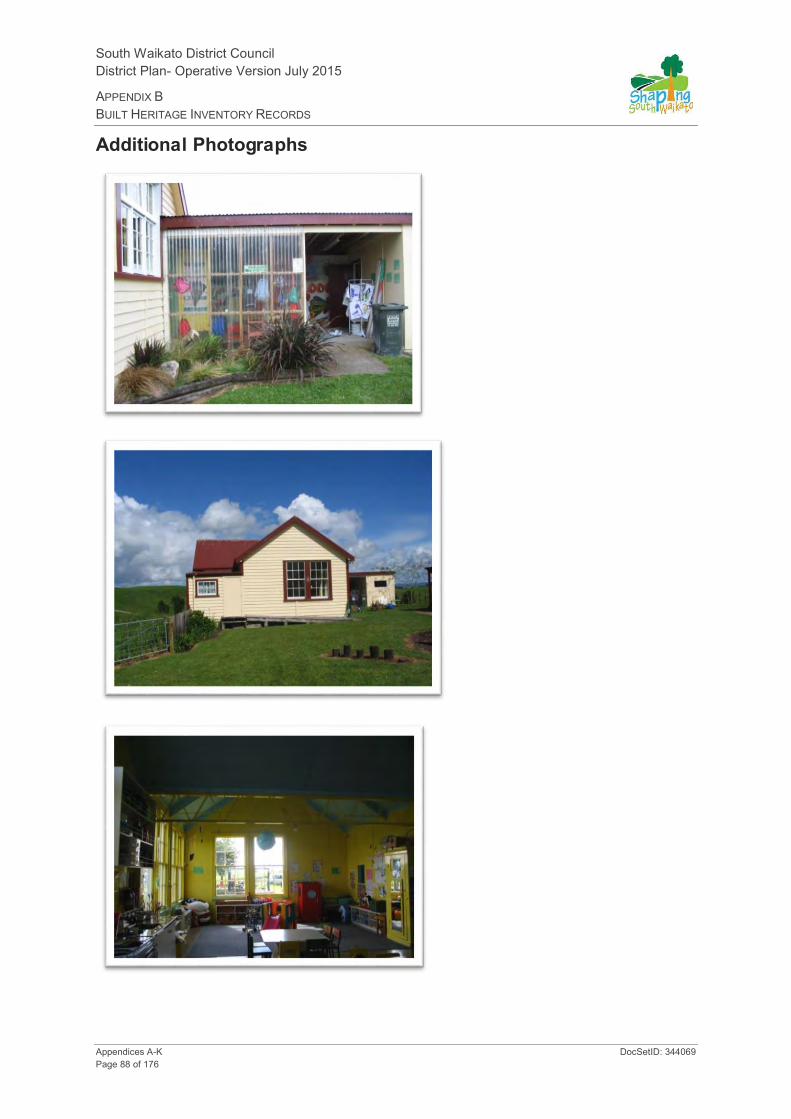
South Waikato District Council District Plan- Operative Version July 2015
APPENDIX B BUILT HERITAGE INVENTORY RECORDS
Appendices A-K DocSetID: 344069 Page 88 of 176
Additional Photographs
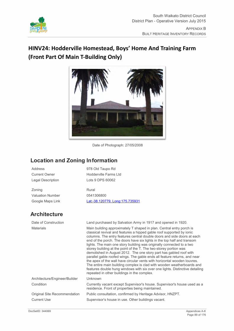
South Waikato District Council District Plan - Operative Version July 2015
APPENDIX B BUILT HERITAGE INVENTORY RECORDS
DocSetID: 344069 Appendices A-K Page 89 of 176
HINV24: Hodderville Homestead, Boys’ Home And Training Farm
(Front Part Of Main T-Building Only)
Date of Photograph: 27/05/2008
Location and Zoning Information Address 978 Old Taupo Rd Current Owner Hodderville Farms Ltd Legal Description Lots 9 DPS 60062
Zoning Rural Valuation Number 0541306800 Google Maps Link Lat:-38.120779, Long:175.735931
Architecture Date of Construction Land purchased by Salvation Army in 1917 and opened in 1920. Materials Main building approximately T shaped in plan. Central entry porch is
classical revival and features a hipped gable roof supported by ionic columns. The entry features central double doors and side doors at each end of the porch. The doors have six lights in the top half and transom lights. The main one story building was originally connected to a two storey building at the point of the T. The two-storey portion was demolished in August 2012. The one story part has gabled roof with parallel gable roofed wings. The gable ends all feature returns, and near the apex of the wall have circular vents with horizontal wooden louvres. The entire main building complex is clad with wooden weatherboards and features double hung windows with six over one lights. Distinctive detailing repeated in other buildings in the complex.
Architecture/Engineer/Builder Unknown Condition Currently vacant except Supervisor's house. Supervisor's house used as a
residence. Front of properties being maintained. Original Site Recommendation Public consultation, confirmed by Heritage Advisor, HNZPT. Current Use Supervisor’s house in use. Other buildings vacant.
South Waikato District Council District Plan- Operative Version July 2015
APPENDIX B BUILT HERITAGE INVENTORY RECORDS
Appendices A-K DocSetID: 344069 Page 90 of 176
Statement of Significance
(1 Historical) - Aspect of history, 1920's through 1950's social responsibility movement, English Farm Cadet programme, and history of the Salvation Army in New Zealand. Reflects important or representative aspects of South Waikato. Home was associated with events, persons, or ideas of importance in South Waikato history, Salvation Army's commitment to social service and community needs as provided by a farm home for orphaned or disadvantaged boys and later as a substance abuse treatment centre. (3 Community Association) - has important community association and public esteem, played a central role in Hodderville and the South Waikato as a social institution (orphanage and farm training facility); associated with the lives of many New Zealand men who passed through its doors over a 60 year period. (6 Educational) - has the potential to educate the public about the history of South Waikato. The Boys' Home was part of NZ social history and could be interpreted and used for discussing both social history and social responsibility with students. (10 Architectural) - consistient style and detailing used throughout complex. (11 Context) - Home part of a complex or landscape. Visual aspects to consider that relate to history, landscape, frontage sweeping drive and front lawn. (12 Rarity) - is a rare type of historic place, only orphanage in South Waikato District (historical aspect, no longer used as an orphanage). (13 Integrity) - good level of integrity.
District Plan Rules Demolition - Discretionary. Protection focus - 1, 3, 6, 10, 11 and 12. Mitigate the effects of demolition by requiring applicant to provide a Historic Building Documentation (HBD) which should include the buildings' history, photographic documentation, and measurements of the building prior to removal. Emphasis should be placed on recording how the building operated as an orphanage and recording any internal or external features that relate to use and the way of life of orphans at the facility.
Alterations necessary for the primary purpose of improving structural performance, fire safety or physical access - Controlled. Other Additions/Alterations - Discretionary. Protection focus - 1, 6, 10 and 12. Effects can be mitigated/remedied through; a) HBD - See mitigating the effects of demolition. b) Design rules: 1.The overall visual character/shape of the front part of the original building should be identifiable. The addition should not dominate the existing building. 2. New work should be restricted to the rear of the building and not be evident from the road frontage. 3. The following special elements that are associated with the rarity or architectural uniqueness or craftsmanship of the structure should be retained: Elements of the structure that should be retained are those elements associated with its historic use as a rare type of structure, i.e.: front façade, lawn, driveway through lawn to building, exterior walls, openings, chimney, and any other special elements identified in the HBD.
Repair of Structure - Permitted. Refer to Rule 28.3.1. Protection focus - 1, 10 and 11.
Re-use/Change of Use - Permitted. Refer to Rule 28.3.1. Protection focus - 1, 3, 6 and 12.
Internal Changes - Discretionary - buildings is remarkably intact - can still be adapted but effects need active management and recording.
Relocation - Discretionary. Protection focus - 1, 11 and 12.
Disturbance of the site surface/earthworks - Note: Any place that was associated with human activity prior to 1900 and is able to provide evidence relating to the history of New Zealand is an 'archaeological site' (refer to definition of 'archaeological site' in Section 2 of the Heritage New Zealand Pouhere Taonga Act 2014). All archaeological sites are protected under the Heritage New Zealand Pouhere Taonga Act 2014 and approval from Heritage New Zealand must be obtained prior to destroying, damaging or modifying any site. Accordingly, where this site on which a building is located is an 'archaeological site' and the building is to be repaired, added to, relocated or demolished and this involves disturbance to the surface and/or subsurface of the site, approval from Heritage New Zealand is required.
Surrounds - Protection extends to cover the front yard and the following: -
Golden macrocarpa (cuppressus macrocarpii) Totaras (2) (podocarpus totara) Canary Island date palms (phoenix canariensis) Bay laurel (laurus nobilis) Deodar (cedrus deodara) Strawberry tree (arbutus unedo)
Discretionary consent required for tree removal. (normal gardening, pruning and maintenance of tree health is permitted) The location and shape of the original driveway should continue to be obvious.

South Waikato District Council District Plan - Operative Version July 2015
APPENDIX B BUILT HERITAGE INVENTORY RECORDS
DocSetID: 344069 Appendices A-K Page 91 of 176
History The Boys Home included a main building (orphan accommodation/dining room, kitchen, laundry), woodshed, staff quarters, a chapel, farm buildings (milking shed and stables), vegetable garden, a well, a football field, gym and swimming pool (located across road). Supervisor's house detached from main building. A Salvation Army home for orphans and boys whose family could not afford to keep them. Also accommodated British Farm Cadets who were training to work in New Zealand. The facility was operated from 1920 to 1989 by the Salvation Army. Toward the end of the homes' operation it was used as a rehabilitation centre for substance abusers. Only orphanage in the South Waikato District. (A. Simmons 09/10/00). Had approx. 80 boys at peak. They attended Hodderville School and worked their way up from kitchen to laundry to farm. At age 12 the boys worked on the Army's 980ha farm. The brighter boys went to Putāruru College. Many of the boys that worked on the Army farm moved to local farm employment once they were mature.

South Waikato District Council District Plan- Operative Version July 2015
APPENDIX B BUILT HERITAGE INVENTORY RECORDS
Appendices A-K DocSetID: 344069 Page 92 of 176
Additional Photographs
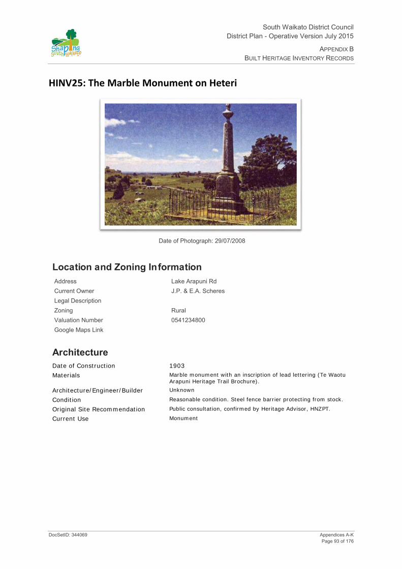
South Waikato District Council District Plan - Operative Version July 2015
APPENDIX B BUILT HERITAGE INVENTORY RECORDS
DocSetID: 344069 Appendices A-K Page 93 of 176
HINV25: The Marble Monument on Heteri
Date of Photograph: 29/07/2008
Location and Zoning Information Address Lake Arapuni Rd Current Owner J.P. & E.A. Scheres Legal Description Zoning Rural Valuation Number 0541234800 Google Maps Link
Architecture Date of Construction 1903
Materials Marble monument with an inscription of lead lettering (Te Waotu Arapuni Heritage Trail Brochure).
Architecture/Engineer/Builder Unknown
Condition Reasonable condition. Steel fence barrier protecting from stock.
Original Site Recommendation Public consultation, confirmed by Heritage Advisor, HNZPT.
Current Use Monument
South Waikato District Council District Plan- Operative Version July 2015
APPENDIX B BUILT HERITAGE INVENTORY RECORDS
Appendices A-K DocSetID: 344069 Page 94 of 176
Statement of Significance
(1 Historical) - was associated with events, persons (important person in SWD history - Rongowhitiao Te Puni) or ideas (native school) of importance in South Waikato history, (2 Tangata Whenua) - forms part of a wider historical and cultural complex, Rongowhitiao Te Puni and Te Waotu Native School. (4 Commemorative) - has symbolic or commemorate value, Rongowhitiao Te Puni benefactor of Te Waotu Native School and year of erection 1903. (5 Symbolic) - of special significance to tangata whenua and symbolic value to district. (6 Educational) - has potential to educate public about history of South Waikato, Iwi's role in South Waikato and Rongowhitiao Te Puni. (11 Context) - Part of the context/cultural landscape, part of Te Waotu Heritage Trail. (13 Integrity) - good level of integrity.
District Plan Rules Demolition - Discretionary. Protection focus - 1, 2, 4, 5, 6 and 11.
Alterations necessary for the primary purpose of improving structural performance, fire safety or physical access - Controlled. Other Additions/Alterations - Discretionary. Protection focus - 4, 5, and 11.
Repair of structure - Permitted. Refer to Rule 28.3.1. Protection focus - 4 and 11.
Internal Changes - Not applicable.
Relocation - Discretionary. Protection focus - 2, 4, 5, 6 and 11. Relocation/removal may be necessary to preserve an item for future generations and consideration should be given to a) Consultation with the community, and /or consultation with Iwi or special interest groups; b) relocate to a similar setting; c) documentation (HBD).
Disturbance of the site surface/earthworks - Note: Any place that was associated with human activity prior to 1900 and is able to provide evidence relating to the history of New Zealand is an 'archaeological site' (refer to definition of 'archaeological site' in Section 2 of the Heritage New Zealand Pouhere Taonga Act 2014). All archaeological sites are protected under the Heritage New Zealand Pouhere Taonga Act 2014 and approval from Heritage New Zealand must be obtained prior to destroying, damaging or modifying any site. Accordingly, where this site on which a building is located is an 'archaeological site' and the building is to be repaired, added to, relocated or demolished and this involves disturbance to the surface and/or subsurface of the site, approval from Heritage New Zealand is required.
History The memorial is in memory of Rongowhitiao Te Puni, initiator and benefactor of Te Waotu Native School. Erected and unveiled on 16 and 17 March 1903, permission to close the school for those two days was granted by the Education Department in honour of such a highly respected Chief. Lead inscription in Maori (inscription to be added to record sheet). (Te Waotu Arapuni Heritage Trail Brochure). A written history by James Allen Barnett (H Barnett 05/02/01).

South Waikato District Council District Plan - Operative Version July 2015
APPENDIX B BUILT HERITAGE INVENTORY RECORDS
DocSetID: 344069 Appendices A-K Page 95 of 176
HINV26: Water Tower - Ngatira
Date of Photograph: 07/08/2008
Location and Zoning Information Address Ngatira Rd Current Owner NZ Railways Corporation Legal Description Zoning Designated “Railway” Valuation Number Google Maps Link
Architecture Date of Construction Probably dates from 1885-86 when two other towers were
built Materials Brick Architecture/Engineer/Builder Engineer: James Stewart CE., Builder: Daniell Fullon
(HNZPT). Condition Good. The tower is essential infrastructure to the private
railway. Tower is of robust construction in comparison to towers associated with public railway. (HNZPT). Significant amount of graffiti on bricks.
Original Site Recommendation Public consultation confirmed by Heritage Advisor, HNZPT. Current Use None - Railway Water tower

South Waikato District Council District Plan- Operative Version July 2015
APPENDIX B BUILT HERITAGE INVENTORY RECORDS
Appendices A-K DocSetID: 344069 Page 96 of 176
Statement of Significance
(1 Historical) - reflects important or representative aspects of South Waikato history, 1885-1886, transportation and rail history in South Waikato. Dates from periods of early settlement in South Waikato, (6 Educational) - has the potential to provide knowledge and educate public about history of South Waikato and New Zealand. Potential heritage trail/school programme use; transportation, railways in the South Waikato. (7 Archaeology, pre 1900) - the site is protected under the Heritage New Zealand Pouhere Taonga Act 2014, has the potential through archaeological investigation to provide information about NZ and the South Waikato history. (10 Architectural). (11 Context) - forms part of a wider historical and cultural complex - one of three in South Waikato District on same line). (12 Rarity) - it is a rare type of historic place, only a few 1880's railway water towers remain in NZ. (13 Integrity) - has a good level of integrity, structure is not compromised by additions.
District Plan Rules Demolition - Discretionary. Protection focus - 1, 6, 7, 10, 11, 12 and 13. Mitigate the effects of demolition by requiring the applicant to provide Historical Building Documentation (HBD) which should include: the structure history, photographic documentation, and measurements of the item prior to removal.
Visual aspects to consider that relate to history, landscape/landmark value.
Alterations necessary for the primary purpose of improving structural performance, fire safety or physical access - Controlled. Other Additions/Alterations - Discretionary. Protection focus - 1, 6, 10, 12 and 13. Effects can be mitigated/remedied through; a) HBD - See mitigating the effects of demolition. b) Design rules: 1.The overall visual character/shape of the original building should be identifiable. The addition should not dominate the existing building. 2. New work should be restricted to the rear of the building and not be evident from the road frontage. 3. The following special elements that are associated with the rarity or architectural uniqueness or craftsmanship of the structure should be retained: Those elements associated with the structures historic character, use, rarity, landmark values, craftsmanship and any other special elements identified in the HBD. c) Building Materials Rule: If repair of the buildings is proposed the materials used for the exterior walls and elements should be similar in type, dimensions and profile as the existing fabric of the building.
Repair of the Structure - Permitted. Refer to Rule 28.3.1. Protection focus - 1, 6, 10, 12 and 13. Building Materials Rule: If repair of the buildings is proposed the materials used for the exterior walls and elements should be similar in type, dimensions and profile as the existing exterior fabric of building. Design rule: Repair or replication work should match the existing design and profile of element.
Re-use/Change of Use - Permitted. Refer to Rule 28.3.1. Protection focus - 1, 6, 12 and 13.
Disturbance of the site surface/earthworks - Note: Any place that was associated with human activity prior to 1900 and is able to provide evidence relating to the history of New Zealand is an 'archaeological site' (refer to definition of 'archaeological site' in Section 2 of the Heritage New Zealand Pouhere Taonga Act 2014). All archaeological sites are protected under the Heritage New Zealand Pouhere Taonga Act 2014 and approval from Heritage New Zealand must be obtained prior to destroying, damaging or modifying any site. Accordingly, where this site on which a building is located is an 'archaeological site' and the building is to be repaired, added to, relocated or demolished and this involves disturbance to the surface and/or subsurface of the site, approval from Heritage New Zealand is required.
Relocation - discretionary.
History No specified information.

South Waikato District Council District Plan - Operative Version July 2015
APPENDIX B BUILT HERITAGE INVENTORY RECORDS
DocSetID: 344069 Appendices A-K Page 97 of 176
Additional Photographs

South Waikato District Council District Plan- Operative Version July 2015
APPENDIX B BUILT HERITAGE INVENTORY RECORDS
Appendices A-K DocSetID: 344069 Page 98 of 176
HINV27: Walsh Rhyolite House
Date of Photograph: 25/08/2008
Location and Zoning Information Address 64 Papanui Street, Tokoroa Current Owner J Yang and K Ly Legal Description Lot 31 DPS 108 Zoning Tokoroa Residential Valuation Number 0547319100 Google Maps Link Lat:-38.219731, Long:175.861992
Architecture Date of Construction 1940's Materials House built from hand cut pink rhyolite rock (only found in the
Tokoroa area). Architecture/Engineer/Builder Unknown Condition Good Original Site Recommendation Public consultation and confirmed by Heritage Advisor, HNZPT. Current Use Private residence.
South Waikato District Council District Plan - Operative Version July 2015
APPENDIX B BUILT HERITAGE INVENTORY RECORDS
DocSetID: 344069 Appendices A-K Page 99 of 176
Statement of Significance
(1 Historical) - is an important example of construction using particular material, rhyolite. (10) - Architectural, an example of construction of a building from rhyolite. (12 Rarity) - unique one of a kind? (13) has a good level of integrity. (HNZPT)
District Plan Rules Demolition - Discretionary. Protection focus - 1. Mitigate the effects of demolition by requiring the applicant to provide Historical Building Documentation (HBD) which should include: the structure history, photographic documentation and measurements of the item prior to removal.
Alterations necessary for the primary purpose of improving structural performance, fire safety or physical access - Controlled. Other Additions/Alterations - Discretionary. Protection focus - 1, 10, 12 and rhyolite. Discretionary - Rhyolite. Effects can be mitigated/remedied through; a) HBD - See mitigating the effects of demolition. b) Design Rules: 1.The overall visual character/shape of the original building should be identifiable. The addition should not dominate the existing building.
Repair of the Structure - Permitted. Refer to Rule 20.3.1. Protection focus - 10 and stone. Discretionary - stone. Building Materials Rule: If repair of the buildings is proposed the materials used for the exterior walls should be similar in type, dimensions and profile as the existing exterior fabric of the building. Design Rule: Repair or replication work should match the existing design and profile of element.
Re-use/Change of Use - Permitted. Refer to Rule 20.3.1. Protection focus - 1, 3 and 6.
Internal Changes - Discretionary. Warrants protection and recording.
Relocation - Discretionary. Protection focus - 1, 10 and 12.
Disturbance of the site surface/earthworks - Note: Any place that was associated with human activity prior to 1900 and is able to provide evidence relating to the history of New Zealand is an 'archaeological site' (refer to definition of 'archaeological site' in Section 2 of the Heritage New Zealand Pouhere Taonga Act 2014). All archaeological sites are protected under the Heritage New Zealand Pouhere Taonga Act 2014 and approval from Heritage New Zealand must be obtained prior to destroying, damaging or modifying any site. Accordingly, where this site on which a building is located is an 'archaeological site' and the building is to be repaired, added to, relocated or demolished and this involves disturbance to the surface and/or subsurface of the site, approval from Heritage New Zealand is required.
History Only known building constructed of this material and therefore is of local importance. Associated with Mr Reg Walsh who cut the rhyolite stone to construct house in his workshop.

South Waikato District Council District Plan- Operative Version July 2015
APPENDIX B BUILT HERITAGE INVENTORY RECORDS
Appendices A-K DocSetID: 344069 Page 100 of 176
Additional Photographs

South Waikato District Council District Plan - Operative Version July 2015
APPENDIX B BUILT HERITAGE INVENTORY RECORDS
DocSetID: 344069 Appendices A-K Page 101 of 176
HINV28A: Lower Crimp Tram Tunnel
Date of Photograph: 06/07/2011
Location and Zoning Information Address Lower Crimp Road, off Te Whetu Road Current Owner NZ Forest Products Ltd Legal Description Lot 3 DP 414616 Zoning Rural Valuation Number 0541321904 Google Maps Link
Architecture Date of Construction 1913 Materials Tram Tunnel excavated into solid rhyolite hillside.
No structural supports or other building materials used. Architecture/Engineer/Builder Reportedly built by Huntly Coal Miners, but this is doubtful. It is
more likely to have been constructed by the Taupo Totara Timber Company.
Condition Most of the tunnel itself appears to be in reasonable condition, there is evidence of partial erosion of the roof in places and it is reported that the roof has partially collapsed at one end. It also appears that a narrow water course is emanating out of the southern end of the tunnel.
Original Site Recommendation NZ Archaeological Assn – Site T16/36 - 52129 Current Use None - disused Tram Tunnel

South Waikato District Council District Plan- Operative Version July 2015
APPENDIX B BUILT HERITAGE INVENTORY RECORDS
Appendices A-K DocSetID: 344069 Page 102 of 176
Statement of Significance
Criteria for Scheduling: 1, 6, 7, 9, 11, 12 and 13.
(1 Historical) – was associated with events, persons or ideas of importance in South Waikato history. (6 Educational) – has the potential to educate public about the history of South Waikato, item on a heritage trail, school programme potential, study of technology. (7 Archaeological) the tunnel environs are protected under the Historic Places Act, as it has the potential through investigation to provide information about the development of the timber industry in New Zealand and represents an important era of South Waikato History. (9 Technological) – is an important example of construction using particular construction methods. (11 Context) – forms part of a wider historical complex (the history of forestry harvesting and associated bush tramways). (12 Rarity) Most bush tramways were designed for a temporary existence and tunnels were not a common feature anyway. (13 Integrity) – has a good level of integrity, much of it is in reasonable condition, there have been no additions or major alterations.
District Plan Rules Demolition/Destruction – Discretionary. Protection focus – 1, 6, 7, 9, 11 and 12. Mitigate the effects of demolition by requiring the applicant to provide Historical Documentation, which should include: the structure’s history, photographic documentation and measurements of the structure prior to demolition /destruction.
Modifications/Alterations necessary for the primary purpose of improving structural performance, fire safety or physical access - Controlled. Other Additions/Alterations - Discretionary. Protection focus – 9, 11, and 13. Those elements associated with the historic character, use, rarity, craftsmanship and any other special elements identified in the Historical documentation, should be protected. NB. Erection of gates to secure the entrances to the tunnels is permitted.
Repair /Restoration of the Structure – Permitted. Refer to Rule 28.3.1. Protection focus – 6, 7, 9, 11, and 13. Building Materials Rule: If repair or restoration of the tunnel is proposed, where possible the materials used should be similar in type, dimensions and profile as the original. Design Rule: repair or replication work should match the existing design and profile of element. Restoration of missing parts allowed where there is a high level of authenticity.
Re use/Change of use- Controlled. Refer to Rule Rule 28.3.1. Protection focus - 1,6,12 and 13. Any proposed change of use /re use must ensure that adverse effects on the tunnel and its environs are mitigated. Erection of gates to secure the entrances to the tunnels is permitted.
Disturbance of the site surface/earth works- Discretionary. Protection focus - 1, 6, 7,10,11,12 and 13. – Note: Any place that was associated with human activity prior to 1900 and is able to provide evidence relating to the history of New Zealand is an ‘archaeological site’ (refer to definition of ‘archaeological site’ in Section 2 of the Heritage New Zealand Pouhere Taonga Act 2014). All archaeological sites are protected under the Heritage New Zealand Pouhere Taonga Act 2014 and approval from Heritage New Zealand must be obtained prior to destroying, damaging or modifying any site. Accordingly, where the site on which a structure is located is an ‘archaeological site’ and the structure is to be repaired, added to, relocated or demolished and this involves disturbance to the surface and/or subsurface of the site, approval from Heritage New Zealand is required.
History The area has had a connection with the timber industry that dates back to the end of the 19th Century. Bush tramways were the principal method of transporting felled timber to the local mills until the late 1940s. Due to the steep gradients, tram tunnels had to be constructed in places to enable the trams to travel through some of the areas with the steepest and most challenging terrain.
Bush tramways and associated tram tunnels such as these represent an important example of engineering innovation. From the 1850s, bush tramways formed a common feature in harvesting the forests in New Zealand. Most bush tramways were designed for a temporary existence and tunnels in particular were not a common feature anyway. This tunnel is one of only several that remain in this District and is a rare surviving remnant of the former bush tramway system.

South Waikato District Council District Plan - Operative Version July 2015
APPENDIX B BUILT HERITAGE INVENTORY RECORDS
DocSetID: 344069 Appendices A-K Page 103 of 176
Additional Photographs Pick marks where the tunnel was excavated by hand are still clearly visible.
Areas of erosion on ceiling of tunnel clearly visible.
Tunnel floor with evidence of railway sleeper positions still visible. Water course also apparent.

South Waikato District Council District Plan- Operative Version July 2015
APPENDIX B BUILT HERITAGE INVENTORY RECORDS
Appendices A-K DocSetID: 344069 Page 104 of 176
HINV28B: Tunnel Road – Western Tram Tunnel
Date of Photograph: 21/07/2011
Location and Zoning Information Address Tunnel Road, off Ngatira Road Current Owner NZ Forest Products Ltd Legal Description Pt Lot 1 Sec 105 Block XII Patetere North SD Zoning Rural Valuation Number 0541120300 Google Maps Link
Architecture Date of Construction Circa 1900 Materials Tunnel excavated into solid rhyolite hillside.
No structural supports or other building material used Architecture/Engineer/Builder Believed to have been constructed by the Taupo Totara Timber
Company. Condition The tunnel itself is in good condition, although the sides are
scraped due to vehicles carrying large loads. Also interior walls have recently been subjected to graffiti and scarring by vandals.
Original Site Recommendation NZ Archaeological Assn – Site T15/192 - 52062 Current Use None - disused Tram Tunnel.

South Waikato District Council District Plan - Operative Version July 2015
APPENDIX B BUILT HERITAGE INVENTORY RECORDS
DocSetID: 344069 Appendices A-K Page 105 of 176
Statement of Significance
Criteria for Scheduling: 1, 6, 7, 9, 11, 12 and 13.
((1 Historical) – was associated with events, persons or ideas of importance in South Waikato history. (6 Educational) – has the potential to educate public about the history of South Waikato, item on a heritage trail, school programme potential, study of technology. (7 Archaeological) the tunnel environs are protected under the Heritage New Zealand Pouhere Taonga Act 2014, as it has the potential through investigation to provide information about the development of the timber industry in New Zealand and represents an important era of South Waikato History. (9 Technological) – is an important example of construction using particular construction methods. (11 Context) – forms part of a wider historical complex (the history of forestry harvesting and associated bush tramways). (12 Rarity) Most bush tramways were designed for a temporary existence and tunnels were not a common feature anyway. (13 Integrity) – has a good level of integrity, much of it is in reasonable condition, there have been no additions or major alterations.
District Plan Rules Demolition/Destruction – Discretionary. Protection focus – 1, 6, 7, 9, 11 and 12. Mitigate the effects of demolition by requiring the applicant to provide Historical Documentation, which should include: the structure’s history, photographic documentation and measurements of the structure prior to demolition /destruction.
Modifications/Alterations necessary for the primary purpose of improving structural performance, fire safety or physical access - Controlled. Other Additions/Alterations - Discretionary. Protection focus – 9, 11, and 13. Those elements associated with the historic character, use, rarity, craftsmanship and any other special elements identified in the Historical documentation, should be protected. NB. Erection of gates to secure the entrances to the tunnels is permitted.
Repair /Restoration of the Structure – Permitted. Refer to Rule 28.3.1. Protection focus – 6, 7, 9, 11, and 13. Building Materials Rule: If repair or restoration of the tunnel is proposed, where possible the materials used should be similar in type, dimensions and profile as the original Design Rule: repair or replication work should match the existing design and profile of element. Restoration of missing parts allowed where there is a high level of authenticity.
Re use/Change of use- Controlled. Refer to Rule 28.3.1. Protection focus - 1,6,12 and 13. Any proposed change of use /re use must ensure that adverse effects on the tunnel and its environs are mitigated. Erection of gates to secure the entrances to the tunnels is permitted.
Disturbance of the site surface/earth works- Discretionary. Protection focus - 1, 6, 7,10,11,12 and 13. – Note: Any place that was associated with human activity prior to 1900 and is able to provide evidence relating to the history of New Zealand is an ‘archaeological site’ (refer to definition of ‘archaeological site’ in Section 2 of the Heritage New Zealand Pouhere Taonga Act 2014). All archaeological sites are protected under the Heritage New Zealand Pouhere Taonga Act 2014 and approval from Heritage New Zealand must be obtained prior to destroying, damaging or modifying any site. Accordingly, where the site on which a structure is located is an ‘archaeological site’ and the structure is to be repaired, added to, relocated or demolished and this involves disturbance to the surface and/or subsurface of the site, approval from Heritage New Zealand is required.
History The area has had a connection with the timber industry that dates back to the end of the 19th Century. Bush tramways were the principal method of transporting felled timber to the local mills until the late 1940s. Due to the steep gradients, tram tunnels had to be constructed in places to enable the trams to travel through some of the areas with the steepest and most challenging terrain.
Bush tramways and associated tram tunnels such as these represent an important example of engineering innovation. From the 1850s, bush tramways formed a common feature in harvesting the forests in New Zealand. Most bush tramways were designed for a temporary existence and tunnels in particular were not a common feature anyway. This tunnel is one of only several that remain in this District and is a rare surviving remnant of the former bush tramway system.

South Waikato District Council District Plan- Operative Version July 2015
APPENDIX B BUILT HERITAGE INVENTORY RECORDS
Appendices A-K DocSetID: 344069 Page 106 of 176
Additional Photographs Tunnel was excavated by hand. Pick marks are still clearly visible.
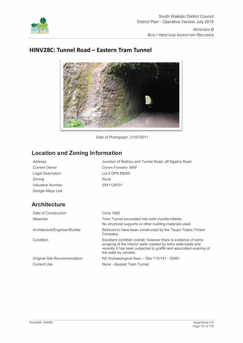
South Waikato District Council District Plan - Operative Version July 2015
APPENDIX B BUILT HERITAGE INVENTORY RECORDS
DocSetID: 344069 Appendices A-K Page 107 of 176
HINV28C: Tunnel Road – Eastern Tram Tunnel
Date of Photograph: 21/07/2011
Location and Zoning Information Address Junction of Waihou and Tunnel Road, off Ngatira Road Current Owner Crown Forestry- MAF Legal Description Lot 2 DPS 88269 Zoning Rural Valuation Number 0541128701 Google Maps Link
Architecture Date of Construction Circa 1900 Materials Tram Tunnel excavated into solid rhyolite hillside.
No structural supports or other building materials used Architecture/Engineer/Builder Believed to have been constructed by the Taupo Totara Timber
Company. Condition Excellent condition overall; however there is evidence of some
scraping of the interior walls created by extra wide loads and recently it has been subjected to graffiti and associated scarring of the walls by vandals.
Original Site Recommendation NZ Archaeological Assn – Site T15/191 - 52061 Current Use None - disused Tram Tunnel.
South Waikato District Council District Plan- Operative Version July 2015
APPENDIX B BUILT HERITAGE INVENTORY RECORDS
Appendices A-K DocSetID: 344069 Page 108 of 176
Statement of Significance
Criteria for Scheduling: 1, 6, 7, 9, 11, 12 and 13.
(1 Historical) – was associated with events, persons or ideas of importance in South Waikato history. (6 Educational) – has the potential to educate public about the history of South Waikato, item on a heritage trail, school programme potential, study of technology. (7 Archaeological) the tunnel environs are protected under the Heritage New Zealand Pouhere Taonga Act 2014, as it has the potential through investigation to provide information about the development of the timber industry in New Zealand and represents an important era of South Waikato History. (9 Technological) – is an important example of construction using particular construction methods. (11 Context) – forms part of a wider historical complex (the history of forestry harvesting and associated bush tramways). (12 Rarity) Most bush tramways were designed for a temporary existence and tunnels were not a common feature anyway. (13 Integrity) – has a good level of integrity, much of it is in reasonable condition, there have been no additions or major alterations.
District Plan Rules Demolition/Destruction – Discretionary. Protection focus – 1, 6, 7, 9, 11 and 12. Mitigate the effects of demolition by requiring the applicant to provide Historical Documentation, which should include: the structure’s history, photographic documentation and measurements of the structure prior to demolition /destruction.
Modifications/Alterations necessary for the primary purpose of improving structural performance, fire safety or physical access - Controlled. Other Additions/Alterations - Discretionary. Protection focus – 9, 11, and 13. Those elements associated with the historic character, use, rarity, craftsmanship and any other special elements identified in the Historical documentation, should be protected. NB. Erection of gates to secure the entrances to the tunnels is permitted.
Repair /Restoration of the Structure – Permitted. Refer to Rule 28.3.1. Protection focus – 6, 7, 9, 11, and 13. Building Materials Rule: If repair or restoration of the tunnel is proposed, where possible the materials used should be similar in type, dimensions and profile as the original. Design Rule: repair or replication work should match the existing design and profile of element. Restoration of missing parts allowed where there is a high level of authenticity.
Re use/Change of use- Controlled. Refer to Rule 28.3.1. Protection focus - 1,6,12 and 13. Any proposed change of use /re use must ensure that adverse effects on the tunnel and its environs are mitigated. Erection of gates to secure the entrances to the tunnels is permitted.
Disturbance of the site surface/earth works- Discretionary. Protection focus - 1, 6, 7,10,11,12 and 13. Note: Any place that was associated with human activity prior to 1900 and is able to provide evidence relating to the history of New Zealand is an ‘archaeological site’ (refer to definition of ‘archaeological site’ in Section 2 of the Heritage New Zealand Pouhere Taonga Act 2014). All archaeological sites are protected under the Heritage New Zealand Pouhere Taonga Act 2014 and approval from Heritage New Zealand must be obtained prior to destroying, damaging or modifying any site. Accordingly, where the site on which a structure is located is an ‘archaeological site’ and the structure is to be repaired, added to, relocated or demolished and this involves disturbance to the surface and/or subsurface of the site, approval from Heritage New Zealand is required.
History The area has had a connection with the timber industry that dates back to the end of the 19th century. Bush tramways were the principal method of transporting felled timber to the local mills until the late 1940s. Due to the steep gradients, tram tunnels had to be constructed in places to enable the trams to travel through some of the areas with the steepest and most challenging terrain.
Bush tramways and associated tram tunnels such as these represent an important example of engineering innovation. From the 1850s, bush tramways formed a common feature in harvesting the forests in New Zealand. Most bush tramways were designed for a temporary existence and tunnels in particular were not a common feature anyway. This tunnel is one of only several that remain in this District and is a rare surviving remnant of the former bush tramway system.

South Waikato District Council District Plan - Operative Version July 2015
APPENDIX B BUILT HERITAGE INVENTORY RECORDS
DocSetID: 344069 Appendices A-K Page 109 of 176
Additional Photographs Excavated hole for placing oil lamp, just outside tunnel entrance
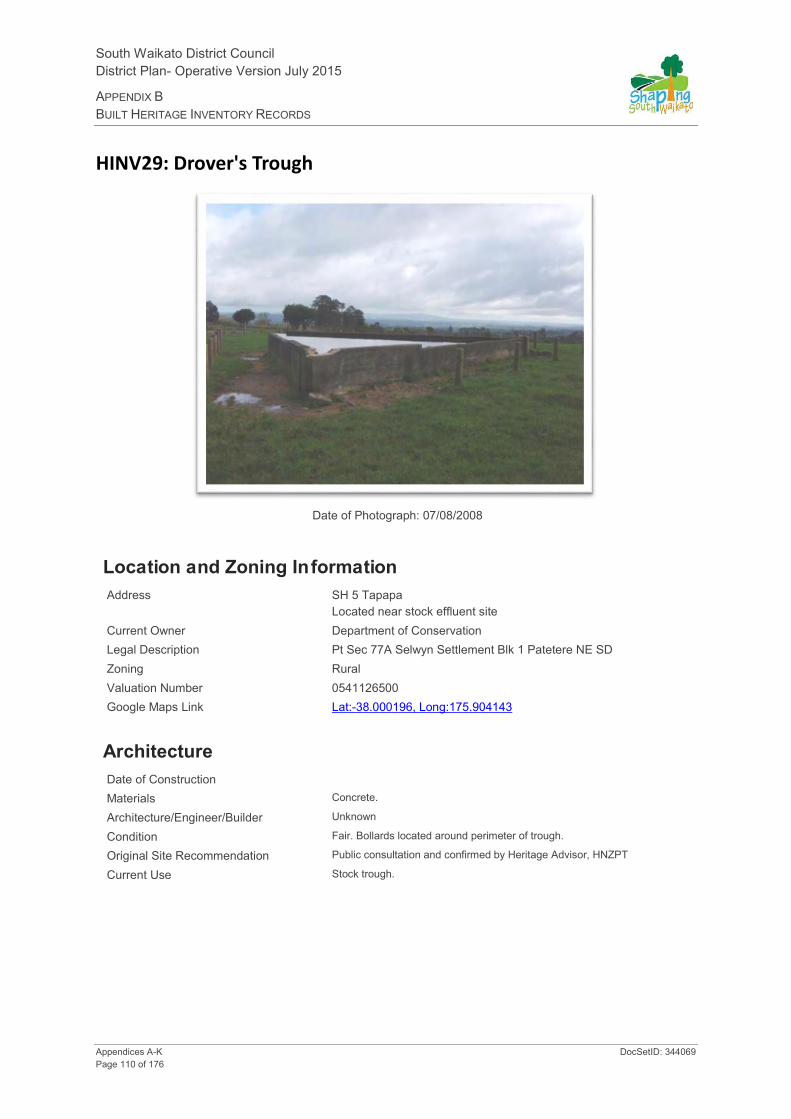
South Waikato District Council District Plan- Operative Version July 2015
APPENDIX B BUILT HERITAGE INVENTORY RECORDS
Appendices A-K DocSetID: 344069 Page 110 of 176
HINV29: Drover's Trough
Date of Photograph: 07/08/2008
Location and Zoning Information Address SH 5 Tapapa
Located near stock effluent site Current Owner Department of Conservation Legal Description Pt Sec 77A Selwyn Settlement Blk 1 Patetere NE SD Zoning Rural Valuation Number 0541126500 Google Maps Link Lat:-38.000196, Long:175.904143
Architecture Date of Construction Materials Concrete.
Architecture/Engineer/Builder Unknown
Condition Fair. Bollards located around perimeter of trough.
Original Site Recommendation Public consultation and confirmed by Heritage Advisor, HNZPT
Current Use Stock trough.
South Waikato District Council District Plan - Operative Version July 2015
APPENDIX B BUILT HERITAGE INVENTORY RECORDS
DocSetID: 344069 Appendices A-K Page 111 of 176
Statement of Significance
(1 Historical) - reflects important or representative aspects of South Waikato agricultural history; livestock industry and cattle drives from East Coast to Waikato. (11 Context) - forms part of a wider historical and cultural complex, linked to farming in the South Waikato and Waikato areas. (12 Rarity) - is a rare type of historic place, unusual type of water trough in triangle shape.
District Plan Rules Demolition - Discretionary. Protection focus - 1, 6, 11 and 12. Mitigate the effects of demolition by requiring the applicant to provide Historical Building Documentation (HBD) which should include: the structure history, photographic documentation and measurements of the item prior to removal.
Alterations necessary for the primary purpose of improving structural performance, fire safety or physical access - Controlled. Other Additions/Alterations - Discretionary. Protection focus - 11 and 12. Effects can be mitigated/remedied through; a) HBD - See mitigating the effects of Demolition. b) Design rules: 1.The overall visual character/shape of the original structure should be identifiable. The addition should not dominate the existing structure. 2.Special elements that are associated with uniqueness/craftsmanship of the structure should be retained.
Repair of the Structure - Permitted. Refer to Rule 28.3.1. Protection focus - 12. Building Materials Rule: If repair of the structure is proposed the materials used for the exterior walls should be similar in type, dimensions and profile as the existing exterior fabric of the structure. Design Rule: Repair or replication work should match the existing design and profile of element.
Re-use/Change of Use - Permitted. Refer to Rule 28.3.1. Protection focus - 1.
Internal Changes - Not applicable.
Relocation - Discretionary. Protection focus - 1, 11 and 12. Mitigate the effects of relocation by requiring the applicant to a) consult with the community, B) relocate to a similar setting and c) document through HBD process.
Disturbance of the site surface/earthworks - Note: Any place that was associated with human activity prior to 1900 and is able to provide evidence relating to the history of New Zealand is an 'archaeological site' (refer to definition of 'archaeological site' in Section 2 of the Heritage New Zealand Pouhere Taonga Act 2014). All archaeological sites are protected under the Heritage New Zealand Pouhere Taonga Act 2014 and approval from Heritage New Zealand must be obtained prior to destroying, damaging or modifying any site. Accordingly, where this site on which a building is located is an 'archaeological site' and the building is to be repaired, added to, relocated or demolished and this involves disturbance to the surface and/or subsurface of the site, approval from Heritage New Zealand is required.
History Triangle shaped water trough. Water originally supplied by hydraulic ram from Waiohotu Stream. (P Van Dougan 29/09/00). Used on cattle driving route from East Coast to Waikato? Refer to DOC for more info.

South Waikato District Council District Plan- Operative Version July 2015
APPENDIX B BUILT HERITAGE INVENTORY RECORDS
Appendices A-K DocSetID: 344069 Page 112 of 176
Additional Photographs

South Waikato District Council District Plan - Operative Version July 2015
APPENDIX B BUILT HERITAGE INVENTORY RECORDS
DocSetID: 344069 Appendices A-K Page 113 of 176
HINV30: Barnett Homestead
Date of Photograph: 23/10/2008
Location and Zoning Information Address 1690 Wiltsdown Rd, Waotu Current Owner Mangaorua Farm Ltd Legal Description Pt Lot 3 DP 31897 Zoning Rural Valuation Number 0541236600 Google Maps Link
Architecture Date of Construction 1912 Materials Weatherboard construction. Architecture/Engineer/Builder Unknown Condition Fully fenced. "Homestead farm" is operational dairy farm. Maybe
altered as windows don't look original in style. Original Site Recommendation Public consultation confirmed by Heritage Advisor, HNZPT. Current Use Private residence.

South Waikato District Council District Plan- Operative Version July 2015
APPENDIX B BUILT HERITAGE INVENTORY RECORDS
Appendices A-K DocSetID: 344069 Page 114 of 176
Statement of Significance
(1 Historical) - was associated with events, persons or ideas of importance in South Waikato history, early settlement history in South Waikato and association with a pioneering family involved in farming and timber industry; self-sufficiency demonstrated by homestead having an independent supply of electricity. (6 Educational) - has the potential to educate public about the history of South Waikato, potential to provide information about early settlement in South Waikato as part of a heritage trail or school programme.
District Plan Rules Demolition - Discretionary. Protection focus - 1 and 6. Mitigate the effects of demolition by requiring the applicant to provide Historical Building Documentation (HBD) which should include: the structure history, photographic documentation and measurements of the item prior to removal.
Alterations necessary for the primary purpose of improving structural performance, fire safety or physical access - Controlled. Other Additions/Alterations - Discretionary. Protection focus - 1 and 6.
Repair of the Structure - Permitted. Refer to Rule 28.3.1. Protection focus - 1.
Re-use/Change of Use - Permitted. Refer to Rule 28.3.1. Protection focus - 1 and 6.
Internal Changes - Permitted.
Relocation - Discretionary. Protection focus - 1.
Disturbance of the site surface/earthworks - Note: Any place that was associated with human activity prior to 1900 and is able to provide evidence relating to the history of New Zealand is an 'archaeological site' (refer to definition of 'archaeological site' in Section 2 of the Heritage New Zealand Pouhere Taonga Act 2014). All archaeological sites are protected under the Heritage New Zealand Pouhere Taonga Act 2014 and approval from Heritage New Zealand must be obtained prior to destroying, damaging or modifying any site. Accordingly, where this site on which a building is located is an 'archaeological site' and the building is to be repaired, added to, relocated or demolished and this involves disturbance to the surface and/or subsurface of the site, approval from Heritage New Zealand is required.
Protection extends to cover the Chinese fan palm (livistona chinensis) and kauri (agathis australis) trees. Discretionary consent required for tree removal. (Normal gardening, pruning and maintenance of tree health is permitted).
History Early homestead. Family associated with farming and timber ventures, technologically unique as had an independent supply of electricity until 1940.

South Waikato District Council District Plan - Operative Version July 2015
APPENDIX B BUILT HERITAGE INVENTORY RECORDS
DocSetID: 344069 Appendices A-K Page 115 of 176
HINV31: Te Waotu Post Office - Telegraph Office
Date of Photograph: 23/10/2008
Location and Zoning Information Address Waotu-Putāruru Road Current Owner J Scheres Legal Description Lot 5 DPS 84848 Zoning Rural Valuation Number 0541236900 Google Maps Link
Architecture Date of Construction 1885 -1886 Materials Pit sawn kauri and totara. Architecture/Engineer/Builder Unknown Condition Has had many alterations and additions done to the building over
the years. (Public consultation). Alterations need to be researched and documented when various changes made.
Original Site Recommendation Public consultation and confirmed by Heritage Advisor, HNZPT. Current Use Farm workers cottage
South Waikato District Council District Plan- Operative Version July 2015
APPENDIX B BUILT HERITAGE INVENTORY RECORDS
Appendices A-K DocSetID: 344069 Page 116 of 176
Statement of Significance
(1 Historical) - was associated with events, persons or ideas of importance in South Waikato history, early postal history in South Waikato, early settlement of Te Waotu 1885/86. (6 Educational) - has the potential to educate public about the history of South Waikato, potential to provide information about early settlement in South Waikato as part of a heritage trail. (7 Archaeology, pre 1900 site) - site can be investigated using archaeological methods to obtain information concerning NZ and South Waikato. (11 Context) - part of wider context of Waotu.
District Plan Rules Demolition - Discretionary. Protection focus - 1, 6, 7 and 11. Mitigate the effects of demolition by requiring the applicant to provide Historical Building Documentation (HBD) which should include: the structure history, photographic documentation and measurements of the item prior to removal.
Alterations necessary for the primary purpose of improving structural performance, fire safety or physical access - Controlled. Other Additions/Alterations - Discretionary. Protection focus - 1. Still need to control further alterations even though it has been altered over the years as this is part of its history.
Repair of the Structure - Permitted. Refer to Rule 28.3.1. Protection focus - 1.
Re-use/Change of Use - Permitted. Refer to Rule 28.3.1. Protection focus - 1 and 6.
Internal Changes - Permitted. Protection focus - 1. - needs evaluation to determine is any original features are left to warrant protection - may need to be discretionary.
Relocation - Discretionary. Protection focus - 1.
Disturbance of the site surface/earthworks - Protection focus - 7. Note: Any place that was associated with human activity prior to 1900 and is able to provide evidence relating to the history of New Zealand is an 'archaeological site' (refer to definition of 'archaeological site' in Section 2 of the Heritage New Zealand Pouhere Taonga Act 2014). All archaeological sites are protected under the Heritage New Zealand Pouhere Taonga Act 2014 and approval from Heritage New Zealand must be obtained prior to destroying, damaging or modifying any site. Accordingly, where this site on which a building is located is an 'archaeological site' and the building is to be repaired, added to, relocated or demolished and this involves disturbance to the surface and/or subsurface of the site, approval from Heritage New Zealand is required.
History Telegraph station run by Ramsay Family. Closed in 1937. Originally a house too?

South Waikato District Council District Plan - Operative Version July 2015
APPENDIX B BUILT HERITAGE INVENTORY RECORDS
DocSetID: 344069 Appendices A-K Page 117 of 176
Additional Photographs

South Waikato District Council District Plan- Operative Version July 2015
APPENDIX B BUILT HERITAGE INVENTORY RECORDS
Appendices A-K DocSetID: 344069 Page 118 of 176
HINV32: Putāruru Post Office
Date of Photograph: 07/08/2008
Location and Zoning Information Address 1-25 Kensington St, Putāruru.
Cnr of Tirau St & Kensington St, Putāruru Current Owner Country Star Properties Ltd Legal Description Lot 1 DPS 57699 Blk IV Putāruru Village Zoning Putāruru Town Centre Valuation Number 0541759602 Google Maps Link Lat:-38.049717, Long:175.780042
Architecture Date of Construction 1968. Opened on 19 June 1970. Materials Constructed of thin pre-cast concrete shells which were joined on
site with a concrete in-fill. The entire roof surface was weather proofed by elastomeric coating which covers an area of approx. 18,000sq ft. Roof drainage handled by a single down-pipe system at the extremities of lower arches. Crown shaped with a central dome. Roof comprised of thin concrete arches radiating from a central dome. The arches are arranged in two concentric rows, one lower than the other thus creating a crown shaped effect. When the arches are viewed from the interior the fourteen upper arches radiate like spokes from a central hub. The roof form gives the building its notable appearance and provides excellent natural lighting. Roof windows: Each arch contains 4 rectangular single glass windows set in aluminium/steel? frames. Roof Verges: Semi-circular concrete arches. Doors: Sliding and casement with one over one glass
Architecture/Engineer/Builder FGF Sheppard, Government Architect.
South Waikato District Council District Plan - Operative Version July 2015
APPENDIX B BUILT HERITAGE INVENTORY RECORDS
DocSetID: 344069 Appendices A-K Page 119 of 176
Condition Excellent. Some internal changes to suit use as a museum. Main foyer intact.
Original Site Recommendation Public consultation confirmed by Heritage Advisor, NZHPT. Current Use Food Court and Café
Statement of Significance
(1 Historical) - reflects important or representative aspects of South Waikato, part of postal history in district/government services. Associated with communication and postal history. (3 Community Association) - was associated with events, persons, or ideas of importance in South Waikato history; has important community association and public esteem, history as a post office/post bank part of daily community life. (6 Educationall) - has potential to educate public about history of South Waikato, current use as a museum provides the potential for educational use/public access; heritage trail/school programme/postal history tour, etc. (9 Technologica) - is an important example of construction using particular construction methods, roof is associated with innovation-use of a fluid applied membrane of Neoprene/Hypalon; use of a thin concrete shell to provide structural strength. (10 Architectural) - is of important design, unusual design to fit site, innovative use of materials. Exterior visual aspects include unusual shape (round), roof-crown shape, notable fenestration in roof openings that provides natural light; internal foyer under crown roof strong part of design. (11 Context) - forms part of a wider historical and cultural complex, strong landscape feature/landmark. (12 Rarity) - is a rare type of historic place, rare design, only post office in NZ with round floor plan and crown shaped roof. Rarity linked to design type and technology. (13 Integrity) - has a good level of integrity, relationship of surrounding buildings/townscape/landscape.
District Plan Rules Demolition - Discretionary. Protection focus - 1,3, 6, 9, 10, 11, 12 and 13. Mitigate the effects of demolition by requiring the applicant to provide Historical Building Documentation (HBD) which should include: the structure history, photographic documentation and measurements of the item prior to removal. To mitigate the loss of a rare building type, emphasis should be placed on recording how the building operated as a post office.
Alterations necessary for the primary purpose of improving structural performance, fire safety or physical access - Controlled. Other Additions/Alterations - Discretionary. Protection focus - 3, 6, 10, 11, 12 and 13. Effects can be mitigated/remedied through; a) HBD - See mitigating the effects of demolition. b) Design Rules: 1.The overall visual character/shape of the original building should be identifiable. The addition should not dominate the existing building. 2. New work should be restricted to the rear of the building and not be evident from the road frontages. Additions restricted to link structure (enclosed corridors at the back of the building) to provide internal access to any adjacent buildings at the rear of the Post Office. Visual aspects to considered that relate to history, landscape/landmark, public views. The design and landmark qualities of the building should not be compromised by a linked building addition. 3. The following special elements that are associated with the rarity or architectural uniqueness or craftsmanship of the structure should be retained: Elements of the Post Office that should be retained are those elements associated with its historic use as a rare type of building, i.e. exterior walls, openings, construction materials and any other elements identified in the Historic Building Documentation. c) Building Materials Rule: If the repair of the buildings is proposed the materials used for the exterior walls should be similar in type, dimensions and profile as the existing exterior fabric of the building.
Repair of the Structure - Permitted. Refer to Rule 21.3.1. Protection focus - 9, 10, 12 and 13. Building Materials Rule: If repair of the building is proposed the materials used for the exterior walls and elements should be similar in type, dimensions and profile as the existing exterior fabric of the building, i.e. brick, metal framed windows etc. Design Rule: Repair or replication work should match the existing design and profile of element.
Re-use/Change of Use - Permitted. Refer to Rule 21.3.1. Protection focus - 1, 3, 6 and 12.
Internal Changes - Discretionary. Protection focus - 10 - Post Office only? Design Rule: Significant interior spaces and use areas should be identifiable. a) Modification of the Post Office central foyer is not ruled out. b) Modification of the other internal spaces surrounding the Post Office foyer is allowed but alterations must be documented and not detract from the heritage values.
Relocation - Discretionary. Protection focus - 9, 10, 11 and 12.
Disturbance of the site surface/earthworks - Note: Any place that was associated with human activity prior to 1900 and is able to provide evidence relating to the history of New Zealand is an 'archaeological site' (refer to definition of 'archaeological site' in Section 2 of the Heritage New Zealand Pouhere Taonga Act 2014). All

South Waikato District Council District Plan- Operative Version July 2015
APPENDIX B BUILT HERITAGE INVENTORY RECORDS
Appendices A-K DocSetID: 344069 Page 120 of 176
archaeological sites are protected under the Heritage New Zealand Pouhere Taonga Act 2014 and approval from Heritage New Zealand must be obtained prior to destroying, damaging or modifying any site. Accordingly, where this site on which a building is located is an 'archaeological site' and the building is to be repaired, added to, relocated or demolished and this involves disturbance to the surface and/or subsurface of the site, approval from Heritage New Zealand is required.
Surrounds - include an identifiable context for the building and to ensure open space retained - further research required for boiler room and bike shed?
History Only post office in New Zealand that has a round floor plan and crown shaped roof. Postal and Government Services provided to District including mail, telephone, telegraph, banking, auto registration and marriage certificates. Designed in a circular shape to make best use of acute angle section between Tirau and Kensington Streets. Replaced the 1912 post office. (A Simmons 19/02/01).
Land use consent for building alterations was granted in 2010 to facilitate conversion from a café/museum into a food court.
Additional Photographs
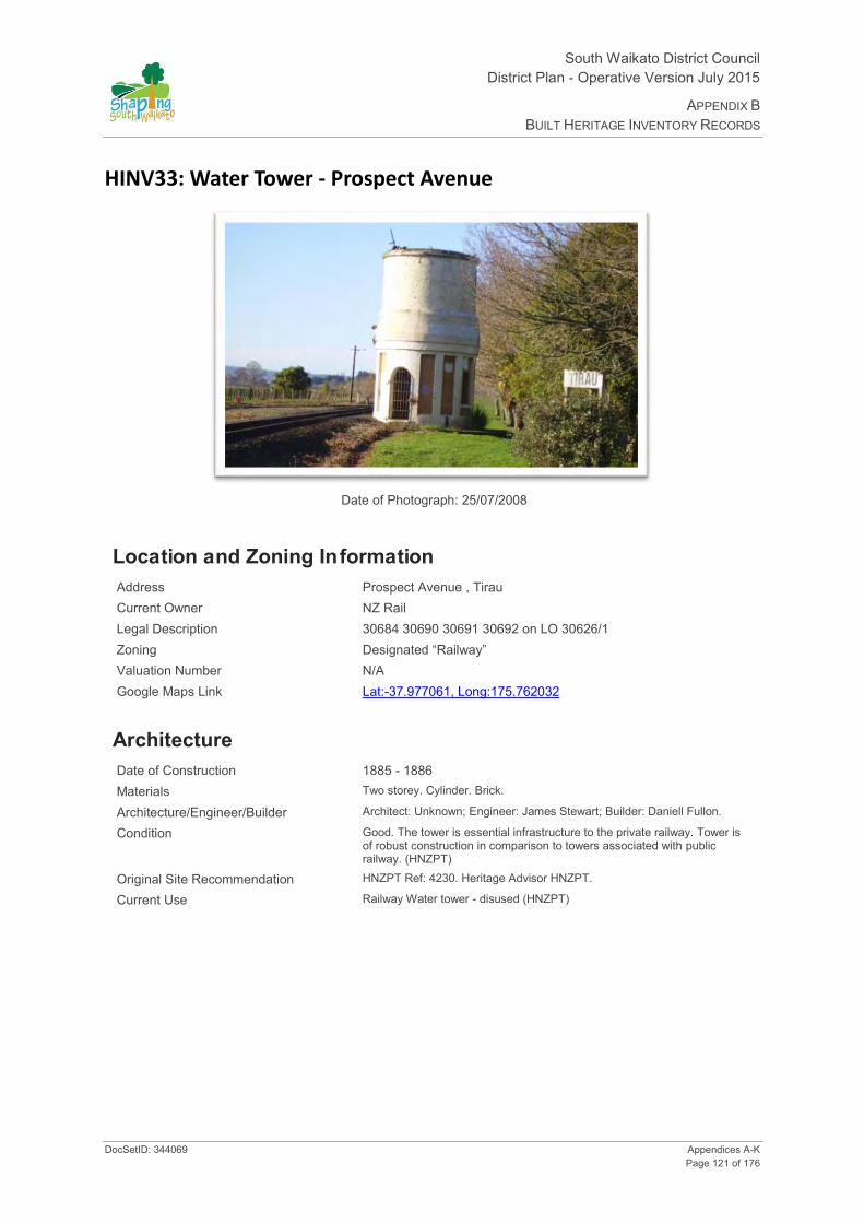
South Waikato District Council District Plan - Operative Version July 2015
APPENDIX B BUILT HERITAGE INVENTORY RECORDS
DocSetID: 344069 Appendices A-K Page 121 of 176
HINV33: Water Tower - Prospect Avenue
Date of Photograph: 25/07/2008
Location and Zoning Information Address Prospect Avenue , Tirau Current Owner NZ Rail Legal Description 30684 30690 30691 30692 on LO 30626/1 Zoning Designated “Railway” Valuation Number N/A Google Maps Link Lat:-37.977061, Long:175.762032
Architecture Date of Construction 1885 - 1886 Materials Two storey. Cylinder. Brick.
Architecture/Engineer/Builder Architect: Unknown; Engineer: James Stewart; Builder: Daniell Fullon.
Condition Good. The tower is essential infrastructure to the private railway. Tower is of robust construction in comparison to towers associated with public railway. (HNZPT)
Original Site Recommendation HNZPT Ref: 4230. Heritage Advisor HNZPT.
Current Use Railway Water tower - disused (HNZPT)
South Waikato District Council District Plan- Operative Version July 2015
APPENDIX B BUILT HERITAGE INVENTORY RECORDS
Appendices A-K DocSetID: 344069 Page 122 of 176
Statement of Significance
(1 Historical) - reflects important or representative aspects of South Waikato history, 1885-1886, transportation and rail history in South Waikato. Dates from periods of early settlement in South Waikato, (6 Educational) - has the potential to provide knowledge and educate public about history of South Waikato and New Zealand. Potential heritage trail/school programme use; transportation, railways in the South Waikato. (7 Archaeology, pre 1900) - the site is protected under the Heritage New Zealand Pouhere Taonga Act 2014, has the potential through archaeological investigation to provide information about NZ and the South Waikato history. (10 Architectural) - design - attention to detail even though utilitarian structure. (11 Context) - forms part of a wider historical and cultural complex - one of three in South Waikato District on same line. (12 Rarity) - it is a rare type of historic place, only a few 1880's railway water towers remain in NZ. (13 Integrity) - has a good level of integrity, structure is not compromised by additions.
District Plan Rules Demolition - Discretionary. Protection focus - 1, 6, 7, 10, 11, 12 and 13. Mitigate the effects of demolition by requiring the applicant to provide Historical Building Documentation (HBD) which should include: the structure history, photographic documentation, and measurements of the item prior to removal.
Visual aspects to consider that relate to history, landscape/landmark value.
Alterations necessary for the primary purpose of improving structural performance, fire safety or physical access - Controlled. Other Additions/Alterations - Discretionary. Protection focus - 1, 6, 10, 12 and 13. Effects can be mitigated/remedied through; a) HBD - See mitigating the effects of demolition. b) Design Rules: 1.The overall visual character/shape of the original building should be identifiable. The addition should not dominate the existing building. 2. New work should be restricted to the rear of the building and not be evident from the road frontage. 3. The following special elements that are associated with the rarity or architectural uniqueness or craftsmanship of the structure should be retained: Those elements associated with the structures historic character, use, rarity, landmark values, craftsmanship and any other special elements identified in the HBD. c) Building materials rule: If repair of the buildings is proposed the materials used for the exterior walls and elements should be similar in type, dimensions and profile as the existing fabric of the building.
Repair of the Structure - Permitted. Refer to Rule 28.3.1. Protection focus - 1, 6, 10, 12 and 13. Building Materials Rule: If repair of the buildings is proposed the materials used for the exterior walls and elements should be similar in type, dimensions and profile as the existing exterior fabric of building. Design rule: Repair or replication work should match the existing design and profile of element.
Re-use/Change of Use - Permitted. Refer to Rule 28.3.1. Protection focus - 1, 6, 12 and 13.
Internal - Discretionary - has room under, should not be compromised especially ceiling which is shaped underside of well.
Disturbance of the site surface/earthworks - Note: Any place that was associated with human activity prior to 1900 and is able to provide evidence relating to the history of New Zealand is an 'archaeological site' (refer to definition of 'archaeological site' in Section 2 of the Heritage New Zealand Pouhere Taonga Act 2014). All archaeological sites are protected under the Heritage New Zealand Pouhere Taonga Act 2014 and approval from Heritage New Zealand must be obtained prior to destroying, damaging or modifying any site. Accordingly, where this site on which a building is located is an 'archaeological site' and the building is to be repaired, added to, relocated or demolished and this involves disturbance to the surface and/or subsurface of the site, approval from Heritage New Zealand is required.
Relocation - Discretionary
History Originally constructed for the Thames Valley & Rotorua Railway Company to serve as a water storage tower. It is very similar in style to the water towers in Lichfield and Ngatira. (HNZPT).

South Waikato District Council District Plan - Operative Version July 2015
APPENDIX B BUILT HERITAGE INVENTORY RECORDS
DocSetID: 344069 Appendices A-K Page 123 of 176
Additional Photographs

South Waikato District Council District Plan- Operative Version July 2015
APPENDIX B BUILT HERITAGE INVENTORY RECORDS
Appendices A-K DocSetID: 344069 Page 124 of 176
HINV34: Motai Niu Pole (T15/193)
Date of Photograph: 29/07/2008
Location and Zoning Information Address Kakoahu Road, Kuranui Current Owner H.H. Pate, R & L Kinred & Others Legal Description Te Hanga A11 Block Zoning Rural Valuation Number 0541133600 Google Maps Link
Architecture Date of Construction 1865 (according to local tradition but no exact date could be
established) Materials Totara Architecture/Engineer/Builder Condition Good. The wire stays have were replaced or tightened recently.
The niu pole was conserved in the 1980s. At that time an archaeological investigation was carried out at the site to gather additional information about the pole. (The report has been added to this record as additional information). The pole was 14 metres high when assessed for conservation in the early 1980s. 2.50 metres were below ground and deteriorated. 1.25m of the pole which was in the ground broke off when it was being removed for treatment. The base dimensions of the pole are 43 x 38 cm. An iron hook is located around the top of the pole. It is believed the hook held a cross timber or spar in place near the top of the pole. The base of the pole in fenced. Local history suggests there was a garden in this zone at the base of the pole.

South Waikato District Council District Plan - Operative Version July 2015
APPENDIX B BUILT HERITAGE INVENTORY RECORDS
DocSetID: 344069 Appendices A-K Page 125 of 176
(A paper is attached that describes the pole and the treatments used to stabilise the pole). A small derelict house is located near the pole. The back of the house has collapsed and is open to the weather, but the main structure is still stable.
Original Site Recommendation Cowan, J (1983) The New Zealand Wars Vol 1. NZAA Site Record T15/193. Martelletti, N (1996) Kuranui Historic Pole NZ Historic Places Trust Magazine. Peters, K (1990) Conservation of a Niu Pole at Kuranui and Excavation Report 1980. Stokes, E (1980) Pai Marire The Niu at Kuranui (Occasional paper no 6)
Current Use
Statement of Significance
(1, 3, and 4) Historical the niu pole relates to early New Zealand History and the development of a new religion (Pai Marire) within New Zealand. The site has research potential as an archaeological site and is both a settlement site and religious site.
(5) Important to Tangata whenua as a traditional, historical, religious, commemorative, and educational symbol. The niu was associated with the king movement but the Kuranui pole is specifically noted as associated with Ngati Raukawa and the hapu Ngati Motai.
(7) Potential for Public Education as part of a heritage trail or through school visits.
(11) Rare, the only niu in SWD.
(13) Integrity of the niu is high, it is on its original site and has a relationship with the modified landscape of the setting. The pole has been conserved.
District Plan Rules Demolition – Non- complying – Refer to Rule 28.3.5
Additions/ Alterations - Non- complying – Refer to Rule 28.3.5
Re-use/ Change of Use - Non- complying – Refer to Rule 28.3.5
Internal Changes - Not applicable
Relocation- Non- complying – Refer to Rule 28.3.5
Disturbance of the site surface/ earthworks - Note: An archaeological site is any place that was associated with human activity prior to 1900 and is or may be able, through investigation using archaeological methods, to provide evidence relating to the history of New Zealand (Historic Places Act 1993, Section 2). All archaeological sites are protected under the Heritage New Zealand Pouhere Taonga Act 2014 and approval must be obtained from Heritage New Zealand prior to destroying, damaging or modifying an archaeological site. Accordingly, where this site on which a building is located is an ‘archaeological site’ and the building is to be repaired, added to, relocated or demolished and this involves disturbance of the surface and/or sub-surface of the site, approval from Heritage New Zealand is required.
History The Motai Niu Pole or worship pole at Kuranui marks the presence of the Pai Marire or Hauhau movement. The Pai Marire religion was practiced in the area in the late 19th century. The Pai Marire faith was founded by Te Ua Horopapera Haumene of Taranaki. Te Ua’s guiding spirit was Atua Pai Marire, the “good and peaceful god”. The niu was the central symbol of worship and each tribe that converted to the new religion erected a niu pole under the direction of Te Ua or his sub-priests. Pai Marire was adopted by the Maori King.
By the end of 1865s a niu stood in every large village from Taranaki to the Bay of Plenty (except Arawa) and from the north of Wellington to the Waikato frontier. Several times each day the Hauhau gathered at the foot
South Waikato District Council District Plan- Operative Version July 2015
APPENDIX B BUILT HERITAGE INVENTORY RECORDS
Appendices A-K DocSetID: 344069 Page 126 of 176
of the niu pole for worship. They marched in procession round and round the pole chanting in chorus the Pai Marire incantations taught by the prophet.
Kuranui was a gathering point for Hauhau in the region. The niu pole at Kuranui belongs to Ngati Motai, a hapu of Ngati Raukawa. Local tradition indicates the pole at Kuranui was erected in 1865. The Motai niu pole was made from a totara tree felled near Katikati. A human figure with a birds head, ‘Rupe’, is carved near the base of the pole. Rupe represented a dove, the biblical symbol of the Holy Spirit in Pai Marire religion. Rupe was also one of the ancestors associated with Maui.
In the early 1870’s Te Kooti was regarded as a leader of the movement and during military pursuit from Taupo he retreated from Tapapa to Kuranui and was sheltered. According to local tradition Te Kooti’s flag, Te Whepu (the whip) once flew from the Kuranui niu pole.
A small caretakers house is located near the pole. The last guardian of the pole was Mokai Te Pakaru. He died in 1972 and the site has been abandoned. The archaeological report on the pole conservation notes that according to Mrs Rangipukea Kindred, who lived at Kuranui in her youth, there was a settlement at the site. These are indicated by the line of trees and tree stumps and a meeting house.
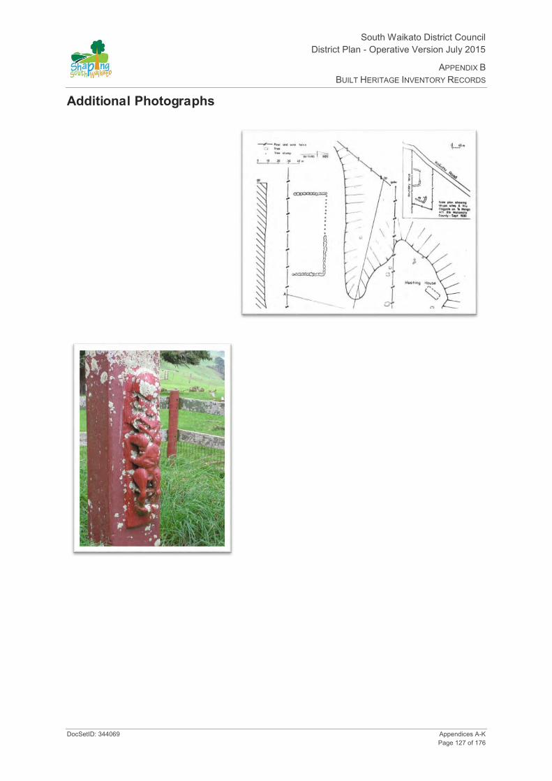
South Waikato District Council District Plan - Operative Version July 2015
APPENDIX B BUILT HERITAGE INVENTORY RECORDS
DocSetID: 344069 Appendices A-K Page 127 of 176
Additional Photographs

South Waikato District Council District Plan- Operative Version July 2015
APPENDIX B BUILT HERITAGE INVENTORY RECORDS
Appendices A-K DocSetID: 344069 Page 128 of 176
HINV35: Stockmans Hut
Date of Photograph: 29/07/2008
Location and Zoning Information Address 2670 State Highway 5, Tirau Current Owner Duncan Processors Ltd. Legal Description Section 50 Block X Paterere North East Survey District (Selwyn
Settlement) CT 991/187 Zoning Rural Valuation Number 0541129200 Google Maps Link
Architecture Date of Construction 1935 - 1940; fire place circa early 1950s Materials Wooden weather boards; single skin of exterior weather boards on
a timber frame. Concrete piles and pre-cast concrete block fireplace. Round nails, rose-head and flat top used to attach boards, repair (re-nailing) is evident. The frame is lashed to the concrete piles with #8 wire (see additional photos). The wire feeds through holes in the piles. The roof is corrugated iron. No metal door or window hardware was evident
Architecture/Engineer/Builder TS Duncan or more probably Albert Hemmings Condition Stable Condition and high level of integrity. Many of the floor
boards, some of the weatherboards, the windows, and door are missing. No major areas of wet rot were evident. The building appears very stable considering how exposed it is. The hut is not in use nor has it been used for many years.
Original Site Recommendation Barker, Eileen (1986) A History of the Tapapa School and District.

South Waikato District Council District Plan - Operative Version July 2015
APPENDIX B BUILT HERITAGE INVENTORY RECORDS
DocSetID: 344069 Appendices A-K Page 129 of 176
McMillan, TE (editor) (1995) The Centennial History of the Matamata Plains.
Current Use Not in use. Popular landscape feature and landmark on the way to and from Rotorua on SH 5. The hut is frequently photographed
Statement of Significance
Historical –The Hut reflects an important or representative aspect of SWD history, (ie development of farming in the district, and agricultural management ideas). Section 50’s history is associated with farming by the Thames Valley Land Company and the leasing by ballot of the Selwyn Settlement block. The paddock (Section 50) and the associated hut relate to the history of land use in the Kaimais and the use of grazing rotation to overcome the ill effects of bush sickness prior to the discovery of the cobalt deficiency.
Educational - The stockman’s hut has the potential to be used to educate the public about SWD’s history as an item on a heritage trail or school field trip.
Landscape/ Landmark- The hut and associated paddock are a landmark on State Highway 5 for many people. The hut in it’s setting are aesthetically pleasing. The hut is frequently photographed and has been used on calendars (including the Duncan Processing Plan calendar).
District Plan Rules Demolition- Discretionary. Protection focus- Mitigate the effects of demolition by requiring the applicant to provide Historical Building Documentation (HBD) which should include: the structures history, photographic documentation and measurements of the item prior to removal.
Additions/ Alterations - Not permitted (would have an adverse effect on the integrity of the buildings scale and landmark qualities).
Repair of the Structure - Permitted. Refer to Rule 28.3.1 Protection focus- building materials should be similar in type and dimensions to the existing materials. The finish and profile of the exiting building should be respected and replicated.
Re-use/Change of Use-
Internal Changes - Discretionary. Protection Focus: building materials should be similar in type and dimensions to the existing materials. The finish and profile of the exiting building should be respected and replicated.
Relocation - Discretionary. Protection focus- Mitigate the effects by 1) Consulting with the local community and/ or consulting with Iwi or special interest groups, 2) Relocating to a similar setting, 3) Documenting (HBD).
History The hut is located on a fifty acre block that was part of the Selwyn Settlement Block X which was surveyed off in 1905 (SO 13863). The Selwyn Settlement was a series of blocks east of the Waihou River that extended from the northern side of the Kaimai Road southward for eighteen miles along the foot of the ranges to beyond Lichfield. The south-eastern part of the area encompassed the edge of the Patetere Plateau. The Selwyn Settlement was part of the Thames Valley Land Company estate prior to Government acquisition in 1905. The Thames Valley Land Company had acquired the blocks from the Patetere Company in 1883. Thames Valley Land Company liquidated their holdings in 1891 as a result of the economic depression of the 1880’s. The Bank of New Zealand took over the property in 1891 and it was administered by the Assets Administration Board in 1895 and taken over by the Government in 1905.
The Selwyn Settlement comprised 37,444 acres and was divided into 24 farms. Some of the farm allotments were composed of groupings of land, one section in open country and one in the bush country (i.e. Kaharoa- “Highland Farm”). The land was offered by ballot in 1906 for dispersal on lease, with all the improvements, other then buildings, included in the lease price for the section.
Survey plan SO 13863 (1905) shows section 50 and the notation “good grass, cocksfoot & c”. Section 50 is set in the middle of a wooded landscape near the Kaharoa Clearing. The description of the paddock indicates the pasture had been cleared and cultivated probably by the Thames Valley Land Company. T.S Duncan was the successful applicant for Sections 81 (248 acres) which included Sections 49 (352 acres) and Section 50 (57 acres). The sections were combined so stock could be rotated since Sections 49 and 50 (near Mamaku)
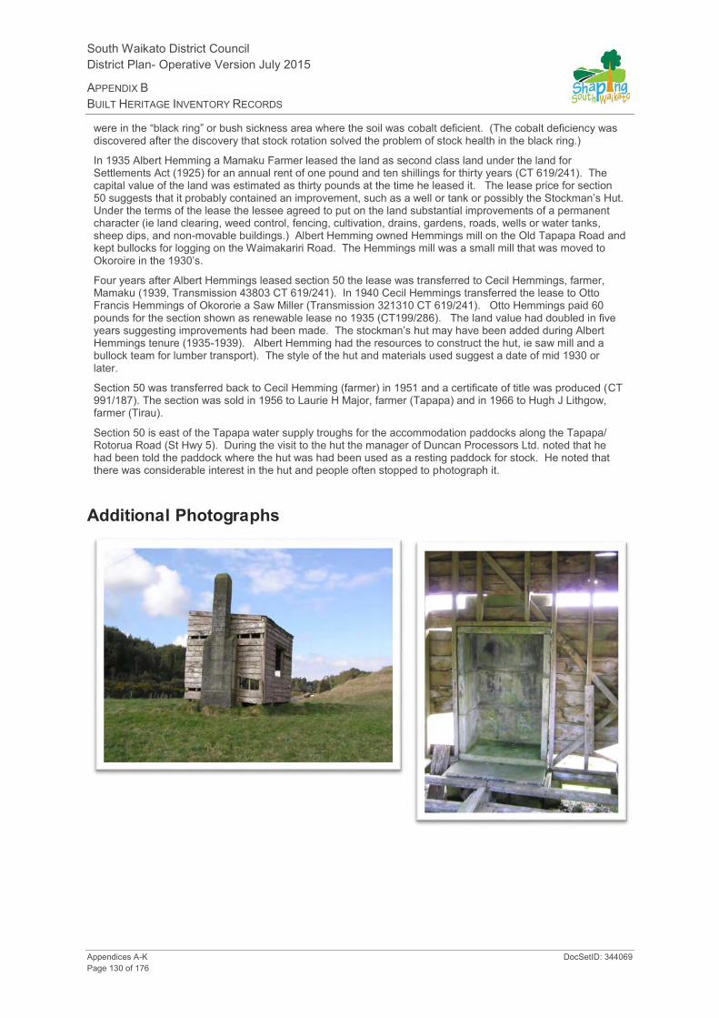
South Waikato District Council District Plan- Operative Version July 2015
APPENDIX B BUILT HERITAGE INVENTORY RECORDS
Appendices A-K DocSetID: 344069 Page 130 of 176
were in the “black ring” or bush sickness area where the soil was cobalt deficient. (The cobalt deficiency was discovered after the discovery that stock rotation solved the problem of stock health in the black ring.)
In 1935 Albert Hemming a Mamaku Farmer leased the land as second class land under the land for Settlements Act (1925) for an annual rent of one pound and ten shillings for thirty years (CT 619/241). The capital value of the land was estimated as thirty pounds at the time he leased it. The lease price for section 50 suggests that it probably contained an improvement, such as a well or tank or possibly the Stockman’s Hut. Under the terms of the lease the lessee agreed to put on the land substantial improvements of a permanent character (ie land clearing, weed control, fencing, cultivation, drains, gardens, roads, wells or water tanks, sheep dips, and non-movable buildings.) Albert Hemming owned Hemmings mill on the Old Tapapa Road and kept bullocks for logging on the Waimakariri Road. The Hemmings mill was a small mill that was moved to Okoroire in the 1930’s.
Four years after Albert Hemmings leased section 50 the lease was transferred to Cecil Hemmings, farmer, Mamaku (1939, Transmission 43803 CT 619/241). In 1940 Cecil Hemmings transferred the lease to Otto Francis Hemmings of Okororie a Saw Miller (Transmission 321310 CT 619/241). Otto Hemmings paid 60 pounds for the section shown as renewable lease no 1935 (CT199/286). The land value had doubled in five years suggesting improvements had been made. The stockman’s hut may have been added during Albert Hemmings tenure (1935-1939). Albert Hemming had the resources to construct the hut, ie saw mill and a bullock team for lumber transport). The style of the hut and materials used suggest a date of mid 1930 or later.
Section 50 was transferred back to Cecil Hemming (farmer) in 1951 and a certificate of title was produced (CT 991/187). The section was sold in 1956 to Laurie H Major, farmer (Tapapa) and in 1966 to Hugh J Lithgow, farmer (Tirau).
Section 50 is east of the Tapapa water supply troughs for the accommodation paddocks along the Tapapa/ Rotorua Road (St Hwy 5). During the visit to the hut the manager of Duncan Processors Ltd. noted that he had been told the paddock where the hut was had been used as a resting paddock for stock. He noted that there was considerable interest in the hut and people often stopped to photograph it.
Additional Photographs
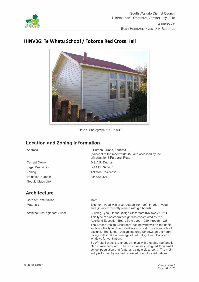
South Waikato District Council District Plan - Operative Version July 2015
APPENDIX B BUILT HERITAGE INVENTORY RECORDS
DocSetID: 344069 Appendices A-K Page 131 of 176
HINV36: Te Whetu School / Tokoroa Red Cross Hall
Date of Photograph: 29/07/2008
Location and Zoning Information Address 4 Paraonui Road, Tokoroa
(adjacent to the reserve (lot #2) and accessed by the driveway for 6 Paraonui Road
Current Owner D & A.P. Duggan Legal Description Lot 1 DP 373480 Zoning Tokoroa Residential Valuation Number 0547200301 Google Maps Link
Architecture Date of Construction 1925 Materials Exterior - wood with a corrugated iron roof. Interior- wood
and gib (note: recently relined with gib board) Architecture/Engineer/Builder Building Type: Linear Design Classroom (Kellaway 1981)
This type of classroom design was constructed by the Auckland Education Board from about 1920 through 1928. The ‘Linear Design Classroom’ has no windows on the gable ends nor the type of roof ventilation typical in previous school designs. The ‘Linear Design’ featured windows on the north facing wall to take advantage of natural light with transoms windows for ventilation. Te Whetu School is L-shaped in plan with a gabled roof and is clad in weatherboard. The structure was designed for a small school population and features a single classroom. The main entry is formed by a small recessed porch located between
South Waikato District Council District Plan- Operative Version July 2015
APPENDIX B BUILT HERITAGE INVENTORY RECORDS
Appendices A-K DocSetID: 344069 Page 132 of 176
the toilet/ washroom and the teacher’s room. The main entry opens into a short hall that provides access to the teachers room, toilet/ washroom, and classroom. A second exterior access door is located at the gable end of the classroom. The main classroom roof extends over the toilet/ washroom and teachers room. The corrugated iron roof still features a stove pipe. The stove would have been the main source of heat for the school. Photographs of the school on site at Te Whetu suggest that the exterior of the building has been altered very little over the years.
Condition Excellent. Recently repainted and being converted into a self contained residence (June 2007).
Original Site Recommendation De Lisle, Leslie 2006 pers communication to Alexy Simmons about the Red Cross Hall in Tokoroa. Kellaway, J W 1981 Education 150 from Schoolhouse to Classpace in the Waikato- Bay of Plenty. On file Hamilton Public Library. Putaruru Press, 20 October 1961 Scherer, Vicki 1992 Putāruru Home of the Owl. Published by South Waikato District Council. Vennell, CW and Mona Gordon, MEW FitzGerald, TE McMillan, G Gilmore Griffiths 1951 Centennial History of Matamata Plains. Matamata County Council.
Current Use Residential
Statement of Significance
1. Historical aspect - Te Whetu school represents the economic influence the timber industry had on Te Whetu. Community growth resulted in the establishment of institutions like schools, public halls, and churches. The structure continued to function as a community building when it was relocated to Tokoroa in the 1960s and acquired a history in Tokoroa as the Red Cross Hall. Its public use has only recently changed.
The building is a good example of the ‘Linear Design Classroom’ style used by the Education Board in the 1920s. A feature of the design is the use of natural light and ventilation. This element of the building has not been modified over the years and remains a dominant feature of the building.
Integrity-
The exterior architectural integrity of the building is good. (The structures exterior profile and form has changed little based on comparison with historic photographs). The building still features the original cladding, fenestration and the original classroom/ playground access door. The main entry door is a four panelled style that was used in school buildings from an earlier period (i.e. this style of door is shown in school drawings and contract plans for circa 1880 to 1913). The main entry door may have been inserted recently or been a replacement door inserted during the buildings use as a school. The exterior design continues to communicate the structures original design and use as a school.
The historical integrity of the building as a school has been affected by relocation and use. The building was relocated from Te Whetu to Tokoroa in 1965 for use as a Red Cross Hall. The new public use in 1965 reflects the common practice of reuse and relocation of community buildings for public purposes. Since 1965 the building has accrued approximately forty years of history on its current site as a public hall. The ‘Linear Design Classroom’ retained its interior and exterior integrity during its use as a Red Cross Hall. This included retention of a blackboard on one wall.
Recently the interior architectural integrity of the building and use of the building as a public facility has changed. The building has been relined and is currently being converted into a residence. Although the interior of the building has been altered substantially the exterior elements of the building remain and still communicate its original use as a school and later use as a public hall.
Education- The building could be included as an item on a heritage trail of Tokoroa with directions provided for viewing the structure from the reserve.

South Waikato District Council District Plan - Operative Version July 2015
APPENDIX B BUILT HERITAGE INVENTORY RECORDS
DocSetID: 344069 Appendices A-K Page 133 of 176
Te Whetu School/ Tokoroa Red Cross Hall/ residence still retains its original external form. It could be interpreted as it was built and originally used, i.e. Te Whetu School. It could also be interpreted as it was recycled and reused as Tokoroa’s Red Cross Hall for approximately forty years.
An interpretation sign could be erect on the reserve opposite the structure that contains historic photographs and describes the structures history. Alterations could also be made to the reserve fence to make the building more visible. (note: this could include lowering a section of the fence and inserting plexi-glass panels).
District Plan Rules Demolition- Discretionary. Refer to Rule 20.3.4. Protection focus- Avoid demolition. If demolition is the only option document the structure.
Relocation- Discretionary. Refer to Rule 20.3.4. Protection focus- Mitigate the effects by 1) Consulting with the local community, and/ or consulting with Iwi or special interest groups, 2) Relocating to a similar setting, 3) Documenting (HBD).
Alterations necessary for the primary purpose of improving structural performance, fire safety or physical access - Controlled. Other Additions/Alterations - Discretionary. Refer to Rule 20.3.4. Protection focus- form, scale, exterior elements that indicate previous use as a 1925 school- “Linear Design Classroom.”
The design form and scale of the building is small and indicative of its original use and should not be compromised by additions. The most significant elevation is the elevation parallel to the reserve. This elevation should not be modified.
The most significant exterior design element is the fenestration on the classroom wall, ie the four double hung wooden sash windows with transoms. The windows should not be compromised by removal or external alterations or replacement. If double pane glass is desired this should consist of an internal layer of glass. If repair is required the existing fenestration should be matched.
The building is clad in weatherboard. If repairs are required this element should be retained by repair and replacement with boards of a similar profile.
The roof is clad in corrugated iron. The roofing profile should be retained by repair/ replacement with corrugated iron of the same profile. No dormers should be inserted into the roof line. A flush sky light could be inserted on the rear roof of the building to provide more natural light and ventilation.
The door at the end of the classroom is an original door and should be retained. If repair is required the door should be replicated or replaced with one of the same style.
Re-use/ Change of Use- This has already occurred.
Internal Changes- These have already occurred.
History The former Te Whetu School/Tokoroa Red Cross Hall was the second school in Te Whetu. The school was in use for approximately 40 years.
Te Whetu had a series of schools that reflected the growth and eventual decline of the community. Over the years a total of 889 pupils passed through the Te Whetu school, the majority of these students would have spent many of their school years in the ‘Linear Design Classroom’. When the school had its school jubilee in 1961, it had a roll of 38 pupils.
The first school at Te Whetu was opened on 4 September, 1911 to its first intake of students. Establishment of the school was associated with timber harvest in the region and the growth of Te Whetu. Bartholomew Land and Timber Company commenced operation at Te Whetu in 1910. Te Whetu grew from a small Maori settlement to a village of 150 people with its own store, town hall, and school.
The first school building was probably provided by the local community or the mill. The school was described as being “a very plain, unpainted building on a site close to the mill” (Putāruru Press 20 October 1961). The 1911 school was probably near the South Taranaki Timber Company mill and not the Bartholomew Land and Timber Company (based on references made in a newspaper article about the school reunion). In approximately 1925 the pine forest was planted at Te Whetu. At that time the school was relocated to a site away from the mill. Whether the old building was relocated is not known.
A new school was constructed at Te Whetu in 1925 by the Auckland Education Board. This school is the building located on Paraonui Road adjacent to the reserve (#4 Paraonui Road). The school was a ‘Linear

South Waikato District Council District Plan- Operative Version July 2015
APPENDIX B BUILT HERITAGE INVENTORY RECORDS
Appendices A-K DocSetID: 344069 Page 134 of 176
Design Classroom’. The ‘Linear Design’ featured windows on the north wall instead of the gable end to make use of natural light (Kellaway 1981). The design focus was on increasing student health through classrooms that featured sunlight and natural ventilation. Ventilation was through the transom above the double hung sash windows. The classroom layout featured blackboards on the gable ends. Until recently Te Whetu School still had its blackboard. (Red Cross member Leslie De Lisle pers comm. 2006: “the building still contains the original blackboard and is a large hall like structure”).
Photographs taken of the Te Whetu School show two school buildings of different designs adjacent to the ‘Linear Design Classroom’ (see attached photographs under additional photographs). These buildings appear to date from different periods of time. The older of the two structures had a low gable roof with vertical battens on the exterior walls. This building may have been erected as a temporary classroom in the late 1940s or early 1950s and is similar to the unit classroom, AK1 style, (Kellaway 1981:200). If the classroom was the AK1 style it was probably clad in asbestos cement panels and considered a temporary structure (see attached photographs and Kellaway 1981:200-203). By the 1960s this structure was replaced by an SA1 classroom (see photograph). The SA1 classroom was clad in weather board and featured a shed roof that shaded the front casement windows. This style of building was used from approximately 1953 through the following ten years. The SA1 plan size was modified by the Education Board over the years. The later designs had an extended front roof that formed a narrow veranda. The veranda was used as an external corridor between classrooms.
In the 1960s the two buildings that comprised Te Whetu School became redundant, ie the ‘Linear Design Classroom’ and the SA1 classroom. Both buildings were relocated. (Newspaper comments suggest the SA1 classroom was shifted to another school).
The ‘Linear Design Classroom’ was relocated in 1965 by the Tokoroa Red Cross and placed on the site adjacent to the reserve on Paraonui Street. Recently the Tokoroa Red Cross ceased using the building due to a decline in membership.
The building has now been converted into a residence. The classroom has been lined with gib and a partial mezzanine floor has been inserted in one corner. The mezzanine floor has been designed as a sleeping loft and is located in the northwest corner of the classroom. The ‘sleeping loft’ corner of the classroom has no historic openings (doors or windows). The loft is set back from the main classroom windows and was not apparent from the exterior during the day.

South Waikato District Council District Plan - Operative Version July 2015
APPENDIX B BUILT HERITAGE INVENTORY RECORDS
DocSetID: 344069 Appendices A-K Page 135 of 176
Additional Photographs
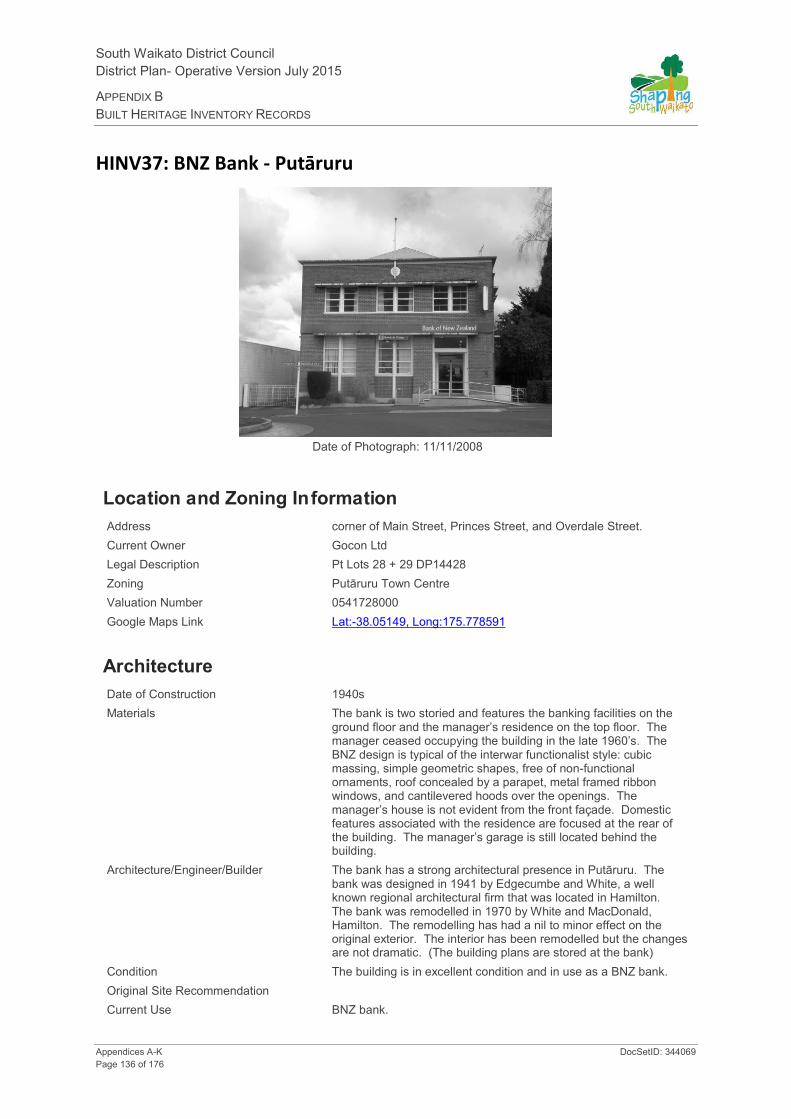
South Waikato District Council District Plan- Operative Version July 2015
APPENDIX B BUILT HERITAGE INVENTORY RECORDS
Appendices A-K DocSetID: 344069 Page 136 of 176
HINV37: BNZ Bank - Putāruru
Date of Photograph: 11/11/2008
Location and Zoning Information Address corner of Main Street, Princes Street, and Overdale Street. Current Owner Gocon Ltd Legal Description Pt Lots 28 + 29 DP14428 Zoning Putāruru Town Centre Valuation Number 0541728000 Google Maps Link Lat:-38.05149, Long:175.778591
Architecture Date of Construction 1940s Materials The bank is two storied and features the banking facilities on the
ground floor and the manager’s residence on the top floor. The manager ceased occupying the building in the late 1960’s. The BNZ design is typical of the interwar functionalist style: cubic massing, simple geometric shapes, free of non-functional ornaments, roof concealed by a parapet, metal framed ribbon windows, and cantilevered hoods over the openings. The manager’s house is not evident from the front façade. Domestic features associated with the residence are focused at the rear of the building. The manager’s garage is still located behind the building.
Architecture/Engineer/Builder The bank has a strong architectural presence in Putāruru. The bank was designed in 1941 by Edgecumbe and White, a well known regional architectural firm that was located in Hamilton. The bank was remodelled in 1970 by White and MacDonald, Hamilton. The remodelling has had a nil to minor effect on the original exterior. The interior has been remodelled but the changes are not dramatic. (The building plans are stored at the bank)
Condition The building is in excellent condition and in use as a BNZ bank. Original Site Recommendation Current Use BNZ bank.

South Waikato District Council District Plan - Operative Version July 2015
APPENDIX B BUILT HERITAGE INVENTORY RECORDS
DocSetID: 344069 Appendices A-K Page 137 of 176
Statement of Significance
Criteria for Scheduling: 1, 3, 5, 6, 10, 11, and 12
1. Aspect of history - associated with business confidence in the timber industry and agriculture in the district.
3. Community association – associated with the economic growth of Putāruru into a town in the late 1930’s. Putāruru’s business community.
5. Symbolic - economic growth in the district
6. Educational Use – could be included as an item on a heritage trail.
10. Architectural - example of inter war functionalist style, designed by Edgecumbe and White (Hamilton).
11. Context cultural landscape/complex or group – anchors the commercial district of Putāruru.
12. Integrity – good condition/but altered (note: Previous Alterations notes: based on the architectural plans the central entry and architrave were moved to their current location, off centre, in 1970s. The entry was inserted in the opening occupied by windows and the window relocated to the central entry. Tile roof replaced by corrugated iron. Two of the three chimneys were removed. Interior was remodelled in the 1970s).
District Plan Rules Demolition – Discretionary. Refer to Rule 21.3.3. Protection focus - 1, 3, 5, 6, 10, 11, and 12. Mitigate the effects of demolition by requiring the applicant to provide a Historical Building Documentation (HBD) which should include: the structure’s history, photographic documentation, and measurements of the item prior to removal.
Alterations necessary for the primary purpose of improving structural performance, fire safety or physical access - Controlled. Other Additions/Alterations - Discretionary. Refer to Rule 21.3.3. Protection focus – 10. Effects can be mitigated/ remedied through a) an HBD (see mitigating the effects of demolition). b) Design Rules: The overall visual character/ shape of the original building should be identifiable. The addition should not dominate the existing building frontage on Main, Princes, and Overdale Streets or affect the cubic massing/shape, except at the rear of the building. New work should be restricted to the rear of the building and not be evident from the street/road frontage. Special elements that are associated with the rarity or architectural uniqueness or craftsmanship of the structure should be retained:
Parapet Fenestration (1st and 2nd floor metal windows), sills and mullions between windows Entry architrave, transom window, sill with building date Round port-hole window on the rear west elevation Lentils projecting over the windows Brick cladding (stretcher bond) and side on brick base course under the front ground floor windows Wide concrete building base Plain concrete cornice
Other elements of the structure that should be retained are those elements associated with the structure’s historic character, use, rarity, landmark values, craftsmanship, etc. (i.e. façade, exterior walls, openings, chimney, landscape, and any other special elements identified in the HBD. c) Building Materials Rule: If repair of the building is proposed the materials used for the exterior walls and elements (i.e. windows, mullions, lentils, building base, and central entry surround) should be similar in type, dimensions and profile as the existing exterior fabric of the building.
Repair of the Structure – Discretionary. Refer to Rule 21.3.3. Protection focus – 10. a) Building Materials Rule: If repair of the building is proposed the materials used for the exterior walls and elements should be similar in type, dimensions and profile as the existing exterior fabric of the building. b) Design Rule: Repair or replication work should match the existing design, profile, and texture of the building elements.
Reuse/Change of Use – Discretionary. Refer to Rule 21.3.3. Protection focus - 1, 3, and 5. This is generally allowed and supported. Rationale for supporting reuse - history is an ongoing process. Reuse of historic structures in most instances ensures the structure is retained for future generations. Advice or Community concerns will be considered as well as economic viability, Occupational Safety and Health, zoning, etc.

South Waikato District Council District Plan- Operative Version July 2015
APPENDIX B BUILT HERITAGE INVENTORY RECORDS
Appendices A-K DocSetID: 344069 Page 138 of 176
Disturbance of the site surface/earthworks – Permitted. Refer to Rule 21.3.1. Protection focus – 7. Existing plan rule relating to archaeological sites. This only applies if evidence is found to indicate that there was a pre-1900 site in the development zone.
Internal Changes – Permitted. Refer to Rule 21.3.1. Protection focus – 10. Design Rule: Significant interior spaces and use areas should be identifiable. Historic elements should be retained. Remodelling is allowed but alterations must be documented (HBD).
Relocation – Discretionary. Refer to Rule 21.3.3. Protection focus – 1 and 3. Relocation may be necessary to preserve an item for future generations. Mitigate the effects by 1) Consulting with the local community and/ or consulting with Iwi or special interest groups, 2) Relocating to a similar setting, 3) Documenting (HBD). 4) Applying rules relating to archaeological sites.

South Waikato District Council District Plan - Operative Version July 2015
APPENDIX B BUILT HERITAGE INVENTORY RECORDS
DocSetID: 344069 Appendices A-K Page 139 of 176
HINV38: Putāruru Hotel
Date of Photograph: 04/09/2008
Location and Zoning Information Address corner of Arapuni Street and Princes Street. (79 Princes Street). Current Owner R & LM Norbis Ltd Legal Description Pt Lot 6 DPS 6183 Zoning Putāruru Business Valuation Number 0541728800 Google Maps Link Lat:-38.053378, Long:175.779925
Architecture Date of Construction Materials It is composed of modern material, i.e. Reinforced concrete and
steel. The interior was not viewed. Architecture/Engineer/Builder The hotel’s architectural style is inter-war art deco. The massing is
asymmetrical. The projecting semi-circular entry emphasises the building’s mass. It features exposed hipped gable roof lines, which are common after 1940. The exterior finishes are smooth, sleek, and have minimal ornamentation.
Condition The building has had a series of additions. Some of the additions match the existing architectural style. The additions are located at the rear and on one side of the building and have only a minor effect on the buildings architectural integrity.
Original Site Recommendation Current Use The hotel is still in use and is widely advertised on tourist travel
sites.
South Waikato District Council District Plan- Operative Version July 2015
APPENDIX B BUILT HERITAGE INVENTORY RECORDS
Appendices A-K DocSetID: 344069 Page 140 of 176
Statement of Significance
Criteria for Scheduling: 1, 3, 6, 10, 11, and 12
1. Historical Aspect - associated with Putāruru RR Station (a Junction Station with 2 platforms) provided accommodation for travellers. Replaced the earlier, much smaller Putāruru Junction Hotel.
3. Community association – associated with the growth of Putāruru in the late 1930’s and through 1950’s as a regional centre for the agriculture and timber industry.
6. Educational Use –could be included as an item on a heritage trail,
10. Architectural- Example of inter war Art Deco Style with some international style elements
11. Context cultural landscape/ complex or group – Anchors the southern end of Putāruru. A large hotel complex that expanded rapidly and occupies a large corner section near the RR Station. Demonstrates the commercial vitality the town had in the past.
12. Integrity –good condition/ additions do not compromise the structure
District Plan Rules Demolition – Discretionary. Refer to Rule 22.3.3. Protection focus - 1, 3, 6, 10, 11, and 12. Mitigate the effects of demolition by requiring the applicant to provide a Historical Building Documentation (HBD) which should include: the structure’s history, photographic documentation, and measurements of the item prior to removal.
Alterations necessary for the primary purpose of improving structural performance, fire safety or physical access - Controlled. Other Additions/Alterations - Discretionary. Refer to Rule 22.3.3. Protection focus 10. Effects can be mitigated/ remedied through: a) HBD (see mitigating the effects of demolition). b) Design Rules: The overall visual character/ shape of the original building should be identifiable. The addition should not dominate the existing building frontage on Arapuni Street and Princes Street. The open view of the hotel from the street should be retained. Fences/hedges over 1m in height between the road boundary and the building are discretionary. (The garden / lawn supports the architectural impact of the building). New work should be restricted to the rear of the building and not be evident from the street/ road frontage. Special elements that are associated with the rarity or architectural uniqueness or craftsmanship of the structure should be retained:
The central two storied bowed entry, including the polished granite (or marble?) central entry, bay windows on either side of the central entry, brick building base under bays, projecting 2nd floor window over the central entry, and other first and second floor fenestration (windows).
Fenestration (1st and 2nd floors windows) and window sills Smooth exterior walls Tiled roof Other elements of the structure that should be retained are those elements associated with the
structures historic character, use, rarity, landmark values, craftsmanship, etc i.e. Façade, exterior walls, openings, chimney, landscape, and any other special elements identified in the HBD.
c) Building Materials Rule: If repair of the buildings is proposed the materials used for the exterior walls and elements (i.e. Windows, building base, and central entry surround) should be similar in type, dimensions and profile as the existing exterior fabric of the building.
Repair of the Structure –Permitted. Refer to Rule 22.3.1. Protection focus – 10. a) Building Materials Rule: If repair of the buildings is proposed the materials used for the exterior walls and elements (i.e. windows, building base, and central entry surround) should be similar in type, dimensions and profile as the existing exterior fabric of the building. b) Design Rule: Repair or replication work should match the existing design, profile, texture (i.e. brick, tile, smooth concrete, metal) of the building elements.
Reuse/Change of Use –Permitted. Refer to Rule 22.3.1. Protection focus – 1 and 11. This is generally allowed and supported. Rationale for supporting reuse - history is an ongoing process. Reuse of historic structures in most instances ensures the structure is retained for future generations. Advice or Community concerns will be considered as well as economic viability, Occupational Safety and Health, zoning, etc.
South Waikato District Council District Plan - Operative Version July 2015
APPENDIX B BUILT HERITAGE INVENTORY RECORDS
DocSetID: 344069 Appendices A-K Page 141 of 176
Disturbance of the site surface / earthworks – Permitted. Refer to Rule 22.3.1. Protection focus - 7. Existing plan rule relating to archaeological sites. This only applies if evidence is found to indicate that there was a pre-1900 site in the development zone.
Internal Changes –Permitted. Refer to Rule 22.3.1. Protection focus - 10. Design Rule: Significant interior spaces and use areas should be identifiable. Historic elements should be retained. Remodelling of rooms, hallways, and facilities (kitchens, etc) and the foyer is allowed but alterations must be documented (HBD).
Relocation – Discretionary. Refer to Rule 22.3.3. Protection focus - 1, 3, and 11. Relocation may be necessary to preserve an item for future generations. Mitigate the effects by 1) Consulting with the local community and/ or consulting with Iwi or special interest groups, 2) Relocating to a similar setting, 3) Documenting (HBD), 4) Applying the rules relating to archaeological sites.
History Notes: This is not the Putāruru Junction Hotel, which was documented on the heritage inventory form. The existing Putāruru Hotel may have replaced the Putāruru Junction Hotel. The hotel probably filled a need for additional beds near the station when Putāruru station hosted two trains a day.
Documenting this building through historical research would be worthwhile and assist in creating a more robust listing.

South Waikato District Council District Plan- Operative Version July 2015
APPENDIX B BUILT HERITAGE INVENTORY RECORDS
Appendices A-K DocSetID: 344069 Page 142 of 176
HINV39: Woodstock Homestead and Farm Complex
Date of Photograph: 11/11/2008
Location and Zoning Information Address Somerville Road (part of Somerville Farm 208 Somerville Rd) Current Owner Avec Lait Ltd Legal Description Lot 2 DP 3478 Zoning Rural Valuation Number 0541108300 Google Maps Link
Architecture Date of Construction 1883 Materials The house belonged to the Somerville family. In 1888-89 the
house was moved in sections to the present site. Architecture/Engineer/Builder Built by the Thames Valley Land Company Condition Woodstock house has been added to over the years. The
additions are at the rear of the house and there has been attention to matching the cladding
Original Site Recommendation Current Use

South Waikato District Council District Plan - Operative Version July 2015
APPENDIX B BUILT HERITAGE INVENTORY RECORDS
DocSetID: 344069 Appendices A-K Page 143 of 176
Statement of Significance
Criteria for Scheduling: 1, 3, 6, 7, 10, 11, and 12
1. Historical aspect - associated with settlement of the district in the 1880’s, i.e. initially the timber industry and for most of its history agriculture.
3. Community association –Historic Woodstock Farm.
6. Educational Use –could be included as an item on a heritage trail.
7. Archaeology- pre 1900 the site is protected under the Heritage New Zealand Pouhere Taonga Act 2014; has the potential through archaeological investigation to provide information about New Zealand and the South Waikato District’s history.
10. Architectural- Example of Victorian Domestic Architecture.
11. Context cultural landscape/ complex or group – homestead set in a woodland garden with adjacent barn and fields.
12. Integrity –good condition.
District Plan Rules Demolition – Discretionary. Protection focus - 1, 3, 5, 6, 10, 11, and 12. Mitigate the effects of demolition by requiring the applicant to provide a Historical Building Documentation (HBD) which should include: the structure’s history, photographic documentation, and measurements of the item prior to removal.
Alterations necessary for the primary purpose of improving structural performance, fire safety or physical access - Controlled. Other Additions/Alterations - Discretionary. Refer to Rule 28.3.3. Protection focus - 1, 3, and 10. Effects can be mitigated/ remedied through: a) HBD (see mitigating the effects of demolition). b) Design Rules: The overall visual character/ shape of the original building should be identifiable. The addition should not dominate the existing building frontage or affect the shape of the building. New work should be restricted to the rear of the building and in keeping with the building. Special elements that are associated with the rarity or architectural uniqueness or craftsmanship of the structure should be retained:
Central four panelled glazed door with side lights and transom window Double hung sash windows with ornate architraves. Fenestration Front veranda Chimneys Hipped roof with cross gables Other elements of the structure that should be retained are those elements associated with the
structure’s historic character, use, rarity, landmark values, craftsmanship, etc i.e. Façade, exterior walls, openings, chimney, landscape, and any other special elements identified in the HBD.
c) Building Materials Rule: If repair of the building is proposed the materials used for the exterior walls and elements should be similar in type, dimensions and profile as the historic fabric of the building.
Repair of the Structure – Permitted. Refer to Rule 28.3.1. Protection focus – 1 and 10. a) Building Materials Rule: If repair of the building is proposed the materials used for the exterior walls and elements should be similar in type, dimensions and profile as the historic exterior fabric of the building. b) Design Rule: Repair or replication work should match the existing design, profile, and materials of the historic building elements.
Reuse/ Change of Use – Permitted. Refer to Rule 28.3.1. Protection focus 1 and 3. This is generally allowed and supported. Rationale for supporting reuse- History is an ongoing process. Reuse of historic structures in most instances ensures the structure is retained for future generations. Advice or community concerns will be considered as well as economic viability, Occupational Safety and Health, zoning, etc.
Disturbance of the site surface/earthworks – Permitted. Refer to Rule 28.3.1. Protection focus – 7. Existing plan rule relating to archaeological sites. This is a pre-1900 structure and there is a potential that archaeological deposits could be found if earthworks are carried out under or adjacent to the building.

South Waikato District Council District Plan- Operative Version July 2015
APPENDIX B BUILT HERITAGE INVENTORY RECORDS
Appendices A-K DocSetID: 344069 Page 144 of 176
Internal Changes – Permitted. Refer to Rule 28.3.1. Protection focus – 10. Design Rule: Significant historic interior spaces, central hall, and use areas should be identifiable. Elements like fire place surrounds, architraves, double pocket doors, panelled ceilings, skirting, hardware, etc. Should be retained. Remodelling is allowed but alterations must be documented (HBD).
Relocation – Discretionary. Refer to Rule 28.3.3. Protection focus – 1 and 3. Relocation may be necessary to preserve an item for future generations. Mitigate the effects by 1) Consulting with the local community and/ or consulting with Iwi or special interest groups, 2) Relocating to a similar setting, 3) Documenting (HBD), 4) Applying rules relating to archaeological sites.
History The house, garden, and barn should be included on the schedule as a farm complex. Woodstock homestead is located on a rise and is picturesque. The house is located on a farm and set in a woodland garden with large established trees, shrubs, perennials, and bulbs. There is an old garage and a barn adjacent to the house. Woodstock House has substantial architectural and landscape integrity. The architecture externally and internally is typical of quality homesteads of the 1880s and is one of a few homesteads in the South Waikato.
It has a wide veranda and typical hipped gabled roof with double cross gables. The original elements of the building, central four panel glazed door with side lights and transom window, double hung sash windows with ornate architrave surround, have been retained along with the original chimneys, and many internal design features. Internal elements include pocket sliding doors, fire surrounds, paneled ceilings, ornate architraves and skirting, etc.
Land use consent was granted on 2 February 2012 for alterations and a minor extension to Woodstock homestead. The applicants proposed to remove the existing modern rear extension and construct a new larger extension in its place. Internal remodelling and alterations to the existing layout, including the provision of a new bathroom and additional en-suite facilities etc were also proposed, with verandahs added to the side and rear. The proposed alterations were to enable the property to be used as guest house accommodation.
Additional Photographs

South Waikato District Council District Plan - Operative Version July 2015
APPENDIX B BUILT HERITAGE INVENTORY RECORDS
DocSetID: 344069 Appendices A-K Page 145 of 176
HINV40: WDFF Building, Putāruru
Date of Photograph: 04/09/2008
Location and Zoning Information Address Overdale Street adjacent to the monument and across from the
Library. Current Owner SWDC Legal Description Lot 5 DPS 4338 Zoning Putāruru Business Valuation Number 0541735600 Google Maps Link Lat:-38.050706, Long:175.778594
Architecture Date of Construction 1930s Materials The building is located on a slight rise and has a sweeping entry.
The covered porch and double doors suit the building’s use as a hall. The façade is slightly asymmetrical, but appears balanced. It has the low restrained stile of a bungalow-cottage with its boxed eaves and porch tucked into the building. The WDFF building probably dates from the 1930’s based on the architecture. The building has good architectural integrity. The external and internal architectural elements have been retained, i.e. original double doors, central entry, bow windows on the front façade, casement window, interior paneling, fireplace and a large meeting room.
Architecture/Engineer/Builder Condition The building has been altered through additions on the sides and
rear of the building. Additional research would be useful and provide information about when the building was altered. In general the alterations have been restrained and have not affected the street façade. The building has retained substantial architectural integrity.
Original Site Recommendation

South Waikato District Council District Plan- Operative Version July 2015
APPENDIX B BUILT HERITAGE INVENTORY RECORDS
Appendices A-K DocSetID: 344069 Page 146 of 176
Current Use The current use, as a contract bridge club rooms, is in keeping with the building’s original purpose and use, i.e. for meetings, functions, and WDFF business.
Statement of Significance
Criteria for Scheduling: 1, 3, 6, 10, and 12
1. Aspect of history - associated with the agriculture industry in SWDC.
3. Community association – politics and social life in Putāruru.
6. Educational Use – could be included as an item on a heritage trail.
10. Architectural - example of the bungalow cottage style (circa 1930s).
12. Integrity –good condition/ additions do not compromise the street frontage of the structure.
District Plan Rules Demolition - Non-Complying. Protection focus - 1, 3, 6, 10, and 12. Mitigate the effects of demolition by requiring the applicant to provide a Historical Building Documentation (HBD) should include the structure’s history, photographic documentation, and measurements of the item prior to removal.
Alterations necessary for the primary purpose of improving structural performance, fire safety or physical access - Controlled. Other Additions/Alterations - Discretionary. Refer to Rule 22.3.3. Protection focus – 10. Effects can be mitigated/ remedied through: a) HBD (see mitigating the effects of demolition). b) Design Rules: The overall visual character/ shape of the original building should be identifiable. The addition should not dominate the existing building frontage on Overdale Street. The sweeping lawn and stairway should be retained (the lawn and stairway supports the architectural impact of the building). New work should be restricted to the rear of the building and not be evident from the street/ road frontage. Special elements that are associated with the rarity or architectural uniqueness or craftsmanship of the structure should be retained:
The off centre recessed entry, porch posts, fenestration and doors located on the entry porch, Fenestration, particularly the bow windows on the frontage Boxed eaves Other elements of the structure that should be retained are those elements associated with the
structure’s historic character, use, rarity, landmark values, craftsmanship, etc i.e. Façade, exterior walls, openings, chimney, landscape, and any other special elements identified in the HBD.
c) Building Materials Rule: If repair of the building is proposed the materials used for the exterior walls and elements (i.e. windows and doors) should be similar in type, dimensions and profile as the existing exterior fabric of the building.
Repair of the Structure – Permitted. Refer to Rule 22.3.1. Protection focus – 10. a) Building Materials Rule: If repair of the buildings is proposed the materials used for the exterior walls and elements (i.e. windows, building base, and central entry surround) should be similar in type, dimensions and profile as the existing exterior fabric of the building. b) Design Rule: Repair or replication work should match the existing design, profile, and materials (i.e. Wood) of the building elements.
Reuse/Change of Use – Permitted. Refer to Rule 22.3.1. Protection focus – 1. This is generally allowed and supported. Rationale for supporting reuse- history is an ongoing process. Reuse of historic structures in most instances ensures the structure is retained for future generations. (The building is already being reused as a Contract Bridge Club). Advice or Community concerns will be considered as well as economic viability, Occupational Safety and Health, zoning, etc.
Disturbance of the site surface / earthworks – Permitted. Protection focus – 7. Existing plan rule relating to archaeological sites. This only applies if evidence is found to indicate that there was a pre-1900 site in the development zone.
Internal Changes – Permitted. Refer to Rule 22.3.1. Protection focus – 10. Design Rule: Significant interior spaces and use areas should be identifiable (such as the large meeting room with fireplace). Historic internal elements should be retained (such as fireplace, panelled walls and ceilings, doors and architraves, period

South Waikato District Council District Plan - Operative Version July 2015
APPENDIX B BUILT HERITAGE INVENTORY RECORDS
DocSetID: 344069 Appendices A-K Page 147 of 176
hardware, etc). Remodelling of rooms, hallways, and facilities (kitchens, etc) is allowed but alterations must be documented (HBD).
Relocation – Discretionary. Refer to Rule 22.3.3. Protection focus – 1 and 3. Relocation may be necessary to preserve an item for future generations. Mitigate the effects by 1) Consulting with the local community and/ or consulting with Iwi or special interest groups, 2) Relocating to a similar setting, 3) Documenting (HBD), 4) Applying rules relating to archaeological sites.

South Waikato District Council District Plan- Operative Version July 2015
APPENDIX B BUILT HERITAGE INVENTORY RECORDS
Appendices A-K DocSetID: 344069 Page 148 of 176
HINV41: Tirau Hotel (Oxford Royal Hotel)
Date of Photograph: 04/09/2008
Location and Zoning Information Address SH1 and Hillcrest Street Current Owner Arthur Anae & Leslie Divers Legal Description Lot 1 DPS 88273 Zoning Tirau Town Centre Valuation Number 0541509500 Google Maps Link Lat:-37.980365, Long:175.759588
Architecture Date of Construction 1877-81, Completely re-built 1907. Materials The main (original) part of the hotel still features original building
fabric and elements like windows and balcony brackets. Architecture/Engineer/Builder The architectural integrity of the hotel is mixed, but it still reads as a
historic hotel and is used for its original function. The hotel has had many changes over the year, verandahs filled in, new entries added, additions to the sides and rear.
Condition Original Site Recommendation Current Use

South Waikato District Council District Plan - Operative Version July 2015
APPENDIX B BUILT HERITAGE INVENTORY RECORDS
DocSetID: 344069 Appendices A-K Page 149 of 176
Statement of Significance
Criteria for Scheduling: 1, 3, 6, And 7
1. Aspect of history - associated with settlement of Tirau (Oxford)
3. Community association – associated with the growth of Tirau (Oxford) as a stage stop and small town.
6. Educational Use – could be included as an item on a heritage trail,
7. Archaeology - pre 1900 the site is protected under the Heritage New Zealand Pouhere Taonga Act 2014; has the potential through archaeological investigation to provide information about New Zealand and the South Waikato District’s history.
10. Architecture (This needs to be added so the historic parts of the building can be preserved). The building has mixed architectural integrity due to the number of changes and additions but still retains some original fabric like the double hung sash windows, hipped roof, balcony brackets, cladding, etc.)
District Plan Rules Demolition – Discretionary. Protection focus - 1, 3, 6, 7, and 10. Mitigate the effects of demolition by requiring the applicant to provide a Historical Building Documentation (HBD) which should include: the structure’s history, photographic documentation, and measurements of the item prior to removal. Demolition of additions is encouraged.
Alterations necessary for the primary purpose of improving structural performance, fire safety or physical access - Controlled. Other Additions/Alterations - Discretionary. Refer to Rule 24.3.4. Protection focus - 1, 3, and 10. Effects can be mitigated/ remedied through: a) HBD (see mitigating the effects of demolition). b) Design Rules: The overall visual character/ shape of the historic building should be identifiable. The addition should not dominate the existing building frontage on the corner of SH1 and Hillcrest Street. New work should be restricted to the rear of the building or existing additions. Special elements that are associated with the pre-1900 part of the structure’s architecture should be retained:
Fenestration, double hung windows with architraves Porch brackets on 2nd floor Hipped roof on pre-1900 part of the building Other elements of the structure that should be retained are those elements associated with the
structure’s historic character (pre-1900), use, rarity, landmark values, craftsmanship, etc i.e. Façade, exterior walls, openings, chimney, landscape, and any other special elements identified in the HBD.
c) Building Materials Rule: If repair of the buildings is proposed the materials used for the exterior walls and elements, in the pre-1900 part of the structure, should be similar in type, dimensions and profile as the existing exterior fabric of the building.
Repair of the Structure – Permitted. Refer to Rule 24.3.1. Protection focus - 1, 3, and 10. a) Building Materials Rule: If repair of the buildings is proposed the materials used for the exterior walls and elements should be similar in type, dimensions and profile as the existing exterior fabric of the building. b) Design Rule: Repair or replication work should match the existing design, profile, and materials (i.e. wood) of the building’s historic elements unless the repair is to a more recent addition.
Reuse/ Change of Use – Permitted. Refer to Rule 24.3.1. Protection focus 1 and 10. This is generally allowed and supported. Rationale for supporting reuse- History is an ongoing process. Reuse of historic structures in most instances ensures the structure is retained for future generations. Advice or Community concerns will be considered as well as economic viability, Occupational Safety and Health, zoning, etc.
Disturbance of the site surface/earthworks – Permitted. Refer to Rule 24.3.1. Protection focus – 7. Existing plan rule relating to archaeological sites. This is a pre-1900 structure and there is a potential that archaeological deposits could be found if earthworks are carried out under or adjacent to the hotel.
Internal Changes – Permitted. Refer to Rule 24.3.1. Protection focus 1 and 10. Design Rule: Significant historic interior spaces and use areas should be identifiable. Remodelling of rooms, hallways, and facilities (kitchens, etc) is allowed but alterations must be documented (HBD).

South Waikato District Council District Plan- Operative Version July 2015
APPENDIX B BUILT HERITAGE INVENTORY RECORDS
Appendices A-K DocSetID: 344069 Page 150 of 176
Relocation – Discretionary. Refer to Rule 24.3.4. Protection focus – 1 and 3. Relocation may be necessary to preserve an item for future generations. Mitigate the effects by 1) Consulting with the local community and/ or consulting with Iwi or special interest groups, 2) Relocating to a similar setting, 3) Documenting (HBD), 4) Applying rules relating to archaeological sites.
History The hotel is a typical Victorian style hotel (of the late 1870s early 1880s). The hotel is one of the earliest buildings in Tirau (then Oxford) and became the commercial centre of the town. The history of this building satisfies the criteria for scheduling.
The Oxford Royal Hotel was built around 1877-81 and was used as a staging post for travelers between Rotorua, Cambridge, Lichfield and later Taupo. In 1881 The Express (horse and coach) carrying Her Majesty's mail delivered mail to and from the Oxford Royal Hotel twice a week.
By 1885 the Armed Constabulary had formed a road to Rotorua along which a four horse coach made the Cambridge - Rotorua run three times a week with an overnight stop at the Oxford Royal Hotel. In 1886, when Mt Tarawera (near Rotorua) erupted many people found refuge at the hotel.
When Mr. Francis Rose took over the Oxford Hotel about 1885 a small store was operating out of the back of the hotel's tap room. (http://tirauinfo.homestead.com/TirausPast)
Newspaper reports from the time show that the original hotel building was totally destroyed by a fire on 27 June 1906, and then had to be completely re-built.

South Waikato District Council District Plan - Operative Version July 2015
APPENDIX C SCHEDULE OF OUTSTANDING NATURAL FEATURES AND LANDSCAPES, AND SIGNIFICANT AMENITY
LANDSCAPES
DocSetID; 344069 Appendices A-K Page 151 of 176
Appendix C Schedule of Outstanding Natural Features and Landscapes, and Significant Amenity Landscapes
a) Outstanding Natural Landscapes (As shown on planning maps)
ONL 1- Arapuni Dam section of Waikato River
ONL 2- Arapuni Walkway and Lake Arapuni section of Waikato River
ONL 3- Waipapa Dam Gorge section of Waikato River
ONL 4- Lake Waipapa section of Waikato River
ONL 5- Lake Whakamaru and Whakamaru Gorge section of Waikato River
ONL 6- Matahana Basin Rim
ONL 7- Mokaihaha and its Corridors
ONL 8- Waihou River Headwaters
ONL 9- Mamaku Corridor
ONL10- Lake Karapiro section of Waikato River
ONL 11- Lake Maraetai section of Waikato River
b) Outstanding Natural Features (As shown on planning maps)
ONF 1- Waihou River Blue Springs
ONF 2- Okoroire Hot Springs
ONF 3- Jones’ Landing Ignimbrite Cliffs
ONF 4- Rhyolitic Domes, Atiamuri
ONF 6 – Lake Rd Wetland
ONF 7- Waihou River Wetland
ONF 9- Fitzgerald Glade- Tukorehe Scenic Reserve
c) Significant Amenity Landscapes (As shown on planning maps)
SAL 1- Pokaiwhenua Stream
SAL 2- Waihou River Walkway
SAL 3- Okoroire Precinct
South Waikato District Council District Plan- Operative Version July 2015
APPENDIX C SCHEDULE OF OUTSTANDING NATURAL FEATURES AND LANDSCAPES, AND SIGNIFICANT AMENITY LANDSCAPES
Appendices A-K DocSetID: 344069 Page 152 of 176
SAL 4- Arahiwi section of the Ngatira Railway
SAL 5 – Lake Moananui, Tokoroa
SAL 6 – Jim Barnett Reserve, Waotu
NB- The important values of each of the above areas and features, and their ranking against seven assessment criteria, are detailed in the South Waikato District Landscape Assessment, completed by Isthmus Consultants in August 2012.
South Waikato District Council District Plan - Operative Version July 2015
APPENDIX D CULTURAL HERITAGE SITES
DocSetID; 344069 Appendices A-K Page 153 of 176
Appendix D Cultural Heritage Sites NB – Appendix D and related Rules have immediate legal effect under Section 86B (3) of the Act from the date of public notification of this proposed plan.
(As shown on planning maps)
CH 1 – Te Kohatu o Hatupatu. (Hatupatu’s Rock), SH 1, Atiamuri
ADVISORY NOTE- The criteria for further sites to qualify for inclusion in this Appendix are to be developed in partnership with Tangata Whenua. The above list may only be added to by means of a formal district plan change under the First Schedule of the Act.

South Waikato District Council District Plan- Operative Version July 2015
APPENDIX F CRITERIA FOR DETERMINING SIGNIFICANCE OF HERITAGE FEATURES
Appendices A-K DocSetID: 344069 Page 154 of 176
Appendix F Criteria for Determining Significance of Heritage Features Where discretionary activity resource consent is required for a built heritage feature, the assessment criteria below, in addition to the matters listed in the relevant Heritage Inventory Record Form in Appendix B, will be used to assess the application. The assessment criteria below have been used to assess the heritage value of each of the places in Appendix B, and will be used to evaluate any proposals to add new buildings to the Heritage Inventory.
ADVISORY NOTE: The current inventory of Built Heritage is recorded in Appendix B.
1.0 Historical: “The extent to which the place reflects importance or is representative of South Waikato or New Zealand’s history.”
1.1 The extent to which the place is important as a representative example of a type of historic place in terms of age, historical aspects, time periods, patterns or themes (like transport, warfare or women’s history).
1.2 The extent to which the place is associated with important persons, groups, individuals, organisations, or institutions who have owned, lived in, worked in, or carried out activities in or on the place, or associated with important historic events or actions.
1.3 The extent to which the place is associated with important ideas or beliefs that symbolise or illustrate historic change in South Waikato or New Zealand.
1.4 Does the place date from an early period of South Waikato or New Zealand’s settlement?
2.0 Tangata Whenua: “The importance of the place to Tangata Whenua.”
2.1 This evaluation needs to be made by, or in full consultation with iwi. It includes such matters as the Historical, Traditional (place names, people and events), Cultural, Spiritual, Religious, Symbolic, Commemorative, Social, Educational, Economic, and Contextual importance of a place. The importance may be at iwi, hapu, and whanau level.
3.0 Community Association: “The community association with, or public esteem for the place.”
3.1 The extent to which the place has qualities which make it the focal point for the spiritual, cultural, customary, religious, social, political, philosophical, or economic, values of an ethnic group or the local or wider community.
3.2 The extent to which there is evidence of strong feelings of community association with the place.
3.3 The extent to which the place illustrates the distinctiveness of the community’s identity, social history and way of life, and has this community association with the place been formally recognised through the planning process?
4.0 Commemorative: “The commemorative value of the place.”
4.1 Does the place commemorate an important person, event, idea, activity, and is this formalised by a memorial of some specific kind?
5.0 Symbolic: “The symbolic value of the place.”
5.1 The extent to which the place is of symbolic value to the district, region or nation, by symbolising a feature of the area’s past history. (A place such as a sacred mountain can have symbolic importance without being commemorative.)

South Waikato District Council District Plan - Operative Version July 2015
APPENDIX F CRITERIA FOR DETERMINING SIGNIFICANCE OF HERITAGE FEATURES
DocSetID; 344069 Appendices A-K Page 155 of 176
6.0 Educational: “The potential of the place for public education.”
6.1 The extent to which the place provides potential to enhance public understanding and appreciation of the past, and its potential for interpretation for present and future generations.
6.2 The extent to which the place is accessible to the public.
7.0 Archaeological: “The potential of the place to provide knowledge of South Waikato or New Zealand’s history.”
7.1 The extent to which the place has the potential to define or expand knowledge of earlier human occupation, activities or events through investigation using archaeological methods, and the research potential of the place.
7.2 Whether the place is important as a representative example of a site type, feature or activity, and whether this importance has been recognised as a formally recorded or registered archaeological site?
(Note: When evaluating the significance of an archaeological site all of the other criteria need to be considered.)
8.0 Scientific: “The potential of the place to provide knowledge of South Waikato or New Zealand’s history.”
8.1 The extent to which the place has the potential in scientific (e.g. geological or biological) terms to provide evidence and knowledge relating to South Waikato or New Zealand’s human history.
8.2 The importance of the place in the history of the development of science (e.g. agriculture or horticulture) in South Waikato or New Zealand.
9.0 Technological: “The technical accomplishment or value of the place.”
9.1 The extent to which the place is or was important in the development of technology, technological innovation or technological processes, and is that technological process still carried out on the site?
10.0 Architectural: “The design of the place.”
10.1 Whether the place provides a notable, rare or representative example of an architectural style, type or convention in either interior or exterior layout.
10.2 Whether the place is an important example of architectural innovation.
10.3 The extent to which the place is an important example of a particular method of construction, use of material or design feature, or a particular form of craftsmanship.
10.4 Whether the place is an important example of the work of a notable architect, designer, engineer or builder.
11.0 Context: “The extent to which the place forms part of a wider historical and cultural context or historical and cultural landscape.”
11.1 The extent to which the historical context of the place is important in terms of comparative age, being part of a particular time period, or historical or cultural continuity.
11.2 The extent to which the place is an important component of a group of associated historic places, and its value as a component of the wider historical or cultural landscape, or streetscape.
11.3 Whether the place is part of a registered or scheduled historic area.
11.4 The importance of the place in terms of visual amenity, or aesthetic value (past or present beauty), or as a landmark.
12.0 Rarity: “The frequency with which the historic place can be found.”

South Waikato District Council District Plan- Operative Version July 2015
APPENDIX F CRITERIA FOR DETERMINING SIGNIFICANCE OF HERITAGE FEATURES
Appendices A-K DocSetID: 344069 Page 156 of 176
12.1 The rarity of that type of historic place.
13.0 Integrity: “What is the integrity of the place?”
13.1 The extent to which the place has integrity in terms of its historical or cultural setting and its relationship with associated structures, and whether the place is located on its original site.
13.2 The extent to which the place has been modified, altered, or restored in an important or sensitive way.
13.3 The physical state or condition of the place.
13.4 Whether the place is dangerous or poses a threat to the health and safety of people.
13.5 To what extent is the place vulnerable to modification or destruction?
Please note the following when using these guidelines:
Any type of historic place can be assessed using the above criteria;
A place may be assessed as being important under any one of the above criteria;
All archaeological sites, historic areas, buildings, places, objects, structures, and flora, should be assessed under each of the criteria; and
Although all these criteria are inter-related, the historical criteria should be assessed first because these values link with all the others.

South Waikato District Council District Plan - Operative Version July 2015
APPENDIX G HAZARDOUS SUBSTANCES
DocSetID; 344069 Appendices A-K Page 157 of 176
Appendix G Hazardous Substances
Permitted Activities Use or storage of a hazardous substance is a permitted activity in the Industrial Zone. For all other zones the use or storage of a hazardous substance is a permitted activity if:
a) The aggregate quantity of hazardous substances of any hazard classification on the site is less than the quantity specified for the relevant zone in Table G1 (but for the purpose of this clause, hazardous substances and activities addressed by clause b) and clause d) through to k) are excluded from consideration.)
b) The activity is a service station with a maximum storage for retail sale of any or all of: 100,000 litres of petrol in underground storage tanks: 50,000 litres of diesel: 6 tonnes of LPG (single or multiple vessel storage above ground): 12 tonnes of LPG in underground storage tanks.
c) The conditions in Table G2 are complied with in the case of a) or b) above, or
d) The hazardous substances stored or used on the site are:
i) Trade waste in a wastewater or waste treatment facility
ii) Roading materials within a road reserve
iii) Domestic storage and use of consumer products for domestic purposes
iv) Consumer products, held for re-sale to the public and stored in the manufacturers’ packaging
v) Gas or oil pipelines and ancillary equipment
vi) Fuel or safety equipment in motor vehicles, aircraft, boats or small engines
vii) Fireworks subject to the Hazardous Substances (Fireworks) Regulations 2001, or ammunition, in domestic quantities
viii) Fire-fighting substances on emergency vehicles, or in containers at emergency service facilities
ix) Temporary storage of hazardous substances on site for no more than four days, where the hazardous substances containment meets the requirements for road transportation
e) Radioactivity is below that specified as an exempt activity in the Radiation Protection Regulations 1982, or radioactive materials are confined to domestic appliances
f) Ponds used for processing or storing wastewater are set back at least:
i) 150m from a dwelling, and
ii) 30m from the site boundary
g) A wastewater plant serving 3 or more dwellings, where wastewater treatment is fully enclosed, is set back at least
i) 30m from a dwelling, and
ii) 15m from the site boundary

South Waikato District Council District Plan- Operative Version July 2015
APPENDIX G HAZARDOUS SUBSTANCES
Appendices A-K DocSetID: 344069 Page 158 of 176
h) The activity is the removal and/or replacement of underground petroleum storage systems associated with service stations
i) The activity is the storage and use of agrichemicals within the Rural Zone or Rural Residential Zone, in accordance with NZS8409:2004
j) The activity is the storage and use of Class 3 fuels within the Rural Zone or Rural Residential Zone in accordance with the Environmental Protection Agency’s Approved Practice Guide for Above Ground Fuel Storage on Farms, September 2010
k) The activity is the storage and use of fertiliser within the Rural Zone or Rural Residential Zone in accordance with the:
Fertiliser (Corrosive) Group Standard HSR002569
Fertiliser (Oxidising) Group Standard HSR002570
Fertiliser (Subsidiary Hazard) Group Standard HSR002571
Fertiliser (Toxic) Group Standard HSR002572, and
The Code of Practice for Nutrient Management (with emphasis on fertiliser use).
Controlled Activities
a) Storage at a service station that does not comply with any of the above relevant standards for a permitted activity, shall be a controlled activity.
b) The specific matters where control is reserved are identified in Rule 8.3.1 f) and shall be used when considering a resource consent application for a controlled activity involving hazardous substances.
Restricted Discretionary Activities Use or storage of hazardous substances which contravenes a standard for a permitted activity is a restricted discretionary activity. The specific matters where discretion is restricted are identified in Rule 8.3.3 g) and shall be used when considering a resource consent application for a restricted discretionary activity involving hazardous substances.
Table G1 - Permitted Quantities by Zone Hazardous Substance Property and Class
HSNO Subclass Electricity Generation Zone
Rural Zone, Business Zones, Rural Residential Zone, Town Centre Zones, Tokoroa Airport Zone
Residential Zones, Tokoroa Neighbourhood Retail Zone Arapuni Village Zone
Explosive 1 1.1 (all) 50kg 20kg 0 1.2 (all) 500kg 200kg 0 1.3 (all) 1500kg 500kg 0 1.2 or 1.3 with 1.1 50kg 20kg 0
Flammable 2 (gases)
2.1 (all) 1000kg or 2000m3 500kg or 1000m3 20kg or 40m3 2.1 (within 50m of m.s.z) 200kg 100kg N/A

South Waikato District Council District Plan - Operative Version July 2015
APPENDIX G HAZARDOUS SUBSTANCES
DocSetID; 344069 Appendices A-K Page 159 of 176
Hazardous Substance Property and Class
HSNO Subclass Electricity Generation Zone
Rural Zone, Business Zones, Rural Residential Zone, Town Centre Zones, Tokoroa Airport Zone
Residential Zones, Tokoroa Neighbourhood Retail Zone Arapuni Village Zone
(Aerosols) All other non-hazardous 5000kg or 10,000m3 2000kg or 4000m3 100kg LPG 3000kg 1500kg 100kg LPG (within 50m of m.s.z)
1000kg 500kg N/A
Flammable 3 (Liquids)
3.1A, 3.1B 6000kg 2000kg 100kg 3.1A, 3.1B (within 50m of m.s.z)
2000kg 600kg N/A
3.1C 20,000kg 6000kg 300kg 3.1D 60,000kg 20,000kg 1000kg 3.2 (all) 3000kg 1000kg 50kg
Flammable 4 (Solids)
4.1 (all) 3000kg 1000kg 50kg 4.2 (all) 1000kg 400kg 20kg 4.3 (all) 1000kg 400kg 20kg
Oxidising Capacity 5
5.1.2 Gases 1000m3 400m3 40m3 5.1.1 (all) 3000kg 1500kg 50kg 5.2 (all) 1000kg 500kg 20kg
Toxic 6 6.1A 500kg 200kg 0 6.1 Gases 300m3 100m3 0 6.1A (within 50m of m.s.z)
200kg 100kg 0
6.1B, 6.3-6.9 6000kg 2000kg 50kg 6.1B, 6.3-6.9 (within 50m of m.s.z)
2000kg 1000kg N/A
6.1C 20,000kg 6000kg 300kg 6.1C (within 50m of m.s.z)
6000kg 2000kg 50kg
Corrosive 8 8.1, 8.2A, 8.3 6000kg 2000kg 50kg 8.2B, 8.2C 20,000kg 10,000kg 300kg
Eco-toxic 9 9.1A, 9.2A, 9.3A, 9.4A 500kg 500kg 500kg (within 30m of water body)
100kg 100kg 100kg
9.1B, 9.2B, 9.3B, 9.4B 10,000kg 10,000kg 10,000kg (within 30m of water body)
3000kg 3000kg 3000kg
9.1C, 9.2C, 9.3C, 9.4C 30,000kg 30,000kg 30,000kg (within 30m of water body)
10,000kg 10,000kg 10,000kg
High BOD (>10,000mg/l)
100,000kg 40,000kg 20,000kg (within 30m of water body)
40,000kg 20,000kg 20,000kg

South Waikato District Council District Plan- Operative Version July 2015
APPENDIX G HAZARDOUS SUBSTANCES
Appendices A-K DocSetID: 344069 Page 160 of 176
Interpretation of Table G1 All- means all categories as defined in the Hazardous Substances (Classification) Regulations 2001. (Categories are identified alphabetically for particular classes of Hazardous Substance. For example Class 1 explosives is divided into categories A-H, J, K, L, N and S).
BOD5 – the biochemical oxygen demand (measured over a 5 day period), which is the amount of dissolved oxygen in a body of water required for the breakdown of organic matter in the water.
Class 1.2 and 1.3 substances are to be treated as Class 1.1 substances if they are stored with Class 1.1 substances.
HSNO subclass – has its meaning in the Hazardous Substances (Classification) Regulations 2001.
m.s.z – means “more sensitive zone” in the following order of sensitivity:
Industrial Zone (least sensitive)
Electricity Generation Zone
Tokoroa Airport Zone
Rural Zone,
Business Zones,
Rural Residential Zone,
Town Centre Zones,
Tokoroa Neighbourhood Retail Zone
Residential Zones,
Arapuni Village Zone (most sensitive)
eg the Rural zone is more sensitive than the Tokoroa Airport Zone but less sensitive than the Residential Zones.
Conditions for all Permitted Activities The following conditions apply to all activities permitted under this Appendix:
Table G2 Item Condition 1. Site Design Any part of a site that is involved in the manufacture, mixing, packaging
storage, loading, transfer, usage or handling of hazardous substances is designed, constructed and operated in a manner that prevents: a) The occurrence of any off-site adverse effects from the activity on people, ecosystems, structures and other parts of the environment, or b) The contamination of air, land or water (including groundwater, potable water supplies, and surface waters) in the event of a spill or other type of release of hazardous substances.
2. Site Layout The separation between on-site facilities and the property boundary is adequate to protect neighbouring facilities, land uses and sensitive environments.
3. Storage The storage of any hazardous substance is managed to prevent: a) The unintentional release of the hazardous substance, and b) The accumulation of any liquid or solid spills or fugitive vapours and gases in enclosed areas, that might have adverse effects on people, ecosystems or structures.

South Waikato District Council District Plan - Operative Version July 2015
APPENDIX G HAZARDOUS SUBSTANCES
DocSetID; 344069 Appendices A-K Page 161 of 176
Item Condition 4. Drainage systems Site drainage systems are designed, constructed and operated in a manner
that prevents the entry or discharge of hazardous substances into the stormwater or wastewater systems unless permitted by a network utility operator. Compliance can be achieved using precautionary methods, including clearly identified stormwater grates and access holes, roofing, sloped pavements, interceptor drains, containment and diversion valves, oil-water separators, sumps and similar systems.
5. Spill containment Any part of the site where a hazardous substance spill may occur must be serviced by a suitable spill containment system that is: a) constructed from impervious materials resistant to the hazardous substances used, stored, manufactured, mixed, packaged, loaded or otherwise handled on the site, and for liquid hazardous substances i) able to contain the maximum volume of the largest tank present, plus an allowance for stormwater or fire water, and ii) for drums or other smaller containers, able to contain half of the maximum volume of substances stored, plus an allowance for stormwater or fire water, and b) able to prevent any spill or other unintentional release of hazardous substances, and any stormwater or fire water that has become contaminated, from entering the stormwater drainage system, unless permitted by a network utility, and c) able to prevent any spill or other unintentional release of hazardous substances, and any stormwater or fire water that has become contaminated, from discharging into or onto land or water (including drainage systems, groundwater and potable water supplies) unless permitted by a resource consent. Suitable means of compliance include graded floors and surfaces, bunding, roofing, sumps, fire-water catchments, overfill protection and alarms, and similar systems.
6. Stormwater All stormwater grates on the site are clearly labelled “Stormwater Only”. 7. Wash down areas Any part of the site where vehicles, equipment or containers that are, or may
be contaminated with hazardous substances are washed must be designed, constructed and managed to prevent any contaminated wash water from: a) entry or discharge into the stormwater drainage or the wastewater system unless permitted by a network utility operator, and b) discharge into or onto land or water (including groundwater and potable water supplies) permitted by resource consent. Suitable means of compliance include roofing, sloped pavements, interceptor drains, containment and diversion valves, oil-water separators and sumps.
8. Underground storage tanks Underground storage tanks for petroleum product storage must be designed, constructed and managed to prevent leakage and spills, and adverse effects on people, ecosystems and property. Underground storage tanks are: a) constructed from impervious materials resistant to the hazardous substances to be stored, and b) equipped with secondary containment facilities in areas of environmental sensitivity, and c) serviced by a leak detection or monitoring system that is capable of detecting a failure or breach in the structural integrity of the primary containment vessel.
9. Signage Signs are placed in compliance with the Hazardous Substances and New Organisms Act 1996.

South Waikato District Council District Plan- Operative Version July 2015
APPENDIX G HAZARDOUS SUBSTANCES
Appendices A-K DocSetID: 344069 Page 162 of 176
Item Condition 10. Waste Management Waste containing hazardous substances is stored in a manner that prevents:
a) exposure to ignition sources, and b) the corrosion or other alteration of the containers used for the storage of the waste, and c) the unintentional release of the waste. Wastes are disposed of to authorised facilities.
11. Records Records are kept of all types and quantities of hazardous substances and wastes produced or stored on the site. Records note method of waste disposal.

South Waikato District Council District Plan - Operative Version July 2015
APPENDIX H HIGH-IMPACT INDUSTRIAL ACTIVITIES
DocSetID; 344069 Appendices A-K Page 163 of 176
Appendix H High-Impa ct Industrial Activities a) Blood or offal treating
b) Bone boiling or crushing
c) Collection and storage of used bottles for sale
d) Dag crushing
e) Fellmongering
f) Fish cleaning
g) Fish curing
h) Flax pulping
i) Flock manufacturing, or teasing of textile materials for any purpose
j) Gut scraping and treating
k) Nightsoil collection and disposal
l) Refuse collection and disposal
m) Septic tank desludging and disposal of sludge
n) Slaughtering animals for any purpose other than human consumption
o) Storage, drying or preserving of bones, hides, hooves or skins
p) Tallow melting
q) Tanning
r) Wood pulping
s) Wool scouring
ADVISORY NOTE – The above are listed as “offensive trades” under Schedule 3 of the Health Act 1956.

South Waikato District Council District Plan- Operative Version July 2015
APPENDIX H HIGH-IMPACT INDUSTRIAL ACTIVITIES
Appendices A-K DocSetID: 344069 Page 164 of 176

South Waikato District Council District Plan - Operative Version July 2015
APPENDIX I AIRPORT APPROACH SLOPES
DocSetID; 344069 Appendices A-K Page 165 of 176
Appendix I Airport Approach Slopes These height controls are planned and designed to protect the airfield at Tokoroa
1.0 Main Runway Main sealed runway is 850 metres long by 18 metres wide and is situated within a grassed runway of 1,100 metres long by 60 metres wide. It is orientated on a bearing of 310° true.
2.0 Main Strip The main strip is 1,525 metres long and 150 metres wide and contains the main sealed runway. The airfield has an established elevation of 365 metres.
3.0 Approach/Departure Slopes
3.1 There is an approach/departure slope rising at a specific gradient from the level of the lowest part of the strip ends.
3.2 Each approach/departure slope extends over a horizontal distance of 1,200 metres from each end of the main strip and is symmetrically disposed about the extended centreline of the strip with its sides diverging uniformly outward at a rate of 1 in 20 from the corners at the end of the strip.
3.3 Each approach/departure slope rises at a gradient of 1 in 20 over a horizontal distance of 1,200 metres.
4.0 Transitional Side Slopes
4.1 These extend upwards and outwards from the sides of each approach slope, rising at a gradient of 1 in 4 to intercept the horizontal surface 50 metres above the main strip.
Transitional side slopes also extend upwards and outwards from the sides of the grass strip at a gradient of 1 in 4 to intercept the horizontal surface 50 metres above the runway.
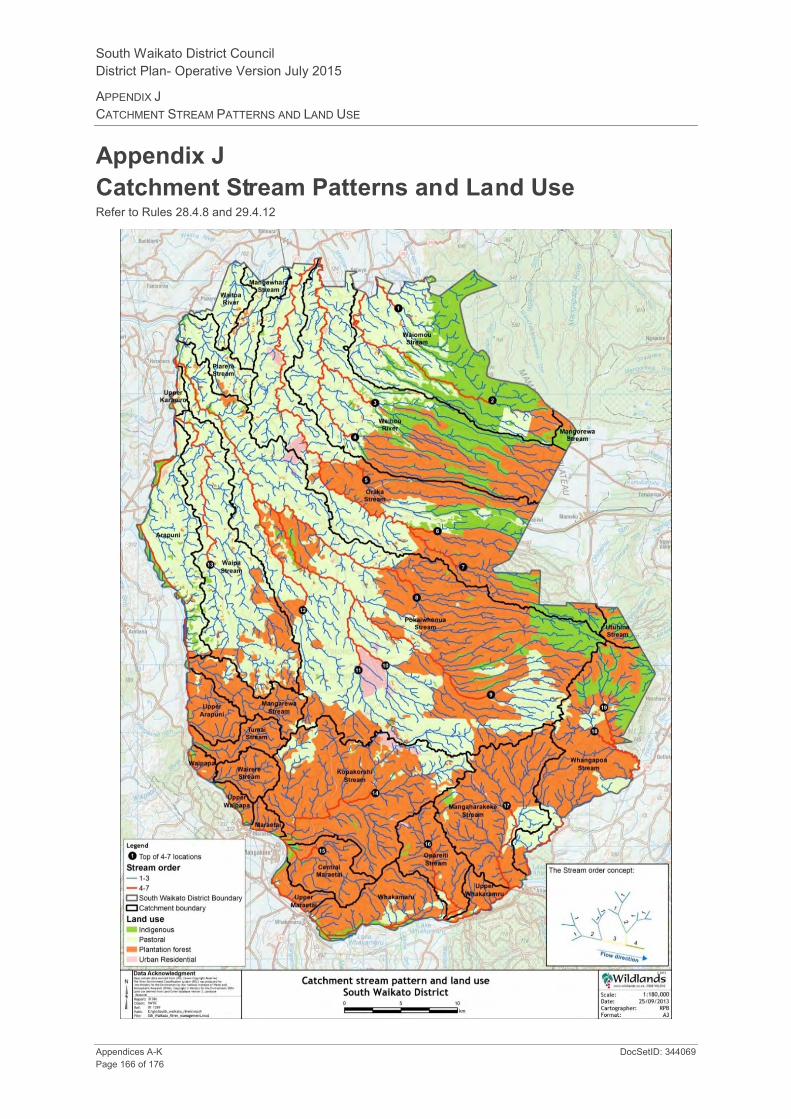
South Waikato District Council District Plan- Operative Version July 2015
APPENDIX J CATCHMENT STREAM PATTERNS AND LAND USE
Appendices A-K DocSetID: 344069 Page 166 of 176
Appendix J Catchment Stream Patterns and Land Use Refer to Rules 28.4.8 and 29.4.12

South Waikato District Council District Plan - Operative Version July 2015
APPENDIX J CATCHMENT STREAM PATTERNS AND LAND USE
DocSetID; 344069 Appendices A-K Page 167 of 176
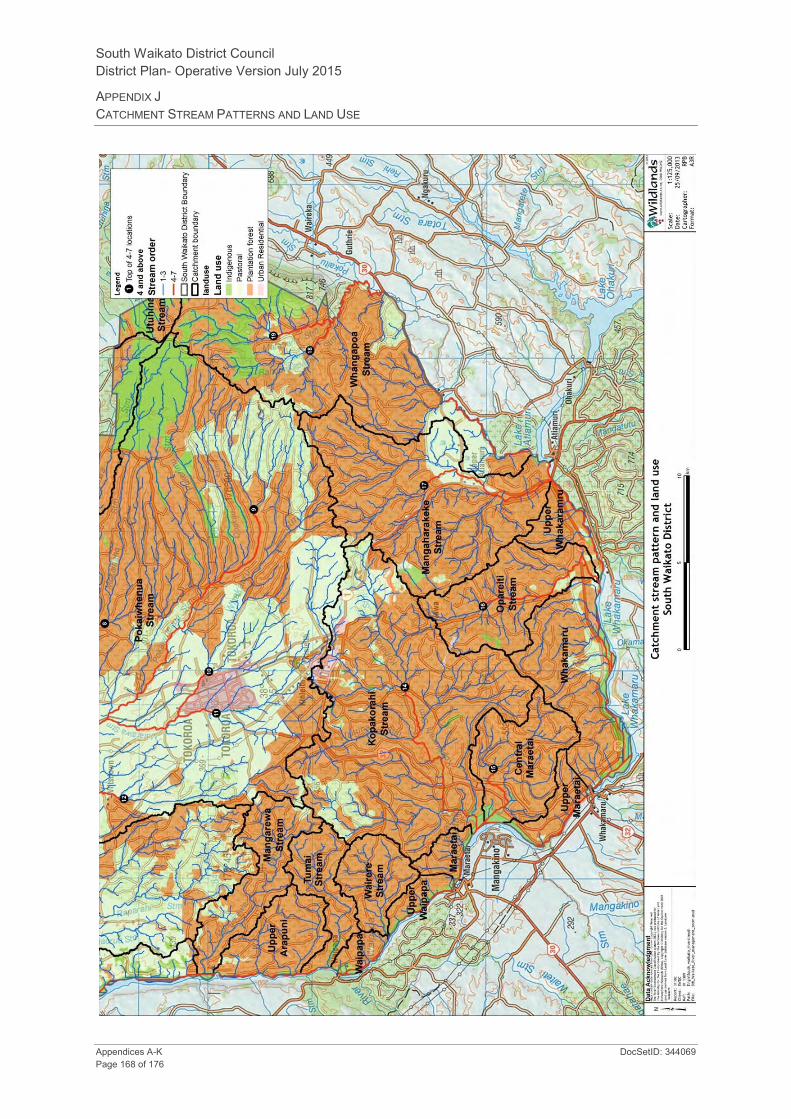
South Waikato District Council District Plan- Operative Version July 2015
APPENDIX J CATCHMENT STREAM PATTERNS AND LAND USE
Appendices A-K DocSetID: 344069 Page 168 of 176

South Waikato District Council District Plan - Operative Version July 2015
APPENDIX K NATIONAL ENVIRONMENTAL STANDARDS FOR ASSESSING AND MANAGING CONTAMINANTS IN SOIL TO
PROTECT HUMAN HEALTH REGULATIONS 2011
DocSetID; 344069 Appendices A-K Page 169 of 176
Appendix K National Environmental Standards for Assessing and Managing Contaminants in Soil to Protect Human Health Regulations 2011 The following is a complete copy of the above Regulations, as at 1 January 2012, being the date at which they first came into effect.
Regulations
1. Title
These regulations are the Resource Management (National Environmental Standard for Assessing and Managing Contaminants in Soil to Protect Human Health) Regulations 2011.
2. Commencement
These regulations come into force on 1 January 2012.
3. Interpretation
In these regulations,—
Act means the Resource Management Act 1991
current edition means the edition that has legal effect when the edition is being used
detailed site investigation means an investigation that—
(a) is done by a suitably qualified and experienced practitioner; and
(b) is done in accordance with the current edition of Contaminated Land Management Guidelines No. 5–Site Investigation and Analysis of Soils, Wellington, Ministry for the Environment; and
(c) is reported on in accordance with the current edition of Contaminated Land Management Guidelines No. 1–Reporting on Contaminated Sites in New Zealand, Wellington, Ministry for the Environment; and
(d) results in a report that is certified by the practitioner
fuel storage system means a system in which at least 1 of the following is underground:
(a) a storage tank for aviation kerosene, diesel, kerosene, lubricating oil, or petroleum:
(b) the whole of the tank's ancillary equipment:
(c) part of the tank's ancillary equipment
HAIL means the current edition of the Hazardous Activities and Industries List, Wellington, Ministry for the Environment
person means the person referred to in regulation 5(1)(a)
preliminary site investigation means an investigation that—
(a) is done by a suitably qualified and experienced practitioner; and

South Waikato District Council District Plan - Operative Version July 2015
APPENDICES A-K
Appendices A-K DocSetID: 344069 Page 170 of 176
(b) is reported on in accordance with the current edition of Contaminated Land Management Guidelines No. 1–Reporting on Contaminated Sites in New Zealand, Wellington, Ministry for the Environment; and
(c) results in a report that is certified by the practitioner.
4. Relationship of regulations with territorial authority and regional council functions
These regulations—
(a) deal with territorial authority functions under section 31 of the Act:
(b) do not deal with regional council functions under section 30 of the Act.
5. Application
(1) These regulations—
(a) apply when a person wants to do an activity described in any of subclauses (2) to (6) on a piece of land described in subclause (7) or (8):
(b) do not apply when a person wants to do an activity described in any of subclauses (2) to (6) on a piece of land described in subclause (9).
Activities
(2) An activity is removing a fuel storage system from the piece of land or replacing a fuel storage system in or on the piece of land, which means—
(a) doing any of the following:
(i) removing or replacing the whole system:
(ii) removing or replacing an underground part of the system:
(iii) taking away or putting back soil associated with the removal or replacement of the system or the part:
(b) doing any of the following for purposes associated with removing or replacing the whole system or part of the system:
(i) sampling the soil of the piece of land:
(ii) investigating the piece of land:
(iii) remediating the piece of land:
(iv) validating the piece of land:
(v) managing the piece of land.
(3) An activity is sampling the soil of the piece of land, which means sampling it to determine whether or not it is contaminated and, if it is, the amount and kind of contamination.
(4) An activity is disturbing the soil of the piece of land, which—
(a) means disturbing the soil of the piece of land for a particular purpose:
(b) does not include disturbing the soil of the piece of land, whatever the purpose, if the land is land to which regulation 33(9) or 36 of the Resource Management (National Environmental Standard for Electricity Transmission Activities) Regulations 2009 applies.
(5) An activity is subdividing land, which means subdividing land—
(a) that has boundaries that are identical with the boundaries of the piece of land; or
(b) that has all the piece of land within its boundaries; or
(c) that has part of the piece of land within its boundaries.

South Waikato District Council District Plan - Operative Version July 2015
APPENDIX K NATIONAL ENVIRONMENTAL STANDARDS FOR ASSESSING AND MANAGING CONTAMINANTS IN SOIL TO
PROTECT HUMAN HEALTH REGULATIONS 2011
DocSetID; 344069 Appendices A-K Page 171 of 176
(6) An activity is changing the use of the piece of land, which means changing it to a use that, because the land is as described in subclause (7), is reasonably likely to harm human health.
Land covered
(7) The piece of land is a piece of land that is described by 1 of the following:
(a) an activity or industry described in the HAIL is being undertaken on it:
(b) an activity or industry described in the HAIL has been undertaken on it:
(c) it is more likely than not that an activity or industry described in the HAIL is being or has been undertaken on it.
(8) If a piece of land described in subclause (7) is production land, these regulations apply if the person wants to—
(a) remove a fuel storage system from the piece of land or replace a fuel storage system in or on the piece of land:
(b) sample or disturb—
(i) soil under existing residential buildings on the piece of land:
(ii) soil used for the farmhouse garden or other residential purposes in the immediate vicinity of existing residential buildings:
(iii) soil that would be under proposed residential buildings on the piece of land:
(iv) soil that would be used for the farmhouse garden or other residential purposes in the immediate vicinity of proposed residential buildings:
(c) subdivide land in a way that causes the piece of land to stop being production land:
(d) change the use of the piece of land in a way that causes the piece of land to stop being production land.
Land not covered
(9) These regulations do not apply to a piece of land described in subclause (7) or (8) about which a detailed site investigation exists that demonstrates that any contaminants in or on the piece of land are at, or below, background concentrations.
6. Methods
(1) Subclauses (2) and (3) prescribe the only 2 methods that the person may use for establishing whether or not a piece of land is as described in regulation 5(7).
(2) One method is by using information that is the most up-to-date information about the area where the piece of land is located that the territorial authority—
(a) holds on its dangerous goods files, property files, or resource consent database or relevant registers; or
(b) has available to it from the regional council.
(3) The other method is by relying on the report of a preliminary site investigation—
(a) stating that an activity or industry described in the HAIL is, or is not, being undertaken on the piece of land; or
(b) stating that an activity or industry described in the HAIL has, or has not, been undertaken on the piece of land; or
(c) stating the likelihood of an activity or industry described in the HAIL being undertaken, or having been undertaken, on the piece of land.
South Waikato District Council District Plan - Operative Version July 2015
APPENDICES A-K
Appendices A-K DocSetID: 344069 Page 172 of 176
(4) The person must—
(a) choose which of the 2 methods to use; and
(b) meet all the costs involved in using the method that the person has chosen.
7. Standards
(1) In this regulation,—
land use means—
(a) the current use, if the activity the person wants to do is—
(i) to remove a fuel storage system from the piece of land or replace a fuel storage system in or on the piece of land:
(ii) to sample the soil of the piece of land:
(iii) to disturb the soil of the piece of land:
(b) the intended use, if the activity the person wants to do is—
(i) to subdivide land:
(ii) to change the use of the piece of land
Methodology means the current edition of the Methodology for Deriving Standards for Contaminants in Soil to Protect Human Health, Wellington, Ministry for the Environment
priority contaminant means a contaminant for which the Methodology derives a soil contaminant standard.
(2) If the contaminant of concern is a priority contaminant and the land use fits within an exposure scenario adopted in the Methodology, the applicable standard is the soil contaminant standard for the priority contaminant.
(3) If the contaminant of concern is a priority contaminant and the land use does not fit within an exposure scenario adopted in the Methodology, the applicable standard is whichever of the following is more appropriate in the circumstances:
(a) the guideline value derived in accordance with the methods and guidance on site-specific risk assessment provided in the Methodology:
(b) the soil contaminant standard for the priority contaminant of the exposure scenario adopted in the Methodology with greater assumed exposure than the actual exposure.
(4) If the contaminant of concern is not a priority contaminant, the applicable standard is whichever of the following is more appropriate in the circumstances:
(a) the guideline value derived in accordance with the methods and guidance on site-specific risk assessment provided in the Methodology:
(b) a guideline value for the protection of human health that is chosen in accordance with the current edition of Contaminated Land Management Guidelines No. 2–Hierarchy and Application in New Zealand of Environmental Guideline Values, Wellington, Ministry for the Environment.
8. Permitted activities
Removing or replacing fuel storage system
Removing or replacing a fuel storage system is a permitted activity while the following requirements are met:
(a) the activity must be done in accordance with the current edition of Guidelines for Assessing and Managing Petroleum Hydrocarbon Contaminated Sites in New Zealand, Wellington, Ministry for the Environment:

South Waikato District Council District Plan - Operative Version July 2015
APPENDIX K NATIONAL ENVIRONMENTAL STANDARDS FOR ASSESSING AND MANAGING CONTAMINANTS IN SOIL TO
PROTECT HUMAN HEALTH REGULATIONS 2011
DocSetID; 344069 Appendices A-K Page 173 of 176
(b) the territorial authority of the district where the system is located must be notified of—
(i) the place where the activity is to be done:
(ii) the dates on which it is intended that the activity begin and end:
(iii) the facility at which it is intended that soil taken away in the course of the activity be disposed of:
(c) notification under paragraph (b) must be done no sooner than 1 month and no later than 1 week before the activity begins:
(d) the volume of soil disturbed must be no more than 30 m3 for each tank in the system:
(e) the volume of soil taken away in the course of the activity must be no more than 30 m3 for each tank in the system:
(f) soil taken away in the course of the activity must be disposed of at a facility authorised to receive soil of that kind:
(g) the duration of the activity must be no longer than 2 months:
(h) the results of the investigation of the piece of land required by the guidelines described in paragraph (a) must be reported to the territorial authority within 3 months after the activity ends.
Sampling soil
Sampling the soil of the piece of land is a permitted activity while the following requirements are met:
(a) controls to minimise the exposure of humans to mobilised contaminants must—
(i) be in place when the activity begins:
(ii) be effective while the activity is done:
(iii) be effective until the soil is reinstated to an erosion-resistant state:
(b) the soil must be reinstated to an erosion-resistant state within 1 month after the end of the course of sampling for which the activity was done:
(c) soil must not be taken away in the course of the activity except as samples taken for the purpose of laboratory analysis:
(d) the integrity of a structure designed to contain contaminated soil or other contaminated materials must not be compromised.
Disturbing soil
Disturbing the soil of the piece of land is a permitted activity while the following requirements are met:
(a) controls to minimise the exposure of humans to mobilised contaminants must—
(i) be in place when the activity begins:
(ii) be effective while the activity is done:
(iii) be effective until the soil is reinstated to an erosion-resistant state:
(b) the soil must be reinstated to an erosion-resistant state within 1 month after the serving of the purpose for which the activity was done:
(c) the volume of the disturbance of the soil of the piece of land must be no more than 25 m3 per 500 m2:
(d) soil must not be taken away in the course of the activity, except that,—
(i) for the purpose of laboratory analysis, any amount of soil may be taken away as samples:
(ii) for all other purposes combined, a maximum of 5 m3 per 500 m2 of soil may be taken away per year:
South Waikato District Council District Plan - Operative Version July 2015
APPENDICES A-K
Appendices A-K DocSetID: 344069 Page 174 of 176
(e) soil taken away in the course of the activity must be disposed of at a facility authorised to receive soil of that kind:
(f) the duration of the activity must be no longer than 2 months:
(g) the integrity of a structure designed to contain contaminated soil or other contaminated materials must not be compromised.
Subdividing or changing use
Subdividing land or changing the use of the piece of land is a permitted activity while the following requirements are met:
(a) a preliminary site investigation of the land or piece of land must exist:
(b) the report on the preliminary site investigation must state that it is highly unlikely that there will be a risk to human health if the activity is done to the piece of land:
(c) the report must be accompanied by a relevant site plan to which the report is referenced:
(d) the consent authority must have the report and the plan.
Consequence if requirement not met
If a requirement described in any of subclauses (1) to (3) is not met, the activity is a controlled activity under regulation 9 while it meets the requirements in regulation 9(1).
If a requirement described in subclause (4) is not met, the activity is a controlled activity under regulation 9 while it meets the requirements in regulation 9(3).
9. Controlled activities
Removing or replacing fuel storage system, sampling soil, or disturbing soil
If a requirement described in any of regulation 8(1) to (3) is not met, the activity is a controlled activity while the following requirements are met:
(a) a detailed site investigation of the piece of land must exist:
(b) the report on the detailed site investigation must state that the soil contamination does not exceed the applicable standard in regulation 7:
(c) the consent authority must have the report:
(d) conditions arising from the application of subclause (2), if there are any, must be complied with.
The matters over which control is reserved are as follows:
(a) the adequacy of the detailed site investigation, including—
(i) site sampling:
(ii) laboratory analysis:
(iii) risk assessment:
(b) how the activity must be—
(i) managed, which may include the requirement of a site management plan:
(ii) monitored:
(iii) reported on:
(c) the transport, disposal, and tracking of soil and other materials taken away in the course of the activity:
(d) the timing and nature of the review of the conditions in the resource consent:
(e) the duration of the resource consent.

South Waikato District Council District Plan - Operative Version July 2015
APPENDIX K NATIONAL ENVIRONMENTAL STANDARDS FOR ASSESSING AND MANAGING CONTAMINANTS IN SOIL TO
PROTECT HUMAN HEALTH REGULATIONS 2011
DocSetID; 344069 Appendices A-K Page 175 of 176
Subdividing or changing use
If a requirement described in regulation 8(4) is not met, the activity is a controlled activity while the following requirements are met:
(a) a detailed site investigation of the piece of land must exist:
(b) the report on the detailed site investigation must state that the soil contamination does not exceed the applicable standard in regulation 7:
(c) the consent authority must have the report:
(d) conditions arising from the application of subclause (4), if there are any, must be complied with.
The matter over which control is reserved is the adequacy of the detailed site investigation, including—
(a) site sampling:
(b) laboratory analysis:
(c) risk assessment.
No public notification of application for resource consent
The consent authority must not give public notification of an application for a resource consent to do any of the activities.
Consequence if requirement not met
If a requirement described in this regulation is not met, the activity is a restricted discretionary activity under regulation 10 while it meets the requirements in regulation 10(2).
10. Restricted discretionary activities
(1) This regulation applies to an activity described in any of regulation 5(2) to (6) on a piece of land described in regulation 5(7) or (8) that is not a permitted activity or a controlled activity.
(2) The activity is a restricted discretionary activity while the following requirements are met:
(a) a detailed site investigation of the piece of land must exist:
(b) the report on the detailed site investigation must state that the soil contamination exceeds the applicable standard in regulation 7:
(c) the consent authority must have the report:
(d) conditions arising from the application of subclause (3), if there are any, must be complied with.
(3) The matters over which discretion is restricted are as follows:
(a) the adequacy of the detailed site investigation, including—
(i) site sampling:
(ii) laboratory analysis:
(iii) risk assessment:
(b) the suitability of the piece of land for the proposed activity, given the amount and kind of soil contamination:
(c) the approach to the remediation or ongoing management of the piece of land, including—
(i) the remediation or management methods to address the risk posed by the contaminants to human health:

South Waikato District Council District Plan - Operative Version July 2015
APPENDICES A-K
Appendices A-K DocSetID: 344069 Page 176 of 176
(ii) the timing of the remediation:
(iii) the standard of the remediation on completion:
(iv) the mitigation methods to address the risk posed by the contaminants to human health:
(v) the mitigation measures for the piece of land, including the frequency and location of monitoring of specified contaminants:
(d) the adequacy of the site management plan or the site validation report or both, as applicable:
(e) the transport, disposal, and tracking of soil and other materials taken away in the course of the activity:
(f) the requirement for and conditions of a financial bond:
(g) the timing and nature of the review of the conditions in the resource consent:
(h) the duration of the resource consent.
Consequence if requirement not met
(4) If a requirement described in this regulation is not met, the activity is a discretionary activity under regulation 11.
11. Discretionary activities
(1) This regulation applies to an activity described in any of regulation 5(2) to (6) on a piece of land described in regulation 5(7) or (8) that is not a permitted activity, controlled activity, or restricted discretionary activity.
(2) The activity is a discretionary activity".
Rebecca Kitteridge, Clerk of the Executive Council.
Explanatory note
This note is not part of the regulations, but is intended to indicate their general effect.
These regulations provide a national environmental standard for activities on pieces of land whose soil may be contaminated in such a way as to be a risk to human health. The activities are removing or replacing a fuel storage system, sampling the soil, disturbing the soil, subdividing land, and changing the use of the piece of land. The activities are classed as permitted activities, controlled activities, restricted discretionary activities, or discretionary activities.
The current editions of documents incorporated by reference are available on the Ministry for the Environment's website.
The regulations come into force on 1 January 2012.
Issued under the authority of the Acts and Regulations Publication Act 1989.
Date of notification in Gazette: 13 October 2011.
These regulations are administered by the Ministry for the Environment.