Embed Size (px)
Citation preview
South Eastern RegionalUsers Conference - 2010
April 26 2010Westin, Charlotte, NC
Pennsylvania Federated GIS
Tom Sweet
RGIS Chesapeake – Wilkes University/
Pennsylvania GIS [email protected]

8 Site Locations across the USA
Chesapeake, Pennsylvania State UniversityChesapeake, Wilkes University & PaGIS ConsortiumGreat Lakes, University of Wisconsin-MadisonGreat Plains, University of North DakotaMid-South, University of ArkansasPacific Northwest, Central Washington UniversitySouth Georgia, South Georgia Regional Development
CenterTribal Technical Center, Southwestern Indian Polytechnic
Institute
National Consortium for Rural Geospatial Innovations in America
(RGIS)___________________

RGIS Site History?RGIS Site History?
Regional Problem solving:Provide leveraged collaboration
Environmental applications and applied research
Research that supports the design and deployment of locally independent, regionally coordinated, multipurpose Geographic Information Systems
Training, Education and skills retooling
Tech-Transfer

United States Department of Agriculture
Cooperative State Research
Education and Extension Service
Made Possible By___________________

Philadelphia, PA. & Redlands, CA.
Offices of the Environmental Systems Research Institute (ESRI)
Made Possible By___________________

Commonwealth of Pennsylvania
Made Possible By___________________
North Central Regional Counter Terrorism Task ForceNorth Central Regional Counter Terrorism Task Force
GovernorGovernor’’s Office of Administration, Bureau of Geos Office of Administration, Bureau of Geo--Spatial TechnologySpatial Technology
Pennsylvania Emergency Management AgencyPennsylvania Emergency Management Agency

North Central Task Force: North Central Task Force: Clinton, Bradford, Lycoming, Potter, Tioga, Sullivan, Clinton, Bradford, Lycoming, Potter, Tioga, Sullivan,
Tioga and Wayne CountiesTioga and Wayne Counties
Pennsylvania Federated Pennsylvania Federated GIS NetworkGIS Network
Access to live Locally Access to live Locally Stored & Maintained Stored & Maintained
Spatial DataSpatial Data
East Central Task Force: East Central Task Force: Berks, Columbia, Luzerne, Montour, Northumberland, Schuylkill Berks, Columbia, Luzerne, Montour, Northumberland, Schuylkill Wyoming, Wayne CountiesWyoming, Wayne Counties
Others:Others: South Central, Northeast, Northwest, PEMA, NGA, others???South Central, Northeast, Northwest, PEMA, NGA, others???

Project history
• The concept of sharing GIS data amongst counties has long been a topic of discussion within the Commonwealth
• That need, to share accurate data rapidly, still exists.
• Several projects in Central Pennsylvania demonstrated that county GIS data could be shared and put into a regional ‘layer’.
A bit more history…
• In subsequent discussions about those early projects, many expressed a desire for this type of data collaboration to be done more in near ‘real time’.
• Rather than just a ‘snap shot in time’

Those ‘wouldn’t it be nice’discussions…
Evolved into what became the initial Federated GIS Pilot Project:
• 2005-2006 Research and development
• 2007 live demonstration of pilot (flooding event)
• 2008-2009 deployment in Counter Terrorism Taskforces
• 2010 – private sector

Key aspects of the Project:
• Each county would build/maintain their data sets to suit local needs and be able to share the data at will without changing their day to day business model

Key aspects continued…
• Data would be able to be shared at regional, state, and federal level without changing the local data structure– And accomplish a sub-goal of not requiring the tax
payer to pay two, three, or more times for the same data

Key aspects continued…
• That data could be shared & combined in near real time with those who needed current data, thus eliminating the issue of outdated GIS data being used for critical decision making from data sets only updated bi-annually or annually
Key aspects continued…
• That a system could be built to provide redundancy of county data and thereby provide continuous access to data during those emergencies where a county’s infrastructure was interrupted or destroyed.

Key aspects worth repeating…
• Certain project components were deemed non-negotiable by participating counties:– Could not change existing current county
workflows;
– Could not change existing data models or standards;
– Maintaining local county independence was absolute;
– Maintaining regional coordination and combining datasets was mandatory.

Typical County Participant?Typical County Participant?
GIS – 1993Rural, 1 – 3 man shopEnterprise GISContributing Data:
Transportation networksHydrologyBuildingsDigital Orthophotos
IMS/SDEAverage relationship with IT (or better)
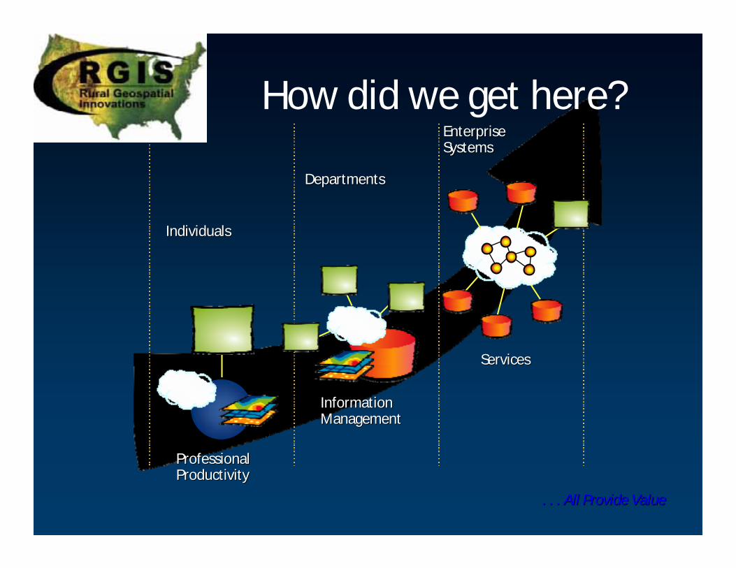
How did we get here?
IndividualsIndividuals
DepartmentsDepartments
ProfessionalProfessionalProductivityProductivity
InformationInformationManagementManagement
ServicesServices
EnterpriseEnterpriseSystemsSystems
. . . All Provide Value. . . All Provide Value

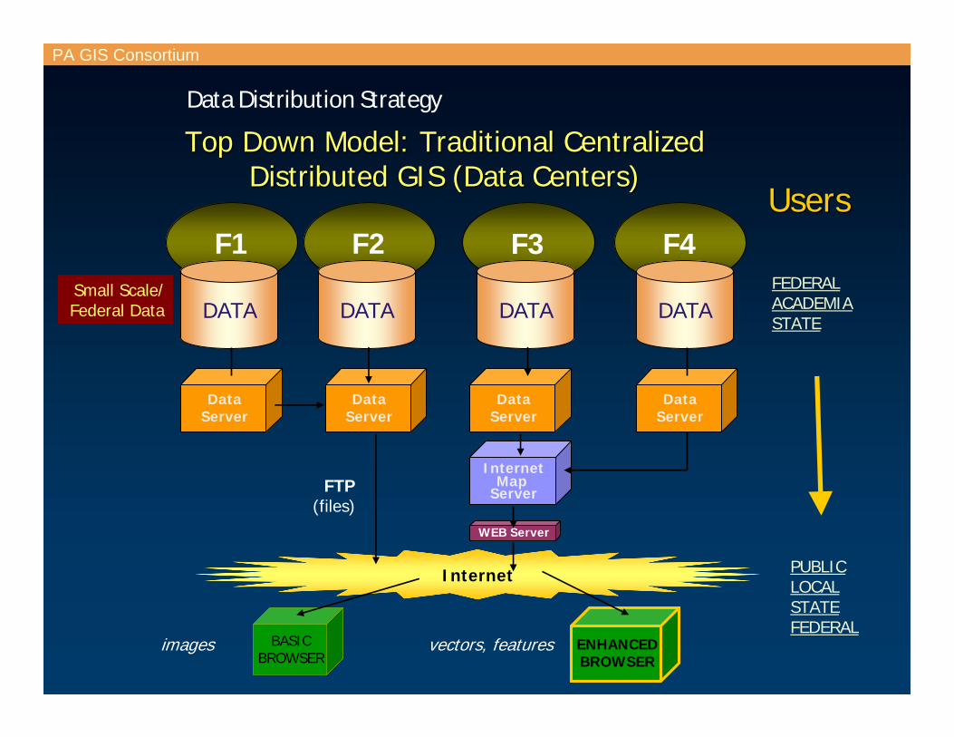
PA GIS Consortium
Data Distribution Strategy
1993 Model:1993 Model:NonNon--Distributed GIS Distributed GIS (independent and mostly isolated)(independent and mostly isolated)
Local DatabaseLocal Database(e.g. Project GIS)(e.g. Project GIS)
GIS ApplicationsGIS Applications(Project Driven)(Project Driven)
CountyX
MunicipalityY
AgencyZ
DATA
GIS app
DATADATA
GIS app GIS app
InternetMap
Server
Internet
images
BASICBROWSER
Internet
PA GIS Consortium
Data Distribution Strategy
FEDERALACADEMIASTATE
F2 F3 F4
PUBLICLOCALSTATEFEDERAL
UsersUsers
BASICBROWSER
ENHANCEDBROWSER
DataServer
DATADATA
DataServer
DataServer
InternetMap
Server
WEB Server
DATA
Top Down Model: Traditional CentralizedTop Down Model: Traditional CentralizedDistributed GIS (Data Centers)Distributed GIS (Data Centers)
F1
DataServer
DATA
FTP(files)
vectors, featuresimages
Small Scale/Federal Data

Internet/Intranet
PA GIS Consortium
Data Distribution Strategy
LOCALCountyMunicipalityAgencyUniversityOtherL1 L2 L3
PA GIS CONSORTIUMregional coordination
PUBLICOTHER LOCALSTATEFEDERAL
UsersUsers
images
BASICBROWSER
ENHANCEDBROWSER
SDE
ArcIMS
WEB Server
DATADBMS
SDESDE
ArcIMS
WEB Server
DATA
2000 Model:2000 Model:Distributed GISDistributed GIS((locally maintained andlocally maintained andregionally coordinated)regionally coordinated)
vectors, features
Large Scale/Local Data

PA GIS Consortium
Data Distribution Strategy
Portal Model 2002: Enterprise GISPortal Model 2002: Enterprise GIS((locally integrated and maintained)locally integrated and maintained)
ENVIRONM/PLANNING
911
EMERGENCY
TAX
ENGINEERING
SECURE (Data Creator)
FIREWALL
* e.g. JAVA Applet, ArcExplorer
PUBLIC (Data Consumer)
SDE
ArcIMS
WEB Server
DATA
passivepassive
activeactive
GIS Application
ENHANCEDBROWSER
BASICBROWSER
BASICBROWSER
ENHANCEDBROWSER*
Internet/Intranet
FIREWALL
data flowdata flow
UsersUsers
imagesvectors, features

GIS Portals: PA GIS Consortium History

Portal Approach Informs About What's Available
Saves Time, Lowers Redundancy & Enables Sharing
But….(Doesn’t Really Harmonize Information)
It’s a Static Catalog that Involves Dynamic
Integration of Distributed Data
. . . Geographic Inconsistency Along Boundaries

PEMA - Terrorism Task Force: Foundation Philosophy
Develop Regional Counter-Terrorism Task ForcesDevelop county task forces Integrate federal/state/county response Institutionalize mutual aid agreements in the region Establish standing regional response groups Encourage regional networking
……. Challenge and Opportunity. Challenge and Opportunity

GIS Portals Connecting Distributed GIS Services . . .
Accessing Shared Accessing Shared GIS ResourcesGIS ResourcesDatasetsDatasetsData ModelsData ModelsMap ServicesMap ServicesGIS ServicesGIS ServicesApplicationsApplicationsGIS ActivitiesGIS ActivitiesStaff CapacityStaff Capacity
. . . With Tools For Dynamically Integrating Geospatial Servi. . . With Tools For Dynamically Integrating Geospatial Servicesces

Our Challenge

Our Challenge
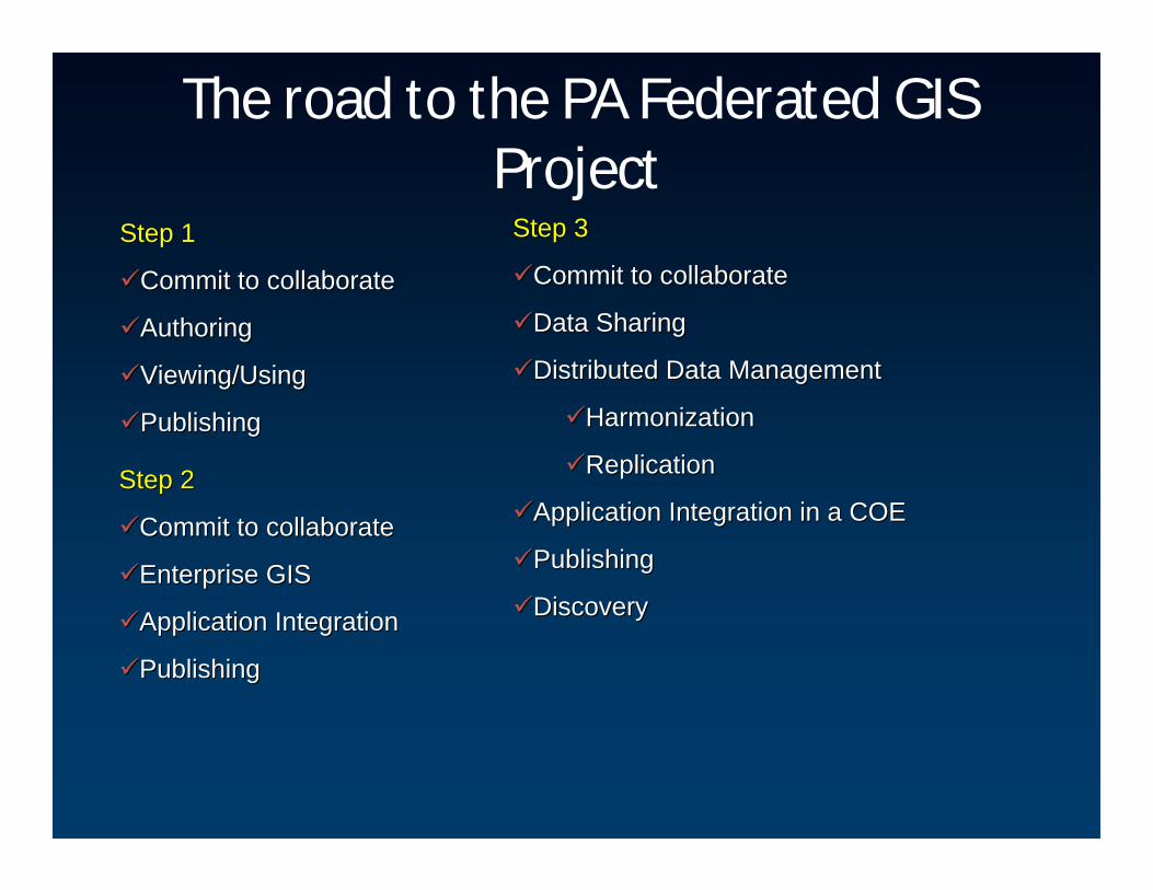
The road to the PA Federated GIS Project
Step 1Step 1
Commit to collaborateCommit to collaborate
AuthoringAuthoring
Viewing/UsingViewing/Using
PublishingPublishing
Step 2Step 2
Commit to collaborateCommit to collaborate
Enterprise GISEnterprise GIS
Application IntegrationApplication Integration
PublishingPublishing
Step 3 Step 3
Commit to collaborateCommit to collaborate
Data SharingData Sharing
Distributed Data ManagementDistributed Data Management
HarmonizationHarmonization
ReplicationReplication
Application Integration in a COEApplication Integration in a COE
PublishingPublishing
DiscoveryDiscovery

GIS Portals: Connecting the Dots!Connecting Distributed GIS Services . . .Connecting Distributed GIS Services . . .
. . . Analysis on the Fly . . . Analysis on the Fly –– Spatial Data on DemandSpatial Data on Demand

(PaGIS Consortium)(PaGIS Consortium)

Creating the Infrastructure
GIS Portals……………PAGIS Consortium Phase 1
Uniform Harmonization of Data Models And Data …..Common Operating EnvironmentPennsylvania Geospatial Data Sharing Standards (PGDSS)
Periodic Harmonization ……PA Federated GIS Project
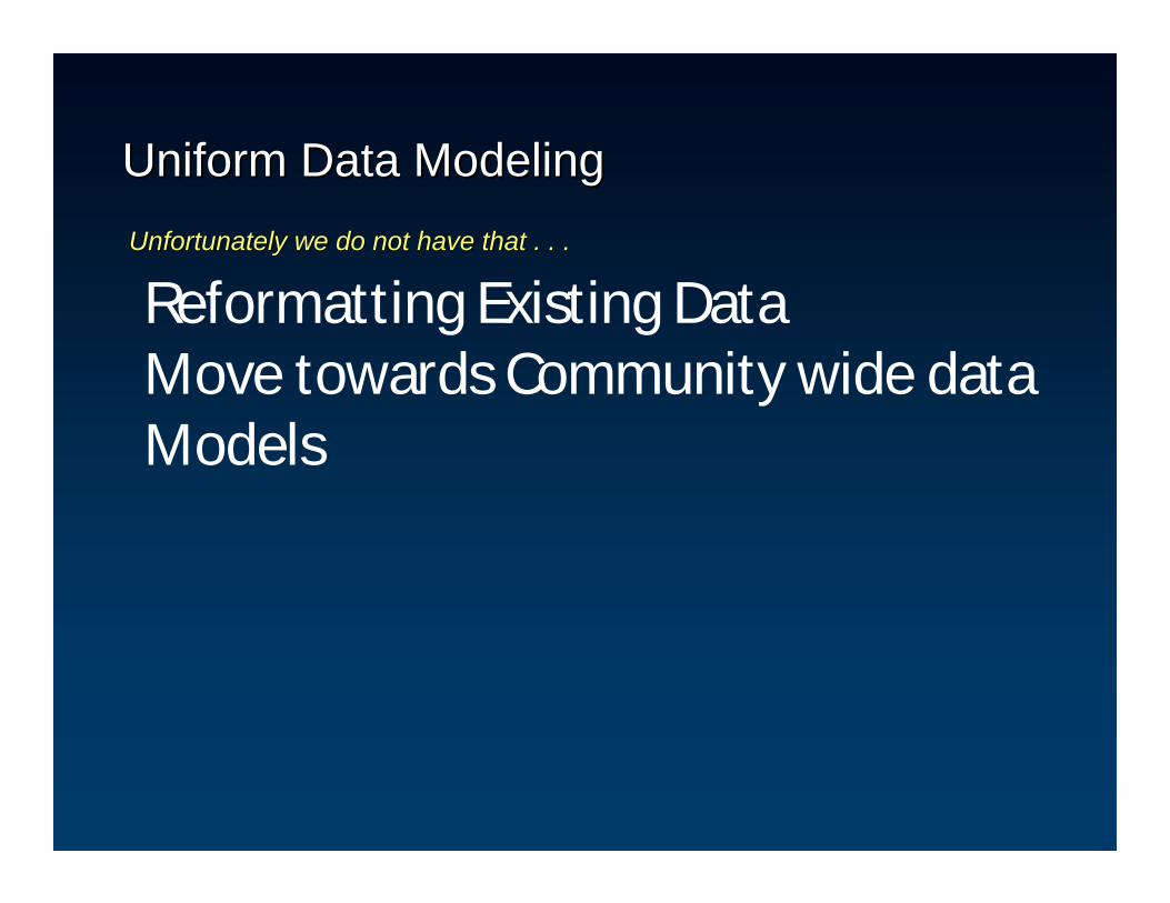
Reformatting Existing DataMove towards Community wide data Models
Uniform Data Modeling Uniform Data Modeling Unfortunately we do not have that . . .Unfortunately we do not have that . . .

Uniform Data HarmonizationRequires Change - Transformation
……Time And Leadership Is RequiredTime And Leadership Is Required
TransportationTransportation
CulturalCulturalHydrographyHydrography
Orthophoto BaseOrthophoto Base
•• Agreement On Uniform Data ModelAgreement On Uniform Data Model•• Reformatting Data Reformatting Data •• Changes In WorkflowChanges In Workflow•• Significant Funding. . .Significant Funding. . .

Uniform Data Harmonization - PGDSS
Develop tools, procedures and workflows to test the standards Develop tools, procedures and workflows to test the standards

One Uniform Data Model With Distributed Management Is Powerful
Update Once …… Use Many Times
SupportsSupports Collaborating AgenciesCollaborating Agencies
OneOneWayWay
TwoTwo
WayWayRead /Read /WriteWrite
ViewViewOnlyOnly GIS ServerGIS Server
Read /Read /WriteWrite
NationalNational
StateState
LocalLocal
HierarchyHierarchy
Technically Possible. . . Technically Possible. . . . . . But Requires Institutional Sharing Agreements, Financial S. . . But Requires Institutional Sharing Agreements, Financial Support upport
Periodic Harmonization (Federated) – Pennsylvania Federated GIS
Project
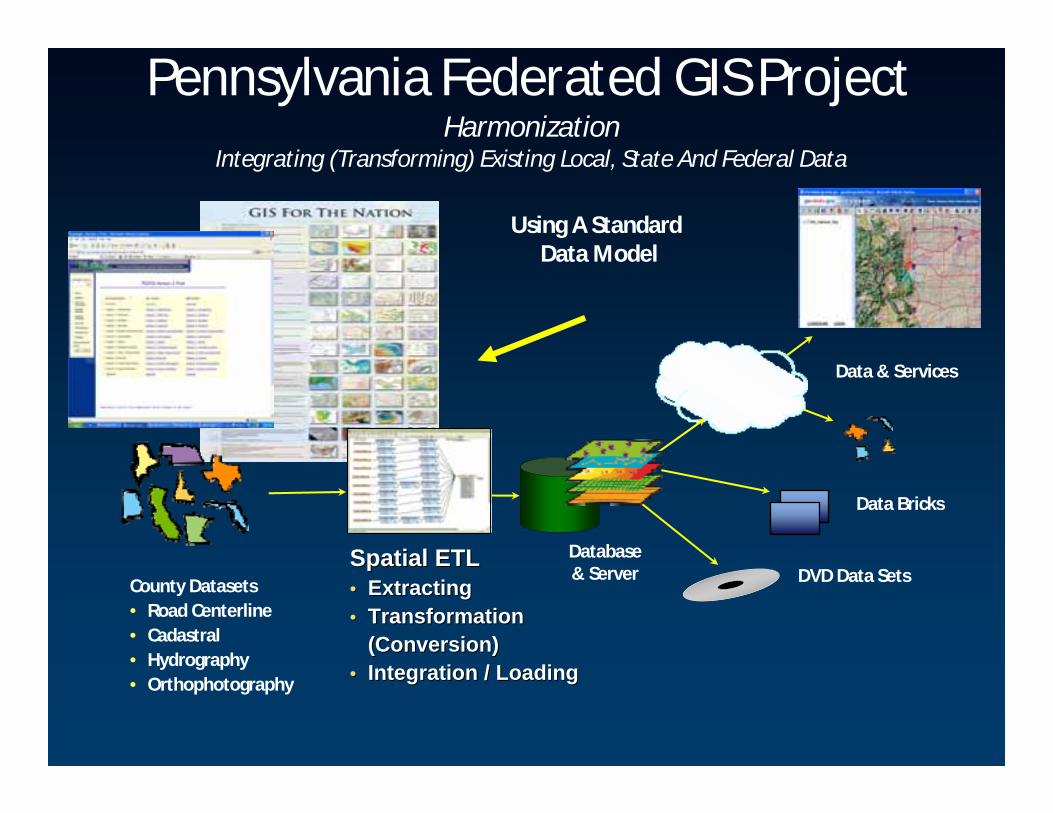
Spatial ETLSpatial ETL•• ExtractingExtracting•• TransformationTransformation
(Conversion)(Conversion)•• Integration / LoadingIntegration / Loading
Database & Server
Data & Services
County Datasets• Road Centerline• Cadastral• Hydrography• Orthophotography
DVD Data Sets
Data Bricks
Using A Standard Data Model
Pennsylvania Federated GIS ProjectHarmonization
Integrating (Transforming) Existing Local, State And Federal Data

CountiesCounties
TaskTaskForcesForces
NationalNationalStatesStates
What started as ….Development of a Regional Collaborative Process
ETLETL ETLETL
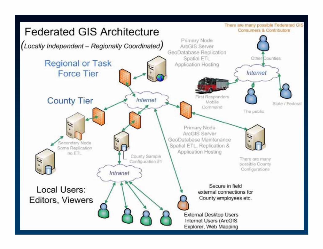
Federated GIS Configuration

One Federated GIS Configuration

Federated GIS Configuration: No Proxy Server
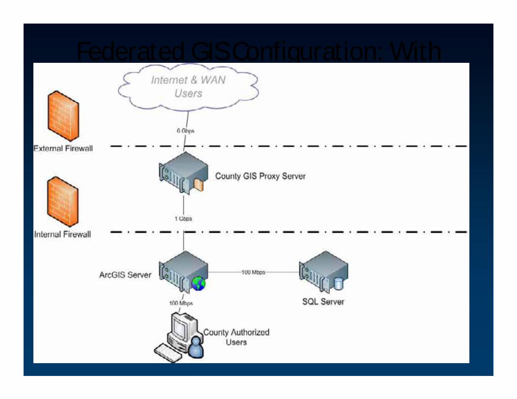
Federated GIS Configuration: With Proxy Server

ETL Architecture and approach

ArcGIS Server Interoperability
extensionETL
example

Where are we today? – road ahead
AuthoringAuthoringTierTier
Presentation TierPresentation Tier(Any Viewer)(Any Viewer)
Globe Globe ServicesServices
Map &Map &ChartChart
ServicesServices
ImageImage--ProcessingProcessing
ServicesServices
Open Open Web Web
ServicesServices
TrackingTracking& RSS & RSS
ServicesServicesServing/Serving/
PublishingPublishingTierTier
22--D D ViewersViewers
33--DDViewersViewers
MetadataMetadataCatalog Catalog ServicesServices
GeoGeo--ProcessingProcessing
ServicesServices
COPCOP
3 Tiers3 Tiers
ArcGIS Server
MobileMobile
CountyCounty
Task ForceTask Force
•• Open Open •• InteroperableInteroperable•• Standards BasedStandards Based•• On DemandOn Demand
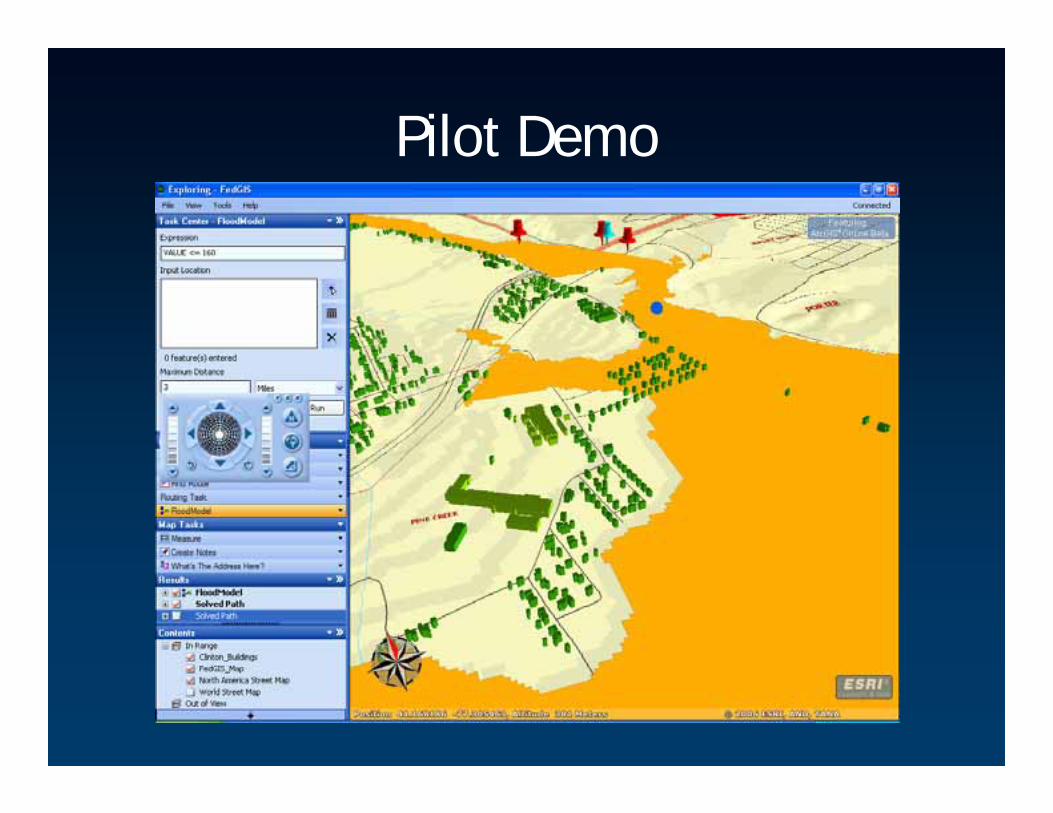
Pilot Demo

Damage Assessment Tool

Near real time access to local spatial data on a regional level

Near real time access to local spatial data on a regional level
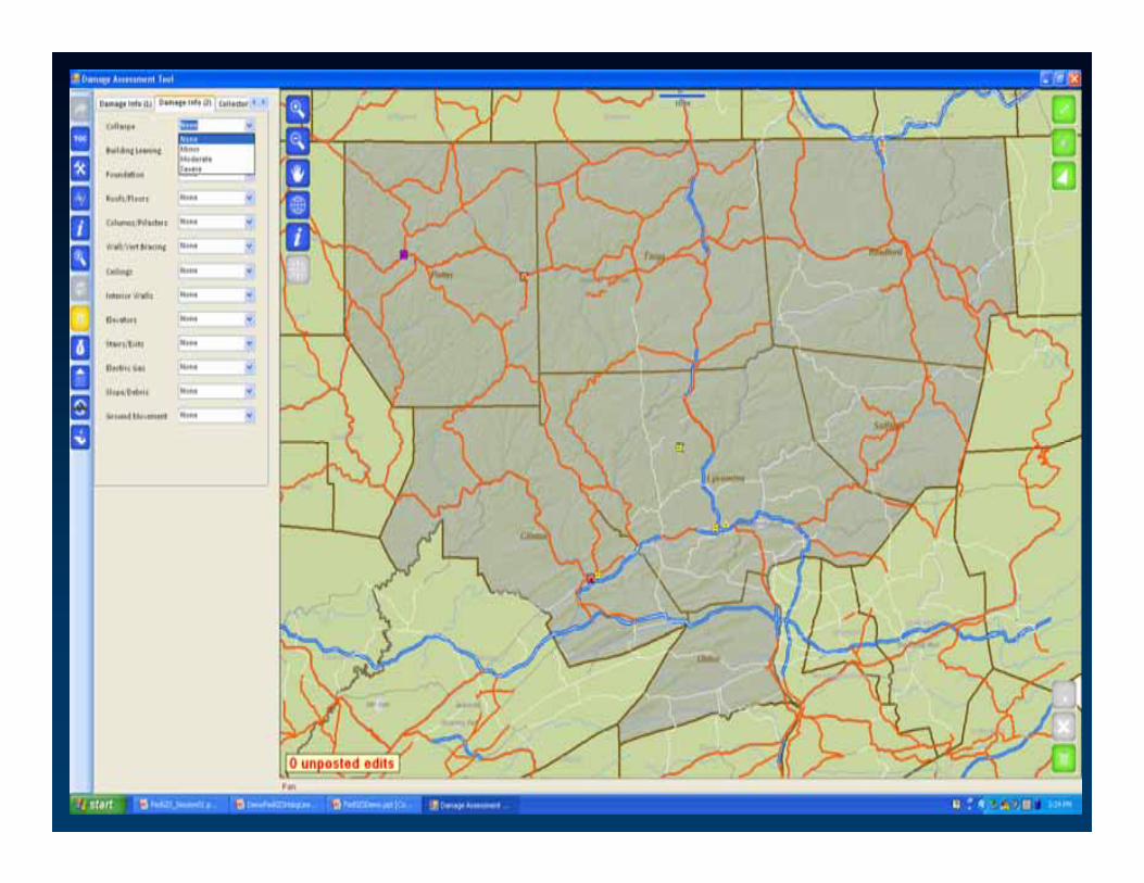
Near real time access to local spatial data on a regional level

Near real time access to local spatial data on a regional level

Summary
• Coordination is Essential– Establishing & leveraging relationships, management & leadership
• Technology – Easier part– Its catching up
• GIS Portals Work ………………………..– Essential to collaboration and discovery
• Data Harmonization Is Possible (Data Models)– Short Term Strategy– A Very Long Term Strategy– Common Operating Environment
• Practical Solutions (ETL ) Exist– For Building On Existing Systems– Immediately Useful