Embed Size (px)
Citation preview

submitted by VHb
South Boston WaterfrontSustainable Transportation Plan
in collaboration witHA Better City
in association witHCambridge Systematics, Inc.
Cooper, Robertson & Partners
Norris & Norris Associates
Regina Villa Associates, Inc.
JANUARY 2015

South Boston Waterfront Sustainable Transportation Plan | Final Report 1 www.sbwaterfrontmobility.org
ExEc
uti
vE S
um
mar
y
EXECUTIVE SUMMARYIntroductionthe South Boston Waterfront is a truly unique place with tremendous, still to be realized, potential for the future. at the heart of the city of Boston, it is home to an active, growing industrial port; an emerging residential area; first class convention, cultural and recreational resources that attract visitors from throughout the nation and around the world; and, an emerging center for innovation in the finance, legal, biomedical research, and technology sectors.
it is also the fastest growing urban area in the commonwealth, with ten million square feet of development built between 2000 and 2013, adding more than 4,100 new residents and 7,700 jobs. Growth and vitality of the South Boston Waterfront were set in motion more than three decades ago through infrastructure planning and investment (principally, the Boston Harbor Project, central artery/tunnel Project, the South Boston Bypass road, and construction of the Silver Line tunnel from South Station), along with additional public sector investment in the new Federal courthouse and the Boston convention & Exhibition center. in 2000, the city of Boston released the South Boston transportation Study (“the 2000 Plan”) that codified a comprehensive set of transportation recommendations to support the pending wave of development while protecting the residential neighborhoods and preserving the working port and industrial land uses.
much has changed in the almost 15 years since the 2000 Plan was published in terms of the Waterfront’s development and the transportation system that serves it. many of the 2000 Plan recommendations have been implemented. Furthermore, the
The South Boston Waterfront is the fastest growing urban area in the Commonwealth.

2 South Boston Waterfront Sustainable Transportation Plan | Final Report www.sbwaterfrontmobility.org
ExEc
uti
vE S
um
mar
y
accelerated pace of growth in the Waterfront in recent years with increased tourism, commercial traffic, and residential populations has led to congestion and mobility challenges.
Over the next two decades, another 17 million square feet of development is underway or planned—including 5,300 new residences, 6 million square feet of new office and research space, nearly one million square feet of port and maritime-related uses, and more than a doubling of convention and hospitality space. From a transportation perspective, it is time to take stock of what has been accomplished and set the course for the next 20 years.
as we look to the future, additional emphasis is also needed to increase sustainable transportation modes (walking, bicycling, and transit), ensure the compatibility of transportation solutions with environmental and quality of life goals, and to actively manage the performance of existing infrastructure. this Sustainable Transportation Plan (“the Plan”) is both a strategic plan—providing a blueprint for the transportation system improvements over a 20 year planning horizon—and an action plan defining more immediate/short-term strategies to address existing transportation and mobility issues, capacity constraints, transit, pedestrian and bicycle needs, and operational enhancements.
Vision and Plan Goals Building upon the successes of Boston’s waterfront redevelopment to date and shaping the next two decades of growth and investment require a fresh examination of the long-term vision for the South Boston Waterfront and establishing a new set of aspirational transportation goals and objectives.
VISION
the Plan seeks to realize the full transformation of the South Boston Waterfront to a distinct and vibrant neighborhood within the city of Boston that:
• Supports a broad cross-section of the region’s economic drivers:
◦ traditional maritime and industrial trades ◦ innovative economy/incubator businesses ◦ Financial, legal, and technology sectors ◦ convention and tourism business and related
services ◦ arts and culture
• Provides residential space and quality of life for a diversity of Boston’s residents.
• is a world-renowned, memorable, and accessible destination for tourists, conventioneers, and visitors, alike.
The Sustainable Transportation Plan lays out a blueprint for transportation and public realm improvements for the South Boston Waterfront over the next two decades.

South Boston Waterfront Sustainable Transportation Plan | Final Report 3 www.sbwaterfrontmobility.org
ExEc
uti
vE S
um
mar
y
critical to turning this Sustainable transportation Plan into action and realizing the needed improvements in transportation and mobility requires: (1) establishing the organizational structure and capacity to implement the Plan and, (2) establishing mechanisms to monitor and evaluate the effectiveness of implemented improvements across transportation, environment, social, and cost metrics. this assessment has to be consistent with stated performance management goals.
Goals
there is broad consensus that this transportation plan—that supports the 21st Century South Boston Waterfront area, defines and prioritizes transportation system investments, seeks to influence people’s travel behaviors, and improves the public realm —is a major step forward to ensure the full potential of this area and achieve the vision. this Plan seeks to:
Improve Access and Mobility for All – improve multimodal access to/from/through and mobility within the South Boston Waterfront for residents, workers, maritime-related commerce, and visitors.
Support Economic Growth and Vitality – Deliver the transportation infrastructure needed to support a world-class economy.
Reinforce Sustainable Policies and Programs – align programs and policies to support more sustainable transportation choices and demand management to and within the South Boston Waterfront.
Enhance the Public Realm – contribute to enhancing the attractiveness and quality of the urban character through ongoing transportation investment.
Contribute Environmental and Health Benefits – realize the positive environmental effects and health benefits that result from a more sustainable transportation plan.
Invest Smartly for the Future – advance strategic investment in the South Boston Waterfront to ensure the long-term financial and operational sustainability of its transportation system.

4 South Boston Waterfront Sustainable Transportation Plan | Final Report www.sbwaterfrontmobility.org
ExEc
uti
vE S
um
mar
y
interagency Working Group (iWG) was established at the outset of this initiative to guide the technical elements of plan development. the iWG met weekly to share information, review all technical documents, and provide direct input on plan alternatives and recommendations. most importantly, the iWG helped foster interagency cooperation and consensus on the study findings.
Public Engagement
A major component of this planning effort involved stakeholder engagement guided by a comprehensive Public involvement Plan developed as part of the first task in the process. The planning team initiated public dialogue early in the process to acknowledge the issues and opportunities facing the South Boston Waterfront, and involve many communities of interest, including residents; employers and employees; maritime and industrial businesses; agencies; advocacy groups; neighborhood associations; and the public. Public input was solicited through individual outreach meetings and broad community gatherings. an online survey (in four languages) was also distributed to employees in visitor and tourism industries to gather their input. Five public meetings were held at key plan milestones to solicit broader input to the study. Public review of the draft recommendations was solicited through presentations and via email and the Plan website. in total, more than 50 outreach meetings were held over the 12-month planning process, garnering input from hundreds of individuals.
the agencies and the planning team mapped the transportation issues and needs to candidate solutions or strategies. the candidate strategies were then analyzed—under the framework provided by the vision, Goals and Objectives of the Plan—vetted within the agencies and with the public, and screened to determine the most promising options for incorporation into the plan recommendations.
Study and Impact Areathe area known as the South Boston Waterfront is located southeast of Downtown Boston and across the inner Harbor from East Boston and comprises land bound by East and West First Streets to the south, Boston Harbor to the east, and the Fort Point channel area to the west, as shown within the orange boundary in Exhibit ES-1. the attractiveness of the South Boston Waterfront is in large part due to its strategic location abutting historic Boston Harbor, adjacent to Boston’s financial district and Logan international airport, and at the nexus of two major interstate highways (i-90 and i-93). it also features the largest supply of centrally located, undeveloped land in the city of Boston. as the South Boston Waterfront is located on a peninsula, proximate to the Downtown and many of the city’s oldest neighborhoods, it cannot be studied in isolation. accordingly, the Plan also considers the impact area surrounding the Waterfront as outlined by the dashed blue line in Exhibit ES-1.
Planning Processthe South Boston Waterfront transportation plan development, kicked off in December of 2013, engaged the many and diverse stakeholders in the Study area and adjacent neighborhoods from its inception, and involved a unique partnership among all of the sponsoring agencies.
Multi-Agency Collaboration
Plan development was overseen by a Steering committee comprising senior leadership from the massachusetts convention center authority, massachusetts Port authority, massachusetts Department of transportation, and the city of Boston. the project was managed by a Better city and supported by generous donations from area businesses. the Steering committee met monthly over the 12-month planning process. in addition, an
The framing of study area and neighborhood transportation issues, opportunities, and needs evolved from a thorough review of data and the compilation of concerns and desired outcomes identified by key project stakeholders, with more than 50 outreach meetings over the planning process.

South Boston Waterfront Sustainable Transportation Plan | Final Report 5 www.sbwaterfrontmobility.org
ExEc
uti
vE S
um
mar
y
Exhibit ES-1: Study and Impact Areas Study and Impact Areathe area known as the South Boston Waterfront is located southeast of Downtown Boston and across the inner Harbor from East Boston and comprises land bound by East and West First Streets to the south, Boston Harbor to the east, and the Fort Point channel area to the west, as shown within the orange boundary in Exhibit ES-1. the attractiveness of the South Boston Waterfront is in large part due to its strategic location abutting historic Boston Harbor, adjacent to Boston’s financial district and Logan international airport, and at the nexus of two major interstate highways (i-90 and i-93). it also features the largest supply of centrally located, undeveloped land in the city of Boston. as the South Boston Waterfront is located on a peninsula, proximate to the Downtown and many of the city’s oldest neighborhoods, it cannot be studied in isolation. accordingly, the Plan also considers the impact area surrounding the Waterfront as outlined by the dashed blue line in Exhibit ES-1.
Planning Processthe South Boston Waterfront transportation plan development, kicked off in December of 2013, engaged the many and diverse stakeholders in the Study area and adjacent neighborhoods from its inception, and involved a unique partnership among all of the sponsoring agencies.
Multi-Agency Collaboration
Plan development was overseen by a Steering committee comprising senior leadership from the massachusetts convention center authority, massachusetts Port authority, massachusetts Department of transportation, and the city of Boston. the project was managed by a Better city and supported by generous donations from area businesses. the Steering committee met monthly over the 12-month planning process. in addition, an

6 South Boston Waterfront Sustainable Transportation Plan | Final Report www.sbwaterfrontmobility.org
ExEc
uti
vE S
um
mar
y
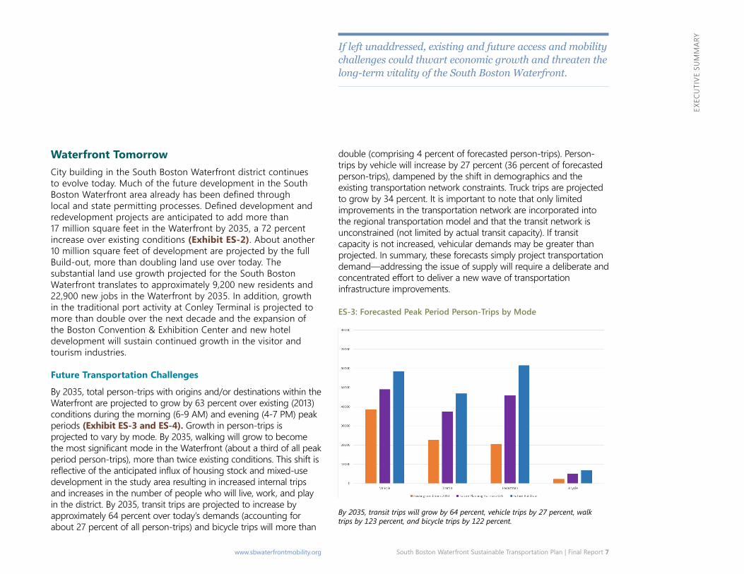
Waterfront Tomorrowcity building in the South Boston Waterfront district continues to evolve today. much of the future development in the South Boston Waterfront area already has been defined through local and state permitting processes. Defined development and redevelopment projects are anticipated to add more than 17 million square feet in the Waterfront by 2035, a 72 percent increase over existing conditions (Exhibit ES-2). about another 10 million square feet of development are projected by the full Build-out, more than doubling land use over today. the substantial land use growth projected for the South Boston Waterfront translates to approximately 9,200 new residents and 22,900 new jobs in the Waterfront by 2035. in addition, growth in the traditional port activity at conley terminal is projected to more than double over the next decade and the expansion of the Boston convention & Exhibition center and new hotel development will sustain continued growth in the visitor and tourism industries.
Future Transportation Challenges
By 2035, total person-trips with origins and/or destinations within the Waterfront are projected to grow by 63 percent over existing (2013) conditions during the morning (6-9 am) and evening (4-7 Pm) peak periods (Exhibit ES-3 and ES-4). Growth in person-trips is projected to vary by mode. By 2035, walking will grow to become the most significant mode in the Waterfront (about a third of all peak period person-trips), more than twice existing conditions. this shift is reflective of the anticipated influx of housing stock and mixed-use development in the study area resulting in increased internal trips and increases in the number of people who will live, work, and play in the district. By 2035, transit trips are projected to increase by approximately 64 percent over today’s demands (accounting for about 27 percent of all person-trips) and bicycle trips will more than
Waterfront and there is no scheduled water transportation service. Limitations on direct and comfortable pedestrian connections, exclusive bicycle accommodations, and internal transit services contribute to mobility challenges within the Waterfront. Private companies are offsetting constraints by providing shuttle services to key destinations, which add to the overall congestion levels during peak hours and can be inefficient. Finally, the development of the public open space network—connecting people and places in the Waterfront and providing key activity hubs—has lagged far behind new construction.
Exhibit ES-2: Projected Growth – South Boston Waterfront
Waterfront TodayBetween 2000 and 2013, approximately 10 million square feet of development was built, adding more than 4,100 new residents (61 percent growth) and 7,700 jobs (27 percent growth). Furthermore, in 2013, the Boston convention & Exhibition center (opened in 2004), institute of contemporary art (opened in 2006), cruiseport Boston, and other conference, cultural, and recreational venues attracted more than 3.4 million visitors to the Waterfront. approximately one third of Waterfront land today is related to port activities and industrial uses. the Port of Boston, which is New England’s largest seaport, supports approximately 50,000 jobs; with 1,600 companies importing and exporting goods through the port (including more than 14 million pounds of seafood in 2013). and, cruiseport Boston continues to grow with 380,000 passengers in 2013. the Boston convention & Exhibition center, the World trade center, and the Boston Fish Pier Exchange conference center (all of which are experiencing record attendance levels) and a rich range of cultural resources, tourist attractions, and restaurants are quickly making the Waterfront a premier destination in the region and the nation.
Existing Transportation Challenges
a substantial investment in major transportation infrastructure serving the South Boston Waterfront was made as part of the ca/t project and with construction of the Silver Line transitway. today, these systems are beginning to be overtaxed by the pace of growth. transit services and key vehicular gateways into and out of the waterfront are at or nearing capacity. the movement of truck-dependent freight through the Waterfront is also affected by local road congestion or the lack of physical connections. the transportation system will be further stressed by new development currently under construction or planned. Furthermore, current transit connections do not provide direct or efficient access from many parts of the region for those who need to reach the
Limitations on transportation access to the Waterfront affect not only the residents of Boston, but all of the region’s commuters to the area.
Population and employment will more than double by Build-out.
South Boston Waterfront Sustainable Transportation Plan | Final Report 7 www.sbwaterfrontmobility.org
ExEc
uti
vE S
um
mar
y
double (comprising 4 percent of forecasted person-trips). Person-trips by vehicle will increase by 27 percent (36 percent of forecasted person-trips), dampened by the shift in demographics and the existing transportation network constraints. truck trips are projected to grow by 34 percent. it is important to note that only limited improvements in the transportation network are incorporated into the regional transportation model and that the transit network is unconstrained (not limited by actual transit capacity). if transit capacity is not increased, vehicular demands may be greater than projected. in summary, these forecasts simply project transportation demand—addressing the issue of supply will require a deliberate and concentrated effort to deliver a new wave of transportation infrastructure improvements.
ES-3: Forecasted Peak Period Person-Trips by Mode
Waterfront Tomorrowcity building in the South Boston Waterfront district continues to evolve today. much of the future development in the South Boston Waterfront area already has been defined through local and state permitting processes. Defined development and redevelopment projects are anticipated to add more than 17 million square feet in the Waterfront by 2035, a 72 percent increase over existing conditions (Exhibit ES-2). about another 10 million square feet of development are projected by the full Build-out, more than doubling land use over today. the substantial land use growth projected for the South Boston Waterfront translates to approximately 9,200 new residents and 22,900 new jobs in the Waterfront by 2035. in addition, growth in the traditional port activity at conley terminal is projected to more than double over the next decade and the expansion of the Boston convention & Exhibition center and new hotel development will sustain continued growth in the visitor and tourism industries.
Future Transportation Challenges
By 2035, total person-trips with origins and/or destinations within the Waterfront are projected to grow by 63 percent over existing (2013) conditions during the morning (6-9 am) and evening (4-7 Pm) peak periods (Exhibit ES-3 and ES-4). Growth in person-trips is projected to vary by mode. By 2035, walking will grow to become the most significant mode in the Waterfront (about a third of all peak period person-trips), more than twice existing conditions. this shift is reflective of the anticipated influx of housing stock and mixed-use development in the study area resulting in increased internal trips and increases in the number of people who will live, work, and play in the district. By 2035, transit trips are projected to increase by approximately 64 percent over today’s demands (accounting for about 27 percent of all person-trips) and bicycle trips will more than
If left unaddressed, existing and future access and mobility challenges could thwart economic growth and threaten the long-term vitality of the South Boston Waterfront.
By 2035, transit trips will grow by 64 percent, vehicle trips by 27 percent, walk trips by 123 percent, and bicycle trips by 122 percent.

8 South Boston Waterfront Sustainable Transportation Plan | Final Report www.sbwaterfrontmobility.org
ExEc
uti
vE S
um
mar
y
Plan Recommendationsthe framing of study area and neighborhood transportation issues, opportunities, and needs evolved from a thorough review of data and the compilation of issues, concerns, and desired outcomes identified by key project stakeholders. The formation of Plan recommendations, in response to study area needs and the data, described briefly below, are organized as follows:
• improve regional access• Expand community connections• Enhance internal waterfront mobility• improve public realm• implement supportive management strategies and policies• maintain state of good repair
it should be underscored that many of the capital intensive recommendations identified in this Plan and the timing for their implementation are subject to further review, planning, and programming as part of other state and federally mandated transportation planning and environmental processes. Notably, to be advanced, these projects will need be considered and endorsed as part of the Commonwealth’s update to its fiscally-constrained Long-range transportation Plan, the massDOt/mBta Program for mass transportation, and/or the city of Boston’s mobility Plan (all of which are just getting underway). Depending on the nature of the project and the source of funding, state and/or federal environmental documentation and clearances may also be required.
at the same time, there is potential for experimenting with transportation improvements as a hallmark of the innovation District.
Forecasted demands for transportation services in the Waterfront have confirmed the need to address multimodal mobility:
• Expand access to and capacity of transit• Enhance pedestrian environment and ensure connectivity• improve operations and safety on the local street network• improve access to/from regional highway system, for trucks
and private vehicles• complete safer bicycle connections
Trips to/from/within the Waterfront are expected to grow by 63% from 2013-2035.
Exhibit ES-4: Existing and Forecasted Person-Trips by Mode

South Boston Waterfront Sustainable Transportation Plan | Final Report 9 www.sbwaterfrontmobility.org
ExEc
uti
vE S
um
mar
y
Improve Regional Access
an increased reliance on transit, both today and in the future, overtaxes a system that is already at or nearing capacity. in addition, the current transit system fails to provide convenient connections for many of the residents, employees, and visitors of the Waterfront. Deficiencies in regional highway and street connections impact access to the Waterfront, including the working port, cause travel delays and potentially divert traffic from the regional highway system onto local streets. the key regional access recommendations are intended to: improve Silver Line operations and capacity, including capacity and connections to/from South Station; expand transit access to the North; provide new transit connections to the Waterfront, including ferry services; and, improve access/egress at downtown and interstate highway (i-93 and i-90/ted Williams tunnel) gateways for both trucks and private vehicles.
to provide more extensive and reliable regional transit access and improve regional vehicle access to the Waterfront, Plan recommendations in response to identified needs are summarized in Exhibit ES-5.
Key regional access recommendations are intended to: improve Silver Line operations and capacity; expand transit access to the North; provide new transit connections to the Waterfront, including ferry services; and, improve access/egress at gateways for both trucks and private vehicles.

10 South Boston Waterfront Sustainable Transportation Plan | Final Report www.sbwaterfrontmobility.org
ExEc
uti
vE S
um
mar
yRecomendation: IMPROVE REGIONAL ACCESS: IMPROVE TRANSIT CAPACITYSilver Line
Issue/Need• The Silver Line is operating at or near capacity today.• Capacity constraints in the short to medium-term are exacerbated by the lack of vehicles to expand services until new Silver Line vehicles are designed, procured and placed into service. • A comprehensive and systematic set of improvements to expand the capacity and quality of operations on the Silver Line is the most important transit investment for the future of the
Waterfront.
Immediate and Short-Term (0–3 yrs) Recommendations• Extend Silver Line service to Chelsea (underway).• Overhaul existing Silver Line vehicles to improve reliability (underway).• Implement operational improvements to Silver Line (transit signal priority at D Street, enhanced peak period supervision, and pilot off-board fare collection).• Improve quality of Silver Line service (traveler information system and new Seaport Square headhouse).• DevelopspecificationsandprocurementdocumentsfornextgenerationSilverLinetransitvehicles,sufficienttoachieve
average 45 second headways (a minimum of 60 vehicles based on current service plan).
Mid-Term (3–10 yrs) & Long-Term (10–20+ yrs) Recommendations for Consideration• Pending outcome of transit signal priority strategy, further evaluate and complete design, and, if needed to achieve target headways, construction of the extension of the Silver Line tunnel
under D Street (and possibly build a new Silver Line Way Station).• ProcureanewfleetfortheSilverLineservingtheWaterfront(atleast60vehicles).• ExplorerestoringSilverLineBusRoute3andotherSilverLineserviceenhancementsenabledbynewfleet.
South Station
Issue/Need• Maintaining and expanding the capacity of South Station is critical to providing high quality transit access to the South Boston Waterfront in the future.
Immediate and Short-Term (0–3 yrs) Recommendations• Completepermitting,design,andfinanceplanfortheSouthStationExpansion.
Mid-Term (3–10 yrs) & Long-Term (10–20+ yrs) Recommendations for Consideration• Pendingresolutionofthedesign,permitting,andfinanceplanprocesses,buildSouthStationExpansion.
Recomendation: IMPROVE REGIONAL ACCESS: EXPAND TRANSIT CONNECTIONSConnections to the North
Issue/Need• Transit only captures 22 percent of Waterfront trips to/from the north as a result of limited connections and multi-seat rides. Future demand for transit connections from the north is expected to
increase as employment in the district grows. • Strengtheningtransitaccessto/fromthisunderservedmarketrepresentsasignificantopportunityfortheSouthBostonWaterfront.• Theproliferationofprivateshuttlesoperatingtoaddressthisservicegapyieldinefficienciesrelatedtoredundantroutesandcontributestoroadwaycongestionandincreasedemissions,
particularly curbside at both North and South Stations.
Immediate and Short-Term (0–3 yrs) Recommendations• Consolidate private shuttles serving North Station (discussions underway).• Initiate ferry service between Fan Pier and North Station (see below).• Explore enhanced North Station to Waterfront bus service (or Bus Rapid Transit) along Merrimac/Congress Streets
Mid-Term (3–10 yrs) & Long-Term (10–20+ yrs) Recommendations for Consideration• Pending success of early actions, initiate service planning and design to evolve Congress/Merrimac Streets to a bus rapid transit corridor for enhanced bus services to/from North Station
Exhibit ES-5: Recommendations to Improve Regional Access
Issue/Need Immediate and Short-Term (0–3 yrs) Recommendations
Mid-Term (3–10 yrs) & Long-Term (10–20+ yrs) Recommendations for Consideration
IMPROVE REGIONAL ACCESS: IMPROVE TRANSIT CAPACITY
Silver Line
• The Silver Line is operating at or near capacity today.
• Capacity constraints in the short to medium-term are exacerbated by the lack of vehicles to expand services until new Silver Line vehicles are designed, procured and placed into service.
• A comprehensive and systematic set of improvements to expand the capacity and quality of operations on the Silver Line is the most important transit investment for the future of the Waterfront.
• Extend Silver Line service to Chelsea (underway).
• Overhaul existing Silver Line vehicles to improve reliability (underway).
• Implement operational improvements to Silver Line (transit signal priority at D Street, enhanced peak period supervision, and pilot off-board fare collection).
• Improve quality of Silver Line service (traveler information system and new Seaport Square headhouse).
• Developspecificationsandprocurementdocuments for next generation Silver Line transitvehicles,sufficienttoachieve average 45 second headways (a minimum of 60 vehicles based on current service plan).
• Pending outcome of transit signal priority strategy, further evaluate and complete design, and, if needed to achieve target headways, construction of the extension of the Silver Line tunnel under D Street (and possibly build a new Silver Line Way Station).
• ProcureanewfleetfortheSilverLineserving the Waterfront (at least 60 vehicles).
• Explore restoring Silver Line Bus Route 3 and other Silver Line service enhancements enabledbynewfleet.
South Station
• Maintaining and expanding the capacity of South Station is critical to providing high quality transit access to the South Boston Waterfront in the future.
• Completepermitting,design,andfinanceplan for the South Station Expansion.
• Pending resolution of the design, permitting, andfinanceplanprocesses,buildSouthStation Expansion.
IMPROVE REGIONAL ACCESS: EXPAND TRANSIT CONNECTIONS
Connections to the North
• Transit only captures 22 percent of Waterfront trips to/from the north as a result of limited connections and multi-seat rides. Future demand for transit connections from the north is expected to increase as employment in the district grows.
• Strengthening transit access to/from this underserved market represents a significantopportunityfortheSouthBoston Waterfront.
• The proliferation of private shuttles operating to address this service gap yield inefficienciesrelatedtoredundantroutesand contributes to roadway congestion and increased emissions, particularly curbside at both North and South Stations.
• Consolidate private shuttles serving North Station (discussions underway).
• Initiate ferry service between Fan Pier and North Station (see below).
• Explore enhanced North Station to Waterfront bus service (or Bus Rapid Transit) along Merrimac/Congress Streets
• Pending success of early actions, initiate service planning and design to evolve Congress/Merrimac Streets to a bus rapid transit corridor for enhanced bus services to/from North Station

South Boston Waterfront Sustainable Transportation Plan | Final Report 11 www.sbwaterfrontmobility.org
ExEc
uti
vE S
um
mar
y
Recomendation: IMPROVE REGIONAL ACCESS: EXPAND TRANSIT CONNECTIONSWater Transport Opportunities
Issue/Need• Water transportation represents an untapped resource to open up new channels of transit ridership to/from the South Boston Waterfront, especially to/from North Station, the downtown, and coastal
communities to the north and south.• Water transportation services also provide attractive connections for visitors, conventioneers, and tourists.• The proximity of potential water transportation terminals to existing Silver Line stations presents opportunities to create more robust mobility hubs.
Immediate and Short-Term (0–3 yrs) Recommendations• Establish the organizational structure and oversight to coordinate and expand water transportation services within Boston Harbor.• Link North Station (Lovejoy Wharf) into the planned ferry service between the Waterfront and East Boston.• Support Cultural Connector pilot project (underway).• Invest in water transportation infrastructure by developing a new, public water transportation hub at World Trade Center.
Mid-Term (3–10 yrs) & Long-Term (10–20+ yrs) Recommendations for ConsiderationBased on success of early pilot programs, explore feasibility of providing new or expanded ferry services to:• North Station/Charlestown (Navy Yard) • Hingham, Hull, and/or Lynn• Boston Marine Industrial Park-WTC-Downtown-North Station Connector West/Southwest Connections
Issue/Need• Improved transit connections are needed between the South Boston Waterfront and the residential neighborhoods to the west and southwest that are served by the Orange Line and several
commuter rail lines.
Immediate and Short-Term (0–3 yrs) Recommendations• Review prior plans and engineering studies for the extension of the Silver Line to Dudley Square via a new tunnel connecting South Station with the Orange Line at Chinatown and the Green Line at Boylston(theso-calledSilverLinePhase3Project)anddevelopstrategiestoadvancetheprojectordefinealternativestoprovideimprovedconnectionstothisunderservedmarket..
Mid-Term (3–10 yrs) & Long-Term (10–20+ yrs) Recommendations for Consideration• Dependingonthefindingsoftheshort-termreviewandcompletionoftheMassDOT/MBTA’sProgramforMassTransportation(PMT),implementstrategiestoimprovetheseconnections.New Urban Rail Transit Services
Issue/Need• Existing rail infrastructure provides opportunities for improved rail access to the Waterfront.• New urban rail service along the Fairmount Line would provide enhanced transit access to serve several environmental justice communities and South Station. • New urban rail service along the Worcester/Framingham Line could provide a direct rail link between Back Bay and the Waterfront via “Track 61.”
Immediate and Short-Term (0–3 yrs) Recommendations• Completefeasibilitystudiesoftherequirements,benefits,andcostsassociatedwithimplementingnewurbanrailservices.• In conjunction with current development plans (BCEC expansion and Headquarters Hotel), preserve the right-of-way along Track 61 for station(s) and freight/passenger rail service in the future.
Mid-Term (3–10 yrs) & Long-Term (10–20+ yrs) Recommendations for Consideration• Dependingonthefindingsoftheshort-termfeasibilitystudiesandcompletionoftheMassDOT/MBTAProgramforMassTransportation(PMT),implementstrategiestoinitiatenewurbanrail
connections.
Recomendation: IMPROVE REGIONAL ACCESS: HIGHWAY AND ARTERIAL STREET ACCESSDowntown Gateways
Issue/Need• Downtown gateways to/from the Waterfront are at or near capacity today.• Enhancingcapacityatexistingcrossingsand/orprovidingadditionalcrossingsoftheFortPointChanneliscriticaltoprovidingsufficientvehicularaccessto/fromtheSouthBostonWaterfrontinthefuture.
Immediate and Short-Term (0–3 yrs) Recommendations• Implement circulation, signal, and lane management changes to improve access to/from I-93 North at the Seaport Boulevard, Atlantic Avenue, Oliver Street intersection.• AdvancethedesigntorehabilitateorreplacetheNorthernAvenuebridgetoaccommodatepedestrians,bicyclists,andpeakdirectionalvehiculartraffic.
Mid-Term (3–10 yrs) & Long-Term (10–20+ yrs) Recommendations for Consideration• Secure the right-of-way, design, and reopen Dorchester Avenue for all modes of travel between West Second Street and Summer Street.• Rehabilitate or replace the Northern Avenue bridge and its connections to Atlantic Avenue and the Rose Kennedy Greenway.
Issue/Need Immediate and Short-Term (0–3 yrs) Recommendations
Mid-Term (3–10 yrs) & Long-Term (10–20+ yrs) Recommendations for Consideration
IMPROVE REGIONAL ACCESS: EXPAND TRANSIT CONNECTIONS
Water Transport Opportunities
• Water transportation represents an untapped resource to open up new channels of transit ridership to/from the South Boston Waterfront, especially to/from North Station, the downtown, and coastal communities to the north and south.
• Water transportation services also provide attractive connections for visitors, conventioneers, and tourists.
• The proximity of potential water transportation terminals to existing Silver Line stations presents opportunities to create more robust mobility hubs.
• Establish the organizational structure and oversight to coordinate and expand water transportation services within Boston Harbor.
• Link North Station (Lovejoy Wharf) into the planned ferry service between the Waterfront and East Boston.
• Support Cultural Connector pilot project (underway).
• Invest in water transportation infrastructure by developing a new, public water transportation hub at World Trade Center.
Based on success of early pilot programs, explore feasibility of providing new or ex-panded ferry services to:
• North Station/Charlestown (Navy Yard) • Hingham, Hull, and/or Lynn• Boston Marine Industrial Park-WTC-
Downtown-North Station Connector
West/ Southwest Connections
• Improved transit connections are needed between the South Boston Waterfront and the residential neighborhoods to the west and southwest that are served by the Orange Line and several commuter rail lines.
• Review prior plans and engineering studies for the extension of the Silver Line to Dudley Square via a new tunnel connecting South Station with the Orange Line at Chinatown and the Green Line at Boylston (the so-called Silver Line Phase 3 Project) and develop strategies to advancetheprojectordefinealternativesto provide improved connections to this underserved market.
• Dependingonthefindingsofthe short-term review and completion of theMassDOT/MBTA’sProgramforMassTransportation (PMT), implement strategies to improve these connections.
New Urban Rail Transit Services
• Existing rail infrastructure provides opportunities for improved rail access to the Waterfront.
• New urban rail service along the Fairmount Line would provide enhanced transit access to serve several environmental justice communities and South Station.
• New urban rail service along the Worcester/Framingham Line could provide a direct rail link between Back Bay and the Waterfront via “Track 61.”
• Complete feasibility studies of the requirements,benefits,andcostsassociated with implementing new urban rail services.
• In conjunction with current development plans (BCEC expansion and Headquarters Hotel), preserve the right-of-way along Track 61 for station(s) and freight/passenger rail service in the future.
• Dependingonthefindingsoftheshort-term feasibility studies and completion of the MassDOT/MBTA Program for Mass Transportation (PMT), implement strategies to initiate new urban rail connections.
IMPROVE REGIONAL ACCESS: HIGHWAY AND ARTERIAL STREET ACCESS
Downtown Gateways
• Downtown gateways to/from the Waterfront are at or near capacity today.
• Enhancing capacity at existing crossings and/or providing additional crossings of the Fort Point Channel is critical to providing sufficientvehicularaccessto/fromtheSouth Boston Waterfront in the future.
• Implement circulation, signal, and lane management changes to improve access to/from I-93 North at the Seaport Boulevard, Atlantic Avenue, Oliver Street intersection.
• Advance the design to rehabilitate or replace the Northern Avenue bridge to accommodate pedestrians, bicyclists, and peakdirectionalvehiculartraffic.
• Secure the right-of-way, design, and reopen Dorchester Avenue for all modes of travel between West Second Street and Summer Street.
• Rehabilitate or replace the Northern Avenue bridge and its connections to Atlantic Avenue and the Rose Kennedy Greenway.

12 South Boston Waterfront Sustainable Transportation Plan | Final Report www.sbwaterfrontmobility.org
ExEc
uti
vE S
um
mar
y Recomendation: IMPROVE REGIONAL ACCESS: HIGHWAY AND ARTERIAL STREET ACCESSInterstate Highway Gateways
Issue/Need• Both trucks and private vehicles rely heavily on the interstate system for access to the Waterfront; there is a need to preserve and enhance operations at the key interstate access/egress
points to ensure the future vitality of the Waterfront and reduce impacts on local neighborhoods.
Immediate and Short-Term (0–3 yrs) Recommendations• Improve I-90 Eastbound operations through improved lane management: restripe I-90 to add a lane at the South Boston on-ramp.• Make minor geometric improvements and restripe the I-90 ramp approach from D Street to formalize two lanes of travel.• Completeapilotstudy(afterrequiredMEPAreview)toallowuseoftheSouthBostonBypassRoadbyalltrafficinbothdirectionsbetweenRichards/CypherStreetsandWestService
Road and eastbound during the morning peak period from I-93 to Richards/Cypher Streets.
Mid-Term (3–10 yrs) & Long-Term (10–20+ yrs) Recommendations for Consideration• Restrict left-turn access to I-90 ramp from D Street (relocate access to Haul Road). • Advance regional improvements to I-93/southbound Frontage Road system and along Morrissey Boulevard, including Kosciuszko Circle. Truck Movements/Access to Port
Issue/Need• The ability to move freight through the Waterfront in a timely manner is vital to the continued success of port operations and freight dependent businesses in the Waterfront.
Immediate and Short-Term (0–3 yrs) Recommendations• Complete the Thomas J. Butler Freight Corridor and Memorial Park (underway).• Design and construct the Cypher Street extension from D Street to E Street and reconstruct and extend E Street from Cypher Street to Summer Street.
Mid-Term (3–10 yrs) & Long-Term (10–20+ yrs) Recommendations for Consideration• Provide new north/south truck and general vehicle connection by extending the Haul Road to Summer Street and Pappas Way. Connect westbound Drydock Avenue to the Haul Road
with eastbound Drydock Avenue access limited to Summer Street.
Issue/Need Immediate and Short-Term (0–3 yrs) Recommendations
Mid-Term (3–10 yrs) & Long-Term (10–20+ yrs) Recommendations for Consideration
IMPROVE REGIONAL ACCESS: HIGHWAY AND ARTERIAL STREET ACCESS
Interstate Highway Gateways
• Both trucks and private vehicles rely heavily on the interstate system for access to the Waterfront; there is a need to preserve and enhance operations at the key interstate access/egress points to ensure the future vitality of the Waterfront and reduce impacts on local neighborhoods.
• Improve I-90 Eastbound operations through improved lane management: restripe I-90 to add a lane at the South Boston on-ramp.
• Make minor geometric improvements and restripe the I-90 ramp approach from D Street to formalize two lanes of travel.
• Complete a pilot study (after required MEPA review) to allow use of the South BostonBypassRoadbyalltrafficinbothdirections between Richards/Cypher Streets and West Service Road and eastbound during the morning peak period from I-93 to Richards/Cypher Streets.
• Restrict left-turn access to I-90 ramp from D Street (relocate access to Haul Road).
• Advance regional improvements to I-93/southbound Frontage Road system and along Morrissey Boulevard, including Kosciuszko Circle.
Truck Movements/Access to Port
• The ability to move freight through the Waterfront in a timely manner is vital to the continued success of port operations and freight dependent businesses in the Waterfront.
• Complete the Thomas J. Butler Freight Corridor and Memorial Park (underway).
• Design and construct the Cypher Street extension from D Street to E Street and reconstruct and extend E Street from Cypher Street to Summer Street.
• Provide new north/south truck and general vehicle connection by extending the Haul Road to Summer Street and Pappas Way. Connect westbound Drydock Avenue to the Haul Road with eastbound Drydock Avenue access limited to Summer Street.

South Boston Waterfront Sustainable Transportation Plan | Final Report 13 www.sbwaterfrontmobility.org
ExEc
uti
vE S
um
mar
y
Expand Community Connections
through the course of this planning process, a broad outreach effort was carried out to better understand the transportation needs of the community and seek input on the plan’s direction and recommendations. concerns were primarily focused on pedestrian safety, local bus service, bicycle connections, and local street operations. infrastructure and poor aesthetics are barriers to making walking a desired and viable mode to key activity centers in the Waterfront. Local bus routes and services in South Boston have not responded to the growing residential populations and employment opportunities in the Waterfront and bicycle accommodations do not yet provide network continuity along key corridors. improved walking, transit, and bicycling connections were all emphasized as desired outcomes of the South Boston Waterfront Plan. improvements to vehicular travel should focus on improving the highway and arterial access (as previously discussed) and discourage travel on local streets and through the more established neighborhoods. Accordingly, the efforts to expand community connections to the Waterfront are focused on improving pedestrian, local transit, and bicycle connections, and safety and operational improvements on the local street network, as described below.
to improve multimodal community connections to the Waterfront and address needs on the local street system in South Boston, the key Plan recommendations are summarized in Exhibit ES-6.
The community consistently expressed a desire to see connections to/from the Waterfront expanded while seeking to protect the neighborhood from the intrusion of unwanted, cut through traffic or additional parking demands.

14 South Boston Waterfront Sustainable Transportation Plan | Final Report www.sbwaterfrontmobility.org
ExEc
uti
vE S
um
mar
yRecomendation: EXPAND COMMUNITY CONNECTIONS: LOCAL TRANSITSLocal Bus Service
Issue/Need• Trips with origins or destinations in the South Boston neighborhood currently account for 9% of all peak period trips to/from the Waterfront and are projected to grow by 58% by
2035.• Transit connections between the South Boston Waterfront and the South Boston residential neighborhoods have not kept pace with Waterfront land use growth and demand for
access to these areas.• Throughout the outreach process, stakeholders stressed the need to improve local bus services and/or supplement them with additional services between the community and the
Waterfront.
Immediate and Short-Term (0–3 yrs) Recommendations• Consolidate private shuttles along A Street and extend route to include connection to Broadway Station (discussions underway).• Complete district-wide planning and operations review of local bus services and assess level of service needs with the anticipated outcomes to include:
» Route 7 bus service enhancements; » Route 9 bus services enhancements; » Route 11 bus services enhancements; and, » New bus route between Andrew Station and the Waterfront via D Street.
• Perform D Street “circuit breaker” study to examine allowing two-way access for buses only or all vehicles between W. First and Second Streets and at Old Colony Avenue.
Mid-Term (3–10 yrs) & Long-Term (10–20+ yrs) Recommendations for Consideration• Implement corridor-level improvements along Day Boulevard from I Street to Farragut Road and Columbia Road from G Street to I Street.• ImproveintersectiongeometryandtrafficcontrolattheintersectionsofEast/West
First Street and East/West First Street at Pappas Way.
• MonitorandperiodicallyaddressintersectionoperationsintheWaterfrontandadjacentneighborhoodsthroughsignaltechnologyupgrades,timingmodifications,restriping,etc., improvements to maintain or enhance vehicular and freight mobility (every 2 to 3 years).
Red Line Access
Issue/Need• Enhancing bus connections between the South, Broadway, and Andrew Stations is essential to supplement transit access to the Waterfront prior to the procurement and arrival ofanewandexpandedSilverLinefleet.
• PedestrianconnectionsalongkeycorridorsbetweenRedLinestationsandtheWaterfrontlackwayfinding,consistentandaccessiblesidewalkconnectionsandahospitablewalkingenvironment. Bicycle connections to/from transit are inhibited by the lack of network continuity.
Immediate and Short-Term (0–3 yrs) Recommendations• SupplementbusaccessfromBroadwayandAndrewStationstotheWaterfront,asdefinedabove.• Improve visibility, accessibility and walking connections from Broadway Station to A Street and D Street.
Mid-Term (3–10 yrs) & Long-Term (10–20+ yrs) Recommendations for Consideration• Reopen Dorchester Avenue between West Second Street and Summer Street for all modes of travel.• Complete bicycle network connections
along A, D, and West Second and Third Streets.
Issue/Need Immediate and Short-Term (0–3 yrs) Recommendations
Mid-Term (3–10 yrs) & Long-Term (10–20+ yrs) Recommendations for Consideration
EXPAND COMMUNITY CONNECTIONS: LOCAL TRANSIT
Local Bus Service
• Trips with origins or destinations in the South Boston neighborhood currently account for 9% of all peak period trips to/from the Waterfront and are projected to grow by 58% by 2035.
• Transit connections between the South Boston Waterfront and the South Boston residential neighborhoods have not kept pace with Waterfront land use growth and demand for access to these areas.
• Throughout the outreach process, stakeholders stressed the need to improve local bus services and/or supplement them with additional services between the community and the Waterfront.
• Consolidate private shuttles along A Street and extend route to include connection to Broadway Station (discussions underway).
• Complete district-wide planning and operations review of local bus services and assess level of service needs with the anticipated outcomes to include: » Route 7 bus service enhancements; » Route 9 bus services enhancements; » Route 11 bus services enhancements; and, » New bus route between Andrew Station
and the Waterfront via D Street.
• Perform D Street “circuit breaker” study to examine allowing two-way access for buses only or all vehicles between W. First and Second Streets and at Old Colony Avenue.
• Implement corridor-level improvements along Day Boulevard from I Street to Farragut Road and Columbia Road from G Street to I Street.
• Improveintersectiongeometryandtrafficcontrol at the intersections of East/West First Street and East/West First Street at Pappas Way.
• Monitor and periodically address intersection operations in the Waterfront and adjacent neighborhoods through signal technologyupgrades,timingmodifications,restriping, etc., improvements to maintain or enhance vehicular and freight mobility (every 2 to 3 years).
Red Line Access
• Enhancing bus connections between the South, Broadway, and Andrew Stations is essential to supplement transit access to the Waterfront prior to the procurement and arrival of a new and expanded Silver Linefleet.
• Pedestrian connections along key corridors between Red Line stations and the Waterfrontlackwayfinding,consistentand accessible sidewalk connections and a hospitable walking environment. Bicycle connections to/from transit are inhibited by the lack of network continuity.
• Supplement bus access from Broadway and Andrew Stations to the Waterfront, as definedabove.
• Improve visibility, accessibility and walking connections from Broadway Station to A Street and D Street.
• Reopen Dorchester Avenue between West Second Street and Summer Street for all modes of travel.
• Complete bicycle network connections along A, D, and West Second and Third Streets.
Exhibit ES-6: Recommendations to Expand Community Connections

South Boston Waterfront Sustainable Transportation Plan | Final Report 15 www.sbwaterfrontmobility.org
ExEc
uti
vE S
um
mar
yRecomendation: EXPAND COMMUNITY CONNECTIONS: LOCAL STREETSLocal Streets
Issue/Need• MaintainingabalancebetweenvehicularmobilityandprotectingtheadjacentSouthBostonneighborhoodfromcutthroughtrafficisakeyobjectiveofthisplan.• Reducing congestion along key South Boston corridors is critical to maintaining vehicular mobility for neighborhood residents and businesses. • Calmingtrafficalongkeycorridors,likeDayBoulevardandLStreet,improvespedestriansafetyandmakestheserouteslessdesirableforcommuters.
Immediate and Short-Term (0–3 yrs) Recommendations• Perform Roadway Safety Audit (RSA) along Day Boulevard.• InstallnewtrafficsignalatDayBoulevard/LStreet/ColumbiaRoadandmakepedestriansafetyimprovements.• Implement lane management, restriping, pedestrian, and signal improvements along the L Street corridor.• UpgradetrafficsignalatAStreet/WestSecondStreet.• Extend Melcher Street to West Service Road.• InstallnewtrafficsignalatAStreet/BinfordStreet.• Address local operations and pedestrian safety at 8 South Boston neighborhood intersections along East/West Broadway, Dorchester Avenue, and Old Colony Avenue.
» Design and construct the Cypher Street extension from D Street to E Street and reconstruct and extend E Street from Cypher Street to Summer Street.
• Perform D Street “circuit breaker” study to examine allowing two-way access for buses only or all vehicles between W. First and Second Streets and at Old Colony Avenue.
Mid-Term (3–10 yrs) & Long-Term (10–20+ yrs) Recommendations for Consideration• Implement corridor-level improvements along Day Boulevard from I Street to Farragut Road and Columbia Road from G Street to I Street.• ImproveintersectiongeometryandtrafficcontrolattheintersectionsofEast/WestFirstStreetandEast/WestFirstStreetatPappasWay.• MonitorandperiodicallyaddressintersectionoperationsintheWaterfrontandadjacentneighborhoodsthroughsignaltechnologyupgrades,timingmodifications,restriping,
etc. improvements to maintain or enhance vehicular and freight mobility (every 2 to 3 years).• Provide a new Summer Street north/south connection to both Northern Avenue/Haul Road/Drydock Avenue and simplify access to the Boston Marine Industrial Park. Network Scale and Connections
Issue/Need• Lackofnetworkcontinuity,missingconnections,andlimitedpedestrian-scalewayfindingsignageareprevalentthroughoutthedistrict.• Reducingblockscaleinapplicableareasofthedistrict,minimizingthewidthofstreetsandintersections,calmingtraffic,improvingtrafficcontrols,andengagingthelandusesbetween
activity nodes are critical needs to improve the walkability of the South Boston Waterfront.
Immediate and Short-Term (0–3 yrs) Recommendations• DesignandimplementpedestrianwayfindingsignageimprovementsfromcommunitygatewaystoandthroughouttheWaterfront.• Completethepedestrianaccessandtrafficcontrolimprovements,includingimprovingcrosswalkvisibilityandaccessibilityatlocalintersectionsdefinedpreviously.• Improve pedestrian connections to/from Broadway Station.• Complete design of multimodal accommodations along Summer Street and implement.
Mid-Term (3–10 yrs) & Long-Term (10–20+ yrs) Recommendations for Consideration• Complete pedestrian enhancements along the D Street corridor.• Consider several new above-grade pedestrian crossings over Track 61 and the South Boston Bypass Road to connect the BCEC to the Fort Point neighborhood.• Consider a new pedestrian/bicycle bridge across the Fort Point Channel with the reopening of Dorchester Avenue.• ImproveaccessibilityandwayfindingforpersonswithdisabilitiesthroughouttheWaterfrontaspartoftheCity’scommitmenttouniversaldesignandinclusion.
Issue/Need Immediate and Short-Term (0–3 yrs) Recommendations
Mid-Term (3–10 yrs) & Long-Term (10–20+ yrs) Recommendations for Consideration
EXPAND COMMUNITY CONNECTIONS: LOCAL STREETS
Local Streets • Maintaining a balance between vehicular mobility and protecting the adjacent South Boston neighborhood from cut through trafficisakeyobjectiveofthisplan.
• Reducing congestion along key South Boston corridors is critical to maintaining vehicular mobility for neighborhood residents and businesses.
• Calmingtrafficalongkeycorridors,likeDayBoulevard and L Street, improves pedestrian safety and makes these routes less desirable for commuters.
• Perform Roadway Safety Audit (RSA) along Day Boulevard.
• InstallnewtrafficsignalatDayBoulevard/LStreet/Columbia Road and make pedestrian safety improvements.
• Implement lane management, restriping, pedestrian, and signal improvements along the L Street corridor.
• UpgradetrafficsignalatAStreet/West Second Street.
• Extend Melcher Street to West Service Road.• InstallnewtrafficsignalatAStreet/
Binford Street.• Address local operations and pedestrian
safety at 8 South Boston neighborhood intersections along East/West Broadway, Dorchester Avenue, and Old Colony Avenue.
• Design and construct the Cypher Street extension from D Street to E Street and reconstruct and extend E Street from Cypher Street to Summer Street.
• Implement corridor-level improvements along Day Boulevard from I Street to Farragut Road and Columbia Road from G Street to I Street.
• Improveintersectiongeometryandtrafficcontrol at the intersections of East/West First Street and East/West First Street at Pappas Way.
• Monitor and periodically address intersection operations in the Waterfront and adjacent neighborhoods through signal technologyupgrades,timingmodifications,restriping, etc. improvements to maintain or enhance vehicular and freight mobility (every 2 to 3 years).
• Provide a new Summer Street north/south connection to both Northern Avenue/ Haul Road/Drydock Avenue and simplify access to the Boston Marine Industrial Park.
EXPAND COMMUNITY CONNECTIONS: PEDESTRIAN ACCESS
Network Scale and Connections
• Lack of network continuity, missing connections, and limited pedestrian-scalewayfindingsignageareprevalentthroughout the district.
• Reducing block scale in applicable areas of the district, minimizing the width of streets andintersections,calmingtraffic,improvingtrafficcontrols,andengagingthelandusesbetween activity nodes are critical needs to improve the walkability of the South Boston Waterfront.
• Design and implement pedestrian wayfindingsignageimprovementsfromcommunity gateways to and throughout the Waterfront.
• Completethepedestrianaccessandtrafficcontrol improvements, including improving crosswalk visibility and accessibility at local intersectionsdefinedpreviously.
• Improve pedestrian connections to/from Broadway Station.
• Complete design of multimodal accommodations along Summer Street and implement.
• Complete pedestrian enhancements along the D Street corridor.
• Consider several new above-grade pedestrian crossings over Track 61 and the South Boston Bypass Road to connect the BCEC to the Fort Point neighborhood.
• Consider a new pedestrian/bicycle bridge across the Fort Point Channel with the reopening of Dorchester Avenue.
• Improveaccessibilityandwayfindingforpersons with disabilities throughout the WaterfrontaspartoftheCity’scommitmentto universal design and inclusion.

16 South Boston Waterfront Sustainable Transportation Plan | Final Report www.sbwaterfrontmobility.org
ExEc
uti
vE S
um
mar
y Recomendation: EXPAND COMMUNITY CONNECTIONS: PEDESTRIAN ACCESSQuality of Pedestrian Environment
Issue/Need• MaintainingabalancebetweenvehicularmobilityandprotectingtheadjacentSouthBostonneighborhoodfromcutthroughtrafficisakeyobjectiveofthisplan.• There are needs to both improve the street network and take advantage of paths, the Harborwalk, and private ways to improve the conditions for walking to the Waterfront from the
neighborhoods.• Severalcorridorsoffermajoropportunitiestoaddressdeficienciesinthepedestrianconnectionstothecommunity.
Immediate and Short-Term (0–3 yrs) Recommendations• Complete the Thomas Butler Memorial Park incorporating a shared-use path. • Improve pedestrian accommodations from Pappas Way along East First Street to Thomas Butler Memorial Park.
» As development and infrastructure projects present themselves, seek opportunities to engage land uses and provide pedestrian amenities along key pedestrian corridors that connect adjacent neighborhoods with the Waterfront.
• Perform D Street “circuit breaker” study to examine allowing two-way access for buses only or all vehicles between W. First and Second Streets and at Old Colony Avenue.
Mid-Term (3–10 yrs) & Long-Term (10–20+ yrs) Recommendations for Consideration• Implement corridor-level improvements along Day Boulevard from I Street to Farragut Road and Columbia Road from G Street to I Street.• With roadway improvements planned at Summer Street/Pappas Way/Haul Road/Dydock Avenue, complete pedestrian connection from the shared use path along Pappas Way to
harbor at Northern Avenue. Network Continuity
Issue/Need• Lackofnetworkcontinuity,missingconnections,andlimitedpedestrian-scalewayfindingsignageareprevalentthroughoutthedistrict.• To facilitate and encourage bicycle travel, there is a need to complete the bicycle network with focused attention on continuous and quality accommodations along the major east/west
and north/south area corridors.
Immediate and Short-Term (0–3 yrs) Recommendations• Complete/improve east-west connections along Seaport Boulevard, Northern Avenue, Summer Street, and East First, and West Second and Third Streets.• Complete/improve north-south connections along A Street, D Street, and between Pappas Way and Northern Avenue.
Mid-Term (3–10 yrs) & Long-Term (10–20+ yrs) Recommendations for Consideration• Improve north-south connections by re-opening Dorchester Avenue with bicycle accommodations.
Issue/Need Immediate and Short-Term (0–3 yrs) Recommendations
Mid-Term (3–10 yrs) & Long-Term (10–20+ yrs) Recommendations for Consideration
EXPAND COMMUNITY CONNECTIONS: PEDESTRIAN ACCESS
Quality of Pedestrian Environment
• There are needs to both improve the street network and take advantage of paths, the Harborwalk, and private ways to improve the conditions for walking to the Waterfront from the neighborhoods.
• Several corridors offer major opportunities toaddressdeficienciesinthepedestrianconnections to the community.
• Complete the Thomas Butler Memorial Park incorporating a shared-use path.
• Improve pedestrian accommodations from Pappas Way along East First Street to Thomas Butler Memorial Park.
• As development and infrastructure projects present themselves, seek opportunities to engage land uses and provide pedestrian amenities along key pedestrian corridors that connect adjacent neighborhoods with the Waterfront.
• With roadway improvements planned at Summer Street/Pappas Way/Haul Road/Dydock Avenue, complete pedestrian connection from the shared use path along Pappas Way to harbor at Northern Avenue.
EXPAND COMMUNITY CONNECTIONS: BICYCLE CONNECTIONS
Network Continuity
• To facilitate and encourage bicycle travel, there is a need to complete the bicycle network with focused attention on continuous and quality accommodations along the major east/west and north/south area corridors.
• Complete/improve east-west connections along Seaport Boulevard, Northern Avenue, Summer Street, and East First, and West Second and Third Streets.
• Complete/improve north-south connections along A Street, D Street, and between Pappas Way and Northern Avenue.
• Improve north-south connections by re-opening Dorchester Avenue with bicycle accommodations.

South Boston Waterfront Sustainable Transportation Plan | Final Report 17 www.sbwaterfrontmobility.org
ExEc
uti
vE S
um
mar
y
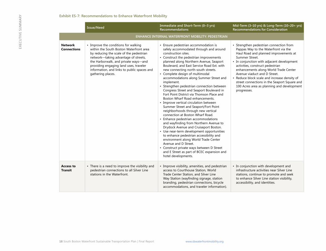
Enhance Internal Waterfront Mobility
as the popularity and vibrancy of the South Boston Waterfront grow, the transportation needs within the district also increase. approximately 15 percent of existing Waterfront trips are within the district. By 2035, internal trips are projected to nearly triple and comprise 26 percent of all trips to/from/within the Waterfront. the scale and the diversity of land uses in the South Boston Waterfront present challenges to internal circulation and mobility. mobility within the study area is particularly important for visitors, conventioneers, and tourists who seek to take advantage of the many cultural and recreational opportunities within the Waterfront or the adjacent South Boston community, many of whom are car free when they visit and some of whom are unfamiliar with the area. maintaining and enhancing mobility within the South Boston Waterfront is critical for the development of a successful, vibrant district.
Expected growth in convention-related, leisure, cruise and hospitality industries in the study area is reflected by the planned expansion of the BcEc, addition of more than 4,300 hotel rooms by 2035, expansion of retail and restaurant uses, and continued vibrancy of the study area’s notable museums, including Boston’s children museum and the institute of contemporary art. Existing transit services within the Waterfront are commuter focused and do not provide the connectivity or hours of service to address the needs of this constituency. and, as previously discussed, the pedestrian and bicycle networks serving these locations are incomplete or inconvenienced by construction activity. Plan recommendations to enhance internal Waterfront mobility in response to identified needs are summarized in Exhibit ES-7.
Mobility within the study area is particularly important for visitors, conventioneers, and tourists who seek to take advantage of the many cultural and recreational opportunities within the Waterfront.
Vehicle circulation challenges in the pedestrian network.
18 South Boston Waterfront Sustainable Transportation Plan | Final Report www.sbwaterfrontmobility.org
ExEc
uti
vE S
um
mar
y Recomen-da-tion: ENHANCE INTERNAL WATERFRONT MOBILITY: PEDESTRIAN
Network Connections
Issue/Need• Improve the conditions for walking within the South Boston Waterfront area by reducing the scale of the pedestrian network—taking advantage of streets, the Harborwalk, and
private ways—and providing engaging land uses, traveler information, and links to public spaces and gathering places.
Immediate and Short-Term (0–3 yrs) Recommendations• Ensure pedestrian accommodation is safely accommodated through and around construction sites.• Construct the pedestrian improvements planned along Northern Avenue, Seaport Boulevard, and East Service Road Ext. with new connecting north-south streets.• Complete design of multimodal accommodations along Summer Street and implement.• Strengthen pedestrian connection between Congress Street and Seaport Boulevard in Fort Point District via Thomson Place and Boston Wharf Road enhancements.• Improve vertical circulation between Summer Street and Seaport/Fort Point neighborhoods through new vertical connection at Boston Wharf Road.• EnhancepedestrianaccommodationsandwayfindingfromNorthernAvenuetoDrydockAvenueandCruiseportBoston.• Use near-term development opportunities to enhance pedestrian accessibility and environment along World Trade Center Avenue and D Street.• Construct private ways between D Street and E Street as part of BCEC expansion and hotel developments.
Mid-Term (3–10 yrs) & Long-Term (10–20+ yrs) Recommendations for Consideration• Strengthen pedestrian connection from Pappas Way to the Waterfront via the Haul Road and planned improvements at Summer Street.• In conjunction with adjacent development activities, construct pedestrian enhancements along World Trade Center Avenue viaduct and D Street.• Reduce block scale and increase density of street connections in the Seaport Square and 100 Acres area as planning and development progresses. Access to Transit
Issue/Need• There is a need to improve the visibility and pedestrian connections to all Silver Line stations in the Waterfront.
Immediate and Short-Term (0–3 yrs) Recommendations• Improvevisibility,amenities,andpedestrianaccesstoCourthouseStation,WorldTradeCenterStation,andSilverLineWayStation(wayfindingsignage,stationbranding,pedestrian
connections, bicycle accommodations, and traveler information).
Mid-Term (3–10 yrs) & Long-Term (10–20+ yrs) Recommendations for Consideration• In conjunction with development and infrastructure activities near Silver Line stations, continue to promote and seek to enhance Silver Line station visibility, accessibility, and
identities.
Issue/Need Immediate and Short-Term (0–3 yrs) Recommendations
Mid-Term (3–10 yrs) & Long-Term (10–20+ yrs) Recommendations for Consideration
ENHANCE INTERNAL WATERFRONT MOBILITY: PEDESTRIAN
Network Connections
• Improve the conditions for walking within the South Boston Waterfront area by reducing the scale of the pedestrian network—taking advantage of streets, the Harborwalk, and private ways—and providing engaging land uses, traveler information, and links to public spaces and gathering places.
• Ensure pedestrian accommodation is safely accommodated through and around construction sites.
• Construct the pedestrian improvements planned along Northern Avenue, Seaport Boulevard, and East Service Road Ext. with new connecting north-south streets.
• Complete design of multimodal accommodations along Summer Street and implement.
• Strengthen pedestrian connection between Congress Street and Seaport Boulevard in Fort Point District via Thomson Place and Boston Wharf Road enhancements.
• Improve vertical circulation between Summer Street and Seaport/Fort Point neighborhoods through new vertical connection at Boston Wharf Road.
• Enhance pedestrian accommodations andwayfindingfromNorthernAvenuetoDrydock Avenue and Cruiseport Boston.
• Use near-term development opportunities to enhance pedestrian accessibility and environment along World Trade Center Avenue and D Street.
• Construct private ways between D Street and E Street as part of BCEC expansion and hotel developments.
• Strengthen pedestrian connection from Pappas Way to the Waterfront via the Haul Road and planned improvements at Summer Street.
• In conjunction with adjacent development activities, construct pedestrian enhancements along World Trade Center Avenue viaduct and D Street.
• Reduce block scale and increase density of street connections in the Seaport Square and 100 Acres area as planning and development progresses.
Access to Transit
• There is a need to improve the visibility and pedestrian connections to all Silver Line stations in the Waterfront.
• Improve visibility, amenities, and pedestrian access to Courthouse Station, World Trade Center Station, and Silver Line WayStation(wayfindingsignage,stationbranding, pedestrian connections, bicycle accommodations, and traveler information).
• In conjunction with development and infrastructure activities near Silver Line stations, continue to promote and seek to enhance Silver Line station visibility, accessibility, and identities.
Exhibit ES-7: Recommendations to Enhance Waterfront Mobility

South Boston Waterfront Sustainable Transportation Plan | Final Report 19 www.sbwaterfrontmobility.org
ExEc
uti
vE S
um
mar
yRecomendation: ENHANCE INTERNAL WATERFRONT MOBILITY: TRANSITMobility Hubs
Issue/Need• There is a need to create mobility hubs that bring together multiple transit modes and parking in the Waterfront—including but not limited to Silver Line BRT, pedestrian
connections, bicycle access, automobiles, water and bus services, and traveler information services and amenities. These hubs will serve as gateways to the South Boston Waterfront and should contribute to place-making and the public realm.
Immediate and Short-Term (0–3 yrs) Recommendations• Advance mobility hubs at the Silver Line Stations (as described above) and consider the Massport Air Rights Garage as a mobility hub site.
Mid-Term (3–10 yrs) & Long-Term (10–20+ yrs) Recommendations for Consideration• Adapt traveler services and modes present within mobility hubs as transport and information technologies evolve. Internal Transit
Issue/Need• Travel within the district between an expanded BCEC, hotels, retail and restaurant uses, and various cultural offerings, and desired connections to the community, will become even
more prevalent as development advances and more car-free visitors and residents enjoy the Waterfront.
Immediate and Short-Term (0–3 yrs) Recommendations• Examine opportunities to provide an internal transit circulator in conjunction with efforts to consolidate private shuttles within the Waterfront.
Mid-Term (3–10 yrs) & Long-Term (10–20+ yrs) Recommendations for Consideration• Implement local bus improvements within South Boston as described under Community Connections.• Explore feasibility through public or private means of providing Waterfront Connector ferry service (Pier 10, WTC, Fan Pier, North Station, Downtown).
Recomendation: ENHANCE INTERNAL WATERFRONT MOBILITY: ADVANCED TRAFFIC AND PARKING MANAGEMENT SYSTEMSAll Modes
Issue/Need• OptimizingtheoperationalefficiencyoftravelforallmodeswithintheWaterfrontandto/fromdesiredconnectionstothecommunitywillbecomeincreasinglyimportantas
demands increase and travelers seek real-time information about their choice of modes. The deployment of new transportation technologies can help respond to these challenges and needs.
Immediate and Short-Term (0–3 yrs) Recommendations• UsetheSouthBostonWaterfrontasatestbedforinnovationintransportationsystemsmanagement:ExpandthedeploymentoftrafficadaptiveandsmartsystemcontroltechnologiestomonitorandmanagetrafficintheWaterfront;optimizetheutilizationandpricingofon-streetparkingthroughnewsmartparkingtechnologies;andenablemobiletraveler information systems that integrate access by all modes of travel.
Mid-Term (3–10 yrs) & Long-Term (10–20+ yrs) Recommendations for Consideration• Evolvetransportationmanagementsystemsasnewtechnologiesaretestedandprovenbeneficial.
Recomendation: ENHANCE INTERNAL WATERFRONT MOBILITY: BICYCLES
Bicycles
Issue/Need• The provision of high quality bicycle accommodations could address a healthy share of the projected increase in intra-district trips and provide another mobility option besides
walking and transit among study area neighborhoods.
Immediate and Short-Term (0–3 yrs) Recommendations• Install Hubway stations at Thomson Place, P&G Gillette, and Channel Center.• Install public bicycle racks (approximate capacity: 175 bicycles committed to by 2018) throughout Waterfront.• Install additional Hubway stations and other related bicycle amenities in conjunction with mobility hub development.
Mid-Term (3–10 yrs) & Long-Term (10–20+ yrs) Recommendations for Consideration• Improve bicycle connection over the new Northern Avenue bridge.• Consider a bicycle connection over the Fort Point Channel between the 100-Acre area and Dorchester Avenue.• Continue to expand bicycle amenities, parking, and system enhancements as new development projects go through planning and permitting processes.
Issue/Need Immediate and Short-Term (0–3 yrs) Recommendations
Mid-Term (3–10 yrs) & Long-Term (10–20+ yrs) Recommendations for Consideration
ENHANCE INTERNAL WATERFRONT MOBILITY: TRANSIT
Mobility Hubs • There is a need to create mobility hubs that bring together multiple transit modes and parking in the Waterfront—including but not limited to Silver Line BRT, pedestrian connections, bicycle access, automobiles, water and bus services, and traveler information services and amenities. These hubs will serve as gateways to the South Boston Waterfront and should contribute to place-making and the public realm.
• Advance mobility hubs at the Silver Line Stations (as described above) and consider the Massport Air Rights Garage as a mobility hub site.
• Adapt traveler services and modes present within mobility hubs as transport and information technologies evolve.
Internal Transit
• Travel within the district between an expanded BCEC, hotels, retail and restaurant uses, and various cultural offerings, and desired connections to the community, will become even more prevalent as development advances and more car-free visitors and residents enjoy the Waterfront.
• Examine opportunities to provide an internal transit circulator in conjunction with efforts to consolidate private shuttles within the Waterfront.
• Implement local bus improvements within South Boston as described under Community Connections.
• Explore feasibility through public or private means of providing Waterfront Connector ferry service (Pier 10, WTC, Fan Pier, North Station, Downtown).
ENHANCE INTERNAL WATERFRONT MOBILITY: ADVANCED TRAFFIC AND PARKING MANAGEMENT SYSTEMS
All Modes • Optimizingtheoperationalefficiencyoftravel for all modes within the Waterfront and to/from desired connections to the community will become increasingly important as demands increase and travelers seek real-time information about their choice of modes. The deployment of new transportation technologies can help respond to these challenges and needs.
• Use the South Boston Waterfront as a test bed for innovation in transportation systems management: Expand the deployment of trafficadaptiveandsmartsystemcontroltechnologiestomonitorandmanagetrafficin the Waterfront; optimize the utilization and pricing of on-street parking through new smart parking technologies; and enable mobile traveler information systems that integrate access by all modes of travel.
• Evolve transportation management systems as new technologies are tested and proven beneficial.
ENHANCE INTERNAL WATERFRONT MOBILITY: BICYCLES
Bicycles • The provision of high quality bicycle accommodations could address a healthy share of the projected increase in intra-district trips and provide another mobility option besides walking and transit among study area neighborhoods.
• Install Hubway stations at Thomson Place, P&G Gillette, and Channel Center.
• Install public bicycle racks (approximate capacity: 175 bicycles committed to by 2018) throughout Waterfront.
• Install additional Hubway stations and other related bicycle amenities in conjunction with mobility hub development.
• Improve bicycle connection over the new Northern Avenue bridge.
• Consider a bicycle connection over the Fort Point Channel between the 100-Acre area and Dorchester Avenue.
• Continue to expand bicycle amenities, parking, and system enhancements as new development projects go through planning and permitting processes.

20 South Boston Waterfront Sustainable Transportation Plan | Final Report www.sbwaterfrontmobility.org
ExEc
uti
vE S
um
mar
y
Primary Public Realm Elements• an integrated Street & Block Plan promoting the physical, visual
and functional integration of the South Boston Waterfront with Downtown and adjacent neighborhoods.
• Primary Streets: three principal east/west streets (Summer Street, congress Street, Seaport Boulevard) and continuous north/south streets.
• a network of smaller scale streets and open spaces to create an integrated, walkable district.
• Extended Harborwalk, activated Waterfront, and access to the water.• Special Places to anchor each neighborhood or sub-district
in the South Boston Waterfront and give them unique identity and sense of place.
• reinforce view corridors to the water.
Implement Supportive Management Strategies and Policies
Enhancing existing policies related to overall transportation demand management (TDM), parking and traffic systems management (tSm), and establishing the organizational capacity to plan, implement, and monitor recommendations and outcomes will reinforce the immediate and long-term success of this Sustainable transportation Plan.
Transportation Demand Management
the sponsoring agencies of this plan should continue to support educational, outreach, and regulatory programs that reduce the transportation impacts of development activity and/or reduce single occupant vehicle use for commuters. considerations to affect these changes might include:
• TDM Ordinance – at the city and/or state level, consider adopting a parking and transportation demand management (PtDm) ordinance, similar to the model provided by the city of
Advance Public Realm
city building within the South Boston Waterfront began in earnest two decades ago and continues to evolve today. the ultimate goal is to achieve a world-class live, work, play city within the city. it is important to reflect on how the mix of development, location of densities, changing patterns, planned projects, and quality of the public realm influence this goal today.
a primary goal is to create a high quality public realm that connects to Downtown Boston yet reflects the unique scale and emerging character of the South Boston Waterfront. the ‘public realm’ includes all aspects of the physical environment that are visible and accessible to the public —including streets and sidewalks, parks and open spaces; greenways, promenades and bikeways; view corridors; and public transit. it also encompasses areas held in private ownership that are truly public in terms of their function, impact on the streetscape, or historic context.
the creation of the public realm in the Seaport involves expanding upon the existing street grid to provide the framework within which new development would be located.
this process involves a layering of elements, moving in degree from one level to the next: (1) an activated and publicly accessible waterfront, (2) a street and block plan that control development, (3) view corridors and pedestrian ways that bring people to the water, (4) Harborwalk and an open space network that connect different neighborhoods, (5) the creation of mixed use neighborhoods that would sustain themselves and bring 24 hour life to the district, and (6) the retention of a maritime industry.
A primary goal is to create a high quality public realm that connects to Downtown Boston yet reflects the unique scale and emerging character of the South Boston Waterfront.

South Boston Waterfront Sustainable Transportation Plan | Final Report 21 www.sbwaterfrontmobility.org
ExEc
uti
vE S
um
mar
y
Exhibit ES-8: Trip Generation (Per 1,000 Square Feet) Urban Residen-tial vs. Office Uses
• cambridge, to improve mobility and access, reduce congestion and air pollution, and increase safety by promoting walking, bicycling, public transit, carsharing, and other sustainable modes.
• Mix of Land Uses – to the extent opportunities present themselves, continue to seek a mix of land uses and services that reduce the need to travel during peak periods and directions, provide supportive land uses within the Waterfront area, and reduce the overall dependence on the automobile. For example, residential development has the potential to reduce the journey to work, increase non-automobile mode share, and minimize traffic loads to the Waterfront in the peak commuter direction. From simply a trip generation standpoint, substituting a residential unit for the equivalent square footage of commercial office spaces reduces the transportation demand of a development by at least 50 percent.
• Expanded TMA Role – the Seaport tma has a long-standing track record for successful advocacy, marketing, special event management, and information clearinghouse to support commuter programs in the Waterfront. there is opportunity to expand the tma’s membership and potentially its role as a coordinator of corporate and/or commuter services, focusing on the exchange of more real-time information, service offerings (e.g., consolidated shuttle system) and other more tangible incentives and disincentives to influence control behaviors. through the taPa process, agencies should work regularly with the tma and businesses to strengthen relationships, encourage employee participation in the Seaport tma, and make businesses better aware of the full program of available services.
From simply a trip generation standpoint, substituting a residential unit for the equivalent square footage as commercial office space reduces the transportation demand of a development by at least 50 percent.

22 South Boston Waterfront Sustainable Transportation Plan | Final Report www.sbwaterfrontmobility.org
ExEc
uti
vE S
um
mar
y
candidate employer and landlord actions encouraged by this plan could include: limiting parking spaces on site and reduce or eliminate free parking; providing priority parking for bicycles, car-share vehicles, vanpools, and low/clean emissions vehicles; implementing commuter Options programs, such as parking cash outs; parking reservation systems and demand based or congestion pricing; and unbundling the price of parking from leases. the Seaport tma can assist employers who are members through a suite of programs currently offered to implement new incentive programs.
the Districtwide Parking management Strategy also needs to address the protection of short-term, nearby, and appropriately priced parking for visitors to museums and cultural offerings in the Waterfront.
• Traffic Management – use the South Boston Waterfront as a test bed for innovation in transportation systems management: expand the deployment of traffic adaptive and smart system control technologies to monitor and manage traffic in the Waterfront; optimize the utilization and pricing of on-street parking through new smart parking technologies; and enable mobile traveler information systems that integrate access by all modes of travel. monitor and periodically address intersection operations in the Waterfront and adjacent neighborhoods through signal technology upgrades, timing modifications, restriping, etc., improvements to maintain or enhance vehicular and freight mobility (every 2 to 3 years).
• Coordinated Traffic Management and Enforcement – consistent enforcement and coordination among multiple traffic control jurisdictions are critical to ensuring safe and efficient traffic management at all times.
Transportation Systems Management (TSM)
Maximizing the efficiency of existing transportation systems is critically important to optimize areawide operations, reduce delays and traveler inconveniences, and contribute to the sustainability of the transportation resources in the Waterfront.
• Districtwide Shared Parking Management Strategy – Parking remains one of the most powerful and pervasive tools to influence travel demands and patterns, and the traffic impacts on area streets and highways. a districtwide parking management plan is needed to keep pace with near-term changes and issues associated with parking, as well as implement longer-term parking management strategies. Districtwide activities defined by this plan could include encouraging shared parking between compatible land uses (office and restaurant/cinema/cultural uses, etc.); wayfinding and real-time guidance systems to available parking and exiting garages for “best way” to interstate system; and demand based or performance based pricing. Shared-parking facilities can also reduce the amount of on-site parking needed for individual development projects in the district, thereby reducing development costs and keeping residential and commercial rents lower. Furthermore, by combining a centralized shared-parking facility with an excellent pedestrian network and a mobility hub (which could provide protected bicycle parking, electric vehicle charging stations, bikeshare and carshare parking spaces), travel demand within the district could shift from vehicle-oriented to more pedestrian- and bike-oriented. thus, shared parking may simultaneously advance the Plan’s goals related to internal circulation and mobility, economic vitality, and public realm.

South Boston Waterfront Sustainable Transportation Plan | Final Report 23 www.sbwaterfrontmobility.org
ExEc
uti
vE S
um
mar
y
Maintain State of Good Repair
in addition to the transportation recommendations described above, it is fundamental to the health and vibrancy of the Waterfront over the long-term that the existing transportation assets be maintained in good condition. maintaining transportation assets in a “state of good repair” (SOGr) requires an ongoing investment in preventative maintenance and periodic rehabilitation or reconstruction of facilities as assets age. the SOGr means that all capital assets, such as bridges, pavement, transit vehicles, and tracks are fully functioning and are rehabilitated or replaced before the end of their design life. SOGr is essential to ensure that our roads and bridges can operate safely and at their full capacity, carrying the loads they are designated to accommodate, and our transit systems operate reliably. the study area encompasses just over 23 miles of roadway, 12 bridges, the I-90 tunnel, three boat docks, and five transit stations with associated infrastructure (Silver Line buses, power, elevators, and escalators, etc.). maintaining assets in SOGr requires an ongoing investment in preventative maintenance and periodic rehabilitation equal to roughly $40 million per year.
Establishing the organizational capacity to plan, implement, and monitor recommendations and outcomes is essential to ensure the immediate and long-term success of this Sustainable Transportation Plan.

24 South Boston Waterfront Sustainable Transportation Plan | Final Report www.sbwaterfrontmobility.org
ExEc
uti
vE S
um
mar
y
• Ensuring a coordinated, comprehensive, and tested emergency response plan is in place for the Waterfront.
• Educating and informing the diverse stakeholders regularly on initiatives, procedures, and responsibilities.
Plan Implementation and Next Steps the completion of this Sustainable transportation Plan with its articulated goals, objectives, and recommendations, marks the first step towards fulfilling the long-term vision for the South Boston Waterfront. implementing the Plan will begin with its endorsement by sponsoring agencies. Refining Plan recommendations, defining a prioritization and finance plan that supports the phased implementation of these recommendations, advocating for and executing the improvements, and monitoring progress requires a consistent, committed, and cooperative interagency structure.
a critical next step in turning this sustainable transportation plan into action and realizing improvements in transportation and mobility is establishing the organizational structure and capacity to implement the Plan. this structure would provide timely review and decision-making for project development, funding, and implementation, as well as focus on issues such as:
• implement a series of immediate improvements within the next six months to alleviate congestion.
• advocating for funding and public-private partnerships for the design, construction, and maintenance of the South Boston Waterfront Sustainable transportation Plan.
• Establishing important near and long-term considerations in planning for resiliency in the South Boston Waterfront.
• articulating a more sequential phasing plan that reinforces transportation improvements and placemaking strategies for the District.
• Ensuring that the current infrastructure is adequately funded to be maintained in a state of good repair.
• incorporating state of the practice management strategies and routine operational improvements to optimize transportation systems efficiencies and interoperability.
Immediate (within 6 months) Actions: • consolidate private shuttles• Signal priority for Silver Line at D Street• Silver Line real time arrival information• Design 1-93 access improvements at Purchase Street • Geometric improvements to D Street on ramp to i-90 • initiate construction of streetscape, circulation, pedestrian and
bicycle enhancements on Northern avenue and East Service road, including new north-south connecting streets
• Pilot expanded use of South Boston Bypass road: ◦ From richards to West Service road (full access, 24/7) ◦ From i-93 to richards Street (eastbound only, am peak)
• Pilot access for all vehicles on northbound HOv from i-93 to tWt• Pedestrian enhancements at Seaport Park (by private developer)• Local pedestrian and intersection improvements (3 to 5 locations)• New Hubway stations• Determine process for developing bicycle accommodations• D Street circuit Breaker community process• Improved traffic and parking enforcement• implement new technology for on-street short term parking• massport Dedicated Freight corridor and thomas J. Butler
memorial Park under construction• continued review of circulation changes within the Waterfront
and BmiP

ww
w.v
hb.c
om