Embed Size (px)
Citation preview

Sounding Better!
Chart Storage in HYPACK® 2016
by Judy Bragg
Historically, HYPACK® listed most of the charts in your project under Background Charts in your Project Items list and you could read the chart files from any folder location.With the recent development of more features, which each have the potential of generating large numbers of charts or georeferenced images, it quickly became clear that a list of all of these files under one heading would be unwieldy and inefficient in managing your project background displays. To remedy this, HYPACK® 2016 has a few new folders in the Project Items list.This article provides a list of each folder in the Project Items list that contains charts or image files and the origin of the images of each.• Background Charts is the default location for chart files of all formats. Most charts are
imported from external sources. HYPACK® supports an extensive number of chart file formats:
• Web Maps: In 2014, we introduced Web Maps. These georeferenced PNG files, generated from satellite images available on Web servers, have always had their own Web Maps folder in the Project Items list. They are physically stored in the ProjectName\Satellite folder.
• ARCS• BSB ver. 3• C-Map Ed. 2• DIG• DG2• DGNa
• DGWb
a. DGN: v7 and v8. Version 8 for display only.
• DWGb
• DXF• ECW• GML• JPEG2000• MIF• MrSid
b. DXF and DWG: Versions 13-15, 18, 2004, 2007, 2010 and 2013. Used as chart display in any chart-supporting module, and as source or destination file in EXPORT TO CAD.
• PDF (Georeferenced)• PNG (Georeferenced)• S57• S63• SHP• TIF• VPF
November / 2015 1

Chart Storage in HYPACK® 2016
FIGURE 1. Web Maps Panel
• Real-Time Mosaic: For side scan surveys only, real-time mosaic is a series of georeferenced TIF (GeoTIF) images (tiles) generated by HYPACK® SURVEY based on your real-time mosaic options. HYPACK® SURVEY paints a preview of the real-time mosaic tile at the vessel location. As the vessel moves through the project area, the program continuously loads and unloads the individual tiles according to the vessel location and logs the data to a binary file in the project \Autoscan folder. When you close the SURVEY program, HYPACK® generates a series of GeoTIF files from the binary data, stores them to your project \Real Time Mosaic folder and enables them as background charts in your project.FIGURE 2. Real-time Mosaic in the HYPACK® SURVEY Map Window (left) and Side Scan Waterfall (right)
2
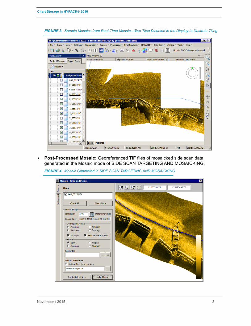
Chart Storage in HYPACK® 2016
FIGURE 3. Sample Mosaics from Real-Time Mosaic—Two Tiles Disabled in the Display to Illustrate Tiling
• Post-Processed Mosaic: Georeferenced TIF files of mosaicked side scan data generated in the Mosaic mode of SIDE SCAN TARGETING AND MOSAICKING.FIGURE 4. Mosaic Generated in SIDE SCAN TARGETING AND MOSAICKING
November / 2015 3
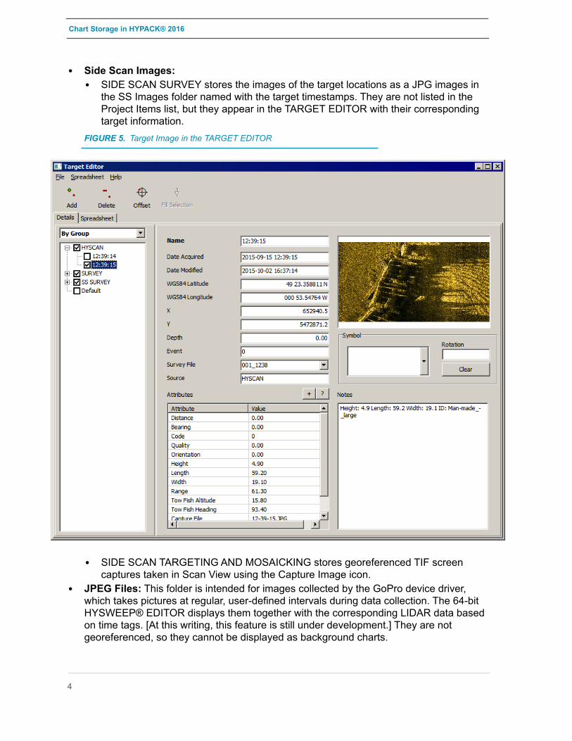
Chart Storage in HYPACK® 2016
• Side Scan Images:• SIDE SCAN SURVEY stores the images of the target locations as a JPG images in
the SS Images folder named with the target timestamps. They are not listed in the Project Items list, but they appear in the TARGET EDITOR with their corresponding target information.
FIGURE 5. Target Image in the TARGET EDITOR
• SIDE SCAN TARGETING AND MOSAICKING stores georeferenced TIF screen captures taken in Scan View using the Capture Image icon.
• JPEG Files: This folder is intended for images collected by the GoPro device driver, which takes pictures at regular, user-defined intervals during data collection. The 64-bit HYSWEEP® EDITOR displays them together with the corresponding LIDAR data based on time tags. [At this writing, this feature is still under development.] They are not georeferenced, so they cannot be displayed as background charts.
4