Embed Size (px)
Citation preview

1 Sound Waves April 2002U.S. Department of the InteriorU.S. Geological Survey
Sound Waves Volume FY 2002, Issue No. 39April 2002
Sound Waves C o a s t a l S c i e n c e a n d R e s e a r c h N e w s f r o m A c r o s s t h e U S G S
Fieldwork
http://soundwaves.usgs.gov/
(Gas-Hydrate Research Wells continued on page 2)
Three 1,200-m-deep wells—a main production research well and two nearby scientifi c observation wells—were recent-ly drilled in the Mackenzie Delta region of the Northwest Territories, Canada, to explore the presence of subpermafrost gas hydrate. This project was one of the most complex, expensive, and daring undertak-ings to explore natural-gas hydrate, a crys-talline solid composed of individual gas molecules trapped within cages formed by hydrogen-bonded water molecules. Most of the cages contain a single gas molecule—typically, but not limited to, methane in the natural setting.
Gas hydrates have been of global inter-est for much of the past decade because of their potential impact on energy reserves, global climate change, continental-margin slope stability, and petroleum-drilling hazards. High pressures and low tempera-tures, associated with many continental margins and Arctic regions, can form gas hydrate in the presence of an adequate supply of certain gas molecules and water.
The drilling project, involving more than 60 scientists and engineers and 250 support staff from six countries, overcame huge logistical problems compounded by the drillsite’s extremely remote location and harsh winter conditions, including temper-atures below –40°C. The drill holes, spaced 40 m apart, were located in the Mallik gas-hydrate fi eld next to the Beaufort Sea on the northern part of Richards Island, and were near the Mallik 2L-38 well drilled in 1998. All major equipment was delivered by way of a project ice road constructed on the frozen Mackenzie River. Overall sci-entifi c leadership and responsibility were provided by Scott Dallimore (Geological Survey of Canada, Sidney, British Colum-bia), and the principal investigators were Tim Collett (USGS Energy Team, Denver,
Gas-Hydrate Research Wells Completed in the Canadian ArcticBy Bill Winters
CO), Takashi Uchida (Japan Petroleum Exploration Co., Chiba, Japan), and Michael Weber (GeoForschungsZen-trum, Potsdam, Germany). The Japan Petroleum Exploration Co. coordinated drilling activi-ties. Other organizations in-volved in the project included Canada’s University of Ottawa and University of Alberta; the United States’ Department of Energy (DOE), Idaho National Environmental and Engineer-
ing of the fi rst observation well began on Christmas Day. One after the other, the two observation wells were drilled and instrumented with fi ber-optic temperature sensors; then the main well was begun. The 640-m-deep permafrost section in the main well was drilled and cased before
Mallik drill site, northern Mackenzie Delta, Northwest Territories, Canada. The ice road (lower right) enabled supplies and personnel to be brought to the site. Photograph by Suzanne Weedman.
Mallik drill rig during logging and coring operations.
ing Laboratory, Lamont-Doherty Earth Ob-servatory, Pacifi c Northwest National Lab-oratory (PNNL), and Lawrence Berkeley National Laboratory; Japan’s University of Tokyo and Japan National Oil Corp.; and India’s Oil and Natural Gas Corp.
The recently completed Mallik project consisted of several different phases. Drill-

2April 2002 Sound Waves
Sound Waves
EditorHelen Gibbons
Menlo Park, CaliforniaTelephone: (650) 329-5042
E-mail: [email protected]: (650) 329-5198
Print Layout EditorsSusan Mayfi eld, Sara Boore
Menlo Park, CaliforniaTelephone: (650) 329-5066
E-mail: smayfi [email protected]; [email protected]: (650) 329-5051
Web Layout EditorTrent Faust
St. Petersburg, FloridaTelephone: (727) 803-8747 Ext. 3043
E-mail: [email protected]: (727) 803-2030
SOUND WAVES (WITH ADDITIONAL LINKS) IS AVAILABLE ONLINE AT URLhttp://soundwaves.usgs.gov/
Contents
Fieldwork 1Research 4Outreach 5Meetings 9Awards 12Staff and Center News 12Publications 14
Fieldwork
U.S. Geological Survey Earth Science Information Sources:
Need to fi nd natural-science data orinformation? Visit the USGS Frequently Asked Ques tions (FAQ’s) at URL http://ask.usgs.gov/faqs.html
Can’t fi nd the answer to your question on the Web? Call 1-888-ASK-USGS
Want to e-mail your question to the USGS?Send it to this address: [email protected]
Fieldwork, continued
(Gas-Hydrate Research Wells continued from page 1)
Submission Guidelines
Deadline: The dead line for news items and pub li ca tion lists for the May issue of Sound Waves is Monday, April 22.Publications: When new publications or prod ucts are re leased, please no ti fy the ed i tor with a full reference and a bulleted sum ma ry or description.Images: Please sub mit all images at pub li -ca tion size (col umn, 2-column, or page width). Resolution of 200 to 300 dpi (dots per inch) is best. Ado be Illustrator© fi les or EPS fi les work well with vector fi les (such as graphs or di a grams). TIFF and JPEG fi les work well with ras ter fi les (pho to graphs or rasterized vec tor fi les).
Any use of trade, fi rm, or product names is for descriptive purposes only and does not imply endorsement by the U.S. Gov ern ment.
the start of continuous coring, which com-pletely penetrated the gas-hydrate section between about 890-m and 1,150-m depth. Because recovery of sediment cores con-taining gas hydrate was extremely good, more than 50 pressure vessels and four liquid-nitrogen dewar fl asks were fi lled to capacity. Other aspects of the project consisted of well logging, downhole tem-perature profi ling, microbiologic studies, seismic crosshole tomography (yielded information about sediment density and elastic properties), and the fi rst intentional production tests of a gas-hydrate reservoir involving both pressure drawdown and thermal stimulation. These last tests were conducted to determine the relation be-tween pressure reduction and dissociation of inplace gas hydrate, and to measure gas release for a given input of thermal energy.
Bill Winters (Woods Hole Field Cen-ter) was responsible for determining the physical properties of cored sediment and making infrared temperature mea-surements of freshly obtained sediment sections at the drillsite. At the Inuvik Research Center (3 to 4 hours south of the drillsite by ice road), Bill recorded timelapse infrared imaging of dissociating gas hydrate, using a custom-made sys-tem supplied by Phil Long of the Pacifi c Northwest National Laboratory.
The infrared temperature measure-ments were part of a pilot program involving Frank Rack of Joint Oceano-
graphic Institutions (JOI) and Bill Gwil-liam (DOE). During a giant-piston-cor-ing cruise in July 2002, researchers will use the French research vessel Marion Dufresne to obtain 50-m-long cores from potential gas-hydrate zones in the Gulf of Mexico. During recovery, gas hydrate in the cores will begin to dis-sociate because of the reduction in pres-sure and contact with warm gulf surface water and air. It is hoped that infrared measurements of the type obtained in the Arctic will help the Gulf of Mexico researchers quickly pinpoint and pre-serve sections of the core that may con-tain gas hydrate (hydrate dissociation, an endothermic reaction, will cool sur-rounding sediment).
Whole-round gas-hydrate sediment sections were preserved in pressurized vessels for future testing in the Gas Hydrate And Sediment Test Laboratory Instrument (GHASTLI) located at the Woods Hole Field Center. Other mem-bers of the Woods Hole gas-hydrate group include Debbie Hutchinson, Bill Dillon, Bill Waite, and Dave Mason.
Many of the samples, collected for about 30 different research programs worldwide, have been earmarked for Tom Lorenson and Keith Kvenvolden (USGS, Menlo Park), who will perform gas-geochemistry analyses on them. Steve Kirby, Laura Stern, Susan Cir-
(Left to right) Bill Winters, Suzanne Weedman, Bennett Raley, and Pat Leahy at the Inuvik Re-search Center.
(Gas-Hydrate Research Wells continued on page 3)

3 Sound Waves April 2002Fieldwork
cone, and John Pinkston (USGS, Men-lo Park) will use a scanning electron microscope to perform fabric analyses on the mixtures of gas hydrate and sedi-ment, and they will conduct dissociation tests on samples preserved in liquid ni-trogen. Tom Mroz (DOE) and Pete Mc-Grail (PNNL) will also be determining the properties and dissociation charac-teristics of preserved sediment samples containing gas hydrate.
Bennett Raley (Assistant Secretary of the Interior for Water and Science), Pat Leahy (Associate Director for Ge-ology), and Suzanne Weedman (USGS Energy Program Coordinator) were among the dignitaries that visited opera-tions at both the drillsite and the Inuvik Research Center. Canadian VIPs includ-ed Peter Harrison (Deputy Minister of Natural Resources Canada), Assistant
Deputy Ministers Irwin Itzkovitch and Ric Cameron, and Jan Boon (Director General for the Geological Survey of Canada). We were also honored by vis-its from the president of the Japan Na-
(Gas-Hydrate Research Wells continued from page 2)
Fieldwork, continued
Tim Collett (right) shows a piece of gas-hy-drate-bonded core to U.S. News and World Report journalist Tom Hayden in the science trailer at the Mallik drillsite.
tional Oil Corp. and members of other Japanese organizations involved in the project.
Widespread media coverage involved days of filming by both the Canadian Broadcasting Corp. and SFB, a German broadcasting company, as well as inter-views by reporters from Canadian Press (a Canadian wire service similar to the Associated Press) and U.S. News and World Report.
The current and previous drilling proj-ects resulted in several scientifi c and tech-nical accomplishments, discussed in more detail at the following Web sites:
http://sts.gsc.nrcan.gc.ca/gashydrate/mallik2002/home.asp
http://icdp.gfz-potsdam.de/html/sites/mallik/index/index.html
http://sts.gsc.nrcan.gc.ca/page1/hydrat/hydrates.html.
On February 12 to 18, 2002, partici-pants in the Coastal and Marine Geology Program (CMGP)’s Coral Reef Project from Menlo Park and Santa Cruz, CA (Hank Chezar, Susie Cochran, Mike Field [Project Chief], Josh Logan, Becky Stamski, and Curt Storlazzi), Woods Hole, MA (Mike Bothner, Michael Casso, and Rick Rendigs), and the Uni-versity of Washington (Andrea Ogston and Kathy Presto) recovered instruments that monitor oceanographic conditions and sediment resuspension along the 35-mile-long fringing coral reef off the south shoreline of Moloka‘i, Hawai‘i. One of the primary goals of this multidisciplinary study is to understand the sediment dy-namics and to assess the impact of sedi-ment on the health of this coral reef. Land use on Moloka‘i has changed in the recent past, and the increased discharge of eroded sediment during infrequent but intense rainfall is a potential threat to the health of the reef. No rain fell during the fi rst 10 months of the instrument deployments; however, kona storms (Hawai‘ian storms characterized by strong southerly or south-
Recent Flood-Derived Sediment Collected on Moloka‘i’s Coral ReefBy Michael Casso and Mike Bothner
westerly winds and heavy rain) in Novem-ber 2001 and January 2002 brought wind and heavy rain from the south-southwest to the normally dry side of Moloka‘i. The rain fl ooded intermittent stream channels, deposited boulders on the coastal highway, and turned the nearshore waters red with land-derived sediment. These pulses of new sediment provide an excellent oppor-tunity to test our hypotheses about sedi-ment-transport processes in this setting.
Two time-series sediment traps were in place for these fl ood events. Modifi ed for application in this wave-dominated, shallow reef environment, each trap con-sisted of a 20-cm (inner diameter) x 75-cm cylinder with an internal funnel that directed particles into one of 21 sample bottles. The bottles were on a carousel that rotated a new bottle under the funnel
(Sediment Collected continued on page 4)
Divers Curt Storlazzi (USGS and University of California, Santa Cruz) and Paul Jokiel (University of Hawai‘i) about to retrieve and refurbish the time-series sediment trap located near the coral reef off the south shore of Moloka‘i, Hawai‘i. Water depth is 10 m. Photograph by Tom Reiss.
4April 2002 Sound Waves
Fieldwork, continued
Fieldwork, Research
Research
at programmed intervals (usually about 5 days) during a typical 100-day deploy-ment. To prevent fi sh and other organisms from inhabiting the trap, a honeycomb-like baffl e with approximately 1-cm-diameter cells was installed in the trap opening. The value of the baffl e was demonstrated upon recovery of the support framework that contained an unbaffl ed pipe. To our surprise, when the framework landed on deck, a small but aggressive moray eel squirmed out of the pipe and nipped one of the scientists as he kindly tried to return it to the ocean. A similar organism living in a trap could alter the sediment composi-tion considerably.
The modular instrument tripod sup-porting the time-series sediment trap was designed by Ray Davis (USGS, Woods
(Sediment Collected continued from page 3)
Hole). This design allowed scuba div-ers to recover only the sampling package for periodic refurbishment. The heavy framework and 300 lb of stainless-steel leg weights remained on the bottom until the fi nal recovery last February. The tripod also accommodated a wave gauge and sen-sors for turbidity, temperature, and salinity.
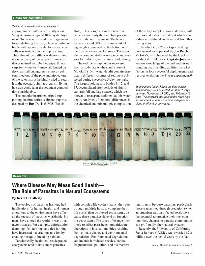
The sediment-trap bottles recovered from a study site on the south shore of Moloka‘i (10-m water depth) contain dras-tically different volumes of sediment col-lected during successive 5-day intervals. The largest volumes, in bottles 3, 12, and 17, accumulated after periods of signifi -cant rainfall and large waves, which are known to resuspend sediment at this water depth. Analyses of temporal differences in the chemical and mineralogic composition
Each sample (below) from the time-series sediment trap was collected for about 5 days between November 15, 2001, and February 14, 2002. The intervals that yielded the three high-est sediment volumes coincide with periods of high runoff and large waves.
of these trap samples, now underway, will help us understand the rates at which new sediment is diluted and removed from this reef system.
The Alyce C., a 28-foot sport-fi shing boat owned and operated by Joe Reich of Moloka‘i, was chartered by the USGS to conduct this fi eldwork. Captain Joe’s ex-tensive knowledge of the reef and his out-standing boat-handling abilities were key factors in four successful deployments and recoveries during the 1-year experiment.
The ecology of parasites has long had implications for human health, and human alterations to the environment have affect-ed the success of parasites worldwide. Hu-mans have altered the world in ways that favor diseases. For example, deforestation, damming, fi sh farming, and rice farming have increased malaria transmission by creating mosquito-breeding habitats.
Paradoxically, healthier, less degraded ecosystems tend to have more parasites
with complex life cycles (that is, they pass through multiple hosts to complete their life cycle) than do altered ecosystems, be-cause these parasites depend on function-ing ecosystems. The types of change most likely to affect parasite communities are alterations in host communities resulting from climate change and environmental degradation. Environmental degradation can include introduced species, habitat fragmentation, pollution, and overharvest-
Where Disease May Mean Good Health—The Role of Parasites in Natural EcosystemsBy Kevin D. Lafferty
(Role of Parasites continued on page 5)
ing. In turn, because parasites, particularly those transmitted through predation (when an organism eats an infected host), have the potential to organize their host com-munities, changes to parasite communities can profoundly alter natural systems.
Recently, the University of California, Santa Barbara (UCSB), was awarded $2.2 million over the next 5 years by the Na-
5 Sound Waves April 2002Research, Outreach
Research, continued
tional Science Foundation to study the role of parasites in natural ecosystems. The money will largely fund student research under the direction of three coprincipal investigators, all specialists in parasite ecology: Armand Kuris, a professor of zoology at UCSB; Andrew P. Dobson, a professor of zoology at Princeton; and myself, a marine biologist with the USGS’ Western Ecological Research Center and an adjunct professor of biology at UCSB.
Because salt marshes have proved to be a model system for understanding the ecology of parasites with complex life cycles, we will study parasites of the abun-dant horn snail, Cerithidea californica, found in salt marshes. The snail acts as a hub in the life cycle of 17 parasitic trema-tode (worm) species.
A trematode castrates the snail it infects and each day produces scores of free-swimming stages of offspring that leave infected snails to search out a second, in-termediate host, such as a fi sh, clam, crab, or snail. In the second host, the trematode can greatly alter host behavior to increase the chance of transmission to a fi nal host. Wading birds, shorebirds, and seabirds prey selectively on second, intermediate hosts and become parasitized by adult worms. In the fi nal host, the small worms live in the gastrointestinal tract, mate, and produce eggs that pass into the marsh with
(Role of Parasites continued from page 4)
the host’s feces, where they encounter snails and complete their life cycle. Each of the 17 trematode species that use C. californica has a different life cycle.
The new research ties in with current research by the USGS and UCSB funded by the U.S. Environmental Protection Agency to develop monitoring tools us-ing parasites to evaluate the health of salt marshes. Mathematical models, molecular tools, laboratory experiments, fi eld experi-ments, and large-scale comparative fi eld studies will all be used in the investigation. In addition to work at two UCSB natural reserves, Carpinteria Salt Marsh and Coal Oil Point, our research will take us to estu-aries in California’s Morro Bay and Mugu Lagoon, along the Pacifi c Coast of Baja California, Mexico, and to Japan.
Scientists are studying wet-lands to fi nd better ways to assess their condition. Are these sites as healthy as they
This free-swimming stage, a trematode cer-caria, leaves infected snails to encyst on a fi sh brain. View is 0.267 mm across. Photograph courtesy of Todd Huspeni, UCSB.
Outreach
USGS contractor Carey Hamburg, who does photography, videography, and Web-site work at the National Wetlands Research Center (Lafayette, LA), was featured recently in the Times of Acadiana article “Faces to Watch.” Carey was noted for his artistic contribution to the Peli-cans on Parade public art project, similar to projects that displayed cow statues in Chicago and fi sh statues in New Orleans. The program features nearly 100 4-ft-tall fi berglass pelican statues that have been “nested” throughout the Lafayette area.
Heads or Tails? USGS Contractor Participates in Public Art ProjectBy Susan S. Horton
Local artists uniquely painted each peli-can. Carey created a Mardi Gras pelican and one representing a hot-and-spicy red crawfi sh, a local Cajun delicacy from the Louisiana wetlands. Part of the sponsor-ship money from each pelican will go to local arts-in-education programs.
Taking artistic license, Carey Hamburg (shown here with his creative crustacean) transformed the fi berglass pelican into a hot-and-spicy red crawfi sh, a.k.a. mudbug.
are beautiful? Top, Shark Inlet, Morro Bay, CA. Bottom, Devereux Lagoon, near Santa Barbara, CA. Photographs by Kevin Lafferty, USGS.

6April 2002 Sound Waves Outreach
Outreach, continued
The Louisiana coastal-prairie ecosys-tem once contained 2.5 million acres; today it covers less than 100 acres. Wiped out mostly by farming and grazing, this ecosystem once boasted 500 species of grasses and perennial wildfl owers and was home to bison, antelope, prairie chickens, and mountain lions, among other species. USGS botanist Larry Allain (National Wetlands Research Center, Lafayette, LA) is heading up a joint prairie-restoration project between the University of Louisi-ana, Lafayette (ULL)’s chapter of Ameri-corps and the USGS’ National Wetlands Research Center. Recently, Americorps volunteers relocated 5,000 ft2 of endan-gered prairie grasses, such as big bluestem grass and Indian grass, to a site at the ULL’s Center for Ecology and Environ-mental Technology (CEET). The reloca-tion was necessary to save as many species as possible before this section of prairie is cleared to make way for a four-lane high-way. At CEET, this “refuge” of cultivated coastal-prairie species will be used for re-search, restoration, and education. Larry hopes that enough of the prairie can be planted so that eventually suffi cient seed can be produced to make it practical to re-store large areas of this imperiled ecosys-tem. For more information, visit the Cajun Prairie Habitat Preservation Society’s Web site at URL http://www.cajunprairie.org/
Americorps volun-teers from the Uni-versity of Louisiana at Lafayette dig up grasses and peren-nials from a remnant of the coastal prairie that will be destroyed to make room for a four-lane highway.
USGS and Students Restore Disappearing PrairieBy Susan S. Horton
With the guidance of USGS researchers, Americorps volun-teers prepare the ground for planting of endangered prairie grasses and wild-fl owers at the Uni-versity of Louisiana, Lafayette’s Center for Ecology and Environ-mental Technology.
James Kostka of The Canterbury School of Florida organized Marine Sci-ence Day on March 1 for the school’s youngsters from kindergarten through second grade and invited the USGS to par-ticipate in the day’s activities. About 120 children in groups of 10 to 12 visited vari-ous science displays set up in the school’s courtyard in St. Petersburg, FL.
Georgia De Stoppelaire and Noreen Buster (USGS, St. Petersburg) took part in the outreach event. They presented
Marine Science Day in St. Petersburg Sparks Children’s InterestBy Georgia De Stoppelaire
Georgia’s research project, which uses NASA lidar (light detection and ranging) surveys to study the effects of nonnative horse grazing on American beachgrass and the resulting impact on coastal geomor-phology at Assateague Island, USA.
Assateague Island is a barrier island ap-proximately 57 km long. The south third of the island is in Virginia, and the north two-thirds in Maryland. Wild horses roam the island in two main herds, one on the Virginia side and one on the Maryland
side. Once a year, the horses are rounded up, and most of the foals are auctioned off to control the size of each herd and lessen their impact on island ecology.
Georgia and Noreen’s presentation included posters and a miniature barrier-island display with fenced experimental plots, toy horses, sand, and turfgrass. Georgia used a toy helicopter and laser pointer to help the youngsters understand
(Marine Science Day continued on page 7)
7 Sound Waves April 2002Outreach
Outreach, continued
(Marine Science Day continued from page 6)
the concept of lidar surveying, which uses laser light shot from an aircraft to make detailed measurements of topography. The children were in-trigued, and the presentation sparked interest and many questions. To end the presentation, Noreen and Georgia gave a coloring book to each child, compliments of the Southwest Florida Water Management District. As the afternoon’s naptime approached, we don’t know who was more ex-hausted—the children or Noreen and Georgia! All in all, the big event was quite a success for the little ones.
Noreen Buster (left) and Georgia De Stoppelaire (right) educate young students about coastal pro-cesses, NASA lidar technology, and the effects of horse grazing on Assateague Island.
Georgia De Stoppelaire demonstrates NASA lidar technology and how it is used to detect horse-grazing effects on coastal geomorphology at Assateague Island.
The Woods Hole Field Center (WHFC) contributed to the Eighth Annual Mas-sachusetts Maritime Academy (MMA)–New England Aquarium High School Environmental Symposium. The event was held on the shores of MMA’s Cape Cod Canal campus (Buzzard’s Bay, MA) on March 1 and 2 under the direction of Christopher Ryan and Fuji Fulgueras, the MMA symposium coordinators. Bus-loads of 300 students and teachers depart-ed for behind-the-scenes tours of the New England Aquarium and the Woods Hole scientifi c community as part of the 2-day symposium. Chris Polloni (WHFC) or-ganized the fi eld trip in Woods Hole. He led students and teachers to the fi rst stop on the fi eld trip, Chappaquoit Beach in West Falmouth, where box lunches were enjoyed on the sand in a very brisk wind.
David Radosh of the National Oce-anic and Atmospheric Administration (NOAA)’s National Marine Fisheries Ser-vice (NMFS) made NOAA’s Woods Hole Science Aquarium available for a tour. The animals in the aquarium are represen-tative of the populations on Stellwagen Bank. Anne Smrcina (NOAA), of the Stellwagen Bank National Marine Sanctu-ary (SBNMS), and Erika Hammar-Klose (WHFC) provided an overview of the biologic surveys and geologic mapping that are being accomplished as part of the joint-agency research on the bank. Anne
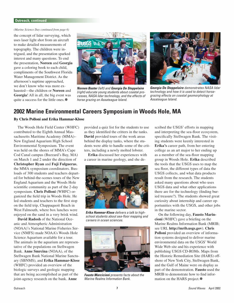
2002 Marine Environmental Careers Symposium in Woods Hole, MABy Chris Polloni and Erika Hammar-Klose
provided a quiz list for the students to use as they identifi ed the critters in the tanks. David provided tours of the work areas behind the display tanks, where the stu-dents were able to handle some of the crit-ters, including a newly molted lobster.
Erika discussed her experiences with a career in marine geology, and she de-
scribed the USGS’ efforts in mapping and interpreting the sea-fl oor ecosystem, specifi cally Stellwagen Bank. The visit-ing students were keenly interested in Erika’s career path, from her entering college as an art major to her ending up as a member of the sea-fl oor mapping group in Woods Hole. Erika described the tools that the USGS uses to map the sea fl oor, the different types of data the USGS collects, and what data products result from the research. The students asked many questions about who uses USGS data and what other applications there are for the technology (fi nding bur-ied treasure?). The students showed great curiosity about internship and career op-portunities with the USGS, and other jobs in the marine sector.
On the following day, Fausto Marin-cioni (WHFC) gave a briefi ng on the Marine Realms Information Bank (MRIB; see URL http://mrib.usgs.gov). Chris Polloni provided an overview of informa-tion systems designed to deliver marine environmental data on the USGS’ World Wide Web site and his experience with publishing USGS CD-ROMs. Maps from the Historic Remediation Site (HARS) off-shore of New York City, Stellwagen Bank, and the Gulf of Maine were on display as part of the demonstration. Fausto used the MRIB to demonstrate how to fi nd infor-mation on the HARS project.
Fausto Marcicioni presents facts about the Marine Realms Information Bank.
Erika Hammar-Klose delivers a talk to high-school students about sea-fl oor mapping and careers in ocean sciences.
8April 2002 Sound Waves Outreach
Outreach, continued
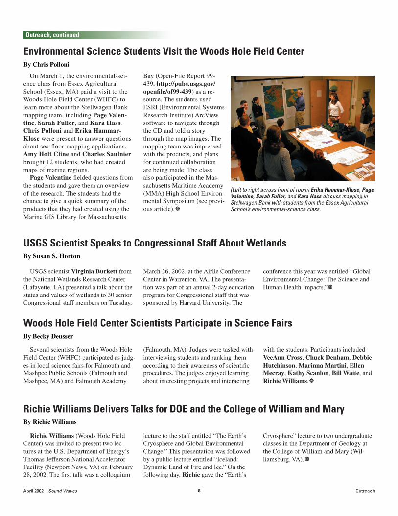
On March 1, the environmental-sci-ence class from Essex Agricultural School (Essex, MA) paid a visit to the Woods Hole Field Center (WHFC) to learn more about the Stellwagen Bank mapping team, including Page Valen-tine, Sarah Fuller, and Kara Hass. Chris Polloni and Erika Hammar-Klose were present to answer questions about sea-fl oor-mapping applications. Amy Holt Cline and Charles Saulnier brought 12 students, who had created maps of marine regions.
Page Valentine fi elded questions from the students and gave them an overview of the research. The students had the chance to give a quick summary of the products that they had created using the Marine GIS Library for Massachusetts
Environmental Science Students Visit the Woods Hole Field CenterBy Chris Polloni
(Left to right across front of room) Erika Hammar-Klose, Page Valentine, Sarah Fuller, and Kara Hass discuss mapping in Stellwagen Bank with students from the Essex Agricultural School’s environmental-science class.
Bay (Open-File Report 99-439, http://pubs.usgs.gov/openfi le/of99-439) as a re-source. The students used ESRI (Environmental Systems Research Institute) ArcView software to navigate through the CD and told a story through the map images. The mapping team was impressed with the products, and plans for continued collaboration are being made. The class also participated in the Mas-sachusetts Maritime Academy (MMA) High School Environ-mental Symposium (see previ-ous article).
USGS scientist Virginia Burkett from the National Wetlands Research Center (Lafayette, LA) presented a talk about the status and values of wetlands to 30 senior Congressional staff members on Tuesday,
USGS Scientist Speaks to Congressional Staff About WetlandsBy Susan S. Horton
March 26, 2002, at the Airlie Conference Center in Warrenton, VA. The presenta-tion was part of an annual 2-day education program for Congressional staff that was sponsored by Harvard University. The
conference this year was entitled “Global Environmental Change: The Science and Human Health Impacts.”
Several scientists from the Woods Hole Field Center (WHFC) participated as judg-es in local science fairs for Falmouth and Mashpee Public Schools (Falmouth and Mashpee, MA) and Falmouth Academy
Woods Hole Field Center Scientists Participate in Science FairsBy Becky Deusser
(Falmouth, MA). Judges were tasked with interviewing students and ranking them according to their awareness of scientifi c procedures. The judges enjoyed learning about interesting projects and interacting
with the students. Participants included VeeAnn Cross, Chuck Denham, Debbie Hutchinson, Marinna Martini, Ellen Mecray, Kathy Scanlon, Bill Waite, and Richie Williams.
Richie Williams (Woods Hole Field Center) was invited to present two lec-tures at the U.S. Department of Energy’s Thomas Jefferson National Accelerator Facility (Newport News, VA) on February 28, 2002. The fi rst talk was a colloquium
Richie Williams Delivers Talks for DOE and the College of William and MaryBy Richie Williams
lecture to the staff entitled “The Earth’s Cryosphere and Global Environmental Change.” This presentation was followed by a public lecture entitled “Iceland: Dynamic Land of Fire and Ice.” On the following day, Richie gave the “Earth’s
Cryosphere” lecture to two undergraduate classes in the Department of Geology at the College of William and Mary (Wil-liamsburg, VA).

9 Sound Waves April 2002Meetings
Meetings
The Netherlands leads the world in coastal engineering, and for good rea-son. Parts of Holland are 6 m below sea level, and a recently passed national law declares that the configuration of the coast and beaches in 1990 will be main-tained in perpetuity, despite predictions of sea-level rise. Delft, an old town about 10 km from The Hague, is one of the most renowned centers for coastal engineering in Europe, with a leading technical university and the WL|Delft Hydraulics Laboratory. USGS Coastal and Marine Geology Program research-ers Guy Gelfenbaum, Jessie Lacy, and Peter Ruggiero (Menlo Park) and Chris Sherwood (Woods Hole) were lucky to arrange an extended visit to Delft through a cooperative agreement with Delft Hydraulics. They were gra-ciously hosted by Dano Roelvink and Dirk-Jan Walstra, with wonderful lo-gistical support from Marcia de Jonge. Delft Hydraulics provided a conference room, network access, and bikes for com-muting (the only way to go in Holland; see photo), and helped the researchers locate an apartment at the Beestenmarkt, a centuries-old area featured in the recent novel Girl with a Pearl Earring (after the painting by Vermeer).
In nearly 3 weeks of collaborative work, the USGS scientists and their hosts
USGS Sediment-Transport Researchers Collaborate with Colleagues in The Netherlands or Researchers Go DutchBy Chris Sherwood
applied state-of-the-art numerical models of waves, fl ow, and sedi-
a student from Delft who worked in Menlo Park, CA, this winter (see article in February 2002 Sound Waves). Guy is also beginning a project to evaluate the long-term evolution of morphology at the entrance to Willapa Bay, WA. Chris is using Delft3D, modeling software from Delft Hydraulics, to develop test cases for comparison and evaluation of sediment-transport models.
In addition to the benefits of a re-markably productive and collaborative work environment, the USGS research-ers engaged in informal hallway or lunchroom conversations with such coastal-process legends as Leo van Rijn, Jurgen Battjes, Huib de Vriend, and Marcel Stive. On weekend trips, the learning process continued as they alternated visits to great museums with trips to the beaches and coastal defenses of Holland. The knowledge and experience they bring back to the USGS will be applied to Coastal and Marine Geology Program studies of coastal erosion, coastal evolution, and sediment transport.
Delft3D model results. Map of tidally averaged and depth-averaged fl ow around a headland and associated mor-phology change after a 2-week simulation.
A large proportion of Delft’s citizens commute by bicycle, and Chris Sherwood is happy to fol-low the trend. Here he passes through the Oost Poort (gate through the old Delft wall) and over the Zuider Gracht canal.
USGS researchers (left to right) Guy Gelfenbaum, Peter Ruggiero, Jessie Lacy, and Chris Sher-wood with their host Dano Roelvink in front of the water clock at Delft Hydraulics Laboratory.
ment transport to USGS projects. Jessie is apply-ing a three-dimensional model to evaluate circu-lation and suspended-sediment transport near the entrance to Grays Harbor, WA. Peter is focussed on shoreface evolution at Ocean Shores and Long Beach, WA, both part of the Columbia River littoral cell. Guy is continuing to work on morphologic change near Grays Har-bor with Mathijs Meijs,

10April 2002 Sound Waves Meetings
(Tampa Bay Estuary Tour continued on page 11)
Meetings, continued
USGS activities in coastal-sediment-transport modeling were highlighted at the recent Ocean Sciences Meeting in Ho-nolulu, Hawai‘i, sponsored jointly by the American Geophysical Union (AGU) and the American Society of Limnology and Oceanography (ASLO). Chris Sherwood (Woods Hole, MA) and Courtney Har-ris (former USGS postdoctoral fellow at Woods Hole) were co-convenors for a spe-cial scientifi c session on “Application and Assessment of Coastal Sediment Transport Models,” featuring nearly 40 presenta-
USGS Sediment-Transport Modeling Highlighted at Ocean Sciences MeetingBy Chris Sherwood
tions from scientists around the world. The USGS (Sherwood) and the Woods Hole Oceanographic Institution (Rocky Geyer) also hosted a Town Meeting to promote and discuss the ongoing development of community models. This meeting was part of a joint National Oceanographic Partner-ship Program (NOPP) grant, and linked to the USGS’ National Community Sedi-ment-Transport Model Project (see URL http://woodshole.er.usgs.gov/project-pages/sediment-transport/). The goal of the Town Meeting was to report on prog-
ress toward a community model, engage the wider community of interested scien-tists in the project, and continue open dis-cussion of technical issues. John Warner (USGS Mendenhall postdoctoral fellow at Woods Hole), Dano Roelvink (Delft Hydraulics), and Pravi Shrestha (Hy-droQual, Inc.) presented results of model tests and comparisons. The meeting was well attended and a great success, thanks in part to logistical coordination by Soupy Alexander (USGS, Woods Hole).
On January 30, 50 managers and sci-entists attending the USGS Geologic Discipline (GD) managers meeting in St. Petersburg, FL, set out on a field trip to observe the Gulf of Mexico Estuaries Integrated Science Pilot Study in ac-tion. Holly Greening, Senior Scientist of the Tampa Bay Estuary Program (a partnership of agencies and local gov-ernments), gave introductory remarks. Holly and her team of more than 150 scientists have worked with elected of-ficials to establish long-term restoration and protection goals for natural resourc-es in Tampa Bay. Holly spoke about the importance of the USGS’ role as a long-term partner to fill tactical gaps in bay research. The managers then boarded a 54-ft catamaran and cruised to the Bish-op Harbor area along the bay’s south shore. During the transit, Mike Crane of the EROS Data Center in Sioux Falls, ND, briefly spoke about urban growth and significant changes in land cover and land-use practices over the past 50 years. He described the USGS’ highly advanced computer technology in the predictive modeling of future population growth in the Tampa Bay watershed.
The first stop was Mariposa Key, a relatively undisturbed stretch of shore-line in southeastern Tampa Bay where
important studies are underway. Sci-entists had set up exhibits in shallow water along the mangroves to describe their activities. Separated into groups, the managers were escorted through knee-deep water to each of the five sta-
USGS Managers Tour the Tampa Bay Estuary in FloridaBy Noah Silverman
Managers and scientists ride a 54-ft catamaran to the Bishop Harbor area along Tampa Bay’s south shore.
tions, where they heard lectures and saw equipment demonstrations. Peter Swarzenski (GD, St. Petersburg) and Dan Yobbi (USGS, Water Resources,

11 Sound Waves April 2002Meetings
Meetings, continued
(Tampa Bay Estuary Tour continued from page 10)
Tampa) presented their understanding of physical processes at the sediment-wa-ter interface. They demonstrated the use of piezometers in sampling ground wa-ter. Terry Edgar (GD, St. Petersburg) and Greg Brooks (Eckerd College, St. Petersburg) discussed their analysis of the geologic record of Tampa Bay. They showed how a vibracorer was an essential tool for obtaining sediment cores in shallow parts of the estuary; they displayed cores and led discussions of their interpretations of the strata. Wendy Weaver (University of Georgia, Athens), an archeologist, discussed her analysis of Indian middens (shell mounds) located throughout the Mari-posa Key area and showed several shell artifacts to the group. Understanding the prehistoric deposits is an important aspect in defining the history of sea-level change in the bay area. Kim Yates (GD, St. Petersburg) demonstrated her submersible habitat for analyzing reef quality (SHARQ). The clear tent traps water over a reef (or seagrass bed in this instance) but allows sunlight to reach the bay floor. Use of submersible probes and sophisticated data loggers permits measurement and recording of photo-synthesis and carbon fixation. Through successive deployments, Kim is assess-ing the relative quality of different ma-rine habitats in Tampa Bay.
Carole McIvor displays estuarine forage fi shes and discusses how conditions in their ponds might change when mosquito ditches are fi lled.
Managers wade to scientifi c exhibits at Mariposa Key. Tom Smith gives an overview of his vegetation analysis.
Before the group left Mariposa Key, Tampa Bay Aquatic Preserve manager Randy Runnels outlined the long-term commitment of the Florida Department of Environmental Protection (DEP) to pre-serve and restore upland and aquatic habi-tats throughout the bay. Next, participants took a short catamaran trip into Cockroach Bay, after which they were bussed to the Terra Ceia Aquatic and Buffer Preserve.
This part of the field trip showcased research on wetland ecology. Carole McIvor (USGS, Biological Resources, St. Petersburg) discussed how the com-position of fish faunas of selected man-grove-lined karst ponds could be direct-ly linked to hydrologic modifications made by mosquito ditching 40 years previously. She exhibited several spe-cies of estuarine forage fishes captured from one such pond and discussed how pond conditions might change when mosquito ditches are filled, which is part of the restoration plan. Tom Smith (USGS, Biological Resources, St. Pe-tersburg), a mangrove ecologist, gave an overview of his vegetation analysis. He explained the use of permanent vegeta-tion plots as a tool for collecting data on biomass, mortality rate, and growth rate for mangrove trees. Sarah Kruse (University of South Florida, Tampa) il-lustrated how resistivity measurements have been used at Terra Ceia to assess
ground conductivity and to infer the sa-linity of underlying ground water.
At the trip’s end, scientists and manag-ers boarded buses for a short ride back home. Their brief tour of Tampa Bay could showcase only a small part of the extensive research that is being performed and that is planned. Understanding the processes within one of the largest estuar-ies on the Gulf of Mexico is an enormous undertaking that requires the collaboration of numerous disciplines, research agen-cies, and academia. The managers were shown a glimpse of the diverse scientifi c elements that have been integrated as a resource for restoration and management of the Tampa Bay estuary.

12April 2002 Sound Waves
Awards
Awards, Staff and Center News
Steve Eittreim (Menlo Park, CA) received this year’s Monterey Bay National Marine Sanctuary Award for Science/Research. This is one of several awards presented yearly by the Monterey Bay National Marine Sanctu-ary and the Association of Monterey Bay Area Governments (AMBAG) to people and organizations that have contributed greatly to the implementation of programs geared toward meeting the goals of the sanctuary. (Last year, the USGS won the sanctuary’s award in the Organization category; see March 2001 issue of Sound Waves.)
The awards were presented at the Ninth Annual Sanctuary Awards ceremony held at California State University, Monterey Bay, on March 9, 2002. The program notes, quot-ed here, explain why Steve was honored with this year’s Science/Research award:
“Dr. Steve Eittreim has recently com-pleted a multiyear USGS study of the ge-ology and geologic processes of Monterey Bay National Marine Sanctuary. Steve provided leadership and coordination of
Steve Eittreim Receives Monterey Bay National Marine Sanctuary Award for Science/ResearchBy Helen Gibbons
a large group of geologists, oceanogra-phers, and sedimentologists investigating a spectrum of research topics ranging from regional current structure to sea-fl oor map-ping to coastal retreat. He also participated in numerous cruises and individual studies of his own. His research has contributed markedly to maps of the sanctuary and a new understanding of sediment distribu-tion and processes on the sea fl oor. A hall-mark of the effort that he led is the publi-cation of a CD with maps and data [Wong, F.L., and Eittreim, S.L., Continental Shelf GIS for the Monterey Bay National Ma-rine Sanctuary: U.S. Geological Survey Open-File Report 01-179, version 1.0; see article in August 2001 issue of Sound Waves] and a forthcoming special issue of the journal Marine Geology which will detail the research investigations of USGS scientists and collaborators over the past 5 years. Both of these products will be use-ful for years to come to all researchers in the Monterey Bay community.”
Steve Eittreim expresses his appreciation upon receiving this year’s Monterey Bay Na-tional Marine Sanctuary Award for Science/Research. Photograph courtesy of the Mon-terey Bay National Marine Sanctuary.
Staff and Center News
Fuminori Kato and Koji Yamamoto from the National Institute for Land and Infrastructure Management in Japan visited the USGS’ Center for Coastal and Regional Marine Studies (CCRMS) in St. Petersburg, FL, on March 25 and 26. They were here to attend the Asso-ciation of State Flood Plain Managers meeting in Tampa and had a few extra days. Jack Medlin (USGS, Interna-tional Programs, Reston, VA) arranged a tour of our facility. Mr. Kato and Mr. Yamamoto were especially interested in how the USGS deals with coastal-erosion issues on a populated beach. We took them on a field trip to visit developed and undeveloped beaches along Pinellas County. Thanks to Bob
St. Petersburg Field Center Hosts Visit from Japanese Land-Management TeamBy Dennis Krohn
Obrochta from the University of South Florida, and Greg Brooks and Bekka Larsen from Eckerd College for helping introduce them to our facilities. Some of their publications are:
Kato, Fuminori, Sato, Shinji, and Yeh, Harry, 2000, Large-scale experiment on dynamic response of sand bed around a cylinder due to tsunami, in Edge, Billy L., ed., Coastal Engineering 2000, Pro-ceedings of the 27th International Con-ference on Coastal Engineering, Sydney, Australia, July 16-21, 2000: American Society of Civil Engineers (ASCE), p. 1848-1859.
(Visit continued on page 13)
Fuminori Kato, Koji Yamamoto, Steve Ob-rochta, Greg Brooks, and Bekka Larsen (left to right) gather at Fort De Soto Park for a fi eld trip to undeveloped beaches.
Halley, Bob Morton, John Brock, Terry Edgar, Abby Sallenger, and Russ Peterson from the USGS, Steve

13 Sound Waves April 2002Staff and Center News
Kato, Fuminori, Sato, Shinji, and Torii, Ken-Ichi, in preparation, Interaction between coastal vegeta-tion and beach topography change: manuscript, 18 p.
Uda, Takaaki, and Yamamoto, Koji, 1992, Beach changes around a sand spit—the example of Mihono-Matsubara: Coastal Engineering in Japan, v. 35, no. 1, p. 111-128.
Uda, Takaaki, and Yamamoto, Koji, 1994, Beach changes caused by obstruction of longshore sand transport; an example of the Hi-daka Coast in Hokkaido: Coastal Engineering in Japan, v. 37, no. 1, p. 87-106.
(Visit continued from page 12)
Russ Peterson demon-strates use of the All Terrain Vehicle for beach mapping to Fuminori Kato.
Staff and Center News, continued
Koji Yamamoto and Fuminori Kato wade into the lagoon be-tween Fort De Soto and Hook Island to do fi eldwork at Fort De Soto.
Steve Obrochta and Koji Yama-moto look at grain sizes at a Fort De Soto Park beach.
Peter Barnes, Jim Bischoff, and Alan Cooper were feted by the Western Region Coastal and Marine Geology (WRCMG) team at Ming’s Restaurant in Palo Alto, CA, on February 21, 2002, to celebrate their retirements after a combined 104 years of service to the USGS. Steve Eittreim reviewed Peter Barnes’ impact on Arctic marine processes and Peter’s recognition in the research and outreach arenas. Bob Rosenbauer discussed key discoveries that Jim Bischoff, a WRCMG alumnus, made in geochemistry of marine and terrestrial environments. Dave Scholl and Jon Childs detailed Alan Cooper’s long interest in high latitudes in both hemispheres—the Bering Sea and Antarctica—and his role as shepherd of the Antarctic Seismic Data Library.
Homa Lee and Terry Bruns presented the honorees with gift certifi cates and in-
Triple-Header Retirement Party in Western RegionBy Florence Wong
scribed plaques decorated with USGS bench-marks. Because retirement can be viewed as another fi eld activity, the retirees were outfi t-ted with special copies of fi eld-activity col-
Western Region retirees (from left to right) Peter Barnes, Jim Bischoff, and Alan Cooper attend a luncheon in their honor. Photograph by Stephanie Ross.
lection-system (FACS) notebooks assembled by Clint Steele, Carolyn Degnan, and Flor-ence Wong.
As is commonly the case, long-buried stories emerged for good or ill. We learned that Alan Cooper created havoc on board the research vessel S.P. Lee in 1984 when he collected an oversize boulder in Antarctica that got loose on the Lee’s deck in rough seas. After 35 years, Jim Bischoff explained to Harry Cook that the abortive explosion of Harry’s experiment in a UC Berkeley laboratory when they were both grad students was an accident. Steve Eittreim recounted a harrowing fi rst sail with Peter Barnes from Santa Cruz to San Francisco.
About 50 WRCMG team members and guests attended to wish the retirees well at the event, which was effi ciently organized by Anne Gartner and Terry Bruns.
Bruce Buffet, a professor in the Earth and Ocean Sciences Department at the University of British Columbia, Vancou-ver, Canada, was a guest lecturer this month for a Geodynamics Seminar of-fered at the Woods Hole Oceanographic
Bruce Buffet Visits Woods HoleBy Becky Deusser
Institution. He delivered a talk about gas-hydrate stability. During his visit, Bruce met with the members of the Woods Hole Field Center (WHFC)’s Gas Hydrates group (Bill Dillon, Debbie Hutchinson, and Bill Waite) to discuss their ongoing
projects and to tour the Gas Hydrate And Sediment Test Laboratory Instrument (GHASTLI) facilities at WHFC.

14April 2002 Sound Waves Publications
Publications
(Recently Published continued on page 15)
Brock, J.C., Chavez, P., Andrefouet, S., Palandro, D., Muller-Karger, F., and Wright, C.W., 2001, Evaluation of airborne and satellite remote sensing for coral reef studies [abs.]: Association of Marine Laboratories of the Caribbean (AMLC) Scientifi c Meeting, 30th, La Parguera, Puerto Rico, June 24-29, 2001, p. 11.
Brock J., Duffy, M., Krabill, W., Harris, M., Moore, L., and Sallenger, A., 2001, USGS-NPS-NASA research on coastal change and habitats within U.S. National Seashores [abs.]: Geological Society of America Annual Meeting and Exposition Abstracts, v. 33, no. 6, p. A-165.
Brock, J., Krabill, W., Duffy, M., Sallenger, A., and Wright, C.W., 2001, A demonstration of lidar metrics analysis and barrier island morphodynamic classifi cation, north Assateague Island, Maryland [abs.]: Geological Society of America Annual Meeting and Exposition Abstracts, v. 33, no. 6, p. A-320.
Brock, J., and Nayegandhi, A., 2001, Creation of a processing system to enable wide application of coastal NASA airborne topographic mapper lidar data [abs.]: American Society for Photogrammetry and Remote Sensing (ASPRS), Measuring the Earth—Digital Elevation Technologies and Applications Conference Abstracts and Program, St. Petersburg, FL, p. 10.
Brock, J.C., Sallenger, A.H., Krabill, W.B., Swift, R.N., and Wright, C.W., 2001, Identifi cation and mapping of barrier island vegetation with NASA airborne topographic mapper lidar surveys: International Airborne Remote Sensing Conference and Exhibition, 5th, San Francisco, September 17-20, 2001, Proceedings, 8 p.
Brock, J.C., Sallenger, A.H., Krabill, W.B., Swift, R.N., and Wright, C.W., 2001, Recognition of fi ducial surfaces in lidar surveys of coastal topography: Photogrammetric Engineering and Remote Sensing, v. 67, no. 11, p. 1245-1258.
Brock, J.C., and Wright, C.W., 2001, An optical model for coral reef mapping based on compound remote sensing, Biscayne National Park, Florida, USA [abs.]: 2001 Florida Bay Science
Recently Published ArticlesConference Abstracts and Program, Key Largo, FL, p. 3-4.
Brock, J.C., and Wright, C.W., 2002, An approach to merging remote sensing with in situ monitoring in assessing the status of coral reef ecosystems [abs.]: Eos (American Geophysical Union Transactions), v. 83, no. 4 (Ocean Sciences Meeting supp.), Abstract OS21F-105.
Dvorkin, J., Helgerud, M.B., Waite, W.F., Kirby, S.H., and Nur, A., 2000, Introduction to physical properties and elasticity models, chap. 20 of Max, M.D., ed., Natural gas hydrate in oceanic and permafrost environments: Dordrecht, Kluwer Academic Publishers, p. 245-260.
Griffi n, D.W., Kellogg, C.A., Peak, R.R., and Shinn, E.A., 2001, A rapid and effi cient assay for extracting DNA from fungi: Letters in Applied Microbiology, v. 34, no. 3, p. 210-214.
Harris, C.K., and Butman, B., 2002, Sediment redistribution in the New York Bight; infl uence of wind-forced currents, energetic waves, and topography [abs.]: Eos (American Geophysical Union Transactions), v. 83, no. 4 (Ocean Sciences Meeting supp.), p. OS55.
Karl, H.A., Chin, J.L., Ueber, Edward, Stauffer, P.H., and Hendley, J.W., II, 2001, Beyond the Golden Gate—oceanography, geology, biology, and environmental issues in the Gulf of the Farallones: U.S. Geological Survey Circular 1198, 78 p., CD-ROM with extended articles.
Keeley, J.E., 2002, Fire and invasive species in Mediterranean-climate ecosystems of California, in Galley, K.E.M., and Wilson, T.P., eds., Proceedings of the Invasive Species Workshop; the Role of Fire in the Control and Spread of Invasive Species; Fire Conference 2000—the First National Congress on Fire Ecology, Prevention, and Management: Tallahassee, FL, Tall Timbers Research Station Miscellaneous Publication 11, p. 81-94.
Keeley, J.E., 2002, Fire management of California shrubland landscapes: Environmental Management, v. 29, p. 395-408.
Manheim, F.T., Krantz, D.E., Snyder, D.S., and Sturgis, B., 2002, Streamer resistivity surveys in Delmarva coastal
bays: Symposium for the Application of Geophysics to Environmental and Engineering Problems (SAGEEP) Workshop, Las Vegas, NV, February 10-13, 2002, paper 13GSL5, 17 p.
Marincioni, F., and Hotchkiss, F., 2002, Marine Realms Information Bank, a distributed geolibrary for the ocean [abs.]: Eos (American Geophysical Union Transactions), v. 83, no. 4 (Ocean Sciences Meeting supp.), p. 0S322 (URL: http://woodshole.er.usgs.gov/bibliographies/2002/2865.html).
Moore, L.J., Jol, H.M., Vanderburg, S., Kaminsky, G., and Gelfenbaum, G., 2001, Linkages between shoreline progradation and climate, southwest Washington [abs.]: Eos (American Geophysical Union Transactions), v. 82, no. 47, supp., p. F1132.
Nelson, C.H., Damuth, J.E., Olson, H.C., and Twichell, D.C., 2002, Comparison of modern intraslope mini-basins to deep-sea fan turbidite systems in the Gulf of Mexico [abs.]: American Association of Petroleum Geologists Annual Meeting, Houston, TX, March 10-13, 2002, v. 11, p. A129.
Poppe, L.J., Commeau, J.A., and Luepke, Gretchen, 2001, Silt heavy-mineral distributions in the Rio Cibuco system and adjacent rivers of north-central Puerto Rico, in Bawiec, W.J., compiler, Geology, geochemistry, geophysics, mineral occurrences and mineral resource assessment for the Commonwealth of Puerto Rico: U.S. Geological Survey Open-File Report 98-38, CD-ROM.
Rendigs, R.R., and Bothner, M.H., 2002, Temporal changes in grain size and organic-mineral aggregate in surfi cial sediments near the Massachusetts Bay outfall site: U.S. Geological Survey Open-File Report 01-499, 47 p.
Twichell, D.C., Cross, V.A., and Rudin, M., 2002, Mapping turbidites in Lake Mead from source to sink [abs.]: American Association of Petroleum Geologists Annual Meeting, Houston, TX, March 10-13, 2002, v. 11, p. A179-180 (URL: http://woodshole.er.usgs.gov/bibliographies/2002/2177.html).
15 Sound Waves April 2002Publications
Publications, continued
(Recently Published continued from page 14)
Waite, W.F., Helgerud, M.B., Nur, A., Pinkston, J.C., Stern, L.A., Kirby, S.H., and Durham, W.B., 2000, Laboratory measurements of compressional and shear wave speeds through methane hydrate, in Holder, G.D., and Bishnoi, P.R., eds., Gas hydrates, challenges for the future: New York Academy of Sciences Annals, v. 912, p. 1003-1009.
Ware, J., Frye, D., Hogg, N., Koshi, P., Butman, B., and Martini, M., 2002, Acoustically linked ocean observatories; initial results from three installations [abs.]: Eos (American Geophysical Union Transactions), v. 84, no. 4 (Ocean Sciences Meeting supp.), p. OS75.
Publications Submitted for Director’s ApprovalBrock, J.C., Wright, C.W., Sallenger, A.H.,
Krabill, W.B., and Swift, R.N., Airborne laser sensing for coastal studies I—basis and methods: Journal of Coastal Research.
Deusser, R., and Schwab, W.P., Woods Hole Field Center, Sea-Floor Mapping Facilities: U.S. Geological Survey Fact Sheet.
Griffi n, D.W., Drinking water, microbiology and homeland defense: Water Conditioning and Purifi cation Magazine.
Hart, P.E., and Cooper, A.K., U.S. Geological Survey gas hydrate studies in the northern Gulf of Mexico [abs.]: Methane Hydrates Interagency R&D Conference, Washington, D.C., March 20-22, 2002, Proceedings.
Hirata, Kenji, Geist, E.L., Satake, Kenji, and Tanioka, Yuichiro, Slip distribution of the 1952 Tokachi-Oki earthquake (M8.1) along the Kuril trench deduced from tsunami waveform inversion: Journal of Geophysical Research.
Hoare, A.M., Hallock Muller, P., Lidz, B.H., Reich, C.D., and Shinn, E.A., Analysis of Biscayne Bay sediments—do benthic foraminifera of the bay refl ect trace metal contamination?: Benthic Ecology Conference sponsored by Florida State University, March 22-24, 2002, Orlando, FL.
Holmes, C.W., Robbins, J.A., Reddy, R.A., Neuman, S.A., and Marot, M., The effect
of phosphorous-enriched waters on the timing and rate of cattail growth in the northern Florida Everglades: American Geophysical Union (AGU) Spring Meeting, Washington, D.C., May 28-31, 2002.
Holmes, C.W., Willard, D.A., Weimer, L.M., and Marot, M.E., Changes of the sub-aquatic ecosystem in northeastern Florida Bay due to the hydrologic changes in the southern Everglades: American Geophysical Union (AGU) Spring Meeting, Washington, D.C., May 28-31, 2002.
Hutchinson, D., U.S. Geological Survey research in gas hydrates: U.S. Department of Energy Newsletter.
Lidz, B.H., Reich, C.D., and Shinn, E.A., Late Quaternary evolution of recurring coral reef ecosystems, South Florida—a regional synthesis with global perspectives: Geological Society of America Bulletin.
Lidz, B.H., Reich, C.D., and Shinn, E.A., Regional submarine geomorphology and implications for land loss in the Florida Keys: Geological Society of America Bulletin.
McQuarrie, Megan, and Hibbeler, Lori, Pollution and waste disposal, Los Angeles shelf—predicting the fate of contaminants: U.S. Geological Survey Fact Sheet.
Multer, H.G., Gischler, E., Lundberg, J., Simmons, K.R., and Shinn, E.A., The Key Largo Limestone revisited—Pleistocene shelf-edge facies, Florida Keys, USA [abs.]: Sediment 2002 Conference, Darmstadt, Germany, May 29-31, 2002.
Multer, H.G., Gischler, E., Lundberg, J., Simmons, K.R., and Shinn, E.A., Key Largo Limestone revisited—Pleistocene shelf-edge facies, Florida Keys, USA: Facies.
Nealon, J.W., Dillon, W.P., Danforth, W.W., and O’Brien, T.F., Deep towed chirp profi les of the Blake Ridge collapse structure collected aboard the R/V Cape Hatteras in 1992 and 1995: U.S. Geological Survey Open-File Report 01-123, CD-ROM.
Poag, C.W., Tsunamis and hypercanes; late-stage impact depositional systems
at Chesapeake Bay Crater: American Geophysical Union (AGU) Spring Meeting, Washington, D.C., May 28-31, 2002.
Poppe, L.J., Paskevich, V.F., Hathaway, J.C., and Blackwood, D.S., A digital compilation of x-ray powder diffraction methods [abs.]: Clay Minerals Society Annual Meeting, 39th, Boulder, CO, June 8-13, 2002.
Rubin, D.M., Topping, D.J., and Schmidt, J.C., Grand Canyon sediment update: Eos (American Geophysical Union Transactions).
Snow-Cotter, S., Todd, B., Valentine, P.C., and Noji, T., Mapping the Gulf of Maine; building the link between marine geology and benthic habitat to improve ocean management [abs.]: Canadian Coastal Zone Conference, Hamilton, Ontario, Canada, June 2002.
Takahashi, Hiroaki, and Hirata, Kenji, The 2000 Nemuro-Hanto-Oki earthquake, off eastern Hokkaido, Japan—a key to solving the fault plane problem of the 1994 Kuril earthquake (Mw8.3): Journal of Geophysical Research.


![17.2 Sound Waves: In Halliday and Resnick: Longitudinal waves are sound waves! Chapter 17: [Sound] Waves-(II) Sound waves propagate in gases. Can they](https://img.dokumen.tips/doc/110x75/56649eb25503460f94bb9375/172-sound-waves-in-halliday-and-resnick-longitudinal-waves-are-sound-waves.jpg)