Embed Size (px)
Citation preview
Utah Soaring Association Cedar Valley Orientation
Utah Soaring Association Page 1 Rev 00 09/2014
SOPs for Cedar Valley Airport – UT10
Cedar Valley Airport is a privately owned airport located approximately 10 miles west of
Lehi, Ut and 5 miles northeast of Cedar Fort, UT. The airport location is N40.3572 W
112.0183 at 5000 MSL.
The Utah Soaring Association glider operation at Cedar Valley is very busy. The glider is in
high demand. If you schedule the glider and subsequently are unable to use it, please
cancel your reservation on the scheduling website so others may avail themselves of the joy
of soaring.
Also please remember that all of the tow pilots at Cedar Valley Airport volunteer their time
to take you into the air. If you schedule, and do not cancel, it is entirely possible the tow
pilot may make the two hour round trip journey from Salt Lake for no reason at all. Do
everyone the courtesy of calling Brent to make sure he and the tow pilot know you will not
use your reservation.
Facilities:
There is one FBO on the field, one towplane and several tow pilots available. The towplane
operator will coordinate with the tow pilots for tows, and will operate retrieval flights if
necessary. For towplane services, contact Brent at 801-228-8590 during normal business
ours. He will arrange for a tow pilot.
The airport FBO has one glider, a 2-33, for rental. The 2-33 is most likely one of the most
beautiful in existence and is a joy to fly. While there is limited tie down and hangar space,
there are plentiful locations for trailer parking.
There are three bathrooms; two are located on the west side of the building that is located
to the south of the main parking area prior to the ramp entrance from the airport road. The
third is located in the northeast corner inside the hangar next to the grass tiedowns for the
gliders (most easterly hanger).
There are no food services located at the airport. Approximately five miles to the east is the
busy commerce area at the intersection of UT-73 and Redwood Road. The businesses in this
area can supply almost any need. Additionally, full services can be found at the town of
Lehi, 9 miles east of the airport.
Communications:
Communications are maintained on 123.3. This frequency is used for UNICOM and towplane
to glider communications. For transponder equipped gliders, Salt Lake Approach may be
contacted on 120.9 or 124.3 for advisories and VFR flight following. An informational report
to Salt Lake is encouraged if flying above 9000 MSL in the vicinity of the airport.
Runways, taxiways and windsocks:
There is one runway, identified as 17/35. There is a prescribed traffic pattern of right traffic
for both runways, but glider traffic will use right traffic for runway 35 and left traffic for 17.
The arrival flight path for the towplane is predominantly from the west, so the use of an
east side traffic pattern for gliders keeps their flight path on the opposite side of the airport
from the towplane.
There is a consistent daily local area flow developing from the northeast at approximately
1000. The flow will continue throughout the day, sometimes quite strong (15 knots). Most
glider flights depart the airport to the south. To provide wind direction and intensity
Utah Soaring Association Cedar Valley Orientation
Utah Soaring Association Page 2 Rev 00 09/2014
indications, there is a non-standard windsock mounted on the top of one of the hangars to
the west of the runway as well as a small bright yellow aircraft mounted on a swivel near
mid-point of the runway on the west side.
The runway is mostly gravel with a slight crown to provide for water drainage. After periods
of rain, the north end of the runway (north of the main ramp) will tend to stay wet longer
than the south end. All flight operations start abeam the taxiway that exits the ramp. At
that location there is an asphalt paved section of the runway approximately 100 yards long
which provides a hard surface for the towplane to begin the takeoff. The remainder of the
runway is hard packed gravel. Located just to the north of the taxiway exiting the ramp
there is a staging area to the west of the runway. Adjacent to, and north of the staging area
are tie down locations.
There are no runway lights on the edge of the runway and an alternate landing area is the
grass on the east side of the runway. The grass surface, referred to as 17L/35R, starts
abeam the taxiway from the ramp.
During operations to the south, be aware that there is a large berm on the west side of
runway 17. The size of the berm creates an obstacle so that in the event of an aborted
takeoff, the best (and expected) course of action is for the glider to maneuver to the left,
not the right side of the runway. If you have any questions, discuss this issue with the tow
pilot prior to departure.
When taking off to the north, there is a large gully at the north end of the runway. It is an
issue for aborted takeoff to the north and landing short to the south. Impact with the gully
will cause severe damage to both the glider and its occupants.
There is additional an additional landing surface to the west of the main runway, referred to
as (you guessed it) 17R/35L. During early summer operations ask the airport manager if
the surface is useable. After the winter it must be rolled prior to use.
At all times during departure make sure cockpit vents are closed for departure. After
extended dry periods the takeoff roll can be very dusty.
Towing and staging:
The predominant staging area is to the east of the main hangers and north of the taxiway to
the runway. The USA glider is tied down just east of the last hanger on the ramp. The
simplest method to prepare for launch is to push the glider back from it’s tie down, and then
pull it straight to the staging area.
When ready for departure use radio calls and visual signals to the towplane. The pilot will
expect a visual confirmation of launch preparation with the use of the rudder waggle signal.
Premature tow termination:
Remember that the standard procedure during an aborted takeoff at Cedar Valley is for the
glider to move to the east side of the runway when departing to the south. The berm on the
west side of runway 17 creates a hazard. Expect the towplane to continue straight.
Once in the air during south tow operations there are plentiful fields to the south, east and
west of the departure end of the runway. The options to the north are not as plentiful. Once
past UT-73, there are few fields. The only two options are to the west of the extended
centerline of the runway, just past the highway.
Utah Soaring Association Cedar Valley Orientation
Utah Soaring Association Page 3 Rev 00 09/2014
Tow patterns and operations:
Both south and north tow patterns start with a turn to the west. The tow pilot will turn to
parallel the runway, and continue 180 degree turns up and down the valley. Once sufficient
altitude is reached, the tow will continue towards the Oquirrh Mountains.
A tow to Lake Mountain to the east is possible as well. If this is desired, the tow will still
start with a turn to the west in order to avoid low overflight of the residential areas to the
east.
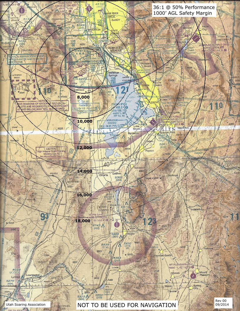
Airspace and Salt Lake City traffic and transponder use:
The airport is located under the 9000 foot floor of the SLC Class B airspace. The south end
of the Class B extends to the Fairfield VOR, which is located on the crest of Lake Mountain,
southeast of the airport. The Cedar Valley operator has an agreement for a “glider box” with
Salt Lake Approach control. The agreement covers the airspace within the 9000’ floor, to
the west of Eagle Mountain Road, which is the first major north/south road west of the
airport. West of the road, gliders are permitted into the Class B airspace without
establishing radio communications. This provides for a natural return from the Oquirrh
Mountains without violating the airspace requirements.
For all flight operations in the area, the use of a transponder is highly recommended. There
is extensive airline traffic though the area to the west and the east of the airport. Most jet
traffic will transit the area between 14,000 and 11,000 MSL. Be aware there is an
established arrival procedure that crosses the town of Eureka, located in the Tintic
Mountains to the south. Flights over the town of Eureka at 11,000 MSL run a high risk of an
in-flight encounter with a very fast and heavy aircraft. It is a good habit to be aware of the
direction of the traffic flow at the Salt Lake Airport in order to understand the expected
arrival and departure traffic and it’s impact on your flight out of the Cedar Valley Airport.
Salt Lake International ATIS is available on 124.75.
To the north of Cedar Valley Airport are two areas of restricted airspace. Areas R-6412 A&B
and 6412 C&D are used by Camp Williams Air National Guard for helicopter and artillery
training. The airspace is in effect from the surface to 10,000 MSL. The status of the areas
will be identified on the Salt Lake ATIS and by NOTAM. Contact Salt Lake TRACON, or 1-
800-WX-BRIEF for further information.
To the west of the town of Cedar Fort, west of the south tip of the Oquirrh Mountains, there
is an airspace restriction over the ordinance depot. Pilots are requested to avoid flight at
and below 8000 MSL in the area. For the exact location of the depot consult the Salt Lake
sectional or the Salt Lake VFR Terminal Area chart.
Local weather and soaring activity:
Glider operations during the midweek are minimal, however on weekend afternoons there
can be multiple glider flights being launched and recovered. Most traffic begins after 1300.
There are several gliders based on the field. Expect significant activity on the weekends
when conditions are good.
Due to local geographical orientation there is a consistent afternoon crosswind from the
east. The wind will pick up in the late morning, and will not die off until late in the day.
Rarely the wind is from the north, but when it is there will be a small wave located just
north of SR73, which allows for extended, but not high altitude, flight.
There is plentiful thermal activity in the valley during the day and the area provides for
excellent cross country flight capabilities. The Oquirrh Mountains to the west, Lake Mountain
to the east and the Tintic Mountains to the south are used extensively for glider operations.
Utah Soaring Association Cedar Valley Orientation
Utah Soaring Association Page 4 Rev 00 09/2014
Winds from the west will allow ridge soaring on the west slope of Lake Mountain. In
addition, the late afternoon sun will heat the west slope of Lake Mountain and provide for
thermal activity until the early evening.
The Oquirrh Mountains are situated to take advantage of many wind conditions. Virtually
any wind direction will provide for ridge soaring at some location in the range. The spurs
running off of the east slope provide for good ridge lift during south and north winds while
the east slope works during east winds. In addition, multiple bowls in the mountain range
will allow for ridge/thermal soaring.
To the east, the Wasatch range will provide tremendous ridge soaring opportunities.
Obviously crossing over the Class B airspace is an issue that must be considered.
To the south, the Tintic mountain range can provide for lift that begins a chain of
geographical opportunities for hundreds of miles. Be aware to fly the route to the Tintic
Mountains, the area south of the Oquirrh Mountains must be crossed. Sinking air
predominates this area so sufficient altitude must be gained prior to flying south.
Land Outs:
There are two airports in the area available for land out. The West Desert Airport is located
just south of the town of Fairfield, UT and is southwest of Cedar Valley. It is a private
airport that has a 2600 foot strip at an altitude of 4900 MSL. Jake Garn Airport is due south
of Cedar Valley and uses a 2500 foot runway. It too is located approximately 4900 MSL. Use
caution landing at Jake Garn airport. There are fence obstacles at the north end of the
runway. Other than the established airports, the main valley provides for many land out
opportunities in the way of farmed acreage.
Directions to the Airport:
From the Salt Lake City area there are two routes:I-15 south to Bangerter Hwy (UT-154).
Then drive Bangerter Hwy west to Redwood Road (SR68). Follow SR68 to SR73. Turn right
on SR73 and follow it for approximately five miles to the Cedar Valley Airport entrance road.
An airport sign marks the road and there is a small metal glider cutout mounted on a pole.
An alternate method is to follow I-15 south to the US-89 exit at Lehi, UT. Turn right at
500W (SP197) and follow it south to SR73. Turn right at SP 73 and follow it west
approximately 9 miles to the airport.
8,000
10,000
12,000
14,000
16,000
18,000
36:1 @ 50% Performance
1000’ AGL Safety Margin
NOT TO BE USED FOR NAVIGATION Utah Soaring Association Rev 00 09/2014