Embed Size (px)
Citation preview
7/31/2019 Sonepat
http://slidepdf.com/reader/full/sonepat 1/19
SONIPAT DISTRICT HARYANA
CENTRAL GROUND WATER BOARD
Ministry of Water Resources
Government of India
North Western Region
CHANDIGARH
2008

7/31/2019 Sonepat
http://slidepdf.com/reader/full/sonepat 2/19
ContributorsS.Marwaha Scientist-‘D’
Prepared under supervision of
Sushil GuptaRegional Director
Our Vision“Water Security Through Ground Water Management”

7/31/2019 Sonepat
http://slidepdf.com/reader/full/sonepat 3/19

7/31/2019 Sonepat
http://slidepdf.com/reader/full/sonepat 4/19
SONIPAT DISTRICT AT A GLANCE Sl.NO. ITEMS Statistics
GENERAL INFORMATION
Geographical Area (sq. km.) 2122Administrative DivisionsNumber Of Tehsils (4) 1. Sonipat
2. Ganaur3. Gohana4. Kharkhoda
Number Of Blocks (7) 1. Sonipat2. Ganaur3. Gohana4. Kharkhoda5. Rai
6. Mundlana7. Kathura
Number Of Panchayats 316Number Of Villages 323
Population (As per 2001Census) 12,79,175
1.
Average Annual Rainfall (mm) 567
GEOMORPHOLOGY
Major Physiographic Units Alluvial Plains
2.
Major Drainage Yamuna River,Drain No.8
LAND USE (Sq.Km.)
a. Forest Area: 10
b. Net area sown: 1470
3.
c. Cultivable area: 1850
4. MAJOR SOIL TYPES Sandy loams to loamysands
5. AREA UNDER PRINCIPAL CROPS (Sq. Km.) 2780
IRRIGATION BY DIFFERENT SOURCES(Areas and Number Of Structures) Sq.Km
Dug wells -
Tubewells/Bore wells 600 sq.km.(37,385)
Tanks/ponds -
Canals 850 sq.km.
6.
Other sources -
7/31/2019 Sonepat
http://slidepdf.com/reader/full/sonepat 5/19
Net Irrigated area 1440 sq.km.
Gross irrigated area 2710 sq. km.
NUMBERS OF GROUND WATERMONITORING WELLS OF CGWBNo. of dug wells 25
7.
No of Piezometers 4
8. PREDOMINANT GEOLOGICAL FORMATIONS Alluvium
HYDROGEOLOGY9.
*Major Water bearing formation
*(Pre-monsoon depth to water level)*(Post-monsoon depth to water level)*Long term water level trend in 10 yrs in m /yr
Alluvium(Sand & Gravel)1.41-23.220.99 m-24.46 m0.05 to 0.32 (Rise)0.05 to 0.97 (Fall)
GROUND WATER EXPLORATION BYCGWBNo. of wells drilled
EWOWPZSH
8-52
Depth range (m) 69-462m
Discharge (liters per minute) 4541 lpm
Storativity (S) 21.5 X10⁻²
10.
Transmissivity (m2 /day) 2340
GROUND WATER QUALITYPresence of Chemical constituents more thanthe permissible limitEC, in micromhos at 250C (>3000)F, in mg/l (>1.5)As, in mg/l(>0.01)Fe, in mg/l(>1.0)
101326
11.
Type of water Ca+Mg-HC03 and Na-mixed anion
DYNAMIC GROUND WATER RESOURCES(2004)
Annual Replenish able Ground water Resources 449.58 MCMNet Annual Ground water Draft 511.10 MCMProjected Demand for Domestic and industrialUses upto 2025
43.09 MCM
12
Stage of Groundwater Development 114 %AWARENESS AND TRAINING ACTIVITY -
Mass Awareness Programmes organized -
13
Date -

7/31/2019 Sonepat
http://slidepdf.com/reader/full/sonepat 6/19
Place -
No of participants -
EFFORTS OF ARTIFICIAL RECHARGE &RAIN WATER HARVESTING
-
Projects completed by CGWB (No.& Amountspent)
-
14.
Projects under technical guidance of CGWB(Numbers)
-
GROUND WATER CONTROL ANDREGULATIONNumber of OE Blocks. 4
No. Critical Blocks -
15.
No. of blocks notified -16 MAJOR GROUND WATER PROBLEMS AND
ISSUES.Salinity and fluorideproblem in Ground
water

7/31/2019 Sonepat
http://slidepdf.com/reader/full/sonepat 7/19
HYDROGEOLOGICAL INFORMATION BOOKLET OFSONIPAT DISTRICT, HARYANA
1.0 INTRODUCTION
The district of Sonipat is bounded by 28048’15” to 29017’10” north latitudeand 76028’40” to 77012’45” east longitude. It falls in the survey of India topo sheetsno.53C,53D, 53G & 53H covering an area of 2260.53 sq.km. Sonipat is one of thesmallest district in Haryana State and covers 5.11 % area of the state. The district issurrounded by Panipat district in the north, Jind district in the west, Rohtak district inthe S.W direction and Delhi in the South. The district headquarter, Sonipat isconnected by metalled roads with important cities of the state and to Delhi. It is alsoconnected by broad gouge railway line with Delhi and Chandigarh. Gohana, Ganaur,Rai & Kundli are the other important towns in the district.
Administrative setup
The district comes under Rohtak division administratively. It has the followingadministrative subdivisions:
Sub-Division Tehsil Block Area of block (sq.km)a. Sonipat a. Sonipat a. Ganaur 388.90b. Gohana b. Gohana b. Kharkhoda 299.44c. Ganour c. Ganour c. Rai 280.49
d. Kharkhoda d. Sonipat 397.89e. Mundalana 305.73f. Kathura 205.77g. Gohana 290.32
Sonipat district is one of the densely populated districts of the state. The totalpopulation of the district as per 2001 census is 12,79,175. The population density is471 persons per sq.km against the state average of 372 persons per sq.km.
Drainage
The River Yamuna, which borders the district in the East, is the main river inthe district. The district is drained by drain no.8, which was constructed to take outexcess monsoon runoff from uplands to River Yamuna. The areas east of upland
plains are more prone to flooding because of its low-lying nature.Irrigation
Irrigation in the district is done by surface and ground water as well .Around42% of the area is irrigated by tubewells and rest of the area is irrigated by canals.About 96% area has been irrigated with respect to net sown area in the district. Thedistrict has a high irrigation intensity of 159%. About 91% area of the district is grossarea irrigated with respect to total cropped area. The area, which is irrigated bysurface water lies towards west where ground water is mostly saline while ground

7/31/2019 Sonepat
http://slidepdf.com/reader/full/sonepat 8/19
7/31/2019 Sonepat
http://slidepdf.com/reader/full/sonepat 9/19
water irrigation is maximum in the eastern parts adjoining the Yamuna river. In thispart of the district, ground water is fresh. The canal irrigation is mainly done by WestYamuna Canal system.
Studies carried out by CGWB
The district was covered under systematic hydrogeological studies in the fieldseason 1962-63. The district was covered under re-appraisal hydrogeologicalsurveys in 1980-81, 1985-86 and 1997-98. The Sonipat district formed a part ofstudies undertaken during upper Yamuna project by Central Ground Water Board.As part of the studies in the basin, the exploratory drilling was taken up in Sonipatdistrict and 15 wells were constructed during the period 1971-76.
2.0 CLIMATE & RAINFALL
HYDROMETEOROLOGY
The climate of the district is characterized by the dryness of the air with anintensely hot summer and a cold winter. The cold season starts by late Novemberand extends to about he middle of March. It is followed by hot season, whichcontinues to about the end of June when the southwest monsoon arrives over thedistrict. The period from July to September is the southwest monsoon season.
Rainfall: The normal annual rainfall of the district, based on the record for the period1901-1980 is 567 mm recorded in 30 rainy days in a year. There is nometeorological observatory in the district, so the climatological data of the near byobservatory at Delhi has been taken as representative of the climatologicalconditions of the district. About 76% of the annual rainfall is recorded during thesouthwest monsoon from June-September. July is the wettest month of the year with7.5 rainy days and 169 mm rainfall. During the period 1901-80, deficient to scantyrainfall was recorded in 18 years. The probability of occurrence of rainfall in therange 400-700 mm is 0.65.
January is the coldest month with mean daily maximum temperature 21.3o Cand mean daily minimum temp 7.3oC. May is the hottest month with mean dailymaximum temp 26.6oC. In May and June, the maximum temperature sometimesreaches about 47oC.
3.0 GEOMORPHOLOGY AND SOIL TYPES
3.1 Physiography
The area forms a part of the Indo-Gangetic plains and exhibit flat terrain withgeneral slope from north to south. The area is devoid of any prominent topographicfeatures. However, a natural depression exists in north & northwest of Gohana(29008’22”N & 76042’55”E). The maximum elevation of the plain is 230m above msl.Topographically the district can be divided into the following units.

7/31/2019 Sonepat
http://slidepdf.com/reader/full/sonepat 10/19
1. Active flood plains along the present day course of the river Yamuna ineastern part of the district
2. Abandoned flood plains of recent past. These are generally bordering theactive flood plains and are wider, low lying flat tracts.
5. Upland plains representing the relatively older river deposits. The westernYamuna canal has been roughly aligned along the ridge formed by uplandplains
3.2 Soils Types • Psammaquents and Haplaquepts- These soils are found in Yamuna Plains• Haplaquept- These soils are non saline, alkalinity hazards are classified as
typic ustochrepts but water logged soils with loam to clay loam texture showingthe effect of glazing, are classified as aeric/ typic Haplaquepts. Areas as aeridicsoil moisture have soils classified as camborthics and torropsamments.
4.0 GROUND WATER SCENARIO
4.1 Hydrogeology
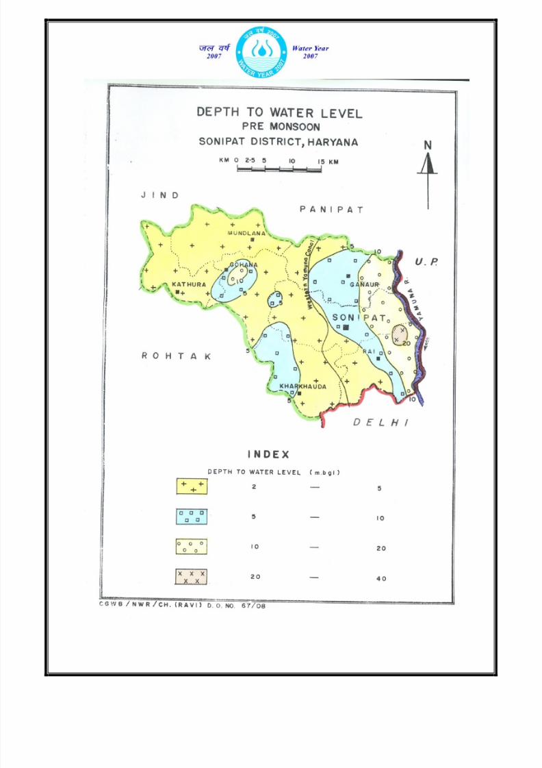
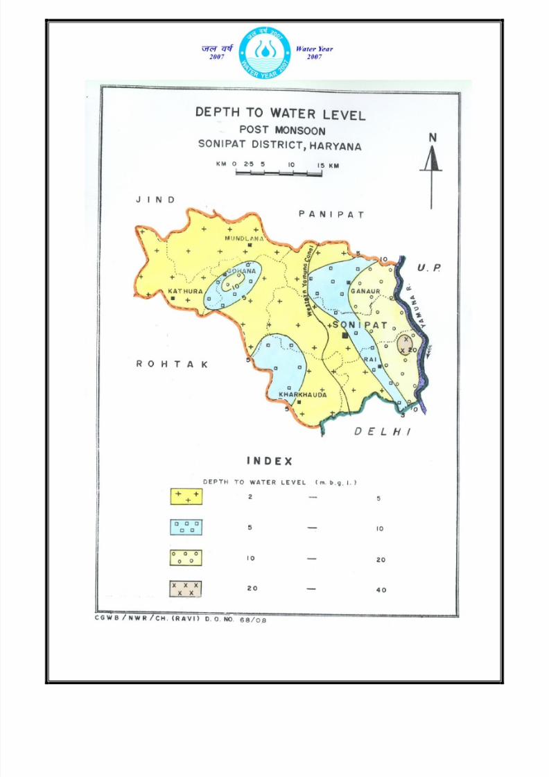
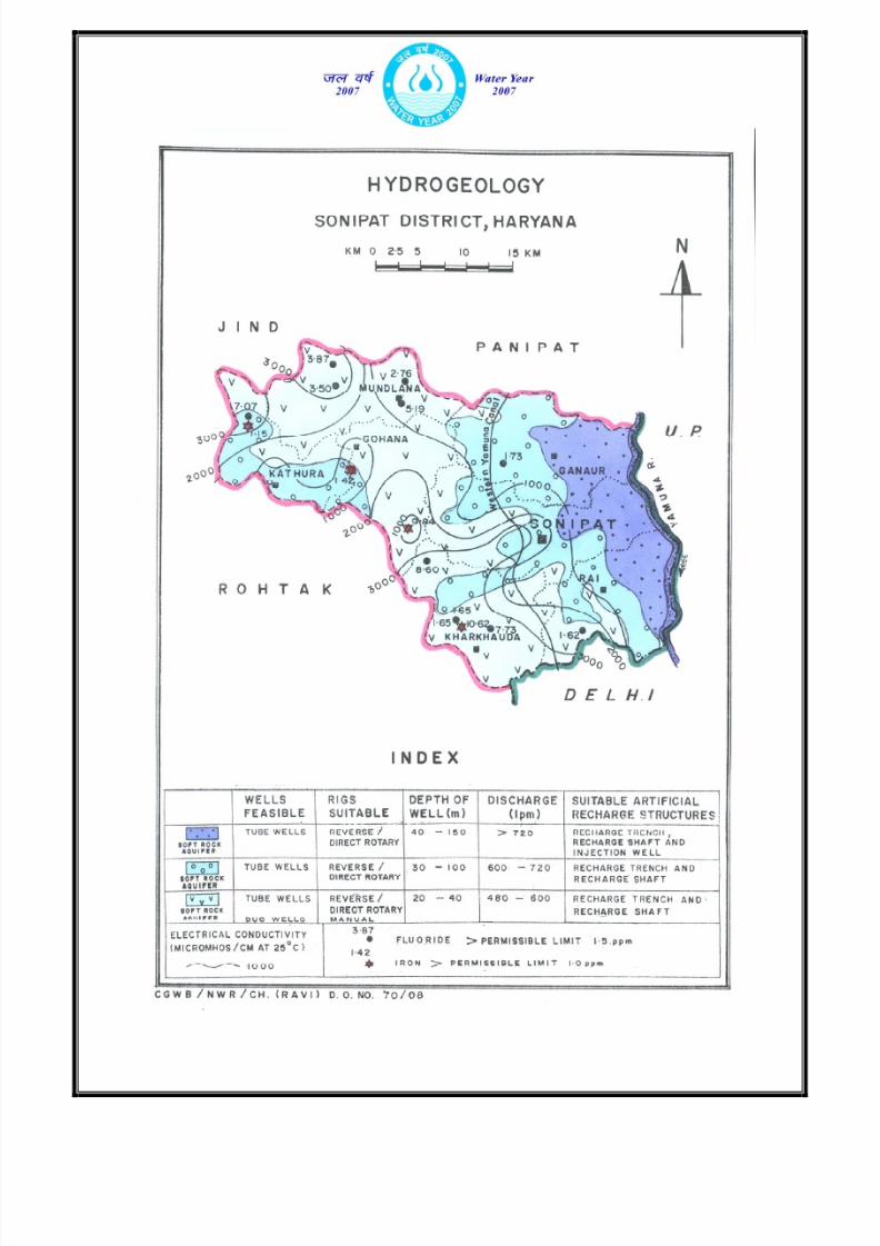
Ground water occurs in alluvial sand, silt, kankar and gravel, which formpotential aquifer zones. Depth to water level during pre-monsoon varies from 1.41 – 23.22m while during post-monsoon it varies from 0.99 – 24.46m. The depth towater level lies within 10m below the land surface in most parts of the district. Itrests between 2 to 25m deep in the eastern side and 2 to 10m in the north westernparts of the district. Only in small patches in the Rai block, water table is deeperhaving range of 20m to 40m. Water table elevations range from 230 to 220m amsland the general ground water flow is from northwest to southeast. In general, thewater table has declined all over the district over the past decade. During past oendecade the district has recorded a fall of less than 1m to 7m .The decline was 2 to4m in most parts of the district. Long term water level fluctuations indicate rise ofwater level over a period of last one decade in Mundlana, Kathura, K harkhoda andRari blocks. The trend of rise of water level is in the range of 0.05 to 0.32m/year.The trend of decline of water level is 0.05 to 0.95m/year.
Central Ground Water Board has drilled 15 wells under ground waterexploration programme; 8 are exploratory wells, 5 are piezometers and 2 are slimholes. Out of 8 boreholes drilled for ground water exploration, 7 were abandoneddue to poor quality of ground water or due to inadequate thickness of permeablegranular zones. Granular zones exist down to 460m depth i.e. to depth explored.
However, the chemical quality of ground water is not fresh in deeper horizons inmost parts of the district and in shallow horizons; in some parts. In general, thequality of ground water in shallow dugwell zones is fresh in the eastern and north,northwest parts and gradually gets deteriorated in the western and southwesternparts. Also the deep zones below 150m depth contain brackish / saline groundwater. A number of shallow tubewells exist in all the blocks – more in number inSonipat, Rai and Ganaur block and these tap water bearing zones in the shallowunconfined aquifer group. These tubewells yielded 300 to 600 lpm for moderate
7/31/2019 Sonepat
http://slidepdf.com/reader/full/sonepat 11/19
7/31/2019 Sonepat
http://slidepdf.com/reader/full/sonepat 12/19

7/31/2019 Sonepat
http://slidepdf.com/reader/full/sonepat 13/19
drawdowns. Detailed test drilling has established occurrence of three distinct aquifergroups, down to 450m depth in Upper Yamuna Basin which includes Sonipat district.
Aquifer group-I which was in unconfined state extends from water table down to
70m depth. A tubewell located at Khera in the eastern part of the district and tappingthis aquifer group-I, yielded 4540 lpm for about 7.5m of drawdown. Aquifercharacteristics at Khera site were – Transmissivity : 2340m2 /day ; Lateral Hydraulic
conductivity – 36m/day and specific yield – 2.15 x 10⁻¹ ( 21.4%). This aquifer group-Icontains fresh water in eastern parts of the district. Aquifer group-II which is undersemi-confined / confined state occurs in the depth range of 90 to 200m and has notbeen tested for its yield and aquifer characteristics since the formation water issaline. Aquifer group-III which too is under confined state occurs in the depth rangeof 250 to 400m and contains brackish saline ground water.
4.2 Ground Water Resources
The block wise ground water resource potential in the district has beenassessed as per GEC-97. The stage of ground water development ranges between44% (block-Kathura) to 152% (block-Ganaur). The total replenish able ground waterresource in the district is 449.58 mcm, of which the total existing ground water draftby all means is 511.10 mcm. The net utilizable ground water resources for futureirrigation development are –75.31 MCM.
GROUND WATER RESOURCES OF SONIPAT DISTRICT, HARYANA STATE
S.No
Block TotalReplenish-ableGroundWaterresource(ham)
UtilizablegroundwaterResourcesfor irrigation(ham)
ExistingGW draftForDomesticindustrialand otheruses(ham)
Grossdraft(ham)as on31.3.04
Allocat-ion fornext 25yearsfordomes-tic andindustrial uses
Netgroundwateravailability forfutureirrigationdevelopment
Stageofgroundwaterdevelopment%
1 Ganaur 11305 16089 1047 17137 1540 -6324 152%
2 Gohana 4921 5009 54 5063 80 -168 103%
3 Kathura 3093 1369 0 1369 0 1724 44%
4 Kharkhoda 4892 3107 94 3201 138 1647 65%
5 Mundlana 5696 3958 0 3958 0 1738 69%
6 Rai 5356 6708 691 7399 1015 -2367 138%
7 Sonepat 9693 11938 1045 12983 1536 -3781 134%
Total 44958 48179 2931 51110 4309 -7531 114%
Discharge of the tubewells increases from west to east towards river Yamuna. Goodaquifer exist in the flood plain of Yamuna river. The discharge of tubewells

7/31/2019 Sonepat
http://slidepdf.com/reader/full/sonepat 14/19

7/31/2019 Sonepat
http://slidepdf.com/reader/full/sonepat 15/19
constructed in Mundlana, Gohana, Kathura, Kharkoda blocks is generally upto 10lps(86.4_m3 /day). However, in the eastern parts of Ganaur, Sonipat and Rai blockshigh discharge wells upto 20 lps have been reported.
4.3 Ground water quality
The shallow ground water of the district is generally alkaline in nature and ismoderate to highly mineralized with EC ranging from 597 to 6710µS/cm. at 250C .Ground water occurring in the southern and N-W parts of the district is more salineas compared to ground water occurring in the rest of the district. Among anions,either bicarbonate predominates or none of the anion dominates. Similarly, amongcations, sodium predominates in 50% of the samples and in the remaining calcium +magnesium combined dominates.
On comparing the ionic concentration of major ions with the recommended
limits prescribed by Bureau of Indian standards for drinking waters, it is found thatmore than half (68%) the ground waters are not suitable for drinking purposes mainlydue to salinity and fluoride contents that exceed the maximum permissible limits ofthese chemical parameters, which are 3000µS/cm. and 1.5mg/l respectively.
Plot of USSL diagram used for the determination of irrigation rating of groundwaters indicates that ground waters at several places fall under C2S1, C3S1, C3S2,
C4S2 classes of irrigation rating. These waters are, therefore, suitable for customaryirrigation for salt tolerant crops like wheat, rice, maize, gram etc without any fear ofsalinity hazards to the crops. Waters falling under C4S3 and C4S4 classes are likely tocause salinity as well as sodium hazards. It would be better if such waters are usedfor irrigating salt tolerant crops along with appropriate amount of gypsum on well
drained soils
Type Of Water
The shallow ground water is of Ca +Mg-HCO3 and Na-mixed Anion type andmixed facies type of water also occur in the district.
4.4 Status of Ground Water Development
Irrigation from ground water is being done in large parts of the district.Maximum number of minor irrigation units have been installed in Sonipat and Ganaurblocks. Density of MI units is also highest in these blocks, while it is lowest inKathura block. A large number of pump sets have been installed at shallow depth inrange of 5 -10m in Mundlana, Kathura, Gohana, Kharkhoda blocks. Deep tubewellsare installed in Sonipat, Ganaur and Rai blocks. Ground water is relatively fresh inthese blocks at deeper levels as compared to other areas. Generally the H.P. ofPump varies from 3 to 7.5 in large parts of the district. However, higher capacitypump having H.P. upto 20 are being used for lifting ground water from deeptubewells in Sonipat and Rai blocks. These areas are more or less parallel to theYamuna River in the eastern part of the district.
7/31/2019 Sonepat
http://slidepdf.com/reader/full/sonepat 16/19

7/31/2019 Sonepat
http://slidepdf.com/reader/full/sonepat 17/19
The depth of shallow tubewells is mainly in the range of 20-30m with discharge in therange of 8-10lps. However in parts of Ganauour and Sonepat block the shallowtubewells upto 45m haaving discharge more than 12 lps are prevalent.
4.5 Geophysical Studies
The results of the surface geophysical studies in entire Sonepat districtindicates that ground water is saline at all levels in some part of the Sonepat district.About 28% area is adversely affected with shallow ground water salinity. Such areasinclude few localities in Mundlana, Gohana, Kathurah and Kharkhauda blocks.Ground water is saline within 20m depth over half of the Sonepat district particularlyin the areas lying in west, northwest, and south of the district. However, the impact ofground water salinity is less in the vicinity of river and canals. Part of the study areaover northern eastern, northeastern, central and southeastern direction has freshquality of ground water within a depth of 40 to 80 m b.g.l. Such areas include blocks
of Sonepat, Rai, & Ganaur. Major area has saline quality of ground water in thedepth range of 40 to 80m depth b.g.l. The prominent localities where considerablethickness of aquifer bearing fresh ground water has been inferred are Kheora,Ganaur, Chirasmi, Quamaspur, Kheri-gujar, Rajpura, Ghasauli, Murthal, Majri-mawaiand Ahulana. Part of the area over southeast and small pockets in extreme northand northeast of Sonepat district has been identified bearing fresh ground waterwithin a depth of 100 to 150m b.g.l. The prominent localities where fresh wateravailable within 100 to 150m depth are around Simbalgarh and Jagdishpur lying inextreme northeast and southeast of the district adjacent to Yamuna river. Part of thedistrict over northwest, west and south is water logged which is also one of thereason for ground water salinity. Preventive measures are suggested to stop waterlogging. The salient features of the study are shown in figure .
5.0 GROUND WATER MANAGEMENT STRATEGY
5.1 Possibility Of Artificial Recharge
There are few isolated pockets located in the eastern part of the district wherewater levels are declining very fast. Fresh ground water at deeper level is beingexploited by deep tubewells. Limited possibilities of artificial recharge exist in theseareas during monsoon season, where excess runoff from upland areas can beutilized. Some of drains which were constructed to drain out excess water can beutilized for artificial recharge by constructing suitable recharge structures, such as
injection wells, recharge shafts etc.
5.2 Water Conservation Structures
There is not much work carried out in the district. However, about 402 pondsexist in all the blocks, which act as fresh rainwater conservation structures. Out ofthese 75 ponds exist in Ganaur, 52 in Gohana, 30 in Kathura, 50 in Kharkhoda, 38 inmundlana, 65 in Rai and 92 in Sonepat block.
7/31/2019 Sonepat
http://slidepdf.com/reader/full/sonepat 18/19
5.3 Ground Water Development
The hydrogeological data generated through exploratory drilling has proved a
vital information regarding identification of aquifer systems, demarcation of theirvertical and lateral extent, delineation of potential aquifer characteristics. Thesestudies also provide information on well design and drilling techniques. A wellassembly of 203mm dia, using about 20m to 30m long housing pipe and MS slotpipe with slots of 1.19 mm to 1.59 mm size would be ideal in the district area. “V”wires galvanized Screen having 0.50- 1.5mm slot can also be used as it can providemore open area thenconventional slotted pipes. Entrance velocity of water in the wellhas to be kept in mind while designing the well assembly.
6.0 GROUND WATER RELATED ISSUES & PROBLEMS
6.1 Declining water levels
There are certain areas in the district, which have recorded water level declinein recent past. Since ground water is the only source of irrigation in around 42% areaof the district, ground water aquifers are under great stress due to increaseddemand in irrigation and industrial sector.
Necessary remedial measures need to taken to arrest further declining ofwater levels in the areas and suitable methodology to be adopted to recharge theaquifers.
6.2 Water logging & Ground Water Salinity
Parts of Kathura, Gohana, Mundlana and Kharkhoda blocks have problems ofshallow water levels or water logged areas and soil and water salinity at shallowlevels. CSSRI, Karnal had taken up pilot projects in the district. One projectcomprised of areas in Gohana block covering 5000 ha in 5 villages viz. Bali,Revlasa, Moj, Kot wali and Lath. Another project was in Mundlana covering 50 haarea. Horizontal subsurface drainage was installed in Mundlana in years 1985, 87.Soil in the area was sandy loam having hydraulic conductivity of 0.8m/day.Horizontal drains were laid at a depth of 1.75m having variable drain spacing of 50,67 and 84m. It was found that salinity levels at the initial stages of project were ofthe range of 25,000 – 30,000 micromhos had reduced to below 5000 micromhosafter a gap of about 5 years. Similar experiments were conducted in Ishapur Kheri
(58 ha) and Mehlana (41 ha) where horizontal subsurface drainage was laid.
7.0 RECOMMENDATIONS
1. Construction of shallow tubewells in areas along active flood plains of riverYamuna, which have shallow water level can help in augmenting watersupplies in the area
7/31/2019 Sonepat
http://slidepdf.com/reader/full/sonepat 19/19
2. Areas witnessing decline of water levels have to be demarcated and rainwaterharvesting to artificial recharge measures be taken up in a big way to reducethe impact.
3. Areas having shallow water levels and soil water salinity be improvised using
subsurface drainage.4. Improved agricultural practices like establishing good crop stand,sowing/planting practices, material management, Irrigation water managemente.g. land leveling should be implemented in the shallow water levels areas.
5. Local farmers, NGOs be educated in water management, conjunctive use ofsaline and fresh water, rainwater harvesting and artificial recharge methods.
*********