Embed Size (px)
Citation preview
Some of the Current Missions Around the Solar System

Close to Home• More than 9000 satellites are
currently orbiting Earth!– Provide telecommunications and
remote sensing data of the Earth and its atmosphere.

Tra
veli
ng in
out
er s
pace
is h
ard!
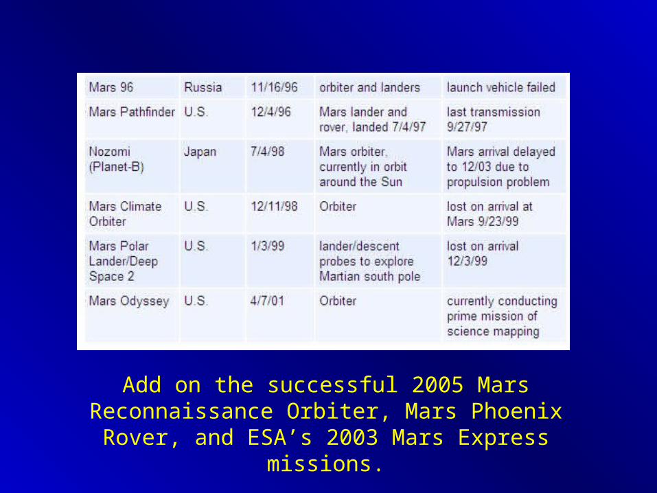
Add on the successful 2005 Mars Reconnaissance Orbiter, Mars Phoenix Rover, and ESA’s 2003 Mars Express missions.

European Space Agency
• Inter-governmental agency carrying out a number of missions.– Budget $3.8 billion; relative to $16 billion for NASA.
• Increasing collaborative efforts with NASA.
• Big Current Missions: Mars Express, Venus Express, Chandryaan-1 and Rosetta.
• Future Projects: ExoMars, Bepi-Colombo, and KEO

NASA Mission Classes:• Flagship – large class, ~$3 billion, launch once a decade,
institution-led– Galileo was the last, currently we have Cassini. Currently, the
next ones will be an outer planets mission and the Mars Sample Return.
• New Frontiers – mid-class, $750 million, launch every few years, PI-led– Juno (Jupiter), New Horizons (Pluto)
• Discovery – small class, ~$400 million, roughly annual launch, PI-led– NEAR, MESSENGER, DAWN, Deep Impact, Genesis,

Cassini-Huygens Mission to Saturn• Launched in 1997, arrived on
July 1, 2004.• $3 billion, 6 ton orbiter and
probe (Huygens) sent to study Saturn, the rings, and moons.
• Will complete 74 orbits of Saturn and 44 close fly-bys of satellites.
• Instruments onboard include: imagers, radar, and field and particle detectors.
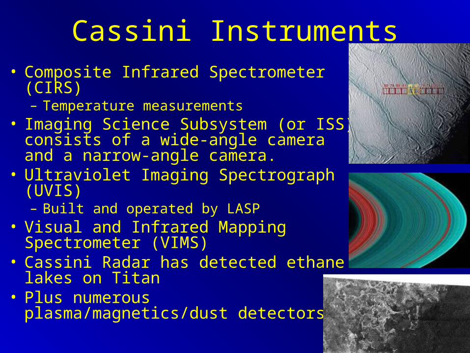
Cassini Instruments• Composite Infrared Spectrometer (CIRS)
– Temperature measurements• Imaging Science Subsystem (or ISS)
consists of a wide-angle camera and a narrow-angle camera.
• Ultraviolet Imaging Spectrograph (UVIS) – Built and operated by LASP
• Visual and Infrared Mapping Spectrometer (VIMS)
• Cassini Radar has detected ethane lakes on Titan
• Plus numerous plasma/magnetics/dust detectors.

Planetary Spectroscopy• A Michelson Interferometer is often
employed to sample radiance from planetary surfaces.
• Interference patterns result from the split and phase-shifted light.
• The emission spectrum of the light source can then be obtained from a Fourier transformation of the interference signal.
• Results in high-precision characterization of EM radiation.
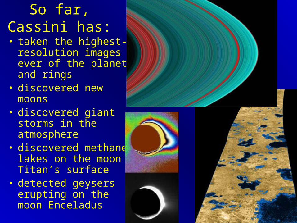
So far, Cassini has:
• taken the highest-resolution images ever of the planet and rings
• discovered new moons• discovered giant
storms in the atmosphere
• discovered methane lakes on the moon Titan’s surface
• detected geysers erupting on the moon Enceladus

Huygens Probe• Supplied by the European
Space Agency (ESA)• Descended onto the
surface of Titan, Saturn’s largest moon (Jan. 13, 2005).– During these 3 hours it
measured the atmosphere and took pictures of the surface.
– Landed near a putative lake shoreline

Stardust• A mission to Comet
Wild 2 to image the nucleus, collect cometary and interstellar dust, and return the samples to Earth.
• Launched 1999, returned 2006
• Best views ever of a comet.
• First samples returned from a comet– New organic molecules
discovered and some high-temp minerals
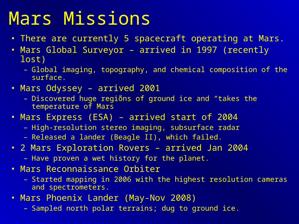
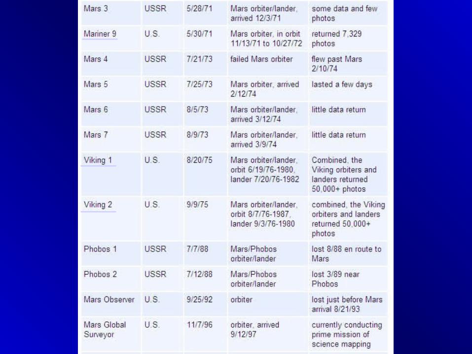
Mars Missions• There are currently 5 spacecraft operating at Mars.• Mars Global Surveyor – arrived in 1997 (recently lost)
– Global imaging, topography, and chemical composition of the surface.
• Mars Odyssey – arrived 2001– Discovered huge regions of ground ice and “takes the temperature of Mars”
• Mars Express (ESA) – arrived start of 2004– High-resolution stereo imaging, subsurface radar– Released a lander (Beagle II), which failed.
• 2 Mars Exploration Rovers – arrived Jan 2004– Have proven a wet history for the planet.
• Mars Reconnaissance Orbiter– Started mapping in 2006 with the highest resolution cameras and
spectrometers.
• Mars Phoenix Lander (May-Nov 2008)– Sampled north polar terrains; dug to ground ice.
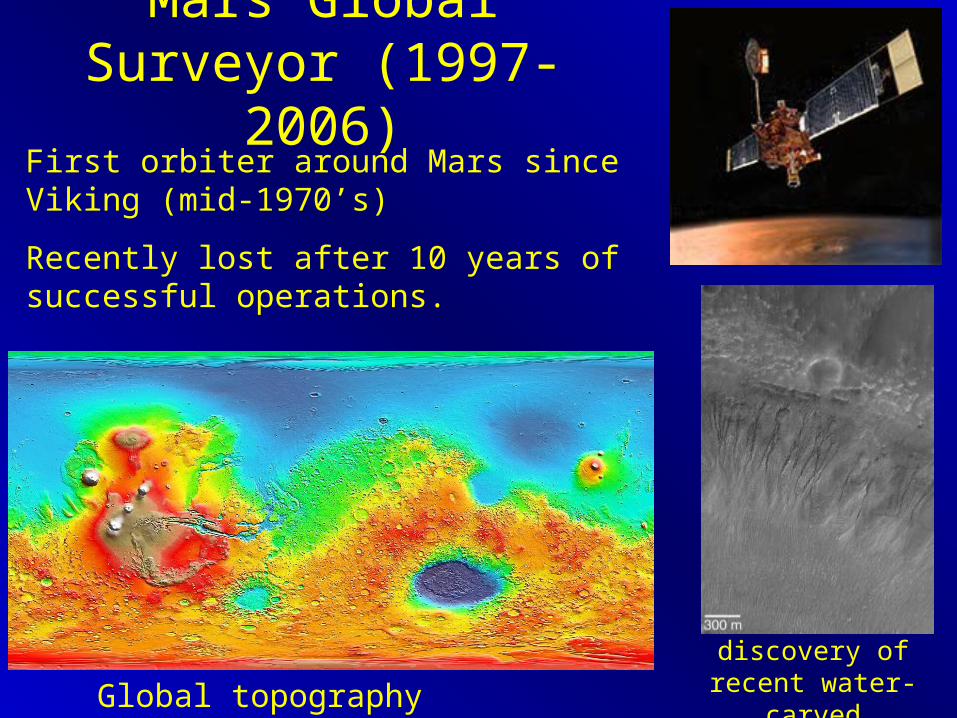
Mars Global Surveyor (1997-2006)
Global topography (elevation)
discovery of recent water-carved gullies
First orbiter around Mars since Viking (mid-1970’s)
Recently lost after 10 years of successful operations.

Science Package

1997 Mars Global Surveyor (MGS)
• Mars Orbiter Laser Altimeter (MOLA)– 300 m profiling resolution with < 1 m vertical
resolution– over 550,000,000 shots with returns.
• Mars Orbiter Camera (MOC)– 1.5 to 12 m/pixel resolution– more than 120,000 released images
• Thermal Emission Spectrometer– Near-Infrared broadband spectrometer
• rock, ice, and atmosphere compositions
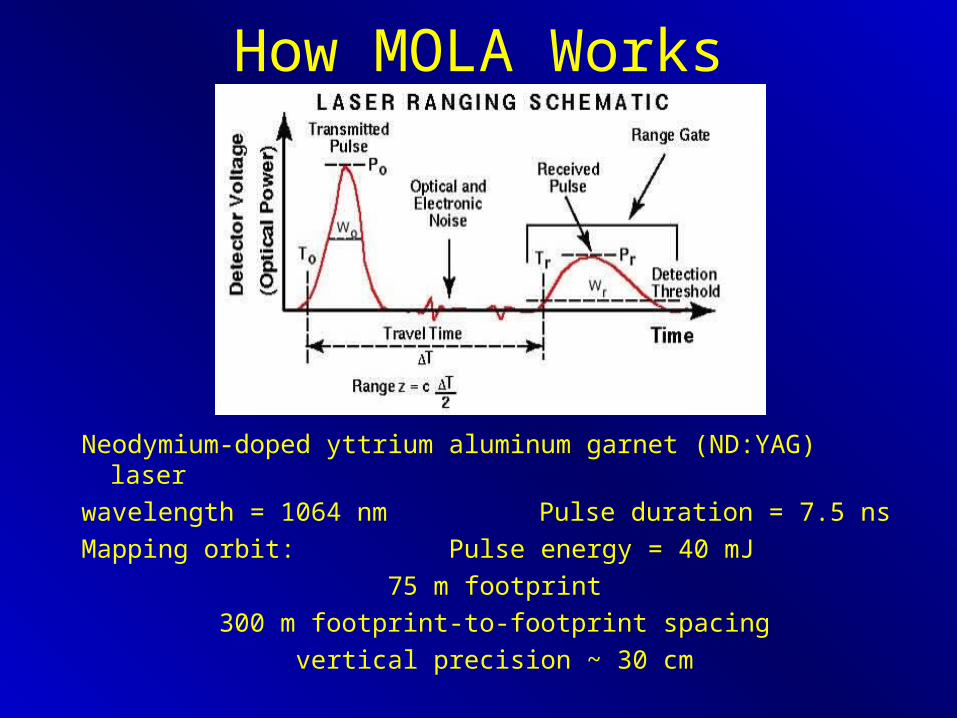
How MOLA Works
Neodymium-doped yttrium aluminum garnet (ND:YAG) laser
wavelength = 1064 nm Pulse duration = 7.5 ns
Mapping orbit: Pulse energy = 40 mJ
75 m footprint
300 m footprint-to-footprint spacing
vertical precision ~ 30 cm

Pre-MGS Global Topography

MGS Topography

Viking image and previously mapped valley networks
MGS data and newly recognized VN
Comparison of Viking and MGS data

Mars Odyssey (2001-)
Surface IR radiance map
Near-surface ice deposits

Thermal Emission Imaging Spectrometer (THEMIS)– A multi-spectal imaging sub-systems:
• 10-band thermal infrared imager
• 5-band visible imager


Gamma Ray Spectrometer
(Mars GRS Science Team)
Incoming cosmic rays excite neutrons High energy neutrons collide with atoms, releasing gamma rays for specific elements Neutrons are slowed by collision with H to epi-thermal (intermediate) and thermal (low) energies We can measure all of these from orbit and obtain chemical compositionRequires long sample time (years).

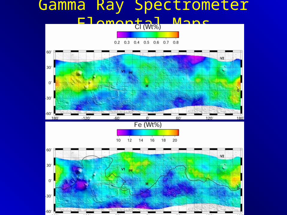
Gamma Ray Spectrometer Elemental Maps
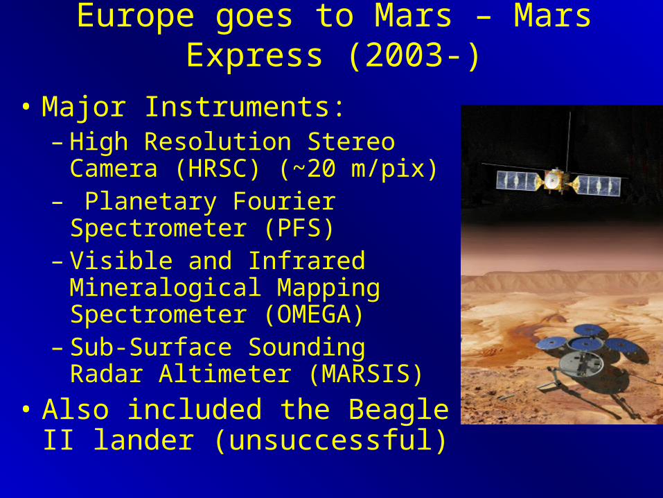
Europe goes to Mars – Mars Express (2003-)
• Major Instruments: – High Resolution Stereo Camera
(HRSC) (~20 m/pix)– Planetary Fourier Spectrometer
(PFS) – Visible and Infrared Mineralogical
Mapping Spectrometer (OMEGA)– Sub-Surface Sounding Radar
Altimeter (MARSIS)
• Also included the Beagle II lander (unsuccessful)
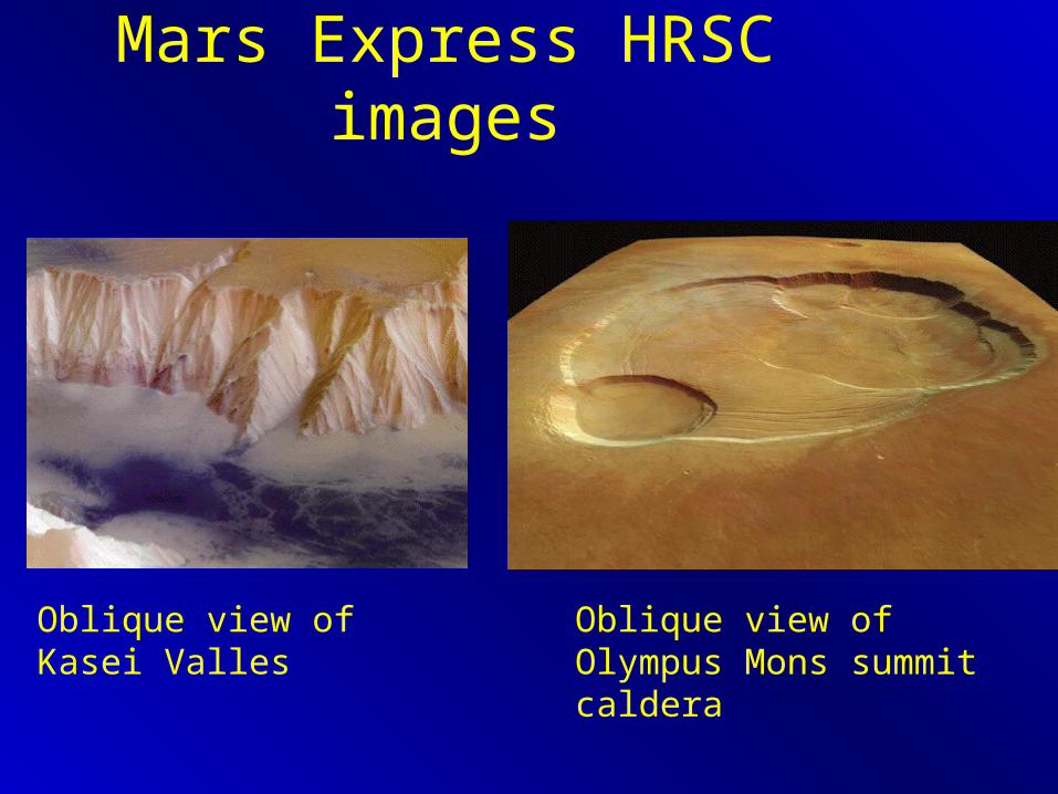
Mars Express HRSC images
Oblique view of Kasei Valles Oblique view of Olympus Mons summit caldera

Best evidence yet for recent (current?) glaciation


Marsis – (Sub-surface Sounding Radar Altimeter)
• deep sounding radar
• 40 m booms
• recent results include imaging the base of the north polar cap and possible detection of a subsurface impact basin


Mars Exploration Rovers (MERs)
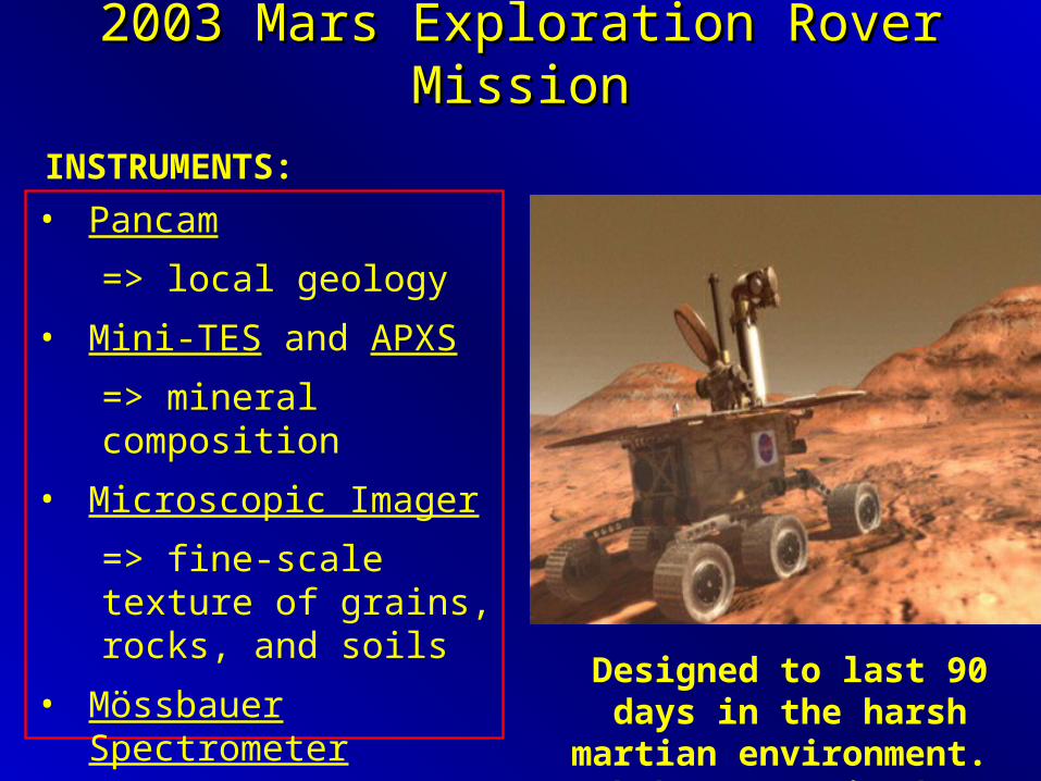
• Pancam
=> local geology
• Mini-TES and APXS
=> mineral composition
• Microscopic Imager
=> fine-scale texture of grains, rocks, and soils
• Mössbauer Spectrometer
=> Iron mineralogy and oxide states
2003 Mars Exploration Rover Mission2003 Mars Exploration Rover Mission
INSTRUMENTS:
Designed to last 90 days in the harsh martian environment.
Both have survived over 2000!

An Elevation Map of Mars
Meridiani Landing Site
Gusev Landing Site

First landing site: GUSEV CRATER
This crater once held a lake.
Elevation data around landing site

An unpleasant welcome…

The Meridiani landing site was chosen for a unique mineral occurrence
Meridiani Planum
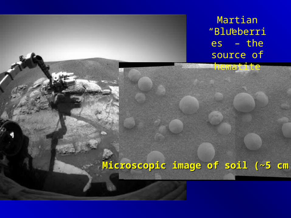
Martian “Blueberries
” – the source of hematite
Microscopic image of soil (~5 cm across)Microscopic image of soil (~5 cm across)

APXS chemistry of
soil and rocks
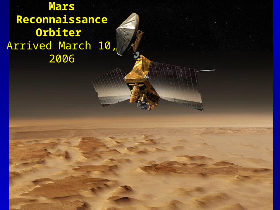
Mars Reconnaissance Orbiter
Arrived March 10, 2006
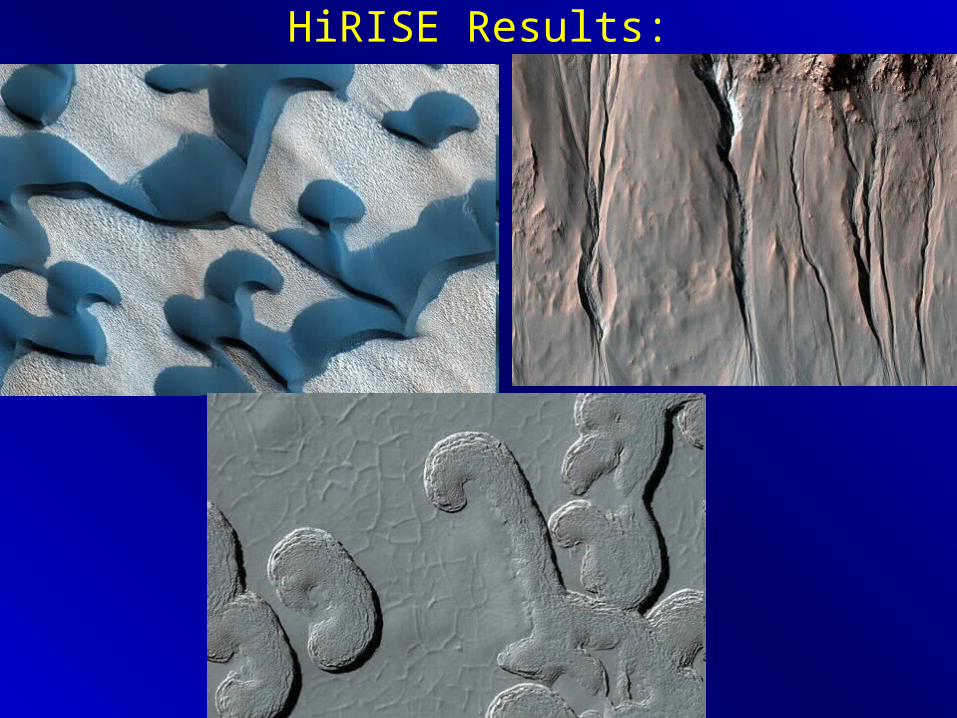
HiRISE Results:

polar layered terrains at 25 cm resolution

SHAllow RADar (SHARAD)

2008 Phoenix LanderLaunched 8/07, landed 4/25/08
(1) Can the Martian arctic support life?
(2) What is the history of water at the landing site?
(3) How is the Martian climate affected by polar dynamics?
ground ice near N pole

Mars Science Laboratory• GOAL: Explore and quantitatively assess a local region
on Mars’ surface as a potential habitat for life, past or present.
• Launch in 2011, land 2012
• Planned to last 3 years, drive at least 20 km
• A sophisticated geological, chemical and astrobiological field rover
• Onboard instruments include stereo cameras, a hand lens, XRD/XRF, mass spectrometer for isotopic analysis, laser-induced breakdown spectroscopy, and more!

Messenger: A Mission to MercuryMErcury Surface, Space ENvironment, Geochemistry, and Ranging
• Successfully launched in 2004
• Several flybys already and then orbit insertion in 2011.
• Houses imagers, a laser altimeter, spectrometers, and magnetometers.
• CU/LASP plays an important role in the mission.

MESSENGER Payload• Mercury Dual Imaging System (MDIS): Wide-angle and
narrow-angle imagers. Global maps at 2 km/pix (color) and 250 m/pix (monochrome). Color = 11 filters from 415 nm to 1020 nm.
• Gamma-Ray and Neutron Spectrometer (GRNS): It will be used to map the relative abundances of different elements and will help to determine if there is ice at Mercury's poles.
• Mercury Laser Altimeter (MLA): This instrument contains a laser that will send light to the planet's surface and a sensor that will gather the light after it has been reflected from the surface.
• Mercury Atmospheric and Surface Composition Spectrometer (MASCS): This spectrometer is sensitive to light from the infrared to the ultraviolet and will measure the abundances of atmospheric gases, as well as detect minerals on the surface. – UltraViolet-Visible Spectrometer (UVVS) and a Visible-InfraRed
Spectrograph (VIRS).
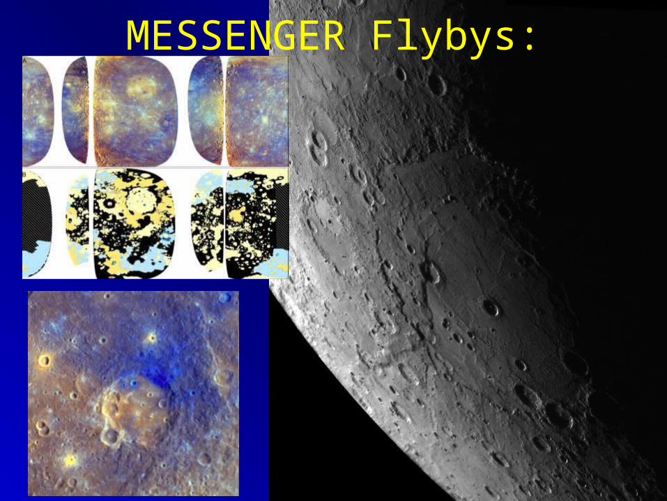
MESSENGER Flybys:

New Horizons: To Pluto!• Launched 2006, arrival in 2015.
Instruments:Ralph: Visible and infrared imager/spectrometer; provides color, composition and thermal maps.
Alice: Ultraviolet imaging spectrometer; analyzes composition and structure of Pluto's atmosphere and looks for atmospheres around Charon and Kuiper Belt Objects (KBOs).
REX: (Radio Science EXperiment) Measures atmospheric composition and temperature; passive radiometer.
LORRI: (Long Range Reconnaissance Imager) telescopic camera; obtains encounter data at long distances, maps Pluto's farside and provides high resolution geologic data.
SWAP: (Solar Wind Around Pluto) Solar wind and plasma spectrometer; measures atmospheric "escape rate" and observes Pluto's interaction with solar wind.
PEPSSI: (Pluto Energetic Particle Spectrometer Science Investigation) Energetic particle spectrometer; measures the composition and density of plasma (ions) escaping from Pluto's atmosphere.
SDC: (Student Dust Counter) Built and operated by students; measures the space dust peppering New Horizons during its voyage across the solar system.

Lunar Reconnaissance Orbiter (in orbit)
• Objectives are to map the surface topography, collect high resolution images, evaluate the radiation environment and confirm the presence of water near the poles.

First LRO Results
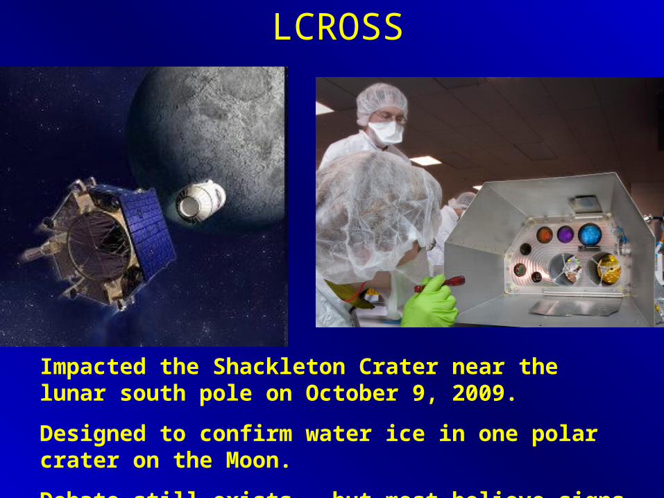
LCROSS
Impacted the Shackleton Crater near the lunar south pole on October 9, 2009.
Designed to confirm water ice in one polar crater on the Moon.
Debate still exists – but most believe signs of water ice.