Embed Size (px)
DESCRIPTION
Solved SQA Navigation Papers for Mates Masters
Citation preview

1
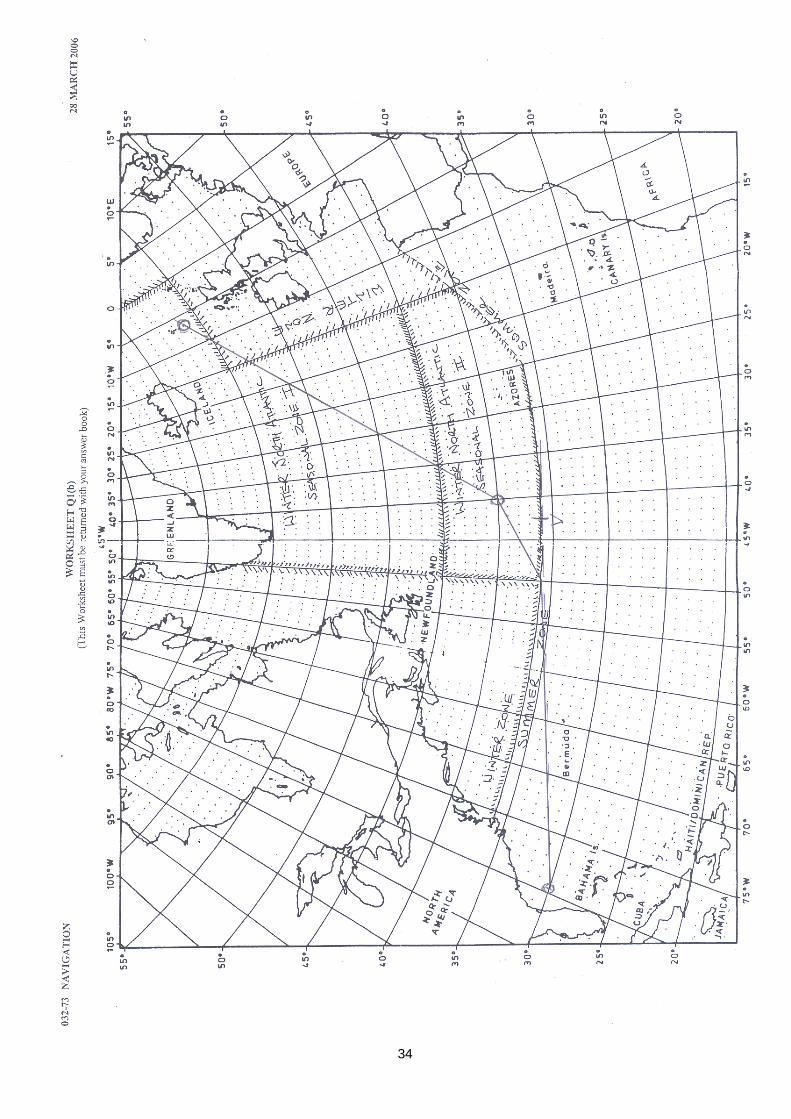
July-2007 All questions refer to a bulk carrier which is to make a fully laden passage between Port Hedland (W Australia) and Mombasa (Kenya) in June. The vessel's service speed is expected to be 15 knots. 1 a) Outline five factors that should be considered when planning an ocean passage. (10) b) The following departure and landfall positions are to be used for the passage, Datasheets Q1(1) and Q1(2) are included for reference. Port Hedland Departure Position 20 12.0 S 118 37.0 E Mombasa Landfall Position 04 05.0 S 039 43.0 E Assume that the vessel is under pilotage for a total distance of 87 miles from the berth to the departure position. Calculate each of the following: i) the shortest distance from Port Hedland to the landfall position; (10) ii) the course of the vessel at the departure position. (10) c) When appraising the passage it is noted that the vessel will pass close to the Agalega Islands which have a report of shoal water close to the north of the islands in position 10 04.0 S 056 39.0 E Calculate the distance the vessel will pass off the shoal when crossing longitude 056 39 E (8) a) 1. Use of great circle tracks to minimise distance. 2. The presence on the track of adverse meteorological and oceanographical elements that may adversely affect the vessel. 3. The presence near the track of favourable meteorological and oceanographical elements that may favourably affect the vessel. 4. The presence of navigational hazards on the track. 5. Ship type and vulnerability to Meteorological conditions. b) i) A 20 12.0 S 118 37.0 E PA = 90 – 20 12 = 69 48 B 04 05.0 S 039 43.0 E PB = 90 – 04 05 = 85 55 d 078 54.0 W P = 078 54 W cos AB = cos P x sin PA x sin PB + cos PA x cos PB. AB = cos-1 (cos P x sin PA x sin PB + cos PA x cos PB) Dis = = cos-1 (cos 78 54 x sin 69 48 x sin 85 55 + cos 69 48 x cos 85 55) Dis = 78 10 53.92 x 60 = 4690.898… + 87 = 4777.898… Dis = 4777.9 NM
E1 E2 E1
V1
V2
P
A
B W

2
ii) A = tan Lat ÷ tan LHA = tan Lat A ÷ tan DLon = tan 20 12 ÷ tan 78 54 = 0.07218467442 N B = tan Dec ÷ sin LHA = tan Lat B ÷ sin DLon = tan 04 05 ÷ sin 78 54 = 0.0727494632 S C = A ± B = 0.072… - 0.072… = -0.00056478877 = 0.00056478877 S Tan Az = 1 ÷ C ÷ cos Lat ICo = tan-1 (1 ÷ C ÷ cos Lat A) = tan-1 (1 ÷ 0.000… ÷ cos 20 12) = 89 58 10.67 = S 90.0 W ICo = 270 c) Position of Vertex sin mid = cos opp x cos opp sin PV = cos (90 – A) x cos (90 – PA) PV = sin-1 (cos (90 - 89 58 10.67) x cos (90 – 69 48) PV = 69 47 59.92 Lat V = 90 - 69 47 59.92 = 20 12 00.08 S sin (90 – PA) = tan (90 – P) x tan (90 – A) tan (90 – P) = sin (90 – PA) ÷ tan (90 – A) P = 90 – tan-1 (sin (90 – PA) ÷ tan (90 – A)) P = 90 – tan-1 (sin (90 – 69 48) ÷ tan (90 – 89 58 10.67)) 00 05 16.62 DLon AV = 00 05 16.62 W Lon V = 118 37.0 E – 00 05 16.62 = 118 31 43.38 E Latitude of Waypoint DLon PW = 118 31 43.38 – 56 39.0 E = 61 52 43.38 = P sin (90 – P) = tan PV x tan (90 – PW) tan (90 – PW) = sin (90 – P) ÷ tan PV PW = 90 – tan-1 (sin (90 – P) ÷ tan PV) PW = 90 – tan-1 (sin (90 – 61 52 43.38) ÷ tan 69 47 59.92) PW = 80 09 41.94 Lat W = 90 - 80 09 41.94 = 09 50 18.06 Lat W = 09 50.3 S Lat Shoal = 10 04.0 S Distance off = DLat = 10 04.0 – 09 50.3 = 00 13.7 = 13.7 NM 2. Weather routing is often effectively used by vessels making trans oceanic passages. a) Outline five factors that should be considered when deciding to weather route the ship. (20) b) Describe three types of weather routeing currently available to vessels. (12) c) Outline the benefits of carrying out shipboard routeing. (8) a) 1. The weather along the route. Wind speed and direction, therefore wave heights and direction. The probability of reduced visibility and fog. The probability of ice along and close to the route. 2. Ocean currents, adverse and favourable, along the route and close to it. 3. The vessel. Vessel type, hull form and susceptibility to wave action. Service speed, relative effect of ocean currents. Draft, likelihood of pounding in adverse seas. Freeboard, likelihood of shipping seas. Stability, susceptibility to heavy rolling.
V
VA(VW)
90 - A
90 - PA(PW)
90 - P
PV
P
W V A

3
Availability of Performance Data. 4. The cargo. Sensitivity to temperature and humidity. Deck cargo, susceptibility to heavy weather damage. 5. The voyage. Destination and range of alternative routes available. Distance, long voyages are more likely to offer alternatives. Navigational hazards on the route. Scheduling requirements. Legal requirements and restrictions. b) 1. Onboard, by ship's staff, using available information from climatological data and broadcast forecasts. The first approximation of the route is the shortest distance with adequate margins of safety. Climatological and forecast information is used to decide whether a deviation from this is justified in order to achieve the optimum route. 2. On board, using computer programs with data supplied from ashore. The program holds information about the ship's performance in a variety of weather conditions. The program holds climatological information. Forecast information is received from ashore. The program calculates an optimum route for the vessel. 3. Shore based Routeing Officers. An organisation ashore has details of the ship's performance, climatological data and forecast information. A Routeing Officer, using a computer program, calculates an optimum route for the vessel and advises the Master accordingly. Weather forecasts and further routeing advice are provided throughout the voyage. c) Local meteorological conditions and changes can be observed directly. Appropriate action can then be taken in response to changes as soon as they occur. The performance characteristics of the vessel in different circumstances are known by the Master in detail. The performance of the vessel in response to the prevailing conditions can be directly assessed and appropriate adjustments made. The original plan can be modified quickly in response to changing conditions to maximise the efficiency of the voyage. 3. Whilst approaching the Agalega Islands, on the evening of the 28th June, the Master wishes to verify the vessel's position as given by GPS. He instructs the OOW to take a set of star sights during evening twilight. The following observations are made, whilst steering 288T at 14 knots, using a DR position, based on GPS, of 10 09.0 S 057 40.0 E. Conditions were partly cloudy with a clear horizon and no moon. Wind ESE Force 5. Time Star Azimuth True Alt Calc Alt 1804 Arcturus N 42 E 42 34.2 42 41.9 1808 Procyon N 78 W 18 48.0 18 57.2 1818 Rigel Kent S 21 E 39 41.8 39 35.5 a) Determine the Vessel's Most Probable Position (MPP) at 1815 hours, assuming a systematic error. (25) b) In the light of the position determined in Q3a and the proximity of the Agalega Islands to the planned track, explain the actions a prudent Master should take, given the vessel's MPP at 1815 hrs. (15) a) Arcturus. Transfer 00:11 x 14 = 2.6 F. TB 042. Int = 42 34.2 – 42 41.9 = 7.7 A. Procyon. Transfer 00:07 x 14 = 1.6 F. TB 282. Int = 18 48.0 – 18 57.2 = 9.2 A. Rigel Kent. Transfer 00:03 x 14 = 0.7 B. TB 159 Int = 39 41.8 – 39 35.5 = 6.3 T.

4
Plot

5
DLat 9.8 S Dep 2.3 E OP Lat = AP Lat ± DLat = 10 09.0 S + 00 09.8 S = 10 18.8 S MLat = Lat ± DLat ÷ 2 = 10 09.0 + 00 09.8 ÷ 2 = 10 13.9 S DLon = Dep x cos MLat = 2.3 ÷ cos 10 13.9 = 2.3 E OP Lon = AP Lon ± DLon = 057 40.0 + 000 02.3 = 057 42.3 E b) MPP is 167 x 10.0 NM from GPS Position. Check GPS: signal strength, datum in use, whether on DR, Consider accuracy of shoal position, accuracy of surveys, chart corrections. AC to pass 20 NM (GPS Error x 2), north of the shoal, this allows for steaming since MPP and other uncertainties. Stop, wait till dawn, take further observations before proceeding? Bearing and distance of shoal from MPP. Could be done by plot. Shoal Patch 10 04.0 S 56 39.0 E MPP 10 18.8 S 57 42.3 E DLat Lon 00 14.8 N 01 03.3 W = 63.3 MLat = Lat ± DLat ÷ 2 = 10 04.0 + 00 14.8 ÷ 2 = 10 11.4 S Dep = DLon x cos MLat = 63.3 x cos 10 11.4 = 62.3 NM TB = tan-1 (Dep ÷ DLat) = tan-1 (62.3 ÷ 14.8) = 76 38 11.46 = N 76.6 W TB = 360 – 76.6 = 283.6 Dis = DLat ÷ cos TB = 14.8 ÷ 76 38 11.46 = 64.033… NM Wind from 112.5 toward 282.5. Astern. WP Lat = Shoal Lat ± 00 20 = 10 04.0 S – 00 20 = 09 44.0 S WP Lon = Shoal Lon = 056 39.0 W WP 09 44.0 S 056 39.0 E MPP 10 18.8 S 057 42.3 E DLat Lon 00 34.8 N 001 03.3 W 63.3 MLat = Lat ± DLat ÷ 2 = 09 44.0 + 00 34.8 ÷ 2 = 10 01.4 Dep = DLon x cos MLat = 63.3 x cos 10 01.4 = 62.3 NM Co = tan-1 (Dep ÷ DLat) = tan-1 (34.8 ÷ 62.3) = N 29.2 W Co = 360 – 29.2 = 330.8

6
4. Whilst approaching the port of Mombasa, in the early hours of the morning, the OOW obtains radar plots of four targets as shown in Worksheet Q4. Visibility is approximately 1 mile in thick haze. The vessel is currently steering 295°(T) at 12 knots. Plots were commenced at 0400 hrs and the plot covers a 20 minute period. a) Analyse the situation for all FOUR targets at 0420hrs. (20) b) Determine the alteration of course required at 0425hrs to ensure that all targets pass at a distance of at least 1.5 miles, giving reasons for the answer. (20) a) 12 x 00:20 = 4 NM TCPA = AC ÷ OA x T A. 5.9 ÷ 3.4 x 00:20 = 00:35 B. 4.2 ÷ 2.1 x 00:20 = 00:40 C. 5.7 ÷ 2.1 x 00:20 = 00:54 D .5.2 ÷ 4.0 x 00:20 = 00:26 Analysis at 04:20 A B C D True Bearing 344 113 160 260 Tendency Steady Steady Closing Opening Range 5.9 4.2 5.7 5.4 Tendency Decreasing Decreasing Decreasing Decreasing CPA TB 255 023 246 181 CPA Range 0.1 0.0 0.6 1.1 TCPA 00:35 00:40 00:54 00:26 T of CPA 04:55 05:00 05:14 04:46 Course 241 295 308 013 Speed 9.6 18.0 17.7 5.1 Aspect Red 077 Red 003 Green 032 Green 067 A. Broad on Starboard Bow. Crossing Starboard to Port. CPA 255 x 0.1 in 00:35 at 04:55. B. Right Astern. Overtaking. CPA 0.0 in 00:40 at 05:00 C. Port Quarter. Overtaking, crossing ahead. CPA 246 x 0.6 in 00:54 at 05:14 D Port Bow. Crossing Port to Starboard. CPA 181 x 1.1 in 00:26 at 04:46 b) Distance AP = Distance OA ÷ Plot Interval OA x Time AP A. 3.4 ÷ 00:20 x 00:05 = 0.9 B. 2.1 ÷ 00:20 x 00:05 = 0.5 C. 2.1 ÷ 00:20 x 00:05 = 0.5 D. 4.0 ÷ 00:20 x 00:05 = 1.0 A is critical target. Alter course 24° to starboard to 319° at 04:25 to achieve a CPA of 1.5 NM. The prudent Master would make a broad alteration so as to be readily apparent to another vessels observing by radar. Reasons. In restricted visibility. Vessel D forward of the beam, do not alter course to port. Vessel C abaft the beam, do not alter towards it. Vessel B astern, overtaking, collision course, requirement to maintain course and speed does not apply in restricted visibility. Therefore alter to starboard. The alteration increases the CPA of all other vessels to more than 1.5 NM.

7

8
5. a) Outline the information that should be discussed as part of the Master-Pilot exchange. (20) b) Describe the procedures that should be adopted on the bridge prior to arrival at the pilot station. (15) a) Current situation. Position, course, speed, engine setting. Pilot Card. Ship’s particulars, displacement, draught, trim, manoeuvring characteristics, engine characteristics, thrusters, anchor details, hull form. Navigation equipment status. Emergency procedures; anchor status, crash stop/astern power. Defects. Passage Plan to berth, speeds, tide and currents, weather, tug details, mooring plan. Hazards on passage, changed navigational information, operations in progress. Reporting requirements and local regulations. Expected traffic. Pilot’s emergency procedures and life saving equipment. b) Exchange of information with port, routine and special requirements. Amendment of Passage Plan if required. Clock synchronisation. Preparation of recording equipment. External communications tested. Internal communications tested, Bridge, Engine Room, Mooring Stations. Signals and signalling equipment prepared. Deck lighting functional. Steering gear tested in accordance with requirements. Engines tested astern. Hand steering engaged to allow familiarisation. Master / Pilot Information Exchange prepared. Check that preparations other than on Bridge have been carried out.

9
March-2007 All questions refer to a 2,000 TEU container vessel which is to make a passage from Wellington (New Zealand) to Buenos Aries (Argentina) in June. Expected service speed is 16.0 knots. 1 a) Outline five factors to be considered when planning East – West ocean passages. (15) b) The vessel's charterers have advised that they wish to route the vessel via Cape Horn (Chile) and have requested the distances for both Rhumb line and composite great circle routes (limiting latitude 58 20 S) for the following departure and landfall positions. Departure position Wellington 41 22.0 S 174 50.0 E Arrival position Cape Horn 56 20.0 S 067 20.0 W Calculate each of the following: i) the rhumb line distance (9) ii) the composite great circle distance; (18) iii) the ETA at the landfall position off Cape Horn if the vessel leaves Wellington at 2215 hrs Standard Time on the 8th June and follows the composite great circle route. (8) a) 1. Use of great circle tracks to minimise distance. 2. Limiting latitude due to navigational hazards in high latitudes. 3. Adverse wind and waves due to polar frontal depressions. 4. Adverse currents due to prevailing wind and general current circulation. 5. Extreme single waves due to extensive wind and wave fields. 6. Winter S.H. Ice is a possibility. b) i) 41 22.0 S 2715.36 174 50.0 E 56 20.0 S 4090.33 067 20.0 W 14 58.0 S 1374.97 242 10.0 W 898 117 50.0 E 7070 E tan Co = DMP ÷ DLon Co = tan-1 (DLon ÷ DMP) = tan-1 (7070 ÷ 1374.97) = 78 59 40.29 Dis = DLat ÷ cos Co = 898 ÷ cos 78 59 40.29 = 4706.964345 or Dis = √(DMP2 + DLon2 ) x DLat ÷ DMP Dis = √(1374.972 + 70702) x 898 ÷ 1374.97 = 4703.964345 = 4704.0 NM 80 70 60 50 40 30 80 70 60 50 40 30 P
A
V1 V2 B

10
ii) Dis AV1 sin (90 – PA) = cos AV1 x cos PV1 cos AV1 = sin (90 – PA) ÷ cos PV1 AV = cos-1 (sin (90 – PA) ÷ cos PV1) AV = cos-1 (sin (90 – 48 38) ÷ cos 31 40) AV = 39 03 38.02 x 60 = 2343.633718 Dis AV1 = 2343.6 Dis V1 V2 PA = 90 - 41 22 = 48 38 PV1 = 90 - 58 20 = 31 40 sin (90 – P) = tan PV1 x tan (90 – PA) P = 90 – sin-1 (tan PV1 x tan (90 – PA)) P = 90 – sin-1 (tan 31 40 x tan (90 – 48 38)) P = 57 06 05.27 DLon AV1 = 56 06 05.27 E PB = 90 - 56 20 = 33 40 PV2 = 90 - 58 20 = 31 40 sin (90 – P) = tan PV x tan (90 – PB) P = 90 - sin-1 (tan PV x tan (90 - PB)) P = 90 - sin-1 (tan 31 40 x tan (90 – 33 40)) P = 22 10 31.28 DLon BV2 = 22 10 31.28 W DLon V1 V2 = DLon AB – Dlon AV1 - DLon AV2 = 117 50 – 56 06 05.27 – 22 10 31.28 = 38 33 23.45 E Dep = DLon x cos Lat = 38 33 23.45 x 60 x cos 58 20 Dis V1V2 = 1214.5 NM Dis V2 B sin (90 – PB) = cos PV2 x cos BV2 cos BV2 = sin (90 – PB) ÷ cos PV2 BV2 = cos-1 (sin (90 – PB) ÷ cos PV2) BV2 = cos-1 (sin (90 – 33 40) ÷ cos 31 40) BV2 = 12 04 39.97 x 60 = 724.6661251 Dis BV2 = 724.7 NM Dis AB = Dis AV1 + Dis V1V2 + Dis V2 B = 2343.6 + 1214.5 + 724.7 Dis AB = 4282.8 NM
V2
BV2
90 - B
90 - PB
90 - P
PV2
P
B V2
V1
AV1
90 - A
90 - PA
90 - P
PV1
P
A V1

11
iii) DST Jun 08/22:15 TD 00:00 Summer Time may be kept, June is Winter. ST Jun 08/22:15 TD 12 E – UT Jun 08/10:15 ST 11/03:41 4282.8 ÷ 16 = 267:41.= 11/03:41 UT Jun 19/13:56 UT Nature of arrival time not stated. LIT = 67 20 ÷ 15 = 04:29 W – Jun 19/09:27 LMT ZN = 04 W – Jun 19/09:56 ZT TD Chile = 04 – Jun 19/09:56 ST 2. The vessel encounters heavy weather two days out from Wellington and an engine room rating is seriously injured during a fall. At 0330 hrs GMT on the 10th June, whilst in position 46 15.0 S 178 24.0 W, the Master makes contact with a New Zealand warship, in position 48 30.0 S 179 54.0 E, and agrees to rendezvous with the warship at sunrise the following day. The container vessel is to maintain its current course and speed of 148 T x 18 knots. Calculate EACH of the following: a) the GMT of Sunrise; (20) b) the rendezvous position; (10) c) the course and speed required by the warship to make the rendezvous. (10) a) Start 06-10 03:30 UT ZN 12 LIT 178 24 W ÷ 15 = 11:54 Start 06-09 15:30 ZT Sunrise next morning. 06-10 06:00 ZT approximately 06-10 06:06 UTG for reference to Almanac. 06-10 SR 50 S 10 07:54 SR 45 S 10 07:34 T1 00:05 5, 01 15, +00:20 SR 10 07:39 UTG LIT 11:54 W + SR 10 19:33 UT Start 10 03:30 UT PT 16:03 Dis = PT x Sp = 16:03 x 18 = 288.9 NM DLat = Dis x cos Co = 288.9 x cos 148 = 245.0 = 04 05.0 S Lat = Lat A ± DLat = 46 15 S + 04 05.0 S = 50 20.0 S

12
MLat = (Lat A ± Lat B) ÷ 2 = (46 15 + 50 20) ÷ 2 = 48 17.5 S Dep = Dis x sin Co = 288.9 x sin 148 = 153.1 DLon = Dep ÷ cos MLat =.153.1 ÷ cos 48 17.5 = 230.1 = 003 50.1 E Lon = Lon A ± DLon = 178 24.0 W – 003 50.1 E = 174 33.9 W SR 52 S 10 08:04 SR 50 S 10 07:54 T1 00:01 2, 00 20, +00:10 SR 10 07:55 UTG LIT 11:38 W + SR 10 19:33 UT b) SR same as first iteration, Passage time is the same. RV 50 20.0 S 174 33.9 W c) RV 50 20.0 S 174 33.9 W NZ 48 30.0 S 179 54.0 E D 01 50.0 S 354 27.9 W 110.0 S 005 32.1 E 332.1 E MLat = (Lat A + Lat B) ÷ 2 = (50 20 + 48 30) ÷ 2 = 49 25 S Dep = DLon x cos MLat = 332.1 x cos 49 25 = 216.0487598 NM Co = tan-1 (Dep ÷ DLat) = tan-1(216.0487598 ÷ 110.0) = 63 01 02.42 = S 63.0 E Co = 180 - 63.0 = 117.0 = 117 Dis =DLat ÷ cos Co = 110.0 ÷ cos 63 01 02.42 = 242.4398217 NM Sp = 242.4398217 ÷ 16:03 = 15.10528484 = 15.1 kts. 3. On arrival at the rendezvous position the Captain of the Warship decides conditions are still too severe to transfer the casualty by boat and asks the master to prepare for a helicopter evacuation of the casualty. a) Outline the bridge procedures that should be adopted when planning and conducting helicopter operations. (20) b) Produce a bridge checklist that could be used to ensure that the vessel is ready for the transfer of the casualty. (15) a) Bridge team: Master. In Command. Communications. OOW conducts navigation, Position, Course, Speed, Traffic, record keeping. Rating. Helmsman. Rating. Lookout. Communications with Warship. RV position RV time Course Speed Ship movement Probability of spray or seas on deck Type and location of operating area, winching or landing. Status of casualty and luggage amount.

13
Medical information concerning casualty. Communication channels, Bridge, Deck, Helicopter, Warship. Engage hand steering for instant manoeuvrability. Engines on standby. Signals displayed. Homing signal transmitted if required. Securite message transmitted. Signalling lamp rigged. Casualty signed off and paid. Documentation prepared. b) Confirm the following: Bridge Team in position. Engines on Standby. Hand Steering engaged. Securite message transmitted. IRPCaS signals displayed. Communication established with Helicopter. Information exchanged with Helicopter. Communications established with Deck Party. Deck Team in position. Deck Team wearing appropriate PPE. Landing/Winching area clear of obstructions and loose items. Landing/Winching area clean. Fire Fighting Equipment prepared. Emergency Equipment for Helicopter operation in position. Helicopter signalling equipment available. Casualty in position. Items to be landed in position. 4. Vessels planning to undertake ocean passages at high latitudes are likely to encounter several navigational and meteorological/climatological hazards. a) Outline three navigational problems that may be encountered by the container vessel, when at its most southerly latitude, should the vessel's GPS system fail. (15) b) Outline TWO meteorological/climatological hazards that may be encountered by the vessel. (8) c) On the 14th June, whilst in DR position 58 05.0 S 125 36.0 W, the OOW makes the following observation of the star Achernar. Time at Ship 2215 hrs Chronometer read 6h 23m 15s Chronometer error 2m 35s Slow on GMT Compass Bearing 203 (C) Variation 34 W Calculate the deviation of the compass for the ship's head. (20) a) Cloud cover is likely to be extensive, limiting the opportunities for celestial observations. Visibility is likely to be poor degrading the availability and quality of the horizon. Abnormal refraction due to low temperatures is likely to affect both the horizon and altitudes of bodies to an unknown extent. Transfer of position lines over extensive time periods may be inaccurate due to unknown strong currents. Vessel movement may be extreme, degrading the accuracy of observations.
14
b) High wind speeds and high wind waves due to intense polar frontal depressions. High swell heights from various directions due to extensive polar frontal depressions. Extreme Single Waves in extensive wave fields that allow the harmonic combination of wave trains. Sea ice and icebergs may be present. Ice accretion is possible. c) ZT 14/22:15 LIT = 125 36 ÷ 15 = 08:22 ZN 8 UT = 15/06:15 CT 15/06:23:15 CE 00:02:35 S + UT 15/06:25:50 GHA A 15/06 353 24.6 SHA Ach 335 47.3 Dec 57 20.8 S Inc A 25:50 006 28.6 Lon 125 36 W LHA 570 04.5 360 - LHA 210 04.5 A = tan Lat ÷ tan LHA = tan 58 05 ÷ tan 210 04.5 = 2.772465074 S B = tan Dec ÷ sin LHA = tan 57 20.8 ÷ sin 210 04.5 = - 3.11385141 = 3.11385141 S C = A ± B = 2.772465074 S + 3.11385141 S = 5.886316483 S Az = tan-1 (1 ÷ C ÷ cos Lat) = tan-1 (1 ÷ 5.886316483 ÷ cos 58 05) = S 17 48 50.67 E TB = 162 11 09.33 TB 162 CB 203 – CE –41 W V –34 W – D –7 W D = 7 W 5. Whilst approaching Buenos Aries the vessel will transit an IMO approved traffic Separations Scheme. a) Outline the stated objectives of Traffic Separation and Routeing Schemes. (17) b) State, with reasons, the manning levels to be observed on the bridge when a vessel transits a Traffic Separation Scheme with heavy traffic. (15) a) The purpose of Ship's Routeing is to improve the safety of navigation in converging areas and in areas where the density of traffic is greatest and where freedom of movement of shipping is inhibited by restricted sea room, existence of obstructions to navigation, limited depths or unfavourable meteorological conditions. The prime objective of Ship's Routeing system adopted by IMO may include some or all of the following :- The separation of opposing streams of traffic so as to reduce the incidence of head-on encounters The reduction of dangers of collision between crossing traffic and shipping in established traffic lane. The simplification of the patterns of traffic flow in converging areas. The organisation of safe traffic flow in areas of concentrated offshore exploration or exploitation. The organisation of traffic flow in or around areas where navigation by all ships or by certain classes of ships is dangerous or undesirable. The reduction of risk of grounding to provide special guidance to vessels in areas where water depths are uncertain and critical. The guidance of traffic clear of fishing grounds or the organization of traffic through fishing grounds.

15
b) Master. In command. Receives information from Bridge Team, Analyses and issues commands. Communications. Monitors bridge team performance. OOW. Navigation. Position, course and speed monitoring. Informs Master accordingly. Communications. Record keeping. Monitors Master. Monitors Ratings performance. OOW. Traffic. Monitors traffic in vicinity. Informs Master. Rating. Helmsman. Steers vessel to Master’s orders. Monitors Master’s orders.. Rating. Lookout. Keeps visual and aural lookout. Reports to Master and OOW. Rating. Standby. On Call as required.

16
November-2006 All questions refer to a tanker which is to make a fully laden passage from Louisiana Offshore Oil Port, LOOP, (28° 53' N 090° 01' W) to a landfall position off Cape Town (S.Africa) (33° 53' S 018° 26' E). The vessel is to clear LOOP on the 13th September. 1. a. With reference to Datasheets Q1(1-4), outline the recommended routes for the proposed passage. (10) b. With reference to the great circle leg of the passage, calculate each of the following: i. the distance on the great circle leg; (10) ii. the final course on arrival at the landfall position; (10) iii. the position of the vertex. (15) a) LOOP to Yucatan Channel, 4.26 to Alta Vela, 7 miles south of Cabo San Antonio, S coast of Cuba, 5 miles south of Cabo Cruz, 5 miles south of Navassa Island, 5 miles south of Pointe de Gavios, 5 miles south of Alt aVela. 4.27 to St Lucia, Position H, 13° 30' N 061° 00' W, 2.106 to Position D, 05° 00' N 045° 00' W, to Position E, 04° 40' S 034° 35' W then 2.79 by Great Circle to Cape Town. The routes 2.107 between Position E and Galleons Passage and St Lucia are shown for westward passages only. b) A 04° 40' S 034° 35' W B 33° 53' S 018° 26' E D 053° 01’ E P = 053 01 E PA = 90 – 04 40 = 85 20 PB = 90 – 33 53 = 56 07 Distance cos AB = cos P x sin PA x sin PB + cos PA x cos PB AB = cos-1 (cos P x sin PA x sin PB + cos PA x cos PB) Dis = cos-1 (cos 053 01 x sin 85 20 0 x sin 56 07 + cos 85 20 x cos 56 07) Dis = 57 06 13.2 x 60 = 3426.2 NM Final Course ICo BA A = tan Lat A ÷ tan DLon = tan 33 53 ÷ tan 53 01 = 0.05057429856 N B = tan Lat B ÷ sin DLon = tan 04 40 ÷ sin 53 01 = 0.1023172951 S C = A ± B = 0.05057429856 N - 0.1023172951 S = 0.4034256905 N Azi = tan-1 (1 ÷ C ÷ cos Lat A) = tan-1 (1 ÷ 0.4034256905 ÷ cos 33 53) = N 71 29 00.94 W ICo = 360 – 71 29 00.94 = 288 30 59.06 FCo = 288 31 18.8 – 180 = 108 30 59.06 FCo = 108½
P
A
B

17
cos opp = cos ang x sin adj x sin adj + cos adj x cos adj cos ang = (cos opp – cos adj x cos adj) ÷ sin adj ÷ sin adj ang = cos-1 ((cos opp – cos adj x cos adj) ÷ sin adj ÷ sin adj) B = cos-1 ((cos PA – cos AB x cos PB) ÷ sin AB ÷ sin PB) B = cos-1 ((cos 85 20 – cos 57 06 13.2 x cos 56 07) ÷ sin 57 06 13.2 ÷ sin 56 07) B = S 108 31 18.88 W ICo BA = 180 + 108 31 18.88 = 288 31 18.8 FCo = ICo BA ± 180 = 288 31 18.8 – 180 = 108 31 18.8 FCo = 108½ Track is within E2 V2. S Hemisphere, Southerly course at B, Vertex is east of B Use triangle PBV. B = 180 – FCo = 180 - 108 31 18.8 = 71 28 41.2 PB = 90 – 33 53 = 56 07 sin PV = cos (90 – B) x cos (90 – PB) PV = sin-1 (cos (90 – B) x cos (90 – PB)) PV = sin-1 (cos (90 – 71 28 41.2) x cos (90 – 56 07)) PV = 51 55 19.71 Lat V = 90 – 51 55 19.71 = 38 04 40.29 N and S sin (90 – PB) = tan (90 – P) x tan (90 – B) tan (90 – P) = sin (90 – PB) ÷ tan (90 – B) P = 90 – tan-1 (sin (90 – PB) ÷ tan (90 – B)) P = 90 – tan-1 (sin (90 – 56 07) ÷ tan (90 – 71 28 41.2)) P = 31 00 10.38 DLon BV = 31 00.2 E Lon V = Lon B ± DLon BV Lon V = 018 26 E + 031 00.2 Lon V = 049 26.2 E Lat V = 38 04.7 S Lon V = 049 26.2 E
V
BV
90 - B
90 - PB
90 - P
PV
P
B V
E1 E2 E1
V1
V2
P
B
18
2 When carrying out the appraisal of the Caribbean leg of the passage, it is noted that several hazards will be encountered. a) Describe EACH of the following: i) the navigational hazards that are likely to be encountered; (12) ii) the meteorological hazards that are likely to be encountered. (8) b) datasheet Q1.3 shows an alternate route from the Mississippi delta to the exit channel from the Caribbean, passing through the Old Bahama Channel and the Mona Passage. Comment on why this is not listed as an alternate route for the proposed passage. (8) c) Outline the watchkeeping procedures that should be implemented to deal with the hazards described in Q2a). (12) i) 4.11 Strong northerly currents may be experienced in the Yucatan Channel. 4.15 Charts may be based on old and imperfect surveys. Depths may be less than those charted due to coral growth. Depths may be less than charted due to imprecise surveys. Many banks and cays are generally steep giving little or no warning of their presence. 4.26 Strong onshore sets are possible along the south coast of Cuba. ii) Hurricanes in the summer. Heavy rain and thunderstorms from May to December. Squalls at any time. Low visibility in rain. ( in the Gulf, Gale force Northerly winds near the coast.) b) Hurricanes track north of Cuba, limited manoeuvring room. Poor surveys. Strong currents. Shoals. Shallow water. Adverse current. c) Master to be readily available when in the vicinity of hazards. Master to be on bridge at critical points. Echo sounder run whenever in the vicinity of banks and shoals. Position fixing by appropriate means and cross checks between methods. Increased frequency of position fixing along the south coast of Cuba due to onshore sets. Radar performance monitored and clutter controls used appropriately in rain. Frequent meteorological observations, hourly, particularly during hurricane season. Atmospheric pressure, swell, wind direction and force, and cloud cover are particularly important. Monitor communications for weather warnings. 3 On Worksheet Q3, chartlet of the South Atlantic Ocean, indicate each of the following: a the general pressure distribution over the ocean; (5) b the general wind circulation; (10) c the main ocean currents; (15) d any environmental hazards a) Low over equator. High in tropics Low in mid-latitudes

19
b) Anticlockwise circulation. From tropical high to equatorial low, SE trades. From tropical high to mid-latitude low, Westerlies. On east side of tropical high, southerly. On west side of tropical high, northerly. c) Anticlockwise circulation. South Equatorial Current, westwards, divides on east end of South America, one branch crossing equator. Brazil current, southwards. Southern Ocean Drift, eastwards. Benguela Current, northwards. Others. Falklands Current, northwards from Cape Horn. d) There has been one Hurricane, in 2004 March. Polar Frontal Depressions in mid-latitudes. Extreme single waves in extensive strong wind and wave fields. Fog off west coast of S Africa. Ice and icebergs in high latitudes.

20

21
4. Whilst on passage across the South Atlantic Ocean, the Master wishes to verify the accuracy of the GPS using celestial observations. a) Discuss the availability and use of celestial observations to verify the vessel's position. (8) b) The vessel intends to take star sights during morning twilight on the 26th September, whilst in DR position 22° 17' S 042° 36' W. Ships time (GMT –3 hrs) With reference to Datasheet Q4: i) determine which stars are available for observation, stating their altitudes and azimuths; (14) ii) state, with reasons, which stars are best suited for a four star fix. (8) c) Discuss the factors that should be considered when selecting stars for determining the vessel's position. (10) a) Star sights are available twice a day, at morning and evening twilight, provided the sky is sufficiently clear of cloud. Sun, Moon and Venus are available during the day during certain periods. The above enable sights to be taken over short time intervals, and give positions accurate to approximately one Nautical Mile. During the day, when the Moon and Venus are not available, a running fix using sun sights may be used, but is of limited accuracy due to uncertainties in the transfer of position lines. b) i) CT 30S 26/05:21 CT 20S 26/05:24 LC T1, 10, 02 17, 00:03 00:01 – LIT 042 36 ÷ 15 02:50 + CT 26/08:13 Middle day, no interpolation. GHA A 26/08 125 00.8 Inc 13 A 003 15.5 + Lon 042 36 W – LHA A 085 40.3 Lat 22S LHA 086 Alt TB Capella 21 42 354 Pollux 31 12 031 Procyon 51 00 049 Suhail 43 10 129 Canopus 58 24 169 Achernar 33 27 215 Hamal 20 09 307
Cap Pol
Pro
Suh
Can Ach
Ham

22
ii) Capella and Canopus. Procyon (or Pollux) and Achernar. Bright stars, at reasonable altitudes, in opposite directions, in pairs at a wide angle from each other. c) Bright stars are easiest to observe. Stars at low altitudes are likely to be obscured by cloud, haze etc. Stars at high altitudes are difficult to observe accurately. Pairs of stars on approximately opposite bearings help to reduce the effects of systemic errors. A wide spread of position lines helps reduce the effects of errors. The extent and position of cloud cover on the occasion may reduce the range of options available. The presence of land may restrict the range of horizon available. The quality of the horizon may vary in different directions and affect the choices made. 5. Masters standing orders form an important part in ensuring the safety of the navigational watch. a) Describe the contents of Masters Standing Orders, outlining the factors that should be taken into account when compiling them. (20) b) Compile masters Standing Orders for EACH of the following situations: i) making a landfall; (10) ii) maintaining an anchor watch. (10) a)Masters Standing Orders (SO) should be used as a supplement to other available publications, such as Bridge Procedures Guide and Company and ISM Manuals, to make it clear to the OOW exactly what his duties and responsibilities are when on watch. SO should be written with the particular vessel in mind as check lists in the Bridge Procedures Guide tend to be generic. SO should start with a general section which covers factors which are common to all watchkeeping situations. Amongst these that should be covered are: Keeping a lookout Manning on the bridge Distress situations Protection of the Marine environment Use of navigation equipment Passing distances Calling the Master Procedure for Master taking the con This should be followed by more detailed advice covering the following watchkeeping situations: Ocean Passages Coastal Passages Traffic separation schemes and confined waters Navigation under pilotage Restricted visibility Heavy weather/ice/TRS At Anchor In Port Preparation of Arrival/Departure

23
b) i. Making a Landfall If possible check electronic position fixing aids using celestial observations. Obtain latest weather forecast for area. Obtain latest navigational warnings and if necessary amend passage plan. Update charts for latest navigational warnings. Engine room to be kept informed of expected time of standby Check stability, ballast and trim requirements Update tidal information with particular regard to tidal streams Ensure extra lookouts posted in ample time Obtain compass and gyro errors and ensure echo sounder is operational to monitor expected time of obtaining soundings Endure radar is working at maximum efficiency so that targets may be detected at maximum range. ii. Maintaining an Anchor Watch Vessels position to be monitored by all available means, preferably using visual observations. Where possible transits should be used to check for vessel dragging anchor. Keep a careful watch on other vessels approaching or moving with the anchorage Ensure that the vessel has sufficient swinging room to allow for possible change of tidal stream Ensure regular patrols of deck and accommodation spaces are carried out and that the ships security plan is implemented, especially where there is a risk of piracy Monitor appropriate VHF channels for information regarding pilots or shipping movement within the area Monitor weather carefully and ensure that all lights and shapes, sound signals etc are displayed.

24
July-2006
All questions refer to a fully laden iron ore carrier (106 000 GT) which is to make a passage from Darwin (N Territory, Australia) to Iqueque (Chile), via the Torres Strait, in March. 1. a) Using Datasheets Q1(a)(1)-(3): i) outline the recommended route from Torres Strait to Iqueque; (8) ii) identify FOUR potential hazards to navigation which should be taken into account during the appraisal of the passage. (12) b) With reference to Datasheet Q1 (b), describe the general weather and winds that may be expected on passage from the Torres Strait to Iqueque. (20) a) i) From Darwin as navigation permits to Torres Strait. Through Bligh Entrance thence through 28 30 S 170 00 E, passing S of Bellona Reefs and the submarine volcano 27 45 S 169 09 E. Great Circle to Iqueque, passing close south of Isla San Ambrosio. ii) Tropical Revolving Storms north of Australia and in Coral Sea. Out of date and innacurate surveys. Growth of reefs in Coral Sea. Depth changes due to seismic activity in western part. Polar Frontal Depressions south of 40 S. Extreme single waves in southernmost areas of passage. Poor visibility off S American coast. b) March is late Summer. From Darwin through Torres Strait to approximately 30 S. SE Trade winds f4 rising to f5 to f6 at times. Partly cloudy, cumulus. Showery precipitation. Moderate seas and swell from East. Dust haze north of Australia. Tropical Revolving Storms are possible. 30 S to 40 S Sub tropical anticyclone. Light variable winds. Clear to partly cloudy. Little precipitation. Swell from high wind waves in the higher latitudes South of 40 S Polar Frontal Depressions. Predominantly westerly winds, but very variable around depressions. Cloudy to overcast in vicinity of fronts. Moderate to heavy precipitation in vicinity of fronts. Heavy swell from high wind waves in the vicinity, and from the extreme wind waves in higher latitudes. Intermittent spells of good weather in anticyclones and ridges between depressions. Approaching South America. Southerly winds on the east side of the anticyclone. Low temperatures due to the Peru current. Reduced visibility due to the cold current, advection fog. Little precipitation. Swell from the wind waves in higher latitudes.

25
2 The vessel is to sail the shortest route from 28 30.0 S 170 00.0 W to 20 12.0 S 70 10.0 W calculate EACH of the following: a) The distance; (10) b) the position of the vertex; (15) c) the distance off Isla San Ambrosia 26 20.0 S 079 52.0 W, when the vessel crosses latitude 26 20 S. (25) a) Cos AB = cos P x sin PA x sin PB + cos PA x cos PB AB = Dis P = DLon = Lon B ± Lon A = 070 10 W + 170 00 E = 240 10 W ~ 360 = 119 50 E. PA = 90 - 28 30 = 61 30 PB = 90 - 20 12 = 69 48 Dis = cos-1 (cos 119 50 x sin 61 30 x sin 69 48 + cos 61 30 x cos 69 48) = 104 12 49.57 x 60 = 6252.826122 NM = 6252.8 NM b) A = tan Lat ÷ tan LHA = tan Lat A ÷ tan DLon = tan 28 30 ÷ tan 119 50 = -0.3113732854 = 0.3113732854 S B = tan Dec ÷ sin LHA = tan Lat B ÷ sin DLon = tan 20 12 ÷ sin 119 50 = 0.4241365576 S C = A ± B = 0.3113732854 + 0.4241365576 = 0.735509843 S Az = tan-1 (1 ÷ C ÷ cos Lat) ICo = tan-1 (1 ÷ C ÷ cos Lat A) = tan-1 (1 ÷ 0.735509843 ÷ cos 28 30) = 57 07 20.05 sin mid = cos opp x cos opp sin PV = cos (90 – PA) x cos (90 – A) PV = sin-1 (cos (90 – 61 30) x cos(90 – 57 07 20.05)) PV = 47 33 58.34 Lat V = 90 – 47 33 58.34 = 42 26 01.66 = 42 26.0 S sin mid = tan adj x tan adj sin (90 – PA) = tan (90 –P) x tan (90 – A) tan (90 –P) = sin (90 – PA) ÷ tan (90 – A) P = 90 - tan-1 (sin (90 – PA) ÷ tan (90 – A)) P = 90 - tan-1 (sin (90 – 61 30) ÷ tan (90 – 57 07 20.05)) = 053 33 54.5 Lon V = 170 00 E + 053 33.9 E = 223 33.9 E ~ 360 Lon V = 136 26.1 W c) PW = 90 - 26 20 = 63 40 Sin (90 – P) = tan (90 – PW) x tan PV P = 90 – sin-1 (tan (90 – PW) x tan PV) P = 90 – sin-1 (tan (90 –63 40) x tan 47 33 58.34) P = 57 13 14.86 E Lon W = Lon V ± DLon VW = 136 26 1.62 W – 57 13 14.86 E = 79 12 46.86 W
P
A V
B W
V
PV
90 - P
90 - PW
90 - W
VW
V
AV
90 - A
90 - PA
90 - P
PV

26
DLon I W = Lon I ± Lon W = 79 52.0 – 79 12 46.86 = 000 39 13.14 Dep = DLon x Cos M Lat = 000 39 13.14 x cos 26 20 = 35.1 NM = Dis Off. 3 On departure the vessel is expected to have a maximum draught of 14.0 m. En route to the main outbound channel the vessel is required to cross a sand bank with a charted depth of 9.4m, approximately 20 minutes steaming from the berth. The Master has stated that the vessel must have a minimum UKC of 1.0m and in addition, an allowance for squat of 10% of the draught must be considered. In the event the vessel completes cargo at 1900 standard time on the 21st March. a) using Worksheet 3(a), determine the latest time the vessel can leave the berth on the PM ebb tide of the 21st March and comply with the Master’s requirements. (20) b) Just prior to sailing the Chief Engineer advises that there is a problem with the engine which requires a replacement Part to be fitted. In the event the repair is completed at 2300hrs (standard time) on the 22nd March. Determine the earliest tide the vessel can sail on thereafter. (5) c) Explain how meteorological conditions can influence the accuracy of tidal predictions. (15) a) Draft 14.0 10% Squat 1.4 UKC 1.0 WL to Bed 16.4 Charted Depth 9.4 HoT 7.0 Standard Port. Darwin HW 21/20:24 7.6 LW 22/03:06 0.5 Range 7.1 Duration 06:42 Plot. HW 21/20:24 Interval 01:15 + Time required 21/21:39 Steaming 00:20 - Depart 21/21:19 b) Repairs complete 22/23:00 Next HW >= 7.0 m is Apr 03 19:08
Keel
Waterline
Draft 14.0
CD
HoT
Squat 1.4 + UKC 1.0 Charted Depth 9.4
Sea Bed

27

28
c) Height of Tide can be reduced by: High atmospheric pressure reducing the sea level, approximately 1 cm per hPa difference from standard. Winds blowing away from the area, moving water out of the area. Heavy rain increasing river heights in estuarial and river ports. Wind blowing parallel to a coast setting up long waves. Height of Tide can be increased by: Low atmospheric pressure increasing sea level, approximately 1 cm per hPa difference from standard. Wind blowing into area, moving water in to the area. Wind blowing onshore generating a storm surge due to onshore waves. Drought conditions reducing river flow in estuarial and river ports. Wind blowing parallel to a coast setting up long waves. The time of high and low water may similarly be influenced. 4. a) Outline the main components of the Global Maritime Distress and Safety System (GMDSS) (15) b) Describe the criteria used to determine the GMDSS equipment required for an ocean going vessel. (8) c) Outline the GMDSS equipment which must be carried for the proposed voyage from Darwin to Iqueque. (7) a) There are three main components of the GMDSS system: Space component: Consists of a number of satellites, some in geostationary orbit around the earth, some in polar orbits, arranged such that at any point on the earth’s surface there is one or more satellite above the horizon at any one time. Three satellites maintain a continuous watch on certain distress frequencies (eg 406 MHz EPIRB Satellite) and when a transmission is detected the information is then passed down to dedicated receiving stations on earth. Information from two or more satellites allow the position of the transmitter to be determined. Ground Based Component: This consists of the satellite receiving stations, Coast Radio Stations and certain Rescue Co-ordination Centres (RCC). These are interlinked and the RCC can usually take control of any distress situation originated from either satellite or Coastal Radio Station. Receipt of distress signals sent on certain specified radio frequencies (DSC channels either VHF, MF or HF) at a coastal radio station can then put SAR assets into action when received by the RCC. Certain Coast Radio Stations may be able to receive all (VHF, MF, HF) frequencies or may only be able to deal with VHF/MF. Coast Radio Stations are designated to transmit on 518 kHz which is the frequency used to carry NAVTEX information which is available on a world-wide basis. Mobile Based Component: These include ships and aircraft and the communications equipment that they require to have onboard depends on the area of operation of the unit. All vessels must now carry satellite EPIRB plus NAVTEX receivers. Other equipment may be VHF, MF, HF or Satellite communications or telex. b) The concept of sea areas are used to determine the type of equipment required: Sea Area A1 An area where any vessel will always be in range (20-30 miles)
of a VHF DSC Coast Station Sea Area A2 An Area where any vessel will always be in range (100 – 150
miles) of an MF DSC Coast Station (Excluding Area 1) Sea Area A3 An area where any vessel will be within coverage of an
INMARSAT Communications satellite (Excluding A1 and A2) within the limits of latitudes 70°N and 70°S.
Sea Area A4 Any area not covered by A1, A2, A3. (Polar regions)

29
c) Vessel will be transiting areas A1, A2 and A3 therefore equipment required will be as follows: VHF Radio (DSC Ch 70, 16, 13, 6) 2 SARTS Navtex Receiver 406 MHz or 1.6 GHz EPIRB Plus INMARSAT C ship station MF Radio Installation + MF DSC watch receiver Or MF/HF Radio Installation MF/HF DSC Watch Receiver INMARSAT ship station 5. Whilst approaching the coast off Iqueque, in dense fog, the OOW makes the following observations on the radar (12 Mile Range). The vessel is steering 050°(T) at 10.0 knots. Target A Target B Target C Time Bearing Range Bearing Range Bearing Range 0810 075(T) 11.0 336(T) 11.1 170(T) 6.0 0822 075(T) 9.0 337(T) 9.3 170(T) 5.2 0834 075(T) 7.0 338(T) 7.6 170(T) 4.4 a) On worksheet 5. complete the plot for all three targets. (10) b) Prepare a full report on all three targets at 0834hrs. (15) c) Determine the maximum speed required after 0846hrs to ensure that all targets clear the vessel with a minimum CPA of 2.0 miles. (15) Note: assume change of speed has instantaneous effect. a) WO = 10.0 x 00:24 = 4.0 NM b) T to / of CPA A 7.0 ÷ 4.0 x 00:24 = 00:42+ 08:34 = 09:16 B 7.6 ÷ 3.5 x 00:24 = 00:52+ 08:34 = 09:26 C 4.4 ÷ 1.6 x 00:24 = 01:06+ 08:34 = 09:40 Speed A 1.8 NM ÷ 00:24 = 4.5 kn B 4.7 NM ÷ 00:24 = 11.75 kn C 5.0 NM ÷ 00:24 = 12.5 kn Aspect A 333 ~ 255 = 078 B 098 ~ 158 = 060 C 034 ~ 350 = 044 A B C Bearing 075 338 170 Tendency Steady Closing slowly Steady Range 7.0 7.6 4.4 Tendency Closing Closing Closing CPA Range 0.0 0.8 0.0 CPA Bearing 062 T to CPA 00:42 00:52 01:06 T of CPA 09:16 09:26 09:40 Course 333 097 034

30
Speed 4.5 11.7 12.5 Aspect R078 G061 R044 c) 08:46 – 08:34 = 00:12 OP A 4.0 x 00:12 ÷ 00:24 = 2.0 B 3.6 x 00:12 ÷ 00:24 = 1.8 C 1.6 x 00:12 ÷ 00:24 = 0.8 WO1 A = 1.8 B = 3.2 C = 2.0 A requires lowest speed. Speed = 1.8 ÷ 00:24 = 4.5 kn

31
32
March-2006 New
1. A vessel is to carry a gas separation module, for an oil production platform, from Jacksonville (Florida, USA) to Trondheim (Norway). On completion of loading the vessel will be 210 tonnes over her winter displacement. The vessel consumes 42 tonne of fuel and water per day at a service speed of 16 knots. The vessel is expected to sail on the morning of 11th April. The charterers have requested that the vessel takes the shortest possible distance to position 61 14.0 N 6 40.0 W and thence proceed directly to Trondheim Pilot station, however the vessel must stay outside the accepted iceberg limit as stated in Ocean Passages of the world. The Master is to use a departure position of 30 00.0 N 79 40.0 W. With reference to datasheet Q1(A)-(B) and using worksheet Q1(b): (a) calculate the shortest possible distance between the departure position and 61 14.0 N 6 40.0 W (40) (b) On Worksheet Q1(b) indicate the route to be followed to 61 14 N 6 40.0 W (10) a) 210 mt ÷ 42 t/d = 5 d 5 d x 24 h x 16 kn = 1920 NM April 11th and 16th WNASZII is Summer GC to corner of WZ A 30 00 N 079 40 W WZ 36 00 N 050 00 W DLon 029 40 E Using W Q1(b) as gnomonic, corner is before Vertex. No intrusion into WZ. Confirm that corner is before Vertex. DLon to V on 36 N DLon AV Sin (90 – P) = tan PV x tan (90 – PA) P = 90 - sin-1 (tan PV x tan (90 – PA)) P = 90 - sin-1 (tan 54 00 x tan (90 – 60 00)) P= 37 22 38.53 Lon V = 079° 40’ – 037° 22.6 = 042° 17.4’ W V beyond corner. Cos AB = cos P x sin PA x sin PB + cos PA x cos PB Dis = cos-1 (cos 29 40 x sin 60 x sin 54 + cos 60 x cos 54) Dis = 25 29 13.1 x 60 = 1529.2 NM 1920 – 1529.2 = 390.8 NM Limit of WNASZI = 45 N DLat 36 to 45 = 9 x 60 = 540 NM Vessel will not reach 45 N before Apr 16. WNASZI will be Summer. Ice Limits 40 N 040 W
P
A B, V
V
AV
90 - A
90 - PA
90 - P
PV
33
GC to IL WZ 36 00 N 050 00 W IL 40 00 N 040 00 W DLon 010 00 E Cos AB = cos P x sin PA x sin PB + cos PA x cos PB Dis = cos-1 (cos 10 x sin 54 x sin 50 + cos 54 x cos 50) Dis = 8 49 47.17 x 60 = 529.8 NM Dis so far = 1529.2 + 529.8 = 2059.0 NM >1920 NM. Winter LL now exposed. Passage through WZ around is UK acceptable. GC to B IL 40 00 N 040 00 W B 61 14 N 006 40 W DLon 033 20 E Cos AB = cos P x sin PA x sin PB + cos PA x cos PB Dis = cos-1 (cos 033 20 x sin 50 x sin 28 46 + cos 50 x cos 28 46) Dis = 29 22 14.34 x 60 = 1762.2 NM Dis = 1529.2 + 529.8 + 1762.2 = 3821.2 NM b) See chartlet.
34

35

36

37
2. An accommodation module for the platform in Q1 is to be loaded onto a barge and towed, from its building dock in Nantucket Bay, to Boston for transhipment to a heavy lift vessel. The route is via Cape Cod Canal (ATT2805). With the module in its loaded position the barge has a freeboard of 4.6 m. The overall height of the module and its supports is 18.3m above the deck of the barge. The tow must pass under a bridge at the entrance to the Cape Cod Canal which has a charted elevation of 25.2m. US Federal regulations state that a minimum clearance of 4m below the bridge must be maintained at all times. Using the Pacific and Atlantic Tide Tables and worksheet Q2, determine the latest time the tow can pass under the bridge on the AM flood tide on the 9th April and still comply with the Federal regulations. (30) Standard Port Boston 2809 Secondary Port Cape Cod Canal 2805 SP MHWS 3.1 2P Height Difference -0.3 2P MHWS 2.8 Clearance 4.0 Deck Cargo 18.3 Freeboard 4.6 Obstruction to Waterline 26.9 Height 25.2 MHWS 2.8 Obstruction to CD 28.0 HoT 1.1 Date April 09 Require Latest time HoT = 1.1 Morning Flood Time Height LW HW LW HW SP P 05:48 12:03 -0.4 3.4 SP SC Neg Neg SP U -0.4 3.4 D 00:00 00:00 -0.1 -0.3 By inspection 2P U -0.5 3.1 2P SC Neg Neg 2P P 05:48 12:03 -0.5 3.1 05:48 Duration 06:15 Diagram HW 12:03 Interval -03:20 Time 08:43
Obstruction
Truck
Waterline
Deck Cargo 18.3
Clearance 4.0
Height 25.2
MHWS
CD
HoT CD - MHWS
Freeboard 4.6

38

39

40
3. The vessel in Q1 is fitted with all modern aids to navigation and communications systems, including GPS, ECDIS, ARPA and Loran C. a) Outline the availability and likely accuracy of EACH of the following position fixing methods when used on an ocean passage in high northern latitudes in summer: i) Loran C; (5) ii) Celestial observations. (5) b) Outline the MAIN features of an Electronic Navigation Chart (ENC). (10) c) Outline the current MCA guidance regarding the use of Raster Navigation Charts in ECDIS systems. (10) a) i) The claimed accuracy of Loran C is approximately ± 0.25 miles when groundwave reception is available and ± 2.0 miles when only skywave available. Range is approx 1200' for groundwave reception but can double to 2400' for skywave coverage, however accuracy tails off with increasing distance. Currently there are two chains on E.Coast USA/Canada which could give coverage for part of the voyage and US coastal waters. Availability:- 24 hrs a day. ii) Celestial observations: Multiple bodies observed at short time intervals, stars or sun / moon / Venus, accuracy should be in order of ± 2mls on an ocean passage. Running fixes using sun are subject to more errors due to run between observations. Star fixes available twice a day during twilight, sun / Moon / Venus and sun-run-sun during daylight hours. All dependent on clear skies and visible horizon. b) An electronic chart is basically a database of all the charted features to be found on charts covering a specified area. Each charted feature has its own set of entries in the database, e.g. a lighthouse will have its charted position stored on the database. Attached to this entry will be all the information concerning the light that could be found on the chart: e.g. Type of structure Characteristics Elevation Nominal range, etc. Items stored on the database would include depths (individual + contours), rocks, buoys, lights, TSS wrecks etc. The fact that each feature can be stored individually means that the user can choose (with some restrictions) what is displayed, e.g. all depths shallower than a stated depth could be shown but depths greater than the stated depth would not be shown. This is known as layering and could be used to show only the salient features necessary for the safe navigation of the vessel. As the vessel moves through an area, the computer system will look for features within the radius of the ECDIS display. It will display features which come within range and discard features as they move out of range. This allows for a seamless display as the vessel transits an area. There are set standards/specifications laid down by IHO regarding EUC but few systems meet all the requirements. c) The Raster Navigational Chart (RNC) is a digitised scan of an actual Admiralty chart and thus has the same accuracy as a paper chart. The system lacks the sophistication of the ENC as when the vessel reaches the edge of an RNC the display will go blank unless adjoining chart is available in RNC format. Current guidelines regarding RNC are such that paper charts must still be carried and used for navigation. MGN 63 gives general guidance of the use of electronic chart systems and use of each type of chart. MGN 193 gives detailed guidance on how the requirements for paper charts may be reduced by carrying out risk assessments on the major problems that may be encountered when using RNC's.

41
Points to be considered, include: Are there RNC charts with sufficient detail of coverage for intended passage Failure of vital components of the ECDIS system 4. Whilst navigating in the approaches to Trondheim the vessel will be required to use a traffic separation scheme. a) Outline the bridge procedures to be adopted when approaching or navigating in a traffic separation scheme. (15) b) state, giving reasons, the manning requirements of BOTH the bridge and engine room for the situation described in Q4(a). (15) c) Explain the precautions that should be taken when using parallel indexing to monitor the vessels progress along its track. (10) a.)The Master should be called in ample time to allow him: i. To observe the navigational and traffic situation in the approaches to the T.S.S. ii. The engines should be on standby and E/R manned. iii. Both steering motors should be engaged prior to the entering of T.S.S.. The Helmsman should switch to hand steering in ample time to allow him to gauge responsiveness to helm orders. iv. Extra lookouts to be posted prior to entering T.S.S. v. Watertight doors to be closed vi. Major navigational equipment to be tested, with particular reference to performance of radar/ ARPA and the errors of the compass. vii. Systematic plotting of all targets commenced well before entering the scheme. viii. Speed adjusted to that commensurate with observed traffic density and available searoom. ix. Frequency of position fixing to be increased and all major navigational marks to be identified visually and by radar. x. Check visibility using radar range to nearby targets and navigational lights b) Bridge Team to consist of: Master: to be in overall control and responsible for collision avoidance. OOW: responsible for navigation and advising master of early warning of radar targets causing concern Helmsman: as vessel may need to manoeuvre quickly Lookout: due to increased traffic density and possibility of small craft in area. If the navigation is critical then it may be prudent to call a second OOW to Bridge. This will ensure: OOW 1 - To concentrate purely on navigation and OOW 2 - To look after collision avoidance. Master can then take an overview of situation with information being fed by both OOWs Engine Room Team consists of: Chief Engineer: to take care of E/R and monitor overall condition of machinery and liaise with Bridge from E/R control room. EOOW: to assist Chief Engineer and if necessary attend to alarms GP Rating: to assist EOOW In confined waters, reduced visibility or heavy traffic where failure of propulsion or steering gear could rapidly put ship in danger, consideration should be give to having electrician or second EOOW available. c) When using PI techniques OOW must still fix vessel position on chart. The following checks must be carried out prior to using PI: i. Targets to be used for tracking must be positively identified and should not be chosen if they are likely to be confused with other targets in vicinity. ii. The overall performance of the radar to be checked prior to and more frequently during the passage when using PI. iii. Timebase must be accurately centred on own ship. iv. The heading marker should be checked for alignment with ships F+A line. v. The Gyro error should be determined prior to using PI and should be allowed for.
42
vi. If possible check accuracy of VRM and range rings against a fix from secondary navigation system (e.g. GPs) vii. OOW should be aware that changing range scales may necessitate re-positioning the PI lines. 5. Whilst in the traffic separation scheme the following observations were made on radar (6’ Range Scale). Own vessel was proceeding on a course of 125T at 8 knots down the centre of the SE bound Lane. Visibility was estimated to be 7 cables in fog. Target A Target B Target C Time Range Bearing Range Bearing Range Bearing 1010 5.70 172.0T 4.5 104.5T 3.5 305.0T 1016 4.60 173.0T 4.0 105.5T 3.0 305.0T 1022 3.50 174.0T 3.5 106.0T 2.5 305.0T a) On Worksheet Q5 – Radar Plotting Sheet, prepare a full report on all THREE targets. (30) b) Determine the required alteration of course at 1028hrs to pass target A at a distance of one mile, assuming all alterations of course and/or speed are instantaneous. (10) c) Comment on the navigational significance of your action. (5) d) If own vessel resumes course at 1040hrs, determine the new CPA of Target B. (5) a) WO = 8.0 x 00:12 = 1.6 NM T to CPA A 3.5 ÷ 2.2 x 00:12 = 00:19 B 3.5 ÷ 1.0 x 00:12 = 00:42 C 2.5 ÷ 1.0 x 00:12 = 00:30 Speed A 1.5 NM ÷ 00:12 = 7.5 kn B 0.8 NM ÷ 00:12 = 4.0 kn C 2.6 NM ÷ 00:12 = 13.0 kn Aspect A 035 ~ 354 = R041 B 156 ~ 286 = G130 C 127 ~ 125 = G002 A B C Bearing 174 106 305 Tendency Opening slowly Closing slowly Steady Range 3.5 3.5 2.5 Tendency Closing Closing Closing CPA Range 0.3 0.5 0.0 CPA Bearing 258 188 T to CPA 00:19 00:42 00:30 T of CPA 10:41 11:04 10:52 Course 035 156 127 Speed 7.5 4.0 13.0 Aspect R041 G130 G002 A Crossing vessel, R19, do not alter to port. B Overtaken vessel, may be joining TSS, alteration either way, port clears faster. C Overtaking vessel, alteration either way if necessary to avoid close quarters situation. Bold alteration to starboard will resolve all situations. Reduction of speed does not clear C. b)

43
10:28 – 10:22 = 00:06 AP A 2.2 ÷ 00:12 x 00:06 = 1.1 Required Course 188. c) Vessel is no longer proceeding with the general flow of traffic. This is permitted (Rule 10) if necessary to manoeuvre to avoid immediate danger. Vessel will have to monitor position in relation to Separation Scheme, and take appropriate further action if approaching Separation Line or Zone. d) Target B AP = 1.0 x 00:06 ÷ 00:12 = 0.5 PQ = AO1 CPA 008 x 0.4 NM

44

45
March-2006 Old
1. A vessel departs New York, bound for Cape Town, on the recommended Great Circle track. Departure position off New York 40° 28’N 73° 50’W Landfall position nearing Cape Town 33° 53’S 18° 26’E Departure time New York 24 April 1976 at 1000hrs New York standard time. Calculate EACH of the following: a) the total Great Circle distance to Cape Town; (20) b) the standard time of arrival at Cape Town at 15.5 knots; (15) c) the distance saved on the Great Circle track compared with the Rhumb line distance. (15) a) A 40 28 N 073 50 W B 33 53 S 018 26 E d 092 16 E cos AB = cos P x sin PA x sin PB + cos PA x cos PB P = 092 16 PA = 90 ± Lat A = 90 – 40 28 = 49 32 PB = 90 ± Lat B = 90 + 33 53 = 123 53 Dis = cos-1 (cos 92 16 x sin 49 32 x sin 123 53 + cos 49 32 x cos 123 53) = 112 45 20.45 x 60 = 6765.340786 NM Dis = 6765.3 NM b) Passage Time = 6765.3 ÷ 15.5 = 436:28 ÷ 24 = 18 04:28 Note 3. DST from last Sunday in April, 25. DST does not apply. Dep 04-24 10:00 ST Dep 115 10:00 ST TD 05 Dep 115 15:00 UT PT 18 04:28 ETA 133 19:28 UT TD 02 ETA 133 21:28 ST ETA 05-12 21:28 ST ETA May 12 21:28 ST c) A 40 28 N 2644.17 N 073 50 W B 33 53 S 2149.99 S 018 26 E d 74 21 S 4794.16 S 092 16 E 4461 S 5536 E tan Co = DMP ÷ DLon Co = tan-1 (DLon ÷ DMP) = tan-1 (5536 ÷ 4794.16) = 49 06 27.11 Dis = DLat ÷ cos Co = 4461 ÷ cos 49 06 27.11 = 6814.417281 NM Dis = √(DMP2 + DLon2) x DLat ÷ DMP = √(4794.162 + 55362) x 4461 ÷ 4794.16 = 6814.417281 NM Dis = 6814.4 – 6765.3 Distance saved = 49.1 NM

46
2. Time at ship 1st January 1976, at 1700hrs. Chronometer showed 3h 55m 13s Chronometer error 1m 20s slow on GMT Sextant altitude of planet Mars 24° 43’ Index error 2’ on the arc. DR position 36° 10’N 18° 47’E Height of eye 15.0 metres The observed gyro bearing is 076° Calculate EACH of the following: a) the direction of the position line; b) a position through which it passes; c) the gyro error (35) a) ZT 17:00 ZN 01 UT 16:00 CT 15:55:13 CE 00:01:20 S UT 15:56:33 GHA 01 15 249 38.1 Dec N 25 56.7 v 3.1 000 02.9 d 0.0 00 00.0 Inc 56:33 014 08.3 Dec N 25 56.7 Lon 018 47 E LHA 282 36.3 A = tan Lat ÷ tan LHA = tan 36 10 ÷ tan 282 36.3 = -0.1634640186 = 0.1634640186 S B = tan Dec ÷ sin LHA = tan 25 56.7 ÷ sin 282 36.3 = -0.4985613257 = 0.4985613257 N C = A ± B = 0.1634640186 S - 0.4985613257 N = -0.335097307 = 0.335097307 N tan Az = 1 ÷ (C x cos Lat) Az = tan-1 (1 ÷ C ÷ cos Lat) = tan-1 (1 ÷ 0.335097307 ÷ cos 36 10) = 74 51 44.55 TB = N 75 W = 075 PL = TB ± 90 = 075 ± 90 PL 165 / 345 b) cos AB = cos P x sin PA x sin PB + cos PA x cos PB cos ZX = cos P x sin PZ x sin PX + cos PZ x cos PX ZX = cos-1 (cos P x sin PZ x sin PX + cos PZ x cos PX) ZX = CZD P = LHA PZ = co Lat PX = co Dec sin co Lat = cos Lat sin co Dec = cos Dec + = ±, Lat and Dec same names, +; different names, -. cos co Lat = sin Lat cos co Dec = sin Dec CZD = cos-1 (cos LHA x cos Lat x cos Dec ± sin Lat x sin Dec) CZD = cos-1 (cos 282 36.3 x cos 36 10 x cos 25 56.7 + sin 36 10 x sin 25 56.7) CZD = 65 22 45.33

47
SA 24 43 IE 00 02 On - OA 24 41 Dip 00 06.8 - AA 24 34.2 TC 00 02.1 - AC 00 00.2 + TA 24 32.3 90 TZD 65 27.7 CZD 65 22.8 Int 00 04.9 A DLat = Int x cos TB = 4.9 x cos 74 51 44.55 = 1.279…S Dep = Int x sin TB = 4.9 x sin 74 51 44.55 = 4.729…W MLat = DR Lat ± DLat ÷ 2 = 36 10 – 00 01.3 ÷ 2 = 36 09 21 N DLon = Dep ÷ cos MLat = 24.036… ÷ cos 36 09 21 = 5.8 W ITP Lat = DR Lat ± DLat = 36 10 N – 00 01.3 S = 36 08.7 N ITP Lon = DR Lon ± DLon = 018 47 E – 000 05.8 W = 018 02.2 E c) TB 075 GB 076 GE 001 H 3. A vessel is approaching the Pentland Firth, between NE Scotland and Orkney on a course of 325°T at 8 knots, in visibility restricted to about 1 mile. Worksheet Q3 shows the incomplete Relative Radar Plot of THREE targets taken between 0345hrs and 0405hrs, on a 12 mile scale. Target ‘A’ is Duncansby Head, targets ‘B’ and ‘C’ are vessels. a) On worksheet Q3, complete the plot to find the set and rate of the tidal stream. b) Make an assessment of the situation at 0405hrs. c) At 0410hrs, it was decided to alter course to leave the headland 2 miles to port. i) Find the new course required of own vessel to achieve this passing distance. ii) Analyse the effect on targets ‘B’ and ‘C’ after altering course, which should be considered instantaneously effective. Note. Assume that the tidal stream is constant in the plotting area. (45) a) T = 04:05 – 03:45 = 00:20 WO = 8.0 x 00:20 = 2.666… = 2.7 NM Set = 277 Rate = AW ÷ T = 1.4 ÷ 00:20 = 4.2 kn

48
b) Report At 04:05 A B C TB 323 005 125 T Closing Opening Steady R 6.1 5.2 4.9 T Decreasing Decreasing Decreasing CPA TB 039 084 212 CPA R 1.5 1.0 0.1 TtCPA 00:31 00:20 01:38 ToCPA 04:36 04:25 05:43 Co 201 319 Sp 8.7 10.8 Asp R 16 R 14 Tt/oCPA = AC ÷ OA x T = 5.9 ÷ 3.8 x 00:20 = 00:31 + 04:05 = 04:36 = 5.0 ÷ 4.9 x 00:20 = 00:20 + 04:05 = 04:25 = 4.9 ÷ 1.0 x 00:20 = 01:38 + 04:05 = 05:43 Sp = WA ÷ T = 2.9 ÷ 00:20 = 8.7 = 3.6 ÷ 00:20 = 10.8 Asp = Co ~ TB ± 180 = 201 ~ 005 + 180 = 16 = 319 ~ 125+180 = 14 Analysis. A. Port Bow, crossing to starboard. Fixed Mark, vessel is being set to port. B. Starboard Bow, clearing to starboard. C. Starboard Quarter, collision course. c) AP = (T2 – T1) ÷ T x OA = (04:10 – 04:05) ÷ 00:20 x 3.8 = 0.9 NM … x 5.0 = 1.3 … x 1.0 = 0.3 Co = 019 At 04:10 B C CPA TB 29 183 CPA R 0.8 2.4 TtCPA 00:14 00:24 ToCPA 04:24 04:34 TtoCPA = PC1 ÷ O1A x T + TA = 3.8 ÷ 5.6 x 00:20 = 00:14 + 04:10 = 04:24 = 3.9 ÷ 3.3 x 00:20 = 00:24 + 04:10 = 04:34

49

50
4. a) List the information found on an Admiralty Routeing Chart. (6) b) Describe the uses of EACH of the following charts: i) Vector Mean Current Chart; (6) ii) Predominant Current Chart; (6) iii) Current Rose Chart. (6) c) With reference to Ocean Passages of the World (NP136) define EACH of the following vessel categories: i) low powered; (2) ii) moderate-powered; (2) iii) full-powered. (2) a) An explanation of the features of the chart. Dew Point Temperature Mean Sea Temperature. Tropical Storms tracks Winds of Beaufort Force 7 and higher, percentage frequency. Mean Air Pressure. Mean Air Temperature. Fog, percentage frequency. Low Visibility, percentage frequency. Ocean Currents by predominant current arrows. Wind Roses Recommended routes with distances. Load Line Zones. Marpol areas. Major ports. b) i) Vector Mean Current Charts are used to estimate the average drift of floating objects over a period of time. ii) Predominant Current Charts are used in Passage Planning to estimate the probable direction, rate and constancy of currents along a route and decide upon the optimum track to follow. iii) Current Rose Charts are used in conjunction with Predominant Current Charts to enhance the estimation of the constancy of the currents represented when deciding on the optimum route to follow. c) i) ii) iii) The current edition of Ocean Passages for the world refers to: Full-powered vessels, able to maintain a sea-going speed in excess of 16 knots. Low-powered or hampered by damage or towing and unable to meet the requirements of full-powered vessels. Both are regarded as of moderate draught. 5. A vessel trades regularly between the USA and the Baltic Sea in the winter months. a) i) List the sources of information concerning Baltic ice conditions when approaching the Baltic. (5) ii) List sources of information concerning ice conditions when in the Baltic. (5) b) Describe the problems with regard to maintenance of navigational accuracy when operating in the Baltic. (20) c) Vessels trading in the Baltic may be subjected to severe ice accretion in winter. i) List the factors which may lead to its formation. (4) ii) State the harmful effects that ice accretion may have on a vessel. (3) iii) State how the formation of ice accretion may be reduced. (3) a) i) Sailing Directions. Admiralty List of Radio Signals for details of relevant broadcasts. ii) Navtex broadcasts. Telex over radio and satcom from Baltic states authorities. Coast Radio Stations, verbal reports on VHF, MF.

51
b) i) Air temperature below the freezing temperature of the water, 0°C for fresh water, -2°C for salt water. Spray from waves generated by wind, typically greater that Beaufort Force 6. ii) Reduced freeboard due to added weight. Reduced stability due to weight added on deck. Damage to fittings by ice or caused when clearing ice. iii) Reducing ship’s speed. Altering course. Sheltering in the lee of land.

52
November-2005 New
1. A tug and tow is to make a passage from Cape Town (S. Africa) to Colombo (Sri Lanka) in early May. With reference to Datasheets Q1(A)-(D): a) Outline the navigational and environmental factors which should be taken into consideration when appraising the passage; (14) b) explain why there are multiple routes, for a passage from Cape Town to Colombo, both East and West of Madagascar; (6) c) describe the recommended routes available to the master for EACH of the following: i) a passage West of Madagascar; (9) ii) a passage East of Madagascar. (9) d) if the vessel departs Cape Town at 2000hrs (ST) on the 2nd May,and follows the recommended route Eastwards of Madagascar, calculate the ETA (ST) at Colombo if a speed of 7.5 knots is maintained throughout. (12) a) 6.55 Strong Agulhas current flowing S and W. Heavy seas and swells in S gales, W of C St Francis Strong local onshore sets in eddies between main and counter currents. 6.55.1 Abnormal waves off East London. Area to be Avoided, 6 NM radius, centred on 35 01.7 S 020 51.2 E 6.57 Islands and shoals in N approach to Mocambique Channel. Variable currents near W coast of Madagascar. Strong SSW current on east side of Mozambique Channel. 6.67 Islands and shoal water at SE extremity of Seyshelles Bank. Currents S of 5 S, near Wizard Reef. W going current past N point of Madagascar. b) In the southern part there are routes to avoid the adverse current, either inshore or offshore. Because the Monsoon winds in the North Indian Ocean blow in opposite directions in Summer and Winter. This leads to different adverse / favourable currents in the two seasons. Heavy rain during the SW Monsoon can affect visibility and therefore the choice of landfall positions. It also means that onshore / offshore winds are different in different seasons at various points along the routes. The monsoons are of differing strength in the different seasons, so some areas are subject to high winds in one season, and not in the other. c) i) Cape Town, coastal to Durban. J 27 15 S 036 00 E D 17 00 S 042 15 E N 08 30 S 050 40 E 30 NM NW of Wizard reef 30 NM E of Geyser Reef and Isles Glorieuses One and Half Degree Channel Colombo or Cape Town A 36 45 S 019 00 E B 34 30 S 032 30 E C 30 00 S 038 20 E D 17 00 S 042 15 E as above from this point.

53
ii)Cape Town, coastal to Great Fish Point, M 26 45 S047 45 E S of Reunion and Mauritius SE of Diego Garcia Colombo or Cape Town A 36 45 S 019 00 E B 34 30 S 032 30 E M 26 45 S047 45 E As above from this point. d) 6.67.6 Dis = 4450 N PT = 4450 ÷ 7.5 = 593:20 = 24/17:20 Dep May 02/20:00 ST TD 02:00 - 02/18:00 UT PT 24/17:20 ETA 27/11:20 UT TD 05:30 + ETA May 27/16:50 ST 2. At 1000hrs GMT on the 12th May, whilst in position 24° 00.0’ S 52° 36.0’ E the Master of the tug receives weather facsimile indicating a late season tropical Storm reported in position 16°S, 52° E. the forecast track for the next 12 hours is 185° at 16 kts. The tug is presently steering 060°T at 7 knots. a) i) On Worksheet Q2A plot the present position of the storm and the tug. (2) ii) Indicate the probable tracks the storm could follow. (3) b) Outline the procedures to be adopted on the bridge on receipt of the facsimile. (12) c) Outline THREE possible actions open to the Master to avoid encountering the worst of the storm. (12) d) State, giving reasons, which of these options a prudent Master would choose. (15) a) i) Storm is off the north east coast of Madagascar. Vessel is east of south part of Madagascar. 480 NM south of storm. ii) Storm will probably move in any direction 40° either side of the forecast path, from 145 to 225. b) Record weather elements hourly. True wind direction. Wind force. Atmospheric pressure, corrected to sea level. Sea direction and height. Swell direction/s and height/s. Cloud amounts and types. Analyse observed elements and changes. Wind direction, Buys Ballot’s Law, direction of TRS. Changing wind direction, position relative to Path. Change of pressure, position relative to trough line. Swell direction, direction of TRS. Monitor weather forecasts from as many sources as are available. Initiate heavy weather precautions. Plot position of TRS, probable movement, Danger Sectors, ship’s probable movement in different directions, considering speed reduction due to wind and waves.

54
c) 12:00 x 16 kn = 192 NM Distance 450 NM ÷ 16 kn = 28:07 x 7 kn =197 NM Radius of gale force winds 150 NM Vessel is not yet in the storm field. Current wind is likely to be NEly May in the future be in Dangerous Quadrant of storm, close to Path. Storm is more likely to recurve SE wards. Storm speed of movement may increase in higher latitudes. Storm is likely to reduce in intensity in higher latitudes over water with lower temperatures. 1 Proceed on a southeasterly course. Increases CPA of storm. Greastest reduction of speed due to current weather, and future weather of storm field. 2 Proceed on a southerly course. Probably maximises CPA of storm Some reduction of speed due to current weather, and future weather of storm field. 3 Proceed on a southwesterly course. Increases CPA of storm. Least reduction of speed due to current weather, and future weather of storm field. Cross current forecast path into Navigable Semicircle. Storm is least likely to change direction into this quarter. d) Proceed on a southwesterly course. Increases CPA of storm. Least reduction of speed due to current weather, and future weather of storm field. Cross current forecast path into future Navigable Semicircle. Storm is least likely to change direction into this quarter. Storm is likely to reduce in intensity in higher latitudes over water with lower temperatures.

55

56
3. FOUR vessels are engaged in a parallel track search, steaming line abreast, on a course of 295T at 10 knots. The track separation is 4 miles. To ease language problems the vessels are labelled A to D in alphabetical order, with A being the most Southerly vessel and D being the most Northerly. C is nominated as CSS. At 1240hrs, with visibility decreasing to 2 miles, vessel A is instructed to take up a position bearing 135R at a distance of 2 miles from the CSS. The manoeuvre is to commence at 1300hrs. a) Determine the course required by vessel A to take up station as soon as possible, assuming a maximum speed of 15 knots. (15) b) Determine the time vessel A will reach the new station. (5) c) Determine the bearing on which vessel A will first sight vessel B, assuming the visibility is 2 miles. (14) Note: Assume all alterations of course and speed are instantaneous a) 352 b) OP ÷ OA = 9.4 ÷ 12.9 x 01:00 = 00:44 + 13:00 = 13:44 c) 015 T (G012)

57
4. STCW and several other relevant publications contain guidance to Masters on determining the composition of the Bridge team under varying operational conditions. Outline the various factors that should be considered by the Master when deciding appropriate manning levels on the bridge. (30) The following are amongst the factors to be considered: The state of visibility, weather and sea conditions and the impact these have on the ability to keep an effective lookout The proximity of navigational hazards and the frequency of position fixing required for safe navigation The density of traffic and the need for systematic observation of approaching targets The configuration of the bridge with particular regards to the layout of key items of equipment The complexity of the bridge equipment and the experience of the officers in using it The operational status of all bridge equipment, with particular regards to the operation of alarm systems The need to operate communications equipment The need to manœuvre the vessel and the characteristics of the vessels propulsion and steering systems The experience of the officers and crew and their familiarity with the area the vessel is navigating in The fitness for duty of the officers and crew with particular regard to fatigue The additional workload that may be put on the OOW due to routine operational procedures which may be going on. 5. With reference to the proposed passage by the tug and tow, the One and a Half degree channel is flanked to the North and the South by the Maldive Islands. These consist of numerous low lying islands, banks, reefs and shoals. a) Outline the difficulties in maintaining navigational accuracy, likely to be encountered, when approaching and transiting the Maldives between may and September. (24) b) Explain why a fully operational GPS receiver would be an advantage when transiting the islands. (6) c) Outline the precautions that should be observed by the Officer of the Watch when using parallel indexing to monitor the vessels progress in the passage. (12) a) Many of the islands are only a few feet above water and therefore may be difficult to detect visually or by radar at adequate range. Islands may be surrounded by banks and reefs which may extend a considerable distance from the shore Identification of individual islands may be difficult if a vessel is unsure of its exact position Shoals and banks may be steep too and there may be little or no warning of depth changes until a vessel is close to danger Seasonal changes in current direction and strength may change position of banks quite quickly Currents may not be as expected with regards to direction and strength Charts may be based on old surveys and source data should always be considered Some islands may be uninhabited and unlit There may be an increase in inter-island traffic, particularly crossing situations and the possibility of numerous small craft During the SW monsoon visibility may be poor due to heavy rain and small craft may not be detected at adequate range At the start of the SW monsoon currents may tend to cause onshore sets Poor visibility may limit the opportunities for checking electronic navigational aids using celestial navigation b) A vessel fitted with GPS, which is frequently cross checked by appropriate navigational methods, would allow the vessel to pass closer to navigational marks, in order to allow them to be positively identified by sight or radar. A vessel without GPS would obviously increase passing distances of navigational marks due to the uncertainty in its ability to accurately fix its position by other means

58
c) The following precautions should be observed: The target chosen for PI must be clearly identifiable on radar and preferably visually as a check The heading marker alignment should be checked with the shops fore and aft line The radar should be on the smallest range scale which is appropriate A performance monitor test should be carried out prior to using radar in PI mode and more frequently during parallel indexing Radar time base to be checked The VRM should be checked using the Range Rings Gyro error to be determined and allowed for when setting index line

59
November-2005 Old 1. A vessel is to make a passage from Yokohama Japan, to San Diego, California, U.S.A. The Charter Party requirements are for the vessel to take the shortest possible route without crossing the parallel of 42°N. Departure position off Yokohama 34° 40’N 140° 00’E Arrival Position, approaching San Diego 32° 38’N 117° 15’W The vessel departs the position off Yokohama at 0700hrs local time on 19th December, and maintains 15.2 knots throughout the passage. Calculate EACH of the following: a) the total distance between the two positions; (30) b) the ETA local time off San Diego. (15) A 34 40 N 140 00 E B 32 38N 117 15 W d 257 15 W 102 45 E P = 102 45 PA = 90 – 34 40 = 55 20 PV = 90 – 42 00 = 48 00 PB = 90 – 32 38 = 57 22 Dis AV1 sin mid = cos opp x cos opp sin (90 – PA) = cos AV1 x cos PV AV1 = cos-1 (sin (90 – PA) ÷ cos PV) AV1 = cos-1 (sin (90 – 55 20) ÷ cos 48 00) AV1 = 31 46 54.52 x 60 = 1906.908637 NM DLon AV1 sin mid = tan adj x tan adj sin (90 – P) = tan PV x tan (90 – PA) P = 90 – sin-1 (tan PV x tan (90 – PA)) P = 90 – sin-1 (tan 48 00 x tan (90 – 55 20)) P = 39 49 09.1 Dis BV2 sin mid = cos opp x cos opp sin (90 – PB) = cos BV x cos PV BV = cos-1 (sin (90 – PB) ÷ cos PV) BV = cos-1 (sin (90 – 57 22) ÷ cos 48 00) BV = 36 18 05.45 x 60 = 2178.090837 NM DLon BV2 sin mid = tan adj x tan adj sin (90 – P) = tan PV x tan (90 – PB) P = 90 – sin-1 (tan PV x tan (90 – PB)) P = 90 – sin-1 (tan 48 00 x tan (90 – 57 22)) P = 44 40 09.24 Dis V1V2 DLon V1V2 = DLon AB – Dlon AV1 – Dlon BV2 = 102 45 – 39 49 09.1 – 44 40 09.24 = 18 15 41.66 x 60 DLon V1V2 = 1095.694333 Dep = DLon x cos MLat = 1095.694333 x cos 42 00 = 814.2595741 NM Dis = 1906.908637 + 814.2595741 + 2178.090837 = 4899.259048 NM
A
B
P
V1
V2
L
L
V
AV
90 - A
90 - PA
90 - P
PV
P
A V V
BV
90 - B
90 - PB
90 - P
PV
P
B V

60
Dis = 4899.3 NM b) PT = Dis ÷ Sp = 4899.3 ÷ 15.2 = 322:19 = 13 10:19 Dep 12-19 07:00 ST Dep 354 07:00 ST TD 09 Dep 353 22:00 UT PT 013 10:19 ETA 367 08:19 UT TD 08 ETA 367 00:19 ST 366 Leap Year ETA 1977-01-01 00:19 ST ##

61
2. On 20 June at 1530hrs GMT, numerous NATO vessels are engaged in a Joint Maritime Command (JMC) exercise to the north-west of Scotland. The Officer commanding the JMC issues orders that a frigate alters course immediately to rendezvous with an RFA Tanker at sunrise the flowing morning for bunkering. The RFA vessel is to maintain her course of 112° at 12.5 knots. The position of each vessel at 1530hrs GMT is as follows: RFA Tanker 60° 30’N 16 15’W Frigate 61° 54’N 10° 30’W Calculate EACH of the following: a) the GMT of sunrise; (18) b) the rendezvous position; (18) c) the course and speed required of the frigate to rendezvous at the prescribed time. (12) 3. At 1800hrs a vessel is in DR position 43° 14’N 57° 22’W steering a course of 133°T at 15 knots. At twilight a group of stars is observed by sextant altitude and the following results were obtained: Star Time of observation Azimuth Intercept A 1806 050° 4.2’T B 1812 113° 5’T C 1820 208° 1.9A D 1830 272° 9.2’A The same DR position was used thoughout. Find the vessel’s Most Probable Position at 1820hrs. (30) 4. A vessel is following the recommended track 7.74 from Brisbane, Queensland, Australia to Papeete in the Archipelago des Tuamoto, and is steering 070° at 15 knots in 21° 00’S 159° 00’W approximately (Datasheet Q4 refers). The Master receives a radio report that a Tropical Cyclone currently in position 18° 20’S 154° 00’W is heading 260°T at 12 knots. a) On worksheet Q4 “Large scale Chartlet of Central Pacific Ocean”, plot the positions and tracks of the vessel and the storm, showing the approximate area of the storm field. (7) b) The wind is now SSE increasing and slowly backing as pressure falls. State, with reasons, the Master’s most appropriate action in view of the present weather conditions. (15) c) A few hours later the wind steadies from the SE and then commences to veer slowly, pressure still falling and wind still strengthening. State, with reasons, the Master’s most prudent action to safeguard the the vessel from damage, in view of the changing conditions. (15) 5. a) i) List SIX objectives of Traffic Separation Schemes. (12) ii) Explain the differences between Adopted and Non-Adopted Schemes. (6) b) List THREE types of vessels exempted from obeying Rule 10 of the International Regulations for Preventing Collision at Sea. (6) c) Datasheet Q5 shows a Traffic Separation Scheme. Own vessel, indicated by letter X, is proceeding in the NE-bund Lane, in clear visibility, accompanied by other vessels, indicated by letter Y. In the SW-bound lane there are other vessels indicated by letter Z. The master receives a radio message instructing him/her to proceed to Port A. Explain how this manoeuvre should be carried out, stating the precautions to be observed whilst doing so. (16)

62
July-2005 New 1. A 56 000 GT bulk carrier is due to make a loaded passage between Durban (South Africa) to Melbourne (Victoria, Australia) in December. The following landfall and departure positions are to be used: Departure Position 30 00.0 S 031 30.0 E Landfall Position 39 00.0 S 144 00.0 E The Master asks the Navigating Officer to consider the following routes between the positions: The recommended route as per Ocean Passages of the World. The direct great circle route. A composite great circle route with a limiting latitude of 42 S a) with reference to datasheet Q1(a), outline the recommended route as per Ocean Passages of the world. (4) b) on worksheet Q1(b) indicate EACH of the following: i) the direct great circle track. (4) ii) the composite great circle route. (6) c) From Worksheet Q1(b) estimate EACH of the following: i) the position of the vertex for the direct great circle route; (2) ii) the position of the vertices for the composite great circle route. (4) d) Calculate the total distance on passage if the composite great circle route is used. (assume an extra 136 miles will be added, sailing to and from the respective pilot stations.) (30) e) Calculate the ETA at the Melbourne pilot station, if the vessel drops the Durban Pilot at 0600hrs ST, 18th December and maintains an average speed of 15.8 knots. (7) a) 6.158 Durban to 40 S 077 E by great circle 6.157 Along the parallel of 40 S From 40 S 100E to Melbourne by great circle. b) See below. c) i) 51 S 094 E ii) 42 S 082 E 42 S 118 E d) Dis AV1 PA = 90 – 30 = 60 00 PV = 90 – 42 00 = 48 00 Sin mid = cos opp x cos opp Sin (90 – PA) = cos PV x cos AV AV = cos-1 (sin (90 – PA) ÷ cos PV) AV = cos-1 (sin (90 – 60 00) ÷ cos 48 00) AV = 41 38 53.84 x 60 = 2498.897297 Dis AV1 = 2498.9 NM DLon AV1 Sin mid = tan adj x tan adj Sin (90 – P) = tan PV x tan (90 – PA) P = 90 – sin-1 (tan PV x tan (90 – PA) P = 90 – sin-1 (tan 48 00 x tan (90 – 60 00)) DLon AV = 50 07 03.77 E
V
AV
90 - A
90 - PA
90 - P
PV
P
A V

63
Dis V2B PB = 90 – 39 00 = 51 00 PV = 90 – 42 00 = 48 00 Sin mid = cos opp x cos opp Sin (90 – PB) = cos PV x cos BV BV = cos -1 (sin (90 – PB) ÷ cos PV) BV = cos-1 (sin (90 – 51 00) ÷ cos 48 00) Dis V2B = 19 51 48.73 x 60 = 1191.81209 Dis BV = 1191.8 NM DLon V2B Sin mid = tan adj x tan adj Sin (90 – P) = tan PV x tan (90 – PB) P = 90 – sin-1 (tan PV x tan (90 – PB)) P = 90 – sin-1 (tan 48 00 x tan (90 – 51 00)) DLon V2B = 25 55 35.11 E DLon V1V2 = DLon AB – DLon AV1 – DLon V2B DLon V1V2 = (144 00 – 031 30) – DLon 50 07 03.77 – DLon 25 55 35.11 DLon V1 V2 = 36 27 21.12 Dep = DLon x cos MLat = 36 27 21.12 x cos 42 00 x 60 = 1625.51932 NM Dis V1V2 = 1625.5 NM Dis AB = 2498.9 + 1625.5 + 1191.8 = 5316.2 NM Total Dis = 5316.2 + 136 = 5452.2 NM e) ST Dec 18/06:40 Y 352/06:40 TD 02 - UT 352/04:40 PT 14/09:05 5452.2 ÷ 15.8 = 345:05 UT 366/13:45 TD 10:00 + ST 366/23:45 365 ST 001/23:45 ST Jan 01/23:45 DST 01:00 DST Jan 02/00:45 ETA Jan 01 23:45 ST Summer Time may be kept. It is summer. If Summer Time is kept: ETA Jan 02/00:45 DST
V
BV
90 - B
90 - PB
90 - P
PV
P
B V

64

65
2. When carrying out an appraisal of any passage, various environmental and climatic factors must be considered. Admiralty routeing charts will invariably be used when carrying out the above appraisal. For the passage from Durban to Melbourne: a) Outline the relevant information that a Routeing chart can provide; (15) b) describe how this information should be used to assist planning the passage; (14) c) describe THREE navigational considerations that should also be considered when appraising the above passage. (6) a) An explanation of the features of the chart. Dew Point Temperature Mean Sea Temperature. Tropical Storms tracks Winds of Beaufort Force 7 and higher, percentage frequency. Mean Air Pressure. Mean Air Temperature. Fog, percentage frequency. Low Visibility, percentage frequency. Ocean Currents by predominant current arrows. Wind Roses Recommended routes with distances. Load Line Zones. Marpol areas. Major ports. b) Dew Point Temperature. Indicates humidity of atmosphere. Relevant to precipitation and visibility. Mean Sea Temperature. Relevant to visibility, fog, and probability of ship sweat, and efficiency of engine room machinery. Tropical Storms tracks. An indication of frequency and movement of Tropical Revolving Storms. Winds of Beaufort Force 7 and higher, percentage frequency. Indicates probability of high winds, and therefore waves. Mean Air Pressure. Indicates probability of depressions. Mean Air Temperature. Relevant to probability of freezing conditions, air conditioning requirements, personnel comfort. Fog, percentage frequency. Probability of reduced speed in order to comply with IRPCAS. Low Visibility, percentage frequency. As with fog. Ocean Currents by predominant current arrows. Adverse currents on the route can be avoided, and favourable currents near the route used, to optimise performance. Wind Roses. Probability of adverse winds and therefore waves, reducing speed and causing damage. Recommended routes with distances. These give a first approximation of the route, which can be modified as required to optimise performance. Load Line Zones. Indicates limits of freedom if loaded to marks. Marpol areas. Relevant to disposal of tank washings and general compliance with MARPOL. Major ports. Easy identification of destination, port of refuge.

66
c) Availability of celestial observations for position and compass error due to cloud cover in Polar Frontal Depressions.
Accuracy of celestial observations for position due to abnormal refraction, poor horizon and vessel movement in high waves. Accuracy of celestial observations for compass error due to vessel movement. Accuracy of gyrocompass in high latitudes. Accuracy of magnetic compass in high latitudes with significant vessel movement.
3. a) Describe the circumstances when weather routeing is most effective. (5) b) Compare the advantages and disadvantages of shore based routeing and shipboard routeing. (20) c) Describe FIVE objectives of weather routeing. (10) a) Weather Routeing, distinct from Climatological Routeing, is most effective on passages in the middle latitudes where weather is very variable from day to day, and in areas where analyses and forecasts can be obtained. The forecasts can be used to identify adverse factors, which will reduce speed and cause damage to vessel and cargo, such as high winds and waves, swell, precipitation, reduced visibility, freezing temperatures, ice and icebergs. Ideally the potential speed reduction can be quantified, and the optimum deviation, to avoid or minimise the effect of adverse factors, determined. The Passage Plan can then be modified to avoid these areas, while optimising the passage. Favourable factors may be identified, which will justify a deviation to take advantage of them. b) Shore based routeing. Advantages. High skill and experience of Routeing Officers. Powerful computers and software are used. Routeing Officers have access to Meteorologists and considerable meteorological data. Low time factor for ships’ staff. Disadvantages. High cost. Routeing Officers rely on data available ashore, and may not identify rapid changes of weather patterns. Routeing Officers may not be aware of local small scale effects on weather elements, such as headlands. Routeing Officers dependent on position information from ships. Shipboard Routeing. Manual. Advantages. Involvement of staff in the process. Local circumstances and effects can be considered. Low cost. Disadvantages. Time consuming. Dependent on amount of information available on board. Dependent on knowledge and skill of ships’ staff. Secondary factors such as wind force and direction, sea wave and swell characteristics, may have to be derived from primary information such as atmospheric pressure. Computer based. Advantages. Involvement of ships’ staff in process. Computer programs can be modified to ship’s characteristics. Meteorological data readily available from supplier. All important factors, atmospheric pressure, wind direction and force, wave and swell height and direction, position and movement of storms, are contained in data received.

67
Disadvantages. Cost of program and data. Time consuming. Modification of ship data dependent on ships’ staff skills. Local small scale effects are not taken into consideration by the program. c) Objectives of Weather Routeing. Objectives may be mutually incompatible, priorities must be established for the particular voyage. To complete the passage in the least time. To complete the passage with the least overall cost. To complete the passage with the least damage to the vessel and cargo. To comply with requirements of legislation, Charter Party and schedules. To carry out important maintenance tasks. To maximise personnel safety. 4. After several days of continuous cloud cover, the sky clears and the Master and OOW obtain simultaneous sights of the sun and moon, to check the vessel’s position against the GPS. Ship’s time 0750 hrs on 28th December. DR position 41 20.0 S 132 15.0 E Sextant Altitude of the Sun’s Lower Limb 33 45.4 Index Error 3.6 Off the Arc Height of Eye 16.9 m Chronometer read 10h 56m 31s Chronometer error 3m 02s Fast on GMT a) Calculate the direction of the Sun’s position line and a point through which it passes. (20) b) The simultaneous observations of the Moon, worked with the same DR gave an intercept 6.2 away on a bearing of 342T Determine the position of the vessel at 0750 hrs (10) c) The compass bearing of the moon at the time of the sight was taken was observed to be 302C and the variation noted as 44 E Calculate the deviation for the ship’s head. (3) ZT 28/07:50 ZN 09:00 132 15 ÷ 15 = 08:49 UT 27/22:50 CT 27/22:56:31 CE 00:03:02 F UT 27/22:53:29 GHA 27/22 149 40.4 Dec S 23 18.1 Inc 53:29 013 22.3 d 0.1 – 00 00.1 Lon 132 15.0 E Dec S 23 18.0 LHA 295 17.7 A = tan Lat ÷ tan LHA = tan 41 20.0 ÷ tan 295 17.7 = - 0.4156687945 = 0.4156687945 N B = tan Dec ÷ sin LHA = tan 23 18.0 ÷sin 295 17.7 = - 0.476339552 = 0.476339552 S C = A ± B = 0.4156687945 N - 0.476339552 S = - 0.06067075744 = 0.06067075744 S Az = tan-1 (1 ÷ C ÷ cos Lat) = tan-1 (1 ÷ 0.06067075744 ÷ cos 41 20.0) = 87 23 29.8 = S 87.4 E TB = 092.6 = 092½ PL 002½ / 182½

68
cos AB = cos P x sin PA x sin PB +cos PA x cos PB cos ZD = cos LHA x sin co Lat x sin co Dec + cos co Lat x cos co Dec cos ZD = cos LHA x cos Lat x cos Dec ± sin Lat x sin Dec ZD = cos-1 (cos LHA x cos Lat x cos Dec ± sin Lat x sin Dec) ZD = cos-1 (cos 295 17.7 x cos 41 20.0 x cos 23 18.0 + sin 41 20.0 x sin 23 18.0) ZD = 56 13.6 SA 33 45.4 IE 00 03.6 Off + OA 33 49.0 D 00 07.2 – AA 33 41.8 TC 00 14.8 + TA 33 56.6 90 00.0 TZD 56 03.4 CZD 56 13.6 Int 00 10.2 T DLat = Int x cos TB = 10.2 x cos 92.6 = 0.5 S MLat = AP Lat ± Dlat ÷ 2 = 41 20.0 + 00 00.5 ÷ 2 = 41 20 15 Dep = Int x sin TB = 10.2 x sin 92.6 = 10.2 DLon = Dep ÷ cos MLat = 10.2 ÷ cos 41 20 15 = 13.6 E ITP Lat = AP Lat ± DLat = 41 20.0 + 00 00.5 = 41 20.5 S ITP Lon = AP Lon ± DLon = 132 15.0 E + 000 13.6 E = 132 28.6 E b) Plot DLat 3.1 S Dep 10.3 E MLat = AP Lat ± Dlat ÷ 2 = 41 20.0 + 00 03.1 ÷ 2 = 41 20 33 S DLon = Dep ÷ cos MLat = 10.3 ÷ cos 41 20 33 = 13.7 E OP Lat = AP Lat ± DLat = 41 20.0 + 00 03.1 = 41 23.1 S OP Lon = AP Lon ± DLon = 132 15.0 + 000 13.7 = 132 28.7 E OP Lat 41 23.1 S OP Lon 132 28.7 E c) TB 342 MCB 302 – MCE 40 E V 44 E - D - 4 W

69

70
5. Due to weather delays the vessel is expected to reach the Melbourne pilot station at 0600hrs ST on the 2nd January. a) Outline the preparations that the OOW should undertake on the bridge prior to the Engine room being given 1 hour notice of standby. (10) b) Outline the information that should be exchanged between the Master and Pilot, as soon as the Pilot arrives on the bridge. (15) c) Explain the responsibilities of the OOW while the vessel is under pilotage. (15) (a) Pilot Station advised of ETA Passage Plan updated Contingency plans drawn up Anchors cleared away Tidal Information updated Pilot card completed Compass error check carried out Radar performance verified Latest weather forecast obtained
b) Master: Vessel Heading Engine settings Exact position of vessel Current navigational situation Current traffic situation Limitations on vessel Pilot: Intended berth
ETA Works in progress Unreported information c) OOW responsible for: Maintain Navigational watch Monitor actions of Master, Pilot, Helmsmen, Lookout Bridge team Monitor traffic Communications. Maintain record of events Fix vessels position Assist Pilot. ###
71
2006 Mar Old 4. a) List the information found on an Admiralty Routeing Chart. b) Describe the uses of EACH of the following charts: i) Vector Mean Current Chart; ii) Predominant Current Chart; iii) Current Rose Chart. c) With reference to Ocean Passages of the world (NP136) define EACH of the following vessel categories: i) low powered; (2) ii) moderate-powered; (2) iii) full powered. (2) 5. A vessel trades regularly between the USA and the Baltic Sea in the winter months. a) i) list the sources of information concerning Baltic Sea ice conditions when approaching the Baltic. (5) ii) List sources of information concerning ice conditions when in the Baltic. (5) b) Describe the problems with regards to maintenance of navigational accuracy when operating in the Baltic. c) Vessels trading in the Baltic Sea may be subjected to severe ice accretion in winter. i) List the factors which may lead to its formation. (4) ii) State the harmful effects which ice accretion may have on the vessel. (3) iii) State how the formation of ice accretion may be reduced.

72
2005 Nov Old 4. A vessel is following the recommended track 7.74 from Brisbane, Queensland, Australia to Papeete in the Archipelago des Tuamotu, and is steering 070°T at 15 knots in 21° 00’ S 159° 00’ W approximately. (Datasheet Q4 refers) The Master receives a radio report that a tropical storm currently in position 18° 20’ S 154°00’ W is heading 260°T at 12 knots. a) On Worksheet Q4 “Large scale Chartlet of Central Pacific Ocean”, plot the positions of the vessel and the storm, showing the approximate area of the storm field. (7) b) The wind is now SSE increasing and slowly backing as the pressure falls. State, with reasons, the Master’s most appropriate action in view of the present weather conditions. (15) c) A few hours later the wind steadies from the SE and then commences to veer slowly, pressure still falling and wind strengthening. State, with reasons, the Master’s most prudent action to safeguard the vessel from damage, in view of the changing conditions. a) Vessel is 240° x 360 NM from storm, in left advance quadrant, Dangerous Quadrant in Southern Hemisphere. Vessel is 120 NM from current path of storm. Storm field approximately 150 NM radius around storm centre. b) Wind SSE. Buys Ballot’s Law. Storm centre approximately NE. Wind backing. Vessel to left of Path. Backing slowly. Vessel close to Path. Pressure falling. Vessel in advance of storm. Wind increasing. Vessel in advance of storm. Two actions are available. Steam with wind on port bow to maximise distance from path and eye. Steam with wind on port quarter to cross the Path into the Navigable Semicircle. Most appropriate action is to steam with wind on port quarter, at maximum speed, to cross Path into Navigable Semicircle. Wind is backing slowly, vessel is close to Path. With wind and sea on the quarter the vessel will make more speed than with wind and sea on the bow. At present speeds vessel should remain out of storm field. Storm is likely to recurve southward of present path. Storm is unlikely to move toward Equator. c) Wind steadies. Vessel is on Path. Wind SE. Storm is in NE’ly direction. Wind starts veering, vessel is left of path. Vessel has crossed the Path into the Navigable Semicircle. Most prudent action is to continue steaming with wind on port quarter at maximum speed. This will maximise distance from Path and Eye. Storm is likely to recurve further southward of present path. Storm is unlikely to move toward Equator. If in b) decision made to steam with wind on port bow: Wind steadies. Vessel is on Path. Wind SE. Storm is in NE’ly direction. Wind starts veering, vessel is left of path. Storm has recurved. Vessel is now in Navigable Semicircle. Most prudent action is to steam with wind on port quarter at maximum speed. This will maximise distance from Path and Eye.

73
Storm is likely to recurve further southward of present path. Storm is unlikely to move toward Equator.

74
2005 Jul Old 1. A vessel leaves Bergen, Norway, bound for the St Lawrence River, Canada, with the intention of transiting the Strait of Belle Isle, to the north of Newfoundland. The vessel follows the route recommended in Datasheet Q1. Departure Position off Bergen 60° 24’ N 005° 18’ E Entrance to Strait of Belle Isle 51° 44’ N 056° 00’ W Date of departure 7 July. a) Calculate each of the following:
i) the total distance; ii) the initial course, iii) the position of the vertex.
b) State the potential hazards that may be encountered on passage, outlining the precautions that should be taken. Polar frontal depressions. High winds and seas. Monitor weather forecasts, atmospheric pressure, wind direction and force, cloud cover, swell direction and height. Icebergs and other ice formations are possible near Canada, although unlikely. Monitor International Ice Patrol transmissions. Brief lookouts and use searchlights as required. Fog and reduced visibility, particularly when approaching the Canadian coast. Monitor weather forecasts. Monitor dew point temperature and sea temperature. Should these converge, the probability of fog rises, and may be forecast from the rate of convergence. 4. A cruise ship sailed from Miami, Florida, to New York and is currently in position 28° N 079° W. A report is received that a hurricane, presently in position 27° 30’ N 074° 30’ W is heading NW at 15 knots.
a) On Worksheet Q4, plot the ship’s position and that of the hurricane showing each of the following:
i) the extent of the storm field; ii) THREE possible paths that the hurricane might follow. b) List THREE courses of action that might be considered by the Master to avoid damage to his vessel
and injury to passengers and ship’s personnel. c) Indicate the safest option available to the Master in view of the present weather conditions.
a) The hurricane is approximately 230NM ExS of the vessel. i) Radius of gale force winds approximately 130 NM. ii) Hurricane might move Northward, Northwestward or Westward.
b) Assume vessel speed 20 kts. i) Continue toward destination. Should stay out of gale force wind field. Will experience high
seas and swell. ii) Stop and allow situation to develop. At current movement will stay out of gale force wind
field. Will still experience high seas and swell. iii) Steam SSW through Florida Strait. This will maximise distance from hurricane and minimise
wind, seas and swell experienced.
c) The safest option is to steam SSW through Florida Strait. Maximises distance from hurricane. Keeps vessel out of gale force wind field of all probable hurricane paths. Minimises wave heights likely to be experienced. Provides shelter from likely swell, winds and waves.

75
2004 Nov 3. At 1220hrs TWO vessels are conducting a parallel search for survivors from a sunken vessel that are believed to be in a 25 man liferaft. Both vessels are steaming on a parallel course of 085T, at 111 knots, maintaining a track spacing as recommended for 20 miles meteorological visibility. Table given. Own vessel is assisting in the search on the starboard beam of the On-Scene Coordinator (OSC) vessel. At 1230hrs. meteorological visibility decreases to 3 miles and the OSC requests that own vessel closes up to the recommended track spacing, still on the starboard beam. Find EACH of the following: a) i) the course to steer, at own vessel’s maximum speed of 13.5 knots, to change station; 25 person liferaft, 20 nm visibility, Track Spacing 7.5 NM. OV on starboard beam of OSC. 12:30 Visibility 3 nm. Track Spacing 2.7 NM Decrease in track spacing = 7.5 – 2.7 = 4.8 NM WA = 085 x 11 kn WO = ? x 13.5 kn Co = 050 WOA is right angled. Cos W = WO ÷ WA W = cos-1 (WO ÷ WA) = cos-1 (11.0 ÷ 13.5) W = 35 25 51.4 Co = 085 – 35.4 = 049½ sin W = OA ÷ WA OA = WA x sin W = 13.5 x sin 35 25 51.4 = 7.826 ii) the earliest time that own vessel can come to the new station, assuming that alterations of course and speed are instantaneously effective. (29) OA, 01:00, 7.8 NM Time to 4.8 NM = 4.8 ÷ 7.8 x 01:00 = 00:37 ETA = 12:30 + 00:37 = 13:07 b) List the factors which should be considered when establishing the search datum. (6) ? 4. In mid – September a loaded container ship is in position 26° 30’ N 121° 20’ E bound through the Strait of Taiwan for Hong Kong, steaming on a SW’ly course at 16 knots. A weather report from Hong Kong indicates that a typhoon, currently in position 21° 30’ N 117° 15’ E has recurved on to a NE path, moving at 25 knots. a) On Worksheet Q4, plot EACH of the following
OSC
AV
7.5
2.7
W
A
O 085 x 11.0
13.5 7.8
050

76
i) the TWO quoted positions, and the alternative tracks that the typhoon’s centre may follow in this area; ii) THREE separate and distinct tracks that the vessel could follow to avoid the storm’s centre; b) i) Discuss the advantages and disadvantages of following EACH of the tracks plotted in Q4a)i). ii) State, with reasons, which track should be taken by a prudent Master. c) In the open ocean, free from intervening islands and shoals, there is usually one phenomenon which becomes visible before all others, indicating the probability of a tropical cyclone in the vicinity. State this phenomenon, explaining its significance. a) i) The vessel is to the north of Taiwan Strait. The cyclone is southwest of the south end of the strait. Cyclones in this area may move in any direction. Most probable paths are from West through North to East. ii) Northerly. Stop in present position. Southwesterly. b) i) Northerly. Advantages. Maximises CPA to cyclone. Minimises winds, waves. Maximises time to assess cyclone’s movement. Cyclone is likely to decrease in intensity in higher latitudes. Disadvantages. Away from destination. Stop Advantages Gives time to assess cyclone’s movement. Cyclone is likely to decrease in intensity over land. Vessel is in lee of Taiwan from present wind direction. No movement away from destination. Disadvantages Cyclone may change direction toward this position. Southwesterly Advantages Vessel will be in lee of Taiwan from present wind direction. Vessel will remain in Navigable Semicircle of cyclone’s present movement. Movement toward destination. Disadvantages CPA to cyclone is reduced, high winds and seas are likely to be experienced. Cyclone may change direction toward this area. ii) Northerly. Maximises CPA to cyclone. Minimises winds, waves. Maximises time to assess cyclone’s movement. Cyclone is likely to decrease in intensity in higher latitudes.

77
c) An unusually large swell, possibly from an unusual direction. High winds close to the eye of the cyclone generate high waves. High waves have high speeds of movement. A swell from the high waves near the eye radiates out from the area of the eye in all directions. This swell travels faster than the cyclone and will reach areas in advance of the cyclone before the cyclone itself. The direction of the swell may be different from that of the swell generated by the winds prevailing in the area. The direction from which the swell is coming is an indication of the direction of the eye of the cyclone.

78
2004 July 1 A vessel leaves Wellington, N.Z., bound for Panama, on the recommended great circle route acros the Pacific. Departure position off C Palliser is 41 42 S 175 14 E WP at the approaches to Panama 08 00 N 079 00 W Departure time from Wellington is 18:30 Standard Time on 24 March. Given that the extra distance coasting from Wellington to Cape Palliser is 66 miles. Calculate EACH of the following: a) the total distance from Wellington to Panama.(15) b) the standard time of arrival at Panama, if the vessel maintains 14.7 knots throughout the passage; (15) c) the initial course on departure from C Palliser. (15) a) cos AB =cos P x sin PA x sin PB + cos PA x cos PB P = 175 14 + 079 00 = 254 14 W ~ 360 = 105 46 E PA = 90 – 41 42 = 48 18 PB = 90 + 08 00 = 98 00 GC Dis = cos-1 (cos 105 46 x sin 48 18 x sin 98 00 + cos 48 18 x cos 98 00) GC Dis = 107 04 00.09 x 60 = 6424.001438 = 6424.0 NM Dis = 6424.0 + 66 = 6490.0 NM b) DT Mar 24/18:30 ST 365 083/18:30 ST TD 12:00 - DT 083/06:30 UT PT 018/09:30 6490.0 ÷ 14.7 = 441:30 = 18/09:30 ETA 101/16:00 UT TD 05:00 - ETA 101/11:00 ST ETA Apr 11/11:00 ST c) A = tan Lat A ÷ tan DLon = tan 41 42 ÷ tan 105 46 = -0.2515586326 = 0.2515586326 S B = tan Lat B ÷ sin DLon = tan 08 00 ÷ sin 105 46 = 0.1460352296 N C = A ± B = 0.2515586326 S - 0.1460352296 N = 0.105523403 S ICo = tan-1 (1 ÷ C ÷ cos Lat A) = tan-1 (1 ÷ 0.105523403 ÷ cos 41 42) = 85 29 42.35 = S 85.5 E ICo = 094.5 2. A vessel is steaming on a course 043° at 9 knots, in visibility reduced by mist and fog to just 2 miles. On the Radar Plot, shown on the 12 mile scale Target A has been identified as a Racon beacon guarding a shoal, to the south of the beacon. Target B is a vessel. The plot on Worksheet Q2 was conducted over a period of 20 minutes from 1015 to 1035. At 1035, the Master, anxious about the presence of the vessel on his quarter, the strength of the tidal stream and the shoal patch, reduces speed to 5 knots to help clear the situation as quickly as possible.

79

80
a) Find the set and rate of drift of the tidal stream. (15) WO = 9 kn x 00:20 = 3.0 NM Plot WO Join AW = Tidal stream, because Racon is stationary. Set = 085° Drift = 1.5 NM Rate = 1.5 ÷ 00:20 = 4.5 kn. b) A speed of 5 knots will be maintained until target B has passed and is at a range of 2.0 miles. The vessel will then resume a speed of 9 knots, and alter course so that the Racon passes down the starboard side at a range of 1.5 miles. Determine each of the following: i) the time to alter course. (15) ii) the course to clear the beacon. (15) Note. Assume that any alteration is instantaneous. Assume that the tidal stream is constant over the whole plotting area. i) Target B Plot WO. WO1 = 5 kn x 00:20 = 1.67 NM Plot WO1 Join O1A Project O1A to 2.0 NM range ring = P O1A = 3.2 NM AP = 2.0 NM T = 2.0 ÷ 3.2 x 00:20 = 00:13 AC at 10:35 + 00:13 = 10:48 ii) Target A O1A = 3.0 NM AP = 00:13 ÷ 00:20 x 3.0 = 1.9 NM Project OA 1.9 NM to P Draw CPA circle 1.5 NM around centre. Draw PQ tangent to circle. Transfer direction QP to A. Draw arc WO2 Radius WO to cut this line at O2. AO2 = Co Co = 003 3 DR position latitude 10 42 S longitude 130 14 W Time at ship 18:35 0n Friday 26 March 1976 Chronometer reading 3H 18M 25S Chronometer error 2m 10s fast on GMT Index error 1.5 on the arc. Height of eye 14.2 metres. Sextant altitude of Rigel was 65 16.4 From the above observation of the star Rigel, calculate EACH of the following: a) the direction of the position line (15) b) a position through which it passes. (15) Mar 26/18:35 ZT ZN 09:00 130 14 W ÷ 15 = 08:41 Mar 27/03:35 UT CT 27/03:18:25 CE 00:02:10 F -

81
UT 27/03:16:15 GHA A 27/03 229 40.5 SHA X 281 39.0 S 08 13.9 Inc 16:15 A 004 04.4 Lon 130 14 W LHA X 385 09.9
360 LHA X 025 09.9 A = tan Lat ÷ tan LHA = tan 10 42 ÷ tan 025 09.9 = 0.4021808952 N B = tan Dec ÷ sin LHA = tan 08 13.9 ÷ sin 025 09.9 = 0.3402102548 S C = A ± B = 0.4021808952 - 0.3402102548 = 0.06197062036 N Az = tan-1 (1 ÷ C ÷ cos Lat) = tan-1 (1 ÷ 0.06197062036 ÷ cos 10 42) = 86 30 55.38 = N 86.5 W TB = 273.5 PL 003.5 / 183.5 Cos AB = cos P x sin PA x sin PB + cos PA x cos PB P = 025 09.9 PA = 90 – 10 42 = 79 18 PB = 90 – 8 13.9 = 81 46.1 CZD = cos-1 (cos 025 09.9 x sin 79 18 x sin 81 46.1 + cos 79 18 x cos 81 46.1) = 24 56 14 CZD = 24 56.2 SA 65 16.4 IE 00 01.5 on OA 65 14.9 D 00 06.6 AA 65 08.3 TC 00 00.4 TA 65 07.9 CZD 65 03.8 Int 00 04.1 T AP Lat PL Lon Dep = Int ÷ cos TB = 4.1 ÷ cos 3.5 = 4.1 DLon = Dep ÷ cos MLat = 4.1 ÷ cos 10 42 = 000 04.2 W PL Lon = Lon AP ± DLon = 130 14 W + 000 04.2 = 130 18.2 W PL Passes through 10 42 S 130 18.2 W ITP DLat = Int x sin TB = 4.1 x sin 3.5 = 00 00 15 N MLat = Lat a ± DLat ÷ 2 = 10 42 – 00 00.3 N ÷ 2 = 10 41 52 Lat ITP = 10 42 – 00.3 = 10 41.7 S Dep = Int x cos 3.5 = 4.1 x cos 3.5 =4.1 NM DLon = Dep ÷ cos MLat = 4.1÷ cos 10 41 52 = 000 04.2 W Lon ITP = Lon AP ± DLon = 130 14 W + 000 04.2 = 130 18.2 W PL passes through ITP 10 41.7 S 130 18.2 W 4 a) Describe the Worldwide Navigation Warning Service. (7) b) List FIVE types of messages that may be transmitted. (15) c) Explain the difference between Coastal and Local Navigation Warnings. (6)
TB
AP
ITP
AP Lat PL Lon
Int

82
5 During a naval exercise in the North Atlantic, a Royal Navy frigate in position 61 08 N 19 56 W is required to refuel from an RFA supply vessel currently in position 62 15 N 19 20 W. Time is 22:05 GMT, May 29 1976. It has been agreed that the two vessels will rendezvous at sunrise the following day to start bunkering. The RFA vessel will maintain her present course 249 T at 14.3 knots. Calculate EACH of the following: a) the GMT of sunrise; (20) b) the rendezvous position; (18) c) the course and speed required of the frigate to rendezvous as arranged. (14) a) RFA SR 64 28/02:08 31/02:00 62 28/02:35 31/02:29 T1 00:03 00:03 2, 00 15, 27 / 29 SR 28/02:32 31/02:26 I 00:04 00:06 x 2 ÷ 3 SR 30/02:28 UT@G LIT 01:17 19 20 ÷ 15 SR 30/03:45 UT DT 29/22:05 UT PT 05:40 Dis = Sp x Tim = 14.3 x 05:40 = 81.033… NM DLat = Dis x cos Co = 81.033... x cos 249 = 00 29.0 S MLat = Lat RFA ± Dlat ÷ 2 = 62 15 N – 00 29.0 ÷ 2 = 62 00.5 N Dep = Dis x sin Co = 81.033... x sin 249 = 75.65... W DLon = Dep ÷ cos Mlat = 75.65... ÷ cos 62 00.5 = 161 11 06.46 ÷ 60 = 002 41.2 W Lat DR = Lat RFA ± DLat = 62 15 N – 00 29.0 S = 61 46 N Lon DR = Lon RFA ± DLon = 019 20 W + 002 41.2 W = 022 01.2 W RFA SR 62 28/02:35 31/02:29 60 28/02:56 31/02:51 T1 00:19 00:20 2, 01 46, 21 / 22 SR 28/02:37 31/02:31 I 00:04 00:06 x 2 ÷ 3 SR 30/02:33 UT@G LIT 01:28 22 01 ÷ 15 SR 30/04:01 UT b) RV DT 29/22:05 UT PT 05:56 Dis = Sp x Tim = 14.3 x 05:56 = 84.84… NM DLat = Dis x cos Co = 84.84... x cos 249 = 00 30.4 S MLat = Lat RFA ± Dlat ÷ 2 = 62 15 N – 00 30.4 ÷ 2 = 61 59.8 N Dep = Dis x sin Co = 84.84… x sin 249 = 79.21... W DLon = Dep ÷ cos Mlat = 79.21... ÷ cos 61 59.8 = 168 42 20.46 ÷ 60 = 002 48.7 W Lat RV = Lat RFA ± DLat = 62 15 N – 00 30.4 S = 61 44.6 N Lon RV = Lon RFA ± DLon = 019 20 W + 002 48.7 W = 022 08.7 W c) Co and Sp W 61 08 N 019 56 W RV 61 44.6 N 022 08.7 W d 36.6 N 12.7 W

83
MLat = (Lat A ± Lat B) ÷ 2 = (61 08 + 61 44.6) ÷ 2 = 61 26 18 Dep = DLon x cos MLat = 12.7 x cos 61 26 18 = 6.071… Tan Co =Dep ÷ DLat Co = tan-1 (6.071… ÷ 36.6) = 9 25 10.4 = N 9.4 W = 350.6 Co = 350½ Dis = DLat ÷ cos Co = 36.6 ÷ cos 9 25 10.4 = 37.100… NM Sp = Dis ÷ Tim = 37.1 ÷ 05:56 = 6.3 kn

84
2004 Mar
1. a) On Worksheet Q1 (Mercator chartlet of the N Atlantic) plot each of the following for January: i) ocean currents; Clockwise circulation. Flow through Caribbean, Gulf of Mexico, Florida Strait. Flow North East past Norway. Flow southward east of Greenland, Northward west of Greenland, and southward east of Canada, Labrador, Newfoundland. ii) winds expected; Clockwise circulation around oceanic anticyclone. iii) areas where gales could be expected for 10 days per month; Approximately north of 45° N, west of 15° W. iv) mean iceberg limits. Strictly, no icebergs are expected in January, they are held in sea ice around Greenland and in Baffin Bay. The general limits are 40° N and 040° W. 2. At 1600 GMT on 27 July 1976, a vessel sends a message indicating that she is on fire off the Canadian coast, and is heading for for Halifax, Nova Scotia, at 9 knots. The distress call is intercepted by a fire-fighting tug in the vicinity, and she heads on a course to intercept the casualty to render assistance, at her maximum speed of 14 knots. The relevant positions at 1600GMT were: Casualty in 42 06 N 059 17 W Tug in 41 15 N 060 32 W Halifax Pilot Stn 44 38 N 063 35 W Calculate EACH of the following: a) the course required of the tug to rendezvous with the casualty as soon as possible; (30) Cas 42 06 N 059 17 W Hal P 44 38 N 063 35 W D 02 32 N 004 18 W 152 N 258 W MLat = (42 06 + 44 38) ÷ 2 = 43 22 N Dep = 258 x cos 43 22 = 187.5593641 NM Co = tan-1 (187.5593641 ÷ 152) = 50 58 42.03 = N 50 58 42.03 W = 309 01 17.97 Cas 42 06 N 059 17 W T 41 15 N 060 32 W D 00 51 N 001 15 E 51 N 75 E MLat = (42 06 + 41 15) ÷ 2 = 41 40 30 N Dep = 75 x cos 41 40 30 = 56.01962795 NM TB = tan-1 (56.01962795 ÷ 51 ) = 47 41 07.52 = N 47 41 07.52 E = 47 41 07.52 Dis = 51 ÷ cos 047 41 07.52 = 75.7574994 NM
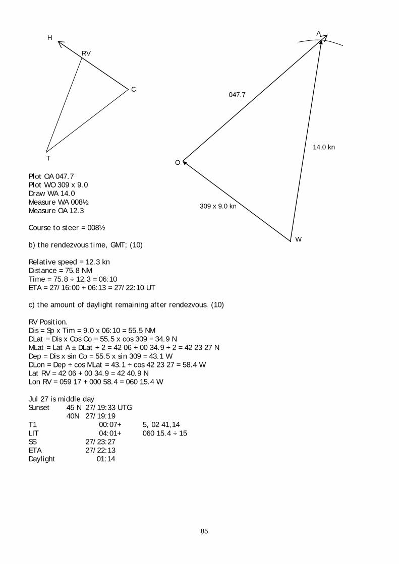
85
Plot OA 047.7 Plot WO 309 x 9.0 Draw WA 14.0 Measure WA 008½ Measure OA 12.3 Course to steer = 008½ b) the rendezvous time, GMT; (10) Relative speed = 12.3 kn Distance = 75.8 NM Time = 75.8 ÷ 12.3 = 06:10 ETA = 27/16:00 + 06:13 = 27/22:10 UT c) the amount of daylight remaining after rendezvous. (10) RV Position. Dis = Sp x Tim = 9.0 x 06:10 = 55.5 NM DLat = Dis x Cos Co = 55.5 x cos 309 = 34.9 N MLat = Lat A ± DLat ÷ 2 = 42 06 + 00 34.9 ÷ 2 = 42 23 27 N Dep = Dis x sin Co = 55.5 x sin 309 = 43.1 W DLon = Dep ÷ cos MLat = 43.1 ÷ cos 42 23 27 = 58.4 W Lat RV = 42 06 + 00 34.9 = 42 40.9 N Lon RV = 059 17 + 000 58.4 = 060 15.4 W Jul 27 is middle day Sunset 45 N 27/19:33 UTG 40N 27/19:19 T1 00:07+ 5, 02 41,14 LIT 04:01+ 060 15.4 ÷ 15 SS 27/23:27 ETA 27/22:13 Daylight 01:14
C
T
H
RV
O
A
047.7
14.0 kn
309 x 9.0 kn
W

86
3. A vessel is approaching the Baltic Sea from the USA in winter, bound for Finland a) List the sources from which a Master may gain information about ice conditions in the Baltic. Mariner’s Handbook. Sailing Directions. Radio. Coast Radio Stations. Baltic Code. Fax. Charts. Internet. Charts. Navtex. Text messages. b) List the problems associated with maintaining navigational accuracy when operating in the Baltic, in winter months. Buoys removed by authorities or moved by ice. Loran errors greater due to transmission over ice surface. Radar image distorted by sea ice around headlands and coasts, making bearings and ranges inaccurate. Navigation marks obscured by ice and snow. Colours of lights altered by ice and snow on lenses. Arcs of sectors altered by ice on lights. 4. A vessel is in position 25° S 38° E bound up the Mozambique Channel from Durban to Mombasa, Kenya. The Master receives a report that a Tropical Cyclone is in position 15° S 45° E heading SSW at 18 knots. The vessel is a small feeder container vessel, capable of 16 knots. a) On Worksheet Q4 (Mercator chartlet of the SW Indian Ocean) plot the positions of the ship and the cyclone’s centre, showing possible paths for such a cyclone. Cyclone is at north end of Channel, vessel is at south end. Possible paths are in any direction. Probable paths are in the sector from east through south to west. Cyclones in this area have been known to move northward. b) Describe the alternative courses of action that could be taken by the Master to avoid the dangers to his ship, explaining how each could keep the vessel clear of the worst of the cyclone. Current position is in right advance quadrant, close to path. This is the Navigable Semicircle. 1. Proceed northwestward, away from Path. Increases CPA and therefore decreases intensity of weather experienced. 2. Stop in present position. Gives time to assess cyclone movement and decide on future course of action. Cyclone is likely to be decreasing in intensity as it moves southward. 3. Proceed southsouthwestward, away from cyclone. Maximises distance from cyclone. Cyclone is likely to be decreasing in intensity as it moves southward. Maximises time to assess movement of cyclone and decide on future course of action. 4. Proceed east to close Madagascar coast. Wind direction will be offshore, and therefore fetch minimised. c) State which of these alternatives should be taken by the prudent Master, giving reason for the choice. 3. Proceed southsouthwestward, away from cyclone. Maximises distance from cyclone. Cyclone is likely to be decreasing in intensity as it moves southward. Maximises time to assess movement of cyclone and decide on future course of action. 03 Nov 18 3. A vessel in the North Atlantic is in the vicinity of a hurricane centred to the northeast of the West Indies. a) In the absence of information transmitted by Coast Radio Stations, state how the Master can, by on-board observation, determine his position in relation to the direction of the storm’s path.

87
Strictly, with relation to the Path: Wind veering, observer is to the right of the Path. Wind steadyish, observer is on Path. Wind backing, observer is to the left of the Path. This is hemisphere independent. Additionally: Atmospheric pressure decreasing, vessel is in advance of trough line. Atmospheric pressure steadyish, vessel is in near trough line. Atmospheric pressure increasing, vessel is in rear of trough line. b) State THREE reasons why the dangerous quadrant is so named. TRS is more likely to recurve into this sector. Wind is driving toward Path. Sea waves are driving toward Path. Cross swell from trough line area is probably worse in this sector. c) Present weather conditions are as follows: Heavy swell from the SSE Rapidly falling barometer pressure Wind ENE, freshening and slowly veering The vessel’s present course is 230° State any actions which the Master might consider advisable to take in view of the present weather conditions, giving reasons for any action contemplated. Swell from the SSE indicates the probable direction of the storm centre. Decreasing barometric pressure indicates that the observer is in the Advance sector, the storm is approaching. Buys Ballot’s Law and the wind direction of ENE confirms that the low pressure centre bears SSE to SSW. Freshening wind confirms that the storm is approaching. Veering wind indicates that the observer is to the right of the storm’s Path. Slow veering indicates that the observer is close to the Path. The Eye of the storm is the most dangerous area, and the Path is the line that the Eye is expected to follow. The Eye is to be avoided if at all possible. Standard The vessel is in the Dangerous Quadrant. Action should be taken to move as far from the Path as possible. Course should be altered to place the wind on the Starboard Bow to take the vessel away from the Path and the Eye. Vessel should steam at maximum practicable speed to maximise distance from the Path. Course should be altered to maintain this orientation. The expectation is that the wind will continue to veer as the storm passes. Conditions should be monitored to ascertain whether the action taken is having the desired effect. Alternatively. The vessel is in the Dangerous Quadrant. The vessel is close to the Path. Action should be taken to cross the Path into the Navigable Semicircle and move as far from the Path as possible. Course should be altered to place the wind on the Starboard Quarter. Vessel should steam at maximum practicable speed to maximise distance from the Path. Course should be altered to maintain this orientation. The expectation is that the wind will steady as the Path is crossed and then back when the vessel is in the Navigable Semicircle. Conditions should be monitored to ascertain whether the action taken is having the desired effect.

88
d) Several hours later, the wind direction steadies and begins to back with the pressure still falling. In the light of the action which may have been taken in Q3c), state any further action which should be taken. The steadying of the wind direction indicates that the observer is on the Path. The backing of the wind indicates that the observer is to the left of the Path. The decreasing pressure indicates that the observer is in the Advance sector. Standard The changes in wind direction contrary to expectation indicate that the storm has altered direction. The vessel is now in the Navigable semicircle. Course should be altered to place the wind on the Starboard Quarter. Vessel should steam at maximum practicable speed to maximise distance from the Path. Course should be altered to maintain this orientation. The expectation is that the wind will continue to back as the storm passes. Conditions should be monitored to ascertain whether the action taken is having the desired effect. Alternative The vessel has crossed the Path and is now in the Navigable Semicircle. The vessel should continue at maximum speed with the wind on the Starboard Quarter. Course should be altered to maintain this orientation. The expectation is that the wind will continue to back as the storm passes. Conditions should be monitored to ascertain whether the action taken is having the desired effect. 4. A vessel, trading across the N. Atlantic, is fitted with a radio facsimile receiver. a) Describe how a least-time track may be constructed using the information from the receiver. The information required from the facsimile receiver is a set of forecast wave charts giving significant wave height and direction. The vessel’s position is plotted on the first chart. The direct course is plotted. The Ship’s Performance Curves are used to estimate the distance that the vessel should achieve in the time span to the second chart. This is plotted on the chart. The process is repeated for a number of possible tracks on either side of the direct track, 10° course intervals. The end points of the projected tracks are joined to form an isochrone or time front. This is transferred to the second forecast chart. Selected points on the isochrone are used as starting points for further proposed tracks. A second isochrone is drawn. This is transferred to the third chart. The process is repeated for as many forecast charts as are available, or until a track reaches the destination. The initial track leading to the point on the final time front that is closest to the destination is followed. b) List the information that the Master of a vessel which is to be routed by MetRoute should supply to the Routeing Officer for each of the following: i) Prior to sailing; MetRoute no longer exists. The information required is similar for all routeing services. Ship name, Callsign, communication method, telex number Company name, address, contact details.

89
Agent name, address, contact details. Ship type. Drafts. Service speed. Cargo. Special requirements. Departure port. Intermediate port/s. Destination port. Route preferred where there are alternatives. Expected date of departure. Schedule arrival date/time ii) While on passage Time of report. Position. Weather to a degree of detail dependent on the vessel’s equipment. Wind direction. Wind force. Wave height. Swell height. Swell direction. Barometric pressure. Air temperature c) State the function and useage of Ship’s Performance Curves in the above routeing systems. The function of Ship’s Performance Curves is to provide the information required to assess the vessel’s performance in different sea conditions. Specifically the reduction in speed due to waves of different heights from different relative directions. In constructing a least time track the performance curves are used to determine the distance that the vessel should travel in the time span between forecast charts. In the case of a shore routeing service the performance curves are used to forecast the vessel’s position in order to provide weather forecasts and routeing advice. 03 Jul 2. From a position 35 40 N 145 48 E, a sextant observation of the sun was taken with the following results: Time at ship 0820 Saturday 15th May 1976. Chronometer readings10H 41M 04S, error NIL. Intercept obtained 8.0 miles toward, bearing 125T. Index error 2.0 on the arc. Height of eye 15.4 metres. The vessel maintains a steady course 258T, speed 18.0 knots. Calculate each of the following: a) GMT of meridian passage; (18) ITP DLat = Dis x cos Co = Int x cos TB = 8.0 x cos 125 = 00 04 35.32 S MLat = Lat AP ± DLat ÷ 2 = 35 40 - 00 04.6 ÷ 2 MLat = 35 37.7 N Dep = Dis x sin Co = Int x sin TB = 8.0 x sin 125 = 6.553216354 E DLon = Dep ÷ cos MLat = 6.553216354 ÷ cos 35 37.7 = 8.1 E Lat ITP = Lat AP ± DLat = 35 40 N – 00 04.6 S = 35 35.4 N Lon ITP = Lon AP ± DLon = 145 48 E + 000 08.1 E = 145 56.1 E
DLat
Dep
Dis DMP
DLon
MLat
Co

90
LIT 145 56.1 ÷ 15 = 09:44 ZT 15/08:20 ZN = 10 - UT = 14/22:20 MP 15/11:56 UTG LIT 09:44 MP 15/02:12 UT Time of Observation CT 14/22:41:04 CE 00:00:00 UT 14/22:41:04 MP 15/02:12 Run 03:30:56 Dis = 18.0 x 03:30:56 = 63.28 NM DLat = Dis x cos Co = 63.28 x cos 258 = 00 13 09.4 S MLat = Lat ITP ± DLat ÷ 2 = 35 35.4 N - 00 13 09.4 ÷ 2 MLat = 35 28 49.3 N Dep = Dis x sin Co = 63.28 x sin 258 = 61.89718017 W DLon = Dep ÷ cos MLat = 61.89718017 ÷ cos 35 28 49.3 = 76.01139252 W = 001 16 00.68 W Lat TP = Lat ITP ± DLat = 35 35.4 N – 00 13.2 S = 35 22.2 N Lon TP = Lon AP ± DLon = 145 56.1 E – 001 16.0 E = 144 40.1 E LIT = Lon ÷ 15 = 144 40.1 ÷ 15 = 09:39 MP 15/11:56 UTG LIT 09:39 MP 15/02:17 UT b) the setting to put on the sextant to observe the Sun’s lower limb at meridian passage. (12) Dec 15/02 N 18 51.8 d 0.6 + 39 00 00.4 Dec N 18 52.2 Lat 35 22.2 N Z Dec N 18 52.2 - X TZD 16 30.0 Q TA 73 30.0 TC 15.6 + therefore - AA 73 14.4 Dip 15.4 6.9 – therefore + OA 73 21.3 IE 2.0 On – therefore + SA 73 23.3

91
2003 March 1.a) First approximation is shortest route. Then consider diverting to:
avoid adverse factors on the shortest route, use favourable factors near the shortest route.
7.314.3 Balintang Panama Minimum distance. Favourable current throughout. TRS possible, particularly in South China Sea, West Pacific and East Pacific. Polar frontal depressions in West Pacific, vessel likely to be in westerly winds. 7.314.1 Yokohama Panama Favourable current throughout. Not minimum distance. TRS possible, particularly in South China Sea, West Pacific and East Pacific. Polar frontal depressions in central Pacific, vessel likely to be in westerly winds. 7.314.2 Yokohama Honolulu Panama Favourable current to Yokohama. Adverse current thereafter. Not minimum distance. TRS possible, particularly in South China Sea, West Pacific and East Pacific. Polar frontal depressions in West Pacific, vessel likely to be in westerly winds. 7.314.4 Bernadino Guam Panama Adverse current throughout. Not minimum distance. TRS possible, particularly in South China Sea, West Pacific and East Pacific. 7.314.5 Bernadino Panama Adverse current throughout. Not minimum distance. Polar frontal depressions possible in Central Pacific, vessel likely to be in westerly winds. TRS possible, particularly in South China Sea, West Pacific and East Pacific. 7.314.6 Basilan Panama Favourable current possible throughout. Not minimum distance. TRS possible, particularly in South China Sea, West Pacific and East Pacific. 7.314.7 Torres Strait Panama TRS very unlikely, except in East Pacific. Probable unfavourable current. Not minimum distance. b) Preferred route 7.314.3. Balintang Panama. Least distance. Favourable currents. Following wind likely if encountering Polar Frontal Depressions. Low probability of TRS.

92
3. A vessel is in the North Pacific Ocean, east of the Philippines, with good sea room, and a typhoon is forecast for that area. a) In the absence of information transmitted from shore stations, state how a Master can, by onboard observation, determine his vessel’s position in relation to the storm’s path. (9) Strictly, with relation to the Path: Wind veering, observer is to the right of the Path. Wind steadyish, observer is on Path. Wind backing, observer is to the left of the Path. This is hemisphere independent. b) State THREE reasons why the dangerous semicircle is so named. (6) TRS is more likely to recurve into this sector. Wind is driving toward Path. Sea waves are driving toward Path. Cross swell from trough line area is probably worse in this sector. Wind wave and swell heights are likely to be higher in this sector. c) Present weather conditions are as follows: Heavy swell from the SSE Rapidly falling Barometer Wind ENE, freshening and slowly veering eastwards. If the vessel’s course is SW’ly, state any action which the Master might consider advisable to take, in view of the present weather conditions, giving reasons for any action contemplated. (10) Swell from eye wall area, gives direction of vortex. Falling barometer, vessel in advance of storm. Wind ENE, Buys Ballot's Law gives direction of vortex SSE to SSW. Wind freshening, reinforces TRS approaching. Veering Eastwards, vessel to right of Path. Veering slowly, vessel near Path. Vessel may be on Path, change in wind direction due to change in angle of indraft. Advance, Right, Northern Hemisphere, vessel is in the Dangerous Quadrant. Action. In Dangerous Quadrant, steer a course with the wind on the Starboard Bow and make maximum speed. Alter course as wind direction changes to maintain relative wind direction. This should carry the vessel away from the path and maximise distance from the Eye. Wind should continue to veer. Alternative. Vessel is close to, or on, the path, as indicated by slow change of wind direction. It is possible to cross the Path into the Navigable Semicircle, with wind and wind waves astern rather than ahead. Steer a course with the wind on the Starboard Quarter and make maximum speed. Alter course as wind direction changes to maintain relative wind direction. This should carry the vessel across the path into the Navigable Semicircle, and maximise distance from the Eye. Wind should steady, indicating that Path is being crossed. Wind should then back, indicating that vessel is in Navigable Semicircle. In both cases: Report in accordance with SOLAS. Monitor weather, particularly wind direction and pressure change, to determine direction and movement of TRS, and be prepared to change action if required. Continue until TRS has passed, indicated by rising pressure and decreasing wind force.

93
d) Three hours later, the wind direction steadies and begins to back toward the North, barometer still falling. In the light of any action which may have been taken in Q.3(c), make a thorough assessment of the changing situation, and state any further action which might have to be taken. (10) Wind direction steadying indicates that vessel in on Path. Wind backing indicates that vessel is to left of Path, in the Navigable Semicircle. Pressure falling indicates that vessel is still in advance of TRS. Action. TRS has changed direction, recurving. Alter course to put wind on Starboard Quarter. Make maximum speed. Alter course as wind direction changes to maintain relative wind direction. This should carry the vessel away from the path in the Navigable Semicircle, and maximise distance from the Eye. Wind should continue to back, indicating that vessel is in still in the Navigable Semicircle. Alternative. Action is having desired effect. Continue. 02 Jul 3. A vessel is steaming across the North Atlantic, and for several days checking gyro compass error has not been possible, but it is thought that the error is minimal. On 15 June 1976 at 0509 GMT in DR position 53 27 N 030 11 W, just before sunrise, two planets were observed low on the eastern horizon, one bearing 064 G and the other 075 G. With reference to Datasheet Q.3 (Planetary Diagram 1976) identify both planets, and find the gyro compass error. (30) From the diagram, Mercury and Jupiter pass the meridian before the Sun, therefore will rise before the Sun, and will be visible at morning twilight. No data is available for Mercury. 76/Jun/15/05:09 UT Jupiter GHA 15/05 291 57.4 Dec N 16 30.3 V 1.9 09 000 00.3+ d 0.1 + 00 00.0 Inc 09 002 15.0+ Dec N 16 30.3 Lon 030 11 W- LHA 264 01.7 A = tan Lat ÷ tan LHA = tan 53 27 N ÷ tan 264 01.7 = 0.141106885 N B = tan Dec ÷ sin LHA = tan N 16 30.3 ÷ sin 264 01.7 = 0.297925122 N C = A ± B = 0.141106885 + 0.297925122 = 0.439032007 N Azi = tan-1 (1 ÷ C ÷ cos Lat) = tan-1 (1 ÷ 0.439032007 ÷ cos 53 27) = 75 20 51.98 = N 75.3 E TB = 075½ GB = 075 GE = 000½ L

94
2001 Mar 3. A vessel is in the South Pacific, in the vicinity of Fiji, during the Cyclone season. a) State the first visible sign that will usually alert the Master that a cyclone may be in the vicinity, explaining its significance. (6) Swell, higher than normal for the area, and from an unusual direction. High winds near the eye generate large waves. These travel faster than the storm, becoming swell waves radiating from the area of the eye outward. The direction of the storm can be deduced from the direction from which the swell is coming. b) In the absence of information transmitted from shore stations, state how the Master can, when in the southern hemisphere, determine his position in relation to the direction of a cyclone's path. (10) Strictly, with relation to the Path: Wind veering, observer is to the right of the Path. Wind approximately steady, observer is on Path.
Wind direction may change on the Path due to the changing angle of indraft. Wind backing, observer is to the left of the Path. This is the same in both hemispheres. Aditionally, Falling pressure, observer is in advance of the storm Steady pressure, observer is on the trough line Rising pressure, observer is to the rear of the storm. c) Present weather conditions near Fiji are as follows:
Heavy swell from the NE Rapidly falling barometer Wind SE, freshening and slowly backing If the vessel's present course is 210°, state any action which the Master might consider advisable to take in view of the weather conditions, giving reasons for any action contemplated. (10) Standard Action. Put the wind on the Port Bow and make maximum speed. Alter course as the wind backs to maintain the relative direction. This should bring the vessel clear of the vortex to the rear of the storm. Wind should continue to back. Alternative. Put the wind on the port quarter and make maximum speed. Alter course as the wind veers to maintain the relative direction. This should bring the vessel across the path into the navigable semicircle and then to the rear of the TRS. Wind should steady when on Path, then begin to veer when in Navigable Semicircle. In both cases: Report in accordance with SOLAS. Monitor changes in wind direction and pressure to determine direction and movement of TRS. Reasons. Vessel is in the field of a Tropical Revolving Storm, indicated by the pressure drop and presence of heavy swell. Swell direction indicates direction of TRS centre to NE. Decreasing pressure indicates that storm is approaching. Buys Ballot's Law and wind direction further indicate direction of storm centre as NE’ly. Wind freshening further indicates that storm is approaching. Wind backing indicates that vessel is to the left of the Path. Advance Left quadrant in the Southern Hemisphere is the Dangerous Quadrant.

95
Standard Action Steaming with the wind on the Port Bow will take the vessel away from the Path, maximise distance from the storm centre, and eventually to the rear of the storm. Alternative. Slow change of wind direction indicates that vessel is close to, or on, the Path. Steaming with the wind on the port quarter will take the vessel across the Path into the Navigable semicircle, and then away from the path and eventually to the rear of the storm, maximising distance form the Eye. Speed is likely to be higher with the wind and sea on the quarter than on the bow. d) Several hours later, wind steadies from SSE and then begins to veer towards the south, barometer still falling. In the light of any action which may have been taken in Q.3c), make a thorough assessment of the present situation, and state any further action which might have to be taken. (10) Wind has veered from SE to SSE, indicating the vessel is on right hand side of Path. Wind steadying indicates that vessel in on Path. Wind veering indicates that vessel is on right hand side of Path. Right semicircle is the Navigable Semicircle in southern hemisphere. Decreasing pressure indicates that the storm is approaching. The storm has changed direction. Vessel is now in the Navigable Semicircle. Standard Action. Vessel should steam with wind on the port quarter and make maximum speed. Alter course as the wind veers to maintain the relative direction. This should take the vessel away from the Path to the rear of the storm and maximise distance from the eye. Alternative. Vessel should continue to steam with wind on the port quarter and make maximum speed. Alter course as the wind veers to maintain the relative direction. This should take the vessel away from the Path to the rear of the storm and maximise distance from the eye.

96
2000 June 2. On 15 May 1976, at 2130 GMT, a cargo vessel is in a position 31 18 N 69 26 W and a seaman on board suffers an accident which requires urgent medical attention. At this time, a passenger vessel is in position 29 42 N 65 14 W, steaming on a course of 260T at 23 knots. It has been agreed between the two Masters to rendezvous at sunrise next morning, and that the passenger vessel will maintain her present course and speed. Calculate EACH of the following: a) the GMT of sunrise; (10) b) the rendezvous position; (15) c) the course and speed required by the cargo vessel to rendezvous at sunrise. (15) 0000 Almanac. March 25. Sunrise. 30 N 24/05:59 27/05:56 20 N 24/06:01 27/05:58 T1 10, 09 42, 00:02 00:02 00:02 29 42 N 24/05:59 27/05:56 Diff 00:03 x 2 ÷ 3 = 00:02 SR 26/05:57 UTG LIT = 065 14 ÷ 15 = 04:21 West, later. SR 069 26 W 26/10:18 UT Dep 25/21:30 UT Run Time 12:48 Dis = Tim x Sp = 12:48 x 23 = 294.4 NM DLat = Dis x cos Co = 294.4 x cos 260 = 00 51.1 S MLat = Lat ± DLat ÷ 2 = 29 42 N - 00 51.1 S ÷ 2 = 29 16.4 N Dep = Dis x sin Co = 294.4 x sin 260 = 289.9 NM DLon = Dep ÷ cos MLat = 289.9 NM ÷ cos 29 16.4 N = 332.3 = 005 32.3 W Lat DR1 = Lat ± DLat = 29 42 N – 00 51.1 S = 28 50.9 N Lon DR1 = Lon ± DLon = 065 14 W + 005 32.3 W = 070 46.3 W Sunrise. 30 N 24/05:59 27/05:56 20 N 24/06:01 27/05:58 T1 10, 09 42, 00:02 00:02 00:02 29 16.4 N 24/05:59 27/05:56 Diff 00:03 x 2 ÷ 3 = 00:02 SR 26/05:57 UTG LIT = 070 46.3 ÷ 15 = 04:43 West, later. SR 070 46.3 W 26/10:40 UT Dep 25/21:30 UT Run Time 13:10 Dis = Tim x Sp = 13:10 x 23 = 302.8 NM DLat = Dis x cos Co = 302.8 x cos 260 = 00 52.6 S MLat = Lat ± DLat ÷ 2 = 29 42 N - 00 52.6 S ÷ 2 = 29 15.7 N Dep = Dis x sin Co = 302.8 x sin 260 = 298.2 NM DLon = Dep ÷ cos MLat = 298.2 NM ÷ cos 29 15.7 N = 341.8 = 005 41.8 W Lat RV = Lat ± DLat = 29 42 N - 00 52.6 S = 28 49.4 N Lon RV = Lon ± DLon = 065 14 W + 005 41.8 W = 070 55.8 W
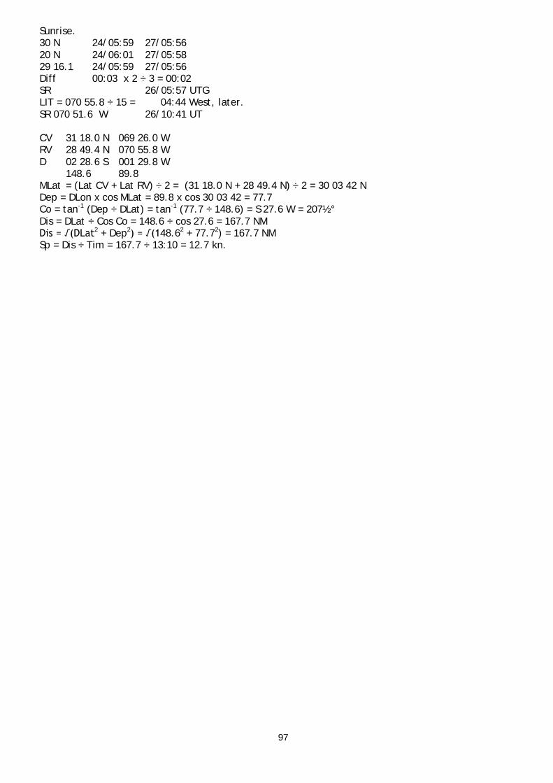
97
Sunrise. 30 N 24/05:59 27/05:56 20 N 24/06:01 27/05:58 29 16.1 24/05:59 27/05:56 Diff 00:03 x 2 ÷ 3 = 00:02 SR 26/05:57 UTG LIT = 070 55.8 ÷ 15 = 04:44 West, later. SR 070 51.6 W 26/10:41 UT CV 31 18.0 N 069 26.0 W RV 28 49.4 N 070 55.8 W D 02 28.6 S 001 29.8 W 148.6 89.8 MLat = (Lat CV + Lat RV) ÷ 2 = (31 18.0 N + 28 49.4 N) ÷ 2 = 30 03 42 N Dep = DLon x cos MLat = 89.8 x cos 30 03 42 = 77.7 Co = tan-1 (Dep ÷ DLat) = tan-1 (77.7 ÷ 148.6) = S 27.6 W = 207½° Dis = DLat ÷ Cos Co = 148.6 ÷ cos 27.6 = 167.7 NM Dis = √(DLat2 + Dep2) = √(148.62 + 77.72) = 167.7 NM Sp = Dis ÷ Tim = 167.7 ÷ 13:10 = 12.7 kn.