Embed Size (px)
Citation preview

United StatesDepartment ofAgriculture
NaturalResourcesConservationService
In cooperation withOklahoma AgricultureExperiment Station andOklahoma ConservationCommission
Soil Survey ofNoble County,Oklahoma


General Soil Map
The general soil map, which is a color map, shows the survey area divided into groupsof associated soils called general soil map units. This map is useful in planning the useand management of large areas.
To find information about your area of interest, locate that area on the map, identify thename of the map unit in the area on the color-coded map legend, then refer to thesection General Soil Map Units for a general description of the soils in your area.
Detailed Soil Maps
The detailed soil maps can be useful in planning the use and management of smallareas.
To find information about your area of interest,locate that area on the Index to MapSheets. Note the number of themap sheetand turnto thatsheet.
Locateyour areaof intereston themapsheet.Note themap unitsymbolsthat arein thatarea. Turnto theContents,whichlists themapunits by symbol and name and shows the page where each map unit is described.
The Contents shows which table has data on a specific land use for each detailed soilmap unit. Also see the Contents for sections of this publication that may address yourspecific needs.
i
How To Use This Soil Survey

Additional information about the Nation’s natural resources is available onlinefrom the Natural Resources Conservation Service at http://www.nrcs.usda.gov.
ii
This soil survey is a publication of the National Cooperative Soil Survey, a joint effortof the United States Department of Agriculture and other Federal agencies, Stateagencies including the Agricultural Experiment Stations, and local agencies. The NaturalResources Conservation Service (formerly the Soil Conservation Service) hasleadership for the Federal part of the National Cooperative Soil Survey.
Major fieldwork for this soil survey was completed in 1992. Soil names anddescriptions were approved in 1994. Unless otherwise indicated, statements in thispublication refer to conditions in the survey area in 1996. This survey was mappedutilizing survey photographic imagery of 1:24,000 and rectified to 1995 digitalorthophotography for SSURGO digitizing. This survey was made cooperatively by theNatural Resources Conservation Service, the Oklahoma Agriculture Experiment Station,and the Oklahoma Conservation Commission. It is part of the technical assistancefurnished to the Noble County Conservation District.
Soil maps in this survey may be copied without permission. Enlargement of thesemaps, however, could cause misunderstanding of the detail of mapping. If enlarged,maps do not show the small areas of contrasting soils that could have been shown at alarger scale.
The United States Department of Agriculture (USDA) prohibits discrimination in all itsprograms and activities on the basis of race, color, national origin, gender, religion, age,disability, political beliefs, sexual orientation, and marital or family status. (Not allprohibited bases apply to all programs.) Persons with disabilities who require alternativemeans for communication of program information (Braille, large print, audiotape, etc.)should contact USDA’s TARGET Center at 202-720-2600 (voice and TDD).
To file a complaint of discrimination, write USDA, Director, Office of Civil Rights,Room 326-W, Whitten Building, 14th and Independence Avenue, SW, Washington, DC20250-9410 or call 202-720-5964 (voice and TDD). USDA is an equal opportunityprovider and employer.
Cover: Wheat on a terraced field of Renfrow silt loam, 3 to 5 percent slopes, and Renfrow silt
loam, 1 to 3 percent slopes.

iii
Contents
How To Use This Soil Survey ....................................................................................... iContents ...................................................................................................................... iiiSummary of Tables ................................................................................................... viiiForeword ..................................................................................................................... ixGeneral Nature of the Survey Area .............................................................................. 1
History ...................................................................................................................... 1Physiography and Drainage ..................................................................................... 1Natural Resources ................................................................................................... 2Climate ..................................................................................................................... 2Table—Temperature and Precipitation ..................................................................... 4Table—Freeze Dates in Spring and Fall ................................................................... 5Table—Growing Season .......................................................................................... 5
How This Survey Was Made ........................................................................................ 6General Soil Map Units .............................................................................................. 9
1. OK086—Grainola-Lucien-Renfrow (Grainola-Lucien-Masham) ....................... 9 2. OK091—Keokuk-Pulaski-Roebuck (Keokuk-Goodnight-Ashport) .................. 11 3. OK093—Kirkland-Bethany-Tabler (Bethany-Kirkland-Norge-Tabler) .............. 13 4. OK097—McLain-Dale-Reinach (McLain-Braman-Lela) .................................. 14 5. OK112—Port-Pulaski-Ashport (Port-Ashport-Pulaski) ................................... 15 6. OK116—Renfrow-Kirkland-Grainola (Renfrow-Kirkland)................................ 17 7. OK117—Renfrow-Zaneis-Grainola (Renfrow-Grainola-Coyle) ....................... 18 8. OK121—Teller-Konawa-Norge (Teller-Konawa) ............................................. 19 9. OK151—Stephenville-Darnell-Newalla (Darnell-Grainola-Newalla-Harrah) ... 2010. OK221—Norge-Bethany-Kirkland (Norge-Bethany-Kirkland) ........................ 2211. OK222—Milan-Norge-Bethany (Milan-Norge-Bethany) ................................. 2412. OK223—Vanoss-Slaughterville-Teller (Vanoss-Slaughterville) ..................... 2513. OK224—Renfrow-Grainola-Kingfisher-Grant (Grainola-Renfrow-
Kingfisher) ....................................................................................................... 27Detailed Soil Map Units ........................................................................................... 29Table—Acreage and Proportionate Extent of the Soils .............................................. 31
AhpA—Ashport silty clay loam, 0 to 1 percent slopes, occasionally flooded ......... 33APPA—Ashport, Port, and Pulaski soils, 0 to 1 percent slopes, frequently
flooded ............................................................................................................. 34AspA—Ashport silt loam, 0 to 1 percent slopes, occasionally flooded ................... 35AspB—Ashport silt loam, 1 to 3 percent slopes, occasionally flooded ................... 36BetA—Bethany silt loam, 0 to 1 percent slopes ..................................................... 38BetB—Bethany silt loam, 1 to 3 percent slopes ..................................................... 39BPG—Borrow pits, gravelly .................................................................................... 40BPR—Borrow pits, rock ......................................................................................... 41BraA—Braman silt loam, 0 to 1 percent slopes, rarely flooded .............................. 42BrwA—Brewer silt loam, 0 to 1 percent slopes, rarely flooded .............................. 43CoLC—Coyle-Lucien complex, 1 to 5 percent slopes ............................................ 44CoyB—Coyle loam, 1 to 3 percent slopes .............................................................. 45CoyC—Coyle loam, 3 to 5 percent slopes ............................................................. 46CoyC2—Coyle loam, 3 to 5 percent slopes, eroded .............................................. 47

iv
CoZC3—Coyle and Zaneis soils, 3 to 5 percent slopes, severely eroded ............. 48DalA—Dale silt loam, 0 to 1 percent slopes, rarely flooded ................................... 50DAM—Dam ............................................................................................................ 51DaUA—Dale-Urban land complex, 0 to 1 percent slopes, rarely flooded ............... 51DiGE—Dilworth-Grainola complex, 5 to 12 percent slopes ................................... 53DooB—Doolin silt loam, 0 to 2 percent slopes ....................................................... 54DwhC—Dilworth silty clay loam, 3 to 5 percent slopes .......................................... 55EasA—Easpur loam, 0 to 1 percent slopes, occasionally flooded ......................... 56GadA—Gaddy loamy fine sand, 0 to 1 percent slopes, occasionally flooded ........ 57GayA—Gaddy loamy fine sand, 0 to 1 percent slopes, rarely flooded ................... 58GMLG—Grainola-Masham-Lucien complex, 5 to 40 percent slopes, very
bouldery ........................................................................................................... 59GohE—Goodnight loamy fine sand, 3 to 20 percent slopes .................................. 61GraC—Grainola silty clay loam, 3 to 5 percent slopes ........................................... 62GrAD—Grainola-Ashport complex, 0 to 8 percent slopes ...................................... 63GrHC—Grant-Huska complex, 1 to 5 percent slopes ............................................ 64GrLC—Grainola-Lucien complex, 1 to 5 percent slopes ........................................ 66GrLE—Grainola-Lucien complex, 5 to 12 percent slopes ...................................... 67GrnC—Grant loam, 3 to 5 percent slopes .............................................................. 69GrtB—Grant silt loam, 1 to 3 percent slopes ......................................................... 70HaPE—Harrah-Pulaski complex, 0 to 12 percent slopes ....................................... 71HiRG—Highview-Rock outcrop complex, 15 to 45 percent slopes ........................ 72KekA—Keokuk very fine sandy loam, 0 to 1 percent slopes, rarely flooded .......... 73KeoA—Keokuk very fine sandy loam, 0 to 1 percent slopes,
occasionally flooded ........................................................................................ 74KgfB—Kingfisher silt loam, 1 to 3 percent slopes .................................................. 75KgLC—Kingfisher-Lucien complex, 1 to 5 percent slopes ..................................... 76KgWC—Kingfisher-Wakita complex, 1 to 5 percent slopes.................................... 78KinC2—Kingfisher loam, 3 to 5 percent slopes, eroded......................................... 80KowB—Konawa fine sandy loam, 1 to 3 percent slopes ........................................ 81KowD—Konawa fine sandy loam, 3 to 8 percent slopes ........................................ 82KrdA—Kirkland silt loam, 0 to 1 percent slopes ..................................................... 83KrdB—Kirkland silt loam, 1 to 3 percent slopes ..................................................... 83KrdB2—Kirkland silt loam, 1 to 3 percent slopes, eroded ...................................... 84KrPB—Kirkland-Pawhuska complex, 0 to 3 percent slopes ................................... 85LAN—Landfill ......................................................................................................... 87LelA—Lela silty clay, 0 to 1 percent slopes, occasionally flooded .......................... 88LveB—Lovedale sandy loam, 1 to 3 percent slopes .............................................. 89M-W—Miscellaneous water ................................................................................... 90McaA—McLain silty clay loam, 0 to 1 percent slopes, rarely flooded .................... 91MilB—Milan loam, 1 to 3 percent slopes ................................................................ 91MilC—Milan loam, 3 to 5 percent slopes ................................................................ 92MinB—Minco very fine sandy loam, 1 to 3 percent slopes .................................... 93MinC—Minco very fine sandy loam, 3 to 5 percent slopes .................................... 94MirA—Miller silty clay loam, 0 to 1 percent slopes, occasionally flooded ............... 95MisA—Miller silty clay loam, saline, 0 to 1 percent slopes,
occasionally flooded ........................................................................................ 97MPNC2—Milan-Pawhuska-Norge complex, 3 to 5 percent slopes, eroded ........... 98MulC—Mulhall loam, 3 to 5 percent slopes .......................................................... 100MulD—Mulhall loam, 5 to 8 percent slopes .......................................................... 101MulD4—Mulhall loam, 5 to 8 percent slopes, gullied ........................................... 102NeDG—Newalla-Darnell complex, 8 to 45 percent slopes, very bouldery ........... 103NorA—Norge silt loam, 0 to 1 percent slopes ...................................................... 105NorB—Norge silt loam, 1 to 3 percent slopes ...................................................... 106

v
NorC—Norge silt loam, 3 to 5 percent slopes ...................................................... 107NorC2—Norge silt loam, 3 to 5 percent slopes, eroded ....................................... 108NoUC—Norge-Urban land complex, 1 to 5 percent slopes .................................. 109OWWE—Oil waste land-Westsum complex, 3 to 12 percent slopes .................... 111PoaA—Port silt loam, 0 to 1 percent slopes, frequently flooded .......................... 112PoOA—Port-Oscar complex, 0 to 1 percent slopes, occasionally flooded ........... 113PorA—Port silt loam, 0 to 1 percent slopes, occasionally flooded ....................... 114PotA—Port silty clay loam, 0 to 1 percent slopes, occasionally flooded .............. 115PukA—Pulaski fine sandy loam, 0 to 1 percent slopes, frequently flooded ......... 117PulA—Pulaski fine sandy loam, 0 to 1 percent slopes, occasionally flooded ....... 118RefC2—Renfrow loam, 3 to 5 percent slopes, eroded ......................................... 119ReGC2—Renfrow and Grainola soils, 3 to 5 percent slopes, eroded .................. 120ReiA—Reinach very fine sandy loam, 0 to 1 percent slopes, rarely flooded ........ 121RenB—Renfrow silt loam, 1 to 3 percent slopes .................................................. 122RenC—Renfrow silt loam, 3 to 5 percent slopes ................................................. 124RewC2—Renfrow silty clay loam, 3 to 5 percent slopes, eroded ......................... 125RGPD3—Renfrow, Grainola, and Pawhuska soils, 3 to 8 percent slopes,
severely eroded ............................................................................................. 126SlaB—Slaughterville fine sandy loam, 0 to 3 percent slopes ............................... 128SlaC—Slaughterville fine sandy loam, 3 to 5 percent slopes ............................... 128SlaG—Slaughterville fine sandy loam, 8 to 45 percent slopes ............................ 129StDD—Stephenville-Darnell complex, 3 to 8 percent slopes ............................... 130TabA—Tabler silt loam, 0 to 1 percent slopes ...................................................... 132TeaA—Tearney silty clay, 0 to 1 percent slopes, ponded ..................................... 133TelB—Teller loam, 1 to 3 percent slopes .............................................................. 134TelD—Teller loam, 5 to 8 percent slopes .............................................................. 135TelD2—Teller loam, 5 to 8 percent slopes, eroded............................................... 136VanA—Vanoss silt loam, 0 to 1 percent slopes .................................................... 137W—Water ............................................................................................................. 138WauA—Waurika silt loam, 0 to 1 percent slopes ................................................. 138WesB—Westsum silty clay loam, 1 to 3 percent slopes ...................................... 139WesC—Westsum silty clay loam, 3 to 5 percent slopes ...................................... 140WiLC—Wisby-Lovedale complex, 1 to 5 percent slopes ...................................... 141ZaHC—Zaneis-Huska complex, 1 to 5 percent slopes ........................................ 142ZanB—Zaneis loam, 1 to 3 percent slopes .......................................................... 144
Use and Management of the Soils ........................................................................ 147Agronomy ............................................................................................................. 147
Land Capability Classification .......................................................................... 148Table—Land Capability and Yields per Acre of Crops...................................... 149Table—Land Capability and Yields per Acre of Hay and Pasture ..................... 155Estimated Yields of Crops, Hay, and Pasture ................................................... 161Cropland Limitations and Hazards ................................................................... 161 Criteria for Limitations and Hazards ............................................................. 162Table—Cropland Limitations and Hazards ....................................................... 164Prime Farmland ............................................................................................... 173Table—Prime Farmland ................................................................................... 174
Range .................................................................................................................. 175Similarity Index ................................................................................................ 176Rangeland Management ................................................................................. 177Ecological Sites ............................................................................................... 179
Table—Rangeland Productivity and Characteristic Plant Communities ............... 183Windbreaks and Environmental Plantings............................................................ 204Table—Windbreaks and Environmental Plantings................................................ 205Recreation............................................................................................................ 220

vi
Table—Recreational Development, Part I ............................................................ 222Table—Recreational Development, Part II ........................................................... 233Engineering .......................................................................................................... 242
Sanitary Facilities............................................................................................. 242Table—Sanitary Facilities, Part I ...................................................................... 245Table—Sanitary Facilities, Part II ..................................................................... 257Building Site Development ............................................................................... 268Table—Building Site Development, Part I ........................................................ 270Table—Building Site Development, Part II ....................................................... 279Construction Materials ..................................................................................... 291Table—Construction Materials, Part I .............................................................. 293Table—Construction Materials, Part II ............................................................. 303Water Management ......................................................................................... 317Table—Water Management ............................................................................. 318
Soil Properties ........................................................................................................ 329Engineering Index Properties ............................................................................... 329Table—Engineering Index Properties ................................................................... 331Engineering Index Test Data ................................................................................ 375Table—Engineering Index Test Data of Selected Soils ......................................... 376Physical Properties .............................................................................................. 378Table—Physical Properties of the Soils ............................................................... 381Physical Analyses of Selected Soils .................................................................... 401Table—Physical Properties of Selected Soils ...................................................... 402Chemical Properties ............................................................................................ 406Table—Chemical Properties of the Soils .............................................................. 407Chemical Analyses of Selected Soils ................................................................... 422Table—Chemical Properties of Selected Soils ..................................................... 423Additional Chemical and Physical Analyses of Selected Soils ............................. 427Table—Additional Chemical and Physical Properties of Selected Soils ............... 428Table—Clay Mineralogy of Selected Soils ............................................................ 431Table—Sand-Silt Mineralogy of Selected Soils .................................................... 433Water Features .................................................................................................... 435Table—Water Features ........................................................................................ 437Soil Features ........................................................................................................ 448Table—Soil Features ............................................................................................ 449
Classification of the Soils ..................................................................................... 455Table—Classification of the Soils ............................................................................. 456Soil Series and Their Morphology ............................................................................ 457
Ashport Series ..................................................................................................... 457Bethany Series ..................................................................................................... 459Braman Series ..................................................................................................... 461Brewer Series ...................................................................................................... 463Coyle Series ......................................................................................................... 464Dale Series .......................................................................................................... 468Darnell Series ...................................................................................................... 469Dilworth Series ..................................................................................................... 470Doolin Series ........................................................................................................ 472Easpur Series ...................................................................................................... 474Gaddy Series ....................................................................................................... 476Goodnight Series ................................................................................................. 477Grainola Series .................................................................................................... 478Grant Series ......................................................................................................... 482Harrah Series ....................................................................................................... 483Highview Series ................................................................................................... 485

vii
Huska Series ....................................................................................................... 486Keokuk Series ...................................................................................................... 488Kingfisher Series .................................................................................................. 490Kirkland Series ..................................................................................................... 492Konawa Series ..................................................................................................... 495Lela Series ........................................................................................................... 496Lovedale Series ................................................................................................... 499Lucien Series ....................................................................................................... 501Masham Series .................................................................................................... 503McLain Series ...................................................................................................... 504Milan Series ......................................................................................................... 506Miller Series ......................................................................................................... 507Minco Series ........................................................................................................ 509Mulhall Series ...................................................................................................... 510Newalla Series ..................................................................................................... 513Norge Series ........................................................................................................ 515Oscar Series ........................................................................................................ 518Pawhuska Series ................................................................................................. 519Port Series ........................................................................................................... 521Pulaski Series ...................................................................................................... 524Reinach Series ..................................................................................................... 525Renfrow Series .................................................................................................... 526Slaughterville Series ............................................................................................ 529Stephenville Series .............................................................................................. 530Tabler Series ........................................................................................................ 532Tearney Series ..................................................................................................... 533Teller Series ......................................................................................................... 535Vanoss Series ...................................................................................................... 536Wakita Series ....................................................................................................... 538Waurika Series ..................................................................................................... 540Westsum Series ................................................................................................... 542Wisby Series ........................................................................................................ 546Zaneis Series ....................................................................................................... 547
Formation of the Soils ........................................................................................... 551Factors of Soil Formation ..................................................................................... 551Geology................................................................................................................ 552
References .............................................................................................................. 559Glossary .................................................................................................................. 561
Issued 2005

viii
Temperature and Precipitation ....................................................................................... 4Freeze Dates in Spring and Fall .................................................................................... 5Growing Season ........................................................................................................... 5Acreage and Proportionate Extent of the Soils ............................................................31Land Capability and Yields per Acre of Crops ............................................................ 149Land Capability and Yields per Acre of Hay and Pasture ........................................... 155Cropland Limitations and Hazards ............................................................................. 164Prime Farmland ......................................................................................................... 174Rangeland Productivity and Characteristic Plant Communities ................................. 183Windbreaks and Environmental Plantings .................................................................. 205Recreational Development, Part I .............................................................................. 222Recreational Development, Part II ............................................................................. 233Sanitary Facilities, Part I ........................................................................................... 245Sanitary Facilities, Part II .......................................................................................... 257Building Site Development, Part I .............................................................................. 270Building Site Development, Part II ............................................................................. 279Construction Materials, Part I .................................................................................... 293Construction Materials, Part II ................................................................................... 303Water Management .................................................................................................... 318Engineering Index Properties ..................................................................................... 331Engineering Index Test Data of Selected Soils .......................................................... 376Physical Properties of the Soils ................................................................................ 381Physical Properties of Selected Soils ....................................................................... 402Chemical Properties of the Soils ............................................................................... 407Chemical Properties of Selected Soils ...................................................................... 423Additional Chemical and Physical Properties of Selected Soils ................................ 428Clay Mineralogy of Selected Soils ............................................................................. 431Sand-Silt Mineralogy of Selected Soils ...................................................................... 433Water Features .......................................................................................................... 437Soil Features ............................................................................................................. 449Classification of the Soils .......................................................................................... 456
Summary of Tables

ix
This soil survey contains information that can be used in land-planning programs inNoble County. It contains predictions of soil behavior for selected land uses. The surveyalso highlights limitations and hazards inherent in the soil, improvements needed toovercome the limitations, and the impact of selected land uses on the environment.
This soil survey is designed for many different users. Farmers, ranchers, foresters,and agronomists can use it to evaluate the potential of the soil and the managementneeded for maximum food and fiber production. Planners, community officials, engi-neers, developers, builders, and home buyers can use the survey to plan land use,select sites for construction, and identify special practices needed to ensure properperformance. Conservationists, teachers, students, and specialists in recreation, wildlifemanagement, waste disposal, and pollution control can use the survey to help themunderstand, protect, and enhance the environment.
Great differences in soil properties can occur within short distances. Some soils areseasonally wet or subject to flooding. Some are shallow to bedrock. Some are toounstable to be used as a foundation for buildings or roads. Clayey or wet soils arepoorly suited to use as septic tank absorption fields. A high water table makes a soilvery limited for basements or underground installations.
These and many other soil properties that affect land use are described in this soilsurvey. Broad areas of soils are shown on the general soil map. The location of eachsoil is shown on the detailed soil maps. Each soil in the survey area is described.Information on specific uses is given for each soil. Help in using this publication andadditional information are available at the local office of the Natural ResourcesConservation Service or the Cooperative Extension Service.
M. Darrel DominickState ConservationistNatural Resources Conservation Service
Foreword


1
Fieldwork by Gregory F. Scott, Troy L. Collier, Jim E. Henley, R. Dwaine Gelnar, andKaren B. Stevenson, Natural Resources Conservation Service
United States Department of Agriculture, Natural Resources Conservation Service,in cooperation withOklahoma Agriculture Experiment Station and Oklahoma Conservation Commission
NOBLE COUNTY is located in north-central Oklahoma (fig. 1). It has an area of about475,475 acres, or about 742 square miles. The population of the county is 11,388.Perry, the county seat, is in the southwestern part of the county and has a populationof about 5,230. Lake McMurtry, Sooner Lake, the Arkansas River, and other waterareas of more than 40 acres in size make up about 5,400 acres. Noble County isbordered on the north by Kay and Osage Counties, on the east by Pawnee County, onthe west by Garfield County, and on the south by Logan and Payne Counties.
This soil survey updates the survey of Noble County published in 1956 (9). Itprovides additional information and has maps on a photographic background.
General Nature of the Survey AreaThis section gives general information about the survey area. It describes the
history, physiography and drainage, natural resources, and climate.
History
Noble County is located in the part of Oklahoma known as the Cherokee Outlet or“Cherokee Strip.” In the 1800’s, cattlemen leased the area from the Cherokee Tribe andused the land to fatten cattle from Texas before moving them to railheads in Kansas.The West Shawnee Trail went through Noble County from Boggy Depot in Atoka County,Oklahoma, to Wichita, Kansas. Part of the strip was opened to settlers at noon onSeptember 16, 1893. This was one of a series of “runs” that opened “unassigned lands”to white settlement. The Ponca Tribe and the Otoe-Missouri Tribe retained land in thenorthern part of the survey area.
As the survey area was settled, the land gradually changed from lush bluestemprairies to areas of cultivated crops. Alfalfa, corn, cotton, and small grains were themajor crops of the early settlers. Today, wheat is the main crop.
Physiography and Drainage
Noble County is within the Central Rolling Red Prairies Major Land Resource Area(MLRA 80A) and the Cross Timbers Major Land Resource Area (MLRA 84A). Most ofthe county drains eastward into the Arkansas River. The southern one-fourth of thecounty is drained by Stillwater Creek, which drains southeastward into the CimarronRiver. The Arkansas River and the Salt Fork of the Arkansas River border the
Soil Survey of
Noble County, Oklahoma

2 Soil Survey
northeastern corner of the county. Black Bear Creek and Red Rock Creek drain thewestern and eastern parts of the county. Major flooding occurs along Black Bear Creek,Red Rock Creek, the Salt Fork of the Arkansas River, and the Arkansas River.
The relief in Noble County is dominantly gently undulating to steep uplands. Thenorthern half of the county has a large area of nearly level to gently undulating uplands,and the southern half of the county dominantly has undulating to steep uplands.Elevation ranges from 840 feet, in the Arkansas River Valley in the northeastern part ofthe county, to 1,270 feet, in the southwestern part of the county.
Natural Resources
The mineral and water resources of Noble County are important to the overalldevelopment and progress of the county. Petroleum production is by far the mostimportant mineral activity. In 1993, petroleum production in Noble County amounted toabout 1.7 million barrels of crude oil (valued at $28.5 million) and about 5 billion cubicfeet of natural gas (valued at $9.6 million). Due to these production levels, NobleCounty ranks near the middle of the petroleum-producing counties in Oklahoma.
Sand and gravel have been produced from a number of sites in the alluvial andterrace deposits of the county, and thin beds of limestone and sandstone have beenquarried at several sites for the construction of highways and county roads. In addition,a number of small deposits of copper minerals occur at scattered locations in thecounty, although these deposits are not commercially mined at this time.
Small or moderate quantities of good-quality ground water occur in some of theQuaternary alluvial and terrace deposits and are locally available from thin sandstonebeds in the Wellington Formation. A number of wells in Noble County yield 5 to 30gallons of water per minute. There are also a large number of test wells, which do notyield even enough water for household use (3, 8).
Climate
The table “Temperature and Precipitation” gives data on temperature and precipitationfor the survey area as recorded at Billings, Oklahoma, in the period 1971 to 2000. Thetable “Freeze Dates in Spring and Fall” shows probable dates of the first freeze in falland the last freeze in spring. The table “Growing Season” provides data on the length ofthe growing season.
In winter, the average temperature is 36.2 degrees F and the average daily minimumtemperature is 25.4 degrees. The lowest temperature on record, which occurred atBillings on January 8, 1988, was -15 degrees. In summer, the average temperature is80.0 degrees and the average daily maximum temperature is 91.8 degrees. The highestrecorded temperature, which occurred at Billings on July 7, 1996, was 113 degrees.
Figure 1.—Location of Noble County in Oklahoma.

Noble County, Oklahoma 3
Growing degree days are shown in the table “Temperature and Precipitation.” Theyare equivalent to “heat units.” During the month, growing degree days accumulate bythe amount that the average temperature each day exceeds a base temperature (50degrees F). The normal monthly accumulation is used to schedule single or successiveplantings of a crop between the last freeze in spring and the first freeze in fall.
The average annual total precipitation is 35.75 inches. Of this, 25.7 inches, or about72 percent, usually falls in April through October. The growing season for most cropsfalls within this period. The heaviest 1-day rainfall during the period of record was 7.88inches, which occurred at Billings on October 3, 1986. Thunderstorms occur on about50 days each year, and most occur between May and August.
The average seasonal snowfall is 9.1 inches. The greatest snow depth at any onetime during the period of record was 12 inches, which was recorded on March 14, 1999.On an average, 5 days per year have at least 1 inch of snow on the ground. Theheaviest 1-day snowfall on record was 14.2 inches, which was recorded on March 14,1999.
The average relative humidity in mid-afternoon is about 52 percent. Humidity ishigher at night, and the average at dawn is about 80 percent. The sun shines 78percent of the time possible in summer and 60 percent in winter. The prevailing wind isfrom the south. Average windspeed is highest, around 14 miles per hour, in March andApril.

4 Soil Survey
Temperature and Precipitation
(Recorded in the period 1971-2000 at Billings, Oklahoma)
_________________________________________________________________________________________________ | | | Temperature | Precipitation _______________________________________________________________________________________ | | | | 2 years in | | |2 years in 10|Average| Month | | | | 10 will have-- | Average | | will have-- |number |Aver- _________________ _____________ |Average|Average|Average| Maximum|Minimum |number of|Average| | |of days|age | daily | daily | | temp. | temp. | growing | | Less | More | with |snow- |maximum|minimum| | higher | lower | degree | |than--|than--|0.10 in|fall | | | | than-- | than-- | days* | | | |or more|_________________________________________________________________________________________________ | oF | oF | oF | oF | oF | Units | In | In | In | | In __ __ __ __ __ _____ __ __ __ __ | | | | | | | | | | |January--| 44.2 | 22.9 | 33.6 | 71 | -2 | 4 | 1.18 | 0.27| 1.93| 2 | 2.6 | | | | | | | | | | |February-| 50.5 | 27.3 | 38.9 | 78 | 0 | 21 | 1.53 | 0.43| 2.44| 3 | 2.9 | | | | | | | | | | |March----| 59.8 | 35.9 | 47.8 | 85 | 12 | 102 | 3.13 | 1.52| 4.58| 5 | 1.5 | | | | | | | | | | |April----| 69.7 | 44.3 | 57.0 | 90 | 25 | 241 | 3.59 | 1.66| 5.25| 5 | 0.0 | | | | | | | | | | |May------| 78.2 | 55.3 | 66.7 | 95 | 37 | 504 | 4.84 | 2.23| 7.08| 6 | 0.0 | | | | | | | | | | |June-----| 88.2 | 65.4 | 76.8 | 101 | 50 | 797 | 4.34 | 2.05| 6.30| 5 | 0.0 | | | | | | | | | | |July-----| 94.4 | 70.6 | 82.5 | 107 | 58 | 1,005 | 3.11 | 1.35| 4.61| 4 | 0.0 | | | | | | | | | | |August---| 92.9 | 68.8 | 80.8 | 105 | 54 | 930 | 3.10 | 1.09| 4.77| 3 | 0.0 | | | | | | | | | | |September| 84.1 | 60.4 | 72.3 | 103 | 37 | 643 | 3.80 | 1.33| 5.84| 4 | 0.0 | | | | | | | | | | |October--| 73.2 | 48.1 | 60.6 | 91 | 26 | 339 | 2.96 | 0.86| 4.66| 3 | 0.0 | | | | | | | | | | |November-| 57.8 | 35.3 | 46.5 | 80 | 14 | 74 | 2.57 | 0.68| 4.12| 3 | 0.5 | | | | | | | | | | |December-| 46.4 | 26.0 | 36.2 | 72 | 2 | 7 | 1.59 | 0.44| 2.52| 3 | 1.6 | | | | | | | | | | | | | | | | | | | | | |Yearly: | | | | | | | | | | | | | | | | | | | | | | Average-| 69.9 | 46.7 | 58.3 | --- | --- | --- | --- | ---| ---| --- | --- | | | | | | | | | | | Extreme-| 113 | -15 | --- | 108 | -6 | --- | --- | ---| ---| --- | --- | | | | | | | | | | | Total---| --- | --- | --- | --- | --- | 4,668 | 35.75 | 29.94| 41.31| 46 | 9.1 | | | | | | | | | | |_________________________________________________________________________________________________
* A growing degree day is a unit of heat available for plant growth. It can be calculatedby adding the maximum and minimum daily temperatures, dividing the sum by 2, and subtracting thetemperature below which growth is minimal for the principal crops in the area (50 degrees F).

Noble County, Oklahoma 5
Freeze Dates in Spring and Fall
(Recorded in the period 1971-2000 at Billings, Oklahoma)
____________________________________________________________ | | Temperature _________________________________________ Probability | | | | 24 oF | 28 oF | 32 oF | or lower | or lower | or lower____________________________________________________________ | | |Last freezing | | | temperature | | | in spring: | | | | | | 1 year in 10 | | | later than-- | Apr. 2 | Apr. 14 | Apr. 22 | | | 2 years in 10 | | | later than-- | Mar. 26 | Apr. 8 | Apr. 18 | | | 5 years in 10 | | | later than-- | Mar. 12 | Mar. 26 | Apr. 8 | | |First freezing | | | temperature | | | in fall: | | | | | | 1 year in 10 | | | earlier than-- | Oct. 29 | Oct. 25 | Oct. 7 | | | 2 years in 10 | | | earlier than-- | Nov. 6 | Oct. 30 | Oct. 13 | | | 5 years in 10 | | | earlier than-- | Nov. 20 | Nov. 10 | Oct. 26 | | |____________________________________________________________
Growing Season
(Recorded for the period 1971-2000 at Billings, Oklahoma)
____________________________________________________________ | | Daily minimum temperature | during growing season ___________________________________________ Probability | | | | Higher | Higher | Higher | than | than | than | 24 oF | 28 oF | 32 oF____________________________________________________________ | Days | Days | Days ____ ____ ____ | | | 9 years in 10 | 220 | 199 | 180 | | | 8 years in 10 | 231 | 208 | 186 | | | 5 years in 10 | 251 | 227 | 199 | | | 2 years in 10 | 271 | 245 | 212 | | | 1 year in 10 | 281 | 255 | 219 | | |____________________________________________________________

6 Soil Survey
How This Survey Was MadeThis survey was made to provide information about the soils and miscellaneous
areas in the survey area. The information includes a description of the soils andmiscellaneous areas and their location and a discussion of their suitability, limitations,and management for specified uses. Soil scientists observed the steepness, length,and shape of the slopes; the general pattern of drainage; the kinds of crops and nativeplants; and the kinds of bedrock. They dug many holes to study the soil profile, whichis the sequence of natural layers, or horizons, in a soil. The profile extends from thesurface down into the unconsolidated material in which the soil formed. Theunconsolidated material is devoid of roots and other living organisms and has not beenchanged by other biological activity.
The soils and miscellaneous areas in the survey area are in an orderly pattern that isrelated to the geology, landforms, relief, climate, and natural vegetation of the area.Each kind of soil and miscellaneous area is associated with a particular kind orsegment of the landscape. By observing the soils and miscellaneous areas in thesurvey area and relating their position to specific segments of the landscape, soilscientists develop a concept, or model, of how the soils were formed. Thus, duringmapping, this model enables the soil scientists to predict with a considerable degree ofaccuracy the kind of soil or miscellaneous area at a specific location on the landscape.
Individual soils on the landscape commonly merge into one another as theircharacteristics gradually change. To construct an accurate map, however, soilscientists must determine the boundaries between the soils. They can observe only alimited number of soil profiles. Nevertheless, these observations, supplemented by anunderstanding of the soil-vegetation-landscape relationship, are sufficient to verifypredictions of the kinds of soil in an area and to determine the boundaries.
Soil scientists recorded the characteristics of the soil profiles that they studied. Theynoted color, texture, size, and shape of soil aggregates, kind and amount of rockfragments, distribution of plant roots, reaction, and other features that enable them toidentify soils (13). After describing the soils in the survey area and determining theirproperties, the soil scientists assigned the soils to taxonomic classes (units).Taxonomic classes are concepts. Each taxonomic class has a set of soilcharacteristics with precisely defined limits. The classes are used as a basis forcomparison to classify soils systematically. Soil taxonomy, the system of taxonomicclassification used in the United States, is based mainly on the kind and character ofsoil properties and the arrangement of horizons within the profile. After the soilscientists classified and named the soils in the survey area, they compared theindividual soils with similar soils in the same taxonomic class in other areas so thatthey could confirm data and assemble additional data based on experience andresearch.
While a soil survey is in progress, samples of some of the soils in the area generallyare collected for laboratory analyses and for engineering tests. Soil scientists interpretthe data from these analyses and tests as well as the field-observed characteristicsand the soil properties to determine the expected behavior of the soils under differentuses. Interpretations for all of the soils are field tested through observation of the soilsin different uses and under different levels of management. Some interpretations aremodified to fit local conditions, and some new interpretations are developed to meetlocal needs. Data are assembled from other sources, such as research information,production records, and field experience of specialists. For example, data on cropyields under defined levels of management are assembled from farm records and fromfield or plot experiments on the same kinds of soil.
Predictions about soil behavior are based not only on soil properties but also onsuch variables as climate and biological activity. Soil conditions are predictable overlong periods of time, but they are not predictable from year to year. For example, soil

Noble County, Oklahoma 7
scientists can predict with a fairly high degree of accuracy that a given soil will have ahigh water table within certain depths in most years, but they cannot predict that a highwater table will always be at a specific level in the soil on a specific date.
After soil scientists located and identified the significant natural bodies of soil in thesurvey area, they drew the boundaries of these bodies on aerial photographs andidentified each as a specific map unit. Aerial photographs show trees, buildings, fields,roads, and rivers, all of which help in locating boundaries accurately.
The descriptions, names, and delineations of the soils in this survey area do notfully agree with those of the soils in adjacent survey areas. Differences are the result ofa better knowledge of soils, modifications in series concepts, or variations in theintensity of mapping or in the extent of the soils in the survey areas.


9
The general soil map shows broad areas that have a distinctive pattern of soils,relief, and drainage. Each map unit on the general soil map is a unique naturallandscape. Typically, it consists of one or more major soils or miscellaneous areas andsome minor soils or miscellaneous areas. It is named for the major soils ormiscellaneous areas. The soils or miscellaneous areas making up one unit can occurin another but in a different pattern.
The general soil map is part of the State Soil Geographic Data Base (STATSGO). Itis at a scale of 1 to 250,000. It should not be used to locate soils for intensive landuses, such as determining the suitability of a soil for house lots. It is useful forunderstanding the soil resource and for planning broad land uses in a State or region.The component composition of a STATSGO map unit does not statistically represent asubset (county) or any one portion of the whole STATSGO map unit. A STATSGO mapunit may have up to 21 named components, but any one particular area within theSTATSGO map unit may not consist of all named components or the components ofthe entire STATSGO map unit.
The general soil map reflects the STATSGO composition of the county subset. Thesubset name of a general soil map unit may vary from county to county, but it is withinthe parameters of the entire STATSGO map unit. In the legend for the general soilmap, the STATSGO map unit name is listed first and the county general soil map unitname is listed (in parentheses) directly after the STATSGO name. The STATSGOreference number (which consists of the letters “OK” followed by a three-digit number)precedes the STATSGO name.
The general soil map can be used to compare the suitability of large areas forgeneral land uses. Areas of suitable soils or miscellaneous areas can be identified onthe map. Likewise, areas that are not suitable can be identified.
Because of its small scale, the map is not suitable for planning the management ofa farm or field or for selecting a site for a road or building or other structure. The soilsin any one map unit differ from place to place in slope, depth, drainage, and othercharacteristics that affect management.
1. OK086—Grainola-Lucien-Renfrow (Grainola-Lucien-Masham)
Moderately deep and shallow, well drained, gently sloping to steep soils that formed inmaterial weathered from shale or interbedded shale and sandstone; on prairie uplands(fig. 2)
Setting
Location in the survey area: Southern part of the countyPrimary landscape: HillsSlope range: 3 to 40 percent
General Soil Map Units

10 Soil Survey
Composition
Extent of map unit in the survey area: 14 percentExtent of the components in the map unit:
Grainola soils—40 percentLucien soils—19 percentMasham soils—11 percentMinor soils (including Highview, Norge, Dilworth, Renfrow, Westsum, Mulhall,
Kingfisher, Coyle, Ashport, Dale, Port, and Pulaski)—30 percent
Soil Characteristics
Grainola
Surface layer: Reddish brown clay loamSubsoil: Red silty clayBedrock: Red shale interbedded with siltstoneDepth class: Moderately deepDrainage class: Well drainedSeasonal high water table: NoneMajor landform: Backslopes and footslopes of upland hillsSlope range: 5 to 40 percentParent material: Shale
Lucien
Surface layer: Dark brown loamSubsoil: Reddish brown loamBedrock: Red sandstoneDepth class: ShallowDrainage class: Well drainedSeasonal high water table: None
Figure 2.—Typical pattern of soils and underlying material in the Grainola-Lucien-Masham generalsoil map unit.

Noble County, Oklahoma 11
Major landform: Summits and shoulders of upland hillsSlope range: 3 to 12 percentParent material: Sandstone
Masham
Surface layer: Reddish brown silty clay loamSubsoil: Reddish brown silty clayBedrock: Red shaleDepth class: ShallowDrainage class: Well drainedSeasonal high water table: NoneMajor landform: Backslopes of upland hillsSlope range: 8 to 40 percentParent material: Shale
Use and Management
Major uses: RangelandManagement concerns: Conservation of moisture, soil blowing, soil fertility, areas of
rock outcrop, depth to bedrock, water erosion, potential of ground-water pollution,lime content, limited available water capacity, poor tilth, restricted permeability,slope, and surface stones or boulders
2. OK091—Keokuk-Pulaski-Roebuck (Keokuk-Goodnight-Ashport)
Very deep, well drained and excessively drained, nearly level to hilly soils that formedin alluvial sediment under prairie grasses and scattered bottomland hardwoods (fig. 3)
Setting
Location in the survey area: Flood plains along the Arkansas River and the Salt Forkof the Arkansas River
Figure 3.—Typical pattern of soils and underlying material in the Keokuk-Goodnight-Ashport andthe McLain-Braman-Lela general soil map units.

12 Soil Survey
Primary landscape: ValleySlope range: 0 to 20 percent
Composition
Extent of map unit in the survey area: 1 percentExtent of the components in the map unit:
Keokuk soils—42 percentGoodnight soils—17 percentAshport soils—14 percentMinor soils (including Port, Tearney, Pulaski, Reinach, Miller, and Gaddy)—27
percent
Soil Characteristics
Keokuk
Surface layer: Reddish brown very fine sandy loamSubsoil: Reddish brown silt loamUnderlying material: Light reddish brown loamy very fine sandDepth class: Very deepDrainage class: Well drainedSeasonal high water table: NoneMajor landform: Flood plainsSlope range: 0 to 1 percentParent material: Loamy alluvium
Goodnight
Surface layer: Dark yellowish brown loamy fine sandSubsoil: Brown and pink fine sandUnderlying material: Yellow fine sandDepth class: Very deepDrainage class: Excessively drainedSeasonal high water table: NoneMajor landform: Dunes on flood plainsSlope range: 3 to 20 percentParent material: Aeolian sand
Ashport
Surface layer: Reddish brown silt loamSubsoil: Reddish brown silty clay loamUnderlying material: Reddish brown silty clay loamDepth class: Very deepDrainage class: Well drainedSeasonal high water table: NoneMajor landform: Flood plainsSlope range: 0 to 1 percentParent material: Loamy alluvium
Use and Management
Major uses: Cropland, pasture, and haylandManagement concerns: Conservation of moisture, soil blowing, water erosion, soil
fertility and tilth, excessive permeability, potential of ground-water pollution, slope,and flooding
Noble County, Oklahoma 13
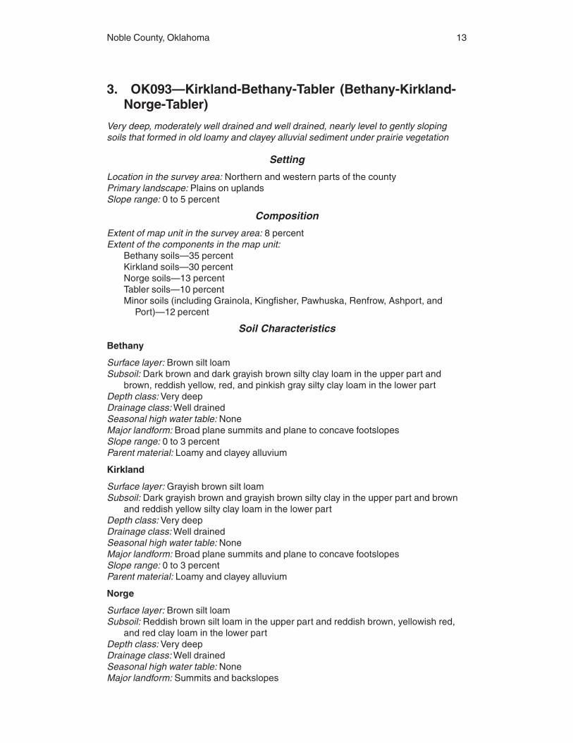
3. OK093—Kirkland-Bethany-Tabler (Bethany-Kirkland-Norge-Tabler)
Very deep, moderately well drained and well drained, nearly level to gently slopingsoils that formed in old loamy and clayey alluvial sediment under prairie vegetation
Setting
Location in the survey area: Northern and western parts of the countyPrimary landscape: Plains on uplandsSlope range: 0 to 5 percent
Composition
Extent of map unit in the survey area: 8 percentExtent of the components in the map unit:
Bethany soils—35 percentKirkland soils—30 percentNorge soils—13 percentTabler soils—10 percentMinor soils (including Grainola, Kingfisher, Pawhuska, Renfrow, Ashport, and
Port)—12 percent
Soil Characteristics
Bethany
Surface layer: Brown silt loamSubsoil: Dark brown and dark grayish brown silty clay loam in the upper part and
brown, reddish yellow, red, and pinkish gray silty clay loam in the lower partDepth class: Very deepDrainage class: Well drainedSeasonal high water table: NoneMajor landform: Broad plane summits and plane to concave footslopesSlope range: 0 to 3 percentParent material: Loamy and clayey alluvium
Kirkland
Surface layer: Grayish brown silt loamSubsoil: Dark grayish brown and grayish brown silty clay in the upper part and brown
and reddish yellow silty clay loam in the lower partDepth class: Very deepDrainage class: Well drainedSeasonal high water table: NoneMajor landform: Broad plane summits and plane to concave footslopesSlope range: 0 to 3 percentParent material: Loamy and clayey alluvium
Norge
Surface layer: Brown silt loamSubsoil: Reddish brown silt loam in the upper part and reddish brown, yellowish red,
and red clay loam in the lower partDepth class: Very deepDrainage class: Well drainedSeasonal high water table: NoneMajor landform: Summits and backslopes

14 Soil Survey
Slope range: 0 to 5 percentParent material: Loamy alluvium
Tabler
Surface layer: Grayish brown silt loamSubsoil: Very dark gray silty clay in the upper part, dark grayish brown silty clay in the
middle part, and light brownish gray and reddish brown silty clay loam in the lowerpart
Depth class: Very deepDrainage class: Moderately well drainedSeasonal high water table: NoneMajor landform: Broad plane summits and depressional areasSlope range: 0 to 1 percentParent material: Loamy and clayey alluvium
Use and Management
Major uses: CroplandManagement concerns: Conservation of moisture, soil blowing, water erosion, soil
fertility and tilth, restricted permeability, and water table
4. OK097—McLain-Dale-Reinach (McLain-Braman-Lela)Very deep, well drained to somewhat poorly drained, nearly level soils that formed inalluvial sediment under prairie grasses and scattered bottomland hardwoods (fig. 3)
Setting
Location in the survey area: Flood plains along the Arkansas River and Bird’s NestCreek
Primary landscape: ValleySlope range: 0 to 1 percent
Composition
Extent of map unit in the survey area: 0.5 percentExtent of the components in the map unit:
McLain soils—47 percentBraman soils—28 percentLela soils—13 percentMinor soils (including Dale, Port, Ashport, Pulaski, and Gaddy)—12 percent
Soil Characteristics
McLain
Surface layer: Reddish brown silty clay loamSubsoil: Dark reddish gray silty clay loam in the upper part, reddish brown silty clay
loam in the middle part, and reddish brown silty clay in the lower partDepth class: Very deepDrainage class: Moderately well drainedSeasonal high water table: NoneMajor landform: Flood plainsSlope range: 0 to 1 percentParent material: Clayey and loamy alluvium
Braman
Surface layer: Dark brown silt loam
Noble County, Oklahoma 15
Subsoil: Reddish brown silty clay loam in the upper part and reddish brown silt loam inthe lower part
Underlying material: Stratified reddish brown silty clay and loamDepth class: Very deepDrainage class: Well drainedSeasonal high water table: NoneMajor landform: Flood plainsSlope range: 0 to 1 percentParent material: Loamy alluvium
Lela
Surface layer: Dark reddish brown silty claySubsoil: Dark reddish brown silty clay in the upper part, dark reddish gray silty clay in
the middle part, and reddish brown silty clay in the lower partDepth class: Very deepDrainage class: Somewhat poorly drainedSeasonal high water table: NoneMajor landform: Flood plainsSlope range: 0 to 1 percentParent material: Clayey alluvium
Use and Management
Major uses: CroplandManagement concerns: Conservation of moisture, soil blowing, water erosion, soil
fertility, flooding, restricted permeability, potential of ground-water pollution, andpoor tilth
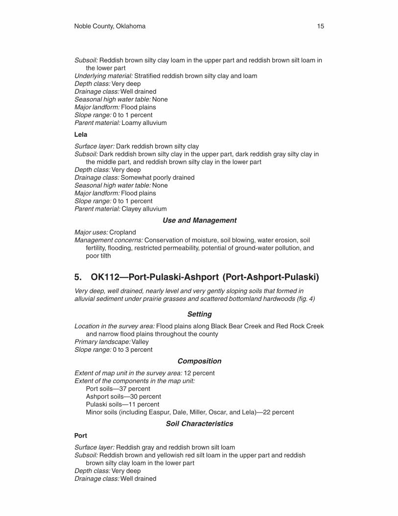
5. OK112—Port-Pulaski-Ashport (Port-Ashport-Pulaski)Very deep, well drained, nearly level and very gently sloping soils that formed inalluvial sediment under prairie grasses and scattered bottomland hardwoods (fig. 4)
Setting
Location in the survey area: Flood plains along Black Bear Creek and Red Rock Creekand narrow flood plains throughout the county
Primary landscape: ValleySlope range: 0 to 3 percent
Composition
Extent of map unit in the survey area: 12 percentExtent of the components in the map unit:
Port soils—37 percentAshport soils—30 percentPulaski soils—11 percentMinor soils (including Easpur, Dale, Miller, Oscar, and Lela)—22 percent
Soil Characteristics
Port
Surface layer: Reddish gray and reddish brown silt loamSubsoil: Reddish brown and yellowish red silt loam in the upper part and reddish
brown silty clay loam in the lower partDepth class: Very deepDrainage class: Well drained

16 Soil Survey
Seasonal high water table: NoneMajor landform: Flood plainsSlope range: 0 to 1 percentParent material: Loamy alluvium
Ashport
Surface layer: Reddish brown silt loamSubsoil: Reddish brown silty clay loamDepth class: Very deepDrainage class: Well drainedSeasonal high water table: NoneMajor landform: Flood plainsSlope range: 0 to 3 percentParent material: Loamy alluvium
Pulaski
Surface layer: Reddish brown fine sandy loamUnderlying material: Yellowish red fine sandy loamDepth class: Very deepDrainage class: Well drainedSeasonal high water table: NoneMajor landform: Flood plainsSlope range: 0 to 1 percentParent material: Loamy alluvium
Use and Management
Major uses: Cropland, pasture, and hayland
Figure 4.—Typical pattern of soils and underlying material in the Port-Ashport-Pulaski general soilmap unit.

Noble County, Oklahoma 17
Management concerns: Conservation of moisture, soil blowing, water erosion, soilfertility and tilth, potential of ground-water pollution, and flooding
6. OK116—Renfrow-Kirkland-Grainola (Renfrow-Kirkland)
Very deep, well drained, nearly level to gently sloping soils that formed in old loamyand clayey alluvial sediment and shale under prairie vegetation
Setting
Location in the survey area: Southeastern part of the countyPrimary landscape: HillsSlope range: 0 to 5 percent
Composition
Extent of map unit in the survey area: 1.2 percentExtent of the components in the map unit:
Renfrow soils—50 percentKirkland soils—39 percentMinor soils (including Grainola, Lucien, Zaneis, and Ashport)—11 percent
Soil Characteristics
Renfrow
Surface layer: Reddish brown silt loamSubsoil: Reddish brown silty clay loam in the upper part and red silty clay in the lower
partDepth class: Very deepDrainage class: Well drainedSeasonal high water table: NoneMajor landform: Backslopes and footslopesSlope range: 1 to 5 percentParent material: Clayey alluvium and shale
Kirkland
Surface layer: Grayish brown silt loamSubsoil: Dark grayish brown and grayish brown silty clay in the upper part and brown
and reddish yellow silty clay loam in the lower partDepth class: Very deepDrainage class: Well drainedSeasonal high water table: NoneMajor landform: Broad plane summits and plane to slightly convex footslopesSlope range: 0 to 3 percentParent material: Clayey alluvium and shale
Use and Management
Major uses: Cropland, pasture, hayland, and rangelandManagement concerns: Conservation of moisture, soil blowing, water erosion, soil
fertility, restricted permeability, and poor tilth

18 Soil Survey
7. OK117—Renfrow-Zaneis-Grainola (Renfrow-Grainola-Coyle)
Very deep and moderately deep, well drained, very gently sloping to moderatelysloping soils that formed in material weathered primarily from shale or sandstoneunder prairie vegetation
Setting
Location in the survey area: Upland summits, shoulder slopes, and backslopes in theeastern and central parts of the county
Primary landscape: HillsSlope range: 1 to 8 percent
Composition
Extent of map unit in the survey area: 11 percentExtent of the components in the map unit:
Renfrow soils—28 percentGrainola soils—23 percentCoyle soils—9 percentMinor soils (including Bethany, Doolin, Huska, Kirkland, Lucien, Masham, Mulhall,
Norge, Pawhuska, Zaneis, Ashport, Port, Oscar, and Pulaski)—40 percent
Soil Characteristics
Renfrow
Surface layer: Reddish brown silt loamSubsoil: Reddish brown silty clay loam in the upper part and red silty clay in the lower
partDepth class: Very deepDrainage class: Well drainedSeasonal high water table: NoneMajor landform: Backslopes and footslopesSlope range: 1 to 5 percentParent material: Clayey alluvium and shale
Grainola
Surface layer: Reddish brown clay loamSubsoil: Red silty clayBedrock: ShaleDepth class: Moderately deepDrainage class: Well drainedSeasonal high water table: NoneMajor landform: Backslopes and footslopesSlope range: 1 to 8 percentParent material: Shale
Coyle
Surface layer: Reddish gray loamSubsoil: Reddish brown loam in the upper part and reddish brown sandy clay loam in
the lower partBedrock: SandstoneDepth class: Moderately deepDrainage class: Well drainedSeasonal high water table: None

Noble County, Oklahoma 19
Major landform: Summits, shoulder slopes, and backslopesSlope range: 1 to 5 percentParent material: Sandstone
Use and Management
Major uses: Cropland, rangeland, pasture, and haylandManagement concerns: Conservation of moisture, soil blowing, water erosion, soil
fertility, depth to bedrock, limited available water capacity, poor tilth, and restrictedpermeability
8. OK121—Teller-Konawa-Norge (Teller-Konawa)Very deep, well drained, very gently sloping to moderately sloping soils that formed inold loamy and sandy alluvial sediment under prairie vegetation or an oak savannah(fig. 5)
Setting
Location in the survey area: Northeastern part of the countyPrimary landscape: HillsSlope range: 1 to 8 percent
Composition
Extent of map unit in the survey area: 2 percentExtent of the components in the map unit:
Teller soils—70 percent
Figure 5.—Typical pattern of soils and underlying material in the Teller-Konawa general soil mapunit.

20 Soil Survey
Konawa soils—9 percentMinor soils (including Darnell, Grainola, Harrah, Lucien, Masham, Newalla,
Slaughterville, Vanoss, Ashport, Oscar, Port, and Pulaski)—21 percent
Soil Characteristics
Teller
Surface layer: Dark reddish gray loamSubsoil: Reddish brown loam in the upper part, reddish brown and yellowish red clay
loam in the middle part, and reddish yellow loam in the lower partDepth class: Very deepDrainage class: Well drainedSeasonal high water table: NoneMajor landform: Convex summits and backslopesSlope range: 1 to 8 percentParent material: Loamy alluvium
Konawa
Surface layer: Brown fine sandy loamSubsurface layer: Brown fine sandy loamSubsoil: Yellowish red sandy clay loam in the upper part, yellowish red fine sandy loam
in the middle part, and reddish yellow loamy fine sand in the lower partDepth class: Very deepDrainage class: Well drainedSeasonal high water table: NoneMajor landform: Summits and backslopesSlope range: 1 to 8 percentParent material: Sandy alluvium
Use and Management
Major uses: Rangeland and croplandManagement concerns: Conservation of moisture, soil blowing, water erosion, soil
fertility and tilth, excessive permeability, and potential of ground-water pollution
9. OK151—Stephenville-Darnell-Newalla (Darnell-Grainola-Newalla-Harrah)
Very deep to shallow, somewhat excessively drained to moderately well drained, verygently sloping to steep soils that formed in material weathered primarily fromsandstone under an oak savannah with prairie openings (fig. 6)
Setting
Location in the survey area: Southern part of the countyPrimary landscape: HillsSlope range: 1 to 45 percent
Composition
Extent of map unit in the survey area: 2.5 percentExtent of the components in the map unit:
Darnell soils—24 percentGrainola soils—16 percentNewalla soils—15 percentHarrah soils—13 percent
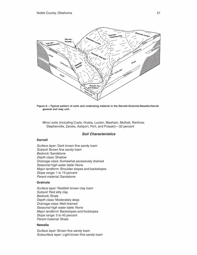
Noble County, Oklahoma 21
Minor soils (including Coyle, Huska, Lucien, Masham, Mulhall, Renfrow,Stephenville, Zaneis, Ashport, Port, and Pulaski)—32 percent
Soil Characteristics
Darnell
Surface layer: Dark brown fine sandy loamSubsoil: Brown fine sandy loamBedrock: SandstoneDepth class: ShallowDrainage class: Somewhat excessively drainedSeasonal high water table: NoneMajor landform: Shoulder slopes and backslopesSlope range: 1 to 15 percentParent material: Sandstone
Grainola
Surface layer: Reddish brown clay loamSubsoil: Red silty clayBedrock: ShaleDepth class: Moderately deepDrainage class: Well drainedSeasonal high water table: NoneMajor landform: Backslopes and footslopesSlope range: 5 to 45 percentParent material: Shale
Newalla
Surface layer: Brown fine sandy loamSubsurface layer: Light brown fine sandy loam
Figure 6.—Typical pattern of soils and underlying material in the Darnell-Grainola-Newalla-Harrahgeneral soil map unit.

22 Soil Survey
Subsoil: Reddish brown sandy clay loam in the upper part, red silty clay in the middlepart, and reddish brown silty clay in the lower part
Depth class: DeepDrainage class: Moderately well drainedSeasonal high water table: NoneMajor landform: BackslopesSlope range: 5 to 8 percentParent material: Colluvium from sandstone over shale
Harrah
Surface layer: Reddish brown fine sandy loamSubsurface layer: Reddish brown fine sandy loamSubsoil: Red sandy clay loam in the upper part and red fine sandy loam in the lower
partDepth class: Very deepDrainage class: Well drainedSeasonal high water table: NoneMajor landform: BackslopesSlope range: 1 to 12 percentParent material: Colluvium from sandstone
Use and Management
Major uses: RangelandManagement concerns: Conservation of moisture, soil blowing, water erosion, soil
fertility and tilth, areas of rock outcrop, depth to bedrock, excessive permeability,potential of ground-water pollution, limited available water capacity, restrictedpermeability, slope, and surface stones or boulders
10. OK221—Norge-Bethany-Kirkland (Norge-Bethany-Kirkland)
Very deep, well drained, nearly level to gently sloping soils that formed in old loamyand clayey alluvial sediment under prairie vegetation (fig. 7)
Setting
Location in the survey area: Northern and western parts of the countyPrimary landscape: Plains on uplandsSlope range: 0 to 5 percent
Composition
Extent of map unit in the survey area: 22.8 percentExtent of the components in the map unit:
Norge soils—48 percentBethany soils—21 percentKirkland soils—15 percentMinor soils (including Grainola, Kingfisher, Lucien, Milan, Pawhuska, Renfrow,
Ashport, Port, and Pulaski)—16 percent
Soil Characteristics
Norge
Surface layer: Brown silt loam

Noble County, Oklahoma 23
Subsoil: Reddish brown silt loam in the upper part and reddish brown, yellowish red,and red clay loam in the lower part
Depth class: Very deepDrainage class: Well drainedSeasonal high water table: NoneMajor landform: Summits and backslopesSlope range: 0 to 5 percentParent material: Loamy alluvium
Bethany
Surface layer: Brown silt loamSubsoil: Dark brown and dark grayish brown silty clay loam in the upper part and
brown, reddish yellow, red, and pinkish gray silty clay loam in the lower partDepth class: Very deepDrainage class: Well drainedSeasonal high water table: NoneMajor landform: Broad plane summits and plane to concave footslopesSlope range: 0 to 3 percentParent material: Loamy and clayey alluvium
Kirkland
Surface layer: Grayish brown silt loamSubsoil: Dark grayish brown and grayish brown silty clay in the upper part and brown
and reddish yellow silty clay loam in the lower partDepth class: Very deepDrainage class: Well drainedSeasonal high water table: NoneMajor landform: Broad plane summits and plane to slightly convex footslopesSlope range: 0 to 3 percent
Use and Management
Major uses: Rangeland, cropland, and pastureland
Figure 7.—Typical pattern of soils and underlying material in the Norge-Bethany-Kirkland generalsoil map unit.
24 Soil Survey
Management concerns: Conservation of moisture, soil blowing, water erosion, soilfertility and tilth, and restricted permeability
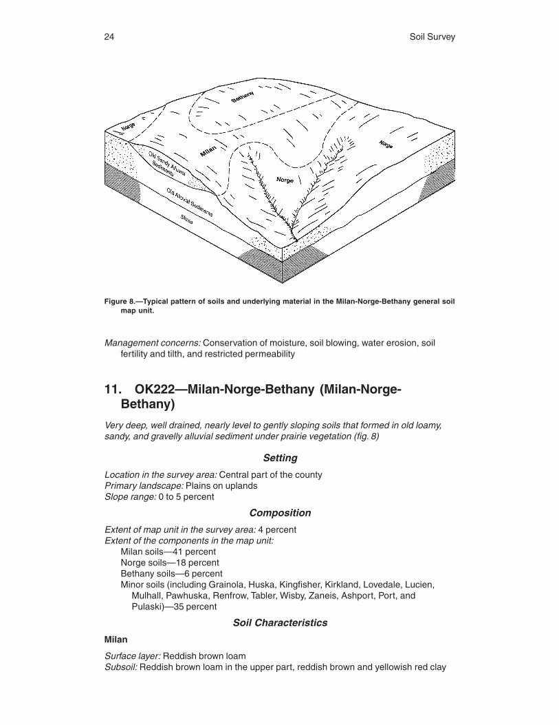
11. OK222—Milan-Norge-Bethany (Milan-Norge-Bethany)
Very deep, well drained, nearly level to gently sloping soils that formed in old loamy,sandy, and gravelly alluvial sediment under prairie vegetation (fig. 8)
Setting
Location in the survey area: Central part of the countyPrimary landscape: Plains on uplandsSlope range: 0 to 5 percent
Composition
Extent of map unit in the survey area: 4 percentExtent of the components in the map unit:
Milan soils—41 percentNorge soils—18 percentBethany soils—6 percentMinor soils (including Grainola, Huska, Kingfisher, Kirkland, Lovedale, Lucien,
Mulhall, Pawhuska, Renfrow, Tabler, Wisby, Zaneis, Ashport, Port, andPulaski)—35 percent
Soil Characteristics
Milan
Surface layer: Reddish brown loamSubsoil: Reddish brown loam in the upper part, reddish brown and yellowish red clay
Figure 8.—Typical pattern of soils and underlying material in the Milan-Norge-Bethany general soilmap unit.

Noble County, Oklahoma 25
loam and sandy clay loam in the middle part, and yellowish red sandy loam in thelower part
Depth class: Very deepDrainage class: Well drainedSeasonal high water table: NoneMajor landform: Summits and backslopesSlope range: 1 to 5 percentParent material: Gravelly and loamy alluvium
Norge
Surface layer: Brown silt loamSubsoil: Reddish brown silt loam in the upper part and reddish brown, yellowish red,
and red clay loam in the lower partDepth class: Very deepDrainage class: Well drainedSeasonal high water table: NoneMajor landform: Summits and backslopesSlope range: 0 to 5 percentParent material: Loamy alluvium
Bethany
Surface layer: Brown silt loamSubsoil: Dark brown and dark grayish brown silty clay loam in the upper part and
brown, reddish yellow, red, and pinkish gray silty clay loam in the lower partDepth class: Very deepDrainage class: Well drainedSeasonal high water table: NoneMajor landform: Broad plane summits and plane to concave footslopesSlope range: 0 to 3 percentParent material: Loamy and clayey alluvium
Use and Management
Major uses: Rangeland, cropland, and pasturelandManagement concerns: Conservation of moisture, soil blowing, water erosion, soil
fertility and tilth, and restricted permeability
12. OK223—Vanoss-Slaughterville-Teller (Vanoss-Slaughterville)
Very deep, well drained, nearly level to steeply sloping soils that formed in old loamyalluvial sediment under prairie vegetation (fig. 9)
Setting
Location in the survey area: Northeastern part of the countyPrimary landscape: Stream terracesSlope range: 0 to 45 percent
Composition
Extent of map unit in the survey area: 1 percentExtent of the components in the map unit:
Vanoss soils—42 percentSlaughterville soils—32 percent

26 Soil Survey
Minor soils (including Bethany, Grainola, Kirkland, Minco, Norge, Teller, Waurika,Ashport, Port, and Pulaski)—26 percent
Soil Characteristics
Vanoss
Surface layer: Dark brown silt loamSubsoil: Brown silt loam in the upper part, brown and strong brown silty clay loam in
the middle part, and yellowish red silty clay loam in the lower partDepth class: Very deepDrainage class: Well drainedSeasonal high water table: NoneMajor landform: Terrace treadsSlope range: 0 to 1 percentParent material: Silty alluvium
Slaughterville
Surface layer: Brown fine sandy loamSubsoil: Brown fine sandy loam in the upper part, strong brown fine sandy loam in the
middle part, and yellowish red sandy clay loam in the lower partDepth class: Very deepDrainage class: Well drainedSeasonal high water table: NoneMajor landform: Terrace steps and treadsSlope range: 0 to 45 percentParent material: Loamy alluvium
Figure 9.—Typical pattern of soils and underlying material in the Vanoss-Slaughterville generalsoil map unit.

Noble County, Oklahoma 27
Use and Management
Major uses: Rangeland, cropland, and pasturelandManagement concerns: Conservation of moisture, soil blowing, water erosion, soil
fertility and tilth, excessive permeability, potential of ground-water pollution, andslope
13. OK224—Renfrow-Grainola-Kingfisher-Grant(Grainola-Renfrow-Kingfisher)
Very deep and moderately deep, well drained, very gently sloping to moderatelysloping soils that formed in material weathered primarily from shale, siltstone, orsandstone under prairie vegetation
Setting
Location in the survey area: Western and central parts of the countyPrimary landscape: HillsSlope range: 1 to 8 percent
Composition
Extent of map unit in the survey area: 20 percentExtent of the components in the map unit:
Grainola soils—24 percentRenfrow soils—23 percentKingfisher soils—11 percentMinor soils (including Bethany, Dilworth, Grant, Huska, Kirkland, Lucien, Masham,
Mulhall, Pawhuska, Wakita, Westsum, Ashport, Port, and Pulaski)—42 percent
Soil Characteristics
Grainola
Surface layer: Reddish brown clay loamSubsoil: Red silty clayBedrock: Red shale interbedded with siltstoneDepth class: Moderately deepDrainage class: Well drainedSeasonal high water table: NoneMajor landform: BackslopesSlope range: 1 to 8 percentParent material: Shale
Renfrow
Surface layer: Reddish brown silt loamSubsoil: Reddish brown silty clay loam in the upper part and red silty clay in the lower
partDepth class: Very deepDrainage class: Well drainedSeasonal high water table: NoneMajor landform: Backslopes and footslopesSlope range: 1 to 5 percentParent material: Clayey alluvium and shale
Kingfisher
Surface layer: Brown silt loam

28
Subsoil: Brown silt loam in the upper part and reddish brown silty clay loam in thelower part
Bedrock: SiltstoneDepth class: Moderately deepDrainage class: Well drainedSeasonal high water table: NoneMajor landform: Summits and backslopesSlope range: 1 to 5 percentParent material: Siltstone
Use and Management
Major uses: Rangeland and croplandManagement concerns: Conservation of moisture, soil blowing, water erosion, soil
fertility, depth to bedrock, limited available water capacity, poor tilth, and restrictedpermeability

29
The map units on the detailed soil maps represent the soils or miscellaneous areas inthe survey area. The map unit descriptions in this section, along with the maps, can beused to determine the suitability and potential of a unit for specific uses. They also canbe used to plan the management needed for those uses. More information about eachmap unit is given in the section “Use and Management of the Soils.”
A map unit delineation on the detailed soil maps represents an area on the landscapeand consists of one or more soils or miscellaneous areas. A map unit is identified andnamed according to the taxonomic classification of the dominant soils or miscellaneousareas. Within a taxonomic class there are precisely defined limits for the properties ofthe soils. On the landscape, however, the soils and miscellaneous areas are naturalphenomena, and they have the characteristic variability of all natural phenomena. Thus,the range of some observed properties may extend beyond the limits defined for ataxonomic class. Areas of soils of a single taxonomic class rarely, if ever, are mappedwithout areas of minor components of other taxonomic classes. Consequently, mapunits are made up of the soils or miscellaneous areas for which they are named andsome areas of included soils that belong to other taxonomic classes.
Most included soils have properties similar to those of the dominant soil or soils inthe map unit, and thus they do not affect use and management. These are callednoncontrasting or similar inclusions. They may or may not be mentioned in the map unitdescription. Other included soils and miscellaneous areas, however, have properties andbehavioral characteristics divergent enough to affect use or to require different manage-ment. These are called contrasting, or dissimilar, inclusions. They generally are in smallareas and could not be mapped separately because of the scale used. Some smallareas of strongly contrasting soils or miscellaneous areas are identified by a specialsymbol on the maps. The included areas of contrasting soils or miscellaneous areas arementioned in the map unit descriptions. A few included areas may not have beenobserved, and consequently they are not mentioned in the descriptions, especiallywhere the pattern was so complex that it was impractical to make enough observationsto identify all the soils and miscellaneous areas on the landscape.
The presence of included areas in a map unit in no way diminishes the usefulness oraccuracy of the data. The objective of mapping is not to delineate pure taxonomicclasses but rather to separate the landscape into segments that have similar use andmanagement requirements. The delineation of such landscape segments on the mapprovides sufficient information for the development of resource plans, but if intensiveuse of small areas is planned, onsite investigation is needed to define and locate thesoils and miscellaneous areas.
An identifying symbol precedes the map unit name in the map unit descriptions. Eachdescription includes general facts about the unit and gives the principal hazards andlimitations to be considered in planning for specific uses.
Soils that have profiles that are almost alike make up a soil series. Except fordifferences in texture of the surface layer or of the underlying layers, all the soils of aseries have major horizons that are similar in composition, thickness, and arrangement.
Soils of one series can differ in texture of the surface layer or of the underlyinglayers. They also can differ in slope, stoniness, salinity, wetness, degree of erosion, andother characteristics that affect their use. On the basis of such differences, a soil series
Detailed Soil Map Units

30 Soil Survey
is divided into soil phases. Most of the areas shown on the detailed soil maps arephases of soil series. The name of a soil phase commonly indicates a feature thataffects use or management. For example, Ashport silt loam, 0 to 1 percent slopes,occasionally flooded, is a phase of the Ashport series.
Some map units are made up of two or more major soils or miscellaneous areas.These map units are complexes or undifferentiated groups.
A complex consists of two or more soils or miscellaneous areas in such an intricatepattern or in such small areas that they cannot be shown separately on the maps. Thepattern and proportion of the soils or miscellaneous areas are somewhat similar in allareas. Newalla-Darnell complex, 8 to 45 percent slopes, very bouldery, is an example.
An undifferentiated group consists of two or more soils or miscellaneous areas thatare not consistently associated geographically and, therefore, do not always occurtogether in the same map delineation. These components are included in the samenamed map unit because their use and management are the same or very similar forcommon uses. Generally, they are grouped together because some common featuredetermines their use and management. Each delineation has at least one of the majorcomponents, and some may have all of them. Coyle and Zaneis soils, 3 to 5 percentslopes, severely eroded, is an example.
This survey includes miscellaneous areas. Such areas have little or no soil materialand support little or no vegetation. The Urban land part of Norge-Urban land complex, 1to 5 percent slopes, is an example.
The table “Acreage and Proportionate Extent of the Soils” gives the acreage andproportionate extent of each map unit. Other tables (see “Summary of Tables”) giveproperties of the soils and the limitations, capabilities, and potentials for many uses.The Glossary defines many of the terms used in describing the soils or miscellaneousareas.

Noble County, Oklahoma 31
Acreage and Proportionate Extent of the Soils________________________________________________________________________________________________ | | | Map | Soil name | Acres |Percentsymbol | | | | | |________________________________________________________________________________________________ | | |AhpA |Ashport silty clay loam, 0 to 1 percent slopes, occasionally flooded-| 4,025 | 0.8APPA |Ashport, Port, and Pulaski soils, 0 to 1 percent slopes, frequently | | | flooded-------------------------------------------------------------| 29,133 | 6.1AspA |Ashport silt loam, 0 to 1 percent slopes, occasionally flooded-------| 7,040 | 1.5AspB |Ashport silt loam, 1 to 3 percent slopes, occasionally flooded-------| 504 | 0.1BetA |Bethany silt loam, 0 to 1 percent slopes-----------------------------| 8,348 | 1.8BetB |Bethany silt loam, 1 to 3 percent slopes-----------------------------| 21,146 | 4.4BPG |Borrow pits, gravelly------------------------------------------------| 107 | *BPR |Borrow pits, rock----------------------------------------------------| 942 | 0.2BraA |Braman silt loam, 0 to 1 percent slopes, rarely flooded--------------| 374 | *BrwA |Brewer silt loam, 0 to 1 percent slopes, rarely flooded--------------| 608 | 0.1CoLC |Coyle-Lucien complex, 1 to 5 percent slopes--------------------------| 5,715 | 1.2CoyB |Coyle loam, 1 to 3 percent slopes------------------------------------| 551 | 0.1CoyC |Coyle loam, 3 to 5 percent slopes------------------------------------| 654 | 0.1CoyC2 |Coyle loam, 3 to 5 percent slopes, eroded----------------------------| 1,337 | 0.3CoZC3 |Coyle and Zaneis soils, 3 to 5 percent slopes, severely eroded-------| 2,682 | 0.6DalA |Dale silt loam, 0 to 1 percent slopes, rarely flooded----------------| 1,482 | 0.3DAM |Dam------------------------------------------------------------------| 261 | *DaUA |Dale-Urban land complex, 0 to 1 percent slopes, rarely flooded-------| 369 | *DiGE |Dilworth-Grainola complex, 5 to 12 percent slopes--------------------| 2,437 | 0.5DooB |Doolin silt loam, 0 to 2 percent slopes------------------------------| 1,059 | 0.2DwhC |Dilworth silty clay loam, 3 to 5 percent slopes----------------------| 1,404 | 0.3EasA |Easpur loam, 0 to 1 percent slopes, occasionally flooded-------------| 2,555 | 0.5GadA |Gaddy loamy fine sand, 0 to 1 percent slopes, occasionally flooded---| 596 | 0.1GayA |Gaddy loamy fine sand, 0 to 1 percent slopes, rarely flooded---------| 103 | *GMLG |Grainola-Masham-Lucien complex, 5 to 40 percent slopes, very bouldery| 21,827 | 4.6GohE |Goodnight loamy fine sand, 3 to 20 percent slopes--------------------| 501 | 0.1GraC |Grainola silty clay loam, 3 to 5 percent slopes----------------------| 3,155 | 0.7GrAD |Grainola-Ashport complex, 0 to 8 percent slopes----------------------| 21,092 | 4.4GrHC |Grant-Huska complex, 1 to 5 percent slopes---------------------------| 10,514 | 2.2GrLC |Grainola-Lucien complex, 1 to 5 percent slopes-----------------------| 17,679 | 3.7GrLE |Grainola-Lucien complex, 5 to 12 percent slopes----------------------| 34,319 | 7.2GrnC |Grant loam, 3 to 5 percent slopes------------------------------------| 961 | 0.2GrtB |Grant silt loam, 1 to 3 percent slopes-------------------------------| 1,853 | 0.4HaPE |Harrah-Pulaski complex, 0 to 12 percent slopes-----------------------| 1,738 | 0.4HiRG |Highview-Rock outcrop complex, 15 to 45 percent slopes---------------| 2,084 | 0.4KekA |Keokuk very fine sandy loam, 0 to 1 percent slopes, rarely flooded---| 715 | 0.2KeoA |Keokuk very fine sandy loam, 0 to 1 percent slopes, occasionally | | | flooded-------------------------------------------------------------| 945 | 0.2KgfB |Kingfisher silt loam, 1 to 3 percent slopes--------------------------| 2,583 | 0.5KgLC |Kingfisher-Lucien complex, 1 to 5 percent slopes---------------------| 3,635 | 0.8KgWC |Kingfisher-Wakita complex, 1 to 5 percent slopes---------------------| 1,226 | 0.3KinC2 |Kingfisher loam, 3 to 5 percent slopes, eroded-----------------------| 2,643 | 0.6KowB |Konawa fine sandy loam, 1 to 3 percent slopes------------------------| 467 | *KowD |Konawa fine sandy loam, 3 to 8 percent slopes------------------------| 815 | 0.2KrdA |Kirkland silt loam, 0 to 1 percent slopes----------------------------| 10,886 | 2.3KrdB |Kirkland silt loam, 1 to 3 percent slopes----------------------------| 19,230 | 4.0KrdB2 |Kirkland silt loam, 1 to 3 percent slopes, eroded--------------------| 12,251 | 2.6KrPB |Kirkland-Pawhuska complex, 0 to 3 percent slopes---------------------| 4,494 | 0.9LAN |Landfill-------------------------------------------------------------| 17 | *LelA |Lela silty clay, 0 to 1 percent slopes, occasionally flooded---------| 4,188 | 0.9LveB |Lovedale sandy loam, 1 to 3 percent slopes---------------------------| 67 | *M-W |Miscellaneous water--------------------------------------------------| 74 | *McaA |McLain silty clay loam, 0 to 1 percent slopes, rarely flooded--------| 458 | *MilB |Milan loam, 1 to 3 percent slopes------------------------------------| 7,968 | 1.7MilC |Milan loam, 3 to 5 percent slopes------------------------------------| 4,108 | 0.9MinB |Minco very fine sandy loam, 1 to 3 percent slopes--------------------| 251 | *MinC |Minco very fine sandy loam, 3 to 5 percent slopes--------------------| 113 | *MirA |Miller silty clay loam, 0 to 1 percent slopes, occasionally flooded--| 1,087 | 0.2 | | |
See footnote at end of table.

32 Soil Survey
Acreage and Proportionate Extent of the Soils--Continued________________________________________________________________________________________________ | | | Map | Soil name | Acres |Percentsymbol | | | | | |________________________________________________________________________________________________ | | |MisA |Miller silty clay loam, saline, 0 to 1 percent slopes, occasionally | | | flooded-------------------------------------------------------------| 207 | *MPNC2 |Milan-Pawhuska-Norge complex, 3 to 5 percent slopes, eroded----------| 4,805 | 1.0MulC |Mulhall loam, 3 to 5 percent slopes----------------------------------| 4,218 | 0.9MulD |Mulhall loam, 5 to 8 percent slopes----------------------------------| 1,416 | 0.3MulD4 |Mulhall loam, 5 to 8 percent slopes, gullied-------------------------| 1,501 | 0.3NeDG |Newalla-Darnell complex, 8 to 45 percent slopes, very bouldery-------| 4,151 | 0.9NorA |Norge silt loam, 0 to 1 percent slopes-------------------------------| 1,137 | 0.2NorB |Norge silt loam, 1 to 3 percent slopes-------------------------------| 25,641 | 5.4NorC |Norge silt loam, 3 to 5 percent slopes-------------------------------| 7,459 | 1.6NorC2 |Norge silt loam, 3 to 5 percent slopes, eroded-----------------------| 13,822 | 2.9NoUC |Norge-Urban land complex, 1 to 5 percent slopes----------------------| 1,172 | 0.2OWWE |Oil waste land-Westsum complex, 3 to 12 percent slopes---------------| 540 | 0.1PoaA |Port silt loam, 0 to 1 percent slopes, frequently flooded------------| 6,988 | 1.5PoOA |Port-Oscar complex, 0 to 1 percent slopes, occasionally flooded------| 3,290 | 0.7PorA |Port silt loam, 0 to 1 percent slopes, occasionally flooded----------| 15,754 | 3.3PotA |Port silty clay loam, 0 to 1 percent slopes, occasionally flooded----| 3,075 | 0.6PukA |Pulaski fine sandy loam, 0 to 1 percent slopes, frequently flooded---| 849 | 0.2PulA |Pulaski fine sandy loam, 0 to 1 percent slopes, occasionally flooded-| 1,293 | 0.3RefC2 |Renfrow loam, 3 to 5 percent slopes, eroded--------------------------| 39 | *ReGC2 |Renfrow and Grainola soils, 3 to 5 percent slopes, eroded------------| 24,762 | 5.2ReiA |Reinach very fine sandy loam, 0 to 1 percent slopes, rarely flooded--| 249 | *RenB |Renfrow silt loam, 1 to 3 percent slopes-----------------------------| 14,123 | 3.0RenC |Renfrow silt loam, 3 to 5 percent slopes-----------------------------| 9,611 | 2.0RewC2 |Renfrow silty clay loam, 3 to 5 percent slopes, eroded---------------| 33 | *RGPD3 |Renfrow, Grainola, and Pawhuska soils, 3 to 8 percent slopes, | | | severely eroded-----------------------------------------------------| 4,511 | 0.9SlaB |Slaughterville fine sandy loam, 0 to 3 percent slopes----------------| 770 | 0.2SlaC |Slaughterville fine sandy loam, 3 to 5 percent slopes----------------| 220 | *SlaG |Slaughterville fine sandy loam, 8 to 45 percent slopes---------------| 439 | *StDD |Stephenville-Darnell complex, 3 to 8 percent slopes------------------| 5,011 | 1.1TabA |Tabler silt loam, 0 to 1 percent slopes------------------------------| 2,155 | 0.5TeaA |Tearney silty clay, 0 to 1 percent slopes, ponded--------------------| 323 | *TelB |Teller loam, 1 to 3 percent slopes-----------------------------------| 3,119 | 0.7TelD |Teller loam, 5 to 8 percent slopes-----------------------------------| 2,260 | 0.5TelD2 |Teller loam, 5 to 8 percent slopes, eroded---------------------------| 3,889 | 0.8VanA |Vanoss silt loam, 0 to 1 percent slopes------------------------------| 2,225 | 0.5W |Water----------------------------------------------------------------| 7,663 | 1.6WauA |Waurika silt loam, 0 to 1 percent slopes-----------------------------| 213 | *WesB |Westsum silty clay loam, 1 to 3 percent slopes-----------------------| 1,423 | 0.3WesC |Westsum silty clay loam, 3 to 5 percent slopes-----------------------| 315 | *WiLC |Wisby-Lovedale complex, 1 to 5 percent slopes------------------------| 373 | *ZaHC |Zaneis-Huska complex, 1 to 5 percent slopes--------------------------| 6,775 | 1.4ZanB |Zaneis loam, 1 to 3 percent slopes-----------------------------------| 280 | * | |_________|________ | Total-----------------------------------------------------------| 475,475 | 100.0 | | |________________________________________________________________________________________________
* Less than 0.1 percent.

Noble County, Oklahoma 33
AhpA—Ashport silty clay loam, 0 to 1 percent slopes, occasionallyflooded
Map Unit Setting
Major land resource area: 80AElevation range: 700 to 1,500 feetMean annual precipitation: 26 to 38 inchesMean annual air temperature: 57 to 63 degrees FFrost-free period: 200 to 230 days
Major Component Description
Ashport and similar soils
Extent of the component in the map unit: 89 percentGeomorphic setting: Valley flat on a flood plain in a valleyParent material: Silty alluviumSlope range: 0 to 1 percentRunoff: NegligibleSoil depth: More than 60 inchesSlowest permeability class within a depth of 60 inches: ModerateDrainage class: Well drainedAvailable water capacity: About 11.7 inchesDepth to water table: More than 6 feetFlooding: OccasionalPonding: None
Interpretive groups:Land capability classification—2wRange site number and name—080AY050OK, Loamy Bottomland
Typical profile:Ap—0 to 10 inches; silty clay loamBw1—10 to 25 inches; silty clay loamBw2—25 to 35 inches; silty clay loamC—35 to 42 inches; stratified fine sandy loam to silty clay loamAb1—42 to 52 inches; silty clay loamAb2—52 to 80 inches; silty clay loam
Location of representative profile: About 800 feet west and 100 feet north of the south-eastern corner of sec. 10, T. 21 N., R. 3 E.
Additional Components
• Miller and similar soils: 5 percent• Pulaski and similar soils: 3 percent• Oscar and similar soils: 2 percent• Depressions and channels: 1 percent
Management
Major uses: Cropland and rangeland
For general and detailed information about managing this map unit, see the sections“Use and Management of the Soils” and “Soil Properties.”

34 Soil Survey
APPA—Ashport, Port, and Pulaski soils, 0 to 1 percent slopes,frequently flooded
Map Unit Setting
Major land resource area: 80AElevation range: 700 to 1,500 feetMean annual precipitation: 26 to 40 inchesMean annual air temperature: 57 to 63 degrees FFrost-free period: 190 to 240 daysNote: The composition of soils in delineations of this map unit is variable. Most areas
are made up of all the named soils, but some areas may contain only one or two ofthe named soils.
Major Component Description
Ashport and similar soils
Extent of the component in the map unit: 61 percentGeomorphic setting: Valley flat on a flood plain in a valleyParent material: Silty alluviumSlope range: 0 to 1 percentRunoff: NegligibleSoil depth: More than 60 inchesSlowest permeability class within a depth of 60 inches: ModerateDrainage class: Well drainedAvailable water capacity: About 11.7 inchesDepth to water table: More than 6 feetFlooding: FrequentPonding: None
Interpretive groups:Land capability classification—5wRange site number and name—080AY050OK, Loamy Bottomland
Typical profile:A—0 to 14 inches; silty clay loamBw—14 to 27 inches; silt loamC—27 to 80 inches; stratified fine sandy loam to silty clay loam
Location of representative profile: About 2,525 feet south and 300 feet east of thenorthwestern corner of sec. 33, T. 21 N., R. 1 W.
Port and similar soils
Extent of the component in the map unit: 15 percentGeomorphic setting: Valley flat on a flood plain in a valleyParent material: Silty alluviumSlope range: 0 to 1 percentRunoff: NegligibleSoil depth: More than 60 inchesSlowest permeability class within a depth of 60 inches: ModerateDrainage class: Well drainedAvailable water capacity: About 11.5 inchesDepth to water table: More than 6 feetFlooding: FrequentPonding: None

Noble County, Oklahoma 35
Interpretive groups:Land capability classification—5wRange site number and name—080AY050OK, Loamy Bottomland
Typical profile:Ap—0 to 7 inches; fine sandy loamA—7 to 27 inches; silt loamBw—27 to 46 inches; silt loamAb—46 to 51 inches; silt loamBwb—51 to 80 inches; silt loam
Location of representative profile: About 2,550 feet south and 200 feet east of thenorthwestern corner of sec. 33, T. 21 N., R. 1 W.
Pulaski and similar soils
Extent of the component in the map unit: 15 percentGeomorphic setting: Natural levee on a flood plain in a valleyParent material: Loamy alluviumSlope range: 0 to 1 percentRunoff: NegligibleSoil depth: More than 60 inchesSlowest permeability class within a depth of 60 inches: Moderately rapidDrainage class: Well drainedAvailable water capacity: About 8.8 inchesDepth to water table: More than 6 feetFlooding: FrequentPonding: None
Interpretive groups:Land capability classification—5wRange site number and name—084AY050OK, Loamy Bottomland
Typical profile:A—0 to 9 inches; fine sandy loamC1—9 to 25 inches; fine sandy loamC2—25 to 80 inches; stratified loamy fine sand to loam
Location of representative profile: About 2,550 feet south and 400 feet east of thenorthwestern corner of sec. 33, T. 21 N., R. 1 W.
Additional Components
• Easpur and similar soils: 9 percent
Management
Major uses: Rangeland
For general and detailed information about managing this map unit, see the sections“Use and Management of the Soils” and “Soil Properties.”
AspA—Ashport silt loam, 0 to 1 percent slopes, occasionallyflooded
Map Unit Setting
Major land resource area: 80AElevation range: 700 to 1,500 feetMean annual precipitation: 26 to 38 inches

36 Soil Survey
Mean annual air temperature: 57 to 63 degrees FFrost-free period: 200 to 230 days
Major Component Description
Ashport and similar soils
Extent of the component in the map unit: 90 percentGeomorphic setting: Valley flat on a flood plain in a valleyParent material: Silty alluviumSlope range: 0 to 1 percentRunoff: NegligibleSoil depth: More than 60 inchesSlowest permeability class within a depth of 60 inches: ModerateDrainage class: Well drainedAvailable water capacity: About 11.8 inchesDepth to water table: More than 6 feetFlooding: OccasionalPonding: None
Interpretive groups:Land capability classification—2wRange site number and name—080AY050OK, Loamy Bottomland
Typical profile:Ap—0 to 10 inches; silt loamBw—10 to 32 inches; silty clay loamAb—32 to 45 inches; silty clay loamBwb1—45 to 70 inches; silty clay loamBwb2—70 to 80 inches; silty clay loam
Location of representative profile: About 2,300 feet south and 200 feet east of thenorthwestern corner of sec. 11, T. 21 N., R. 3 E.
Additional Components
• Oscar and similar soils: 5 percent• Pulaski and similar soils: 3 percent• Easpur and similar soils: 2 percent
Management
Major uses: Cropland and rangeland (fig. 10)
For general and detailed information about managing this map unit, see the sections“Use and Management of the Soils” and “Soil Properties.”
AspB—Ashport silt loam, 1 to 3 percent slopes, occasionallyflooded
Map Unit Setting
Major land resource area: 80AElevation range: 700 to 1,500 feetMean annual precipitation: 26 to 38 inchesMean annual air temperature: 57 to 63 degrees FFrost-free period: 200 to 230 days

Noble County, Oklahoma 37
Major Component Description
Ashport and similar soils
Extent of the component in the map unit: 93 percentGeomorphic setting: Valley flat on a flood plain in a valleyParent material: Silty alluviumSlope range: 1 to 3 percentRunoff: LowSoil depth: More than 60 inchesSlowest permeability class within a depth of 60 inches: ModerateDrainage class: Well drainedAvailable water capacity: About 11.8 inchesDepth to water table: More than 6 feetFlooding: OccasionalPonding: None
Interpretive groups:Land capability classification—2wRange site number and name—080AY050OK, Loamy Bottomland
Typical profile:Ap—0 to 10 inches; silt loamBw1—10 to 21 inches; silty clay loamBw2—21 to 36 inches; silty clay loamBw3—36 to 65 inches; loamBC—65 to 80 inches; silty clay loam
Location of representative profile: About 2,200 feet east and 500 feet south of thenorthwestern corner of sec. 35, T. 23 N., R. 1 E.
Figure 10.—Wheat on Ashport silt loam, 0 to 1 percent slopes, occasionally flooded.

38 Soil Survey
Additional Components
• Easpur and similar soils: 5 percent• Oscar and similar soils: 2 percent
Management
Major uses: Cropland and rangeland
For general and detailed information about managing this map unit, see the sections“Use and Management of the Soils” and “Soil Properties.”
BetA—Bethany silt loam, 0 to 1 percent slopes
Map Unit Setting
Major land resource area: 80AElevation range: 950 to 1,250 feetMean annual precipitation: 26 to 38 inchesMean annual air temperature: 57 to 64 degrees FFrost-free period: 200 to 220 days
Major Component Description
Bethany and similar soils
Extent of the component in the map unit: 85 percentGeomorphic setting: Terrace on plainsLandform position: SummitParent material: Loess over silty Pleistocene alluvium, over residuum weathered from
clayey Permian shaleSlope range: 0 to 1 percentRunoff: MediumSoil depth: More than 60 inchesSlowest permeability class within a depth of 60 inches: SlowDrainage class: Well drainedAvailable water capacity: About 10.4 inchesDepth to water table: More than 6 feetFlooding: NonePonding: None
Interpretive groups:Land capability classification—1Range site number and name—080AY056OK, Loamy Prairie
Typical profile:Ap—0 to 9 inches; silt loamBA—9 to 12 inches; silty clay loamBt—12 to 30 inches; silty clayBtk—30 to 47 inches; silty clayBtb1—47 to 71 inches; silty clayBtb2—71 to 80 inches; silty clay
Location of representative profile: About 1,900 feet north and 800 feet west of thesoutheastern corner of sec. 17, T. 24 N., R. 1 E.
Additional Components
• Kirkland and similar soils: 5 percent

Noble County, Oklahoma 39
• Norge and similar soils: 5 percent• Tabler and similar soils: 5 percent
Management
Major uses: Cropland and rangeland (fig. 11)
For general and detailed information about managing this map unit, see the sections“Use and Management of the Soils” and “Soil Properties.”
BetB—Bethany silt loam, 1 to 3 percent slopes
Map Unit Setting
Major land resource area: 80AElevation range: 950 to 1,250 feetMean annual precipitation: 26 to 38 inchesMean annual air temperature: 57 to 64 degrees FFrost-free period: 200 to 220 days
Major Component Description
Bethany and similar soils
Extent of the component in the map unit: 84 percentGeomorphic setting: Terrace on plainsLandform position: Summit and shoulderParent material: Loess over silty Pleistocene alluvium, over residuum weathered from
clayey Permian shaleSlope range: 1 to 3 percentRunoff: HighSoil depth: More than 60 inchesSlowest permeability class within a depth of 60 inches: SlowDrainage class: Well drainedAvailable water capacity: About 10.5 inches
Figure 11.—Wheat baled for hay on Bethany silt loam, 0 to 1 percent slopes.

40 Soil Survey
Depth to water table: More than 6 feetFlooding: NonePonding: None
Interpretive groups:Land capability classification—2eRange site number and name—080AY056OK, Loamy Prairie
Typical profile:Ap—0 to 11 inches; silt loamBA—11 to 16 inches; silty clay loamBt1—16 to 36 inches; silty clay loamBt2—36 to 60 inches; silty clay loamBt3—60 to 80 inches; silty clay loam
Location of representative profile: About 2,000 feet west and 100 feet south of thenortheastern corner of sec. 9, T. 20 N., R. 1 E.
Additional Components
• Kirkland and similar soils: 6 percent• Norge and similar soils: 6 percent• Renfrow and similar soils: 3 percent• Pawhuska and similar soils: 1 percent
Management
Major uses: Cropland and rangeland
For general and detailed information about managing this map unit, see the sections“Use and Management of the Soils” and “Soil Properties.”
BPG—Borrow pits, gravelly
Map Unit Setting
Major land resource area: 80AElevation range: 700 to 2,500 feetMean annual precipitation: 18 to 55 inchesMean annual air temperature: 57 to 63 degrees FFrost-free period: 190 to 230 days
Major Component Description
Borrow pits, gravelly
Extent of the component in the map unit: 90 percentGeomorphic setting: Hillslope on hillsParent material: Sandy and gravelly Pleistocene alluviumSlope range: 0 to 3 percentSoil depth: More than 60 inchesSlowest permeability class within a depth of 60 inches: RapidAvailable water capacity: About 1.2 inchesDepth to water table: More than 6 feetFlooding: NonePonding: None
Interpretive groups:Land capability classification—8sRange site number and name—none assigned

Noble County, Oklahoma 41
Typical profile:
This map unit consists of areas from which soil and unconsolidated underlyingmaterials have been removed for building roads, foundations, and other structures. Theexcavations, including borrow pits, gravel pits, and sand pits, have nearly vertical sidesand very gently sloping or gently sloping floors. They range from 5 to 30 feet in depthand 200 to 1,000 feet in length and width. The soil material is variable in texture andcontent of coarse fragments. In some pits, the Permian sandstone and shale is exposedin the bottom of the pit. These pits commonly have small areas of intermittent water onthe floor of the pit. A typical profile is not given due to the variability of the soil material.
Location of a representative area: About 4,400 feet north and 1,250 feet east of thesouthwestern corner of sec. 1, T. 21 N., R. 1 W.
Additional Components
• Water: 10 percent
Management
For general and detailed information about managing this map unit, see the sections“Use and Management of the Soils” and “Soil Properties.”
BPR—Borrow pits, rock
Map Unit Setting
Major land resource area: 80AElevation range: 500 to 2,500 feetMean annual precipitation: 18 to 55 inchesMean annual air temperature: 57 to 63 degrees FFrost-free period: 190 to 230 days
Major Component Description
Borrow pits, rock
Extent of the component in the map unit: 90 percentGeomorphic setting: Hillslope on hillsParent material: Residuum weathered from sandstone and shaleSlope range: 0 to 25 percentSlowest permeability class within a depth of 60 inches: ImpermeableDepth to water table: More than 6 feetFlooding: NonePonding: None
Interpretive groups:Land capability classification—8sRange site number and name—none assigned
Typical profile:
This map unit consists of areas from which soil and consolidated underlying materi-als, such as sandstone and shale, have been removed for building roads, foundations,and other structures. The excavations have sloping or strongly sloping sides and verygently sloping floors. They range from 5 to 20 feet in depth and from 200 to 1,000 feet inlength and width. The floors and parts of the walls are exposed sandstone or shale inmost of the pits. These pits commonly have small areas of intermittent water on thefloor of the pit. A typical pedon is not given due to the variability of the soil material.

42 Soil Survey
Location of a representative area: About 3,900 feet north and 2,400 feet east of thesouthwestern corner of sec. 20, T. 21 N., R. 1 W.
Additional Components
• Water: 10 percent
Management
For general and detailed information about managing this map unit, see the sections“Use and Management of the Soils” and “Soil Properties.”
BraA—Braman silt loam, 0 to 1 percent slopes, rarely flooded
Map Unit Setting
Major land resource area: 80AElevation range: 800 to 1,500 feetMean annual precipitation: 26 to 38 inchesMean annual air temperature: 57 to 63 degrees FFrost-free period: 190 to 230 days
Major Component Description
Braman and similar soils
Extent of the component in the map unit: 85 percentGeomorphic setting: Valley flat on a flood plain in a valleyParent material: Silty and clayey Pleistocene alluviumSlope range: 0 to 1 percentRunoff: LowSoil depth: More than 60 inchesSlowest permeability class within a depth of 60 inches: Moderately slowDrainage class: Well drainedAvailable water capacity: About 11.2 inchesDepth to water table: More than 6 feetFlooding: RarePonding: None
Interpretive groups:Land capability classification—1Range site number and name—080AY050OK, Loamy Bottomland
Typical profile:Ap—0 to 8 inches; silt loamA—8 to 12 inches; silt loamBt1—12 to 23 inches; silty clay loamBt2—23 to 36 inches; silty clay loamBC—36 to 48 inches; silt loamC—48 to 82 inches; silty clay
Location of representative profile: About 1,700 feet east and 1,000 feet south of thenorthwestern corner of sec. 4, T. 24 N., R. 1 E.
Additional Components
• McLain and similar soils: 7 percent• Dale and similar soils: 5 percent• Lela and similar soils: 3 percent

Noble County, Oklahoma 43
Management
Major uses: Cropland and rangeland
For general and detailed information about managing this map unit, see the sections“Use and Management of the Soils” and “Soil Properties.”
BrwA—Brewer silt loam, 0 to 1 percent slopes, rarely flooded
Map Unit Setting
Major land resource area: 80AElevation range: 700 to 1,500 feetMean annual precipitation: 26 to 38 inchesMean annual air temperature: 57 to 63 degrees FFrost-free period: 200 to 230 days
Major Component Description
Brewer and similar soils
Extent of the component in the map unit: 97 percentGeomorphic setting: Valley flat on a flood plain in a valleyParent material: Silty and clayey Pleistocene alluviumSlope range: 0 to 1 percentRunoff: MediumSoil depth: More than 60 inchesSlowest permeability class within a depth of 60 inches: SlowDrainage class: Moderately well drainedAvailable water capacity: About 10.7 inchesDepth to water table: More than 6 feetFlooding: RarePonding: None
Interpretive groups:Land capability classification—1Range site number and name—080AY050OK, Loamy Bottomland
Typical profile:Ap—0 to 11 inches; silt loamA—11 to 23 inches; silt loamBt—23 to 40 inches; silty clay loamBtk—40 to 48 inches; silty clay loamBC—48 to 80 inches; silty clay loam
Location of representative profile: About 200 feet south and 100 feet east of the north-western corner of sec. 9, T. 23 N., R. 2 E.
Additional Components
• Drummond and similar soils: 3 percent
Management
Major uses: Cropland and rangeland (fig. 12)
For general and detailed information about managing this map unit, see the sections“Use and Management of the Soils” and “Soil Properties.”

44 Soil Survey
CoLC—Coyle-Lucien complex, 1 to 5 percent slopes
Map Unit Setting
Major land resource area: 80AElevation range: 700 to 1,500 feetMean annual precipitation: 26 to 38 inchesMean annual air temperature: 57 to 63 degrees FFrost-free period: 190 to 230 daysNote: These Coyle and Lucien soils occur in a regular and repeating pattern. They are so
intermingled that individual areas of the named soils could not be separated at ascale of 1:24,000.
Major Component Description
Coyle and similar soils
Extent of the component in the map unit: 61 percentGeomorphic setting: Hillslope on hillsLandform position: Summit and shoulderParent material: Loamy residuum weathered from Permian sandstoneSlope range: 1 to 3 percentRunoff: HighDepth to bedrock (paralithic): 20 to 40 inchesSlowest permeability class within a depth of 60 inches: ImpermeableDrainage class: Well drainedAvailable water capacity: About 3.4 inchesDepth to water table: More than 6 feetFlooding: NonePonding: None
Figure 12.—Grain sorghum on Brewer silt loam, 0 to 1 percent slopes, rarely flooded.

Noble County, Oklahoma 45
Interpretive groups:Land capability classification—3sRange site number and name—080AY056OK, Loamy Prairie
Typical profile:A—0 to 6 inches; loamBA—6 to 11 inches; loamBt1—11 to 16 inches; clay loamBt2—16 to 21 inches; clay loamCr—21 to 29 inches; bedrock
Location of representative profile: About 2,950 feet east and 2,450 feet south of thenorthwestern corner of sec. 2, T. 22 N., R. 1 E.
Lucien and similar soils
Extent of the component in the map unit: 30 percentGeomorphic setting: Hillslope on hillsLandform position: Summit and shoulderParent material: Loamy residuum weathered from Permian sandstoneSlope range: 1 to 5 percentRunoff: Very highDepth to bedrock (paralithic): 10 to 20 inchesSlowest permeability class within a depth of 60 inches: Very slowDrainage class: Well drainedAvailable water capacity: About 3.0 inchesDepth to water table: More than 6 feetFlooding: NonePonding: None
Interpretive groups:Land capability classification—4sRange site number and name—080AY083OK, Shallow Prairie
Typical profile:A—0 to 4 inches; very fine sandy loamBA—4 to 8 inches; very fine sandy loamBw—8 to 13 inches; very fine sandy loamCr—13 to 17 inches; bedrock
Location of representative profile: 3,000 feet east and 2,450 feet south of the northwest-ern corner of sec. 2, T. 22 N., R. 1 E.
Additional Components
• Huska and similar soils: 5 percent• Grainola and similar soils: 4 percent
Management
Major uses: Cropland and rangeland
For general and detailed information about managing this map unit, see the sections“Use and Management of the Soils” and “Soil Properties.”
CoyB—Coyle loam, 1 to 3 percent slopes
Map Unit Setting
Major land resource area: 80AElevation range: 700 to 1,500 feet

46 Soil Survey
Mean annual precipitation: 26 to 38 inchesMean annual air temperature: 57 to 63 degrees FFrost-free period: 190 to 230 days
Major Component Description
Coyle and similar soils
Extent of the component in the map unit: 85 percentGeomorphic setting: Hillslope on hillsLandform position: Summit and shoulderParent material: Loamy residuum weathered from Permian sandstoneSlope range: 1 to 3 percentRunoff: HighDepth to bedrock (paralithic): 20 to 40 inchesSlowest permeability class within a depth of 60 inches: ImpermeableDrainage class: Well drainedAvailable water capacity: About 4.7 inchesDepth to water table: More than 6 feetFlooding: NonePonding: None
Interpretive groups:Land capability classification—3sRange site number and name—080AY056OK, Loamy Prairie
Typical profile:A—0 to 10 inches; loamBt1—10 to 17 inches; sandy clay loamBt2—17 to 23 inches; sandy clay loamBC—23 to 30 inches; sandy clay loamCr—30 to 38 inches; bedrock
Location of representative profile: About 1,300 feet north and 700 feet west of thesoutheastern corner of sec. 36, T. 20 N., R. 1 W.
Additional Components
• Grainola and similar soils: 5 percent• Huska and similar soils: 5 percent• Lucien and similar soils: 5 percent
Management
Major uses: Cropland and rangeland
For general and detailed information about managing this map unit, see the sections“Use and Management of the Soils” and “Soil Properties.”
CoyC—Coyle loam, 3 to 5 percent slopes
Map Unit Setting
Major land resource area: 80AElevation range: 700 to 1,500 feetMean annual precipitation: 26 to 38 inchesMean annual air temperature: 57 to 63 degrees FFrost-free period: 190 to 230 days

Noble County, Oklahoma 47
Major Component Description
Coyle and similar soils
Extent of the component in the map unit: 82 percentGeomorphic setting: Hillslope on hillsLandform position: Summit and shoulderParent material: Loamy residuum weathered from Permian sandstoneSlope range: 3 to 5 percentRunoff: HighDepth to bedrock (paralithic): 20 to 40 inchesSlowest permeability class within a depth of 60 inches: ImpermeableDrainage class: Well drainedAvailable water capacity: About 4.3 inchesDepth to water table: More than 6 feetFlooding: NonePonding: None
Interpretive groups:Land capability classification—3eRange site number and name—080AY056OK, Loamy Prairie
Typical profile:A—0 to 7 inches; loamBA—7 to 10 inches; loamBt—10 to 20 inches; sandy clay loamBC—20 to 27 inches; loamCr—27 to 30 inches; bedrock
Location of representative profile: About 2,250 feet west and 150 feet north of thesoutheastern corner of sec. 27, T. 20 N., R. 1 W.
Additional Components
• Grainola and similar soils: 5 percent• Huska and similar soils: 5 percent• Lucien and similar soils: 5 percent• Mulhall and similar soils: 3 percent
Management
Major uses: Cropland and rangeland
For general and detailed information about managing this map unit, see the sections“Use and Management of the Soils” and “Soil Properties.”
CoyC2—Coyle loam, 3 to 5 percent slopes, eroded
Map Unit Setting
Major land resource area: 80AElevation range: 700 to 1,500 feetMean annual precipitation: 26 to 38 inchesMean annual air temperature: 57 to 63 degrees FFrost-free period: 190 to 230 daysNote: Areas of this map unit are or have been cultivated and are moderately eroded. In
most areas, the upper part of the subsoil has been incorporated into the plow layer.In some areas, surface rills and small gullies are common.

48 Soil Survey
Major Component Description
Coyle and similar soils
Extent of the component in the map unit: 82 percentGeomorphic setting: Hillslope on hillsLandform position: Shoulder and backslopeParent material: Loamy residuum weathered from Permian sandstoneSlope range: 3 to 5 percentRunoff: HighDepth to bedrock (paralithic): 20 to 40 inchesSlowest permeability class within a depth of 60 inches: ImpermeableDrainage class: Well drainedAvailable water capacity: About 4.8 inchesDepth to water table: More than 6 feetFlooding: NonePonding: None
Interpretive groups:Land capability classification—4eRange site number and name—080AY856OK, Reseeded Loamy Prairie
Typical profile:Ap—0 to 5 inches; loamBA—5 to 9 inches; loamBt1—9 to 16 inches; clay loamBt2—16 to 23 inches; clay loamBC—23 to 31 inches; very gravelly fine sandy loamCr—31 to 35 inches; bedrock
Location of representative profile: About 800 feet west and 500 feet south of the north-eastern corner of sec. 1, T. 20 N., R. 1 E.
Additional Components
• Grainola and similar soils: 5 percent• Huska and similar soils: 5 percent• Lucien and similar soils: 5 percent• Mulhall and similar soils: 3 percent
Management
Major uses: Cropland and rangeland
For general and detailed information about managing this map unit, see the sections“Use and Management of the Soils” and “Soil Properties.”
CoZC3—Coyle and Zaneis soils, 3 to 5 percent slopes, severelyeroded
Map Unit Setting
Major land resource area: 80AElevation range: 700 to 1,500 feetMean annual precipitation: 26 to 40 inchesMean annual air temperature: 57 to 64 degrees FFrost-free period: 190 to 230 daysNote: The composition of soils in delineations of this map unit is variable. Most areas
are made up of both named soils, but some areas may contain only one of the soils.

Noble County, Oklahoma 49
All the areas have been cultivated. Erosion has resulted in gullies 1 to 5 feet deep,10 to 50 feet wide, and 25 to 300 feet apart. About 50 percent of the areas notgullied land are moderately eroded.
Major Component Description
Coyle and similar soils
Extent of the component in the map unit: 60 percentGeomorphic setting: Hillslope on hillsLandform position: Shoulder and backslopeParent material: Loamy residuum weathered from Permian sandstoneSlope range: 3 to 5 percentRunoff: HighDepth to bedrock (paralithic): 20 to 40 inchesSlowest permeability class within a depth of 60 inches: ImpermeableDrainage class: Well drainedAvailable water capacity: About 3.5 inchesDepth to water table: More than 6 feetFlooding: NonePonding: None
Interpretive groups:Land capability classification—6eRange site number and name—080AY856OK, Reseeded Loamy Prairie
Typical profile:A—0 to 7 inches; loamBA—7 to 10 inches; loamBt—10 to 21 inches; clay loamCr—21 to 24 inches; bedrock
Location of representative profile: About 650 feet west and 180 feet south of the north-eastern corner of sec. 35, T. 20 N., R. 1 E.
Zaneis and similar soils
Extent of the component in the map unit: 16 percentGeomorphic setting: Hillslope on hillsLandform position: Shoulder and backslopeParent material: Loamy residuum weathered from Permian sandstoneSlope range: 3 to 5 percentRunoff: MediumDepth to bedrock (paralithic): 40 to 60 inchesSlowest permeability class within a depth of 60 inches: ImpermeableDrainage class: Well drainedAvailable water capacity: About 8.2 inchesDepth to water table: More than 6 feetFlooding: NonePonding: None
Interpretive groups:Land capability classification—6eRange site number and name—080AY856OK, Reseeded Loamy Prairie
Typical profile:A—0 to 10 inches; loamBA—10 to 14 inches; loamBt1—14 to 26 inches; clay loam

50 Soil Survey
Bt2—26 to 40 inches; clay loamBt3—40 to 50 inches; clay loamCr—50 to 52 inches; bedrock
Location of representative profile: About 700 feet west and 500 feet south of the north-eastern corner of sec. 35, T. 20 N., R. 1 E.
Additional Components
• Gullies: 9 percent• Mulhall and similar soils: 9 percent• Huska and similar soils: 3 percent• Pawhuska and similar soils: 3 percent
Management
Major uses: Rangeland
For general and detailed information about managing this map unit, see the sections“Use and Management of the Soils” and “Soil Properties.”
DalA—Dale silt loam, 0 to 1 percent slopes, rarely flooded
Map Unit Setting
Major land resource area: 80AElevation range: 700 to 1,500 feetMean annual precipitation: 26 to 38 inchesMean annual air temperature: 57 to 64 degrees FFrost-free period: 200 to 230 days
Major Component Description
Dale and similar soils
Extent of the component in the map unit: 90 percentGeomorphic setting: Valley flat on a flood plain in a valleyParent material: Loamy alluviumSlope range: 0 to 1 percentRunoff: NegligibleSoil depth: More than 60 inchesSlowest permeability class within a depth of 60 inches: ModerateDrainage class: Well drainedAvailable water capacity: About 11.8 inchesDepth to water table: More than 6 feetFlooding: RarePonding: None
Interpretive groups:Land capability classification—1Range site number and name—080AY050OK, Loamy Bottomland
Typical profile:Ap—0 to 7 inches; silt loamA—7 to 21 inches; silt loamBw1—21 to 60 inches; silty clay loamBw2—60 to 80 inches; silty clay loam
Location of representative profile: About 1,100 feet east and 1,200 feet south of thenorthwestern corner of sec. 27, T. 21 N., R. 1 W.

Noble County, Oklahoma 51
Additional Components
• Easpur and similar soils: 5 percent• Oscar and similar soils: 3 percent• Port and similar soils: 2 percent
Management
Major uses: Cropland and rangeland
For general and detailed information about managing this map unit, see the sections“Use and Management of the Soils” and “Soil Properties.”
DAM—Dam
Map Unit Setting
Major land resource area: 80AElevation range: 700 to 2,000 feetMean annual precipitation: 22 to 40 inchesMean annual air temperature: 57 to 64 degrees FFrost-free period: 185 to 230 days
Major Component Description
Dam
Extent of the component in the map unit: 100 percentParent material: Mine spoil or earthy fill derived from sandstone and shaleSlope range: 0 to 45 percentRunoff: Very high
Interpretive groups:Land capability classification—8sRange site number and name—none assigned
Location of a representative area: About 1,600 feet north and 450 feet west of thesoutheastern corner of sec. 34, T. 20 N., R. 1 E.
Management
For general and detailed information about managing this map unit, see the sections“Use and Management of the Soils” and “Soil Properties.”
DaUA—Dale-Urban land complex, 0 to 1 percent slopes, rarelyflooded
Map Unit Setting
Major land resource area: 80AElevation range: 700 to 2,000 feetMean annual precipitation: 22 to 40 inchesMean annual air temperature: 57 to 64 degrees FFrost-free period: 185 to 230 daysNote: Areas of the Dale soil and Urban land are so intermingled that they could not be
separated at a scale of 1:24,000.

52 Soil Survey
Major Component Description
Dale and similar soils
Extent of the component in the map unit: 48 percentGeomorphic setting: Valley flat on a flood plain in a valleyParent material: Loamy alluviumSlope range: 0 to 1 percentRunoff: NegligibleSoil depth: More than 60 inchesSlowest permeability class within a depth of 60 inches: ModerateDrainage class: Well drainedAvailable water capacity: About 11.8 inchesDepth to water table: More than 6 feetFlooding: RarePonding: None
Interpretive groups:Land capability classification—1Range site number and name—none assigned
Typical profile:A—0 to 13 inches; silt loamBw1—13 to 22 inches; silty clay loamBw2—22 to 34 inches; silty clay loamBw3—34 to 50 inches; clay loamBC—50 to 80 inches; clay loam
Location of representative profile: About 3,900 feet west and 1,700 feet south of thenortheastern corner of sec. 23, T. 21 N., R. 1 W.
Urban land
Extent of the component in the map unit: 42 percentDefinition of the component: Mostly residential and business areas, streets, and parking
areasGeomorphic setting: Valley flat on a flood plain in a valleyParent material: Earthy fill derived primarily from Dale and Norge soilsSlope range: 0 to 1 percentRunoff: Very highFlooding: Rare
Interpretive groups:Land capability classification—8eRange site number and name—none assigned
Location of a representative area: About 3,900 feet west and 1,700 feet south of thenortheastern corner of sec. 23, T. 21 N., R. 1 W.
Additional Components
• Easpur and similar soils: 5 percent• Norge and similar soils: 5 percent
Management
Major uses: Urban land
For general and detailed information about managing this map unit, see the sections“Use and Management of the Soils” and “Soil Properties.”

Noble County, Oklahoma 53
DiGE—Dilworth-Grainola complex, 5 to 12 percent slopes
Map Unit Setting
Major land resource area: 80AElevation range: 700 to 1,500 feetMean annual precipitation: 26 to 40 inchesMean annual air temperature: 57 to 64 degrees FFrost-free period: 200 to 220 daysNote: These Dilworth and Grainola soils occur in a regular and repeating pattern. They
are so intermingled that individual areas of the named soils could not be separatedat a scale of 1:24,000.
Major Component Description
Dilworth and similar soils
Extent of the component in the map unit: 64 percentGeomorphic setting: Hillslope on hillsLandform position: Shoulder and backslopeParent material: Clayey residuum weathered from clayey Permian shaleSlope range: 5 to 12 percentRunoff: Very highDepth to bedrock (paralithic): 20 to 40 inchesSlowest permeability class within a depth of 60 inches: ImpermeableDrainage class: Well drainedAvailable water capacity: About 3.8 inchesDepth to water table: More than 6 feetFlooding: NonePonding: None
Interpretive groups:Land capability classification—6eRange site number and name—080AY010OK, Claypan Prairie (north)
Typical profile:A—0 to 7 inches; silty clay loamBt—7 to 12 inches; silty clayBtk—12 to 22 inches; silty clayCr—22 to 30 inches; weathered bedrock
Location of representative profile: About 1,200 feet east and 1,500 feet south of thenorthwestern corner of sec. 33, T. 24 N., R. 1 W.
Grainola and similar soils
Extent of the component in the map unit: 16 percentGeomorphic setting: Hillslope on hillsLandform position: Shoulder and backslopeParent material: Clayey residuum weathered from clayey Permian shaleSlope range: 5 to 12 percentRunoff: Very highDepth to bedrock (paralithic): 20 to 40 inchesSlowest permeability class within a depth of 60 inches: ImpermeableDrainage class: Well drainedAvailable water capacity: About 5.2 inchesDepth to water table: More than 6 feetFlooding: NonePonding: None

54 Soil Survey
Interpretive groups:Land capability classification—6eRange site number and name—080AY010OK, Claypan Prairie (north)
Typical profile:A—0 to 7 inches; loamBt—7 to 17 inches; silty clayBtk—17 to 31 inches; silty clayCr—31 to 44 inches; weathered bedrock
Location of representative profile: About 1,300 feet east and 1,700 feet south of thenorthwestern corner of sec. 33, T. 24 N., R. 1 W.
Additional Components
• Highview and similar soils: 8 percent• Westsum and similar soils: 8 percent• Masham and similar soils: 4 percent
Management
Major uses: Rangeland
For general and detailed information about managing this map unit, see the sections“Use and Management of the Soils” and “Soil Properties.”
DooB—Doolin silt loam, 0 to 2 percent slopes
Map Unit Setting
Major land resource area: 80AElevation range: 1,000 to 1,300 feetMean annual precipitation: 26 to 40 inchesMean annual air temperature: 57 to 64 degrees FFrost-free period: 200 to 230 days
Major Component Description
Doolin and similar soils
Extent of the component in the map unit: 85 percentGeomorphic setting: Interfluve on hillsParent material: Silty and clayey Pleistocene alluvium over loamy residuum weathered
from Permian sandstoneSlope range: 0 to 2 percentRunoff: HighDepth to bedrock (paralithic): 60 to 80 inchesSlowest permeability class within a depth of 60 inches: Very slowDrainage class: Moderately well drainedAvailable water capacity: About 6.9 inchesDepth to water table: More than 6 feetFlooding: NonePonding: NoneSodium affected: Sodic within a depth of 30 inches
Interpretive groups:Land capability classification—4sRange site number and name—080AY010OK, Claypan Prairie (north)

Noble County, Oklahoma 55
Typical profile:Ap—0 to 10 inches; silt loamBtn1—10 to 24 inches; silty clay loamBtn2—24 to 36 inches; clay loam2Bt1—36 to 51 inches; sandy clay loam2Bt2—51 to 70 inches; sandy clay loam2Cr—70 to 75 inches; bedrock
Location of representative profile: About 2,400 feet east and 200 feet north of thesouthwestern corner of sec. 24, T. 21 N., R. 3 E.
Additional Components
• Huska and similar soils: 5 percent• Pawhuska and similar soils: 5 percent• Zaneis and similar soils: 5 percent
Management
Major uses: Cropland and rangeland
For general and detailed information about managing this map unit, see the sections“Use and Management of the Soils” and “Soil Properties.”
DwhC—Dilworth silty clay loam, 3 to 5 percent slopes
Map Unit Setting
Major land resource area: 80AElevation range: 700 to 1,500 feetMean annual precipitation: 26 to 40 inchesMean annual air temperature: 57 to 64 degrees FFrost-free period: 200 to 220 days
Major Component Description
Dilworth and similar soils
Extent of the component in the map unit: 85 percentGeomorphic setting: Hillslope on hillsLandform position: BackslopeParent material: Gray clayey residuum weathered from clayey Permian shaleSlope range: 3 to 5 percentRunoff: Very highDepth to bedrock (paralithic): 20 to 40 inchesSlowest permeability class within a depth of 60 inches: ImpermeableDrainage class: Well drainedAvailable water capacity: About 5.8 inchesDepth to water table: More than 6 feetFlooding: NonePonding: None
Interpretive groups:Land capability classification—3eRange site number and name—080AY010OK, Claypan Prairie (north)
Typical profile:A—0 to 7 inches; silty clay loamBt—7 to 13 inches; silty clay

56 Soil Survey
Btk1—13 to 18 inches; silty clayBtk2—18 to 28 inches; silty clayBCk—28 to 36 inches; silty clayCr—36 to 43 inches; bedrock
Location of representative profile: About 700 feet south and 1,250 feet east of thenorthwestern corner of sec. 33, T. 24 N., R. 1 W.
Additional Components
• Westsum and similar soils: 10 percent• Highview and similar soils: 5 percent
Management
Major uses: Cropland and rangeland
For general and detailed information about managing this map unit, see the sections“Use and Management of the Soils” and “Soil Properties.”
EasA—Easpur loam, 0 to 1 percent slopes, occasionally flooded
Map Unit Setting
Major land resource area: 80AElevation range: 700 to 1,500 feetMean annual precipitation: 26 to 38 inchesMean annual air temperature: 57 to 63 degrees FFrost-free period: 200 to 230 days
Major Component Description
Easpur and similar soils
Extent of the component in the map unit: 79 percentGeomorphic setting: Natural levee on a flood plain in a valleyParent material: Loamy alluviumSlope range: 0 to 1 percentRunoff: NegligibleSoil depth: More than 60 inchesSlowest permeability class within a depth of 60 inches: ModerateDrainage class: Well drainedAvailable water capacity: About 9.9 inchesDepth to water table: More than 6 feetFlooding: OccasionalPonding: None
Interpretive groups:Land capability classification—2wRange site number and name—080AY050OK, Loamy Bottomland
Typical profile:A—0 to 11 inches; loamBw—11 to 30 inches; loamC1—30 to 54 inches; stratified loam to silty clay loamC2—54 to 63 inches; stratified very fine sandy loam to silt loamAb—63 to 80 inches; silty clay loam
Location of representative profile: About 1,200 feet north and 200 feet east of thesouthwestern corner of sec. 11, T. 21 N., R. 3 E.

Noble County, Oklahoma 57
Additional Components
• Pulaski and similar soils: 10 percent• Ashport and similar soils: 5 percent• Port and similar soils: 5 percent• Depressions and channels: 1 percent
Management
Major uses: Cropland and rangeland
For general and detailed information about managing this map unit, see the sections“Use and Management of the Soils” and “Soil Properties.”
GadA—Gaddy loamy fine sand, 0 to 1 percent slopes, occasionallyflooded
Map Unit Setting
Major land resource area: 80AElevation range: 700 to 1,500 feetMean annual precipitation: 26 to 38 inchesMean annual air temperature: 57 to 63 degrees FFrost-free period: 200 to 230 days
Major Component Description
Gaddy and similar soils
Extent of the component in the map unit: 89 percentGeomorphic setting: Natural levee on a flood plain in a valleyParent material: Sandy alluviumSlope range: 0 to 1 percentRunoff: NegligibleSoil depth: More than 60 inchesSlowest permeability class within a depth of 60 inches: RapidDrainage class: Somewhat excessively drainedAvailable water capacity: About 4.8 inchesDepth to water table: More than 6 feetFlooding: OccasionalPonding: None
Interpretive groups:Land capability classification—3eRange site number and name—080AY068OK, Sandy Bottomland
Typical profile:A—0 to 6 inches; loamy fine sandC—6 to 80 inches; stratified fine sand to fine sandy loam
Location of representative profile: About 1,200 feet north and 200 feet east of thesouthwestern corner of sec. 31, T. 25 N., R. 4 E.
Additional Components
• Goodnight and similar soils: 5 percent• Keokuk and similar soils: 5 percent• Depressions and channels: 1 percent

58 Soil Survey
Management
Major uses: Cropland and rangeland
For general and detailed information about managing this map unit, see the sections“Use and Management of the Soils” and “Soil Properties.”
GayA—Gaddy loamy fine sand, 0 to 1 percent slopes, rarely flooded
Map Unit Setting
Major land resource area: 80AElevation range: 700 to 1,500 feetMean annual precipitation: 26 to 38 inchesMean annual air temperature: 57 to 63 degrees FFrost-free period: 200 to 230 days
Major Component Description
Gaddy and similar soils
Extent of the component in the map unit: 85 percentGeomorphic setting: Natural levee on a flood plain in a valleyParent material: Sandy alluviumSlope range: 0 to 1 percentRunoff: NegligibleSoil depth: More than 60 inchesSlowest permeability class within a depth of 60 inches: Moderately rapidDrainage class: Somewhat excessively drainedAvailable water capacity: About 4.9 inchesDepth to water table: More than 6 feetFlooding: RarePonding: None
Interpretive groups:Land capability classification—3eRange site number and name—080AY068OK, Sandy Bottomland
Typical profile:Ap1—0 to 6 inches; loamy fine sandAp2—6 to 11 inches; loamy fine sandC1—11 to 24 inches; loamy very fine sandC2—24 to 45 inches; loamy fine sandBwb—45 to 60 inches; loamy very fine sandCb—60 to 80 inches; stratified loamy fine sand to loamy very fine sand
Location of representative profile: About 450 feet east and 100 feet south of the north-western corner of sec. 4, T. 24 N., R. 2 E.
Additional Components
• Goodnight and similar soils: 10 percent• Keokuk and similar soils: 5 percent
Management
Major uses: Cropland and rangeland
For general and detailed information about managing this map unit, see the sections“Use and Management of the Soils” and “Soil Properties.”

Noble County, Oklahoma 59
GMLG—Grainola-Masham-Lucien complex, 5 to 40 percent slopes,very bouldery
Map Unit Setting
Major land resource area: 80AElevation range: 700 to 1,500 feetMean annual precipitation: 26 to 40 inchesMean annual air temperature: 57 to 64 degrees FFrost-free period: 190 to 230 daysNote: These Grainola, Masham, and Lucien soils occur in a regular and repeating
pattern. They are so intermingled that individual areas of the named soils could notbe separated at a scale of 1:24,000.
Major Component Description
Grainola and similar soils
Extent of the component in the map unit: 37 percentGeomorphic setting: Hillslope on hillsLandform position: BackslopeParent material: Clayey residuum weathered from clayey Permian shaleSlope range: 5 to 25 percentRunoff: Very highDepth to bedrock (paralithic): 20 to 40 inchesSlowest permeability class within a depth of 60 inches: ImpermeableDrainage class: Well drainedAvailable water capacity: About 4.2 inchesDepth to water table: More than 6 feetFlooding: NonePonding: None
Interpretive groups:Land capability classification—7eRange site number and name—080AY010OK, Claypan Prairie (north)
Typical profile:A—0 to 5 inches; gravelly loamBt—5 to 24 inches; silty clayBC—24 to 30 inches; silty clayCr—30 to 40 inches; bedrock
Location of representative profile: About 450 feet north and 250 feet east of the south-western corner of sec. 34, T. 22 N., R. 1 E.
Masham and similar soils
Extent of the component in the map unit: 22 percentGeomorphic setting: Hillslope on hillsLandform position: BackslopeParent material: Clayey residuum weathered from clayey Permian shaleSlope range: 20 to 40 percentRunoff: Very highDepth to bedrock (paralithic): 10 to 20 inchesSlowest permeability class within a depth of 60 inches: ImpermeableDrainage class: Well drainedAvailable water capacity: About 2.2 inches

60 Soil Survey
Depth to water table: More than 6 feetFlooding: NonePonding: None
Interpretive groups:Land capability classification—7eRange site number and name—080AY080OK, Shallow Clay Prairie
Typical profile:A—0 to 4 inches; silty clay loamBw—4 to 13 inches; silty clayCr—13 to 25 inches; bedrock
Location of representative profile: About 750 feet north and 600 feet east of the south-western corner of sec. 34, T. 22 N., R. 1 E.
Lucien and similar soils
Extent of the component in the map unit: 21 percentGeomorphic setting: Hillslope on hillsLandform position: ShoulderParent material: Loamy residuum weathered from Permian sandstoneSlope range: 15 to 20 percentRunoff: Very highDepth to bedrock (paralithic): 10 to 20 inchesSlowest permeability class within a depth of 60 inches: Very slowDrainage class: Well drainedAvailable water capacity: About 3.0 inchesDepth to water table: More than 6 feetFlooding: NonePonding: None
Interpretive groups:Land capability classification—6eRange site number and name—080AY083OK, Shallow Prairie
Typical profile:A—0 to 7 inches; very fine sandy loamBw—7 to 17 inches; very fine sandy loamCr—17 to 20 inches; bedrock
Location of representative profile: About 750 feet north and 700 feet east of the south-western corner of sec. 34, T. 22 N., R. 1 E.
Additional Components
• Rock outcrop: 9 percent• Mulhall and similar soils: 6 percent• Ashport and similar soils: 3 percent• Highview and similar soils: 2 percent
Management
Major uses: Rangeland (fig. 13)
For general and detailed information about managing this map unit, see the sections“Use and Management of the Soils” and “Soil Properties.”

Noble County, Oklahoma 61
GohE—Goodnight loamy fine sand, 3 to 20 percent slopes
Map Unit Setting
Major land resource area: 80AElevation range: 700 to 1,500 feetMean annual precipitation: 26 to 38 inchesMean annual air temperature: 57 to 63 degrees FFrost-free period: 200 to 230 days
Major Component Description
Goodnight and similar soils
Extent of the component in the map unit: 95 percentGeomorphic setting: Dune on sandhills on a flood plain in a valleyLandform position: Summit and backslopeParent material: Eolian sandsSlope range: 5 to 15 percentRunoff: Very lowSoil depth: More than 60 inchesSlowest permeability class within a depth of 60 inches: RapidDrainage class: Excessively drainedAvailable water capacity: About 4.2 inchesDepth to water table: More than 6 feetFlooding: NonePonding: None
Interpretive groups:Land capability classification—6eRange site number and name—080AY014OK, Deep Sand
Figure 13.—Rangeland in an area of Grainola-Masham-Lucien complex, 5 to 40 percent slopes,very bouldery.

62 Soil Survey
Typical profile:A—0 to 8 inches; loamy fine sandAC—8 to 20 inches; loamy fine sandC—20 to 80 inches; fine sand
Location of representative profile: About 2,350 feet east and 350 feet north of thesouthwestern corner of sec. 8, T. 24 N., R. 4 E.
Additional Components
• Gaddy and similar soils: 3 percent• Keokuk and similar soils: 2 percent
Management
Major uses: Rangeland
For general and detailed information about managing this map unit, see the sections“Use and Management of the Soils” and “Soil Properties.”
GraC—Grainola silty clay loam, 3 to 5 percent slopes
Map Unit Setting
Major land resource area: 80AElevation range: 800 to 1,500 feetMean annual precipitation: 26 to 40 inchesMean annual air temperature: 57 to 64 degrees FFrost-free period: 200 to 220 days
Major Component Description
Grainola and similar soils
Extent of the component in the map unit: 85 percentGeomorphic setting: Hillslope on hillsLandform position: BackslopeParent material: Clayey residuum weathered from clayey Permian shaleSlope range: 3 to 5 percentRunoff: Very highDepth to bedrock (paralithic): 20 to 40 inchesSlowest permeability class within a depth of 60 inches: ImpermeableDrainage class: Well drainedAvailable water capacity: About 5.4 inchesDepth to water table: More than 6 feetFlooding: NonePonding: None
Interpretive groups:Land capability classification—4eRange site number and name—080AY010OK, Claypan Prairie (north)
Typical profile:Ap—0 to 5 inches; silty clay loamBt1—5 to 22 inches; silty clayBt2—22 to 34 inches; silty clayCr—34 to 40 inches; bedrock
Location of representative profile: About 1,500 feet west and 400 feet north of thesoutheastern corner of sec. 27, T. 23 N., R. 2 W.

Noble County, Oklahoma 63
Additional Components
• Lucien and similar soils: 5 percent• Renfrow and similar soils: 5 percent• Kingfisher and similar soils: 3 percent• Coyle and similar soils: 2 percent
Management
Major uses: Cropland and rangeland
For general and detailed information about managing this map unit, see the sections“Use and Management of the Soils” and “Soil Properties.”
GrAD—Grainola-Ashport complex, 0 to 8 percent slopes
Map Unit Setting
Major land resource area: 80AElevation range: 700 to 1,500 feetMean annual precipitation: 26 to 40 inchesMean annual air temperature: 57 to 64 degrees FFrost-free period: 200 to 230 daysNote: These Grainola and Ashport soils occur in a regular and repeating pattern. They
are so intermingled that individual areas of the named soils could not be separatedat a scale of 1:24,000.
Major Component Description
Grainola and similar soils
Extent of the component in the map unit: 38 percentGeomorphic setting: Drainageway on hillsLandform position: BackslopeParent material: Clayey residuum weathered from clayey Permian shaleSlope range: 5 to 8 percentRunoff: Very highDepth to bedrock (paralithic): 20 to 40 inchesSlowest permeability class within a depth of 60 inches: ImpermeableDrainage class: Well drainedAvailable water capacity: About 5.7 inchesDepth to water table: More than 6 feetFlooding: NonePonding: None
Interpretive groups:Land capability classification—4eRange site number and name—080AY010OK, Claypan Prairie (north)
Typical profile:A—0 to 4 inches; silty clay loamBt—4 to 14 inches; silty clayBtk—14 to 36 inches; silty clayCr—36 to 40 inches; bedrock
Location of representative profile: About 500 feet south and 300 feet east of the north-western corner of sec. 19, T. 20 N., R. 1 W.

64 Soil Survey
Ashport and similar soils
Extent of the component in the map unit: 23 percentGeomorphic setting: Valley flat along a drainageway on hillsParent material: Silty alluviumSlope range: 0 to 1 percentRunoff: NegligibleDepth to bedrock (paralithic): 41 to 79 inchesSlowest permeability class within a depth of 60 inches: ModerateDrainage class: Well drainedAvailable water capacity: About 9.1 inchesDepth to water table: More than 6 feetFlooding: FrequentPonding: None
Interpretive groups:Land capability classification—5wRange site number and name—080AY050OK, Loamy Bottomland
Typical profile:A—0 to 13 inches; silty clay loamBw—13 to 32 inches; silt loamC—32 to 40 inches; silt loamBwb—40 to 46 inches; silty clay loam2Cr—46 to 58 inches; bedrock
Location of representative profile: About 500 feet south and 350 feet east of the north-western corner of sec. 19, T. 20 N., R. 1 W.
Additional Components
• Mulhall and similar soils: 14 percent• Pawhuska and similar soils: 10 percent• Renfrow and similar soils: 8 percent• Kingfisher and similar soils: 3 percent• Lucien and similar soils: 3 percent• Depressions and channels: 1 percent
Management
Major uses: Rangeland
For general and detailed information about managing this map unit, see the sections“Use and Management of the Soils” and “Soil Properties.”
GrHC—Grant-Huska complex, 1 to 5 percent slopes
Map Unit Setting
Major land resource area: 80AElevation range: 700 to 1,500 feetMean annual precipitation: 26 to 40 inchesMean annual air temperature: 57 to 64 degrees FFrost-free period: 190 to 230 daysNote: These Grant and Huska soils occur in a regular and repeating pattern. They are so
intermingled that individual areas of the named soils could not be separated at ascale of 1:24,000.

Noble County, Oklahoma 65
Major Component Description
Grant and similar soils
Extent of the component in the map unit: 37 percentGeomorphic setting: Hillslope on hillsLandform position: Summit and backslopeParent material: Silty residuum weathered from Permian sandstoneSlope range: 3 to 5 percentRunoff: LowDepth to bedrock (paralithic): 40 to 60 inchesSlowest permeability class within a depth of 60 inches: Very slowDrainage class: Well drainedAvailable water capacity: About 9.9 inchesDepth to water table: More than 6 feetFlooding: NonePonding: None
Interpretive groups:Land capability classification—3eRange site number and name—080AY056OK, Loamy Prairie
Typical profile:A—0 to 7 inches; silt loamBA—7 to 11 inches; silt loamBt1—11 to 17 inches; silty clay loamBt2—17 to 35 inches; silty clay loamBt3—35 to 54 inches; silty clay loamCr—54 to 58 inches; bedrock
Location of representative profile: About 2,600 feet south and 100 feet east of thenorthwestern corner of sec. 24, T. 23 N., R. 1 E.
Huska and similar soils
Extent of the component in the map unit: 35 percentGeomorphic setting: Hillslope on hillsLandform position: Summit and backslopeParent material: Residuum weathered from interbedded Permian sandstone and shaleSlope range: 1 to 5 percentRunoff: Very highDepth to bedrock (paralithic): 40 to 60 inchesSlowest permeability class within a depth of 60 inches: ImpermeableDrainage class: Moderately well drainedAvailable water capacity: About 4.4 inchesDepth to water table: More than 6 feetFlooding: NonePonding: NoneSalt affected: Saline within a depth of 30 inchesSodium affected: Sodic within a depth of 30 inches
Interpretive groups:Land capability classification—6sRange site number and name—080AY091OK, Slickspot
Typical profile:A—0 to 6 inches; silt loamBtn1—6 to 17 inches; silty clayBtnz—17 to 32 inches; silty clay loam

66 Soil Survey
Btn2—32 to 40 inches; silty clay loamBCn—40 to 50 inches; silty clay loamCr—50 to 54 inches; bedrock
Location of representative profile: About 2,600 feet south and 400 feet east of thenorthwestern corner of sec. 24, T. 23 N., R. 1 E.
Additional Components
• Renfrow and similar soils: 10 percent• Kingfisher and similar soils: 8 percent• Grainola and similar soils: 5 percent• Wakita and similar soils: 5 percent
Management
Major uses: Cropland and rangeland
For general and detailed information about managing this map unit, see the sections“Use and Management of the Soils” and “Soil Properties.”
GrLC—Grainola-Lucien complex, 1 to 5 percent slopes
Map Unit Setting
Major land resource area: 80AElevation range: 700 to 1,500 feetMean annual precipitation: 26 to 40 inchesMean annual air temperature: 57 to 64 degrees FFrost-free period: 200 to 230 daysNote: These Grainola and Lucien soils occur in a regular and repeating pattern. They are
so intermingled that individual areas of the named soils could not be separated at ascale of 1:24,000.
Major Component Description
Grainola and similar soils
Extent of the component in the map unit: 47 percentGeomorphic setting: Hillslope on hillsLandform position: BackslopeParent material: Clayey residuum weathered from clayey Permian shaleSlope range: 3 to 5 percentRunoff: Very highDepth to bedrock (paralithic): 20 to 40 inchesSlowest permeability class within a depth of 60 inches: ImpermeableDrainage class: Well drainedAvailable water capacity: About 6.4 inchesDepth to water table: More than 6 feetFlooding: NonePonding: None
Interpretive groups:Land capability classification—3eRange site number and name—080AY010OK, Claypan Prairie (north)
Typical profile:A—0 to 6 inches; loamBA—6 to 11 inches; clay loam

Noble County, Oklahoma 67
Bt—11 to 18 inches; clayBtk1—18 to 33 inches; clayBtk2—33 to 39 inches; silty clayCr—39 to 42 inches; bedrock
Location of representative profile: About 2,425 feet south and 175 feet east of thenorthwestern corner of sec. 32, T. 20 N., R. 1 E.
Lucien and similar soils
Extent of the component in the map unit: 30 percentGeomorphic setting: Hillslope on hillsLandform position: SummitParent material: Loamy residuum weathered from Permian sandstoneSlope range: 1 to 5 percentRunoff: Very highDepth to bedrock (paralithic): 10 to 20 inchesSlowest permeability class within a depth of 60 inches: Very slowDrainage class: Well drainedAvailable water capacity: About 3.3 inchesDepth to water table: More than 6 feetFlooding: NonePonding: None
Interpretive groups:Land capability classification—4sRange site number and name—080AY083OK, Shallow Prairie
Typical profile:A—0 to 7 inches; loamBw—7 to 18 inches; loamCr—18 to 24 inches; bedrock
Location of representative profile: About 2,350 feet south and 200 feet east of thenorthwestern corner of sec. 32, T. 20 N., R. 1 E.
Additional Components
• Kingfisher and similar soils: 10 percent• Coyle and similar soils: 5 percent• Piedmont and similar soils: 5 percent• Huska and similar soils: 3 percent
Management
Major uses: Cropland and rangeland
For general and detailed information about managing this map unit, see the sections“Use and Management of the Soils” and “Soil Properties.”
GrLE—Grainola-Lucien complex, 5 to 12 percent slopes
Map Unit Setting
Major land resource area: 80AElevation range: 700 to 1,500 feetMean annual precipitation: 26 to 40 inchesMean annual air temperature: 57 to 64 degrees FFrost-free period: 200 to 230 days

68 Soil Survey
Note: These Grainola and Lucien soils occur in a regular and repeating pattern. They areso intermingled that individual areas of the named soils could not be separated at ascale of 1:24,000.
Major Component Description
Grainola and similar soils
Extent of the component in the map unit: 50 percentGeomorphic setting: Hillslope on hillsLandform position: Shoulder and backslopeParent material: Clayey residuum weathered from clayey Permian shaleSlope range: 5 to 12 percentRunoff: Very highDepth to bedrock (paralithic): 20 to 40 inchesSlowest permeability class within a depth of 60 inches: ImpermeableDrainage class: Well drainedAvailable water capacity: About 4.4 inchesDepth to water table: More than 6 feetFlooding: NonePonding: None
Interpretive groups:Land capability classification—6eRange site number and name—080AY010OK, Claypan Prairie (north)
Typical profile:A—0 to 8 inches; clay loamBt—8 to 20 inches; silty clayBC—20 to 27 inches; silty clayCr—27 to 30 inches; bedrock
Location of representative profile: About 1,350 feet west and 75 feet north of the south-eastern corner of sec. 33, T. 21 N., R. 1 W.
Lucien and similar soils
Extent of the component in the map unit: 26 percentGeomorphic setting: Hillslope on hillsLandform position: Shoulder and backslopeParent material: Loamy residuum weathered from Permian sandstoneSlope range: 5 to 12 percentRunoff: Very highDepth to bedrock (paralithic): 10 to 20 inchesSlowest permeability class within a depth of 60 inches: Very slowDrainage class: Well drainedAvailable water capacity: About 2.1 inchesDepth to water table: More than 6 feetFlooding: NonePonding: None
Interpretive groups:Land capability classification—6eRange site number and name—080AY083OK, Shallow Prairie
Typical profile:A—0 to 7 inches; loamBw—7 to 12 inches; gravelly loamCr—12 to 15 inches; bedrock

Noble County, Oklahoma 69
Location of representative profile: About 1,500 feet west and 75 feet north of the south-eastern corner of sec. 33, T. 21 N., R. 1 W.
Additional Components
• Masham and similar soils: 10 percent• Piedmont and similar soils: 4 percent• Coyle and similar soils: 3 percent• Kingfisher and similar soils: 3 percent• Mulhall and similar soils: 3 percent• Rock outcrop: 1 percent
Management
Major uses: Rangeland
For general and detailed information about managing this map unit, see the sections“Use and Management of the Soils” and “Soil Properties.”
GrnC—Grant loam, 3 to 5 percent slopes
Map Unit Setting
Major land resource area: 80AElevation range: 700 to 1,500 feetMean annual precipitation: 26 to 38 inchesMean annual air temperature: 57 to 63 degrees FFrost-free period: 190 to 220 days
Major Component Description
Grant and similar soils
Extent of the component in the map unit: 95 percentGeomorphic setting: Hillslope on hillsLandform position: BackslopeParent material: Silty residuum weathered from Permian sandstoneSlope range: 3 to 5 percentRunoff: LowDepth to bedrock (paralithic): 40 to 60 inchesSlowest permeability class within a depth of 60 inches: ModerateDrainage class: Well drainedAvailable water capacity: About 10.4 inchesDepth to water table: More than 6 feetFlooding: NonePonding: None
Interpretive groups:Land capability classification—3eRange site number and name—080AY056OK, Loamy Prairie
Typical profile:A—0 to 7 inches; loamBA—7 to 12 inches; loamBt1—12 to 20 inches; clay loamBt2—20 to 29 inches; clay loamBt3—29 to 44 inches; loamBC—44 to 59 inches; very fine sandy loamCr—59 to 65 inches; bedrock

70 Soil Survey
Location of representative profile: About 100 feet south and 50 feet east of the north-western corner of sec. 5, T. 20 N., R. 2 W.
Additional Components
• Huska and similar soils: 5 percent
Management
Major uses: Cropland and rangeland
For general and detailed information about managing this map unit, see the sections“Use and Management of the Soils” and “Soil Properties.”
GrtB—Grant silt loam, 1 to 3 percent slopes
Map Unit Setting
Major land resource area: 80AElevation range: 700 to 1,500 feetMean annual precipitation: 26 to 38 inchesMean annual air temperature: 57 to 63 degrees FFrost-free period: 190 to 220 days
Major Component Description
Grant and similar soils
Extent of the component in the map unit: 90 percentGeomorphic setting: Hillslope on hillsLandform position: Summit and shoulderParent material: Silty residuum weathered from Permian sandstoneSlope range: 1 to 3 percentRunoff: LowDepth to bedrock (paralithic): 40 to 60 inchesSlowest permeability class within a depth of 60 inches: ModerateDrainage class: Well drainedAvailable water capacity: About 10.2 inchesDepth to water table: More than 6 feetFlooding: NonePonding: None
Interpretive groups:Land capability classification—2eRange site number and name—080AY056OK, Loamy Prairie
Typical profile:Ap—0 to 11 inches; silt loamBA—11 to 21 inches; silt loamBt—21 to 51 inches; silty clay loamBC—51 to 57 inches; silty clay loamCr—57 to 64 inches; bedrock
Location of representative profile: About 1,600 feet east and 50 feet south of the north-western corner of sec. 19, T. 21 N., R. 2 W.
Additional Components
• Huska and similar soils: 5 percent• Renfrow and similar soils: 5 percent

Noble County, Oklahoma 71
Management
Major uses: Cropland and rangeland
For general and detailed information about managing this map unit, see the sections“Use and Management of the Soils” and “Soil Properties.”
HaPE—Harrah-Pulaski complex, 0 to 12 percent slopes
Map Unit Setting
Major land resource area: 84AElevation range: 700 to 1,300 feetMean annual precipitation: 30 to 40 inchesMean annual air temperature: 57 to 63 degrees FFrost-free period: 200 to 240 daysNote: These Harrah and Pulaski soils occur in a regular and repeating pattern. They are
so intermingled that individual areas of the named soils could not be separated at ascale of 1:24,000.
Major Component Description
Harrah and similar soils
Extent of the component in the map unit: 44 percentGeomorphic setting: Drainageway on hillsLandform position: BackslopeParent material: Loamy colluvium derived from Permian sandstoneSlope range: 5 to 8 percentRunoff: MediumDepth to bedrock (paralithic): 63 to 80 inchesSlowest permeability class within a depth of 60 inches: ModerateDrainage class: Well drainedAvailable water capacity: About 8.1 inchesDepth to water table: More than 6 feetFlooding: NonePonding: None
Interpretive groups:Land capability classification—4eRange site number and name—084AY076OK, Sandy Savannah (central)
Typical profile:A—0 to 5 inches; fine sandy loamE—5 to 9 inches; fine sandy loamBt1—9 to 24 inches; sandy clay loamBt2—24 to 70 inches; sandy clay loamBt3—70 to 80 inches; fine sandy loam
Location of representative profile: About 2,100 feet east and 25 feet north of the south-western corner of sec. 26, T. 20 N., R. 1 E.
Pulaski and similar soils
Extent of the component in the map unit: 25 percentGeomorphic setting: Valley flat along a drainageway on hillsParent material: Loamy alluviumSlope range: 0 to 2 percentRunoff: Negligible

72 Soil Survey
Soil depth: More than 60 inchesSlowest permeability class within a depth of 60 inches: Moderately rapidDrainage class: Well drainedAvailable water capacity: About 8.6 inchesDepth to water table: More than 6 feetFlooding: FrequentPonding: None
Interpretive groups:Land capability classification—5wRange site number and name—084AY050OK, Loamy Bottomland
Typical profile:A—0 to 6 inches; fine sandy loamAC—6 to 12 inches; fine sandy loamC—12 to 50 inches; stratified loamy fine sand to loamAb—50 to 55 inches; fine sandy loamCb—55 to 65 inches; stratified loamy fine sand to loamCr—65 to 68 inches; bedrock
Location of representative profile: About 2,200 feet east and 100 feet south of thenorthwestern corner of sec. 35, T. 20 N., R. 1 E.
Additional Components
• Darnell and similar soils: 14 percent• Rock outcrop: 9 percent• Stephenville and similar soils: 8 percent
Management
Major uses: Rangeland
For general and detailed information about managing this map unit, see the sections“Use and Management of the Soils” and “Soil Properties.”
HiRG—Highview-Rock outcrop complex, 15 to 45 percent slopes
Map Unit Setting
Major land resource area: 80AElevation range: 500 to 2,200 feetMean annual precipitation: 22 to 48 inchesMean annual air temperature: 57 to 64 degrees FFrost-free period: 190 to 240 daysNote: Areas of the Highview soil and Rock outcrop occur in a regular and repeating
pattern. They are so intermingled that individual areas of the named componentscould not be separated at a scale of 1:24,000.
Major Component Description
Highview and similar soils
Extent of the component in the map unit: 43 percentGeomorphic setting: Hillslope on hillsLandform position: Backslope and footslopeParent material: Gray clayey colluvium derived from Permian shaleSlope range: 20 to 45 percentRunoff: Very high

Noble County, Oklahoma 73
Depth to bedrock (paralithic): 10 to 20 inchesSlowest permeability class within a depth of 60 inches: ImpermeableDrainage class: Well drainedAvailable water capacity: About 1.7 inchesDepth to water table: More than 6 feetFlooding: NonePonding: None
Interpretive groups:Land capability classification—7eRange site number and name—080AY080OK, Shallow Clay Prairie
Typical profile:A—0 to 6 inches; gravelly silty clayBw—6 to 17 inches; gravelly silty clayCr—17 to 25 inches; bedrock
Location of representative profile: About 500 feet east and 2,100 feet south of thenorthwestern corner of sec. 22, T. 23 N., R. 2 W.
Rock outcrop
Extent of the component in the map unit: 33 percentGeomorphic setting: Hillslope on hillsLandform position: ShoulderParent material: DolomiteSlope range: 20 to 45 percentRunoff: Very highDepth to bedrock (paralithic): 0 to 3 inches
Interpretive groups:Land capability classification—8eRange site number and name—none assigned
Location of a representative area: About 520 feet east and 2,100 feet south of thenorthwestern corner of sec. 22, T. 23 N., R. 2 W.
Additional Components
• Masham and similar soils: 10 percent• Dilworth and similar soils: 7 percent• Lucien and similar soils: 4 percent• Shidler and similar soils: 3 percent
Management
Major uses: Rangeland
For general and detailed information about managing this map unit, see the sections“Use and Management of the Soils” and “Soil Properties.”
KekA—Keokuk very fine sandy loam, 0 to 1 percent slopes, rarelyflooded
Map Unit Setting
Major land resource area: 80AElevation range: 700 to 1,100 feetMean annual precipitation: 26 to 40 inches

74 Soil Survey
Mean annual air temperature: 57 to 64 degrees FFrost-free period: 200 to 230 days
Major Component Description
Keokuk and similar soils
Extent of the component in the map unit: 88 percentGeomorphic setting: Valley flat on a flood plain in a valleyParent material: Loamy alluviumSlope range: 0 to 1 percentRunoff: NegligibleSoil depth: More than 60 inchesSlowest permeability class within a depth of 60 inches: ModerateDrainage class: Well drainedAvailable water capacity: About 10.9 inchesDepth to water table: More than 6 feetFlooding: RarePonding: None
Interpretive groups:Land capability classification—1Range site number and name—080AY050OK, Loamy Bottomland
Typical profile:Ap—0 to 14 inches; very fine sandy loamA—14 to 21 inches; very fine sandy loamBw1—21 to 31 inches; very fine sandy loamBw2—31 to 53 inches; very fine sandy loamBC—53 to 70 inches; silt loamC—70 to 80 inches; very fine sandy loam
Location of representative profile: About 2,200 feet east and 600 feet south of thenorthwestern corner of sec. 4, T. 24 N., R. 2 E.
Additional Components
• Ashport and similar soils: 5 percent• Gaddy and similar soils: 5 percent• Goodnight and similar soils: 2 percent
Management
Major uses: Cropland and rangeland
For general and detailed information about managing this map unit, see the sections“Use and Management of the Soils” and “Soil Properties.”
KeoA—Keokuk very fine sandy loam, 0 to 1 percent slopes,occasionally flooded
Map Unit Setting
Major land resource area: 80AElevation range: 700 to 1,100 feetMean annual precipitation: 26 to 40 inchesMean annual air temperature: 57 to 64 degrees FFrost-free period: 200 to 230 days

Noble County, Oklahoma 75
Major Component Description
Keokuk and similar soils
Extent of the component in the map unit: 88 percentGeomorphic setting: Valley flat on a flood plain in a valleyParent material: Loamy alluviumSlope range: 0 to 1 percentRunoff: NegligibleSoil depth: More than 60 inchesSlowest permeability class within a depth of 60 inches: ModerateDrainage class: Well drainedAvailable water capacity: About 11.1 inchesDepth to water table: More than 6 feetFlooding: OccasionalPonding: None
Interpretive groups:Land capability classification—2wRange site number and name—080AY050OK, Loamy Bottomland
Typical profile:Ap—0 to 6 inches; very fine sandy loamA—6 to 13 inches; very fine sandy loamBw—13 to 27 inches; very fine sandy loamC—27 to 80 inches; very fine sandy loam
Location of representative profile: About 2,200 feet west and 3,050 feet south of thenortheastern corner of sec. 5, T. 24 N., R. 2 E.
Additional Components
• Ashport and similar soils: 5 percent• Gaddy and similar soils: 5 percent• Goodnight and similar soils: 2 percent
Management
Major uses: Cropland and rangeland
For general and detailed information about managing this map unit, see the sections“Use and Management of the Soils” and “Soil Properties.”
KgfB—Kingfisher silt loam, 1 to 3 percent slopes
Map Unit Setting
Major land resource area: 80AElevation range: 700 to 1,500 feetMean annual precipitation: 26 to 38 inchesMean annual air temperature: 57 to 63 degrees FFrost-free period: 200 to 230 days
Major Component Description
Kingfisher and similar soils
Extent of the component in the map unit: 90 percentGeomorphic setting: Hillslope on hillsLandform position: Summit and shoulder

76 Soil Survey
Parent material: Silty residuum weathered from Permian sandstoneSlope range: 1 to 3 percentRunoff: HighDepth to bedrock (paralithic): 20 to 40 inchesSlowest permeability class within a depth of 60 inches: ImpermeableDrainage class: Well drainedAvailable water capacity: About 5.0 inchesDepth to water table: More than 6 feetFlooding: NonePonding: None
Interpretive groups:Land capability classification—3sRange site number and name—080AY056OK, Loamy Prairie
Typical profile:A—0 to 6 inches; silt loamBA—6 to 10 inches; silty clay loamBt—10 to 26 inches; silty clay loamCr—26 to 35 inches; bedrock
Location of representative profile: About 175 feet east and 2,800 feet north of thesouthwestern corner of sec. 36, T. 24 N., R. 1 E.
Additional Components
• Lucien and similar soils: 5 percent• Wakita and similar soils: 5 percent
Management
Major uses: Cropland and rangeland
For general and detailed information about managing this map unit, see the sections“Use and Management of the Soils” and “Soil Properties.”
KgLC—Kingfisher-Lucien complex, 1 to 5 percent slopes
Map Unit Setting
Major land resource area: 80AElevation range: 700 to 1,500 feetMean annual precipitation: 26 to 38 inchesMean annual air temperature: 57 to 63 degrees FFrost-free period: 200 to 230 daysNote: These Kingfisher and Lucien soils occur in a regular and repeating pattern. They
are so intermingled that individual areas of the named soils could not be separatedat a scale of 1:24,000.
Major Component Description
Kingfisher and similar soils
Extent of the component in the map unit: 53 percentGeomorphic setting: Hillslope on hillsLandform position: Summit and shoulderParent material: Silty residuum weathered from Permian sandstoneSlope range: 3 to 5 percentRunoff: High

Noble County, Oklahoma 77
Depth to bedrock (paralithic): 20 to 40 inchesSlowest permeability class within a depth of 60 inches: ImpermeableDrainage class: Well drainedAvailable water capacity: About 4.2 inchesDepth to water table: More than 6 feetFlooding: NonePonding: None
Interpretive groups:Land capability classification—3eRange site number and name—080AY056OK, Loamy Prairie
Typical profile:A—0 to 5 inches; loamBA—5 to 8 inches; loamBt—8 to 22 inches; silty clay loamCr—22 to 25 inches; bedrock
Location of representative profile: About 600 feet east and 150 feet north of the south-western corner of sec. 34, T. 21 N., R. 2 W.
Lucien and similar soils
Extent of the component in the map unit: 29 percentGeomorphic setting: Hillslope on hillsLandform position: Summit and shoulderParent material: Silty residuum weathered from Permian sandstoneSlope range: 1 to 5 percentRunoff: Very highDepth to bedrock (paralithic): 10 to 20 inchesSlowest permeability class within a depth of 60 inches: Moderately slowDrainage class: Well drainedAvailable water capacity: About 2.5 inchesDepth to water table: More than 6 feetFlooding: NonePonding: None
Interpretive groups:Land capability classification—4sRange site number and name—080AY083OK, Shallow Prairie
Typical profile:A—0 to 7 inches; very fine sandy loamBw—7 to 14 inches; very fine sandy loamCr—14 to 17 inches; bedrock
Location of representative profile: About 900 feet east and 150 feet south of the north-western corner of sec. 3, T. 20 N., R. 2 W.
Additional Components
• Grant and similar soils: 9 percent• Wakita and similar soils: 5 percent• Grainola and similar soils: 4 percent
Management
Major uses: Cropland and rangeland
For general and detailed information about managing this map unit, see the sections“Use and Management of the Soils” and “Soil Properties.”

78 Soil Survey
KgWC—Kingfisher-Wakita complex, 1 to 5 percent slopes
Map Unit Setting
Major land resource area: 80AElevation range: 700 to 1,500 feetMean annual precipitation: 26 to 40 inchesMean annual air temperature: 57 to 64 degrees FFrost-free period: 200 to 230 daysNote: These Kingfisher and Wakita soils occur in a regular and repeating pattern. They
are so intermingled that individual areas of the named soils could not be separatedat a scale of 1:24,000.
Major Component Description
Kingfisher and similar soils
Extent of the component in the map unit: 63 percentGeomorphic setting: Hillslope on hillsLandform position: Summit and shoulderParent material: Silty residuum weathered from Permian sandstoneSlope range: 1 to 5 percentRunoff: HighDepth to bedrock (paralithic): 20 to 40 inchesSlowest permeability class within a depth of 60 inches: ImpermeableDrainage class: Well drainedAvailable water capacity: About 6.1 inchesDepth to water table: More than 6 feetFlooding: NonePonding: None
Interpretive groups:Land capability classification—3eRange site number and name—080AY056OK, Loamy Prairie
Typical profile:A—0 to 6 inches; silt loamBA—6 to 10 inches; silt loamBt1—10 to 26 inches; silty clay loamBt2—26 to 32 inches; silty clay loamCr—32 to 40 inches; bedrock
Location of representative profile: About 1,200 feet north and 1,400 feet west of thesoutheastern corner of sec. 20, T. 23 N., R. 2 W.
Wakita and similar soils
Extent of the component in the map unit: 19 percentGeomorphic setting: Hillslope on hillsLandform position: Summit and shoulderParent material: Silty residuum weathered from Permian sandstoneSlope range: 1 to 3 percentRunoff: Very highDepth to bedrock (paralithic): 20 to 40 inchesSlowest permeability class within a depth of 60 inches: ImpermeableDrainage class: Moderately well drainedAvailable water capacity: About 3.3 inches

Noble County, Oklahoma 79
Water table: PresentFlooding: NonePonding: NoneSalt affected: Saline within a depth of 30 inchesSodium affected: Sodic within a depth of 30 inches
Interpretive groups:Land capability classification—6sRange site number and name—080AY091OK, Slickspot
Typical profile:Ap—0 to 4 inches; silt loamBtn1—4 to 25 inches; silty clay loamBtn2—25 to 31 inches; silty clay loamCr—31 to 37 inches; bedrock
Location of representative profile: About 1,400 feet north and 1,650 feet west of thesoutheastern corner of sec. 20, T. 23 N., R. 2 W.
Additional Components
• Lucien and similar soils: 9 percent• Grainola and similar soils: 6 percent• Huska and similar soils: 3 percent
Management
Major uses: Cropland and rangeland (fig. 14)
For general and detailed information about managing this map unit, see the sections“Use and Management of the Soils” and “Soil Properties.”
Figure 14.—Native grass hay on Kingfisher-Wakita complex, 1 to 5 percent slopes.

80 Soil Survey
KinC2—Kingfisher loam, 3 to 5 percent slopes, eroded
Map Unit Setting
Major land resource area: 80AElevation range: 700 to 1,500 feetMean annual precipitation: 26 to 38 inchesMean annual air temperature: 57 to 63 degrees FFrost-free period: 200 to 230 daysNote: Areas of this map unit are or have been cultivated and are moderately eroded. In
most areas, the upper part of the subsoil has been incorporated into the plow layer.In some areas, surface rills and small gullies are common.
Major Component Description
Kingfisher and similar soils
Extent of the component in the map unit: 82 percentGeomorphic setting: Hillslope on hillsLandform position: Shoulder and backslopeParent material: Silty residuum weathered from Permian sandstoneSlope range: 3 to 5 percentRunoff: HighDepth to bedrock (paralithic): 20 to 40 inchesSlowest permeability class within a depth of 60 inches: ImpermeableDrainage class: Well drainedAvailable water capacity: About 4.2 inchesDepth to water table: More than 6 feetFlooding: NonePonding: None
Interpretive groups:Land capability classification—4eRange site number and name—080AY856OK, Reseeded Loamy Prairie
Typical profile:Ap—0 to 8 inches; loamBt—8 to 19 inches; clay loamBC—19 to 22 inches; clay loamCr—22 to 25 inches; bedrock
Location of representative profile: About 1,000 feet south and 100 feet east of thenorthwestern corner of sec. 3, T. 22 N., R. 1 E.
Additional Components
• Lucien and similar soils: 10 percent• Wakita and similar soils: 5 percent• Grainola and similar soils: 3 percent
Management
Major uses: Cropland and rangeland
For general and detailed information about managing this map unit, see the sections“Use and Management of the Soils” and “Soil Properties.”

Noble County, Oklahoma 81
KowB—Konawa fine sandy loam, 1 to 3 percent slopes
Map Unit Setting
Major land resource area: 84AElevation range: 500 to 1,500 feetMean annual precipitation: 30 to 38 inchesMean annual air temperature: 57 to 64 degrees FFrost-free period: 200 to 230 days
Major Component Description
Konawa and similar soils
Extent of the component in the map unit: 80 percentGeomorphic setting: Terrace on plainsLandform position: SummitParent material: Coarse-loamy Pleistocene alluviumSlope range: 1 to 3 percentRunoff: LowSoil depth: More than 60 inchesSlowest permeability class within a depth of 60 inches: ModerateDrainage class: Well drainedAvailable water capacity: About 8.7 inchesDepth to water table: More than 6 feetFlooding: NonePonding: None
Interpretive groups:Land capability classification—2eRange site number and name—084AY076OK, Sandy Savannah (central)
Typical profile:A—0 to 6 inches; fine sandy loamE—6 to 14 inches; fine sandy loamBt1—14 to 24 inches; sandy clay loamBt2—24 to 44 inches; sandy clay loamBC1—44 to 60 inches; fine sandy loamBC2—60 to 80 inches; loamy fine sand
Location of representative profile: About 600 feet west and 900 feet north of the south-eastern corner of sec. 7, T. 24 N., R. 4 E.
Additional Components
• Dougherty and similar soils: 10 percent• Slaughterville and similar soils: 5 percent• Teller and similar soils: 5 percent
Management
Major uses: Cropland and rangeland
For general and detailed information about managing this map unit, see the sections“Use and Management of the Soils” and “Soil Properties.”

82 Soil Survey
KowD—Konawa fine sandy loam, 3 to 8 percent slopes
Map Unit Setting
Major land resource area: 84AElevation range: 500 to 1,500 feetMean annual precipitation: 30 to 38 inchesMean annual air temperature: 57 to 64 degrees FFrost-free period: 200 to 230 days
Major Component Description
Konawa and similar soils
Extent of the component in the map unit: 78 percentGeomorphic setting: Terrace on plainsLandform position: BackslopeParent material: Coarse-loamy Pleistocene alluviumSlope range: 5 to 8 percentRunoff: MediumSoil depth: More than 60 inchesSlowest permeability class within a depth of 60 inches: ModerateDrainage class: Well drainedAvailable water capacity: About 8.7 inchesDepth to water table: More than 6 feetFlooding: NonePonding: None
Interpretive groups:Land capability classification—4eRange site number and name—084AY076OK, Sandy Savannah (central)
Typical profile:A—0 to 8 inches; fine sandy loamE—8 to 20 inches; fine sandy loamBt1—20 to 33 inches; sandy clay loamBt2—33 to 50 inches; fine sandy loamCB—50 to 67 inches; loamy fine sandC—67 to 80 inches; fine sand
Location of representative profile: About 50 feet north and 100 feet east of the south-western corner of sec. 8, T. 24 N., R. 4 E.
Additional Components
• Dougherty and similar soils: 12 percent• Slaughterville and similar soils: 5 percent• Teller and similar soils: 5 percent
Management
Major uses: Cropland and rangeland
For general and detailed information about managing this map unit, see the sections“Use and Management of the Soils” and “Soil Properties.”

Noble County, Oklahoma 83
KrdA—Kirkland silt loam, 0 to 1 percent slopes
Map Unit Setting
Major land resource area: 80AElevation range: 1,000 to 1,300 feetMean annual precipitation: 26 to 38 inchesMean annual air temperature: 57 to 64 degrees FFrost-free period: 190 to 230 days
Major Component Description
Kirkland and similar soils
Extent of the component in the map unit: 85 percentGeomorphic setting: Terrace on plainsLandform position: SummitParent material: Loess over clayey Pleistocene alluvium, over residuum weathered from
clayey Permian shaleSlope range: 0 to 1 percentRunoff: HighSoil depth: More than 60 inchesSlowest permeability class within a depth of 60 inches: Very slowDrainage class: Well drainedAvailable water capacity: About 8.4 inchesDepth to water table: More than 6 feetFlooding: NonePonding: None
Interpretive groups:Land capability classification—2sRange site number and name—080AY010OK, Claypan Prairie (north)
Typical profile:Ap—0 to 9 inches; silt loamBt—9 to 28 inches; silty clayBtk1—28 to 40 inches; silty clayBtk2—40 to 53 inches; silty clay loamBtk3—53 to 80 inches; silty clay loam
Location of representative profile: About 1,800 feet west and 150 feet south of thenortheastern corner of sec. 4, T. 24 N., R. 2 W.
Additional Components
• Bethany and similar soils: 10 percent• Pawhuska and similar soils: 5 percent
Management
Major uses: Cropland and rangeland
For general and detailed information about managing this map unit, see the sections“Use and Management of the Soils” and “Soil Properties.”
KrdB—Kirkland silt loam, 1 to 3 percent slopes
Map Unit Setting
Major land resource area: 80AElevation range: 1,000 to 1,300 feet

84 Soil Survey
Mean annual precipitation: 26 to 38 inchesMean annual air temperature: 57 to 64 degrees FFrost-free period: 190 to 230 days
Major Component Description
Kirkland and similar soils
Extent of the component in the map unit: 80 percentGeomorphic setting: Terrace on plainsLandform position: Summit and backslopeParent material: Loess over clayey Pleistocene alluvium, over residuum weathered from
clayey Permian shaleSlope range: 1 to 3 percentRunoff: Very highDepth to bedrock (paralithic): 60 to 99 inchesSlowest permeability class within a depth of 60 inches: Very slowDrainage class: Well drainedAvailable water capacity: About 8.2 inchesDepth to water table: More than 6 feetFlooding: NonePonding: None
Interpretive groups:Land capability classification—3eRange site number and name—080AY010OK, Claypan Prairie (north)
Typical profile:Ap—0 to 7 inches; silt loamBt—7 to 14 inches; silty clayBtk—14 to 33 inches; silty clayBC—33 to 61 inches; silty clay loamCr—61 to 80 inches; bedrock
Location of representative profile: About 500 feet west and 1,900 feet south of thenortheastern corner of sec. 3, T. 22 N., R. 2 W.
Additional Components
• Bethany and similar soils: 10 percent• Pawhuska and similar soils: 5 percent• Renfrow and similar soils: 5 percent
Management
Major uses: Cropland and rangeland
For general and detailed information about managing this map unit, see the sections“Use and Management of the Soils” and “Soil Properties.”
KrdB2—Kirkland silt loam, 1 to 3 percent slopes, eroded
Map Unit Setting
Major land resource area: 80AElevation range: 1,000 to 1,300 feetMean annual precipitation: 26 to 38 inchesMean annual air temperature: 57 to 64 degrees FFrost-free period: 190 to 230 daysNote: Areas of this map unit are or have been cultivated and are moderately eroded. In

Noble County, Oklahoma 85
most areas, the upper part of the subsoil has been incorporated into the plow layer.In some areas, surface rills and small gullies are common.
Major Component Description
Kirkland and similar soils
Extent of the component in the map unit: 80 percentGeomorphic setting: Terrace on plainsLandform position: Summit and backslopeParent material: Loess over clayey Pleistocene alluvium, over residuum weathered from
clayey Permian shaleSlope range: 1 to 3 percentRunoff: Very highDepth to bedrock (paralithic): 60 to 99 inchesSlowest permeability class within a depth of 60 inches: Very slowDrainage class: Well drainedAvailable water capacity: About 8.1 inchesDepth to water table: More than 6 feetFlooding: NonePonding: None
Interpretive groups:Land capability classification—3eRange site number and name—080AY810OK, Reseeded Claypan Prairie
Typical profile:Ap—0 to 4 inches; silt loamBt1—4 to 25 inches; silty clayBt2—25 to 44 inches; silty clay loamBt3—44 to 61 inches; silty clay loamCr—61 to 80 inches; bedrock
Location of representative profile: About 1,750 feet west and 200 feet south of thenortheastern corner of sec. 2, T. 24 N., R. 2 W.
Additional Components
• Bethany and similar soils: 10 percent• Pawhuska and similar soils: 5 percent• Renfrow and similar soils: 5 percent
Management
Major uses: Cropland and rangeland
For general and detailed information about managing this map unit, see the sections“Use and Management of the Soils” and “Soil Properties.”
KrPB—Kirkland-Pawhuska complex, 0 to 3 percent slopes
Map Unit Setting
Major land resource area: 80AElevation range: 700 to 1,500 feetMean annual precipitation: 26 to 38 inchesMean annual air temperature: 57 to 64 degrees FFrost-free period: 190 to 230 daysNote: These Kirkland and Pawhuska soils occur in a regular and repeating pattern. They

86 Soil Survey
are so intermingled that individual areas of the named soils could not be separatedat a scale of 1:24,000.
Major Component Description
Kirkland and similar soils
Extent of the component in the map unit: 52 percentGeomorphic setting: Terrace on plainsLandform position: FootslopeParent material: Loess over clayey Pleistocene alluvium, over residuum weathered from
clayey Permian shaleSlope range: 1 to 3 percentRunoff: Very highSoil depth: More than 60 inchesSlowest permeability class within a depth of 60 inches: Very slowDrainage class: Well drainedAvailable water capacity: About 8.5 inchesDepth to water table: More than 6 feetFlooding: NonePonding: None
Interpretive groups:Land capability classification—3eRange site number and name—080AY010OK, Claypan Prairie (north)
Typical profile:Ap—0 to 8 inches; silt loamBt1—8 to 21 inches; silty clayBtk—21 to 41 inches; silty clayBt2—41 to 64 inches; silty clay loamBt3—64 to 80 inches; clay loam
Location of representative profile: About 1,600 feet west and 400 feet north of thesoutheastern corner of sec. 4, T. 22 N., R. 2 W.
Pawhuska and similar soils
Extent of the component in the map unit: 33 percentGeomorphic setting: Terrace on plainsLandform position: FootslopeParent material: Loess over clayey Pleistocene alluvium, over residuum weathered from
clayey Permian shaleSlope range: 0 to 3 percentRunoff: Very highDepth to bedrock (paralithic): 68 to 80 inchesSlowest permeability class within a depth of 60 inches: ImpermeableDrainage class: Moderately well drainedAvailable water capacity: About 7.8 inchesDepth to water table: More than 6 feetFlooding: NonePonding: NoneSalt affected: Saline within a depth of 30 inchesSodium affected: Sodic within a depth of 30 inches
Interpretive groups:Land capability classification—4sRange site number and name—080AY091OK, Slickspot

Noble County, Oklahoma 87
Typical profile:Ap—0 to 6 inches; silt loamBtn1—6 to 22 inches; silty clayBtn2—22 to 43 inches; silty clayBtn3—43 to 55 inches; silty clay loamBtn4—55 to 72 inches; silty clay loamCr—72 to 80 inches; bedrock
Location of representative profile: About 500 feet west and 1,000 feet north of thesoutheastern corner of sec. 4, T. 22 N., R. 2 W.
Additional Components
• Bethany and similar soils: 7 percent• Huska and similar soils: 4 percent• Tabler and similar soils: 4 percent
Management
Major uses: Cropland and rangeland (fig. 15)
For general and detailed information about managing this map unit, see the sections“Use and Management of the Soils” and “Soil Properties.”
LAN—Landfill
Map Unit Setting
Major land resource area: 80AElevation range: 500 to 2,500 feetMean annual precipitation: 20 to 40 inches
Figure 15.—Wheat on Kirkland-Pawhuska complex, 0 to 3 percent slopes. The bare area is thePawhuska soil.

88 Soil Survey
Mean annual air temperature: 57 to 64 degrees FFrost-free period: 200 to 230 days
Major Component Description
Landfill
Extent of the component in the map unit: 100 percentGeomorphic setting: Hillslope on hillsParent material: Mine spoil or earthy fillSlope range: 0 to 12 percentRunoff: Very highSoil depth: More than 60 inchesSlowest permeability class within a depth of 60 inches: Impermeable
Interpretive groups:Land capability classification—8sRange site number and name—none assigned
Typical profile:
This map unit consists of areas from which soil and underlying materials have beenremoved and stockpiled. Areas were filled with layers of municipal waste and soil thencovered with a layer of stockpiled soil about 1.5 feet thick. The soil material is variablein texture and thickness. A typical pedon is not given due to the variability of the soilmaterial.
Location of a representative area: About 4,200 feet north and 1,750 feet east of thesouthwestern corner of sec. 14, T. 21 N., R. 1 W.
Management
Major uses: Urban landfill
For general and detailed information about managing this map unit, see the sections“Use and Management of the Soils” and “Soil Properties.”
LelA—Lela silty clay, 0 to 1 percent slopes, occasionally flooded
Map Unit Setting
Major land resource area: 80AElevation range: 800 to 1,200 feetMean annual precipitation: 26 to 38 inchesMean annual air temperature: 57 to 63 degrees FFrost-free period: 200 to 230 days
Major Component Description
Lela and similar soils
Extent of the component in the map unit: 91 percentGeomorphic setting: Backswamp on a flood plain in a valleyParent material: Clayey alluviumSlope range: 0 to 1 percentRunoff: HighSoil depth: More than 60 inchesSlowest permeability class within a depth of 60 inches: Very slowDrainage class: Somewhat poorly drainedAvailable water capacity: About 7.3 inches

Noble County, Oklahoma 89
Depth to water table: More than 6 feetFlooding: OccasionalPonding: None
Interpretive groups:Land capability classification—4wRange site number and name—080AY045OK, Heavy Bottomland
Typical profile:Ap—0 to 6 inches; silty clayA—6 to 13 inches; silty clayBss1—13 to 34 inches; silty clayBss2—34 to 42 inches; silty clayBss3—42 to 53 inches; silty clayBkss1—53 to 61 inches; silty clayBkss2—61 to 72 inches; silty clayBCss—72 to 87 inches; silty clay
Location of representative profile: About 2,500 feet south and 50 feet west of thenortheastern corner of sec. 1, T. 24 N., R. 1 W.
Additional Components
• Port and similar soils: 5 percent• Ashport and similar soils: 3 percent• Depressions and channels: 1 percent
Management
Major uses: Cropland and rangeland
For general and detailed information about managing this map unit, see the sections“Use and Management of the Soils” and “Soil Properties.”
LveB—Lovedale sandy loam, 1 to 3 percent slopes
Map Unit Setting
Major land resource area: 80AElevation range: 1,000 to 1,500 feetMean annual precipitation: 26 to 38 inchesMean annual air temperature: 57 to 63 degrees FFrost-free period: 190 to 220 days
Major Component Description
Lovedale and similar soils
Extent of the component in the map unit: 90 percentGeomorphic setting: Hillslope on hillsLandform position: SummitParent material: Sandy Pleistocene alluviumSlope range: 1 to 3 percentRunoff: LowSoil depth: More than 60 inchesSlowest permeability class within a depth of 60 inches: ModerateDrainage class: Well drainedAvailable water capacity: About 7.6 inchesDepth to water table: More than 6 feet

90 Soil Survey
Flooding: NonePonding: None
Interpretive groups:Land capability classification—2eRange site number and name—080AY073OK, Sandy Prairie
Typical profile:A—0 to 7 inches; sandy loamBA—7 to 12 inches; sandy loamBt1—12 to 18 inches; sandy clay loamBt2—18 to 26 inches; sandy clay loamBt3—26 to 46 inches; sandy clay loamBC—46 to 80 inches; loamy coarse sand
Location of representative profile: About 3,100 feet west and 100 feet north of thesoutheastern corner of sec. 2, T. 21 N., R. 3 E.
Additional Components
• Milan and similar soils: 5 percent• Wisby and similar soils: 5 percent
Management
Major uses: Cropland and rangeland
For general and detailed information about managing this map unit, see the sections“Use and Management of the Soils” and “Soil Properties.”
M-W—Miscellaneous water
Map Unit Setting
Major land resource area: 80AElevation range: 250 to 4,000 feetMean annual precipitation: 22 to 48 inchesMean annual air temperature: 57 to 64 degrees FFrost-free period: 190 to 240 days
Major Component Description
Miscellaneous water
Extent of the component in the map unit: 100 percentDefinition of the component: Areas of waste water, such as sewage lagoons and
industrial waste water
Interpretive groups:Land capability classification—none assignedRange site number and name—none assigned
Location of a representative area: About 2,200 feet north and 1,000 feet west of thesoutheastern corner of sec. 14, T. 21 N., R. 1 W.
Management
For general and detailed information about managing this map unit, see the sections“Use and Management of the Soils” and “Soil Properties.”

Noble County, Oklahoma 91
McaA—McLain silty clay loam, 0 to 1 percent slopes, rarely flooded
Map Unit Setting
Major land resource area: 80AElevation range: 700 to 1,500 feetMean annual precipitation: 26 to 38 inchesMean annual air temperature: 57 to 63 degrees FFrost-free period: 200 to 230 days
Major Component Description
McLain and similar soils
Extent of the component in the map unit: 95 percentGeomorphic setting: Valley flat on a flood plain in a valleyParent material: Silty and clayey Pleistocene alluviumSlope range: 0 to 1 percentRunoff: MediumSoil depth: More than 60 inchesSlowest permeability class within a depth of 60 inches: SlowDrainage class: Moderately well drainedAvailable water capacity: About 10.3 inchesDepth to water table: More than 6 feetFlooding: RarePonding: None
Interpretive groups:Land capability classification—1Range site number and name—080AY045OK, Heavy Bottomland
Typical profile:Ap—0 to 7 inches; silty clay loamBt1—7 to 17 inches; silty clay loamBt2—17 to 31 inches; silty clay loamBt3—31 to 46 inches; silty clay loamBC—46 to 80 inches; silty clay
Location of representative profile: About 2,400 feet west and 400 feet south of thenortheastern corner of sec. 6, T. 24 N., R. 1 E.
Additional Components
• Lela and similar soils: 5 percent
Management
Major uses: Cropland and rangeland
For general and detailed information about managing this map unit, see the sections“Use and Management of the Soils” and “Soil Properties.”
MilB—Milan loam, 1 to 3 percent slopes
Map Unit Setting
Major land resource area: 80AElevation range: 1,200 to 1,500 feetMean annual precipitation: 28 to 32 inches

92 Soil Survey
Mean annual air temperature: 55 to 57 degrees FFrost-free period: 185 to 225 days
Major Component Description
Milan and similar soils
Extent of the component in the map unit: 95 percentGeomorphic setting: Hillslope on hillsLandform position: Summit and shoulderParent material: Sandy and gravelly Pleistocene alluviumSlope range: 1 to 3 percentRunoff: MediumSoil depth: More than 60 inchesSlowest permeability class within a depth of 60 inches: Moderately slowDrainage class: Well drainedAvailable water capacity: About 9.9 inchesDepth to water table: More than 6 feetFlooding: NonePonding: None
Interpretive groups:Land capability classification—2eRange site number and name—080AY056OK, Loamy Prairie
Typical profile:A—0 to 7 inches; loamBA—7 to 12 inches; loamBt1—12 to 26 inches; clay loamBt2—26 to 45 inches; clay loamBt3—45 to 72 inches; sandy clay loamBC—72 to 80 inches; sandy loam
Location of representative profile: About 2,000 feet west and 2,100 feet north of thesoutheastern corner of sec. 2, T. 21 N., R. 3 E.
Additional Components
• Norge and similar soils: 5 percent
Management
Major uses: Cropland and rangeland
For general and detailed information about managing this map unit, see the sections“Use and Management of the Soils” and “Soil Properties.”
MilC—Milan loam, 3 to 5 percent slopes
Map Unit Setting
Major land resource area: 80AElevation range: 1,200 to 1,500 feetMean annual precipitation: 28 to 32 inchesMean annual air temperature: 55 to 57 degrees FFrost-free period: 185 to 225 days

Noble County, Oklahoma 93
Major Component Description
Milan and similar soils
Extent of the component in the map unit: 90 percentGeomorphic setting: Hillslope on hillsLandform position: Shoulder and backslopeParent material: Sandy and gravelly Pleistocene alluviumSlope range: 3 to 5 percentRunoff: MediumSoil depth: More than 60 inchesSlowest permeability class within a depth of 60 inches: Moderately slowDrainage class: Well drainedAvailable water capacity: About 9.4 inchesDepth to water table: More than 6 feetFlooding: NonePonding: None
Interpretive groups:Land capability classification—3eRange site number and name—080AY056OK, Loamy Prairie
Typical profile:A—0 to 9 inches; loamBA—9 to 15 inches; loamBt1—15 to 33 inches; sandy clay loamBt2—33 to 48 inches; clay loamBC—48 to 62 inches; sandy loamC—62 to 80 inches; loamy sand
Location of representative profile: About 1,650 feet west and 150 feet south of thenortheastern corner of sec. 10, T. 21 N., R. 3 E.
Additional Components
• Norge and similar soils: 5 percent• Wisby and similar soils: 5 percent
Management
Major uses: Cropland and rangeland
For general and detailed information about managing this map unit, see the sections“Use and Management of the Soils” and “Soil Properties.”
MinB—Minco very fine sandy loam, 1 to 3 percent slopes
Map Unit Setting
Major land resource area: 80AElevation range: 700 to 1,500 feetMean annual precipitation: 26 to 38 inchesMean annual air temperature: 57 to 63 degrees FFrost-free period: 200 to 230 days
Major Component Description
Minco and similar soils
Extent of the component in the map unit: 85 percent

94 Soil Survey
Geomorphic setting: Stream terrace in a valleyLandform position: TreadParent material: LoessSlope range: 1 to 3 percentRunoff: LowSoil depth: More than 60 inchesSlowest permeability class within a depth of 60 inches: ModerateDrainage class: Well drainedAvailable water capacity: About 11.2 inchesDepth to water table: More than 6 feetFlooding: NonePonding: None
Interpretive groups:Land capability classification—2eRange site number and name—080AY056OK, Loamy Prairie
Typical profile:Ap—0 to 8 inches; very fine sandy loamA—8 to 15 inches; very fine sandy loamBw1—15 to 32 inches; very fine sandy loamBw2—32 to 46 inches; very fine sandy loamBC—46 to 62 inches; very fine sandy loamC—62 to 80 inches; very fine sandy loam
Location of representative profile: About 3,700 feet east and 1,350 feet south of thenorthwestern corner of sec. 29, T. 24 N., R. 3 E.
Additional Components
• Vanoss and similar soils: 10 percent• Slaughterville and similar soils: 5 percent
Management
Major uses: Cropland and rangeland
For general and detailed information about managing this map unit, see the sections“Use and Management of the Soils” and “Soil Properties.”
MinC—Minco very fine sandy loam, 3 to 5 percent slopes
Map Unit Setting
Major land resource area: 80AElevation range: 700 to 1,500 feetMean annual precipitation: 26 to 38 inchesMean annual air temperature: 57 to 63 degrees FFrost-free period: 200 to 230 days
Major Component Description
Minco and similar soils
Extent of the component in the map unit: 90 percentGeomorphic setting: Stream terrace in a valleyLandform position: TreadParent material: LoessSlope range: 3 to 5 percent

Noble County, Oklahoma 95
Runoff: LowSoil depth: More than 60 inchesSlowest permeability class within a depth of 60 inches: ModerateDrainage class: Well drainedAvailable water capacity: About 11.2 inchesDepth to water table: More than 6 feetFlooding: NonePonding: None
Interpretive groups:Land capability classification—3eRange site number and name—080AY056OK, Loamy Prairie
Typical profile:Ap—0 to 8 inches; very fine sandy loamA—8 to 17 inches; very fine sandy loamBw1—17 to 23 inches; very fine sandy loamBw2—23 to 54 inches; very fine sandy loamBC—54 to 59 inches; very fine sandy loamBb—59 to 80 inches; very fine sandy loam
Location of representative profile: About 2,900 feet east and 3,200 feet south of thenorthwestern corner of sec. 29, T. 24 N., R. 3 E.
Additional Components
• Slaughterville and similar soils: 10 percent
Management
Major uses: Cropland and rangeland
For general and detailed information about managing this map unit, see the sections“Use and Management of the Soils” and “Soil Properties.”
MirA—Miller silty clay loam, 0 to 1 percent slopes, occasionallyflooded
Map Unit Setting
Major land resource area: 80AElevation range: 800 to 1,300 feetMean annual precipitation: 26 to 40 inchesMean annual air temperature: 57 to 64 degrees FFrost-free period: 200 to 230 days
Major Component Description
Miller and similar soils
Extent of the component in the map unit: 84 percentGeomorphic setting: Backswamp on a flood plain in a valleyParent material: Clayey alluviumSlope range: 0 to 1 percentRunoff: HighSoil depth: More than 60 inchesSlowest permeability class within a depth of 60 inches: Very slowDrainage class: Moderately well drainedAvailable water capacity: About 9.8 inches

96 Soil Survey
Depth to water table: More than 6 feetFlooding: OccasionalPonding: None
Interpretive groups:Land capability classification—2wRange site number and name—080AY045OK, Heavy Bottomland
Typical profile:Ap—0 to 10 inches; silty clay loamBw—10 to 30 inches; silty clayAb—30 to 44 inches; silty clay loamBwb—44 to 80 inches; clay loam
Location of representative profile: About 1,800 feet west and 400 feet south of thenortheastern corner of sec. 13, T. 21 N., R. 3 E.
Additional Components
• Ashport and similar soils: 10 percent• Port and similar soils: 5 percent• Depressions and channels: 1 percent
Management
Major uses: Cropland and rangeland (fig. 16)
For general and detailed information about managing this map unit, see the sections“Use and Management of the Soils” and “Soil Properties.”
Figure 16.—Pecan orchard on Miller silty clay loam, 0 to 1 percent slopes, occasionally flooded.

Noble County, Oklahoma 97
MisA—Miller silty clay loam, saline, 0 to 1 percent slopes,occasionally flooded
Map Unit Setting
Major land resource area: 80AElevation range: 700 to 1,500 feetMean annual precipitation: 26 to 38 inchesMean annual air temperature: 57 to 63 degrees FFrost-free period: 200 to 230 days
Major Component Description
Miller and similar soils
Extent of the component in the map unit: 84 percentGeomorphic setting: Backswamp on a flood plain in a valleyParent material: Clayey alluviumSlope range: 0 to 1 percentRunoff: HighSoil depth: More than 60 inchesSlowest permeability class within a depth of 60 inches: Very slowDrainage class: Moderately well drainedAvailable water capacity: About 6.4 inchesDepth to water table: More than 6 feetFlooding: OccasionalPonding: NoneSalt affected: Saline within a depth of 30 inches
Interpretive groups:Land capability classification—4sRange site number and name—080AY001OK, Alkali Bottomland
Typical profile:Ap—0 to 10 inches; silty clay loamBw1—10 to 23 inches; silty clayBw2—23 to 34 inches; silty clay loamC—34 to 40 inches; stratified silty clay to fine sandy loamAb—40 to 51 inches; silty clay loamBwb—51 to 80 inches; silty clay
Location of representative profile: About 1,400 feet west and 2,000 feet north of thesoutheastern corner of sec. 11, T. 21 N., R. 2 E.
Additional Components
• Oscar and similar soils: 10 percent• Ashport and similar soils: 3 percent• Port and similar soils: 2 percent• Depressions and channels: 1 percent
Management
Major uses: Cropland and rangeland
For general and detailed information about managing this map unit, see the sections“Use and Management of the Soils” and “Soil Properties.”

98 Soil Survey
MPNC2—Milan-Pawhuska-Norge complex, 3 to 5 percent slopes,eroded
Map Unit Setting
Major land resource area: 80AElevation range: 700 to 1,500 feetMean annual precipitation: 26 to 40 inchesMean annual air temperature: 55 to 64 degrees FFrost-free period: 185 to 230 daysNote: These Milan, Pawhuska, and Norge soils occur in a regular and repeating pattern.
They are so intermingled that individual areas of the named soils could not beseparated at a scale of 1:24,000.
Major Component Description
Milan and similar soils
Extent of the component in the map unit: 35 percentGeomorphic setting: Terrace on plainsLandform position: BackslopeParent material: Sandy and gravelly Pleistocene alluviumSlope range: 3 to 5 percentRunoff: MediumSoil depth: More than 60 inchesSlowest permeability class within a depth of 60 inches: Moderately slowDrainage class: Well drainedAvailable water capacity: About 10.0 inchesDepth to water table: More than 6 feetFlooding: NonePonding: None
Interpretive groups:Land capability classification—3eRange site number and name—080AY856OK, Reseeded Loamy Prairie
Typical profile:Ap—0 to 11 inches; loamBt1—11 to 16 inches; clay loamBt2—16 to 28 inches; clay loamBt3—28 to 57 inches; clay loamBC1—57 to 65 inches; coarse sandy loamBC2—65 to 75 inches; loamy coarse sand
Location of representative profile: About 2,300 feet east and 750 feet north of thesouthwestern corner of sec. 18, T. 21 N., R. 3 E.
Pawhuska and similar soils
Extent of the component in the map unit: 28 percentGeomorphic setting: Terrace on plainsLandform position: Shoulder and backslopeParent material: Silty Pleistocene alluviumSlope range: 3 to 5 percentRunoff: Very highSoil depth: More than 60 inchesSlowest permeability class within a depth of 60 inches: Very slowDrainage class: Moderately well drained

Noble County, Oklahoma 99
Available water capacity: About 7.8 inchesDepth to water table: More than 6 feetFlooding: NonePonding: NoneSalt affected: Saline within a depth of 30 inchesSodium affected: Sodic within a depth of 30 inches
Interpretive groups:Land capability classification—4sRange site number and name—080AY891OK, Reseeded Slickspot
Typical profile:Ap—0 to 8 inches; silt loamBtn1—8 to 17 inches; clayBtn2—17 to 27 inches; clayBtn3—27 to 40 inches; clay loamBtn4—40 to 64 inches; clay loamBC—64 to 80 inches; coarse sandy loam
Location of representative profile: About 2,000 feet east and 800 feet north of thesouthwestern corner of sec. 18, T. 21 N., R. 3 E.
Norge and similar soils
Extent of the component in the map unit: 24 percentGeomorphic setting: Terrace on plainsLandform position: Shoulder and backslopeParent material: Silty Pleistocene alluviumSlope range: 3 to 5 percentRunoff: MediumSoil depth: More than 60 inchesSlowest permeability class within a depth of 60 inches: Moderately slowDrainage class: Well drainedAvailable water capacity: About 11.4 inchesDepth to water table: More than 6 feetFlooding: NonePonding: None
Interpretive groups:Land capability classification—3eRange site number and name—080AY856OK, Reseeded Loamy Prairie
Typical profile:Ap—0 to 6 inches; silt loamBA—6 to 14 inches; silt loamBt1—14 to 35 inches; silty clay loamBt2—35 to 45 inches; silty clay loamBt3—45 to 80 inches; silty clay loam
Location of representative profile: About 200 feet south and 1,800 feet east of thenorthwestern corner of sec. 19, T. 21 N., R. 3 E.
Additional Components
• Huska and similar soils: 9 percent• Kirkland and similar soils: 4 percent
Management
Major uses: Cropland and rangeland
100 Soil Survey
For general and detailed information about managing this map unit, see the sections“Use and Management of the Soils” and “Soil Properties.”
MulC—Mulhall loam, 3 to 5 percent slopes
Map Unit Setting
Major land resource area: 80AElevation range: 700 to 1,500 feetMean annual precipitation: 26 to 38 inchesMean annual air temperature: 57 to 63 degrees FFrost-free period: 200 to 230 days
Major Component Description
Mulhall and similar soils
Extent of the component in the map unit: 92 percentGeomorphic setting: Hillslope on hillsLandform position: BackslopeParent material: Loamy colluvium derived from Permian sandstone over clayey residuum
weathered from Permian shaleSlope range: 3 to 5 percentRunoff: LowSoil depth: More than 60 inchesSlowest permeability class within a depth of 60 inches: ModerateDrainage class: Well drainedAvailable water capacity: About 9.2 inchesDepth to water table: More than 6 feetFlooding: NonePonding: None
Interpretive groups:Land capability classification—3eRange site number and name—080AY056OK, Loamy Prairie
Typical profile:A—0 to 7 inches; loamBA—7 to 13 inches; loamBt1—13 to 26 inches; clay loamBt2—26 to 42 inches; clay loamBt3—42 to 60 inches; clay loamBC—60 to 80 inches; clay loam
Location of representative profile: About 3,500 feet east and 2,900 feet south of thenorthwestern corner of sec. 2, T. 22 N., R. 1 E.
Additional Components
• Zaneis and similar soils: 5 percent• Pawhuska and similar soils: 3 percent
Management
Major uses: Cropland and rangeland
For general and detailed information about managing this map unit, see the sections“Use and Management of the Soils” and “Soil Properties.”

Noble County, Oklahoma 101
MulD—Mulhall loam, 5 to 8 percent slopes
Map Unit Setting
Major land resource area: 80AElevation range: 700 to 1,500 feetMean annual precipitation: 26 to 38 inchesMean annual air temperature: 57 to 63 degrees FFrost-free period: 200 to 230 days
Major Component Description
Mulhall and similar soils
Extent of the component in the map unit: 92 percentGeomorphic setting: Hillslope on hillsLandform position: BackslopeParent material: Loamy colluvium derived from Permian sandstone, over clayey re-
siduum weathered from Permian shaleSlope range: 5 to 8 percentRunoff: MediumSoil depth: More than 60 inchesSlowest permeability class within a depth of 60 inches: ModerateDrainage class: Well drainedAvailable water capacity: About 9.3 inchesDepth to water table: More than 6 feetFlooding: NonePonding: None
Interpretive groups:Land capability classification—4eRange site number and name—080AY056OK, Loamy Prairie
Typical profile:A—0 to 10 inches; loamBA—10 to 14 inches; loamBt1—14 to 23 inches; clay loamBt2—23 to 33 inches; clay loamBt3—33 to 42 inches; clay loamBt4—42 to 56 inches; clay loamBC—56 to 80 inches; clay loam
Location of representative profile: About 2,400 feet west and 50 feet north of the south-eastern corner of sec. 26, T. 20 N., R. 1 E.
Additional Components
• Zaneis and similar soils: 5 percent• Pawhuska and similar soils: 3 percent
Management
Major uses: Cropland and rangeland
For general and detailed information about managing this map unit, see the sections“Use and Management of the Soils” and “Soil Properties.”

102 Soil Survey
MulD4—Mulhall loam, 5 to 8 percent slopes, gullied
Map Unit Setting
Major land resource area: 80AElevation range: 700 to 1,500 feetMean annual precipitation: 26 to 38 inchesMean annual air temperature: 57 to 63 degrees FFrost-free period: 200 to 230 daysNote: All areas of this map unit have been cultivated. Erosion has resulted in
uncrossable gullies that are 4 to 8 feet deep, 30 to 50 feet wide, and 50 to 300 feetapart. The gullied land makes up about 5 percent of the unit. About 50 percent of theareas not gullied land are moderately eroded.
Major Component Description
Mulhall and similar soils
Extent of the component in the map unit: 92 percentGeomorphic setting: Hillslope on hillsLandform position: BackslopeParent material: Loamy colluvium derived from Permian sandstone, over clayey
residuum weathered from Permian shaleSlope range: 5 to 8 percentRunoff: MediumSoil depth: More than 60 inchesSlowest permeability class within a depth of 60 inches: ModerateDrainage class: Well drainedAvailable water capacity: About 9.4 inchesDepth to water table: More than 6 feetFlooding: NonePonding: None
Interpretive groups:Land capability classification—6eRange site number and name—080AY856OK, Reseeded Loamy Prairie
Typical profile:A—0 to 14 inches; loamBA—14 to 19 inches; loamBt1—19 to 29 inches; clay loamBt2—29 to 44 inches; clay loamBt3—44 to 80 inches; sandy clay loam
Location of representative profile: About 1,100 feet west and 25 feet north of the south-eastern corner of sec. 30, T. 21 N., R. 2 E.
Additional Components
• Zaneis and similar soils: 5 percent• Pawhuska and similar soils: 3 percent
Management
Major uses: Rangeland (fig. 17)
For general and detailed information about managing this map unit, see the sections“Use and Management of the Soils” and “Soil Properties.”

Noble County, Oklahoma 103
NeDG—Newalla-Darnell complex, 8 to 45 percent slopes, verybouldery
Map Unit Setting
Major land resource area: 84AElevation range: 750 to 1,300 feetMean annual precipitation: 30 to 40 inchesMean annual air temperature: 57 to 63 degrees FFrost-free period: 200 to 230 daysNote: These Newalla and Darnell soils occur in a regular and repeating pattern. They are
so intermingled that individual areas of the named soils could not be separated at ascale of 1:24,000.
Major Component Description
Newalla and similar soils
Extent of the component in the map unit: 41 percentGeomorphic setting: Hillslope on hillsLandform position: BackslopeParent material: Sandy colluvium derived from Permian sandstone over clayey residuum
weathered from Permian shaleSlope range: 5 to 8 percentRunoff: Very highDepth to bedrock (paralithic): 40 to 60 inchesSlowest permeability class within a depth of 60 inches: Very slowDrainage class: Moderately well drainedAvailable water capacity: About 7.8 inchesDepth to water table: More than 6 feet
Figure 17.—Native grass and gullies on Mulhall loam, 5 to 8 percent slopes, gullied.

104 Soil Survey
Flooding: NonePonding: None
Interpretive groups:Land capability classification—4eRange site number and name—084AY076OK, Sandy Savannah (central)
Typical profile:A—0 to 5 inches; fine sandy loamE—5 to 14 inches; fine sandy loamBt1—14 to 22 inches; sandy clay loam2Bt2—22 to 32 inches; silty clay2Bt3—32 to 40 inches; silty clay2BC—40 to 54 inches; silty clay2Cr—54 to 58 inches; bedrock
Location of representative profile: About 2,050 feet east and 500 feet south of thenorthwestern corner of sec. 34, T. 20 N., R. 1 E.
Darnell and similar soils
Extent of the component in the map unit: 36 percentGeomorphic setting: Hillslope on hillsLandform position: Shoulder and backslopeParent material: Sandy residuum weathered from Permian sandstoneSlope range: 8 to 45 percentRunoff: Very highDepth to bedrock (paralithic): 10 to 20 inchesSlowest permeability class within a depth of 60 inches: ImpermeableDrainage class: Well drainedAvailable water capacity: About 1.5 inchesDepth to water table: More than 6 feetFlooding: NonePonding: None
Interpretive groups:Land capability classification—7eRange site number and name—084AY089OK, Shallow Savannah
Typical profile:A—0 to 4 inches; fine sandy loamBw—4 to 11 inches; fine sandy loamCr—11 to 15 inches; bedrock
Location of representative profile: About 1,900 feet east and 500 feet south of thenorthwestern corner of sec. 34, T. 20 N., R. 1 E.
Additional Components
• Rock outcrop: 9 percent• Stephenville and similar soils: 9 percent• Grainola and similar soils: 5 percent
Management
Major uses: Rangeland
For general and detailed information about managing this map unit, see the sections“Use and Management of the Soils” and “Soil Properties” (fig. 18).

Noble County, Oklahoma 105
NorA—Norge silt loam, 0 to 1 percent slopes
Map Unit Setting
Major land resource area: 80AElevation range: 900 to 1,300 feetMean annual precipitation: 26 to 40 inchesMean annual air temperature: 57 to 64 degrees FFrost-free period: 200 to 230 days
Major Component Description
Norge and similar soils
Extent of the component in the map unit: 90 percentGeomorphic setting: Terrace on plainsLandform position: Summit and shoulderParent material: Silty Pleistocene alluviumSlope range: 0 to 1 percentRunoff: LowSoil depth: More than 60 inchesSlowest permeability class within a depth of 60 inches: Moderately slowDrainage class: Well drainedAvailable water capacity: About 11.4 inchesDepth to water table: More than 6 feetFlooding: NonePonding: None
Interpretive groups:Land capability classification—1Range site number and name—080AY056OK, Loamy Prairie
Figure 18.—A recreational area near Lake McMurtry on Newalla-Darnell complex, 8 to 45 percentslopes, very bouldery.

106 Soil Survey
Typical profile:Ap—0 to 11 inches; silt loamBA—11 to 14 inches; silt loamBt1—14 to 23 inches; clay loamBt2—23 to 32 inches; clay loamBt3—32 to 38 inches; clay loam2Bt4—38 to 49 inches; clay loam2Bt5—49 to 58 inches; clay loam2Btk—58 to 81 inches; clay loam
Location of representative profile: About 2,000 feet south and 1,300 feet west of thenortheastern corner of sec. 7, T. 24 N., R. 1 E.
Additional Components
• Bethany and similar soils: 10 percent
Management
Major uses: Cropland and rangeland
For general and detailed information about managing this map unit, see the sections“Use and Management of the Soils” and “Soil Properties.”
NorB—Norge silt loam, 1 to 3 percent slopes
Map Unit Setting
Major land resource area: 80AElevation range: 900 to 1,300 feetMean annual precipitation: 26 to 40 inchesMean annual air temperature: 57 to 64 degrees FFrost-free period: 200 to 230 days
Major Component Description
Norge and similar soils
Extent of the component in the map unit: 85 percentGeomorphic setting: Terrace on plainsLandform position: Summit and shoulderParent material: Silty Pleistocene alluviumSlope range: 1 to 3 percentRunoff: MediumSoil depth: More than 60 inchesSlowest permeability class within a depth of 60 inches: Moderately slowDrainage class: Well drainedAvailable water capacity: About 11.4 inchesDepth to water table: More than 6 feetFlooding: NonePonding: None
Interpretive groups:Land capability classification—2eRange site number and name—080AY056OK, Loamy Prairie
Typical profile:Ap—0 to 9 inches; silt loamA—9 to 15 inches; silt loam

Noble County, Oklahoma 107
BA—15 to 19 inches; silty clay loamBt1—19 to 30 inches; silty clay loamBt2—30 to 44 inches; silty clay loamBt3—44 to 67 inches; silty clay loamBC—67 to 80 inches; silt loam
Location of representative profile: About 1,300 feet west and 50 feet north of the south-eastern corner of sec. 34, T. 21 N., R. 1 E.
Additional Components
• Bethany and similar soils: 5 percent• Milan and similar soils: 5 percent• Pawhuska and similar soils: 5 percent
Management
Major uses: Cropland and rangeland
For general and detailed information about managing this map unit, see the sections“Use and Management of the Soils” and “Soil Properties.”
NorC—Norge silt loam, 3 to 5 percent slopes
Map Unit Setting
Major land resource area: 80AElevation range: 900 to 1,300 feetMean annual precipitation: 26 to 40 inchesMean annual air temperature: 57 to 64 degrees FFrost-free period: 200 to 230 days
Major Component Description
Norge and similar soils
Extent of the component in the map unit: 90 percentGeomorphic setting: Terrace on plainsLandform position: BackslopeParent material: Silty Pleistocene alluviumSlope range: 3 to 5 percentRunoff: MediumSoil depth: More than 60 inchesSlowest permeability class within a depth of 60 inches: Moderately slowDrainage class: Well drainedAvailable water capacity: About 11.4 inchesDepth to water table: More than 6 feetFlooding: NonePonding: None
Interpretive groups:Land capability classification—3eRange site number and name—080AY056OK, Loamy Prairie
Typical profile:A—0 to 11 inches; silt loamBA—11 to 16 inches; silt loamBt1—16 to 27 inches; clay loamBt2—27 to 47 inches; clay loam
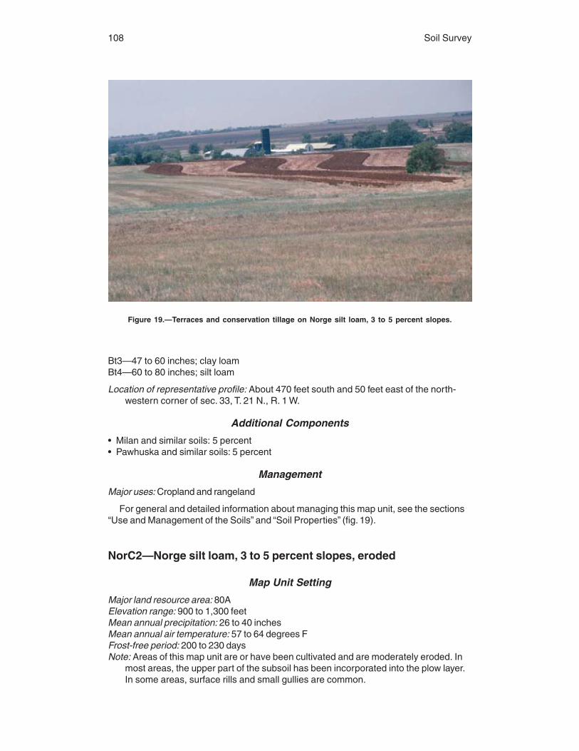
108 Soil Survey
Bt3—47 to 60 inches; clay loamBt4—60 to 80 inches; silt loam
Location of representative profile: About 470 feet south and 50 feet east of the north-western corner of sec. 33, T. 21 N., R. 1 W.
Additional Components
• Milan and similar soils: 5 percent• Pawhuska and similar soils: 5 percent
Management
Major uses: Cropland and rangeland
For general and detailed information about managing this map unit, see the sections“Use and Management of the Soils” and “Soil Properties” (fig. 19).
NorC2—Norge silt loam, 3 to 5 percent slopes, eroded
Map Unit Setting
Major land resource area: 80AElevation range: 900 to 1,300 feetMean annual precipitation: 26 to 40 inchesMean annual air temperature: 57 to 64 degrees FFrost-free period: 200 to 230 daysNote: Areas of this map unit are or have been cultivated and are moderately eroded. In
most areas, the upper part of the subsoil has been incorporated into the plow layer.In some areas, surface rills and small gullies are common.
Figure 19.—Terraces and conservation tillage on Norge silt loam, 3 to 5 percent slopes.

Noble County, Oklahoma 109
Major Component Description
Norge and similar soils
Extent of the component in the map unit: 90 percentGeomorphic setting: Terrace on plainsLandform position: BackslopeParent material: Silty Pleistocene alluviumSlope range: 3 to 5 percentRunoff: MediumSoil depth: More than 60 inchesSlowest permeability class within a depth of 60 inches: Moderately slowDrainage class: Well drainedAvailable water capacity: About 11.3 inchesDepth to water table: More than 6 feetFlooding: NonePonding: None
Interpretive groups:Land capability classification—3eRange site number and name—080AY856OK, Reseeded Loamy Prairie
Typical profile:Ap—0 to 9 inches; silt loamBt1—9 to 18 inches; silty clay loamBt2—18 to 30 inches; silty clay loamBt3—30 to 44 inches; silty clay loamBt4—44 to 64 inches; silty clay loamBC—64 to 86 inches; silt loam
Location of representative profile: About 1,950 feet west and 1,050 feet south of thenortheastern corner of sec. 11, T. 23 N., R. 1 E.
Additional Components
• Milan and similar soils: 5 percent• Pawhuska and similar soils: 5 percent
Management
Major uses: Cropland and rangeland
For general and detailed information about managing this map unit, see the sections“Use and Management of the Soils” and “Soil Properties.”
NoUC—Norge-Urban land complex, 1 to 5 percent slopes
Map Unit Setting
Major land resource area: 80AElevation range: 700 to 2,000 feetMean annual precipitation: 22 to 40 inchesMean annual air temperature: 57 to 64 degrees FFrost-free period: 185 to 230 daysNote: Areas of the Norge soil and Urban land are so intermingled that they could not be
separated at a scale of 1:24,000.

110 Soil Survey
Major Component Description
Norge and similar soils
Extent of the component in the map unit: 55 percentGeomorphic setting: Terrace on plainsLandform position: Summit and backslopeParent material: Silty Pleistocene alluviumSlope range: 1 to 5 percentRunoff: MediumSoil depth: More than 60 inchesSlowest permeability class within a depth of 60 inches: Moderately slowDrainage class: Well drainedAvailable water capacity: About 11.3 inchesDepth to water table: More than 6 feetFlooding: NonePonding: None
Interpretive groups:Land capability classification—3eRange site number and name—none assigned
Typical profile:A—0 to 7 inches; silt loamBA—7 to 10 inches; silt loamBt1—10 to 20 inches; silty clay loamBt2—20 to 39 inches; silty clay loamBt3—39 to 45 inches; silty clay loamBt4—45 to 80 inches; silty clay loam
Location of representative profile: About 2,300 feet north and 100 feet east of thesouthwestern corner of sec. 14, T. 21 N., R. 1 W.
Urban land
Extent of the component in the map unit: 30 percentDefinition of the component: Mostly residential and business areas, streets, and parking
areasGeomorphic setting: Terrace on plainsLandform position: Summit and backslopeParent material: Earthy fill derived primarily from Dale and Norge soilsSlope range: 1 to 5 percentRunoff: Very high
Interpretive groups:Land capability classification—8eRange site number and name—none assigned
Location of a representative area: About 2,300 feet north and 100 feet east of thesouthwestern corner of sec. 14, T. 21 N., R. 1 W.
Additional Components
• Bethany and similar soils: 5 percent• Dale and similar soils: 5 percent• Milan and similar soils: 5 percent
Management
Major uses: Urban land

Noble County, Oklahoma 111
For general and detailed information about managing this map unit, see the sections“Use and Management of the Soils” and “Soil Properties.”
OWWE—Oil waste land-Westsum complex, 3 to 12 percent slopes
Map Unit Setting
Major land resource area: 80AElevation range: 500 to 2,200 feetMean annual precipitation: 22 to 48 inchesMean annual air temperature: 57 to 64 degrees FFrost-free period: 190 to 240 daysNote: Areas of oil waste land and the Westsum soil occur in a regular and repeating
pattern. They are so intermingled that individual areas of the named componentscould not be separated at a scale of 1:24,000.
Major Component Description
Oil waste land
Extent of the component in the map unit: 69 percentGeomorphic setting: Hillslope on hillsParent material: Gray clayey residuum weathered from Permian sandstone and shaleSlope range: 3 to 12 percentRunoff: Very highSoil depth: More than 60 inchesSlowest permeability class within a depth of 60 inches: ImpermeableDepth to water table: More than 6 feetFlooding: NonePonding: NoneSalt affected: Saline within a depth of 30 inchesSodium affected: Sodic within a depth of 30 inches
Interpretive groups:Land capability classification—8sRange site number and name—none assigned
Location of a representative area: About 350 feet west and 1,400 feet north of thesoutheastern corner of sec. 16, T. 23 N., R. 2 W.
Westsum and similar soils
Extent of the component in the map unit: 25 percentGeomorphic setting: Hillslope on hillsLandform position: FootslopeParent material: Gray clayey residuum weathered from Permian shaleSlope range: 3 to 5 percentRunoff: Very highSoil depth: More than 60 inchesSlowest permeability class within a depth of 60 inches: Very slowDrainage class: Well drainedAvailable water capacity: About 10.2 inchesDepth to water table: More than 6 feetFlooding: NonePonding: None

112 Soil Survey
Interpretive groups:Land capability classification—3eRange site number and name—080AY010OK, Claypan Prairie (north)
Typical profile:A—0 to 9 inches; silty clay loamBt1—9 to 14 inches; silty clayBtk1—14 to 20 inches; silty clayBtk2—20 to 28 inches; silty clayBt2—28 to 45 inches; silty clayBt3—45 to 56 inches; silty clayBC—56 to 72 inches; silty clay
Location of representative profile: About 350 feet west and 1,400 feet north of thesoutheastern corner of sec. 16, T. 23 N., R. 2 W.
Additional Components
• Dilworth and similar soils: 6 percent
Management
Major uses: Rangeland
For general and detailed information about managing this map unit, see the sections“Use and Management of the Soils” and “Soil Properties.”
PoaA—Port silt loam, 0 to 1 percent slopes, frequently flooded
Map Unit Setting
Major land resource area: 80AElevation range: 700 to 1,500 feetMean annual precipitation: 26 to 38 inchesMean annual air temperature: 57 to 63 degrees FFrost-free period: 200 to 230 days
Major Component Description
Port and similar soils
Extent of the component in the map unit: 84 percentGeomorphic setting: Valley flat on a flood plain in a valleyParent material: Silty alluviumSlope range: 0 to 1 percentRunoff: NegligibleSoil depth: More than 60 inchesSlowest permeability class within a depth of 60 inches: ModerateDrainage class: Well drainedAvailable water capacity: About 11.8 inchesDepth to water table: More than 6 feetFlooding: FrequentPonding: None
Interpretive groups:Land capability classification—5wRange site number and name—080AY050OK, Loamy Bottomland
Typical profile:A1—0 to 19 inches; silt loam

Noble County, Oklahoma 113
A2—19 to 30 inches; silt loamBw1—30 to 43 inches; silt loamBw2—43 to 59 inches; silt loamBw3—59 to 74 inches; silty clay loam
Location of representative profile: About 500 feet west and 600 feet north of the south-eastern corner of sec. 32, T. 23 N., R. 2 W.
Additional Components
• Easpur and similar soils: 5 percent• Miller and similar soils: 5 percent• Oscar and similar soils: 5 percent• Depressions and channels: 1 percent
Management
Major uses: Rangeland
For general and detailed information about managing this map unit, see the sections“Use and Management of the Soils” and “Soil Properties.”
PoOA—Port-Oscar complex, 0 to 1 percent slopes, occasionallyflooded
Map Unit Setting
Major land resource area: 80AElevation range: 700 to 1,500 feetMean annual precipitation: 26 to 38 inchesMean annual air temperature: 57 to 63 degrees FFrost-free period: 190 to 230 daysNote: These Port and Oscar soils occur in a regular and repeating pattern. They are so
intermingled that individual areas of the named soils could not be separated at ascale of 1:24,000.
Major Component Description
Port and similar soils
Extent of the component in the map unit: 57 percentGeomorphic setting: Valley flat on a flood plain in a valleyParent material: Silty alluviumSlope range: 0 to 1 percentRunoff: NegligibleSoil depth: More than 60 inchesSlowest permeability class within a depth of 60 inches: ModerateDrainage class: Well drainedAvailable water capacity: About 11.8 inchesDepth to water table: More than 6 feetFlooding: OccasionalPonding: None
Interpretive groups:Land capability classification—2wRange site number and name—080AY050OK, Loamy Bottomland
Typical profile:A1—0 to 16 inches; silt loam

114 Soil Survey
A2—16 to 23 inches; silt loamBw1—23 to 40 inches; silt loamBw2—40 to 51 inches; silt loamAb—51 to 80 inches; silt loam
Location of representative profile: About 2,350 feet west and 100 feet north of thesoutheastern corner of sec. 36, T. 21 N., R. 2 E.
Oscar and similar soils
Extent of the component in the map unit: 40 percentGeomorphic setting: Valley flat on a flood plain in a valleyParent material: Silty alluviumSlope range: 0 to 1 percentRunoff: MediumSoil depth: More than 60 inchesSlowest permeability class within a depth of 60 inches: SlowDrainage class: Moderately well drainedAvailable water capacity: About 11.1 inchesDepth to water table: More than 6 feetFlooding: OccasionalPonding: NoneSalt affected: Saline within a depth of 30 inchesSodium affected: Sodic within a depth of 30 inches
Interpretive groups:Land capability classification—6sRange site number and name—080AY001OK, Alkali Bottomland
Typical profile:A1—0 to 4 inches; silt loamA2—4 to 10 inches; silt loamBtn—10 to 16 inches; silty clay loamBC—16 to 33 inches; silt loamAb1—33 to 43 inches; silt loamAb2—43 to 80 inches; silt loam
Location of representative profile: About 2,300 feet west and 100 feet north of thesoutheastern corner of sec. 36, T. 21 N., R. 2 E.
Additional Components
• Miller and similar soils: 2 percent• Depressions and channels: 1 percent
Management
Major uses: Cropland and rangeland
For general and detailed information about managing this map unit, see the sections“Use and Management of the Soils” and “Soil Properties.”
PorA—Port silt loam, 0 to 1 percent slopes, occasionally flooded
Map Unit Setting
Major land resource area: 80AElevation range: 700 to 1,500 feetMean annual precipitation: 26 to 38 inches
Noble County, Oklahoma 115
Mean annual air temperature: 57 to 63 degrees FFrost-free period: 190 to 230 days
Major Component Description
Port and similar soils
Extent of the component in the map unit: 92 percentGeomorphic setting: Valley flat on a flood plain in a valleyParent material: Silty alluviumSlope range: 0 to 1 percentRunoff: NegligibleSoil depth: More than 60 inchesSlowest permeability class within a depth of 60 inches: ModerateDrainage class: Well drainedAvailable water capacity: About 11.8 inchesDepth to water table: More than 6 feetFlooding: OccasionalPonding: None
Interpretive groups:Land capability classification—2wRange site number and name—080AY050OK, Loamy Bottomland
Typical profile:Ap—0 to 8 inches; silt loamAd—8 to 14 inches; silt loamA1—14 to 20 inches; silt loamA2—20 to 31 inches; silt loamBw—31 to 40 inches; silt loamBk1—40 to 48 inches; silt loamBk2—48 to 55 inches; silty clay loamAb—55 to 68 inches; silty clay loamBwb1—68 to 74 inches; silty clay loamBwb2—74 to 85 inches; silty clay loamBwb3—85 to 93 inches; silty clay loam
Location of representative profile: About 1,700 feet east and 100 feet north of thesouthwestern corner of sec. 27, T. 22 N., R. 1 W.
Additional Components
• Easpur and similar soils: 5 percent• Oscar and similar soils: 2 percent• Depressions and channels: 1 percent
Management
Major uses: Cropland and rangeland (fig. 20)
For general and detailed information about managing this map unit, see the sections“Use and Management of the Soils” and “Soil Properties.”
PotA—Port silty clay loam, 0 to 1 percent slopes, occasionallyflooded
Map Unit Setting
Major land resource area: 80AElevation range: 700 to 1,500 feet

116 Soil Survey
Mean annual precipitation: 26 to 38 inchesMean annual air temperature: 57 to 63 degrees FFrost-free period: 190 to 230 days
Major Component Description
Port and similar soils
Extent of the component in the map unit: 86 percentGeomorphic setting: Valley flat on a flood plain in a valleyParent material: Silty alluviumSlope range: 0 to 1 percentRunoff: NegligibleSoil depth: More than 60 inchesSlowest permeability class within a depth of 60 inches: ModerateDrainage class: Well drainedAvailable water capacity: About 11.8 inchesDepth to water table: More than 6 feetFlooding: OccasionalPonding: None
Interpretive groups:Land capability classification—2wRange site number and name—080AY050OK, Loamy Bottomland
Typical profile:A—0 to 10 inches; silty clay loamBw1—10 to 26 inches; silty clay loamBw2—26 to 35 inches; silty clay loamBw3—35 to 66 inches; silty clay loamBC—66 to 80 inches; silty clay loam
Figure 20.—Alfalfa on Port silt loam, 0 to 1 percent slopes, occasionally flooded.

Noble County, Oklahoma 117
Location of representative profile: About 1,050 feet north and 100 feet east of thesouthwestern corner of sec. 16, T. 23 N., R. 1 W.
Additional Components
• Lela and similar soils: 5 percent• Miller and similar soils: 5 percent• Oscar and similar soils: 3 percent• Depressions and channels: 1 percent
Management
Major uses: Cropland and rangeland
For general and detailed information about managing this map unit, see the sections“Use and Management of the Soils” and “Soil Properties.”
PukA—Pulaski fine sandy loam, 0 to 1 percent slopes, frequentlyflooded
Map Unit Setting
Major land resource area: 84AElevation range: 700 to 1,100 feetMean annual precipitation: 30 to 40 inchesMean annual air temperature: 57 to 63 degrees FFrost-free period: 200 to 240 days
Major Component Description
Pulaski and similar soils
Extent of the component in the map unit: 70 percentGeomorphic setting: Valley flat on a flood plain in a valleyParent material: Loamy alluviumSlope range: 0 to 1 percentRunoff: NegligibleSoil depth: More than 60 inchesSlowest permeability class within a depth of 60 inches: Moderately rapidDrainage class: Well drainedAvailable water capacity: About 9.2 inchesDepth to water table: More than 6 feetFlooding: FrequentPonding: None
Interpretive groups:Land capability classification—5wRange site number and name—084AY050OK, Loamy Bottomland
Typical profile:A1—0 to 8 inches; fine sandy loamA2—8 to 20 inches; fine sandy loamC1—20 to 37 inches; fine sandy loamAb—37 to 47 inches; fine sandy loamC2—47 to 80 inches; stratified fine sandy loam to fine sand
Location of representative profile: About 1,100 feet east and 20 feet south of the north-western corner of sec. 21, T. 19 N., R. 2 E.; Payne County, Oklahoma

118 Soil Survey
Additional Components
• Ashport and similar soils: 10 percent• Easpur and similar soils: 10 percent• Port and similar soils: 10 percent
Management
Major uses: Rangeland
For general and detailed information about managing this map unit, see the sections“Use and Management of the Soils” and “Soil Properties.”
PulA—Pulaski fine sandy loam, 0 to 1 percent slopes, occasionallyflooded
Map Unit Setting
Major land resource area: 84AElevation range: 700 to 1,100 feetMean annual precipitation: 30 to 40 inchesMean annual air temperature: 57 to 63 degrees FFrost-free period: 200 to 240 days
Major Component Description
Pulaski and similar soils
Extent of the component in the map unit: 82 percentGeomorphic setting: Natural levee on a flood plain in a valleyParent material: Loamy alluviumSlope range: 0 to 1 percentRunoff: NegligibleSoil depth: More than 60 inchesSlowest permeability class within a depth of 60 inches: Moderately rapidDrainage class: Well drainedAvailable water capacity: About 8.8 inchesDepth to water table: More than 6 feetFlooding: OccasionalPonding: None
Interpretive groups:Land capability classification—2wRange site number and name—084AY050OK, Loamy Bottomland
Typical profile:A—0 to 9 inches; fine sandy loamC1—9 to 27 inches; fine sandy loamC2—27 to 80 inches; stratified loamy fine sand to loam
Location of representative profile: About 3,050 feet south and 2,800 feet east of thenorthwestern corner of sec. 11, T. 21 N., R. 3 E.
Additional Components
• Easpur and similar soils: 10 percent• Ashport and similar soils: 5 percent• Port and similar soils: 3 percent
Noble County, Oklahoma 119
Management
Major uses: Cropland and rangeland
For general and detailed information about managing this map unit, see the sections“Use and Management of the Soils” and “Soil Properties.”
RefC2—Renfrow loam, 3 to 5 percent slopes, eroded
Map Unit Setting
Major land resource area: 80AElevation range: 900 to 1,500 feetMean annual precipitation: 26 to 40 inchesMean annual air temperature: 57 to 64 degrees FFrost-free period: 190 to 230 daysNote: Areas of this map unit are or have been cultivated and are moderately eroded. In
most areas, the upper part of the subsoil has been incorporated into the plow layer.In some areas, surface rills and small gullies are common.
Major Component Description
Renfrow and similar soils
Extent of the component in the map unit: 75 percentGeomorphic setting: Hillslope on hillsLandform position: BackslopeParent material: Clayey residuum weathered from clayey Permian shaleSlope range: 3 to 5 percentRunoff: Very highSoil depth: More than 60 inchesSlowest permeability class within a depth of 60 inches: Very slowDrainage class: Well drainedAvailable water capacity: About 10.2 inchesDepth to water table: More than 6 feetFlooding: NonePonding: None
Interpretive groups:Land capability classification—3eRange site number and name—080AY810OK, Reseeded Claypan Prairie
Typical profile:Ap—0 to 6 inches; loamBt1—6 to 35 inches; silty clayBt2—35 to 73 inches; silty clay
Location of representative profile: About 2,500 feet south and 900 feet west of thenortheastern corner of sec. 24, T. 20 N., R. 2 E.; Payne County, Oklahoma
Additional Components
• Grainola and similar soils: 10 percent• Piedmont and similar soils: 5 percent• Zaneis and similar soils: 5 percent• Pawhuska and similar soils: 3 percent• Huska and similar soils: 2 percent

120 Soil Survey
Management
Major uses: Cropland and rangeland
For general and detailed information about managing this map unit, see the sections“Use and Management of the Soils” and “Soil Properties.”
ReGC2—Renfrow and Grainola soils, 3 to 5 percent slopes, eroded
Map Unit Setting
Major land resource area: 80AElevation range: 800 to 1,500 feetMean annual precipitation: 26 to 40 inchesMean annual air temperature: 57 to 64 degrees FFrost-free period: 190 to 230 daysNote: The composition of soils in delineations of this map unit is variable. Most areas
are made up of both soils, but some areas may be only the Renfrow soil. Areas ofthis map unit are or have been cultivated and are moderately eroded. In most areas,the upper part of the subsoil has been incorporated into the plow layer. In someareas, surface rills and small gullies are common.
Major Component Description
Renfrow and similar soils
Extent of the component in the map unit: 60 percentGeomorphic setting: Hillslope on hillsLandform position: BackslopeParent material: Clayey residuum weathered from clayey Permian shaleSlope range: 3 to 5 percentRunoff: Very highDepth to bedrock (paralithic): 61 to 80 inchesSlowest permeability class within a depth of 60 inches: Very slowDrainage class: Well drainedAvailable water capacity: About 10.3 inchesDepth to water table: More than 6 feetFlooding: NonePonding: None
Interpretive groups:Land capability classification—3eRange site number and name—080AY810OK, Reseeded Claypan Prairie
Typical profile:Ap—0 to 8 inches; silty clay loamBA—8 to 12 inches; silty clay loamBt1—12 to 30 inches; silty clayBt2—30 to 44 inches; silty clayBC—44 to 63 inches; silty clayCr—63 to 80 inches; bedrock
Location of representative profile: About 1,900 feet west and 850 feet north of thesoutheastern corner of sec. 8, T. 20 N., R. 1 W.
Grainola and similar soils
Extent of the component in the map unit: 20 percentGeomorphic setting: Hillslope on hills

Noble County, Oklahoma 121
Landform position: BackslopeParent material: Clayey residuum weathered from clayey Permian shaleSlope range: 3 to 5 percentRunoff: Very highDepth to bedrock (paralithic): 20 to 40 inchesSlowest permeability class within a depth of 60 inches: ImpermeableDrainage class: Well drainedAvailable water capacity: About 5.5 inchesDepth to water table: More than 6 feetFlooding: NonePonding: None
Interpretive groups:Land capability classification—4eRange site number and name—080AY810OK, Reseeded Claypan Prairie
Typical profile:Ap—0 to 7 inches; silty clay loamBA—7 to 12 inches; silty clay loamBt—12 to 26 inches; silty clayBC—26 to 33 inches; silty clayCr—33 to 40 inches; bedrock
Location of representative profile: About 1,900 feet west and 1,000 feet north of thesoutheastern corner of sec. 8, T. 20 N., R. 1 W.
Additional Components
• Renthin and similar soils: 8 percent• Kirkland and similar soils: 3 percent• Lucien and similar soils: 3 percent• Pawhuska and similar soils: 3 percent• Piedmont and similar soils: 3 percent
Management
Major uses: Cropland and rangeland
For general and detailed information about managing this map unit, see the sections“Use and Management of the Soils” and “Soil Properties.”
ReiA—Reinach very fine sandy loam, 0 to 1 percent slopes, rarelyflooded
Map Unit Setting
Major land resource area: 80AElevation range: 700 to 1,300 feetMean annual precipitation: 26 to 38 inchesMean annual air temperature: 57 to 63 degrees FFrost-free period: 190 to 230 days
Major Component Description
Reinach and similar soils
Extent of the component in the map unit: 90 percentGeomorphic setting: Valley flat on a flood plain in a valleyParent material: Silty alluvium

122 Soil Survey
Slope range: 0 to 1 percentRunoff: NegligibleSoil depth: More than 60 inchesSlowest permeability class within a depth of 60 inches: ModerateDrainage class: Well drainedAvailable water capacity: About 10.6 inchesDepth to water table: More than 6 feetFlooding: RarePonding: None
Interpretive groups:Land capability classification—1Range site number and name—080AY050OK, Loamy Bottomland
Typical profile:Ap—0 to 8 inches; very fine sandy loamA1—8 to 23 inches; very fine sandy loamA2—23 to 30 inches; very fine sandy loamBw1—30 to 42 inches; very fine sandy loamBw2—42 to 65 inches; silt loamBw3—65 to 82 inches; very fine sandy loam
Location of representative profile: About 250 feet south and 200 feet east of the north-western corner of sec. 3, T. 24 N., R. 2 E.
Additional Components
• Keokuk and similar soils: 10 percent
Management
Major uses: Cropland and rangeland
For general and detailed information about managing this map unit, see the sections“Use and Management of the Soils” and “Soil Properties.”
RenB—Renfrow silt loam, 1 to 3 percent slopes
Map Unit Setting
Major land resource area: 80AElevation range: 900 to 1,500 feetMean annual precipitation: 26 to 40 inchesMean annual air temperature: 57 to 64 degrees FFrost-free period: 190 to 230 days
Major Component Description
Renfrow and similar soils
Extent of the component in the map unit: 82 percentGeomorphic setting: Hillslope on hillsLandform position: Summit and backslopeParent material: Clayey residuum weathered from clayey Permian shaleSlope range: 1 to 3 percentRunoff: Very highSoil depth: More than 60 inchesSlowest permeability class within a depth of 60 inches: Very slowDrainage class: Well drained

Noble County, Oklahoma 123
Available water capacity: About 10.4 inchesDepth to water table: More than 6 feetFlooding: NonePonding: None
Interpretive groups:Land capability classification—2eRange site number and name—080AY010OK, Claypan Prairie (north)
Typical profile:Ap—0 to 9 inches; silt loamBA—9 to 13 inches; silty clay loamBt1—13 to 23 inches; silty clay loamBt2—23 to 42 inches; silty clayBt3—42 to 60 inches; silty clayBC—60 to 80 inches; silty clay
Location of representative profile: About 1,500 feet west and 2,600 feet south of thenortheastern corner of sec. 19, T. 21 N., R. 1 W.
Additional Components
• Grainola and similar soils: 10 percent• Pawhuska and similar soils: 5 percent• Bethany and similar soils: 3 percent
Management
Major uses: Cropland and rangeland (fig. 21)
For general and detailed information about managing this map unit, see the sections“Use and Management of the Soils” and “Soil Properties.”
Figure 21.—Rangeland on Renfrow silt loam, 1 to 3 percent slopes, in the foreground, andGrainola-Lucien complex, 1 to 5 percent slopes, in the background.

124 Soil Survey
RenC—Renfrow silt loam, 3 to 5 percent slopes
Map Unit Setting
Major land resource area: 80AElevation range: 900 to 1,500 feetMean annual precipitation: 26 to 40 inchesMean annual air temperature: 57 to 64 degrees FFrost-free period: 190 to 230 days
Major Component Description
Renfrow and similar soils
Extent of the component in the map unit: 85 percentGeomorphic setting: Hillslope on hillsLandform position: Summit and backslopeParent material: Clayey residuum weathered from clayey Permian shaleSlope range: 3 to 5 percentRunoff: Very highSoil depth: More than 60 inchesSlowest permeability class within a depth of 60 inches: Very slowDrainage class: Well drainedAvailable water capacity: About 10.4 inchesDepth to water table: More than 6 feetFlooding: NonePonding: None
Interpretive groups:Land capability classification—3eRange site number and name—080AY010OK, Claypan Prairie (north)
Typical profile:Ap—0 to 10 inches; silt loamBA—10 to 13 inches; silty clay loamBt1—13 to 28 inches; silty clayBt2—28 to 36 inches; silty clayBt3—36 to 50 inches; silty clayBC1—50 to 65 inches; silty clayBC2—65 to 80 inches; silty clay
Location of representative profile: About 1,400 feet east and 150 feet south of thenorthwestern corner of sec. 30, T. 21 N., R. 1 W.
Additional Components
• Grainola and similar soils: 12 percent• Pawhuska and similar soils: 3 percent
Management
Major uses: Cropland and rangeland
For general and detailed information about managing this map unit, see the sections“Use and Management of the Soils” and “Soil Properties.”

Noble County, Oklahoma 125
RewC2—Renfrow silty clay loam, 3 to 5 percent slopes, eroded
Map Unit Setting
Major land resource area: 80AElevation range: 900 to 1,500 feetMean annual precipitation: 26 to 40 inchesMean annual air temperature: 57 to 64 degrees FFrost-free period: 190 to 230 daysNote: Areas of this map unit are or have been cultivated and are moderately eroded. In
most areas, the upper part of the subsoil has been incorporated into the plow layer.In some areas, surface rills and small gullies are common.
Major Component Description
Renfrow and similar soils
Extent of the component in the map unit: 80 percentGeomorphic setting: Hillslope on hillsLandform position: BackslopeParent material: Clayey residuum weathered from clayey Permian shaleSlope range: 3 to 5 percentRunoff: MediumDepth to bedrock (paralithic): 61 to 80 inchesSlowest permeability class within a depth of 60 inches: Very slowDrainage class: Well drainedAvailable water capacity: About 10.2 inchesDepth to water table: More than 6 feetFlooding: NonePonding: None
Interpretive groups:Land capability classification—3eRange site number and name—080AY810OK, Reseeded Claypan Prairie
Typical profile:Ap—0 to 10 inches; silty clay loamBt1—10 to 24 inches; silty clayBt2—24 to 37 inches; silty clayBt3—37 to 54 inches; silty clayBC—54 to 63 inches; silty clayCr—63 to 80 inches; bedrock
Location of representative profile: About 2,300 feet south and 2,200 feet east of thenorthwestern corner of sec. 22, T. 19 N., R. 4 W.; Logan County, Oklahoma
Additional Components
• Grainola and similar soils: 9 percent• Huska and similar soils: 4 percent• Zaneis and similar soils: 4 percent• Kirkland and similar soils: 3 percent
Management
Major uses: Cropland and rangeland
For general and detailed information about managing this map unit, see the sections“Use and Management of the Soils” and “Soil Properties.”

126 Soil Survey
RGPD3—Renfrow, Grainola, and Pawhuska soils, 3 to 8 percentslopes, severely eroded
Map Unit Setting
Major land resource area: 80AElevation range: 700 to 1,500 feetMean annual precipitation: 26 to 40 inchesMean annual air temperature: 57 to 64 degrees FFrost-free period: 190 to 230 daysNote: The pattern of soils in this map unit is variable from one area to another. Most
areas are made up of all three named soils, but some areas may be only theRenfrow soil. Areas of this map unit have been cultivated and are severely eroded.The upper part of the subsoil has been mixed into the plow layer, and surface rillsand small gullies are common. Uncrossable gullies are common in some delinea-tions.
Major Component Description
Renfrow and similar soils
Extent of the component in the map unit: 45 percentGeomorphic setting: Hillslope on hillsLandform position: BackslopeParent material: Clayey residuum weathered from clayey Permian shaleSlope range: 3 to 5 percentRunoff: Very highSoil depth: More than 60 inchesSlowest permeability class within a depth of 60 inches: Very slowDrainage class: Well drainedAvailable water capacity: About 10.2 inchesDepth to water table: More than 6 feetFlooding: NonePonding: None
Interpretive groups:Land capability classification—6eRange site number and name—080AY810OK, Reseeded Claypan Prairie
Typical profile:Ap—0 to 10 inches; clay loamBt1—10 to 24 inches; silty clayBt2—24 to 44 inches; silty clay loamBt3—44 to 80 inches; silty clay loam
Location of representative profile: About 900 feet north and 600 feet east of the south-western corner of sec. 5, T. 20 N., R. 1 E.
Grainola and similar soils
Extent of the component in the map unit: 29 percentGeomorphic setting: Hillslope on hillsLandform position: BackslopeParent material: Clayey residuum weathered from clayey Permian shaleSlope range: 3 to 8 percentRunoff: Very highDepth to bedrock (paralithic): 20 to 40 inchesSlowest permeability class within a depth of 60 inches: Impermeable

Noble County, Oklahoma 127
Drainage class: Well drainedAvailable water capacity: About 3.5 inchesDepth to water table: More than 6 feetFlooding: NonePonding: None
Interpretive groups:Land capability classification—6eRange site number and name—080AY810OK, Reseeded Claypan Prairie
Typical profile:Ap—0 to 5 inches; silty clay loamBt—5 to 21 inches; silty clayCr—21 to 24 inches; bedrock
Location of representative profile: About 600 feet north and 300 feet east of the south-western corner of sec. 5, T. 20 N., R. 1 E.
Pawhuska and similar soils
Extent of the component in the map unit: 15 percentGeomorphic setting: Hillslope on hillsLandform position: BackslopeParent material: Residuum weathered from Permian sandstone and shaleSlope range: 3 to 5 percentRunoff: Very highSoil depth: More than 60 inchesSlowest permeability class within a depth of 60 inches: Very slowDrainage class: Moderately well drainedAvailable water capacity: About 7.7 inchesDepth to water table: More than 6 feetFlooding: NonePonding: NoneSalt affected: Saline within a depth of 30 inchesSodium affected: Sodic within a depth of 30 inches
Interpretive groups:Land capability classification—6eRange site number and name—080AY891OK, Reseeded Slickspot
Typical profile:Ap—0 to 3 inches; silt loamBtn1—3 to 13 inches; silty clayBtn2—13 to 42 inches; silty clay loamBtn3—42 to 80 inches; silty clay loam
Location of representative profile: About 800 feet north and 600 feet east of the south-western corner of sec. 5, T. 20 N., R. 1 E.
Additional Components
• Mulhall and similar soils: 6 percent• Huska and similar soils: 5 percent
Management
Major uses: Rangeland
For general and detailed information about managing this map unit, see the sections“Use and Management of the Soils” and “Soil Properties.”

128 Soil Survey
SlaB—Slaughterville fine sandy loam, 0 to 3 percent slopes
Map Unit Setting
Major land resource area: 80AElevation range: 800 to 1,200 feetMean annual precipitation: 26 to 40 inchesMean annual air temperature: 57 to 64 degrees FFrost-free period: 190 to 220 days
Major Component Description
Slaughterville and similar soils
Extent of the component in the map unit: 85 percentGeomorphic setting: Stream terrace in a valleyLandform position: Tread and riserParent material: Coarse-loamy Pleistocene alluviumSlope range: 1 to 3 percentRunoff: Very lowSoil depth: More than 60 inchesSlowest permeability class within a depth of 60 inches: ModerateDrainage class: Well drainedAvailable water capacity: About 7.7 inchesDepth to water table: More than 6 feetFlooding: NonePonding: None
Interpretive groups:Land capability classification—2eRange site number and name—080AY073OK, Sandy Prairie
Typical profile:Ap—0 to 10 inches; fine sandy loamBw1—10 to 39 inches; fine sandy loamBw2—39 to 50 inches; fine sandy loamBtb—50 to 80 inches; sandy clay loam
Location of representative profile: About 300 feet east and 700 feet south of the north-western corner of sec. 17, T. 24 N., R. 4 E.
Additional Components
• Konawa and similar soils: 10 percent• Minco and similar soils: 5 percent
Management
Major uses: Cropland and rangeland
For general and detailed information about managing this map unit, see the sections“Use and Management of the Soils” and “Soil Properties.”
SlaC—Slaughterville fine sandy loam, 3 to 5 percent slopes
Map Unit Setting
Major land resource area: 80AElevation range: 800 to 1,200 feet

Noble County, Oklahoma 129
Mean annual precipitation: 26 to 40 inchesMean annual air temperature: 57 to 64 degrees FFrost-free period: 190 to 220 days
Major Component Description
Slaughterville and similar soils
Extent of the component in the map unit: 85 percentGeomorphic setting: Stream terrace in a valleyLandform position: RiserParent material: Coarse-loamy Pleistocene alluviumSlope range: 3 to 5 percentRunoff: Very lowSoil depth: More than 60 inchesSlowest permeability class within a depth of 60 inches: Moderately rapidDrainage class: Well drainedAvailable water capacity: About 7.5 inchesDepth to water table: More than 6 feetFlooding: NonePonding: None
Interpretive groups:Land capability classification—3eRange site number and name—080AY073OK, Sandy Prairie
Typical profile:Ap—0 to 13 inches; fine sandy loamBw1—13 to 19 inches; fine sandy loamBw2—19 to 30 inches; fine sandy loamBw3—30 to 50 inches; fine sandy loamC—50 to 80 inches; fine sandy loam
Location of representative profile: About 2,400 feet east and 300 feet south of thenorthwestern corner of sec. 22, T. 24 N., R. 3 E.
Additional Components
• Minco and similar soils: 10 percent• Konawa and similar soils: 5 percent
Management
Major uses: Cropland and rangeland
For general and detailed information about managing this map unit, see the sections“Use and Management of the Soils” and “Soil Properties.”
SlaG—Slaughterville fine sandy loam, 8 to 45 percent slopes
Map Unit Setting
Major land resource area: 80AElevation range: 800 to 1,200 feetMean annual precipitation: 26 to 40 inchesMean annual air temperature: 57 to 64 degrees FFrost-free period: 190 to 220 days

130 Soil Survey
Major Component Description
Slaughterville and similar soils
Extent of the component in the map unit: 78 percentGeomorphic setting: Stream terrace in a valleyLandform position: RiserParent material: Coarse-loamy Pleistocene alluviumSlope range: 8 to 45 percentRunoff: LowSoil depth: More than 60 inchesSlowest permeability class within a depth of 60 inches: Moderately rapidDrainage class: Well drainedAvailable water capacity: About 7.2 inchesDepth to water table: More than 6 feetFlooding: NonePonding: None
Interpretive groups:Land capability classification—7eRange site number and name—080AY073OK, Sandy Prairie
Typical profile:A—0 to 16 inches; fine sandy loamBw—16 to 33 inches; fine sandy loamC—33 to 80 inches; loamy fine sand
Location of representative profile: About 450 feet east and 1,550 feet south of thenorthwestern corner of sec. 23, T. 24 N., R. 3 E.
Additional Components
• Minco and similar soils: 10 percent• Konawa and similar soils: 7 percent• Derby and similar soils: 5 percent
Management
Major uses: Rangeland
For general and detailed information about managing this map unit, see the sections“Use and Management of the Soils” and “Soil Properties.”
StDD—Stephenville-Darnell complex, 3 to 8 percent slopes
Map Unit Setting
Major land resource area: 84AElevation range: 750 to 1,500 feetMean annual precipitation: 30 to 40 inchesMean annual air temperature: 57 to 64 degrees FFrost-free period: 200 to 230 daysNote: These Stephenville and Darnell soils occur in a regular and repeating pattern. They
are so intermingled that individual areas of the named soils could not be separatedat a scale of 1:24,000.

Noble County, Oklahoma 131
Major Component Description
Stephenville and similar soils
Extent of the component in the map unit: 45 percentGeomorphic setting: Hillslope on hillsLandform position: SummitParent material: Loamy residuum weathered from Permian sandstoneSlope range: 3 to 5 percentRunoff: MediumDepth to bedrock (paralithic): 20 to 40 inchesSlowest permeability class within a depth of 60 inches: ModerateDrainage class: Well drainedAvailable water capacity: About 5.6 inchesDepth to water table: More than 6 feetFlooding: NonePonding: None
Interpretive groups:Land capability classification—3eRange site number and name—084AY076OK, Sandy Savannah (central)
Typical profile:A—0 to 5 inches; fine sandy loamE—5 to 9 inches; fine sandy loamBt—9 to 30 inches; sandy clay loamBC—30 to 36 inches; fine sandy loamCr—36 to 40 inches; bedrock
Location of representative profile: About 1,600 feet east and 1,100 feet south of thenorthwestern corner of sec. 34, T. 20 N., R. 1 E.
Darnell and similar soils
Extent of the component in the map unit: 35 percentGeomorphic setting: Hillslope on hillsLandform position: BackslopeParent material: Loamy residuum weathered from Permian sandstoneSlope range: 3 to 8 percentRunoff: Very highDepth to bedrock (paralithic): 10 to 20 inchesSlowest permeability class within a depth of 60 inches: ImpermeableDrainage class: Well drainedAvailable water capacity: About 1.6 inchesDepth to water table: More than 6 feetFlooding: NonePonding: None
Interpretive groups:Land capability classification—6eRange site number and name—084AY089OK, Shallow Savannah
Typical profile:A—0 to 4 inches; fine sandy loamBw—4 to 12 inches; fine sandy loamCr—12 to 15 inches; bedrock
Location of representative profile: About 1,300 feet east and 1,400 feet south of thenorthwestern corner of sec. 34, T. 20 N., R. 1 E.

132 Soil Survey
Additional Components
• Newalla and similar soils: 10 percent• Harrah and similar soils: 9 percent• Rock outcrop: 1 percent
Management
Major uses: Cropland and rangeland
For general and detailed information about managing this map unit, see the sections“Use and Management of the Soils” and “Soil Properties.”
TabA—Tabler silt loam, 0 to 1 percent slopes
Map Unit Setting
Major land resource area: 80AElevation range: 750 to 1,500 feetMean annual precipitation: 26 to 38 inchesMean annual air temperature: 57 to 64 degrees FFrost-free period: 190 to 230 days
Major Component Description
Tabler and similar soils
Extent of the component in the map unit: 83 percentGeomorphic setting: Terrace on plainsLandform position: SummitParent material: Loess over silty and clayey Pleistocene alluviumSlope range: 0 to 1 percentRunoff: HighSoil depth: More than 60 inchesSlowest permeability class within a depth of 60 inches: Very slowDrainage class: Moderately well drainedAvailable water capacity: About 9.7 inchesFlooding: NonePonding: None
Interpretive groups:Land capability classification—2sRange site number and name—080AY010OK, Claypan Prairie (north)
Typical profile:Ap—0 to 10 inches; silt loamBt1—10 to 25 inches; silty clayBt2—25 to 43 inches; silty clayBt3—43 to 65 inches; silty clayBt4—65 to 80 inches; silty clay
Location of representative profile: About 1,800 feet north and 350 feet west of thesoutheastern corner of sec. 7, T. 24 N., R. 2 W.
Additional Components
• Kirkland and similar soils: 10 percent• Bethany and similar soils: 5 percent• Waurika and similar soils: 2 percent

Noble County, Oklahoma 133
Management
Major uses: Cropland and rangeland
For general and detailed information about managing this map unit, see the sections“Use and Management of the Soils” and “Soil Properties.”
TeaA—Tearney silty clay, 0 to 1 percent slopes, ponded
Map Unit Setting
Major land resource area: 80AElevation range: 700 to 1,500 feetMean annual precipitation: 26 to 40 inchesMean annual air temperature: 58 to 64 degrees FFrost-free period: 200 to 230 days
Major Component Description
Tearney and similar soils
Extent of the component in the map unit: 82 percentGeomorphic setting: Interdune in a dune field on a flood plain in a valleyLandform position: DepressionParent material: Clayey alluvium over sandy alluviumSlope range: 0 to 1 percentRunoff: NegligibleSoil depth: More than 60 inchesSlowest permeability class within a depth of 60 inches: Very slowDrainage class: Well drainedAvailable water capacity: About 6.5 inchesDepth to water table: More than 6 feetFlooding: OccasionalPonding: Occasional
Interpretive groups:Land capability classification—4wRange site number and name—080AY090OK, Meadow
Typical profile:A—0 to 10 inches; silty clayBw—10 to 26 inches; silty clay loam2C1—26 to 30 inches; loamy fine sand2C2—30 to 80 inches; sand
Location of representative profile: About 3,800 feet west and 2,300 feet south of thenortheastern corner of sec. 5, T. 24 N., R. 2 E.
Additional Components
• Ashport and similar soils: 8 percent• Keokuk and similar soils: 7 percent• Depressions: 3 percent
Management
Major uses: Cropland and rangeland
For general and detailed information about managing this map unit, see the sections“Use and Management of the Soils” and “Soil Properties.”

134 Soil Survey
TelB—Teller loam, 1 to 3 percent slopes
Map Unit Setting
Major land resource area: 80AElevation range: 800 to 1,300 feetMean annual precipitation: 26 to 40 inchesMean annual air temperature: 57 to 64 degrees FFrost-free period: 200 to 230 days
Major Component Description
Teller and similar soils
Extent of the component in the map unit: 85 percentGeomorphic setting: Terrace on plainsLandform position: Summit and shoulderParent material: Loamy Pleistocene alluviumSlope range: 1 to 3 percentRunoff: LowSoil depth: More than 60 inchesSlowest permeability class within a depth of 60 inches: ModerateDrainage class: Well drainedAvailable water capacity: About 10.4 inchesDepth to water table: More than 6 feetFlooding: NonePonding: None
Interpretive groups:Land capability classification—2eRange site number and name—080AY056OK, Loamy Prairie
Typical profile:A—0 to 8 inches; loamBA—8 to 12 inches; loamBt1—12 to 20 inches; clay loamBt2—20 to 30 inches; clay loamBt3—30 to 50 inches; clay loamBC—50 to 80 inches; loam
Location of representative profile: About 2,000 feet south and 500 feet west of thenortheastern corner of sec. 12, T. 24 N., R. 3 E.
Additional Components
• Norge and similar soils: 10 percent• Konawa and similar soils: 3 percent• Pawhuska and similar soils: 2 percent
Management
Major uses: Cropland and rangeland
For general and detailed information about managing this map unit, see the sections“Use and Management of the Soils” and “Soil Properties.”

Noble County, Oklahoma 135
TelD—Teller loam, 5 to 8 percent slopes
Map Unit Setting
Major land resource area: 80AElevation range: 800 to 1,300 feetMean annual precipitation: 26 to 40 inchesMean annual air temperature: 57 to 64 degrees FFrost-free period: 200 to 230 days
Major Component Description
Teller and similar soils
Extent of the component in the map unit: 85 percentGeomorphic setting: Terrace on plainsLandform position: BackslopeParent material: Loamy Pleistocene alluviumSlope range: 5 to 8 percentRunoff: MediumSoil depth: More than 60 inchesSlowest permeability class within a depth of 60 inches: ModerateDrainage class: Well drainedAvailable water capacity: About 10.5 inchesDepth to water table: More than 6 feetFlooding: NonePonding: None
Interpretive groups:Land capability classification—4eRange site number and name—080AY056OK, Loamy Prairie
Typical profile:A—0 to 12 inches; loamBA—12 to 17 inches; loamBt1—17 to 27 inches; clay loamBt2—27 to 45 inches; clay loamBt3—45 to 58 inches; clay loamBC—58 to 80 inches; loam
Location of representative profile: About 2,400 feet north and 2,500 feet west of thesoutheastern corner of sec. 11, T. 24 N., R. 3 E.
Additional Components
• Norge and similar soils: 10 percent• Konawa and similar soils: 3 percent• Pawhuska and similar soils: 2 percent
Management
Major uses: Cropland and rangeland
For general and detailed information about managing this map unit, see the sections“Use and Management of the Soils” and “Soil Properties.”

136 Soil Survey
TelD2—Teller loam, 5 to 8 percent slopes, eroded
Map Unit Setting
Major land resource area: 80AElevation range: 800 to 1,300 feetMean annual precipitation: 26 to 40 inchesMean annual air temperature: 57 to 64 degrees FFrost-free period: 200 to 230 daysNote: Areas of this map unit are or have been cultivated and are moderately eroded. In
most areas, the upper part of the subsoil has been incorporated into the plow layer.In some areas, surface rills and small gullies are common.
Major Component Description
Teller and similar soils
Extent of the component in the map unit: 82 percentGeomorphic setting: Terrace on plainsLandform position: BackslopeParent material: Loamy Pleistocene alluviumSlope range: 5 to 8 percentRunoff: MediumSoil depth: More than 60 inchesSlowest permeability class within a depth of 60 inches: ModerateDrainage class: Well drainedAvailable water capacity: About 10.4 inchesDepth to water table: More than 6 feetFlooding: NonePonding: None
Interpretive groups:Land capability classification—4eRange site number and name—080AY856OK, Reseeded Loamy Prairie
Typical profile:A—0 to 6 inches; loamBA—6 to 11 inches; loamBt1—11 to 16 inches; clay loamBt2—16 to 31 inches; clay loamBt3—31 to 42 inches; clay loamBC—42 to 72 inches; loamC—72 to 85 inches; loam
Location of representative profile: About 3,150 feet east and 3,650 feet north of thesouthwestern corner of sec. 7, T. 24 N., R. 4 E.
Additional Components
• Norge and similar soils: 10 percent• Pawhuska and similar soils: 5 percent• Konawa and similar soils: 3 percent
Management
Major uses: Cropland and rangeland
For general and detailed information about managing this map unit, see the sections“Use and Management of the Soils” and “Soil Properties.”

Noble County, Oklahoma 137
VanA—Vanoss silt loam, 0 to 1 percent slopes
Map Unit Setting
Major land resource area: 80AElevation range: 700 to 1,200 feetMean annual precipitation: 26 to 38 inchesMean annual air temperature: 57 to 64 degrees FFrost-free period: 200 to 230 days
Major Component Description
Vanoss and similar soils
Extent of the component in the map unit: 82 percentGeomorphic setting: Stream terrace in a valleyLandform position: TreadParent material: Silty Pleistocene alluviumSlope range: 0 to 1 percentRunoff: NegligibleSoil depth: More than 60 inchesSlowest permeability class within a depth of 60 inches: ModerateDrainage class: Well drainedAvailable water capacity: About 11.4 inchesDepth to water table: More than 6 feetFlooding: NonePonding: None
Interpretive groups:Land capability classification—1Range site number and name—080AY056OK, Loamy Prairie
Typical profile:A—0 to 10 inches; silt loamBA—10 to 15 inches; silt loamBt1—15 to 30 inches; silty clay loamBt2—30 to 42 inches; silty clay loamBt3—42 to 52 inches; silty clay loamBC—52 to 80 inches; silty clay loam
Location of representative profile: About 200 feet east and 1,350 feet south of thenorthwestern corner of sec. 29, T. 24 N., R. 3 E.
Additional Components
• Bethany and similar soils: 5 percent• Minco and similar soils: 5 percent• Teller and similar soils: 5 percent• Waurika and similar soils: 2 percent• Depressions: 1 percent
Management
Major uses: Cropland and rangeland
For general and detailed information about managing this map unit, see the sections“Use and Management of the Soils” and “Soil Properties.”

138 Soil Survey
W—Water
Map Unit Setting
Major land resource area: 80AElevation range: 250 to 4,000 feetMean annual precipitation: 22 to 48 inchesMean annual air temperature: 57 to 64 degrees FFrost-free period: 190 to 240 days
Major Component Description
Water
Extent of the component in the map unit: 100 percentDefinition of the component: Ponds, lakes, rivers, and other bodies of water
Interpretive groups:Land capability classification—none assignedRange site number and name—none assigned
Location of a representative area: At Perry Lake; about 2,000 feet north and 1,000 feetwest of the southeastern corner of sec. 31, T. 21 N., R. 1 W.
Management
Major uses: Recreation
For general and detailed information about managing this map unit, see the sections“Use and Management of the Soils” and “Soil Properties.”
WauA—Waurika silt loam, 0 to 1 percent slopes
Map Unit Setting
Major land resource area: 80AElevation range: 800 to 1,500 feetMean annual precipitation: 26 to 38 inchesMean annual air temperature: 57 to 63 degrees FFrost-free period: 200 to 230 days
Major Component Description
Waurika and similar soils
Extent of the component in the map unit: 89 percentGeomorphic setting: Stream terrace in a valleyLandform position: Depression on a treadParent material: Silty and clayey Pleistocene alluviumSlope range: 0 to 1 percentRunoff: HighSoil depth: More than 60 inchesSlowest permeability class within a depth of 60 inches: Very slowDrainage class: Somewhat poorly drainedAvailable water capacity: About 9.2 inchesWater table: PresentFlooding: NonePonding: None

Noble County, Oklahoma 139
Interpretive groups:Land capability classification—2wRange site number and name—080AY010OK, Claypan Prairie (north)
Typical profile:A—0 to 9 inches; silt loamE—9 to 12 inches; silt loamBt1—12 to 31 inches; silty clayBt2—31 to 39 inches; silty clay loamBtk—39 to 61 inches; silty clay loamBC—61 to 80 inches; silty clay loam
Location of representative profile: About 1,300 feet east and 1,400 feet south of thenorthwestern corner of sec. 20, T. 24 N., R. 3 E.
Additional Components
• Kirkland and similar soils: 5 percent• Vanoss and similar soils: 5 percent• Depressions: 1 percent
Management
Major uses: Cropland and rangeland
For general and detailed information about managing this map unit, see the sections“Use and Management of the Soils” and “Soil Properties.”
WesB—Westsum silty clay loam, 1 to 3 percent slopes
Map Unit Setting
Major land resource area: 80AElevation range: 700 to 1,500 feetMean annual precipitation: 26 to 38 inchesMean annual air temperature: 57 to 63 degrees FFrost-free period: 200 to 230 days
Major Component Description
Westsum and similar soils
Extent of the component in the map unit: 85 percentGeomorphic setting: Hillslope on hillsLandform position: FootslopeParent material: Gray clayey residuum weathered from clayey Permian shaleSlope range: 1 to 3 percentRunoff: Very highSoil depth: More than 60 inchesSlowest permeability class within a depth of 60 inches: Very slowDrainage class: Well drainedAvailable water capacity: About 10.4 inchesDepth to water table: More than 6 feetFlooding: NonePonding: None
Interpretive groups:Land capability classification—2eRange site number and name—080AY010OK, Claypan Prairie (north)
140 Soil Survey
Typical profile:Ap—0 to 10 inches; silty clay loamBt1—10 to 16 inches; silty clayBtk1—16 to 30 inches; silty clayBtk2—30 to 36 inches; silty clayBt2—36 to 52 inches; silty clayBt3—52 to 65 inches; silty clayBC—65 to 80 inches; silty clay
Location of representative profile: About 650 feet north and 150 feet west of the south-eastern corner of sec. 8, T. 23 N., R. 1 W.
Additional Components
• Bethany and similar soils: 10 percent• Dilworth and similar soils: 5 percent
Management
Major uses: Cropland and rangeland
For general and detailed information about managing this map unit, see the sections“Use and Management of the Soils” and “Soil Properties.”
WesC—Westsum silty clay loam, 3 to 5 percent slopes
Map Unit Setting
Major land resource area: 80AElevation range: 700 to 1,500 feetMean annual precipitation: 26 to 38 inchesMean annual air temperature: 57 to 63 degrees FFrost-free period: 200 to 230 days
Major Component Description
Westsum and similar soils
Extent of the component in the map unit: 90 percentGeomorphic setting: Hillslope on hillsLandform position: FootslopeParent material: Gray clayey residuum weathered from clayey Permian shaleSlope range: 3 to 5 percentRunoff: Very highSoil depth: More than 60 inchesSlowest permeability class within a depth of 60 inches: Very slowDrainage class: Well drainedAvailable water capacity: About 10.8 inchesDepth to water table: More than 6 feetFlooding: NonePonding: None
Interpretive groups:Land capability classification—3eRange site number and name—080AY010OK, Claypan Prairie (north)
Typical profile:A—0 to 6 inches; silty clay loamBA—6 to 10 inches; silty clay loam

Noble County, Oklahoma 141
Btk1—10 to 17 inches; silty clayBtk2—17 to 31 inches; silty clayBtk3—31 to 59 inches; silty clayBC1—59 to 75 inches; silty clayBC2—75 to 80 inches; silty clay
Location of representative profile: About 200 feet west and 250 feet south of the north-eastern corner of sec. 21, T. 23 N., R. 2 W.
Additional Components
• Dilworth and similar soils: 10 percent
Management
Major uses: Cropland and rangeland
For general and detailed information about managing this map unit, see the sections“Use and Management of the Soils” and “Soil Properties.”
WiLC—Wisby-Lovedale complex, 1 to 5 percent slopes
Map Unit Setting
Major land resource area: 80AElevation range: 1,000 to 2,000 feetMean annual precipitation: 26 to 38 inchesMean annual air temperature: 57 to 63 degrees FFrost-free period: 190 to 220 daysNote: These Wisby and Lovedale soils occur in a regular and repeating pattern. They are
so intermingled that individual areas of the named soils could not be separated at ascale of 1:24,000.
Major Component Description
Wisby and similar soils
Extent of the component in the map unit: 48 percentGeomorphic setting: Hillslope on hillsLandform position: Summit and shoulderParent material: Sandy and gravelly Pleistocene alluviumSlope range: 3 to 5 percentRunoff: Very lowSoil depth: More than 60 inchesSlowest permeability class within a depth of 60 inches: Moderately rapidDrainage class: Somewhat excessively drainedAvailable water capacity: About 5.7 inchesDepth to water table: More than 6 feetFlooding: NonePonding: None
Interpretive groups:Land capability classification—3eRange site number and name—080AY073OK, Sandy Prairie
Typical profile:A—0 to 6 inches; sandy loamBA—6 to 10 inches; sandy loamBt1—10 to 17 inches; sandy loamBt2—17 to 32 inches; coarse sandy loam

142 Soil Survey
BC—32 to 36 inches; loamy coarse sandC—36 to 80 inches; loamy coarse sand
Location of representative profile: About 700 feet east and 800 feet south of the north-western corner of sec. 7, T. 21 N., R. 3 E.
Lovedale and similar soils
Extent of the component in the map unit: 40 percentGeomorphic setting: Hillslope on hillsLandform position: Summit and shoulderParent material: Sandy Pleistocene alluviumSlope range: 1 to 3 percentRunoff: LowSoil depth: More than 60 inchesSlowest permeability class within a depth of 60 inches: ModerateDrainage class: Well drainedAvailable water capacity: About 8.5 inchesDepth to water table: More than 6 feetFlooding: NonePonding: None
Interpretive groups:Land capability classification—2eRange site number and name—080AY073OK, Sandy Prairie
Typical profile:A—0 to 6 inches; sandy loamBA—6 to 10 inches; sandy loamBt1—10 to 15 inches; sandy clay loamBt2—15 to 33 inches; sandy clay loamBt3—33 to 46 inches; loamBC—46 to 61 inches; sandy loamC—61 to 80 inches; sand
Location of representative profile: About 700 feet east and 650 feet south of the north-western corner of sec. 7, T. 21 N., R. 3 E.
Additional Components
• Milan and similar soils: 12 percent
Management
Major uses: Cropland and rangeland
For general and detailed information about managing this map unit, see the sections“Use and Management of the Soils” and “Soil Properties.”
ZaHC—Zaneis-Huska complex, 1 to 5 percent slopes
Map Unit Setting
Major land resource area: 80AElevation range: 700 to 1,300 feetMean annual precipitation: 26 to 40 inchesMean annual air temperature: 57 to 64 degrees FFrost-free period: 200 to 230 days

Noble County, Oklahoma 143
Note: These Zaneis and Huska soils occur in a regular and repeating pattern. They areso intermingled that individual areas of the named soils could not be separated at ascale of 1:24,000.
Major Component Description
Zaneis and similar soils
Extent of the component in the map unit: 54 percentGeomorphic setting: Hillslope on hillsLandform position: Summit and backslopeParent material: Residuum weathered from Permian sandstone and shaleSlope range: 1 to 5 percentRunoff: MediumDepth to bedrock (paralithic): 40 to 60 inchesSlowest permeability class within a depth of 60 inches: ImpermeableDrainage class: Well drainedAvailable water capacity: About 7.5 inchesDepth to water table: More than 6 feetFlooding: NonePonding: None
Interpretive groups:Land capability classification—3eRange site number and name—080AY056OK, Loamy Prairie
Typical profile:A—0 to 7 inches; loamBA—7 to 10 inches; loamBt1—10 to 28 inches; clay loamBt2—28 to 38 inches; clay loamBC—38 to 46 inches; clay loamCr—46 to 50 inches; bedrock
Location of representative profile: About 1,700 feet west and 2,300 feet north of thesoutheastern corner of sec. 36, T. 21 N., R. 3 E.
Huska and similar soils
Extent of the component in the map unit: 32 percentGeomorphic setting: Hillslope on hillsLandform position: Summit and backslopeParent material: Residuum weathered from sandstone and Permian shaleSlope range: 1 to 5 percentRunoff: Very highDepth to bedrock (paralithic): 40 to 60 inchesSlowest permeability class within a depth of 60 inches: ImpermeableDrainage class: Moderately well drainedAvailable water capacity: About 4.9 inchesDepth to water table: More than 6 feetFlooding: NonePonding: NoneSalt affected: Saline within a depth of 30 inchesSodium affected: Sodic within a depth of 30 inches
Interpretive groups:Land capability classification—6sRange site number and name—080AY091OK, Slickspot

144 Soil Survey
Typical profile:A—0 to 8 inches; loamBtn1—8 to 20 inches; clayBtnz—20 to 42 inches; clay loamBtn2—42 to 54 inches; clay loamCr—54 to 60 inches; bedrock
Location of representative profile: About 2,100 feet west and 2,500 feet north of thesoutheastern corner of sec. 36, T. 21 N., R. 3 E.
Additional Components
• Coyle and similar soils: 14 percent
Management
Major uses: Cropland and rangeland
For general and detailed information about managing this map unit, see the sections“Use and Management of the Soils” and “Soil Properties.”
ZanB—Zaneis loam, 1 to 3 percent slopes
Map Unit Setting
Major land resource area: 80AElevation range: 900 to 1,200 feetMean annual precipitation: 26 to 40 inchesMean annual air temperature: 57 to 64 degrees FFrost-free period: 200 to 230 days
Major Component Description
Zaneis and similar soils
Extent of the component in the map unit: 80 percentGeomorphic setting: Hillslope on hillsLandform position: Summit and shoulderParent material: Loamy residuum weathered from Permian sandstone and shaleSlope range: 1 to 3 percentRunoff: MediumDepth to bedrock (paralithic): 40 to 60 inchesSlowest permeability class within a depth of 60 inches: ImpermeableDrainage class: Well drainedAvailable water capacity: About 8.3 inchesDepth to water table: More than 6 feetFlooding: NonePonding: None
Interpretive groups:Land capability classification—2eRange site number and name—080AY056OK, Loamy Prairie
Typical profile:A—0 to 11 inches; loamBA—11 to 15 inches; clay loamBt1—15 to 30 inches; clay loam

Noble County, Oklahoma 145
Bt2—30 to 42 inches; clay loamBC—42 to 50 inches; clay loamCr—50 to 55 inches; bedrock
Location of representative profile: About 200 feet north and 2,600 feet west of thesoutheastern corner of sec. 26, T. 21 N., R. 3 E.
Additional Components
• Coyle and similar soils: 10 percent• Huska and similar soils: 5 percent• Renfrow and similar soils: 5 percent
Management
Major uses: Cropland and rangeland
For general and detailed information about managing this map unit, see the sections“Use and Management of the Soils” and “Soil Properties.”


147
This soil survey is an inventory and evaluation of the soils in the survey area. It canbe used to adjust land uses to the limitations and potentials of natural resources and theenvironment. Also, it can help to prevent soil-related failures in land uses.
In preparing a soil survey, soil scientists, conservationists, engineers, and otherscollect extensive field data about the nature and behavioral characteristics of the soils.They collect data on erosion, droughtiness, flooding, and other factors that affectvarious soil uses and management. Field experience and collected data on soil proper-ties and performance are used as a basis in predicting soil behavior.
Information in this section can be used to plan the use and management of soils forcrops and pasture; as rangeland and woodland; as sites for buildings, sanitary facilities,highways and other transportation systems, and parks and other recreational facilities;and for wildlife habitat. It can be used to identify the potentials and limitations of eachsoil for specific land uses and to help prevent construction failures caused by unfavor-able soil properties.
Interpretive ratings help engineers, planners, and others understand how soil proper-ties influence important nonagricultural uses, such as building site development andconstruction materials. The ratings indicate the most restrictive soil features affectingthe suitability of the soils for these uses.
Soils are rated in their natural state. No unusual modification of the soil site ormaterial is made other than that which is considered normal practice for the rated use.Even though soils may have limitations, it is important to remember that engineers andothers can modify soil features or can design or adjust the plans for a structure tocompensate for most of the limitations. Most of these practices, however, are costly.The final decision in selecting a site for a particular use generally involves weighing thecosts of site preparation and maintenance.
Planners and others using soil survey information can evaluate the effect of specificland uses on productivity and on the environment in all or part of the survey area. Thesurvey can help planners to maintain or create a land use pattern in harmony with thenatural soil.
Contractors can use this survey to locate sources of sand and gravel, roadfill, andtopsoil. They can use it to identify areas where bedrock, wetness, or very firm soil layerscan cause difficulty in excavation.
Health officials, highway officials, engineers, and others may also find this surveyuseful. The survey can help them plan the safe disposal of wastes and locate sites forpavements, sidewalks, campgrounds, playgrounds, lawns, and trees and shrubs.
AgronomyGeneral management concerns affecting the production of crops and hay and pasture
plants are identified in this section. The system of land capability classification used bythe Natural Resources Conservation Service is explained, and the estimated yields ofthe main crops and hay and pasture plants are listed for each soil.
Planners of management systems for individual fields or farms should considerspecific information available from the local office of the Natural ResourcesConservation Service or the Cooperative Extension Service.
Use and Management of the Soils

148 Soil Survey
Land Capability Classification
Land capability classification shows, in a general way, the suitability of soils for mostkinds of field crops. Crops that require special management are excluded. The soils aregrouped according to their limitations for field crops, the risk of damage if they are usedfor crops, and the way they respond to management. The criteria used in grouping thesoils do not include major and generally expensive landforming that would change slope,depth, or other characteristics of the soils, nor do they include possible but unlikelymajor reclamation projects. Capability classification is not a substitute for interpretationsdesigned to show suitability and limitations of groups of soils for rangeland, woodland, orengineering purposes.
In the capability system, soils generally are grouped at three levels: capability class,subclass, and unit (14). These levels indicate the degree and kinds of limitationsaffecting mechanized farming systems that produce the more commonly grown fieldcrops, such as corn, small grain, cotton, hay, and field-grown vegetables. Only classand subclass are used in this survey.
Capability classes, the broadest groups, are designated by Arabic numerals 1 through8. The numerals indicate progressively greater limitations and narrower choices forpractical use.
If properly managed, soils in classes 1, 2, 3, and 4 are suitable for the mechanizedproduction of commonly grown field crops and for pasture and woodland. The degree ofthe soil limitations affecting the production of cultivated crops increases progressivelyfrom class 1 to class 4. The limitations can affect levels of production and the risk ofpermanent soil deterioration caused by erosion and other factors.
Soils in classes 5, 6, and 7 are generally not suited to the mechanized production ofcommonly grown field crops without special management, but they are suitable forplants that provide a permanent cover, such as grasses and trees. The severity of thesoil limitations affecting crops increases progressively from class 5 to class 7. The localoffice of the Natural Resources Conservation Service or the Cooperative ExtensionService can provide guidance on the use of these soils as cropland.
Areas in class 8 are generally not suitable for crops, pasture, rangeland, or woodland.These areas may have potential for other uses, such as recreational facilities andwildlife habitat.
Capability subclasses identify the dominant kind of limitation in the class. They aredesignated by adding a small letter, e, w, s, or c, to the class numeral, for example, 2e.The letter e shows that the main hazard is the risk of erosion unless a close-growingplant cover is maintained; w shows that water in or on the soil interferes with plantgrowth or cultivation (in some soils the wetness can be partly corrected by artificialdrainage); s shows that the soil is limited mainly because it is shallow, droughty, orstony; and c, used in only some parts of the United States, shows that the chieflimitation is climate that is very cold or very dry.
There are no subclasses in class 1 because the soils of this class have few limita-tions. Class 5 contains only the subclasses indicated by w, s, or c because the soils inclass 5 are subject to little or no erosion. They have other limitations that restrict theiruse mainly to pasture, rangeland, woodland, wildlife habitat, or recreation.
The capability classification of each map unit is given in the tables “Land Capabilityand Yields per Acre of Crops” and “Land Capability and Yields per Acre of Hay andPasture” and in the “Detailed Soil Map Units” section.

Noble County, Oklahoma 149
Land Capability and Yields per Acre of Crops
(Yields are those that can be expected under a high level of management. Absence of a yield indicates that the soil is not suited to the crop or the crop generally is not grown on the soil)
_________________________________________________________________________ Map symbol | Land | Cotton | Grain | | and soil name |capability| lint | sorghum | Soybeans| Wheat | | | | |_________________________________________________________________________ | | Lbs | Bu | Bu | Bu ___ __ __ __ | | | | |AhpA: | | | | | Ashport------------| 2w | --- | 50.00 | 30.00 | 35.00 | | | | |APPA: | | | | | Ashport------------| 5w | --- | --- | --- | --- | | | | | Port---------------| 5w | --- | --- | --- | --- | | | | | Pulaski------------| 5w | --- | --- | --- | --- | | | | |AspA: | | | | | Ashport------------| 2w | --- | 50.00 | 30.00 | 35.00 | | | | |AspB: | | | | | Ashport------------| 2w | --- | 45.00 | 20.00 | 30.00 | | | | |BetA: | | | | | Bethany------------| 1 | 400.00 | 50.00 | --- | 35.00 | | | | |BetB: | | | | | Bethany------------| 2e | 325.00 | 45.00 | --- | 30.00 | | | | |BPG: | | | | | Borrow pits, | | | | | gravelly----------| 8s | --- | --- | --- | --- | | | | |BPR: | | | | | Borrow pits, rock--| 8s | --- | --- | --- | --- | | | | |BraA: | | | | | Braman-------------| 1 | --- | 50.00 | --- | 35.00 | | | | |BrwA: | | | | | Brewer-------------| 1 | 500.00 | 55.00 | --- | 35.00 | | | | |CoLC: | | | | | Coyle--------------| 3s | --- | 45.00 | --- | 25.00 | | | | | Lucien-------------| 4s | --- | --- | --- | 15.00 | | | | |CoyB: | | | | | Coyle--------------| 3s | --- | 45.00 | --- | 25.00 | | | | |CoyC: | | | | | Coyle--------------| 3e | --- | 40.00 | --- | 20.00 | | | | |CoyC2: | | | | | Coyle--------------| 4e | --- | 35.00 | --- | 15.00 | | | | |CoZC3: | | | | | Coyle--------------| 6e | --- | --- | --- | --- | | | | | Zaneis-------------| 6e | --- | --- | --- | --- | | | | |
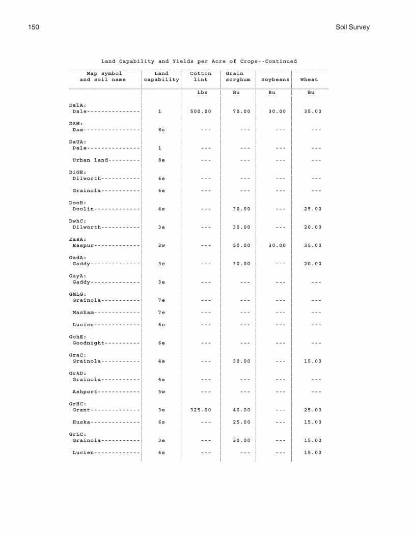
150 Soil Survey
Land Capability and Yields per Acre of Crops--Continued_________________________________________________________________________ Map symbol | Land | Cotton | Grain | | and soil name |capability| lint | sorghum | Soybeans| Wheat | | | | |_________________________________________________________________________ | | Lbs | Bu | Bu | Bu ___ __ __ __ | | | | |DalA: | | | | | Dale---------------| 1 | 500.00 | 70.00 | 30.00 | 35.00 | | | | |DAM: | | | | | Dam----------------| 8s | --- | --- | --- | --- | | | | |DaUA: | | | | | Dale---------------| 1 | --- | --- | --- | --- | | | | | Urban land---------| 8e | --- | --- | --- | --- | | | | |DiGE: | | | | | Dilworth-----------| 6e | --- | --- | --- | --- | | | | | Grainola-----------| 6e | --- | --- | --- | --- | | | | |DooB: | | | | | Doolin-------------| 4s | --- | 30.00 | --- | 25.00 | | | | |DwhC: | | | | | Dilworth-----------| 3e | --- | 30.00 | --- | 20.00 | | | | |EasA: | | | | | Easpur-------------| 2w | --- | 50.00 | 30.00 | 35.00 | | | | |GadA: | | | | | Gaddy--------------| 3e | --- | 30.00 | --- | 20.00 | | | | |GayA: | | | | | Gaddy--------------| 3e | --- | --- | --- | --- | | | | |GMLG: | | | | | Grainola-----------| 7e | --- | --- | --- | --- | | | | | Masham-------------| 7e | --- | --- | --- | --- | | | | | Lucien-------------| 6e | --- | --- | --- | --- | | | | |GohE: | | | | | Goodnight----------| 6e | --- | --- | --- | --- | | | | |GraC: | | | | | Grainola-----------| 4e | --- | 30.00 | --- | 15.00 | | | | |GrAD: | | | | | Grainola-----------| 4e | --- | --- | --- | --- | | | | | Ashport------------| 5w | --- | --- | --- | --- | | | | |GrHC: | | | | | Grant--------------| 3e | 325.00 | 40.00 | --- | 25.00 | | | | | Huska--------------| 6s | --- | 25.00 | --- | 15.00 | | | | |GrLC: | | | | | Grainola-----------| 3e | --- | 30.00 | --- | 15.00 | | | | | Lucien-------------| 4s | --- | --- | --- | 15.00 | | | | |

Noble County, Oklahoma 151
Land Capability and Yields per Acre of Crops--Continued_________________________________________________________________________ Map symbol | Land | Cotton | Grain | | and soil name |capability| lint | sorghum | Soybeans| Wheat | | | | |_________________________________________________________________________ | | Lbs | Bu | Bu | Bu ___ __ __ __ | | | | |GrLE: | | | | | Grainola-----------| 6e | --- | --- | --- | --- | | | | | Lucien-------------| 6e | --- | --- | --- | --- | | | | |GrnC: | | | | | Grant--------------| 3e | 325.00 | 40.00 | --- | 25.00 | | | | |GrtB: | | | | | Grant--------------| 2e | 350.00 | 50.00 | --- | 30.00 | | | | |HaPE: | | | | | Harrah-------------| 4e | --- | 35.00 | --- | 20.00 | | | | | Pulaski------------| 5w | --- | --- | --- | --- | | | | |HiRG: | | | | | Highview-----------| 7e | --- | --- | --- | --- | | | | | Rock outcrop-------| 8e | --- | --- | --- | --- | | | | |KekA: | | | | | Keokuk-------------| 1 | 700.00 | 65.00 | 30.00 | 35.00 | | | | |KeoA: | | | | | Keokuk-------------| 2w | 600.00 | 60.00 | 25.00 | 30.00 | | | | |KgfB: | | | | | Kingfisher---------| 3s | --- | 40.00 | --- | 30.00 | | | | |KgLC: | | | | | Kingfisher---------| 3e | --- | 35.00 | --- | 25.00 | | | | | Lucien-------------| 4s | --- | --- | --- | 15.00 | | | | |KgWC: | | | | | Kingfisher---------| 3e | --- | 35.00 | --- | 25.00 | | | | | Wakita-------------| 6s | --- | --- | --- | 15.00 | | | | |KinC2: | | | | | Kingfisher---------| 4e | --- | 30.00 | --- | 20.00 | | | | |KowB: | | | | | Konawa-------------| 2e | 450.00 | 50.00 | 28.00 | 30.00 | | | | |KowD: | | | | | Konawa-------------| 4e | 400.00 | 40.00 | --- | 25.00 | | | | |KrdA: | | | | | Kirkland-----------| 2s | 300.00 | 40.00 | --- | 30.00 | | | | |KrdB: | | | | | Kirkland-----------| 3e | 250.00 | 35.00 | --- | 25.00 | | | | |KrdB2: | | | | | Kirkland-----------| 3e | --- | --- | --- | 20.00 | | | | |

152 Soil Survey
Land Capability and Yields per Acre of Crops--Continued_________________________________________________________________________ Map symbol | Land | Cotton | Grain | | and soil name |capability| lint | sorghum | Soybeans| Wheat | | | | |_________________________________________________________________________ | | Lbs | Bu | Bu | Bu ___ __ __ __ | | | | |KrPB: | | | | | Kirkland-----------| 3e | 250.00 | 35.00 | --- | 25.00 | | | | | Pawhuska-----------| 4s | --- | --- | --- | 15.00 | | | | |LAN: | | | | | Landfill-----------| 8s | --- | --- | --- | --- | | | | |LelA: | | | | | Lela---------------| 4w | --- | 45.00 | 25.00 | 30.00 | | | | |LveB: | | | | | Lovedale-----------| 2e | --- | 45.00 | --- | 30.00 | | | | |M-W. | | | | | Miscellaneous water| | | | | | | | | |McaA: | | | | | McLain-------------| 1 | 500.00 | 55.00 | --- | 35.00 | | | | |MilB: | | | | | Milan--------------| 2e | --- | 53.00 | --- | 35.00 | | | | |MilC: | | | | | Milan--------------| 3e | --- | 48.00 | --- | 32.00 | | | | |MinB: | | | | | Minco--------------| 2e | 450.00 | 45.00 | --- | 30.00 | | | | |MinC: | | | | | Minco--------------| 3e | 400.00 | 40.00 | --- | 30.00 | | | | |MirA: | | | | | Miller-------------| 2w | 450.00 | 60.00 | --- | 35.00 | | | | |MisA: | | | | | Miller-------------| 4s | --- | --- | --- | 20.00 | | | | |MPNC2: | | | | | Milan--------------| 3e | --- | 44.00 | --- | 28.00 | | | | | Pawhuska-----------| 4s | --- | --- | --- | 10.00 | | | | | Norge--------------| 3e | 300.00 | 35.00 | --- | 20.00 | | | | |MulC: | | | | | Mulhall------------| 3e | --- | 35.00 | --- | 30.00 | | | | |MulD: | | | | | Mulhall------------| 4e | --- | 30.00 | --- | 25.00 | | | | |MulD4: | | | | | Mulhall------------| 6e | --- | --- | --- | --- | | | | |NeDG: | | | | | Newalla------------| 4e | --- | --- | --- | --- | | | | | Darnell------------| 7e | --- | --- | --- | --- | | | | |NorA: | | | | | Norge--------------| 1 | 450.00 | 55.00 | --- | 35.00 | | | | |

Noble County, Oklahoma 153
Land Capability and Yields per Acre of Crops--Continued_________________________________________________________________________ Map symbol | Land | Cotton | Grain | | and soil name |capability| lint | sorghum | Soybeans| Wheat | | | | |_________________________________________________________________________ | | Lbs | Bu | Bu | Bu ___ __ __ __ | | | | |NorB: | | | | | Norge--------------| 2e | 400.00 | 50.00 | --- | 30.00 | | | | |NorC: | | | | | Norge--------------| 3e | 350.00 | 40.00 | --- | 25.00 | | | | |NorC2: | | | | | Norge--------------| 3e | 300.00 | 35.00 | --- | 20.00 | | | | |NoUC: | | | | | Norge--------------| 3e | --- | --- | --- | --- | | | | | Urban land---------| 8e | --- | --- | --- | --- | | | | |OWWE: | | | | | Oil waste land-----| 8s | --- | --- | --- | --- | | | | | Westsum------------| 3e | --- | --- | --- | 15.00 | | | | |PoaA: | | | | | Port---------------| 5w | --- | --- | --- | --- | | | | |PoOA: | | | | | Port---------------| 2w | 500.00 | 50.00 | --- | 35.00 | | | | | Oscar--------------| 6s | --- | --- | --- | --- | | | | |PorA, PotA: | | | | | Port---------------| 2w | 500.00 | 50.00 | --- | 35.00 | | | | |PukA: | | | | | Pulaski------------| 5w | --- | --- | --- | --- | | | | |PulA: | | | | | Pulaski------------| 2w | 425.00 | 50.00 | --- | 30.00 | | | | |RefC2: | | | | | Renfrow------------| 3e | --- | --- | --- | 15.00 | | | | |ReGC2: | | | | | Renfrow------------| 3e | --- | --- | --- | 15.00 | | | | | Grainola-----------| 4e | --- | --- | --- | 10.00 | | | | |ReiA: | | | | | Reinach------------| 1 | 500.00 | 55.00 | --- | 35.00 | | | | |RenB: | | | | | Renfrow------------| 2e | 250.00 | 30.00 | --- | 20.00 | | | | |RenC, RewC2: | | | | | Renfrow------------| 3e | --- | --- | --- | 15.00 | | | | |RGPD3: | | | | | Renfrow------------| 6e | --- | --- | --- | --- | | | | | Grainola-----------| 6e | --- | --- | --- | --- | | | | | Pawhuska-----------| 6e | --- | --- | --- | --- | | | | |

154 Soil Survey
Land Capability and Yields per Acre of Crops--Continued_________________________________________________________________________ Map symbol | Land | Cotton | Grain | | and soil name |capability| lint | sorghum | Soybeans| Wheat | | | | |_________________________________________________________________________ | | Lbs | Bu | Bu | Bu ___ __ __ __ | | | | |SlaB: | | | | | Slaughterville-----| 2e | 400.00 | 45.00 | --- | 30.00 | | | | |SlaC: | | | | | Slaughterville-----| 3e | 350.00 | 40.00 | --- | 25.00 | | | | |SlaG: | | | | | Slaughterville-----| 7e | --- | --- | --- | --- | | | | |StDD: | | | | | Stephenville-------| 3e | --- | --- | --- | 20.00 | | | | | Darnell------------| 6e | --- | --- | --- | 12.00 | | | | |TabA: | | | | | Tabler-------------| 2s | --- | 50.00 | --- | 35.00 | | | | |TeaA: | | | | | Tearney------------| 4w | --- | --- | --- | 25.00 | | | | |TelB: | | | | | Teller-------------| 2e | 400.00 | 50.00 | --- | 30.00 | | | | |TelD: | | | | | Teller-------------| 4e | 300.00 | 35.00 | --- | 20.00 | | | | |TelD2: | | | | | Teller-------------| 4e | 250.00 | 30.00 | --- | 15.00 | | | | |VanA: | | | | | Vanoss-------------| 1 | 450.00 | 55.00 | --- | 35.00 | | | | |W. | | | | | Water | | | | | | | | | |WauA: | | | | | Waurika------------| 2w | 350.00 | 40.00 | --- | 25.00 | | | | |WesB: | | | | | Westsum------------| 2e | --- | 30.00 | --- | 20.00 | | | | |WesC: | | | | | Westsum------------| 3e | --- | --- | --- | 15.00 | | | | |WiLC: | | | | | Wisby--------------| 3e | --- | 34.00 | --- | 20.00 | | | | | Lovedale-----------| 2e | --- | 35.00 | --- | 25.00 | | | | |ZaHC: | | | | | Zaneis-------------| 3e | 350.00 | 40.00 | --- | 30.00 | | | | | Huska--------------| 6s | --- | 25.00 | --- | 15.00 | | | | |ZanB: | | | | | Zaneis-------------| 2e | 350.00 | 40.00 | --- | 30.00 | | | | |_________________________________________________________________________
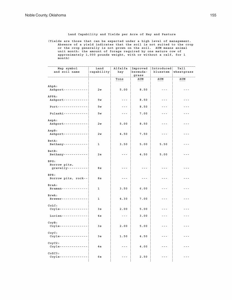
Noble County, Oklahoma 155
Land Capability and Yields per Acre of Hay and Pasture
(Yields are those that can be expected under a high level of management. Absence of a yield indicates that the soil is not suited to the crop or the crop generally is not grown on the soil. AUM means animal unit month: the amount of forage required by one mature cow of approximately 1,000 pounds weight, with or without a calf, for 1 month)
__________________________________________________________________________ Map symbol | Land | Alfalfa |Improved |Introduced| Tall and soil name |capability| hay |bermuda- | bluestem |wheatgrass | | | grass | |__________________________________________________________________________ | | Tons | AUM | AUM | AUM ____ ___ ___ ___ | | | | |AhpA: | | | | | Ashport------------| 2w | 5.00 | 8.50 | --- | --- | | | | |APPA: | | | | | Ashport------------| 5w | --- | 8.50 | --- | --- | | | | | Port---------------| 5w | --- | 8.50 | --- | --- | | | | | Pulaski------------| 5w | --- | 7.00 | --- | --- | | | | |AspA: | | | | | Ashport------------| 2w | 5.00 | 8.50 | --- | --- | | | | |AspB: | | | | | Ashport------------| 2w | 4.50 | 7.50 | --- | --- | | | | |BetA: | | | | | Bethany------------| 1 | 3.50 | 5.00 | 5.50 | --- | | | | |BetB: | | | | | Bethany------------| 2e | --- | 4.50 | 5.00 | --- | | | | |BPG: | | | | | Borrow pits, | | | | | gravelly----------| 8s | --- | --- | --- | --- | | | | |BPR: | | | | | Borrow pits, rock--| 8s | --- | --- | --- | --- | | | | |BraA: | | | | | Braman-------------| 1 | 3.50 | 6.00 | --- | --- | | | | |BrwA: | | | | | Brewer-------------| 1 | 4.30 | 7.00 | --- | --- | | | | |CoLC: | | | | | Coyle--------------| 3s | 2.00 | 5.00 | --- | --- | | | | | Lucien-------------| 4s | --- | 3.00 | --- | --- | | | | |CoyB: | | | | | Coyle--------------| 3s | 2.00 | 5.00 | --- | --- | | | | |CoyC: | | | | | Coyle--------------| 3e | 1.50 | 4.50 | --- | --- | | | | |CoyC2: | | | | | Coyle--------------| 4e | --- | 4.00 | --- | --- | | | | |CoZC3: | | | | | Coyle--------------| 6e | --- | 2.50 | --- | --- | | | | |

156 Soil Survey
Land Capability and Yields per Acre of Hay and Pasture--Continued__________________________________________________________________________ Map symbol | Land | Alfalfa |Improved |Introduced| Tall and soil name |capability| hay |bermuda- | bluestem |wheatgrass | | | grass | |__________________________________________________________________________ | | Tons | AUM | AUM | AUM ____ ___ ___ ___ | | | | |CoZC3: | | | | | Zaneis-------------| 6e | --- | 3.00 | --- | --- | | | | |DalA: | | | | | Dale---------------| 1 | 5.50 | 8.50 | --- | --- | | | | |DAM: | | | | | Dam----------------| 8s | --- | --- | --- | --- | | | | |DaUA: | | | | | Dale---------------| 1 | --- | --- | --- | --- | | | | | Urban land---------| 8e | --- | --- | --- | --- | | | | |DiGE: | | | | | Dilworth-----------| 6e | --- | 3.00 | --- | --- | | | | | Grainola-----------| 6e | --- | 2.50 | --- | --- | | | | |DooB: | | | | | Doolin-------------| 4s | 1.00 | 3.50 | --- | --- | | | | |DwhC: | | | | | Dilworth-----------| 3e | --- | 4.00 | --- | --- | | | | |EasA: | | | | | Easpur-------------| 2w | 5.00 | 8.50 | --- | --- | | | | |GadA: | | | | | Gaddy--------------| 3e | 3.00 | 5.50 | --- | --- | | | | |GayA: | | | | | Gaddy--------------| 3e | --- | 5.00 | --- | --- | | | | |GMLG: | | | | | Grainola-----------| 7e | --- | 2.50 | --- | --- | | | | | Masham-------------| 7e | --- | --- | --- | --- | | | | | Lucien-------------| 6e | --- | 2.00 | --- | --- | | | | |GohE: | | | | | Goodnight----------| 6e | --- | 2.50 | --- | --- | | | | |GraC: | | | | | Grainola-----------| 4e | --- | 3.50 | --- | --- | | | | |GrAD: | | | | | Grainola-----------| 4e | --- | 2.50 | --- | --- | | | | | Ashport------------| 5w | --- | 8.50 | --- | --- | | | | |GrHC: | | | | | Grant--------------| 3e | 2.00 | 5.00 | 4.50 | --- | | | | | Huska--------------| 6s | --- | 3.00 | --- | --- | | | | |GrLC: | | | | | Grainola-----------| 3e | --- | 3.50 | --- | --- | | | | | Lucien-------------| 4s | --- | 3.00 | --- | --- | | | | |

Noble County, Oklahoma 157
Land Capability and Yields per Acre of Hay and Pasture--Continued__________________________________________________________________________ Map symbol | Land | Alfalfa |Improved |Introduced| Tall and soil name |capability| hay |bermuda- | bluestem |wheatgrass | | | grass | |__________________________________________________________________________ | | Tons | AUM | AUM | AUM ____ ___ ___ ___ | | | | |GrLE: | | | | | Grainola-----------| 6e | --- | 2.50 | --- | --- | | | | | Lucien-------------| 6e | --- | 2.00 | --- | --- | | | | |GrnC: | | | | | Grant--------------| 3e | 2.00 | 5.00 | 4.50 | --- | | | | |GrtB: | | | | | Grant--------------| 2e | 2.30 | 5.50 | 5.00 | --- | | | | |HaPE: | | | | | Harrah-------------| 4e | 2.00 | 3.50 | --- | --- | | | | | Pulaski------------| 5w | --- | 7.00 | --- | --- | | | | |HiRG: | | | | | Highview-----------| 7e | --- | --- | --- | --- | | | | | Rock outcrop-------| 8e | --- | --- | --- | --- | | | | |KekA: | | | | | Keokuk-------------| 1 | 4.50 | 8.50 | --- | --- | | | | |KeoA: | | | | | Keokuk-------------| 2w | 4.50 | 8.50 | --- | --- | | | | |KgfB: | | | | | Kingfisher---------| 3s | --- | 5.00 | 4.50 | --- | | | | |KgLC: | | | | | Kingfisher---------| 3e | --- | 4.50 | 4.00 | --- | | | | | Lucien-------------| 4s | --- | 3.00 | --- | --- | | | | |KgWC: | | | | | Kingfisher---------| 3e | --- | 4.50 | 4.00 | --- | | | | | Wakita-------------| 6s | --- | 3.00 | --- | --- | | | | |KinC2: | | | | | Kingfisher---------| 4e | --- | 4.00 | 3.50 | --- | | | | |KowB: | | | | | Konawa-------------| 2e | --- | 4.50 | --- | --- | | | | |KowD: | | | | | Konawa-------------| 4e | --- | 4.00 | --- | --- | | | | |KrdA: | | | | | Kirkland-----------| 2s | --- | 4.00 | --- | --- | | | | |KrdB: | | | | | Kirkland-----------| 3e | --- | 4.00 | --- | --- | | | | |KrdB2: | | | | | Kirkland-----------| 3e | --- | 3.50 | --- | --- | | | | |KrPB: | | | | | Kirkland-----------| 3e | --- | 4.00 | --- | --- | | | | | Pawhuska-----------| 4s | --- | 3.50 | --- | ---

158 Soil Survey
Land Capability and Yields per Acre of Hay and Pasture--Continued__________________________________________________________________________ Map symbol | Land | Alfalfa |Improved |Introduced| Tall and soil name |capability| hay |bermuda- | bluestem |wheatgrass | | | grass | |__________________________________________________________________________ | | Tons | AUM | AUM | AUM ____ ___ ___ ___ | | | | |LAN: | | | | | Landfill-----------| 8s | --- | --- | --- | --- | | | | |LelA: | | | | | Lela---------------| 4w | 3.50 | 5.50 | --- | --- | | | | |LveB: | | | | | Lovedale-----------| 2e | 2.50 | 5.50 | --- | --- | | | | |M-W. | | | | | Miscellaneous water| | | | | | | | | |McaA: | | | | | McLain-------------| 1 | 4.50 | 8.50 | 6.50 | --- | | | | |MilB: | | | | | Milan--------------| 2e | --- | --- | --- | --- | | | | |MilC: | | | | | Milan--------------| 3e | --- | --- | --- | --- | | | | |MinB: | | | | | Minco--------------| 2e | 3.00 | 5.50 | --- | --- | | | | |MinC: | | | | | Minco--------------| 3e | 2.50 | 5.00 | --- | --- | | | | |MirA: | | | | | Miller-------------| 2w | 3.50 | 6.50 | --- | --- | | | | |MisA: | | | | | Miller-------------| 4s | --- | --- | --- | 4.50 | | | | |MPNC2: | | | | | Milan--------------| 3e | --- | --- | --- | --- | | | | | Pawhuska-----------| 4s | --- | 2.50 | --- | --- | | | | | Norge--------------| 3e | 1.50 | 4.50 | 4.00 | --- | | | | |MulC: | | | | | Mulhall------------| 3e | --- | 5.50 | --- | --- | | | | |MulD: | | | | | Mulhall------------| 4e | --- | 5.00 | --- | --- | | | | |MulD4: | | | | | Mulhall------------| 6e | --- | 3.00 | --- | --- | | | | |NeDG: | | | | | Newalla------------| 4e | --- | 4.50 | --- | --- | | | | | Darnell------------| 7e | --- | --- | --- | --- | | | | |NorA: | | | | | Norge--------------| 1 | 3.50 | 5.50 | 5.00 | --- | | | | |NorB: | | | | | Norge--------------| 2e | 3.00 | 5.50 | 5.00 | --- | | | | |

Noble County, Oklahoma 159
Land Capability and Yields per Acre of Hay and Pasture--Continued__________________________________________________________________________ Map symbol | Land | Alfalfa |Improved |Introduced| Tall and soil name |capability| hay |bermuda- | bluestem |wheatgrass | | | grass | |__________________________________________________________________________ | | Tons | AUM | AUM | AUM ____ ___ ___ ___ | | | | |NorC: | | | | | Norge--------------| 3e | 2.00 | 5.00 | 4.50 | --- | | | | |NorC2: | | | | | Norge--------------| 3e | 1.50 | 4.50 | 4.00 | --- | | | | |NoUC: | | | | | Norge--------------| 3e | --- | --- | --- | --- | | | | | Urban land---------| 8e | --- | --- | --- | --- | | | | |OWWE: | | | | | Oil waste land-----| 8s | --- | --- | --- | --- | | | | | Westsum------------| 3e | --- | 2.50 | --- | --- | | | | |PoaA: | | | | | Port---------------| 5w | --- | 8.50 | --- | --- | | | | |PoOA: | | | | | Port---------------| 2w | 5.00 | 8.50 | --- | --- | | | | | Oscar--------------| 6s | --- | 3.50 | --- | --- | | | | |PorA, PotA: | | | | | Port---------------| 2w | 5.00 | 8.50 | --- | --- | | | | |PukA: | | | | | Pulaski------------| 5w | --- | 7.00 | --- | --- | | | | |PulA: | | | | | Pulaski------------| 2w | 3.50 | 7.00 | --- | --- | | | | |RefC2: | | | | | Renfrow------------| 3e | --- | 2.50 | --- | --- | | | | |ReGC2: | | | | | Renfrow------------| 3e | --- | 2.50 | --- | --- | | | | | Grainola-----------| 4e | --- | 3.00 | --- | --- | | | | |ReiA: | | | | | Reinach------------| 1 | 5.00 | 8.50 | --- | --- | | | | |RenB: | | | | | Renfrow------------| 2e | --- | 3.00 | --- | --- | | | | |RenC, RewC2: | | | | | Renfrow------------| 3e | --- | 2.50 | --- | --- | | | | |RGPD3: | | | | | Renfrow------------| 6e | --- | 2.00 | --- | --- | | | | | Grainola-----------| 6e | --- | 2.00 | --- | --- | | | | | Pawhuska-----------| 6e | --- | 2.50 | --- | --- | | | | |SlaB: | | | | | Slaughterville-----| 2e | 3.00 | 5.00 | --- | --- | | | | |

160 Soil Survey
Land Capability and Yields per Acre of Hay and Pasture--Continued__________________________________________________________________________ Map symbol | Land | Alfalfa |Improved |Introduced| Tall and soil name |capability| hay |bermuda- | bluestem |wheatgrass | | | grass | |__________________________________________________________________________ | | Tons | AUM | AUM | AUM ____ ___ ___ ___ | | | | |SlaC: | | | | | Slaughterville-----| 3e | 2.50 | 4.50 | --- | --- | | | | |SlaG: | | | | | Slaughterville-----| 7e | --- | 3.50 | --- | --- | | | | |StDD: | | | | | Stephenville-------| 3e | --- | 3.50 | --- | --- | | | | | Darnell------------| 6e | --- | 3.00 | --- | --- | | | | |TabA: | | | | | Tabler-------------| 2s | --- | 4.00 | --- | --- | | | | |TeaA: | | | | | Tearney------------| 4w | --- | 5.00 | --- | --- | | | | |TelB: | | | | | Teller-------------| 2e | 3.00 | 5.50 | --- | --- | | | | |TelD: | | | | | Teller-------------| 4e | 1.50 | 4.50 | --- | --- | | | | |TelD2: | | | | | Teller-------------| 4e | 1.00 | 4.00 | --- | --- | | | | |VanA: | | | | | Vanoss-------------| 1 | 3.50 | 5.50 | --- | --- | | | | |W. | | | | | Water | | | | | | | | | |WauA: | | | | | Waurika------------| 2w | --- | 5.00 | --- | --- | | | | |WesB: | | | | | Westsum------------| 2e | --- | 3.00 | --- | --- | | | | |WesC: | | | | | Westsum------------| 3e | --- | 2.50 | --- | --- | | | | |WiLC: | | | | | Wisby--------------| 3e | --- | 4.00 | --- | --- | | | | | Lovedale-----------| 2e | 2.00 | 5.00 | --- | --- | | | | |ZaHC: | | | | | Zaneis-------------| 3e | 2.50 | 5.50 | --- | --- | | | | | Huska--------------| 6s | --- | 3.00 | --- | --- | | | | |ZanB: | | | | | Zaneis-------------| 2e | 2.50 | 5.50 | --- | --- | | | | |__________________________________________________________________________

Noble County, Oklahoma 161
Estimated Yields of Crops, Hay, and Pasture
The average yields per acre that can be expected of the principal crops under a highlevel of management are shown in the tables “Land Capability and Yields per Acre ofCrops” and “Land Capability and Yields per Acre of Hay and Pasture.” In any given year,yields may be higher or lower than those indicated in the tables because of variations inrainfall and other climatic factors.
The yields are based mainly on the experience and records of farmers, conservation-ists, and extension agents. Available yield data from nearby counties and results of fieldtrials and demonstrations are also considered.
The management needed to obtain the indicated yields of the various crops dependson the kind of soil and the crop. Management can include drainage, erosion control, andprotection from flooding; the proper planting and seeding rates; suitable high-yieldingcrop varieties; appropriate and timely tillage; control of weeds, plant diseases, andharmful insects; favorable soil reaction and optimum levels of nitrogen, phosphorus,potassium, and trace elements for each crop; effective use of crop residue, barnyardmanure, and green manure crops; and harvesting that ensures the smallest possibleloss.
The estimated yields reflect the productive capacity of each soil for each of theprincipal crops. Yields are likely to increase as new production technology is developed.The productivity of a given soil compared with that of other soils, however, is not likelyto change.
Crops other than those shown in the tables are grown in the survey area, but esti-mated yields are not listed because the acreage of such crops is small.
Under good pasture management, proper grazing is essential for the production ofhigh-quality forage, stand survival, and erosion control. Proper grazing helps plants tomaintain sufficient and generally vigorous top growth during the growing season. Brushcontrol is essential in many areas, and weed control generally is needed. Rotationgrazing and renovation also are important management practices.
A pasture program is needed to provide the desired amount of forage during eachmonth of the year. A study of the growth habits of the different plants is necessary toensure adequate forage during each month. The months that various kinds of forageplants grow are indicated in figure 22, which is in the “Range” section. The percentgrowth that can be safely grazed each month without substantially reducing the totalyield for each kind of plant is illustrated.
Yield estimates are often indicated in animal unit months (AUM), or the amount offorage or feed required to feed one animal unit (one cow, one horse, one mule, fivesheep, or five goats) for 30 days.
The local office of the Natural Resources Conservation Service or of the CooperativeExtension Service can provide information about forage yields other than those shown inthe tables.
Cropland Limitations and Hazards
The management concerns affecting the use of the detailed map units in the surveyarea for crops are shown in the table “Cropland Limitations and Hazards.” The mainconcerns in managing nonirrigated cropland are conserving moisture, controlling soilblowing and water erosion, and maintaining soil fertility and tilth.
Conserving moisture primarily involves reducing the evaporation and runoff rates andincreasing the rate of water infiltration. Applying conservation tillage and conservationcropping systems, farming on the contour, stripcropping, establishing field windbreaks,and leaving crop residue on the surface conserve moisture.
Generally, a combination of several practices is needed to control soil blowing andwater erosion. Conservation tillage, stripcropping, field windbreaks, tall grass barriers,

162 Soil Survey
contour farming, conservation cropping systems, crop residue management, diversions,and grassed waterways help to prevent excessive soil loss.
Measures that are effective in maintaining soil fertility include applying fertilizer, bothorganic and inorganic, including manure; incorporating crop residue or green manurecrops into the soil; and using proper crop rotations. Controlling erosion helps to preventthe loss of organic matter and plant nutrients and thus helps to maintain productivity,although the level of fertility can be reduced even in areas where erosion is controlled.All soils used for nonirrigated crops respond well to applications of fertilizer.
On irrigated soils the main management concerns are efficient water use, nutrientmanagement, control of erosion, soil tilth, pest and weed control, and timely plantingand harvesting for a successful crop. An irrigation system that provides optimum controland distribution of water at minimum cost is needed. Overirrigation wastes water,leaches plant nutrients, and causes erosion. Also, it can create drainage problems, raisethe water table, and increase soil salinity.
Some of the limitations and hazards shown in the table cannot be easily overcome.These are flooding, depth to bedrock, and ponding.
Additional limitations and hazards are as follows:Areas of rock outcrop and oil waste land.—Farming around these areas may be
feasible. Subsoiling or deep ripping soft sedimentary beds increases the effectiverooting depth and the rate of water infiltration.
Excessive permeability.—This limitation causes deep leaching of nutrients andpesticides. The capacity of the soil to retain moisture for plant use is poor.
Potential for ground-water pollution.—This is a hazard in soils with excessive perme-ability, hard bedrock, or a water table within the profile.
Lime content, limited available water capacity, poor tilth, restricted permeability, andsurface crusting.—The adverse effects of these limitations can be reduced by incorpo-rating green manure crops, manure, or crop residue into the soil; applying a system ofconservation tillage; and using conservation cropping systems. Also, crops may respondwell to additions of phosphate fertilizer on soils that have a high content of lime.
Slope.—Where the slope is more than 8 percent, water erosion and soil blowing maybe accelerated unless conservation farming practices are applied.
Salt and sodium content.—In areas where this is a limitation, only salt- and sodium-tolerant crops should be grown.
Criteria for Limitations and Hazards
Following is an explanation of the criteria used to determine the limitations or haz-ards.
Areas of rock outcrop.—Rock outcrop is a named component of the map unit.Areas of oil waste land.—Oil waste land is a named component of the map unit.Depth to bedrock.—Bedrock is within a depth of 40 inches.Water erosion.—The surface K factor multiplied by the upper slope limit is more
than 2 (same as prime farmland criteria).Excessive permeability.—The upper limit of the permeability range is 6 inches or
more within the soil profile.Flooding.—The component of the map unit is occasionally flooded or frequently
flooded.Lime content.—The upper 10 inches has more than 15 percent calcium carbonate
equivalent.Limited available water capacity.—The available water capacity calculated to a depth
of 60 inches or to a root-limiting layer is 6 inches or less.Ponding.—A ponding duration is assigned to the component of the map unit.Potential for ground-water pollution.—The soil has a water table within a depth of 4
feet or bedrock within 40 inches of the surface, or permeability is more than 2 inches perhour within the soil profile.

Noble County, Oklahoma 163
Poor tilth.—The component of the map unit has more than 35 percent clay in thesurface layer.
Restricted permeability.—Permeability is 0.06 inch per hour or less within the soilprofile.
Salt content.—The component of the map unit has an electrical conductivity of morethan 4 in the surface layer or more than 8 within a depth of 30 inches.
Slope.—The upper slope limit of the component of the map unit is more than 8percent.
Sodium content.—The sodium adsorption ratio of the component of the map unit ismore than 13 within a depth of 30 inches.
Soil blowing.—The wind erodibility group is WEG 1, WEG 2, or WEG 3.Surface crusting.—The organic matter content is less than 2 percent in the surface
layer.Water table.—The component of the map unit has a water table within a depth of 3
feet.

164 Soil Survey
Cropland Limitations and Hazards
(See text for a description and criteria of the limitations and hazards listed in this table)
_____________________________________________________________________________ | Map symbol and component name | Cropland limitations and hazards |_____________________________________________________________________________ |AhpA: | Ashport--------------------------------|Flooding |APPA: | Ashport--------------------------------|Flooding | Port-----------------------------------|Flooding |Surface crusting | Pulaski--------------------------------|Flooding |Potential for ground-water pollution |Surface crusting |AspA, AspB: | Ashport--------------------------------|Flooding |BetA, BetB: | Bethany--------------------------------|None |BPG: | Borrow pits, gravelly------------------|Non-soil material |BPR: | Borrow pits, rock----------------------|Non-soil material |BraA: | Braman---------------------------------|None |BrwA: | Brewer---------------------------------|None |CoLC: | Coyle----------------------------------|Depth to bedrock |Restricted permeability |Limited available water capacity | Lucien---------------------------------|Soil blowing |Depth to bedrock |Restricted permeability |Potential for ground-water pollution |Limited available water capacity |CoyB, CoyC, CoyC2: | Coyle----------------------------------|Depth to bedrock |Restricted permeability |Limited available water capacity |CoZC3: | Coyle----------------------------------|Depth to bedrock |Restricted permeability |Limited available water capacity | Zaneis---------------------------------|Restricted permeability |DalA: | Dale-----------------------------------|None |

Noble County, Oklahoma 165
Cropland Limitations and Hazards--Continued_____________________________________________________________________________ | Map symbol and component name | Cropland limitations and hazards |_____________________________________________________________________________ |DAM: | Dam------------------------------------|Non-soil material |DaUA: | Dale-----------------------------------|None | Urban land-----------------------------|Non-soil material |DiGE: | Dilworth-------------------------------|Water erosion |Depth to bedrock |Restricted permeability |Limited available water capacity |Slope | Grainola-------------------------------|Water erosion |Depth to bedrock |Restricted permeability |Limited available water capacity |Slope |Surface crusting |DooB: | Doolin---------------------------------|Restricted permeability |Sodium content |Surface crusting |DwhC: | Dilworth-------------------------------|Depth to bedrock |Restricted permeability |Limited available water capacity |EasA: | Easpur---------------------------------|Flooding |GadA: | Gaddy----------------------------------|Flooding |Excessive permeability |Potential for ground-water pollution |GayA: | Gaddy----------------------------------|Excessive permeability |Potential for ground-water pollutionGMLG: | Grainola-------------------------------|Water erosion |Depth to bedrock |Restricted permeability |Limited available water capacity |Slope |Poor tilth | Masham---------------------------------|Soil blowing |Water erosion |Depth to bedrock |Restricted permeability |Limited available water capacity |Slope |Surface crusting |Lime content |Poor tilth |

166 Soil Survey
Cropland Limitations and Hazards--Continued_____________________________________________________________________________ | Map symbol and component name | Cropland limitations and hazards |_____________________________________________________________________________ |GMLG: | Lucien---------------------------------|Soil blowing |Water erosion |Depth to bedrock |Restricted permeability |Potential for ground-water pollution |Limited available water capacity |Slope |GohE: | Goodnight------------------------------|Water erosion |Excessive permeability |Potential for ground-water pollution |Limited available water capacity |Slope |GraC: | Grainola-------------------------------|Depth to bedrock |Restricted permeability |Limited available water capacity |Surface crusting |Poor tilth |GrAD: | Grainola-------------------------------|Water erosion |Depth to bedrock |Restricted permeability |Limited available water capacity |Surface crusting |Poor tilth | Ashport--------------------------------|Flooding |GrHC: | Grant----------------------------------|Restricted permeability | Huska----------------------------------|Water erosion |Restricted permeability |Sodium content |Salt content |Limited available water capacity |Surface crusting |Poor tilth |GrLC: | Grainola-------------------------------|Water erosion |Depth to bedrock |Restricted permeability |Surface crusting |Poor tilth | Lucien---------------------------------|Depth to bedrock |Restricted permeability |Potential for ground-water pollution |Limited available water capacity |

Noble County, Oklahoma 167
Cropland Limitations and Hazards--Continued_____________________________________________________________________________ | Map symbol and component name | Cropland limitations and hazards |_____________________________________________________________________________ |GrLE: | Grainola-------------------------------|Water erosion |Depth to bedrock |Restricted permeability |Limited available water capacity |Slope |Surface crusting | Lucien---------------------------------|Water erosion |Depth to bedrock |Restricted permeability |Potential for ground-water pollution |Limited available water capacity |Slope |GrnC, GrtB: | Grant----------------------------------|Restricted permeability |HaPE: | Harrah---------------------------------|None | Pulaski--------------------------------|Flooding |Potential for ground-water pollution |Surface crusting |HiRG: | Highview-------------------------------|Soil blowing |Water erosion |Depth to bedrock |Restricted permeability |Limited available water capacity |Slope |Poor tilth | Rock outcrop---------------------------|Non-soil material |KekA: | Keokuk---------------------------------|None |KeoA: | Keokuk---------------------------------|Flooding |KgfB: | Kingfisher-----------------------------|Depth to bedrock |Restricted permeability |Limited available water capacity |KgLC: | Kingfisher-----------------------------|Depth to bedrock |Restricted permeability |Limited available water capacity | Lucien---------------------------------|Soil blowing |Depth to bedrock |Restricted permeability |Potential for ground-water pollution |Limited available water capacity |

168 Soil Survey
Cropland Limitations and Hazards--Continued_____________________________________________________________________________ | Map symbol and component name | Cropland limitations and hazards |_____________________________________________________________________________ |KgWC: | Kingfisher-----------------------------|Depth to bedrock |Restricted permeability | Wakita---------------------------------|Soil blowing |Depth to bedrock |Restricted permeability |Sodium content |Salt content |Limited available water capacity |Water table |Surface crusting |KinC2: | Kingfisher-----------------------------|Depth to bedrock |Restricted permeability |Limited available water capacity |KowB: | Konawa---------------------------------|Potential for ground-water pollution |Surface crusting |KowD: | Konawa---------------------------------|Excessive permeability |Potential for ground-water pollution |Surface crusting |KrdA, KrdB: | Kirkland-------------------------------|Restricted permeability |Surface crusting |KrdB2: | Kirkland-------------------------------|Restricted permeability |Surface crusting |Poor tilth |KrPB: | Kirkland-------------------------------|Restricted permeability |Surface crusting | Pawhuska-------------------------------|Restricted permeability |Sodium content |Salt content |Surface crusting |Poor tilth |LAN: | Landfill-------------------------------|Non-soil material |LelA: | Lela-----------------------------------|Flooding |Restricted permeability |Potential for ground-water pollution |Poor tilth |LveB: | Lovedale-------------------------------|Excessive permeability |Potential for ground-water pollution |M-W: | Miscellaneous water--------------------|Non-soil material |

Noble County, Oklahoma 169
Cropland Limitations and Hazards--Continued_____________________________________________________________________________ | Map symbol and component name | Cropland limitations and hazards |_____________________________________________________________________________ |McaA: | McLain---------------------------------|None |MilB, MilC: | Milan----------------------------------|Potential for ground-water pollution |MinB, MinC: | Minco----------------------------------|None |MirA: | Miller---------------------------------|Flooding |Restricted permeability |Poor tilth |MisA: | Miller---------------------------------|Flooding |Restricted permeability |Salt content |Surface crusting |Lime content |Poor tilth |MPNC2: | Milan----------------------------------|Potential for ground-water pollution | Pawhuska-------------------------------|Water erosion |Restricted permeability |Sodium content |Salt content |Surface crusting | Norge----------------------------------|None |MulC: | Mulhall--------------------------------|None |MulD, MulD4: | Mulhall--------------------------------|Water erosion |NeDG: | Newalla--------------------------------|Water erosion |Restricted permeability | Darnell--------------------------------|Water erosion |Depth to bedrock |Restricted permeability |Potential for ground-water pollution |Limited available water capacity |Slope |Surface crusting |NorA, NorB, NorC, NorC2: | Norge----------------------------------|None |NoUC: | Norge----------------------------------|None | Urban land-----------------------------|Non-soil material |OWWE: | Oil waste land-------------------------|Non-soil material | Westsum--------------------------------|Restricted permeability |

170 Soil Survey
Cropland Limitations and Hazards--Continued_____________________________________________________________________________ | Map symbol and component name | Cropland limitations and hazards |_____________________________________________________________________________ |PoaA: | Port-----------------------------------|Flooding |PoOA: | Port-----------------------------------|Flooding | Oscar----------------------------------|Flooding |Sodium content |Salt content |Surface crusting |PorA, PotA: | Port-----------------------------------|Flooding |PukA, PulA: | Pulaski--------------------------------|Flooding |Potential for ground-water pollution |Surface crusting |RefC2: | Renfrow--------------------------------|Water erosion |Restricted permeability |Poor tilth |ReGC2: | Renfrow--------------------------------|Water erosion |Restricted permeability | Grainola-------------------------------|Depth to bedrock |Restricted permeability |Limited available water capacity |Surface crusting |ReiA: | Reinach--------------------------------|None |RenB: | Renfrow--------------------------------|Restricted permeability |RenC, RewC2: | Renfrow--------------------------------|Water erosion |Restricted permeability |RGPD3: | Renfrow--------------------------------|Water erosion |Restricted permeability | Grainola-------------------------------|Water erosion |Depth to bedrock |Restricted permeability |Limited available water capacity |Surface crusting |Lime content |Poor tilth | Pawhuska-------------------------------|Soil blowing |Water erosion |Restricted permeability |Sodium content |Salt content |Surface crusting |Poor tilth |

Noble County, Oklahoma 171
Cropland Limitations and Hazards--Continued_____________________________________________________________________________ | Map symbol and component name | Cropland limitations and hazards |_____________________________________________________________________________ |SlaB: | Slaughterville-------------------------|Potential for ground-water pollution |SlaC: | Slaughterville-------------------------|Excessive permeability |Potential for ground-water pollution |SlaG: | Slaughterville-------------------------|Water erosion |Excessive permeability |Potential for ground-water pollution |Slope |StDD: | Stephenville---------------------------|Depth to bedrock |Limited available water capacity |Surface crusting |StDD: | Darnell--------------------------------|Soil blowing |Depth to bedrock |Restricted permeability |Potential for ground-water pollution |Limited available water capacity |Surface crusting |TabA: | Tabler---------------------------------|Restricted permeability |Water table |TeaA: | Tearney--------------------------------|Flooding |Ponding |Excessive permeability |Restricted permeability |Potential for ground-water pollution |Poor tilth |TelB: | Teller---------------------------------|Potential for ground-water pollution |TelD, TelD2: | Teller---------------------------------|Water erosion |Potential for ground-water pollution |VanA: | Vanoss---------------------------------|None |W: | Water----------------------------------|Non-soil material |WauA: | Waurika--------------------------------|Restricted permeability |Potential for ground-water pollution |Water table |Surface crusting |WesB, WesC: | Westsum--------------------------------|Restricted permeability |

172 Soil Survey
Cropland Limitations and Hazards--Continued_____________________________________________________________________________ | Map symbol and component name | Cropland limitations and hazards |_____________________________________________________________________________ |WiLC: | Wisby----------------------------------|Excessive permeability |Potential for ground-water pollution | Lovedale-------------------------------|None |ZaHC: | Zaneis---------------------------------|Restricted permeability | Huska----------------------------------|Water erosion |Restricted permeability |Sodium content |Salt content |Limited available water capacity |Surface crusting |ZanB: | Zaneis---------------------------------|Restricted permeability |_____________________________________________________________________________

Noble County, Oklahoma 173
Prime Farmland
Prime farmland is of major importance in meeting the Nation’s short- and long-rangeneeds for food and fiber. The acreage of high-quality farmland is limited, and the U.S.Department of Agriculture recognizes that government at local, State, and Federallevels, as well as individuals, must encourage and facilitate the wise use of our Nation’sprime farmland.
Prime farmland soils, as defined by the U.S. Department of Agriculture, are soils thatare best suited to food, feed, forage, fiber, and oilseed crops. Such soils have propertiesthat favor the economic production of sustained high yields of crops. The soils need onlyto be treated and managed by acceptable farming methods. An adequate moisturesupply and a sufficiently long growing season are required. Prime farmland soils producethe highest yields with minimal expenditure of energy and economic resources, andfarming these soils results in the least damage to the environment.
Prime farmland soils may presently be used as cropland, pasture, rangeland, orwoodland or for other purposes. They either are used for food and fiber or are availablefor these uses. Urban or built-up land, public land, and water areas cannot be consideredprime farmland. Urban or built-up land is any contiguous unit of land 10 acres or more insize that is used for such purposes as housing, industrial, and commercial sites, sitesfor institutions or public buildings, small parks, golf courses, cemeteries, railroad yards,airports, sanitary landfills, sewage treatment plants, and water-control structures. Publicland is land not available for farming in National forests, National parks, military reserva-tions, and State parks.
Prime farmland soils commonly receive an adequate and dependable supply ofmoisture from precipitation or irrigation. The temperature and growing season arefavorable, and the level of acidity or alkalinity and the content of salts and sodium areacceptable. The soils have few, if any, rocks and are permeable to water and air. Theyare not excessively erodible or saturated with water for long periods, and they are notfrequently flooded during the growing season or are protected from flooding. Slopesrange from 0 to 8 percent.
Soils that have a high water table, are subject to flooding, or are droughty may qualifyas prime farmland where these limitations are overcome by drainage measures, floodcontrol, or irrigation. Onsite evaluation is necessary to determine the effectiveness ofcorrective measures. More information about the criteria for prime farmland can beobtained at the local office of the Natural Resources Conservation Service.
A recent trend in land use has been the conversion of prime farmland to urban andindustrial uses. The loss of prime farmland to other uses puts pressure on lands that areless productive than prime farmland.
About 199,342 acres in the survey area, or nearly 42 percent of the total acreage,meets the requirements for prime farmland. The map units in the survey area that meetthe requirements for prime farmland are listed in the table “Prime Farmland.” The locationof each map unit is shown on the detailed soil maps. The soil qualities that affect useand management are described in the section “Detailed Soil Map Units.” The table doesnot constitute a recommendation for a particular land use.

174 Soil Survey
Prime Farmland
(Only the soils considered prime farmland are listed. Urban or built-up areas of the soils listed are not considered prime farmland)
________________________________________________________________________________________ | Map | Soil namesymbol | |________________________________________________________________________________________ |AhpA |Ashport silty clay loam, 0 to 1 percent slopes, occasionally floodedAspA |Ashport silt loam, 0 to 1 percent slopes, occasionally floodedAspB |Ashport silt loam, 1 to 3 percent slopes, occasionally floodedBetA |Bethany silt loam, 0 to 1 percent slopesBetB |Bethany silt loam, 1 to 3 percent slopesBraA |Braman silt loam, 0 to 1 percent slopes, rarely floodedBrwA |Brewer silt loam, 0 to 1 percent slopes, rarely floodedCoyB |Coyle loam, 1 to 3 percent slopesCoyC |Coyle loam, 3 to 5 percent slopesDalA |Dale silt loam, 0 to 1 percent slopes, rarely floodedDwhC |Dilworth silty clay loam, 3 to 5 percent slopesEasA |Easpur loam, 0 to 1 percent slopes, occasionally floodedGraC |Grainola silty clay loam, 3 to 5 percent slopesGrnC |Grant loam, 3 to 5 percent slopesGrtB |Grant silt loam, 1 to 3 percent slopesKekA |Keokuk very fine sandy loam, 0 to 1 percent slopes, rarely floodedKeoA |Keokuk very fine sandy loam, 0 to 1 percent slopes, occasionally floodedKgfB |Kingfisher silt loam, 1 to 3 percent slopesKinC2 |Kingfisher loam, 3 to 5 percent slopes, erodedKowB |Konawa fine sandy loam, 1 to 3 percent slopesKowD |Konawa fine sandy loam, 3 to 8 percent slopesKrdA |Kirkland silt loam, 0 to 1 percent slopesKrdB |Kirkland silt loam, 1 to 3 percent slopesKrdB2 |Kirkland silt loam, 1 to 3 percent slopes, erodedLelA |Lela silty clay, 0 to 1 percent slopes, occasionally floodedMcaA |McLain silty clay loam, 0 to 1 percent slopes, rarely floodedMilB |Milan loam, 1 to 3 percent slopesMilC |Milan loam, 3 to 5 percent slopesMinB |Minco very fine sandy loam, 1 to 3 percent slopesMinC |Minco very fine sandy loam, 3 to 5 percent slopesMirA |Miller silty clay loam, 0 to 1 percent slopes, occasionally floodedMulC |Mulhall loam, 3 to 5 percent slopesNorA |Norge silt loam, 0 to 1 percent slopesNorB |Norge silt loam, 1 to 3 percent slopesNorC |Norge silt loam, 3 to 5 percent slopesNorC2 |Norge silt loam, 3 to 5 percent slopes, erodedPorA |Port silt loam, 0 to 1 percent slopes, occasionally floodedPotA |Port silty clay loam, 0 to 1 percent slopes, occasionally floodedPulA |Pulaski fine sandy loam, 0 to 1 percent slopes, occasionally floodedRefC2 |Renfrow loam, 3 to 5 percent slopes, erodedReGC2 |Renfrow and Grainola soils, 3 to 5 percent slopes, erodedReiA |Reinach very fine sandy loam, 0 to 1 percent slopes, rarely floodedRenB |Renfrow silt loam, 1 to 3 percent slopesRenC |Renfrow silt loam, 3 to 5 percent slopesRewC2 |Renfrow silty clay loam, 3 to 5 percent slopes, erodedSlaB |Slaughterville fine sandy loam, 0 to 3 percent slopesSlaC |Slaughterville fine sandy loam, 3 to 5 percent slopesTabA |Tabler silt loam, 0 to 1 percent slopesTelB |Teller loam, 1 to 3 percent slopesTelD |Teller loam, 5 to 8 percent slopesVanA |Vanoss silt loam, 0 to 1 percent slopesWauA |Waurika silt loam, 0 to 1 percent slopesWesB |Westsum silty clay loam, 1 to 3 percent slopesWesC |Westsum silty clay loam, 3 to 5 percent slopesZanB |Zaneis loam, 1 to 3 percent slopes |________________________________________________________________________________________

Noble County, Oklahoma 175
RangeMark Moseley, Range Conservationist, Natural Resources Conservation Service, helped prepare this
section.
Range, grazed forestland, and native pasture provide forage for livestock in thesurvey area.
Range is defined as land on which the native vegetation (the climax, or naturalpotential, plant community) is predominantly grasses, grass-like plants, forbs, andshrubs suitable for grazing and browsing. Range includes natural grasslands,savannahs, many wetlands, some deserts, tundra, and certain shrub and forb communi-ties. Range receives no regular or frequent cultural treatment. The composition andproduction of the plant community are determined by soil, climate, topography, overstorycanopy, and grazing management.
Grazed forestland is defined as land on which the understory includes, as an integralpart of the forest plant community, plants that can be grazed without significant impair-ment of other forest values.
Native pasture is defined as land on which the potential (climax) vegetation is forestbut which is used and managed primarily for the production of native forage plants.Native pasture includes cutover forestland and forestland that has been cleared and ismanaged for native or naturalized forage plants.
The table “Rangeland Productivity and Characteristic Plant Communities” shows, foreach soil, the ecological site; the total annual production of vegetation in favorable,normal, and unfavorable years; the characteristic vegetation; and the average percent-age of each species in the rangeland composition.
Rangeland makes up about 40 percent of Noble County. It is mainly on gently slopingto steep side slopes and on a few narrow very gently sloping to sloping summits thatcannot be economically cultivated. A few native grass meadows that are managed forhay production are in the central and north-central parts of the county.
Noble County has three types of range. The first type is in the southeastern part ofthe county, in areas where most of the soils are loamy and are moderately deep orshallow over sandstone. These soils support an oak savannah that has low productivitydue to the shallow rooting depth and low water-holding capacity.
The second type is in the northeastern and western parts of the county, in areaswhere the soils are loamy and are dominantly moderately deep, with some shallow ordeep soils, over shale and shale interbedded with sandstone. These soils support midand tall grasses, and productivity is moderate.
The third type is in the north-central, central, and south-central parts of the county, inareas where the soils are loamy and are moderately deep, with some shallow and deepsoils, over sandstone and sandstone interbedded with shale. The soils support tall andmid grasses that are moderately productive.
Approximately 75 percent of the annual production on rangeland grows in April, May,and June, responding to spring rains and moderate temperatures. A secondary growthperiod generally occurs in September and October, coinciding with fall rains and coolingtemperatures.
Most of the local ranches and livestock farms are cow-calf operations. There aresome pure stocker enterprises and some ranchers that diversify their cow-calf operationwith stockers in order to provide greater flexibility.
Several livestock operations supplement the grazing of native rangeland with intro-duced grasses such as bermudagrass and plains bluestem. Forage crops are also used.Protein, hay, and small grain crops are used to supplement livestock through winter.
Droughts occur in varying lengths. Short-term summer droughts are common, andlonger periods of drought, some lasting several months, also occur frequently.
The pre-settlement vegetation evolved according to periodic natural fires, droughts,

176 Soil Survey
migratory grazing by bison, and the impact from many other wildlife species. The bisonheavily impacted an area and then moved to other grazing range.
Early settlement brought continuous grazing and eliminated much of the high-qualityvegetation on some range sites. Areas that were once open savannah range sites with amixture of grasses, forbs, and scattered trees are now covered with oak, a few tall andmid grasses, and low successional grasses and forbs. Some prairie sites are nowproducing low successional grasses and forbs instead of tall grasses. The amount offorage currently produced may be less than half of that originally produced. Easternredcedar has increased significantly on some sites due to the lack of prairie fires.
Remnants of the original plant species, however, are still found on most rangeland.Progressive grazing management can allow these high-quality plants to reestablishwithout reseeding.
An ecological site is a distinctive kind of land with specific physical characteristicsthat make it different from other sites in its ability to produce a distinctive kind andamount of vegetation.
Many different ecological sites are in the survey area. Over time, a combination ofplants best suited to a particular soil and climate becomes dominant. If the soil is notexcessively disturbed, this group of plants is the natural plant community for the site.Natural plant communities are not static but vary slightly from year to year and place toplace.
The relationship between soils and vegetation was ascertained during this survey;thus, ecological sites generally can be determined directly from the soil map. Soilproperties that affect moisture supply and plant nutrients have the greatest influence onthe productivity of range plants. Soil reaction, salt content, and a seasonal high watertable are also important. The “Field Office Technical Guide,” which is available at thelocal office of the Natural Resources Conservation Service, can provide specific infor-mation about ecological sites.
Total dry-weight production is the amount of vegetation that can be expected to growannually on well managed rangeland. It includes all vegetation, whether or not it ispalatable to grazing animals. It includes the current year’s growth of leaves, twigs, andfruit of woody plants. It does not include the increase in stem diameter of trees andshrubs. It is expressed in pounds per acre of air-dry vegetation for favorable, normal,and unfavorable years. In a favorable year, the amount and distribution of precipitationand the temperatures make growing conditions substantially better than average. In anormal year, growing conditions are near the historical monthly average. In an unfavor-able year, growing conditions are well below average, generally because of low availablesoil moisture. Figure 22 shows a typical growth curve for native vegetation and otherforage that represents the percentage of total growth that occurs each month.
Dry weight is the total annual yield per acre of air-dry vegetation. Yields are adjustedto a percent of air-dry moisture content. The relationship of green weight to air-dry weightvaries according to such factors as stage of maturity, exposure, amount of shade,recent rains, and unseasonable dry periods.
Characteristic vegetation consists of the grasses, forbs, and shrubs that make upmost of the potential natural plant community on each soil. The plants are listed bycommon name. Under composition, the anticipated percentage of the total annualproduction is given for each species making up the characteristic vegetation. Theamount that can be used as forage depends on the kinds of grazing animals and on thegrazing season.
Similarity Index
Similarity index indicates, by percentages ranging from 1 to 100, the extent to whichthe present plant community resembles one of two other plant communities on anecological site. A similarity index can be used to compare the present vegetation on an

Noble County, Oklahoma 177
ecological site to the presumed historic vegetation for that site. This comparison pro-vides a basis for ascertaining the extent and direction of changes that have differenti-ated the current vegetation from the historic vegetation. A similarity index of 70 wouldsuggest that the present plant community has 70 percent of the presumed historic plantcommunity for the site.
The management goal is not necessarily a present plant community that has assimilarity index of 100 when compared to the historic plant community. A similarity indexcan be used as a measure of how near the current plant community is to the goal of thelandowner, that is, the percentage of the present plant community that resembles adesired plant community.
Abnormal disturbances that change the natural plant community include repeatedoveruse by livestock, excessive burning, erosion, and cultivation. Grazing animalsselect the most palatable plants. These plants will eventually die if they are continuallygrazed at a severity that does not allow for recovery. A very severe disturbance cancompletely destroy the natural community. Under these conditions, the less desirableplants, such as annuals and weed-like plants, can increase. If the plant community andthe soils have not deteriorated significantly, the plant community eventually can returnto predominantly natural plants if proper range management is applied.
Knowledge of the ecological site is necessary as a basis for planning and applyingthe management needed to maintain or improve the desired plant community for se-lected uses. Such information is needed to support or maintain management objectives,planned grazing systems, proper stocking rates, suitable wildlife management practices,recreational uses, and the condition of watersheds.
Rangeland Management
Rangeland management requires a knowledge of the kinds of soil and of the potentialnatural plant community. It also requires an evaluation of the similarity index.
Effective range management conserves rainfall, enhances water quality, reduces thehazard of downstream flooding, improves yields, provides forage for livestock and
Figure 22.—Typical growth curves for various kinds of forage in Noble County. Thegrowth curve for each kind of forage indicates the percentage of the total annualgrowth that occurs each month.

178 Soil Survey
wildlife, enhances recreational opportunities, and protects the soil. The main manage-ment concern is recognizing important changes in the plant cover or the range trend.These changes take place gradually and may be overlooked.
Each range manager should evaluate the type of plant community that best supportsthe ranch and then apply management and ecological principles to achieve the goals.The desired plant community should be within the capabilities of the land.
The primary range management practices used in Noble County include prescribedgrazing, stock-water developments, and fences. If undesirable plants become dominant,range seeding, brush management, or prescribed burning are commonly used.
Range management includes four major considerations:1. Proper grazing distribution, which is achieved by managing livestock so that all
parts of the grazing unit are grazed equally.2. Selective grazing, which occurs because animals graze preferred plants to
balance their diets. If selective grazing occurs repeatedly, the preferred plants aredamaged.
3. A proper stocking rate, which is achieved by balancing animal numbers withforage production.
4. Rest periods during which grazed plants are given enough rest to recover and tomaintain their growth.
It is important to remember that forage production is controlled by rainfall whilecomposition is determined by grazing management.
Setting the stocking rate is not an exact science because there are influences fromgrazing management systems, season of use, mix of livestock, and seasonal forageproduction. Some rules of thumb, however, can be helpful. To maintain a nutritional coverof plants, about 50 percent of the annual growth of the key or most important grazingplants should remain at the end of the grazing season. Plants can be removed not onlythrough grazing by livestock but also through grazing by rodents, insects, and wildlifeand through the deterioration caused by climatic variations. Because of these factors, asafe initial stocking rate for livestock should be calculated on the basis of 25 percent ofthe total annual growth, by weight, of the vegetation.
For example, production could be 3,500 pounds per acre of air-dry grasses, forbs,and limited woody species during an average season on a Loamy Prairie ecological sitewhere the similarity between the present plant community and the historic plant commu-nity is more than 70 percent. Twenty-five percent of this production is 875 pounds peracre.
A 1,000-pound cow and her calf is equivalent to one animal unit (AU) and will con-sume about 2.6 percent of her body weight (26 pounds) of forage per day. So, in onemonth, an animal unit will consume 790 pounds of native vegetation, depending on thequality and stage of growth of the plants (26 pounds per day times 365 days per yeardivided by 12 months per year).
Dividing 875 pounds (forage allocation) by 26 pounds (forage required per day for oneanimal unit) suggests that 1 acre of Loamy Prairie ecological site with a similarity indexof 70 will feed one cow for 33.6 days. To convert forage available from 1 acre to ananimal unit month (AUM), the available forage (875 pounds) is divided by the amountrequired to feed an animal unit for 1 month (790 pounds). One acre will provide 1.1 AUMof grazing. Therefore, 10.9 acres will feed one cow for 12 months in this example.Another approach is to calculate the annual forage needs of an animal unit (790 poundsper month times 12 months equals 9,490 pounds). Dividing the 875 pounds of usableforage per acre into the 9,490 pounds needed by the cow reveals that approximately10.9 acres is needed for one cow annually. Stocking rate calculation should be adjustedfor animal size, grazing system, and grazing season.
More information about planning a grazing program is available from the local office ofthe Natural Resources Conservation Service.

Noble County, Oklahoma 179
Ecological Sites
Twenty-five ecological sites are recognized in Noble County. The ecological siteidentifier has eleven characters. The “R” indicates an ecological site. The next fourcharacters identify the major land resource area, the sixth character identifies the majorland resource unit subdivision, the next three characters identify the individual ecologi-cal site number, and the final two characters identify the state. The ecological siteidentifier is followed by the proper name for the ecological site. The following paragraphsdescribe the ecological sites in Noble County and list the plants that are characteristicof each site. Detailed ecological site descriptions are available at the local office of theNatural Resources Conservation Service.
R080AY010OK, Claypan Prairie (north).—This site is in areas of nearly level togently sloping, deep and very deep, loamy soils. These soils have a dense clayeysubsoil that absorbs water slowly and restricts root penetration. Under good manage-ment, the important plants are little bluestem, switchgrass, leadplant, and perennialsunflowers. As the site deteriorates, sideoats grama, blue grama, tall dropseed, wildalfalfa, and buckbrush increase in abundance. Forage production is moderate.
R080AY014OK, Deep Sand.—This site is in areas of nearly level to sloping, verydeep, sandy soils. Forage production is moderate. Areas consist of rolling hills sepa-rated by narrow valleys. Under good management, the important plants are sandbluestem, indiangrass, switchgrass, little bluestem, and sand lovegrass. As the sitedeteriorates, tall dropseed, blue grama, sandbur, prairie sagewort, skunkbush, and sandplum increase in abundance.
R080AY022OK, Dune.—This site is in areas of very deep, strongly sloping to steep,sandy soils. Forage production is low. Areas consist of choppy high dunes separated bynarrow valleys. Careful grazing management is needed to prevent the development ofblowout areas. Under good management, the important plants are sand bluestem, littlebluestem, giant sandreed, and sand lovegrass. If this site is abused, Texas bluegrass,sand paspalum, sandlily, bush morningglory, and skunkbush increase in abundance.
R080AY045OK, Heavy Bottomland.—This site is in areas of nearly level, very gentlysloping, very deep, clayey soils on flood plains. These soils absorb water slowly. Largecracks are common during droughty periods. Under good management, the importantplants are big bluestem, indiangrass, prairie cordgrass, switchgrass, and perennialsunflowers. If abused, tall dropseed, goldenrods, sedges, and persimmon increase inabundance. Forage production is moderate.
R080AY050OK, Loamy Bottomland.—This site is in areas of nearly level to sloping,very deep, loamy soils on flood plains or terraces. Forage production is high. Under goodmanagement, the important plants are big bluestem, indiangrass, eastern gamagrass,compassplant, and switchgrass. It this site is abused, beaked panicum, tall dropseed,heath aster, sedges, elm, and greenbrier increase in abundance.
R080AY056OK, Loamy Prairie.—This site is in areas where the climax vegetation isprimarily little bluestem, big bluestem, indiangrass, and switchgrass. These plants,together with Canada wildrye, make up about 70 percent of the vegetation. Undercontinuous heavy grazing, the principal grasses are sideoats grama and blue grama.Leadplant, wildindigo, scurfpea, and prairie acacia are the common legumes.
R080AY068OK, Sandy Bottomland.—This site is in areas of nearly level, verygently sloping, very deep, sandy soils on flood plains or terraces. These soils aredroughty and subject to soil blowing. Forage production is low. Under good management,the important plants are switchgrass, sand bluestem, indiangrass, and perennial sun-flowers. If this site is abused, beaked panicum, Texas bluegrass, goldenrods, willow, andcottonwood increase in abundance.
R080AY073OK, Sandy Prairie.—This site is in areas of very gently sloping toundulating, deep, moderately sandy soils on uplands. Forage production is high. Thesoils have a moderate water-holding capacity, which benefits root development and

180 Soil Survey
moisture storage. Under good management, the important plants are sand bluestem,little bluestem, and indiangrass. If this site is subject to continual heavy grazing,sideoats grama, blue grama, and sand dropseed increase in abundance.
R080AY080OK, Shallow Clay Prairie.—This site is in areas of severely eroded,gently sloping to strongly sloping, shallow, raw, clayey soils that are underlain by shale.The shale is commonly exposed on the steeper slopes. Vegetation is difficult to estab-lish. Under good management, the important plants are sideoats grama, little bluestem,and hairy grama. It this site is subject to continual heavy grazing, grass cover isreduced and areas of bare soil increase. Carefully managed grazing can prevent erosion.Forage production is very low. This site has some natural erosion.
R080AY083OK, Shallow Prairie.—This site is in areas where the potential plantcommunity is tall grasses. Species composition, by weight, is 75 percent grasses, 20percent forbs, and 5 percent woody plants. Big bluestem, indiangrass, switchgrass, littlebluestem, tephrosia, catclaw sensitivebrier, perennial sunflowers, and skunkbush arepreferred plants and make up 65 percent of livestock forage when the site is in excellentcondition. If the site is subject to continuous heavy grazing, these plants are replacedby less palatable plants, such as dropseeds, jointtail, Scribner panicum, buffalograss,wildindigo, milkweeds, sagewort, sumacs, and indigobush. As the site deteriorates,other plants, such as broomsedge bluestem, splitbeard, Japanese brome, showypartridgepea, common broomweed, ragweeds, bitter sneezeweed, crotons, persimmon,and hawthorn, dominate the site.
R080AY090OK, Meadow.—This site is in areas where the vegetation includesgrasses, sedges, rushes, buttonbush, and various broadleaf plants. Willow and cotton-wood trees are common. In these areas, water is ponded for long or very long periodsbut the areas typically do not have standing water during the growing season. For aconsiderable part of the year, the water table is within a depth of a few inches.
R080AY091OK, Slickspot.—This site is in areas of gently sloping, deep and verydeep, loamy soils on uplands. These soils have a clayey, alkali subsoil with blockystructure. Forage production is low because of a slow rate of water intake, salt content,and poor aeration. Under good management, the important plants, which are alkalisacaton, switchgrass, western wheatgrass, tall dropseed, white tridens, and blue grama,make up 50 percent of the vegetation. Other plants include dotted gayfeather, whorleddropseed, gummy lovegrass, fall witchgrass, yellow neptunia, mourning lovegrass,purple threeawn, curlycup gumweed, goldenweed, and hairy goldaster. If the site isabused, blue grama, silver bluestem, wild alfalfa, lanceleaf ragweed, threeawn, andwestern ragweed increase in abundance.
R080AY095OK, Subirrigated.—This site is in areas of deep, nearly level, very gentlysloping, sandy soils on uplands or flood plains. These soils have a high water table,which is beneficial to plant growth. Forage production is high. Under good management,the important plants are switchgrass, big bluestem, indiangrass, and easterngamagrass. If the site is abused, tall dropseed, sideoats grama, sedges, willow, andcottonwood increase in abundance.
R080AY099OK, Depressional Upland.—This site is in areas where, depending uponthe degree of inundation, the dominant plants are willow, switchgrass, prairie cordgrass,indiangrass, cattails, western wheatgrass, sedges, bristlegrass, Illinois bundleflower,duckweed, sedges, and other forbs.
R080AY810OK, Reseeded Claypan Prairie.—This site is in areas of formerlycultivated land that typically are seeded to sideoats grama, blue grama, little bluestem,sand bluestem, and indiangrass. The site may have been damaged by erosion, and soilfertility is inherently low. If the site is abused, broomweeds and threeawn dominate.
R080AY856OK, Reseeded Loamy Prairie.—This site is in areas where the plantcover includes big bluestem, switchgrass, little bluestem, indiangrass, and other seededspecies. Native legumes can be abundant. Other important grasses include jointtail,

Noble County, Oklahoma 181
meadow dropseed, tall dropseed, and hairy grama. Production is much lower than theLoamy Prairie ecological site due to a lower quality of soil health.
R080AY880OK, Reseeded Clay.—This site is in areas of severely eroded, deep,loamy, upland soils that were formerly cultivated and have a clay subsoil. When re-seeded and well managed, this site can support little bluestem, big bluestem,indiangrass, switchgrass, and sideoats grama. If the site is abused, annual threeawn,western ragweed, blue grama, buffalograss, and common broomweed dominate. Care-fully managing grazing can prevent erosion. Forage production is very low.
R080AY883OK, Reseeded Shallow Prairie.—This site is in areas where the seededgrasses include sideoats grama and native bluestem mixes. If the site is heavily grazed,the dominant plants are hairy grama, buffalograss, dropseed, silver bluestem,cheatgrass, broomweed, western ragweed, and other weedy grasses and forbs. Becauseof past use and erosion, this site is not productive.
R084AY018OK, Deep Sand Savannah.—This site is in areas of very gently slopingto moderately steep, very deep, sandy soils on uplands. Under good management, theimportant plants consist of an overstory of post oak and blackjack oak and an under-story of big bluestem, sand lovegrass, and switchgrass. The trees occur in thick standsor in scattered stands. As trees thicken, herbaceous vegetation decreases in abun-dance. If the site is abused, tall dropseed, purpletop, Scribner panicum, heathaster,white snakeroot, splitbeard bluestem, broomsedge bluestem, winged elm, hickory,buckbrush, sumac, and shrubby oak increase in abundance. Eastern redcedar canincrease in abundance if the site is not subject to fires.
R084AY050OK, Loamy Bottomland.—This site is in areas where the pristine plantcommunity is tall grasses. Species composition, by weight, is 70 percent grasses, 20percent forbs, and 10 percent woody plants. Eastern gamagrass, Florida paspalum,prairie cordgrass, big bluestem, indiangrass, switchgrass, switchcane, leadplant, Illinoisbundleflower, compassplant, gayfeather, and passion vine are the major plants andmake up 75 percent of the production when the site is in top ecological condition. If thesite is heavily grazed, these plants are replaced by such plants as little bluestem, talldropseed, Scribner panicum, sedges, rushes, wildindigo, perennial sunflowers, golden-rods, trumpetvine, winged elm, sumacs, and indigobush. As the site deteriorates,unpalatable plants, such as silver bluestem, splitbeard bluestem, broomsedge bluestem,sideoats grama, Japanese brome, threeawns, showy partridgepea, ragweeds, bittersneezeweed, ironweed, white snakeroot, persimmon, hawthorn, post oak, and blackjackoak, dominate.
R084AY076OK, Sandy Savannah (central).—This site is in areas where thedecreaser grasses are little bluestem, indiangrass, big bluestem, and switchgrass.These grasses make up at least 45 percent of the total vegetation. Canada wildrye,Virginia wildrye, Texas bluegrass, and flatsedge are cool-season species. Woodyspecies include post oak, blackjack oak, hickory, ash, elm, bumelia, coralberry,persimmon, poison ivy, grape, and hackberry. These species should not exceed 20percent of the total cover.
R084AY089OK, Shallow Savannah.—This site is in areas that have a savannahwhere 15 percent of the coverage is post oak, blackjack oak, and other scrub woodyspecies of little commercial value. The principal grasses, which make up 55 to 65percent of the vegetation, include little bluestem, big bluestem, switchgrass,indiangrass, and Canada wildrye. The less dominant grasses are hairy grama, talldropseed, and meadow dropseed. Invader plants include splitbeard, silver bluestem,eastern redcedar, and threeawn.
R084AY095OK, Subirrigated.—This site is in an area of very deep, nearly level andvery gently sloping, sandy soils on flood plains. These soils have a high water table,which is beneficial to plant growth. Forage production is high. Under good management,the important plants are switchgrass, big bluestem, indiangrass, and eastern

182 Soil Survey
gamagrass. If the site is subject to continual abuse, tall dropseed, sideoats grama,sedges, willow, and cottonwood increase in abundance.
R084AY876OK, Reseeded Sandy Savannah.—This site is in areas where formercropland is typically seeded to a mixture of big bluestem, little bluestem, indiangrass,switchgrass, sideoats grama, and other grasses. If the land is abused, these plants arereplaced by red lovegrass, gummy lovegrass, dropseeds, Scribner panicum, fallwitchgrass, wild buckwheat, ragweed, and sandbur.
R084AY889OK, Reseeded Shallow Savannah.—This site is in areas where theprincipal seeded grasses are little bluestem, blue grama, and sideoats grama. Othergrasses include big bluestem, indiangrass, and switchgrass. As the site deteriorates,grasses such as red lovegrass, mourning lovegrass, and splitbeard bluestem increase inabundance.

Noble C
ounty, Oklahom
a183
Rangeland Productivity and Characteristic Plant Communities_____________________________________________________________________________________________________________________________ Map symbol | | Total dry-weight production | | Rangeland _______________________________ and soil name | Ecological site |Favorable| Normal |Unfavorable| Characteristic vegetation | composition | | year | year | year | |_____________________________________________________________________________________________________________________________ | | Lb/acre | Lb/acre | Lb/acre | | Pct _______ _______ _______ ___ | | | | | |AhpA: | | | | | | Ashport--------------|Loamy Bottomland | 8,500 | 6,100 | 4,500 |big bluestem-------------------| 25 | R080AY050OK | | | |indiangrass--------------------| 15 | | | | |miscellaneous perennial grasses| 15 | | | | |switchgrass--------------------| 15 | | | | |little bluestem----------------| 10 | | | | |miscellaneous perennial forbs--| 10 | | | | |eastern gamagrass--------------| 5 | | | | |miscellaneous trees------------| 5 | | | | | |APPA: | | | | | | Ashport--------------|Loamy Bottomland | 8,500 | 6,100 | 4,500 |big bluestem-------------------| 25 | R080AY050OK | | | |indiangrass--------------------| 15 | | | | |miscellaneous perennial grasses| 15 | | | | |switchgrass--------------------| 15 | | | | |little bluestem----------------| 10 | | | | |miscellaneous perennial forbs--| 10 | | | | |eastern gamagrass--------------| 5 | | | | |miscellaneous trees------------| 5 | | | | | | Port-----------------|Loamy Bottomland | 8,500 | 6,100 | 4,500 |big bluestem-------------------| 25 | R080AY050OK | | | |indiangrass--------------------| 15 | | | | |miscellaneous perennial grasses| 15 | | | | |switchgrass--------------------| 15 | | | | |little bluestem----------------| 10 | | | | |miscellaneous perennial forbs--| 10 | | | | |eastern gamagrass--------------| 5 | | | | |miscellaneous trees------------| 5 | | | | | | Pulaski--------------|Loamy Bottomland | 7,000 | 4,900 | 3,500 |big bluestem-------------------| 25 | R084AY050OK | | | |indiangrass--------------------| 15 | | | | |switchgrass--------------------| 15 | | | | |miscellaneous trees------------| 10 | | | | |beaked panicum-----------------| 5 | | | | |eastern gamagrass--------------| 5 | | | | |miscellaneous perennial forbs--| 5 | | | | |prairie cordgrass--------------| 5 | | | | |sedge--------------------------| 5 | | | | | |

184S
oil Survey
Rangeland Productivity and Characteristic Plant Communities--Continued_____________________________________________________________________________________________________________________________ Map symbol | | Total dry-weight production | | Rangeland _______________________________ and soil name | Ecological site |Favorable| Normal |Unfavorable| Characteristic vegetation | composition | | year | year | year | |_____________________________________________________________________________________________________________________________ | | Lb/acre | Lb/acre | Lb/acre | | Pct _______ _______ _______ ___ | | | | | |AspA, AspB: | | | | | | Ashport--------------|Loamy Bottomland | 8,500 | 6,100 | 4,500 |big bluestem-------------------| 25 | R080AY050OK | | | |indiangrass--------------------| 15 | | | | |miscellaneous perennial grasses| 15 | | | | |switchgrass--------------------| 15 | | | | |little bluestem----------------| 10 | | | | |miscellaneous perennial forbs--| 10 | | | | |eastern gamagrass--------------| 5 | | | | |miscellaneous trees------------| 5 | | | | | |BetA, BetB: | | | | | | Bethany--------------|Loamy Prairie | 5,500 | 3,850 | 2,750 |little bluestem----------------| 25 | R080AY056OK | | | |big bluestem-------------------| 20 | | | | |indiangrass--------------------| 10 | | | | |switchgrass--------------------| 10 | | | | |blue grama---------------------| 5 | | | | |miscellaneous perennial forbs--| 5 | | | | |sideoats grama-----------------| 5 | | | | |tall dropseed------------------| 5 | | | | | |BPG. | | | | | | Borrow pits, gravelly| | | | | | | | | | | |BPR. | | | | | | Borrow pits, rock | | | | | | | | | | | |BraA: | | | | | | Braman---------------|Loamy Bottomland | 8,500 | 6,100 | 4,500 |big bluestem-------------------| 25 | R080AY050OK | | | |indiangrass--------------------| 15 | | | | |miscellaneous perennial grasses| 15 | | | | |switchgrass--------------------| 15 | | | | |little bluestem----------------| 10 | | | | |miscellaneous perennial forbs--| 10 | | | | |eastern gamagrass--------------| 5 | | | | |miscellaneous trees------------| 5 | | | | | |BrwA: | | | | | | Brewer---------------|Loamy Bottomland | 8,500 | 6,100 | 4,500 |big bluestem-------------------| 25 | R080AY050OK | | | |indiangrass--------------------| 15 | | | | |miscellaneous perennial grasses| 15 | | | | |switchgrass--------------------| 15 | | | | |little bluestem----------------| 10 | | | | |miscellaneous perennial forbs--| 10 | | | | |eastern gamagrass--------------| 5 | | | | |miscellaneous trees------------| 5 | | | | | |

Noble C
ounty, Oklahom
a185
Rangeland Productivity and Characteristic Plant Communities--Continued_____________________________________________________________________________________________________________________________ Map symbol | | Total dry-weight production | | Rangeland _______________________________ and soil name | Ecological site |Favorable| Normal |Unfavorable| Characteristic vegetation | composition | | year | year | year | |_____________________________________________________________________________________________________________________________ | | Lb/acre | Lb/acre | Lb/acre | | Pct _______ _______ _______ ___ | | | | | |CoLC: | | | | | | Coyle----------------|Loamy Prairie | 5,500 | 3,850 | 2,750 |little bluestem----------------| 25 | R080AY056OK | | | |big bluestem-------------------| 20 | | | | |indiangrass--------------------| 10 | | | | |switchgrass--------------------| 10 | | | | |blue grama---------------------| 5 | | | | |miscellaneous perennial forbs--| 5 | | | | |sideoats grama-----------------| 5 | | | | |tall dropseed------------------| 5 | | | | | | Lucien---------------|Shallow Prairie | 3,000 | 2,100 | 1,500 |little bluestem----------------| 30 | R080AY083OK | | | |sideoats grama-----------------| 15 | | | | |big bluestem-------------------| 10 | | | | |blue grama---------------------| 10 | | | | |miscellaneous perennial forbs--| 10 | | | | |miscellaneous perennial grasses| 10 | | | | |buffalograss-------------------| 5 | | | | |sand dropseed------------------| 5 | | | | |threeawn-----------------------| 5 | | | | | |CoyB, CoyC: | | | | | | Coyle----------------|Loamy Prairie | 5,500 | 3,850 | 2,750 |little bluestem----------------| 25 | R080AY056OK | | | |big bluestem-------------------| 20 | | | | |indiangrass--------------------| 10 | | | | |switchgrass--------------------| 10 | | | | |blue grama---------------------| 5 | | | | |miscellaneous perennial forbs--| 5 | | | | |sideoats grama-----------------| 5 | | | | |tall dropseed------------------| 5 | | | | | |CoyC2: | | | | | | Coyle----------------|Reseeded Loamy Prairie | 3,300 | 2,300 | 1,650 | --- | --- | R080AY856OK | | | | | | | | | | |CoZC3: | | | | | | Coyle----------------|Reseeded Loamy Prairie | 3,300 | 2,300 | 1,650 | --- | --- | R080AY856OK | | | | | | | | | | | Zaneis---------------|Reseeded Loamy Prairie | 3,300 | 2,300 | 1,650 | --- | --- | R080AY856OK | | | | | | | | | | |

186S
oil Survey
Rangeland Productivity and Characteristic Plant Communities--Continued_____________________________________________________________________________________________________________________________ Map symbol | | Total dry-weight production | | Rangeland _______________________________ and soil name | Ecological site |Favorable| Normal |Unfavorable| Characteristic vegetation | composition | | year | year | year | |_____________________________________________________________________________________________________________________________ | | Lb/acre | Lb/acre | Lb/acre | | Pct _______ _______ _______ ___ | | | | | |DalA: | | | | | | Dale-----------------|Loamy Bottomland | 8,500 | 6,100 | 4,500 |big bluestem-------------------| 25 | R080AY050OK | | | |indiangrass--------------------| 15 | | | | |miscellaneous perennial grasses| 15 | | | | |switchgrass--------------------| 15 | | | | |little bluestem----------------| 10 | | | | |miscellaneous perennial forbs--| 10 | | | | |eastern gamagrass--------------| 5 | | | | |miscellaneous trees------------| 5 | | | | | |DAM. | | | | | | Dam | | | | | | | | | | | |DaUA. | | | | | | Dale-Urban land | | | | | | | | | | | |DiGE: | | | | | | Dilworth-------------|Claypan Prairie (north) | 4,000 | 2,800 | 2,000 |little bluestem----------------| 25 | R080AY010OK | | | |big bluestem-------------------| 20 | | | | |switchgrass--------------------| 15 | | | | |indiangrass--------------------| 10 | | | | |blue grama---------------------| 5 | | | | |buffalograss-------------------| 5 | | | | |sideoats grama-----------------| 5 | | | | | | Grainola-------------|Claypan Prairie (north) | 4,000 | 2,800 | 2,000 |little bluestem----------------| 25 | R080AY010OK | | | |big bluestem-------------------| 20 | | | | |switchgrass--------------------| 15 | | | | |indiangrass--------------------| 10 | | | | |blue grama---------------------| 5 | | | | |buffalograss-------------------| 5 | | | | |sideoats grama-----------------| 5 | | | | | |DooB: | | | | | | Doolin---------------|Claypan Prairie (north) | 4,000 | 2,800 | 2,000 |little bluestem----------------| 25 | R080AY010OK | | | |big bluestem-------------------| 20 | | | | |switchgrass--------------------| 15 | | | | |indiangrass--------------------| 10 | | | | |blue grama---------------------| 5 | | | | |buffalograss-------------------| 5 | | | | |sideoats grama-----------------| 5 | | | | | |

Noble C
ounty, Oklahom
a187
Rangeland Productivity and Characteristic Plant Communities--Continued_____________________________________________________________________________________________________________________________ Map symbol | | Total dry-weight production | | Rangeland _______________________________ and soil name | Ecological site |Favorable| Normal |Unfavorable| Characteristic vegetation | composition | | year | year | year | |_____________________________________________________________________________________________________________________________ | | Lb/acre | Lb/acre | Lb/acre | | Pct _______ _______ _______ ___ | | | | | |DwhC: | | | | | | Dilworth-------------|Claypan Prairie (north) | 4,000 | 2,800 | 2,000 |little bluestem----------------| 25 | R080AY010OK | | | |big bluestem-------------------| 20 | | | | |switchgrass--------------------| 15 | | | | |indiangrass--------------------| 10 | | | | |blue grama---------------------| 5 | | | | |buffalograss-------------------| 5 | | | | |sideoats grama-----------------| 5 | | | | | |EasA: | | | | | | Easpur---------------|Loamy Bottomland | 8,500 | 6,100 | 4,500 |big bluestem-------------------| 25 | R080AY050OK | | | |indiangrass--------------------| 15 | | | | |miscellaneous perennial grasses| 15 | | | | |switchgrass--------------------| 15 | | | | |little bluestem----------------| 10 | | | | |miscellaneous perennial forbs--| 10 | | | | |eastern gamagrass--------------| 5 | | | | |miscellaneous trees------------| 5 | | | | | |GadA, GayA: | | | | | | Gaddy----------------|Sandy Bottomland | 3,800 | 2,700 | 2,000 |switchgrass--------------------| 30 | R080AY068OK | | | |indiangrass--------------------| 15 | | | | |big bluestem-------------------| 15 | | | | |annual grasses-----------------| 10 | | | | |Texas bluegrass----------------| 5 | | | | |little bluestem----------------| 5 | | | | |miscellaneous perennial forbs--| 5 | | | | |miscellaneous perennial grasses| 5 | | | | |miscellaneous trees------------| 5 | | | | |threeawn-----------------------| 5 | | | | | |GMLG: | | | | | | Grainola-------------|Claypan Prairie (north) | 4,000 | 2,800 | 2,000 |little bluestem----------------| 25 | R080AY010OK | | | |big bluestem-------------------| 20 | | | | |switchgrass--------------------| 15 | | | | |indiangrass--------------------| 10 | | | | |blue grama---------------------| 5 | | | | |buffalograss-------------------| 5 | | | | |sideoats grama-----------------| 5 | | | | | |

188S
oil Survey
Rangeland Productivity and Characteristic Plant Communities--Continued_____________________________________________________________________________________________________________________________ Map symbol | | Total dry-weight production | | Rangeland _______________________________ and soil name | Ecological site |Favorable| Normal |Unfavorable| Characteristic vegetation | composition | | year | year | year | |_____________________________________________________________________________________________________________________________ | | Lb/acre | Lb/acre | Lb/acre | | Pct _______ _______ _______ ___ | | | | | |GMLG: | | | | | | Masham---------------|Shallow Clay Prairie | 2,400 | 1,700 | 1,200 |sideoats grama-----------------| 25 | R080AY080OK | | | |buffalograss-------------------| 15 | | | | |alkali sacaton-----------------| 10 | | | | |blue grama---------------------| 10 | | | | |miscellaneous perennial grasses| 10 | | | | |hairy grama--------------------| 5 | | | | |little bluestem----------------| 5 | | | | |miscellaneous perennial forbs--| 5 | | | | |silver bluestem----------------| 5 | | | | |vine mesquite------------------| 5 | | | | |meadow dropseed----------------| 4 | | | | |fourwing saltbush--------------| 1 | | | | | | Lucien---------------|Shallow Prairie | 3,000 | 2,100 | 1,500 |little bluestem----------------| 30 | R080AY083OK | | | |sideoats grama-----------------| 15 | | | | |big bluestem-------------------| 10 | | | | |blue grama---------------------| 10 | | | | |miscellaneous perennial forbs--| 10 | | | | |miscellaneous perennial grasses| 10 | | | | |buffalograss-------------------| 5 | | | | |sand dropseed------------------| 5 | | | | |threeawn-----------------------| 5 | | | | | |GohE: | | | | | | Goodnight------------|Deep Sand (30 to 39 in.) | 4,000 | 2,700 | 1,800 |big bluestem-------------------| 25 | R080AY014OK | | | |little bluestem----------------| 20 | | | | |miscellaneous shrubs-----------| 10 | | | | |switchgrass--------------------| 10 | | | | |indiangrass--------------------| 5 | | | | |blue grama---------------------| 5 | | | | |miscellaneous perennial forbs--| 5 | | | | |miscellaneous perennial grasses| 5 | | | | |sand lovegrass-----------------| 5 | | | | |sand sagebrush-----------------| 5 | | | | |sideoats grama-----------------| 5 | | | | | |GraC: | | | | | | Grainola-------------|Claypan Prairie (north) | 4,000 | 2,800 | 2,000 |little bluestem----------------| 25 | R080AY010OK | | | |big bluestem-------------------| 20 | | | | |switchgrass--------------------| 15 | | | | |indiangrass--------------------| 10 | | | | |blue grama---------------------| 5 | | | | |buffalograss-------------------| 5 | | | | |sideoats grama-----------------| 5 | | | | | |

Noble C
ounty, Oklahom
a189
Rangeland Productivity and Characteristic Plant Communities--Continued_____________________________________________________________________________________________________________________________ Map symbol | | Total dry-weight production | | Rangeland _______________________________ and soil name | Ecological site |Favorable| Normal |Unfavorable| Characteristic vegetation | composition | | year | year | year | |_____________________________________________________________________________________________________________________________ | | Lb/acre | Lb/acre | Lb/acre | | Pct _______ _______ _______ ___ | | | | | |GrAD: | | | | | | Grainola-------------|Claypan Prairie (north) | 4,000 | 2,800 | 2,000 |little bluestem----------------| 25 | R080AY010OK | | | |big bluestem-------------------| 20 | | | | |switchgrass--------------------| 15 | | | | |indiangrass--------------------| 10 | | | | |blue grama---------------------| 5 | | | | |buffalograss-------------------| 5 | | | | |sideoats grama-----------------| 5 | | | | | | Ashport--------------|Loamy Bottomland | 8,500 | 6,100 | 4,500 |big bluestem-------------------| 25 | R080AY050OK | | | |indiangrass--------------------| 15 | | | | |miscellaneous perennial grasses| 15 | | | | |switchgrass--------------------| 15 | | | | |little bluestem----------------| 10 | | | | |miscellaneous perennial forbs--| 10 | | | | |eastern gamagrass--------------| 5 | | | | |miscellaneous trees------------| 5 | | | | | |GrHC: | | | | | | Grant----------------|Loamy Prairie | 5,500 | 3,850 | 2,750 |little bluestem----------------| 25 | R080AY056OK | | | |big bluestem-------------------| 20 | | | | |indiangrass--------------------| 10 | | | | |switchgrass--------------------| 10 | | | | |blue grama---------------------| 5 | | | | |miscellaneous perennial forbs--| 5 | | | | |sideoats grama-----------------| 5 | | | | |tall dropseed------------------| 5 | | | | | | Huska----------------|Slickspot (annual pre- | 2,000 | 1,400 | 1,000 |alkali sacaton-----------------| 15 | cipitation 29 to 35 in.)| | | |miscellaneous perennial grasses| 15 | R080AY091OK | | | |switchgrass--------------------| 15 | | | | |blue grama---------------------| 10 | | | | |sideoats grama-----------------| 10 | | | | |tall dropseed------------------| 10 | | | | |Scribner panicum---------------| 5 | | | | |dotted gayfeather--------------| 5 | | | | |miscellaneous perennial forbs--| 5 | | | | |silver bluestem----------------| 5 | | | | |whorled dropseed---------------| 5 | | | | | |GrLC, GrLE: | | | | | | Grainola-------------|Claypan Prairie (north) | 4,000 | 2,800 | 2,000 |little bluestem----------------| 25 | R080AY010OK | | | |big bluestem-------------------| 20 | | | | |switchgrass--------------------| 15 | | | | |indiangrass--------------------| 10 | | | | |blue grama---------------------| 5 | | | | |buffalograss-------------------| 5 | | | | |sideoats grama-----------------| 5

190S
oil Survey
Rangeland Productivity and Characteristic Plant Communities--Continued_____________________________________________________________________________________________________________________________ Map symbol | | Total dry-weight production | | Rangeland _______________________________ and soil name | Ecological site |Favorable| Normal |Unfavorable| Characteristic vegetation | composition | | year | year | year | |_____________________________________________________________________________________________________________________________ | | Lb/acre | Lb/acre | Lb/acre | | Pct _______ _______ _______ ___ | | | | | |GrLC, GrLE: | | | | | | Lucien---------------|Shallow Prairie | 3,000 | 2,100 | 1,500 |little bluestem----------------| 30 | R080AY083OK | | | |sideoats grama-----------------| 15 | | | | |big bluestem-------------------| 10 | | | | |blue grama---------------------| 10 | | | | |miscellaneous perennial forbs--| 10 | | | | |miscellaneous perennial grasses| 10 | | | | |buffalograss-------------------| 5 | | | | |sand dropseed------------------| 5 | | | | |threeawn-----------------------| 5 | | | | | |GrnC, GrtB: | | | | | | Grant----------------|Loamy Prairie | 5,500 | 3,850 | 2,750 |little bluestem----------------| 25 | R080AY056OK | | | |big bluestem-------------------| 20 | | | | |indiangrass--------------------| 10 | | | | |switchgrass--------------------| 10 | | | | |blue grama---------------------| 5 | | | | |miscellaneous perennial forbs--| 5 | | | | |sideoats grama-----------------| 5 | | | | |tall dropseed------------------| 5 | | | | | |HaPE: | | | | | | Harrah---------------|Sandy Savannah (central) | 5,000 | 3,500 | 2,500 |little bluestem----------------| 25 | R084AY076OK | | | |big bluestem-------------------| 20 | | | | |blackjack oak------------------| 10 | | | | |post oak-----------------------| 10 | | | | |Scribner panicum---------------| 5 | | | | |miscellaneous perennial forbs--| 5 | | | | |miscellaneous trees------------| 5 | | | | |purple lovegrass---------------| 5 | | | | |purpletop tridens--------------| 5 | | | | |sand lovegrass-----------------| 5 | | | | |switchgrass--------------------| 5 | | | | | | Pulaski--------------|Loamy Bottomland | 7,000 | 4,900 | 3,500 |big bluestem-------------------| 25 | R084AY050OK | | | |indiangrass--------------------| 15 | | | | |switchgrass--------------------| 15 | | | | |miscellaneous trees------------| 10 | | | | |beaked panicum-----------------| 5 | | | | |eastern gamagrass--------------| 5 | | | | |miscellaneous perennial forbs--| 5 | | | | |prairie cordgrass--------------| 5 | | | | |sedge--------------------------| 5 | | | | | |

Noble C
ounty, Oklahom
a191
Rangeland Productivity and Characteristic Plant Communities--Continued_____________________________________________________________________________________________________________________________ Map symbol | | Total dry-weight production | | Rangeland _______________________________ and soil name | Ecological site |Favorable| Normal |Unfavorable| Characteristic vegetation | composition | | year | year | year | |_____________________________________________________________________________________________________________________________ | | Lb/acre | Lb/acre | Lb/acre | | Pct _______ _______ _______ ___ | | | | | |HiRG: | | | | | | Highview-------------|Shallow Clay Prairie | 2,400 | 1,700 | 1,200 |sideoats grama-----------------| 25 | R080AY080OK | | | |buffalograss-------------------| 15 | | | | |alkali sacaton-----------------| 10 | | | | |blue grama---------------------| 10 | | | | |miscellaneous perennial grasses| 10 | | | | |hairy grama--------------------| 5 | | | | |little bluestem----------------| 5 | | | | |miscellaneous perennial forbs--| 5 | | | | |silver bluestem----------------| 5 | | | | |vine mesquite------------------| 5 | | | | |meadow dropseed----------------| 4 | | | | |fourwing saltbush--------------| 1 | | | | | | Rock outcrop. | | | | | | | | | | | |KekA, KeoA: | | | | | | Keokuk---------------|Loamy Bottomland | 8,500 | 6,100 | 4,500 |big bluestem-------------------| 25 | R080AY050OK | | | |indiangrass--------------------| 15 | | | | |miscellaneous perennial grasses| 15 | | | | |switchgrass--------------------| 15 | | | | |little bluestem----------------| 10 | | | | |miscellaneous perennial forbs--| 10 | | | | |eastern gamagrass--------------| 5 | | | | |miscellaneous trees------------| 5 | | | | | |KgfB: | | | | | | Kingfisher-----------|Loamy Prairie | 5,500 | 3,850 | 2,750 |little bluestem----------------| 25 | R080AY056OK | | | |big bluestem-------------------| 20 | | | | |indiangrass--------------------| 10 | | | | |switchgrass--------------------| 10 | | | | |blue grama---------------------| 5 | | | | |miscellaneous perennial forbs--| 5 | | | | |sideoats grama-----------------| 5 | | | | |tall dropseed------------------| 5 | | | | | |KgLC: | | | | | | Kingfisher-----------|Loamy Prairie | 5,500 | 3,850 | 2,750 |little bluestem----------------| 25 | R080AY056OK | | | |big bluestem-------------------| 20 | | | | |indiangrass--------------------| 10 | | | | |switchgrass--------------------| 10 | | | | |blue grama---------------------| 5 | | | | |miscellaneous perennial forbs--| 5 | | | | |sideoats grama-----------------| 5 | | | | |tall dropseed------------------| 5 | | | | | |

192S
oil Survey
Rangeland Productivity and Characteristic Plant Communities--Continued_____________________________________________________________________________________________________________________________ Map symbol | | Total dry-weight production | | Rangeland _______________________________ and soil name | Ecological site |Favorable| Normal |Unfavorable| Characteristic vegetation | composition | | year | year | year | |_____________________________________________________________________________________________________________________________ | | Lb/acre | Lb/acre | Lb/acre | | Pct _______ _______ _______ ___ | | | | | |KgLC: | | | | | | Lucien---------------|Shallow Prairie | 3,000 | 2,100 | 1,500 |little bluestem----------------| 30 | R080AY083OK | | | |sideoats grama-----------------| 15 | | | | |big bluestem-------------------| 10 | | | | |blue grama---------------------| 10 | | | | |miscellaneous perennial forbs--| 10 | | | | |miscellaneous perennial grasses| 10 | | | | |buffalograss-------------------| 5 | | | | |sand dropseed------------------| 5 | | | | |threeawn-----------------------| 5 | | | | | |KgWC: | | | | | | Kingfisher-----------|Loamy Prairie | 5,500 | 3,850 | 2,750 |little bluestem----------------| 25 | R080AY056OK | | | |big bluestem-------------------| 20 | | | | |indiangrass--------------------| 10 | | | | |switchgrass--------------------| 10 | | | | |blue grama---------------------| 5 | | | | |miscellaneous perennial forbs--| 5 | | | | |sideoats grama-----------------| 5 | | | | |tall dropseed------------------| 5 | | | | | | Wakita---------------|Slickspot (annual pre- | 2,000 | 1,400 | 1,000 |alkali sacaton-----------------| 15 | cipitation 29 to 35 in.)| | | |miscellaneous perennial grasses| 15 | R080AY091OK | | | |switchgrass--------------------| 15 | | | | |blue grama---------------------| 10 | | | | |sideoats grama-----------------| 10 | | | | |tall dropseed------------------| 10 | | | | |Scribner panicum---------------| 5 | | | | |dotted gayfeather--------------| 5 | | | | |miscellaneous perennial forbs--| 5 | | | | |silver bluestem----------------| 5 | | | | |whorled dropseed---------------| 5 | | | | | |KinC2: | | | | | | Kingfisher-----------|Reseeded Loamy Prairie | 3,300 | 2,300 | 1,650 | --- | --- | R080AY856OK | | | | | | | | | | |

Noble C
ounty, Oklahom
a193
Rangeland Productivity and Characteristic Plant Communities--Continued_____________________________________________________________________________________________________________________________ Map symbol | | Total dry-weight production | | Rangeland _______________________________ and soil name | Ecological site |Favorable| Normal |Unfavorable| Characteristic vegetation | composition | | year | year | year | |_____________________________________________________________________________________________________________________________ | | Lb/acre | Lb/acre | Lb/acre | | Pct _______ _______ _______ ___ | | | | | |KowB, KowD: | | | | | | Konawa---------------|Sandy Savannah (central) | 5,000 | 3,500 | 2,500 |little bluestem----------------| 25 | R084AY076OK | | | |big bluestem-------------------| 20 | | | | |blackjack oak------------------| 10 | | | | |post oak-----------------------| 10 | | | | |Scribner panicum---------------| 5 | | | | |miscellaneous perennial forbs--| 5 | | | | |miscellaneous trees------------| 5 | | | | |purple lovegrass---------------| 5 | | | | |purpletop tridens--------------| 5 | | | | |sand lovegrass-----------------| 5 | | | | |switchgrass--------------------| 5 | | | | | |KrdA, KrdB: | | | | | | Kirkland-------------|Claypan Prairie (north) | 4,000 | 2,800 | 2,000 |little bluestem----------------| 25 | R080AY010OK | | | |big bluestem-------------------| 20 | | | | |switchgrass--------------------| 15 | | | | |indiangrass--------------------| 10 | | | | |blue grama---------------------| 5 | | | | |buffalograss-------------------| 5 | | | | |sideoats grama-----------------| 5 | | | | | |KrdB2: | | | | | | Kirkland-------------|Reseeded Claypan Prairie | 3,300 | 2,300 | 1,600 | --- | --- | R080AY810OK | | | | | | | | | | |KrPB: | | | | | | Kirkland-------------|Claypan Prairie (north) | 4,000 | 2,800 | 2,000 |little bluestem----------------| 25 | R080AY010OK | | | |big bluestem-------------------| 20 | | | | |switchgrass--------------------| 15 | | | | |indiangrass--------------------| 10 | | | | |blue grama---------------------| 5 | | | | |buffalograss-------------------| 5 | | | | |sideoats grama-----------------| 5 | | | | | | Pawhuska-------------|Slickspot (annual pre- | 2,000 | 1,400 | 1,000 |alkali sacaton-----------------| 15 | cipitation 29 to 35 in.)| | | |miscellaneous perennial grasses| 15 | R080AY091OK | | | |switchgrass--------------------| 15 | | | | |blue grama---------------------| 10 | | | | |sideoats grama-----------------| 10 | | | | |tall dropseed------------------| 10 | | | | |Scribner panicum---------------| 5 | | | | |dotted gayfeather--------------| 5 | | | | |miscellaneous perennial forbs--| 5 | | | | |silver bluestem----------------| 5 | | | | |whorled dropseed---------------| 5 | | | | | |

194S
oil Survey
Rangeland Productivity and Characteristic Plant Communities--Continued_____________________________________________________________________________________________________________________________ Map symbol | | Total dry-weight production | | Rangeland _______________________________ and soil name | Ecological site |Favorable| Normal |Unfavorable| Characteristic vegetation | composition | | year | year | year | |_____________________________________________________________________________________________________________________________ | | Lb/acre | Lb/acre | Lb/acre | | Pct _______ _______ _______ ___ | | | | | |LAN. | | | | | | Landfill | | | | | | | | | | | |LelA: | | | | | | Lela-----------------|Heavy Bottomland | 5,500 | 3,700 | 2,500 |switchgrass--------------------| 15 | R080AY045OK | | | |blue grama---------------------| 10 | | | | |meadow dropseed----------------| 10 | | | | |miscellaneous perennial grasses| 10 | | | | |sideoats grama-----------------| 10 | | | | |western wheatgrass-------------| 10 | | | | |Canada wildrye-----------------| 5 | | | | |alkali sacaton-----------------| 5 | | | | |buffalograss-------------------| 5 | | | | |fourwing saltbush--------------| 5 | | | | |miscellaneous perennial forbs--| 5 | | | | |prairie cordgrass--------------| 5 | | | | |vine mesquite------------------| 5 | | | | | |LveB: | | | | | | Lovedale-------------|Sandy Prairie | 4,500 | 3,200 | 2,000 |little bluestem----------------| 30 | R080AY073OK | | | |big bluestem-------------------| 25 | | | | |indiangrass--------------------| 10 | | | | |switchgrass--------------------| 10 | | | | |blue grama---------------------| 5 | | | | |sand sagebrush-----------------| 5 | | | | |sideoats grama-----------------| 5 | | | | |sand lovegrass-----------------| 3 | | | | |skunkbush sumac----------------| 2 | | | | | |M-W. | | | | | | Miscellaneous water | | | | | | | | | | | |McaA: | | | | | | McLain---------------|Heavy Bottomland | 5,500 | 3,700 | 2,500 |switchgrass--------------------| 15 | R080AY045OK | | | |blue grama---------------------| 10 | | | | |meadow dropseed----------------| 10 | | | | |miscellaneous perennial grasses| 10 | | | | |sideoats grama-----------------| 10 | | | | |western wheatgrass-------------| 10 | | | | |Canada wildrye-----------------| 5 | | | | |alkali sacaton-----------------| 5 | | | | |buffalograss-------------------| 5 | | | | |fourwing saltbush--------------| 5 | | | | |miscellaneous perennial forbs--| 5 | | | | |prairie cordgrass--------------| 5 | | | | |vine mesquite------------------| 5 | | | | | |

Noble C
ounty, Oklahom
a195
Rangeland Productivity and Characteristic Plant Communities--Continued_____________________________________________________________________________________________________________________________ Map symbol | | Total dry-weight production | | Rangeland _______________________________ and soil name | Ecological site |Favorable| Normal |Unfavorable| Characteristic vegetation | composition | | year | year | year | |_____________________________________________________________________________________________________________________________ | | Lb/acre | Lb/acre | Lb/acre | | Pct _______ _______ _______ ___ | | | | | |MilB, MilC: | | | | | | Milan----------------|Loamy Prairie | 5,500 | 3,850 | 2,750 |little bluestem----------------| 25 | R080AY056OK | | | |big bluestem-------------------| 20 | | | | |indiangrass--------------------| 10 | | | | |switchgrass--------------------| 10 | | | | |blue grama---------------------| 5 | | | | |miscellaneous perennial forbs--| 5 | | | | |sideoats grama-----------------| 5 | | | | |tall dropseed------------------| 5 | | | | | |MinB, MinC: | | | | | | Minco----------------|Loamy Prairie | 5,500 | 3,850 | 2,750 |little bluestem----------------| 25 | R080AY056OK | | | |big bluestem-------------------| 20 | | | | |indiangrass--------------------| 10 | | | | |switchgrass--------------------| 10 | | | | |blue grama---------------------| 5 | | | | |miscellaneous perennial forbs--| 5 | | | | |sideoats grama-----------------| 5 | | | | |tall dropseed------------------| 5 | | | | | |MirA: | | | | | | Miller---------------|Heavy Bottomland | 5,500 | 3,700 | 2,500 |switchgrass--------------------| 15 | R080AY045OK | | | |blue grama---------------------| 10 | | | | |meadow dropseed----------------| 10 | | | | |miscellaneous perennial grasses| 10 | | | | |sideoats grama-----------------| 10 | | | | |western wheatgrass-------------| 10 | | | | |Canada wildrye-----------------| 5 | | | | |alkali sacaton-----------------| 5 | | | | |buffalograss-------------------| 5 | | | | |fourwing saltbush--------------| 5 | | | | |miscellaneous perennial forbs--| 5 | | | | |prairie cordgrass--------------| 5 | | | | |vine mesquite------------------| 5 | | | | | |MisA: | | | | | | Miller---------------|Alkali Bottomland | 5,000 | 3,200 | 2,000 |alkali sacaton-----------------| 20 | R080AY001OK | | | |switchgrass--------------------| 20 | | | | |indiangrass--------------------| 10 | | | | |miscellaneous perennial forbs--| 10 | | | | |miscellaneous perennial grasses| 10 | | | | |western wheatgrass-------------| 10 | | | | |inland saltgrass---------------| 5 | | | | |sedge--------------------------| 5 | | | | |sideoats grama-----------------| 5 | | | | |vine mesquite------------------| 5 | | | | | |

196S
oil Survey
Rangeland Productivity and Characteristic Plant Communities--Continued_____________________________________________________________________________________________________________________________ Map symbol | | Total dry-weight production | | Rangeland _______________________________ and soil name | Ecological site |Favorable| Normal |Unfavorable| Characteristic vegetation | composition | | year | year | year | |_____________________________________________________________________________________________________________________________ | | Lb/acre | Lb/acre | Lb/acre | | Pct _______ _______ _______ ___ | | | | | |MPNC2: | | | | | | Milan----------------|Reseeded Loamy Prairie | 3,300 | 2,300 | 1,650 | --- | --- | R080AY856OK | | | | | | | | | | | Pawhuska-------------|Reseeded Slickspot | 2,000 | 1,400 | 1,000 | --- | --- | R080AY891OK | | | | | | | | | | | Norge----------------|Reseeded Loamy Prairie | 3,300 | 2,300 | 1,650 | --- | --- | R080AY856OK | | | | | | | | | | |MulC, MulD: | | | | | | Mulhall--------------|Loamy Prairie | 5,500 | 3,850 | 2,750 |little bluestem----------------| 25 | R080AY056OK | | | |big bluestem-------------------| 20 | | | | |indiangrass--------------------| 10 | | | | |switchgrass--------------------| 10 | | | | |blue grama---------------------| 5 | | | | |miscellaneous perennial forbs--| 5 | | | | |sideoats grama-----------------| 5 | | | | |tall dropseed------------------| 5 | | | | | |MulD4: | | | | | | Mulhall--------------|Reseeded Loamy Prairie | 3,300 | 2,300 | 1,650 | --- | --- | R080AY856OK | | | | | | | | | | |NeDG: | | | | | | Newalla--------------|Sandy Savannah (central) | 5,000 | 3,500 | 2,500 |little bluestem----------------| 25 | R084AY076OK | | | |big bluestem-------------------| 20 | | | | |blackjack oak------------------| 10 | | | | |post oak-----------------------| 10 | | | | |Scribner panicum---------------| 5 | | | | |miscellaneous perennial forbs--| 5 | | | | |miscellaneous trees------------| 5 | | | | |purple lovegrass---------------| 5 | | | | |purpletop tridens--------------| 5 | | | | |sand lovegrass-----------------| 5 | | | | |switchgrass--------------------| 5 | | | | | | Darnell--------------|Shallow Savannah | 3,200 | 2,100 | 1,400 |little bluestem----------------| 30 | (33 to 39 in.) | | | |big bluestem-------------------| 20 | R084AY089OK | | | |blackjack oak------------------| 10 | | | | |miscellaneous perennial grasses| 10 | | | | |post oak-----------------------| 10 | | | | |indiangrass--------------------| 5 | | | | |miscellaneous perennial forbs--| 5 | | | | |miscellaneous shrubs-----------| 5 | | | | |sideoats grama-----------------| 5 | | | | | |

Noble C
ounty, Oklahom
a197
Rangeland Productivity and Characteristic Plant Communities--Continued_____________________________________________________________________________________________________________________________ Map symbol | | Total dry-weight production | | Rangeland _______________________________ and soil name | Ecological site |Favorable| Normal |Unfavorable| Characteristic vegetation | composition | | year | year | year | |_____________________________________________________________________________________________________________________________ | | Lb/acre | Lb/acre | Lb/acre | | Pct _______ _______ _______ ___ | | | | | |NorA, NorB, NorC: | | | | | | Norge----------------|Loamy Prairie | 5,500 | 3,850 | 2,750 |little bluestem----------------| 25 | R080AY056OK | | | |big bluestem-------------------| 20 | | | | |indiangrass--------------------| 10 | | | | |switchgrass--------------------| 10 | | | | |blue grama---------------------| 5 | | | | |miscellaneous perennial forbs--| 5 | | | | |sideoats grama-----------------| 5 | | | | |tall dropseed------------------| 5 | | | | | |NorC2: | | | | | | Norge----------------|Reseeded Loamy Prairie | 3,300 | 2,300 | 1,650 | --- | --- | R080AY856OK | | | | | | | | | | |NoUC. | | | | | | Norge-Urban land | | | | | | | | | | | |OWWE: | | | | | | Oil waste land. | | | | | | | | | | | | Westsum--------------|Claypan Prairie (north) | 4,000 | 2,800 | 2,000 |little bluestem----------------| 25 | R080AY010OK | | | |big bluestem-------------------| 20 | | | | |switchgrass--------------------| 15 | | | | |indiangrass--------------------| 10 | | | | |blue grama---------------------| 5 | | | | |buffalograss-------------------| 5 | | | | |sideoats grama-----------------| 5 | | | | | |PoaA: | | | | | | Port-----------------|Loamy Bottomland | 8,500 | 6,100 | 4,500 |big bluestem-------------------| 25 | R080AY050OK | | | |indiangrass--------------------| 15 | | | | |miscellaneous perennial grasses| 15 | | | | |switchgrass--------------------| 15 | | | | |little bluestem----------------| 10 | | | | |miscellaneous perennial forbs--| 10 | | | | |eastern gamagrass--------------| 5 | | | | |miscellaneous trees------------| 5 | | | | | |PoOA: | | | | | | Port-----------------|Loamy Bottomland | 8,500 | 6,100 | 4,500 |big bluestem-------------------| 25 | R080AY050OK | | | |indiangrass--------------------| 15 | | | | |miscellaneous perennial grasses| 15 | | | | |switchgrass--------------------| 15 | | | | |little bluestem----------------| 10 | | | | |miscellaneous perennial forbs--| 10 | | | | |eastern gamagrass--------------| 5 | | | | |miscellaneous trees------------| 5 | | | | | |

198S
oil Survey
Rangeland Productivity and Characteristic Plant Communities--Continued_____________________________________________________________________________________________________________________________ Map symbol | | Total dry-weight production | | Rangeland _______________________________ and soil name | Ecological site |Favorable| Normal |Unfavorable| Characteristic vegetation | composition | | year | year | year | |_____________________________________________________________________________________________________________________________ | | Lb/acre | Lb/acre | Lb/acre | | Pct _______ _______ _______ ___ | | | | | |PoOA: | | | | | | Oscar----------------|Alkali Bottomland | 5,000 | 3,200 | 2,000 |alkali sacaton-----------------| 20 | R080AY001OK | | | |switchgrass--------------------| 20 | | | | |indiangrass--------------------| 10 | | | | |miscellaneous perennial forbs--| 10 | | | | |miscellaneous perennial grasses| 10 | | | | |western wheatgrass-------------| 10 | | | | |inland saltgrass---------------| 5 | | | | |sedge--------------------------| 5 | | | | |sideoats grama-----------------| 5 | | | | |vine mesquite------------------| 5 | | | | | |PorA, PotA: | | | | | | Port-----------------|Loamy Bottomland | 8,500 | 6,100 | 4,500 |big bluestem-------------------| 25 | R080AY050OK | | | |indiangrass--------------------| 15 | | | | |miscellaneous perennial grasses| 15 | | | | |switchgrass--------------------| 15 | | | | |little bluestem----------------| 10 | | | | |miscellaneous perennial forbs--| 10 | | | | |eastern gamagrass--------------| 5 | | | | |miscellaneous trees------------| 5 | | | | | |PukA, PulA: | | | | | | Pulaski--------------|Loamy Bottomland | 7,000 | 4,900 | 3,500 |big bluestem-------------------| 25 | R084AY050OK | | | |indiangrass--------------------| 15 | | | | |switchgrass--------------------| 15 | | | | |miscellaneous trees------------| 10 | | | | |beaked panicum-----------------| 5 | | | | |eastern gamagrass--------------| 5 | | | | |miscellaneous perennial forbs--| 5 | | | | |prairie cordgrass--------------| 5 | | | | |sedge--------------------------| 5 | | | | | |RefC2: | | | | | | Renfrow--------------|Reseeded Claypan Prairie | 3,300 | 2,300 | 1,600 | --- | --- | R080AY810OK | | | | | | | | | | |ReGC2: | | | | | | Renfrow--------------|Reseeded Claypan Prairie | 3,300 | 2,300 | 1,600 | --- | --- | R080AY810OK | | | | | | | | | | | Grainola-------------|Reseeded Claypan Prairie | 3,300 | 2,300 | 1,600 | --- | --- | R080AY810OK | | | | | | | | | | |

Noble C
ounty, Oklahom
a199
Rangeland Productivity and Characteristic Plant Communities--Continued_____________________________________________________________________________________________________________________________ Map symbol | | Total dry-weight production | | Rangeland _______________________________ and soil name | Ecological site |Favorable| Normal |Unfavorable| Characteristic vegetation | composition | | year | year | year | |_____________________________________________________________________________________________________________________________ | | Lb/acre | Lb/acre | Lb/acre | | Pct _______ _______ _______ ___ | | | | | |ReiA: | | | | | | Reinach--------------|Loamy Bottomland | 8,500 | 6,100 | 4,500 |big bluestem-------------------| 25 | R080AY050OK | | | |indiangrass--------------------| 15 | | | | |miscellaneous perennial grasses| 15 | | | | |switchgrass--------------------| 15 | | | | |little bluestem----------------| 10 | | | | |miscellaneous perennial forbs--| 10 | | | | |eastern gamagrass--------------| 5 | | | | |miscellaneous trees------------| 5 | | | | | |RenB, RenC: | | | | | | Renfrow--------------|Claypan Prairie (north) | 4,000 | 2,800 | 2,000 |little bluestem----------------| 25 | R080AY010OK | | | |big bluestem-------------------| 20 | | | | |switchgrass--------------------| 15 | | | | |indiangrass--------------------| 10 | | | | |blue grama---------------------| 5 | | | | |buffalograss-------------------| 5 | | | | |sideoats grama-----------------| 5 | | | | | |RewC2: | | | | | | Renfrow--------------|Reseeded Claypan Prairie | 3,300 | 2,300 | 1,600 | --- | --- | R080AY810OK | | | | | | | | | | |RGPD3: | | | | | | Renfrow--------------|Reseeded Claypan Prairie | 3,300 | 2,300 | 1,600 | --- | --- | R080AY810OK | | | | | | | | | | | Grainola-------------|Reseeded Claypan Prairie | 3,300 | 2,300 | 1,600 | --- | --- | R080AY810OK | | | | | | | | | | | Pawhuska-------------|Reseeded Slickspot | 2,000 | 1,400 | 1,000 | --- | --- | R080AY891OK | | | | | | | | | | |SlaB, SlaC, SlaG: | | | | | | Slaughterville-------|Sandy Prairie | 4,500 | 3,200 | 2,000 |little bluestem----------------| 30 | R080AY073OK | | | |big bluestem-------------------| 25 | | | | |indiangrass--------------------| 10 | | | | |switchgrass--------------------| 10 | | | | |blue grama---------------------| 5 | | | | |sand sagebrush-----------------| 5 | | | | |sideoats grama-----------------| 5 | | | | |sand lovegrass-----------------| 3 | | | | |skunkbush sumac----------------| 2 | | | | | |

200S
oil Survey
Rangeland Productivity and Characteristic Plant Communities--Continued_____________________________________________________________________________________________________________________________ Map symbol | | Total dry-weight production | | Rangeland _______________________________ and soil name | Ecological site |Favorable| Normal |Unfavorable| Characteristic vegetation | composition | | year | year | year | |_____________________________________________________________________________________________________________________________ | | Lb/acre | Lb/acre | Lb/acre | | Pct _______ _______ _______ ___ | | | | | |StDD: | | | | | | Stephenville---------|Sandy Savannah (central) | 5,000 | 3,500 | 2,500 |little bluestem----------------| 25 | R084AY076OK | | | |big bluestem-------------------| 20 | | | | |blackjack oak------------------| 10 | | | | |post oak-----------------------| 10 | | | | |Scribner panicum---------------| 5 | | | | |miscellaneous perennial forbs--| 5 | | | | |miscellaneous trees------------| 5 | | | | |purple lovegrass---------------| 5 | | | | |purpletop tridens--------------| 5 | | | | |sand lovegrass-----------------| 5 | | | | |switchgrass--------------------| 5 | | | | | | Darnell--------------|Shallow Savannah | 3,200 | 2,100 | 1,400 |little bluestem----------------| 30 | (33 to 39 in.) | | | |big bluestem-------------------| 20 | R084AY089OK | | | |blackjack oak------------------| 10 | | | | |miscellaneous perennial grasses| 10 | | | | |post oak-----------------------| 10 | | | | |indiangrass--------------------| 5 | | | | |miscellaneous perennial forbs--| 5 | | | | |miscellaneous shrubs-----------| 5 | | | | |sideoats grama-----------------| 5 | | | | | |TabA: | | | | | | Tabler---------------|Claypan Prairie (north) | 4,000 | 2,800 | 2,000 |little bluestem----------------| 25 | R080AY010OK | | | |big bluestem-------------------| 20 | | | | |switchgrass--------------------| 15 | | | | |indiangrass--------------------| 10 | | | | |blue grama---------------------| 5 | | | | |buffalograss-------------------| 5 | | | | |sideoats grama-----------------| 5 | | | | | |TeaA: | | | | | | Tearney--------------|Meadow | 6,500 | 4,500 | 2,500 |sedge--------------------------| 40 | R080AY090OK | | | |rush---------------------------| 25 | | | | |prairie cordgrass--------------| 10 | | | | |miscellaneous perennial grasses| 8 | | | | |miscellaneous perennial forbs--| 5 | | | | |switchgrass--------------------| 5 | | | | |miscellaneous shrubs-----------| 3 | | | | |inland ceanothus---------------| 2 | | | | |miscellaneous trees------------| 2 | | | | | |

Noble C
ounty, Oklahom
a201
Rangeland Productivity and Characteristic Plant Communities--Continued_____________________________________________________________________________________________________________________________ Map symbol | | Total dry-weight production | | Rangeland _______________________________ and soil name | Ecological site |Favorable| Normal |Unfavorable| Characteristic vegetation | composition | | year | year | year | |_____________________________________________________________________________________________________________________________ | | Lb/acre | Lb/acre | Lb/acre | | Pct _______ _______ _______ ___ | | | | | |TelB, TelD: | | | | | | Teller---------------|Loamy Prairie | 5,500 | 3,850 | 2,750 |little bluestem----------------| 25 | R080AY056OK | | | |big bluestem-------------------| 20 | | | | |indiangrass--------------------| 10 | | | | |switchgrass--------------------| 10 | | | | |blue grama---------------------| 5 | | | | |miscellaneous perennial forbs--| 5 | | | | |sideoats grama-----------------| 5 | | | | |tall dropseed------------------| 5 | | | | | |TelD2: | | | | | | Teller---------------|Reseeded Loamy Prairie | 3,300 | 2,300 | 1,650 | --- | --- | R080AY856OK | | | | | | | | | | |VanA: | | | | | | Vanoss---------------|Loamy Prairie | 5,500 | 3,850 | 2,750 |little bluestem----------------| 25 | R080AY056OK | | | |big bluestem-------------------| 20 | | | | |indiangrass--------------------| 10 | | | | |switchgrass--------------------| 10 | | | | |blue grama---------------------| 5 | | | | |miscellaneous perennial forbs--| 5 | | | | |sideoats grama-----------------| 5 | | | | |tall dropseed------------------| 5 | | | | | |W. | | | | | | Water | | | | | | | | | | | |WauA: | | | | | | Waurika--------------|Claypan Prairie (north) | 4,000 | 2,800 | 2,000 |little bluestem----------------| 25 | R080AY010OK | | | |big bluestem-------------------| 20 | | | | |switchgrass--------------------| 15 | | | | |indiangrass--------------------| 10 | | | | |blue grama---------------------| 5 | | | | |buffalograss-------------------| 5 | | | | |sideoats grama-----------------| 5 | | | | | |WesB, WesC: | | | | | | Westsum--------------|Claypan Prairie (north) | 4,000 | 2,800 | 2,000 |little bluestem----------------| 25 | R080AY010OK | | | |big bluestem-------------------| 20 | | | | |switchgrass--------------------| 15 | | | | |indiangrass--------------------| 10 | | | | |blue grama---------------------| 5 | | | | |buffalograss-------------------| 5 | | | | |sideoats grama-----------------| 5 | | | | | |
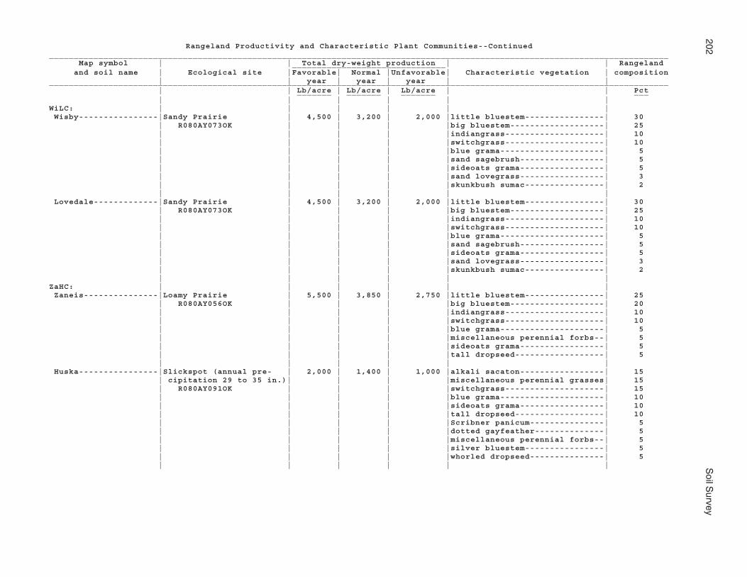
202S
oil Survey
Rangeland Productivity and Characteristic Plant Communities--Continued_____________________________________________________________________________________________________________________________ Map symbol | | Total dry-weight production | | Rangeland _______________________________ and soil name | Ecological site |Favorable| Normal |Unfavorable| Characteristic vegetation | composition | | year | year | year | |_____________________________________________________________________________________________________________________________ | | Lb/acre | Lb/acre | Lb/acre | | Pct _______ _______ _______ ___ | | | | | |WiLC: | | | | | | Wisby----------------|Sandy Prairie | 4,500 | 3,200 | 2,000 |little bluestem----------------| 30 | R080AY073OK | | | |big bluestem-------------------| 25 | | | | |indiangrass--------------------| 10 | | | | |switchgrass--------------------| 10 | | | | |blue grama---------------------| 5 | | | | |sand sagebrush-----------------| 5 | | | | |sideoats grama-----------------| 5 | | | | |sand lovegrass-----------------| 3 | | | | |skunkbush sumac----------------| 2 | | | | | | Lovedale-------------|Sandy Prairie | 4,500 | 3,200 | 2,000 |little bluestem----------------| 30 | R080AY073OK | | | |big bluestem-------------------| 25 | | | | |indiangrass--------------------| 10 | | | | |switchgrass--------------------| 10 | | | | |blue grama---------------------| 5 | | | | |sand sagebrush-----------------| 5 | | | | |sideoats grama-----------------| 5 | | | | |sand lovegrass-----------------| 3 | | | | |skunkbush sumac----------------| 2 | | | | | |ZaHC: | | | | | | Zaneis---------------|Loamy Prairie | 5,500 | 3,850 | 2,750 |little bluestem----------------| 25 | R080AY056OK | | | |big bluestem-------------------| 20 | | | | |indiangrass--------------------| 10 | | | | |switchgrass--------------------| 10 | | | | |blue grama---------------------| 5 | | | | |miscellaneous perennial forbs--| 5 | | | | |sideoats grama-----------------| 5 | | | | |tall dropseed------------------| 5 | | | | | | Huska----------------|Slickspot (annual pre- | 2,000 | 1,400 | 1,000 |alkali sacaton-----------------| 15 | cipitation 29 to 35 in.)| | | |miscellaneous perennial grasses| 15 | R080AY091OK | | | |switchgrass--------------------| 15 | | | | |blue grama---------------------| 10 | | | | |sideoats grama-----------------| 10 | | | | |tall dropseed------------------| 10 | | | | |Scribner panicum---------------| 5 | | | | |dotted gayfeather--------------| 5 | | | | |miscellaneous perennial forbs--| 5 | | | | |silver bluestem----------------| 5 | | | | |whorled dropseed---------------| 5 | | | | | |

Noble C
ounty, Oklahom
a203
Rangeland Productivity and Characteristic Plant Communities--Continued_____________________________________________________________________________________________________________________________ Map symbol | | Total dry-weight production | | Rangeland _______________________________ and soil name | Ecological site |Favorable| Normal |Unfavorable| Characteristic vegetation | composition | | year | year | year | |_____________________________________________________________________________________________________________________________ | | Lb/acre | Lb/acre | Lb/acre | | Pct _______ _______ _______ ___ | | | | | |ZanB: | | | | | | Zaneis---------------|Loamy Prairie | 5,500 | 3,850 | 2,750 |little bluestem----------------| 25 | R080AY056OK | | | |big bluestem-------------------| 20 | | | | |indiangrass--------------------| 10 | | | | |switchgrass--------------------| 10 | | | | |blue grama---------------------| 5 | | | | |miscellaneous perennial forbs--| 5 | | | | |sideoats grama-----------------| 5 | | | | |tall dropseed------------------| 5 | | | | | |_____________________________________________________________________________________________________________________________

204 Soil Survey
Windbreaks and Environmental PlantingsWindbreaks protect livestock, buildings, and yards from wind and snow. They also
protect fruit trees and gardens, and they furnish habitat for wildlife. Several rows of low-and high-growing broadleaf and coniferous trees and shrubs provide the most protection.
Field windbreaks are narrow plantings made at right angles to the prevailing wind andat specific intervals across the field. The interval depends on the erodibility of the soil.Field windbreaks protect cropland and crops from wind, help to keep snow on the fields,and provide food and cover for wildlife.
Environmental plantings help to beautify and screen houses and other buildings andto abate noise. The plants, mostly evergreen shrubs and trees, are closely spaced. Toensure plant survival, a healthy planting stock of suitable species should be plantedproperly on a well prepared site and maintained in good condition.
Windbreaks are often planted on land that did not originally support trees. Knowledgeof how trees perform on such land can be gained only by observing and recording theperformance of trees that have been planted and have survived. Many popular wind-break species are not indigenous to the areas in which they are planted.
Each tree or shrub species has certain climatic and physiographic limits. Within theseparameters, a tree or shrub may grow well or grow poorly, depending on the characteris-tics of the soil. Each tree or shrub has definable potential heights in a given physi-ographic area and under given climatic conditions. Accurate definitions of potentialheights are necessary when a windbreak is planned and designed.
The table “Windbreaks and Environmental Plantings” shows the height that locallygrown trees and shrubs are expected to reach in 20 years on the soils in Noble County.The estimates in this table are based on measurements and observation of establishedplantings that have been given adequate care. They can be used as a guide in planningwindbreaks and screens. Additional information on planning windbreaks and screens andplanting and caring for trees and shrubs can be obtained from the local office of theNatural Resources Conservation Service or the Cooperative Extension Service or from alocal nursery.

Noble C
ounty, Oklahom
a205
Windbreaks and Environmental Plantings
(Absence of an entry indicates that trees generally do not grow to the given height)
______________________________________________________________________________________________________________________________ Map symbol | Trees having predicted 20-year average height, in feet, of-- _______________________________________________________________________________________________________ and soil name | <8 | 8-15 | 16-25 | 26-35 | >35______________________________________________________________________________________________________________________________ | | | | |AhpA: | | | | | Ashport--------------| --- |common lilac, shrub |eastern redbud, |Osage-orange, red | --- | | lespedeza, Amur | Rocky Mountain | mulberry, common | | | honeysuckle, | juniper, oriental | hackberry, green | | | American plum | arborvitae, | ash, lacebark elm, | | | | Austrian pine, bur | black locust | | | | oak | | | | | | |APPA: | | | | | Ashport--------------| --- |common lilac, shrub |eastern redbud, |Osage-orange, red | --- | | lespedeza, Amur | Rocky Mountain | mulberry, common | | | honeysuckle, | juniper, oriental | hackberry, green | | | American plum | arborvitae, | ash, lacebark elm, | | | | Austrian pine, bur | black locust | | | | oak | | | | | | | Port-----------------| --- |common lilac, shrub |eastern redbud, |Osage-orange, red | --- | | lespedeza, Amur | Rocky Mountain | mulberry, common | | | honeysuckle, | juniper, oriental | hackberry, green | | | American plum | arborvitae, | ash, lacebark elm, | | | | Austrian pine, bur | black locust | | | | oak | | | | | | | Pulaski--------------| --- |shrub lespedeza, |Rocky Mountain |Austrian pine, bur |black locust | | Amur honeysuckle, | juniper, eastern | oak, Osage-orange, | | | American plum | redbud, ponderosa | red mulberry, | | | | pine, oriental | common hackberry, | | | | arborvitae, Scotch | green ash, lacebark| | | | pine | elm | | | | | |AspA, AspB: | | | | | Ashport--------------| --- |common lilac, shrub |eastern redbud, |Osage-orange, red | --- | | lespedeza, Amur | Rocky Mountain | mulberry, common | | | honeysuckle, | juniper, oriental | hackberry, green | | | American plum | arborvitae, | ash, lacebark elm, | | | | Austrian pine, bur | black locust | | | | oak | | | | | | |BetA, BetB: | | | | | Bethany--------------|American plum |common lilac, Amur |bur oak, |loblolly pine | --- | | honeysuckle, | Osage-orange, | | | | eastern redbud, | ponderosa pine, red| | | | oriental arborvitae| mulberry, black | | | | | locust, common | | | | | hackberry, lacebark| | | | | elm | | | | | | |

206S
oil Survey
Windbreaks and Environmental Plantings--Continued______________________________________________________________________________________________________________________________ Map symbol | Trees having predicted 20-year average height, in feet, of-- _______________________________________________________________________________________________________ and soil name | <8 | 8-15 | 16-25 | 26-35 | >35______________________________________________________________________________________________________________________________ | | | | |BPG. | | | | | Borrow pits, gravelly| | | | | | | | | |BPR. | | | | | Borrow pits, rock | | | | | | | | | |BraA: | | | | | Braman---------------|American plum |common lilac, Amur |bur oak, |loblolly pine | --- | | honeysuckle, | Osage-orange, | | | | eastern redbud, | ponderosa pine, red| | | | oriental arborvitae| mulberry, black | | | | | locust, common | | | | | hackberry, lacebark| | | | | elm | | | | | | |BrwA: | | | | | Brewer---------------|American plum |common lilac, Amur |bur oak, |loblolly pine | --- | | honeysuckle, | Osage-orange, | | | | eastern redbud, | ponderosa pine, red| | | | oriental arborvitae| mulberry, black | | | | | locust, common | | | | | hackberry, lacebark| | | | | elm | | | | | | |CoLC: | | | | | Coyle----------------|American plum |eastern redbud, |Austrian pine, Rocky| --- | --- | | oriental arborvitae| Mountain juniper, | | | | | common hackberry, | | | | | lacebark elm, | | | | | Osage-orange, | | | | | ponderosa pine, red| | | | | mulberry, bur oak, | | | | | green ash, black | | | | | locust, loblolly | | | | | pine | | | | | | | Lucien. | | | | | | | | | |CoyB, CoyC, CoyC2: | | | | | Coyle----------------|sand plum |eastern redbud, |bur oak, common | --- | --- | | oriental | hackberry, lacebark| | | | arborvitae, Rocky | elm, Osage-orange, | | | | Mountain juniper | ponderosa pine, | | | | | green ash, black | | | | | locust | | | | | | |

Noble C
ounty, Oklahom
a207
Windbreaks and Environmental Plantings--Continued______________________________________________________________________________________________________________________________ Map symbol | Trees having predicted 20-year average height, in feet, of-- _______________________________________________________________________________________________________ and soil name | <8 | 8-15 | 16-25 | 26-35 | >35______________________________________________________________________________________________________________________________ | | | | |CoZC3: | | | | | Coyle----------------|American plum |eastern redbud, |Austrian pine, Rocky| --- | --- | | oriental arborvitae| Mountain juniper, | | | | | common hackberry, | | | | | lacebark elm, | | | | | Osage-orange, | | | | | ponderosa pine, red| | | | | mulberry, bur oak, | | | | | green ash, black | | | | | locust, loblolly | | | | | pine | | | | | | | Zaneis---------------|American plum |common lilac, Amur |bur oak, |loblolly pine | --- | | honeysuckle, | Osage-orange, | | | | eastern redbud, | ponderosa pine, red| | | | oriental arborvitae| mulberry, black | | | | | locust, common | | | | | hackberry, lacebark| | | | | elm | | | | | | |DalA: | | | | | Dale-----------------|shrub lespedeza |Amur honeysuckle, |eastern redbud, |Osage-orange, bur | --- | | American plum | Scotch pine, Rocky | oak, common | | | | Mountain juniper, | hackberry, green | | | | oriental | ash, lacebark elm, | | | | arborvitae, red | black locust | | | | mulberry, Austrian | | | | | pine, ponderosa | | | | | pine | | | | | | |DAM. | | | | | Dam | | | | | | | | | |DaUA: | | | | | Dale-----------------|shrub lespedeza |Amur honeysuckle, |eastern redbud, |Osage-orange, bur | --- | | American plum | Scotch pine, Rocky | oak, common | | | | Mountain juniper, | hackberry, green | | | | oriental | ash, lacebark elm, | | | | arborvitae, red | black locust | | | | mulberry, Austrian | | | | | pine, ponderosa | | | | | pine | | | | | | | Urban land. | | | | | | | | | |

208S
oil Survey
Windbreaks and Environmental Plantings--Continued______________________________________________________________________________________________________________________________ Map symbol | Trees having predicted 20-year average height, in feet, of-- _______________________________________________________________________________________________________ and soil name | <8 | 8-15 | 16-25 | 26-35 | >35______________________________________________________________________________________________________________________________ | | | | |DiGE: | | | | | Dilworth-------------|American plum |eastern redbud, |common hackberry, | --- | --- | | oriental | lacebark elm, | | | | arborvitae, Rocky | Osage-orange, | | | | Mountain juniper | ponderosa pine, bur| | | | | oak, black locust, | | | | | green ash | | | | | | | Grainola-------------|sand plum |eastern redbud, |bur oak, common | --- | --- | | oriental | hackberry, lacebark| | | | arborvitae, Rocky | elm, Osage-orange, | | | | Mountain juniper | ponderosa pine, | | | | | green ash, black | | | | | locust | | | | | | |DooB: | | | | | Doolin. | | | | | | | | | |DwhC: | | | | | Dilworth-------------|American plum |eastern redbud, |common hackberry, | --- | --- | | oriental | lacebark elm, | | | | arborvitae, Rocky | Osage-orange, | | | | Mountain juniper | ponderosa pine, bur| | | | | oak, black locust, | | | | | green ash | | | | | | |EasA: | | | | | Easpur---------------| --- |common lilac, shrub |eastern redbud, |Osage-orange, red | --- | | lespedeza, Amur | Rocky Mountain | mulberry, common | | | honeysuckle, | juniper, oriental | hackberry, green | | | American plum | arborvitae, | ash, lacebark elm, | | | | Austrian pine, bur | black locust | | | | oak | | | | | | |GadA: | | | | | Gaddy----------------|sand plum | --- |Rocky Mountain |black locust | --- | | | juniper, bur oak, | | | | | oriental | | | | | arborvitae, | | | | | ponderosa pine, | | | | | Austrian pine, | | | | | Osage-orange, | | | | | common hackberry, | | | | | green ash, lacebark| | | | | elm, loblolly pine | | | | | | |

Noble C
ounty, Oklahom
a209
Windbreaks and Environmental Plantings--Continued______________________________________________________________________________________________________________________________ Map symbol | Trees having predicted 20-year average height, in feet, of-- _______________________________________________________________________________________________________ and soil name | <8 | 8-15 | 16-25 | 26-35 | >35______________________________________________________________________________________________________________________________ | | | | |GayA: | | | | | Gaddy----------------|American plum |eastern redbud, |Austrian pine, bur | --- | --- | | oriental | oak, common | | | | arborvitae, Rocky | hackberry, lacebark| | | | Mountain juniper | elm, ponderosa | | | | | pine, green ash, | | | | | black locust, | | | | | loblolly pine | | | | | | |GMLG: | | | | | Grainola-------------|sand plum |eastern redbud, |bur oak, common | --- | --- | | oriental | hackberry, lacebark| | | | arborvitae, Rocky | elm, Osage-orange, | | | | Mountain juniper | ponderosa pine, | | | | | green ash, black | | | | | locust | | | | | | | Masham. | | | | | | | | | | Lucien. | | | | | | | | | |GohE: | | | | | Goodnight------------|sand plum | --- |Rocky Mountain |black locust | --- | | | juniper, bur oak, | | | | | oriental | | | | | arborvitae, | | | | | ponderosa pine, | | | | | Austrian pine, | | | | | Osage-orange, | | | | | common hackberry, | | | | | green ash, lacebark| | | | | elm, loblolly pine | | | | | | |GraC: | | | | | Grainola-------------|sand plum |eastern redbud, |bur oak, common | --- | --- | | oriental | hackberry, lacebark| | | | arborvitae, Rocky | elm, Osage-orange, | | | | Mountain juniper | ponderosa pine, | | | | | green ash, black | | | | | locust | | | | | | |GrAD: | | | | | Grainola-------------|sand plum |eastern redbud, |bur oak, common | --- | --- | | oriental | hackberry, lacebark| | | | arborvitae, Rocky | elm, Osage-orange, | | | | Mountain juniper | ponderosa pine, | | | | | green ash, black | | | | | locust | | | | | | |

210S
oil Survey
Windbreaks and Environmental Plantings--Continued______________________________________________________________________________________________________________________________ Map symbol | Trees having predicted 20-year average height, in feet, of-- _______________________________________________________________________________________________________ and soil name | <8 | 8-15 | 16-25 | 26-35 | >35______________________________________________________________________________________________________________________________ | | | | |GrAD: | | | | | Ashport--------------| --- |common lilac, shrub |eastern redbud, |Osage-orange, red | --- | | lespedeza, Amur | Rocky Mountain | mulberry, common | | | honeysuckle, | juniper, oriental | hackberry, green | | | American plum | arborvitae, | ash, lacebark elm, | | | | Austrian pine, bur | black locust | | | | oak | | | | | | |GrHC: | | | | | Grant----------------|shrub lespedeza |Amur honeysuckle, |eastern redbud, |Osage-orange, bur | --- | | American plum | Scotch pine, Rocky | oak, common | | | | Mountain juniper, | hackberry, green | | | | oriental | ash, lacebark elm, | | | | arborvitae, red | black locust | | | | mulberry, Austrian | | | | | pine, ponderosa | | | | | pine | | | | | | | Huska. | | | | | | | | | |GrLC, GrLE: | | | | | Grainola-------------|sand plum |eastern redbud, |bur oak, common | --- | --- | | oriental | hackberry, lacebark| | | | arborvitae, Rocky | elm, Osage-orange, | | | | Mountain juniper | ponderosa pine, | | | | | green ash, black | | | | | locust | | | | | | | Lucien. | | | | | | | | | |GrnC: | | | | | Grant----------------|shrub lespedeza |Amur honeysuckle, |eastern redbud, |Osage-orange, bur | --- | | American plum | Scotch pine, Rocky | oak, common | | | | Mountain juniper, | hackberry, green | | | | oriental | ash, lacebark elm, | | | | arborvitae, red | black locust | | | | mulberry, Austrian | | | | | pine, ponderosa | | | | | pine | | | | | | |GrtB: | | | | | Grant----------------|American plum, Amur |eastern redbud, |bur oak, |loblolly pine | --- | honeysuckle, common| oriental arborvitae| Osage-orange, | | | lilac | | ponderosa pine, red| | | | | mulberry, black | | | | | locust, common | | | | | hackberry, lacebark| | | | | elm | | | | | | |

Noble C
ounty, Oklahom
a211
Windbreaks and Environmental Plantings--Continued______________________________________________________________________________________________________________________________ Map symbol | Trees having predicted 20-year average height, in feet, of-- _______________________________________________________________________________________________________ and soil name | <8 | 8-15 | 16-25 | 26-35 | >35______________________________________________________________________________________________________________________________ | | | | |HaPE: | | | | | Harrah---------------|skunkbush sumac |common lilac, | --- |Austrian pine, |Chinese elm | | American plum, Amur| | Osage-orange | | | honeysuckle | | | | | | | | Pulaski--------------| --- |shrub lespedeza, |Rocky Mountain |Austrian pine, bur |black locust | | Amur honeysuckle, | juniper, eastern | oak, Osage-orange, | | | American plum | redbud, ponderosa | red mulberry, | | | | pine, oriental | common hackberry, | | | | arborvitae, Scotch | green ash, lacebark| | | | pine | elm | | | | | |HiRG. | | | | | Highview-Rock outcrop| | | | | | | | | |KekA, KeoA: | | | | | Keokuk---------------|shrub lespedeza |Amur honeysuckle, |eastern redbud, |Osage-orange, bur | --- | | American plum | Scotch pine, Rocky | oak, common | | | | Mountain juniper, | hackberry, green | | | | oriental | ash, lacebark elm, | | | | arborvitae, red | black locust | | | | mulberry, Austrian | | | | | pine, ponderosa | | | | | pine | | | | | | |KgfB: | | | | | Kingfisher-----------|sand plum |eastern redbud, |bur oak, common | --- | --- | | oriental | hackberry, lacebark| | | | arborvitae, Rocky | elm, Osage-orange, | | | | Mountain juniper | ponderosa pine, | | | | | green ash, black | | | | | locust | | | | | | |KgLC: | | | | | Kingfisher-----------|sand plum |eastern redbud, |bur oak, common | --- | --- | | oriental | hackberry, lacebark| | | | arborvitae, Rocky | elm, Osage-orange, | | | | Mountain juniper | ponderosa pine, | | | | | green ash, black | | | | | locust | | | | | | | Lucien. | | | | | | | | | |

212S
oil Survey
Windbreaks and Environmental Plantings--Continued______________________________________________________________________________________________________________________________ Map symbol | Trees having predicted 20-year average height, in feet, of-- _______________________________________________________________________________________________________ and soil name | <8 | 8-15 | 16-25 | 26-35 | >35______________________________________________________________________________________________________________________________ | | | | |KgWC: | | | | | Kingfisher-----------|sand plum |eastern redbud, |bur oak, common | --- | --- | | oriental | hackberry, lacebark| | | | arborvitae, Rocky | elm, Osage-orange, | | | | Mountain juniper | ponderosa pine, | | | | | green ash, black | | | | | locust | | | | | | | Wakita. | | | | | | | | | |KinC2: | | | | | Kingfisher-----------|sand plum |eastern redbud, |bur oak, common | --- | --- | | oriental | hackberry, lacebark| | | | arborvitae, Rocky | elm, Osage-orange, | | | | Mountain juniper | ponderosa pine, | | | | | green ash, black | | | | | locust | | | | | | |KowB: | | | | | Konawa---------------| --- |American plum, Amur |oriental arborvitae,|Austrian pine, | --- | | honeysuckle | red mulberry | Chinese elm, black | | | | | locust, green ash | | | | | |KowD: | | | | | Konawa---------------|sand plum |Rocky Mountain |oriental arborvitae,|loblolly pine | --- | | juniper, eastern | Austrian pine, bur | | | | redbud | oak, lacebark elm, | | | | | common hackberry, | | | | | green ash, black | | | | | locust | | | | | | |KrdA, KrdB, KrdB2: | | | | | Kirkland-------------|American plum, Amur |eastern redbud, |bur oak, |loblolly pine | --- | honeysuckle, common| oriental arborvitae| Osage-orange, | | | lilac | | ponderosa pine, red| | | | | mulberry, black | | | | | locust, common | | | | | hackberry, lacebark| | | | | elm | | | | | | |KrPB: | | | | | Kirkland-------------|American plum, Amur |eastern redbud, |bur oak, |loblolly pine | --- | honeysuckle, common| oriental arborvitae| Osage-orange, | | | lilac | | ponderosa pine, red| | | | | mulberry, black | | | | | locust, common | | | | | hackberry, lacebark| | | | | elm | | | | | | | Pawhuska. | | | | | | | | | |

Noble C
ounty, Oklahom
a213
Windbreaks and Environmental Plantings--Continued______________________________________________________________________________________________________________________________ Map symbol | Trees having predicted 20-year average height, in feet, of-- _______________________________________________________________________________________________________ and soil name | <8 | 8-15 | 16-25 | 26-35 | >35______________________________________________________________________________________________________________________________ | | | | |LAN. | | | | | Landfill | | | | | | | | | |LelA: | | | | | Lela-----------------|American plum, Amur |eastern redbud, |bur oak, |loblolly pine | --- | honeysuckle, common| oriental arborvitae| Osage-orange, | | | lilac | | ponderosa pine, red| | | | | mulberry, black | | | | | locust, common | | | | | hackberry, lacebark| | | | | elm | | | | | | |LveB: | | | | | Lovedale-------------|American plum |eastern redbud, |Austrian pine, bur | --- | --- | | oriental | oak, common | | | | arborvitae, Rocky | hackberry, lacebark| | | | Mountain juniper | elm, ponderosa | | | | | pine, green ash, | | | | | black locust, | | | | | loblolly pine | | | | | | |M-W. | | | | | Miscellaneous water | | | | | | | | | |McaA: | | | | | McLain---------------|American plum |common lilac, Amur |bur oak, |loblolly pine | --- | | honeysuckle, | Osage-orange, | | | | eastern redbud, | ponderosa pine, red| | | | oriental arborvitae| mulberry, black | | | | | locust, common | | | | | hackberry, lacebark| | | | | elm | | | | | | |MilB: | | | | | Milan----------------| --- |American plum, Amur |ponderosa pine, bur |black locust | --- | | honeysuckle, common| oak, red mulberry, | | | | lilac, eastern | Osage-orange, | | | | redbud, oriental | common hackberry, | | | | arborvitae | lacebark elm, | | | | | loblolly pine | | | | | | |MilC: | | | | | Milan----------------|shrub lespedeza |Amur honeysuckle, |eastern redbud, |Osage-orange, bur | --- | | American plum | Scotch pine, Rocky | oak, common | | | | Mountain juniper, | hackberry, green | | | | oriental | ash, lacebark elm, | | | | arborvitae, red | black locust | | | | mulberry, Austrian | | | | | pine, ponderosa | | | | | pine | | | | | | |

214S
oil Survey
Windbreaks and Environmental Plantings--Continued______________________________________________________________________________________________________________________________ Map symbol | Trees having predicted 20-year average height, in feet, of-- _______________________________________________________________________________________________________ and soil name | <8 | 8-15 | 16-25 | 26-35 | >35______________________________________________________________________________________________________________________________ | | | | |MinB, MinC: | | | | | Minco----------------|shrub lespedeza |Amur honeysuckle, |eastern redbud, |Osage-orange, bur | --- | | American plum | Scotch pine, Rocky | oak, common | | | | Mountain juniper, | hackberry, green | | | | oriental | ash, lacebark elm, | | | | arborvitae, red | black locust | | | | mulberry, Austrian | | | | | pine, ponderosa | | | | | pine | | | | | | |MirA: | | | | | Miller---------------|American plum |common lilac, Amur |bur oak, |loblolly pine | --- | | honeysuckle, | Osage-orange, | | | | eastern redbud, | ponderosa pine, red| | | | oriental arborvitae| mulberry, black | | | | | locust, common | | | | | hackberry, lacebark| | | | | elm | | | | | | |MisA. | | | | | Miller | | | | | | | | | |MPNC2: | | | | | Milan----------------| --- |American plum, Amur |ponderosa pine, bur |black locust | --- | | honeysuckle, common| oak, red mulberry, | | | | lilac, eastern | Osage-orange, | | | | redbud, oriental | common hackberry, | | | | arborvitae | lacebark elm, | | | | | loblolly pine | | | | | | | Pawhuska. | | | | | | | | | | Norge----------------|American plum |common lilac, Amur |bur oak, |loblolly pine | --- | | honeysuckle, | Osage-orange, | | | | eastern redbud, | ponderosa pine, red| | | | oriental arborvitae| mulberry, black | | | | | locust, common | | | | | hackberry, lacebark| | | | | elm | | | | | | |MulC, MulD, MulD4: | | | | | Mulhall--------------|shrub lespedeza |Amur honeysuckle, |eastern redbud, |Osage-orange, bur | --- | | American plum | Scotch pine, Rocky | oak, common | | | | Mountain juniper, | hackberry, green | | | | oriental | ash, lacebark elm, | | | | arborvitae, red | black locust | | | | mulberry, Austrian | | | | | pine, ponderosa | | | | | pine | | | | | | |

Noble C
ounty, Oklahom
a215
Windbreaks and Environmental Plantings--Continued______________________________________________________________________________________________________________________________ Map symbol | Trees having predicted 20-year average height, in feet, of-- _______________________________________________________________________________________________________ and soil name | <8 | 8-15 | 16-25 | 26-35 | >35______________________________________________________________________________________________________________________________ | | | | |NeDG: | | | | | Newalla--------------| --- |American plum, Amur |Austrian pine, bur |Chinese elm, black | --- | | honeysuckle | oak, green ash, | locust | | | | Osage-orange | | | | | | | Darnell. | | | | | | | | | |NorA, NorB, NorC, | | | | | NorC2: | | | | | Norge---------------|American plum |common lilac, Amur |bur oak, |loblolly pine | --- | | honeysuckle, | Osage-orange, | | | | eastern redbud, | ponderosa pine, red| | | | oriental arborvitae| mulberry, black | | | | | locust, common | | | | | hackberry, lacebark| | | | | elm | | | | | | |NoUC: | | | | | Norge----------------|American plum |common lilac, Amur |bur oak, |loblolly pine | --- | | honeysuckle, | Osage-orange, | | | | eastern redbud, | ponderosa pine, red| | | | oriental arborvitae| mulberry, black | | | | | locust, common | | | | | hackberry, lacebark| | | | | elm | | | | | | | Urban land. | | | | | | | | | |OWWE: | | | | | Oil waste land. | | | | | | | | | | Westsum--------------|American plum, Amur |eastern redbud, |bur oak, |loblolly pine | --- | honeysuckle, common| oriental arborvitae| Osage-orange, | | | lilac | | ponderosa pine, red| | | | | mulberry, black | | | | | locust, common | | | | | hackberry, lacebark| | | | | elm | | | | | | |PoaA: | | | | | Port-----------------|shrub lespedeza |Amur honeysuckle, |eastern redbud, |Osage-orange, bur | --- | | American plum | Scotch pine, Rocky | oak, common | | | | Mountain juniper, | hackberry, green | | | | oriental | ash, lacebark elm, | | | | arborvitae, red | black locust | | | | mulberry, Austrian | | | | | pine, ponderosa | | | | | pine | | | | | | |

216S
oil Survey
Windbreaks and Environmental Plantings--Continued______________________________________________________________________________________________________________________________ Map symbol | Trees having predicted 20-year average height, in feet, of-- _______________________________________________________________________________________________________ and soil name | <8 | 8-15 | 16-25 | 26-35 | >35______________________________________________________________________________________________________________________________ | | | | |PoOA: | | | | | Port-----------------| --- |common lilac, shrub |eastern redbud, |Osage-orange, red | --- | | lespedeza, Amur | Rocky Mountain | mulberry, common | | | honeysuckle, | juniper, oriental | hackberry, green | | | American plum | arborvitae, | ash, lacebark elm, | | | | Austrian pine, bur | black locust | | | | oak | | | | | | | Oscar. | | | | | | | | | |PorA, PotA: | | | | | Port-----------------| --- |common lilac, shrub |eastern redbud, |Osage-orange, red | --- | | lespedeza, Amur | Rocky Mountain | mulberry, common | | | honeysuckle, | juniper, oriental | hackberry, green | | | American plum | arborvitae, | ash, lacebark elm, | | | | Austrian pine, bur | black locust | | | | oak | | | | | | |PukA, PulA: | | | | | Pulaski--------------| --- |shrub lespedeza, |Rocky Mountain |Austrian pine, bur |black locust | | Amur honeysuckle, | juniper, eastern | oak, Osage-orange, | | | American plum | redbud, ponderosa | red mulberry, | | | | pine, oriental | common hackberry, | | | | arborvitae, Scotch | green ash, lacebark| | | | pine | elm | | | | | |RefC2: | | | | | Renfrow--------------|American plum, Amur |eastern redbud, |bur oak, |loblolly pine | --- | honeysuckle, common| oriental arborvitae| Osage-orange, | | | lilac | | ponderosa pine, red| | | | | mulberry, black | | | | | locust, common | | | | | hackberry, lacebark| | | | | elm | | | | | | |ReGC2: | | | | | Renfrow--------------|American plum, Amur |eastern redbud, |bur oak, |loblolly pine | --- | honeysuckle, common| oriental arborvitae| Osage-orange, | | | lilac | | ponderosa pine, red| | | | | mulberry, black | | | | | locust, common | | | | | hackberry, lacebark| | | | | elm | | | | | | | Grainola-------------|sand plum |eastern redbud, |bur oak, common | --- | --- | | oriental | hackberry, lacebark| | | | arborvitae, Rocky | elm, Osage-orange, | | | | Mountain juniper | ponderosa pine, | | | | | green ash, black | | | | | locust | | | | | | |

Noble C
ounty, Oklahom
a217
Windbreaks and Environmental Plantings--Continued______________________________________________________________________________________________________________________________ Map symbol | Trees having predicted 20-year average height, in feet, of-- _______________________________________________________________________________________________________ and soil name | <8 | 8-15 | 16-25 | 26-35 | >35______________________________________________________________________________________________________________________________ | | | | |ReiA: | | | | | Reinach--------------|shrub lespedeza |Amur honeysuckle, |eastern redbud, |Osage-orange, bur | --- | | American plum | Scotch pine, Rocky | oak, common | | | | Mountain juniper, | hackberry, green | | | | oriental | ash, lacebark elm, | | | | arborvitae, red | black locust | | | | mulberry, Austrian | | | | | pine, ponderosa | | | | | pine | | | | | | |RenB, RenC, RewC2: | | | | | Renfrow--------------|American plum, Amur |eastern redbud, |bur oak, |loblolly pine | --- | honeysuckle, common| oriental arborvitae| Osage-orange, | | | lilac | | ponderosa pine, red| | | | | mulberry, black | | | | | locust, common | | | | | hackberry, lacebark| | | | | elm | | | | | | |RGPD3: | | | | | Renfrow--------------|American plum, Amur |eastern redbud, |bur oak, |loblolly pine | --- | honeysuckle, common| oriental arborvitae| Osage-orange, | | | lilac | | ponderosa pine, red| | | | | mulberry, black | | | | | locust, common | | | | | hackberry, lacebark| | | | | elm | | | | | | | Grainola-------------|American plum |eastern redbud, |Austrian pine, Rocky| --- | --- | | oriental arborvitae| Mountain juniper, | | | | | common hackberry, | | | | | lacebark elm, | | | | | Osage-orange, | | | | | ponderosa pine, red| | | | | mulberry, bur oak, | | | | | green ash, black | | | | | locust, loblolly | | | | | pine | | | | | | | Pawhuska. | | | | | | | | | |SlaB: | | | | | Slaughterville-------|shrub lespedeza |Amur honeysuckle, |eastern redbud, |Osage-orange, bur | --- | | American plum | Scotch pine, Rocky | oak, common | | | | Mountain juniper, | hackberry, green | | | | oriental | ash, lacebark elm, | | | | arborvitae, red | black locust | | | | mulberry, Austrian | | | | | pine, ponderosa | | | | | pine | | | | | | |

218S
oil Survey
Windbreaks and Environmental Plantings--Continued______________________________________________________________________________________________________________________________ Map symbol | Trees having predicted 20-year average height, in feet, of-- _______________________________________________________________________________________________________ and soil name | <8 | 8-15 | 16-25 | 26-35 | >35______________________________________________________________________________________________________________________________ | | | | |SlaC, SlaG: | | | | | Slaughterville-------|American plum |eastern redbud, |Austrian pine, bur | --- | --- | | oriental | oak, common | | | | arborvitae, Rocky | hackberry, lacebark| | | | Mountain juniper | elm, ponderosa | | | | | pine, green ash, | | | | | black locust, | | | | | loblolly pine | | | | | | |StDD: | | | | | Stephenville---------|Amur honeysuckle | --- |red mulberry, black |Siberian elm | --- | | | locust, green ash, | | | | | Osage-orange, | | | | | Austrian pine | | | | | | | Darnell. | | | | | | | | | |TabA. | | | | | Tabler | | | | | | | | | |TeaA. | | | | | Tearney | | | | | | | | | |TelB, TelD, TelD2: | | | | | Teller---------------|shrub lespedeza |Amur honeysuckle, |eastern redbud, |Osage-orange, bur | --- | | American plum | Scotch pine, Rocky | oak, common | | | | Mountain juniper, | hackberry, green | | | | oriental | ash, lacebark elm, | | | | arborvitae, red | black locust | | | | mulberry, Austrian | | | | | pine, ponderosa | | | | | pine | | | | | | |VanA: | | | | | Vanoss---------------|shrub lespedeza |Amur honeysuckle, |eastern redbud, |Osage-orange, bur | --- | | American plum | Scotch pine, Rocky | oak, common | | | | Mountain juniper, | hackberry, green | | | | oriental | ash, lacebark elm, | | | | arborvitae, red | black locust | | | | mulberry, Austrian | | | | | pine, ponderosa | | | | | pine | | | | | | |W. | | | | | Water | | | | | | | | | |WauA: | | | | | Waurika. | | | | | | | | | |

Noble C
ounty, Oklahom
a219
Windbreaks and Environmental Plantings--Continued______________________________________________________________________________________________________________________________ Map symbol | Trees having predicted 20-year average height, in feet, of-- _______________________________________________________________________________________________________ and soil name | <8 | 8-15 | 16-25 | 26-35 | >35______________________________________________________________________________________________________________________________ | | | | |WesB, WesC: | | | | | Westsum--------------|American plum, Amur |eastern redbud, |bur oak, |loblolly pine | --- | honeysuckle, common| oriental arborvitae| Osage-orange, | | | lilac | | ponderosa pine, red| | | | | mulberry, black | | | | | locust, common | | | | | hackberry, lacebark| | | | | elm | | | | | | |WiLC: | | | | | Wisby----------------|American plum |eastern redbud, |Austrian pine, bur | --- | --- | | oriental | oak, common | | | | arborvitae, Rocky | hackberry, lacebark| | | | Mountain juniper | elm, ponderosa | | | | | pine, green ash, | | | | | black locust, | | | | | loblolly pine | | | | | | | Lovedale-------------|American plum |eastern redbud, |Austrian pine, bur | --- | --- | | oriental | oak, common | | | | arborvitae, Rocky | hackberry, lacebark| | | | Mountain juniper | elm, ponderosa | | | | | pine, green ash, | | | | | black locust, | | | | | loblolly pine | | | | | | |ZaHC: | | | | | Zaneis---------------|American plum |common lilac, Amur |bur oak, |loblolly pine | --- | | honeysuckle, | Osage-orange, | | | | eastern redbud, | ponderosa pine, red| | | | oriental arborvitae| mulberry, black | | | | | locust, common | | | | | hackberry, lacebark| | | | | elm | | | | | | | Huska. | | | | | | | | | |ZanB: | | | | | Zaneis---------------|American plum |common lilac, Amur |bur oak, |loblolly pine | --- | | honeysuckle, | Osage-orange, | | | | eastern redbud, | ponderosa pine, red| | | | oriental arborvitae| mulberry, black | | | | | locust, common | | | | | hackberry, lacebark| | | | | elm | | | | | | |______________________________________________________________________________________________________________________________

220 Soil Survey
RecreationThe soils of the survey area are rated in tables “Recreational Development, Part I”
and “Recreational Development, Part II” according to limitations that affect their suitabil-ity for recreation. The ratings are both verbal and numerical. Rating class terms indicatethe extent to which the soils are limited by all of the soil features that affect the recre-ational uses.
Not limited indicates that the soil has features that are very favorable for the speci-fied use. Good performance and very low maintenance can be expected.
Somewhat limited indicates that the soil has features that are moderately favorablefor the specified use. The limitations can be overcome or minimized by special planning,design, or installation. Fair performance and moderate maintenance can be expected.
Very limited indicates that the soil has one or more features that are unfavorable forthe specified use. The limitations generally cannot be overcome without major soilreclamation, special design, or expensive installation procedures. Poor performance andhigh maintenance can be expected.
Numerical ratings in the tables indicate the severity of individual limitations. Theratings are shown as decimal fractions ranging from 0.01 to 1.00. They indicate grada-tions between the point at which a soil feature has the greatest negative impact on theuse (1.00) and the point at which the soil feature is not a limitation (0.00). The ratings inthe tables are based on restrictive soil features, such as wetness, slope, and texture ofthe surface layer. Susceptibility to flooding is considered.
Not considered in the ratings, but important in evaluating a site, are the location andaccessibility of the area, the size and shape of the area and its scenic quality, vegeta-tion, access to water, potential water impoundment sites, and access to public sewerlines. The capacity of the soil to absorb septic tank effluent and the ability of the soil tosupport vegetation also are important. Soils that are subject to flooding are limited forrecreational uses by the duration and intensity of flooding and the season when floodingoccurs. In planning recreational facilities, onsite assessment of the height, duration,intensity, and frequency of flooding is essential.
The information in tables “Recreational Development, Part I” and “RecreationalDevelopment, Part II” can be supplemented by other information in this survey, forexample, interpretations for building site development, construction materials, sanitaryfacilities, and water management.
Camp areas require site preparation, such as shaping and leveling the tent andparking areas, stabilizing roads and intensively used areas, and installing sanitaryfacilities and utility lines. Camp areas are subject to heavy foot traffic and some vehicu-lar traffic. The ratings are based on the soil properties that affect the ease of developingcamp areas and the performance of the areas after development. Slope, stoniness, anddepth to bedrock or a cemented pan are the main concerns affecting the development ofcamp areas. The soil properties that affect the performance of the areas after develop-ment are those that influence trafficability and promote the growth of vegetation,especially in heavily used areas. For good trafficability, the surface of camp areasshould absorb rainfall readily, remain firm under heavy foot traffic, and not be dustywhen dry. The soil properties that influence trafficability are texture of the surface layer,depth to a water table, ponding, flooding, permeability, and large stones. The soilproperties that affect the growth of plants are depth to bedrock or a cemented pan,permeability, and toxic substances in the soil.
Picnic areas are subject to heavy foot traffic. Most vehicular traffic is confined toaccess roads and parking areas. The ratings are based on the soil properties that affectthe ease of developing picnic areas and that influence trafficability and the growth ofvegetation after development. Slope and stoniness are the main concerns affecting thedevelopment of picnic areas. For good trafficability, the surface of picnic areas shouldabsorb rainfall readily, remain firm under heavy foot traffic, and not be dusty when dry.

Noble County, Oklahoma 221
The soil properties that influence trafficability are texture of the surface layer, depth to awater table, ponding, flooding, permeability, and large stones. The soil properties thataffect the growth of plants are depth to bedrock or a cemented pan, permeability, andtoxic substances in the soil.
Playgrounds require soils that are nearly level, are free of stones, and can withstandintensive foot traffic. The ratings are based on the soil properties that affect the ease ofdeveloping playgrounds and that influence trafficability and the growth of vegetation afterdevelopment. Slope and stoniness are the main concerns affecting the development ofplaygrounds. For good trafficability, the surface of the playgrounds should absorb rainfallreadily, remain firm under heavy foot traffic, and not be dusty when dry. The soil proper-ties that influence trafficability are texture of the surface layer, depth to a water table,ponding, flooding, permeability, and large stones. The soil properties that affect thegrowth of plants are depth to bedrock or a cemented pan, permeability, and toxicsubstances in the soil.
Paths and trails should require little or no slope modification through cutting andfilling. The ratings are based on the soil properties that affect trafficability and erodibility.These properties are stoniness, depth to a water table, ponding, flooding, slope, andtexture of the surface layer.
Off-road motorcycle trails require little or no site preparation. They are not coveredwith surfacing material or vegetation. Considerable compaction of the soil material islikely. The ratings are based on the soil properties that influence erodibility, trafficability,dustiness, and the ease of revegetation. These properties are stoniness, slope, depth toa water table, ponding, flooding, and texture of the surface layer.
Golf fairways are subject to heavy foot traffic and some light vehicular traffic. Cuttingor filling may be required. Irrigation is not considered in the ratings. The ratings arebased on the soil properties that affect plant growth and trafficability after vegetation isestablished. The properties that affect plant growth are reaction; depth to a water table;ponding; depth to bedrock or a cemented pan; the available water capacity in the upper40 inches; the content of salts, sodium, or calcium carbonate; and sulfidic materials. Theproperties that affect trafficability are flooding, depth to a water table, ponding, slope,stoniness, and the amount of sand, clay, or organic matter in the surface layer. Thesuitability of the soil for traps, tees, roughs, and greens is not considered in the ratings.

222 Soil Survey
Recreational Development, Part I
(The information in this table indicates the dominant soil condition but does not eliminate the need for onsite investigation. The numbers in the value columns range from 0.01 to 1.00. The larger the value, the greater the limitation. See text for further explanation of ratings in this table)
_________________________________________________________________________________________________ | | | | Map symbol |Pct.| Camp areas | Picnic areas | Playgrounds and soil name| of | | | _____________________________________________________________________________ |map | Rating class and |Value| Rating class and |Value| Rating class and |Value |unit| limiting features | | limiting features | | limiting features |_________________________________________________________________________________________________ | | | | | | |AhpA: | | | | | | | Ashport------| 89 |Very limited | |Not limited | |Somewhat limited | | | Flooding |1.00 | | | Flooding |0.60 | | | | | | |APPA: | | | | | | | Ashport------| 61 |Very limited | |Somewhat limited | |Very limited | | | Flooding |1.00 | Flooding |0.40 | Flooding |1.00 | | | | | | | Port---------| 15 |Very limited | |Somewhat limited | |Very limited | | | Flooding |1.00 | Flooding |0.40 | Flooding |1.00 | | | | | | | Pulaski------| 15 |Very limited | |Somewhat limited | |Very limited | | | Flooding |1.00 | Flooding |0.40 | Flooding |1.00 | | | | | | |AspA: | | | | | | | Ashport------| 90 |Very limited | |Not limited | |Somewhat limited | | | Flooding |1.00 | | | Flooding |0.60 | | | | | | |AspB: | | | | | | | Ashport------| 93 |Very limited | |Not limited | |Somewhat limited | | | Flooding |1.00 | | | Flooding |0.60 | | | | | | |BetA: | | | | | | | Bethany------| 85 |Somewhat limited | |Somewhat limited | |Somewhat limited | | | Restricted |0.41 | Restricted |0.41 | Restricted |0.41 | | permeability | | permeability | | permeability | | | | | | | |BetB: | | | | | | | Bethany------| 84 |Somewhat limited | |Somewhat limited | |Somewhat limited | | | Restricted |0.41 | Restricted |0.41 | Restricted |0.41 | | permeability | | permeability | | permeability | | | | | | | |BPG: | | | | | | | Borrow pits, | | | | | | | gravelly----| 90 |Not rated | |Not rated | |Not rated | | | | | | | |BPR: | | | | | | | Borrow pits, | | | | | | | rock--------| 90 |Not rated | |Not rated | |Not rated | | | | | | | |BraA: | | | | | | | Braman-------| 85 |Very limited | |Not limited | |Not limited | | | Flooding |1.00 | | | | | | | | | | |BrwA: | | | | | | | Brewer-------| 97 |Very limited | |Somewhat limited | |Somewhat limited | | | Flooding |1.00 | Restricted |0.41 | Restricted |0.41 | | Restricted |0.41 | permeability | | permeability | | | permeability | | | | | | | | | | | |

Noble County, Oklahoma 223
Recreational Development, Part I--Continued_________________________________________________________________________________________________ | | | | Map symbol |Pct.| Camp areas | Picnic areas | Playgrounds and soil name| of | | | _____________________________________________________________________________ |map | Rating class and |Value| Rating class and |Value| Rating class and |Value |unit| limiting features | | limiting features | | limiting features |_________________________________________________________________________________________________ | | | | | | |CoLC: | | | | | | | Coyle--------| 61 |Not limited | |Not limited | |Not limited | | | | | | | | Lucien-------| 30 |Very limited | |Very limited | |Very limited | | | Depth to bedrock |1.00 | Depth to bedrock |1.00 | Depth to bedrock |1.00 | | | | | | Slope |0.12 | | | | | | Content of large |0.03 | | | | | | stones | | | | | | | |CoyB: | | | | | | | Coyle--------| 85 |Not limited | |Not limited | |Not limited | | | | | | | |CoyC: | | | | | | | Coyle--------| 82 |Not limited | |Not limited | |Somewhat limited | | | | | | | Depth to bedrock |0.71 | | | | | | Slope |0.50 | | | | | | |CoyC2: | | | | | | | Coyle--------| 82 |Not limited | |Not limited | |Somewhat limited | | | | | | | Slope |0.50 | | | | | | Depth to bedrock |0.35 | | | | | | |CoZC3: | | | | | | | Coyle--------| 60 |Not limited | |Not limited | |Somewhat limited | | | | | | | Depth to bedrock |0.99 | | | | | | Slope |0.50 | | | | | | | Zaneis-------| 16 |Not limited | |Not limited | |Somewhat limited | | | | | | | Slope |0.50 | | | | | | |DalA: | | | | | | | Dale---------| 90 |Very limited | |Not limited | |Not limited | | | Flooding |1.00 | | | | | | | | | | |DAM: | | | | | | | Dam----------|100 |Not rated | |Not rated | |Not rated | | | | | | | |DaUA: | | | | | | | Dale---------| 48 |Very limited | |Not limited | |Not limited | | | Flooding |1.00 | | | | | | | | | | | Urban land---| 42 |Not rated | |Not rated | |Not rated | | | | | | | |DiGE: | | | | | | | Dilworth-----| 64 |Somewhat limited | |Somewhat limited | |Very limited | | | Restricted |0.41 | Restricted |0.41 | Slope |1.00 | | permeability | | permeability | | Depth to bedrock |0.97 | | Slope |0.04 | Slope |0.04 | Restricted |0.41 | | | | | | permeability | | | | | | | Gravel content |0.04 | | | | | | | Grainola-----| 16 |Somewhat limited | |Somewhat limited | |Very limited | | | Restricted |0.41 | Restricted |0.41 | Slope |1.00 | | permeability | | permeability | | Restricted |0.41 | | Slope |0.04 | Slope |0.04 | permeability | | | | | | | Depth to bedrock |0.35 | | | | | | Content of large |0.08 | | | | | | stones | | | | | | | |

224 Soil Survey
Recreational Development, Part I--Continued_________________________________________________________________________________________________ | | | | Map symbol |Pct.| Camp areas | Picnic areas | Playgrounds and soil name| of | | | _____________________________________________________________________________ |map | Rating class and |Value| Rating class and |Value| Rating class and |Value |unit| limiting features | | limiting features | | limiting features |_________________________________________________________________________________________________ | | | | | | |DooB: | | | | | | | Doolin-------| 85 |Very limited | |Very limited | |Very limited | | | Sodium content |1.00 | Sodium content |1.00 | Sodium content |1.00 | | Restricted |0.45 | Restricted |0.45 | Restricted |0.45 | | permeability | | permeability | | permeability | | | | | | | |DwhC: | | | | | | | Dilworth-----| 85 |Somewhat limited | |Somewhat limited | |Somewhat limited | | | Restricted |0.41 | Restricted |0.41 | Slope |0.50 | | permeability | | permeability | | Restricted |0.41 | | | | | | permeability | | | | | | | Depth to bedrock |0.06 | | | | | | Gravel content |0.04 | | | | | | |EasA: | | | | | | | Easpur-------| 79 |Very limited | |Not limited | |Somewhat limited | | | Flooding |1.00 | | | Flooding |0.60 | | | | | | |GadA: | | | | | | | Gaddy--------| 89 |Very limited | |Somewhat limited | |Somewhat limited | | | Flooding |1.00 | Too sandy |0.79 | Too sandy |0.79 | | Too sandy |0.79 | | | Flooding |0.60 | | | | | | |GayA: | | | | | | | Gaddy--------| 85 |Very limited | |Somewhat limited | |Somewhat limited | | | Flooding |1.00 | Too sandy |0.79 | Too sandy |0.79 | | Too sandy |0.79 | | | | | | | | | | |GMLG: | | | | | | | Grainola-----| 37 |Very limited | |Very limited | |Very limited | | | Slope |1.00 | Slope |1.00 | Slope |1.00 | | Too stony |0.76 | Too stony |0.76 | Gravel content |1.00 | | Restricted |0.41 | Restricted |0.41 | Content of large |0.95 | | permeability | | permeability | | stones | | | Gravel content |0.02 | Gravel content |0.02 | Too stony |0.76 | | Content of large |0.01 | Content of large |0.01 | Depth to bedrock |0.46 | | stones | | stones | | | | | | | | | | Masham-------| 22 |Very limited | |Very limited | |Very limited | | | Slope |1.00 | Slope |1.00 | Slope |1.00 | | Depth to bedrock |1.00 | Depth to bedrock |1.00 | Depth to bedrock |1.00 | | Too stony |0.76 | Too stony |0.76 | Too stony |0.76 | | Restricted |0.45 | Restricted |0.45 | Restricted |0.45 | | permeability | | permeability | | permeability | | | | | | | | Lucien-------| 21 |Very limited | |Very limited | |Very limited | | | Slope |1.00 | Slope |1.00 | Slope |1.00 | | Depth to bedrock |1.00 | Depth to bedrock |1.00 | Depth to bedrock |1.00 | | | | | | Content of large |0.03 | | | | | | stones | | | | | | | |GohE: | | | | | | | Goodnight----| 95 |Somewhat limited | |Somewhat limited | |Very limited | | | Too sandy |0.87 | Too sandy |0.87 | Slope |1.00 | | Slope |0.16 | Slope |0.16 | Too sandy |0.87 | | | | | | |

Noble County, Oklahoma 225
Recreational Development, Part I--Continued_________________________________________________________________________________________________ | | | | Map symbol |Pct.| Camp areas | Picnic areas | Playgrounds and soil name| of | | | _____________________________________________________________________________ |map | Rating class and |Value| Rating class and |Value| Rating class and |Value |unit| limiting features | | limiting features | | limiting features |_________________________________________________________________________________________________ | | | | | | |GraC: | | | | | | | Grainola-----| 85 |Somewhat limited | |Somewhat limited | |Somewhat limited | | | Restricted |0.41 | Restricted |0.41 | Slope |0.50 | | permeability | | permeability | | Restricted |0.41 | | | | | | permeability | | | | | | | Depth to bedrock |0.16 | | | | | | Content of large |0.05 | | | | | | stones | | | | | | | Gravel content |0.02 | | | | | | |GrAD: | | | | | | | Grainola-----| 38 |Somewhat limited | |Somewhat limited | |Very limited | | | Restricted |0.41 | Restricted |0.41 | Slope |1.00 | | permeability | | permeability | | Restricted |0.41 | | | | | | permeability | | | | | | | Depth to bedrock |0.06 | | | | | | Content of large |0.05 | | | | | | stones | | | | | | | Gravel content |0.02 | | | | | | | Ashport------| 23 |Very limited | |Somewhat limited | |Very limited | | | Flooding |1.00 | Flooding |0.40 | Flooding |1.00 | | | | | | |GrHC: | | | | | | | Grant--------| 37 |Not limited | |Not limited | |Somewhat limited | | | | | | | Slope |0.50 | | | | | | | Huska--------| 35 |Very limited | |Very limited | |Very limited | | | Sodium content |1.00 | Sodium content |1.00 | Sodium content |1.00 | | Restricted |0.45 | Restricted |0.45 | Restricted |0.45 | | permeability | | permeability | | permeability | | | Salinity |0.01 | Salinity |0.01 | Slope |0.12 | | | | | | Salinity |0.01 | | | | | | |GrLC: | | | | | | | Grainola-----| 47 |Somewhat limited | |Somewhat limited | |Somewhat limited | | | Restricted |0.41 | Restricted |0.41 | Slope |0.50 | | permeability | | permeability | | Restricted |0.41 | | | | | | permeability | | | | | | | Content of large |0.05 | | | | | | stones | | | | | | | Gravel content |0.02 | | | | | | Depth to bedrock |0.01 | | | | | | | Lucien-------| 30 |Very limited | |Very limited | |Very limited | | | Depth to bedrock |1.00 | Depth to bedrock |1.00 | Depth to bedrock |1.00 | | | | | | Slope |0.12 | | | | | | Content of large |0.03 | | | | | | stones | | | | | | | |GrLE: | | | | | | | Grainola-----| 50 |Somewhat limited | |Somewhat limited | |Very limited | | | Restricted |0.41 | Restricted |0.41 | Slope |1.00 | | permeability | | permeability | | Depth to bedrock |0.74 | | Slope |0.04 | Slope |0.04 | Restricted |0.41 | | | | | | permeability | | | | | | | Content of large |0.05 | | | | | | stones | | | | | | | Gravel content |0.02 | | | | | | |

226 Soil Survey
Recreational Development, Part I--Continued_________________________________________________________________________________________________ | | | | Map symbol |Pct.| Camp areas | Picnic areas | Playgrounds and soil name| of | | | _____________________________________________________________________________ |map | Rating class and |Value| Rating class and |Value| Rating class and |Value |unit| limiting features | | limiting features | | limiting features |_________________________________________________________________________________________________ | | | | | | |GrLE: | | | | | | | Lucien-------| 26 |Very limited | |Very limited | |Very limited | | | Depth to bedrock |1.00 | Depth to bedrock |1.00 | Depth to bedrock |1.00 | | Slope |0.04 | Slope |0.04 | Slope |1.00 | | | | | | Content of large |0.03 | | | | | | stones | | | | | | | |GrnC: | | | | | | | Grant--------| 95 |Not limited | |Not limited | |Somewhat limited | | | | | | | Slope |0.50 | | | | | | |GrtB: | | | | | | | Grant--------| 90 |Not limited | |Not limited | |Not limited | | | | | | | |HaPE: | | | | | | | Harrah-------| 44 |Not limited | |Not limited | |Very limited | | | | | | | Slope |1.00 | | | | | | | Pulaski------| 25 |Very limited | |Somewhat limited | |Very limited | | | Flooding |1.00 | Flooding |0.40 | Flooding |1.00 | | | | | | |HiRG: | | | | | | | Highview-----| 43 |Very limited | |Very limited | |Very limited | | | Slope |1.00 | Slope |1.00 | Slope |1.00 | | Depth to bedrock |1.00 | Depth to bedrock |1.00 | Depth to bedrock |1.00 | | Too clayey |0.50 | Too clayey |0.50 | Gravel content |1.00 | | Restricted |0.41 | Restricted |0.41 | Too clayey |0.50 | | permeability | | permeability | | Restricted |0.41 | | Gravel content |0.13 | Gravel content |0.13 | permeability | | | | | | | | Rock outcrop-| 33 |Not rated | |Not rated | |Not rated | | | | | | | |KekA: | | | | | | | Keokuk-------| 88 |Very limited | |Not limited | |Not limited | | | Flooding |1.00 | | | | | | | | | | |KeoA: | | | | | | | Keokuk-------| 88 |Very limited | |Not limited | |Somewhat limited | | | Flooding |1.00 | | | Flooding |0.60 | | | | | | |KgfB: | | | | | | | Kingfisher---| 90 |Not limited | |Not limited | |Not limited | | | | | | | |KgLC: | | | | | | | Kingfisher---| 53 |Not limited | |Not limited | |Somewhat limited | | | | | | | Depth to bedrock |0.97 | | | | | | Slope |0.50 | | | | | | | Lucien-------| 29 |Very limited | |Very limited | |Very limited | | | Depth to bedrock |1.00 | Depth to bedrock |1.00 | Depth to bedrock |1.00 | | | | | | Slope |0.12 | | | | | | Content of large |0.03 | | | | | | stones | | | | | | | |

Noble County, Oklahoma 227
Recreational Development, Part I--Continued_________________________________________________________________________________________________ | | | | Map symbol |Pct.| Camp areas | Picnic areas | Playgrounds and soil name| of | | | _____________________________________________________________________________ |map | Rating class and |Value| Rating class and |Value| Rating class and |Value |unit| limiting features | | limiting features | | limiting features |_________________________________________________________________________________________________ | | | | | | |KgWC: | | | | | | | Kingfisher---| 63 |Not limited | |Not limited | |Somewhat limited | | | | | | | Depth to bedrock |0.29 | | | | | | Slope |0.12 | | | | | | | Wakita-------| 19 |Very limited | |Very limited | |Very limited | | | Sodium content |1.00 | Sodium content |1.00 | Sodium content |1.00 | | Salinity |1.00 | Salinity |1.00 | Salinity |1.00 | | Restricted |0.41 | Restricted |0.41 | Restricted |0.41 | | permeability | | permeability | | permeability | | | | | | | |KinC2: | | | | | | | Kingfisher---| 82 |Not limited | |Not limited | |Somewhat limited | | | | | | | Depth to bedrock |0.97 | | | | | | Slope |0.50 | | | | | | |KowB: | | | | | | | Konawa-------| 80 |Not limited | |Not limited | |Not limited | | | | | | | |KowD: | | | | | | | Konawa-------| 78 |Not limited | |Not limited | |Very limited | | | | | | | Slope |1.00 | | | | | | |KrdA: | | | | | | | Kirkland-----| 85 |Somewhat limited | |Somewhat limited | |Somewhat limited | | | Restricted |0.45 | Restricted |0.45 | Restricted |0.45 | | permeability | | permeability | | permeability | | | | | | | |KrdB: | | | | | | | Kirkland-----| 80 |Somewhat limited | |Somewhat limited | |Somewhat limited | | | Restricted |0.45 | Restricted |0.45 | Restricted |0.45 | | permeability | | permeability | | permeability | | | | | | | |KrdB2: | | | | | | | Kirkland-----| 80 |Somewhat limited | |Somewhat limited | |Somewhat limited | | | Restricted |0.45 | Restricted |0.45 | Restricted |0.45 | | permeability | | permeability | | permeability | | | | | | | |KrPB: | | | | | | | Kirkland-----| 52 |Somewhat limited | |Somewhat limited | |Somewhat limited | | | Restricted |0.45 | Restricted |0.45 | Restricted |0.45 | | permeability | | permeability | | permeability | | | | | | | | Pawhuska-----| 33 |Very limited | |Very limited | |Very limited | | | Sodium content |1.00 | Sodium content |1.00 | Sodium content |1.00 | | Salinity |1.00 | Salinity |1.00 | Salinity |1.00 | | Restricted |0.45 | Restricted |0.45 | Restricted |0.45 | | permeability | | permeability | | permeability | | | | | | | |LAN: | | | | | | | Landfill-----|100 |Not rated | |Not rated | |Not rated | | | | | | | |LelA: | | | | | | | Lela---------| 91 |Very limited | |Somewhat limited | |Somewhat limited | | | Flooding |1.00 | Too clayey |0.50 | Flooding |0.60 | | Too clayey |0.50 | Restricted |0.45 | Too clayey |0.50 | | Restricted |0.45 | permeability | | Restricted |0.45 | | permeability | | | | permeability | | | | | | | |

228 Soil Survey
Recreational Development, Part I--Continued_________________________________________________________________________________________________ | | | | Map symbol |Pct.| Camp areas | Picnic areas | Playgrounds and soil name| of | | | _____________________________________________________________________________ |map | Rating class and |Value| Rating class and |Value| Rating class and |Value |unit| limiting features | | limiting features | | limiting features |_________________________________________________________________________________________________ | | | | | | |LveB: | | | | | | | Lovedale-----| 90 |Not limited | |Not limited | |Not limited | | | | | | | |M-W: | | | | | | | Miscellaneous| | | | | | | Water-------|100 |Not rated | |Not rated | |Not rated | | | | | | | |McaA: | | | | | | | McLain-------| 95 |Very limited | |Somewhat limited | |Somewhat limited | | | Flooding |1.00 | Restricted |0.41 | Restricted |0.41 | | Restricted |0.41 | permeability | | permeability | | | permeability | | | | | | | | | | | |MilB: | | | | | | | Milan--------| 95 |Not limited | |Not limited | |Not limited | | | | | | | |MilC: | | | | | | | Milan--------| 90 |Not limited | |Not limited | |Somewhat limited | | | | | | | Slope |0.50 | | | | | | |MinB: | | | | | | | Minco--------| 85 |Not limited | |Not limited | |Not limited | | | | | | | |MinC: | | | | | | | Minco--------| 90 |Not limited | |Not limited | |Somewhat limited | | | | | | | Slope |0.50 | | | | | | |MirA, MisA: | | | | | | | Miller-------| 84 |Very limited | |Somewhat limited | |Somewhat limited | | | Flooding |1.00 | Restricted |0.45 | Flooding |0.60 | | Restricted |0.45 | permeability | | Restricted |0.45 | | permeability | | | | permeability | | | | | | | |MPNC2: | | | | | | | Milan--------| 35 |Not limited | |Not limited | |Somewhat limited | | | | | | | Slope |0.50 | | | | | | | Pawhuska-----| 28 |Very limited | |Very limited | |Very limited | | | Sodium content |1.00 | Sodium content |1.00 | Sodium content |1.00 | | Salinity |1.00 | Salinity |1.00 | Salinity |1.00 | | Restricted |0.45 | Restricted |0.45 | Slope |0.50 | | permeability | | permeability | | Restricted |0.45 | | | | | | permeability | | | | | | | | Norge--------| 24 |Not limited | |Not limited | |Somewhat limited | | | | | | | Slope |0.50 | | | | | | |MulC: | | | | | | | Mulhall------| 92 |Not limited | |Not limited | |Somewhat limited | | | | | | | Slope |0.50 | | | | | | |MulD, MulD4: | | | | | | | Mulhall------| 92 |Not limited | |Not limited | |Very limited | | | | | | | Slope |1.00 | | | | | | |

Noble County, Oklahoma 229
Recreational Development, Part I--Continued_________________________________________________________________________________________________ | | | | Map symbol |Pct.| Camp areas | Picnic areas | Playgrounds and soil name| of | | | _____________________________________________________________________________ |map | Rating class and |Value| Rating class and |Value| Rating class and |Value |unit| limiting features | | limiting features | | limiting features |_________________________________________________________________________________________________ | | | | | | |NeDG: | | | | | | | Newalla------| 41 |Somewhat limited | |Somewhat limited | |Very limited | | | Too stony |0.76 | Too stony |0.76 | Slope |1.00 | | Restricted |0.45 | Restricted |0.45 | Too stony |0.76 | | permeability | | permeability | | Restricted |0.45 | | | | | | permeability | | | | | | | | Darnell------| 36 |Very limited | |Very limited | |Very limited | | | Depth to bedrock |1.00 | Depth to bedrock |1.00 | Slope |1.00 | | Slope |1.00 | Slope |1.00 | Depth to bedrock |1.00 | | | | | | |NorA: | | | | | | | Norge--------| 90 |Not limited | |Not limited | |Not limited | | | | | | | |NorB: | | | | | | | Norge--------| 85 |Not limited | |Not limited | |Not limited | | | | | | | |NorC: | | | | | | | Norge--------| 90 |Not limited | |Not limited | |Somewhat limited | | | | | | | Slope |0.50 | | | | | | |NorC2: | | | | | | | Norge--------| 90 |Not limited | |Not limited | |Somewhat limited | | | | | | | Slope |0.50 | | | | | | |NoUC: | | | | | | | Norge--------| 55 |Not limited | |Not limited | |Not limited | | | | | | | | Urban land---| 30 |Not rated | |Not rated | |Not rated | | | | | | | |OWWE: | | | | | | | Oil waste | | | | | | | land--------| 69 |Not rated | |Not rated | |Not rated | | | | | | | | Westsum------| 25 |Somewhat limited | |Somewhat limited | |Somewhat limited | | | Restricted |0.45 | Restricted |0.45 | Slope |0.50 | | permeability | | permeability | | Restricted |0.45 | | | | | | permeability | | | | | | | |PoaA: | | | | | | | Port---------| 84 |Very limited | |Somewhat limited | |Very limited | | | Flooding |1.00 | Flooding |0.40 | Flooding |1.00 | | | | | | |PoOA: | | | | | | | Port---------| 57 |Very limited | |Not limited | |Somewhat limited | | | Flooding |1.00 | | | Flooding |0.60 | | | | | | | Oscar--------| 40 |Very limited | |Very limited | |Very limited | | | Sodium content |1.00 | Sodium content |1.00 | Sodium content |1.00 | | Flooding |1.00 | Salinity |1.00 | Salinity |1.00 | | Salinity |1.00 | Restricted |0.41 | Flooding |0.60 | | Restricted |0.41 | permeability | | Restricted |0.41 | | permeability | | | | permeability | | | | | | | |PorA: | | | | | | | Port---------| 92 |Very limited | |Not limited | |Somewhat limited | | | Flooding |1.00 | | | Flooding |0.60 | | | | | | |PotA: | | | | | | | Port---------| 86 |Very limited | |Not limited | |Somewhat limited | | | Flooding |1.00 | | | Flooding |0.60 | | | | | | |

230 Soil Survey
Recreational Development, Part I--Continued_________________________________________________________________________________________________ | | | | Map symbol |Pct.| Camp areas | Picnic areas | Playgrounds and soil name| of | | | _____________________________________________________________________________ |map | Rating class and |Value| Rating class and |Value| Rating class and |Value |unit| limiting features | | limiting features | | limiting features |_________________________________________________________________________________________________ | | | | | | |PukA: | | | | | | | Pulaski------| 70 |Very limited | |Somewhat limited | |Very limited | | | Flooding |1.00 | Flooding |0.40 | Flooding |1.00 | | | | | | |PulA: | | | | | | | Pulaski------| 82 |Very limited | |Not limited | |Somewhat limited | | | Flooding |1.00 | | | Flooding |0.60 | | | | | | |RefC2: | | | | | | | Renfrow------| 75 |Somewhat limited | |Somewhat limited | |Somewhat limited | | | Restricted |0.45 | Restricted |0.45 | Slope |0.50 | | permeability | | permeability | | Restricted |0.45 | | | | | | permeability | | | | | | | |ReGC2: | | | | | | | Renfrow------| 60 |Somewhat limited | |Somewhat limited | |Somewhat limited | | | Restricted |0.45 | Restricted |0.45 | Slope |0.50 | | permeability | | permeability | | Restricted |0.45 | | | | | | permeability | | | | | | | | Grainola-----| 20 |Somewhat limited | |Somewhat limited | |Somewhat limited | | | Restricted |0.41 | Restricted |0.41 | Slope |0.50 | | permeability | | permeability | | Restricted |0.41 | | | | | | permeability | | | | | | | Depth to bedrock |0.20 | | | | | | Content of large |0.05 | | | | | | stones | | | | | | | Gravel content |0.02 | | | | | | |ReiA: | | | | | | | Reinach------| 90 |Very limited | |Not limited | |Not limited | | | Flooding |1.00 | | | | | | | | | | |RenB: | | | | | | | Renfrow------| 82 |Somewhat limited | |Somewhat limited | |Somewhat limited | | | Restricted |0.45 | Restricted |0.45 | Restricted |0.45 | | permeability | | permeability | | permeability | | | | | | | |RenC: | | | | | | | Renfrow------| 85 |Somewhat limited | |Somewhat limited | |Somewhat limited | | | Restricted |0.45 | Restricted |0.45 | Slope |0.50 | | permeability | | permeability | | Restricted |0.45 | | | | | | permeability | | | | | | | |RewC2: | | | | | | | Renfrow------| 80 |Somewhat limited | |Somewhat limited | |Somewhat limited | | | Restricted |0.45 | Restricted |0.45 | Slope |0.50 | | permeability | | permeability | | Restricted |0.45 | | | | | | permeability | | | | | | | |RGPD3: | | | | | | | Renfrow------| 45 |Somewhat limited | |Somewhat limited | |Somewhat limited | | | Restricted |0.45 | Restricted |0.45 | Slope |0.50 | | permeability | | permeability | | Restricted |0.45 | | | | | | permeability | | | | | | | |

Noble County, Oklahoma 231
Recreational Development, Part I--Continued_________________________________________________________________________________________________ | | | | Map symbol |Pct.| Camp areas | Picnic areas | Playgrounds and soil name| of | | | _____________________________________________________________________________ |map | Rating class and |Value| Rating class and |Value| Rating class and |Value |unit| limiting features | | limiting features | | limiting features |_________________________________________________________________________________________________ | | | | | | |RGPD3: | | | | | | | Grainola-----| 29 |Somewhat limited | |Somewhat limited | |Very limited | | | Restricted |0.41 | Restricted |0.41 | Slope |1.00 | | permeability | | permeability | | Depth to bedrock |0.99 | | | | | | Restricted |0.41 | | | | | | permeability | | | | | | | Content of large |0.05 | | | | | | stones | | | | | | | Gravel content |0.02 | | | | | | | Pawhuska-----| 15 |Very limited | |Very limited | |Very limited | | | Sodium content |1.00 | Sodium content |1.00 | Sodium content |1.00 | | Salinity |1.00 | Salinity |1.00 | Salinity |1.00 | | Restricted |0.45 | Restricted |0.45 | Slope |0.50 | | permeability | | permeability | | Restricted |0.45 | | | | | | permeability | | | | | | | |SlaB: | | | | | | | Slaughter- | | | | | | | ville-------| 85 |Not limited | |Not limited | |Not limited | | | | | | | |SlaC: | | | | | | | Slaughter- | | | | | | | ville-------| 85 |Not limited | |Not limited | |Somewhat limited | | | | | | | Slope |0.50 | | | | | | |SlaG: | | | | | | | Slaughter- | | | | | | | ville-------| 78 |Very limited | |Very limited | |Very limited | | | Slope |1.00 | Slope |1.00 | Slope |1.00 | | | | | | |StDD: | | | | | | | Stephenville-| 45 |Not limited | |Not limited | |Somewhat limited | | | | | | | Slope |0.50 | | | | | | Depth to bedrock |0.06 | | | | | | Content of large |0.03 | | | | | | stones | | | | | | | | Darnell------| 35 |Very limited | |Very limited | |Very limited | | | Depth to bedrock |1.00 | Depth to bedrock |1.00 | Depth to bedrock |1.00 | | | | | | Slope |0.50 | | | | | | Content of large |0.03 | | | | | | stones | | | | | | | |TabA: | | | | | | | Tabler-------| 83 |Very limited | |Very limited | |Very limited | | | Depth to |1.00 | Depth to |1.00 | Depth to |1.00 | | saturated zone | | saturated zone | | saturated zone | | | Restricted |0.45 | Restricted |0.45 | Restricted |0.45 | | permeability | | permeability | | permeability | | | | | | | |TeaA: | | | | | | | Tearney------| 82 |Very limited | |Very limited | |Very limited | | | Flooding |1.00 | Restricted |1.00 | Restricted |1.00 | | Restricted |1.00 | permeability | | permeability | | | permeability | | Too clayey |1.00 | Too clayey |1.00 | | Too clayey |1.00 | Ponding |1.00 | Ponding |1.00 | | Ponding |1.00 | | | Flooding |0.60 | | | | | | |TelB: | | | | | | | Teller-------| 85 |Not limited | |Not limited | |Not limited | | | | | | | |

232 Soil Survey
Recreational Development, Part I--Continued_________________________________________________________________________________________________ | | | | Map symbol |Pct.| Camp areas | Picnic areas | Playgrounds and soil name| of | | | _____________________________________________________________________________ |map | Rating class and |Value| Rating class and |Value| Rating class and |Value |unit| limiting features | | limiting features | | limiting features |_________________________________________________________________________________________________ | | | | | | |TelD: | | | | | | | Teller-------| 85 |Not limited | |Not limited | |Very limited | | | | | | | Slope |1.00 | | | | | | |TelD2: | | | | | | | Teller-------| 82 |Not limited | |Not limited | |Very limited | | | | | | | Slope |1.00 | | | | | | |VanA: | | | | | | | Vanoss-------| 82 |Not limited | |Not limited | |Not limited | | | | | | | |W: | | | | | | | Water--------|100 |Not rated | |Not rated | |Not rated | | | | | | | |WauA: | | | | | | | Waurika------| 89 |Very limited | |Very limited | |Very limited | | | Depth to |1.00 | Depth to |1.00 | Depth to |1.00 | | saturated zone | | saturated zone | | saturated zone | | | Restricted |1.00 | Restricted |1.00 | Restricted |1.00 | | permeability | | permeability | | permeability | | | Sodium content |1.00 | Sodium content |1.00 | Sodium content |1.00 | | | | | | |WesB: | | | | | | | Westsum------| 85 |Somewhat limited | |Somewhat limited | |Somewhat limited | | | Restricted |0.45 | Restricted |0.45 | Restricted |0.45 | | permeability | | permeability | | permeability | | | | | | | |WesC: | | | | | | | Westsum------| 90 |Somewhat limited | |Somewhat limited | |Somewhat limited | | | Restricted |0.45 | Restricted |0.45 | Slope |0.50 | | permeability | | permeability | | Restricted |0.45 | | | | | | permeability | | | | | | | |WiLC: | | | | | | | Wisby--------| 48 |Not limited | |Not limited | |Somewhat limited | | | | | | | Slope |0.50 | | | | | | Gravel content |0.06 | | | | | | | Lovedale-----| 40 |Not limited | |Not limited | |Not limited | | | | | | | |ZaHC: | | | | | | | Zaneis-------| 54 |Not limited | |Not limited | |Not limited | | | | | | | | Huska--------| 32 |Very limited | |Very limited | |Very limited | | | Sodium content |1.00 | Sodium content |1.00 | Sodium content |1.00 | | Restricted |0.45 | Restricted |0.45 | Restricted |0.45 | | permeability | | permeability | | permeability | | | Salinity |0.01 | Salinity |0.01 | Salinity |0.01 | | | | | | |ZanB: | | | | | | | Zaneis-------| 80 |Not limited | |Not limited | |Not limited | | | | | | | |_________________________________________________________________________________________________

Noble County, Oklahoma 233
Recreational Development, Part II
(The information in this table indicates the dominant soil condition but does not eliminate the need for onsite investigation. The numbers in the value columns range from 0.01 to 1.00. The larger the value, the greater the limitation. See text for further explanation of ratings in this table)
_________________________________________________________________________________________________ | | | | Map symbol |Pct.| Paths and trails | Off-road | Golf fairways and soil name| of | | motorcycle trails | _____________________________________________________________________________ |map | Rating class and |Value| Rating class and |Value| Rating class and |Value |unit| limiting features | | limiting features | | limiting features |_________________________________________________________________________________________________ | | | | | | |AhpA: | | | | | | | Ashport------| 89 |Not limited | |Not limited | |Somewhat limited | | | | | | | Flooding |0.60 | | | | | | |APPA: | | | | | | | Ashport------| 61 |Somewhat limited | |Somewhat limited | |Very limited | | | Flooding |0.40 | Flooding |0.40 | Flooding |1.00 | | | | | | | Port---------| 15 |Somewhat limited | |Somewhat limited | |Very limited | | | Flooding |0.40 | Flooding |0.40 | Flooding |1.00 | | | | | | | Pulaski------| 15 |Somewhat limited | |Somewhat limited | |Very limited | | | Flooding |0.40 | Flooding |0.40 | Flooding |1.00 | | | | | | |AspA: | | | | | | | Ashport------| 90 |Not limited | |Not limited | |Somewhat limited | | | | | | | Flooding |0.60 | | | | | | |AspB: | | | | | | | Ashport------| 93 |Not limited | |Not limited | |Somewhat limited | | | | | | | Flooding |0.60 | | | | | | |BetA: | | | | | | | Bethany------| 85 |Not limited | |Not limited | |Not limited | | | | | | | |BetB: | | | | | | | Bethany------| 84 |Not limited | |Not limited | |Not limited | | | | | | | |BPG: | | | | | | | Borrow pits, | | | | | | | gravelly----| 90 |Not rated | |Not rated | |Not rated | | | | | | | |BPR: | | | | | | | Borrow pits, | | | | | | | rock--------| 90 |Not rated | |Not rated | |Not rated | | | | | | | |BraA: | | | | | | | Braman-------| 85 |Not limited | |Not limited | |Not limited | | | | | | | |BrwA: | | | | | | | Brewer-------| 97 |Not limited | |Not limited | |Not limited | | | | | | | |CoLC: | | | | | | | Coyle--------| 61 |Not limited | |Not limited | |Very limited | | | | | | | Depth to bedrock |0.99 | | | | | | Droughty |0.19 | | | | | | | Lucien-------| 30 |Not limited | |Not limited | |Very limited | | | | | | | Depth to bedrock |1.00 | | | | | | Droughty |0.97 | | | | | | Content of large |0.03 | | | | | | stones | | | | | | | |

234 Soil Survey
Recreational Development, Part II--Continued_________________________________________________________________________________________________ | | | | Map symbol |Pct.| Paths and trails | Off-road | Golf fairways and soil name| of | | motorcycle trails | _____________________________________________________________________________ |map | Rating class and |Value| Rating class and |Value| Rating class and |Value |unit| limiting features | | limiting features | | limiting features |_________________________________________________________________________________________________ | | | | | | |CoyB: | | | | | | | Coyle--------| 85 |Not limited | |Not limited | |Somewhat limited | | | | | | | Depth to bedrock |0.46 | | | | | | |CoyC: | | | | | | | Coyle--------| 82 |Not limited | |Not limited | |Somewhat limited | | | | | | | Depth to bedrock |0.71 | | | | | | |CoyC2: | | | | | | | Coyle--------| 82 |Not limited | |Not limited | |Somewhat limited | | | | | | | Depth to bedrock |0.35 | | | | | | |CoZC3: | | | | | | | Coyle--------| 60 |Not limited | |Not limited | |Very limited | | | | | | | Depth to bedrock |0.99 | | | | | | Droughty |0.12 | | | | | | | Zaneis-------| 16 |Not limited | |Not limited | |Not limited | | | | | | | |DalA: | | | | | | | Dale---------| 90 |Not limited | |Not limited | |Not limited | | | | | | | |DAM: | | | | | | | Dam----------|100 |Not rated | |Not rated | |Not rated | | | | | | | |DaUA: | | | | | | | Dale---------| 48 |Not limited | |Not limited | |Not limited | | | | | | | | Urban land---| 42 |Not rated | |Not rated | |Not rated | | | | | | | |DiGE: | | | | | | | Dilworth-----| 64 |Not limited | |Not limited | |Somewhat limited | | | | | | | Depth to bedrock |0.97 | | | | | | Slope |0.04 | | | | | | Droughty |0.02 | | | | | | | Grainola-----| 16 |Very limited | |Very limited | |Somewhat limited | | | Water erosion |1.00 | Water erosion |1.00 | Depth to bedrock |0.35 | | | | | | Content of large |0.08 | | | | | | stones | | | | | | | Slope |0.04 | | | | | | |DooB: | | | | | | | Doolin-------| 85 |Not limited | |Not limited | |Very limited | | | | | | | Sodium content |1.00 | | | | | | |DwhC: | | | | | | | Dilworth-----| 85 |Not limited | |Not limited | |Somewhat limited | | | | | | | Depth to bedrock |0.06 | | | | | | |EasA: | | | | | | | Easpur-------| 79 |Not limited | |Not limited | |Somewhat limited | | | | | | | Flooding |0.60 | | | | | | |GadA: | | | | | | | Gaddy--------| 89 |Somewhat limited | |Somewhat limited | |Somewhat limited | | | Too sandy |0.79 | Too sandy |0.79 | Flooding |0.60 | | | | | | Droughty |0.29 | | | | | | |

Noble County, Oklahoma 235
Recreational Development, Part II--Continued_________________________________________________________________________________________________ | | | | Map symbol |Pct.| Paths and trails | Off-road | Golf fairways and soil name| of | | motorcycle trails | _____________________________________________________________________________ |map | Rating class and |Value| Rating class and |Value| Rating class and |Value |unit| limiting features | | limiting features | | limiting features |_________________________________________________________________________________________________ | | | | | | |GayA: | | | | | | | Gaddy--------| 85 |Somewhat limited | |Somewhat limited | |Somewhat limited | | | Too sandy |0.79 | Too sandy |0.79 | Droughty |0.27 | | | | | | |GMLG: | | | | | | | Grainola-----| 37 |Somewhat limited | |Somewhat limited | |Very limited | | | Too stony |0.76 | Too stony |0.76 | Slope |1.00 | | Content of large |0.01 | Content of large |0.01 | Content of large |0.95 | | stones | | stones | | stones | | | | | | | Depth to bedrock |0.46 | | | | | | Gravel content |0.02 | | | | | | | Masham-------| 22 |Very limited | |Very limited | |Very limited | | | Water erosion |1.00 | Water erosion |1.00 | Depth to bedrock |1.00 | | Slope |1.00 | Too stony |0.76 | Slope |1.00 | | Too stony |0.76 | Slope |0.22 | Droughty |0.97 | | | | | | | Lucien-------| 21 |Somewhat limited | |Not limited | |Very limited | | | Slope |0.18 | | | Depth to bedrock |1.00 | | | | | | Slope |1.00 | | | | | | Droughty |0.49 | | | | | | Content of large |0.03 | | | | | | stones | | | | | | | |GohE: | | | | | | | Goodnight----| 95 |Somewhat limited | |Somewhat limited | |Somewhat limited | | | Too sandy |0.87 | Too sandy |0.87 | Droughty |0.63 | | | | | | Slope |0.16 | | | | | | |GraC: | | | | | | | Grainola-----| 85 |Not limited | |Not limited | |Somewhat limited | | | | | | | Depth to bedrock |0.16 | | | | | | Content of large |0.05 | | | | | | stones | | | | | | | |GrAD: | | | | | | | Grainola-----| 38 |Not limited | |Not limited | |Somewhat limited | | | | | | | Depth to bedrock |0.06 | | | | | | Content of large |0.05 | | | | | | stones | | | | | | | | Ashport------| 23 |Somewhat limited | |Somewhat limited | |Very limited | | | Flooding |0.40 | Flooding |0.40 | Flooding |1.00 | | | | | | |GrHC: | | | | | | | Grant--------| 37 |Not limited | |Not limited | |Not limited | | | | | | | | Huska--------| 35 |Not limited | |Not limited | |Very limited | | | | | | | Sodium content |1.00 | | | | | | Droughty |0.08 | | | | | | Salinity |0.01 | | | | | | |GrLC: | | | | | | | Grainola-----| 47 |Not limited | |Not limited | |Somewhat limited | | | | | | | Content of large |0.05 | | | | | | stones | | | | | | | Depth to bedrock |0.01 | | | | | | |

236 Soil Survey
Recreational Development, Part II--Continued_________________________________________________________________________________________________ | | | | Map symbol |Pct.| Paths and trails | Off-road | Golf fairways and soil name| of | | motorcycle trails | _____________________________________________________________________________ |map | Rating class and |Value| Rating class and |Value| Rating class and |Value |unit| limiting features | | limiting features | | limiting features |_________________________________________________________________________________________________ | | | | | | |GrLC: | | | | | | | Lucien-------| 30 |Not limited | |Not limited | |Very limited | | | | | | | Depth to bedrock |1.00 | | | | | | Droughty |0.25 | | | | | | Content of large |0.03 | | | | | | stones |GrLE: | | | | | | | Grainola-----| 50 |Very limited | |Very limited | |Somewhat limited | | | Water erosion |1.00 | Water erosion |1.00 | Depth to bedrock |0.74 | | | | | | Content of large |0.05 | | | | | | stones | | | | | | | Slope |0.04 | | | | | | | Lucien-------| 26 |Not limited | |Not limited | |Very limited | | | | | | | Depth to bedrock |1.00 | | | | | | Droughty |0.99 | | | | | | Slope |0.04 | | | | | | Content of large |0.03 | | | | | | stones | | | | | | | |GrnC: | | | | | | | Grant--------| 95 |Not limited | |Not limited | |Not limited | | | | | | | |GrtB: | | | | | | | Grant--------| 90 |Not limited | |Not limited | |Not limited | | | | | | | |HaPE: | | | | | | | Harrah-------| 44 |Not limited | |Not limited | |Not limited | | | | | | | | Pulaski------| 25 |Somewhat limited | |Somewhat limited | |Very limited | | | Flooding |0.40 | Flooding |0.40 | Flooding |1.00 | | | | | | |HiRG: | | | | | | | Highview-----| 43 |Very limited | |Somewhat limited | |Very limited | | | Slope |1.00 | Slope |0.56 | Depth to bedrock |1.00 | | Too clayey |0.50 | Too clayey |0.50 | Slope |1.00 | | | | | | Droughty |1.00 | | | | | | Too clayey |1.00 | | | | | | Content of large |0.38 | | | | | | stones | | | | | | | | Rock outcrop-| 33 |Not rated | |Not rated | |Not rated | | | | | | | |KekA: | | | | | | | Keokuk-------| 88 |Not limited | |Not limited | |Not limited | | | | | | | |KeoA: | | | | | | | Keokuk-------| 88 |Not limited | |Not limited | |Somewhat limited | | | | | | | Flooding |0.60 | | | | | | |KgfB: | | | | | | | Kingfisher---| 90 |Not limited | |Not limited | |Somewhat limited | | | | | | | Depth to bedrock |0.80 | | | | | | |KgLC: | | | | | | | Kingfisher---| 53 |Not limited | |Not limited | |Somewhat limited | | | | | | | Depth to bedrock |0.97 | | | | | | |

Noble County, Oklahoma 237
Recreational Development, Part II--Continued_________________________________________________________________________________________________ | | | | Map symbol |Pct.| Paths and trails | Off-road | Golf fairways and soil name| of | | motorcycle trails | _____________________________________________________________________________ |map | Rating class and |Value| Rating class and |Value| Rating class and |Value |unit| limiting features | | limiting features | | limiting features |_________________________________________________________________________________________________ | | | | | | |KgLC: | | | | | | | Lucien-------| 29 |Not limited | |Not limited | |Very limited | | | | | | | Depth to bedrock |1.00 | | | | | | Droughty |0.87 | | | | | | Content of large |0.03 | | | | | | stones | | | | | | | |KgWC: | | | | | | | Kingfisher---| 63 |Not limited | |Not limited | |Somewhat limited | | | | | | | Depth to bedrock |0.29 | | | | | | | Wakita-------| 19 |Not limited | |Not limited | |Very limited | | | | | | | Sodium content |1.00 | | | | | | Salinity |1.00 | | | | | | Depth to bedrock |0.35 | | | | | | Droughty |0.22 | | | | | | |KinC2: | | | | | | | Kingfisher---| 82 |Not limited | |Not limited | |Somewhat limited | | | | | | | Depth to bedrock |0.97 | | | | | | |KowB: | | | | | | | Konawa-------| 80 |Not limited | |Not limited | |Not limited | | | | | | | |KowD: | | | | | | | Konawa-------| 78 |Not limited | |Not limited | |Not limited | | | | | | | |KrdA: | | | | | | | Kirkland-----| 85 |Not limited | |Not limited | |Not limited | | | | | | | |KrdB, KrdB2: | | | | | | | Kirkland-----| 80 |Not limited | |Not limited | |Not limited | | | | | | | |KrPB: | | | | | | | Kirkland-----| 52 |Not limited | |Not limited | |Not limited | | | | | | | | Pawhuska-----| 33 |Not limited | |Not limited | |Very limited | | | | | | | Sodium content |1.00 | | | | | | Salinity |1.00 | | | | | | |LAN: | | | | | | | Landfill-----|100 |Not rated | |Not rated | |Not rated | | | | | | | |LelA: | | | | | | | Lela---------| 91 |Somewhat limited | |Somewhat limited | |Very limited | | | Too clayey |0.50 | Too clayey |0.50 | Too clayey |1.00 | | | | | | Flooding |0.60 | | | | | | |LveB: | | | | | | | Lovedale-----| 90 |Not limited | |Not limited | |Not limited | | | | | | | |M-W: | | | | | | | Miscellaneous| | | | | | | water-------|100 |Not rated | |Not rated | |Not rated | | | | | | | |McaA: | | | | | | | McLain-------| 95 |Not limited | |Not limited | |Not limited | | | | | | | |

238 Soil Survey
Recreational Development, Part II--Continued_________________________________________________________________________________________________ | | | | Map symbol |Pct.| Paths and trails | Off-road | Golf fairways and soil name| of | | motorcycle trails | _____________________________________________________________________________ |map | Rating class and |Value| Rating class and |Value| Rating class and |Value |unit| limiting features | | limiting features | | limiting features |_________________________________________________________________________________________________ | | | | | | |MilB: | | | | | | | Milan--------| 95 |Not limited | |Not limited | |Not limited | | | | | | | |MilC: | | | | | | | Milan--------| 90 |Not limited | |Not limited | |Not limited | | | | | | | |MinB: | | | | | | | Minco--------| 85 |Not limited | |Not limited | |Not limited | | | | | | | |MinC: | | | | | | | Minco--------| 90 |Not limited | |Not limited | |Not limited | | | | | | | |MirA, MisA: | | | | | | | Miller-------| 84 |Not limited | |Not limited | |Somewhat limited | | | | | | | Flooding |0.60 | | | | | | |MPNC2: | | | | | | | Milan--------| 35 |Not limited | |Not limited | |Not limited | | | | | | | | Pawhuska-----| 28 |Not limited | |Not limited | |Very limited | | | | | | | Sodium content |1.00 | | | | | | Salinity |1.00 | | | | | | | Norge--------| 24 |Not limited | |Not limited | |Not limited | | | | | | | |MulC, MulD, | | | | | | | MulD4: | | | | | | | Mulhall-----| 92 |Not limited | |Not limited | |Not limited | | | | | | | |NeDG: | | | | | | | Newalla------| 41 |Somewhat limited | |Somewhat limited | |Not limited | | | Too stony |0.76 | Too stony |0.76 | | | | | | | | | Darnell------| 36 |Very limited | |Somewhat limited | |Very limited | | | Slope |1.00 | Slope |0.04 | Depth to bedrock |1.00 | | | | | | Droughty |1.00 | | | | | | Slope |1.00 | | | | | | |NorA: | | | | | | | Norge--------| 90 |Not limited | |Not limited | |Not limited | | | | | | | |NorB: | | | | | | | Norge--------| 85 |Not limited | |Not limited | |Not limited | | | | | | | |NorC, NorC2: | | | | | | | Norge--------| 90 |Not limited | |Not limited | |Not limited | | | | | | | |NoUC: | | | | | | | Norge--------| 55 |Not limited | |Not limited | |Not limited | | | | | | | | Urban land---| 30 |Not rated | |Not rated | |Not rated | | | | | | | |OWWE: | | | | | | | Oil waste | | | | | | | land--------| 69 |Not rated | |Not rated | |Not rated | | | | | | | | Westsum------| 25 |Not limited | |Not limited | |Not limited | | | | | | | |

Noble County, Oklahoma 239
Recreational Development, Part II--Continued_________________________________________________________________________________________________ | | | | Map symbol |Pct.| Paths and trails | Off-road | Golf fairways and soil name| of | | motorcycle trails | _____________________________________________________________________________ |map | Rating class and |Value| Rating class and |Value| Rating class and |Value |unit| limiting features | | limiting features | | limiting features |_________________________________________________________________________________________________ | | | | | | |PoaA: | | | | | | | Port---------| 84 |Somewhat limited | |Somewhat limited | |Very limited | | | Flooding |0.40 | Flooding |0.40 | Flooding |1.00 | | | | | | |PoOA: | | | | | | | Port---------| 57 |Not limited | |Not limited | |Somewhat limited | | | | | | | Flooding |0.60 | | | | | | | Oscar--------| 40 |Not limited | |Not limited | |Very limited | | | | | | | Sodium content |1.00 | | | | | | Salinity |1.00 | | | | | | Flooding |0.60 | | | | | | |PorA: | | | | | | | Port---------| 92 |Not limited | |Not limited | |Somewhat limited | | | | | | | Flooding |0.60 | | | | | | |PotA: | | | | | | | Port---------| 86 |Not limited | |Not limited | |Somewhat limited | | | | | | | Flooding |0.60 | | | | | | |PukA: | | | | | | | Pulaski------| 70 |Somewhat limited | |Somewhat limited | |Very limited | | | Flooding |0.40 | Flooding |0.40 | Flooding |1.00 | | | | | | |PulA: | | | | | | | Pulaski------| 82 |Not limited | |Not limited | |Somewhat limited | | | | | | | Flooding |0.60 | | | | | | |RefC2: | | | | | | | Renfrow------| 75 |Not limited | |Not limited | |Not limited | | | | | | | |ReGC2: | | | | | | | Renfrow------| 60 |Not limited | |Not limited | |Not limited | | | | | | | | Grainola-----| 20 |Not limited | |Not limited | |Somewhat limited | | | | | | | Depth to bedrock |0.20 | | | | | | Content of large |0.05 | | | | | | stones | | | | | | | |ReiA: | | | | | | | Reinach------| 90 |Not limited | |Not limited | |Not limited | | | | | | | |RenB: | | | | | | | Renfrow------| 82 |Not limited | |Not limited | |Not limited | | | | | | | |RenC: | | | | | | | Renfrow------| 85 |Not limited | |Not limited | |Not limited | | | | | | | |RewC2: | | | | | | | Renfrow------| 80 |Not limited | |Not limited | |Not limited | | | | | | | |

240 Soil Survey
Recreational Development, Part II--Continued_________________________________________________________________________________________________ | | | | Map symbol |Pct.| Paths and trails | Off-road | Golf fairways and soil name| of | | motorcycle trails | _____________________________________________________________________________ |map | Rating class and |Value| Rating class and |Value| Rating class and |Value |unit| limiting features | | limiting features | | limiting features |_________________________________________________________________________________________________ | | | | | | |RGPD3: | | | | | | | Renfrow------| 45 |Not limited | |Not limited | |Not limited | | | | | | | | Grainola-----| 29 |Not limited | |Not limited | |Very limited | | | | | | | Depth to bedrock |0.99 | | | | | | Droughty |0.12 | | | | | | Content of large |0.05 | | | | | | stones | | | | | | | | Pawhuska-----| 15 |Not limited | |Not limited | |Very limited | | | | | | | Sodium content |1.00 | | | | | | Salinity |1.00 | | | | | | |SlaB, SlaC: | | | | | | | Slaughter- | | | | | | | ville-------| 85 |Not limited | |Not limited | |Not limited | | | | | | | |SlaG: | | | | | | | Slaughter- | | | | | | | ville-------| 78 |Very limited | |Not limited | |Very limited | | | Slope |1.00 | | | Slope |1.00 | | | | | | |StDD: | | | | | | | Stephenville-| 45 |Not limited | |Not limited | |Somewhat limited | | | | | | | Depth to bedrock |0.06 | | | | | | Content of large |0.03 | | | | | | stones | | | | | | | | Darnell------| 35 |Not limited | |Not limited | |Very limited | | | | | | | Depth to bedrock |1.00 | | | | | | Droughty |1.00 | | | | | | Content of large |0.03 | | | | | | stones | | | | | | | |TabA: | | | | | | | Tabler-------| 83 |Very limited | |Very limited | |Very limited | | | Depth to |1.00 | Depth to |1.00 | Depth to |1.00 | | saturated zone | | saturated zone | | saturated zone | | | | | | | |TeaA: | | | | | | | Tearney------| 82 |Very limited | |Very limited | |Very limited | | | Too clayey |1.00 | Too clayey |1.00 | Too clayey |1.00 | | Ponding |1.00 | Ponding |1.00 | Ponding |1.00 | | | | | | Flooding |0.60 | | | | | | |TelB, TelD: | | | | | | | Teller-------| 85 |Not limited | |Not limited | |Not limited | | | | | | | |TelD2: | | | | | | | Teller-------| 82 |Not limited | |Not limited | |Not limited | | | | | | | |VanA: | | | | | | | Vanoss-------| 82 |Not limited | |Not limited | |Not limited | | | | | | | |W: | | | | | | | Water--------|100 |Not rated | |Not rated | |Not rated | | | | | | | |

Noble County, Oklahoma 241
Recreational Development, Part II--Continued_________________________________________________________________________________________________ | | | | Map symbol |Pct.| Paths and trails | Off-road | Golf fairways and soil name| of | | motorcycle trails | _____________________________________________________________________________ |map | Rating class and |Value| Rating class and |Value| Rating class and |Value |unit| limiting features | | limiting features | | limiting features |_________________________________________________________________________________________________ | | | | | | |WauA: | | | | | | | Waurika------| 89 |Very limited | |Very limited | |Very limited | | | Depth to |1.00 | Depth to |1.00 | Depth to |1.00 | | saturated zone | | saturated zone | | saturated zone | | | | | | | Sodium content |1.00 | | | | | | |WesB: | | | | | | | Westsum------| 85 |Not limited | |Not limited | |Not limited | | | | | | | |WesC: | | | | | | | Westsum------| 90 |Not limited | |Not limited | |Not limited | | | | | | | |WiLC: | | | | | | | Wisby--------| 48 |Not limited | |Not limited | |Not limited | | | | | | | | Lovedale-----| 40 |Not limited | |Not limited | |Not limited | | | | | | | |ZaHC: | | | | | | | Zaneis-------| 54 |Not limited | |Not limited | |Not limited | | | | | | | | Huska--------| 32 |Not limited | |Not limited | |Very limited | | | | | | | Sodium content |1.00 | | | | | | Droughty |0.04 | | | | | | Salinity |0.01 | | | | | | |ZanB: | | | | | | | Zaneis-------| 80 |Not limited | |Not limited | |Not limited | | | | | | | |_________________________________________________________________________________________________

242 Soil Survey
EngineeringThis section provides information for planning land uses related to urban development
and to water management. Soils are rated for various uses, and the most limitingfeatures are identified. Ratings are given for sanitary facilities, waste management,building site development, construction materials, and water management. The ratingsare based on observed performance of the soils and on the estimated data and test datain the “Soil Properties” section.
Information in this section is intended for land use planning, for evaluating land usealternatives, and for planning site investigations prior to design and construction. Theinformation, however, has limitations. For example, estimates and other data generallyapply only to that part of the soil within a depth of 6 feet. Because of the map scale,small areas of different soils may be included within the mapped areas of a specific soil.
The information is not site specific and does not eliminate the need for onsite investi-gation of the soils or for testing and analysis by personnel experienced in the design andconstruction of engineering works.
Government ordinances and regulations that restrict certain land uses or imposespecific design criteria were not considered in preparing the information in this section.Local ordinances and regulations should be considered in planning, in site selection, andin design.
Soil properties, site features, and observed performance were considered in determin-ing the ratings in this section. During the fieldwork for this soil survey, determinationswere made about grain-size distribution, liquid limit, plasticity index, soil reaction, depthto bedrock, hardness of bedrock within 5 or 6 feet of the surface, soil wetness, depth toa seasonal high water table, slope, likelihood of flooding, natural soil structure aggrega-tion, and soil density. Data were collected about kinds of clay minerals, mineralogy ofthe sand and silt fractions, and the kinds of adsorbed cations. Estimates were made forerodibility, permeability, corrosivity, shrink-swell potential, available water capacity, andother behavioral characteristics affecting engineering uses.
This information can be used to evaluate the potential of areas for residential,commercial, industrial, and recreational uses; make preliminary estimates of construc-tion conditions; evaluate alternative routes for roads, streets, highways, pipelines, andunderground cables; evaluate alternative sites for sanitary landfills, septic tank absorp-tion fields, and sewage lagoons; plan detailed onsite investigations of soils and geology;locate potential sources of gravel, sand, earthfill, and topsoil; plan drainage systems,irrigation systems, ponds, terraces, and other structures for soil and water conservation;and predict performance of proposed small structures and pavements by comparing theperformance of existing similar structures on the same or similar soils.
The information in the tables, along with the soil maps, the soil descriptions, andother data provided in this survey, can be used to make additional interpretations.
Some of the terms used in this soil survey have a special meaning in soil scienceand are defined in the Glossary.
Sanitary Facilities
The tables “Sanitary Facilities, Part I” and “Sanitary Facilities, Part II” show thedegree and kind of soil limitations that affect septic tank absorption fields, sewagelagoons, sanitary landfills, and daily cover for landfill. The ratings are both verbal andnumerical. Rating class terms indicate the extent to which the soils are limited by all ofthe soil features that affect these uses.
Not limited indicates that the soil has features that are very favorable for the speci-fied use. Good performance and very low maintenance can be expected.
Somewhat limited indicates that the soil has features that are moderately favorable

Noble County, Oklahoma 243
for the specified use. The limitations can be overcome or minimized by special planning,design, or installation. Fair performance and moderate maintenance can be expected.
Very limited indicates that the soil has one or more features that are unfavorable forthe specified use. The limitations generally cannot be overcome without major soilreclamation, special design, or expensive installation procedures. Poor performance andhigh maintenance can be expected.
Numerical ratings in the tables indicate the severity of individual limitations. Theratings are shown as decimal fractions ranging from 0.01 to 1.00. They indicate grada-tions between the point at which a soil feature has the greatest negative impact on theuse (1.00) and the point at which the soil feature is not a limitation (0.00).
Septic tank absorption fields are areas in which effluent from a septic tank is distrib-uted into the soil through subsurface tiles or perforated pipe. Only that part of the soilbetween depths of 24 and 60 inches is evaluated. The ratings are based on the soilproperties that affect absorption of the effluent, construction and maintenance of thesystem, and public health. Permeability, depth to a water table, ponding, depth tobedrock or a cemented pan, and flooding affect absorption of the effluent. Stones andboulders, ice, and bedrock or a cemented pan interfere with installation. Subsidenceinterferes with installation and maintenance. Excessive slope may cause lateral seep-age and surfacing of the effluent in downslope areas. Some soils are underlain by loosesand and gravel or fractured bedrock at a depth of less than 4 feet below the distributionlines. In these soils the absorption field may not adequately filter the effluent, particu-larly when the system is new. As a result, the ground water may become contaminated.
Sewage lagoons are shallow ponds constructed to hold sewage while aerobic bacteriadecompose the solid and liquid wastes. Lagoons should have a nearly level floorsurrounded by cut slopes or embankments of compacted soil. Nearly impervious soilmaterial for the lagoon floor and sides is required to minimize seepage and contamina-tion of ground water. Considered in the ratings are slope, permeability, depth to a watertable, ponding, depth to bedrock or a cemented pan, flooding, large stones, and contentof organic matter. Soil permeability is a critical property affecting the suitability forsewage lagoons. Most porous soils eventually become sealed when they are used assites for sewage lagoons. Until sealing occurs, however, the hazard of pollution issevere. Soils that have a permeability rate of more than 2 inches per hour are too porousfor the proper functioning of sewage lagoons. In these soils, seepage of the effluent canresult in contamination of the ground water. Ground-water contamination is also a hazardif fractured bedrock is within a depth of 40 inches, if the water table is high enough toraise the level of sewage in the lagoon, or if floodwater overtops the lagoon. A highcontent of organic matter is detrimental to proper functioning of the lagoon because itinhibits aerobic activity. Slope, bedrock, and cemented pans can cause constructionproblems, and large stones can hinder compaction of the lagoon floor. If the lagoon is tobe uniformly deep throughout, the slope must be gentle enough and the soil materialmust be thick enough over bedrock or a cemented pan to make land smoothingpractical.
Trench sanitary landfill is an area where solid waste is placed in successive layers inan excavated trench. The waste is spread, compacted, and covered daily with a thinlayer of soil excavated at the site. When the trench is full, a final cover of soil material atleast 2 feet thick is placed over the landfill. The ratings in the table are based on the soilproperties that affect the risk of pollution, the ease of excavation, trafficability, andrevegetation. These properties include permeability, depth to bedrock or a cementedpan, depth to a water table, ponding, slope, flooding, texture, stones and boulders,highly organic layers, soil reaction, and content of salts and sodium. Unless otherwisestated, the ratings apply only to that part of the soil within a depth of about 6 feet. Fordeeper trenches, onsite investigation may be needed. Hard, nonrippable bedrock,creviced bedrock, or highly permeable strata in or directly below the proposed trenchbottom can affect the ease of excavation and the hazard of ground-water pollution.
244 Soil Survey
Slope affects construction of the trenches and the movement of surface water aroundthe landfill. It also affects the construction and performance of roads in areas of thelandfill. Soil texture and consistence affect the ease with which the trench is dug and theease with which the soil can be used as daily or final cover. They determine the work-ability of the soil when dry and when wet. Soils that are plastic and sticky when wet aredifficult to excavate, grade, or compact and are difficult to place as a uniformly thickcover over a layer of refuse. The soil material used as the final cover for a trench landfillshould be suitable for plants. It should not have excess sodium or salts and should notbe too acid. The surface layer generally has the best workability, the highest content oforganic matter, and the best potential for plants. Material from the surface layer shouldbe stockpiled for use as the final cover.
Area sanitary landfill is an area where solid waste is placed in successive layers onthe surface of the soil. The waste is spread, compacted, and covered daily with a thinlayer of soil from a source away from the site. A final cover of soil material at least 2feet thick is placed over the completed landfill. The ratings in the table are based on thesoil properties that affect trafficability and the risk of pollution. These properties includeflooding, permeability, depth to a water table, ponding, slope, and depth to bedrock or acemented pan. Flooding is a serious problem because it can result in pollution in areasdownstream from the landfill. If permeability is too rapid or if fractured bedrock, afractured cemented pan, or the water table is close to the surface, the leachate cancontaminate the water supply. Slope is a consideration because of the extra gradingrequired to maintain roads in the steeper areas of the landfill. Also, leachate may flowalong the surface of the soils in the steeper areas and cause difficult seepage problems.
Daily cover for landfill is the soil material that is used to cover compacted solid wastein an area sanitary landfill. The soil material is obtained offsite, transported to thelandfill, and spread over the waste. The ratings in the table also apply to the final coverfor a landfill. They are based on the soil properties that affect workability, the ease ofdigging, and the ease of moving and spreading the material over the refuse daily duringwet and dry periods. These properties include soil texture, depth to a water table,ponding, rock fragments, slope, depth to bedrock or a cemented pan, reaction, andcontent of salts, sodium, or lime. Loamy or silty soils that are free of large stones andexcess gravel are the best cover for a landfill. Clayey soils may be sticky and difficult tospread; sandy soils are subject to wind erosion. Slope affects the ease of excavationand of moving the cover material. Also, it can influence runoff, erosion, and reclamationof the borrow area. After soil material has been removed, the soil material remaining inthe borrow area must be thick enough over bedrock, a cemented pan, or the water tableto permit revegetation. The soil material used as the final cover for a landfill should besuitable for plants. It should not have excess sodium, salts, or lime and should not betoo acid.

Noble County, Oklahoma 245
Sanitary Facilities, Part I
(The information in this table indicates the dominant soil condition but does not eliminate the need for onsite investigation. The numbers in the value columns range from 0.01 to 1.00. The larger the value, the greater the limitation. See text for further explanation of ratings in this table)
______________________________________________________________________________ | | | Map symbol |Pct.| Septic tank | Sewage lagoons and soil name | of | absorption fields | ___________________________________________________ |map | Rating class and |Value| Rating class and |Value |unit| limiting features | | limiting features |______________________________________________________________________________ | | | | |AhpA: | | | | | Ashport-------------| 89 |Very limited | |Very limited | | | Flooding |1.00 | Flooding |1.00 | | Restricted |0.46 | Seepage |0.53 | | permeability | | | | | | | |APPA: | | | | | Ashport-------------| 61 |Very limited | |Very limited | | | Flooding |1.00 | Flooding |1.00 | | Restricted |0.46 | Seepage |0.53 | | permeability | | | | | | | | Port----------------| 15 |Very limited | |Very limited | | | Flooding |1.00 | Flooding |1.00 | | Restricted |0.46 | Seepage |0.53 | | permeability | | | | | | | | Pulaski-------------| 15 |Very limited | |Very limited | | | Flooding |1.00 | Flooding |1.00 | | | | Seepage |1.00 | | | | |AspA: | | | | | Ashport-------------| 90 |Very limited | |Very limited | | | Flooding |1.00 | Flooding |1.00 | | Restricted |0.46 | Seepage |0.53 | | permeability | | | | | | | |AspB: | | | | | Ashport-------------| 93 |Very limited | |Very limited | | | Flooding |1.00 | Flooding |1.00 | | Restricted |0.46 | Seepage |0.53 | | permeability | | | | | | | |BetA: | | | | | Bethany-------------| 85 |Very limited | |Not limited | | | Restricted |1.00 | | | | permeability | | | | | | | |BetB: | | | | | Bethany-------------| 84 |Very limited | |Not limited | | | Restricted |1.00 | | | | permeability | | | | | | | |BPG: | | | | | Borrow pits, | | | | | gravelly-----------| 90 |Not rated | |Not rated | | | | | |BPR: | | | | | Borrow pits, rock---| 90 |Not rated | |Not rated | | | | | |

246 Soil Survey
Sanitary Facilities, Part I--Continued______________________________________________________________________________ | | | Map symbol |Pct.| Septic tank | Sewage lagoons and soil name | of | absorption fields | ___________________________________________________ |map | Rating class and |Value| Rating class and |Value |unit| limiting features | | limiting features |______________________________________________________________________________ | | | | |BraA: | | | | | Braman--------------| 85 |Very limited | |Somewhat limited | | | Restricted |1.00 | Seepage |0.53 | | permeability | | Flooding |0.40 | | Flooding |0.40 | | | | | | |BrwA: | | | | | Brewer--------------| 97 |Very limited | |Somewhat limited | | | Restricted |1.00 | Flooding |0.40 | | permeability | | | | | Flooding |0.40 | | | | | | |CoLC: | | | | | Coyle---------------| 61 |Very limited | |Very limited | | | Depth to bedrock |1.00 | Depth to soft |1.00 | | | | bedrock | | | | | Seepage |0.53 | | | | | Lucien--------------| 30 |Very limited | |Very limited | | | Depth to bedrock |1.00 | Depth to soft |1.00 | | | | bedrock | | | | | Seepage |1.00 | | | | Slope |0.08 | | | | |CoyB: | | | | | Coyle---------------| 85 |Very limited | |Very limited | | | Depth to bedrock |1.00 | Depth to soft |1.00 | | Restricted |0.46 | bedrock | | | permeability | | Seepage |0.53 | | | | |CoyC, CoyC2: | | | | | Coyle---------------| 82 |Very limited | |Very limited | | | Depth to bedrock |1.00 | Depth to soft |1.00 | | Restricted |0.46 | bedrock | | | permeability | | Seepage |0.53 | | | | Slope |0.32 | | | | |CoZC3: | | | | | Coyle---------------| 60 |Very limited | |Very limited | | | Depth to bedrock |1.00 | Depth to soft |1.00 | | | | bedrock | | | | | Seepage |0.53 | | | | Slope |0.32 | | | | | Zaneis--------------| 16 |Very limited | |Somewhat limited | | | Restricted |1.00 | Seepage |0.53 | | permeability | | Depth to soft |0.42 | | Depth to bedrock |0.78 | bedrock | | | | | Slope |0.32 | | | | |DalA: | | | | | Dale----------------| 90 |Somewhat limited | |Somewhat limited | | | Restricted |0.46 | Seepage |0.53 | | permeability | | Flooding |0.40 | | Flooding |0.40 | | | | | | |DAM: | | | | | Dam-----------------|100 |Not rated | |Not rated | | | | | |

Noble County, Oklahoma 247
Sanitary Facilities, Part I--Continued______________________________________________________________________________ | | | Map symbol |Pct.| Septic tank | Sewage lagoons and soil name | of | absorption fields | ___________________________________________________ |map | Rating class and |Value| Rating class and |Value |unit| limiting features | | limiting features |______________________________________________________________________________ | | | | |DaUA: | | | | | Dale----------------| 48 |Somewhat limited | |Somewhat limited | | | Restricted |0.46 | Seepage |0.53 | | permeability | | Flooding |0.40 | | Flooding |0.40 | | | | | | | Urban land----------| 42 |Not rated | |Not rated | | | | | |DiGE: | | | | | Dilworth------------| 64 |Very limited | |Very limited | | | Depth to bedrock |1.00 | Depth to soft |1.00 | | Slope |0.04 | bedrock | | | | | Slope |1.00 | | | | | Grainola------------| 16 |Very limited | |Very limited | | | Restricted |1.00 | Depth to soft |1.00 | | permeability | | bedrock | | | Depth to bedrock |1.00 | Slope |1.00 | | Slope |0.04 | | | | | | |DooB: | | | | | Doolin--------------| 85 |Very limited | |Not limited | | | Restricted |1.00 | | | | permeability | | | | | Depth to bedrock |0.01 | | | | | | |DwhC: | | | | | Dilworth------------| 85 |Very limited | |Very limited | | | Restricted |1.00 | Depth to soft |1.00 | | permeability | | bedrock | | | Depth to bedrock |1.00 | Slope |0.32 | | | | |EasA: | | | | | Easpur--------------| 79 |Very limited | |Very limited | | | Flooding |1.00 | Flooding |1.00 | | Restricted |0.46 | Seepage |0.53 | | permeability | | | | | | | |GadA: | | | | | Gaddy---------------| 89 |Very limited | |Very limited | | | Flooding |1.00 | Flooding |1.00 | | Filtering |1.00 | Seepage |1.00 | | capacity | | | | | | | |GayA: | | | | | Gaddy---------------| 85 |Very limited | |Very limited | | | Filtering |1.00 | Seepage |1.00 | | capacity | | Flooding |0.40 | | Flooding |0.40 | | | | | | |GMLG: | | | | | Grainola------------| 37 |Very limited | |Very limited | | | Restricted |1.00 | Depth to soft |1.00 | | permeability | | bedrock | | | Depth to bedrock |1.00 | Slope |1.00 | | Slope |1.00 | | | | | | |

248 Soil Survey
Sanitary Facilities, Part I--Continued______________________________________________________________________________ | | | Map symbol |Pct.| Septic tank | Sewage lagoons and soil name | of | absorption fields | ___________________________________________________ |map | Rating class and |Value| Rating class and |Value |unit| limiting features | | limiting features |______________________________________________________________________________ | | | | |GMLG: | | | | | Masham--------------| 22 |Very limited | |Very limited | | | Depth to bedrock |1.00 | Depth to soft |1.00 | | Slope |1.00 | bedrock | | | | | Slope |1.00 | | | | | Lucien--------------| 21 |Very limited | |Very limited | | | Depth to bedrock |1.00 | Depth to soft |1.00 | | Slope |1.00 | bedrock | | | | | Slope |1.00 | | | | Seepage |1.00 | | | | |GohE: | | | | | Goodnight-----------| 95 |Very limited | |Very limited | | | Filtering |1.00 | Seepage |1.00 | | capacity | | Slope |1.00 | | Slope |0.16 | | | | | | |GraC: | | | | | Grainola------------| 85 |Very limited | |Very limited | | | Restricted |1.00 | Depth to soft |1.00 | | permeability | | bedrock | | | Depth to bedrock |1.00 | Slope |0.32 | | | | |GrAD: | | | | | Grainola------------| 38 |Very limited | |Very limited | | | Restricted |1.00 | Depth to soft |1.00 | | permeability | | bedrock | | | Depth to bedrock |1.00 | Slope |1.00 | | | | | Ashport-------------| 23 |Very limited | |Very limited | | | Flooding |1.00 | Flooding |1.00 | | Depth to bedrock |0.91 | Depth to soft |0.77 | | Restricted |0.46 | bedrock | | | permeability | | Seepage |0.53 | | | | |GrHC: | | | | | Grant---------------| 37 |Somewhat limited | |Somewhat limited | | | Depth to bedrock |0.59 | Seepage |0.53 | | Restricted |0.46 | Slope |0.32 | | permeability | | Depth to soft |0.13 | | | | bedrock | | | | | | Huska---------------| 35 |Very limited | |Somewhat limited | | | Restricted |1.00 | Depth to soft |0.42 | | permeability | | bedrock | | | Depth to bedrock |0.78 | Slope |0.08 | | | | |GrLC: | | | | | Grainola------------| 47 |Very limited | |Very limited | | | Restricted |1.00 | Depth to soft |1.00 | | permeability | | bedrock | | | Depth to bedrock |1.00 | Slope |0.32 | | | | | Lucien--------------| 30 |Very limited | |Very limited | | | Depth to bedrock |1.00 | Depth to soft |1.00 | | | | bedrock | | | | | Seepage |1.00 | | | | Slope |0.08 | | | | |

Noble County, Oklahoma 249
Sanitary Facilities, Part I--Continued______________________________________________________________________________ | | | Map symbol |Pct.| Septic tank | Sewage lagoons and soil name | of | absorption fields | ___________________________________________________ |map | Rating class and |Value| Rating class and |Value |unit| limiting features | | limiting features |______________________________________________________________________________ | | | | |GrLE: | | | | | Grainola------------| 50 |Very limited | |Very limited | | | Restricted |1.00 | Depth to soft |1.00 | | permeability | | bedrock | | | Depth to bedrock |1.00 | Slope |1.00 | | Slope |0.04 | | | | | | | Lucien--------------| 26 |Very limited | |Very limited | | | Depth to bedrock |1.00 | Depth to soft |1.00 | | Slope |0.04 | bedrock | | | | | Slope |1.00 | | | | |GrnC: | | | | | Grant---------------| 95 |Somewhat limited | |Somewhat limited | | | Restricted |0.46 | Seepage |0.53 | | permeability | | Slope |0.32 | | Depth to bedrock |0.30 | | | | | | |GrtB: | | | | | Grant---------------| 90 |Somewhat limited | |Somewhat limited | | | Restricted |0.46 | Seepage |0.53 | | permeability | | Depth to soft |0.02 | | Depth to bedrock |0.41 | bedrock | | | | | |HaPE: | | | | | Harrah--------------| 44 |Somewhat limited | |Very limited | | | Restricted |0.46 | Slope |1.00 | | permeability | | Seepage |0.53 | | | | | Pulaski-------------| 25 |Very limited | |Very limited | | | Flooding |1.00 | Flooding |1.00 | | Depth to bedrock |0.09 | Seepage |1.00 | | | | |HiRG: | | | | | Highview------------| 43 |Very limited | |Very limited | | | Depth to bedrock |1.00 | Depth to soft |1.00 | | Slope |1.00 | bedrock | | | | | Slope |1.00 | | | | | Rock outcrop--------| 33 |Not rated | |Not rated | | | | | |KekA: | | | | | Keokuk--------------| 88 |Somewhat limited | |Somewhat limited | | | Restricted |0.46 | Seepage |0.53 | | permeability | | Flooding |0.40 | | Flooding |0.40 | | | | | | |KeoA: | | | | | Keokuk--------------| 88 |Very limited | |Very limited | | | Flooding |1.00 | Flooding |1.00 | | Restricted |0.46 | Seepage |0.53 | | permeability | | | | | | | |KgfB: | | | | | Kingfisher----------| 90 |Very limited | |Very limited | | | Depth to bedrock |1.00 | Depth to soft |1.00 | | Restricted |1.00 | bedrock | | | permeability | | | | | | | |

250 Soil Survey
Sanitary Facilities, Part I--Continued______________________________________________________________________________ | | | Map symbol |Pct.| Septic tank | Sewage lagoons and soil name | of | absorption fields | ___________________________________________________ |map | Rating class and |Value| Rating class and |Value |unit| limiting features | | limiting features |______________________________________________________________________________ | | | | |KgLC: | | | | | Kingfisher----------| 53 |Very limited | |Very limited | | | Depth to bedrock |1.00 | Depth to soft |1.00 | | | | bedrock | | | | | Slope |0.32 | | | | | Lucien--------------| 29 |Very limited | |Very limited | | | Depth to bedrock |1.00 | Depth to soft |1.00 | | | | bedrock | | | | | Seepage |1.00 | | | | Slope |0.08 | | | | |KgWC: | | | | | Kingfisher----------| 63 |Very limited | |Very limited | | | Depth to bedrock |1.00 | Depth to soft |1.00 | | Restricted |1.00 | bedrock | | | permeability | | Slope |0.08 | | | | | Wakita--------------| 19 |Very limited | |Very limited | | | Restricted |1.00 | Depth to soft |1.00 | | permeability | | bedrock | | | Depth to bedrock |1.00 | Depth to |0.19 | | Depth to |1.00 | saturated zone | | | saturated zone | | | | | | | |KinC2: | | | | | Kingfisher----------| 82 |Very limited | |Very limited | | | Depth to bedrock |1.00 | Depth to soft |1.00 | | | | bedrock | | | | | Slope |0.32 | | | | |KowB: | | | | | Konawa--------------| 80 |Not limited | |Very limited | | | | | Seepage |1.00 | | | | |KowD: | | | | | Konawa--------------| 78 |Very limited | |Very limited | | | Filtering |1.00 | Seepage |1.00 | | capacity | | Slope |1.00 | | | | |KrdA: | | | | | Kirkland------------| 85 |Very limited | |Not limited | | | Restricted |1.00 | | | | permeability | | | | | | | |KrdB: | | | | | Kirkland------------| 80 |Very limited | |Not limited | | | Restricted |1.00 | | | | permeability | | | | | Depth to bedrock |0.20 | | | | | | |KrdB2: | | | | | Kirkland------------| 80 |Very limited | |Not limited | | | Restricted |1.00 | | | | permeability | | | | | Depth to bedrock |0.22 | | | | | | |

Noble County, Oklahoma 251
Sanitary Facilities, Part I--Continued______________________________________________________________________________ | | | Map symbol |Pct.| Septic tank | Sewage lagoons and soil name | of | absorption fields | ___________________________________________________ |map | Rating class and |Value| Rating class and |Value |unit| limiting features | | limiting features |______________________________________________________________________________ | | | | |KrPB: | | | | | Kirkland------------| 52 |Very limited | |Not limited | | | Restricted |1.00 | | | | permeability | | | | | | | | Pawhuska------------| 33 |Very limited | |Not limited | | | Restricted |1.00 | | | | permeability | | | | | | | |LAN: | | | | | Landfill------------|100 |Not rated | |Not rated | | | | | |LelA: | | | | | Lela----------------| 91 |Very limited | |Very limited | | | Flooding |1.00 | Flooding |1.00 | | Restricted |1.00 | | | | permeability | | | | | | | |LveB: | | | | | Lovedale------------| 90 |Very limited | |Very limited | | | Filtering |1.00 | Seepage |1.00 | | capacity | | | | | Restricted |0.46 | | | | permeability | | | | | | | |M-W: | | | | | Miscellaneous water-|100 |Not rated | |Not rated | | | | | |McaA: | | | | | McLain--------------| 95 |Very limited | |Somewhat limited | | | Restricted |1.00 | Flooding |0.40 | | permeability | | | | | Flooding |0.40 | | | | | | |MilB: | | | | | Milan---------------| 95 |Very limited | |Very limited | | | Restricted |1.00 | Seepage |1.00 | | permeability | | | | | | | |MilC: | | | | | Milan---------------| 90 |Not limited | |Very limited | | | | | Seepage |1.00 | | | | Slope |0.32 | | | | |MinB: | | | | | Minco---------------| 85 |Somewhat limited | |Somewhat limited | | | Restricted |0.46 | Seepage |0.53 | | permeability | | | | | | | |MinC: | | | | | Minco---------------| 90 |Somewhat limited | |Somewhat limited | | | Restricted |0.46 | Seepage |0.53 | | permeability | | Slope |0.32 | | | | |MirA, MisA: | | | | | Miller--------------| 84 |Very limited | |Very limited | | | Flooding |1.00 | Flooding |1.00 | | Restricted |1.00 | | | | permeability | | | | | | | |

252 Soil Survey
Sanitary Facilities, Part I--Continued______________________________________________________________________________ | | | Map symbol |Pct.| Septic tank | Sewage lagoons and soil name | of | absorption fields | ___________________________________________________ |map | Rating class and |Value| Rating class and |Value |unit| limiting features | | limiting features |______________________________________________________________________________ | | | | |MPNC2: | | | | | Milan---------------| 35 |Very limited | |Very limited | | | Restricted |1.00 | Seepage |1.00 | | permeability | | Slope |0.32 | | | | | Pawhuska------------| 28 |Very limited | |Somewhat limited | | | Restricted |1.00 | Slope |0.32 | | permeability | | | | | | | | Norge---------------| 24 |Very limited | |Somewhat limited | | | Restricted |1.00 | Slope |0.32 | | permeability | | Seepage |0.28 | | | | |MulC: | | | | | Mulhall-------------| 92 |Somewhat limited | |Somewhat limited | | | Restricted |0.46 | Seepage |0.53 | | permeability | | Slope |0.32 | | | | |MulD, MulD4: | | | | | Mulhall-------------| 92 |Somewhat limited | |Very limited | | | Restricted |0.46 | Slope |1.00 | | permeability | | Seepage |0.53 | | | | |NeDG: | | | | | Newalla-------------| 41 |Very limited | |Very limited | | | Restricted |1.00 | Slope |1.00 | | permeability | | Seepage |0.53 | | Depth to bedrock |0.59 | Depth to soft |0.13 | | | | bedrock | | | | | | Darnell-------------| 36 |Very limited | |Very limited | | | Depth to bedrock |1.00 | Depth to soft |1.00 | | Slope |1.00 | bedrock | | | | | Slope |1.00 | | | | |NorA: | | | | | Norge---------------| 90 |Very limited | |Somewhat limited | | | Restricted |1.00 | Seepage |0.28 | | permeability | | | | | | | |NorB: | | | | | Norge---------------| 85 |Very limited | |Somewhat limited | | | Restricted |1.00 | Seepage |0.53 | | permeability | | | | | | | |NorC: | | | | | Norge---------------| 90 |Very limited | |Somewhat limited | | | Restricted |1.00 | Slope |0.32 | | permeability | | Seepage |0.28 | | | | |NorC2: | | | | | Norge---------------| 90 |Very limited | |Somewhat limited | | | Restricted |1.00 | Slope |0.32 | | permeability | | | | | | | |

Noble County, Oklahoma 253
Sanitary Facilities, Part I--Continued______________________________________________________________________________ | | | Map symbol |Pct.| Septic tank | Sewage lagoons and soil name | of | absorption fields | ___________________________________________________ |map | Rating class and |Value| Rating class and |Value |unit| limiting features | | limiting features |______________________________________________________________________________ | | | | |NoUC: | | | | | Norge---------------| 55 |Very limited | |Not limited | | | Restricted |1.00 | | | | permeability | | | | | | | | Urban land----------| 30 |Not rated | |Not rated | | | | | |OWWE: | | | | | Oil waste land------| 69 |Not rated | |Not rated | | | | | | Westsum-------------| 25 |Very limited | |Somewhat limited | | | Restricted |1.00 | Slope |0.32 | | permeability | | | | | | | |PoaA: | | | | | Port----------------| 84 |Very limited | |Very limited | | | Flooding |1.00 | Flooding |1.00 | | Restricted |0.46 | Seepage |0.53 | | permeability | | | | | | | |PoOA: | | | | | Port----------------| 57 |Very limited | |Very limited | | | Flooding |1.00 | Flooding |1.00 | | Restricted |0.46 | Seepage |0.53 | | permeability | | | | | | | | Oscar---------------| 40 |Very limited | |Very limited | | | Flooding |1.00 | Flooding |1.00 | | Restricted |0.46 | Seepage |0.53 | | permeability | | | | | | | |PorA: | | | | | Port----------------| 92 |Very limited | |Very limited | | | Flooding |1.00 | Flooding |1.00 | | Restricted |0.46 | Seepage |0.53 | | permeability | | | | | | | |PotA: | | | | | Port----------------| 86 |Very limited | |Very limited | | | Flooding |1.00 | Flooding |1.00 | | Restricted |0.46 | Seepage |0.53 | | permeability | | | | | | | |PukA: | | | | | Pulaski-------------| 70 |Very limited | |Very limited | | | Flooding |1.00 | Flooding |1.00 | | | | Seepage |1.00 | | | | |PulA: | | | | | Pulaski-------------| 82 |Very limited | |Very limited | | | Flooding |1.00 | Flooding |1.00 | | | | Seepage |1.00 | | | | |RefC2: | | | | | Renfrow-------------| 75 |Very limited | |Somewhat limited | | | Restricted |1.00 | Slope |0.32 | | permeability | | | | | | | |

254 Soil Survey
Sanitary Facilities, Part I--Continued______________________________________________________________________________ | | | Map symbol |Pct.| Septic tank | Sewage lagoons and soil name | of | absorption fields | ___________________________________________________ |map | Rating class and |Value| Rating class and |Value |unit| limiting features | | limiting features |______________________________________________________________________________ | | | | |ReGC2: | | | | | Renfrow-------------| 60 |Very limited | |Somewhat limited | | | Restricted |1.00 | Slope |0.32 | | permeability | | | | | Depth to bedrock |0.14 | | | | | | | Grainola------------| 20 |Very limited | |Very limited | | | Restricted |1.00 | Depth to soft |1.00 | | permeability | | bedrock | | | Depth to bedrock |1.00 | Slope |0.32 | | | | |ReiA: | | | | | Reinach-------------| 90 |Somewhat limited | |Somewhat limited | | | Restricted |0.46 | Seepage |0.53 | | permeability | | Flooding |0.40 | | Flooding |0.40 | | | | | | |RenB: | | | | | Renfrow-------------| 82 |Very limited | |Not limited | | | Restricted |1.00 | | | | permeability | | | | | | | |RenC: | | | | | Renfrow-------------| 85 |Very limited | |Somewhat limited | | | Restricted |1.00 | Slope |0.32 | | permeability | | | | | | | |RewC2: | | | | | Renfrow-------------| 80 |Very limited | |Somewhat limited | | | Restricted |1.00 | Slope |0.32 | | permeability | | | | | Depth to bedrock |0.14 | | | | | | |RGPD3: | | | | | Renfrow-------------| 45 |Very limited | |Somewhat limited | | | Restricted |1.00 | Slope |0.32 | | permeability | | | | | | | | Grainola------------| 29 |Very limited | |Very limited | | | Depth to bedrock |1.00 | Depth to soft |1.00 | | | | bedrock | | | | | Slope |0.92 | | | | | Pawhuska------------| 15 |Very limited | |Somewhat limited | | | Restricted |1.00 | Slope |0.32 | | permeability | | | | | | | |SlaB: | | | | | Slaughterville------| 85 |Not limited | |Very limited | | | | | Seepage |1.00 | | | | |SlaC: | | | | | Slaughterville------| 85 |Very limited | |Very limited | | | Filtering |1.00 | Seepage |1.00 | | capacity | | Slope |0.32 | | | | |

Noble County, Oklahoma 255
Sanitary Facilities, Part I--Continued______________________________________________________________________________ | | | Map symbol |Pct.| Septic tank | Sewage lagoons and soil name | of | absorption fields | ___________________________________________________ |map | Rating class and |Value| Rating class and |Value |unit| limiting features | | limiting features |______________________________________________________________________________ | | | | |SlaG: | | | | | Slaughterville------| 78 |Very limited | |Very limited | | | Filtering |1.00 | Slope |1.00 | | capacity | | Seepage |1.00 | | Slope |1.00 | | | | | | |StDD: | | | | | Stephenville--------| 45 |Very limited | |Very limited | | | Depth to bedrock |1.00 | Depth to soft |1.00 | | Restricted |0.46 | bedrock | | | permeability | | Seepage |0.53 | | | | Slope |0.32 | | | | | Darnell-------------| 35 |Very limited | |Very limited | | | Depth to bedrock |1.00 | Depth to soft |1.00 | | | | bedrock | | | | | Slope |0.32 | | | | |TabA: | | | | | Tabler--------------| 83 |Very limited | |Very limited | | | Restricted |1.00 | Depth to |1.00 | | permeability | | saturated zone | | | Depth to |1.00 | | | | saturated zone | | | | | | | |TeaA: | | | | | Tearney-------------| 82 |Very limited | |Very limited | | | Flooding |1.00 | Flooding |1.00 | | Restricted |1.00 | Seepage |1.00 | | permeability | | Ponding |1.00 | | Filtering |1.00 | | | | capacity | | | | | Ponding |1.00 | | | | | | |TelB: | | | | | Teller--------------| 85 |Somewhat limited | |Very limited | | | Restricted |0.46 | Seepage |1.00 | | permeability | | | | | | | |TelD: | | | | | Teller--------------| 85 |Somewhat limited | |Very limited | | | Restricted |0.46 | Seepage |1.00 | | permeability | | Slope |1.00 | | | | |TelD2: | | | | | Teller--------------| 82 |Somewhat limited | |Very limited | | | Restricted |0.46 | Seepage |1.00 | | permeability | | Slope |1.00 | | | | |VanA: | | | | | Vanoss--------------| 82 |Somewhat limited | |Somewhat limited | | | Restricted |0.46 | Seepage |0.53 | | permeability | | | | | | | |W: | | | | | Water---------------|100 |Not rated | |Not rated | | | | | |

256 Soil Survey
Sanitary Facilities, Part I--Continued______________________________________________________________________________ | | | Map symbol |Pct.| Septic tank | Sewage lagoons and soil name | of | absorption fields | ___________________________________________________ |map | Rating class and |Value| Rating class and |Value |unit| limiting features | | limiting features |______________________________________________________________________________ | | | | |WauA: | | | | | Waurika-------------| 89 |Very limited | |Very limited | | | Restricted |1.00 | Depth to |1.00 | | permeability | | saturated zone | | | Depth to |1.00 | | | | saturated zone | | | | | | | |WesB: | | | | | Westsum-------------| 85 |Very limited | |Not limited | | | Restricted |1.00 | | | | permeability | | | | | | | |WesC: | | | | | Westsum-------------| 90 |Very limited | |Somewhat limited | | | Restricted |1.00 | Slope |0.32 | | permeability | | | | | | | |WiLC: | | | | | Wisby---------------| 48 |Very limited | |Very limited | | | Filtering |1.00 | Seepage |1.00 | | capacity | | Slope |0.32 | | | | | Lovedale------------| 40 |Very limited | |Somewhat limited | | | Filtering |1.00 | Seepage |0.53 | | capacity | | | | | Restricted |0.46 | | | | permeability | | | | | | | |ZaHC: | | | | | Zaneis--------------| 54 |Very limited | |Somewhat limited | | | Restricted |1.00 | Depth to soft |0.77 | | permeability | | bedrock | | | Depth to bedrock |0.91 | Seepage |0.53 | | | | | Huska---------------| 32 |Very limited | |Somewhat limited | | | Restricted |1.00 | Depth to soft |0.13 | | permeability | | bedrock | | | Depth to bedrock |0.59 | | | | | | |ZanB: | | | | | Zaneis--------------| 80 |Very limited | |Somewhat limited | | | Restricted |1.00 | Seepage |0.53 | | permeability | | Depth to soft |0.42 | | Depth to bedrock |0.78 | bedrock | | | | | |______________________________________________________________________________

Noble County, Oklahoma 257
Sanitary Facilities, Part II
(The information in this table indicates the dominant soil condition but does not eliminate the need for onsite investigation. The numbers in the value columns range from 0.01 to 1.00. The larger the value, the greater the limitation. See text for further explanation of ratings in this table)
_________________________________________________________________________________________________ | | | | Map symbol |Pct.| Trench sanitary | Area sanitary | Daily cover for and soil name| of | landfill | landfill | landfill _____________________________________________________________________________ |map | Rating class and |Value| Rating class and |Value| Rating class and |Value |unit| limiting features | | limiting features | | limiting features |_________________________________________________________________________________________________ | | | | | | |AhpA: | | | | | | | Ashport------| 89 |Very limited | |Very limited | |Somewhat limited | | | Flooding |1.00 | Flooding |1.00 | Too clayey |0.50 | | Too clayey |0.50 | | | | | | | | | | |APPA: | | | | | | | Ashport------| 61 |Very limited | |Very limited | |Not limited | | | Flooding |1.00 | Flooding |1.00 | | | | | | | | | Port---------| 15 |Very limited | |Very limited | |Not limited | | | Flooding |1.00 | Flooding |1.00 | | | | | | | | | Pulaski------| 15 |Very limited | |Very limited | |Somewhat limited | | | Flooding |1.00 | Flooding |1.00 | Seepage |0.52 | | Seepage |1.00 | Seepage |1.00 | Too sandy |0.50 | | Too sandy |0.50 | | | | | | | | | | |AspA: | | | | | | | Ashport------| 90 |Very limited | |Very limited | |Somewhat limited | | | Flooding |1.00 | Flooding |1.00 | Too clayey |0.50 | | Too clayey |0.50 | | | | | | | | | | |AspB: | | | | | | | Ashport------| 93 |Very limited | |Very limited | |Not limited | | | Flooding |1.00 | Flooding |1.00 | | | | | | | | |BetA: | | | | | | | Bethany------| 85 |Very limited | |Not limited | |Very limited | | | Too clayey |1.00 | | | Too clayey |1.00 | | | | | | Hard to compact |1.00 | | | | | | |BetB: | | | | | | | Bethany------| 84 |Somewhat limited | |Not limited | |Very limited | | | Too clayey |0.50 | | | Hard to compact |1.00 | | | | | | Too clayey |0.50 | | | | | | |BPG: | | | | | | | Borrow pits, | | | | | | | gravelly----| 90 |Not rated | |Not rated | |Not rated | | | | | | | |BPR: | | | | | | | Borrow pits, | | | | | | | rock--------| 90 |Not rated | |Not rated | |Not rated | | | | | | | |BraA: | | | | | | | Braman-------| 85 |Very limited | |Somewhat limited | |Very limited | | | Too clayey |1.00 | Flooding |0.40 | Hard to compact |1.00 | | Flooding |0.40 | | | Too clayey |0.50 | | | | | | |BrwA: | | | | | | | Brewer-------| 97 |Somewhat limited | |Somewhat limited | |Very limited | | | Too clayey |0.50 | Flooding |0.40 | Hard to compact |1.00 | | Flooding |0.40 | | | Too clayey |0.50 | | | | | | |

258 Soil Survey
Sanitary Facilities, Part II--Continued_________________________________________________________________________________________________ | | | | Map symbol |Pct.| Trench sanitary | Area sanitary | Daily cover for and soil name| of | landfill | landfill | landfill _____________________________________________________________________________ |map | Rating class and |Value| Rating class and |Value| Rating class and |Value |unit| limiting features | | limiting features | | limiting features |_________________________________________________________________________________________________ | | | | | | |CoLC: | | | | | | | Coyle--------| 61 |Very limited | |Very limited | |Very limited | | | Depth to bedrock |1.00 | Depth to bedrock |1.00 | Depth to bedrock |1.00 | | Too clayey |0.50 | | | Too clayey |0.50 | | | | | | | Lucien-------| 30 |Very limited | |Very limited | |Very limited | | | Depth to bedrock |1.00 | Depth to bedrock |1.00 | Depth to bedrock |1.00 | | Seepage |1.00 | | | Seepage |0.52 | | | | | | |CoyB: | | | | | | | Coyle--------| 85 |Very limited | |Very limited | |Very limited | | | Depth to bedrock |1.00 | Depth to bedrock |1.00 | Depth to bedrock |1.00 | | | | | | |CoyC, CoyC2: | | | | | | | Coyle--------| 82 |Very limited | |Very limited | |Very limited | | | Depth to bedrock |1.00 | Depth to bedrock |1.00 | Depth to bedrock |1.00 | | | | | | |CoZC3: | | | | | | | Coyle--------| 60 |Very limited | |Very limited | |Very limited | | | Depth to bedrock |1.00 | Depth to bedrock |1.00 | Depth to bedrock |1.00 | | Too clayey |0.50 | | | Too clayey |0.50 | | | | | | | Zaneis-------| 16 |Very limited | |Somewhat limited | |Somewhat limited | | | Depth to bedrock |1.00 | Depth to bedrock |0.42 | Too clayey |0.50 | | Too clayey |0.50 | | | Depth to bedrock |0.42 | | | | | | |DalA: | | | | | | | Dale---------| 90 |Somewhat limited | |Somewhat limited | |Somewhat limited | | | Too clayey |0.50 | Flooding |0.40 | Too clayey |0.50 | | Flooding |0.40 | | | | | | | | | | |DAM: | | | | | | | Dam----------|100 |Not rated | |Not rated | |Not rated | | | | | | | |DaUA: | | | | | | | Dale---------| 48 |Somewhat limited | |Somewhat limited | |Somewhat limited | | | Too clayey |0.50 | Flooding |0.40 | Too clayey |0.50 | | Flooding |0.40 | | | | | | | | | | | Urban land---| 42 |Not rated | |Not rated | |Not rated | | | | | | | |DiGE: | | | | | | | Dilworth-----| 64 |Very limited | |Very limited | |Very limited | | | Depth to bedrock |1.00 | Depth to bedrock |1.00 | Depth to bedrock |1.00 | | Too clayey |1.00 | Slope |0.04 | Too clayey |1.00 | | Slope |0.04 | | | Hard to compact |1.00 | | | | | | Slope |0.04 | | | | | | | Grainola-----| 16 |Very limited | |Very limited | |Very limited | | | Depth to bedrock |1.00 | Depth to bedrock |1.00 | Depth to bedrock |1.00 | | Too clayey |1.00 | Slope |0.04 | Too clayey |1.00 | | Slope |0.04 | | | Hard to compact |1.00 | | | | | | Slope |0.04 | | | | | | |DooB: | | | | | | | Doolin-------| 85 |Very limited | |Not limited | |Very limited | | | Depth to bedrock |1.00 | | | Sodium content |1.00 | | Sodium content |1.00 | | | | | | | | | | |

Noble County, Oklahoma 259
Sanitary Facilities, Part II--Continued_________________________________________________________________________________________________ | | | | Map symbol |Pct.| Trench sanitary | Area sanitary | Daily cover for and soil name| of | landfill | landfill | landfill _____________________________________________________________________________ |map | Rating class and |Value| Rating class and |Value| Rating class and |Value |unit| limiting features | | limiting features | | limiting features |_________________________________________________________________________________________________ | | | | | | |DwhC: | | | | | | | Dilworth-----| 85 |Very limited | |Very limited | |Very limited | | | Depth to bedrock |1.00 | Depth to bedrock |1.00 | Depth to bedrock |1.00 | | Too clayey |1.00 | | | Too clayey |1.00 | | | | | | Hard to compact |1.00 | | | | | | |EasA: | | | | | | | Easpur-------| 79 |Very limited | |Very limited | |Not limited | | | Flooding |1.00 | Flooding |1.00 | | | | | | | | |GadA: | | | | | | | Gaddy--------| 89 |Very limited | |Very limited | |Very limited | | | Flooding |1.00 | Flooding |1.00 | Too sandy |1.00 | | Seepage |1.00 | Seepage |1.00 | Seepage |1.00 | | Too sandy |1.00 | | | | | | | | | | |GayA: | | | | | | | Gaddy--------| 85 |Very limited | |Very limited | |Very limited | | | Seepage |1.00 | Seepage |1.00 | Seepage |1.00 | | Too sandy |0.50 | Flooding |0.40 | Too sandy |0.50 | | Flooding |0.40 | | | | | | | | | | |GMLG: | | | | | | | Grainola-----| 37 |Very limited | |Very limited | |Very limited | | | Depth to bedrock |1.00 | Depth to bedrock |1.00 | Depth to bedrock |1.00 | | Too clayey |1.00 | Slope |1.00 | Too clayey |1.00 | | Slope |1.00 | | | Hard to compact |1.00 | | | | | | Slope |1.00 | | | | | | | Masham-------| 22 |Very limited | |Very limited | |Very limited | | | Slope |1.00 | Slope |1.00 | Depth to bedrock |1.00 | | Depth to bedrock |1.00 | Depth to bedrock |1.00 | Slope |1.00 | | Too clayey |1.00 | | | Too clayey |1.00 | | | | | | Hard to compact |1.00 | | | | | | | Lucien-------| 21 |Very limited | |Very limited | |Very limited | | | Slope |1.00 | Slope |1.00 | Depth to bedrock |1.00 | | Depth to bedrock |1.00 | Depth to bedrock |1.00 | Slope |1.00 | | Seepage |1.00 | | | Seepage |0.52 | | | | | | |GohE: | | | | | | | Goodnight----| 95 |Very limited | |Very limited | |Very limited | | | Seepage |1.00 | Seepage |1.00 | Too sandy |1.00 | | Too sandy |1.00 | Slope |0.16 | Seepage |1.00 | | Slope |0.16 | | | Slope |0.16 | | | | | | |GraC: | | | | | | | Grainola-----| 85 |Very limited | |Very limited | |Very limited | | | Depth to bedrock |1.00 | Depth to bedrock |1.00 | Depth to bedrock |1.00 | | Too clayey |1.00 | | | Too clayey |1.00 | | | | | | Hard to compact |1.00 | | | | | | |GrAD: | | | | | | | Grainola-----| 38 |Very limited | |Very limited | |Very limited | | | Depth to bedrock |1.00 | Depth to bedrock |1.00 | Depth to bedrock |1.00 | | Too clayey |1.00 | | | Too clayey |1.00 | | | | | | Hard to compact |1.00 | | | | | | |

260 Soil Survey
Sanitary Facilities, Part II--Continued_________________________________________________________________________________________________ | | | | Map symbol |Pct.| Trench sanitary | Area sanitary | Daily cover for and soil name| of | landfill | landfill | landfill _____________________________________________________________________________ |map | Rating class and |Value| Rating class and |Value| Rating class and |Value |unit| limiting features | | limiting features | | limiting features |_________________________________________________________________________________________________ | | | | | | |GrAD: | | | | | | | Ashport------| 23 |Very limited | |Very limited | |Somewhat limited | | | Flooding |1.00 | Flooding |1.00 | Depth to bedrock |0.77 | | Depth to bedrock |1.00 | Depth to bedrock |0.77 | | | | | | | | |GrHC: | | | | | | | Grant--------| 37 |Very limited | |Somewhat limited | |Somewhat limited | | | Depth to bedrock |1.00 | Depth to bedrock |0.14 | Too clayey |0.50 | | Too clayey |0.50 | | | Depth to bedrock |0.14 | | | | | | | Huska--------| 35 |Very limited | |Somewhat limited | |Very limited | | | Depth to bedrock |1.00 | Depth to bedrock |0.42 | Sodium content |1.00 | | Sodium content |1.00 | | | Hard to compact |1.00 | | Too clayey |0.50 | | | Too clayey |0.50 | | | | | | Depth to bedrock |0.42 | | | | | | |GrLC: | | | | | | | Grainola-----| 47 |Very limited | |Very limited | |Very limited | | | Depth to bedrock |1.00 | Depth to bedrock |1.00 | Depth to bedrock |1.00 | | Too clayey |1.00 | | | Too clayey |1.00 | | | | | | Hard to compact |1.00 | | | | | | | Lucien-------| 30 |Very limited | |Very limited | |Very limited | | | Depth to bedrock |1.00 | Depth to bedrock |1.00 | Depth to bedrock |1.00 | | Seepage |1.00 | | | Seepage |0.52 | | | | | | |GrLE: | | | | | | | Grainola-----| 50 |Very limited | |Very limited | |Very limited | | | Depth to bedrock |1.00 | Depth to bedrock |1.00 | Depth to bedrock |1.00 | | Too clayey |1.00 | Slope |0.04 | Too clayey |1.00 | | Slope |0.04 | | | Hard to compact |1.00 | | | | | | Slope |0.04 | | | | | | | Lucien-------| 26 |Very limited | |Very limited | |Very limited | | | Depth to bedrock |1.00 | Depth to bedrock |1.00 | Depth to bedrock |1.00 | | Seepage |1.00 | Slope |0.04 | Seepage |0.52 | | Slope |0.04 | | | Slope |0.04 | | | | | | |GrnC: | | | | | | | Grant--------| 95 |Very limited | |Not limited | |Not limited | | | Depth to bedrock |1.00 | | | | | | | | | | |GrtB: | | | | | | | Grant--------| 90 |Very limited | |Somewhat limited | |Somewhat limited | | | Depth to bedrock |1.00 | Depth to bedrock |0.02 | Too clayey |0.50 | | Too clayey |0.50 | | | Depth to bedrock |0.02 | | | | | | |HaPE: | | | | | | | Harrah-------| 44 |Not limited | |Not limited | |Not limited | | | | | | | | Pulaski------| 25 |Very limited | |Very limited | |Somewhat limited | | | Flooding |1.00 | Flooding |1.00 | Seepage |0.52 | | Depth to bedrock |1.00 | Seepage |1.00 | Too sandy |0.50 | | Seepage |1.00 | | | | | | Too sandy |0.50 | | | | | | | | | | |

Noble County, Oklahoma 261
Sanitary Facilities, Part II--Continued_________________________________________________________________________________________________ | | | | Map symbol |Pct.| Trench sanitary | Area sanitary | Daily cover for and soil name| of | landfill | landfill | landfill _____________________________________________________________________________ |map | Rating class and |Value| Rating class and |Value| Rating class and |Value |unit| limiting features | | limiting features | | limiting features |_________________________________________________________________________________________________ | | | | | | |HiRG: | | | | | | | Highview-----| 43 |Very limited | |Very limited | |Very limited | | | Slope |1.00 | Slope |1.00 | Depth to bedrock |1.00 | | Depth to bedrock |1.00 | Depth to bedrock |1.00 | Slope |1.00 | | Too clayey |1.00 | | | Too clayey |1.00 | | | | | | Hard to compact |1.00 | | | | | | Gravel content |0.02 | | | | | | | Rock outcrop-| 33 |Not rated | |Not rated | |Not rated | | | | | | | |KekA: | | | | | | | Keokuk-------| 88 |Somewhat limited | |Somewhat limited | |Not limited | | | Flooding |0.40 | Flooding |0.40 | | | | | | | | |KeoA: | | | | | | | Keokuk-------| 88 |Very limited | |Very limited | |Not limited | | | Flooding |1.00 | Flooding |1.00 | | | | | | | | |KgfB: | | | | | | | Kingfisher---| 90 |Very limited | |Very limited | |Very limited | | | Depth to bedrock |1.00 | Depth to bedrock |1.00 | Depth to bedrock |1.00 | | Too clayey |0.50 | | | Too clayey |0.50 | | | | | | |KgLC: | | | | | | | Kingfisher---| 53 |Very limited | |Very limited | |Very limited | | | Depth to bedrock |1.00 | Depth to bedrock |1.00 | Depth to bedrock |1.00 | | Too clayey |0.50 | | | Too clayey |0.50 | | | | | | | Lucien-------| 29 |Very limited | |Very limited | |Very limited | | | Depth to bedrock |1.00 | Depth to bedrock |1.00 | Depth to bedrock |1.00 | | Seepage |1.00 | | | Seepage |0.52 | | | | | | |KgWC: | | | | | | | Kingfisher---| 63 |Very limited | |Very limited | |Very limited | | | Depth to bedrock |1.00 | Depth to bedrock |1.00 | Depth to bedrock |1.00 | | Too clayey |0.50 | | | Too clayey |0.50 | | | | | | | Wakita-------| 19 |Very limited | |Very limited | |Very limited | | | Depth to bedrock |1.00 | Depth to bedrock |1.00 | Depth to bedrock |1.00 | | Sodium content |1.00 | Depth to |0.19 | Sodium content |1.00 | | Depth to |0.86 | saturated zone | | Too clayey |0.50 | | saturated zone | | | | Depth to |0.47 | | Too clayey |0.50 | | | saturated zone | | | | | | | |KinC2: | | | | | | | Kingfisher---| 82 |Very limited | |Very limited | |Very limited | | | Depth to bedrock |1.00 | Depth to bedrock |1.00 | Depth to bedrock |1.00 | | Too clayey |0.50 | | | Too clayey |0.50 | | | | | | |KowB: | | | | | | | Konawa-------| 80 |Very limited | |Very limited | |Somewhat limited | | | Seepage |1.00 | Seepage |1.00 | Seepage |0.52 | | | | | | |KowD: | | | | | | | Konawa-------| 78 |Very limited | |Very limited | |Somewhat limited | | | Seepage |1.00 | Seepage |1.00 | Seepage |0.52 | | Too sandy |0.50 | | | Too sandy |0.50 | | | | | | |

262 Soil Survey
Sanitary Facilities, Part II--Continued_________________________________________________________________________________________________ | | | | Map symbol |Pct.| Trench sanitary | Area sanitary | Daily cover for and soil name| of | landfill | landfill | landfill _____________________________________________________________________________ |map | Rating class and |Value| Rating class and |Value| Rating class and |Value |unit| limiting features | | limiting features | | limiting features |_________________________________________________________________________________________________ | | | | | | |KrdA: | | | | | | | Kirkland-----| 85 |Very limited | |Not limited | |Very limited | | | Too clayey |1.00 | | | Too clayey |1.00 | | | | | | Hard to compact |1.00 | | | | | | |KrdB, KrdB2: | | | | | | | Kirkland-----| 80 |Very limited | |Not limited | |Very limited | | | Depth to bedrock |1.00 | | | Hard to compact |1.00 | | Too clayey |0.50 | | | Too clayey |0.50 | | | | | | |KrPB: | | | | | | | Kirkland-----| 52 |Somewhat limited | |Not limited | |Very limited | | | Too clayey |0.50 | | | Too clayey |1.00 | | | | | | Hard to compact |1.00 | | | | | | | Pawhuska-----| 33 |Very limited | |Not limited | |Very limited | | | Sodium content |1.00 | | | Sodium content |1.00 | | Too clayey |1.00 | | | Too clayey |1.00 | | | | | | Hard to compact |1.00 | | | | | | |LAN: | | | | | | | Landfill-----|100 |Not rated | |Not rated | |Not rated | | | | | | | |LelA: | | | | | | | Lela---------| 91 |Very limited | |Very limited | |Very limited | | | Flooding |1.00 | Flooding |1.00 | Too clayey |1.00 | | Too clayey |1.00 | | | Hard to compact |1.00 | | | | | | |LveB: | | | | | | | Lovedale-----| 90 |Very limited | |Not limited | |Very limited | | | Seepage |1.00 | | | Seepage |1.00 | | Too sandy |0.50 | | | Too sandy |0.50 | | | | | | |M-W: | | | | | | | Miscellaneous| | | | | | | water-------|100 |Not rated | |Not rated | |Not rated | | | | | | | |McaA: | | | | | | | McLain-------| 95 |Very limited | |Somewhat limited | |Very limited | | | Too clayey |1.00 | Flooding |0.40 | Hard to compact |1.00 | | Flooding |0.40 | | | Too clayey |0.50 | | | | | | |MilB: | | | | | | | Milan--------| 95 |Very limited | |Very limited | |Somewhat limited | | | Seepage |1.00 | Seepage |1.00 | Too clayey |0.50 | | | | | | Seepage |0.16 | | | | | | |MilC: | | | | | | | Milan--------| 90 |Very limited | |Very limited | |Somewhat limited | | | Seepage |1.00 | Seepage |1.00 | Seepage |0.16 | | | | | | |MinB: | | | | | | | Minco--------| 85 |Not limited | |Not limited | |Not limited | | | | | | | |MinC: | | | | | | | Minco--------| 90 |Not limited | |Not limited | |Not limited | | | | | | | |

Noble County, Oklahoma 263
Sanitary Facilities, Part II--Continued_________________________________________________________________________________________________ | | | | Map symbol |Pct.| Trench sanitary | Area sanitary | Daily cover for and soil name| of | landfill | landfill | landfill _____________________________________________________________________________ |map | Rating class and |Value| Rating class and |Value| Rating class and |Value |unit| limiting features | | limiting features | | limiting features |_________________________________________________________________________________________________ | | | | | | |MirA, MisA: | | | | | | | Miller-------| 84 |Very limited | |Very limited | |Very limited | | | Flooding |1.00 | Flooding |1.00 | Too clayey |1.00 | | Too clayey |0.50 | | | Hard to compact |1.00 | | | | | | |MPNC2: | | | | | | | Milan--------| 35 |Very limited | |Very limited | |Somewhat limited | | | Seepage |1.00 | Seepage |1.00 | Too clayey |0.50 | | Too clayey |0.50 | | | Seepage |0.16 | | | | | | | Pawhuska-----| 28 |Very limited | |Not limited | |Very limited | | | Sodium content |1.00 | | | Sodium content |1.00 | | Seepage |1.00 | | | Hard to compact |1.00 | | Too clayey |0.50 | | | Too clayey |0.50 | | | | | | | Norge--------| 24 |Somewhat limited | |Not limited | |Somewhat limited | | | Too clayey |0.50 | | | Too clayey |0.50 | | | | | | |MulC, MulD: | | | | | | | Mulhall------| 92 |Somewhat limited | |Not limited | |Somewhat limited | | | Too clayey |0.50 | | | Too clayey |0.50 | | | | | | |MulD4: | | | | | | | Mulhall------| 92 |Not limited | |Not limited | |Somewhat limited | | | | | | | Too clayey |0.50 | | | | | | |NeDG: | | | | | | | Newalla------| 41 |Very limited | |Somewhat limited | |Very limited | | | Depth to bedrock |1.00 | Depth to bedrock |0.14 | Too clayey |1.00 | | Too clayey |1.00 | | | Hard to compact |1.00 | | | | | | Depth to bedrock |0.14 | | | | | | | Darnell------| 36 |Very limited | |Very limited | |Very limited | | | Depth to bedrock |1.00 | Depth to bedrock |1.00 | Depth to bedrock |1.00 | | Seepage |1.00 | Slope |1.00 | Slope |1.00 | | Slope |1.00 | | | Seepage |0.52 | | | | | | |NorA: | | | | | | | Norge--------| 90 |Somewhat limited | |Not limited | |Somewhat limited | | | Too clayey |0.50 | | | Too clayey |0.50 | | | | | | |NorB: | | | | | | | Norge--------| 85 |Somewhat limited | |Not limited | |Somewhat limited | | | Too clayey |0.50 | | | Too clayey |0.50 | | | | | | |NorC, NorC2: | | | | | | | Norge--------| 90 |Somewhat limited | |Not limited | |Somewhat limited | | | Too clayey |0.50 | | | Too clayey |0.50 | | | | | | |NoUC: | | | | | | | Norge--------| 55 |Somewhat limited | |Not limited | |Somewhat limited | | | Too clayey |0.50 | | | Too clayey |0.50 | | | | | | | Urban land---| 30 |Not rated | |Not rated | |Not rated | | | | | | | |

264 Soil Survey
Sanitary Facilities, Part II--Continued_________________________________________________________________________________________________ | | | | Map symbol |Pct.| Trench sanitary | Area sanitary | Daily cover for and soil name| of | landfill | landfill | landfill _____________________________________________________________________________ |map | Rating class and |Value| Rating class and |Value| Rating class and |Value |unit| limiting features | | limiting features | | limiting features |_________________________________________________________________________________________________ | | | | | | |OWWE: | | | | | | | Oil waste | | | | | | | land--------| 69 |Not rated | |Not rated | |Not rated | | | | | | | | Westsum------| 25 |Very limited | |Not limited | |Very limited | | | Too clayey |1.00 | | | Too clayey |1.00 | | | | | | Hard to compact |1.00 | | | | | | |PoaA: | | | | | | | Port---------| 84 |Very limited | |Very limited | |Not limited | | | Flooding |1.00 | Flooding |1.00 | | | | | | | | |PoOA: | | | | | | | Port---------| 57 |Very limited | |Very limited | |Not limited | | | Flooding |1.00 | Flooding |1.00 | | | | | | | | | Oscar--------| 40 |Very limited | |Very limited | |Very limited | | | Flooding |1.00 | Flooding |1.00 | Sodium content |1.00 | | Sodium content |1.00 | | | | | | | | | | |PorA: | | | | | | | Port---------| 92 |Very limited | |Very limited | |Not limited | | | Flooding |1.00 | Flooding |1.00 | | | | Too clayey |0.50 | | | | | | | | | | |PotA: | | | | | | | Port---------| 86 |Very limited | |Very limited | |Somewhat limited | | | Flooding |1.00 | Flooding |1.00 | Too clayey |0.50 | | Too clayey |0.50 | | | | | | | | | | |PukA: | | | | | | | Pulaski------| 70 |Very limited | |Very limited | |Very limited | | | Flooding |1.00 | Flooding |1.00 | Too sandy |1.00 | | Seepage |1.00 | Seepage |1.00 | Seepage |0.52 | | Too sandy |1.00 | | | | | | | | | | |PulA: | | | | | | | Pulaski------| 82 |Very limited | |Very limited | |Somewhat limited | | | Flooding |1.00 | Flooding |1.00 | Seepage |0.52 | | Seepage |1.00 | Seepage |1.00 | Too sandy |0.50 | | Too sandy |0.50 | | | | | | | | | | |RefC2: | | | | | | | Renfrow------| 75 |Very limited | |Not limited | |Very limited | | | Too clayey |1.00 | | | Too clayey |1.00 | | | | | | Hard to compact |1.00 | | | | | | |ReGC2: | | | | | | | Renfrow------| 60 |Very limited | |Not limited | |Very limited | | | Depth to bedrock |1.00 | | | Too clayey |1.00 | | Too clayey |1.00 | | | Hard to compact |1.00 | | | | | | | Grainola-----| 20 |Very limited | |Very limited | |Very limited | | | Depth to bedrock |1.00 | Depth to bedrock |1.00 | Depth to bedrock |1.00 | | Too clayey |1.00 | | | Too clayey |1.00 | | | | | | Hard to compact |1.00 | | | | | | |ReiA: | | | | | | | Reinach------| 90 |Somewhat limited | |Somewhat limited | |Not limited | | | Flooding |0.40 | Flooding |0.40 | | | | | | | | |

Noble County, Oklahoma 265
Sanitary Facilities, Part II--Continued_________________________________________________________________________________________________ | | | | Map symbol |Pct.| Trench sanitary | Area sanitary | Daily cover for and soil name| of | landfill | landfill | landfill _____________________________________________________________________________ |map | Rating class and |Value| Rating class and |Value| Rating class and |Value |unit| limiting features | | limiting features | | limiting features |_________________________________________________________________________________________________ | | | | | | |RenB: | | | | | | | Renfrow------| 82 |Very limited | |Not limited | |Very limited | | | Too clayey |1.00 | | | Too clayey |1.00 | | | | | | Hard to compact |1.00 | | | | | | |RenC: | | | | | | | Renfrow------| 85 |Very limited | |Not limited | |Very limited | | | Too clayey |1.00 | | | Too clayey |1.00 | | | | | | Hard to compact |1.00 | | | | | | |RewC2: | | | | | | | Renfrow------| 80 |Very limited | |Not limited | |Very limited | | | Depth to bedrock |1.00 | | | Too clayey |1.00 | | Too clayey |1.00 | | | Hard to compact |1.00 | | | | | | |RGPD3: | | | | | | | Renfrow------| 45 |Somewhat limited | |Not limited | |Very limited | | | Too clayey |0.50 | | | Hard to compact |1.00 | | | | | | Too clayey |0.50 | | | | | | | Grainola-----| 29 |Very limited | |Very limited | |Very limited | | | Depth to bedrock |1.00 | Depth to bedrock |1.00 | Depth to bedrock |1.00 | | Too clayey |1.00 | | | Too clayey |1.00 | | | | | | Hard to compact |1.00 | | | | | | | Pawhuska-----| 15 |Very limited | |Not limited | |Very limited | | | Sodium content |1.00 | | | Sodium content |1.00 | | Too clayey |0.50 | | | Hard to compact |1.00 | | | | | | Too clayey |0.50 | | | | | | |SlaB: | | | | | | | Slaughter- | | | | | | | ville-------| 85 |Very limited | |Very limited | |Somewhat limited | | | Seepage |1.00 | Seepage |1.00 | Seepage |0.52 | | | | | | |SlaC: | | | | | | | Slaughter- | | | | | | | ville-------| 85 |Very limited | |Very limited | |Very limited | | | Seepage |1.00 | Seepage |1.00 | Seepage |1.00 | | | | | | |SlaG: | | | | | | | Slaughter- | | | | | | | ville-------| 78 |Very limited | |Very limited | |Very limited | | | Seepage |1.00 | Seepage |1.00 | Seepage |1.00 | | Slope |1.00 | Slope |1.00 | Slope |1.00 | | Too sandy |0.50 | | | Too sandy |0.50 | | | | | | |StDD: | | | | | | | Stephenville-| 45 |Very limited | |Very limited | |Very limited | | | Depth to bedrock |1.00 | Depth to bedrock |1.00 | Depth to bedrock |1.00 | | | | | | | Darnell------| 35 |Very limited | |Very limited | |Very limited | | | Depth to bedrock |1.00 | Depth to bedrock |1.00 | Depth to bedrock |1.00 | | Seepage |1.00 | | | Seepage |0.52 | | | | | | |TabA: | | | | | | | Tabler-------| 83 |Very limited | |Very limited | |Very limited | | | Depth to |1.00 | Depth to |1.00 | Depth to |1.00 | | saturated zone | | saturated zone | | saturated zone | | | Too clayey |1.00 | | | Too clayey |1.00 | | | | | | Hard to compact |1.00 | | | | | | |

266 Soil Survey
Sanitary Facilities, Part II--Continued_________________________________________________________________________________________________ | | | | Map symbol |Pct.| Trench sanitary | Area sanitary | Daily cover for and soil name| of | landfill | landfill | landfill _____________________________________________________________________________ |map | Rating class and |Value| Rating class and |Value| Rating class and |Value |unit| limiting features | | limiting features | | limiting features |_________________________________________________________________________________________________ | | | | | | |TeaA: | | | | | | | Tearney------| 82 |Very limited | |Very limited | |Very limited | | | Flooding |1.00 | Flooding |1.00 | Too sandy |1.00 | | Seepage |1.00 | Seepage |1.00 | Seepage |1.00 | | Too sandy |1.00 | Ponding |1.00 | Ponding |1.00 | | Ponding |1.00 | | | | | | | | | | |TelB: | | | | | | | Teller-------| 85 |Very limited | |Not limited | |Somewhat limited | | | Seepage |1.00 | | | Seepage |0.52 | | | | | | Too clayey |0.50 | | | | | | |TelD: | | | | | | | Teller-------| 85 |Very limited | |Not limited | |Somewhat limited | | | Seepage |1.00 | | | Seepage |0.52 | | Too clayey |0.50 | | | Too clayey |0.50 | | | | | | |TelD2: | | | | | | | Teller-------| 82 |Very limited | |Not limited | |Somewhat limited | | | Seepage |1.00 | | | Seepage |0.52 | | | | | | |VanA: | | | | | | | Vanoss-------| 82 |Somewhat limited | |Not limited | |Somewhat limited | | | Too clayey |0.50 | | | Too clayey |0.50 | | | | | | |W: | | | | | | | Water--------|100 |Not rated | |Not rated | |Not rated | | | | | | | |WauA: | | | | | | | Waurika------| 89 |Very limited | |Very limited | |Very limited | | | Depth to |1.00 | Depth to |1.00 | Depth to |1.00 | | saturated zone | | saturated zone | | saturated zone | | | Sodium content |1.00 | | | Hard to compact |1.00 | | Too clayey |0.50 | | | Sodium content |1.00 | | | | | | Too clayey |0.50 | | | | | | |WesB: | | | | | | | Westsum------| 85 |Very limited | |Not limited | |Very limited | | | Too clayey |1.00 | | | Too clayey |1.00 | | | | | | Hard to compact |1.00 | | | | | | |WesC: | | | | | | | Westsum------| 90 |Very limited | |Not limited | |Very limited | | | Too clayey |1.00 | | | Too clayey |1.00 | | | | | | Hard to compact |1.00 | | | | | | |WiLC: | | | | | | | Wisby--------| 48 |Very limited | |Very limited | |Very limited | | | Seepage |1.00 | Seepage |1.00 | Seepage |1.00 | | Too sandy |0.50 | | | Too sandy |0.50 | | | | | | | Lovedale-----| 40 |Very limited | |Not limited | |Very limited | | | Seepage |1.00 | | | Seepage |1.00 | | | | | | |ZaHC: | | | | | | | Zaneis-------| 54 |Very limited | |Somewhat limited | |Somewhat limited | | | Depth to bedrock |1.00 | Depth to bedrock |0.77 | Depth to bedrock |0.77 | | Too clayey |0.50 | | | Too clayey |0.50 | | | | | | |

Noble County, Oklahoma 267
Sanitary Facilities, Part II--Continued_________________________________________________________________________________________________ | | | | Map symbol |Pct.| Trench sanitary | Area sanitary | Daily cover for and soil name| of | landfill | landfill | landfill _____________________________________________________________________________ |map | Rating class and |Value| Rating class and |Value| Rating class and |Value |unit| limiting features | | limiting features | | limiting features |_________________________________________________________________________________________________ | | | | | | |ZaHC: | | | | | | | Huska--------| 32 |Very limited | |Somewhat limited | |Very limited | | | Depth to bedrock |1.00 | Depth to bedrock |0.14 | Sodium content |1.00 | | Sodium content |1.00 | | | Hard to compact |1.00 | | Too clayey |0.50 | | | Too clayey |0.50 | | | | | | Depth to bedrock |0.14 | | | | | | |ZanB: | | | | | | | Zaneis-------| 80 |Very limited | |Somewhat limited | |Somewhat limited | | | Depth to bedrock |1.00 | Depth to bedrock |0.42 | Too clayey |0.50 | | Too clayey |0.50 | | | Depth to bedrock |0.42 | | | | | | |_________________________________________________________________________________________________

268 Soil Survey
Building Site Development
Soil properties influence the development of building sites, including the selection ofthe site, the design of the structure, construction, performance after construction, andmaintenance. The tables “Building Site Development, Part I” and “Building SiteDevelopment, Part II” show the degree and kind of soil limitations that affect dwellingswith and without basements, small commercial buildings, local roads and streets,shallow excavations, and lawns and landscaping. The ratings in the tables are bothverbal and numerical. Rating class terms indicate the extent to which the soils arelimited by all of the soil features that affect building site development.
Not limited indicates that the soil has features that are very favorable for the speci-fied use. Good performance and very low maintenance can be expected.
Somewhat limited indicates that the soil has features that are moderately favorablefor the specified use. The limitations can be overcome or minimized by special planning,design, or installation. Fair performance and moderate maintenance can be expected.
Very limited indicates that the soil has one or more features that are unfavorable forthe specified use. The limitations generally cannot be overcome without major soilreclamation, special design, or expensive installation procedures. Poor performance andhigh maintenance can be expected. Numerical ratings in the tables indicate the severityof individual limitations. The ratings are shown as decimal fractions ranging from 0.01 to1.00. They indicate gradations between the point at which a soil feature has the greatestnegative impact on the use (1.00) and the point at which the soil feature is not alimitation (0.00).
Dwellings are single-family houses of three stories or less. For dwellings withoutbasements, the foundation is assumed to consist of spread footings of reinforcedconcrete built on undisturbed soil at a depth of 2 feet or at the depth of maximum frostpenetration, whichever is deeper. For dwellings with basements, the foundation isassumed to consist of spread footings of reinforced concrete built on undisturbed soil ata depth of about 7 feet. The ratings for dwellings are based on the soil properties thataffect the capacity of the soil to support a load without movement and on the propertiesthat affect excavation and construction costs. The properties that affect the load-supporting capacity include depth to a water table, ponding, flooding, subsidence, linearextensibility (shrink-swell potential), and compressibility. Compressibility is inferred fromthe Unified classification. The properties that affect the ease and amount of excavationinclude depth to a water table, ponding, flooding, slope, depth to bedrock or a cementedpan, hardness of bedrock or a cemented pan, and the amount and size of rock frag-ments.
Small commercial buildings are structures that are less than three stories high and donot have basements. The foundation is assumed to consist of spread footings ofreinforced concrete built on undisturbed soil at a depth of 2 feet or at the depth ofmaximum frost penetration, whichever is deeper. The ratings are based on the soilproperties that affect the capacity of the soil to support a load without movement and onthe properties that affect excavation and construction costs. The properties that affectthe load-supporting capacity include depth to a water table, ponding, flooding,subsidence, linear extensibility (shrink-swell potential), and compressibility (which isinferred from the Unified classification). The properties that affect the ease and amountof excavation include flooding, depth to a water table, ponding, slope, depth to bedrockor a cemented pan, hardness of bedrock or a cemented pan, and the amount and size ofrock fragments.
Local roads and streets have an all-weather surface and carry automobile and lighttruck traffic all year. They have a subgrade of cut or fill soil material; a base of gravel,crushed rock, or soil material stabilized by lime or cement; and a surface of flexiblematerial (asphalt), rigid material (concrete), or gravel with a binder. The ratings are basedon the soil properties that affect the ease of excavation and grading and the traffic-

Noble County, Oklahoma 269
supporting capacity. The properties that affect the ease of excavation and grading aredepth to bedrock or a cemented pan, hardness of bedrock or a cemented pan, depth toa water table, ponding, flooding, the amount of large stones, and slope. The propertiesthat affect the traffic-supporting capacity are soil strength (as inferred from the AASHTOgroup index number), subsidence, linear extensibility (shrink-swell potential), thepotential for frost action, depth to a water table, and ponding.
Shallow excavations are trenches or holes dug to a maximum depth of 5 or 6 feet forgraves, utility lines, open ditches, or other purposes. The ratings are based on the soilproperties that influence the ease of digging and the resistance to sloughing. Depth tobedrock or a cemented pan, hardness of bedrock or a cemented pan, the amount oflarge stones, and dense layers influence the ease of digging, filling, and compacting.Depth to the seasonal high water table, flooding, and ponding may restrict the periodwhen excavations can be made. Slope influences the ease of using machinery. Soiltexture, depth to the water table, and linear extensibility (shrink-swell potential) influencethe resistance to sloughing.
Lawns and landscaping require soils on which turf and ornamental trees and shrubscan be established and maintained. Irrigation is not considered in the ratings. The ratingsare based on the soil properties that affect plant growth and trafficability after vegetationis established. The properties that affect plant growth are reaction; depth to a watertable; ponding; depth to bedrock or a cemented pan; the available water capacity in theupper 40 inches; the content of salts, sodium, or calcium carbonate; and sulfidic materi-als. The properties that affect trafficability are flooding, depth to a water table, ponding,slope, stoniness, and the amount of sand, clay, or organic matter in the surface layer.

270 Soil Survey
Building Site Development, Part I
(The information in this table indicates the dominant soil condition but does not eliminate the need for onsite investigation. The numbers in the value columns range from 0.01 to 1.00. The larger the value, the greater the limitation. See text for further explanation of ratings in this table)
________________________________________________________________________________________________ |Pct.| Dwellings without | Dwellings with | Small commercial Map symbol | of | basements | basements | buildings _____________________________________________________________________________and soil name|map | Rating class and |Value| Rating class and |Value| Rating class and |Value |unit| limiting features | | limiting features | | limiting features |________________________________________________________________________________________________ | | | | | | |AhpA: | | | | | | | Ashport-----| 89 |Very limited | |Very limited | |Very limited | | | Flooding |1.00 | Flooding |1.00 | Flooding |1.00 | | Shrink-swell |0.50 | Shrink-swell |0.50 | Shrink-swell |0.50 | | | | | | |APPA: | | | | | | | Ashport-----| 61 |Very limited | |Very limited | |Very limited | | | Flooding |1.00 | Flooding |1.00 | Flooding |1.00 | | Shrink-swell |0.50 | Shrink-swell |0.50 | Shrink-swell |0.50 | | | | | | | Port--------| 15 |Very limited | |Very limited | |Very limited | | | Flooding |1.00 | Flooding |1.00 | Flooding |1.00 | | | | Shrink-swell |0.50 | | | | | | | | | Pulaski-----| 15 |Very limited | |Very limited | |Very limited | | | Flooding |1.00 | Flooding |1.00 | Flooding |1.00 | | | | | | |AspA: | | | | | | | Ashport-----| 90 |Very limited | |Very limited | |Very limited | | | Flooding |1.00 | Flooding |1.00 | Flooding |1.00 | | Shrink-swell |0.50 | Shrink-swell |0.50 | Shrink-swell |0.50 | | | | | | |AspB: | | | | | | | Ashport-----| 93 |Very limited | |Very limited | |Very limited | | | Flooding |1.00 | Flooding |1.00 | Flooding |1.00 | | Shrink-swell |0.50 | Shrink-swell |0.50 | Shrink-swell |0.50 | | | | | | |BetA: | | | | | | | Bethany-----| 85 |Very limited | |Very limited | |Very limited | | | Shrink-swell |1.00 | Shrink-swell |1.00 | Shrink-swell |1.00 | | | | | | |BetB: | | | | | | | Bethany-----| 84 |Very limited | |Very limited | |Very limited | | | Shrink-swell |1.00 | Shrink-swell |1.00 | Shrink-swell |1.00 | | | | | | |BPG: | | | | | | | Borrow pits,| | | | | | | gravelly---| 90 |Not rated | |Not rated | |Not rated | | | | | | | |BPR: | | | | | | | Borrow pits,| | | | | | | rock-------| 90 |Not rated | |Not rated | |Not rated | | | | | | | |BraA: | | | | | | | Braman------| 85 |Very limited | |Very limited | |Very limited | | | Flooding |1.00 | Flooding |1.00 | Flooding |1.00 | | Shrink-swell |0.50 | Shrink-swell |0.50 | Shrink-swell |0.50 | | | | | | |BrwA: | | | | | | | Brewer------| 97 |Very limited | |Very limited | |Very limited | | | Flooding |1.00 | Flooding |1.00 | Flooding |1.00 | | Shrink-swell |1.00 | Shrink-swell |0.50 | Shrink-swell |1.00 | | | | | | |
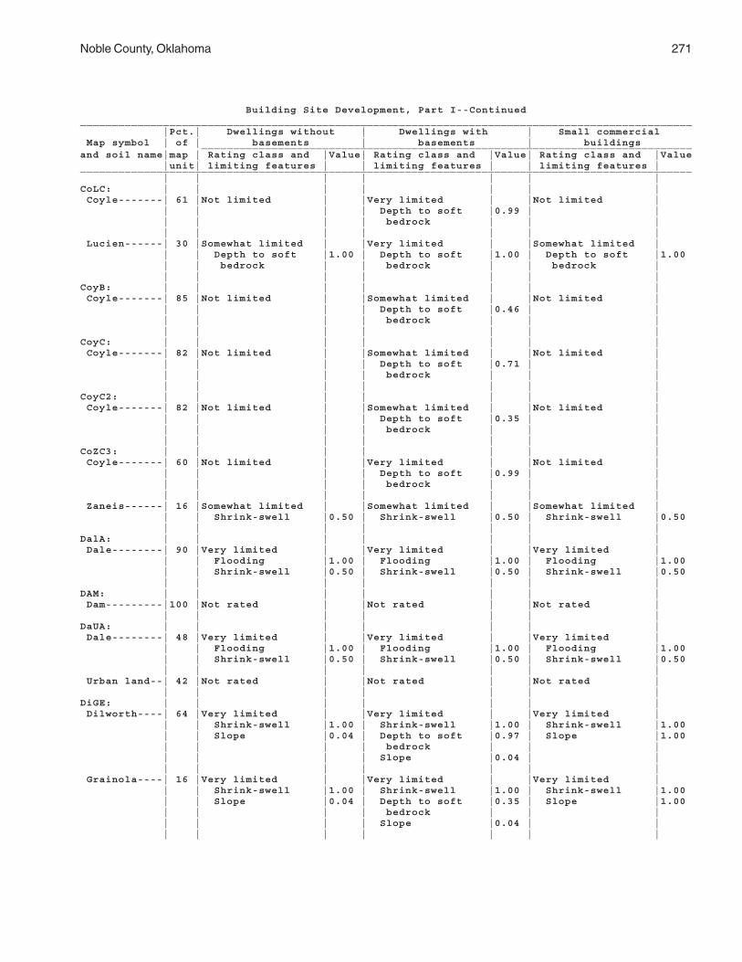
Noble County, Oklahoma 271
Building Site Development, Part I--Continued________________________________________________________________________________________________ |Pct.| Dwellings without | Dwellings with | Small commercial Map symbol | of | basements | basements | buildings _____________________________________________________________________________and soil name|map | Rating class and |Value| Rating class and |Value| Rating class and |Value |unit| limiting features | | limiting features | | limiting features |________________________________________________________________________________________________ | | | | | | |CoLC: | | | | | | | Coyle-------| 61 |Not limited | |Very limited | |Not limited | | | | | Depth to soft |0.99 | | | | | | bedrock | | | | | | | | | | Lucien------| 30 |Somewhat limited | |Very limited | |Somewhat limited | | | Depth to soft |1.00 | Depth to soft |1.00 | Depth to soft |1.00 | | bedrock | | bedrock | | bedrock | | | | | | | |CoyB: | | | | | | | Coyle-------| 85 |Not limited | |Somewhat limited | |Not limited | | | | | Depth to soft |0.46 | | | | | | bedrock | | | | | | | | | |CoyC: | | | | | | | Coyle-------| 82 |Not limited | |Somewhat limited | |Not limited | | | | | Depth to soft |0.71 | | | | | | bedrock | | | | | | | | | |CoyC2: | | | | | | | Coyle-------| 82 |Not limited | |Somewhat limited | |Not limited | | | | | Depth to soft |0.35 | | | | | | bedrock | | | | | | | | | |CoZC3: | | | | | | | Coyle-------| 60 |Not limited | |Very limited | |Not limited | | | | | Depth to soft |0.99 | | | | | | bedrock | | | | | | | | | | Zaneis------| 16 |Somewhat limited | |Somewhat limited | |Somewhat limited | | | Shrink-swell |0.50 | Shrink-swell |0.50 | Shrink-swell |0.50 | | | | | | |DalA: | | | | | | | Dale--------| 90 |Very limited | |Very limited | |Very limited | | | Flooding |1.00 | Flooding |1.00 | Flooding |1.00 | | Shrink-swell |0.50 | Shrink-swell |0.50 | Shrink-swell |0.50 | | | | | | |DAM: | | | | | | | Dam---------|100 |Not rated | |Not rated | |Not rated | | | | | | | |DaUA: | | | | | | | Dale--------| 48 |Very limited | |Very limited | |Very limited | | | Flooding |1.00 | Flooding |1.00 | Flooding |1.00 | | Shrink-swell |0.50 | Shrink-swell |0.50 | Shrink-swell |0.50 | | | | | | | Urban land--| 42 |Not rated | |Not rated | |Not rated | | | | | | | |DiGE: | | | | | | | Dilworth----| 64 |Very limited | |Very limited | |Very limited | | | Shrink-swell |1.00 | Shrink-swell |1.00 | Shrink-swell |1.00 | | Slope |0.04 | Depth to soft |0.97 | Slope |1.00 | | | | bedrock | | | | | | | Slope |0.04 | | | | | | | | | Grainola----| 16 |Very limited | |Very limited | |Very limited | | | Shrink-swell |1.00 | Shrink-swell |1.00 | Shrink-swell |1.00 | | Slope |0.04 | Depth to soft |0.35 | Slope |1.00 | | | | bedrock | | | | | | | Slope |0.04 | | | | | | | | |

272 Soil Survey
Building Site Development, Part I--Continued________________________________________________________________________________________________ |Pct.| Dwellings without | Dwellings with | Small commercial Map symbol | of | basements | basements | buildings _____________________________________________________________________________and soil name|map | Rating class and |Value| Rating class and |Value| Rating class and |Value |unit| limiting features | | limiting features | | limiting features |________________________________________________________________________________________________ | | | | | | |DooB: | | | | | | | Doolin------| 85 |Very limited | |Somewhat limited | |Very limited | | | Shrink-swell |1.00 | Shrink-swell |0.50 | Shrink-swell |1.00 | | | | | | |DwhC: | | | | | | | Dilworth----| 85 |Very limited | |Very limited | |Very limited | | | Shrink-swell |1.00 | Shrink-swell |1.00 | Shrink-swell |1.00 | | | | Depth to soft |0.06 | | | | | | bedrock | | | | | | | | | |EasA: | | | | | | | Easpur------| 79 |Very limited | |Very limited | |Very limited | | | Flooding |1.00 | Flooding |1.00 | Flooding |1.00 | | | | | | |GadA: | | | | | | | Gaddy-------| 89 |Very limited | |Very limited | |Very limited | | | Flooding |1.00 | Flooding |1.00 | Flooding |1.00 | | | | | | |GayA: | | | | | | | Gaddy-------| 85 |Very limited | |Very limited | |Very limited | | | Flooding |1.00 | Flooding |1.00 | Flooding |1.00 | | | | | | |GMLG: | | | | | | | Grainola----| 37 |Very limited | |Very limited | |Very limited | | | Shrink-swell |1.00 | Shrink-swell |1.00 | Shrink-swell |1.00 | | Slope |1.00 | Slope |1.00 | Slope |1.00 | | | | Depth to soft |0.46 | | | | | | bedrock | | | | | | | | | | Masham------| 22 |Very limited | |Very limited | |Very limited | | | Slope |1.00 | Slope |1.00 | Slope |1.00 | | Depth to soft |1.00 | Shrink-swell |1.00 | Depth to soft |1.00 | | bedrock | | Depth to soft |1.00 | bedrock | | | Shrink-swell |1.00 | bedrock | | Shrink-swell |1.00 | | | | | | | Lucien------| 21 |Very limited | |Very limited | |Very limited | | | Slope |1.00 | Slope |1.00 | Slope |1.00 | | Depth to soft |1.00 | Depth to soft |1.00 | Depth to soft |1.00 | | bedrock | | bedrock | | bedrock | | | | | | | |GohE: | | | | | | | Goodnight---| 95 |Somewhat limited | |Somewhat limited | |Very limited | | | Slope |0.16 | Slope |0.16 | Slope |1.00 | | | | | | |GraC: | | | | | | | Grainola----| 85 |Very limited | |Very limited | |Very limited | | | Shrink-swell |1.00 | Shrink-swell |1.00 | Shrink-swell |1.00 | | | | Depth to soft |0.15 | | | | | | bedrock | | | | | | | | | |GrAD: | | | | | | | Grainola----| 38 |Very limited | |Very limited | |Very limited | | | Shrink-swell |1.00 | Shrink-swell |1.00 | Shrink-swell |1.00 | | | | Depth to soft |0.06 | Slope |0.88 | | | | bedrock | | | | | | | | | | Ashport-----| 23 |Very limited | |Very limited | |Very limited | | | Flooding |1.00 | Flooding |1.00 | Flooding |1.00 | | Shrink-swell |0.50 | Shrink-swell |0.50 | Shrink-swell |0.50 | | | | | | |

Noble County, Oklahoma 273
Building Site Development, Part I--Continued________________________________________________________________________________________________ |Pct.| Dwellings without | Dwellings with | Small commercial Map symbol | of | basements | basements | buildings _____________________________________________________________________________and soil name|map | Rating class and |Value| Rating class and |Value| Rating class and |Value |unit| limiting features | | limiting features | | limiting features |________________________________________________________________________________________________ | | | | | | |GrHC: | | | | | | | Grant-------| 37 |Not limited | |Not limited | |Not limited | | | | | | | | Huska-------| 35 |Very limited | |Very limited | |Very limited | | | Shrink-swell |1.00 | Shrink-swell |1.00 | Shrink-swell |1.00 | | | | | | |GrLC: | | | | | | | Grainola----| 47 |Very limited | |Very limited | |Very limited | | | Shrink-swell |1.00 | Shrink-swell |1.00 | Shrink-swell |1.00 | | | | Depth to soft |0.01 | | | | | | bedrock | | | | | | | | | | Lucien------| 30 |Somewhat limited | |Very limited | |Somewhat limited | | | Depth to soft |1.00 | Depth to soft |1.00 | Depth to soft |1.00 | | bedrock | | bedrock | | bedrock | | | | | | | |GrLE: | | | | | | | Grainola----| 50 |Very limited | |Very limited | |Very limited | | | Shrink-swell |1.00 | Shrink-swell |1.00 | Shrink-swell |1.00 | | Slope |0.04 | Depth to soft |0.74 | Slope |1.00 | | | | bedrock | | | | | | | Slope |0.04 | | | | | | | | | Lucien------| 26 |Somewhat limited | |Very limited | |Very limited | | | Depth to soft |1.00 | Depth to soft |1.00 | Depth to soft |1.00 | | bedrock | | bedrock | | bedrock | | | Slope |0.04 | Slope |0.04 | Slope |1.00 | | | | | | |GrnC: | | | | | | | Grant-------| 95 |Not limited | |Not limited | |Not limited | | | | | | | |GrtB: | | | | | | | Grant-------| 90 |Not limited | |Not limited | |Not limited | | | | | | | |HaPE: | | | | | | | Harrah------| 44 |Not limited | |Not limited | |Somewhat limited | | | | | | | Slope |0.88 | | | | | | | Pulaski-----| 25 |Very limited | |Very limited | |Very limited | | | Flooding |1.00 | Flooding |1.00 | Flooding |1.00 | | | | | | |HiRG: | | | | | | | Highview----| 43 |Very limited | |Very limited | |Very limited | | | Slope |1.00 | Slope |1.00 | Slope |1.00 | | Depth to soft |1.00 | Shrink-swell |1.00 | Depth to soft |1.00 | | bedrock | | Depth to soft |1.00 | bedrock | | | Shrink-swell |1.00 | bedrock |1.00 | Shrink-swell |1.00 | | | | | | | Rock outcrop| 33 |Not rated | |Not rated | |Not rated | | | | | | | |KekA, KeoA: | | | | | | | Keokuk------| 88 |Very limited | |Very limited | |Very limited | | | Flooding |1.00 | Flooding |1.00 | Flooding |1.00 | | | | | | |KgfB: | | | | | | | Kingfisher--| 90 |Somewhat limited | |Somewhat limited | |Somewhat limited | | | Shrink-swell |0.50 | Depth to soft |0.79 | Shrink-swell |0.50 | | | | bedrock | | | | | | | Shrink-swell |0.50 | | | | | | | | |

274 Soil Survey
Building Site Development, Part I--Continued________________________________________________________________________________________________ |Pct.| Dwellings without | Dwellings with | Small commercial Map symbol | of | basements | basements | buildings _____________________________________________________________________________and soil name|map | Rating class and |Value| Rating class and |Value| Rating class and |Value |unit| limiting features | | limiting features | | limiting features |________________________________________________________________________________________________ | | | | | | |KgLC: | | | | | | | Kingfisher--| 53 |Somewhat limited | |Somewhat limited | |Somewhat limited | | | Shrink-swell |0.50 | Depth to soft |0.97 | Shrink-swell |0.50 | | | | bedrock | | | | | | | Shrink-swell |0.50 | | | | | | | | | Lucien------| 29 |Somewhat limited | |Very limited | |Somewhat limited | | | Depth to soft |1.00 | Depth to soft |1.00 | Depth to soft |1.00 | | bedrock | | bedrock | | bedrock | | | | | | | |KgWC: | | | | | | | Kingfisher--| 63 |Somewhat limited | |Somewhat limited | |Somewhat limited | | | Shrink-swell |0.50 | Shrink-swell |0.50 | Shrink-swell |0.50 | | | | Depth to soft |0.29 | | | | | | bedrock | | | | | | | | | | Wakita------| 19 |Somewhat limited | |Very limited | |Somewhat limited | | | Shrink-swell |0.50 | Depth to |1.00 | Shrink-swell |0.50 | | | | saturated zone | | | | | | | Shrink-swell |0.50 | | | | | | Depth to soft |0.35 | | | | | | bedrock | | | | | | | | | |KinC2: | | | | | | | Kingfisher--| 82 |Somewhat limited | |Somewhat limited | |Somewhat limited | | | Shrink-swell |0.50 | Depth to soft |0.97 | Shrink-swell |0.50 | | | | bedrock | | | | | | | Shrink-swell |0.50 | | | | | | | | |KowB: | | | | | | | Konawa------| 80 |Not limited | |Not limited | |Not limited | | | | | | | |KowD: | | | | | | | Konawa------| 78 |Not limited | |Not limited | |Somewhat limited | | | | | | | Slope |0.88 | | | | | | |KrdA: | | | | | | | Kirkland----| 85 |Very limited | |Very limited | |Very limited | | | Shrink-swell |1.00 | Shrink-swell |1.00 | Shrink-swell |1.00 | | | | | | |KrdB, KrdB2: | | | | | | | Kirkland----| 80 |Very limited | |Very limited | |Very limited | | | Shrink-swell |1.00 | Shrink-swell |1.00 | Shrink-swell |1.00 | | | | | | |KrPB: | | | | | | | Kirkland----| 52 |Very limited | |Very limited | |Very limited | | | Shrink-swell |1.00 | Shrink-swell |1.00 | Shrink-swell |1.00 | | | | | | | Pawhuska----| 33 |Very limited | |Very limited | |Very limited | | | Shrink-swell |1.00 | Shrink-swell |1.00 | Shrink-swell |1.00 | | | | | | |LAN: | | | | | | | Landfill----|100 |Not rated | |Not rated | |Not rated | | | | | | | |LelA: | | | | | | | Lela--------| 91 |Very limited | |Very limited | |Very limited | | | Flooding |1.00 | Flooding |1.00 | Flooding |1.00 | | Shrink-swell |1.00 | Shrink-swell |1.00 | Shrink-swell |1.00 | | | | | | |

Noble County, Oklahoma 275
Building Site Development, Part I--Continued________________________________________________________________________________________________ |Pct.| Dwellings without | Dwellings with | Small commercial Map symbol | of | basements | basements | buildings _____________________________________________________________________________and soil name|map | Rating class and |Value| Rating class and |Value| Rating class and |Value |unit| limiting features | | limiting features | | limiting features |________________________________________________________________________________________________ | | | | | | |LveB: | | | | | | | Lovedale----| 90 |Not limited | |Not limited | |Not limited | | | | | | | |M-W: | | | | | | | Miscellane- | | | | | | | ous water--|100 |Not rated | |Not rated | |Not rated | | | | | | | |McaA: | | | | | | | McLain------| 95 |Very limited | |Very limited | |Very limited | | | Flooding |1.00 | Flooding |1.00 | Flooding |1.00 | | Shrink-swell |1.00 | Shrink-swell |1.00 | Shrink-swell |1.00 | | | | | | |MilB: | | | | | | | Milan-------| 95 |Somewhat limited | |Not limited | |Somewhat limited | | | Shrink-swell |0.50 | | | Shrink-swell |0.50 | | | | | | |MilC: | | | | | | | Milan-------| 90 |Not limited | |Not limited | |Not limited | | | | | | | |MinB: | | | | | | | Minco-------| 85 |Not limited | |Not limited | |Not limited | | | | | | | |MinC: | | | | | | | Minco-------| 90 |Not limited | |Not limited | |Not limited | | | | | | | |MirA, MisA: | | | | | | | Miller------| 84 |Very limited | |Very limited | |Very limited | | | Flooding |1.00 | Flooding |1.00 | Flooding |1.00 | | Shrink-swell |1.00 | Shrink-swell |1.00 | Shrink-swell |1.00 | | | | | | |MPNC2: | | | | | | | Milan-------| 35 |Somewhat limited | |Not limited | |Somewhat limited | | | Shrink-swell |0.50 | | | Shrink-swell |0.50 | | | | | | | Pawhuska----| 28 |Very limited | |Very limited | |Very limited | | | Shrink-swell |1.00 | Shrink-swell |1.00 | Shrink-swell |1.00 | | | | | | | Norge-------| 24 |Somewhat limited | |Somewhat limited | |Somewhat limited | | | Shrink-swell |0.50 | Shrink-swell |0.50 | Shrink-swell |0.50 | | | | | | |MulC: | | | | | | | Mulhall-----| 92 |Not limited | |Not limited | |Not limited | | | | | | | |MulD, MulD4: | | | | | | | Mulhall-----| 92 |Not limited | |Not limited | |Somewhat limited | | | | | | | Slope |0.88 | | | | | | |NeDG: | | | | | | | Newalla-----| 41 |Very limited | |Very limited | |Very limited | | | Shrink-swell |1.00 | Shrink-swell |1.00 | Shrink-swell |1.00 | | | | | | Slope |0.88 | | | | | | | Darnell-----| 36 |Very limited | |Very limited | |Very limited | | | Depth to soft |1.00 | Depth to soft |1.00 | Slope |1.00 | | bedrock | | bedrock | | Depth to soft |1.00 | | Slope |1.00 | Slope |1.00 | bedrock | | | | | | | |NorA: | | | | | | | Norge-------| 90 |Somewhat limited | |Somewhat limited | |Somewhat limited | | | Shrink-swell |0.50 | Shrink-swell |0.50 | Shrink-swell |0.50 | | | | | | |

276 Soil Survey
Building Site Development, Part I--Continued________________________________________________________________________________________________ |Pct.| Dwellings without | Dwellings with | Small commercial Map symbol | of | basements | basements | buildings _____________________________________________________________________________and soil name|map | Rating class and |Value| Rating class and |Value| Rating class and |Value |unit| limiting features | | limiting features | | limiting features |________________________________________________________________________________________________ | | | | | | |NorB: | | | | | | | Norge-------| 85 |Somewhat limited | |Somewhat limited | |Somewhat limited | | | Shrink-swell |0.50 | Shrink-swell |0.50 | Shrink-swell |0.50 | | | | | | |NorC, NorC2: | | | | | | | Norge-------| 90 |Somewhat limited | |Somewhat limited | |Somewhat limited | | | Shrink-swell |0.50 | Shrink-swell |0.50 | Shrink-swell |0.50 | | | | | | |NoUC: | | | | | | | Norge-------| 55 |Somewhat limited | |Somewhat limited | |Somewhat limited | | | Shrink-swell |0.50 | Shrink-swell |0.50 | Shrink-swell |0.50 | | | | | | | Urban land--| 30 |Not rated | |Not rated | |Not rated | | | | | | | |OWWE: | | | | | | | Oil waste | | | | | | | land-------| 69 |Not rated | |Not rated | |Not rated | | | | | | | | Westsum-----| 25 |Very limited | |Very limited | |Very limited | | | Shrink-swell |1.00 | Shrink-swell |1.00 | Shrink-swell |1.00 | | | | | | |PoaA: | | | | | | | Port--------| 84 |Very limited | |Very limited | |Very limited | | | Flooding |1.00 | Flooding |1.00 | Flooding |1.00 | | | | | | |PoOA: | | | | | | | Port--------| 57 |Very limited | |Very limited | |Very limited | | | Flooding |1.00 | Flooding |1.00 | Flooding |1.00 | | | | | | | Oscar-------| 40 |Very limited | |Very limited | |Very limited | | | Flooding |1.00 | Flooding |1.00 | Flooding |1.00 | | | | | | |PorA: | | | | | | | Port--------| 92 |Very limited | |Very limited | |Very limited | | | Flooding |1.00 | Flooding |1.00 | Flooding |1.00 | | | | Shrink-swell |0.50 | | | | | | | | |PotA: | | | | | | | Port--------| 86 |Very limited | |Very limited | |Very limited | | | Flooding |1.00 | Flooding |1.00 | Flooding |1.00 | | Shrink-swell |0.50 | Shrink-swell |0.50 | Shrink-swell |0.50 | | | | | | |PukA: | | | | | | | Pulaski-----| 70 |Very limited | |Very limited | |Very limited | | | Flooding |1.00 | Flooding |1.00 | Flooding |1.00 | | | | | | |PulA: | | | | | | | Pulaski-----| 82 |Very limited | |Very limited | |Very limited | | | Flooding |1.00 | Flooding |1.00 | Flooding |1.00 | | | | | | |RefC2: | | | | | | | Renfrow-----| 75 |Very limited | |Very limited | |Very limited | | | Shrink-swell |1.00 | Shrink-swell |1.00 | Shrink-swell |1.00 | | | | | | |

Noble County, Oklahoma 277
Building Site Development, Part I--Continued________________________________________________________________________________________________ |Pct.| Dwellings without | Dwellings with | Small commercial Map symbol | of | basements | basements | buildings _____________________________________________________________________________and soil name|map | Rating class and |Value| Rating class and |Value| Rating class and |Value |unit| limiting features | | limiting features | | limiting features |________________________________________________________________________________________________ | | | | | | |ReGC2: | | | | | | | Renfrow-----| 60 |Very limited | |Very limited | |Very limited | | | Shrink-swell |1.00 | Shrink-swell |1.00 | Shrink-swell |1.00 | | | | | | | Grainola----| 20 |Very limited | |Very limited | |Very limited | | | Shrink-swell |1.00 | Shrink-swell |1.00 | Shrink-swell |1.00 | | | | Depth to soft |0.20 | | | | | | bedrock | | | | | | | | | |ReiA: | | | | | | | Reinach-----| 90 |Very limited | |Very limited | |Very limited | | | Flooding |1.00 | Flooding |1.00 | Flooding |1.00 | | | | | | |RenB: | | | | | | | Renfrow-----| 82 |Very limited | |Very limited | |Very limited | | | Shrink-swell |1.00 | Shrink-swell |1.00 | Shrink-swell |1.00 | | | | | | |RenC: | | | | | | | Renfrow-----| 85 |Very limited | |Very limited | |Very limited | | | Shrink-swell |1.00 | Shrink-swell |1.00 | Shrink-swell |1.00 | | | | | | |RewC2: | | | | | | | Renfrow-----| 80 |Very limited | |Very limited | |Very limited | | | Shrink-swell |1.00 | Shrink-swell |1.00 | Shrink-swell |1.00 | | | | | | |RGPD3: | | | | | | | Renfrow-----| 45 |Very limited | |Very limited | |Very limited | | | Shrink-swell |1.00 | Shrink-swell |1.00 | Shrink-swell |1.00 | | | | | | | Grainola----| 29 |Very limited | |Very limited | |Very limited | | | Shrink-swell |1.00 | Shrink-swell |1.00 | Shrink-swell |1.00 | | | | Depth to soft |0.99 | Slope |0.50 | | | | bedrock | | | | | | | | | | Pawhuska----| 15 |Very limited | |Very limited | |Very limited | | | Shrink-swell |1.00 | Shrink-swell |1.00 | Shrink-swell |1.00 | | | | | | |SlaB, SlaC: | | | | | | | Slaughter- | | | | | | | ville------| 85 |Not limited | |Not limited | |Not limited | | | | | | | |SlaG: | | | | | | | Slaughter- | | | | | | | ville------| 78 |Very limited | |Very limited | |Very limited | | | Slope |1.00 | Slope |1.00 | Slope |1.00 | | | | | | |StDD: | | | | | | | Stephenville| 45 |Not limited | |Somewhat limited | |Not limited | | | | | Depth to soft |0.06 | | | | | | bedrock | | | | | | | | | | Darnell-----| 35 |Somewhat limited | |Very limited | |Somewhat limited | | | Depth to soft |1.00 | Depth to soft |1.00 | Depth to soft |1.00 | | bedrock | | bedrock | | bedrock | | | | | | | |TabA: | | | | | | | Tabler------| 83 |Very limited | |Very limited | |Very limited | | | Depth to |1.00 | Depth to |1.00 | Depth to |1.00 | | saturated zone | | saturated zone | | saturated zone | | | Shrink-swell |1.00 | Shrink-swell |1.00 | Shrink-swell |1.00 | | | | | | |

278 Soil Survey
Building Site Development, Part I--Continued________________________________________________________________________________________________ |Pct.| Dwellings without | Dwellings with | Small commercial Map symbol | of | basements | basements | buildings _____________________________________________________________________________and soil name|map | Rating class and |Value| Rating class and |Value| Rating class and |Value |unit| limiting features | | limiting features | | limiting features |________________________________________________________________________________________________ | | | | | | |TeaA: | | | | | | | Tearney-----| 82 |Very limited | |Very limited | |Very limited | | | Flooding |1.00 | Flooding |1.00 | Flooding |1.00 | | Shrink-swell |1.00 | Ponding |1.00 | Shrink-swell |1.00 | | Ponding |1.00 | | | Ponding |1.00 | | | | | | |TelB: | | | | | | | Teller------| 85 |Not limited | |Not limited | |Not limited | | | | | | | |TelD, TelD2: | | | | | | | Teller------| 85 |Not limited | |Not limited | |Somewhat limited | | | | | | | Slope |0.88 | | | | | | |VanA: | | | | | | | Vanoss------| 82 |Somewhat limited | |Somewhat limited | |Somewhat limited | | | Shrink-swell |0.50 | Shrink-swell |0.50 | Shrink-swell |0.50 | | | | | | |W: | | | | | | | Water-------|100 |Not rated | |Not rated | |Not rated | | | | | | | |WauA: | | | | | | | Waurika-----| 89 |Very limited | |Very limited | |Very limited | | | Depth to |1.00 | Depth to |1.00 | Depth to |1.00 | | saturated zone | | saturated zone | | saturated zone | | | Shrink-swell |1.00 | Shrink-swell |1.00 | Shrink-swell |1.00 | | | | | | |WesB: | | | | | | | Westsum-----| 85 |Very limited | |Very limited | |Very limited | | | Shrink-swell |1.00 | Shrink-swell |1.00 | Shrink-swell |1.00 | | | | | | |WesC: | | | | | | | Westsum-----| 90 |Very limited | |Very limited | |Very limited | | | Shrink-swell |1.00 | Shrink-swell |1.00 | Shrink-swell |1.00 | | | | | | |WiLC: | | | | | | | Wisby-------| 48 |Not limited | |Not limited | |Not limited | | | | | | | | Lovedale----| 40 |Not limited | |Not limited | |Not limited | | | | | | | |ZaHC: | | | | | | | Zaneis------| 54 |Somewhat limited | |Somewhat limited | |Somewhat limited | | | Shrink-swell |0.50 | Shrink-swell |0.50 | Shrink-swell |0.50 | | | | | | | Huska-------| 32 |Very limited | |Very limited | |Very limited | | | Shrink-swell |1.00 | Shrink-swell |1.00 | Shrink-swell |1.00 | | | | | | |ZanB: | | | | | | | Zaneis------| 80 |Not limited | |Not limited | |Not limited | | | | | | | |________________________________________________________________________________________________

Noble County, Oklahoma 279
Building Site Development, Part II
(The information in this table indicates the dominant soil condition but does not eliminate the need for onsite investigation. The numbers in the value columns range from 0.01 to 1.00. The larger the value, the greater the limitation. See text for further explanation of ratings in this table)
________________________________________________________________________________________________ |Pct.| Local roads and | Shallow excavations | Lawns and landscaping Map symbol | of | streets | | _____________________________________________________________________________and soil name|map | Rating class and |Value| Rating class and |Value| Rating class and |Value |unit| limiting features | | limiting features | | limiting features |________________________________________________________________________________________________ | | | | | | |AhpA: | | | | | | | Ashport-----| 89 |Very limited | |Somewhat limited | |Somewhat limited | | | Flooding |1.00 | Flooding |0.60 | Flooding |0.60 | | Low strength |1.00 | Cutbanks cave |0.10 | | | | Shrink-swell |0.50 | | | | | | | | | | |APPA: | | | | | | | Ashport-----| 61 |Very limited | |Somewhat limited | |Very limited | | | Flooding |1.00 | Flooding |0.80 | Flooding |1.00 | | Low strength |1.00 | Cutbanks cave |0.10 | | | | Shrink-swell |0.50 | | | | | | | | | | | Port--------| 15 |Very limited | |Somewhat limited | |Very limited | | | Flooding |1.00 | Flooding |0.80 | Flooding |1.00 | | Low strength |1.00 | Cutbanks cave |0.10 | | | | | | | | | Pulaski-----| 15 |Very limited | |Very limited | |Very limited | | | Flooding |1.00 | Cutbanks cave |1.00 | Flooding |1.00 | | | | Flooding |0.80 | | | | | | | | |AspA: | | | | | | | Ashport-----| 90 |Very limited | |Somewhat limited | |Somewhat limited | | | Flooding |1.00 | Flooding |0.60 | Flooding |0.60 | | Low strength |1.00 | Cutbanks cave |0.10 | | | | Shrink-swell |0.50 | | | | | | | | | | |AspB: | | | | | | | Ashport-----| 93 |Very limited | |Somewhat limited | |Somewhat limited | | | Flooding |1.00 | Flooding |0.60 | Flooding |0.60 | | Low strength |1.00 | Cutbanks cave |0.10 | | | | Shrink-swell |0.50 | | | | | | | | | | |BetA: | | | | | | | Bethany-----| 85 |Very limited | |Somewhat limited | |Not limited | | | Low strength |1.00 | Cutbanks cave |0.10 | | | | Shrink-swell |1.00 | Too clayey |0.03 | | | | | | | | |BetB: | | | | | | | Bethany-----| 84 |Very limited | |Somewhat limited | |Not limited | | | Low strength |1.00 | Cutbanks cave |0.10 | | | | Shrink-swell |1.00 | | | | | | | | | | |BPG: | | | | | | | Borrow pits,| | | | | | | gravelly---| 90 |Not rated | |Not rated | |Not rated | | | | | | | |BPR: | | | | | | | Borrow pits,| | | | | | | rock-------| 90 |Not rated | |Not rated | |Not rated | | | | | | | |

280 Soil Survey
Building Site Development, Part II--Continued________________________________________________________________________________________________ |Pct.| Local roads and | Shallow excavations | Lawns and landscaping Map symbol | of | streets | | _____________________________________________________________________________and soil name|map | Rating class and |Value| Rating class and |Value| Rating class and |Value |unit| limiting features | | limiting features | | limiting features |________________________________________________________________________________________________ | | | | | | |BraA: | | | | | | | Braman------| 85 |Very limited | |Somewhat limited | |Not limited | | | Low strength |1.00 | Cutbanks cave |0.10 | | | | Shrink-swell |0.50 | Too clayey |0.03 | | | | Flooding |0.40 | | | | | | | | | | |BrwA: | | | | | | | Brewer------| 97 |Very limited | |Somewhat limited | |Not limited | | | Low strength |1.00 | Cutbanks cave |0.10 | | | | Shrink-swell |1.00 | | | | | | Flooding |0.40 | | | | | | | | | | |CoLC: | | | | | | | Coyle-------| 61 |Not limited | |Somewhat limited | |Very limited | | | | | Depth to soft |0.99 | Depth to bedrock |0.99 | | | | bedrock | | Droughty |0.19 | | | | Dense layer |0.50 | | | | | | Cutbanks cave |0.10 | | | | | | | | | Lucien------| 30 |Somewhat limited | |Very limited | |Very limited | | | Depth to soft |1.00 | Depth to soft |1.00 | Depth to bedrock |1.00 | | bedrock | | bedrock | | Droughty |0.97 | | | | Dense layer |0.50 | Content of large |0.03 | | | | Cutbanks cave |0.10 | stones | | | | | | | |CoyB: | | | | | | | Coyle-------| 85 |Not limited | |Somewhat limited | |Somewhat limited | | | | | Dense layer |0.50 | Depth to bedrock |0.46 | | | | Depth to soft |0.46 | | | | | | bedrock | | | | | | | Cutbanks cave |0.10 | | | | | | | | |CoyC: | | | | | | | Coyle-------| 82 |Not limited | |Somewhat limited | |Somewhat limited | | | | | Depth to soft |0.71 | Depth to bedrock |0.71 | | | | bedrock | | | | | | | Dense layer |0.50 | | | | | | Cutbanks cave |0.10 | | | | | | | | |CoyC2: | | | | | | | Coyle-------| 82 |Not limited | |Very limited | |Somewhat limited | | | | | Cutbanks cave |1.00 | Depth to bedrock |0.35 | | | | Dense layer |0.50 | | | | | | Depth to soft |0.35 | | | | | | bedrock | | | | | | | | | |CoZC3: | | | | | | | Coyle-------| 60 |Not limited | |Somewhat limited | |Very limited | | | | | Depth to soft |0.99 | Depth to bedrock |0.99 | | | | bedrock | | Droughty |0.12 | | | | Dense layer |0.50 | | | | | | Cutbanks cave |0.10 | | | | | | | | | Zaneis------| 16 |Somewhat limited | |Somewhat limited | |Not limited | | | Shrink-swell |0.50 | Dense layer |0.50 | | | | | | Cutbanks cave |0.10 | | | | | | | | |

Noble County, Oklahoma 281
Building Site Development, Part II--Continued________________________________________________________________________________________________ |Pct.| Local roads and | Shallow excavations | Lawns and landscaping Map symbol | of | streets | | _____________________________________________________________________________and soil name|map | Rating class and |Value| Rating class and |Value| Rating class and |Value |unit| limiting features | | limiting features | | limiting features |________________________________________________________________________________________________ | | | | | | |DalA: | | | | | | | Dale--------| 90 |Very limited | |Somewhat limited | |Not limited | | | Low strength |1.00 | Cutbanks cave |0.10 | | | | Shrink-swell |0.50 | | | | | | Flooding |0.40 | | | | | | | | | | |DAM: | | | | | | | Dam---------|100 |Not rated | |Not rated | |Not rated | | | | | | | |DaUA: | | | | | | | Dale--------| 48 |Very limited | |Somewhat limited | |Not limited | | | Low strength |1.00 | Cutbanks cave |0.10 | | | | Shrink-swell |0.50 | | | | | | Flooding |0.40 | | | | | | | | | | | Urban land--| 42 |Not rated | |Not rated | |Not rated | | | | | | | |DiGE: | | | | | | | Dilworth----| 64 |Very limited | |Somewhat limited | |Somewhat limited | | | Low strength |1.00 | Depth to soft |0.97 | Depth to bedrock |0.97 | | Shrink-swell |1.00 | bedrock | | Slope |0.04 | | Slope |0.04 | Dense layer |0.50 | Droughty |0.02 | | | | Too clayey |0.28 | | | | | | Cutbanks cave |0.10 | | | | | | Slope |0.04 | | | | | | | | | Grainola----| 16 |Very limited | |Somewhat limited | |Somewhat limited | | | Low strength |1.00 | Dense layer |0.50 | Depth to bedrock |0.35 | | Shrink-swell |1.00 | Depth to soft |0.35 | Content of large |0.08 | | Slope |0.04 | bedrock | | stones | | | | | Cutbanks cave |0.10 | Slope |0.04 | | | | Slope |0.04 | | | | | | Too clayey |0.03 | | | | | | | | |DooB: | | | | | | | Doolin------| 85 |Very limited | |Somewhat limited | |Very limited | | | Low strength |1.00 | Cutbanks cave |0.10 | Sodium content |1.00 | | Shrink-swell |1.00 | | | | | | | | | | |DwhC: | | | | | | | Dilworth----| 85 |Very limited | |Somewhat limited | |Somewhat limited | | | Low strength |1.00 | Too clayey |0.28 | Depth to bedrock |0.06 | | Shrink-swell |1.00 | Cutbanks cave |0.10 | | | | | | Depth to soft |0.06 | | | | | | bedrock | | | | | | | | | |EasA: | | | | | | | Easpur------| 79 |Very limited | |Somewhat limited | |Somewhat limited | | | Flooding |1.00 | Flooding |0.60 | Flooding |0.60 | | | | Cutbanks cave |0.10 | | | | | | | | |GadA: | | | | | | | Gaddy-------| 89 |Very limited | |Very limited | |Somewhat limited | | | Flooding |1.00 | Cutbanks cave |1.00 | Flooding |0.60 | | | | Flooding |0.60 | Droughty |0.29 | | | | | | |GayA: | | | | | | | Gaddy-------| 85 |Somewhat limited | |Very limited | |Somewhat limited | | | Flooding |0.40 | Cutbanks cave |1.00 | Droughty |0.27 | | | | | | |

282 Soil Survey
Building Site Development, Part II--Continued________________________________________________________________________________________________ |Pct.| Local roads and | Shallow excavations | Lawns and landscaping Map symbol | of | streets | | _____________________________________________________________________________and soil name|map | Rating class and |Value| Rating class and |Value| Rating class and |Value |unit| limiting features | | limiting features | | limiting features |________________________________________________________________________________________________ | | | | | | |GMLG: | | | | | | | Grainola----| 37 |Very limited | |Very limited | |Very limited | | | Shrink-swell |1.00 | Slope |1.00 | Slope |1.00 | | Slope |1.00 | Dense layer |0.50 | Content of large |0.95 | | Low strength |1.00 | Depth to soft |0.46 | stones | | | | | bedrock | | Depth to bedrock |0.46 | | | | Too clayey |0.28 | Gravel content |0.02 | | | | Cutbanks cave |0.10 | | | | | | | | | Masham------| 22 |Very limited | |Very limited | |Very limited | | | Slope |1.00 | Depth to soft |1.00 | Depth to bedrock |1.00 | | Depth to soft |1.00 | bedrock | | Slope |1.00 | | bedrock | | Slope |1.00 | Droughty |0.97 | | Low strength |1.00 | Dense layer |0.50 | | | | Shrink-swell |1.00 | Cutbanks cave |0.10 | | | | | | | | | Lucien------| 21 |Very limited | |Very limited | |Very limited | | | Slope |1.00 | Depth to soft |1.00 | Depth to bedrock |1.00 | | Depth to soft |1.00 | bedrock | | Slope |1.00 | | bedrock | | Slope |1.00 | Droughty |0.49 | | | | Dense layer |0.50 | Content of large |0.03 | | | | Cutbanks cave |0.10 | stones | | | | | | | |GohE: | | | | | | | Goodnight---| 95 |Somewhat limited | |Very limited | |Somewhat limited | | | Slope |0.16 | Cutbanks cave |1.00 | Droughty |0.63 | | | | Slope |0.16 | Slope |0.16 | | | | | | |GraC: | | | | | | | Grainola----| 85 |Very limited | |Somewhat limited | |Somewhat limited | | | Shrink-swell |1.00 | Dense layer |0.50 | Depth to bedrock |0.16 | | Low strength |1.00 | Too clayey |0.28 | Content of large |0.05 | | | | Depth to soft |0.15 | stones | | | | | bedrock | | | | | | | Cutbanks cave |0.10 | | | | | | | | |GrAD: | | | | | | | Grainola----| 38 |Very limited | |Somewhat limited | |Somewhat limited | | | Low strength |1.00 | Dense layer |0.50 | Depth to bedrock |0.06 | | Shrink-swell |1.00 | Too clayey |0.28 | Content of large |0.05 | | | | Cutbanks cave |0.10 | stones | | | | | Depth to soft |0.06 | | | | | | bedrock | | | | | | | | | | Ashport-----| 23 |Very limited | |Somewhat limited | |Very limited | | | Flooding |1.00 | Flooding |0.80 | Flooding |1.00 | | Low strength |1.00 | Cutbanks cave |0.10 | | | | Shrink-swell |0.50 | | | | | | | | | | |GrHC: | | | | | | | Grant-------| 37 |Very limited | |Somewhat limited | |Not limited | | | Low strength |1.00 | Dense layer |0.50 | | | | | | Cutbanks cave |0.10 | | | | | | | | | Huska-------| 35 |Very limited | |Somewhat limited | |Very limited | | | Low strength |1.00 | Dense layer |0.50 | Sodium content |1.00 | | Shrink-swell |1.00 | Cutbanks cave |0.10 | Droughty |0.08 | | | | | | Salinity |0.01 | | | | | | |

Noble County, Oklahoma 283
Building Site Development, Part II--Continued________________________________________________________________________________________________ |Pct.| Local roads and | Shallow excavations | Lawns and landscaping Map symbol | of | streets | | _____________________________________________________________________________and soil name|map | Rating class and |Value| Rating class and |Value| Rating class and |Value |unit| limiting features | | limiting features | | limiting features |________________________________________________________________________________________________ | | | | | | |GrLC: | | | | | | | Grainola----| 47 |Very limited | |Somewhat limited | |Somewhat limited | | | Low strength |1.00 | Dense layer |0.50 | Content of large |0.05 | | Shrink-swell |1.00 | Too clayey |0.28 | stones | | | | | Cutbanks cave |0.10 | Depth to bedrock |0.01 | | | | Depth to soft |0.01 | | | | | | bedrock | | | | | | | | | | Lucien------| 30 |Somewhat limited | |Very limited | |Very limited | | | Depth to soft |1.00 | Depth to soft |1.00 | Depth to bedrock |1.00 | | bedrock | | bedrock | | Droughty |0.25 | | | | Dense layer |0.50 | Content of large |0.03 | | | | Cutbanks cave |0.10 | stones | | | | | | | |GrLE: | | | | | | | Grainola----| 50 |Very limited | |Somewhat limited | |Somewhat limited | | | Shrink-swell |1.00 | Depth to soft |0.74 | Depth to bedrock |0.74 | | Low strength |1.00 | bedrock | | Content of large |0.05 | | Slope |0.04 | Dense layer |0.50 | stones | | | | | Too clayey |0.28 | Slope |0.04 | | | | Cutbanks cave |0.10 | | | | | | Slope |0.04 | | | | | | | | | Lucien------| 26 |Somewhat limited | |Very limited | |Very limited | | | Depth to soft |1.00 | Depth to soft |1.00 | Depth to bedrock |1.00 | | bedrock | | bedrock | | Droughty |0.99 | | Slope |0.04 | Dense layer |0.50 | Slope |0.04 | | | | Cutbanks cave |0.10 | Content of large |0.03 | | | | Slope |0.04 | stones | | | | | | | |GrnC: | | | | | | | Grant-------| 95 |Not limited | |Somewhat limited | |Not limited | | | | | Cutbanks cave |0.10 | | | | | | | | |GrtB: | | | | | | | Grant-------| 90 |Very limited | |Somewhat limited | |Not limited | | | Low strength |1.00 | Dense layer |0.50 | | | | | | Cutbanks cave |0.10 | | | | | | | | |HaPE: | | | | | | | Harrah------| 44 |Not limited | |Somewhat limited | |Not limited | | | | | Cutbanks cave |0.10 | | | | | | | | | Pulaski-----| 25 |Very limited | |Very limited | |Very limited | | | Flooding |1.00 | Cutbanks cave |1.00 | Flooding |1.00 | | | | Flooding |0.80 | | | | | | | | |HiRG: | | | | | | | Highview----| 43 |Very limited | |Very limited | |Very limited | | | Slope |1.00 | Depth to soft |1.00 | Depth to bedrock |1.00 | | Depth to soft |1.00 | bedrock | | Slope |1.00 | | bedrock | | Slope |1.00 | Droughty |1.00 | | Shrink-swell |1.00 | Dense layer |0.50 | Too clayey |1.00 | | Low strength |1.00 | Cutbanks cave |0.10 | Content of large |0.38 | | | | | | stones | | | | | | | | Rock outcrop| 33 |Not rated | |Not rated | |Not rated | | | | | | | |

284 Soil Survey
Building Site Development, Part II--Continued________________________________________________________________________________________________ |Pct.| Local roads and | Shallow excavations | Lawns and landscaping Map symbol | of | streets | | _____________________________________________________________________________and soil name|map | Rating class and |Value| Rating class and |Value| Rating class and |Value |unit| limiting features | | limiting features | | limiting features |________________________________________________________________________________________________ | | | | | | |KekA: | | | | | | | Keokuk------| 88 |Somewhat limited | |Somewhat limited | |Not limited | | | Flooding |0.40 | Cutbanks cave |0.10 | | | | | | | | |KeoA: | | | | | | | Keokuk------| 88 |Very limited | |Somewhat limited | |Somewhat limited | | | Flooding |1.00 | Flooding |0.60 | Flooding |0.60 | | | | Cutbanks cave |0.10 | | | | | | | | |KgfB: | | | | | | | Kingfisher--| 90 |Very limited | |Somewhat limited | |Somewhat limited | | | Low strength |1.00 | Depth to soft |0.79 | Depth to bedrock |0.80 | | Shrink-swell |0.50 | bedrock | | | | | | | Dense layer |0.50 | | | | | | Cutbanks cave |0.10 | | | | | | | | |KgLC: | | | | | | | Kingfisher--| 53 |Very limited | |Somewhat limited | |Somewhat limited | | | Low strength |1.00 | Depth to soft |0.97 | Depth to bedrock |0.97 | | Shrink-swell |0.50 | bedrock | | | | | | | Dense layer |0.50 | | | | | | Cutbanks cave |0.10 | | | | | | | | | Lucien------| 29 |Somewhat limited | |Very limited | |Very limited | | | Depth to soft |1.00 | Depth to soft |1.00 | Depth to bedrock |1.00 | | bedrock | | bedrock | | Droughty |0.87 | | | | Dense layer |0.50 | Content of large |0.03 | | | | Cutbanks cave |0.10 | stones | | | | | | | |KgWC: | | | | | | | Kingfisher--| 63 |Very limited | |Somewhat limited | |Somewhat limited | | | Low strength |1.00 | Dense layer |0.50 | Depth to bedrock |0.29 | | Shrink-swell |0.50 | Depth to soft |0.29 | | | | | | bedrock | | | | | | | Cutbanks cave |0.10 | | | | | | | | | Wakita------| 19 |Very limited | |Very limited | |Very limited | | | Low strength |1.00 | Depth to |1.00 | Sodium content |1.00 | | Shrink-swell |0.50 | saturated zone | | Salinity |1.00 | | | | Dense layer |0.50 | Depth to bedrock |0.35 | | | | Depth to soft |0.35 | Droughty |0.22 | | | | bedrock | | | | | | | Cutbanks cave |0.10 | | | | | | | | |KinC2: | | | | | | | Kingfisher--| 82 |Very limited | |Somewhat limited | |Somewhat limited | | | Low strength |1.00 | Depth to soft |0.97 | Depth to bedrock |0.97 | | Shrink-swell |0.50 | bedrock | | | | | | | Dense layer |0.50 | | | | | | Cutbanks cave |0.10 | | | | | | | | |KowB: | | | | | | | Konawa------| 80 |Not limited | |Very limited | |Not limited | | | | | Cutbanks cave |1.00 | | | | | | | | |KowD: | | | | | | | Konawa------| 78 |Not limited | |Very limited | |Not limited | | | | | Cutbanks cave |1.00 | | | | | | | | |

Noble County, Oklahoma 285
Building Site Development, Part II--Continued________________________________________________________________________________________________ |Pct.| Local roads and | Shallow excavations | Lawns and landscaping Map symbol | of | streets | | _____________________________________________________________________________and soil name|map | Rating class and |Value| Rating class and |Value| Rating class and |Value |unit| limiting features | | limiting features | | limiting features |________________________________________________________________________________________________ | | | | | | |KrdA: | | | | | | | Kirkland----| 85 |Very limited | |Somewhat limited | |Not limited | | | Low strength |1.00 | Too clayey |0.50 | | | | Shrink-swell |1.00 | Cutbanks cave |0.10 | | | | | | | | |KrdB, KrdB2: | | | | | | | Kirkland----| 80 |Very limited | |Somewhat limited | |Not limited | | | Low strength |1.00 | Too clayey |0.50 | | | | Shrink-swell |1.00 | Cutbanks cave |0.10 | | | | | | | | |KrPB: | | | | | | | Kirkland----| 52 |Very limited | |Somewhat limited | |Not limited | | | Shrink-swell |1.00 | Too clayey |0.50 | | | | Low strength |1.00 | Cutbanks cave |0.10 | | | | | | | | | Pawhuska----| 33 |Very limited | |Somewhat limited | |Very limited | | | Low strength |1.00 | Cutbanks cave |0.10 | Sodium content |1.00 | | Shrink-swell |1.00 | Too clayey |0.03 | Salinity |1.00 | | | | | | |LAN: | | | | | | | Landfill----|100 |Not rated | |Not rated | |Not rated | | | | | | | |LelA: | | | | | | | Lela--------| 91 |Very limited | |Very limited | |Very limited | | | Flooding |1.00 | Cutbanks cave |1.00 | Too clayey |1.00 | | Shrink-swell |1.00 | Flooding |0.60 | Flooding |0.60 | | Low strength |1.00 | Too clayey |0.50 | | | | | | | | |LveB: | | | | | | | Lovedale----| 90 |Not limited | |Very limited | |Not limited | | | | | Cutbanks cave |1.00 | | | | | | | | |M-W: | | | | | | | Miscellane- | | | | | | | ous water--|100 |Not rated | |Not rated | |Not rated | | | | | | | |McaA: | | | | | | | McLain------| 95 |Very limited | |Somewhat limited | |Not limited | | | Low strength |1.00 | Cutbanks cave |0.10 | | | | Shrink-swell |1.00 | Too clayey |0.03 | | | | Flooding |0.40 | | | | | | | | | | |MilB: | | | | | | | Milan-------| 95 |Very limited | |Somewhat limited | |Not limited | | | Low strength |1.00 | Cutbanks cave |0.10 | | | | Shrink-swell |0.50 | | | | | | | | | | |MilC: | | | | | | | Milan-------| 90 |Not limited | |Very limited | |Not limited | | | | | Cutbanks cave |1.00 | | | | | | | | |MinB: | | | | | | | Minco-------| 85 |Not limited | |Somewhat limited | |Not limited | | | | | Cutbanks cave |0.10 | | | | | | | | |MinC: | | | | | | | Minco-------| 90 |Not limited | |Somewhat limited | |Not limited | | | | | Cutbanks cave |0.10 | | | | | | | | |

286 Soil Survey
Building Site Development, Part II--Continued________________________________________________________________________________________________ |Pct.| Local roads and | Shallow excavations | Lawns and landscaping Map symbol | of | streets | | _____________________________________________________________________________and soil name|map | Rating class and |Value| Rating class and |Value| Rating class and |Value |unit| limiting features | | limiting features | | limiting features |________________________________________________________________________________________________ | | | | | | |MirA: | | | | | | | Miller------| 84 |Very limited | |Somewhat limited | |Somewhat limited | | | Flooding |1.00 | Flooding |0.60 | Flooding |0.60 | | Low strength |1.00 | Too clayey |0.28 | | | | Shrink-swell |1.00 | Cutbanks cave |0.10 | | | | | | | | |MisA: | | | | | | | Miller------| 84 |Very limited | |Somewhat limited | |Somewhat limited | | | Flooding |1.00 | Flooding |0.60 | Flooding |0.60 | | Low strength |1.00 | Too clayey |0.50 | | | | Shrink-swell |1.00 | Cutbanks cave |0.10 | | | | | | | | |MPNC2: | | | | | | | Milan-------| 35 |Very limited | |Very limited | |Not limited | | | Low strength |1.00 | Cutbanks cave |1.00 | | | | Shrink-swell |0.50 | | | | | | | | | | | Pawhuska----| 28 |Very limited | |Somewhat limited | |Very limited | | | Low strength |1.00 | Cutbanks cave |0.10 | Sodium content |1.00 | | Shrink-swell |1.00 | Too clayey |0.03 | Salinity |1.00 | | | | | | | Norge-------| 24 |Very limited | |Somewhat limited | |Not limited | | | Low strength |1.00 | Cutbanks cave |0.10 | | | | Shrink-swell |0.50 | | | | | | | | | | |MulC, MulD, | | | | | | | MulD4: | | | | | | | Mulhall----| 92 |Not limited | |Somewhat limited | |Not limited | | | | | Cutbanks cave |0.10 | | | | | | | | |NeDG: | | | | | | | Newalla-----| 41 |Very limited | |Somewhat limited | |Not limited | | | Low strength |1.00 | Too clayey |0.50 | | | | Shrink-swell |1.00 | Dense layer |0.50 | | | | | | Cutbanks cave |0.10 | | | | | | | | | Darnell-----| 36 |Very limited | |Very limited | |Very limited | | | Depth to soft |1.00 | Depth to soft |1.00 | Depth to bedrock |1.00 | | bedrock | | bedrock | | Droughty |1.00 | | Slope |1.00 | Slope |1.00 | Slope |1.00 | | | | Dense layer |0.50 | | | | | | Cutbanks cave |0.10 | | | | | | | | |NorA: | | | | | | | Norge-------| 90 |Very limited | |Somewhat limited | |Not limited | | | Low strength |1.00 | Cutbanks cave |0.10 | | | | Shrink-swell |0.50 | | | | | | | | | | |NorB: | | | | | | | Norge-------| 85 |Very limited | |Somewhat limited | |Not limited | | | Low strength |1.00 | Cutbanks cave |0.10 | | | | Shrink-swell |0.50 | | | | | | | | | | |NorC, NorC2: | | | | | | | Norge-------| 90 |Very limited | |Somewhat limited | |Not limited | | | Low strength |1.00 | Cutbanks cave |0.10 | | | | Shrink-swell |0.50 | | | | | | | | | | |

Noble County, Oklahoma 287
Building Site Development, Part II--Continued________________________________________________________________________________________________ |Pct.| Local roads and | Shallow excavations | Lawns and landscaping Map symbol | of | streets | | _____________________________________________________________________________and soil name|map | Rating class and |Value| Rating class and |Value| Rating class and |Value |unit| limiting features | | limiting features | | limiting features |________________________________________________________________________________________________ | | | | | | |NoUC: | | | | | | | Norge-------| 55 |Very limited | |Somewhat limited | |Not limited | | | Low strength |1.00 | Cutbanks cave |0.10 | | | | Shrink-swell |0.50 | | | | | | | | | | | Urban land--| 30 |Not rated | |Not rated | |Not rated | | | | | | | |OWWE: | | | | | | | Oil waste | | | | | | | land-------| 69 |Not rated | |Not rated | |Not rated | | | | | | | | Westsum-----| 25 |Very limited | |Somewhat limited | |Not limited | | | Shrink-swell |1.00 | Too clayey |0.15 | | | | Low strength |1.00 | Cutbanks cave |0.10 | | | | | | | | |PoaA: | | | | | | | Port--------| 84 |Very limited | |Somewhat limited | |Very limited | | | Flooding |1.00 | Flooding |0.80 | Flooding |1.00 | | Low strength |1.00 | Cutbanks cave |0.10 | | | | | | | | |PoOA: | | | | | | | Port--------| 57 |Very limited | |Somewhat limited | |Somewhat limited | | | Flooding |1.00 | Flooding |0.60 | Flooding |0.60 | | Low strength |1.00 | Cutbanks cave |0.10 | | | | | | | | | Oscar-------| 40 |Very limited | |Somewhat limited | |Very limited | | | Flooding |1.00 | Flooding |0.60 | Sodium content |1.00 | | Low strength |1.00 | Cutbanks cave |0.10 | Salinity |1.00 | | | | | | Flooding |0.60 | | | | | | |PorA: | | | | | | | Port--------| 92 |Very limited | |Somewhat limited | |Somewhat limited | | | Flooding |1.00 | Flooding |0.60 | Flooding |0.60 | | Low strength |1.00 | Cutbanks cave |0.10 | | | | | | | | |PotA: | | | | | | | Port--------| 86 |Very limited | |Somewhat limited | |Somewhat limited | | | Flooding |1.00 | Flooding |0.60 | Flooding |0.60 | | Low strength |1.00 | Cutbanks cave |0.10 | | | | Shrink-swell |0.50 | | | | | | | | | | |PukA: | | | | | | | Pulaski-----| 70 |Very limited | |Very limited | |Very limited | | | Flooding |1.00 | Cutbanks cave |1.00 | Flooding |1.00 | | | | Flooding |0.80 | | | | | | | | |PulA: | | | | | | | Pulaski-----| 82 |Very limited | |Very limited | |Somewhat limited | | | Flooding |1.00 | Cutbanks cave |1.00 | Flooding |0.60 | | | | Flooding |0.60 | | | | | | | | |RefC2: | | | | | | | Renfrow-----| 75 |Very limited | |Somewhat limited | |Not limited | | | Low strength |1.00 | Too clayey |0.12 | | | | Shrink-swell |1.00 | Cutbanks cave |0.10 | | | | | | | | |

288 Soil Survey
Building Site Development, Part II--Continued________________________________________________________________________________________________ |Pct.| Local roads and | Shallow excavations | Lawns and landscaping Map symbol | of | streets | | _____________________________________________________________________________and soil name|map | Rating class and |Value| Rating class and |Value| Rating class and |Value |unit| limiting features | | limiting features | | limiting features |________________________________________________________________________________________________ | | | | | | |ReGC2: | | | | | | | Renfrow-----| 60 |Very limited | |Somewhat limited | |Not limited | | | Low strength |1.00 | Too clayey |0.12 | | | | Shrink-swell |1.00 | Cutbanks cave |0.10 | | | | | | | | | Grainola----| 20 |Very limited | |Somewhat limited | |Somewhat limited | | | Low strength |1.00 | Dense layer |0.50 | Depth to bedrock |0.20 | | Shrink-swell |1.00 | Too clayey |0.28 | Content of large |0.05 | | | | Depth to soft |0.20 | stones | | | | | bedrock | | | | | | | Cutbanks cave |0.10 | | | | | | | | |ReiA: | | | | | | | Reinach-----| 90 |Somewhat limited | |Somewhat limited | |Not limited | | | Flooding |0.40 | Cutbanks cave |0.10 | | | | | | | | |RenB: | | | | | | | Renfrow-----| 82 |Very limited | |Somewhat limited | |Not limited | | | Low strength |1.00 | Too clayey |0.12 | | | | Shrink-swell |1.00 | Cutbanks cave |0.10 | | | | | | | | |RenC: | | | | | | | Renfrow-----| 85 |Very limited | |Somewhat limited | |Not limited | | | Low strength |1.00 | Too clayey |0.12 | | | | Shrink-swell |1.00 | Cutbanks cave |0.10 | | | | | | | | |RewC2: | | | | | | | Renfrow-----| 80 |Very limited | |Somewhat limited | |Not limited | | | Low strength |1.00 | Too clayey |0.12 | | | | Shrink-swell |1.00 | Cutbanks cave |0.10 | | | | | | | | |RGPD3: | | | | | | | Renfrow-----| 45 |Very limited | |Somewhat limited | |Not limited | | | Low strength |1.00 | Too clayey |0.12 | | | | Shrink-swell |1.00 | Cutbanks cave |0.10 | | | | | | | | | Grainola----| 29 |Very limited | |Somewhat limited | |Very limited | | | Low strength |1.00 | Depth to soft |0.99 | Depth to bedrock |0.99 | | Shrink-swell |1.00 | bedrock | | Droughty |0.12 | | | | Dense layer |0.50 | Content of large |0.05 | | | | Too clayey |0.28 | stones | | | | | Cutbanks cave |0.10 | | | | | | | | | Pawhuska----| 15 |Very limited | |Somewhat limited | |Very limited | | | Low strength |1.00 | Cutbanks cave |0.10 | Sodium content |1.00 | | Shrink-swell |1.00 | | | Salinity |1.00 | | | | | | |SlaB, SlaC: | | | | | | | Slaughter- | | | | | | | ville------| 85 |Not limited | |Somewhat limited | |Not limited | | | | | Cutbanks cave |0.10 | | | | | | | | |SlaG: | | | | | | | Slaughter- | | | | | | | ville------| 78 |Very limited | |Very limited | |Very limited | | | Slope |1.00 | Cutbanks cave |1.00 | Slope |1.00 | | | | Slope |1.00 | | | | | | | | |

Noble County, Oklahoma 289
Building Site Development, Part II--Continued________________________________________________________________________________________________ |Pct.| Local roads and | Shallow excavations | Lawns and landscaping Map symbol | of | streets | | _____________________________________________________________________________and soil name|map | Rating class and |Value| Rating class and |Value| Rating class and |Value |unit| limiting features | | limiting features | | limiting features |________________________________________________________________________________________________ | | | | | | |StDD: | | | | | | | Stephenville| 45 |Not limited | |Somewhat limited | |Somewhat limited | | | | | Dense layer |0.50 | Depth to bedrock |0.06 | | | | Cutbanks cave |0.10 | Content of large |0.03 | | | | Depth to soft |0.06 | stones | | | | | bedrock | | | | | | | | | | Darnell-----| 35 |Somewhat limited | |Very limited | |Very limited | | | Depth to soft |1.00 | Depth to soft |1.00 | Depth to bedrock |1.00 | | bedrock | | bedrock | | Droughty |1.00 | | | | Dense layer |0.50 | Content of large |0.03 | | | | Cutbanks cave |0.10 | stones | | | | | | | |TabA: | | | | | | | Tabler------| 83 |Very limited | |Very limited | |Very limited | | | Depth to |1.00 | Depth to |1.00 | Depth to |1.00 | | saturated zone | | saturated zone | | saturated zone | | | Low strength |1.00 | Too clayey |0.28 | | | | Shrink-swell |1.00 | Cutbanks cave |0.10 | | | | | | | | |TeaA: | | | | | | | Tearney-----| 82 |Very limited | |Very limited | |Very limited | | | Flooding |1.00 | Cutbanks cave |1.00 | Too clayey |1.00 | | Low strength |1.00 | Ponding |1.00 | Ponding |1.00 | | Shrink-swell |1.00 | Flooding |0.60 | Flooding |0.60 | | Ponding |1.00 | | | | | | | | | | |TelB, TelD: | | | | | | | Teller------| 85 |Not limited | |Somewhat limited | |Not limited | | | | | Cutbanks cave |0.10 | | | | | | | | |TelD2: | | | | | | | Teller------| 82 |Not limited | |Somewhat limited | |Not limited | | | | | Cutbanks cave |0.10 | | | | | | | | |VanA: | | | | | | | Vanoss------| 82 |Very limited | |Somewhat limited | |Not limited | | | Low strength |1.00 | Cutbanks cave |0.10 | | | | Shrink-swell |0.50 | | | | | | | | | | |W: | | | | | | | Water-------|100 |Not rated | |Not rated | |Not rated | | | | | | | |WauA: | | | | | | | Waurika-----| 89 |Very limited | |Very limited | |Very limited | | | Depth to |1.00 | Depth to |1.00 | Depth to |1.00 | | saturated zone | | saturated zone | | saturated zone | | | Low strength |1.00 | Too clayey |0.50 | Sodium content |1.00 | | Shrink-swell |1.00 | Cutbanks cave |0.10 | | | | | | | | |WesB: | | | | | | | Westsum-----| 85 |Very limited | |Somewhat limited | |Not limited | | | Shrink-swell |1.00 | Too clayey |0.15 | | | | Low strength |1.00 | Cutbanks cave |0.10 | | | | | | | | |WesC: | | | | | | | Westsum-----| 90 |Very limited | |Somewhat limited | |Not limited | | | Shrink-swell |1.00 | Too clayey |0.15 | | | | Low strength |1.00 | Cutbanks cave |0.10 | | | | | | | | |

290 Soil Survey
Building Site Development, Part II--Continued________________________________________________________________________________________________ |Pct.| Local roads and | Shallow excavations | Lawns and landscaping Map symbol | of | streets | | _____________________________________________________________________________and soil name|map | Rating class and |Value| Rating class and |Value| Rating class and |Value |unit| limiting features | | limiting features | | limiting features |________________________________________________________________________________________________ | | | | | | |WiLC: | | | | | | | Wisby-------| 48 |Not limited | |Very limited | |Not limited | | | | | Cutbanks cave |1.00 | | | | | | | | | Lovedale----| 40 |Not limited | |Very limited | |Not limited | | | | | Cutbanks cave |1.00 | | | | | | | | |ZaHC: | | | | | | | Zaneis------| 54 |Somewhat limited | |Somewhat limited | |Not limited | | | Shrink-swell |0.50 | Dense layer |0.50 | | | | | | Cutbanks cave |0.10 | | | | | | | | | Huska-------| 32 |Very limited | |Somewhat limited | |Very limited | | | Low strength |1.00 | Dense layer |0.50 | Sodium content |1.00 | | Shrink-swell |1.00 | Cutbanks cave |0.10 | Droughty |0.04 | | | | | | Salinity |0.01 | | | | | | |ZanB: | | | | | | | Zaneis------| 80 |Not limited | |Somewhat limited | |Not limited | | | | | Dense layer |0.50 | | | | | | Cutbanks cave |0.10 | | | | | | | | |________________________________________________________________________________________________

Noble County, Oklahoma 291
Construction Materials
The tables “Construction Materials, Part I” and “Construction Materials, Part II” giveinformation about the soils as potential sources of gravel, sand, reclamation material,roadfill, and topsoil. Normal compaction, minor processing, and other standardconstruction practices are assumed.
Sand and gravel are natural aggregates suitable for commercial use with a minimumof processing. They are used in many kinds of construction. Specifications for each usevary widely. In the table “Construction Materials, Part I,” only the likelihood of findingmaterial in suitable quantity is evaluated. The suitability of the material for specificpurposes is not evaluated, nor are factors that affect excavation of the material. Theproperties used to evaluate the soil as a source of sand or gravel are gradation of grainsizes (as indicated by the Unified classification of the soil), the thickness of suitablematerial, and the content of rock fragments. If the bottom layer of the soil contains sandor gravel, the soil is considered a likely source regardless of thickness. The assumptionis that the sand or gravel layer below the depth of observation exceeds the minimumthickness. The soils are rated good, fair, or poor as potential sources of sand and gravel.A rating of good or fair means that the source material is likely to be in or below the soil.The bottom layer and the thickest layer of the soils are assigned numerical ratings.These ratings indicate the likelihood that the layer is a source of sand or gravel. Thenumber 0.00 indicates that the layer is a poor source. The number 1.00 indicates thatthe layer is a good source. A number between 0.00 and 1.00 indicates the degree towhich the layer is a likely source.
The soils are rated good, fair, or poor as potential sources of topsoil, reclamationmaterial, and roadfill. The features that limit the soils as sources of these materials arespecified in the table “Construction Materials, Part II.” The numerical ratings given afterthe specified features indicate the degree to which the features limit the soils assources of topsoil, reclamation material, or roadfill. The lower the number, the greater thelimitation.
Reclamation material is used in areas that have been drastically disturbed by surfacemining or similar activities. When these areas are reclaimed, layers of soil material orunconsolidated geological material, or both, are replaced in a vertical sequence. Thereconstructed soil favors plant growth. The ratings in the table do not apply to quarriesand other mined areas that require an offsite source of reconstruction material. Theratings are based on the soil properties that affect erosion and stability of the surfaceand the productive potential of the reconstructed soil. These properties include thecontent of sodium, salts, and calcium carbonate; reaction; available water capacity;erodibility; texture; content of rock fragments; and content of organic matter and otherfeatures that affect fertility.
Roadfill is soil material that is excavated in one place and used in road embankmentsin another place. In this table, the soils are rated as a source of roadfill for low embank-ments, generally less than 6 feet high and less exacting in design than higher embank-ments. The ratings are for the whole soil, from the surface to a depth of about 5 feet. Itis assumed that soil layers will be mixed when the soil material is excavated andspread. The ratings are based on the amount of suitable material and on soil propertiesthat affect the ease of excavation and the performance of the material after it is in place.The thickness of the suitable material is a major consideration. The ease of excavationis affected by large stones, depth to a water table, and slope. How well the soil performsin place after it has been compacted and drained is determined by its strength (asinferred from the AASHTO classification of the soil) and linear extensibility (shrink-swellpotential).
Topsoil is used to cover an area so that vegetation can be established and main-tained. The upper 40 inches of a soil is evaluated for use as topsoil. Also evaluated isthe reclamation potential of the borrow area. The ratings are based on the soil properties

292 Soil Survey
that affect plant growth; the ease of excavating, loading, and spreading the material; andreclamation of the borrow area. Toxic substances, soil reaction, and the properties thatare inferred from soil texture, such as available water capacity and fertility, affect plantgrowth. The ease of excavating, loading, and spreading is affected by rock fragments,slope, depth to a water table, soil texture, and thickness of suitable material. Reclama-tion of the borrow area is affected by slope, depth to a water table, rock fragments,depth to bedrock or a cemented pan, and toxic material. The surface layer of most soilsis generally preferred for topsoil because of its organic matter content. Organic mattergreatly increases the absorption and retention of moisture and nutrients for plant growth.

Noble County, Oklahoma 293
Construction Materials, Part I
(The information in this table indicates the dominant soil condition but does not eliminate the need for onsite investigation. The ratings given for the thickest layer are for the thickest layer above and excluding the bottom layer. The numbers in the value columns range from 0.00 to 0.99. The greater the value, the greater the likelihood that the bottom layer or thickest layer of the soil is a source of sand or gravel. See text for further explanation of ratings in this table)
______________________________________________________________________________ |Pct.| Potential source of | Potential source of Map symbol | of | gravel | sand and soil name |map | | ___________________________________________________ |unit| Rating class |Value| Rating class |Value______________________________________________________________________________ | | | | |AhpA: | | | | | Ashport-------------| 89 |Poor | |Poor | | | Bottom layer |0.00 | Bottom layer |0.00 | | Thickest layer |0.00 | Thickest layer |0.00 | | | | |APPA: | | | | | Ashport-------------| 61 |Poor | |Poor | | | Bottom layer |0.00 | Bottom layer |0.00 | | Thickest layer |0.00 | Thickest layer |0.00 | | | | | Port----------------| 15 |Poor | |Poor | | | Bottom layer |0.00 | Bottom layer |0.00 | | Thickest layer |0.00 | Thickest layer |0.00 | | | | | Pulaski-------------| 15 |Poor | |Poor | | | Bottom layer |0.00 | Thickest layer |0.00 | | Thickest layer |0.00 | Bottom layer |0.00 | | | | |AspA: | | | | | Ashport-------------| 90 |Poor | |Poor | | | Bottom layer |0.00 | Bottom layer |0.00 | | Thickest layer |0.00 | Thickest layer |0.00 | | | | |AspB: | | | | | Ashport-------------| 93 |Poor | |Poor | | | Bottom layer |0.00 | Bottom layer |0.00 | | Thickest layer |0.00 | Thickest layer |0.00 | | | | |BetA: | | | | | Bethany-------------| 85 |Poor | |Poor | | | Bottom layer |0.00 | Bottom layer |0.00 | | Thickest layer |0.00 | Thickest layer |0.00 | | | | |BetB: | | | | | Bethany-------------| 84 |Poor | |Poor | | | Bottom layer |0.00 | Bottom layer |0.00 | | Thickest layer |0.00 | Thickest layer |0.00 | | | | |BPG: | | | | | Borrow pits, | | | | | gravelly-----------| 90 |Not rated | |Not rated | | | | | |BPR: | | | | | Borrow pits, rock---| 90 |Not rated | |Not rated | | | | | |BraA: | | | | | Braman--------------| 85 |Poor | |Poor | | | Bottom layer |0.00 | Bottom layer |0.00 | | Thickest layer |0.00 | Thickest layer |0.00 | | | | |

294 Soil Survey
Construction Materials, Part I--Continued______________________________________________________________________________ |Pct.| Potential source of | Potential source of Map symbol | of | gravel | sand and soil name |map | | ___________________________________________________ |unit| Rating class |Value| Rating class |Value______________________________________________________________________________ | | | | |BrwA: | | | | | Brewer--------------| 97 |Poor | |Poor | | | Bottom layer |0.00 | Bottom layer |0.00 | | Thickest layer |0.00 | Thickest layer |0.00 | | | | |CoLC: | | | | | Coyle---------------| 61 |Poor | |Poor | | | Bottom layer |0.00 | Bottom layer |0.00 | | Thickest layer |0.00 | Thickest layer |0.00 | | | | | Lucien--------------| 30 |Poor | |Poor | | | Bottom layer |0.00 | Bottom layer |0.00 | | Thickest layer |0.00 | Thickest layer |0.00 | | | | |CoyB: | | | | | Coyle---------------| 85 |Poor | |Poor | | | Bottom layer |0.00 | Bottom layer |0.00 | | Thickest layer |0.00 | Thickest layer |0.00 | | | | |CoyC, CoyC2: | | | | | Coyle---------------| 82 |Poor | |Poor | | | Bottom layer |0.00 | Bottom layer |0.00 | | Thickest layer |0.00 | Thickest layer |0.00 | | | | |CoZC3: | | | | | Coyle---------------| 60 |Poor | |Poor | | | Bottom layer |0.00 | Bottom layer |0.00 | | Thickest layer |0.00 | Thickest layer |0.00 | | | | | Zaneis--------------| 16 |Poor | |Poor | | | Bottom layer |0.00 | Bottom layer |0.00 | | Thickest layer |0.00 | Thickest layer |0.00 | | | | |DalA: | | | | | Dale----------------| 90 |Poor | |Poor | | | Bottom layer |0.00 | Bottom layer |0.00 | | Thickest layer |0.00 | Thickest layer |0.00 | | | | |DAM: | | | | | Dam-----------------|100 |Not rated | |Not rated | | | | | |DaUA: | | | | | Dale----------------| 48 |Poor | |Poor | | | Bottom layer |0.00 | Bottom layer |0.00 | | Thickest layer |0.00 | Thickest layer |0.00 | | | | | Urban land----------| 42 |Not rated | |Not rated | | | | | |DiGE: | | | | | Dilworth------------| 64 |Poor | |Poor | | | Bottom layer |0.00 | Bottom layer |0.00 | | Thickest layer |0.00 | Thickest layer |0.00 | | | | | Grainola------------| 16 |Poor | |Poor | | | Bottom layer |0.00 | Bottom layer |0.00 | | Thickest layer |0.00 | Thickest layer |0.00 | | | | |DooB: | | | | | Doolin--------------| 85 |Poor | |Poor | | | Bottom layer |0.00 | Bottom layer |0.00 | | Thickest layer |0.00 | Thickest layer |0.00 | | | | |

Noble County, Oklahoma 295
Construction Materials, Part I--Continued______________________________________________________________________________ |Pct.| Potential source of | Potential source of Map symbol | of | gravel | sand and soil name |map | | ___________________________________________________ |unit| Rating class |Value| Rating class |Value______________________________________________________________________________ | | | | |DwhC: | | | | | Dilworth------------| 85 |Poor | |Poor | | | Bottom layer |0.00 | Bottom layer |0.00 | | Thickest layer |0.00 | Thickest layer |0.00 | | | | |EasA: | | | | | Easpur--------------| 79 |Poor | |Poor | | | Bottom layer |0.00 | Bottom layer |0.00 | | Thickest layer |0.00 | Thickest layer |0.00 | | | | |GadA: | | | | | Gaddy---------------| 89 |Poor | |Fair | | | Bottom layer |0.00 | Bottom layer |0.01 | | Thickest layer |0.00 | Thickest layer |0.06 | | | | |GayA: | | | | | Gaddy---------------| 85 |Poor | |Fair | | | Bottom layer |0.00 | Thickest layer |0.05 | | Thickest layer |0.00 | Bottom layer |0.22 | | | | |GMLG: | | | | | Grainola------------| 37 |Poor | |Poor | | | Bottom layer |0.00 | Bottom layer |0.00 | | Thickest layer |0.00 | Thickest layer |0.00 | | | | | Masham--------------| 22 |Poor | |Poor | | | Bottom layer |0.00 | Bottom layer |0.00 | | Thickest layer |0.00 | Thickest layer |0.00 | | | | | Lucien--------------| 21 |Poor | |Poor | | | Bottom layer |0.00 | Bottom layer |0.00 | | Thickest layer |0.00 | Thickest layer |0.00 | | | | |GohE: | | | | | Goodnight-----------| 95 |Poor | |Fair | | | Bottom layer |0.00 | Thickest layer |0.07 | | Thickest layer |0.00 | Bottom layer |0.12 | | | | |GraC: | | | | | Grainola------------| 85 |Poor | |Poor | | | Bottom layer |0.00 | Bottom layer |0.00 | | Thickest layer |0.00 | Thickest layer |0.00 | | | | |GrAD: | | | | | Grainola------------| 38 |Poor | |Poor | | | Bottom layer |0.00 | Bottom layer |0.00 | | Thickest layer |0.00 | Thickest layer |0.00 | | | | | Ashport-------------| 23 |Poor | |Poor | | | Bottom layer |0.00 | Bottom layer |0.00 | | Thickest layer |0.00 | Thickest layer |0.00 | | | | |GrHC: | | | | | Grant---------------| 37 |Poor | |Poor | | | Bottom layer |0.00 | Bottom layer |0.00 | | Thickest layer |0.00 | Thickest layer |0.00 | | | | | Huska---------------| 35 |Poor | |Poor | | | Bottom layer |0.00 | Bottom layer |0.00 | | Thickest layer |0.00 | Thickest layer |0.00 | | | | |

296 Soil Survey
Construction Materials, Part I--Continued______________________________________________________________________________ |Pct.| Potential source of | Potential source of Map symbol | of | gravel | sand and soil name |map | | ___________________________________________________ |unit| Rating class |Value| Rating class |Value______________________________________________________________________________ | | | | |GrLC: | | | | | Grainola------------| 47 |Poor | |Poor | | | Bottom layer |0.00 | Bottom layer |0.00 | | Thickest layer |0.00 | Thickest layer |0.00 | | | | | Lucien--------------| 30 |Poor | |Poor | | | Bottom layer |0.00 | Bottom layer |0.00 | | Thickest layer |0.00 | Thickest layer |0.00 | | | | |GrLE: | | | | | Grainola------------| 50 |Poor | |Poor | | | Bottom layer |0.00 | Bottom layer |0.00 | | Thickest layer |0.00 | Thickest layer |0.00 | | | | | Lucien--------------| 26 |Poor | |Poor | | | Bottom layer |0.00 | Bottom layer |0.00 | | Thickest layer |0.00 | Thickest layer |0.00 | | | | |GrnC: | | | | | Grant---------------| 95 |Poor | |Poor | | | Bottom layer |0.00 | Bottom layer |0.00 | | Thickest layer |0.00 | Thickest layer |0.00 | | | | |GrtB: | | | | | Grant---------------| 90 |Poor | |Poor | | | Bottom layer |0.00 | Bottom layer |0.00 | | Thickest layer |0.00 | Thickest layer |0.00 | | | | |HaPE: | | | | | Harrah--------------| 44 |Poor | |Poor | | | Bottom layer |0.00 | Bottom layer |0.00 | | Thickest layer |0.00 | Thickest layer |0.00 | | | | | Pulaski-------------| 25 |Poor | |Poor | | | Bottom layer |0.00 | Bottom layer |0.00 | | Thickest layer |0.00 | Thickest layer |0.00 | | | | |HiRG: | | | | | Highview------------| 43 |Poor | |Poor | | | Thickest layer |0.00 | Bottom layer |0.00 | | Bottom layer |0.00 | Thickest layer |0.00 | | | | | Rock outcrop--------| 33 |Not rated | |Not rated | | | | | |KekA, KeoA: | | | | | Keokuk--------------| 88 |Poor | |Poor | | | Bottom layer |0.00 | Bottom layer |0.00 | | Thickest layer |0.00 | Thickest layer |0.00 | | | | |KgfB: | | | | | Kingfisher----------| 90 |Poor | |Poor | | | Bottom layer |0.00 | Bottom layer |0.00 | | Thickest layer |0.00 | Thickest layer |0.00 | | | | |
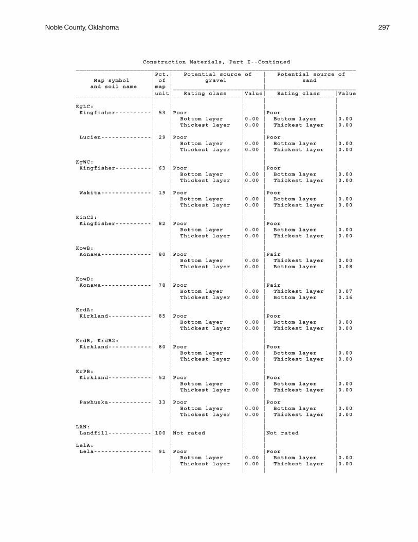
Noble County, Oklahoma 297
Construction Materials, Part I--Continued______________________________________________________________________________ |Pct.| Potential source of | Potential source of Map symbol | of | gravel | sand and soil name |map | | ___________________________________________________ |unit| Rating class |Value| Rating class |Value______________________________________________________________________________ | | | | |KgLC: | | | | | Kingfisher----------| 53 |Poor | |Poor | | | Bottom layer |0.00 | Bottom layer |0.00 | | Thickest layer |0.00 | Thickest layer |0.00 | | | | | Lucien--------------| 29 |Poor | |Poor | | | Bottom layer |0.00 | Bottom layer |0.00 | | Thickest layer |0.00 | Thickest layer |0.00 | | | | |KgWC: | | | | | Kingfisher----------| 63 |Poor | |Poor | | | Bottom layer |0.00 | Bottom layer |0.00 | | Thickest layer |0.00 | Thickest layer |0.00 | | | | | Wakita--------------| 19 |Poor | |Poor | | | Bottom layer |0.00 | Bottom layer |0.00 | | Thickest layer |0.00 | Thickest layer |0.00 | | | | |KinC2: | | | | | Kingfisher----------| 82 |Poor | |Poor | | | Bottom layer |0.00 | Bottom layer |0.00 | | Thickest layer |0.00 | Thickest layer |0.00 | | | | |KowB: | | | | | Konawa--------------| 80 |Poor | |Fair | | | Bottom layer |0.00 | Thickest layer |0.00 | | Thickest layer |0.00 | Bottom layer |0.08 | | | | |KowD: | | | | | Konawa--------------| 78 |Poor | |Fair | | | Bottom layer |0.00 | Thickest layer |0.07 | | Thickest layer |0.00 | Bottom layer |0.16 | | | | |KrdA: | | | | | Kirkland------------| 85 |Poor | |Poor | | | Bottom layer |0.00 | Bottom layer |0.00 | | Thickest layer |0.00 | Thickest layer |0.00 | | | | |KrdB, KrdB2: | | | | | Kirkland------------| 80 |Poor | |Poor | | | Bottom layer |0.00 | Bottom layer |0.00 | | Thickest layer |0.00 | Thickest layer |0.00 | | | | |KrPB: | | | | | Kirkland------------| 52 |Poor | |Poor | | | Bottom layer |0.00 | Bottom layer |0.00 | | Thickest layer |0.00 | Thickest layer |0.00 | | | | | Pawhuska------------| 33 |Poor | |Poor | | | Bottom layer |0.00 | Bottom layer |0.00 | | Thickest layer |0.00 | Thickest layer |0.00 | | | | |LAN: | | | | | Landfill------------|100 |Not rated | |Not rated | | | | | |LelA: | | | | | Lela----------------| 91 |Poor | |Poor | | | Bottom layer |0.00 | Bottom layer |0.00 | | Thickest layer |0.00 | Thickest layer |0.00 | | | | |

298 Soil Survey
Construction Materials, Part I--Continued______________________________________________________________________________ |Pct.| Potential source of | Potential source of Map symbol | of | gravel | sand and soil name |map | | ___________________________________________________ |unit| Rating class |Value| Rating class |Value______________________________________________________________________________ | | | | |LveB: | | | | | Lovedale------------| 90 |Poor | |Fair | | | Bottom layer |0.00 | Thickest layer |0.00 | | Thickest layer |0.00 | Bottom layer |0.20 | | | | |M-W: | | | | | Miscellaneous water-|100 |Not rated | |Not rated | | | | | |McaA: | | | | | McLain--------------| 95 |Poor | |Poor | | | Bottom layer |0.00 | Bottom layer |0.00 | | Thickest layer |0.00 | Thickest layer |0.00 | | | | |MilB: | | | | | Milan---------------| 95 |Poor | |Fair | | | Bottom layer |0.00 | Thickest layer |0.00 | | Thickest layer |0.00 | Bottom layer |0.04 | | | | |MilC: | | | | | Milan---------------| 90 |Poor | |Fair | | | Bottom layer |0.00 | Thickest layer |0.00 | | Thickest layer |0.00 | Bottom layer |0.10 | | | | |MinB: | | | | | Minco---------------| 85 |Poor | |Poor | | | Bottom layer |0.00 | Bottom layer |0.00 | | Thickest layer |0.00 | Thickest layer |0.00 | | | | |MinC: | | | | | Minco---------------| 90 |Poor | |Poor | | | Bottom layer |0.00 | Bottom layer |0.00 | | Thickest layer |0.00 | Thickest layer |0.00 | | | | |MirA, MisA: | | | | | Miller--------------| 84 |Poor | |Poor | | | Bottom layer |0.00 | Bottom layer |0.00 | | Thickest layer |0.00 | Thickest layer |0.00 | | | | |MPNC2: | | | | | Milan---------------| 35 |Poor | |Fair | | | Bottom layer |0.00 | Thickest layer |0.00 | | Thickest layer |0.00 | Bottom layer |0.15 | | | | | Pawhuska------------| 28 |Poor | |Fair | | | Bottom layer |0.00 | Thickest layer |0.00 | | Thickest layer |0.00 | Bottom layer |0.05 | | | | | Norge---------------| 24 |Poor | |Poor | | | Bottom layer |0.00 | Bottom layer |0.00 | | Thickest layer |0.00 | Thickest layer |0.00 | | | | |MulC, MulD, MulD4: | | | | | Mulhall-------------| 92 |Poor | |Poor | | | Bottom layer |0.00 | Bottom layer |0.00 | | Thickest layer |0.00 | Thickest layer |0.00 | | | | |

Noble County, Oklahoma 299
Construction Materials, Part I--Continued______________________________________________________________________________ |Pct.| Potential source of | Potential source of Map symbol | of | gravel | sand and soil name |map | | ___________________________________________________ |unit| Rating class |Value| Rating class |Value______________________________________________________________________________ | | | | |NeDG: | | | | | Newalla-------------| 41 |Poor | |Poor | | | Thickest layer |0.00 | Bottom layer |0.00 | | Bottom layer |0.00 | Thickest layer |0.00 | | | | | Darnell-------------| 36 |Poor | |Poor | | | Bottom layer |0.00 | Bottom layer |0.00 | | Thickest layer |0.00 | Thickest layer |0.00 | | | | |NorA: | | | | | Norge---------------| 90 |Poor | |Poor | | | Bottom layer |0.00 | Bottom layer |0.00 | | Thickest layer |0.00 | Thickest layer |0.00 | | | | |NorB: | | | | | Norge---------------| 85 |Poor | |Poor | | | Bottom layer |0.00 | Bottom layer |0.00 | | Thickest layer |0.00 | Thickest layer |0.00 | | | | |NorC, NorC2: | | | | | Norge---------------| 90 |Poor | |Poor | | | Bottom layer |0.00 | Bottom layer |0.00 | | Thickest layer |0.00 | Thickest layer |0.00 | | | | |NoUC: | | | | | Norge---------------| 55 |Poor | |Poor | | | Bottom layer |0.00 | Bottom layer |0.00 | | Thickest layer |0.00 | Thickest layer |0.00 | | | | | Urban land----------| 30 |Not rated | |Not rated | | | | | |OWWE: | | | | | Oil waste land------| 69 |Not rated | |Not rated | | | | | | Westsum-------------| 25 |Poor | |Poor | | | Bottom layer |0.00 | Bottom layer |0.00 | | Thickest layer |0.00 | Thickest layer |0.00 | | | | |PoaA: | | | | | Port----------------| 84 |Poor | |Poor | | | Bottom layer |0.00 | Bottom layer |0.00 | | Thickest layer |0.00 | Thickest layer |0.00 | | | | |PoOA: | | | | | Port----------------| 57 |Poor | |Poor | | | Bottom layer |0.00 | Bottom layer |0.00 | | Thickest layer |0.00 | Thickest layer |0.00 | | | | | Oscar---------------| 40 |Poor | |Poor | | | Bottom layer |0.00 | Bottom layer |0.00 | | Thickest layer |0.00 | Thickest layer |0.00 | | | | |PorA: | | | | | Port----------------| 92 |Poor | |Poor | | | Bottom layer |0.00 | Bottom layer |0.00 | | Thickest layer |0.00 | Thickest layer |0.00 | | | | |PotA: | | | | | Port----------------| 86 |Poor | |Poor | | | Bottom layer |0.00 | Bottom layer |0.00 | | Thickest layer |0.00 | Thickest layer |0.00 | | | | |

300 Soil Survey
Construction Materials, Part I--Continued______________________________________________________________________________ |Pct.| Potential source of | Potential source of Map symbol | of | gravel | sand and soil name |map | | ___________________________________________________ |unit| Rating class |Value| Rating class |Value______________________________________________________________________________ | | | | |PukA: | | | | | Pulaski-------------| 70 |Poor | |Poor | | | Bottom layer |0.00 | Thickest layer |0.00 | | Thickest layer |0.00 | Bottom layer |0.00 | | | | |PulA: | | | | | Pulaski-------------| 82 |Poor | |Poor | | | Bottom layer |0.00 | Thickest layer |0.00 | | Thickest layer |0.00 | Bottom layer |0.00 | | | | |RefC2: | | | | | Renfrow-------------| 75 |Poor | |Poor | | | Bottom layer |0.00 | Bottom layer |0.00 | | Thickest layer |0.00 | Thickest layer |0.00 | | | | |ReGC2: | | | | | Renfrow-------------| 60 |Poor | |Poor | | | Bottom layer |0.00 | Bottom layer |0.00 | | Thickest layer |0.00 | Thickest layer |0.00 | | | | | Grainola------------| 20 |Poor | |Poor | | | Bottom layer |0.00 | Bottom layer |0.00 | | Thickest layer |0.00 | Thickest layer |0.00 | | | | |ReiA: | | | | | Reinach-------------| 90 |Poor | |Poor | | | Bottom layer |0.00 | Bottom layer |0.00 | | Thickest layer |0.00 | Thickest layer |0.00 | | | | |RenB: | | | | | Renfrow-------------| 82 |Poor | |Poor | | | Bottom layer |0.00 | Bottom layer |0.00 | | Thickest layer |0.00 | Thickest layer |0.00 | | | | |RenC: | | | | | Renfrow-------------| 85 |Poor | |Poor | | | Bottom layer |0.00 | Bottom layer |0.00 | | Thickest layer |0.00 | Thickest layer |0.00 | | | | |RewC2: | | | | | Renfrow-------------| 80 |Poor | |Poor | | | Bottom layer |0.00 | Bottom layer |0.00 | | Thickest layer |0.00 | Thickest layer |0.00 | | | | |RGPD3: | | | | | Renfrow-------------| 45 |Poor | |Poor | | | Bottom layer |0.00 | Bottom layer |0.00 | | Thickest layer |0.00 | Thickest layer |0.00 | | | | | Grainola------------| 29 |Poor | |Poor | | | Bottom layer |0.00 | Bottom layer |0.00 | | Thickest layer |0.00 | Thickest layer |0.00 | | | | | Pawhuska------------| 15 |Poor | |Poor | | | Bottom layer |0.00 | Bottom layer |0.00 | | Thickest layer |0.00 | Thickest layer |0.00 | | | | |SlaB, SlaC: | | | | | Slaughterville------| 85 |Poor | |Poor | | | Bottom layer |0.00 | Bottom layer |0.00 | | Thickest layer |0.00 | Thickest layer |0.00 | | | | |

Noble County, Oklahoma 301
Construction Materials, Part I--Continued______________________________________________________________________________ |Pct.| Potential source of | Potential source of Map symbol | of | gravel | sand and soil name |map | | ___________________________________________________ |unit| Rating class |Value| Rating class |Value______________________________________________________________________________ | | | | |SlaG: | | | | | Slaughterville------| 78 |Poor | |Fair | | | Bottom layer |0.00 | Thickest layer |0.00 | | Thickest layer |0.00 | Bottom layer |0.07 | | | | |StDD: | | | | | Stephenville--------| 45 |Poor | |Poor | | | Bottom layer |0.00 | Thickest layer |0.00 | | Thickest layer |0.00 | Bottom layer |0.00 | | | | | Darnell-------------| 35 |Poor | |Poor | | | Bottom layer |0.00 | Bottom layer |0.00 | | Thickest layer |0.00 | Thickest layer |0.00 | | | | |TabA: | | | | | Tabler--------------| 83 |Poor | |Poor | | | Bottom layer |0.00 | Bottom layer |0.00 | | Thickest layer |0.00 | Thickest layer |0.00 | | | | |TeaA: | | | | | Tearney-------------| 82 |Poor | |Fair | | | Bottom layer |0.00 | Thickest layer |0.00 | | Thickest layer |0.00 | Bottom layer |0.31 | | | | |TelB, TelD: | | | | | Teller--------------| 85 |Poor | |Poor | | | Bottom layer |0.00 | Bottom layer |0.00 | | Thickest layer |0.00 | Thickest layer |0.00 | | | | |TelD2: | | | | | Teller--------------| 82 |Poor | |Poor | | | Bottom layer |0.00 | Bottom layer |0.00 | | Thickest layer |0.00 | Thickest layer |0.00 | | | | |VanA: | | | | | Vanoss--------------| 82 |Poor | |Poor | | | Bottom layer |0.00 | Bottom layer |0.00 | | Thickest layer |0.00 | Thickest layer |0.00 | | | | |W: | | | | | Water---------------|100 |Not rated | |Not rated | | | | | |WauA: | | | | | Waurika-------------| 89 |Poor | |Poor | | | Bottom layer |0.00 | Bottom layer |0.00 | | Thickest layer |0.00 | Thickest layer |0.00 | | | | |WesB: | | | | | Westsum-------------| 85 |Poor | |Poor | | | Bottom layer |0.00 | Bottom layer |0.00 | | Thickest layer |0.00 | Thickest layer |0.00 | | | | |WesC: | | | | | Westsum-------------| 90 |Poor | |Poor | | | Bottom layer |0.00 | Bottom layer |0.00 | | Thickest layer |0.00 | Thickest layer |0.00 | | | | |
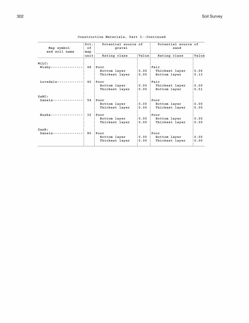
302 Soil Survey
Construction Materials, Part I--Continued______________________________________________________________________________ |Pct.| Potential source of | Potential source of Map symbol | of | gravel | sand and soil name |map | | ___________________________________________________ |unit| Rating class |Value| Rating class |Value______________________________________________________________________________ | | | | |WiLC: | | | | | Wisby---------------| 48 |Poor | |Fair | | | Bottom layer |0.00 | Thickest layer |0.06 | | Thickest layer |0.00 | Bottom layer |0.13 | | | | | Lovedale------------| 40 |Poor | |Fair | | | Bottom layer |0.00 | Thickest layer |0.00 | | Thickest layer |0.00 | Bottom layer |0.51 | | | | |ZaHC: | | | | | Zaneis--------------| 54 |Poor | |Poor | | | Bottom layer |0.00 | Bottom layer |0.00 | | Thickest layer |0.00 | Thickest layer |0.00 | | | | | Huska---------------| 32 |Poor | |Poor | | | Bottom layer |0.00 | Bottom layer |0.00 | | Thickest layer |0.00 | Thickest layer |0.00 | | | | |ZanB: | | | | | Zaneis--------------| 80 |Poor | |Poor | | | Bottom layer |0.00 | Bottom layer |0.00 | | Thickest layer |0.00 | Thickest layer |0.00 | | | | |______________________________________________________________________________

Noble County, Oklahoma 303
Construction Materials, Part II
(The information in this table indicates the dominant soil condition but does not eliminate the need for onsite investigation. The numbers in the value columns range from 0.00 to 0.99. The smaller the value, the greater the limitation. See text for further explanation of ratings in this table)
________________________________________________________________________________________________ |Pct.| Potential source of | Potential source of | Potential source of Map symbol | of | reclamation material | roadfill | topsoil _____________________________________________________________________________and soil name|map | Rating class and |Value| Rating class and |Value| Rating class and |Value |unit| limiting features | | limiting features | | limiting features |________________________________________________________________________________________________ | | | | | | |AhpA: | | | | | | | Ashport-----| 90 |Fair | |Poor | |Good | | | Low content of |0.88 | Low strength |0.00 | | | | organic matter | | Shrink-swell |0.87 | | | | Water erosion |0.99 | | | | | | | | | | |APPA: | | | | | | | Ashport-----| 61 |Fair | |Poor | |Fair | | | Low content of |0.88 | Low strength |0.00 | Too clayey |0.93 | | organic matter | | Shrink-swell |0.87 | | | | Too clayey |0.98 | | | | | | Water erosion |0.99 | | | | | | | | | | | Port--------| 15 |Fair | |Poor | |Good | | | Water erosion |0.99 | Low strength |0.00 | | | | | | Shrink-swell |0.99 | | | | | | | | | Pulaski-----| 15 |Fair | |Good | |Good | | | Low content of |0.50 | | | | | | organic matter | | | | | | | | | | | |AspA: | | | | | | | Ashport-----| 90 |Fair | |Poor | |Good | | | Low content of |0.88 | Low strength |0.00 | | | | organic matter | | Shrink-swell |0.87 | | | | Water erosion |0.99 | | | | | | | | | | |AspB: | | | | | | | Ashport-----| 93 |Fair | |Poor | |Good | | | Low content of |0.88 | Low strength |0.00 | | | | organic matter | | Shrink-swell |0.87 | | | | Water erosion |0.99 | | | | | | | | | | |BetA: | | | | | | | Bethany-----| 85 |Poor | |Poor | |Poor | | | Too clayey |0.00 | Low strength |0.00 | Too clayey |0.00 | | Low content of |0.50 | Shrink-swell |0.15 | | | | organic matter | | | | | | | Water erosion |0.90 | | | | | | | | | | |BetB: | | | | | | | Bethany-----| 84 |Fair | |Poor | |Fair | | | Too clayey |0.12 | Low strength |0.00 | Too clayey |0.10 | | Low content of |0.50 | Shrink-swell |0.21 | | | | organic matter | | | | | | | Water erosion |0.90 | | | | | | | | | | |BPG: | | | | | | | Borrow pits,| | | | | | | gravelly---| 90 |Not rated | |Not rated | |Not rated | | | | | | | |

304 Soil Survey
Construction Materials, Part II--Continued________________________________________________________________________________________________ |Pct.| Potential source of | Potential source of | Potential source of Map symbol | of | reclamation material | roadfill | topsoil _____________________________________________________________________________and soil name|map | Rating class and |Value| Rating class and |Value| Rating class and |Value |unit| limiting features | | limiting features | | limiting features |________________________________________________________________________________________________ | | | | | | |BPR: | | | | | | | Borrow pits,| | | | | | | rock-------| 90 |Not rated | |Not rated | |Not rated | | | | | | | |BraA: | | | | | | | Braman------| 85 |Fair | |Poor | |Fair | | | Low content of |0.12 | Low strength |0.00 | Too clayey |0.76 | | organic matter | | Shrink-swell |0.98 | | | | Too clayey |0.98 | | | | | | Water erosion |0.99 | | | | | | | | | | |BrwA: | | | | | | | Brewer------| 97 |Fair | |Poor | |Fair | | | Too clayey |0.08 | Low strength |0.00 | Too clayey |0.08 | | Low content of |0.88 | Shrink-swell |0.49 | | | | organic matter | | | | | | | Water erosion |0.90 | | | | | | | | | | |CoLC: | | | | | | | Coyle-------| 61 |Fair | |Poor | |Poor | | | Depth to bedrock |0.01 | Depth to bedrock |0.00 | Hard to reclaim, |0.00 | | Droughty |0.04 | | | dense layer | | | Water erosion |0.99 | | | Depth to bedrock |0.01 | | | | | | | Lucien------| 30 |Poor | |Poor | |Poor | | | Depth to bedrock |0.00 | Depth to bedrock |0.00 | Hard to reclaim, |0.00 | | Droughty |0.00 | | | dense layer | | | | | | | Depth to bedrock |0.00 | | | | | | Rock fragments |0.88CoyB: | | | | | | | Coyle-------| 85 |Fair | |Poor | |Poor | | | Depth to bedrock |0.54 | Depth to bedrock |0.00 | Hard to reclaim, |0.00 | | Droughty |0.68 | | | dense layer | | | Water erosion |0.99 | | | Depth to bedrock |0.54 | | | | | | |CoyC: | | | | | | | Coyle-------| 82 |Fair | |Poor | |Poor | | | Depth to bedrock |0.29 | Depth to bedrock |0.00 | Hard to reclaim ,|0.00 | | Droughty |0.45 | | | dense layer | | | Low content of |0.88 | | | Depth to bedrock |0.29 | | organic matter | | | | | | | Water erosion |0.99 | | | | | | | | | | |CoyC2: | | | | | | | Coyle-------| 82 |Fair | |Poor | |Poor | | | Low content of |0.12 | Depth to bedrock |0.00 | Hard to reclaim, |0.00 | | organic matter | | | | dense layer | | | Depth to bedrock |0.65 | | | Rock fragments |0.02 | | Droughty |0.71 | | | Depth to bedrock |0.65 | | Water erosion |0.99 | | | | | | | | | | |CoZC3: | | | | | | | Coyle-------| 60 |Fair | |Poor | |Poor | | | Depth to bedrock |0.01 | Depth to bedrock |0.00 | Hard to reclaim, |0.00 | | Droughty |0.06 | | | dense layer | | | Low content of |0.88 | | | Depth to bedrock |0.01 | | organic matter | | | | Too clayey |0.64 | | Too clayey |0.89 | | | | | | Water erosion |0.99 | | | | | | | | | | |

Noble County, Oklahoma 305
Construction Materials, Part II--Continued________________________________________________________________________________________________ |Pct.| Potential source of | Potential source of | Potential source of Map symbol | of | reclamation material | roadfill | topsoil _____________________________________________________________________________and soil name|map | Rating class and |Value| Rating class and |Value| Rating class and |Value |unit| limiting features | | limiting features | | limiting features |________________________________________________________________________________________________ | | | | | | |CoZC3: | | | | | | | Zaneis------| 16 |Fair | |Fair | |Poor | | | Low content of |0.88 | Depth to bedrock |0.58 | Hard to reclaim, |0.00 | | organic matter | | Shrink-swell |0.99 | dense layer | | | Water erosion |0.99 | | | | | | | | | | |DalA: | | | | | | | Dale--------| 90 |Fair | |Poor | |Good | | | Water erosion |0.99 | Low strength |0.00 | | | | | | Shrink-swell |0.96 | | | | | | | | |DAM: | | | | | | | Dam---------|100 |Not rated | |Not rated | |Not rated | | | | | | | |DaUA: | | | | | | | Dale--------| 48 |Fair | |Poor | |Good | | | Water erosion |0.99 | Low strength |0.00 | | | | | | Shrink-swell |0.90 | | | | | | | | | Urban land--| 42 |Not rated | |Not rated | |Not rated | | | | | | | |DiGE: | | | | | | | Dilworth----| 64 |Poor | |Poor | |Poor | | | Too clayey |0.00 | Depth to bedrock |0.00 | Too clayey |0.00 | | Depth to bedrock |0.03 | Low strength |0.00 | Hard to reclaim, |0.00 | | Droughty |0.15 | Shrink-swell |0.12 | dense layer | | | Low content of |0.88 | | | Depth to bedrock |0.03 | | organic matter | | | | Slope |0.96 | | Water erosion |0.99 | | | | | | | | | | | Grainola----| 16 |Poor | |Poor | |Poor | | | Too clayey |0.00 | Depth to bedrock |0.00 | Hard to reclaim, |0.00 | | Low content of |0.12 | Low strength |0.00 | dense layer | | | organic matter | | Shrink-swell |0.12 | Too clayey |0.00 | | Depth to bedrock |0.65 | | | Depth to bedrock |0.65 | | Droughty |0.87 | | | Slope |0.96 | | Water erosion |0.90 | | | | | | | | | | |DooB: | | | | | | | Doolin------| 85 |Poor | |Poor | |Poor | | | Sodium content |0.00 | Low strength |0.00 | Sodium content |0.00 | | Too clayey |0.08 | Shrink-swell |0.47 | Too clayey |0.07 | | Water erosion |0.68 | | | Hard to reclaim, |0.94 | | | | | | dense layer | | | | | | | |DwhC: | | | | | | | Dilworth----| 85 |Poor | |Poor | |Poor | | | Too clayey |0.00 | Depth to bedrock |0.00 | Too clayey |0.00 | | Low content of |0.88 | Low strength |0.00 | Hard to reclaim, |0.00 | | organic matter | | Shrink-swell |0.12 | dense layer | | | Depth to bedrock |0.93 | | | Depth to bedrock |0.93 | | Water erosion |0.99 | | | | | | Droughty |0.99 | | | | | | | | | | |EasA: | | | | | | | Easpur------| 80 |Fair | |Good | |Good | | | Low content of |0.88 | | | | | | organic matter | | | | | | | Water erosion |0.99 | | | | | | | | | | |

306 Soil Survey
Construction Materials, Part II--Continued________________________________________________________________________________________________ |Pct.| Potential source of | Potential source of | Potential source of Map symbol | of | reclamation material | roadfill | topsoil _____________________________________________________________________________and soil name|map | Rating class and |Value| Rating class and |Value| Rating class and |Value |unit| limiting features | | limiting features | | limiting features |________________________________________________________________________________________________ | | | | | | |GadA: | | | | | | | Gaddy-------| 90 |Poor | |Good | |Fair | | | Wind erosion |0.00 | | | Too sandy |0.28 | | Low content of |0.12 | | | | | | organic matter | | | | | | | Too sandy |0.28 | | | | | | | | | | |GayA: | | | | | | | Gaddy-------| 85 |Poor | |Good | |Poor | | | Too sandy |0.00 | | | Too sandy |0.00 | | Wind erosion |0.00 | | | | | | Low content of |0.12 | | | | | | organic matter | | | | | | | | | | | |GMLG: | | | | | | | Grainola----| 37 |Poor | |Poor | |Poor | | | Too clayey |0.00 | Depth to bedrock |0.00 | Too clayey |0.00 | | Low content of |0.12 | Low strength |0.00 | Slope |0.00 | | organic matter | | Shrink-swell |0.12 | Hard to reclaim, |0.10 | | Droughty |0.36 | | | dense layer | | | Depth to bedrock |0.54 | | | Depth to bedrock |0.54 | | Water erosion |0.99 | | | | | | | | | | | Masham------| 22 |Poor | |Poor | |Poor | | | Droughty |0.00 | Depth to bedrock |0.00 | Slope |0.00 | | Depth to bedrock |0.00 | Low strength |0.00 | Hard to reclaim, |0.00 | | Too clayey |0.00 | Slope |0.00 | dense layer | | | Low content of |0.12 | Shrink-swell |0.12 | Depth to bedrock |0.00 | | organic matter | | | | Too clayey |0.00 | | Water erosion |0.90 | | | | | | | | | | | Lucien------| 21 |Poor | |Poor | |Poor | | | Depth to bedrock |0.00 | Depth to bedrock |0.00 | Slope |0.00 | | Droughty |0.00 | Slope |0.82 | Hard to reclaim, |0.00 | | | | | | dense layer | | | | | | | Depth to bedrock |0.00 | | | | | | Rock fragments |0.88 | | | | | | |GohE: | | | | | | | Goodnight---| 95 |Poor | |Good | |Poor | | | Wind erosion |0.00 | | | Too sandy |0.00 | | Too sandy |0.00 | | | Slope |0.84 | | Low content of |0.12 | | | | | | organic matter | | | | | | | Droughty |0.99 | | | | | | | | | | |GraC: | | | | | | | Grainola----| 85 |Poor | |Poor | |Poor | | | Too clayey |0.00 | Depth to bedrock |0.00 | Too clayey |0.00 | | Low content of |0.12 | Low strength |0.00 | Hard to reclaim, |0.03 | | organic matter | | Shrink-swell |0.12 | dense layer | | | Depth to bedrock |0.84 | | | Depth to bedrock |0.84 | | Droughty |0.94 | | | Rock fragments |0.97 | | Water erosion |0.99 | | | | | | | | | | |

Noble County, Oklahoma 307
Construction Materials, Part II--Continued________________________________________________________________________________________________ |Pct.| Potential source of | Potential source of | Potential source of Map symbol | of | reclamation material | roadfill | topsoil _____________________________________________________________________________and soil name|map | Rating class and |Value| Rating class and |Value| Rating class and |Value |unit| limiting features | | limiting features | | limiting features |________________________________________________________________________________________________ | | | | | | |GrAD: | | | | | | | Grainola----| 38 |Poor | |Poor | |Poor | | | Too clayey |0.00 | Depth to bedrock |0.00 | Hard to reclaim, |0.00 | | Low content of |0.12 | Low strength |0.00 | dense layer | | | organic matter | | Shrink-swell |0.12 | Too clayey |0.00 | | Depth to bedrock |0.93 | | | Depth to bedrock |0.93 | | Water erosion |0.99 | | | | | | Droughty |0.99 | | | | | | | | | | | Ashport-----| 23 |Fair | |Poor | |Fair | | | Low content of |0.88 | Low strength |0.00 | Hard to reclaim, |0.71 | | organic matter | | Depth to bedrock |0.23 | dense layer | | | Water erosion |0.99 | Shrink-swell |0.87 | | | | | | | | |GrHC: | | | | | | | Grant-------| 37 |Fair | |Fair | |Fair | | | Low content of |0.88 | Depth to bedrock |0.87 | Hard to reclaim, |0.90 | | organic matter | | | | dense layer | | | Water erosion |0.99 | | | | | | | | | | | Huska-------| 35 |Poor | |Poor | |Poor | | | Sodium content |0.00 | Low strength |0.00 | Hard to reclaim, |0.00 | | Too clayey |0.08 | Shrink-swell |0.12 | dense layer | | | Droughty |0.49 | Depth to bedrock |0.58 | Sodium content |0.00 | | Low content of |0.50 | | | Salinity |0.00 | | organic matter | | | | Too clayey |0.05 | | Water erosion |0.68 | | | | | | Salinity |0.97 | | | | | | | | | | |GrLC: | | | | | | | Grainola----| 47 |Poor | |Poor | |Poor | | | Too clayey |0.00 | Depth to bedrock |0.00 | Hard to reclaim, |0.00 | | Low content of |0.12 | Low strength |0.00 | dense layer | | | organic matter | | Shrink-swell |0.12 | Too clayey |0.00 | | Water erosion |0.90 | | | Depth to bedrock |0.99 | | Depth to bedrock |0.99 | | | | | | | | | | | Lucien------| 30 |Poor | |Poor | |Poor | | | Depth to bedrock |0.00 | Depth to bedrock |0.00 | Hard to reclaim, |0.00 | | Droughty |0.02 | | | dense layer | | | | | | | Depth to bedrock |0.00 | | | | | | Rock fragments |0.88 | | | | | | |GrLE: | | | | | | | Grainola----| 50 |Poor | |Poor | |Poor | | | Too clayey |0.00 | Depth to bedrock |0.00 | Too clayey |0.00 | | Low content of |0.12 | Low strength |0.00 | Hard to reclaim, |0.00 | | organic matter | | Shrink-swell |0.12 | dense layer | | | Depth to bedrock |0.26 | | | Depth to bedrock |0.26 | | Droughty |0.48 | | | Slope |0.96 | | Water erosion |0.99 | | | Rock fragments |0.97 | | | | | | | Lucien------| 26 |Poor | |Poor | |Poor | | | Droughty |0.00 | Depth to bedrock |0.00 | Hard to reclaim, |0.00 | | Depth to bedrock |0.00 | | | dense layer | | | | | | | Depth to bedrock |0.00 | | | | | | Rock fragments |0.95 | | | | | | Slope |0.96 | | | | | | |

308 Soil Survey
Construction Materials, Part II--Continued________________________________________________________________________________________________ |Pct.| Potential source of | Potential source of | Potential source of Map symbol | of | reclamation material | roadfill | topsoil _____________________________________________________________________________and soil name|map | Rating class and |Value| Rating class and |Value| Rating class and |Value |unit| limiting features | | limiting features | | limiting features |________________________________________________________________________________________________ | | | | | | |GrnC: | | | | | | | Grant-------| 95 |Fair | |Good | |Fair | | | Low content of |0.50 | | | Hard to reclaim, |0.42 | | organic matter | | | | dense layer | | | Water erosion |0.99 | | | | | | | | | | |GrtB: | | | | | | | Grant-------| 90 |Fair | |Poor | |Good | | | Low content of |0.88 | Low strength |0.00 | | | | organic matter | | Depth to bedrock |0.98 | | | | Water erosion |0.99 | | | | | | | | | | |HaPE: | | | | | | | Harrah------| 44 |Fair | |Good | |Good | | | Low content of |0.50 | | | | | | organic matter | | | | | | | Too acid |0.88 | | | | | | | | | | | Pulaski-----| 25 |Fair | |Good | |Poor | | | Low content of |0.50 | | | Hard to reclaim, |0.00 | | organic matter | | | | dense layer | | | | | | | |HiRG: | | | | | | | Highview----| 43 |Poor | |Poor | |Poor | | | Depth to bedrock |0.00 | Depth to bedrock |0.00 | Slope |0.00 | | Droughty |0.00 | Slope |0.00 | Hard to reclaim, |0.00 | | Too clayey |0.00 | Low strength |0.00 | dense layer |0.00 | | Low content of |0.12 | Shrink-swell |0.12 | Depth to bedrock |0.00 | | organic matter | | | | Too clayey |0.00 | | | | | | Rock fragments |0.00 | | | | | | | Rock outcrop| 33 |Not rated | |Not rated | |Not rated | | | | | | | |KekA, KeoA: | | | | | | | Keokuk------| 88 |Fair | |Good | |Good | | | Low content of |0.88 | | | | | | organic matter | | | | | | | Water erosion |0.99 | | | | | | | | | | |KgfB: | | | | | | | Kingfisher--| 90 |Fair | |Poor | |Poor | | | Low content of |0.12 | Depth to bedrock |0.00 | Hard to reclaim, |0.00 | | organic matter | | Low strength |0.00 | dense layer | | | Depth to bedrock |0.21 | Shrink-swell |0.87 | Depth to bedrock |0.21 | | Droughty |0.83 | | | Too clayey |0.57 | | Too clayey |0.98 | | | | | | Water erosion |0.99 | | | | | | | | | | |KgLC: | | | | | | | Kingfisher--| 53 |Fair | |Poor | |Poor | | | Depth to bedrock |0.03 | Depth to bedrock |0.00 | Hard to reclaim, |0.00 | | Low content of |0.12 | Low strength |0.00 | dense layer | | | organic matter | | Shrink-swell |0.87 | Depth to bedrock |0.03 | | Droughty |0.34 | | | Too clayey |0.57 | | Too clayey |0.98 | | | | | | Water erosion |0.99 | | | | | | | | | | | Lucien------| 29 |Poor | |Poor | |Poor | | | Depth to bedrock |0.00 | Depth to bedrock |0.00 | Hard to reclaim, |0.00 | | Droughty |0.00 | | | dense layer | | | | | | | Depth to bedrock |0.00 | | | | | | Rock fragments |0.95

Noble County, Oklahoma 309
Construction Materials, Part II--Continued________________________________________________________________________________________________ |Pct.| Potential source of | Potential source of | Potential source of Map symbol | of | reclamation material | roadfill | topsoil _____________________________________________________________________________and soil name|map | Rating class and |Value| Rating class and |Value| Rating class and |Value |unit| limiting features | | limiting features | | limiting features |________________________________________________________________________________________________ | | | | | | |KgWC: | | | | | | | Kingfisher--| 63 |Fair | |Poor | |Poor | | | Low content of |0.12 | Depth to bedrock |0.00 | Hard to reclaim, |0.00 | | organic matter | | Low strength |0.00 | dense layer | | | Depth to bedrock |0.71 | Shrink-swell |0.87 | Too clayey |0.57 | | Too clayey |0.98 | | | Depth to bedrock |0.71 | | Water erosion |0.99 | | | | | | | | | | | Wakita------| 19 |Poor | |Poor | |Poor | | | Sodium content |0.00 | Depth to bedrock |0.00 | Sodium content |0.00 | | Droughty |0.03 | Low strength |0.00 | Salinity |0.00 | | Depth to bedrock |0.65 | Shrink-swell |0.87 | Hard to reclaim, |0.16 | | Low content of |0.88 | Depth to |0.89 | dense layer | | | organic matter | | saturated zone | | Depth to bedrock |0.65 | | Water erosion |0.90 | | | Depth to |0.89 | | | | | | saturated zone | | | | | | | |KinC2: | | | | | | | Kingfisher--| 82 |Fair | |Poor | |Poor | | | Depth to bedrock |0.03 | Depth to bedrock |0.00 | Hard to reclaim, |0.00 | | Droughty |0.37 | Low strength |0.00 | dense layer | | | Low content of |0.50 | Shrink-swell |0.87 | Depth to bedrock |0.03 | | organic matter | | | | | | | Water erosion |0.99 | | | | | | | | | | |KowB: | | | | | | | Konawa------| 80 |Fair | |Good | |Good | | | Low content of |0.32 | | | | | | organic matter | | | | | | | Too acid |0.84 | | | | | | | | | | |KowD: | | | | | | | Konawa------| 78 |Fair | |Good | |Good | | | Low content of |0.32 | | | | | | organic matter | | | | | | | Too acid |0.84 | | | | | | | | | | |KrdA: | | | | | | | Kirkland----| 85 |Poor | |Poor | |Poor | | | Too clayey |0.00 | Low strength |0.00 | Too clayey |0.00 | | Water erosion |0.68 | Shrink-swell |0.00 | | | | | | | | |KrdB: | | | | | | | Kirkland----| 80 |Poor | |Poor | |Poor | | | Too clayey |0.00 | Low strength |0.00 | Too clayey |0.00 | | Water erosion |0.68 | Shrink-swell |0.00 | Sodium content |0.78 | | Sodium content |0.78 | | | Hard to reclaim, |0.80 | | Low content of |0.88 | | | dense layer | | | organic matter | | | | | | | | | | | |KrdB2: | | | | | | | Kirkland----| 80 |Poor | |Poor | |Poor | | | Too clayey |0.00 | Low strength |0.00 | Too clayey |0.00 | | Water erosion |0.68 | Shrink-swell |0.00 | | | | | | | | |KrPB: | | | | | | | Kirkland----| 52 |Poor | |Poor | |Poor | | | Too clayey |0.00 | Low strength |0.00 | Too clayey |0.00 | | Water erosion |0.68 | Shrink-swell |0.00 | Sodium content |0.78 | | Low content of |0.88 | | | | | | organic matter | | | | | | | | | | | |

310 Soil Survey
Construction Materials, Part II--Continued________________________________________________________________________________________________ |Pct.| Potential source of | Potential source of | Potential source of Map symbol | of | reclamation material | roadfill | topsoil _____________________________________________________________________________and soil name|map | Rating class and |Value| Rating class and |Value| Rating class and |Value |unit| limiting features | | limiting features | | limiting features |________________________________________________________________________________________________ | | | | | | |KrPB: | | | | | | | Pawhuska----| 33 |Poor | |Poor | |Poor | | | Sodium content |0.00 | Low strength |0.00 | Sodium content |0.00 | | Too clayey |0.00 | Shrink-swell |0.12 | Too clayey |0.00 | | Water erosion |0.68 | | | Salinity |0.00 | | Low content of |0.88 | | | Hard to reclaim, |0.03 | | organic matter | | | | dense layer | | | Salinity |0.97 | | | | | | | | | | |LAN: | | | | | | | Landfill----|100 |Not rated | |Not rated | |Not rated | | | | | | | |LelA: | | | | | | | Lela--------| 92 |Poor | |Poor | |Poor | | | Too clayey |0.00 | Low strength |0.00 | Too clayey |0.00 | | Water erosion |0.99 | Shrink-swell |0.12 | Rock fragments |0.94 | | | | | | |LveB: | | | | | | | Lovedale----| 90 |Fair | |Good | |Good | | | Low content of |0.12 | | | | | | organic matter | | | | | | | | | | | |M-W: | | | | | | | Miscellane- | | | | | | | ous water--|100 |Not rated | |Not rated | |Not rated | | | | | | | |McaA: | | | | | | | McLain------| 95 |Fair | |Poor | |Fair | | | Too clayey |0.02 | Low strength |0.00 | Too clayey |0.02 | | Water erosion |0.99 | Shrink-swell |0.12 | | | | | | | | |MilB: | | | | | | | Milan-------| 95 |Fair | |Good | |Good | | | Low content of |0.12 | | | | | | organic matter | | | | | | | | | | | |MilC: | | | | | | | Milan-------| 90 |Fair | |Good | |Good | | | Low content of |0.12 | | | | | | organic matter | | | | | | | | | | | |MinB: | | | | | | | Minco-------| 85 |Fair | |Good | |Good | | | Low content of |0.50 | | | | | | organic matter | | | | | | | Water erosion |0.99 | | | | | | | | | | |MinC: | | | | | | | Minco-------| 90 |Fair | |Good | |Good | | | Low content of |0.50 | | | | | | organic matter | | | | | | | Water erosion |0.99 | | | | | | | | | | |MirA: | | | | | | | Miller------| 85 |Poor | |Poor | |Poor | | | Too clayey |0.00 | Low strength |0.00 | Too clayey |0.00 | | Low content of |0.88 | Shrink-swell |0.12 | | | | organic matter | | | | | | | Water erosion |0.90 | | | | | | | | | | |

Noble County, Oklahoma 311
Construction Materials, Part II--Continued________________________________________________________________________________________________ |Pct.| Potential source of | Potential source of | Potential source of Map symbol | of | reclamation material | roadfill | topsoil _____________________________________________________________________________and soil name|map | Rating class and |Value| Rating class and |Value| Rating class and |Value |unit| limiting features | | limiting features | | limiting features |________________________________________________________________________________________________ | | | | | | |MisA: | | | | | | | Miller------| 85 |Poor | |Poor | |Poor | | | Too clayey |0.00 | Low strength |0.00 | Too clayey |0.00 | | Salinity |0.88 | Shrink-swell |0.12 | Salinity |0.00 | | Low content of |0.88 | | | | | | organic matter | | | | | | | Water erosion |0.90 | | | | | | Sodium content |0.97 | | | | | | | | | | |MPNC2: | | | | | | | Milan-------| 35 |Fair | |Good | |Good | | | Low content of |0.12 | | | | | | organic matter | | | | | | | | | | | | Pawhuska----| 28 |Poor | |Poor | |Poor | | | Sodium content |0.00 | Low strength |0.00 | Sodium content |0.00 | | Too clayey |0.02 | Shrink-swell |0.12 | Salinity |0.00 | | Low content of |0.12 | | | Too clayey |0.01 | | organic matter | | | | | | | Water erosion |0.68 | | | | | | Salinity |0.97 | | | | | | | | | | | Norge-------| 24 |Fair | |Poor | |Fair | | | Low content of |0.88 | Low strength |0.00 | Too clayey |0.70 | | organic matter | | Shrink-swell |0.87 | | | | Too clayey |0.98 | | | | | | Water erosion |0.99 | | | | | | | | | | |MulC, MulD, | | | | | | | MulD4: | | | | | | | Mulhall----| 92 |Fair | |Good | |Good | | | Low content of |0.12 | | | | | | organic matter | | | | | | | Water erosion |0.99 | | | | | | | | | | |NeDG: | | | | | | | Newalla-----| 41 |Poor | |Poor | |Poor | | | Too clayey |0.00 | Low strength |0.00 | Too clayey |0.00 | | Low content of |0.12 | Shrink-swell |0.55 | Hard to reclaim, |0.03 | | organic matter | | Depth to bedrock |0.87 | dense layer | | | Too acid |0.88 | | | Hard to reclaim, |0.82 | | Water erosion |0.90 | | | rock fragments | | | | | | | | Darnell-----| 36 |Poor | |Poor | |Poor | | | Droughty |0.00 | Depth to bedrock |0.00 | Hard to reclaim, |0.00 | | Depth to bedrock |0.00 | Slope |0.00 | dense layer | | | Low content of |0.12 | | | Depth to bedrock |0.00 | | organic matter | | | | Slope |0.00 | | Too acid |0.97 | | | Rock fragments |0.88 | | | | | | |NorA: | | | | | | | Norge-------| 90 |Fair | |Poor | |Good | | | Low content of |0.88 | Low strength |0.00 | | | | organic matter | | Shrink-swell |0.89 | | | | Water erosion |0.99 | | | | | | | | | | |NorB: | | | | | | | Norge-------| 85 |Fair | |Poor | |Fair | | | Low content of |0.88 | Low strength |0.00 | Too clayey |0.70 | | organic matter | | Shrink-swell |0.92 | | | | Too clayey |0.98 | | | | | | Water erosion |0.99 | | | |

312 Soil Survey
Construction Materials, Part II--Continued________________________________________________________________________________________________ |Pct.| Potential source of | Potential source of | Potential source of Map symbol | of | reclamation material | roadfill | topsoil _____________________________________________________________________________and soil name|map | Rating class and |Value| Rating class and |Value| Rating class and |Value |unit| limiting features | | limiting features | | limiting features |________________________________________________________________________________________________ | | | | | | |NorC: | | | | | | | Norge-------| 90 |Fair | |Poor | |Fair | | | Low content of |0.88 | Low strength |0.00 | Too clayey |0.70 | | organic matter | | Shrink-swell |0.89 | | | | Too clayey |0.98 | | | | | | Water erosion |0.99 | | | | | | | | | | |NorC2: | | | | | | | Norge-------| 90 |Fair | |Poor | |Fair | | | Low content of |0.88 | Low strength |0.00 | Too clayey |0.70 | | organic matter | | Shrink-swell |0.87 | | | | Too clayey |0.98 | | | | | | Water erosion |0.99 | | | | | | | | | | |NoUC: | | | | | | | Norge-------| 55 |Fair | |Poor | |Fair | | | Low content of |0.88 | Low strength |0.00 | Too clayey |0.70 | | organic matter | | Shrink-swell |0.87 | | | | Too clayey |0.98 | | | | | | Water erosion |0.99 | | | | | | | | | | | Urban land--| 30 |Not rated | |Not rated | |Not rated | | | | | | | |OWWE: | | | | | | | Oil waste | | | | | | | land-------| 69 |Not rated | |Not rated | |Not rated | | | | | | | | Westsum-----| 25 |Poor | |Poor | |Poor | | | Too clayey |0.00 | Low strength |0.00 | Too clayey |0.00 | | Low content of |0.50 | Shrink-swell |0.00 | | | | organic matter | | | | | | | Water erosion |0.99 | | | | | | | | | | |PoaA: | | | | | | | Port--------| 84 |Fair | |Poor | |Good | | | Water erosion |0.99 | Low strength |0.00 | | | | | | | | |PoOA: | | | | | | | Port--------| 58 |Fair | |Poor | |Good | | | Water erosion |0.99 | Low strength |0.00 | | | | | | | | | Oscar-------| 40 |Poor | |Poor | |Good | | | Sodium content |0.00 | Low strength |0.00 | | | | Water erosion |0.37 | | | | | | Salinity |0.88 | | | | | | | | | | |PorA: | | | | | | | Port--------| 93 |Fair | |Poor | |Good | | | Water erosion |0.99 | Low strength |0.00 | | | | | | | | |PotA: | | | | | | | Port--------| 87 |Fair | |Poor | |Fair | | | Low content of |0.50 | Low strength |0.00 | Too clayey |0.93 | | organic matter | | Shrink-swell |0.87 | | | | Too clayey |0.98 | | | | | | Water erosion |0.99 | | | | | | | | | | |PukA: | | | | | | | Pulaski-----| 70 |Fair | |Good | |Good | | | Low content of |0.50 | | | | | | organic matter | | | | | | | | | | | |

Noble County, Oklahoma 313
Construction Materials, Part II--Continued________________________________________________________________________________________________ |Pct.| Potential source of | Potential source of | Potential source of Map symbol | of | reclamation material | roadfill | topsoil _____________________________________________________________________________and soil name|map | Rating class and |Value| Rating class and |Value| Rating class and |Value |unit| limiting features | | limiting features | | limiting features |________________________________________________________________________________________________ | | | | | | |PulA: | | | | | | | Pulaski-----| 82 |Fair | |Good | |Good | | | Low content of |0.50 | | | | | | organic matter | | | | | | | | | | | |RefC2: | | | | | | | Renfrow-----| 75 |Poor | |Poor | |Poor | | | Too clayey |0.00 | Low strength |0.00 | Too clayey |0.00 | | Water erosion |0.68 | Shrink-swell |0.12 | | | | Low content of |0.88 | | | | | | organic matter | | | | | | | | | | | |ReGC2: | | | | | | | Renfrow-----| 60 |Poor | |Poor | |Poor | | | Too clayey |0.00 | Low strength |0.00 | Hard to reclaim, |0.00 | | Low content of |0.88 | Shrink-swell |0.15 | dense layer | | | organic matter | | | | Too clayey |0.00 | | Water erosion |0.90 | | | | | | | | | | | Grainola----| 20 |Poor | |Poor | |Poor | | | Too clayey |0.00 | Depth to bedrock |0.00 | Hard to reclaim, |0.00 | | Low content of |0.12 | Low strength |0.00 | dense layer | | | organic matter | | Shrink-swell |0.12 | Too clayey |0.00 | | Depth to bedrock |0.79 | | | Depth to bedrock |0.79 | | Droughty |0.95 | | | | | | Water erosion |0.99 | | | | | | | | | | |ReiA: | | | | | | | Reinach-----| 90 |Fair | |Good | |Good | | | Low content of |0.88 | | | | | | organic matter | | | | | | | Water erosion |0.99 | | | | | | | | | | |RenB: | | | | | | | Renfrow-----| 82 |Poor | |Poor | |Poor | | | Too clayey |0.00 | Low strength |0.00 | Too clayey |0.00 | | Water erosion |0.68 | Shrink-swell |0.16 | | | | Low content of |0.88 | | | | | | organic matter | | | | | | | | | | | |RenC: | | | | | | | Renfrow-----| 85 |Poor | |Poor | |Poor | | | Too clayey |0.00 | Low strength |0.00 | Too clayey |0.00 | | Water erosion |0.68 | Shrink-swell |0.16 | | | | Low content of |0.88 | | | | | | organic matter | | | | | | | | | | | |RewC2: | | | | | | | Renfrow-----| 80 |Poor | |Poor | |Poor | | | Too clayey |0.00 | Low strength |0.00 | Too clayey |0.00 | | Low content of |0.88 | Shrink-swell |0.12 | Hard to reclaim |0.10 | | organic matter | | | | | | | Water erosion |0.90 | | | | | | | | | | |RGPD3: | | | | | | | Renfrow-----| 45 |Fair | |Poor | |Fair | | | Too clayey |0.02 | Low strength |0.00 | Too clayey |0.01 | | Low content of |0.88 | Shrink-swell |0.12 | | | | organic matter | | | | | | | Water erosion |0.90 | | | | | | | | | | |

314 Soil Survey
Construction Materials, Part II--Continued________________________________________________________________________________________________ |Pct.| Potential source of | Potential source of | Potential source of Map symbol | of | reclamation material | roadfill | topsoil _____________________________________________________________________________and soil name|map | Rating class and |Value| Rating class and |Value| Rating class and |Value |unit| limiting features | | limiting features | | limiting features |________________________________________________________________________________________________ | | | | | | |RGPD3: | | | | | | | Grainola----| 29 |Poor | |Poor | |Poor | | | Too clayey |0.00 | Depth to bedrock |0.00 | Too clayey |0.00 | | Depth to bedrock |0.01 | Low strength |0.00 | Hard to reclaim, |0.01 | | Droughty |0.07 | Shrink-swell |0.12 | dense layer | | | Low content of |0.12 | | | Depth to bedrock |0.01 | | organic matter | | | | | | | Water erosion |0.99 | | | | | | | | | | | Pawhuska----| 15 |Poor | |Poor | |Poor | | | Sodium content |0.00 | Low strength |0.00 | Sodium content |0.00 | | Too clayey |0.02 | Shrink-swell |0.12 | Salinity |0.00 | | Low content of |0.50 | | | Too clayey |0.01 | | organic matter | | | | | | | Water erosion |0.68 | | | | | | Salinity |0.97 | | | | | | | | | | |SlaB: | | | | | | | Slaughter- | | | | | | | ville------| 85 |Fair | |Good | |Good | | | Low content of |0.88 | | | | | | organic matter | | | | | | | | | | | |SlaC: | | | | | | | Slaughter- | | | | | | | ville------| 85 |Fair | |Good | |Good | | | Low content of |0.50 | | | | | | organic matter | | | | | | | | | | | |SlaG: | | | | | | | Slaughter- | | | | | | | ville------| 78 |Fair | |Poor | |Poor | | | Low content of |0.50 | Slope |0.00 | Slope |0.00 | | organic matter | | | | | | | | | | | |StDD: | | | | | | | Stephenville| 45 |Fair | |Poor | |Fair | | | Too acid |0.54 | Depth to bedrock |0.00 | Hard to reclaim, |0.54 | | Low content of |0.88 | | | dense layer | | | organic matter | | | | Depth to bedrock |0.93 | | Depth to bedrock |0.93 | | | Too acid |0.98 | | Droughty |0.98 | | | | | | | | | | | Darnell-----| 35 |Poor | |Poor | |Poor | | | Droughty |0.00 | Depth to bedrock |0.00 | Hard to reclaim, |0.00 | | Depth to bedrock |0.00 | | | dense layer | | | Low content of |0.12 | | | Depth to bedrock |0.00 | | organic matter | | | | Rock fragments |0.88 | | Too acid |0.97 | | | | | | | | | | |TabA: | | | | | | | Tabler------| 83 |Poor | |Poor | |Poor | | | Too clayey |0.00 | Depth to |0.00 | Too clayey |0.00 | | Water erosion |0.68 | saturated zone | | Depth to |0.00 | | Low content of |0.88 | Low strength |0.00 | saturated zone | | | organic matter | | Shrink-swell |0.12 | | | | | | | | |TeaA: | | | | | | | Tearney-----| 82 |Fair | |Fair | |Fair | | | Too clayey |0.02 | Shrink-swell |0.99 | Too clayey |0.01 | | Low content of |0.12 | | | | | | organic matter | | | | | | | Water erosion |0.99 | | | | | | | | | | |

Noble County, Oklahoma 315
Construction Materials, Part II--Continued________________________________________________________________________________________________ |Pct.| Potential source of | Potential source of | Potential source of Map symbol | of | reclamation material | roadfill | topsoil _____________________________________________________________________________and soil name|map | Rating class and |Value| Rating class and |Value| Rating class and |Value |unit| limiting features | | limiting features | | limiting features |________________________________________________________________________________________________ | | | | | | |TelB, TelD: | | | | | | | Teller------| 85 |Fair | |Good | |Good | | | Low content of |0.88 | | | | | | organic matter | | | | | | | Water erosion |0.99 | | | | | | | | | | |TelD2: | | | | | | | Teller------| 82 |Fair | |Good | |Good | | | Low content of |0.88 | | | | | | organic matter | | | | | | | Water erosion |0.99 | | | | | | | | | | |VanA: | | | | | | | Vanoss------| 82 |Fair | |Poor | |Fair | | | Low content of |0.88 | Low strength |0.00 | Too clayey |0.70 | | organic matter | | Shrink-swell |0.87 | | | | Too acid |0.97 | | | | | | Too clayey |0.98 | | | | | | Water erosion |0.99 | | | | | | | | | | |W: | | | | | | | Water-------|100 |Not rated | |Not rated | |Not rated | | | | | | | |WauA: | | | | | | | Waurika-----| 89 |Poor | |Poor | |Poor | | | Too clayey |0.00 | Depth to |0.00 | Too clayey |0.00 | | Low content of |0.50 | saturated zone | | Depth to |0.00 | | organic matter | | Low strength |0.00 | saturated zone | | | Water erosion |0.68 | Shrink-swell |0.17 | Sodium content |0.78 | | Sodium content |0.78 | | | | | | | | | | |WesB: | | | | | | | Westsum-----| 85 |Poor | |Poor | |Poor | | | Too clayey |0.00 | Low strength |0.00 | Too clayey |0.00 | | Low content of |0.50 | Shrink-swell |0.00 | | | | organic matter | | | | | | | Water erosion |0.99 | | | | | | | | | | |WesC: | | | | | | | Westsum-----| 90 |Poor | |Poor | |Poor | | | Too clayey |0.00 | Shrink-swell |0.00 | Too clayey |0.00 | | Low content of |0.50 | Low strength |0.00 | | | | organic matter | | | | | | | Water erosion |0.99 | | | | | | | | | | |WiLC: | | | | | | | Wisby-------| 48 |Fair | |Good | |Fair | | | Low content of |0.12 | | | Hard to reclaim, |0.92 | | organic matter | | | | rock fragments | | | | | | | Rock fragments |0.97 | | | | | | | Lovedale----| 40 |Fair | |Good | |Good | | | Low content of |0.50 | | | | | | organic matter | | | | | | | | | | | |

316 Soil Survey
Construction Materials, Part II--Continued________________________________________________________________________________________________ |Pct.| Potential source of | Potential source of | Potential source of Map symbol | of | reclamation material | roadfill | topsoil _____________________________________________________________________________and soil name|map | Rating class and |Value| Rating class and |Value| Rating class and |Value |unit| limiting features | | limiting features | | limiting features |________________________________________________________________________________________________ | | | | | | |ZaHC: | | | | | | | Zaneis------| 54 |Fair | |Fair | |Poor | | | Low content of |0.88 | Depth to bedrock |0.23 | Hard to reclaim, |0.00 | | organic matter | | Shrink-swell |0.96 | dense layer | | | Water erosion |0.99 | | | | | | | | | | | Huska-------| 32 |Poor | |Poor | |Poor | | | Sodium content |0.00 | Low strength |0.00 | Sodium content |0.00 | | Too clayey |0.02 | Shrink-swell |0.12 | Salinity |0.00 | | Low content of |0.50 | Depth to bedrock |0.87 | Hard to reclaim, |0.00 | | organic matter | | | | dense layer | | | Water erosion |0.68 | | | Too clayey |0.01 | | Droughty |0.75 | | | | | | Salinity |0.97 | | | | | | | | | | |ZanB: | | | | | | | Zaneis------| 80 |Fair | |Fair | |Poor | | | Water erosion |0.99 | Depth to bedrock |0.58 | Hard to reclaim, |0.00 | | | | | | dense layer | | | | | | | |________________________________________________________________________________________________

Noble County, Oklahoma 317
Water Management
The table “Water Management” gives information on the soil properties and sitefeatures that affect water management. The degree and kind of soil limitations are givenfor pond reservoir areas; embankments, dikes, and levees; and aquifer-fed excavatedponds. The ratings are both verbal and numerical. Rating class terms indicate the extentto which the soils are limited by all of the soil features that affect these uses.
Not limited indicates that the soil has features that are very favorable for the speci-fied use. Good performance and very low maintenance can be expected.
Somewhat limited indicates that the soil has features that are moderately favorablefor the specified use. The limitations can be overcome or minimized by special planning,design, or installation. Fair performance and moderate maintenance can be expected.
Very limited indicates that the soil has one or more features that are unfavorable forthe specified use. The limitations generally cannot be overcome without major soilreclamation, special design, or expensive installation procedures. Poor performance andhigh maintenance can be expected.
Numerical ratings in the tables indicate the severity of individual limitations. Theratings are shown as decimal fractions ranging from 0.01 to 1.00. They indicate grada-tions between the point at which a soil feature has the greatest negative impact on theuse (1.00) and the point at which the soil feature is not a limitation (0.00).
Pond reservoir areas hold water behind a dam or embankment. Soils best suited tothis use have low seepage potential in the upper 60 inches. The seepage potential isdetermined by the permeability of the soil and the depth to fractured bedrock or otherpermeable material. Excessive slope can affect the storage capacity of the reservoirarea.
Embankments, dikes, and levees are raised structures of soil material, generally lessthan 20 feet high, constructed to impound water or to protect land against overflow.Embankments that have zoned construction (core and shell) are not considered. In thistable, the soils are rated as a source of material for embankment fill. The ratings applyto the soil material below the surface layer to a depth of about 5 feet. It is assumed thatsoil layers will be uniformly mixed and compacted during construction. The ratings donot indicate the ability of the natural soil to support an embankment. Soil properties to adepth even greater than the height of the embankment can affect performance andsafety of the embankment. Generally, deeper onsite investigation is needed to determinethese properties. Soil material in embankments must be resistant to seepage, piping,and erosion and have favorable compaction characteristics. Unfavorable featuresinclude less than 5 feet of suitable material and a high content of stones or boulders,organic matter, or salts or sodium. A high water table affects the amount of usablematerial. It also affects trafficability.
Aquifer-fed excavated ponds are pits or dugouts that extend to a ground-water aquiferor to a depth below a permanent water table. Excluded are ponds that are fed only bysurface runoff and embankment ponds that impound water 3 feet or more above theoriginal surface. Excavated ponds are affected by depth to a permanent water table,permeability of the aquifer, and quality of the water as inferred from the salinity of thesoil. Depth to bedrock and the content of large stones affect the ease of excavation.

318 Soil Survey
Water Management
(The information in this table indicates the dominant soil condition but does not eliminate the need for onsite investigation. The numbers in the value columns range from 0.01 to 1.00. The larger the value, the greater the limitation. See text for further explanation of ratings in this table)
_________________________________________________________________________________________________ | | | | Map symbol |Pct.| Pond reservoir areas | Embankments, dikes, and | Aquifer-fed and soil name| of | | levees | excavated ponds _____________________________________________________________________________ |map | Rating class and |Value| Rating class and |Value| Rating class and |Value |unit| limiting features | | limiting features | | limiting features |_________________________________________________________________________________________________ | | | | | | |AhpA: | | | | | | | Ashport------| 89 |Somewhat limited | |Somewhat limited | |Very limited | | | Seepage |0.72 | Piping |0.65 | Depth to water |1.00 | | | | | | |APPA: | | | | | | | Ashport------| 61 |Somewhat limited | |Somewhat limited | |Very limited | | | Seepage |0.72 | Piping |0.64 | Depth to water |1.00 | | | | | | | Port---------| 15 |Somewhat limited | |Somewhat limited | |Very limited | | | Seepage |0.72 | Piping |0.89 | Depth to water |1.00 | | | | | | | Pulaski------| 15 |Very limited | |Very limited | |Very limited | | | Seepage |1.00 | Piping |1.00 | Depth to water |1.00 | | | | Seepage |0.01 | | | | | | | | |AspA: | | | | | | | Ashport------| 90 |Somewhat limited | |Somewhat limited | |Very limited | | | Seepage |0.72 | Piping |0.80 | Depth to water |1.00 | | | | | | |AspB: | | | | | | | Ashport------| 93 |Somewhat limited | |Somewhat limited | |Very limited | | | Seepage |0.72 | Piping |0.80 | Depth to water |1.00 | | | | | | |BetA: | | | | | | | Bethany------| 85 |Not limited | |Not limited | |Very limited | | | | | | | Depth to water |1.00 | | | | | | |BetB: | | | | | | | Bethany------| 84 |Not limited | |Not limited | |Very limited | | | | | | | Depth to water |1.00 | | | | | | |BPG: | | | | | | | Borrow pits, | | | | | | | gravelly----| 90 |Not rated | |Not rated | |Not rated | | | | | | | |BPR: | | | | | | | Borrow pits, | | | | | | | rock--------| 90 |Not rated | |Not rated | |Not rated | | | | | | | |BraA: | | | | | | | Braman-------| 85 |Somewhat limited | |Somewhat limited | |Very limited | | | Seepage |0.72 | Piping |0.49 | Depth to water |1.00 | | | | | | |BrwA: | | | | | | | Brewer-------| 97 |Somewhat limited | |Not limited | |Very limited | | | Seepage |0.04 | | | Depth to water |1.00 | | | | | | |

Noble County, Oklahoma 319
Water Management--Continued_________________________________________________________________________________________________ | | | | Map symbol |Pct.| Pond reservoir areas | Embankments, dikes, and | Aquifer-fed and soil name| of | | levees | excavated ponds _____________________________________________________________________________ |map | Rating class and |Value| Rating class and |Value| Rating class and |Value |unit| limiting features | | limiting features | | limiting features |_________________________________________________________________________________________________ | | | | | | |CoLC: | | | | | | | Coyle--------| 61 |Somewhat limited | |Very limited | |Very limited | | | Seepage |0.72 | Piping |1.00 | Depth to water |1.00 | | Depth to bedrock |0.42 | Thin layer |1.00 | | | | | | | | | Lucien-------| 30 |Somewhat limited | |Very limited | |Very limited | | | Depth to bedrock |0.74 | Thin layer |1.00 | Depth to water |1.00 | | | | Piping |1.00 | | | | | | | | |CoyB: | | | | | | | Coyle--------| 85 |Somewhat limited | |Very limited | |Very limited | | | Seepage |0.72 | Piping |0.99 | Depth to water |1.00 | | Depth to bedrock |0.11 | Thin layer |0.86 | | | | | | | | |CoyC: | | | | | | | Coyle--------| 82 |Somewhat limited | |Very limited | |Very limited | | | Seepage |0.72 | Piping |0.99 | Depth to water |1.00 | | Depth to bedrock |0.19 | Thin layer |0.93 | | | | | | | | |CoyC2: | | | | | | | Coyle--------| 82 |Somewhat limited | |Very limited | |Very limited | | | Seepage |0.72 | Piping |0.99 | Depth to water |1.00 | | Depth to bedrock |0.09 | Thin layer |0.83 | | | | | | | | |CoZC3: | | | | | | | Coyle--------| 60 |Somewhat limited | |Very limited | |Very limited | | | Seepage |0.72 | Thin layer |1.00 | Depth to water |1.00 | | Depth to bedrock |0.42 | Piping |0.99 | | | | | | | | | Zaneis-------| 16 |Somewhat limited | |Somewhat limited | |Very limited | | | Seepage |0.72 | Piping |0.90 | Depth to water |1.00 | | Depth to bedrock |0.01 | Thin layer |0.11 | | | | | | | | |DalA: | | | | | | | Dale---------| 90 |Somewhat limited | |Somewhat limited | |Very limited | | | Seepage |0.72 | Piping |0.79 | Depth to water |1.00 | | | | | | |DAM: | | | | | | | Dam----------|100 |Not rated | |Not rated | |Not rated | | | | | | | |DaUA: | | | | | | | Dale---------| 48 |Somewhat limited | |Somewhat limited | |Very limited | | | Seepage |0.72 | Piping |0.75 | Depth to water |1.00 | | | | | | | Urban land---| 42 |Not rated | |Not rated | |Not rated | | | | | | | |DiGE: | | | | | | | Dilworth-----| 64 |Somewhat limited | |Very limited | |Very limited | | | Depth to bedrock |0.37 | Thin layer |0.99 | Depth to water |1.00 | | | | Hard to pack |0.03 | | | | | | | | | Grainola-----| 16 |Somewhat limited | |Somewhat limited | |Very limited | | | Depth to bedrock |0.09 | Thin layer |0.83 | Depth to water |1.00 | | | | | | |DooB: | | | | | | | Doolin-------| 85 |Somewhat limited | |Very limited | |Very limited | | | Seepage |0.04 | Piping |1.00 | Depth to water |1.00 | | | | | | |

320 Soil Survey
Water Management--Continued_________________________________________________________________________________________________ | | | | Map symbol |Pct.| Pond reservoir areas | Embankments, dikes, and | Aquifer-fed and soil name| of | | levees | excavated ponds _____________________________________________________________________________ |map | Rating class and |Value| Rating class and |Value| Rating class and |Value |unit| limiting features | | limiting features | | limiting features |_________________________________________________________________________________________________ | | | | | | |DwhC: | | | | | | | Dilworth-----| 85 |Somewhat limited | |Somewhat limited | |Very limited | | | Depth to bedrock |0.03 | Thin layer |0.66 | Depth to water |1.00 | | | | Hard to pack |0.07 | | | | | | | | |EasA: | | | | | | | Easpur-------| 79 |Somewhat limited | |Somewhat limited | |Very limited | | | Seepage |0.72 | Piping |0.99 | Depth to water |1.00 | | | | | | |GadA: | | | | | | | Gaddy--------| 89 |Very limited | |Somewhat limited | |Very limited | | | Seepage |1.00 | Seepage |0.06 | Depth to water |1.00 | | | | | | |GayA: | | | | | | | Gaddy--------| 85 |Very limited | |Somewhat limited | |Very limited | | | Seepage |1.00 | Seepage |0.22 | Depth to water |1.00 | | | | | | |GMLG: | | | | | | | Grainola-----| 37 |Somewhat limited | |Somewhat limited | |Very limited | | | Depth to bedrock |0.11 | Thin layer |0.86 | Depth to water |1.00 | | Slope |0.03 | | | | | | | | | | | Masham-------| 22 |Somewhat limited | |Very limited | |Very limited | | | Depth to bedrock |0.74 | Thin layer |1.00 | Depth to water |1.00 | | Slope |0.50 | | | | | | | | | | | Lucien-------| 21 |Somewhat limited | |Very limited | |Very limited | | | Depth to bedrock |0.58 | Thin layer |1.00 | Depth to water |1.00 | | Slope |0.08 | Piping |1.00 | | | | | | | | |GohE: | | | | | | | Goodnight----| 95 |Very limited | |Somewhat limited | |Very limited | | | Seepage |1.00 | Seepage |0.12 | Depth to water |1.00 | | | | | | |GraC: | | | | | | | Grainola-----| 85 |Somewhat limited | |Somewhat limited | |Very limited | | | Depth to bedrock |0.05 | Thin layer |0.74 | Depth to water |1.00 | | | | | | |GrAD: | | | | | | | Grainola-----| 38 |Somewhat limited | |Somewhat limited | |Very limited | | | Depth to bedrock |0.03 | Thin layer |0.66 | Depth to water |1.00 | | | | | | | Ashport------| 23 |Somewhat limited | |Somewhat limited | |Very limited | | | Seepage |0.72 | Piping |0.61 | Depth to water |1.00 | | Depth to bedrock |0.01 | Thin layer |0.22 | | | | | | | | |GrHC: | | | | | | | Grant--------| 37 |Somewhat limited | |Very limited | |Very limited | | | Seepage |0.72 | Piping |1.00 | Depth to water |1.00 | | Depth to bedrock |0.01 | Thin layer |0.03 | | | | | | | | | Huska--------| 35 |Somewhat limited | |Very limited | |Very limited | | | Depth to bedrock |0.01 | Piping |1.00 | Depth to water |1.00 | | | | Thin layer |0.11 | | | | | | Salinity |0.03 | | | | | | | | |

Noble County, Oklahoma 321
Water Management--Continued_________________________________________________________________________________________________ | | | | Map symbol |Pct.| Pond reservoir areas | Embankments, dikes, and | Aquifer-fed and soil name| of | | levees | excavated ponds _____________________________________________________________________________ |map | Rating class and |Value| Rating class and |Value| Rating class and |Value |unit| limiting features | | limiting features | | limiting features |_________________________________________________________________________________________________ | | | | | | |GrLC: | | | | | | | Grainola-----| 47 |Somewhat limited | |Somewhat limited | |Very limited | | | Depth to bedrock |0.01 | Thin layer |0.52 | Depth to water |1.00 | | | | | | | Lucien-------| 30 |Somewhat limited | |Very limited | |Very limited | | | Depth to bedrock |0.53 | Thin layer |1.00 | Depth to water |1.00 | | | | Piping |1.00 | | | | | | | | |GrLE: | | | | | | | Grainola-----| 50 |Somewhat limited | |Somewhat limited | |Very limited | | | Depth to bedrock |0.20 | Thin layer |0.94 | Depth to water |1.00 | | | | | | | Lucien-------| 26 |Somewhat limited | |Very limited | |Very limited | | | Depth to bedrock |0.78 | Thin layer |1.00 | Depth to water |1.00 | | | | Piping |1.00 | | | | | | | | |GrnC: | | | | | | | Grant--------| 95 |Somewhat limited | |Very limited | |Very limited | | | Seepage |0.72 | Piping |1.00 | Depth to water |1.00 | | | | | | |GrtB: | | | | | | | Grant--------| 90 |Somewhat limited | |Somewhat limited | |Very limited | | | Seepage |0.72 | Piping |0.99 | Depth to water |1.00 | | Depth to bedrock |0.01 | Thin layer |0.01 | | | | | | | | |HaPE: | | | | | | | Harrah-------| 44 |Somewhat limited | |Not limited | |Very limited | | | Seepage |0.72 | | | Depth to water |1.00 | | | | | | | Pulaski------| 25 |Very limited | |Very limited | |Very limited | | | Seepage |1.00 | Piping |1.00 | Depth to water |1.00 | | | | Seepage |0.01 | | | | | | | | |HiRG: | | | | | | | Highview-----| 43 |Somewhat limited | |Very limited | |Very limited | | | Slope |0.64 | Thin layer |1.00 | Depth to water |1.00 | | Depth to bedrock |0.58 | Hard to pack |0.50 | | | | | | | | | Rock outcrop-| 33 |Not rated | |Not rated | |Not rated | | | | | | | |KekA, KeoA: | | | | | | | Keokuk-------| 88 |Somewhat limited | |Very limited | |Very limited | | | Seepage |0.72 | Piping |1.00 | Depth to water |1.00 | | | | | | |KgfB: | | | | | | | Kingfisher---| 90 |Somewhat limited | |Somewhat limited | |Very limited | | | Depth to bedrock |0.23 | Thin layer |0.95 | Depth to water |1.00 | | Seepage |0.04 | Piping |0.75 | | | | | | | | |KgLC: | | | | | | | Kingfisher---| 53 |Somewhat limited | |Very limited | |Very limited | | | Depth to bedrock |0.37 | Thin layer |0.99 | Depth to water |1.00 | | Seepage |0.04 | Piping |0.69 | | | | | | | | | Lucien-------| 29 |Somewhat limited | |Very limited | |Very limited | | | Depth to bedrock |0.69 | Thin layer |1.00 | Depth to water |1.00 | | | | Piping |1.00 | | | | | | | | |

322 Soil Survey
Water Management--Continued_________________________________________________________________________________________________ | | | | Map symbol |Pct.| Pond reservoir areas | Embankments, dikes, and | Aquifer-fed and soil name| of | | levees | excavated ponds _____________________________________________________________________________ |map | Rating class and |Value| Rating class and |Value| Rating class and |Value |unit| limiting features | | limiting features | | limiting features |_________________________________________________________________________________________________ | | | | | | |KgWC: | | | | | | | Kingfisher---| 63 |Somewhat limited | |Somewhat limited | |Very limited | | | Depth to bedrock |0.08 | Thin layer |0.81 | Depth to water |1.00 | | Seepage |0.04 | Piping |0.43 | | | | | | | | | Wakita-------| 19 |Somewhat limited | |Very limited | |Very limited | | | Depth to bedrock |0.09 | Piping |1.00 | Depth to water |1.00 | | | | Depth to |0.86 | | | | | | saturated zone | | | | | | | Thin layer |0.83 | | | | | | | | |KinC2: | | | | | | | Kingfisher---| 82 |Somewhat limited | |Very limited | |Very limited | | | Depth to bedrock |0.37 | Thin layer |0.99 | Depth to water |1.00 | | Seepage |0.04 | Piping |0.94 | | | | | | | | |KowB: | | | | | | | Konawa-------| 80 |Very limited | |Somewhat limited | |Very limited | | | Seepage |1.00 | Seepage |0.08 | Depth to water |1.00 | | | | | | |KowD: | | | | | | | Konawa-------| 78 |Very limited | |Somewhat limited | |Very limited | | | Seepage |1.00 | Seepage |0.16 | Depth to water |1.00 | | | | | | |KrdA: | | | | | | | Kirkland-----| 85 |Not limited | |Somewhat limited | |Very limited | | | | | Hard to pack |0.78 | Depth to water |1.00 | | | | | | |KrdB: | | | | | | | Kirkland-----| 80 |Not limited | |Somewhat limited | |Very limited | | | | | Piping |0.22 | Depth to water |1.00 | | | | | | |KrdB2: | | | | | | | Kirkland-----| 80 |Not limited | |Somewhat limited | |Very limited | | | | | Hard to pack |0.82 | Depth to water |1.00 | | | | | | |KrPB: | | | | | | | Kirkland-----| 52 |Not limited | |Somewhat limited | |Very limited | | | | | Hard to pack |0.86 | Depth to water |1.00 | | | | | | | Pawhuska-----| 33 |Not limited | |Very limited | |Very limited | | | | | Hard to pack |1.00 | Depth to water |1.00 | | | | Salinity |0.03 | | | | | | | | |LAN: | | | | | | | Landfill-----|100 |Not rated | |Not rated | |Not rated | | | | | | | |LelA: | | | | | | | Lela---------| 91 |Not limited | |Somewhat limited | |Very limited | | | | | Hard to pack |0.41 | Depth to water |1.00 | | | | | | |LveB: | | | | | | | Lovedale-----| 90 |Very limited | |Somewhat limited | |Very limited | | | Seepage |1.00 | Seepage |0.20 | Depth to water |1.00 | | | | | | |M-W: | | | | | | | Miscellaneous| | | | | | | water-------|100 |Not rated | |Not rated | |Not rated | | | | | | | |

Noble County, Oklahoma 323
Water Management--Continued_________________________________________________________________________________________________ | | | | Map symbol |Pct.| Pond reservoir areas | Embankments, dikes, and | Aquifer-fed and soil name| of | | levees | excavated ponds _____________________________________________________________________________ |map | Rating class and |Value| Rating class and |Value| Rating class and |Value |unit| limiting features | | limiting features | | limiting features |_________________________________________________________________________________________________ | | | | | | |McaA: | | | | | | | McLain-------| 95 |Somewhat limited | |Not limited | |Very limited | | | Seepage |0.02 | | | Depth to water |1.00 | | | | | | |MilB: | | | | | | | Milan--------| 95 |Very limited | |Somewhat limited | |Very limited | | | Seepage |1.00 | Piping |0.45 | Depth to water |1.00 | | | | Seepage |0.04 | | | | | | | | |MilC: | | | | | | | Milan--------| 90 |Very limited | |Somewhat limited | |Very limited | | | Seepage |1.00 | Piping |0.97 | Depth to water |1.00 | | | | Seepage |0.10 | | | | | | | | |MinB: | | | | | | | Minco--------| 85 |Somewhat limited | |Very limited | |Very limited | | | Seepage |0.72 | Piping |1.00 | Depth to water |1.00 | | | | | | |MinC: | | | | | | | Minco--------| 90 |Somewhat limited | |Very limited | |Very limited | | | Seepage |0.72 | Piping |1.00 | Depth to water |1.00 | | | | | | |MirA: | | | | | | | Miller-------| 84 |Not limited | |Not limited | |Very limited | | | | | | | Depth to water |1.00 | | | | | | |MisA: | | | | | | | Miller-------| 84 |Not limited | |Somewhat limited | |Very limited | | | | | Salinity |0.12 | Depth to water |1.00 | | | | Piping |0.02 | | | | | | | | |MPNC2: | | | | | | | Milan--------| 35 |Very limited | |Somewhat limited | |Very limited | | | Seepage |1.00 | Piping |0.51 | Depth to water |1.00 | | | | Seepage |0.15 | | | | | | | | | Pawhuska-----| 28 |Very limited | |Very limited | |Very limited | | | Seepage |1.00 | Hard to pack |1.00 | Depth to water |1.00 | | | | Seepage |0.05 | | | | | | Salinity |0.03 | | | | | | | | | Norge--------| 24 |Somewhat limited | |Somewhat limited | |Very limited | | | Seepage |0.04 | Piping |0.41 | Depth to water |1.00 | | | | | | |MulC: | | | | | | | Mulhall------| 92 |Somewhat limited | |Somewhat limited | |Very limited | | | Seepage |0.72 | Piping |0.90 | Depth to water |1.00 | | | | | | |MulD: | | | | | | | Mulhall------| 92 |Somewhat limited | |Somewhat limited | |Very limited | | | Seepage |0.72 | Piping |0.91 | Depth to water |1.00 | | | | | | |MulD4: | | | | | | | Mulhall------| 92 |Somewhat limited | |Somewhat limited | |Very limited | | | Seepage |0.72 | Piping |0.92 | Depth to water |1.00 | | | | | | |

324 Soil Survey
Water Management--Continued_________________________________________________________________________________________________ | | | | Map symbol |Pct.| Pond reservoir areas | Embankments, dikes, and | Aquifer-fed and soil name| of | | levees | excavated ponds _____________________________________________________________________________ |map | Rating class and |Value| Rating class and |Value| Rating class and |Value |unit| limiting features | | limiting features | | limiting features |_________________________________________________________________________________________________ | | | | | | |NeDG: | | | | | | | Newalla------| 41 |Somewhat limited | |Somewhat limited | |Very limited | | | Seepage |0.72 | Piping |0.11 | Depth to water |1.00 | | Depth to bedrock |0.01 | Thin layer |0.03 | | | | | | | | | Darnell------| 36 |Somewhat limited | |Very limited | |Very limited | | | Depth to bedrock |0.80 | Thin layer |1.00 | Depth to water |1.00 | | Slope |0.36 | | | | | | | | | | |NorA: | | | | | | | Norge--------| 90 |Somewhat limited | |Somewhat limited | |Very limited | | | Seepage |0.04 | Piping |0.45 | Depth to water |1.00 | | | | | | |NorB: | | | | | | | Norge--------| 85 |Somewhat limited | |Somewhat limited | |Very limited | | | Seepage |0.04 | Piping |0.56 | Depth to water |1.00 | | | | | | |NorC: | | | | | | | Norge--------| 90 |Somewhat limited | |Somewhat limited | |Very limited | | | Seepage |0.04 | Piping |0.58 | Depth to water |1.00 | | | | | | |NorC2: | | | | | | | Norge--------| 90 |Somewhat limited | |Somewhat limited | |Very limited | | | Seepage |0.04 | Piping |0.43 | Depth to water |1.00 | | | | | | |NoUC: | | | | | | | Norge--------| 55 |Somewhat limited | |Somewhat limited | |Very limited | | | Seepage |0.04 | Piping |0.39 | Depth to water |1.00 | | | | | | | Urban land---| 30 |Not rated | |Not rated | |Not rated | | | | | | | |OWWE: | | | | | | | Oil waste | | | | | | | land--------| 69 |Not rated | |Not rated | |Not rated | | | | | | | | Westsum------| 25 |Not limited | |Not limited | |Very limited | | | | | | | Depth to water |1.00 | | | | | | |PoaA: | | | | | | | Port---------| 84 |Somewhat limited | |Somewhat limited | |Very limited | | | Seepage |0.72 | Piping |0.95 | Depth to water |1.00 | | | | | | |PoOA: | | | | | | | Port---------| 57 |Somewhat limited | |Somewhat limited | |Very limited | | | Seepage |0.72 | Piping |0.98 | Depth to water |1.00 | | | | | | | Oscar--------| 40 |Somewhat limited | |Very limited | |Very limited | | | Seepage |0.72 | Piping |1.00 | Depth to water |1.00 | | | | Salinity |0.12 | | | | | | | | |PorA: | | | | | | | Port---------| 92 |Somewhat limited | |Somewhat limited | |Very limited | | | Seepage |0.72 | Piping |0.90 | Depth to water |1.00 | | | | | | |PotA: | | | | | | | Port---------| 86 |Somewhat limited | |Somewhat limited | |Very limited | | | Seepage |0.72 | Piping |0.57 | Depth to water |1.00 | | | | | | |

Noble County, Oklahoma 325
Water Management--Continued_________________________________________________________________________________________________ | | | | Map symbol |Pct.| Pond reservoir areas | Embankments, dikes, and | Aquifer-fed and soil name| of | | levees | excavated ponds _____________________________________________________________________________ |map | Rating class and |Value| Rating class and |Value| Rating class and |Value |unit| limiting features | | limiting features | | limiting features |_________________________________________________________________________________________________ | | | | | | |PukA: | | | | | | | Pulaski------| 70 |Very limited | |Very limited | |Very limited | | | Seepage |1.00 | Piping |1.00 | Depth to water |1.00 | | | | Seepage |0.01 | | | | | | | | |PulA: | | | | | | | Pulaski------| 82 |Very limited | |Very limited | |Very limited | | | Seepage |1.00 | Piping |1.00 | Depth to water |1.00 | | | | Seepage |0.01 | | | | | | | | |RefC2: | | | | | | | Renfrow------| 75 |Not limited | |Not limited | |Very limited | | | | | | | Depth to water |1.00 | | | | | | |ReGC2: | | | | | | | Renfrow------| 60 |Not limited | |Not limited | |Very limited | | | | | | | Depth to water |1.00 | | | | | | | Grainola-----| 20 |Somewhat limited | |Somewhat limited | |Very limited | | | Depth to bedrock |0.06 | Thin layer |0.77 | Depth to water |1.00 | | | | | | |ReiA: | | | | | | | Reinach------| 90 |Somewhat limited | |Very limited | |Very limited | | | Seepage |0.72 | Piping |1.00 | Depth to water |1.00 | | | | | | |RenB: | | | | | | | Renfrow------| 82 |Not limited | |Not limited | |Very limited | | | | | | | Depth to water |1.00 | | | | | | |RenC: | | | | | | | Renfrow------| 85 |Not limited | |Not limited | |Very limited | | | | | | | Depth to water |1.00 | | | | | | |RewC2: | | | | | | | Renfrow------| 80 |Not limited | |Not limited | |Very limited | | | | | | | Depth to water |1.00 | | | | | | |RGPD3: | | | | | | | Renfrow------| 45 |Not limited | |Not limited | |Very limited | | | | | | | Depth to water |1.00 | | | | | | | Grainola-----| 29 |Somewhat limited | |Very limited | |Very limited | | | Depth to bedrock |0.42 | Thin layer |1.00 | Depth to water |1.00 | | | | | | | Pawhuska-----| 15 |Not limited | |Very limited | |Very limited | | | | | Hard to pack |1.00 | Depth to water |1.00 | | | | Salinity |0.03 | | | | | | | | |SlaB, SlaC: | | | | | | | Slaughter- | | | | | | | ville-------| 85 |Very limited | |Not limited | |Very limited | | | Seepage |1.00 | | | Depth to water |1.00 | | | | | | |SlaG: | | | | | | | Slaughter- | | | | | | | ville-------| 78 |Very limited | |Somewhat limited | |Very limited | | | Seepage |1.00 | Seepage |0.07 | Depth to water |1.00 | | Slope |0.28 | | | | | | | | | | |

326 Soil Survey
Water Management--Continued_________________________________________________________________________________________________ | | | | Map symbol |Pct.| Pond reservoir areas | Embankments, dikes, and | Aquifer-fed and soil name| of | | levees | excavated ponds _____________________________________________________________________________ |map | Rating class and |Value| Rating class and |Value| Rating class and |Value |unit| limiting features | | limiting features | | limiting features |_________________________________________________________________________________________________ | | | | | | |StDD: | | | | | | | Stephenville-| 45 |Somewhat limited | |Somewhat limited | |Very limited | | | Seepage |0.72 | Thin layer |0.66 | Depth to water |1.00 | | Depth to bedrock |0.03 | Seepage |0.01 | | | | | | | | | Darnell------| 35 |Somewhat limited | |Very limited | |Very limited | | | Depth to bedrock |0.78 | Thin layer |1.00 | Depth to water |1.00 | | | | | | |TabA: | | | | | | | Tabler-------| 83 |Not limited | |Very limited | |Very limited | | | | | Depth to |1.00 | Depth to water |1.00 | | | | saturated zone | | | | | | | Hard to pack |0.06 | | | | | | | | |TeaA: | | | | | | | Tearney------| 82 |Very limited | |Very limited | |Very limited | | | Seepage |1.00 | Ponding |1.00 | Depth to water |1.00 | | | | Seepage |0.31 | | | | | | | | |TelB, TelD: | | | | | | | Teller-------| 85 |Very limited | |Very limited | |Very limited | | | Seepage |1.00 | Piping |1.00 | Depth to water |1.00 | | | | | | |TelD2: | | | | | | | Teller-------| 82 |Very limited | |Very limited | |Very limited | | | Seepage |1.00 | Piping |1.00 | Depth to water |1.00 | | | | | | |VanA: | | | | | | | Vanoss-------| 82 |Somewhat limited | |Somewhat limited | |Very limited | | | Seepage |0.72 | Piping |0.65 | Depth to water |1.00 | | | | | | |W: | | | | | | | Water--------|100 |Not rated | |Not rated | |Not rated | | | | | | | |WauA: | | | | | | | Waurika------| 89 |Not limited | |Very limited | |Very limited | | | | | Depth to |1.00 | Depth to water |1.00 | | | | saturated zone | | | | | | | Piping |1.00 | | | | | | | | |WesB: | | | | | | | Westsum------| 85 |Not limited | |Not limited | |Very limited | | | | | | | Depth to water |1.00 | | | | | | |WesC: | | | | | | | Westsum------| 90 |Not limited | |Not limited | |Very limited | | | | | | | Depth to water |1.00 | | | | | | |WiLC: | | | | | | | Wisby--------| 48 |Very limited | |Somewhat limited | |Very limited | | | Seepage |1.00 | Seepage |0.13 | Depth to water |1.00 | | | | | | | Lovedale-----| 40 |Very limited | |Somewhat limited | |Very limited | | | Seepage |1.00 | Seepage |0.51 | Depth to water |1.00 | | | | | | |

Noble County, Oklahoma 327
Water Management--Continued_________________________________________________________________________________________________ | | | | Map symbol |Pct.| Pond reservoir areas | Embankments, dikes, and | Aquifer-fed and soil name| of | | levees | excavated ponds _____________________________________________________________________________ |map | Rating class and |Value| Rating class and |Value| Rating class and |Value |unit| limiting features | | limiting features | | limiting features |_________________________________________________________________________________________________ | | | | | | |ZaHC: | | | | | | | Zaneis-------| 54 |Somewhat limited | |Somewhat limited | |Very limited | | | Seepage |0.72 | Piping |0.92 | Depth to water |1.00 | | Depth to bedrock |0.01 | Thin layer |0.22 | | | | | | | | | Huska--------| 32 |Somewhat limited | |Very limited | |Very limited | | | Depth to bedrock |0.01 | Piping |1.00 | Depth to water |1.00 | | | | Thin layer |0.03 | | | | | | Salinity |0.03 | | | | | | | | |ZanB: | | | | | | | Zaneis-------| 80 |Somewhat limited | |Somewhat limited | |Very limited | | | Seepage |0.72 | Piping |0.93 | Depth to water |1.00 | | Depth to bedrock |0.01 | Thin layer |0.11 | | | | | | | | |_________________________________________________________________________________________________


329
Data relating to soil properties are collected during the course of the soil survey. Thedata and the estimates of soil and water features, listed in tables, are explained on thefollowing pages.
Soil properties are determined by field examination of the soils and by laboratoryindex testing of some benchmark soils. Established standard procedures are followed.During the survey, many shallow borings are made and examined to identify andclassify the soils and to delineate them on the soil maps. Samples are taken fromsome typical profiles and tested in the laboratory to determine grain-size distribution,plasticity, and compaction characteristics.
Estimates of soil properties are based on field examinations, on laboratory tests ofsamples from the survey area, and on laboratory tests of samples of similar soils innearby areas. Tests verify field observations, verify properties that cannot be estimatedaccurately by field observation, and help to characterize key soils.
The estimates of soil properties shown in the tables include the range of grain-sizedistribution and Atterberg limits, the engineering classification, and the physical andchemical properties of the major layers of each soil. Pertinent soil and water featuresalso are given.
Engineering Index PropertiesThe table “Engineering Index Properties” gives estimates of the engineering
classification and of the range of index properties for the major layers of each soil inthe survey area. Most soils have layers of contrasting properties within the upper 5 or 6feet.
Depth to the upper and lower boundaries of each layer is indicated. The range indepth and information on other properties of each layer are given in the section “SoilSeries and Their Morphology.”
Texture is given in the standard terms used by the U.S. Department of Agriculture.These terms are defined according to percentages of sand, silt, and clay in the fractionof the soil that is less than 2 millimeters in diameter. “Loam,” for example, is soil that is7 to 27 percent clay, 28 to 50 percent silt, and less than 52 percent sand. If the contentof particles coarser than sand is as much as 15 percent, an appropriate modifier isadded, for example, “gravelly.” Textural terms are defined in the Glossary.
Classification of the soils is determined according to the system adopted by theAmerican Association of State Highway and Transportation Officials (1) and the Unifiedsoil classification system (2).
The Unified system classifies soils according to properties that affect their use asconstruction material. Soils are classified according to grain-size distribution of thefraction less than 3 inches in diameter and according to plasticity index, liquid limit,and organic matter content. Sandy and gravelly soils are identified as GW, GP, GM,GC, SW, SP, SM, and SC; silty and clayey soils as ML, CL, OL, MH, CH, and OH; andhighly organic soils as PT. Soils exhibiting engineering properties of two groups canhave a dual classification, for example, SP-SM.
The AASHTO system classifies soils according to those properties that affectroadway construction and maintenance. In this system, the fraction of a mineral soil
Soil Properties

330 Soil Survey
that is less than 3 inches in diameter is classified in one of seven groups from A-1through A-7 on the basis of grain-size distribution, liquid limit, and plasticity index. Soilsin group A-1 are coarse grained and low in content of fines (silt and clay). At the otherextreme, soils in group A-7 are fine grained. Highly organic soils are classified in groupA-8 on the basis of visual inspection.
If laboratory data are available, the A-1, A-2, and A-7 groups are further classified asA-1-a, A-1-b, A-2-4, A-2-5, A-2-6, A-2-7, A-7-5, or A-7-6. As an additional refinement,the suitability of a soil as subgrade material can be indicated by a group index number.Group index numbers range from 0 for the best subgrade material to 20 or higher for thepoorest.
Rock fragments larger than 10 inches in diameter and 3 to 10 inches in diameter areindicated as a percentage of the total soil on a dry-weight basis. The percentages areestimates determined mainly by converting volume percentage in the field to weightpercentage.
Percentage (of soil particles) passing designated sieves is the percentage of the soilfraction less than 3 inches in diameter based on an ovendry weight. The sieves,numbers 4, 10, 40, and 200 (USA Standard Series), have openings of 4.76, 2.00,0.420, and 0.074 millimeters, respectively. Estimates are based on laboratory tests ofsoils sampled in the survey area and in nearby areas and on estimates made in thefield.
Liquid limit and plasticity index (Atterberg limits) indicate the plasticitycharacteristics of a soil. The estimates are based on test data from the survey area orfrom nearby areas and on field examination.

Noble C
ounty, Oklahom
a331
Engineering Index Properties
(Absence of an entry indicates that data were not estimated. The symbol > means greater than; < means less than)
_____________________________________________________________________________________________________________________________ | | | Classification | Fragments | Percentage passing | | Map symbol | Depth | USDA texture | | | sieve number-- |Liquid| Plas- _____________________________________________________________________ and soil name | | | | | >10 | 3-10 | | | | |limit |ticity | | | Unified | AASHTO |inches|inches| 4 | 10 | 40 | 200 | |index_____________________________________________________________________________________________________________________________ | In | | | | Pct | Pct | | | | | Pct | __ ___ ___ ___ | | | | | | | | | | | |AhpA: | | | | | | | | | | | | Ashport---------| 0-10 |Silty clay loam|CL |A-6, A-7 | 0 | 0 | 100 | 100 |98-100|90-98 |33-42 |12-19 | 10-25 |Silty clay |CL |A-4, A-6, A-7| 0 | 0 | 100 | 100 |96-100|75-98 |30-43 | 8-20 | | loam, loam, | | | | | | | | | | | | silt loam | | | | | | | | | | | 25-35 |Silty clay |CL |A-4, A-6, A-7| 0 | 0 | 100 | 100 |96-100|75-98 |30-43 | 8-20 | | loam, loam, | | | | | | | | | | | | silt loam | | | | | | | | | | | 35-42 |Stratified fine|CL |A-4, A-6, A-7| 0 | 0 | 100 | 100 |96-100|75-98 |30-43 | 8-20 | | sandy loam to | | | | | | | | | | | | silty clay | | | | | | | | | | | | loam, silty | | | | | | | | | | | | clay loam, | | | | | | | | | | | | loam, silt | | | | | | | | | | | | loam | | | | | | | | | | | 42-52 |Silty clay |CL |A-4, A-6, A-7| 0 | 0 | 100 | 100 |96-100|75-98 |30-43 | 8-20 | | loam, loam, | | | | | | | | | | | | silt loam | | | | | | | | | | | 52-80 |Silty clay |CL |A-4, A-6, A-7| 0 | 0 | 100 | 100 |96-100|75-98 |30-43 | 8-20 | | loam, loam, | | | | | | | | | | | | silt loam | | | | | | | | | | | | | | | | | | | | | |APPA: | | | | | | | | | | | | Ashport---------| 0-14 |Silty clay loam|CL |A-6, A-7 | 0 | 0 | 100 | 100 |98-100|90-98 |33-42 |12-19 | 14-27 |Silt loam, |CL |A-4, A-6, A-7| 0 | 0 | 100 | 100 |96-100|75-98 |30-43 | 8-20 | | loam, silty | | | | | | | | | | | | clay loam | | | | | | | | | | | 27-80 |Stratified fine|CL |A-4, A-6, A-7| 0 | 0 | 100 | 100 |96-100|75-98 |30-43 | 8-20 | | sandy loam to | | | | | | | | | | | | silty clay | | | | | | | | | | | | loam, loam, | | | | | | | | | | | | silt loam | | | | | | | | | | | | | | | | | | | | | | Port------------| 0-7 |Fine sandy loam|CL-ML, ML, |A-4 | 0 | 0 | 100 |98-100|94-100|36-60 |14-26 |NP-7 | | | SC-SM, SM | | | | | | | | | | 7-27 |Silt loam |CL |A-4, A-6 | 0 | 0 | 100 | 100 |96-100|65-97 |27-37 | 8-14 | 27-46 |Silt loam, clay|CL |A-4, A-6, A-7| 0 | 0 | 100 | 100 |96-100|65-98 |27-43 | 8-20 | | loam, silty | | | | | | | | | | | | clay loam | | | | | | | | | | | 46-51 |Silt loam, clay|CL |A-4, A-6, A-7| 0 | 0 | 100 | 100 |96-100|65-98 |27-43 | 8-20 | | loam, silty | | | | | | | | | | | | clay loam | | | | | | | | | | | 51-80 |Silt loam, clay|CL |A-4, A-6, A-7| 0 | 0 | 100 | 100 |96-100|65-98 |27-43 | 8-20 | | loam, silty | | | | | | | | | | | | clay loam | | | | | | | | | |

332S
oil Survey
Engineering Index Properties--Continued_____________________________________________________________________________________________________________________________ | | | Classification | Fragments | Percentage passing | | Map symbol | Depth | USDA texture | | | sieve number-- |Liquid| Plas- _____________________________________________________________________ and soil name | | | | | >10 | 3-10 | | | | |limit |ticity | | | Unified | AASHTO |inches|inches| 4 | 10 | 40 | 200 | |index_____________________________________________________________________________________________________________________________ | In | | | | Pct | Pct | | | | | Pct | __ ___ ___ ___ | | | | | | | | | | | |APPA: | | | | | | | | | | | | Pulaski---------| 0-9 |Fine sandy loam|CL-ML, ML, |A-4 | 0 | 0 | 100 |98-100|94-100|36-60 |14-26 |NP-7 | | | SC-SM, SM | | | | | | | | | | 9-25 |Fine sandy |CL-ML, ML, |A-4 | 0 | 0 | 100 |98-100|94-100|36-85 |14-29 |NP-7 | | loam, loam | SC-SM, SM | | | | | | | | | | 25-80 |Stratified |CL-ML, ML, |A-2, A-4 | 0 | 0 | 100 |98-100|94-100|15-85 | 0-29 |NP-7 | | loamy fine | SC-SM, SM | | | | | | | | | | | sand to loam | | | | | | | | | | | | | | | | | | | | | |AspA: | | | | | | | | | | | | Ashport---------| 0-10 |Silt loam |CL, CL-ML, ML|A-4, A-6 | 0 | 0 | 100 | 100 |96-100|70-97 |22-37 | 2-13 | 10-32 |Silty clay |CL |A-4, A-6, A-7| 0 | 0 | 100 | 100 |96-100|75-98 |30-43 | 8-20 | | loam, loam, | | | | | | | | | | | | silt loam | | | | | | | | | | | 32-45 |Silty clay |CL |A-4, A-6, A-7| 0 | 0 | 100 | 100 |96-100|75-98 |30-43 | 8-20 | | loam, loam, | | | | | | | | | | | | silt loam | | | | | | | | | | | 45-70 |Silty clay |CL |A-4, A-6, A-7| 0 | 0 | 100 | 100 |96-100|75-98 |30-43 | 8-20 | | loam, loam, | | | | | | | | | | | | silt loam | | | | | | | | | | | 70-80 |Silty clay |CL |A-4, A-6, A-7| 0 | 0 | 100 | 100 |96-100|75-98 |30-43 | 8-20 | | loam, loam, | | | | | | | | | | | | silt loam | | | | | | | | | | | | | | | | | | | | | |AspB: | | | | | | | | | | | | Ashport---------| 0-10 |Silt loam |CL, CL-ML, ML|A-4, A-6 | 0 | 0 | 100 | 100 |96-100|70-97 |22-37 | 2-13 | 10-21 |Silty clay |CL |A-4, A-6, A-7| 0 | 0 | 100 | 100 |96-100|75-98 |30-43 | 8-20 | | loam, loam, | | | | | | | | | | | | silt loam | | | | | | | | | | | 21-36 |Silty clay |CL |A-4, A-6, A-7| 0 | 0 | 100 | 100 |96-100|75-98 |30-43 | 8-20 | | loam, loam, | | | | | | | | | | | | silt loam | | | | | | | | | | | 36-65 |Silty clay |CL |A-4, A-6, A-7| 0 | 0 | 100 | 100 |96-100|75-98 |30-43 | 8-20 | | loam, loam, | | | | | | | | | | | | silt loam | | | | | | | | | | | 65-80 |Silty clay |CL |A-4, A-6, A-7| 0 | 0 | 100 | 100 |96-100|75-98 |30-43 | 8-20 | | loam, loam, | | | | | | | | | | | | silt loam | | | | | | | | | | | | | | | | | | | | | |

Noble C
ounty, Oklahom
a333
Engineering Index Properties--Continued_____________________________________________________________________________________________________________________________ | | | Classification | Fragments | Percentage passing | | Map symbol | Depth | USDA texture | | | sieve number-- |Liquid| Plas- _____________________________________________________________________ and soil name | | | | | >10 | 3-10 | | | | |limit |ticity | | | Unified | AASHTO |inches|inches| 4 | 10 | 40 | 200 | |index_____________________________________________________________________________________________________________________________ | In | | | | Pct | Pct | | | | | Pct | __ ___ ___ ___ | | | | | | | | | | | |BetA: | | | | | | | | | | | | Bethany---------| 0-9 |Silt loam |CL, CL-ML, ML|A-4, A-6 | 0 | 0 | 100 | 100 |96-100|80-98 |21-37 | 2-13 | 9-12 |Silty clay |CL |A-6, A-7 | 0 | 0 | 100 | 100 |96-100|80-98 |33-43 |12-26 | | loam, clay | | | | | | | | | | | | loam | | | | | | | | | | | 12-30 |Silty clay, |CH, CL |A-6, A-7 | 0 | 0 | 100 |96-100|96-100|90-99 |37-60 |15-34 | | clay, silty | | | | | | | | | | | | clay loam | | | | | | | | | | | 30-47 |Silty clay, |CH, CL |A-6, A-7 | 0 | 0 | 100 |96-100|96-100|90-99 |37-60 |15-34 | | clay, silty | | | | | | | | | | | | clay loam | | | | | | | | | | | 47-71 |Silty clay, |CH, CL |A-6, A-7 | 0 | 0 | 100 |96-100|96-100|90-99 |37-60 |15-34 | | clay, silty | | | | | | | | | | | | clay loam | | | | | | | | | | | 71-80 |Silty clay, |CH, CL |A-6, A-7 | 0 | 0 | 100 |96-100|96-100|90-99 |37-60 |15-34 | | clay, silty | | | | | | | | | | | | clay loam | | | | | | | | | | | | | | | | | | | | | |BetB: | | | | | | | | | | | | Bethany---------| 0-11 |Silt loam |CL, CL-ML, ML|A-4, A-6 | 0 | 0 | 100 | 100 |96-100|80-98 |21-37 | 2-13 | 11-16 |Silty clay |CL |A-6, A-7 | 0 | 0 | 100 | 100 |96-100|80-98 |33-43 |12-26 | | loam, clay | | | | | | | | | | | | loam | | | | | | | | | | | 16-36 |Silty clay |CH, CL |A-6, A-7 | 0 | 0 | 100 |96-100|96-100|90-99 |37-60 |15-34 | | loam, clay, | | | | | | | | | | | | silty clay | | | | | | | | | | | 36-60 |Silty clay |CH, CL |A-6, A-7 | 0 | 0 | 100 |96-100|96-100|90-99 |37-60 |15-34 | | loam, clay, | | | | | | | | | | | | silty clay | | | | | | | | | | | 60-80 |Silty clay |CH, CL |A-6, A-7 | 0 | 0 | 100 |96-100|96-100|90-99 |37-60 |15-34 | | loam, clay, | | | | | | | | | | | | silty clay | | | | | | | | | | | | | | | | | | | | | |BPG: | | | | | | | | | | | | Borrow pits, | | | | | | | | | | | | gravelly-------| 0-10 |Extremely |GW |A-1 | --- | 0-25 |10-25 | 5-25 | 0-15 | 0-5 | 0-14 | NP | | gravelly sand | | | | | | | | | | | 10-80 |Extremely |GP, GW, SP, |A-1 | --- | 0-25 |10-55 | 5-50 | 0-15 | 0-5 | 0-14 | NP | | gravelly sand,| SW | | | | | | | | | | | extremely | | | | | | | | | | | | gravelly | | | | | | | | | | | | coarse sand, | | | | | | | | | | | | very gravelly | | | | | | | | | | | | coarse sand | | | | | | | | | | | | | | | | | | | | | |

334S
oil Survey
Engineering Index Properties--Continued_____________________________________________________________________________________________________________________________ | | | Classification | Fragments | Percentage passing | | Map symbol | Depth | USDA texture | | | sieve number-- |Liquid| Plas- _____________________________________________________________________ and soil name | | | | | >10 | 3-10 | | | | |limit |ticity | | | Unified | AASHTO |inches|inches| 4 | 10 | 40 | 200 | |index_____________________________________________________________________________________________________________________________ | In | | | | Pct | Pct | | | | | Pct | __ ___ ___ ___ | | | | | | | | | | | |BPR: | | | | | | | | | | | | Borrow pits, | | | | | | | | | | | | rock-----------| 0-80 |Bedrock | | | --- | --- | --- | --- | --- | --- | 0-14 | --- | | | | | | | | | | | |BraA: | | | | | | | | | | | | Braman----------| 0-8 |Silt loam |CL |A-4, A-6 | 0 | 0 | 100 | 100 |96-100|80-97 |30-37 | 8-13 | 8-12 |Silt loam |CL |A-4, A-6 | 0 | 0 | 100 | 100 |96-100|80-97 |30-37 | 8-13 | 12-23 |Silty clay |CL |A-6, A-7 | 0 | 0 | 100 | 100 |96-100|80-98 |30-42 |12-20 | | loam, silt | | | | | | | | | | | | loam | | | | | | | | | | | 23-36 |Silty clay |CL |A-6, A-7 | 0 | 0 | 100 | 100 |96-100|80-98 |30-42 |12-20 | | loam, silt | | | | | | | | | | | | loam | | | | | | | | | | | 36-48 |Silt loam, very|CL, CL-ML, ML|A-4, A-6 | 0 | 0 | 100 | 100 |94-100|51-97 |14-37 |NP-13 | | fine sandy | | | | | | | | | | | | loam | | | | | | | | | | | 48-82 |Silty clay, |CH, CL |A-4, A-6, A-7| 0 | 0 | 100 | 100 |94-100|51-99 |24-60 | 4-34 | | loam, silt | | | | | | | | | | | | loam | | | | | | | | | | | | | | | | | | | | | |BrwA: | | | | | | | | | | | | Brewer----------| 0-11 |Silt loam |CL |A-4, A-6 | 0 | 0 | 100 | 100 |96-100|80-98 |30-37 | 8-13 | 11-23 |Silt loam |CL |A-4, A-6 | 0 | 0 | 100 | 100 |96-100|80-98 |30-37 | 8-13 | 23-40 |Silty clay |CH, CL |A-6, A-7 | 0 | 0 | 100 | 100 |96-100|80-99 |37-70 |16-38 | | loam, silty | | | | | | | | | | | | clay, clay | | | | | | | | | | | | loam | | | | | | | | | | | 40-48 |Silty clay |CH, CL |A-6, A-7 | 0 | 0 | 100 | 100 |96-100|80-99 |37-70 |16-38 | | loam, silty | | | | | | | | | | | | clay, clay | | | | | | | | | | | | loam | | | | | | | | | | | 48-80 |Silty clay |CH, CL |A-4, A-6, A-7| 0 | 0 | 100 | 100 |96-100|80-98 |30-70 | 8-38 | | loam, loam, | | | | | | | | | | | | clay loam | | | | | | | | | | | | | | | | | | | | | |CoLC: | | | | | | | | | | | | Coyle-----------| 0-6 |Loam |CL, CL-ML |A-4, A-6 | 0 | 0 | 100 | 100 |96-100|65-85 |25-35 | 4-13 | 6-11 |Loam, fine |CL, CL-ML, |A-4, A-6 | 0 | 0 | 100 |98-100|94-100|36-85 |22-35 | 4-13 | | sandy loam | SC, SC-SM | | | | | | | | | | 11-16 |Clay loam, |CL, SC |A-2, A-4, A-6| 0 | 0 |85-100|85-100|80-100|30-90 |25-40 | 7-18 | | sandy clay | | | | | | | | | | | | loam | | | | | | | | | | | 16-21 |Clay loam, |CL, CL-ML, |A-6, A-2, A-4| 0 | 0-45 |55-100|55-100|50-100|20-90 |22-40 | 4-18 | | sandy clay | SC, SC-SM | | | | | | | | | | | loam, fine | | | | | | | | | | | | sandy loam | | | | | | | | | | | 21-38 |Bedrock | | | --- | --- | --- | --- | --- | --- | --- | ---

Noble C
ounty, Oklahom
a335
Engineering Index Properties--Continued_____________________________________________________________________________________________________________________________ | | | Classification | Fragments | Percentage passing | | Map symbol | Depth | USDA texture | | | sieve number-- |Liquid| Plas- _____________________________________________________________________ and soil name | | | | | >10 | 3-10 | | | | |limit |ticity | | | Unified | AASHTO |inches|inches| 4 | 10 | 40 | 200 | |index_____________________________________________________________________________________________________________________________ | In | | | | Pct | Pct | | | | | Pct | __ ___ ___ ___ | | | | | | | | | | | |CoLC: | | | | | | | | | | | | Lucien----------| 0-4 |Very fine sandy|SC-SM, CL-ML,|A-4 | 0 | 0-15 |85-100|85-100|80-100|36-75 |14-28 |NP-7 | | loam | ML, SM | | | | | | | | | | 4-8 |Very fine sandy|CL, ML, SC, |A-2, A-4, A-6| 0 | 0-20 |85-100|85-100|80-100|30-97 |14-37 |NP-14 | | loam, loam, | SM | | | | | | | | | | | fine sandy | | | | | | | | | | | | loam | | | | | | | | | | | 8-13 |Very fine sandy| | | 0 | 0-20 |85-100|85-100|80-100|30-97 |14-37 |NP-14 | | loam, loam, | | | | | | | | | | | | fine sandy | | | | | | | | | | | | loam | | | | | | | | | | | 13-17 |Bedrock | | | --- | --- | --- | --- | --- | --- | --- | --- | | | | | | | | | | | |CoyB: | | | | | | | | | | | | Coyle-----------| 0-10 |Loam |CL, CL-ML |A-4, A-6 | 0 | 0 | 100 | 100 |96-100|65-85 |25-35 | 4-13 | 10-17 |Sandy clay |CL, SC |A-2, A-4, A-6| 0 | 0 |85-100|85-100|80-100|30-90 |25-40 | 7-18 | | loam, clay | | | | | | | | | | | | loam | | | | | | | | | | | 17-23 |Sandy clay |CL, CL-ML, |A-6, A-2, A-4| 0 | 0-5 |55-100|55-100|50-100|20-90 |22-40 | 4-18 | | loam, clay | SC, SC-SM | | | | | | | | | | | loam, fine | | | | | | | | | | | | sandy loam | | | | | | | | | | | 23-30 |Sandy clay |CL, CL-ML, |A-2, A-4, A-6| 0 | 0-4 |55-100|55-100|50-100|20-90 |22-40 | 4-18 | | loam, clay | SC, SC-SM | | | | | | | | | | | loam, fine | | | | | | | | | | | | sandy loam | | | | | | | | | | | 30-38 |Bedrock | | | --- | --- | --- | --- | --- | --- | --- | --- | | | | | | | | | | | |CoyC: | | | | | | | | | | | | Coyle-----------| 0-7 |Loam |CL, CL-ML |A-4, A-6 | 0 | 0 | 100 | 100 |96-100|65-85 |25-35 | 4-13 | 7-10 |Loam, fine |CL, CL-ML, |A-4, A-6 | 0 | 0 | 100 |98-100|94-100|36-85 |22-35 | 4-13 | | sandy loam | SC, SC-SM | | | | | | | | | | 10-20 |Clay loam, |CL, SC |A-2, A-4, A-6| 0 | 0 |85-100|85-100|80-100|30-90 |25-40 | 7-18 | | sandy clay | | | | | | | | | | | | loam | | | | | | | | | | | 20-27 |Loam, clay |CL, CL-ML, |A-2, A-4, A-6| 0 | 0-5 |55-100|55-100|50-100|20-90 |22-40 | 4-18 | | loam, sandy | SC, SC-SM | | | | | | | | | | | clay loam, | | | | | | | | | | | | fine sandy | | | | | | | | | | | | loam | | | | | | | | | | | 27-30 |Bedrock | | | --- | --- | --- | --- | --- | --- | --- | --- | | | | | | | | | | | |

336S
oil Survey
Engineering Index Properties--Continued_____________________________________________________________________________________________________________________________ | | | Classification | Fragments | Percentage passing | | Map symbol | Depth | USDA texture | | | sieve number-- |Liquid| Plas- _____________________________________________________________________ and soil name | | | | | >10 | 3-10 | | | | |limit |ticity | | | Unified | AASHTO |inches|inches| 4 | 10 | 40 | 200 | |index_____________________________________________________________________________________________________________________________ | In | | | | Pct | Pct | | | | | Pct | __ ___ ___ ___ | | | | | | | | | | | |CoyC2: | | | | | | | | | | | | Coyle-----------| 0-5 |Loam |CL, CL-ML |A-4, A-6 | 0 | 0 | 100 | 100 |96-100|65-85 |25-35 | 4-13 | 5-9 |Loam, fine |CL, CL-ML, |A-4, A-6 | 0 | 0 | 100 |98-100|94-100|36-85 |22-35 | 4-13 | | sandy loam | SC, SC-SM | | | | | | | | | | 9-16 |Clay loam, |CL, SC |A-2, A-4, A-6| 0 | 0 |85-100|85-100|80-100|30-90 |25-40 | 7-18 | | sandy clay | | | | | | | | | | | | loam | | | | | | | | | | | 16-23 |Clay loam, |CL, CL-ML, |A-2, A-4, A-6| 0 | 0-45 |55-100|55-100|50-100|20-90 |22-40 | 4-18 | | sandy clay | SC, SC-SM | | | | | | | | | | | loam, fine | | | | | | | | | | | | sandy loam | | | | | | | | | | | 23-31 |Very gravelly |CL, CL-ML, |A-2, A-4, A-6| 0 | 0-45 |55-100|55-100|50-100|20-90 |22-40 | 4-18 | | fine sandy | SC, SC-SM | | | | | | | | | | | loam, fine | | | | | | | | | | | | sandy loam, | | | | | | | | | | | | sandy clay | | | | | | | | | | | | loam, clay | | | | | | | | | | | | loam | | | | | | | | | | | 31-35 |Bedrock | | | --- | --- | --- | --- | --- | --- | --- | --- | | | | | | | | | | | |CoZC3: | | | | | | | | | | | | Coyle-----------| 0-7 |Loam |CL, CL-ML |A-4, A-6 | 0 | 0 | 100 | 100 |96-100|65-85 |25-35 | 4-13 | 7-10 |Loam, fine |CL-ML, SC, |A-4, A-6 | 0 | 0 | 100 |98-100|94-100|36-85 |22-35 | 4-13 | | sandy loam | SC-SM, CL | | | | | | | | | | 10-21 |Clay loam, |CL, SC |A-2, A-4, A-6| 0 | 0 |85-100|85-100|80-100|30-90 |25-40 | 7-18 | | sandy clay | | | | | | | | | | | | loam | | | | | | | | | | | 21-24 |Bedrock | | | --- | --- | --- | --- | --- | --- | --- | --- | | | | | | | | | | | | Zaneis----------| 0-10 |Loam |CL |A-4, A-6 | 0 | 0 | 100 |98-100|91-100|65-85 |30-35 | 9-13 | 10-14 |Loam, clay |CL, SC |A-4, A-6 | 0 | 0 | 100 | 100 |90-100|36-90 |25-40 | 7-18 | | loam, sandy | | | | | | | | | | | | clay loam | | | | | | | | | | | 14-26 |Clay loam, |CL, SC |A-4, A-6 | 0 | 0 | 100 | 100 |90-100|36-90 |25-40 | 7-18 | | loam, sandy | | | | | | | | | | | | clay loam | | | | | | | | | | | 26-40 |Clay loam, |CL, SC |A-4, A-6 | 0 | 0 | 100 | 100 |90-100|36-90 |25-40 | 7-18 | | sandy clay | | | | | | | | | | | | loam | | | | | | | | | | | 40-50 |Clay loam, |CL, SC |A-4, A-6 | 0 | 0 | 100 | 100 |90-100|36-90 |25-40 | 7-18 | | sandy clay | | | | | | | | | | | | loam | | | | | | | | | | | 50-52 |Bedrock | | | --- | --- | --- | --- | --- | --- | --- | --- | | | | | | | | | | | |

Noble C
ounty, Oklahom
a337
Engineering Index Properties--Continued_____________________________________________________________________________________________________________________________ | | | Classification | Fragments | Percentage passing | | Map symbol | Depth | USDA texture | | | sieve number-- |Liquid| Plas- _____________________________________________________________________ and soil name | | | | | >10 | 3-10 | | | | |limit |ticity | | | Unified | AASHTO |inches|inches| 4 | 10 | 40 | 200 | |index_____________________________________________________________________________________________________________________________ | In | | | | Pct | Pct | | | | | Pct | __ ___ ___ ___ | | | | | | | | | | | |DalA: | | | | | | | | | | | | Dale------------| 0-7 |Silt loam |CL |A-4, A-6 | 0 | 0 | 100 | 100 |96-100|70-97 |22-31 | 8-14 | 7-21 |Silt loam |CL |A-4, A-6 | 0 | 0 | 100 | 100 |96-100|70-97 |22-31 | 8-14 | 21-60 |Silty clay |CL |A-4, A-6, A-7| 0 | 0 | 100 | 100 |96-100|65-98 |30-43 | 8-20 | | loam, loam, | | | | | | | | | | | | silt loam | | | | | | | | | | | 60-80 |Silty clay |CL |A-4, A-6, A-7| 0 | 0 | 100 | 100 |96-100|65-98 |30-43 | 8-20 | | loam, loam, | | | | | | | | | | | | silt loam | | | | | | | | | | | | | | | | | | | | | |DAM. | | | | | | | | | | | | Dam | | | | | | | | | | | | | | | | | | | | | | | |DaUA: | | | | | | | | | | | | Dale------------| 0-13 |Silt loam |CL |A-4, A-6 | 0 | 0 | 100 | 100 |96-100|70-97 |22-31 | 8-14 | 13-22 |Silty clay |CL |A-4, A-6, A-7| 0 | 0 | 100 | 100 |96-100|65-98 |30-43 | 8-20 | | loam, loam, | | | | | | | | | | | | silt loam | | | | | | | | | | | 22-34 |Silty clay |CL |A-4, A-6, A-7| 0 | 0 | 100 | 100 |96-100|65-98 |30-43 | 8-20 | | loam, loam, | | | | | | | | | | | | silt loam | | | | | | | | | | | 34-50 |Clay loam, |CL |A-4, A-6, A-7| 0 | 0 | 100 | 100 |96-100|65-98 |30-43 | 8-20 | | silty clay | | | | | | | | | | | | loam, loam, | | | | | | | | | | | | silt loam | | | | | | | | | | | 50-80 |Clay loam, |CL |A-4, A-6, A-7| 0 | 0 | 100 | 100 |96-100|65-98 |30-43 | 8-20 | | silty clay | | | | | | | | | | | | loam, loam, | | | | | | | | | | | | silt loam | | | | | | | | | | | | | | | | | | | | | | Urban land. | | | | | | | | | | | | | | | | | | | | | | | |DiGE: | | | | | | | | | | | | Dilworth--------| 0-7 |Silty clay loam|CL |A-6, A-7 | 0 | 0-5 |75-100|75-100|70-100|60-98 |33-42 |12-19 | 7-12 |Silty clay, |CH, CL |A-6, A-7 | 0 | 0 | 100 | 100 |98-100|90-99 |37-60 |15-34 | | silty clay | | | | | | | | | | | | loam | | | | | | | | | | | 12-22 |Silty clay |CH, CL |A-7 | 0 | 0 | 100 | 100 |98-100|90-99 |41-60 |19-34 | 22-30 |Weathered | | | --- | --- | --- | --- | --- | --- | --- | --- | | bedrock | | | | | | | | | | | | | | | | | | | | | |

338S
oil Survey
Engineering Index Properties--Continued_____________________________________________________________________________________________________________________________ | | | Classification | Fragments | Percentage passing | | Map symbol | Depth | USDA texture | | | sieve number-- |Liquid| Plas- _____________________________________________________________________ and soil name | | | | | >10 | 3-10 | | | | |limit |ticity | | | Unified | AASHTO |inches|inches| 4 | 10 | 40 | 200 | |index_____________________________________________________________________________________________________________________________ | In | | | | Pct | Pct | | | | | Pct | __ ___ ___ ___ | | | | | | | | | | | |DiGE: | | | | | | | | | | | | Grainola--------| 0-7 |Loam |CL, SC |A-4, A-6 | 0-25 | 0-25 |90-100|90-100|72-100|49-97 |30-37 | 8-14 | 7-17 |Silty clay, |CH, CL, SC |A-6, A-7 | 0-25 | 0-25 |90-100|90-100|72-100|49-98 |37-60 |15-34 | | clay loam, | | | | | | | | | | | | clay | | | | | | | | | | | 17-31 |Clay loam, |CH, CL |A-6, A-7 | 0 | 0 | 100 | 100 |96-100|80-99 |37-60 |15-34 | | clay, silty | | | | | | | | | | | | clay | | | | | | | | | | | 31-44 |Weathered | | | --- | --- | --- | --- | --- | --- | --- | --- | | bedrock | | | | | | | | | | | | | | | | | | | | | |DooB: | | | | | | | | | | | | Doolin----------| 0-10 |Silt loam |CL, CL-ML, ML|A-4, A-6 | 0 | 0 | 100 | 100 |96-100|80-97 |22-37 | 2-13 | 10-24 |Silty clay |CH, CL |A-6, A-7 | 0 | 0 | 100 | 100 |96-100|80-99 |37-60 |15-34 | | loam, clay | | | | | | | | | | | | loam, silty | | | | | | | | | | | | clay | | | | | | | | | | | 24-36 |Clay loam, |CH, CL |A-6, A-7 | 0 | 0 | 100 | 100 |96-100|80-99 |37-60 |15-34 | | silty clay | | | | | | | | | | | | loam, silty | | | | | | | | | | | | clay | | | | | | | | | | | 36-51 |Sandy clay |CL, SC |A-4, A-6, A-7| 0 | 0 | 100 |95-100|90-100|36-90 |25-50 | 7-26 | | loam, clay | | | | | | | | | | | | loam | | | | | | | | | | | 51-70 |Sandy clay |CL, SC |A-4, A-6, A-7| 0 | 0 | 100 |95-100|90-100|36-90 |25-50 | 7-26 | | loam, clay | | | | | | | | | | | | loam | | | | | | | | | | | 70-75 |Bedrock | | | --- | --- | --- | --- | --- | --- | --- | --- | | | | | | | | | | | |DwhC: | | | | | | | | | | | | Dilworth--------| 0-7 |Silty clay loam|CL |A-6, A-7 | 0 | 0-5 |75-100|75-100|70-100|60-98 |33-42 |12-19 | 7-13 |Silty clay, |CH, CL |A-6, A-7 | 0 | 0 | 100 | 100 |98-100|90-99 |37-60 |15-34 | | silty clay | | | | | | | | | | | | loam | | | | | | | | | | | 13-18 |Silty clay |CH, CL |A-7 | 0 | 0 | 100 | 100 |98-100|90-99 |41-60 |19-34 | 18-28 |Silty clay |CH, CL |A-7 | 0 | 0 | 100 | 100 |98-100|90-99 |41-60 |18-34 | 28-36 |Silty clay |CH, CL |A-7 | 0 | 0 | 100 | 100 |98-100|90-99 |41-60 |18-34 | 36-43 |Bedrock | | | --- | --- | --- | --- | --- | --- | --- | --- | | | | | | | | | | | |

Noble C
ounty, Oklahom
a339
Engineering Index Properties--Continued_____________________________________________________________________________________________________________________________ | | | Classification | Fragments | Percentage passing | | Map symbol | Depth | USDA texture | | | sieve number-- |Liquid| Plas- _____________________________________________________________________ and soil name | | | | | >10 | 3-10 | | | | |limit |ticity | | | Unified | AASHTO |inches|inches| 4 | 10 | 40 | 200 | |index_____________________________________________________________________________________________________________________________ | In | | | | Pct | Pct | | | | | Pct | __ ___ ___ ___ | | | | | | | | | | | |EasA: | | | | | | | | | | | | Easpur----------| 0-11 |Loam |CL, CL-ML, ML|A-4, A-6 | 0 | 0 | 100 | 100 |96-100|65-97 |22-37 | 3-14 | 11-30 |Loam, clay |CL, ML, SC, |A-4, A-6 | 0 | 0 | 100 |98-100|94-100|36-90 |20-40 | 3-18 | | loam, fine | SM | | | | | | | | | | | sandy loam | | | | | | | | | | | 30-54 |Stratified loam|CL, ML, SC, |A-4, A-6 | 0 | 0 | 100 |98-100|94-100|36-90 |20-40 | 3-18 | | to silty clay | SM | | | | | | | | | | | loam | | | | | | | | | | | 54-63 |Stratified very|CL, ML, SC, |A-4, A-6 | 0 | 0 | 100 |98-100|94-100|36-90 |20-40 | 3-18 | | fine sandy | SM | | | | | | | | | | | loam to silt | | | | | | | | | | | | loam, clay | | | | | | | | | | | | loam, fine | | | | | | | | | | | | sandy loam | | | | | | | | | | | 63-80 |Silty clay |CL |A-4, A-6, A-7| 0 | 0 | 100 | 100 |96-100|65-98 |30-42 | 8-19 | | loam, loam, | | | | | | | | | | | | silt loam | | | | | | | | | | | | | | | | | | | | | |GadA: | | | | | | | | | | | | Gaddy-----------| 0-6 |Loamy fine sand|SM, SP-SM |A-2, A-3 | 0 | 0 | 100 |98-100|80-100| 5-35 | 0-14 | NP | 6-80 |Stratified fine|CL, ML, SM, |A-2, A-3, | 0 | 0 | 100 |98-100|80-100| 5-90 | 0-40 |NP-18 | | sand to fine | SP-SM | A-4, A-6 | | | | | | | | | | sandy loam | | | | | | | | | | | | | | | | | | | | | |GayA: | | | | | | | | | | | | Gaddy-----------| 0-6 |Loamy fine sand|SM, SP-SM |A-3, A-2 | 0 | 0 | 100 |98-100|80-100| 5-35 | 0-14 | NP | 6-11 |Loamy fine sand|SM, SP-SM |A-2, A-3 | 0 | 0 | 100 |98-100|80-100| 5-35 | 0-14 | NP | 11-24 |Loamy very fine|SM, SP-SM |A-2, A-3 | 0 | 0 | 100 |98-100|80-100| 5-35 | 0-14 | NP | | sand | | | | | | | | | | | 24-45 |Fine sand, |SM, SP-SM |A-2, A-3 | 0 | 0 |90-100|85-100|82-100| 3-35 | 0-0 | NP | | sand, loamy | | | | | | | | | | | | fine sand | | | | | | | | | | | 45-60 |Loamy very fine|SM, SP-SM |A-2, A-3 | 0 | 0 | 100 |98-100|80-100| 5-35 | 0-14 | NP | | sand | | | | | | | | | | | 60-80 |Stratified |SM, SP-SM |A-2, A-3 | 0 | 0 | 100 |98-100|80-100| 5-35 | 0-37 | NP | | loamy fine | | | | | | | | | | | | sand to loamy | | | | | | | | | | | | very fine sand| | | | | | | | | | | | | | | | | | | | | |

340S
oil Survey
Engineering Index Properties--Continued_____________________________________________________________________________________________________________________________ | | | Classification | Fragments | Percentage passing | | Map symbol | Depth | USDA texture | | | sieve number-- |Liquid| Plas- _____________________________________________________________________ and soil name | | | | | >10 | 3-10 | | | | |limit |ticity | | | Unified | AASHTO |inches|inches| 4 | 10 | 40 | 200 | |index_____________________________________________________________________________________________________________________________ | In | | | | Pct | Pct | | | | | Pct | __ ___ ___ ___ | | | | | | | | | | | |GMLG: | | | | | | | | | | | | Grainola--------| 0-5 |Gravelly loam |CL, GC, SC |A-2, A-4, A-6| 0-25 | 0-25 |55-80 |50-75 |48-75 |32-73 |30-37 | 8-14 | 5-24 |Silty clay, |CL, GC, SC, |A-6, A-7 | 0-25 | 0-25 |55-100|50-100|48-75 |40-75 |37-60 |15-34 | | clay loam, | CH | | | | | | | | | | | clay | | | | | | | | | | | 24-30 |Silty clay, |CH, CL |A-6, A-7 | 0 | 0 | 100 | 100 |96-100|80-99 |37-60 |15-34 | | clay, clay | | | | | | | | | | | | loam | | | | | | | | | | | 30-40 |Bedrock | | | --- | --- | --- | --- | --- | --- | --- | --- | | | | | | | | | | | | Masham----------| 0-4 |Silty clay loam|CL |A-6, A-7 | 0 | 0 |90-100|85-100|80-100|70-98 |37-50 |15-26 | 4-13 |Silty clay, |CH, CL |A-6, A-7 | 0 | 0 |90-100|90-100|85-100|80-99 |37-60 |15-34 | | silty clay | | | | | | | | | | | | loam, clay | | | | | | | | | | | 13-25 |Bedrock | | | --- | --- | --- | --- | --- | --- | --- | --- | | | | | | | | | | | | Lucien----------| 0-7 |Very fine sandy|CL-ML, ML, |A-4 | 0 | 0-15 |85-100|85-100|80-100|36-75 |14-28 |NP-7 | | loam | SC-SM, SM | | | | | | | | | | 7-17 |Very fine sandy|CL, ML, SC, |A-2, A-4, A-6| 0 | 0-20 |85-100|85-100|80-100|30-97 |14-37 |NP-14 | | loam, loam, | SM | | | | | | | | | | | fine sandy | | | | | | | | | | | | loam | | | | | | | | | | | 17-20 |Bedrock | | | --- | --- | --- | --- | --- | --- | --- | --- | | | | | | | | | | | |GohE: | | | | | | | | | | | | Goodnight-------| 0-8 |Loamy fine sand|SM |A-2 | 0 | 0 | 100 |98-100|90-100|15-35 | 0-14 | NP | 8-20 |Loamy fine |SM, SP-SM |A-2, A-3 | 0 | 0 | 100 |98-100|82-100| 3-35 | 0-14 | NP | | sand, fine | | | | | | | | | | | | sand | | | | | | | | | | | 20-80 |Fine sand, |SM, SP-SM |A-2, A-3 | 0 | 0 | 100 |98-100|82-100| 3-35 | 0-14 | NP | | loamy fine | | | | | | | | | | | | sand | | | | | | | | | | | | | | | | | | | | | |GraC: | | | | | | | | | | | | Grainola--------| 0-5 |Silty clay loam|CL |A-6, A-7 | 0-6 | 0-10 |80-100|75-100|72-100|60-98 |33-43 |12-20 | 5-22 |Silty clay, |CH, CL, SC |A-6, A-7 | 0-5 | 0-5 |80-100|75-100|72-100|49-98 |37-60 |15-34 | | clay loam, | | | | | | | | | | | | clay | | | | | | | | | | | 22-34 |Silty clay, |CH, CL |A-6, A-7 | 0 | 0 | 100 | 100 |96-100|80-99 |37-60 |15-34 | | clay, clay | | | | | | | | | | | | loam | | | | | | | | | | | 34-40 |Bedrock | | | --- | --- | --- | --- | --- | --- | --- | --- | | | | | | | | | | | |

Noble C
ounty, Oklahom
a341
Engineering Index Properties--Continued_____________________________________________________________________________________________________________________________ | | | Classification | Fragments | Percentage passing | | Map symbol | Depth | USDA texture | | | sieve number-- |Liquid| Plas- _____________________________________________________________________ and soil name | | | | | >10 | 3-10 | | | | |limit |ticity | | | Unified | AASHTO |inches|inches| 4 | 10 | 40 | 200 | |index_____________________________________________________________________________________________________________________________ | In | | | | Pct | Pct | | | | | Pct | __ ___ ___ ___ | | | | | | | | | | | |GrAD: | | | | | | | | | | | | Grainola--------| 0-4 |Silty clay loam|CL |A-6, A-7 | 0-6 | 0-10 |80-100|75-100|72-100|60-98 |33-43 |12-20 | 4-14 |Silty clay, |CH, CL, SC |A-6, A-7 | 0-5 | 0-5 |80-100|75-100|72-100|49-98 |37-60 |15-34 | | clay loam, | | | | | | | | | | | | clay | | | | | | | | | | | 14-36 |Silty clay, |CH, CL |A-6, A-7 | 0 | 0 | 100 | 100 |96-100|80-99 |37-60 |15-34 | | clay, clay | | | | | | | | | | | | loam | | | | | | | | | | | 36-40 |Bedrock | | | --- | --- | --- | --- | --- | --- | --- | --- | | | | | | | | | | | | Ashport---------| 0-13 |Silty clay loam|CL |A-6, A-7 | 0 | 0 | 100 | 100 |98-100|90-98 |33-42 |12-19 | 13-32 |Silty clay |CL |A-4, A-6, A-7| 0 | 0 | 100 | 100 |96-100|75-98 |30-43 | 8-20 | | loam, loam, | | | | | | | | | | | | silt loam | | | | | | | | | | | 32-40 |Silty clay |CL |A-4, A-6, A-7| 0 | 0 | 100 | 100 |96-100|75-98 |30-43 | 8-20 | | loam, loam, | | | | | | | | | | | | silt loam | | | | | | | | | | | 40-46 |Silty clay |CL |A-4, A-6, A-7| 0 | 0 | 100 | 100 |96-100|75-98 |30-43 | 8-20 | | loam, loam, | | | | | | | | | | | | silt loam | | | | | | | | | | | 46-58 |Bedrock |CL |A-4, A-6, A-7| 0 | 0 | 100 | 100 |96-100|75-98 |30-43 | 8-20 | | | | | | | | | | | |GrHC: | | | | | | | | | | | | Grant-----------| 0-7 |Silt loam |CL |A-4, A-6 | 0 | 0 | 100 | 100 |96-100|65-97 |30-37 | 8-14 | 7-11 |Silt loam, |CL, CL-ML, ML|A-4 | 0 | 0 | 100 | 100 |90-100|51-90 |20-32 | 1-10 | | loam, very | | | | | | | | | | | | fine sandy | | | | | | | | | | | | loam | | | | | | | | | | | 11-17 |Silty clay |CL |A-4, A-6, A-7| 0 | 0 | 100 | 100 |90-100|70-90 |30-42 | 8-19 | | loam, loam, | | | | | | | | | | | | silt loam | | | | | | | | | | | 17-35 |Silty clay |CL |A-4, A-6, A-7| 0 | 0 | 100 | 100 |90-100|70-90 |30-42 | 8-19 | | loam, loam, | | | | | | | | | | | | silt loam | | | | | | | | | | | 35-54 |Silty clay |CL, CL-ML, ML|A-4 | 0 | 0 |70-100|70-100|65-100|55-90 |20-32 | 1-10 | | loam, clay | | | | | | | | | | | | loam, loam, | | | | | | | | | | | | silt loam, | | | | | | | | | | | | very fine | | | | | | | | | | | | sandy loam | | | | | | | | | | | 54-58 |Bedrock | | | --- | --- | --- | --- | --- | --- | --- | --- | | | | | | | | | | | |

342S
oil Survey
Engineering Index Properties--Continued_____________________________________________________________________________________________________________________________ | | | Classification | Fragments | Percentage passing | | Map symbol | Depth | USDA texture | | | sieve number-- |Liquid| Plas- _____________________________________________________________________ and soil name | | | | | >10 | 3-10 | | | | |limit |ticity | | | Unified | AASHTO |inches|inches| 4 | 10 | 40 | 200 | |index_____________________________________________________________________________________________________________________________ | In | | | | Pct | Pct | | | | | Pct | __ ___ ___ ___ | | | | | | | | | | | |GrHC: | | | | | | | | | | | | Huska-----------| 0-6 |Silt loam |CL, CL-ML |A-4, A-6 | 0 | 0 | 100 | 100 |94-100|51-97 |24-37 | 5-14 | 6-17 |Silty clay, |CH, CL |A-6, A-7 | 0 | 0 | 100 | 100 |96-100|80-99 |37-60 |15-34 | | silty clay | | | | | | | | | | | | loam, clay | | | | | | | | | | | | loam | | | | | | | | | | | 17-32 |Silty clay |CH, CL |A-6, A-7 | 0 | 0 | 100 | 100 |96-100|80-99 |37-60 |15-34 | | loam, silty | | | | | | | | | | | | clay, clay | | | | | | | | | | | | loam | | | | | | | | | | | 32-40 |Silty clay |CH, CL |A-6, A-7 | 0 | 0 | 100 | 100 |96-100|80-99 |37-60 |15-34 | | loam, silty | | | | | | | | | | | | clay, clay | | | | | | | | | | | | loam | | | | | | | | | | | 40-50 |Silty clay |CH, CL |A-6, A-7 | 0 | 0 | 100 | 100 |96-100|80-99 |37-60 |15-34 | | loam, silty | | | | | | | | | | | | clay, clay | | | | | | | | | | | | loam | | | | | | | | | | | 50-54 |Bedrock | | | --- | --- | --- | --- | --- | --- | --- | --- | | | | | | | | | | | |GrLC: | | | | | | | | | | | | Grainola--------| 0-6 |Loam |CL, SC |A-4, A-6 | 0-6 | 0-10 |80-100|75-100|72-100|49-97 |30-37 | 8-14 | 6-11 |Clay loam, |CH, CL, SC |A-6, A-7 | 0-5 | 0-5 |80-100|75-100|72-100|49-98 |37-60 |15-34 | | silty clay, | | | | | | | | | | | | clay | | | | | | | | | | | 11-18 |Clay, clay |CH, CL |A-6, A-7 | 0 | 0 | 100 | 100 |96-100|80-99 |37-60 |15-34 | | loam, silty | | | | | | | | | | | | clay | | | | | | | | | | | 18-33 |Clay, clay |CH, CL |A-6, A-7 | 0 | 0 | 100 | 100 |96-100|80-99 |37-60 |15-34 | | loam, silty | | | | | | | | | | | | clay | | | | | | | | | | | 33-39 |Silty clay, |CH, CL |A-6, A-7 | 0 | 0 | 100 | 100 |96-100|80-99 |37-60 |15-34 | | clay, clay | | | | | | | | | | | | loam | | | | | | | | | | | 39-42 |Bedrock | | | --- | --- | --- | --- | --- | --- | --- | --- | | | | | | | | | | | | Lucien----------| 0-7 |Loam |CL, CL-ML, |A-4, A-6 | 0 | 0-15 |85-100|85-100|80-100|42-97 |22-31 | 2-13 | | | ML, SM | | | | | | | | | | 7-18 |Loam, very fine|CL, ML, SC, |A-2, A-4, A-6| 0 | 0-20 |85-100|85-100|80-100|30-97 |14-37 |NP-14 | | sandy loam, | SM | | | | | | | | | | | fine sandy | | | | | | | | | | | | loam | | | | | | | | | | | 18-24 |Bedrock | | | --- | --- | --- | --- | --- | --- | --- | --- | | | | | | | | | | | |

Noble C
ounty, Oklahom
a343
Engineering Index Properties--Continued_____________________________________________________________________________________________________________________________ | | | Classification | Fragments | Percentage passing | | Map symbol | Depth | USDA texture | | | sieve number-- |Liquid| Plas- _____________________________________________________________________ and soil name | | | | | >10 | 3-10 | | | | |limit |ticity | | | Unified | AASHTO |inches|inches| 4 | 10 | 40 | 200 | |index_____________________________________________________________________________________________________________________________ | In | | | | Pct | Pct | | | | | Pct | __ ___ ___ ___ | | | | | | | | | | | |GrLE: | | | | | | | | | | | | Grainola--------| 0-8 |Clay loam |CL |A-6, A-7 | 0-6 | 0-10 |80-100|75-100|72-100|60-98 |33-43 |12-20 | 8-20 |Silty clay, |CH, CL, SC |A-6, A-7 | 0-5 | 0-5 |80-100|75-100|72-100|49-98 |37-60 |15-34 | | clay loam, | | | | | | | | | | | | clay | | | | | | | | | | | 20-27 |Silty clay, |CH, CL |A-6, A-7 | 0 | 0 | 100 | 100 |96-100|80-99 |37-60 |15-34 | | clay, clay | | | | | | | | | | | | loam | | | | | | | | | | | 27-30 |Bedrock | | | --- | --- | --- | --- | --- | --- | --- | --- | | | | | | | | | | | | Lucien----------| 0-7 |Loam |CL, CL-ML, |A-4, A-6 | 0 | 0-15 |85-100|85-100|80-100|42-97 |22-31 | 2-13 | | | ML, SM | | | | | | | | | | 7-12 |Gravelly loam, |CL, ML, SC, |A-2, A-4, A-6| 0 | 5-20 |75-100|75-100|70-100|30-97 |14-37 |NP-14 | | very fine | SM | | | | | | | | | | | sandy loam, | | | | | | | | | | | | fine sandy | | | | | | | | | | | | loam | | | | | | | | | | | 12-15 |Bedrock | | | --- | --- | --- | --- | --- | --- | --- | --- | | | | | | | | | | | |GrnC: | | | | | | | | | | | | Grant-----------| 0-7 |Loam |CL |A-4, A-6 | 0 | 0 | 100 | 100 |96-100|65-97 |30-37 | 8-14 | 7-12 |Loam, very fine|ML, CL, CL-ML|A-4 | 0 | 0 | 100 | 100 |90-100|51-90 |20-32 | 1-10 | | sandy loam | | | | | | | | | | | 12-20 |Clay loam, |CL |A-4, A-6, A-7| 0 | 0 | 100 | 100 |90-100|70-90 |30-42 | 8-19 | | loam, silty | | | | | | | | | | | | clay loam | | | | | | | | | | | 20-29 |Clay loam, |CL, CL-ML, ML|A-4 | 0 | 0 |70-100|70-100|65-100|55-90 |20-32 | 1-10 | | loam, very | | | | | | | | | | | | fine sandy | | | | | | | | | | | | loam | | | | | | | | | | | 29-44 |Loam, very fine|ML, CL, CL-ML|A-4 | 0 | 0 |97-100|95-100|90-100|55-90 |20-32 | 1-10 | | sandy loam | | | | | | | | | | | 44-59 |Very fine sandy| | | 0-3 | 0-2 |97-100|95-100|89-95 |60-85 |14-28 |NP-7 | | loam | | | | | | | | | | | 59-65 |Bedrock | | | --- | --- | --- | --- | --- | --- | --- | --- | | | | | | | | | | | |

344S
oil Survey
Engineering Index Properties--Continued_____________________________________________________________________________________________________________________________ | | | Classification | Fragments | Percentage passing | | Map symbol | Depth | USDA texture | | | sieve number-- |Liquid| Plas- _____________________________________________________________________ and soil name | | | | | >10 | 3-10 | | | | |limit |ticity | | | Unified | AASHTO |inches|inches| 4 | 10 | 40 | 200 | |index_____________________________________________________________________________________________________________________________ | In | | | | Pct | Pct | | | | | Pct | __ ___ ___ ___ | | | | | | | | | | | |GrtB: | | | | | | | | | | | | Grant-----------| 0-11 |Silt loam |CL |A-4, A-6 | 0 | 0 | 100 | 100 |96-100|65-97 |30-37 | 8-14 | 11-21 |Silt loam, |CL, CL-ML, ML|A-4 | 0 | 0 | 100 | 100 |90-100|51-90 |20-32 | 1-10 | | loam, very | | | | | | | | | | | | fine sandy | | | | | | | | | | | | loam | | | | | | | | | | | 21-51 |Silty clay |CL |A-4, A-6, A-7| 0 | 0 | 100 | 100 |90-100|70-90 |30-42 | 8-19 | | loam, loam, | | | | | | | | | | | | silt loam | | | | | | | | | | | 51-57 |Silty clay |CL, CL-ML, ML|A-4 | 0 | 0 |70-100|70-100|65-100|55-90 |20-32 | 1-10 | | loam, silt | | | | | | | | | | | | loam, loam, | | | | | | | | | | | | very fine | | | | | | | | | | | | sandy loam | | | | | | | | | | | 57-64 |Bedrock | | | --- | --- | --- | --- | --- | --- | --- | --- | | | | | | | | | | | |HaPE: | | | | | | | | | | | | Harrah----------| 0-5 |Fine sandy loam|CL-ML, ML, |A-4 | 0 | 0 |95-100|95-100|94-100|36-60 |15-26 |NP-7 | | | SC-SM, SM | | | | | | | | | | 5-9 |Fine sandy |CL-ML, ML, |A-2, A-4 | 0 | 0 |95-100|95-100|94-100|15-60 | 0-26 |NP-7 | | loam, loamy | SC-SM, SM | | | | | | | | | | | fine sand | | | | | | | | | | | 9-24 |Sandy clay |CL, CL-ML, |A-4, A-6 | 0 | 0 |95-100|95-100|90-100|36-65 |20-37 | 5-16 | | loam, fine | SC, SC-SM | | | | | | | | | | | sandy loam | | | | | | | | | | | 24-70 |Sandy clay |CL, CL-ML, |A-4, A-6 | 0 | 0 |95-100|95-100|90-100|36-65 |20-37 | 5-16 | | loam, fine | SC, SC-SM | | | | | | | | | | | sandy loam | | | | | | | | | | | 70-80 |Fine sandy |CL, CL-ML, |A-2, A-4, A-6| 0 | 0 |70-100|70-100|60-100|25-65 |20-37 | 5-16 | | loam, sandy | SC, SC-SM | | | | | | | | | | | clay loam | | | | | | | | | | | | | | | | | | | | | | Pulaski---------| 0-6 |Fine sandy loam|CL-ML, ML, |A-4 | 0 | 0 | 100 |98-100|94-100|36-60 |14-26 |NP-7 | | | SC-SM, SM | | | | | | | | | | 6-12 |Fine sandy |CL-ML, ML, |A-4 | 0 | 0 | 100 |98-100|94-100|36-85 |14-29 |NP-7 | | loam, loam | SC-SM, SM | | | | | | | | | | 12-50 |Stratified |CL-ML, ML, |A-2, A-4 | 0 | 0 | 100 |98-100|94-100|15-85 | 0-29 |NP-7 | | loamy fine | SC-SM, SM | | | | | | | | | | | sand to loam | | | | | | | | | | | 50-55 |Fine sandy |CL-ML, ML, |A-4 | 0 | 0 | 100 |98-100|94-100|36-85 |14-29 |NP-7 | | loam, loam | SC-SM, SM | | | | | | | | | | 55-65 |Stratified |CL-ML, ML, |A-2, A-4 | 0 | 0 | 100 |98-100|94-100|15-85 | 0-29 |NP-7 | | loamy fine | SC-SM, SM | | | | | | | | | | | sand to loam | | | | | | | | | | | 65-68 |Bedrock | | | --- | --- | --- | --- | --- | --- | --- | --- | | | | | | | | | | | |

Noble C
ounty, Oklahom
a345
Engineering Index Properties--Continued_____________________________________________________________________________________________________________________________ | | | Classification | Fragments | Percentage passing | | Map symbol | Depth | USDA texture | | | sieve number-- |Liquid| Plas- _____________________________________________________________________ and soil name | | | | | >10 | 3-10 | | | | |limit |ticity | | | Unified | AASHTO |inches|inches| 4 | 10 | 40 | 200 | |index_____________________________________________________________________________________________________________________________ | In | | | | Pct | Pct | | | | | Pct | __ ___ ___ ___ | | | | | | | | | | | |HiRG: | | | | | | | | | | | | Highview--------| 0-6 |Gravelly silty |CH, CL, GC, |A-2, A-7 | 0-1 | 0-30 |40-85 |40-85 |38-85 |33-84 |41-70 |20-40 | | clay | SC | | | | | | | | | | 6-17 |Gravelly silty |CH, CL, GC, |A-2, A-7 | 0-1 | 0-30 |40-100|40-100|38-100|33-99 |41-70 |20-40 | | clay, very | SC | | | | | | | | | | | gravelly silty| | | | | | | | | | | | clay, gravelly| | | | | | | | | | | | silty clay | | | | | | | | | | | | loam | | | | | | | | | | | 17-25 |Bedrock | | | --- | --- | --- | --- | --- | --- | --- | --- | | | | | | | | | | | | Rock outcrop. | | | | | | | | | | | | | | | | | | | | | | | |KekA: | | | | | | | | | | | | Keokuk----------| 0-14 |Very fine sandy|CL-ML, ML |A-4 | 0 | 0 | 100 | 100 |94-100|65-90 |14-28 |NP-7 | | loam | | | | | | | | | | | 14-21 |Very fine sandy|CL, CL-ML, ML|A-4 | 0 | 0 | 100 | 100 |94-100|65-97 |14-31 |NP-10 | | loam, loam, | | | | | | | | | | | | silt loam | | | | | | | | | | | 21-31 |Very fine sandy|CL, CL-ML, ML|A-4 | 0 | 0 | 100 | 100 |94-100|65-97 |14-31 |NP-10 | | loam, loam, | | | | | | | | | | | | silt loam | | | | | | | | | | | 31-53 |Very fine sandy|CL, CL-ML, ML|A-4 | 0 | 0 | 100 | 100 |94-100|65-97 |14-31 |NP-10 | | loam, loam, | | | | | | | | | | | | silt loam | | | | | | | | | | | 53-70 |Silt loam, |CL, CL-ML, ML|A-4 | 0 | 0 | 100 | 100 |94-100|65-97 |14-31 |NP-10 | | loam, very | | | | | | | | | | | | fine sandy | | | | | | | | | | | | loam | | | | | | | | | | | 70-80 |Very fine sandy|CL, CL-ML, ML|A-4 | 0 | 0 | 100 | 100 |94-100|65-97 |14-31 |NP-10 | | loam, loam, | | | | | | | | | | | | silt loam | | | | | | | | | | | | | | | | | | | | | |KeoA: | | | | | | | | | | | | Keokuk----------| 0-6 |Very fine sandy|CL-ML, ML |A-4 | 0 | 0 | 100 | 100 |94-100|65-90 |14-28 |NP-7 | | loam | | | | | | | | | | | 6-13 |Very fine sandy|CL, CL-ML, ML|A-4 | 0 | 0 | 100 | 100 |94-100|65-97 |14-31 |NP-10 | | loam, loam, | | | | | | | | | | | | silt loam | | | | | | | | | | | 13-27 |Very fine sandy|CL, CL-ML, ML|A-4 | 0 | 0 | 100 | 100 |94-100|65-97 |14-31 |NP-10 | | loam, loam, | | | | | | | | | | | | silt loam | | | | | | | | | | | 27-80 |Very fine sandy|CL, CL-ML, ML|A-4 | 0 | 0 | 100 | 100 |94-100|65-97 |14-31 |NP-10 | | loam, loam, | | | | | | | | | | | | silt loam | | | | | | | | | | | | | | | | | | | | | |

346S
oil Survey
Engineering Index Properties--Continued_____________________________________________________________________________________________________________________________ | | | Classification | Fragments | Percentage passing | | Map symbol | Depth | USDA texture | | | sieve number-- |Liquid| Plas- _____________________________________________________________________ and soil name | | | | | >10 | 3-10 | | | | |limit |ticity | | | Unified | AASHTO |inches|inches| 4 | 10 | 40 | 200 | |index_____________________________________________________________________________________________________________________________ | In | | | | Pct | Pct | | | | | Pct | __ ___ ___ ___ | | | | | | | | | | | |KgfB: | | | | | | | | | | | | Kingfisher------| 0-6 |Silt loam |ML, CL, CL-ML|A-4, A-6 | 0 | 0 | 100 | 100 |96-100|80-97 |22-37 | 2-13 | 6-10 |Silt loam, |CL |A-4, A-6 | 0 | 0 | 100 | 100 |96-100|80-98 |30-40 | 8-17 | | silty clay | | | | | | | | | | | | loam, clay | | | | | | | | | | | | loam | | | | | | | | | | | 10-26 |Silty clay |CL |A-6, A-7 | 0 | 0 | 100 | 100 |96-100|80-98 |33-43 |12-20 | | loam, clay | | | | | | | | | | | | loam | | | | | | | | | | | 26-35 |Bedrock | | | --- | --- | --- | --- | --- | --- | --- | --- | | | | | | | | | | | |KgLC: | | | | | | | | | | | | Kingfisher------| 0-5 |Loam |CL, CL-ML |A-4, A-6 | 0 | 0 | 100 | 100 |96-100|65-85 |24-37 | 4-14 | 5-8 |Loam, silt |CL |A-4, A-6 | 0 | 0 | 100 | 100 |96-100|80-98 |30-40 | 8-17 | | loam, silty | | | | | | | | | | | | clay loam, | | | | | | | | | | | | clay loam | | | | | | | | | | | 8-22 |Silty clay |CL |A-6, A-7 | 0 | 0 | 100 | 100 |96-100|80-98 |33-43 |12-20 | | loam, clay | | | | | | | | | | | | loam | | | | | | | | | | | 22-25 |Bedrock | | | --- | --- | --- | --- | --- | --- | --- | --- | | | | | | | | | | | | Lucien----------| 0-7 |Very fine sandy|CL-ML, ML, |A-4 | 0 | 0-15 |85-100|85-100|80-100|36-75 |14-28 |NP-7 | | loam | SC-SM, SM | | | | | | | | | | 7-14 |Loam, very fine|CL, ML, SC, |A-2, A-4, A-6| 0 | 0-20 |85-100|85-100|80-100|30-97 |14-37 |NP-14 | | sandy loam, | SM | | | | | | | | | | | fine sandy | | | | | | | | | | | | loam | | | | | | | | | | | 14-17 |Bedrock | | | --- | --- | --- | --- | --- | --- | --- | --- | | | | | | | | | | | |KgWC: | | | | | | | | | | | | Kingfisher------| 0-6 |Silt loam |CL, CL-ML, ML|A-4, A-6 | 0 | 0 | 100 | 100 |96-100|80-97 |22-37 | 2-13 | 6-10 |Silt loam, |CL |A-4, A-6 | 0 | 0 | 100 | 100 |96-100|80-98 |30-40 | 8-17 | | silty clay | | | | | | | | | | | | loam, clay | | | | | | | | | | | | loam | | | | | | | | | | | 10-26 |Silty clay |CL |A-6, A-7 | 0 | 0 | 100 | 100 |96-100|80-98 |33-43 |12-20 | | loam, clay | | | | | | | | | | | | loam | | | | | | | | | | | 26-32 |Silty clay |CH, CL |A-6, A-7 | 0 | 0 | 100 | 100 |96-100|80-99 |33-60 |12-35 | | loam, clay | | | | | | | | | | | | loam, silty | | | | | | | | | | | | clay | | | | | | | | | | | 32-40 |Bedrock | | | --- | --- | --- | --- | --- | --- | --- | --- | | | | | | | | | | | |

Noble C
ounty, Oklahom
a347
Engineering Index Properties--Continued_____________________________________________________________________________________________________________________________ | | | Classification | Fragments | Percentage passing | | Map symbol | Depth | USDA texture | | | sieve number-- |Liquid| Plas- _____________________________________________________________________ and soil name | | | | | >10 | 3-10 | | | | |limit |ticity | | | Unified | AASHTO |inches|inches| 4 | 10 | 40 | 200 | |index_____________________________________________________________________________________________________________________________ | In | | | | Pct | Pct | | | | | Pct | __ ___ ___ ___ | | | | | | | | | | | |KgWC: | | | | | | | | | | | | Wakita----------| 0-4 |Silt loam |CL |A-4, A-6 | 0 | 0 | 100 |95-100|90-100|75-97 |30-37 | 8-13 | 4-25 |Silty clay |CL |A-6, A-7 | 0 | 0 | 100 |80-100|75-100|65-98 |30-42 |10-20 | | loam, silt | | | | | | | | | | | | loam | | | | | | | | | | | 25-31 |Silty clay |CL |A-6, A-7 | 0 | 0 |80-100|75-100|70-95 |60-93 |30-42 |10-20 | | loam, clay | | | | | | | | | | | | loam, silt | | | | | | | | | | | | loam | | | | | | | | | | | 31-37 |Bedrock | | | --- | --- | --- | --- | --- | --- | --- | --- | | | | | | | | | | | |KinC2: | | | | | | | | | | | | Kingfisher------| 0-8 |Loam |CL, CL-ML |A-4, A-6 | 0 | 0 | 100 | 100 |96-100|65-85 |24-37 | 4-14 | 8-19 |Clay loam, |CL |A-4, A-6 | 0 | 0 | 100 | 100 |96-100|80-98 |30-40 | 8-17 | | silty clay | | | | | | | | | | | | loam, silt | | | | | | | | | | | | loam | | | | | | | | | | | 19-22 |Silty clay |CL |A-6, A-7 | 0 | 0 | 100 | 100 |96-100|80-98 |33-43 |12-20 | | loam, clay | | | | | | | | | | | | loam | | | | | | | | | | | 22-25 |Bedrock | | | --- | --- | --- | --- | --- | --- | --- | --- | | | | | | | | | | | |KowB: | | | | | | | | | | | | Konawa----------| 0-6 |Fine sandy loam|CL-ML, ML, |A-4 | 0 | 0 | 100 |98-100|94-100|36-60 |14-26 |NP-7 | | | SC-SM, SM | | | | | | | | | | 6-14 |Fine sandy |CL-ML, ML, |A-2, A-3, A-4| 0 | 0 | 100 |98-100|82-100| 3-60 | 0-26 |NP-7 | | loam, loamy | SC-SM, SM | | | | | | | | | | | fine sand, | | | | | | | | | | | | fine sand | | | | | | | | | | | 14-24 |Sandy clay |CL, ML, SC, |A-4, A-6 | 0 | 0 | 100 |98-100|90-100|36-65 |14-37 |NP-16 | | loam, fine | SM | | | | | | | | | | | sandy loam | | | | | | | | | | | 24-44 |Sandy clay |CL, ML, SC, |A-4, A-6 | 0 | 0 | 100 |98-100|90-100|36-65 |14-37 |NP-16 | | loam, fine | SM | | | | | | | | | | | sandy loam | | | | | | | | | | | 44-60 |Fine sandy |CL-ML, ML, |A-2, A-4, A-6| 0 | 0 | 100 |98-100|90-100|15-65 | 0-37 |NP-16 | | loam, sandy | SC-SM, SM | | | | | | | | | | | clay loam, | | | | | | | | | | | | loamy fine | | | | | | | | | | | | sand | | | | | | | | | | | 60-80 |Loamy fine |CL-ML, ML, |A-2, A-4, A-6| 0 | 0 | 100 |98-100|90-100|15-65 | 0-37 |NP-16 | | sand, sandy | SC-SM, SM | | | | | | | | | | | clay loam, | | | | | | | | | | | | fine sandy | | | | | | | | | | | | loam | | | | | | | | | | | | | | | | | | | | | |

348S
oil Survey
Engineering Index Properties--Continued_____________________________________________________________________________________________________________________________ | | | Classification | Fragments | Percentage passing | | Map symbol | Depth | USDA texture | | | sieve number-- |Liquid| Plas- _____________________________________________________________________ and soil name | | | | | >10 | 3-10 | | | | |limit |ticity | | | Unified | AASHTO |inches|inches| 4 | 10 | 40 | 200 | |index_____________________________________________________________________________________________________________________________ | In | | | | Pct | Pct | | | | | Pct | __ ___ ___ ___ | | | | | | | | | | | |KowD: | | | | | | | | | | | | Konawa----------| 0-8 |Fine sandy loam|CL-ML, ML, |A-4 | 0 | 0 | 100 |98-100|94-100|36-60 |14-26 |NP-7 | | | SC-SM, SM | | | | | | | | | | 8-20 |Fine sandy |CL-ML, ML, |A-2, A-3, A-4| 0 | 0 | 100 |98-100|82-100| 3-60 | 0-26 |NP-7 | | loam, loamy | SC-SM, SM | | | | | | | | | | | fine sand, | | | | | | | | | | | | fine sand | | | | | | | | | | | 20-33 |Sandy clay |CL, ML, SC, |A-4, A-6 | 0 | 0 | 100 |98-100|90-100|36-65 |14-37 |NP-16 | | loam, fine | SM | | | | | | | | | | | sandy loam | | | | | | | | | | | 33-50 |Fine sandy |CL, ML, SC, |A-4, A-6 | 0 | 0 | 100 |98-100|90-100|36-65 |14-37 |NP-16 | | loam, sandy | SM | | | | | | | | | | | clay loam | | | | | | | | | | | 50-67 |Loamy fine |CL-ML, ML, |A-2, A-4, A-6| 0 | 0 | 100 |98-100|90-100|15-65 | 0-37 |NP-16 | | sand, sandy | SC-SM, SM | | | | | | | | | | | clay loam, | | | | | | | | | | | | fine sandy | | | | | | | | | | | | loam | | | | | | | | | | | 67-80 |Fine sand, |CL-ML, ML, |A-2, A-3, A-4| 0 | 0 | 100 |98-100|82-100| 3-60 | 0-26 |NP-7 | | loamy fine | SC-SM, SM | | | | | | | | | | | sand, fine | | | | | | | | | | | | sandy loam | | | | | | | | | | | | | | | | | | | | | |KrdA: | | | | | | | | | | | | Kirkland--------| 0-9 |Silt loam |CL, CL-ML, ML|A-4, A-6 | 0 | 0 | 100 | 100 |96-100|80-97 |22-37 | 2-13 | 9-28 |Silty clay, |CH, CL |A-7 | 0 | 0 | 100 | 100 |96-100|90-99 |41-65 |18-38 | | clay | | | | | | | | | | | 28-40 |Silty clay, |CH, CL |A-6, A-7 | 0 | 0 | 100 | 100 |96-100|76-99 |39-70 |26-45 | | clay, clay | | | | | | | | | | | | loam | | | | | | | | | | | 40-53 |Silty clay |CH, CL |A-6, A-7 | 0 | 0 | 100 | 100 |96-100|76-99 |39-70 |26-45 | | loam, silty | | | | | | | | | | | | clay, clay | | | | | | | | | | | | loam, clay | | | | | | | | | | | 53-80 |Silty clay |CH, CL |A-6, A-7 | 0 | 0 | 100 | 100 |96-100|76-99 |39-70 |26-45 | | loam, clay, | | | | | | | | | | | | silty clay, | | | | | | | | | | | | clay loam | | | | | | | | | | | | | | | | | | | | | |

Noble C
ounty, Oklahom
a349
Engineering Index Properties--Continued_____________________________________________________________________________________________________________________________ | | | Classification | Fragments | Percentage passing | | Map symbol | Depth | USDA texture | | | sieve number-- |Liquid| Plas- _____________________________________________________________________ and soil name | | | | | >10 | 3-10 | | | | |limit |ticity | | | Unified | AASHTO |inches|inches| 4 | 10 | 40 | 200 | |index_____________________________________________________________________________________________________________________________ | In | | | | Pct | Pct | | | | | Pct | __ ___ ___ ___ | | | | | | | | | | | |KrdB: | | | | | | | | | | | | Kirkland--------| 0-7 |Silt loam |CL, CL-ML, ML|A-4, A-6 | 0 | 0 | 100 | 100 |96-100|80-97 |22-37 | 2-13 | 7-14 |Silty clay, |CH, CL |A-7 | 0 | 0 | 100 | 100 |96-100|90-99 |41-65 |18-38 | | clay | | | | | | | | | | | 14-33 |Silty clay, |CH, CL |A-7 | 0 | 0 | 100 | 100 |96-100|90-99 |41-65 |18-38 | | clay | | | | | | | | | | | 33-61 |Silty clay |CH, CL |A-6, A-7 | 0 | 0 | 100 | 100 |96-100|76-99 |37-70 |15-45 | | loam, silty | | | | | | | | | | | | clay, clay | | | | | | | | | | | | loam, clay | | | | | | | | | | | 61-80 |Bedrock | | | --- | --- | --- | --- | --- | --- | --- | --- | | | | | | | | | | | |KrdB2: | | | | | | | | | | | | Kirkland--------| 0-4 |Silt loam |CL, CL-ML, ML|A-4, A-6 | 0 | 0 | 100 | 100 |96-100|80-97 |22-37 | 2-13 | 4-25 |Silty clay, |CH, CL |A-7 | 0 | 0 | 100 | 100 |96-100|90-99 |41-65 |18-38 | | clay | | | | | | | | | | | 25-44 |Silty clay |CH, CL |A-6, A-7 | 0 | 0 | 100 | 100 |96-100|76-99 |35-70 |26-45 | | loam, clay, | | | | | | | | | | | | silty clay, | | | | | | | | | | | | clay loam | | | | | | | | | | | 44-61 |Silty clay |CH, CL |A-6, A-7 | 0 | 0 | 100 | 100 |96-100|76-99 |35-70 |26-45 | | loam, clay | | | | | | | | | | | | loam, silty | | | | | | | | | | | | clay, clay | | | | | | | | | | | 61-80 |Bedrock | | | --- | --- | --- | --- | --- | --- | --- | --- | | | | | | | | | | | |KrPB: | | | | | | | | | | | | Kirkland--------| 0-8 |Silt loam |CL, CL-ML, ML|A-4, A-6 | 0 | 0 | 100 | 100 |96-100|80-97 |22-37 | 2-13 | 8-21 |Silty clay, |CH, CL |A-7 | 0 | 0 | 100 | 100 |96-100|90-99 |41-65 |18-38 | | clay | | | | | | | | | | | 21-41 |Silty clay, |CH, CL |A-6, A-7 | 0 | 0 | 100 | 100 |96-100|76-99 |37-70 |26-45 | | clay, clay | | | | | | | | | | | | loam | | | | | | | | | | | 41-64 |Silty clay |CH, CL |A-6, A-7 | 0 | 0 | 100 | 100 |96-100|76-99 |37-70 |26-45 | | loam, silty | | | | | | | | | | | | clay, clay | | | | | | | | | | | | loam, clay | | | | | | | | | | | 64-80 |Clay loam, |CH, CL |A-6, A-7 | 0 | 0 | 100 | 100 |96-100|76-99 |37-70 |26-45 | | silty clay, | | | | | | | | | | | | clay, silty | | | | | | | | | | | | clay loam | | | | | | | | | | | | | | | | | | | | | |

350S
oil Survey
Engineering Index Properties--Continued_____________________________________________________________________________________________________________________________ | | | Classification | Fragments | Percentage passing | | Map symbol | Depth | USDA texture | | | sieve number-- |Liquid| Plas- _____________________________________________________________________ and soil name | | | | | >10 | 3-10 | | | | |limit |ticity | | | Unified | AASHTO |inches|inches| 4 | 10 | 40 | 200 | |index_____________________________________________________________________________________________________________________________ | In | | | | Pct | Pct | | | | | Pct | __ ___ ___ ___ | | | | | | | | | | | |KrPB: | | | | | | | | | | | | Pawhuska--------| 0-6 |Silt loam |CL-ML, ML |A-4 | 0 | 0 | 100 | 100 |96-100|80-97 |22-30 | 2-7 | 6-22 |Silty clay, |CH, CL |A-7 | 0 | 0 |90-100|90-100|85-100|85-99 |41-70 |20-40 | | silty clay | | | | | | | | | | | | loam, clay | | | | | | | | | | | 22-43 |Silty clay, |CH, CL |A-7 | 0 | 0 |90-100|90-100|85-100|85-99 |41-70 |20-40 | | silty clay | | | | | | | | | | | | loam, clay | | | | | | | | | | | 43-55 |Silty clay |CH, CL |A-7 | 0 | 0 |90-100|90-100|85-100|85-99 |41-70 |20-40 | | loam, silty | | | | | | | | | | | | clay, clay | | | | | | | | | | | 55-72 |Silty clay |CH, CL |A-7 | 0 | 0 |90-100|90-100|85-100|85-99 |41-70 |20-40 | | loam, silty | | | | | | | | | | | | clay, clay | | | | | | | | | | | 72-80 |Bedrock | | | --- | --- | --- | --- | --- | --- | --- | --- | | | | | | | | | | | |LAN. | | | | | | | | | | | | Landfill | | | | | | | | | | | | | | | | | | | | | | | |LelA: | | | | | | | | | | | | Lela------------| 0-6 |Silty clay |CH, CL |A-7 | 0 | 0 | 100 | 100 |96-100|90-99 |41-70 |20-38 | 6-13 |Silty clay |CH, CL |A-7 | 0 | 0 | 100 | 100 |96-100|90-99 |41-70 |20-38 | 13-34 |Silty clay, |CH, CL |A-7 | 0 | 0 |75-98 |75-98 |70-98 |52-95 |41-70 |20-38 | | clay | | | | | | | | | | | 34-42 |Silty clay, |CH, CL |A-7 | 0 | 0 |75-98 |75-98 |70-98 |52-95 |41-70 |20-38 | | clay | | | | | | | | | | | 42-53 |Silty clay, |CH, CL |A-7 | 0 | 0 |75-98 |75-98 |70-98 |52-95 |41-70 |20-38 | | clay | | | | | | | | | | | 53-61 |Silty clay, |CH, CL |A-7 | 0 | 0 |75-98 |75-98 |70-98 |52-95 |41-70 |20-38 | | clay | | | | | | | | | | | 61-72 |Silty clay, |CH, CL |A-7 | 0 | 0 |75-98 |75-98 |70-98 |52-95 |41-70 |20-38 | | clay | | | | | | | | | | | 72-87 |Silty clay, |CH, CL |A-7 | 0 | 0 |75-98 |75-98 |70-98 |52-95 |41-70 |20-38 | | clay | | | | | | | | | | | | | | | | | | | | | |

Noble C
ounty, Oklahom
a351
Engineering Index Properties--Continued_____________________________________________________________________________________________________________________________ | | | Classification | Fragments | Percentage passing | | Map symbol | Depth | USDA texture | | | sieve number-- |Liquid| Plas- _____________________________________________________________________ and soil name | | | | | >10 | 3-10 | | | | |limit |ticity | | | Unified | AASHTO |inches|inches| 4 | 10 | 40 | 200 | |index_____________________________________________________________________________________________________________________________ | In | | | | Pct | Pct | | | | | Pct | __ ___ ___ ___ | | | | | | | | | | | |LveB: | | | | | | | | | | | | Lovedale--------| 0-7 |Sandy loam |CL-ML, ML, |A-2, A-4 | 0 | 0 |95-100|95-100|85-100|34-60 |14-26 |NP-7 | | | SC-SM, SM | | | | | | | | | | 7-12 |Sandy clay |CL, SC |A-2, A-4, A-6| 0 | 0 |95-100|85-100|80-100|30-65 |25-37 | 7-16 | | loam, sandy | | | | | | | | | | | | loam, fine | | | | | | | | | | | | sandy loam | | | | | | | | | | | 12-18 |Sandy clay |CL, ML, SC, |A-2, A-4, A-6| 0 | 0 |95-100|85-100|80-100|30-65 |14-37 |NP-16 | | loam, sandy | SM | | | | | | | | | | | loam, fine | | | | | | | | | | | | sandy loam | | | | | | | | | | | 18-26 |Sandy clay |CL, ML, SC, |A-2, A-4, A-6| 0 | 0 |95-100|85-100|80-100|30-65 |14-37 |NP-16 | | loam, sandy | SM | | | | | | | | | | | loam, fine | | | | | | | | | | | | sandy loam | | | | | | | | | | | 26-46 |Sandy clay |CL, ML, SC, |A-2, A-4, A-6| 0 | 0 |95-100|85-100|80-100|30-65 |14-37 |NP-16 | | loam, sandy | SM | | | | | | | | | | | loam, fine | | | | | | | | | | | | sandy loam | | | | | | | | | | | 46-80 |Loamy coarse |SC-SM, SM, |A-2, A-4 | 0 | 0 |80-100|70-100|60-75 |11-45 | 0-26 |NP-7 | | sand, coarse | SP-SM | | | | | | | | | | | sandy loam, | | | | | | | | | | | | fine sandy | | | | | | | | | | | | loam, sand | | | | | | | | | | | | | | | | | | | | | |M-W. | | | | | | | | | | | | Miscellneous | | | | | | | | | | | | water | | | | | | | | | | | | | | | | | | | | | | | |McaA: | | | | | | | | | | | | McLain----------| 0-7 |Silty clay loam|CL |A-7, A-6 | 0 | 0 | 100 | 100 |96-100|80-99 |33-43 |13-19 | 7-17 |Silty clay |CH, CL |A-6, A-7 | 0 | 0 | 100 | 100 |96-100|80-99 |37-60 |15-34 | | loam, clay | | | | | | | | | | | | loam, silty | | | | | | | | | | | | clay | | | | | | | | | | | 17-31 |Silty clay |CH, CL |A-6, A-7 | 0 | 0 | 100 | 100 |96-100|80-99 |37-60 |15-34 | | loam, clay | | | | | | | | | | | | loam, silty | | | | | | | | | | | | clay | | | | | | | | | | | 31-46 |Silty clay |CH, CL |A-6, A-7 | 0 | 0 | 100 | 100 |96-100|80-99 |37-60 |15-34 | | loam, clay | | | | | | | | | | | | loam, silty | | | | | | | | | | | | clay | | | | | | | | | | | 46-80 |Silty clay, |CH, CL |A-4, A-6, A-7| 0 | 0 | 100 |95-100|95-100|65-99 |27-60 | 7-34 | | silty clay | | | | | | | | | | | | loam, silt | | | | | | | | | | | | loam, loam | | | | | | | | | |

352S
oil Survey
Engineering Index Properties--Continued_____________________________________________________________________________________________________________________________ | | | Classification | Fragments | Percentage passing | | Map symbol | Depth | USDA texture | | | sieve number-- |Liquid| Plas- _____________________________________________________________________ and soil name | | | | | >10 | 3-10 | | | | |limit |ticity | | | Unified | AASHTO |inches|inches| 4 | 10 | 40 | 200 | |index_____________________________________________________________________________________________________________________________ | In | | | | Pct | Pct | | | | | Pct | __ ___ ___ ___ | | | | | | | | | | | |MilB: | | | | | | | | | | | | Milan-----------| 0-7 |Loam |CL, CL-ML |A-4, A-6 | 0 | 0 |95-100|95-100|95-100|65-85 |20-35 | 5-15 | 7-12 |Loam, sandy |CL, ML, SC, |A-6, A-7-6 | 0 | 0 |95-100|95-100|65-100|45-80 |35-55 |11-25 | | clay loam, | SM | | | | | | | | | | | clay loam | | | | | | | | | | | 12-26 |Clay loam, |CL, ML, SC, |A-6, A-7-6 | 0 | 0 |95-100|95-100|65-100|45-80 |35-55 |11-25 | | sandy clay | SM | | | | | | | | | | | loam, loam | | | | | | | | | | | 26-45 |Clay loam, |CL, SC, SM |A-2-6, A-4, | 0 | 0 |95-100|95-100|65-100|30-80 |14-40 |NP-20 | | sandy clay | | A-6 | | | | | | | | | | loam, sandy | | | | | | | | | | | | loam | | | | | | | | | | | 45-72 |Sandy clay |CL, SC, SM |A-4, A-6, | 0 | 0 |95-100|95-100|65-100|30-80 |14-40 |NP-20 | | loam, clay | | A-2-6 | | | | | | | | | | loam, sandy | | | | | | | | | | | | loam | | | | | | | | | | | 72-80 |Sandy loam, |CL, SC, SM |A-2, A-4, A-6| 0 | 0 |95-100|95-100|60-90 |15-70 |14-40 |NP-20 | | sandy clay | | | | | | | | | | | | loam, clay | | | | | | | | | | | | loam | | | | | | | | | | | | | | | | | | | | | |MilC: | | | | | | | | | | | | Milan-----------| 0-9 |Loam |CL, CL-ML |A-4, A-6 | 0 | 0 |95-100|95-100|95-100|65-85 |20-35 | 5-15 | 9-15 |Loam, sandy |CL, ML, SC, |A-6, A-7-6 | 0 | 0 |95-100|95-100|65-100|45-80 |35-55 |11-25 | | clay loam, | SM | | | | | | | | | | | clay loam | | | | | | | | | | | 15-33 |Sandy clay |CL, SC, SM |A-2-6, A-4, | 0 | 0 |95-100|95-100|65-100|30-80 |14-40 |NP-20 | | loam, clay | | A-6 | | | | | | | | | | loam, sandy | | | | | | | | | | | | loam | | | | | | | | | | | 33-48 |Clay loam, |CL, SC, SM |A-4, A-6, | 0 | 0 |95-100|95-100|65-100|30-80 |14-40 |NP-20 | | sandy clay | | A-2-6 | | | | | | | | | | loam, sandy | | | | | | | | | | | | loam | | | | | | | | | | | 48-62 |Sandy loam, |CL, SC, SM |A-2, A-6, A-4| 0 | 0 |95-100|95-100|60-90 |15-70 |14-40 |NP-20 | | sandy clay | | | | | | | | | | | | loam, clay | | | | | | | | | | | | loam | | | | | | | | | | | 62-80 |Loamy sand, |CL, ML, SC, |A-2, A-4, A-6| 0 | 0 |95-100|95-100|60-90 |15-65 | 0-37 |NP-16 | | sandy loam, | SM | | | | | | | | | | | sandy clay | | | | | | | | | | | | loam | | | | | | | | | | | | | | | | | | | | | |

Noble C
ounty, Oklahom
a353
Engineering Index Properties--Continued_____________________________________________________________________________________________________________________________ | | | Classification | Fragments | Percentage passing | | Map symbol | Depth | USDA texture | | | sieve number-- |Liquid| Plas- _____________________________________________________________________ and soil name | | | | | >10 | 3-10 | | | | |limit |ticity | | | Unified | AASHTO |inches|inches| 4 | 10 | 40 | 200 | |index_____________________________________________________________________________________________________________________________ | In | | | | Pct | Pct | | | | | Pct | __ ___ ___ ___ | | | | | | | | | | | |MinB: | | | | | | | | | | | | Minco-----------| 0-8 |Very fine sandy|CL-ML, ML |A-4 | 0 | 0 | 100 | 100 |94-100|51-75 |14-28 |NP-7 | | loam | | | | | | | | | | | 8-15 |Very fine sandy|ML, CL-ML, CL|A-4 | 0 | 0 | 100 | 100 |94-100|51-97 |14-31 |NP-10 | | loam, silt | | | | | | | | | | | | loam, loam | | | | | | | | | | | 15-32 |Very fine sandy|CL, CL-ML, ML|A-4 | 0 | 0 | 100 | 100 |94-100|51-97 |14-31 |NP-10 | | loam, silt | | | | | | | | | | | | loam, loam | | | | | | | | | | | 32-46 |Very fine sandy|CL, CL-ML, ML|A-4 | 0 | 0 | 100 | 100 |94-100|51-97 |14-31 |NP-10 | | loam, silt | | | | | | | | | | | | loam, loam | | | | | | | | | | | 46-62 |Very fine sandy|CL, CL-ML, ML|A-4 | 0 | 0 | 100 | 100 |94-100|51-97 |14-31 |NP-10 | | loam, silt | | | | | | | | | | | | loam, loam | | | | | | | | | | | 62-80 |Very fine sandy|CL, ML, SC, |A-4 | 0 | 0 | 100 |98-100|94-100|36-97 |14-31 |NP-10 | | loam, loam, | SM | | | | | | | | | | | silt loam, | | | | | | | | | | | | fine sandy | | | | | | | | | | | | loam | | | | | | | | | | | | | | | | | | | | | |MinC: | | | | | | | | | | | | Minco-----------| 0-8 |Very fine sandy|CL-ML, ML |A-4 | 0 | 0 | 100 | 100 |94-100|51-75 |14-28 |NP-7 | | loam | | | | | | | | | | | 8-17 |Very fine sandy|CL, CL-ML, ML|A-4 | 0 | 0 | 100 | 100 |94-100|51-97 |14-31 |NP-10 | | loam, silt | | | | | | | | | | | | loam, loam | | | | | | | | | | | 17-23 |Very fine sandy|CL, CL-ML, ML|A-4 | 0 | 0 | 100 | 100 |94-100|51-97 |14-31 |NP-10 | | loam, silt | | | | | | | | | | | | loam, loam | | | | | | | | | | | 23-54 |Very fine sandy|CL, CL-ML, ML|A-4 | 0 | 0 | 100 | 100 |94-100|51-97 |14-31 |NP-10 | | loam, silt | | | | | | | | | | | | loam, loam | | | | | | | | | | | 54-59 |Very fine sandy|CL, CL-ML, ML|A-4 | 0 | 0 | 100 | 100 |94-100|51-97 |14-31 |NP-10 | | loam, silt | | | | | | | | | | | | loam, loam | | | | | | | | | | | 59-80 |Very fine sandy|CL, ML, SC, |A-4 | 0 | 0 | 100 |98-100|94-100|36-97 |14-31 |NP-10 | | loam, silt | SM | | | | | | | | | | | loam, loam | | | | | | | | | | | | | | | | | | | | | |

354S
oil Survey
Engineering Index Properties--Continued_____________________________________________________________________________________________________________________________ | | | Classification | Fragments | Percentage passing | | Map symbol | Depth | USDA texture | | | sieve number-- |Liquid| Plas- _____________________________________________________________________ and soil name | | | | | >10 | 3-10 | | | | |limit |ticity | | | Unified | AASHTO |inches|inches| 4 | 10 | 40 | 200 | |index_____________________________________________________________________________________________________________________________ | In | | | | Pct | Pct | | | | | Pct | __ ___ ___ ___ | | | | | | | | | | | |MirA: | | | | | | | | | | | | Miller----------| 0-10 |Silty clay loam|CL |A-6, A-7 | 0 | 0 | 100 |98-100|96-100|90-98 |37-50 |15-25 | 10-30 |Silty clay, |CH, CL |A-7 | 0 | 0 | 100 |98-100|96-100|90-99 |41-65 |20-40 | | clay, silty | | | | | | | | | | | | clay loam | | | | | | | | | | | 30-44 |Silty clay |CH, CL |A-7, A-6 | 0 | 0 | 100 |98-100|96-100|80-99 |35-60 |15-35 | | loam, silty | | | | | | | | | | | | clay, clay | | | | | | | | | | | 44-80 |Clay loam, |CH, CL |A-6, A-7 | 0 | 0 | 100 |98-100|96-100|80-99 |35-60 |15-35 | | silty clay, | | | | | | | | | | | | silty clay | | | | | | | | | | | | loam, clay | | | | | | | | | | | | | | | | | | | | | |MisA: | | | | | | | | | | | | Miller----------| 0-10 |Silty clay loam|CL |A-7, A-6 | 0 | 0 | 100 |98-100|96-100|90-98 |37-50 |15-25 | 10-23 |Silty clay |CH, CL |A-7 | 0 | 0 | 100 |98-100|96-100|90-99 |41-65 |20-40 | | loam, silty | | | | | | | | | | | | clay, clay | | | | | | | | | | | 23-34 |Silty clay |CH, CL |A-7 | 0 | 0 | 100 |98-100|96-100|90-99 |41-65 |20-40 | | loam, silty | | | | | | | | | | | | clay, clay | | | | | | | | | | | 34-40 |Silty clay |CH, CL |A-6, A-7 | 0 | 0 | 100 |98-100|96-100|80-99 |35-60 |15-35 | | loam, | | | | | | | | | | | | stratified | | | | | | | | | | | | silty clay to | | | | | | | | | | | | fine sandy | | | | | | | | | | | | loam, clay | | | | | | | | | | | 40-51 |Silty clay |CH, CL |A-6, A-7 | 0 | 0 | 100 |98-100|96-100|80-99 |35-60 |15-35 | | loam, silty | | | | | | | | | | | | clay, clay | | | | | | | | | | | 51-80 |Silty clay |CH, CL |A-6, A-7 | 0 | 0 | 100 |98-100|96-100|80-99 |35-60 |15-35 | | loam, silty | | | | | | | | | | | | clay, clay | | | | | | | | | | | | | | | | | | | | | |

Noble C
ounty, Oklahom
a355
Engineering Index Properties--Continued_____________________________________________________________________________________________________________________________ | | | Classification | Fragments | Percentage passing | | Map symbol | Depth | USDA texture | | | sieve number-- |Liquid| Plas- _____________________________________________________________________ and soil name | | | | | >10 | 3-10 | | | | |limit |ticity | | | Unified | AASHTO |inches|inches| 4 | 10 | 40 | 200 | |index_____________________________________________________________________________________________________________________________ | In | | | | Pct | Pct | | | | | Pct | __ ___ ___ ___ | | | | | | | | | | | |MPNC2: | | | | | | | | | | | | Milan-----------| 0-11 |Loam |CL-ML, CL |A-4, A-6 | 0 | 0 |95-100|95-100|95-100|65-85 |20-35 | 5-15 | 11-16 |Clay loam, |CL, ML, SC, |A-6, A-7-6 | 0 | 0 |95-100|95-100|65-100|45-80 |35-55 |11-25 | | sandy clay | SM | | | | | | | | | | | loam, loam | | | | | | | | | | | 16-28 |Clay loam, |CL, ML, SC, |A-6, A-7-6 | 0 | 0 |95-100|95-100|65-100|45-80 |35-55 |11-25 | | sandy clay | SM | | | | | | | | | | | loam, loam | | | | | | | | | | | 28-57 |Clay loam, |CL, SC, SM |A-2-6, A-4, | 0 | 0 |95-100|95-100|65-100|30-80 |14-40 |NP-20 | | sandy clay | | A-6 | | | | | | | | | | loam, sandy | | | | | | | | | | | | loam | | | | | | | | | | | 57-65 |Coarse sandy |CL, SC, SM |A-2, A-4, A-6| 0 | 0 |95-100|95-100|60-90 |15-70 |14-40 |NP-20 | | loam, sandy | | | | | | | | | | | | loam, sandy | | | | | | | | | | | | clay loam, | | | | | | | | | | | | clay loam | | | | | | | | | | | 65-75 |Loamy coarse |CL, SC, SM |A-2, A-4, A-6| 0 | 0 |95-100|95-100|60-90 |15-70 |14-40 |NP-20 | | sand, sandy | | | | | | | | | | | | loam, sandy | | | | | | | | | | | | clay loam, | | | | | | | | | | | | clay loam | | | | | | | | | | | | | | | | | | | | | | Pawhuska--------| 0-8 |Silt loam |CL-ML, ML |A-4 | 0 | 0 | 100 | 100 |96-100|80-97 |22-30 | 2-7 | 8-17 |Silty clay |CH, CL |A-7 | 0 | 0 |90-100|90-100|85-100|85-99 |41-70 |20-40 | | loam, silty | | | | | | | | | | | | clay, clay | | | | | | | | | | | 17-27 |Silty clay |CH, CL |A-7 | 0 | 0 |90-100|90-100|85-100|85-99 |41-70 |20-40 | | loam, silty | | | | | | | | | | | | clay, clay | | | | | | | | | | | 27-40 |Clay loam, |CH, CL |A-7 | 0 | 0 |90-100|90-100|85-100|85-99 |41-70 |20-40 | | silty clay | | | | | | | | | | | | loam, silty | | | | | | | | | | | | clay, clay | | | | | | | | | | | 40-64 |Clay loam, |CH, CL |A-7 | 0 | 0 |90-100|90-100|85-100|85-99 |41-70 |20-40 | | silty clay | | | | | | | | | | | | loam, silty | | | | | | | | | | | | clay, clay | | | | | | | | | | | 64-80 |Coarse sandy |CL, SC, SM |A-2, A-4, A-6| 0 | 0 |95-100|95-100|60-90 |15-70 |14-40 |NP-20 | | loam, sandy | | | | | | | | | | | | loam, sandy | | | | | | | | | | | | clay loam, | | | | | | | | | | | | clay loam | | | | | | | | | | | | | | | | | | | | | |

356S
oil Survey
Engineering Index Properties--Continued_____________________________________________________________________________________________________________________________ | | | Classification | Fragments | Percentage passing | | Map symbol | Depth | USDA texture | | | sieve number-- |Liquid| Plas- _____________________________________________________________________ and soil name | | | | | >10 | 3-10 | | | | |limit |ticity | | | Unified | AASHTO |inches|inches| 4 | 10 | 40 | 200 | |index_____________________________________________________________________________________________________________________________ | In | | | | Pct | Pct | | | | | Pct | __ ___ ___ ___ | | | | | | | | | | | |MPNC2: | | | | | | | | | | | | Norge-----------| 0-6 |Silt loam |CL, CL-ML, ML|A-4, A-6 | 0 | 0 | 100 | 100 |96-100|65-97 |22-35 | 2-14 | 6-14 |Silt loam, clay|CL, CL-ML, ML|A-4, A-6, A-7| 0 | 0 | 100 | 100 |96-100|65-98 |22-43 | 2-20 | | loam, silty | | | | | | | | | | | | clay loam | | | | | | | | | | | 14-35 |Silty clay |CL |A-6, A-7 | 0 | 0 | 100 | 100 |96-100|80-98 |33-43 |12-20 | | loam, clay | | | | | | | | | | | | loam | | | | | | | | | | | 35-45 |Silty clay |CL |A-6, A-7 | 0 | 0 | 100 | 100 |96-100|80-98 |33-49 |12-22 | | loam, clay | | | | | | | | | | | | loam, silty | | | | | | | | | | | | clay | | | | | | | | | | | 45-80 |Silty clay |CL |A-7, A-6 | 0 | 0 | 100 | 100 |96-100|80-98 |33-49 |12-22 | | loam, clay | | | | | | | | | | | | loam, silty | | | | | | | | | | | | clay | | | | | | | | | | | | | | | | | | | | | |MulC: | | | | | | | | | | | | Mulhall---------| 0-7 |Loam |CL-ML, CL |A-4, A-6 | 0 | 0 | 100 | 100 |96-100|65-85 |25-35 | 5-13 | 7-13 |Loam, clay loam|CL |A-4, A-6 | 0 | 0 | 100 | 100 |96-100|65-90 |30-40 | 9-18 | 13-26 |Clay loam, |CL, CL-ML, |A-2, A-4, A-6| 0 | 0 |85-100|85-100|80-100|30-90 |25-40 | 7-18 | | sandy clay | SC, SC-SM | | | | | | | | | | | loam | | | | | | | | | | | 26-42 |Clay loam, |CL, CL-ML, |A-2, A-4, A-6| 0 | 0 |85-100|85-100|80-100|30-90 |25-40 | 7-18 | | sandy clay | SC, SC-SM | | | | | | | | | | | loam | | | | | | | | | | | 42-60 |Clay loam, |CL, CL-ML, |A-2, A-4, A-6| 0 | 0 |85-100|85-100|80-100|30-90 |25-40 | 7-18 | | sandy clay | SC, SC-SM | | | | | | | | | | | loam | | | | | | | | | | | 60-80 |Clay loam, |CL, CL-ML, |A-2, A-4, A-6| 0 | 0 |85-100|85-100|80-100|30-90 |25-40 | 7-18 | | sandy clay | SC, SC-SM | | | | | | | | | | | loam | | | | | | | | | | | | | | | | | | | | | |

Noble C
ounty, Oklahom
a357
Engineering Index Properties--Continued_____________________________________________________________________________________________________________________________ | | | Classification | Fragments | Percentage passing | | Map symbol | Depth | USDA texture | | | sieve number-- |Liquid| Plas- _____________________________________________________________________ and soil name | | | | | >10 | 3-10 | | | | |limit |ticity | | | Unified | AASHTO |inches|inches| 4 | 10 | 40 | 200 | |index_____________________________________________________________________________________________________________________________ | In | | | | Pct | Pct | | | | | Pct | __ ___ ___ ___ | | | | | | | | | | | |MulD: | | | | | | | | | | | | Mulhall---------| 0-10 |Loam |CL, CL-ML |A-4, A-6 | 0 | 0 | 100 | 100 |96-100|65-85 |25-35 | 5-13 | 10-14 |Loam, clay loam|CL |A-4, A-6 | 0 | 0 | 100 | 100 |96-100|65-90 |30-40 | 9-18 | 14-23 |Clay loam, |CL, CL-ML, |A-2, A-4, A-6| 0 | 0 |85-100|85-100|80-100|30-90 |25-40 | 7-18 | | sandy clay | SC, SC-SM | | | | | | | | | | | loam | | | | | | | | | | | 23-33 |Clay loam, |CL, CL-ML, |A-2, A-4, A-6| 0 | 0 |85-100|85-100|80-100|30-90 |25-40 | 7-18 | | sandy clay | SC, SC-SM | | | | | | | | | | | loam | | | | | | | | | | | 33-42 |Clay loam, |CL, CL-ML, |A-2, A-4, A-6| 0 | 0 |85-100|85-100|80-100|30-90 |25-40 | 7-18 | | sandy clay | SC, SC-SM | | | | | | | | | | | loam | | | | | | | | | | | 42-56 |Clay loam, |CL, CL-ML, |A-2, A-4, A-6| 0 | 0 |85-100|85-100|80-100|30-90 |25-40 | 7-18 | | sandy clay | SC, SC-SM | | | | | | | | | | | loam | | | | | | | | | | | 56-80 |Clay loam, |CL, CL-ML, |A-2, A-4, A-6| 0 | 0 |85-100|85-100|80-100|30-90 |25-40 | 7-18 | | sandy clay | SC, SC-SM | | | | | | | | | | | loam | | | | | | | | | | | | | | | | | | | | | |MulD4: | | | | | | | | | | | | Mulhall---------| 0-14 |Loam |CL, CL-ML |A-6, A-4 | 0 | 0 | 100 | 100 |96-100|65-85 |25-35 | 5-13 | 14-19 |Loam, clay loam|CL |A-4, A-6 | 0 | 0 | 100 | 100 |96-100|65-90 |30-40 | 9-18 | 19-29 |Clay loam, |CL, CL-ML, |A-2, A-4, A-6| 0 | 0 |85-100|85-100|80-100|30-90 |25-40 | 7-18 | | sandy clay | SC, SC-SM | | | | | | | | | | | loam | | | | | | | | | | | 29-44 |Clay loam, |CL, CL-ML, |A-2, A-4, A-6| 0 | 0 |85-100|85-100|80-100|30-90 |25-40 | 7-18 | | sandy clay | SC, SC-SM | | | | | | | | | | | loam | | | | | | | | | | | 44-80 |Clay loam, |CL, CL-ML, |A-6, A-2, A-4| 0 | 0 |85-100|85-100|80-100|30-90 |25-40 | 7-18 | | sandy clay | SC, SC-SM | | | | | | | | | | | loam | | | | | | | | | | | | | | | | | | | | | |

358S
oil Survey
Engineering Index Properties--Continued_____________________________________________________________________________________________________________________________ | | | Classification | Fragments | Percentage passing | | Map symbol | Depth | USDA texture | | | sieve number-- |Liquid| Plas- _____________________________________________________________________ and soil name | | | | | >10 | 3-10 | | | | |limit |ticity | | | Unified | AASHTO |inches|inches| 4 | 10 | 40 | 200 | |index_____________________________________________________________________________________________________________________________ | In | | | | Pct | Pct | | | | | Pct | __ ___ ___ ___ | | | | | | | | | | | | | | | | | | | | | | | |NeDG: | | | | | | | | | | | | Newalla---------| 0-5 |Fine sandy loam|CL-ML, ML, |A-4 | 0 | 0 | 100 |98-100|94-100|36-60 |14-26 |NP-7 | | | SC-SM, SM | | | | | | | | | | 5-14 |Fine sandy loam|CL-ML, ML, |A-4 | 0 | 0 | 100 |98-100|94-100|36-60 |14-26 |NP-7 | | | SC-SM, SM | | | | | | | | | | 14-22 |Sandy clay |CL, SC |A-4, A-6 | 0 | 0 | 100 | 100 |96-100|36-85 |25-40 | 7-18 | | loam, clay | | | | | | | | | | | | loam | | | | | | | | | | | 22-32 |Clay, silty |CH, CL |A-7 | 0 | 0 | 100 | 100 |96-100|80-99 |41-60 |18-34 | | clay | | | | | | | | | | | 32-40 |Clay, silty |CH, CL |A-7 | 0 | 0 | 100 | 100 |96-100|80-99 |41-60 |18-34 | | clay | | | | | | | | | | | 40-54 |Silty clay, |CH, CL, GC, |A-6, A-7, A-2| 0 | 0 |40-100|35-100|30-100|15-99 |35-60 |14-34 | | very gravelly | SC | | | | | | | | | | | silty clay, | | | | | | | | | | | | clay | | | | | | | | | | | 54-58 |Bedrock | | | --- | --- | --- | --- | --- | --- | --- | --- | | | | | | | | | | | | Darnell---------| 0-4 |Fine sandy loam|CL, ML, SC, |A-4, A-2 | 0-3 | 0-10 |90-100|90-100|85-100|30-60 |15-30 |NP-10 | | | SM | | | | | | | | | | 4-11 |Fine sandy |CL, ML, SC, |A-2, A-4 | 0-3 | 0-10 |70-100|70-100|60-100|25-60 |15-30 |NP-10 | | loam, loam, | SM | | | | | | | | | | | gravelly fine | | | | | | | | | | | | sandy loam | | | | | | | | | | | 11-15 |Bedrock | | | --- | --- | --- | --- | --- | --- | --- | --- | | | | | | | | | | | |

Noble C
ounty, Oklahom
a359
Engineering Index Properties--Continued_____________________________________________________________________________________________________________________________ | | | Classification | Fragments | Percentage passing | | Map symbol | Depth | USDA texture | | | sieve number-- |Liquid| Plas- _____________________________________________________________________ and soil name | | | | | >10 | 3-10 | | | | |limit |ticity | | | Unified | AASHTO |inches|inches| 4 | 10 | 40 | 200 | |index_____________________________________________________________________________________________________________________________ | In | | | | Pct | Pct | | | | | Pct | __ ___ ___ ___ | | | | | | | | | | | |NorA: | | | | | | | | | | | | Norge-----------| 0-11 |Silt loam |CL, CL-ML, ML|A-4, A-6 | 0 | 0 | 100 | 100 |96-100|65-97 |22-35 | 2-14 | 11-14 |Silty clay |CL, CL-ML, ML|A-4, A-6, A-7| 0 | 0 | 100 | 100 |96-100|65-98 |22-43 | 2-20 | | loam, clay | | | | | | | | | | | | loam, silt | | | | | | | | | | | | loam | | | | | | | | | | | 14-23 |Silty clay |CL |A-6, A-7 | 0 | 0 | 100 | 100 |96-100|80-98 |33-43 |12-20 | | loam, clay | | | | | | | | | | | | loam | | | | | | | | | | | 23-32 |Silty clay |CL |A-6, A-7 | 0 | 0 | 100 | 100 |96-100|80-98 |33-43 |12-20 | | loam, clay | | | | | | | | | | | | loam | | | | | | | | | | | 32-38 |Silty clay |CL |A-6, A-7 | 0 | 0 | 100 | 100 |96-100|80-98 |33-43 |12-20 | | loam, clay | | | | | | | | | | | | loam | | | | | | | | | | | 38-49 |Silty clay |CL |A-6, A-7 | 0 | 0 | 100 | 100 |96-100|80-98 |33-49 |12-22 | | loam, clay | | | | | | | | | | | | loam, silty | | | | | | | | | | | | clay | | | | | | | | | | | 49-58 |Silty clay |CL |A-6, A-7 | 0 | 0 | 100 | 100 |96-100|80-98 |33-49 |12-22 | | loam, clay | | | | | | | | | | | | loam, silty | | | | | | | | | | | | clay | | | | | | | | | | | 58-81 |Silty clay |CL |A-7, A-6 | 0 | 0 | 100 | 100 |96-100|80-98 |33-49 |12-22 | | loam, clay | | | | | | | | | | | | loam, silty | | | | | | | | | | | | clay | | | | | | | | | | | | | | | | | | | | | |

360S
oil Survey
Engineering Index Properties--Continued_____________________________________________________________________________________________________________________________ | | | Classification | Fragments | Percentage passing | | Map symbol | Depth | USDA texture | | | sieve number-- |Liquid| Plas- _____________________________________________________________________ and soil name | | | | | >10 | 3-10 | | | | |limit |ticity | | | Unified | AASHTO |inches|inches| 4 | 10 | 40 | 200 | |index_____________________________________________________________________________________________________________________________ | In | | | | Pct | Pct | | | | | Pct | __ ___ ___ ___ | | | | | | | | | | | |NorB: | | | | | | | | | | | | Norge-----------| 0-9 |Silt loam |CL, CL-ML, ML|A-4, A-6 | 0 | 0 | 100 | 100 |96-100|65-97 |22-35 | 2-14 | 9-15 |Silt loam |CL, CL-ML, ML|A-4, A-6 | 0 | 0 | 100 | 100 |96-100|65-97 |22-35 | 2-14 | 15-19 |Silty clay |CL, CL-ML, ML|A-4, A-7, A-6| 0 | 0 | 100 | 100 |96-100|65-98 |22-43 | 2-20 | | loam, clay | | | | | | | | | | | | loam, silt | | | | | | | | | | | | loam | | | | | | | | | | | 19-30 |Silty clay |CL |A-7, A-6 | 0 | 0 | 100 | 100 |96-100|80-98 |33-43 |12-20 | | loam, clay | | | | | | | | | | | | loam | | | | | | | | | | | 30-44 |Silty clay |CL |A-6, A-7 | 0 | 0 | 100 | 100 |96-100|80-98 |33-43 |12-20 | | loam, clay | | | | | | | | | | | | loam | | | | | | | | | | | 44-67 |Silty clay |CL |A-6, A-7 | 0 | 0 | 100 | 100 |96-100|80-98 |33-49 |12-22 | | loam, clay | | | | | | | | | | | | loam, silty | | | | | | | | | | | | clay | | | | | | | | | | | 67-80 |Silt loam, |CL |A-7, A-6 | 0 | 0 | 100 | 100 |96-100|80-98 |33-49 |12-22 | | silty clay | | | | | | | | | | | | loam, clay | | | | | | | | | | | | loam, silty | | | | | | | | | | | | clay | | | | | | | | | | | | | | | | | | | | | |NorC: | | | | | | | | | | | | Norge-----------| 0-11 |Silt loam |CL, CL-ML, ML|A-4, A-6 | 0 | 0 | 100 | 100 |96-100|65-97 |22-35 | 2-14 | 11-16 |Silty clay |CL, CL-ML, ML|A-4, A-6, A-7| 0 | 0 | 100 | 100 |96-100|65-98 |22-43 | 2-20 | | loam, clay | | | | | | | | | | | | loam, silt | | | | | | | | | | | | loam | | | | | | | | | | | 16-27 |Silty clay |CL |A-6, A-7 | 0 | 0 | 100 | 100 |96-100|80-98 |33-43 |12-20 | | loam, clay | | | | | | | | | | | | loam | | | | | | | | | | | 27-47 |Silty clay |CL |A-6, A-7 | 0 | 0 | 100 | 100 |96-100|80-98 |33-43 |12-20 | | loam, clay | | | | | | | | | | | | loam | | | | | | | | | | | 47-60 |Silty clay |CL |A-6, A-7 | 0 | 0 | 100 | 100 |96-100|80-98 |33-43 |12-20 | | loam, clay | | | | | | | | | | | | loam | | | | | | | | | | | 60-80 |Silt loam, |CL |A-6, A-7 | 0 | 0 | 100 | 100 |96-100|80-98 |33-43 |12-20 | | silty clay | | | | | | | | | | | | loam, clay | | | | | | | | | | | | loam | | | | | | | | | | | | | | | | | | | | | |

Noble C
ounty, Oklahom
a361
Engineering Index Properties--Continued_____________________________________________________________________________________________________________________________ | | | Classification | Fragments | Percentage passing | | Map symbol | Depth | USDA texture | | | sieve number-- |Liquid| Plas- _____________________________________________________________________ and soil name | | | | | >10 | 3-10 | | | | |limit |ticity | | | Unified | AASHTO |inches|inches| 4 | 10 | 40 | 200 | |index_____________________________________________________________________________________________________________________________ | In | | | | Pct | Pct | | | | | Pct | __ ___ ___ ___ | | | | | | | | | | | |NorC2: | | | | | | | | | | | | Norge-----------| 0-9 |Silt loam |CL, CL-ML, ML|A-4, A-6 | 0 | 0 | 100 | 100 |96-100|65-97 |22-35 | 2-14 | 9-18 |Silty clay |CL |A-6, A-7 | 0 | 0 | 100 | 100 |96-100|80-98 |33-43 |12-20 | | loam, clay | | | | | | | | | | | | loam | | | | | | | | | | | 18-30 |Silty clay |CL |A-6, A-7 | 0 | 0 | 100 | 100 |96-100|80-98 |33-43 |12-20 | | loam, clay | | | | | | | | | | | | loam | | | | | | | | | | | 30-44 |Silty clay |CL |A-6, A-7 | 0 | 0 | 100 | 100 |96-100|80-98 |33-43 |12-20 | | loam, clay | | | | | | | | | | | | loam | | | | | | | | | | | 44-64 |Silty clay |CL |A-6, A-7 | 0 | 0 | 100 | 100 |96-100|80-98 |33-43 |12-20 | | loam, clay | | | | | | | | | | | | loam | | | | | | | | | | | 64-86 |Silt loam, |CL |A-6, A-7 | 0 | 0 | 100 | 100 |96-100|80-98 |33-49 |12-22 | | silty clay | | | | | | | | | | | | loam, clay | | | | | | | | | | | | loam, silty | | | | | | | | | | | | clay | | | | | | | | | | | | | | | | | | | | | |NoUC: | | | | | | | | | | | | Norge-----------| 0-7 |Silt loam |CL, CL-ML, ML|A-6, A-4 | 0 | 0 | 100 | 100 |96-100|65-97 |22-35 | 2-14 | 7-10 |Silty clay |CL, CL-ML, ML|A-6, A-7, A-4| 0 | 0 | 100 | 100 |96-100|65-98 |22-43 | 2-20 | | loam, clay | | | | | | | | | | | | loam, silt | | | | | | | | | | | | loam | | | | | | | | | | | 10-20 |Silty clay |CL |A-6, A-7 | 0 | 0 | 100 | 100 |96-100|80-98 |33-43 |12-20 | | loam, clay | | | | | | | | | | | | loam | | | | | | | | | | | 20-39 |Silty clay |CL |A-6, A-7 | 0 | 0 | 100 | 100 |96-100|80-98 |33-43 |12-20 | | loam, clay | | | | | | | | | | | | loam | | | | | | | | | | | 39-45 |Silty clay |CL |A-6, A-7 | 0 | 0 | 100 | 100 |96-100|80-98 |33-43 |12-20 | | loam, clay | | | | | | | | | | | | loam | | | | | | | | | | | 45-80 |Silty clay |CL |A-6, A-7 | 0 | 0 | 100 | 100 |96-100|80-98 |33-49 |12-22 | | loam, clay | | | | | | | | | | | | loam, silty | | | | | | | | | | | | clay | | | | | | | | | | | | | | | | | | | | | | Urban land. | | | | | | | | | | | | | | | | | | | | | | | |

362S
oil Survey
Engineering Index Properties--Continued_____________________________________________________________________________________________________________________________ | | | Classification | Fragments | Percentage passing | | Map symbol | Depth | USDA texture | | | sieve number-- |Liquid| Plas- _____________________________________________________________________ and soil name | | | | | >10 | 3-10 | | | | |limit |ticity | | | Unified | AASHTO |inches|inches| 4 | 10 | 40 | 200 | |index_____________________________________________________________________________________________________________________________ | In | | | | Pct | Pct | | | | | Pct | __ ___ ___ ___ | | | | | | | | | | | |OWWE: | | | | | | | | | | | | Oil waste land--| 0-60 |Variable | | | --- | --- | --- | --- | --- | --- | --- | --- | | | | | | | | | | | | Westsum---------| 0-9 |Silty clay loam|CL |A-6, A-7 | 0 | 0 | 100 | 100 |98-100|90-98 |33-42 |12-19 | 9-14 |Silty clay |CH, CL |A-6, A-7 | 0 | 0 | 100 | 100 |98-100|90-99 |33-60 |12-34 | | loam, silty | | | | | | | | | | | | clay | | | | | | | | | | | 14-20 |Silty clay |CH, CL |A-6, A-7 | 0 | 0 | 100 | 100 |98-100|90-99 |37-60 |26-45 | | loam, silty | | | | | | | | | | | | clay | | | | | | | | | | | 20-28 |Silty clay |CH, CL |A-6, A-7 | 0 | 0 | 100 | 100 |98-100|90-99 |37-60 |26-45 | | loam, silty | | | | | | | | | | | | clay | | | | | | | | | | | 28-45 |Silty clay |CH, CL |A-7 | 0 | 0 | 100 | 100 |98-100|93-99 |41-60 |26-45 | 45-56 |Silty clay |CH, CL |A-7 | 0 | 0 | 100 | 100 |98-100|93-99 |41-60 |26-45 | 56-72 |Silty clay, |CH, CL |A-6, A-7 | 0 | 0 | 100 | 100 |96-100|80-99 |37-60 |26-45 | | clay loam | | | | | | | | | | | | | | | | | | | | | |PoaA: | | | | | | | | | | | | Port------------| 0-19 |Silt loam |CL |A-4, A-6 | 0 | 0 | 100 | 100 |96-100|65-97 |27-37 | 8-14 | 19-30 |Silt loam |CL |A-4, A-6 | 0 | 0 | 100 | 100 |96-100|65-97 |27-37 | 8-14 | 30-43 |Silt loam |CL |A-4, A-6 | 0 | 0 | 100 | 100 |96-100|65-97 |27-37 | 8-14 | 43-59 |Silt loam |CL |A-4, A-6 | 0 | 0 | 100 | 100 |96-100|65-97 |27-37 | 8-14 | 59-74 |Silty clay |CL |A-4, A-6, A-7| 0 | 0 | 100 | 100 |96-100|65-98 |27-43 | 8-20 | | loam, clay | | | | | | | | | | | | loam, loam | | | | | | | | | | | | | | | | | | | | | |PoOA: | | | | | | | | | | | | Port------------| 0-16 |Silt loam |CL |A-6, A-4 | 0 | 0 | 100 | 100 |96-100|65-97 |27-37 | 8-14 | 16-23 |Silt loam |CL |A-6, A-4 | 0 | 0 | 100 | 100 |96-100|65-97 |27-37 | 8-14 | 23-40 |Silt loam |CL |A-4, A-6 | 0 | 0 | 100 | 100 |96-100|65-97 |27-37 | 8-14 | 40-51 |Silt loam |CL |A-4, A-6 | 0 | 0 | 100 | 100 |96-100|65-97 |27-37 | 8-14 | 51-80 |Silt loam |CL |A-4, A-6 | 0 | 0 | 100 | 100 |96-100|65-97 |27-37 | 8-14 | | | | | | | | | | | | Oscar-----------| 0-4 |Silt loam |CL, CL-ML, ML|A-4 | 0 | 0 | 100 | 100 |94-100|51-97 |15-31 |NP-10 | 4-10 |Silt loam |CL, CL-ML, ML|A-4 | 0 | 0 | 100 | 100 |94-100|51-97 |15-31 |NP-10 | 10-16 |Silty clay |CL |A-6, A-7 | 0 | 0 | 100 | 100 |96-100|80-98 |32-43 |12-20 | | loam, clay | | | | | | | | | | | | loam, silt | | | | | | | | | | | | loam | | | | | | | | | | | 16-33 |Silt loam |CL |A-4, A-6 | 0 | 0 | 100 | 100 |96-100|65-97 |27-37 | 8-14 | 33-43 |Silt loam |CL |A-4, A-6 | 0 | 0 | 100 | 100 |96-100|65-97 |27-37 | 8-14 | 43-80 |Silt loam |CL |A-4, A-6 | 0 | 0 | 100 | 100 |96-100|65-97 |27-37 | 8-14 | | | | | | | | | | | |

Noble C
ounty, Oklahom
a363
Engineering Index Properties--Continued_____________________________________________________________________________________________________________________________ | | | Classification | Fragments | Percentage passing | | Map symbol | Depth | USDA texture | | | sieve number-- |Liquid| Plas- _____________________________________________________________________ and soil name | | | | | >10 | 3-10 | | | | |limit |ticity | | | Unified | AASHTO |inches|inches| 4 | 10 | 40 | 200 | |index_____________________________________________________________________________________________________________________________ | In | | | | Pct | Pct | | | | | Pct | __ ___ ___ ___ | | | | | | | | | | | |PorA: | | | | | | | | | | | | Port------------| 0-8 |Silt loam |CL |A-4, A-6 | 0 | 0 | 100 | 100 |96-100|65-97 |27-37 | 8-14 | 8-14 |Silt loam |CL |A-4, A-6 | 0 | 0 | 100 | 100 |96-100|65-97 |27-37 | 8-14 | 14-20 |Silt loam |CL |A-4, A-6 | 0 | 0 | 100 | 100 |96-100|65-97 |27-37 | 8-14 | 20-31 |Silt loam |CL |A-4, A-6 | 0 | 0 | 100 | 100 |96-100|65-97 |27-37 | 8-14 | 31-40 |Silt loam |CL |A-4, A-6 | 0 | 0 | 100 | 100 |96-100|65-97 |27-37 | 8-14 | 40-48 |Silt loam |CL |A-4, A-6 | 0 | 0 | 100 | 100 |96-100|65-97 |27-37 | 8-14 | 48-55 |Silty clay |CL |A-4, A-6, A-7| 0 | 0 | 100 | 100 |96-100|65-98 |27-43 | 8-20 | | loam, clay | | | | | | | | | | | | loam, loam | | | | | | | | | | | 55-68 |Silty clay |CL |A-4, A-6, A-7| 0 | 0 | 100 | 100 |96-100|65-98 |27-43 | 8-20 | | loam, clay | | | | | | | | | | | | loam, loam | | | | | | | | | | | 68-74 |Silty clay |CL |A-4, A-6, A-7| 0 | 0 | 100 | 100 |96-100|65-98 |27-43 | 8-20 | | loam, clay | | | | | | | | | | | | loam, loam | | | | | | | | | | | 74-85 |Silty clay |CL |A-4, A-6, A-7| 0 | 0 | 100 | 100 |96-100|65-98 |27-43 | 8-20 | | loam, clay | | | | | | | | | | | | loam, loam | | | | | | | | | | | 85-93 |Silty clay |CL |A-4, A-6, A-7| 0 | 0 | 100 | 100 |96-100|65-98 |27-43 | 8-20 | | loam, clay | | | | | | | | | | | | loam, loam | | | | | | | | | | | | | | | | | | | | | |PotA: | | | | | | | | | | | | Port------------| 0-10 |Silty clay loam|CL |A-6, A-7 | 0 | 0 | 100 | 100 |96-100|80-98 |33-43 |12-20 | 10-26 |Silty clay loam|CL |A-6, A-7 | 0 | 0 | 100 | 100 |96-100|80-98 |33-43 |12-20 | 26-35 |Silty clay |CL |A-4, A-6, A-7| 0 | 0 | 100 | 100 |96-100|65-98 |27-43 | 8-20 | | loam, clay | | | | | | | | | | | | loam, loam | | | | | | | | | | | 35-66 |Silty clay |CL |A-4, A-6, A-7| 0 | 0 | 100 | 100 |96-100|65-98 |27-43 | 8-20 | | loam, clay | | | | | | | | | | | | loam, loam | | | | | | | | | | | 66-80 |Silty clay |CL |A-4, A-6, A-7| 0 | 0 | 100 | 100 |96-100|65-98 |27-43 | 8-20 | | loam, clay | | | | | | | | | | | | loam, loam | | | | | | | | | | | | | | | | | | | | | |PukA: | | | | | | | | | | | | Pulaski---------| 0-8 |Fine sandy loam|CL-ML, ML, |A-4 | 0 | 0 | 100 |98-100|94-100|36-60 |14-26 |NP-7 | | | SC-SM, SM | | | | | | | | | | 8-20 |Fine sandy |CL-ML, ML, |A-4 | 0 | 0 | 100 |98-100|94-100|36-85 |14-29 |NP-7 | | loam, loam | SC-SM, SM | | | | | | | | | | 20-37 |Fine sandy |CL-ML, ML, |A-4 | 0 | 0 | 100 |98-100|94-100|36-85 |14-29 |NP-7 | | loam, loam | SC-SM, SM | | | | | | | | | | 37-47 |Fine sandy |CL-ML, ML, |A-4 | 0 | 0 | 100 |98-100|94-100|36-85 |14-29 |NP-7 | | loam, loam | SC-SM, SM | | | | | | | | | | 47-80 |Stratified fine|CL-ML, ML, |A-2, A-4 | 0 | 0 | 100 |98-100|94-100|15-85 | 0-29 |NP-7 | | sandy loam to | SC-SM, SM | | | | | | | | | | | fine sand | | | | | | | | | |
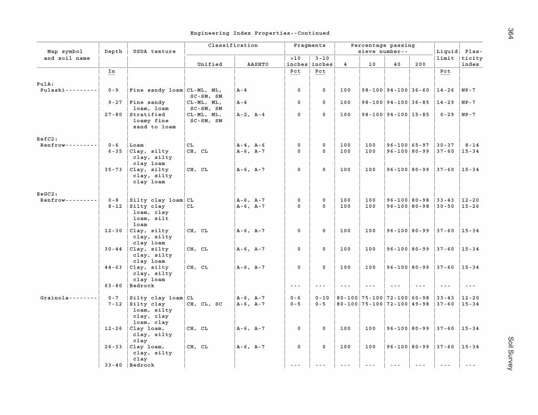
364S
oil Survey
Engineering Index Properties--Continued_____________________________________________________________________________________________________________________________ | | | Classification | Fragments | Percentage passing | | Map symbol | Depth | USDA texture | | | sieve number-- |Liquid| Plas- _____________________________________________________________________ and soil name | | | | | >10 | 3-10 | | | | |limit |ticity | | | Unified | AASHTO |inches|inches| 4 | 10 | 40 | 200 | |index_____________________________________________________________________________________________________________________________ | In | | | | Pct | Pct | | | | | Pct | __ ___ ___ ___ | | | | | | | | | | | |PulA: | | | | | | | | | | | | Pulaski---------| 0-9 |Fine sandy loam|CL-ML, ML, |A-4 | 0 | 0 | 100 |98-100|94-100|36-60 |14-26 |NP-7 | | | SC-SM, SM | | | | | | | | | | 9-27 |Fine sandy |CL-ML, ML, |A-4 | 0 | 0 | 100 |98-100|94-100|36-85 |14-29 |NP-7 | | loam, loam | SC-SM, SM | | | | | | | | | | 27-80 |Stratified |CL-ML, ML, |A-2, A-4 | 0 | 0 | 100 |98-100|94-100|15-85 | 0-29 |NP-7 | | loamy fine | SC-SM, SM | | | | | | | | | | | sand to loam | | | | | | | | | | | | | | | | | | | | | |RefC2: | | | | | | | | | | | | Renfrow---------| 0-6 |Loam |CL |A-4, A-6 | 0 | 0 | 100 | 100 |96-100|65-97 |30-37 | 8-14 | 6-35 |Clay, silty |CH, CL |A-6, A-7 | 0 | 0 | 100 | 100 |96-100|80-99 |37-60 |15-34 | | clay, silty | | | | | | | | | | | | clay loam | | | | | | | | | | | 35-73 |Clay, silty |CH, CL |A-6, A-7 | 0 | 0 | 100 | 100 |96-100|80-99 |37-60 |15-34 | | clay, silty | | | | | | | | | | | | clay loam | | | | | | | | | | | | | | | | | | | | | |ReGC2: | | | | | | | | | | | | Renfrow---------| 0-8 |Silty clay loam|CL |A-6, A-7 | 0 | 0 | 100 | 100 |96-100|80-98 |33-43 |12-20 | 8-12 |Silty clay |CL |A-6, A-7 | 0 | 0 | 100 | 100 |96-100|80-98 |30-50 |15-26 | | loam, clay | | | | | | | | | | | | loam, silt | | | | | | | | | | | | loam | | | | | | | | | | | 12-30 |Clay, silty |CH, CL |A-6, A-7 | 0 | 0 | 100 | 100 |96-100|80-99 |37-60 |15-34 | | clay, silty | | | | | | | | | | | | clay loam | | | | | | | | | | | 30-44 |Clay, silty |CH, CL |A-6, A-7 | 0 | 0 | 100 | 100 |96-100|80-99 |37-60 |15-34 | | clay, silty | | | | | | | | | | | | clay loam | | | | | | | | | | | 44-63 |Clay, silty |CH, CL |A-6, A-7 | 0 | 0 | 100 | 100 |96-100|80-99 |37-60 |15-34 | | clay, silty | | | | | | | | | | | | clay loam | | | | | | | | | | | 63-80 |Bedrock | | | --- | --- | --- | --- | --- | --- | --- | --- | | | | | | | | | | | | Grainola--------| 0-7 |Silty clay loam|CL |A-6, A-7 | 0-6 | 0-10 |80-100|75-100|72-100|60-98 |33-43 |12-20 | 7-12 |Silty clay |CH, CL, SC |A-6, A-7 | 0-5 | 0-5 |80-100|75-100|72-100|49-98 |37-60 |15-34 | | loam, silty | | | | | | | | | | | | clay, clay | | | | | | | | | | | | loam, clay | | | | | | | | | | | 12-26 |Clay loam, |CH, CL |A-6, A-7 | 0 | 0 | 100 | 100 |96-100|80-99 |37-60 |15-34 | | clay, silty | | | | | | | | | | | | clay | | | | | | | | | | | 26-33 |Clay loam, |CH, CL |A-6, A-7 | 0 | 0 | 100 | 100 |96-100|80-99 |37-60 |15-34 | | clay, silty | | | | | | | | | | | | clay | | | | | | | | | | | 33-40 |Bedrock | | | --- | --- | --- | --- | --- | --- | --- | ---

Noble C
ounty, Oklahom
a365
Engineering Index Properties--Continued_____________________________________________________________________________________________________________________________ | | | Classification | Fragments | Percentage passing | | Map symbol | Depth | USDA texture | | | sieve number-- |Liquid| Plas- _____________________________________________________________________ and soil name | | | | | >10 | 3-10 | | | | |limit |ticity | | | Unified | AASHTO |inches|inches| 4 | 10 | 40 | 200 | |index_____________________________________________________________________________________________________________________________ | In | | | | Pct | Pct | | | | | Pct | __ ___ ___ ___ | | | | | | | | | | | |ReiA: | | | | | | | | | | | | Reinach---------| 0-8 |Very fine sandy|CL-ML, ML |A-4 | 0 | 0 | 100 | 100 |94-100|51-75 |14-28 |NP-7 | | loam | | | | | | | | | | | 8-23 |Very fine sandy|CL-ML, ML |A-4 | 0 | 0 | 100 | 100 |94-100|51-75 |14-28 |NP-7 | | loam | | | | | | | | | | | 23-30 |Very fine sandy|CL-ML, ML |A-4 | 0 | 0 | 100 | 100 |94-100|51-75 |14-28 |NP-7 | | loam | | | | | | | | | | | 30-42 |Loam, very fine|CL, CL-ML, ML|A-4 | 0 | 0 | 100 | 100 |94-100|51-97 |14-31 |NP-10 | | sandy loam, | | | | | | | | | | | | silt loam | | | | | | | | | | | 42-65 |Loam, very fine|CL, CL-ML, ML|A-4 | 0 | 0 | 100 | 100 |94-100|51-97 |14-31 |NP-10 | | sandy loam, | | | | | | | | | | | | silt loam | | | | | | | | | | | 65-82 |Loam, very fine|CL, CL-ML, ML|A-4 | 0 | 0 | 100 | 100 |94-100|51-97 |14-31 |NP-10 | | sandy loam, | | | | | | | | | | | | silt loam | | | | | | | | | | | | | | | | | | | | | |RenB: | | | | | | | | | | | | Renfrow---------| 0-9 |Silt loam |CL |A-4, A-6 | 0 | 0 | 100 | 100 |96-100|65-97 |30-37 | 8-14 | 9-13 |Silty clay |CL |A-6, A-7 | 0 | 0 | 100 | 100 |96-100|80-98 |30-50 |15-26 | | loam, clay | | | | | | | | | | | | loam, silt | | | | | | | | | | | | loam | | | | | | | | | | | 13-23 |Clay, silty |CH, CL |A-6, A-7 | 0 | 0 | 100 | 100 |96-100|80-99 |37-60 |15-34 | | clay, silty | | | | | | | | | | | | clay loam | | | | | | | | | | | 23-42 |Clay, silty |CH, CL |A-6, A-7 | 0 | 0 | 100 | 100 |96-100|80-99 |37-60 |15-34 | | clay, silty | | | | | | | | | | | | clay loam | | | | | | | | | | | 42-60 |Clay, silty |CH, CL |A-6, A-7 | 0 | 0 | 100 | 100 |96-100|80-99 |37-60 |15-34 | | clay, silty | | | | | | | | | | | | clay loam | | | | | | | | | | | 60-80 |Clay, silty |CH, CL |A-6, A-7 | 0 | 0 | 100 | 100 |96-100|80-99 |37-60 |15-34 | | clay, silty | | | | | | | | | | | | clay loam | | | | | | | | | | | | | | | | | | | | | |

366S
oil Survey
Engineering Index Properties--Continued_____________________________________________________________________________________________________________________________ | | | Classification | Fragments | Percentage passing | | Map symbol | Depth | USDA texture | | | sieve number-- |Liquid| Plas- _____________________________________________________________________ and soil name | | | | | >10 | 3-10 | | | | |limit |ticity | | | Unified | AASHTO |inches|inches| 4 | 10 | 40 | 200 | |index_____________________________________________________________________________________________________________________________ | In | | | | Pct | Pct | | | | | Pct | __ ___ ___ ___ | | | | | | | | | | | |RenC: | | | | | | | | | | | | Renfrow---------| 0-10 |Silt loam |CL |A-4, A-6 | 0 | 0 | 100 | 100 |96-100|65-97 |30-37 | 8-14 | 10-13 |Silty clay |CL |A-6, A-7 | 0 | 0 | 100 | 100 |96-100|80-98 |30-50 |15-26 | | loam, clay | | | | | | | | | | | | loam, silt | | | | | | | | | | | | loam | | | | | | | | | | | 13-28 |Clay, silty |CH, CL |A-6, A-7 | 0 | 0 | 100 | 100 |96-100|80-99 |37-60 |15-34 | | clay, silty | | | | | | | | | | | | clay loam | | | | | | | | | | | 28-36 |Clay, silty |CH, CL |A-6, A-7 | 0 | 0 | 100 | 100 |96-100|80-99 |37-60 |15-34 | | clay, silty | | | | | | | | | | | | clay loam | | | | | | | | | | | 36-50 |Clay, silty |CH, CL |A-6, A-7 | 0 | 0 | 100 | 100 |96-100|80-99 |37-60 |15-34 | | clay, silty | | | | | | | | | | | | clay loam | | | | | | | | | | | 50-65 |Clay, silty |CH, CL |A-6, A-7 | 0 | 0 | 100 | 100 |96-100|80-99 |37-60 |15-34 | | clay, silty | | | | | | | | | | | | clay loam | | | | | | | | | | | 65-80 |Clay, silty |CH, CL |A-6, A-7 | 0 | 0 | 100 | 100 |96-100|80-99 |37-60 |15-34 | | clay, silty | | | | | | | | | | | | clay loam | | | | | | | | | | | | | | | | | | | | | |RewC2: | | | | | | | | | | | | Renfrow---------| 0-10 |Silty clay loam|CL |A-6, A-7 | 0 | 0 | 100 | 100 |96-100|80-98 |33-43 |12-20 | 10-24 |Clay, silty |CH, CL |A-6, A-7 | 0 | 0 | 100 | 100 |96-100|80-99 |37-60 |15-34 | | clay, silty | | | | | | | | | | | | clay loam | | | | | | | | | | | 24-37 |Clay, silty |CH, CL |A-6, A-7 | 0 | 0 | 100 | 100 |96-100|80-99 |37-60 |15-34 | | clay, silty | | | | | | | | | | | | clay loam | | | | | | | | | | | 37-54 |Clay, silty |CH, CL |A-6, A-7 | 0 | 0 | 100 | 100 |96-100|80-99 |37-60 |15-34 | | clay, silty | | | | | | | | | | | | clay loam | | | | | | | | | | | 54-63 |Clay, silty |CH, CL |A-6, A-7 | 0 | 0 | 100 | 100 |96-100|80-99 |37-60 |15-34 | | clay, silty | | | | | | | | | | | | clay loam | | | | | | | | | | | 63-80 |Bedrock | | | --- | --- | --- | --- | --- | --- | --- | --- | | | | | | | | | | | |

Noble C
ounty, Oklahom
a367
Engineering Index Properties--Continued_____________________________________________________________________________________________________________________________ | | | Classification | Fragments | Percentage passing | | Map symbol | Depth | USDA texture | | | sieve number-- |Liquid| Plas- _____________________________________________________________________ and soil name | | | | | >10 | 3-10 | | | | |limit |ticity | | | Unified | AASHTO |inches|inches| 4 | 10 | 40 | 200 | |index_____________________________________________________________________________________________________________________________ | In | | | | Pct | Pct | | | | | Pct | __ ___ ___ ___ | | | | | | | | | | | |RGPD3: | | | | | | | | | | | | Renfrow---------| 0-10 |Clay loam |CL |A-6, A-7 | 0 | 0 | 100 | 100 |96-100|80-98 |33-43 |12-20 | 10-24 |Clay, silty |CH, CL |A-6, A-7 | 0 | 0 | 100 | 100 |96-100|80-99 |37-60 |15-34 | | clay, silty | | | | | | | | | | | | clay loam | | | | | | | | | | | 24-44 |Clay, silty |CH, CL |A-6, A-7 | 0 | 0 | 100 | 100 |96-100|80-99 |37-60 |15-34 | | clay, silty | | | | | | | | | | | | clay loam | | | | | | | | | | | 44-80 |Clay, silty |CH, CL |A-6, A-7 | 0 | 0 | 100 | 100 |96-100|80-99 |37-60 |15-34 | | clay, silty | | | | | | | | | | | | clay loam | | | | | | | | | | | | | | | | | | | | | | Grainola--------| 0-5 |Silty clay loam|CL |A-6, A-7 | 0-6 | 0-10 |80-100|75-100|72-100|60-98 |33-43 |12-20 | 5-21 |Clay loam, |CH, CL |A-6, A-7 | 0 | 0 | 100 | 100 |96-100|80-99 |37-60 |15-34 | | clay, silty | | | | | | | | | | | | clay | | | | | | | | | | | 21-24 |Bedrock | | | --- | --- | --- | --- | --- | --- | --- | --- | | | | | | | | | | | | Pawhuska--------| 0-3 |Silt loam |CL-ML, ML |A-4 | 0 | 0 | 100 | 100 |96-100|80-97 |22-30 | 2-7 | 3-13 |Silty clay |CH, CL |A-7 | 0 | 0 |90-100|90-100|85-100|85-99 |41-70 |20-40 | | loam, silty | | | | | | | | | | | | clay, clay | | | | | | | | | | | 13-42 |Silty clay |CH, CL |A-7 | 0 | 0 |90-100|90-100|85-100|85-99 |41-70 |20-40 | | loam, silty | | | | | | | | | | | | clay, clay | | | | | | | | | | | 42-80 |Silty clay |CH, CL |A-7 | 0 | 0 |90-100|90-100|85-100|85-99 |41-70 |20-40 | | loam, silty | | | | | | | | | | | | clay, clay | | | | | | | | | | | | | | | | | | | | | |SlaB: | | | | | | | | | | | | Slaughterville--| 0-10 |Fine sandy loam|CL-ML, ML, |A-4 | 0 | 0 | 100 |98-100|94-100|36-60 |15-26 |NP-7 | | | SC-SM, SM | | | | | | | | | | 10-39 |Fine sandy loam|CL-ML, ML, |A-4 | 0 | 0 | 100 |98-100|94-100|36-60 |15-26 |NP-7 | | | SC-SM, SM | | | | | | | | | | 39-50 |Fine sandy loam|CL-ML, ML, |A-4 | 0 | 0 | 100 |98-100|94-100|36-60 |15-26 |NP-7 | | | SC-SM, SM | | | | | | | | | | 50-80 |Sandy clay |CL-ML, ML, |A-4 | 0 | 0 | 100 |98-100|94-100|36-60 |15-26 |NP-7 | | loam, fine | SC-SM, SM | | | | | | | | | | | sandy loam | | | | | | | | | | | | | | | | | | | | | |

368S
oil Survey
Engineering Index Properties--Continued_____________________________________________________________________________________________________________________________ | | | Classification | Fragments | Percentage passing | | Map symbol | Depth | USDA texture | | | sieve number-- |Liquid| Plas- _____________________________________________________________________ and soil name | | | | | >10 | 3-10 | | | | |limit |ticity | | | Unified | AASHTO |inches|inches| 4 | 10 | 40 | 200 | |index_____________________________________________________________________________________________________________________________ | In | | | | Pct | Pct | | | | | Pct | __ ___ ___ ___ | | | | | | | | | | | |SlaC: | | | | | | | | | | | | Slaughterville--| 0-13 |Fine sandy loam|SC-SM, SM, |A-4 | 0 | 0 | 100 |98-100|94-100|36-60 |15-26 |NP-7 | | | CL-ML, ML | | | | | | | | | | 13-19 |Fine sandy loam|CL-ML, ML, |A-4 | 0 | 0 | 100 |98-100|94-100|36-60 |15-26 |NP-7 | | | SC-SM, SM | | | | | | | | | | 19-30 |Fine sandy loam|CL-ML, ML, |A-4 | 0 | 0 | 100 |98-100|94-100|36-60 |15-26 |NP-7 | | | SC-SM, SM | | | | | | | | | | 30-50 |Fine sandy loam|CL-ML, ML, |A-4 | 0 | 0 | 100 |98-100|94-100|36-60 |15-26 |NP-7 | | | SC-SM, SM | | | | | | | | | | 50-80 |Fine sandy |CL-ML, ML, |A-2, A-4 | 0 | 0 | 100 |98-100|90-100|15-60 |15-26 |NP-7 | | loam, loamy | SC-SM, SM | | | | | | | | | | | fine sand | | | | | | | | | | | | | | | | | | | | | |SlaG: | | | | | | | | | | | | Slaughterville--| 0-16 |Fine sandy loam|CL-ML, ML, |A-4 | 0 | 0 | 100 |98-100|94-100|36-60 |15-26 |NP-7 | | | SC-SM, SM | | | | | | | | | | 16-33 |Fine sandy loam|CL-ML, ML, |A-4 | 0 | 0 | 100 |98-100|94-100|36-60 |15-26 |NP-7 | | | SC-SM, SM | | | | | | | | | | 33-80 |Fine sandy |CL-ML, ML, |A-2, A-4 | 0 | 0 | 100 |98-100|90-100|15-60 |15-26 |NP-7 | | loam, loamy | SC-SM, SM | | | | | | | | | | | fine sand | | | | | | | | | | | | | | | | | | | | | |StDD: | | | | | | | | | | | | Stephenville----| 0-5 |Fine sandy loam|CL-ML, ML, |A-2, A-4 | 0 | 0-15 |83-100|83-100|80-100|11-60 |14-26 |NP-7 | | | SC-SM, SM | | | | | | | | | | 5-9 |Fine sandy |CL-ML, ML, |A-2, A-4 | 0 | 0-15 |85-100|85-100|76-100|12-60 | 0-26 |NP-7 | | loam, loamy | SC-SM, SM | | | | | | | | | | | fine sand | | | | | | | | | | | 9-30 |Fine sandy |CL, CL-ML, |A-4, A-6 | 0 | 0 | 100 |98-100|90-100|36-65 |20-37 | 7-16 | | loam, sandy | SC, SC-SM | | | | | | | | | | | clay loam | | | | | | | | | | | 30-36 |Fine sandy |CL, CL-ML, |A-4, A-6 | 0 | 0 | 100 |98-100|90-100|36-65 |20-37 | 7-16 | | loam, sandy | SC, SC-SM | | | | | | | | | | | clay loam | | | | | | | | | | | 36-40 |Bedrock | | | --- | --- | --- | --- | --- | --- | --- | --- | | | | | | | | | | | | Darnell---------| 0-4 |Fine sandy loam|CL-ML, ML, |A-2, A-4 | 0 | 0-15 |90-100|88-100|83-100|30-60 | 0-26 |NP-7 | | | SC-SM, SM | | | | | | | | | | 4-12 |Fine sandy |CL, ML, SC, |A-2, A-4 | 0 | 0-10 |70-100|70-100|60-100|25-60 |15-30 |NP-10 | | loam, loam, | SM | | | | | | | | | | | gravelly fine | | | | | | | | | | | | sandy loam | | | | | | | | | | | 12-15 |Bedrock | | | --- | --- | --- | --- | --- | --- | --- | --- | | | | | | | | | | | |

Noble C
ounty, Oklahom
a369
Engineering Index Properties--Continued_____________________________________________________________________________________________________________________________ | | | Classification | Fragments | Percentage passing | | Map symbol | Depth | USDA texture | | | sieve number-- |Liquid| Plas- _____________________________________________________________________ and soil name | | | | | >10 | 3-10 | | | | |limit |ticity | | | Unified | AASHTO |inches|inches| 4 | 10 | 40 | 200 | |index_____________________________________________________________________________________________________________________________ | In | | | | Pct | Pct | | | | | Pct | __ ___ ___ ___ | | | | | | | | | | | |TabA: | | | | | | | | | | | | Tabler----------| 0-10 |Silt loam |CL, CL-ML, ML|A-4, A-6 | 0 | 0 | 100 | 100 |96-100|80-97 |22-37 | 2-13 | 10-25 |Silty clay, |CH, CL |A-7 | 0 | 0 | 100 | 100 |96-100|90-99 |41-65 |18-35 | | clay | | | | | | | | | | | 25-43 |Silty clay, |CH, CL |A-7 | 0 | 0 | 100 | 100 |96-100|90-99 |41-65 |18-35 | | clay | | | | | | | | | | | 43-65 |Silty clay, |CH, CL |A-6, A-7 | 0 | 0 | 100 | 100 |96-100|80-99 |38-60 |15-35 | | clay, silty | | | | | | | | | | | | clay loam | | | | | | | | | | | 65-80 |Silty clay, |CH, CL |A-6, A-7 | 0 | 0 | 100 | 100 |96-100|80-99 |38-60 |15-35 | | clay, silty | | | | | | | | | | | | clay loam | | | | | | | | | | | | | | | | | | | | | |TeaA: | | | | | | | | | | | | Tearney---------| 0-10 |Silty clay |CH, CL |A-7 | 0 | 0 | 100 | 100 |96-100|90-99 |41-60 |18-34 | 10-26 |Silty clay |CH, CL |A-6, A-7 | 0 | 0 | 100 | 100 |98-100|90-99 |37-60 |15-34 | | loam, clay, | | | | | | | | | | | | silty clay | | | | | | | | | | | 26-30 |Loamy fine |SM, SP-SM |A-2, A-3 | 0 | 0 | 100 |98-100|82-100| 3-35 | 0-0 | NP | | sand, sand, | | | | | | | | | | | | fine sand | | | | | | | | | | | 30-80 |Sand, loamy |SM, SP-SM |A-2, A-3 | 0 | 0 | 100 |98-100|82-100| 3-35 | 0-0 | NP | | fine sand, | | | | | | | | | | | | fine sand | | | | | | | | | | | | | | | | | | | | | |TelB: | | | | | | | | | | | | Teller----------| 0-8 |Loam |CL, CL-ML |A-4, A-6 | 0 | 0 | 100 | 100 |96-100|65-97 |22-35 | 7-13 | 8-12 |Loam |CL, CL-ML |A-4, A-6 | 0 | 0 | 100 | 100 |96-100|65-97 |22-35 | 7-13 | 12-20 |Sandy clay |CL, SC |A-4, A-6 | 0 | 0 | 100 | 100 |90-100|36-85 |25-40 | 7-18 | | loam, clay | | | | | | | | | | | | loam | | | | | | | | | | | 20-30 |Sandy clay |CL, SC |A-4, A-6 | 0 | 0 | 100 | 100 |90-100|36-85 |25-40 | 7-18 | | loam, clay | | | | | | | | | | | | loam | | | | | | | | | | | 30-50 |Sandy clay |CL, SC |A-4, A-6 | 0 | 0 | 100 | 100 |90-100|36-85 |25-40 | 7-18 | | loam, clay | | | | | | | | | | | | loam | | | | | | | | | | | 50-80 |Fine sandy |CL, ML, SC, |A-4, A-6 | 0 | 0 | 100 |98-100|94-100|36-85 |14-35 |NP-13 | | loam, very | SM | | | | | | | | | | | fine sandy | | | | | | | | | | | | loam, loam | | | | | | | | | | | | | | | | | | | | | |

370S
oil Survey
Engineering Index Properties--Continued_____________________________________________________________________________________________________________________________ | | | Classification | Fragments | Percentage passing | | Map symbol | Depth | USDA texture | | | sieve number-- |Liquid| Plas- _____________________________________________________________________ and soil name | | | | | >10 | 3-10 | | | | |limit |ticity | | | Unified | AASHTO |inches|inches| 4 | 10 | 40 | 200 | |index_____________________________________________________________________________________________________________________________ | In | | | | Pct | Pct | | | | | Pct | __ ___ ___ ___ | | | | | | | | | | | |TelD: | | | | | | | | | | | | Teller----------| 0-12 |Loam |CL, CL-ML |A-4, A-6 | 0 | 0 | 100 | 100 |96-100|65-97 |22-35 | 7-13 | 12-17 |Loam |CL, CL-ML |A-4, A-6 | 0 | 0 | 100 | 100 |96-100|65-97 |22-35 | 7-13 | 17-27 |Sandy clay |CL, SC |A-4, A-6 | 0 | 0 | 100 | 100 |90-100|36-85 |25-40 | 7-18 | | loam, clay | | | | | | | | | | | | loam | | | | | | | | | | | 27-45 |Sandy clay |CL, SC |A-4, A-6 | 0 | 0 | 100 | 100 |90-100|36-85 |25-40 | 7-18 | | loam, clay | | | | | | | | | | | | loam | | | | | | | | | | | 45-58 |Sandy clay |CL, SC |A-4, A-6 | 0 | 0 | 100 | 100 |90-100|36-85 |25-40 | 7-18 | | loam, clay | | | | | | | | | | | | loam | | | | | | | | | | | 58-80 |Fine sandy |CL, ML, SC, |A-4, A-6 | 0 | 0 | 100 |98-100|94-100|36-85 |14-35 |NP-13 | | loam, very | SM | | | | | | | | | | | fine sandy | | | | | | | | | | | | loam, loam | | | | | | | | | | | | | | | | | | | | | |TelD2: | | | | | | | | | | | | Teller----------| 0-6 |Loam |CL, CL-ML |A-4, A-6 | 0 | 0 | 100 | 100 |96-100|65-97 |22-35 | 7-13 | 6-11 |Loam |CL, CL-ML |A-4, A-6 | 0 | 0 | 100 | 100 |96-100|65-97 |22-35 | 7-13 | 11-16 |Sandy clay |CL, SC |A-4, A-6 | 0 | 0 | 100 | 100 |90-100|36-85 |25-40 | 7-18 | | loam, clay | | | | | | | | | | | | loam | | | | | | | | | | | 16-31 |Sandy clay |CL, SC |A-4, A-6 | 0 | 0 | 100 | 100 |90-100|36-85 |25-40 | 7-18 | | loam, clay | | | | | | | | | | | | loam | | | | | | | | | | | 31-42 |Sandy clay |CL, SC |A-4, A-6 | 0 | 0 | 100 | 100 |90-100|36-85 |25-40 | 7-18 | | loam, clay | | | | | | | | | | | | loam | | | | | | | | | | | 42-72 |Fine sandy |CL, ML, SC, |A-4, A-6 | 0 | 0 | 100 |98-100|94-100|36-85 |14-35 |NP-13 | | loam, very | SM | | | | | | | | | | | fine sandy | | | | | | | | | | | | loam, loam | | | | | | | | | | | 72-85 |Fine sandy |CL, ML, SC, |A-4, A-6 | 0 | 0 | 100 |98-100|94-100|36-85 |14-35 |NP-13 | | loam, very | SM | | | | | | | | | | | fine sandy | | | | | | | | | | | | loam, loam | | | | | | | | | | | | | | | | | | | | | |

Noble C
ounty, Oklahom
a371
Engineering Index Properties--Continued_____________________________________________________________________________________________________________________________ | | | Classification | Fragments | Percentage passing | | Map symbol | Depth | USDA texture | | | sieve number-- |Liquid| Plas- _____________________________________________________________________ and soil name | | | | | >10 | 3-10 | | | | |limit |ticity | | | Unified | AASHTO |inches|inches| 4 | 10 | 40 | 200 | |index_____________________________________________________________________________________________________________________________ | In | | | | Pct | Pct | | | | | Pct | __ ___ ___ ___ | | | | | | | | | | | |VanA: | | | | | | | | | | | | Vanoss----------| 0-10 |Silt loam |CL, CL-ML, ML|A-4, A-6 | 0 | 0 | 100 | 100 |96-100|65-95 |22-35 | 2-14 | 10-15 |Loam, silt |CL |A-4, A-6, A-7| 0 | 0 | 100 | 100 |96-100|65-98 |30-43 | 8-20 | | loam, clay | | | | | | | | | | | | loam | | | | | | | | | | | 15-30 |Clay loam, |CL |A-6, A-7 | 0 | 0 | 100 | 100 |96-100|80-98 |33-43 |12-20 | | silty clay | | | | | | | | | | | | loam | | | | | | | | | | | 30-42 |Clay loam, |CL |A-6, A-7 | 0 | 0 | 100 | 100 |96-100|80-98 |33-43 |12-20 | | silty clay | | | | | | | | | | | | loam | | | | | | | | | | | 42-52 |Clay loam, |CL |A-6, A-7 | 0 | 0 | 100 | 100 |96-100|80-98 |33-43 |12-20 | | silty clay | | | | | | | | | | | | loam | | | | | | | | | | | 52-80 |Silty clay |CL |A-4, A-6, A-7| 0 | 0 | 100 | 100 |96-100|65-98 |30-43 | 8-20 | | loam, loam, | | | | | | | | | | | | silt loam, | | | | | | | | | | | | clay loam | | | | | | | | | | | | | | | | | | | | | |W. | | | | | | | | | | | | Water | | | | | | | | | | | | | | | | | | | | | | | |WauA: | | | | | | | | | | | | Waurika---------| 0-9 |Silt loam |CL |A-4, A-6 | 0 | 0 | 100 | 100 |96-100|80-97 |30-37 | 9-14 | 9-12 |Silt loam, loam|ML, CL, CL-ML|A-4, A-6 | 0 | 0 | 100 | 100 |96-100|60-95 |22-35 | 2-14 | 12-31 |Clay, silty |CH, CL |A-7 | 0 | 0 |95-100|95-100|90-100|80-98 |41-66 |20-40 | | clay | | | | | | | | | | | 31-39 |Silty clay |CH, CL |A-6, A-7 | 0 | 0 |90-100|90-100|85-100|80-98 |38-55 |16-30 | | loam, clay | | | | | | | | | | | | loam, clay | | | | | | | | | | | 39-61 |Silty clay |CH, CL |A-6, A-7 | 0 | 0 |90-100|90-100|85-100|80-98 |38-55 |16-30 | | loam, clay | | | | | | | | | | | | loam, clay | | | | | | | | | | | 61-80 |Clay loam, |CL |A-6, A-7 | 0 | 0 |90-100|90-100|80-100|70-98 |33-43 |12-20 | | silty clay | | | | | | | | | | | | loam | | | | | | | | | | | | | | | | | | | | | |

372S
oil Survey
Engineering Index Properties--Continued_____________________________________________________________________________________________________________________________ | | | Classification | Fragments | Percentage passing | | Map symbol | Depth | USDA texture | | | sieve number-- |Liquid| Plas- _____________________________________________________________________ and soil name | | | | | >10 | 3-10 | | | | |limit |ticity | | | Unified | AASHTO |inches|inches| 4 | 10 | 40 | 200 | |index_____________________________________________________________________________________________________________________________ | In | | | | Pct | Pct | | | | | Pct | __ ___ ___ ___ | | | | | | | | | | | |WesB: | | | | | | | | | | | | Westsum---------| 0-10 |Silty clay loam|CL |A-6, A-7 | 0 | 0 | 100 | 100 |98-100|90-98 |33-42 |12-19 | 10-16 |Silty clay |CH, CL |A-6, A-7 | 0 | 0 | 100 | 100 |98-100|90-99 |33-60 |12-34 | | loam, silty | | | | | | | | | | | | clay | | | | | | | | | | | 16-30 |Silty clay |CH, CL |A-6, A-7 | 0 | 0 | 100 | 100 |98-100|90-99 |37-60 |26-45 | | loam, silty | | | | | | | | | | | | clay | | | | | | | | | | | 30-36 |Silty clay |CH, CL |A-6, A-7 | 0 | 0 | 100 | 100 |98-100|90-99 |37-60 |26-45 | | loam, silty | | | | | | | | | | | | clay | | | | | | | | | | | 36-52 |Silty clay |CH, CL |A-7 | 0 | 0 | 100 | 100 |98-100|93-99 |41-60 |26-45 | 52-65 |Silty clay |CH, CL |A-7 | 0 | 0 | 100 | 100 |98-100|93-99 |41-60 |26-45 | 65-80 |Silty clay, |CH, CL |A-6, A-7 | 0 | 0 | 100 | 100 |96-100|80-99 |37-60 |26-45 | | clay loam | | | | | | | | | | | | | | | | | | | | | |WesC: | | | | | | | | | | | | Westsum---------| 0-6 |Silty clay loam|CL |A-6, A-7 | 0 | 0 | 100 | 100 |98-100|90-98 |33-42 |12-19 | 6-10 |Silty clay loam|CL |A-6, A-7 | 0 | 0 | 100 | 100 |98-100|90-98 |33-42 |12-19 | 10-17 |Silty clay |CH, CL |A-6, A-7 | 0 | 0 | 100 | 100 |98-100|90-99 |37-60 |26-45 | | loam, silty | | | | | | | | | | | | clay | | | | | | | | | | | 17-31 |Silty clay |CH, CL |A-6, A-7 | 0 | 0 | 100 | 100 |98-100|90-99 |37-60 |26-45 | | loam, silty | | | | | | | | | | | | clay | | | | | | | | | | | 31-59 |Silty clay |CH, CL |A-6, A-7 | 0 | 0 | 100 | 100 |98-100|90-99 |37-60 |26-45 | | loam, silty | | | | | | | | | | | | clay | | | | | | | | | | | 59-75 |Silty clay, |CH, CL |A-6, A-7 | 0 | 0 | 100 | 100 |96-100|80-99 |37-60 |26-45 | | clay loam | | | | | | | | | | | 75-80 |Silty clay, |CH, CL |A-6, A-7 | 0 | 0 | 100 | 100 |96-100|80-99 |37-60 |26-45 | | clay loam | | | | | | | | | | | | | | | | | | | | | |

Noble C
ounty, Oklahom
a373
Engineering Index Properties--Continued_____________________________________________________________________________________________________________________________ | | | Classification | Fragments | Percentage passing | | Map symbol | Depth | USDA texture | | | sieve number-- |Liquid| Plas- _____________________________________________________________________ and soil name | | | | | >10 | 3-10 | | | | |limit |ticity | | | Unified | AASHTO |inches|inches| 4 | 10 | 40 | 200 | |index_____________________________________________________________________________________________________________________________ | In | | | | Pct | Pct | | | | | Pct | __ ___ ___ ___ | | | | | | | | | | | |WiLC: | | | | | | | | | | | | Wisby-----------| 0-6 |Sandy loam |ML, SM |A-2, A-4 | 0 | 0 |85-100|75-100|71-100|27-60 | 0-25 |NP-4 | 6-10 |Sandy loam, |CL-ML, ML, |A-2, A-4 | 0 | 0 |85-100|75-100|71-100|27-60 | 0-29 |NP-7 | | loam | SC-SM, SM | | | | | | | | | | 10-17 |Sandy loam, |CL-ML, ML, |A-2, A-4 | 0 | 0 |85-100|75-100|71-100|27-60 | 0-29 |NP-7 | | loam | SC-SM, SM | | | | | | | | | | 17-32 |Coarse sandy |CL-ML, ML, |A-2, A-4 | 0 | 0 |85-100|75-100|71-100|27-60 | 0-29 |NP-7 | | loam, sandy | SC-SM, SM | | | | | | | | | | | loam, loam | | | | | | | | | | | 32-36 |Loamy coarse |SM, SP-SM |A-1, A-2, A-3| 0 | 0 |85-100|40-100|37-100| 7-35 | 0-14 | NP | | sand, loamy | | | | | | | | | | | | sand, gravelly| | | | | | | | | | | | sand, sand | | | | | | | | | | | 36-80 |Loamy coarse |SM, SP-SM |A-1, A-2, A-3| 0 | 0 |85-100|40-100|37-100| 7-35 | 0-14 | NP | | sand, loamy | | | | | | | | | | | | sand, gravelly| | | | | | | | | | | | sand, sand | | | | | | | | | | | | | | | | | | | | | | Lovedale--------| 0-6 |Sandy loam |CL-ML, ML, |A-2, A-4 | 0 | 0 |95-100|95-100|85-100|34-60 |14-26 |NP-7 | | | SC-SM, SM | | | | | | | | | | 6-10 |Sandy clay |CL, SC |A-6, A-2, A-4| 0 | 0 |95-100|85-100|80-100|30-65 |25-37 | 7-16 | | loam, sandy | | | | | | | | | | | | loam, fine | | | | | | | | | | | | sandy loam | | | | | | | | | | | 10-15 |Sandy clay |CL, SC |A-6, A-2, A-4| 0 | 0 |95-100|85-100|80-100|30-65 |25-37 | 7-16 | | loam, sandy | | | | | | | | | | | | loam, fine | | | | | | | | | | | | sandy loam | | | | | | | | | | | 15-33 |Sandy clay |CL, SC |A-6, A-2, A-4| 0 | 0 |95-100|85-100|80-100|30-65 |25-37 | 7-16 | | loam, sandy | | | | | | | | | | | | loam, fine | | | | | | | | | | | | sandy loam | | | | | | | | | | | 33-46 |Loam, sandy |CL, ML, SC, |A-2, A-4, A-6| 0 | 0 |95-100|85-100|80-100|30-65 |14-37 |NP-16 | | clay loam, | SM | | | | | | | | | | | sandy loam, | | | | | | | | | | | | fine sandy | | | | | | | | | | | | loam | | | | | | | | | | | 46-61 |Sandy clay |CL, ML, SC, |A-2, A-4, A-6| 0 | 0 |95-100|85-100|80-100|30-65 |14-37 |NP-16 | | loam, sandy | SM | | | | | | | | | | | loam, fine | | | | | | | | | | | | sandy loam | | | | | | | | | | | 61-80 |Coarse sandy |SC-SM, SM, |A-2, A-4 | 0 | 0 |80-100|70-100|60-75 |11-45 | 0-26 |NP-7 | | loam, fine | SP-SM | | | | | | | | | | | sandy loam, | | | | | | | | | | | | sand | | | | | | | | | | | | | | | | | | | | | |

374S
oil Survey
Engineering Index Properties--Continued_____________________________________________________________________________________________________________________________ | | | Classification | Fragments | Percentage passing | | Map symbol | Depth | USDA texture | | | sieve number-- |Liquid| Plas- _____________________________________________________________________ and soil name | | | | | >10 | 3-10 | | | | |limit |ticity | | | Unified | AASHTO |inches|inches| 4 | 10 | 40 | 200 | |index_____________________________________________________________________________________________________________________________ | In | | | | Pct | Pct | | | | | Pct | __ ___ ___ ___ | | | | | | | | | | | |ZaHC: | | | | | | | | | | | | Zaneis----------| 0-7 |Loam |CL |A-4, A-6 | 0 | 0 | 100 |98-100|91-100|65-85 |30-35 | 9-13 | 7-10 |Loam, clay |CL, SC |A-4, A-6 | 0 | 0 | 100 | 100 |90-100|36-90 |25-40 | 7-18 | | loam, sandy | | | | | | | | | | | | clay loam | | | | | | | | | | | 10-28 |Clay loam, |CL, SC |A-4, A-6 | 0 | 0 | 100 | 100 |90-100|36-90 |25-40 | 7-18 | | sandy clay | | | | | | | | | | | | loam | | | | | | | | | | | 28-38 |Clay loam, |CL, SC |A-4, A-6 | 0 | 0 | 100 | 100 |90-100|36-90 |25-40 | 7-18 | | sandy clay | | | | | | | | | | | | loam | | | | | | | | | | | 38-46 |Clay loam, |CL, CL-ML, |A-2, A-4, A-6| 0 | 0-10 |90-100|90-100|85-100|30-90 |20-40 | 4-18 | | sandy clay | SC, SC-SM | | | | | | | | | | | loam, fine | | | | | | | | | | | | sandy loam | | | | | | | | | | | 46-50 |Bedrock | | | --- | --- | --- | --- | --- | --- | --- | --- | | | | | | | | | | | | Huska-----------| 0-8 |Loam |CL, CL-ML |A-4, A-6 | 0 | 0 | 100 | 100 |94-100|51-97 |24-37 | 5-14 | 8-20 |Clay, silty |CH, CL |A-6, A-7 | 0 | 0 | 100 | 100 |96-100|80-99 |37-60 |15-34 | | clay loam, | | | | | | | | | | | | silty clay, | | | | | | | | | | | | clay loam | | | | | | | | | | | 20-42 |Silty clay |CH, CL |A-6, A-7 | 0 | 0 | 100 | 100 |96-100|80-99 |37-60 |15-34 | | loam, silty | | | | | | | | | | | | clay, clay | | | | | | | | | | | | loam | | | | | | | | | | | 42-54 |Silty clay |CH, CL |A-6, A-7 | 0 | 0 | 100 | 100 |96-100|80-99 |37-60 |15-34 | | loam, silty | | | | | | | | | | | | clay, clay | | | | | | | | | | | | loam | | | | | | | | | | | 54-60 |Bedrock | | | --- | --- | --- | --- | --- | --- | --- | --- | | | | | | | | | | | |ZanB: | | | | | | | | | | | | Zaneis----------| 0-11 |Loam |CL |A-4, A-6 | 0 | 0 | 100 |98-100|91-100|65-85 |30-35 | 9-13 | 11-15 |Clay loam, loam|CL |A-4, A-6 | 0 | 0 | 100 |98-100|91-100|65-85 |30-35 | 9-13 | 15-30 |Loam, clay |CL, SC |A-4, A-6 | 0 | 0 | 100 | 100 |90-100|36-90 |25-40 | 7-18 | | loam, sandy | | | | | | | | | | | | clay loam | | | | | | | | | | | 30-42 |Clay loam, |CL, SC |A-4, A-6 | 0 | 0 | 100 | 100 |90-100|36-90 |25-40 | 7-18 | | sandy clay | | | | | | | | | | | | loam | | | | | | | | | | | 42-50 |Clay loam, |CL, CL-ML, |A-2, A-4, A-6| 0 | 0-10 |90-100|90-100|85-100|30-90 |20-40 | 4-18 | | sandy clay | SC, SC-SM | | | | | | | | | | | loam, fine | | | | | | | | | | | | sandy loam | | | | | | | | | | | 50-55 |Bedrock | | | --- | --- | --- | --- | --- | --- | --- | --- | | | | | | | | | | | |_____________________________________________________________________________________________________________________________

Noble County, Oklahoma 375
Engineering Index Test DataThe table “Engineering Index Test Data of Selected Soils” shows laboratory test data
for several pedons sampled at carefully selected sites in the survey area. The pedonsare representative of the series and are described in the section “Soil Series and TheirMorphology.” The soil samples were tested by the Oklahoma Department ofTransportation, Materials Division.
The testing methods generally are those of the American Association of StateHighway and Transportation Officials (AASHTO) or the American Society for Testingand Materials (ASTM).
The tests and methods are AASHTO classification—M 145 (AASHTO), D 3282(ASTM); group index number; mechanical analysis—T 88 (AASHTO), D 2217 (ASTM);liquid limit—T 89 (AASHTO), D 423 (ASTM); plasticity index—T 90 (AASHTO), D 424(ASTM), D 1883 (ASTM); shrinkage—T 92 (AASHTO), D 427 (ASTM); and volumechange from field moisture equivalent (F.M.E.).

376S
oil Survey
Engineering Index Test Data of Selected Soils
(All engineering data were provided by the Oklahoma Department of Transportation. LL means liquid limit; PI means plasticity index; F.M.E. means field moisture equivalent)
_______________________________________________________________________________________________________________________________ Soil series, |Horizon|Classification| | | Grain size distribution | Shrinkage |Volume ______________ _________________________________________________________________ sample number*,| depth | |Group | LL | PI | Percentage passing | Percentage | | |change horizon, and | in |AASHTO | index| | | sieve number-- | smaller than |Limit|Ratio| from _____________________________________________________ depth in inches| inches| |number| | | 4 | 10 | 40 | 60 | 200 |0.05mm|0.005mm|0.002mm| | |F.M.E._______________________________________________________________________________________________________________________________ | | | | | | | | | | | | | | | |Bethany: | | | | | | | | | | | | | | | | (S90OK-103-005) | | | | | | | | | | | | | | | | Ap, Ad, A ------| 0-12 | A-6 | 10 | 31 | 11 | 100 | 99 | 99 | 98 | 95 | 88 | 28 | 23 | 17 |1.78 | 19 Bt1, Bt2, Btk1, | | | | | | | | | | | | | | | | Btk2 ----------| 12-47 | A-7-6 | 45 | 60 | 42 | 100 | 99 | 99 | 98 | 97 | 92 | 48 | 42 | 11 |2.06 | 59 | | | | | | | | | | | | | | | |Coyle: | | | | | | | | | | | | | | | | (S90OK-103-002) | | | | | | | | | | | | | | | | A --------------| 0-10 | A-6 | 11 | 34 | 13 | 100 | 100 | 100 | 99 | 85 | 76 | 24 | 20 | 21 |1.69 | 12 Bt1 ------------| 10-17 | A-6 | 11 | 38 | 20 | 100 | 100 | 100 | 100 | 66 | 57 | 32 | 27 | 14 |1.88 | 26 | | | | | | | | | | | | | | | |Grainola: | | | | | | | | | | | | | | | | (S90OK-103-003) | | | | | | | | | | | | | | | | Ap1, Ap2, Ad ---| 0-9 | A-7-6 | 20 | 41 | 23 | 98 | 97 | 96 | 96 | 87 | 80 | 42 | 38 | 11 |2.00 | 38 Btk1, Btk2 -----| 9-25 | A-7-6 | 37 | 59 | 39 | 99 | 98 | 94 | 94 | 88 | 85 | 55 | 48 | 8 |2.12 | 66 | | | | | | | | | | | | | | | |Kirkland: | | | | | | | | | | | | | | | | (S90OK-103-006) | | | | | | | | | | | | | | | | Ap1, Ap2 -------| 0-11 | A-6 | 18 | 36 | 18 | 100 | 100 | 100 | 99 | 97 | 92 | 34 | 29 | 15 |1.8 | 22 Bt1, Bt2, Bt3, | | | | | | | | | | | | | | | | Bt4 -----------| 11-33 | A-7-6 | 42 | 58 | 39 | 100 | 100 | 100 | 99 | 98 | 95 | 48 | 42 | 12 |2.02 | 55 | | | | | | | | | | | | | | | |Lela: | | | | | | | | | | | | | | | | (S90OK-103-007) | | | | | | | | | | | | | | | | Ap1, Ap2 -------| 0-6 | A-7-6 | 31 | 48 | 29 | 100 | 100 | 100 | 100 | 99 | 97 | 53 | 44 | 12 |1.97 | 43 A2, A3, A4 -----| 13-42 | A-7-6 | 59 | 75 | 52 | 100 | 100 | 100 | 100 | 99 | 98 | 57 | 50 | 10 |2.08 | 81 | | | | | | | | | | | | | | | |Norge: | | | | | | | | | | | | | | | | (S90OK-103-008) | | | | | | | | | | | | | | | | Ap1, Ap2 -------| 0-11 | A-6 | 10 | 31 | 11 | 100 | 100 | 100 | 99 | 97 | 90 | 28 | 24 | 18 |1.80 | 13 | | | | | | | | | | | | | | | |Port: | | | | | | | | | | | | | | | | (S90OK-103-004) | | | | | | | | | | | | | | | | Ap1, Ap2, Ad ---| 0-14 | A-6 | 17 | 34 | 18 | 100 | 100 | 100 | 99 | 97 | 92 | 33 | 28 | 14 |1.86 | 23 Bw, Bwk1 -------| 30-48 | A-6 | 12 | 31 | 14 | 100 | 100 | 100 | 100 | 95 | 85 | 28 | 23 | 15 |1.84 | 18 | | | | | | | | | | | | | | | |
See footnote at end of table.

Noble C
ounty, Oklahom
a377
Engineering Index Test Data of Selected Soils--Continued_______________________________________________________________________________________________________________________________ Soil series, |Horizon|Classification| | | Grain size distribution | Shrinkage |Volume ______________ _________________________________________________________________ sample number*,| depth | |Group | LL | PI | Percentage passing | Percentage | | |change horizon, and | in |AASHTO | index| | | sieve number-- | smaller than |Limit|Ratio| from _____________________________________________________ depth in inches| inches| |number| | | 4 | 10 | 40 | 60 | 200 |0.05mm|0.005mm|0.002mm| | |F.M.E._______________________________________________________________________________________________________________________________ | | | | | | | | | | | | | | | |Renfrow: | | | | | | | | | | | | | | | | (S90OK-103-001) | | | | | | | | | | | | | | | | Ap, A ----------| 0-7 | A-6 | 12 | 29 | 12 | 100 | 100 | 100 | 99 | 80 | 73 | 28 | 24 | 14 |1.85 | 19 Bt, Btk1 -------| 11-33 | A-7-6 | 37 | 58 | 42 | 100 | 100 | 100 | 100 | 85 | 81 | 50 | 45 | 9 |2.08 | 59 | | | | | | | | | | | | | | | |_______________________________________________________________________________________________________________________________
* Locations of sampled pedons are as follows:
Bethany silt loam: 1,900 feet north and 800 feet west of the southeastern corner of sec. 17, T. 24 N., R. 1 E.; lat. 36degrees 33 minutes 21 seconds N. and long. 97 degrees 12 minutes 49 seconds W. (The surface layer is more acid than is typicalfor the Bethany series due to cultural practices.) Coyle loam: 1,300 feet north and 700 feet west of the southeastern corner of sec. 36, T. 20 N., R. 1 W.; lat. 36 degrees09 minutes 46 seconds N. and long. 97 degrees 14 minutes 56 seconds W. Dilworth silty clay loam: 1,650 feet east and 700 feet south of the northwestern corner of sec. 33, T. 24 N., R. 1 W.;lat. 36 degrees 31 minutes 10 seconds N. and long. 97 degrees 18 minutes 46 seconds W. Grainola silty clay loam: 1,500 feet north and 150 feet west of the southeastern corner of sec. 4, T. 21 N., R. 1 W.;lat. 36 degrees 09 minutes 46 seconds N. and long. 97 degrees 14 minutes 56 seconds W. (This pedon has a mollic epipedon andis outside the range for the Grainola series. This pedon is in the Piedmont series.) Highview gravelly silty clay: 500 feet east and 2,100 feet south of the northwestern corner of sec. 22, T. 23 N., R. 2 W.;lat. 36 degrees 27 minutes 21 seconds N. and long. 97 degrees 24 minutes 20 seconds W. Kirkland silt loam: 1,750 feet east and 500 feet north of the southwestern corner of sec. 17, T. 24 N., R. 1 E.; lat. 36degrees 33 minutes 08 seconds N. and long. 97 degrees 13 minutes 23 seconds W. (The surface layer is more acid, the chroma ofthe Btk2b is lower than typical, and the Btk3b and Btk4b horizons are yellower than the typical conditions of the series. Theacid surface layer is due to cultural practices.) Lela silty clay: 2,500 feet south and 50 feet west of the northeastern corner of sec. 1, T. 24 N., R. 1 W.; lat. 36degrees 35 minutes 01 second N. and long. 97 degrees 14 minutes 49 seconds W. Lucien very fine sandy loam: 3,000 feet east and 2,450 feet south of the northwestern corner of sec. 2, T. 22 N., R. 1 E.;lat. 36 degrees 24 minutes 48 seconds N. and long. 97 degrees 09 minutes 55 seconds W. Norge silt loam: 2,000 feet south and 1,300 feet west of the northeastern corner of sec. 7, T. 24 N., R. 1 E.; lat. 36degrees 34 minutes 25 seconds N. and long. 97 degrees 14 minutes 01 second W. (The clay percentage in the control section isslightly higher, 0.5-0.8 percent, than what is typical for the series.) Port silt loam: 1,700 east and 100 feet north of the southwestern corner of sec. 27, T. 22 N., R. 1 W.; lat. 36 degrees20 minutes 52 seconds N. and long. 97 degrees 17 minutes 40 seconds W. Renfrow silt loam: 1,000 feet east and 500 feet south of the northwestern corner of sec. 16, T. 21 N., R. 1 W.; lat. 36degrees 18 minutes 09 seconds N. and long. 97 degrees 18 minutes 55 seconds W. (The depth to secondary carbonates is slightlyless, the color of the lower Bt horizon is slightly redder, and the reaction of the surface horizon is more acid than thetypical conditions of the series. The acid surface layer is due to cultural practices.) Westsum silty clay loam: 150 feet west and 650 feet north of the southeastern corner of sec. 8, T. 23 N., R. 1 W.; lat. 36degrees 28 minutes 49 seconds N. and long. 97 degrees 19 minutes 09 seconds W.

378 Soil Survey
Physical PropertiesThe table “Physical Properties of the Soils” shows estimates of some characteristics
and features that affect soil behavior. These estimates are given for the major layers ofeach soil in the survey area. The estimates are based on field observations and on testdata for these and similar soils.
Depth to the upper and lower boundaries of each layer is indicated. The range indepth and information on other properties of each layer are given in the seriesdescriptions section of this survey.
Sand as a soil separate consists of mineral soil particles that are 0.05 millimeter to2 millimeters in diameter. The estimated sand content of each soil layer is given as apercentage, by weight, of the soil material that is less than 2 millimeters in diameter.
Silt as a soil separate consists of mineral soil particles that are 0.002 to 0.05millimeter in diameter. The estimated silt content of each soil layer is given as apercentage, by weight, of the soil material that is less than 2 millimeters in diameter.
Clay as a soil separate, or component, consists of mineral soil particles that areless than 0.002 millimeter in diameter. The estimated clay content of each major soillayer is given as a percentage, by weight, of the soil material that is less than 2millimeters in diameter.
The amount and kind of clay greatly affect the fertility and physical condition of thesoil. They determine the ability of the soil to adsorb cations and to retain moisture. Theyinfluence shrink-swell potential, permeability, plasticity, the ease of soil dispersion, andother soil properties. The amount and kind of clay in a soil also affect tillage and earth-moving operations.
Moist bulk density is the weight of soil (ovendry) per unit volume. Volume ismeasured when the soil is at field moisture capacity, that is, the moisture content at1/3-bar moisture tension. Weight is determined after drying the soil at 105 degrees C. Inthe table “Physical Properties of the Soils,” the estimated moist bulk density of eachmajor soil horizon is expressed in grams per cubic centimeter of soil material that isless than 2 millimeters in diameter. Bulk density data are used to compute shrink-swellpotential, available water capacity, total pore space, and other soil properties. Themoist bulk density of a soil indicates the pore space available for water and roots. Abulk density of more than 1.6 can restrict water storage and root penetration. Moist bulkdensity is influenced by texture, kind of clay, content of organic matter, and soilstructure.
Permeability (Ksat ) refers to the ability of a soil to transmit water or air. The term“permeability,” as used in soil surveys, indicates saturated hydraulic conductivity (K
sat).
The estimates in the table indicate the rate of water movement, in inches per hour,when the soil is saturated. They are based on soil characteristics observed in the field,particularly structure, porosity, and texture. Permeability is considered in the design ofsoil drainage systems and septic tank absorption fields.
Available water capacity refers to the quantity of water that the soil is capable ofstoring for use by plants. The capacity for water storage is given in inches of water perinch of soil for each major soil layer. The capacity varies, depending on soil propertiesthat affect the retention of water and the depth of the root zone. The most importantproperties are the content of organic matter, soil texture, bulk density, and soilstructure. Available water capacity is an important factor in the choice of plants orcrops to be grown and in the design and management of irrigation systems. Availablewater capacity is not an estimate of the quantity of water actually available to plants atany given time.
Linear extensibility refers to the change in length of an unconfined clod as moisturecontent is decreased from a moist to a dry state. It is an expression of the volumechange between the water content of the clod at 1/3- or 1/10-bar tension (33kPa or 10kPatension) and oven dryness. The volume change is reported in the table as percent

Noble County, Oklahoma 379
change for the whole soil. Volume change is influenced by the amount and type of clayminerals in the soil.
Linear extensibility is used to determine the shrink-swell potential of soils. Theshrink-swell potential is low if the soil has a linear extensibility of less than 3 percent;moderate if 3 to 6 percent; high if 6 to 9 percent; and very high if more than 9 percent. Ifthe linear extensibility is more than 3, shrinking and swelling can cause damage tobuildings, roads, and other structures and to plant roots. Special design commonly isneeded.
Organic matter is the plant and animal residue in the soil at various stages ofdecomposition. The estimated content of organic matter is expressed as a percentage,by weight, of the soil material that is less than 2 millimeters in diameter.
The content of organic matter in a soil can be maintained or increased by returningcrop residue to the soil. Organic matter affects the available water capacity, infiltrationrate, and tilth. It is a source of nitrogen and other nutrients for crops.
Erosion factors.—Soil erodibility (K) and soil-loss tolerance (T) factors are used inan equation that predicts the amount of soil lost through water erosion in areas ofcropland. The procedure for predicting soil loss is useful in guiding the selection of soiland water conservation practices.
Erosion factor K factor indicates the susceptibility of a soil to sheet and rill erosionby water. Factor K is one of six factors used in the Universal Soil Loss Equation(USLE) to predict the average rate of soil loss by sheet and rill erosion in tons per acreper year. The soil properties that influence erodibility are those that affect the infiltrationrate, the movement of water through the soil, and the water storage capacity of the soiland those that allow the soil to resist dispersion, splashing, abrasion, and thetransporting forces of rainfall and runoff. The most important soil properties are thecontent of silt plus very fine sand, the content of sand coarser than very fine sand, thecontent of organic matter, soil structure, and permeability. The estimates are modifiedby the presence of rock fragments. Values of K range from 0.02 to 0.64. The higher thevalue, the more susceptible the soil is to sheet and rill erosion.
Erosion factor Kw indicates the erodibility of the whole soil. The estimates aremodified by the presence of rock fragments.
Erosion factor Kf indicates the erodibility of the fine-earth fraction, or the materialless than 2 millimeters in size. This is one of the factors used in the revised UniversalSoil Loss Equation.
Erosion factor T is an estimate of the maximum annual rate of soil erosion by windor water that can occur over a sustained period without affecting crop productivity. Therate is expressed in tons of soil loss per acre per year. Ratings of 1 to 5 are used,depending on soil properties and prior erosion. The criteria used in assigning a T factorto a soil include maintenance of an adequate rooting depth for crop production,potential reduction of crop yields, maintenance of water-control structures affected bysedimentation, prevention of gullying, and the value of nutrients lost through erosion.
Wind erodibility groups.—Wind erodibility is directly related to the percentage of dry,nonerodible surface soil aggregates larger than 0.84 millimeter in diameter. From thispercentage, the wind erodibility index factor (I) is determined. This factor is anexpression of the stability of the soil aggregates, or the extent to which they are brokendown by tillage and the abrasion caused by windblown soil particles. Soils are assignedto wind erodibility groups (WEGs) having similar percentages of dry soil aggregateslarger than 0.84 millimeter.
Wind erodibility groups are made up of soils that have similar properties affectingtheir resistance to soil blowing in cultivated areas. The groups indicate thesusceptibility to soil blowing. Soils are grouped according to the following distinctions:
WEG 1. Very fine sand, fine sand, sand, and coarse sand.WEG 2. Loamy very fine sand, loamy fine sand, loamy sand, loamy coarse sand,
ash, and sapric organic soil material.

380 Soil Survey
WEG 3. Very fine sandy loam, fine sandy loam, sandy loam, and coarse sandyloam.
WEG 4. Clay, silty clay, and noncalcareous clay loam and silty clay loam withmore than 35 percent clay.
WEG 4L. Calcareous loam, silt loam, clay loam, and silty clay loam characterizedby a strongly or violently effervescent reaction to cold dilute (1N) HCl.
WEG 5. Noncalcareous loam and silt loam with less than 20 percent clay andsandy clay loam, sandy clay, and hemic organic soil material.
WEG 6. Noncalcareous loam and silt loam with more than 20 percent clay andnoncalcareous clay loam with less than 35 percent clay.
WEG 7. Silt, noncalcareous silty clay loam with less than 35 percent clay, andfibric organic soil material.
WEG 8. Soils that are not susceptible to soil blowing because of rock fragments onthe surface or because of surface wetness.
Wind erodibility index is a numerical value indicating the susceptibility of soil to soilblowing, or the tons per acre per year that can be expected to be lost to soil blowing.There is a close correlation between soil blowing and the size and durability of surfaceclods, rock fragments, organic matter, and a calcareous reaction. Soil moisture andfrozen soil layers also influence soil blowing.
Additional information about wind erodibility groups and K, Kf, T, and I factors can beobtained from the local office of the Natural Resources Conservation Service or theCooperative Extension Service.

Noble C
ounty, Oklahom
a381
Physical Properties of the Soils
(Entries under "Erosion factors--T" apply to the entire profile. Entries under "Wind erodibility group" and "Wind erodibility index" apply only to the surface layer. Absence of an entry indicates that data were not estimated)
_____________________________________________________________________________________________________________________________ | | | | | | | | | |Erosion factors|Wind |Wind _______________ Map symbol |Depth| Sand | Silt | Clay | Moist | Permea- |Available| Linear | Organic| | | |erodi-|erodi-and soil name | | | | | bulk | bility | water |extensi- | matter | Kw | Kf | T |bility|bility | | | | | density | (Ksat) |capacity | bility | | | | |group |index_____________________________________________________________________________________________________________________________ | In | Pct | Pct | Pct | g/cc | In/hr | In/in | Pct | Pct | | | | | __ ___ ___ ___ ____ _____ _____ ___ ___ | | | | | | | | | | | | | |AhpA: | | | | | | | | | | | | | | Ashport------| 0-10| 0-20 | 40-73 | 27-35 |1.30-1.60| 0.6-2 |0.15-0.22| 3.0-5.9 |1.0-3.0 | .32 | .32 | 5 | 7 | 38 |10-25| 0-53 | 27-82 | 18-35 |1.40-1.70| 0.6-2 |0.15-0.24| 3.0-5.9 |0.5-1.0 | .37 | .37 | | | |25-35| 0-53 | 27-82 | 18-35 |1.40-1.70| 0.6-2 |0.15-0.24| 3.0-5.9 |0.5-1.0 | .37 | .37 | | | |35-42| 5-80 | 5-65 | 5-35 |1.40-1.70| 0.6-2 |0.15-0.24| 3.0-5.9 |0.5-1.0 | .37 | .37 | | | |42-52| 0-53 | 27-82 | 18-35 |1.40-1.70| 0.6-2 |0.15-0.24| 3.0-5.9 |0.5-1.0 | .37 | .37 | | | |52-80| 0-53 | 27-82 | 18-35 |1.40-1.70| 0.6-2 |0.15-0.24| 3.0-5.9 |0.5-1.0 | .37 | .37 | | | | | | | | | | | | | | | | |APPA: | | | | | | | | | | | | | | Ashport------| 0-14| 0-20 | 40-73 | 27-35 |1.30-1.60| 0.6-2 |0.15-0.22| 3.0-5.9 |1.0-3.0 | .32 | .32 | 5 | 7 | 38 |14-27| 0-53 | 27-82 | 18-35 |1.40-1.70| 0.6-2 |0.15-0.24| 3.0-5.9 |0.5-1.0 | .37 | .37 | | | |27-80| 5-80 | 5-65 | 5-35 |1.40-1.70| 0.6-2 |0.15-0.24| 3.0-5.9 |0.5-1.0 | .37 | .37 | | | | | | | | | | | | | | | | | Port---------| 0-7 |43-85 | 0-50 | 10-18 |1.40-1.65| 2-6 |0.13-0.19| 0.0-2.9 |0.5-1.0 | .20 | .20 | 5 | 3 | 86 | 7-27| 0-32 | 50-88 | 12-26 |1.30-1.55| 0.6-2 |0.15-0.24| 0.0-2.9 |1.0-3.0 | .37 | .37 | | | |27-46| 0-45 | 15-82 | 20-35 |1.30-1.60| 0.6-2 |0.15-0.24| 3.0-5.9 |0.0-1.0 | .37 | .37 | | | |46-51| 0-45 | 15-82 | 20-35 |1.30-1.60| 0.6-2 |0.15-0.24| 3.0-5.9 |0.0-1.0 | .37 | .37 | | | |51-80| 0-45 | 15-82 | 20-35 |1.30-1.60| 0.6-2 |0.15-0.24| 3.0-5.9 |0.0-1.0 | .37 | .37 | | | | | | | | | | | | | | | | | Pulaski------| 0-9 |43-85 | 0-50 | 10-18 |1.40-1.65| 2-6 |0.13-0.19| 0.0-2.9 |0.5-1.0 | .20 | .20 | 5 | 3 | 86 | 9-25|32-85 | 0-50 | 10-18 |1.30-1.70| 2-6 |0.13-0.19| 0.0-2.9 |0.0-1.0 | .32 | .32 | | | |25-80|30-90 | 3-50 | 5-18 |1.30-1.70| 2-6 |0.07-0.20| 0.0-2.9 |0.0-1.0 | .32 | .32 | | | | | | | | | | | | | | | | |AspA: | | | | | | | | | | | | | | Ashport------| 0-10| 0-32 | 50-88 | 15-26 |1.30-1.50| 0.6-2 |0.16-0.24| 0.0-2.9 |1.0-3.0 | .37 | .37 | 5 | 6 | 48 |10-32| 0-53 | 27-82 | 18-35 |1.40-1.70| 0.6-2 |0.15-0.24| 3.0-5.9 |0.5-1.0 | .37 | .37 | | | |32-45| 0-53 | 27-82 | 18-35 |1.40-1.70| 0.6-2 |0.15-0.24| 3.0-5.9 |0.5-1.0 | .37 | .37 | | | |45-70| 0-53 | 27-82 | 18-35 |1.40-1.70| 0.6-2 |0.15-0.24| 3.0-5.9 |0.5-1.0 | .37 | .37 | | | |70-80| 0-53 | 27-82 | 18-35 |1.40-1.70| 0.6-2 |0.15-0.24| 3.0-5.9 |0.5-1.0 | .37 | .37 | | | | | | | | | | | | | | | | |AspB: | | | | | | | | | | | | | | Ashport------| 0-10| 0-32 | 50-88 | 15-26 |1.30-1.50| 0.6-2 |0.16-0.24| 0.0-2.9 |1.0-3.0 | .37 | .37 | 5 | 6 | 48 |10-21| 0-53 | 27-82 | 18-35 |1.40-1.70| 0.6-2 |0.15-0.24| 3.0-5.9 |0.5-1.0 | .37 | .37 | | | |21-36| 0-53 | 27-82 | 18-35 |1.40-1.70| 0.6-2 |0.15-0.24| 3.0-5.9 |0.5-1.0 | .37 | .37 | | | |36-65| 0-53 | 27-82 | 18-35 |1.40-1.70| 0.6-2 |0.15-0.24| 3.0-5.9 |0.5-1.0 | .37 | .37 | | | |65-80| 0-53 | 27-82 | 18-35 |1.40-1.70| 0.6-2 |0.15-0.24| 3.0-5.9 |0.5-1.0 | .37 | .37 | | | | | | | | | | | | | | | | |

382S
oil Survey
Physical Properties of the Soils--Continued_____________________________________________________________________________________________________________________________ | | | | | | | | | |Erosion factors|Wind |Wind _______________ Map symbol |Depth| Sand | Silt | Clay | Moist | Permea- |Available| Linear | Organic| | | |erodi-|erodi-and soil name | | | | | bulk | bility | water |extensi- | matter | Kw | Kf | T |bility|bility | | | | | density | (Ksat) |capacity | bility | | | | |group |index_____________________________________________________________________________________________________________________________ | In | Pct | Pct | Pct | g/cc | In/hr | In/in | Pct | Pct | | | | | __ ___ ___ ___ ____ _____ _____ ___ ___ | | | | | | | | | | | | | |BetA: | | | | | | | | | | | | | | Bethany------| 0-9 | 0-35 | 50-88 | 15-26 |1.30-1.50| 0.6-2 |0.16-0.24| 0.0-2.9 |1.0-3.0 | .43 | .43 | 5 | 5 | 56 | 9-12| 0-45 | 15-65 | 27-35 |1.45-1.70| 0.2-0.6 |0.16-0.22| 3.0-5.9 |1.0-3.0 | .37 | .37 | | | |12-30| 0-45 | 5-65 | 35-50 |1.40-1.70| 0.06-0.2 |0.12-0.22| 6.0-8.9 |0.5-2.0 | .37 | .37 | | | |30-47| 0-45 | 5-65 | 35-50 |1.40-1.70| 0.06-0.2 |0.12-0.22| 6.0-8.9 |0.5-2.0 | .37 | .37 | | | |47-71| 0-45 | 5-65 | 35-50 |1.40-1.70| 0.06-0.2 |0.12-0.22| 6.0-8.9 |0.0-2.0 | .37 | .37 | | | |71-80| 0-45 | 5-65 | 35-50 |1.40-1.70| 0.06-0.2 |0.12-0.22| 6.0-8.9 |0.0-2.0 | .37 | .37 | | | | | | | | | | | | | | | | |BetB: | | | | | | | | | | | | | | Bethany------| 0-11| 0-34 | 50-88 | 15-26 |1.30-1.50| 0.6-2 |0.16-0.24| 0.0-2.9 |1.0-3.0 | .43 | .43 | 5 | 5 | 56 |11-16| 0-45 | 15-65 | 27-35 |1.45-1.70| 0.2-0.6 |0.16-0.22| 3.0-5.9 |1.0-3.0 | .37 | .37 | | | |16-36| 0-45 | 5-65 | 35-50 |1.40-1.70| 0.06-0.2 |0.12-0.22| 6.0-8.9 |0.5-2.0 | .37 | .37 | | | |36-60| 0-45 | 5-65 | 35-50 |1.40-1.70| 0.06-0.2 |0.12-0.22| 6.0-8.9 |0.0-1.0 | .37 | .37 | | | |60-80| 0-45 | 5-65 | 35-50 |1.40-1.70| 0.06-0.2 |0.12-0.22| 6.0-8.9 |0.0-1.0 | .37 | .37 | | | | | | | | | | | | | | | | |BPG: | | | | | | | | | | | | | | Borrow pits, | | | | | | | | | | | | | | gravelly----| 0-10| --- | --- | 0-1 | --- | 6-20 |0.01-0.02| 0.0-2.9 |0.0-0.1 | .02 | .15 | --| 8 | 0 |10-80| --- | --- | 0-1 | --- | 6-20 |0.01-0.02| 0.0-2.9 |0.0-0.1 | .02 | .15 | | | | | | | | | | | | | | | | |BPR: | | | | | | | | | | | | | | Borrow pits, | | | | | | | | | | | | | | rock--------| 0-80| --- | --- | --- | --- |0.0000-0.005|0.00-0.00| --- | --- | --- | --- | --| 8 | 0 | | | | | | | | | | | | | |BraA: | | | | | | | | | | | | | | Braman-------| 0-8 | 0-32 | 50-88 | 15-26 |1.30-1.50| 0.6-2 |0.16-0.24| 0.0-2.9 |1.0-3.0 | .37 | .37 | 5 | 5 | 56 | 8-12| 0-32 | 50-88 | 15-26 |1.30-1.50| 0.6-2 |0.16-0.24| 0.0-2.9 |1.0-3.0 | .37 | .37 | | | |12-23| 0-32 | 40-82 | 18-35 |1.40-1.70| 0.2-2 |0.16-0.24| 3.0-5.9 |0.0-2.0 | .37 | .37 | | | |23-36| 0-32 | 40-88 | 18-35 |1.40-1.70| 0.2-2 |0.16-0.24| 3.0-5.9 |0.0-2.0 | .37 | .37 | | | |36-48| 0-85 | 0-88 | 15-27 |1.30-1.50| 0.6-2 |0.13-0.24| 0.0-2.9 |0.0-0.5 | .37 | .37 | | | |48-82| 0-52 | 0-88 | 15-50 |1.25-1.50| 0.2-0.6 |0.13-0.18| 3.0-5.9 |0.0-0.5 | .28 | .28 | | | | | | | | | | | | | | | | |BrwA: | | | | | | | | | | | | | | Brewer-------| 0-11| 0-32 | 50-82 | 18-26 |1.30-1.50| 0.2-0.6 |0.15-0.24| 3.0-5.9 |1.0-3.0 | .43 | .43 | 5 | 6 | 48 |11-23| 0-32 | 50-82 | 18-26 |1.30-1.50| 0.2-0.6 |0.15-0.24| 3.0-5.9 |1.0-3.0 | .43 | .43 | | | |23-40| 0-45 | 0-65 | 35-55 |1.40-1.70| 0.06-0.2 |0.12-0.22| 6.0-8.9 |1.0-3.0 | .37 | .37 | | | |40-48| 0-45 | 0-65 | 35-55 |1.40-1.70| 0.06-0.2 |0.12-0.22| 6.0-8.9 |1.0-3.0 | .37 | .37 | | | |48-80| 0-53 | 0-50 | 25-40 |1.40-1.70| 0.06-0.6 |0.12-0.22| 3.0-5.9 |0.5-1.0 | .43 | .43 | | | | | | | | | | | | | | | | |

Noble C
ounty, Oklahom
a383
Physical Properties of the Soils--Continued_____________________________________________________________________________________________________________________________ | | | | | | | | | |Erosion factors|Wind |Wind _______________ Map symbol |Depth| Sand | Silt | Clay | Moist | Permea- |Available| Linear | Organic| | | |erodi-|erodi-and soil name | | | | | bulk | bility | water |extensi- | matter | Kw | Kf | T |bility|bility | | | | | density | (Ksat) |capacity | bility | | | | |group |index_____________________________________________________________________________________________________________________________ | In | Pct | Pct | Pct | g/cc | In/hr | In/in | Pct | Pct | | | | | __ ___ ___ ___ ____ _____ _____ ___ ___ | | | | | | | | | | | | | |CoLC: | | | | | | | | | | | | | | Coyle--------| 0-6 |32-52 | 27-50 | 15-26 |1.30-1.55| 0.6-2 |0.15-0.20| 0.0-2.9 |1.0-3.0 | .37 | .37 | 3 | 6 | 48 | 6-11|23-80 | 0-50 | 18-26 |1.40-1.70| 0.6-2 |0.11-0.20| 0.0-2.9 |0.5-2.0 | .37 | .37 | | | |11-16|20-80 | 0-53 | 20-35 |1.40-1.70| 0.6-2 |0.11-0.20| 0.0-2.9 |0.5-1.0 | .32 | .32 | | | |16-21|20-80 | 0-53 | 18-35 |1.40-1.70| 0.6-2 |0.07-0.20| 0.0-2.9 |0.0-0.5 | .28 | .32 | | | |21-38| --- | --- | --- |1.85-2.00| 0.0000-0.2 | --- | --- | --- | --- | --- | | | | | | | | | | | | | | | | | | | | | | | | | | | | | | | Lucien-------| 0-4 |43-85 | 0-50 | 10-18 |1.30-1.55| 2-6 |0.13-0.20| 0.0-2.9 |1.0-3.0 | .32 | .32 | 2 | 3 | 86 | 4-8 |32-85 | 0-85 | 10-25 |1.30-1.55| 2-6 |0.12-0.24| 0.0-2.9 |0.5-2.0 | .32 | .32 | | | | 8-13|32-85 | 0-50 | 10-25 |1.30-1.55| 2-6 |0.12-0.24| 0.0-2.9 |0.5-1.5 | .32 | .32 | | | |13-17| --- | --- | --- |1.85-2.00|0.0015-0.06 | --- | --- | --- | --- | --- | | | | | | | | | | | | | | | | |CoyB: | | | | | | | | | | | | | | Coyle--------| 0-10|32-52 | 27-50 | 15-26 |1.30-1.55| 0.6-2 |0.15-0.20| 0.0-2.9 |1.0-3.0 | .37 | .37 | 3 | 6 | 48 |10-17|20-80 | 0-53 | 20-35 |1.40-1.70| 0.6-2 |0.11-0.20| 0.0-2.9 |0.5-1.0 | .32 | .32 | | | |17-23|20-80 | 0-53 | 18-35 |1.40-1.70| 0.6-2 |0.07-0.20| 0.0-2.9 |0.0-0.5 | .28 | .32 | | | |23-30|20-80 | 0-53 | 18-35 |1.40-1.70| 0.6-2 |0.07-0.20| 0.0-2.9 |0.0-0.5 | .28 | .32 | | | |30-38| --- | --- | --- |1.85-2.00|0.0000-0.2 | --- | --- | --- | --- | --- | | | | | | | | | | | | | | | | |CoyC: | | | | | | | | | | | | | | Coyle--------| 0-7 |32-52 | 27-50 | 15-26 |1.30-1.55| 0.6-2 |0.15-0.20| 0.0-2.9 |1.0-3.0 | .37 | .37 | 3 | 6 | 48 | 7-10|32-85 | 0-50 | 18-26 |1.40-1.70| 0.6-2 |0.11-0.20| 0.0-2.9 |0.5-2.0 | .37 | .37 | | | |10-20|20-80 | 0-53 | 20-35 |1.40-1.70| 0.6-2 |0.11-0.20| 0.0-2.9 |0.5-1.0 | .32 | .32 | | | |20-27|20-80 | 0-57 | 18-35 |1.40-1.70| 0.6-2 |0.07-0.20| 0.0-2.9 |0.0-0.5 | .28 | .32 | | | |27-30| --- | --- | --- |1.85-2.00|0.0000-0.2 | --- | --- | --- | --- | --- | | | | | | | | | | | | | | | | |CoyC2: | | | | | | | | | | | | | | Coyle--------| 0-5 |32-52 | 27-50 | 15-26 |1.30-1.55| 0.6-2 |0.15-0.20| 0.0-2.9 |1.0-3.0 | .37 | .37 | 3 | 6 | 48 | 5-9 |32-85 | 0-50 | 18-26 |1.40-1.70| 0.6-2 |0.11-0.20| 0.0-2.9 |0.5-2.0 | .37 | .37 | | | | 9-16|20-80 | 0-53 | 20-35 |1.40-1.70| 0.6-2 |0.11-0.20| 0.0-2.9 |0.5-1.0 | .32 | .32 | | | |16-23|20-80 | 0-53 | 18-35 |1.40-1.70| 0.6-2 |0.07-0.20| 0.0-2.9 |0.0-0.5 | .28 | .32 | | | |23-31|20-80 | 0-53 | 18-35 |1.40-1.70| 0.6-2 |0.07-0.20| 0.0-2.9 |0.0-0.5 | .28 | .32 | | | |31-35| --- | --- | --- |1.85-2.00|0.0000-0.2 | --- | --- | --- | --- | --- | | | | | | | | | | | | | | | | |CoZC3: | | | | | | | | | | | | | | Coyle--------| 0-7 |32-52 | 27-50 | 15-26 |1.30-1.55| 0.6-2 |0.15-0.20| 0.0-2.9 |1.0-3.0 | .37 | .37 | 2 | 6 | 48 | 7-10|43-85 | 0-50 | 10-26 |1.40-1.70| 0.6-2 |0.11-0.20| 0.0-2.9 |0.5-2.0 | .37 | .37 | | | |10-21|20-80 | 0-53 | 20-35 |1.40-1.70| 0.6-2 |0.11-0.20| 0.0-2.9 |0.5-1.0 | .32 | .32 | | | |21-24| --- | --- | --- |1.85-2.00|0.0000-0.2 | --- | --- | --- | --- | --- | | | | | | | | | | | | | | | | | Zaneis-------| 0-10|32-52 | 27-50 | 15-26 |1.30-1.60| 0.6-2 |0.15-0.20| 0.0-2.9 |1.0-3.0 | .37 | .37 | 3 | 5 | 56 |10-14|20-80 | 0-53 | 18-30 |1.40-1.70| 0.6-2 |0.12-0.20| 0.0-2.9 |0.5-2.0 | .37 | .37 | | | |14-26|20-80 | 0-53 | 18-30 |1.40-1.70| 0.6-2 |0.12-0.20| 0.0-2.9 |0.5-2.0 | .37 | .37 | | | |26-40|20-80 | 0-53 | 20-38 |1.45-1.70| 0.2-0.6 |0.12-0.20| 3.0-5.9 |0.5-1.0 | .32 | .32 | | | |40-50|20-80 | 0-53 | 20-38 |1.45-1.70| 0.2-0.6 |0.12-0.20| 3.0-5.9 |0.5-1.0 | .32 | .32 | | | |50-52| --- | --- | --- |1.85-2.00|0.0000-0.2 | --- | --- | --- | --- | --- | | |
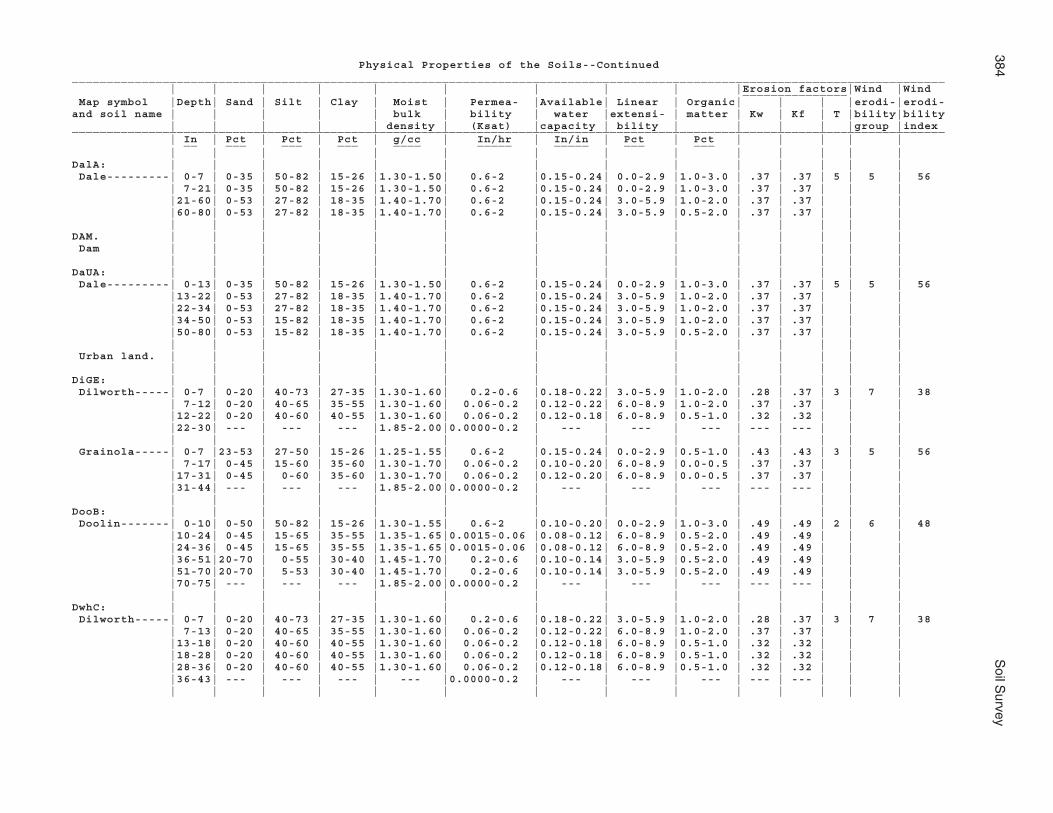
384S
oil Survey
Physical Properties of the Soils--Continued_____________________________________________________________________________________________________________________________ | | | | | | | | | |Erosion factors|Wind |Wind _______________ Map symbol |Depth| Sand | Silt | Clay | Moist | Permea- |Available| Linear | Organic| | | |erodi-|erodi-and soil name | | | | | bulk | bility | water |extensi- | matter | Kw | Kf | T |bility|bility | | | | | density | (Ksat) |capacity | bility | | | | |group |index_____________________________________________________________________________________________________________________________ | In | Pct | Pct | Pct | g/cc | In/hr | In/in | Pct | Pct | | | | | __ ___ ___ ___ ____ _____ _____ ___ ___ | | | | | | | | | | | | | |DalA: | | | | | | | | | | | | | | Dale---------| 0-7 | 0-35 | 50-82 | 15-26 |1.30-1.50| 0.6-2 |0.15-0.24| 0.0-2.9 |1.0-3.0 | .37 | .37 | 5 | 5 | 56 | 7-21| 0-35 | 50-82 | 15-26 |1.30-1.50| 0.6-2 |0.15-0.24| 0.0-2.9 |1.0-3.0 | .37 | .37 | | | |21-60| 0-53 | 27-82 | 18-35 |1.40-1.70| 0.6-2 |0.15-0.24| 3.0-5.9 |1.0-2.0 | .37 | .37 | | | |60-80| 0-53 | 27-82 | 18-35 |1.40-1.70| 0.6-2 |0.15-0.24| 3.0-5.9 |0.5-2.0 | .37 | .37 | | | | | | | | | | | | | | | | |DAM. | | | | | | | | | | | | | | Dam | | | | | | | | | | | | | | | | | | | | | | | | | | | |DaUA: | | | | | | | | | | | | | | Dale---------| 0-13| 0-35 | 50-82 | 15-26 |1.30-1.50| 0.6-2 |0.15-0.24| 0.0-2.9 |1.0-3.0 | .37 | .37 | 5 | 5 | 56 |13-22| 0-53 | 27-82 | 18-35 |1.40-1.70| 0.6-2 |0.15-0.24| 3.0-5.9 |1.0-2.0 | .37 | .37 | | | |22-34| 0-53 | 27-82 | 18-35 |1.40-1.70| 0.6-2 |0.15-0.24| 3.0-5.9 |1.0-2.0 | .37 | .37 | | | |34-50| 0-53 | 15-82 | 18-35 |1.40-1.70| 0.6-2 |0.15-0.24| 3.0-5.9 |1.0-2.0 | .37 | .37 | | | |50-80| 0-53 | 15-82 | 18-35 |1.40-1.70| 0.6-2 |0.15-0.24| 3.0-5.9 |0.5-2.0 | .37 | .37 | | | | | | | | | | | | | | | | | Urban land. | | | | | | | | | | | | | | | | | | | | | | | | | | | |DiGE: | | | | | | | | | | | | | | Dilworth-----| 0-7 | 0-20 | 40-73 | 27-35 |1.30-1.60| 0.2-0.6 |0.18-0.22| 3.0-5.9 |1.0-2.0 | .28 | .37 | 3 | 7 | 38 | 7-12| 0-20 | 40-65 | 35-55 |1.30-1.60| 0.06-0.2 |0.12-0.22| 6.0-8.9 |1.0-2.0 | .37 | .37 | | | |12-22| 0-20 | 40-60 | 40-55 |1.30-1.60| 0.06-0.2 |0.12-0.18| 6.0-8.9 |0.5-1.0 | .32 | .32 | | | |22-30| --- | --- | --- |1.85-2.00|0.0000-0.2 | --- | --- | --- | --- | --- | | | | | | | | | | | | | | | | | Grainola-----| 0-7 |23-53 | 27-50 | 15-26 |1.25-1.55| 0.6-2 |0.15-0.24| 0.0-2.9 |0.5-1.0 | .43 | .43 | 3 | 5 | 56 | 7-17| 0-45 | 15-60 | 35-60 |1.30-1.70| 0.06-0.2 |0.10-0.20| 6.0-8.9 |0.0-0.5 | .37 | .37 | | | |17-31| 0-45 | 0-60 | 35-60 |1.30-1.70| 0.06-0.2 |0.12-0.20| 6.0-8.9 |0.0-0.5 | .37 | .37 | | | |31-44| --- | --- | --- |1.85-2.00|0.0000-0.2 | --- | --- | --- | --- | --- | | | | | | | | | | | | | | | | |DooB: | | | | | | | | | | | | | | Doolin-------| 0-10| 0-50 | 50-82 | 15-26 |1.30-1.55| 0.6-2 |0.10-0.20| 0.0-2.9 |1.0-3.0 | .49 | .49 | 2 | 6 | 48 |10-24| 0-45 | 15-65 | 35-55 |1.35-1.65|0.0015-0.06 |0.08-0.12| 6.0-8.9 |0.5-2.0 | .49 | .49 | | | |24-36| 0-45 | 15-65 | 35-55 |1.35-1.65|0.0015-0.06 |0.08-0.12| 6.0-8.9 |0.5-2.0 | .49 | .49 | | | |36-51|20-70 | 0-55 | 30-40 |1.45-1.70| 0.2-0.6 |0.10-0.14| 3.0-5.9 |0.5-2.0 | .49 | .49 | | | |51-70|20-70 | 5-53 | 30-40 |1.45-1.70| 0.2-0.6 |0.10-0.14| 3.0-5.9 |0.5-2.0 | .49 | .49 | | | |70-75| --- | --- | --- |1.85-2.00|0.0000-0.2 | --- | --- | --- | --- | --- | | | | | | | | | | | | | | | | |DwhC: | | | | | | | | | | | | | | Dilworth-----| 0-7 | 0-20 | 40-73 | 27-35 |1.30-1.60| 0.2-0.6 |0.18-0.22| 3.0-5.9 |1.0-2.0 | .28 | .37 | 3 | 7 | 38 | 7-13| 0-20 | 40-65 | 35-55 |1.30-1.60| 0.06-0.2 |0.12-0.22| 6.0-8.9 |1.0-2.0 | .37 | .37 | | | |13-18| 0-20 | 40-60 | 40-55 |1.30-1.60| 0.06-0.2 |0.12-0.18| 6.0-8.9 |0.5-1.0 | .32 | .32 | | | |18-28| 0-20 | 40-60 | 40-55 |1.30-1.60| 0.06-0.2 |0.12-0.18| 6.0-8.9 |0.5-1.0 | .32 | .32 | | | |28-36| 0-20 | 40-60 | 40-55 |1.30-1.60| 0.06-0.2 |0.12-0.18| 6.0-8.9 |0.5-1.0 | .32 | .32 | | | |36-43| --- | --- | --- | --- |0.0000-0.2 | --- | --- | --- | --- | --- | | | | | | | | | | | | | | | | |
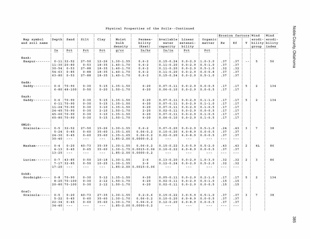
Noble C
ounty, Oklahom
a385
Physical Properties of the Soils--Continued_____________________________________________________________________________________________________________________________ | | | | | | | | | |Erosion factors|Wind |Wind _______________ Map symbol |Depth| Sand | Silt | Clay | Moist | Permea- |Available| Linear | Organic| | | |erodi-|erodi-and soil name | | | | | bulk | bility | water |extensi- | matter | Kw | Kf | T |bility|bility | | | | | density | (Ksat) |capacity | bility | | | | |group |index_____________________________________________________________________________________________________________________________ | In | Pct | Pct | Pct | g/cc | In/hr | In/in | Pct | Pct | | | | | __ ___ ___ ___ ____ _____ _____ ___ ___ | | | | | | | | | | | | | |EasA: | | | | | | | | | | | | | | Easpur-------| 0-11|32-52 | 27-50 | 12-26 |1.30-1.55| 0.6-2 |0.15-0.24| 0.0-2.9 |1.0-3.0 | .37 | .37 | --| 5 | 56 |11-30|20-80 | 0-53 | 18-35 |1.40-1.70| 0.6-2 |0.11-0.20| 0.0-2.9 |0.5-1.0 | .37 | .37 | | | |30-54| 0-53 | 27-88 | 18-35 |1.40-1.70| 0.6-2 |0.11-0.20| 0.0-2.9 |0.5-1.0 | .32 | .32 | | | |54-63| 0-85 | 0-88 | 18-35 |1.40-1.70| 0.6-2 |0.11-0.20| 0.0-2.9 |0.0-0.8 | .37 | .37 | | | |63-80| 0-53 | 27-88 | 18-35 |1.40-1.70| 0.6-2 |0.15-0.24| 0.0-2.9 |0.5-1.0 | .37 | .37 | | | | | | | | | | | | | | | | |GadA: | | | | | | | | | | | | | | Gaddy--------| 0-6 |70-90 | 0-30 | 5-15 |1.35-1.50| 6-20 |0.07-0.11| 0.0-2.9 |0.0-0.5 | .17 | .17 | 5 | 2 | 134 | 6-80|48-100| 0-50 | 0-20 |1.50-1.70| 6-20 |0.06-0.10| 0.0-2.9 |0.0-0.5 | .17 | .17 | | | | | | | | | | | | | | | | |GayA: | | | | | | | | | | | | | | Gaddy--------| 0-6 |70-90 | 0-30 | 5-15 |1.35-1.50| 6-20 |0.07-0.11| 0.0-2.9 |0.1-1.0 | .17 | .17 | 5 | 2 | 134 | 6-11|70-90 | 0-30 | 5-15 |1.35-1.50| 6-20 |0.07-0.11| 0.0-2.9 |0.1-1.0 | .17 | .17 | | | |11-24|70-90 | 0-30 | 3-10 |1.35-1.50| 6-20 |0.07-0.11| 0.0-2.9 |0.1-0.5 | .17 | .17 | | | |24-45|70-90 | 0-30 | 2-10 |1.50-1.70| 2-20 |0.02-0.11| 0.0-2.9 |0.0-0.5 | .17 | .17 | | | |45-60|70-90 | 0-30 | 3-10 |1.35-1.50| 6-20 |0.07-0.11| 0.0-2.9 |0.1-0.5 | .17 | .17 | | | |60-80|70-90 | 0-30 | 5-15 |1.50-1.70| 6-20 |0.06-0.10| 0.0-2.9 |0.1-0.5 | .17 | .17 | | | | | | | | | | | | | | | | |GMLG: | | | | | | | | | | | | | | Grainola-----| 0-5 |32-52 | 27-50 | 15-26 |1.30-1.55| 0.6-2 |0.07-0.20| 0.0-2.9 |0.5-1.0 | .24 | .43 | 3 | 7 | 38 | 5-24| 0-45 | 0-60 | 35-60 |1.35-1.65| 0.06-0.2 |0.10-0.20| 6.0-8.9 |0.0-0.5 | .37 | .37 | | | |24-30| 0-45 | 0-60 | 35-60 |1.35-1.65| 0.06-0.2 |0.02-0.20| 6.0-8.9 |0.0-0.5 | .37 | .37 | | | |30-40| --- | --- | --- |1.85-2.00|0.0000-0.2 | --- | --- | --- | --- | --- | | | | | | | | | | | | | | | | | Masham-------| 0-4 | 0-20 | 40-73 | 35-39 |1.30-1.55| 0.06-0.2 |0.15-0.22| 3.0-5.9 |0.5-2.0 | .43 | .43 | 2 | 4L | 86 | 4-13| 0-45 | 0-65 | 35-60 |1.30-1.75|0.0015-0.06 |0.10-0.22| 6.0-8.9 |0.0-0.5 | .37 | .37 | | | |13-25| --- | --- | --- |1.85-2.00|0.0000-0.2 | --- | --- | --- | --- | --- | | | | | | | | | | | | | | | | | Lucien-------| 0-7 |43-85 | 0-50 | 10-18 |1.30-1.55| 2-6 |0.13-0.20| 0.0-2.9 |1.0-3.0 | .32 | .32 | 2 | 3 | 86 | 7-17|32-85 | 0-50 | 10-25 |1.30-1.55| 2-6 |0.12-0.24| 0.0-2.9 |0.5-2.0 | .32 | .32 | | | |17-20| --- | --- | --- |1.85-2.00|0.0015-0.06 | --- | --- | --- | --- | --- | | | | | | | | | | | | | | | | |GohE: | | | | | | | | | | | | | | Goodnight----| 0-8 |70-90 | 0-30 | 5-12 |1.35-1.50| 6-20 |0.05-0.11| 0.0-2.9 |0.2-1.0 | .17 | .17 | 5 | 2 | 134 | 8-20|70-100| 0-30 | 2-12 |1.50-1.70| 6-20 |0.02-0.11| 0.0-2.9 |0.0-1.0 | .15 | .15 | | | |20-80|70-100| 0-30 | 2-12 |1.50-1.70| 6-20 |0.02-0.11| 0.0-2.9 |0.0-0.5 | .15 | .15 | | | | | | | | | | | | | | | | |GraC: | | | | | | | | | | | | | | Grainola-----| 0-5 | 0-20 | 40-73 | 27-35 |1.30-1.55| 0.2-0.6 |0.15-0.22| 3.0-5.9 |0.5-1.0 | .37 | .37 | 3 | 7 | 38 | 5-22| 0-45 | 0-60 | 35-60 |1.30-1.70| 0.06-0.2 |0.10-0.20| 6.0-8.9 |0.0-0.5 | .37 | .37 | | | |22-34| 0-45 | 0-60 | 35-60 |1.30-1.70| 0.06-0.2 |0.12-0.20| 6.0-8.9 |0.0-0.5 | .37 | .37 | | | |34-40| --- | --- | --- |1.85-2.00|0.0000-0.2 | --- | --- | --- | --- | --- | | | | | | | | | | | | | | | | |

386S
oil Survey
Physical Properties of the Soils--Continued_____________________________________________________________________________________________________________________________ | | | | | | | | | |Erosion factors|Wind |Wind _______________ Map symbol |Depth| Sand | Silt | Clay | Moist | Permea- |Available| Linear | Organic| | | |erodi-|erodi-and soil name | | | | | bulk | bility | water |extensi- | matter | Kw | Kf | T |bility|bility | | | | | density | (Ksat) |capacity | bility | | | | |group |index_____________________________________________________________________________________________________________________________ | In | Pct | Pct | Pct | g/cc | In/hr | In/in | Pct | Pct | | | | | __ ___ ___ ___ ____ _____ _____ ___ ___ | | | | | | | | | | | | | |GrAD: | | | | | | | | | | | | | | Grainola-----| 0-4 | 0-20 | 40-73 | 27-35 |1.30-1.55| 0.2-0.6 |0.15-0.22| 3.0-5.9 |0.5-1.0 | .37 | .37 | 3 | 7 | 38 | 4-14| 0-45 | 0-60 | 35-60 |1.30-1.70| 0.06-0.2 |0.10-0.20| 6.0-8.9 |0.0-0.5 | .37 | .37 | | | |14-36| 0-45 | 0-60 | 35-60 |1.30-1.70| 0.06-0.2 |0.12-0.20| 6.0-8.9 |0.0-0.5 | .37 | .37 | | | |36-40| --- | --- | --- |1.85-2.00|0.0000-0.2 | --- | --- | --- | --- | --- | | | | | | | | | | | | | | | | |Ashport-------| 0-13| 0-20 | 40-73 | 27-35 |1.30-1.60| 0.6-2 |0.15-0.22| 3.0-5.9 |1.0-3.0 | .32 | .32 | 5 | 7 | 38 |13-32| 0-53 | 27-73 | 18-35 |1.40-1.70| 0.6-2 |0.15-0.24| 3.0-5.9 |0.5-1.0 | .37 | .37 | | | |32-40| 0-53 | 27-73 | 18-35 |1.40-1.70| 0.6-2 |0.15-0.24| 3.0-5.9 |0.5-1.0 | .37 | .37 | | | |40-46| 0-53 | 27-73 | 18-35 |1.40-1.70| 0.6-2 |0.15-0.24| 3.0-5.9 |0.5-1.0 | .37 | .37 | | | |46-58| --- | --- | |1.85-2.00|0.0000-0.2 | | | | | | | | | | | | | | | | | | | | | |GrHC: | | | | | | | | | | | | | | Grant--------| 0-7 | 0-35 | 50-88 | 15-26 |1.30-1.50| 0.6-2 |0.15-0.20| 0.0-2.9 |1.0-3.0 | .37 | .37 | 4 | 5 | 56 | 7-11| 0-53 | 0-88 | 15-26 |1.30-1.55| 0.6-2 |0.13-0.20| 0.0-2.9 |1.0-3.0 | .37 | .37 | | | |11-17| 0-53 | 27-82 | 18-35 |1.40-1.70| 0.6-2 |0.15-0.20| 0.0-2.9 |0.5-1.0 | .37 | .37 | | | |17-35| 0-53 | 27-82 | 18-35 |1.40-1.70| 0.6-2 |0.15-0.20| 0.0-2.9 |0.5-1.0 | .37 | .37 | | | |35-54| 0-85 | 0-82 | 15-40 |1.40-1.65| 0.6-2 |0.16-0.22| 0.0-2.9 |0.5-1.0 | .37 | .37 | | | |54-58| --- | --- | --- |1.85-2.00|0.0015-0.06 | --- | --- | --- | --- | --- | | | | | | | | | | | | | | | | | Huska--------| 0-6 | 0-35 | 50-88 | 12-26 |1.30-1.55| 0.6-2 |0.10-0.20| 0.0-2.9 |1.0-3.0 | .49 | .49 | 2 | 5 | 56 | 6-17| 0-45 | 15-65 | 35-45 |1.50-1.70|0.0015-0.06 |0.06-0.10| 6.0-8.9 |0.0-1.0 | .43 | .43 | | | |17-32| 0-45 | 15-65 | 35-60 |1.50-1.70|0.0015-0.06 |0.06-0.10| 6.0-8.9 |0.0-1.0 | .43 | .43 | | | |32-40| 0-45 | 15-65 | 35-60 |1.50-1.70|0.0015-0.06 |0.06-0.10| 6.0-8.9 |0.0-1.0 | .43 | .43 | | | |40-50| 0-45 | 15-65 | 35-60 |1.50-1.70|0.0015-0.06 |0.06-0.10| 6.0-8.9 |0.0-1.0 | .43 | .43 | | | |50-54| --- | --- | --- |1.85-2.00|0.0000-0.2 | --- | --- | --- | --- | --- | | | | | | | | | | | | | | | | |GrLC: | | | | | | | | | | | | | | Grainola-----| 0-6 |23-53 | 27-50 | 15-26 |1.25-1.55| 0.6-2 |0.15-0.24| 0.0-2.9 |0.5-1.0 | .43 | .43 | 3 | 5 | 56 | 6-11| 0-45 | 0-60 | 35-60 |1.30-1.70| 0.06-0.2 |0.10-0.20| 6.0-8.9 |0.0-0.5 | .37 | .37 | | | |11-18| 0-45 | 0-60 | 35-60 |1.30-1.70| 0.06-0.2 |0.12-0.20| 6.0-8.9 |0.0-0.5 | .37 | .37 | | | |18-33| 0-45 | 0-60 | 35-60 |1.30-1.70| 0.06-0.2 |0.12-0.20| 6.0-8.9 |0.0-0.5 | .37 | .37 | | | |33-39| 0-45 | 0-60 | 35-60 |1.30-1.70| 0.06-0.2 |0.12-0.20| 6.0-8.9 |0.0-0.5 | .37 | .37 | | | |39-42| --- | --- | --- |1.85-2.00|0.0000-0.2 | --- | --- | --- | --- | --- | | | | | | | | | | | | | | | | | Lucien-------| 0-7 |32-52 | 27-50 | 15-25 |1.30-1.55| 2-6 |0.12-0.24| 0.0-2.9 |1.0-3.0 | .32 | .32 | 2 | 5 | 56 | 7-18|32-85 | 0-50 | 10-25 |1.30-1.55| 2-6 |0.12-0.24| 0.0-2.9 |0.5-2.0 | .32 | .32 | | | |18-24| --- | --- | --- |1.85-2.00|0.0015-0.06 | --- | --- | --- | --- | --- | | | | | | | | | | | | | | | | |GrLE: | | | | | | | | | | | | | | Grainola-----| 0-8 |20-45 | 15-45 | 27-35 |1.30-1.55| 0.2-0.6 |0.15-0.22| 3.0-5.9 |0.5-1.0 | .37 | .37 | 3 | 7 | 38 | 8-20| 0-45 | 15-60 | 35-60 |1.30-1.70| 0.06-0.2 |0.10-0.20| 6.0-8.9 |0.0-0.5 | .37 | .37 | | | |20-27| 0-45 | 15-60 | 35-60 |1.30-1.70| 0.06-0.2 |0.12-0.20| 6.0-8.9 |0.0-0.5 | .37 | .37 | | | |27-30| --- | --- | --- |1.85-2.00|0.0000-0.2 | --- | --- | --- | --- | --- | | | | | | | | | | | | | | | | |

Noble C
ounty, Oklahom
a387
Physical Properties of the Soils--Continued_____________________________________________________________________________________________________________________________ | | | | | | | | | |Erosion factors|Wind |Wind _______________ Map symbol |Depth| Sand | Silt | Clay | Moist | Permea- |Available| Linear | Organic| | | |erodi-|erodi-and soil name | | | | | bulk | bility | water |extensi- | matter | Kw | Kf | T |bility|bility | | | | | density | (Ksat) |capacity | bility | | | | |group |index_____________________________________________________________________________________________________________________________ | In | Pct | Pct | Pct | g/cc | In/hr | In/in | Pct | Pct | | | | | __ ___ ___ ___ ____ _____ _____ ___ ___ | | | | | | | | | | | | | |GrLE: | | | | | | | | | | | | | | Lucien-------| 0-7 |32-52 | 27-50 | 15-25 |1.30-1.55| 2-6 |0.12-0.24| 0.0-2.9 |1.0-3.0 | .32 | .32 | 2 | 5 | 56 | 7-12|32-85 | 0-50 | 10-25 |1.30-1.55| 2-6 |0.12-0.24| 0.0-2.9 |0.5-2.0 | .32 | .32 | | | |12-15| --- | --- | --- |1.85-2.00|0.0015-0.06 | --- | --- | --- | --- | --- | | | | | | | | | | | | | | | | |GrnC: | | | | | | | | | | | | | | Grant--------| 0-7 |23-53 | 27-50 | 15-26 |1.30-1.50| 0.6-2 |0.15-0.20| 0.0-2.9 |1.0-3.0 | .37 | .37 | 4 | 5 | 56 | 7-12|23-85 | 0-50 | 15-26 |1.30-1.55| 0.6-2 |0.13-0.20| 0.0-2.9 |1.0-3.0 | .37 | .37 | | | |12-20| 0-53 | 15-73 | 18-35 |1.40-1.70| 0.6-2 |0.15-0.20| 0.0-2.9 |0.5-1.0 | .37 | .37 | | | |20-29|20-53 | 0-53 | 15-35 |1.40-1.65| 0.6-2 |0.16-0.22| 0.0-2.9 |0.5-1.0 | .37 | .37 | | | |29-44|33-53 | 0-50 | 15-26 |1.30-1.55| 0.6-2 |0.13-0.20| 0.0-2.9 |0.3-0.8 | .37 | .37 | | | |44-59|43-85 | 0-50 | 8-18 |1.30-1.55| 0.6-2 |0.13-0.20| 0.0-2.9 |0.3-0.8 | .37 | .37 | | | |59-65| --- | --- | --- |1.85-2.00|0.0015-0.06 | --- | --- | --- | --- | --- | | | | | | | | | | | | | | | | |GrtB: | | | | | | | | | | | | | | Grant--------| 0-11| 0-50 | 27-88 | 15-26 |1.30-1.50| 0.6-2 |0.15-0.20| 0.0-2.9 |1.0-3.0 | .37 | .37 | 4 | 5 | 56 |11-21| 0-53 | 0-88 | 15-26 |1.30-1.55| 0.6-2 |0.13-0.20| 0.0-2.9 |1.0-3.0 | .37 | .37 | | | |21-51| 0-53 | 27-82 | 18-35 |1.40-1.70| 0.6-2 |0.15-0.20| 0.0-2.9 |0.5-1.0 | .37 | .37 | | | |51-57| 0-53 | 0-82 | 15-35 |1.40-1.65| 0.6-2 |0.16-0.22| 0.0-2.9 |0.5-1.0 | .37 | .37 | | | |57-64| --- | --- | --- |1.85-2.00|0.0015-0.06 | --- | --- | --- | --- | --- | | | | | | | | | | | | | | | | |HaPE: | | | | | | | | | | | | | | Harrah-------| 0-5 |43-85 | 0-50 | 10-18 |1.30-1.60| 2-6 |0.11-0.15| 0.0-2.9 |0.5-2.0 | .24 | .24 | 5 | 3 | 86 | 5-9 |43-85 | 0-50 | 5-18 |1.30-1.60| 2-6 |0.07-0.15| 0.0-2.9 |0.5-2.0 | .20 | .20 | | | | 9-24|45-80 | 0-53 | 18-35 |1.40-1.70| 0.6-2 |0.11-0.17| 0.0-2.9 |0.0-1.0 | .32 | .32 | | | |24-70|45-80 | 0-53 | 18-35 |1.40-1.70| 0.6-2 |0.11-0.17| 0.0-2.9 |0.0-1.0 | .32 | .32 | | | |70-80|45-80 | 0-53 | 18-35 |1.40-1.70| 0.6-2 |0.10-0.17| 0.0-2.9 |0.0-1.0 | .32 | .32 | | | | | | | | | | | | | | | | | Pulaski------| 0-6 |43-85 | 0-50 | 10-18 |1.40-1.65| 2-6 |0.13-0.19| 0.0-2.9 |0.5-1.0 | .20 | .20 | 5 | 3 | 86 | 6-12|32-85 | 0-50 | 10-18 |1.30-1.70| 2-6 |0.13-0.19| 0.0-2.9 |0.0-1.0 | .32 | .32 | | | |12-50|35-90 | 3-50 | 5-18 |1.30-1.70| 2-6 |0.07-0.20| 0.0-2.9 |0.0-1.0 | .32 | .32 | | | |50-55|32-85 | 0-50 | 10-18 |1.30-1.70| 2-6 |0.13-0.19| 0.0-2.9 |0.0-1.0 | .32 | .32 | | | |55-65|35-90 | 3-50 | 5-18 |1.30-1.70| 2-6 |0.07-0.20| 0.0-2.9 |0.0-1.0 | .32 | .32 | | | |65-68| --- | --- | --- |1.85-2.00|0.0015-0.06 | --- | --- | --- | --- | --- | | | | | | | | | | | | | | | | |HiRG: | | | | | | | | | | | | | | Highview-----| 0-6 | 0-20 | 40-60 | 40-50 |1.35-1.65| 0.06-0.2 |0.02-0.18| 6.0-8.9 |0.5-1.0 | .15 | .28 | 2 | 4 | 86 | 6-17| 0-20 | 40-65 | 35-50 |1.35-1.65| 0.06-0.2 |0.02-0.18| 6.0-8.9 |0.0-0.5 | .15 | .28 | | | |17-25| --- | --- | --- |1.85-2.00|0.0000-0.2 | --- | --- | --- | --- | --- | | | | | | | | | | | | | | | | | Rock outcrop.| | | | | | | | | | | | | | | | | | | | | | | | | | | |

388S
oil Survey
Physical Properties of the Soils--Continued_____________________________________________________________________________________________________________________________ | | | | | | | | | |Erosion factors|Wind |Wind _______________ Map symbol |Depth| Sand | Silt | Clay | Moist | Permea- |Available| Linear | Organic| | | |erodi-|erodi-and soil name | | | | | bulk | bility | water |extensi- | matter | Kw | Kf | T |bility|bility | | | | | density | (Ksat) |capacity | bility | | | | |group |index_____________________________________________________________________________________________________________________________ | In | Pct | Pct | Pct | g/cc | In/hr | In/in | Pct | Pct | | | | | __ ___ ___ ___ ____ _____ _____ ___ ___ | | | | | | | | | | | | | |KekA: | | | | | | | | | | | | | | Keokuk-------| 0-14|43-85 | 0-50 | 10-18 |1.30-1.55| 0.6-2 |0.13-0.20| 0.0-2.9 |1.0-3.0 | .37 | .37 | 5 | 5 | 56 |14-21|33-85 | 0-88 | 10-18 |1.30-1.60| 0.6-2 |0.13-0.24| 0.0-2.9 |0.5-1.0 | .37 | .37 | | | |21-31|33-85 | 0-88 | 10-18 |1.30-1.60| 0.6-2 |0.13-0.24| 0.0-2.9 |0.5-1.0 | .37 | .37 | | | |31-53| 0-85 | 0-88 | 10-18 |1.30-1.60| 0.6-2 |0.13-0.24| 0.0-2.9 |0.5-1.0 | .37 | .37 | | | |53-70| 0-85 | 0-88 | 10-18 |1.30-1.60| 0.6-2 |0.13-0.24| 0.0-2.9 |0.5-1.0 | .37 | .37 | | | |70-80| 0-85 | 0-88 | 10-18 |1.30-1.60| 0.6-2 |0.13-0.24| 0.0-2.9 |0.5-1.0 | .37 | .37 | | | | | | | | | | | | | | | | |KeoA: | | | | | | | | | | | | | | Keokuk-------| 0-6 |43-85 | 0-50 | 10-18 |1.30-1.55| 0.6-2 |0.13-0.20| 0.0-2.9 |1.0-3.0 | .37 | .37 | 5 | 5 | 56 | 6-13| 0-85 | 0-88 | 10-18 |1.30-1.60| 0.6-2 |0.13-0.24| 0.0-2.9 |0.5-1.0 | .37 | .37 | | | |13-27| 0-85 | 0-88 | 10-18 |1.30-1.60| 0.6-2 |0.13-0.24| 0.0-2.9 |0.5-1.0 | .37 | .37 | | | |27-80| 0-85 | 0-88 | 10-18 |1.30-1.60| 0.6-2 |0.13-0.24| 0.0-2.9 |0.5-1.0 | .37 | .37 | | | | | | | | | | | | | | | | |KgfB: | | | | | | | | | | | | | | Kingfisher---| 0-6 | 0-50 | 50-88 | 15-27 |1.30-1.55| 0.6-2 |0.16-0.24| 0.0-2.9 |1.0-3.0 | .37 | .37 | 3 | 5 | 56 | 6-10| 0-45 | 15-82 | 25-35 |1.40-1.70| 0.2-0.6 |0.15-0.24| 3.0-5.9 |0.0-1.0 | .37 | .37 | | | |10-26| 0-45 | 15-73 | 27-35 |1.45-1.70| 0.2-0.6 |0.15-0.22| 3.0-5.9 |0.0-0.5 | .32 | .32 | | | |26-35| --- | --- | --- |1.85-2.00|0.0000-0.2 | --- | --- | --- | --- | --- | | | | | | | | | | | | | | | | |KgLC: | | | | | | | | | | | | | | Kingfisher---| 0-5 |33-53 | 27-50 | 15-27 |1.30-1.55| 0.6-2 |0.15-0.20| 0.0-2.9 |1.0-3.0 | .37 | .37 | 3 | 5 | 56 | 5-8 | 0-53 | 27-88 | 25-35 |1.40-1.70| 0.2-0.6 |0.15-0.24| 3.0-5.9 |0.0-1.0 | .37 | .37 | | | | 8-22| 0-45 | 15-73 | 27-35 |1.45-1.70| 0.2-0.6 |0.15-0.22| 3.0-5.9 |0.0-0.5 | .32 | .32 | | | |22-25| --- | --- | --- |1.85-2.00|0.0000-0.2 | --- | --- | --- | --- | --- | | | | | | | | | | | | | | | | | Lucien-------| 0-7 |43-85 | 0-50 | 10-18 |1.30-1.55| 2-6 |0.13-0.20| 0.0-2.9 |1.0-3.0 | .32 | .32 | 2 | 3 | 86 | 7-14|32-85 | 0-50 | 10-25 |1.30-1.55| 2-6 |0.12-0.24| 0.0-2.9 |0.5-2.0 | .32 | .32 | | | |14-17| --- | --- | --- |1.85-2.00|0.0015-0.06 | --- | --- | --- | --- | --- | | | | | | | | | | | | | | | | |KgWC: | | | | | | | | | | | | | | Kingfisher---| 0-6 | 0-50 | 50-88 | 15-27 |1.30-1.55| 0.6-2 |0.16-0.24| 0.0-2.9 |1.0-3.0 | .37 | .37 | 3 | 5 | 56 | 6-10| 0-45 | 15-88 | 25-35 |1.40-1.70| 0.2-0.6 |0.15-0.24| 3.0-5.9 |0.0-1.0 | .37 | .37 | | | |10-26| 0-45 | 15-73 | 27-35 |1.45-1.70| 0.2-0.6 |0.15-0.22| 3.0-5.9 |0.0-0.5 | .32 | .32 | | | |26-32| 0-45 | 15-73 | 27-40 |1.45-1.70| 0.2-0.6 |0.14-0.22| 3.0-5.9 |0.0-0.5 | .32 | .32 | | | |32-40| --- | --- | --- |1.85-2.00|0.0000-0.2 | --- | --- | --- | --- | --- | | | | | | | | | | | | | | | | | Wakita-------| 0-4 | 0-50 | 50-88 | 18-22 |1.30-1.50| 0.6-2 |0.12-0.18| 0.0-2.9 |1.0-3.0 | .43 | .43 | 2 | 4 | 86 | 4-25| 0-32 | 40-82 | 25-35 |1.45-1.70| 0.06-0.2 |0.08-0.12| 3.0-5.9 |0.5-1.5 | .43 | .55 | | | |25-31| 0-45 | 15-88 | 25-35 |1.45-1.70| 0.06-0.2 |0.08-0.12| 3.0-5.9 |0.0-0.5 | .43 | .55 | | | |31-37| --- | --- | --- |1.85-2.00|0.0000-0.2 | --- | --- | --- | --- | --- | | | | | | | | | | | | | | | | |KinC2: | | | | | | | | | | | | | | Kingfisher---| 0-8 |33-53 | 27-50 | 15-27 |1.30-1.55| 0.6-2 |0.15-0.20| 0.0-2.9 |1.0-3.0 | .37 | .37 | 3 | 5 | 56 | 8-19| 0-45 | 15-82 | 25-35 |1.40-1.70| 0.2-0.6 |0.15-0.24| 3.0-5.9 |0.0-1.0 | .37 | .37 | | | |19-22| 0-32 | 15-73 | 27-35 |1.45-1.70| 0.2-0.6 |0.15-0.22| 3.0-5.9 |0.0-0.5 | .32 | .32 | | | |22-25| --- | --- | --- |1.85-2.00|0.0000-0.2 | --- | --- | --- | --- | --- | | |

Noble C
ounty, Oklahom
a389
Physical Properties of the Soils--Continued_____________________________________________________________________________________________________________________________ | | | | | | | | | |Erosion factors|Wind |Wind _______________ Map symbol |Depth| Sand | Silt | Clay | Moist | Permea- |Available| Linear | Organic| | | |erodi-|erodi-and soil name | | | | | bulk | bility | water |extensi- | matter | Kw | Kf | T |bility|bility | | | | | density | (Ksat) |capacity | bility | | | | |group |index_____________________________________________________________________________________________________________________________ | In | Pct | Pct | Pct | g/cc | In/hr | In/in | Pct | Pct | | | | | __ ___ ___ ___ ____ _____ _____ ___ ___ | | | | | | | | | | | | | |KowB: | | | | | | | | | | | | | | Konawa-------| 0-6 |43-85 | 0-50 | 8-18 |1.40-1.65| 2-6 |0.13-0.19| 0.0-2.9 |0.5-1.0 | .24 | .24 | 5 | 3 | 86 | 6-14|43-100| 0-50 | 2-15 |1.40-1.75| 0.6-2 |0.05-0.19| 0.0-2.9 |0.3-1.0 | .32 | .32 | | | |14-24|45-80 | 0-27 | 18-30 |1.45-1.70| 0.6-6 |0.13-0.19| 0.0-2.9 |0.1-0.7 | .24 | .24 | | | |24-44|45-80 | 0-27 | 18-30 |1.45-1.70| 0.6-6 |0.13-0.19| 0.0-2.9 |0.1-0.7 | .24 | .24 | | | |44-60|45-90 | 0-30 | 7-30 |1.40-1.70| 2-6 |0.07-0.19| 0.0-2.9 |0.1-0.7 | .20 | .20 | | | |60-80|50-90 | 0-30 | 3-30 |1.40-1.70| 2-6 |0.07-0.19| 0.0-2.9 |0.1-0.7 | .20 | .20 | | |KowD: | | | | | | | | | | | | | | Konawa-------| 0-8 |43-85 | 0-50 | 8-18 |1.40-1.65| 2-6 |0.13-0.19| 0.0-2.9 |0.5-1.0 | .24 | .24 | 5 | 3 | 86 | 8-20|43-100| 0-50 | 2-15 |1.40-1.75| 2-20 |0.05-0.19| 0.0-2.9 |0.3-1.0 | .32 | .32 | | | |20-33|45-80 | 0-27 | 18-30 |1.45-1.70| 0.6-6 |0.13-0.19| 0.0-2.9 |0.1-0.7 | .24 | .24 | | | |33-50|45-80 | 0-27 | 10-30 |1.45-1.70| 0.6-6 |0.13-0.19| 0.0-2.9 |0.1-0.7 | .24 | .24 | | | |50-67|45-90 | 0-50 | 7-30 |1.40-1.70| 2-6 |0.07-0.19| 0.0-2.9 |0.1-0.7 | .20 | .20 | | | |67-80|45-100| 0-50 | 2-15 |1.40-1.75| 2-20 |0.05-0.19| 0.0-2.9 |0.3-1.0 | .32 | .32 | | | | | | | | | | | | | | | | |KrdA: | | | | | | | | | | | | | | Kirkland-----| 0-9 | 0-50 | 50-88 | 13-26 |1.30-1.50| 0.6-2 |0.16-0.24| 0.0-2.9 |1.0-3.0 | .49 | .49 | 5 | 5 | 56 | 9-28| 0-45 | 0-60 | 40-60 |1.35-1.60|0.0015-0.06 |0.10-0.14| 6.0-8.9 |1.0-2.0 | .37 | .37 | | | |28-40| 0-45 | 0-60 | 35-60 |1.30-1.65|0.0015-0.06 |0.10-0.18| 9.0-25.0|0.5-1.0 | .32 | .32 | | | |40-53| 0-45 | 0-65 | 35-60 |1.30-1.65|0.0015-0.06 |0.10-0.18| 9.0-25.0|0.5-1.0 | .32 | .32 | | | |53-80| 0-45 | 0-65 | 35-60 |1.30-1.65|0.0015-0.06 |0.10-0.18| 9.0-25.0|0.5-1.0 | .32 | .32 | | | | | | | | | | | | | | | | |KrdB: | | | | | | | | | | | | | | Kirkland-----| 0-7 | 0-38 | 50-88 | 13-26 |1.30-1.50| 0.6-2 |0.16-0.24| 0.0-2.9 |1.0-3.0 | .49 | .49 | 5 | 5 | 56 | 7-14| 0-45 | 0-60 | 40-60 |1.35-1.60|0.0015-0.06 |0.10-0.14| 6.0-8.9 |1.0-2.0 | .37 | .37 | | | |14-33| 0-45 | 0-60 | 40-60 |1.35-1.60|0.0015-0.06 |0.10-0.14| 6.0-8.9 |1.0-2.0 | .37 | .37 | | | |33-61| 0-45 | 0-65 | 35-60 |1.30-1.65|0.0015-0.06 |0.10-0.18| 9.0-25.0|0.5-1.0 | .32 | .32 | | | |61-80| --- | --- | --- |1.85-2.00|0.0000-0.2 | --- | --- | --- | --- | --- | | | | | | | | | | | | | | | | |KrdB2: | | | | | | | | | | | | | | Kirkland-----| 0-4 | 0-40 | 50-88 | 13-26 |1.30-1.50| 0.6-2 |0.16-0.24| 0.0-2.9 |1.0-3.0 | .49 | .49 | 5 | 5 | 56 | 4-25| 0-45 | 0-60 | 40-60 |1.35-1.60|0.0015-0.06 |0.10-0.14| 6.0-8.9 |1.0-2.0 | .37 | .37 | | | |25-44| 0-45 | 0-65 | 35-60 |1.30-1.65|0.0015-0.06 |0.10-0.18| 9.0-25.0|0.5-1.0 | .32 | .32 | | | |44-61| 0-45 | 0-65 | 35-60 |1.30-1.65|0.0015-0.06 |0.10-0.18| 9.0-25.0|0.5-1.0 | .32 | .32 | | | |61-80| --- | --- | --- |1.85-2.00|0.0000-0.2 | --- | --- | --- | --- | --- | | | | | | | | | | | | | | | | |KrPB: | | | | | | | | | | | | | | Kirkland-----| 0-8 | 0-40 | 50-88 | 13-26 |1.30-1.50| 0.6-2 |0.16-0.24| 0.0-2.9 |1.0-3.0 | .49 | .49 | 5 | 5 | 56 | 8-21| 0-45 | 0-60 | 40-60 |1.35-1.60|0.0015-0.06 |0.10-0.14| 6.0-8.9 |1.0-2.0 | .37 | .37 | | | |21-41| 0-45 | 0-60 | 35-60 |1.30-1.65|0.0015-0.06 |0.10-0.18| 9.0-25.0|0.5-1.0 | .32 | .32 | | | |41-64| 0-45 | 0-65 | 35-60 |1.30-1.65|0.0015-0.06 |0.10-0.18| 9.0-25.0|0.5-1.0 | .32 | .32 | | | |64-80| 0-45 | 0-65 | 35-60 |1.30-1.65|0.0015-0.06 |0.10-0.18| 9.0-25.0|0.5-1.0 | .32 | .32 | | | | | | | | | | | | | | | | |

390S
oil Survey
Physical Properties of the Soils--Continued_____________________________________________________________________________________________________________________________ | | | | | | | | | |Erosion factors|Wind |Wind _______________ Map symbol |Depth| Sand | Silt | Clay | Moist | Permea- |Available| Linear | Organic| | | |erodi-|erodi-and soil name | | | | | bulk | bility | water |extensi- | matter | Kw | Kf | T |bility|bility | | | | | density | (Ksat) |capacity | bility | | | | |group |index_____________________________________________________________________________________________________________________________ | In | Pct | Pct | Pct | g/cc | In/hr | In/in | Pct | Pct | | | | | __ ___ ___ ___ ____ _____ _____ ___ ___ | | | | | | | | | | | | | |KrPB: | | | | | | | | | | | | | | Pawhuska-----| 0-6 | 0-40 | 50-88 | 18-27 |1.30-1.50| 0.6-2 |0.12-0.18| 0.0-2.9 |0.5-3.0 | .49 | .49 | 2 | 6 | 48 | 6-22| 0-45 | 0-65 | 35-50 |1.35-1.65|0.0015-0.06 |0.06-0.20| 6.0-8.9 |0.5-2.0 | .43 | .43 | | | |22-43| 0-45 | 0-65 | 35-50 |1.35-1.65|0.0015-0.06 |0.06-0.20| 6.0-8.9 |0.5-1.0 | .43 | .43 | | | |43-55| 0-45 | 0-68 | 35-50 |1.35-1.65|0.0015-0.06 |0.06-0.20| 6.0-8.9 |0.2-0.8 | .43 | .43 | | | |55-72| 0-45 | 0-69 | 35-50 |1.35-1.65|0.0015-0.06 |0.06-0.20| 6.0-8.9 |0.2-0.8 | .43 | .43 | | | |72-80| --- | --- | --- |1.85-2.00|0.0000-0.2 | --- | --- | --- | --- | --- | | | | | | | | | | | | | | | | |LAN. | | | | | | | | | | | | | | Landfill | | | | | | | | | | | | | | | | | | | | | | | | | | | |LelA: | | | | | | | | | | | | | | Lela---------| 0-6 | 0-20 | 40-60 | 40-60 |1.25-1.45|0.0015-0.06 |0.10-0.18| 6.0-8.9 |1.0-3.0 | .37 | .37 | 5 | 4 | 86 | 6-13| 0-20 | 40-60 | 40-60 |1.25-1.45|0.0015-0.06 |0.10-0.18| 6.0-8.9 |1.0-3.0 | .37 | .37 | | | |13-34| 0-20 | 0-60 | 40-60 |1.35-1.60|0.0015-0.06 |0.10-0.14| 6.0-8.9 |1.0-2.0 | .37 | .37 | | | |34-42| 0-20 | 0-60 | 40-60 |1.35-1.60|0.0015-0.06 |0.10-0.14| 6.0-8.9 |1.0-2.0 | .37 | .37 | | | |42-53| 0-20 | 0-60 | 40-60 |1.35-1.60|0.0015-0.06 |0.10-0.14| 6.0-8.9 |1.0-2.0 | .37 | .37 | | | |53-61| 0-30 | 0-60 | 40-60 |1.35-1.60|0.0015-0.06 |0.10-0.14| 6.0-8.9 |1.0-2.0 | .37 | .37 | | | |61-72| 0-20 | 0-60 | 40-60 |1.35-1.60|0.0015-0.06 |0.10-0.14| 6.0-8.9 |1.0-2.0 | .37 | .37 | | | |72-87| 0-20 | 0-60 | 40-60 |1.35-1.60|0.0015-0.06 |0.10-0.14| 6.0-8.9 |1.0-2.0 | .37 | .37 | | | | | | | | | | | | | | | | |LveB: | | | | | | | | | | | | | | Lovedale-----| 0-7 |43-85 | 0-50 | 8-16 |1.30-1.60| 0.6-2 |0.10-0.15| 0.0-2.9 |1.0-2.0 | .24 | .24 | 5 | 3 | 86 | 7-12|45-80 | 0-50 | 10-27 |1.50-1.70| 0.6-2 |0.12-0.17| 0.0-2.9 |0.0-1.0 | .28 | .32 | | | |12-18|45-80 | 0-50 | 18-27 |1.50-1.70| 0.6-2 |0.10-0.17| 0.0-2.9 |0.0-0.5 | .28 | .32 | | | |18-26|45-80 | 0-50 | 18-27 |1.50-1.70| 0.6-2 |0.10-0.17| 0.0-2.9 |0.0-0.5 | .28 | .32 | | | |26-46|45-80 | 0-50 | 18-27 |1.50-1.70| 0.6-2 |0.10-0.17| 0.0-2.9 |0.0-0.5 | .28 | .32 | | | |46-80|45-100| 0-50 | 3-18 |1.50-1.70| 2-20 |0.02-0.15| 0.0-2.9 |0.0-0.5 | .15 | .20 | | | | | | | | | | | | | | | | |M-W. | | | | | | | | | | | | | | Miscellaneous| | | | | | | | | | | | | | water | | | | | | | | | | | | | | | | | | | | | | | | | | | |McaA: | | | | | | | | | | | | | | McLain-------| 0-7 | 0-20 | 40-73 | 27-35 |1.30-1.60| 0.2-0.6 |0.15-0.22| 3.0-5.9 |1.0-3.0 | .37 | .37 | 5 | 7 | 38 | 7-17| 0-45 | 15-65 | 35-50 |1.45-1.70| 0.06-0.2 |0.12-0.22| 6.0-8.9 |0.5-2.0 | .37 | .37 | | | |17-31| 0-45 | 15-65 | 35-50 |1.45-1.70| 0.06-0.2 |0.12-0.22| 6.0-8.9 |0.5-2.0 | .37 | .37 | | | |31-46| 0-45 | 15-65 | 35-50 |1.45-1.70| 0.06-0.2 |0.12-0.22| 6.0-8.9 |0.5-2.0 | .37 | .37 | | | |46-80| 0-53 | 27-65 | 20-45 |1.40-1.70| 0.06-0.6 |0.12-0.24| 6.0-8.9 |0.5-2.0 | .43 | .43 | | | | | | | | | | | | | | | | |MilB: | | | | | | | | | | | | | | Milan--------| 0-7 |32-52 | 27-50 | 14-27 |1.35-1.45| 0.6-2 |0.20-0.22| 0.0-2.9 |1.0-3.0 | .28 | .28 | 5 | 6 | 48 | 7-12|20-80 | 27-53 | 25-35 |1.40-1.55| 0.2-0.6 |0.14-0.21| 3.0-5.9 |0.0-0.5 | .28 | .32 | | | |12-26|20-80 | 27-53 | 25-35 |1.40-1.55| 0.2-0.6 |0.14-0.21| 3.0-5.9 |0.0-0.5 | .28 | .32 | | | |26-45|20-80 | 0-53 | 10-35 |1.40-1.70| 0.2-6 |0.10-0.20| 0.0-2.9 |0.0-0.5 | .28 | .32 | | | |45-72|20-80 | 0-50 | 10-35 |1.40-1.70| 0.2-6 |0.10-0.20| 0.0-2.9 |0.0-0.5 | .28 | .32 | | | |72-80|20-80 | 0-53 | 5-35 |1.45-1.70| 0.2-6 |0.06-0.20| 0.0-2.9 |0.0-0.5 | .32 | .32 | | |

Noble C
ounty, Oklahom
a391
Physical Properties of the Soils--Continued_____________________________________________________________________________________________________________________________ | | | | | | | | | |Erosion factors|Wind |Wind _______________ Map symbol |Depth| Sand | Silt | Clay | Moist | Permea- |Available| Linear | Organic| | | |erodi-|erodi-and soil name | | | | | bulk | bility | water |extensi- | matter | Kw | Kf | T |bility|bility | | | | | density | (Ksat) |capacity | bility | | | | |group |index_____________________________________________________________________________________________________________________________ | In | Pct | Pct | Pct | g/cc | In/hr | In/in | Pct | Pct | | | | | __ ___ ___ ___ ____ _____ _____ ___ ___ | | | | | | | | | | | | | |MilC: | | | | | | | | | | | | | | Milan--------| 0-9 |32-52 | 27-50 | 14-27 |1.35-1.45| 0.6-2 |0.20-0.22| 0.0-2.9 |1.0-3.0 | .28 | .28 | 5 | 6 | 48 | 9-15|20-80 | 0-53 | 14-35 |1.40-1.55| 0.2-0.6 |0.14-0.21| 3.0-5.9 |0.0-0.5 | .28 | .32 | | | |15-33|20-80 | 0-53 | 10-35 |1.40-1.70| 0.2-6 |0.10-0.20| 0.0-2.9 |0.0-0.5 | .28 | .32 | | | |33-48|20-80 | 0-53 | 10-35 |1.40-1.70| 0.2-6 |0.10-0.20| 0.0-2.9 |0.0-0.5 | .28 | .32 | | | |48-62|20-80 | 0-53 | 5-35 |1.45-1.70| 0.2-6 |0.06-0.20| 0.0-2.9 |0.0-0.5 | .32 | .32 | | | |62-80|45-90 | 0-50 | 5-27 |1.45-1.70| 0.2-6 |0.06-0.20| 0.0-2.9 |0.0-0.5 | .32 | .32 | | | | | | | | | | | | | | | | |MinB: | | | | | | | | | | | | | | Minco--------| 0-8 |43-85 | 0-50 | 8-18 |1.35-1.60| 0.6-2 |0.13-0.24| 0.0-2.9 |1.0-3.0 | .37 | .37 | 5 | 3 | 86 | 8-15| 0-85 | 0-88 | 8-18 |1.35-1.60| 0.6-2 |0.13-0.24| 0.0-2.9 |1.0-3.0 | .37 | .37 | | | |15-32| 0-85 | 0-88 | 8-18 |1.35-1.60| 0.6-2 |0.13-0.24| 0.0-2.9 |0.2-1.0 | .37 | .37 | | | |32-46| 0-85 | 0-88 | 8-18 |1.35-1.60| 0.6-2 |0.13-0.24| 0.0-2.9 |0.2-1.0 | .37 | .37 | | | |46-62| 0-85 | 0-88 | 8-18 |1.35-1.60| 0.6-2 |0.13-0.24| 0.0-2.9 |0.2-0.7 | .37 | .37 | | | |62-80| 0-85 | 0-88 | 8-18 |1.35-1.60| 0.6-2 |0.11-0.24| 0.0-2.9 |0.2-0.7 | .37 | .37 | | | | | | | | | | | | | | | | |MinC: | | | | | | | | | | | | | | Minco--------| 0-8 |43-85 | 0-50 | 8-18 |1.35-1.60| 0.6-2 |0.13-0.24| 0.0-2.9 |1.0-3.0 | .37 | .37 | 5 | 3 | 86 | 8-17| 0-85 | 0-88 | 8-18 |1.35-1.60| 0.6-2 |0.13-0.24| 0.0-2.9 |1.0-3.0 | .37 | .37 | | | |17-23| 0-85 | 0-88 | 8-18 |1.35-1.60| 0.6-2 |0.13-0.24| 0.0-2.9 |0.2-1.0 | .37 | .37 | | | |23-54| 0-85 | 0-88 | 8-18 |1.35-1.60| 0.6-2 |0.13-0.24| 0.0-2.9 |0.2-1.0 | .37 | .37 | | | |54-59| 0-85 | 0-88 | 8-18 |1.35-1.60| 0.6-2 |0.13-0.24| 0.0-2.9 |0.2-0.8 | .37 | .37 | | | |59-80| 0-85 | 0-88 | 8-18 |1.35-1.60| 0.6-2 |0.11-0.24| 0.0-2.9 |0.2-0.8 | .37 | .37 | | | | | | | | | | | | | | | | |MirA: | | | | | | | | | | | | | | Miller-------| 0-10| 0-20 | 40-73 | 35-40 |1.30-1.60| 0.06-0.2 |0.18-0.22| 3.0-5.9 |1.0-3.0 | .43 | .43 | 5 | 7 | 38 |10-30| 0-45 | 0-65 | 35-60 |1.35-1.65|0.0015-0.06 |0.12-0.19| 6.0-8.9 |0.5-2.0 | .37 | .37 | | | |30-44| 0-45 | 0-65 | 35-60 |1.35-1.65| 0.06-0.2 |0.12-0.19| 6.0-8.9 |0.5-1.0 | .37 | .37 | | | |44-80| 0-45 | 0-65 | 25-50 |1.35-1.65| 0.06-0.2 |0.12-0.19| 6.0-8.9 |0.5-1.0 | .37 | .37 | | | | | | | | | | | | | | | | |MisA: | | | | | | | | | | | | | | Miller-------| 0-10| 0-20 | 40-73 | 35-40 |1.30-1.60| 0.06-0.2 |0.18-0.22| 3.0-5.9 |1.0-3.0 | .43 | .43 | 5 | 4L | 86 |10-23| 0-45 | 0-65 | 35-60 |1.35-1.65|0.0015-0.06 |0.07-0.10| 6.0-8.9 |0.5-2.0 | .37 | .37 | | | |23-34| 0-45 | 0-65 | 35-60 |1.35-1.65|0.0015-0.06 |0.07-0.10| 6.0-8.9 |0.5-2.0 | .37 | .37 | | | |34-40| 2-60 | 30-60 | 0-60 |1.35-1.65| 0.06-0.2 |0.07-0.10| 6.0-8.9 |0.5-1.0 | .37 | .37 | | | |40-51| 0-45 | 0-65 | 35-60 |1.35-1.65| 0.06-0.2 |0.07-0.10| 6.0-8.9 |0.5-1.0 | .37 | .37 | | | |51-80| 0-45 | 0-65 | 35-60 |1.35-1.65| 0.06-0.2 |0.07-0.10| 6.0-8.9 |0.5-1.0 | .37 | .37 | | | | | | | | | | | | | | | | |MPNC2: | | | | | | | | | | | | | | Milan--------| 0-11|32-52 | 27-50 | 14-27 |1.35-1.45| 0.6-2 |0.20-0.22| 0.0-2.9 |1.0-3.0 | .28 | .28 | 5 | 6 | 48 |11-16|20-80 | 0-53 | 25-35 |1.40-1.55| 0.2-0.6 |0.14-0.21| 3.0-5.9 |0.0-0.5 | .28 | .32 | | | |16-28|23-80 | 0-53 | 25-35 |1.40-1.55| 0.2-0.6 |0.14-0.21| 3.0-5.9 |0.0-0.5 | .28 | .32 | | | |28-57|20-80 | 0-53 | 10-35 |1.40-1.70| 0.2-6 |0.10-0.20| 0.0-2.9 |0.0-0.5 | .28 | .32 | | | |57-65|20-80 | 0-53 | 5-35 |1.45-1.70| 0.2-6 |0.06-0.20| 0.0-2.9 |0.0-0.5 | .32 | .32 | | | |65-75|20-90 | 0-53 | 5-35 |1.45-1.70| 0.2-6 |0.06-0.20| 0.0-2.9 |0.0-0.5 | .32 | .32 | | | | | | | | | | | | | | | | |

392S
oil Survey
Physical Properties of the Soils--Continued_____________________________________________________________________________________________________________________________ | | | | | | | | | |Erosion factors|Wind |Wind _______________ Map symbol |Depth| Sand | Silt | Clay | Moist | Permea- |Available| Linear | Organic| | | |erodi-|erodi-and soil name | | | | | bulk | bility | water |extensi- | matter | Kw | Kf | T |bility|bility | | | | | density | (Ksat) |capacity | bility | | | | |group |index_____________________________________________________________________________________________________________________________ | In | Pct | Pct | Pct | g/cc | In/hr | In/in | Pct | Pct | | | | | __ ___ ___ ___ ____ _____ _____ ___ ___ | | | | | | | | | | | | | |MPNC2: | | | | | | | | | | | | | | Pawhuska-----| 0-8 | 0-50 | 50-88 | 18-27 |1.30-1.50| 0.6-2 |0.12-0.18| 0.0-2.9 |0.5-3.0 | .49 | .49 | 2 | 6 | 48 | 8-17| 0-45 | 0-65 | 35-50 |1.35-1.65|0.0015-0.06 |0.06-0.20| 6.0-8.9 |0.5-2.0 | .43 | .43 | | | |17-27| 0-45 | 0-65 | 35-50 |1.35-1.65|0.0015-0.06 |0.06-0.20| 6.0-8.9 |0.2-1.0 | .43 | .43 | | | |27-40| 0-45 | 0-65 | 35-50 |1.35-1.65|0.0015-0.06 |0.06-0.20| 6.0-8.9 |0.2-0.8 | .43 | .43 | | | |40-64| 0-45 | 0-65 | 35-50 |1.35-1.65|0.0015-0.06 |0.06-0.20| 6.0-8.9 |0.0-0.8 | .43 | .43 | | | |64-80|20-80 | 0-53 | 5-35 |1.45-1.70| 0.2-6 |0.06-0.20| 0.0-2.9 |0.0-0.5 | .32 | .32 | | | | | | | | | | | | | | | | | Norge--------| 0-6 | 0-40 | 50-88 | 15-26 |1.30-1.50| 0.6-2 |0.15-0.24| 0.0-2.9 |1.0-3.0 | .37 | .37 | 5 | 6 | 48 | 6-14| 0-45 | 15-88 | 18-35 |1.40-1.70| 0.2-2 |0.15-0.24| 3.0-5.9 |0.5-2.0 | .32 | .32 | | | |14-35| 0-45 | 40-82 | 27-35 |1.45-1.70| 0.2-0.6 |0.15-0.22| 3.0-5.9 |0.5-1.0 | .32 | .32 | | | |35-45| 0-45 | 40-82 | 27-50 |1.45-1.70| 0.2-0.6 |0.15-0.22| 3.0-5.9 |0.5-1.0 | .32 | .32 | | | |45-80| 0-45 | 40-82 | 27-50 |1.45-1.70| 0.2-0.6 |0.15-0.22| 3.0-5.9 |0.5-1.0 | .32 | .32 | | | | | | | | | | | | | | | | |MulC: | | | | | | | | | | | | | | Mulhall------| 0-7 |23-53 | 27-50 | 15-26 |1.30-1.55| 0.6-2 |0.15-0.20| 0.0-2.9 |1.0-3.0 | .37 | .37 | 5 | 6 | 48 | 7-13|20-53 | 15-53 | 18-30 |1.45-1.70| 0.6-2 |0.15-0.20| 0.0-2.9 |0.5-1.0 | .37 | .37 | | | |13-26|20-80 | 0-53 | 20-35 |1.45-1.70| 0.6-2 |0.10-0.20| 0.0-2.9 |0.0-0.5 | .32 | .32 | | | |26-42|20-80 | 0-53 | 20-35 |1.45-1.70| 0.6-2 |0.10-0.20| 0.0-2.9 |0.0-0.5 | .32 | .32 | | | |42-60|20-80 | 0-53 | 20-35 |1.45-1.70| 0.6-2 |0.10-0.20| 0.0-2.9 |0.0-0.5 | .32 | .32 | | | |60-80|20-80 | 0-53 | 20-35 |1.45-1.70| 0.6-2 |0.10-0.20| 0.0-2.9 |0.0-0.5 | .32 | .32 | | | | | | | | | | | | | | | | |MulD: | | | | | | | | | | | | | | Mulhall------| 0-10|23-53 | 27-50 | 15-26 |1.30-1.55| 0.6-2 |0.15-0.20| 0.0-2.9 |1.0-3.0 | .37 | .37 | 5 | 6 | 48 |10-14|20-53 | 15-53 | 18-30 |1.45-1.70| 0.6-2 |0.15-0.20| 0.0-2.9 |0.5-1.0 | .37 | .37 | | | |14-23|30-80 | 0-53 | 20-35 |1.45-1.70| 0.6-2 |0.10-0.20| 0.0-2.9 |0.0-0.5 | .32 | .32 | | | |23-33|20-80 | 0-53 | 20-35 |1.45-1.70| 0.6-2 |0.10-0.20| 0.0-2.9 |0.0-0.5 | .32 | .32 | | | |33-42|20-80 | 0-53 | 20-35 |1.45-1.70| 0.6-2 |0.10-0.20| 0.0-2.9 |0.0-0.5 | .32 | .32 | | | |42-56|20-80 | 0-53 | 20-35 |1.45-1.70| 0.6-2 |0.10-0.20| 0.0-2.9 |0.0-0.5 | .32 | .32 | | | |56-80|20-80 | 0-53 | 20-35 |1.45-1.70| 0.6-2 |0.10-0.20| 0.0-2.9 |0.0-0.5 | .32 | .32 | | | | | | | | | | | | | | | | |MulD4: | | | | | | | | | | | | | | Mulhall------| 0-14|23-53 | 27-50 | 15-26 |1.30-1.55| 0.6-2 |0.15-0.20| 0.0-2.9 |1.0-3.0 | .37 | .37 | 4 | 6 | 48 |14-19|20-53 | 15-53 | 18-30 |1.45-1.70| 0.6-2 |0.15-0.20| 0.0-2.9 |0.5-1.0 | .37 | .37 | | | |19-29|20-80 | 0-53 | 20-35 |1.45-1.70| 0.6-2 |0.10-0.20| 0.0-2.9 |0.0-0.5 | .32 | .32 | | | |29-44|20-80 | 0-53 | 20-35 |1.45-1.70| 0.6-2 |0.10-0.20| 0.0-2.9 |0.0-0.5 | .32 | .32 | | | |44-80|20-80 | 0-53 | 20-35 |1.45-1.70| 0.6-2 |0.10-0.20| 0.0-2.9 |0.0-0.5 | .32 | .32 | | | | | | | | | | | | | | | | |NeDG: | | | | | | | | | | | | | | Newalla------| 0-5 |43-85 | 0-50 | 7-17 |1.40-1.65| 0.6-2 |0.13-0.19| 0.0-2.9 |0.5-3.0 | .37 | .37 | 4 | 3 | 86 | 5-14|43-85 | 0-50 | 7-17 |1.40-1.65| 0.6-2 |0.13-0.19| 0.0-2.9 |0.5-3.0 | .37 | .37 | | | |14-22|20-80 | 0-53 | 20-35 |1.30-1.70| 0.6-2 |0.14-0.20| 0.0-2.9 |0.5-1.0 | .43 | .43 | | | |22-32| 0-45 | 0-60 | 40-60 |1.30-1.60|0.0015-0.06 |0.12-0.18| 6.0-8.9 |0.0-0.5 | .37 | .37 | | | |32-40| 0-45 | 0-60 | 40-60 |1.30-1.60|0.0015-0.06 |0.12-0.18| 6.0-8.9 |0.0-0.5 | .37 | .37 | | | |40-54| 0-45 | 0-60 | 40-60 |1.30-1.65|0.0015-0.06 |0.04-0.18| 6.0-8.9 |0.0-0.5 | .37 | .37 | | | |54-58| --- | --- | --- |1.85-2.00|0.0015-0.06 | --- | --- | --- | --- | --- | | | | | | | | | | | | | | | | |

Noble C
ounty, Oklahom
a393
Physical Properties of the Soils--Continued_____________________________________________________________________________________________________________________________ | | | | | | | | | |Erosion factors|Wind |Wind _______________ Map symbol |Depth| Sand | Silt | Clay | Moist | Permea- |Available| Linear | Organic| | | |erodi-|erodi-and soil name | | | | | bulk | bility | water |extensi- | matter | Kw | Kf | T |bility|bility | | | | | density | (Ksat) |capacity | bility | | | | |group |index_____________________________________________________________________________________________________________________________ | In | Pct | Pct | Pct | g/cc | In/hr | In/in | Pct | Pct | | | | | __ ___ ___ ___ ____ _____ _____ ___ ___ | | | | | | | | | | | | | |NeDG: | | | | | | | | | | | | | | Darnell------| 0-4 |43-85 | 0-50 | 10-20 |1.30-1.65| 2-6 |0.12-0.16| 0.0-2.9 |0.5-1.0 | .10 | .20 | 2 | 8 | 0 | 4-11|43-85 | 0-50 | 10-25 |1.40-1.70| 2-6 |0.12-0.16| 0.0-2.9 |0.0-0.5 | .20 | .24 | | | |11-15| --- | --- | --- |1.85-2.00|0.0000-0.2 | --- | --- | --- | --- | --- | | | | | | | | | | | | | | | | |NorA: | | | | | | | | | | | | | | Norge--------| 0-11| 0-32 | 50-88 | 15-26 |1.30-1.50| 0.6-2 |0.15-0.24| 0.0-2.9 |1.0-3.0 | .37 | .37 | 5 | 6 | 48 |11-14| 0-45 | 15-88 | 18-35 |1.40-1.70| 0.2-2 |0.15-0.24| 3.0-5.9 |0.5-2.0 | .32 | .32 | | | |14-23| 0-45 | 15-73 | 27-35 |1.45-1.70| 0.2-0.6 |0.15-0.22| 3.0-5.9 |0.5-1.0 | .32 | .32 | | | |23-32| 0-45 | 15-73 | 27-35 |1.45-1.70| 0.2-0.6 |0.15-0.22| 3.0-5.9 |0.5-1.0 | .32 | .32 | | | |32-38| 0-45 | 15-73 | 27-35 |1.45-1.70| 0.2-0.6 |0.15-0.22| 3.0-5.9 |0.5-1.0 | .32 | .32 | | | |38-49| 0-45 | 15-73 | 27-50 |1.45-1.70| 0.2-0.6 |0.15-0.22| 3.0-5.9 |0.5-1.0 | .32 | .32 | | | |49-58| 0-45 | 15-73 | 27-50 |1.45-1.70| 0.2-0.6 |0.15-0.22| 3.0-5.9 |0.5-1.0 | .32 | .32 | | | |58-81| 0-45 | 15-73 | 27-50 |1.45-1.70| 0.2-0.6 |0.15-0.22| 3.0-5.9 |0.5-1.0 | .32 | .32 | | | | | | | | | | | | | | | | |NorB: | | | | | | | | | | | | | | Norge--------| 0-9 | 0-32 | 50-88 | 15-26 |1.30-1.50| 0.6-2 |0.15-0.24| 0.0-2.9 |1.0-3.0 | .37 | .37 | 5 | 6 | 48 | 9-15| 0-32 | 50-88 | 15-26 |1.30-1.50| 0.6-2 |0.15-0.24| 0.0-2.9 |1.0-3.0 | .37 | .37 | | | |15-19| 0-45 | 15-82 | 18-35 |1.40-1.70| 0.2-2 |0.15-0.24| 3.0-5.9 |0.5-2.0 | .32 | .32 | | | |19-30| 0-45 | 15-73 | 27-35 |1.45-1.70| 0.2-0.6 |0.15-0.22| 3.0-5.9 |0.5-1.0 | .32 | .32 | | | |30-44| 0-45 | 15-73 | 27-35 |1.45-1.70| 0.2-0.6 |0.15-0.22| 3.0-5.9 |0.5-1.0 | .32 | .32 | | | |44-67| 0-45 | 15-73 | 27-50 |1.45-1.70| 0.2-0.6 |0.15-0.22| 3.0-5.9 |0.5-1.0 | .32 | .32 | | | |67-80| 0-45 | 15-88 | 12-50 |1.45-1.70| 0.2-0.6 |0.15-0.22| 3.0-5.9 |0.5-1.0 | .32 | .32 | | | | | | | | | | | | | | | | |NorC: | | | | | | | | | | | | | | Norge--------| 0-11| 0-32 | 50-88 | 15-26 |1.30-1.50| 0.6-2 |0.15-0.24| 0.0-2.9 |1.0-3.0 | .37 | .37 | 5 | 6 | 48 |11-16| 0-45 | 15-88 | 18-35 |1.40-1.70| 0.2-2 |0.15-0.24| 3.0-5.9 |0.5-2.0 | .32 | .32 | | | |16-27| 0-45 | 15-73 | 27-35 |1.45-1.70| 0.2-0.6 |0.15-0.22| 3.0-5.9 |0.5-1.0 | .32 | .32 | | | |27-47| 0-45 | 15-73 | 27-35 |1.45-1.70| 0.2-0.6 |0.15-0.22| 3.0-5.9 |0.5-1.0 | .32 | .32 | | | |47-60| 0-45 | 15-73 | 27-35 |1.45-1.70| 0.2-0.6 |0.15-0.22| 3.0-5.9 |0.5-1.0 | .32 | .32 | | | |60-80| 0-45 | 15-88 | 18-27 |1.45-1.70| 0.2-0.6 |0.15-0.22| 3.0-5.9 |0.5-1.0 | .32 | .32 | | | | | | | | | | | | | | | | |NorC2: | | | | | | | | | | | | | | Norge--------| 0-9 | 0-32 | 50-88 | 15-26 |1.30-1.50| 0.6-2 |0.15-0.24| 0.0-2.9 |1.0-3.0 | .37 | .37 | 5 | 6 | 48 | 9-18| 0-45 | 15-73 | 27-35 |1.45-1.70| 0.2-0.6 |0.15-0.22| 3.0-5.9 |0.5-1.0 | .32 | .32 | | | |18-30| 0-45 | 15-73 | 27-35 |1.45-1.70| 0.2-0.6 |0.15-0.22| 3.0-5.9 |0.5-1.0 | .32 | .32 | | | |30-44| 0-45 | 15-73 | 27-35 |1.45-1.70| 0.2-0.6 |0.15-0.22| 3.0-5.9 |0.5-1.0 | .32 | .32 | | | |44-64| 0-45 | 15-73 | 27-35 |1.45-1.70| 0.2-0.6 |0.15-0.22| 3.0-5.9 |0.5-1.0 | .32 | .32 | | | |64-86| 0-45 | 15-88 | 15-60 |1.45-1.70| 0.2-0.6 |0.15-0.22| 3.0-5.9 |0.5-1.0 | .32 | .32 | | | | | | | | | | | | | | | | |

394S
oil Survey
Physical Properties of the Soils--Continued_____________________________________________________________________________________________________________________________ | | | | | | | | | |Erosion factors|Wind |Wind _______________ Map symbol |Depth| Sand | Silt | Clay | Moist | Permea- |Available| Linear | Organic| | | |erodi-|erodi-and soil name | | | | | bulk | bility | water |extensi- | matter | Kw | Kf | T |bility|bility | | | | | density | (Ksat) |capacity | bility | | | | |group |index_____________________________________________________________________________________________________________________________ | In | Pct | Pct | Pct | g/cc | In/hr | In/in | Pct | Pct | | | | | __ ___ ___ ___ ____ _____ _____ ___ ___ | | | | | | | | | | | | | |NoUC: | | | | | | | | | | | | | | Norge--------| 0-7 | 0-32 | 50-88 | 15-26 |1.30-1.50| 0.6-2 |0.15-0.24| 0.0-2.9 |1.0-3.0 | .37 | .37 | 5 | 6 | 48 | 7-10| 0-45 | 15-88 | 18-35 |1.40-1.70| 0.2-2 |0.15-0.24| 3.0-5.9 |0.5-2.0 | .32 | .32 | | | |10-20| 0-45 | 15-73 | 27-35 |1.45-1.70| 0.2-0.6 |0.15-0.22| 3.0-5.9 |0.5-1.0 | .32 | .32 | | | |20-39| 0-45 | 15-73 | 27-35 |1.45-1.70| 0.2-0.6 |0.15-0.22| 3.0-5.9 |0.5-1.0 | .32 | .32 | | | |39-45| 0-45 | 15-73 | 27-35 |1.45-1.70| 0.2-0.6 |0.15-0.22| 3.0-5.9 |0.5-1.0 | .32 | .32 | | | |45-80| 0-45 | 15-73 | 27-50 |1.45-1.70| 0.2-0.6 |0.15-0.22| 3.0-5.9 |0.5-1.0 | .32 | .32 | | | | | | | | | | | | | | | | | | | | | | | | | | | | | | | Urban land. | | | | | | | | | | | | | | | | | | | | | | | | | | | |OWWE: | | | | | | | | | | | | | | Oil waste | | | | | | | | | | | | | | land--------| 0-60| --- | --- | --- | --- |0.0000-0.2 | --- | --- | --- | --- | --- | --| 8 | 0 | | | | | | | | | | | | | | | | | | | | | | | | | | | | Westsum------| 0-9 | 0-20 | 40-73 | 28-35 |1.30-1.60| 0.2-0.6 |0.18-0.22| 3.0-5.9 |1.0-3.0 | .37 | .37 | 5 | 7 | 38 | 9-14| 0-45 | 40-65 | 30-45 |1.35-1.70| 0.06-0.2 |0.14-0.22| 6.0-8.9 |1.0-2.0 | .37 | .37 | | | |14-20| 0-45 | 40-65 | 35-50 |1.35-1.70|0.0015-0.06 |0.14-0.22| 9.0-25.0|0.5-1.0 | .37 | .37 | | | |20-28| 0-45 | 40-65 | 35-50 |1.35-1.70|0.0015-0.06 |0.14-0.22| 9.0-25.0|0.2-1.0 | .37 | .37 | | | |28-45| 0-20 | 40-60 | 40-50 |1.45-1.60|0.0015-0.06 |0.14-0.18| 9.0-25.0|0.2-1.0 | .37 | .37 | | | |45-56| 0-20 | 40-60 | 40-50 |1.45-1.60|0.0015-0.06 |0.14-0.18| 9.0-25.0|0.0-1.0 | .37 | .37 | | | |56-72| 0-45 | 15-60 | 35-50 |1.35-1.70|0.0015-0.06 |0.14-0.20| 9.0-25.0|0.0-1.0 | .37 | .37 | | | | | | | | | | | | | | | | |PoaA: | | | | | | | | | | | | | | Port---------| 0-19| 0-40 | 50-88 | 12-26 |1.30-1.55| 0.6-2 |0.15-0.24| 0.0-2.9 |1.0-3.0 | .37 | .37 | 5 | 6 | 48 |19-30| 0-40 | 50-88 | 12-26 |1.30-1.55| 0.6-2 |0.15-0.24| 0.0-2.9 |1.0-3.0 | .37 | .37 | | | |30-43| 0-40 | 50-88 | 12-26 |1.30-1.55| 0.6-2 |0.15-0.24| 0.0-2.9 |0.0-1.0 | .37 | .37 | | | |43-59| 0-40 | 50-88 | 12-26 |1.30-1.55| 0.6-2 |0.15-0.24| 0.0-2.9 |0.0-1.0 | .37 | .37 | | | |59-74| 0-45 | 15-73 | 20-35 |1.30-1.60| 0.6-2 |0.15-0.24| 3.0-5.9 |0.0-1.0 | .37 | .37 | | | | | | | | | | | | | | | | |PoOA: | | | | | | | | | | | | | | Port---------| 0-16| 0-40 | 50-88 | 12-26 |1.30-1.55| 0.6-2 |0.15-0.24| 0.0-2.9 |1.0-3.0 | .37 | .37 | 5 | 5 | 56 |16-23| 0-40 | 50-88 | 12-26 |1.30-1.55| 0.6-2 |0.15-0.24| 0.0-2.9 |1.0-3.0 | .37 | .37 | | | |23-40| 0-40 | 50-88 | 12-26 |1.30-1.55| 0.6-2 |0.15-0.24| 0.0-2.9 |0.0-1.0 | .37 | .37 | | | |40-51| 0-40 | 50-88 | 12-26 |1.30-1.55| 0.6-2 |0.15-0.24| 0.0-2.9 |0.0-1.0 | .37 | .37 | | | |51-80| 0-40 | 50-88 | 12-26 |1.30-1.55| 0.6-2 |0.15-0.24| 0.0-2.9 |0.5-2.0 | .37 | .37 | | | | | | | | | | | | | | | | | Oscar--------| 0-4 | 0-40 | 50-88 | 15-26 |1.35-1.60| 0.6-2 |0.13-0.21| 0.0-2.9 |0.5-1.0 | .43 | .43 | 2 | 5 | 56 | 4-10| 0-40 | 50-88 | 15-26 |1.35-1.60| 0.6-2 |0.13-0.21| 0.0-2.9 |0.5-1.0 | .43 | .43 | | | |10-16| 0-45 | 15-73 | 24-35 |1.45-1.70| 0.06-0.2 |0.10-0.15| 3.0-5.9 |0.5-1.0 | .55 | .55 | | | |16-33| 0-40 | 50-88 | 12-26 |1.30-1.55| 0.6-2 |0.15-0.24| 0.0-2.9 |0.0-1.0 | .37 | .37 | | | |33-43| 0-40 | 50-88 | 12-26 |1.30-1.55| 0.6-2 |0.15-0.24| 0.0-2.9 |0.5-2.0 | .37 | .37 | | | |43-80| 0-40 | 50-88 | 12-26 |1.30-1.55| 0.6-2 |0.15-0.24| 0.0-2.9 |0.5-2.0 | .37 | .37 | | | | | | | | | | | | | | | | |

Noble C
ounty, Oklahom
a395
Physical Properties of the Soils--Continued_____________________________________________________________________________________________________________________________ | | | | | | | | | |Erosion factors|Wind |Wind _______________ Map symbol |Depth| Sand | Silt | Clay | Moist | Permea- |Available| Linear | Organic| | | |erodi-|erodi-and soil name | | | | | bulk | bility | water |extensi- | matter | Kw | Kf | T |bility|bility | | | | | density | (Ksat) |capacity | bility | | | | |group |index_____________________________________________________________________________________________________________________________ | In | Pct | Pct | Pct | g/cc | In/hr | In/in | Pct | Pct | | | | | __ ___ ___ ___ ____ _____ _____ ___ ___ | | | | | | | | | | | | | |PorA: | | | | | | | | | | | | | | Port---------| 0-8 | 0-40 | 50-88 | 12-26 |1.30-1.55| 0.6-2 |0.15-0.24| 0.0-2.9 |1.0-3.0 | .37 | .37 | 5 | 5 | 56 | 8-14| 0-40 | 50-88 | 12-26 |1.30-1.55| 0.6-2 |0.15-0.24| 0.0-2.9 |1.0-3.0 | .37 | .37 | | | |14-20| 0-40 | 50-88 | 12-26 |1.30-1.55| 0.6-2 |0.15-0.24| 0.0-2.9 |1.0-3.0 | .37 | .37 | | | |20-31| 0-40 | 50-88 | 12-26 |1.30-1.55| 0.6-2 |0.15-0.24| 0.0-2.9 |1.0-3.0 | .37 | .37 | | | |31-40| 0-40 | 50-88 | 12-26 |1.30-1.55| 0.6-2 |0.15-0.24| 0.0-2.9 |0.0-1.0 | .37 | .37 | | | |40-48| 0-40 | 50-88 | 12-26 |1.30-1.55| 0.6-2 |0.15-0.24| 0.0-2.9 |0.0-1.0 | .37 | .37 | | | |48-55| 4-53 | 15-73 | 20-35 |1.30-1.60| 0.6-2 |0.15-0.24| 3.0-5.9 |0.0-1.0 | .37 | .37 | | | |55-68| 0-53 | 15-73 | 20-35 |1.30-1.60| 0.6-2 |0.15-0.24| 3.0-5.9 |0.5-2.0 | .37 | .37 | | | |68-74| 0-53 | 15-73 | 20-35 |1.30-1.60| 0.6-2 |0.15-0.24| 3.0-5.9 |0.0-1.0 | .37 | .37 | | | |74-85| 0-53 | 15-73 | 20-35 |1.30-1.60| 0.6-2 |0.15-0.24| 3.0-5.9 |0.0-1.0 | .37 | .37 | | | |85-93| 0-53 | 15-73 | 20-35 |1.30-1.60| 0.6-2 |0.15-0.24| 3.0-5.9 |0.0-1.0 | .37 | .37 | | | | | | | | | | | | | | | | |PotA: | | | | | | | | | | | | | | Port---------| 0-10| 0-20 | 40-73 | 27-35 |1.30-1.60| 0.6-2 |0.15-0.24| 3.0-5.9 |1.0-3.0 | .32 | .32 | 5 | 6 | 48 |10-26| 0-20 | 40-73 | 27-35 |1.30-1.60| 0.6-2 |0.15-0.24| 3.0-5.9 |1.0-3.0 | .32 | .32 | | | |26-35| 0-45 | 15-73 | 20-35 |1.30-1.60| 0.6-2 |0.15-0.24| 3.0-5.9 |0.0-1.0 | .37 | .37 | | | |35-66| 0-45 | 15-73 | 20-35 |1.30-1.60| 0.6-2 |0.15-0.24| 3.0-5.9 |0.0-1.0 | .37 | .37 | | | |66-80| 0-45 | 15-73 | 20-35 |1.30-1.60| 0.6-2 |0.15-0.24| 3.0-5.9 |0.0-1.0 | .37 | .37 | | | | | | | | | | | | | | | | |PukA: | | | | | | | | | | | | | | Pulaski------| 0-8 |43-85 | 0-50 | 10-18 |1.40-1.65| 2-6 |0.13-0.19| 0.0-2.9 |0.5-1.0 | .20 | .20 | 5 | 3 | 86 | 8-20|32-85 | 0-50 | 10-18 |1.30-1.70| 2-6 |0.13-0.19| 0.0-2.9 |0.0-1.0 | .32 | .32 | | | |20-37|32-85 | 0-50 | 10-18 |1.30-1.70| 2-6 |0.13-0.19| 0.0-2.9 |0.0-1.0 | .32 | .32 | | | |37-47|32-85 | 0-50 | 10-18 |1.30-1.70| 2-6 |0.13-0.19| 0.0-2.9 |0.5-2.0 | .32 | .32 | | | |47-80|43-90 | 0-50 | 5-18 |1.30-1.70| 2-6 |0.07-0.20| 0.0-2.9 |0.0-1.0 | .32 | .32 | | | | | | | | | | | | | | | | |PulA: | | | | | | | | | | | | | | Pulaski------| 0-9 |43-85 | 0-50 | 10-18 |1.40-1.65| 2-6 |0.13-0.19| 0.0-2.9 |0.5-1.0 | .20 | .20 | 5 | 3 | 86 | 9-27|32-85 | 0-50 | 10-18 |1.30-1.70| 2-6 |0.13-0.19| 0.0-2.9 |0.0-1.0 | .32 | .32 | | | |27-80|32-90 | 5-50 | 5-18 |1.30-1.70| 2-6 |0.07-0.20| 0.0-2.9 |0.0-1.0 | .32 | .32 | | | | | | | | | | | | | | | | |RefC2: | | | | | | | | | | | | | | Renfrow------| 0-6 |23-53 | 27-50 | 18-26 |1.25-1.55| 0.6-2 |0.15-0.24| 0.0-2.9 |1.0-3.0 | .49 | .49 | 5 | 6 | 48 | 6-35| 0-45 | 0-65 | 35-55 |1.30-1.75|0.0015-0.06 |0.12-0.22| 6.0-8.9 |0.5-1.0 | .43 | .43 | | | |35-73| 0-45 | 0-65 | 35-55 |1.30-1.75|0.0015-0.06 |0.12-0.22| 6.0-8.9 |0.5-1.0 | .43 | .43 | | | | | | | | | | | | | | | | |ReGC2: | | | | | | | | | | | | | | Renfrow------| 0-8 | 0-20 | 40-73 | 27-35 |1.30-1.55| 0.2-0.6 |0.15-0.22| 3.0-5.9 |1.0-3.0 | .43 | .43 | 5 | 6 | 48 | 8-12| 0-45 | 15-82 | 22-40 |1.30-1.75| 0.2-0.6 |0.15-0.24| 3.0-5.9 |0.5-2.0 | .43 | .43 | | | |12-30| 0-45 | 0-65 | 35-55 |1.30-1.75|0.0015-0.06 |0.12-0.22| 6.0-8.9 |0.5-1.0 | .43 | .43 | | | |30-44| 0-45 | 0-65 | 35-55 |1.30-1.75|0.0015-0.06 |0.12-0.22| 6.0-8.9 |0.5-1.0 | .43 | .43 | | | |44-63| 0-45 | 0-65 | 35-55 |1.30-1.75|0.0015-0.06 |0.12-0.22| 6.0-8.9 |0.5-1.0 | .43 | .43 | | | |63-80| --- | --- | --- |1.85-2.00|0.0000-0.2 | --- | --- | --- | --- | --- | | | | | | | | | | | | | | | | |

396S
oil Survey
Physical Properties of the Soils--Continued_____________________________________________________________________________________________________________________________ | | | | | | | | | |Erosion factors|Wind |Wind _______________ Map symbol |Depth| Sand | Silt | Clay | Moist | Permea- |Available| Linear | Organic| | | |erodi-|erodi-and soil name | | | | | bulk | bility | water |extensi- | matter | Kw | Kf | T |bility|bility | | | | | density | (Ksat) |capacity | bility | | | | |group |index_____________________________________________________________________________________________________________________________ | In | Pct | Pct | Pct | g/cc | In/hr | In/in | Pct | Pct | | | | | __ ___ ___ ___ ____ _____ _____ ___ ___ | | | | | | | | | | | | | |ReGC2: | | | | | | | | | | | | | | Grainola-----| 0-7 | 0-20 | 40-73 | 27-35 |1.30-1.55| 0.2-0.6 |0.15-0.22| 3.0-5.9 |0.5-1.0 | .37 | .37 | 3 | 7 | 38 | 7-12| 0-45 | 0-65 | 35-60 |1.30-1.70| 0.06-0.2 |0.10-0.20| 6.0-8.9 |0.0-0.5 | .37 | .37 | | | |12-26| 0-45 | 0-60 | 35-60 |1.30-1.70| 0.06-0.2 |0.12-0.20| 6.0-8.9 |0.0-0.5 | .37 | .37 | | | |26-33| 0-45 | 0-60 | 35-60 |1.30-1.70| 0.06-0.2 |0.12-0.20| 6.0-8.9 |0.0-0.5 | .37 | .37 | | | |33-40| --- | --- | --- |1.85-2.00|0.0000-0.2 | --- | --- | --- | --- | --- | | | | | | | | | | | | | | | | |ReiA: | | | | | | | | | | | | | | Reinach------| 0-8 |43-85 | 0-50 | 12-18 |1.30-1.55| 0.6-2 |0.13-0.20| 0.0-2.9 |1.0-3.0 | .37 | .37 | 5 | 3 | 86 | 8-23|43-85 | 0-50 | 12-18 |1.30-1.55| 0.6-2 |0.13-0.20| 0.0-2.9 |1.0-3.0 | .37 | .37 | | | |23-30|43-85 | 0-50 | 12-18 |1.30-1.55| 0.6-2 |0.13-0.20| 0.0-2.9 |1.0-3.0 | .37 | .37 | | | |30-42| 0-85 | 0-88 | 12-18 |1.30-1.55| 0.6-2 |0.13-0.24| 0.0-2.9 |0.5-1.0 | .37 | .37 | | | |42-65| 0-85 | 0-88 | 12-18 |1.30-1.55| 0.6-2 |0.13-0.24| 0.0-2.9 |0.5-1.0 | .37 | .37 | | | |65-82| 0-85 | 0-88 | 12-18 |1.30-1.55| 0.6-2 |0.13-0.24| 0.0-2.9 |0.5-1.0 | .37 | .37 | | | | | | | | | | | | | | | | |RenB: | | | | | | | | | | | | | | Renfrow------| 0-9 | 0-40 | 50-88 | 18-26 |1.25-1.55| 0.6-2 |0.15-0.24| 0.0-2.9 |1.0-3.0 | .49 | .49 | 5 | 6 | 48 | 9-13| 0-45 | 15-88 | 18-35 |1.30-1.75| 0.2-0.6 |0.15-0.24| 3.0-5.9 |0.5-2.0 | .43 | .43 | | | |13-23| 0-45 | 0-65 | 35-55 |1.30-1.75|0.0015-0.06 |0.12-0.22| 6.0-8.9 |0.5-1.0 | .43 | .43 | | | |23-42| 0-45 | 0-65 | 35-55 |1.30-1.75|0.0015-0.06 |0.12-0.22| 6.0-8.9 |0.5-1.0 | .43 | .43 | | | |42-60| 0-45 | 0-65 | 35-55 |1.30-1.75|0.0015-0.06 |0.12-0.22| 6.0-8.9 |0.5-1.0 | .43 | .43 | | | |60-80| 0-45 | 0-65 | 35-55 |1.30-1.75|0.0015-0.06 |0.12-0.22| 6.0-8.9 |0.5-1.0 | .43 | .43 | | | | | | | | | | | | | | | | |RenC: | | | | | | | | | | | | | | Renfrow------| 0-10| 0-40 | 50-88 | 18-26 |1.25-1.55| 0.6-2 |0.15-0.24| 0.0-2.9 |1.0-3.0 | .49 | .49 | 5 | 6 | 48 |10-13| 0-45 | 15-88 | 18-35 |1.30-1.75| 0.2-0.6 |0.15-0.24| 3.0-5.9 |0.5-2.0 | .43 | .43 | | | |13-28| 0-45 | 0-65 | 35-55 |1.30-1.75|0.0015-0.06 |0.12-0.22| 6.0-8.9 |0.5-1.0 | .43 | .43 | | | |28-36| 0-45 | 0-65 | 35-55 |1.30-1.75|0.0015-0.06 |0.12-0.22| 6.0-8.9 |0.5-1.0 | .43 | .43 | | | |36-50| 0-45 | 0-65 | 35-55 |1.30-1.75|0.0015-0.06 |0.12-0.22| 6.0-8.9 |0.5-1.0 | .43 | .43 | | | |50-65| 0-45 | 0-65 | 35-55 |1.30-1.75|0.0015-0.06 |0.12-0.22| 6.0-8.9 |0.5-1.0 | .43 | .43 | | | |65-80| 0-45 | 0-65 | 35-55 |1.30-1.75|0.0015-0.06 |0.12-0.22| 6.0-8.9 |0.5-1.0 | .43 | .43 | | | | | | | | | | | | | | | | |RewC2: | | | | | | | | | | | | | | Renfrow------| 0-10| 0-20 | 40-73 | 27-35 |1.30-1.55| 0.2-0.6 |0.15-0.22| 3.0-5.9 |1.0-3.0 | .43 | .43 | 5 | 6 | 48 |10-24| 0-45 | 0-65 | 35-55 |1.30-1.75|0.0015-0.06 |0.12-0.22| 6.0-8.9 |0.5-1.0 | .43 | .43 | | | |24-37| 0-45 | 0-65 | 35-55 |1.30-1.75|0.0015-0.06 |0.12-0.22| 6.0-8.9 |0.5-1.0 | .43 | .43 | | | |37-54| 0-45 | 0-65 | 35-55 |1.30-1.75|0.0015-0.06 |0.12-0.22| 6.0-8.9 |0.5-1.0 | .43 | .43 | | | |54-63| 0-45 | 0-65 | 35-55 |1.30-1.75|0.0015-0.06 |0.12-0.22| 6.0-8.9 |0.5-1.0 | .43 | .43 | | | |63-80| --- | --- | --- |1.85-2.00|0.0015-0.06 | --- | --- | --- | --- | --- | | | | | | | | | | | | | | | | |

Noble C
ounty, Oklahom
a397
Physical Properties of the Soils--Continued_____________________________________________________________________________________________________________________________ | | | | | | | | | |Erosion factors|Wind |Wind _______________ Map symbol |Depth| Sand | Silt | Clay | Moist | Permea- |Available| Linear | Organic| | | |erodi-|erodi- and soil name| | | | | bulk | bility | water |extensi- | matter | Kw | Kf | T |bility|bility | | | | | density | (Ksat) |capacity | bility | | | | |group |index_____________________________________________________________________________________________________________________________ | In | Pct | Pct | Pct | g/cc | In/hr | In/in | Pct | Pct | | | | | __ ___ ___ ___ ____ _____ _____ ___ ___ | | | | | | | | | | | | | |RGPD3: | | | | | | | | | | | | | | Renfrow------| 0-10|20-45 | 15-53 | 27-35 |1.30-1.55| 0.2-0.6 |0.15-0.22| 3.0-5.9 |1.0-3.0 | .43 | .43 | 4 | 6 | 48 |10-24| 0-45 | 0-65 | 35-55 |1.30-1.75|0.0015-0.06 |0.12-0.22| 6.0-8.9 |0.5-1.0 | .43 | .43 | | | |24-44| 0-45 | 0-65 | 35-55 |1.30-1.75|0.0015-0.06 |0.12-0.22| 6.0-8.9 |0.5-1.0 | .43 | .43 | | | |44-80| 0-45 | 0-65 | 35-55 |1.30-1.75|0.0015-0.06 |0.12-0.22| 6.0-8.9 |0.5-1.0 | .43 | .43 | | | | | | | | | | | | | | | | | Grainola-----| 0-5 | 0-20 | 40-73 | 27-35 |1.30-1.55| 0.2-0.6 |0.15-0.22| 3.0-5.9 |0.5-1.0 | .37 | .37 | 2 | 7 | 38 | 5-21| 0-45 | 0-60 | 35-60 |1.30-1.70| 0.06-0.2 |0.12-0.20| 6.0-8.9 |0.0-0.5 | .37 | .37 | | | |21-24| --- | --- | --- |1.85-2.00|0.0000-0.2 | --- | --- | --- | --- | --- | | | | | | | | | | | | | | | | | Pawhuska-----| 0-3 | 0-32 | 50-88 | 18-27 |1.30-1.50| 0.6-2 |0.12-0.18| 0.0-2.9 |0.5-3.0 | .49 | .49 | 1 | 6 | 48 | 3-13| 0-45 | 0-65 | 35-50 |1.35-1.65|0.0015-0.06 |0.06-0.20| 6.0-8.9 |0.5-1.0 | .43 | .43 | | | |13-42| 0-45 | 0-65 | 35-50 |1.35-1.65|0.0015-0.06 |0.06-0.20| 6.0-8.9 |0.2-0.8 | .43 | .43 | | | |42-80| 0-45 | 0-65 | 35-50 |1.35-1.65|0.0015-0.06 |0.06-0.20| 6.0-8.9 |0.2-0.8 | .43 | .43 | | | | | | | | | | | | | | | | |SlaB: | | | | | | | | | | | | | | Slaughter- | | | | | | | | | | | | | | ville-------| 0-10|43-85 | 0-50 | 10-18 |1.30-1.60| 2-6 |0.11-0.15| 0.0-2.9 |1.0-3.0 | .20 | .20 | 5 | 3 | 86 |10-39|43-85 | 0-50 | 10-18 |1.50-1.70| 2-6 |0.11-0.15| 0.0-2.9 |0.5-1.0 | .20 | .20 | | | |39-50|43-85 | 0-50 | 10-18 |1.50-1.70| 2-6 |0.11-0.15| 0.0-2.9 |0.5-1.0 | .20 | .20 | | | |50-80|43-85 | 0-50 | 15-30 |1.50-1.70| 2-6 |0.11-0.15| 0.0-2.9 |0.0-1.0 | .20 | .20 | | | | | | | | | | | | | | | | |SlaC: | | | | | | | | | | | | | | Slaughter- | | | | | | | | | | | | | | ville-------| 0-13|43-85 | 0-50 | 10-18 |1.30-1.60| 2-6 |0.11-0.15| 0.0-2.9 |1.0-3.0 | .20 | .20 | 5 | 3 | 86 |13-19|43-85 | 0-50 | 10-18 |1.50-1.70| 2-6 |0.11-0.15| 0.0-2.9 |0.5-1.0 | .20 | .20 | | | |19-30|43-85 | 0-50 | 10-18 |1.50-1.70| 2-6 |0.11-0.15| 0.0-2.9 |0.5-1.0 | .20 | .20 | | | |30-50|43-85 | 0-50 | 10-18 |1.50-1.70| 2-6 |0.11-0.15| 0.0-2.9 |0.5-1.0 | .20 | .20 | | | |50-80|43-90 | 0-50 | 3-18 |1.50-1.70| 2-20 |0.07-0.15| 0.0-2.9 |0.0-1.0 | .20 | .20 | | | | | | | | | | | | | | | | |SlaG: | | | | | | | | | | | | | | Slaughter- | | | | | | | | | | | | | | ville-------| 0-16|43-85 | 0-50 | 10-18 |1.30-1.60| 2-6 |0.11-0.15| 0.0-2.9 |1.0-3.0 | .20 | .20 | 5 | 3 | 86 |16-33|43-85 | 0-50 | 10-18 |1.50-1.70| 2-6 |0.11-0.15| 0.0-2.9 |0.5-1.0 | .20 | .20 | | | |33-80|43-90 | 0-50 | 3-18 |1.50-1.70| 2-20 |0.07-0.15| 0.0-2.9 |0.0-1.0 | .20 | .20 | | | | | | | | | | | | | | | | |StDD: | | | | | | | | | | | | | | Stephenville-| 0-5 |43-85 | 0-50 | 10-20 |1.40-1.65| 2-6 |0.13-0.19| 0.0-2.9 |0.5-1.0 | .24 | .24 | 3 | 3 | 86 | 5-9 |43-90 | 0-50 | 5-15 |1.40-1.70| 2-20 |0.07-0.19| 0.0-2.9 |0.0-0.5 | .20 | .20 | | | | 9-30|43-85 | 0-27 | 18-35 |1.35-1.75| 0.6-2 |0.13-0.19| 0.0-2.9 |0.5-1.0 | .32 | .32 | | | |30-36|43-85 | 0-27 | 10-35 |1.35-1.75| 0.6-2 |0.13-0.19| 0.0-2.9 |0.5-1.0 | .32 | .32 | | | |36-40| --- | --- | --- |1.85-2.00| 0.2-0.6 | --- | --- | --- | --- | --- | | | | | | | | | | | | | | | | | Darnell------| 0-4 |43-85 | 0-50 | 10-20 |1.30-1.65| 2-6 |0.11-0.15| 0.0-2.9 |0.5-1.0 | .20 | .24 | 2 | 3 | 86 | 4-12|32-85 | 0-50 | 10-25 |1.40-1.70| 2-6 |0.12-0.16| 0.0-2.9 |0.0-0.5 | .24 | .32 | | | |12-15| --- | --- | --- |1.85-2.00|0.0000-0.2 | --- | --- | --- | --- | --- | | | | | | | | | | | | | | | | |

398S
oil Survey
Physical Properties of the Soils--Continued_____________________________________________________________________________________________________________________________ | | | | | | | | | |Erosion factors|Wind |Wind _______________ Map symbol |Depth| Sand | Silt | Clay | Moist | Permea- |Available| Linear | Organic| | | |erodi-|erodi-and soil name | | | | | bulk | bility | water |extensi- | matter | Kw | Kf | T |bility|bility | | | | | density | (Ksat) |capacity | bility | | | | |group |index_____________________________________________________________________________________________________________________________ | In | Pct | Pct | Pct | g/cc | In/hr | In/in | Pct | Pct | | | | | __ ___ ___ ___ ____ _____ _____ ___ ___ | | | | | | | | | | | | | |TabA: | | | | | | | | | | | | | | Tabler-------| 0-10| 0-40 | 50-88 | 12-27 |1.30-1.55| 0.6-2 |0.15-0.24| 0.0-2.9 |1.0-3.0 | .49 | .49 | 5 | 6 | 48 |10-25| 0-45 | 0-60 | 40-55 |1.35-1.60|0.0015-0.06 |0.12-0.18| 6.0-8.9 |0.0-2.0 | .37 | .37 | | | |25-43| 0-45 | 0-60 | 40-55 |1.35-1.60|0.0015-0.06 |0.12-0.18| 6.0-8.9 |0.0-2.0 | .37 | .37 | | | |43-65| 0-45 | 0-65 | 35-55 |1.35-1.65|0.0015-0.06 |0.12-0.22| 6.0-8.9 |0.5-1.0 | .37 | .37 | | | |65-80| 0-45 | 0-65 | 35-55 |1.35-1.65|0.0015-0.06 |0.12-0.22| 6.0-8.9 |0.5-1.0 | .37 | .37 | | | | | | | | | | | | | | | | |TeaA: | | | | | | | | | | | | | | Tearney------| 0-10| 0-20 | 40-60 | 40-60 |1.25-1.45|0.0015-0.06 |0.12-0.18| 6.0-8.9 |1.0-3.0 | .37 | .37 | 4 | 4 | 86 |10-26| 0-45 | 0-65 | 35-60 |1.35-1.70|0.0015-0.06 |0.12-0.22| 6.0-8.9 |0.0-0.5 | .37 | .37 | | | |26-30|70-100| 0-30 | 2-14 |1.50-1.70| 6-20 |0.02-0.11| 0.0-2.9 |0.0-0.5 | .15 | .15 | | | |30-80|70-100| 0-30 | 2-14 |1.50-1.70| 6-20 |0.02-0.11| 0.0-2.9 |0.0-0.5 | .15 | .15 | | | | | | | | | | | | | | | | |TelB: | | | | | | | | | | | | | | Teller-------| 0-8 |32-52 | 27-50 | 10-20 |1.30-1.70| 2-6 |0.15-0.24| 0.0-2.9 |1.0-3.0 | .37 | .37 | 5 | 5 | 56 | 8-12|32-52 | 27-50 | 10-20 |1.30-1.70| 2-6 |0.15-0.24| 0.0-2.9 |1.0-3.0 | .37 | .37 | | | |12-20|20-80 | 0-53 | 18-30 |1.30-1.70| 0.6-2 |0.14-0.20| 0.0-2.9 |0.5-1.0 | .32 | .32 | | | |20-30|20-80 | 0-53 | 18-30 |1.30-1.70| 0.6-2 |0.14-0.20| 0.0-2.9 |0.5-1.0 | .32 | .32 | | | |30-50|20-80 | 0-53 | 18-30 |1.30-1.70| 0.6-2 |0.14-0.20| 0.0-2.9 |0.5-1.0 | .32 | .32 | | | |50-80|32-85 | 0-50 | 10-20 |1.30-1.70| 2-6 |0.13-0.20| 0.0-2.9 |0.5-1.0 | .32 | .32 | | | | | | | | | | | | | | | | |TelD: | | | | | | | | | | | | | | Teller-------| 0-12|32-52 | 27-50 | 10-20 |1.30-1.70| 2-6 |0.15-0.24| 0.0-2.9 |1.0-3.0 | .37 | .37 | 5 | 5 | 56 |12-17|32-52 | 27-50 | 10-20 |1.30-1.70| 2-6 |0.15-0.24| 0.0-2.9 |1.0-3.0 | .37 | .37 | | | |17-27|20-80 | 0-53 | 18-30 |1.30-1.70| 0.6-2 |0.14-0.20| 0.0-2.9 |0.5-1.0 | .32 | .32 | | | |27-45|20-80 | 0-53 | 18-30 |1.30-1.70| 0.6-2 |0.14-0.20| 0.0-2.9 |0.5-1.0 | .32 | .32 | | | |45-58|20-80 | 0-53 | 18-30 |1.30-1.70| 0.6-2 |0.14-0.20| 0.0-2.9 |0.5-1.0 | .32 | .32 | | | |58-80|32-85 | 0-50 | 10-20 |1.30-1.70| 2-6 |0.13-0.20| 0.0-2.9 |0.5-1.0 | .32 | .32 | | | | | | | | | | | | | | | | |TelD2: | | | | | | | | | | | | | | Teller-------| 0-6 |32-52 | 27-50 | 10-20 |1.30-1.70| 2-6 |0.15-0.24| 0.0-2.9 |1.0-3.0 | .37 | .37 | 5 | 5 | 56 | 6-11|32-52 | 27-50 | 10-20 |1.30-1.70| 2-6 |0.15-0.24| 0.0-2.9 |1.0-3.0 | .37 | .37 | | | |11-16|20-80 | 0-53 | 18-30 |1.30-1.70| 0.6-2 |0.14-0.20| 0.0-2.9 |0.5-1.0 | .32 | .32 | | | |16-31|20-80 | 0-53 | 18-30 |1.30-1.70| 0.6-2 |0.14-0.20| 0.0-2.9 |0.5-1.0 | .32 | .32 | | | |31-42|20-80 | 0-53 | 18-30 |1.30-1.70| 0.6-2 |0.14-0.20| 0.0-2.9 |0.5-1.0 | .32 | .32 | | | |42-72|32-85 | 0-50 | 10-20 |1.30-1.70| 2-6 |0.13-0.20| 0.0-2.9 |0.5-1.0 | .32 | .32 | | | |72-85|32-85 | 0-50 | 10-20 |1.30-1.70| 2-6 |0.13-0.20| 0.0-2.9 |0.5-1.0 | .32 | .32 | | | | | | | | | | | | | | | | |VanA: | | | | | | | | | | | | | | Vanoss-------| 0-10| 0-40 | 50-88 | 15-26 |1.30-1.50| 0.6-2 |0.15-0.24| 0.0-2.9 |1.0-3.0 | .37 | .37 | 5 | 5 | 56 |10-15| 0-53 | 15-88 | 18-30 |1.40-1.70| 0.6-2 |0.15-0.24| 3.0-5.9 |0.5-2.0 | .32 | .32 | | | |15-30| 0-45 | 15-73 | 27-35 |1.45-1.70| 0.6-2 |0.15-0.22| 3.0-5.9 |0.5-1.0 | .32 | .32 | | | |30-42| 0-45 | 15-73 | 27-35 |1.45-1.70| 0.6-2 |0.15-0.22| 3.0-5.9 |0.5-1.0 | .32 | .32 | | | |42-52| 0-45 | 15-73 | 27-35 |1.45-1.70| 0.6-2 |0.15-0.22| 3.0-5.9 |0.5-1.0 | .32 | .32 | | | |52-80| 0-45 | 15-88 | 18-35 |1.40-1.70| 0.6-2 |0.15-0.24| 3.0-5.9 |0.5-1.0 | .32 | .32 | | | | | | | | | | | | | | | | |

Noble C
ounty, Oklahom
a399
Physical Properties of the Soils--Continued_____________________________________________________________________________________________________________________________ | | | | | | | | | |Erosion factors|Wind |Wind _______________ Map symbol |Depth| Sand | Silt | Clay | Moist | Permea- |Available| Linear | Organic| | | |erodi-|erodi-and soil name | | | | | bulk | bility | water |extensi- | matter | Kw | Kf | T |bility|bility | | | | | density | (Ksat) |capacity | bility | | | | |group |index_____________________________________________________________________________________________________________________________ | In | Pct | Pct | Pct | g/cc | In/hr | In/in | Pct | Pct | | | | | __ ___ ___ ___ ____ _____ _____ ___ ___ | | | | | | | | | | | | | |W. | | | | | | | | | | | | | | Water | | | | | | | | | | | | | | | | | | | | | | | | | | | |WauA: | | | | | | | | | | | | | | Waurika------| 0-9 | 0-40 | 50-88 | 15-25 |1.30-1.50| 0.6-2 |0.16-0.24| 0.0-2.9 |1.0-3.0 | .49 | .49 | 5 | 6 | 48 | 9-12| 0-52 | 27-88 | 15-25 |1.30-1.60| 0.6-2 |0.15-0.20| 0.0-2.9 |0.5-1.0 | .49 | .49 | | | |12-31| 0-45 | 0-60 | 40-60 |1.35-1.60|0.0015-0.06 |0.10-0.17| 6.0-8.9 |1.0-2.0 | .37 | .37 | | | |31-39| 0-45 | 0-65 | 30-50 |1.40-1.70| 0.06-0.2 |0.10-0.19| 6.0-8.9 |0.0-1.0 | .37 | .37 | | | |39-61| 0-45 | 0-65 | 30-50 |1.40-1.70| 0.06-0.2 |0.10-0.19| 6.0-8.9 |0.0-1.0 | .37 | .37 | | | |61-80| 0-45 | 15-65 | 27-39 |1.45-1.70| 0.06-0.2 |0.15-0.19| 3.0-5.9 |0.0-1.0 | .43 | .43 | | | | | | | | | | | | | | | | |WesB: | | | | | | | | | | | | | | Westsum------| 0-10| 0-20 | 40-73 | 28-35 |1.30-1.60| 0.2-0.6 |0.18-0.22| 3.0-5.9 |1.0-3.0 | .37 | .37 | 5 | 7 | 38 |10-16| 0-20 | 40-65 | 30-45 |1.35-1.70| 0.06-0.2 |0.14-0.22| 6.0-8.9 |1.0-2.0 | .37 | .37 | | | |16-30| 0-20 | 40-65 | 35-50 |1.35-1.70|0.0015-0.06 |0.14-0.22| 9.0-25.0|0.5-1.0 | .37 | .37 | | | |30-36| 0-20 | 40-65 | 35-50 |1.35-1.70|0.0015-0.06 |0.14-0.22| 9.0-25.0|0.2-0.8 | .37 | .37 | | | |36-52| 0-20 | 40-60 | 40-50 |1.45-1.60|0.0015-0.06 |0.14-0.18| 9.0-25.0|0.2-0.8 | .37 | .37 | | | |52-65| 0-20 | 40-60 | 40-50 |1.45-1.60|0.0015-0.06 |0.14-0.18| 9.0-25.0|0.0-0.5 | .37 | .37 | | | |65-80| 0-45 | 15-60 | 35-50 |1.35-1.70|0.0015-0.06 |0.14-0.20| 9.0-25.0|0.0-0.5 | .37 | .37 | | | | | | | | | | | | | | | | |WesC: | | | | | | | | | | | | | | Westsum------| 0-6 | 0-20 | 40-73 | 28-35 |1.30-1.60| 0.2-0.6 |0.18-0.22| 3.0-5.9 |1.0-3.0 | .37 | .37 | 5 | 7 | 38 | 6-10| 0-20 | 40-65 | 28-35 |1.30-1.60| 0.2-0.6 |0.18-0.22| 3.0-5.9 |1.0-3.0 | .37 | .37 | | | |10-17| 0-20 | 40-65 | 35-50 |1.35-1.70|0.0015-0.06 |0.14-0.22| 9.0-25.0|0.5-1.0 | .37 | .37 | | | |17-31| 0-20 | 40-65 | 35-50 |1.35-1.70|0.0015-0.06 |0.14-0.22| 9.0-25.0|0.2-0.8 | .37 | .37 | | | |31-59| 0-20 | 40-65 | 35-50 |1.35-1.70|0.0015-0.06 |0.14-0.22| 9.0-25.0|0.2-0.8 | .37 | .37 | | | |59-75| 0-45 | 15-60 | 35-50 |1.35-1.70|0.0015-0.06 |0.14-0.20| 9.0-25.0|0.0-0.5 | .37 | .37 | | | |75-80| 0-45 | 15-60 | 35-50 |1.35-1.70|0.0015-0.06 |0.14-0.20| 9.0-25.0|0.0-0.5 | .37 | .37 | | | | | | | | | | | | | | | | |WiLC: | | | | | | | | | | | | | | Wisby--------| 0-6 |43-85 | 0-50 | 7-15 |1.30-1.60| 2-6 |0.10-0.14| 0.0-2.9 |1.0-2.0 | .15 | .20 | 4 | 3 | 86 | 6-10|32-85 | 0-50 | 10-18 |1.40-1.70| 2-6 |0.10-0.20| 0.0-2.9 |0.5-2.0 | .24 | .32 | | | |10-17|32-85 | 0-50 | 10-18 |1.40-1.70| 2-6 |0.10-0.20| 0.0-2.9 |0.5-2.0 | .24 | .32 | | | |17-32|32-85 | 0-50 | 10-18 |1.40-1.70| 2-6 |0.10-0.20| 0.0-2.9 |0.5-2.0 | .24 | .32 | | | |32-36|70-100| 0-30 | 2-10 |1.50-1.70| 6-20 |0.02-0.06| 0.0-2.9 |0.0-0.5 | .10 | .10 | | | |36-80|70-100| 0-30 | 2-10 |1.50-1.70| 6-20 |0.02-0.06| 0.0-2.9 |0.0-0.5 | .10 | .10 | | | | | | | | | | | | | | | | | Lovedale-----| 0-6 |43-85 | 0-50 | 8-16 |1.30-1.60| 0.6-2 |0.10-0.15| 0.0-2.9 |1.0-2.0 | .24 | .24 | 5 | 3 | 86 | 6-10|43-85 | 0-53 | 18-27 |1.50-1.70| 0.6-2 |0.12-0.17| 0.0-2.9 |0.0-1.0 | .28 | .32 | | | |10-15|43-85 | 0-50 | 18-27 |1.50-1.70| 0.6-2 |0.12-0.17| 0.0-2.9 |0.0-1.0 | .28 | .32 | | | |15-33|43-85 | 0-50 | 18-27 |1.50-1.70| 0.6-2 |0.12-0.17| 0.0-2.9 |0.0-1.0 | .28 | .32 | | | |33-46|32-85 | 0-50 | 8-27 |1.50-1.70| 0.6-2 |0.10-0.17| 0.0-2.9 |0.0-0.5 | .28 | .32 | | | |46-61|43-85 | 0-50 | 8-27 |1.50-1.70| 0.6-2 |0.10-0.17| 0.0-2.9 |0.0-0.5 | .28 | .32 | | | |61-80|43-100| 0-50 | 3-18 |1.50-1.70| 2-20 |0.02-0.15| 0.0-2.9 |0.0-0.5 | .15 | .20 | | | | | | | | | | | | | | | | |

400S
oil Survey
Physical Properties of the Soils--Continued_____________________________________________________________________________________________________________________________ | | | | | | | | | |Erosion factors|Wind |Wind _______________ Map symbol |Depth| Sand | Silt | Clay | Moist | Permea- |Available| Linear | Organic| | | |erodi-|erodi-and soil name | | | | | bulk | bility | water |extensi- | matter | Kw | Kf | T |bility|bility | | | | | density | (Ksat) |capacity | bility | | | | |group |index_____________________________________________________________________________________________________________________________ | In | Pct | Pct | Pct | g/cc | In/hr | In/in | Pct | Pct | | | | | __ ___ ___ ___ ____ _____ _____ ___ ___ | | | | | | | | | | | | | |ZaHC: | | | | | | | | | | | | | | Zaneis-------| 0-7 |23-53 | 27-50 | 15-26 |1.30-1.60| 0.6-2 |0.15-0.20| 0.0-2.9 |1.0-3.0 | .37 | .37 | 4 | 5 | 56 | 7-10|20-80 | 0-53 | 18-30 |1.40-1.70| 0.6-2 |0.12-0.20| 0.0-2.9 |0.5-2.0 | .37 | .37 | | | |10-28|20-80 | 0-53 | 20-38 |1.45-1.70| 0.2-0.6 |0.12-0.20| 3.0-5.9 |0.5-1.0 | .32 | .32 | | | |28-38|20-80 | 0-53 | 20-38 |1.45-1.70| 0.2-0.6 |0.12-0.20| 3.0-5.9 |0.5-1.0 | .32 | .32 | | | |38-46|20-85 | 0-53 | 18-30 |1.40-1.70| 0.6-2 |0.11-0.20| 0.0-2.9 |0.5-1.0 | .32 | .32 | | | |46-50| --- | --- | --- |1.85-2.00|0.0000-0.2 | --- | --- | --- | --- | --- | | | | | | | | | | | | | | | | | Huska--------| 0-8 |23-53 | 27-50 | 12-26 |1.30-1.55| 0.6-2 |0.10-0.20| 0.0-2.9 |1.0-3.0 | .49 | .49 | 2 | 5 | 56 | 8-20| 0-45 | 0-65 | 35-45 |1.50-1.70|0.0015-0.06 |0.06-0.10| 6.0-8.9 |0.0-1.0 | .43 | .43 | | | |20-42| 0-45 | 15-65 | 35-60 |1.50-1.70|0.0015-0.06 |0.06-0.10| 6.0-8.9 |0.0-1.0 | .43 | .43 | | | |42-54| 0-45 | 15-65 | 35-60 |1.50-1.70|0.0015-0.06 |0.06-0.10| 6.0-8.9 |0.0-1.0 | .43 | .43 | | | |54-60| --- | --- | --- |1.85-2.00|0.0000-0.2 | --- | --- | --- | --- | --- | | | | | | | | | | | | | | | | |ZanB: | | | | | | | | | | | | | | Zaneis-------| 0-11|32-52 | 27-50 | 15-26 |1.30-1.60| 0.6-2 |0.15-0.20| 0.0-2.9 |1.0-3.0 | .37 | .37 | 4 | 5 | 56 |11-15|20-52 | 27-53 | 15-35 |1.30-1.60| 0.6-2 |0.15-0.20| 0.0-2.9 |1.0-3.0 | .37 | .37 | | | |15-30|20-80 | 0-53 | 18-35 |1.40-1.70| 0.6-2 |0.12-0.20| 0.0-2.9 |0.5-2.0 | .37 | .37 | | | |30-42|20-80 | 0-53 | 20-38 |1.45-1.70| 0.2-0.6 |0.12-0.20| 3.0-5.9 |0.5-1.0 | .32 | .32 | | | |42-50|20-85 | 0-53 | 18-30 |1.40-1.70| 0.6-2 |0.11-0.20| 0.0-2.9 |0.5-1.0 | .32 | .32 | | | |50-55| --- | --- | --- |1.85-2.00|0.0000-0.2 | --- | --- | --- | --- | --- | | | | | | | | | | | | | | | | |_____________________________________________________________________________________________________________________________

Noble County, Oklahoma 401
Physical Analyses of Selected SoilsThe results of physical analyses of several pedons are given in the table “Physical
Properties of Selected Soils.” The data are for soils sampled at carefully selected sites.The pedons are representative of the series described in the section “Soil Series andTheir Morphology.” Soil samples were analyzed by the Soil Survey Laboratory, Lincoln,Nebraska.
Most determinations, except for those for grain-size analysis and bulk density, weremade on soil material smaller than 2 millimeters in diameter. Measurements reportedas percent or quantity of unit weight were calculated on an ovendry basis. The methodsused in obtaining the data are indicated in the list that follows. The codes inparentheses refer to published methods (10).
Clay—(fraction less than 0.002 mm) pipette extraction, weight percentages of allmaterial less than 2 mm (3A1).
Silt—(0.002-0.05 mm fraction) pipette extraction, weight percentages of all materialless than 2 mm (3A1).
Sand—(0.05-2.0 mm fraction) weight percentages of material less than 2 mm (3A1).
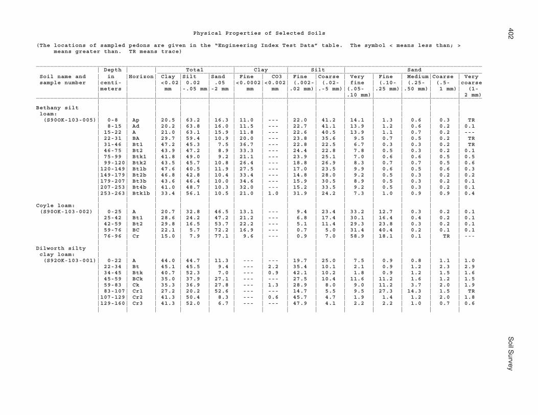
402S
oil Survey
Physical Properties of Selected Soils
(The locations of sampled pedons are given in the “Engineering Index Test Data” table. The symbol < means less than; > means greater than. TR means trace)
_____________________________________________________________________________________________________________________________ | Depth | | Total | Clay | Silt | Sand ___________________________________________________________________________________________ Soil name and | in |Horizon| Clay |Silt |Sand | Fine | CO3 | Fine |Coarse | Very | Fine | Medium|Coarse | Very sample number |centi- | | <0.02| 0.02 | .05 |<0.0002|<0.002| (.002-| (.02- | fine | (.10- | (.25- | (.5- |coarse |meters | | mm |-.05 mm|-2 mm | mm | mm |.02 mm)|.-5 mm)|(.05- |.25 mm)|.50 mm)| 1 mm)| (1- | | | | | | | | | |.10 mm)| | | | 2 mm)_____________________________________________________________________________________________________________________________ | | | | | | | | | | | | | |Bethany silt | | | | | | | | | | | | | | loam: | | | | | | | | | | | | | | (S90OK-103-005)| 0-8 | Ap | 20.5 | 63.2 | 16.3 | 11.0 | --- | 22.0 | 41.2 | 14.1 | 1.3 | 0.6 | 0.3 | TR | 8-15 | Ad | 20.2 | 63.8 | 16.0 | 11.5 | --- | 22.7 | 41.1 | 13.9 | 1.2 | 0.6 | 0.2 | 0.1 | 15-22 | A | 21.0 | 63.1 | 15.9 | 11.8 | --- | 22.6 | 40.5 | 13.9 | 1.1 | 0.7 | 0.2 | --- | 22-31 | BA | 29.7 | 59.4 | 10.9 | 20.0 | --- | 23.8 | 35.6 | 9.5 | 0.7 | 0.5 | 0.2 | TR | 31-46 | Bt1 | 47.2 | 45.3 | 7.5 | 36.7 | --- | 22.8 | 22.5 | 6.7 | 0.3 | 0.3 | 0.2 | TR | 46-75 | Bt2 | 43.9 | 47.2 | 8.9 | 33.3 | --- | 24.4 | 22.8 | 7.8 | 0.5 | 0.3 | 0.2 | 0.1 | 75-99 | Btk1 | 41.8 | 49.0 | 9.2 | 21.1 | --- | 23.9 | 25.1 | 7.0 | 0.6 | 0.6 | 0.5 | 0.5 | 99-120| Btk2 | 43.5 | 45.7 | 10.8 | 26.4 | --- | 18.8 | 26.9 | 8.3 | 0.7 | 0.7 | 0.5 | 0.6 |120-149| Bt1b | 47.6 | 40.5 | 11.9 | 27.5 | --- | 17.0 | 23.5 | 9.9 | 0.6 | 0.5 | 0.6 | 0.3 |149-179| Bt2b | 46.8 | 42.8 | 10.4 | 33.4 | --- | 14.8 | 28.0 | 9.2 | 0.5 | 0.3 | 0.2 | 0.2 |179-207| Bt3b | 43.6 | 46.4 | 10.0 | 34.6 | --- | 15.9 | 30.5 | 8.9 | 0.5 | 0.3 | 0.2 | 0.1 |207-253| Bt4b | 41.0 | 48.7 | 10.3 | 32.0 | --- | 15.2 | 33.5 | 9.2 | 0.5 | 0.3 | 0.2 | 0.1 |253-263| Btk1b | 33.4 | 56.1 | 10.5 | 21.0 | 1.0 | 31.9 | 24.2 | 7.3 | 1.0 | 0.9 | 0.9 | 0.4 | | | | | | | | | | | | | |Coyle loam: | | | | | | | | | | | | | | (S90OK-103-002) | 0-25 | A | 20.7 | 32.8 | 46.5 | 13.1 | --- | 9.4 | 23.4 | 33.2 | 12.7 | 0.3 | 0.2 | 0.1 | 25-42 | Bt1 | 28.6 | 24.2 | 47.2 | 21.2 | --- | 6.8 | 17.4 | 30.1 | 16.4 | 0.4 | 0.2 | 0.1 | 42-59 | Bt2 | 29.8 | 16.5 | 53.7 | 22.2 | --- | 5.1 | 11.4 | 29.3 | 23.8 | 0.3 | 0.2 | 0.1 | 59-76 | BC | 22.1 | 5.7 | 72.2 | 16.9 | --- | 0.7 | 5.0 | 31.4 | 40.4 | 0.2 | 0.1 | 0.1 | 76-96 | Cr | 15.0 | 7.9 | 77.1 | 9.6 | --- | 0.9 | 7.0 | 58.9 | 18.1 | 0.1 | TR | --- | | | | | | | | | | | | | |Dilworth silty | | | | | | | | | | | | | | clay loam: | | | | | | | | | | | | | | (S92OK-103-001)| 0-22 | A | 44.0 | 44.7 | 11.3 | --- | --- | 19.7 | 25.0 | 7.5 | 0.9 | 0.8 | 1.1 | 1.0 | 22-34 | Bt | 45.1 | 45.5 | 9.4 | --- | 2.2 | 35.4 | 10.1 | 2.1 | 0.9 | 1.2 | 2.3 | 2.9 | 34-45 | Btk | 40.7 | 52.3 | 7.0 | --- | 0.9 | 42.1 | 10.2 | 1.8 | 0.9 | 1.2 | 1.5 | 1.6 | 45-59 | BCk | 35.0 | 37.9 | 27.1 | --- | --- | 27.5 | 10.4 | 11.6 | 11.2 | 1.6 | 1.2 | 1.5 | 59-83 | Ck | 35.3 | 36.9 | 27.8 | --- | 1.3 | 28.9 | 8.0 | 9.0 | 11.2 | 3.7 | 2.0 | 1.9 | 83-107| Cr1 | 27.2 | 20.2 | 52.6 | --- | --- | 14.7 | 5.5 | 9.5 | 27.3 | 14.3 | 1.5 | TR |107-129| Cr2 | 41.3 | 50.4 | 8.3 | --- | 0.6 | 45.7 | 4.7 | 1.9 | 1.4 | 1.2 | 2.0 | 1.8 |129-160| Cr3 | 41.3 | 52.0 | 6.7 | --- | --- | 47.9 | 4.1 | 2.2 | 2.2 | 1.0 | 0.7 | 0.6 | | | | | | | | | | | | | |

Noble C
ounty, Oklahom
a403
Physical Properties of Selected Soils--Continued_____________________________________________________________________________________________________________________________ | Depth | | Total | Clay | Silt | Sand ___________________________________________________________________________________________ Soil name and | in |Horizon| Clay |Silt |Sand | Fine | CO3 | Fine |Coarse | Very | Fine | Medium|Coarse | Very sample number |centi- | | <0.02| 0.02 | .05 |<0.0002|<0.002| (.002-| (.02- | fine | (.10- | (.25- | (.5- |coarse |meters | | mm |-.05 mm|-2 mm | mm | mm |.02 mm)|.-5 mm)|(.05- |.25 mm)|.50 mm)| 1 mm)| (1- | | | | | | | | | |.10 mm)| | | | 2 mm)_____________________________________________________________________________________________________________________________ | | | | | | | | | | | | | |Grainola silty | | | | | | | | | | | | | | clay loam: | | | | | | | | | | | | | | (S90OK-103-003)| 0-8 | Ap1 | 36.0 | 42.4 | 21.6 | 24.4 | --- | 13.5 | 28.9 | 14.9 | 5.3 | 0.5 | 0.5 | 0.4 | 8-1 | Ap2 | 37.8 | 43.0 | 19.2 | 25.8 | --- | 13.9 | 29.1 | 13.2 | 4.6 | 0.4 | 0.4 | 0.6 | 13-22 | Ad | 40.8 | 41.6 | 17.6 | 27.7 | --- | 15.0 | 26.6 | 11.6 | 4.4 | 0.4 | 0.5 | 0.7 | 22-37 | Btk1 | 48.6 | 34.3 | 17.1 | 28.3 | 1 | 19.4 | 14.9 | 7.5 | 3.4 | 2.0 | 2.3 | 1.9 | 37-63 | Btk2 | 49.6 | 36.0 | 14.4 | 29.6 | 1 | 22.4 | 13.6 | 5.7 | 3.1 | 1.8 | 2.2 | 1.6 | 63-86 | Btk3 | 68.8 | 27.1 | 4.1 | 33.5 | 1 | 24.6 | 2.5 | 0.8 | 0.8 | 1.0 | 0.9 | 0.6 | 86-102| Btk4 | 60.6 | 34.1 | 5.3 | 20.8 | 1 | 30.9 | 3.2 | 1.3 | 1.0 | 0.9 | 1.2 | 0.9 |102-116| C | 58.9 | 35.5 | 5.6 | ---- | 1 | 31.0 | 4.5 | 3.3 | 1.1 | 0.6 | 0.5 | 0.1 |116-140| Cr1 | 41.9 | 41.8 | 16.3 | ---- | 1 | 29.1 | 12.7 | 9.6 | 2.8 | 1.5 | 1.4 | 1.0 |140-180| Cr2 | 27.5 | 57.8 | 14.7 | ---- | TR | 29.6 | 28.2 | 12.6 | 0.8 | 0.3 | 0.5 | 0.5 | 0-12 | Ap* | 37.6 | 39.6 | 22.8 | ---- | --- | 10.8 | 28.8 | 15.0 | 6.5 | 0.5 | 0.4 | 0.4 | | | | | | | | | | | | | |Highview gravelly| | | | | | | | | | | | | | silty clay: | | | | | | | | | | | | | | (S910K-103-003)| 0-10 | A | 49.8 | 42.0 | 8.2 | 8.5 | --- | 32.4 | 9.6 | 1.9 | 1.7 | 1.8 | 1.5 | 1.3 | 10-34 | Bw | 56.8 | 36.3 | 6.9 | 6.6 | 6.6 | 30.2 | 6.1 | 1.7 | 1.5 | 1.5 | 1.3 | 0.9 | 34-60 | Cr | 42.0 | 47.6 | 10.4 | 5.8 | 2.5 | 41.0 | 6.6 | 3.7 | 3.3 | 2.2 | 1.0 | 0.2 | | | | | | | | | | | | | |Kirkland silt | | | | | | | | | | | | | | loam: | | | | | | | | | | | | | | (S90OK-103-006)| 0-12 | Ap1 | 25.7 | 62.1 | 12.2 | 20.3 | --- | 23.0 | 39.1 | 10.8 | 0.8 | 0.5 | 0.1 | TR | 12-27 | Ap2 | 24.4 | 63.8 | 11.8 | 19.6 | --- | 23.2 | 40.6 | 10.6 | 0.7 | 0.4 | 0.1 | TR | 27-37 | Bt1 | 39.5 | 52.7 | 7.8 | 33.7 | --- | 23.3 | 29.4 | 6.8 | 0.6 | 0.3 | 0.1 | TR | 37-51 | Bt2 | 46.0 | 48.8 | 5.2 | 39.8 | --- | 23.6 | 25.2 | 4.4 | 0.4 | 0.3 | 0.1 | --- | 51-67 | Bt3 | 44.2 | 50.7 | 5.1 | 33.9 | --- | 24.6 | 26.2 | 4.3 | 0.4 | 0.3 | 0.1 | --- | 67-85 | Bt4 | 40.2 | 53.9 | 5.9 | 32.7 | --- | 25.2 | 28.7 | 5.2 | 0.3 | 0.3 | 0.1 | TR | 85-118| Btk | 30.8 | 54.8 | 14.4 | 21.4 | --- | 22.6 | 32.2 | 12.5 | 1.1 | 0.5 | 0.2 | 0.1 |118-144| Btk1b | 39.3 | 49.6 | 11.1 | 29.1 | --- | 19.1 | 30.5 | 9.4 | 0.6 | 0.4 | 0.4 | 0.3 |144-174| Btk2b | 42.6 | 47.3 | 10.1 | 31.0 | --- | 17.9 | 29.4 | 8.7 | 0.6 | 0.3 | 0.2 | 0.3 |174-204| Btk3b | 40.1 | 50.7 | 9.2 | 29.0 | --- | 19.0 | 31.7 | 8.1 | 0.4 | 0.3 | 0.3 | 0.1 |204-238| Btk4b | 39.9 | 49.6 | 10.5 | 31.4 | --- | 17.9 | 31.7 | 9.6 | 0.4 | 0.3 | 0.1 | 0.1 | | | | | | | | | | | | | |Lela silty clay: | | | | | | | | | | | | | | (S90OK-103-007) | 0-8 | Ap1 | 44.1 | 52.8 | 3.1 | --- | --- | 31.3 | 21.5 | 2.4 | 0.4 | 0.2 | 0.1 | TR | 8-16 | Ap2 | 44.2 | 52.9 | 2.9 | --- | --- | 31.3 | 21.6 | 2.4 | 0.2 | 0.2 | 0.1 | TR | 16-32 | A1 | 54.3 | 42.2 | 3.5 | --- | --- | 24.3 | 17.9 | 2.8 | 0.4 | 0.3 | TR | TR | 32-58 | A2 | 60.3 | 36.4 | 3.3 | --- | --- | 21.9 | 14.5 | 2.8 | 0.3 | 0.2 | TR | --- | 58-87 | A3 | 60.1 | 36.6 | 3.3 | --- | --- | 24.7 | 11.9 | 2.5 | 0.4 | 0.3 | TR | 0.1 | 87-107| A4 | 61.6 | 35.8 | 2.6 | --- | --- | 25.6 | 10.2 | 1.9 | 0.4 | 0.2 | 0.1 | --- |107-134| Bw1 | 62.6 | 34.9 | 2.5 | --- | --- | 25.0 | 9.9 | 1.6 | 0.3 | 0.3 | 0.1 | 0.2 |134-154| Bw2 | 59.6 | 36.0 | 4.4 | --- | --- | 24.7 | 11.3 | 2.0 | 0.3 | 0.5 | 0.6 | 1.0 |154-182| Bw3 | 58.7 | 36.9 | 4.4 | --- | --- | 26.0 | 10.9 | 2.6 | 0.5 | 0.5 | 0.2 | 0.6 |182-222| Bw4 | 57.9 | 36.8 | 5.3 | --- | --- | 25.0 | 11.8 | 2.2 | 0.6 | 0.8 | 0.8 | 0.9 | 0-10 | Ap* | 53.7 | 43.8 | 2.5 | --- | --- | 30.8 | 13.0 | 2.0 | 0.2 | 0.2 | 0.1 | TR
See footnote at end of table.

404S
oil Survey
Physical Properties of Selected Soils--Continued_____________________________________________________________________________________________________________________________ | Depth | | Total | Clay | Silt | Sand ___________________________________________________________________________________________ Soil name and | in |Horizon| Clay |Silt |Sand | Fine | CO3 | Fine |Coarse | Very | Fine | Medium|Coarse | Very sample number |centi- | | <0.02| 0.02 | .05 |<0.0002|<0.002| (.002-| (.02- | fine | (.10- | (.25- | (.5- |coarse |meters | | mm |-.05 mm|-2 mm | mm | mm |.02 mm)|.-5 mm)|(.05- |.25 mm)|.50 mm)| 1 mm)| (1- | | | | | | | | | |.10 mm)| | | | 2 mm)_____________________________________________________________________________________________________________________________ | | | | | | | | | | | | | |Lucien very fine | | | | | | | | | | | | | | sandy loam: | | | | | | | | | | | | | | (S91OK-103-001)| 0-13 | A | 11.5 | 21.4 | 67.1 | --- | --- | 7.0 | 14.4 | 46.9 | 19.8 | 0.3 | 0.1 | TR | 13-21 | BA | 11.7 | 21.0 | 67.3 | --- | --- | 4.8 | 16.2 | 48.4 | 18.5 | 0.3 | 0.1 | TR | 21-32 | Bw | 11.0 | 18.5 | 70.5 | --- | --- | 4.2 | 14.3 | 40.5 | 29.6 | 0.2 | 0.1 | 0.1 | 32-44 | Cr | 10.7 | 10.8 | 78.5 | 8.2 | --- | 4.7 | 6.1 | 68.2 | 10.2 | 0.1 | TR | --- | | | | | | | | | | | | | |Norge silt loam: | | | | | | | | | | | | | | (S90OK-103-008) | 0-15 | Ap1 | 20.8 | 65.5 | 13.7 | 15.9 | --- | 19.0 | 46.5 | 12.0 | 0.9 | 0.6 | 0.2 | TR | 15-27 | Ap2 | 24.0 | 63.2 | 12.8 | 19.1 | --- | 20.9 | 42.3 | 10.8 | 1.1 | 0.7 | 0.2 | --- | 27-37 | BA | 34.0 | 54.6 | 11.4 | 27.2 | --- | 21.4 | 33.2 | 9.5 | 1.0 | 0.7 | 0.2 | TR | 37-59 | Bt1 | 36.1 | 50.3 | 13.6 | 28.7 | --- | 19.8 | 30.5 | 11.0 | 1.5 | 0.8 | 0.2 | 0.1 | 59-81 | Bt2 | 35.4 | 50.5 | 14.1 | 28.8 | --- | 19.2 | 31.3 | 12.4 | 0.9 | 0.6 | 0.2 | TR | 81-97 | Bt3 | 36.3 | 48.0 | 15.7 | 30.7 | --- | 18.4 | 29.6 | 13.8 | 1.0 | 0.6 | 0.2 | 0.1 | 97-124| 2Bt4 | 38.3 | 48.1 | 13.6 | 32.4 | --- | 17.4 | 30.7 | 11.9 | 1.0 | 0.5 | 0.2 | TR |124-147| 2Bt5 | 38.7 | 47.7 | 13.6 | 32.2 | --- | 15.2 | 32.5 | 12.2 | 0.7 | 0.4 | 0.2 | 0.1 |147-169| 2Btk1 | 39.1 | 45.4 | 15.5 | 31.5 | --- | 15.6 | 29.8 | 13.8 | 0.8 | 0.4 | 0.3 | 0.2 |169-205| 2Btk2 | 39.2 | 47.2 | 13.6 | 25.2 | --- | 17.6 | 29.6 | 10.3 | 0.7 | 0.6 | 0.9 | 1.1 |205-241| 2Btk3 | 37.4 | 46.3 | 16.3 | 23.2 | --- | 16.7 | 29.6 | 13.8 | 0.8 | 0.5 | 0.5 | 0.7 | | | | | | | | | | | | | |Port silt loam: | | | | | | | | | | | | | | (S90OK-103-004) | 0-10 | Ap1 | 23.9 | 65.6 | 10.5 | --- | --- | 33.9 | 31.7 | 9.1 | 0.8 | 0.4 | 0.1 | 0.1 | 10-19 | Ap2 | 24.6 | 67.3 | 8.1 | --- | -- | 34.5 | 32.8 | 7.4 | 0.5 | 0.1 | 0.1 | TR | 19-35 | Ad | 23.5 | 65.0 | 11.5 | --- | --- | 31.3 | 33.7 | 10.3 | 0.8 | 0.3 | 0.1 | TR | 35-52 | A1 | 25.2 | 62.4 | 12.4 | --- | --- | 33.3 | 29.1 | 10.6 | 1.2 | 0.5 | 0.1 | TR | 52-76 | A2 | 20.1 | 69.8 | 10.1 | --- | --- | 32.9 | 36.9 | 9.1 | 0.7 | 0.2 | 0.1 | TR | 76-101| Bw | 20.3 | 63.4 | 16.3 | --- | --- | 25.6 | 37.8 | 12.7 | 2.3 | 0.9 | 0.3 | 0.1 |101-123| Bwk1 | 22.2 | 59.3 | 18.5 | --- | --- | 24.7 | 34.6 | 15.5 | 2.4 | 0.3 | 0.2 | 0.1 |123-139| Bwk2 | 23.0 | 54.9 | 22.1 | --- | --- | 23.7 | 31.2 | 18.1 | 3.1 | 0.3 | 0.2 | 0.4 |139-172| Ab | 32.5 | 58.7 | 8.8 | --- | --- | 31.7 | 27.0 | 7.6 | 0.8 | 0.2 | 0.1 | 0.1 |172-187| Bw1b | 31.8 | 62.0 | 6.2 | --- | --- | 34.9 | 27.1 | 5.3 | 0.6 | 0.2 | 0.1 | TR |187-217| Bw2b | 34.5 | 60.0 | 5.5 | --- | --- | 35.8 | 24.2 | 5.0 | 0.3 | 0.1 | TR | 0.1 |217-237| Bw3b | 33.5 | 55.3 | 11.2 | --- | --- | 31.1 | 24.2 | 8.4 | 0.9 | 0.4 | 0.6 | 0.9 | 0-12 | Ap* | 26.0 | 59.4 | 14.6 | --- | --- | 29.8 | 29.6 | 12.8 | 1.2 | 0.4 | 0.1 | 0.1 | | | | | | | | | | | | | |
See footnote at end of table.

Noble C
ounty, Oklahom
a405
Physical Properties of Selected Soils--Continued_____________________________________________________________________________________________________________________________ | Depth | | Total | Clay | Silt | Sand ___________________________________________________________________________________________ Soil name and | in |Horizon| Clay |Silt |Sand | Fine | CO3 | Fine |Coarse | Very | Fine | Medium|Coarse | Very sample number |centi- | | <0.02| 0.02 | .05 |<0.0002|<0.002| (.002-| (.02- | fine | (.10- | (.25- | (.5- |coarse |meters | | mm |-.05 mm|-2 mm | mm | mm |.02 mm)|.-5 mm)|(.05- |.25 mm)|.50 mm)| 1 mm)| (1- | | | | | | | | | |.10 mm)| | | | 2 mm)_____________________________________________________________________________________________________________________________ | | | | | | | | | | | | | |Renfrow silt | | | | | | | | | | | | | | loam: | | | | | | | | | | | | | | (S90OK-103-001)| 0-9 | Ap | 20.2 | 50.3 | 29.5 | 15.3 | --- | 17.6 | 32.7 | 15.6 | 12.8 | 0.7 | 0.4 | TR | 9-18 | A | 20.5 | 49.8 | 29.7 | 16.0 | --- | 17.7 | 32.1 | 15.1 | 13.5 | 0.6 | 0.4 | 0.1 | 18-29 | BA | 31.7 | 44.3 | 24.0 | 25.6 | --- | 18.9 | 25.4 | 12.6 | 10.5 | 0.5 | 0.3 | 0.1 | 29-56 | Bt | 45.9 | 36.8 | 17.3 | 37.1 | --- | 20.2 | 16.6 | 8.4 | 8.3 | 0.4 | 0.2 | TR | 56-83 | Btk1 | 43.4 | 36.7 | 19.9 | 27.9 | --- | 21.0 | 15.7 | 9.5 | 9.4 | 0.4 | 0.4 | 0.2 | 83-108| Btk2 | 49.4 | 32.5 | 18.1 | 27.8 | --- | 21.0 | 11.5 | 7.9 | 8.4 | 0.7 | 0.6 | 0.5 |108-142| Btk3 | 54.4 | 34.5 | 11.1 | 33.4 | --- | 24.2 | 10.3 | 5.9 | 4.8 | 0.2 | 0.1 | 0.1 |142-169| Btk4 | 46.6 | 45.7 | 7.7 | 21.1 | 4 | 35.6 | 10.1 | 3.1 | 2.6 | 0.9 | 0.6 | 0.5 |169-183| BC1 | 41.6 | 44.2 | 14.2 | --- | 3 | 36.4 | 7.8 | 2.9 | 2.9 | 2.9 | 3.0 | 2.5 |183-201| BC2 | 43.4 | 43.9 | 12.7 | --- | 2 | 34.2 | 9.7 | 2.5 | 2.9 | 2.4 | 2.5 | 2.4 |201-224| Cr1 | 45.2 | 50.4 | 4.4 | --- | 2 | 42.1 | 8.3 | 1.2 | 0.6 | 0.9 | 1.0 | 0.7 |224-250| Cr2 | 43.7 | 53.5 | 2.8 | --- | --- | 43.8 | 9.7 | 1.2 | 0.3 | 0.3 | 0.4 | 0.6 | | | | | | | | | | | | | |Westsum silty | | | | | | | | | | | | | | clay loam: | | | | | | | | | | | | | | (S91OK-103-002)| 0-16 | Ap | 41.0 | 49.9 | 9.1 | 27.9 | --- | 20.8 | 29.1 | 8.1 | 0.5 | 0.3 | 0.1 | 0.1 | 16-28 | Bt1 | 47.0 | 46.3 | 6.7 | 32.4 | --- | 19.6 | 26.7 | 5.5 | 0.4 | 0.3 | 0.3 | 0.2 | 28-42 | Btk1 | 47.2 | 44.1 | 8.7 | 25.2 | --- | 23.1 | 21.0 | 5.0 | 0.9 | 0.8 | 1.1 | 0.9 | 42-86 | Btk2 | 45.9 | 43.4 | 10.7 | 22.2 | 4.1 | 26.6 | 16.8 | 5.7 | 1.2 | 1.5 | 1.3 | 1.0 | 86-117| Bt2 | 46.7 | 43.7 | 9.6 | 24.0 | 4.0 | 27.0 | 16.7 | 5.7 | 1.2 | 1.0 | 0.8 | 0.9 |117-166| Bt3 | 47.4 | 46.3 | 6.3 | ---- | 6.5 | 29.0 | 17.3 | 4.2 | 0.7 | 0.5 | 0.5 | 0.4 |166-208| BC1 | 47.1 | 46.0 | 6.9 | ---- | 5.6 | 27.9 | 18.1 | 5.2 | 0.8 | 0.5 | 0.3 | 0.1 |208-236| BC2 | 46.8 | 45.3 | 7.9 | 25.2 | 3.4 | 27.4 | 17.9 | 5.3 | 1.0 | 0.7 | 0.6 | 0.3 | | | | | | | | | | | | | |_____________________________________________________________________________________________________________________________
* Additional satellite samples of surface layers for verification.

406 Soil Survey
Chemical PropertiesThe table “Chemical Properties of the Soils” shows estimates of some
characteristics and features that affect soil behavior. These estimates are given for themajor layers of each soil in the survey area. The estimates are based on fieldobservations and on test data for these and similar soils.
Depth to the upper and lower boundaries of each layer is indicated. The range indepth and information on other properties of each layer are given in the seriesdescriptions section of this survey.
Cation-exchange capacity is the total amount of exchangeable cations that can beheld by the soil, expressed in terms of milliequivalents per 100 grams of soil atneutrality (pH 7.0) or at some other stated pH value. Soils having a low cation-exchange capacity hold fewer cations and may require more frequent applications offertilizer than soils having a high cation-exchange capacity. Soils having a high cation-exchange capacity can retain cations. The ability to retain cations helps to prevent thepollution of ground water.
Soil reaction is a measure of acidity or alkalinity and is expressed as a range in pHvalues. The range in pH of each major horizon is based on many field tests. For manysoils, values have been verified by laboratory analyses. Soil reaction is important inselecting crops and other plants, in evaluating soil amendments for fertility andstabilization, and in determining the risk of corrosion.
Calcium carbonate equivalent is the percent of carbonates, by weight, in the soil.The availability of plant nutrients is influenced by the amount of carbonates in the soil.Incorporating nitrogen fertilizer into calcareous soils helps to prevent nitriteaccumulation and ammonium-N volatilization.
Gypsum is given as the percent, by weight, of hydrated calcium sulfates in the soil.Gypsum is partially soluble in water and can be dissolved and removed by water. Soilsthat have a high content of gypsum (more than 10 percent) may collapse if the gypsumis removed by percolating water.
Salinity is a measure of soluble salts in the soil at saturation. It is expressed as theelectrical conductivity of the saturation extract, in millimhos per centimeter(decisiemens per meter) at 25 degrees C. Estimates are based on field and laboratorymeasurements at representative sites of nonirrigated soils. The salinity of irrigated soilsis affected by the quality of the irrigation water and by the frequency of waterapplication. Hence, the salinity of soils in individual fields can differ greatly from thevalue given in the table. Salinity affects the suitability of a soil for crop production, thestability of the soil if used as construction material, and the potential of the soil tocorrode metal and concrete.
Sodium adsorption ratio is the measure of sodium relative to calcium andmagnesium in the water extract from saturated soil paste. Soils having a sodiumadsorption ratio of 13 or more may be characterized by an increased dispersion oforganic matter and clay particles, reduced permeability and aeration, and a generaldegradation of soil structure.

Noble County, Oklahoma 407
Chemical Properties of the Soils
(Absence of an entry indicates that data were not estimated)
_________________________________________________________________________________________ | | Cation- | |Calcium| | | Sodium Map symbol | Depth |exchange | Soil |carbon-| Gypsum | Salinity | adsorp- and soil name | |capacity |reaction | ate | | | tion | | | | | | | ratio_________________________________________________________________________________________ | In |meq/100 g| pH | Pct | Pct | mmhos/cm | __ _________ __ ___ ___ ________ | | | | | | |AhpA: | | | | | | | Ashport--------------| 0-10 | 16-21 | 5.6-8.4 | 0 | 0 | 0 | 0 | 10-25 | 11-21 | 6.1-8.4 | 0-1 | 0 | 0 | 0 | 25-35 | 11-21 | 6.1-8.4 | 0-1 | 0 | 0 | 0 | 35-42 | 11-21 | 6.1-8.4 | 0-1 | 0 | 0 | 0 | 42-52 | 11-21 | 6.1-8.4 | 0-1 | 0 | 0 | 0 | 52-80 | 11-21 | 6.1-8.4 | 0-1 | 0 | 0 | 0 | | | | | | |APPA: | | | | | | | Ashport--------------| 0-14 | 16-21 | 5.6-8.4 | 0 | 0 | 0 | 0 | 14-27 | 11-21 | 6.1-8.4 | 0-1 | 0 | 0 | 0 | 27-80 | 11-21 | 6.1-8.4 | 0-1 | 0 | 0 | 0 | | | | | | | Port-----------------| 0-7 | 7.0-11 | 5.6-7.3 | 0 | 0 | 0 | 0 | 7-27 | 8.0-16 | 5.6-7.8 | 0-2 | 0 | 0 | 0 | 27-46 | 12-21 | 6.1-8.4 | 0 | 0 | 0 | 0 | 46-51 | 12-21 | 6.1-8.4 | 0 | 0 | 0 | 0 | 51-80 | 12-21 | 6.1-8.4 | 0 | 0 | 0 | 0 | | | | | | | Pulaski--------------| 0-9 | 7.0-11 | 5.6-7.3 | 0 | 0 | 0 | 0 | 9-25 | 7.0-11 | 5.6-7.3 | 0 | 0 | 0 | 0 | 25-80 | 4.0-11 | 5.6-8.4 | 0 | 0 | 0 | 0 | | | | | | |AspA: | | | | | | | Ashport--------------| 0-10 | 9.0-16 | 5.6-8.4 | 0 | 0 | 0 | 0 | 10-32 | 11-21 | 6.1-8.4 | 0-1 | 0 | 0 | 0 | 32-45 | 11-21 | 6.1-8.4 | 0-1 | 0 | 0 | 0 | 45-70 | 11-21 | 6.1-8.4 | 0-1 | 0 | 0 | 0 | 70-80 | 11-21 | 6.1-8.4 | 0-1 | 0 | 0 | 0 | | | | | | |AspB: | | | | | | | Ashport--------------| 0-10 | 9.0-16 | 5.6-8.4 | 0 | 0 | 0 | 0 | 10-21 | 11-21 | 6.1-8.4 | 0-1 | 0 | 0 | 0 | 21-36 | 11-21 | 6.1-8.4 | 0-1 | 0 | 0 | 0 | 36-65 | 11-21 | 6.1-8.4 | 0-1 | 0 | 0 | 0 | 65-80 | 11-21 | 6.1-8.4 | 0-1 | 0 | 0 | 0 | | | | | | |BetA: | | | | | | | Bethany--------------| 0-9 | 10-16 | 5.1-7.8 | 0 | 0 | 0 | 0 | 9-12 | 17-21 | 6.1-7.8 | 0 | 0 | 0 | 0 | 12-30 | 21-30 | 6.6-8.4 | 0-2 | 0 | 0 | 0 | 30-47 | 21-30 | 6.6-8.4 | 0-2 | 0 | 0 | 0 | 47-71 | 21-30 | 6.6-8.4 | 0-10 | 0 | 0.0-2.0 | 0-4 | 71-80 | 21-30 | 6.6-8.4 | 0-10 | 0 | 0.0-2.0 | 0-4 | | | | | | |BetB: | | | | | | | Bethany--------------| 0-11 | 10-16 | 5.1-7.8 | 0 | 0 | 0 | 0 | 11-16 | 17-21 | 6.1-7.8 | 0 | 0 | 0 | 0 | 16-36 | 21-30 | 6.6-8.4 | 0-2 | 0 | 0 | 0 | 36-60 | 21-30 | 6.6-8.4 | 0-2 | 0 | 0 | 0 | 60-80 | 21-30 | 6.6-8.4 | 0-10 | 0 | 0.0-2.0 | 0-4 | | | | | | |BPG. | | | | | | | Borrow pits, gravelly| | | | | | | | | | | | | |BPR. | | | | | | | Borrow pits, rock | | | | | | | | | | | | | |

408 Soil Survey
Chemical Properties of the Soils--Continued_________________________________________________________________________________________ | | Cation- | |Calcium| | | Sodium Map symbol | Depth |exchange | Soil |carbon-| Gypsum | Salinity | adsorp- and soil name | |capacity |reaction | ate | | | tion | | | | | | | ratio_________________________________________________________________________________________ | In |meq/100 g| pH | Pct | Pct | mmhos/cm | __ _________ __ ___ ___ ________ | | | | | | |BraA: | | | | | | | Braman---------------| 0-8 | 9.0-16 | 5.6-7.3 | 0 | 0 | 0 | 0 | 8-12 | 9.0-16 | 5.6-7.3 | 0 | 0 | 0 | 0 | 12-23 | 15-21 | 5.6-8.4 | 0 | 0 | 0 | 0 | 23-36 | 15-21 | 5.6-8.4 | 0 | 0 | 0 | 0 | 36-48 | 9.0-17 | 7.4-8.4 | 0-2 | 0 | 0 | 0 | 48-82 | 9.0-30 | 7.9-8.4 | 0-2 | 0 | 0 | 0 | | | | | | |BrwA: | | | | | | | Brewer---------------| 0-11 | 11-16 | 5.6-7.3 | 0 | 0 | 0 | 0 | 11-23 | 11-16 | 5.6-7.3 | 0 | 0 | 0 | 0 | 23-40 | 21-33 | 6.1-8.4 | 0-2 | 0-1 | 0 | 0-7 | 40-48 | 21-33 | 7.4-8.4 | 0-2 | 0-1 | 0 | 0-7 | 48-80 | 15-24 | 6.6-8.4 | 0-2 | 0-1 | 0.0-8.0 | 0-7 | | | | | | |CoLC: | | | | | | | Coyle----------------| 0-6 | 10-16 | 5.6-7.8 | 0 | 0 | 0 | 0 | 6-11 | 11-16 | 5.6-7.8 | 0 | 0 | 0 | 0 | 11-16 | 13-21 | 5.6-7.8 | 0 | 0 | 0 | 0 | 16-21 | 11-21 | 5.6-7.8 | 0 | 0 | 0 | 0 | 21-38 | --- | --- | --- | --- | --- | --- | | | | | | | Lucien---------------| 0-4 | 6.0-11 | 5.6-7.3 | 0 | 0 | 0 | 0 | 4-8 | 9.0-15 | 5.6-7.3 | 0 | 0 | 0 | 0 | 8-13 | 9.0-15 | 5.6-7.3 | 0 | 0 | 0 | 0 | 13-17 | --- | --- | --- | --- | --- | --- | | | | | | |CoyB: | | | | | | | Coyle----------------| 0-10 | 10-16 | 5.6-7.8 | 0 | 0 | 0 | 0 | 10-17 | 13-21 | 5.6-7.8 | 0 | 0 | 0 | 0 | 17-23 | 11-21 | 5.6-7.8 | 0 | 0 | 0 | 0 | 23-30 | 11-21 | 5.6-7.8 | 0 | 0 | 0 | 0 | 30-38 | --- | --- | --- | --- | --- | --- | | | | | | |CoyC: | | | | | | | Coyle----------------| 0-7 | 10-16 | 5.6-7.8 | 0 | 0 | 0 | 0 | 7-10 | 11-16 | 5.6-7.8 | 0 | 0 | 0 | 0 | 10-20 | 13-21 | 5.6-7.8 | 0 | 0 | 0 | 0 | 20-27 | 11-21 | 5.6-7.8 | 0 | 0 | 0 | 0 | 27-30 | --- | --- | --- | --- | --- | --- | | | | | | |CoyC2: | | | | | | | Coyle----------------| 0-5 | 10-16 | 5.6-7.8 | 0 | 0 | 0 | 0 | 5-9 | 11-16 | 5.6-7.8 | 0 | 0 | 0 | 0 | 9-16 | 13-21 | 5.6-7.8 | 0 | 0 | 0 | 0 | 16-23 | 11-21 | 5.6-7.8 | 0 | 0 | 0 | 0 | 23-31 | 11-21 | 5.6-7.8 | 0 | 0 | 0 | 0 | 31-35 | --- | --- | --- | --- | --- | --- | | | | | | |CoZC3: | | | | | | | Coyle----------------| 0-7 | 10-16 | 5.6-7.8 | 0 | 0 | 0 | 0 | 7-10 | 11-16 | 5.6-7.8 | 0 | 0 | 0 | 0 | 10-21 | 13-21 | 5.6-7.8 | 0 | 0 | 0 | 0 | 21-24 | --- | --- | --- | --- | --- | --- | | | | | | | Zaneis---------------| 0-10 | 10-16 | 5.6-7.3 | 0 | 0 | 0 | 0 | 10-14 | 11-18 | 5.6-7.3 | 0 | 0 | 0 | 0 | 14-26 | 11-18 | 5.6-7.3 | 0 | 0 | 0 | 0 | 26-40 | 13-23 | 5.6-7.3 | 0 | 0 | 0 | 0 | 40-50 | 13-23 | 5.6-7.3 | 0 | 0 | 0 | 0 | 50-52 | --- | --- | --- | --- | --- | ---

Noble County, Oklahoma 409
Chemical Properties of the Soils--Continued_________________________________________________________________________________________ | | Cation- | |Calcium| | | Sodium Map symbol | Depth |exchange | Soil |carbon-| Gypsum | Salinity | adsorp- and soil name | |capacity |reaction | ate | | | tion | | | | | | | ratio_________________________________________________________________________________________ | In |meq/100 g| pH | Pct | Pct | mmhos/cm | __ _________ __ ___ ___ ________ | | | | | | |DalA: | | | | | | | Dale-----------------| 0-7 | 10-16 | 6.1-7.8 | 0 | 0 | 0 | 0 | 7-21 | 10-16 | 6.1-7.8 | 0 | 0 | 0 | 0 | 21-60 | 11-21 | 6.6-8.4 | 0-5 | 0 | 0 | 0 | 60-80 | 11-21 | 6.6-8.4 | 0-5 | 0 | 0 | 0 | | | | | | |DAM. | | | | | | | Dam | | | | | | | | | | | | | |DaUA: | | | | | | | Dale-----------------| 0-13 | 10-16 | 6.1-7.8 | 0 | 0 | 0 | 0 | 13-22 | 11-21 | 6.6-8.4 | 0-5 | 0 | 0 | 0 | 22-34 | 11-21 | 6.6-8.4 | 0-5 | 0 | 0 | 0 | 34-50 | 11-21 | 6.6-8.4 | 0-5 | 0 | 0 | 0 | 50-80 | 11-21 | 6.6-8.4 | 0-5 | 0 | 0 | 0 | | | | | | | Urban land. | | | | | | | | | | | | | |DiGE: | | | | | | | Dilworth-------------| 0-7 | 17-21 | 6.6-8.4 | 0-1 | 0 | 0 | 0 | 7-12 | 21-33 | 7.9-8.4 | 10-20 | 0 | 0 | 0 | 12-22 | 24-32 | 7.9-8.4 | 10-20 | 0 | 0 | 0 | 22-30 | --- | --- | --- | --- | --- | --- | | | | | | | Grainola-------------| 0-7 | 10-16 | 6.6-8.4 | 0-2 | 0 | 0 | 0 | 7-17 | 21-36 | 7.9-8.4 | 0-5 | 0 | 0 | 0 | 17-31 | 21-36 | 7.9-8.4 | 0-10 | 0 | 0 | 0 | 31-44 | --- | --- | 0 | 0 | --- | 0 | | | | | | |DooB: | | | | | | | Doolin---------------| 0-10 | 9.0-17 | 5.6-7.8 | 0 | 0 | 0.0-2.0 | 0-10 | 10-24 | 21-33 | 6.1-8.4 | 0 | 0-1 | 0.0-2.0 | 15-20 | 24-36 | 21-33 | 6.1-8.4 | 0 | 0-1 | 0.0-2.0 | 15-20 | 36-51 | 18-24 | 7.4-8.4 | 0 | 0-1 | 2.0-6.0 | 15-20 | 51-70 | 18-24 | 7.4-8.4 | 0 | 0-1 | 2.0-6.0 | 15-20 | 70-75 | --- | --- | --- | --- | --- | --- | | | | | | |DwhC: | | | | | | | Dilworth-------------| 0-7 | 17-21 | 6.6-8.4 | 0-1 | 0 | 0 | 0 | 7-13 | 21-33 | 7.9-8.4 | 10-20 | 0 | 0 | 0 | 13-18 | 24-32 | 7.9-8.4 | 10-20 | 0 | 0 | 0 | 18-28 | 24-32 | 7.9-8.4 | 10-20 | 0 | 0 | 0 | 28-36 | 24-32 | 7.9-8.4 | 10-20 | 0 | 0 | 0 | 36-43 | --- | --- | --- | --- | --- | --- | | | | | | |EasA: | | | | | | | Easpur---------------| 0-11 | 8.0-16 | 5.6-8.4 | 0 | 0 | 0 | 0 | 11-30 | 11-21 | 6.1-8.4 | 0 | 0 | 0 | 0 | 30-54 | 11-21 | 6.1-8.4 | 0 | 0 | 0 | 0 | 54-63 | 11-21 | 6.1-8.4 | 0 | 0 | 0 | 0 | 63-80 | 11-21 | 6.1-8.4 | 0-2 | 0 | 0 | 0 | | | | | | |GadA: | | | | | | | Gaddy----------------| 0-6 | 4.0-10 | 7.4-8.4 | 0-2 | 0 | 0 | 0 | 6-80 | 4.0-10 | 7.9-8.4 | 1-5 | 0 | 0 | 0 | | | | | | |

410 Soil Survey
Chemical Properties of the Soils--Continued_________________________________________________________________________________________ | | Cation- | |Calcium| | | Sodium Map symbol | Depth |exchange | Soil |carbon-| Gypsum | Salinity | adsorp- and soil name | |capacity |reaction | ate | | | tion | | | | | | | ratio_________________________________________________________________________________________ | In |meq/100 g| pH | Pct | Pct | mmhos/cm | __ _________ __ ___ ___ ________ | | | | | | |GayA: | | | | | | | Gaddy----------------| 0-6 | 4.0-10 | 7.4-8.4 | 0-2 | 0 | 0 | 0 | 6-11 | 4.0-10 | 7.4-8.4 | 0-2 | 0 | 0 | 0 | 11-24 | 3.0-8.0 | 7.4-8.4 | 0-5 | 0 | 0.0-2.0 | 0 | 24-45 | 2.0-7.0 | 7.4-8.4 | 0-1 | 0 | 0.0-4.0 | 0-2 | 45-60 | 3.0-8.0 | 7.4-8.4 | 0-5 | 0 | 0.0-2.0 | 0 | 60-80 | 3.0-10 | 7.9-8.4 | 2-15 | 0 | 0.0-2.0 | 0 | | | | | | |GMLG: | | | | | | | Grainola-------------| 0-5 | 9.0-15 | 6.6-8.4 | 0 | 0 | 0 | 0 | 5-24 | 21-35 | 7.9-8.4 | 0 | 0 | 0 | 0 | 24-30 | 21-35 | 7.9-8.4 | 0 | 0 | 0 | 0 | 30-40 | --- | --- | --- | --- | --- | --- | | | | | | | Masham---------------| 0-4 | 21-24 | 7.9-8.4 | 0-5 | 0 | 0 | 0 | 4-13 | 21-36 | 7.9-8.4 | 0-5 | 0 | 0 | 0 | 13-25 | --- | --- | --- | --- | --- | --- | | | | | | | Lucien---------------| 0-7 | 6.0-11 | 5.6-7.3 | 0 | 0 | 0 | 0 | 7-17 | 0.0-0.0 | 5.6-7.3 | 0 | 0 | 0 | 0 | 17-20 | --- | --- | --- | --- | --- | --- | | | | | | |GohE: | | | | | | | Goodnight------------| 0-8 | 4.0-8.0 | 6.1-8.4 | 0-2 | 0 | 0 | 0 | 8-20 | 4.0-8.0 | 6.1-8.4 | 0-2 | 0 | 0 | 0 | 20-80 | 4.0-8.0 | 6.1-8.4 | 0-2 | 0 | 0 | 0 | | | | | | |GraC: | | | | | | | Grainola-------------| 0-5 | 17-21 | 6.6-8.4 | 0-2 | 0 | 0 | 0 | 5-22 | 21-36 | 7.9-8.4 | 0-5 | 0 | 0 | 0 | 22-34 | 21-36 | 7.9-8.4 | 0-10 | 0 | 0 | 0 | 34-40 | --- | --- | 0 | 0 | --- | 0 | | | | | | |GrAD: | | | | | | | Grainola-------------| 0-4 | 17-21 | 6.6-8.4 | 0-2 | 0 | 0 | 0 | 4-14 | 21-36 | 7.9-8.4 | 0-5 | 0 | 0 | 0 | 14-36 | 21-36 | 7.9-8.4 | 0-10 | 0 | 0 | 0 | 36-40 | --- | --- | 0 | 0 | --- | 0 | | | | | | | Ashport--------------| 0-13 | 16-21 | 5.6-8.4 | 0 | 0 | 0 | 0 | 13-32 | 11-21 | 6.1-8.4 | 0-1 | 0 | 0 | 0 | 32-40 | 11-21 | 6.1-8.4 | 0-1 | 0 | 0 | 0 | 40-46 | 11-21 | 6.1-8.4 | 0-1 | 0 | 0 | 0 | 46-58 | 11-21 | 6.1-8.4 | 0-1 | 0 | 0 | 0 | | | | | | |GrHC: | | | | | | | Grant----------------| 0-7 | 10-16 | 6.1-7.8 | 0 | 0 | 0 | 0 | 7-11 | 10-16 | 6.1-7.8 | 0 | 0 | 0 | 0 | 11-17 | 11-21 | 6.1-8.4 | 0-2 | 0 | 0 | 0 | 17-35 | 11-21 | 6.1-8.4 | 0-2 | 0 | 0 | 0 | 35-54 | 10-16 | 7.4-8.4 | 0-2 | 0 | 0 | 0 | 54-58 | --- | --- | 0-5 | --- | --- | --- | | | | | | | Huska----------------| 0-6 | 8.0-16 | 5.6-7.8 | 0 | 0 | 0.0-8.0 | 8-18 | 6-17 | 21-27 | 6.6-8.4 | 0-2 | 0-2 | 2.0-16.0 | 15-55 | 17-32 | 21-36 | 7.4-8.4 | 0-2 | 0-2 | 2.0-16.0 | 15-55 | 32-40 | 21-36 | 7.4-8.4 | 0-2 | 0-2 | 2.0-16.0 | 15-55 | 40-50 | 21-36 | 7.4-8.4 | 0-2 | 0-2 | 2.0-16.0 | 15-55 | 50-54 | --- | --- | --- | --- | --- | --- | | | | | | |

Noble County, Oklahoma 411
Chemical Properties of the Soils--Continued_________________________________________________________________________________________ | | Cation- | |Calcium| | | Sodium Map symbol | Depth |exchange | Soil |carbon-| Gypsum | Salinity | adsorp- and soil name | |capacity |reaction | ate | | | tion | | | | | | | ratio_________________________________________________________________________________________ | In |meq/100 g| pH | Pct | Pct | mmhos/cm | __ _________ __ ___ ___ ________ | | | | | | |GrLC: | | | | | | | Grainola-------------| 0-6 | 10-16 | 6.6-8.4 | 0-2 | 0 | 0 | 0 | 6-11 | 21-36 | 7.9-8.4 | 0-5 | 0 | 0 | 0 | 11-18 | 21-36 | 7.9-8.4 | 0-10 | 0 | 0 | 0 | 18-33 | 21-36 | 7.9-8.4 | 0-10 | 0 | 0 | 0 | 33-39 | 21-36 | 7.9-8.4 | 0-10 | 0 | 0 | 0 | 39-42 | --- | --- | 0 | 0 | --- | 0 | | | | | | | Lucien---------------| 0-7 | 9.0-15 | 5.6-7.3 | 0 | 0 | 0 | 0 | 7-18 | 0.0-0.0 | 5.6-7.3 | 0 | 0 | 0 | 0 | 18-24 | --- | --- | --- | --- | --- | --- | | | | | | |GrLE: | | | | | | | Grainola-------------| 0-8 | 17-21 | 6.6-8.4 | 0-2 | 0 | 0 | 0 | 8-20 | 21-36 | 7.9-8.4 | 0-5 | 0 | 0 | 0 | 20-27 | 21-36 | 7.9-8.4 | 0-10 | 0 | 0 | 0 | 27-30 | --- | --- | 0 | 0 | --- | 0 | | | | | | | Lucien---------------| 0-7 | 9.0-15 | 5.6-7.3 | 0 | 0 | 0 | 0 | 7-12 | 0.0-0.0 | 5.6-7.3 | 0 | 0 | 0 | 0 | 12-15 | --- | --- | --- | --- | --- | --- | | | | | | |GrnC: | | | | | | | Grant----------------| 0-7 | 10-16 | 6.1-7.8 | 0 | 0 | 0 | 0 | 7-12 | 10-16 | 6.1-7.8 | 0 | 0 | 0 | 0 | 12-20 | 11-21 | 6.1-8.4 | 0-2 | 0 | 0 | 0 | 20-29 | 10-16 | 7.4-8.4 | 0-2 | 0 | 0 | 0 | 29-44 | 10-16 | 7.4-8.4 | 0-2 | 0 | 0 | 0 | 44-59 | 10-16 | 7.4-8.4 | 0-2 | 0 | 0 | 0 | 59-65 | --- | --- | 0-5 | --- | --- | --- | | | | | | |GrtB: | | | | | | | Grant----------------| 0-11 | 10-16 | 6.1-7.8 | 0 | 0 | 0 | 0 | 11-21 | 10-16 | 6.1-7.8 | 0 | 0 | 0 | 0 | 21-51 | 11-21 | 6.1-8.4 | 0-2 | 0 | 0 | 0 | 51-57 | 10-16 | 7.4-8.4 | 0-2 | 0 | 0 | 0 | 57-64 | --- | --- | 0-5 | --- | --- | --- | | | | | | |HaPE: | | | | | | | Harrah---------------| 0-5 | 7.0-11 | 4.5-7.3 | 0 | 0 | 0 | 0 | 5-9 | 4.0-11 | 4.5-7.3 | 0 | 0 | 0 | 0 | 9-24 | 11-21 | 4.5-7.3 | 0 | 0 | 0 | 0 | 24-70 | 11-21 | 4.5-7.3 | 0 | 0 | 0 | 0 | 70-80 | 11-21 | 4.5-7.3 | 0 | 0 | 0 | 0 | | | | | | | Pulaski--------------| 0-6 | 7.0-11 | 5.6-7.3 | 0 | 0 | 0 | 0 | 6-12 | 7.0-11 | 5.6-7.3 | 0 | 0 | 0 | 0 | 12-50 | 4.0-11 | 5.6-8.4 | 0 | 0 | 0 | 0 | 50-55 | 7.0-11 | 5.6-7.3 | 0 | 0 | 0 | 0 | 55-65 | 4.0-11 | 5.6-8.4 | 0 | 0 | 0 | 0 | 65-68 | --- | --- | 0-5 | --- | --- | --- | | | | | | |HiRG: | | | | | | | Highview-------------| 0-6 | 24-30 | 7.4-8.4 | 0 | 0 | 0 | 0 | 6-17 | 21-30 | 7.9-8.4 | 0 | 0 | 0 | 0 | 17-25 | --- | --- | --- | --- | --- | --- | | | | | | | Rock outcrop. | | | | | | | | | | | | | |

412 Soil Survey
Chemical Properties of the Soils--Continued_________________________________________________________________________________________ | | Cation- | |Calcium| | | Sodium Map symbol | Depth |exchange | Soil |carbon-| Gypsum | Salinity | adsorp- and soil name | |capacity |reaction | ate | | | tion | | | | | | | ratio_________________________________________________________________________________________ | In |meq/100 g| pH | Pct | Pct | mmhos/cm | __ _________ __ ___ ___ ________ | | | | | | |KekA: | | | | | | | Keokuk---------------| 0-14 | 7.0-11 | 6.1-8.4 | 0 | 0 | 0 | 0 | 14-21 | 7.0-11 | 6.1-8.4 | 0-1 | 0 | 0 | 0 | 21-31 | 7.0-11 | 6.1-8.4 | 0-1 | 0 | 0 | 0 | 31-53 | 7.0-11 | 6.1-8.4 | 0-1 | 0 | 0 | 0 | 53-70 | 7.0-11 | 6.1-8.4 | 0-1 | 0 | 0 | 0 | 70-80 | 7.0-11 | 6.1-8.4 | 0-1 | 0 | 0 | 0 | | | | | | |KeoA: | | | | | | | Keokuk---------------| 0-6 | 7.0-11 | 6.1-8.4 | 0 | 0 | 0 | 0 | 6-13 | 7.0-11 | 6.1-8.4 | 0-1 | 0 | 0 | 0 | 13-27 | 7.0-11 | 6.1-8.4 | 0-1 | 0 | 0 | 0 | 27-80 | 7.0-11 | 6.1-8.4 | 0-1 | 0 | 0 | 0 | | | | | | |KgfB: | | | | | | | Kingfisher-----------| 0-6 | 9.0-16 | 6.1-7.8 | 0 | 0 | 0 | 0 | 6-10 | 15-21 | 6.1-7.8 | 0 | 0 | 0 | 0 | 10-26 | 16-21 | 6.6-8.4 | 0 | 0 | 0 | 0 | 26-35 | --- | --- | --- | --- | --- | --- | | | | | | |KgLC: | | | | | | | Kingfisher-----------| 0-5 | 9.0-16 | 6.1-7.8 | 0 | 0 | 0 | 0 | 5-8 | 15-21 | 6.1-7.8 | 0 | 0 | 0 | 0 | 8-22 | 16-21 | 6.6-8.4 | 0 | 0 | 0 | 0 | 22-25 | --- | --- | --- | --- | --- | --- | | | | | | | Lucien---------------| 0-7 | 6.0-11 | 5.6-7.3 | 0 | 0 | 0 | 0 | 7-14 | 0.0-0.0 | 5.6-7.3 | 0 | 0 | 0 | 0 | 14-17 | --- | --- | --- | --- | --- | --- | | | | | | |KgWC: | | | | | | | Kingfisher-----------| 0-6 | 9.0-16 | 6.1-7.8 | 0 | 0 | 0 | 0 | 6-10 | 15-21 | 6.1-7.8 | 0 | 0 | 0 | 0 | 10-26 | 16-21 | 6.6-8.4 | 0 | 0 | 0 | 0 | 26-32 | 16-24 | 6.6-8.4 | 0 | 0 | 0 | 0 | 32-40 | --- | --- | --- | --- | --- | --- | | | | | | | Wakita---------------| 0-4 | 15-21 | 6.1-8.4 | 0 | 0-3 | 0.0-16.0 | 10-30 | 4-25 | 15-21 | 7.4-8.5 | 0 | 0-3 | 0.0-16.0 | 13-100 | 25-31 | 15-21 | 7.4-8.5 | 0 | 0-3 | 0.0-16.0 | 13-100 | 31-37 | --- | --- | --- | --- | --- | --- | | | | | | |KinC2: | | | | | | | Kingfisher-----------| 0-8 | 9.0-16 | 6.1-7.8 | 0 | 0 | 0 | 0 | 8-19 | 15-21 | 6.1-7.8 | 0 | 0 | 0 | 0 | 19-22 | 16-21 | 6.6-8.4 | 0 | 0 | 0 | 0 | 22-25 | --- | --- | --- | --- | --- | --- | | | | | | |KowB: | | | | | | | Konawa---------------| 0-6 | 6.0-11 | 5.1-6.5 | 0 | 0 | 0 | 0 | 6-14 | 2.0-10 | 5.1-6.5 | 0 | 0 | 0 | 0 | 14-24 | 11-18 | 5.1-7.3 | 0 | 0 | 0 | 0 | 24-44 | 11-18 | 5.1-7.3 | 0 | 0 | 0 | 0 | 44-60 | 5.0-18 | 5.1-6.5 | 0 | 0 | 0 | 0 | 60-80 | 5.0-18 | 5.1-6.5 | 0 | 0 | 0 | 0 | | | | | | |

Noble County, Oklahoma 413
Chemical Properties of the Soils--Continued_________________________________________________________________________________________ | | Cation- | |Calcium| | | Sodium Map symbol | Depth |exchange | Soil |carbon-| Gypsum | Salinity | adsorp- and soil name | |capacity |reaction | ate | | | tion | | | | | | | ratio_________________________________________________________________________________________ | In |meq/100 g| pH | Pct | Pct | mmhos/cm | __ _________ __ ___ ___ ________ | | | | | | |KowD: | | | | | | | Konawa---------------| 0-8 | 6.0-11 | 5.1-6.5 | 0 | 0 | 0 | 0 | 8-20 | 2.0-10 | 5.1-6.5 | 0 | 0 | 0 | 0 | 20-33 | 11-18 | 5.1-7.3 | 0 | 0 | 0 | 0 | 33-50 | 11-18 | 5.1-7.3 | 0 | 0 | 0 | 0 | 50-67 | 5.0-18 | 5.1-6.5 | 0 | 0 | 0 | 0 | 67-80 | 2.0-10 | 5.1-6.5 | 0 | 0 | 0 | 0 | | | | | | |KrdA: | | | | | | | Kirkland-------------| 0-9 | 10-16 | 5.6-7.3 | 0 | 0 | 0.0-2.0 | 1-4 | 9-28 | 24-36 | 6.6-8.4 | 0-2 | 0 | 0.0-2.0 | 2-12 | 28-40 | 21-36 | 7.4-8.4 | 0-2 | 0-2 | 2.0-4.0 | 3-10 | 40-53 | 21-36 | 7.4-8.4 | 0-2 | 0-2 | 2.0-4.0 | 3-10 | 53-80 | 21-36 | 7.4-8.4 | 0-2 | 0-2 | 2.0-4.0 | 3-10 | | | | | | |KrdB: | | | | | | | Kirkland-------------| 0-7 | 10-16 | 5.6-7.3 | 0 | 0 | 0.0-2.0 | 1-4 | 7-14 | 24-36 | 6.6-8.4 | 0-2 | 0 | 0.0-2.0 | 2-10 | 14-33 | 24-36 | 6.6-8.4 | 0-2 | 0 | 0.0-2.0 | 2-10 | 33-61 | 21-36 | 7.4-8.4 | 0-2 | 0-2 | 2.0-4.0 | 3-10 | 61-80 | --- | --- | --- | --- | --- | --- | | | | | | |KrdB2: | | | | | | | Kirkland-------------| 0-4 | 10-16 | 5.6-7.3 | 0 | 0 | 0.0-2.0 | 1-4 | 4-25 | 24-36 | 6.6-8.4 | 0-2 | 0 | 0.0-2.0 | 2-10 | 25-44 | 21-36 | 7.4-8.4 | 0-2 | 0-2 | 2.0-4.0 | 3-10 | 44-61 | 21-36 | 7.4-8.4 | 0-2 | 0-2 | 2.0-4.0 | 3-10 | 61-80 | --- | --- | --- | --- | --- | --- | | | | | | |KrPB: | | | | | | | Kirkland-------------| 0-8 | 10-16 | 5.6-7.3 | 0 | 0 | 0.0-2.0 | 1-4 | 8-21 | 24-36 | 6.6-8.4 | 0-2 | 0 | 0.0-2.0 | 2-10 | 21-41 | 21-36 | 7.4-8.4 | 0-2 | 0-2 | 2.0-4.0 | 3-10 | 41-64 | 21-36 | 7.4-8.4 | 0-2 | 0-2 | 2.0-4.0 | 3-10 | 64-80 | 21-36 | 7.4-8.4 | 0-2 | 0-2 | 2.0-4.0 | 3-10 | | | | | | | Pawhuska-------------| 0-6 | 11-17 | 5.6-8.4 | 0 | 0 | 2.0-16.0 | 5-20 | 6-22 | 21-30 | 6.1-8.4 | 0-2 | 0-2 | 2.0-16.0 | 16-25 | 22-43 | 21-30 | 6.1-8.4 | 0-2 | 0-2 | 2.0-16.0 | 16-25 | 43-55 | 21-30 | 6.1-8.4 | 0-2 | 0-2 | 2.0-16.0 | 16-25 | 55-72 | 21-30 | 6.1-8.4 | 0-2 | 0-2 | 2.0-16.0 | 16-25 | 72-80 | --- | --- | --- | --- | --- | --- | | | | | | |LAN. | | | | | | | Landfill | | | | | | | | | | | | | |LelA: | | | | | | | Lela-----------------| 0-6 | 24-35 | 6.1-8.4 | 0-2 | 0 | 0 | 0 | 6-13 | 24-35 | 6.1-8.4 | 0-2 | 0 | 0 | 0 | 13-34 | 24-35 | 7.4-8.4 | 0-2 | 0 | 0 | 0 | 34-42 | 24-35 | 7.4-8.4 | 0-2 | 0 | 0 | 0 | 42-53 | 24-35 | 7.4-8.4 | 0-2 | 0 | 0 | 0 | 53-61 | 24-35 | 7.4-8.4 | 0-2 | 0 | 0 | 0 | 61-72 | 24-35 | 7.4-8.4 | 0-2 | 0 | 0 | 0 | 72-87 | 24-35 | 7.4-8.4 | 0-2 | 0 | 0 | 0 | | | | | | |

414 Soil Survey
Chemical Properties of the Soils--Continued_________________________________________________________________________________________ | | Cation- | |Calcium| | | Sodium Map symbol | Depth |exchange | Soil |carbon-| Gypsum | Salinity | adsorp- and soil name | |capacity |reaction | ate | | | tion | | | | | | | ratio_________________________________________________________________________________________ | In |meq/100 g| pH | Pct | Pct | mmhos/cm | __ _________ __ ___ ___ ________ | | | | | | |LveB: | | | | | | | Lovedale-------------| 0-7 | 6.0-10 | 5.6-7.3 | 0 | 0 | 0 | 0 | 7-12 | 11-17 | 5.6-7.3 | 0 | 0 | 0 | 0 | 12-18 | 6.0-17 | 6.1-8.4 | 0 | 0 | 0 | 0 | 18-26 | 6.0-17 | 6.1-8.4 | 0 | 0 | 0 | 0 | 26-46 | 6.0-17 | 6.1-8.4 | 0 | 0 | 0 | 0 | 46-80 | 3.0-11 | 6.6-8.4 | 0-5 | 0 | 0 | 0 | | | | | | |M-W. | | | | | | | Miscellaneous water | | | | | | | | | | | | | |McaA: | | | | | | | McLain---------------| 0-7 | 16-21 | 5.6-8.4 | 0 | 0 | 0 | 0 | 7-17 | 21-29 | 6.1-8.4 | 0 | 0 | 0 | 0 | 17-31 | 21-29 | 6.1-8.4 | 0 | 0 | 0 | 0 | 31-46 | 21-29 | 6.1-8.4 | 0 | 0 | 0 | 0 | 46-80 | 12-27 | 6.6-8.4 | 0 | 0 | 0 | 0 | | | | | | |MilB: | | | | | | | Milan----------------| 0-7 | 9.0-15 | 5.6-7.3 | 0 | 0 | 0 | 0 | 7-12 | 15-20 | 5.6-7.3 | 0 | 0 | 0 | 0 | 12-26 | 15-20 | 5.6-7.3 | 0 | 0 | 0 | 0 | 26-45 | 7.0-20 | 5.6-7.3 | 0 | 0 | 0 | 0 | 45-72 | 7.0-20 | 5.6-7.3 | 0 | 0 | 0 | 0 | 72-80 | 3.0-20 | 5.6-8.4 | 0 | 0 | 0 | 0 | | | | | | |MilC: | | | | | | | Milan----------------| 0-9 | 9.0-15 | 5.6-7.3 | 0 | 0 | 0 | 0 | 9-15 | 15-20 | 5.6-7.3 | 0 | 0 | 0 | 0 | 15-33 | 7.0-20 | 5.6-7.3 | 0 | 0 | 0 | 0 | 33-48 | 7.0-20 | 5.6-7.3 | 0 | 0 | 0 | 0 | 48-62 | 3.0-20 | 5.6-7.3 | 0 | 0 | 0 | 0 | 62-80 | 3.0-17 | 5.6-8.4 | 0 | 0 | 0 | 0 | | | | | | |MinB: | | | | | | | Minco----------------| 0-8 | 5.0-11 | 5.6-7.3 | 0 | 0 | 0 | 0 | 8-15 | 5.0-11 | 5.6-8.4 | 0 | 0 | 0 | 0 | 15-32 | 5.0-11 | 5.6-8.4 | 0 | 0 | 0 | 0 | 32-46 | 5.0-11 | 5.6-8.4 | 0 | 0 | 0 | 0 | 46-62 | 5.0-11 | 5.6-8.4 | 0 | 0 | 0 | 0 | 62-80 | 5.0-11 | 6.1-8.4 | 0 | 0-2 | 0 | 0 | | | | | | |MinC: | | | | | | | Minco----------------| 0-8 | 5.0-11 | 5.6-7.3 | 0 | 0 | 0 | 0 | 8-17 | 5.0-11 | 5.6-8.4 | 0 | 0 | 0 | 0 | 17-23 | 5.0-11 | 5.6-8.4 | 0 | 0 | 0 | 0 | 23-54 | 5.0-11 | 5.6-8.4 | 0 | 0 | 0 | 0 | 54-59 | 5.0-11 | 5.6-8.4 | 0 | 0 | 0 | 0 | 59-80 | 5.0-11 | 6.1-8.4 | 0 | 0-2 | 0 | 0 | | | | | | |MirA: | | | | | | | Miller---------------| 0-10 | 21-24 | 7.4-8.4 | 0 | 0 | 0 | 0 | 10-30 | 21-36 | 7.4-8.4 | 0 | 0 | 0 | 0 | 30-44 | 21-36 | 7.4-8.4 | 0-2 | 0-2 | 0 | 0 | 44-80 | 21-36 | 7.4-8.4 | 0-2 | 0-2 | 0 | 0 | | | | | | |

Noble County, Oklahoma 415
Chemical Properties of the Soils--Continued_________________________________________________________________________________________ | | Cation- | |Calcium| | | Sodium Map symbol | Depth |exchange | Soil |carbon-| Gypsum | Salinity | adsorp- and soil name | |capacity |reaction | ate | | | tion | | | | | | | ratio_________________________________________________________________________________________ | In |meq/100 g| pH | Pct | Pct | mmhos/cm | __ _________ __ ___ ___ ________ | | | | | | |MisA: | | | | | | | Miller---------------| 0-10 | 21-24 | 7.4-8.4 | 0 | 0 | 0.0-4.0 | 1-8 | 10-23 | 24-36 | 7.4-8.4 | 0 | 0-2 | 4.0-16.0 | 0-4 | 23-34 | 24-36 | 7.4-8.4 | 0 | 0-2 | 4.0-16.0 | 0-4 | 34-40 | 21-36 | 7.4-8.4 | 0-2 | 0-2 | 4.0-16.0 | 0-4 | 40-51 | 21-36 | 7.4-8.4 | 0-2 | 0-2 | 4.0-16.0 | 0-4 | 51-80 | 21-36 | 7.4-8.4 | 0-2 | 0-2 | 4.0-16.0 | 0-4 | | | | | | |MPNC2: | | | | | | | Milan----------------| 0-11 | 9.0-15 | 5.6-7.3 | 0 | 0 | 0 | 0 | 11-16 | 15-20 | 5.6-7.3 | 0 | 0 | 0 | 0 | 16-28 | 15-20 | 5.6-7.3 | 0 | 0 | 0 | 0 | 28-57 | 7.0-20 | 5.6-7.3 | 0 | 0 | 0 | 0 | 57-65 | 3.0-20 | 5.6-7.3 | 0 | 0 | 0 | 0 | 65-75 | 3.0-20 | 5.6-7.3 | 0 | 0 | 0 | 0 | | | | | | | Pawhuska-------------| 0-8 | 11-17 | 5.6-7.3 | 0 | 0 | 2.0-16.0 | 5-20 | 8-17 | 21-30 | 6.1-8.4 | 0-2 | 0-2 | 2.0-16.0 | 16-25 | 17-27 | 21-30 | 6.6-8.4 | 0-2 | 0-2 | 2.0-16.0 | 16-25 | 27-40 | 21-30 | 6.6-8.4 | 0-2 | 0-2 | 2.0-16.0 | 16-25 | 40-64 | 21-30 | 6.6-8.4 | 0-2 | 0-2 | 2.0-16.0 | 16-25 | 64-80 | 3.0-20 | 7.3-8.4 | 0 | 0 | 0 | 0 | | | | | | | Norge----------------| 0-6 | 10-16 | 5.6-7.3 | 0 | 0 | 0 | 0 | 6-14 | 11-21 | 5.6-7.3 | 0 | 0 | 0 | 0 | 14-35 | 17-21 | 5.6-7.8 | 0 | 0 | 0 | 0 | 35-45 | 17-30 | 6.1-8.4 | 0-2 | 0 | 0 | 0 | 45-80 | 17-30 | 6.1-8.4 | 0-2 | 0 | 0 | 0 | | | | | | |MulC: | | | | | | | Mulhall--------------| 0-7 | 10-16 | 5.6-7.8 | 0 | 0 | 0 | 0 | 7-13 | 11-18 | 6.1-7.3 | 0 | 0 | 0 | 0 | 13-26 | 13-21 | 6.1-7.8 | 0 | 0 | 0 | 0 | 26-42 | 13-21 | 6.1-7.8 | 0 | 0 | 0 | 0 | 42-60 | 13-21 | 6.6-8.4 | 0 | 0 | 0 | 0 | 60-80 | 13-21 | 6.6-8.4 | 0 | 0 | 0 | 0 | | | | | | |MulD: | | | | | | | Mulhall--------------| 0-10 | 10-16 | 5.6-7.8 | 0 | 0 | 0 | 0 | 10-14 | 11-18 | 6.1-7.3 | 0 | 0 | 0 | 0 | 14-23 | 13-21 | 6.1-7.8 | 0 | 0 | 0 | 0 | 23-33 | 13-21 | 6.1-7.8 | 0 | 0 | 0 | 0 | 33-42 | 13-21 | 6.1-7.8 | 0 | 0 | 0 | 0 | 42-56 | 13-21 | 6.6-8.4 | 0 | 0 | 0 | 0 | 56-80 | 13-21 | 6.6-8.4 | 0 | 0 | 0 | 0 | | | | | | |MulD4: | | | | | | | Mulhall--------------| 0-14 | 10-16 | 5.6-7.8 | 0 | 0 | 0 | 0 | 14-19 | 11-18 | 6.1-7.3 | 0 | 0 | 0 | 0 | 19-29 | 13-21 | 6.1-7.8 | 0 | 0 | 0 | 0 | 29-44 | 13-21 | 6.1-7.8 | 0 | 0 | 0 | 0 | 44-80 | 13-21 | 6.6-8.4 | 0 | 0 | 0 | 0 | | | | | | |

416 Soil Survey
Chemical Properties of the Soils--Continued_________________________________________________________________________________________ | | Cation- | |Calcium| | | Sodium Map symbol | Depth |exchange | Soil |carbon-| Gypsum | Salinity | adsorp- and soil name | |capacity |reaction | ate | | | tion | | | | | | | ratio_________________________________________________________________________________________ | In |meq/100 g| pH | Pct | Pct | mmhos/cm | __ _________ __ ___ ___ ________ | | | | | | |NeDG: | | | | | | | Newalla--------------| 0-5 | 5.0-11 | 4.5-7.3 | 0 | 0 | 0 | 0 | 5-14 | 5.0-11 | 4.5-7.3 | 0 | 0 | 0 | 0 | 14-22 | 12-21 | 4.5-7.3 | 0 | 0 | 0 | 0 | 22-32 | 24-36 | 4.5-8.4 | 0-2 | 0 | 0 | 0-4 | 32-40 | 24-36 | 4.5-8.4 | 0-2 | 0 | 0 | 0-4 | 40-54 | 24-36 | 7.4-8.4 | 0-2 | 0 | 0 | 0-8 | 54-58 | --- | --- | --- | --- | --- | --- | | | | | | | Darnell--------------| 0-4 | 7.0-13 | 5.1-7.3 | 0 | 0 | 0 | 0 | 4-11 | 7.0-16 | 5.1-7.3 | 0 | 0 | 0 | 0 | 11-15 | --- | --- | --- | --- | --- | --- | | | | | | |NorA: | | | | | | | Norge----------------| 0-11 | 10-16 | 5.6-7.3 | 0 | 0 | 0 | 0 | 11-14 | 11-21 | 5.6-7.3 | 0 | 0 | 0 | 0 | 14-23 | 17-21 | 5.6-7.8 | 0 | 0 | 0 | 0 | 23-32 | 17-21 | 5.6-7.8 | 0 | 0 | 0 | 0 | 32-38 | 17-21 | 5.6-7.8 | 0 | 0 | 0 | 0 | 38-49 | 17-30 | 6.1-8.4 | 0-2 | 0 | 0 | 0 | 49-58 | 17-30 | 6.1-8.4 | 0-2 | 0 | 0 | 0 | 58-81 | 17-30 | 6.1-8.4 | 0-2 | 0 | 0 | 0 | | | | | | |NorB: | | | | | | | Norge----------------| 0-9 | 10-16 | 5.6-7.3 | 0 | 0 | 0 | 0 | 9-15 | 10-16 | 5.6-7.3 | 0 | 0 | 0 | 0 | 15-19 | 11-21 | 5.6-7.3 | 0 | 0 | 0 | 0 | 19-30 | 17-21 | 5.6-7.8 | 0 | 0 | 0 | 0 | 30-44 | 17-21 | 5.6-7.8 | 0 | 0 | 0 | 0 | 44-67 | 17-30 | 6.1-8.4 | 0-2 | 0 | 0 | 0 | 67-80 | 17-30 | 6.1-8.4 | 0-2 | 0 | 0 | 0 | | | | | | |NorC: | | | | | | | Norge----------------| 0-11 | 10-16 | 5.6-7.3 | 0 | 0 | 0 | 0 | 11-16 | 11-21 | 5.6-7.3 | 0 | 0 | 0 | 0 | 16-27 | 17-21 | 5.6-7.8 | 0 | 0 | 0 | 0 | 27-47 | 17-21 | 5.6-7.8 | 0 | 0 | 0 | 0 | 47-60 | 17-21 | 5.6-7.8 | 0 | 0 | 0 | 0 | 60-80 | 17-21 | 5.6-7.8 | 0 | 0 | 0 | 0 | | | | | | |NorC2: | | | | | | | Norge----------------| 0-9 | 10-16 | 5.6-7.3 | 0 | 0 | 0 | 0 | 9-18 | 17-21 | 5.6-7.8 | 0 | 0 | 0 | 0 | 18-30 | 17-21 | 5.6-7.8 | 0 | 0 | 0 | 0 | 30-44 | 17-21 | 5.6-7.8 | 0 | 0 | 0 | 0 | 44-64 | 17-21 | 5.6-7.8 | 0 | 0 | 0 | 0 | 64-86 | 17-30 | 6.1-8.4 | 0-2 | 0 | 0 | 0 | | | | | | |NoUC: | | | | | | | Norge----------------| 0-7 | 10-16 | 5.6-7.3 | 0 | 0 | 0 | 0 | 7-10 | 11-21 | 5.6-7.3 | 0 | 0 | 0 | 0 | 10-20 | 17-21 | 5.6-7.8 | 0 | 0 | 0 | 0 | 20-39 | 17-21 | 5.6-7.8 | 0 | 0 | 0 | 0 | 39-45 | 17-21 | 5.6-7.8 | 0 | 0 | 0 | 0 | 45-80 | 17-30 | 6.1-8.4 | 0-2 | 0 | 0 | 0 | | | | | | | Urban land. | | | | | | | | | | | | | |

Noble County, Oklahoma 417
Chemical Properties of the Soils--Continued_________________________________________________________________________________________ | | Cation- | |Calcium| | | Sodium Map symbol | Depth |exchange | Soil |carbon-| Gypsum | Salinity | adsorp- and soil name | |capacity |reaction | ate | | | tion | | | | | | | ratio_________________________________________________________________________________________ | In |meq/100 g| pH | Pct | Pct | mmhos/cm | __ _________ __ ___ ___ ________ | | | | | | |OWWE: | | | | | | | Oil waste land-------| 0-60 | --- | --- | --- | --- | 16.0-30.0 | 13-20 | | | | | | | Westsum--------------| 0-9 | 17-21 | 7.4-8.4 | 0-1 | 0 | 0 | 0 | 9-14 | 18-27 | 7.4-8.4 | 0-1 | 0 | 0 | 0 | 14-20 | 21-30 | 7.9-8.4 | 5-10 | 0 | 0 | 0 | 20-28 | 21-30 | 7.9-8.4 | 5-10 | 0 | 0 | 0 | 28-45 | 24-30 | 7.9-8.4 | 1-2 | 0 | 0 | 0 | 45-56 | 24-30 | 7.9-8.4 | 1-2 | 0 | 0 | 0 | 56-72 | 21-30 | 7.9-8.4 | 1-2 | 0 | 0 | 0 | | | | | | |PoaA: | | | | | | | Port-----------------| 0-19 | 8.0-16 | 5.6-7.8 | 0-2 | 0 | 0 | 0 | 19-30 | 8.0-16 | 5.6-7.8 | 0-2 | 0 | 0 | 0 | 30-43 | 8.0-16 | 5.6-7.8 | 0-2 | 0 | 0 | 0 | 43-59 | 8.0-16 | 5.6-7.8 | 0-2 | 0 | 0 | 0 | 59-74 | 12-21 | 6.1-8.4 | 0 | 0 | 0 | 0 | | | | | | |PoOA: | | | | | | | Port-----------------| 0-16 | 8.0-16 | 5.6-7.8 | 0-2 | 0 | 0 | 0 | 16-23 | 8.0-16 | 5.6-7.8 | 0-2 | 0 | 0 | 0 | 23-40 | 8.0-16 | 5.6-7.8 | 0-2 | 0 | 0 | 0 | 40-51 | 8.0-16 | 5.6-7.8 | 0-2 | 0 | 0 | 0 | 51-80 | 8.0-16 | 5.6-7.8 | 0-2 | 0 | 0 | 0 | | | | | | | Oscar----------------| 0-4 | 9.0-15 | 5.6-8.4 | 0 | 0 | 0.0-16.0 | 0-75 | 4-10 | 9.0-15 | 5.6-8.4 | 0 | 0 | 0.0-16.0 | 0-75 | 10-16 | 15-21 | 6.6-9.0 | 0 | 0-1 | 4.0-16.0 | 15-80 | 16-33 | 8.0-16 | 5.6-7.8 | 0-2 | 0 | 0 | 0 | 33-43 | 8.0-16 | 5.6-7.8 | 0-2 | 0 | 0 | 0 | 43-80 | 8.0-16 | 5.6-7.8 | 0-2 | 0 | 0 | 0 | | | | | | |PorA: | | | | | | | Port-----------------| 0-8 | 8.0-16 | 5.6-7.8 | 0-2 | 0 | 0 | 0 | 8-14 | 8.0-16 | 5.6-7.8 | 0-2 | 0 | 0 | 0 | 14-20 | 8.0-16 | 5.6-7.8 | 0-2 | 0 | 0 | 0 | 20-31 | 8.0-16 | 5.6-7.8 | 0-2 | 0 | 0 | 0 | 31-40 | 8.0-16 | 5.6-7.8 | 0-2 | 0 | 0 | 0 | 40-48 | 8.0-16 | 5.6-7.8 | 0-2 | 0 | 0 | 0 | 48-55 | 12-21 | 6.1-8.4 | 0 | 0 | 0 | 0 | 55-68 | 12-21 | 6.1-8.4 | 0 | 0 | 0 | 0 | 68-74 | 12-21 | 6.1-8.4 | 0 | 0 | 0 | 0 | 74-85 | 12-21 | 6.1-8.4 | 0 | 0 | 0 | 0 | 85-93 | 12-21 | 6.1-8.4 | 0 | 0 | 0 | 0 | | | | | | |PotA: | | | | | | | Port-----------------| 0-10 | 17-21 | 5.6-7.8 | 0-2 | 0 | 0 | 0 | 10-26 | 17-21 | 5.6-7.8 | 0-2 | 0 | 0 | 0 | 26-35 | 12-21 | 6.1-8.4 | 0 | 0 | 0 | 0 | 35-66 | 12-21 | 6.1-8.4 | 0 | 0 | 0 | 0 | 66-80 | 12-21 | 6.1-8.4 | 0 | 0 | 0 | 0 | | | | | | |PukA: | | | | | | | Pulaski--------------| 0-8 | 7.0-11 | 5.6-7.3 | 0 | 0 | 0 | 0 | 8-20 | 7.0-11 | 5.6-7.3 | 0 | 0 | 0 | 0 | 20-37 | 7.0-11 | 5.6-7.3 | 0 | 0 | 0 | 0 | 37-47 | 7.0-11 | 5.6-7.3 | 0 | 0 | 0 | 0 | 47-80 | 4.0-11 | 5.6-8.4 | 0 | 0 | 0 | 0 | | | | | | |

418 Soil Survey
Chemical Properties of the Soils--Continued_________________________________________________________________________________________ | | Cation- | |Calcium| | | Sodium Map symbol | Depth |exchange | Soil |carbon-| Gypsum | Salinity | adsorp- and soil name | |capacity |reaction | ate | | | tion | | | | | | | ratio_________________________________________________________________________________________ | In |meq/100 g| pH | Pct | Pct | mmhos/cm | __ _________ __ ___ ___ ________ | | | | | | |PulA: | | | | | | | Pulaski--------------| 0-9 | 7.0-11 | 5.6-7.3 | 0 | 0 | 0 | 0 | 9-27 | 7.0-11 | 5.6-7.3 | 0 | 0 | 0 | 0 | 27-80 | 4.0-11 | 5.6-8.4 | 0 | 0 | 0 | 0 | | | | | | |RefC2: | | | | | | | Renfrow--------------| 0-6 | 11-16 | 6.1-7.8 | 0 | 0 | 0 | 0 | 6-35 | 21-33 | 6.1-8.4 | 0 | 0 | 0.0-2.0 | 0-4 | 35-73 | 21-33 | 6.6-8.4 | 0 | 0 | 0.0-2.0 | 0-4 | | | | | | |ReGC2: | | | | | | | Renfrow--------------| 0-8 | 17-21 | 6.1-7.8 | 0 | 0 | 0 | 0 | 8-12 | 14-24 | 6.1-7.8 | 0 | 0 | 0 | 0 | 12-30 | 21-33 | 6.1-8.4 | 0 | 0 | 0.0-2.0 | 0-4 | 30-44 | 21-33 | 6.1-8.4 | 0 | 0 | 0.0-2.0 | 0-4 | 44-63 | 21-33 | 6.6-8.4 | 0 | 0 | 0.0-2.0 | 0-4 | 63-80 | --- | --- | 0 | 0 | --- | 0 | | | | | | | Grainola-------------| 0-7 | 17-21 | 6.6-8.4 | 0-2 | 0 | 0 | 0 | 7-12 | 21-36 | 7.9-8.4 | 0-5 | 0 | 0 | 0 | 12-26 | 21-36 | 7.9-8.4 | 0-10 | 0 | 0 | 0 | 26-33 | 21-36 | 7.9-8.4 | 0-10 | 0 | 0 | 0 | 33-40 | --- | --- | 0 | 0 | --- | 0 | | | | | | |ReiA: | | | | | | | Reinach--------------| 0-8 | 8.0-11 | 6.1-8.4 | 0-1 | 0 | 0 | 0 | 8-23 | 8.0-11 | 6.1-8.4 | 0-1 | 0 | 0 | 0 | 23-30 | 8.0-11 | 6.1-8.4 | 0-1 | 0 | 0 | 0 | 30-42 | 8.0-11 | 7.4-8.4 | 0-2 | 0 | 0 | 0 | 42-65 | 8.0-11 | 7.4-8.4 | 0-2 | 0 | 0 | 0 | 65-82 | 8.0-11 | 7.4-8.4 | 0-2 | 0 | 0 | 0 | | | | | | |RenB: | | | | | | | Renfrow--------------| 0-9 | 11-16 | 6.1-7.8 | 0 | 0 | 0 | 0 | 9-13 | 14-24 | 6.1-7.8 | 0 | 0 | 0 | 0 | 13-23 | 21-33 | 6.1-8.4 | 0 | 0 | 0.0-2.0 | 0-4 | 23-42 | 21-33 | 6.1-8.4 | 0 | 0 | 0.0-2.0 | 0-4 | 42-60 | 21-33 | 6.6-8.4 | 0 | 0 | 0.0-2.0 | 0-4 | 60-80 | 21-33 | 7.9-8.4 | 0 | 0 | 0.0-2.0 | 0-4 | | | | | | |RenC: | | | | | | | Renfrow--------------| 0-10 | 11-16 | 6.1-7.8 | 0 | 0 | 0 | 0 | 10-13 | 14-24 | 6.1-7.8 | 0 | 0 | 0 | 0 | 13-28 | 21-33 | 6.1-8.4 | 0 | 0 | 0.0-2.0 | 0-4 | 28-36 | 21-33 | 6.1-8.4 | 0 | 0 | 0.0-2.0 | 0-4 | 36-50 | 21-33 | 6.1-8.4 | 0 | 0 | 0.0-2.0 | 0-4 | 50-65 | 21-33 | 7.9-8.4 | 0 | 0 | 0.0-2.0 | 0-4 | 65-80 | 21-33 | 7.9-8.4 | 0 | 0 | 0.0-2.0 | 0-4 | | | | | | |RewC2: | | | | | | | Renfrow--------------| 0-10 | 17-21 | 6.1-7.8 | 0 | 0 | 0 | 0 | 10-24 | 21-33 | 6.1-8.4 | 0 | 0 | 0.0-2.0 | 0-4 | 24-37 | 21-33 | 6.1-8.4 | 0 | 0 | 0.0-2.0 | 0-4 | 37-54 | 21-33 | 6.6-8.4 | 0 | 0 | 0.0-2.0 | 0-4 | 54-63 | 21-33 | 7.9-8.4 | 0 | 0 | 0.0-2.0 | 0-4 | 63-80 | --- | --- | --- | --- | --- | --- | | | | | | |

Noble County, Oklahoma 419
Chemical Properties of the Soils--Continued_________________________________________________________________________________________ | | Cation- | |Calcium| | | Sodium Map symbol | Depth |exchange | Soil |carbon-| Gypsum | Salinity | adsorp- and soil name | |capacity |reaction | ate | | | tion | | | | | | | ratio_________________________________________________________________________________________ | In |meq/100 g| pH | Pct | Pct | mmhos/cm | __ _________ __ ___ ___ ________ | | | | | | |RGPD3: | | | | | | | Renfrow--------------| 0-10 | 17-21 | 6.1-7.8 | 0 | 0 | 0 | 0 | 10-24 | 21-33 | 6.1-8.4 | 0 | 0 | 0.0-2.0 | 0-4 | 24-44 | 21-33 | 6.1-8.4 | 0 | 0 | 0.0-2.0 | 0-4 | 44-80 | 21-33 | 6.6-8.4 | 0 | 0 | 0.0-2.0 | 0-4 | | | | | | | Grainola-------------| 0-5 | 17-21 | 6.6-8.4 | 0-2 | 0 | 0 | 0 | 5-21 | 21-36 | 7.9-8.4 | 0-10 | 0 | 0 | 0 | 21-24 | --- | --- | 0 | 0 | --- | 0 | | | | | | | Pawhuska-------------| 0-3 | 11-17 | 5.6-7.3 | 0 | 0 | 2.0-16.0 | 5-20 | 3-13 | 21-30 | 6.1-8.4 | 0-2 | 0-2 | 2.0-16.0 | 16-25 | 13-42 | 21-30 | 6.6-8.4 | 0-2 | 0-2 | 2.0-16.0 | 16-25 | 42-80 | 21-30 | 6.6-8.4 | 0-2 | 0-2 | 2.0-16.0 | 16-25 | | | | | | |SlaB: | | | | | | | Slaughterville-------| 0-10 | 6.0-11 | 5.6-7.3 | 0 | 0 | 0 | 0 | 10-39 | 6.0-11 | 6.1-8.4 | 0 | 0 | 0 | 0 | 39-50 | 6.0-11 | 6.1-8.4 | 0 | 0 | 0 | 0 | 50-80 | 6.0-11 | 6.6-8.4 | 0 | 0 | 0 | 0 | | | | | | |SlaC: | | | | | | | Slaughterville-------| 0-13 | 6.0-11 | 5.6-7.3 | 0 | 0 | 0 | 0 | 13-19 | 6.0-11 | 6.1-8.4 | 0 | 0 | 0 | 0 | 19-30 | 6.0-11 | 6.1-8.4 | 0 | 0 | 0 | 0 | 30-50 | 6.0-11 | 6.1-8.4 | 0 | 0 | 0 | 0 | 50-80 | 3.0-11 | 6.6-8.4 | 0 | 0 | 0 | 0 | | | | | | |SlaG: | | | | | | | Slaughterville-------| 0-16 | 6.0-11 | 5.6-7.3 | 0 | 0 | 0 | 0 | 16-33 | 6.0-11 | 6.1-8.4 | 0 | 0 | 0 | 0 | 33-80 | 3.0-11 | 6.6-8.4 | 0 | 0 | 0 | 0 | | | | | | |StDD: | | | | | | | Stephenville---------| 0-5 | 7.0-12 | 5.1-6.5 | 0 | 0 | 0 | 0 | 5-9 | 4.0-10 | 5.1-6.5 | 0 | 0 | 0 | 0 | 9-30 | 11-21 | 4.5-6.0 | 0 | 0 | 0 | 0 | 30-36 | 11-21 | 4.5-6.0 | 0 | 0 | 0 | 0 | 36-40 | --- | --- | --- | --- | --- | --- | | | | | | | Darnell--------------| 0-4 | 7.0-13 | 5.1-7.3 | 0 | 0 | 0 | 0 | 4-12 | 7.0-16 | 5.1-7.3 | 0 | 0 | 0 | 0 | 12-15 | --- | --- | --- | --- | --- | --- | | | | | | |TabA: | | | | | | | Tabler---------------| 0-10 | 7.0-16 | 5.6-8.4 | 0 | 0 | 0 | 0 | 10-25 | 24-32 | 6.1-8.4 | 0 | 0 | 0 | 0 | 25-43 | 24-32 | 6.1-8.4 | 0 | 0 | 0 | 0 | 43-65 | 21-32 | 7.4-8.4 | 0 | 0 | 0 | 0 | 65-80 | 21-32 | 7.4-8.4 | 0 | 0 | 0 | 0 | | | | | | |TeaA: | | | | | | | Tearney--------------| 0-10 | 24-36 | 7.4-8.4 | 0-2 | 0 | 0 | 0 | 10-26 | 21-35 | 7.4-8.4 | 0-2 | 0 | 0 | 0 | 26-30 | 2.0-9.0 | 7.4-8.4 | 0-2 | 0 | 0 | 0 | 30-80 | 2.0-9.0 | 7.4-8.4 | 0-2 | 0 | 0 | 0 | | | | | | |

420 Soil Survey
Chemical Properties of the Soils--Continued_________________________________________________________________________________________ | | Cation- | |Calcium| | | Sodium Map symbol | Depth |exchange | Soil |carbon-| Gypsum | Salinity | adsorp- and soil name | |capacity |reaction | ate | | | tion | | | | | | | ratio_________________________________________________________________________________________ | In |meq/100 g| pH | Pct | Pct | mmhos/cm | __ _________ __ ___ ___ ________ | | | | | | |TelB: | | | | | | | Teller---------------| 0-8 | 7.0-13 | 5.6-7.3 | 0 | 0 | 0 | 0 | 8-12 | 7.0-13 | 5.6-7.3 | 0 | 0 | 0 | 0 | 12-20 | 11-18 | 5.6-7.3 | 0 | 0 | 0 | 0 | 20-30 | 11-18 | 5.6-7.3 | 0 | 0 | 0 | 0 | 30-50 | 11-18 | 5.6-7.3 | 0 | 0 | 0 | 0 | 50-80 | 7.0-13 | 6.1-7.8 | 0 | 0 | 0 | 0 | | | | | | |TelD: | | | | | | | Teller---------------| 0-12 | 7.0-13 | 5.6-7.3 | 0 | 0 | 0 | 0 | 12-17 | 7.0-13 | 5.6-7.3 | 0 | 0 | 0 | 0 | 17-27 | 11-18 | 5.6-7.3 | 0 | 0 | 0 | 0 | 27-45 | 11-18 | 5.6-7.3 | 0 | 0 | 0 | 0 | 45-58 | 11-18 | 5.6-7.3 | 0 | 0 | 0 | 0 | 58-80 | 7.0-13 | 6.1-7.8 | 0 | 0 | 0 | 0 | | | | | | |TelD2: | | | | | | | Teller---------------| 0-6 | 7.0-13 | 5.6-7.3 | 0 | 0 | 0 | 0 | 6-11 | 7.0-13 | 5.6-7.3 | 0 | 0 | 0 | 0 | 11-16 | 11-18 | 5.6-7.3 | 0 | 0 | 0 | 0 | 16-31 | 11-18 | 5.6-7.3 | 0 | 0 | 0 | 0 | 31-42 | 11-18 | 5.6-7.3 | 0 | 0 | 0 | 0 | 42-72 | 7.0-13 | 5.6-7.8 | 0 | 0 | 0 | 0 | 72-85 | 7.0-13 | 5.6-7.8 | 0 | 0 | 0 | 0 | | | | | | |VanA: | | | | | | | Vanoss---------------| 0-10 | 10-16 | 5.1-7.3 | 0 | 0 | 0 | 0 | 10-15 | 11-18 | 5.1-7.3 | 0 | 0 | 0 | 0 | 15-30 | 17-21 | 5.1-7.3 | 0 | 0 | 0 | 0 | 30-42 | 17-21 | 5.1-7.3 | 0 | 0 | 0 | 0 | 42-52 | 17-21 | 5.1-7.3 | 0 | 0 | 0 | 0 | 52-80 | 11-21 | 5.6-7.8 | 0 | 0 | 0 | 0 | | | | | | |W. | | | | | | | Water | | | | | | | | | | | | | |WauA: | | | | | | | Waurika--------------| 0-9 | 9.0-15 | 5.6-7.3 | 0 | 0 | 0.0-2.0 | 0-4 | 9-12 | 9.0-15 | 5.6-7.3 | 0 | 0 | 0.0-2.0 | 4-10 | 12-31 | 24-35 | 6.1-8.4 | 0 | 0 | 0.0-4.0 | 4-10 | 31-39 | 18-29 | 7.4-8.4 | 0 | 0 | 0.0-8.0 | 8-20 | 39-61 | 18-29 | 7.4-8.4 | 0 | 0 | 0.0-8.0 | 8-20 | 61-80 | 16-23 | 7.4-8.4 | 0 | 0 | 0.0-8.0 | 8-20 | | | | | | |WesB: | | | | | | | Westsum--------------| 0-10 | 17-21 | 7.4-8.4 | 0-1 | 0 | 0 | 0 | 10-16 | 18-27 | 7.4-8.4 | 0-1 | 0 | 0 | 0 | 16-30 | 21-30 | 7.9-8.4 | 5-10 | 0 | 0 | 0 | 30-36 | 21-30 | 7.9-8.4 | 5-10 | 0 | 0 | 0 | 36-52 | 24-30 | 7.9-8.4 | 1-2 | 0 | 0 | 0 | 52-65 | 24-30 | 7.9-8.4 | 1-2 | 0 | 0 | 0 | 65-80 | 21-30 | 7.9-8.4 | 1-2 | 0 | 0 | 0 | | | | | | |

Noble County, Oklahoma 421
Chemical Properties of the Soils--Continued_________________________________________________________________________________________ | | Cation- | |Calcium| | | Sodium Map symbol | Depth |exchange | Soil |carbon-| Gypsum | Salinity | adsorp- and soil name | |capacity |reaction | ate | | | tion | | | | | | | ratio_________________________________________________________________________________________ | In |meq/100 g| pH | Pct | Pct | mmhos/cm | __ _________ __ ___ ___ ________ | | | | | | |WesC: | | | | | | | Westsum--------------| 0-6 | 17-21 | 7.4-8.4 | 0-1 | 0 | 0 | 0 | 6-10 | 17-21 | 7.4-8.4 | 0-1 | 0 | 0 | 0 | 10-17 | 21-30 | 7.9-8.4 | 5-10 | 0 | 0 | 0 | 17-31 | 21-30 | 7.9-8.4 | 5-10 | 0 | 0 | 0 | 31-59 | 21-30 | 7.9-8.4 | 5-10 | 0 | 0 | 0 | 59-75 | 21-30 | 7.9-8.4 | 1-2 | 0 | 0 | 0 | 75-80 | 21-30 | 7.9-8.4 | 1-2 | 0 | 0 | 0 | | | | | | |WiLC: | | | | | | | Wisby----------------| 0-6 | 5.0-10 | 5.6-7.3 | 0 | 0 | 0 | 0 | 6-10 | 7.0-11 | 6.1-7.3 | 0 | 0 | 0 | 0 | 10-17 | 7.0-11 | 6.1-7.3 | 0 | 0 | 0 | 0 | 17-32 | 7.0-11 | 6.1-7.3 | 0 | 0 | 0 | 0 | 32-36 | 2.0-7.0 | 6.1-8.4 | 0 | 0 | 0 | 0 | 36-80 | 2.0-7.0 | 6.1-8.4 | 0 | 0 | 0 | 0 | | | | | | | Lovedale-------------| 0-6 | 6.0-10 | 5.6-7.3 | 0 | 0 | 0 | 0 | 6-10 | 11-17 | 5.6-7.3 | 0 | 0 | 0 | 0 | 10-15 | 11-17 | 6.1-8.4 | 0 | 0 | 0 | 0 | 15-33 | 11-17 | 6.1-8.4 | 0 | 0 | 0 | 0 | 33-46 | 6.0-17 | 6.1-8.4 | 0 | 0 | 0 | 0 | 46-61 | 6.0-17 | 6.1-8.4 | 0 | 0 | 0 | 0 | 61-80 | 3.0-11 | 6.1-8.4 | 0-5 | 0 | 0 | 0 | | | | | | |ZaHC: | | | | | | | Zaneis---------------| 0-7 | 10-16 | 5.6-7.3 | 0 | 0 | 0 | 0 | 7-10 | 11-18 | 5.6-7.3 | 0 | 0 | 0 | 0 | 10-28 | 13-23 | 5.6-7.3 | 0 | 0 | 0 | 0 | 28-38 | 13-23 | 5.6-7.3 | 0 | 0 | 0 | 0 | 38-46 | 11-18 | 6.1-7.8 | 0 | 0 | 0 | 0 | 46-50 | --- | --- | --- | --- | --- | --- | | | | | | | Huska----------------| 0-8 | 8.0-16 | 5.6-7.8 | 0 | 0 | 0.0-8.0 | 8-18 | 8-20 | 21-27 | 6.6-8.4 | 0-2 | 0-2 | 2.0-16.0 | 15-55 | 20-42 | 21-36 | 7.4-8.4 | 0-2 | 0-2 | 2.0-16.0 | 15-55 | 42-54 | 21-36 | 7.4-8.4 | 0-2 | 0-2 | 2.0-16.0 | 15-55 | 54-60 | --- | --- | --- | --- | --- | --- | | | | | | |ZanB: | | | | | | | Zaneis---------------| 0-11 | 10-16 | 5.6-7.3 | 0 | 0 | 0 | 0 | 11-15 | 10-16 | 5.6-7.3 | 0 | 0 | 0 | 0 | 15-30 | 11-18 | 5.6-7.3 | 0 | 0 | 0 | 0 | 30-42 | 13-23 | 5.6-7.3 | 0 | 0 | 0 | 0 | 42-50 | 11-18 | 6.1-7.8 | 0 | 0 | 0 | 0 | 50-55 | --- | --- | --- | --- | --- | --- | | | | | | |_________________________________________________________________________________________

422 Soil Survey
Chemical Analyses of Selected SoilsThe results of chemical analysis of several pedons are given in the table “Chemical
Properties of Selected Soils” in this section. The data are for soils sampled at carefullyselected sites. The pedons are representative of the series described in the section”Soil Series and Their Morphology.” Soil samples were analyzed by the Soil SurveyLaboratory, Lincoln, Nebraska.
Most determinations, except for those for grain-size analysis and bulk density, weremade on soil material smaller than 2 millimeters in diameter. Measurements reportedas percent or quantity of unit weight were calculated on an ovendry basis. The methodsused in obtaining the data are indicated in the list that follows. The codes inparentheses refer to published methods.
Extractable cations—ammonium acetate pH 7.0, atomic absorption; calcium (6N2e),magnesium (6O2d), sodium (6P2b), potassium (6Q2b).
Cation-exchange capacity—ammonium acetate, pH 7.0, steam distillation (5A8b).Exchangeable sodium percentage—ammonium acetate, pH 7.0 (5D2).Base saturation—ammonium acetate, pH 7.0 (5C1).Carbonate as calcium carbonate—Manometer, electronic (6E1g).Reaction (pH)—1:1 water dilution (8C1f).

Noble C
ounty, Oklahom
a423
Chemical Properties of Selected Soils
(The locations of the sampled pedons are given in the table “Engineering Index Test Data.” The symbol < means less than; > means greater than. TR means trace)
___________________________________________________________________________________________________________ | | | NH4OAC extractable bases | Cation-| | Base | | ____________________________ Soil name and | | | | | | |exchange|Exchange-|satura- | CO3 as | pH sample number | Depth |Horizon| Ca | Mg | Na | K |capacity| able | tion | CaCO3 | H2O | | | | | | |ammonium| sodium |ammonium| <2 mm | 1:1 | | | | | | |acetate | |acetate | |___________________________________________________________________________________________________________ | Cm | |-----------meq/100g---------| Pct | Pct | Pct | Pct | __ ____________________________ ___ ___ ___ ___ | | | | | | | | | | |Bethany silt loam:| | | | | | | | | | | (S90OK-103-005) | 0-8 |Ap | 9.5 | 2.6 | TR | 0.8 | 14.3 | TR | 90 | --- | 5.0 | 8-15 |Ad | 9.1 | 2.2 | --- | 0.4 | 13.8 | --- | 85 | --- | 5.2 | 15-22 |A | 9.3 | 2.3 | 0.1 | 0.3 | 14.1 | TR | 85 | --- | 5.4 | 22-31 |BA | 14.5 | 4.2 | 0.2 | 0.3 | 20.3 | 1 | 95 | --- | 6.1 | 31-46 |Bt1 | 21.8 | 7.9 | 0.6 | 0.4 | 18.1 | 3 | 100 | --- | 7.1 | 46-75 |Bt2 | 21.4 | 8.3 | 1.1 | 0.4 | 41.9 | 3 | 74 | --- | 7.7 | 75-99 |Btk1 | 33.1 | 7.8 | 1.8 | 0.4 | 18.8 | 8 | 100 | 1 | 8.2 | 99-120|Btk2 | 30.1 | 7.6 | 2.5 | 0.4 | 20.7 | 11 | 100 | 1 | 8.3 |120-149|Bt1b | 28.5 | 7.9 | 3.2 | 0.5 | 18.9 | 14 | 100 | 1 | 8.1 |149-179|Bt2b | 19.6 | 7.1 | 3.2 | 0.4 | 39.1 | 7 | 77 | --- | 8.1 |179-207|Bt3b | 19.5 | 6.7 | 3.0 | 0.5 | 26.9 | 9 | 100 | --- | 8.0 |207-253|Bt4b | 19.1 | 6.1 | 2.9 | 0.5 | 25.5 | 9 | 100 | --- | 7.8 |253-263|Btk1b | --- | 5.7 | 2.5 | 0.4 | 21.6 | 9 | --- | 22 | 8.1 | | | | | | | | | | |Coyle loam: | | | | | | | | | | | (S90OK-103-002) | 0-25 |A | 7.1 | 2.6 | --- | 0.4 | 11.7 | --- | 86 | --- | 5.7 | 25-42 |Bt1 | 9.6 | 4.2 | --- | 0.1 | 14.8 | --- | 94 | --- | 5.9 | 42-59 |Bt2 | 8.5 | 4.9 | --- | 0.2 | 15.3 | --- | 89 | --- | 5.8 | 59-76 |BC | 6.9 | 3.8 | --- | 0.1 | 11.6 | --- | 93 | --- | 6.3 | 76-96 |Cr | 4.1 | 2.8 | --- | 0.1 | 7.1 | --- | 99 | --- | 6.3 | | | | | | | | | | |Dilworth silty | | | | | | | | | | | clay loam: | | | | | | | | | | | (S92OK-103-001) | 0-22 |A | 39.6 | 10.1 | 0.1 | 0.8 | 23.2 | TR | 100 | 10 | 7.6 | 22-34 |Bt | 46.4 | 10.3 | --- | 0.3 | 23.9 | --- | 100 | 8 | 8.0 | 34-45 |Btk | 46.4 | 12.5 | 0.1 | 0.3 | 24.4 | TR | 100 | 5 | 8.1 | 45-59 |BCk | 37.7 | 13.4 | 0.1 | 0.4 | 24.6 | 1 | 100 | 6 | 8.1 | 59-83 |Ck | 45.4 | 16.5 | 0.2 | 0.3 | 21.3 | 1 | 100 | 13 | 8.1 | 83-107|Cr1 | 16.8 | 15.5 | 0.2 | 0.3 | 24.7 | 1 | 100 | 1 | 8.1 |107-129|Cr2 | 41.9 | 17.5 | 0.1 | 0.2 | 21.1 | 1 | 100 | 14 | 8.3 |129-160|Cr3 | 23.3 | 18.4 | 0.3 | 0.9 | 26.5 | 1 | 100 | 1 | 8.2 | | | | | | | | | | |

424S
oil Survey
Chemical Properties of Selected Soils--Continued___________________________________________________________________________________________________________ | | | NH4OAC extractable bases | Cation-| | Base | | ____________________________ Soil name and | | | | | | |exchange|Exchange-|satura- | CO3 as | pH sample number | Depth |Horizon| Ca | Mg | Na | K |capacity| able | tion | CaCO3 | H2O | | | | | | |ammonium| sodium |ammonium| <2 mm | 1:1 | | | | | | |acetate | |acetate | |___________________________________________________________________________________________________________ | Cm | |-----------meq/100g---------| Pct | Pct | Pct | Pct | __ ____________________________ ___ ___ ___ ___ | | | | | | | | | | |Grainola silty | | | | | | | | | | | clay loam: | | | | | | | | | | | (S90OK-103-003) | 0-8 |Ap1 | 18.8 | 6.1 | 0.3 | 0.5 | 22.8 | 1 | 100 | --- | 7.1 | 8-13 |Ap2 | 19.1 | 6.5 | 0.3 | 0.5 | 23.8 | 1 | 100 | --- | 7.1 | 13-22 |Ad | 21.1 | 8.0 | 0.8 | 0.3 | 24.8 | 3 | 100 | TR | 7.9 | 22-37 |Btk1 | --- | 12.8 | 1.9 | 0.3 | 26.4 | 6 | --- | 11 | 8.4 | 37-63 |Btk2 | --- | 14.4 | 3.6 | 0.2 | 25.0 | 11 | --- | 14 | 8.4 | 63-86 |Btk3 | --- | 21.6 | 8.0 | 0.3 | 31.8 | 17 | --- | 9 | 8.7 | 86-102|Btk4 | --- | 16.5 | 7.7 | 0.3 | 27.4 | 16 | --- | 8 | 7.7 |102-116|C | --- | 13.5 | 7.0 | 0.3 | 24.1 | 19 | --- | 5 | 8.2 |116-140|Cr1 | --- | 9.6 | 4.8 | 0.2 | 17.0 | 20 | --- | 13 | 8.3 |140-180|Cr2 | 4.4 | 4.7 | 2.4 | TR | 8.9 | 17 | 100 | --- | 7.8 | 0-12 |Ap* | 13.1 | 4.9 | --- | 0.6 | 31.3 | --- | 59 | --- | 5.7 | | | | | | | | | | |Highview gravelly | | | | | | | | | | | silty clay: | | | | | | | | | | | (S910K-103-003) | 0-10 |A | --- | 16.4 | 0.1 | 0.8 | 19.6 | 1 | 100 | 25 | 7.9 | 10-34 |Bw | --- | 18.0 | 0.1 | 0.5 | 21.8 | 1 | 100 | 20 | 7.9 | 34-60 |Cr | --- | 17.6 | 0.2 | 1.0 | 21.1 | 1 | 100 | 13 | 8.2 | | | | | | | | | | |Kirkland silt | | | | | | | | | | | loam: | | | | | | | | | | | (S90OK-103-006) | 0-12 |Ap1 | 9.3 | 2.7 | --- | 0.5 | 15.2 | --- | 82 | --- | 4.9 | 12-27 |Ap2 | 8.8 | 2.5 | --- | 0.5 | 15.0 | --- | 79 | --- | 5.0 | 27-37 |Bt1 | 18.2 | 6.5 | 0.1 | 0.5 | 25.8 | TR | 98 | --- | 6.5 | 37-51 |Bt2 | 21.4 | 8.4 | 0.4 | 0.5 | 41.7 | 1 | 74 | --- | 7.2 | 51-67 |Bt3 | 20.9 | 8.1 | 0.6 | 0.5 | 39.2 | 2 | 77 | --- | 7.4 | 67-85 |Bt4 | 19.6 | 7.5 | 0.9 | 0.4 | 27.3 | 3 | 100 | --- | 7.4 | 85-118|Btk | 15.6 | 5.3 | 1.0 | 0.2 | 19.0 | 5 | 100 | TR | 7.8 |118-144|Btk1b | 23.1 | 6.9 | 2.1 | 0.4 | 25.2 | 7 | 100 | 1 | 8.4 |144-174|Btk2b | 21.5 | 7.3 | 2.7 | 0.4 | 27.7 | 8 | 100 | TR | 8.0 |174-204|Btk3b | 19.1 | 6.6 | 2.8 | 0.4 | 26.2 | 9 | 100 | TR | 8.0 |204-238|Btk4b | 18.7 | 6.1 | 2.8 | 0.5 | 36.9 | 6 | 76 | --- | 7.9 | | | | | | | | | | |Lela silty clay: | | | | | | | | | | | (S90OK-103-007) | 0-8 |Ap1 | 16.2 | 10.2 | 0.1 | 1.1 | 27.2 | 1 | 100 | --- | 6.2 | 8-16 |Ap2 | 16.0 | 10.1 | 0.1 | 1.1 | 36.9 | TR | 74 | --- | 6.0 | 16-32 |A1 | 19.2 | 13.8 | 0.3 | 0.9 | 29.8 | 1 | 100 | --- | 7.1 | 32-58 |A2 | 19.5 | 17.6 | 0.6 | 0.7 | 37.4 | 2 | 100 | --- | 7.4 | 58-87 |A3 | 18.6 | 19.1 | 0.9 | 0.9 | 48.6 | 2 | 81 | --- | 7.1 | 87-107|A4 | 18.3 | 20.1 | 1.1 | 0.8 | 31.3 | 3 | 100 | --- | 7.7 |107-134|Bw1 | 19.3 | 20.9 | 1.2 | 0.8 | 27.8 | 3 | 100 | 1 | 7.7 |134-154|Bw2 | 27.0 | 21.3 | 1.1 | 0.8 | 27.9 | 3 | 100 | 2 | 8.1 |154-182|Bw3 | 21.2 | 21.5 | 1.2 | 0.8 | 29.6 | 3 | 100 | 1 | 8.1 |182-222|Bw4 | 32.3 | 21.5 | 1.3 | 0.8 | 21.2 | 5 | 100 | 2 | 8.2 | 0-10 |Ap* | 19.8 | 12.8 | 0.1 | 1.4 | 18.4 | 1 | 100 | | 6.5
See footnote at end of table.

Noble C
ounty, Oklahom
a425
Chemical Properties of Selected Soils--Continued___________________________________________________________________________________________________________ | | | NH4OAC extractable bases | Cation-| | Base | | ____________________________ Soil name and | | | | | | |exchange|Exchange-|satura- | CO3 as | pH sample number | Depth |Horizon| Ca | Mg | Na | K |capacity| able | tion | CaCO3 | H2O | | | | | | |ammonium| sodium |ammonium| <2 mm | 1:1 | | | | | | |acetate | |acetate | |___________________________________________________________________________________________________________ | Cm | |-----------meq/100g---------| Pct | Pct | Pct | Pct | __ ____________________________ ___ ___ ___ ___ | | | | | | | | | | |Lucien very fine | | | | | | | | | | | sandy loam: | | | | | | | | | | | (S91OK-103-001) | 0-13 |A | 5.3 | 1.4 | TR | 0.4 | 9.4 | --- | 76 | --- | 5.6 | 13-21 |BA | 4.1 | 1.2 | TR | 0.2 | 7.6 | --- | 72 | --- | 5.4 | 21-32 |Bw | 4.2 | 1.4 | 0.1 | 0.1 | 7.3 | --- | 79 | --- | 5.6 | 32-44 |Cr | --- | --- | --- | --- | --- | --- | --- | --- | --- | | | | | | | | | | |Norge silt loam: | | | | | | | | | | | (S90OK-103-008) | 0-15 |Ap1 | 6.4 | 1.9 | --- | 0.6 | 13.4 | --- | 66 | --- | 4.5 | 15-27 |Ap2 | 8.0 | 2.1 | --- | 0.3 | 14.6 | --- | 71 | --- | 4.8 | 27-37 |BA | 13.4 | 4.8 | TR | 0.4 | 18.2 | TR | 100 | --- | 6.4 | 37-59 |Bt1 | 13.4 | 6.2 | 0.1 | 0.3 | 20.8 | 1 | 96 | --- | 6.8 | 59-81 |Bt2 | 12.1 | 5.9 | 0.4 | 0.4 | 16.9 | 2 | 100 | --- | 7.1 | 81-97 |Bt3 | 11.7 | 5.4 | 0.7 | 0.3 | 18.5 | 4 | 98 | --- | 7.0 | 97-124|2Bt4 | 12.6 | 5.7 | 1.2 | 0.4 | 17.4 | 7 | 100 | --- | 7.1 |124-147|2Bt5 | 14.6 | 5.9 | 1.8 | 0.5 | 17.7 | 10 | 100 | --- | 7.8 |147-169|2Btk1 | 17.4 | 6.6 | 2.3 | 0.4 | 23.9 | 10 | 100 | --- | 8.2 |169-205|2Btk2 | 32.9 | 7.6 | 2.8 | 0.7 | 19.6 | 14 | 100 | 2 | 8.3 |205-241|2Btk3 | 25.3 | 6.9 | 3.0 | 0.5 | 18.3 | 15 | 100 | 1 | 8.3 | | | | | | | | | | |Port silt loam: | | | | | | | | | | | (S90OK-103-004) | 0-10 |Ap1 | 10.3 | 5.5 | --- | 0.4 | 17.3 | --- | 94 | --- | 5.7 | 10-19 |Ap2 | 10.5 | 5.4 | --- | 0.4 | 27.8 | --- | 59 | --- | 5.7 | 19-35 |Ad | 12.6 | 5.2 | --- | 0.4 | 17.7 | --- | 100 | --- | 6.8 | 35-52 |A1 | 11.3 | 5.6 | --- | 0.3 | 17.6 | --- | 98 | --- | 5.9 | 52-76 |A2 | 11.8 | 4.0 | --- | 0.2 | 15.4 | --- | 100 | --- | 6.9 | 76-101|Bw | 12.9 | 4.7 | TR | 0.3 | 15.2 | TR | 100 | TR | 7.6 |101-123|Bwk1 | 16.3 | 6.8 | TR | 0.4 | 16.2 | TR | 100 | TR | 8.0 |123-139|Bwk2 | 13.9 | 8.3 | 0.1 | 0.4 | 15.6 | 1 | 100 | TR | 8.2 |139-172|Ab | 12.5 | 12.9 | 0.4 | 0.5 | 21.6 | 2 | 100 | TR | 8.2 |172-187|Bw1b | 11.7 | 13.4 | 0.8 | 0.4 | 21.7 | 4 | 100 | TR | 8.5 |187-217|Bw2b | 17.1 | 14.9 | 1.3 | 0.4 | 20.8 | 6 | 100 | 1 | 8.7 |217-237|Bw3b | 29.6 | 15.2 | 1.6 | 0.4 | 31.3 | 4 | 100 | 2 | 8.7 | 0-12 |Ap* | 9.9 | 5.4 | --- | 0.6 | 16.0 | --- | 99 | --- | 5.4 | | | | | | | | | | |
See footnote at end of table.

426S
oil Survey
Chemical Properties of Selected Soils--Continued___________________________________________________________________________________________________________ | | | NH4OAC extractable bases | Cation-| | Base | | ____________________________ Soil name and | | | | | | |exchange|Exchange-|satura- | CO3 as | pH sample number | Depth |Horizon| Ca | Mg | Na | K |capacity| able | tion | CaCO3 | H2O | | | | | | |ammonium| sodium |ammonium| <2 mm | 1:1 | | | | | | |acetate | |acetate | |___________________________________________________________________________________________________________ | Cm | |-----------meq/100g---------| Pct | Pct | Pct | Pct | __ ____________________________ ___ ___ ___ ___ | | | | | | | | | | |Renfrow silt loam:| | | | | | | | | | | (S90OK-103-001) | 0-9 |Ap | 8.9 | 4.8 | 0.2 | 0.3 | 20.6 | 1 | 69 | --- | 6.0 | 9-18 |A | 8.8 | 4.8 | 0.3 | 0.3 | 15.0 | 2 | 95 | --- | 6.2 | 18-29 |BA | 11.1 | 8.4 | 0.7 | 0.4 | 21.3 | 3 | 97 | --- | 6.3 | 29-56 |Bt | 14.2 | 14.6 | 1.9 | 0.5 | 9.3 | 20 | 100 | --- | 7.4 | 56-83 |Btk1 | 19.5 | 15.1 | 3.9 | 0.2 | 26.9 | 10 | 100 | TR | 8.0 | 83-108|Btk2 | --- | 18.5 | 6.5 | 0.2 | 13.3 | 24 | --- | 2 | 8.0 |108-142|Btk3 | --- | 18.5 | 6.6 | 0.2 | 26.7 | 13 | --- | 1 | 7.9 |142-169|Btk4 | --- | 17.4 | 4.9 | 0.1 | 21.1 | 13 | --- | 19 | 8.1 |169-183|BC1 | --- | 21.7 | 4.6 | 0.1 | 22.0 | 13 | --- | 29 | 8.3 |183-201|BC2 | --- | 21.2 | 4.4 | 0.2 | 22.3 | 12 | --- | 25 | 8.3 |201-224|Cr1 | --- | 24.9 | 5.0 | 0.2 | 28.7 | 12 | --- | 9 | 8.1 |224-250|Cr2 | 26.3 | 15.5 | 4.4 | 0.3 | 28.5 | 11 | 100 | 2 | 8.3 | | | | | | | | | | |Westsum silty clay| | | | | | | | | | | loam: | | | | | | | | | | | (S91OK-103-002) | 0-16 |Ap | --- | 12.8 | 0.1 | 0.7 | 29.2 | TR | 100 | 1 | 7.8 | 16-28 |Bt1 | --- | 15.8 | 0.1 | 0.6 | 30.4 | TR | 100 | 1 | 7.9 | 28-42 |Btk1 | --- | 15.7 | 0.1 | 0.5 | 26.4 | 1 | 100 | 9 | 8.0 | 42-86 |Btk2 | --- | 18.3 | 0.1 | 0.4 | 21.2 | 1 | 100 | 18 | 8.1 | 86-117|Bt2 | --- | 23.6 | 0.3 | 0.4 | 20.1 | 1 | 100 | 20 | 8.2 |117-166|Bt3 | --- | 31.4 | 0.7 | 0.4 | 20.0 | 3 | 100 | 24 | 8.4 |166-208|BC1 | --- | 30.8 | 1.1 | 0.5 | 21.0 | 5 | 100 | 17 | 8.5 |208-236|BC2 | --- | 27.5 | 1.4 | 0.5 | 21.4 | 5 | 100 | 14 | 8.6 | 0-5 |DB* | --- | --- | --- | --- | --- | --- | --- | --- | | 0-10 |P.D.* | --- | 14.6 | 0.1 | 0.8 | 29.0 | 1 | 100 | 2 | 8.0 | | | | | | | | | | |___________________________________________________________________________________________________________
* Additional satellite samples of surface horizons for verification.

Noble County, Oklahoma 427
Additional Chemical and Physical Analyses of SelectedSoils
The results of chemical and physical analyses of several pedons are given in thetables “Additional Chemical and Physical Properties of Selected Soils”, “ClayMineralogy of Selected Soils”, and “Sand-Silt Mineralogy of Selected Soils.” The dataare for soils sampled at carefully selected sites. The pedons are representative of theseries described in the section “Soil Series and Their Morphology.” Soil samples wereanalyzed by the Soil Survey Laboratory, Lincoln, Nebraska.
Most determinations, except for those for grain-size analysis and bulk density, weremade on soil material smaller than 2 millimeters in diameter. Measurements reportedas percent or quantity of unit weight were calculated on an ovendry basis. The methodsused in obtaining the data are indicated in the list that follows. The codes inparentheses refer to published methods (10).
Organic carbon—wet combustion. Walkley-Black modified acid-dichromate, ferricsulfate titration (6A1c).
Ratio—CEC to non-carbonate clay (8D1).Ratio—15-bar water to non-carbonate clay (8D1).Bulk density—saran coated clods, 1/3-bar desorption I (4A1d).Bulk density—saran coated clods, ovendry (4A1h).Coefficient of linear extensibility (COLE)—air-dry or ovendry to 1/3-bar tension (4D1).Water retention—natural clods 1/3-bar (4B1c).Water retention—natural clods 15-bar (4B1c).Water retention difference—between 1/3- and 15-bar tension (4C1).Clay mineralogy—x-ray diffraction, thin film on glass, resin pretreatment II (7A2i).
Sand-silt mineralogy—optical analysis, grain mounts, epoxy (7B1a).

428S
oil Survey
Additional Chemical and Physical Properties of Selected Soils
(The locations of the sampled pedons are given in the table “Engineering Index test Data.” WRD represents water retention difference)
______________________________________________________________________________________________________________ | | | | Ratio/clay | Bulk density | COLE | Water content | WRD _______________________________ _______________ Soil name and | Depth |Horizon|Organic| | 15 | 1/3 |Ovendry | whole | 1/3 | 15 | whole sample number | | | carbon| CEC | bar | bar | | soil | bar | bar | soil | | | | | H2O | | | | | |______________________________________________________________________________________________________________ | Cm | | | | | g/cc | g/cc | Cm/cm | Pct | Pct | Cm/cm __ ____ ____ _____ ___ ___ _____ | | | | | | | | | | |Bethany silt loam:| | | | | | | | | | | (S90OK-103-005) | 0-8 |Ap | 1.69 | 0.70 | 0.41 | 1.20 | 1.29 | 0.024 | 19.5 | 8.5 | 0.13 | 8-15 |Ad | 1.18 | 0.68 | 0.45 | 1.38 | 1.39 | 0.002 | 29.2 | 9.0 | 0.28 | 15-22 |A | 1.13 | 0.67 | 0.43 | 1.47 | 1.81 | 0.072 | 22.4 | 9.0 | 0.20 | 22-31 |BA | 1.11 | 0.68 | 0.44 | 1.45 | 1.56 | 0.025 | 23.0 | 13.1 | 0.14 | 31-46 |Bt1 | 0.82 | 0.38 | 0.49 | 1.36 | 1.83 | 0.104 | 31.5 | 23.1 | 0.11 | 46-75 |Bt2 | 0.61 | 0.95 | 0.45 | 1.39 | 1.82 | 0.094 | 28.7 | 19.8 | 0.12 | 75-99 |Btk1 | 0.38 | 0.45 | 0.45 | 1.46 | 2.00 | 0.110 | 27.0 | 18.9 | 0.12 | 99-120 |Btk2 | 0.23 | 0.48 | 0.47 | 1.46 | 1.85 | 0.081 | 28.0 | 20.4 | 0.11 | 120-149 |Bt1b | 0.13 | 0.40 | 0.48 | 1.34 | 1.85 | 0.114 | 35.2 | 23.0 | 0.16 | 149-179 |Bt2b | 0.08 | 0.84 | 0.46 | 1.41 | 1.87 | 0.099 | 29.9 | 21.5 | 0.12 | 179-207 |Bt3b | 0.07 | 0.62 | 0.46 | 1.46 | 1.86 | 0.084 | 27.7 | 20.1 | 0.11 | 207-253 |Bt4b | 0.04 | 0.62 | 0.47 | 1.47 | 1.90 | 0.089 | 27.2 | 19.1 | 0.12 | 253-263 |Btk1b | 0.04 | 0.65 | 0.46 | 1.48 | 1.81 | 0.066 | 26.8 | 15.2 | 0.16 | | | | | | | | | | |Coyle loam: | | | | | | | | | | | (S90OK-103-002) | 0-25 |A | 1.69 | 0.57 | 0.44 | 1.40 | 1.51 | 0.026 | 20.6 | 9.2 | 0.16 | 25-42 |Bt1 | 1.16 | 0.52 | 0.40 | 1.41 | 1.54 | 0.030 | 21.2 | 11.5 | 0.14 | 42-59 |Bt2 | 0.82 | 0.51 | 0.40 | 1.51 | 1.67 | 0.034 | 19.6 | 11.9 | 0.12 | 59-76 |BC | 0.53 | 0.52 | 0.40 | --- | --- | --- | --- | 8.9 | --- | 76-96 |Cr | 0.18 | 0.47 | 0.40 | --- | --- | --- | --- | 6.0 | --- | | | | | | | | | | |Grainola silty | | | | | | | | | | | clay loam: | | | | | | | | | | | (S90OK-103-003) | 0-8 |Ap1 | 1.15 | 0.63 | 0.35 | --- | --- | --- | --- | 12.5 | --- | 8-13 |Ap2 | 1.24 | 0.63 | 0.35 | 1.45 | 1.72 | 0.058 | 22.1 | 13.4 | 0.12 | 13-22 |Ad | 0.85 | 0.61 | 0.35 | 1.51 | 1.85 | 0.069 | 24.1 | 14.4 | 0.14 | 22-37 |Btk1 | 0.40 | 0.54 | 0.34 | 1.45 | 1.94 | 0.096 | 27.9 | 16.7 | 0.16 | 37-63 |Btk2 | 0.31 | 0.50 | 0.34 | 1.53 | 1.96 | 0.082 | 23.8 | 17.1 | 0.10 | 63-86 |Btk3 | 0.15 | 0.46 | 0.32 | 1.44 | 1.96 | 0.106 | 30.4 | 21.8 | 0.12 | 86-102 |Btk4 | 0.08 | 0.45 | 0.34 | 1.44 | 1.99 | 0.109 | 31.9 | 20.9 | 0.15 | 102-116 |C | 0.03 | 0.41 | 0.31 | 1.54 | 1.94 | 0.064 | 26.1 | 18.5 | 0.10 | 116-140 |Cr1 | 0.01 | 0.41 | 0.33 | 1.59 | 1.99 | 0.078 | 23.7 | 13.7 | 0.16 | 140-180 |Cr2 | 0.01 | 0.32 | 0.33 | 1.97 | 2.18 | 0.034 | 12.6 | 9.1 | 0.07 | 0-12 |Ap* | 1.26 | 0.83 | 0.32 | --- | --- | --- | --- | 12.1 | --- | | | | | | | | | | |Highview gravelly | | | | | | | | | | | silty clay: | | | | | | | | | | | (S910K-103-003) | 0-10 |A | 1.61 | 0.39 | 0.31 | --- | --- | --- | --- | 15.4 | --- | 10-34 |Bw | 1.05 | 0.38 | 0.29 | --- | --- | --- | --- | 16.6 | --- | 34-60 |Cr | 0.25 | 0.50 | 0.46 | --- | --- | --- | --- | 19.3 | --- | | | | | | | | | | |
See footnote at end of table.

Noble C
ounty, Oklahom
a429
Additional Chemical and Physical Properties of Selected Soils--Continued______________________________________________________________________________________________________________ | | | | Ratio/clay | Bulk density | COLE | Water content | WRD _______________________________ _______________ Soil name and | Depth |Horizon|Organic| | 15 | 1/3 |Ovendry | whole | 1/3 | 15 | whole sample number | | | carbon| CEC | bar | bar | | soil | bar | bar | soil | | | | | H2O | | | | | |______________________________________________________________________________________________________________ | Cm | | | | | g/cc | g/cc | Cm/cm | Pct | Pct | Cm/cm __ ____ ____ _____ ___ ___ _____ | | | | | | | | | | |Kirkland silt | | | | | | | | | | | loam: | | | | | | | | | | | (S90OK-103-006) | 0-12 |Ap1 | 1.26 | 0.59 | 0.40 | 1.44 | 1.71 | 0.059 | 21.2 | 10.2 | 0.16 | 12-27 |Ap2 | 1.37 | 0.61 | 0.43 | 1.45 | 1.64 | 0.042 | 22.6 | 10.6 | 0.17 | 27-37 |Bt1 | 1.09 | 0.65 | 0.46 | 1.33 | 1.69 | 0.083 | 30.2 | 18.1 | 0.16 | 37-51 |Bt2 | 0.65 | 0.91 | 0.44 | 1.44 | 1.86 | 0.089 | 24.1 | 20.2 | 0.06 | 51-67 |Bt3 | 0.52 | 0.89 | 0.44 | 1.41 | 1.80 | 0.085 | 28.7 | 19.4 | 0.13 | 67-85 |Bt4 | 0.48 | 0.68 | 0.44 | 1.46 | 1.94 | 0.099 | 26.0 | 17.5 | 0.12 | 85-118 |Btk | 0.23 | 0.62 | 0.43 | 1.50 | 1.66 | 0.034 | 22.0 | 13.3 | 0.13 | 118-144 |Btk1b | 0.12 | 0.64 | 0.46 | 1.42 | 1.88 | 0.097 | 30.5 | 18.0 | 0.18 | 144-174 |Btk2b | 0.11 | 0.65 | 0.48 | 1.35 | 1.80 | 0.100 | 33.3 | 20.3 | 0.18 | 174-204 |Btk3b | 0.07 | 0.65 | 0.48 | 1.50 | 1.93 | 0.087 | 24.7 | 19.4 | 0.08 | 204-238 |Btk4b | 0.04 | 0.92 | 0.48 | 1.37 | 1.76 | 0.087 | 33.9 | 19.1 | 0.20 | | | | | | | | | | |Lela silty clay: | | | | | | | | | | | (S90OK-103-007) | 0-8 |Ap1 | 1.62 | 0.62 | 0.31 | 1.44 | 1.92 | 0.101 | 26.2 | 13.7 | 0.18 | 8-16 |Ap2 | 1.71 | 0.83 | 0.41 | --- | --- | --- | --- | 18.2 | --- | 16-32 |A1 | 1.29 | 0.55 | 0.40 | 1.39 | 1.97 | 0.123 | 29.9 | 21.8 | 0.11 | 32-58 |A2 | 1.16 | 0.62 | 0.40 | 1.30 | 1.90 | 0.135 | 35.0 | 4.3 | 0.14 | 58-87 |A3 | 1.00 | 0.81 | 0.40 | 1.32 | 1.92 | 0.133 | 34.5 | 24.0 | 0.14 | 87-107 |A4 | 0.84 | 0.51 | 0.39 | 1.32 | 1.89 | 0.127 | 34.3 | 24.3 | 0.13 | 107-134 |Bw1 | 0.66 | 0.44 | 0.39 | --- | --- | --- | --- | 24.2 | --- | 134-154 |Bw2 | 0.42 | 0.47 | 0.39 | 1.34 | 1.89 | 0.121 | 32.4 | 23.0 | 0.13 | 154-182 |Bw3 | 0.32 | 0.50 | 0.39 | 1.40 | 1.96 | 0.117 | 27.8 | 22.8 | 0.07 | 182-222 |Bw4 | 0.27 | 0.37 | 0.35 | 1.30 | 1.88 | 0.131 | 33.8 | 20.0 | 0.18 | 0-10 |Ap* | 1.49 | 0.34 | 0.41 | 1.37 | 1.86 | 0.107 | 31.7 | 21.9 | 0.13 | | | | | | | | | | |Lucien very fine | | | | | | | | | | | sandy loam: | | | | | | | | | | | (S91OK-103-001) | 0-13 |A | 2.06 | 0.82 | 0.62 | 1.35 | 1.42 | 0.017 | 15.8 | 7.1 | 0.12 | 13-21 |BA | 1.10 | 0.65 | 0.47 | 1.42 | 1.46 | 0.009 | 12.6 | 5.5 | 0.10 | 21-32 |Bw | 0.90 | 0.66 | 0.49 | 1.40 | 1.41 | 0.002 | 11.4 | 5.4 | 0.08 | 32-44 |Cr | --- | --- | 0.48 | 1.83 | 1.83 | --- | 5.1 | 5.1 | --- | | | | | | | | | | |Norge silt loam: | | | | | | | | | | | (S90OK-103-008) | 0-15 |Ap1 | 1.29 | 0.64 | 0.45 | --- | --- | --- | --- | 9.4 | --- | 15-27 |Ap2 | 1.13 | 0.61 | 0.41 | --- | --- | --- | --- | 9.8 | --- | 27-37 |BA | 1.01 | 0.54 | 0.44 | 1.39 | 1.84 | 0.098 | 25.3 | 14.8 | 0.15 | 37-59 |Bt1 | 0.59 | 0.58 | 0.44 | 1.45 | 1.69 | 0.052 | 25.1 | 15.9 | 0.13 | 59-81 |Bt2 | 0.41 | 0.48 | 0.44 | 1.48 | 1.70 | 0.047 | 24.5 | 15.5 | 0.13 | 81-97 |Bt3 | 0.35 | 0.51 | 0.45 | 1.48 | 1.73 | 0.053 | 26.0 | 16.2 | 0.15 | 97-124 |2Bt4 | 0.28 | 0.45 | 0.45 | 1.48 | 1.75 | 0.057 | 26.6 | 17.4 | 0.14 | 124-147 |2Bt5 | 0.12 | 0.46 | 0.49 | 1.49 | 1.81 | 0.067 | 27.3 | 18.8 | 0.13 | 147-169 |2Btk1 | 0.07 | 0.61 | 0.42 | 1.54 | 1.90 | 0.072 | 22.8 | 16.5 | 0.10 | 169-205 |2Btk2 | 0.05 | 0.50 | 0.49 | 1.51 | 1.90 | 0.080 | 23.4 | 19.3 | 0.06 | 205-241 |2Btk3 | 0.01 | 0.49 | 0.50 | 1.50 | 1.88 | 0.078 | 25.8 | 18.8 | 0.11
See footnote at end of table.

430S
oil Survey
Additional Chemical and Physical Properties of Selected Soils--Continued______________________________________________________________________________________________________________ | | | | Ratio/clay | Bulk density | COLE | Water content | WRD _______________________________ _______________ Soil name and | Depth |Horizon|Organic| | 15 | 1/3 |Ovendry | whole | 1/3 | 15 | whole sample number | | | carbon| CEC | bar | bar | | soil | bar | bar | soil | | | | | H2O | | | | | |______________________________________________________________________________________________________________ | Cm | | | | | g/cc | g/cc | Cm/cm | Pct | Pct | Cm/cm __ ____ ____ _____ ___ ___ _____ | | | | | | | | | | |Port silt loam: | | | | | | | | | | | (S90OK-103-004) | 0-10 |Ap1 | 1.00 | 0.72 | 0.42 | 1.57 | 1.72 | 0.031 | 20.1 | 10.1 | 0.16 | 10-19 |Ap2 | 0.90 | 1.13 | 0.44 | --- | --- | --- | --- | 10.8 | --- | 19-35 |Ad | 0.70 | 0.75 | 0.46 | 1.57 | 1.93 | 0.071 | 21.7 | 10.7 | 0.17 | 35-52 |A1 | 0.77 | 0.70 | 0.44 | 1.33 | 1.50 | 0.041 | 26.6 | 11.2 | 0.20 | 52-76 |A2 | 0.61 | 0.77 | 0.48 | 1.32 | 1.80 | 0.109 | 27.2 | 9.6 | 0.23 | 76-101 |Bw | 0.42 | 0.75 | 0.47 | 1.41 | 2.01 | 0.125 | 25.0 | 9.5 | 0.22 | 101-123 |Bwk1 | 0.28 | 0.73 | 0.46 | 1.49 | 1.97 | 0.098 | 22.4 | 10.2 | 0.18 | 123-139 |Bwk2 | 0.24 | 0.68 | 0.44 | 1.55 | 1.64 | 0.019 | 21.3 | 10.1 | 0.17 | 139-172 |AB | 0.30 | 0.66 | 0.42 | 1.46 | 1.68 | 0.048 | 23.8 | 13.7 | 0.15 | 172-187 |Bw1b | 0.22 | 0.68 | 0.44 | 1.62 | 1.81 | 0.038 | 23.8 | 14.0 | 0.16 | 187-217 |Bw2b | 0.24 | 0.60 | 0.44 | 1.49 | 1.83 | 0.071 | 25.0 | 15.3 | 0.14 | 217-237 |Bw3b | 0.18 | 0.93 | 0.44 | 1.55 | 1.90 | 0.070 | 26.2 | 14.7 | 0.18 | 0-12 |Ap* | 0.99 | 0.62 | 0.38 | --- | --- | --- | --- | 10.0 | --- | | | | | | | | | | |Renfrow silt loam:| | | | | | | | | | | (S90OK-103-001) | 0-9 |Ap | 1.37 | 1.02 | 0.43 | 1.57 | 1.69 | 0.025 | 19.3 | 8.7 | 0.17 | 9-18 |A | 1.30 | 0.73 | 0.45 | 1.46 | 1.59 | 0.029 | 22.1 | 9.2 | 0.19 | 18-29 |BA | 1.17 | 0.67 | 0.45 | 1.41 | 1.85 | 0.095 | 27.7 | 14.2 | 0.19 | 29-56 |Bt | 0.73 | 0.20 | 0.39 | 1.42 | 1.87 | 0.096 | 29.1 | 18.1 | 0.16 | 56-83 |Btk1 | 0.36 | 0.62 | 0.42 | 1.44 | 1.91 | 0.099 | 28.3 | 18.3 | 0.14 | 83-108 |Btk2 | 0.18 | 0.27 | 0.41 | 1.41 | 1.92 | 0.108 | 30.5 | 20.2 | 0.15 | 108-142 |Btk3 | 0.10 | 0.49 | 0.35 | 1.45 | 2.01 | 0.115 | 27.8 | 19.0 | 0.13 | 142-169 |Btk4 | 0.06 | 0.45 | 0.36 | 1.55 | 1.94 | 0.076 | 24.0 | 16.7 | 0.11 | 169-183 |BC1 | 0.06 | 0.53 | 0.37 | 1.56 | 1.95 | 0.073 | 24.1 | 15.5 | 0.13 | 183-201 |BC2 | 0.03 | 0.51 | 0.36 | 1.53 | 1.98 | 0.064 | 25.8 | 15.6 | 0.12 | 201-224 |Cr1 | 0.03 | 0.64 | 0.39 | 1.48 | 1.85 | 0.033 | 28.2 | 17.7 | 0.07 | 224-250 |Cr2 | 0.03 | 0.65 | 0.37 | 1.54 | 1.92 | 0.076 | 24.9 | 16.3 | 0.13 | | | | | | | | | | | Westsum silty | | | | | | | | | | | clay loam: | | | | | | | | | | | (S91OK-103-002)| 0-16 |Ap | 1.64 | 0.71 | 0.43 | 1.37 | 1.64 | 0.062 | 28.1 | 17.8 | 0.14 | 16-28 |Bt1 | 1.49 | 0.65 | 0.42 | 1.36 | 1.73 | 0.083 | 28.8 | 19.8 | 0.12 | 28-42 |Btk1 | 1.11 | 0.56 | 0.40 | 1.47 | 1.83 | 0.074 | 25.4 | 18.8 | 0.09 | 42-86 |Btk2 | 0.60 | 0.46 | 0.37 | 1.58 | 1.86 | 0.054 | 21.1 | 16.8 | 0.07 | 86-117 |Bt2 | 0.39 | 0.43 | 0.36 | 1.38 | 1.51 | 0.030 | 19.8 | 16.9 | 0.04 | 117-166 |Bt3 | 0.23 | 0.42 | 0.36 | 1.60 | 2.04 | 0.084 | 22.3 | 16.9 | 0.09 | 166-208 |BC1 | 0.16 | 0.45 | 0.38 | 1.56 | 1.95 | 0.077 | 23.4 | 18.0 | 0.08 | 208-236 |BC2 | 0.16 | 0.46 | 0.38 | 1.53 | 1.96 | 0.086 | 25.1 | 17.7 | 0.11 | 0-5 |DB* | --- | --- | --- | --- | --- | --- | --- | --- | --- | 0-10 |P.D.* | 1.51 | 0.68 | 0.41 | --- | --- | --- | --- | 17.3 | --- | | | | | | | | | | |______________________________________________________________________________________________________________
* Additional satellite samples of surface horizons for verification.

Noble County, Oklahoma 431
Clay Mineralogy of Selected Soils
(The locations of the sampled pedons are given in the table “Engineering Index Test Data.” TCLY means total clay fraction (<0.002 mm particle diameter). Legends for the mineral abbreviations and the relative peak sizes are at the end of this table)
__________________________________________________________________________________ | | | | Soil name and | Horizon | Depth |Fraction|Clay mineralogy (<.002 mm) and its sample number | | (cm) | | relative peak size by x-ray__________________________________________________________________________________ | | | |Bethany silt loam:| | | | (S90OK-103-005) | Bt1 | 31-46 | TCLY | MT 3 KK 2 MI 2 MC 2 QZ 1 | Bt2 | 46-75 | TCLY | MT 3 KK 2 MI 2 QZ 1 | Btk2 | 99-120 | TCLY | MT 3 KK 2 MI 2 MC 1 QZ 1 | | | |Coyle loam: | | | | (S90OK-103-002) | Bt1 | 25-42 | TCLY | KK 3 MI 2 MT 2 VM 2 CL 1 | Bt2 | 42-59 | TCLY | MT 3 KK 3 MI 2 | | | |Grainola silty | | | | clay loam: | | | | (S90OK-103-003) | Btk2 | 37-63 | TCLY | MT 3 MI 3 KK 3 VR 2 | Btk4 | 86-102 | TCLY | QZ 1 MT 1 | Cr2 | 140-180 | TCLY | MI 4 KK 3 VR 3 QZ 1 | | | |Highview gravelly | | | | silty clay: | | | | (S91OK-103-003) | Bw | 10-34 | TCLY | MI 3 KK 3 MM 2 MT 2 CL 1 | Bw | 10-34 | TCLY | HE 1 | Cr | 34-60 | TCLY | MI 4 KK 3 MM 2 MT 1 CL 1 | | | |Kirkland silt | | | | loam: | | | | (S90OK-103-006) | Bt2 | 37-51 | TCLY | MT 3 KK 2 MI 2 QZ 1 | Bt4 | 67-85 | TCLY | MT 3 KK 2 MI 2 QZ 1 | Btk2b | 144-174 | TCLY | MT 3 KK 2 MI 2 QZ 1 | Btk4b | 204-238 | TCLY | MT 3 MI 2 KK 2 QZ 1 | | | |Lela silty clay: | | | | (S90OK-103-007) | A1 | 16-32 | TCLY | MT 3 MI 3 KK 2 QZ 1 | A2 | 32-58 | TCLY | MI 3 MT 2 VR 2 KK 2 QZ 1 | A3 | 58-87 | TCLY | MI 3 MT 3 KK 2 MC 1 CL 1 | A4 | 87-107 | TCLY | MT 3 MI 3 KK 2 CL 1 QZ 1 | | | |Lucien very fine | | | | sandy loam: | | | | (S91OK-103-001) | Bw | 21-32 | TCLY | KK 3 MI 2 MT 2 MM 2 | Cr | 32-44 | TCLY | KK 3 MI 3 | | | |Norge silt loam: | | | | (S90OK-103-008) | Bt1 | 37-59 | TCLY | MT 3 MI 3 KK 2 MC 1 CL 1 | Bt3 | 81-97 | TCLY | MI 3 KK 3 MT 2 MC 1 QZ 1 | | | |Port silt loam: | | | | (S90OK-103-004) | A2 | 52-76 | TCLY | MT 3 MI 3 KK 3 | Bw | 76-101 | TCLY | MI 3 KK 3 MT 3 VM 2 | | | |Renfrow silt loam:| | | | (S90OK-103-001) | Bt | 29-56 | TCLY | KK 3 MT 3 MI 2 MC 1 QZ 1 | Btk1 | 56-83 | TCLY | MT 3 KK 3 VR 2 MI 2 QZ 1 | Btk2 | 83-108 | TCLY | MT 3 KK 3 MI 2 VR 1 QZ 1 | Btk3 | 108-142 | TCLY | KK 3 MT 3 MI 3 VM 2 HE 1 | Btk4 | 142-169 | TCLY | KK 3 MI 3 MT 2 MM 2 MC 1 | | | |

432 Soil Survey
Clay Mineralogy of Selected Soils--Continued__________________________________________________________________________________ | | | | Soil name and | Horizon | Depth |Fraction|Clay mineralogy (<.002 mm) and its sample number | | (cm) | | relative peak size by x-ray__________________________________________________________________________________ | | | |Westsum silty clay| | | | loam: | | | | (S91OK-103-002) | Bt1 | 16-28 | TCLY | MT 3 MI 3 KK 2 MM 1 QZ 1 | Btk1 | 28-42 | TCLY | MT 3 MI 3 KK 3 MM 2 | Btk2 | 42-86 | TCLY | MI 3 KK 3 MT 2 MM 2 QZ 1 | | | |__________________________________________________________________________________
Mineral Legend:
CL = chloriteKK = kaoliniteMC = montmorillonite-chloriteMI = micaMM = montmorillonite-micaMT = montmorillioniteQZ = quartzVM = vermiculite-micaVR = vermiculite
Legend for relative peak size:
6 = no peaks5 = very large4 = large3 = medium2 = small1 = very small

Noble County, Oklahoma 433
Sand-Silt Mineralogy of Selected Soils
(The locations of the sampled pedons are given in the table “Engineering Index Test Data.” TR means trace; VFS means very fine sand (0.05-0.10 mm); CSI means coarse silt (0.02-0.05 mm). A legend for the mineral abbreviations is at the end of this table)
___________________________________________________________________________________________ | | | | Total | Soil name and |Horizon| Depth |Fraction|resistant| Optical grain count sample number | | (cm) | |minerals | (percent) | | | | (pct) |___________________________________________________________________________________________ | | | | |Bethany silt loam:| | | | | (S90OK-103-005) |Bt2 | 46-75 | VFS | 78 |QZ 75 FD 19 QC 2 MS 2 OP 1 | | | | |HNtr ARtr FPtr PRtr POtr TMtr | | | | |BTtr GNtr AMtr ZRtr FKtr | | | | |Coyle loam: | | | | | (S90OK-103-002) |Bt2 | 42-59 | VFS | 98 |QZ 93 QC 4 FD 2 OP 1 BTtr HNtr | | | | |ARtr PRtr MStr AMtr TMtr ZRtr |Cr | 76-96 | VFS | 99 |QZ 96 QC 3 PR 1 FD 1 OPtr TMtr | | | | |ZRtr MStr CLtr | | | | |Grainola silty | | | | | clay loam: | | | | | (S90OK-103-003) |Btk2 | 37-63 | VFS | 73 |QZ 69 CB13 CA 7 FD 4 QC 4 AR 2 | | | | |MStr OPtr FKtr TMtr FPtr ZRtr | | | | |HNtr POtr PRtr BTtr CLtr |Cr2 | 140-180 | VFS | 98 |QZ 89 QC 8 MS 2 FD 1 OP 1 BTtr | | | | |CAtr ARtr CLtr HNtr TMtr KKtr | | | | |Highview gravelly | | | | | silty clay: | | | | | (S910K-1003-003)|Bw | 10-34 | CSI | 69 |QZ58 CB11 FK10 KK10 OT 4 CA 4 | | | | |FP 2 OP 1 ZRtr MStr PRtr POtr | | | | |GStr TMtr BTtr GNtr HNtr |Cr | 34-60 | CSI | 68 |QZ52 KK16 CB13 OT10 FK 7 FP 1 | | | | |MS 1 CAtr OPtr CLtr BTtr HNtr | | | | |POtr TMtr | | | | |Kirkland silt | | | | | loam: | | | | | (S90OK-103-006) |Bt2 | 37-51 | VFS | 82 |QZ76 FD15 QC 5 AR 2 MS 1 OP 1 | | | | |PRtr BTtr POtr GNtr CLtr TMtr | | | | |FPtr AMtr |Btk4b | 204-238 | VFS | 81 |QZ77 FD16 QC 4 MS 1 AR 1 OPtr | | | | |PRtr HNtr BTtr CLtr GNtr POtr | | | | |ZRtr TMtr | | | | |Lela silty clay: | | | | | (S90OK-103-007) |A2 | 32-58 | VFS | 67 |QZ61 FD18 AR13 QC 6 CLtr MStr | | | | |HNtr BTtr FKtr FPtr PRtr POtr | | | | |AMtr OPtr | | | | |Lucien very fine | | | | | sandy loam: | | | | | (S91OK-103-001) |A | 0-13 | VFS | 95 |QZ94 FK 4 OT 2 OP 1 POtr ZRtr | | | | |MStr TMtr AMtr GStr FRtr PRtr |Bw | 21-32 | VFS | 95 |QZ95 FK 3 OT 1 OP 1 ZRtr POtr | | | | |TMtr |Cr | 32-44 | VFS | 95 |QZ91 FK 4 OP 4 OT 1 TMtr PRtr | | | | |Norge silt loam: | | | | | (S90OK-103-008) |Bt1 | 37-59 | VFS | 74 |QZ 66 FD 24 QC 8 AR 1 OPtr | | | | |BTtr POtr PRtr HNtr MStr TMtr | | | | |FPtr AMtr CLtr | | | | |Port silt loam: | | | | | (S90OK-103-004) |A2 | 52-76 | VFS | 95 |QZ 88 QC 5 FD 4 PO 2 MS 1 OPtr | | | | |PRtr TMtr BTtr GStr KKtr HNtr

434 Soil Survey
Sand-Silt Mineralogy of Selected Soils--Continued___________________________________________________________________________________________ | | | | Total | Soil name and |Horizon| Depth |Fraction|resistant| Optical grain count sample number | | (cm) | |minerals | (percent) | | | | (pct) |___________________________________________________________________________________________ | | | | |Renfrow silt loam:| | | | | (S90OK-103-001) |Btk1 | 56-83 | VFS | 95 |QZ 90 FD 5 QC 5 ARtr OPtr MStr | | | | |PRtr TMtr POtr FPtr BTtr CLtr | | | | |FKtr | | | | |Westsum silty clay| | | | | loam: | | | | | (S91OK-103-002) |Ap | 0-16 | CSI | 67 |QZ63 FK24 FP 3 OP 3 MS 2 PR 2 | | | | |OT 1 PO 1 HNtr BTtr TMtr GStr | | | | |ZRtr AMtr CLtr |Bt1 | 16-28 | CSI | 65 |QZ62 FK26 OT 3 OP 2 FP 2 MS 1 | | | | |PO 1 PR 1 HN 1 TMtr BTtr AMtr | | | | |ZRtr GStr CLtr |Btk1 | 28-42 | CSI | 69 |QZ64 FK20 OT 5 OP 4 CA 2 FP 1 | | | | |CB 1 PR 1 PO 1 ZRtr MStr BTtr | | | | |AMtr CLtr TMtr HNtr |Btk2 | 42-86 | CSI | 70 |QZ68 FK15 OT 8 OP 2 CA 1 PR 1 | | | | |FP 1 CB 1 MS 1 HN 1 ZRtr TMtr | | | | |BTtr AMtr GStr CLtr POtr | | | | |___________________________________________________________________________________________
Mineral Legend:
AM = amphiboleAR = weathered aggregatesBT = biotiteCA = calciteCB = carbonate aggregatesCL = chloriteFD = feldsparFK = potassium-feldsparFP = plagioclase-feldsparGE = goethiteGN = garnetGS = glassHE = hematiteHN = hornblendeKK = kaoliniteMC = montmorillonite-chloriteMI = micaMM = montmorillonite-micaMS = muscoviteMT = montmorilloniteOP = opaquesPO = plant opalPR = pyroxeneQC = clay-coat quartzQZ = quartzTM = tourmalineVM = vermiculite-micaVR = vermiculiteZR = zircon

Noble County, Oklahoma 435
Water FeaturesThe table “Water Features” gives estimates of various water features. The estimates
are used in land use planning that involves engineering considerations.Hydrologic soil groups are based on estimates of runoff potential. Soils are assigned
to one of four groups according to the rate of water infiltration when the soils are notprotected by vegetation, are thoroughly wet, and receive precipitation from long-duration storms.
The four hydrologic soil groups are:Group A. Soils having a high infiltration rate (low runoff potential) when thoroughly
wet. These consist mainly of deep, well drained to excessively drained sands orgravelly sands. These soils have a high rate of water transmission.
Group B. Soils having a moderate infiltration rate when thoroughly wet. Theseconsist chiefly of moderately deep or deep, moderately well drained or well drainedsoils that have moderately fine texture to moderately coarse texture. These soils havea moderate rate of water transmission.
Group C. Soils having a slow infiltration rate when thoroughly wet. These consistchiefly of soils having a layer that impedes the downward movement of water or soilsof moderately fine texture or fine texture. These soils have a slow rate of watertransmission.
Group D. Soils having a very slow infiltration rate (high runoff potential) whenthoroughly wet. These consist chiefly of clays that have a high shrink-swell potential,soils that have a high water table, soils that have a claypan or clay layer at or near thesurface, and soils that are shallow over nearly impervious material. These soils have avery slow rate of water transmission.
The months in the table indicate the portion of the year in which the feature is mostlikely to be a concern.
Water table refers to a saturated zone in the soil. The table “Water Features”indicates, by month, depth to the top (upper limit) and base (lower limit) of thesaturated zone in most years. Estimates of the upper and lower limits are based mainlyon observations of the water table at selected sites and on evidence of a saturatedzone, namely grayish colors or mottles (redoximorphic features) in the soil. A saturatedzone that lasts for less than a month is not considered a water table.
Ponding is standing water in a closed depression. Unless a drainage system isinstalled, the water is removed only by percolation, transpiration, or evaporation. Thetable indicates surface water depth and the duration and frequency of ponding. Durationis expressed as very brief if less than 2 days, brief if 2 to 7 days, long if 7 to 30 days,and very long if more than 30 days. Frequency is expressed as none, rare, occasional,and frequent. None means that ponding is not probable; rare that it is unlikely butpossible under unusual weather conditions (the chance of ponding is nearly 0 percentto 5 percent in any year); occasional that it occurs, on the average, once or less in 2years (the chance of ponding is 5 to 50 percent in any year); and frequent that itoccurs, on the average, more than once in 2 years (the chance of ponding is more than50 percent in any year).
Flooding, the temporary inundation of an area, is caused by overflowing streams, byrunoff from adjacent slopes, or by tides. Water standing for short periods after rainfall orsnowmelt is not considered flooding, and water standing in swamps and marshes isconsidered ponding rather than flooding.
Duration and frequency are estimated. Duration is expressed as extremely brief if 0.1hour to 4 hours, very brief if 4 hours to 2 days, brief if 2 to 7 days, long if 7 to 30 days,and very long if more than 30 days. Frequency is expressed as none, very rare, rare,occasional, frequent, and very frequent. None means that flooding is not probable; veryrare that it is very unlikely but possible under extremely unusual weather conditions(the chance of flooding is less than 1 percent in any year); rare that it is unlikely but
436 Soil Survey
possible under unusual weather conditions (the chance of flooding is 1 to 5 percent inany year); occasional that it occurs infrequently under normal weather conditions (thechance of flooding is 5 to 50 percent in any year); frequent that it is likely to occur oftenunder normal weather conditions (the chance of flooding is more than 50 percent in anyyear but is less than 50 percent in all months in any year); and very frequent that it islikely to occur very often under normal weather conditions (the chance of flooding ismore than 50 percent in all months of any year).
The information is based on evidence in the soil profile, namely thin strata of gravel,sand, silt, or clay deposited by floodwater; irregular decrease in organic matter contentwith increasing depth; and little or no horizon development.
Also considered are local information about the extent and levels of flooding and therelation of each soil on the landscape to historic floods. Information on the extent offlooding based on soil data is less specific than that provided by detailed engineeringsurveys that delineate flood-prone areas at specific flood frequency levels.

Noble County, Oklahoma 437
Water Features
(Depths of layers are in feet. See text for definitions of terms used in this table. Estimates of the frequency of ponding and flooding apply to the whole year rather than to individual months. Absence of an entry indicates that the feature is not a concern or that data were not estimated)
_________________________________________________________________________________________________ | | | Water table | Ponding | Flooding _________________________________________________________________ Map symbol |Hydro-| Month | Upper | Lower |Surface|Duration|Frequency | Duration |Frequency and soil name|logic | | limit | limit | water | | | | |group | | | | depth | | | |_________________________________________________________________________________________________ | | | Ft | Ft | Ft | | | | __ __ __ | | | | | | | | |AhpA: | | | | | | | | | Ashport------| B | | | | | | | | | |March | --- | --- | --- | --- | None | Brief |Occasional | |April | --- | --- | --- | --- | None | Brief |Occasional | |May | --- | --- | --- | --- | None | Brief |Occasional | |June | --- | --- | --- | --- | None | Brief |Occasional | |July | --- | --- | --- | --- | None | Brief |Occasional | |August | --- | --- | --- | --- | None | Brief |Occasional | |September| --- | --- | --- | --- | None | Brief |Occasional | |October | --- | --- | --- | --- | None | Brief |Occasional | | | | | | | | |APPA: | | | | | | | | | Ashport------| B | | | | | | | | | |March | --- | --- | --- | --- | None | Brief | Frequent | |April | --- | --- | --- | --- | None | Brief | Frequent | |May | --- | --- | --- | --- | None | Brief | Frequent | |June | --- | --- | --- | --- | None | Brief | Frequent | |July | --- | --- | --- | --- | None | Brief | Frequent | |August | --- | --- | --- | --- | None | Brief | Frequent | |September| --- | --- | --- | --- | None | Brief | Frequent | |October | --- | --- | --- | --- | None | Brief | Frequent | | | | | | | | | Port---------| B | | | | | | | | | |March | --- | --- | --- | --- | None | Brief | Frequent | |April | --- | --- | --- | --- | None | Brief | Frequent | |May | --- | --- | --- | --- | None | Brief | Frequent | |June | --- | --- | --- | --- | None | Brief | Frequent | |July | --- | --- | --- | --- | None | Brief | Frequent | |August | --- | --- | --- | --- | None | Brief | Frequent | |September| --- | --- | --- | --- | None | Brief | Frequent | |October | --- | --- | --- | --- | None | Brief | Frequent | | | | | | | | | Pulaski------| B | | | | | | | | | |March | --- | --- | --- | --- | None |Very brief| Frequent | |April | --- | --- | --- | --- | None |Very brief| Frequent | |May | --- | --- | --- | --- | None |Very brief| Frequent | |June | --- | --- | --- | --- | None |Very brief| Frequent | |July | --- | --- | --- | --- | None |Very brief| Frequent | |August | --- | --- | --- | --- | None |Very brief| Frequent | |September| --- | --- | --- | --- | None |Very brief| Frequent | |October | --- | --- | --- | --- | None |Very brief| Frequent | | | | | | | | |AspA, AspB: | | | | | | | | | Ashport------| B | | | | | | | | | |March | --- | --- | --- | --- | None | Brief |Occasional | |April | --- | --- | --- | --- | None | Brief |Occasional | |May | --- | --- | --- | --- | None | Brief |Occasional | |June | --- | --- | --- | --- | None | Brief |Occasional | |July | --- | --- | --- | --- | None | Brief |Occasional | |August | --- | --- | --- | --- | None | Brief |Occasional | |September| --- | --- | --- | --- | None | Brief |Occasional | |October | --- | --- | --- | --- | None | Brief |Occasional | | | | | | | | |

438 Soil Survey
Water Features--Continued_________________________________________________________________________________________________ | | | Water table | Ponding | Flooding _________________________________________________________________ Map symbol |Hydro-| Month | Upper | Lower |Surface|Duration|Frequency | Duration |Frequency and soil name|logic | | limit | limit | water | | | | |group | | | | depth | | | |_________________________________________________________________________________________________ | | | Ft | Ft | Ft | | | | __ __ __ | | | | | | | | |BetA, BetB: | | | | | | | | | Bethany------| C | | | | | | | | | |Jan-Dec | --- | --- | --- | --- | None | --- | None | | | | | | | | |BPG: | | | | | | | | | Borrow pits, | | | | | | | | | gravelly----| A | | | | | | | | | |Jan-Dec | --- | --- | --- | --- | None | --- | None | | | | | | | | |BPR: | | | | | | | | | Borrow pits, | | | | | | | | | rock--------| --- | | | | | | | | | |Jan-Dec | --- | --- | --- | --- | None | --- | None | | | | | | | | |BraA: | | | | | | | | | Braman-------| B | | | | | | | | | |April | --- | --- | --- | --- | None | Brief | Rare | |May | --- | --- | --- | --- | None | Brief | Rare | |June | --- | --- | --- | --- | None | Brief | Rare | |July | --- | --- | --- | --- | None | Brief | Rare | |August | --- | --- | --- | --- | None | Brief | Rare | |September| --- | --- | --- | --- | None | Brief | Rare | |October | --- | --- | --- | --- | None | Brief | Rare | |November | --- | --- | --- | --- | None | Brief | Rare | | | | | | | | |BrwA: | | | | | | | | | Brewer-------| C | | | | | | | | | |April | --- | --- | --- | --- | None | Brief | Rare | |May | --- | --- | --- | --- | None | Brief | Rare | |June | --- | --- | --- | --- | None | Brief | Rare | |July | --- | --- | --- | --- | None | Brief | Rare | |August | --- | --- | --- | --- | None | Brief | Rare | |September| --- | --- | --- | --- | None | Brief | Rare | |October | --- | --- | --- | --- | None | Brief | Rare | |November | --- | --- | --- | --- | None | Brief | Rare | | | | | | | | |CoLC: | | | | | | | | | Coyle--------| B | | | | | | | | | |Jan-Dec | --- | --- | --- | --- | None | --- | None | | | | | | | | | Lucien-------| C | | | | | | | | | |Jan-Dec | --- | --- | --- | --- | None | --- | None | | | | | | | | |CoyB, CoyC, | | | | | | | | | CoyC2: | | | | | | | | | Coyle-------| B | | | | | | | | | |Jan-Dec | --- | --- | --- | --- | None | --- | None | | | | | | | | |CoZC3: | | | | | | | | | Coyle--------| B | | | | | | | | | |Jan-Dec | --- | --- | --- | --- | None | --- | None | | | | | | | | | Zaneis-------| B | | | | | | | | | |Jan-Dec | --- | --- | --- | --- | None | --- | None | | | | | | | | |

Noble County, Oklahoma 439
Water Features--Continued_________________________________________________________________________________________________ | | | Water table | Ponding | Flooding _________________________________________________________________ Map symbol |Hydro-| Month | Upper | Lower |Surface|Duration|Frequency | Duration |Frequency and soil name|logic | | limit | limit | water | | | | |group | | | | depth | | | |_________________________________________________________________________________________________ | | | Ft | Ft | Ft | | | | __ __ __ | | | | | | | | |DalA: | | | | | | | | | Dale---------| B | | | | | | | | | |April | --- | --- | --- | --- | None | Brief | Rare | |May | --- | --- | --- | --- | None | Brief | Rare | |June | --- | --- | --- | --- | None | Brief | Rare | |July | --- | --- | --- | --- | None | Brief | Rare | |August | --- | --- | --- | --- | None | Brief | Rare | |September| --- | --- | --- | --- | None | Brief | Rare | |October | --- | --- | --- | --- | None | Brief | Rare | |November | --- | --- | --- | --- | None | Brief | Rare | | | | | | | | |DAM: | | | | | | | | | Dam----------| D | | | | | | | | | |Jan-Dec | --- | --- | --- | --- | None | --- | None | | | | | | | | |DaUA: | | | | | | | | | Dale---------| B | | | | | | | | | |April | --- | --- | --- | --- | None | Brief | Rare | |May | --- | --- | --- | --- | None | Brief | Rare | |June | --- | --- | --- | --- | None | Brief | Rare | |July | --- | --- | --- | --- | None | Brief | Rare | |August | --- | --- | --- | --- | None | Brief | Rare | |September| --- | --- | --- | --- | None | Brief | Rare | |October | --- | --- | --- | --- | None | Brief | Rare | |November | --- | --- | --- | --- | None | Brief | Rare | | | | | | | | | Urban land---| D | | | | | | | | | |April | --- | --- | --- | --- | None | Brief | Rare | |May | --- | --- | --- | --- | None | Brief | Rare | |June | --- | --- | --- | --- | None | Brief | Rare | |July | --- | --- | --- | --- | None | Brief | Rare | |August | --- | --- | --- | --- | None | Brief | Rare | |September| --- | --- | --- | --- | None | Brief | Rare | |October | --- | --- | --- | --- | None | Brief | Rare | |November | --- | --- | --- | --- | None | Brief | Rare | | | | | | | | |DiGE: | | | | | | | | | Dilworth-----| D | | | | | | | | | |Jan-Dec | --- | --- | --- | --- | None | --- | None | | | | | | | | | Grainola-----| D | | | | | | | | | |Jan-Dec | --- | --- | --- | --- | None | --- | None | | | | | | | | |DooB: | | | | | | | | | Doolin-------| D | | | | | | | | | |Jan-Dec | --- | --- | --- | --- | None | --- | None | | | | | | | | |DwhC: | | | | | | | | | Dilworth-----| D | | | | | | | | | |Jan-Dec | --- | --- | --- | --- | None | --- | None | | | | | | | | |

440 Soil Survey
Water Features--Continued_________________________________________________________________________________________________ | | | Water table | Ponding | Flooding _________________________________________________________________ Map symbol |Hydro-| Month | Upper | Lower |Surface|Duration|Frequency | Duration |Frequency and soil name|logic | | limit | limit | water | | | | |group | | | | depth | | | |_________________________________________________________________________________________________ | | | Ft | Ft | Ft | | | | __ __ __ | | | | | | | | |EasA: | | | | | | | | | Easpur-------| B | | | | | | | | | |March | --- | --- | --- | --- | None | Brief |Occasional | |April | --- | --- | --- | --- | None | Brief |Occasional | |May | --- | --- | --- | --- | None | Brief |Occasional | |June | --- | --- | --- | --- | None | Brief |Occasional | |July | --- | --- | --- | --- | None | Brief |Occasional | |August | --- | --- | --- | --- | None | Brief |Occasional | |September| --- | --- | --- | --- | None | Brief |Occasional | |October | --- | --- | --- | --- | None | Brief |Occasional | | | | | | | | |GadA: | | | | | | | | | Gaddy--------| A | | | | | | | | | |March | --- | --- | --- | --- | None |Very brief|Occasional | |April | --- | --- | --- | --- | None |Very brief|Occasional | |May | --- | --- | --- | --- | None |Very brief|Occasional | |June | --- | --- | --- | --- | None |Very brief|Occasional | |July | --- | --- | --- | --- | None |Very brief|Occasional | |August | --- | --- | --- | --- | None |Very brief|Occasional | |September| --- | --- | --- | --- | None |Very brief|Occasional | |October | --- | --- | --- | --- | None |Very brief|Occasional | | | | | | | | |GayA: | | | | | | | | | Gaddy--------| A | | | | | | | | | |March | --- | --- | --- | --- | None |Very brief| Rare | |April | --- | --- | --- | --- | None |Very brief| Rare | |May | --- | --- | --- | --- | None |Very brief| Rare | |June | --- | --- | --- | --- | None |Very brief| Rare | |July | --- | --- | --- | --- | None |Very brief| Rare | |August | --- | --- | --- | --- | None |Very brief| Rare | |September| --- | --- | --- | --- | None |Very brief| Rare | |October | --- | --- | --- | --- | None |Very brief| Rare | | | | | | | | |GMLG: | | | | | | | | | Grainola-----| D | | | | | | | | | |Jan-Dec | --- | --- | --- | --- | None | --- | None | | | | | | | | | Masham-------| D | | | | | | | | | |Jan-Dec | --- | --- | --- | --- | None | --- | None | | | | | | | | | Lucien-------| C | | | | | | | | | |Jan-Dec | --- | --- | --- | --- | None | --- | None | | | | | | | | |GohE: | | | | | | | | | Goodnight----| A | | | | | | | | | |Jan-Dec | --- | --- | --- | --- | None | --- | None | | | | | | | | |GraC: | | | | | | | | | Grainola-----| D | | | | | | | | | |Jan-Dec | --- | --- | --- | --- | None | --- | None | | | | | | | | |

Noble County, Oklahoma 441
Water Features--Continued_________________________________________________________________________________________________ | | | Water table | Ponding | Flooding _________________________________________________________________ Map symbol |Hydro-| Month | Upper | Lower |Surface|Duration|Frequency | Duration |Frequency and soil name|logic | | limit | limit | water | | | | |group | | | | depth | | | |_________________________________________________________________________________________________ | | | Ft | Ft | Ft | | | | __ __ __ | | | | | | | | |GrAD: | | | | | | | | | Grainola-----| D | | | | | | | | | |Jan-Dec | --- | --- | --- | --- | None | --- | None | | | | | | | | | Ashport------| B | | | | | | | | | |March | --- | --- | --- | --- | None | Brief | Frequent | |April | --- | --- | --- | --- | None | Brief | Frequent | |May | --- | --- | --- | --- | None | Brief | Frequent | |June | --- | --- | --- | --- | None | Brief | Frequent | |July | --- | --- | --- | --- | None | Brief | Frequent | |August | --- | --- | --- | --- | None | Brief | Frequent | |September| --- | --- | --- | --- | None | Brief | Frequent | |October | --- | --- | --- | --- | None | Brief | Frequent | | | | | | | | |GrHC: | | | | | | | | | Grant--------| B | | | | | | | | | |Jan-Dec | --- | --- | --- | --- | None | --- | None | | | | | | | | | Huska--------| D | | | | | | | | | |Jan-Dec | --- | --- | --- | --- | None | --- | None | | | | | | | | |GrLC: | | | | | | | | | Grainola-----| D | | | | | | | | | |Jan-Dec | --- | --- | --- | --- | None | --- | None | | | | | | | | | Lucien-------| C | | | | | | | | | |Jan-Dec | --- | --- | --- | --- | None | --- | None | | | | | | | | |GrLE: | | | | | | | | | Grainola-----| D | | | | | | | | | |Jan-Dec | --- | --- | --- | --- | None | --- | None | | | | | | | | | Lucien-------| C | | | | | | | | | |Jan-Dec | --- | --- | --- | --- | None | --- | None | | | | | | | | |GrnC, GrtB: | | | | | | | | | Grant--------| B | | | | | | | | | |Jan-Dec | --- | --- | --- | --- | None | --- | None | | | | | | | | |HaPE: | | | | | | | | | Harrah-------| B | | | | | | | | | |Jan-Dec | --- | --- | --- | --- | None | --- | None | | | | | | | | | Pulaski------| B | | | | | | | | | |March | --- | --- | --- | --- | None |Very brief| Frequent | |April | --- | --- | --- | --- | None |Very brief| Frequent | |May | --- | --- | --- | --- | None |Very brief| Frequent | |June | --- | --- | --- | --- | None |Very brief| Frequent | |July | --- | --- | --- | --- | None |Very brief| Frequent | |August | --- | --- | --- | --- | None |Very brief| Frequent | |September| --- | --- | --- | --- | None |Very brief| Frequent | |October | --- | --- | --- | --- | None |Very brief| Frequent | | | | | | | | |HiRG: | | | | | | | | | Highview-----| D | | | | | | | | | |Jan-Dec | --- | --- | --- | --- | None | --- | None | | | | | | | | | Rock outcrop-| D | | | | | | | | | |Jan-Dec | --- | --- | --- | --- | None | --- | None | | | | | | | | |

442 Soil Survey
Water Features--Continued_________________________________________________________________________________________________ | | | Water table | Ponding | Flooding _________________________________________________________________ Map symbol |Hydro-| Month | Upper | Lower |Surface|Duration|Frequency | Duration |Frequency and soil name|logic | | limit | limit | water | | | | |group | | | | depth | | | |_________________________________________________________________________________________________ | | | Ft | Ft | Ft | | | | __ __ __ | | | | | | | | |KekA: | | | | | | | | | Keokuk-------| B | | | | | | | | | |April | --- | --- | --- | --- | None |Very brief| Rare | |May | --- | --- | --- | --- | None |Very brief| Rare | |June | --- | --- | --- | --- | None |Very brief| Rare | |July | --- | --- | --- | --- | None |Very brief| Rare | |August | --- | --- | --- | --- | None |Very brief| Rare | |September| --- | --- | --- | --- | None |Very brief| Rare | |October | --- | --- | --- | --- | None |Very brief| Rare | |November | --- | --- | --- | --- | None |Very brief| Rare | | | | | | | | |KeoA: | | | | | | | | | Keokuk-------| B | | | | | | | | | |March | --- | --- | --- | --- | None |Very brief|Occasional | |April | --- | --- | --- | --- | None |Very brief|Occasional | |May | --- | --- | --- | --- | None |Very brief|Occasional | |June | --- | --- | --- | --- | None |Very brief|Occasional | |July | --- | --- | --- | --- | None |Very brief|Occasional | |August | --- | --- | --- | --- | None |Very brief|Occasional | |September| --- | --- | --- | --- | None |Very brief|Occasional | |October | --- | --- | --- | --- | None |Very brief|Occasional | | | | | | | | |KgfB: | | | | | | | | | Kingfisher---| B | | | | | | | | | |Jan-Dec | --- | --- | --- | --- | None | --- | None | | | | | | | | |KgLC: | | | | | | | | | Kingfisher---| B | | | | | | | | | |Jan-Dec | --- | --- | --- | --- | None | --- | None | | | | | | | | | Lucien-------| C | | | | | | | | | |Jan-Dec | --- | --- | --- | --- | None | --- | None | | | | | | | | |KgWC: | | | | | | | | | Kingfisher---| B | | | | | | | | | |Jan-Dec | --- | --- | --- | --- | None | --- | None | | | | | | | | | Wakita-------| D | | | | | | | | | |April |2.0-3.0|2.0-3.5| --- | --- | None | --- | None | |May |2.0-3.0|2.0-3.5| --- | --- | None | --- | None | |June |2.0-3.0|2.0-3.5| --- | --- | None | --- | None | | | | | | | | |KinC2: | | | | | | | | | Kingfisher---| B | | | | | | | | | |Jan-Dec | --- | --- | --- | --- | None | --- | None | | | | | | | | |KowB, KowD: | | | | | | | | | Konawa-------| B | | | | | | | | | |Jan-Dec | --- | --- | --- | --- | None | --- | None | | | | | | | | |KrdA, KrdB, | | | | | | | | | KrdB2: | | | | | | | | | Kirkland----| D | | | | | | | | | |Jan-Dec | --- | --- | --- | --- | None | --- | None | | | | | | | | |

Noble County, Oklahoma 443
Water Features--Continued_________________________________________________________________________________________________ | | | Water table | Ponding | Flooding _________________________________________________________________ Map symbol |Hydro-| Month | Upper | Lower |Surface|Duration|Frequency | Duration |Frequency and soil name|logic | | limit | limit | water | | | | |group | | | | depth | | | |_________________________________________________________________________________________________ | | | Ft | Ft | Ft | | | | __ __ __ | | | | | | | | |KrPB: | | | | | | | | | Kirkland-----| D | | | | | | | | | |Jan-Dec | --- | --- | --- | --- | None | --- | None | | | | | | | | | Pawhuska-----| D | | | | | | | | | |Jan-Dec | --- | --- | --- | --- | None | --- | None | | | | | | | | |LAN: | | | | | | | | | Landfill-----| D | | | | | | | | | |Jan-Dec | --- | --- | --- | --- | None | --- | None | | | | | | | | |LelA: | | | | | | | | | Lela---------| D | | | | | | | | | |April | --- | --- | --- | --- | None |Very brief|Occasional | |May | --- | --- | --- | --- | None |Very brief|Occasional | |June | --- | --- | --- | --- | None |Very brief|Occasional | |July | --- | --- | --- | --- | None |Very brief|Occasional | |August | --- | --- | --- | --- | None |Very brief|Occasional | |September| --- | --- | --- | --- | None |Very brief|Occasional | |October | --- | --- | --- | --- | None |Very brief|Occasional | | | | | | | | |LveB: | | | | | | | | | Lovedale-----| B | | | | | | | | | |Jan-Dec | --- | --- | --- | --- | None | --- | None | | | | | | | | |M-W. | | | | | | | | | Miscellaneous| | | | | | | | | water | | | | | | | | | | | | | | | | | |McaA: | | | | | | | | | McLain-------| C | | | | | | | | | |April | --- | --- | --- | --- | None | Brief | Rare | |May | --- | --- | --- | --- | None | Brief | Rare | |June | --- | --- | --- | --- | None | Brief | Rare | |July | --- | --- | --- | --- | None | Brief | Rare | |August | --- | --- | --- | --- | None | Brief | Rare | |September| --- | --- | --- | --- | None | Brief | Rare | |October | --- | --- | --- | --- | None | Brief | Rare | |November | --- | --- | --- | --- | None | Brief | Rare | | | | | | | | |MilB, MilC: | | | | | | | | | Milan--------| B | | | | | | | | | |Jan-Dec | --- | --- | --- | --- | None | --- | None | | | | | | | | |MinB, MinC: | | | | | | | | | Minco--------| B | | | | | | | | | |Jan-Dec | --- | --- | --- | --- | None | --- | None | | | | | | | | |MirA: | | | | | | | | | Miller-------| D | | | | | | | | | |March | --- | --- | --- | --- | None | Brief |Occasional | |April | --- | --- | --- | --- | None | Brief |Occasional | |May | --- | --- | --- | --- | None | Brief |Occasional | |June | --- | --- | --- | --- | None | Brief |Occasional | |July | --- | --- | --- | --- | None | Brief |Occasional | |August | --- | --- | --- | --- | None | Brief |Occasional | |September| --- | --- | --- | --- | None | Brief |Occasional | |October | --- | --- | --- | --- | None | Brief |Occasional | | | | | | | | |

444 Soil Survey
Water Features--Continued_________________________________________________________________________________________________ | | | Water table | Ponding | Flooding _________________________________________________________________ Map symbol |Hydro-| Month | Upper | Lower |Surface|Duration|Frequency | Duration |Frequency and soil name|logic | | limit | limit | water | | | | |group | | | | depth | | | |_________________________________________________________________________________________________ | | | Ft | Ft | Ft | | | | __ __ __ | | | | | | | | |MisA: | | | | | | | | | Miller-------| D | | | | | | | | | |March | --- | --- | --- | --- | None | Brief |Occasional | |April | --- | --- | --- | --- | None | Brief |Occasional | |May | --- | --- | --- | --- | None | Brief |Occasional | | | | | | | | |MPNC2: | | | | | | | | | Milan--------| B | | | | | | | | | |Jan-Dec | --- | --- | --- | --- | None | --- | None | | | | | | | | | Pawhuska-----| D | | | | | | | | | |Jan-Dec | --- | --- | --- | --- | None | --- | None | | | | | | | | | Norge--------| B | | | | | | | | | |Jan-Dec | --- | --- | --- | --- | None | --- | None | | | | | | | | |MulC, MulD, | | | | | | | | | MulD4: | | | | | | | | | Mulhall-----| B | | | | | | | | | |Jan-Dec | --- | --- | --- | --- | None | --- | None | | | | | | | | |NeDG: | | | | | | | | | Newalla------| D | | | | | | | | | |Jan-Dec | --- | --- | --- | --- | None | --- | None | | | | | | | | | Darnell------| C | | | | | | | | | |Jan-Dec | --- | --- | --- | --- | None | --- | None | | | | | | | | |NorA, NorB, | | | | | | | | | NorC, NorC2: | | | | | | | | | Norge-------| B | | | | | | | | | |Jan-Dec | --- | --- | --- | --- | None | --- | None | | | | | | | | |NoUC: | | | | | | | | | Norge--------| B | | | | | | | | | |Jan-Dec | --- | --- | --- | --- | None | --- | None | | | | | | | | | Urban land---| D | | | | | | | | | |Jan-Dec | --- | --- | --- | --- | None | --- | None | | | | | | | | |OWWE: | | | | | | | | | Oil waste | | | | | | | | | land--------| D | | | | | | | | | |Jan-Dec | --- | --- | --- | --- | None | --- | None | | | | | | | | | Westsum------| D | | | | | | | | | |Jan-Dec | --- | --- | --- | --- | None | --- | None | | | | | | | | |PoaA: | | | | | | | | | Port---------| B | | | | | | | | | |March | --- | --- | --- | --- | None |Very brief| Frequent | |April | --- | --- | --- | --- | None |Very brief| Frequent | |May | --- | --- | --- | --- | None |Very brief| Frequent | |June | --- | --- | --- | --- | None |Very brief| Frequent | |July | --- | --- | --- | --- | None |Very brief| Frequent | |August | --- | --- | --- | --- | None |Very brief| Frequent | |September| --- | --- | --- | --- | None |Very brief| Frequent | |October | --- | --- | --- | --- | None |Very brief| Frequent | | | | | | | | |

Noble County, Oklahoma 445
Water Features--Continued_________________________________________________________________________________________________ | | | Water table | Ponding | Flooding _________________________________________________________________ Map symbol |Hydro-| Month | Upper | Lower |Surface|Duration|Frequency | Duration |Frequency and soil name|logic | | limit | limit | water | | | | |group | | | | depth | | | |_________________________________________________________________________________________________ | | | Ft | Ft | Ft | | | | __ __ __ | | | | | | | | |PoOA: | | | | | | | | | Port---------| B | | | | | | | | | |March | --- | --- | --- | --- | None | Brief |Occasional | |April | --- | --- | --- | --- | None | Brief |Occasional | |May | --- | --- | --- | --- | None | Brief |Occasional | |June | --- | --- | --- | --- | None | Brief |Occasional | |July | --- | --- | --- | --- | None | Brief |Occasional | |August | --- | --- | --- | --- | None | Brief |Occasional | |September| --- | --- | --- | --- | None | Brief |Occasional | |October | --- | --- | --- | --- | None | Brief |Occasional | | | | | | | | | Oscar--------| D | | | | | | | | | |March | --- | --- | --- | --- | None |Very brief|Occasional | |April | --- | --- | --- | --- | None |Very brief|Occasional | |May | --- | --- | --- | --- | None |Very brief|Occasional | |June | --- | --- | --- | --- | None |Very brief|Occasional | |July | --- | --- | --- | --- | None |Very brief|Occasional | |August | --- | --- | --- | --- | None |Very brief|Occasional | |September| --- | --- | --- | --- | None |Very brief|Occasional | |October | --- | --- | --- | --- | None |Very brief|Occasional | | | | | | | | |PorA, PotA: | | | | | | | | | Port---------| B | | | | | | | | | |March | --- | --- | --- | --- | None | Brief |Occasional | |April | --- | --- | --- | --- | None | Brief |Occasional | |May | --- | --- | --- | --- | None | Brief |Occasional | |June | --- | --- | --- | --- | None | Brief |Occasional | |July | --- | --- | --- | --- | None | Brief |Occasional | |August | --- | --- | --- | --- | None | Brief |Occasional | |September| --- | --- | --- | --- | None | Brief |Occasional | |October | --- | --- | --- | --- | None | Brief |Occasional | | | | | | | | |PukA: | | | | | | | | | Pulaski------| B | | | | | | | | | |March | --- | --- | --- | --- | None |Very brief| Frequent | |April | --- | --- | --- | --- | None |Very brief| Frequent | |May | --- | --- | --- | --- | None |Very brief| Frequent | |June | --- | --- | --- | --- | None |Very brief| Frequent | |July | --- | --- | --- | --- | None |Very brief| Frequent | |August | --- | --- | --- | --- | None |Very brief| Frequent | |September| --- | --- | --- | --- | None |Very brief| Frequent | |October | --- | --- | --- | --- | None |Very brief| Frequent | | | | | | | | |PulA: | | | | | | | | | Pulaski------| B | | | | | | | | | |March | --- | --- | --- | --- | None |Very brief|Occasional | |April | --- | --- | --- | --- | None |Very brief|Occasional | |May | --- | --- | --- | --- | None |Very brief|Occasional | |June | --- | --- | --- | --- | None |Very brief|Occasional | |July | --- | --- | --- | --- | None |Very brief|Occasional | |August | --- | --- | --- | --- | None |Very brief|Occasional | |September| --- | --- | --- | --- | None |Very brief|Occasional | |October | --- | --- | --- | --- | None |Very brief|Occasional | | | | | | | | |RefC2: | | | | | | | | | Renfrow------| D | | | | | | | | | |Jan-Dec | --- | --- | --- | --- | None | --- | None | | | | | | | | |

446 Soil Survey
Water Features--Continued_________________________________________________________________________________________________ | | | Water table | Ponding | Flooding _________________________________________________________________ Map symbol |Hydro-| Month | Upper | Lower |Surface|Duration|Frequency | Duration |Frequency and soil name|logic | | limit | limit | water | | | | |group | | | | depth | | | |_________________________________________________________________________________________________ | | | Ft | Ft | Ft | | | | __ __ __ | | | | | | | | |ReGC2: | | | | | | | | | Renfrow------| D | | | | | | | | | |Jan-Dec | --- | --- | --- | --- | None | --- | None | | | | | | | | | Grainola-----| D | | | | | | | | | |Jan-Dec | --- | --- | --- | --- | None | --- | None | | | | | | | | |ReiA: | | | | | | | | | Reinach------| B | | | | | | | | | |April | --- | --- | --- | --- | None |Very brief| Rare | |May | --- | --- | --- | --- | None |Very brief| Rare | |June | --- | --- | --- | --- | None |Very brief| Rare | |July | --- | --- | --- | --- | None |Very brief| Rare | |August | --- | --- | --- | --- | None |Very brief| Rare | |September| --- | --- | --- | --- | None |Very brief| Rare | |October | --- | --- | --- | --- | None |Very brief| Rare | |November | --- | --- | --- | --- | None |Very brief| Rare | | | | | | | | |RenB, RenC, | | | | | | | | | RewC2: | | | | | | | | | Renfrow-----| D | | | | | | | | | |Jan-Dec | --- | --- | --- | --- | None | --- | None | | | | | | | | |RGPD3: | | | | | | | | | Renfrow------| D | | | | | | | | | |Jan-Dec | --- | --- | --- | --- | None | --- | None | | | | | | | | | Grainola-----| D | | | | | | | | | |Jan-Dec | --- | --- | --- | --- | None | --- | None | | | | | | | | | Pawhuska-----| D | | | | | | | | | |Jan-Dec | --- | --- | --- | --- | None | --- | None | | | | | | | | |SlaB, SlaC, | | | | | | | | | SlaG: | | | | | | | | | Slaughter- | | | | | | | | | ville------| B | | | | | | | | | |Jan-Dec | --- | --- | --- | --- | None | --- | None | | | | | | | | |StDD: | | | | | | | | | Stephenville-| B | | | | | | | | | |Jan-Dec | --- | --- | --- | --- | None | --- | None | | | | | | | | | Darnell------| C | | | | | | | | | |Jan-Dec | --- | --- | --- | --- | None | --- | None | | | | | | | | |TabA: | | | | | | | | | Tabler-------| D | | | | | | | | | |January |0.5-1.0|0.7-1.2| --- | --- | None | --- | None | |February |0.5-1.0|0.7-1.2| --- | --- | None | --- | None | |March |0.5-1.0|0.7-1.2| --- | --- | None | --- | None | |April |0.5-1.0|0.7-1.2| --- | --- | None | --- | None | |May |0.5-1.0|0.7-1.2| --- | --- | None | --- | None | |June |0.5-1.0|0.7-1.2| --- | --- | None | --- | None | |October |0.5-1.0|0.7-1.2| --- | --- | None | --- | None | |November |0.5-1.0|0.7-1.2| --- | --- | None | --- | None | |December |0.5-1.0|0.7-1.2| --- | --- | None | --- | None | | | | | | | | |

Noble County, Oklahoma 447
Water Features--Continued_________________________________________________________________________________________________ | | | Water table | Ponding | Flooding _________________________________________________________________ Map symbol |Hydro-| Month | Upper | Lower |Surface|Duration|Frequency | Duration |Frequency and soil name|logic | | limit | limit | water | | | | |group | | | | depth | | | |_________________________________________________________________________________________________ | | | Ft | Ft | Ft | | | | __ __ __ | | | | | | | | |TeaA: | | | | | | | | | Tearney------| D | | | | | | | | | |January | --- | --- |0.0-0.5| Long |Occasional| --- | None | |February | --- | --- |0.0-0.5| Long |Occasional| --- | None | |March | --- | --- |0.0-0.5| Long |Occasional| Long |Occasional | |April | --- | --- |0.0-0.5| Long |Occasional| Long |Occasional | |May | --- | --- |0.0-0.5| Long |Occasional| Long |Occasional | |June | --- | --- |0.0-0.5| Long |Occasional| Long |Occasional | |July | --- | --- | --- | --- | None | Long |Occasional | |August | --- | --- | --- | --- | None | Long |Occasional | |September| --- | --- | --- | --- | None | Long |Occasional | |October | --- | --- | --- | --- | None | Long |Occasional | | | | | | | | |TelB, TelD, | | | | | | | | | TelD2: | | | | | | | | | Teller------| B | | | | | | | | | |Jan-Dec | --- | --- | --- | --- | None | --- | None | | | | | | | | |VanA: | | | | | | | | | Vanoss-------| B | | | | | | | | | |Jan-Dec | --- | --- | --- | --- | None | --- | None | | | | | | | | |W. | | | | | | | | | Water | | | | | | | | | | | | | | | | | |WauA: | | | | | | | | | Waurika------| D | | | | | | | | | |January |0.5-1.5|1.0-2.0| --- | --- | None | --- | None | |February |0.5-1.5|1.0-2.0| --- | --- | None | --- | None | |March |0.5-1.5|1.0-2.0| --- | --- | None | --- | None | |April |0.5-1.5|1.0-2.0| --- | --- | None | --- | None | |May |0.5-1.5|1.0-2.0| --- | --- | None | --- | None | |November |0.5-1.5|1.0-2.0| --- | --- | None | --- | None | |December |0.5-1.5|1.0-2.0| --- | --- | None | --- | None | | | | | | | | |WesB, WesC: | | | | | | | | | Westsum------| D | | | | | | | | | |Jan-Dec | --- | --- | --- | --- | None | --- | None | | | | | | | | |WiLC: | | | | | | | | | Wisby--------| B | | | | | | | | | |Jan-Dec | --- | --- | --- | --- | None | --- | None | | | | | | | | | Lovedale-----| B | | | | | | | | | |Jan-Dec | --- | --- | --- | --- | None | --- | None | | | | | | | | |ZaHC: | | | | | | | | | Zaneis-------| B | | | | | | | | | |Jan-Dec | --- | --- | --- | --- | None | --- | None | | | | | | | | | Huska--------| D | | | | | | | | | |Jan-Dec | --- | --- | --- | --- | None | --- | None | | | | | | | | |ZanB: | | | | | | | | | Zaneis-------| B | | | | | | | | | |Jan-Dec | --- | --- | --- | --- | None | --- | None | | | | | | | | |_____________________________________________________________________________________________________

448 Soil Survey
Soil FeaturesThe table “Soil Features” gives estimates of various soil features. The estimates are
used in land use planning that involves engineering considerations.A restrictive layer is a nearly continuous layer that has one or more physical,
chemical, or thermal properties that significantly impede the movement of water and airthrough the soil or that otherwise provide an unfavorable root environment. Examplesare bedrock, cemented layers, dense layers, and frozen layers. The table indicates thehardness and thickness of the restrictive layer, both of which significantly affect theease of excavation. Depth to top is the vertical distance from the soil surface to theupper boundary of the restrictive layer.
Potential for frost action is the likelihood of upward or lateral expansion of the soilcaused by the formation of segregated ice lenses (frost heave) and the subsequentcollapse of the soil and loss of strength on thawing. Frost action occurs when moisturemoves into the freezing zone of the soil. Temperature, texture, density, permeability,content of organic matter, and depth to the water table are the most important factorsconsidered in evaluating the potential for frost action. It is assumed that the soil is notinsulated by vegetation or snow and is not artificially drained. Silty and highlystructured, clayey soils that have a high water table in winter are the most susceptibleto frost action. Well drained, very gravelly, or very sandy soils are the least susceptible.Frost heave and low soil strength during thawing cause damage mainly to pavementsand other rigid structures.
Risk of corrosion pertains to potential soil-induced electrochemical or chemicalaction that dissolves or weakens uncoated steel or concrete. The rate of corrosion ofuncoated steel is related to such factors as soil moisture, particle-size distribution,acidity, and electrical conductivity of the soil. The rate of corrosion of concrete is basedmainly on the sulfate and sodium content, texture, moisture content, and acidity of thesoil. Special site examination and design may be needed if the combination of factorsresults in a severe hazard of corrosion. The steel in installations that intersect soilboundaries or soil layers is more susceptible to corrosion than steel in installations thatare entirely within one kind of soil or within one soil layer.
For uncoated steel, the risk of corrosion, expressed as low, moderate, or high, isbased on soil drainage class, total acidity, electrical resistivity near field capacity, andelectrical conductivity of the saturation extract.
For concrete, the risk of corrosion also is expressed as low, moderate, or high. It isbased on soil texture, acidity, and amount of sulfates in the saturation extract.

Noble County, Oklahoma 449
Soil Features
(See text for definitions of terms used in this table. Absence of an entry indicates that the feature is not a concern or that data were not estimated)
_____________________________________________________________________________________ Map symbol | Restrictive layer | Potential | Risk of corrosion _________________________ _________________________ and soil name | | Depth | for | Uncoated | | Kind |to top |frost action| steel | Concrete_____________________________________________________________________________________ | | In | | | __ | | | | |AhpA: | | | | | Ashport------------| --- | --- |None |Moderate |Low | | | | |APPA: | | | | | Ashport------------| --- | --- |None |Moderate |Low | | | | | Port---------------| --- | --- |None |Moderate |Low | | | | | Pulaski------------| --- | --- |None |Low |Moderate | | | | |AspA. AspB: | | | | | Ashport------------| --- | --- |None |Moderate |Low | | | | |BetA, BetB: | | | | | Bethany------------| --- | --- |None |High |Low | | | | |BPG: | | | | | Borrow pits, | | | | | gravelly----------| --- | --- |None | --- | --- | | | | |BPR: | | | | | Borrow pits, | | | | | rock--------------|Bedrock (lithic) | 0-0 |None | --- | --- | | | | |BraA: | | | | | Braman-------------| --- | --- |None |Moderate |Moderate | | | | |BrwA: | | | | | Brewer-------------| --- | --- |None |High |Moderate | | | | |CoLC: | | | | | Coyle--------------|Bedrock | 20-40 |None |Moderate |Low | (paralithic) | | | | | | | | | Lucien-------------|Bedrock | 10-20 |None |Low |Low | (paralithic) | | | | | | | | |CoyB, CoyC, CoyC2: | | | | | Coyle--------------|Bedrock | 20-40 |None |Moderate |Low | (paralithic) | | | | | | | | |CoZC3: | | | | | Coyle--------------|Bedrock | 20-40 |None |Moderate |Low | (paralithic) | | | | | | | | | Zaneis-------------|Bedrock | 40-60 |None |Moderate |Low | (paralithic) | | | | | | | | |DalA: | | | | | Dale---------------| --- | --- |None |Moderate |Low | | | | |DAM: | | | | | Dam----------------|Dense material | 0-60 |None | --- | --- | | | | |

450 Soil Survey
Soil Features--Continued_____________________________________________________________________________________ Map symbol | Restrictive layer | Potential | Risk of corrosion _________________________ _________________________ and soil name | | Depth | for | Uncoated | | Kind |to top |frost action| steel | Concrete_____________________________________________________________________________________ | | In | | | __ | | | | |DaUA: | | | | | Dale---------------| --- | --- |None |Moderate |Low | | | | | Urban land. | | | | | | | | | |DiGE: | | | | | Dilworth-----------|Bedrock | 20-40 |None |Moderate |Low | (paralithic) | | | | | | | | | Grainola-----------|Bedrock | 20-40 |None |High |Low | (paralithic) | | | | | | | | |DooB: | | | | | Doolin-------------|Bedrock | 60-80 |None |High |Moderate | (paralithic) | | | | | | | | |DwhC: | | | | | Dilworth-----------|Bedrock | 20-40 |None |Moderate |Low | (paralithic) | | | | | | | | |EasA: | | | | | Easpur-------------| --- | --- |None |Moderate |Low | | | | |GadA, GayA: | | | | | Gaddy--------------| --- | --- |None |Low |Low | | | | |GMLG: | | | | | Grainola-----------|Bedrock | 20-40 |None |High |Low | (paralithic) | | | | | | | | | Masham-------------|Bedrock | 10-20 |None |High |Low | (paralithic) | | | | | | | | | Lucien-------------|Bedrock | 10-20 |None |Low |Low | (paralithic) | | | | | | | | |GohE: | | | | | Goodnight----------| --- | --- |None |Low |Low | | | | |GraC: | | | | | Grainola-----------|Bedrock | 20-40 |None |High |Low | (paralithic) | | | | | | | | |GrAD: | | | | | Grainola-----------|Bedrock | 20-40 |None |High |Low | (paralithic) | | | | | | | | | Ashport------------|Bedrock | 41-79 |None |Moderate |Low | (paralithic) | | | | | | | | |GrHC: | | | | | Grant--------------|Bedrock | 40-60 |None |Moderate |Low | (paralithic) | | | | | | | | | Huska--------------|Bedrock | 40-60 |None |High |Moderate | (paralithic) | | | | | | | | |
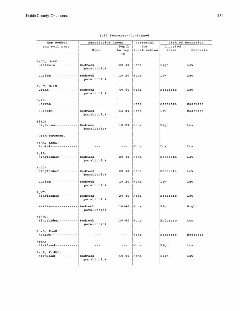
Noble County, Oklahoma 451
Soil Features--Continued_____________________________________________________________________________________ Map symbol | Restrictive layer | Potential | Risk of corrosion _________________________ _________________________ and soil name | | Depth | for | Uncoated | | Kind |to top |frost action| steel | Concrete_____________________________________________________________________________________ | | In | | | __ | | | | |GrLC, GrLE: | | | | | Grainola-----------|Bedrock | 20-40 |None |High |Low | (paralithic) | | | | | | | | | Lucien-------------|Bedrock | 10-20 |None |Low |Low | (paralithic) | | | | | | | | |GrnC, GrtB: | | | | | Grant--------------|Bedrock | 40-60 |None |Moderate |Low | (paralithic) | | | | | | | | |HaPE: | | | | | Harrah-------------| --- | --- |None |Moderate |Moderate | | | | | Pulaski------------|Bedrock | 63-80 |None |Low |Moderate | (paralithic) | | | | | | | | |HiRG: | | | | | Highview-----------|Bedrock | 10-20 |None |High |Low | (paralithic) | | | | | | | | | Rock outcrop. | | | | | | | | | |KekA, KeoA: | | | | | Keokuk-------------| --- | --- |None |Low |Low | | | | |KgfB: | | | | | Kingfisher---------|Bedrock | 20-40 |None |Moderate |Low | (paralithic) | | | | | | | | |KgLC: | | | | | Kingfisher---------|Bedrock | 20-40 |None |Moderate |Low | (paralithic) | | | | | | | | | Lucien-------------|Bedrock | 10-20 |None |Low |Low | (paralithic) | | | | | | | | |KgWC: | | | | | Kingfisher---------|Bedrock | 20-40 |None |Moderate |Low | (paralithic) | | | | | | | | | Wakita-------------|Bedrock | 20-40 |None |High |High | (paralithic) | | | | | | | | |KinC2: | | | | | Kingfisher---------|Bedrock | 20-40 |None |Moderate |Low | (paralithic) | | | | | | | | |KowB, KowD: | | | | | Konawa-------------| --- | --- |None |Moderate |Moderate | | | | |KrdA: | | | | | Kirkland-----------| --- | --- |None |High |Low | | | | |KrdB, KrdB2: | | | | | Kirkland-----------|Bedrock | 60-99 |None |High |Low | (paralithic) | | | | | | | | |

452 Soil Survey
Soil Features--Continued_____________________________________________________________________________________ Map symbol | Restrictive layer | Potential | Risk of corrosion _________________________ _________________________ and soil name | | Depth | for | Uncoated | | Kind |to top |frost action| steel | Concrete_____________________________________________________________________________________ | | In | | | __ | | | | |KrPB: | | | | | Kirkland-----------| --- | --- |None |High |Low | | | | | Pawhuska-----------|Bedrock | 68-80 |None |High |High | (paralithic) | | | | | | | | |LAN. | | | | | Landfill | | | | | | | | | |LelA: | | | | | Lela---------------| --- | --- |None |High |Low | | | | |LveB: | | | | | Lovedale-----------| --- | --- |None |Low |Moderate | | | | |M-W. | | | | | Miscellaneous water| | | | | | | | | |McaA: | | | | | McLain-------------| --- | --- |None |High |Low | | | | |MilB, MilC: | | | | | Milan--------------| --- | --- |Low |Moderate |Low | | | | |MinB, MinC: | | | | | Minco--------------| --- | --- |None |Low |Low | | | | |MirA: | | | | | Miller-------------| --- | --- |None |High |Low | | | | |MisA: | | | | | Miller-------------| --- | --- |None |High |Moderate | | | | |MPNC2: | | | | | Milan--------------| --- | --- |Low |Moderate |Low | | | | | Pawhuska-----------| --- | --- |None |High |High | | | | | Norge--------------| --- | --- |None |Moderate |Low | | | | |MulC, MulD, MulD4: | | | | | Mulhall------------| --- | --- |None |Moderate |Low | | | | |NeDG: | | | | | Newalla------------|Bedrock | 40-60 |None |High |Moderate | (paralithic) | | | | | | | | | Darnell------------|Bedrock | 10-20 |None |Low |Moderate | (paralithic) | | | | | | | | |NorA, NorB, NorC, | | | | | NorC2: | | | | | Norge-------------| --- | --- |None |Moderate |Low | | | | |NoUC: | | | | | Norge--------------| --- | --- |None |Moderate |Low | | | | | Urban land. | | | | | | | | | |
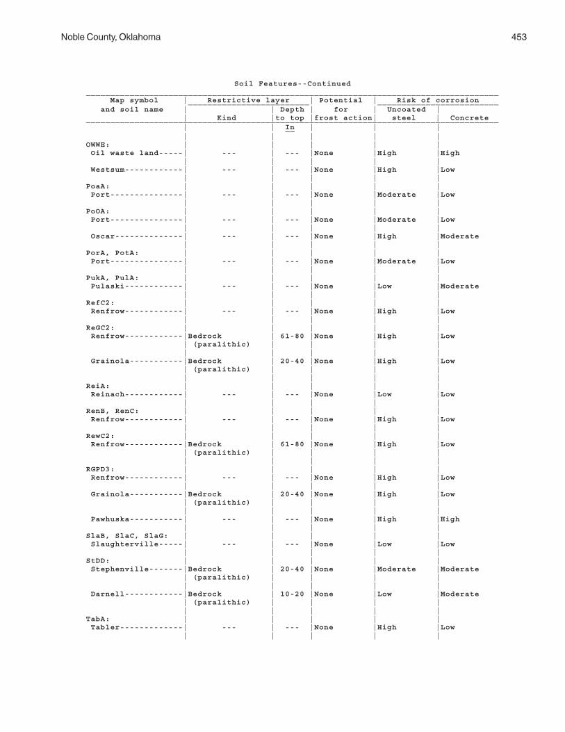
Noble County, Oklahoma 453
Soil Features--Continued_____________________________________________________________________________________ Map symbol | Restrictive layer | Potential | Risk of corrosion _________________________ _________________________ and soil name | | Depth | for | Uncoated | | Kind |to top |frost action| steel | Concrete_____________________________________________________________________________________ | | In | | | __ | | | | |OWWE: | | | | | Oil waste land-----| --- | --- |None |High |High | | | | | Westsum------------| --- | --- |None |High |Low | | | | |PoaA: | | | | | Port---------------| --- | --- |None |Moderate |Low | | | | |PoOA: | | | | | Port---------------| --- | --- |None |Moderate |Low | | | | | Oscar--------------| --- | --- |None |High |Moderate | | | | |PorA, PotA: | | | | | Port---------------| --- | --- |None |Moderate |Low | | | | |PukA, PulA: | | | | | Pulaski------------| --- | --- |None |Low |Moderate | | | | |RefC2: | | | | | Renfrow------------| --- | --- |None |High |Low | | | | |ReGC2: | | | | | Renfrow------------|Bedrock | 61-80 |None |High |Low | (paralithic) | | | | | | | | | Grainola-----------|Bedrock | 20-40 |None |High |Low | (paralithic) | | | | | | | | |ReiA: | | | | | Reinach------------| --- | --- |None |Low |Low | | | | |RenB, RenC: | | | | | Renfrow------------| --- | --- |None |High |Low | | | | |RewC2: | | | | | Renfrow------------|Bedrock | 61-80 |None |High |Low | (paralithic) | | | | | | | | |RGPD3: | | | | | Renfrow------------| --- | --- |None |High |Low | | | | | Grainola-----------|Bedrock | 20-40 |None |High |Low | (paralithic) | | | | | | | | | Pawhuska-----------| --- | --- |None |High |High | | | | |SlaB, SlaC, SlaG: | | | | | Slaughterville-----| --- | --- |None |Low |Low | | | | |StDD: | | | | | Stephenville-------|Bedrock | 20-40 |None |Moderate |Moderate | (paralithic) | | | | | | | | | Darnell------------|Bedrock | 10-20 |None |Low |Moderate | (paralithic) | | | | | | | | |TabA: | | | | | Tabler-------------| --- | --- |None |High |Low | | | | |

454
Soil Features--Continued_____________________________________________________________________________________ Map symbol | Restrictive layer | Potential | Risk of corrosion _________________________ _________________________ and soil name | | Depth | for | Uncoated | | Kind |to top |frost action| steel | Concrete_____________________________________________________________________________________ | | In | | | __ | | | | |TeaA: | | | | | Tearney------------| --- | --- |None |High |Low | | | | |TelB, TelD, TelD2: | | | | | Teller-------------| --- | --- |None |Low |Moderate | | | | |VanA: | | | | | Vanoss-------------| --- | --- |None |Moderate |Moderate | | | | |W. | | | | | Water | | | | | | | | | |WauA: | | | | | Waurika------------| --- | --- |None |High |Moderate | | | | |WesB, WesC: | | | | | Westsum------------| --- | --- |None |High |Low | | | | |WiLC: | | | | | Wisby--------------| --- | --- |None |Low |Low | | | | | Lovedale-----------| --- | --- |None |Low |Moderate | | | | |ZaHC: | | | | | Zaneis-------------|Bedrock | 40-60 |None |Moderate |Low | (paralithic) | | | | | | | | | Huska--------------|Bedrock | 40-60 |None |High |Moderate | (paralithic) | | | | | | | | |ZanB: | | | | | Zaneis-------------|Bedrock | 40-60 |None |Moderate |Low | (paralithic) | | | | | | | | |_____________________________________________________________________________________

455
The system of soil classification used by the National Cooperative Soil Survey hassix categories (11, 12). Beginning with the broadest, these categories are the order,suborder, great group, subgroup, family, and series. Classification is based on soilproperties observed in the field or inferred from those observations or from laboratorymeasurements. The table “Classification of the Soils” lists each soil series in the surveyarea and gives its classification. The categories are defined in the following paragraphs.
ORDER. Twelve soil orders are recognized. The differences among orders reflect thedominant soil-forming processes and the degree of soil formation. Each order is identi-fied by a word ending in sol. An example is Mollisol.
SUBORDER. Each order is divided into suborders primarily on the basis of proper-ties that influence soil genesis and are important to plant growth or properties thatreflect the most important variables within the orders. The last syllable in the name of asuborder indicates the order. An example is Ustoll (Ust, meaning dry, plus oll, fromMollisol).
GREAT GROUP. Each suborder is divided into great groups on the basis of closesimilarities in kind, arrangement, and degree of development of pedogenic horizons; soilmoisture and temperature regimes; and base status. Each great group is identified bythe name of a suborder and by a prefix that indicates a property of the soil. An exampleis Argiustolls (Argi, meaning argillic horizonation, plus ustoll, the suborder of theMollisols that has an ustic moisture regime).
SUBGROUP. Each great group has a typic subgroup. Other subgroups are inter-grades or extragrades. The typic is the central concept of the great group; it is notnecessarily the most extensive. Intergrades are transitions to other orders, suborders, orgreat groups. Extragrades have some properties that are not representative of the greatgroup but do not indicate transitions to any other known kind of soil. Each subgroup isidentified by one or more adjectives preceding the name of the great group. An exampleis Udic Argiustolls.
FAMILY. Families are established within a subgroup on the basis of physical andchemical properties and other characteristics that affect management. Generally, theproperties are those of horizons below plow depth where there is much biologicalactivity. Among the properties and characteristics considered are particle-size class,mineral content, temperature regime, thickness of the root zone, consistence, moistureequivalent, slope, and permanent cracks. A family name consists of the name of asubgroup preceded by terms that indicate soil properties. An example is fine-loamy,mixed, thermic Udic Argiustolls.
SERIES. The series consists of soils that have similar horizons in their profile. Thehorizons are similar in color, texture, structure, reaction, consistence, mineral andchemical composition, and arrangement in the profile. The texture of the surface layer orof the substratum can differ within a series.
Classification of the Soils
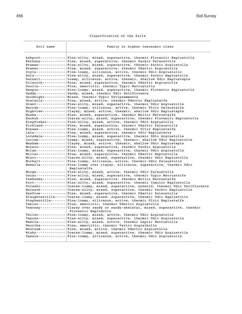
456 Soil Survey
Classification of the Soils__________________________________________________________________________________________ | Soil name | Family or higher taxonomic class |__________________________________________________________________________________________ | Ashport------------|Fine-silty, mixed, superactive, thermic Fluventic Haplustolls Bethany------------|Fine, mixed, superactive, thermic Pachic Paleustolls Braman-------------|Fine-silty, mixed, superactive, thermic Pachic Argiustolls Brewer-------------|Fine, mixed, superactive, thermic Udertic Argiustolls Coyle--------------|Fine-loamy, siliceous, active, thermic Udic Argiustolls Dale---------------|Fine-silty, mixed, superactive, thermic Pachic Haplustolls Darnell------------|Loamy, siliceous, active, thermic, shallow Udic Haplustepts Dilworth-----------|Fine, mixed, superactive, thermic Udertic Argiustolls Doolin-------------|Fine, smectitic, thermic Typic Natrustolls Easpur-------------|Fine-loamy, mixed, superactive, thermic Fluventic Haplustolls Gaddy--------------|Sandy, mixed, thermic Udic Ustifluvents Goodnight----------|Mixed, thermic Typic Ustipsamments Grainola-----------|Fine, mixed, active, thermic Udertic Haplustalfs Grant--------------|Fine-silty, mixed, superactive, thermic Udic Argiustolls Harrah-------------|Fine-loamy, siliceous, active, thermic Ultic Paleustalfs Highview-----------|Clayey, mixed, active, thermic, shallow Udic Haplustepts Huska--------------|Fine, mixed, superactive, thermic Mollic Natrustalfs Keokuk-------------|Coarse-silty, mixed, superactive, thermic Fluventic Haplustolls Kingfisher---------|Fine-silty, mixed, active, thermic Udic Argiustolls Kirkland-----------|Fine, mixed, superactive, thermic Udertic Paleustolls Konawa-------------|Fine-loamy, mixed, active, thermic Ultic Haplustalfs Lela---------------|Fine, mixed, superactive, thermic Udic Haplusterts Lovedale-----------|Fine-loamy, mixed, superactive, thermic Udic Argiustolls Lucien-------------|Loamy, mixed, superactive, thermic, shallow Udic Haplustolls Masham-------------|Clayey, mixed, active, thermic, shallow Udic Haplustepts McLain-------------|Fine, mixed, superactive, thermic Pachic Argiustolls Milan--------------|Fine-loamy, mixed, superactive, thermic Udic Argiustolls Miller-------------|Fine, mixed, superactive, thermic Udertic Haplustolls Minco--------------|Coarse-silty, mixed, superactive, thermic Udic Haplustolls Mulhall------------|Fine-loamy, siliceous, active, thermic Udic Paleustolls Newalla------------|Fine-loamy over clayey, siliceous, superactive, thermic Udic | Haplustalfs Norge--------------|Fine-silty, mixed, active, thermic Udic Paleustolls Oscar--------------|Fine-silty, mixed, superactive, thermic Typic Natrustalfs Pawhuska-----------|Fine, mixed, superactive, thermic Mollic Natrustalfs Port---------------|Fine-silty, mixed, superactive, thermic Cumulic Haplustolls Pulaski------------|Coarse-loamy, mixed, superactive, nonacid, thermic Udic Ustifluvents Reinach------------|Coarse-silty, mixed, superactive, thermic Pachic Haplustolls Renfrow------------|Fine, mixed, superactive, thermic Udertic Paleustolls Slaughterville-----|Coarse-loamy, mixed, superactive, thermic Udic Haplustolls Stephenville-------|Fine-loamy, siliceous, active, thermic Ultic Haplustalfs Tabler-------------|Fine, smectitic, thermic Udertic Argiustolls Tearney------------|Clayey over sandy or sandy-skelatal, mixed, superactive, thermic | Fluventic Hapludolls Teller-------------|Fine-loamy, mixed, active, thermic Udic Argiustolls Vanoss-------------|Fine-silty, mixed, superactive, thermic Udic Argiustolls Wakita-------------|Fine-silty, mixed, active, thermic Leptic Natrustolls Waurika------------|Fine, smectitic, thermic Vertic Argialbolls Westsum------------|Fine, mixed, active, thermic Udertic Argiustolls Wisby--------------|Coarse-loamy, mixed, superactive, thermic Udic Argiustolls Zaneis-------------|Fine-loamy, siliceous, active, thermic Udic Argiustolls |__________________________________________________________________________________________

Noble County, Oklahoma 457
Soil Series and Their MorphologyIn this section, arranged in alphabetical order, each soil series recognized in the
survey area is described. Characteristics of the soil and the material in which it formedare identified for each soil series. In addition, the physiographic region, province, andsubprovince are specified for most of the series (6). A pedon, a small three-dimensionalarea of soil, which is typical of the series in the survey area is described. The detaileddescription of each soil horizon follows standards in the “Soil Survey Manual” (15). Manyof the technical terms used in the descriptions are defined in “Soil Taxonomy” (12) and“Keys to Soil Taxonomy” (11). Following the pedon description is the range of importantcharacteristics of the soils in the series.
The map units of each soil series are described in the section “Detailed Soil MapUnits.”
Ashport Series
Major land resource area: Central Rolling Red Prairies (80A)Depth class: Very deepDrainage class: Well drainedParent material and geologic age: Loamy alluvium of Recent agePhysiographic region: Interior LowlandsPhysiographic province: Central LowlandPhysiographic sub-province: Osage PlainLandscape: ValleyLandform: Low flood plainSlope range: 0 to 3 percentSlope shape: Linear-linearElevation range: 700 to 1,500 feetMean annual precipitation: 26 to 40 inchesMean annual air temperature: 58 to 65 degrees FFrost-free days: 200 to 230Thornthwaite PE index: 44 to 64Taxonomic class: Fine-silty, mixed, superactive, thermic Fluventic Haplustolls
Associated Soils
• Dale soils which have a mollic epipedon more than 20 inches thick, at the slightlyhigher elevations or on the higher flood plains that are rarely flooded• Port soils which have a mollic epipedon more than 20 inches thick, on landscapesthat are similar to those of the Ashport soils but are commonly further from the streamchannel• Pulaski soils which have a coarse-loamy control section and do not have a mollicepipedon, on landscapes that are similar to those of the Ashport soils but are generallynearer to the stream channel
Typical Pedon
Ashport silty clay loam; Payne County, Oklahoma; about 1/2 mile west of Stillwater,Oklahoma, in a cultivated area; 2,440 feet east and 920 feet north of the southwesterncorner of sec. 16, T. 19 N., R. 2 E. (Colors are for dry soil unless otherwise indicated.)
Ap—0 to 5 inches; dark reddish gray (5YR 4/2) silty clay loam, dark reddish brown (5YR3/2) moist; weak medium platy structure; hard, firm; many fine roots; slightly acid;abrupt smooth boundary. (0 to 8 inches thick)
A—5 to 16 inches; dark reddish gray (5YR 4/2) silty clay loam, dark reddish brown (5YR

458 Soil Survey
3/2) moist; moderate medium subangular blocky structure; hard, firm; many fineroots; neutral; clear smooth boundary. (0 to 16 inches thick)
Bw—16 to 36 inches; reddish brown (5YR 5/4) silty clay loam, reddish brown (5YR 5/4)moist; weak coarse prismatic structure parting to moderate coarse subangularblocky; hard, firm; few fine roots; slightly acid; clear smooth boundary. (14 to 54inches thick)
Ab—36 to 52 inches; dark reddish gray (5YR 4/2) loam, dark reddish brown (5YR 3/2)moist; weak coarse prismatic structure parting to weak medium granular; slightlyhard, friable; slightly acid; gradual smooth boundary. (0 to 20 inches thick)
Bwb—52 to 66 inches; reddish brown (5YR 5/4) loam, reddish brown (5YR 4/4) moist;weak coarse prismatic structure parting to weak medium subangular blocky; slightlyhard, friable; slightly acid; gradual smooth boundary. (0 to 27 inches thick)
BCb—66 to 80 inches; yellowish red (5YR 5/6) loam, yellowish red (5YR 4/6) moist;weak coarse prismatic structure parting to weak coarse subangular blocky; slightlyhard, friable; neutral.
Range in Characteristics
Thickness of the mollic epipedon: Less than 20 inchesThickness of the solum: 26 to more than 60 inchesDepth to carbonates: 20 to 60 inchesDepth to bedrock: More than 80 inchesDepth to buried horizon: 24 to more than 60 inches
A horizon:Color—hue of 5YR to 10YR, value of 4 or 5, and chroma of 2 or 3Texture—silt loam, loam, clay loam, or silty clay loamReaction—moderately acid to moderately alkalineRoots—many, fineClay content—15 to 35 percentThickness—10 to 16 inches
Bw horizon:Color—hue of 2.5YR to 7.5YR, value of 3 to 5, and chroma of 3 to 6Texture—silty clay loam, clay loam, loam, or silt loamReaction—slightly acid to moderately alkalineRoots—few, fineClay content—18 to 35 percentThickness—14 to 54 inches
C horizon (if it occurs):Color—hue of 2.5YR or 5YR, value of 4 or 5, and chroma of 3 to 6Texture—loam, silt loam, silty clay loam, or clay loam that is stratified with coarser
or finer materialsReaction—slightly acid to moderately alkalineClay content—5 to 35 percentThickness—0 to 24 inches
Ab horizon:Color—hue of 5YR or 7.5YR, value of 4 or 5, and chroma of 2 to 4Texture—loam, silt loam, clay loam, or silty clay loamReaction—slightly acid to moderately alkalineClay content—18 to 35 percentThickness—0 to 20 inches
Bwb horizon:Color—hue of 2.5YR to 7.5YR, value of 4 or 5, and chroma of 3 to 6Texture—loam, silt loam, or silty clay loam

Noble County, Oklahoma 459
Reaction—slightly acid to moderately alkalineClay content—18 to 35 percentThickness—0 to 27 inches
BCb horizon:Color—hue of 2.5YR to 7.5YR, value of 4 or 5, and chroma of 4 to 6Texture—loam, silt loam, or silty clay loamReaction—slightly acid to moderately alkalineClay content—18 to 35 percent
Bethany Series
Major land resource area: Central Rolling Red Prairies (80A)Depth class: Very deepDrainage class: Well drainedParent material and geologic age: Alluvium or loess of Pleistocene age over shale of
Permian agePhysiographic region: Interior LowlandsPhysiographic province: Central LowlandPhysiographic sub-province: Osage PlainLandscape: UplandLandform: TerraceLandform position: TreadSlope range: 0 to 5 percentSlope shape: Linear-linearElevation range: 950 to 1,250 feetMean annual precipitation: 26 to 38 inchesMean annual air temperature: 57 to 64 degrees FFrost-free days: 190 to 220Thornthwaite PE index: 44 to 64Taxonomic class: Fine, mixed, superactive, thermic Pachic Paleustolls
Associated Soils
• Pond Creek soils which have less than 35 percent clay in the control section, onlandscapes similar to those of the Bethany soils• Kirkland soils which have an abrupt textural change from the A horizon to the Bthorizon and have COLE value of 0.07 or more, on landscapes similar to those of theBethany soils• Renfrow soils which have COLE value of 0.07 or more and have a mollic epipedonless than 20 inches thick, on landscapes similar to those of the Bethany soils• Norge and Vanoss soils which have a mollic epipedon less than 20 inches thick andhave less than 35 percent clay in the control section, on landscapes similar to those ofthe Bethany soils• Tabler soils which have COLE value of 0.07 or more, have redoximorphic accumula-tions and depletions in the Bt horizon, and have smectitic mineralogy; in the slightlylower positions on the landscape
Typical Pedon
Bethany silt loam; Oklahoma County, Oklahoma; about 1 mile east of Wheatland, in acultivated area; 1,000 feet north and 200 feet east of the southwestern corner of sec. 28,T. 11 N., R. 4 W. (Colors are for dry soil unless otherwise indicated.)
Ap—0 to 6 inches; dark grayish brown (10YR 4/2) silt loam, very dark grayish brown(10YR 3/2) moist; weak fine granular structure; slightly hard, friable; many fine roots;slightly acid; clear smooth boundary. (0 to 10 inches thick)

460 Soil Survey
A—6 to 14 inches; dark grayish brown (10YR 4/2) silt loam, very dark brown (10YR 2/2)moist; moderate medium granular structure; slightly hard, friable; many fine roots;slightly acid; gradual smooth boundary. (6 to 20 inches thick)
BA—14 to 18 inches; dark grayish brown (10YR 4/2) silty clay loam, very dark grayishbrown (10YR 3/2) moist; moderate fine subangular blocky structure; hard, firm; manyfine roots; neutral; clear smooth boundary. (3 to 10 inches thick)
Bt1—18 to 36 inches; brown (10YR 4/3) silty clay, dark brown (10YR 3/3) moist; strongfine and medium blocky structure; very hard, very firm; clay films on faces of peds;common fine roots; slightly alkaline; gradual smooth boundary. (10 to 25 inchesthick)
Bt2—36 to 56 inches; brown (10YR 5/3) silty clay, brown (10YR 4/3) moist; moderatemedium and coarse blocky structure; very hard, very firm; clay films on faces ofpeds; few fine roots; common fine iron-manganese concretions; few fine concretionsof calcium carbonate; moderately alkaline; gradual smooth boundary. (10 to 30inches thick)
Bt3—56 to 72 inches; brown (7.5YR 5/4) silty clay, brown (7.5YR 4/4) moist; moderatemedium and coarse blocky structure; very hard, very firm; patchy clay films onfaces of peds; few fine roots; common fine and coarse distinct yellowish red (5YR5/6) and reddish brown (5YR 5/4) redoximorphic accumulations; common fine iron-manganese concretions; few soft accumulations of secondary lime; few fineconcretions of calcium carbonate; calcareous; moderately alkaline; gradual smoothboundary. (10 to 20 inches thick)
Bt4—72 to 80 inches; reddish brown (5YR 5/4) silty clay loam, reddish brown (5YR 4/4)moist; weak medium blocky structure; very hard, very firm; patchy clay films onfaces of peds; common coarse distinct brown (7.5YR 5/4) and red (2.5YR 5/6)redoximorphic accumulations; few fine concretions of calcium carbonate;calcareous; moderately alkaline.
Range in Characteristics
Thickness of the mollic epipedon: More than 20 inchesThickness of the solum: More than 60 inchesDepth to bedrock: More than 80 inchesDepth to carbonates: 28 to 40 inches
A horizon:Color—hue of 7.5YR to 2.5Y, value of 3 to 5, and chroma of 2 or 3Texture—silt loam or silty clay loamReaction—strongly acid to slightly alkalineElectrical conductivity of the saturation extract—0 to 1 mmhos/cmClay content—14 to 32 percentThickness—8 to 20 inches
BA horizon:Color—hue of 7.5YR to 2.5Y, value of 4 or 5, and chroma of 2 or 3Texture—silty clay loam or clay loamReaction—slightly acid to slightly alkalineElectrical conductivity of the saturation extract—0 to 1 mmhos/cmClay content—27 to 35 percentThickness—3 to 10 inches
Bt1 horizon:Color—hue of 7.5YR to 2.5Y, value of 4 or 5, and chroma of 2 or 3Texture—clay, silty clay, clay loam, or silty clay loamReaction—neutral to moderately alkalineElectrical conductivity of the saturation extract—0 to 1 mmhos/cm

Noble County, Oklahoma 461
Clay content—35 to 50 percentThickness—10 to 25 inches
Bt2 horizon:Color—hue of 7.5YR to 2.5Y, value of 4 to 6, and chroma of 2 to 6Texture—clay, silty clay, clay loam, or silty clay loamRedoximorphic features—few or common accumulations in shades of brownReaction—neutral to moderately alkalineElectrical conductivity of the saturation extract—0 to 4 mmhos/cmSodium adsorption ratio—0 to 8 percentClay content—35 to 50 percentThickness—10 to 30 inches
Bt3 horizon:Color—hue of 5YR to 2.5Y, value of 4 to 6, and chroma of 2 to 6Texture—clay, silty clay, clay loam, or silty clay loamRedoximorphic features—accumulations and depletions in shades of yellow, red,
gray, and brownReaction—slightly alkaline or moderately alkalineElectrical conductivity of the saturation extract—0 to 4 mmhos/cmClay content—35 to 50 percentSodium adsorption ratio—0 to 8 percentThickness—8 to 20 inches
Bt4 horizon:Color—hue of 5YR to 2.5Y, value of 4 to 6, and chroma of 2 to 6Texture—clay, silty clay, clay loam, or silty clay loamRedoximorphic features—accumulations and depletions in shades of yellow, red,
gray, and brownReaction—neutral to moderately alkalineClay content—35 to 50 percent
Braman Series
Major land resource area: Central Rolling Red Prairies (80A)Depth class: Very deepDrainage class: Well drainedParent material and geologic age: Loamy alluvium of Pleistocene agePhysiographic region: Interior LowlandsPhysiographic province: Central LowlandPhysiographic sub-province: Osage PlainLandscape: ValleyLandform: High flood plainSlope range: 0 to 1 percentSlope shape: Linear-linearElevation range: 800 to 1,500 feetMean annual precipitation: 30 to 36 inchesMean annual air temperature: 57 to 61 degrees FFrost-free days: 190 to 230Thornthwaite PE index: 48 to 60Taxonomic class: Fine-silty, mixed, superactive, thermic Pachic Argiustolls
Associated Soils
• Brewer, Lela, and McLain soils which have a fine control section, on flood plain levelssimilar to those of the Braman soils

462 Soil Survey
• Dale soils which do not have an argillic horizon, on flood plain levels similar to thoseof Braman soils• Reinach soils which have a coarse-silty control section, on the lower flood plainsnearer to the stream than the Braman soils• Keokuk soils which have a mollic epipedon less than 20 inches thick and have acoarse-silty control section, on the lower flood plains nearer to the stream than theBraman soils• Port soils which do not have an argillic horizon, on the lower flood plains nearer to thestream than the Braman soils• Miller soils which have a fine control section and do not have an argillic horizon, onthe lower flood plains nearer to the stream than the Braman soils
Typical Pedon
Braman silt loam, 0 to 1 percent slopes, rarely flooded; Noble County, Oklahoma; about3 miles west and 2 miles north of Marland, in a cultivated area; 1,700 feet east and1,000 feet south of the northwestern corner of sec. 4, T. 24 N., R. 1 E. (Colors are for drysoil unless otherwise indicated.)
Ap—0 to 8 inches; brown (7.5YR 4/2) silt loam, dark brown (7.5YR 3/2) moist; weak finegranular structure; hard, friable; common fine roots; common wormcasts; few coarseand common fine tubular pores with low vertical continuity; slightly acid (pH 6.5);clear smooth boundary. (7 to 10 inches thick)
A—8 to 12 inches; brown (7.5YR 4/2) silt loam, dark brown (7.5YR 3/2) moist; moderatefine and medium granular structure; hard, friable; common fine roots; commonwormcasts; common fine tubular pores with low vertical continuity; slightly acid (pH6.5); clear smooth boundary. (0 to 11 inches thick)
Bt1—12 to 23 inches; reddish brown (5YR 4/3) silty clay loam, dark reddish brown (5YR3/3) moist; moderate fine and very fine subangular blocky structure; hard, firm; fewfine roots; common wormcasts; few fine and common very fine tubular pores withlow vertical continuity; common distinct clay films on faces of peds; neutral (pH7.0); gradual smooth boundary. (6 to 12 inches thick)
Bt2—23 to 36 inches; reddish brown (5YR 4/4) silty clay loam, dark reddish brown (5YR3/4) moist; moderate fine prismatic structure parting to moderate very finesubangular blocky; hard, friable; few wormcasts; few fine and common very finetubular pores with low vertical continuity; few distinct clay films on faces of peds;neutral (pH 7.0); gradual smooth boundary. (6 to 22 inches thick)
BC—36 to 48 inches; reddish brown (5YR 5/4) silt loam, reddish brown (5YR 4/4) moist;weak medium prismatic structure parting to weak fine subangular blocky; hard, veryfriable; moderately alkaline (pH 8.0); gradual smooth boundary. (0 to 22 inches thick)
C—48 to 80 inches; stratified reddish brown (5YR 4/4) silty clay and reddish brown (5YR5/4) loam, reddish brown (5YR 3/4) and reddish brown (5YR 4/4) moist; massive;very hard, very firm and hard, friable; moderately alkaline (pH 8.0).
Range in Characteristics
Thickness of the mollic epipedon: 20 to 31 inchesThickness of the solum: More than 60 inches
Ap horizon:Color—hue of 5YR to 7.5YR, value of 4, and chroma of 2Texture—silt loamReaction—moderately acid to neutralRoots—many, fineClay content—15 to 35 percent

Noble County, Oklahoma 463
A horizon:Color—hue of 5YR to 7.5YR, value of 4, and chroma of 2Texture—silt loamReaction—moderately acid to neutralRoots—many, fineClay content—15 to 35 percent
Bt horizon:Color—hue of 5YR, value of 4 or 5, and chroma of 2 to 4Texture—silt loam, loam, clay loam, or silty clay loamReaction—moderately acid to moderately alkalineClay content—18 to 35 percent
BC horizon:Color—hue of 5YR, value of 5, and chroma of 4 to 6Texture—very fine sandy loam or silt loamReaction—mildly alkaline or moderately alkalineClay content—15 to 27 percent
C horizon:Color—hue of 5YR to 10YR, value of 4 or 5, and chroma of 2 or 3Texture—very fine sandy loam, silt loam, loam, or silty clayReaction—moderately acid to moderately alkalineClay content—15 to 35 percent
Brewer Series
Major land resource area: Central Rolling Red Prairies (80A)Depth class: Very deepDrainage class: Moderately well drainedParent material and geologic age: Silty and clayey alluvium of Pleistocene agePhysiographic region: Interior LowlandsPhysiographic province: Central LowlandPhysiographic sub-province: Osage PlainLandscape: ValleyLandform: Flood plainsSlope range: 0 to 1 percentSlope shape: LinearElevation range: 700 to 1,500 feetMean annual precipitation: 26 to 38 inchesMean annual air temperature: 58 to 63 degrees FFrost-free days: 200 to 230Thornthwaite PE index: 44 to 64Taxonomic class: Fine, mixed, superactive, thermic Udertic Argiustolls
Associated Soils
• Port and Reinach soils which have less than 35 percent clay in the control section, onflood plains• McLain soils which have upper Bt horizons with hues of 5YR or redder, on flood plains
Typical Pedon
Brewer silty clay loam; Pawnee County, Oklahoma; about 1/2 mile north of Pawnee on theeast side of Oklahoma Highway 18, in pasture; 200 feet east and 900 feet north of thesouthwestern corner of sec. 29, T. 22 N., R. 5 E. (Colors are for dry soil unless otherwiseindicated.)

464 Soil Survey
A—0 to 12 inches; very dark grayish brown (10YR 3/2) silty clay loam, very dark brown(10YR 2/2) moist; moderate medium granular structure; hard, friable; slightly acid;gradual smooth boundary. (8 to 16 inches thick)
Bt1—12 to 30 inches; very dark grayish brown (10YR 3/2) silty clay loam, very darkbrown (10YR 2/2) moist; moderate medium and fine subangular blocky structure;very hard, firm; clay films on faces of peds; neutral; gradual smooth boundary. (10 to22 inches thick)
Bt2—30 to 50 inches; brown (7.5YR 4/2) silty clay, dark brown (7.5YR 3/2) moist;moderate medium blocky structure; very hard, firm; clay films on faces of peds;moderately alkaline; gradual smooth boundary. (12 to 26 inches thick)
BC—50 to 80 inches; reddish brown (5YR 4/3) silty clay loam; dark reddish brown (5YR3/3) moist; weak coarse blocky structure; very hard, firm; moderately alkaline;gradual smooth boundary. (15 to 35 inches thick)
Ck—80 to 90 inches; reddish brown (5YR 4/4) silty clay loam, dark reddish brown (5YR3/4) moist; massive; very hard, firm; common fine concretions of calcium carbonate;moderately alkaline.
Range in Characteristics
Thickness of the solum: 50 to 90 inches
A horizon:Color—hue of 7.5YR or 10YR, value of 3 to 5, and chroma of 1 or 2Texture—silty clay loam, clay loam, or silt loamReaction—moderately acid to neutral
Bt1 and Bt2 horizons:Color—hue of 7.5YR or 10YR, value of 3 to 5, and chroma of 1 or 2Texture—clay loam, silty clay, loam, or clayReaction—slightly acid to moderately alkalineRedoximorphic features—some pedons have accumulations or depletions in shades
of brown or gray below a depth of 30 inchesSodium—salt or sodium accumulation below a depth of 50 inches in some pedonsSecondary carbonates—below a depth of 28 inches in some pedons
Btk horizon (if it occurs):Color—hue of 7.5YR to 10YR, value of 4 or 5, and chroma of 3 or 4Texture—silty clay loam, silty clay, or clayReaction—slightly acid to moderately alkaline
BC horizon:Color—hue of 5YR to 10YR, value of 4 or 5, and chroma of 2 to 4Texture—loam, silty clay loam, clay loam, or clayReaction—neutral to moderately alkaline
C horizon (if it occurs):Color—hue of 5YR to 10YR, value of 4 or 5, and chroma of 2 to 4Texture—loam, silty clay loam, clay loam, or clayReaction—neutral to moderately alkaline; horizon may be calcareous or
noncalcareous
Coyle Series
Major land resource area: Central Rolling Red Prairies (80A)Depth class: Moderately deepDrainage class: Well drainedParent material and geologic age: Sandstone of Permian age

Noble County, Oklahoma 465
Physiographic region: Interior LowlandsPhysiographic province: Central LowlandPhysiographic sub-province: Osage PlainLandscape: UplandLandform: HillsLandform position: Summit and backslopeSlope range: 1 to 12 percentSlope shape: Convex-convexElevation range: 700 to 1,500 feetMean annual precipitation: 26 to 40 inchesMean annual air temperature: 58 to 64 degrees FFrost-free days: 190 to 230Thornthwaite PE index: 44 to 64Taxonomic class: Fine-loamy, siliceous, active, thermic Udic Argiustolls (fig. 23)
Associated Soils
• Chickasha and Zaneis soils which have a solum more than 40 inches thick, generallyon side slopes below the Coyle soils• Grainola and Renfrow soils which have a fine control section, typically on convex sideslopes below the Coyle soils• Lucien soils which have a solum less than 20 inches thick over sandstone and do nothave Bt horizons, on landscapes similar to those of the Coyle soils
Typical Pedon
Coyle loam; Payne County, Oklahoma; about 6 miles south and 3 miles west ofStillwater, in rangeland; 70 feet north and 460 feet west of the southeastern corner ofsec. 17, T. 18 N., R. 2 E. (Colors are for dry soil unless otherwise indicated.)
A—0 to 11 inches; dark reddish gray (5YR 4/2) loam, dark reddish brown (5YR 3/2)moist; strong fine granular structure; slightly hard, friable; many fine roots; slightlyalkaline; clear smooth boundary. (6 to 14 inches thick)
BA—11 to 14 inches; reddish brown (5YR 4/3) loam, dark reddish brown (5YR 3/3)moist; moderate medium granular structure; slightly hard, friable; many fine roots;many fine pores; many wormcasts; slightly alkaline; clear smooth boundary. (0 to 8inches thick)
Bt1—14 to 31 inches; red (2.5YR 5/6) clay loam, red (2.5YR 4/6) moist; moderatemedium subangular blocky structure; hard, firm; common fine roots; thin nearlycontinuous clay films on faces of peds; neutral; gradual smooth boundary. (7 to 19inches thick)
Bt2—31 to 39 inches; light red (2.5YR 6/8) sandy clay loam, red (2.5YR 5/8) moist;weak coarse subangular blocky structure; hard, firm; common fine roots; few coarsefragments of sandstone less than 76 mm in diameter; patchy clay films on faces ofpeds; neutral; abrupt smooth boundary. (0 to 16 inches thick)
Cr—39 to 42 inches; red (2.5YR 5/6) sandstone; material can be augered when moist.
Range in Characteristics
Thickness of the mollic epipedon: 7 to 20 inchesThickness of the solum: 20 to 40 inchesDepth to bedrock: 20 to 40 inches
A or Ap horizon:Color—hue of 5YR to 10YR, value of 4 or 5, and chroma of 2 or 3Texture—fine sandy loam or loamReaction—moderately acid to slightly alkalineRoots—many, fine

466 Soil Survey
Clay content—10 to 26 percentThickness—6 to 14 inches
BA horizon:Color—hue of 5YR or 7.5YR, value of 4 or 5, and chroma of 2 to 4Texture—loam or fine sandy loamReaction—moderately acid to slightly alkalineRoots—many, finePores—many, fine
Figure 23.—Profile of Coyle loam.

Noble County, Oklahoma 467
Clay content—18 to 26 percentThickness—0 to 8 inches
Bt1 horizon:Color—hue of 2.5YR to 7.5YR, value of 4 to 6, and chroma of 3 to 6Texture—clay loam, loam, or sandy clay loamRedoximorphic features—red or brown concentrationsReaction—moderately acid to slightly alkalineRoots—common, fineClay content—20 to 35 percentCoarse fragments—0 to 10 percent, by volume, fragments less than 76 mm in
diameterThickness—7 to 19 inches
Bt2 horizon:Color—hue of 2.5YR to 7.5YR, value of 4 to 6, and chroma of 4 to 8Texture—clay loam, fine sandy loam, loam, or sandy clay loam or their channery,
flaggy, or gravelly counterpartsRedoximorphic features—yellow, red, or brown concentrationsReaction—moderately acid to slightly alkalineRoots—common, fineClay content—18 to 35 percentCoarse fragments—0 to 35 percent, by volume, sandstone fragments (about 0 to 30
percent are fragments less than 76 mm in diameter and 0 to 30 percent arefragments more than 76 mm in diameter)
Thickness—0 to 16 inches
Bt3 horizon (if it occurs):Color—hue of 2.5YR to 7.5YR, value of 4 to 6, and chroma of 4 to 8Texture—clay loam, fine sandy loam, loam, or sandy clay loam or their channery,
flaggy, or gravelly counterpartsRedoximorphic features—yellow, red, or brown concentrationsReaction—moderately acid to slightly alkalineRoots—common, fineClay content—18 to 35 percentCoarse fragments—0 to 35 percent, by volume, sandstone fragments (about 0 to 30
percent are fragments less than 76 mm in diameter and 0 to 30 percent arefragments more than 76 mm in diameter)
Thickness—0 to 10 inches
BC horizon (if it occurs):Color—hue of 2.5YR to 7.5YR, value of 4 to 6, and chroma of 4 to 8Texture—clay loam, loam, fine sandy loam, or very fine sandy loam or their gravelly,
channery, or flaggy counterpartsRedoximorphic features—yellow, red, or brown concentrationsReaction—moderately acid to slightly alkalineClay content—18 to 35 percentCoarse fragments—0 to 35 percent, by volume, sandstone fragments (about 0 to 30
percent are fragments less than 76 mm in diameter and 0 to 30 percent arefragments more than 76 mm in diameter)
Thickness—0 to 16 inches
Cr horizon:Color—hue of 2.5YR to 10YR, value of 5 or 6, and chroma of 4 to 8Texture—weathered sandstone bedrock

468 Soil Survey
Dale Series
Major land resource area: Central Rolling Red Prairies (80A)Depth class: Very deepDrainage class: Well drainedParent material and geologic age: Loamy alluvium of Pleistocene agePhysiographic region: Interior LowlandsPhysiographic province: Central LowlandPhysiographic sub-province: Osage PlainLandscape: ValleyLandform: High flood plainSlope range: 0 to 8 percentSlope shape: Linear-linearElevation range: 700 to 1,500 feetMean annual precipitation: 26 to 38 inchesMean annual air temperature: 57 to 64 degrees FFrost-free days: 190 to 230Thornthwaite PE index: 44 to 64Taxonomic class: Fine-silty, mixed, superactive, thermic Pachic Haplustolls
Associated Soils
• Port soils which are on the lower landscapes• Brewer, Lela, and McLain soils which have more than 35 percent clay in the controlsection, in the slightly lower positions on similar landscapes and farther from the streamthan the Dale soils• Reinach soils which are on the slightly higher landscapes nearer to the stream thanthe Dale soils• Canadian and Crisfield soils which have a coarse-loamy control section and have amollic epipedon less than 20 inches thick, on the slightly higher landscapes nearer tothe stream than the Dale soils
Typical Pedon
Dale silt loam; Lincoln County, Oklahoma; about 1 mile east of Harrah, in a cultivatedarea; 4,000 feet south and 900 feet east of the northwestern corner of sec. 30, T. 12 N.,R. 2 E. (Colors are for dry soil unless otherwise indicated.)
Ap—0 to 7 inches; dark grayish brown (10YR 4/2) silt loam, very dark grayish brown(10YR 3/2) moist; weak fine granular structure; hard, friable; many fine roots; manywormcasts; neutral; abrupt smooth boundary. (0 to 10 inches thick)
A—7 to 21 inches; dark grayish brown (10YR 4/2) silt loam, very dark grayish brown(10YR 3/2) moist; moderate fine and medium granular structure; hard, friable; manyfine roots; many wormcasts; neutral; abrupt smooth boundary. (10 to 26 inches thick)
Bw—21 to 40 inches; brown (10YR 4/3) silt loam, dark brown (10YR 3/3) moist; weakcoarse prismatic structure parting to moderate medium granular; hard, friable; fewfine roots; few wormcasts; slightly alkaline; gradual smooth boundary. (10 to 30inches thick)
C—40 to 60 inches; brown (7.5YR 5/4) silt loam, brown (7.5YR 4/4) moist; massive;hard, friable; few fine roots; few wormcasts; few films and spots of calciumcarbonate; calcareous; moderately alkaline.
Range in Characteristics
Thickness of the mollic epipedon: 20 to 50 inchesDepth to bedrock: More than 80 inchesDepth to carbonates: 20 to 60 inches

Noble County, Oklahoma 469
A horizon:Color—hue of 5YR to 10YR, value of 3 to 5, and chroma of 2 or 3Texture—silt loam, loam, silty clay loam, or clay loamReaction—slightly acid to moderately alkalineRoots—many, fineClay content—15 to 35 percentThickness—10 to 26 inches
Bw horizon:Color—hue of 2.5YR to 10YR, value of 3 to 5, and chroma of 2 to 8Texture—silt loam, loam, silty clay loam, or clay loamReaction—slightly acid to moderately alkalineRoots—few, fineClay content—18 to 35 percentThickness—10 to 30 inches
C horizon:Color—hue of 2.5YR to 10YR, value of 4 to 6, and chroma of 2 to 8Texture—silt loam, loam, silty clay loam, or clay loam; strata of very fine sandy
loam, fine sandy loam, or loamy fine sand occur below a depth of 50 inches insome pedons
Reaction—slightly acid to moderately alkalineRoots—few, fineClay content—18 to 35 percent
Darnell Series
Major land resource area: Northern Cross Timbers (84A)Depth class: ShallowDrainage class: Well drained and somewhat excessively drainedParent material and geologic age: Sandstone of Permian agePhysiographic region: Interior LowlandsPhysiographic province: Central LowlandPhysiographic sub-province: Osage PlainLandscape: UplandLandform: HillsLandform position: Summit and backslopeSlope range: 1 to 45 percentSlope shape: Convex-convexElevation range: 750 to 1,300 feetMean annual precipitation: 28 to 40 inchesMean annual air temperature: 58 to 64 degrees FFrost-free days: 200 to 230Thornthwaite PE index: 44 to 64Taxonomic class: Loamy, siliceous, active, thermic, shallow Udic Haplustepts
Associated Soils
• Darsil soils which have a textural control section of loamy fine sand or coarsermaterial, intermingled on the same landscape as the Darnell soils• Harrah soils which have Bt horizons and have a solum more than 60 inches thick, onbroad flat summits, shoulders, and backslopes• Littleaxe soils which have Bt horizons and have a solum that is 40 to 60 inches thick,on broad flat summits, shoulders, and backslopes• Stephenville soils which have Bt horizons and have a solum that is 20 to 40 inchesthick, on broad flat summits, shoulders, and backslopes

470 Soil Survey
• Newalla and Niotaze soils which have a solum more than 20 inches thick, have Bthorizons, and have a fine control section; on broad flats or upper side slopes
Typical Pedon
Darnell fine sandy loam; Lincoln County, Oklahoma; about 8 miles west of Tryon, inscrub oak forest; 900 feet west and 100 feet north of the southeastern corner of sec. 17,T. 16 N., R. 2 E. (Colors are for dry soil unless otherwise indicated.)
A—0 to 5 inches; brown (10YR 5/3) fine sandy loam, dark brown (10YR 3/3) moist; weakfine granular structure; slightly hard, very friable; many roots; moderately acid;gradual smooth boundary. (4 to 10 inches thick)
Bw—5 to 15 inches; light brown (7.5YR 6/4) fine sandy loam, brown (7.5YR 4/4) moist;weak fine granular structure; slightly hard, very friable; many roots; few fragments ofsandstone less than 1 inch in diameter; moderately acid; gradual wavy boundary.(4 to 12 inches thick)
Cr—15 to 30 inches; red (2.5YR 4/6) sandstone, dark red (2.5YR 3/6) moist; material isdifficult to auger; moderately acid.
Range in Characteristics
Thickness of the ochric epipedon: 4 to 10 inchesThickness of the solum: 10 to 20 inchesDepth to bedrock: 10 to 20 inches
A horizon:Color—hue of 5YR to 10YR, value of 4 to 6, and chroma of 2 to 4Texture—fine sandy loam, sandy loam, loam, stony fine sandy loam, or stony loamReaction—strongly acid to neutralClay content—10 to 20 percentCoarse fragments—0 to 20 percent, by volume (0 to 5 percent are fragments less
than 3 inches in diameter and 0 to 15 percent are fragments 3 to 10 inches indiameter)
Bw horizon:Color—hue of 2.5YR to 10YR, value of 4 to 8, and chroma of 2 to 6Texture—fine sandy loam, sandy loam, gravelly loam, or gravelly fine sandy loamReaction—strongly acid to neutralClay content—10 to 25 percentContent of coarse fragments—0 to 20 percent, by volume (0 to 20 percent are
fragments less than 3 inches in diameter and 0 to 5 percent are fragments 3 to10 inches in diameter)
Cr horizon:Color—hue of 10R to 10YR, value of 4 to 7, and chroma of 3 to 8Texture—weakly to strongly consolidated sandstoneExcavation difficulty—high or very highReaction—strongly acid to neutralOther features—fractures more than 10 cm apart; horizon is root restrictive
Dilworth Series
Major land resource area: Central Rolling Red Prairies (80A)Depth class: Moderately deepDrainage class: Well drainedParent material and geologic age: Gray Permian-age clayey residum weathered from
clayey shalePhysiographic region: Interior Lowlands

Noble County, Oklahoma 471
Physiographic province: Central LowlandPhysiographic sub-province: Osage PlainLandscape: HillsLandform: HillslopesSlope range: 3 to 12 percentSlope shape: ConvexElevation range: 700 to 1,500 feetMean annual precipitation: 26 to 36 inchesMean annual air temperature: 57 to 61 degrees FFrost-free days: 200 to 220Thornthwaite PE index: 48 to 60Taxonomic class: Fine, mixed, superactive, thermic Udertic Argiustolls
Associated Soils
• Grainola soils which have redder shale than the Dilworth soils, in similar positions• Highview soils which are on adjacent steep backslopes• Lucien soils which are on summits or shoulder slopes above the Dilworth soils• Westsum soils which are on very gently sloping or gently sloping lower footslopes andbackslopes
Typical Pedon
Dilworth silty clay loam, 3 to 5 percent slopes; Noble County, Oklahoma; about 7 mileseast and 2 miles south of Billings, on a 3 percent slope, in native rangeland; 700 feetsouth and 1,250 feet east of the northwestern corner of sec. 33, T. 24 N., R. 1 W. (Colorsare dry soil unless otherwise indicated.)
A—0 to 7 inches; dark grayish brown (10YR 4/2) silty clay loam, very dark grayishbrown (10YR 3/2) moist; strong medium granular structure; hard, firm; common fineroots; few pebbles of siltstone; slightly alkaline (pH 7.5); clear smooth boundary.(7 to 10 inches thick)
Bt—7 to 13 inches; brown (10YR 5/3) silty clay, brown (10YR 4/3) moist; moderate veryfine subangular blocky structure; very hard, very firm; common fine roots; fewdistinct clay films on faces of peds; few wormcasts; common very fine roundedcarbonate concretions; few very fine rounded masses of calcium carbonate; fewpebbles of siltstone; few slightly effervescent spots (HCl, unspecified); moderatelyalkaline (pH 8.0); clear smooth boundary. (0 to 13 inches thick)
Btk1—13 to 18 inches; grayish brown (2.5Y 5/2) silty clay, dark grayish brown (2.5Y 4/2)moist; moderate medium and fine subangular blocky structure; very hard, very firm;few fine roots; few very fine discontinuous tubular pores; many distinct clay films onfaces of peds; common fine irregular masses of calcium carbonate; few pebbles ofsiltstone; few strongly effervescent spots (HCl, unspecified); moderately alkaline (pH8.0); gradual smooth boundary. (4 to 23 inches thick)
Btk2—18 to 28 inches; grayish brown (2.5Y 5/2) silty clay, dark grayish brown (2.5Y 4/2)moist; moderate medium prismatic structure parting to strong medium and finesubangular blocky; very hard, very firm; few fine roots; few very fine discontinuoustubular pores; common slickensides; many distinct clay films on faces of peds; fewvery fine rounded carbonate concretions; common medium rounded masses ofcalcium carbonate; few strongly effervescent spots (HCl, unspecified); moderatelyalkaline (pH 8.0); clear smooth boundary. (0 to 21 inches thick)
BCk—28 to 36 inches; light brownish gray (2.5Y 6/2) silty clay, grayish brown (2.5Y 5/2)moist; moderate medium subangular blocky structure; very hard, very firm; few fineroots; few very fine discontinuous tubular pores; common coarse irregular masses ofcalcium carbonate; few slightly effervescent spots (HCl, unspecified); moderatelyalkaline (pH 8.0); clear smooth boundary. (0 to 15 inches thick)

472 Soil Survey
Cr—36 to 43 inches; light brownish gray (2.5Y 6/2) weathered shale, grayish brown(2.5Y 5/2) moist; common films of calcium carbonate in cracks; moderately alkaline(pH 8.0).
Range in Characteristics
Thickness of the solum: 20 to 40 inchesDepth to shale: 20 to 40 inchesDepth to secondary carbonates: 7 to 17 inches
Ap or A horizon:Color—hue of 7.5YR to 2.5Y, value of 3 to 5, and chroma of 1 to 3; hue is 5YR in
some pedons where the colluvial surface is influenced by red sandstone andshale
Texture—silty clay loam or gravelly silty clay loamClay content—27 to 35 percentReaction—neutral to moderately alkaline
Bt horizon:Color—hue of 7.5YR to 5Y, value of 4 to 6, and chroma of 1 to 3Texture—silty clay loam or silty clay
Btk1 horizon:Color—hue of 10YR to 5Y, value of 5 or 6, and chroma of 1 to 4Texture—silty clay or gravelly silty clayClay content—40 to 60 percent
Btk2 horizon:Color—hue of 2.5Y or 5Y, value of 5 or 6, and chroma of 1 or 2Texture—silty clayClay content—40 to 60 percent
BCk horizon:Color—hue of 2.5Y or 5Y, value of 5 to 7, and chroma of 1 or 2Texture—silty clayClay content—40 to 60 percent
Cr horizon:Color—hue of 2.5Y or 5Y, value of 5 to 7, and chroma of 1 to 4Paralithic contact—weathered shale; thin strata of red sandstone in some pedons
Doolin Series
Major land resource area: Central Rolling Red Prairies (80A)Depth class: Very deepDrainage class: Moderately well drainedParent material and geologic age: Residuum of old alluvium over sandstone of Permian
agePhysiographic region: Interior LowlandsPhysiographic province: Central LowlandPhysiographic sub-province: Osage PlainLandscape: UplandLandform: HillsLandform position: Summit and backslopeSlope range: 0 to 3 percentSlope shape: Linear-concave and linear-linearElevation range: 1,000 to 1,300 feetMean annual precipitation: 26 to 40 inches

Noble County, Oklahoma 473
Mean annual air temperature: 58 to 64 degrees FFrost-free days: 200 to 230Thornthwaite PE index: 44 to 64Taxonomic class: Fine, smectitic, thermic Typic Natrustolls
Associated Soils
• Chickasha, Kirkland, Renfrow, and Zaneis soils which do not have a natric horizon, onside slopes below the Doolin soils• Kirkland and Pawhuska soils which are on landscapes similar to those of the Doolinsoils
Typical Pedon
Doolin silt loam; Payne County, Oklahoma; about 10 miles east and 3 miles north ofStillwater, on a 0.5 percent slope, in rangeland; 1,100 feet west and 50 feet south of thenortheastern corner of sec. 2, T. 19 N., R. 4 E. (Colors are for dry soil unless otherwiseindicated.)
A—0 to 12 inches; grayish brown (10YR 5/2) silt loam, very dark grayish brown (10YR3/2) moist; moderate medium granular structure; slightly hard, friable; slightly acid;abrupt smooth boundary. (10 to 15 inches thick)
Btn1—12 to 20 inches; brown (7.5YR 4/2) silty clay loam, dark brown (7.5YR 3/2) moist;strong coarse columnar structure parting to moderate medium blocky; hard, firm;thick nearly continuous clay films on faces of peds; common fine distinct reddishbrown redoximorphic features; few fine dark brown concretions; organic matterstaining on faces of peds; exchangeable sodium percentage of 16; neutral; clearsmooth boundary. (6 to 14 inches thick)
Btn2—20 to 32 inches; brown (10YR 4/3) silty clay loam, dark brown (10YR 3/3) moist;moderate medium blocky structure; hard, firm; thin nearly continuous clay films onfaces of peds; few fine distinct strong brown redoximorphic features; organic matterstaining between faces of peds; exchangeable sodium percentage of 15; slightlyalkaline; gradual smooth boundary. (0 to 21 inches thick)
2Btn1—32 to 48 inches; brown (7.5YR 5/4) clay loam, brown (7.5YR 4/4) moist; weakcoarse prismatic structure; hard, firm; thin patchy clay films on faces of peds; manymedium prominent strong brown (7.5YR 5/6) and dark yellowish brown (10YR 4/4)redoximorphic features; many threads of salts; exchangeable sodium percentage of18; few medium and fine calcium carbonate concretions; slightly alkaline; gradualsmooth boundary. (9 to 30 inches thick)
2Btn2—48 to 68 inches; reddish yellow (7.5YR 6/8) clay loam, strong brown (7.5YR 5/8)moist; weak coarse prismatic structure; hard, firm; thin patchy clay films on faces ofpeds; many coarse prominent gray (10YR 5/1), light gray (10YR 7/2), and red (2.5YR4/8) redoximorphic features; exchangeable sodium percentage of 18; slightlyalkaline; abrupt smooth boundary. (0 to 35 inches thick)
2Cr—68 to 70 inches; strong brown (7.5YR 5/6) sandstone.
Range in Characteristics
Thickness of the mollic epipedon: 10 to 32 inchesThickness of the solum: More than 60 inchesDepth to bedrock: More than 60 inchesDepth to carbonates: More than 30 inches
Ap or A horizon:Color—hue of 7.5YR or 10YR, value of 4 or 5, and chroma of 2Texture—silt loam, loam, or very fine sandy loamReaction—moderately acid to slightly alkalineClay content—10 to 26 percent

474 Soil Survey
Coarse fragments—0 to 5 percent, by volume, rounded dark concretionsThickness—10 to 15 inchesElectrical conductivity of the saturation extract—0 to 2 mmhos/cm
Btn1 horizon:Color—hue of 7.5YR or 10YR, value of 4 or 5, and chroma of 2 to 6Texture—silty clay loam, silty clay, or clayReaction—slightly acid to moderately alkalineClay content—35 to 55 percentCoarse fragments—0 to 5 percent, by volume, rounded dark concretionsThickness—6 to 14 inchesExchangeable sodium percentage—15 to 20Electrical conductivity of the saturation extract—0 to 2 mmhos/cm
Btn2 horizon:Color—hue of 7.5YR or 10YR, value of 4 to 6, and chroma of 2 to 6Texture—silty clay loam, clay, silty clay, or clay loamRedoximorphic features—concentrations in shades of brownReaction—slightly acid to moderately alkalineClay content—35 to 55 percentThickness—0 to 21 inchesExchangeable sodium percentage—15 to 20Electrical conductivity of the saturation extract—0 to 2 mmhos/cm
2Btn1 and 2Btn2 horizons:Color—hue of 2.5YR to 7.5YR, value of 4 to 6, and chroma of 3 to 8Texture—clay loam or sandy clay loamRedoximorphic features—concentrations and depletions in shades of red, brown,
and grayReaction—slightly alkaline or moderately alkalineClay content—30 to 40 percentExchangeable sodium percentage—15 to 20Electrical conductivity of the saturation extract—2 to 6 mmhos/cm
2Cr horizon:Color—hue of 2.5YR to 10YR, value of 4 or 5, and chroma of 2 to 6Paralithic contact—sandstone
Easpur Series
Major land resource area: Central Rolling Red Prairies (80A)Depth class: Very deepDrainage class: Well drainedParent material and geologic age: Loamy alluvium of Recent agePhysiographic region: Interior LowlandsPhysiographic province: Central LowlandPhysiographic sub-province: Osage PlainLandscape: ValleyLandform: Low flood plainSlope range: 0 to 1 percentSlope shape: Linear-linearElevation range: 700 to 1,500 feetMean annual precipitation: 26 to 38 inchesMean annual air temperature: 58 to 63 degrees FFrost-free days: 200 to 230

Noble County, Oklahoma 475
Thornthwaite PE index: 44 to 64Taxonomic class: Fine-loamy, mixed, superactive, thermic Fluventic Haplustolls
Associated Soils
• Port soils which have a mollic epipedon more than 20 inches thick and have a fine-silty control section, on landscapes similar to those of the Easpur soils• Dale soils which have a mollic epipedon more than 20 inches thick, have a fine-siltycontrol section, and are rarely flooded; on the slightly higher landscapes• Pulaski soils which have a coarse-loamy control section and do not have a mollicepipedon, typically closer to the stream channel than the Easpur soils
Typical Pedon
Easpur loam; Payne County, Oklahoma; about 1/2 mile west of Stillwater, in a cultivatedarea; 2,000 feet east and 1,300 feet north of the southwestern corner of sec. 16, T. 19N., R. 2 E. (Colors are for dry soil unless otherwise indicated.)
Ap—0 to 11 inches; reddish brown (5YR 4/3) loam, dark reddish brown (5YR 3/3) moist;weak fine granular structure; slightly hard, friable; many fine roots; slightly acid; clearsmooth boundary. (8 to 14 inches thick)
Bw1—11 to 19 inches; reddish brown (5YR 5/4) fine sandy loam, reddish brown (5YR4/4) moist; weak fine granular structure; soft, very friable; many fine roots; neutral;clear smooth boundary. (6 to 24 inches thick)
Bw2—19 to 29 inches; reddish brown (5YR 4/4) clay loam, dark reddish brown (5YR 3/4)moist; moderate fine granular structure; hard, firm; few fine roots; neutral; clearsmooth boundary. (0 to 24 inches thick)
C—29 to 41 inches; stratified reddish brown (5YR 5/4) loam, yellowish red (5YR 5/6) finesandy loam, and reddish brown (5YR 4/3) clay loam; massive; slightly hard, friable;few fine roots; strata are 1 to 4 inches thick; slightly alkaline; clear smooth boundary.(0 to 33 inches thick)
2Ab—41 to 62 inches; dark reddish gray (5YR 4/2) silty clay loam, dark reddish brown(5YR 3/2) moist; moderate fine granular structure; hard, firm; slightly alkaline; clearsmooth boundary. (10 to 21 inches thick)
2Bwb—62 to 72 inches; reddish brown (5YR 4/4) silty clay loam, dark reddish brown(5YR 3/4) moist; weak medium subangular blocky structure; hard, firm; slightlyalkaline.
Range in Characteristics
Thickness of the mollic epipedon: Less than 20 inchesThickness of the solum: 20 to more than 60 inchesDepth to buried horizons: 20 to more than 60 inchesDepth to carbonates (if they occur): More than 50 inchesDepth to bedrock: More than 80 inches
Ap or A horizon:Color—hue of 5YR or 7.5YR, value of 4 or 5, and chroma of 2 or 3Texture—loam or silt loamReaction—moderately acid to moderately alkalineRoots—many, fineClay content—12 to 26 percentThickness—8 to 14 inches
Bw horizon:Color—hue of 2.5YR to 7.5YR, value of 4 to 6, and chroma of 3 to 6Texture—loam, clay loam, fine sandy loam, or very fine sandy loamReaction—slightly acid to moderately alkalineRoots—few to many, fine

476 Soil Survey
Clay content—18 to 35 percentThickness—6 to 48 inches
C horizon:Color—hue of 2.5YR to 10YR, value of 4 to 7, and chroma of 3 to 6Texture—stratified fine sandy loam to clay loamReaction—slightly acid to moderately alkalineRoots—few, fineClay content—18 to 35 percentThickness—0 to 33 inches
2Ab horizon:Color—hue of 5YR or 7.5YR, value of 3 to 5, and chroma of 2 or 3Texture—silt loam, silty clay loam, clay loam, or loamReaction—slightly acid to moderately alkalineClay content—18 to 35 percentThickness—10 to 21 inches
2Bwb horizon:Color—hue of 5YR to 10YR, value of 4 or 5, and chroma of 2 to 4Texture—silt loam, silty clay loam, clay loam, or loamReaction—slightly acid to moderately alkalineClay content—18 to 35 percent
Gaddy Series
Major land resource area: Central Rolling Red Prairies (80A)Depth class: Very deepDrainage class: Somewhat excessively drainedParent material and geologic age: Recent sandy alluviumPhysiographic region: Interior LowlandsPhysiographic province: Central LowlandPhysiographic sub-province: Osage PlainLandscape: ValleyLandform: Low flood plainSlope range: 0 to 3 percentSlope shape: Linear-linearElevation range: 700 to 1,500 feetMean annual air temperature: 57 to 63 degrees FFrost-free days: 200 to 230Thornthwaite PE index: 44 to 64Taxonomic class: Sandy, mixed, thermic Udic Ustifluvents
Associated Soils
• Gracemore soils which are in the lower areas nearest to the stream channels• Yahola soils which have textures finer than loamy fine sand in the textural controlsection, commonly in the higher areas
Typical Pedon
Gaddy loamy fine sand; Pottawatomie County, Oklahoma; about 2 miles east and 1 milesouth of Shawnee; about 2,100 feet west and 200 feet south of the northeastern cornerof sec. 28, T. 10 N., R. 4 E. (Colors are for dry soil unless otherwise indicated.)
Ap—0 to 8 inches; brown (7.5YR 5/4) loamy fine sand, brown (7.5YR 4/4) moist; weakfine granular structure; slightly hard, very friable; calcareous; moderately alkaline;clear smooth boundary.

Noble County, Oklahoma 477
C1—8 to 20 inches; light brown (7.5YR 6/4) loamy fine sand, brown (7.5YR 5/4) moist;single grained; soft; common thin strata of brown (7.5YR 4/4) fine sandy loam;calcareous; moderately alkaline; gradual smooth boundary.
C2—20 to 60 inches; very pale brown (10YR 7/3) fine sand, pale brown (10YR 6/3)moist; single grained; loose; common thin strata of brown (10YR 5/3) loamy finesand and fine sandy loam; calcareous; moderately alkaline.
Range in Characteristics
Depth to effervescence: 0 to 10 inches
A horizon:Color—hue of 5YR, 7.5YR, or 10YR, value of 4 to 6 (dry) and 3 to 5 (moist), and
chroma of 2 to 6; where the moist value and chroma are less than 3.5, thehorizon is less than 10 inches thick or the organic matter content is less than 1percent
Texture—fine sand to silt loam in the upper 10 inches and loamy fine sand or finesand below a depth of 10 inches
Reaction—moderately alkaline or slightly alkaline; horizon is calcareous
C horizon:Color—hue of 5YR, 7.5YR, or 10YR, value of 6 to 8 (dry) and 5 to 7 (moist), and
chroma of 3 to 6Texture—horizon is loamy fine sand or fine sand and is stratified with thin strata of
fine sandy loam to clay loamReaction—moderately alkaline; horizon is calcareous
Goodnight Series
Major land resource area: Central Rolling Red Prairies (80A)Depth class: Very deepDrainage class: Excessively drainedParent material and geologic age: Sandy eolian sediments of Recent agePhysiographic region: Interior LowlandsPhysiographic province: Central LowlandPhysiographic sub-province: Osage PlainLandscape: ValleySecondary landscape: TerraceLandform: Dune fieldSecondary landform: DuneSlope range: 0 to 45 percentSlope shape: Convex-convexElevation range: 800 to 1,500 feetMean annual precipitation: 26 to 40 inchesMean annual air temperature: 58 to 64 degrees FFrost-free days: 200 to 230Thornthwaite PE index: 44 to 64Taxonomic class: Mixed, thermic Typic Ustipsamments
Associated Soils
• Derby soils which are higher in elevation than the Goodnight soils• Gaddy soils which are on the lower flood plains adjacent to the Goodnight soils• Amber and Reinach soils which are coarse-silty, on flood plains• Gracemore soils which have thin strata of finer textures in the control section, on floodplains

478 Soil Survey
• Miller soils which have a fine control section, on flood plains• Yahola soils which have a coarse-loamy control section, on flood plains
Typical Pedon
Goodnight loamy fine sand; Payne County, Oklahoma; 5 miles north on OklahomaHighway 18 and 1 mile east of Cushing, in rangeland; 600 feet south and 200 feet eastof the northwestern corner of sec. 11, T. 18 N., R. 5 E. (Colors are for dry soil unlessotherwise indicated.)
A—0 to 5 inches; brown (7.5YR 5/3) loamy fine sand, brown (7.5YR 4/3) moist; weakfine granular structure; soft, very friable; slightly acid; clear smooth boundary. (4 to14 inches thick)
AC1—5 to 16 inches; light brown (7.5YR 6/4) fine sand, brown (7.5YR 5/4) moist; singlegrained; loose; slightly acid; gradual wavy boundary. (0 to 28 inches thick)
AC2—16 to 40 inches; reddish yellow (7.5YR 7/6) fine sand, reddish yellow (7.5YR 6/6)moist; single grained; loose; neutral; clear smooth boundary. (0 to 36 inches thick)
C—40 to 80 inches; reddish yellow (7.5YR 7/6) fine sand, reddish yellow (7.5YR 6/6)moist; single grained; loose; bedding strata and some cross bedding; calcareous;moderately alkaline.
Range in Characteristics
Thickness of the solum: 10 to 60 inchesDepth to bedrock: More than 80 inchesDepth to carbonates: 0 to 40 inches
A horizon:Color—hue of 5YR to 10YR, value of 4 to 6, and chroma of 2 to 4Texture—loamy fine sand or fine sandReaction—slightly acid to moderately alkalineClay content—2 to 10 percent
AC1 horizon:Color—hue of 5YR or 10YR, value of 5 to 7, and chroma of 3 to 6Texture—loamy fine sand or fine sandReaction—slightly acid to moderately alkalineClay content—2 to 12 percent
AC2 horizon:Color—hue of 5YR or 7.5YR, value of 5 to 8, and chroma of 4 to 8Texture—loamy fine sand or fine sandReaction—neutral to moderately alkalineClay content—2 to 12 percent
C horizon:Color—hue of 5YR or 7.5YR, value of 5 to 8, and chroma of 4 to 8Texture—loamy fine sand or fine sandReaction—neutral to moderately alkalineClay content—2 to 12 percent
Grainola Series
Major land resource area: Central Rolling Red Prairies (80A)Depth class: Moderately deepDrainage class: Well drainedParent material and geologic age: Shale of Recent agePhysiographic region: Interior Lowlands

Noble County, Oklahoma 479
Physiographic province: Central LowlandPhysiographic sub-province: Osage PlainLandscape: UplandLandform: HillsLandform position: Shoulder and backslopeSlope range: 1 to 25 percentSlope shape: Linear-convexElevation range: 800 to 1,500 feetMean annual precipitation: 26 to 40 inchesMean annual air temperature: 58 to 64 degrees FFrost-free days: 200 to 220Thornthwaite PE index: 44 to 64Taxonomic class: Fine, mixed, active, thermic Udertic Haplustalfs (fig. 24)
Figure 24.—Profile of Grainola clay loam.

480 Soil Survey
Associated Soils
• Aydelotte soils which have a solum more than 60 inches thick, commonly on broadridges that are slightly higher on the landscape than the Grainola soils• Foraker soils which have smectitic mineralogy, commonly on broad ridges that areslightly higher on the landscape than the Grainola soils• Apperson, Corbin, and Renfrow soils which have a mollic epipedon, commonly onbroad ridges that are slightly higher on the landscape than the Grainola soils• Kiti, Lucien, and Shidler soils which are less than 20 inches thick, do not have anargillic horizon, and have a mollic epipedon; on ridgetops• Masham soils which are less than 20 inches thick, typically in areas slightly lower onthe landscape than the Grainola soils• Tamford soils which do not have an argillic horizon, on footslopes• Piedmont and Renthin soils which have a mollic epipedon, typically in the slightlyhigher, smoother areas
Typical Pedon
Grainola very gravelly silty clay loam; Osage County, Oklahoma; about 4 miles west and3 miles north of Shidler, in rangeland; 1,060 feet east and 280 feet south of the north-western corner of sec. 14, T. 27 N., R. 5 E. (Colors are for dry soil unless otherwiseindicated.)
Ak—0 to 6 inches; reddish brown (5YR 4/3) very gravelly silty clay loam, dark reddishbrown (5YR 3/3) moist; strong medium granular structure; hard, friable; about 25percent, by volume, flat limestone fragments 2 to 76 mm in diameter and about 10percent flat limestone fragments more than 76 mm in diameter; about 5 percentcalcium carbonate concretions 2 to 76 mm in diameter; calcareous; moderatelyalkaline; clear smooth boundary. (4 to 10 inches thick)
BAk—6 to 13 inches; reddish brown (5YR 5/3) silty clay loam, reddish brown (5YR 4/3)moist; moderate medium granular structure; hard, firm; about 7 percent, by volume,flat limestone fragments 2 to 76 mm in diameter; about 5 percent calcium carbonateconcretions 2 to 76 mm in diameter; calcareous; moderately alkaline; gradualsmooth boundary. (0 to 10 inches thick)
Btk1—13 to 28 inches; reddish brown (2.5YR 4/4) silty clay, dark reddish brown (2.5YR3/4) moist; common fine light olive gray spots of weathered shale; weak mediumblocky structure; very hard, very firm; nearly continuous clay films or pressure faceson faces of peds; about 5 percent, by volume, sandstone fragments 2 to 76 mm indiameter; few calcium carbonate concretions; few masses of calcium carbonate;calcareous; moderately alkaline; clear wavy boundary. (8 to 16 inches thick)
Btk2—28 to 36 inches; reddish brown (2.5YR 4/4) very gravelly silty clay, dark reddishbrown (2.5YR 3/4) moist; weak medium blocky structure; very hard, very firm;patchy clay films on faces of peds; about 40 percent, by volume, dark reddishbrown and olive gray shale fragments 2 to 76 mm in diameter; few calciumcarbonate concretions; common masses of calcium carbonate; calcareous;moderately alkaline; clear wavy boundary. (0 to 16 inches thick)
Cr—36 to 42 inches; weak red (2.5YR 5/2) shale bedrock; laminated; calcium carbonatefilms on faces of some fragments; calcareous.
Range in Characteristics
Thickness of the ochric epipedon: 4 to 10 inchesThickness of the solum: 20 to 40 inchesDepth to bedrock: 20 to 40 inches
A horizon:Color—hue of 2.5YR to 7.5YR, value of 4 or 5, and chroma of 2 or 4

Noble County, Oklahoma 481
Texture—silt loam, loam, silty clay loam, or clay loam or their gravelly, cobbly,bouldery, or stony counterparts
Reaction—neutral to moderately alkalineClay content—15 to 35 percentCoarse fragments—0 to 55 percent, by volume (0 to 35 percent are fragments of
hard limestone or sandstone less than 76 mm in diameter, 0 to 20 percent arefragments 76 to 250 mm in diameter, and 0 to 20 percent are fragments 250 to375 mm in diameter)
BA horizon:Color—hue of 2.5YR to 7.5YR, value of 4 or 5, and chroma of 2 to 4Texture—silty clay loam, clay loam, clay, or silty clay or their gravelly, cobbly,
stony, or bouldery counterpartsReaction—moderately alkaline; horizon is calcareousClay content—35 to 60 percentCoarse fragments—0 to 55 percent, by volume (0 to 35 percent are fragments of
hard limestone or sandstone less than 76 mm in diameter, 0 to 20 percent arefragments 76 to 250 mm in diameter, and 0 to 20 percent are fragments 250 to375 mm in diameter)
Btk1 horizon:Color—hue of 2.5YR or 5YR, value of 4 or 5, and chroma of 3 to 8Texture—silty clay loam, clay loam, clay, or silty clayReaction—moderately alkaline; horizon is calcareousClay content—35 to 60 percentCoarse fragments—0 to 15 percent, by volume, soft shale fragments less than 76
mm in diameter; fragments slake in water within 15 hours
Btk2 horizon:Color—hue of 2.5YR to 7.5YR, value of 4 or 5, and chroma of 2 to 8Texture—clay loam, silty clay loam, clay, or silty clay or their gravelly or very
gravelly counterpartsReaction—moderately alkaline; horizon is calcareousClay content—35 to 60 percentCoarse fragments—5 to 45 percent, by volume, soft shale fragments less than 76
mm in diameter; fragments slake in water within 15 hoursCarbonates—0 to 10 percent, by volume, masses of calcium carbonate
BC horizon (if it occurs):Color—hue of 10R to 5YR, value of 4 to 6, and chroma of 2 to 8Texture—clay loam, silty clay loam, clay, or silty clay or their gravelly, very gravelly,
or extremely gravelly counterpartsReaction—moderately alkaline; horizon is calcareousClay content—35 to 60 percentCoarse fragments—5 to 70 percent, by volume, soft shale fragments less than 76
mm in diameter; fragments slake in water within 15 hoursCarbonates—0 to 10 percent, by volume, masses of calcium carbonate
Cr horizon:Color—hue of 10R to 5YR, value of 3 to 5, and chroma of 2 to 6; horizon is streaked
or spotted in shades of gray, brown, yellow, or olive in some pedonsParalithic contact—weathered shale and thin strata of sandstone and limestoneExcavation difficulty—high or very high
482 Soil Survey
Grant Series
Major land resource area: Central Rolling Red Prairies (80A)Depth class: DeepDrainage class: Well drainedParent material and geologic age: Silty sandstone or silty shale of Permian agePhysiographic region: Interior LowlandsPhysiographic province: Central LowlandPhysiographic sub-province: Osage PlainLandscape: UplandLandform: Dissected terraceLandform position: Summit, shoulder, and backslopeSlope range: 0 to 20 percentSlope shape: Linear-linear/convexElevation range: 700 to 1,500 feetMean annual precipitation: 26 to 38 inchesMean annual air temperature: 57 to 63 degrees FFrost-free days: 190 to 220Thornthwaite PE index: 44 to 64Taxonomic class: Fine-silty, mixed, superactive, thermic Udic Argiustolls
Associated Soils
• Bethany soils which have more than 35 percent clay in the textural control section• Lucien, Nash, and Nashville soils which do not have an argillic horizon and havebedrock within a depth of 40 inches, on side slopes• Norge soils which are in the lower positions on side slopes• Pond Creek soils which are in the lower positions on broad flats
Typical Pedon
Grant silt loam; Garfield County, Oklahoma; about 2 miles north and 6 1/2 miles west ofHillsdale; 500 feet south and 100 feet east of the northwestern corner of sec. 6, T. 24 S.,R. 8 W. (Colors are for dry soil unless otherwise indicated.)
Ap—0 to 7 inches; brown (7.5YR 5/2) silt loam, dark brown (7.5YR 3/2) moist; weak finegranular structure; slightly hard, very friable; many fine roots; slightly acid; clearsmooth boundary.
A—7 to 12 inches; brown (7.5YR 4/2) silt loam, dark brown (7.5YR 3/2) moist; moderatefine granular structure; slightly hard, very friable; many fine roots; slightly acid;gradual smooth boundary.
AB—12 to 16 inches; reddish brown (5YR 4/3) silt loam, dark reddish brown (5YR 3/3)moist; moderate medium granular structure; slightly hard, very friable; many fineroots; neutral; gradual smooth boundary.
Bt—16 to 32 inches; reddish brown (5YR 5/4) silty clay loam, reddish brown (5YR 4/4)moist; moderate medium subangular blocky structure; hard, friable; common fineroots; clay films on faces of peds; neutral; gradual smooth boundary.
BC—32 to 47 inches; yellowish red (5YR 5/6) silt loam, yellowish red (5YR 4/6) moist;weak medium subangular blocky structure; hard, friable; few fine roots; slightlyalkaline; gradual smooth boundary.
C—47 to 59 inches; yellowish red (5YR 5/6) silt loam, yellowish red (5YR 4/6) moist;massive; hard, friable; few fine roots; common medium fragments of sandstone;calcareous; moderately alkaline; clear smooth boundary.
Cr—59 to 72 inches; red (2.5YR 5/6) weakly consolidated sandstone, red (2.5YR 4/6)moist; calcareous in seams.

Noble County, Oklahoma 483
Range in Characteristics
Thickness of the solum: 40 to 60 inchesDepth to bedrock: 40 to 60 inchesDepth to carbonates: 30 to 60 inches
A horizon:Color—hue of 5YR to 10YR, value of 4 or 5 (dry) and 3 (moist), and chroma of 2 or 3Texture—silt loam, very fine sandy loam, or loamReaction—slightly acid to slightly alkaline
AB or BA horizon (if it occurs):Color—hue of 2.5YR to 7.5YR, value of 4 or 5 (dry) and 3 or 4 (moist), and chroma
of 2 to 4Texture—silt loam, very fine sandy loam, or loamReaction—slightly acid to slightly alkaline
Bt horizon:Color—hue of 2.5YR to 7.5YR, value of 4 or 5 (dry) and 3 or 4 (moist), and chroma
of 2 to 8Texture—silt loam, loam, very fine sandy loam, silty clay loam, or clay loamReaction—slightly acid to moderately alkaline; lower part of horizon is calcareous in
some pedonsClay content—18 to 35 percent
BC horizon:Color—hue of 2.5YR or 5YR, value of 4 to 6 (dry) and 3 to 5 (moist), and chroma of
4 to 8Texture—silt loam, loam, very fine sandy loam, silty clay loam, or clay loamReaction—neutral to moderately alkaline; horizon is calcareous in some pedons
C horizon:Color—hue of 2.5YR or 5YR, value of 4 to 7 (dry) and 3 to 6 (moist), and chroma of
4 to 8Texture—silt loam, loam, or very fine sandy loamReaction—slightly alkaline or moderately alkaline; horizon is noncalcareous in some
pedonsCoarse fragments—0 to 20 percent, by volume, sandstone fragments 5 mm to 1
inch in diameter
Cr horizon:Texture—soft reddish silty sandstone or silty shale bedrockReaction—slightly alkaline or moderately alkaline; horizon may or may not be
calcareousHardness—dominantly nonparalithic with an excavation difficulty of low or moderate;
paralithic with a high excavation difficulty in some pedonsMoist bulk density—1.85 to more than 2.0 gm/cm3
Harrah Series
Major land resource area: Northern Cross Timbers (84A)Depth class: Very deepDrainage class: Well drainedParent material and geologic age: Sandy and loamy colluvial material weathered from
sandstone of Permian agePhysiographic region: Interior LowlandsPhysiographic province: Central Lowland

484 Soil Survey
Physiographic sub-province: Osage PlainLandscape: UplandLandform: HillsLandform position: FootslopeSlope range: 3 to 45 percentSlope shape: Concave-linearElevation range: 1,000 to 1,300 feetMean annual precipitation: 30 to 38 inchesMean annual air temperature: 58 to 62 degrees FFrost-free days: 190 to 220Thornthwaite PE index: 48 to 64Taxonomic class: Fine-loamy, siliceous, active, thermic Ultic Paleustalfs
Associated Soils
• Darnell and Darsil soils which do not have an argillic horizon and are less than 20inches thick over sandstone, mainly on ridge crests• Pulaski soils which do not have an argillic horizon, have an irregular decrease inorganic carbon content with increasing depth, and have a coarse-loamy control section;on flood plains• Tribbey soils which do not have an argillic horizon, have an irregular decrease inorganic carbon content with increasing depth, have a coarse-loamy control section, andhave a water table within a depth of 40 inches most of the time; on flood plains• Stephenville soils which have a solum less than 40 inches thick, in the slightly higherareas
Typical Pedon
Harrah fine sandy loam; Cleveland County, Oklahoma; about 10 miles east and 2.6 milesnorth of the intersection of U.S. Highway 77 and Robinson Street in Norman, on a 6percent, convex east-facing slope, in a severely eroded field that was reseeded tonative grasses; about 2,350 feet south and 900 feet east of the northwestern corner ofsec. 12, T. 9 N., R. 1 W. (Colors are for dry soil unless otherwise indicated.)
Ap—0 to 9 inches; brown (7.5YR 5/2) fine sandy loam, brown (7.5YR 4/2) moist; weakfine granular structure; soft, very friable; neutral; clear smooth boundary. (2 to 10inches thick)
E—9 to 19 inches; light brown (7.5YR 6/4) loamy fine sand, brown (7.5YR 5/4) moist;weak fine granular structure; soft, very friable; neutral; clear smooth boundary. (0 to20 inches thick)
Bt1—19 to 34 inches; red (2.5YR 5/6) sandy clay loam, red (2.5YR 4/6) moist; weak fineblocky structure; hard, firm; thin nearly continuous clay films on faces of peds;slightly acid; gradual wavy boundary. (10 to 25 inches thick)
Bt2—34 to 52 inches; red (2.5YR 5/8) sandy clay loam, red (2.5YR 4/8) moist;moderate medium prismatic structure parting to moderate medium blocky; hard,firm; thin nearly continuous clay films on faces of peds; about 5 percent, byvolume, uncoated sand grains on vertical faces of peds and in pores; moderatelyacid; gradual wavy boundary. (12 to 45 inches thick)
Btb1—52 to 76 inches; red (2.5YR 4/6) sandy clay loam, dark red (2.5YR 3/6) moist;moderate medium prismatic structure parting to moderate medium blocky; hard,firm; thin continuous clay films on faces of peds; about 20 percent, by volume,uncoated sand grains on vertical faces of peds and in pores; moderately acid;gradual wavy boundary. (0 to 28 inches thick)
Btb2—76 to 86 inches; red (2.5YR 4/6) sandy clay loam, dark red (2.5YR 3/6) moist;moderate medium blocky structure; hard, firm; thin continuous clay films on faces of

Noble County, Oklahoma 485
peds; few fine dark concretions; about 10 percent, by volume, uncoated sand grainson vertical faces of peds and in pores; slightly acid.
Range in Characteristics
Thickness of the solum: More than 60 inches
Ap or A horizon:Color—hue of 5YR or 10YR, value of 4 to 6, and chroma of 2 to 4Texture—fine sandy loam or loamy fine sandReaction—very strongly acid to neutralClay content—5 to 18 percent
E horizon:Color—hue of 2.5YR to 7.5YR, value of 5 to 7, and chroma of 4 to 6Texture—fine sandy loam or loamy fine sandReaction—very strongly acid to neutralClay content—5 to 18 percent
Bt horizon:Color—hue of 10R to 5YR, value of 4 to 6, and chroma of 4 to 8Texture—sandy clay loam or fine sandy loamReaction—very strongly acid to neutralClay content—18 to 35 percent
Btb horizon:Color—hue of 10R or 2.5YR, value of 4 to 6, and chroma of 4 to 8Texture—fine sandy loam or sandy clay loamReaction—very strongly acid to neutralClay content—18 to 35 percent
Highview Series
Major land resource area: Central Rolling Red Prairies (80A)Depth class: ShallowDrainage class: Well drainedParent material and geologic age: Colluvial material weathered from gray Permian shalePhysiographic region: Interior LowlandsPhysiographic province: Central LowlandPhysiographic sub-province: Osage PlainLandscape: HillsLandform: HillslopeSlope range: 5 to 45 percentSlope shape: ConcaveElevation range: 700 to 1,500 feetMean annual precipitation: 30 to 36 inchesMean annual air temperature: 57 to 61 degrees FFrost-free days: 200 to 220Thornthwaite PE index: 48 to 60Taxonomic class: Clayey, mixed, active, thermic, shallow Udic Haplustepts
Associated Soils
• Masham soils which have redder shale than the Highview soils, on similar landscapes• Steedman soils which are on gently sloping or sloping backslopes and footslopes• Lucien soils which are underlain by red sandstone at a depth of less than 20 inches,on summits above the Highview soils

486 Soil Survey
• Westsum soils which are on very gently sloping or gently sloping backslopes andfootslopes
Typical Pedon
Highview channery silty clay in an area of Highview-Rock outcrop complex, 15 to 45percent slopes; Noble County, Oklahoma; about 2 miles east and 5 miles south ofBillings, on a 40 percent slope, in native rangeland; 500 feet east and 2,100 feet southof the northwestern corner of sec. 22, T. 23 N., R. 2 W. (Colors are for dry soil unlessotherwise indicated.)
A—0 to 6 inches; grayish brown (10YR 5/2) channery silty clay, dark grayish brown(10YR 4/2) moist; weak fine angular blocky structure; very hard, very firm; many fineroots; about 20 percent coarse fragments; 70 percent of surface covered by coarsefragments of siltstone and dolomite; moderately alkaline; clear smooth boundary.(3 to 6 inches thick)
Bw—6 to 17 inches; grayish brown (2.5Y 5/2) channery silty clay, dark grayish brown(2.5Y 4/2) moist; moderate very fine angular blocky structure; extremely hard, veryfirm; common fine roots; about 20 percent coarse fragments; moderately alkaline;clear smooth boundary. (4 to 15 inches thick)
Cr—17 to 25 inches; grayish brown (2.5Y 5/2) weathered shale, dark grayish brown(2.5Y 4/2) moist; moderately alkaline.
Range in Characteristics
Thickness of the solum and shale: 8 to 20 inches
A horizon:Color—hue of 7.5YR to 2.5Y, value of 4 or 5, and chroma of 2 or 3; hue is 5YR in
some pedons where the colluvial surface is influenced by red sandstone andshale
Texture—silty clay, silty clay loam, channery silty clay, channery silty clay loam,very channery silty clay loam, very channery silty clay, or very channery clayloam
Reaction—slightly alkaline or moderately alkaline
Bw horizon:Color—hue of 10YR to 5Y, value of 4 to 6, and chroma of 1 or 2Texture—silty clay, silty clay loam, channery silty clay, very channery silty clay, or
very channery silty clay loamReaction—moderately alkaline; horizon is calcareous in some pedons
Cr horizon:Color—hue of 2.5YR, value of 5, and chroma of 2Paralithic contact—weathered shale
Huska Series
Major land resource area: Central Rolling Red Prairies (80A)Depth class: DeepDrainage class: Moderately well drainedParent material and geologic age: Interbedded shale and sandstone of Permian agePhysiographic region: Interior LowlandsPhysiographic province: Central LowlandPhysiographic sub-province: Osage PlainLandscape: UplandLandform: HillsLandform position: Summit and backslope

Noble County, Oklahoma 487
Slope range: 1 to 5 percentSlope shape: Linear-convex and convex-linearElevation range: 900 to 1,300 feetMean annual precipitation: 26 to 40 inchesMean annual air temperature: 58 to 64 degrees FFrost-free days: 200 to 230Thornthwaite PE index: 44 to 64Taxonomic class: Fine, mixed, superactive, thermic Mollic Natrustalfs
Associated Soils
• Chickasha and Zaneis soils which have a fine-loamy control section and do not havea natric horizon, on landscapes similar to those of the Huska soils• Grainola and Renfrow soils which do not have a natric horizon, commonly onlandscapes below the Huska soils• Lucien soils which do not have a natric horizon and have a solum less than 20 inchesthick, on landscapes similar to those of the Huska soils
Typical Pedon
Huska silt loam; Payne County, Oklahoma; on the Oklahoma State University GolfDriving Range in Stillwater, on a 1 percent slope, in rangeland; 2,200 feet west and 500feet south of the northeastern corner of sec. 10, T. 19 N., R. 2 E. (Colors are for dry soilunless otherwise indicated.)
A—0 to 9 inches; brown (7.5YR 5/4) silt loam, dark brown (7.5YR 3/4) moist; massive;hard, friable; slightly acid; abrupt smooth boundary. (4 to 9 inches thick)
Btn—9 to 18 inches; reddish brown (5YR 4/4) silty clay, dark reddish brown (5YR 3/4)moist; moderate coarse columnar structure; extremely hard, very firm; thick nearlycontinuous clay films on faces of peds; ped faces are dark reddish brown (5YR 3/2);few fine black concretions; exchangeable sodium percentage of 22; neutral; clearsmooth boundary. (7 to 11 inches thick)
Btnz1—18 to 25 inches; reddish brown (5YR 5/4) silty clay loam, reddish brown (5YR4/4) moist; moderate medium subangular blocky structure; extremely hard, very firm;thin nearly continuous clay films on faces of peds; few fine faint strong brownredoximorphic concentrations; exchangeable sodium of 39 percent; few fine calciumcarbonate concretions; common fine visible threads of salts; moderately alkaline;clear smooth boundary. (8 to 18 inches thick)
Btnz2—25 to 34 inches; yellowish red (5YR 5/6) clay, yellowish red (5YR 4/6) moist;weak medium blocky structure; extremely hard, very firm; thin nearly continuousclay films on faces of peds; many fine irregular threads of salts; few mediumcrystals of gypsum; exchangeable sodium of 53 percent; moderately alkaline; clearsmooth boundary. (9 to 23 inches thick)
B´tn—34 to 50 inches; red (2.5YR 5/6) clay, red (2.5YR 4/6) moist; weak fine subangularblocky structure; extremely hard, firm; thin patchy clay films on faces of peds;exchangeable sodium of 52 percent; moderately alkaline; abrupt smooth boundary.(10 to 33 inches thick)
Cr—50 to 55 inches; slightly gray (5YR 7/1) sandstone; rippable.
Range in Characteristics
Thickness of the solum: 40 to 60 inchesDepth to carbonates: More than 30 inchesExchangeable sodium: 15 to 55 percent in the Btn horizon
A horizon:Color—hue of 5YR or 7.5YR, value of 4 or 5, and chroma of 2 to 4Texture—fine sandy loam, very fine sandy loam, loam, or silt loam

488 Soil Survey
Reaction—moderately acid to slightly alkalineClay content—8 to 26 percentElectrical conductivity of the saturation extract—0 to 8 mmhos/cmOther features—the Ap horizon, or materials between the soil surface and a depth of
18 cm after mixing, have moist value of 3 or less and dry value of 5 or less(crushed and smoothed sample); the A horizon is typically hard when dry
Btn horizon:Color—hue of 5YR or 7.5YR, value of 4 or 5, and chroma of 2 to 6Texture—silty clay loam, clay loam, silty clay, or clayReaction—neutral to moderately alkalineClay content—35 to 45 percentRedoximorphic features—red concentrationsElectrical conductivity of the saturation extract—2 to 16 mmhos/cmOther features—ped faces have a lower value and chroma than the matrix in most
pedons
Btnz1 horizon:Color—hue of 2.5YR to 7.5YR, value of 4 or 5, and chroma of 3 to 6Texture—silty clay loam, clay loam, silty clay, or clayRedoximorphic features—red and brown concentrationsReaction—moderately alkalineClay content—35 to 60 percentOther features—calcium carbonate concretions and visible threads of salts occur in
most pedons
Btnz2 horizon:Color—hue of 2.5YR or 5YR, value of 4 to 6, and chroma of 4 to 8Texture—silty clay loam, clay loam, clay, or silty clayRedoximorphic features—red and brown concentrationsReaction—moderately alkalineClay content—35 to 60 percentOther features—soft bodies of calcium carbonate, threads of salts, and dark
concretions occur in most pedons
B´tn horizon:Color—hue of 2.5YR or 5YR, value of 4 to 6, and chroma of 4 to 8Texture—silty clay loam, clay loam, clay, or silty clayReaction—slightly alkaline or moderately alkalineClay content—35 to 60 percentOther features—threads and soft bodies of salts occur in some pedons
Cr horizon:Color and texture—interbedded reddish or grayish sandstone and sandy shale and
red shaleHardness—nonparalithic with a low or moderate excavation difficultyOther features—fractures more than 10 cm apart; horizon is dense enough to be
root restrictive; most of the material slakes in water within 15 hours
Keokuk Series
Major land resource area: Central Rolling Red Prairies (80A)Depth class: Very deepDrainage class: Well drainedParent material and geologic age: Loamy and sandy alluvium of Recent agePhysiographic region: Interior Lowlands

Noble County, Oklahoma 489
Physiographic province: Central LowlandPhysiographic sub-province: Osage PlainLandscape: ValleyLandform: Low flood plainSlope range: 0 to 1 percentSlope shape: Linear-linearElevation range: 700 to 1,500 feetMean annual precipitation: 26 to 40 inchesMean annual air temperature: 58 to 64 degrees FFrost-free days: 200 to 230Thornthwaite PE index: 44 to 64Taxonomic class: Coarse-silty, mixed, superactive, thermic Fluventic Haplustolls
Associated Soils
• Amber soils which do not have a mollic epipedon, in slightly concave areas on sideslopes• Dale soils which have a mollic epipedon more than 20 inches thick and have a fine-silty control section, in slightly concave areas• Gaddy soils which have a sandy control section, typically on the lower flood plainsthat are closer to the stream channel than the Keokuk soils• Lela and McLain soils which have a fine control section, in the slightly concave areas• Port soils which have a mollic epipedon more than 20 inches thick and have a fine-silty control section, typically on the lower flood plains that are closer to the streamchannel than the Keokuk soils• Yahola soils which have a coarse-loamy control section, typically on the lower floodplains that are closer to the stream channel than the Keokuk soils
Typical Pedon
Keokuk silt loam; Pottawatomie County, Oklahoma; about 6 miles east and 6 miles northof Shawnee, in a cultivated area; 1,850 feet east and 200 feet south of the northwesterncorner of sec. 29, T. 11 N., R. 5 E. (Colors are for dry soil unless otherwise indicated.)
Ap—0 to 12 inches; dark grayish brown (10YR 4/2) silt loam, very dark grayish brown(10YR 3/2) moist; moderate fine granular structure; hard, very friable; slightly acid;gradual smooth boundary. (7 to 18 inches thick)
Bw—12 to 24 inches; brown (7.5YR 5/2) silt loam, brown (7.5YR 4/2) moist; weakmedium subangular blocky structure; slightly hard, very friable; slightly alkaline;gradual smooth boundary. (8 to 26 inches thick)
C—24 to 65 inches; light brown (7.5YR 6/4) very fine sandy loam, brown (7.5YR 5/4)moist; massive; slightly hard, very friable; material stratified with a few layers of siltloam, loam, and loamy very fine sand that are 1/4 inch to 3 inches thick; few films ofsecondary carbonates at a depth of 29 inches; calcareous; moderately alkaline.
Range in Characteristics
Thickness of the solum: 18 to 44 inchesDepth to carbonates: 10 to 35 inches
Ap or A horizon:Color—hue of 5YR or 10YR, value of 4 or 5, and chroma of 2 or 3Texture—silt loam, loam, or very fine sandy loamReaction—slightly acid to moderately alkalineClay content—10 to 18 percent
Bw horizon:Color—hue of 2.5YR to 10YR, value of 4 to 6, and chroma of 2 to 8Texture—silt loam, loam, or very fine sandy loam

490 Soil Survey
Reaction—slightly acid to moderately alkalineClay content—10 to 18 percent
C horizon:Color—hue of 2.5YR to 10YR, value of 4 to 7, and chroma of 2 to 8Texture—stratified silt loam, loam, very fine sandy loam, and loamy very fine sandReaction—slightly alkaline or moderately alkalineClay content—5 to 18 percent
Kingfisher Series
Major land resource area: Central Rolling Red Prairies (80A)Depth class: Moderately deepDrainage class: Well drainedParent material and geologic age: Loamy material weathered from silty red beds of
Permian agePhysiographic region: Interior LowlandsPhysiographic province: Central LowlandPhysiographic sub-province: Osage PlainLandscape: UplandLandform: HillsLandform position: Summit and backslopeSlope range: 0 to 8 percentSlope shape: Linear-convexElevation range: 700 to 1,500 feetMean annual precipitation: 26 to 38 inchesMean annual air temperature: 58 to 63 degrees FFrost-free days: 200 to 230Thornthwaite PE index: 44 to 64Taxonomic class: Fine-silty, mixed, active, thermic Udic Argiustolls
Associated Soils
• Bethany and Grant soils which are on nearby landscapes• Norge and Pond Creek soils which are on the lower landscapes of high streamterraces• Grainola soils which do not have a mollic epipedon and have more than 35 percentclay in the textural control section, on landscapes similar to those of the Kingfisher soils• Lucien and Ironmound soils which do not have a Bt horizon and are less than 20inches thick over sandstone, typically in the more sloping areas on adjacent landscapes• Ironmound soils which do not have a mollic epipedon• Nash soils which do not have a Bt2 horizon and contain less than 18 percent clay inthe control section, on nearby landscapes• Piedmont and Renthin soils which have more than 35 percent clay in the texturalcontrol section, typically in the more sloping areas on adjacent landscapes
Typical Pedon
Kingfisher silt loam; Kingfisher County, Oklahoma; about 1 mile west and 5 miles southof Kingfisher, in a cultivated area; 1,800 feet west and 50 feet south of the northeasterncorner of sec. 16, T. 15 N., R. 7 W. (Colors are for dry soil unless otherwise indicated.)
Ap—0 to 14 inches; reddish brown (5YR 4/3) silt loam, dark reddish brown (5YR 3/3)moist; moderate medium granular structure; slightly hard, friable; many fine roots;upper 6 inches mixed by cultivation; many fine pores; slightly acid; gradual smoothboundary. (8 to 16 inches thick)

Noble County, Oklahoma 491
BA—14 to 21 inches; reddish brown (5YR 4/4) silty clay loam, dark reddish brown (5YR3/4) moist; moderate coarse granular structure; hard, friable; many fine roots; neutral;gradual smooth boundary. (3 to 10 inches thick)
Bt1—21 to 32 inches; reddish brown (5YR 4/4) silty clay loam, dark reddish brown (5YR3/4) moist; moderate medium subangular blocky structure; hard, firm; common fineroots throughout peds; distinct continuous clay films on faces of peds; slightlyalkaline; gradual smooth boundary. (6 to 16 inches thick)
Bt2—32 to 38 inches; reddish brown (2.5YR 4/4) silty clay loam, dark reddish brown(2.5YR 3/4) moist; moderate medium subangular blocky structure; hard, firm;few fine pores; few fine roots; distinct continuous clay films on faces of peds;moderately alkaline; gradual smooth boundary. (2 to 10 inches thick)
Cr—38 to 46 inches; red (2.5YR 5/8) weathered silty shale red beds, red (2.5YR 4/8)moist; weakly effervescent.
Range in Characteristics
Thickness of the mollic epipedon: 8 to 16 inchesThickness of the solum: 20 to 40 inchesDepth to bedrock: 20 to 40 inches
Ap horizon:Color—hue of 5YR to 10YR, value of 4 or 5, and chroma of 2 or 3Texture—loam or silt loamReaction—slightly acid to slightly alkalineClay content—15 to 27 percent
BA horizon:Color—hue of 2.5YR to 7.5YR, value of 4 or 5, and chroma of 2 to 4Texture—silt loam, silty clay loam, or clay loamReaction—slightly acid to slightly alkalineClay content—25 to 35 percent
Bt1 horizon:Color—hue of 2.5YR or 5YR, value of 4 or 5, and chroma of 3 to 6Texture—silty clay loam or clay loamReaction—slightly acid to moderately alkalineClay content—27 to 35 percent
Bt2 horizon:Color—hue of 2.5YR or 5YR, value of 4 or 5, and chroma of 3 to 6Texture—silty clay loam or clay loamReaction—slightly acid to moderately alkalineClay content—27 to 42 percent
BC horizon (if it occurs):Color—hue of 2.5YR or 5YR, value of 4 or 5, and chroma of 3 to 6Texture—silty clay loam or clay loamReaction—neutral to moderately alkalineClay content—27 to 40 percent
Cr horizon:Color—hue of 2.5YR or 5YR, value of 4 or 5, and chroma of 4 to 8Texture—weathered interbedded siltstone, shale, and sandstoneHardness—paralithic with a high excavation difficultyReaction—slightly alkaline or moderately alkaline

492 Soil Survey
Kirkland Series
Major land resource area: Central Rolling Red Prairies (80A)Depth class: Very deepDrainage class: Well drainedParent material and geologic age: Predominantly clayey mantles over shale of Permian
agePhysiographic region: Interior LowlandsPhysiographic province: Central LowlandPhysiographic sub-province: Osage PlainLandscape: UplandLandform: TerraceLandform position: TreadSlope range: 0 to 3 percentSlope shape: Linear-linear/concaveElevation range: 800 to 1,300 feetMean annual precipitation: 26 to 38 inchesMean annual air temperature: 58 to 64 degrees FFrost-free days: 190 to 230Thornthwaite PE index: 44 to 64Taxonomic class: Fine, mixed, superactive, thermic Udertic Paleustolls
Associated Soils
• Renfrow soils which are in the lower areas on side slopes• Aydelotte and Grainola soils which do not have a mollic epipedon• Bethany soils which are in the slightly higher areas on side slopes• Pawhuska and Doolin soils which have a natric horizon, on nearby landscapes• Pond Creek soils which are fine silty, on high terraces• Tabler soils which are in the slightly lower positions• Waurika soils which are on nearby landscapes in slightly concave areas• Renthin and Piedmont soils which have a solum less than 60 inches thick, in thelower areas on side slopes
Typical Pedon
Kirkland silt loam; Logan County, Oklahoma; about 4 miles south and 8 miles west ofGuthrie, in a cultivated area; 1,000 feet north and 150 feet west of the southeasterncorner of sec. 36, T. 16 N., R. 4 W. (Colors are for dry soil unless otherwise indicated.)
Ap—0 to 8 inches; dark grayish brown (10YR 4/2, exterior) and grayish brown (10YR 5/2,crushed) silt loam, very dark brown (10YR 2/2, exterior) and very dark grayish brown(10YR 3/2, crushed) moist; moderate medium subangular blocky structure parting tomoderate fine granular; soft, very friable; common very fine and fine roots through-out; common very fine and fine vesicular and tubular pores; electrical conductivity ofthe saturation extract is less than 1 mmho/cm; sodium adsorption ratio of less than1; strongly acid; abrupt wavy boundary. (6 to 14 inches thick)
Bt1—8 to 19 inches; dark grayish brown (10YR 4/2) silty clay, black (10YR 2/1) moist;weak medium prismatic structure parting to strong medium subangular blocky; veryhard, very firm; common very fine and fine roots throughout; common very fine andfine vesicular and tubular pores; few fine rounded iron-manganese concretions; 65percent of volume has distinct discontinuous clay films in root channels and pores;electrical conductivity of the saturation extract is less than 1 mmho/cm; sodiumadsorption ratio of 2; neutral; gradual smooth boundary. (11 to 15 inches thick)
Bt2—19 to 28 inches; brown (7.5YR 4/2) silty clay, dark brown (7.5YR 3/2) moist; weakmedium and coarse prismatic structure parting to strong medium subangular blocky;extremely hard, extremely firm; common very fine and fine roots throughout;

Noble County, Oklahoma 493
common very fine and fine vesicular and tubular pores; about 2 percent of volume isprominent continuous intersecting slickensides on faces of peds; electrical conduc-tivity of the saturation extract is less than 1 mmho/cm; sodium adsorption ratio of 4;slightly alkaline; clear smooth boundary. (6 to 20 inches thick)
Btk—28 to 42 inches; brown (7.5YR 4/2) silty clay, dark brown (7.5YR 3/2) moist; weakmedium and coarse prismatic structure parting to strong medium angular blocky;extremely hard, extremely firm; common very fine and fine roots throughout;common very fine and fine vesicular and tubular pores; few fine and mediumirregular carbonate threads; few medium rounded carbonate concretions; fewmedium rounded iron-manganese concretions; common distinct discontinuous clayfilms on faces of peds; common prominent continuous intersecting slickensides;strongly effervescent; electrical conductivity of the saturation extract is 1 mmho/cm;sodium adsorption ratio of 6; moderately alkaline; gradual wavy boundary. (10 to 20inches thick)
2Bt1—42 to 51 inches; brown (7.5YR 4/4) silty clay, dark brown (7.5YR 3/4) moist;strong medium prismatic structure parting to strong medium angular blocky;extremely hard, extremely firm; few very fine and fine roots throughout; commonvery fine and fine vesicular and tubular pores; few fine and medium rounded iron-manganese concretions; common faint continuous clay films on faces of peds;common distinct continuous intersecting slickensides; strongly effervescent;electrical conductivity of the saturation extract is 1.5 mmhos/cm; sodium adsorptionratio of 7; moderately alkaline; gradual wavy boundary. (0 to 16 inches thick)
2Btk—51 to 60 inches; reddish brown (2.5YR 4/4) silty clay, dark reddish brown (2.5YR3/4) moist; moderate medium and coarse prismatic structure parting to strongmedium angular blocky; very hard, very firm; common very fine and fine rootsthroughout; common very fine and fine vesicular and tubular pores; many fine andcommon medium distinct dark red (2.5YR 3/6) redoximorphic accumulationsassociated with root channels; few fine and medium and few coarse rounded iron-manganese concretions; few medium and coarse carbonate concretions; cracksbetween peds are filled with dark brown (7.5YR 3/3) silty clay loam; stronglyeffervescent; 1 percent quartzite pebbles; electrical conductivity of the saturationextract is 1.76 mmhos/cm; sodium adsorption ratio of 8; moderately alkaline; gradualwavy boundary. (0 to 18 inches thick)
2Bt2—60 to 75 inches; red (2.5YR 4/6) silty clay, dark reddish brown (2.5YR 3/6) moist;moderate coarse prismatic structure parting to moderate medium and coarsesubangular blocky; very hard, very firm; few very fine and fine roots throughout;common fine and common very fine vesicular and tubular pores; common fine andmedium prominent gray (10YR 6/1) and very dark gray (10YR 3/1) redoximorphicdepletions associated with root channels; cracks between peds filled with darkbrown (7.5YR 3/3) silty clay loam from above; strongly effervescent; electricalconductivity of the saturation extract is 2.16 mmhos/cm; sodium adsorption ratio of8; slightly alkaline; diffuse wavy boundary. (0 to 15 inches thick)
2Bt3—75 to 82 inches; red (2.5YR 4/6) silty clay, dark red (2.5YR 3/6) moist; moderatecoarse prismatic structure parting to moderate medium and coarse subangularblocky; very hard, very firm; common very fine roots throughout; common fine andvery fine vesicular and tubular pores; few medium prominent brown (7.5YR 5/3),common fine distinct reddish gray (5YR 5/2), and common fine prominent very darkgrayish brown (10YR 3/2) redoximorphic accumulations and depletions associatedwith root channels; few fine irregular threads of calcium carbonate; stronglyeffervescent; electrical conductivity of the saturation extract is 2.12 mmhos/cm;sodium adsorption ratio of 7; slightly alkaline; abrupt wavy boundary. (0 to 11 inchesthick)
2Cr—82 to 98 inches; red (2.5YR 5/8) weakly cemented sandy siltstone, red (2.5YR 4/8)

494 Soil Survey
moist; very hard, very firm; very few very fine roots in cracks; very slightlyeffervescent; slightly alkaline.
Range in Characteristics
Thickness of the mollic epipedon: 20 to 43 inchesThickness of the solum: More than 60 inchesDepth to carbonates: 25 to 50 inchesDepth to bedrock: More than 60 inchesOther features: Cracks within a depth of 125 cm that are 5 mm or more wide through a
thickness of 30 cm or more for some time in most years; slickensides in a layer 15cm or more thick that has its upper boundary within a depth of 125 cm; a linearextensibility of 6.0 cm or more between the mineral soil surface and a depth of 100cm
A horizon:Color—hue of 7.5YR or 10YR, value of 3 to 5, and chroma of 2 or 3Texture—silt loam, clay loam, or silty clay loamReaction—moderately acid to neutralClay content—13 to 35 percentElectrical conductivity of the saturation extract—0 to 1 mmho/cmSodium adsorption ratio—1 to 4
Bt1 horizon:Color—hue of 5YR to 10YR, value of 3 to 5, and chroma of 2 or 3Texture—clay or silty clayReaction—neutral or slightly alkalineClay content—40 to 60 percentElectrical conductivity of the saturation extract—0 to 2 mmhos/cmSodium adsorption ratio—2 to 12
Bt2 horizon:Color—hue of 5YR to 10YR, value of 3 to 5, and chroma of 2 to 4Texture—clay or silty clayReaction—neutral to moderately alkalineClay content—40 to 60 percentElectrical conductivity of the saturation extract—0 to 2 mmhos/cmSodium adsorption ratio—2 to 12
Btk horizon:Color—hue of 2.5YR to 10YR, value of 4 to 6, and chroma of 3 to 6Texture—clay, silty clay, clay loam, or silty clay loamReaction—slightly alkaline or moderately alkaline; horizon is calcareousClay content—35 to 60 percentElectrical conductivity of the saturation extract—2 to 4 mmhos/cmSodium adsorption ratio—3 to 16
2Bt and 2Btk horizons:Color—hue of 2.5YR to 10YR, value of 4 to 6, and chroma of 2 to 8Texture—clay, silty clay, clay loam, or silty clay loamRedoximorphic features—common redoximorphic accumulations and depletions in
shades of red, brown, and grayReaction—slightly alkaline or moderately alkaline; horizon is calcareousClay content—35 to 60 percentElectrical conductivity of the saturation extract—2 to 4 mmhos/cmSodium adsorption ratio—3 to 16

Noble County, Oklahoma 495
2Cr horizon:Color—hue of 2.5YR to 7.5YR, value of 4 to 8, and chroma of 2 to 8Texture—weakly consolidated shale, clay, or siltstoneExcavation difficulty—low or moderateReaction—moderately alkaline; horizon is calcareous
Konawa Series
Major land resource area: Northern Cross Timbers (84A)Depth class: Very deepDrainage class: Well drainedParent material and geologic age: Sandy and loamy stream terrace sediments of
Pleistocene agePhysiographic region: Interior LowlandsPhysiographic province: Central LowlandPhysiographic sub-province: Osage PlainLandscape: UplandLandform: TerraceLandform position: Tread and riserSlope range: 0 to 20 percentSlope shape: Linear/convex-convexElevation range: 500 to 1,500 feetMean annual precipitation: 30 to 40 inchesMean annual air temperature: 58 to 64 degrees FFrost-free days: 200 to 230Thornthwaite PE index: 48 to 64Taxonomic class: Fine-loamy, mixed, active, thermic Ultic Haplustalfs
Associated Soils
• Dougherty and Stidham soils which are in similar areas on the landscape or in areasslightly higher than the Konawa soils• Bastrop soils which have a thicker argillic horizon that does not decrease in claycontent as depth increases, on broad flat landscapes that are slightly higher and fartherfrom the stream channel than the Konawa soils• Eufaula soils which have an A horizon more than 20 inches thick and have a sandycontrol section, on the slightly higher landscapes• Teller soils which have a mollic epipedon, typically on similar landscapes farther fromthe stream channel than the Konawa soils
Typical Pedon
Konawa fine sandy loam; Payne County, Oklahoma; about 8 miles west and 1 mile southof Perkins, in bermudagrass pasture; 2,000 feet north and 200 feet west of the south-eastern corner of sec. 10, T. 17 N., R. 1 E. (Colors are for dry soil unless otherwiseindicated.)
A—0 to 9 inches; brown (7.5YR 5/2) fine sandy loam, dark brown (7.5YR 3/2) moist;weak fine granular structure; slightly hard, very friable; slightly acid; clear smoothboundary. (4 to 10 inches thick)
E—9 to 17 inches; light reddish brown (5YR 6/4) fine sandy loam, reddish brown (5YR4/4) moist; weak fine granular structure; slightly hard, very friable; slightly acid; clearsmooth boundary. (0 to 17 inches thick)
Bt—17 to 53 inches; red (2.5YR 4/6) sandy clay loam, dark red (2.5YR 3/6) moist;moderate medium subangular blocky structure; very hard, friable; thin discontinuous

496 Soil Survey
clay films on peds; moderately acid; gradual smooth boundary. (10 to 36 inchesthick)
BC—53 to 72 inches; red (2.5YR 5/6) fine sandy loam, red (5YR 4/6) moist; weak coarsesubangular blocky structure; very hard, friable; neutral.
Range in Characteristics
Thickness of the solum: 40 to 60 inchesDepth to carbonates: 10 to 30 inches
A horizon:Color—hue of 5YR to 10YR, value of 4 to 7, and chroma of 2 to 6Texture—fine sandy loam, loamy fine sand, or fine sandReaction—strongly acid to slightly acidClay content—2 to 18 percent
E horizon:Color—hue of 5YR to 10YR, value of 5 to 8, and chroma of 2 to 6Texture—fine sandy loam, loamy fine sand, or fine sandReaction—strongly acid to slightly acidClay content—2 to 18 percent
Bt horizon:Color—hue of 2.5YR to 7.5YR, value of 4 to 7, and chroma of 4 to 8Texture—fine sandy loam or sandy clay loamReaction—strongly acid to neutralClay content—18 to 30 percentCoarse fragments—0 to 5 percent, by volume, rounded gravel 2 to 10 mm in
diameter
BC horizon:Color—hue of 2.5YR to 7.5YR, value of 4 to 7, and chroma of 4 to 8Texture—fine sandy loam, sandy clay loam, or loamy fine sandReaction—strongly acid to neutralClay content—7 to 30 percent
C horizon (if it occurs):Color—hue of 2.5YR to 7.5YR, value of 4 to 7, and chroma of 4 to 8Texture—fine sandy loam, loamy fine sand, or fine sandReaction—strongly acid to slightly alkalineClay content—2 to 30 percent
Lela Series
Major land resource area: Central Rolling Red Prairies (80A)Depth class: Very deepDrainage class: Somewhat poorly drainedParent material and geologic age: Calcareous clayey alluvium of Pleistocene agePhysiographic region: Interior LowlandsPhysiographic province: Central LowlandPhysiographic sub-province: Osage PlainLandscape: ValleyLandform: Flood plain and backslopeSlope range: 0 to 1 percentSlope shape: Nearly level to slightly concaveElevation range: 800 to 1,200 feetMean annual precipitation: 26 to 40 inches

Noble County, Oklahoma 497
Mean annual air temperature: 58 to 64 degrees FFrost-free days: 200 to 220Thornthwaite PE index: 44 to 64Taxonomic class: Fine, mixed, superactive, thermic Udic Haplusterts
Associated Soils
• Asher soils which have a fine-silty control section, on flood plains similar to those ofthe Lela soils• Braman soils which have an argillic horizon and a fine-silty control section, on floodplains similar to those of the Lela soils• Brewer and McLain soils which have an argillic horizon, on flood plains similar tothose of the Lela soils• Dale soils which have a fine-silty control section, on flood plains similar to those ofthe Lela soils• Port soils which have a fine-silty control section, on the lower flood plains closer tothe stream channel than the Lela soils• Gaddy soils which have a sandy control section, on the lower flood plains closer tothe stream channel than the Lela soils• Keokuk and Reinach soils which have a coarse-silty control section, on flood plainssimilar to those of the Lela soils• Miller soils which do not have wedge-shaped structural aggregates or intersectingslickensides at some depth between 10 and 40 inches and do not have gilgai relief, onthe lower flood plains closer to the stream channel than the Lela soils• Yahola soils which have a coarse-loamy control section, on the lower flood plainscloser to the stream channel than the Lela soils
Typical Pedon
Lela silty clay, 0 to 1 percent slopes, occasionally flooded; Noble County, Oklahoma;about 2 miles north and 6 miles west of Marland, on a 0.5 percent slope, in cropland;2,500 feet south and 50 feet west of the northeastern corner of sec. 1, T. 24 N., R. 1 W.(Colors are for dry soil unless otherwise indicated.)
Ap—0 to 6 inches; dark reddish brown (5YR 3/2, crushed) silty clay, dark reddish brown(5YR 2/2, crushed) moist; moderate fine angular blocky structure parting to strongfine granular; very hard, firm; common fine roots; moderately acid (pH 6.0); abruptsmooth boundary. (0 to 10 inches thick)
A—6 to 13 inches; dark reddish brown (5YR 3/2, crushed) silty clay, dark reddish brown(5YR 2/2, crushed) moist; strong very fine and fine angular blocky structure; veryhard, very firm; few fine roots; few very fine and fine constricted tubular pores;neutral (pH 7.0); clear wavy boundary. (4 to 12 inches thick)
Bss1—13 to 34 inches; dark reddish brown (5YR 3/2, crushed) silty clay, dark reddishbrown (5YR 2/2, crushed) moist; moderate medium angular blocky structure partingto strong very fine and fine angular blocky; very hard, very firm; few very fine roots;common very fine and fine constricted tubular pores; common intersectingslickensides tilted at an angle of 20 to 40 degrees; pressure faces on faces of peds;slightly alkaline (pH 7.5); gradual wavy boundary. (10 to 30 inches thick)
Bss2—34 to 42 inches; 80 percent dark reddish brown (5YR 3/2, crushed) and 20percent dark reddish gray (5YR 4/2) silty clay, 80 percent dark reddish brown (5YR2/2, crushed) and 20 percent dark reddish brown (5YR 3/2) moist; moderate coarseangular blocky structure parting to strong very fine and fine angular blocky; veryhard, very firm; few very fine and fine roots; few very fine and fine constrictedtubular pores; cracks 1 to 2 cm wide filled with dark reddish brown (5YR 3/2) surfacematerial; common pressure faces on faces of peds; common intersectingslickensides tilted at an angle of about 45 degrees; moderately alkaline (pH 8.0);gradual wavy boundary. (0 to 15 inches thick)
498 Soil Survey
Bss3—42 to 53 inches; dark reddish gray (5YR 4/2, crushed) silty clay, dark reddishbrown (5YR 3/2, crushed) moist; moderate coarse angular blocky structure partingto strong very fine and fine angular blocky; very hard, very firm; few fine roots; fewvery fine and fine constricted tubular pores; cracks 0.5 to 3 cm wide filled with darkreddish brown (5YR 3/2) surface material; common pressure faces on faces of peds;common dark reddish brown (5YR 3/2) intersecting slickensides tilted at an angle ofabout 45 degrees; moderately alkaline (pH 8.0); clear wavy boundary. (8 to 25 inchesthick)
Bkss1—53 to 61 inches; reddish gray (5YR 5/2) silty clay, dark reddish gray (5YR 4/2)moist; moderate coarse angular blocky structure parting to strong very fine and fineangular blocky; very hard, very firm; few fine roots between peds; few very fineconstricted tubular pores; cracks 0.5 to 2 cm wide filled with dark reddish brown(5YR 3/2) surface material; common pressure faces on faces of peds; dark reddishbrown (5YR 3/2) intersecting slickensides tilted at an angle of about 30 degrees; fewfine rounded calcium carbonate concretions; strongly effervescent (HCl, unspecified)continuous; moderately alkaline (pH 8.0); gradual wavy boundary. (5 to 30 inchesthick)
Bkss2—61 to 72 inches; reddish brown (5YR 4/4) silty clay, dark reddish brown (5YR3/4) moist; moderate coarse angular blocky structure parting to strong very fine andfine angular blocky; very hard, very firm; few fine roots between peds; cracks 1 to 3cm wide filled with dark reddish brown (5YR 3/2) surface material; common pressurefaces on faces of peds; reddish brown (5YR 5/3) intersecting slickensides tilted atan angle of about 30 degrees; few black stains on horizontal faces of peds; commonfine and common medium rounded calcium carbonate concretions; stronglyeffervescent (HCl, unspecified) continuous; moderately alkaline (pH 8.0); gradualwavy boundary. (0 to 5 inches thick)
BCss—72 to 87 inches; reddish brown (5YR 4/4) silty clay, dark reddish brown (5YR 3/4)moist; strong coarse angular blocky structure parting to moderate very fine angularblocky; very hard, very firm; few very fine roots between peds; cracks 1 to 3 cmwide filled with dark reddish brown (5YR 3/2) surface material; some cracks tilted atan angle of about 30 degrees; common pressure faces on faces of peds; darkreddish brown (5YR 3/2) intersecting slickensides tilted at an angle of about 45degrees; few fine and common medium calcium carbonate concretions; moderatelyalkaline (pH 8.0).
Range in Characteristics
Thickness of the solum: 20 to 80 inchesMicrorelief: Gilgai in undisturbed areas; the cycles of microlows and microhighs are
repeated at linear intervals of 6 to 12 feetSlickensides: Intersecting slickensides occur between depths of 10 and 40 inches
A horizon:Color—hue of 5YR to 10YR, value of 2 to 4, and chroma of 1 to 3; where the horizon
is less than 12 inches thick, the moist value is less than 3.5 to a depth of morethan 12 inches; where chroma of 1 occurs between depths of 15 and 20 inches,the 1-chroma material makes up less than half of the pedon
Texture—silty clay loam, silty clay, or clayReaction—slightly acid to slightly alkaline
Bss horizon:Color—hue of 5YR to 10YR, value of 3 to 5, and chroma of 2 to 4Texture—silty clay or clayRedoximorphic features—distinct or prominent depletions and concentrations in
shades of gray, red, and brown in some pedons

Noble County, Oklahoma 499
Reaction—slightly alkaline or moderately alkaline; horizon is calcareous in somepedons
Calcium carbonate concretions—1 to 15 percent, by volumeStructure—few to many intersecting slickensides
Bkss horizon:Color—hue of 5YR to 10YR, value of 3 to 5, and chroma of 2 to 4Texture—silty clay or clayReaction—slightly alkaline or moderately alkalineCalcium carbonate concretions—few to many masses and filmsStructure—few to many intersecting slickensides
BCss and C horizons (if they occur):Color—similar to the Bkss horizonTexture—similar to the Bkss horizonReaction—similar to the Bkss horizon
Lovedale Series
Major land resource area: Central Rolling Red Prairies (80A)Depth class: Very deepDrainage class: Well drainedParent material and geologic age: Loamy sediments of Pleistocene agePhysiographic region: Interior LowlandsPhysiographic province: Central LowlandPhysiographic sub-province: Osage PlainLandscape: ValleyLandform: TerraceLandform position: Tread and riserSlope range: 0 to 12 percentSlope shape: Linear-linear/convexElevation range: 1,000 to 1,500 feetMean annual precipitation: 26 to 38 inchesMean annual air temperature: 57 to 62 degrees FFrost-free days: 190 to 220Thornthwaite PE index: 44 to 64Taxonomic class: Fine-loamy, mixed, superactive, thermic Udic Argiustolls
Associated Soils
• Waynoka and Wisby soils which are in the slightly lower positions• Devol and Eda soils which have less clay in the subsoil than the Lovedale soils, onthe steeper slopes• Milan soils which have more clay in the argillic horizon than the Lovedale soils, on theless sloping landscapes
Typical Pedon
Lovedale fine sandy loam; Woods County, Oklahoma; about 0.75 mile north of Dacoma;180 feet north and 360 feet east of the southwestern corner of sec. 1, T. 25 N., R. 13 W.(Colors are for dry soil unless otherwise indicated.)
Ap—0 to 9 inches; brown (7.5YR 4/3) fine sandy loam, dark brown (7.5YR 3/3) moist;weak fine granular structure; hard, friable; common fine roots; moderately acid; clearsmooth boundary.
BA—9 to 16 inches; brown (7.5YR 4/3) sandy clay loam, dark brown (7.5YR 3/3) moist;moderate medium subangular blocky structure; very hard, firm; common fine roots;

500 Soil Survey
few faint clay films on faces of peds; noneffervescent; slightly acid; gradual smoothboundary.
Bt1—16 to 26 inches; reddish brown (5YR 4/4) sandy clay loam, dark reddish brown(5YR 3/4) moist; moderate medium prismatic structure parting to moderate mediumsubangular blocky; very hard, firm; few fine roots; many distinct clay films on facesof peds; noneffervescent; neutral; clear smooth boundary.
Bt2—26 to 40 inches; reddish brown (5YR 5/4) sandy clay loam, reddish brown (5YR4/4) moist; moderate medium prismatic structure parting to weak coarse subangularblocky; very hard, firm; few fine roots; common distinct clay films on faces of peds;common fine rounded iron-manganese concretions; noneffervescent; moderatelyalkaline; clear smooth boundary.
BC—40 to 55 inches; reddish yellow (5YR 6/6) sandy loam, yellowish red (5YR 5/6)moist; weak coarse prismatic structure; hard, friable; noneffervescent; 1 percentgravel; moderately alkaline; abrupt smooth boundary.
C—55 to 80 inches; reddish yellow (5YR 7/6) fine sand, reddish yellow (5YR 6/6)moist; massive; loose; very slightly effervescent; 1 percent gravel; moderatelyalkaline.
Range in Characteristics
Thickness of the mollic epipedon: 10 to 20 inchesThickness of the solum: 30 to more than 60 inchesDepth to bedrock: More than 60 inchesDepth to carbonates: More than 34 inches
Ap or A horizon:Color—hue of 5YR to 10YR, value of 3 to 5, and chroma of 2 or 3Texture—sandy loam, fine sandy loam, loamy sand, or loamy fine sandReaction—moderately acid to neutralCoarse fragments—0 to 2 percent, by volume, fragments less than 76 mm in
diameter
BA or AB horizon:Color—hue of 5YR to 10YR, value of 3 to 5, and chroma of 2 or 3Texture—sandy loam, fine sandy loam, loam, or sandy clay loamReaction—moderately acid to neutral
Bt horizon:Color—hue of 2.5YR or 7.5YR, value of 4 to 6, and chroma of 3 to 6Texture—sandy clay loam, loam, or sandy loamRedoximorphic features—yellow or brown concentrations, below a depth of 40
inchesReaction—slightly acid to moderately alkalineClay content—18 to 27 percent; more than 20 percent sand coarser than fineCoarse fragments—0 to 10 percent, by volume, fragments less than 76 mm in
diameter
BC horizon:Color—hue of 2.5YR to 7.5YR, value of 4 to 6, and chroma of 3 to 6Texture—sandy clay loam, sandy loam, or fine sandy loamReaction—neutral to moderately alkalineClay content—8 to 27 percentCoarse fragments: 0 to 10 percent, by volume, fragments less than 76 mm in
diameter
C horizon:Color—hue of 2.5YR to 7.5YR, value of 4 to 7, and chroma of 4 to 8Texture—coarse sandy loam, sandy loam, fine sandy loam, loamy sand, or sand

Noble County, Oklahoma 501
Reaction—slightly acid to moderately alkalineCoarse fragments—0 to 20 percent, by volume, fragments 2 to 76 mm in diameter
Lucien Series
Major land resource area: Central Rolling Red Prairies (80A)Depth class: ShallowDrainage class: Well drainedParent material and geologic age: Material weathered from sandstone, interbedded with
clay, siltstone, or sandy shale of Permian agePhysiographic region: Interior LowlandsPhysiographic province: Central LowlandPhysiographic sub-province: Osage PlainLandscape: UplandLandform: HillsLandform position: Summit and backslopeSlope range: 1 to 30 percentElevation range: 700 to 1,500 feetMean annual precipitation: 26 to 40 inchesMean annual air temperature: 58 to 64 degrees FFrost-free days: 200 to 230Thornthwaite PE index: 44 to 64Taxonomic class: Loamy, mixed, superactive, thermic, shallow Udic Haplustolls (fig. 25)
Associated Soils
• Kingfisher soils which have Bt horizons and have a solum more than 20 inches thick,on adjacent side slopes• Nash soils which have a solum more than 20 inches thick, on adjacent side slopes• Coyle soils which have Bt horizons and have a solum more than 20 inches thick, onadjacent side slopes• Stoneburg and Zaneis soils which have Bt horizons, on adjacent side slopes• Grainola and Steedman soils which have Bt horizons, a solum more than 20 inchesthick, and a fine control section; on adjacent side slopes• Shidler soils which are on ridges
Typical Pedon
Lucien very fine sandy loam in an area of Kingfisher-Lucien complex, 1 to 5 percentslopes; Noble County, Oklahoma; about 6 miles east and 8 miles north of Perry, inrangeland; 3,000 feet east and 2,450 feet south of the northwestern corner of sec. 2,T. 22 N., R. 1 E. (Colors are for dry soil unless otherwise indicated.)
A—0 to 4 inches; brown (7.5YR 4/2) very fine sandy loam, dark brown (7.5YR 3/2)moist; moderate fine and medium granular structure; slightly hard, very friable; manyvery fine and fine roots throughout; common irregular wormcasts; few very fine andcommon fine and medium constricted tubular pores; slightly acid; clear smoothboundary. (4 to 10 inches thick)
BA—4 to 8 inches; brown (7.5YR 4/2) very fine sandy loam, dark brown (7.5YR 3/2)moist; moderate fine and medium subangular blocky structure; slightly hard, veryfriable; common very fine and fine roots throughout; common irregular wormcasts;many very fine and few fine constricted tubular pores; neutral; clear smoothboundary. (3 to 8 inches thick)
Bw—8 to 14 inches; brown (7.5YR 4/4) very fine sandy loam, dark brown (7.5YR 3/4)moist; moderate fine and medium subangular blocky structure; slightly hard, veryfriable; common very fine and fine roots throughout; common irregular wormcasts;

502 Soil Survey
common very fine constricted tubular pores; 10 percent pebbles of sandstone;noncalcareous having a yellowish red (5YR 5/6) weathering rind 1/4 to 1/2 inch thickwith a strong brown (7.5YR 5/6) interior; neutral; abrupt wavy boundary. (3 to 13inches thick)
Cr—14 to 20 inches; 75 percent strong brown (7.5YR 5/6) and 25 percent yellowish red(5YR 5/6) weathered bedrock, 75 percent strong brown (7.5YR 4/6) and 25 percentyellowish red (5YR 4/6) moist; few very fine and fine roots in cracks; neutral.
Range in Characteristics
Thickness of the mollic epipedon: 7 inches or moreThickness of the solum: 10 to 20 inchesDepth to bedrock: 10 to 20 inchesContent of coarse fragments: 0 to 30 percent, by volume, throughout the profile (0 to 10
percent are fragments less than 76 mm in diameter and 0 to 20 percent arefragments more than 76 mm in diameter
Figure 25.—Profile of Lucien loam.

Noble County, Oklahoma 503
A and BA horizons:Color—hue of 2.5YR to 7.5YR, value of 4 or 5, and chroma of 2 or 3Texture—loam, silt loam, very fine sandy loam, or fine sandy loam or their stony
counterpartsReaction—moderately acid to slightly alkalineClay content—10 to 25 percent
Bw horizon:Color—hue of 2.5YR to 7.5YR, value of 4 or 5, and chroma of 2 to 6Texture—loam, silt loam, very fine sandy loam, or fine sandy loam or their stony
counterpartsReaction—moderately acid to slightly alkalineClay content—10 to 25 percent
Cr horizon:Color—hue of 2.5YR or 5YR, value of 4 to 6, and chroma of 4 to 8Texture—rippable sandstone interbedded with clay, siltstone, or sandy shaleReaction—moderately acid to moderately alkaline
Masham Series
Major land resource area: Central Rolling Red Prairies (80A)Depth class: ShallowDrainage class: Well drainedParent material and geologic age: Material weathered from shale of Permian agePhysiographic region: Interior LowlandsPhysiographic province: Central LowlandPhysiographic sub-province: Osage PlainLandscape: UplandLandform: HillsLandform position: Shoulder and backslopeSlope range: 1 to 45 percentSlope shape: Convex-linear, linear-concave, and linear-convexElevation range: 700 to 1,500 feetMean annual precipitation: 26 to 40 inchesMean annual air temperature: 58 to 64 degrees FFrost-free days: 200 to 230Thornthwaite PE index: 44 to 64Taxonomic class: Clayey, mixed, active, thermic, shallow Udic Haplustepts
Associated Soils
• Coyle, Grainola, and Renfrow soils which have an argillic horizon and have a solummore than 20 inches thick, typically on slopes above the Masham soils• Ironmound and Lucien soils which are underlain by sandstone at a depth of less than20 inches and have less than 35 percent clay in the control section, typically onridgetops above the Masham soils• Highview soils which occur over gray Permian shale, in positions similar to those ofthe Masham soils• Piedmont and Renthin soils which have a mollic epipedon, typically on shoulderslopes
Typical Pedon
Masham silty clay loam; Payne County, Oklahoma; about 6 miles north and 4 miles eastof Stillwater, in rangeland; 500 feet west and 150 feet south of the northeastern corner ofsec. 21, T. 20 N., R. 3 E. (Colors are for dry soil unless otherwise indicated.)

504 Soil Survey
A—0 to 5 inches; reddish brown (2.5YR 4/4) silty clay loam, dark reddish brown (2.5YR3/4) moist; strong very fine subangular blocky structure; hard, firm; many fine roots;calcareous; moderately alkaline; gradual smooth boundary. (3 to 9 inches thick)
Bkw—5 to 16 inches; reddish brown (2.5YR 5/4) silty clay, reddish brown (2.5YR 4/4)moist; moderate medium and fine subangular blocky structure; hard, firm; few roundcalcium carbonate concretions 10 to 50 mm in diameter; many pressure faces;calcareous; moderately alkaline; diffuse wavy boundary. (5 to 17 inches thick)
Cr—16 to 40 inches; reddish brown (2.5YR 5/4) weathered silty shale, reddish brown(2.5YR 4/4) moist; massive; extremely hard, firm; few fine roots between shalefragments; calcareous; moderately alkaline.
Range in Characteristics
Thickness of the solum: 10 to 20 inchesDepth to bedrock: 10 to 20 inchesDepth to carbonates: Profile is moderately alkaline throughout; the A horizon is
noncalcareous in some pedonsCoarse fragments on the surface: Rounded limestone, sandstone, hematite, and hard
pitted calcium carbonate concretions that are 2 to 76 mm in diameter cover 0 to 75percent of the surface
A or AB horizon:Color—hue of 2.5YR or 5YR, value of 4 or 5 (dry) and 3 or 4 (moist), and chroma of
4 to 6Texture—silty clay loam, clay loam, silty clay, or clayClay content—35 to 60 percentCoarse fragments—0 to 15 percent, by volume, rounded fragments of sandstone,
ironstone, and calcium carbonate 2 to 76 mm in diameter
Bw or Bkw horizon:Color—hue of 10R to 5YR, value of 4 or 5 (dry) and 3 or 4 (moist), and chroma of 3
to 6 (dry or moist)Texture—silty clay loam, silty clay, or clayClay content—35 to 60 percentCoarse fragments—1 to 5 percent, by volume, rounded calcium carbonate
concretions less than 76 mm in diameter
Cr horizon:Color—hue of 10R or 2.5YR, value of 3 to 5 (dry) and 3 or 4 (moist), and chroma of
2 to 6 (dry or moist)Texture—weathered shale that can be dug with a spade when moistHardness—nonparalithic with a low or moderate excavation difficultyOther features—fractures more than 10 cm apart; horizon is dense enough to be
root restrictive; most of the material slakes in water within 15 hours
McLain Series
Major land resource area: Central Rolling Red Prairies (80A)Depth class: Very deepDrainage class: Moderately well drainedParent material and geologic age: Clayey and loamy alluvium of Pleistocene agePhysiographic region: Interior LowlandsPhysiographic province: Central LowlandPhysiographic sub-province: Osage PlainLandscape: ValleyLandform: High flood plain

Noble County, Oklahoma 505
Slope range: 0 to 1 percentSlope shape: Linear-linearElevation range: 700 to 1,500 feetMean annual precipitation: 26 to 40 inchesMean annual air temperature: 58 to 64 degrees FFrost-free days: 200 to 230Thornthwaite PE index: 44 to 64Taxonomic class: Fine, mixed, superactive, thermic Pachic Argiustolls
Associated Soils
• Lela soils which do not have Bt horizons, on the same flood plains as the McLainsoils• Brewer soils which do not have upper Bt horizons with hues of 5YR or redder, on thesame flood plains as the McLain soils• Canadian, Dale, and Reinach soils which have less than 35 percent clay in the controlsection and do not have Bt horizons, on the same flood plains as the McLain soils• Port soils which have less than 35 percent clay in the control section and do not haveBt horizons, on the adjacent lower flood plains• Miller soils which do not have Bt horizons, on the adjacent lower flood plains
Typical Pedon
McLain silty clay loam; Caddo County, Oklahoma; about 1 mile west of Verden, in acultivated area; 1,000 feet south and 50 feet east of the northwestern corner of sec. 13,T. 7 N., R. 9 W. (Colors are for dry soil unless otherwise indicated.)
A1—0 to 7 inches; brown (7.5YR 4/2) silty clay loam, dark brown (7.5YR 3/2) moist;moderate medium granular structure; hard, friable; neutral; clear smooth boundary.(0 to 10 inches thick)
A2—7 to 14 inches; dark reddish gray (5YR 4/2) silty clay loam, dark reddish brown(5YR 2/2) moist; moderate medium granular structure; very hard, firm; neutral;gradual smooth boundary. (6 to 22 inches thick)
Bt1—14 to 28 inches; reddish brown (5YR 4/3) silty clay, dark reddish brown (5YR 3/3)moist; weak fine blocky structure; very hard, very firm; nearly continuous clay filmson faces of peds; slightly alkaline; gradual smooth boundary. (10 to 30 inches thick)
Bt2—28 to 36 inches; reddish brown (2.5YR 5/4) silty clay loam, reddish brown (2.5YR4/4) moist; weak medium subangular blocky structure; very hard, firm; patchy clayfilms on faces of peds; slightly alkaline; gradual smooth boundary. (0 to 20 inchesthick)
C—36 to 60 inches; reddish brown (2.5YR 5/4) silty clay loam, reddish brown (2.5YR4/4) moist; massive; hard, friable; few soft powdery accumulations and few fineconcretions of calcium carbonate; calcareous; moderately alkaline.
Range in Characteristics
Thickness of the mollic epipedon: More than 20 inchesThickness of the solum: 30 to more than 60 inchesDepth to carbonates: 30 inches or more
A horizon:Color—hue of 5YR or 10YR, value of 3 to 5, and chroma of 2 or 3Texture—silty clay loam, silt loam, loam, or clay loamReaction—moderately acid to moderately alkalineClay content—18 to 35 percent
BA horizon (if it occurs):Color—hue of 5YR or 10YR, value of 3 to 5, and chroma of 2 or 3Texture—silty clay loam, silt loam, loam, or clay loam
506 Soil Survey
Reaction—moderately acid to moderately alkalineClay content—18 to 35 percent
Bt1 horizon:Color—hue of 2.5YR or 5YR, value of 3 to 5, and chroma of 2 to 8Texture—silty clay loam, clay loam, silty clay, or clayReaction—slightly acid to moderately alkalineClay content—35 to 50 percent
Bt2 horizon:Color—hue of 2.5YR or 5YR, value of 4 or 5, and chroma of 3 to 6Texture—silty clay loam, clay loam, silty clay, or clayReaction—slightly acid to moderately alkalineClay content—35 to 50 percent
BC horizon (if it occurs):Color—hue of 2.5YR or 5YR, value of 4 or 5, and chroma of 3 to 6Texture—silty clay loam, clay loam, silty clay, or clayReaction—slightly acid to moderately alkalineClay content—20 to 45 percent
C horizon:Color—hue of 2.5YR or 5YR, value of 4 to 6, and chroma of 3 to 8Texture—silt loam, loam, silty clay loam, clay loam, silty clay, or clayReaction—neutral to moderately alkalineClay content—20 to 45 percent
Milan Series
Major land resource area: Central Rolling Red Prairies (80A)Depth class: DeepDrainage class: Well drainedParent material and geologic age: Pleistocene sandy and gravelly alluviumPhysiographic region: Interior LowlandsPhysiographic province: Central LowlandPhysiographic sub-province: Osage PlainLandscape: HillsLandform: HillslopeSlope range: 0 to 6 percentSlope shape: Convex-linearElevation range: 1,000 to 1,500 feetMean annual precipitation: 26 to 34 inchesMean annual air temperature: 57 to 61 degrees FFrost-free days: 185 to 220Thornthwaite PE index: 44 to 54Taxonomic class: Fine-loamy, mixed, superactive, thermic Udic Argiustolls
Associated Soils
• Rosehill soils which are fine textured and have bedrock at depths of 20 to 40 inches• Bethany and Pond Creek soils which have a mollic epipedon more than 20 inchesthick• Waynoka soils which have a lithologic discontinuity between depths of 30 and 60inches
Typical Pedon
Milan loam; Sumner County, Kansas; about 4 miles east of Milan, in a cultivated area;

Noble County, Oklahoma 507
2,000 feet north and 300 feet west of the southeastern corner of sec. 14, T. 32 S.,R. 3 W. (Colors are for dry soil unless otherwise indicated.)
Ap—0 to 10 inches; dark grayish brown (10YR 4/2) loam, very dark grayish brown (10YR3/2) moist; moderate medium granular structure; slightly hard, friable; many roots;few pebbles as much as 3/4 inch in diameter; moderately acid; clear smoothboundary. (7 to 14 inches thick)
BA—10 to 14 inches; brown (7.5YR 4/2) clay loam, dark brown (7.5YR 3/2) moist;moderate medium and coarse granular structure; hard, firm; many roots; fewpebbles; slightly acid; gradual smooth boundary. (0 to 6 inches thick)
Bt—14 to 34 inches; reddish brown (5YR 4/4) clay loam, dark reddish brown (5YR 3/4)moist; moderate and strong medium and coarse blocky structure; extremely hard,very firm; continuous clay films of darker color on exterior of peds; few fine roots;few pebbles; neutral; gradual smooth boundary. (15 to 30 inches thick)
BC—34 to 48 inches; red (2.5YR 5/6) sandy clay loam, red (2.5YR 4/6) moist; moderatemedium blocky structure; hard, firm; few fine roots; few pebbles; neutral; gradualsmooth boundary. (6 to 20 inches thick)
C—48 to 70 inches; yellowish red (5YR 5/6) sandy clay loam, yellowish red (5YR 4/6)moist; massive; hard, friable; few fine roots; many pebbles; neutral.
Range in Characteristics
Thickness of the solum: Typically 40 to 50 inches; ranging from 30 to 70 inchesCoarse fraction: 0 to 10 percent, by volume, coarse sand and gravel as much as 1 inch
in diameterCarbonate accumulations: Small calcium carbonate concretions in the C horizon in
some pedons
A and BA horizons:Color—hue of 5YR, 7.5YR, or 10YR, value of 3 to 5, and chroma of 2 or 3Texture—typically loam; less commonly, sandy loam, clay loam, or fine sandy loamReaction—strongly acid to neutral
Bt horizon:Color—hue of 2.5YR or 5YR, value of 4 to 6 (dry) and 3 to 5 (moist), and chroma of
3 to 7Texture—clay loam or sandy clay loamClay content—28 to 35 percentSand content—more than 20 percent sand coarser than fineReaction—moderately acid to neutral
BC horizon:Color—similar to the Bt horizonTexture—sandy clay loam, loam, clay loam, or sandy loamReaction—similar to the Bt horizon
C horizon:Color—hue of 2.5YR to 7.5YR, value of 4 to 7 (dry) and 3 to 6 (moist), and chroma
of 4 to 8Texture—sandy loam, sandy clay loam, clay loam, or loamy sandReaction—moderately acid to moderately alkaline
Miller Series
Major land resource area: Central Rolling Red Prairies (80A)Depth class: Very deepDrainage class: Moderately well drained

508 Soil Survey
Parent material and geologic age: Clayey alluvium of Pleistocene agePhysiographic region: Interior LowlandsPhysiographic province: Central LowlandPhysiographic sub-province: Osage PlainLandscape: ValleyLandform: Low flood plainSlope range: 0 to 1 percentSlope shape: Linear-linear and linear-concaveElevation range: 800 to 1,300 feetMean annual precipitation: 26 to 40 inchesMean annual air temperature: 58 to 64 degrees FFrost-free days: 200 to 230Thornthwaite PE index: 44 to 64Taxonomic class: Fine, mixed, superactive, thermic Udertic Haplustolls
Associated Soils
• Gaddy, Pulaski, and Yahola soils which do not have a mollic epipedon and have lessthan 18 percent clay in the textural control section• Ashport and Port soils which have less than 35 percent clay in the textural controlsection
Typical Pedon
Miller clay; Cotton County, Oklahoma; about 4 miles west of Cookietown, in a cultivatedarea; 400 feet north and 500 feet east of the southwestern corner of sec. 24, T. 3 S.,R. 13 W. (Colors are for dry soil unless otherwise indicated.)
Ap—0 to 7 inches; reddish brown (5YR 5/3) clay, dark reddish brown (5YR 3/3) moist;weak medium granular structure; slightly hard, friable; many fine roots; few fine andmedium pores; calcareous; moderately alkaline; clear smooth boundary. (0 to 9inches thick)
A—7 to 14 inches; reddish brown (5YR 4/3) clay, dark reddish brown (5YR 3/3) moist;moderate fine blocky structure; hard, firm; common fine roots; few fine and mediumpores; calcareous; moderately alkaline; clear smooth boundary. (5 to 22 inches thick)
Bw—14 to 35 inches; reddish brown (5YR 4/4) clay, dark reddish brown (5YR 3/4) moist;moderate medium blocky structure; very hard, very firm; few fine roots; few finepores; shiny pressure faces on faces of peds; few medium slickensides that do notintersect; common vertical cracks filled with material from above; few fine softmasses and concretions of calcium carbonate; calcareous; moderately alkaline;gradual smooth boundary. (10 to 40 inches thick)
Ab—35 to 60 inches; dark reddish gray (5YR 4/2) clay, dark reddish brown (5YR 3/2)moist; moderate medium blocky structure; very hard, very firm; few fine roots; fewfine pores; shiny faces on some peds; few fine slickensides that do not intersect;few fine soft masses and concretions of calcium carbonate; calcareous; moderatelyalkaline.
Range in Characteristics
Thickness of the solum: 30 to more than 60 inchesDepth to carbonates: The 10- to 40-inch control section is calcareous throughout; soft
powdery lime is within a depth of 30 inchesOther features: Cracks more than 1 cm wide extend from the surface to a depth of about
30 inches during some season in most years
A horizon:Color—hue of 5YR or 7.5YR, value of 2 to 5, and chroma of 2 or 3Texture—clay, silty clay, clay loam, or silty clay loam

Noble County, Oklahoma 509
Reaction—slightly alkaline or moderately alkalineClay content—35 to 50 percent
Bw horizon:Color—hue of 2.5 to 7.5YR, value of 3 to 5, and chroma of 2 to 6Texture—clay, silty clay, clay loam, or silty clay loamReaction—slightly alkaline or moderately alkalineClay content—35 to 60 percent
Ab horizon:Color—hue of 2.5YR to 7.5YR, value of 3 to 5, and chroma of 2 to 6Texture—silt loam to clayReaction—slightly alkaline or moderately alkalineClay content—25 to 50 percent
C horizon (if it occurs):Color—hue of 2.5YR to 7.5YR, value of 3 to 5, and chroma of 2 to 6Texture—clay, silty clay, clay loam, silty clay loam, or silt loamReaction—slightly alkaline or moderately alkalineClay content—15 to 60 percent
Minco Series
Major land resource area: Central Rolling Red Prairies (80A)Depth class: Very deepDrainage class: Well drainedParent material and geologic age: Loamy eolian deposits of Pleistocene agePhysiographic region: Interior LowlandsPhysiographic province: Central LowlandPhysiographic sub-province: Osage PlainPrimary landscape: ValleySecondary landscape: TerraceLandform: Stream terraceLandform position: Tread and riserSlope range: 0 to 30 percentSlope shape: Linear-convex, convex-linear, and linear-linearElevation range: 700 to 1,500 feetMean annual precipitation: 26 to 40 inchesMean annual air temperature: 58 to 64 degrees FFrost-free days: 190 to 230Thornthwaite PE index: 44 to 64Taxonomic class: Coarse-silty, mixed, superactive, thermic Udic Haplustolls
Associated Soils
• Grant, Norge, and Teller soils which have an argillic horizon with a clay content ofmore than 18 percent, in the higher positions• Pond Creek soils which have a mollic epipedon more than 20 inches thick and anargillic horizon with a clay content of more than 18 percent, in the higher positions• Dougherty and Konawa soils which have an argillic horizon but do not have a mollicepipedon, in similar or slightly higher positions• Reinach soils which have a mollic epipedon more than 20 inches thick, on lowterraces of flood plains
Typical Pedon
Minco silt loam; Grady County, Oklahoma; about 1 3/4 miles north of Tuttle, in a

510 Soil Survey
cultivated area; 1,035 feet south and 300 feet east of the northwestern corner of sec. 26,T. 10 N., R. 6 W. (Colors are for dry soil unless otherwise indicated.)
Ap—0 to 7 inches; brown (7.5YR 4/2) silt loam, dark brown (7.5YR 3/2) moist; weakmedium granular structure; slightly hard, very friable; many fine roots; moderatelyacid; abrupt smooth boundary. (0 to 10 inches thick)
A—7 to 15 inches; brown (7.5YR 4/3) silt loam, dark brown (7.5YR 3/3) moist; moderatemedium granular structure; slightly hard, very friable; many fine roots; slightly acid;gradual smooth boundary. (6 to 12 inches thick)
Bw1—15 to 24 inches; reddish brown (5YR 5/4) silt loam, reddish brown (5YR 4/4) moist;moderate medium prismatic structure; slightly hard, friable; common fine roots;slightly alkaline; gradual smooth boundary. (8 to 14 inches thick)
Bw2—24 to 38 inches; light reddish brown (5YR 6/4) silt loam, reddish brown (5YR 5/4)moist; moderate medium prismatic structure; slightly hard, friable; common fineroots; slightly alkaline; gradual smooth boundary. (10 to 20 inches thick)
Bw3—38 to 55 inches; red (2.5YR 5/6) silt loam, red (2.5YR 4/6) moist; weak coarseprismatic structure; slightly hard, friable; few fine roots; moderately alkaline; gradualsmooth boundary. (0 to 20 inches thick)
C—55 to 72 inches; red (2.5YR 5/8) silt loam, red (2.5YR 4/8) moist; massive; slightlyhard, friable; few fine roots; few films of secondary carbonates; calcareous;moderately alkaline.
Range in Characteristics
Thickness of the solum: 25 to more than 60 inchesDepth to bedrock: More than 72 inchesOther features: Clay content is 8 to 18 percent throughout the profile
A and Ap horizons:Color—hue of 5YR to 10YR, value of 4 or 5, and chroma of 2 or 3Texture—loam, silt loam, or very fine sandy loamReaction—moderately acid to neutral
Bw horizon:Color—hue of 2.5YR to 7.5YR, value of 4 to 6, and chroma of 3 to 6Texture—loam, silt loam, or very fine sandy loamReaction—slightly acid to moderately alkaline
BC horizon (if it occurs):Color—hue of 2.5YR to 7.5YR, value of 4 to 6, and chroma of 3 to 8Texture—loam, silt loam, or very fine sandy loamReaction—slightly acid to moderately alkaline
C horizon:Color—hue of 2.5YR to 7.5YR, value of 4 to 6, and chroma of 4 to 8Texture—loam, silt loam, or very fine sandy loamReaction—slightly acid to moderately alkaline
Mulhall Series
Major land resource area: Central Rolling Red Prairies (80A)Depth class: Very deepDrainage class: Well drainedParent material and geologic age: Colluvium underlain with silty shale of Permian agePhysiographic region: Interior LowlandsPhysiographic province: Central LowlandPhysiographic sub-province: Osage Plain

Noble County, Oklahoma 511
Landscape: UplandLandform: HillsLandform position: FootslopeSlope range: 3 to 8 percentSlope shape: Concave-linearElevation range: 1,000 to 1,300 feetMean annual precipitation: 26 to 40 inchesMean annual air temperature: 58 to 64 degrees FFrost-free days: 200 to 230Thornthwaite PE index: 44 to 64Taxonomic class: Fine-loamy, siliceous, active, thermic Udic Paleustolls
Associated Soils
• Chickasha and Zaneis soils which are on landscapes similar to those of the Mulhallsoils• Grainola soils which have a solum less than 40 inches thick, do not have a mollicepipedon, and have a fine control section; on landscapes that are slightly higher thanthose of the Mulhall soils• Lucien soils which have a solum less than 20 inches thick, do not have an argillichorizon, and have mixed mineralogy; typically on ridgetops• Renfrow soils which have a fine control section, on landscapes that are slightly higherthan those of the Mulhall soils
Typical Pedon
Mulhall loam; Payne County, Oklahoma; about 6 miles south and 3 miles west ofStillwater, in rangeland; 200 feet north and 1,600 feet west of the southeastern corner ofsec. 17, T. 18 N., R. 2 E. (Colors are for dry soil unless otherwise indicated.)
A—0 to 13 inches; reddish brown (5YR 4/3) loam, dark reddish brown (5YR 3/3) moist;weak fine granular structure; slightly hard, friable; many fine roots; neutral; clearsmooth boundary. (6 to 14 inches thick)
BA—13 to 17 inches; reddish brown (5YR 4/4) loam, dark reddish brown (5YR 3/4)moist; weak medium granular structure; slightly hard, friable; many fine roots;slightly acid; clear smooth boundary. (4 to 14 inches thick)
Bt1—17 to 31 inches; yellowish red (5YR 5/6) clay loam, yellowish red (5YR 4/6) moist;moderate medium subangular blocky structure; hard, firm; thin nearly continuousclay films on faces of peds; common fine roots; few rounded sandstone fragmentsless than 3 inches in diameter; slightly acid; gradual smooth boundary. (7 to 22inches thick)
Bt2—31 to 41 inches; red (2.5YR 5/6) clay loam, red (2.5YR 4/6) moist; common finedistinct strong brown and reddish brown mottles; moderate medium prismaticstructure; hard, firm; thin nearly continuous clay films on faces of peds; commonfine roots; slightly acid; gradual wavy boundary. (10 to 26 inches thick)
Bt3—41 to 70 inches; red (2.5YR 5/6) clay loam, red (2.5YR 4/6) moist; weak coarseprismatic structure; hard, firm; thin patchy clay films on faces of peds; few fineroots; many coarse prominent pinkish gray (5YR 6/2) and light reddish brown (5YR6/3) redoximorphic depletions and concentrations; about 10 percent of the verticalped faces are coated with clean sand grains; neutral; clear wavy boundary. (8 to 32inches thick)
2Cr—70 to 80 inches; red (10R 5/6) weakly laminated silty shale, red (10R 4/6) moist;calcareous; moderately alkaline.
Range in Characteristics
Thickness of the solum: More than 60 inches

512 Soil Survey
A horizon:Color—hue of 5YR to 10YR, value of 4 or 5, and chroma of 2 or 3Texture—loam or fine sandy loamReaction—moderately acid to slightly alkalineClay content—12 to 26 percent
BA horizon:Color—hue of 5YR or 7.5YR, value of 4 or 5, and chroma of 2 to 4Texture—loam, sandy clay loam, or clay loamReaction—slightly acid or neutralClay content—20 to 35 percent
Bt1 horizon:Color—hue of 5YR or 7.5YR, value of 4 to 6, and chroma of 2 to 8Texture—clay loam or sandy clay loamReaction—slightly acid to slightly alkalineClay content—18 to 35 percentCoarse fragments—0 to 10 percent, by volume, rounded sandstone fragments less
than 76 mm in diameter
Bt2 horizon:Color—hue of 2.5YR to 7.5YR, value of 5 or 6, and chroma of 4 to 8Texture—clay loam or sandy clay loamReaction—slightly acid to moderately alkalineClay content—20 to 35 percentCoarse fragments—0 to 10 percent, by volume, rounded sandstone fragments less
than 76 mm in diameter
Bt3 horizon:Color—hue of 2.5YR to 7.5YR, value of 4 to 6, and chroma of 4 to 8Texture—clay loam, sandy clay loam, gravelly clay loam, or gravelly sandy clay
loamRedoximorphic features—red, brown, or gray concentrations and depletionsReaction—neutral to moderately alkalineClay content—20 to 35 percentCoarse fragments—0 to 20 percent, by volume, dark concretions less than 76 mm
in diameter
Bt4 horizon (if it occurs):Color—hue of 2.5YR to 7.5YR, value of 4 to 6, and chroma of 4 to 8Texture—clay loam, sandy clay loam, gravelly clay loam, or gravelly sandy clay
loamRedoximorphic features—red, brown, or gray concentrations and depletionsReaction—neutral to moderately alkalineClay content—20 to 35 percentCoarse fragments—0 to 20 percent, by volume, dark concretions less than 76 mm
in diameter
BC horizon (if it occurs):Color—hue of 2.5YR or 5YR, value of 4 or 5, and chroma of 4 to 8Texture—loam or clay loamRedoximorphic features—red, brown, or gray concentrations and depletionsReaction—neutral to moderately alkalineClay content—20 to 35 percent
2Cr horizon:Color—redTexture—weakly consolidated silty shale

Noble County, Oklahoma 513
Hardness—nonparalithic with a low or moderate excavation difficultyOther features—fractures more than 10 cm apart; material is dense enough to be
root restrictive; material slakes in water within 15 hours
Newalla Series
Major land resource area: Northern Cross Timbers (84A)Depth class: DeepDrainage class: Moderately well drainedParent material and geologic age: Shale of Permian agePhysiographic region: Interior LowlandsPhysiographic province: Central LowlandPhysiographic sub-province: Osage PlainLandscape: UplandLandform: HillsLandform position: BackslopeSlope range: 1 to 25 percentSlope shape: Convex-convex and linear-convexElevation range: 800 to 1,200 feetMean annual precipitation: 30 to 40 inchesMean annual air temperature: 58 to 62 degrees FFrost-free days: 200 to 230Thornthwaite PE index: 44 to 64Taxonomic class: Fine-loamy over clayey, siliceous, superactive, thermic Udic
Haplustalfs
Associated Soils
• Darnell and Darsil soils which do not have an argillic horizon and are less than 20inches thick over sandstone, mainly on ridge crests• Grainola soils which are on side slopes of prairie uplands• Harrah soils which have a fine-loamy control section and have a solum more than 72inches thick, on the lower footslopes and side slopes• Stephenville soils which have a solum that is 20 to 40 inches thick over sandstoneand have a fine-loamy control section, on landscapes similar to those of the Newallasoils• Littleaxe soils which have a fine-loamy control section, on ridge crests• Renfrow soils which have a solum that is more than 60 inches thick, on the higherprairie uplands
Typical Pedon
Newalla fine sandy loam; Cleveland County, Oklahoma; about 1 mile south and 7.4 mileseast of Slaughterville, on a 7 percent, slightly convex southeast-facing upland sideslope, in a savannah of post oak and blackjack oak; 1,900 feet east and 150 feet southof the northwestern corner of sec. 21, T. 7 N., R. 1 E. (Colors are for dry soil unlessotherwise indicated.)
A—0 to 3 inches; brown (7.5YR 4/2) fine sandy loam, dark brown (7.5YR 3/2) moist;moderate fine granular structure; slightly hard, very friable; many very fine and fineand common medium roots; strongly acid; clear smooth boundary. (2 to 9 inchesthick)
E—3 to 6 inches; light brown (7.5YR 6/4) fine sandy loam, brown (7.5YR 5/4) moist;weak medium granular structure; slightly hard, very friable; many very fine and fineand common medium roots; very strongly acid; abrupt wavy boundary. (0 to 7 inchesthick)

514 Soil Survey
Bt—6 to 10 inches; red (2.5YR 5/6) sandy clay loam, red (2.5YR 4/6) moist; moderatemedium subangular blocky structure; hard, firm; common very fine, fine, andmedium and few coarse roots; patchy clay films on faces of peds; many faces ofpeds coated with light brown (7.5YR 6/4) fine sandy loam; very strongly acid; clearwavy boundary. (3 to 15 inches thick)
2Bt—10 to 16 inches; red (2.5YR 4/6) clay, dark red (2.5YR 3/6) moist; moderate fineand medium blocky structure; very hard, very firm; common very fine and fine andfew medium and coarse roots; nearly continuous clay films on faces of peds; verystrongly acid; gradual wavy boundary. (4 to 23 inches thick)
2Btss—16 to 30 inches; red (2.5YR 4/6) clay, dark red (2.5YR 3/6) moist; weak mediumsubangular blocky structure; extremely hard, extremely firm; common very fine andfine and few medium and coarse roots; few nonintersecting slickensides; nearlycontinuous clay films on faces of peds; few fine dark concretions; moderately acid;gradual wavy boundary. (0 to 26 inches thick)
2Btkss—30 to 42 inches; red (2.5YR 4/6) clay, dark red (2.5YR 3/6) moist; weakmedium subangular blocky and angular blocky structure; extremely hard, extremelyfirm; few very fine, fine, medium, and coarse roots; few nonintersectingslickensides; nearly continuous clay films on faces of peds; few fine darkconcretions; common fine and medium soft masses of calcium carbonate; slighteffervescence; slightly alkaline; gradual wavy boundary. (0 to 28 inches thick)
2B´tss—42 to 51 inches; red (2.5YR 4/6) clay, dark red (2.5YR 3/6) moist; weak mediumand coarse blocky structure; extremely hard, extremely firm; few very fine and fineroots; common nonintersecting slickensides; nearly continuous clay films on facesof peds; few fine dark concretions; slight effervescence; moderately alkaline; gradualwavy boundary.
2BC—51 to 58 inches; red (2.5YR 4/6) gravelly silty clay, dark red (2.5YR 3/6) moist;weak medium subangular blocky structure; very hard, very firm; few very fine roots;patchy clay films on faces of peds; common fine distinct yellowish red (5YR 4/6)redoximorphic accumulations; 25 percent, by volume, shale fragments 2 to 76 mmin diameter; slight effervescence; slightly alkaline; clear wavy boundary. (0 to 18inches thick)
2Cr—58 to 80 inches; red (2.5YR 4/6) weakly laminated, soft shale; slightly alkaline.
Range in Characteristics
Thickness of the solum: 40 to 60 inchesDepth to bedrock: 40 to 60 inches
A or Ap horizon:Color—hue of 5YR to 10YR, value of 4 to 6, and chroma of 2 to 6Texture—typically fine sandy loam; loam or sandy clay loam in some eroded areasReaction—very strongly acid to neutralClay content—7 to 25 percent
E horizon:Color—hue of 5YR to 10YR, value of 4 to 7, and chroma of 3 to 6Texture—fine sandy loamReaction—very strongly acid to neutralClay content—7 to 17 percent
Bt horizon:Color—hue of 2.5YR to 7.5YR, value of 5 or 6, and chroma of 3 to 8Texture—sandy clay loam or clay loamReaction—very strongly acid to neutralClay content—20 to 35 percent

Noble County, Oklahoma 515
2Bt and 2B´tss horizons:Color—hue of 10R to 5YR, value of 4 to 6, and chroma of 4 to 8Texture—silty clay or clayRedoximorphic features—red, yellow, or brown concentrations in some pedonsReaction—very strongly acid to moderately alkalineClay content—40 to 60 percent
2Btkss horizon:Color—hue of 10R to 5YR, value of 4 to 6, and chroma of 4 to 8Texture—clay or silty clayRedoximorphic features—red, yellow, or brown concentrations in some pedonsReaction—neutral to moderately alkalineClay content—40 to 60 percent
2BC or 2BCk horizon:Color—hue of 10R to 5YR, value of 4 to 6, and chroma of 4 to 8Texture—sandy clay, silty clay, gravelly silty clay, or very gravelly silty clayRedoximorphic features—red, yellow, or brown concentrations in some pedonsReaction—slightly alkaline or moderately alkalineClay content—40 to 60 percentCarbonates—0 to 10 percent, by volume, soft accumulations of calcium carbonate
2Cr horizon:Color—hue of 10R to 5YR, value of 4 to 6, and chroma of 2 to 6Reaction—slightly alkaline or moderately alkaline
Norge Series
Major land resource area: Central Rolling Red Prairies (80A)Depth class: Very deepDrainage class: Well drainedParent material and geologic age: Loamy alluvium of Pleistocene agePhysiographic region: Interior LowlandsPhysiographic province: Central LowlandPhysiographic sub-province: Osage PlainLandscape: UplandLandform: TerraceLandform position: Tread and riserSlope range: 0 to 8 percentSlope shape: Linear-linear/convexElevation range: 900 to 1,300 feetMean annual precipitation: 26 to 40 inchesMean annual air temperature: 58 to 64 degrees FFrost-free days: 200 to 230Thornthwaite PE index: 44 to 64Taxonomic class: Fine-silty, mixed, active, thermic Udic Paleustolls (fig. 26)
Associated Soils
• Bethany soils which have a fine control section, on the same or higher landscapes• Grant soils which have a solum less than 60 inches thick and have a decrease in claycontent of more than 20 percent within a depth of 60 inches, on side slopes of nearbylandscapes• Navina soils which have a decrease in clay content of more than 20 percent within adepth of 60 inches, on the lower terraces or on the same terrace but nearer to thestream than the Norge soils

516 Soil Survey
• Teller and Vanoss soils which have a decrease in clay content of more than 20 percentwithin a depth of 60 inches, on the lower terraces or on the same terrace but nearer tothe stream than the Norge soils• Pond Creek soils which have a mollic epipedon that is more than 20 inches thick andhave a decrease in clay content within a depth of 60 inches, on the lower terraces or onthe same terrace but nearer to the stream than the Norge soils
Typical Pedon
Norge silt loam; Pawnee County, Oklahoma; about 8 miles northeast of Pawnee, in acultivated area; 725 feet east and 150 feet south of the northwestern corner of sec. 9,T. 22 N., R. 6 E. (Colors are for dry soil unless otherwise indicated.)
Figure 26.—Profile of Norge silt loam.

Noble County, Oklahoma 517
A—0 to 12 inches; brown (7.5YR 4/2) silt loam, dark brown (7.5YR 3/2) moist; moderatefine granular structure; slightly hard, friable; many fine roots; moderately acid;gradual smooth boundary. (6 to 16 inches thick)
BA—12 to 18 inches; reddish brown (5YR 4/3) silty clay loam, dark reddish brown (5YR3/3) moist; moderate medium granular structure; hard, friable; many fine roots;moderately acid; gradual smooth boundary. (0 to 10 inches thick)
Bt1—18 to 36 inches; reddish brown (5YR 5/4) silty clay loam, reddish brown (5YR 4/4)moist; moderate fine subangular blocky structure; very hard, firm; common fineroots; nearly continuous clay films on faces of peds; moderately acid; gradualsmooth boundary. (9 to 25 inches thick)
Bt2—36 to 48 inches; red (2.5YR 5/6) silty clay loam, red (2.5YR 4/6) moist; moderatemedium subangular blocky structure; very hard, firm; common fine roots; continuousclay films on faces of peds; slightly acid; gradual smooth boundary. (9 to 37 inchesthick)
Bt3—48 to 66 inches; red (2.5YR 5/8) silty clay loam, red (2.5YR 4/8) moist; weakcoarse subangular blocky structure; hard, firm; few fine roots; discontinuous clayfilms on faces of peds; slightly acid.
Range in Characteristics
Thickness of the mollic epipedon: 10 to 20 inchesThickness of the solum: More than 60 inchesDepth to carbonates: More than 40 inches
A horizon:Color—hue of 5YR to 10YR, value of 4 or 5, and chroma of 2 or 3Texture—silt loam, loam, silty clay loam, or clay loamReaction—moderately acid to neutralClay content—15 to 35 percent
BA horizon:Color—hue of 5YR to 10YR, value of 4 or 5, and chroma of 2 to 4Texture—silt loam, loam, silty clay loam, or clay loamReaction—moderately acid to neutralClay content—18 to 35 percent
Bt1 and Bt2 horizons:Color—hue of 2.5YR or 5YR, value of 4 or 5, and chroma of 4 to 6Texture—silty clay loam or clay loamReaction—moderately acid to slightly alkalineClay content—27 to 35 percent
Bt3 horizon:Color—hue of 2.5YR or 5YR, value of 4 or 5, and chroma of 4 to 8Texture—silty clay loam, clay loam, or silty clayReaction—slighty acid to moderately alkalineClay content—27 to 50 percent
Bt4 horizon (if it occurs):Color—hue of 2.5YR or 5YR, value of 4 to 6, and chroma of 4 to 8Texture—silty clay loam, silty clay, or clay loamRedoximorphic features—concentrations and depletions in shades of gray, yellow,
and brown in some pedonsReaction—slightly acid to slightly alkalineClay content—27 to 50 percent
BC horizon (if it occurs):Color—hue of 2.5YR or 5YR, value of 4 to 6, and chroma of 4 to 8

518 Soil Survey
Texture—silty clay loam, silty clay, or clay loamReaction—neutral to moderately alkaline
Oscar Series
Major land resource area: Central Rolling Red Prairies (80A)Depth class: Very deepDrainage class: Moderately well drainedParent material and geologic age: Loamy alluvium of Recent agePhysiographic region: Interior LowlandsPhysiographic province: Central LowlandPhysiographic sub-province: Osage PlainLandscape: ValleyLandform: Flood plainSlope range: 0 to 2 percentSlope shape: Linear to concaveElevation range: 700 to 1,500 feetMean annual precipitation: 26 to 40 inchesMean annual air temperature: 58 to 64 degrees FFrost-free days: 200 to 220Thornthwaite PE index: 44 to 64Taxonomic class: Fine-silty, mixed, superactive, thermic Typic Natrustalfs
Associated Soils
• McLain soils which have an argillic horizon with a clay content of 35 percent or moreand do not have a natric horizon• Port soils which have a mollic epipedon more than 20 inches thick and do not have anatric horizon
Typical Pedon
Oscar silt loam; Jefferson County, Oklahoma; about 5 miles east and 1 mile north ofWaurika, in rangeland; 50 feet north and 2,500 feet east of the southwestern corner ofsec. 26, T. 4. S., R. 7 W. (Colors are for dry soil unless otherwise indicated.)
A—0 to 5 inches; light brown (7.5YR 6/3) silt loam, brown (7.5YR 4/3) moist; weak fineplaty structure in the upper part, massive in the lower part; hard, friable; manypores; slightly acid; abrupt smooth boundary. (2 to 14 inches thick)
Btn—5 to 12 inches; reddish brown (5YR 4/3) silt clay loam, dark reddish brown (5YR3/3) moist; moderate coarse prismatic structure parting to weak coarse blocky; hard,firm; clay films on faces of peds; patchy dark reddish brown (5YR 3/2) coatings onupper part and sides of peds; moderately alkaline; gradual smooth boundary. (6 to 30inches thick)
BCn—12 to 24 inches; reddish brown (5YR 4/4) silty clay loam, dark reddish brown (5YR3/4) moist; weak fine blocky structure; very hard, firm; few soft accumulations ofcalcium carbonate; calcareous; moderately alkaline; gradual smooth boundary. (4 to20 inches thick)
C—24 to 60 inches; reddish brown (2.5YR 4/4) silty clay loam, dark reddish brown(2.5YR 3/4) moist; massive; hard, friable; strata of coarser textured materialseparated by bedding planes in the lower part of horizon; many soft accumulationsand concretions of calcium carbonate; calcareous; moderately alkaline.
Range in Characteristics
Soil depth: 60 inches or moreThickness of the solum: 20 to more than 60 inchesSecondary lime: Soft and powdery material is within a depth of 60 inches

Noble County, Oklahoma 519
A horizon:Color—hue of 5YR to 10YR, value of 4 to 7, and chroma of 2 to 4Texture—silt loam, loam, or very fine sandy loamStructure—massive to weak fine platy or weak fine granularExchangeable sodium—0 to 75 percentElectrical conductivity—0 to 16 mmhos/cmReaction—moderately acid to moderately alkaline
Btn horizon:Color—hue of 2.5YR to 2.5Y, value of 4 to 7, and chroma of 2 to 6Texture—silt loam, silty clay loam, or clay loamClay content—24 to 35 percentStructure—columnar, prismatic, or blockyExchangeable sodium—15 to about 80 percentElectrical conductivity—4 to about 16 mmhos/cmReaction—neutral to strongly alkaline
BCn or C horizon:Color—hue of 2.5YR to 10YR, value of 4 to 6, and chroma of 2 to 6Texture—silt loam, loam, silty clay loam, or clay loamClay content—24 to 35 percentExchangeable sodium and electrical conductivity—about the same as the Btn
horizonReaction—slightly alkaline to very strongly alkaline
Buried A or Bw horizons (if they occur):Color—hue of 5YR or 7.5YR, value of 4 or 5, and chroma of 2 to 4Texture—silt loam, silty clay loam, or loamReaction—neutral to moderately alkalineOther features—horizons occur below a depth of 30 inches; horizons are not
diagnostic
Pawhuska Series
Major land resource area: Central Rolling Red Prairies (80A)Depth class: Very deepDrainage class: Moderately well drainedParent material and geologic age: Interbedded sandstones and shales of Permian agePhysiographic region: Interior LowlandsPhysiographic province: Central LowlandPhysiographic sub-province: Osage PlainLandscape: UplandLandform: HillsLandform position: Summit and shoulderSlope range: 0 to 5 percentSlope shape: Linear-linear/convexElevation range: 700 to 1,500 feetMean annual precipitation: 26 to 40 inchesMean annual air temperature: 58 to 64 degrees FFrost-free days: 200 to 230Thornthwaite PE index: 44 to 64Taxonomic class: Fine, mixed, superactive, thermic Mollic Natrustalfs
Associated Soils
• Corbin, Kirkland, Norge, and Renfrow soils which do not have a natric horizon, on thesame landscape as the Pawhuska soils

520 Soil Survey
Typical Pedon
Pawhuska silt loam; Osage County, Oklahoma; about 2 miles south and 6 miles west ofBurbank, in rangeland; 500 feet south and 380 feet west of the northeastern corner ofsec. 11, T. 25 N., R. 4 E. (Colors are for dry soil unless otherwise indicated.)
A—0 to 3 inches; grayish brown (10YR 5/2) silt loam, very dark grayish brown (10YR3/2) moist; massive; hard, friable; many fine roots; neutral; abrupt wavy boundary.(2 to 11 inches thick)
Btn1—3 to 10 inches; brown (7.5YR 4/2) silty clay, dark brown (7.5YR 3/2) moist;moderate medium columnar structure parting to strong fine blocky; very hard, firm;common fine roots; nearly continuous clay films on faces of peds; grayish coatingson tops of columns; slightly alkaline; clear smooth boundary. (6 to 17 inches thick)
Btn2—10 to 18 inches; reddish gray (5YR 5/2) silty clay, dark reddish gray (5YR 4/2)moist; moderate medium blocky structure; extremely hard, firm; few fine roots;nearly continuous clay films on faces of peds; many fine concretions of calciumcarbonate; moderately alkaline; clear wavy boundary. (8 to 17 inches thick)
Btn3—18 to 30 inches; reddish brown (5YR 5/3) silty clay, reddish brown (5YR 4/3)moist; moderate medium blocky structure; extremely hard, firm; few fine roots;nearly continuous clay films on faces of peds; few fine black concretions; many fineconcretions of calcium carbonate; few fine soft accumulations of calcium carbonate;moderately alkaline; gradual smooth boundary. (0 to 20 inches thick)
Btn4—30 to 50 inches; reddish brown (5YR 5/3) silty clay loam, reddish brown (5YR 4/3)moist; weak medium blocky structure; extremely hard, firm; few fine roots; patchyclay films on faces of peds; common fine black concretions; common fineconcretions of calcium carbonate; few fine soft accumulations of calcium carbonate;slight effervescence; moderately alkaline; gradual smooth boundary. (0 to 20 inchesthick)
BC—50 to 80 inches; reddish brown (5YR 5/3) silty clay loam, reddish brown (5YR 4/3)moist; weak medium and coarse blocky structure; extremely hard, firm; patchy clayfilms on faces of peds; common fine black concretions; few fine concretions ofcalcium carbonate; few fine soft accumulations of calcium carbonate; slighteffervescence; moderately alkaline.
Range in Characteristics
Thickness of the umbric epipedon: 2 to 11 inchesThickness of the solum: More than 60 inchesDepth to carbonates: 10 to 35 inchesDepth to bedrock: More than 60 inches
A or Ap horizon:Color—hue of 5YR to 10YR, value of 4 or 5, and chroma of 1 to 4Texture—silt loam or silty clay loamReaction—moderately acid to neutralClay content—18 to 35 percentElectrical conductivity of the saturation extract—2 to 16 mmhos/cmSodium adsorption ratio—5 to 20
E horizon (if it occurs):Color—hue of 5YR to 10YR, value of 4 or 5, and chroma of 3 to 6Texture—silt loam or silty clay loamReaction—moderately acid to neutralClay content—18 to 35 percentElectrical conductivity of the saturation extract—2 to 16 mmhos/cmSodium adsorption ratio—5 to 20

Noble County, Oklahoma 521
Btn1 horizon:Color—hue of 2.5YR to 10YR, value of 4 or 5, and chroma of 1 to 4Texture—silty clay loam or silty clayReaction—slightly acid to moderately alkalineClay content—35 to 50 percentElectrical conductivity of the saturation extract—2 to 16 mmhos/cmSodium adsorption ratio—15 to 26
Btn2 horizon:Color—hue of 2.5YR to 10YR, value of 4 or 5, and chroma of 2 to 8Texture—silty clay loam or silty clayReaction—neutral to moderately alkalineClay content—35 to 50 percentElectrical conductivity of the saturation extract—2 to 16 mmhos/cmSodium adsorption ratio—16 to 25
Btn3 horizon:Color—hue of 2.5YR to 10YR, value of 4 or 5, and chroma of 2 to 8Texture—silty clay loam or silty clayReaction—neutral to moderately alkalineClay content—35 to 50 percentElectrical conductivity of the saturation extract—2 to 16 mmhos/cmSodium adsorption ratio—16 to 25
Btn4 horizon:Color—hue of 2.5YR to 10YR, value of 4 or 5, and chroma of 2 to 8Texture—silty clay loam or silty clayReaction—neutral to moderately alkalineClay content—35 to 50 percentElectrical conductivity of the saturation extract—2 to 16 mmhos/cmSodium adsorption ratio—16 to 25
BC horizon:Color—hue of 2.5YR to 5YR, value of 4 or 5, and chroma of 3 to 6Texture—silty clay loam or silty clayReaction—slightly alkaline or moderately alkalineClay content—35 to 50 percentElectrical conductivity of the saturation extract—2 to 16 mmhos/cmSodium adsorption ratio—16 to 25
Cr horizon (if it occurs):Color and texture—soft reddish sandstone interbedded with calcareous reddish,
yellowish, brownish, or grayish shaleExcavation difficulty—low or moderate
Port Series
Major land resource area: Central Rolling Red Prairies (80A)Depth class: Very deepDrainage class: Well drainedParent material and geologic age: Calcareous loamy alluvium of Recent agePhysiographic region: Interior LowlandsPhysiographic province: Central LowlandPhysiographic sub-province: Osage PlainLandscape: ValleyLandform: Low flood plainSlope range: 0 to 3 percent

522 Soil Survey
Slope shape: Linear-linearElevation range: 700 to 1,300 feetMean annual precipitation: 26 to 40 inchesMean annual air temperature: 57 to 64 degrees FFrost-free days: 185 to 220Thornthwaite PE index: 44 to 64Taxonomic class: Fine-silty, mixed, superactive, thermic Cumulic Haplustolls (fig. 27)
Associated Soils
• Ashport and Easpur soils which have a mollic epipedon less than 20 inches thick, onthe slightly lower flood plains and closer to the stream than the Port soils• Brewer soils which have a fine control section and an argillic horizon, on the slightlyhigher flood plains• Dale and Reinach soils, on the slightly higher flood plains• McLain soils which have a fine control section and an argillic horizon, on the slightlyhigher flood plains• Lawrie soils which have an argillic horizon, on the slightly higher flood plains• Canadian soils which have a mollic epipedon less than 20 inches thick and have acoarse-loamy control section, on the slightly higher flood plains• Gaddy soils which have a sandy control section and do not have a mollic epipedon,typically on the slightly lower flood plains and closer to the stream channel than the Portsoils• Miller soils which have a fine control section, on landforms similar to those of the Portsoils• Pulaski and Yahola soils which have a coarse-loamy control section and do not have amollic epipedon, on landforms similar to those of the Port soils
Typical Pedon
Port silt loam; Grady County, Oklahoma; about 7 miles east of Chickasha, Oklahoma, ina cultivated area; 2,300 feet north and 100 feet east of the southwestern corner of sec.24, T. 7 N., R. 6 W. (Colors are for dry soil unless otherwise indicated.)
Ap—0 to 9 inches; reddish brown (5YR 4/3) silt loam, dark reddish brown (5YR 3/3)moist; moderate medium granular structure; soft, very friable; neutral; clear smoothboundary. (0 to 11 inches thick)
A—9 to 27 inches; dark reddish brown (5YR 3/3) silt loam, dark reddish brown (5YR 2/2)moist; moderate coarse granular structure; slightly hard, friable; neutral; gradualsmooth boundary. (10 to 30 inches thick)
Bk—27 to 42 inches; reddish brown (5YR 4/4) silty clay loam, dark reddish brown (5YR3/4) moist; weak fine subangular blocky structure; hard, firm; few thin strata ofdarker material; common soft masses and films of secondary lime; calcareous;moderately alkaline; diffuse smooth boundary. (0 to 25 inches thick)
C—42 to 72 inches; reddish brown (2.5YR 5/4) silt loam, reddish brown (2.5YR 4/4)moist; massive; hard, firm; few thin strata of dark reddish brown silty clay loam;common soft masses and films of secondary lime; calcareous; moderately alkaline.
Range in Characteristics
Thickness of the mollic epipedon: 20 to 40 inchesDepth to carbonates: 20 to 60 inches
Ap or A horizon:Color—hue of 2.5YR to 10YR, value of 3 to 5, and chroma of 1 to 3Texture—loam, silt loam, clay loam, or silty clay loamReaction—moderately acid to slightly alkalineClay content—10 to 35 percent

Noble County, Oklahoma 523
Bk horizon:Color—hue of 2.5YR to 7.5YR, value of 3 to 6, and chroma of 1 to 6Texture—loam, silt loam, clay loam, or silty clay loamReaction—slightly acid to moderately alkalineClay content—20 to 35 percent
C horizon:Color—hue of 2.5YR to 7.5YR, value of 3 to 6, and chroma of 1 to 6Texture—loam, silt loam, clay loam, or silty clay loamReaction—moderately alkaline; horizon is calcareousClay content—20 to 35 percent
Figure 27.—Profile of Port silt loam.

524 Soil Survey
Pulaski Series
Major land resource area: Northern Cross Timbers (84A)Depth class: Very deepDrainage class: Well drainedParent material and geologic age: Loamy alluvial sediments of Recent agePhysiographic region: Interior LowlandsPhysiographic province: Central LowlandPhysiographic sub-province: Osage PlainLandscape: ValleyLandform: Low flood plainSlope range: 0 to 3 percentSlope shape: Linear-linearElevation range: 700 to 1,300 feetMean annual precipitation: 30 to 40 inchesMean annual air temperature: 58 to 63 degrees FFrost-free days: 200 to 230Thornthwaite PE index: 44 to 64Taxonomic class: Coarse-loamy, mixed, superactive, nonacid, thermic Udic Ustifluvents
Associated Soils
• Tribbey and Yahola soils which are on landscapes similar to those of the Pulaski soils• Cyril soils which have a mollic epipedon, on landscapes similar to those of the Pulaskisoils• Gaddy soils which are on flood plains of larger streams and nearer to the streamchannel than the Pulaski soils• Gracemont soils which have an apparent water table within a depth of 20 to 40 inchesand are calcareous throughout, typically on flood plains of the larger streams and nearerto the stream channel than the Pulaski soils• Gracemore soils which have a sandy control section, have an apparent water tablewithin a depth of 20 to 40 inches, and are calcareous throughout; typically on floodplains of the larger streams and nearer to the stream channel than the Pulaski soils• Ashport and Port soils which have a mollic epipedon and a fine-silty textural controlsection, at the slightly higher elevations• Easpur soils which have a mollic epipedon and a fine-loamy textural control section,at the slightly higher elevations
Typical Pedon
Pulaski fine sandy loam; Lincoln County, Oklahoma; about 6 miles north and 1 mile eastof Chandler, in a cultivated area; 1,135 feet north and 200 feet east of the southwesterncorner of sec. 2, T. 15 N., R. 4 E. (Colors are for dry soil unless otherwise indicated.)
Ap—0 to 7 inches; reddish brown (5YR 5/4) fine sandy loam, reddish brown (5YR 4/4)moist; weak fine and very fine granular structure; soft, very friable; moderately acid;clear smooth boundary. (6 to 12 inches thick)
A—7 to 19 inches; reddish brown (5YR 5/4) fine sandy loam, reddish brown (5YR 4/4)moist; weak fine and very fine granular structure; slightly hard, very friable;moderately acid; gradual smooth boundary. (4 to 20 inches thick)
C1—19 to 40 inches; yellowish red (5YR 5/6) fine sandy loam, yellowish red (5YR 4/6)moist; massive; slightly hard, very friable; few thin strata of darker colored finesandy loam in the lower part of horizon; slightly acid; gradual smooth boundary.(16 to 36 inches thick)
C2—40 to 64 inches; reddish yellow (5YR 6/6) fine sandy loam, yellowish red (5YR 5/6)moist; massive; slightly hard, very friable; common thin strata of loamy fine sand;slightly acid.

Noble County, Oklahoma 525
Range in Characteristics
Depth to bedrock: More than 72 inchesDepth to carbonates: More than 40 inchesDepth to buried horizons: More than 30 inches
A horizon:Color—hue of 2.5YR to 10YR, value of 4 to 7, and chroma of 2 to 6Texture—fine sandy loam, loam, or loamy fine sandReaction—moderately acid to slightly alkalineClay content—5 to 18 percent
C horizon:Color—hue of 2.5YR to 7.5YR, value of 4 to 7, and chroma of 3 to 8Texture—fine sandy loam, very fine sandy loam, or loamReaction—moderately acid to slightly alkalineClay content—5 to 18 percent
Reinach Series
Major land resource area: Central Rolling Red Prairies (80A)Depth class: Very deepDrainage class: Well drainedParent material and geologic age: Loamy alluvium of Pleistocene agePhysiographic region: Interior LowlandsPhysiographic province: Central LowlandPhysiographic sub-province: Osage PlainLandscape: ValleyLandform: High flood plainSlope range: 0 to 1 percentSlope shape: Linear-linearElevation range: 700 to 1,300 feetMean annual precipitation: 26 to 38 inchesMean annual air temperature: 57 to 64 degrees FFrost-free days: 185 to 220Thornthwaite PE index: 44 to 64Taxonomic class: Coarse-silty, mixed, superactive, thermic Pachic Haplustolls
Associated Soils
• Amber soils which do not have a mollic epipedon, in the slightly lower areas• Canadian and Crisfield soils, on the same landscape as the Reinach soils but closerto the streams• Dale soils which are on the same landscape as the Reinach soils but further from thestream• Hawley soils which have a coarse-loamy textural control section, on the same land-scape as the Reinach soils but closer to the streams• McLain soils which have an argillic horizon that has more than 35 percent clay in thecontrol section, on the lower landscapes of high flood plains and farther from the streamthan the Reinach soils• Port soils which have more than 18 percent clay in the textural control section, on thelower flood plains• Yahola soils which do not have a mollic epipedon and have a coarse-loamy texturalcontrol section, on the lower flood plains

526 Soil Survey
Typical Pedon
Reinach silt loam; Grady County, Oklahoma; about 1 mile north and 1.6 miles east ofVerden; 2,060 feet west and 50 feet north of the southwestern corner of sec. 6, T. 7 N.,R. 8 W. (Colors are for dry soil unless otherwise indicated.)
Ap—0 to 9 inches; brown (7.5YR 5/2) silt loam, dark brown (7.5YR 3/2) moist; weak fineand medium granular structure; slightly hard, very friable; many fine roots; neutral;clear smooth boundary.
A1—9 to 14 inches; reddish brown (5YR 5/3) silt loam, dark reddish brown (5YR 3/3)moist; moderate fine granular structure; slightly hard, very friable; many fine pores;many wormcasts; neutral; gradual smooth boundary.
A2—14 to 30 inches; reddish brown (2.5YR 5/3) silt loam, dark reddish brown (2.5YR3/3) moist; weak fine and medium granular structure; slightly hard, very friable; manyfine pores; many wormcasts; few dark krotovina; mildly alkaline; gradual smoothboundary.
Bw—30 to 50 inches; red (2.5YR 5/6) silt loam, red (2.5YR 4/6) moist; weak fine andmedium granular structure; slightly hard, very friable; many fine pores; manywormcasts; few dark krotovina; few soft bodies and threads of secondary limebeginning at a depth of 35 inches; calcareous; moderately alkaline; gradual smoothboundary.
C—50 to 84 inches; red (2.5YR 5/6) very fine sandy loam, red (2.5YR 4/6) moist;massive; slightly hard, very friable; many fine roots and pores; few wormcasts; fewsoft bodies and films of secondary lime; few fine concretions of calcium carbonate;calcareous; moderately alkaline.
Range in Characteristics
Thickness of the mollic epipedon: More than 20 inchesDepth to carbonates: 20 to 60 inchesBuried horizons: Buried A horizon at a depth of 40 inches in some pedons
A horizon:Color—hue of 2.5YR to 10YR, value of 4 or 5 (dry) and 3 (moist), and chroma of 2 or
3Texture—loam, very fine sandy loam, or silt loamReaction—slightly acid to moderately alkaline
Bw horizon:Color—hue of 2.5YR to 7.5YR, value of 4 to 6 (dry) and 3 to 5 (moist), and chroma
of 2 to 6Texture—loam, very fine sandy loam, or silt loamReaction—neutral to moderately alkaline; horizon commonly is calcareous
C horizon:Color—hue of 2.5YR to 7.5YR, value of 4 to 6 (dry) and 3 to 5 (moist), and chroma
of 3 to 6Texture—very fine sandy loam, loam, or silt loam; horizon is stratified with thin
strata of coarser or finer textured materials below a depth of 50 inches in somepedons
Reaction—moderately alkaline; horizon is calcareous
Renfrow Series
Major land resource area: Central Rolling Red Prairies (80A)Depth class: Very deepDrainage class: Well drained

Noble County, Oklahoma 527
Parent material and geologic age: Clayey shale of Permian agePhysiographic region: Interior LowlandsPhysiographic province: Central LowlandPhysiographic sub-province: Osage PlainLandscape: UplandLandform: HillsLandform position: Summit and backslopeSlope range: 0 to 5 percentSlope shape: Linear-linear and convexElevation range: 900 to 1,500 feetMean annual precipitation: 26 to 40 inchesMean annual air temperature: 58 to 64 degrees FFrost-free days: 190 to 230Thornthwaite PE index: 44 to 64Taxonomic class: Fine, mixed, superactive, thermic Udertic Paleustolls
Associated Soils
• Bethany and Kirkland soils which are in the higher landscape positions• Tabler soils which have a mollic epipedon more than 20 inches thick, in the higherareas• Piedmont and Renthin soils which have a solum less than 60 inches thick, typicallyon shoulder slopes• Grainola and Masham soils which do not have a mollic epipedon and have a solumless than 60 inches thick, typically on backslopes• Kingfisher soils which have a fine-silty control section, on the same landscape as theRenfrow soils• Stoneburg and Zaneis soils which have a fine-loamy control section, on the samelandscape as the Renfrow soils
Typical Pedon
Renfrow silt loam; Kay County, Oklahoma; about 4 miles south and 3 miles west ofTonkawa, in native range; 2,200 feet south and 50 feet east of the northwestern cornerof sec. 25, T. 25 N., R. 2 W. (Colors are for dry soil unless otherwise indicated.)
A—0 to 9 inches; brown (7.5YR 4/2) silt loam, dark brown (7.5YR 3/2) moist; moderatemedium granular structure; hard, friable; many fine roots; slightly acid; gradualsmooth boundary. (5 to 12 inches thick)
BA—9 to 13 inches; reddish brown (5YR 4/3) clay loam, dark reddish brown (5YR 3/3)moist; moderate medium subangular blocky structure; hard, friable; many fine roots;slightly acid; clear smooth boundary. (3 to 10 inches thick)
Btss1—13 to 25 inches; reddish brown (5YR 4/4) clay, dark reddish brown (5YR 3/4)moist; moderate medium blocky structure; very hard, very firm; nearly continuousclay films on faces of peds; few slickensides; common fine roots; neutral; gradualsmooth boundary. (8 to 20 inches thick)
Btss2—25 to 40 inches; reddish brown (2.5YR 4/4) clay, dark reddish brown (2.5YR 3/4)moist; moderate coarse blocky structure; extremely hard, very firm; nearlycontinuous clay films on faces of peds; common slickensides; few fine roots;calcareous at a depth of 30 inches; slightly alkaline; gradual smooth boundary. (8 to25 inches thick)
Btss3—40 to 65 inches; red (2.5YR 4/6) clay, dark red (2.5YR 3/6) moist; weak coarseblocky structure; extremely hard, very firm; patchy clay films on faces of peds; fewslickensides; few fine roots; few fine and medium concretions of calcium carbonate;few fine soft rounded bodies of calcium carbonate; calcareous; moderately alkaline;gradual smooth boundary. (0 to 33 inches thick)

528 Soil Survey
C—65 to 75 inches; red (2.5YR 5/6) clay, red (2.5YR 4/6) moist; massive; extremelyhard, very firm; calcareous; moderately alkaline.
Range in Characteristics
Thickness of the mollic epipedon: 10 to 20 inchesThickness of the solum: More than 60 inchesDepth to carbonates: 20 to 50 inchesOther features: There are cracks within 125 cm of the mineral soil surface that are 5 mm
or more wide through a thickness of 30 cm or more for some time in most years;slickensides or wedge-shaped aggregates in a layer 15 cm or more thick that has itsupper boundary within 125 cm of the mineral soil surface; a linear extensibility of 6.0cm or more between the mineral soil surface and a depth of 100 cm
A horizon:Color—hue of 5YR to 10YR, value of 4 or 5, and chroma of 2 or 3Texture—silt loam, silty clay loam, clay loam, or loamReaction—moderately acid to slightly alkalineClay content—18 to 35 percent
BA horizon:Color—hue of 2.5YR to 7.5YR, value of 4 or 5, and chroma of 2 to 4Texture—silty clay loam, clay loam, or silt loamReaction—slightly acid to slightly alkalineClay content—22 to 40 percent
Bt1 horizon:Color—hue of 2.5YR to 5YR, value of 4 to 6, and chroma of 3 to 6Texture—clay, silty clay, silty clay loam, or clay loamReaction—slightly acid to moderately alkalineClay content—35 to 55 percent
Bt2 horizon:Color—hue of 2.5YR to 5YR, value of 4 to 6, and chroma of 3 to 6Texture—clay, silty clay, silty clay loam, or clay loamReaction—slightly acid to moderately alkalineClay content—35 to 55 percent
Bt3 horizon:Color—hue of 10R to 5YR, value of 4 to 6, and chroma of 3 to 8Texture—clay, silty clay, silty clay loam, or clay loamReaction—neutral to moderately alkalineClay content—35 to 55 percent
BC horizon (if it occurs):Color—hue of 10R to 5YR, value of 4 to 6, and chroma of 3 to 8Texture—clay, silty clay, silty clay loam, or clay loamReaction—moderately alkaline; horizon is calcareousClay content—35 to 55 percentCoarse fragments—0 to 15 percent, by volume, shale gravel 2 to 25 mm in diameter
C horizon (if it occurs):Color—hue of 10R to 5YR, value of 4 to 6, and chroma of 6 to 8Texture—clay, silty clay, silty clay loam, or clay loamRedoximorphic features—redoximorphic accumulations and depletions in shades of
brown, red, and gray in some pedonsReaction—moderately alkaline; horizon is calcareousClay content—35 to 55 percentCoarse fragments—0 to 15 percent, by volume, shale gravel 2 to 25 mm in diameter

Noble County, Oklahoma 529
Cr horizon (if it occurs):Texture—consolidated shaleDepth—more than 60 inches
Slaughterville Series
Major land resource area: Central Rolling Red Prairies (80A)Depth class: Very deepDrainage class: Well drainedParent material and geologic age: Loamy and sandy eolian deposits of Pleistocene agePhysiographic region: Interior LowlandsPhysiographic province: Central LowlandPhysiographic sub-province: Osage PlainPrimary landscape: ValleySecondary landscape: TerraceLandform: DuneLandform position: InterduneSlope range: 1 to 45 percentSlope shape: Linear-convex and convex-convexElevation range: 800 to 1,200 feetMean annual precipitation: 26 to 40 inchesMean annual air temperature: 58 to 64 degrees FFrost-free days: 200 to 230Thornthwaite PE index: 44 to 64Taxonomic class: Coarse-loamy, mixed, superactive, thermic Udic Haplustolls
Associated Soils
• Canadian soils which are subject to rare flooding, on nearly level or very gently slopingflood plains• Derby soils which have a sandy control section with lamellae, on landscapes similarto those of the Slaughterville soils• Konawa soils which have lighter colored A horizons than the Slaughterville soils andhave a fine-loamy control section, on the higher landscapes that are farther from thestream• Dougherty soils which have lighter colored A horizons than the Slaughterville soils,have a fine-loamy control section, and have A horizons more than 20 inches thick; onthe higher landscapes that are farther from the stream• Minco soils which are typically in the slightly higher and flatter adjacent areas• Norge, Teller, and Vanoss soils which have an argillic horizon, on similar landscapesthat are farther from the stream than the Slaughterville soils
Typical Pedon
Slaughterville fine sandy loam; Cleveland County, Oklahoma; about 6 miles west and 6miles north of Norman, in pasture; about 2,040 feet east and 580 feet north of thesouthwestern corner of sec. 29, T. 10 N., R. 3 W. (Colors are for dry soil unless otherwiseindicated.)
Ap—0 to 9 inches; brown (10YR 5/3) fine sandy loam, very dark grayish brown (10YR3/2) moist; weak fine granular structure; slightly hard, very friable; many very fineand few medium roots; slightly acid; clear smooth boundary. (7 to 11 inches thick)
A—9 to 18 inches; brown (10YR 4/3) fine sandy loam, dark brown (10YR 3/3) moist;moderate medium granular structure; slightly hard, very friable; many very fine roots;slightly acid; gradual smooth boundary. (3 to 10 inches thick)
Bw—18 to 30 inches; brown (7.5YR 5/4) fine sandy loam, brown (7.5YR 4/4) moist; weak

530 Soil Survey
fine subangular blocky structure; slightly hard, very friable; many very fine roots;neutral; gradual smooth boundary. (10 to 56 inches thick)
C1—30 to 58 inches; yellowish red (5YR 5/6) fine sandy loam, yellowish red (5YR 4/6)moist; massive; soft, very friable; common very fine roots; slightly alkaline; gradualsmooth boundary. (8 to 48 inches thick)
C2—58 to 76 inches; yellowish red (5YR 5/6) loamy fine sand, yellowish red (5YR 5/6)moist; massive; soft, very friable; few very fine roots; moderately alkaline.
Range in Characteristics
Thickness of the solum: 20 to more than 50 inches
A and Ap horizons:Color—hue of 7.5YR to 10YR, value of 4 or 5, and chroma of 2 or 3Texture—fine sandy loamReaction—moderately acid to neutral
Bw horizon:Color—hue of 2.5YR to 7.5YR, value of 4 or 5, and chroma of 2 to 6Texture—fine sandy loamReaction—slightly acid to moderately alkalineClay content—10 to 18 percent
C horizon:Color—hue of 5YR or 7.5YR, value of 5 to 7, and chroma of 4 to 6Texture—dominantly fine sandy loam; loamy fine sand or fine sand below a depth of
45 inches in some pedonsReaction—neutral to moderately alkaline
Stephenville Series
Major land resource area: Northern Cross Timbers (84A)Depth class: Moderately deepDrainage class: Well drainedParent material and geologic age: Sandstone of Permian agePhysiographic region: Interior LowlandsPhysiographic province: Central LowlandPhysiographic sub-province: Osage PlainLandscape: UplandLandform: HillsLandform position: Summit and backslopeSlope range: 1 to 25 percentSlope shape: Linear-convexElevation range: 700 to 1,500 feetMean annual precipitation: 30 to 38 inchesMean annual air temperature: 58 to 63 degrees FFrost-free days: 200 to 230Thornthwaite PE index: 48 to 64Taxonomic class: Fine-loamy, siliceous, active, thermic Ultic Haplustalfs
Associated Soils
• Littleaxe, Dougherty, Galey, Harrah, Konawa, and Stidham soils which are on land-scapes similar to those of the Stephenville soils• Darnell and Darsil soils which have a solum less than 20 inches thick and do not haveBt horizons, on ridgetops

Noble County, Oklahoma 531
• Niotaze soils which have a fine control section, on side slopes typically at the lowerelevations
Typical Pedon
Stephenville loamy fine sand; Oklahoma County, Oklahoma; about 2 1/2 miles east and 1mile north of Spencer, on a south-facing slope on a ridge crest, in rangeland; about 750feet south and 450 feet east of the northwestern corner of sec. 8, T. 12 N., R. 1 W.(Colors are for dry soil unless otherwise indicated.)
A—0 to 5 inches; grayish brown (10YR 5/2) loamy fine sand, very dark grayish brown(10YR 3/2) moist; weak very fine granular structure; soft, very friable; many very fineand fine and few medium and coarse roots; moderately acid; clear smooth boundary.(3 to 8 inches thick)
E—5 to 15 inches; light brown (7.5YR 6/4) loamy fine sand, brown (7.5YR 5/4) moist;weak fine granular structure; soft, very friable; common very fine and fine and fewmedium roots; strongly acid; abrupt wavy boundary. (0 to 13 inches thick)
Bt1—15 to 25 inches; red (2.5YR 5/6) sandy clay loam, red (2.5YR 4/6) moist; moderatemedium subangular blocky structure; very hard, firm; common very fine and fine andfew medium roots; common distinct continuous clay films on faces of peds; cleansand grains along root channels; strongly acid; gradual wavy boundary. (5 to 25inches thick)
Bt2—25 to 33 inches; light red (2.5YR 6/6) sandy clay loam, red (2.5YR 5/6) moist;weak coarse subangular blocky structure; hard, firm; few very fine and medium,common fine, and very few coarse roots; common distinct patchy clay films onfaces of peds; clean sand grains along root channels; strongly acid; clear wavyboundary. (0 to 12 inches thick)
Cr1—33 to 40 inches; red (2.5YR 5/6) weakly cemented fine-grained sandstone, red(2.5YR 4/6) moist; hard; common fine and few medium roots in fractures; stronglyacid.
Cr2—40 to 51 inches; light red (2.5YR 6/8) weakly cemented fine-grained sandstone, red(2.5YR 5/8) moist; hard; common fine and few medium roots in fractures; stronglyacid.
Range in Characteristics
Thickness of the solum: 20 to 40 inchesDepth to bedrock: 20 to 40 inches
A horizon:Color—hue of 5YR to 10YR, value of 3 to 7, and chroma of 2 to 6Texture—fine sandy loam or loamy fine sandReaction—strongly acid to slightly acidClay content—5 to 20 percent
E horizon:Color—hue of 5YR to 10YR, value of 5 to 7, and chroma of 2 to 6Texture—fine sandy loam or loamy fine sandReaction—strongly acid to slightly acidClay content—5 to 20 percent
Bt horizon:Color—hue of 2.5YR or 5YR, value of 4 to 6, and chroma of 3 to 8Texture—sandy clay loam or fine sandy loamReaction—very strongly acid to slightly acidClay content—18 to 35 percent
BC horizon (if it occurs):Color—hue of 2.5YR or 5YR, value of 4 to 6, and chroma of 4 to 8

532 Soil Survey
Texture—fine sandy loam or sandy clay loamReaction—very strongly acid to slightly acidClay content—10 to 35 percent
Cr horizon:Color and texture—reddish sandstoneExcavation difficulty—high or very high
Tabler Series
Major land resource area: Central Rolling Red Prairies (80A)Depth class: Very deepDrainage class: Moderately well drainedParent material and geologic age: Loess over Pleistocene silty and clayey alluviumPhysiographic region: Interior LowlandsPhysiographic province: Central LowlandPhysiographic sub-province: Osage PlainLandscape: PlainsLandform: Upland terraceLandform position: TreadSlope range: Dominantly less than 1 percent but as much as 3 percentSlope shape: ConcaveElevation range: 750 to 1,500 feetMean annual precipitation: 26 to 40 inchesMean annual air temperature: 58 to 64 degrees FFrost-free days: 190 to 230Thornthwaite PE index: 44 to 64Taxonomic class: Fine, smectitic, thermic Udertic Argiustolls
Associated Soils
• Bethany, Kirkland, and Renfrow soils which have mixed mineralogy, on adjacentconvex slopes• Pond Creek soils which have fine-silty control sections, on adjacent convex slopes• Norge and Vanoss soils which have a mollic epipedon less than 20 inches thick and afine-silty control section, on adjacent convex slopes• Wetbeth soils which have an apparent water table within a depth of 60 inches
Typical Pedon
Tabler silt loam; Grant County, Oklahoma; about 3 miles west and 1 mile north of DeerCreek, in a cultivated area; 315 feet north and 195 feet east of the southwestern cornerof sec. 7, T. 27 N., R. 3 W. (Colors are for dry soil unless otherwise indicated.)
Ap—0 to 10 inches; dark gray (10YR 4/1) silt loam, black (10YR 2/1) moist; moderatemedium granular structure; slightly hard, friable; slightly acid; clear smooth boundary.(6 to 14 inches thick)
Btss—10 to 30 inches; dark gray (10YR 4/1) clay, black (10YR 2/1) moist; weak mediumblocky structure; extremely hard, very firm; prominent nearly continuous clay filmson faces of peds; few slickensides tilted at an angle of 45 to 60 degrees; neutral;gradual smooth boundary. (14 to 70 inches thick)
BC—30 to 44 inches; dark grayish brown (10YR 4/2) clay, very dark grayish brown(10YR 3/2) moist; weak medium blocky structure; extremely hard, very firm;common fine faint gray redoximorphic depletions and yellowish brown redoximorphicaccumulations; few fine calcium carbonate concretions; calcareous; slightly alkaline;diffuse smooth boundary. (0 to 21 inches thick)
C—44 to 60 inches; grayish brown (10YR 5/2) clay, dark grayish brown (10YR 4/2)

Noble County, Oklahoma 533
moist; massive; extremely hard, very firm; few fine faint gray redoximorphicdepletions and few fine distinct reddish brown redoximorphic accumulations; fewmedium soft calcium carbonate masses; few fine calcium carbonate concretions;calcareous; moderately alkaline.
Range in Characteristics
Thickness of the solum: 40 to more than 60 inchesThickness of mollic epipedon: More than 20 inchesCarbonate accumulations: Concretions and soft masses at a depth of 10 to 60 inchesDepth to redoximorphic features: 30 to 40 inches
A or Ap horizon:Color—hue of 10YR, value of 3 to 5, and chroma of 1 to 3Texture—silt loam, loam, clay loam, or silty clay loamReaction—moderately acid to moderately alkaline
Bt horizon:Color—hue of 10YR or 2.5Y, value of 3 to 6, and chroma of 1 or 2Texture—silty clay or clayRedoximorphic features—iron depletions and accumulations in shades of brown,
gray, and redReaction—slightly acid to moderately alkalineStructure—slickensides occur in most pedons
BC horizon:Color—hue of 10YR or 2.5Y, value of 4 to 6, and chroma of 1 to 3Texture—silty clay, clay, or silty clay loamRedoximorphic features—iron depletions and accumulations in shades of brown,
gray, and redReaction—slightly alkaline or moderately alkaline; horizon may be calcareous or
noncalcareous
C horizon:Color—hue of 10YR or 2.5Y, value of 5 or 6, and chroma of 2 or 3Texture—clay, silty clay, clay loam, or silty clay loamRedoximorphic features—iron depletions and accumulations in shades of brown,
gray, and redReaction—slightly alkaline or moderately alkaline; horizon may be calcareous or
noncalcareous
Tearney Series
Major land resource area: Central Rolling Red Prairies (80A)Depth class: Very deepDrainage class: Well drainedParent material and geologic age: Clayey alluvium over sandy alluvium of Recent agePhysiographic region: Interior LowlandsPhysiographic province: Central LowlandPhysiographic sub-province: Osage PlainLandscape: Flood plainsLandform: Interdunal depressionsSlope range: 0 to 1 percentSlope shape: ConcaveElevation range: 600 to 1,000 feetMean annual precipitation: 26 to 40 inchesMean annual air temperature: 58 to 64 degrees F

534 Soil Survey
Frost-free days: 200 to 220Thornthwaite PE index: 44 to 64Taxonomic class: Clayey over sandy or sandy-skelatal, mixed, superactive, thermic
Fluventic Hapludolls
Associated Soils
• Gaddy soils which are typically closer to the drain than the Tearney soils• Goodnight soils which are on dunes• Keokuk and Yahola soils which are in the slightly higher positions
Typical Pedon
Tearney silty clay, 0 to 1 percent slopes, ponded; Noble County, Oklahoma; about 8miles south and 2.5 miles west of Ponca City, in rangeland; 3,800 feet west and 2,300feet south of the northeastern corner of sec. 5, T. 24 N., R. 2 E. (Colors are for dry soilunless otherwise indicated.)
A—0 to 10 inches; brown (7.5YR 4/2) silty clay, dark brown (7.5YR 3/2) moist; strongmoderate and fine angular blocky structure; extremely hard, extremely firm; commonfine roots; very few very fine iron-manganese concretions; slightly alkaline; clearsmooth boundary.
Bw—10 to 26 inches; reddish brown (5YR 4/4) silty clay loam, dark reddish brown (5YR3/4) moist; strong medium subangular blocky structure; very hard, very firm;common fine roots; few fine iron-manganese concretions; many pressure faces;slightly alkaline; abrupt smooth boundary.
2C1—26 to 30 inches; yellowish red (5YR 5/6) loamy fine sand, yellowish red (5YR 4/6)moist; massive; slightly hard, very friable; few fine roots; slightly effervescent;slightly alkaline; clear smooth boundary.
2C2—30 to 80 inches; reddish yellow (7.5YR 7/6) sand, reddish yellow (7.5YR 6/6)moist; single grained; loose; slightly effervescent; slightly alkaline.
Range in Characteristics
Thickness of the mollic epipedon: 10 to 12 inches
Ap or A horizon:Color—hue of 5YR or 7.5YR, value of 4 or 5, and chroma of 2 or 3Texture—silty clay or silty clay loamReaction—slightly alkaline or moderately alkaline
Bw horizon:Color—hue of 2.5YR or 5YR, value of 4 or 5, and chroma of 3 to 6Texture—dominantly clay, silty clay loam, or silty clay; lower part of horizon is loam
or silt loam in a few pedonsReaction—slightly alkaline or moderately alkaline
2C1 horizon:Color—hue of 5YR or 7.5YR, value of 6 or 7, and chroma of 4 to 6Texture—typically loamy fine sand or fine sand; horizon is stratified with layers of
very fine sandy loam in some pedonsReaction—slightly alkaline or moderately alkaline
2C2 horizon:Color—hue of 5YR to 10YR, value of 6 to 8, and chroma of 4 to 6Texture—typically fine sand or sand; horizon is stratified with silt loam, very fine
sandy loam, or loam in some pedonsReaction—slightly alkaline or moderately alkaline

Noble County, Oklahoma 535
Teller Series
Major land resource area: Central Rolling Red Prairies (80A)Depth class: Very deepDrainage class: Well drainedParent material and geologic age: Loamy sediments of Pleistocene agePhysiographic region: Interior LowlandsPhysiographic province: Central LowlandPhysiographic sub-province: Osage PlainLandscape: UplandLandform: TerraceLandform position: Tread or summitSlope range: 0 to 8 percentSlope shape: Linear-convex, linear-linear, and convex-linearElevation range: 950 to 1,300 feetMean annual precipitation: 26 to 38 inchesMean annual air temperature: 58 to 63 degrees FFrost-free days: 200 to 230Thornthwaite PE index: 44 to 64Taxonomic class: Fine-loamy, mixed, active, thermic Udic Argiustolls
Associated Soils
• Dougherty and Konawa soils which do not have a mollic epipedon, in the slightlyhigher positions• Minco soils which do not have an argillic horizon, in the higher positions or in areasbetween terraces• Norge, Pond Creek, and Vanoss soils which have a fine-silty control section, in theslightly lower positions• Navina soils which are on landscapes similar to those of the Teller soils• Slaughterville soils which do not have an argillic horizon, in the slightly lower positionsnearer to the major streams than the Teller soils
Typical Pedon
Teller fine sandy loam; Payne County, Oklahoma; about 1 mile west and 1 mile north ofPerkins, in a cultivated area; 2,100 feet north and 80 feet east of the southwesterncorner of sec. 36, T. 18 N., R. 2 E. (Colors are for dry soil unless otherwise indicated.)
Ap—0 to 6 inches; brown (10YR 5/3) fine sandy loam, dark brown (10YR 3/3) moist;weak fine and medium granular structure; slightly hard, very friable; moderately acid;clear smooth boundary. (0 to 11 inches thick)
A—6 to 15 inches; brown (10YR 4/3) fine sandy loam, dark brown (10YR 3/3) moist;moderate medium and fine granular structure; slightly hard, friable; moderately acid;gradual smooth boundary. (6 to 15 inches thick)
BA—15 to 20 inches; brown (7.5YR 4/4) fine sandy loam, dark brown (7.5YR 3/4) moist;weak medium subangular blocky structure parting to moderate medium granular;hard, friable; moderately acid; gradual smooth boundary. (0 to 8 inches thick)
Bt1—20 to 32 inches; yellowish red (5YR 5/6) sandy clay loam, yellowish red (5YR 4/6)moist; weak coarse prismatic structure parting to moderate medium subangularblocky; hard, firm; thin nearly continuous clay films on faces of peds; moderatelyacid; gradual smooth boundary. (6 to 20 inches thick)
Bt2—32 to 42 inches; yellowish red (5YR 5/6) sandy clay loam, yellowish red (5YR 4/6)moist; weak coarse prismatic structure parting to weak medium subangular blocky;hard, firm; patchy clay films on faces of peds; moderately acid; gradual smoothboundary. (6 to 20 inches thick)
Bt3—42 to 60 inches; yellowish red (5YR 5/6) fine sandy loam, yellowish red (5YR 4/6)

536 Soil Survey
moist; weak coarse prismatic structure; hard, friable; patchy clay films on faces ofpeds; moderately acid; diffuse smooth boundary. (10 to 30 inches thick)
C—60 to 70 inches; yellowish red (5YR 5/6) fine sandy loam, yellowish red (5YR 4/6)moist; weak coarse prismatic structure; hard, friable; patchy clay films on faces ofpeds; moderately acid.
Range in Characteristics
Thickness of the mollic epipedon: Less than 20 inchesThickness of the solum: More than 50 inchesDepth to bedrock: More than 60 inches
Ap or A horizon:Color—hue of 5YR to 10YR, value of 4 or 5, and chroma of 2 to 4Texture—fine sandy loam, loam, silt loam, or very fine sandy loamReaction—dominantly moderately acid or slightly acid; neutral in limed areasClay content—10 to 20 percent
BA horizon:Color—hue of 5YR or 7.5YR, value of 4 or 5, and chroma of 2 to 4Texture—fine sandy loam, loam, silt loam, or very fine sandy loamReaction—dominantly moderately acid or slightly acid; neutral in limed areasClay content—10 to 25 percent
Bt1 and Bt2 horizons:Color—hue of 2.5YR or 5YR, value of 4 to 6, and chroma of 4 to 8Texture—sandy clay loam or clay loamReaction—moderately acid to neutralClay content—20 to 30 percent
Bt3 horizon:Color—hue of 2.5YR to 7.5YR, value of 4 to 6, and chroma of 4 to 8Texture—fine sandy loam, loam, clay loam, or very fine sandy loamReaction—moderately acid to neutralClay content—10 to 30 percent
BC horizon (if it occurs):Color—hue of 2.5YR to 7.5YR, value of 4 to 6, and chroma of 4 to 8Texture—loam, fine sandy loam, or very fine sandy loamReaction—slightly acid to slightly alkalineClay content—10 to 20 percent
C horizon:Color—hue of 2.5YR to 7.5YR, value of 4 to 6, and chroma of 4 to 8Texture—loam, fine sandy loam, or very fine sandy loamReaction—moderately acid to moderately alkalineClay content—10 to 20 percent
Vanoss Series
Major land resource area: Central Rolling Red Prairies (80A)Depth class: Very deepDrainage class: Well drainedParent material and geologic age: Loamy alluvium of Pleistocene agePhysiographic region: Interior LowlandsPhysiographic province: Central LowlandPhysiographic sub-province: Osage PlainLandscape: Upland

Noble County, Oklahoma 537
Landform: TerraceLandform position: Tread or summitSlope range: 0 to 8 percentSlope shape: Linear-linearElevation range: 900 to 1,300 feetMean annual precipitation: 26 to 38 inchesMean annual air temperature: 58 to 64 degrees FFrost-free days: 200 to 230Thornthwaite PE index: 44 to 64Taxonomic class: Fine-silty, mixed, superactive, thermic Udic Argiustolls
Associated Soils
• Norge soils which are on similar slopes and on adjacent side slopes• Teller soils which are typically on the slightly higher convex ridges• Bethany soils which have a fine control section, on the slightly concave broad flats• Minco soils which have a coarse-silty control section and do not have Bt horizons,typically on adjacent side slopes and closer to the river channel than the Vanoss soils
Typical Pedon
Vanoss loam; Pottawatomie County, Oklahoma; about 1/2 mile west of Shawnee, in acultivated area; 1,400 feet south and 2,200 feet east of the northwestern corner of sec.24, T. 10 N., R. 3 E. (Colors are for dry soil unless otherwise indicated.)
Ap—0 to 7 inches; grayish brown (10YR 5/2) loam, very dark grayish brown (10YR 3/2)moist; weak fine granular structure; slightly hard, friable; strongly acid; abruptsmooth boundary. (6 to 13 inches thick)
A—7 to 11 inches; grayish brown (10YR 5/2) loam, very dark grayish brown (10YR 3/2)moist; moderate very fine granular structure; slightly hard, friable; strongly acid; clearsmooth boundary. (4 to 10 inches thick)
BA—11 to 15 inches; brown (10YR 5/3) loam, dark brown (10YR 3/3) moist; weakmedium subangular blocky structure; slightly hard, friable; moderately acid; clearsmooth boundary. (0 to 8 inches thick)
Bt1—15 to 27 inches; dark yellowish brown (10YR 4/4) clay loam, dark yellowish brown(10YR 3/4) moist; weak medium prismatic structure parting to moderate mediumsubangular blocky; very hard, friable; continuous clay films on faces of peds;moderately acid; clear smooth boundary. (8 to 36 inches thick)
Bt2—27 to 37 inches; yellowish brown (10YR 5/4) clay loam, dark yellowish brown(10YR 4/4) moist; weak coarse subangular blocky structure; very hard, friable;continuous clay films on faces of peds; moderately acid; clear smooth boundary.(0 to 12 inches thick)
Bt3—37 to 50 inches; yellowish brown (10YR 5/4) clay loam, dark yellowish brown(10YR 4/4) moist; weak coarse subangular blocky structure; hard, friable; patchyclay films on faces of peds; moderately acid; gradual smooth boundary. (8 to 22inches thick)
C—50 to 95 inches; pale brown (10YR 6/3) loam, brown (10YR 4/3) moist; hard, friable;many medium faint grayish brown (10YR 5/2), brown (10YR 5/3), and yellowishbrown (10YR 5/6) redoximorphic features; moderately acid.
Range in Characteristics
Thickness of the mollic epipedon: Less than 20 inchesThickness of the solum: 40 to more than 60 inches
Ap or A horizon:Color—hue of 7.5YR or 10YR, value of 4 or 5, and chroma of 1 to 3Texture—loam or silt loam

538 Soil Survey
Reaction—strongly acid to neutralClay content—15 to 26 percent
BA horizon:Color—hue of 7.5YR or 10YR, value of 4 or 5, and chroma of 2 to 4Texture—loam, silt loam, silty clay loam, or clay loamReaction—strongly acid to neutralClay content—18 to 30 percent
Bt1 and Bt2 horizons:Color—hue of 7.5YR or 10YR, value of 4 or 5, and chroma of 3 to 6Texture—clay loam or silty clay loamRedoximorphic features—red or brown concentrations in some pedonsReaction—strongly acid to neutralClay content—27 to 35 percent
Bt3 horizon:Color—hue of 5YR to 10YR, value of 4 or 5, and chroma of 3 to 8Texture—loam, silt loam, clay loam, or silty clay loamRedoximorphic features—red or brown concentrations in some pedonsReaction—moderately acid to slightly alkalineClay content—18 to 35 percent
BC and C horizons:Color—hue of 5YR to 10YR, value of 4 to 6, and chroma of 3 to 8Texture—loam, silt loam, clay loam, or silty clay loamReaction—moderately acid to slightly alkalineClay content—10 to 35 percentOther features—some pedons have buried horizons that are fine sandy loam or
sandy clay loam
Wakita Series
Major land resource area: Central Rolling Red Prairies (80A)Depth class: Moderately deepDrainage class: Moderately well drainedParent material and geologic age: Interbedded sandstone and shale of Permian age or
thin loamy deposits over interbedded sandstone and shale of Permian agePhysiographic region: Interior LowlandsPhysiographic province: Central LowlandPhysiographic sub-province: Osage PlainPrimary landscape: HillsSecondary landscape: HillslopesLandform: BackslopesSlope range: 1 to 5 percentSlope shape: Convex-convexElevation range: 800 to 1,500 feetMean annual precipitation: 26 to 40 inchesMean annual air temperature: 58 to 64 degrees FFrost-free days: 200 to 230Thornthwaite PE index: 44 to 64Taxonomic class: Fine-silty, mixed, active, thermic Leptic Natrustolls
Associated Soils
• Grant, Kingfisher, Norge, Pond Creek, and Zaneis soils which do not have a natrichorizon, on the same landscape as the Wakita soils

Noble County, Oklahoma 539
Typical Pedon
Wakita silt loam; Grant County, Oklahoma; about 3 miles east of Nash, in a cultivatedarea; 1,800 feet south and 400 feet east of the northwestern corner of sec. 12, T. 25 N.,R. 7 W. (Colors are for dry soil unless otherwise indicated.)
Ap—0 to 5 inches; light reddish brown (5YR 6/4) silt loam, dark reddish brown (5YR 3/4)moist; moderate medium platy structure; massive; hard, friable; many fine pores;moderately acid; abrupt smooth boundary. (4 to 10 inches thick)
Btn—5 to 14 inches; reddish gray (5YR 5/2) silt loam, dark reddish brown (5YR 3/2)moist; moderate coarse columnar structure parting to subangular blocky; hard,friable; many fine pores; clay films on faces of peds; slightly alkaline; gradualsmooth boundary. (6 to 20 inches thick)
Btny1—14 to 22 inches; reddish brown (5YR 5/3) silty clay loam, dark reddish brown(5YR 3/3) moist; moderate medium subangular blocky structure; very hard, firm;eluvial material with uncoated sand and silt grains on faces of structure; commonfine pores; clay films on faces of peds; few fine threads of gypsum; slightly alkaline;gradual smooth boundary. (8 to 30 inches thick)
Btny2—22 to 32 inches; light reddish brown (5YR 6/4) silt loam, reddish brown (5YR 4/4)moist; moderate coarse prismatic structure breaking to subangular blocky; hard,firm; few fine pores; clay films on faces of peds; few fine threads of gypsum;moderately alkaline; clear smooth boundary. (6 to 30 inches thick)
Cr—32 to 37 inches; light reddish brown (5YR 6/4) weathered interbedded sandstone andsilty shale, reddish brown (5YR 4/4) moist; calcareous; moderately alkaline.
Range in Characteristics
Thickness of the solum: 20 to 40 inchesDepth to bedrock: 20 to 40 inchesThickness of the mollic epipedon: 7 to 15 inchesBase saturation: 50 percent or more in all horizons between the upper boundary of the
natric horizon and a depth of 60 inchesSalts: Visible crystals of gypsum or more soluble salts, or both, are within a depth of 16
inches of the mineral soil surface
Ap and A horizons:Color of A horizon—hue of 5YR to 7.5YR, value of 5 or 6, and chroma of 2 to 4;
moist value of 2 to 4Color of Ap horizon—hue of 5YR to 7.5YR, value of 5 of less (dry, crushed and
smoothed sample) and 3 or less (moist), and chroma of 3 or lessTexture—loam or silt loamCoarse fragments—0 to 2 percent, by volume, fragments of sandstone and shale 2
to 76 mm in diameterStructure—massive, platy, granular, or blockyReaction—moderately acid to strongly alkalineSodium adsorption ratio—10 to 30Electrical conductivity of the saturation extract—0 to 15 mmhos/cm
Btn horizon:Color—hue of 5YR or 7.5YR, value of 4 to 6, chroma of 2 to 6Texture—silt loam, clay loam, or silty clay loamClay content—25 to 35 percentCoarse fragments—0 to 10 percent, by volume, sandstone and shale fragments 2 to
76 mm in diameterStructure—columnar or prismatic, or blocky with tongues of eluvial material that has
some uncoated silt or sand grainsReaction—slightly alkaline to strongly alkaline

540 Soil Survey
Btny1 and Btny2 horizons:Color—hue of 2.5YR or 5YR, value of 4 to 6, and chroma of 3 to 6Texture—silt loam, clay loam, or silty clay loamRedoximorphic features—red, yellow, or brown concentrations in some pedonsCoarse fragments—0 to 15 percent, by volume, sandstone and shale fragments 2 to
76 mm in diameterReaction—slightly alkaline to strongly alkalineSodium adsorption ratio—13 to 100Electrical conductivity of the saturation extract—0 to 12 mmhos/cmOther features—seams of soluble salts or gypsum crystals occur in most pedons at
some time during the year
Cr or C horizon:Color—dominantly hue of 2.5YR or 5YR, value of 4 to 6, and chroma of 4 to 8; hue
of 5Y or 5GY, value of 5 to 7, and chroma of 1 or 2 in a few pedonsTexture—interbedded sandstone and shale that can be cut with a spadeHardness—nonparalithic with a low or moderate excavation difficultyOther features—fractures more than 10 cm apart; material is dense enough to be
root restrictive; material slakes in water within 15 hours
Waurika Series
Major land resource area: Central Rolling Red Prairies (80A)Depth class: Very deepDrainage class: Somewhat poorly drainedParent material and geologic age: Clayey and loamy old alluvium or residuum weathered
from shale of Permian agePhysiographic region: Interior LowlandsPhysiographic province: Central LowlandPhysiographic sub-province: Osage PlainLandscape: UplandLandform: TerraceLandform position: Tread or summitSlope range: 0 to 1 percentSlope shape: Linear-linearElevation range: 900 to 1,300 feetMean annual precipitation: 26 to 38 inchesMean annual air temperature: 58 to 63 degrees FFrost-free days: 200 to 230Thornthwaite PE index: 44 to 64Taxonomic class: Fine, smectitic, thermic Vertic Argialbolls
Associated Soils
• Bethany, Kirkland, and Tabler soils which do not have an albic horizon, on landscapessimilar to those of the Waurika soils• Renfrow soils which do not have an albic horizon, in the more sloping convex areas• Aydelotte soils which do not have a mollic epipedon and do not have an albic horizon,in the more sloping convex areas• Chickasha soils which have a fine-loamy control section and do not have an albichorizon, in the more sloping convex areas• Foard soils which have a natric horizon and do not have an albic horizon, on land-scapes similar to those of the Waurika soils• Seminole soils which have a natric horizon and do not have an albic horizon, in themore sloping convex areas

Noble County, Oklahoma 541
• Grainola soils which have a solum that is less than 40 inches thick over shalebedrock and do not have an albic horizon, in the more sloping convex areas• Lucien soils which have a have solum that is less than 20 inches thick oversandstone bedrock and do not have an albic horizon, in the more sloping convex areas
Typical Pedon
Waurika silt loam; Cotton County, Oklahoma; about 1 mile south and 3 miles east ofTemple, in a cultivated area; 190 feet south and 100 feet west of the northeastern cornerof sec. 31, T. 3 S., R. 9 W. (Colors are for dry soil unless otherwise indicated.)
Ap—0 to 6 inches; dark grayish brown (10YR 4/2) silt loam, very dark grayish brown(10YR 3/2) moist; weak fine granular structure; slightly hard, friable; many fine roots;moderately acid; clear smooth boundary. (0 to 8 inches thick)
A—6 to 10 inches; dark grayish brown (10YR 4/2) silt loam, very dark grayish brown(10YR 3/2) moist; weak fine granular structure; slightly hard, friable; few fine roots;few wormcasts; neutral; gradual smooth boundary. (0 to 10 inches thick)
E—10 to 12 inches; light brownish gray (10YR 6/2) silt loam, dark grayish brown (10YR4/2) moist; massive; porous; slightly hard, friable; neutral; abrupt wavy boundary.(1 to 5 inches thick)
Btss—12 to 32 inches; dark grayish brown (10YR 4/2) clay, very dark grayish brown(10YR 3/2) moist; moderate medium blocky structure; very hard, very firm; nearlycontinuous clay films on faces of peds; many slickensides; few lime concretions;neutral; gradual smooth boundary. (12 to 25 inches thick)
Btk—32 to 57 inches; grayish brown (10YR 5/2) silty clay loam, dark grayish brown(10YR 4/2) moist; weak medium blocky structure; very hard, firm; few blackconcretions; common lime concretions; few films and masses of calcium carbonate;calcareous; slightly alkaline; gradual smooth boundary. (20 to 30 inches thick)
C—57 to 72 inches; light gray (10YR 7/2) clay loam, light brownish gray (10YR 6/2)moist; massive; many coarse reddish yellow (5YR 6/6) redoximorphicconcentrations; few concretions of calcium carbonate; calcareous; slightly alkaline.
Range in Characteristics
Thickness of the solum: 40 to more than 60 inchesDepth to bedrock: More than 60 inchesDepth to carbonates: 24 to 48 inches
A horizon:Color—hue of 7.5YR, value of 3 to 5, and chroma of 2; hue of 10YR, value of 3 to 5,
and chroma of 1 or 2; or hue of 2.5Y, value of 3 to 5, and chroma of 2Texture—silt loam or loamReaction—moderately acid to neutralClay content—15 to 25 percentElectrical conductivity of the saturation extract—0 to 2 mmhos/cmSodium adsorption ratio—0 to 4
E horizon:Color—hue of 7.5YR, value of 4 to 6, and chroma of 2; hue of 10YR, value of 4 to 6,
and chroma of 1 or 2; or hue of 2.5Y, value of 4 to 6, and chroma of 2Texture—loam or silt loamReaction—moderately acid to neutralClay content—15 to 25 percentElectrical conductivity of the saturation extract—0 to 2 mmhos/cmSodium adsorption ratio—0 to 4

542 Soil Survey
Btss horizon:Color—hue of 7.5YR, value of 3 to 5, and chroma of 2; hue of 10YR, value of 3 to 5,
and chroma of 1 to 3; or hue of 2.5Y, value of 3 to 5, and chroma of 2Texture—clay, silty clay, or silty clay loamRedoximorphic features—brown or gray concentrations or depletions in some
pedonsReaction—slightly acid to moderately alkalineClay content—35 to 60 percentElectrical conductivity of the saturation extract—0 to 4 mmhos/cmSodium adsorption ratio—4 to 10
Btk horizon:Color—hue of 7.5YR, value of 4 or 5, and chroma of 2; hue of 10YR, value of 4 or 5,
and chroma of 1 to 3; or hue of 2.5Y, value of 4 or 5, and chroma of 2Texture—clay loam, silty clay loam, silty clay, or clayRedoximorphic features—brown or gray concentrations or depletions in some
pedonsReaction—slightly alkaline or moderately alkalineClay content—30 to 50 percentElectrical conductivity of the saturation extract—0 to 8 mmhos/cmSodium adsorption ratio—8 to 20
BC horizon (if it occurs):Color—hue of 7.5YR, value of 4 or 5, and chroma of 2; hue of 10YR, value of 4 or 5,
and chroma of 1 to 3; or hue of 2.5Y, value of 4 or 5, and chroma of 2Texture—clay loam, silty clay loam, silty clay, or clayRedoximorphic features—brown or gray concentrations or depletions in some
pedonsReaction—slightly alkaline or moderately alkalineClay content—30 to 50 percent
C horizon:Color—hue of 7.5YR, value of 4 or 5, and chroma of 2 to 4; hue of 10YR, value of 4
to 7, and chroma of 1 to 4; or hue of 2.5Y, value of 4 to 7, and chroma of 2Texture—clay loam or silty clay loamRedoximorphic features—brown, yellow, gray, or red concentrations or depletions in
some pedonsReaction—slightly alkaline or moderately alkalineElectrical conductivity of the saturation extract—0 to 8 mmhos/cmSodium adsorption ratio—8 to 20
Westsum Series
Major land resource area: Central Rolling Red Prairies (80A)Depth class: Very deepDrainage class: Well drainedParent material and geologic age: Residual material weathered from gray clayey Permian
shalePhysiographic region: Interior LowlandsPhysiographic province: Central LowlandPhysiographic sub-province: Osage PlainLandscape: HillsLandform: HillslopeSlope range: 1 to 5 percentSlope shape: Concave
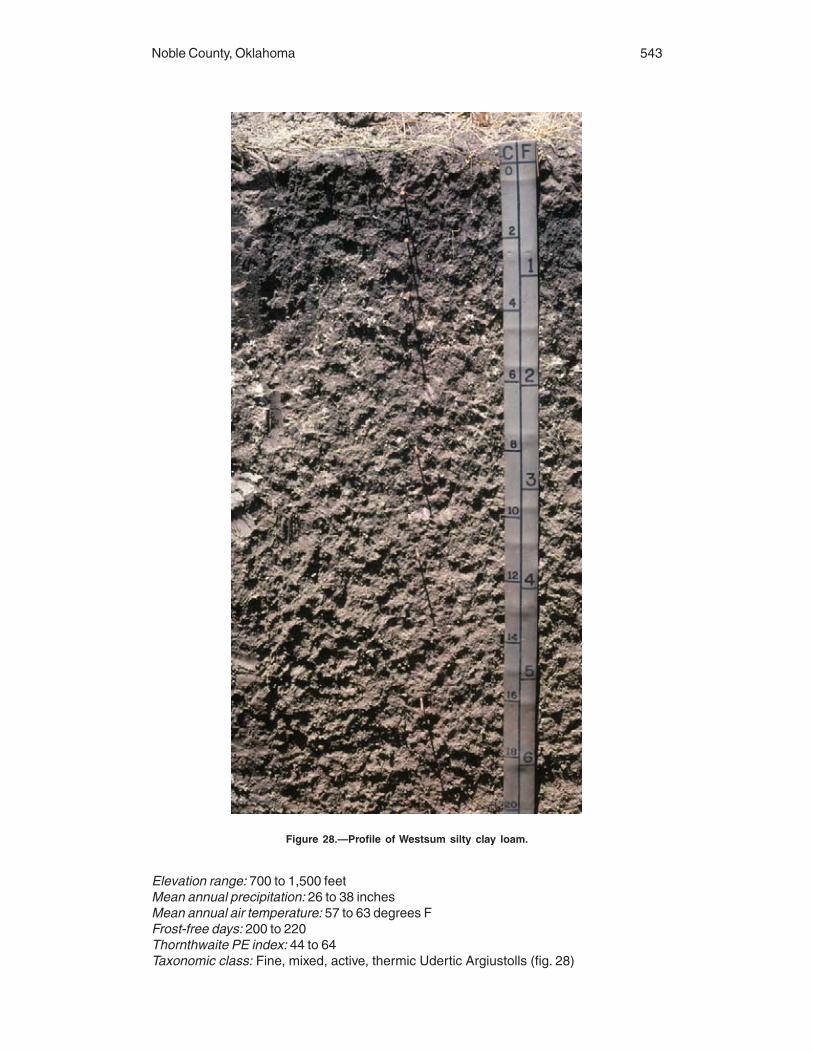
Noble County, Oklahoma 543
Elevation range: 700 to 1,500 feetMean annual precipitation: 26 to 38 inchesMean annual air temperature: 57 to 63 degrees FFrost-free days: 200 to 220Thornthwaite PE index: 44 to 64Taxonomic class: Fine, mixed, active, thermic Udertic Argiustolls (fig. 28)
Figure 28.—Profile of Westsum silty clay loam.

544 Soil Survey
Associated Soils
• Dilworth, Grainola, and Highview soils which are on the more sloping backslopes ofhillsides above the Westsum soils• Kirkland and Renfrow soils which are on the higher parts of the landscape
Typical Pedon
Westsum silty clay loam, 1 to 3 percent slopes; Noble County, Oklahoma; about 7 mileseast and 4 miles south of Billings, on a 2 percent slope, in cropland; 650 feet north and150 feet west of the southeastern corner of sec. 8, T. 23 N., R. 1 W. (Colors are for drysoil unless otherwise indicated.)
Ap—0 to 10 inches; dark gray (10YR 4/1) silty clay loam, very dark gray (10YR 3/1)moist; weak fine subangular blocky structure parting to weak fine granular; hard,friable; common fine roots throughout; few slightly effervescent spots (HCl,unspecified); moderately alkaline (pH 7.8); abrupt smooth boundary. (5 to 10 inchesthick)
Bt1—10 to 16 inches; dark gray (10YR 4/1) silty clay, very dark gray (10YR 3/1) moist;moderate medium blocky structure parting to strong very fine blocky; very hard,firm; few fine roots; few fine and common very fine tubular pores with low verticalcontinuity; few fine fragments of siltstone; many distinct clay films on faces of peds;few wormcasts; few very slightly effervescent spots (HCl, unspecified); moderatelyalkaline (pH 8.0); clear smooth boundary. (6 to 13 inches thick)
Btk1—16 to 30 inches; grayish brown (10YR 5/2) silty clay, dark grayish brown (10YR4/2) moist; moderate very fine and fine blocky structure; very hard, very firm; fewvery fine tubular pores with low vertical continuity; few fine faint yellowish brown(10YR 5/4) redoximorphic concentrations; few fine fragments of siltstone; fewdistinct dark gray (10YR 4/1) streaks of surface material in cracks; common distinctclay films on faces of peds; many fine irregular soft masses of calcium carbonate;few medium and few fine rounded calcium carbonate concretions; stronglyeffervescent (HCl, unspecified); moderately alkaline (pH 8.0); gradual smoothboundary. (10 to 19 inches thick)
Btk2—30 to 36 inches; grayish brown (10YR 5/2) silty clay, dark grayish brown (10YR4/2) moist; moderate very fine and fine blocky structure; very hard, very firm; fewvery fine tubular pores with low vertical continuity; few fine fragments of siltstone;common distinct clay films on faces of peds; few distinct dark gray (10YR 4/1)streaks of surface material in cracks; common fine irregular soft masses of calciumcarbonate; few medium rounded calcium carbonate concretions; stronglyeffervescent (HCl, unspecified); moderately alkaline (pH 8.0); gradual smoothboundary. (0 to 8 inches thick)
Bt2—36 to 52 inches; light brownish gray (10YR 6/2) silty clay, grayish brown (10YR 5/2)moist; moderate fine blocky structure; very hard, very firm; few very fine tubularpores with low vertical continuity; few fine faint light yellowish brown (10YR 6/4)redoximorphic concentrations; few fine fragments of siltstone; common distinct clayfilms on faces of peds; few distinct dark gray (10YR 4/1) streaks of surface materialin cracks; slightly effervescent (HCl, unspecified); moderately alkaline (pH 8.0);gradual smooth boundary. (9 to 28 inches thick)
Bt3—52 to 65 inches; light brownish gray (2.5Y 6/2) silty clay, grayish brown (2.5Y 5/2)moist; moderate fine blocky structure; very hard, very firm; few fine and very finefragments of siltstone; common distinct clay films on faces of peds; few finerounded dark concretions; moderately alkaline (pH 8.0); gradual smooth boundary.(0 to 13 inches thick)
BC—65 to 80 inches; light brownish gray (2.5Y 6/2) silty clay, grayish brown (2.5Y 5/2)moist; weak fine subangular blocky structure; very hard, very firm; common veryfine shale fragments; few faint clay films on faces of peds; common very fine

Noble County, Oklahoma 545
rounded dark concretions; few medium and common fine rounded calcium carbonateconcretions; very slightly effervescent (HCl, unspecified); moderately alkaline(pH 8.0). (0 to 21 inches thick)
Range in Characteristics
Thickness of the solum: More than 55 inchesDepth to shale: More than 60 inchesThickness of the mollic epipedon: 12 to 18 inchesDepth to secondary carbonates: 10 to 23 inches
A horizon:Color—hue of 10YR, value of 3 or 4, and chroma of 1 or 2Texture—silty clay loam or silt loamReaction—slightly alkaline or moderately alkaline
BA horizon (if it occurs):Color—hue of 10YR, value of 4, and chroma of 2Texture—silty clay loam or silt loamReaction—slightly alkaline or moderately alkaline
Bt1 horizon:Color—hue of 10YR, value of 3 to 5, and chroma of 1 to 3Texture—silty clay or silty clay loam
Btk1 horizon:Color—hue of 10YR to 2.5Y, value of 4 to 6, and chroma of 2 or 3Texture—silty clay or silty clay loamRedoximorphic features—few brownish yellow or yellowish brown concentrations in
a few pedonsStructure—slickensides in a few pedons
Btk2 horizon (if it occurs):Color—hue of 10YR to 5Y, value of 5 or 6, and chroma of 2Texture—silty clayRedoximorphic features—few brownish yellow, light yellowish brown, yellowish red,
or yellowish brown concentrations in a few pedonsStructure—slickensides in a few pedons
Bt2 horizon:Color—hue of 10YR to 5Y, value of 5 or 6, and chroma of 2 to 4Texture—silty clayRedoximorphic features—few brownish yellow, light yellowish brown, yellowish red,
or pink concentrations in a few pedonsStructure—slickensides in a few pedons
Bt3 horizon:Color—hue of 7.5YR to 2.5Y, value of 5 or 6, and chroma of 2 to 4Texture—silty clayRedoximorphic features—few brownish yellow concentrations in a few pedonsStructure—slickensides in a few pedons
BC horizon:Color—hue of 7.5YR to 5Y, value of 5 or 6, and chroma of 1 to 4Texture—silty clay or clay loamStructure—slickensides in a few pedons
C horizon (if it occurs):Color—hue of 10YR to 5Y, value of 5 or 6, and chroma of 2 to 4Texture—weathered bedrock or shaly clay
546 Soil Survey
Cr horizon (if it occurs):Color—hue of 10YR to 5Y, value of 4 to 6, and chroma of 2 to 4Paralithic contact—shale bedrock
Wisby Series
Major land resource area: Central Rolling Red Prairies (80A)Depth class: Very deepDrainage class: Somewhat excessively drainedParent material and geologic age: Loamy sediments over old sandy alluvium of
Pleistocene agePhysiographic region: Interior LowlandsPhysiographic province: Central LowlandPhysiographic sub-province: Osage PlainLandscape: UplandLandform: Dissected terraceLandform position: TreadSlope range: 0 to 20 percentSlope shape: Convex-convexElevation range: 800 to 1,500 feetMean annual precipitation: 26 to 38 inchesMean annual air temperature: 57 to 62 degrees FFrost-free days: 185 to 210Thornthwaite PE index: 44 to 64Taxonomic class: Coarse-loamy, mixed, superactive, thermic Udic Argiustolls
Associated Soils
• Milan and Lovedale soils which are fine-loamy and do not have a gravelly substratum,generally in the slightly higher landscape positions
Typical Pedon
Wisby sandy loam; Alfalfa County, Oklahoma; about 2,300 feet west and 300 feet southof the northwestern corner of sec. 1, T. 24 N., R. 10 W. (Colors are for dry soil unlessotherwise indicated.)
A—0 to 12 inches; brown (10YR 5/3) sandy loam, dark brown (10YR 3/3) moist;moderate medium granular structure; hard, friable; noneffervescent; neutral; gradualsmooth boundary. (8 to 18 inches thick)
Bt—12 to 24 inches; brown (7.5YR 5/4) sandy loam, dark brown (7.5YR 3/4) moist; weakcoarse prismatic structure parting to weak medium granular; slightly hard, friable;few faint patchy clay films on faces of peds; common clay bridging between sandgrains; noneffervescent; neutral; gradual smooth boundary. (12 to 20 inches thick)
2C—24 to 80 inches; strong brown (7.5YR 5/6) gravelly sand, strong brown (7.5YR 4/6)moist; single grained; noneffervescent; neutral.
Range in Characteristics
Thickness of the mollic epipedon: 8 to 20 inchesThickness of the solum: 20 to 40 inchesDepth to carbonates: More than 36 inches
A horizon:Color—hue of 7.5YR or 10YR, value of 4 or 5 (dry) and 2 or 3 (moist), and chroma of
2 or 3Texture—sandy loam or fine sandy loamReaction—neutral to moderately acid

Noble County, Oklahoma 547
Coarse fragments—0 to 15 percent, by volume, rounded gravel less than 3 inches indiameter
Bt horizon:Color—hue of 10YR to 2.5YR, value of 4 to 6 (dry) and 3 to 5 (moist), and chroma of
2 to 6Texture—sandy loam or loam with 10 to 18 percent clay and 45 to 75 percent
medium and coarse sandReaction—slightly acid to slightly alkalineCoarse fragments—0 to 15 percent, by volume, rounded gravel less than 3 inches in
diameter
BC horizon (if it occurs):Color—hue of 10YR to 2.5YR, value of 4 to 6 (dry) and 3 to 5 (moist), and chroma of
2 to 6Texture—coarse sandy loam, sandy loam, or loamy sandReaction—neutral to moderately alkaline
2C horizon:Color—hue of 7.5YR or 5YR, value of 4 to 6 (dry) and 4 or 5 (moist), and chroma of
4 to 8Texture—sand, gravelly sand, or loamy sandReaction—slightly acid to moderately alkalineCoarse fragments—0 to 40 percent, by volume, rounded gravel less than 3 inches in
diameter
Zaneis Series
Major land resource area: Central Rolling Red Prairies (80A)Depth class: DeepDrainage class: Well drainedParent material and geologic age: Material weathered from interbedded sandstone and
shale of Permian agePhysiographic region: Interior LowlandsPhysiographic province: Central LowlandPhysiographic sub-province: Osage PlainLandscape: UplandLandform: HillsLandform position: Summit and backslopeSlope range: 0 to 8 percentSlope shape: Linear-convex and convex-convexElevation range: 900 to 1,200 feetMean annual precipitation: 26 to 40 inchesMean annual air temperature: 58 to 64 degrees FFrost-free days: 200 to 230Thornthwaite PE index: 44 to 64Taxonomic class: Fine-loamy, siliceous, active, thermic Udic Argiustolls
Associated Soils
• Bethany soils which have a fine control section, on the slightly higher broad flats• Chickasha and Coyle soils which are on landscapes similar to those of the Zaneissoils• Grainola soils which do not have a mollic epipedon, have a fine control section, andhave a solum less than 40 inches thick; on side slopes

548 Soil Survey
• Loco and Lucien soils which have a solum less than 20 inches thick and do not haveBt horizons, typically on ridge crests and upper side slopes• Mulhall soils which are on the slightly lower side slopes and footslopes• Nash soils which have a coarse-silty control section and do not have Bt horizons,typically on landscapes similar to those of the Zaneis soils• Renfrow soils which have a fine control section, on the slightly higher convex ridgecrests• Stephenville soils which do not have a mollic epipedon and have a solum less than 40inches thick, in areas that have savannah vegetation on landscapes similar to those ofthe Zaneis soils• Teller soils which are typically in the slightly lower areas that are closer to the streamchannel than the Zaneis soils
Typical Pedon
Zaneis loam; Oklahoma County, Oklahoma; about 1 mile east and 5 miles north ofEdmond, in a cultivated area; 100 feet south and 1,000 feet east of the northwesterncorner of sec. 6, T. 14 N., R. 2 W. (Colors are for dry soil unless otherwise indicated.)
A1—0 to 6 inches; brown (7.5YR 4/2) loam, dark brown (7.5YR 3/2) moist; weak mediumplaty structure parting to weak fine granular; slightly hard, very friable; many veryfine and few fine roots; many very fine and fine continuous tubular pores; moderatelyacid; abrupt smooth boundary. (0 to 10 inches thick)
A2—6 to 12 inches; brown (7.5YR 4/2) loam, dark brown (7.5YR 3/2) moist; weak finesubangular blocky structure parting to moderate fine granular; slightly hard, veryfriable; many very fine and few fine roots; many very fine and fine continuous tubularpores; moderately acid; clear smooth boundary. (4 to 14 inches thick)
BA—12 to 19 inches; brown (7.5YR 4/3) loam, dark brown (7.5YR 3/3) moist; weak fineprismatic structure parting to weak fine subangular blocky; hard, firm; many veryfine and few fine and medium roots; common very fine and fine continuous tubularpores; moderately acid; gradual smooth boundary. (0 to 7 inches thick)
Bt1—19 to 31 inches; brown (7.5YR 5/3) clay loam, brown (7.5YR 4/3) moist; moderatemedium prismatic structure parting to moderate medium blocky; very hard, veryfirm; many very fine and few fine roots; common very fine and fine continuoustubular pores; common distinct continuous clay films on vertical and horizontalfaces; slightly acid; gradual wavy boundary. (4 to 18 inches thick)
Bt2—31 to 39 inches; reddish brown (5YR 5/4) sandy clay loam, reddish brown (5YR4/4) moist; moderate coarse prismatic structure parting to moderate medium blocky;very hard, very firm; common very fine roots; common very fine and fine continuoustubular pores; common distinct continuous clay films on vertical and horizontalfaces; common medium distinct red (2.5YR 4/6) redoximorphic concentrations; fewfine iron-manganese concretions; moderately acid; gradual wavy boundary. (6 to 23inches thick)
Bt3—39 to 48 inches; yellowish red (5YR 5/6) sandy clay loam, yellowish red (5YR 4/6)moist; weak coarse prismatic structure parting to weak medium subangular blocky;hard, firm; common very fine roots; many very fine and common fine continuoustubular pores; common distinct discontinuous clay films on vertical and horizontalfaces; common coarse prominent olive yellow (5Y 6/6), reddish brown (2.5YR 5/4),and brown (7.5YR 5/3) redoximorphic concentrations; common fine iron-manganeseconcretions; brown (7.5YR 4/3) material in root channels; slightly acid; gradual wavyboundary. (0 to 24 inches thick)
Bt4—48 to 55 inches; red (2.5YR 5/6) sandy clay loam, red (2.5YR 4/6) moist; weakcoarse prismatic structure parting to weak coarse subangular blocky; hard, firm; fewvery fine roots; few very fine, many fine, and common medium continuous tubularpores; common faint discontinuous clay films on vertical faces; common mediumdistinct dark red (2.5YR 3/6) redoximorphic concentrations; few fine iron-manganese

Noble County, Oklahoma 549
concretions; brown (7.5YR 4/3) material along root channels; slightly acid; clearwavy boundary. (0 to 15 inches thick)
BC—55 to 59 inches; red (2.5YR 5/6) sandy clay loam, red (2.5YR 4/6) moist; weakcoarse subangular blocky structure; hard, friable; few very fine roots; common veryfine and many fine continuous tubular pores; few medium distinct dark red (10R 3/6)redoximorphic concentrations; brown (7.5YR 4/3) material along root channels; 10percent, by volume, weathered sandstone fragments; slightly acid; abrupt wavyboundary. (0 to 10 inches thick)
Cr—59 to 65 inches; red (2.5YR 4/6) soft laminated sandstone, dark red (2.5YR 3/6)moist; slightly acid.
Range in Characteristics
Thickness of the mollic epipedon: Less than 20 inchesThickness of the solum: 40 to 60 inchesDepth to bedrock: 40 to 60 inches
A or Ap horizon:Color—hue of 5YR to 10YR, value of 4 or 5, and chroma of 2 or 3Texture—loam or fine sandy loamReaction—moderately acid to neutralClay content—10 to 26 percent
BA horizon:Color—hue of 5YR or 7.5YR, value of 4, and chroma of 2 to 4Texture—loam or clay loamReaction—moderately acid to neutralClay content—18 to 30 percent
Bt1 horizon:Color—hue of 5YR or 7.5YR, value of 4 or 5, and chroma of 3 or 4Texture—loam, clay loam, or sandy clay loamReaction—moderately acid to slightly alkalineClay content—18 to 30 percent
Bt2 horizon:Color—hue of 2.5YR to 7.5YR, value of 4 or 5, and chroma of 4 to 6Texture—clay loam or sandy clay loamRedoximorphic features—red concentrationsReaction—moderately acid to slightly alkalineClay content—20 to 38 percent
Bt3 horizon:Color—hue of 2.5YR or 5YR, value of 4 or 5, and chroma of 4 to 8Texture—clay loam or sandy clay loamRedoximorphic features—red, brown, or yellow concentrationsReaction—slightly acid to moderately alkalineClay content—20 to 38 percent
Bt4 horizon:Color—hue of 2.5YR or 5YR, value of 4 to 6, and chroma of 4 to 8Texture—fine sandy loam, clay loam, or sandy clay loamRedoximorphic features—red concentrationsReaction—moderately acid to slightly alkalineClay content—18 to 30 percent
BC horizon:Color—hue of 2.5YR or 5YR, value of 4 to 6, and chroma of 4 to 8Texture—fine sandy loam, clay loam, or sandy clay loam

550
Clay content—18 to 30 percentReaction—moderately acid to slightly alkaline
Cr horizon:Color—hue of 2.5YR or 5YR, value of 4 to 6, and chroma of 4 to 8Texture—weathered sandstoneReaction—moderately acid to slightly alkaline

551
This section discusses the factors of soil formation and how they relate to the soils inNoble County. It also discusses the geology of the survey area.
Factors of Soil FormationThe following paragraphs describe the five factors of soil formation—climate, living
organisms, topography, parent material, and time. The combined influence of thesefactors determines the characteristics and properties of a soil.
Climate
Noble County has a moist, subhumid climate. Because the climate is fairly uniformthroughout the county, differences among soils cannot be attributed to differences inclimate based on the present climatic regime. Moisture and warm temperatures havebeen sufficient for the formation of distinct layers in many of the soils. Soil leaching ismoderate. The physical abrasion and redistribution of materials by wind actioncontributes to soil formation. Cold temperatures occur often enough and long enough inthe survey area to alter materials through the processes of freezing and thawing.
Living Organisms
Plants, burrowing animals, insects, and soil micro-organisms have a direct influenceon the formation of soils. The native grasses and trees in the county have had differenteffects on the losses and gains of organic matter and plant nutrients in the soil and onsoil structure and porosity. Soils that formed under prairie vegetation, such as Kirklandand Norge, have a dark grayish brown surface layer and a moderately high content oforganic matter. Soils that formed under trees, such Harrah and Stephenville, have abrown surface layer and a low content of organic matter.
Topography
Relief influences the formation of the soils mainly through its effect on watermovement, erosion, soil temperature, and the kind of plant cover. In Noble County, reliefis determined largely by the resistance of underlying formations to weathering andgeological erosion. The topography of the southern third of Noble County is rolling to hillyuplands with long, narrow, very gently sloping to moderately sloping summits. Thedrainage deeply dissects the uplands, thus forming broad, gently sloping to steep sideslopes with narrow flood plains. The native vegetation is a prairie savannah of postoak and blackjack oak with an understory of tall and mid grasses. The northern twothirds of Noble County consists of nearly level to rolling uplands with broad, nearlylevel and very gently sloping summits. The native vegetation is mid and tall prairiegrasses.
Formation of the Soils

552 Soil Survey
Parent Material
Soils form in unconsolidated material, which influences the rate of formation; thechemical, physical, and mineral composition of the soil; and the color of the soil. Soilson the uplands in Noble County formed in material weathered from alluvium, sandstone,and shale. Examples of soils that formed in shale are Masham and Grainola. Soils thatformed in sandstone are Darnell, Lucien, Stephenville, Coyle, and Zaneis.
Alluvial sediment is extensive along streams and rivers in the county. The kind ofsediment deposited and the kinds of soil that formed in it largely depend on the sourceof the sediment and the velocity of the streams. Soils that formed in ancient fluvialsediments include Norge, Bethany, Teller, and Kirkland. Soils that formed in recent fluvialsediments are Ashport, Port, Pulaski, and Gaddy.
Time
As a factor of soil formation, time is difficult to measure in years. The length of timeneeded for the development of genetic horizons depends on the intensity and theinteraction of the other soil-forming factors in promoting the loss, gain, transfer, ortransformation of the constituents that make up soil horizons. Soils that have no definitegenetic horizons are young or immature. Mature or older soils are in equilibrium with theirenvironment and tend to have well defined horizons.
The soils in Noble County range from young to old. Bethany and Renfrow soils areexamples of old soils. Coyle and Teller soils are younger, but they have well expressedhorizons. Darnell and Masham soils are considered young soils. Although these soilshave had sufficient time to develop well expressed horizons, geological erosion hastaken away soil material almost as fast as it forms because the soils are in slopingareas. Ashport and Pulaski soils are young soils that formed in recent sediments onflood plains. These soils show little horizon development.
GeologyKenneth S. Johnson, Oklahoma Geological Survey, the University of Oklahoma, Norman, Oklahoma,
helped prepare this section.
The surface geology of Noble County is fairly simple. It is shown on the SurfaceGeology Map of the county included with the soil maps. The outcropping rocks in thiscounty consist of reddish brown shales and sandstones of Permian age. These sedi-ments were deposited near the shores of shallow seas that once covered much ofwestern Oklahoma (4). In many parts of the county, these sedimentary rocks aremantled by unconsolidated alluvium of Quaternary age that was laid down by ancient ormodern rivers and streams. Permian sandstones and Quaternary alluvium are localsources of small or moderate amounts of fairly fresh ground water. The outcroppingPermian strata overlie older sedimentary rocks that are important petroleum reservoirs inmany parts of Oklahoma.
Subsurface rock units of sedimentary origin are about 5,500 feet thick in the easternpart of the county and about 8,000 feet thick in the western part. These strata rest upona “basement” of granite and other igneous or metamorphic rocks that extends 20 to 25miles down into the earth’s crust. These subsurface sedimentary rocks were depositedin great, shallow seas that bordered the deep sedimentary basins of western Oklahoma,including the Anadarko Basin to the southwest and the Arkoma Basin to the southeast.These seas inundated the survey area intermittently from the Cambrian Period ofgeologic time (about 525 million years ago) through the later part of Permian time (about250 million years ago). Noble County is considered part of the stable platform of north-central Oklahoma, and the various rock formations that underlie the county dip gently tothe west. The Nemaha Uplift, a series of buried, fault-bounded uplift blocks, formed

Noble County, Oklahoma 553
during Pennsylvanian time. It extends in a north-south direction in the subsurfacematerial, just west of Noble County.
The outcropping rocks in Noble County were deposited during the late Permian Period(about 250 to 270 million years ago). Sands, silts, and clays were eroded from marginalland areas that existed during this time in eastern Oklahoma and adjacent parts ofArkansas. These materials were transported generally to the west and northwest bystreams and rivers that flowed, at the time, toward the large inland sea (Anadarko Basin)that covered most of western Oklahoma. Noble County was close to the shoreline of thisancient sea, and, therefore, was the site for deposition of interbedded shales, siltstones,sandstones, and a few thin limestones (to the east) in alternating riverine, deltaic, tidal-flat, and shallow marine environments.
Permian rock outcrops are typically red or reddish brown with local light gray orgreenish gray variations. The red color in these sedimentary rocks primarily results fromthe presence of iron oxide minerals (e.g., hematite), which are commonly distributeduniformly throughout the rocks. Iron oxides generally do not occur in sedimentary rockshaving grayish, greenish, or whitish colors. Soils that developed from Permian reddish-colored rocks tend to retain the hematite stain of the parent material. This tendancyexplains the red color of most of the soils in Noble County.
The oldest rocks exposed in the survey area crop out along the eastern countyboundary and are overlain by successively younger Permian strata to the west. Theseoutcropping strata dip gently to the west at an angle of less than 1 degree, as shown inthe east-west cross section included with the Surface Geology Map.
The parent materials of soils are generally the product of weathering and disaggrega-tion of outcropping rock units. As such, there is a close relationship between thephysical and chemical properties of these rock formations and the soils that developupon them. Therefore, a description of the rock units that crop out in the county can helpto explain the character and distribution of soils.
The oldest rock unit exposed in Noble County is the Oscar Group. Oscar sedimentsin Noble County have a total thickness of about 600 feet, although only the uppermost300 feet is exposed along the eastern side of the county. This unit consists mainly ofred shale with minor interbeds of sandstone and several thin beds of limestone. TheOscar Group is the parent material for several general soil map units, the most commonof which is the Renfrow-Grainola-Coyle general soil map unit. The loamy soils in thismap unit are gently sloping and well drained and formed in material weathered (primarily)from shale or sandstone. In several general soil map units that are mapped on the OscarGroup outcrop, the soils actually formed in a thin veneer of loamy alluvium covering thebedrock.
The Oscar Group is conformably overlain by the Wellington Formation. The WellingtonFormation is approximately 850 feet thick. Its outcrops are extensive and cover about70 percent of Noble County. The Wellington strata consist mainly of red shale with minorsandstone beds and a thin layer of limestone nodules. The Wellington Formation is theparent material for several general soil map units. The Norge-Bethany-Kirkland andRenfrow-Grainola-Kingfisher-Grant general soil map units are most commonly mappedon Wellington sediments in Noble County. The Renfrow-Grainola-Coyle and Grainola-Lucien-Masham general soil map units are mapped to a lesser extent. The loamy soilsof these map units formed in alluvium weathered from shale, siltstone, or sandstone orin a thin veneer of loamy alluvium that mantles the bedrock. Soils that developed onWellington sediments typically are shallow to very deep and well drained or moderatelywell drained and occur on nearly level to steep slopes.
The Garber Sandstone overlies the Wellington Formation, but it is restricted to smallareas in the western part of the county. Although the Garber Sandstone has a totalthickness of about 600 feet farther west in Garfield County, the upper part of theformation has been eroded from all parts of Noble County and only the lower 50 to 150feet remains in the west. The Garber Sandstone deposits consist mainly of orange-

554 Soil Survey
brown to red-brown sandstone beds that are irregularly interlayered with red-brown shaleand siltstone. The Renfrow-Grainola-Kingfisher-Grant general soil map unit is mostcommonly mapped on the Garber Sandstone outcrops in Noble County. The Teller-Konawa and Bethany-Kirkland-Norge-Tabler general soil map units are mapped to alesser extent. The loamy soils in these map units typically occur on uplands and formedin alluvium weathered from shale, siltstone, or sandstone or in a thin veneer of loamyalluvium that mantles the bedrock. Soils developed on the Garber Sandstone outcropsare shallow to very deep and well drained or moderately well drained and occur on nearlylevel to steep slopes.
Alluvial and terrace deposits of Quaternary age in Noble County are generally 10 to60 feet thick and consist mainly of sand, silt, and clay and some gravel. These sedi-ments were eroded from Permian strata within and to the west of Noble County and alsofrom other rock units that occur west and northwest of the county and are within theArkansas and Cimarron River drainage basins. Quaternary sediments (depositedapproximately within the past million years) were laid down mainly as flood plain oralluvial deposits along major rivers and streams that flowed predominantly to the eastacross the county. In addition, some of the sands and silts are windblown deposits.
Terrace deposits, which consist of older alluvium left behind after a river shiftsposition or cuts more deeply into underlying material, occur either as broad and level, orhummocky and undulating, expanses that are topographically higher than, and generallyadjacent to, the present-day flood plains. They occur mainly to the northeast along theArkansas River but also may be present in small areas near Black Bear Creek and RedRock Creek. Arkansas River terrace deposits are the parent sediments for soils in theVanoss-Slaughterville-Teller general soil map unit. The loamy soils of this map unit arevery deep and well drained and occur on nearly level to sloping topography.
Alluvial deposits are the unconsolidated sediments in stream channels or flood plainsof present-day rivers and streams, such as the main stream tributaries of the ArkansasRiver and of Red Rock, Black Bear, and Stillwater Creeks. Alluvial deposits associatedwith the Arkansas River and the Salt Fork of the Arkansas River are the parentmaterials for soils in the Keokuk-Goodnight-Ashport and McLain-Braman-Lela generalsoil map units. These soils are very deep and somewhat poorly drained to somewhatexcessively drained and locally are clayey, loamy, or sandy. Alluvium associated withRed Rock, Black Bear, and Stillwater Creeks makes up the parent sediments for soils inthe Port-Ashport-Pulaski general soil map unit. These loamy soils are very deep andwell drained and occur on nearly level or very gently sloping topography.
Landscape Evolution and Quaternary Geology
Surface features in Oklahoma were significantly affected by landscape evolutionprocesses during Quaternary (Pleistocene and Holocene) time (see the QuaternaryGeology Map). River systems flowing across Oklahoma deposited an alluvial cover overa large part of the State. These deposits are of prime importance to agriculture inOklahoma, as most prime farmland is associated with soils that developed in alluviumand wind-reworked alluvium (eolian sediments) deposited during the past two millionyears. Alluvium in Noble County ranges from a few feet to more than 50 feet thick. Manysmaller areas are not identified on standard geologic maps, primarily because thedelineations are too small to be identified at the map scale. This section discusses thenature and depositional history of Quaternary deposits and the surface (geomorphic)features associated with these deposits in the survey area.
Depositional History
Terrace development.—Alluvial and eolian sediments associated with Pleistoceneterraces were deposited by rivers (or blown from beds of rivers) originating in the RockyMountains and flowing across the High Plains and Osage Plains. The Ogallala Formation

Noble County, Oklahoma 555
of Miocene-Pliocene age and geologic formations of Permian age were dissected bythese eastward-flowing rivers, and Pleistocene alluvium, loess, and eolian sands weredeposited on this unconformity surface. Pleistocene alluvial deposits are laterallydiscontinuous, and it is not always clear which stream deposited these sediments. Fivemajor Pleistocene terraces are recognized in Noble County. Terrace level Qt5 is thehighest terrace in Noble County and lies on the divide between the Cimarron andArkansas Rivers.
The north-facing escarpment (E5), which is continuous west to southeast of the townof Perry, represents the southern boundary of an ancient Arkansas River valley. Thisancestral Arkansas River was probably a braided stream carrying sediments from theRocky Mountains across the High Plains and Osage Plains. According to Fay (5),Quaternary sediments in Noble County belong to an ancient Arkansas River that flowedsoutheast from the Dodge City, Kansas area and along the present course of theMedicine Lodge River and the Salt Fork of the Arkansas River. This ancestral ArkansasRiver cut escarpment E5 and formed the Qt4 terrace, which typically contains largestrips of bed-load material. Remnants of the Qt4 terrace also occur north of Red RockCreek, where gravel deposits are isolated on topographic highs.
Rejuvenation caused the river system to erode its valley, cut escarpment E4, anddeposit terrace Qt3. Volcanic ash in the Qt3 terrace has been dated at about750,000 years B.P.(16) . Sediments on the Qt3 terrace are dominantly silts and clays. Themineralogy and color of these sediments are not indicative of Permian red beds butstrongly suggest alluvial plain sediments from the Rocky Mountains. Areas of the Qt3terrace occur in northern and central parts of Noble County and in valleys that breachthe Qt4 terrace. The Qt3 terrace deposits are further discussed in the following para-graphs with the development of Black Bear Creek and Red Rock Creek.
The Qt2 terrace in the northeastern corner of Noble County is confined to a meanderbend of the Arkansas River and is slightly lower than the Qt3 terrace. The sedimenttexture and the position of the Qt2 terrace relative to the river suggest a major eolianinfluence. Recent eolian soils and depositional areas on the Qt2 terrace suggest that theprevailing wind direction and channel form facilitated the accumulation of eolian sandsand silts since (at least) late Pleistocene time. The presence of this material is alsoevidence that the river generally flowed within the existing channel in this area for manyyears. The river cut escarpment E2 while providing eolian material for the Qt2 terrace.
The Qt1 terrace in the northeastern part of the county is the lowest Pleistoceneterrace. It lies below escarpment E2 and is a terrace of the modern Arkansas River.Escarpment E1 is the lowest escarpment. It is below the Qt1 terrace and immediatelyabove the Holocene flood plain of the Arkansas River.
Stream piracy.—Stream piracy played an important role in the development of themodern drainage network. The pattern of sediments on the Qt3 terrace bisects themodern drainage system and also bisects the Qt4 terrace in two valleys north of Perry.Following deposition of the Qt4 terrace, north-south drainage developed. Two possiblescenarios could have produced this feature during the development of the Qt3 terrace. Inone scenario, the main river could have breached the Qt4 terrace and flowed to thesouth into what is now the Cimarron River drainage. Terrace sediments in a wind gap insections 7 and 18, T. 20 N., R. 3 E. in Payne County are analogous to these sediments.They are at the same elevation, have the same soil series, and are in line with thesoutheast trend of the sediments. In a second scenario, tributaries of the main riverflowing north could have bisected the Qt4 terrace. The sediment, however, is the sametype as the main body of the Qt3 terrace. Stream piracy eventually diverted the drainageinto the modern course of Black Bear Creek and Red Rock Creek.
Additional evidence of streams flowing north or south are wind gaps in the majordivides, in line from north to south. These wind gaps are higher valleys in saddles of themajor divides that have alluvium on the valley floor but through which active streams nolonger flow. Stream piracy has diverted flow into Black Bear Creek and Red Rock Creek.

556 Soil Survey
The area of Antelope Valley (north half of section T. 22 N., R. 2 W.) is an example of anarea isolated by stream piracy. Active stream piracy is still taking place in section 7,T. 24 N., R. 1 W. This area is in the saddle of a wind gap in the divide between the SaltFork of the Arkansas River and Red Rock Creek. Escarpment E3 helps define windgaps near the northern boundary of Noble County.
Development of Red Rock Creek and Black Bear Creek.—After the deposition of theQt4 and Qt3 terraces, streams forming in backwater positions of the terraces continuedto capture drainage. These creeks became deferred tributaries to the main river, flowingfrom west to east. Red Rock Creek drains the Qt3 terrace, and Black Bear Creek drainsthe Qt4 terrace. Both streams are younger than the terraces that they dissect. Onefactor that complicates an understanding of the Qt3 terrace is the common movement ofstreams down the strike of the Permian formations across Oklahoma. As Red RockCreek drifts southward, the terrace sediments are reworked and the elevation range ofthese sediments grades into the lower terraces. South of the town of Billings and east ofthe town of Red Rock, several small treads and risers in the Qt3 terrace show episodicdowncutting. The south bank of Red Rock Creek and its tributaries are cutting intoPermian formations.
Holocene flood plains.—Flood plains of Holocene age along Black Bear, Red Rock,and Stillwater Creeks are similar in form and history. The paleosol known as the CopanSoil is found on all Holocene flood plains and, in some places, is the land-surface soil.This soil developed during a wet environment lasting from 2,000 to 1,000 years B.P. andis characterized by an over-thickened, organic-rich surface (7). In many places, thispaleosol is covered by 3 to 8 feet of silty and loamy alluvium that is less than 1,000years old. Holocene alluvium in stream valleys is derived from local Permian rocks andPleistocene terraces. Thickness of the alluvium ranges from 25 to 45 feet along RedRock Creek and from 25 to 55 feet along Black Bear Creek.
Arkansas River System.—The Salt Fork of the Arkansas River is an underfit streamflowing in the ancestral Arkansas River valley, which was discussed above. The SaltFork of the Arkansas River has a Holocene meander belt much narrower than thePleistocene flood plain. The Pleistocene flood plain is still rarely flooded by the Salt Forkof the Arkansas River but is relict as far as active aggradation is concerned. The floodplain of the Salt Fork of the Arkansas River is about 5 miles wide at Tonkawa,Oklahoma, and the Arkansas River flood plain is only about 1 mile wide where the tworivers join about 20 miles east. The Arkansas River is now deeply entrenched intoPermian and Pennsylvanian formations, and its broad flood plain narrows as the rivercuts resistant rock layers to the east.
Exposed Permian and Pennsylvanian Materials
Areas in the figure (shown by “P”) have soils that developed in residuum fromoutcropping Permian and Pennsylvanian shale and sandstone. Surface exposuresof Permian and Pennsylvanian sediments occur at all elevations within Noble County,and some soils are mapped regardless of elevation (e.g., Grainola and Lucien soils).Although these surfaces have different ages, ranging from middle to late Pleistocene,mapped soils show the same degree of pedogenesis whether high or low in elevation.One possible explanation for this discrepancy is that the soil-forming processes onthese landscapes are offset somewhat by geologic erosion, thus youthful characteristicsare maintained in the soil profiles.
Faulting in bedrock at depth is common. Most faulting occurred during Pennsylvaniantime. Subsequent movement produced gentle folds at the surface, although associatedfaults do not normally reach the surface.
Characteristics of terrace deposits and escarpments.—The other importantgeomorphic features in Noble County are the many escarpments throughout the surveyarea and the relict, high, isolated river valleys (wind gaps). The escarpments aredissected and of (primarily) Pleistocene age, and some have slopes as low as 5

Noble County, Oklahoma 557
percent. High valleys have alluvium on the valley floor and walls and correlate withvalleys on other divides in this area. The terrace deposits mapped in the county aredelineated based on elevation, soil series, texture, drainage density, and associatedescarpments.
Terrace Level 5.—The highest and oldest terrace (Qt5) caps the divide between theCimarron and Arkansas Rivers. This is a fining-upward terrace with thick sand depositsoverlain by clayey and silty surfaces. The soils mapped on this level are mostlyPaleustolls, typically Kirkland soils. This terrace is well dissected, and only smallremnants remain in Noble County.
Terrace Level 4.—The Qt4 terrace lies at the base of escarpment E5, at an elevationof 1,050 to 1,125 feet. This terrace occurs mostly in the south-central part of the county,although outliers also occur on topographic highs, capping Permian rocks north of RedRock Creek. Although the Qt4 terrace is also a fining-upward terrace, finer surfacesediment overlies thick deposits of bed-load sands and gravel. These deposits providelarge amounts of gravel and sand for construction. Laboratory data shows that thesurface layer of the Qt4 terrace has a loessial influence, but the loess layer is thin andmixed with underlying alluvium. The soils mapped on this level are Argiustolls andPaleustolls. Wisby, Milan, and Lovedale soils are associated with sandy and gravellybed-load deposits. Bethany and Norge soils are associated with silty surface layers. TheQt4 terrace is well dissected, and erosion has isolated several areas on interfluves inthe eastern part of Noble County.
Terrace Level 3.—The Qt3 terrace lies below escarpment E4 at an elevation of 950 to1,050 feet. This terrace is composed dominantly of silty and clayey sediments with sandand gravel as minor components. Laboratory data shows that the surface layer of theQt3 terrace also has a loessial influence, but these layers are also thin and mixed withunderlying alluvium. The soils mapped on this level are Paleustolls and Argiustolls,including Kirkland, Bethany, Tabler, and Norge soils. Norge soils are commonly mappednear Red Rock Creek where either basal sediments are exposed or sediments havebeen reworked by the migrating stream. The Qt3 terrace is the most susceptible surfaceto formation of saline seeps in Noble County. Depth to Permian bedrock on this terraceis less than 20 feet, and percolating water dissolves Permian salts and creates salineseeps on slopes where a contact between the terrace material and bedrock is exposed.The presence of Kirkland, Bethany, Norge, and Tabler soils on several terrace levelsmakes delineation of these terrace levels more difficult. However, it is possible that thefine textured soils (Kirkland, Bethany, and Tabler) have reached a steady state with thepresent climate, or the differences are not discernable with present knowledge. Similaralluvial sediments on each level also tend to produce similar soils. The drainage densityon this level is low or medium, and large areas of nearly level, well drained Kirkland soilsand moderately well drained Tabler soils are present.
Terrace Level 2.—The Qt2 terrace is confined to a large, entrenched meander of theArkansas River in the northeastern corner of the county. The elevation of this terrace is950 to 1,000 feet. The Qt2 terrace sediments are mostly very fine sand, presumablyeolian. These sands cap the Permian Herington Limestone and in places are blown upagainst escarpment E2 below the Herington Limestone on south-facing slopes. Soilsmapped on this level have argillic horizons, but they are not as well developed or asthick as argillic horizons in Qt3 terrace soils. Teller soils (Udic Argiustolls) are thedominant soils, but the soils are slightly more silty than typical for the Teller series.Drainage density is medium.
Terrace Level 1.—The youngest terrace (Qt1) is below the Qt2 terrace level and isdirectly related to the modern Arkansas River. The elevation of this terrace is 900 to 925feet. The drainage density is very low, and the mapped soils are unique to this terrace.Haplustolls (Minco and Slaughterville soils) formed in eolian sediments and wind-reworked alluvium along the first escarpment above the Arkansas River. Argiustolls(Vanoss soils) formed on the terrace tread and in backwater positions farther from the

558
river. Several additional late Pleistocene terraces along Red Rock Creek and Black BearCreek are included in the Qt1 terrace level. Teller soils also occur on this level alongBlack Bear Creek and Red Rock Creek.
Summary
Most prime farmland soils in Noble County formed in Quaternary alluvium. Soils andassociated water resources are the most valuable natural resources affecting the futureof agriculture in the survey area. An understanding of the extent, source, depositionalframework, and soil-geomorphic relationships of these terraces is helpful whenmanaging soil and water resources.

559
(1) American Association of State Highway and Transportation Officials (AASHTO).1998. Standard specifications for transportation materials and methods ofsampling and testing. 19th ed.
(2) American Society for Testing and Materials (ASTM). 1998. Standard classificationof soils for engineering purposes. ASTM Standard D 2487.
(3) Bingham, R.H., and D.L. Bergman. 1980. Reconnaissance of the water resourcesof the Enid Quadrangle, north-central Oklahoma. Ok. Geol. Surv. Hydro. AtlasHA-7, 4 sheets, scale 1:250,000.
(4) Bingham, R.H., and R.L. Moore. 1975. Reconnaissance of the water resources ofthe Oklahoma City Quadrangle, central Oklahoma. Ok. Geol. Surv. Hydro. AtlasHA-4, 4 sheets, scale 1:250,000.
(5) Fay, R.O. 1965. Geology of Woods County, Oklahoma. Ok. Geol. Surv. Bull. 106.
(6) Fenneman, N.M. 1930. Physiographic divisions of the United States. U.S. Geol.Surv. Map.
(7) Hall, S.A. 1990. Channel trenching and climatic change in the southern U.S. GreatPlains. Geol., vol. 18, pp. 342-345.
(8) Shelton, J.W. 1979. Geology and mineral resources of Noble County, Oklahoma.Ok. Geol. Surv. Bull. 128.
(9) United States Department of Agriculture. 1956. Soil survey of Noble County,Oklahoma.
(10) United States Department of Agriculture, Natural Resources ConservationService. 1996. Soil survey laboratory methods manual. Soil Surv. Invest. Rep. 42.
(11) United States Department of Agriculture, Natural Resources ConservationService. 1998. Keys to soil taxonomy. 8th ed. Soil Surv. Staff.
(12) United States Department of Agriculture, Natural Resources ConservationService. 1999. Soil taxonomy: A basic system of soil classification for makingand interpreting soil surveys. 2nd ed. Soil Surv. Staff. U.S. Dep. Agric. Handb.436.
(13) United States Department of Agriculture, Natural Resources ConservationService. 2002. National soil survey handbook, title 430-VI. Soil Surv. Staff.(Available in the State Office of the Natural Resources Conservation Service atStillwater, Oklahoma, or online at http://soils.usda.gov/procedures/handbook/main.htm)
References

560
(14) United States Department of Agriculture, Soil Conservation Service. 1961. Landcapability classification. U.S. Dep. Agric. Handb. 210.
(15) United States Department of Agriculture, Soil Conservation Service. 1993. Soilsurvey manual. U.S. Dep. Agric. Handb.
(16) Ward, P.A., Carter, B.J., and Weaver, B. 1993, Volcanic ashes: Time markers in soil parent materials of the southern plains. Soil Science Society of America Journal 57:453-460.

561
Aeration, soil. The exchange of air in soil with air from the atmosphere. The air in awell aerated soil is similar to that in the atmosphere; the air in a poorly aerated soilis considerably higher in carbon dioxide and lower in oxygen.
Aggregate, soil. Many fine particles held in a single mass or cluster. Natural soilaggregates, such as granules, blocks, or prisms, are called peds. Clods areaggregates produced by tillage or logging.
Alkali (sodic) soil. A soil having so high a degree of alkalinity (pH 8.5 or higher) or sohigh a percentage of exchangeable sodium (15 percent or more of the totalexchangeable bases), or both, that plant growth is restricted.
Alluvium. Material, such as gravel, sand, silt, or clay, deposited on land by streams.Alpha,alpha-dipyridyl. A dye that when dissolved in 1N ammonium acetate is used to
detect the presence of reduced iron (Fe II) in the soil. A positive reaction indicatesa type of redoximorphic feature.
Animal unit month (AUM). The amount of forage required by one mature cow ofapproximately 1,000 pounds weight, with or without a calf, for 1 month.
Aquic conditions. Current soil wetness characterized by saturation, reduction, andredoximorphic features.
Area reclaim (in tables). An area difficult to reclaim after the removal of soil forconstruction and other uses. Revegetation and erosion control are extremelydifficult.
Argillic horizon. A subsoil horizon characterized by an accumulation of illuvial clay.Aspect. The direction in which a slope faces.Available water capacity (available moisture capacity). The capacity of soils to hold
water available for use by most plants. It is commonly defined as the differencebetween the amount of soil water at field moisture capacity and the amount atwilting point. It is commonly expressed as inches of water per inch of soil. Thecapacity, in inches, in a 60-inch profile or to a limiting layer is expressed as:
Very low ................................................................. 0 to 3
Low ........................................................................ 3 to 6
Moderate ............................................................... 6 to 9
High ..................................................................... 9 to 12
Very high .................................................. more than 12
Backslope. The geomorphic component that forms the steepest inclined surface andprincipal element of many hillsides. Backslopes in profile are commonly steep, arelinear, and may or may not include cliff segments.
Badland. Steep or very steep, commonly nonstony, barren land dissected by manyintermittent drainage channels. Badland is most common in semiarid and aridregions where streams are entrenched in soft geologic material. Local reliefgenerally ranges from 25 to 500 feet. Runoff potential is very high, and geologicerosion is active.
Base saturation. The degree to which material having cation-exchange properties issaturated with exchangeable bases (sum of Ca, Mg, Na, and K), expressed as apercentage of the total cation-exchange capacity.
Glossary

562 Soil Survey
Bedding planes. Fine strata, less than 5 millimeters thick, in unconsolidated alluvial,eolian, lacustrine, or marine sediment.
Bedrock. The solid rock that underlies the soil and other unconsolidated material orthat is exposed at the surface.
Bench terrace. A raised, level or nearly level strip of earth constructed on or nearly ona contour, supported by a barrier of rocks or similar material, and designed to makethe soil suitable for tillage and to prevent accelerated erosion.
Blowout. A shallow depression from which all or most of the soil material has beenremoved by wind. A blowout has a flat or irregular floor formed by a resistant layeror by an accumulation of pebbles or cobbles. In some blowouts, the water table isexposed.
Bottom land. The normal flood plain of a stream, subject to flooding.Boulders. Rock fragments larger than 2 feet (60 centimeters) in diameter.Breaks. The steep and very steep broken land at the border of an upland summit that is
dissected by ravines.Brush management. Use of mechanical, chemical, or biological methods to make
conditions favorable for reseeding or to reduce or eliminate competition from woodyvegetation and thus allow understory grasses and forbs to recover. Brushmanagement increases forage production and thus reduces the hazard of erosion.It can improve the habitat for some species of wildlife.
Butte. An isolated small mountain or hill with steep or precipitous sides and a topvariously flat, rounded, or pointed that may be a residual mass isolated by erosionor an exposed volcanic neck.
Calcareous soil. A soil containing enough calcium carbonate (commonly combinedwith magnesium carbonate) to effervesce visibly when treated with cold, dilutehydrochloric acid.
Caliche. A more or less cemented deposit of calcium carbonate in soils of warm-temperate, subhumid to arid areas. Caliche occurs as soft, thin layers in the soil oras hard, thick beds directly beneath the solum, or it is exposed at the surface byerosion.
Canyon. A long, deep, narrow, very steep-sided valley with high, precipitous walls in anarea of high local relief.
Capillary water. Water held as a film around soil particles and in tiny spaces betweenparticles. Surface tension is the adhesive force that holds capillary water in thesoil.
Catena. A sequence of soils on a landscape that formed in similar kinds of parentmaterial but have different characteristics as a result of differences in relief anddrainage.
Cation. An ion carrying a positive charge of electricity. The common soil cations arecalcium, potassium, magnesium, sodium, and hydrogen.
Cation-exchange capacity. The total amount of exchangeable cations that can be heldby the soil, expressed in terms of milliequivalents per 100 grams of soil atneutrality (pH 7.0) or at some other stated pH value. The term, as applied to soils,is synonymous with base-exchange capacity but is more precise in meaning.
Cemented. Material in an air-dry test specimen that does not slake after beingimmersed in water for 1 hour. Cemented soil material has a brittle, hard consistencecaused by some cementing agent other than clay. Calcium carbonate, silica, oroxides or salts of iron and aluminum are common cementing materials.
Channeled. Refers to a drainage area in which natural meandering or repeatedbranching and convergence of a streambed have created deeply incised cuts,either active or abandoned, in alluvial material.
Channery soil material. Soil material that is, by volume, 15 to 35 percent thin, flatfragments of sandstone, shale, slate, limestone, or schist as much as 6 inches (15centimeters) along the longest axis. A single piece is called a channer.

Noble County, Oklahoma 563
Chemical treatment. Control of unwanted vegetation through the use of chemicals.Chiseling. Tillage with an implement having one or more soil-penetrating points that
shatter or loosen hard, compacted layers to a depth below normal plow depth.Clay. As a soil separate, the mineral soil particles less than 0.002 millimeter in
diameter. As a soil textural class, soil material that is 40 percent or more clay, lessthan 45 percent sand, and less than 40 percent silt.
Clay depletions. Low-chroma zones having a low content of iron, manganese, and claybecause of the chemical reduction of iron and manganese and the removal of iron,manganese, and clay. A type of redoximorphic depletion.
Clayey soil. Silty clay, sandy clay, or clay.Clay film. A thin coating of oriented clay on the surface of a soil aggregate or lining
pores or root channels. Synonyms: clay coating, clay skin.Claypan. A slowly permeable soil horizon that contains much more clay than the
horizons above it. A claypan is commonly hard when dry and plastic or stiff whenwet.
Climax plant community. The stabilized plant community on a particular site. Theplant cover reproduces itself and does not change so long as the environmentremains the same.
Closed depression. A low area completely surrounded by higher ground and having nonatural outlet.
Coarse fragments. Mineral or rock particles larger than 2 millimeters in diameter.Coarse textured soil. Sand or loamy sand.Cobble (or cobblestone). A rounded or partly rounded fragment of rock 3 to 10 inches
(7.6 to 25 centimeters) in diameter.Cobbly soil material. Material that is 15 to 35 percent, by volume, rounded or partially
rounded rock fragments 3 to 10 inches (7.6 to 25 centimeters) in diameter. Verycobbly soil material has 35 to 60 percent of these rock fragments, and extremelycobbly soil material has more than 60 percent.
COLE (coefficient of linear extensibility). See Linear extensibility.Colluvium. Soil material or rock fragments, or both, moved by creep, slide, or local
wash and deposited at the base of steep slopes.Complex slope. Irregular or variable slope. Planning or establishing terraces,
diversions, and other water-control structures on a complex slope is difficult.Complex, soil. A map unit of two or more kinds of soil or miscellaneous areas in such
an intricate pattern or so small in area that it is not practical to map themseparately at the selected scale of mapping. The pattern and proportion of the soilsor miscellaneous areas are somewhat similar in all areas.
Compressible (in tables). Excessive decrease in volume of soft soil under load.Concretions. Cemented bodies with crude internal symmetry organized around a point,
a line, or a plane. They typically take the form of concentric layers visible to thenaked eye. Calcium carbonate, iron oxide, and manganese oxide are commoncompounds making up concretions. If formed in place, concretions of iron oxide ormanganese oxide are generally considered a type of redoximorphic concentration.
Conglomerate. A coarse-grained, clastic rock composed of rounded or subangular rockfragments more than 2 millimeters in diameter. It commonly has a matrix of sandand finer textured material. Conglomerate is the consolidated equivalent of gravel.
Conservation cropping system. Growing crops in combination with needed culturaland management practices. In a good conservation cropping system, the soil-improving crops and practices more than offset the effects of the soil-depletingcrops and practices. Cropping systems are needed on all tilled soils. Soil-improvingpractices in a conservation cropping system include the use of rotations thatcontain grasses and legumes and the return of crop residue to the soil. Otherpractices include the use of green manure crops of grasses and legumes, propertillage, adequate fertilization, and weed and pest control.

564 Soil Survey
Conservation tillage. A tillage system that does not invert the soil and that leaves aprotective amount of crop residue on the surface throughout the year.
Consistence, soil. Refers to the degree of cohesion and adhesion of soil material andits resistance to deformation when ruptured. Consistence includes resistance ofsoil material to rupture and to penetration; plasticity, toughness, and stickiness ofpuddled soil material; and the manner in which the soil material behaves whensubject to compression. Terms describing consistence are defined in the “SoilSurvey Manual.”
Consolidated sandstone. Sandstone that disperses within a few hours whenfragments are placed in water. The fragments are extremely hard or very hard whendry, are not easily crushed, and cannot be textured by the usual field method.
Consolidated shale. Shale that disperses within a few hours when fragments areplaced in water. The fragments are extremely hard or very hard when dry and arenot easily crushed.
Consolidated siltstone. Siltstone that disperses within a few hours when fragmentsare placed in water. The fragments are extremely hard or very hard when dry andare not easily crushed.
Contour stripcropping. Growing crops in strips that follow the contour. Strips of grassor close-growing crops are alternated with strips of clean-tilled crops or summerfallow.
Control section. The part of the soil on which classification is based. The thicknessvaries among different kinds of soil, but for many, it is that part of the soil profilebetween depths of 10 inches and 40 or 80 inches.
Coppice dune. A small dune of fine-grained soil material stabilized around shrubs orsmall trees.
Corrosion. Soil-induced electrochemical or chemical action that dissolves or weakensconcrete or uncoated steel.
Cover crop. A close-growing crop grown primarily to improve and protect the soilbetween periods of regular crop production, or a crop grown between trees andvines in orchards and vineyards.
Cropping system. Growing crops according to a planned system of rotation andmanagement practices.
Crop residue management. Returning crop residue to the soil, which helps to maintainsoil structure, organic matter content, and fertility and helps to control erosion.
Cuesta. A hill or ridge that has a gentle slope on one side and a steep slope on theother; specifically, an asymmetric, homoclinal ridge capped by resistant rock layersof slight or moderate dip.
Cutbanks cave (in tables). The walls of excavations tend to cave in or slough.Decreasers. The most heavily grazed climax range plants. Because they are the most
palatable, they are the first to be destroyed by overgrazing.Deep soil. A soil that is 40 to 60 inches deep over bedrock or to other material that
restricts the penetration of plant roots.Deferred grazing. Postponing grazing or resting grazing land for a prescribed period.Dense layer (in tables). A very firm, massive layer that has a bulk density of more than
1.8 grams per cubic centimeter. Such a layer affects the ease of digging and canaffect filling and compacting.
Depth, soil. Generally, the thickness of the soil over bedrock. Very deep soils are morethan 60 inches deep over bedrock; deep soils, 40 to 60 inches; moderately deepsoils, 20 to 40 inches; shallow soils, 10 to 20 inches; and very shallow soils, lessthan 10 inches.
Depth to rock (in tables). Bedrock is too near the surface for the specified use.Dip slope. A slope of the land surface, roughly determined by and approximately
conforming to the dip of the underlying bedrock.

Noble County, Oklahoma 565
Diversion (or diversion terrace). A ridge of earth, generally a terrace, built to protectdownslope areas by diverting runoff from its natural course.
Drainage class (natural). Refers to the frequency and duration of wet periods underconditions similar to those under which the soil formed. Alterations of the waterregime by human activities, either through drainage or irrigation, are not aconsideration unless they have significantly changed the morphology of the soil.Seven classes of natural soil drainage are recognized—excessively drained,somewhat excessively drained, well drained, moderately well drained, somewhatpoorly drained, poorly drained, and very poorly drained. These classes are definedin the “Soil Survey Manual.”
Drainage, surface. Runoff, or surface flow of water, from an area.Drainageway. An area of ground at a lower elevation than the surrounding ground and
in which water collects and is drained to a closed depression or lake or to adrainageway at a lower elevation. A drainageway may or may not have distinctlyincised channels at its upper reaches or throughout its course.
Draw. A small stream valley that generally is more open and has broader bottom landthan a ravine or gulch.
Dune. A mound, ridge, or hill of loose, windblown granular material (generally sand),either bare or covered with vegetation.
Eluviation. The movement of material in true solution or colloidal suspension from oneplace to another within the soil. Soil horizons that have lost material througheluviation are eluvial; those that have received material are illuvial.
Endosaturation. A type of saturation of the soil in which all horizons between theupper boundary of saturation and a depth of 2 meters are saturated.
Eolian soil material. Earthy parent material accumulated through wind action;commonly refers to sandy material in dunes or to loess in blankets on the surface.
Ephemeral stream. A stream, or reach of a stream, that flows only in direct responseto precipitation. It receives no long-continued supply from melting snow or othersource, and its channel is above the water table at all times.
Episaturation. A type of saturation indicating a perched water table in a soil in whichsaturated layers are underlain by one or more unsaturated layers within 2 meters ofthe surface.
Erosion. The wearing away of the land surface by water, wind, ice, or other geologicagents and by such processes as gravitational creep.Erosion (geologic).—Erosion caused by geologic processes acting over longgeologic periods and resulting in the wearing away of mountains and the building upof such landscape features as flood plains and coastal plains. Synonym: naturalerosion.Erosion (accelerated).—Erosion much more rapid than geologic erosion, mainly asa result of human or animal activities or of a catastrophe in nature, such as a fire,that exposes the surface.
Escarpment. A relatively continuous and steep slope or cliff breaking the generalcontinuity of more gently sloping land surfaces and resulting from erosion orfaulting. Synonym: scarp.
Excess fines (in tables). Excess silt and clay in the soil. The soil does not provide asource of gravel or sand for construction purposes.
Excess lime (in tables). Excess carbonates in the soil that restrict the growth of someplants.
Excess salts (in tables). Excess water-soluble salts in the soil that restrict the growthof most plants.
Excess sodium (in tables). Excess exchangeable sodium in the soil. The resultingpoor physical properties restrict the growth of plants.
Fallow. Cropland left idle in order to restore productivity through accumulation ofmoisture. Summer fallow is common in regions of limited rainfall where cereal grain

566 Soil Survey
is grown. The soil is tilled for at least one growing season for weed control anddecomposition of plant residue.
Fast intake (in tables). The rapid movement of water into the soil.Fertility, soil. The quality that enables a soil to provide plant nutrients, in adequate
amounts and in proper balance, for the growth of specified plants when light,moisture, temperature, tilth, and other growth factors are favorable.
Fibric soil material (peat). The least decomposed of all organic soil material. Peatcontains a large amount of well preserved fiber that is readily identifiable accordingto botanical origin. Peat has the lowest bulk density and the highest water contentat saturation of all organic soil material.
Field moisture capacity. The moisture content of a soil, expressed as a percentage ofthe ovendry weight, after the gravitational, or free, water has drained away; the fieldmoisture content 2 or 3 days after a soaking rain; also called normal field capacity,normal moisture capacity, or capillary capacity.
Fine textured soil. Sandy clay, silty clay, or clay.First bottom. The normal flood plain of a stream, subject to frequent or occasional
flooding.Flaggy soil material. Material that is, by volume, 15 to 35 percent flagstones. Very
flaggy soil material has 35 to 60 percent flagstones, and extremely flaggy soilmaterial has more than 60 percent flagstones.
Flagstone. A thin fragment of sandstone, limestone, slate, shale, or (rarely) schist 6 to15 inches (15 to 38 centimeters) long.
Flood plain. A nearly level alluvial plain that borders a stream and is subject toflooding unless protected artificially.
Fluvial. Of or pertaining to rivers; produced by river action, as a fluvial plain.Footslope. The inclined surface at the base of a hill.Forb. Any herbaceous plant not a grass or a sedge.Fragile (in tables). A soil that is easily damaged by use or disturbance.Genesis, soil. The mode of origin of the soil. Refers especially to the processes or soil-
forming factors responsible for the formation of the solum, or true soil, from theunconsolidated parent material.
Gilgai. Commonly, a succession of microbasins and microknolls in nearly level areasor of microvalleys and microridges parallel with the slope. Typically, the microreliefof clayey soils that shrink and swell considerably with changes in moisture content.
Gleyed soil. Soil that formed under poor drainage, resulting in the reduction of iron andother elements in the profile and in gray colors.
Grassed waterway. A natural or constructed waterway, typically broad and shallow,seeded to grass as protection against erosion. Conducts surface water away fromcropland.
Gravel. Rounded or angular fragments of rock as much as 3 inches (2 millimeters to7.6 centimeters) in diameter. An individual piece is a pebble.
Gravelly soil material. Material that is 15 to 35 percent, by volume, rounded or angularrock fragments, not prominently flattened, as much as 3 inches (7.6 centimeters) indiameter. Very gravelly soil material has 35 to 60 percent of these rock fragments,and extremely gravelly soil material has more than 60 percent.
Green manure crop (agronomy). A soil-improving crop grown to be plowed under in anearly stage of maturity or soon after maturity.
Ground water. Water filling all the unblocked pores of the material below the watertable.
Gully. A miniature valley with steep sides cut by running water and through which waterordinarily runs only after rainfall. The distinction between a gully and a rill is one ofdepth. A gully generally is an obstacle to farm machinery and is too deep to beobliterated by ordinary tillage; a rill is of lesser depth and can be smoothed over byordinary tillage.

Noble County, Oklahoma 567
Gypsum. A mineral consisting of hydrous calcium sulfate.Hard bedrock. Bedrock that cannot be excavated except by blasting or by the use of
special equipment that is not commonly used in construction.Hardpan. A hardened or cemented soil horizon, or layer. The soil material is sandy,
loamy, or clayey and is cemented by iron oxide, silica, calcium carbonate, or othersubstance.
Heavy metal. Inorganic substances that are solid at ordinary temperatures and are notsoluble in water. They form oxides and hydroxides that are basic. Examples arecopper, iron, cadmium, zinc, manganese, lead, and arsenic.
Hemic soil material (mucky peat). Organic soil material intermediate in degree ofdecomposition between the less decomposed fibric material and the moredecomposed sapric material.
High-residue crops. Such crops as small grain and corn used for grain. If properlymanaged, residue from these crops can be used to control erosion until the nextcrop in the rotation is established. These crops return large amounts of organicmatter to the soil.
Hill. A natural elevation of the land surface, rising as much as 1,000 feet abovesurrounding lowlands, commonly of limited summit area and having a welldefined outline; hillsides generally have slopes of more than 15 percent. Thedistinction between a hill and a mountain is arbitrary and is dependent on localusage.
Horizon, soil. A layer of soil, approximately parallel to the surface, having distinctcharacteristics produced by soil-forming processes. In the identification of soilhorizons, an uppercase letter represents the major horizons. Numbers or lowercaseletters that follow represent subdivisions of the major horizons. An explanation ofthe subdivisions is given in the “Soil Survey Manual.” The major horizons of mineralsoil are as follows:O horizon.—An organic layer of fresh and decaying plant residue.A horizon.—The mineral horizon at or near the surface in which an accumulation ofhumified organic matter is mixed with the mineral material. Also, a plowed surfacehorizon, most of which was originally part of a B horizon.E horizon.—The mineral horizon in which the main feature is loss of silicate clay,iron, aluminum, or some combination of these.B horizon.—The mineral horizon below an A horizon. The B horizon is in part alayer of transition from the overlying A to the underlying C horizon. The B horizonalso has distinctive characteristics, such as (1) accumulation of clay,sesquioxides, humus, or a combination of these; (2) prismatic or blocky structure;(3) redder or browner colors than those in the A horizon; or (4) a combination ofthese.C horizon.—The mineral horizon or layer, excluding indurated bedrock, that is littleaffected by soil-forming processes and does not have the properties typical of theoverlying soil material. The material of a C horizon may be either like or unlike thatin which the solum formed. If the material is known to differ from that in the solum,an Arabic numeral, commonly a 2, precedes the letter C.Cr horizon.—Soft, consolidated bedrock beneath the soil.R layer.—Consolidated bedrock beneath the soil. The bedrock commonly underliesa C horizon, but it can be directly below an A or a B horizon.
Humus. The well decomposed, more or less stable part of the organic matter in mineralsoils.
Hydrologic soil groups. Refers to soils grouped according to their runoff potential. Thesoil properties that influence this potential are those that affect the minimum rateof water infiltration on a bare soil during periods after prolonged wetting when thesoil is not frozen. These properties are depth to a seasonal high water table, theinfiltration rate and permeability after prolonged wetting, and depth to a very slowly

568 Soil Survey
permeable layer. The slope and the kind of plant cover are not considered but areseparate factors in predicting runoff.
Igneous rock. Rock formed by solidification from a molten or partially molten state.Major varieties include plutonic and volcanic rock. Examples are andesite, basalt,and granite.
Illuviation. The movement of soil material from one horizon to another in the soilprofile. Generally, material is removed from an upper horizon and deposited in alower horizon.
Impervious soil. A soil through which water, air, or roots penetrate slowly or not at all.No soil is absolutely impervious to air and water all the time.
Increasers. Species in the climax vegetation that increase in amount as the moredesirable plants are reduced by close grazing. Increasers commonly are the shorterplants and the less palatable to livestock.
Infiltration. The downward entry of water into the immediate surface of soil or othermaterial, as contrasted with percolation, which is movement of water through soillayers or material.
Infiltration capacity. The maximum rate at which water can infiltrate into a soil under agiven set of conditions.
Infiltration rate. The rate at which water penetrates the surface of the soil at any giveninstant, usually expressed in inches per hour. The rate can be limited by theinfiltration capacity of the soil or the rate at which water is applied at the surface.
Intake rate. The average rate of water entering the soil under irrigation. Most soilshave a fast initial rate; the rate decreases with application time. Therefore, intakerate for design purposes is not a constant but is a variable depending on the netirrigation application. The rate of water intake, in inches per hour, is expressed asfollows:
Less than 0.2 ................................................... very low
0.2 to 0.4 ................................................................... low
0.4 to 0.75 ............................................. moderately low
0.75 to 1.25 .................................................... moderate
1.25 to 1.75 ......................................... moderately high
1.75 to 2.5 ............................................................... high
More than 2.5 .................................................. very high
Intermittent stream. A stream, or reach of a stream, that flows for prolonged periodsonly when it receives ground-water discharge or long, continued contributions frommelting snow or other surface and shallow subsurface sources.
Invaders. On range, plants that encroach into an area and grow after the climaxvegetation has been reduced by grazing. Generally, plants invade followingdisturbance of the surface.
Iron depletions. Low-chroma zones having a low content of iron and manganese oxidebecause of chemical reduction and removal, but having a clay content similar tothat of the adjacent matrix. A type of redoximorphic depletion.
Irrigation. Application of water to soils to assist in production of crops. Methods ofirrigation are:Basin.—Water is applied rapidly to nearly level plains surrounded by levees ordikes.Border.—Water is applied at the upper end of a strip in which the lateral flow ofwater is controlled by small earth ridges called border dikes, or borders.Controlled flooding.—Water is released at intervals from closely spaced fieldditches and distributed uniformly over the field.Corrugation.—Water is applied to small, closely spaced furrows or ditches in fieldsof close-growing crops or in orchards so that it flows in only one direction.Drip (or trickle).—Water is applied slowly and under low pressure to the surface of

Noble County, Oklahoma 569
the soil or into the soil through such applicators as emitters, porous tubing, orperforated pipe.Furrow.—Water is applied in small ditches made by cultivation implements. Furrowsare used for tree and row crops.Sprinkler.—Water is sprayed over the soil surface through pipes or nozzles from apressure system.Subirrigation.—Water is applied in open ditches or tile lines until the water table israised enough to wet the soil.Wild flooding.—Water, released at high points, is allowed to flow onto an areawithout controlled distribution.
Knoll. A small, low, rounded hill rising above adjacent landforms.Lacustrine deposit. Material deposited in lake water and exposed when the water level
is lowered or the elevation of the land is raised.Large stones (in tables). Rock fragments 3 inches (7.6 centimeters) or more across.
Large stones adversely affect the specified use of the soil.Leaching. The removal of soluble material from soil or other material by percolating
water.Linear extensibility. Refers to the change in length of an unconfined clod as moisture
content is decreased from a moist to a dry state. Linear extensibility is used todetermine the shrink-swell potential of soils. It is an expression of the volumechange between the water content of the clod at 1/3- or 1/10-bar tension (33kPa or10kPa tension) and oven dryness. Volume change is influenced by the amount andtype of clay minerals in the soil. The volume change is the percent change for thewhole soil. If it is expressed as a fraction, the resulting value is COLE, coefficientof linear extensibility.
Liquid limit. The moisture content at which the soil passes from a plastic to a liquidstate.
Loam. Soil material that is 7 to 27 percent clay particles, 28 to 50 percent siltparticles, and less than 52 percent sand particles.
Loamy soil. Coarse sandy loam, sandy loam, fine sandy loam, very fine sandy loam,loam, silt loam, silt, clay loam, sandy clay loam, or silty clay loam.
Low-residue crops. Such crops as corn used for silage, peas, beans, and potatoes.Residue from these crops is not adequate to control erosion until the nextcrop in the rotation is established. These crops return little organic matter to thesoil.
Low strength. The soil is not strong enough to support loads.Masses. Concentrations of substances in the soil matrix that do not have a clearly
defined boundary with the surrounding soil material and cannot be removed as adiscrete unit. Common compounds making up masses are calcium carbonate,gypsum or other soluble salts, iron oxide, and manganese oxide. Massesconsisting of iron oxide or manganese oxide generally are considered a type ofredoximorphic concentration.
Mechanical treatment. Use of mechanical equipment for seeding, brush management,and other management practices.
Medium textured soil. Very fine sandy loam, loam, silt loam, or silt.Mesa. A broad, nearly flat-topped and commonly isolated upland mass characterized
by summit widths that are more than the heights of bounding erosional scarps.Metamorphic rock. Rock of any origin altered in mineralogical composition, chemical
composition, or structure by heat, pressure, and movement. Nearly all such rocksare crystalline.
Microhigh. An area that is 2 to 12 inches higher than the adjacent microlow.Microlow. An area that is 2 to 12 inches lower than the adjacent microhigh.Mineral soil. Soil that is mainly mineral material and low in organic material. Its bulk
density is more than that of organic soil.

570 Soil Survey
Minimum tillage. Only the tillage essential to crop production and prevention of soildamage.
Miscellaneous area. An area that has little or no natural soil and supports little or novegetation.
Moderately coarse textured soil. Coarse sandy loam, sandy loam, or fine sandy loam.Moderately deep soil. A soil that is 20 to 40 inches deep over bedrock or to other
material that restricts the penetration of plant roots.Moderately fine textured soil. Clay loam, sandy clay loam, or silty clay loam.Mollic epipedon. A thick, dark, humus-rich surface horizon (or horizons) that has high
base saturation and pedogenic soil structure. It may include the upper part of thesubsoil.
Morphology, soil. The physical makeup of the soil, including the texture, structure,porosity, consistence, color, and other physical, mineral, and biological propertiesof the various horizons, and the thickness and arrangement of those horizons inthe soil profile.
Mottling, soil. Irregular spots of different colors that vary in number and size.Descriptive terms are as follows: abundance—few, common, and many; size—fine,medium, and coarse; and contrast—faint, distinct, and prominent. The sizemeasurements are of the diameter along the greatest dimension. Fine indicatesless than 5 millimeters (about 0.2 inch); medium, from 5 to 15 millimeters (about0.2 to 0.6 inch); and coarse, more than 15 millimeters (about 0.6 inch).
Mudstone. Sedimentary rock formed by induration of silt and clay in approximatelyequal amounts.
Munsell notation. A designation of color by degrees of three simple variables—hue,value, and chroma. For example, a notation of 10YR 6/4 is a color with hue of10YR, value of 6, and chroma of 4.
Natric horizon. A special kind of argillic horizon that contains enough exchangeablesodium to have an adverse effect on the physical condition of the subsoil.
Neutral soil. A soil having a pH value between 6.6 and 7.3. (See Reaction, soil.)Nodules. Cemented bodies lacking visible internal structure. Calcium carbonate, iron
oxide, and manganese oxide are common compounds making up nodules. Ifformed in place, nodules of iron oxide or manganese oxide are considered types ofredoximorphic concentrations.
Nutrient, plant. Any element taken in by a plant essential to its growth. Plant nutrientsare mainly nitrogen, phosphorus, potassium, calcium, magnesium, sulfur, iron,manganese, copper, boron, and zinc obtained from the soil and carbon, hydrogen,and oxygen obtained from the air and water.
Organic matter. Plant and animal residue in the soil in various stages ofdecomposition. The content of organic matter in the surface layer is described asfollows:
Very low ....................................... less than 0.5 percent
Low .................................................... 0.5 to 1.0 percent
Moderately low .................................. 1.0 to 2.0 percent
Moderate ........................................... 2.0 to 4.0 percent
High ................................................... 4.0 to 8.0 percent
Very high ................................... more than 8.0 percent
Oxbow. The horseshoe-shaped channel of a former meander, remaining after thestream formed a cutoff across a narrow meander neck.
Pan. A compact, dense layer in a soil that impedes the movement of water and thegrowth of roots. For example, hardpan, fragipan, claypan, plowpan, and traffic pan.
Parent material. The unconsolidated organic and mineral material in which soil forms.Pebble. See Gravel.Ped. An individual natural soil aggregate, such as a granule, a prism, or a block.

Noble County, Oklahoma 571
Pedisediment. A thin layer of alluvial material that mantles an erosion surface and hasbeen transported to its present position from higher-lying areas of the erosionsurface.
Pedon. The smallest volume that can be called “a soil.” A pedon is three dimensionaland large enough to permit study of all horizons. Its area ranges from about 10 to100 square feet (1 square meter to 10 square meters), depending on the variabilityof the soil.
Percolation. The downward movement of water through the soil.Percs slowly (in tables). The slow movement of water through the soil adversely
affects the specified use.Permeability. The quality of the soil that enables water or air to move downward
through the profile. The rate at which a saturated soil transmits water is acceptedas a measure of this quality. In soil physics, the rate is referred to as “saturatedhydraulic conductivity,” which is defined in the “Soil Survey Manual.” In line withconventional usage in the engineering profession and with traditional usage inpublished soil surveys, this rate of flow continues to be expressed as“permeability.” Terms describing permeability, measured in inches per hour, are asfollows:
Extremely slow .................................. 0.00 to 0.01 inch
Very slow ........................................... 0.01 to 0.06 inch
Slow ...................................................... 0.06 to 0.2 inch
Moderately slow .................................... 0.2 to 0.6 inch
Moderate .................................... 0.6 inch to 2.0 inches
Moderately rapid ................................ 2.0 to 6.0 inches
Rapid ................................................... 6.0 to 20 inches
Very rapid ..................................... more than 20 inches
Phase, soil. A subdivision of a soil series based on features that affect its use andmanagement, such as slope, stoniness, and flooding.
pH value. A numerical designation of acidity and alkalinity in soil. (See Reaction, soil.)Piping (in tables). Formation of subsurface tunnels or pipelike cavities by water moving
through the soil.Plasticity index. The numerical difference between the liquid limit and the plastic limit;
the range of moisture content within which the soil remains plastic.Plastic limit. The moisture content at which a soil changes from semisolid to plastic.Plateau. An extensive upland mass with relatively flat summit area that is considerably
elevated (more than 100 meters) above adjacent lowlands and separated from themon one or more sides by escarpments.
Playa. The generally dry and nearly level lake plain that occupies the lowest parts ofclosed depressional areas. Temporary flooding occurs primarily in response toprecipitation and runoff.
Plowpan. A compacted layer formed in the soil directly below the plowed layer.Ponding. Standing water on soils in closed depressions. Unless the soils are
artificially drained, the water can be removed only by percolation orevapotranspiration.
Poor filter (in tables). Because of rapid or very rapid permeability, the soil may notadequately filter effluent from a waste disposal system.
Poorly graded. Refers to a coarse-grained soil or soil material consisting mainly ofparticles of nearly the same size. Because there is little difference in size of theparticles, density can be increased only slightly by compaction.
Poor outlets (in tables). Refers to areas where surface or subsurface drainage outletsare difficult or expensive to install.
Potential native plant community. See Climax plant community.Potential rooting depth (effective rooting depth). Depth to which roots could

572 Soil Survey
penetrate if the content of moisture in the soil were adequate. The soil has noproperties restricting the penetration of roots to this depth.
Prescribed burning. Deliberately burning an area for specific management purposes,under the appropriate conditions of weather and soil moisture and at the proper timeof day.
Productivity, soil. The capability of a soil for producing a specified plant or sequenceof plants under specific management.
Profile, soil. A vertical section of the soil extending through all its horizons and intothe parent material.
Proper grazing use. Grazing at an intensity that maintains enough cover to protect thesoil and maintain or improve the quantity and quality of the desirable vegetation.This practice increases the vigor and reproduction capacity of the key plants andpromotes the accumulation of litter and mulch necessary to conserve soil andwater.
Range condition. The present composition of the plant community on a range site inrelation to the potential natural plant community for that site. Range condition isexpressed as excellent, good, fair, or poor on the basis of how much the presentplant community has departed from the potential.
Rangeland. Land on which the potential natural vegetation is predominantly grasses,grasslike plants, forbs, or shrubs suitable for grazing or browsing. It includesnatural grasslands, savannahs, many wetlands, some deserts, tundras, and areasthat support certain forb and shrub communities.
Range site. An area of rangeland where climate, soil, and relief are sufficiently uniformto produce a distinct natural plant community. A range site is the product of all theenvironmental factors responsible for its development. It is typified by anassociation of species that differ from those on other range sites in kind orproportion of species or total production.
Reaction, soil. A measure of acidity or alkalinity of a soil, expressed in pH values. Asoil that tests to pH 7.0 is described as precisely neutral in reaction because it isneither acid nor alkaline. The degrees of acidity or alkalinity, expressed as pHvalues, are:
Ultra acid ................................................... less than 3.5
Extremely acid ................................................ 3.5 to 4.4
Very strongly acid ........................................... 4.5 to 5.0
Strongly acid ................................................... 5.1 to 5.5
Moderately acid .............................................. 5.6 to 6.0
Slightly acid ..................................................... 6.1 to 6.5
Neutral ............................................................. 6.6 to 7.3
Slightly alkaline ............................................... 7.4 to 7.8
Moderately alkaline ........................................ 7.9 to 8.4
Strongly alkaline ............................................. 8.5 to 9.0
Very strongly alkaline ............................ 9.1 and higher
Red beds. Sedimentary strata that are mainly red and are made up largely ofsandstone and shale.
Redoximorphic concentrations. Nodules, concretions, soft masses, pore linings, andother features resulting from the accumulation of iron or manganese oxide. Anindication of chemical reduction and oxidation resulting from saturation.
Redoximorphic depletions. Low-chroma zones from which iron and manganeseoxide or a combination of iron and manganese oxide and clay has been removed.These zones are indications of the chemical reduction of iron resulting fromsaturation.
Redoximorphic features. Redoximorphic concentrations, redoximorphic depletions,reduced matrices, a positive reaction to alpha,alpha-dipyridyl, and other features

Noble County, Oklahoma 573
indicating the chemical reduction and oxidation of iron and manganese compoundsresulting from saturation.
Reduced matrix. A soil matrix that has low chroma in situ because of chemicallyreduced iron (Fe II). The chemical reduction results from nearly continuouswetness. The matrix undergoes a change in hue or chroma within 30 minutes afterexposure to air as the iron is oxidized (Fe III). A type of redoximorphic feature.
Regolith. The unconsolidated mantle of weathered rock and soil material on the earth’ssurface; the loose earth material above the solid rock.
Relict stream terrace. One of a series of platforms in or adjacent to a stream valleythat formed prior to the current stream system.
Relief. The elevations or inequalities of a land surface, considered collectively.Residuum (residual soil material). Unconsolidated, weathered or partly weathered
mineral material that accumulated as consolidated rock disintegrated in place.Ridge. A long, narrow elevation of the land surface. It generally is sharp crested and
forms an extended upland between valleys.Rill. A steep-sided channel resulting from accelerated erosion. A rill is generally a few
inches deep and not wide enough to be an obstacle to farm machinery.Riser. The relatively short, steeply sloping area below a terrace tread that grades to a
lower terrace tread or base level.Riverwash. Unstable areas of sandy, silty, clayey, or gravelly sediments. These areas
are flooded, washed, and reworked by rivers so frequently that they support little orno vegetation.
Road cut. A sloping surface produced by mechanical means during road construction.It is commonly on the uphill side of the road.
Rock fragments. Rock or mineral fragments having a diameter of 2 millimeters ormore; for example, pebbles, cobbles, stones, and boulders.
Rock outcrop. Exposures of bare bedrock other than lava flows and rock-lined pits.Rooting depth (in tables). Shallow root zone. The soil is shallow over a layer that
greatly restricts roots.Root zone. The part of the soil that can be penetrated by plant roots.Rubble land. Areas that have more than 90 percent of the surface covered by stones
or boulders. Voids contain no soil material and virtually no vegetation other thanlichens. The areas commonly are at the base of mountain slopes, but some are onmountain slopes as deposits of cobbles, stones, and boulders left by Pleistoceneglaciation or by periglacial phenomena.
Runoff. The precipitation discharged into stream channels from an area. The water thatflows off the surface of the land without sinking into the soil is called surfacerunoff. Water that enters the soil before reaching surface streams is called ground-water runoff or seepage flow from ground water.
Saline soil. A soil containing soluble salts in an amount that impairs the growth ofplants. A saline soil does not contain excess exchangeable sodium.
Salinity. The electrical conductivity of a saline soil. It is expressed, in millimhos percentimeter, as follows:
Nonsaline .............................................................. 0 to 2
Very slightly saline ................................................ 2 to 4
Slightly saline ........................................................ 4 to 8
Moderately saline ............................................... 8 to 16
Strongly saline ......................................... more than 16
Sand. As a soil separate, individual rock or mineral fragments ranging from 0.05millimeter to 2.0 millimeters in diameter. Most sand grains consist of quartz. As asoil textural class, a soil that is 85 percent or more sand and not more than 10percent clay.
Sandstone. Sedimentary rock containing dominantly sand-sized particles.

574 Soil Survey
Sandy soil. Sand or loamy sand.Sapric soil material (muck). The most highly decomposed of all organic soil material.
Muck has the least amount of plant fiber, the highest bulk density, and the lowestwater content at saturation of all organic soil material.
Saturation. Wetness characterized by zero or positive pressure of the soil water. Underconditions of saturation, the water will flow from the soil matrix into an unlinedauger hole.
Scarification. The act of abrading, scratching, loosening, crushing, or modifying thesurface to increase water absorption or to provide a more tillable soil.
Second bottom. The first terrace above the normal flood plain (or first bottom) of ariver.
Sediment. Solid, clastic material, both mineral and organic, that is in suspension, isbeing transported or has been moved from its site of origin by water, wind, ice, ormass wasting, and has come to rest on the earth’s surface either above or belowsea level.
Sedimentary plain. An extensive nearly level to gently rolling or moderately slopingarea that is underlain by sedimentary bedrock and that has a slope of 0 to 8percent.
Sedimentary rock. Rock made up of particles deposited from suspension in water. Thechief kinds of sedimentary rock are conglomerate, formed from gravel; sandstone,formed from sand; shale, formed from clay; and limestone, formed from softmasses of calcium carbonate. There are many intermediate types. Some wind-deposited sand is consolidated into sandstone.
Sedimentary uplands. Land areas of bedrock formed from water- or wind-depositedsediments. They are higher on the landscape than the flood plain.
Seepage (in tables). The movement of water through the soil. Seepage adverselyaffects the specified use.
Semiconsolidated sedimentary beds. Soft geologic sediments that disperse whenfragments are placed in water. The fragments are hard or very hard when dry.Determining the texture by the usual field method is difficult.
Sequum. A sequence consisting of an illuvial horizon and the overlying eluvial horizon.(See Eluviation.)
Series, soil. A group of soils that have profiles that are almost alike, except fordifferences in texture of the surface layer. All the soils of a series have horizonsthat are similar in composition, thickness, and arrangement.
Shale. Sedimentary rock formed by the hardening of a clay deposit.Shallow soil. A soil that is 10 to 20 inches deep over bedrock or to other material that
restricts the penetration of plant roots.Sheet erosion. The removal of a fairly uniform layer of soil material from the land
surface by the action of rainfall and surface runoff.Shoulder slope. The uppermost inclined surface at the top of a hillside. It is the
transition zone from the backslope to the summit of a hill or mountain. The surfaceis dominantly convex in profile and erosional in origin.
Silica. A combination of silicon and oxygen. The mineral form is called quartz.Silt. As a soil separate, individual mineral particles that range in diameter from the
upper limit of clay (0.002 millimeter) to the lower limit of very fine sand (0.05millimeter). As a soil textural class, soil that is 80 percent or more silt and lessthan 12 percent clay.
Siltstone. Sedimentary rock made up of dominantly silt-sized particles.Similar soils. Soils that share limits of diagnostic criteria, behave and perform in a
similar manner, and have similar conservation needs or management requirementsfor the major land uses in the survey area.
Sinkhole. A depression in the landscape where limestone has been dissolved.Slickensides. Polished and grooved surfaces produced by one mass sliding past

Noble County, Oklahoma 575
another. In soils, slickensides may occur at the bases of slip surfaces on thesteeper slopes; on faces of blocks, prisms, and columns; and in swelling clayeysoils, where there is marked change in moisture content.
Slick spot. A small area of soil having a puddled, crusted, or smooth surface and anexcess of exchangeable sodium. The soil generally is silty or clayey, is slipperywhen wet, and is low in productivity.
Slippage (in tables). Soil mass susceptible to movement downslope when loaded,excavated, or wet.
Slope. The inclination of the land surface from the horizontal. Percentage of slope isthe vertical distance divided by horizontal distance, then multiplied by 100. Thus, aslope of 20 percent is a drop of 20 feet in 100 feet of horizontal distance. In thissurvey the following slope classes are recognized:
Nearly level ............................................. 0 to 1 percent
Very gently sloping ................................. 1 to 3 percent
Gently sloping ......................................... 3 to 5 percent
Moderately sloping ................................. 5 to 8 percent
Strongly sloping .................................... 8 to 12 percent
Moderately steep ................................ 12 to 20 percent
Steep ................................................... 20 to 45 percent
Very steep ................................. 45 percent and higher
Classes for complex slopes are as follows:
Nearly level ............................................. 0 to 3 percent
Gently undulating .................................... 1 to 5 percent
Undulating ............................................... 1 to 8 percent
Gently rolling ......................................... 5 to 12 percent
Rolling .................................................... 5 to 15 percent
Hilly ........................................................ 8 to 30 percent
Steep ................................................... 20 to 45 percent
Very steep ................................. 45 percent and higher
Slope (in tables). Slope is great enough that special practices are required to ensuresatisfactory performance of the soil for a specific use.
Slow intake (in tables). The slow movement of water into the soil.Slow refill (in tables). The slow filling of ponds, resulting from restricted permeability in
the soil.Small stones (in tables). Rock fragments less than 3 inches (7.6 centimeters) in
diameter. Small stones adversely affect the specified use of the soil.Sodic (alkali) soil. A soil having so high a degree of alkalinity (pH 8.5 or higher) or so
high a percentage of exchangeable sodium (15 percent or more of the totalexchangeable bases), or both, that plant growth is restricted.
Sodicity. The degree to which a soil is affected by exchangeable sodium. Sodicity isexpressed as a sodium adsorption ratio (SAR) of a saturation extract, or the ratio ofNa+ to Ca++ + Mg++. The degrees of sodicity and their respective ratios are:
Slight ........................................................ less than 13:1
Moderate ........................................................ 13 to 30:1
Strong .................................................... more than 30:1
Soft bedrock. Bedrock that can be excavated with trenching machines, backhoes,small rippers, and other equipment commonly used in construction.
Soil. A natural, three-dimensional body at the earth’s surface. It is capable ofsupporting plants and has properties resulting from the integrated effect of climateand living matter acting on earthy parent material, as conditioned by relief overperiods of time.

576 Soil Survey
Soil separates. Mineral particles less than 2 millimeters in equivalent diameter andranging between specified size limits. The names and sizes, in millimeters, ofseparates recognized in the United States are as follows:
Very coarse sand ........................................... 2.0 to 1.0
Coarse sand ................................................... 1.0 to 0.5
Medium sand ................................................0.5 to 0.25
Fine sand ................................................... 0.25 to 0.10
Very fine sand ............................................ 0.10 to 0.05
Silt ............................................................. 0.05 to 0.002
Clay ...................................................... less than 0.002
Solum. The upper part of a soil profile, above the C horizon, in which the processes ofsoil formation are active. The solum in soil consists of the A, E, and B horizons.Generally, the characteristics of the material in these horizons are unlike those ofthe material below the solum. The living roots and plant and animal activities arelargely confined to the solum.
Species. A single, distinct kind of plant or animal having certain distinguishingcharacteristics.
Stone line. A concentration of coarse fragments in a soil. Generally, it is indicative ofan old weathered surface. In a cross section, the line may be one fragment or morethick. It generally overlies material that weathered in place and is overlain by recentsediment of variable thickness.
Stones. Rock fragments 10 to 24 inches (25 to 60 centimeters) in diameter if roundedor 15 to 24 inches (38 to 60 centimeters) in length if flat.
Stony. Refers to a soil containing stones in numbers that interfere with or preventtillage.
Stratified. Arranged in strata, or layers. The term refers to geologic material. Layers insoils that result from the processes of soil formation are called horizons; thoseinherited from the parent material are called strata.
Strath terrace. A surface cut formed by the erosion of hard or semiconsolidatedbedrock and thinly mantled with stream deposits.
Stream channel. The hollow bed where a natural stream of surface water flows or mayflow; the deepest or central part of the bed, formed by the main current andcovered more or less continuously by water.
Stream terrace. One of a series of platforms in a stream valley, flanking and more orless parallel to the stream channel. It originally formed near the level of the streamand is the dissected remnants of an abandoned flood plain, streambed, or valleyfloor that were produced during a former stage of erosion or deposition.
Stripcropping. Growing crops in a systematic arrangement of strips or bands thatprovide vegetative barriers to soil blowing and water erosion.
Structure, soil. The arrangement of primary soil particles into compound particles oraggregates. The principal forms of soil structure are—platy (laminated),prismatic (vertical axis of aggregates longer than horizontal), columnar (prismswith rounded tops), blocky (angular or subangular), and granular. Structurelesssoils are either single grained (each grain by itself, as in dune sand) ormassive (the particles adhering without any regular cleavage, as in manyhardpans).
Stubble mulch. Stubble or other crop residue left on the soil or partly worked into thesoil. It protects the soil from wind erosion and water erosion after harvest, duringpreparation of a seedbed for the next crop, and during the early growing period ofthe new crop.
Subsoil. Technically, the B horizon; roughly, the part of the solum below plow depth.Subsoiling. Tilling a soil below normal plow depth, ordinarily to shatter a hardpan or
claypan.

Noble County, Oklahoma 577
Substratum. The part of the soil below the solum.Subsurface layer. Technically, the E horizon. Generally refers to a leached horizon
lighter in color and lower in content of organic matter than the overlying surfacelayer. Any surface soil horizon (A, E, AB, or EB) below the surface layer.
Summer fallow. The tillage of uncropped land during the summer to control weeds andallow storage of moisture in the soil for the growth of a later crop. A practicecommon in semiarid regions, where annual precipitation is not enough to produce acrop every year. Summer fallow is frequently practiced before planting winter grain.
Summit. A general term for the top, or highest level, of an upland feature, such as ahill or mountain. It commonly refers to a higher area that has a gentle slope and isflanked by steeper slopes.
Surface layer. The soil ordinarily moved in tillage, or its equivalent in uncultivated soil,ranging in depth from 4 to 10 inches (10 to 25 centimeters). Frequently designatedas the “plow layer,” or the “Ap horizon.”
Surface soil. The A, E, AB, and EB horizons, considered collectively. It includes allsubdivisions of these horizons.
Tailwater. The water directly downstream of a structure.Terrace. An embankment, or ridge, constructed across sloping soils on the contour or
at a slight angle to the contour. The terrace intercepts surface runoff so that watersoaks into the soil or flows slowly to a prepared outlet. A terrace in a field isgenerally built so that the field can be farmed. A terrace intended mainly fordrainage has a deep channel that is maintained in permanent sod.
Terrace (geologic). An old alluvial plain, ordinarily flat or undulating, bordering a river, alake, or the sea.
Texture, soil. The relative proportions of sand, silt, and clay particles in a mass of soil.The basic textural classes, in order of increasing proportion of fine particles, aresand, loamy sand, sandy loam, loam, silt loam, silt, sandy clay loam, clay loam,silty clay loam, sandy clay, silty clay, and clay. The sand, loamy sand, and sandyloam classes may be further divided by specifying “coarse,” “fine,” or “very fine.”
Thin layer (in tables). Otherwise suitable soil material too thin for the specified use.Thornthwaite PE index. The annual PE index is the sum of the 12 monthly
precipitation effectiveness indices.Tilth, soil. The physical condition of the soil as related to tillage, seedbed preparation,
seedling emergence, and root penetration.Toeslope. The outermost inclined surface at the base of a hill; part of a footslope.Topsoil. The upper part of the soil, which is the most favorable material for plant
growth. It is ordinarily rich in organic matter and is used to topdress roadbanks,lawns, and land affected by mining.
Toxicity (in tables). Excessive amount of toxic substances, such as sodium or sulfur,that severely hinder establishment of vegetation or severely restrict plant growth.
Trace elements. Chemical elements, for example, zinc, cobalt, manganese, copper,and iron, in soils in extremely small amounts. They are essential to plant growth.
Trafficability. The degree to which a soil is capable of supporting vehicular trafficacross a wide range in soil moisture conditions.
Tread. The relatively flat terrace surface that was cut or built by stream or wave action.Unstable fill (in tables). Risk of caving or sloughing on banks of fill material.Upland (geology). Land at a higher elevation, in general, than the alluvial plain or
stream terrace; land above the lowlands along streams.Valley. An elongated depressional area primarily developed by stream action.Valley fill. Alluvium deposited by heavily loaded streams.Variegation. Refers to patterns of contrasting colors assumed to be inherited from the
parent material rather than to be the result of poor drainage.Very deep soil. A soil that is more than 60 inches deep over bedrock or to other
material that restricts the penetration of plant roots.

578
Very shallow soil. A soil that is less than 10 inches deep over bedrock or to othermaterial that restricts the penetration of plant roots.
Well graded. Refers to soil material consisting of coarse-grained particles that are welldistributed over a wide range in size or diameter. Such soil normally can be easilyincreased in density and bearing properties by compaction. Contrasts with poorlygraded soil.
Wilting point (or permanent wilting point). The moisture content of soil, on anovendry basis, at which a plant (specifically a sunflower) wilts so much that it doesnot recover when placed in a humid, dark chamber.

The Natural Resources Conservation Service (NRCS) is committed to making itsinformation accessible to all of its customers and employees. If you are experiencingaccessibility issues and need assistance, please contact our Helpdesk by phone at1-800-457-3642 or by e-mail at [email protected]. For assistance withpublications that include maps, graphs, or similar forms of information, you may alsowish to contact our State or local office. You can locate the correct office and phonenumber at http://offices.sc.egov.usda.gov/locator/app.
NRCS Accessibility Statement